Abandoned & Little-Known Airfields:
Virginia: Eastern Richmond area
© 2002, © 2022 by Paul Freeman. Revised 7/10/22.
This site covers airfields in all 50 states: Click here for the site's main menu.
____________________________________________________
Please consider a financial contribution to support the continued growth & operation of this site.
Central Airport (revised 10/16/20) - Elko Decoy Airfield (revised 10/17/20) - Thompson Field / Lee Field (revised 9/9/17) - Waverly Airport (revised 7/10/22)
____________________________________________________
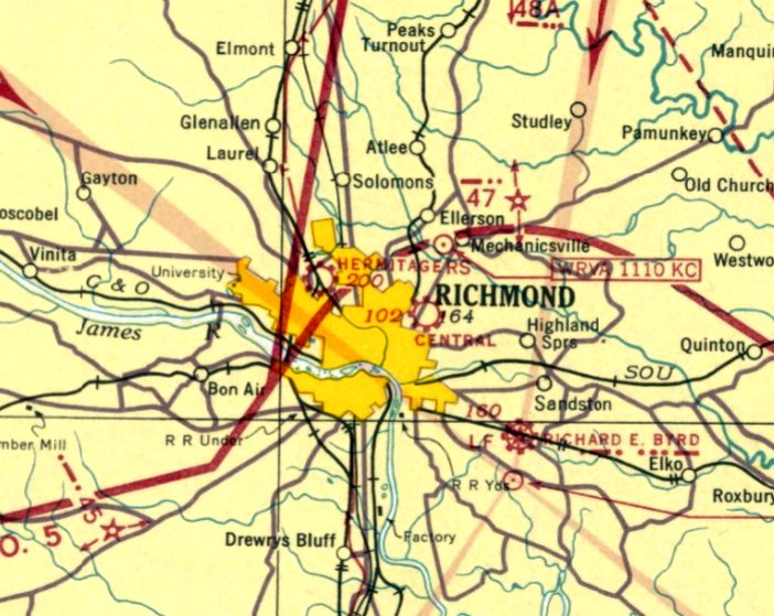
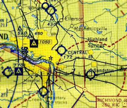
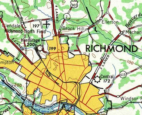
37.555, -77.403 (East of Downtown Richmond, VA)
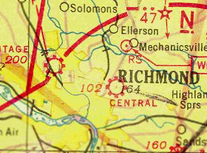
Central Airport, as depicted on the September 1938 Norfolk Sectional Chart.
This general aviation airport was evidently established at some point between 1937-38,
as it was not yet listed among active airports in the 1934 Department of Commerce Airport Directory (according to Chris Kennedy)
or The Airport Directory Company's 1937 Airport Directory (courtesy of Bob Rambo),
nor depicted on the October 1937 Norfolk Sectional Chart.
The depiction which has been located of Central Airport was on the September 1938 Norfolk Sectional Chart.
It depicted Central as a commercial/municipal airport.
Central Airport was listed in The Airport Directory Company's 1938 Airport Directory (according to Chris Kennedy).
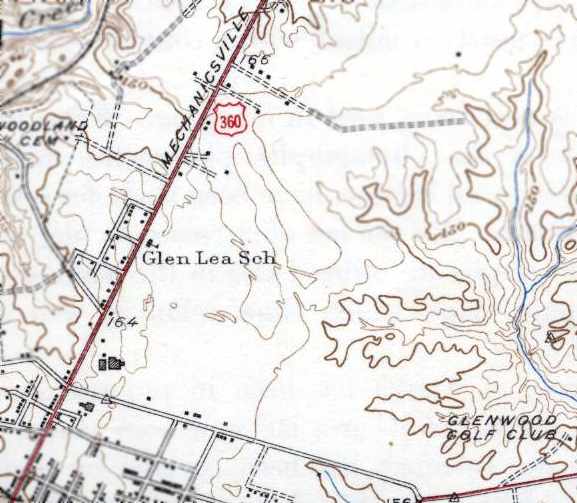
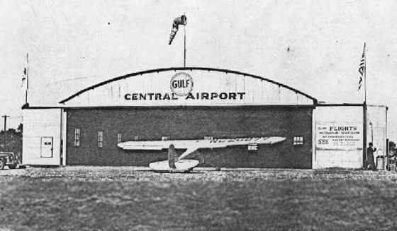
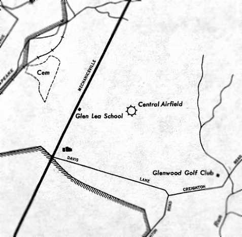
According to Claude Beck, “Central Airport was located on Route 360 (Mechanicsville Pike)
and was operated by Floyd Clark & Aubrey Loving during the 1930s, 1940s and 1950s.
It was next to the old Glen Lea School. I had my first ride when I was 12 years old in a Tri-Motor in 1938.”
Claude continued, “The East/West runway was 5,000'+. It ran from Highway 360 east toward Glenwood golf course.
The diagonal runway ran Southeast/Northwest - it was 5,000'+.
The short North/South runway/tie-down was approximately 1,800-2,000'.
The main hangar was located at the junction of the East/West runway & the short North/South runway.
This was the maintenance hangar adjacent to Highway 360.
The Northeast/Southwest diagonal runway was approximately 3,000' over trees with a drop-in approach.
Floyd liked it & I liked it but not many used it. There were T-hangars behind the main hangar & next to Glen Lea School.
There was a long bench next to the office door facing east.
This was populated with weekend hangar pilots who would critique the take off & landings of any victim they could harass.
I was told that my landings sounded like 'A garbage can falling off a truck on a city street at 2:00 AM in the morning'.
Floyd Clark told me that any airplane I could walk away from after it had made ground contact was a good landing.
He also said 'The two most useless things you can have while flying an airplane were, runway behind & altitude above'.
It was a great hang-out in the 1930s for a farm boy who loved airplanes.”
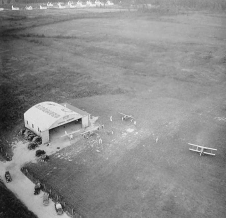
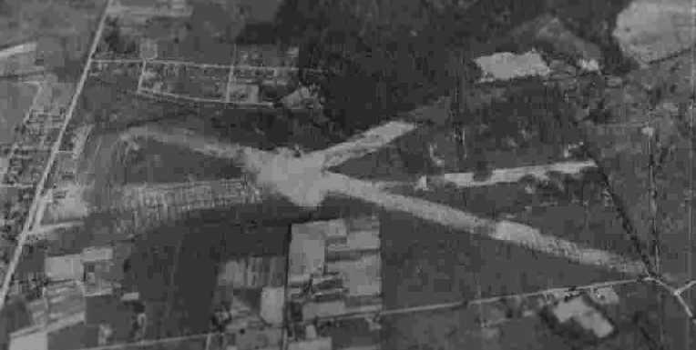
A circa 1930s aerial view of Central Airport, showing 3 high-wing monoplanes & a biplane.
This picture of a picture was taken by Kenneth Keeton,
who reported, “I attended the VA ANG last F-16 training mission on 6/20/07, and in the Operations Building there it was!”
Two hangars (northeast of the intersection at the bottom-left)
and an open field were depicted at the site of Central Airport on the 1939 USGS topo map,
but the field was otherwise not labeled (for reasons unknown).
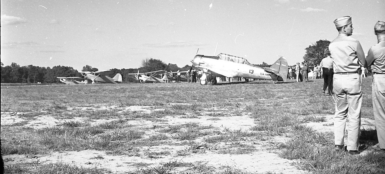
A circa late 1930s / early 1940s photo of a Navy North American SNJ Texan & several light general aviation aircraft at Central Airport
(from the collection of Frederick Bates, courtesy of Marilyn Bates Headley).
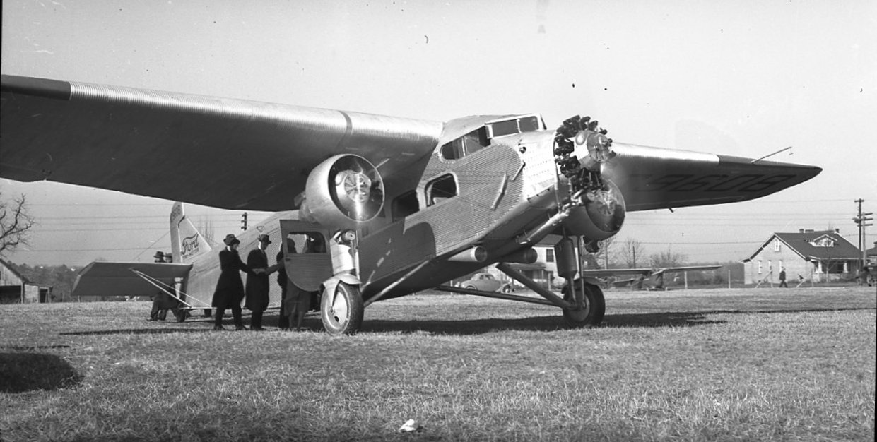
A circa late 1930s / early 1940s photo of passengers boarding Ford Tri-Motor at Central Airport (from the collection of Frederick Bates, courtesy of Marilyn Bates Headley).
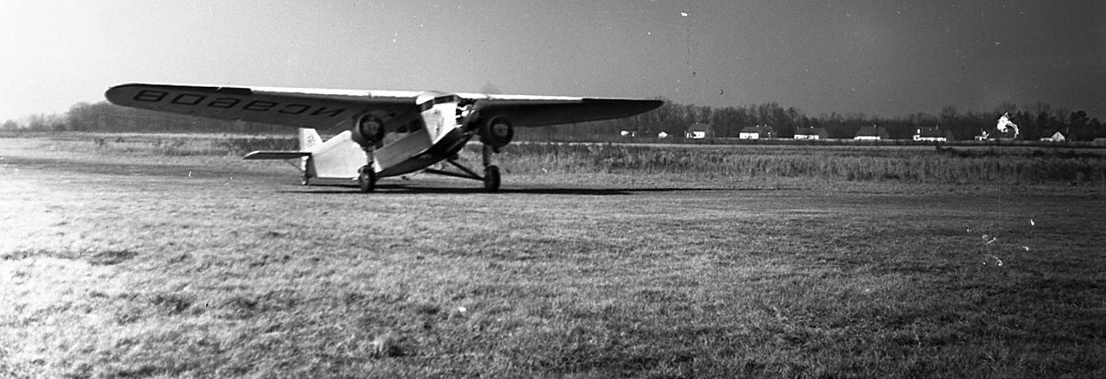
A circa late 1930s / early 1940s photo of a Ford Tri-Motor taxiing on the grass airfield at Central Airport (from the collection of Frederick Bates, courtesy of Marilyn Bates Headley).
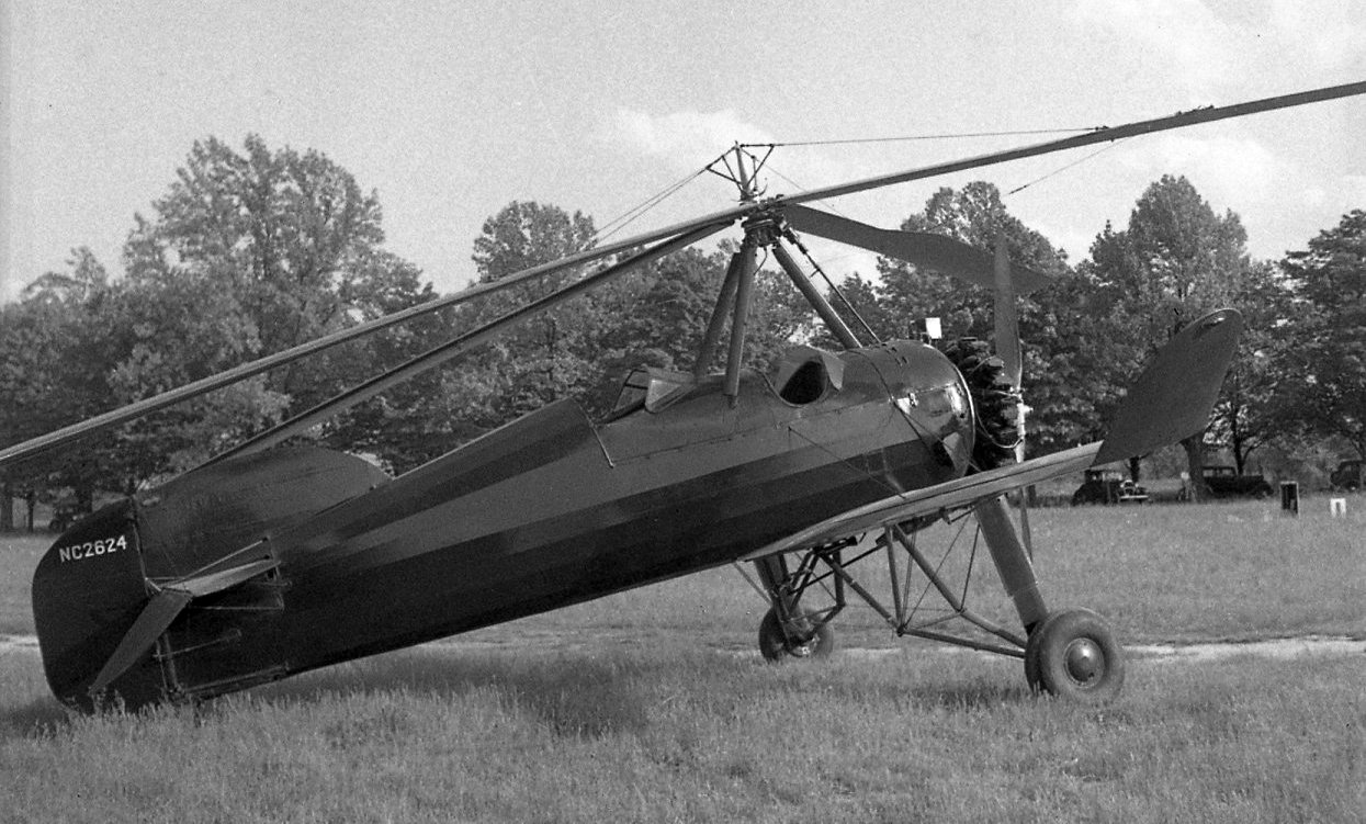
A circa late 1930s / early 1940s photo of a rare Pitcairn Autogiro (model undetermined) at Central Airport (from the collection of Frederick Bates, courtesy of Marilyn Bates Headley).
The August 1940 Norfolk Sectional Chart (courtesy of Chris Kennedy) depicted Central as a commercial/municipal airport.
A circa 1940 photo of a Piper Cub in front of a hangar at Central Airport.
A circa 1942-43 aerial view looking north at Central Airport from the 1945 AAF Airfield Directory (courtesy of Scott Murdock)
depicted the field as having 3 runways.
The directory Central as a 168 acre irregularly-shaped property within which were 3 sod & gravel runways, with the longest being the 4,500' WNW/ESE strip.
The field was said to have a total of 15 wood & metal hangars, with the largest being a 60' square structure.
The field was said to be privately owned & operated.
Gordon Allison recalled, “During WWII, Dad used to take me to Central Airport to see the Navy blimps. I even got to sit in one.”
The April 1946 Norfolk Sectional Chart (courtesy of Chris Kennedy) continued to depict Central as a commercial/municipal airport.
Central Airport, as depicted on a 1946 USGS map.
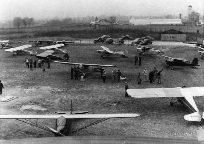
A circa 1940s photo of a large number of Piper Cubs at Central Airport.
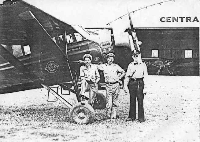
A circa 1940s photo of Floyd Clark, Aubrey Loving, and a police officer in front of a 1931 Stinson SM-8 monoplane, of a NY or KY police department,
with a Central Airport hangar in the background.
A late-1940s photo of a hangar & several monoplanes at Central Airport.
Claude Beck recalled of Central Airport, “I learned to fly there in 1948.”
A 1952 aerial view showed Central Airport as having 3 grass runways, with 3 hangars & 6 light aircraft on the west side.
Gordon Gallison recalled, “Central Airport: When I was about 3 years old, my Dad would take me to Central airport to see the airplanes.
Sometimes a Navy blimp was there to refuel & get some food.
I still remember when he asked the blimp commander if he could lift me into the gondola as the wind moved it around the mooring mast.
That was my first blimp 'ride'.”
An 8/9/53 photo by Carlton McGinley (courtesy of Dianne Gardner) of a Central Airport hangar.
According to Diane Gardner, “My father, Carlton 'Mac' McGinley housed his plane, a Ryan PT low-wing trainer, at Central Airport.
He owned & rented many planes from Central & knew many of the men that congregated at the airport.”
The last aeronautical chart depiction which has been located of Central Airport
was on the July 1954 Norfolk Sectional Chart (courtesy of Chris Kennedy).
It depicted Central as having a 4,900' unpaved runway.
The last aeronautical chart depiction which has been located of Central Airport was on the 1955 USGS topo map.
A 1955 aerial view showed the number of aircraft visible at Central Airport had decreased to only 2.
Central Airport was evidently closed (for reasons unknown) at some point between 1955-56,
as it was no longer depicted on the January 1956 Norfolk Sectional Chart (according to Chris Kennedy) or the 1956 USGS topo map.
A 1968 aerial view no longer showed any trace of Central Airport, with the site having been covered by housing,
and it was no longer depicted on the 1969 USGS topo map.
The name of Central Airport apparently lived on, as the 1984 USGS topo map labeled the property as “Central Gardens”.
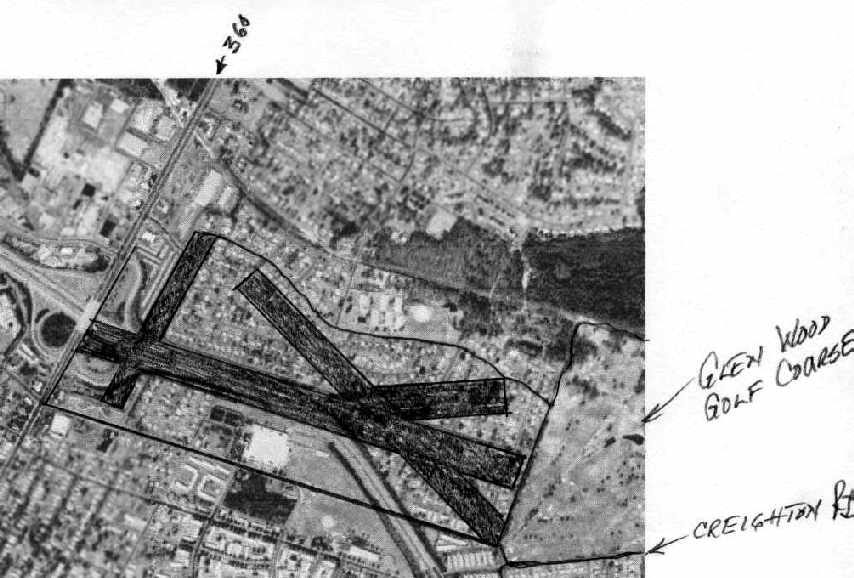
The layout of Central Airport's 4 runways, annotated by Claude Beck over the 1994 USGS aerial photo of the property.
There were no visible traces of the former airport remaining at the site.
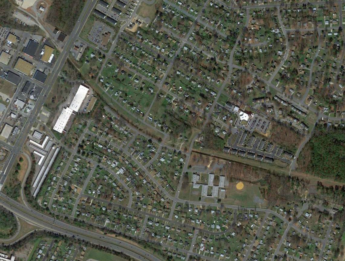
A 2017 aerial view showed no trace remaining of Central Airport.
The site of Central Airport is located east of the intersection of Interstate 64 & Mechanicsville Turnpike.
____________________________________________________
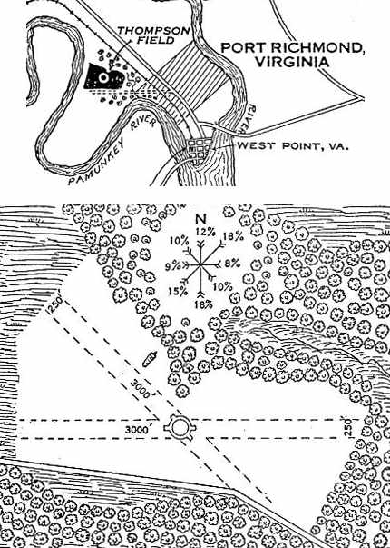
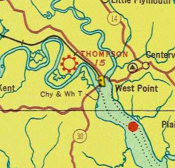
Thompson Field / Lee Field / Port Richmond Airport, Port Richmond, VA
37.56, -76.85 (East of Richmond, VA)
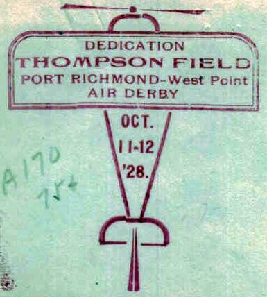
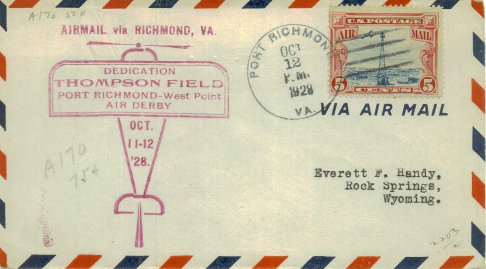
A postmark commemorating the 10/11/28 Dedication of Thompson Field, along with an Air Derby.
This short-lived small airport was located along the banks of the Pamunkey River.
The origins of Thompson Field were described in an article by Frances Hubbard in the 3/16/05 issue of the Tidewater Review.
According to the article, Thompson Field was named after Port Richmond's Mayor, Crosby Thompson.
The 8/3/28 issue of the Tidewater Review reported that work was progressing on the new Thompson Field,
which was said to have 2 graded runways: 3,000' & 2,000' long.
Several visits & inspections were made by military leaders from the Army's nearby Langley Field.
A postmark commemorated the 10/11/28 Dedication of Thompson Field, along with an Air Derby.
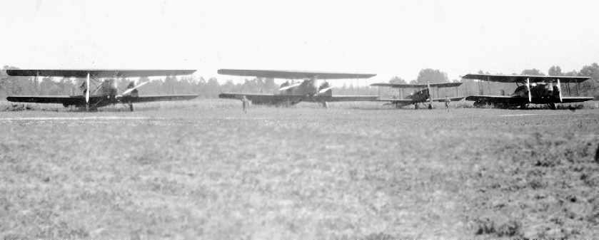
A 12/10/28 photo of Thompson Field (courtesy of Frances Hubbard),
depicting what appeared to be several Army twin-engine biplane bombers along with a smaller single-engine biplane.
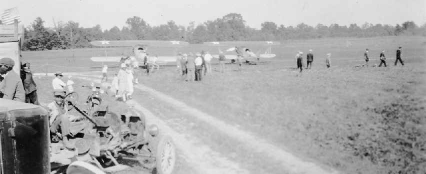
A presumably 1928 photo of Thompson Field showing several Army biplane fighters (courtesy of Frances Hubbard).
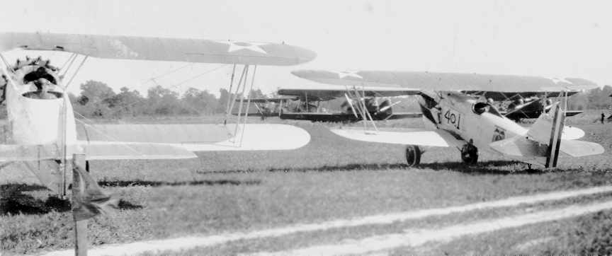
A presumably 1928 photo of Thompson Field showing several Army biplane fighters (courtesy of Frances Hubbard).
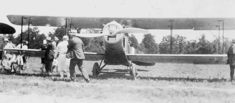
A presumably 1928 photo of Thompson Field showing an Army single-engine biplane (courtesy of Frances Hubbard).
Elis Olsson also reported that the field was known by a local name - Lee Field,
a reference to the fact that the property was once owned by the family of Robert E. Lee.
But “the official name for this airport was Thompson Field.”
A 1/10/29 Department of Commerce Airway Bulletin described Thompson Field
as a municipal airport, owned by Crosby Thompson, and operated by the City of Port Richmond.
The field was said to consist of an irregularly-shaped 88-acre sandy clay parcel,
on which were depicted two 3,000' runways, oriented east/west & northwest/southeast.
The field was said to not have any lighting or hangars.
The 8/29/29 issue of the Tidewater Review reported that “Thompson Field... is said by the U.S. Army Air Corps
to be the best field in this part of the country & is in use by military & commercial planes.”
The 12/12/29 issue of the Tidewater Review reported of aerial combat manueavers stages at Thompson Field
using 24 aircraft from the Army's Langley Field & the Marines' Quantico Field.
It said that “aside from Langley Field & Byrd Field, Thompson Field has more visiting planes than all other fields in VA.
Landings for the last 9 months total 1,058.”
Strangely, Thompson Field was not depicted at all on the 1930 USGS topo map.
The 6/23/32 issue of the Tidewater Review reported that a flying school had been established at Thompson Field.
A night airshow was held on 7/18/32 to celebrate the installation of Thompson Field's lighting system,
according to the 7/21/32 issue of the Tidewater Review.
A total of 1,500 enthusiasts were in attendance.
Thompson Field was described by the The Airport Directory Company's 1933 Airport Directory (according to Chris Kennedy)
as consisting of an irregularly-shaped 120 acre sod field,
with two 3,000' runways, oriented northwest/southeast & east/west.
The field was said to offer a hangar, fuel, and limited repairs.
The June 1934 U.S. Navy Aviation Chart (courtesy of Chris Kennedy) depicted the field as “Port Richmond” Airport.
The 1935 Norfolk Sectional Chart depicted “Thompson” Field as a commercial or municipal airport.
The 1/1/36 Department of Commerce Airway Bulletin described Thompson Field as a municipal field, consisting of an irregularly-shaped sod field.
It was said to have 2 graded 3,000' runways, oriented northwest/southeast & east/west.
The field was said to offer facilities for servicing aircraft, day only.
The last aeronautical chart depiction which has been located of Thompson Field was on the May 1936 Norfolk Sectional Chart.
Thompson Field was evidently abandoned at some point in 1936, as it was no longer depicted on the October 1936 Norfolk Sectional Chart,
nor listed among active airfields in The Airport Directory Company's 1937 Airport Directory (according to Chris Kennedy).
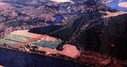
By 1944, a much larger West Point Airport with paved runways had been built by the federal government 5 miles to the southeast in nearby West Point.
Thompson Field was no longer depicted on the 1950 USGS topo map.
A 1963 aerial view showed that the outline of Thompson Field was still recognizable, but there were no other specific remains of the airfield.
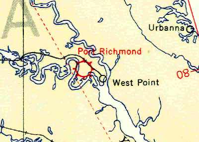
A circa 1990s aerial photo by David Robinson looking northeast at the site of historic Thompson Field (dark area in center),
with the new planned runway highlighted in red on the left.
In an interesting development, the property adjacent to this long-dormant airfield may see aviation activity again.
Elis Olsson reported in 2005, “David Robinson & I are working on permitting a grass strip on my parents' farm.
My planned sod airstrip will be in the barley field, which may be 1/2 mile west of the original Thompson Field. It will be 2,000' x 75'.”
A 2015 aerial photo showed remarkably after 86 years the outline of Thompson Field is still recognizable, although the area of the airfield is now wooded.
By comparing with the airfield layout as depicted on the 1929 Airway Bulletin, the original shape of the airfield is still easily discernible.
The site of Thompson Field is located on the north side of West Euclid Boulevard.
____________________________________________________
37.478, -77.23 (Southeast of Richmond International Airport, VA)
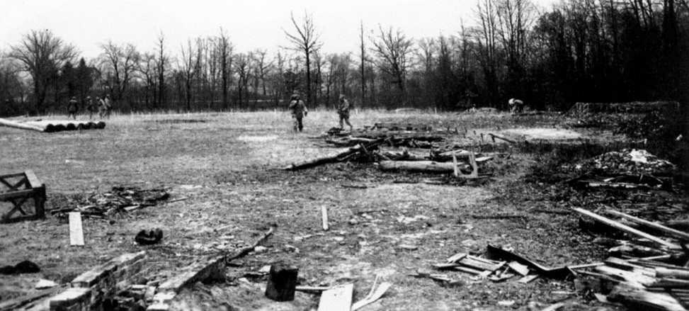
A circa 1942 photo (courtesy of Kenneth Keeton) of the Elko Decoy Airfield under construction by the 936th Camouflage Battalion.
According to a Henrico County history book (courtesy of Kenneth Keeton),
“Early in World War II, the Federal Government seized the land west of White Oak Road & south of Portugee Road, some 2,400 acres.
Landowners were given 30 days to move so construction could start on a decoy airfield.
The purpose of the field was to fool any enemy bomber pilots.
The men of the 936th Camouflage Battalion spent a few months in late 1942 creating dummy landing runways that would look real from 20,000 feet.”
The decoy airfield was constructed 5 miles southeast of Richmond's Byrd Field,
and it was arranged in an identical fashion, with 3 'runways' in the same orientation as Byrd Field.
It was intended to protect Byrd Field by confusing enemy aircraft & drawing them away from their real target.
According to James "Slim" Wilberger, the decoy airfield was equipped with working lights,
as well as decoy airplanes, buildings & trucks constructed of plywood.
As constructed during the war, the decoy reportedly consisted of a network of roads in addition to the runways,
which were carved out of the dense woods to the southeast of Byrd Field.
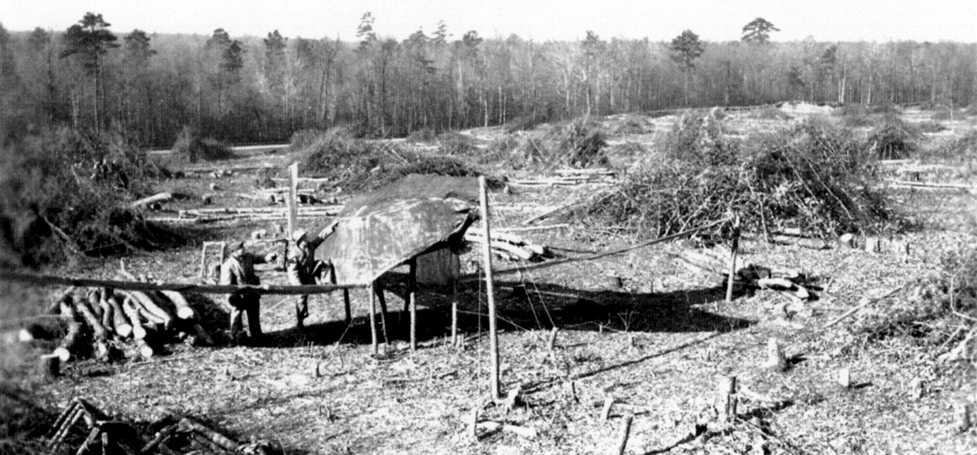
A circa 1942 photo (courtesy of Kenneth Keeton) of a dummy aircraft constructed out of lumber & camouflage netting at the Elko Decoy Airfield.
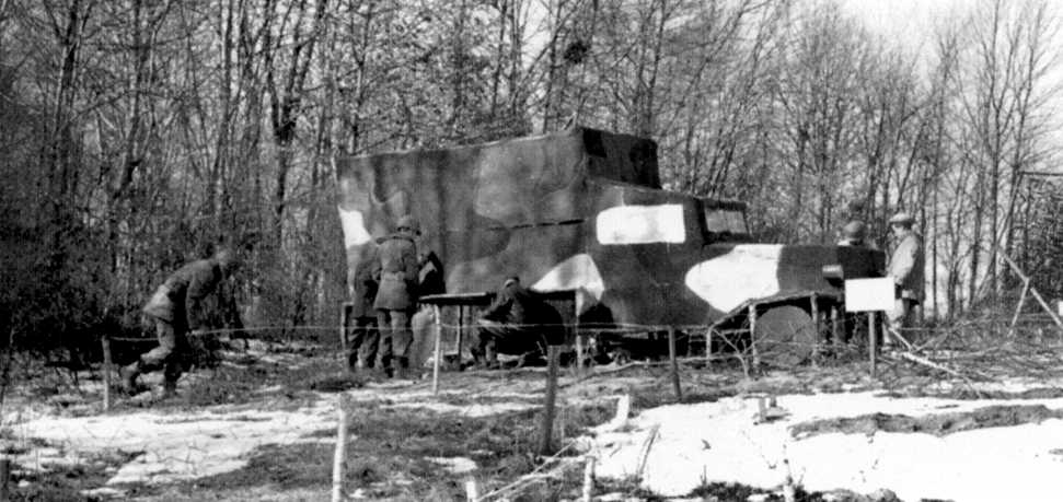
A circa 1942 photo (courtesy of Kenneth Keeton) of a dummy truck at the Elko Decoy Airfield,
positioned at the edge of the treeline so as to give the impression of being one of a number of vehicles parked within the trees.
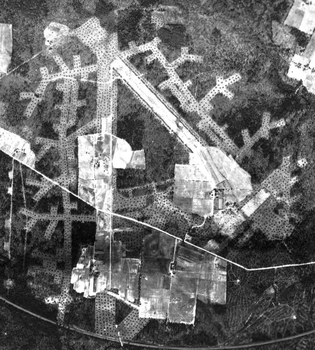
A remarkable 3/9/43 aerial view (from the National Archives, courtesy of Lyle Browning)
showed the Elko Decoy Airfield as having 3 runways (perhaps still in the process of being cleared)
along with an extensive network of taxiways & aircraft dispersal pads.
According to Lyle Browning, “Supposedly a pilot landed on one of the runways with a fairly large plane (I've heard a B-17 or a large civilian aircraft).
It would appear that the northwest/southwest runway was in the best shape for landing so it was probably that one that was landed upon.”
According to a Henrico County history book (courtesy of Kenneth Keeton),
“In September 1943 the 1896th Engineer Aviation Battalion moved from Byrd Field into camouflaged plywood Quonset huts at the decoy field.
They stayed until March 1944.”
It has been reported that the Eko decoy airfield was located beyond the eastern terminus of Portugee Road,
beyond which the road turned to dirt.
At this point an unlocked gate sat at the western edge of the decoy airfield site.
The 1944 USGS topo map did not depict any trace of the Elko Decoy Airfield.
The 1946 Commerce Department Airman's Guide (courtesy of Chris Kennedy)
described the “Elko Auxiliary Field” as being located “5 miles east of Richmond AAB,
is similar in design & layout to the Richmond AAB,
but runways are unsuitable for landing by aircraft of any type.
Care should be taken not to confuse this field with the Richmond AAB.”
The Elko decoy airfield was not depicted at all on the 1946 USGS topo map.
At the end of WW2, the federal government transferred the 2,400-acre Elko tract
to the Commonwealth of Virginia.
It was zoned M-1 & M-3 (Industrial) from the 1950s, but it sat abandoned for years.
According to James "Slim" Wilberger, the Elko tract was used after WW2 for occasional infantry training.
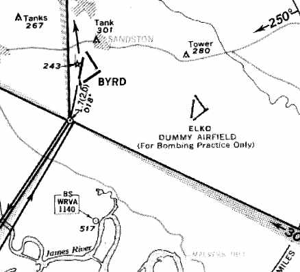
The only official depiction of the decoy airfield which has been located
was on a 1955 approach plate for Byrd Field.
The 3 runways of "Elko Dummy Airfield" were depicted on the approach plate
(which would make sense, as you wouldn't have wanted a pilot to mistake it for the 'real' airport).
The decoy airfield was apparently used as a bombing target by the National Guard fighter unit based at Byrd Field,
as the approach plate included the remark of "For bombing practice only" on the decoy airfield.
The 1957 USGS topo map depicted the outline of a portion of 3 runways of the Elko Decoy Airfield.
The Elko Decoy Airfield was not depicted at all on the 1965 Norfolk Sectional Chart (courtesy of John Voss),
or subsequent Sectionals.
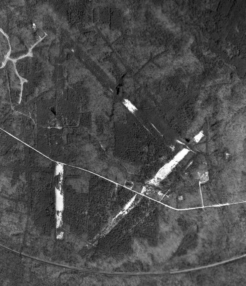
A 3/20/63 USGS aerial view showed the very recognizable outline of 3 runways mimicking the layout of Richmond Byrd Field.
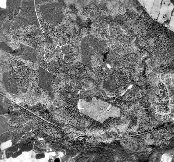
The 1994 USGS aerial photo showed the faintest trace of the triangular outline of the 3 decoy 'runways' in the center of the photograph.
The area was otherwise densely wooded.
When Interstates 64, 95, and 295 were constructed nearby, the Elko Tract became more desirable for redevelopment.
In 1994, Henrico County officials commissioned a study: The Elko Tract, an Industrial Evaluation Report.
Lyle Browning recalled, “I did some archaeological survey of the Elko Tract in the 1990s.
I grew up in the area & was familiar with the Elko Tract.
When I did my archaeological survey there, Runway 2/20 was still virtually intact.
The runway surface was clay & it simply wouldn't grow anything.
It was wide & long enough as well as dense enough in dry weather to support aircraft.
Extrapolating back to WWII would make it a really convincing effort.”
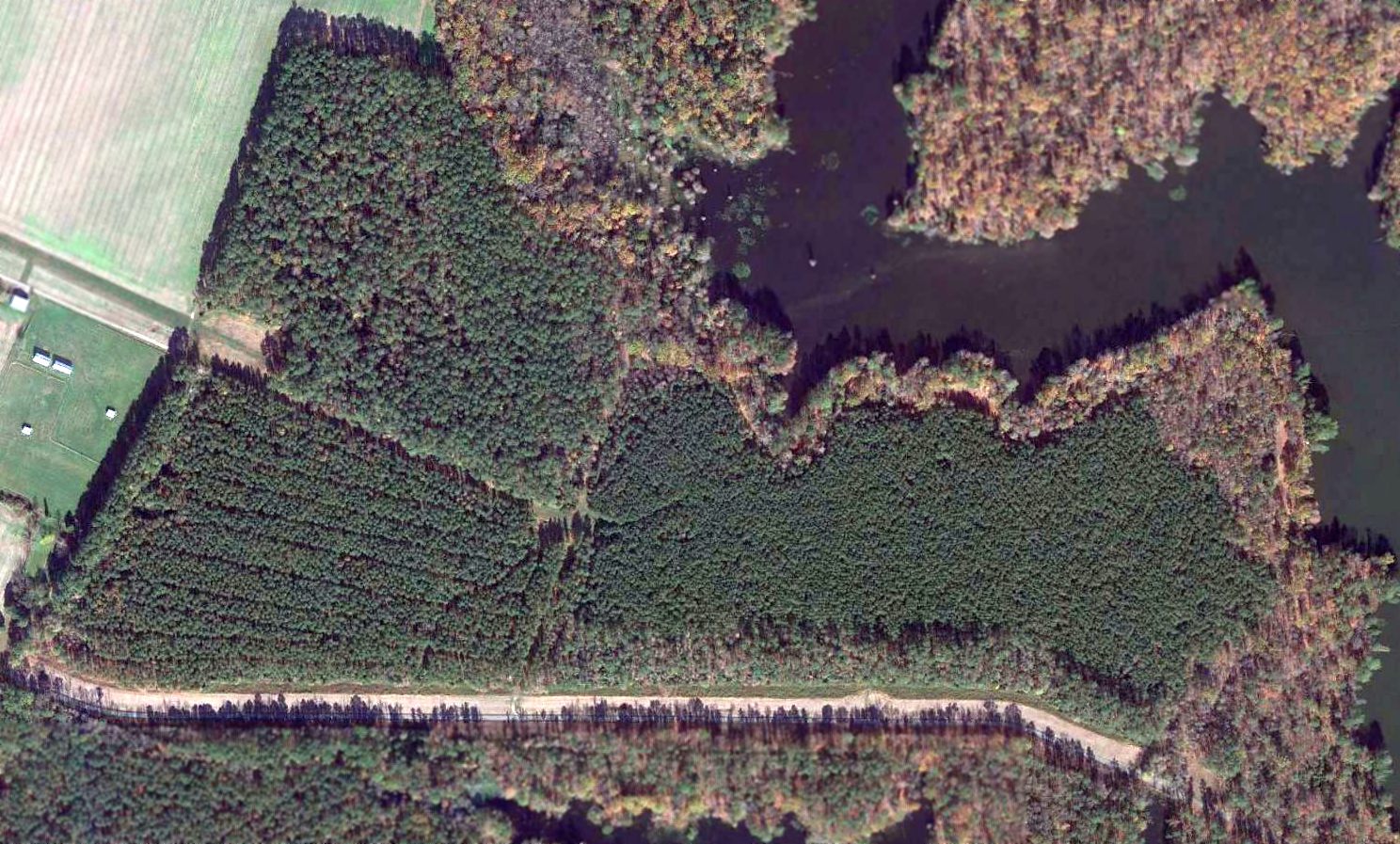
A 1996 aerial view of the site of the Elko Decoy Airfield, in which the alignment of the former decoy runways has been annotated.
On 5/20/96, Henrico County, the Commonwealth of Virginia, and the partnership of Motorola & Siemens Corporation
announced their agreement for development of a semiconductor DRAM manufacturing plant on the site of the Elko Tract,
now renamed the White Oak Technology Park.
Any traces of the former decoy airfield would presumably be removed in the course of the property's redevelopment.
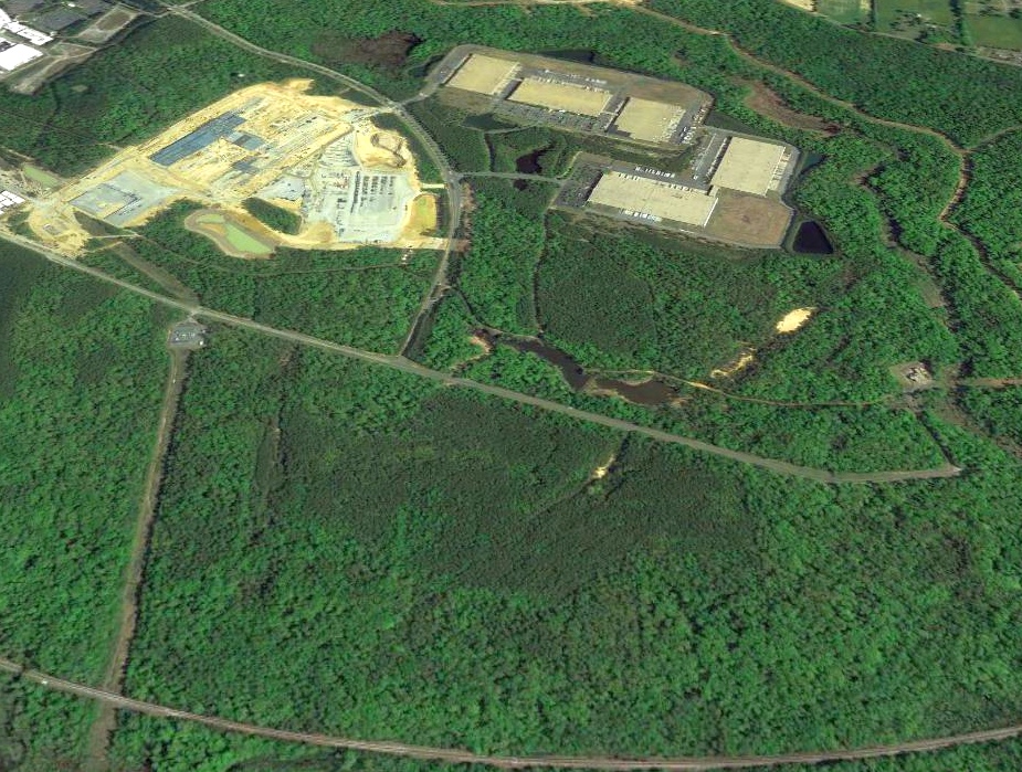
A 2003 aerial photo showed that several large industrial buildings had been built over the northeastern portion of the Elko Decoy Airfield.
James "Slim" Wilberger reported in 2004, "This past fall the Virginia National Guard were holding field exercises in the woods."
In 2013 Henrico County erected a historical plaque at the site entitled “Decoy Airfield”.
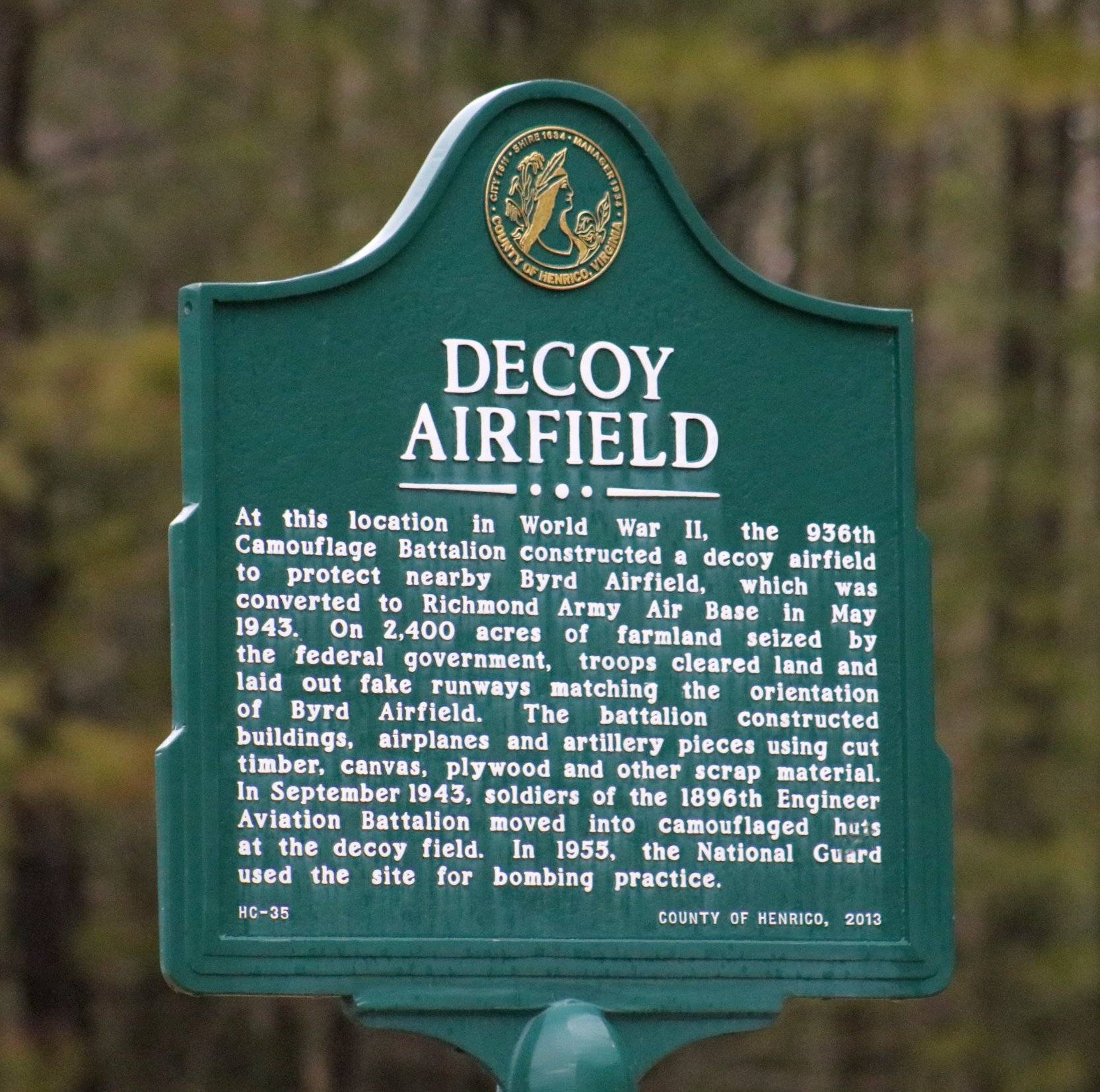
A 2/11/18 photo by Nicholas Cox of the historical plaque at the site of the Elko Decoy Airfield.
Nicholas Cox reported in 2018, “A new Facebook Data Center is going in the exact same area of the airfield, so Facebook is ignoring the history.
Most of the area is now tore up for this new Facebook Data Center.”
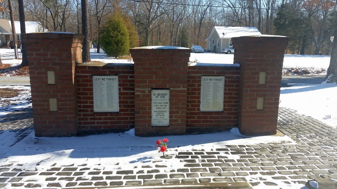
A circa 2017 photo by Charles Chenault of the memorial to the 1896th Engineer Aviation Battalion at the site of the Elko Decoy Airfield.
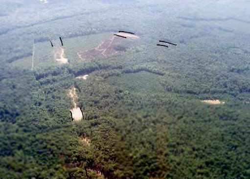
A 2018 aerial view looking north shows industrial buildings covering the northern portion of the Elko Decoy Airfield site,
but amazingly a significant portion of the northeast/southwest decoy runway remains (the light-colored feature running diagonally at right-center).
The site of the Elko Decoy Airfield is located east of the intersection of Portugee Road & Technology Boulevard.
____________________________________________________
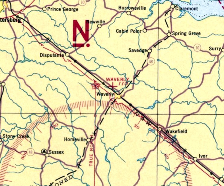
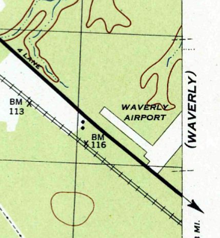
Waverly Airport (2nd location), Waverly, VA
37.06, -77.12 (Southeast of Richmond, VA)
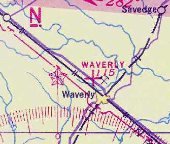
Wavery Airport, as depicted on the October 1937 Norfolk Sectional Chart.
The 2nd location of Waverly Airport (to the north of the town) was evidently established at some point between 1936-37,
as the November 1936 Norfolk Sectional Chart depicted a predecessor Waverly Airport to the west of the town.
The earliest depiction which has been located of the 2nd location of Waverly Airport (to the north of the town) was on the October 1937 Norfolk Sectional Chart.
The Airport Directory Company's 1937 Airports Directory (courtesy of Bob Rambo)
described Waverly as a municipal airport having two 1,800' sod runways in an "L" shape, oriented east/west & north/south.
The earliest photo of Wavery Airport which has been located was a 1938 aerial photo.
It depicted the field as having 2 unpaved runways, oriented in an “L” shape.
According to the book "Virginia Airports" by Vera Rollo & Norman Crabill (published by the VAHS),
a 5/20/38 article noted that this was the date of the first airmail pickup at Waverly.
The July 1941 Norfolk Sectional Chart (courtesy of Chris Kennedy) depicted Waverly as an auxiliary airfield.
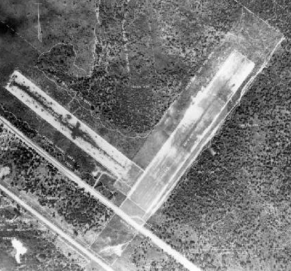
A circa 1942-45 aerial view looking east from the 1945 AAF Airfield Directory (courtesy of Scott Murdock) depicted Waverly Airport as having 2 grass runways.
The directory described Waverly Airport as a 164 acre rectangular property within which were 2 sod runways, measuring 1,670' northeast/southwest & 1,500' northwest/southeast.
The field was said to have 4 wooden hangars, each measuring 40' x 24'.
The airport was said to be owned by the City of Waverly, and privately operated.
The April 1944 US Army/Navy Directory of Airfields (courtesy of Ken Mercer) described Waverly as having a 1,700' unpaved runway.
The 1944 USGS topo map depicted Waverly Airport as having 2 perpendicular runways.
The April 1945 Norfolk Sectional Chart (courtesy of Chris Kennedy) depicted Waverly as a commercial or municipal field.
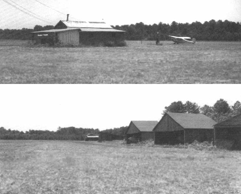
Two 1949 photos of Waverly Airport depicted a single taildragger at the field, along with a row of 5 wooden hangars along one of Waverly's grass runways.
The runway at Waverly had been apparently been significantly lengthened at some point between 1944-65,
as the Aerodromes table on the 1965 Norfolk Sectional Chart (courtesy of John Voss)
described Waverly Municipal as having 2 runways, with the longest being a 4,400' turf strip.
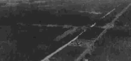
The last photo which has been located showing aircraft at Waverly Airport was a 1966 aerial view,
which showed a single light aircraft along with 2 small hangars to the west of the runway intersection.
Waverly was still depicted as an active airport on the March 1974 Washington Sectional Chart (courtesy of Scott Jednacz),
and described as having a 4,100' unpaved runway.
The Waverly Airport was evidently closed (for reasons unknown) at some point between 1974-75,
as it was no longer depicted at all (even as an abandoned airfield)
on the 1975 Washington Sectional Chart (courtesy of Ed Drury).
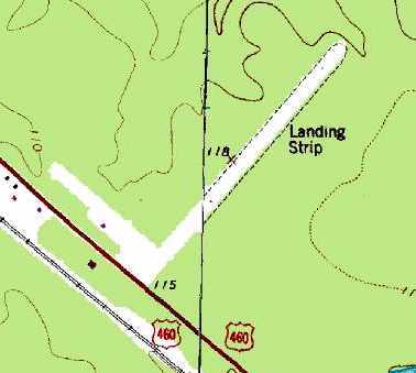
The 2 abandoned runways of the former Waverly Airport were still depicted on the 1989 USGS topo map,
but it was labeled simply as "Landing Strip".
A 1989 USGS aerial view looking northwest showed the 2 grass runways of Waverly Airport still remained remarkably cleared,
but there was not sign of the hangars depicted in the 1949 photos.
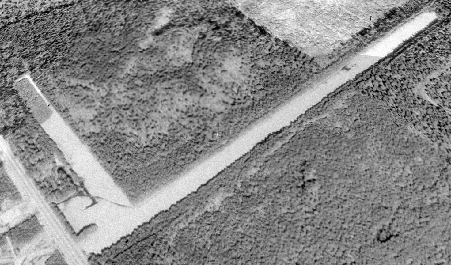
A 6/04 aerial photo by Paul Freeman looking north at the remains of the 2 runways at Waverly.
The outline of the 2 former runways were still recognizable, but you wouldn't necessarily recognize it as a former airfield unless you knew where to look.
Thus, this former airfield is rapidly slipping away into obscurity.
The primary reason was the main runway (oriented northeast/southwest) had been filled in with trees.
The rectangular outline of the former runway was still recognizable,
as the trees within the former runway area were uniformly shorter than those trees in the surrounding forest.
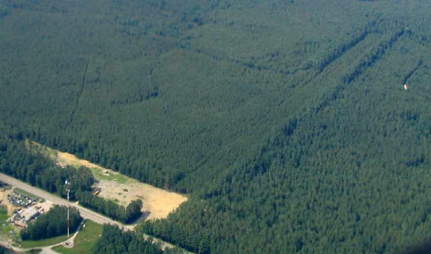
A 6/04 aerial photo by Paul Freeman of the remains of the former crosswind runway at Waverly.
The area of the shorter crosswind runway had remained cleared (for reasons unknown),
with several vehicles stored in the area (including what appeared to be a former school bus).
There was no sign of any former airport buildings.
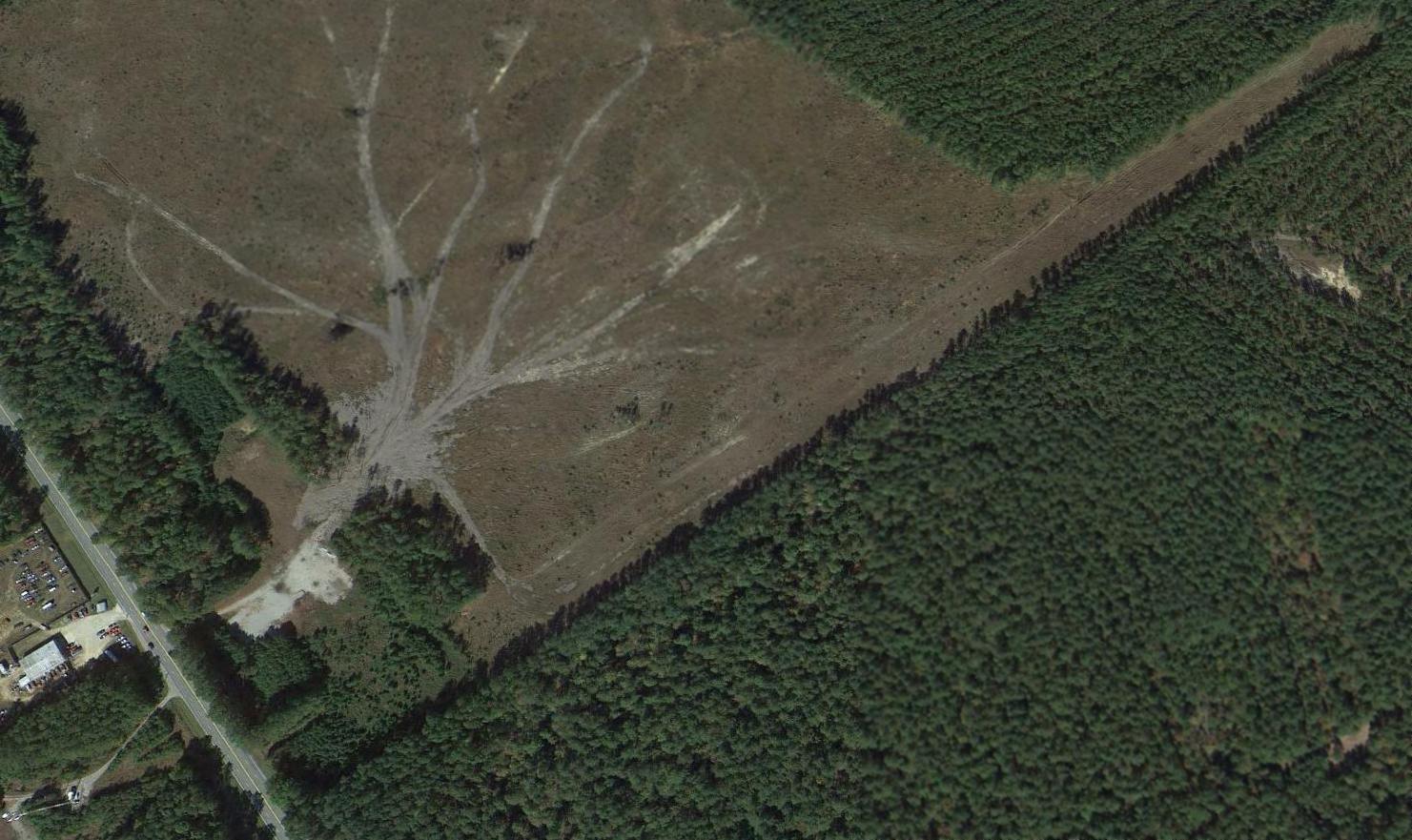
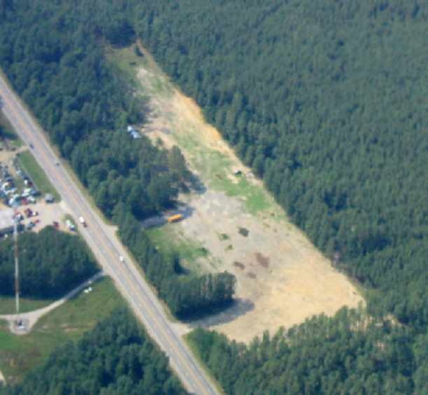
A 2014 aerial view looking northwest at the site of Waverly Airport showed the outlines of the 2 former runways were still recognizable,
but land had been cleared adjacent to the 2 runways for some unknown purpose.
The site of Waverly Airport is located on the northeast side of Route 460, one mile northwest of Waverly, VA.
____________________________________________________
Since this site was first put on the web in 1999, its popularity has grown tremendously.
If the total quantity of material on this site is to continue to grow,
it will require ever-increasing funding to pay its expenses.
Therefore, I request financial contributions from site visitors,
to help defray the increasing costs of the site
and ensure that it continues to be available & to grow.
What would you pay for a good aviation magazine, or a good aviation book?
Please consider a donation of an equivalent amount, at the least.
This site is not supported by commercial advertising –
it is purely supported by donations.
If you enjoy the site, and would like to make a financial contribution,
you
may use a credit card via
![]() :
:
Please consider checking the box to make a monthly donatation.
For a mailing address to send a check, please contact me at: paulandterryfreeman@gmail.com
If you enjoy this web site, please support it with a financial contribution.
please contact me at: paulandterryfreeman@gmail.com
If you enjoy this web site, please support it with a financial contribution.
____________________________________________________
This site covers airfields in all 50 states.