Abandoned & Little-Known Airfields:
Central Virginia
© 2002, © 2024 by Paul Freeman. Revised 9/7/24.
____________________________________________________
Please consider a financial contribution to support the continued growth & operation of this site.
Bradshaw Airpark / Eastview Airport (revised 11/9/23) - Clarksville-Finchley Airport (revised 2/11/24) - (Original) Culpeper Airport (revised 2/9/20) - Gordonsville Intermediate Field (revised 7/18/21)
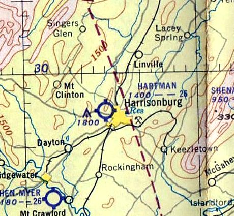
Burke Field / Hartman Field / Harrisonburg Airport / Shenandoah Airways Airfield / Blue Ridge Air Lines Airfield (revised 12/16/19)
Lester Airport (added 2/11/24) - Longs Airport (added 9/7/24) - Mt. Jackson Airport (added 11/1/22) - Shenandoah Airport (revised 11/1/22) - South Hill Municipal Airport (revised 2/11/24) - Staunton Airport (revised 10/27/19)
University of Virginia Airport / Milton Field (revised 4/20/24) - Valley Airport (revised 11/1/22) - Wood Field (revised 11/22/23)
____________________________________________________
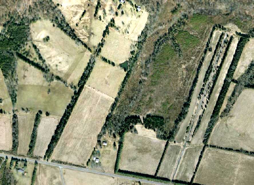
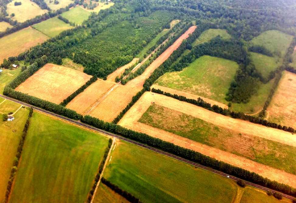
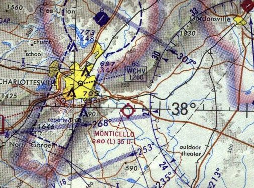
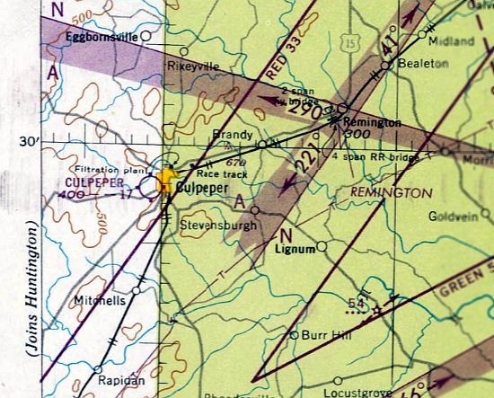
38.804, -78.573 (West of Washington, DC)
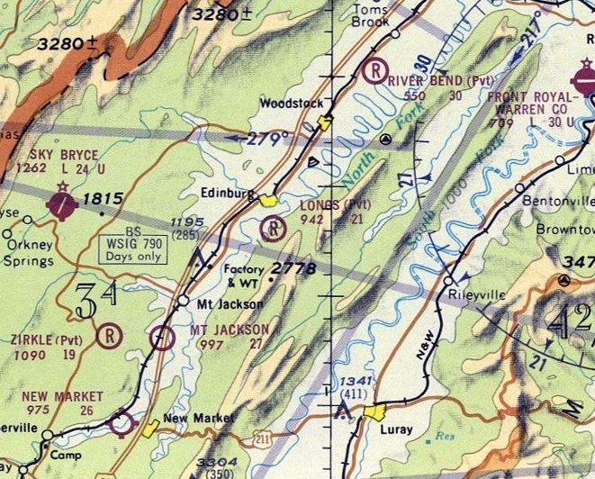
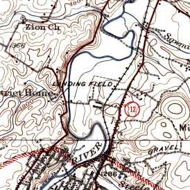
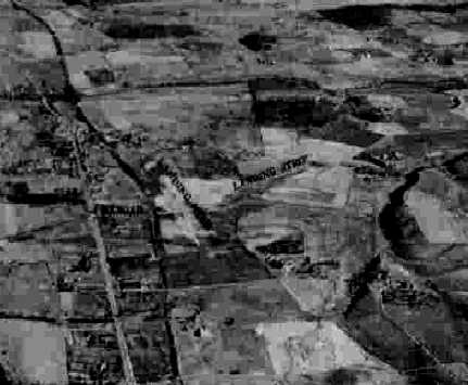
Longs Airport, as depicted on the 1971 Washington Sectional Chart.
Yet another of America's disappearing grassroots airfields.
This small rural airport was evidently established at some point between 1970-71,
as it was not yet depicted on the 1971 Huntington Sectional Chart.
The earliest depiction which has been located of Longs Airport was on the 1971 Washington Sectional Chart.
It depicted Longs as a private airfield having a mere 2,100' unpaved runway.
According to its FAA Airport/Facility Directory data, Longs Airport was activated in February 1976 (which is ironically contradicted by its depicted 5 years earlier on the Washington Sectional Chart).
It was described as a private airfield having a 2,100' turf north/south runway, owned by Jim Long.
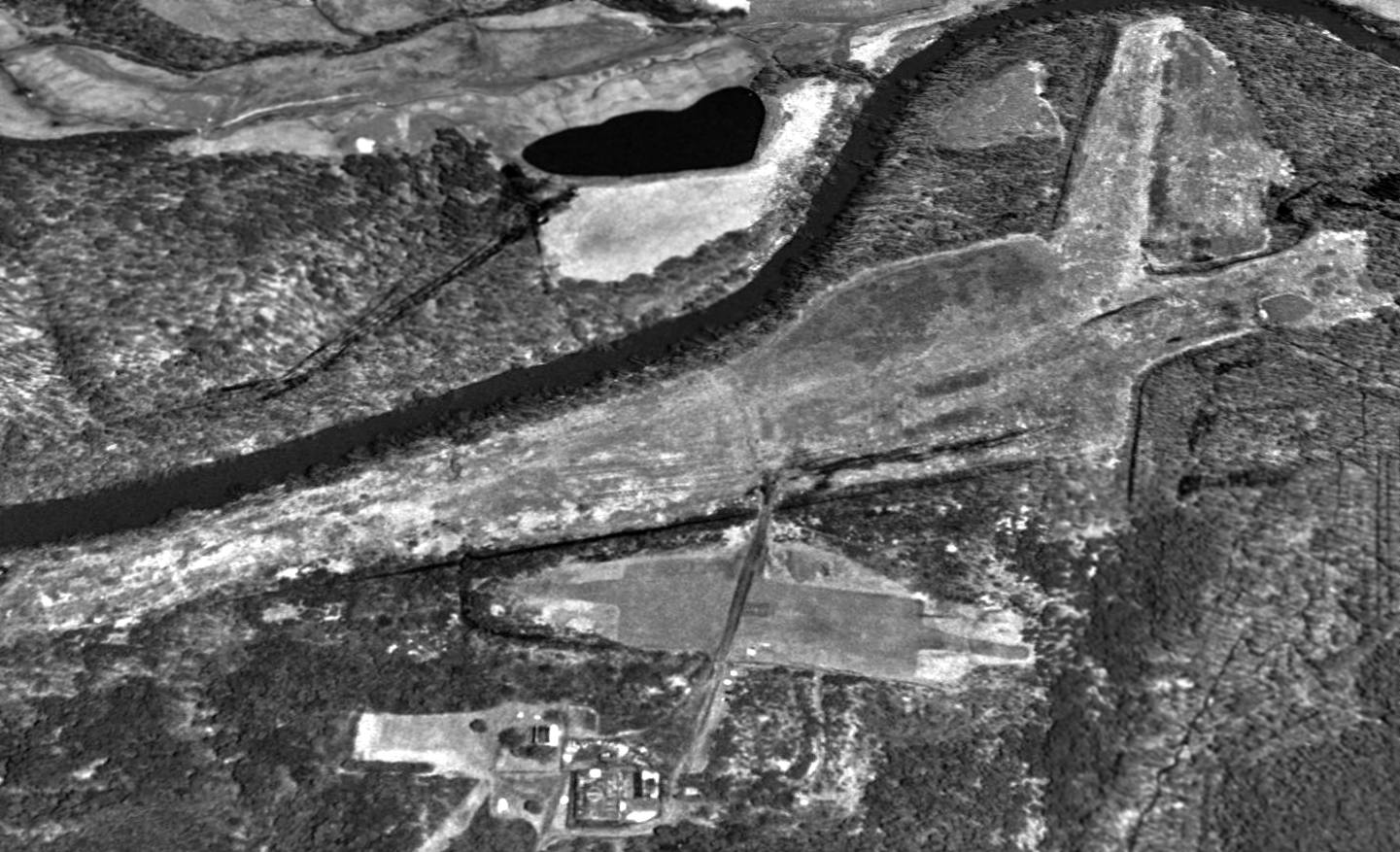
The earliest photo which has been located of Longs Airport was a 1984 aerial view.
It depicted 3 light single-engine aircraft & a small hangar on the west side of a northeast/southwest grass runway.
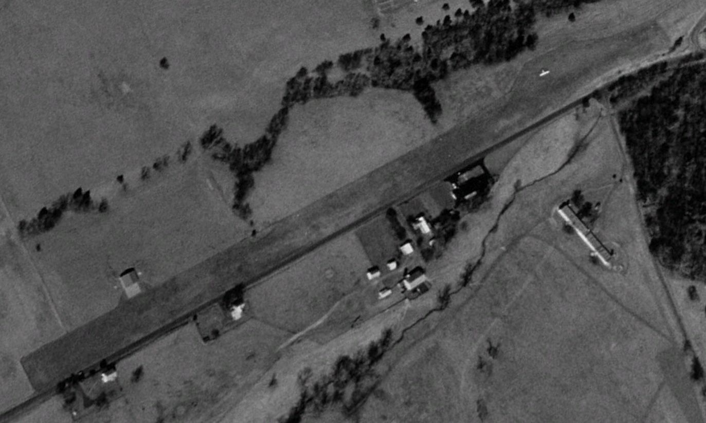
The earliest photo which is available of Longs Airport was a 1997 aerial view looking northwest.
It depicted 1 light single-engine aircraft & a small hangar on the west side of a northeast/southwest grass runway.
A 2017 aerial view looking south depicted Longs Airport as having a single-engine Cessna & a small hangar on the west side of a northeast/southwest grass runway.

The last aeronautical chart depiction which has been located of Longs Airport was on the 2023 Washington Sectional Chart.
It depicted Longs as a private airfield having a 2,100' unpaved runway.
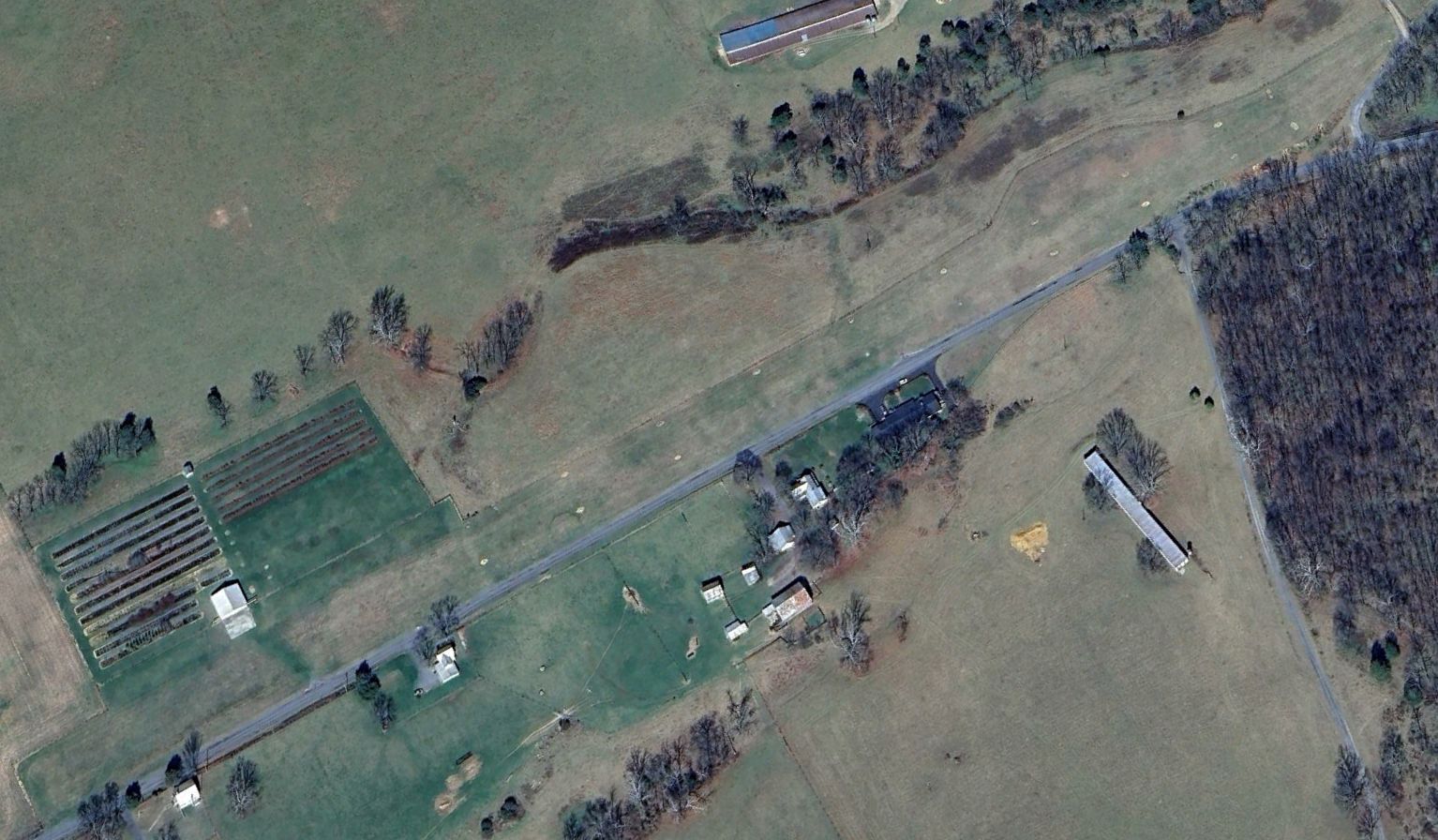
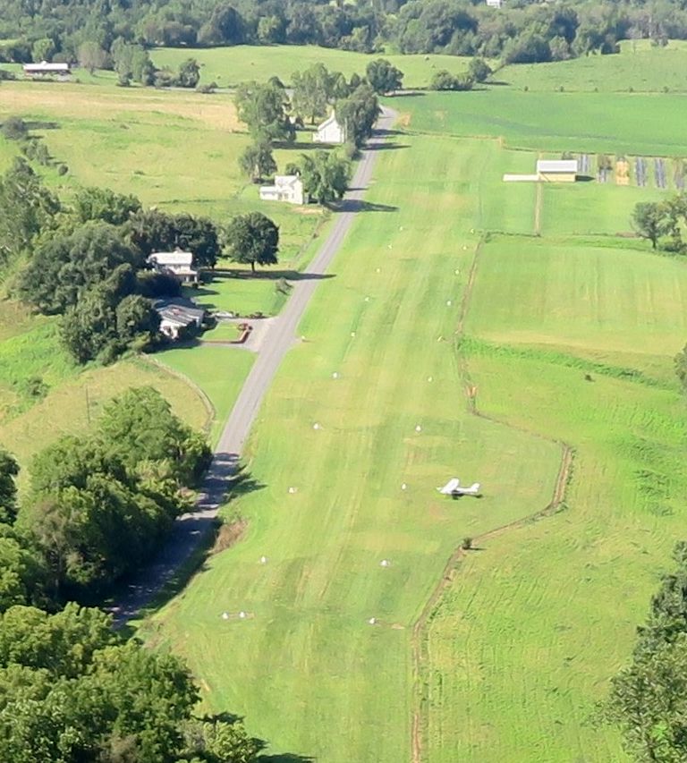
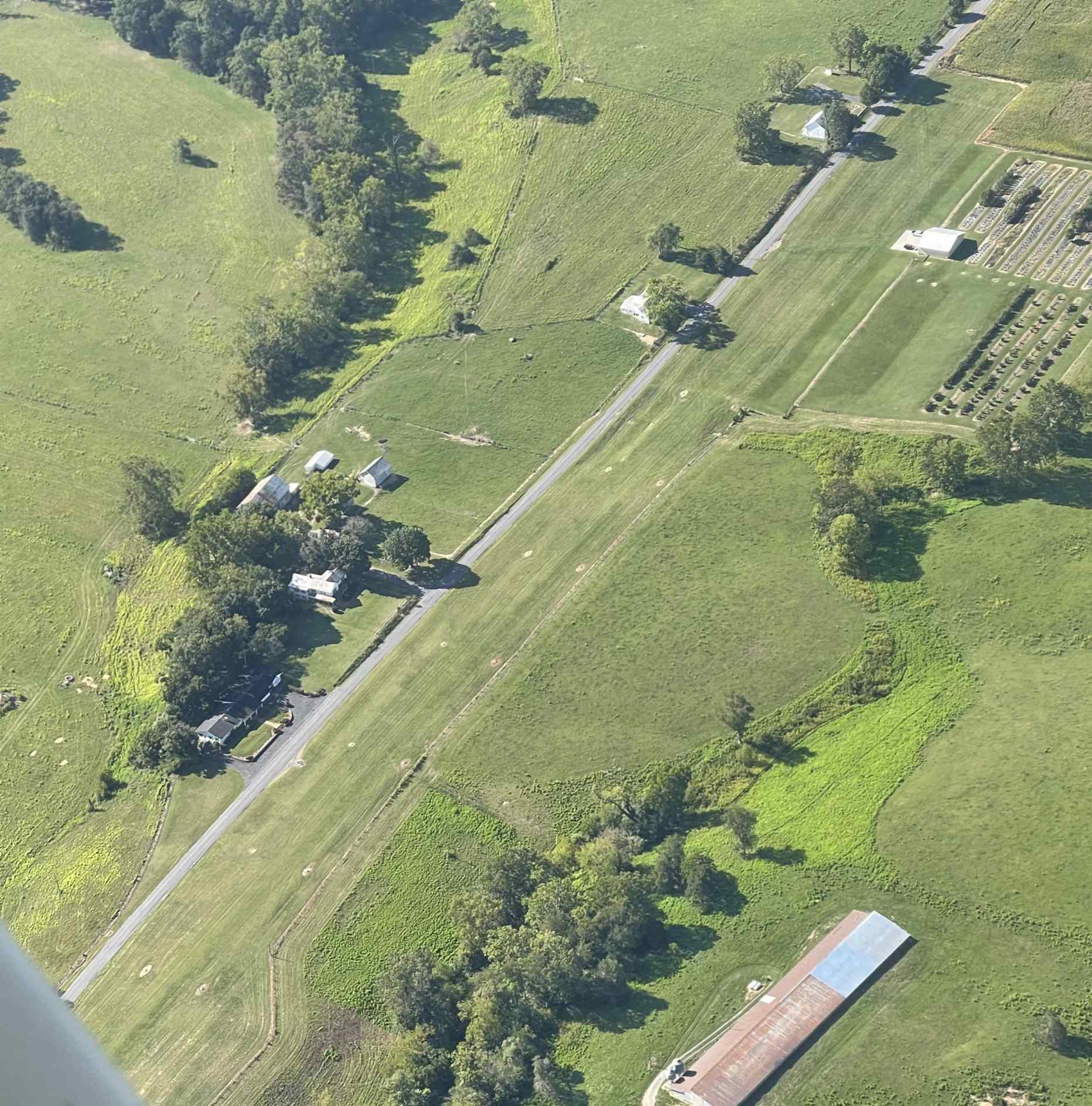
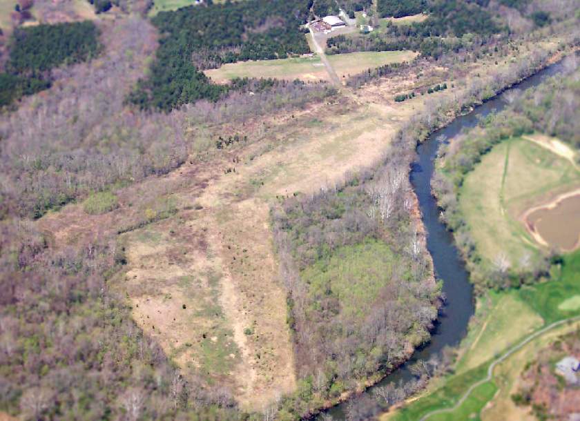
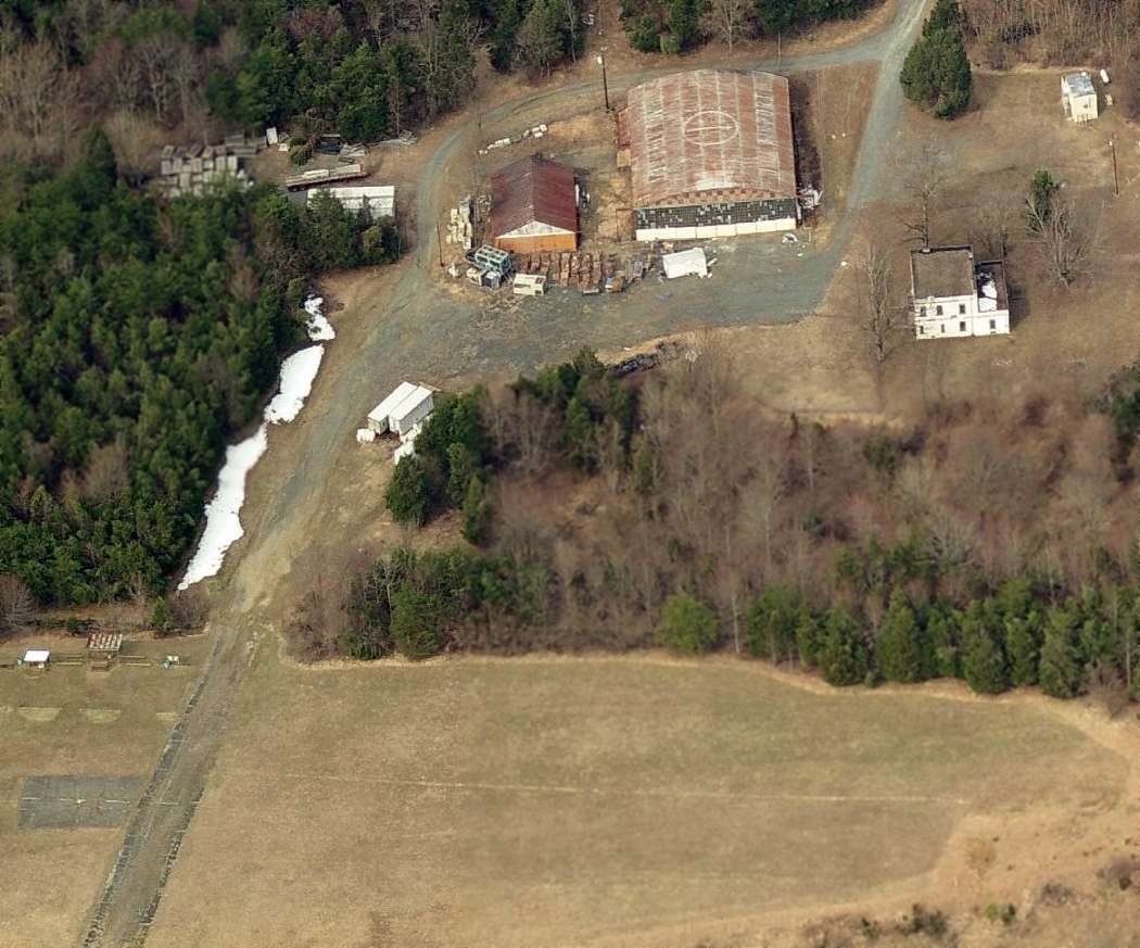
A 2024 aerial view looking northwest showed Longs Airport remained in an unchanged configuration, but devoid of aircraft.
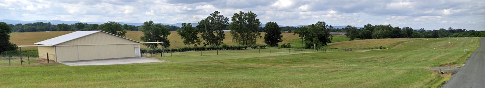
A June 2024 photo looking north showed Longs Airport's hangar & runway remained intact.
A 9/6/24 aerial view by Kevin Bachand looking south showed Longs Airport remained intact but devoid of aircraft.
Longs Airport was evidently closed (for reasons unknown) at some point between 2023-24, as it was no longer depicted on the 2024 Washington Sectional Chart.
Thanks to Kevin Bachand for pointing out this airfield.
____________________________________________________
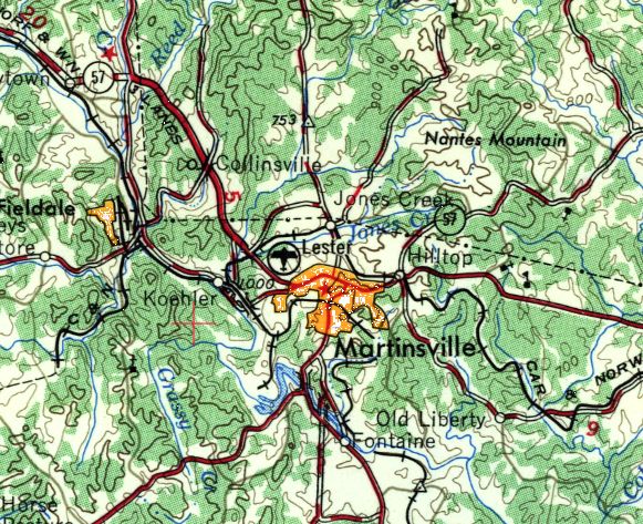
Lester Airport, Martinsville, VA
36.696, -79.875 (Southwest of Richmond, VA)
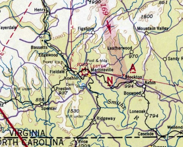
Lester Airport, as depicted on the January 1942 Winston-Salem Sectional Chart.
According to the Blue Ridge Regional Airport website, “Aviation found its way into Martinsville County in the early 1920s.
After World War I, there was a surplus of trainers known as the Curtiss or Standard JN-1 (Jenny).
This surplus bred a hearty breed of 'barnstormers' whose livelihood depended on offering locals airplane rides.
There were multiple sites for this in Martinsville County, with one growing to become Martinsville's first official airport.
Establishing the airport was possible through numerous efforts, including those of G.T. Lester Jr.
Lester was Martinsville's first citizen to own an aircraft & was the area's first commercial multi-engine instructor.
The original airport was one block north of the Martinsville city square on Liberty Street, named Lester Airport, also known as Lester Field.”
Lester Airport, was not yet depicted on the January 1941 Winston-Salem Sectional Chart.
The earliest depiction which has been located of Lester Airport was on the January 1942 Winston-Salem Sectional Chart.
It depicted Lester as a commercial/municipal airport, located adjacent to the northwest side of Martinsville.
According to the Blue Ridge Regional Airport website, “With the onset of World War II,
Lester Field served as training grounds for the first flight experience of many aspiring airmen who would become military pilots.
During the war, the War Training Command used the airfield as an auxiliary or emergency field.
Post-war efforts to expand Lester Field were unattainable due to topography.”
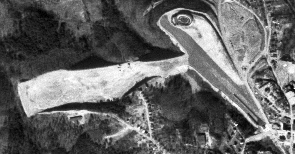
The only photo which has been located showing Lester Airport while open was a 1/9/51 USGS aerial view.
It depicted a northwest/southeast runway, with a small paved southeast portion, and a possible unpaved southwest/northeast runway.
Also note the small racetrack adjacent to the airport's north side.
The only topo map depiction which has been located of Lester Airport was on the 1954 USGS topo map.
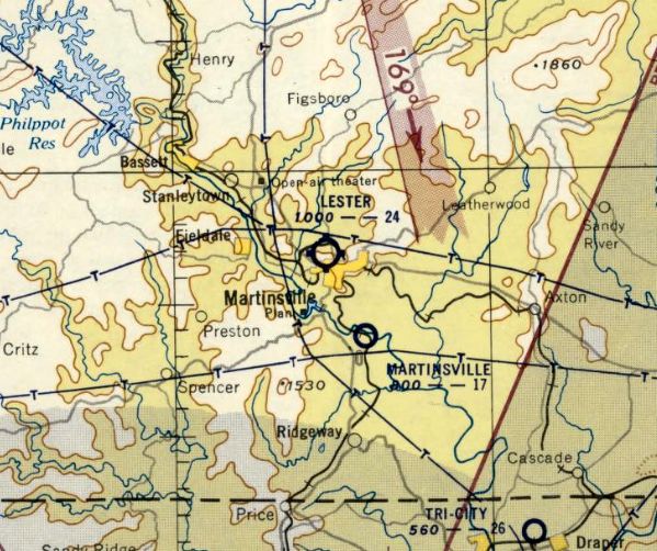
The last aeronautical chart depiction which has been located of Lester Airport was on the February 1954 Winston-Salem Sectional Chart.
It depicted Lester as having a 2,4 unpaved runway.
Lester Airport was evidently closed at some point between February-July 1954,
as it was no longer depicted on the July 1954 Winston-Salem Sectional Chart.
A 1957 aerial view showed Lester Airport after its closure.
It depicted a northwest/southeast runway, with the southeast portion as paved, and a small paved ramp on the southeast,
along which were 6 T-hangars.
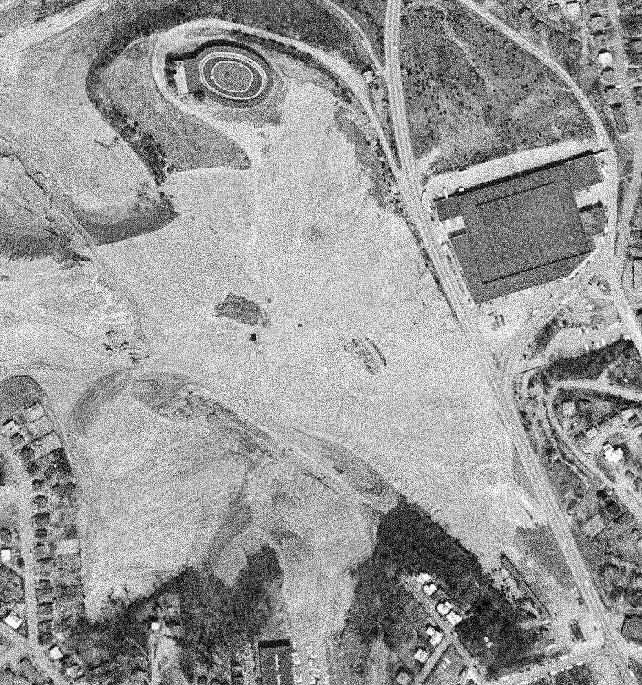
A 3/28/63 USGS aerial view showed the Lester Airport runway was no longer evident, with land being cleared for the construction of Commonwealth Boulevard.
The row of T-hangars remained along the south side.
A 1970 aerial view showed Commonwealth Boulevard had been built through the center of the Lester Airport site, but the T-hangars remained standing.
A 1982 aerial view showed the T-hangars had been removed, erasing the last trace of Lester Airport.
A 1994 aerial photo showed the racetrack on the north side of the Lester Airport site had been replaced by The Village of Martinsville shopping plaza.
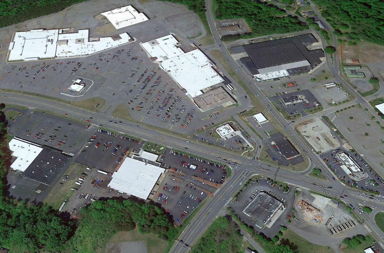
A 2021 aerial view looking north showed no trace remaining of Lester Airport.
Thanks to Bo Bowman for pointing out this airfield.
____________________________________________________
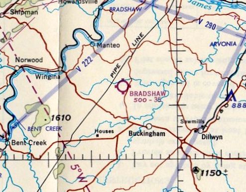
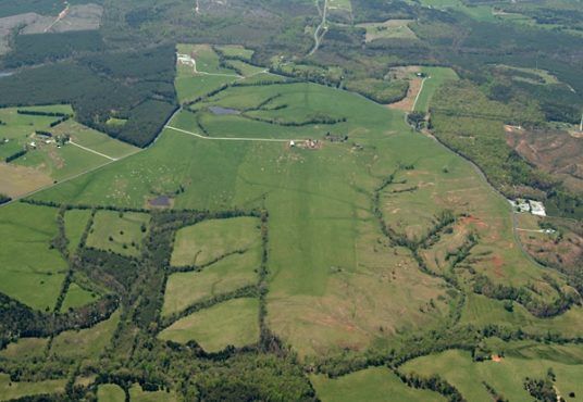
Bradshaw Airpark / Eastview Airport, Buckingham, VA
37.615, -78.604 (West of Richmond, VA)
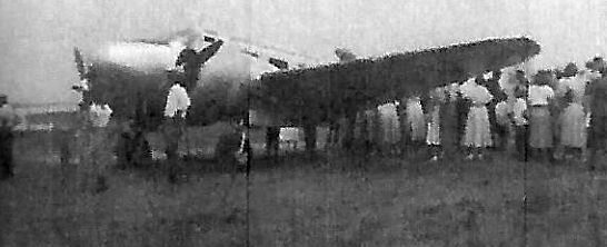
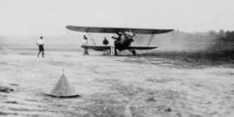
A circa 1940s photo of a Beech 18 at a Bradshaw Airpark airshow (courtesy of Jim Crews).
According to the Buckingham Historical Society, “Colonel Thomas Bondurant was a prominent legislator from Buckingham County
and was successful in business, owning between 20,000-30,000 acres of land.
Among the properties he owned were East View, which was given to his oldest son, Thomas Bondurant.
East View was occupied by a long list of owners until 1946 when W.C. Bradshaw purchased it.
Bradshaw Airport has been the scene of air shows, which gave entertainment to many.”
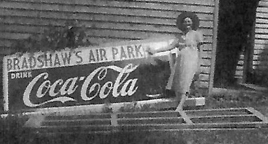
A circa 1940s photo of a woman in front of a Bradshaw's Air Park” sign (courtesy of Jim Crews).
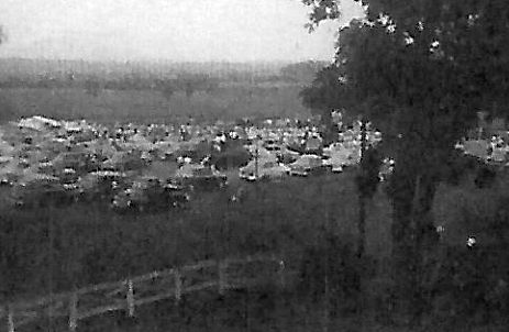
A circa 1940s photo of a spectators cars at a Bradshaw Airpark airshow (courtesy of Jim Crews).
The earliest aerial view which has been located of Bradshaw Airpark was a 1955 aerial photo.
It depicted a single unpaved northwest/southeast runway, with a single hangar on the southwest side.
There were no aircraft visible on the field.
Bradshaw Airpark was not yet depicted on the January 1956 Winston-Salem Sectional Chart.
The earliest aeronautical chart depiction which has been located of Bradshaw Airpark was on the July 1956 Winston-Salem Sectional Chart.
It depicted Bradshaw as having a 3,500' unpaved runway.
The earliest aerial view which is available of Bradshaw Airpark was a 3/8/59 USGS aerial photo.
It depicted a single unpaved northwest/southeast runway, with a single hangar on the southwest side.
There were no aircraft visible on the field.
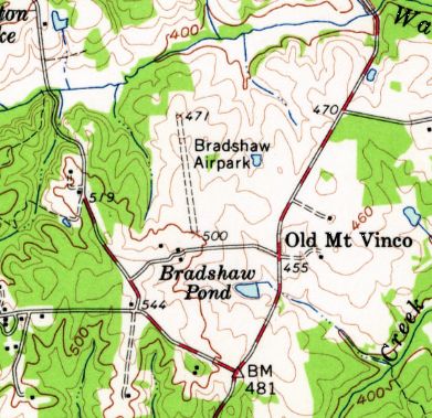
The earliest topo map depiction which has been located of Bradshaw Airpark was on the 1961 USGS topo map.
It depicted “Bradshaw Airpark” as having a single unpaved northwest/southeast runway.
According to the Buckingham Historical Society, “Bradshaw Airport was operated here until recently when it was purchased by James Jackson.”
The 1965 Winston-Salem Sectional Chart depicted Bradshaw as having a 3,500' unpaved runway.
Peter Vines reported, “In 1976 I tried skydiving at Bradshaw Airpark.”
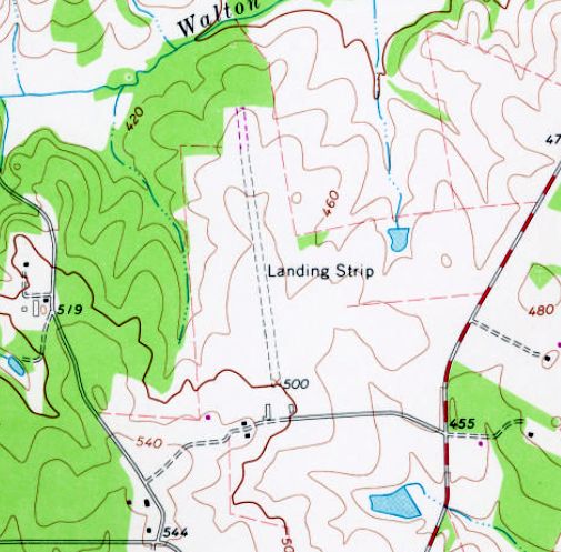
The 1981 USGS topo map depicted “Bradshaw as having a single unpaved northwest/southeast runway, generically labeled as “Landing Strip”.
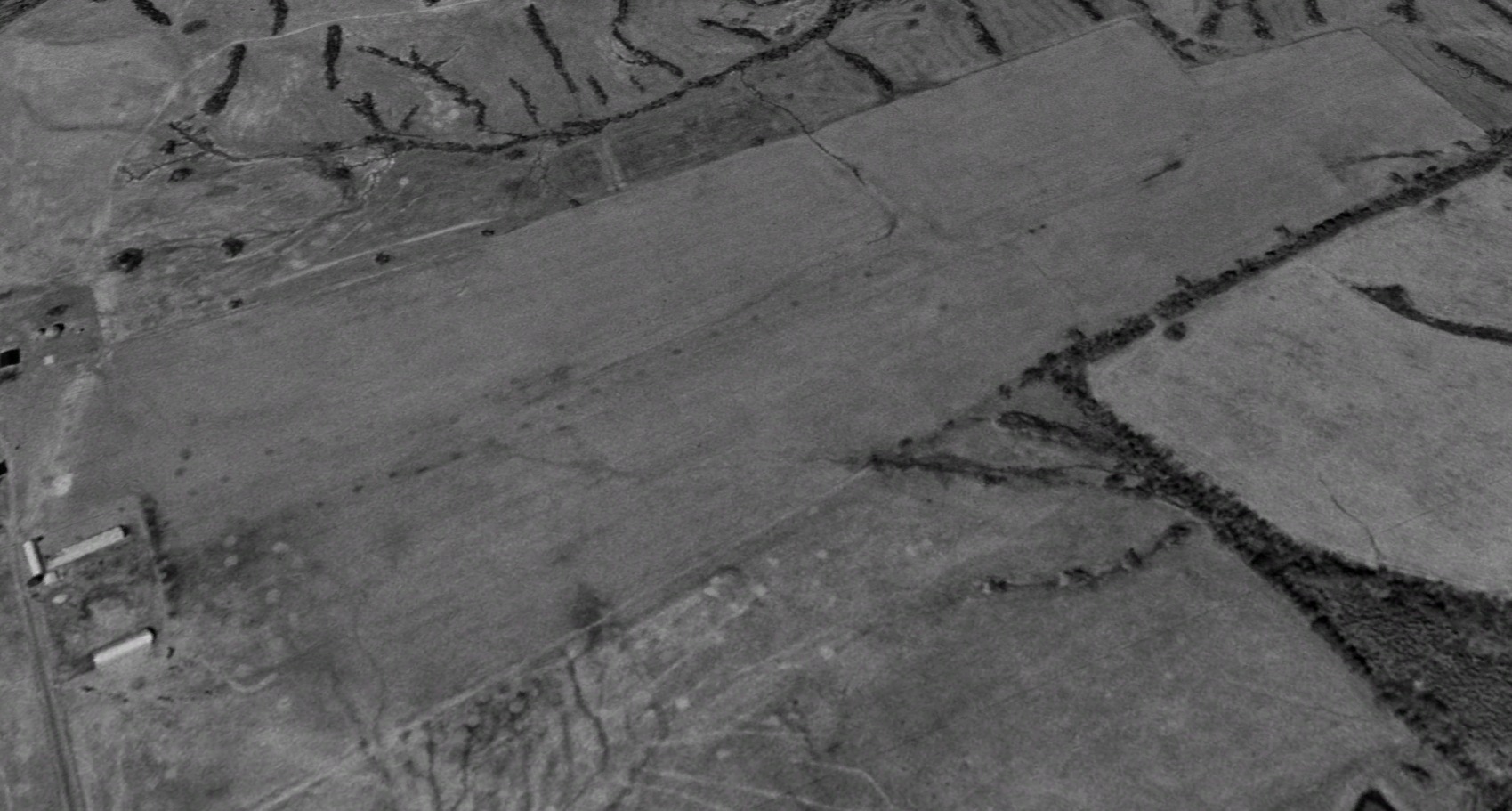
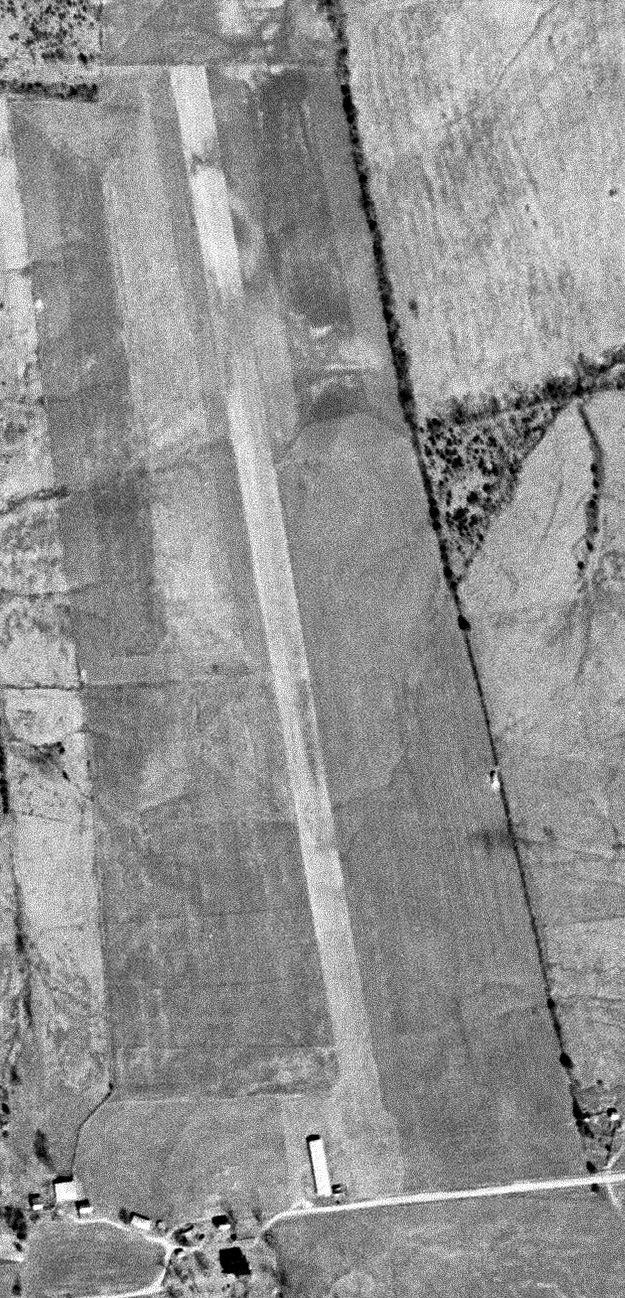
A 1996 aerial view looking northwest showed the Bradshaw Airfield remained clear, but with no sign of recent aviation use.
A 2004 aerial view looking south at Bradshaw Airpark (courtesy of Peter Vines).
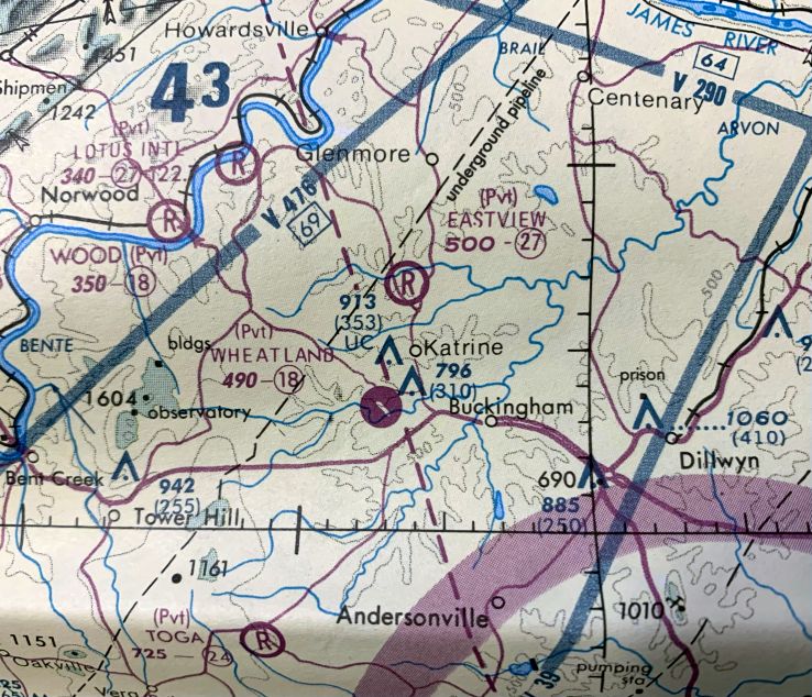
The last aeronautical chart depiction which has been located of Bradshaw Airpark was on the 2005 VA Aeronautical Chart (courtesy of Peter Vines).
It depicted “Eastview” as a private airfield having a 2,700' unpaved runway.
A 2008 aerial view showed the Eastview hangar remained standing.
A 2011 aerial view showed the Eastview hangar had been removed at some point between 2008-2011.
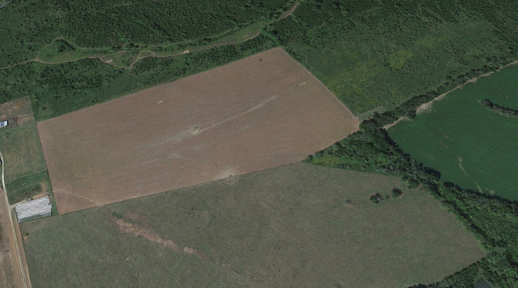
A 2022 aerial view looking northwest showed the Bradshaw Airfield site was unrecognizable as a former airfield, with the hangar having been removed, and the northern half of the airfield being overgrown.
As of 2023, Eastview Airfield was no longer depicted on aeronautical charts.
Thanks to Peter Vines for pointing out this airfield.
____________________________________________________
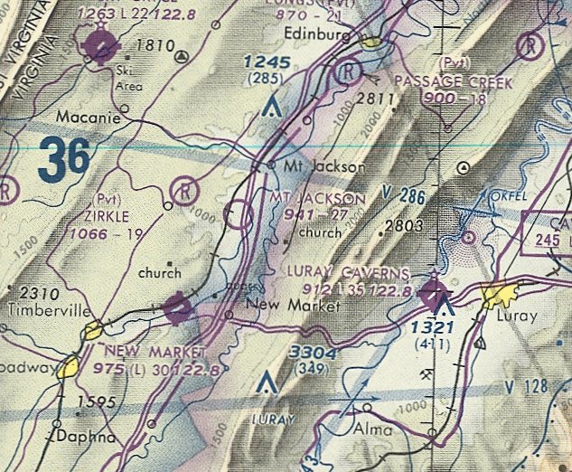
Mt. Jackson Airport, Mt. Jackson, VA
38.718, -78.663 (Southwest of Washington, DC)
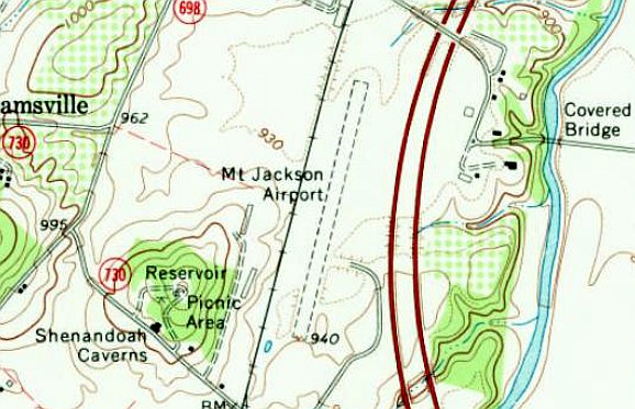
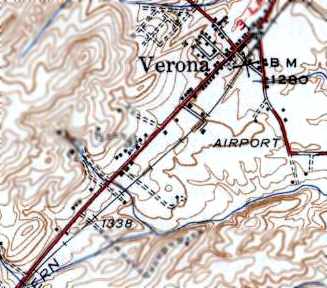
Mt. Jackson Airport, as depicted on the 1967 USGS topo map.
Mt. Jackson Airport was evidently established at some point between 1963-67,
as it was not yet depicted on the 1963 USGS topo map, a 1964 aerial photo, or the 1967 Huntington Sectional Chart.
The earliest depiction which has been located of Mt. Jackson Airport was on the 1967 USGS topo map.
It depicted a single unpaved northeast/southwest runway, between the railroad tracks & the new Interstate 81.
No buildings or other improvements were depicted.
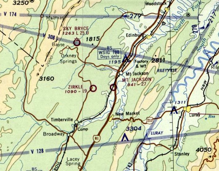
The earliest aeronautical chart depiction which has been located of Mt. Jackson Airport was on the August 1968 Huntington Sectional Chart.
It depicted Mt. Jackson Airport as having a 2,700' unpaved runway.
Jeffrey Uphoff recalled, “Mount Jackson used to have a small airport, grass rather than paved.
I grew up in Mount Jackson, and I mostly remember the airport being used for launching hot-air balloons.
I remember the windsock being visible from I-81.”
The last aeronautical chart depiction which has been located of Mt. Jackson Airport was on the March 1981 Washington Sectional Chart (courtesy of Ron Plante).
It depicted Mt. Jackson Airport as having a 2,700' unpaved runway.
The only photo which has been located of Mt. Jackson Airport was a 1984 aerial view.
It depicted a single grass northeast/southwest runway, with a small parking lot on the east side.
No buildings or planes were present.
Jeffrey Uphoff recalled, Mt. Jackson Airport “closed in the 1980s. The town ceded the land to a local printing company, which built a warehouse on it.
My mother was on the town council when they voted to close the airport & cede the land to the press company.
It wound up a complete boondoggle: the deal was they'd expand their printing operations there, creating lots of jobs,
but in the end they wound up not expanding their printing & just used the site for storage, employing a mere handful of people to tend to that. Harumph.”
Mt. Jackson Airport was no longer depicted on the 1989 Washington Sectional Chart (courtesy of Jonathan Westerling).
A 1997 aerial photo showed 2 industrial buildings had been built over Mt. Jackson Airport, with only faint traces of the middle portion of the runway remaining recognizable.
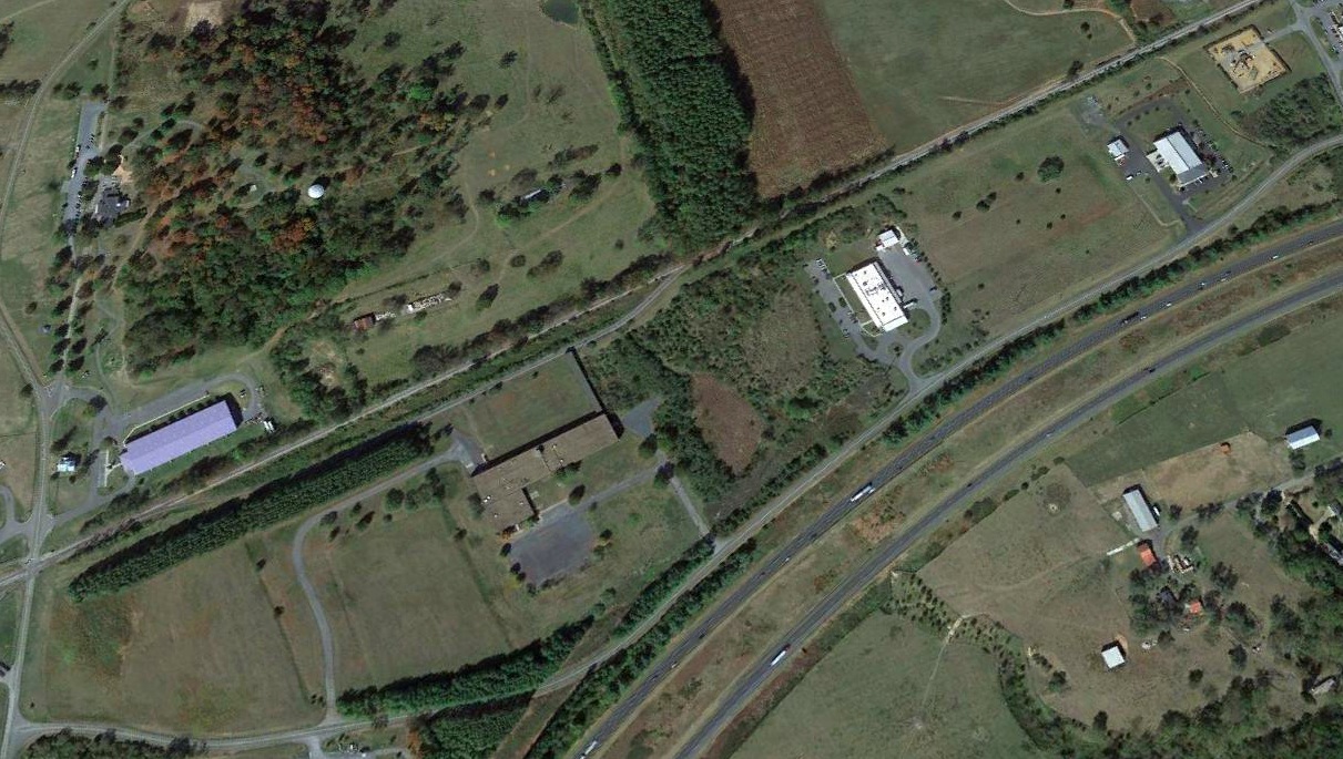
A 2019 aerial view looking northwest showed several buildings covering the site of Mt. Jackson Airport, but a faint trace remained of the runway alignment between 2 of the buildings.
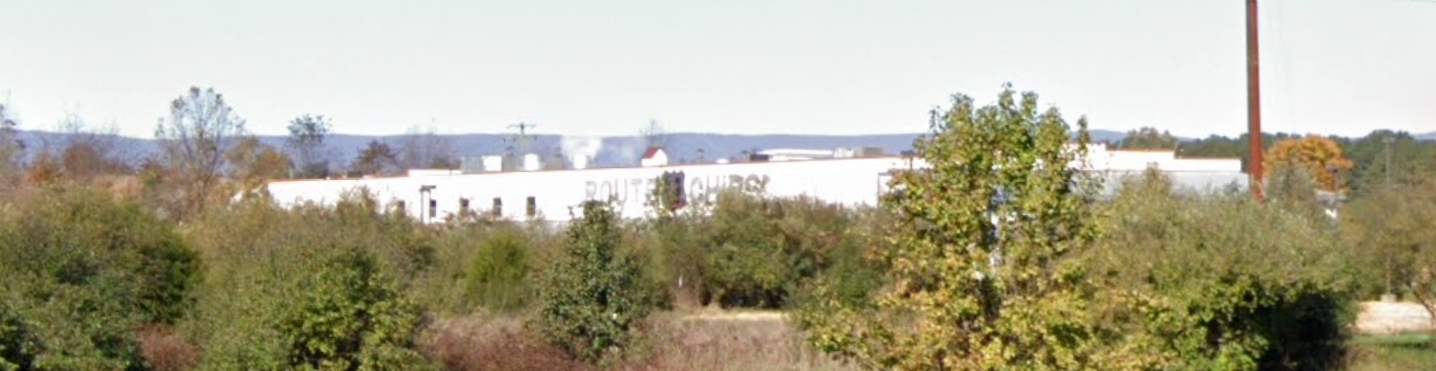
A November 2021 photo looking northwest at the Route 11 Potato Chips facility which occupies the site of Mt. Jackson Airport.
Thanks to Jeffrey Uphoff for pointing out this airfield.
____________________________________________________
Wood Field, Charlottesville, VA
38.1, -78.551 (Southwest of Washington, DC)
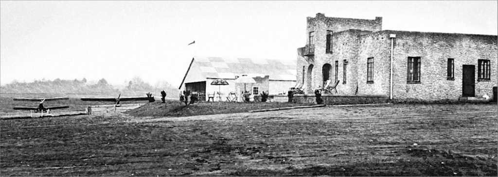
A circa 1929-33 photo of 2 aircraft, Wood Field's hangar, and Dixie Flying Service's Spanish-style clubhouse.
Charlottesville's first airport opened on this site in 1929, which turned out to be very bad timing: only 2 months before the big stock market crash.
According to Phil James' 4/7/17 Crozet Gazette article “Secrets of the Blue Ridge: Dixie Flying Service at Wood Field” (courtesy of Jim Burns),
“Workmen with the aid of tractors & 40 mules busily graded runways in preparation for central Virginia’s first commercial airfield.
Edward Sturhahn, president of newly minted Dixie Flying Service Inc., secured a deed in May 1929
for the 145-acre tract from Hugh Garth who had taken possession of the property less than 3 years earlier.
Sturhahn & his peers had come of age during an era of rapid industrial advancements.
Rail service that radically altered lifestyles in the 19th century was, by the 1920s, shedding business to private trucks & automobiles.
The early 20th century saw important advancements with experimental aircraft being tested by dreamers & bicycle mechanics.”
The article continued, “In June 1929, Dixie Flying signed a contract for the construction of a 60×60’ steel hangar.
Local contractors Failes & Burrage built a Spanish-style clubhouse.
That centerpiece of the airfield included a large main floor meeting room for flight classes & social functions, a private dining room and kitchen, chart room, and restrooms.
The basement contained dressing rooms & showers. A rooftop observation tower allowed an unobstructed view of the field’s 3 landing strips.
Boxwoods adorned the grounds surrounding the clubhouse.
Dixie Flying’s Vice President Captain Malcolm Robinson piloted the service’s first official passenger, Columbus Wells, on a nonstop hop to New York City on August 21.
Within weeks, a decision was made to name the airport Wood Field in honor of WWI aviator Buck Wood.”
The article continued, “At the close of 1929, Dixie Flying Service at Wood Field was numbered among Virginia’s 31 airports.
Each of its 3 landing strips was in service; the clubhouse had an able manager; and its active Aviation Club had 50 members.
The airport officially was christened Wood Field on Memorial Day 1930. American Legion Charlottesville-Albemarle Post 74 organized the event.
Dignitaries participated alongside the Monticello Guard & VFW.
Charlottesville’s Municipal Band performed, and a bronze tablet memorializing 1st Lt. R.H. 'Buck' Wood Jr. was unveiled at the airport’s entrance by his sister, Mrs. Isabelle Wood Holt.
General William 'Billy' Mitchell, who had been in charge of the American Expeditionary Forces during WWI, delivered the keynote address.”
Mitchell noted, “When ‘Young Wood’ entered the service, there were hardly 50 American aviators. He was therefore one of the forerunners of a new force.”
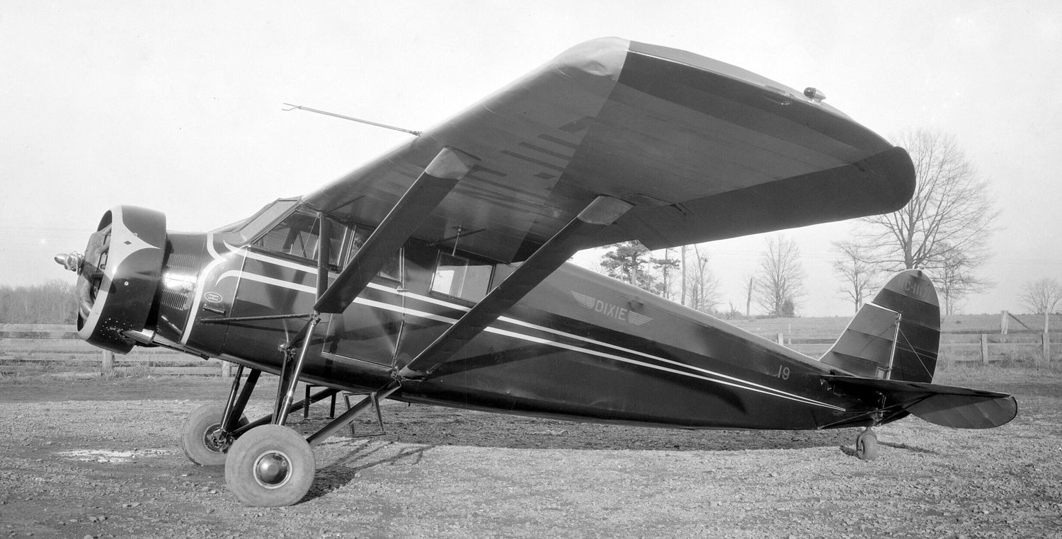
A circa 1930-31 photo of Dixie Flying Service Stinson SM-8A C/n 4305 NC11171 at Wood Field.
The article continued, “During the Great Depression, Dixie Flying Service Inc. inaugurated regularly scheduled air service up & down the east coast.
They also acquired Byrd Field at Richmond & the municipal airport at Danville.
Two devastating storms struck Wood Field a month apart in 1931.
Fierce winds tore planes from their moorings, tossing them like toys across the field & onto the highway, while lightning struck another.
Two burst into flames that reduced them to tangled ruins. Hailstones riddled fabric-covered wings & perforated metal fuselages.
During the first storm, the hangar was unroofed & damaged beyond repair.
The next storm damaged more planes plus the replacement hangar that was still under construction.
Losses not covered by insurance added to the burden of the economic times.”
The 1931 USGS topo map depicted several buildings at the site of Wood Field, but did not depict or label the airfield.
According to Phil James' 4/7/17 Crozet Gazette article “Secrets of the Blue Ridge: Dixie Flying Service at Wood Field” (courtesy of Jim Burns),
“The Cavalier Daily noted in November 1932 a new plane purchased by the Flying Club.
The club’s optimistic yet dwindling membership reflected realities of that day.
In March 1933, Dixie Flying Service was dissolved by its stockholders. Its landing strips were left available for emergency landings, sans liability.
Only an occasional air show during the ensuing years, along with the empty replacement hangar, reminded passersby of the lofty dreams, and dreamers, that had taken flight at that special place.”
Wood Field was no longer depicted on the February 1934 Winston-Salem Sectional Chart, which instead depicted the racetrack on the property.
According to a Charlottesville City Council Report (courtesy of Jim Burns), portions of the Wood Field original hangar were relocated to a building at 1001 West Main Street.
The report stated, “A Mr. Rothwell acquired the property about 1936 & added the west end, into which he incorporated roof trusses & windows from a hanger at the defunct Foxfields Airport.”
A 1963 aerial photo depicted a single unpaved northwest/southeast runway, along with the hangar on the north side.
There was no sign of the Spanish-style clubhouse which had been next to the hangar.
The Wood Field property had belonged to the Vandevender family for generations.
After Grover Vandevender died, the property was bougth by Mariann de Tejeda, who built a horse racetrack on the property, named Foxfield.
In 1978, Foxfield's inaugural race was run, and the property continues to host horse racing.
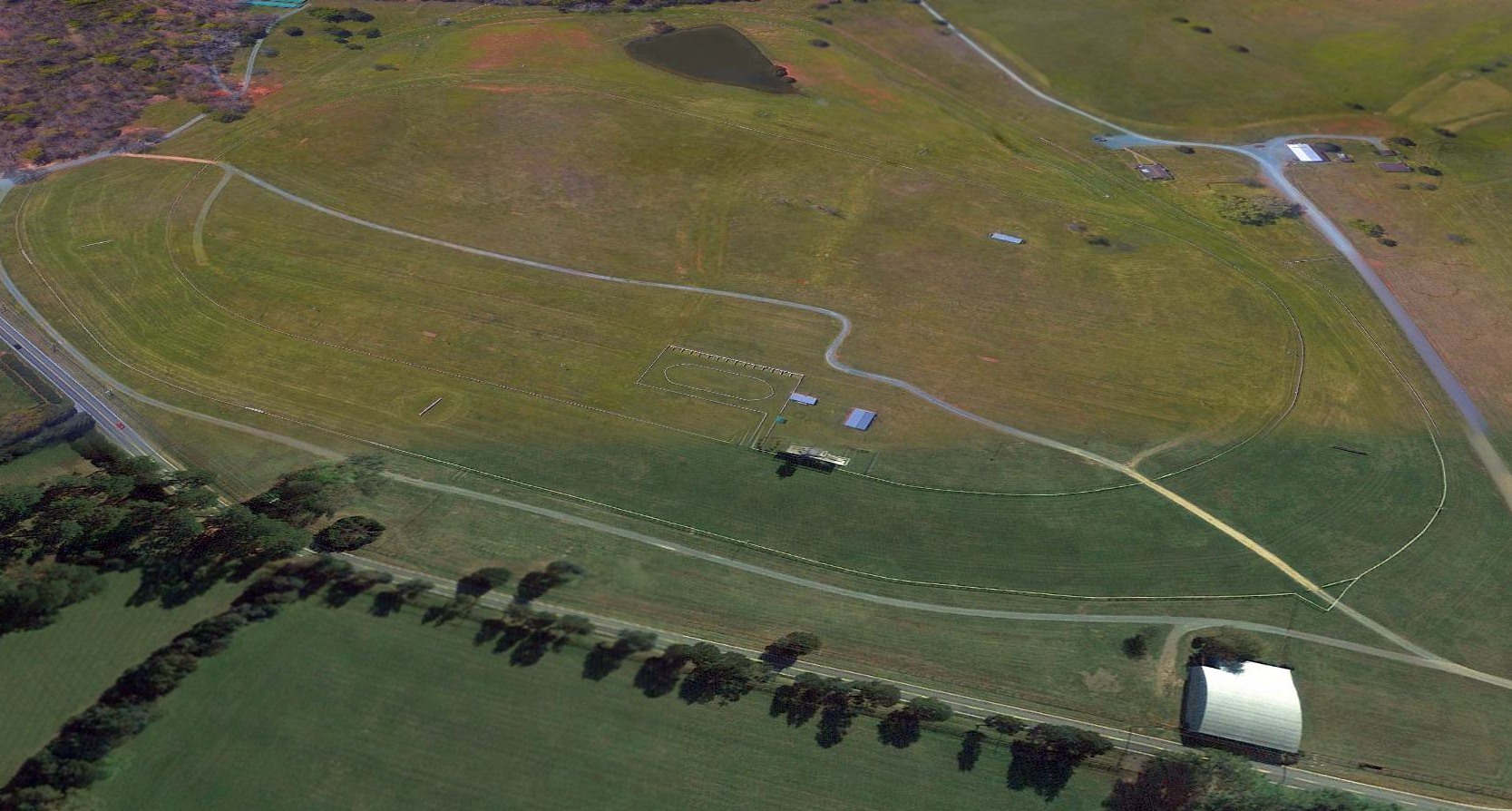
A 2016 aerial view looking south at the site of Wood Field.
No trace remained of the runway, having been covered by a horse racetrack, but the 1931 hangar remained on the northwest side (bottom-right).
A 7/3/18 photo by Jim Burns looking northwest at the 1931 hangar which remains on the northwest side of Wood Field.
Jim reported, “I could almost hear those old engines sputtering.”

A 7/3/18 closeup by Jim Burns of the doors of the 1931 hangar which remains on the northwest side of Wood Field.
A 7/5/18 photo by Jim Burns of the Wood Field original hangar which had been relocated in circa 1936 to 1001 West Main Street Charlottesville.
A 7/5/18 photo by Jim Burns of the interior of the Wood Field original hangar which had been relocated in circa 1936 to 1001 West Main Street Charlottesville.
The site of Wood Field is located south of the intersection of Garth Road & Foxfield Track Lane.
____________________________________________________
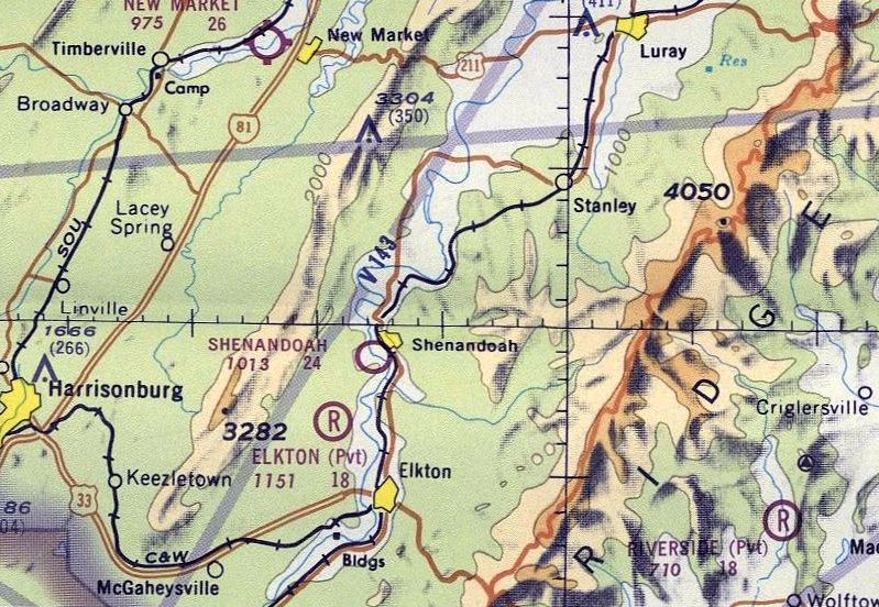
Shenandoah Airport, Shenandoah, VA
38.474, -78.627 (Southwest of Washington, DC)
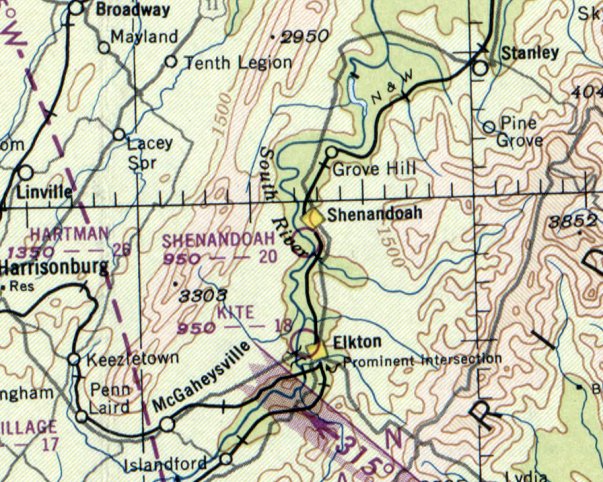
Shenandoah Airport, as depicted on the June 1950 Huntington Sectional Chart.
Photo of the airport while in use has not been located.
This general aviation airport to the southwest of the town of Shenandoah was evidently established at some point after 1946,
as it was not yet depicted on the October 1946 Huntington Sectional Chart.
The earliest reference to Shenandoah Airport which has been located came from Charles Jenkins: “It was there in the 1940s.
Dad said an Army Air Corps plane landed there with engine trouble. Dad said he caught rides there as a kid in the 1940s.”
However, Shenandoah Airport was not yet depicted on the 1949 USGS topo map.
The earliest depiction which has been located of Shenandoah Airport was on the June 1950 Huntington Sectional Chart,
which depicted Shenandoah Airport as having a mere 2,000' unpaved runway.
According to Bill Fravel, “Shenandoah: I flew with my father (William E. Fravel) on this sod strip, first in a Cub & then a Luscombe.
My first flight was around 1951. The owner of the land had a Cessna.
I grew up at 723 9th Street & my father claimed he built our house so he could see planes using the field.
The field ran uphill from near the Shenandoah River with a tall stand of trees & had a small shack (where I read flying magazines),
a hangar for the Cessna & a sheetmetal windsock near midfield.
I heard a story that a Civil Air Patrol twin-engine plane once landed & ran out of strip & ended up in the swamp just shy of the road & a house across the street at the south end.
The State of Virginia filled in the swamp to extend the strip.
I have heard it called the strip at Rinacas Corner.
It was a farm belonging to the owner of the Cessna & he just made his own strip;
there was usually corn on both sides & he still had a road that crossed the strip, which mad for interesting landing in the tail-draggers.
If you still had a bit too much speed, it would put you airborne - get to log 2 landings!”
According to Debbie Burton, "Jennings Meadows owned the hangar where the plane was kept
and the little office was on property owned by my granddad Charlie Morrison.
He & Grandpa Meadows we called him owned the plane together - it would seat 2 adults & a child in back
and Everett Taylor owned the land where the landing strip was.”
According to Bill Fravel, Shenandoah Airport “was there when I graduated from Shenandoah High School in 1961 & I believe still there in 1966.”
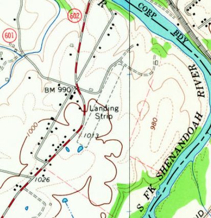
The 1965 USGS topo map depicted Shenandoah Airport as an unpaved northeast/southwest runway, labeled simply as “Landing Strip”.
There were no buildings depicted on the airport.
The last aeronautical chart depiction which has been located of Shenandoah Airport was on the 1971 Washington Sectional Chart.
It depicted Shenandoah Airport as having a 2,400' unpaved runway.
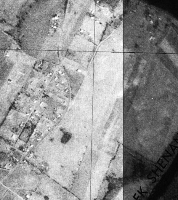
The earliest photo which has been located of Shenandoah Airport was a 1977 USGS aerial view.
Although the runway remained clear, there was no indication of any recent aviation usage.
The 1978 USGS topo map depicted Shenandoah Airport in the same fashion as the 1965 topo map.
According to Bill Fravel, “I believe the original owner sold the farm & the strip was just plowed back under.”
Shenandoah Airport was evidently closed by 1978, as it was no longer depicted on the March 1978 Washington Sectional Chart (courtesy of Ron Plante)
or the 1987 USGS topo map.
Bill Fravel recalled a 2011 visit, “I drove there & saw no trace [of Shenandoah Airport]. Where the hangar once stood is a farm animal feed lot.”
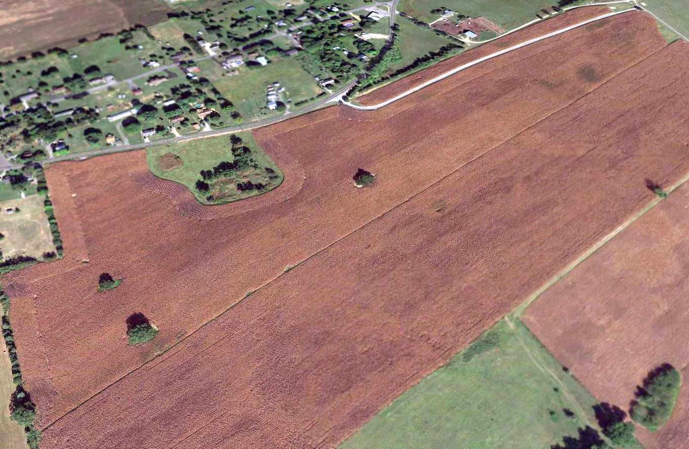
Amazingly a 2015 aerial view looking northwest still showed a recognizable outline of the Shenandoah Airport runway decades after it was abandoned.
The site of Shenandoah Airport is located southeast of the intersection of Route 602 & Route 947.
Thanks to Bill Fravel for pointing out this airfield.
____________________________________________________
Burke Field / Hartman Field / Harrisonburg Airport / Shenandoah Airways Airfield /
Blue Ridge Air Lines Airfield, Harrisonburg, VA
38.453, -78.878 (Southwest of Richmond, VA)
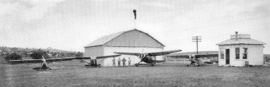
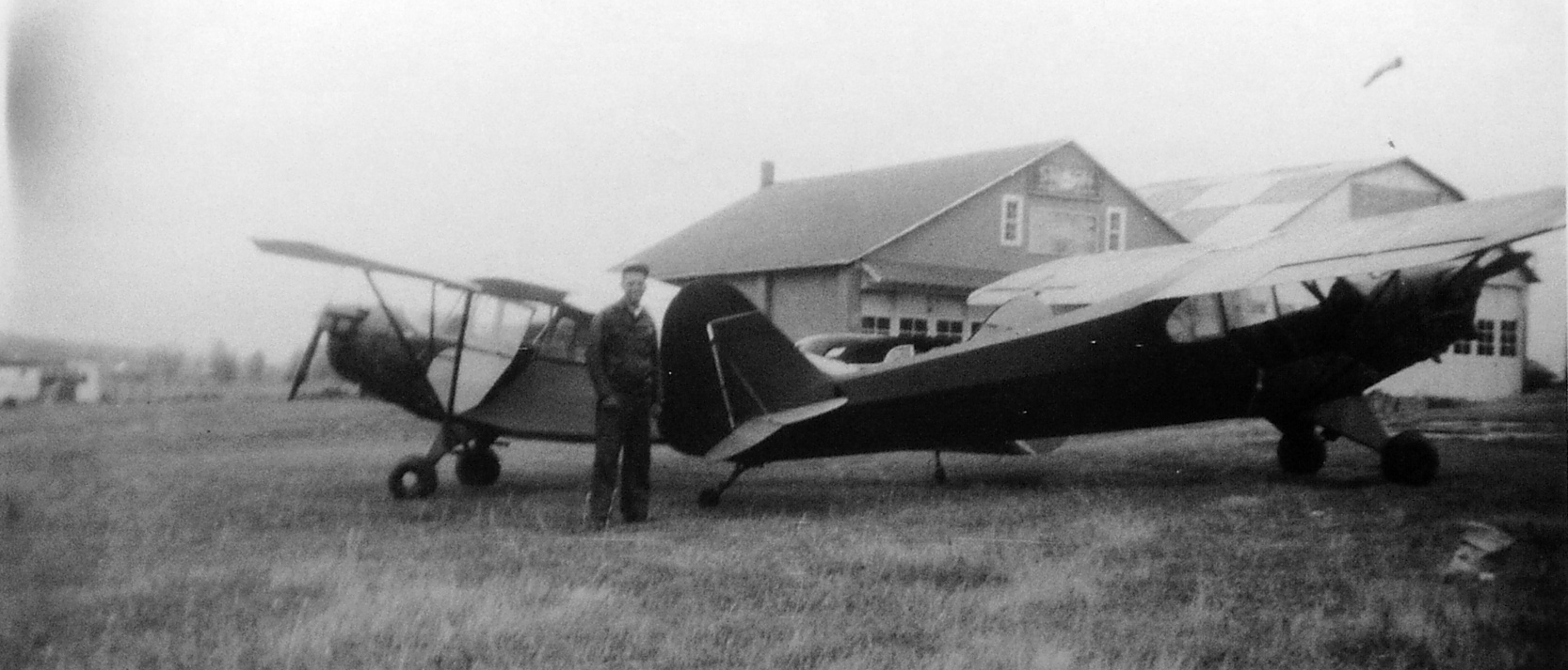
A circa 1941 photo of 4 planes in front of a hangar & office of Hartman Field.
According to the book “Hartman Airfield” by Randall Jones,
“In 1939 [Dan] Hartman leased a 44 acre family farm to establish an airport.
It was located northwest of Harrisonburg, just outside the city limits, situated between the town & the Mennonite community of Park View.
The land offered 360 degrees of good visibility. He initially called it Burke Field, honoring the family from whom he leased the land,
although it was licensed as Hartman Field in November 1939.”
According to the book "Virginia Airports" by Vera Rollo & Norman Crabill (published by the VAHS), “Hartman Field: The property was owned by John Burke.
Application for license made 10/23/39 by Dan Hartman & Joseph Koch.
License granted with restrictions 11/24/39. This was a private-commercial, sod field with a 2,600' runway.
Operations began in December 1939. Operator/manager was John Dean.
Hartman operated Laird, Fleet, Standard, Pitcairn, Stinson, and Piper aircraft.”
Hartman Field was not yet depicted on the 1940 or 1941 Huntington Sectional Charts.
A closeup from the circa 1941 photo showing a Piper Cub at Hartman Field, with Eastern Mennonite College in the background.
Hartman Field was not depicted at all on the 1941 or 1943 USGS topo maps.
The earliest aeronautical chart depiction which has been located of Hartman Field was on the June 1942 Huntington Sectional Chart,
which depicted Hartman as a commercial/municipal airport.
A circa 1942-45 aerial view looking north at Hartman Field (labeled “Landing Strip”) from the 1945 AAF Airfield Directory (courtesy of Scott Murdock).
The directory described Hartman Field as a 46 acre irregularly-shaped property having a 2,200' stone & sod northeast/southwest runway.
Hartman was said to have 3 concrete block hangars, the largest measuring 60' x 46'. The field was said to be owned & operated by private interests.
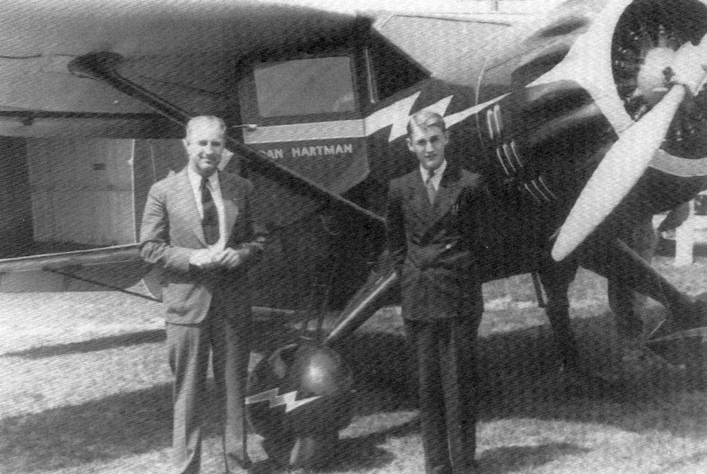
A circa 1946 photo of Dan Hartman & son in front of a Stinson (?) at Hartman Field.
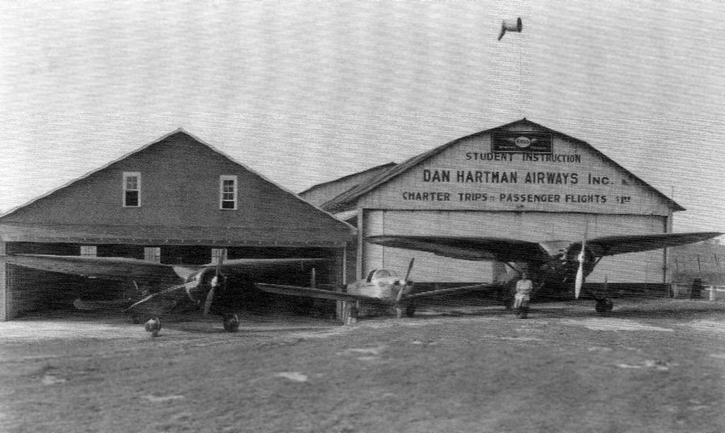
A circa 1946 photo of a total of 6 planes in front of the hangars at Hartman Field.
According to Micheal McMurtrey, “The Cessna Bobcat may be s/n 5332, NC53799, purchased by Dan Hartman Airways Inc. in April 1946.”
A circa 1946 photo Ottie Showalter (the Hartman Field office manager) sitting on the wheel of a Stinson Reliant, along with another Stinson & an Ercoupe, at Hartman Field.
Ned Swartz recalled, “Hartman Field: I remember my grandfather taking me to see airplanes at this site when I was about 2 or 3 –
one of the few memories I have at that age (about 60 years ago)!”
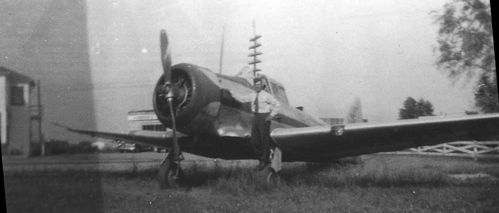
A circa 1949 photo of Alfred Bassler on a North American T-6 Texan at Hartman Field (courtesy of Jeffrey Bassler).
The photo was captioned, “Stanley Kline's T-6 (600 HP) at Harrisonburg Airport.
I went for a ride & we did a slow roll. Bob Bassler & other people from the Luther League were there.”
Perhaps the most exciting event at Hartman Field was an episode in the late 1940s or early 1950s, as described in the book “Hartman Airfield” by Randall Jones.
A Marine Corps F4U Corsair fighter made an emergency landing at Hartman
after another Corsair from its flight crashed elsewhere in Harrisonburg during stormy weather.
The next day a big Marine C-47 transport landed at Hartman bringing military accident investigators,
certainly the biggest plane to ever land at the tiny airport.
Jim Bentch recalled, “Dan Hartman’s Airport: It was still in operation in the early 1950s while I was still a child.”
A 1952 photo of Alfred Bassler & his Piper J4 Cub & Henry Wedland's J3 Cub at Hartman Field (courtesy of Jeffrey Bassler).
The last aeronautical chart depiction which has been located of Hartman Field was on the 1953 Huntington Sectional Chart,
which depicted Hartman as having a 2,600' unpaved runway.
According to the book “Hartman Airfield” by Randall Jones, Hartman Field closed in 1953.
Hartman Field was no longer depicted on the February 1954 Huntington Sectional Chart,
Hartman Field was eventually replaced by the much larger Shenandoah Valley Regional Airport, which opened in 1957.
A 1957 aerial photo showed that houses had covered much of the site of Hartman Field.
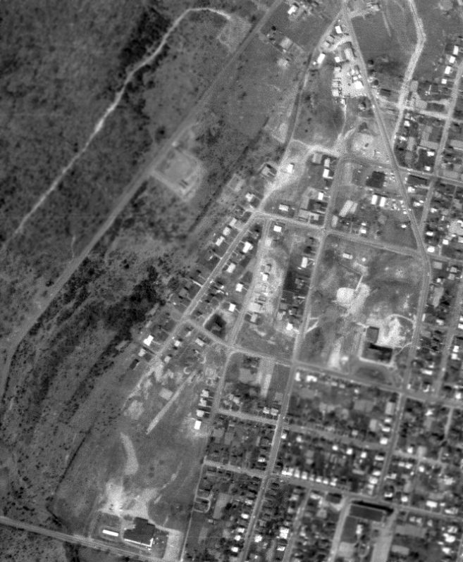
A 4/6/63 USGS aerial photo showed that houses had covered much of the site of Hartman Field,
but a small portion of the runway remained in the center of the photo.
According to the book “Hartman Airfield” by Randall Jones, the subdivision covering most of Hartman Field was built in the 1960s & 1970s,
with Hartman Drive having been built directly over the runway.
The larger of the 2 hangars burned down in 1996.
As of 2006, the smaller hangar remained standing, along with the airport office, which was expanded over the years & was reused as a consignment shop.
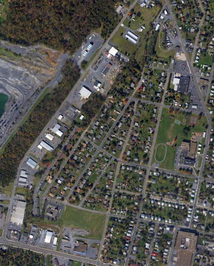
A 4/10/12 aerial photo showed no trace remaining of Hartman Field.
The site of Hartman Field is located at the intersection of Wolfe Street & Hartman Drive, appropriately enough.
See also: “Hartman Airfield” by Randall Jones.
____________________________________________________
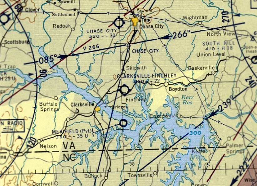
Clarksville-Finchley Airport, Clarksville, VA
36.656, -78.493 (Southwest of Richmond, VA)
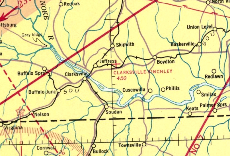
Clarksville-Finchley Airport, as depicted on the January 1941 Winston-Salem Sectional Chart.
Clarksville-Finchley Airport was evidently established at some point between 1938-41,
as it was not listed among active airfields in The Airport Directory Company's 1937 Airport Directory (courtesy of Bob Rambo) nor depicted on the December 1938 Winston-Salem Sectional Chart.
The earliest depiction which has been located of Clarksville-Finchley Airport was on the January 1941 Winston-Salem Sectional Chart,
which depicted Clarksville-Finchley as an auxiliary airfield.
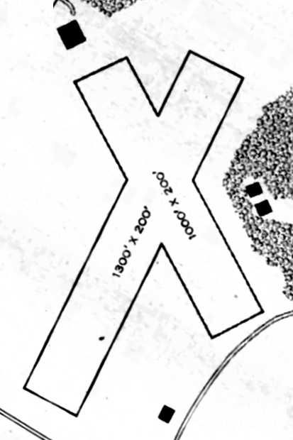
The 1945 AAF Airfield Directory (courtesy of Scott Murdock)
described Clarksville-Finchley Airport as a 35 acre irregularly-shaped property having 2 sod runways,
measuring 1,300' northeast/southwest & 1,000' northwest/southeast
The field was said to have a single 58' x 40' wood hangar, and to be owned by private interests, but “Not in operation” (presumably due to wartime restrictions).
According to the book "Virginia Airports" by Vera Rollo & Norman Crabill (published by the VAHS), “Clarksville-Finchley Airport... was a turf field, a private-commercial operation.”
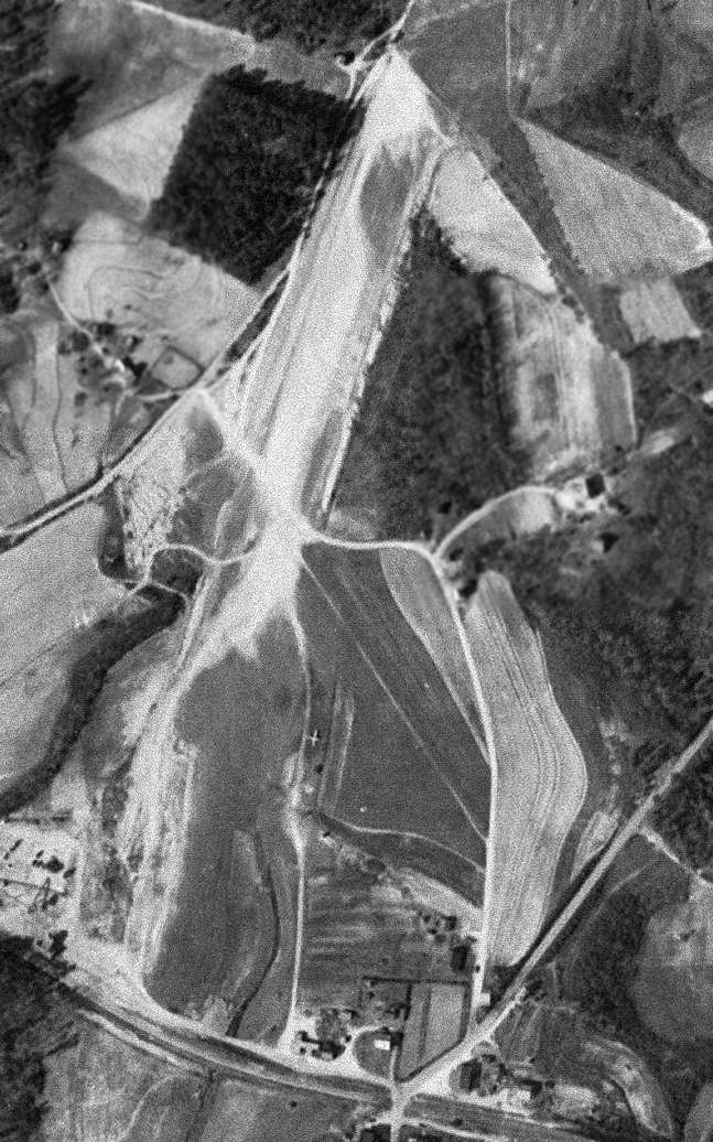
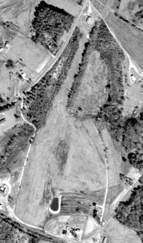
The only photo which has been located showing Clarksville-Finchley Airport in operation was a 3/17/54 USGS aerial view.
It depicted Clarksville-Finchley as having 2 unpaved runways, with one single-engine aircraft visible in the middle of the field.
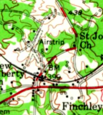
The 1955 USGS topo map depicted Clarksville-Finchley as having 2 unpaved runways, labeled simply as “Airstrip”.
The last aeronautical chart depiction which has been located of Clarksville-Finchley Airport was on the April 1961 Winston-Salem Sectional Chart.
It depicted Clarksville-Finchley as having a 2,200' runway.
Clarksville-Finchley Airport was evidently closed at some point between 1961-65,
as it was no longer depicted on the April 1965 Winston-Salem Sectional Chart.
It was presumably replaced by the larger Marks Municipal Airport, which opened in 1961 a few miles to the southwest.
The 1968 USGS topo map depicted the “Airstrip” in an unchanged fashion.
Clarksville-Finchley Airport was no longer depicted on the 1972 USGS topo map.
The 3/11/94 USGS aerial photo showed the 2 runways of Clarksville-Finchley Airport remained clear.
A building at the north end may have dated from the site's airport days.
A 2003 aerial photo showed the site of the runways remained clear.
A 2007 aerial photo showed crops had been planted on the location of the runways.
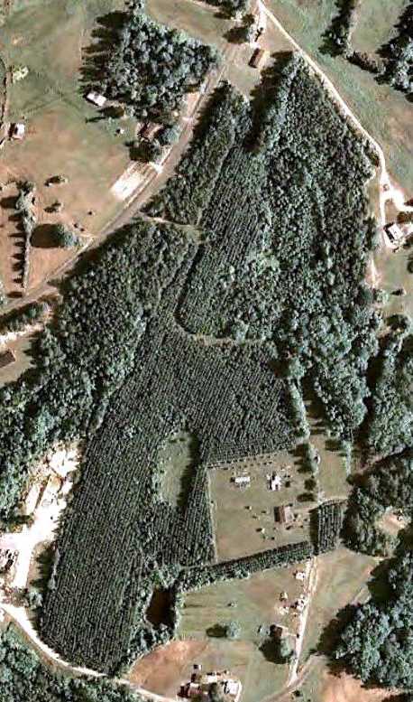
A 6/20/11 aerial photo showed crops covering the location of the Clarksville-Finchley runways.
The site of Clarksville-Finchley Airport is located northwest of the intersection of Routes 58 & 703.
____________________________________________________
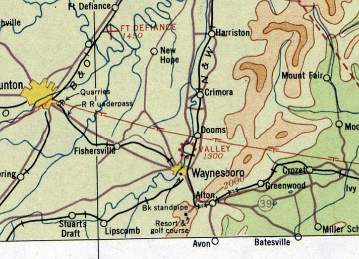
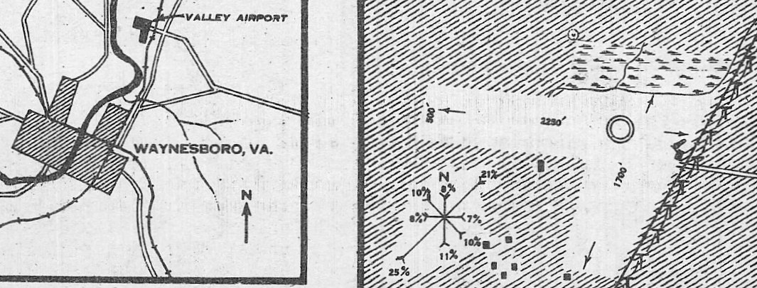
Valley Airport (original location), Waynesboro, VA
38.095, -78.87 West (Northwest of Richmond, VA)
A circa 1931 photo of C. C. "Rip" Loth's 2-seat biplane at Waynesboro.
The date of establishment of the Valley Airport has not been determined.
The earliest reference which has been located to Valley Airport
comes from Clover Archer, curator of the Waynesboro Heritage Foundation,
who reported: “We have 2 artifacts relating to Valley Airport.
They are trophies that were awarded to Valley Airport at an Air Derby on 10/12/28.
One of them says: 'Air Derby, Thompson Field, Oct 12-1928, Speed Race. Won By Valley Airport.'”
The earliest photo which has been located of Valley Airport
was a circa 1931 photo of C. C. "Rip" Loth's 2-seat biplane at Waynesboro.
The earliest airport directory listing which has been located of the Valley Airport
was in The Airport Directory Company's 1933 Airport Directory (according to Chris Kennedy).
It described Valley Airport as being located 1.75 miles northwest of the town of Waynesboro
(which may have described an earlier location, or it may have been in error).
The earliest aeronautical chart depiction which has been located of the Valley Airport was on the February 1934 Huntington Sectional Chart.
It depicted Valley as a commercial/municipal airport.
The 1935 Air Pilots Register (courtesy of Paul McMillan) described Valley Airport as having 2 sod runways, measuring 2,250' northwest/southeast & 1,700' northeast/southwest.
which depicted Valley Airport as having 2 grass runways.
No hangars were depicted on the field.
The Airport Directory Company's 1937 Airport Directory (courtesy of Bob Rambo)
described Valley Airport as being located 1.75 miles northeast of the town of Waynesboro
(which agrees with later chart depictions of the field's location).
It described Valley as a commercial airport, consisting of a 50-acre sod field.
The field was said to have 2 runways in an “L” shape: 2,250' northwest/southeast & 2,000 northeast/southwest.
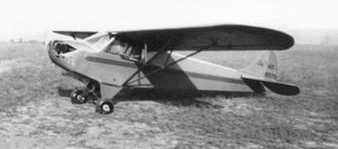
A 1937 photo of a Piper Cub at Valley Airport.
A 1937 photo of a Kinner Bird biplane at Valley Airport.
The 1939 USGS topo map depicted Valley as an irregularly-shaped outline, labeled “Landing Field”.
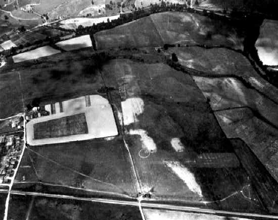
An undated aerial view looking north depicted Valley Airport as having 2 unpaved runways, with 11 light aircraft parked around a hangar on the east side.
No hangars were depicted on the field.
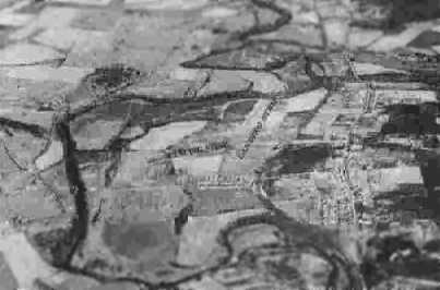
The last photo which has been located of the Valley Airport was a circa 1942-45 aerial view looking north
from the 1945 AAF Airfield Directory (courtesy of Scott Murdock).
The directory described Valley Airport as a 110 acre irregularly-shaped property
within which were 2 sod runways, measuring 2,600' NNW/SSE & 2,400' ENE/WSW.
The field was said to have 3 hangars, with the largest being a 94' x 60' cement block structure.
The airport was said to be privately owned & operated.
The November 1945 Huntington Sectional Chart (courtesy of Chris Kennedy)
depicted Valley as a commercial/municipal airport.
The last depiction which has been located of the original Valley Airport was on the 1953 Huntington Sectional Chart,
which depicted Valley as having a 2,900' unpaved runway.
The original location of Valley Airport was evidently closed at some point in 1953,
as Clover Archer (curator of the Waynesboro Heritage Foundation) reported,
“GE bought the property & built their plant there in 1953.”
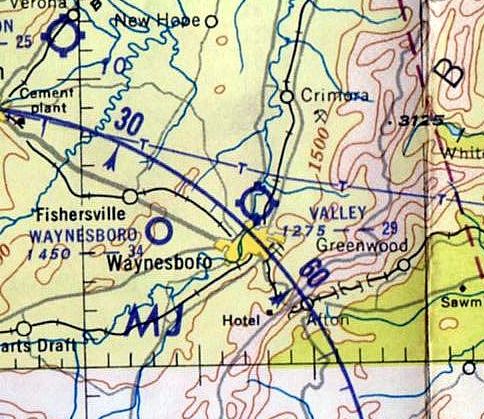
A replacement Valley Airport was eventually opened at another location to the west of Waynesboro,
as the new field was depicted on the July 1954 Huntington Sectional Chart (courtesy of Chris Kennedy),
but the original airfield (to the northeast of the town) was no longer depicted.
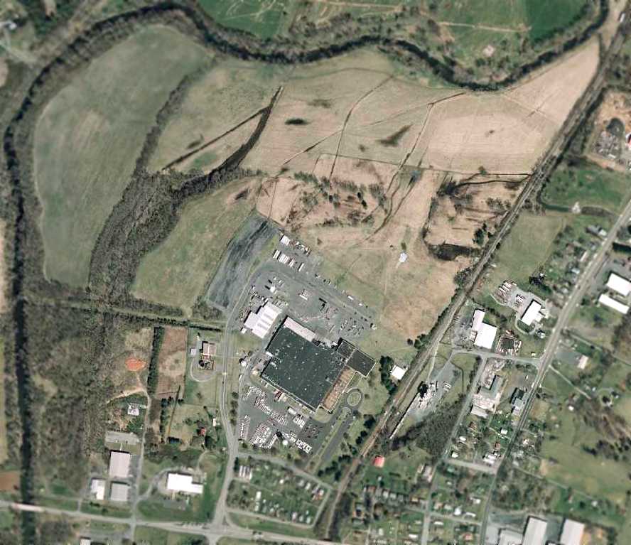
As seen in a 2/1/07 aerial photo, the site of Valley Airport has been covered by a large industrial building (the GE plant),
and it does not appear as if any trace remains of the former airport.
The site of the original Valley Airport is located northwest of the intersection of Route 340 & Hopeman Parkway.
____________________________________________________
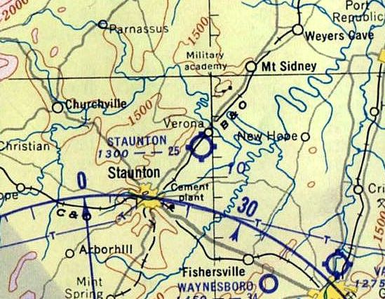
Staunton Airport, Staunton, VA
38.195, -79.01 West (Northwest of Richmond, VA)
Staunton Airport, as depicted on the November 1934 Huntington Sectional Chart.
Staunton Airport was evidently established at some point in 1934,
as it was not yet depicted on the February 1934 Huntington Sectional Chart.
The earliest depiction which has been located of Staunton Airport was on the November 1934 Huntington Sectional Chart.
The Airport Directory Company's 1937 Airport Directory (courtesy of Bob Rambo)
described Staunton Airport as an auxiliary airfield located 5 miles north of the town of Staunton, consisting of an 117 acre field.
The field was said to have 2 runways in a “V” shape, oriented east/west & north/south, with the longest being 2,630'.
The earliest photo which has been located of the Staunton Airport was an 8/23/39 aerial view.
It depicted Staunton as having 2 unpaved runways.
The last photo which has been located showing the Staunton Airport while it was operational was a circa 1942-45 aerial view looking northeast
from the 1945 AAF Airfield Directory (courtesy of Scott Murdock).
The directory described Staunton Airport as a 118 acre triangular property
within which were 2 sod runways, measuring 2,630' NNE/SSW & 2,100' east/west.
The field was said to have a single 80' x 68' metal hangar, and to owned by the City of Staunton & operated by private interests.
The November 1945 Huntington Sectional Chart (courtesy of Chris Kennedy) depicted Staunton as a commercial/municipal airport.
The last depiction which has been located of the Staunton Airport was on the 1947 USGS topo map.
It labeled the site simply as “Airport”, and did not depict any runways or property outline,
just an open area with a few small buildings along the edges.
The Staunton Airport was evidently closed at some point between 1945-51,
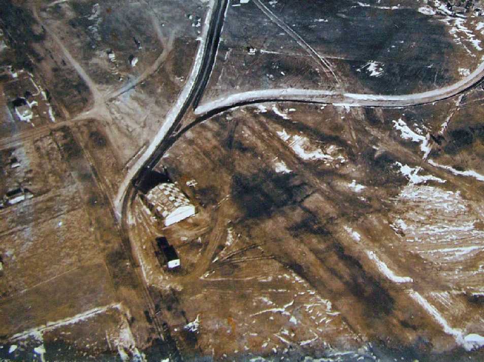
as a 1951 aerial view looking northeast (courtesy of Willard Keeling) showed the the abandoned hangar of the former Staunton Airport
(marked with “Staunton” on the roof), with the remains of the runway in front, amidst the construction of the Westinghouse plant adjacent to the site of the airport.
Willard noted, “The picture was part of the estate of the former maintenance supervisor at Westinghouse.”
According to Willard Keeling, “The site of the Staunton Airport was used to build Smith's Transfer...
a very large trucking company that served the east coast from sometime in the 1950s until it closed in the later 1970s.”
Ironically the 1953 Huntington Sectional Chart continued to depict Staunton Airport,
even though it had been physically removed for at least 2 years by that point.
The Staunton Airport was no longer depicted at all on the July 1954 Huntington Sectional Chart (courtesy of Chris Kennedy).
The 1998 USGS aerial photo showed that the site of Staunton Airport had been covered by several buildings,
and it did not appear as if any trace remained of the former airport.
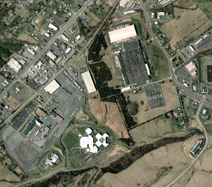
As seen in a 2007 aerial photo, it does not appear as if any trace remains of the former Staunton Airport.
Willard Keeling reported in 2010, “The site now is the Augusta County Government Center & no remains can be seen of the original airport use.”
The site of Staunton Airport is located south of the intersection of Route 11 & Laurel Hill Road.
____________________________________________________
Gordonsville Intermediate Field, Waldrop, VA
38.065, -78.165 (Northwest of Richmond, VA)
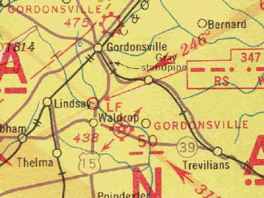
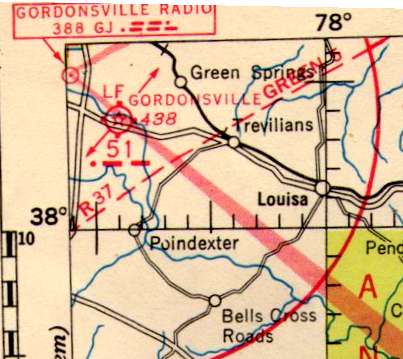
Gordonsville Intermediate Field, as depicted on the June 1939 Huntington Sectional Chart (courtesy of Chris Kennedy).
Gordsonsville Intermediate Field (south of the town of Gordonsville) was one of the network of fields established in the 1930s by the Department of Commerce
for the emergency use of commercial aircraft flying along airways between major cities.
Gordsonsville Intermediate Field was evidently established at some point between 1937-38,
as it was not yet depicted on the 1936 Huntington Sectional Chart or listed in The Airport Directory Company's 1937 Airport Directory (courtesy of Bob Rambo).
The earliest reference to Gordsonsville Intermediate Field which has been located
was in The Airport Directory Company's 1938 Airport Directory (courtesy of Chris Kennedy).
It described the Gordonsville airfield (5 miles southeast of the town of Gordonsville)
as the Department of Commerce's Intermediate Field Site 50, along the Nashville-Washington Airway.
The field was said to have 2 sod runways in a T-shape, measuring 3,125' northwest/southeast & 2,250' northeast/southwest.
The field was said to have a hangar, but to offer no other services.
The earliest depiction which has been located of Gordonsville Intermediate Field
was on the June 1939 Huntington Sectional Chart (courtesy of Chris Kennedy), which depicted it as Intermediate Field Site 50.
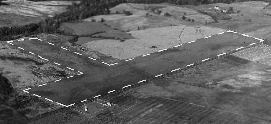
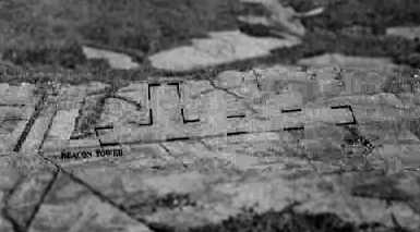
An October 1939 aerial view looking northeast at Gordonsville Intermediate Field (courtesy of the National Archives, photo # 18-LMU-08-829P).
The photo depicted the field as having 2 grass runways in a “T” shape, with a rotating beacon across the road the south.
There were no hangars visible in the photo.
The September 1944 Norfolk Sectional Chart (courtesy of Ron Plante)
showed that Gordonsville had been redesignated as Site 51 at some point between 1939-44.
The 1945 AAF Airfield Directory (courtesy of Scott Murdock)
described Gordonsville Intermediate Field as a 70 acre T-shaped property
within which were 2 sod runways, measuring 3,125' WNW/ESE & 2,250' northeast/southwest.
The field was said to not have any hangars, to be privately owned, but operated by the Civil Aeronautics Administration.
The April 1946 Norfolk Sectional Chart (courtesy of Jim Stanton) depicted Gordonsville as Site 51.
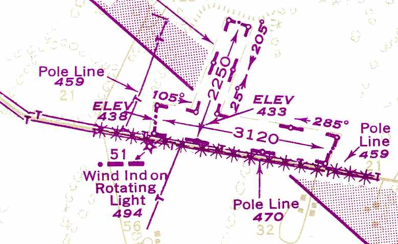
The 1948 USAAF Pilot's Handbook (courtesy of Chris Kennedy) depicted Gordonsville Intermediate Field as having 2 unpaved runways:
3,120' northwest/southeast & 2,250' northeast/southwest. No buildings were depicted at the site.
The last depiction which has been located of Gordonsville Intermediate Field as an active airfield
was on the January 1957 Huntington Sectional Chart (courtesy of Chris Kennedy).
It described the field as having 2 runways, with the longest being a 3,221' turf strip.
Gordsonsville Intermediate Field was evidently abandoned at some point between 1957-58,
as it was no longer depicted at all on the May 1958 Huntington Sectional Chart (courtesy of Chris Kennedy).
This was longer than many of the other Intermediate Fields had lasted,
as their need had long ago been obviated by the advances in range & reliability of commercial aircraft.
A 2/22/59 USGS aerial view showed the outline of the 2 Gordonsville Intermediate Field runways remained apparent,
but there was no indication of any recent aviation usage.
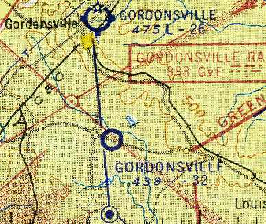
According to a drag racing website (courtesy of Byron Smith), Louisa County Drag Strip was opened in 1959 by Frank LeSueur at the site of Gordonsville Intermediate Field.
A short 1/5th mile paved dragstrip was built over Gordonsville's former northeast/southwest runway.
Nothing at the site of Gordsonsville Intermediate Field was depicted on the 1961 USGS topo map.
Louisa County Drag Strip did not have the longest of lives, closing in the middle 1960s as its short & narrow 1/5th mile strip made it noncompetitive.
The 1994 USGS aerial photo showed the outlines of Gordonsville Intermediate Field's 2 former runways was still evident, although divided up into separate fields.
It did not appear as if any of the buildings at the site dated from its days as an airfield.
As seen in a 2007 USGS aerial view, the outlines of Gordonsville Intermediate Field's 2 former runways were still evident, although divided up into separate fields.
It did not appear as if any of the buildings at the site dated from its days as an airfield.
A July 2011 aerial view by Seth Cassaday looking north at the still-recognizable outline of Gordonsville Intermediate Field.
Byron Smith reported in 2021, “Across the road where the beacon tower was located, there is now a house & possibly remnants of the beacon footings.”
The site of Gordonsville Intermediate Field is located north of the intersection of Route 22 & Nolting Road.
____________________________________________________
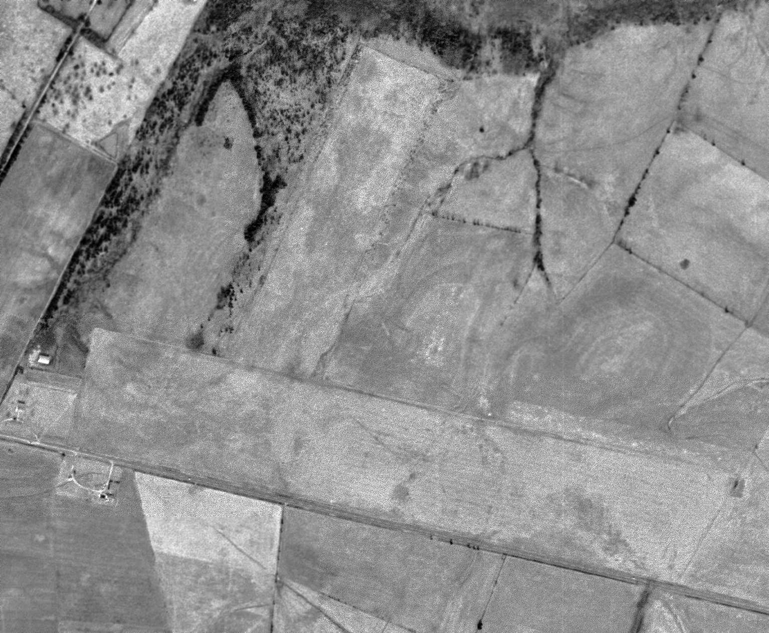
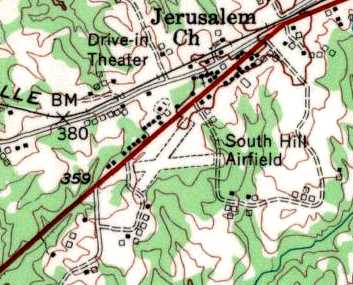
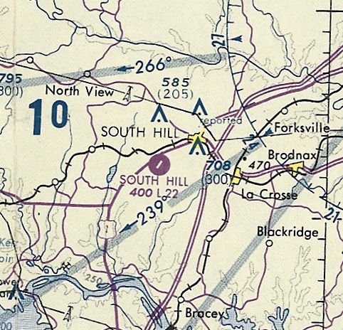
South Hill Municipal Airport, South Hill, VA
36.712, -78.167 (Southwest of Richmond, VA)
South Hill Municipal Airport, as depicted on the October 1948 Winston-Salem Sectional Chart (courtesy of Chris Kennedy).
South Hill Municipal Airport was apparently built at some point in 1948,
as it was not depicted on the April 1948 Winston-Salem Sectional Chart.
The earliest depiction which has been located of South Hill Municipal Airport
was on the October 1948 Winston-Salem Sectional Chart (courtesy of Chris Kennedy).
It depicted South Hill as having an 1,800' unpaved runway.
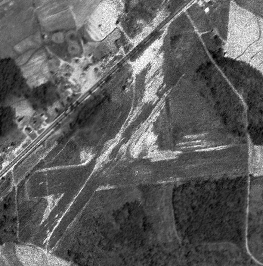
The earliest photo which has been located of South Hill Airport was a 3/17/54 USGS aerial view, which depicted South Hill as having 2 unpaved runways in an “X”-shape.
What appeared to be 1 or 2 T-hangars were on the north side of the field.
The 1955 USGS topo map depicted “South Hill Airfield” as having 2 unpaved runways in an “X”-shape.
South Hill apparently gained a paved runway at some point between 1955-62,
as the March 1966 Winston-Salem Sectional Chart (courtesy of Chris Kennedy) depicted the field as having a 2,200' paved runway.
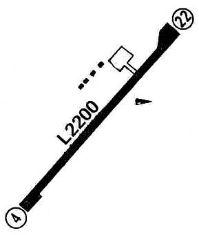
A 2/27/67 USGS aerial view depicted South Hill Airport as having an asphalt Runway 4/22, with an unpaved crosswind runway.
Three T-hangars & 1 light single-engine plane were visible on the northwest side.
The 1970 VA Airport Directory (courtesy of Stephen Mahaley)
described South Hill Municipal Airport as having a single 2,000' paved Runway 4/22.
The outline of a former grass crosswind runway was also depicted.
Four small hangars were depicted along the northwest side of the runway. The manager was listed as H. E. Bailey.
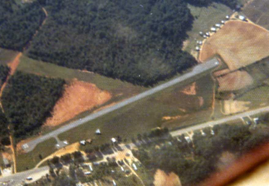
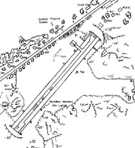
A 9/28/73 aerial view by Kenneth Keeton looking southeast at South Hill Municipal Airport.
Several individual T-hangars were visible along the northwest side of the runway.
The last aeronautical chart depiction which has been located of South Hill Airport
was on the March 1978 Washington Sectional Chart (courtesy of Ron Plante).
It depicted South Hill as having a 2,200' paved northeast/southwest runway.
The 1979 Flight Guide (courtesy of Chris Kennedy) depicted South Hill Municipal Airport
as having a single 2,200' paved runway 4/22, with a ramp at the northern part of the runway, with 4 small buildings (hangars?).
South Hill Municipal Airport apparently was closed at some point between 1979-81,
as it was no longer depicted on the March 1981 Washington Sectional Chart (courtesy of Ron Plante).
This was most likely due to competition from the new & larger Mecklenburg-Brunswick Regional Airport
which was built at some point between 1962-78, four miles southeast of the town of South Hill.
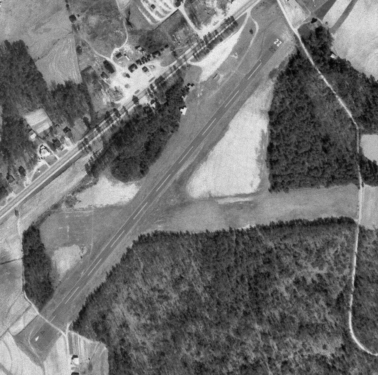
A 1983 aerial photo showed that the former South Hill Airport runway had been reused as a road (Montgomery Street)
with an industrial park being built on the airport site.
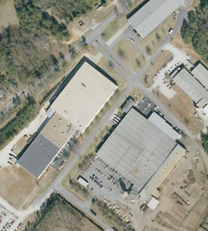
A 2007 aerial photo showed the site of South Hill Municipal Airport to be basically unchanged since 1996,
with the former paved runway still being reused as a road (Montgomery Street) in the middle of the industrial park.
The site of South Hill Municipal Airport is located south of the intersection of Route 1 & Bailey Road.
____________________________________________________
University of Virginia Airport / Milton Field / Monticello Airport, Milton, VA
37.995, -78.395 (East of Charlottesville, VA)
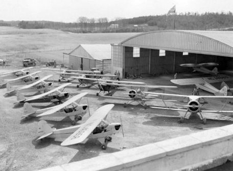
An undated photo of the University's fleet of training aircraft in front of Milton Field's hangar (courtesy of Rick Harshbarger),
with a total of 13 aircraft visible outside & inside the hangar (including Piper Cubs & unidentified biplanes).
Also known as Milton Field, the airport of the University of Virginia was located along the west bank of the Rivanna River,
east of Milton Road, one mile south of Milton, VA.
The University's airfield was Central Virginia's first & only commercial airport for many years.
No airfield was visible at this location on a 5/4/37 aerial photo.
According to an article by Maura Singleton in the University of VA Alumni Association Magazine (courtesy of Mark Harvey),
in 1939, the University's move to buy Hughes River Farm along the west bank of the Rivanna River
stirred the ire of residents in the surrounding agrarian communities of Milton, Shadwell & Keswick.
The prospect of low-flying aircraft piloted by young guns from the local university posed untold hazards.
The property, owned by W.D. Hayden, had in fact originally been part of Thomas Jefferson's 5,000-acre plantation,
and was possibly one of the sites of his water-powered manufacturing enterprises.
The University, which already offered students ground training in aeronautics,
had a compelling reason for wanting to build an airfield.
The Civilian Pilot Training Program, a government-sponsored program
designed to provide a pool of civilian pilots for military service, was newly launched.
Hitler had just invaded Poland; the threat of involvement in the war loomed large.
Lawyers for the property owners association shared their gripes at an 10/20/39
hearing by the State Corporation Commission in Richmond, where they delivered their trump card, to wit:
Mr. Jefferson did not allow for an airport or a school of flight in the University's 1812 charter.
The SCC judges weren't swayed.
Commercial license in hand, the University purchased the 90 acres of level floodplain for $17,800
and cleared the cornfields for 2 crisscrossing runways, oriented north/south & east/west, plus a 3rd short north/south runway.
It would seem that big things were expected: the dedication ceremony on 4/28/40 attracted a crowd of 2,000 people.
The usual formalities - the local chapter of the Daughters of the American Revolution presented a flag to the University,
the dean of engineering gave a speech - were interrupted by the unexpected & dramatic arrival of one of the SCC judges,
who touched down in a Stinson Reliant.
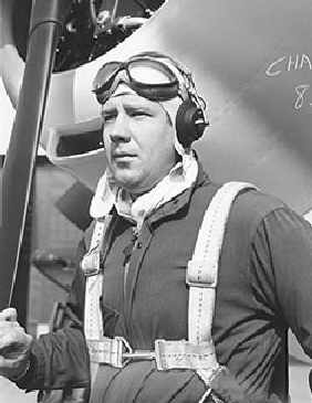
An undated photo of Walter "Roy" Franke.
That the University undertook such a project was due to the energies & talents of 2 men: Frederick Morse & Walter "Roy" Franke. Both were aviators.
Morse chaired the Department of Mechanical Engineering, and Franke was a structural engineer & part-time instructor for U.Va.
Morse & Franke developed the first wind tunnel at the University.
If both men were born to fly, they were also born teachers.
Morse became the director of the University's Civilian Pilot Training Program & headed the ground school.
As second in command, Franke was the flight operations director & essentially ran the airport.
The flight school moved into high gear almost immediately. The first pilot training class began in November 1939.
Lasting 4 or 5 months, each class enrolled 30 students.
That schedule became more compressed when the U.S. entered the war, with a new class receiving pilot certification every 2 months.
Milton Field was not yet depicted on the January 1940 Huntington Sectional Chart.
In late 1940, with a $21,000 grant from the Works Progress Administration, the University expanded Milton Airport.
The runways were extended, a new & larger hangar was constructed, and a 2-story cinderblock administration building was built.
Most students learned on the Piper Cub J-3, which was considered the "Model T" of aviation - cheap, easy to fly, and forgiving on landings.
With a gross weight of 1,220 pounds, and a maximum speed of 85 mph,
the Cub was an excellent trainer, requiring only 800 feet of takeoff room.
An instructor strapped himself into the seat as students learned rolls, forced landings, figure eights, stalls, spins & steep power turns.
For advanced training, students flew the T-6 Texan.
Designed to prepare pilots to fly bombers & fighters, this aircraft could roll, loop, spin & snap, and gave training in all types of tactics,
from ground strafing to bombardment & aerial dogfighting.
To earn their wings, students had to complete 72 hours of a ground course that included classes in meteorology,
theory of flight, engines, instrumentation, elementary air navigation & civil air regulations.
The flight course called for a minimum of 17 hours with an instructor & 18 hours solo.
"For extra flying time, students could hop on a tractor & bush hog the airfield," recalled Fritz Franke, Roy Franke's son.
The earliest aeronautical chart depiction which has been located of University of VA Airport was on the January 1941 Huntington Sectional Chart.
The Airport Directory Company's 1941 Airports Directory (courtesy of Chris Kennedy)
described the University of VA Airport as having 2 sod runways: 2,400' north/south & 1,800' east/west.
The field was said to have hangars.
When the U.S. became involved in World War II, the Army & Navy took over existing airfields such as Milton Airport
to groom pilots until their own training centers could be built.
During this period of intensive training, the staff of ground & flight instructors & service personnel numbered almost 25.
A Civil Air Patrol squadron was established by Frederick Morse at Milton Field during WW2.
The University of VA Airport was described in the 1944 US Army/Navy Directory of Airfields (courtesy of Ken Mercer) as having a 3,500' runway.
A circa 1942-45 aerial view looking north at UVA Airport from the 1945 AAF Airfield Directory (courtesy of Scott Murdock) depicted the field as having 2 grass runways.
The directory described UVA Airport as a 178 acre irregularly-shaped property within which were 2 clay & loam runways, measuring 3,500' north/south & 2,500' WNW/ESE.
The field was said to have 2 hangars: 150' x 80' metal, and 60' x 40' wood. The airport was said to be owned by the State of VA, and be privately operated.
The 1945 Haire Publishing Company Airport Directory (courtesy of Chris Kennedy) described the University of Virginia Airport as having 2 sod runways
(with the longest being a 3,500' north/south strip), and said that the field also had a single 80' x 100' hangar.
It listed the operator as Virginia Cub Distributors, and listed the manager as W. R. Franke.
After the war, the University's flying field continued in its dual capacity as a commercial airport,
but the University's interest in its own airport started to decline.
The "University of VA" was depicted as a commercial/municipal airport
on the March 1945 Winston-Salem Sectional Chart (courtesy of Dick Merrill).
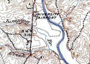
The 1946 USGS topo map depicted the “University Airport” as having an irregularly-shaped outline, with 3 buildings along the northwest side.
In 1948 the Board of Visitors granted permission to lease the airport,
but urged University officials to dispose of the property as soon as possible.
At one time, the University's fleet included a Grumman Wildcat, a Spartan NP-1, and a couple of Stinsons.
When faculty needed to attend conferences around the state,
they sometimes used Frederick Morse's 4-passenger plane, nicknamed the "Blue Goose",
or a Beechcraft 18, a World War II military aircraft that was reconditioned for use as executive transport.
The Beechcraft was declared surplus by the University just a year after its purchase, however, because of the lack of licensed pilots to fly it.
Business at Milton Field began to dwindle with the opening of the Charlottesville-Albemarle Airport, eight miles north of town, in 1955.
The engineering school used a single-engine Stinson Voyager to teach an undergraduate lab course, but that, too, was eventually stopped.
"The students flew as passengers & did measurements.
They were like flight-test engineers," says George Matthews, a professor emeritus of aerospace engineering.
"That course got deleted in the mid-1960s due to growing liability concerns. The plane was sold, and U.Va. didn't buy any more."
The Civil Air Patrol squadron which had been established during WW2 continued in peacetime.
Reid, who served as Morse's adjunct, recalls that the club was a mix of students, faculty & local citizens.
"We were involved in search & rescue missions in the area," he says.
"We got called a lot, because there was no organized air activity then for missing aircraft."
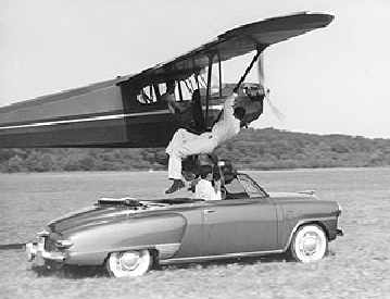
An undated photo of a stunt act at Milton Field, in which a stuntman climbed up from a moving car into a Piper as it flew along the runway.
The crowds that came to the airport now came as spectators for the Sunday afternoon aerobatic shows.
Helmetless men performed maneuvers the likes of which, these days, seem downright rash -
wing walking, hanging precariously upside down from a plane's strut to snatch an object from the ground.
Another popular stunt involved racing a convertible the length of the landing strip, from which a rider was plucked by a low-flying plane.
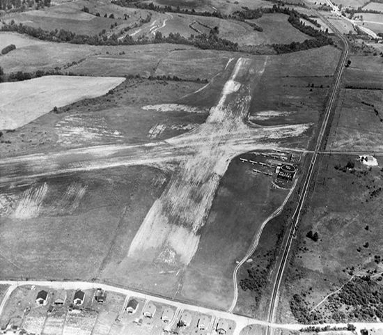
A 6/20/57 aerial view depicted UVA Airport as having 2 grass runways, with a few hangars & 2 light planes on the northwest side.
Bob Somers conducted flight instruction at the University of Virginia Airport in a red & white Aeronca 7AC in 1959.
The UVA Airport was listed among active airports in the 1962 AOPA Airport Directory,
with a single 3,800' turf runway (18/36), and the operator listed as J.W. Taylor.
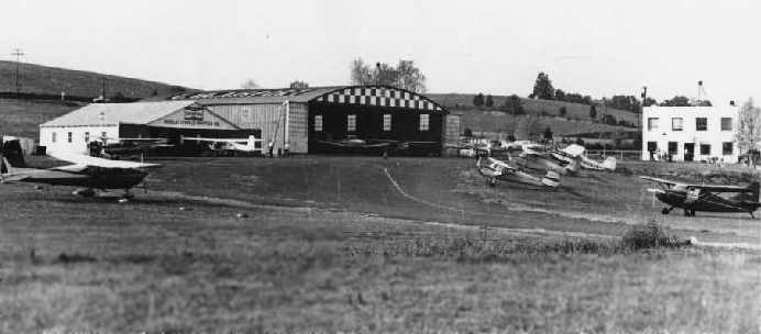
A 1962 picture in the book "Virginia Airports" by Vera Rollo & Norman Crabill (published by the VAHS)
depicted the UVA Airport as having a large arched-roof hangar, a smaller hangar, and a 2-story office building.
The University's last plane was sold off in the mid-1960s.
From the time of its dedication to the end of its commercial use, Milton Airport had a life span of a mere 25 years.
Roy Franke continued to lease the airport for a number of years
and serviced private planes before turning over the lease in 1964 to 2 partners, a local businessman & a judge.
A few flying & parachuting clubs used the field, but otherwise the partners didn't have much success.
A 4/23/64 USGS aerial view depicted one twin-engine plane parked next to the Milton Field hangar.
The October 1965 Winston-Salem Sectional Chart (courtesy of Ron Kunse) depicted UVA Airport as having a 4,000' unpaved runway.
A 12/4/66 aerial view depicted 3 light planes on the field.
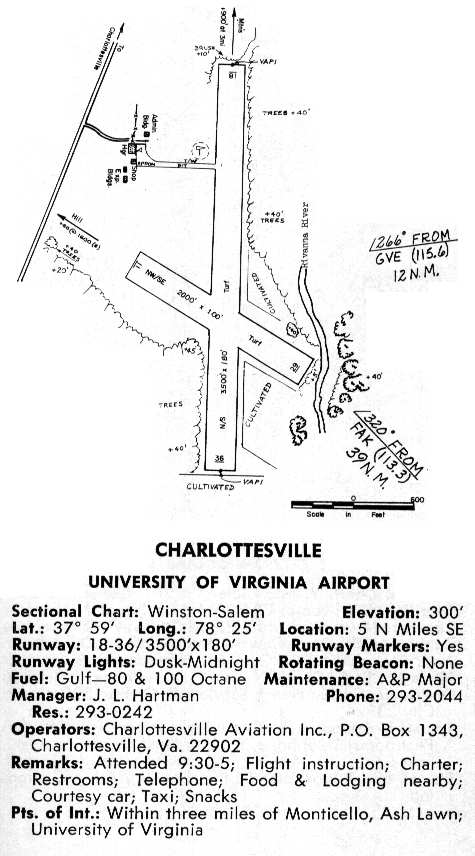
The 1968 VA Airport Directory (courtesy of Don Thompson) described the UVA Airport
as having 2 grass runways, and listed the operator as Charlottesville Aviation Inc.

with water covering the entire runway area, with the hangars & office building just having been spared from being inundated.
A single plane was located next to the hangar.
At some point between 1968-70, the airfield was apparently renamed "Monticello",
as that is how it was labeled on the 1970 Washington Sectional Chart (courtesy of John Clifford).
In the UVA Airport's latter years the operator was Horizon Aviation,
which also ran a fixed-base operation at Charlottesville Airport (according to the book "Virginia Airports").
Milton Field officially closed in 1971, according to an article in the University of VA Alumni Association Magazine (courtesy of Mark Harvey).
However, Monticello Airport was still depicted as an active public-use airfield on the 1973 Washington Sectional Chart (courtesy of Mike Keefe),
and it wasn't until 1974 that the operating license for the UVA Airport was canceled, according to the book "Virginia Airports".
A 10/6/74 aerial view showed the airport remained intact, but no aircraft were visible on the field.
By the time of the 1975 Washington Sectional Chart (courtesy of Ed Drury), Milton Field was no longer depicted at all.
Over the subsequent years, Milton Airport has become a kind of anomaly, serving every purpose except its original one.
A hay farmer leased it briefly, then for 10 years it functioned as a tree farm.
A 1992 aerial photo in the book "Virginia Airports" showed that the area around the hangars had become thickly wooded.
This is in stark contrast to photos of the same area from the 1960s, when then area around the hangars was an open grassy area.
The airport made a brief news splash in the early 1990s when volunteers with the Virginia Canals & Navigation Society found a 60' long bateau, intact,
stuck in the riverbank on the property.
Before a flood swept it away, archaeologists were able to date it to Jefferson's time,
and guessed that its machine-made nails were probably made in Monticello's shop.
A 1994 USGS aerial view looking east at UVA Airport showed the airport & its hangar remained intact though deteriorated,
although a grass area just east of the hangar had been newly cleared for radio-controlled model aircraft operation.
In a 1994 report by the state Joint Legislative Audit & Review Committee, the Milton Airport property was declared surplus by the University,
and was included among state-owned properties that could be put up for sale.
In 1995, when word spread that the University was considering disposing of the airport, interest was reawakened.
The nearby Clifton Inn made inquiries, considering the property for a sports complex.
Albemarle County also looked into acquiring it for recreational use,
its flat runways well suited for soccer or softball fields.
Even the state Department of Corrections made a site inspection.
The fact that most of the property lies in a floodplain (less than 35 acres are developable) has kept its prospects modest.
But perhaps more formidable than its topography has been the opposition of local landowners.
Just across the Rivanna River is the private, gated golf community of Glenmore, whose residents have thwarted such schemes.
Monticello, too, has followed various proposals with particular concern because the property is situated within its "viewshed."
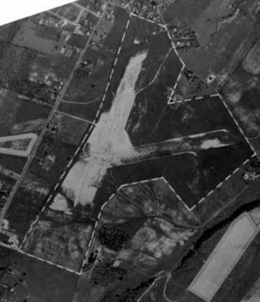
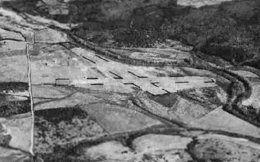
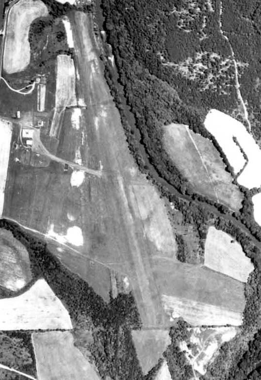
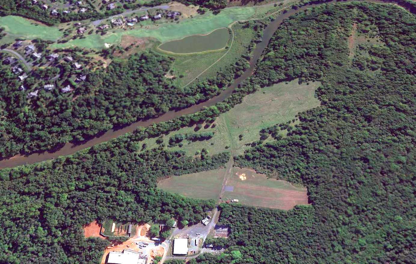
Aerial view looking west, taken from a Diamond Katana DA20-C1, by Paul Freeman, 2002.
The larger hangar still remained standing, but the cleared areas of the former runways were becoming overgrown.
Milton Field was no longer depicted at all (even as an abandoned airfield) on the 2002 Washington Sectional Chart.
As of 2003, local law enforcement agencies use part of the former airport property as a shooting range & for training exercises involving dogs.
The U.S. Army ROTC likes the varied terrain for field training drills.
The U.S. Air Force maintains an air monitoring station there as part of the Comprehensive Test Ban Treaty, measuring radionuclides in the atmosphere.
Franke, who keeps a watchful eye over the property while doing environmental research & computer work there, is also the station's operations technician.
The former hangar has been used to store thousands of folded graduation chairs, along with recycling containers & snow-removal equipment.
As of 2003, there is still flying taking place, albeit of different dimensions.
The amateur Rivanna Radio Airplane Club uses the short runway in exchange for keeping the area free of trash & the grass mown.
Their weekend air shows have an avid following.
On the other runways, U.Va. students fly a solar-powered airship, which is also kept in the former hangar.
Although Milton Field was still listed by the University as surplus property, it hasn't yet been sold (as of 2003).
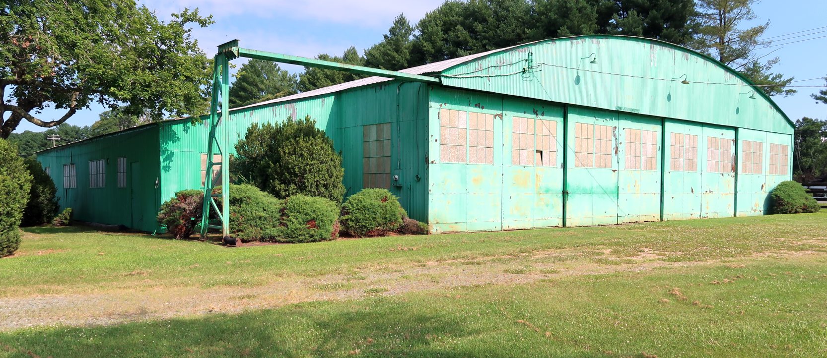
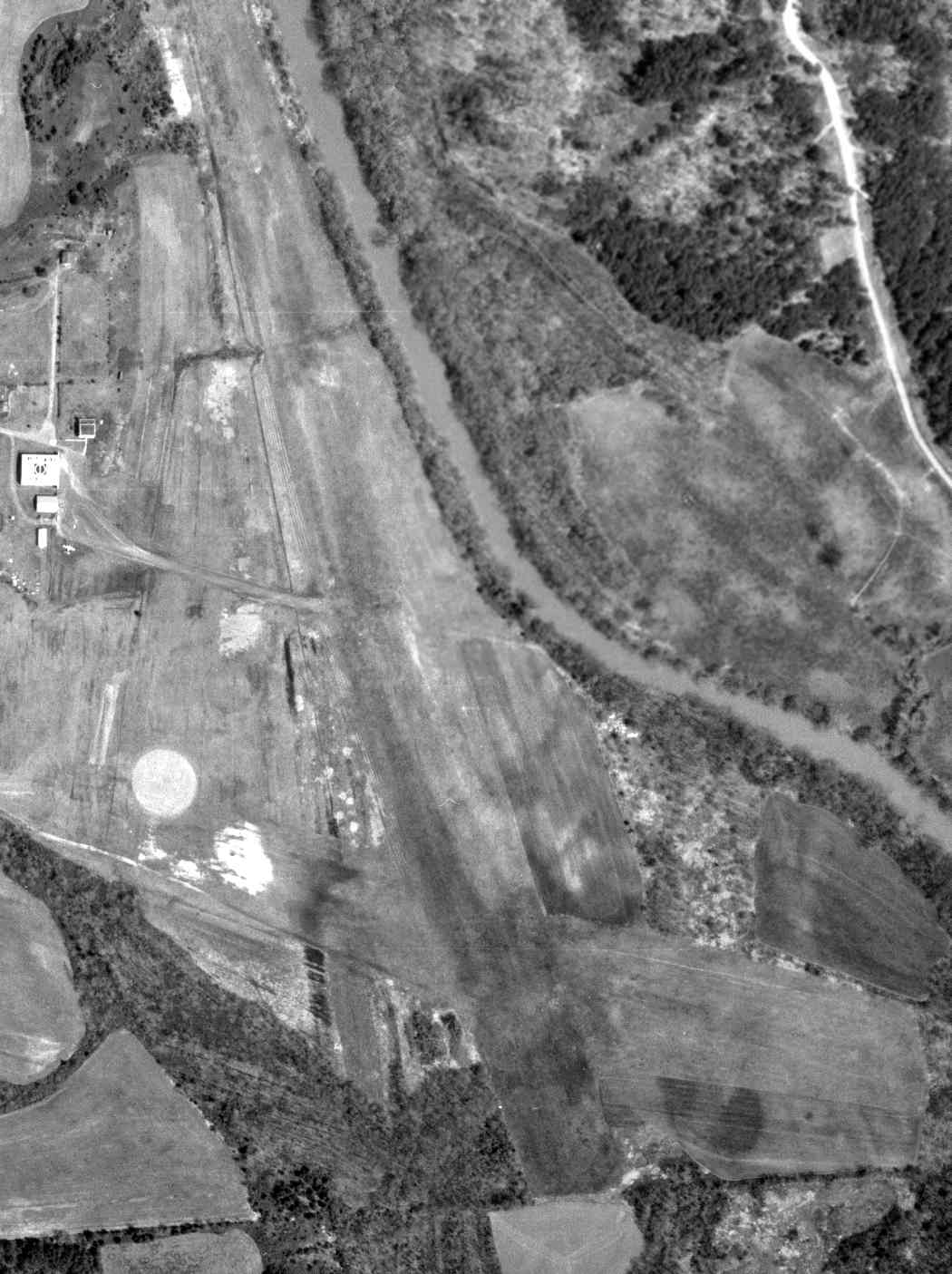
A circa 2010 aerial view looking west at Milton Field showed both hangars still remained standing,
with “UVA Airport” still recognizable painted on both sides of the larger hangar's roof.
Fritz Franke reported in 2015, “UVA Airport... It is being used a lot by the Architecture School & Engineering School.
They conduct classes, workshops, and events out there. They basically have taken over the entire hangar.
Plus, there's now a huge facility that is an indoor firing range supporting the UVA, Albemarle county, and Charlottesville police departments.
With the Rotunda being renovated, the airport is being used as a storage/staging area for the project.
There's a new area that now houses the inventory for brick, slate, and stone for all of the historic buildings on the lawn.
There is also talk of building some warehouses out there. And with all this activity happening, all the buildings are being fixed up & modernized.”
A 2015 aerial view looking east at Milton Field showed the site was no longer recognizable as a former airport, with trees having filled in the area of the 2 former runways.
The larger hangar & the airport office remained, but the smaller hangar had been removed at some point between 2010-2015.
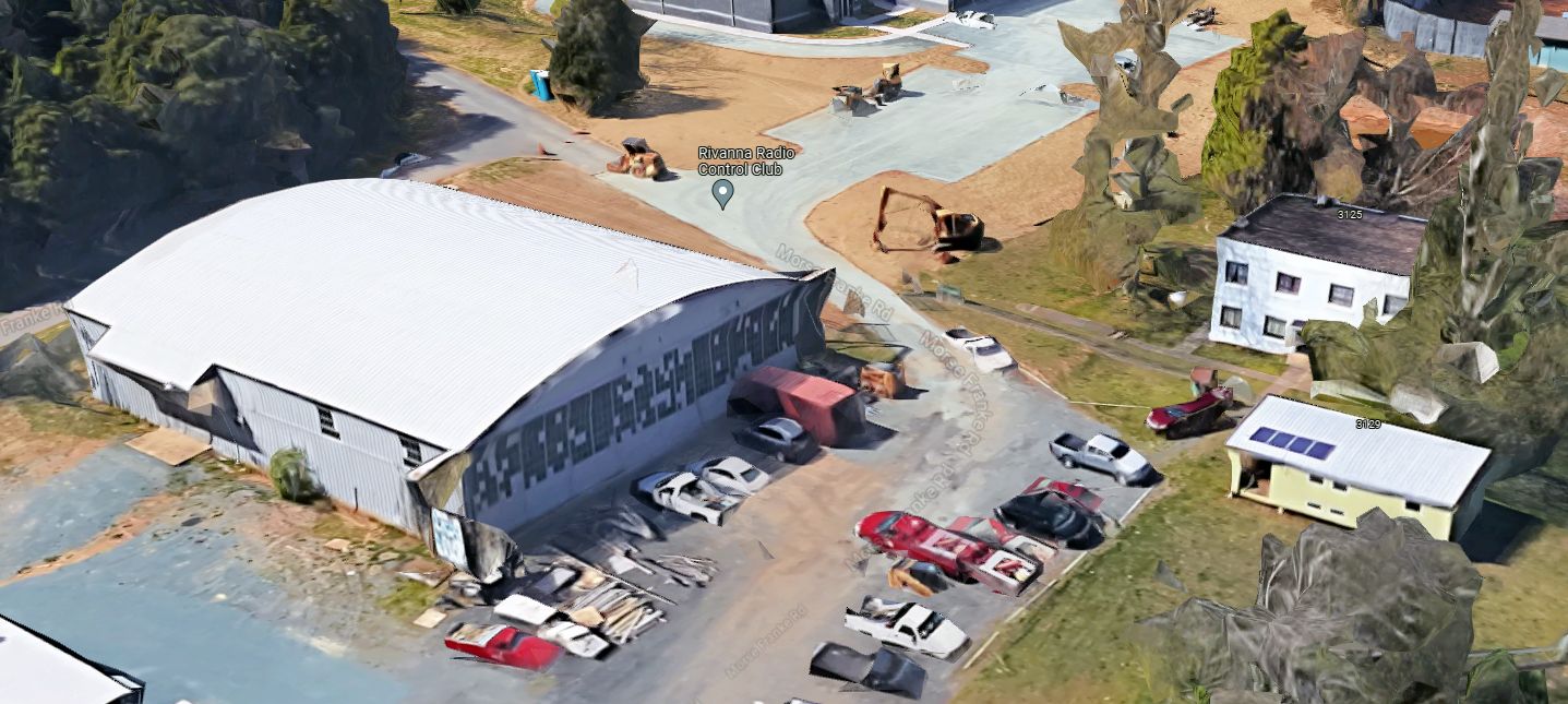
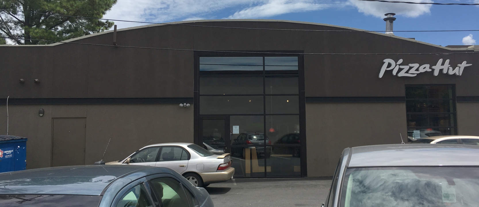
A 2023 3-D aerial image looking northwest at the former Milton Field hangar & airport office building.
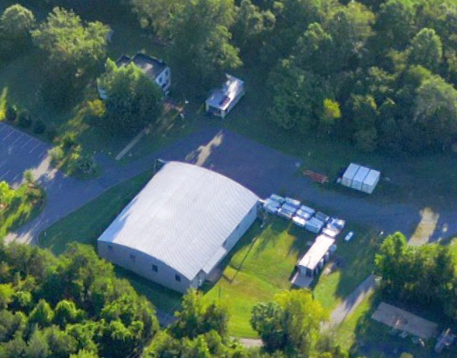
A 2023 aerial photo looking southeast at the former Milton Field hangar & airport office building.
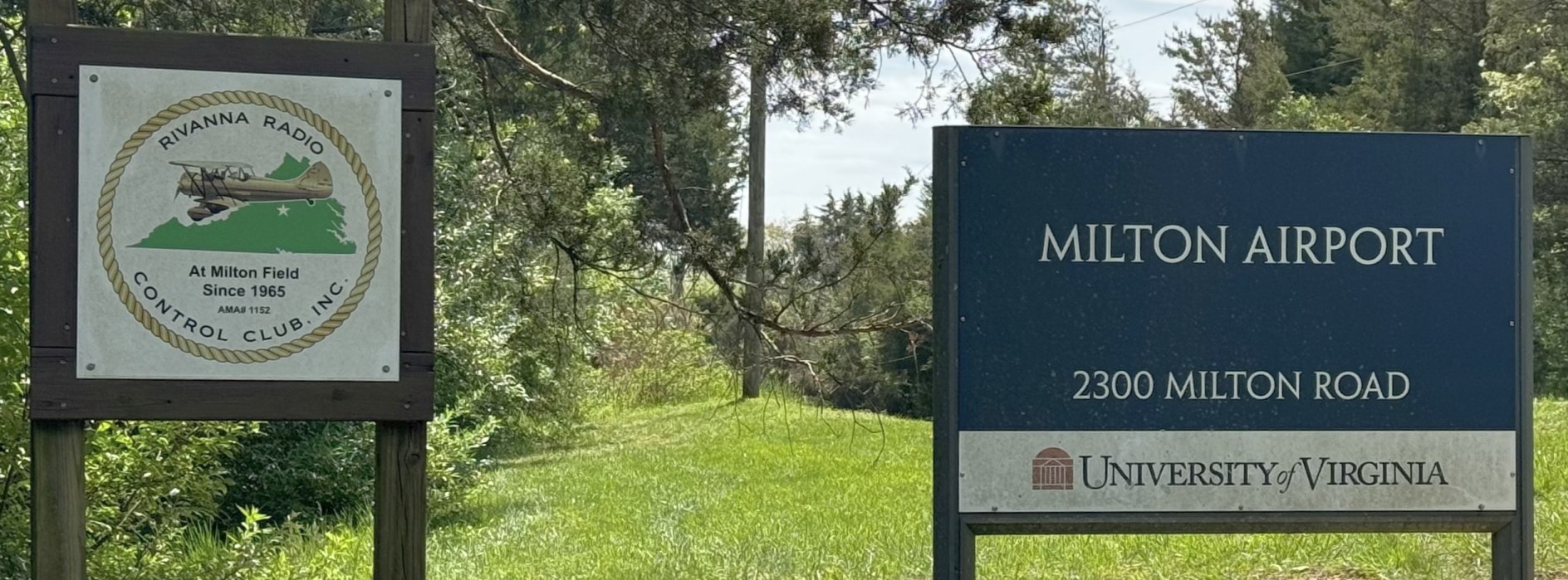
A 4/20/24 photo by Paul Freeman of the signs for Milton Airport & its Rivanna Radio Control Club field.
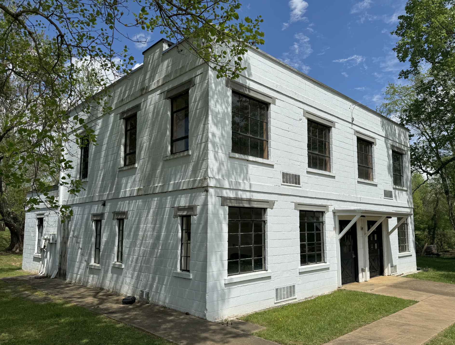
A 4/20/24 photo by Paul Freeman looking northeast at the former Milton Field office building.
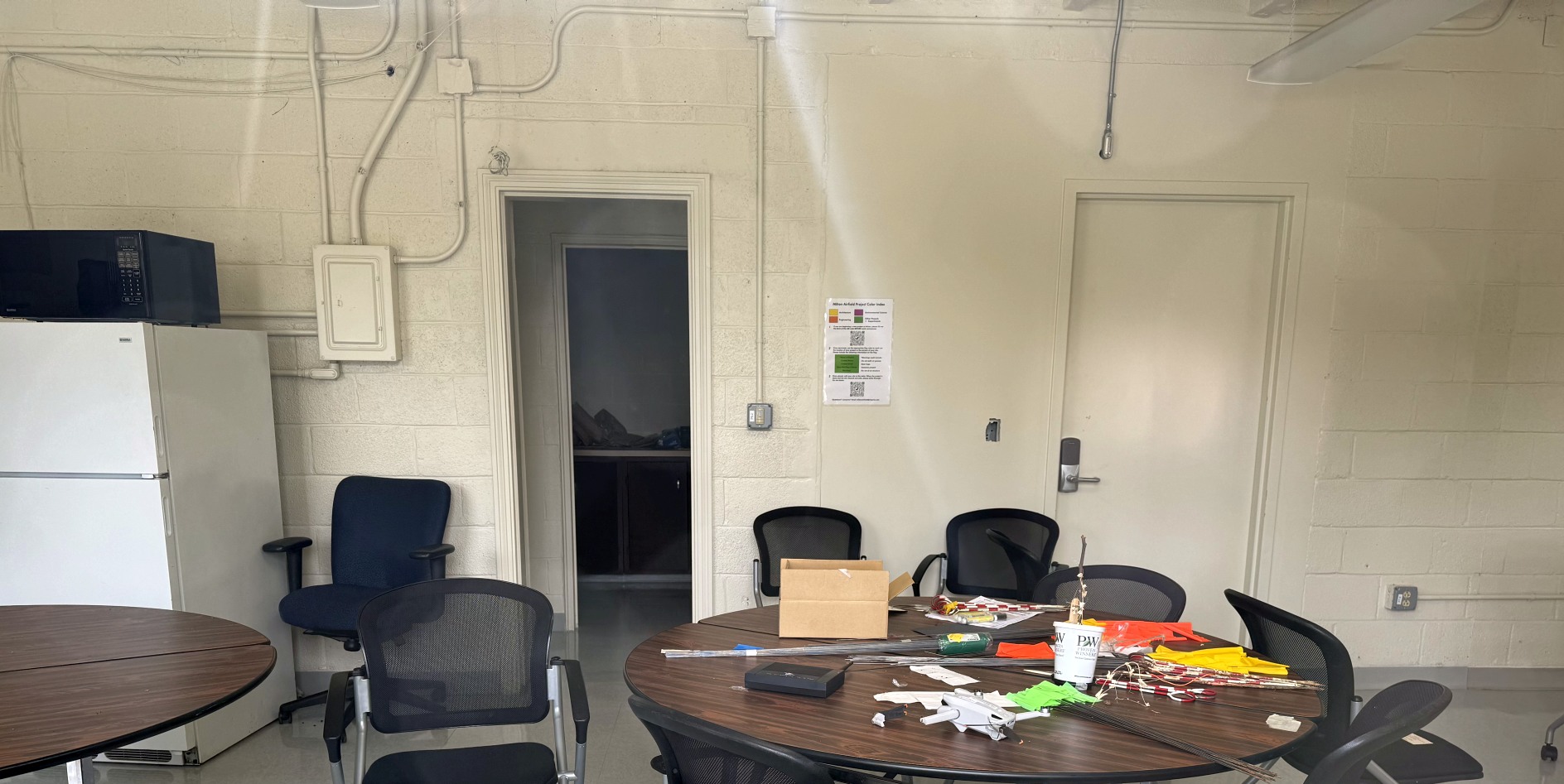
A 4/20/24 photo by Paul Freeman of the interior of the former Milton Field office building.
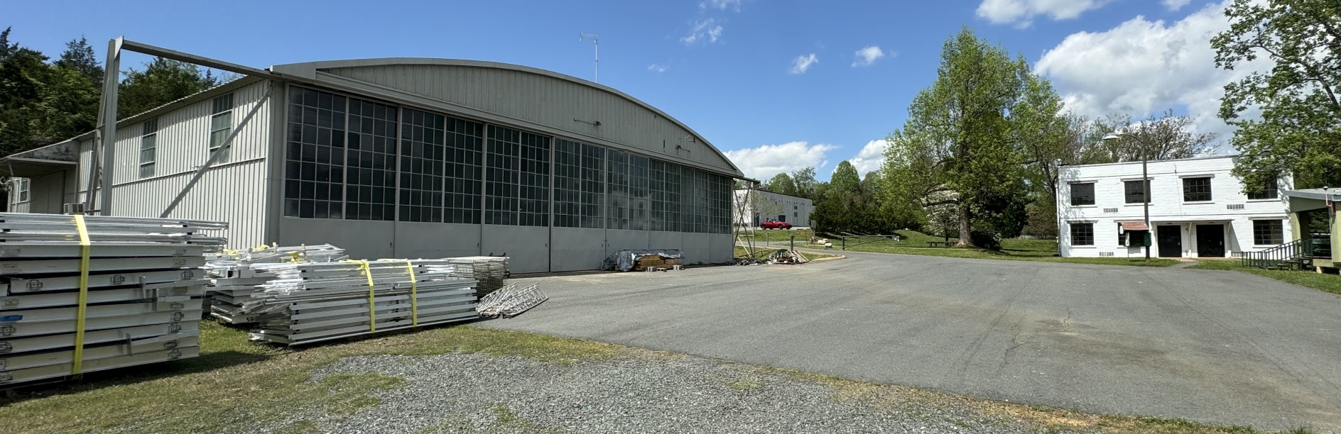
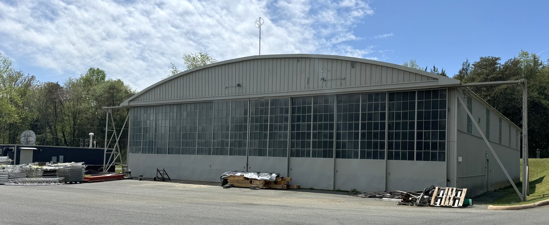
A 4/20/24 photo by Paul Freeman looking northwest at the former Milton Field hangar & office building.
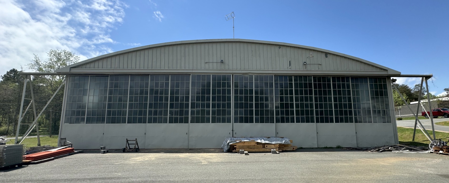
A 4/20/24 photo by Paul Freeman looking west at the former Milton Field hangar.
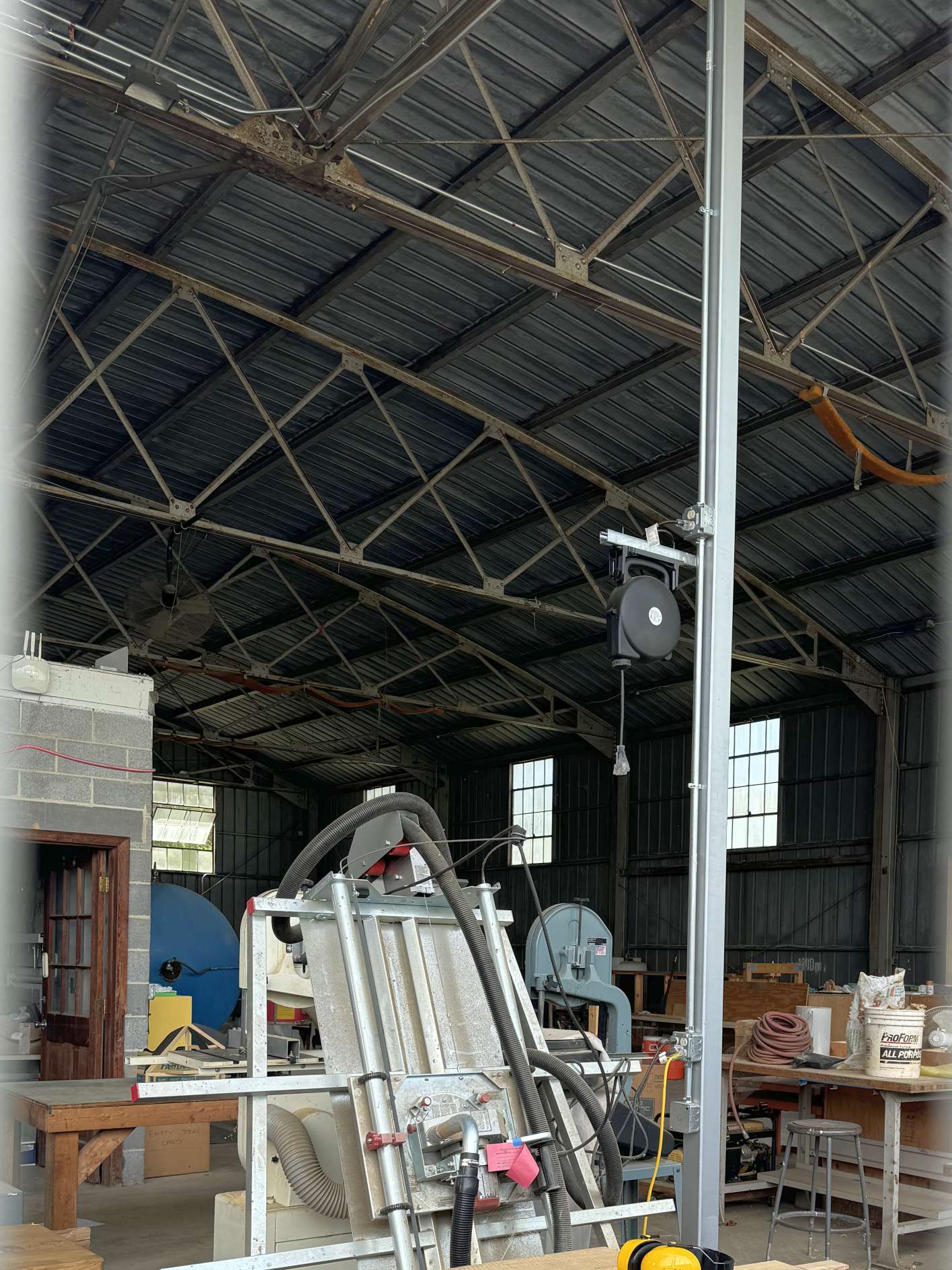
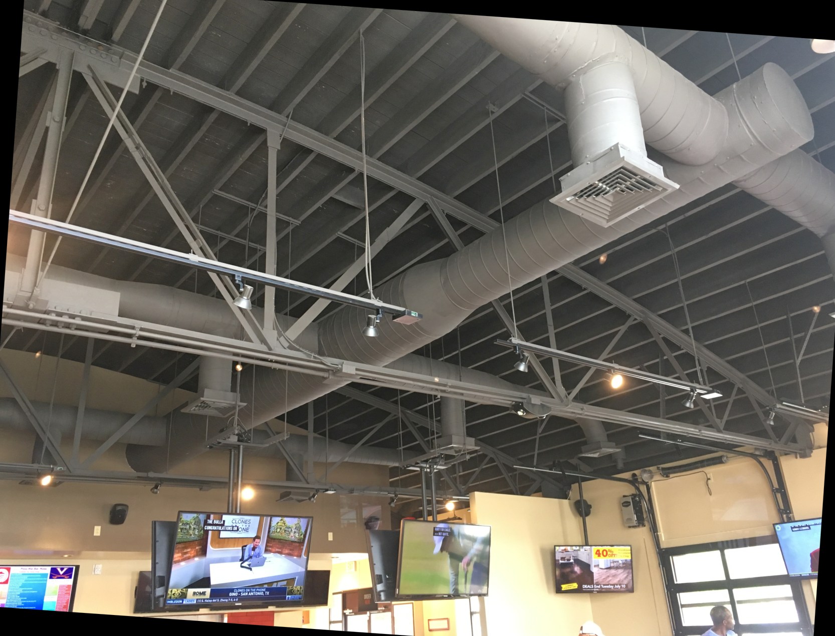
A 4/20/24 photo by Paul Freeman of the interior of the former Milton Field hangar.
A 4/20/24 photo by Paul Freeman looking southwest at the former Milton Field hangar, also showing the site of the former smaller hangar to the left.
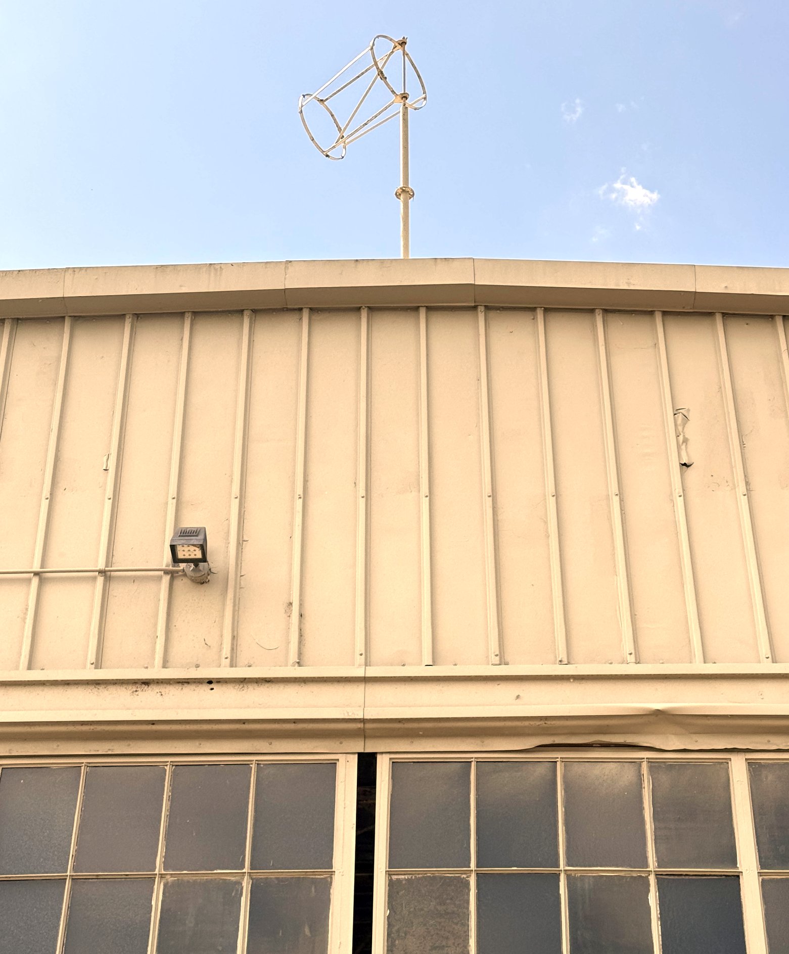
A 4/20/24 photo by Paul Freeman looking at the windsock frame mounted atop the former Milton Field hangar.
Thanks to Charles Robertson for pointing out this field.
____________________________________________________
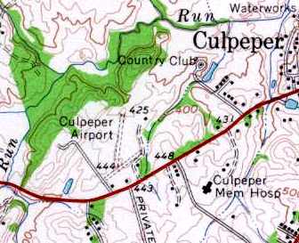
Original Culpeper Airport, Culpeper, VA
38.46, -78.022 (Southwest of Washington, DC)
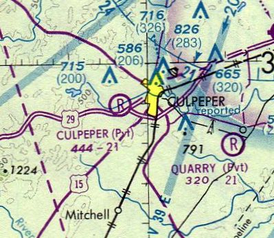
The original Culpeper Airport, as depicted on the April 1947 Washington Sectional Chart.
Culpeper Airport was not yet depicted on the October 1946 Washington Sectional Chart.
The original Culpeper Airport was opened in 1946,
when Peter Jarvis leased land from Tom Cline along Route 29 across from the current Holiday Inn
a mile or so southwest of the town of Culpeper.
According to the book "Virginia Airports" by Vera Rollo & Norman Crabill (published by the VAHS),
Jarvis' applied for his operating license for the airfield on 1/29/46, and it was approved on 6/12/46.
Jarvis hoped his airport could realize significant income from G.I. Bill students,
but that never really materialized, and it was in financial trouble within several years.
The earliest depiction which has been located of Culpeper Airport was on the April 1947 Washington Sectional Chart.
It depicted Culpeper as having a 1,700' unpaved runway.
A number of tenants & students banded together to form the Culpeper Flying Club,
later the Culpeper Flying Corporation, to keep the field & their flying going.
Bill Carpenter (who had flown out of Lindsey’s farm in the 1930s) led the group,
operated the field & became even more of a Culpeper aerial legend.
Bill owned several aircraft throughout his career,
but usually flew his Piper PA-11 Cub which has been in the family for several decades.
In its early career, NC 4854M graced the cover of the March 1948 Flying Magazine
(which sold for 25 cents at the newsstand).
He bought it from the Reeds when they needed cash to make one of the airport payments to Jarvis.
One of Bill’s favorite tricks was to go up on a windy day, fly up Main Street,
throttle back to near idle & drift backwards or just "hover" over Main & Davis.
Of course he would land on any field or meadow, but then getting somewhere on the ground was a chore.
So he made a rig & mounted a small motor-bike outside on the right side of the fuselage
and he would putt-putt to wherever he needed to go after landing.
Back then the rules weren’t so stiff.
Nearly 20 planes were based at a time at the old Culpeper field,
and some 90 airplanes were based there over a 30 year period after WW2,
including Cessna, Pipers, Beechcrafts, Culvers, Luscombes, Bellancas, Stinsons, and Swifts.
But the Culpeper field wasn’t very big.
Initially Runway 6/24 was only 1,600', with a bit of a grade on 24, although it was 300' wide.
In 1947, a crosswind Runway 1/19 of a whopping 2,150' was constructed, albeit only 200' wide.
These were fine for Luscombes & Pipers, but it was a tight squeeze for some of the "hotter" aircraft.
T. I. Martin, long-term Mayor of Culpeper (and for whom the replacement airport was later named)
happened to be at the field one day when golfer Arnold Palmer landed his Aero Commander.
With the brakes locked & the wheels sliding over the grass,
Palmer's Commander stopped "within inches" of the far end.
After stepping out, Palmer turned to Martin & just said, "Damned short strip", and went off to his game.
Bill Carpenter’s son, Glen, claims he also once saw a twin Beech squeeze into the strip
and watched thirteen people (admittedly some children) clamber out.
He said it looked like the Volkswagen in a circus & you could see the shock struts expand as they deplaned.
Surprisingly, considerable night flying was done, even though the field was initially unlit.
Some boundary lights were later installed on Runway 6/24.
The 1949 Washington Sectional Chart (courtesy of Mike Keefe) described Culpeper as having a 2,900' unpaved runway.
Peter Jarvis sold the field in 1949 to Harry Lehman & Frank & Evelyn Reed (who had previously operated Beacon & Hyde Fields),
but he had to repossess it in 1950 after payments fell behind.
However, Jarvis died prematurely from a sudden heart attack in 1951.
Merton Meade recalled “The old Culpeper field was a lot of fun.
Very nice grass & the Holiday Inn across the street was where we usually had lunch.”
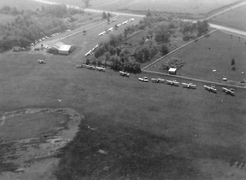
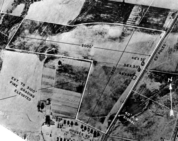
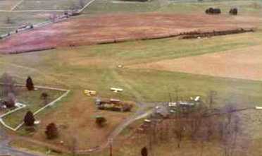
A circa 1950 aerial view of the original Culpeper Airport.
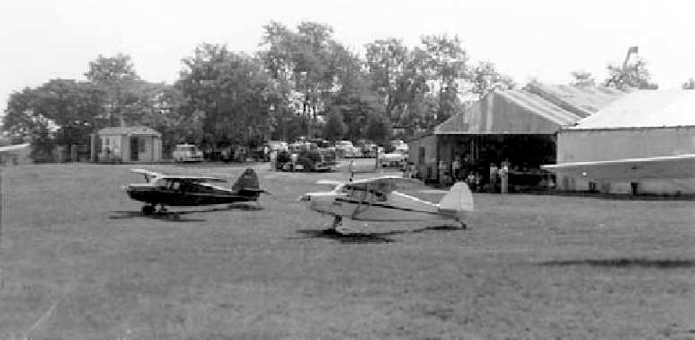
A circa 1950 view of the ramp area at the original Culpeper Airport.
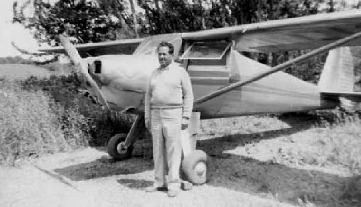
Peter Jarvis & his Luscombe at the original Culpeper Airport.
The runway length had been reduced on the 1951 Washington Sectional Chart (courtesy of Mike Keefe),
which described Culpeper as having a 2,300' unpaved runway.
A 2/25/59 USGS aerial view showed the original Culpeper Airport to have 2 grass runways, with a building & 3 single-engine planes at the southeast end.
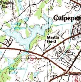
The original Culpeper Airport, as depicted on the 1961 USGS topo map.
The 1962 AOPA Airport Directory described the field as having 2 turf runways: 2,300' Runway 1/19 & 1,700' Runway 5/23.
The operator was listed as Culpeper Flying Service.
The original Culpeper Airport was depicted on the 1964 Washington Sectional Chart (courtesy of John Voss) as having a 2,300' unpaved runway.
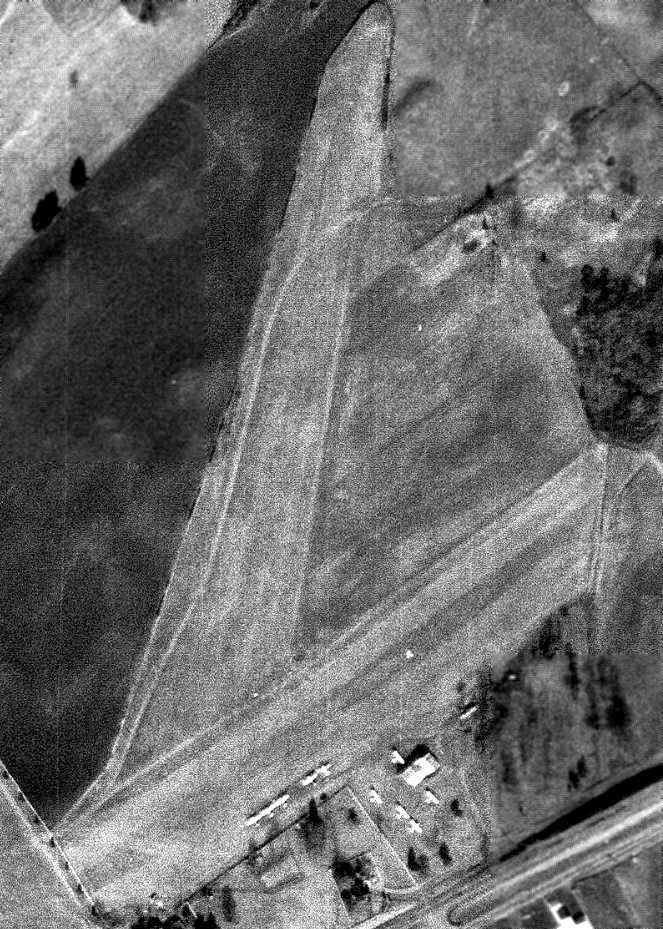
An 11/22/69 USGS aerial view showed the original Culpeper Airport to have 2 grass runways, with a building & 10 single-engine planes at the southeast end.
Perhaps more surprisingly, but maybe not so much given the caliber of those running the operations & training,
there were few incidents or crashes at the field; none of the latter by residents.
But as the town grew, there was clearly a need for a bigger & paved field.
The old field was surrounded & couldn’t really be enlarged.
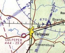
A site for a new Culpeper Airport was selected at Elkwood, about 6 miles northeast of Culpeper,
and the new T. I. Martin Culpeper Municipal (later County & still later Regional) Airport opened in 1969.
The original Culpeper field continued in operation for a few more years.
It was still depicted on the 1973 Washington Sectional Chart (courtesy of Mike Keefe),
and was described as having a 2,100' unpaved runway.
The last photo which has been located showing the original Culpeper Airport still in operation
was a 4/17/72 USGS aerial view (courtesy of Dallam Oliver-Lee).
It showed a row of 8 light aircraft at the field.
The status of the original Culpeper Airport had changed to a private airfield
by the time of the 1975 Washington Sectional Chart (courtesy of Ed Drury).
The last aeronautical chart depiction which has been located of the original Culpeper Airport
was on the August 1976 Cincinnati Sectional Chart (courtesy of Mitchell Hymowitz).
After slowly running out of customers, the original Culpeper field closed in 1977.
The original Culpeper Airport was no longer depicted on the March 1976 Washington Sectional Chart (courtesy of Ron Plante).
The 2 runways of the old Culpeper Airport were still depicted on the 1984 USGS topo map,
but it was erroneously labeled "Martin Field".
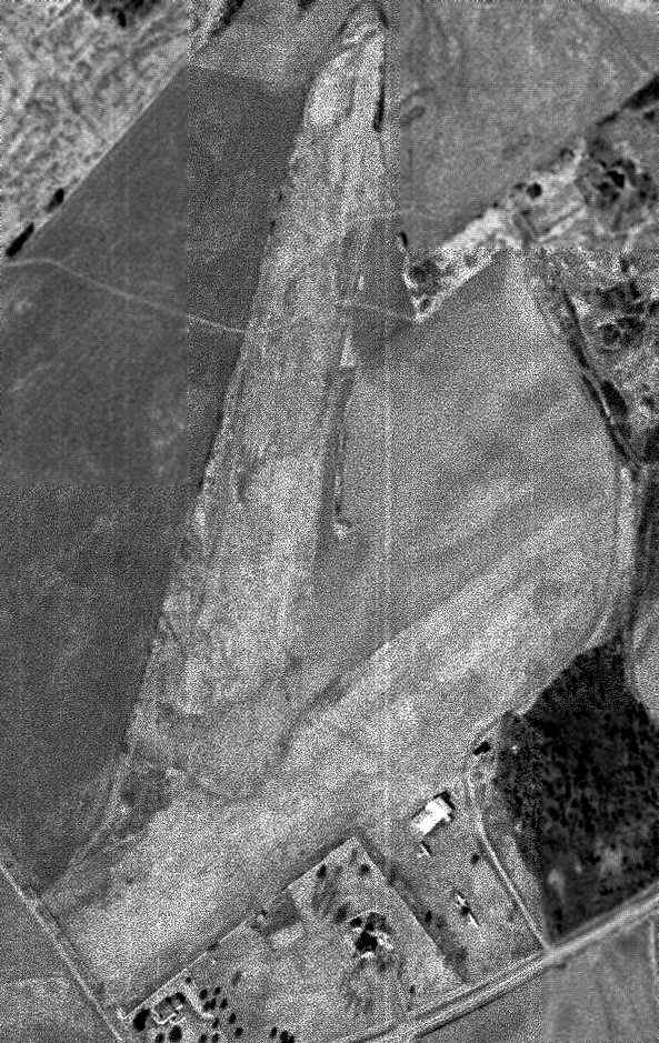
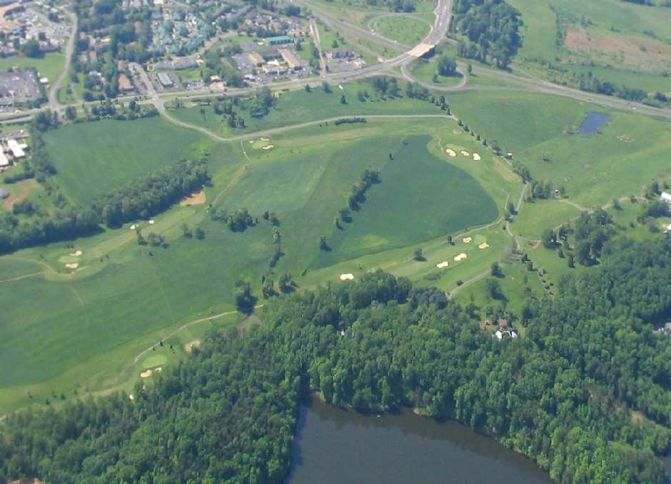
A 4/3/94 USGS aerial photo (courtesy of Dallam Oliver-Lee) showed that the property of the former airport had been redeveloped as a golf course.
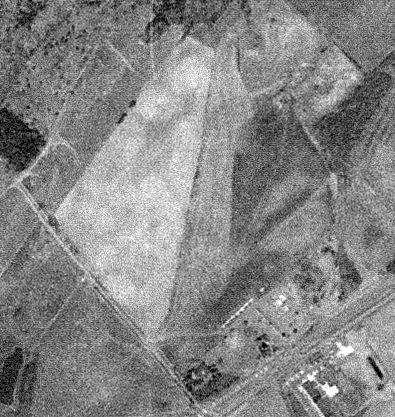
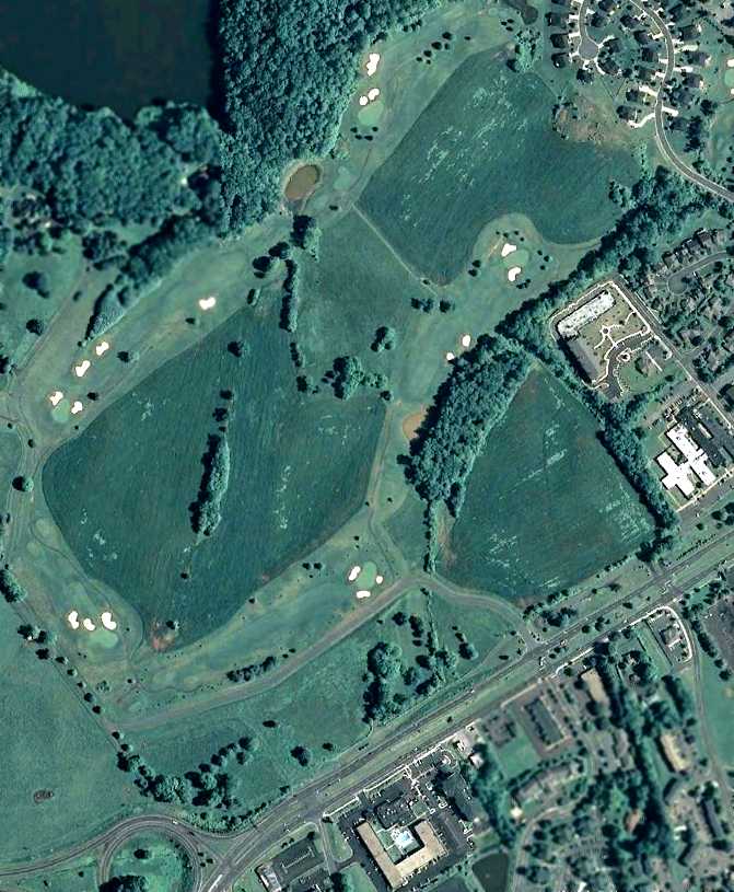
A 2003 aerial view by Paul Freeman looking southeast at the site of the original Culpeper Airport.
The alignment of the former Runway 1/19 was still recognizable
as the row of trees going diagonally from the center of the photo toward the upper-right.
A 6/20/11 aerial view (courtesy of Dallam Oliver-Lee) showed a row of trees along the west side of the property which traced the outline of a runway
as the last remaining trace of the original Culpeper Airport.
The site of the original Culpeper Airport is located north of the intersection of Route 29 & Madison Road.
____________________________________________________
Since this site was first put on the web in 1999, its popularity has grown tremendously.
If the total quantity of material on this site is to continue to grow,
it will require ever-increasing funding to pay its expenses.
Therefore, I request financial contributions from site visitors,
to help defray the increasing costs of the site
and ensure that it continues to be available & to grow.
What would you pay for a good aviation magazine, or a good aviation book?
Please consider a donation of an equivalent amount, at the least.
This site is not supported by commercial advertising –
it is purely supported by donations.
If you enjoy the site, and would like to make a financial contribution,
you
may use a credit card via
![]() :
:
Please consider checking the box to make a monthly donatation.
For a mailing address to send a check, please contact me at: paulandterryfreeman@gmail.com
If you enjoy this web site, please support it with a financial contribution.
please contact me at: paulandterryfreeman@gmail.com
If you enjoy this web site, please support it with a financial contribution.
____________________________________________________
This site covers airfields in all 50 states.