Abandoned & Little-Known Airfields:
Illinois: Northwestern Chicago area
© 2002, © 2023 by Paul Freeman. Revised 11/25/23.
This site covers airfields in all 50 states: Click here for the site's main menu.
Please consider a financial contribution to support the continued growth & operation of this site.
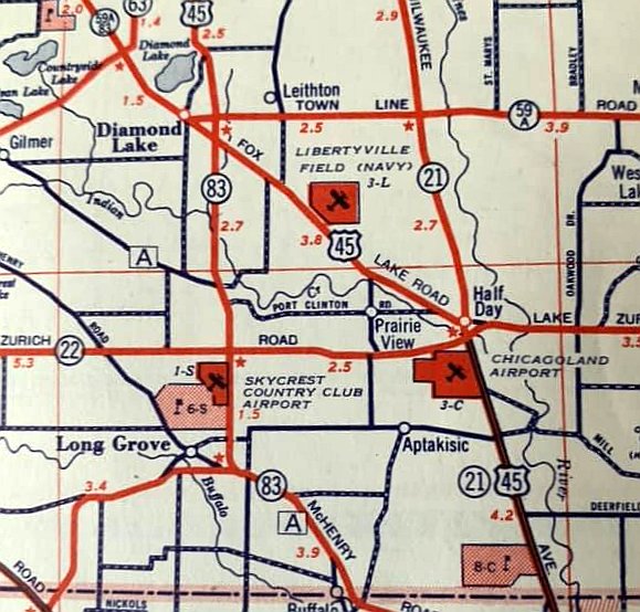
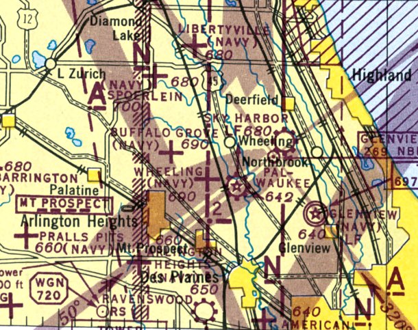
Allendale Field / Libertyville NOLF (revised 2/17/22) - Arlington NOLF / Arlington Airport (revised 9/29/19)
Elgin Airport (revised 7/15/20) - Half Day NOLF / Wheeling NOLF / Chicagoland Airport (revised 11/25/23) - Northern Pump Airfield / McHenry Farms Airfield (added 2/25/18)
Skycrest Country Club Airport (revised 3/12/22) - Woodale NOLF / Wood Dale Field / Moody Airport (revised 1/18/20)
____________________________________________________
Skycrest Country Club Airport, Long Grove, IL
42.19, -87.992 (Northwest of Chicago, IL)
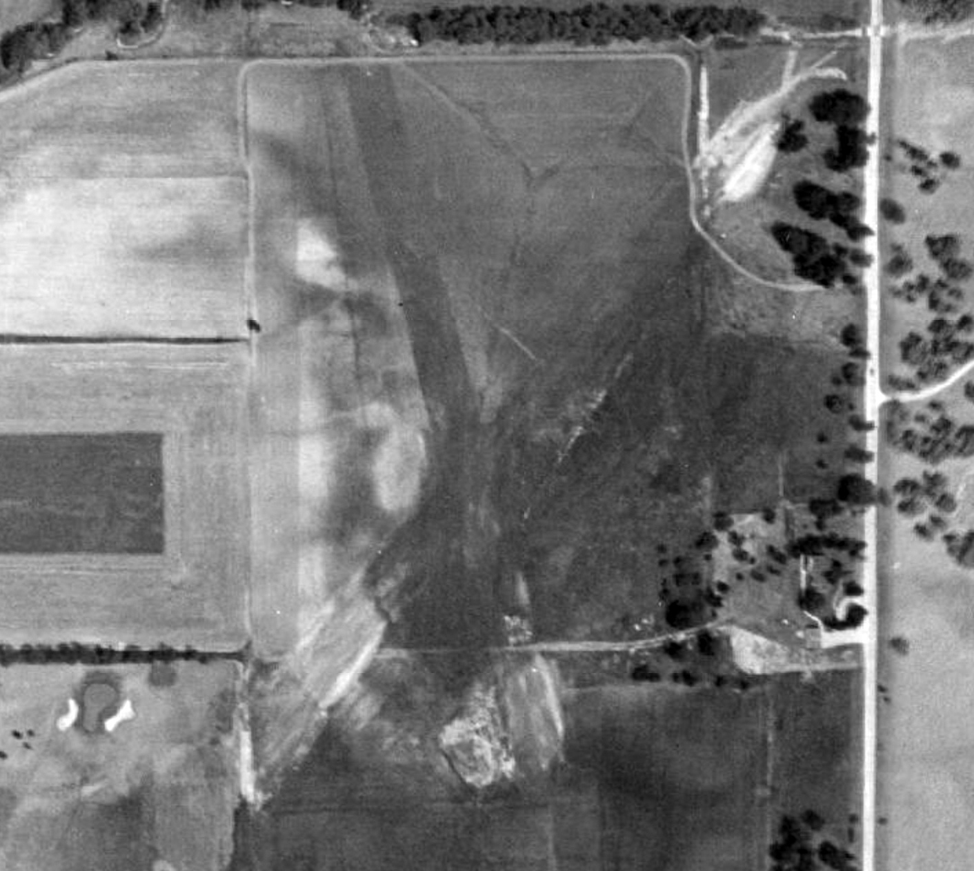
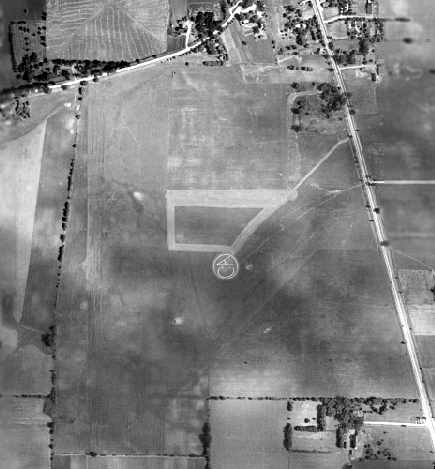
Skycrest Country Club Airport, as depicted on a 1946 aerial view (courtesy of Robbie Culver).
This short-lived small airport was built to serve the adjacent golf course.
Skycrest Country Club Airport was evidently built at some point between 1939-46,
as it was not yet depicted on a 1939 aerial photo, which instead only depicted the adjacent golf course.
The earliest depiction which has been located of Skycrest Country Club Airport was on a 1946 aerial view (courtesy of Robbie Culver).
It depicted Skycrest Country Club Airport as having 2 unpaved runways in an “X” shape.
There were no hangars or aircraft visible on the field.
Skycrest Country Club Airport still was not depicted on the June 1948 Milwaukee Sectional Chart.
The earliest aeronautical chart depiction which has been located of Skycrest Country Club Airport was on the December 1948 Milwaukee Sectional Chart,
which depicted it as having a 2,000' unpaved runway.
Richard Carlson reported, “The country club itself was named Skycrest then as it is on a high point of the area.
In that area speed bumps are usually the highest terrain as it is pretty flat.”
A 1951 Amoco road map (courtesy of Richard Carlson) depicted Skycrest Country Club Airport as a property outline adjacent to the northeast side of the gold course.
The last depiction which has been located of Skycrest Country Club Airport was on the June 1951 Milwaukee Sectional Chart,
which depicted it as having a 2,000' unpaved runway.
Skycrest Country Club Airport was evidently closed (for reasons unknown) at some point in 1951,
as it was no longer depicted on the December 1951 Milwaukee Sectional Chart.
By 1952, an aerial photo showed a road had been built over the middle of the former Skycrest Country Club Airport.
A 1961 aerial view (courtesy of Robbie Culver) of the site of Skycrest Country Club Airport showed a road having been built over the middle, but traces of the 2 runways were still recognizable.
Richard Carlson recalled “I caddied at Twin Orchards in the 1970s & never heard of any type of airport at the time so I am pretty sure all vestiges had been removed by then.
I had flown over this a million times going in & out of Chicagoland in the 1970s & 1980s & never noticed any type of facility that resembled an airstrip.”
A 2018 aerial view looking north showed no recognizable trace remaining of Skycrest Country Club Airport.
As of 2022, the name of Skycrest Country Club Airport lives on, via the Skycrest Animal Clinic which occupies the site.
____________________________________________________
Northern Pump Airfield / McHenry Farms Airfield, McHenry, IL
42.378, -88.319 (Northwest of Chicago, IL)
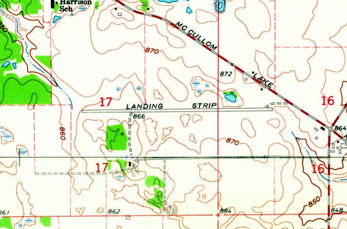
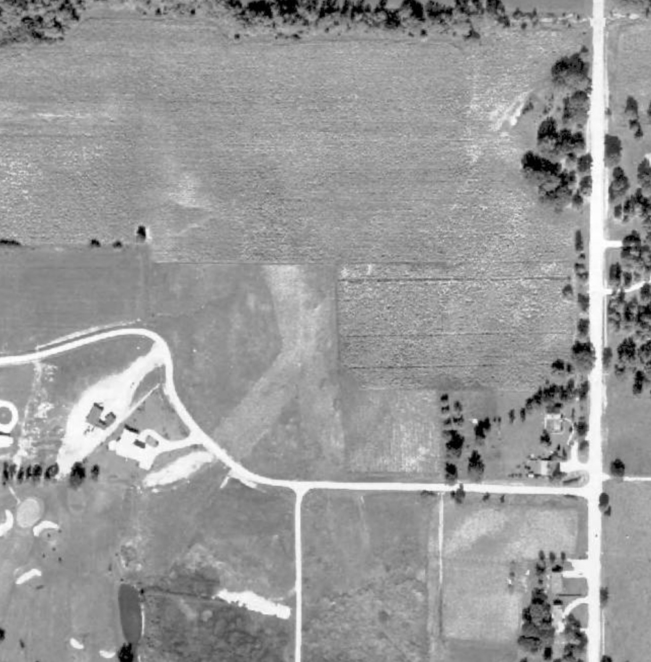
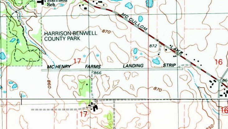
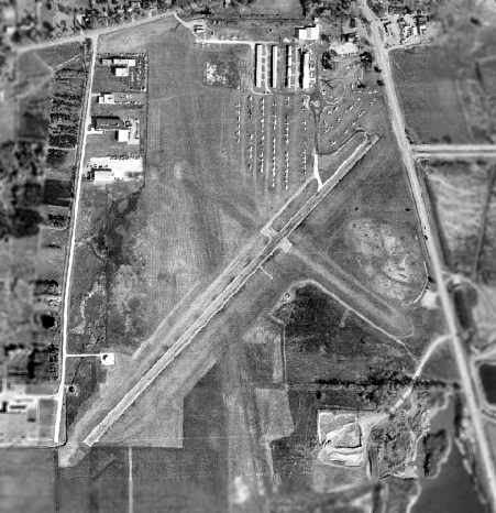
Northern Pump Airfield, as depicted on the 1963 USGS topo map.
This private airfield was evidently established at some point between 1953-61, as it was not yet depicted on a 1953 aerial view.
The earliest depiction which has been located of the Northern Pump Airfield was a 1961 aerial photo.
It depicted a single paved east/west runway, with no hangars or other improvements.
However Northern Pump Airfield was not yet depicted on the May 1965 Milwaukee Sectional Chart.
The earliest aeronautical chart depiction which has been located of the Northern Pump Airfield was on the 1967 Chicago Local Aeronautical Chart.
It depicted Nothern Pump as a private airfield having a 4,600' paved east/west runway.
The Northern Pump Airfield was evidently established to support the nearby Northern Pump Farms,
owned by John Hawley, who also owned the Northern Pump Company (which operated another Northern Pump Airfield in Fridley MN).
According to Chris Sorenson, “ Northern Pump Farms... was where Hawley raised his prize Herefords.”
The 1972 IL Airport Directory (according to Bill Pagett) described the Northern Pump Company Airfield as having a 4,200' runway,
which would have been enough for the surplus B-25 Mitchell operated by the company.
The 1973 Chicago Terminal Aeronautical Chart (courtesy of Bill Pagett) depicted Northern Pump as a private airfield having a 5,400' paved east/west runway.
It was still depicted as Northern Pump Airfield on the May 1975 Chicago Terminal Aeronautical Chart (courtesy of John Ferrara).

The earliest photo which has been located of the Northern Pump Airfield was a 1988 aerial view looking northwest.
It depicted a single paved east/west runway, with no hangars or other improvements.
There was no indication of any recent aviation use.
The airfield was evidently renamed at some point between 1975-92,
as the 1992 USGS topo map labeled it as “McHenry Farms Landing Strip”.
The last aeronautical chart depiction which has been located of the McHenry Farms Landing Strip was on the October 1993 Chicago Sectional Chart (courtesy of Ron Plante).
It depicted McHenry Farms as having a 5,400' paved east/west runway.
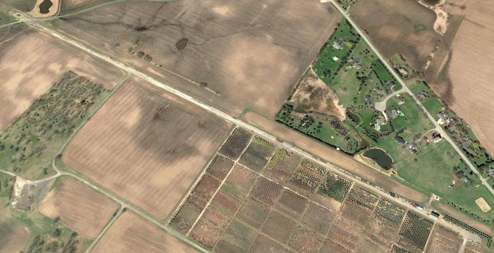
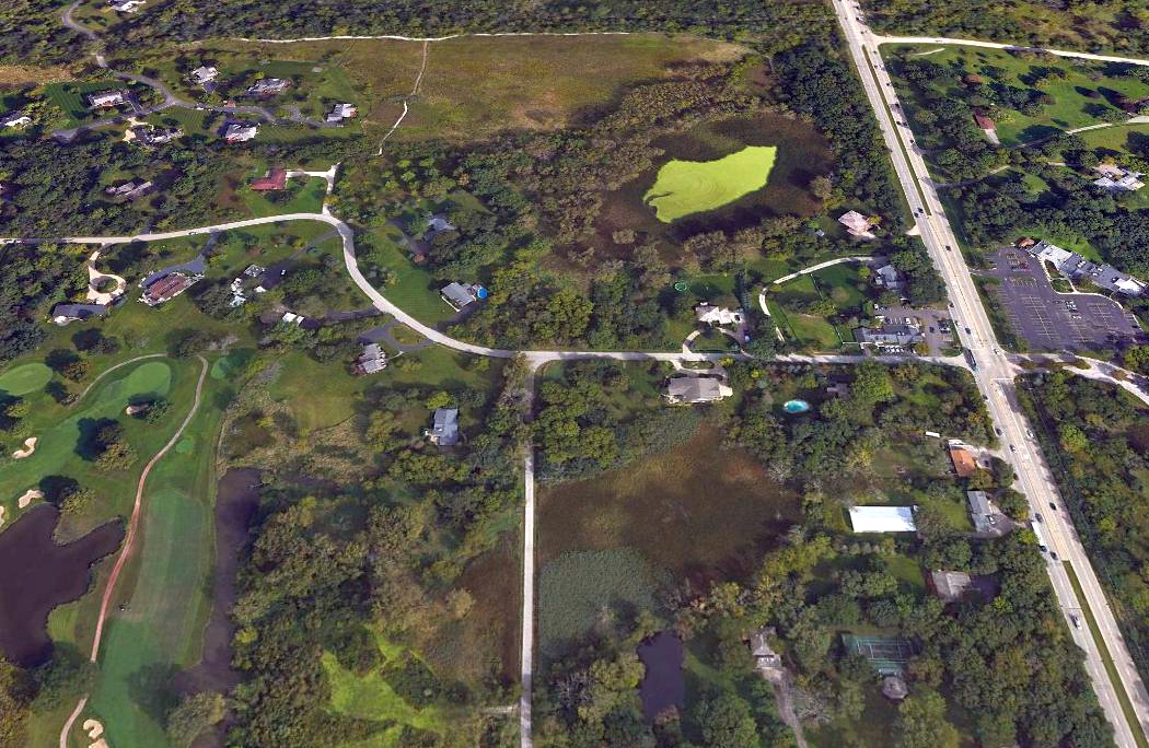
A 2017 aerial view looking northwest showing the McHenry Farms runway remained inact though deteriorated, with vehicles & 2 sheds on the eastern portion.
Bill Paget reported in 2018 of the former Northern Pump Airfield, “With flying in that neighborhood for almost 40 years, I never saw any aircraft operations there.”
Thanks to Bill Pagett for pointing out this airfield.
____________________________________________________
Woodale Naval Outlying Landing Field / Wood Dale Field / Moody Airport, Wood Dale, IL
41.98, -87.97 (Northwest of Chicago, IL)
“Wood Dale” was depicted as a military airfield on the October 1942 Chicago Sectional Chart (courtesy of Brad Lawrence).
Wood Dale Field was evidently established at some point between 1940-42,
as it was not yet depicted on a 1939 aerial view nor on the February 1940 Milwaukee Sectional Chart.
This field was originally used during WW2 as one of 15 satellite airfields which supported flight training operations at nearby NAS Glenview.
According to Brian Rehwinkel, “The field was leased by the Navy & I think it is very likely the field was built as a civilian airport & was then leased by the Navy.
I believe the Navy used the field from sometime in later 1942.”
The earliest depiction of Wood Dale Field which has been located was on the October 1942 Chicago Sectional Chart (courtesy of Brad Lawrence),
which depicted Wood Dale as a military airfield.
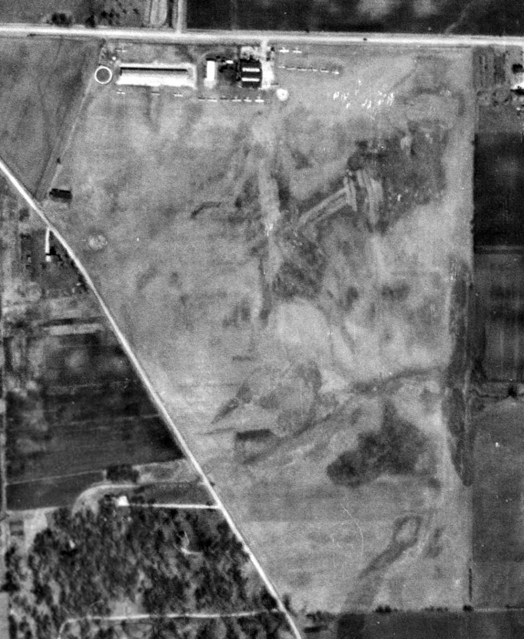
The earliest photo which has been located of Wood Dale OLF (Site 22 / Field 22311) was an 8/11/43 U.S. Navy aerial view looking east (courtesy of Brian Rehwinkel),
which Brian Rehwinkel observed, “shows the field when it was being used by the Navy as an Outlying Field.”
A closeup of the Wood Dale hangars from the 8/11/43 U.S. Navy aerial view looking east (courtesy of Brian Rehwinkel).
Brian Rehwinkel observed, “You can see the fully-developed hangar.”
A 1945 map of NAS Glenview & its 15 satellite airfields, including Woodale (courtesy of Dick Ferron).
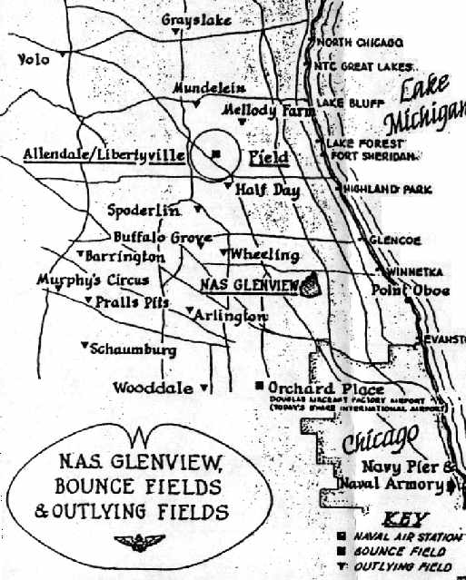
A WW2-era map of NAS Glenview & its Outlying Fields, including Wooddale,
from the book "Lake Michigan's Aircraft Carriers", by Paul Somers (courtesy of John Voss).
“Wood Dale (Navy)” was depicted as a military airfield on the 1946 Chicago Sectional Chart.
Brian Rehwinkel noted, “I believe the Navy used the field to the middle of 1946.
When the Navy canceled the lease for the 82 acre airfield in 1946,
the documents implied that the hangar, offices & shops were not built by the Navy.”
No airport was depicted at this location on the 1946 USGS topo map.
According to Moody Aviation, “In 1950, Moody Aviation transferred operations [from Elmhurst Airport] to Wooddale Airport.”
According to the Encyclopedia of Chicago, “In 1950 part of the airport was leased to the Moody Bible Institute to train missionaries to become pilots & mechanics.
The institute purchased the entire airport 3 years later & changed its name to Moody Airport.”
A 4/8/52 USGS aerial view depicted 18 single-engine aircraft & a few small buildings along the north side of the grass airfield at Wood Dale.
According to the Encyclopedia of Chicago, “The Moody Bible Institute purchased the entire airport [in 1953] & changed its name to Moody Airport.”
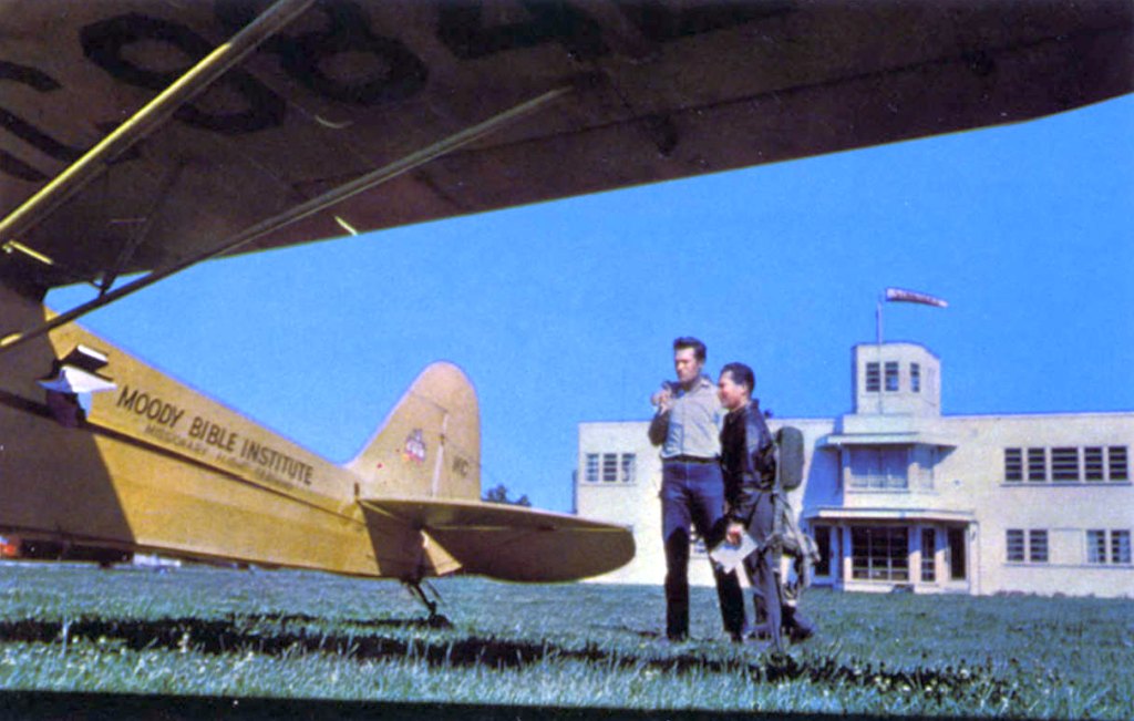
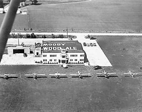
An undated photo from a 1953 postcard showed unidentified men next to a taildragger marked “Moody Bible Institute”.
The caption read, “Moody-WoodDale Airport, Moody Bible Institute. Located at Wood Dale, IL, 23 miles west of Chicago.
Modern hangers house 10 training planes, aircraft & engine mechanics' school & shop.
Administration buildings contain offices, classrooms, lounge, and ready rooms for students in the Missionary Technical Course. CAA approved.”
The 1954 IL Airport Directory (courtesy of Lee Corbin)
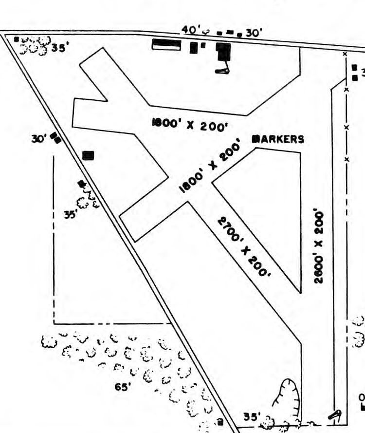
depicted Moody Wooddale Airport as having 4 unpaved runways, and 3 small buildings on the north side.
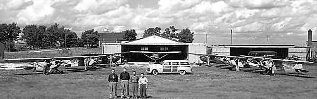
A 1954 photo of 7 aircraft parked in front of hangars at Moody Airport.
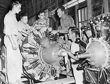
A 1955 photo of aircraft engine maintenance training at Moody Airport.
The 1956 USGS topo map depicted Moody Airport as having a few small buildings along the north side of an open field.
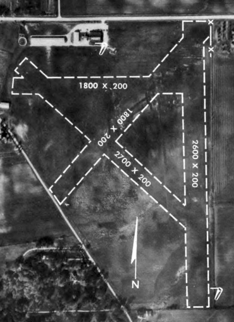
An undated aerial view of Moody Airport from the 1956 IL Airport Directory (from the University of IL, courtesy of Daniel McGill)
depicted the field as having 4 unpaved runways, with the longest being the 2,600' north/south strip.
Four hangars were depicted on the northwest side, one of which had the airport name painted on its roof.

A circa 1950s aerial view looking north at Moody Airport.
A circa 1950s aerial view of 6 training aircraft in front of the terminal building at Moody Airport.
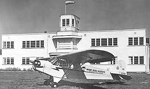
A circa 1950s photo of a Piper Cub marked “Moody Bible Institute” in front of the terminal building at Moody Airport.
RetroDeco recalled, “I lived In Woodale from 1958-75.
As a kid I would ride over to Moody Field when I heard the 2 yellow AT-6s in the pattern!
They would do touch & goes sometimes for hours in the summer!”
USGS aerial photos from 1960 & 1962 depicted Moody Airport as remaining intact,
but there were no aircraft visible on the field.
A 1962 USGS aerial view depicted 2 grass runways, which were not evident in previous photos.
The June 1962 Chicago Sectional Chart depicted Moody as having a 2,900' unpaved runway.
The 1964 USGS topo map depicted Moody Wood Dale Airport as having a few small buildings along the north side of 2 unpaved runways.
The last aeronautical chart depiction which has been located of Moody Airport was on the December 1965 Milwaukee Sectional Chart (courtesy of Ron Kunse).
It depicted Moody as a private airfield having a 2,600' unpaved runway.
Note the little airport's proximity to the massive O'Haire Airport to the east.
The last airport directory listing which has been located of Moody Airport was in the 1968 Flight Guide (courtesy of Robert Levittan).
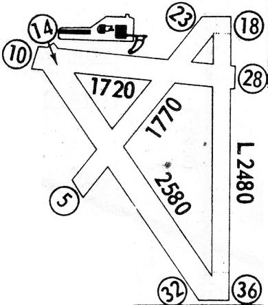
It depicted Moody Wood Dale Airport as having 4 unpaved runways, with the longest being 2,580' Runway 14/32,
along with 2 buildings on the north side.
Moody Airport was evidently closed at some point between 1968-70,
as it was no longer depicted on the May 1970 Milwaukee Sectional Chart.

A sad 1972 photo of the terminal building at Moody Airport, presumably abandoned.
Moody Airport was evidently closed at some point between 1968-73,
as the 1973 USGS topo map no longer depicted Moody Airport.
A 1974 USGS aerial photo showed that buildings had been constructed over the Moody Airport airfield,
and the terminal building & another building had been removed at some point between 1972-74,
but the western T-hangar building remaining standing.
A 1988 USGS aerial photo showed that the western T-hangar building had been removed at some point between 1974-88,
erasing the last sign of Moody Airport.
According to the Encyclopedia of Chicago, “Eventually annexed by Wood Dale, the airfield became Klefstad Industrial Park.”
A 4/2/13 aerial photo showed no trace remaining of Moody Airport.
The site of Moody Airport is located southeast of the intersection of East Thorndale Avenue & Central Avenue.
____________________________________________________
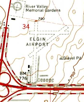
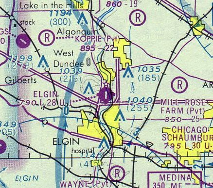
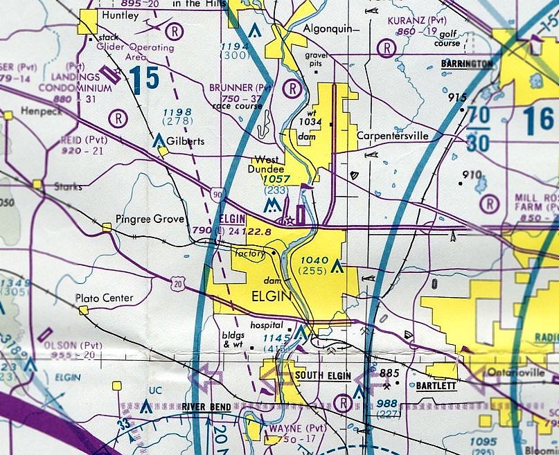
42.07, -88.287 (Northwest of Chicago, IL)
Elgin Airport, as depicted on the 1930 Chicago Sectional Chart.
According to elginhistory.com, “In July, 1929, Elgin Airways Incorporated obtained a lease on a section of the former Todd farm, then owned by Earle Kelley.
The land, most of it lying in Dundee Township, was level & free of obstructions.
It required little grading, and after the weeds were cut & rocks removed, planes soon were able to use the new field.
Learning of a proposed air mail service running from Chicago to Madison via Rockford & Janesville,
the Association of Commerce raised about $16,000 for the improvement of the Kelley property & took over Elgin Airways' lease.
Since the mail plane would have to land after dark several months of the year, it was necessary to install boundary & landing lights.”
According to elginhistory.com, “B.S. Pearsall, a margarine manufacturer, paid for a revolving beacon required by the Post Office Department.
It was erected on a rise of land along Highway 20 west of the city & became a familiar landmark.
The Elgin National Watch Company, then producing tachometers & the Avigo magnetic compass, was a major contributor to the project.
Victor Showalter, engineer for the firm's instrument division, was responsible for much of the planning necessary for government approval.
He also was an active member of the Elgin Avigo Flying Club, a group of local enthusiasts.”
According to elginhistory.com, “Among the reasons for the Association of Commerce's investment
was Elgin's location in the metropolitan area outside the smoke & haze of the central city.
Not only would an Elgin airport offer safe landing conditions, but passengers had fast access to Chicago's Loop on the third rail interurban.
A local airport would be good for business.”
According to elginhistory.com, “Mail & passenger operations provided by Northwest Airways started 3/8/30.
More than 7,000 pieces of mail to be postmarked on the first day of service were received from every state & from several foreign countries.
The service was prompt & regular, with few cancellations due to inclement weather.
The plane from Chicago arrived in the morning, and the plane from Madison landed early in the evening.
About 4 pounds of mail was carried from Elgin each day.”
According to elginhistory.com, “The airport was formally dedicated with a big celebration on 6/10/30.
Among the 77 planes on hand were 30 flown in by the U.S. Army Air Corps & 6 by the Navy.
Hap Arnold (who would become commander of the Army Air Force in the Second World War)
led the flight of Army planes from Wright Field at Dayton, OH.
A crowd of thousands witnessed demonstrations of aerial maneuvering & a parachute jump.
Rides in oil company aircraft were available for the daring.”
According to elginhistory.com, “Among the planes on display were Curtisses, Stinson Detroiters, Douglasses,
Heath Parasols, Gypsy Moths, Monocoupes, Fokkers, Wacos, and Boeings.”
Calling attention to the rapid growth of aviation, the main speaker, Rear Admiral Walter Crosley,
prophesied: “Those cities that are as farseeing as Elgin, who have airports now, are on the ground floor & will profit in the future.”
Elgin Airport was not depicted on the 1932 USGS topo map.
According to elginhistory.com, “After air mail postage rates were increased,
the number of letters declined with the deepening Depression.
On 5/31/33, service on the Elgin route was discontinued.
This blow was followed by a tornado in July that roared through the north end of Elgin.
The walls of one hangar were blown away as though made of paper. Parts of the roof caved in & crushed 2 planes.
Doors were blown out of another hangar, and one wing of the gasoline station - a structure built to resemble an airplane - was damaged.”
According to elginhistory.com, “The Elgin Airport Company, which had been organized as an adjunct to the Association of Commerce,
turned over its lease to the city of Elgin to establish eligibility for federal aid.
The application was not acted upon.
A drive by business leaders for private funds failed, the Elgin Airport Company suspended its activities, and the Kelley family closed the field.”
A 1938 aerial photo did not show any sign of an airport – just an open grass field.
According to elginhistory.com, “During the Second World War, the government leased the Kelley grounds
as an auxiliary training field for fledgling pilots from the Navy's Glenview base.”
However, Elgin Airport was not depicted on the 1942 USGS topo map,
nor listed among active airfields in the 1945 AAF Airfield Directory (courtesy of Scott Murdock).
According to elginhistory.com, “After the war, in 1946, the Elgin Airport Corporation, led by George Edgcumbe,
asked the state of Illinois for permission to re-activate the field.
Approval was granted despite vigorous objections from neighboring property owners,
who feared the noise of low-flying planes & possible hazards.
An office & reception center was erected, and a Quonset hut served as a repair shop.
A helicopter air mail shuttle between Elgin, Chicago, and 9 other cities started in 1949 & continued for several years.”
Elgin Airport was still not depicted on the October 1946 Milwaukee Sectional Chart (courtesy of Jim Stanton).
The earliest aeronautical chart depiction which has been located of Elgin Airport was on the November 1952 Milwaukee Sectional Chart.
It depicted Elgin as having a paved 2,400' runway.
According to elginhistory.com, in 1952 Elgin's rotating beacon was relocated from Highway 20 to the airport.
The November 1952 Milwaukee Sectional Chart depicted Elgin Airport as having a 2,400' paved runway.
The earliest photo which has been located of Elgin Airport was a 1953 aerial photo.
It depicted the field as having a grass north/south runway, with a single building on the south side.
Harvey Nack recalled, “After WWII I dropped my flying to go to school to earn a living.
Ten years later I started over but the Feds would not accept my old paperwork to give me a license.
I had to go to the Elgin Airport where the guru of CAA examiners was an Art Fisher.
Elgin had 2 long runways & was the home of the original Piper distributor & dealer.
B & M Aircraft was doing the shop & maintenance work for most of the area as the only one of its kind.
I got my ticket & ultimately flew rented & my own plane to Elgin frequently.
The man who was the Piper man passed away & then his family ran things
and Priester at Palwaukee took over the Piper sales & many others too.”
The 1956 Chicago Terminal Aeronautical Chart (courtesy of Timothy Zukas) depicted Elgin Airport as having a 2,400' paved runway.
According to elginhistory.com, “When Commonwealth Edison took steps to bisect the Elmhurst Airport with a high power line,
Edgeumbe transferred his facilities to Elgin in 1956-57.
Landing lights were installed & several T-hangars arose.
The airport was mainly used by recreational flyers of single- & twin-engine planes.
The field's longest runway, 2,800', couldn't handle any small jets.
More than 80,000 operations were handled in a peak year.
Revenue to operate the airport was derived from charter flights, instruction, and the sale & delivery of Piper Cub planes.”
Elgin Airport was not depicted on the 1957 USGS topo map.
A 1961 aerial photo depicted Elgin Airport as having a paved north/south runway with a parallel taxiway, in addition to 2 other unpaved runways.
Elgin was apparently very well-used, with over 2-dozen light aircraft visible on the field.
The earliest aeronautical chart depiction which has been located of Elgin Airport was on the June 1962 Chicago Sectional Chart.
It depicted Elgin as having a single paved north/south 2,400' runway.
The 1962 USGS topo map depicted Elgin Airport as having 3 unpaved runways,
with several buildings on the southwest & south sides.
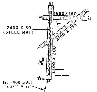
A 1969 approach plate (courtesy of Michael McConnell) depicted Elgin Airport as having 3 unpaved runways,
with Runway 18/36 having a 2,400' steel mat portion in the middle, and buildings on the southwest & southeast sides.
Tad Woodhull recalled, “Elgin... It was quite active in the 1960s housing the Piper distributorship.
They did great work for me back then.”
The 1969 Chicago Sectional Chart depicted Elgin as having a single paved north/south 2,600' runway.
Robert Robar recalled, “Elgin Airport... Back in the very early 1970s it had 3 runways:
paved 18/36 about 2,800' long; two unpaved, 9/27 about 1,700' long, 5/23 about 2,150' long.”
A 10/26/72 aerial photo depicted Elgin Airport as having one paved runway & 2 grass runways.
Several hangars & T-hangars were located on the southwest side, but there did not appear to be any aircraft parked outside.
The 1973 USGS topo map depicted Elgin Airport as having a paved north/south runway with a parallel taxiway,
in addition to 2 other unpaved runways.
Three other buildings had been added at some point between 1962-73.
A 1974 aerial view depicted Elgin Airport's physical configuration as largely unchanged,
and over 2-dozen light aircraft were visible on the field.
Steven Kaplan recalled, “Elgin Airport... I flew from there from 1974-84
and can attest to it's activity & fine people who spent time &/or worked there.”
The May 1975 Chicago Sectional Chart (courtesy of Mitchell Hymowitz) depicted Elgin Airport as having a single paved north/south 2,800' runway.
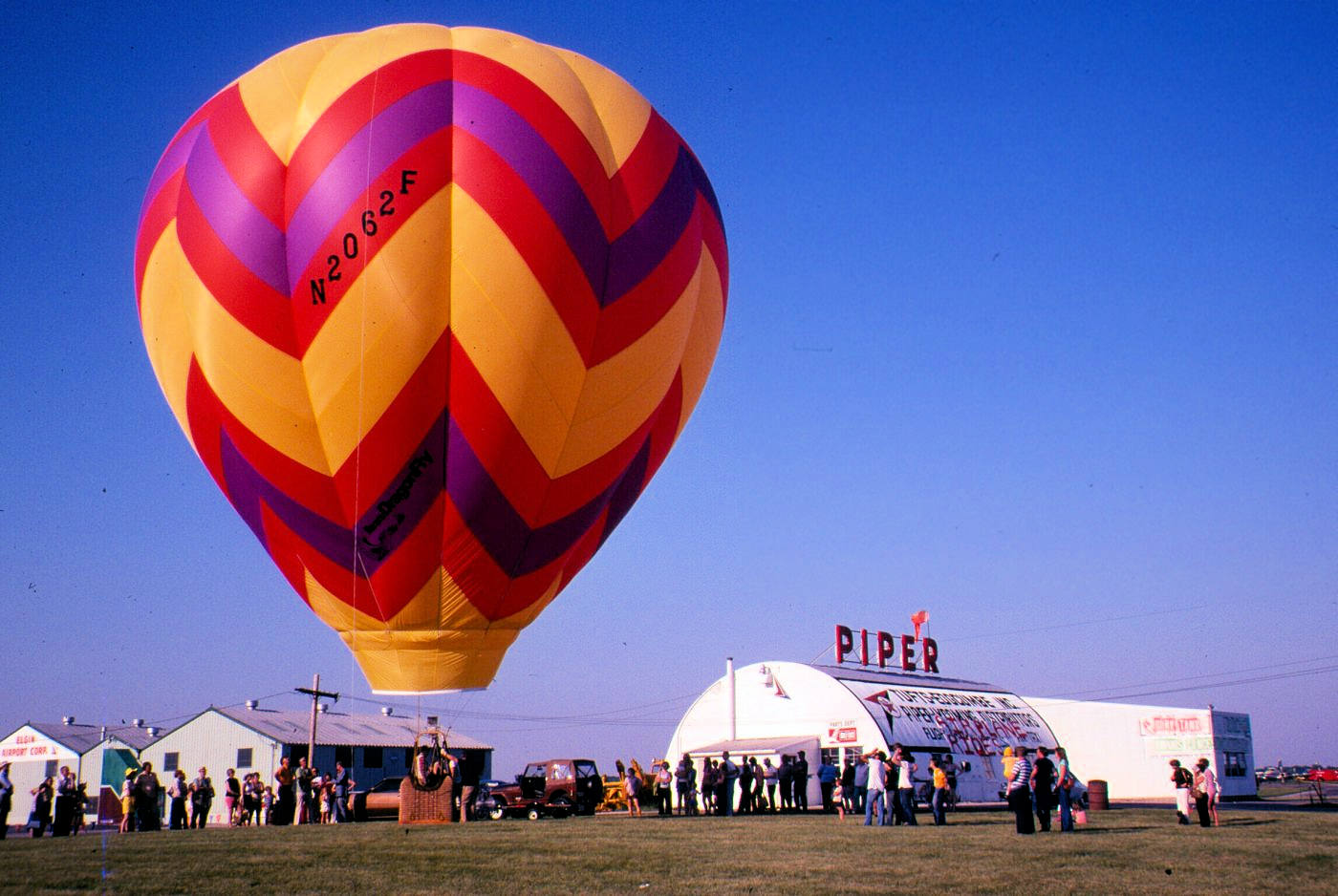
A beautiful October 1975 photo by Marc Stancy of a balloon launch at Elgin Airport, showing the airport office Quonset hut with a Piper sign.
A 1978 aerial photo (courtesy of Sam Scinta) depicted Elgin Airport as being extremely well-used, with dozens of light aircraft parked on the field.
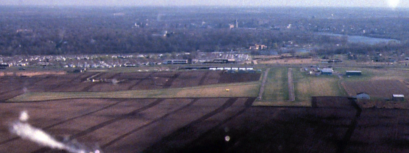
A May 1980 aerial view by Marc Stancy looking south at Elgin Airport on approach to Runway 18 in a Cessna 175 Skylark.
Dustin Dwyer recalled, “Elgin Airport... My only memory of it was going there to watch the Goodyear blimp take off & land.”
The last aeronautical chart depiction which has been located of Elgin Airport was on the 1981 Chicago Terminal Chart.
It depicted Elgin as having a single paved north/south 2,400' runway.
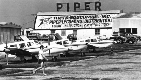
The last depiction which has been located of Elgin Airport was an 8/17/83 photo of Arlene Edgcumbe & several Pipers in front of the Tufts-Edgecumbe hangar.
Pat Keefer reported, “Arlene Edgcumbe was pilot-wife of FBO owner George Edgcumbe & sometimes race co-pilot to my Hall of Fame Mom, Marion Jayne.
Mom & Dad, George, also learned to fly at Elgin & bough the Twin Comanche I now own from the Edgcumbes.”
According to elginhistory.com, “Edgeumbe didn't own the 186-acre field, and the value of the land escalated when the tollway opened.
The airport was forced to close on 11/1/83, after it was decided to develop a shopping center & business park on the site.”
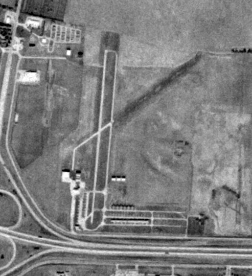
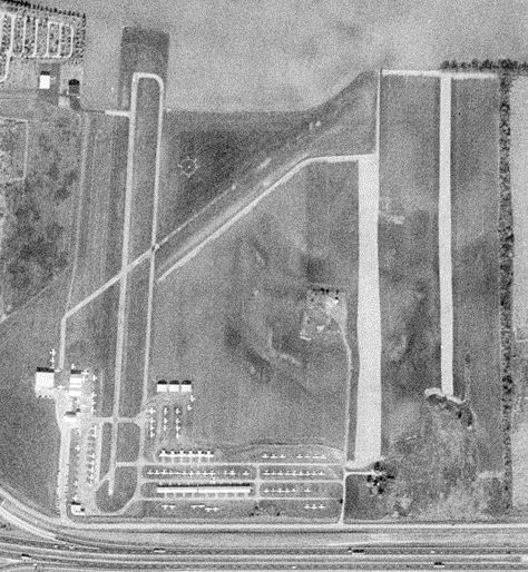
The 1994 USGS aerial photo showed a shopping center covering the site, with no trace remaining of Elgin Airport.
A 3/12/12 aerial photo showed no trace remaining of Elgin Airport.
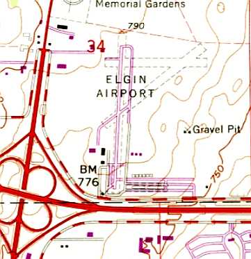
The site of Elgin Airport is located northwest of the intersection of River Ridge Drive & Airport Road, appropriately enough.
____________________________________________________
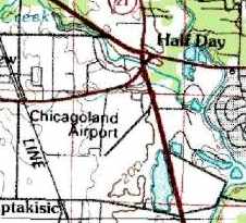
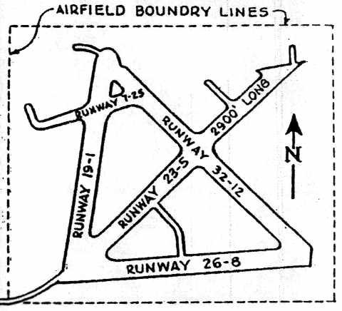
Half Day Naval Outlying Landing Field / Wheeling Naval Outlying Landing Field / Chicagoland Airport (3CG), Wheeling, IL
42.194, -87.935 (Northwest of Chicago, IL)
An 8/11/43 aerial view looking southeast at Half Day Field (courtesy of Brian Rehwinkel).
Brian Rehwinkel noted, “You can see the runway pattern for this field; I suspect the runway areas were mowed lower than the surrounding grass, and stand out because of that.”
Half Day Field was not yet depicted on a 1939 aerial view nor on the July 1942 Milwaukee Sectional Chart.
Brian Rehwinkel reported, “According to a September 1946 report by the IL Airport Commission, the airfield had been licensed as an airport prior to World War Two
(the report does not say whether the location was actually used as an airport).
It was first leased by the Navy in October 1942. This field was a sod field & consisted of 185 acres.”
Half Day Field was originally used during WW2 as one of 15 satellite airfields which supported flight training operations at nearby NAS Glenview.
The earliest depiction of Half Day Field which has been located was an 8/11/43 aerial view (courtesy of Brian Rehwinkel), which depicted the field as having 4 grass runways.
There did not appear to be any airfield-related buildings on the airfield.
A WW2-era map of NAS Glenview & its Outlying Fields (including Half Day),
from the book "Lake Michigan's Aircraft Carriers", by Paul Somers (courtesy of John Voss).
Brian Rehwinkel reported, “According to a September 1946 report by the IL Airport Commission,
the Navy stopped using the field in in the Fall of 1944 when nearby Libertyville OLF (the former Allendale OLF) received paved runways for use as a carrier landing practice field.
The lease was apparently canceled in March 1945.”
A 1945 map of NAS Glenview & its 15 satellite airfields (including Half Day),
courtesy of Dick Ferron (a Naval Aviation Cadet at Glenview in 1945).
The July 1945 Milwaukee Sectional Chart labeled this field as “Wheeling (Navy)”, depicted as auxiliary airfield.
Half Day / Wheeling NOLF was evidently abandoned by the Navy at some point between 1945-46,
as no airfield was depicted at this location on the June 1946 Milwaukee Sectional Chart (according to Chris Kennedy).
Brian Rehwinkel reported, “Interestingly enough, after the Navy canceled the lease, a request was made in early 1946 to re-open the airport using the name Chicagoland Airport.
The Navy strenuously objected to the field being used as a civilian airport – for the same reason it was abandoned during the war...
the Navy felt the air traffic from this field would conflict with traffic at Libertyville OLF.
Over these objections, the Airport Commission apparently allowed the Chicagoland Airport to open in late 1946.”
Half Day NOLF was reopened during 1946 as the Chicagoland Airport,
as a July 1946 aerial view (courtesy of Chris Kennedy) depicted the field as having a large “CA” marking (presumably for “Chicagoland Airport”).
There were no aircraft or hangars visible on the field, which appeared to consist of a grass area with several runways in an unusual arrangement.
The earliest chart depiction which has been located of the Chicagoland Airport
was on the December 1948 Milwaukee Sectional Chart (courtesy of Chris Kennedy).
It described the field as having a 3,500' unpaved runway.
A 1951 Amoco road map (courtesy of Richard Carlson) depicted “Chicagoland Airport” as a property outline.
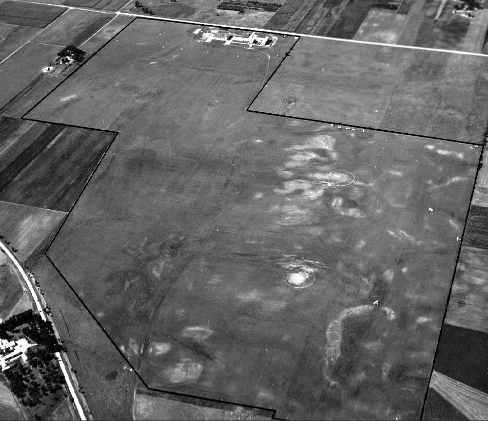
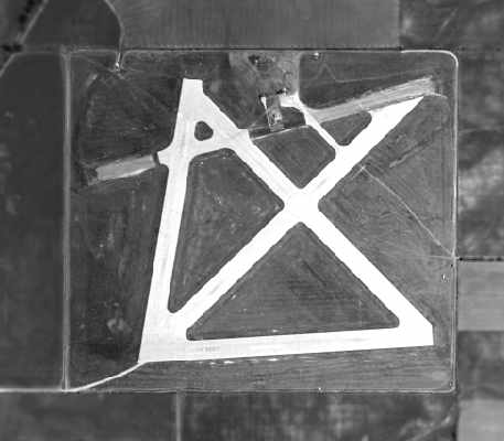
A 1951 aerial photo depicted a considerably expanded airfield compared to the 1946 photo,
with 3 much-larger grass runways, and several dozen hangars & several small hangars on the northeast side.
Aerial photos from 1952 & 1953 depicted much the same configuration.
The 1953 USGS topo map depicted Chicagoland Airport as an irregularly-shaped property outline surrounding 3 unpaved runways,
with several small buildings on the northeast side.
The 1954 Chicago Local Aeronautical Chart (courtesy of Chris Kennedy) depicted Chicagoland as having 4 runways, with the longest being 4,000'.
The 1956 IL Airport Directory (courtesy of Chris Kennedy) depicted Chicagoland as having 4 grass runways,
with the longest being the 4,000' northeast/southwest strip.
Chicagoland was apparently already a very well-used airport by that point, as in the aerial photo in the 1956 directory showed dozens of aircraft on the field.
A paved taxiway led to a group of small hangars on the northeast corner of the field.
The operators were listed as Chicagoland Airport Inc. & the Pop Goggins Flying Club, and the manager was listed as Arthur Schelter.
Mike Schelter recalled, “Art Schelter was my Dad; my mom was Ginny Schelter. I grew up at the [Chicagoland] Airport.
If any of the customers are still living, they would remember me, since I probably gassed their planes.”
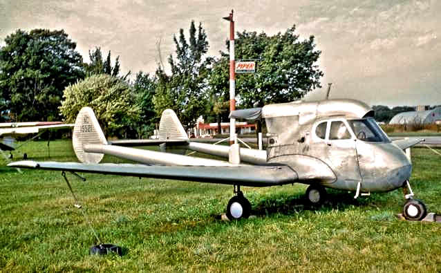
A 1960 photo of a rare & unusual Stearman Hammond Y-1 at Chicagoland Airport (courtesy of Carl Kangas).
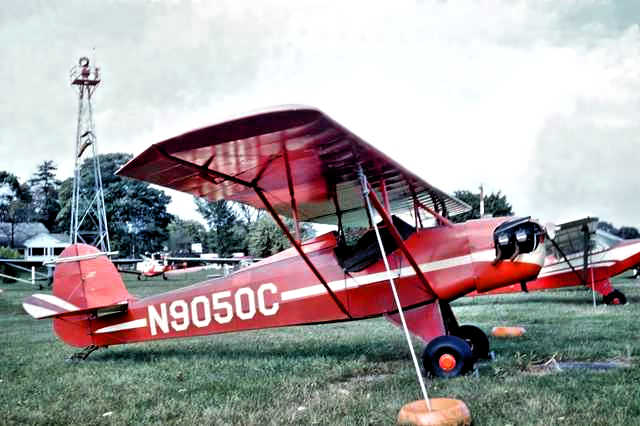
A 1960 photo by Carl Kangas “of the Baby Ace I saw at Chicagoland Airport.
Partially visible over its cowling is the Piper sign that is also in the picture of the Stearman Hammond.
In the next tie-down is a Piper Super Cruiser & in the background [are] 2 Luscombs & an Ercoupe.
Just beyond & left of the rotating beacon tower is a white building that may have housed the restaurant.
They had a nice little restaurant, we sometimes flew there from Waukegan for lunch.”
By the time of the 1961 IL Airport Directory (courtesy of David Brooks),
the northeast/southwest grass runway at Chicagoland had been replaced by a paved (if somewhat shorter) 3,300' strip.
Two other shorter grass runways remained in use, but the east/west grass runway had been closed.
A large number of aircraft were still depicted in the parking area at the northeast corner of the field.
The number of small hangars had grown, and at least one larger hangar had been added as well.
The operator was listed as Chicagoland Airport Inc., and the manager was listed as Arthur Schelter.
A 1961 aerial view depicted several dozen light aircraft on the field.
Luke Warfield recalled, “an old salty pilot with the nickname 'Bones' that was based at Chicagoland.
He was giving check rides out of Chicagoland in the 1960s. He was a 60ish small skinny guy that chain-smoked.
We used to joke all the check rides lasted 40 minutes max as that was the longest he could go without a smoke.”
The 1963 USGS topo map depicted Chicagoland Airport as having a paved northeast/southwest runways & an unpaved perpendicular crosswind runway.
Taxiways led to a cluster of small buildings on the northeast side.
Steven Uhrik recalled, “Chicagoland Airfield... I learned to fly there [in] 1964-65.
Tracy Pillars... the aerobatics champion... She was one of my instructors & she was known for building her own biplane 'Puppy Feet'.”
Bill Pagett recalled, “I met general aviation legend Max Conrad who was a very frequent visitor to the airport.”
A 1969 approach plate (courtesy of Michael McConnell) depicted Chicagoland Airport
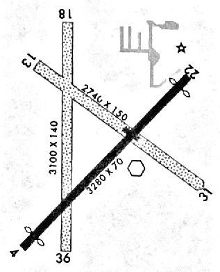
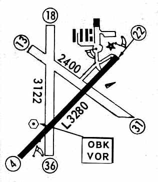
as having a 3,280' paved Runway 4/22, 2 grass runways, and taxiways & ramps on the northeast side.
Mike Stouffer recalled, “My first & my fondest memory of the [Chicagoland] Airport & aviation was playing in the sandbox on a beautiful sunny day under a tree near the main building
while my brother & I waited for Dad to come back from flying a Stinson V77 Gull Wing which he had a 1/4-share in.
A T-28 sat, in need of work, next to a hangar close by. I guess nobody would leave their kids like that today. Back then nobody was much concerned.
My first flying lessons were with Vic Jacobs (about 70 years old at the time) in a J-3 Cub at Chicagoland Airport.
Dad bought my brother & I two hours of flying lessons in 1971. We were paying $19 per hour with fuel & the instructor.
I was about 15 or 16 years old. My logbook cover was embossed with Chicagoland Airport on it.”
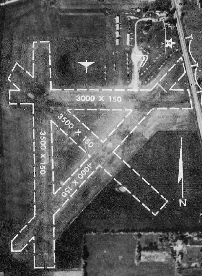
Chicagoland Airport, as depicted on the November 1971 Chicago Sectional Chart.
The 1971 Flight Guide (courtesy of Chris Kennedy) depicted a basically unchanged runway configuration for Chicagoland Airport.
An aerial view of Chicagoland Airport from the 1972 IL Airport Directory (courtesy of Bill Pagett).
The directory described Chicagoland as having a single 3,300' paved Runway 4/22, as well as 2 grass runways.
Over 80 light aircraft were visible parked on the northeast side of the field.
The operator was listed a Chicagoland Airport Inc., and the airport manager was listed as Arthur Schelter.
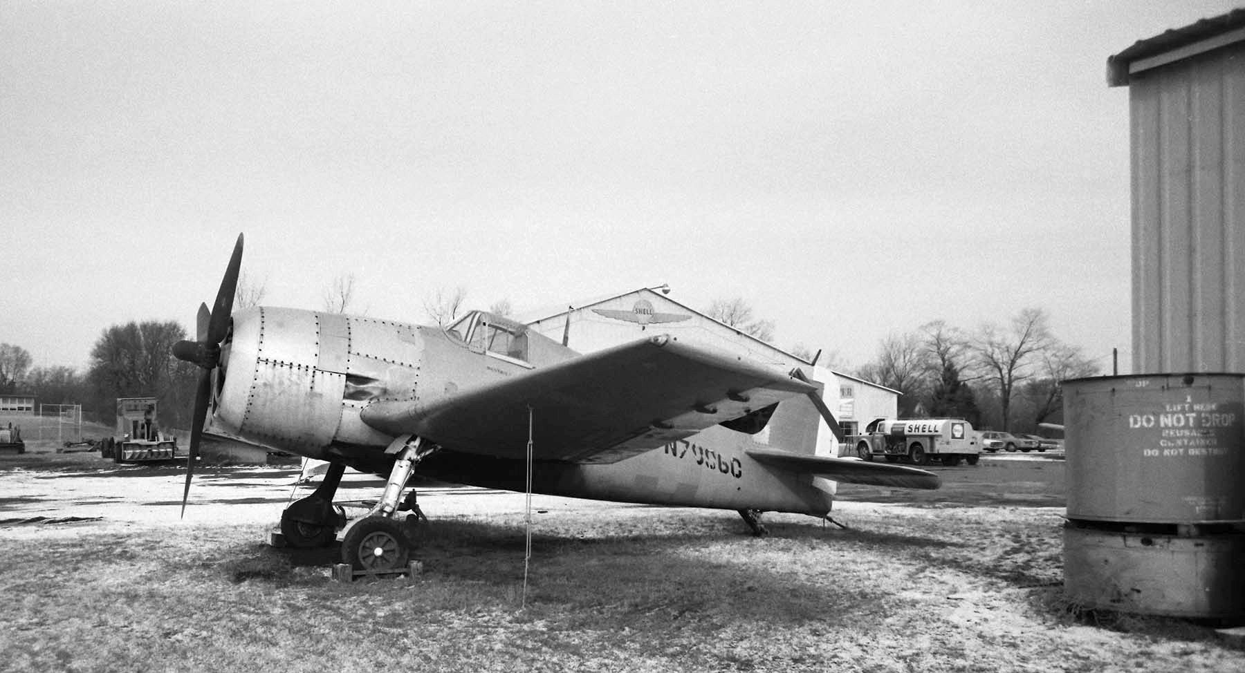
A 1/2/72 photo by Neil Aird of Grumman F6F-5K Hellcat N7896C C/n A-10828 in front of a Chicagoland Airport hangar.
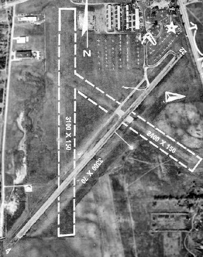
A 1974 aerial view (courtesy of Chris Kennedy) depicted Chicagoland Airport perhaps at its height of usage,
with a very large number of aircraft visible parked on the north side of the field,
in addition to those perhaps inside the numerous hangars.
The north/south grass runway had been relocated somewhat to the east compared to the 1972 photo,
moving it away from the buildings on the west side of the property.
Another building had been constructed adjacent to the west side of the airport, however,
presaging the development pressures which would eventually doom the airport.
Mike Stouffer recalled, “I later trained in 1974 with Gordon Kappe in a Cherokee 140.
I was about an hour short of solo, waiting with Mr. Kappe at the end of the runway when we witnessed a Piper Seneca belly in in front of us with an engine out & gear retracted.
He did a nice job with little damage & no injuries. We taxied to the grass runway & took off.”
The 1976 AOPA Airport Directory (courtesy of Chris Kennedy) described Chicagoland
as having a single 3,280' asphalt Runway 4/22 & two turf runways.
The field was described as providing flight instruction, charter, repairs, and fuel.
The operators were listed as Chicagoland Airport & Whirlwind Propeller Service.
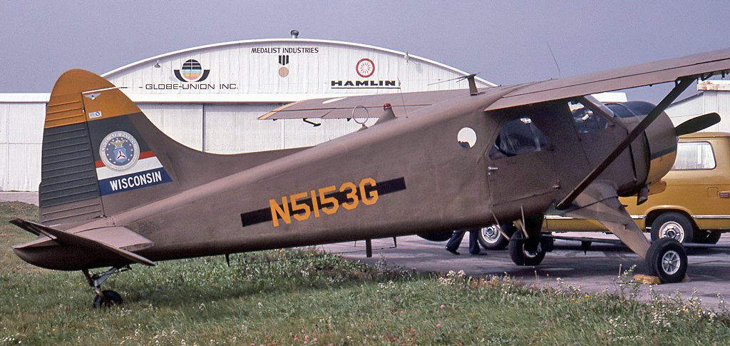
An 11/20/76 photo by Daniel Tanner of De Havilland Canada DHC-2 Beaver N5153G C/n 773 in front of a Chicagoland Airport hangar.
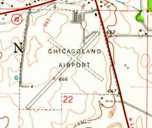
The last depiction of Chicagoland Airport which has been located was on the 1978 USGS topo map (courtesy of David Brooks).
According to Mike Schelter, “Chicagoland Airport closed in 1978.”
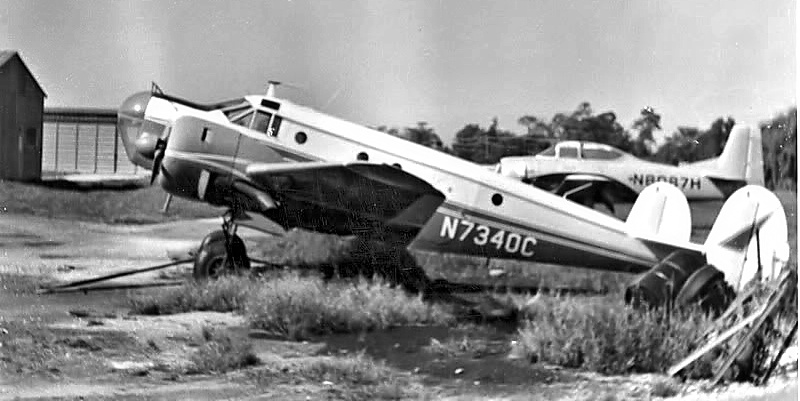
A 1979 photo by Christopher Brame of a military surplus Beech AT-11 at Chicagoland Airport.
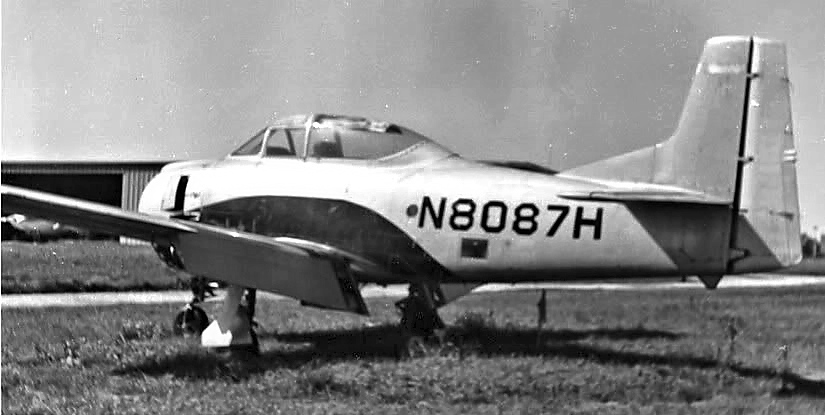
A 1979 photo by Christopher Brame of a military surplus North American T-28 Trojan at Chicagoland Airport.
Chicagoland Airport was no longer listed among active airfields in the 1979 Flight Guide (according to Chris Kennedy).
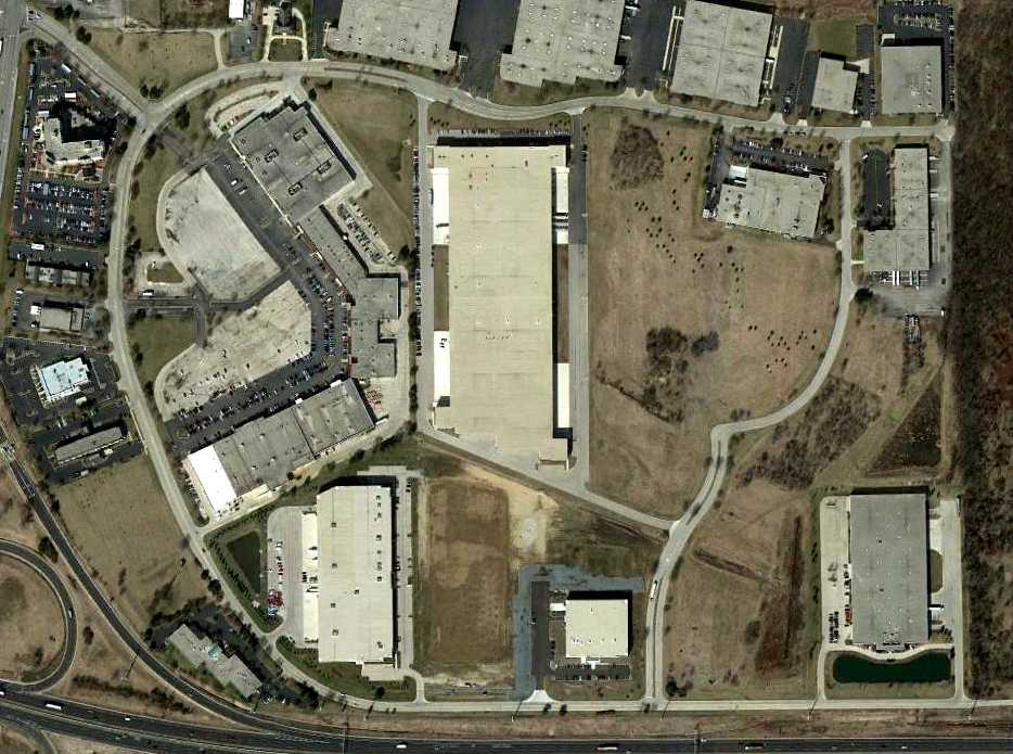
Charles LaBow (who flew his 1st solo from Chicagoland in 1967) recalled,
"The airport was turned into an industrial park sometime in the 1970s.
One of the first large tenants to build a warehouse was Quill Corporation (a large office supply company).
Their address is 100 Schelter Road, named after Arthur Schelter, the owner of the airport (and very, cranky, old man!)."
John Gerty recalled, “I walked around a Hellcat which was being restored at this point sometime in the early 1980s.”
A 1988 aerial view showed that heavy development had occurred on the spot of the former airport,
and not a trace appeared to remain of the field.
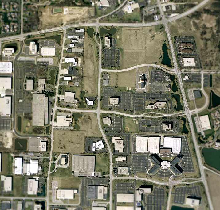
As seen in the 2002 USGS aerial photo, not a trace appeared to remain of the former Chicagoland Airport.
However, Bill Pagett reported in 2006, “There still is a reminder of the airport - if you know what you're looking at.
The road located on the northern boundary of the airport is Route 22 / Half Day Road.
With the sale of the airport, the city & state seized the opportunity to straighten out Route 22
and routed it so that the new road would cut through the T-hangars
and just south of the FBO building at the northeast corner of the airport.
Where the rotating beacon was (denoted by the star [on the photo from the 1972 directory])
was a paved circular area around the base of the beacon tower -
portions of the pavement & the concrete base of the beacon tower were never removed
and are visible from the north/south roadway (Route 21, Milwaukee Avenue) just south of the new intersection.”
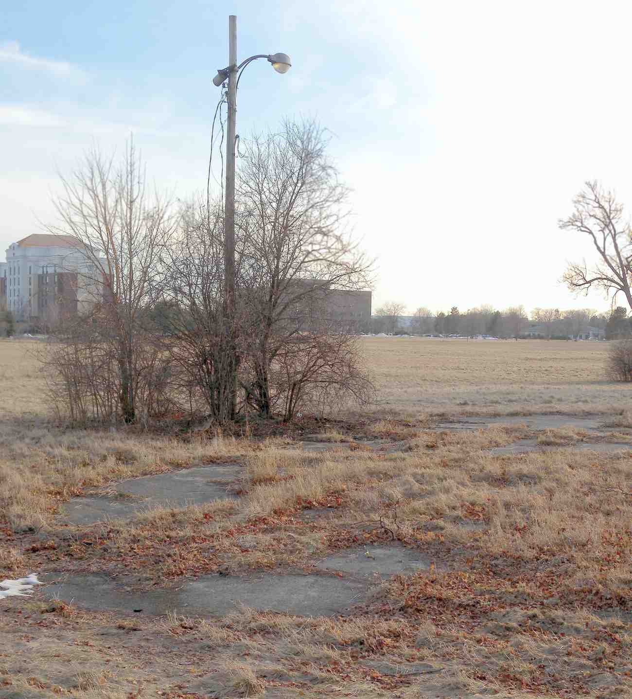
A 3/13/15 photo by John Gerty, looking south “at the corner of Milwaukee Avenue Route 21 & Half Day Road, Route 22.
There is a remnant light pole which stood outside a hangar at the northeast corner of the airport”, and remains of pavement.
The site of Chicagoland Airport is located southwest of the intersection of West Half Day Road & Route 45.
____________________________________________________
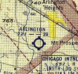
Arlington Naval Outer Landing Field / Field 25610 / Arlington Airport, Arlington Heights, IL
42.064, -88 (Northwest of Chicago, IL)
An 8/11/43 U.S. Navy aerial view looking north at Arlington NOLF (from the National Archives, courtesy of Brian Rehwinkel),
in which the borders of the field were outlined.
The Arlington site has had 3 distinct aviation uses over the years: first a Navy airfield,
then a general aviation airport, and then eventually an Army surface-to-air missile base.
No airfield was yet depicted at this location on a 1938 aerial photo.
Arlington was built during the WW2 era as one of 15 Outlying Fields used by nearby Glenview NAS.
It was designated Field #14 among Glenview's satellite airfields.
Mickey Horndasch of the Arlington Heights Historical Museum provided a wealth of information about the history of the Arlington site.
In 1942, the Navy requested that 360 acres of land east of Wilke Road & south of Central Road
would be cleared to construct an auxiliary air training station field for the use of NAS Glenview.
The airfield as eventually built was not as large as originally planned.
Construction of housing & a single hangar began in 1943.
The Arlington field was occupied by the Navy on 5/21/43
(according to a December 1943 memo from the station commander to the Chief of the Navy Bureau of Yards & Docks, via Brian Rehwinkel).
The same documents described the field as originally consisting of 369 acres (96 acres owned by the Navy & 273 leased from various landowners).
The earliest depiction which has been located of the Arlington airfield was an 8/11/43 aerial view looking north at the field (courtesy of Brian Rehwinkel),
in which the borders of the field were outlined.
The field consisted of an irregularly-shaped grass field, with several buildings at the north end.
According to Brian Rehwinkel, “Arlington was considered as a site for paved runways for the Carrier Qualification Training Unit later in late 1943,
but the topography of the field was not suitable & paved runways were eventually placed at Allendale Field (later Libertyville OLF).”
No airfield was yet depicted at this location on the April 1944 Chicago Sectional Chart.
The earliest aeronautical chart depiction which has been located of the Arlington airfield
was on the October 1944 Chicago Sectional Chart (courtesy of Richard Doehring).
It depicted “Arlington Heights (Navy)" as an auxiliary airfield.
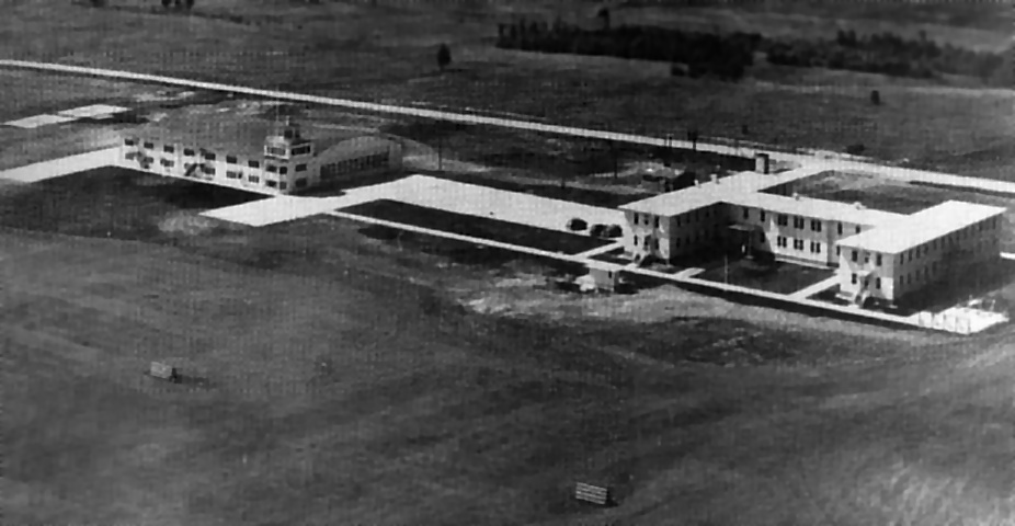
A WW2-era aerial view looking northwest at the hangar & administration building at Arlington NOLF (National Archives photo).
According to the “45th Air Defense Artillery Brigade History”, on 5/4/44, the first German POWs were brought to Arlington Heights.
The "H" building, #T114, was used to house the 17-20 year old German veterans of Rommel’s North African Corps.
Barbed wire enclosed the 2-story wooden building & a soccer field south of the barracks.
A guard detachment of 37 American soldiers under the command of Captain Austin P. Reed was assigned here.
The prisoners were trucked to & from Glenview NAS every day.
Initially they were used to do heavy labor & grounds maintenance, but it was soon discovered that they were good mechanics.
Most were then put to work in the engine overhaul & repair department. The prisoners numbered more than 200 at the peak.
According to the “45th Air Defense Artillery Brigade History”, in September 1944, the government bought 94 acres of the site for $25,646,
in addition to another 182 acres which were leased.
The earliest aeronautical chart depiction which has been located of the Arlington airfield
on the October 1944 Chicago Sectional Chart (courtesy of Richard Doehring).
It depicted "Arlington Heights (Navy)" as an auxiliary airfield.

The 1945 AAF Airfield Directory (courtesy of Scott Murdock) described “Glenview NAS Auxiliary (25610 Arlington Outlying Field)”
as a 252 acre irregularly-shaped property having a sod all-way field measuring 4,462' x 2,948'.
The field was said to have a 160' x 80' hangar on the north side,
to be owned by the U.S. Government, and operated by the Navy.
A 1946 aerial view appeared to show the Arlington airfield after it had been abandoned by the Navy.
The hangar & administration building were located along the north side of the field.
The flying area was a large rectangular grass field, with no distinct runways.
The 1946 Chicago Sectional Chart (courtesy of Chris Kennedy) depicted "Arlington Heights (Navy)" as an auxiliary airfield.
John Lorentz reported, “My uncle, James Oliver, was a Marine Corps Sgt stationed at NAS Glenview in 1946.
At this time, he & a fellow Marine took flying lessons at Arlington Field. His instructors were Inkie Blackwell & Frank Carter.
They took lessons on Monday & Tuesday in a Luscombe single-engine wingover airplane. James says it was very similar to a Cessna 120.
They couldn't get off base on weekends due to the 'Weekend Warriors' that flew from the Glenview base on Saturday & Sunday.
He got his Private pilots license & then accumulated enough flight time to qualify for a Commercial license, all at Arlington. He says it was a grass field.”
By 1947, little remained of Arlington's POW camp, other than the buildings, to remind the local residents of its existence.
After the departure of the prisoners & the training aircraft, the government land was declared excess by the Navy.
Arlington Heights again realized the chance for an airport.
However, through a series of disagreements, the land was awarded to a private company.
Later, the Navy decided that they wanted the land back, and through a court action the land was returned to Government control.
The land was then leased as an airport & later a trailer park.
There were plans to convert the “H” building into 20 apartments for returning World War II veterans & their families, but this never materialized.
"Arlington" was depicted as a civil airport on the 1949 Milwaukee Sectional Chart (courtesy of Donald Felton),
and was described as having a 2,900' unpaved runway.
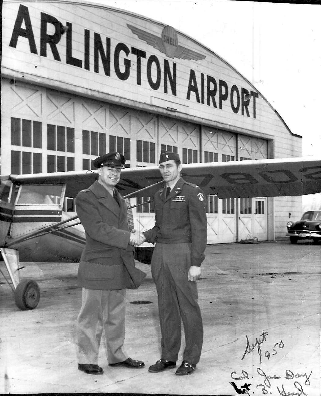
The earliest photo which has been located showing aircraft at the Arlington airfield was a September 1950 photo (courtesy of James Griggs)
of Civil Air Patrol Col. Joe Day & Lt. B. Head in front of a Luscombe & a hangar marked “Arlington Airport”.
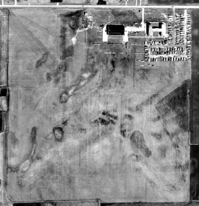
The last photo which has been located showing aircraft at the Arlington airfield was a 1952 aerial view.
It depicted the field during its use as a civilian airport, with a total of 25 light aircraft parked around the hangar,
and another plane on the southeast part of the airfield.
A large number of trailers were also parked just south of the former administration building.
The airfield area appeared to have 2 grass runways, oriented northwest/southeast & northeast/southwest.
In 1953, the U.S. Army began looking for a missile site for the converted 86th Antiaircraft Battalion (Nike)
and a permanent site for the recently activated 45th Antiaircraft Brigade.
In short order this search would lead them to Arlington.
The last depiction on an aeronautical chart which has been located of the Arlington Airport
was on the January 1954 Chicago Local Aeronautical Chart (courtesy of Chris Kennedy).
On 4/28/54, the Army acquired the Arlington Heights POW Camp from the Navy at no cost
for the construction of the Nike surface-to-air battery C-80 Launch Site.
Two additional small parcels of 12 acres total, southeast of the site on Route 58,
were leased for the construction of 2 Integrated Fire Control Sites.
This Nike site was one of 17 Nike batteries established to defend the Chicago area.
Construction of site C-80 was begun with the dual launching pits on the old Navy land
and the fire controls on the 2 small parcels of land to the southeast.
HHB, 86th AAA Battalion & Battery A, became an operational missile battalion in March 1955.
The former hangar was reused as the Battalion & Battery headquarters,
the missile support shop, the mess hall (cooking was done outside in a tent) and barber shop.
The “H” building (the former airfield administration building) was reused as the barracks.
In addition to the construction of the missile battery,
the Brigade headquarters building, two enlisted men's barracks, one enlisted women's barracks,
two bachelor officer's quarters, the service club, and 2 motor pool buildings were constructed.
The 45th AAA Brigade moved from the Museum of Science & Industry to the Arlington Heights Nike Site on 8/19/57.
The new building constructed as an enlisted women's barracks was never used for that purpose,
but was used as NCO quarters & the Brigade's Drum & Bugle Corps practice room.
This practice room was later converted to the Service Club
and the old Service Club building remodeled into the present NCO Open Mess.
Additional construction plans were drawn to provide for 126 EM quarters,
102 officer quarters, post exchange, clothing sales store, commissary, theater,
swimming pool, gymnasium, bowling alley, NCO & Officers' Open Messes, chapel,
dispensary, and a field maintenance support shop & warehouse.
Other than the latter, these were only plans & were never built.
No airfield was depicted at the Arlington site on the May 1955 Milwaukee Sectional Chart.
The site remained virtually unchanged until an additional 44 acres was purchased to house a new Missile Master installation.
On 4/6/59, BG Peter Schmick, Brigade CG, announced the purchase of the land,
along with plans for the construction of the Command Post, 5 radar towers & supporting buildings, to house the Missile Master.
The official dedication of the nation's first operational automatic electronic weapon system
to coordinate all elements of antiaircraft defense was made on 10/28/60.
The ceremonies were hosted by BG Frederick W. Ellery.
In 1961, the 755th Air Control & Warning Squadron was moved to Arlington from Williams Bay AFS, Wisconsin,
and activated with AN/FPS-20A, AN/FPS-6, and AN/FPS-6B radars mounted within large domes.
In 1961, the Army's Arlington Nike battery was manned by an estimated 1,000 soldiers of the 45th Artillery Brigade Air Defense.
A 1961 aerial view depicted a dramatic transformation of the Arlington facility compared to the 1952 photo.
The Nike Launch Site was on the west side of the property.
What was the large paved road leading to the 3 paved pads in the center of the facility?
Five large radomes were seen on the northeast side of the property (note the large shadows).
In 1962 the Arlington site also began SAGE (Semi-Automated Ground Environment) operations.
During the next few Years, the inactivation of the Nike battery & battalion,
the release of the fire control areas & the building of a mess hall, another, barracks, dispensary,
and 2 office buildings, caused minor changes of the site.
In late 1964, the Village of Arlington Heights hoped to acquire approximately 100 acres
which seemed destined to be declared excess land.
An 18 hole golf course & park were planned.
However on 12/29/64 it was decided by ARADCOM that the entire 145 acres would be retained “for future missile requirements”.
In late 1965 it was decided that some of the 145 acres was excess to the present & future needs of ARADCOM.
However, this was to be the biggest heartbreak of the long battle by Arlington Heights.
From November 1965 to the final sale in February 1968,
there were allegations, congressional interest, misunderstandings, disputes
and bad feelings between the civilian populace & the federal government.
In February 1968, the Navy paid the Army $14,129 for 52 acres which would be used for approximately 160 housing units.
Another 22 acres was leased to the 7th Howitzer, Battalion, 3d Artillery (USAR) for a motor pool, park & training grounds.
This however caused more consternation in Arlington Heights & Rolling Meadows - where were the children to go to school?
In 1969, Glenview NAS lost the $3.5 million programmed for the construction of the housing;
however, the Navy still wanted the housing & was not releasing the land.
The 755th Radar Squadron was deactivated in September 1969, and the towers were dismantled in the 1970s.
Eventually the Arlington Nike site C-80 was one of those upgraded to the Nike Hercules missile.
In 1972, half of the remaining 183 men stationed at the base were moved to Fort Sheridan & 5 buildings were evacuated.
The C-80 Nike battery was deactivated in August 1974.
The last photo which has been located to show the former hangar & airfield administration building was a 1974 aerial view.
The 5 support towers for the former radars still stood on the northeast side of the property, but the radomes themselves had been removed.
The Nike Launch Site also remained on the west side of the property.
The 2 Integrated Fire Control Sites (out of the picture to the southeast) had been removed at some point between 1961-74.
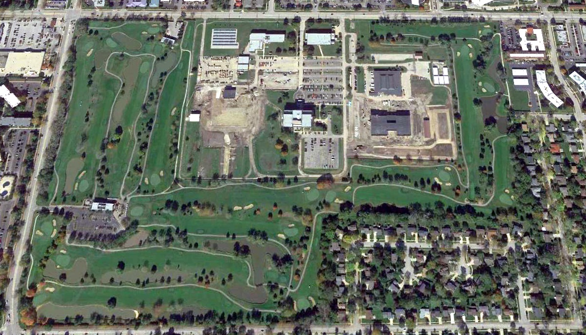
For several years the Arlington Heights Park District had been attempting to acquire the 137 acre property, for a regional park.
The plans included a golf course, picnicking & hiking areas & storm retention area that would provide for boating & fishing.
In 1974, additional acres of Nike Base were declared surplus by the military.
A 103 acre parcel on the west, south, and east sides of the former airfield was given by the Army to the Arlington Heights Park District,
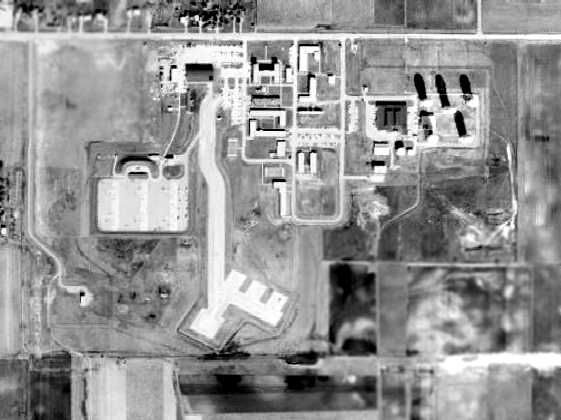
and was used to create the Arlington Lakes Golf Course, which opened in 1979.
A training center & maintenance building was constructed on the remainder of the property (the center of the former airfield)
for an Army Reserve Unit of 600 men.
A 1988 aerial photo showed significant changes at the property,
with much of the former military infrastructure having been removed, including the hangar & airfield administration building,
erasing the last traces of the former airfield.
The radar towers on the northeast side had also been removed, along with the Nike launchers.
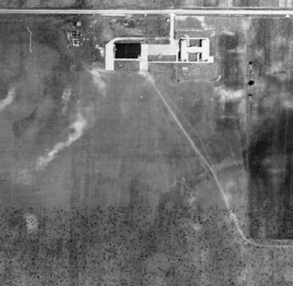
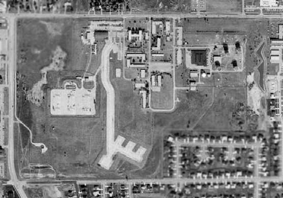
A 2018 aerial view looking north at the site of Arlington NOLF.
According to Mickey Horndasch, "I do not believe there is any trace of the airfield left
(it's probably under one of the holes on the golf course)."
The site is located south of the intersection of West Central Avenue & South Dwyer Avenue.
____________________________________________________
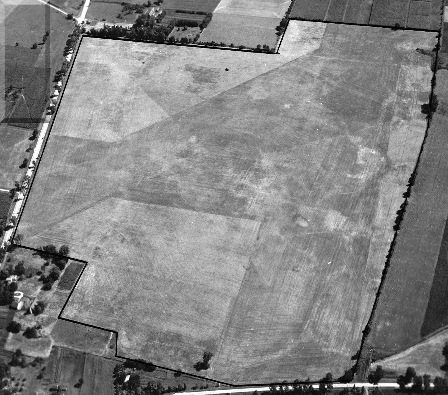
Allendale Field / Libertyville Naval Outer Landing Field (LBV) / Libertyville Airport, Vernon Hills, IL
42.224, -87.954 (North of Chicago, IL)
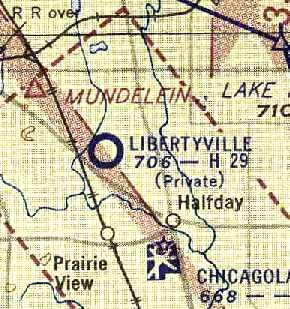
The Libertyville airfield, as depicted on the October 1944 Milwaukee Sectional Chart.
No airfield was depicted at this location on a 1939 aerial view.
This field was used during the WW2 era as one of 15 Outlying Fields used by nearby Glenview NAS.
It was designated Field #2 among Glenview's satellite airfields.
According to the book "Lake Michigan's Aircraft Carriers" by Paul Somers (courtesy of John Voss),
this field was originally an unpaved airfield known as Allendale Field, established in September 1942.
No airfield at this location was yet depicted on the April 1944 Milwaukee Sectional Chart.
According to the book "Lake Michigan's Aircraft Carriers" by Paul Somers (courtesy of John Voss),
in the Summer of 1944 the unpaved runways of Allendale Field were replaced by concrete runways,
and in September 1944 the field was renamed Libertyville Naval Outer Landing Field.
The earliest depiction which has been located of the Libertyville airfield was on the October 1944 Milwaukee Sectional Chart.
It depicted “Libertyville (Navy)” as an auxiliary airfield.
A WW2-era map of NAS Glenview & its Outlying Fields (including Allendale/Libertyville),
from the book "Lake Michigan's Aircraft Carriers", by Paul Somers (courtesy of John Voss).
The 1944-45 layout of Libertyville NOLF, from the book "Lake Michigan's Aircraft Carriers", by Paul Somers (courtesy of John Voss).
Libertyville had 4 concrete runways (with the longest being the 2,900' Runway 5/23),
as well as a much shorter Runway 7/25 which featured a "built-in wooden carrier deck catapult & arresting gear."
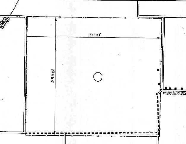
The 1945 AAF Airfield Directory (courtesy of Scott Murdock) described “Glenview NAS Auxiliary (32111 Libertyville Outlying Field)”
as a 185 acre rectangular property having a sod all-way field measuring 2,588' x 3,100'.
Note that this represented Libertyville's pre-1944 configuration, and thus was outdated.
The field was not said to have any hangars,
and was described as being owned by the U.S. Government, and operated by the Navy.
A 1946 aerial photo of Libertyville (from the Lake County IL Maps Online, courtesy of Chris Kennedy)
depicted the field as having 4 concrete runways, plus the 5th runway with the inset carrier deck with arresting gear.
The field did not have any hangars, nor were any aircraft visible on the field.
"Libertyville (Navy") was still depicted as an active military airfield
on the 1949 Milwaukee Sectional Chart (courtesy of Donald Felton).
According to the 9/8/70 Chicago Tribune (courtesy of Will Moffett),
“the Navy retained control of the airport, but permitted civil operations until 1950.
Then it was leased to a civilian group that staged hot rod races on the runways.”
A 1951 Amoco road map (courtesy of Richard Carlson) depicted “Libertyville Field (Navy)” as a property outline.
A 1952 aerial view depicted the site in pretty much the same condition as seen in 1946,
with the only exception being the removal of the carrier deck arresting gear.
The Libertyville airfield was closed by the Navy at some point between 1949-52,
and apparently reused as a civilian airport, as that is how "Libertyville" was depicted
on the November 1952 Milwaukee Sectional Chart.
A 1953 aerial view depicted the abandoned airfield in an unchanged manner.
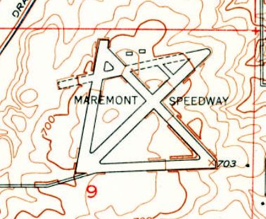
The 1953 USGS top map still depicted Libertyville's 5 paved runways, but labeled it as “Maremont Speedway”,
evidently indicating a brief reuse of the airfield for auto racing.
The Libertyville airfield was depicted as a private airfield on the 1954 Chicago Local Aeronautical Chart (courtesy of Chris Kennedy).
The Aerodromes table on the chart described Libertyville as having 4 runways, with the longest being a 2,891' concrete strip.
Strangely, even though Libertyville was depicted as an active airfield on the front side of the chart,
the remarks in the Aerodromes table on the reverse side of the chart said "Closed to all aircraft."
In the 1950s, the Libertyville site was reused by the Army as a location for a Nike surface-to-air missile battery.
The first operational Chicago-area Nike-Ajax guided missile site was opened in 1954 at Libertyville.
Two Nike missile launch sites (C-92 & C-94) were built
on the northeast & northwest corners of the Libertyville property.
The use of the airfield most likely ceased when the Nike battery was established,
as the missile launchers were situated directly off the northwest end of Libertyville's northwest/southeast runway.
A 1961 aerial view depicted the 2 Nike sites, one on the northwestern & northeastern corners of the airfield.
The runways remained intact, with several buildings (barracks for the Nike batteries?) having been built in between the runways.
The Libertyville Nike batteries were deactivated in 1963.
By the time of the 1967 Milwaukee Sectional Chart (courtesy of Chris Kennedy),
the site of the former Libertyville NOLF was labeled "Abandoned airport".
According to the 12/13/68 Chicago Tribune, the Defense Department announced the Libertyville base had been selected as a Sentinel ballistic missile defense site.
That plan was dropped the following spring because of substantial local opposition.
According to the 9/8/70 Chicago Tribune (courtesy of Will Moffett), “The base is now closed.”
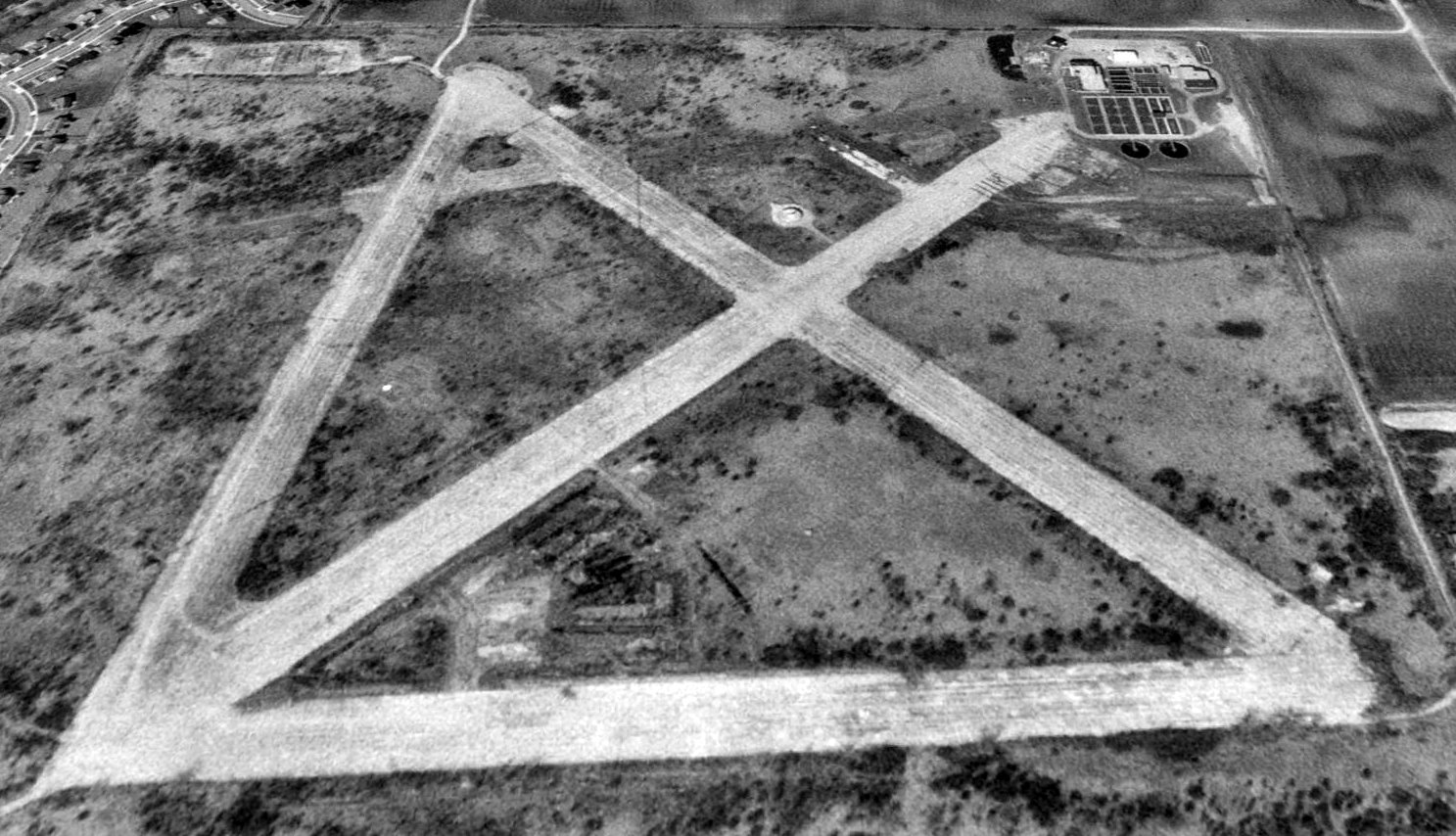
A 1974 aerial photo of Libertyville (from the Lake County IL Maps Online, courtesy of Chris Kennedy)
showed the Nike missile launch batteries which had been built (& subsequently abandoned) on the northwest & northeast corners of the airfield,
as well as the sewage treatment plant had been built over the location of the northeast missile battery at some point between 1961-74.
The Northbrook VORTAC had also been built just north of the runway intersection at some point between 1961-74.
Charles Fleisleber recalled, “I was at this location in the early 1980s.
I was in a USMCR helicopter squadron, HML-776, out of Glenview NAS which at that time was flying UH-1Es.
I remember going to the field to cut the weeds in the cracks in the field,
cut some weeds & grass around the field & look for major foreign object damage on the runways.
There were small buildings by the east/west runway, but they were in disrepair: widows & doors missing.
The missile silos also were in disrepair.
I remember a large weight on a line stored there to train for helicopter external loads but never saw it used.
I also remember pilots landing on the various shaft covers (not the silos though).
I never saw any other squadrons or aircraft use it during this time.”
Christopher Pryble recalled, “Back the spring of 1985, a friend & I
rode our bicycles to 'the Vernon Hills Nike Missile base', as the kids called it back then.
We simply followed the overgrown access road in from Route 45 & what is now called Buffalo Grove Road.
There were the remains of at least 2 small building foundations, with twelve 5-gallon metal used paint cans,
mostly of RED, WHITE & YELLOW paint stacked 2-rows high against the 4-5' high foundation wall remains.
There were weeds in the runway growing 4' high, although the runway looked as if it was just painted!
Huge cross-cut strips were sunk through the runway itself every couple of hundred feet.
They appear in [aerial photos] as straight lines across the runway.
They in fact were 3-4' wide sections, completely straight, and collapsed 2.5-3.5' down into the ground, probably done with explosives.
We had to jump down into them & climb back up the other side.
There was simply no way to ever land a plane on those runways again.”
Christopher continued, “We discovered the Nike missile battery silos, which had both a vertical hatch & a stairway to enter them.
The stairways had been bulldozed in with tons of cement debris,
but the hatches, witch were once welded shut, had been undone with a cutting torch.
They were all completely flooded, save for one.
We decided to come back a few days latter with a rope & flashlight. We did on a cold & rainy day.
As we descended the steel rung-ladder it was damp, smelled of mold, and was surprisingly colder than the April air above.
The floor & walls were dry & looked like they were just pored but the ceiling was mostly green with moss, fungus, something.
There was still a light-switch embedded in the wall with an outlet nearby.
Underneath the outlet was a hand-written note scotch-tapped to the wall reading 440 volts!
They both looked so new yet, I flipped the switch & really thought something might happen.”
Christopher continued, “We could walk around the 2 launch pads that were parked in the horizontal position.
Their sunken bases were flooded, however next to them was some stairs going into the same pool of water,
towards a wall, but we did not follow for obvious reasons.
Next to the bulldozed-in stairs, was a door leading to an office.
And another door inside the first office to another office, which also had a hand-crank to seal the cone-covered air-vent above.
It was nothing fancy, the walls were ripped out & wires were hanging out everywhere.
No other rooms or survival anything could be seen down there
and I'm sure these brave men knew if they had to launch their missiles,
the radioactive fallout would kill them regardless of successfully destroying an enemy's incoming missile.”
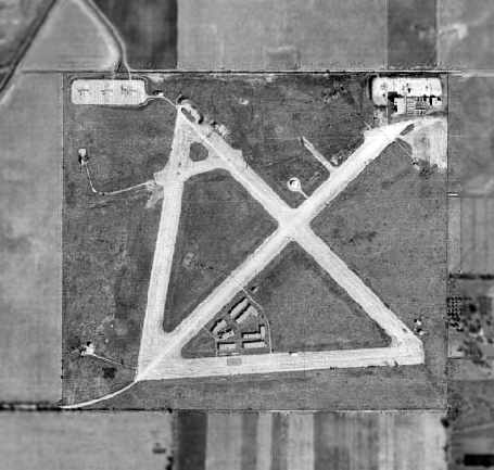
A 1994 USGS aerial photo looking north showed Libertyville's abandoned concrete runways still remained intact,
the last of NAS Glenview's 15 Outlying Fields to remain so.
Remains of the Nike missile batteries still remained on the northwest & northeast corners of the field,
along with the Northbrook VORTAC located just north of the runway intersection.
Libertyville was closed as a military installation in 1995.
It was labeled on USGS topo maps as "US Military Reservation, Libertyville Training Site."
According to nearby resident Ralph Schmidt,
the Vernon Hills office park & a new high school have been built just to the north of the airfield site,
with residential & retail development surrounding the rest of the area.
Police & fire departments have used the former airfield property for various training exercises.
Christopher Pryble recalled, “As of spring 2003, at least one Nike missile silo was still standing,
but a heavy-duty piece of de-construction equipment was sitting right on top of it.
You could even see it on a [aerial photo] back then.
It is such a shame that this could have been cheaply made into a municipal airport with huge, thick concrete runways for large & small jets.”
As of 2003, according to Daniel Feldman,
Libertyville is "…except for [the VORTAC] - gone - turned into a huge sports complex."
A circa 2006 aeial view showed that the remains of the Nike missile launch complex in the northwest corner
had been removed at some point between 2003-2006.
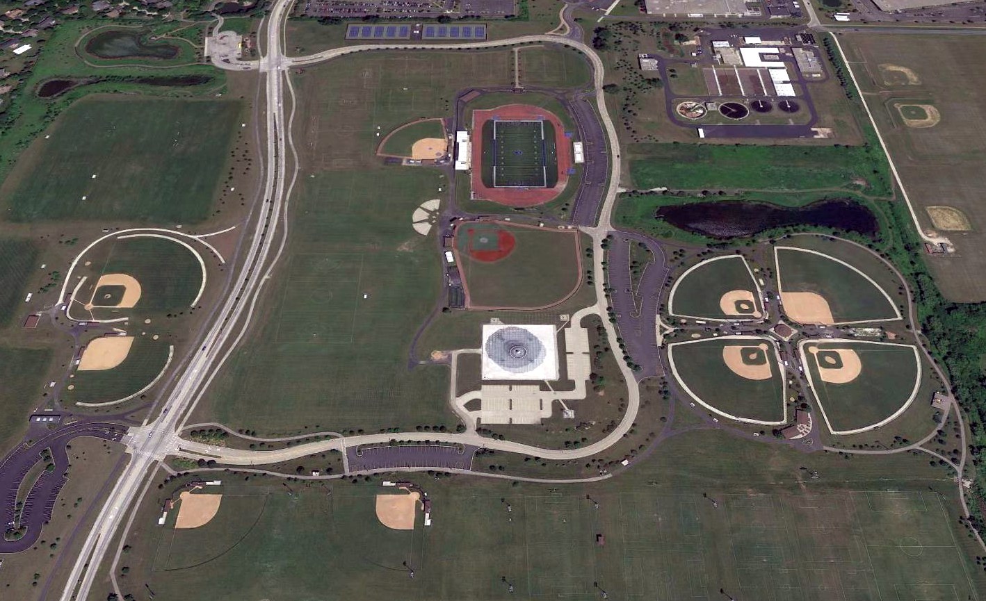
A 2007 aerial view showed that construction was complete, with ballfields covered the majority of the former airfield.
The only remaining trace of any aviation infrastructure at the Libertyville site was the VORTAC station in the center of the property.
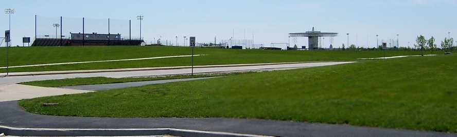
A May 2009 photo by Christopher Pryble of the Northbrook VORTAC & sports fields at the site of Libertyville NOLF.
According to Christopher, “It would not surprise me if the silo was simply filled with dirt & paved over,
due to the expense of removing 3' thick slabs of concrete, and also since the parking area is above that of the surrounding houses.
The area is now called the 'Vernon Hills Sports Center'. And it seemed to be in full use today.”
A 2016 aerial view looking north showed all elements of the Libertyville airfield had been erased.
The local government of the Chicago area should be quite proud
of what a good job they've done at erasing their city's aviation heritage.
Within a five year period (1998-2003),
they've managed to completely remove almost all traces of 3 fairly substantial & historic airports:
NAS Glenview, Meigs Field, and Libertyville NOLF.
See also: http://www.dtic.mil/envirodod/derpreport96/vol2/appx/app-a/nara086.html
____________________________________________________
Since this site was first put on the web in 1999, its popularity has grown tremendously.
If the total quantity of material on this site is to continue to grow,
it will require ever-increasing funding to pay its expenses.
Therefore, I request financial contributions from site visitors,
to help defray the increasing costs of the site
and ensure that it continues to be available & to grow.
What would you pay for a good aviation magazine, or a good aviation book?
Please consider a donation of an equivalent amount, at the least.
This site is not supported by commercial advertising –
it is purely supported by donations.
If you enjoy the site, and would like to make a financial contribution,
you
may use a credit card via
![]() :
:
Please consider checking the box to make a monthly donatation.
For a mailing address to send a check, please contact me at: paulandterryfreeman@gmail.com
If you enjoy this web site, please support it with a financial contribution.
please contact me at: paulandterryfreeman@gmail.com
If you enjoy this web site, please support it with a financial contribution.
____________________________________________________
This site covers airfields in all 50 states.