Abandoned & Little-Known Airfields:
Illinois, Southern Chicago area
© 2002, © 2023 by Paul Freeman. Revised 3/30/23.
This site covers airfields in all 50 states: Click here for the site's main menu.
Please consider a financial contribution to support the continued growth & operation of this site.
Frankfort Airport (revised 3/24/23) - Governor's Airpark / Wings Field / Haedtler Field (revised 4/16/18) - Howell Airport (1st location) (revised 1/18/20)
Mall Airfield / FBM Company Airfield (revised 3/30/23) - Metropolitan Airport / Ashland Avenue Airport / Chicago Heights Airport (added 11/24/19)
New Lenox Airport / Howell Airport (2nd location) (revised 10/29/21) - Plainfield Airport (revised 3/24/23) - Prosperi Airport (revised 1/19/20) - Rubinkam Airport (revised 10/29/21)
____________________________________________________
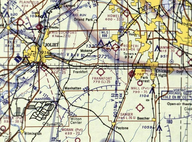
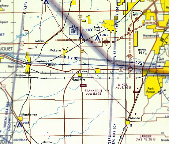
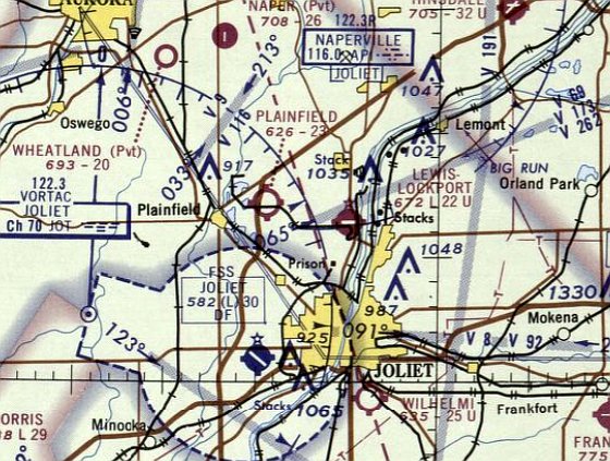
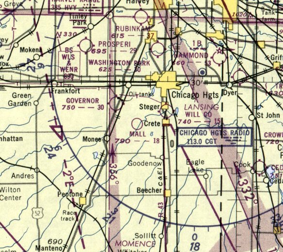
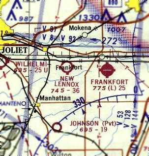
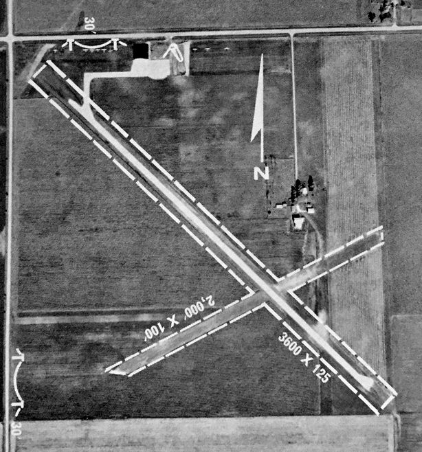
Frankfort Airport (LL40), Frankfort, IL
41.478, -87.845 (South of Chicago, IL)
Frankfort Airport, as depicted on the May 1965 Chicago Sectional Chart.
Frankfort Airport was not yet depicted on the June 1962 Chicago Sectional Chart.
According to the article “Airport Owner Ahead of His Time” in the 4/25/90 Chicago Tribune (courtesy of Matt Valleau),
“In 1962 John Arnold felt there was a need for a small airport in the then-quiet but growing south suburbs & came across a plot of farm land in Frankfort.”
''I felt the area would really expand-which it definitely has over the years,'' he says. ''And the way this property was laid out was perfect for an airport.''
The article continued, “Arnold initially purchased 23 acres in 1962 & built a single-story office building, a 10-stall hangar & a sod runway.
On 9/7/64 he held the grand opening for the Frankfort Airport.”
The earliest depiction which has been located of Frankfort Airport was on the May 1965 Chicago Sectional Chart.
It depicted Frankfort Airport as having a 2,500' unpaved runway.
Matt Valleau recalled, “Frankfort is the airport I started flying out of when I was 2 years old.”
The 1967 Chicago Local Aeronautical Chart depicted Frankfort Airport as having a 2,500' paved east/west runway.
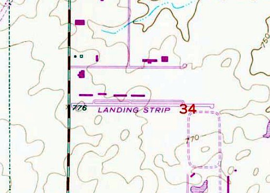
The 1973 USGS topo map depicted Frankfort Airport as single paved east/west runway, labeled genericaly as “Landing Strip”,
with a parallel taxiway & several buildings along the north side.
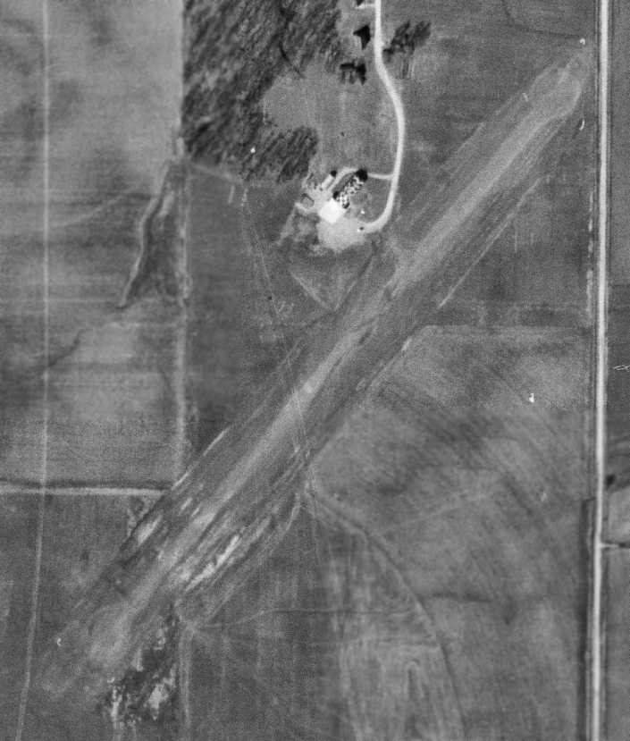
The earliest photo which has been located of Frankfort Airport was a 1973 aerial view.
It depicted a single asphalt east/west runway, with a several hangars & several light single-engine aircraft along the north side.
A 1981 aerial photo depicted Frankfort Airport at perhaps the zenith of its popularity, with over 2-dozen light aircraft visible on the field.
A 1988 aerial view depicted Frankfort Airport in the same physical configuration, but with somewhat fewer aircraft visible.
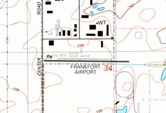
The 1990 USGS topo map depicted Frankfort Airport as having a single paved east/west runway, with a parallel taxiway & several buildings along the north side.
A 1993 aerial photo depicted construction having begun for an industrial park adjacent to the south side of Frankfort Airport.
The last photo which has been located showing multiple aircraft at Frankfort Airport was a 1998 aerial view looking southeast.
A total of 3 light single-engine aircraft were still visible on the north side of the field.
A 2002 aerial photo depicted only a single aircraft at Frankfort Airport: a single-engine Cessna on the north side of the field,
which did not appear to move in subsequent aerial photos.
The April 2017 Chicago Terminal Chart depicted Frankfort Airport as a private airfield having a 4,200' paved east/west runway.
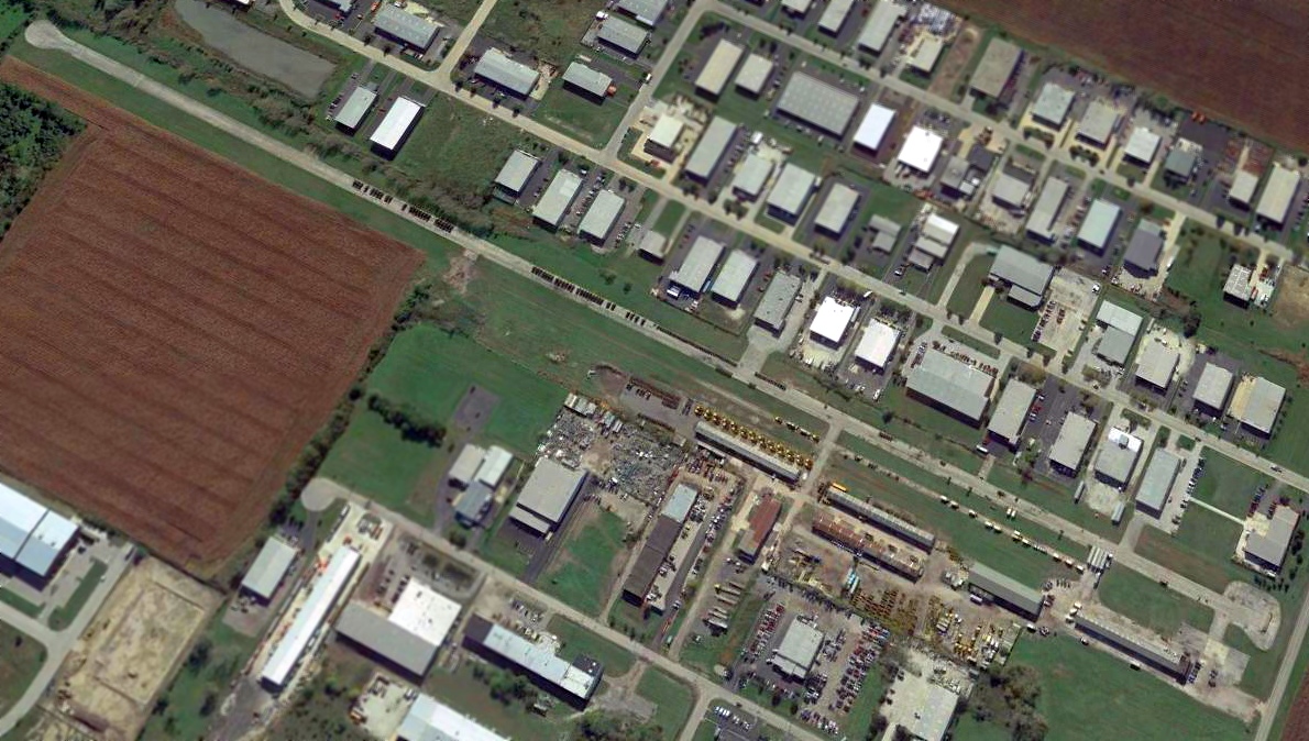
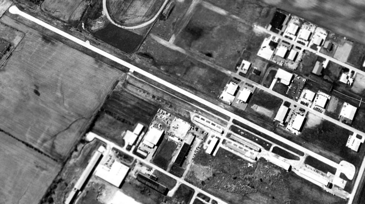
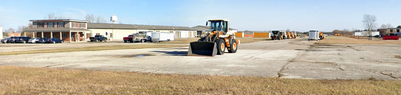
A 2018 aerial view looking southeast at Frankfort Airport showed the runway & hangars to remain intact,
but the runway appeared to be used for non-aviation storage.
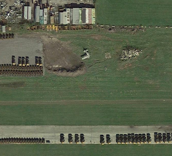
A 2018 aerial view of what appears to be the last remaining aircraft at Frankfort Airport: the remains of a single-engine Cessna on the north side of the field, by this point missing its left wing.
Matt Valleau reported in 2020, “Frankfort (LL40) has finally been removed from the Sectional Chart.
While it’s been technically closed for a while, the runway has had heavy equipment up & down it for years.”
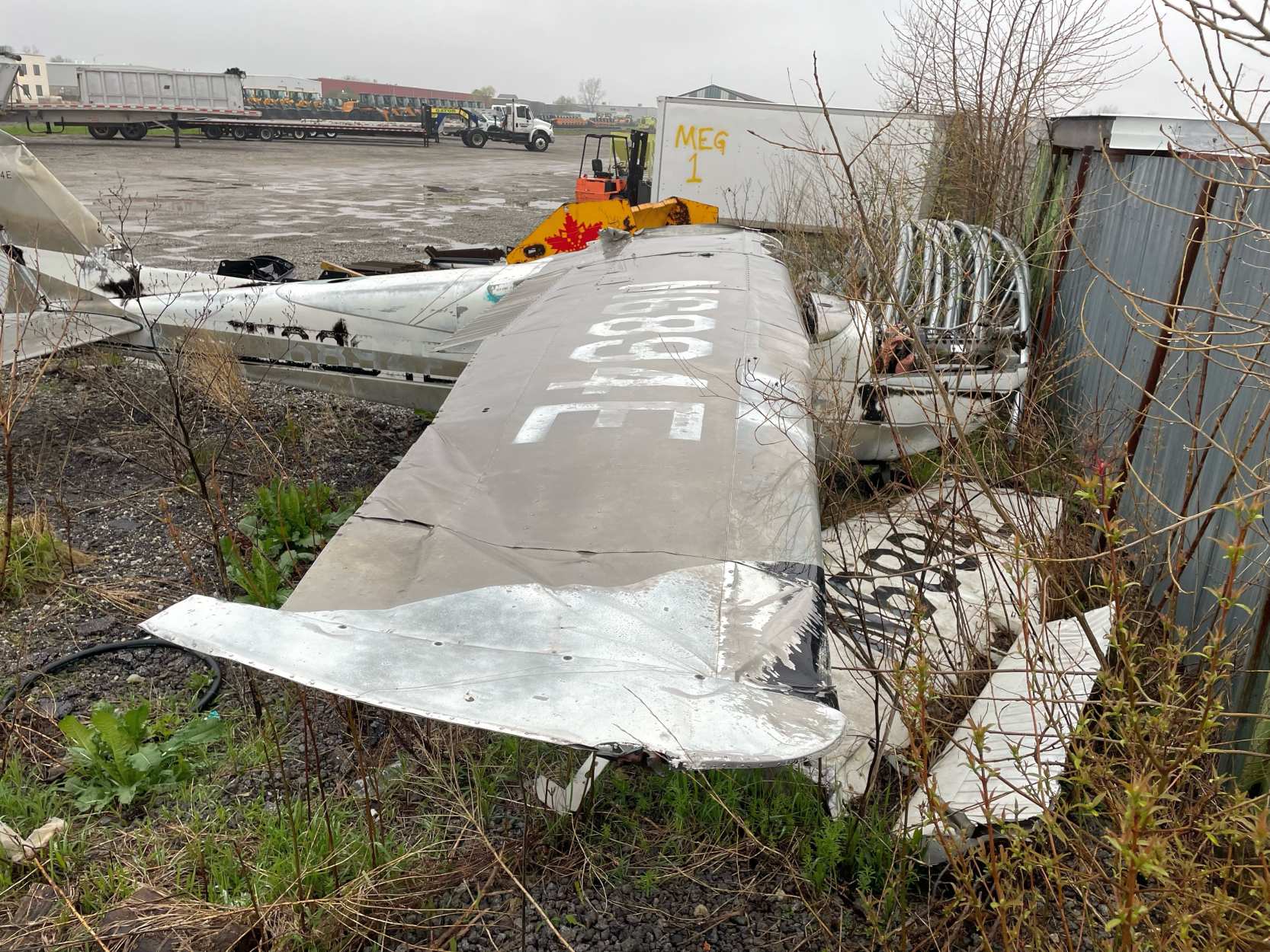
A 7/18/22 photo by Kevin Oliver of the remains of a Cessna 172 at Frankfort Airport, “the last plane at the old airport.”
A December 2021 photo looking northeast along the former Frankfort Airport runway, with the hangars in the background.
Thanks to Matt Valleau for pointing out this airfield.
____________________________________________________
Metropolitan Airport / Ashland Avenue Airport / Chicago Heights Airport, Chicago Heights, IL
41.517, -87.659 (South of Chicago, IL)
Chicago Heights Airport, as depicted on the August 1932 Chicago Sectional Chart.
This small general aviation airport was evidently established at some point between 1930-32,
as it was not yet depicted on the December 1930 Chicago Sectional Chart.
The earliest depiction which has been located of Metropolitan Airport was on the August 1932 Chicago Sectional Chart.
The earliest photo which has been located of Metropolitan Airport was a 1938 aerial view.
It depicted a single unpaved east/west runway, with a small building on the southeast side.
There were no aircraft visible on the field.
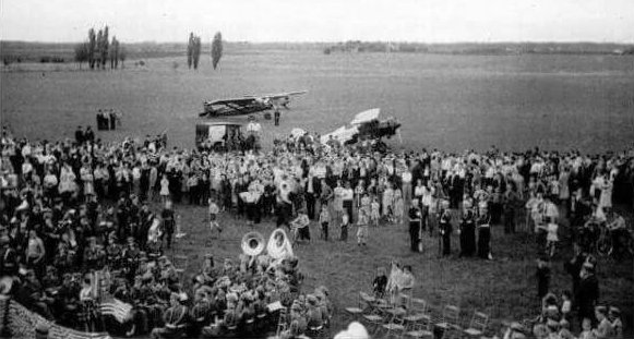
The earliest photo which is available of Metropolitan Airport was a 5/19/38 aerial view (courtesy of Daniel McGill)
of a crowd of nearly 1,000 people who were gathered to view the first air-mail pickup.
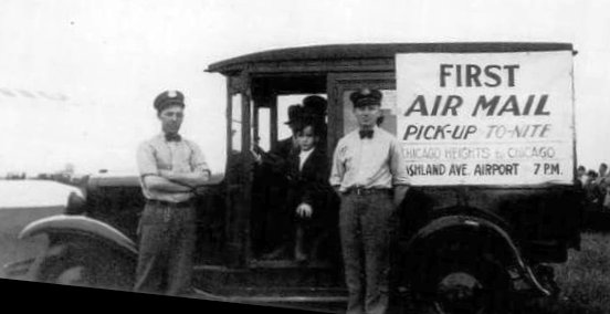
Men & a truck promoting the 5/19/38 first air-mail pickup at Metropolitan Airport / Ashland Avenue Airport (courtesy of Daniel McGill).
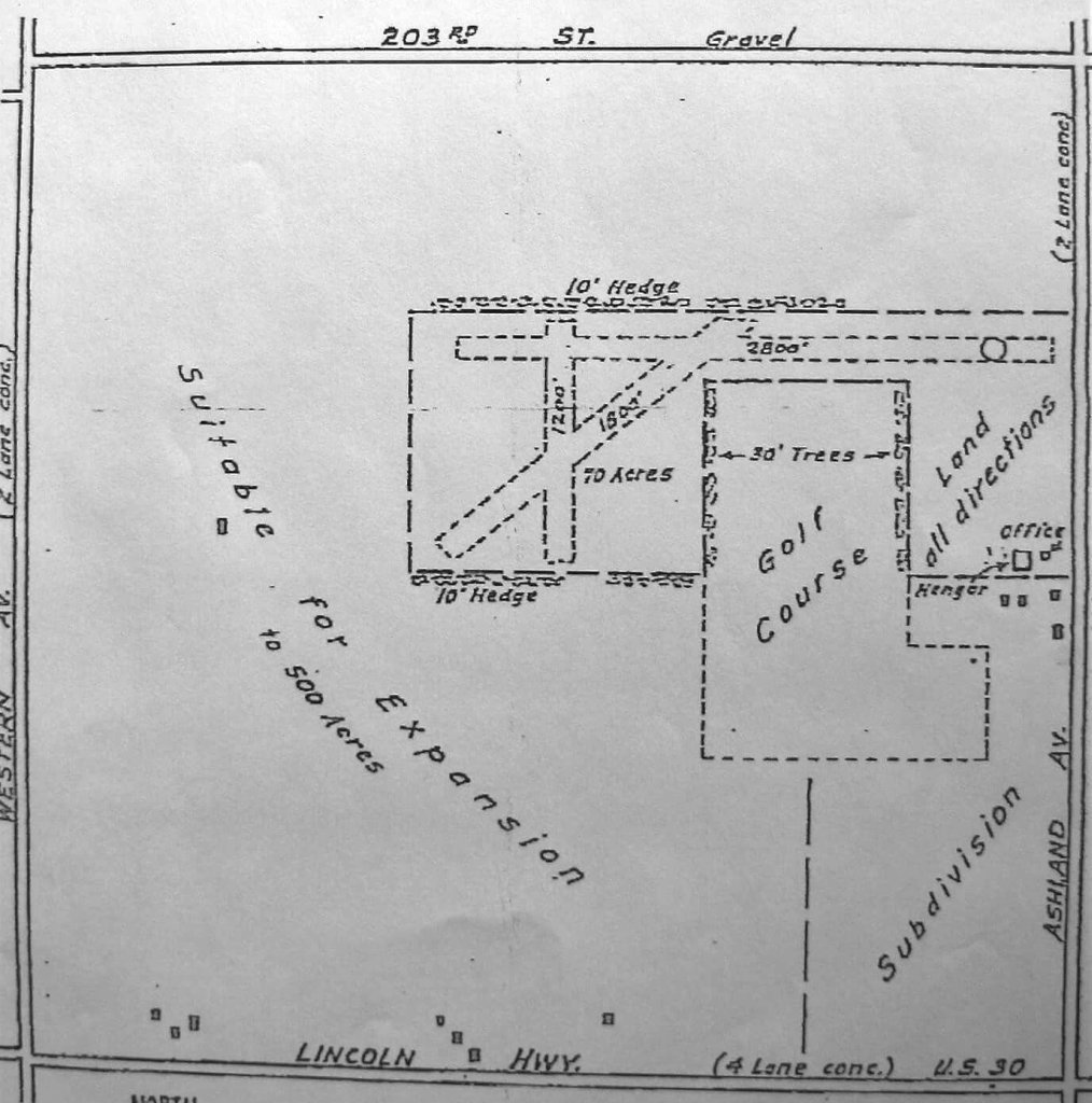
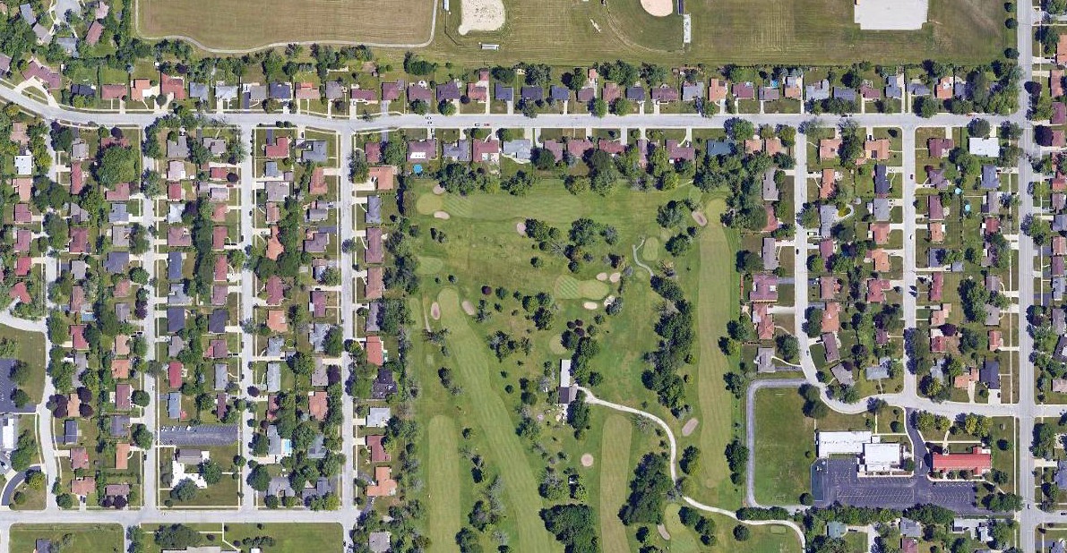
A December 1940 plan of Metropolitan Airport (courtesy of Daniel McGill) depicted the airfield's unusual layout,
being squeezed into a narrow plot of land, with a golf course protruding into the middle portion.
The field was shown to have 3 unpaved runways, with the longest being a 2,800' east/west strip, and a hangar & office on the southeast side.
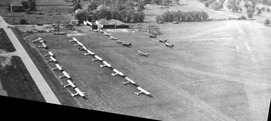
A circa 1940-47 aerial view looking southwest at Metropolitan Airport (courtesy of Daniel McGill)
depicted the airfield being quite popular, with over 30 light aircraft parked near the hangars on the southeast side of the field.
being squeezed into a narrow plot of land, with a golf course protruding into the middle portion.

A circa 1940-47 photo of the Chicago Heights Airport's Midwest Aircraft Sales Corporation hangar (courtesy of Daniel McGill).
It was still labeled Metropolitan Airport on the October 1942 Chicago Sectional Chart.
It was evidently renamed Ashland Avenue Airport at some point between 1942-44,
as that was how it was labeled on the April 1944 Chicago Sectional Chart.
It was still labeled Ashland Avenue Airport on the June 1947 Chicago Sectional Chart.
It was evidently renamed Chicago Heights Airport at some point in 1947, as that is how it was labeled on the December 1947 Chicago Sectional Chart.
It depicted Chicago Heights Airport as having a 2,900' unpaved runway.
Chicago Heights Airport was closed in 1947 when the operators lost their lease.
Chicago Heights Airport was no longer depicted on the July 1948 Chicago Sectional Chart.
A 1952 aerial view showed no trace remaining of Chicago Heights Airport, with residential streets having been constructed over the southeast portion,
and the hangar having been removed.
A 2018 aerial view showed no trace remaining of Chicago Heights Airport, with the property covered by houses.
The site of Chicago Heights Airport is located west of the intersection of Ashland Avenue & 8th Street.
Thanks to Daniel McGill for pointing out this airfield.
____________________________________________________
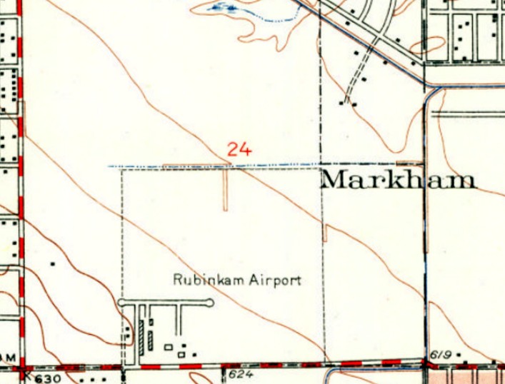
41.589, -87.688 (South of Chicago, IL)
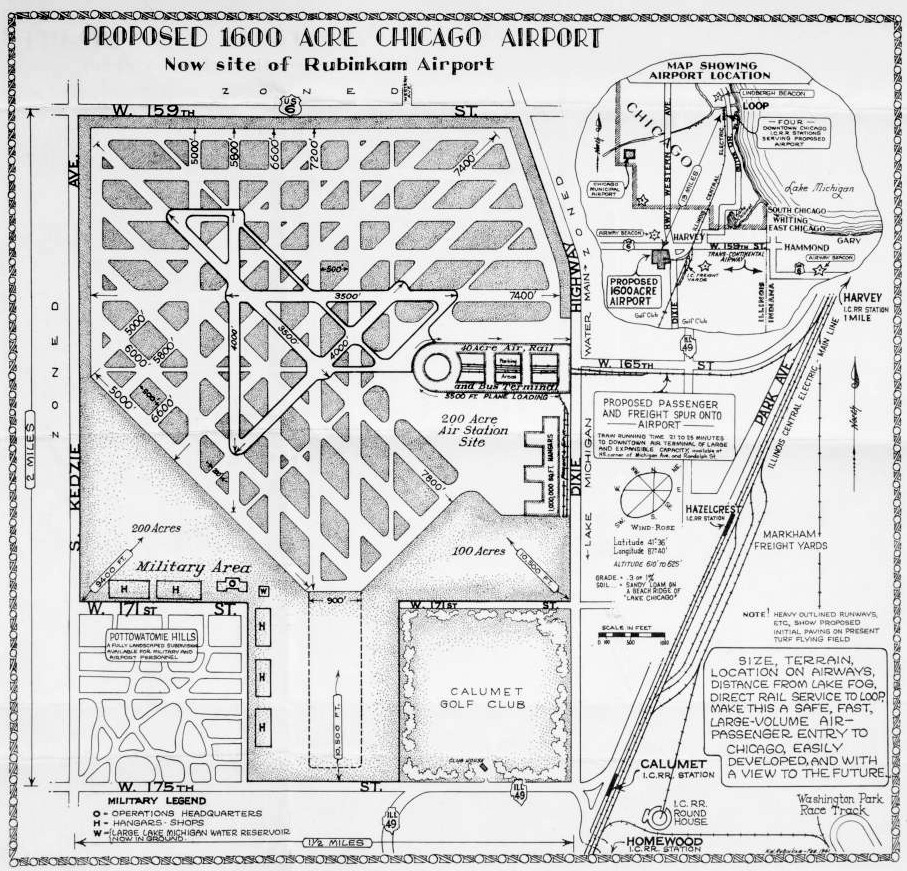
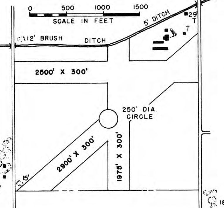
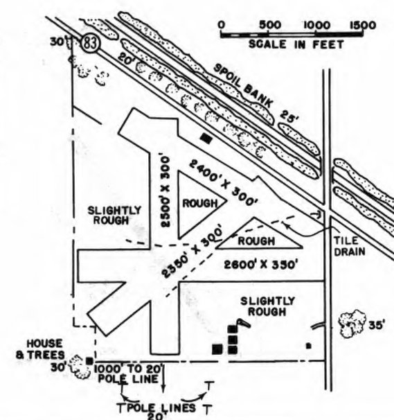
A 2/41 proposal for turning the small (216 acre) Rubinkam Airport into a "large-volume" (1,600 acre) Chicago Airport.
This small general aviation airport was evidently established at some point between 1940-41,
as it was not yet depicted on the February 1940 Chicago Sectional Chart.
The earliest depiction which has been located of Rubinkam Airport was a never-realized 2/41 proposal for turning the small (216 acre) airport
into a "large-volume" (1,600 acre) Chicago Airport.
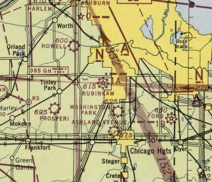
The earliest aeronautical chart depiction which has been located of Rubinkam Airport was on the June 1944 Chicago Sectional Chart.
The earliest photo which has been located of Rubinkam Airport was a 3/9/52 USGS aerial view.
It depicted Rubinkam as having a very short east/west paved runway (or taxiway), and a longer grass northeast/southwest runway.
Over a dozen light single-engine aircraft & several small hangars were on the southeast side.
The earliest topo map depiction which has been located of Rubinkam Airport was on the 1953 USGS topo map.
It depicted Rubinkam as having a very short east/west paved runway (or taxiway), and several small hangars on the south side.
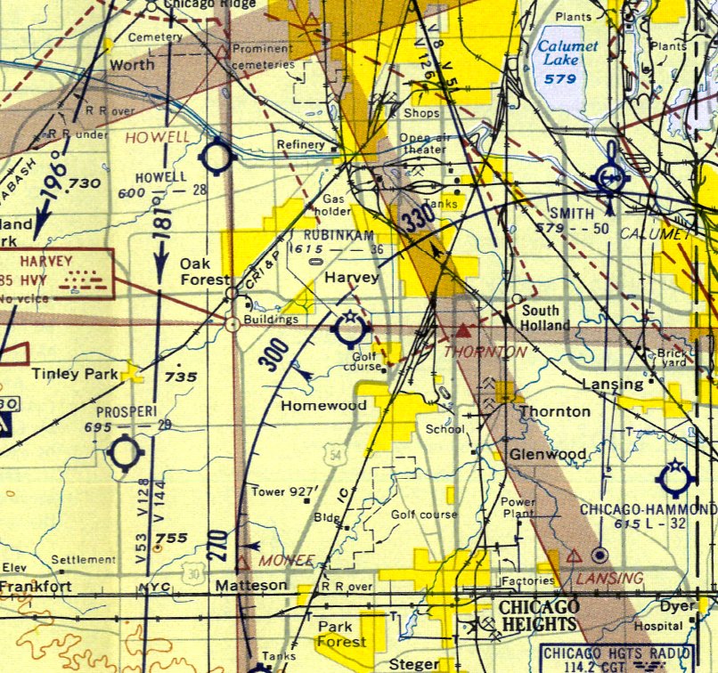
The 1956 Chicago Local Aeronautical Chart (courtesy of Tim Zukas) depicted Rubinkam Airport as having a 3,600' unpaved runway.
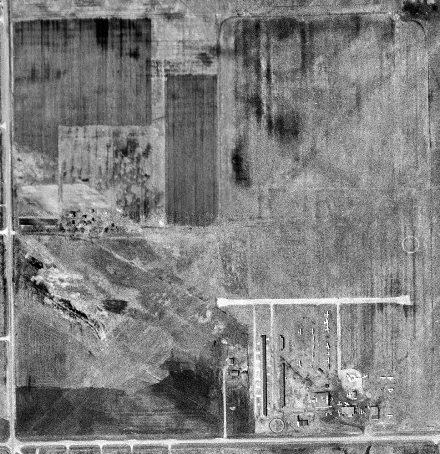
The last photo which has been located of Rubinkam Airport was a 9/3/59 USGS aerial view.
It depicted Rubinkam as having a very short east/west paved runway (or taxiway), and a longer grass northeast/southwest runway.
Over 2 dozen light single-engine aircraft & several small hangars were on the southeast side.
But note, in contrast to the 1952 photo, rows of houses had been built bordering the airport's north & east sides, foreshadowing its eventual demise.
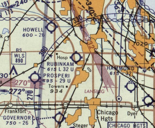
The last aeronautical chart depiction which has been located of Rubinkam Airport was on the January 1960 Chicago Sectional Chart.
It depicted Rubinkam as having a 3,200' unpaved runway.
Rubinkam Airport was evidently closed at some point between 1960-62,
as it was no longer depicted on the June 1962 Chicago Sectional Chart (courtesy of Bill Pagett).
A 2016 aerial view looking north showed no trace remaining of Rubinkam Airport.
The site of Rubinkam Airport is located northwest of the intersection of 167th Street & California Avenue.
Thanks to Toni Herndon for pointing out this airfield.
____________________________________________________
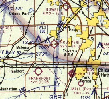
Prosperi Airport, Tinley Park, IL
41.547, -87.788 (Southwest of Chicago, IL)
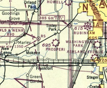
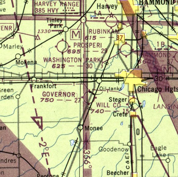
Prosperi Airport, as depicted on the June 1944 Chicago Sectional Chart.
This small general aviation airport was evidently established at some point between 1942-44,
as it was not yet depicted on the October 1942 Chicago Sectional Chart.
The earliest depiction which has been located of Prosperi Airport was on the June 1944 Chicago Sectional Chart,
which depicted it as a commercial/municipal airport.
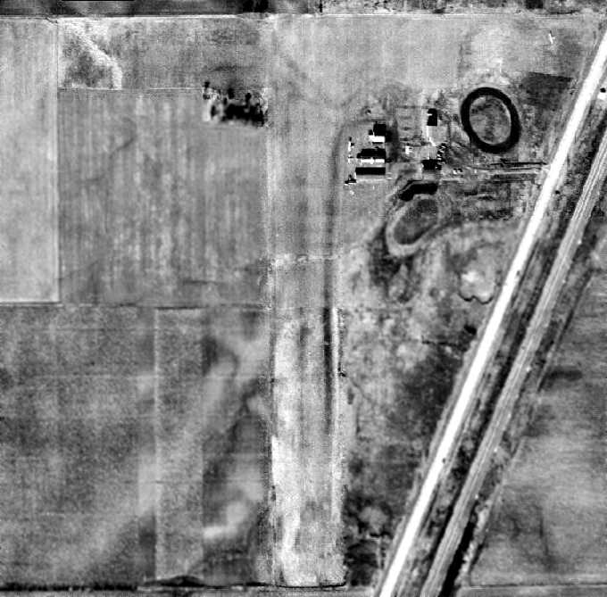
The earliest photo which has been located of Prosperi Airport was a 1951 aerial view.
It depicted Prosperi as having 3 unpaved runways, with several small hangars & buildings on the northeast corner.
There were no aircraft visible on the field.
The 1953 IL Airport Directory (courtesy of Lee Corbin)
depicted Prosperi Airport as having 3 unpaved runways, with 6 small buildings on the northeast corner.
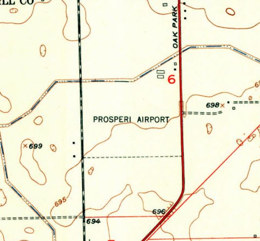
The 1953 USGS topo map depicted Prosperi Airport an an irregularly-shaped property outline, with 4 small buildings on the northeast corner.
The earliest photo which is available of Prosperi Airport was an undated aerial view from the 1956 IL Airport Directory (from the University of IL, courtesy of Daniel McGill).
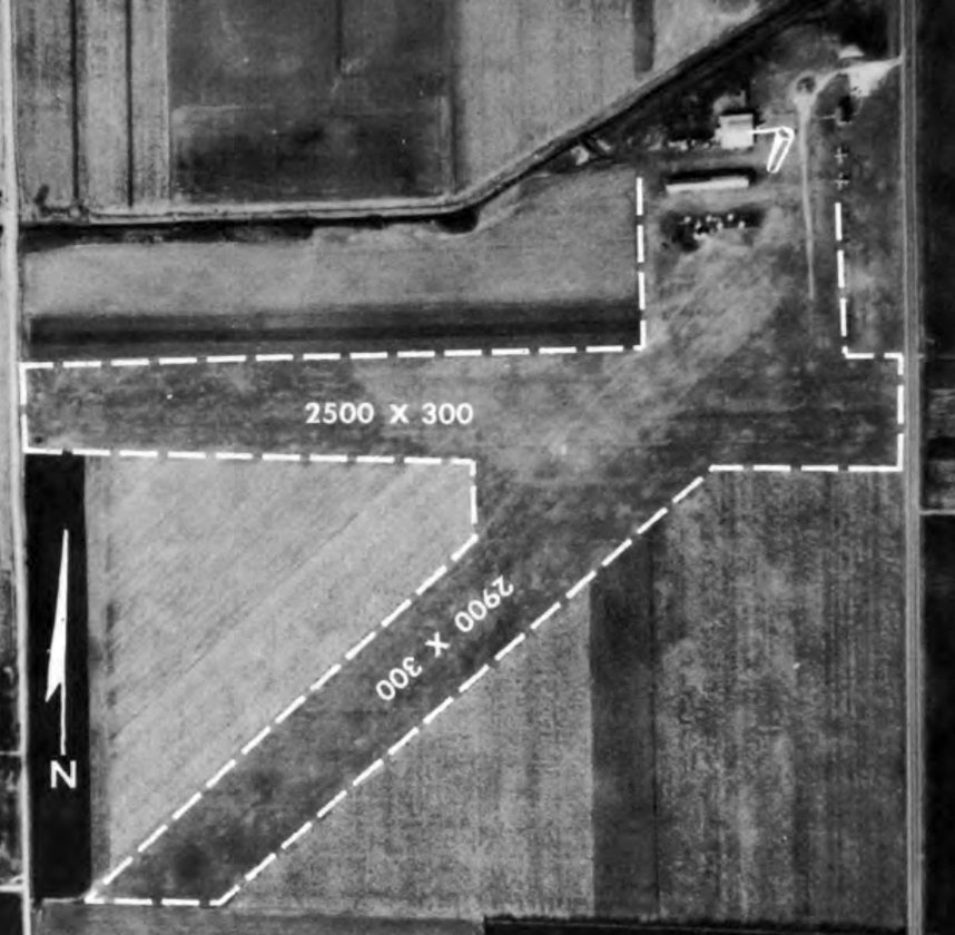
It depicted Prosperi Airport as having 2 unpaved runways, measuring 2,900' northeast/southwest & 2,500' east/west.
Two light single-engine aircraft were visible near some small buildings on the northeast corner.
According to Bruce Mabee, “Prosperi Airport [was] owned & operated by Ed Prosperi, and 'Managed' by Ed's mother, the bookkeeper.
Orland Mabee operated his flights school at Prosperi after the closing of Stinson, approximately 1960-65.
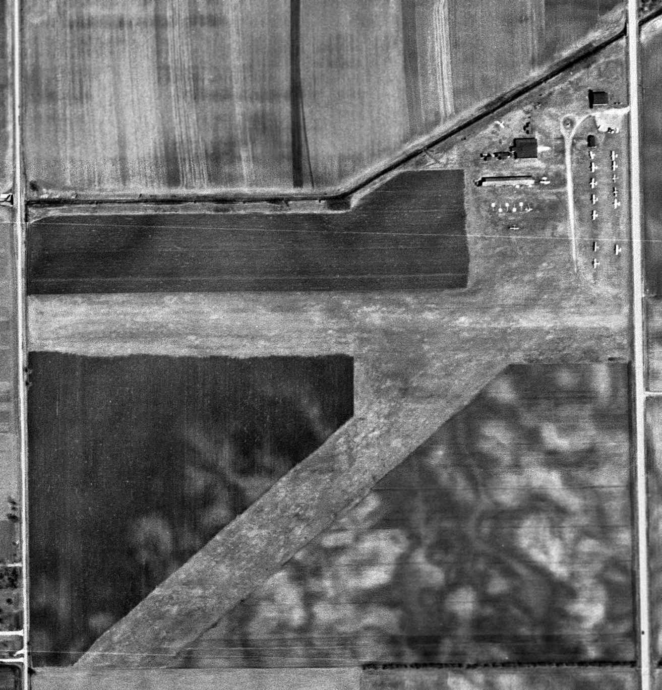
A 4/1/62 USGS aerial view depicted Prosperi as having 2 unpaved runways, with 15 light single-engine aircraft parked near some small hangars & buildings on the northeast corner.
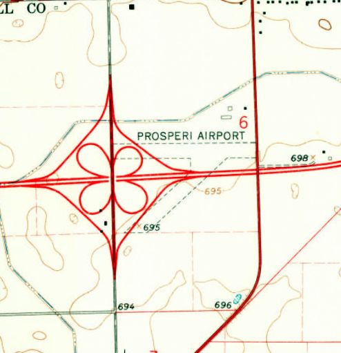
The 1963 USGS topo map showed the reason for Prosperi Airport's eventual demise –
the planned Interstate 80 was superimposed right though the center of the 2 unpaved runways.
The last aeronautical chart depiction which has been located of Prosperi Airport was on the May 1965 Chicago Sectional Chart.
It depicted Prosperi as having a 2,400' unpaved runway.
According to Bruce Mabee, “There are historical Notes & great stories of Ed Properi [in the book 'Lost Airports of Chicago']
such as his chasing state employees with a shotgun when they came to shut down the airport for the Interstate construction
Prosperi Airport [was] closed by 1966 by the building of Interstate 80 though the airport grounds.”
Prosperi Airport was no longer depicted on the December 1966 Chicago Sectional Chart.
A 2015 aerial view showed no trace remaining of Prosperi Airport.
The site of Prosperi Airport is located north of the intersection of West 191st Street & Prosperi Drive, appropriately enough.
Thanks to Bruce Mabee for pointing out this airfield.
____________________________________________________
Plainfield Airport, Plainfield, IL
41.627, -88.16 (Southwest of Chicago, IL)
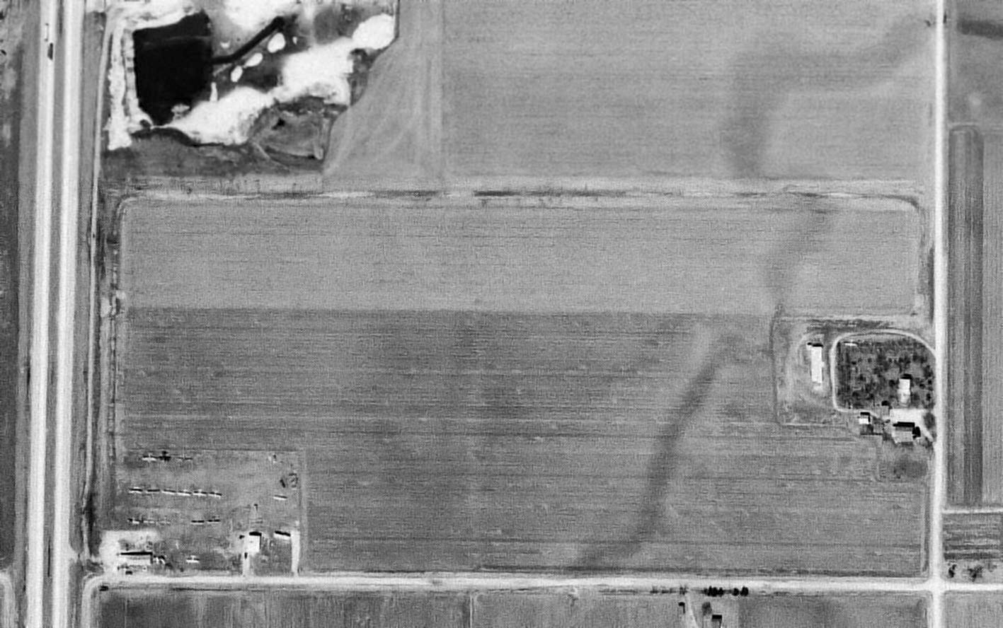
A 4/10/62 USGS aerial photo depicted Plainfield Airport as having a single unpaved east/west runway.
This small general aviation airport was evidently established at some point between 1946-52,
as it was not yet depicted on a 1946 aerial photo.
The earliest depiction which has been located of Plainfield Airport was a 1952 USGS aerial photo,
which depicted perhaps the beginnings of the airport, with a single grass east/west runway & some farm buildings on the southwest side.
There were no aircraft visible on the field.
Plainfield Airport was not yet depicted on the January 1961 Chicago Sectional Chart.
A 1961 aerial photo showed the east/west grass runway was more distinct,
and no less than 19 light single-engine aircraft were visible parked around some small buildings on the southwest corner.
A 4/10/62 aerial photo showed the same runway configuration,
and 15 light single-engine aircraft were visible parked around some small buildings on the southwest corner.
The earliest aeronautical chart depiction which has been located of Plainfield Airport was on the June 1962 Chicago Sectional Chart.
It depicted Plainfield as having a 2,400' unpaved runway.
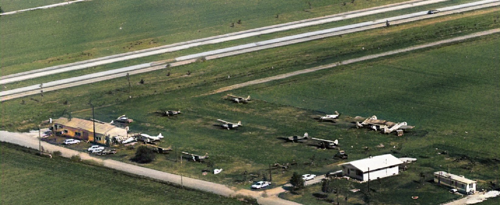
A 1965 aerial view looking northwest at Plainfield Airport (colorized by Mike Denka) depicted a total of 13 single-engine aircraft, including 2 of what appeared to be Grumman F6F Hellcat WW2 fighters.
According to Bruce Mabee, “Plainfield Airport [had] one turf runway, an office & shop.
[It offered] flight lessons by Orland Mabee, approximately 1966-70.
When Plainfield closed, Mabee moved his remaining Piper Tri-Pacer, N155D, to Clow Airport in Bolingbrook.”
The last aeronautical chart depiction which has been located of Plainfield Airport was on the May 1968 Chicago Sectional Chart.
It depicted Plainfield as having a 2,300' unpaved runway.
Plainfield Airport was evidently closed (for reasons unknown) at some point in 1968,
as it was no longer depicted on the December 1968 Chicago Sectional Chart.
In April 1971, Richard Lambert reportedly ferried North American B-25H Mitchell N5548N C/n 48-21107 to the grass strip of Plainfield Airport,
even though the airport had evidently been closed for several years by that point.
A 1974 aerial photo showed that Plainfield Airport's runway was still clear,
but all of the aircraft were gone, and several additional buildings had been built on the southwest corner at some point between 1962-74.
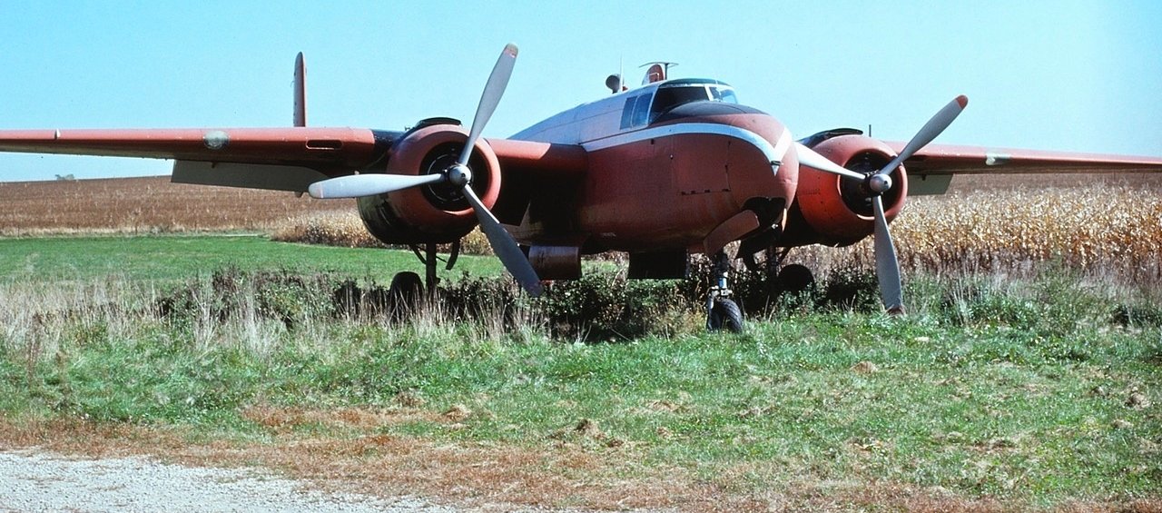
The last photo which has been located of a plane at Plainfield Airport was a September 1980 photo by Glenn Chatfield of North American B-25H Mitchell N5548N C/n 48-21107.
This Mitchell was the 2nd B-25H built, and the prototype for the 75mm cannon-nose version.
The B-25H Mitchell was reportedly flown from Plainfield to Springfield in 1981.
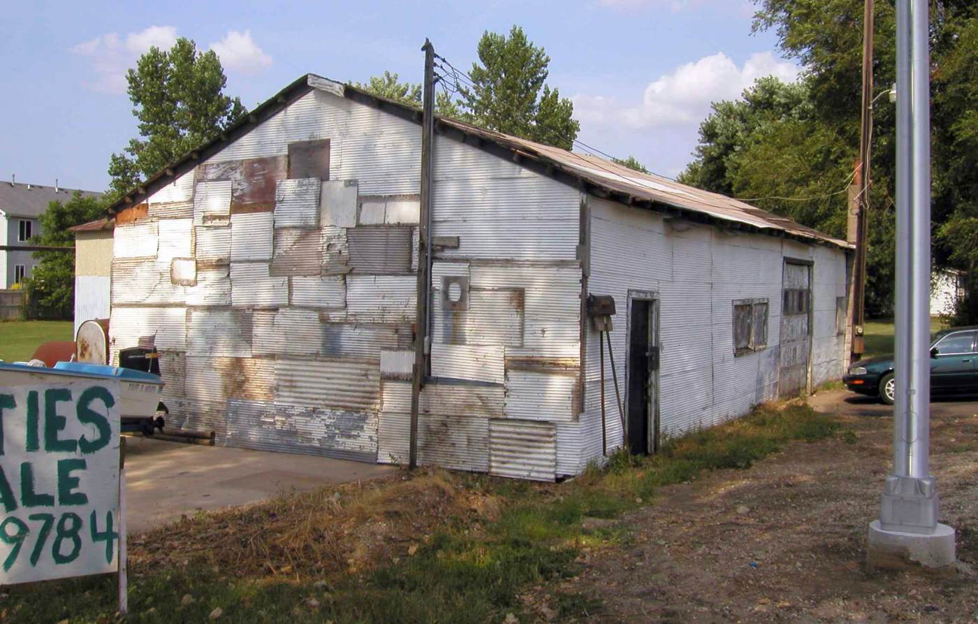
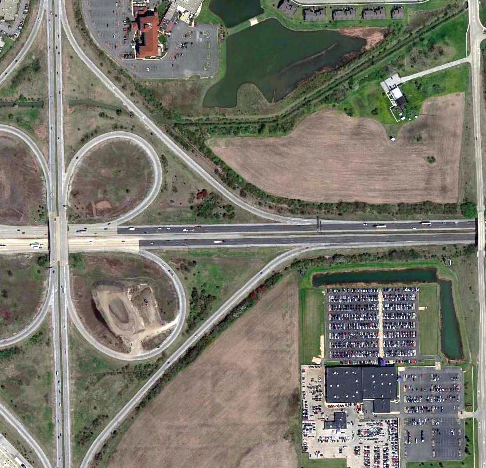
A 2003 photo by Bruce Mabee of the “Plainfield Airport office & shop, long after it closed.”
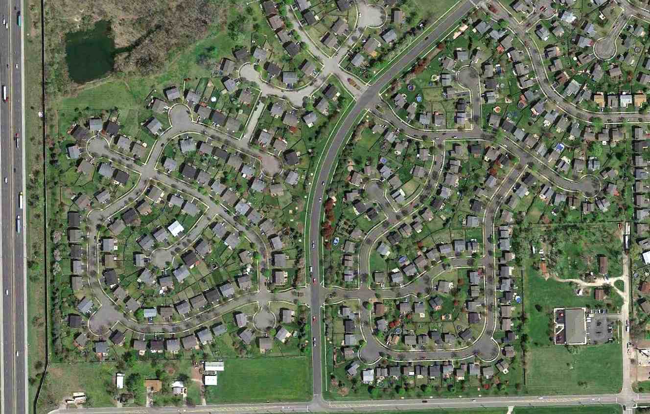
A 2015 aerial view of the site of Plainfield Airport, showing the majority of the site having been filled in with dense housing (apparently the fate of most general aviation airports!),
but the office & shop building remains standing on the southwest corner of the site.
The site of Plainfield Airport is located north of the intersection of Budler Road & West Taylor Road.
Thanks to Bruce Mabee for pointing out this airfield.
____________________________________________________
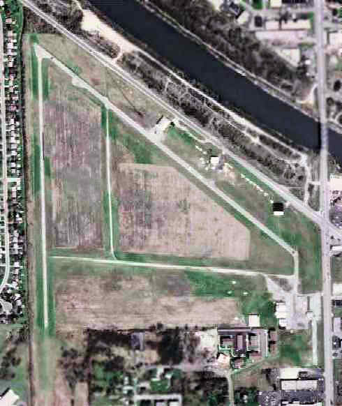
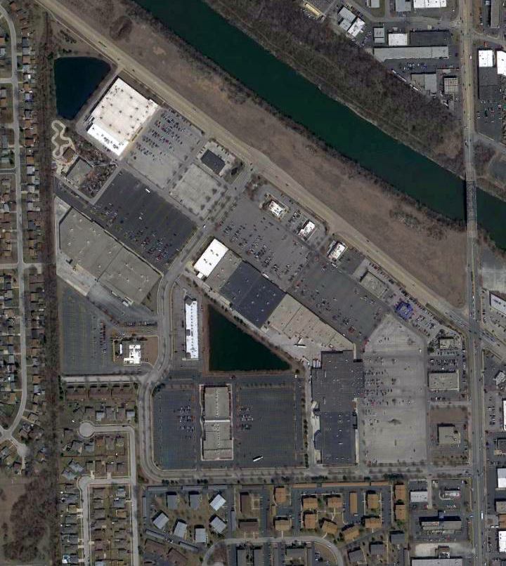
Mall Airfield / FBM Company Airfield, University Park, IL
41.44, -87.69 (South of Chicago, IL)
Mall Airfield, as depicted on the November 1950 Chicago Sectional Chart.
This private airfield was evidently established at some point between 1948-50,
as it was not yet depicted on the December 1948 Chicago Sectional Chart.
The earliest depiction which has been located of the Mall Airfield was on the November 1950 Chicago Sectional Chart.
It depicted Mall Airfield a having a mere 1,800' unpaved runway.
The earliest photo which has been located of the Mall Airfield was a 3/29/52 USGS aerial photo.
It depicted a single unpaved northeast/southwest runway, with a few small buildings on the north side.
Paul Sedlacek reported, “When the American Lock Company moved from Chicago to Crete (now known as University Park),
the owner George Junkunc used the airstrip exclusively.”
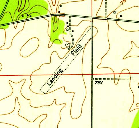
The 1953 USGS topo map depicted Mall Airfield as a single unpaved northeast/southwest runway, labeled simply as “Landing Field”,
with a few small buildings on the north side.
The 1956 Chicago Local Aeronautical Chart depicted Mall as a private airfield having an 1,800' unpaved runway.
A 4/24/62 aerial photo (courtesy of Mike Denja) depicted Mall Airfield as having gained a 2nd unpaved runway at some point between 1953-62, along with several other building/hangars.
The last aeronautical chart depiction which has been located of the Mall Airfield was on the May 1965 Chicago Sectional Chart.
The runway had been nearly doubled in length, to 3,500'.
The Mall Airfield was evidently closed (for reasons unknown) at some point between 1965-67,
as it was no longer depicted on the 1967 Chicago Local Aeronautical Chart.
Paul Sedlacek reported, “The owner George Junkunc added the 2nd runway & at one time he had a Bonanza V33,
a Debonair, 2 Piper Super Cubs and a Cessna 172 (sold to his son in law) based out of there.
George was a childhood inspiration of mine who used to let me fly with him when I was a young boy.
In his later years George lived onsite.
The 1973 USGS topo map depicted Mall Airfield as having 2 perpendicular unpaved runways (still labeled simply as “Landing Field”),
along with several small buildings on the north side.
Paul Sedlacek reported, “When [airfield owner] George passed his heirs sold the company to Master Lock & they sold the property to FBM.”
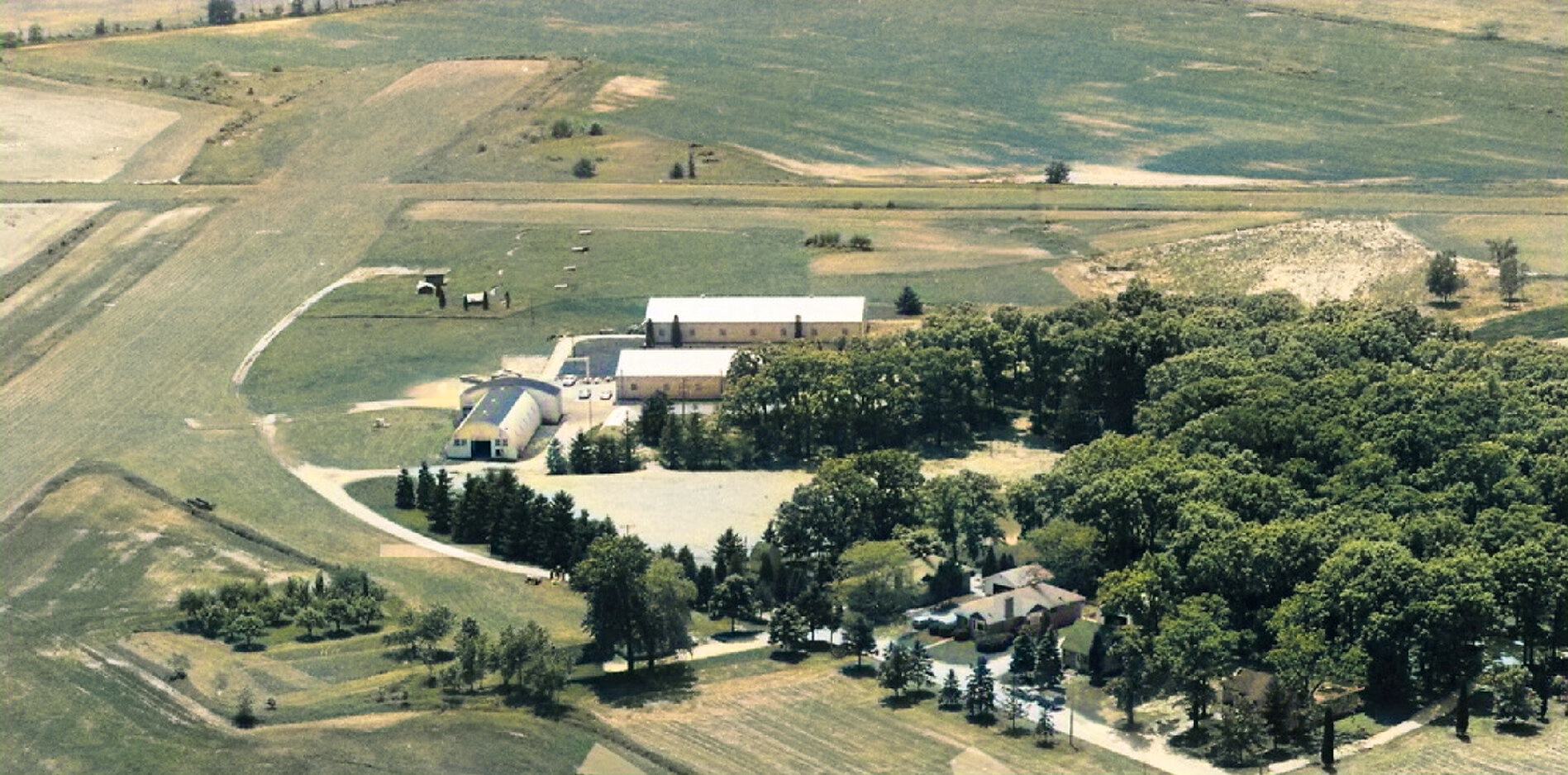
A 1983 aerial view (colorized by Mike Denja) looking southwest at the FBM Airfield runways & hangars.
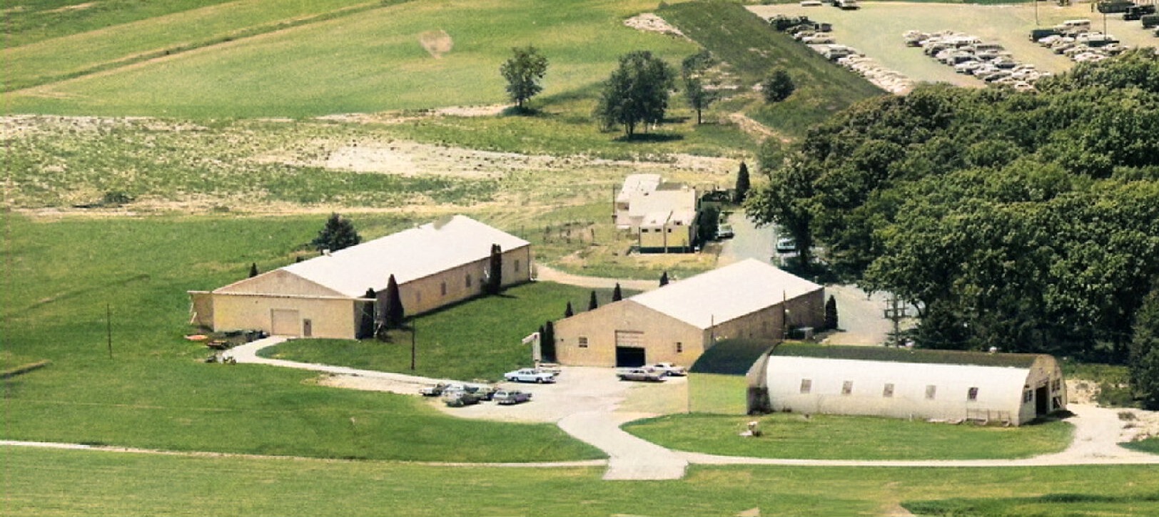
A 1983 aerial view (colorized by Mike Denja) looking west at the FBM Airfield hangars.
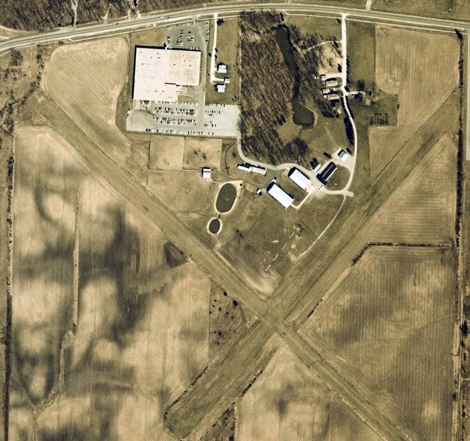
The only photo which has been located showing an aircraft at the Mall/FBM Airfield was a 4/6/87 aerial view (courtesy of Mike Denja).
It depicted the airfield in an unchanged configuration, with 1 light single-engine aircraft parked near the hangars.
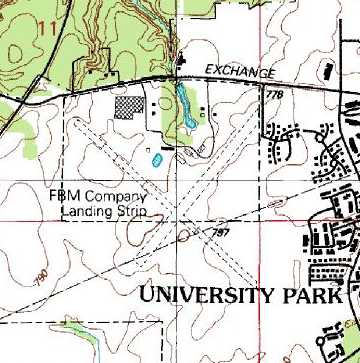
The 1990 USGS topo map depicted the “FBM Company Landing Strip” as having 2 perpendicular unpaved runways, with several buildings on the north side.
A 4/4/93 USGS aerial view depicted FBM as having 2 unpaved runways, with several hangars on the north side.
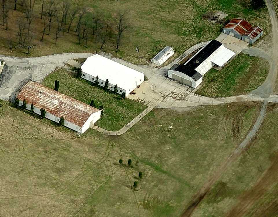
A circa 2005-2010 aerial view looking north depicted a collection of 4 possible hangars on the north side of the FBM Company Airfield.
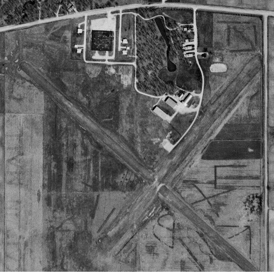
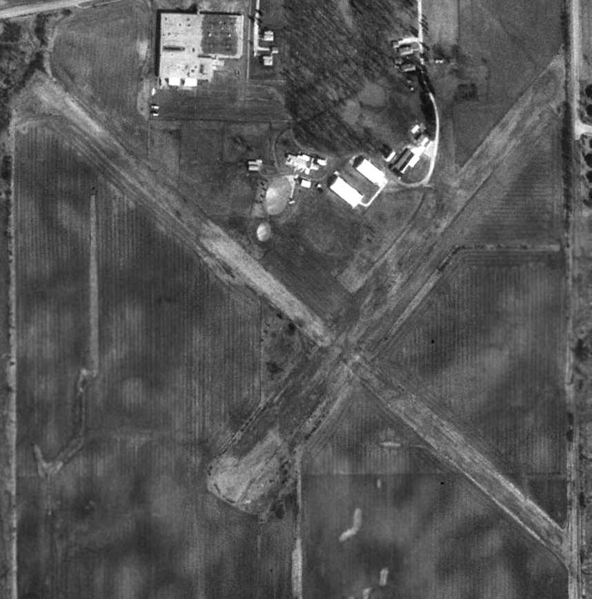
Anthony Zarinnia reported in June 2011, “I overflew 2 days ago at low altitude in haze & saw the strip... X-pattern airfield,
north ramp has hangars circa pre-war, no planes or activity visible.
Grass looks overgrown but not badly. I thought I could actually put down on it no sweat.
I saw a broken ramp & some scattered & tattered buildings... no sign of a windsock or segmented circle.
The house looked abandoned & no cars to be seen. It looks abandoned for some time.”
A 9/25/13 aerial view depicted FBM as remaining completely intact, with the runways still recognizable, and the hangars still standing.
The FBM Company Airfield is located southeast of the intersection of West University Parkway & South Steger Monee Road.
Thanks to Anthony Zarinnia for pointing out this airfield.
____________________________________________________
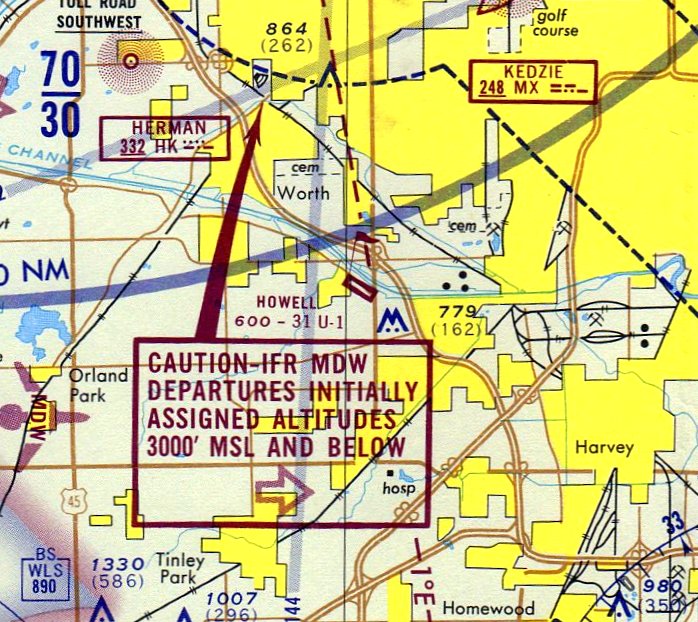
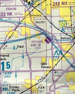
Howell Airport (1st location), Blue Island, IL
41.65, -87.74 (Southwest of Chicago, IL)
Howell Airport, as depicted on the October 1944 Chicago Sectional Chart (courtesy of Richard Doehring).
This is yet another Chicago-area general aviation field which has been lost forever.
The Howell Airport in Blue Island was apparently built at some point between 1938-40,
as it was not yet depicted on a 1938 aerial photo,
nor listed among active airfields in The Airport Directory Company's 1938 Airports Directory (according to Chris Kennedy).
According to Karen Howell, wife of Willis (Bill) Howell, “The airport was in his family since about 1940.”
The earliest depiction of the airfield which has been located was on the October 1944 Chicago Sectional Chart (courtesy of Richard Doehring).
It depicted Howell as a commercial/municipal airport.
The April 1944 US Army/Navy Directory of Airfields (courtesy of Ken Mercer) described Howell as having a 2,600' unpaved runway.
The 1946 Chicago Sectional Chart (courtesy of Chris Kennedy) depicted Howell as a commercial airport.
The earliest photo which has been located of Howell Airport was a 1951 aerial view.
It depicted the field as having 2 grass runways.
Two hangars were located on the southeast side, around which were parked 6 single-engine aircraft.
The 1953 IL Airport Directory (from the University of IL, courtesy of Daniel McGill)
depicted Howell Airport as having 4 runways, with the longest being the 2,600' east/west strip.
Four small buildings were depicted on the southeast side.
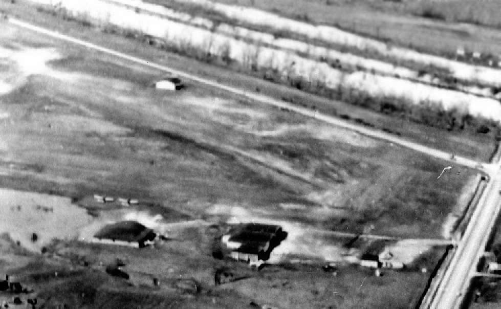
A 2/20/54 aerial view looking north at Howell Airport (courtesy of Karen Howell)
depicted the field as having 3 hangars on the north & south side of the grass airfield.
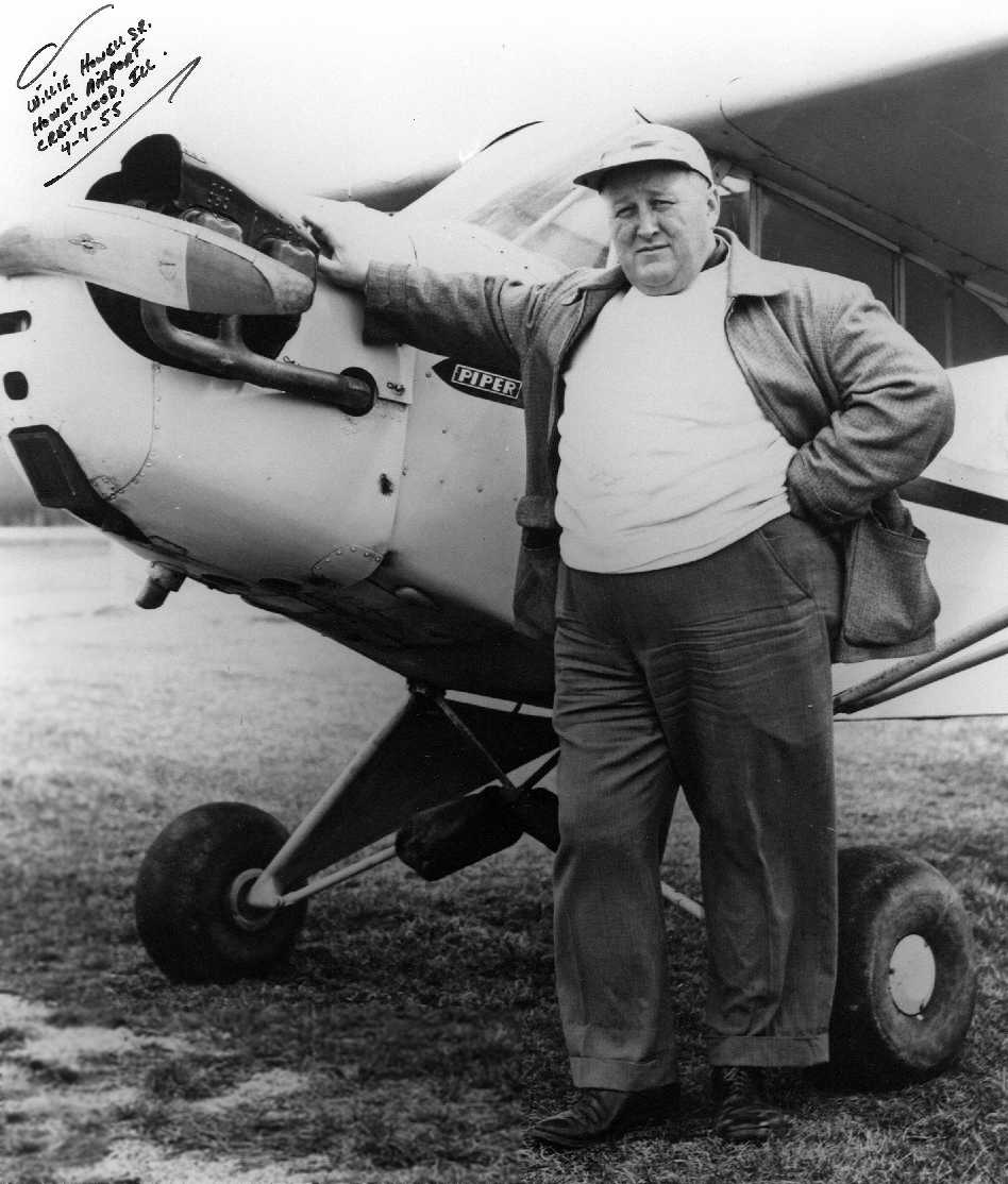
A 4/4/55 photo (courtesy of Karen Howell) of Howell Airport owner Willis Howell in front of a Piper Cub at his airport.
The 1958 IL Airport Directory (courtesy of Chris Kennedy) depicted Howell as having 3 "turf & crushed rock" runways,
with the longest being the 2,600' east/west strip.
The operator & manager was listed as W. T. Howell.
The aerial photo in the directory depicted 2 hangars north of the northwest/southeast runway,
and another hangar at the southeast corner of the field.
Curtis Kovacs recalled, "I learned to fly at Howell 1958-60 with Willie Howell.
There was corn planted in the triangle of the runways & west of the north/south runway.
Willie's school used J-3s & TriPacers. Joliet Range was still active."
According to Nick Selig, “If you landed your airplane at this airport, you'd better pay Howell's landing fee
because he would run out in his Cadillac car & park in front of your airplane so you couldn't move it.”
Virgil Gacke moved his business, Curley's Aero Repair, to Howell Airport in 1960.
He was described as an expert on Navions.
A 1961 aerial view showed that a 3rd hangar had been built on the northeast side at some point between 1958-61.
A 1962 aerial view showed Howell Airport in an unchanged manner.
Howell Airport was described by the 1963 AOPA Airport Directory (according to Chris Kennedy)
as having 3 gravel runways (3,400' 13/31, 2,400' 18/36, and 2,600' 9/27).
The operators were listed as Howell Flying Service & Suburban Flying Service.
The November 1971 Chicago Sectional Chart depicted Howell Airport as having a 3,100' paved runway.
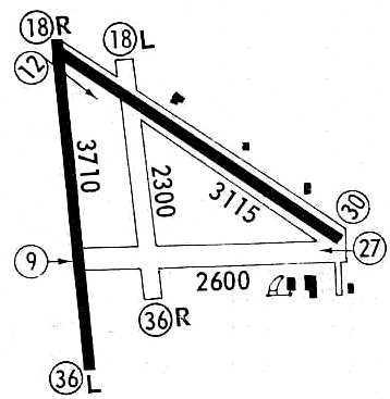
At some point between 1963-71, two of the runways at Howell had been paved, including a new 3,710' Runway 18R/36L,
as depicted on a 1971 airport directory (courtesy of Chris Kennedy).
This brought Howell Airport to a total of 4 runways.
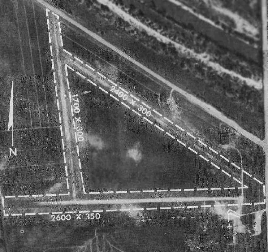
An aerial view of Howell Airport from the 1972 IL Airport Directory (courtesy of Bill Pagett).
The directory depicted the field as having 2 macadam runways (with the longest being the 3,500' northwest/southeast strip), as well as 2 turf runways.
Dozens of light aircraft were visible parked on the northwest & southeast sides of the field.
The operators were listed as Howell Flying Service & Suburban Flying Service, and the airport manager was listed as W.T. Howell.
The May 1973 Chicago Terminal Aeronautical Chart (courtesy of Mitchell Hymowitz) depicted Howell Airport as having a 3,100' paved runway.
Brian Wohlgemuth recalled, “I spent the better part of my early childhood tooling around Howell Airport.
My dad was part owner of Suburban Flying Service back in the mid 1970s.
Runway 9/27 was a taxiway back in the 1970s... I don't know if it was ever rated for runway use from as far back as I can remember.”
A 1974 aerial view depicted over 40 aircraft parked on the northeast & southeast sides of the field.
Brian Wohlgemuth recalled, “Willie Howell was an interesting fellow.
When Willie died in the mid-1980s, his son sold the property to concentrate on his newer field in New Lenox, IL.”
[Unfortunately, the Howell Airport in New Lenox didn't last very long, as it closed in 2006.]
The last aeronautical chart depiction which has been located of Howell Airport
was on the 1985-86 IL Aeronautical Chart (courtesy of John Kielhofer).
It depicted Howell as having a 3,000' paved runway.
By 1986 Howell Airport was apparently on a downslide,
as a 1986 an airport directory (courtesy of Chris Kennedy) showed that the runway configuration had started to shrink.
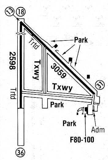
Two former runways (18L/36R & 9/27) had since been downgraded to taxiways,
and what used to be the longest runway (18R/36R) had been shortened to 2,598'.
The longest runway at that point was Runway 13/31, which had also been shortened to 3,059'.
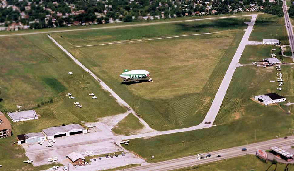
A 1987 aerial view looking southwest at Howell Airport (courtesy of Karen Howell) during a visit by a Fuji blimp.
A 1988 aerial view depicted two-dozen light aircraft at Howell Airport.
In 1988, it was reported that Howell Airport was for sale.
A developer appeared promising to build a power center on the site
if the Village of Crestwood would purchase & deliver the land.

A 5/15/89 photo (courtesy of Karen Howell) of the festivities surrounding the last departure from Howell Airport.
The caption read, “5/15/89, Howell Airport. Bill Howell prepares to be the last plane flown from Howell Airport as thousands of 'well wishers' look on.
He flew his 1942 450-hp Stearman from Crestwood to Howell / New Lennox that day.
One Airport era ended & a new one began that day.”
Brian Wohlgemuth recalled, “The airport 'went out with a bang' back in 1989
with a final going-away party before the airport was converted into a shopping center.
I remember taking off from the 'newer' Runway 18/36 during the final party (in my last flight in a 172 with my stepdad).
Howell was a great field and I was saddened to watch the field
that formed a big part of my childhood turned into a Best Buy & Office Depot.
The movie theaters & the Portillo's Hot Dogs have pictures in their entryway of the early airport
and the various buildings & planes that flew in over the years.”
Howell Airport was no longer depicted on the October 1993 Chicago Sectional Chart (courtesy of Ron Plante) or the 1993 USGS topo map.
A 7/31/95 aerial photo (courtesy of Karen Howell) showed that the Rivercrest Shopping Center had covered the site of the original Howell Airport,
with not a trace remaining of the former airport.
A 4/2/13 aerial photo of the site of Howell Airport.
The site of Howell Airport is located northwest of the intersection of Cicero Avenue & Cal Sag Road.
____________________________________________________
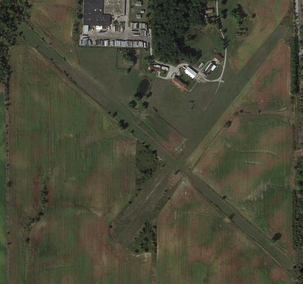
New Lenox Airport / Howell Airport (2nd location) (1C2), New Lenox, IL
41.48, -87.92 (Southwest of Chicago, IL)
New Lennox Airport, as depicted on the December 1969 Chicago Sectional Chart.
No airfield was yet depicted at this location on a 1961 aerial view
or on the May 1969 Chicago Sectional Chart (courtesy of William Pagett).
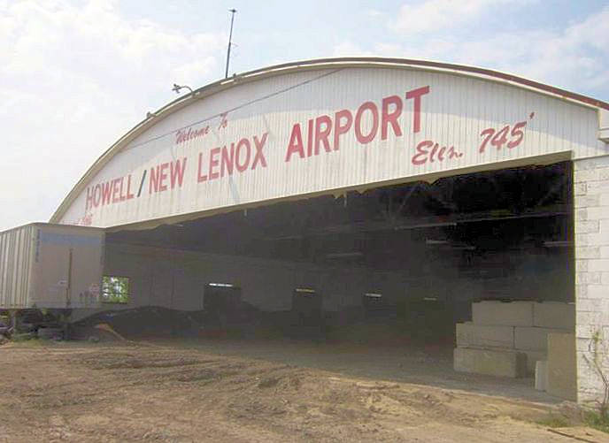
The New Lenox Airport was licensed in 1968 (according to the painted legend along the front of its hangar).
The earliest depiction which has been located of New Lenox Airport was on the December 1969 Chicago Sectional Chart.
It depicted New Lenox as a public-use airport having a 3,600' unpaved runway.
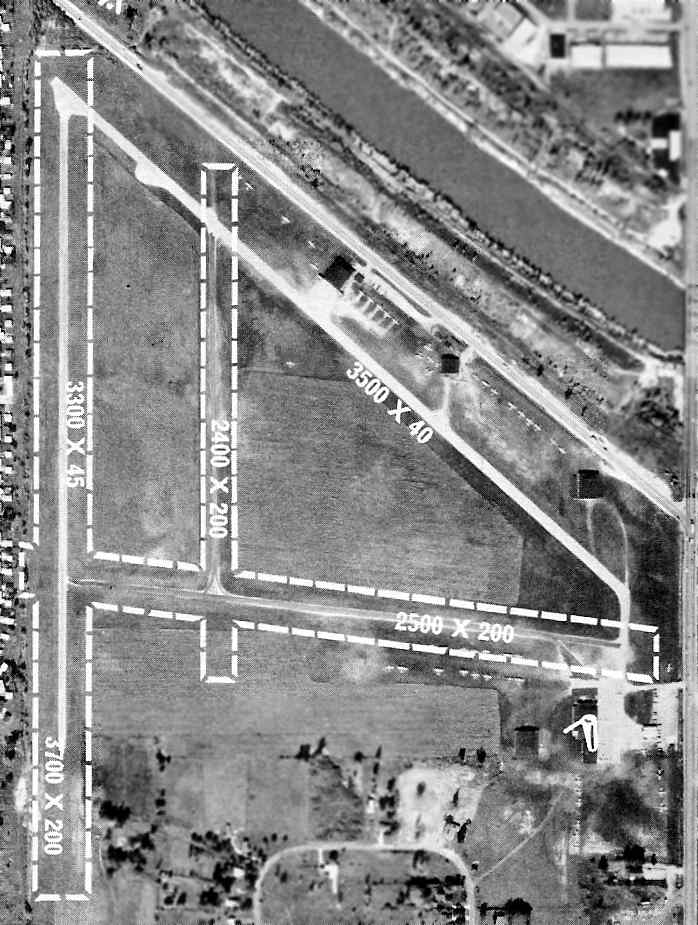
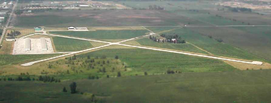
The earliest photo which has been located of New Lenox / Howell Airport was an undated aerial view from the 1972-73 IL Airport Directory (courtesy of Alex Hauzer).
The 3,000' northwest/southeast runway had evidently been paved at some point between 1969-73.
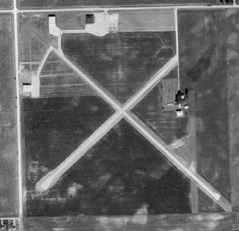
A 1974 aerial view showed that New Lenox / Howell Airport's crosswind runway had also been paved at some point between 1973-74.
Three hangars were located on the north & west sides of the field,
and 3 single-engine aircraft were visible on the north side of the field.
The airport was evidently renamed Howell New Lenox Airport at some point between 1969-83,
as that is how it was labeled on the 1983 USGS topo map.
It had evidently been taken over by the son of Willie Howell, founder of the original Howell Airport in nearby Blue Island.
A 1988 aerial view depicted Howell Airport in the same configuration as seen in 1974.
However there was not a single airplane visible on the entire field.
A 1993 USGS aerial photo showed a total of 10 light single-engine aircraft visible parked outside on the field.
The 1998 USGS aerial photo depicted Howell Airport as having a total of 5 hangars on the northwest corner of the field,
with 2 long T-hangars having been added at some point between 1988-98.
The field did not appear very well-used, though, as only 2 aircraft were visible parked outside at the field.
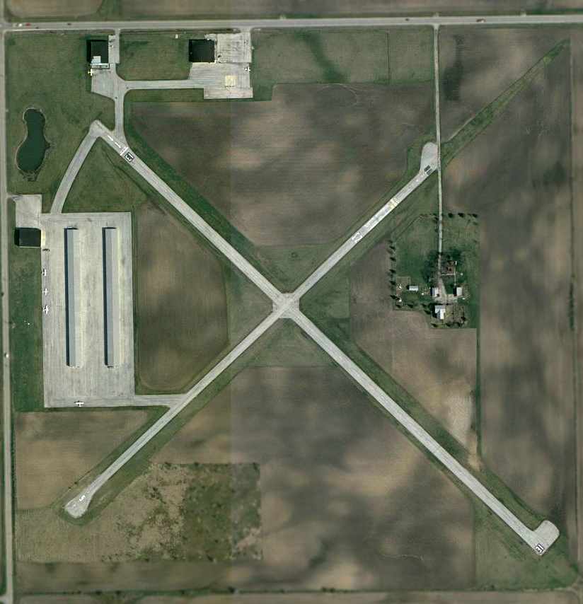
In the 2002 USGS aerial photo, a total of 6 light single-engine aircraft were visible parked at Howell Airport.
The airport was otherwise identical in configuration to how it was depicted in the 1998 photo.
Jacob Rueth recalled, “I took about 20 hours of training there towards my private pilot's license in 2004-05,
and I left because of rumors that they were closing.”
In 2006, Howell New Lenox Airport's FAA Airport/Facility Directory data
described the field as having 2 asphalt runways: 2,877' Runway 13/31 & 2,362' Runway 5/23,
both of which were described as being “in fair condition, cracked with grass growing through.”
There were a total of 63 aircraft listed as being based on the field, including 4 multi-engine aircraft.
The field was said to conduct an average of 82 takeoffs or landings per day.
The 2006 Chicago Terminal Area Chart depicted Howell-New Lenox Airport
as having 2 paved runways, with the longest being 2,900'.
Jacob Rueth reported in 2006, “I flew in there in mid-July this year
and stopped to say hi to the people there & they were still open.”
A July 2006 aerial photo by Brian Cramer, looking north at the Howell New Lenox Airport,
taken only a few days before the field's closure.
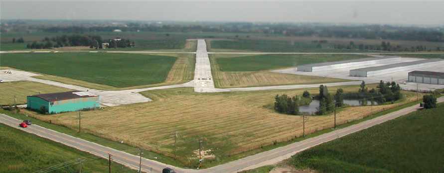
A July 2006 aerial photo by Brian Cramer, taken on final approach for Howell's Runway 13.
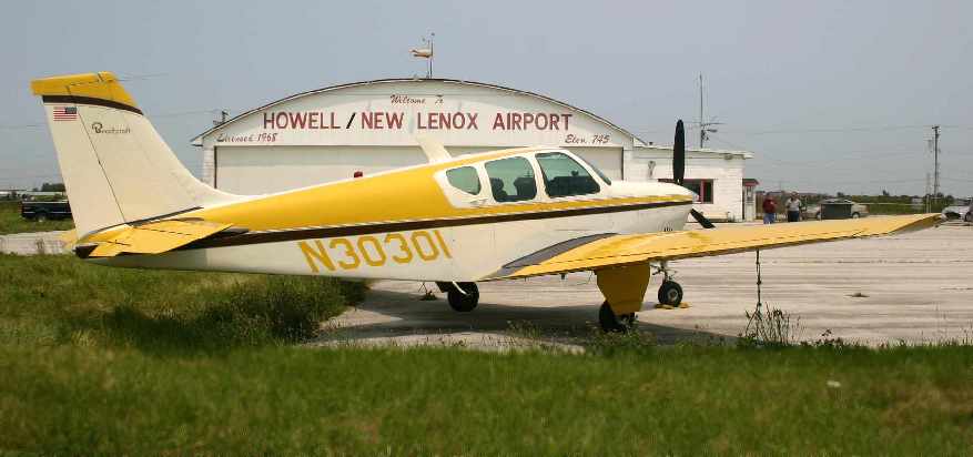
A July 2006 photo by Renée Kwiat of her Beechcraft Debonair at of Howell New Lenox Airport.
According to Renée, “My husband & I flew from Page Field, Fort Myers, FL to Howell New Lenox.
I thought documenting the hangar, which was painted with the field elevation, field name and licensure date
with a nice static shot would be a memorable keepsake of a soon-to-be-destroyed general aviation field.”
According to Brian Cramer, “Howell Airport in New Lenox closed forever on 8/1/06.
It will become mixed commercial & residential development.”
Jacob Rueth reported in 2006, “On August 5th I was on short final when I saw the yellow X above the numbers.
That & the place was abandoned.”
A sad 2007 aerial view showed that 3 of the hangars had been removed, with only the 2 hangars on the north side of the field still standing.
The northern half of the 2 runways still remained,
but the southern half of the property had been covered by streets for a new housing development.
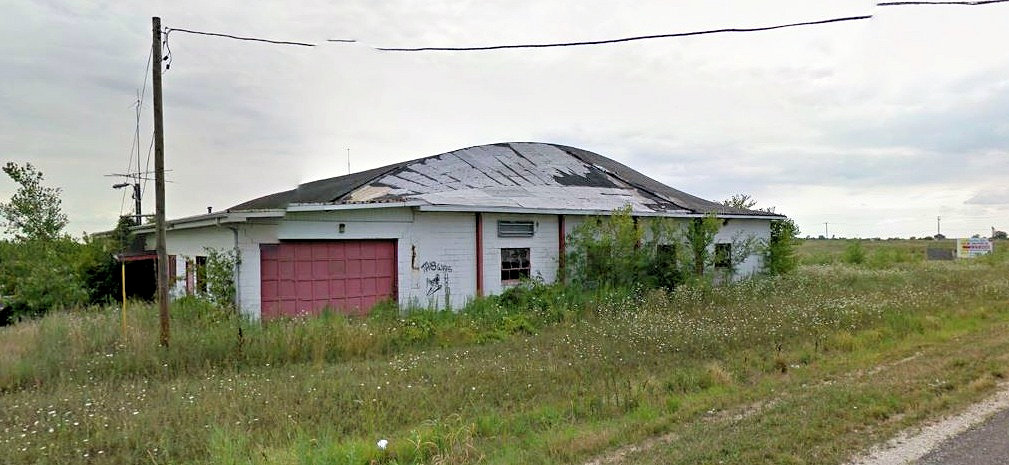
A circa 2010-2013 photo looking southwest at the hangar which remains on the north side of the Howell Airport site (courtesy of Paul Glowiak).
A 2012 photo of the hangar which remained on the north side of the Howell Airport site (courtesy of Paul Glowiak).
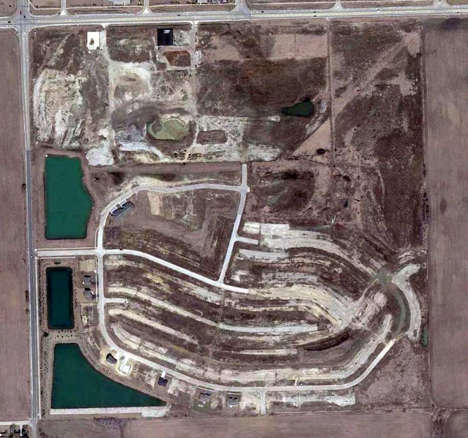
A sad 4/2/13 aerial photo shows the stalled construction for a stillborn housing development covering the majority of the site of Howell Airport.
Amazingly, the photo shows almost no difference compared to a 2007 aerial photo.
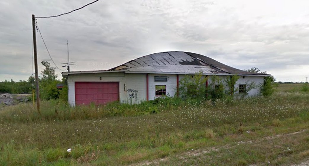
An August 2013 photo looking south at the hangar which remains on the north side of the Howell Airport site.
Paul Glowiak reported in January 2014 that the above-pictured “hangar is all that's left, there is construction equipment in the parking lot.”
He then reported in December 2014 that “the hanger at New Lenox/Howell Airport was demolished this past week.
There is supposed to be a mixed-use development on the property.”
A 2019 photo showed only the foundation remained at the site of the Howell Airport hangar.
The aviation heritage of the Howell New Lenox Airport site is commemorated via some of the names of the residential streets which have covered it: such as Runway Drive & Jet Stream Drive.
____________________________________________________
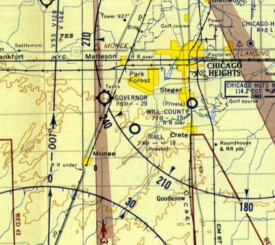
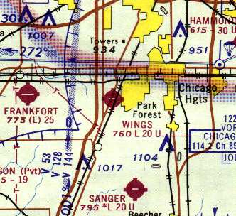
Governor's Airpark / Wings Field / Haedtler Field, Chicago Heights, IL
41.47, -87.72 (Southwest of Chicago, IL)
Governor's Airpark, as depicted on the December 1948 Chicago Sectional Chart.
Governor's Airpark was apparently built at some point between 1946-48,
as it was not yet depicted on a 1939 aerial view
or on the June 1946 Chicago Sectional Chart (courtesy of Chris Kennedy).
The earliest depiction which has been located of Governor's Airpark was on the December 1948 Chicago Sectional Chart,
which depicted it as having a 2,700' unpaved runway.
The earliest photo which has been located of Governor's Airpark was a 1951 aerial view.
It depicted Governor's Airpark as having 2 grass runways, with a few small hangars southeast of the runway intersection.
Four light planes were parked amongst the hangars, and a 5th plane was visible on the east end of the runway.
Sandra Thielman reported, “I’m the granddaughter of Walt & Paul Thielman, the original owners & builders of Governor’s Airpark
and the daughter of Leslie Thielman whom helped my grandmother run Governors.
You might find to go cart track interesting. In the aerial photo [above], you can make out the figure 8 shaped track to the right – south of the driveway in front.
Many, many Saturday nights were spent there with my parents enjoying the fun of go cart racing.”
The 1958 IL Airport Directory (courtesy of George Miner) depicted Governor's Airpark as having 2 turf runways.
It listed the operator as Midwest Aircraft Sales Corporation, and listed the manager as Walter Thomas.
The 1958 IL Airport Directory (courtesy of George Miner) depicted Governor as having a 2,600' unpaved runway.
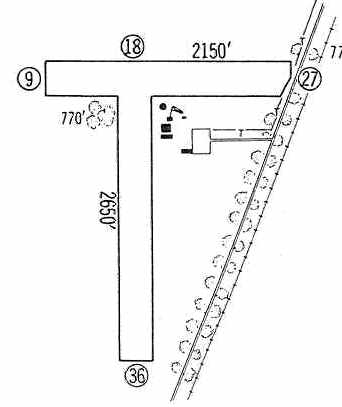
The 1960 Jeppesen Airway Manual (courtesy of George Miner).
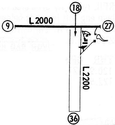
depicted Governor's Airpark as having a 2,650' Runway 18/36 & a 2,150' Runway 9/27.
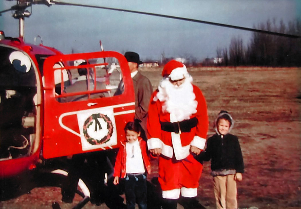
A 1960 photo (courtesy of Sandra Thielman) of Santa Claus arriving at Governor's Airpark in his red Fairchild Hiller FH-1000 helicopter.
A 1961 aerial view depicted Governor's Airpark in basically the same manner as the 1951 photo,
but the number of planes visible on the field had increased to 7.
The 1962 AOPA Airport Directory described Governor's Airpark as having 2 turf runways: 2,650' 18/36 & 2,150' 9/27.
The operator was listed as Midwest Aircraft Sales Corporation.
Sandra Thielman recalled that her mother “Leslie Thielman renamed [the airport] Wings Field after my grandfather’s death.”
The 1963 Chicago Local Aeronautical Chart (courtesy of Chris Kennedy) depicted Wings Field as having a 2,000' paved runway.
Steve Fowler recalled, “I worked at Wing's in 1966-67 as a line boy, an experience I'll never forget.
The field had 2 full-time mechanics then, Vern & Bob, aka Vern's Aero Repair, and a full-time secretary, Harriet, who hailed from Kentucky or West Virginia.
She answered the phone, 'Good mornin', WANGS , Harriet speakin'.
We used to kid her that customers might think we were a Chinese restaurant.
Wings was fairly busy then. There were around 20 aircraft based there, 2 line boys and 2 or 3 CFI's.
The FBO owned 2 C150s which were rented often. The owners had a Rockwell Aero Commander which I once waxed entirely by hand!”
Wings Field apparently gained a paved runway at some point between 1963-68,
as the 1968 Flight Guide (courtesy of Robert Levittan) depicted it as having a 2,000' paved Runway 9/27 & a 2,200' unpaved Runway 18/36.
Timothy Faster recalled, “I soloed out of Wings in 1969 & have fond memories.”
The Aerodromes table on the 1969 Chicago Sectional Chart (courtesy of John Voss)
described Wings Field as having 2 runways, with the longest being a 2,000' asphalt strip.
Karen Johnson-Crowther recalled, "My father, Joseph Bacik,
owned a little private air field which I remember as Wings Field.
We lived in Chicago Heights & my dad sold the airport before he retired to Florida in 1972.
I remember one year many of the small hangars were destroyed by a storm
as well as a fire which burned down the main building.
My dad had a pilot's license which he lost after his heart attack which led to retirement.
He had a few partners in the airport, one of which if I recall correctly,
committed suicide by flying his plane over Lake Michigan until he ran out of fuel."
Apparently Wings Field was closed at some point between 1969-70, after being sold by Joseph Bacik,
as it was not depicted on the October 1970 Chicago Sectional Chart (courtesy of Ron Plante) or the 1970 USGS topo map.
The airfield was evidently reopened by the Civil Air Patrol as 'Haedtler Field' at some point between 1971-74.
It was named in honor of renowned local pilot Marty Haedtler, who had passed away in 1971.
A 1974 aerial view depicted Haedtler Field as having an east/west paved runway & a crosswind grass runway.
Six light aircraft were visible parked on the field.
However, Haedtler Field was not depicted 1974/77/93 Chicago Sectional Charts.
Cherie Sieger reported, "Wings Field has special meaning to me.
My father, Jim Davis, was in the Civil Air Patrol when they were redoing the airfield
and then renamed it 'Haedtler Field' in the early 1970s.
He was very involved with this airfield & he was very proud of the work they were doing there.
We flew out of that airfield many times while my dad was associated with it.
There were 2 hangars there plus a building that had the office.
My sister & I used to play in the hangar."
According to Sam Lee, his brother flew out of Govenor's Airpark with the Civil Air Patrol in early 1970s.
Haedtler Field was described in the 1976 AOPA Airport Directory (courtesy of Chris Kennedy)
as having a single 2,000' asphalt Runway 9/27.
It was said to be a private field, for "Civil Air Patrol use only."
Pat Bahn recalled, “Around 1976-1977, I was a Cadet in the Homewood/Flossmoor/South Chicago Combined CAP Squadron.
We had squadron meetings at the then Homewood Army Reserve base, which was apparently a decommissioned Nike missile site.
We did flight training at Governor’s Airpark. At that time, it was nominally a CAP field, but there were still a few commercial activities still working there.
There was a fellow doing A&P work from one hangar, and there were still a few rented hangars with private aircraft there.
I recall some of the adult squadron members commenting that the CAP wouldn’t pay to recap the hard runway & re-roof the building,
so at some point they expected the airfield to become unviable.
I remember they had looked at various methods to increase income, but, none of them were considered likely.”
Pat continued, “It was a great airfield for me at that time. I learned how to fly in a Schweitzer 232, and if I hadn’t moved away, I’d have completed that.
The CAP had two or three 232’s for basic flight training, and I think some of the adults co-owned a 126, which they used for sport operations.
We had 1 or 2 old Cessna Bird-Dogs which were left over from Vietnam surplus & were used as tow aircraft & for search & rescue.
A few of the adult members also owned small general aviation aircraft, which were available for SAR missions as needed.
We did glider operations off the big grass strip. It was wide enough that you could land a 232 sideways in a pinch.
I really liked the airfield because I could take the then-Illinois Central Gulf Commuter rail down to the station nearby & walk down the road a quarter-mile & take flight training.
I always had to make sure I caught the last train home on a Saturday, because I would otherwise have to hitchhike quite a ways.”
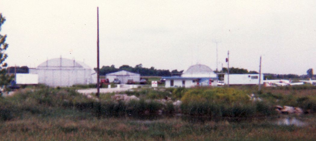
A 1982 photo by Sandra Thielman of Haedtler Field showed several small hangars & light aircraft.
Michael Rafferty recalled, “I was a cadet in Civil Air Patrol in the 1980s.
Circa 1984-86 we used to hold our weekly Squadron meetings at Haedtler Field in the hangar depicted in the 2006 aerial view.
The airport was still active, only used by Civil Air Patrol members for the most part.
I learned how to fly gliders (big old red & white 2-seat Schleicher that was about 25 years old,
towed up to 3,500' by a Vietnam vintage OV-1 Birddog) there,
and others in our squadron flew their 1st solos there in an orange & white Cessna 152.
Runway 18/36 was a grass runway.
If you look at the 2000 photo, there is a square clump of trees in the middle about 1/3 of the way down from the top.
Just to the right of that clump of trees was the northernmost edge of Runway 18/36,
while if you go down near the bottom of the picture, where the dark green spot in the tree line ends, is the end of the runway.
It was about 3,000' long, not exactly smooth & chock full of gopher holes.
There were those who 'maintained' the airport that undertook gopher removal missions at night with a 22 long & a bright flashlight.”
The last photo which has been located showing Haedtler Field in operation was a 1988 aerial view.
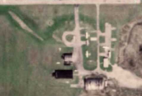
A closeup from the 1988 aerial view showed that Haedtler Field did not appear very healthy,
as only 3 single-engine aircraft were visible on the field.
Haedtler Field was reportedly abandoned in 1989.
The 1990 USGS topo map labeled the field as "Haedtler Landing Strip", and only depicted Runway 9/27.
However, the 1991 USGS topo map appears to have been using older data,
as it labeled the field once again as "Wings Field", and depicted both runways 18/36 & 9/27.
A 1993 USGS aerial view showed Haedtler Field had been abandoned,
with all of the buildings except one having been removed, and the runway considerably deteriorated.
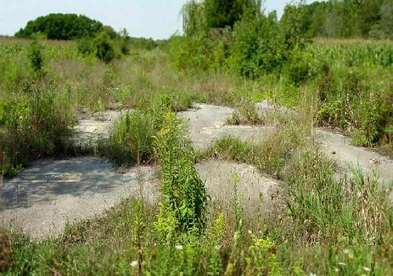
A 2002 photo by Sam Lee looking west along the extremely overgrown remains of Runway 27 at Governor's Airpark.
The painted runway number "27" could just barely be discerned among the weeds. Sam reported that the property was for sale.
According to Cherie Sieger, as of 2002 the old hangar was being reused to store farm equipment for the corn field.
Cherie Sieger reported in 2003, "My father [former Haedtler Field pilot Jim Davis] passed away last September 22nd.
My sister & I took his ashes to the airfield (which was being utilized as a corn field) on October 12th -
very nice people that own the corn field let us go to the old runway and we drove to the middle of it.
She headed one way as if to 'take off' and scattered half of his ashes on the runway,'
I then proceeded to 'land' taking his remaining ashes in the other direction
(can you imagine two 40+ year olds running up & down the airstrip?).
We knew the moment we had to decide what to do with his ashes that this was the most fitting send off for him.
My step-mother (who was also involved with the field at the same time as my dad)
was very moved that we chose 'Haedtler Field' as the place to leave my dad for eternity."
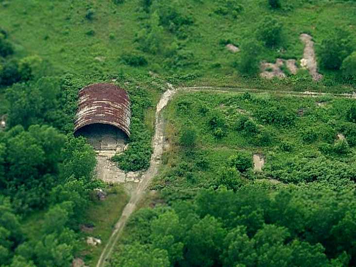
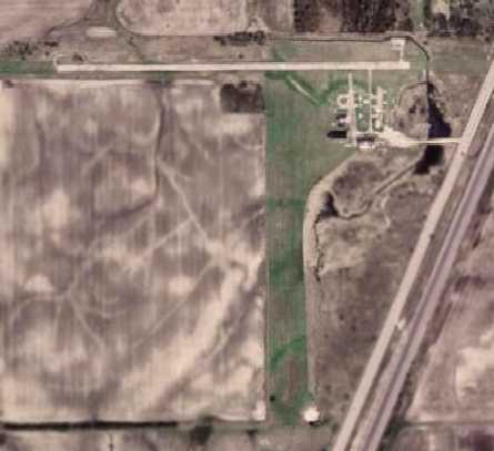
A circa 2006 aerial view looking west at the former hangar which remains south of the Haedtler Field runway.
A 2007 aerial view showed the sole hangar still remained on the site, which was otherwise still clear & not yet redeveloped.
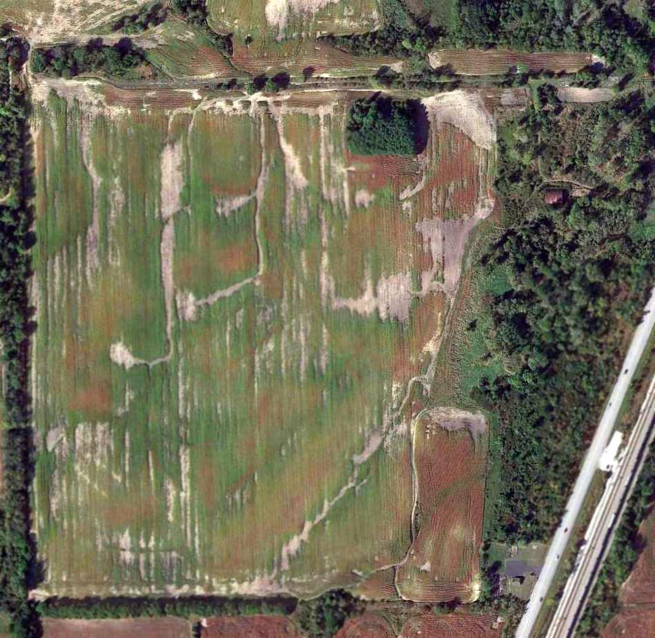
A 9/25/13 aerial photo showed the remains of Haedtler Field's paved east/west runway were still barely recognizable.
There was no sign of the former grass Runway 18/36.
A single former hangar sat to the south of the Runway 27 approach end.
The site of Haedtler Field is located southeast of the intersection of South Cicero Avenue & Route C12.
____________________________________________________
Since this site was first put on the web in 1999, its popularity has grown tremendously.
If the total quantity of material on this site is to continue to grow,
it will require ever-increasing funding to pay its expenses.
Therefore, I request financial contributions from site visitors,
to help defray the increasing costs of the site
and ensure that it continues to be available & to grow.
What would you pay for a good aviation magazine, or a good aviation book?
Please consider a donation of an equivalent amount, at the least.
This site is not supported by commercial advertising –
it is purely supported by donations.
If you enjoy the site, and would like to make a financial contribution,
you
may use a credit card via
![]() :
:
Please consider checking the box to make a monthly donatation.
For a mailing address to send a check, please contact me at: paulandterryfreeman@gmail.com
If you enjoy this web site, please support it with a financial contribution.
please contact me at: paulandterryfreeman@gmail.com
If you enjoy this web site, please support it with a financial contribution.
____________________________________________________
This site covers airfields in all 50 states.