Abandoned & Little-Known Airfields:
Southwestern West Virginia
© 2002, © 2025 by Paul Freeman. Revised 11/14/25.
This site covers airfields in all 50 states: Click here for the site's main menu.
____________________________________________________
Please consider a financial contribution to support the continued growth & operation of this site.
Beckley Mt. Hope Airport (revised 2/14/24) - Bollinger Field / Hilltop Airport (revised 7/21/20) – Clarke Seaplane Base / Kanawha Seaplane Base / Capital City Seaplane Base (revised 3/14/21)
Madison Airport / Slippery Gut Airport (added 11/14/25) - McDonald Airport (revised 5/21/19) - Mingo County Airport (added 7/27/24) - Summersville Airport / (Original) Nicholas County Airport (revised 10/24/23)
Swope Farm Airfield (revised 8/31/24) - Welch Municipal Airport (revised 4/18/25) - Wertz Field (revised 5/21/19)
____________________________________________________
Madison Airport / Slippery Gut Airport, Danville, WV
38.112, -81.85 (Southeast of Lexington, KY)
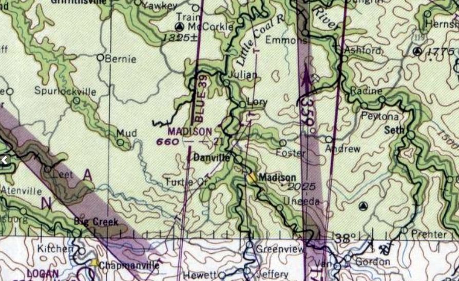
Madison Airport, as depicted on the October 1948 Huntington Sectional Chart.
Photo of the airport has not been located.
This small rural general aviation airport was evidently established at some point between 1947-58,
as Madison Airport was not yet depicted on the 1947 Huntington Sectional Chart.
The earliest depiction which has been located of Madison Airport was on the October 1948 Huntington Sectional Chart.
It depicted Madison as having a mere 2,100' unpaved runway.
According to Mike Graham, “the Madison Flying Service, the 3rd civilian charter service established in West Virginia,
was founded by my grandfather Denver Roush & based there serving southern WV mining communities.”
Patricia Graham recalled, “They called it Slippery Gut Airport. There were wind socks on poles, a dirt runway, a few buildings so they could work on the planes, and a little concession stand.
Nothing grand, just enough for people to gather, sit around, and watch the planes. The coal mines were really running back then & the service flew mining people & cargo in & out.
The runway was all dirt & it had to be decent enough because the planes needed room to get up through all those trees down there.
Othar Mullins kept a plane there, and Elwood Priestley had one too; he’s the one who owned the Chevrolet dealership dad worked for.
Dad was there all the time. He didn’t own the place & he didn’t own a plane of his own - he just flew.
He was the one who taught the others how. He was the Civil Air Patrol flight instructor & trained pilots out of there. I’m pretty sure he taught Othar & Elwood how to fly.
Othar’s plane was a Piper Cub. Elwood’s plane wasn’t a Piper Cub, it was something sleeker. Not enormous for the times, but bigger than the basic trainers.
Dad used to take me & my brother flying when we were small. He’d roll the plane in the air, and I must not have been very big, because I was strapped in the middle somehow.
He’d come out of the roll & I’d holler, 'Do it again! Do it again!'”
Patricia continued, “Mom was the opposite. She was absolutely terrified of airplanes.
Once she was sitting in the plane while Daddy was doing some work on it or getting ready, and she must have dozed off.
He tried to ease her seat forward to take her up, and when she realized what was happening - Lord have mercy - she came out of that plane screaming like a banshee.
That started World War III right there on the ground.”
Lawrence Roush recalled, “The airfield Dad helped construct & flew out of was referred to and was in the vicinity of 'Slippery Gut' Creek, on Route 3 , 3-4 miles from the junction of Routes 119 & 3.
The Madison / Slippery Gut airfield was about 3,000' long, grass, over on the opposite side of the Little Coal River from Route 3.
The strip was not road-accessible, and my job was poling visitors across the stream in a flatboat.
Lindel Miller, a member of Chuck Yeager's WWII Squadron, was Dad's instructor.
He owned a Piper Cub and once Dad got his license, he often used the Cub to give rides to visitors, I assume in exchange for free flight time.
Two other planes, a Stinson (metal body with fabric-covered wings) owned by Othar Mullins & a Cessna (all-metal) owned by Paddy Nabb, were based there.
Other than when Dad would give your mother & I a ride, my greatest memory of that strip was watching Yeager with his wife, Glennis as passenger, give the greatest stunt flying performances I have ever seen.”
Lawrence continued, “After WWII aviation boosters made many optimistic projections for the future of civilian aviation, but it never came to pass & the Madison Airfield never really caught on.
The above occurred in the mid- to late-1940s & Dad's interests moved into Commander of the VFW Post & Chief of the Madison Volunteer Fire Department.”
Madison Airport was not depicted on the 1951 USGS topo map.
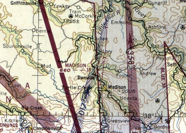
The last depiction which has been located of Madison Airport was on the January 1952 Huntington Sectional Chart.
It depicted Madison's runway length as having slightly decreased, to only 1,900'.
Madison Airport was evidently closed at some point in early 1952, as it was no longer depicted on the July 1948 Huntington Sectional Chart.
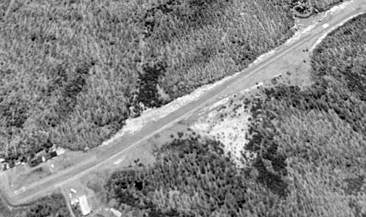
The earliest photo which has been located of the Madison Airport site was a 1957 aerial view.
It depicted a northeast/southwest-oriented clearing, with 2 small buildings at the southwest end.
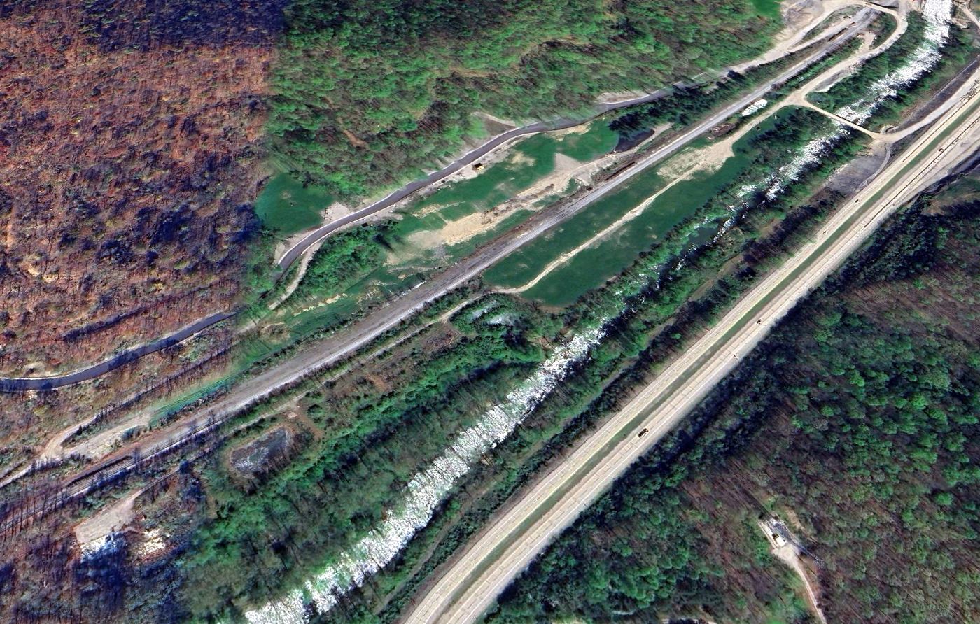
A 2024 aerial view looking north at the Madison Airport site shows the northeast/southwest-oriented clearing of the presumed runway is still recognizable.
Thanks to Mike Graham for pointing out this airfield.
____________________________________________________
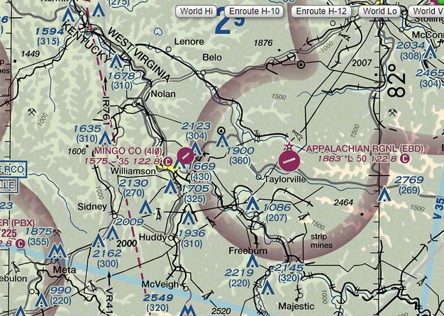
Mingo County Airport (4I0), Williamson, WV
37.688, -82.261 (Southeast of Lexington, KY)
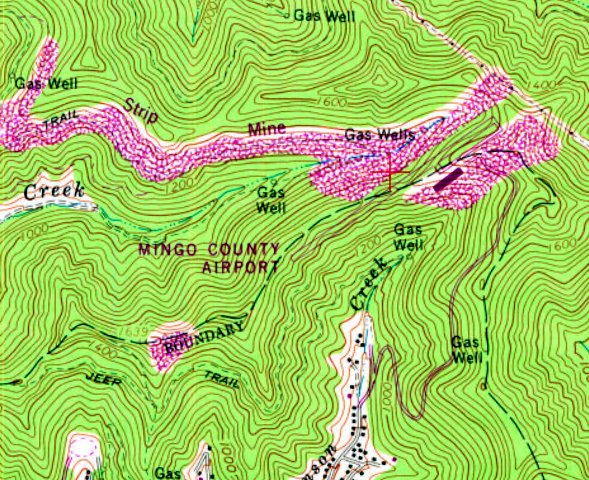
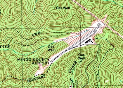
Mingo County Airport, as depicted on the 1978 USGS topo map.
Photo of the airport while in use has not been located.
This small rural general aviation airport was not yet depicted on a 1957 aerial photo.
According to an article in the 1/6/19 Williamson Daily News, Mingo County Airport “opened in the late 1960s.
This FAA-approved facility was constructed as a post-mine land use project with Alpha Natural Resources, the Mingo County Airport Authority & the WV Aeronautics Commission.
Once its surface mining operation was complete & the airport facility was constructed to rough grade, Alpha Natural Resources donated the 900-acre site to Mingo County,
at no cost to the taxpayers, according to the Mingo County Redevelopment Authority.”
The earliest depiction which has been located of Mingo County Airport was on the 1978 USGS topo map.
It depicted Mingo County Airport as having a single paved northeast/southwest runway, with a paved parallel taxiway & a long hangar on the southeast side.
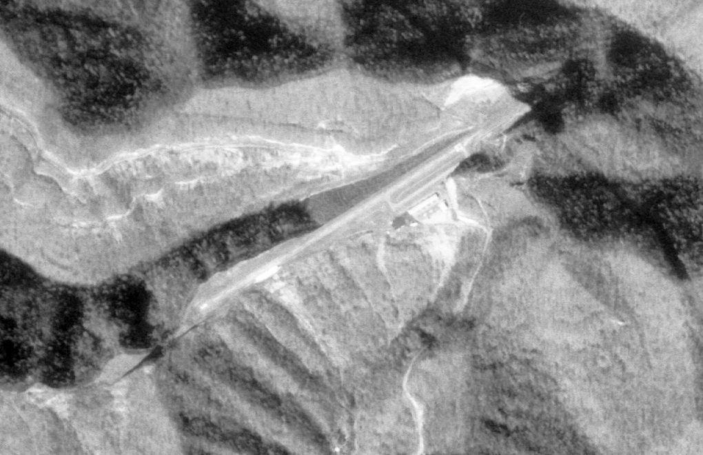
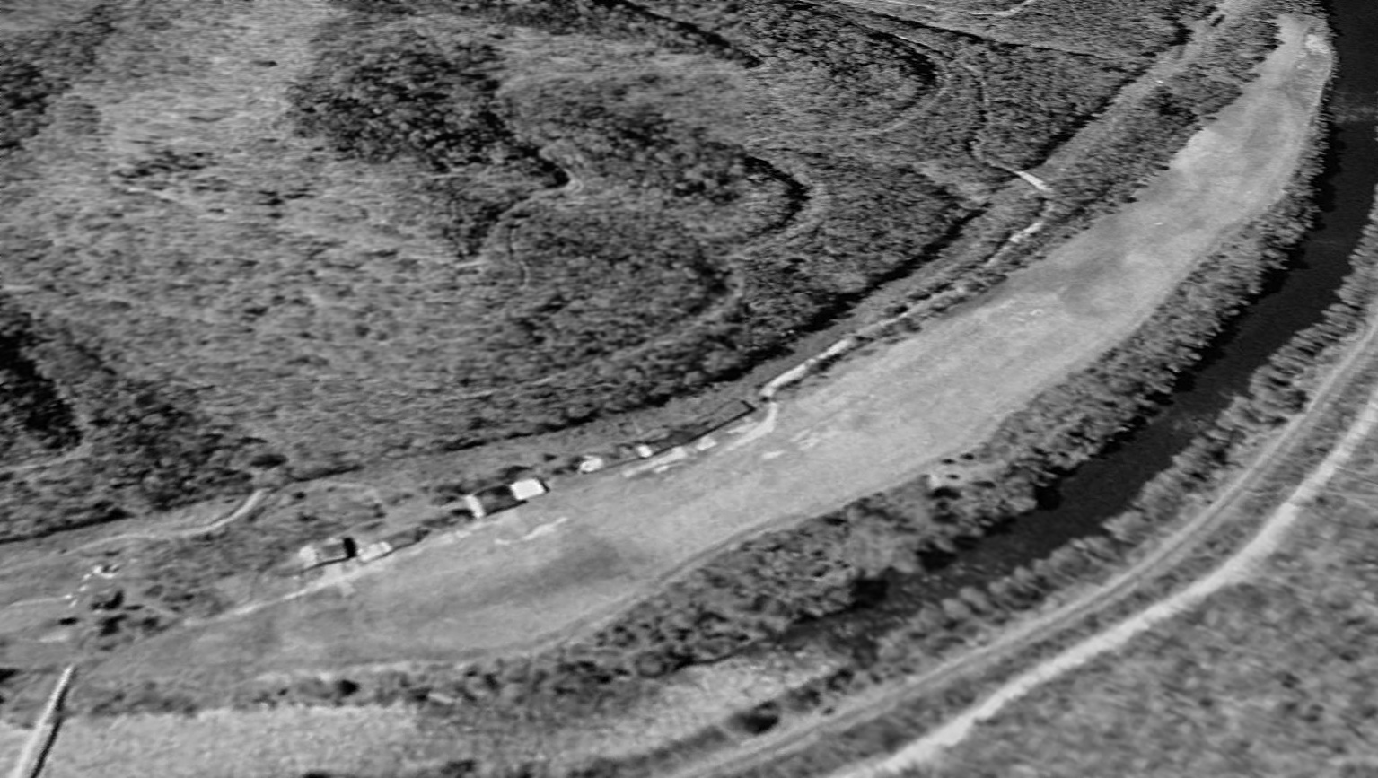
The earliest photo which has been located of Mingo County Airport was on a 12/4/79 USGS aerial view.
It depicted a single paved northeast/southwest runway, with a paved parallel taxiway & a long hangar on the southeast side.
Several light aircraft appeared to be parked near the hangar.
A 1983 aerial photo depicted 4 light aircraft parked at Mingo County Airport.
A 1986 aerial photo depicted 3 light aircraft parked at Mingo County Airport.
A 1995 aerial photo no longer depicted any aircraft parked outside at Mingo County Airport.
The 1992 USGS topo map depicted Mingo County Airport in an unchanged configuration.
A 1995 aerial view looking northwest depicted Mingo County Airport in an unchanged configuration, but with no aircraft visible.
According to Wikipedia, Mingo County Airport was owned by the Mingo County Airport Authority.
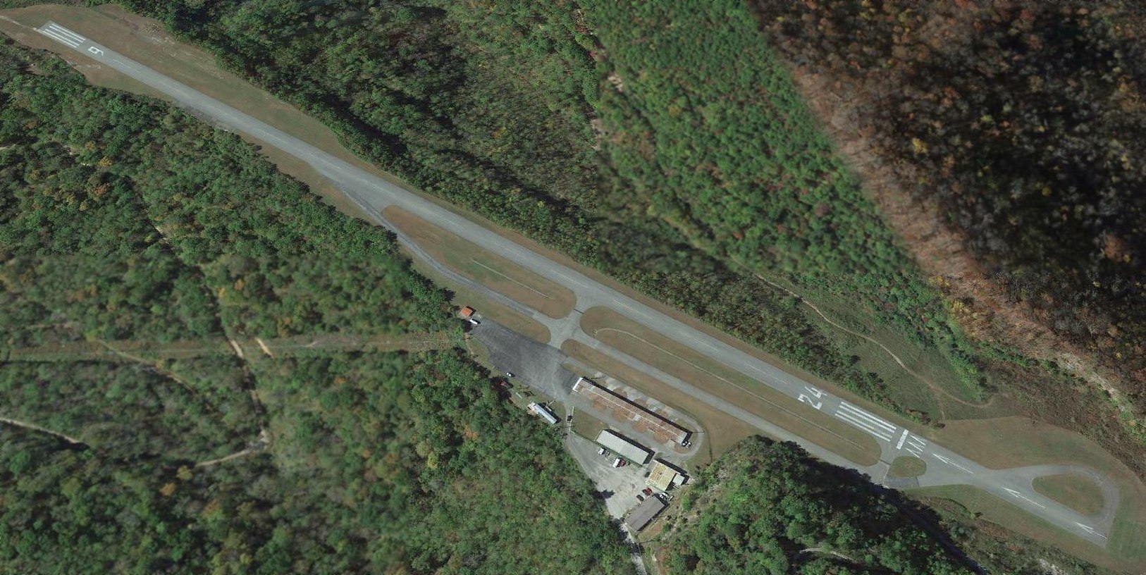
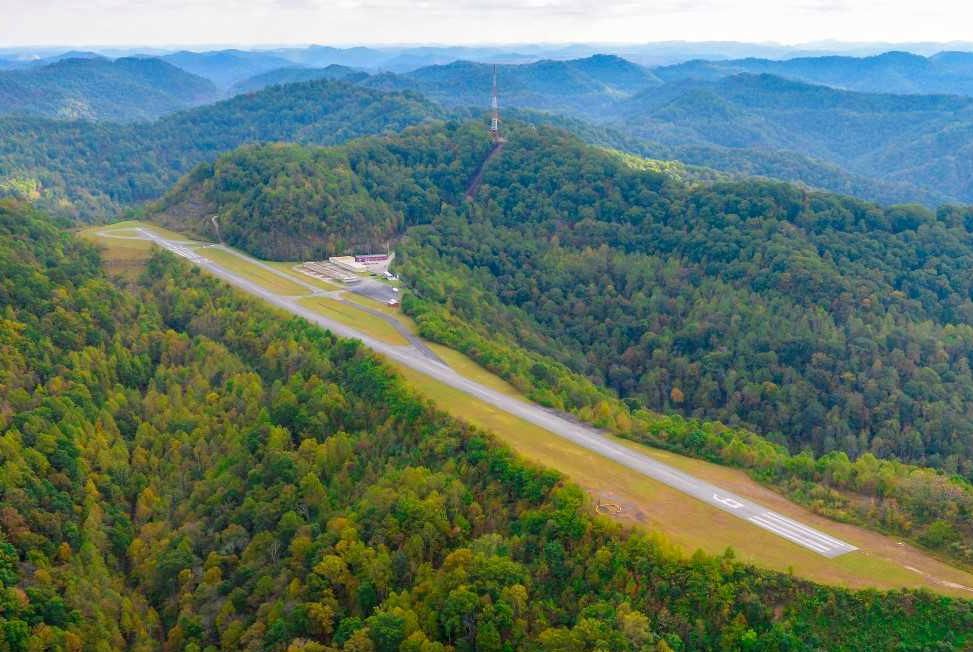
It comprised 150 acres, and had a single 3,515' asphalt Runway 6/24.
For the year of 2010, Mingo County Airport had an average of 12 takeoffs or landings per day, and had 11 single-engine based aircraft.
Rich Harshbarger recalled, “We also landed at the Mingo County Airport, which is tight & narrow & a little challenging.
I can see why it's closing when compared to the beautiful new KEBD [Appalachian Regional Airport].”
The larger Appalachian Regional Airport (later named the Southern West Virginia Regional Airport) opened 5 miles to the east in 2012.
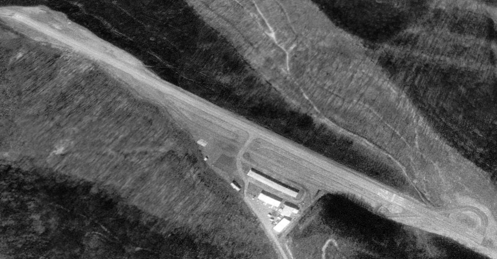
A 2015 aerial view looking northwest depicted Mingo County Airport as remaining with active runway markings, but devoid of aircraft.
Mingo County Airport was still depicted on the 2018 Cincinnati Sectional Chart.
A circa 2019 aerial view looking east at the Mingo County Airport, but with no aircraft visible.
An article entitled “Old Mingo County Airport to be closed” by Kyle Lovern appeared in the 1/6/19 Williamson Daily News:
“The process has begun for the closing of the Mingo County Airport located on a mountaintop above the city of Williamson.
The Mingo County Airport Authority (MCAA) met in a special meeting on Friday to discuss the closure. They picked 5/31/19 for the closing date of the old airport.”
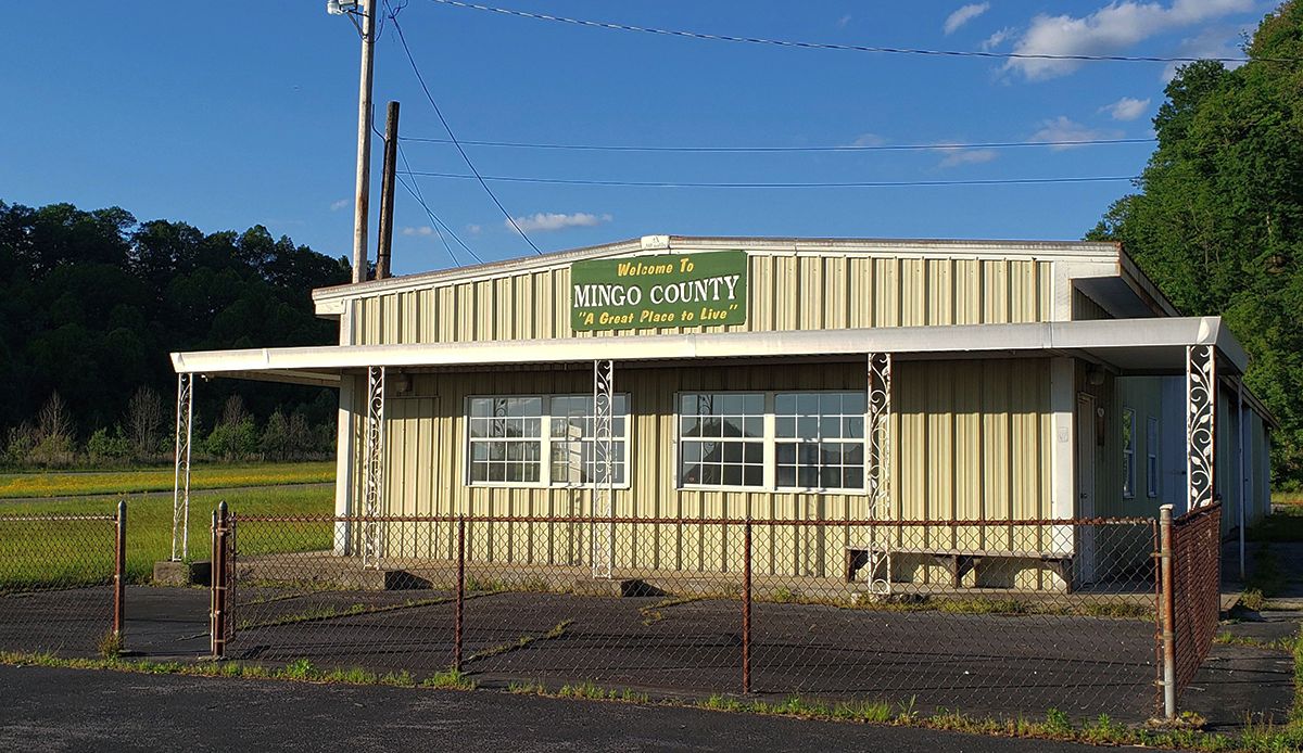
A circa 2020 photo of the former Mingo County Airport office, whose sign boasts the county is “A great place to live”.
Mingo County Airport was depicted as an abandoned airfield on the 2020 Cincinnati Sectional Chart.
Thanks to Randy Coller for pointing out this airfield.
____________________________________________________
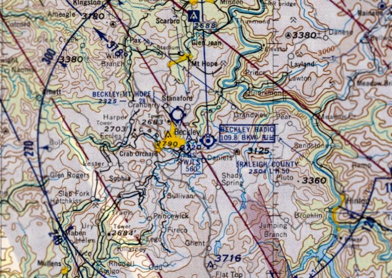
Beckley Mt. Hope Airport, Beckley, WV
37.815, -81.184 (Southwest of Washington, DC)

Beckley Mt. Hope Airport, as depicted on the March 1935 Winston-Salem Sectional Chart.
The original airport for the town of Beckley was located north of the town.
According to the Encyclopedia of WV, “Newspaperman Charles Hodel helped to found the local chamber of commerce.
As chairman of the chamber’s airport committee, he was instrumental in developing the Beckley Mount Hope Airport in 1933.”
The earliest depiction which has been located of Beckley Mt. Hope Airport was on the March 1935 Winston-Salem Sectional Chart.
It depicted Beckley Mt. Hope as a commercial/municipal airport.
According to Rick Harshbarger, “Beckley's first airport, Beckley / Mt. Hope Airport,
was located along the main road off the Harper Road exit going into Beckley where all the big box stores are today [2020].”
According to a historical plaque, “Beckley-Mount Hope Airport [was] built by Herbert Sessler to house the short-lived Beckley Air Transport Corporation.
Sessler, a leading aviation advocate, served as Airport Manager. His flight school trained some 650 pilots.”
Beckley Mt. Hope Airport was not depicted on the 1940/54/62 USGS topo maps.
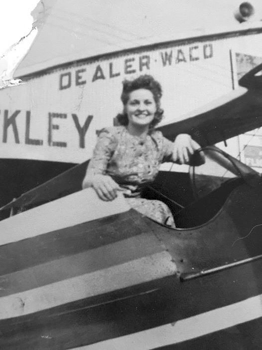
A circa 1940s photo by Patty Priddy (courtesy of Rick Harshbarger) of Nettie Sessler sitting in the cockpit
of one of Herbert Sessler's biplanes in front of a Beckley Mt. Hope Airport hangar, advertising it as a Waco dealer.
According to Rick Harshbarger, Nettie's father Herbert Sessler “was the owner & operator of this airport, having taught many locals to fly.”
According to a 1/19/23 Register-Herald article, “At the age of 16, Jack Clemens learned to fly an airplane at the Beckley-Mount Hope Airport.
“It was a thrill,” Clemens said. Clemens, now 93, said he grew up watching airshows at the airport & remembers watching planes take off & land.
“There were a lot of good times here,” he said. “People would come out and just sit along the road & watch the airplanes.”
At one time, the airfield attracted crowds of spectators to watch high-speed airshow aerobatics & parachuting demonstrations.”
According to a 5/12/06 Register-Herald article, “Jack Clemens owned the operation business for the old Beckley / Mount Hope airport located where present-day Beckley Plaza sits.”
According to a 1/19/23 Register-Herald article, Beckley-Mount Hope Airport “closed in 1952 as its physical structure could not support heavier aircraft developed after World War II.
It was replaced that same year by the Raleigh County Memorial Airport in Beaver.”
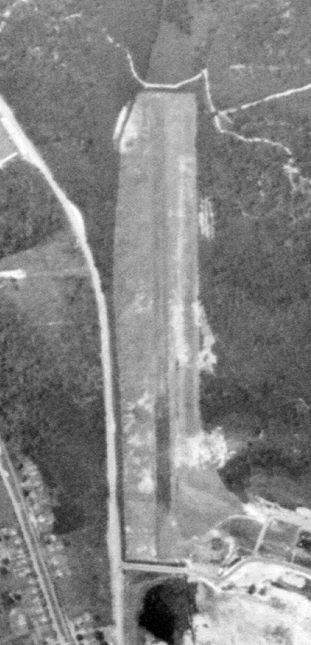
The only aerial view which has been located of Beckley Mt. Hope Airport was a 1956 USGS aerial photo.
It depicted a single north/south unpaved runway, with a hangar on the southeast side, but no aircraft were visible on the field.
The last depiction which has been located of Beckley Mt. Hope Airport was on the June 1958 Winston-Salem Sectional Chart.
It depicted Beckley Mt. Hope Airport as having a 2,800' unpaved runway.
Note it also depicted the larger Raleigh County Airport which had been built to the east of the town, which would soon replace Beckley Mt. Hope Airport.
Beckley Mt. Hope Airport was evidently closed at some point between 1958-59,
as it was no longer depicted on the 1959 Winston-Salem Sectional Chart.
According to a 1/19/23 Register-Herald article, “In 1965, the Beckley Plaza, the city’s first shopping center, was developed on the former site of the Beckley-Mount Hope Airport.”
A 1970 aerial photo showed the shopping center on the southern portion of the Beckley Mt. Hope Airport site, with the hangar having been removed,
and Appalachian Drive had been built over the northern portion of the former runway.
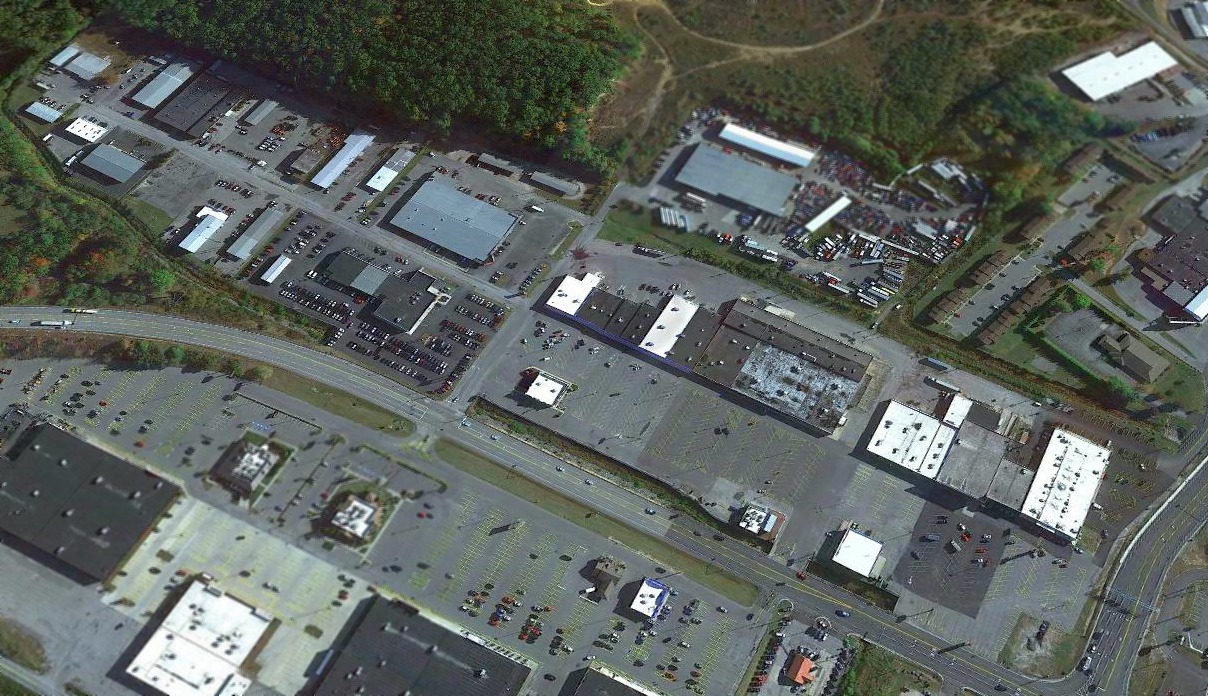
A 2019 aerial view looking northeast at the Beckley Mt. Hope Airport site.
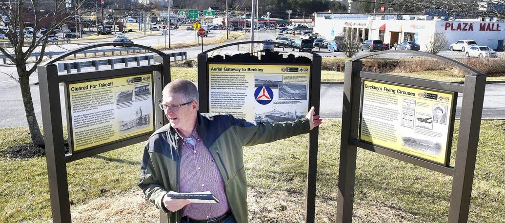
A 2019 photo of a ceremony unveiling 3 historical signs commemorating the Beckley Mt. Hope Airport.
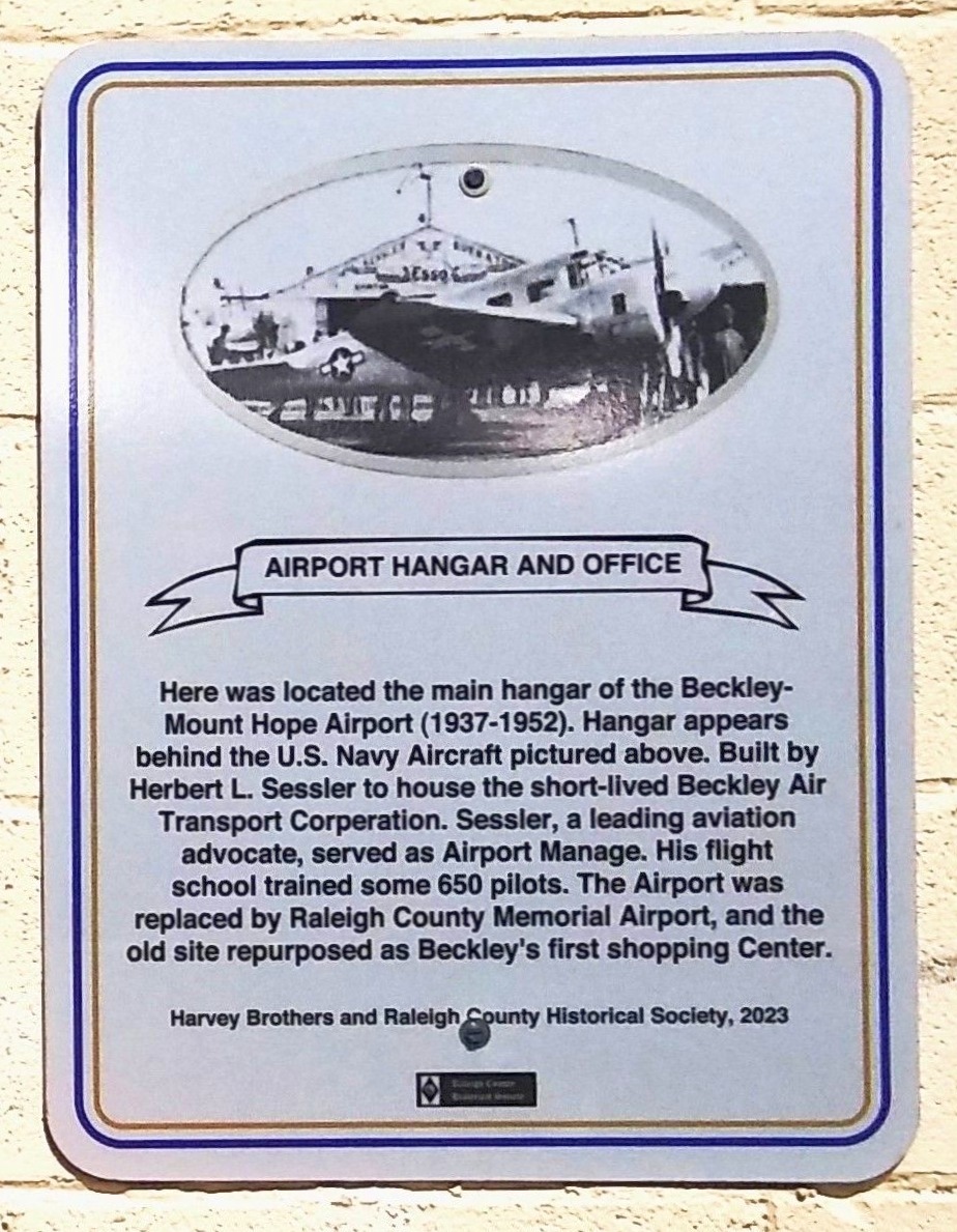
A 2023-2024 photo of a historical plaque erected in 2023 commemorating the Beckley Mt. Hope Airport,
with an undated photo of a Beech Navy UC-47J Navigator in front of the Mt. Hope hangar.
Thanks to Rick Harshbarger for pointing out this airfield.
____________________________________________________
Summersville Airport / (Original) Nicholas County Airport, Summersville, WV
38.33, -80.83 (West of Washington, DC)
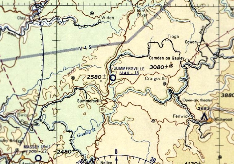
Summersville Airport, as depicted on the May 1958 Huntington Sectional Chart.
According to Rick Harshbarger, the original Nicholas County Airport was located on the north side of Summersville.
No airfield at this location was depicted on the 1949 or 1961 USGS topo maps.
According to Rick Harshbarger, the original Nicholas County Airport
was operated by the same Rader Flying Service which operates the current-day Nicholas County Airport.
Rick reported, “I talked to Buck Hamrick who is a pilot. The Nicholas County Airport... was started by Gerald Rader of Rader Aviation around 1950.
The old airport was grass & measured 2,250' x 100'. Mr. Hamrick flew in & out of there with his father as a small child & continued flying there until it closed.”
Summersville Airport was not yet depicted on the June 1957 Huntington Sectional Chart.
The earliest depiction which has been located of Summersville Airport was a 1957 aerial photo.
It depicted a grass airfield area, with 1 light single-engine plane & a few small buildings on the southeast side.
The earliest aeronautical chart depiction which has been located of Summersville Airport was on the May 1958 Huntington Sectional Chart.
It depicted Summersville as having an 1,800' unpaved runway.
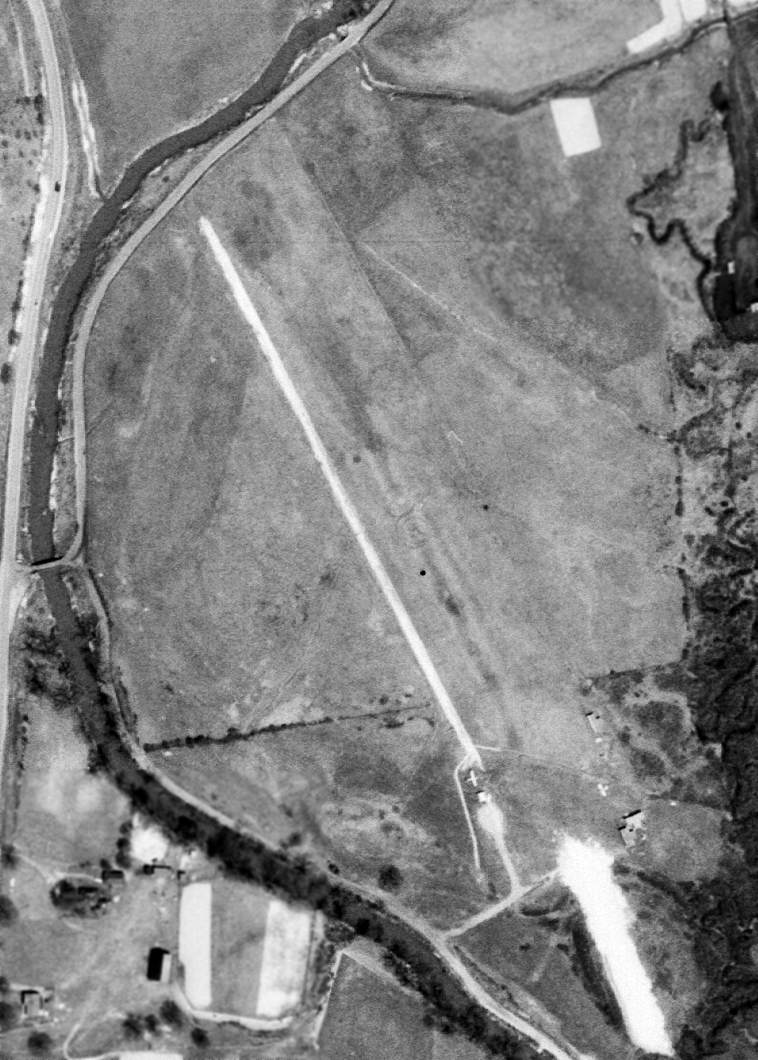
The only photo which is available of the original Nicholas County Airport in operation was a 4/26/63 USGS aerial view,
which depicted the field as having a single unpaved northwest/southeast runway,
with 2 single-engine planes & several T-hangars on the southeast side.
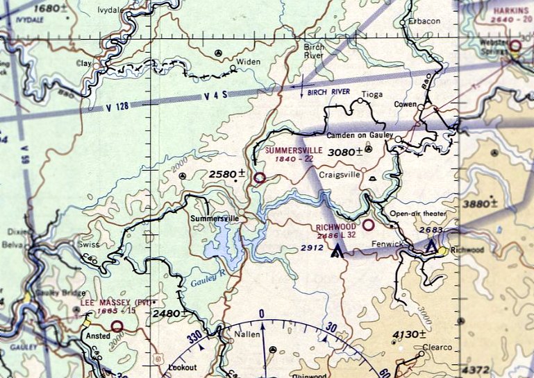
The last aeronautical chart depiction which has been located of the original Summersville Airport was on the August 1967 Huntington Sectional Chart.
It depicted Summersville as having a 2,200' unpaved runway.
According to Rick Harshbarger, “The Nicholas County Airport... was in operation until 1968 or 69
when the Army Corps of Engineers while building the Summersville Dam leveled off the top of a peninsula that stuck out into the lake.
Mr. Rader convinced them & the local government to make it the new municipal airport.”
The original Summersville Airport was no longer depicted on the February 1968 Huntington Sectional Chart
or the 1968 USGS topo map.
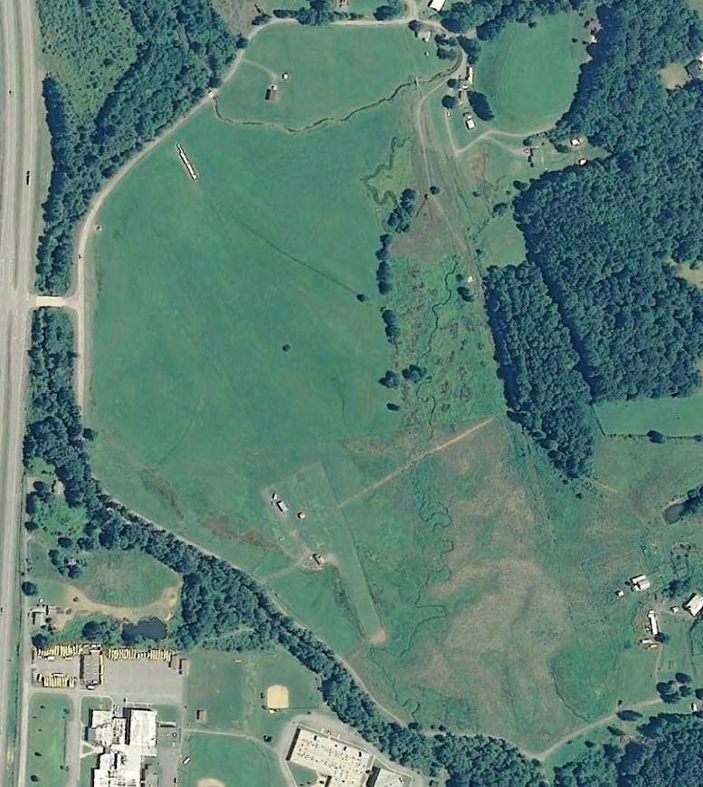
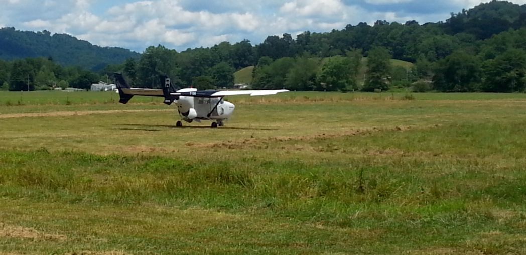
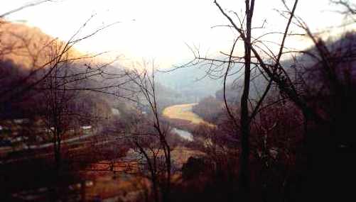
A 9/5/13 aerial view of the site of the original Nicholas County Airport showed the 600' portion used by a remote-controlled model aircraft club.
A 2014 photo by Rick Harshbarger of a derelict Cessna Skymaster (lacking both front & rear propellers)
at the site of the original Nicholas County Airport.
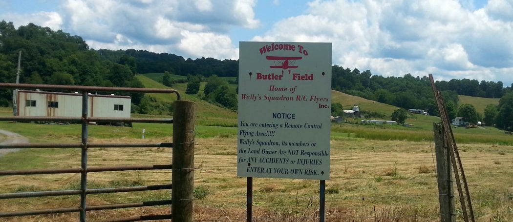
A 2014 photo by Rick Harshbarger of Butler Field, Home of Wally's Squadron Remote Control Flyers club,
which has a 600' grass strip & an office trailer at the site of the original Nicholas County Airport.
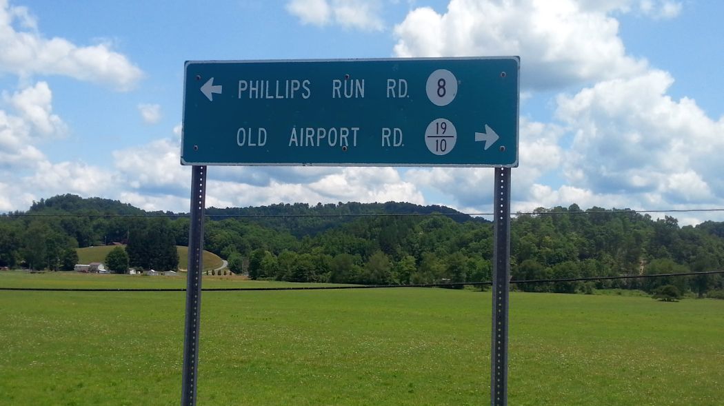
A 2014 photo by Rick Harshbarger of the sign for Old Airport Road, with the former airfield of the original Nicholas County Airport in the background.
A 2016 aerial view continued to show the Cessna Skymaster on the southwest side of the original Nicholas County Airport.
Curiously, a 2018 aerial view showed the number of Cessna Skymasters parked on the southwest side of the original Nicholas County Airport had increased to three.
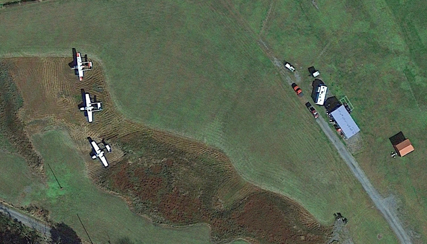
A 2022 aerial view of the 3 Cessna Skymasters parked on the southwest side of the original Nicholas County Airport.
The site of the original Nicholas County Airport is located northwest of the intersection of Lower Glade Fork & Old Airport Road, appropriately enough.
Thanks to Rick Harshbarger for pointing out this airfield.
____________________________________________________
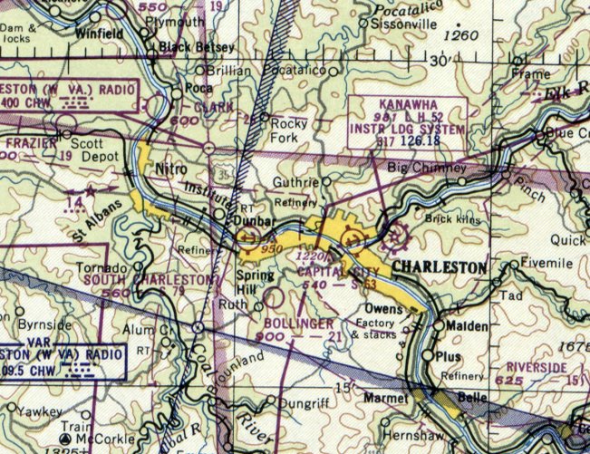
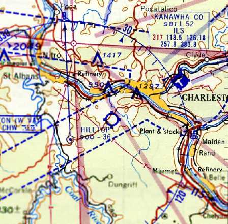
Clark Seaplane Base / Kanawha Seaplane Base / Capital City Seaplane Base, Charleston, WV
38.35, -81.63 (West of Washington, DC)
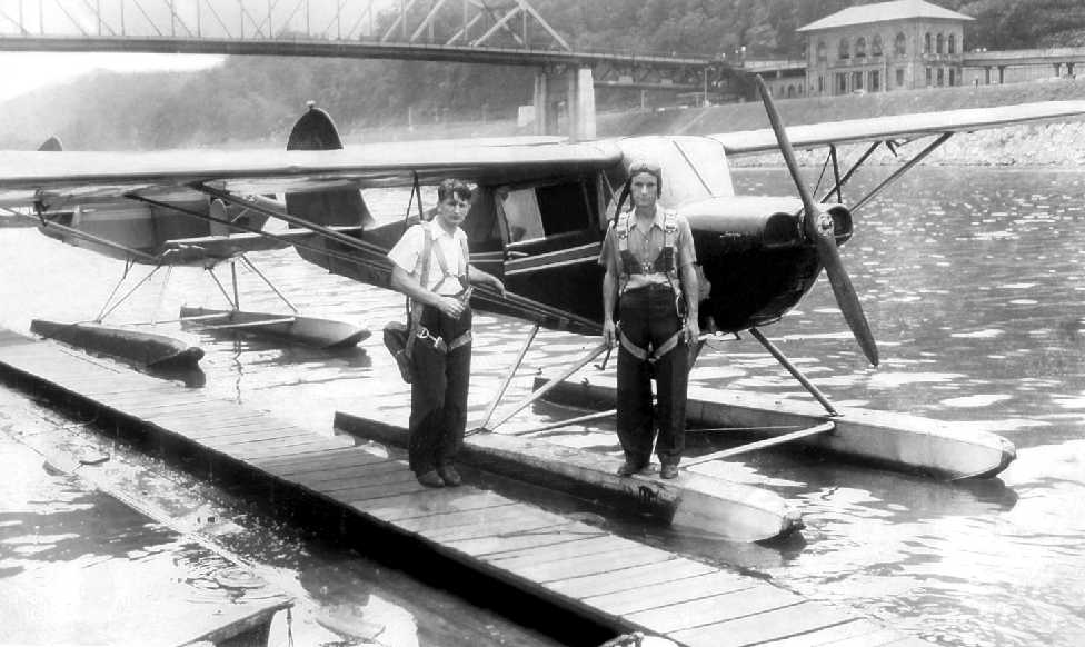
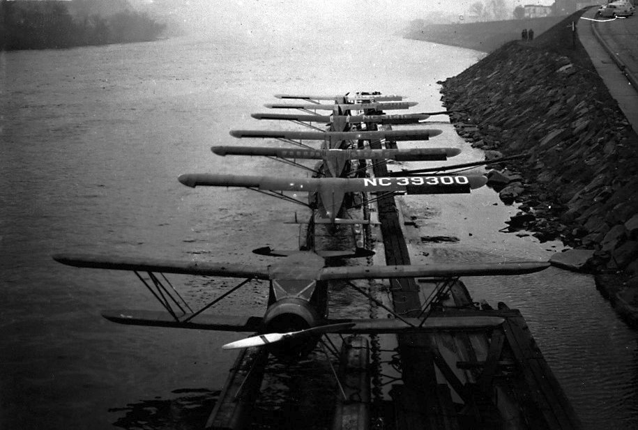
A 1938 photo (courtesy of www.mywvhome.com) of 20 year old Boyd Wolfe & another pilot (both wearing parachutes) in front of 2 Aeronca Champ floatplanes at Kanawha.
According to Mark Hess, the “Kanawha Seaplane Base... opened sometime after 1937, owned by Glenn Clark.”
George Cunningham III recalled, “The Kanawha Seaplane base run by Glenn Clark... My dad (George Cunningham Jr.) worked for Glenn Clark as a high school student around 1936-38.
He got paid in flying lessons. His flight instructor was a woman, and that he had a pilot's license before he got a driver's license.”
The earliest depiction which has been located of Kanawha Seaplane Base
was a 1938 photo (courtesy of Mark Hess) of 20 year old Boyd Wolfe & another pilot (both wearing parachutes) in front of 2 Aeronca Champ floatplanes at Kanawha.
Kanawha Seaplane Base still was not yet depicted on the January 1940 Huntington Sectional Chart.
According to Mark Hess, the “Kanawha Seaplane Base... was called Charleston #2 Squadron of the Civil Air Patrol during WWII.
Clark ran this operation. It was also a Civilian Pilot Training Program base.”
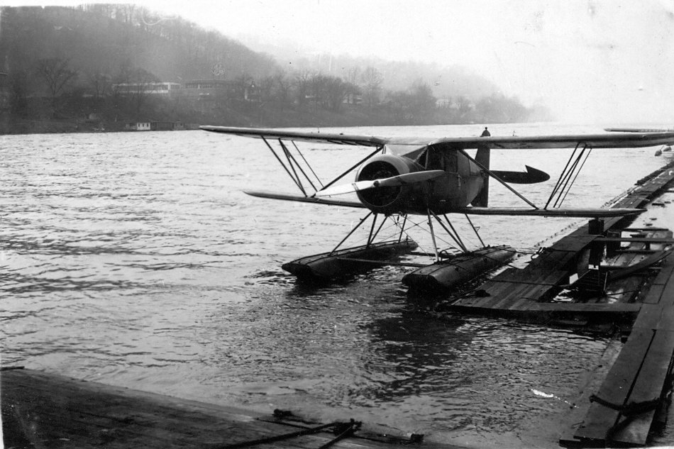
A 1940 photo (courtesy of www.mywvhome.com) of the Kanawha Seaplane Base at its original location on the northeast bank of the river, with 3 Aeronca Champ floatplanes at the bottom-right.
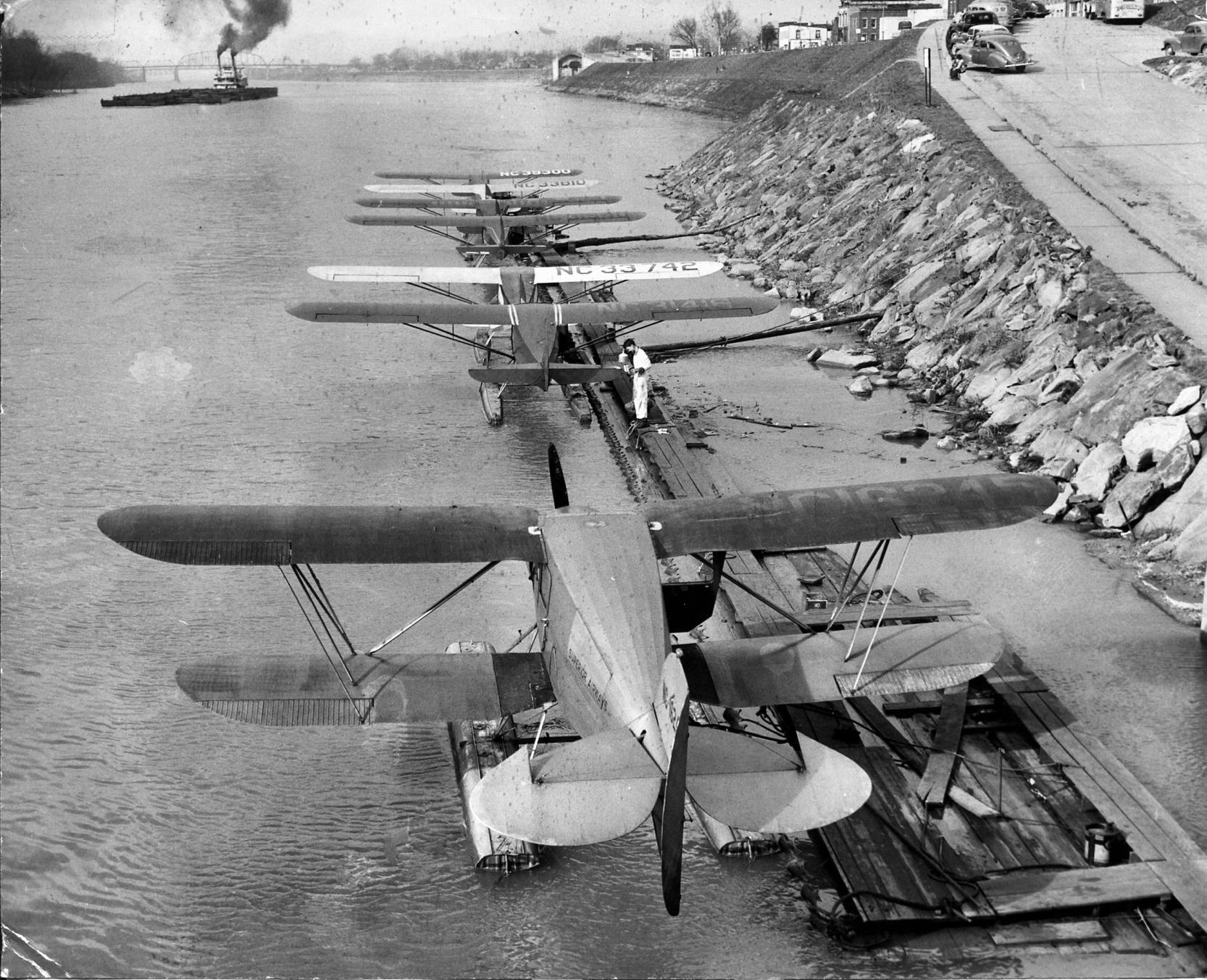
An 11/11/42 photo by John Bailey (courtesy of Bob Bailey) of 6 Aeronca 65Cs & a Waco ZKS-6 at Glenn Clarke's seaplane base.
Bob Bailey recalled, “In 1942-43, my father was assigned to WV as a CAA inspector. One of the places he oversaw was that seaplane base.”
An 11/11/42 photo by John Bailey (courtesy of Bob Bailey) of a Waco ZKS-6 & 6 Aeronca 65Cs at Glenn Clarke's seaplane base.
An 11/11/42 photo by John Bailey (courtesy of Bob Bailey) of a Waco ZKS-6 at Glenn Clarke's seaplane base.
A 1942 photo (courtesy of www.mywvhome.com) of the Kanawha Seaplane Base, after Clark had moved the base across the river to the southwest bank.
One floatplane is visible at bottom-right, and note the "Kanawha Flying School" on the building above it.
The earliest depiction which has been located of the Clarke Seaplane Base was on the June 1942 Huntington Sectional Chart.
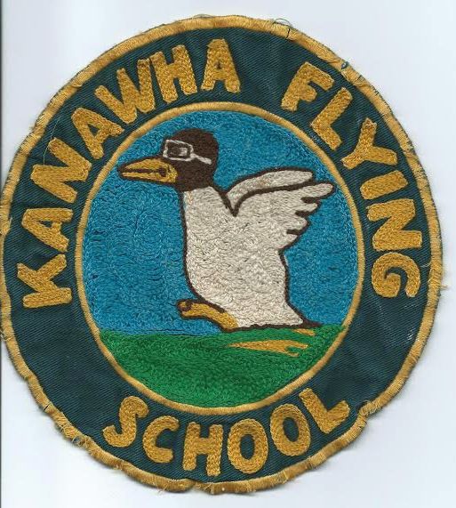
A 2014 photo by Sandi Galloway of an undated patch for the "Kanawha Flying School".
Sandi noted, “My husband Perry learned to fly it at the Kanawha Flying School.”
A 1944 map (courtesy of Mark Hess) depicted Kanawha “Sea Plane Base” at the lower left.
Kanawha Seaplane Base, as depicted on the November 1945 Huntington Sectional Chart (courtesy of Chris Kennedy).
According to Mike Riley, this chart also “shows Clark's base after he moved it from the Charleston levee
west to a location near the town of Winfield [labeled as “Clark” at the top-left].
The seaplane base in Charleston stayed open a little longer after Clark sold it.”
Kanawha Seaplane Base was still depicted on the October 1946 Huntington Sectional Chart.
According to the book “Yeager Airport & Charleston Aviation” by Nicholas Keller (according to George Cunningham III),
Clark moved from the foot of Summers Street across the river to the south side in 1946.
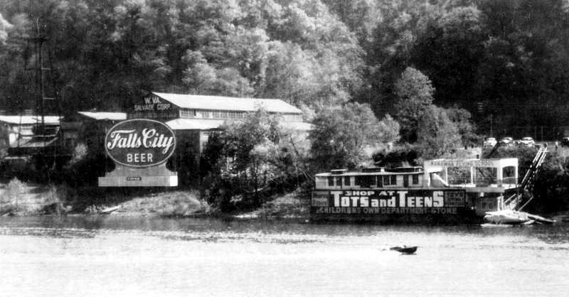
According to George Cunningham, “After WWII, Clark's seaplane base was located on MacCorkle Ave near Spring Hill WV.
My dad used to take me flying both at the seaplane base, and at the Winfield grass strip, in 1946-50.
Floatplane memories: There was a hoist installed on the bank of the river, and the hangar at the top of the bank.
The airplanes were floated on & off of cradles & hoisted up & down to & from the hangar.
There was a small grocery across MacCorkle from the seaplane base & I used to get a cold orange soda from there whenever we went to the seaplane base.
I can remember a float plane in the hangar being striped of fabric & being covered with new fabric. I can almost smell the banana oil dope 70 years on.
One of my very early memories is doing a spin in a floatplane, probably 1946 or 1947.
It was magic, my feeling was that the airplane was not moving & the earth was slowing turning below us.
Also doing a loop and not having any sensation of falling out of the seat.
My dad took me on a trip from Charleston to, probably, Parkersburg in a floatplane.
Somewhere along the way I announced I had to pee. No water in sight. My dad did a steep turn & headed for the Ohio River.
I was not yet 10 years old. He put me out on the float & told me to pee.
Of course, idling along in the middle of the biggest river I had ever seen in my life, in the prop wash, in full view of God & Country, not a drop was coming out.
Glenn Clark entered a floatplane sans wings in the hydroplane races on the Kanawha River in the late 1940s / early 1950s.”
According to the book “Yeager Airport & Charleston Aviation” by Nicholas Keller (according to George Cunningham III),
Clark moved the seaplane base to Spring Hill WV in 1947.
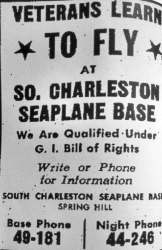
A 6/22/47 advertisement for the “South Charleston Seaplane Base” (courtesy of George Cunningham III).
George continued, “The Winfield grass strip was located on what is now the John Amos Power Plant just west of Saint Albans WV.
The chart also shows a seaplane base at that location, but I don't ever recall seeing seaplanes there.
My best memory of the Winfield grass strip was flying in a J3 Cub with the door open on a summers day.
Futzing around. Very quiet with the engine idled back. Not much like flying today.
According to Mark Hess, the “Kanawha Seaplane Base... closed sometime in the late 1940s.
The June 1950 Huntington Sectional Chart depicted a “Capital City” Seaplane Base slightly to the north of the previous depiction of Kanawha Seaplane Base.
Was this the same facility renamed, or a different location?
According to George Cunningham, “Glenn Clark died in June 1952 in a midair collision on a landing approach to the Winfield strip while doing flight instruction.
In 1954 my dad purchased a Luscomb 8F, N1874B, that had been owned my Mr. Clark.”
The Capital City Seaplane Base was no longer depicted on the 1954 Huntington Sectional Chart.
Bob Bailey recalled, “In the late 1950s, we drove through Charleston. We found where the seaplane base had been but there was no trace of it.”
As of 2012, no trace remains of the Kanawha Seaplane Base.
The site of the Kanawha Seaplane Base is located south the intersection of Summers Street & Kanawha Boulevard.
____________________________________________________
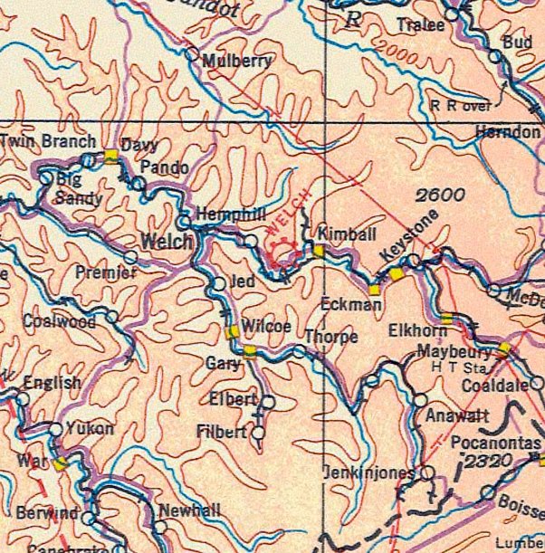
Welch Municipal Airport (I25), Welch, WV
37.42, -81.53 (Southwest of Charleston, WV)
Welch Municipal Airport, as depicted on the March 1935 Winston Salem Sectional Chart (courtesy of Yvan Houdebine).
The date of establishment of this small general aviation airport has not been determined.
The earliest depiction which has been located of Welch Municipal Airport was on the March 1935 Winston Salem Sectional Chart (courtesy of Yvan Houdebine).
However, inexplicably, Welch Municipal Airport's FAA Airport/Facility Directory Data listed an activation date of August 1947.
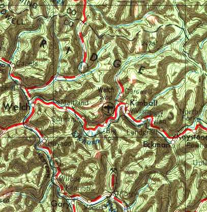
Welch Municipal Airport, as depicted on the 1955 USGS topo map.
The earliest photo which has been located of Welch Municipal Airport was a 9/21/56 USGS aerial view.
It depicted Welch as having an east/west runway, with possibly some small buildings on the southeast side.
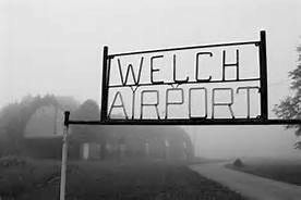
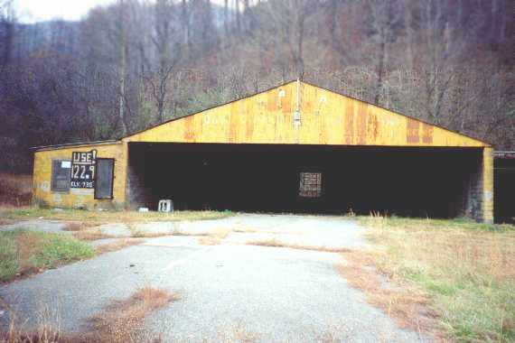
A circa 1950s/60s photo of the sign for Welch Airport (courtesy of Rick Harshbarger), with a curved-roof hangar in the background.
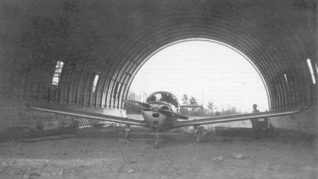
A circa 1950s/60s photo of an Ercoupe inside the curved-roof hangar at Welch Airport (courtesy of Rick Harshbarger).
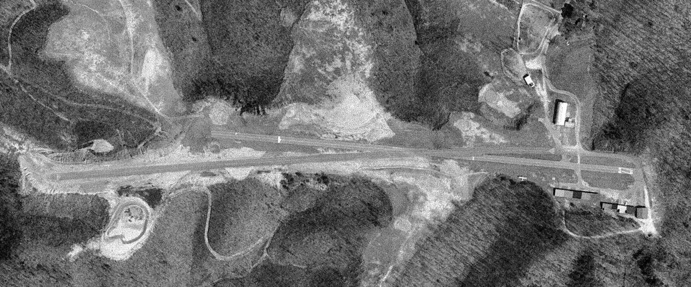
A 4/2/67 USGS aerial photo depicted Welch Municipal Airport as having an unusual runway configuration,
with 2 very closely-angled paved runways: Runway 9/27, and another longer runway, unmarked, but having an approximate orientation of 7/25.
A few small hangars & T-hangars were located on the northeast & southeast sides, and 1 light single-engine aircraft was parked on the southeast side.
The 1968 USGS topo map depicted Welch Municipal Airport as having 2 very closely-angled runways,
and a few small buildings on the northeast & southeast sides.
A 1996 USGS aerial view looking southwest depicted Welch Municipal Airport as having several small buildings on the northeast & southeast sides, and what appeared to be one light aircraft.
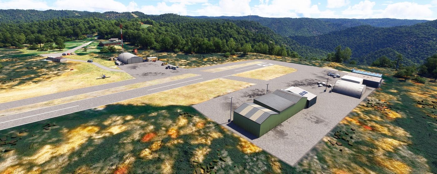
A flight simulation scenery depiction by Ed Rothwell looking northeast at the Welch Airport hangars & ramp.
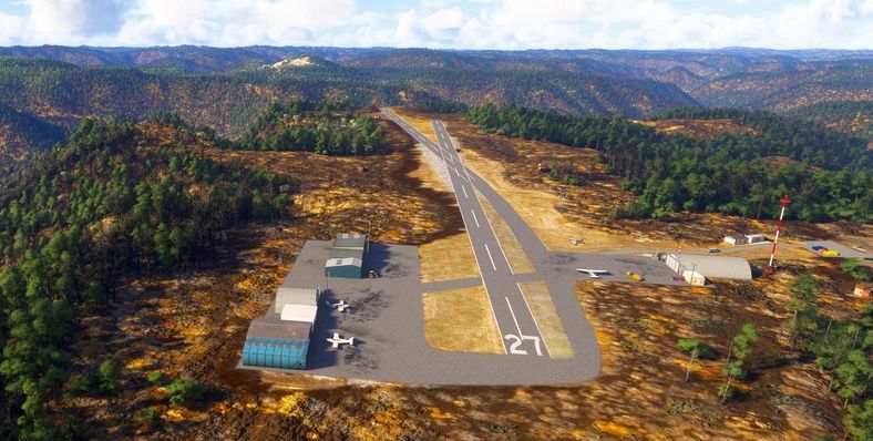
A flight simulation scenery depiction by Ed Rothwell looking west along Welch Airport's Runway 27.
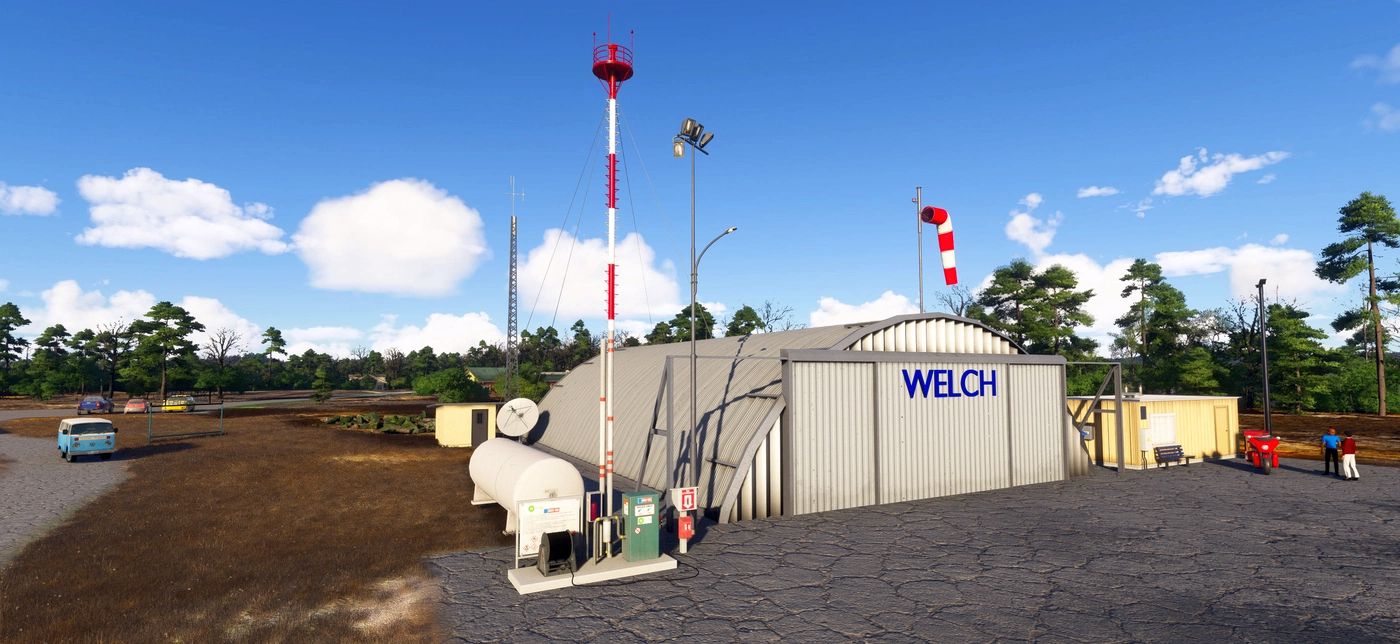
A flight simulation scenery depiction by Ed Rothwell looking north at the Welch Airport hangar & gas pumps.
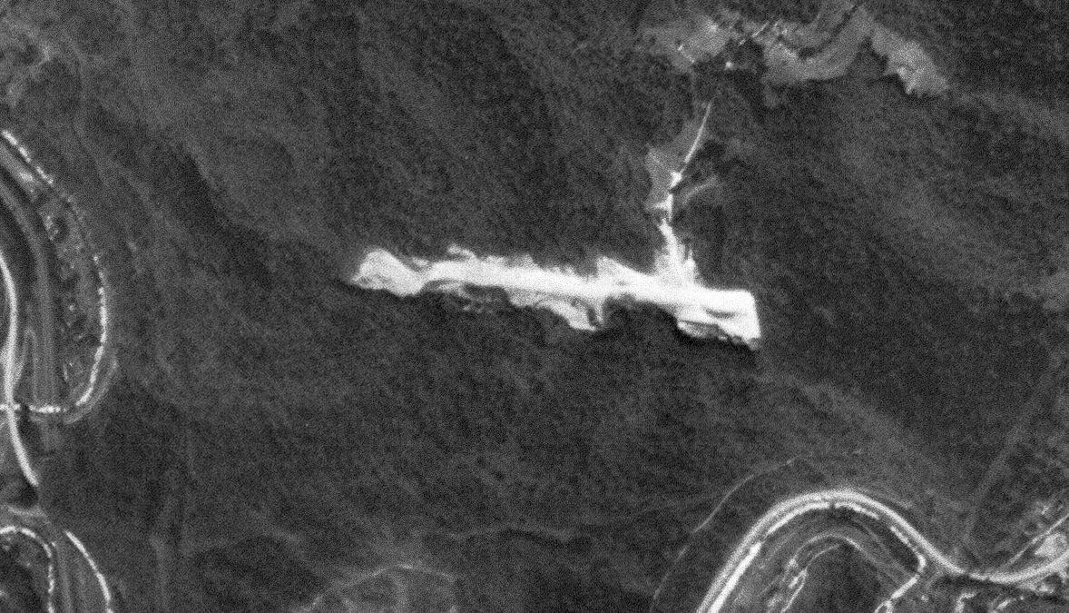
The last photo which has been located showing an aircraft at Welch Municipal Airport was a 2002 aerial view looking southwest,
showing one single-engine aircraft on the northeast ramp.
Runway 27 actually had a bend in the middle, following the alignment of 2 individual runways depicted on the 1968 topo map.
According to NTSB accident report ERA11LA168 (courtesy of Ed Rothwell), “The Welch Municipal Airport was closed 3/15/07.”
An 8/25/07 aerial view showed closed-runway “X” symbols painted on Welch's runway,
and the hangars on the southeast side had been removed at some point between 2003-2007.
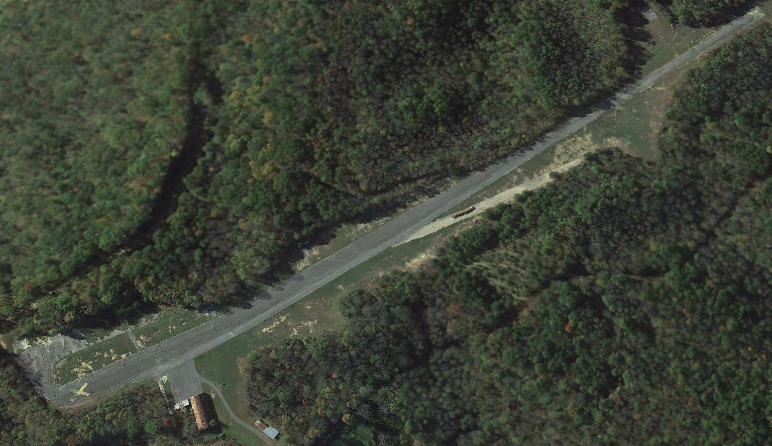
A 2010 aerial view by Randy Coller looking southeast at Welch Airport, showing it sitting atop a peak.
Randy Coller reported of Welch Airport, “The first time I went there, I was flying my 182. After a few fly-bys, I decided not to land there – a good decision.
The runway was in bad shape with 'stuff' on the pavement. After that, I drove there. I had to walk the runway because the gate was always locked.”
A 2010 aerial view by Randy Coller looking east at the east end of Welch Airport.
A 2010 aerial view by Randy Coller looking southeast at the Quonset Hut hangar on the northeast side of Welch Airport.
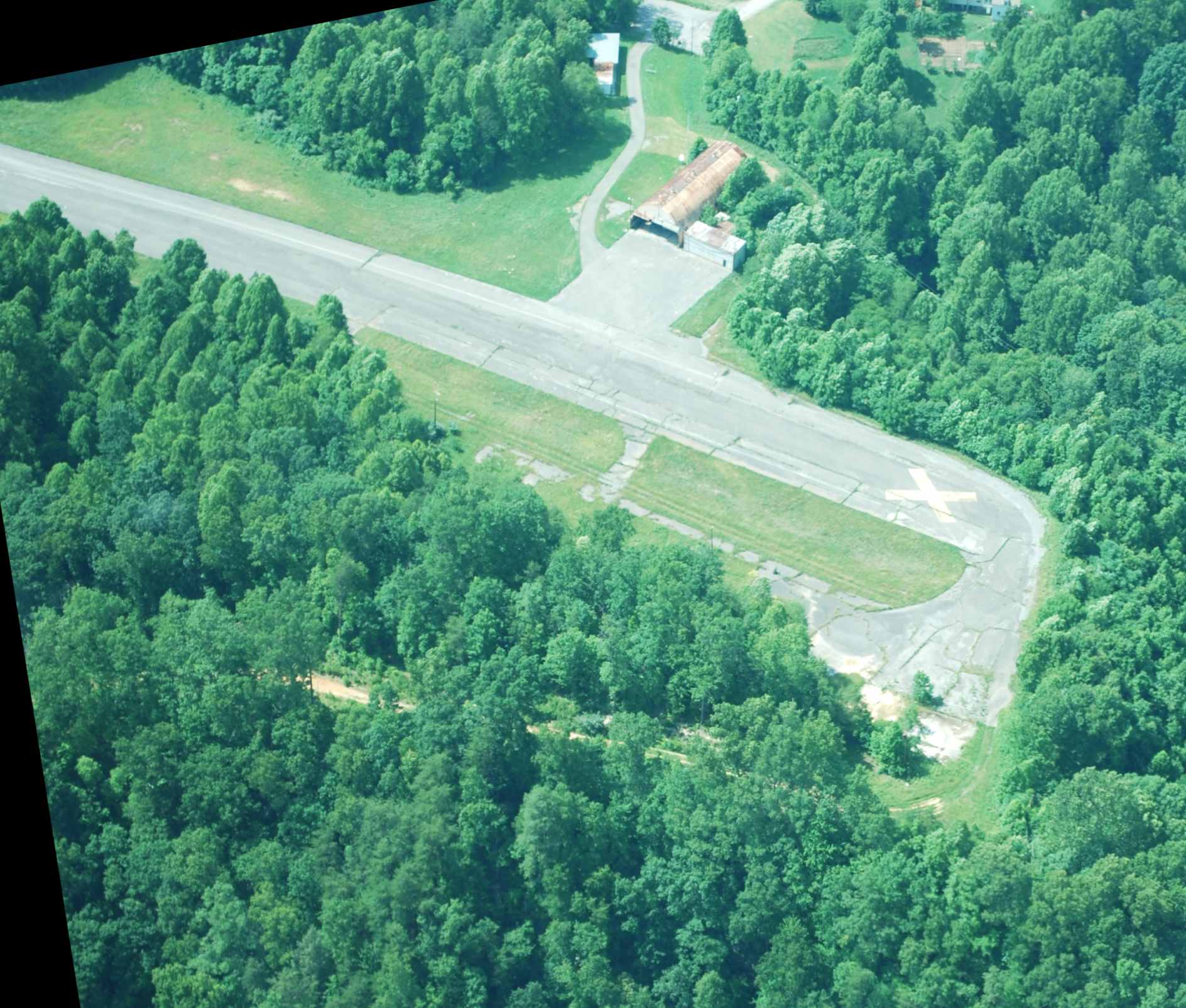
A 2010 aerial view by Randy Coller looking northwest at the Quonset Hut hangar on the northeast side of Welch Airport.
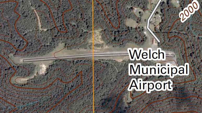
The 2011 USGS topo map continued to depict Welch Municipal Airport, with a bend in its runway.
According to NTSB accident report ERA11LA168 (courtesy of Ed Rothwell), a Cessna 172N was damaged making a landing at Welch Municipal Airport on 2/27/11, 4 years after the airport's closure.
As of 2012, the FAA Airport/Facility Directory Data described Welch Municipal Airport as having a single 2,695' asphalt Runway 9/27,
“in poor condition, pavement condition failed, surface rough & cracking”,
and the first 300' of Runway 27 were noted to have a “3 degree bend”, with “No line of sight between runway ends.”
It was said to be owned by the City of Welch, with the manager listed as Robert Lee.
The airport was said to have 2 single-engine based aircraft,
and to conduct an average of only 65 takeoffs or landings per year.
Although Welch continued to be listed in the A/FD, its airport status was listed as “Airport closed indefinitely.”
Bob Aberman reported in 2012, “Welch Airport.. a few people fly [radio-controlled model aircraft] there.”
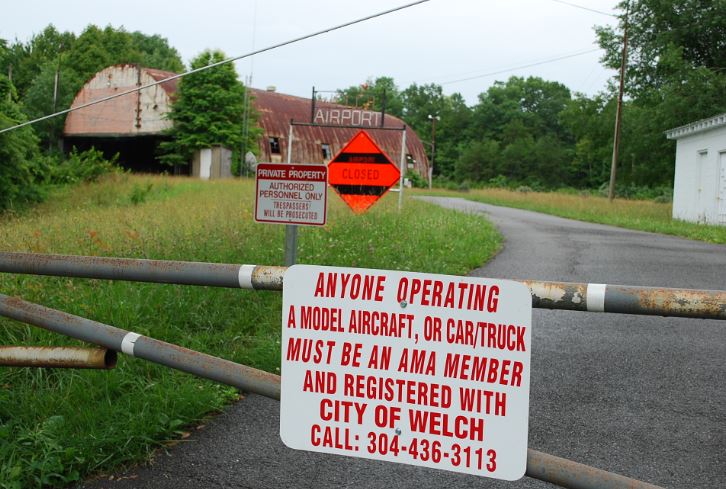
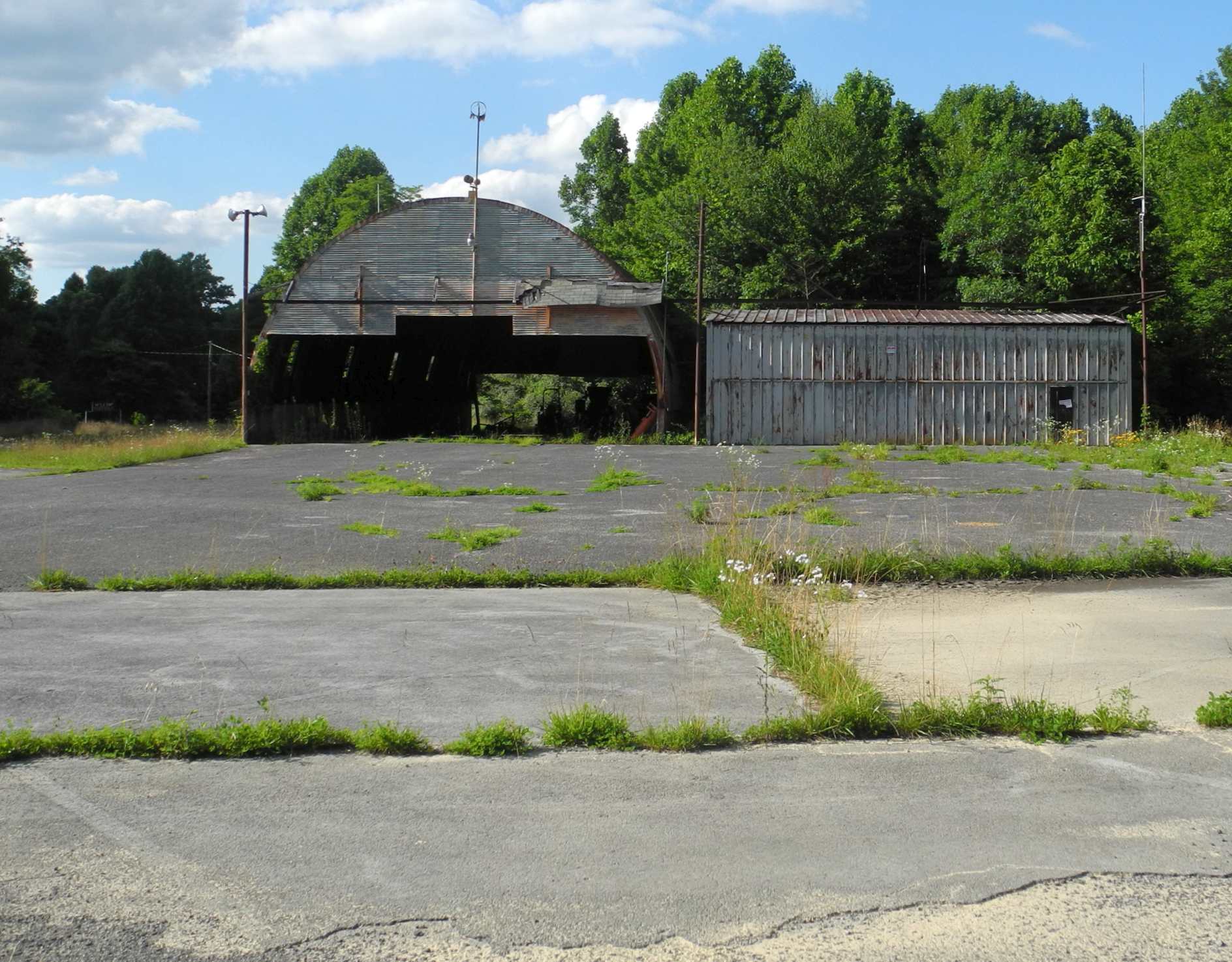
A July 2013 photo by Randy Coller of the entrance sign & hangar at Welch Airport.
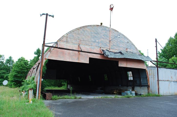
A July 2013 photo by Randy Coller of the Welch Airport hangar, with the wind sock frame on the roof.
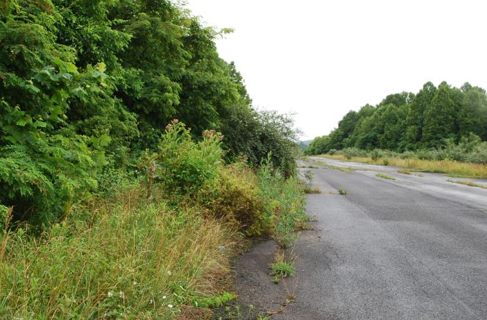
A July 2013 photo by Randy Coller of the remains of the Welch Airport runway.
Randy reported in 2016, “I’ve inspected Welch a few times. It’s a real mess. I would not land a plane there.
Sometimes there are picnic tables & barrels on the runway. The trees have overgrown the edges.
I talked to the Mayor a few years ago, and they have hopes of maybe re-opening it someday,
perhaps when the economy in the area improves or someone with a pile of money walks in the door to help them.
'Closed' in FAA terms generally is a temporary status.
'Abandoned' is permanent, the airspace it given up & the airport would not be re-opened again.
I normally would press the airport owner to abandon the site,
but it is so hard to get a favorable airspace determination from the FAA to open an airport, that I didn’t press the city to go the abandonment route.”
A 2015 aerial view looking southwest showed the Welch Municipal Airport runway to remain intact, though marked with a closed-runway “X” symbol.
The hangar on the northeast side remained standing.
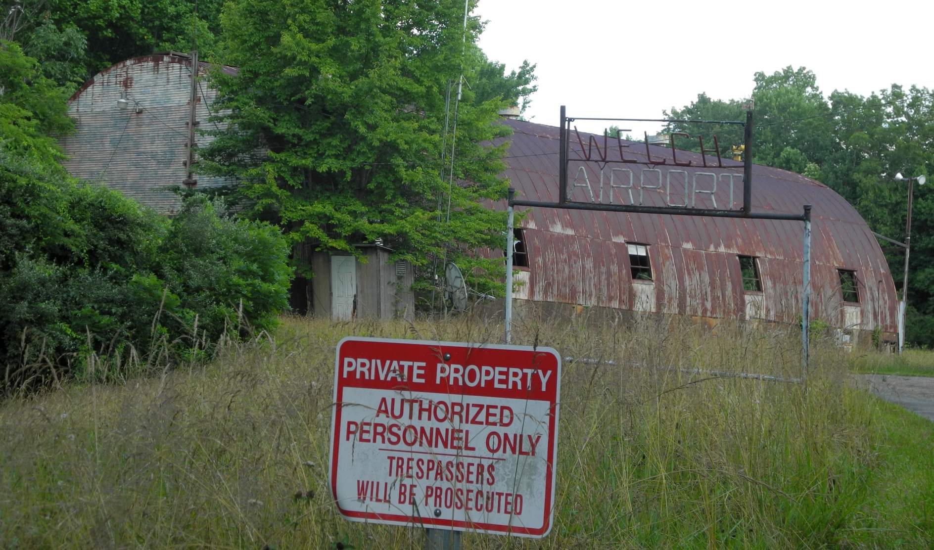
A July 2023 photo by Randy Coller of the Welch Airport entrance sign & hangar.
Randy reported, “Welch is really hard to drive to. Their road system is very bad.
The owner's representative said they were going to file the [form] 7480-1 to abandon the airport. It's not off the aeronautical chart yet, but sometimes that takes up to 9 months. Not much has changed physically; still a 'dump'.
However, the previous owner who had donated the property to the City of Welch exercised a reverter in the deed that allowed them to reclaim the property if it wasn't being maintained as an airport (which it wasn't).
I talked to an employee of the property owner; they are trying to make up their mind about abandoning the site or not.
It still isn't usable, but not 'out of the system' quite yet. There's paperwork to do to abandon (deactivate) the airport.”
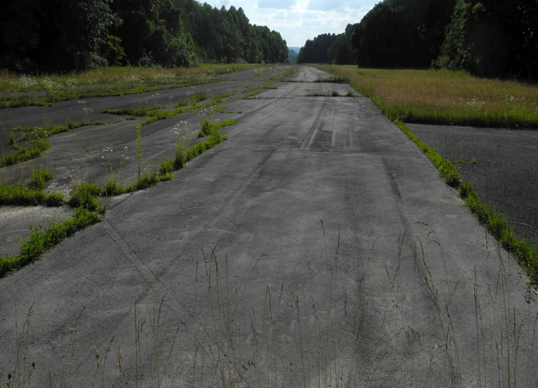
A July 2023 photo by Randy Coller of the remains of the Welch Airport runway.
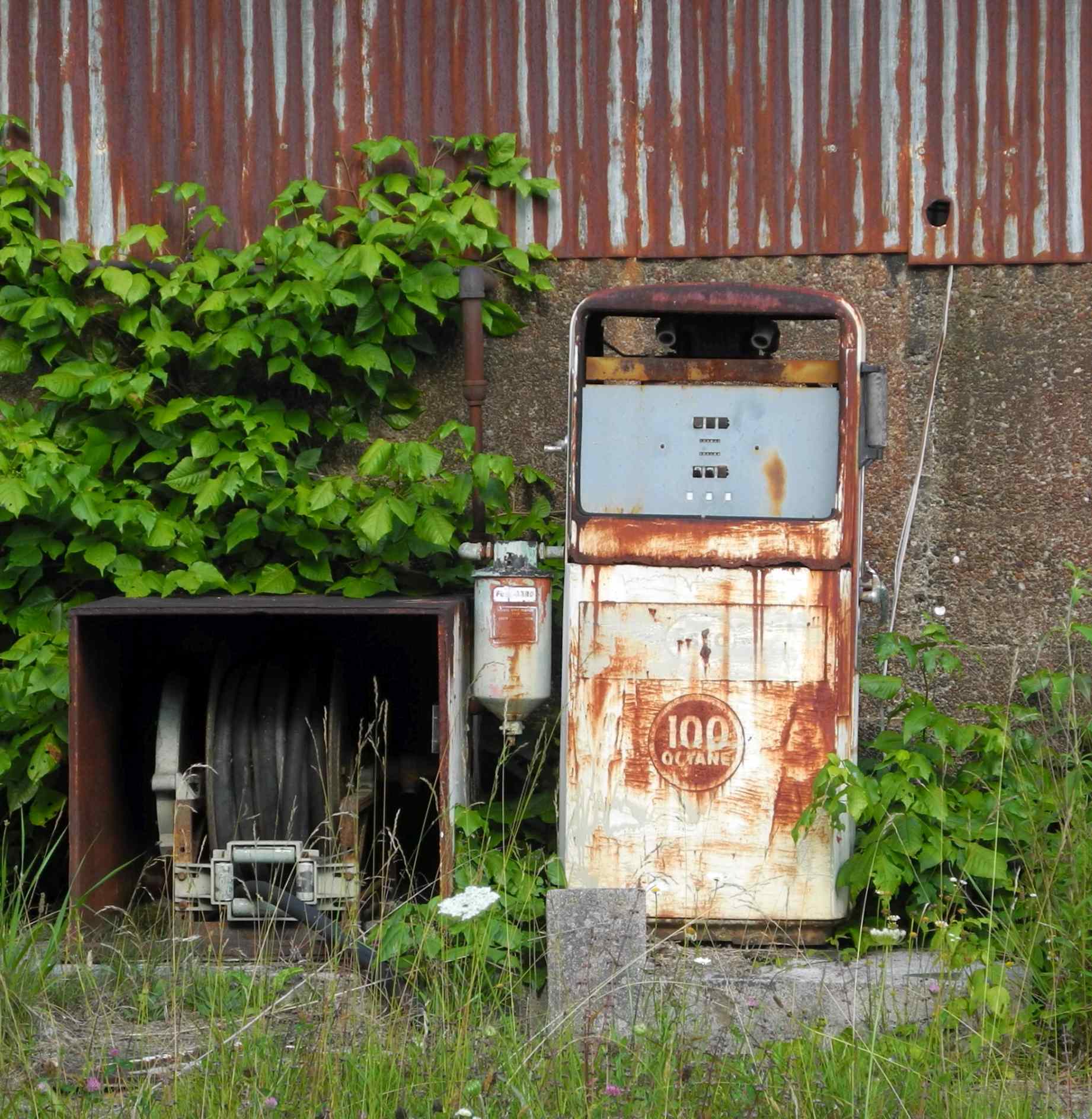
A July 2023 photo by Randy Coller of a 100 octane gas pump at Welch Airport.
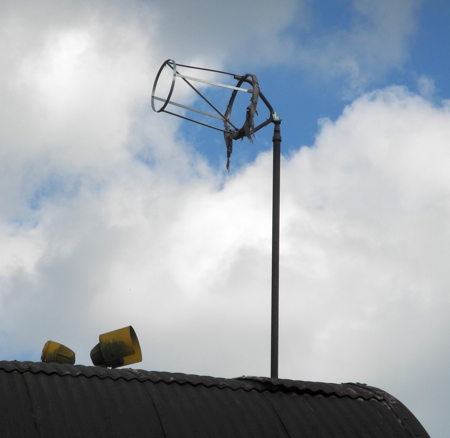
A July 2023 photo by Randy Coller of the remains of the Welch Airport windsock frame on top of its hangar.
A July 2023 photo by Randy Coller of the Welch Airport hangar & ramp.
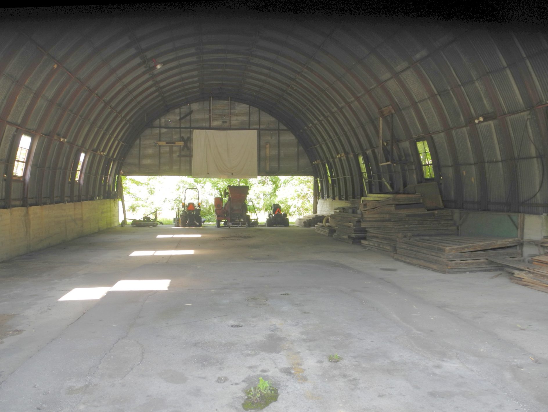
A July 2023 photo by Randy Coller of the interior of the Welch Airport hangar.
Randy Coller reported, “Ownership reverted from City of Welch to original property owner, Pocahontas Surface Interests.
They filed notice with the FAA of their intent to abandon the airport which was approved 9//7/23.”

Welch Municipal Airport continued to be depicted on the January 2024 Cincinnati Sectional Chart.
This continuing depiction of the airport as “open” is a true safety hazard,
as the FAA's Airport/Facility Directory describes the airport as “Airport closed indefinitely. Pavement condition failed. Surface rough & cracking.
Vegetation & trees growing through cracks. Loose stones, rocks & debris on runway. Tree limbs overhang runway edges.”
Welch Municipal Airport was no longer depicted on the July 2024 Cincinnati Sectional Chart.
Welch Municipal Airport is located at the southern terminus of County Road 52/16.
____________________________________________________
Bollinger Field / Hilltop Airport, Ruth, WV
38.32, -81.72 (Southwest of Charleston, WV)
Bollinger Field, as depicted on the November 1945 Huntington Sectional Chart (courtesy of Chris Kennedy).
This little general aviation airport was located in the hills of WV.
According to Jerry Waters, Bollinger Field “opened in the 1930s I believe.”
However, Bollinger Field was not listed among active airfields in the Airport Directory Company's Airport Directories from 1933, 1938, or 1941
or the 1945 AAF Airfield Directory (courtesy of Scott Murdock),
and it was not depicted on the May 1945 Huntington Sectional Chart (according to Chris Kennedy).
The earliest depiction of Bollinger Field which has been located
was on the on the November 1945 Huntington Sectional Chart (courtesy of Chris Kennedy).
It depicted Bollinger as having a commercial/municipal airport.
According to Mark Hess, Bollinger Field was “owned by Cramer Bollinger.
Bollinger took hundreds of aerial movies during this time.”
The Haire Publishing Company's 1945 Airport Directory (courtesy of Chris Kennedy)
described Bollinger Airport as a “Class 1” airport, owned & operated by Charleston Aviation Corporation.
The manager was listed as C.G. Bollinger.
The field was said to consist of 92 acres, irregularly-shaped,
within which was a single 2,200' sod east/west runway, and 2 hangars.

A 1946 photo of a Stinson V77 Reliant of All American Airways picking up mail at Bollinger Field (from the Benny Mallory collection, courtesy of www.mywvhome.com).
A wire was stretched between 2 poles & a hook on the aircraft snatched up the mail bag!
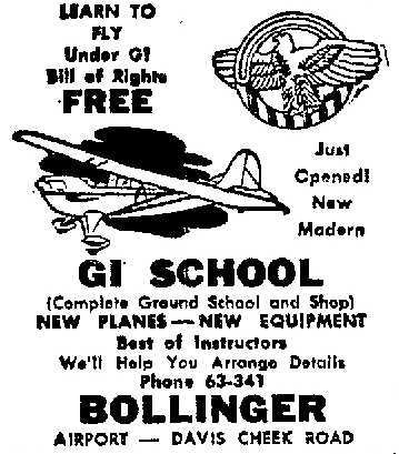
A 1946 advertisement (courtesy of Mark Hess) for the “Just opened, new, modern GI School” at Bollinger Airport.
A 1946 newspaper article (courtesy of Mark Hess) proclaimed that 2 Sikorsky R-5 helicopters would be on display at Bollinger Airport,
as they had “been purchased by the Atlantic Greyhound Lines for experimental purposes pending the start of a feeder service throughout the nation.”
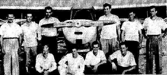
From a 7/21/46 article (courtesy of Mark Hess), a photo of “Ex-servicemen attend GI Flying School at Bollinger Airport” in front of an Aeronca.
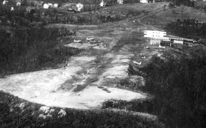
An undated aerial view of Bollinger Field (from the Benny Mallory collection, courtesy of www.mywvhome.com),
showing at least 5 aircraft on the field, with the hangar on the right-rear.
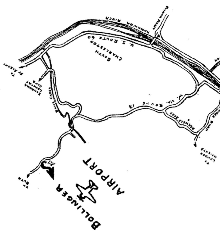
A 1947 map of Bollinger Airport (courtesy of Rick Harshbarger).
The May 1957 Huntington Sectional Chart (according to Chris Kennedy) described Bollinger Field as having a 2,100' unpaved runway.
At some point between 1957-58, Bollinger Field was evidently renamed Hilltop Airport & had its runway lengthened,
as the May 1958 Huntington Sectional Chart (courtesy of Chris Kennedy)
labeled the field as Hilltop & depicted it as having a 3,600' unpaved runway.
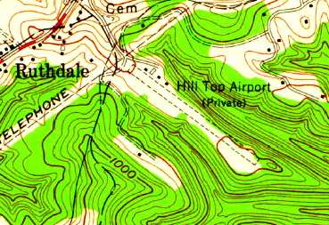
The 1958 USGS topo map depicted “Hill Top Airport (Private)” as having a single unpaved northwest/southeast runway,
with a few small buildings on the north side.
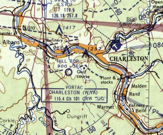
The last depiction which has been located of Hilltop Airport was on the July 1960 Huntington Sectional Chart.
It depicted “Hill Top” as having a 3,600' unpaved runway.
Hilltop Field was evidently closed (for reasons unknown) at some point between 1960-61,
as it was no longer depicted on the January 1961 Huntington Sectional Chart,
or the 1965 USGS topo map.
The 1996 USGS aerial photo showed that several large buildings had been constructed over the site of Bollinger Field,
with no trace remaining of the former airport.
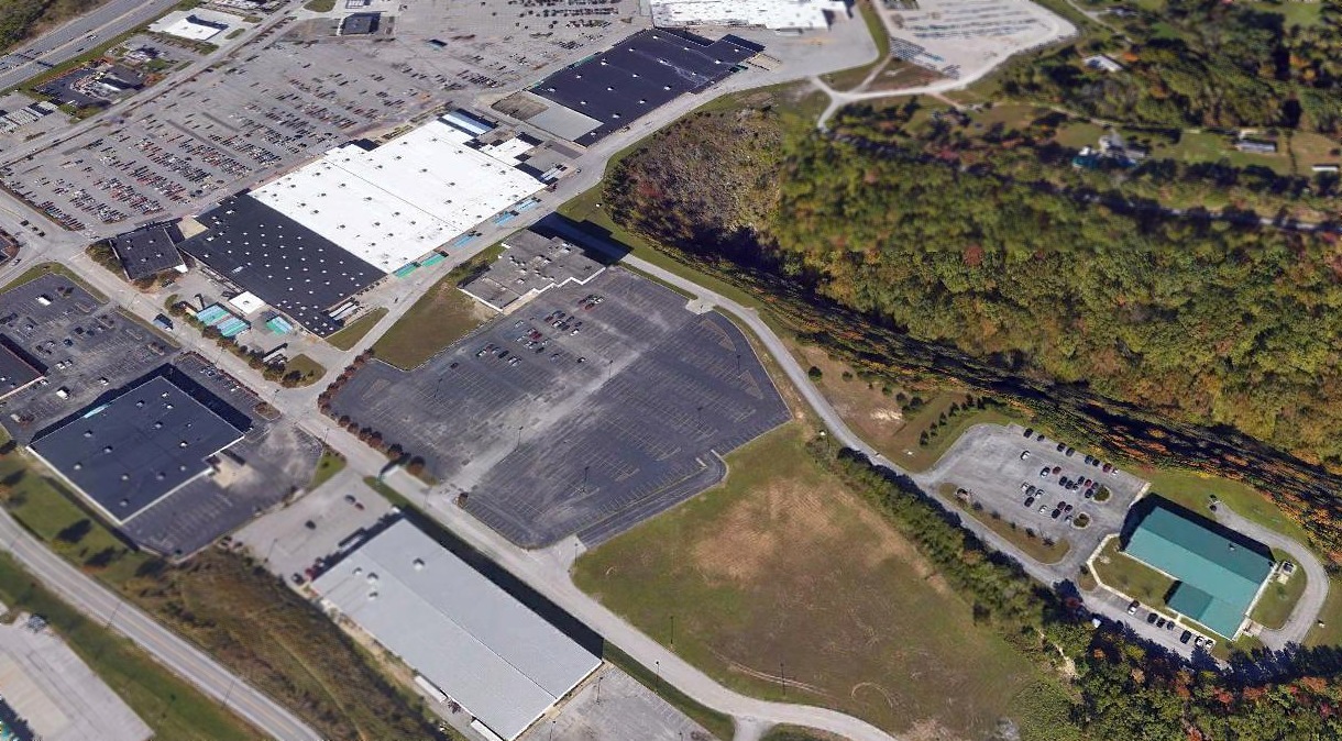
A 2015 aerial view looking north showed no trace remained of Hilltop Airport.
The site of Bollinger Airport is located northeast of the intersection of Route 119 & Southridge Boulevard.
____________________________________________________
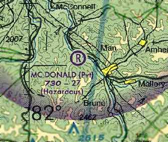
37.761, -81.903 (Southwest of Charleston, WV)
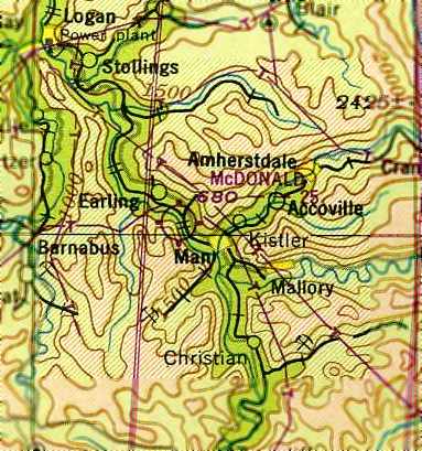
McDonald Airport, as depicted on the October 1948 Winston-Salem Sectional Chart (courtesy of Chris Kennedy).
This unusual little airport was located on a narrow slice of land on the south bank of the Guyandotte River,
with the grass runway following the curve of the riverbank.
McDonald Airport was not yet depicted at all on the March 1945 Winston-Salem Sectional Chart (according to Chris Kennedy)
nor listed among active airfields in the 1945 AAF Airfield Directory (courtesy of Scott Murdock).
McDonald Airport was cofounded in 1946 by WW2 fighter pilot Edsel Varney (according to an article courtesy of Rick Harshbarger).
Varney's grandson Andy York said, “My grandfather & Grady Yeager were the first two to fly into the airfield.”
The earliest depiction which has been located of McDonald Airport
was on the on the October 1948 Winston-Salem Sectional Chart (courtesy of Chris Kennedy).
It depicted McDonald Airport as having a 2,500' unpaved runway.
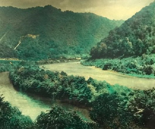
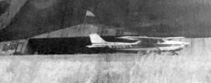
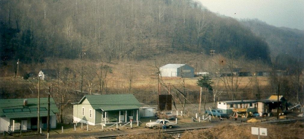
A 1956 photo by Don Freeman looking east at McDonald Airport, with a few small planes barely visible along the right side of the grass runway.
Clinton Winter recalled Edsel Varney, a legendary fighter jet pilot & WW2 hero, saying the planes in the picture belonged to him.
According to an article (courtesy of Rick Harshbarger), “JFK flew into McDonald Airfield while campaigning in 1960.
Several famous & prominent people have taken advantage of the grassy field,
some of which include Lorne Greene of 'Bonanza', Robert F. Kennedy, and a host of WV governors.”
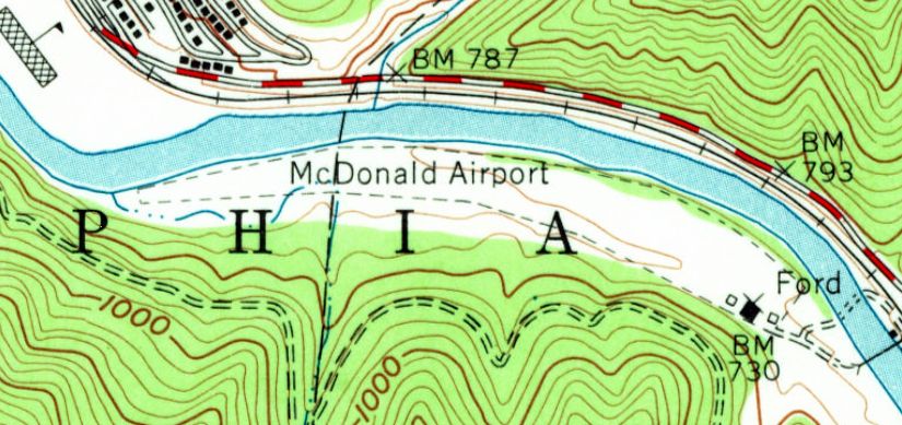
The 1963 USGS topo map depicted McDonald Airport as having a single 2,600' unpaved runway (somewhat curved, following the riverbank).
Three small buildings (hangars?) were depicted southeast of the runway.
Don Elmore recalled, “I have been into the McDonald Airport several times.
Charlie Belcher flew for Buck Harless, a WV coal & timber magnate.
Cotton McGlothlin was the chief pilot at the time & they operated a King Air in & out of McDonald many times.”
According to Bill Napier, “McDonald Field Airport was near my home town, Logan, WV.
I have never been on the field, but have driven past it & flew over it.
I was never able to really make it out from the air. It was definitely from another era.
When I found it on sectionals in the late 1980s it was marked as 'Hazardous.'
I can assure you it was. But that was another era.”
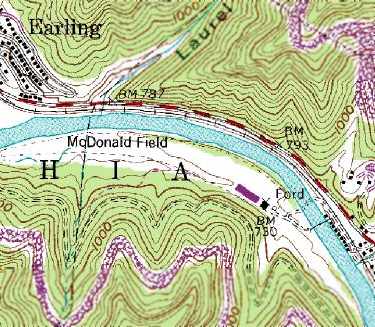
The 1989 USGS topo map depicted “McDonald Field” as having a single 2,600' unpaved runway (somewhat curved, following the riverbank).
Two small buildings (hangars?) were depicted southeast of the runway.
A circa 1991 photo (courtesy of Rick Harshbarger) of the last plane to leave McDonald Airport: Andy York's Cessna 172.
Andy York said, “My grandfather & Grady Yeager were the first two to fly into the airfield
and I wanted to be the last to fly out – in his memory.”
A 4/24/96 USGS aerial view looking southwest showed that the former McDonald Airport runway remained clear, along with the cluster of small buildings/hangars on the southeast side of the field.
However, there were no planes visible on the field.
Eddie Shields recalled, “My wife & I visited it about 1999 just before they plowed it up & closed it for good.
You had to walk over a swinging bridge to get to it.”
A pre-2003 photo looking east at the tiny grass clearing which is McDonald Field (courtesy of Bill Napier).
A pre-2003 photo of a hangar which remained at McDonald Field (courtesy of Bill Napier).
Bill Napier realled, “I took another trip to the Taplin Airport.
The bridge was closed to traffic, although there is a small pedestrian door.
My brother & I walked out to the middle of the bridge, since I had never crossed a swinging bridge I was kind of hesitant.
The bridge floor is in good condition & the cables holding it look strong, but half way was all I would travel!
Some of the neighbors around the bridge told us, rumor was, that they were going to tear down the hangars at the field,
so my brother took me down to the Rich Creek bridge & around the mountain to the airfield.
I took several more pictures of the hangars.
I did find where the official name for the airstrip was McDonald Field Airport & that it was last inspected in 1996.
The sad thing is, what stories such a place could hold, and as far as I could determine, there are no written record of it.”
A pre-2003 photo of hangars at McDonald Field (courtesy of Rick Harshbarger).
A 2003 aerial photo showed that most of the hangars & buildings had been removed at some point between 1996-2003,
but the swinging bridge remained.
Showing that you can't always trust aeronautical charts, McDonald Airport continued to be depicted on the December 2003 Cincinnati Sectional Chart (courtesy of Chris Kennedy),
even though it had evidently been closed for a dozen years by that point.
It depicted McDonald as a private field with a “Hazardous” 2,700' unpaved runway.
McDonald Airport was no longer listed among active airfields in the FAA Airport/Facility Directory data as of January 2006.
A 5/9/07 aerial photo showed that a new road had been cut through the southern portion of the airfield site at some point between 2003-2007,
and the swinging bridge had been removed.
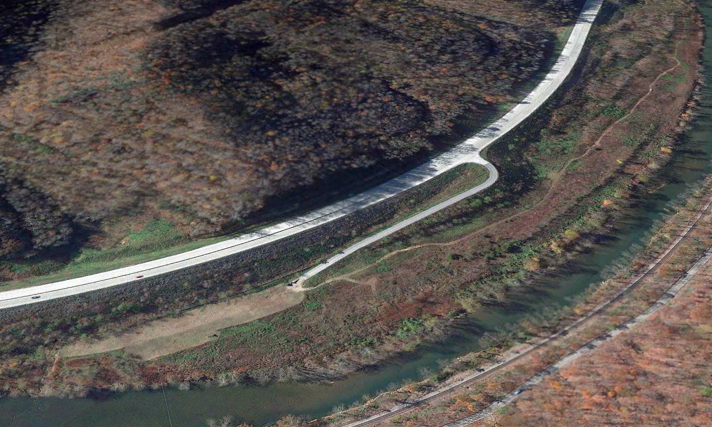
A 2013 aerial view looking southwest shows no trace remaining of McDonald Airport,
with the runway & hangars having been removed, and a new road built over the center.
However, no redevelopment has come to the property, more than 20 years after the airport closed.
Yet another case of a small airport closed for “more lucrative” property reuse that never came to fruition.
The site of McDonald Airport is located at the eastern terminus of Taplin Airport Road, appropriately enough.
____________________________________________________
38.38, -81.78 (West of Roanoke, VA)
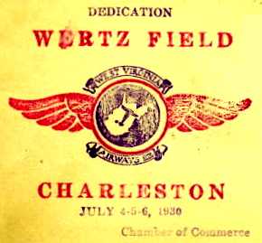
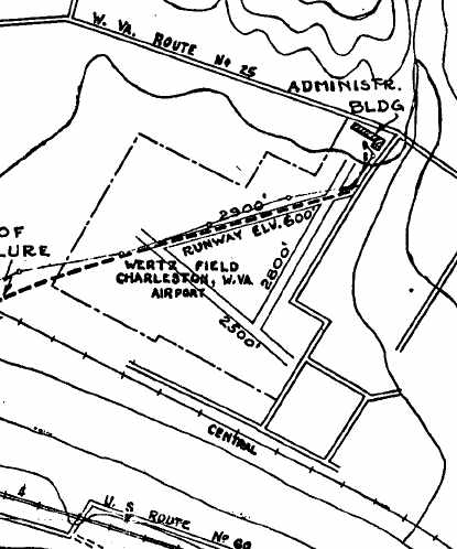
A postmark commemorating the July 4-6, 1930 dedication of Wertz Field.
In 1929 the City of Charleston purchased property for its original airport in the town of Institute (6 miles west of Charleston),
as described on the present-day Charleston Yeager Airport's web site (courtesy of Bob Merritt).
The new field was to be named Wertz Field.
By 1930 the City of Charles still lacked the funds to develop & operate a new airport,
so it leased the tract to a group of businessmen who formed West Virginia Airways, Inc.,
which eventually was able to provide aviation facilities at the site for the next 12 years.
Wertz Field was dedicated on July 4-6, 1930.
Later, with help of federal funds, a large administration building was completed.
Gary Gowans reported, “My father-in-law was 16 years old he took about 30 pictures from Wertz Field on 6/14/31.
Included are pictures of Wiley Post’s plane 9 days before his around-the-world takeoff.
Also Goodyear blimp Columbia NA-11A which only existed for about 7 months, as well as a gyrocopter, and a number of biplanes.”
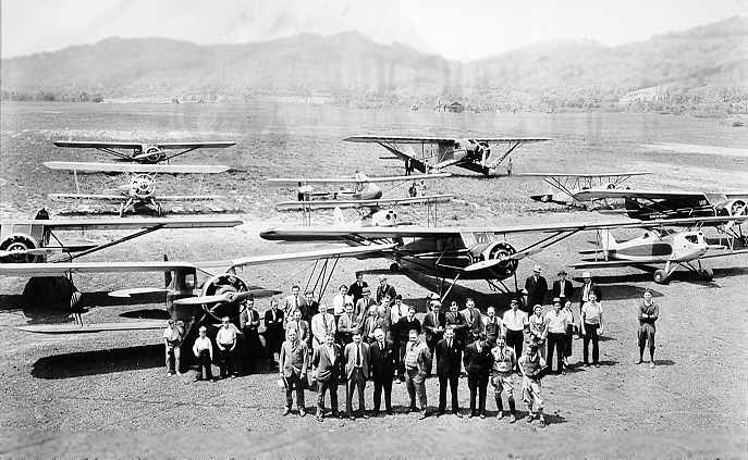
The earliest photo which has been located of Wertz Field
was a 5/16/32 photo of several biplanes & monoplanes at Wertz Field (courtesy of www.mywvhome.com).
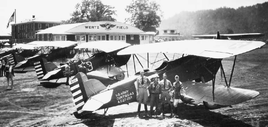
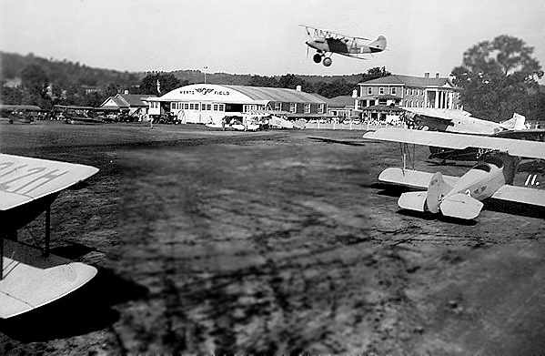
A 1932 photo of a several Army Curtiss A-3 biplanes in front of the Wertz Field hangar (courtesy of www.mywvhome.com).
By 1933 West Virginia was up to that time was one of but 2 states which did not have air mail services.
In October, American Airlines was awarded an air mail contract route,
and opened passenger service between Washington & Chicago, via Charleston,
serving intermediate cities of Elkins, Huntington, Cincinnati, and Indianapolis.
The earliest directory reference to Wertz Field which has been located
was in The Airport Directory Company's 1933 Airports Directory (according to Chris Kennedy).
It described Wertz Field as a 160-acre rectangular property, having 2 sod runways - 2,500' east/west & 1,600' north/south.
A hangar was said to have "Charleston" & "Wertz Field" painted on the roof.
Wertz Field was not yet depicted on the 1933 USGS topo map.
Wertz Field was described in the same fashion in the 1934 Department of Commerce Airport Directory (according to Chris Kennedy).
The earliest aeronautical chart depiction which has been located of Wertz Field was on the February 1934 Huntington Sectional Chart.
It depicted Wertz Field as a commercial/municipal airport.
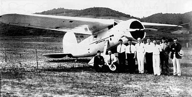
A 1934 photo (courtesy of www.mywvhome.com) of pioneering aviator Wiley Post visiting Wertz Field in his famous Lockheed Vega 5-B Winnie Mae.
Post had been the 1st person to fly around the world solo.
In 1935, Pennsylvania Central Airlines (Capital Airlines) established a branch route passenger service between Charleston & Pittsburgh.
A circa 1930s photo of a barnstorming show at Wertz Field (courtesy of Larry Anderson).
The Airport Directory Company's 1937 Airports Directory (courtesy of Bob Rambo)
described Wertz Field as a municipal airport consisting of a 160-acre rectangular sod field.
It was said to have 3 runways, with the longest being the 2,900' northeast/southwest runway.
Two of the runways were also said to have a 1,200' paved portion.
A hangar was said to have "Charleston" & "Wertz Field" painted on the roof.
A 1937 aerial view depicted the arch-roof hangar at Wertz Field (courtesy of Rick Harshbarger).
By 1937, with larger passenger planes having been put into service by air carriers,
the short runways & obstructed approaches of Wertz Field began showing the field's inadequacy.
American Airlines notified City of Charleston that it would be forced to discontinue service
because Wertz Field was too limited for landing larger planes.
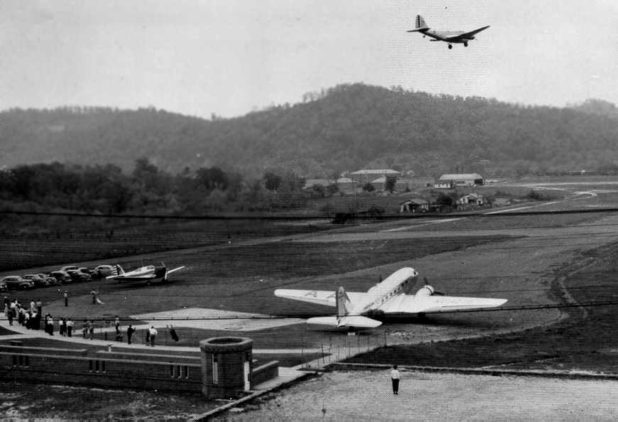
City's aviation enthusiasts prevailed on American Airlines to continue service, using smaller DC-2 planes.
Leaders in Charleston Chamber of Commerce realized that site for a new airport must be found.
A committee was appointed consisted of D.M. Giltinan, D.N. Mohler, D.C. Kennedy, Charles E. Hodges, Fred Alley, and J.B. Pierce.
This committee was asked to make survey of airport needs & to study all possible airport sites within 25-mile radius.
In 1938, after a year examining on foot, by car and topographical maps every possible site,
committee reported that the valley floor offered no suitable site large enough to meet area's growing needs.
Even Wertz Field did not permit expansion.
The committee decided that "We must build on the hilltops."
Wertz Field was not depicted on the 1939 USGS topo map.
A circa late 1930s – early 1940s photo of a DC-2 & two Army aircraft at Wertz Field (courtesy of Larry Anderson).
The 1939 Huntington Sectional Chart (courtesy of Chris Kennedy) depicted Wertz Field as a commercial/municipal airport.
In 1940 a site for a replacement airport was suggested along a series of hills not far from Charleston's city limits.
However, work on the replacement airport was put on the 'back burner' by projects which were certified as essential to national defense.
On 4/16/41 a Boeing 247D of Pennsylvania Central Airlines crashed immediately after departure from Wertz Field.
The crash was described in a September 1941 Civil Aeronautics Board report (courtesy of Bob Merritt).
One engine had lost power, and the captain's attempt to continue the climb
was complicated by the hills & powerlines which surrounded Wertz Field.
The crash destroyed the aircraft & injured some of the crew & passengers.
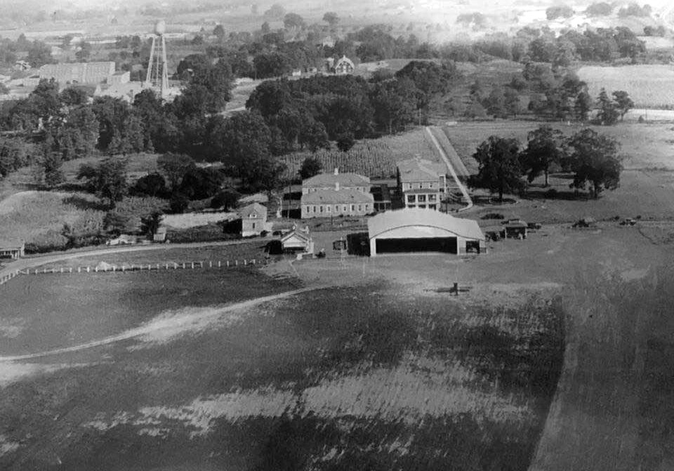
An undated topo map depicting Wertz Field, from a September 1941 Civil Aeronautics Board report (courtesy of Bob Merritt).
It depicted Wertz Field as having 3 runways, with the longest being a 2,900' northeast/southwest strip.
An administration building was depicted as being located at the northeast corner of the field,
immediately off the end of one of the runways.
Bob Merritt observed, "The amazing thing is that the airlines were able to operate from this little airport with 2,500' runways,
down in the river bottom with surrounding hills & powerlines for 12 years with apparently no fatalities."
The last directory reference to Wertz Field as an active airfield which has been located
was in The Airport Directory Company's 1941 Airports Directory (according to Chris Kennedy).
Charleston lost its original airport without gaining a replacement on 5/12/42,
when Wertz Field was closed after 12 years of operation,
as the field's property became the site of a large synthetic rubber plant for the war effort.
It took just 10 months for the employees of Ford, Bacon & Davis to build the massive plant.
Carbide & Carbon Chemicals Corporation along with U.S. Rubber undertook the project.
The last depiction of Wertz Field as an active airfield which has been located was on the June 1942 Huntington Sectional Chart.
It depicted Wertz Field as a commercial/municipal airport.
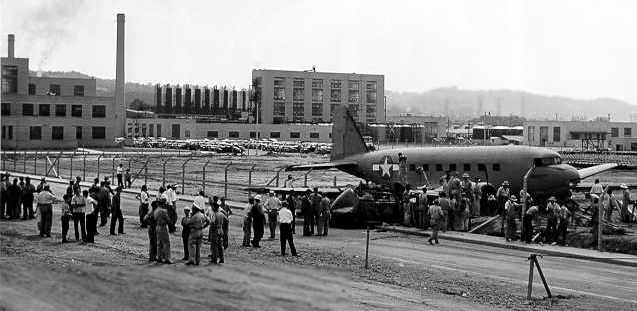
A July 1943 photo of an Air Corps C-47 which evidently crash landed at the former Wertz Field,
with the plant which replaced the airfield visible in the background (courtesy of Larry Anderson).
Wertz Field was no longer depicted on the May 1945 Huntington Sectional Chart.
Charleston's Kanawha Airport was finally opened just north of the city in 1947,
after the City of Charleston had been without an airport for 5 years.
Wertz Field was no longer depicted on the 1954 USGS topo map.
The 1976 USGS topo map showed that the site of Wertz Field was covered by industrial facilities,
and no trace of the former airport appeared to remain.
A 1990 USGS aerial photo showed industrial facilities covered the site of Wertz Field,
and no trace of the former airport appeared to remain.
As of 2004, the site of Wertz Field is still occupied by the Bayer CropScience Institute Site,
an agricultural chemical facility which is the descendant of the rubber plant built over the former airport site.

A 2015 aerial view looking north showed industrial facilities covered the site of Wertz Field, and no trace of the former airport appeared to remain.
Thanks to Bob Merritt for pointing out this airfield.
____________________________________________________
Swope Farm Airfield (WV11), Fan Rock, WV
37.57, -81.62 (West of Roanoke, VA)
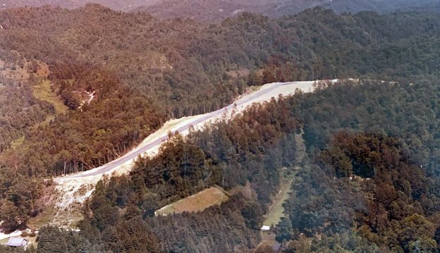
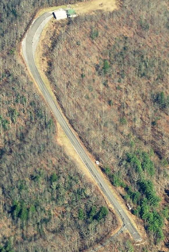
A late 1960s / early 1970s aerial view looking north at the Swope Farm Airfield (courtesy of Bill Babis), “shortly after construction.”
This private airfield is remarkable for a short runway which is both sharply curved, and steeply sloped.
Its sole Runway 7/25 is extremely short (only 1,250'),
but also slopes sharply downhill: dropping from 1,800' elevation to 1,665' - a grade of 11%!
Avid flyer W.O. Swope purchased the land for the airfield in 1963,
and immediately began planning for an extremely unusual runway, given the very unaccommodating topography.
A 1967 aerial view did not yet show the Swope airfield.
The Swope hangar was originally located at the bottom of the runway.
However, it was moved to the top of the runway after an unfortunate incident in which Swope's brakes overheated going downhill,
and he had to dump the plane in the brush to avoid hitting the hangar.
Strangely, no airfield at this location was depicted on the 1966 USGS topo map.
The earliest depiction which has been located of the Swope Airfield was a late 1960s / early 1970s aerial view looking north (courtesy of Bill Babis), which pictured it “shortly after construction.”
Bill Babis recalled, “In June 1973 I flew Billy Swope to Swope Farm Airfield to take him home after he had dropped his Barron off at my father’s business in KLUK.
I flew him there in a 1967 Mooney Executive & he talked me in.
You had to land on the far west side of the runway with no float & have the aircraft slowed enough before the right dogleg at the end. With the uphill gradient it was pretty easy.
It was even easier in his Baron because he had the only Baron with fully-reversible props. With the gradient, he didn’t even need to use the brakes.
Takeoff was the scary part. You had to hold the brakes & start the takeoff from beside the hangar & not be too fast to make the left turn on the runway & then keep trucking.
The end of the runway fell off sharply, so one way or the other you were flying by the end.”
Swope based & flew a twin-engine Beechcraft Baron & a helicopter from the airfield.
He logged a total of 3,000 takeoffs & landings into the Swope Farm airfield. Swope only had one eye.
Takeoffs were made downhill, and landings were made uphill.
The helicopter could only be landed at the very top of the runway, as the lower portion of the runway was too steep.
A 1973 aerial view looking east depicted the Swope Farm Airfield as having a curved & sloped asphalt runway with a small building at the east end.
Swope Farm Airfield still was not depicted on the 1976 USGS topo map.
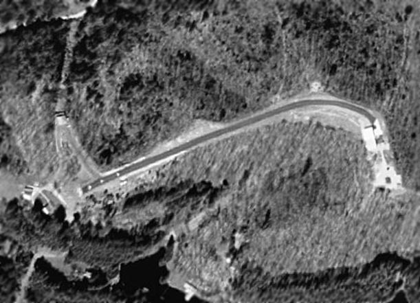
A 1996 aerial view depicted the Swope Farm Airfield as having a curved asphalt runway with buildings on the west & east ends.
According to nearby resident Mark Hrutkay, “Mr. Swope was the Mayor of Welch WV for many years & had an early (underpowered) Bell JetRanger.
He had a landing pad on top of his building and flew it off of there.
They used to throw some really wild fly-in parties at the airport
& it would look like an aircraft carrier with all the planes crammed onto the field (there isn't much field that isn't runway).
Mr. Swope made his last flight in & out of there 2 days before he died at age 86 [in 2001].
He was the type of pilot they don't have many of anymore.”
Swope's son reportedly planned to keep the airfield in operation. According to Mark Hrutkay, “His son still has the Jet Ranger.”
On recent aeronautical charts, the airfield was labeled "Swope (Hazardous)".
The 1996 USGS topo map depicted the curved runway as a road, not labeled as a runway.
Mark Hrutkay reported in 2006, “I love flying down the runway in my helicopters - its a precision thing to do & its downhill.
Since Mr. Swope has died, trees have about closed in to where it is too narrow to operate from.”
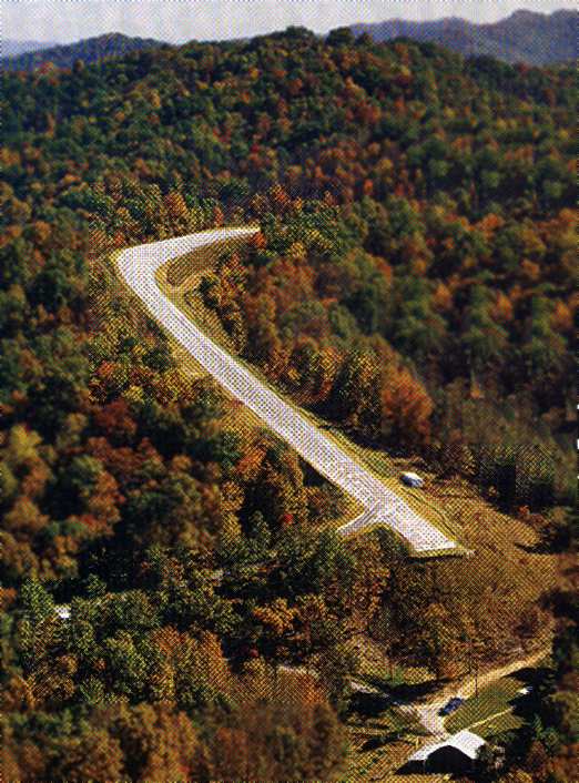
A circa 2010 aerial view looking east at the Swope Farm Airfield shows this bizarre little runway to remain intact.
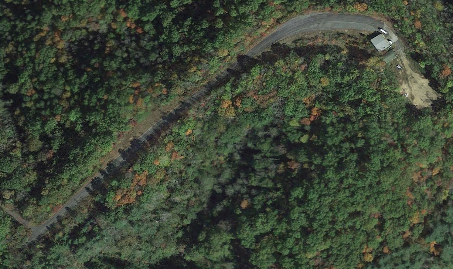
A 2015 aerial view looking
northeast at the Swope Farm Airfield shows this bizarre little runway
to remain intact.
____________________________________________________
Or if you prefer to contact me directly concerning a contribution (for a mailing address to send a check),
please contact me at: paulandterryfreeman@gmail.com
If you enjoy this web site, please support it with a financial contribution.
____________________________________________________
This site covers airfields in all 50 states.