Abandoned & Little-Known Airfields:
West Virginia, Northwestern
© 2002, © 2025 by Paul Freeman. Revised 9/20/25.
This site covers airfields in all 50 states: Click here for the site's main menu.
____________________________________________________
Please consider a financial contribution to support the continued growth & operation of this site.
Glen Dale Fokker Field (revised 12/19/23) - Guinns Airport (revised 9/25/21) - Hundred Airport (revised 5/19/24) - Langin Field (added 10/20/23)
Mason County Airport (added 9/20/25) - Parkersburg Airport / Stewart Air Park (revised 5/19/24) - Skylanes Field / Half Moon Field (added 1/27/25)
State 4H Airport / Lt. Louis Bennett Field (added 5/19/24) - Steelton Civil Air Patrol Airport / P.W. Johnson Memorial Airport (revised 1/28/25) - Weirton Airport (revised 4/10/24)
____________________________________________________
Mason County Airport (3I2), Point Pleasant, WV
38.914, -82.1 (Southeast of Columbus, OH)
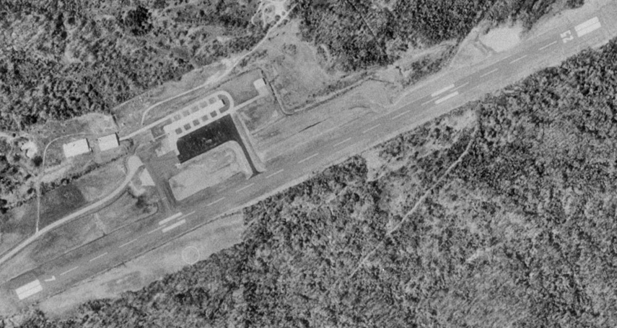
Mason County Airport, as depicted on a 1988 aerial view.
This small general aviation airport was evidently constructed at some point between 1967-70,
as it was not yet depicted on a 1967 aerial photo.
The earliest depiction which has been located of Mason County Airport was on the 1970 USGS topo map.
It depicted the “County Airport” as having a single paved northeast/southwest runway, with a paved ramp on the northwest side.
The earliest depiction which is available of Mason County Airport was a 1983 aerial photo.
It depicted a paved northeast/southwest runway, with a ramp, 2 hangars, and 5 light single-engine aircraft on the northwest side.

The 1989 USGS topo map depicted Mason “County Airport” as having a single paved northeast/southwest runway, and a paved ramp & 4 buildings on the northwest side.
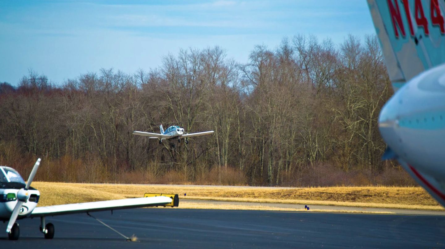
A 2014 photo of a Piper Cherokee taking off at Mason County Airport.

A 2014 photo of a Cessna CitationJet at Mason County Airport.

A 2015 of the Mason County Airport welcome sign.

A 2015 photo of a Piper Warrior at Mason County Airport.

A 2015 photo of a forlorn Piper Cherokee at Mason County Airport.
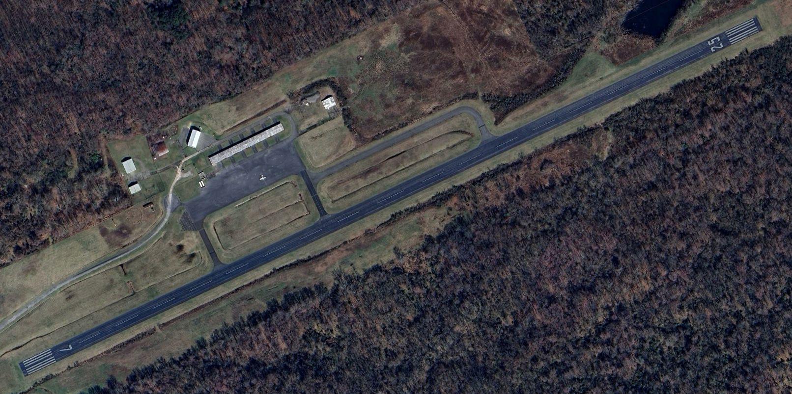
A 2024 aerial view showed only a single aircraft at Mason County Airport.
The 2025 Cincinnati Sectional Chart depicted Mason County Airport as having a single paved 4,000' northeast/southwest runway.
Unfortunately the end for this little grassroots airport came in 2025.
A 7/1/25 globalair.com article entitled “West Virginia airport closing to become AI data center”
said that Mason County Airport is being closed, with the property being redeveloped into a data center.
The article claimed the data center would bring “3,000 high-paying jobs”, which is a very spurious assumption,
as neither the construction nor long-term operation of a data center generates anywhere near that quantity of jobs.
Thanks to Randy Coller for pointing out this airfield.
____________________________________________________
Skylanes Field / Half Moon Field, Weirton, WV
40.387, -80.62 (West of Pittsburgh, PA)

Skylanes Field, as depicted on the July 1938 Cleveland Sectional Chart.
Photo of the airport has not been located.
Hank Lutton reported, “As early as 1928, there are references in the Steubenville Herald Star newspaper about the planned development of an airfield at Half Moon Farm as soon as a bridge is completed nearby (which opened in 1929).
The bridge made travel between Steubenville & the communities that would become incorporated as Weirton more direct.
It appears that aircraft occasionally arrived & departed from Half Moon Farm during this time, but there is no mention of infrastructure & it was likely unimproved.
Use appears to be ad-hoc, daylight only, and in conjunction with celebrations, weekend events, etc.”
Hank continued, “On 1/31/31 the Steubenville Herald Star newspaper reported that aviation enthusiasts intended to develop a 'Half Moon Airport' at Half Moon Farm which had been leased from the development company in ownership of the property.
Plans included hangers, lighting beacon, etc. but funding seems insufficient & by the fall of that year, it likely remained a grass strip without improvements.
Although subsequent articles do not describe the level of development at the field, it was used for fair-weather rides & demonstrations beginning at least 5/1/31.
On 5/7/31 an article referred to 'Twin City Airport, located on Half Moon Farm.'
In the fall of that year, a glider club for Steubenville youths was organized (sponsored by WV Waco Sales Company). The club trained at Half Moon.”
The 6/29/36 Steubenville Herald Star reported “Airliner will land Half Moon Field”.
However, Half Moon Field was not yet depicted on the 1937 Cleveland Sectional Chart.
Hank Lutton reported, “In August 1937, two fatalities occurred in an accident at the field while a pilot was stunting with a passenger.
Newspaper coverage of the accident during 1937-1938 referred to the airport as 'Skylanes'.
It appears that names for the field were quite fluid & since the topographical location was such a prominent landmark (and a familiar gathering spot for outdoor activities),
locals probably continued to refer to it as Half Moon regardless of the actual name.”
The earliest depiction which has been located of an airfield at this location was on the July 1938 Cleveland Sectional Chart,
which depicted “Skylanes” as a commercial/municipal airport.
Skylanes Field was not depicted on the 1938 USGS topo map.

At some point between 1938-40, Skylanes Field was evidently renamed Half Moon Field, as that is how it was depicted on the March 1940 Cleveland Sectional Chart.
Half Moon Field was not depicted on the 1942 USGS topo map.

The last depiction which has been located of Half Moon Field was on the June 1945 Cleveland Sectional Chart (courtesy of Dick Merrill).
Half Moon Field was evidently closed (for reasons unknown) at some point between 1945-47 & replaced by the Wierton Airport to the east,
as the 1947 Cleveland Sectional only depicted Wierton Airport.
A 1954 aerial photo did not show any recognizable trace of Half Moon Field.

A 2023 aerial view showed no recognizable trace of Half Moon Field.
Thanks to Hank Lutton for pointing out this airfield.
____________________________________________________
State 4H Airport / Lt. Louis Bennett Field (49I, WV23), Weston, WV
39.092, -80.471 (Southwest of Pittsburgh, PA)
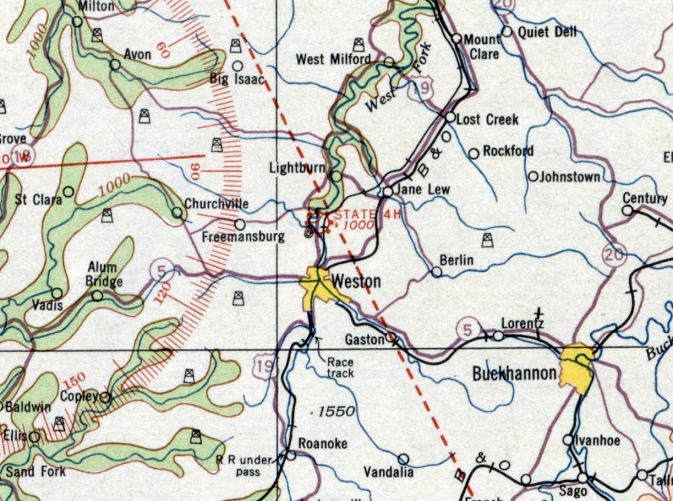
State 4H Airport, as depicted on the February 1934 Huntington Sectional Chart.
The date of establishment of this early WV airfield has not been determined.
The earliest depiction which has been located of State 4H Airport was on the February 1934 Huntington Sectional Chart.
It depicted State 4H as a commercial/municipal airport.
At some point between 1934-40, State 4H Airport was evidently renamed “Lt. Louis Bennett” Field,
as that is how it was depicted on the January 1940 Huntington Sectional Chart.
According to Wikipedia, Louis Bennett Field was “named in honor of Weston native Louis Bennett Jr., a pilot with the Royal Flying Corps during World War I.”
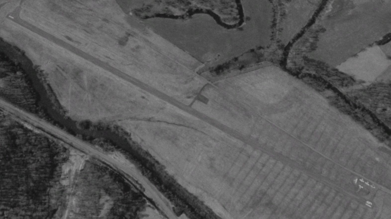
The earliest photo which has been located of Louis Bennett Field was a 1957 aerial view.
It depicted a single grass northeast/southwest runway, but there were no aircraft or buildings visible.
The earliest photo which has been located showing an aircraft at Louis Bennett Field was a 1958 aerial view,
which depicted 1 light single-engine aircraft on the northwest side.
The 1961 USGS topo map depicted Louis Bennett Field as having a single unpaved northeast/southwest runway.
A 1962 aerial photo showed Louis Bennett Field remaining in the same configuration, and with 1 light single-engine aircraft on the northwest side.
The earliest photo which is available of Bennett Field was a 5/9/76 USGS aerial view.
Bennett had gained a paved runway at some point between 1962-76,
and 1 light single-engine aircraft was parked on a small paved northwest ramp.
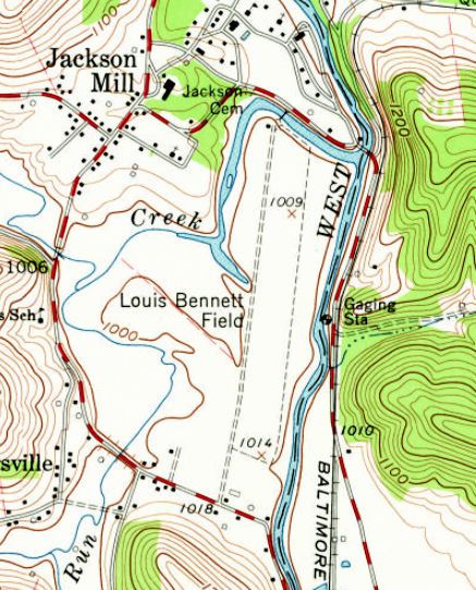
The 1977 USGS topo map depicted Louis Bennett Field as having a single paved north/south runway,
with a small paved ramp on the northwest side.
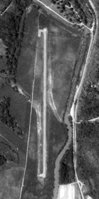
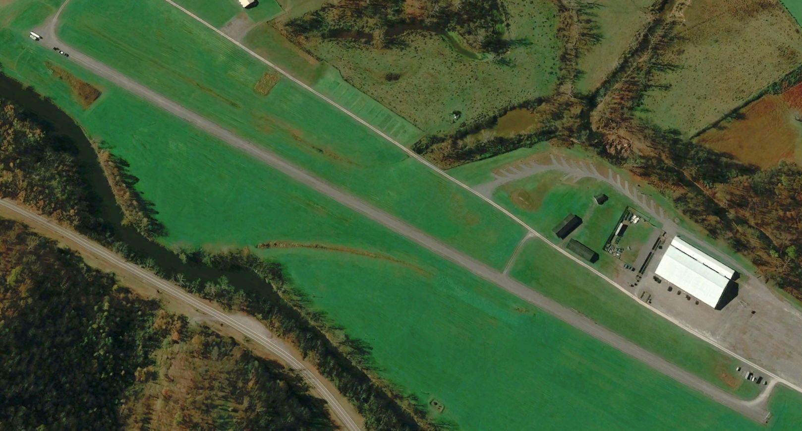
A 1996 aerial view looking southwest depicted Bennett Field perhaps at its zenith of popularity, with 5 light single-engine aircraft parked on its northwest ramp.
Bennett Field may have gone through a period of temporary closure,
as a 2003 aerial view depicted closed-runway “X” markings over the runway numbers, and no aircraft were visible.
Bennett Field was evidently reopened at some point between 2003-2006,
as the closed-runway markings were gone, and 1 light single-engine aircraft parked on the south side.

The last photo which has been located showing an aircraft at Louis Bennett Field was a 2013 aerial view looking southwest.
It depicted 1 light single-engine aircraft on the northwest ramp.
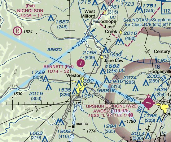
The last aeronautical chart depiction which has been located showing Bennett Field remaining open was on the June 2018 Cincinnati Sectional Chart.
It depicted Bennett as a private airfield having a single 3,200' paved northeast/southwest runway.
According to Wikipedia, Louis Bennett Field was a private airfield owned by WV University, consisting of 80 acres, and had a single 3,195' asphalt Runway 1/19.
Bennett Field was evidently closed (for reasons unknown) at some point in 2018,
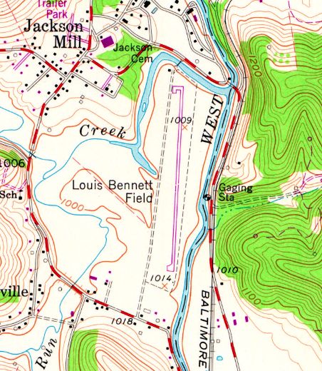
as a June 2018 aerial view looking southwest showed the runway marking had been removed, and items had been placed on the south end of the runway.
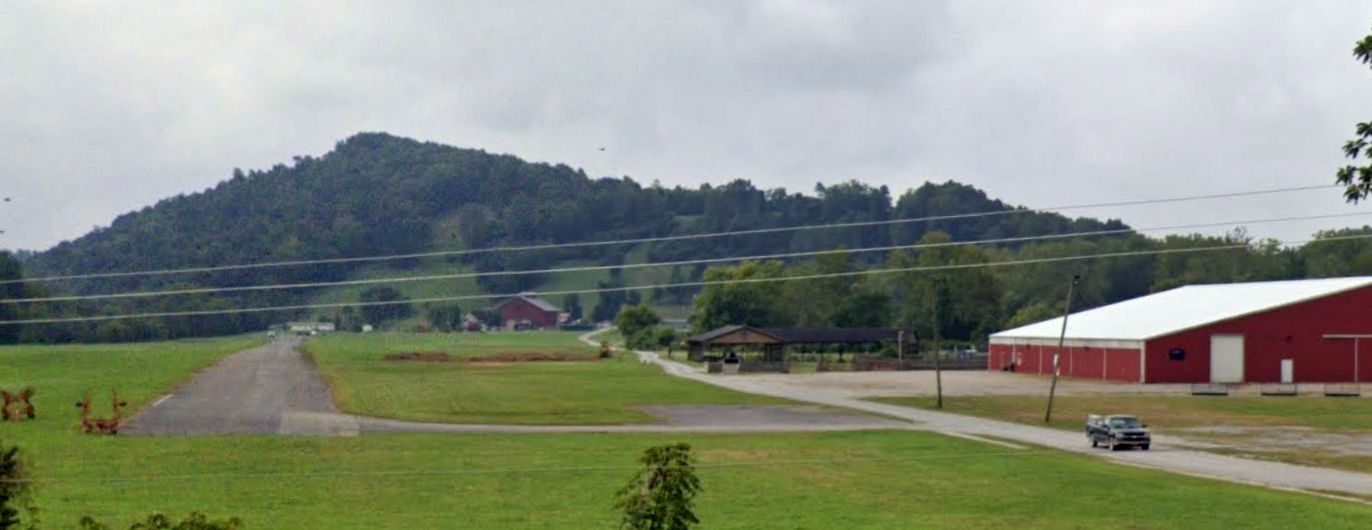
A September 2023 photo looking south showed Bennett Field's runway & ramp remained intact.
Bennett Field was depicted as an abandoned airfield on the 2024 Cincinnati Sectional Chart.
____________________________________________________
39.928, -80.753 (Southwest of Pittsburgh, PA)
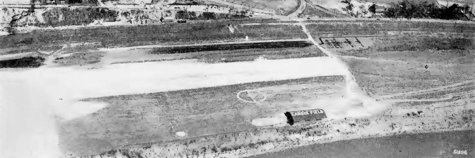
A circa 1924 aerial view looking east at Langin Field, showing the airfield's name painted on its hangar roof (courtesy of Lee Corbin).
According to the article “Moundsville, Wheeling once welcomed Lindbergh” by Derek Coleman in the 8/3/12 Herald-Dispatch (courtesy of Lee Corbin),
“Langin Field from 1921 was an airfield & the refueling stop for military flights from Washington, D.C., to Dayton, OH.
The field was named after 1st Lt. James Langin, who was from IA who but who was stationed at Bolling Field, Washington, DC.
Langin's duty was scouting landing fields & he had been a guest speaker at Moundsville Rotary Club shortly before his gas tank ruptured on takeoff & he was killed in the resulting crash.
The Lieutenant had made such an impression that the local residents pressed the military to name the field after him.
Langin Field was a busy place. In one 10-month period, there were more than 450 landings there & in the early days of aviation that was a lot.”
The earliest depiction which has been located of Langin Field was a circa 1924 aerial view looking east (courtesy of Lee Corbin),
showing a north/south unpaved runway adjacent to the east side of the Ohio River, with a single hangar on the southwest side painted with the airfield's name on its roof .
According to the article “Moundsville, Wheeling once welcomed Lindbergh” by Derek Coleman in the 8/3/12 Herald-Dispatch (courtesy of Lee Corbin), “On 8/3/27 there was an extra-special landing.
A sleek, silver, high-wing Ryan NYP monoplane floated down en route to Dayton
and when it rolled to a stop the young, tall, slim, tousle-haired pilot got out to be greeted by a cheering crowd of some 15,000 people from all over the surrounding area.
Crowds were well-behaved in those days & this one was controlled & held back by 250 Boy Scouts.
Just 10 weeks earlier, the virtually unknown 25-year-old former U.S. Air Mail pilot had made world history when he touched down at Le Bourget Field in Paris.
The young man, Charles Lindbergh, had just made the first solo non-stop trans Atlantic flight from New York, winning the $25,000 Orteig Prize in the process.
Now he was on a tour of the country, showing off his plane, named the Spirit of St. Louis, to the people of America.
A local newspaper said more than 20,000 people saw America's hero on that short visit.
Apparently they lined the streets as Lindbergh, a Colonel in the Air Corps Reserve, was whisked away to a reception at Wheeling.
His visit was short & he stayed in Wheeling overnight, but he did manage to visit the Moundsville Airplane Corporation, located on 10th Street,
to inspect their first-ever product, a single-seat biplane that the test pilot, Lieutenant Jimmy Doolittle, christened 'The Lone Eagle' in honor of Lindbergh's visit.
Lindbergh apparently admired the little plane before going back to Langin field to prepare the Spirit of St. Louis for the next leg of his tour, which would eventually take in some 82 cities.
Despite the hero's endorsement the Moundsville Airplane Corporation only produced a few models of its Lone Eagle before going out of business in 1929.”
Charles Lindbergh left Langin Field an hour before he was scheduled to do so, watched by upwards of a thousand people.
He circled briefly over Wheeling & then turned west toward OH, he did not return.
Other icons of the early days of aviation visited Langin Field over the next few years.
Among them was Ruth Elder, a 25-year-old who persuaded a group of Wheeling businessmen to sponsor her & tried to copy Lindbergh's feat.”
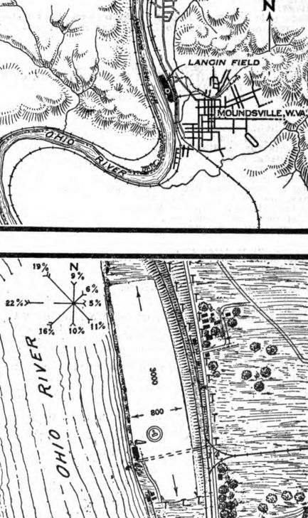
The 6/22/28 Commerce Department Airway Bulletin (courtesy of Lee Corbin) described Langin Field as a commercial airfield, owned & operated by H.T. Compton.
It was said to consist of a 55 acre rectangular sod field measuring 3,000' north/south, with 1 large steel hangar on the southwest side.
According to the article “Moundsville, Wheeling once welcomed Lindbergh” by Derek Coleman in the 8/3/12 Herald-Dispatch (courtesy of Lee Corbin), Langin Field remained in operation until 1932.
The reason for its closure has not been determined.
Langin Field was no longer depicted on the February 1934 Huntington Sectional Chart or the 1940 USGS topo map.
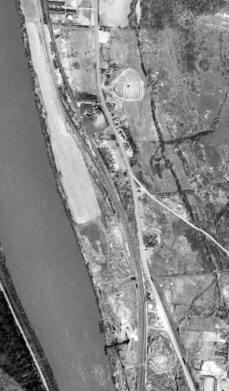
A 1954 aerial view (courtesy of Lee Corbin) showed an empty field in the place of Langin Field.
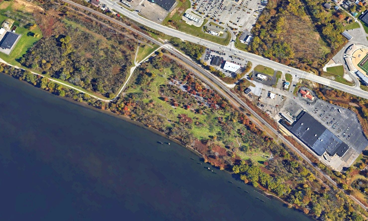
A 2022 aerial view looking northeast showed no trace remaining of Langin Field.
Thanks to Lee Corbin for pointing out this airfield.
____________________________________________________
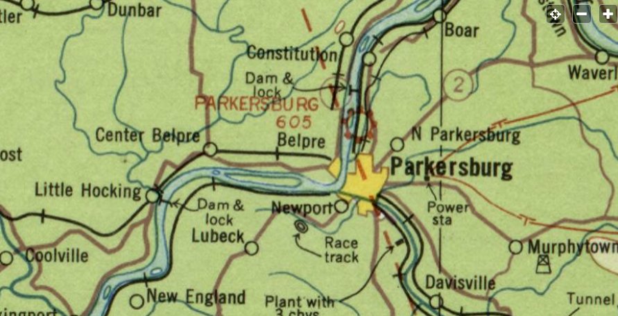
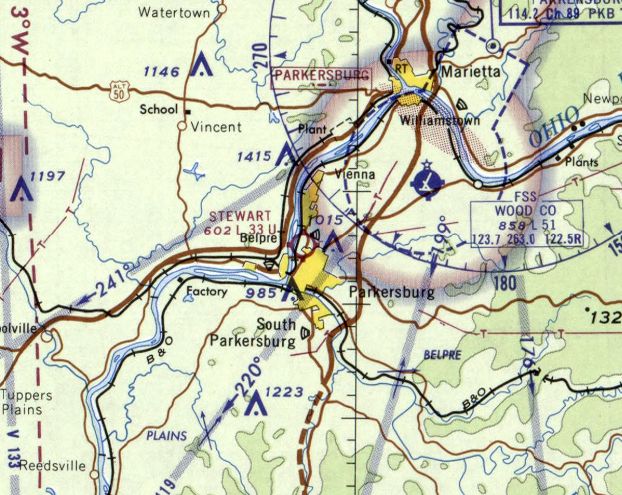
Parkersburg Airport / Stewart Air Park, Parkersburg, WV
39.302, -81.552 (Southwest of Pittsburgh, PA)
Parkersburg Airport, as depicted on the May 1935 Sectional Chart (courtesy of Rob Grant).
According to Roger Mackey, “Stewart Air Park opened in 1935.
The airport was owned by Wade Stewart, a promoter of flying in Parkersburg.”
Randy Ferrell of Kramer's Photo Supply remembers the Air Park's promotion 'A penny a pound to fly around town.'
At the time, Ferrell weighed 75 pounds. “That was my first flight”, he said.
The earliest depiction which has been located of Parkersburg Airport was on the May 1935 Sectional Chart (courtesy of Rob Grant),
which depicted Parkersburg as a commercial/municipal airport.
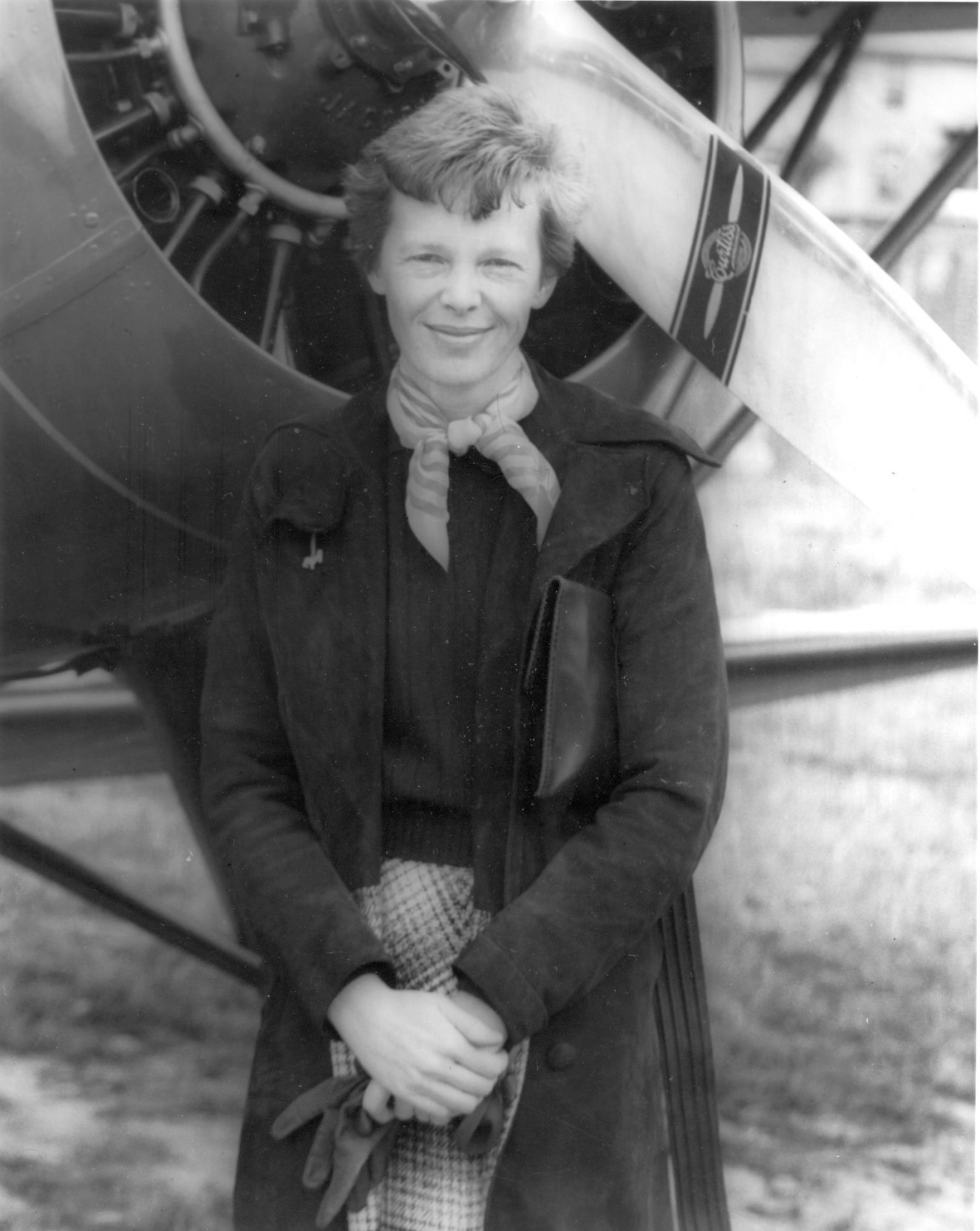
The earliest photo which has been located at the Parkersburg Airport was a photo of Amelia Earhart during her 10/30/36 visit (courtesy of Rob Grant).
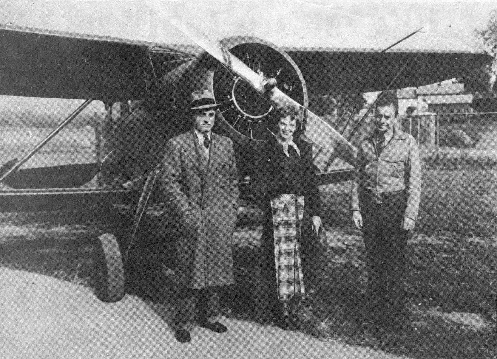
Stewart Airpark owner Wayde Stewart, famous aviatrix Amelia Earhart, and Chief Pilot Jay Sodowsky in front of a biplane during Amelia's 1936 visit to Stewart Airport (courtesy of Rob Grant).
According to Wayde Stewart's obituary (courtesy of Rob Grant), “He owned & operated the Stewart Airport in Parkersburg for many years
where during World War II he operated a pilot training school.”
Jim Roberts recalled, “Stewart Air Park served as a primary training school during WWII for South American pilots.
They flew biplane Waco trainers & they were like flies.
Wade Stewart built barracks for the housing for the South American pilots that was located on the higher ground about where Logans Steak House now stands.
After World War 2 Wade Stewart converted the barracks into a motel called Skytel.”
The earliest aerial view which has been located of the Parkersburg Airport was a circa 1940s aerial view looking east (courtesy of Rob Grant),
which depicted 2 hangars & 3 light single-engine planes on the east side of a grass airfield, with a large airfield circle marking.
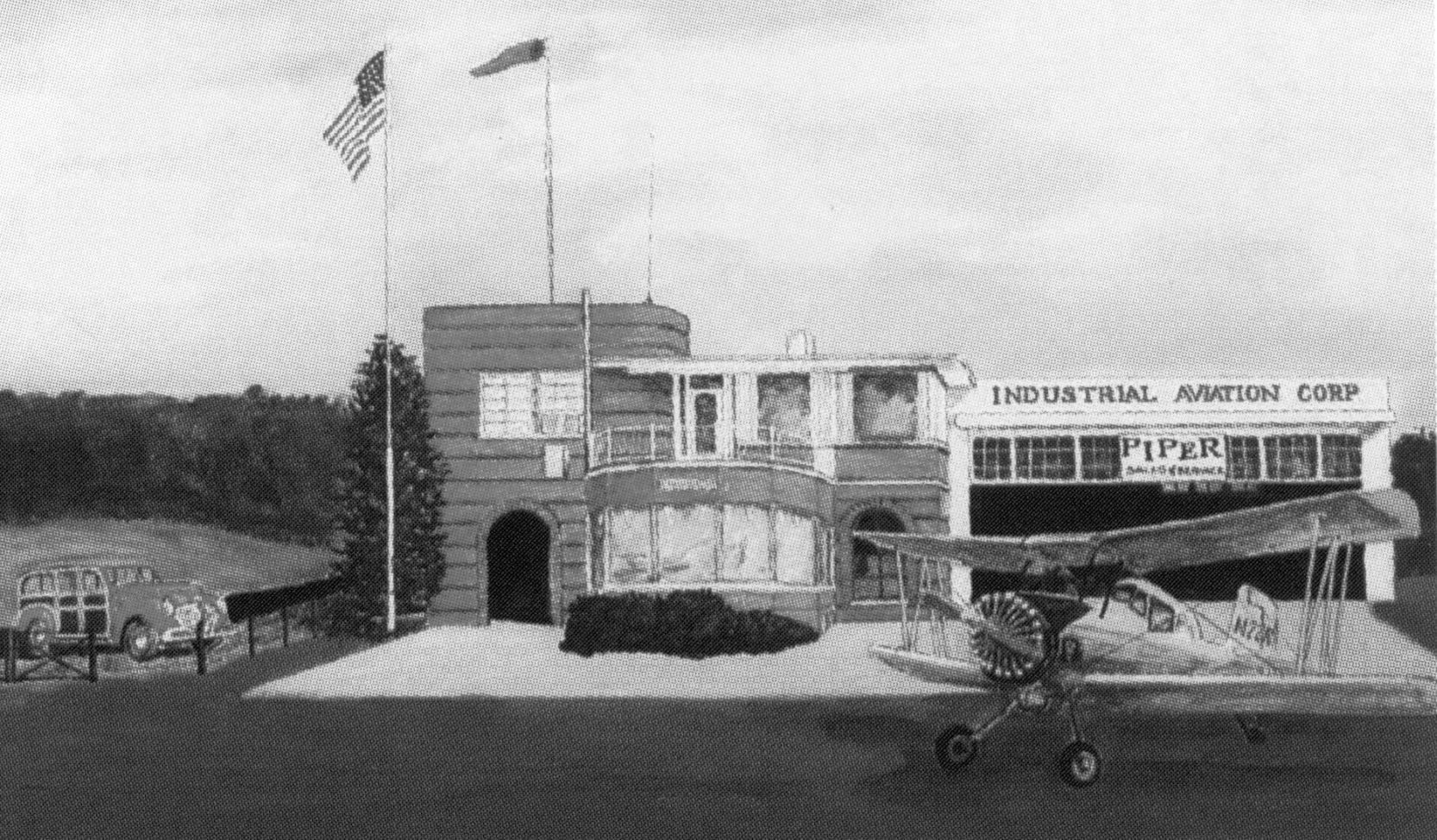
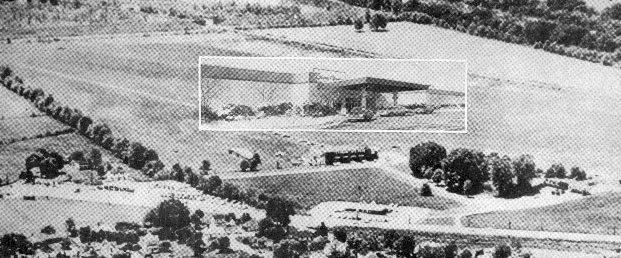
A circa 1940s illustration of a Grumman AgCAt biplane in front of the Industrial Aviation Corporation terminal & hangar at Stewart Airpark (courtesy of Rob Grant).
Rob Grant reported of the reason for Stewart Air Park's decline: “Wood County Airport opened in 1946,
and most (if not all) commercial transport traffic going on then moved to that larger airport with paved runways.”
The earliest topo map depiction which has been located of Stewart Air Park was the 1949 USGS topo map (courtesy of Rob Grant).
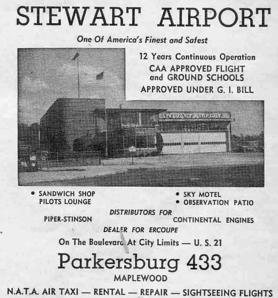
A 1949 advertisement for Stewart Airport (courtesy of Rob Grant).
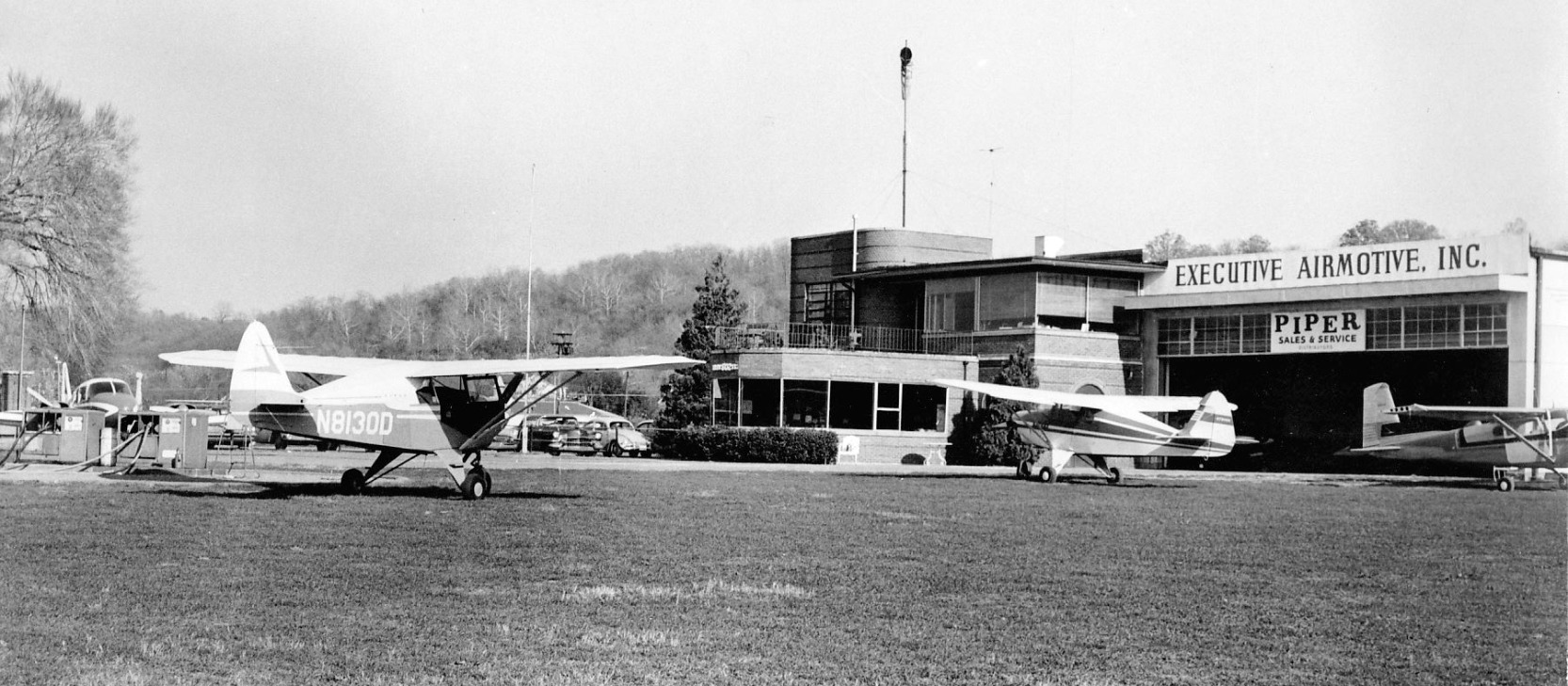
A circa 1950s photo of several Pipers & a Cessna in front of the Industrial Aviation Corporation terminal & hangar at Stewart Airpark (courtesy of Rob Grant).
A 4/8/55 USGS aerial view depicted Stewart Air Park as having 2 hangars on the east side of a grass airfield, and 1 or 2 light aircraft parked on the ramp.
A 1957 aerial view depicted 5 light aircraft parked near Stewart Air Park's hangar.
According to Nicholas Morey's obituary, “In 1965 Mr. Morey combined his love of aviation & his growing business portfolio by purchasing the Stewart Airport.
During his ownership of the airport he opened a Piper airplane dealership & was President & owner of Industrial Aviation.
In 1967 his Piper dealership won first place in sales among the 21 dealerships of the Eastern Division of the US.
Also in the late 1960s for the benefit of the Mid Ohio Valley residents he started the 'penny a pound' rides on summer Sundays so they could ride over & survey the town.
Residents would step on scales & pay 1 penny for each pound they weighed; the ladies of course had their scales adjusted so no one knew their true weight.
One of the highlights of his aviation business was having his Piper Cherokee trainer used during the filming of the James Bond movie Goldfinger.”
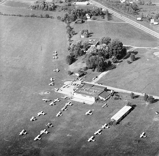
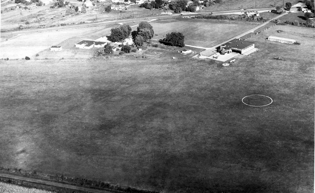
Perhaps the zenith of Stewart Airport's popularity was visible in this circa late 1960s aerial view looking north (courtesy of Rob Grant),
which depicted 28 light single-engine & twin-engine planes parked near the 2 hangars on the east side of the grass airfield.
“Stewart Airport” was painted on the roof of the larger hangar.
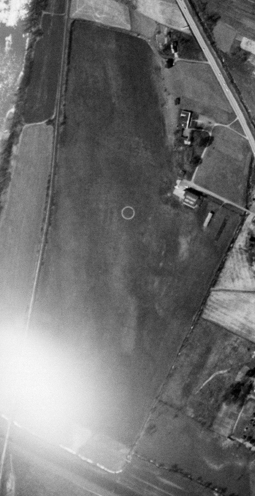
The last photo which has been located showing Stewart Airpark was a 5/7/68 USGS aerial view, which depicted 24 light single-engine & twin-engine aircraft parked near Stewart Air Park's hangar.
The last topo map depiction which has been located of Stewart Air Park was the 1969 USGS topo map (courtesy of Rob Grant).
It depicted several small buildings on the side of an irregularly-shaped unpaved airfield.
The last aeronautical chart depiction which has been located of Stewart Air Park was the February 1969 Huntington Sectional Chart.
It depicted Stewart as having a 3,300' unpaved runway.
According to Nicholas Morey's obituary, “Morey in 1969 formed & was President of Par Progress, which later became Oxford Development,
and built, owned, and operated the Grand Central Mall on Morey's property at the Stewart Airport.”
The Grand Central Mall was opened in 1972 on the site of Stewart Air Park.
The 1975 USGS topo map (courtesy of Rob Grant) showed the Grand Central Mall covering the site of Stewart Air Park.
A circa 1970s photo of the Grand Central Mall superimposed over an earlier aerial view showing Stewart Air Park over which the mall had been built (courtesy of Rob Grant).
A 1986 aerial view depicted the Grand Central Mall covering the site of Stewart Air Park.
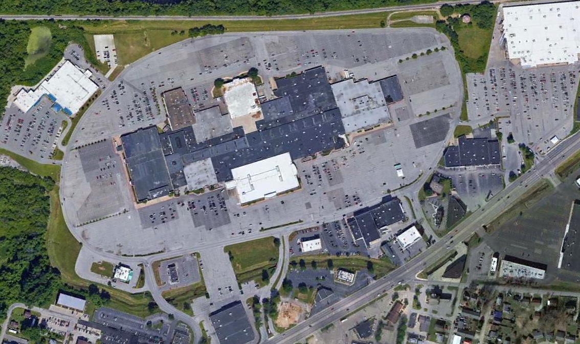
A 2016 aerial view looking west depicted the Grand Central Mall covering the site of Stewart Air Park.
Thanks to Rob Grant for pointing out this airfield.
____________________________________________________
Guinns Airport, Parkersburg, WV
39.24, -81.56 (Southwest of Pittsburgh, PA)
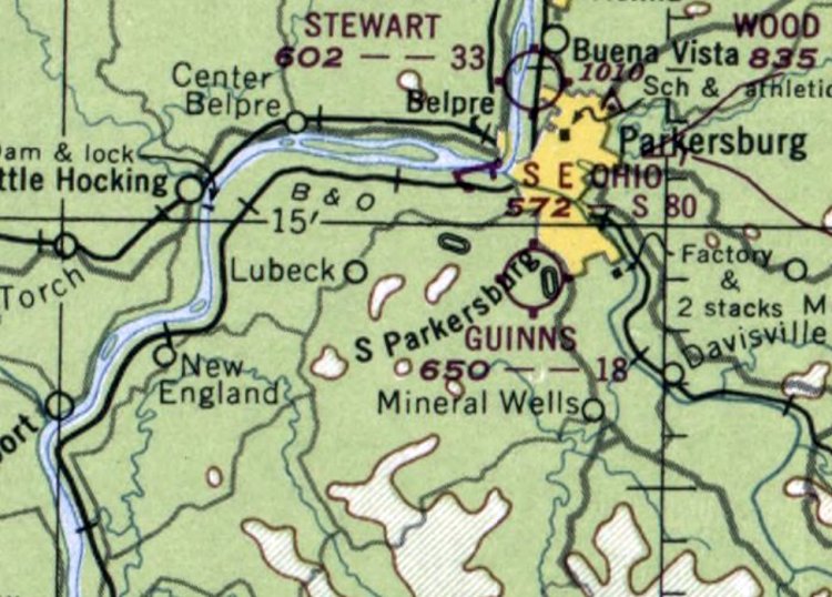
Guinns Airport, as depicted on the October 1948 Huntington Sectional Chart (courtesy of Rob Grant).
This short-lived little general aviation airport to the south of Parkersburg was not yet depicted on the October 1947 Huntington Sectional Chart.
According to a 2/13/00 Parkersburg News article (courtesy of Rob Grant),
“Lou Guinn built the airport in 1947 by leveling runways, installing proper drainage & building a hangar. The runways were 2,200' & 1,800' long.
He was then ready to begin training for the returning World War II veterans. Funding for the training was through the G.I. Bill.
One of the vets who took advantage of this training was south Parkersburg resident Don Smith.
Smith recalls the field as a somewhat treacherous place to land.
When approaching the landing strip by coming over the present Franklin School complex, the pilot had to drop down somewhat quickly.
But, there always seemed to be an 'updraft' that would lift the small planes several feet.”
The earliest depiction which has been located of Guinns Airport was on the October 1948 Huntington Sectional Chart (courtesy of Rob Grant).
It depicted Guinns Airport as having an 1,800' unpaved runway.
According to a 2/13/00 Parkersburg News article (courtesy of Rob Grant),
“For a few years, beginning in the late 1940s, the kids living in the Gihon Road area of south Parkersburg, were in 'kid heaven'; they had their own P-51 Mustang.
Two of those fortunate youngsters were brothers Charlie & John McCrady.
Charlie recalled 'Knocking down more enemy planes than you could count.' He was probably the area’s youngest 'ace'.
Carl Broughton & Bill Perrine flew the Mustang into Guinn’s Field.
It was their intention to prepare the plane to participate in the Cleveland Air Show.
Lou Guinn, developer of the airfield, recalled that on their initial landing, the pilot overcompensated for the short runway & applied the brakes too hard.
This resulted in the plane being 'stood on its nose' & bending the framework.
Pushed to the side of the runway, interest in repairing the disabled aircraft quickly waned,
and the local kids soon took over, creating a training site for neighborhood 'pilots to be'.
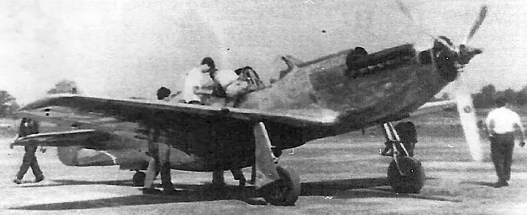
The only photo which has been located of Guinns Airport was a circa late 1940s – early 1950s photo of an early-model 3-blade fastback P-51A Mustang (courtesy of Rob Grant).
According to a 2/13/00 Parkersburg News article (courtesy of Rob Grant),
“What happened to the Mustang? In 1951, it was sold to the South American country of Columbia, which sent 4 or 5 mechanics & a pilot here to prepare the plane to be flown out.
Guinn recalls that only one of them could speak good English.
When the aircraft was again airworthy, the pilot planned to takeoff toward the stately Blizzard Mansion.
If he cleared the house (which Guinn doubted), a much larger obstacle would quickly be looming in his path - the tall stacks of the American Viscose plant.
With the plane far back on the runway, brakes held tight & the engine revved to the max, the brakes were quickly released.
Mildred McCrady, mother of the 2 aforementioned young pilots, remembered the loud roar created as the plane tried to attain the maximum power that would be needed to clear its first obstacle.
Barely clearing the Blizzard house, the pilot avoided the stacks by sharply banking the plane.
Guinn remembers that the pilot buzzed the field a couple times, waved goodbye, and another bit of local history was gone, leaving but memories behind.”
The last depiction which has been located of Guinns Airport was on the January 1950 Huntington Sectional Chart (courtesy of Rob Grant).
It described Guinns as a commercial airport, offering fuel & major repairs, and with 2 runways, the longest of which was 2,200'.
According to a 2/13/00 Parkersburg News article (courtesy of Rob Grant),
“Prior to his leaving the business for the Korean War [1950], Guinn estimated the Guinn’s Airport & Flying Service had trained perhaps 150 pilots.
While away in the service, his lease on the property lapsed, and the land reverted back to the owners.”
Guinns Airport was evidently closed at some point in 1950 (thus lasting no more than 3 years),
as it was no longer depicted on the June 1950 Huntington Sectional Chart (according to Rob Grant).
Guinns Airport was not depicted on the 1954 USGS topo map,
and no recognizable trace of Guinns Airport was perceptible on a 1955 aerial photo.

A 2016 aerial view showed no recognizable trace of Guinns Airport, with the area being redeveloped with houses.
Thanks to Rob Grant for pointing out this airfield.
____________________________________________________
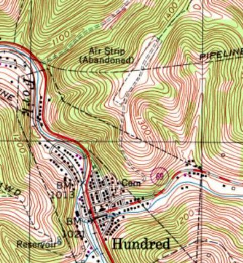
39.691, -80.457 (Southwest of Pittsburgh, PA)
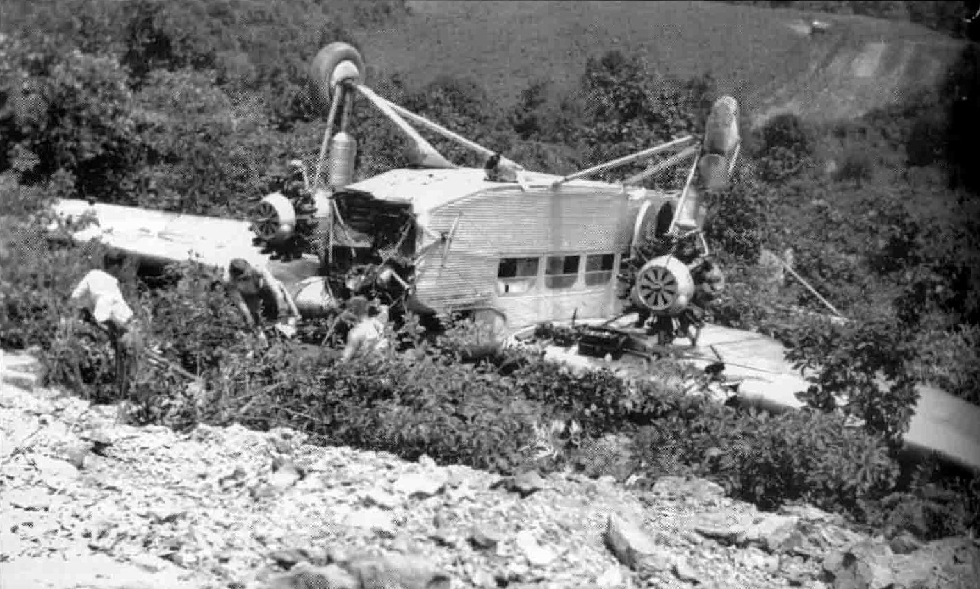
An undated photo of a Ford Trimotor which flipped off the end of the Hundred Airport runway in 1936 (courtesy of Michael Gilt).
Hundred Airport was not depicted on the February 1934 Huntington Sectional Chart (nor subsequent aeronautical charts from the 1940s/50s).
According to a Wetzel Democrat article, Hundred Airport was built in 1935, possibly as a Works Progress Administration project.
An article entitled “Ford Plane Wrecked Here” in the 8/13/36 Wetzel Democrat (courtesy of Dan Gooding) described the crash of a Ford Tri-Motor at Hundred Airport.
The pilot, Charles Gehring, was injured, but the sole passenger escaped injury.
According to Dan Gooding, Hundred Airport “was on a hilltop above Hundred WV, where my ancestors lived for generations.
In 1936 a Ford Trimotor crashed there. John Dexter, of Wheeling, was the only passenger in the crash and he escaped with a “shaking up.”
Dad told me about the immense crowd that 'flocked to the airport.'
The Trimotor was destroyed in the crash & local folks stripped souvenirs from it.
They included my father who was 22 at the time. He had the steering wheel, but it was lost somewhere along the line.
The airport fell into disuse after that.”
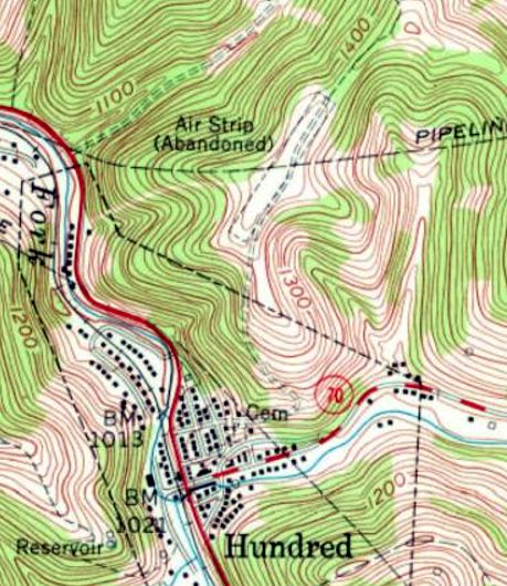
The earliest depiction which has been located of the Hundred Airport was on the 1958 USGS topo map.
It depicted a single unpaved northeast/southwest runway, labeled simply as “Air Strip (Abandoned)”.
There were no buildings depicted on the field.
Dan Gooding recalled, “About 1958-60, when I was a boy of grade school age I hiked up to this airport with some school friends.
Somewhere, I have pictures of a torn wind sock on a tall flagpole & a concrete circle with a large arrow in the center of it.
The diameter was 30-40' & the concreted part of the circle would have been about 3-4' wide, as was the big arrow that ran half way up the middle.
It was then part of a large, flat hay field. A farmer came up to talk with us kids about the airport & I recall that there was a flying club there at one time.
There had been a hangar too, but it was being used to store hay by then.”
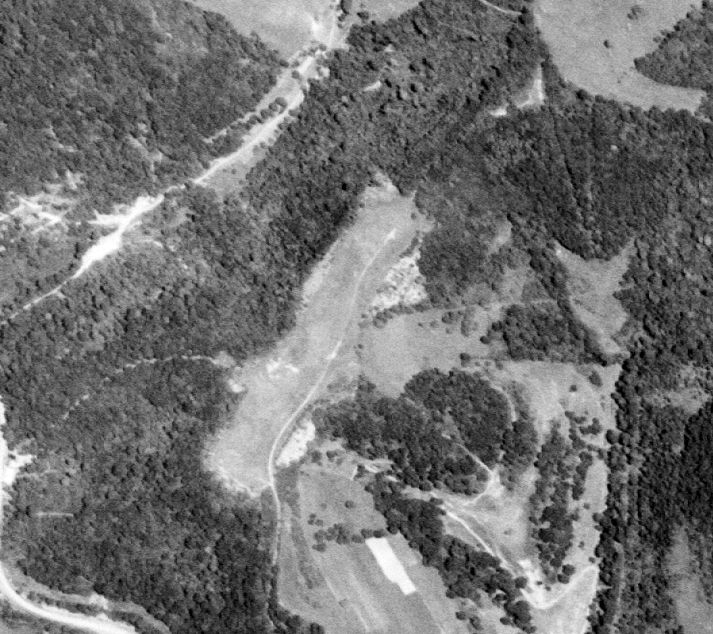
The earliest photo which has been located of the Hundred Airport was a 6/26/60 USGS aerial view.
It depicted a single unpaved northeast/southwest runway, without any buildings.

A 1996 USGS aerial view looking northwest depicted Hundred Airfield as a single unpaved northeast/southwest runway, with a large airport circle marking still recognizable in the center of the runway.
There were no buildings on the airfield.
The 1998 USGS topo map depicted Hundred Airport in the same fashion as the 1958 topo map:
a single unpaved northeast/southwest runway, labeled simply as “Air Strip (Abandoned)”.
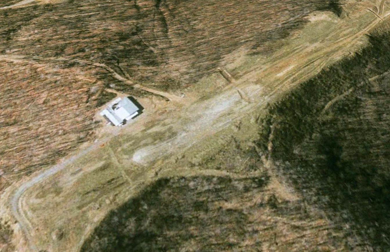
A 2002 aerial view looking northwest showed a large building had been built on the west side of the former runway at some point between 1996-2002.
A 2007 aerial view showed a much smaller building had replaced the larger building at some point between 2006-2007.
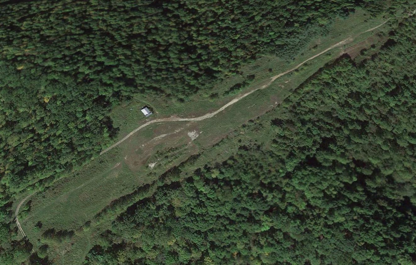
A 2016 aerial view looking northwest at the site of Hundred Airport showed the unpaved runway was still clear, with one small building along its west side.
The site of Hundred Airport is located southeast of the terminus of Airport Road, appropriately enough.
Thanks to Dan Gooding for pointing out this airfield.
____________________________________________________
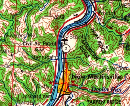
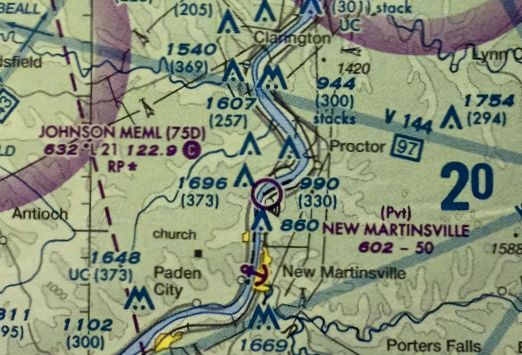
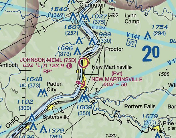
Steelton Civil Air Patrol Airport / P.W. Johnson Memorial Airport (75D), Steelton, WV
39.684, -80.862 (Southwest of Pittsburgh, PA)
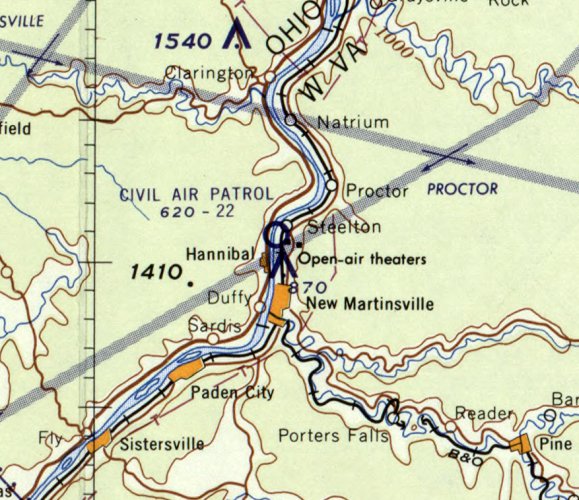
Steelton Civil Air Patrol Airport, as depicted on the January 1960 Huntington Sectional Chart.
This small general aviation airport on the east bank of the Ohio River was evidently established at some point between 1959-60,
as it was not yet depicted on the July 1959 Huntington Sectional Chart.
The earliest depiction which has been located of the Steelton Civil Air Patrol Airport was on the January 1960 Huntington Sectional Chart.
It depicted the “Civil Air Patrol” Airport as having a 2,200' unpaved runway.
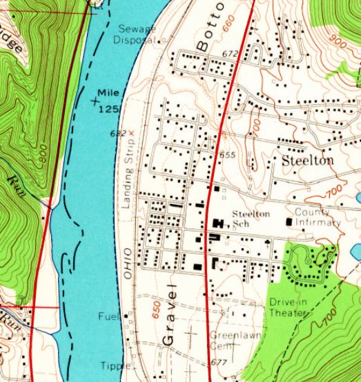
The 1960 USGS topo map depicted Steelton Civil Air Patrol Airport as a single unpaved north/south runway
along a narrow strip on the east bank of the Ohio River, labeled simply as “Landing Strip”.
There were no buildings depicted on the field.
The earliest topo map depiction which has been located of the Steelton Civil Air Patrol Airport was on the 1965 USGS topo map.
At some point between 1965-84 it was evidently renamed P.W. Johnson Memorial Airport,
as that is how it was labeled on the 1984 USGS topo map.
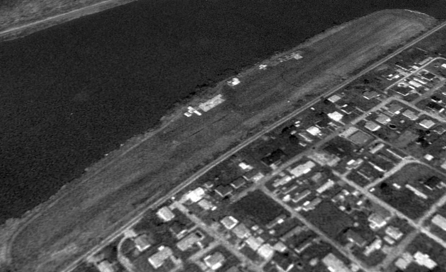
The earliest photo which has been located of P.W. Johnson Memorial Airport was a 1994 USGS aerial view looking northwest.
It depicted a single north/south grass runway, with a few small T-hangars in between the runway & the river.
There were no aircraft visible on the field.
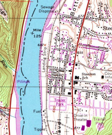
The 1994 USGS topo map depicted a single unpaved north/south runway along a narrow strip on the east bank of the Ohio River, labeled simply as “Landing Strip”.
Three small buildings were depicted along the west edge of the field.
The July 2009 Huntington Sectional Chart depicted Johnson Memorial Airport as having a 2,100' unpaved runway.
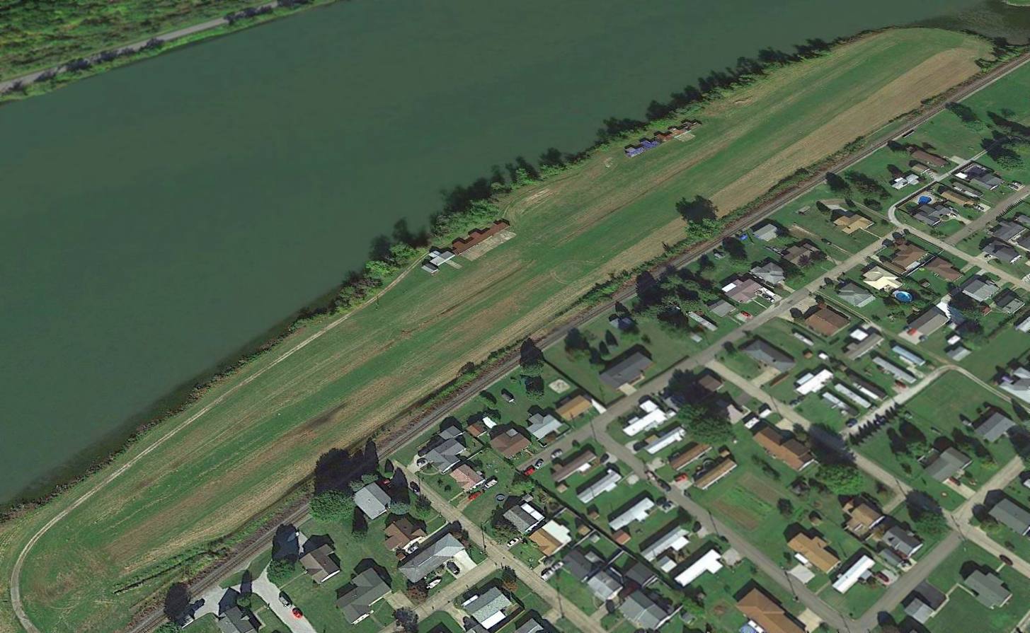
A 2015 aerial view looking northwest depicted P.W. Johnson Memorial Airport as remaining well-maintained, but there were no aircraft visible on the field.
The 2016 Huntington Sectional Chart depicted Johnson Memorial Airport as having a 2,100' unpaved runway.
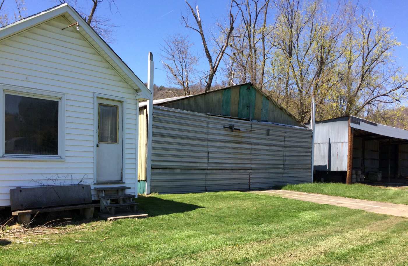
A 4/15/16 photo by Pat Schafer looking northwest at the Johnson Memorial Airport hangars & runway.
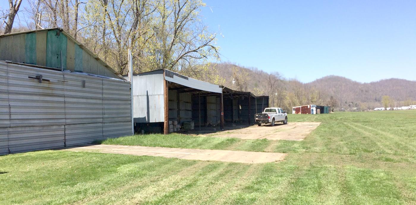
A 4/15/16 photo by Pat Schafer looking northwest at the Johnson Memorial Airport office & hangars.
Pat Schafer reported in 2016 of Johnson Memorial Airport, “I have flown into it for years.
The hangars [are] being dismantled in April 2016, and Parks Department employees [are] removing all markers.
Apparently the parks want ball fields."
As of May 2016, P.W. Johnson Memorial Airport was no longer listed with the FAA as an active airfield.

A 2021 photo looking north at Johnson Memorial Airport, showing only 1 T-hangar remained.
A 2023 aerial photo showed only 1 T-hangar remained, with only foundations at the site of other hangars.
As of May 2016, the site of P.W. Johnson Memorial Airport was depicted on street maps as Gold Star Mothers Memorial Park.
The site of P.W. Johnson Memorial Airport is located at the western terminus of West Benjamin Drive.
Thanks to Pat Schafer for pointing out this airfield.
____________________________________________________
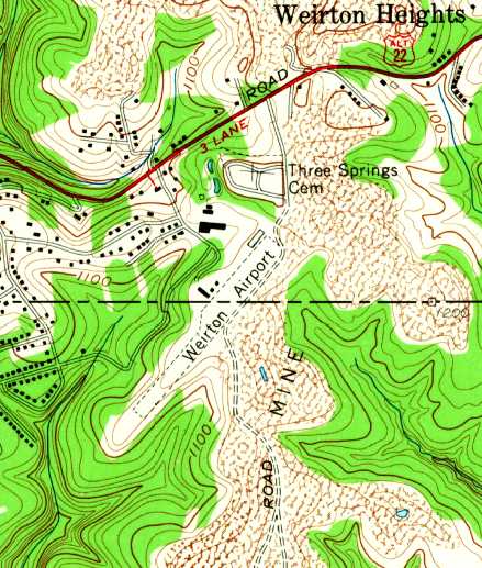
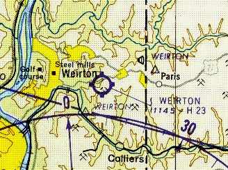
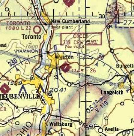
40.4, -80.55 (West of Pittsburgh, PA)
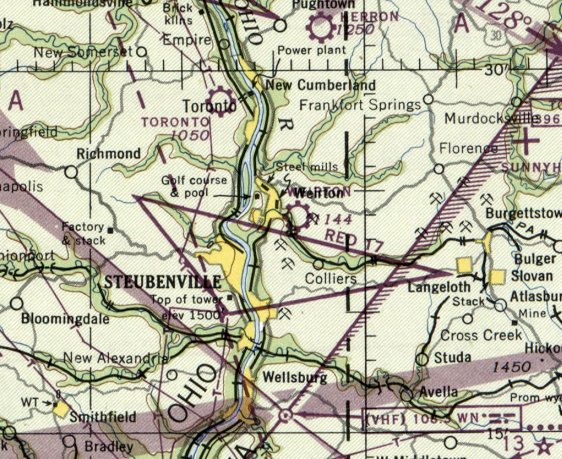
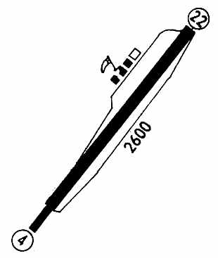
Weirton Airport, as depicted on the July 1947 Cleveland Sectional Chart.
Weirton Airport was not yet depicted on the July 1945 Cleveland Sectional Chart.
Terry Marsh recalled, “The Weirton Airport was built in 1947 & replaced the former Half Moon Airport in the valley by the turn in the Ohio River.
[Airport founder] Lawrence Gullette was my grandfather & I was just about raised at that airport in Weirton.
There was an old military building which could house 18 planes, but all planes had to be moved to get any but the end ones out,
a main building maintenance shop for 3 planes with room to work, 5 planes tight.
This building had a large side shop with a parts room, and a boiler room in the rear.
No control tower. Next to that building was a building used to train pilots it had 3 rooms.
Later 10 private T-hangars were built on the north end.”
Terry recalled, “In 1947 my grandfather purchased all the production of Piper aircraft, up to that point, which was 18 J-3 Cubs & 1 PA-12.
All were brought to Weirton & a flight school was started.
Over the years the training building was used for everything from a restaurant, living quarters,
Civil Air Patrol building, pilots lounge, to another flight school, for a while new tires were stored in it.
The old military building was later converted to an auto auction & in the last years old trucks were stored there.
The main building was always a maintenance hangar.
The PA-12 Piper Super Cruiser that my grandfather purchased in 1947...
William Porter purchased it & kept it at the airport until the field was closed.”
The earliest depiction of the Weirton Airport which has been located was on the July 1947 Cleveland Sectional Chart.
It depicted Weirton as a commercial/municipal airport.
According to James Brostman, “Weirton Airport... the airport construction was overseen by Harold Weekley who became the airport's first manager.
He ran that airport into the early 1950s.”
The January 1949 Cleveland Sectional Chart (courtesy of Chris Kennedy) depicted Weirton Airport as having a 1,600' hard-surface runway.
A 6/18/52 USGS aerial photo depicted Weirton Airport as having a single paved northeast/southwest runway, with 3 small buildings along the northwest side,
near which were visible 3 single-engine aircraft.
Terry Marsh recalled, “The main building was destroyed by an explosion in 1952 & rebuilt.”
The 1958 USGS topo map depicted Weirton Airport as having a single unpaved northeast/southwest runway, with a few small buildings along the north side.
The 1962 AOPA Airport Directory (based on a latest report from 1960)
described Weirton as having a single 2,300' slag Runway 4/22, and the operator was listed as Lawrence Gullette.
By the time of the 1961 Pittsburgh Local Aeronautical Chart (courtesy of Mike Keefe),
Weirton's runway had evidently been lengthened somewhat to a 2,300' hard-surface strip.
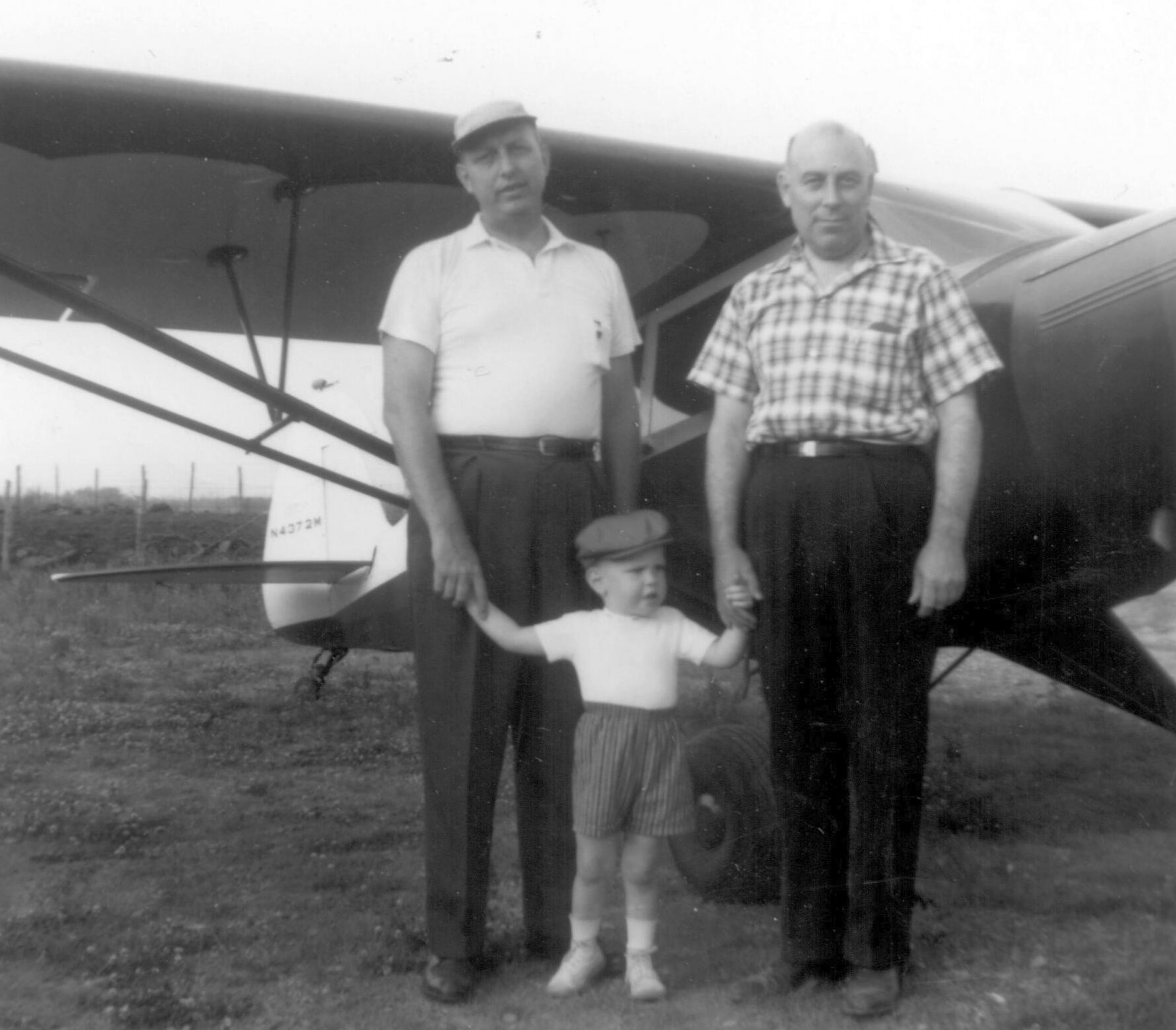
The last photo which has been located of Weirton Airport was an August 1961 photo (courtesy of Jim McCoy) of William McCoy, Jim McCoy, and Bill Porter in front of Porter’s cream & dark green Piper PA-12.
Jim McCoy recalled, “I remember my dad telling me to watch for it over our house, 'Look for the scallops on the wing', he would say.
I remember many summer evenings going for rides with my dad & Mr. Porterin Mr. Porter's Piper, Mr. Porter being a work friend of my dad. Always a thrill!”
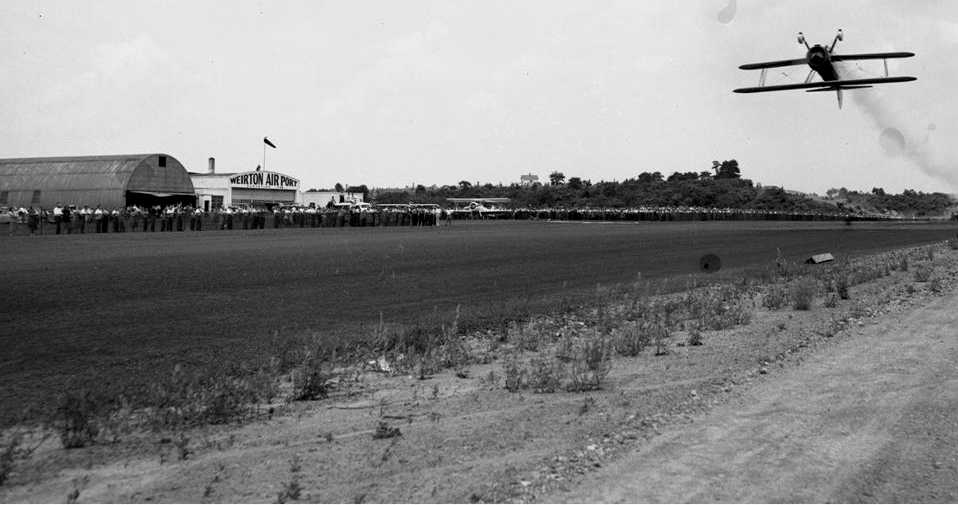
I also remember seeing several airs shows in the early 1960s
including one where an authentic X-15 was displayed on a trailer that kids were even allowed to climb up for a closer view!"
Terry Marsh recalled, “The runway was tar & gravel & at one point a layer of the residue from coal washing operation
was applied to the gravel which gave a solid good stopping surface.
The runway was lengthened to 2,700' but I do not think the records were changed.”
The last aeronautical chart depiction which has been located of the Weirtin Airport
was its depiction on the May 1968 Cleveland Sectional Chart (courtesy of Richard Finley).
It depicted Weirton Airport as having a single 2,600' paved runway.
Terry continued, “During the 1960s & 1970s there was an old See-Bee that sat behind the main building;
it had crashed in the Saint Lawrence Seaway & was hauled in by truck to use for parts to rebuild a replacement plane.”
The last depiction which has been located of Weirton Airport as an active airport was in the 1971 Flight Guide (courtesy of Chris Kennedy).
It depicted Weirton as having a single 2,600' paved Runway 4/22, with 3 buildings (hangars?) along the northwest side of the field.
It was described as being attended during daytime.
Wierton Airport was evidently closed at some point between 1971-72,
as it was depicted as an abandoned airfield on the November 1972 Detroit Sectional Chart (courtesy of Richard Finley).
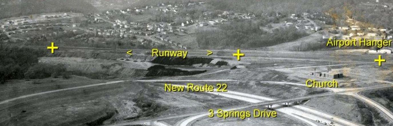
A circa 1970s aerial view looking northwest at Weirton Airport after Route 22 had been constructed adjacent to it (courtesy of Rick Harshbarger).
John Maze recalled, "I grew up in Weirton & lived there until 1976.
My Mom still lives there, so I am quite familiar with the site [of the airport].
The 'original' 1960s-era buildings were a shed/hangar (to the south), a Civil Air Patrol meeting room/control tower building in the middle
and a 'row' hangar to the north (I don't remember how many 'spots' it had).”
Terry Marsh recalled, “The old Cessna T-50 left behind the old hangars when the airport was closed
was a plane my grandfather grounded because of rotten wood in the spar.”
Terry Marsh recalled, “A W.T. Grant was to be built on the site of the main buildings but opened as a K-Mart.”
Terry Marsh recalled, “In 1977 my Grandfather [Lawrence Gullette] was awarded by the FAA
for 50 years of aircraft maintenance with a perfect safety record.
His mechanic FAA number was M-2890 & was still active at his death in 1979.”
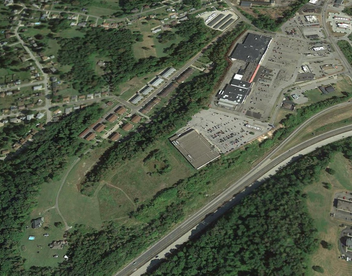
A 2015 aerial view looking north shows no recognizable trace of Weirton Airport.
The site of Weirton Airport is located northwest of the intersection of Route 22 & Three Springs Drive.
Thanks to Jim McCoy for pointing out this airfield.
____________________________________________________
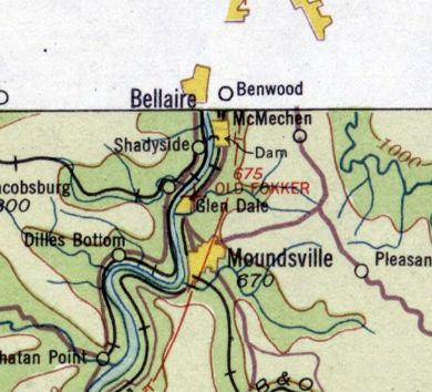
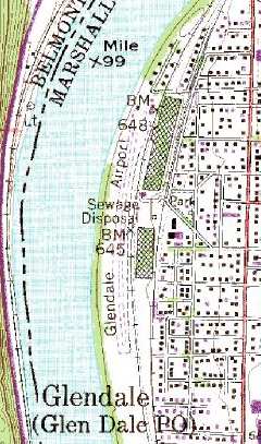
Glen Dale Fokker Field (GWV, WV66), Glen Dale, WV
39.95, -80.76 (Southwest of Pittsburgh, PA)

The earliest depiction which has been located of the Glen Dale Fokker facility
was a 1/20/29 photo of the fuselage assembly line at the Fokker Aircraft Corporation of America, Glen Dale.
The date of establishment of Glen Dale Airport has not been determined.
According to Tom Beamer, Fokker Aircraft opened their facility in Glen Dale in the early to mid-1920s.
It was one of 2 Fokker factories in the US, the other being in Teterboro, NJ.
The history of the Fokker company in America is fairly convoluted.
In 1923, the Atlantic Aircraft Corporation (of Teterboro NJ & Wheeling WV)
obtained a government contract to modify De Havilland DH-4s as mail planes.
In 1924, as the Netherlands Aircraft Manufacturing Company of America, it became an importing agency for Fokker's Dutch aircraft designs.
By 1927, it had become the Fokker Aircraft Corporation of America (of Passaic NJ & Glen Dale WV).
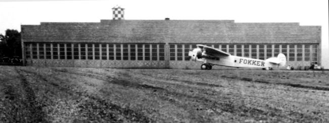
An April 1929 photo by J.E. Anderson of a Fokker Trimotor at Glen Dale Fokker Field,
in front of the north end of the Fokker factory where it was built.
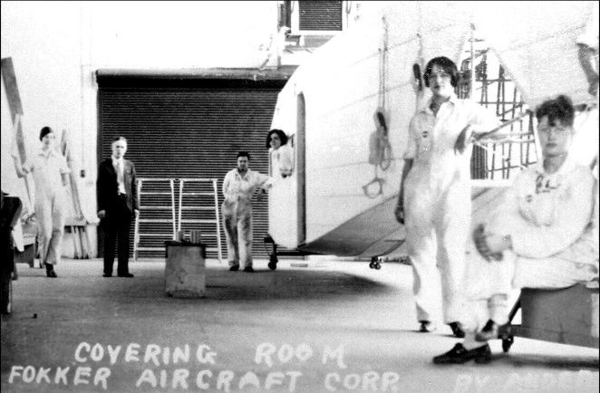
An April 1929 photo by J.E. Anderson of the Covering Room in the Glen Dale Fokker factory.
In 1929 the Fokker Aircraft Corporation became a subsidiary of General Motors as General Aviation Corporation.
The company ended operations in 1931 because of the Depression
and a much-publicized crash of a Fokker F-10 on March 31 in which famed Notre Dame coach Knute Rockne & 7 others were killed.
The company assets were turned over to GAMC, then in a stock exchange became a subsidiary of North American Aviation,
which moved operations to a factory in Baltimore.
In their short heyday of WV aircraft manufacturing, Fokker produced a total of 58 passenger planes in Glen Dale.
The Glen Dale Fokker airfield apparently continued in operation after its namesake company faded away.
"Old Fokker Field" was listed in the 1934 Commerce Department Airports Directory (courtesy of Chris Kennedy).
It was described as consisted of a rectangular sod field, measuring 4,000' x 350'.
The earliest aeronautical chart depiction which has been located of the Fokker Field was on the 1934 Huntington Sectional Chart,
which depicted “Old Fokker” as an auxiliary airfield.
One of the Fokker factory buildings was depicted on the 1935 USGS topo map, but not the airfield itself.
Glen Dale Fokker Field was not listed in the Airport Directory Company's 1937 Airports Directory (courtesy of Bob Rambo),
but it was open at the time (according to Tom Beamer).
The September 1941 9M Regional Aeronautical Chart (courtesy of Chris Kennedy) depicted it as Glen Dale Airport.
The 1944 US Army/Navy Directory of Airfields (courtesy of Ken Mercer) described Glen Dale Fokker Field as having a 2,900' runway.
The 1945 AAF Airfield Directory (courtesy of Scott Murdock) described Glen Dale Airport
as a 39 acre rectangular property within which was a single 2,900 sod north/south runway.
The field was said to have 2 hangars, the largest being a 80' x 60' metal structure, and to be privately owned & operated.
A 1950 aerial view looking east showed at least 6 light aircraft parked along Fokker Field's grass runway (courtesy of Rick Harshbarger).
“Glen Dale” Airport was depicted on a 1953 Flight Chart (courtesy of Scott O'Donnell) as having a 2,100' unpaved runway.
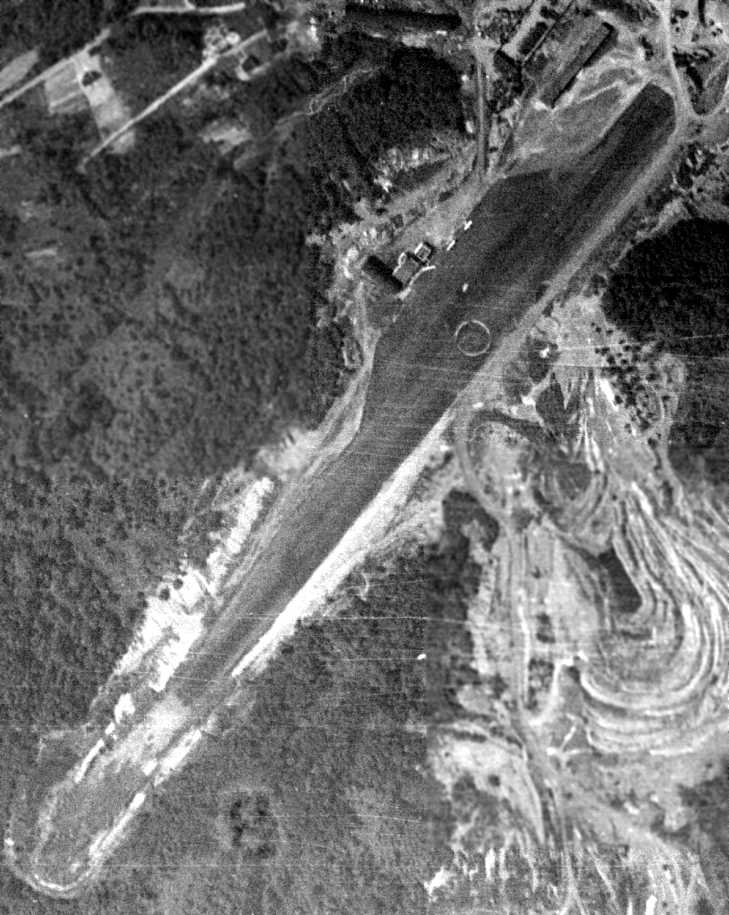
A 4/9/54 USGS aerial photo depicted the Glen Dale Airport as having a curved north/south grass runway,
with an airport circle marking still visible in the center of the field.
What appeared to be 2 small hangars were located on the north end of the runway.
The last aeronautical chart depiction which has been located of the Glen Dale Airport
was its depiction on the May 1968 Cleveland Sectional Chart (courtesy of Richard Finley).
It depicted “Glen Dale” Airport as having a 2,700' unpaved runway.
The Marx Toy Company apparently reused the former Fokker factory at some point, according to Tom Beamer.
Tom Beamer visited Glen Dale Fokker Field in 1984, and reported that it was operated at the time by the local EAA Chapter.
"The Fokker factory was still standing along the east side of the field & you could read 'FOKKER' under a black overpaint on the road side.
I was told that Marx made toy trains there at one time.
Near a concrete pad where the line shack had been there was a underground fuel pit with a VERY long hose still on the reel…
imagine dragging that long hose up to the wing tanks of a Fokker Tri-motor or Super Universal."
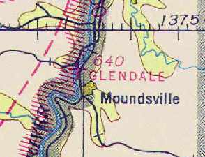
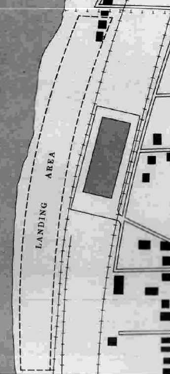
As seen in the 1995 USGS topo map, the runway at Glen Dale Fokker Field actually curves along the riverbank,
which must make for interesting takeoff & landing runs!
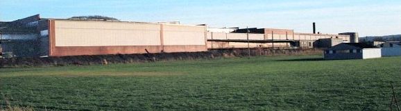
A circa 2003 photo of Glen Dale Fokker Field, with the former Fokker factory buildings in the background.
As of 2003, Glen Dale Fokker Field is still listed as an active private airfield.
It has a single maintained runway, a 2,600' turf Runway 1/19, and a total of 11 aircraft are listed as being based at the field, including 6 ultralights.
The owner is listed as Thomas Aandrich, and the manager is listed as Chuck Yager (which must be a pretty popular name for a WV pilot!).
A pre-2005 picture of the former Fokker factory in Glen Dale (courtesy of Tom Beamer).
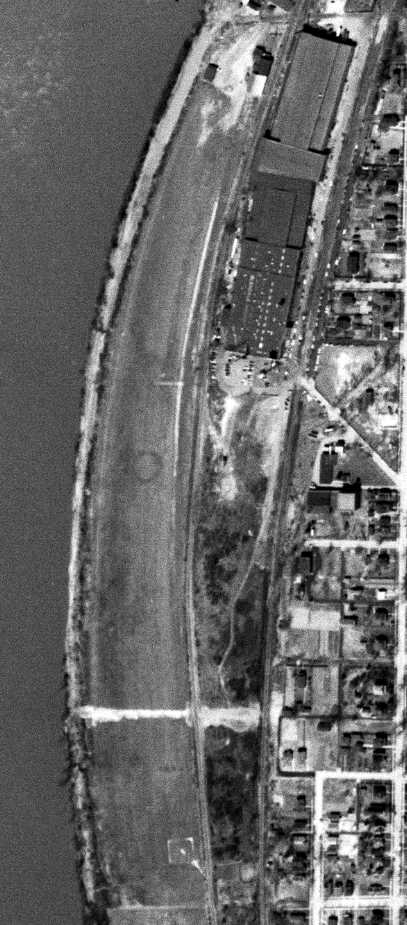
A circa 2010 aerial view looking north at the Glen Dale runway & former Fokker factory.
As of 2014, Glen Dale Fokker Field is still listed as an active private airfield.
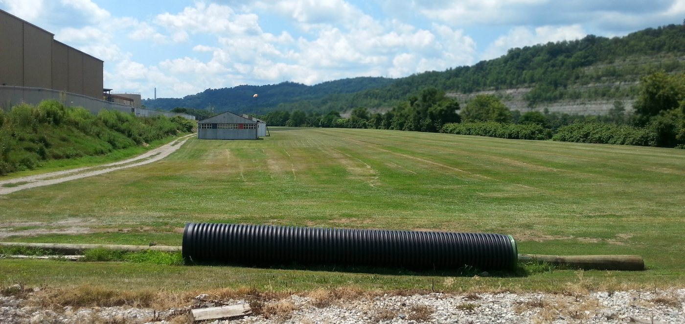
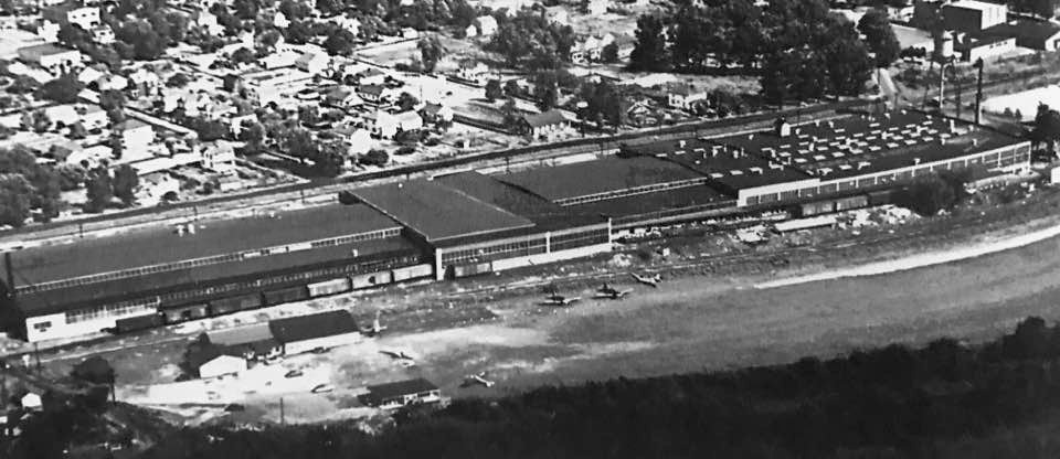
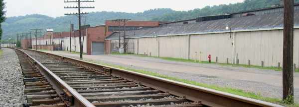
A 7/24/16 photo by Rick Harshbarger looking south along the Glen Dale runway, with the former Fokker airplane factory visible at left.
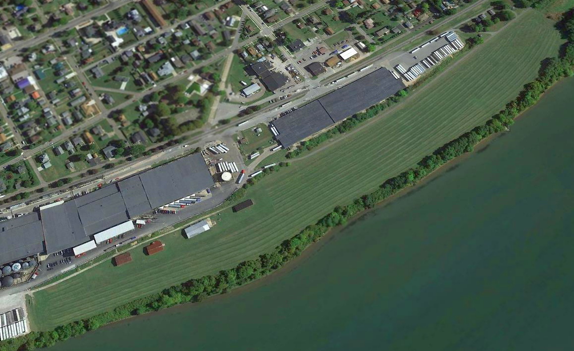
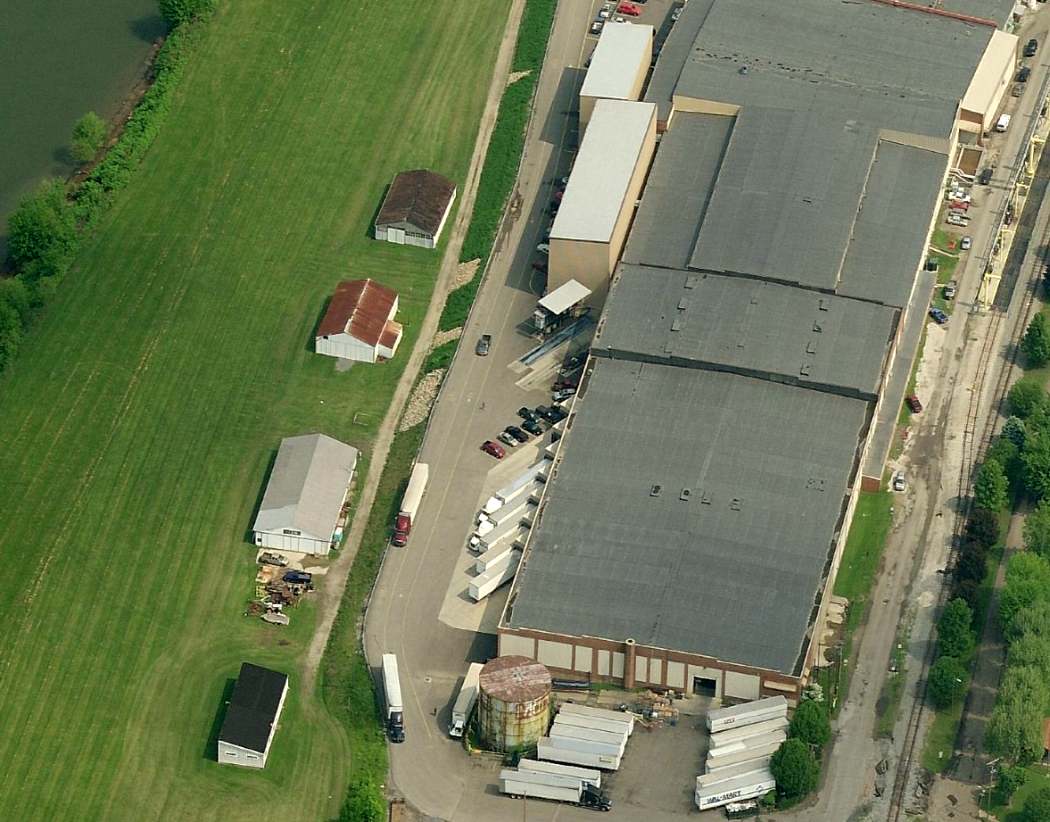
A 2016 aerial view looking southeast showed a total of 4 hangars along the northeast side of the Glen Dale runway, and the large former Fokker factory buildings.
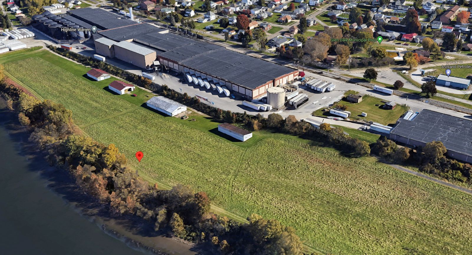
A 2023 3-D aerial image looking northwest at Fokker Field showed the former hangars & Fokker factory buildings.
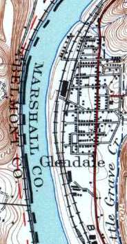
Glen Dale Fokker Field is located in between the Ohio River & the Baltimore & Ohio Railroad.
____________________________________________________
Or if you prefer to contact me directly concerning a contribution (for a mailing address to send a check),
please contact me at: paulandterryfreeman@gmail.com
If you enjoy this web site, please support it with a financial contribution.
____________________________________________________
This site covers airfields in all 50 states.