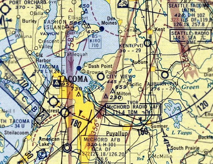
Abandoned & Little-Known Airfields:
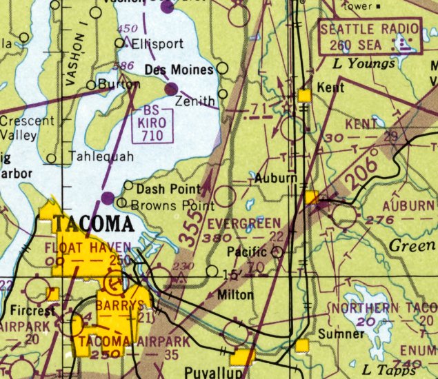
Washington: Tacoma area
© 2002, © 2025 by Paul Freeman. Revised 12/5/25.
This site covers airfields in all 50 states: Click here for the site's main menu.
____________________________________________________
Please consider a financial contribution to support the continued growth & operation of this site.
Auburn Airfield (revised 9/15/19) - Ben Barry's Sky Harbor (revised 2/8/24) - City View Airport (revised 2/8/24) - Evergreen Airport / Evergreen Industrial Airport (revised 8/5/19)
Fort Lewis #1 Airfield (revised 12/5/25) - Gaffney's Lake Wilderness Resort Airfield (revised 9/15/19) - Moss Field (revised 2/12/23)
Mueller-Harkins Field / Tacoma Municipal Airport / Clover Park Technical College (revised 9/1/25) - Spanaway Airport (revised 9/14/23)
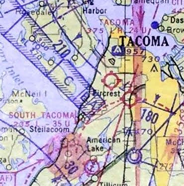
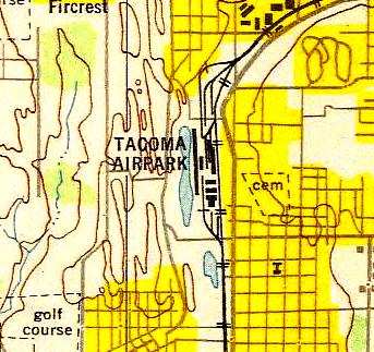
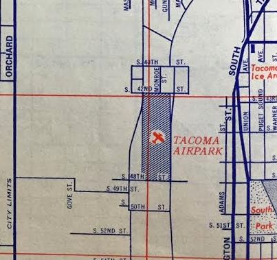
Tacoma Airpark / Tacoma Aero Club Airfield / South Tacoma Airport (revised 9/14/23) - Tacoma Airport (revised 9/14/23)
____________________________________________________
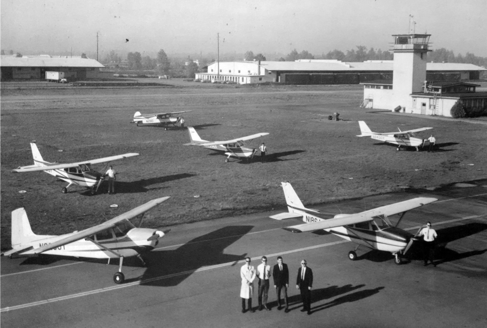
Ben Barry's Sky Harbor, Tacoma, WA
47.247, -122.39 (South of Seattle, WA)
Ben Barry's Sky Harbor, as depicted on the April 1946 Seattle Sectional Chart.
According to a 6/3/48 Tacoma Times article (courtesy of Lee Corbin), “Barry's Sky Harbor was established in 1937.”
However, Ben Barry's Sky Harbor was not yet depicted on the Seattle Sectional Chart from 1939/40/41/45,
or the 1944 USGS topo map.
The earliest depiction which has been located of Ben Barry's Sky Harbor was on the April 1946 Seattle Sectional Chart.
It depicted “Barrys” as a commercial/municipal airport.
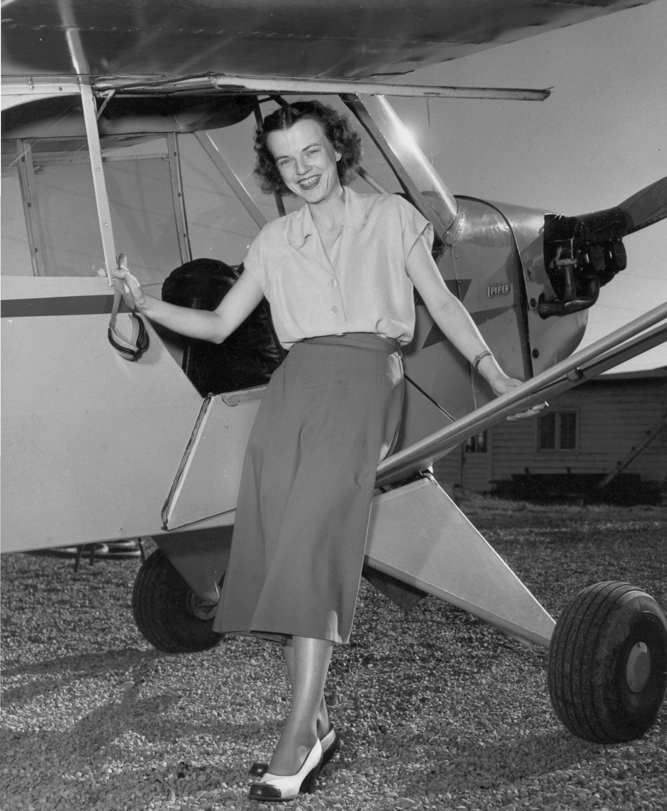
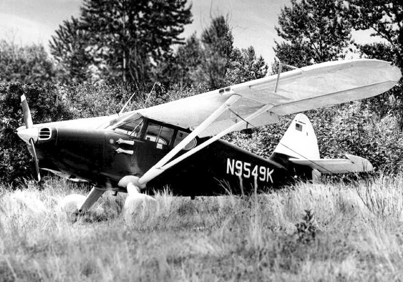
A 6/1/48 photo by Paul Lehman of Nancy Savidge in front of a Piper J-3 Cub at Ben Barry's Sky Harbor (courtesy of Lee Corbin).
The photo's original caption read: “Nancy Savidge, former Navy WAVE who served during WW2, is the first woman training under the GI Bill flight program at Ben Barry's Sky Harbor.
Nancy will be flying a 'Lucky Piper Cub' plane, and will be the first woman at the flight school to obtain a private pilot rating.
Barry's Sky Harbor is reported to be the oldest flight school near Tacoma, it was established in 1937.
There are 20 students currently enrolled at the school in the government approved program.
The school is located on Highway 99, near the Puyallup River Bridge.”
The March 1950 Seattle Sectional Chart (courtesy of Lee Corbin) depicted Ben Barry's Sky Harbor as having a 2,100' unpaved runway.
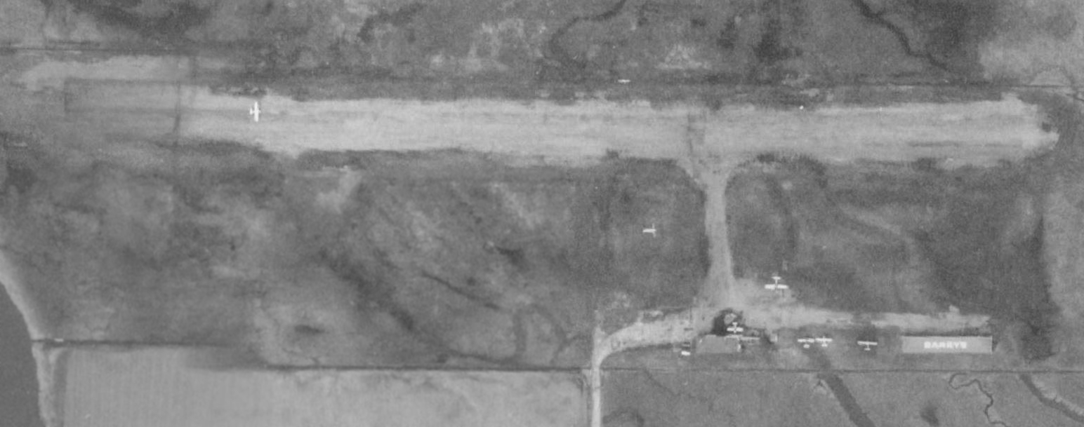
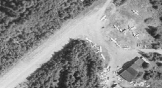
The only photo which has been located showing Ben Barry's Sky Harbor in operation was a March 1950 USGS aerial view (courtesy of Lee Corbin).
It depicted Barry's as having a single east/west unpaved runway, with a parking area & a few small buildings (one with “Barry's” painted on its roof) on the southeast side.
Six light single-engine aircraft were visible, including one on the runway.
The article “Sky Harbor Airport Closed” in the 8/26/56 Tacoma New Tribune (courtesy of Lee Corbin)
said that the airport had been closed, and is in an area scheduled for the expansion of the tideflats industrial area.
The last aeronautical chart depiction which has been located of Ben Barry's Sky Harbor was on the April 1957 Seattle Sectional Chart.
It depicted “Barry” as having a 2,100' unpaved runway.
A 5/28/57 USGS aerial view (courtesy of Lee Corbin) showed Ben Barry's Sky Harbor after it had been closed.
The runway & buildings remained intact, but there were no aircraft or any other sign of recent aviation use.
Ben Barry's Sky Harbor was no longer depicted on the October 1957 Seattle Sectional Chart or the 1961 USGS topo map.
A 1968 aerial view showed North Frontage Road had been constructed over the runway alignment,
and no trace remained of Ben Barry's Sky Harbor.
A 2018 aerial view showed no trace remaining of Ben Barry's Sky Harbor.
Thanks to Lee Corbin for pointing out this airfield.
____________________________________________________
47.288, -122.38 (South of Seattle, WA)
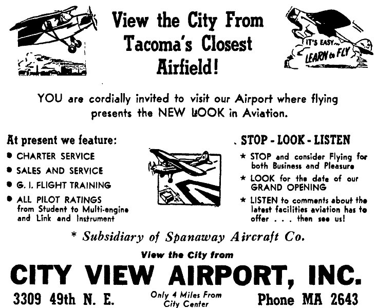
A 4/9/48 advertisement announcing the grand opening of City View Airport (courtesy of Lee Corbin).
The Grand Opening of City View Airport was previewed by a 4/9/48 advertisement (courtesy of Lee Corbin).
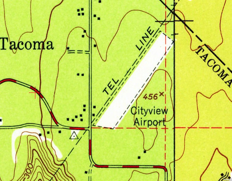
The earliest topo map depiction which has been located of City View Airport was on the 1949 USGS topo map (courtesy of Lee Corbin).
It depicted City View Airport as having a single northeast/southwest unpaved runway, with 2 small buildings on the southwest side.
Strangely, City View Airport was not depicted on Seattle Sectional Charts from 1949-58.
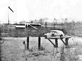
The earliest photo which has been located of City View Airport was a 1953 photo (courtesy of Larry Clark) of 2 hangars & and a small office with a wind sock.
Larry Clark recalled, “I was born & raised across the street from this place.”
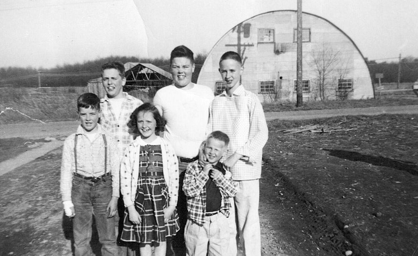
A 1955 photo of Larry Clark & other children in front of the City View Airport hangars.
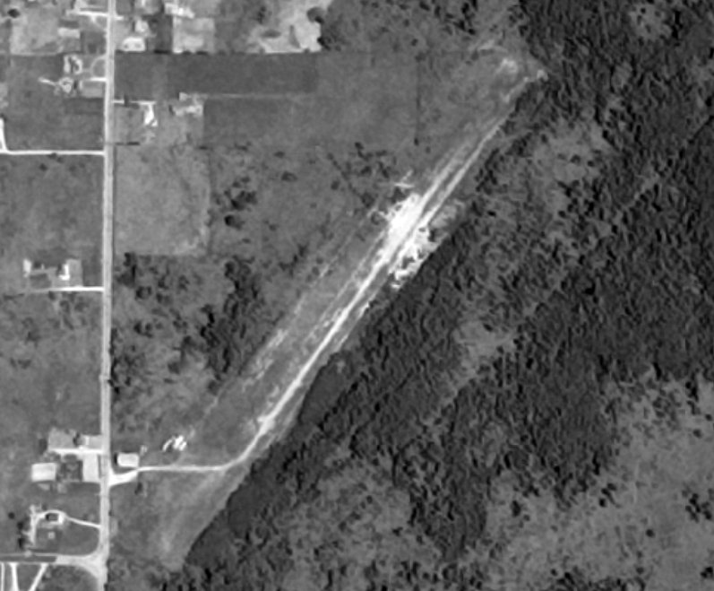
The earliest aerial view which has been located of City View Airport was a 5/28/57 USGS aerial view (courtesy of Lee Corbin).
It depicted City View Airport as having a single northeast/southwest unpaved runway, with a small building & possibly 1 light aircraft on the southwest side.
The earliest aeronautical chart depiction which has been located of City View Airport was on the April 1959 Seattle Sectional Chart.
It depicted City View Airport as having a 2,300' unpaved runway.
The last aeronautical chart depiction which has been located of City View Airport was on the June 1960 Seattle Sectional Chart.
The last photo which has been located showing City View Airport still in operation was a 1964 aerial view.
It depicted City View Airport as having a single northeast/southwest unpaved runway, with a small building & 1 light aircraft on the southwest side.
City View Airport was evidently closed at some point between 1964-65,
as it was no longer depicted on the October 1965 Seattle Sectional Chart.
Aerial photos from 1968 & 1969 show that the City View Airport runway & building remained intact,
but with no sign of recent aviation use.
City View Airport was depicted on the 1976 USGS topo map as an unpaved northeast/southwest runway generically labeled as “Landing Strip”.
A 1980 aerial view showed that no sign remained of City View Airport, with houses & streets having covered the property.
Centennial Way Northeast was built precisely over the former runway alignment.
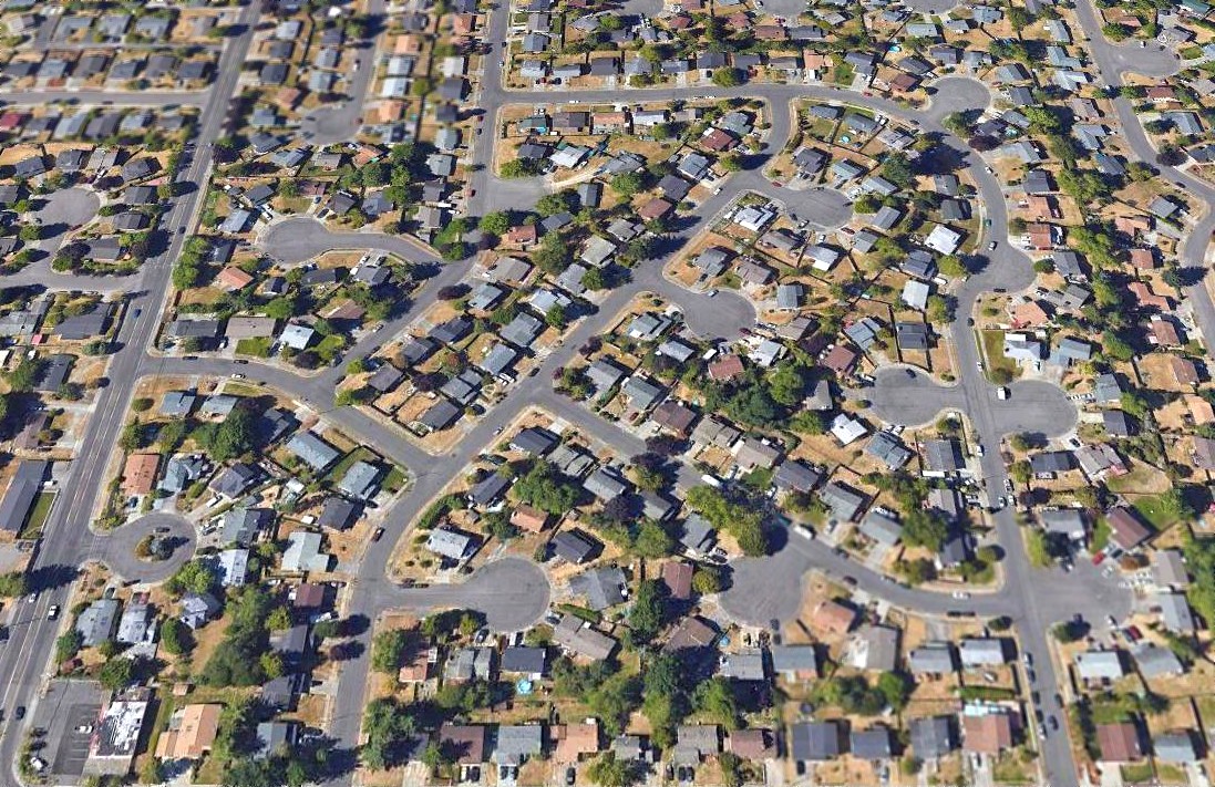
A 2018 aerial view looking north showed no trace remaining of City View Airport.
Thanks to Lee Corbin for pointing out this airfield.
____________________________________________________
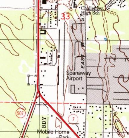
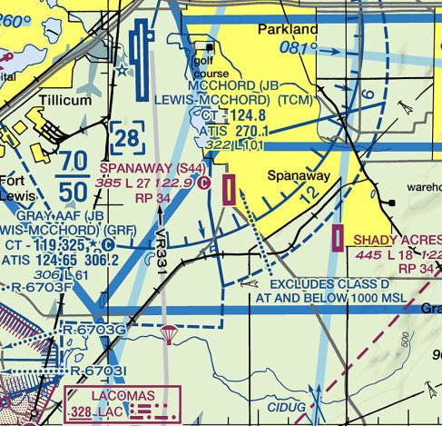
Spanaway Airport (S44), Spanaway, WA
47.087, -122.432 (South of Seattle, WA)
Spanaway Airport, as depicted on the April 1946 Seattle Sectional Chart.
This small general aviation airport was evidently established at some point between 1945-46,
like hundreds of other small airports in the U.S. Post-WW2 aviation boom,
as it was not yet depicted on the October 1945 Seattle Sectional Chart.
The earliest depiction which has been located of Spanaway Airport was on the April 1946 Seattle Sectional Chart.
It depicted Spanaway as a commercial/municipal airport.
A historylink.org article reported: “On 4/12/51, Lt. John Hodgkin, a pilot stationed at McChord Air Force Base,
flies his ski-equipped Piper J-3 Cub from Spanaway Air Strip to the top of Mount Rainier (14,410'),
establishing a new world record for a high-altitude landing.”
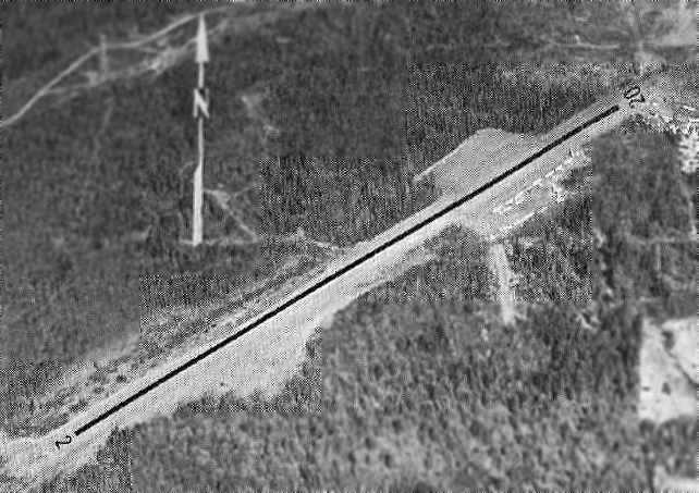
The earliest photo which has been located of Spanaway Airport was on a 7/19/57 USGS aerial photo.
It depicted an unpaved north/south runway, with a small hangar & several T-hangars on either side, and 2 light single-engine aircraft parked on the west side.
The 1958 Airport & Business Flying Directory (courtesy of Jonathan Westerling) described Spanaway Airport as having a 2,500' unpaved runway.
The April 1959 Seattle Sectional Chart depicted Spanaway Airport as having a 2,500' unpaved runway.
The 1961 USGS topo map depicted Spanaway Airport as as a north/south unpaved runway, labeled generically as “Landing Strip”, with a few small buildings on either side.
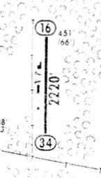
A 1964 airport directory (courtesy of Jonathan Westerling) showed that Spanaway Airport evidently gained a 2,220' paved Runway 16/34 at some point between 1961-64.
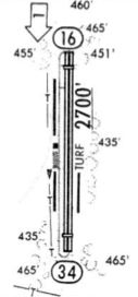
A 1980 airport directory (courtesy of Jonathan Westerling) showed that Spanaway Airport's Runway 16/34 had been extended to 2,700.
A circa 1980s military aeronautical chart (courtesy of Lee Corbin) depicted Spanaway Airport as having a 2,700' north/south paved runway.
The 1985 Airport/Facility Directory (courtesy of Jonathan Westerling) described Spanaway Airport as having a 2,700' asphalt Runway 16/34.
The January 1987 Seattle Terminal Aeronautical Chart depicted Spanaway Airport as having a 2,700' paved north/south runway.
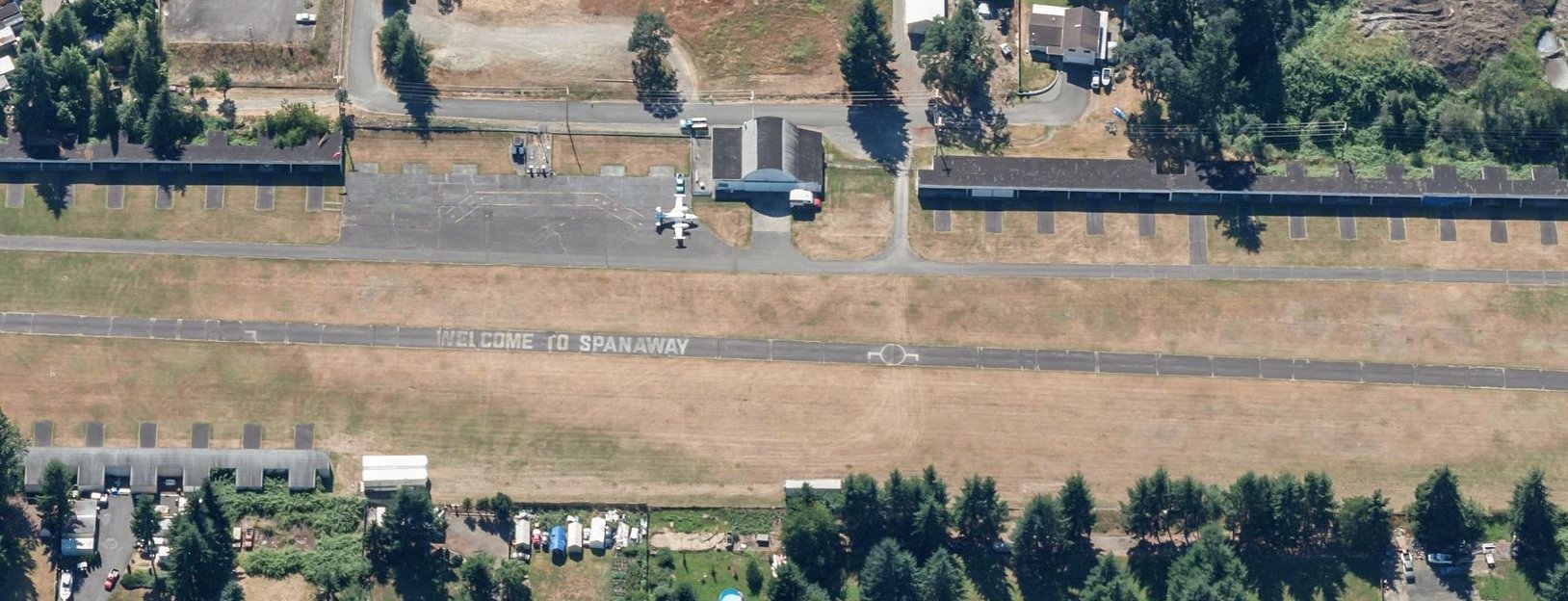
A 1991 USGS aerial view looking northwest depicted Spanaway Airport as having an extremely narrow paved north/south runway, painted with “Welcome to Spanaway” on its midpoint.
Long rows of an amazing number of T-hangars lined both sides of the runway, and several light single-engine aircraft were also visible.
The 1997 USGS topo map depicted Spanaway Airport as having a north/south paved runway.
A circa 2010-2018 aerial view looking west depicted Spanaway Airport as remaining intact, but only 1 aircraft (a light twin-engine Cessna) was visible on the ramp, next to the main hangar.
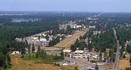
A circa 2013 aerial view by Anthony Tessitore looking northwest at Spanaway Airport.
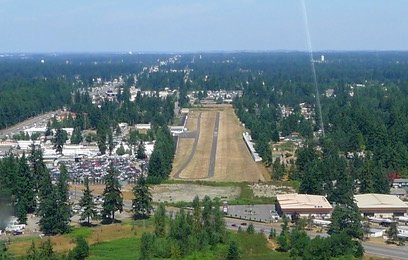
A circa 2013 aerial view by Anthony Tessitore looking north from final approach to Spanaway Airport's Runway 34.
Anthony noted, the “paved runway was 20’ wide; the grass runway on east side was wider.”
A circa 2013 photo by Anthony Tessitore looking south at Spanaway Airport's hangars on the northwest corner.
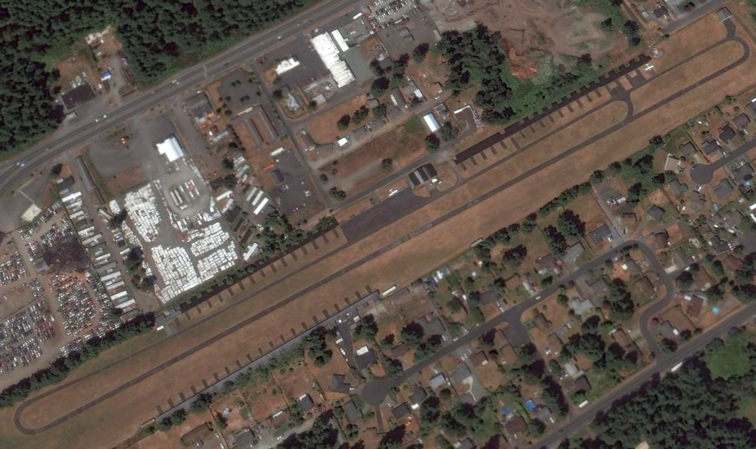
The last photo which has been located showing an aircraft at Spanaway Airport was a 2015 aerial view looking northwest.
A sad sight: only 2 single-engine Cessnas were visible on the once-vibrant little airport.
The last aeronautical chart depiction which has been located of Spanaway Airport was on the May 2018 Seattle Terminal Aeronautical Chart.
It depicted Spanaway Airport as having a 2,700' paved north/south runway.
As of the end of 2016, Spanaway Airport's FAA Airport/Facility Directory data listed it as conducting an average of 38 takeoffs or landings per week,
and having a total of 30 single-engine aircraft based on the field.
As of 2018, Spanaway Airport's FAA Airport/Facility Directory data described it as having a 2,724' asphalt Runway 16/34, “in Fair Condition”,
and it listed the manager as Gary Lawson.
After more than 60 years, unfortunately Spanaway Airport was closed in 2018.
The reason for the airport's closure?
Bob Bogash postulated, “Always the same reason - developers - who keep the local politicians neatly on their payrolls.”
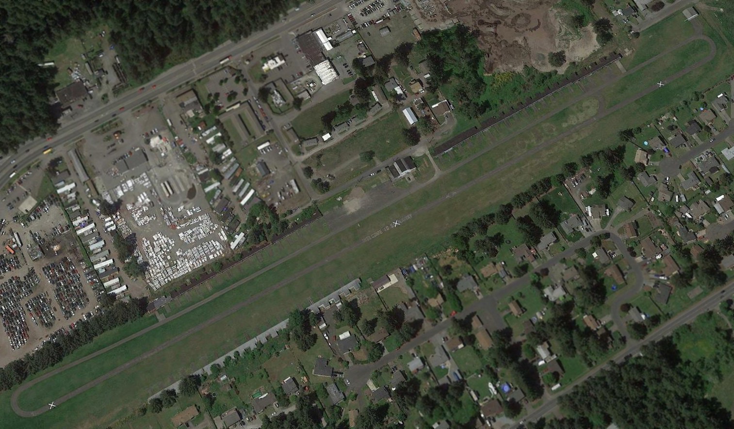
A 2018 aerial view looking northwest showed the sad sight of Spanaway Airport with closed-runway “X” symbols painted over the “Welcome to Spanaway” still visible on the runway.
The airport still remained intact though, including the long rows of T-hangars on both sides of the runway.
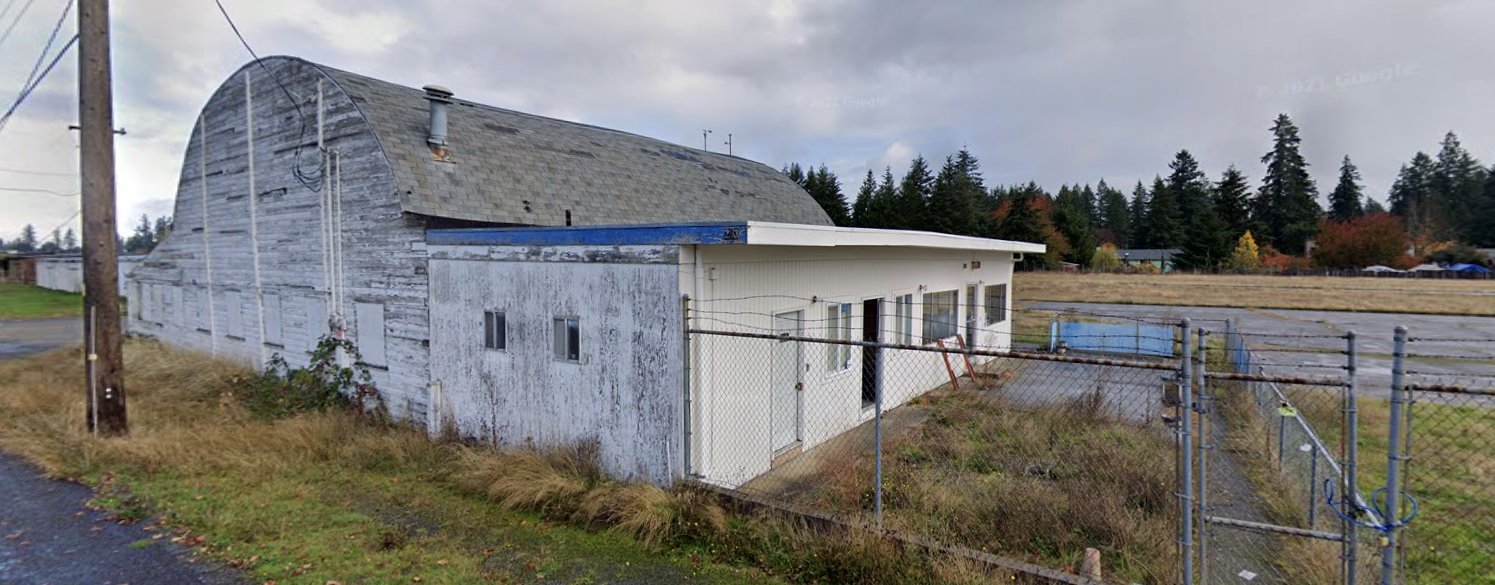
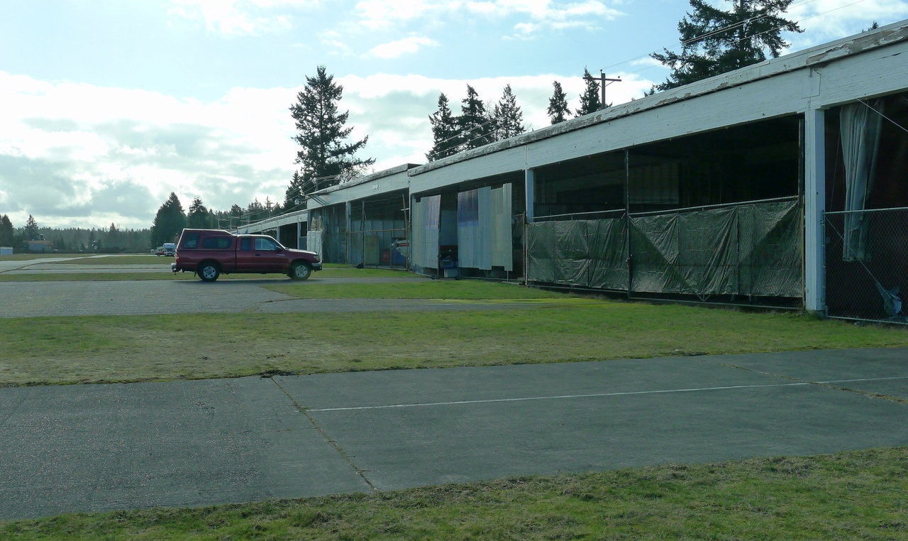
An October 2018 photo looking northeast at the former Spanaway Airport office & arch-roof hangar on its west side.
An October 2018 photo looking southeast at the row of former Spanaway Airport T-hangars on its east side.
A 9/22/23 photo by Jonathan Westerling of the Spanaway Airport site.
Jonathan reported, “The airport is now a large storage area for vehicles. Seemingly all of the aviation-related ephemera have been removed.”
Thanks to Bob Bogash for pointing out this airfield.
____________________________________________________
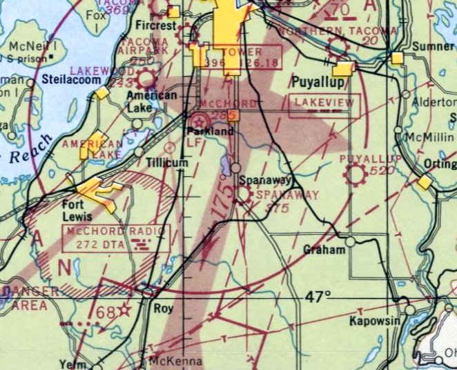
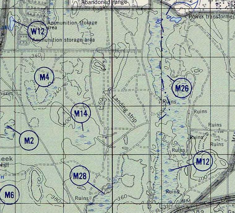
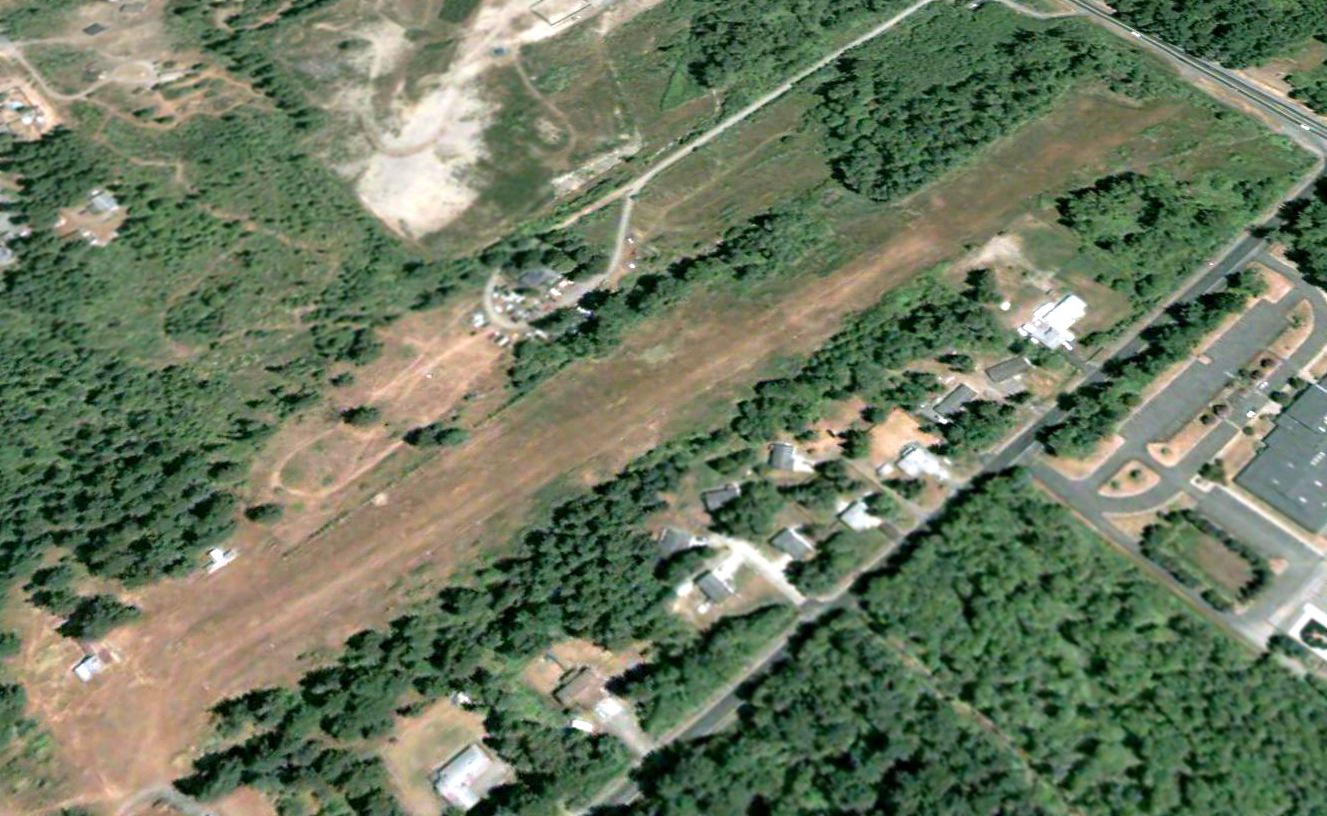
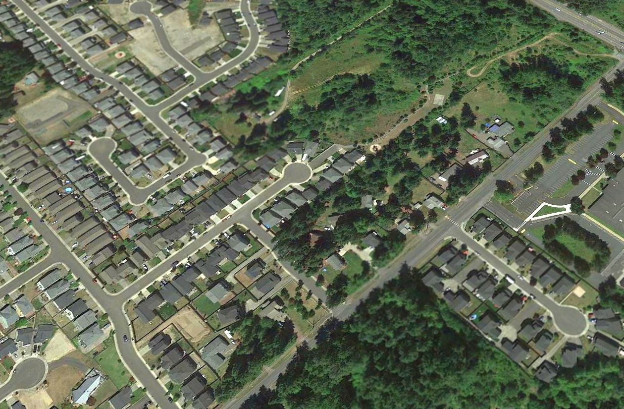
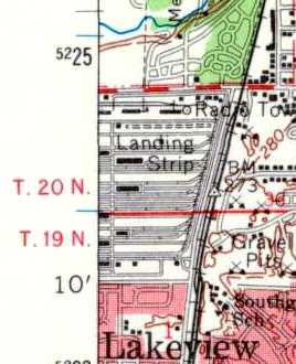
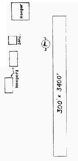
Fort Lewis #1 Airfield, Spanaway, WA
47.079, -122.472 (South of Seattle, WA)
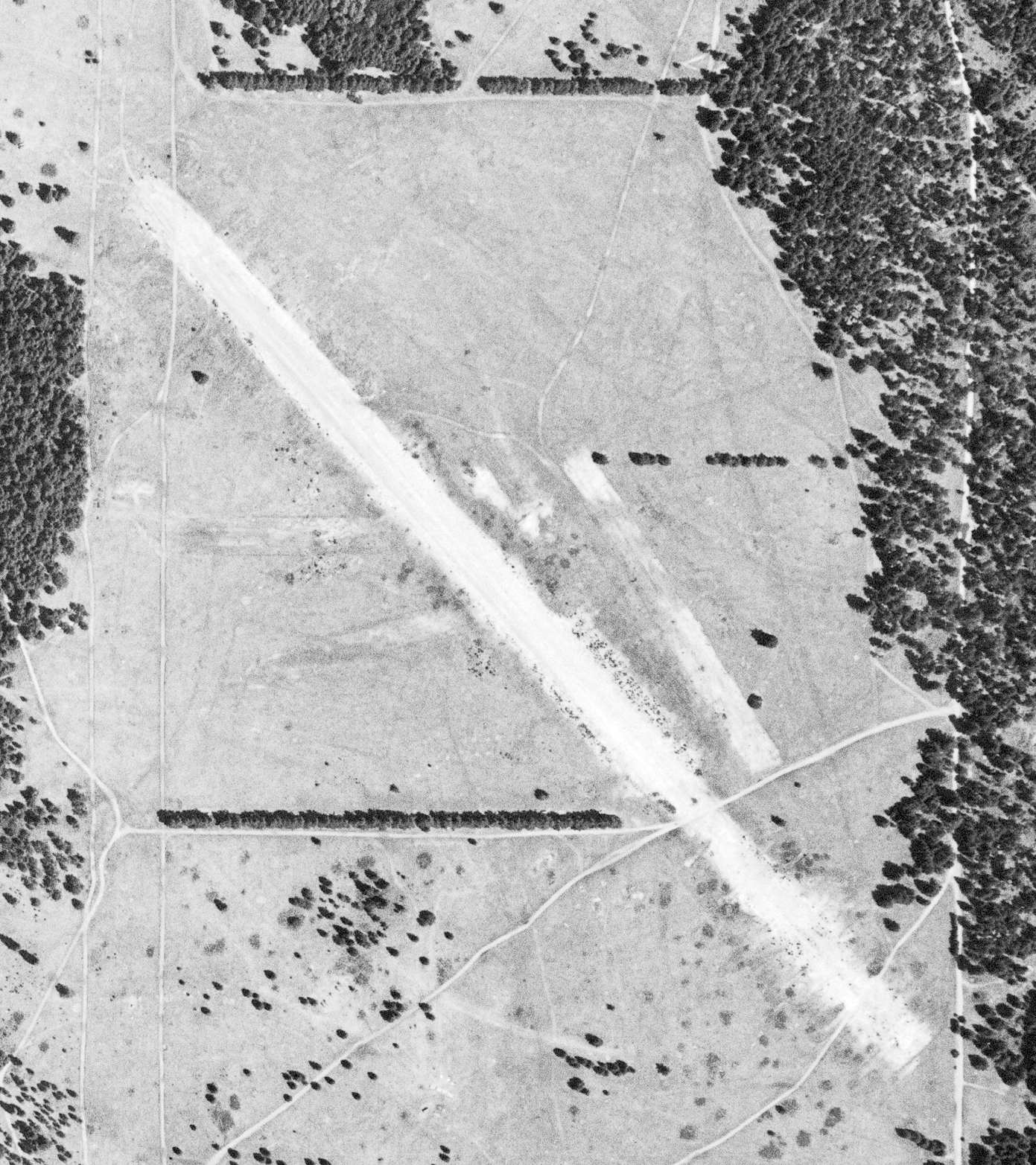
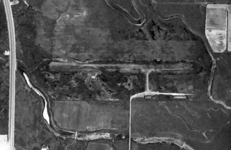
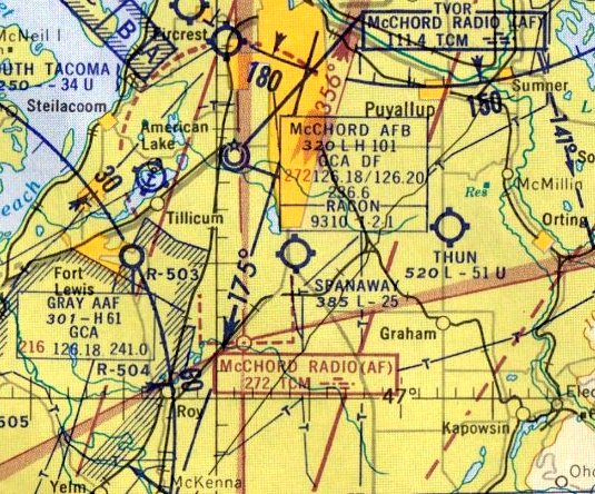
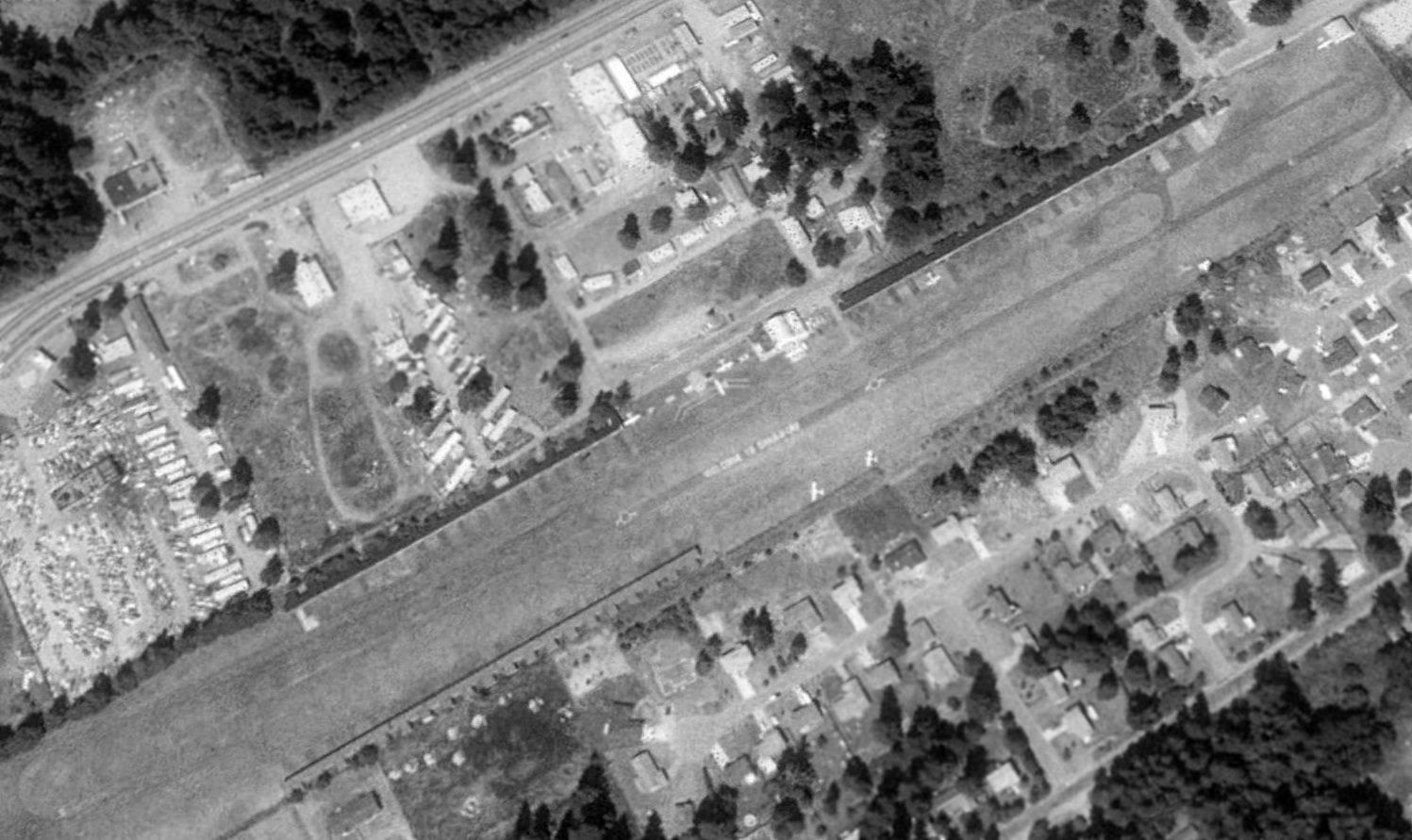
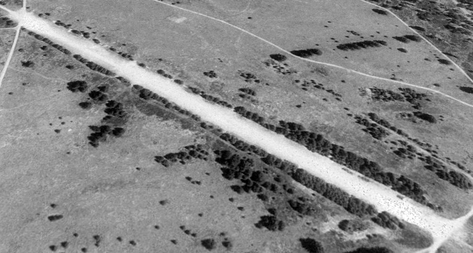
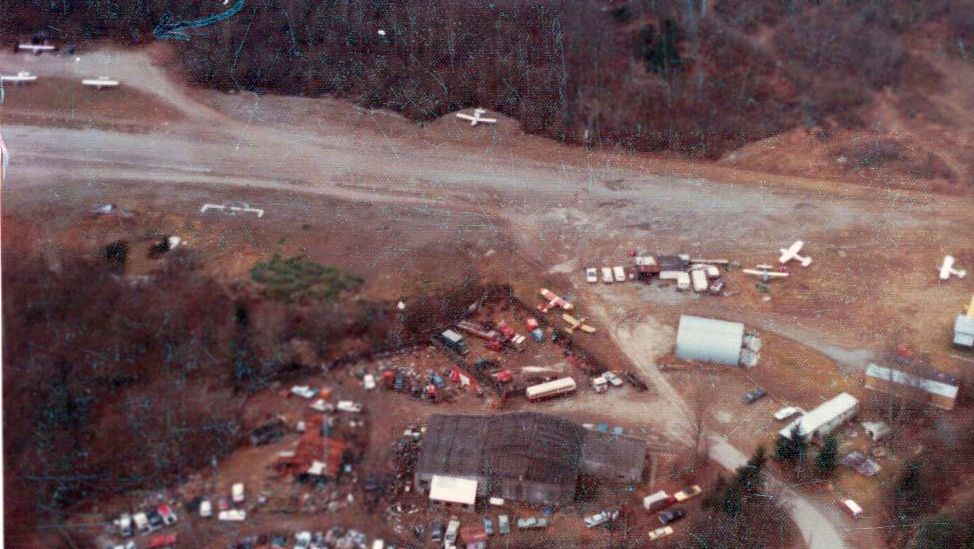
Ft Lewis #1 Airfield, as depicted on a 7/19/57 USGS aerial view.
This auxiliary airfield within Fort Lewis was evidently established at some point between 1941-55, as it was not yet depicted on a 1941 aerial photo.
The earliest photo which has been located of Fort Lewis #1 Airfield was a 1955 aerial view, which depicted a single northwest/southeast runway.
The earliest photo which is available of Fort Lewis #1 Airfield was a 7/19/57 USGS aerial view, which depicted a single northwest/southeast runway.
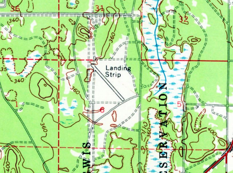
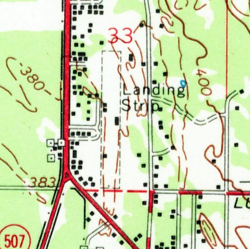
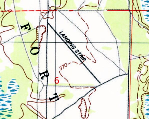
The earliest topo map depiction which has been located of Fort Lewis #1 Airfield was on the 1961 USGS topo map.
It depicted a single paved northwest/southeast runway, labeled simply as “Landing Strip”.
The Fort Lewis #1 Airfield runway was not depicted on the 1965 Seattle Sectional Chart, nor later Sectional or Terminal Charts.
Fort Lewis #1 Airfield was depicted as a paved northwest/southeast runway, generically labeled “Landing Strip”, on the 1977 Ft. Lewis Terrain Analysis map (courtesy of Lee Corbin).
Lee Corbin recalled, “From my years of flying the C-141 in & out of McChord AFB,
I always thought this strip was built for the C-130s that were based at McChord in the 1970s & 1980s, but it shows up [on earlier] topo maps.”
The only aeronautical chart depiction which has been located of Fort Lewis #1 Airfield was on a circa 1980s military aeronautical chart (courtesy of Lee Corbin).
It depicted Fort Lewis #1 as having a single northwest/southeast runway.
The earliest photo which is available of Fort Lewis #1 Airfield was a 1990 USGS aerial view looking northeast.
A 1997 USGS topo map depicted Fort Lewis #1 Airfield in the same fashion as the 1961 topo map.
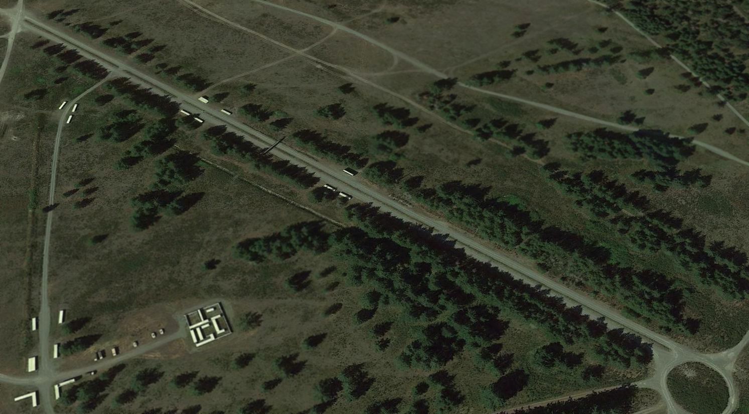
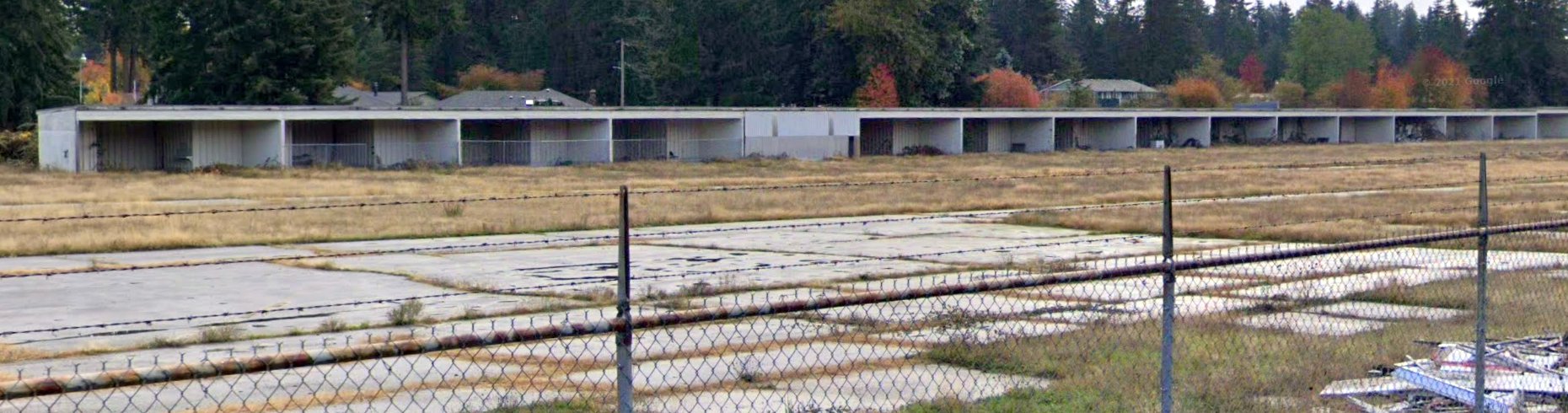
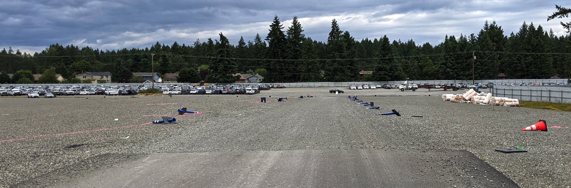
A 2016 aerial view looking northeast showed the Fort Lewis #1 Airfield runway appeared to have been reconfigured for non-aviation use,
with a median strip running down the length of its center, and a pedestrian footbridge across the middle.
The site of Fort Lewis #1 Airfield is located west of the intersection of Route 7 & Route 507.
Thanks to Lee Corbin for pointing out this airfield.
____________________________________________________
Gaffney's Lake Wilderness Resort Airfield, Maple Valley, WA
47.38, -122.039 (Southeast of Seattle, WA)
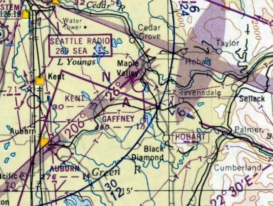
Gaffney's Lake Wilderness Resort Airfield, as depicted on the October 1950 Seattle Sectional Chart.
Gaffney's Lake Wilderness Resort Airfield was not yet depicted on the April 1950 Seattle Sectional Chart.
According to a Maple Valley park brochure (courtesy of Lee Corbin), “Gaffney's Lake Wilderness Resort
was an active year-round vacation destination by the 1950s,
and included a boat & swim facilities, an airstrip, a ballroom, rental cabins, a restaurant, and a skating rink.
The airstrip was in operation from 1950.”
The earliest depiction which has been located of Gaffney's Lake Wilderness Resort Airfield was on the October 1950 Seattle Sectional Chart.
It depicted a Gaffney as having a mere 1,700' unpaved runway.
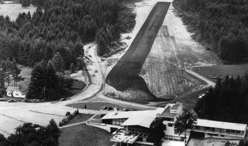
The only photo which has been located showing Gaffney's Lake Wilderness Resort Airfield in operation was a 1950-59 aerial view looking west (courtesy of Lee Corbin).
It depicted a single east/west grass runway just beyond the Lake Wilderness Lodge.
One light single-engine aircraft was visible to the right of the runway.
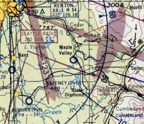
The last aeronautical chart depiction which has been located of Gaffney's Lake Wilderness Resort Airfield was on the April 1958 Seattle Sectional Chart.
It depicted a Gaffney as a private airfield having a 1,700' unpaved runway.
Gaffney's Lake Wilderness Resort Airfield was evidently closed in 1958, as it was no longer depicted on the October 1958 Seattle Sectional Chart.
According to a Maple Valley park brochure (courtesy of Lee Corbin), “The airstrip was in operation to 1959.”
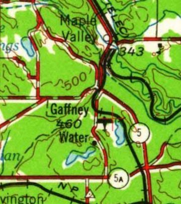
The only topo map depiction which has been located of Gaffney's Lake Wilderness Resort Airfield was on the 1962 USGS topo map (courtesy of Lee Corbin).
A 1964 aerial view showed Gaffney's Lake Wilderness Resort Airfield having been abandoned,
with the runway overgrown & only barely recognizable.
According to a Maple Valley park brochure (courtesy of Lee Corbin), “In 1967 King County Parks purchased Gaffney's property,
and many of the old cabins & facilities were torn down or relocated.”
A 2016 aerial photo showed the Lake Wilderness Lodge remains, but no trace remains of Gaffney's Lake Wilderness Resort Airfield.
According to a Maple Valley park brochure (provided in 2016 by Lee Corbin), “The airstrip is now the site of Lake Wilderness Arboretum.”
The site of Gaffney's Lake Wilderness Resort Airfield is located at the eastern terminus of Gaffney Road.
Thanks to Lee Corbin for pointing out this airfield.
____________________________________________________
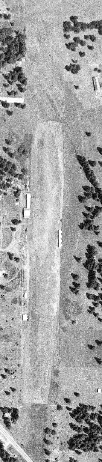
47.072, -122.298 (South of Seattle, WA)
Moss Field, as depicted on the June 1971 Seattle Sectional Chart.
Jon Peterson reported, “Jim Moss was ex-Navy (or USMC) flying ADs (A-1s).
He flew vintage aircraft with a number of old & bold Tacoma-area pilots.
While all that was going on, Moss bought the property & established the unimproved airstrip in 1961-63.
He operated several aircraft out of there for many years & continued with the occasional airshow/demonstrations.
One of the barns on the property housed a broken Pitts Special with a bent upper wing that he only occasionally tried to restore.
He had unfortunately flown it into the ground, inverted, after a loop gone bad. Fortunately, pride & his broken nose were the only injuries.
Meanwhile, the Pitts laid in that shed for years & I don't believe he ever finished it or that it ever flew again.”
Moss Field was not yet depicted on the June 1968 Seattle Sectional Chart.
The earliest depiction which has been located of Moss Field was a 1969 aerial photo, which depicted a single east/west grass runway.
The earliest aeronautical chart depiction which has been located of Moss Field was on the June 1971 Seattle Sectional Chart,
which depicted Moss as a private field having a 1,600' unpaved runway.
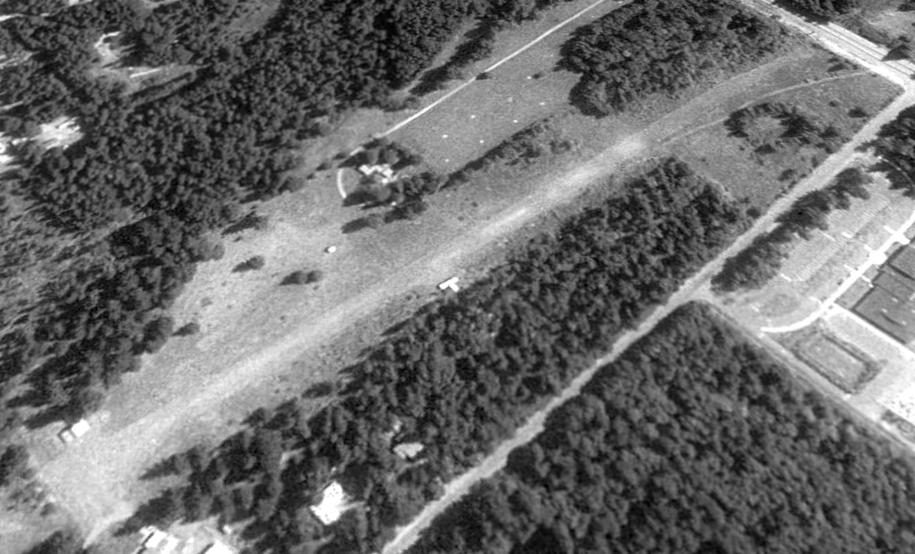
The earliest photo which is available of Moss Field was a 1990 USGS aerial view looking northeast.
It depicted Moss Field as having a single east/west grass runway,
with a small shed on the northwest side, and a T-hangar on the south side.
A house at the southwest side of the runway appeared to have had a taxiway leading toward the runway.
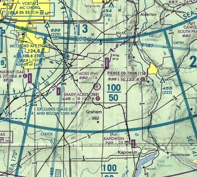
The last aeronautical chart depiction which has been located of Moss Field was on the 2000 Seattle Terminal Aeronautical Chart (courtesy of Lee Corbin).
It depicted Moss as a private airfield having a 1,600' unpaved runway.
Moss Field had a single 1,584' grass Runway 9/27.
Jon Peterson reported, “One thing that distracted Jim Moss from the project was his love of Polo.
He proudly used the property to raise several strings of ponies in subsequent years.
I presume his newfound interests caused the change in the use of the property.”
The last depiction which has been located of Moss Field was a 2003 aerial view looking northeast.
A small shed/hangar & a T-hangar were visible on the northwest side of the grass runway.
Moss Field was evidently closed at some point between 2000-2005, as it was no longer depicted on the June 2005 Seattle Terminal Aeronautical Chart.
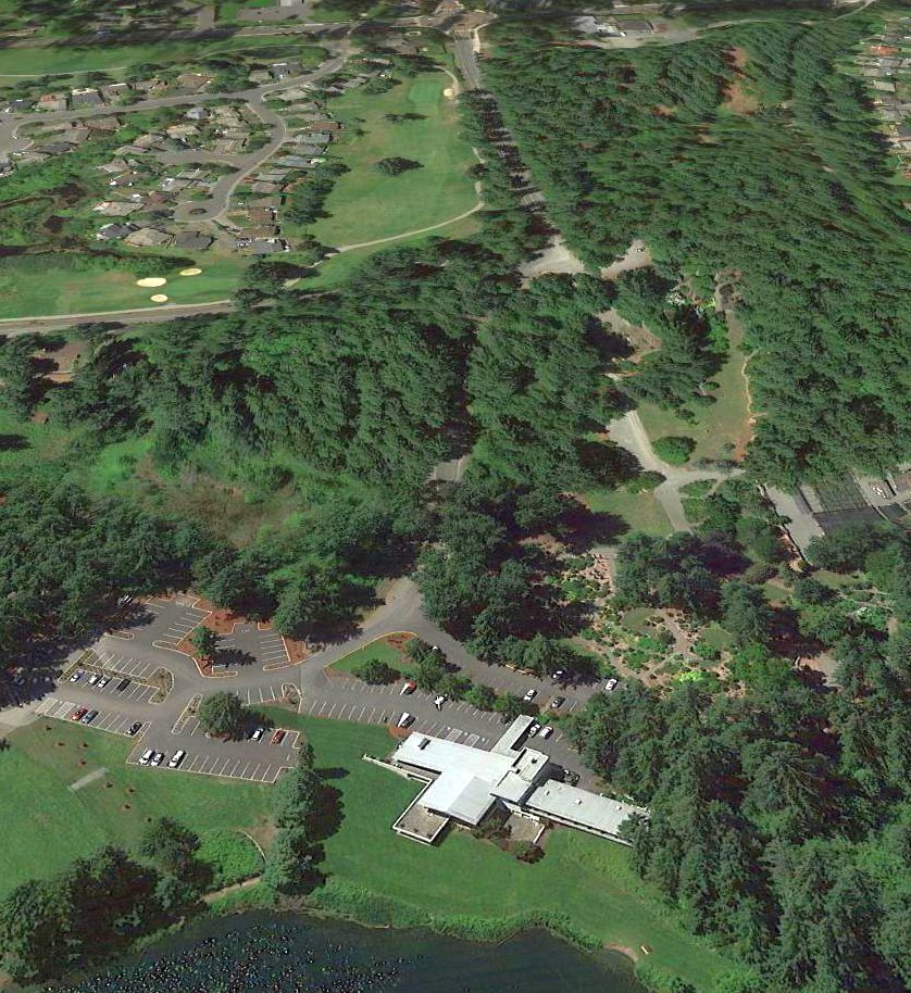
A 2016 aerial photo showed no trace remaining of Moss Field, with houses covering the western portion of the site.
Lee Corbin observed that the house at the bottom-left of this picture actually is left over from the site's airfield days, squeezed in among newer houses.
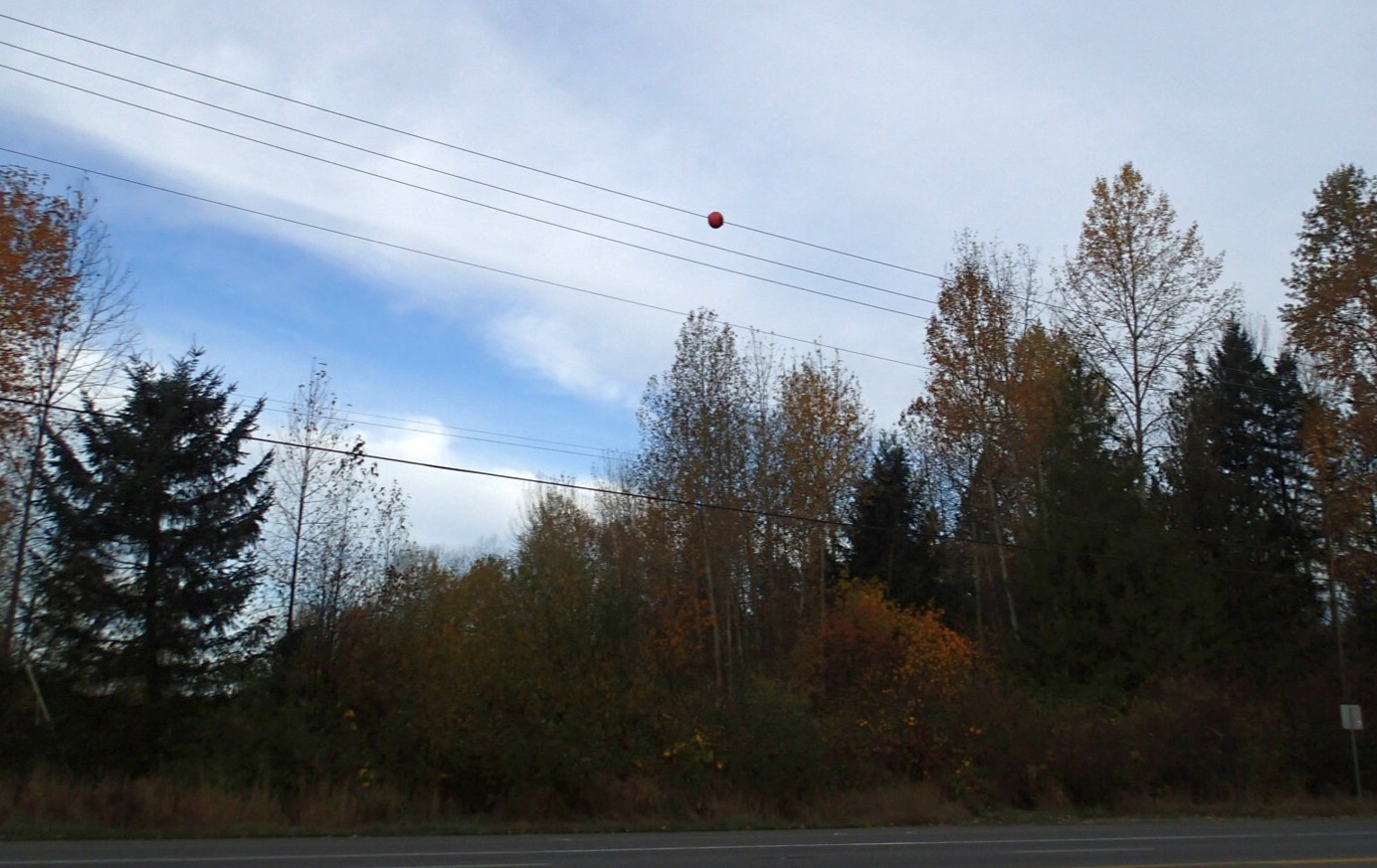
An 11/10/16 photo by Lee Corbin of the last tiny trace remaining of Moss Field: a single red marker ball mounted on an adjacent powerline.
Lee reported, “I've been driving by it for 26 years.”
The site of Moss Field is located northwest of the intersection of Meridian Avenue East & 204th Street East.
Thanks to Lee Corbin for pointing out this airfield.
____________________________________________________
47.293, -122.196 (South of Seattle, WA)
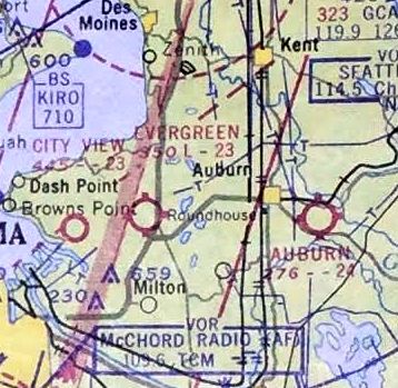
Auburn Airfield, as depicted on the October 1946 Seattle Sectional Chart.
This small general aviation airport on the southeast side of Auburn (a different facility than the later Auburn Municipal Airport to the northwest)
was apparently established at some point in 1946,
as it was not yet depicted on a 1940 aerial photo nor on the April 1946 Seattle Sectional Chart.
The earliest depiction which has been located of Auburn Airfield was on the October 1946 Seattle Sectional Chart.
It depicted Auburn as having a 2,000' unpaved runway.
The earliest photo which has been located of Auburn Airfield was a 1955 aerial view.
It depicted Auburn as having a northeast/southwest grass runway,
with 8 light single-engine aircraft parked near some small buildings on the south side.
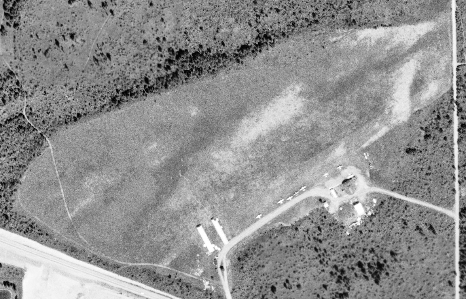
A 5/28/57 USGS aerial view depicted Auburn as having a northeast/southwest grass runway,
with 10 light single-engine aircraft parked on the south side.
Auburn had also gained 2 hangars on the south side at some point between 1955-57.
The last aeronautical chart depiction which has been located of Auburn Airfield was on the October 1962 Seattle Sectional Chart (courtesy of Steve Martin).
It depicted Auburn as having a 2,400' unpaved runway.
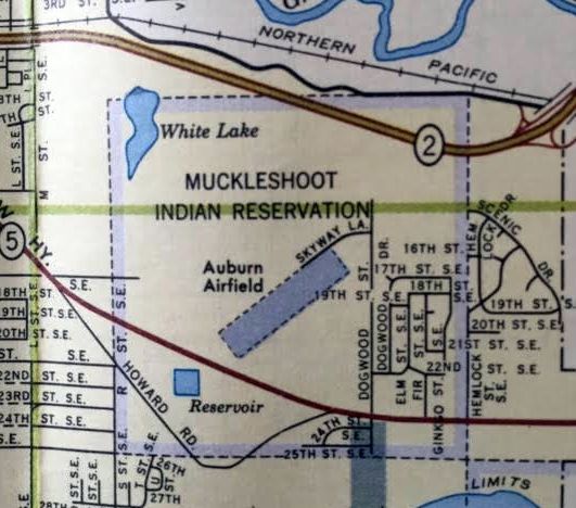
A 1962 street map (courtesy of Kevin Walsh) depicted Auburn Airfield as a northeast/southwest property outline within the Muckleshoot Indian Reservation.
A 1964 aerial photo showed over a dozen light single-engine aircraft parked on the south side of Auburn Airfield.
Marilynn Laird recalled, “The Smith brothers had a connection to a number of airports in the Auburn Kent area.
Ben Smith was an Aeronca dealer; the new Champs were ferried from the factory by his two daughters Teresa & Virginia.
Virginia Smith married Al Knechtel (a pilot & Navy engine mechanic during WW2); they owned the Auburn Airport where the Muckleshoot Casino is now.
They sold that property & and built Crest Air Park.”
Auburn Airfield was evidently closed at some point between 1964-65,
as it was no longer depicted at all on the June 1965 Seattle Sectional Chart (courtesy of Ron Kunse).
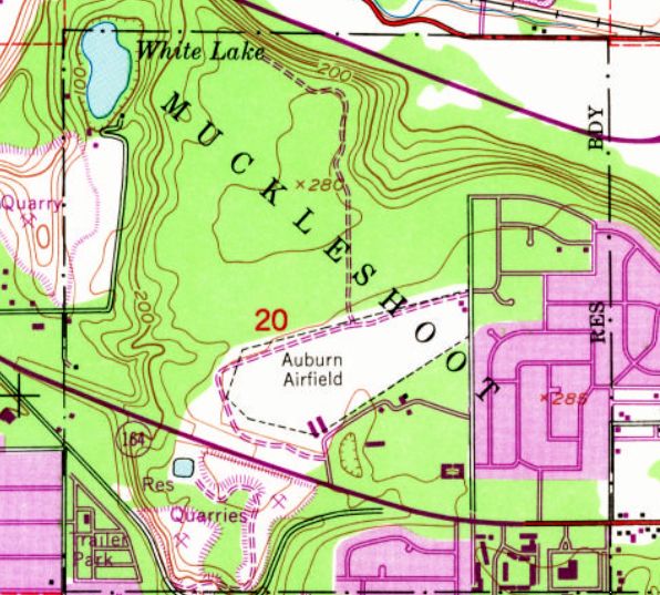
The 1968 USGS topo map depicted “Auburn Airfield” as an irregularly-shaped property outline
with 2 small buildings (hangars?) on the south side.
A 1968 aerial photo showed multiple closed-runway “X” symbols along the Auburn Airfield runway, and all the aircraft were gone.
A 1969 aerial photo showed Auburn Airfield remained in an unchanged condition.
A 1970 aerial photo showed construction had begun over the western portion of the Auburn Airfield site,
but a few of the smaller airfield buildings remained on the southeast corner.
Auburn Airfield's clearing was still depicted on the 1973 USGS topo map, but it was no longer labeled as an airfield.
A 1980 aerial photo showed houses covering the site of Auburn Airfield, erasing the last traces of this little grass-roots airfield.
A 2016 aerial photo showed no trace remaining of Auburn Airfield, with the Muckleshoot Casino occupying southern portion of the site.
The site of Auburn Airfield is located at the western terminus of Skyway Lane, appropriately enough.
Thanks to Kevin Walsh for pointing out this airfield.
____________________________________________________
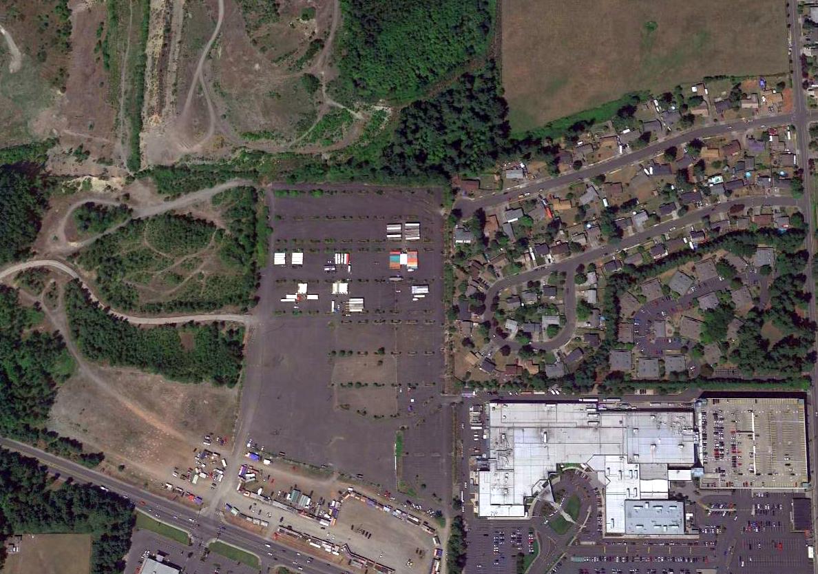
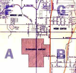
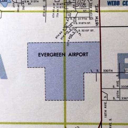
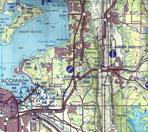
Evergreen Airport / Evergreen Industrial Airport, Federal Way, WA
47.31, -122.32 (Southwest of Seattle, WA)
Evergreen Airport, as depicted on the October 1948 Seattle Sectional Chart.
This general aviation airport was apparently established at some point between 1945-47,
as it was not depicted on a 1936 aerial photo nor on the 1945 Seattle Sectional Chart (courtesy of John Voss).
The earliest record of Evergreen Airport in its FAA Inspection File (according to David Field) was on 7/14/47.
The earliest depiction of Evergreen Airport which has been located was on the October 1948 Seattle Sectional Chart.
It depicted Evergreen Airport as having a 2,200' unpaved runway.
The 1948 USAF Target Complex Chart depicted Evergreen Airport as having a single northeast/southwest runway.
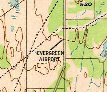
The 1949 USGS topo map depicted Evergreen Airfield as having a single unpaved northeast/southwest runway,
with a parking area & 2 small buildings on the east side.
Steve Martin recalled, “I have very fond & nostalgic memories of Evergreen Airport,
as my dad kept his Piper Apache there in the late 1950s & early 1960s & took me flying many times as a little tyke.
He had passed away by the time I was learning to fly, but I've always had a sentimental attachment to that crude little dirt strip.”
Evergreen Airport had a total of 19 based aircraft in 1961, according to its FAA Inspection File (according to David Field).
The 1961 Flying A road map (courtesy of Bill Eaton) depicted the outline of the Evergreen Airport property.
A 1962 street map (courtesy of Kevin Walsh) depicted a somewhat different property outline for Evergreen Airport.
The October 1962 Seattle Sectional Chart (courtesy of Steve Martin) depicted Evergreen as having a 2,300' unpaved runway.
The 1963 WA Airport Directory (courtesy of Ron Dupas) described Evergreen Airport as a private field,
with a single 2,200' gravel northeast/southwest runway.
A single hangar with a wind sock was depicted on the east side of the field.
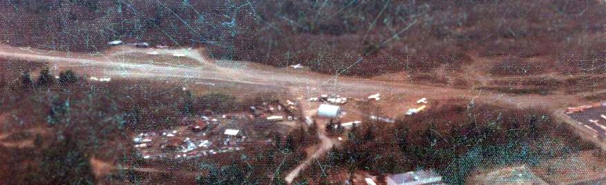
The earliest photo which has been located of Evergreen Airport was a 1964 aerial view.
It depicted the field as having a single unpaved northeast/southwest runway.
A closeup from the 1964 aerial view, showing 13 single-engine aircraft parked on the northeast end of Evergreen Airport.
Evergreen Airport may have gone through some period of abandonment starting at some point between 1964-65,
as it was was not depicted at all on the June 1965 Seattle Sectional Chart (courtesy of Ron Kunse),
the 1967 Seattle Sectional Chart (courtesy of John Voss),
or the December 1968 Seattle Sectional Chart (courtesy of Chris Kennedy).
Evergreen Airport appeared abandoned in a 1968 aerial photo.
In 1968 Evergreen Airport's owner requested reactivation as a public use airport,
according to its FAA Inspection File (according to David Field).
In 1969 the FAA issued “No objection provided it was operated as private use only”,
according to Evergreen Airport's FAA Inspection File (according to David Field).
In 1970, the FAA objected to public use due to Evergreen Airport being directly under the approaches for Sea-Tac airport,
according to its FAA Inspection File (according to David Field).
The FAA decided that if it were private use,
there would be less of a safety concern because the users could be advised of the Sea-Tac flight track issue.
Evergreen Airport was listed once again as a public-use airport in the 1971 WA Airport directory (courtesy of Chris Kennedy).
This aerial view looking north at Evergreen Airport showed at least a dozen planes parked next to the runway.
The directory described the field as having a single 2,000' gravel-dirt Runway 2/20, and listed the manager as Jack Haworth.
In 1973, after the Sea-Tac airspace was modified, FAA issued a “No objection” to public use
“provided power line towers be lighted & the pattern altitude be established at 800 feet”,
according to its FAA Inspection File (according to David Field).
In 1975, the Weyerhauser real estate division owned the property on which the southerly 600' or 700' of runway was located,
according to its FAA Inspection File (according to David Field).
The owners of the airport had not obtained a lease authorizing use of the property for airport purposes.
Weyerhauser filed for an injunction against the airport owners to prevent use of the Weyerhauser property.
This eventually led to the airport owners obtaining a lease.
The December 1976 Seattle Sectional Chart depicted Evergreen as having a 2,000' unpaved runway.
A Winter 1976/77 aerial view by Steve Martin looking west at Evergreen Airport.
Steve recalled, “Evergreen Airport was pretty rough, adjacent to a junkyard
and the runway was just a slot cut through the tall fir trees with a very rough dirt & glacial rock runway that often dented propellers & tail feathers too.
The local pilots would every so often walk the strip & harvest the rocks that had migrated to the surface through the clay soil.”
A Winter 1976/77 aerial view by Steve Martin looking west at Evergreen Airport's tiedown area & the adjacent junkyard.
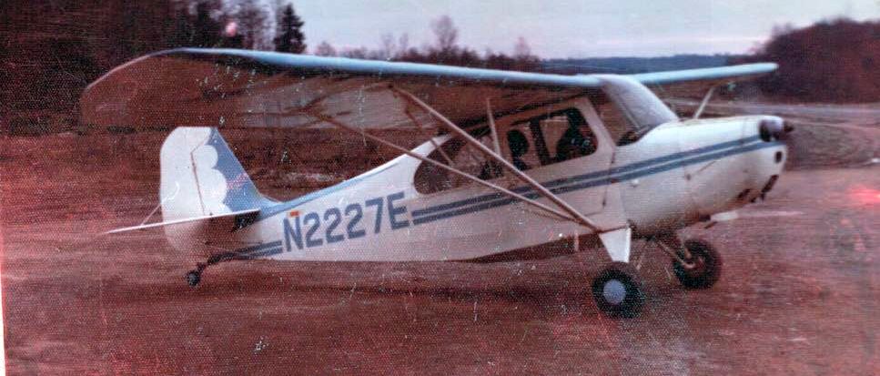
A Winter 1976/77 photo by Steve Martin of his 1946 Aeronca 7AC Champ at Evergreen Airport.
Steve Martin recalled, “I learned to fly at Evergreen Airport in 1976, taking lessons from a WWII P-51 veteran,
and I kept my 1946 Aeronca 7AC Champ there until the airport closed around 1979.
My high school friend Bryan Gilbert (we were both 16 years old) and I bought the Champ from Harry Hood for $2,350 in Hoquiam, WA
and flew it for several years before I bought him out & subsequently sold it a few years later to the well-known antique airplane restorer, my friend Glen Cawley.
I still fly that Champ, which has been expertly restored in factory original colors with a new and more powerful 85hp engine, some 38 years later.”
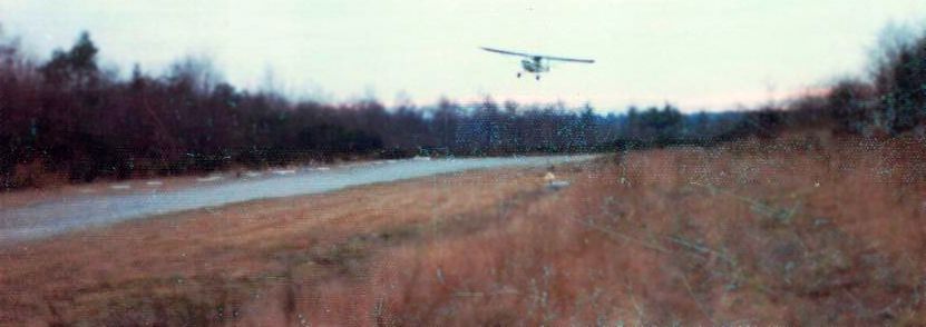
A Winter 1976/77 photo (courtesy of Steve Martin) of him slipping his 1946 Aeronca 7AC Champ on approach at Evergreen Airport.
Steve Martin recalled, “It was quite turbulent when the winds blew from the southwest & tumbled over the trees.
Landing to the south was challenging because of the high-tension power lines just a quarter mile or so to the north of the strip.
I remember Jack Haworth, the manager as a very likable, 'old school' pilot that had flown the Alaska bush a lot in his Cessna 180
and offered good piloting advice to youngsters like Bryan & myself.”
Steve Martin recalled, “Bryan & I made some really cool tie-down anchors for the Champ,
sinking eye bolts with big washers in concrete, then putting our initials and the date (sometime in 1976) in the wet concrete.
I miss that dumpy little field greatly, but I feel very fortunate to have experienced general aviation near its peak
and to have gained skills there that still serve me today as a Captain for Alaska Airlines.”
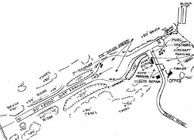
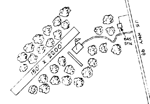
A 1978 FAA diagram (courtesy of David Field) depicted Evergreen Airport as having a single 2,000' dirt & gravel Runway 2/20,
with an unusually shaped bulged tie-down area in the middle.
Two T-hangars were located in the tie-down area, and the office was located on the southeast side of the field.
A 1978 photo of an unidentified taildragger at Evergreen by Owen Blauman.
Owen Blauman observed, “One of several late 1940s vintage planes that were housed at the airport in 1978. Pilots could fill up on the 'honor system'."
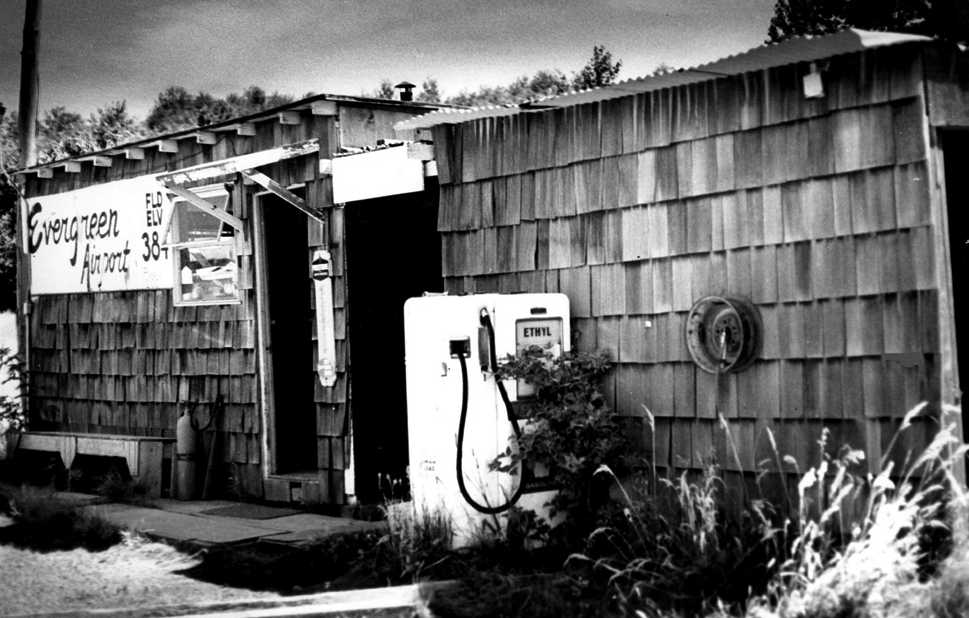
The last photo which has been located of Evergreen Airport was a 1978 photo by Owen Blauman.
Owen Blauman observed, “It looks more like a rural outpost, but this is the 'hub' of Evergreen Industrial Airpark.
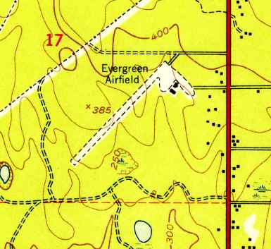
The faded sign informs pilots that the field elevation is 384 feet above sea level."
In 1978, the Evergreen Airport owner, Environmental Research & Development Corporation,
shortened the northeast end by 450' to provide a 20 to 1 approach over the power lines & a building,
according to its FAA Inspection File (according to David Field).
In 1979, Environmental Research & Development Corporation terminated operation of Evergreen Airport,
according to its FAA Inspection File (according to David Field).
According to David Field, “After closure of the airport, the Weyerhauser property was developed as an office complex
and the E.R.& D. property appears to have become a park.”
A 1980 aerial view showed Evergreen Airport to be abandoned.
By the time of the 1980 USGS topo map, the former Evergreen Airport northeast/southwest runway was still depicted,
but it was labeled simply as "Landing Strip".
Evergreen Airport was no longer depicted on the January 1982 Seattle Sectional Chart (courtesy of Paul Columbus).
The last aeronautical chart depiction which has been located of Evergreen Airport was on a circa 1980s military aeronautical chart (courtesy of Lee Corbin).
It depicted “Evergreen Industrial” Airport as having a single northeast/southwest runway.
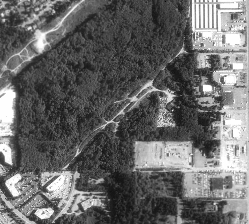
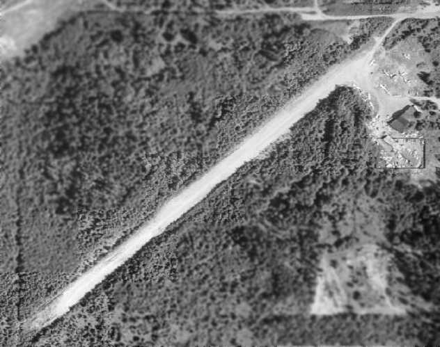
A 1990 USGS aerial photo depicted the remains of the Evergreen Airport runway, although the site had become heavily overgrown by trees.
Traces of the southwestern-most portion of the former runway were also still visible,
extending into the office park which had been constructed on the edge of the former airport property.
By the time of the 1994 USGS topo map, the northeastern end of the Evergreen Airport site was depicted as the City Center Park.
A 2002 USGS aerial photo of the site of Evergreen Airport showed even the remains of the runway were gone,
with the majority of the site of the former airport having been redeveloped with parking lots & grass fields.
Steve Martin recalled, “ Many years later, after the airport property had been sold & made into the soccer & baseball fields of Celebration Park,
I went searching for those tie-down anchors, but to no avail, as I think they were bulldozed under without a trace remaining.”
The site of Evergreen Airport is located northwest of the intersection of Pacific Highway South & South 336th Street.
____________________________________________________
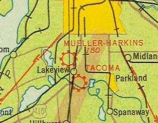
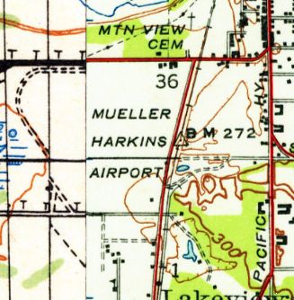
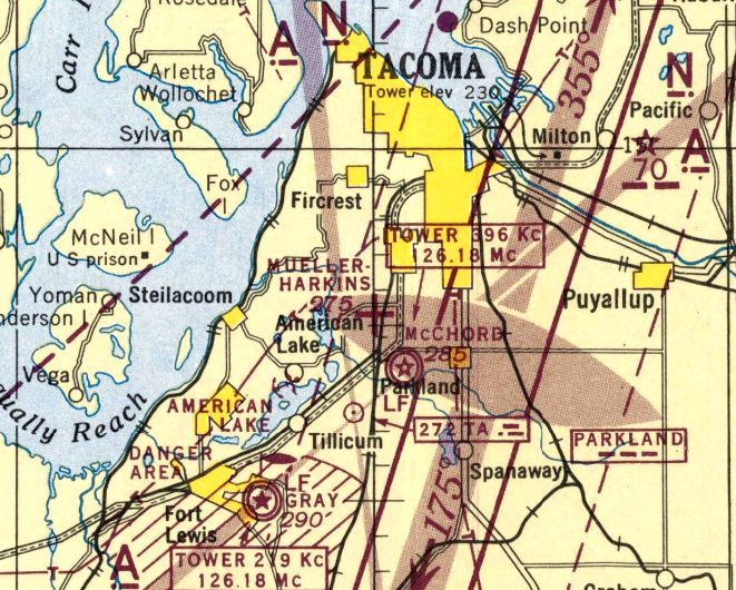
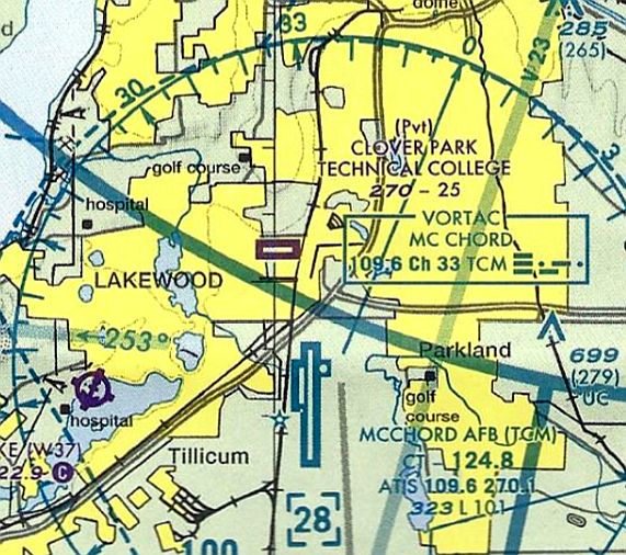
Mueller-Harkins Field / Clover Park Technical College Airfield, Clover Park, WA
47.174, -122.5 (Southwest of Seattle, WA)
A 9/7/27 photo of the inauguration of direct airmail & passenger service at Tacoma's Mueller-Harkins Airport.
According to a City of Lakewood web site (via Chris Kennedy),
the property of the Tacoma Speedway was sold in October of 1922 (after going bankrupt)
and the Mueller-Harkins Airport was established.
The earliest photo which has been located of Mueller-Harkins Airport was a 9/7/27 photo of the inauguration of direct airmail & passenger service at the airport.
After the first bag of air mail arrived, Postmaster Clyde Backus, right, turned it over to department employee Alfred Bottiger, left, who carried it to the city by automobile.
Pictured in the center is R. A. Mueller.
Over 2,500 people waited 2 hours at the airport to cheer the arrival of the first airmail plane of the Pacific Air Transport Co.

An undated photo (courtesy of the Tacoma Library) of Mayor Melvin Tennent & an unidentified unusual single-engine high-wing monoplane
in front of Mueller Harkins Airport's Washington Air College hangar.
Tennent was first elected Mayor in 1926 & served 2 terms.
According to Scott Kimball, "My Dad flew in the Tacoma area starting in gliders in 1928 & I believe [Mueller-Harkins] was open then.
I believe he flew a Standard with an OX-5 powerplant out of this field."
A 4/15/28 photo (courtesy of the Tacoma Library) of Pacific Air Transport Ryan M-1 #4 conducting the inauguration
of the American Railway Express Company air transport service provided for Tacoma in conjunction with the Pacific Air Transport Company fleet of mail carriers.
It would be the first outgoing air parcel service under this new arrangement.
Hundreds of people had gathered at the Mueller-Harkins Airport to celebrate this new service.
A 4/15/28 photo (courtesy of the Tacoma Library) of a pilot accepting delivery of a slender box from an unidentified official
before his northbound departure in Pacific Air Transport Ryan M-1 #4 at Mueller-Harkins Airport
for the inauguration of the American Railway Express Company air transport service in conjunction with the Pacific Air Transport Company fleet of mail carriers.

A 1928 aerial view looking southeast at Mueller-Harkins Field (courtesy of Steve Case) showing when it served as the terminus of the Edsel Ford Trophy national air race,
showing the arch-roof hangar at top-left, a row of aircraft, and large numbers of spectators' parked cars.
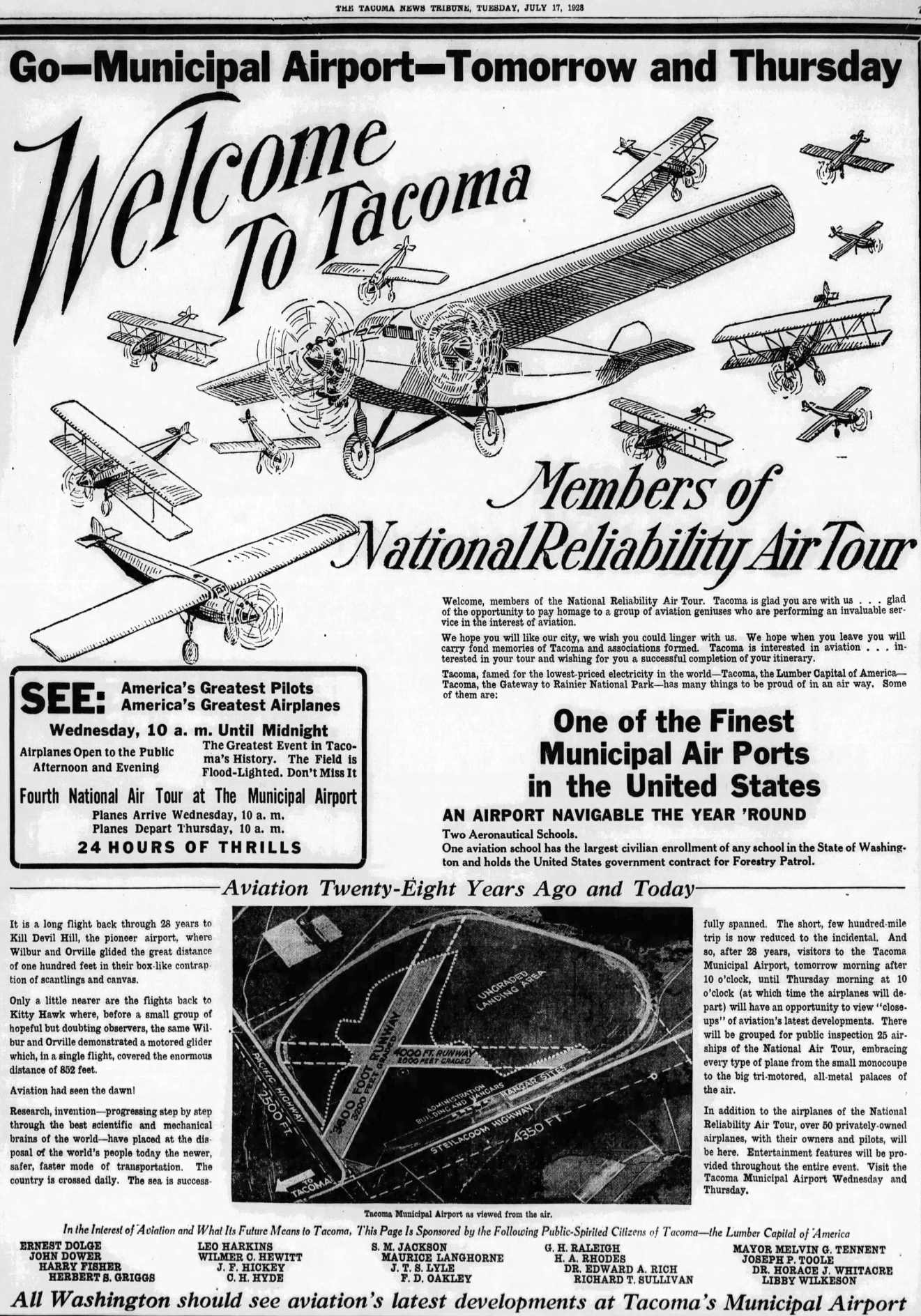
An advertisement from the 7/17/28 Tacoma News Tribune (courtesy of Lee Corbin) touted the attributes of “Tacoma Municipal Airport”, which was a name that wasn't otherwise known to have been used.
Mueller-Harkins was described in the 1929 Standard Oil Airport Directory (according to Chris Kennedy) as "Field inside of wooden speedway oval."
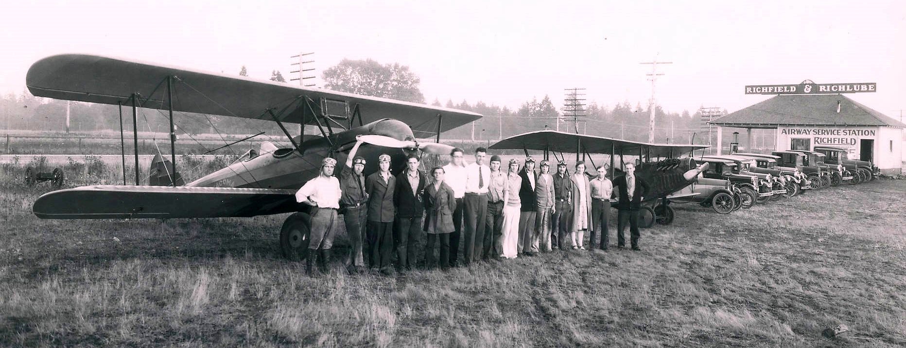
An 8/12/29 photo (from the Tacoma Library's Marvin Boland collection, courtesy of Lee Corbin) of men & women from the Tacoma Airways aviation school in front of 2 biplanes (models unidentified) in front of Mueller-Harkins Airport's Richfield service station.
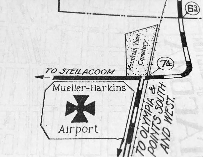
The earliest map depiction which has been located of Mueller-Harkins Airport was on a 1930 map (courtesy of Kevin Walsh),
which depicted it as a roughly rectangular property outline.
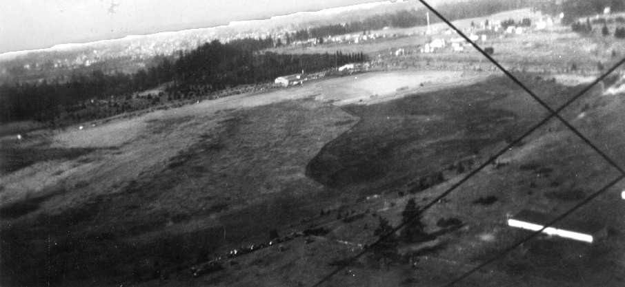
The earliest photo which has been located showing Mueller-Harkins Field was a 1931 aerial taken during the 1931 Air Tour by Wildey "Bud" Kimball (courtesy of Scott Kimball).
The photo was "taken by my Dad the summer he soloed in power", according to Scott Kimball.
It also depicted a "Richfield tower" along the top-right of the image.
These Richfield towers were built along the major flyways for both advertising & as a guide to pilots especially at night.
They had their name in lighted letters down the tower. "The one shown in the image was taken down in about 1970."
Mueller-Harkins Field, as depicted on the 1933 Seattle Airways Chart.
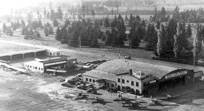
An undated aerial view of hangars & aircraft at Mueller-Harkins Field.
The Airport Directory Company's 1937 Airports Directory (courtesy of Bob Rambo)
described Mueller-Harkins as having two 3,600' sod runways, oriented north/south & east/west.
An undated aerial view of Mueller-Harkins Field from The Airport Directory Company's 1938 Airports Directory (courtesy of Chris Kennedy).
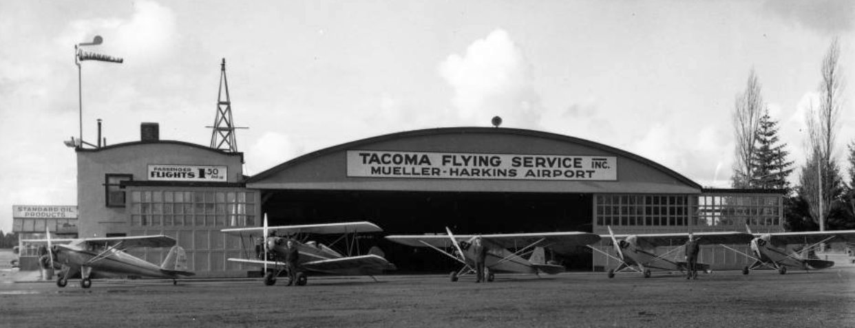
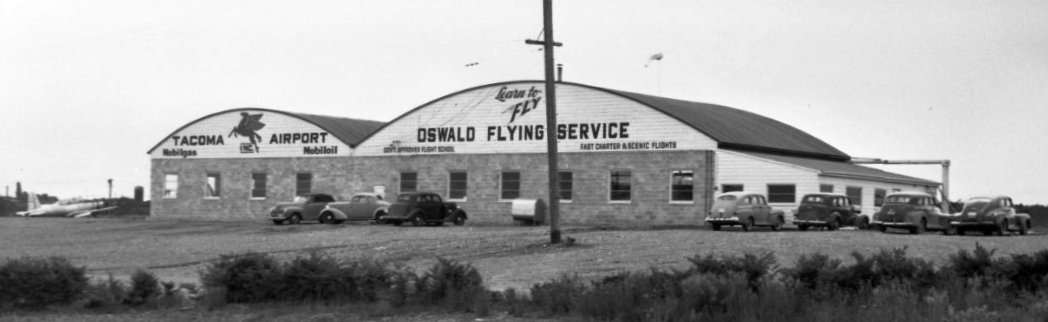
The Tacoma Flying Service, managed by Ben Barry (standing next to the center plane), was one of 3 aeronautical firms with headquarters at Mueller-Harkins Airport.
In 1940 the Tacoma Flying Service had a contract with the Federal Government under the civilian pilot program established by the Civil Aeronautics Authority to train new pilots.
At that time they had 30 students from the College of Puget Sound & Pacific Lutheran College.
The schools' 2 flight instructors, Norvel Norton (next to the biplane) and Bernard "Bud" Oswald (far right), stand next to their planes.
The Mueller-Harkins Airport described as one of the finest privately-owned fields in the northwest, with 3,500' of excellent runway.
The 1941 USGS topo map depicted Mueller-Harkins Airport as an open area.
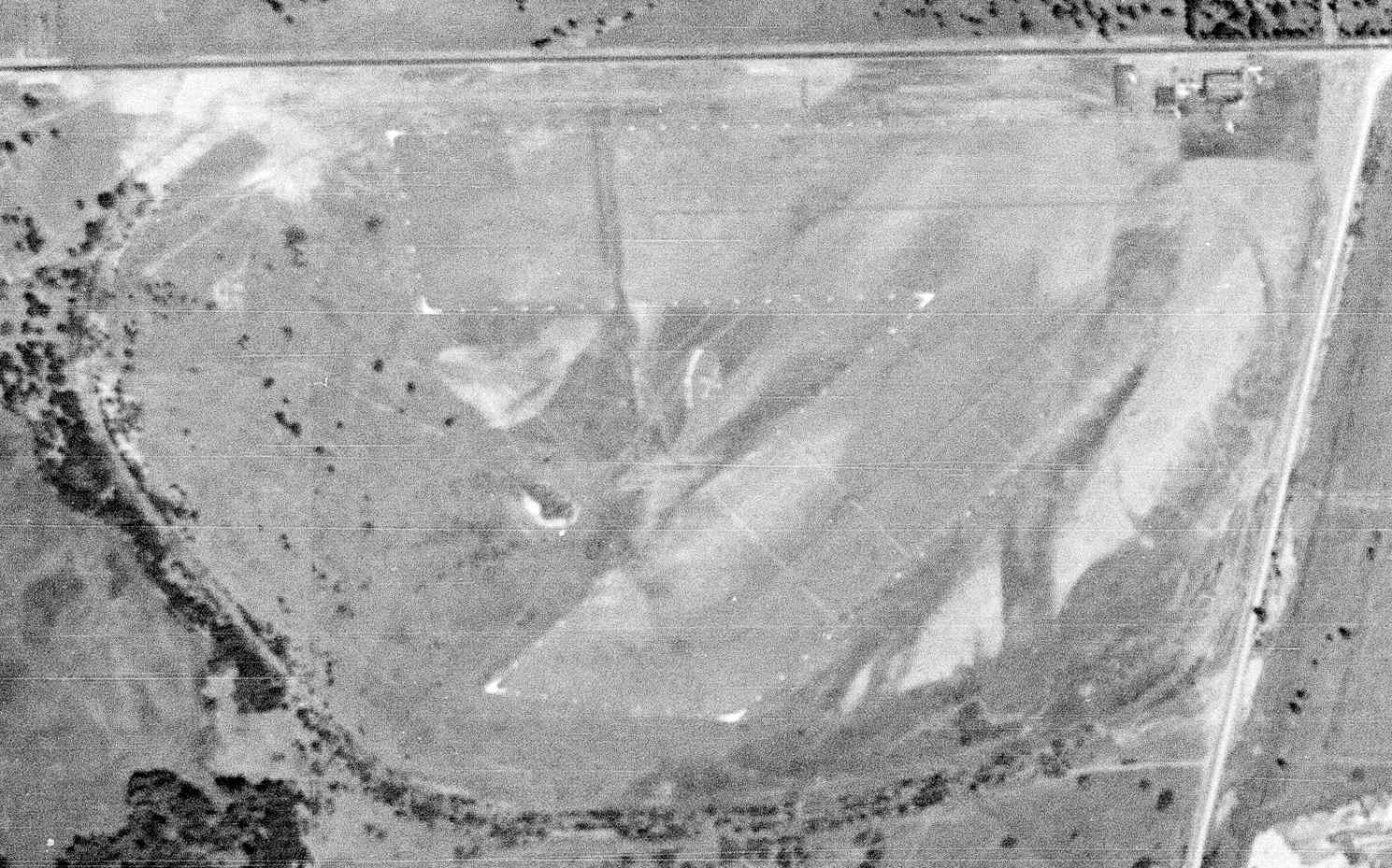
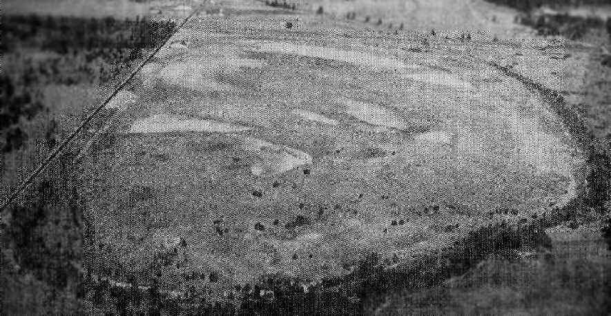
The last photo which has been located of Mueller-Harkins Airport was a 7/10/41 USGS aerial view.
It depicted the field as having a few small buildings at the northeast corner & 2 unpaved runways.
According to a history of the city of Lakewood, "The City of Tacoma used the airstrip as its commercial field for a time,
and national air shows were held at the site until World War II."
The 1944 USGS topo map still depicted Mueller-Harkins Airport.
The last aeronautical chart depiction which has been located of Mueller-Harkins Airport was on the May 1944 Seattle Sectional Chart.
It depicted Mueller-Harkins as an auxiliary airfield.
On 7/21/44, Mueller-Harkins Airport was condemned & taken to support the war effort,
and the property became a Naval Advance Base (Naval supply depot).
Mueller-Harkins Airport was no longer depicted on the September 1944 Seattle Sectional Chart (or subsequent aeronautical charts thru 1991).
However Mueller Harkins Airport may have been briefly reopened after WW2.
Carol-Lee Perkins recalled, “Mueller Harkins Airport between 1945-48...
When I was a youngster, I would take the bus out to this airport in my jodphers & scarf & hang around until my Uncle, Vernon Hubert, took me up stunting in a Stearman.
I was 13 or 14 at the time. At this time, the airport was known as the Mueller Harkins Hubert & Dillon Airport.
I don’t know how long they operated it, but it couldn’t have been very long. This was a very special time for me.”
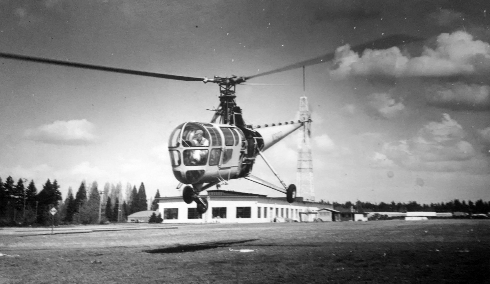
An undated photo of a Sikorsky R-5 helicopter at Mueller-Harkins Airport (courtesy of Steven Morris).
The 1948 USAF Target Complex Chart did not depict any airfield at the Mueller-Harkins Airport site,
but instead a group of buildings, labeled "Naval storehouse".
In 1949, some of the old Navy base was declared surplus & signed over to the Clover Park School District
and by 1954 Clover Park Vocational Technical Institute had received the northern section of the Navy base.
A 1955 aerial photo showed an unpaved east/west clearing at the Clover Park site.
According to “A history of Clover Park Vocational Training Institute” (courtesy of Steve Morris),
“By 1957 the base firehall became headquarters for flight operations.
One summer, instructors built an air traffic control tower on top of the firehall hose drying tower to provide training in air traffic control techniques.”
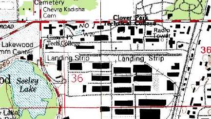
The 1961 USGS topo map depicted a single east/west unpaved runway, labeled simply as “Landing Strip”.
Neither the October 1962 Seattle Sectional Chart (courtesy of Steve Martin)
nor the 1963 WA Pilot's Guide (courtesy of Ron Dupas) depicted an airfield at this location.
The 1967 Seattle Sectional Chart (courtesy of John Voss) still did not depict an airfield at this location.
A 1969 aerial photo showed an unpaved east/west clearing at the Clover Park site.
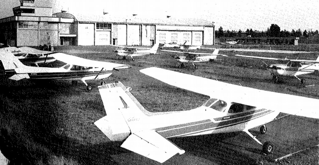
By 1971 Clover Park was operating as an airfield again, operated by the Clover Park Technical College.
By this time, the small airport was situated in what have become a very awkward location: a mere 1 mile north McChord AFB,
almost directly along the extended centerline of McChord's primary runway.
A 5/20/72 USGS aerial view showed the Clover Park Airfield as having an east/west runway, , complete with the runway number “7”, and the hangar at the northeast.
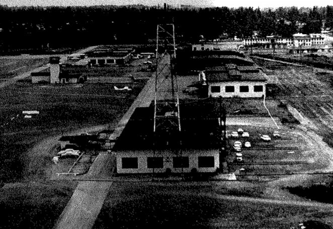
A circa early 1970s photo of Cessnas & a Piper in front of the Clover Park Airfield control tower (courtesy of Steven Morris).
A circa early 1970s aerial view looking west at the Clover Park Airfield (courtesy of Steven Morris).
In Scott Kimball's words, "I learned to fly at this school 1971-1973.
As it was a state-run aviation school, Clover Park had a special arrangement with the Air Force at McChord.
When I was there we took off on an old road used as a runway
and landed on a grass strip parallel & to the south of the paved portion (this was done for building clearance & minimum take-off roll).
Some time after I left the grass strip was paved & used exclusively.
We flew an approximately 500' AGL (800' MSL) pattern only to the North side of the field using specific entry points to the west & northwest.
Clover Park operated it's own 'tower' manned purely by the student pilots which functioned as an advisory to the few outside pilots coming in.
The school preferred to have pilots get prior permission before coming in, but I never heard them complain to anyone."
A circa 1975 aerial view of Clover Park Airfield (courtesy of Steven Morris).
No airfield at this location was depicted on the January 1975 Seattle Sectional Chart (courtesy of Chris Kennedy)
nor on the December 1976 Seattle Sectional Chart.
A 1980 aerial photo showed a single paved east/west runway had been constructed at Clover Park,
and 7 light single-engine aircraft were parked on the southwest side.
A 1982 aerial photo showed 3 light single-engine aircraft were parked on the southwest side of Clover Park Airfield.
The earliest aeronautical chart depiction which has been located of Clover Park Airfield was on a circa 1980s military aeronautical chart (courtesy of Lee Corbin).
It depicted Clover Park as having a single east/west runway.
However Clover Park Airport was still not depicted on the January 1987 Seattle Terminal Chart (courtesy of Mitchell Hymowitz).
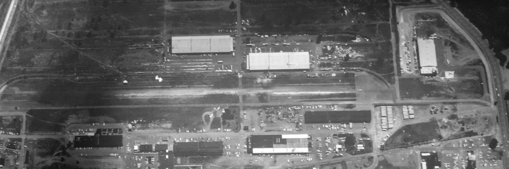
A 1990 USGS aerial view looking northeast depicted the Clover Park Technical College Airfield
as having a single east/west asphalt runway, marked with runway numbers at each end.
A total of 6 light single-engine aircraft were parked at the southwest end
(ironically on the opposite side from the circa 1920s hangar, which remained standing on the northeast side but no longer used for aviation).
The 1994 USGS topo map depicted Clover Park as a single 2,800' east/west runway, labeled simply as "Landing Strip".
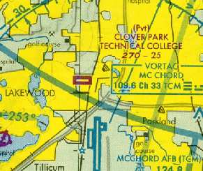
The 1999 Seattle Terminal Area Chart (courtesy of Scott Kimball)
depicted "Clover Park Technical College" as a private airfield, with a single 2,500' paved east/west runway.
Rich Gregory recalled, “The flight school moved in 2001.
I was taking classes there at the time & flew the 1st airplane (to the new Thun Field campus)
on April 3, 2001 & my last flight in or out of S37 was on April 5, 2001.”
The last aeronautical chart depiction which has been located of the Clover Park Airfield
was on the June 2002 Seattle Terminal Area Chart (courtesy of Ghery Pettit).
Clover Park Airfield was no longer depicted on the December 2002 Seattle Terminal Area Chart (according to Ghery Pettit).
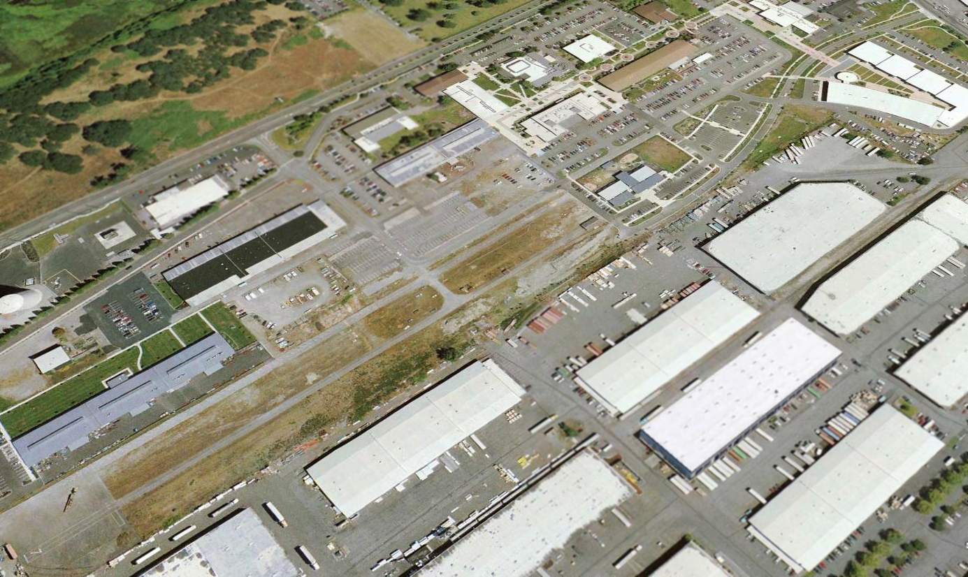
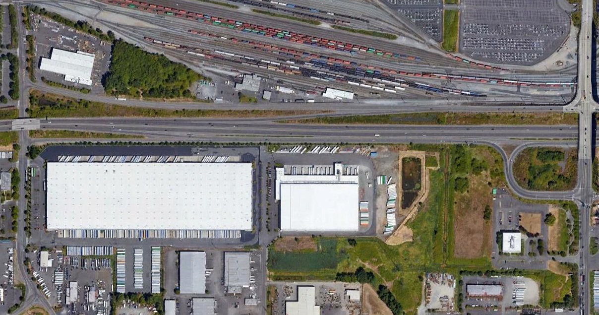
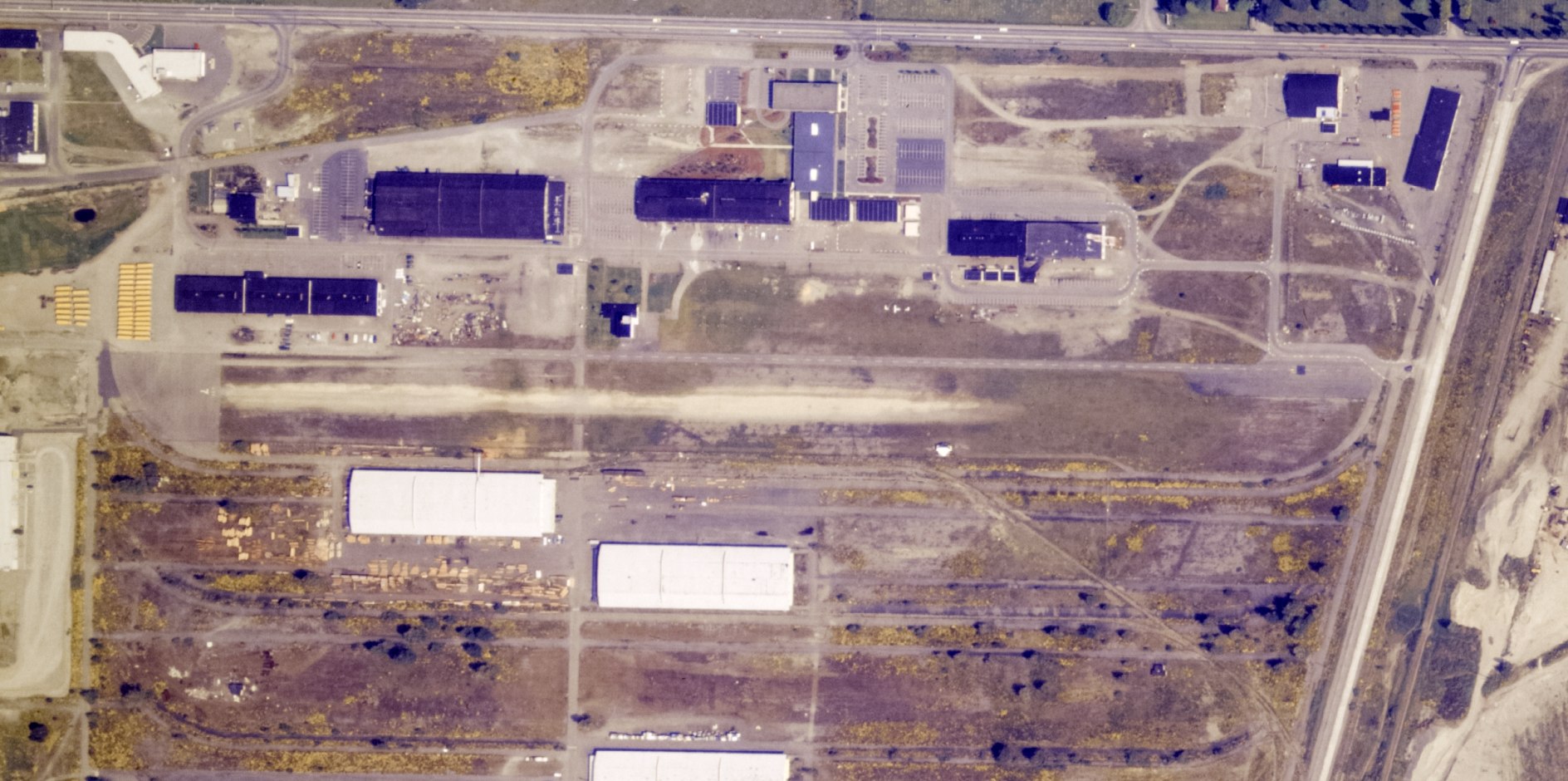
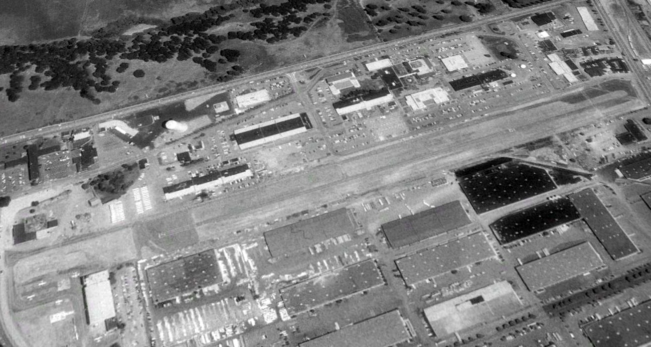
A 2005 aerial view looking northeast at the Clover Park Technical College Airfield
showed that the east end of the runway had been covered with newly-built streets,
but the west end of the runway was still intact, complete with the runway number “7”.
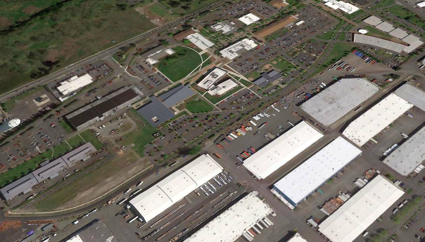
A 2015 aerial view looking northeast at the Clover Park Technical College Airfield
showed that the site had been further redeveloped, to be no longer recognizable as a former airport,
but a small portion of the west end of the runway remained intact (at bottom-left).
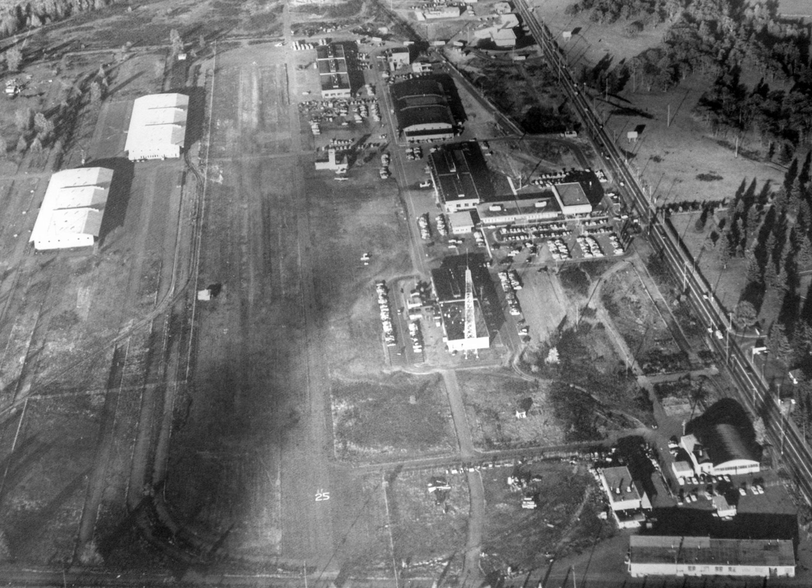
A circa 2015 aerial view looking north at the 1920s vintage Tacoma Flying Service hangar on the northeast side of the site of Mueller-Harkins Airport / Clover Park Technical College Airfield.
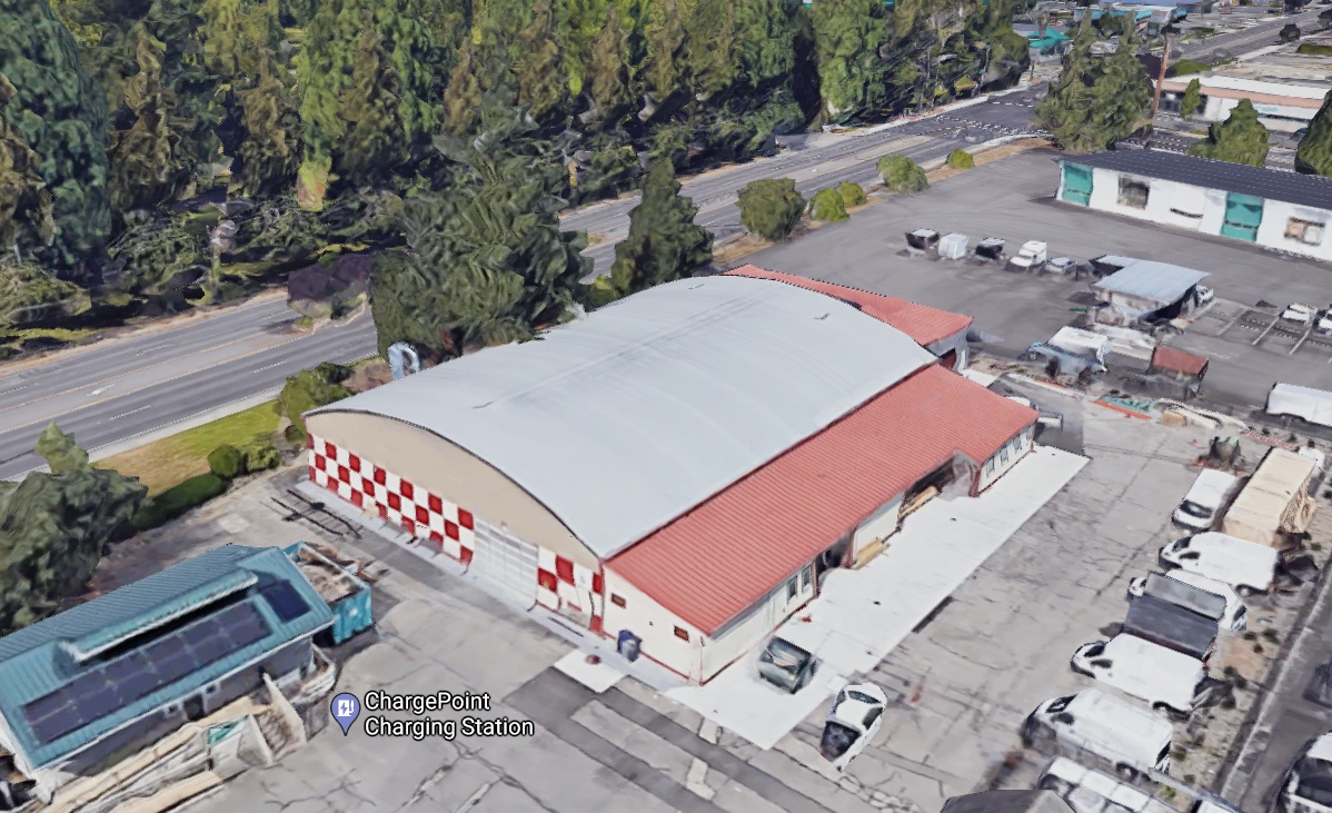
Amazingly, a circa 2011 3-D aerial view looking north showed the 1920s vintage Tacoma Flying Service hangar remains standing
on the northeast side of the site of Mueller-Harkins Airport / Clover Park Technical College Airfield.
The site of the Clover Park Technical College Airfield is located southwest of the intersection of Lakeview Avenue Southwest & Perimeter Drive.
____________________________________________________
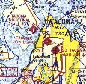
47.24, -122.53 (North-northwest of McChord AFB, WA)
Tacoma Airport, as depicted on the April 1946 Seattle Sectional Chart.
This small general aviation airport was evidently established at some point between 1945-46,
as it was not yet depicted at all on the March 1945 Seattle Sectional Chart (according to Chris Kennedy).
The earliest depiction of the Tacoma Airport which has been located was on the April 1946 Seattle Sectional Chart,
which depicted Tacoma as a commercial/municipal airport.

The 1948 USAF Target Complex Chart (courtesy of Chris Kennedy) depicted Tacoma Airport as having 2 runways, each with a parallel taxiway.
with possibly a surplus Vultee BT-13 Valiant trainer on the left.
The October 1948 Seattle Sectional Chart (courtesy of Chris Kennedy) depicted Tacoma Airport as having a 2,200' unpaved runway.
The 1948 USGS topo map depicted Tacoma Airport as a single north/south runway, labeled simply as “Landing Field”.
Strangely, the crosswind runway (depicted on earlier & later charts) was not depicted at all.
According to Scott Kimball, "Tacoma Airport was better known throughout the northwest as 'Oswalds',
after 'Bud' Oswald, the owner/operator."
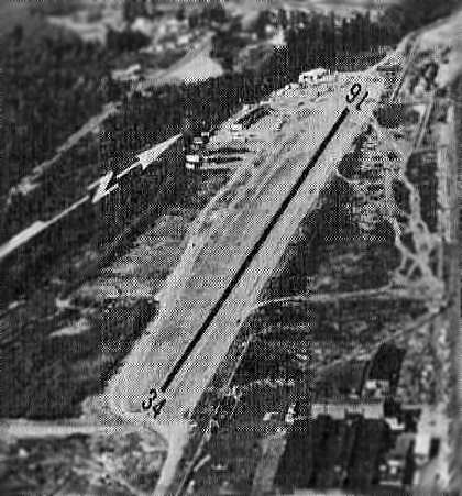
The earliest aerial view which has been located of Tacoma Airport was a 1950 aerial view (courtesy of Lee Corbin).
It depicted Tacoma Airport as having 2 asphalt runways, oriented north/south & northeast/southwest,
with a paved ramp, several hangars, and over a dozen light aircraft on the southeast side.
Bill Hamilton recalled, “I started flying in 1954 at Bud Oswald's Tacoma Airport. One of my instructors was Bud Kimball.
He also handled aircraft sales for Oswalds & I rode along quite a bit on demo flights around Western Washington with Bud.”
Mike Brown recalled, “I have some fond memories of Tacoma Airport.
Back in 1955/56 I was a Cadet in Civil Air Patrol, which had a facility at Tacoma Airport. The Tacoma Squadron had 2 CAP aircraft: an L5 & an L16.
The Commandant of Cadets, CWO Red Young, was a partner in a Waco biplane. That was my favorite ride.
The cadets would save their money & show up at the airport on the weekends, buying gas for a familiarization flight in one of the squadron aircraft.
The senior pilots were more than willing to accept cadet money to buy gas for these rides. It was an inexpensive way to log Pilot-In-Command hours.
There was a cafe across from the airport (Mildred Street) where the cadets would hang out drinking coffee while waiting for a pilot to show up. As I recall, it was not a sure process.
It would appear that the Royal Thai Bistro now occupies that site [2022]. Those were the days."
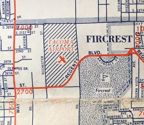
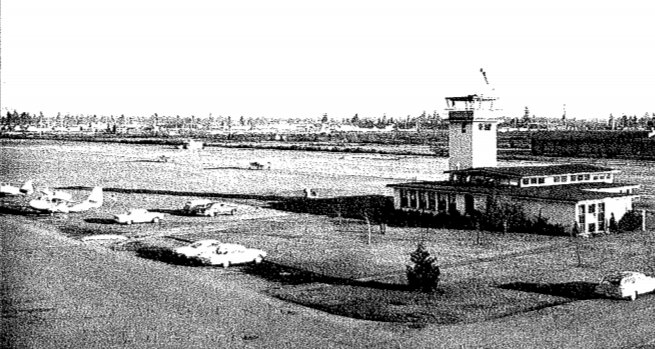
The Tacoma Airport, as depicted on a 1958 street map (courtesy of Kevin Walsh).
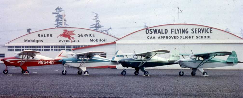
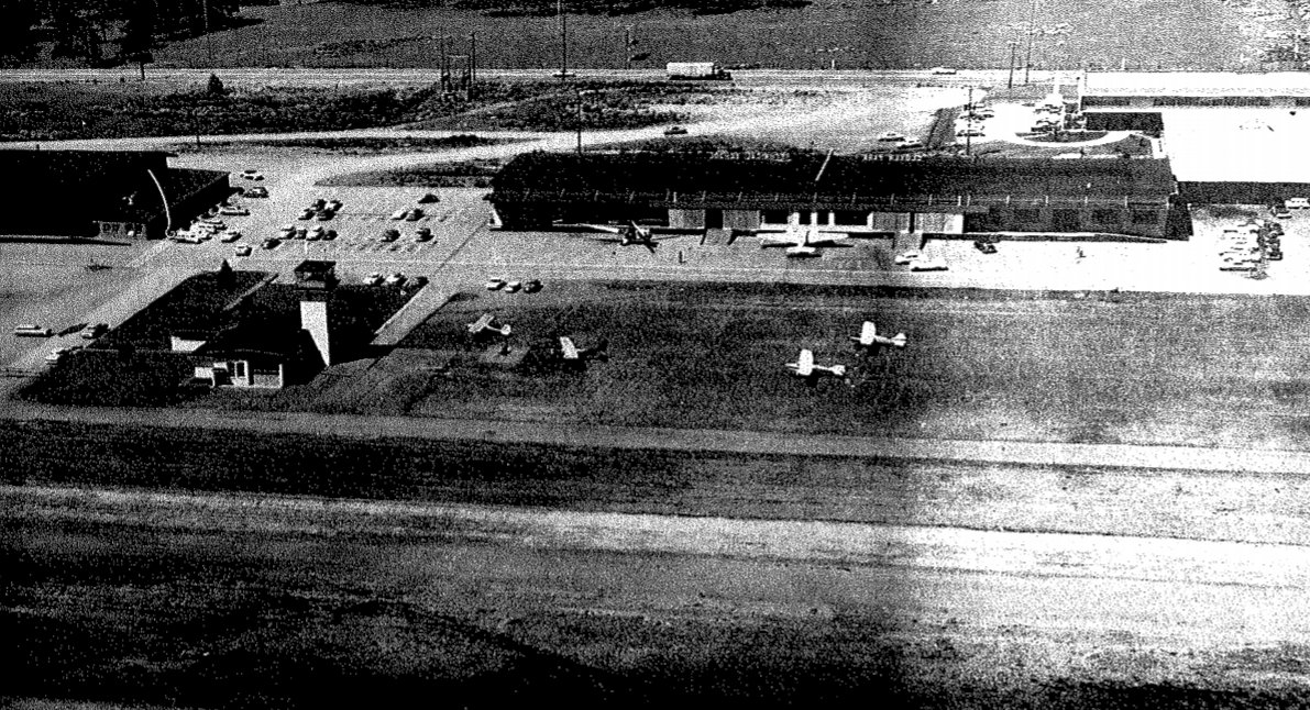
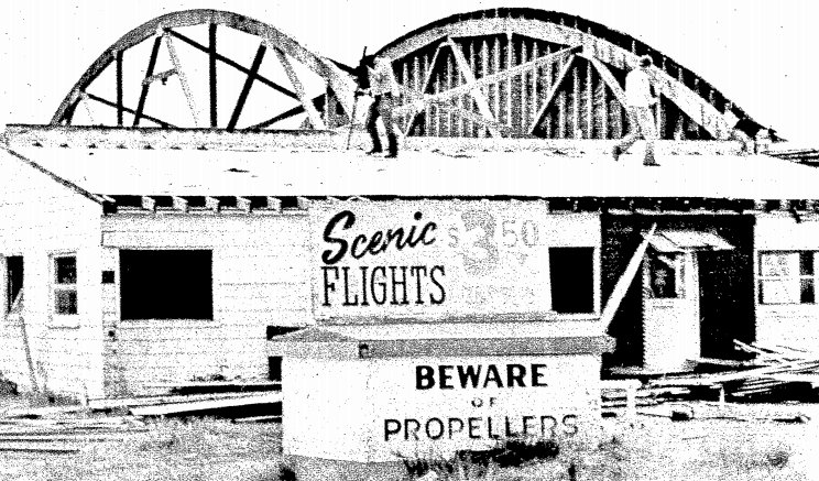
A circa 1959 photo of 4 new Piper Tri-Pacers in front of 2 hangars of Oswald Flying Service at Tacoma Airport
(from the archives of Bud Kimball Photography, courtesy of Jeff Kimball).
The 1959 USGS topo map depicted the Tacoma Airport as having 2 runways,
with several small buildings on the northeast & southeast sides.
A 1961 aerial photo of Tacoma Airport (from the University of WA Library, courtesy of Greg Peterson).
The field could be seen to have a single northeast/southwest runway,
along with the former north/south runway (on which closed-runway “X” markings were visible).
A total of 5 hangars were visible on the east side of the field, along with 5 single-engine aircraft.
A circa 1960s aerial view looking northeast at Tacoma Airport (from the Tacoma Public Library).
The field could be seen to have a single northeast/southwest runway, along with the former north/south runway.
A total of 5 hangars were visible on the east side of the field, along with 5 single-engine aircraft.
The 1962 AOPA Airport Directory described Tacoma Airport as having a single 2,400' oiled Runway 1/19,
and listed the operator as Oswald Flying Service.
The October 1962 Seattle Sectional Chart (courtesy of Steve Martin)
depicted Tacoma Airport as having a 2,400' unpaved runway.
The 1963 WA Airport Directory (courtesy of Ron Dupas)
depicted Tacoma Airport as having a single 2,430' asphalt northeast/southwest runway.
The former north/south runway was still depicted in the airfield diagram, but was labeled "closed".
An office & several hangars were depicted on the east side of the field.
In a 1965 aerial photo of Tacoma Airport (from the University of WA Library, courtesy of Greg Peterson),
the field's configuration was basically unchanged compared to the 1961 aerial photo,
with a single northeast/southwest runway, the closed north/south runway, and 5 hangars.
A total of 9 single-engine aircraft were visible on the east side of the field,
including one taxiing to the runway for takeoff.
A circa 1965 photo (courtesy of Jeff Kimball) of Majorie Kimball in front of “my Dad's highly modified Stinson L-5
taken in between the rows of T-hangars in the southwest corner of Oswald's [Tacoma Airport], near the south end of the closed runway.
The L-5 was quite a critter... Dad's had a 225hp Lycoming R-680 from a PT-17 Stearman, wingtips extended 30 inches each & squared,
plus oversized wheels & tires along with the mods for the photo missions.
Slow... so cross-country was an adventure. But it still had the drooping ailerons & something like 45 degrees of flaps so you had a full wing flap if you wanted it.
You could probably land it in a tennis court.”
The rumor was the fire was an insurance job on the airplane in the slot next to dads, but no one ever proved it.. Dad's L5 would be a real oddity if it was still around...”
The 1967 Seattle Sectional Chart (courtesy of John Voss)
described Tacoma Airport as having a single 2,430' asphalt northeast/southwest runway.
The Aerodromes table on the chart included the remark, "N/S runway permanently closed."
According to Jeff Kimball, “There was a fire in 1969 that burned the south row of hangars including our L-5, and 6 or 7 other airplanes at Tacoma Airport.”
According to Scott Kimball, Tacoma Airport "closed about 1973."
A 1973 aerial view (courtesy of Lee Corbin) showed the site of Tacoma Airport shortly after its closure.
Some of the hangars had been removed at some point between 1965-73, but some still remained.
The northeast/southwest runway remained intact, along with a short portion of the north/south runway.
Both were marked with closed-runway “X” symbols.
Tacoma Airport was not depicted at all on the 1974 USGS topo map or on the July 1974 Seattle Terminal Chart.
A June 1974 photo of the demolition of the Tacoma Airport hangar (courtesy of Lee Corbin).
A 1974 USDA aerial photo of the site of Tacoma Airport (from the University of WA Library, courtesy of Greg Peterson)
showed that the property was in the process of being redeveloped,
with all of the airport buildings except one having been removed, and the outline of the runways still somewhat recognizable.
In a 1983 aerial photo (from the University of WA Library, courtesy of Greg Peterson)
not a trace of Tacoma Airport was still perceptible as the property had been densely redeveloped.
A 2016 aerial view looking northwest showed not a trace remains of Tacoma Airport.
The site of Tacoma Airport is bounded by 19th Street on the north, 27th Street on the south, Mildred Street on the east, and Cascade Place West on the west.
Another small general aviation field, the former South Tacoma Airpark was located less than 2 miles to the southeast of Tacoma Airport.
____________________________________________________
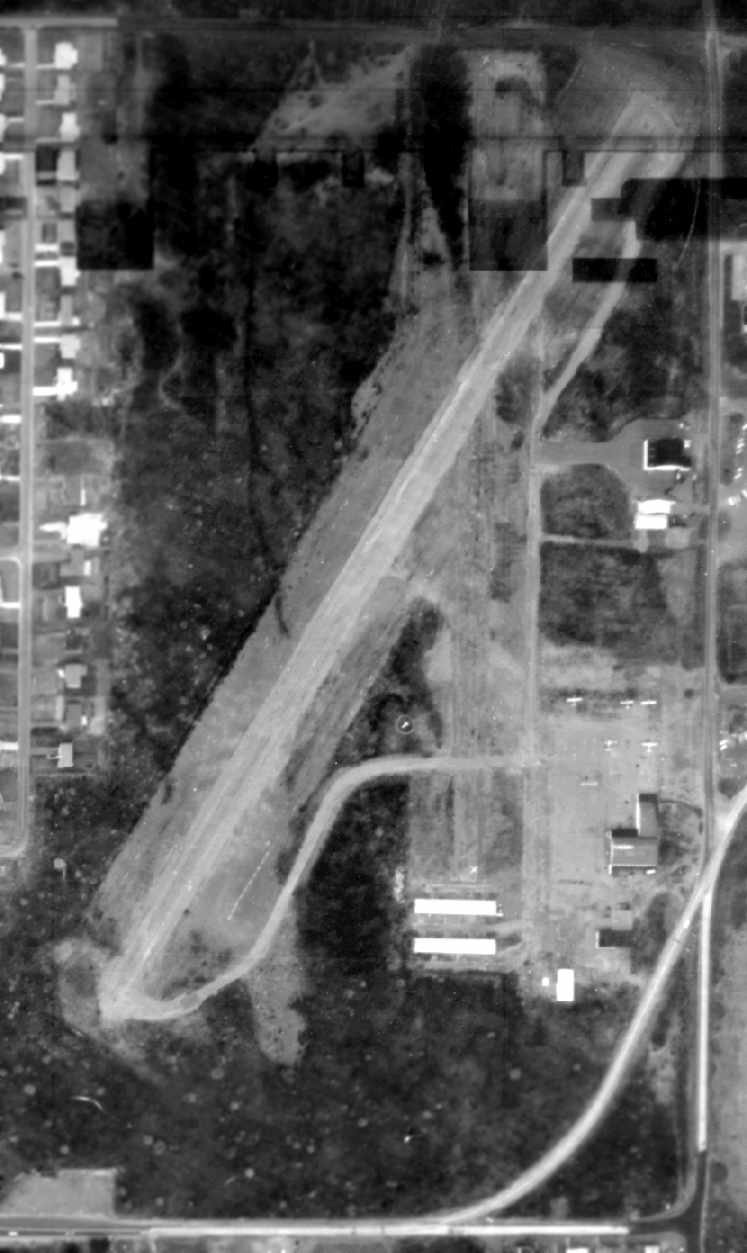
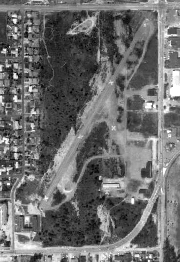
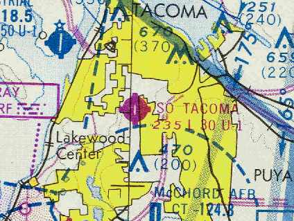
Tacoma Airpark / Tacoma Aero Club Airfield / South Tacoma Airport, Tacoma, WA
47.21, -122.49 (North-northwest of McChord AFB, WA)
The clearing of the South Tacoma Airport was visible on a 7/10/41 USGS aerial photo.
According to a 1995 WA State Department of Health report, "The South Tacoma Airport operated from 1936-73."
According to Scott KimballI, "In its early days (prior to WW2?), South Tacoma had a 'slew' parallel to the hard runway that was used as a float base."
Bill Hamilton recalled, “The 'slew' that was used for floatplane landings... It was rather narrow & not very long but it worked.”
The clearing of the South Tacoma Airport was visible on a 7/10/41 USGS aerial photo.
South Tacoma Airport was not depicted at all on the March 1945 Seattle Sectional Chart (according to Chris Kennedy).
It may have been temporarily closed during WW2, like many other small civilian airports along the coasts, due to wartime security concerns.
The earliest aeronautical chart depiction which has been located of Tacoma Airpark was on the April 1946 Seattle Sectional Chart,
which depicted Tacoma Airpark as a commercial/municipal airport.
The 1948 USAF Target Complex Chart (courtesy of Chris Kennedy) depicted “Tacoma Airpark” as having a single north/south runway.
The October 1948 Seattle Sectional Chart (courtesy of Chris Kennedy) depicted “Tacoma Airpark” as having a 3,500' unpaved runway,
along with a 2,000' seaplane water landing area.
A 1954 street map (courtesy of Kevin Walsh) depicted “Tacoma Airpark” as a north/south-oriented rectangular property outline.
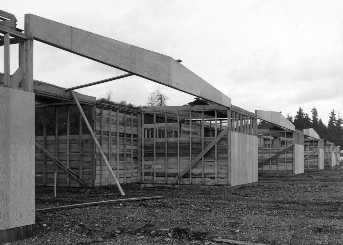
The narrow, slightly bent pieces of plywood above the plywood forms were box beams.
They were probably put together at Weber Lumber Co. a few days before.
These are believed to be some of the 10 new T-hangars built by C.E. Munson, contractor, which held 5 planes to a side.
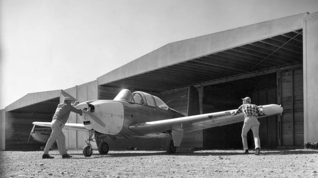
Frank Bly is pushing with his hands on the propeller.
Bly built a hangar at South Tacoma Airport in the late 1950s, which he used to restore & keep his 1931 Stinson W.
South Tacoma Airport was still not depicted on the 1958 USGS topo map.
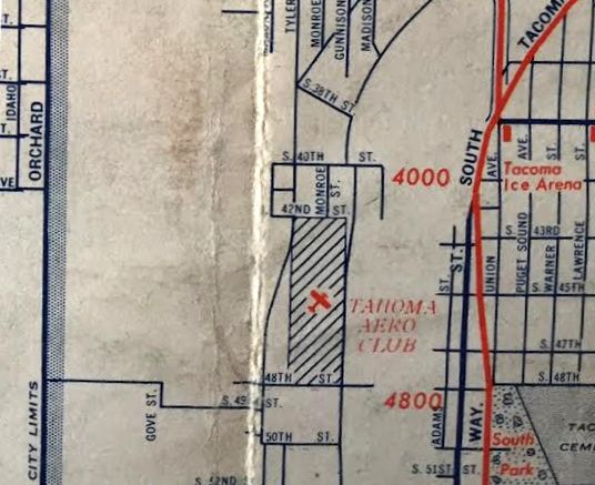
South Tacoma Airport was labeled “Tacoma Aero Club” on a 1958 street map (courtesy of Kevin Walsh),
the only time this name has been seen used for the airport.
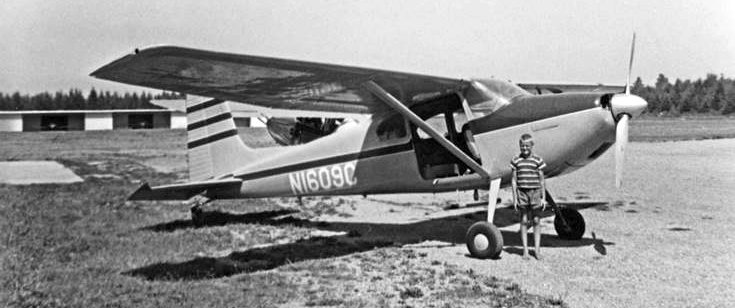
A 1960 photo of Charles Batchelor & a Cessna 180 at the South Tacoma Airport.
The 1961 USGS topo map depicted the South Tacoma Airport as having a single unpaved north/south runway,
with a small building on the northwest side.
The 1962 AOPA Airport Directory described the field as having a 3,400' gravel & turf Runway 18/36,
and listed the operator as Gross Aviation.
According to Scott Kimball, "Gross Aviation was owned by Chuck Gross."
The October 1962 Seattle Sectional Chart (courtesy of Steve Martin) depicted South Tacoma Airport as having a 3,500' unpaved runway.
The 1963 WA Airport Directory (courtesy of Ron Dupas)
described South Tacoma Airport as having a single 3,400' gravel north/south runway.
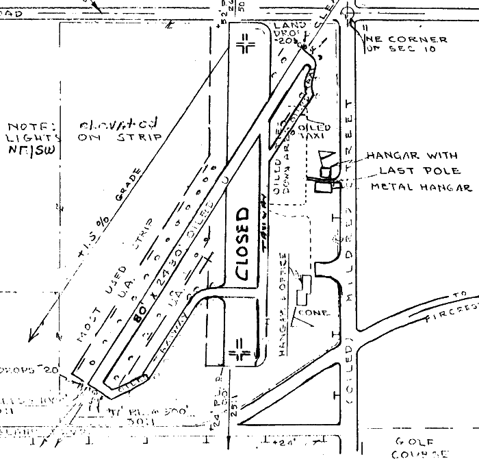
Three hangars & an office building were depicted on the northwest side of the field.

A 1963 photo courtesy of Rich Ziesmer of his grandfather's 1931 Stinson W, “Old Goat”, S/N 3054, NC12146, at “South Tacoma Airport at the north end of the field.
It was my grandpa's life. Everyday after work & on the weekends he went to the South Tacoma Airport & worked on the Stinson or whatever else he had going.
The hangar in the background was owned by Chuck Gross, Gross Aviation the Fixed Base Operator.”
The Aerodromes table on the 1964 Seattle Sectional Chart (according to Chris Kennedy)
listed the runway configuration as a single 3,500' gravel strip.
Patrick Lehne recalled, “In 1965 my older brother took me for my first ride while he got a lesson from South Tacoma Air Park.
The next day I showed up for my first lesson. The instructor said 'TODAY?'
(It was spitting snow but enough ceiling to do a short hope out over the Sound.)
Because of the hill off Runway 16 it was better to do a 'dog leg' final. So you're low & slow & turning.
When the teacher told me this I just thought 'Ya? So what?' Ignorance was bliss.
The power lines off Runway 34 made approach from there even a bit more dicey.
I would guess the runway to be about 50' wide. And it was hard gravel.
At this time there was 3 hangars & an office in the northwest corner. The buildings in the picture at Runway 34 were not there.
It was all open & flat except for the power lines. I have no memory of water for float planes.”
Apparently the runway was paved within the next three years,
as the 1967 Seattle Sectional Chart (courtesy of John Voss)
described South Tacoma as having a single 3,000' asphalt runway.
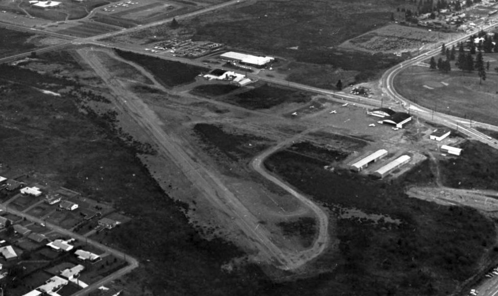
An aerial view looking northwest at South Tacoma Airpark,
from the 1971 WA Airport directory (courtesy of Chris Kennedy).
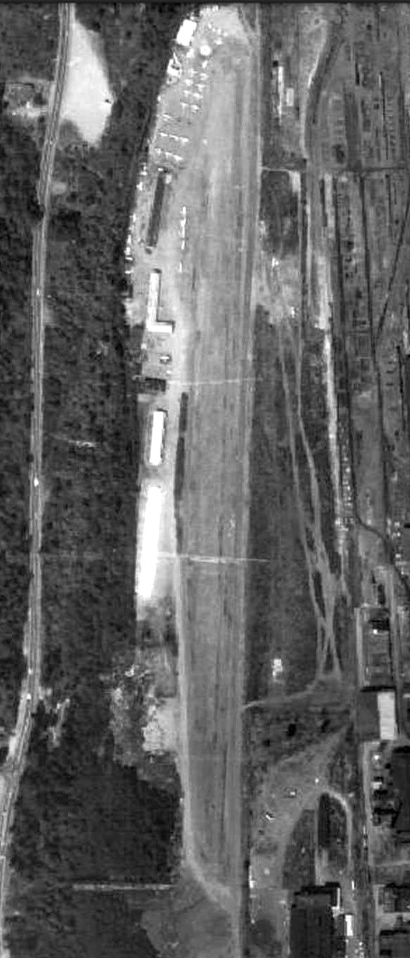
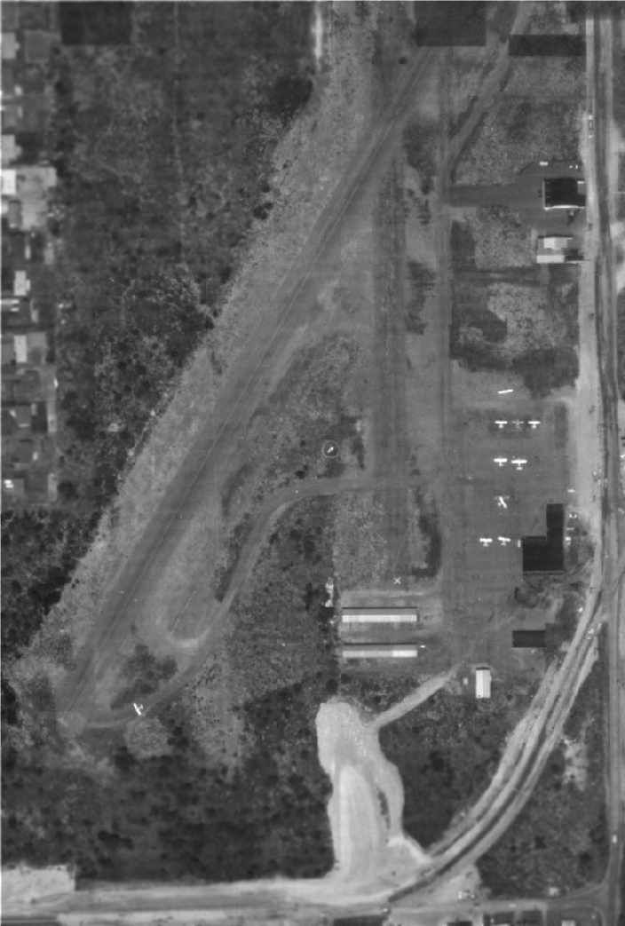
The last photo which has been located of South Tacoma Airport was a 1973 aerial view (courtesy of Lee Corbin).
It depicted South Tacoma Airport as having a north/south runway, with several rows of hangars & over a dozen light aircraft on the northwest side.
The 1995 WA State Department of Health report said that South Tacoma Airport closed in 1973,
although this appears to be contradicted by a later aeronautical chart depiction.
South Tacoma Airport was evidently still open in 1975,
as it was still depicted as an active airfield on the January 1975 Seattle Sectional Chart (courtesy of Chris Kennedy).
It was described as having a single 3,000' paved runway.
The 1976 USGS topo map depicted the South Tacoma Airport as having a single unpaved north/south runway,
with a small building on the northwest side.
South Tacoma Airport was evidently closed at some point between 1975-76,
as it was no longer depicted on the December 1976 Seattle Terminal Area Chart nor on the 1981 USGS topo map.
In a 1990 aerial photo of the site of South Tacoma Airport, remains of the former runway pavement were still barely visible.
Some kind of industrial building had been built at some point along the south side of the former airport property.
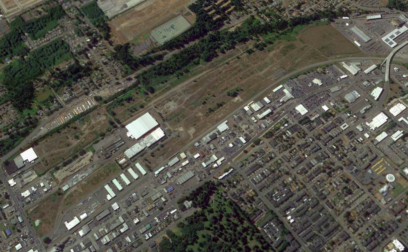
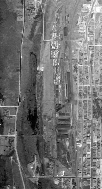
A 2016 aerial view looking northwest showed no trace remaining of South Tacoma Airpark.
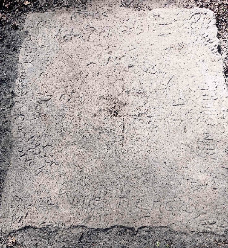
A 2018 photo by Rich Ziesmer of “South Tacoma Airport... I found this old cement slab that held the hangar up [which] Frank Bly & Kenny Coriell built.
It was signed by them, Arnold Casidy (the airport's I/A), Dick Ziesmer my Dad, my mother etc.
I was looking for the sidewalk with my handprint that I made as a kid, and I walked directly to that one of my Grandpa's, in the middle of trees & weeds under a old fire pit.
It was the strangest thing. In the middle of the airport, at the 1st hangar south of the newer T-hangars.”
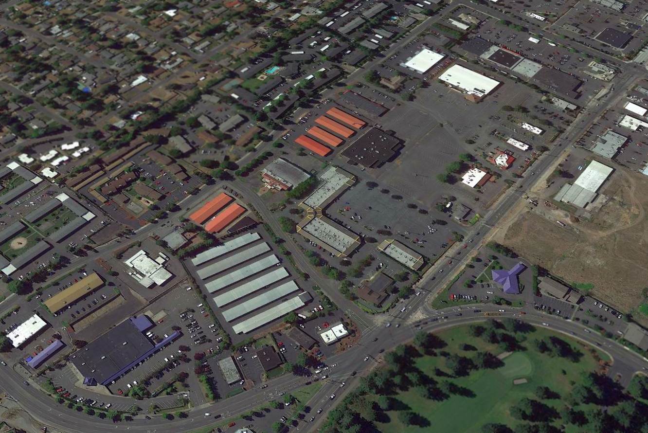
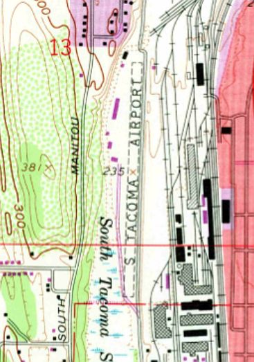
The site of the former South Tacoma Airpark is located north of the intersection of South 56th Street & South Proctor Street.
Another small general aviation field, the former Tacoma Airport was located less than 2 miles to the northwest of South Tacoma Airpark.
____________________________________________________
Or if you prefer to contact me directly concerning a contribution (for a mailing address to send a check),
please contact me at: paulandterryfreeman@gmail.com
If you enjoy this web site, please support it with a financial contribution.
____________________________________________________
This site covers airfields in all 50 states.