Abandoned & Little-Known Airfields:
Virginia: Hampton area
© 2002, © 2025 by Paul Freeman. Revised 2/20/25.
This site covers airfields in all 50 states: Click here for the site's main menu.
____________________________________________________
Please consider a financial contribution to support the continued growth & operation of this site.
College Airport / William & Mary Airport / Central Airport (revised 2/20/25) - Curtiss Aviation School / Atlantic Coast Aeronautical Station / Newport News Airfield / Carey Epes Airfield (revised 11/3/20)
Evans Airport / Gloucester Airport / Mellar Field (revised 11/22/24) - Harcum Airport (revised 9/4/22)
Heathsville Airport (revised 11/3/20) - Langley AFB BOMARC Missile Site (revised 11/22/24) - Lively Intermediate Field (revised 11/22/24)
Walker AAF (revised 11/3/20) - (Original) Williamsburg Airport / Scott Field (revised 2/20/25) - Yorktown Naval Aviation Field (revised 2/7/18)
____________________________________________________
Curtiss Aviation School / Atlantic Coast Aeronautical Station / Newport News Airfield / Carey Epes Airfield, Newport News, VA
36.968, -76.412 (South of Downtown Newport News, VA)
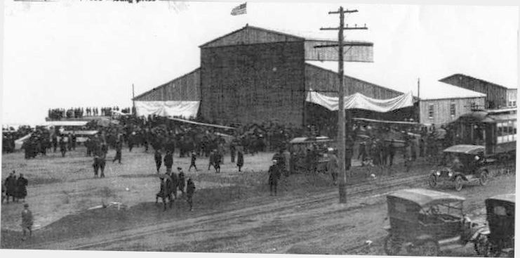
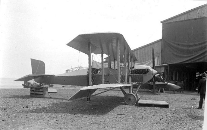
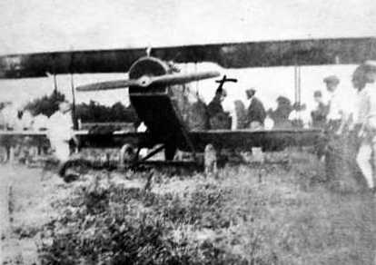
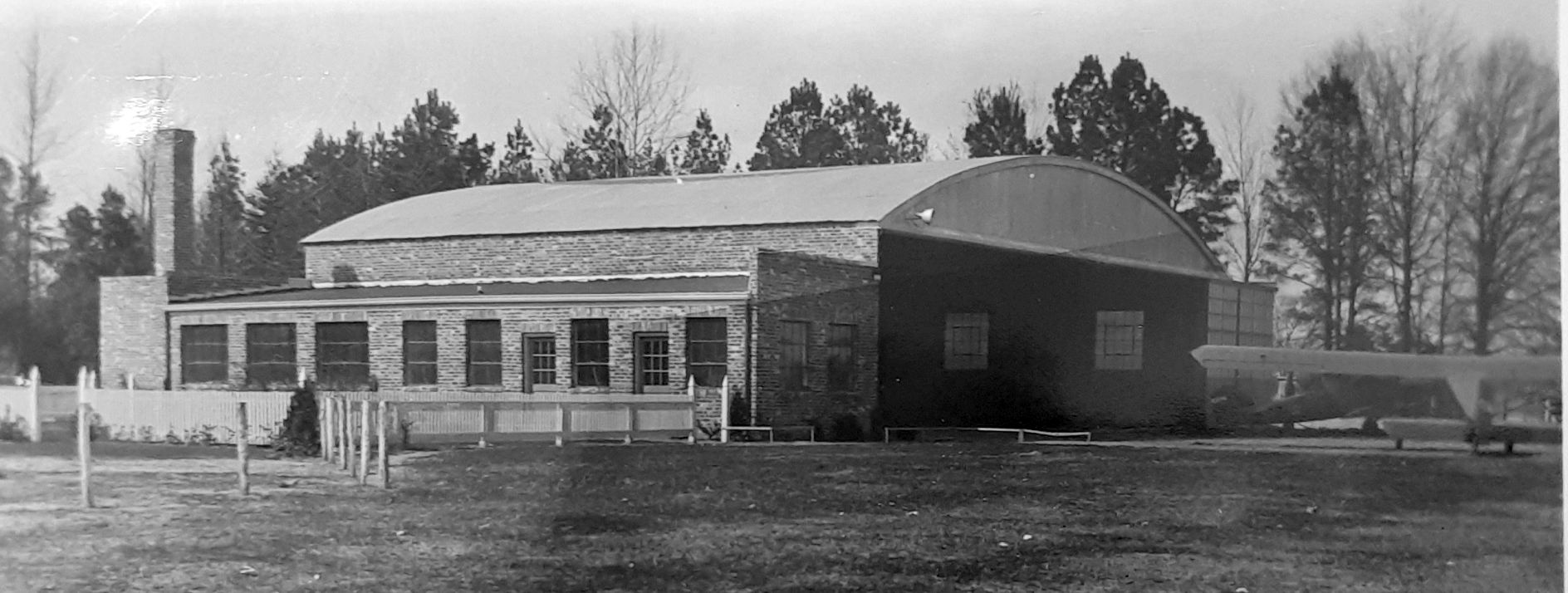
A 1916 photo of biplanes & a large number of spectators in front of the hangar of the Curtiss Aviation School.
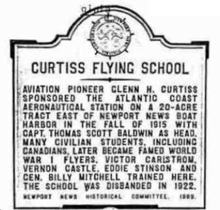
According to a 11/7/69 historical marker, “Aviation pioneer Glenn Curtiss sponsored the Atlantic Coast Aeronautical Station
on a 20 acre tract east of Newport News boat harbor in the fall of 1915 with Captain Thomas Baldwin as head.”
During its half dozen years of operation, the Curtiss Flying School trained a large number of civilian flyers, both American & Canadian.
The first group of U.S. National Guardsmen to take to the air received training at Newport News before going on to active duty in the U.S. Army Air Corps.
Many Canadians who served in the war also won their wings at the little field overlooking Hampton roads.
Victor Carlstrom, an instructor at Curtiss, set world's records for speed & distance in the flight of a modified Jenny from Curtiss Field to New York.
Ballroom dancer Vernon Castle left his willowy wife & partner, Irene, to train in Newport News for overseas flight duty.
Another student was Geoffrey O'Hara, composer of 'K-K-K-Katie'.
Such other pioneer pilots as Eddie Rickenbacker & Eddie Stinson were associated with the school.
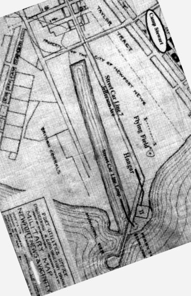
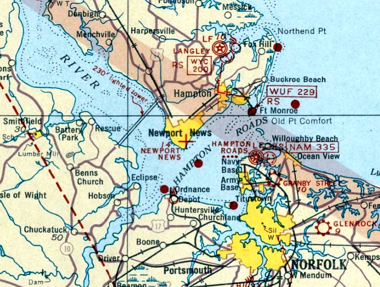
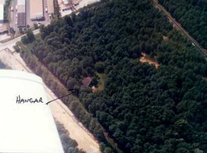
A map showing the location of the Curtiss Flying School flying field & hangar.
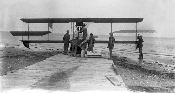
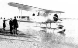
A 1916 photo of a Curtiss Model F seaplane being moved into the water from the Curtiss Aviation School ramp.
Newport News native Cary Epes died in a training plane crash in 1917 at the Curtiss Flying School.
Bruce Terrell observed, “General Billy Mitchell learned to fly there.
One of the things that I find fascinating about this facility is that the flying boat component
took off & landed right above the wrecks of the ships that were sunk by the CSS Virginia during the Civil War.
The USS Monitor & the Virginia fought their famous battle right off of this point of the peninsula.
The site of the field at Newport News Point was originally Camp Butler during the war & the USS Congress was sunk right here.”
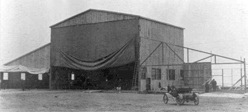
An undated photo of the hangar of the Curtiss Aviation School.
An undated photo of an unidentified biplane in front of the Curtiss Aviation School hangar.
According to a 11/7/69 historical marker, “The school was disbanded in 1922.”
The airfield at the site of the Curtiss Aviation School may have continued in operation after the school closed,
as the October 1935 Norfolk Sectional Chart depicted “Newport News” as an auxiliary airfield.
The Newport News airfield was evidently renamed “Carey Epes” at some point in 1935-36,
as that is how it was labeled on the May 1936 Norfolk Sectional Chart.
The Carey Epes airfield evidently didn't last long,
as it was no longer depicted on the November 1936 Norfolk Sectional Chart or subsequent Sectionals.
No airfield was depicted at this location on the 1951 USGS topo map.
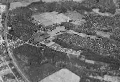
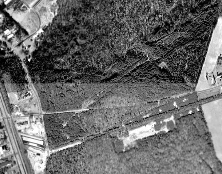
A 1963 aerial photo showed the hangar was gone, and several buildings had been constructed over the northwest portion of the flying field.
An undated photo of Newport News aluminum historical city marker #12, commemorating the Curtiss Flying School.
Located at the foot of Jefferson Avenue facing Hampton Roads, unveiled 11/7/69. Purchased by Newport News Historical Committee.
Present at the unveiling were Rear Admiral Horace Epes, Cary Epes McMurran, and Charles Cary McMurran,
nephews & grandnephews of Newport News native Cary B. Epes, who died in a training plane crash in 1917 at the Curtiss Flying School.
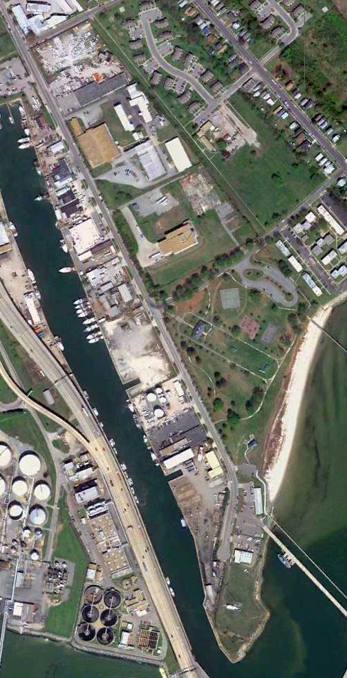
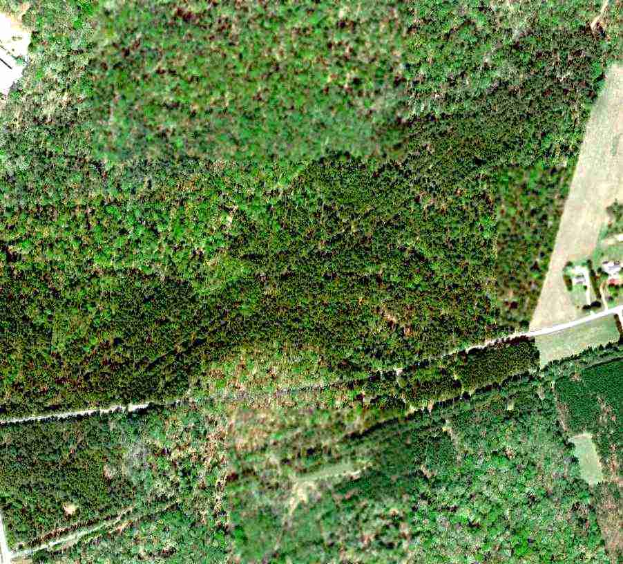
A 4/16/10 aerial photo showed no trace remaining of the Curtiss Aviation School.
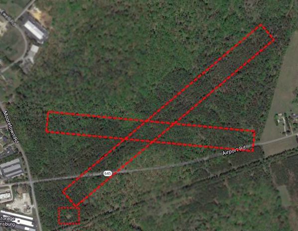
As of 2013, road maps label the central portion of the airfield as King-Lincoln Park.
The site of the Curtiss Aviation School is located at the southern terminus of Jefferson Avenue.
Thanks to Bruce Terrell for pointing out this airfield
____________________________________________________
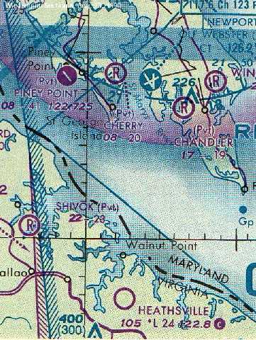
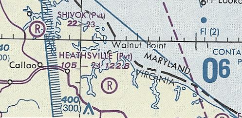
Heathsville Airport (7W7), Heathsville, VA
37.944, -76.458 (North of Hampton Roads, VA)
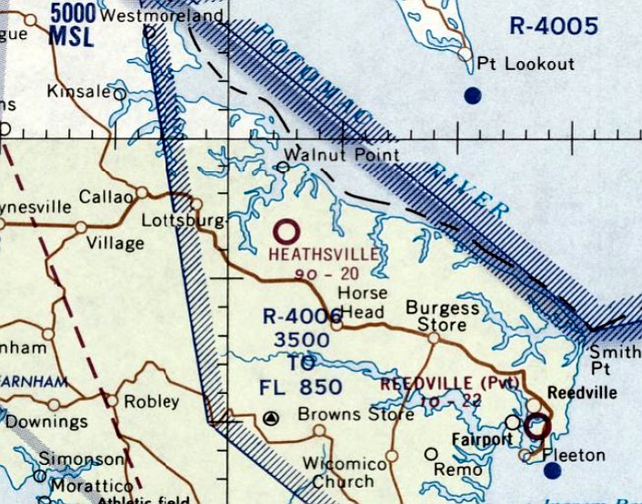
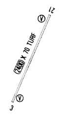
Heathsville Airport, as depicted on the September 1966 Norfolk Sectional Chart.
Photo of the airport while in operation is not available.
The earliest photo which has been located of Heathsville Airport was a 1961 aerial view.
It depicted the field as having a single unpaved northeast/southwest runway.
Heathsville Airport was not yet depicted on the 1962 USGS topo map or the March 1966 Norfolk Sectional Chart.
Sharon Clark recalled, “My dad operated a public state airstrip on our farm near Heathsville.
It was called Heathsville Airport. Several pilots kept their planes tied down there & he also had an air taxi service.”
The earliest depiction of Heathsville Airport which has been located was on the September 1966 Norfolk Sectional Chart.
It depicted Heathsville as having a 2,000' unpaved runway.
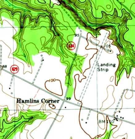
The 1968 USGS topo map depicted Heathsville Airport as a single unpaved northeast/southwest runway, labeled simply as “Landing Strip”.
According to the VAHS book "Virginia Airports" by Vera Rollo & Norman Crabill.
“Heathsville Airport was a turf field, 2,400', located on 10 acres. Visitors were welcome.”
The earliest photo which has been located showing Heathsville Airport while in operation was a 1968 aerial view.
It depicted the field as having a single unpaved northeast/southwest runway, with one single-engine plane parked on the northeast side.
Bob Newman recalled, “The runway was indeed 2,400',
though power lines on Coan Wharf Road (marked with orange balls) limited the usable on Runway 3 somewhat.
The driveway to Mr. Clark's (the owner's) home crossed the runway, as shown on the topo map,
but it was level & no problem when using the runway.
The grass was meticulously maintained; it was the smoothest turf runway I've ever landed upon - it felt like a carpet under the wheels.
Mr. Clark kept a Mooney there for a number of years, and there were several tiedowns available for rent.
The overnight visitor tiedown fee was $3.”
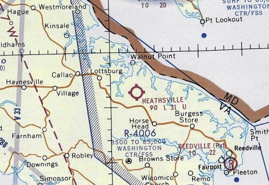
The 1971 Washington Sectional Chart depicted Heathsville as a public-use airport having a 3,100' unpaved runway.
The last photo which has been located showing Heathsville Airport while in operation was a 1982 aerial view.
It depicted 4 light single-engine planes, including 3 parked on a cleared grass area on the opposite side of the road (northeast) from the runway.
The 1986 Washington Sectional Chart (courtesy of Bob Newman)
depicted Heathsville as a full-service public-use airport, with a Unicom, and lighting upon request.
An undated airport directory depicted Heathsville Airport as having a single 2,400' turf Runway 3/12, and indicated that the field had ultralight activity.
The 1990 Washington Sectional Chart (courtesy of Bob Newman) depicted Heathsville as a public-use airport without services,
having a 2,400' unpaved runway, with lighting upon request.
Bob Newman recalled, “My last flight into Heathsville was 4/15/91-4/16/91.
Mr. Clark eventually sold the property to the farmer that lived across Coan Wharf Road from him.
The new owner kept the runway open for perhaps a year, but alas, he had no real interest in flying;
the white runway marking cones were removed, the runway was plowed, and it became part of the soybean field.
From my logbook, I found a note that says 'Heathsville Airport closed in 1992.'
Sometime later, the storage building was built on one end of the old runway.”
Heathsville Airport was still depicted on the 1993 USGS topo map.
The last aeronautical chart depiction which has been located of Heathsville Airport was on the March 1994 Washington Sectional Chart (courtesy of Ron Plante).
Heathsville's status had changed to a private airfield at some point between 1990-94.
The 1994 USGS aerial photo did not show any aircraft on the field, which otherwise remained unchanged.
Heathsville Airport was evidently closed (for reasons unknown) at some point between 1994-2005,
as a 2005 aerial photo showed that a building had been built over the northern portion of the runway.
Heathsville Airport was no longer depicted on the 2013 Sectional Chart,
but Bob Newman observed that as of 2013 “It's interesting to note that Heathsville Airport is still marked on Google Maps.
Today, one can still pick out the runway location from the soybean field if you drive by it.”
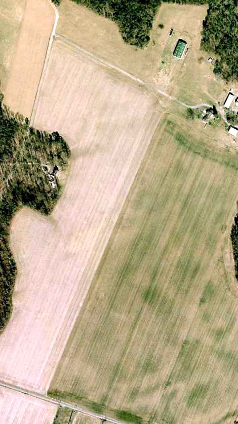
A 1/31/07 aerial photo showed that the majority of the Heathsville runway remained clear, but there was no recognizable trace of an airport.
The site of Heathsville Airport is located northeast of the intersection of Routes 629 & 634.
____________________________________________________
Langley AFB BOMARC Missile Site, New Egypt, NJ
37.1, -76.48 (West of Langley AFB, VA)
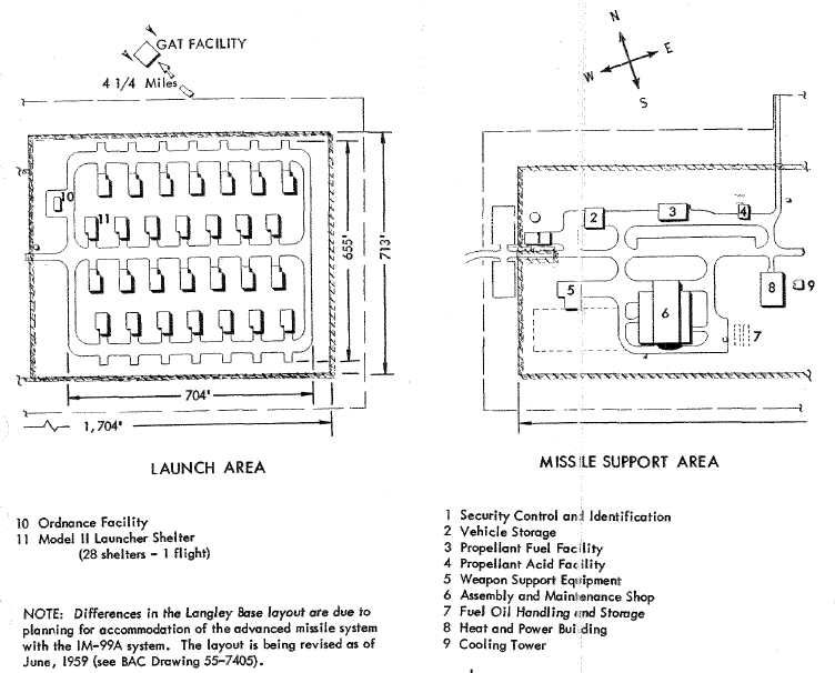
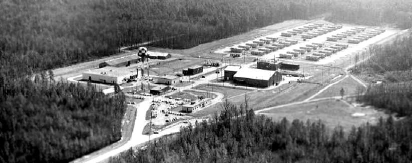
The layout Langley BOMARC Missile Support Area & Launch Area, from the 12/3/59 Boeing “IM-99A Bases Manual”,
showing the facility in its original configuration with 28 Model II Launcher Shelters for the BOMARC A missile.
The purpose of this military base was to shoot down incoming aircraft.
It is included here due to its significance in Cold War history.
This site was one of a network of 8 BOMARC sites spread around the nation.
The others were located at Dow AFB, ME, Suffolk AFB, NY, Otis AFB, MA, McGuire AFB, NJ,
Niagara Falls, NY, Kinchloe AFB, MI (Raco AAF), and Duluth IAP, MN.
Although designated the "Langley AFB BOMARC site", the installation was 6 miles west of the Air Force Base.
The BOMARC missile was huge: each one stood 45 feet tall & weighed 16,000 pounds.
Amazingly, after 50 years the BOMARC's performance parameters still have not been eclipsed by any other anti-aircraft missile:
a range of 440 miles, along with a maximum speed of nearly Mach 4.
The Langley BOMARC site was manned by the 22nd Air Defense Missile Squadron.
According to Mark Morgan, “The 22nd activated on 9/1/58.”
The earliest depiction which has been located of the Langley BOMARC installation
was a diagram of its Missile Support Area & Launch Area from the 12/3/59 Boeing “IM-99A Bases Manual”.
It depicted the facility in its original configuration with 28 individual BOMARC A “Model II Launcher Shelters”.
The Ground-to-Air Transmitter site (which provided missile guidance) was depicted 4.25 miles to the northwest.
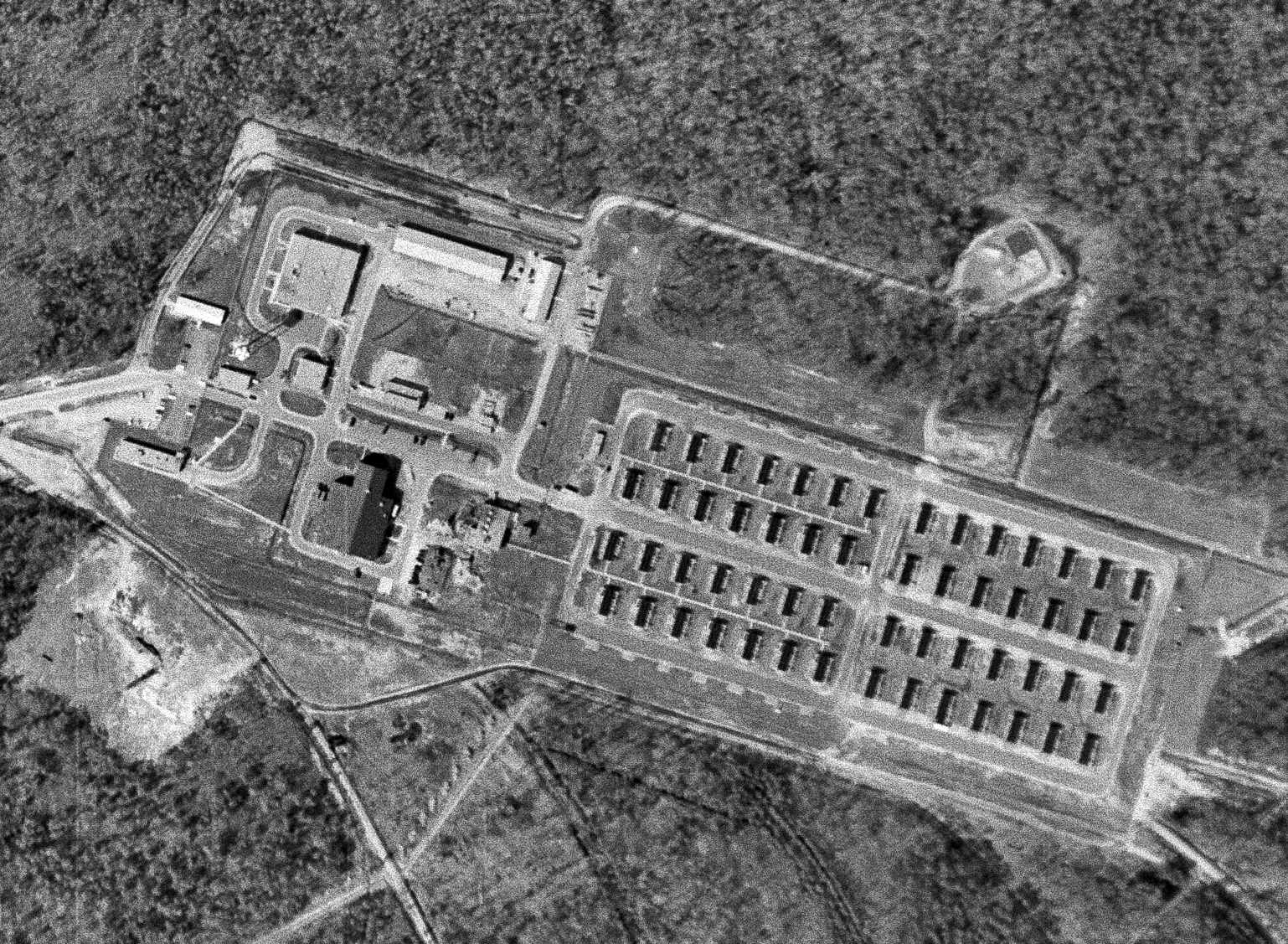
The earliest photo that has been located of the Langley BOMARC site was a 3/30/63 USGS aerial view.
It showed the Langley site after it had been upgraded with 28 new BOMARC B launcher shelters (on the east side) in addition to its original complement of 28 BOMARC A launcher shelters (on the west side).
The 1965 USGS topo map depicted the Langley BOMARC site, but did not depict the individual missile shelters.
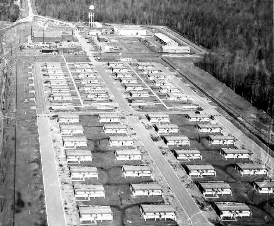
A 1965 USAF Public Affairs aerial view (courtesy of John Eckert) looking northwest at the Langley BOMARC site.
It was a massive installation, with the 28 new BOMARC B launcher shelters in the foreground, and the the original complement of 28 BOMARC A launcher shelters in the background.
As John observed, “This was a combined BOMARC A & BOMARC B site. At the time of the picture, the As were deactivated & 4 shelters were removed.”
A 1965 USAF Public Affairs aerial view (courtesy of John Eckert) looking northeast at the Langley BOMARC site.
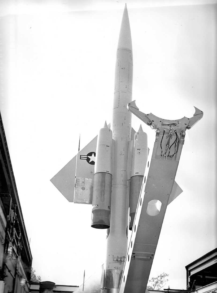
A 1965 USAF Public Affairs photo (courtesy of John Eckert) of a BOMARC missile elevated in its Langley shelter.
As John observed, “Ranch Hand C-123s would spray the area for mosquitoes
and one of the favorite tricks was to do a missile erection just as they came across the site. Surprise!!”
According to Mark Morgan, “The 22nd was one of the last 2 BOMARC squadrons. It inactivated on 10/31/72.”

The 56 BOMARC missile shelters were still depicted on the 1986 USGS topo map at the Langley BOMARC site.
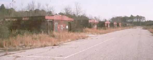
A 1992 photo by Mark Morgan of the Langley BOMARC missile shelters. Mark reported, “An intact BOMARC site is what we find.
All of the buildings & all of the missile shelters are in place, with the former serving as the Service Center of Operations & Transportation, Newport News Public Schools.
The 22nd had 56 A & B missiles & some of the shelters are open.
The launchers now belong to the Newport News Fire Department & are used for storage & training.
I went into a couple of shelters (after getting permission) & now know what the inside looks like.
The shelters are Type IIs; they have a 10' deep well at the back for clearance & blast deflection. Most of the piping is in place.
Alongside the shelters was a continuous corrugated metal duct of some sort, measuring about 3' high by 5' wide.
I have no idea what it was used for…telemetry? Guidance inputs?”
The 1995 USGS aerial photo showed that all trace of the 56 missile launcher buildings had been removed at some point between 1992-95,
with only a cleared patch of land remaining.
However, the missile site support buildings on the west side of the site remained intact,
and it appeared as if the installation had been reused as a school bus storage/maintenance facility.
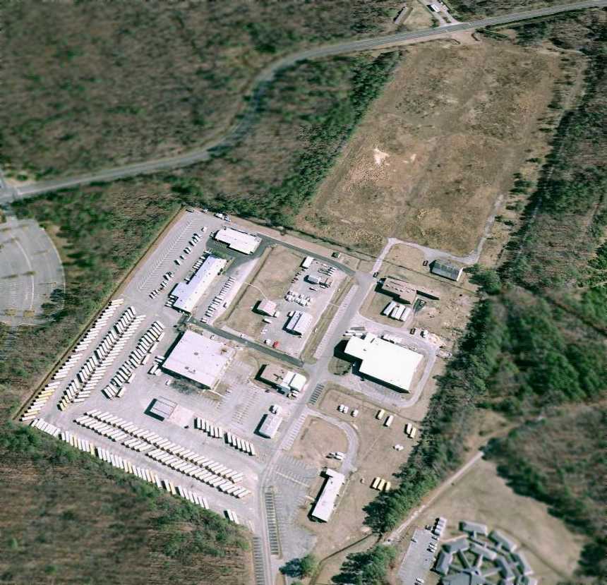
A 2007 aerial view looking east at the site of the Langley BOMARC installation
shows many of the former missile site buildings, including the large assembly & maintenance shop at the lower-right.
However, the cleared patch of land in the background was the site of the former missile launcher buildings.
A circa 2007 aerial view looking east at the site of the Langley BOMARC installation
shows many of the former missile site buildings, including the large assembly & maintenance shop at the lower-right.
A 2021 aerial view showed all the remaining Langley BOMARC buildings had been removed.
The Langley BOMARC site is located east of the intersection of Hogan Drive & Rattley Road.
____________________________________________________
Yorktown Naval Aviation Field, Yorktown, VA
37.27, -76.576 (Northwest of Norfolk, VA)
A 1919 photo of a Curtiss JN-4 Jenny biplane at the Yorktown Naval Aviation Field.
According to a historical marker, in July 1919 the Navy established an aviation training school in Yorktown,
at what was then known as the U.S. Mine Depot.
The school provided the 1st advanced aviation training for pilots in bombing, torpedo, and gunnery operations.
The earliest photo which has been located of the Yorktown Naval Aviation Field
was a 1919 photo of a Curtiss JN-4 Jenny biplane at the field.
Naval Air Facility Yorktown was used by the Atlantic Fleet Torpedo & Bombing Squadron One starting in January 1921,
according to the VAHS book "Virginia Airports" by Vera Rollo & Norman Crabill.
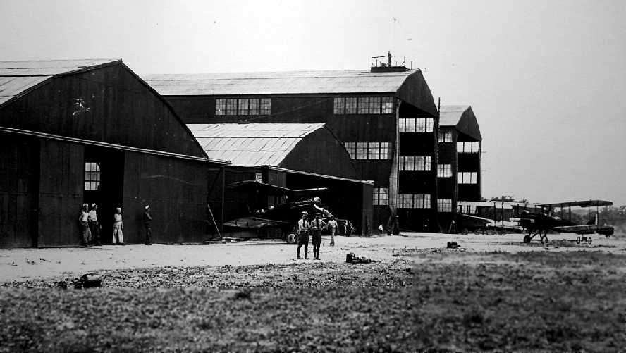
A 6/23/21 photo looking southwest at 2 unidentified biplanes in front of 4 hangars at the Yorktown Naval Aviation Field.
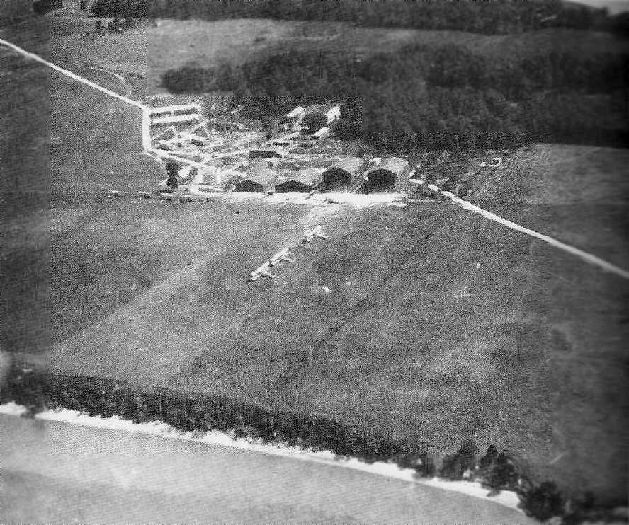
A July 1921 aerial view looking south at the Yorktown Naval Aviation Field (from the VAHS book "Virginia Airports" by Vera Rollo & Norman Crabill),
showing a total of 8 biplanes (Martin MT/MBTs & DH-4s), 2 airplane hangars, and 2 much larger blimp hangars.
The airfield area was a large open grass area in between the hangars & the river.
The photo was taken when Yorktown was being used to support Billy Mitchell's trial bombing of battleships off the Virginia Capes.
The Yorktown airfield was said to be L-shaped, with each end being 3,000' long.
The Navy aviation training school at Yorktown ceased operations in August 1921, according to a historical marker.
According to a historical marker, on 10/17/22 the Yorktown Naval Aviation
field supported the 1st flight made from the aircraft carrier USS Langley (CV 1),
which was anchored in the York River adjacent to the airfield.
According to the VAHS book "Virginia Airports" by Vera Rollo & Norman Crabill,
on 5/6/25 the first overland scheduled airline flight to the southeast Virginia region
(a Sikorsky S-29A twin-engine biplane) landed at the Yorktown Naval Aviation Field after its flight from New York City.
After August 1926 the Yorktown airfield was closed to flying & used as a munitions storage area,
according to the VAHS book "Virginia Airports" by Vera Rollo & Norman Crabill.
The last photo which has been located showing an aircraft at Yorktown was a 1939 photo of an unidentified Navy biplane floatplane.
All aviation at Yorktown ceased prior to WW2.
Nothing of the Yorktown airfield was depicted on the 1952 USGS topo map.
Naval Mine Depot Yorktown became Naval Weapons Station Yorktown in 1958, when the Navy expanded the mission of the base.
A 1963 aerial photo showed that Colonial Parkway had been built through the northern part of the Yorktown airfield,
and several buildings had been constructed over the site of the former hangars.
No aviation facility was depicted at Yorktown on the March 1965 Norfolk Local Aeronautical Chart (courtesy of John Ferrara).
The 1994 USGS aerial photo showed that a helipad had been built on the east side of the former Yorktown airfield at some point between 1963-94.
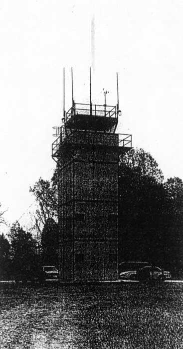
A circa 1990s photo of Yorktown's heliport control tower.
Yorktown's heliport control tower was removed in 2001, according to the VAHS book "Virginia Airports" by Vera Rollo & Norman Crabill.
A 4/16/07 aerial view by Timothy Timmons looking southeast at the site of the Yorktown Naval Aviation Field, taken from a radio-controlled model aircraft.
Note the alignment of the road on the right side is unchanged from that seen in the 1921 aerial photo.
The helipad is visible at the top-left, and what appear to be the foundations of the 1919-era hangars are on the right.
On 10/3/06, Betty Wilson from the Virginia Department of Aviation & Captain Jerry O'Regan, Commanding Officer of Naval Weapons Station Yorktown
dedicated a historical marker commemorating Aviation Field Yorktown.
A 6/7/07 aerial view (courtesy of Chris Kennedy) showed the site of the Yorktown Naval Aviation Field, with the helipad on the east side,
and what appear to be the foundations of the 1919-era hangars in the center.
Ironically, 90 years after the establishment of the aviation school at Yorktown,
as of 2009 the site of the Yorktown Naval Aviation Field continues to be used for aviation,
as it is the location of the Yorktown Naval Weapons Station Helipad (KNCY), which consists of a 100'-square concrete lighted pad.
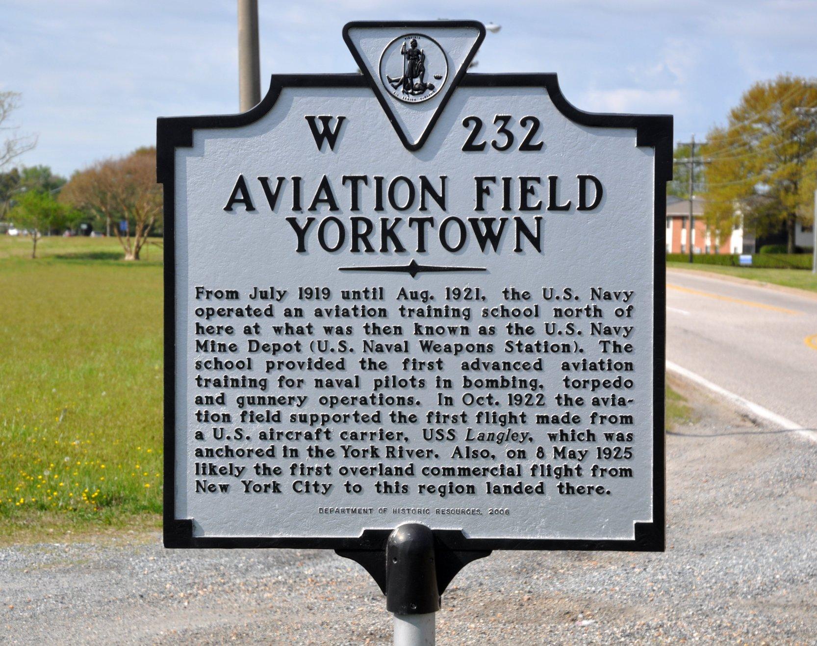
A 4/25/14 photo by Richard Flagg of the 2006 historical marker commemorating Aviation Field Yorktown.
The site of the Yorktown Naval Aviation Field is located northwest of the intersection of Main Road & Diggs Road.
Thanks to Ron Plante for pointing out this airfield.
____________________________________________________
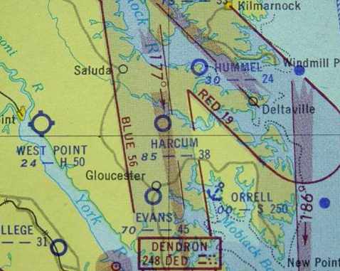
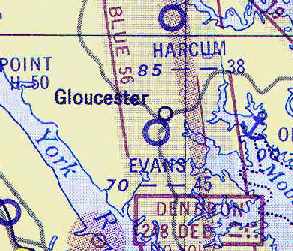
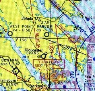
37.517, -76.507 (Northwest of Norfolk, VA)
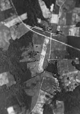
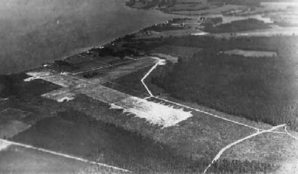
A 1939 aerial view of Harcum Airport.
According to the book "Virginia Airports" by Vera Rollo & Norman Crabill (published by the VAHS),
a license was granted to M.S. & W.M. Harcum on 8/21/39 for Harcum Airport.
The earliest depiction of Harcum Airport which has been located was a 1939 aerial photo,
which showed the airfield to consist of a single unpaved north/south runway.
Harcum Airport was not yet depicted on the March 1940 Norfolk Sectional Chart.
The earliest aeronautical chart depiction which has been located of Harcum Airport was on the March 1943 Norfolk Sectional Chart.
It depicted Harcum Airport as an auxiliary airfield.
The April 1944 US Army/Navy Directory of Airfields (courtesy of Ken Mercer)
described Harcum Airport as having a 2,000' unpaved runway.
However Harcum Airport was not depicted on the September 1944 Norfolk Sectional Chart (courtesy of Ron Plante).
Harcum Airport, as depicted on the 1946 USGS topo map.
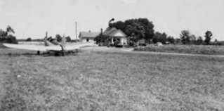
The earliest photo which has been located showing an aircraft at Harcum Airport
was a 1947 photo by Ray Tyson of a PT-19, with the store with the windsock in the background.
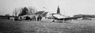
A circa 1947 photo of a PT-19 & another taildragger at Harcum Airport.
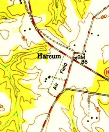
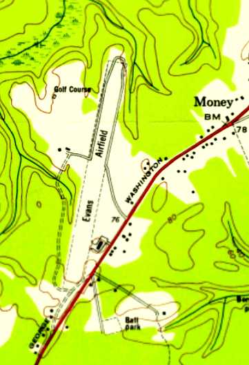
The 1949 USGS topo map depicted Harcum as a northeast/southwest outline, labeled simply as “Air Field”.
The 1952 Chesapeake Bay USAF World Aeronautical Chart (courtesy of Russ Roslewski)
depicted Harcum as having a 3,800' unpaved runway.
The July 1953 Chesapeake Bay USAF World Aeronautical Chart (courtesy of Chris Kennedy)
depicted Harcum as having a 3,800' unpaved runway.
Harcum Airport was depicted on the January 1956 Norfolk Sectional Chart (according to Chris Kennedy)
and listed as an active airfield in the 1957 Aviation Week Airport Directory (according to Chris Kennedy).
According to the book "Virginia Airports" by Vera Rollo & Norman Crabill (published by the VAHS),
this turf field was said to be 3,850' long.
The license for Harcum Airport was canceled on 8/22/60
because the field had been abandoned & the property was sold by M.S. Harcum.
The last aeronautical chart depiction of Harcum Airport which has been located
was on the May 1960 Chesapeake Bay World Aeronautical Chart (courtesy of Scott Kimball).
It depicted Harcum as having a 3,800' unpaved runway.
Harcum Airport was no longer listed among active airfields in the 1960 Jeppesen Airway Manual (according to Chris Kennedy)
and no aviation activity was evident in a 1963 aerial photo.
Harcum Airport was no longer depicted on the 1965 Norfolk Sectional Chart, nor on the 1969 or 1972 USGS topo maps.
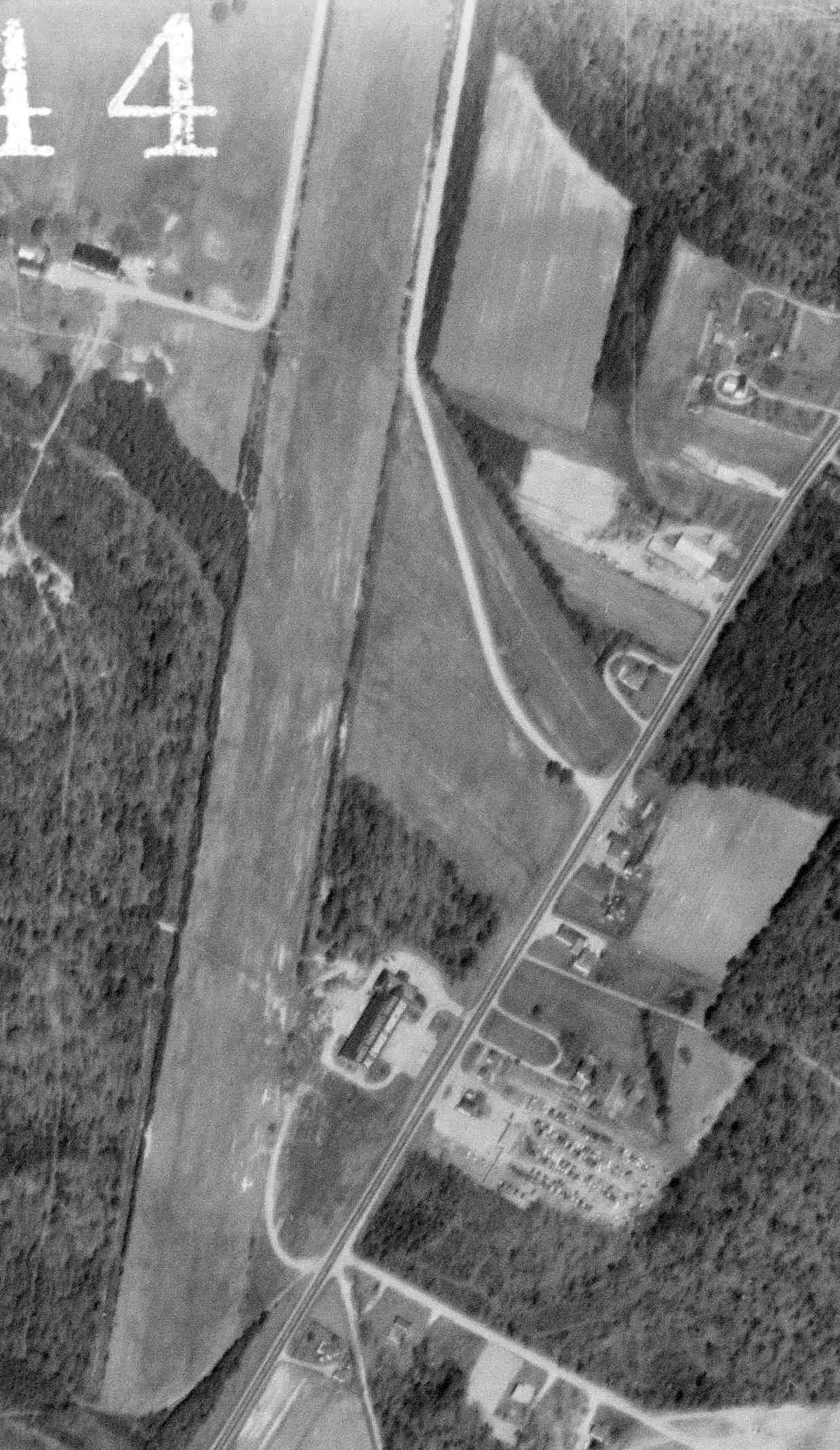
A 1979 aerial view looking southwest at Harcum Airport showed a single light aircraft just above the road intersection.
Nothing related to an airfield was depicted at the site of Harcum Airport on the 1982 or 1986 USGS topo maps.
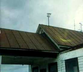
You would have to look pretty closely to find any specific remnant of Harcum Airport –
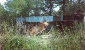
a 1984 photo of the windsock frame which remains on the roof of the old store.
In the 1994 USGS aerial photo, it can be seen that the majority of the former runway at Harcum has remained clear.
There do not appear to be any buildings remaining that were directly related to the airfield.
A 1995 aerial view looking northwest at the buildings along the south side of the Harcum Airport site (colorized by Mike Denja) did not show any recognizable trace of the airfield.
A May 2004 photo by Russ Roslewski, looking northeast at the field which is the site of Harcum Airport.
Russ reported that the property “is now used as farmland. It is very easy to see from Route 606 north of Gloucester.”
The site of Harcum Airport is located southwest of the intersection of Glenns Road & Indian Road.
Thanks to Russ Roslewski for pointing out this airfield.
____________________________________________________
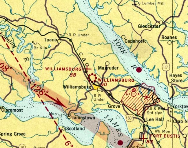
(Original) Williamsburg Airport / Scott Field, Williamsburg, VA
37.298, -76.72 (Northwest of Norfolk, VA)
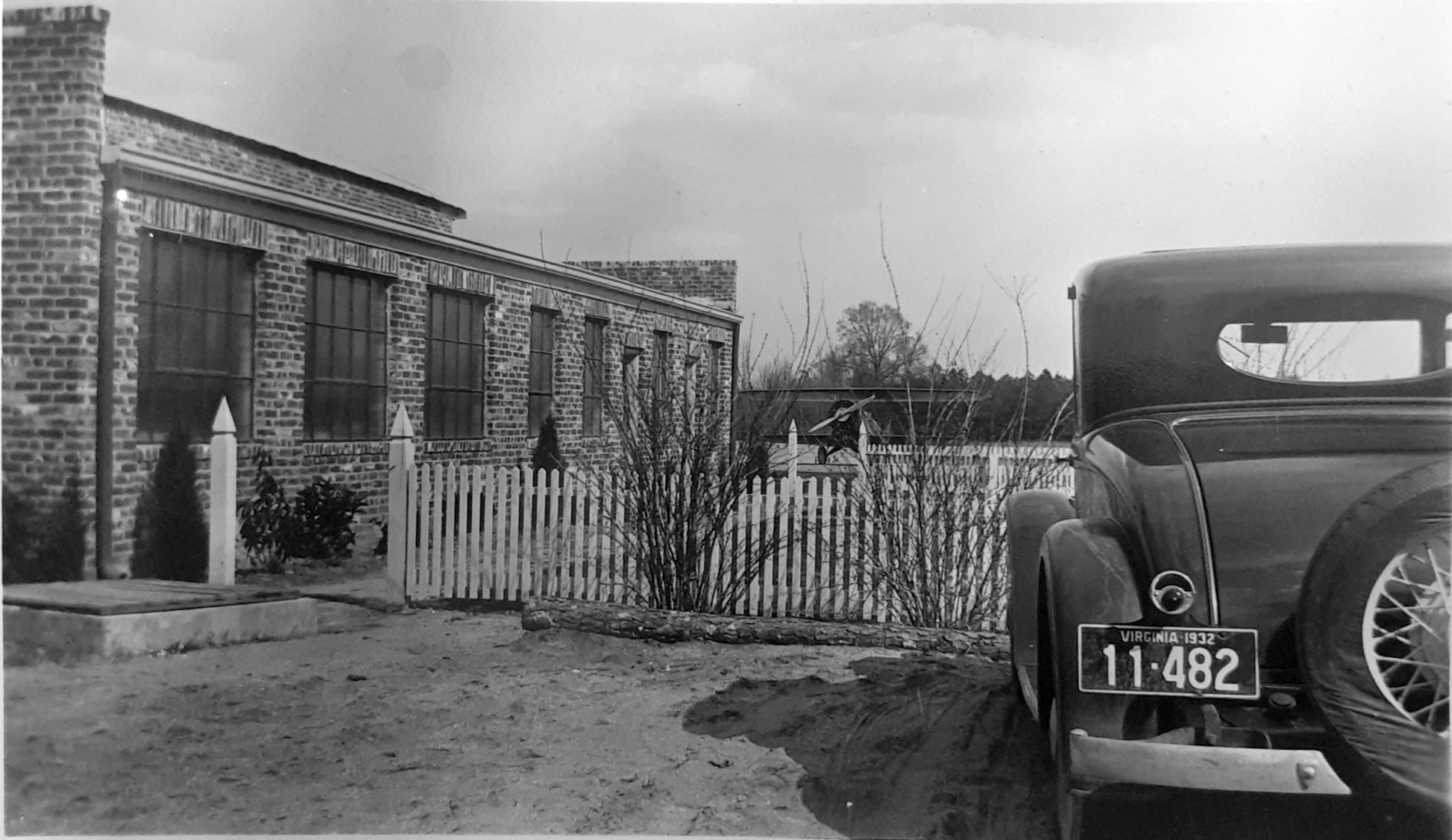
A circa 1931-34 photo of 2 light single-engine planes in front of Scott Field's hangar (courtesy of Page Brinkley).
This early airport for the town of Williamsburg was located adjacent to the north side of the town.
According to an article by B. J. Pryor in the 4/05 issue of the VAHS Virginia Eagles,
in 1930 the nearby College of William & Mary was the first college in America to offer flying lessons in its regular course catalog.
They conducted flight lessons for a short time out of Riordan Field, a field located on the Harwood Farm.
When the school's flight operations quickly outgrew Riordan Field, a larger plot of land was leased a mile from the campus,
and Scott Field was christened in 1931 after the owner of the land.
A $10,000 hangar was constructed (with offices & workshop), and the school purchased planes to operate its flight school.
The flight school was heavily publicized by several college publications.
According to Page Brinkley, “In 1931 the President of the College of William & Mary was Dr. Julian Chandler who foresaw a future for aviation & decided that it should be part of the College’s curriculum.
He negotiated for both the airport at Scott Field & for Lieutenant Colonel Earl Popp to head the program.
This airport included two 1,800' L-shaped runways & a building that included both hangar & office space.”
The earliest depiction of Scott Field which has been located was a circa 1931-34 photo of 2 light single-engine planes in front of Scott Field's hangar (courtesy of Page Brinkley).
A circa 1931-34 photo of Scott Field's hangar & a single-engine biplane (courtesy of Page Brinkley).
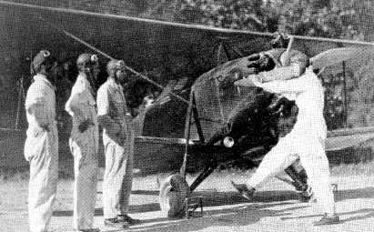
A 1932 photo of William & Mary Flight Club president Travers Hulse hand-propping a Viking B-8 Kitty Hawk (registration # NC975M) at Scott Field.

A 1932 photo of the same Viking K-8 Kitty Hawk at Scott Field (courtesy of Bob Coolbaugh).
According to Bob Coolbaugh, “In 1932 NC975M was painted William & Mary colors by the Viking factory -
forest green with gold trim & a gold university shield on the fuselage aft of the cockpit.
NC975M was the Model B-8, and can be distinguished from the Bourdon Kitty Hawk Model B-4 also owned by the University
because 975M had the unique large landing light in the wig root.”
Marcus Zechini reported in 2015 that this Kitty Hawk is being restored, and is one of only 3 still in existence.
An undated photo from the 1933 Colonial Echo of a monoplane & 3 biplanes (including a Curtiss Robin)
in front of the William & Mary Flight School operation at Williamsburg’s first airport, Scott Field.
An undated photo which appears to be from the same photo shoot, of 2 unidentified biplanes in front of the William & Mary Flight School hangar at Scott Field.
A circa 1930s photo of the Marine Corps' sole example of the Curtiss RC-1 Kingbird at Scott Field.
A 1933 photo of Scott Field's hangar.
According to Page Brinkley, “During the 1931-34 period at College Airport (Scott Field), Lieutenant Colonel Popp was both head of the program & the primary flight instructor.
He was assisted by Julian Chandler, Jr (son of the College’s president) & Yelverton Kent.
The planes used for training included an open-cockpit biplane, flight trainer, Kitty Hawk, and Curtis Robin. The plane’s colors were green & gold.
Thirty-three students were enrolled in the first class, and they were eligible to become private pilots after logging the required flight time & passing various tests.
A college flight club was organized which invited Amelia Earhart to the campus.
Earhart accepted the invitation, drove from Washington, DC to Williamsburg in March 1933, and spoke at the Phi Beta Kappa Auditorium.
She urged women to pursue their interests in aviation & predicted that women would occupy an important role in aviation.
The William & Mary flight club also participated in contests with other college flight clubs & was awarded first place for the 1932-1933 period by the National Aeronautics Association.
Later, the College determined that the cost of insurance & plane maintenance made the program too expensive, and accordingly, the aviation program ended in 1934.”
William & Mary's School of Aeronautics ceased operations at the end of the 1934 academic year (according to an article in the 4/05 issue of the VAHS Virginia Eagles),
as the school was in debt & student enrollments were dropping.
The department's aircraft were sold.
The school's Flight Club continued in operation for one more year, with the last reference to its operation being found in a 1935 William & Mary yearbook.
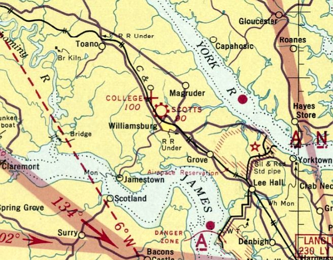
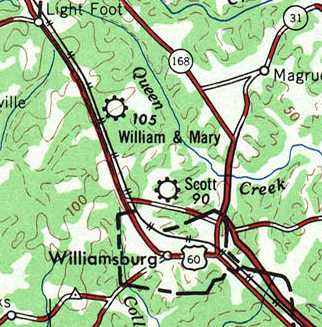
The earliest aeronautical chart depiction which has been located of Williamsburg Airport was on the March 1935 Norfolk Sectional Chart.
It depicted “Williamsburg” Airport adjacent to the north side of the town as a commercial/municipal airport.
A 1936 aerial view looking southwest at Scott Field depicted the airport as having 2 grass runways oriented in an “L” shape.
The 1/1/36 Department of Commerce Airway Bulletin described the “Williamsburg Airport” as a municipal field, located “1 ¼ miles northwest of the city.”
The field was said to consist of a rectangular sod field, with two 1,800' runways, oriented north/south & east/west.
A hangar was said to be located on the west side of the field, which was said to offer facilities for servicing aircraft, day only.
The last aeronautical chart depiction which has been located of the Williamsburg Airport at this location was on the May 1936 Norfolk Sectional Chart.
Confusingly, it also depicted another “Williamsburg” Airport only a mile to the northwest (which would eventually be renamed College Airport).
The Williamsburg Airport at this location may have gone through a period of closure, as it was no longer depicted at all on the November 1936 - March 1940 Norfolk Sectional Charts.
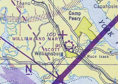
At some point between 1940-41, the former Williamsburg Airport was evidently reopened as Scotts Field,
as that is how it was labeled on the July 1941 Norfolk Sectional Chart (courtesy of Chris Kennedy).
It depicted “Scotts” as a commercial/municipal airport.
An undated photo in the book "Virginia Airports" depicted a Civil Air Patrol Piper J-4 Cub landing at Scott Field.
Scotts Field was still depicted on the March 1943 Norfolk Sectional Chart.
A 10/29/43 aerial view looking north at “Scott's Airport”
from the 1945 AAF Airfield Directory (courtesy of Scott Murdock) depicted the field as having 2 grass runways.
Scott Field may have been temporarily closed at some point during WW2
(like many other small civil airports along the coast, due to wartime security concerns),
as it was not listed among active airfields in the April 1944 US Army/Navy Directory of Airfields (courtesy of Ken Mercer)
nor depicted on the May 1944 Norfolk Sectional Chart.
Scott Field was evidently reopened at some point between 1944-45,
as it was once again depicted as a commercial/municipal field
on the April 1945 Norfolk Sectional Chart (courtesy of Chris Kennedy).
The 1945 AAF Airfield Directory (courtesy of Scott Murdock) described Scott Field
as a 300 acre L-shaped property within which were 2 sod runways, measuring 2,000' northeast/southwest & 1,850' WNW/ESE.
The field was said to have 2 hangars: 60' x 45' brick & steel, and 45' x 30' wood & metal structures.
The field was described as being privately owned & operated.
Scott Field was not depicted at all on the 1951 USGS topo map.
The January 1952 Sectional Chart depicted Scott as a public-use airfield having a 1,800' unpaved runway.
Scott Field was still depicted on the 1955 USGS topo map.
Scott Field was still depicted as a public-use airport on the July 1955 Norfolk Sectional Chart.
Scott Field was changed to a private airfield at some time between 1955-56,
as that is how it was depicted on the January 1956 Norfolk Sectional Chart.
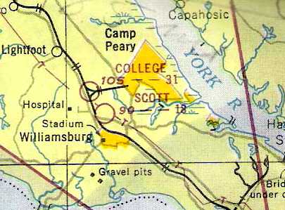
The last aeronautical chart depiction which has been located of Scott Field was on the July 1957 Norfolk Sectional Chart.
It depicted Scott as a private airfield having an 1,800' unpaved runway.
Scott Field was evidently closed (for reasons unknown) at some point between 1957-58,
as it was no longer depicted on the January 1958 Norfolk Sectional Chart.
Scott Field was not listed among active airfields in the 1962 AOPA Airport Directory,
A 1963 aerial photo showed the open grass area of Scott Field remained clear & unredeveloped.
A cluster of small buildings was located on the western edge, but it was not apparent if they were airfield-related.
In the 1994 USGS aerial photo, it can be seen that the site of Scott Field has remained clear & unredeveloped.
It is not known if any of the buildings on the western edge of the clearing date from the site's days as an airfield.
The site of Scott Field is located east of the intersection of Route 603 & Pierpoint Place.
____________________________________________________
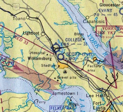
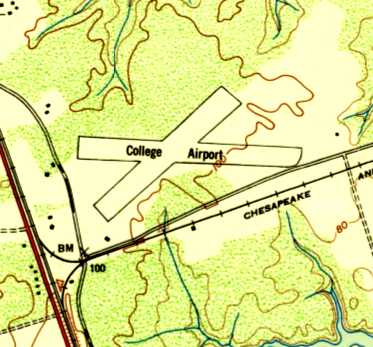
College Airport / William & Mary Airport / Central Airport, Williamsburg, VA
37.315, -76.725 (Northwest of Norfolk, VA)
College Airport was depicted as “Auxiliary” airfield on the October 1935 Norfolk Sectional Chart.
This former small airport was originally associated with the nearby College of William & Mary.
According to the book "Virginia Airports" by Vera Rollo & Norman Crabill (published by the VAHS),
the operating license for College Airport was applied for in 11/10/31 & was granted in 12/7/31.
However, the March 1935 Norfolk Sectional Chart did not depict College Airport at all.
The earliest depiction of College Airport which has been located was on the October 1935 Norfolk Sectional Chart.
It depicted College Airport with the auxiliary airfield symbol, strangely also labeled simply with the name “Auxiliary”.
The 1/1/36 Department of Commerce Airway Bulletin described the “Williamsburg Airport” as an auxiliary field,
located “3 miles northwest of Williamsburg on the east side of U.S. Highway 60.”
The field was said to consist of a rectangular sod field, with 2 runways: 2,250 northeast/southwest & 2,100' northwest/southeast.
The field was said to offer no servicing.
Strangely, the May 1936 Norfolk Sectional Chart depicted this airfield as an auxiliary airfield named “Williamsburg”,
but it also depicted a mile to the southeast the other “Williamsburg” Airport as a commercial/municipal airport.
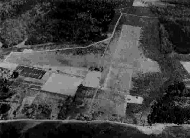
The earliest depiction of College Airport which has been located was an August 1936 aerial view looking east (from the book "Virginia Airports").
It depicted the "Old Williamsburg Airport (College of William & Mary)" as having 2 grass runways in the shape of an "X".
It was still depicted as Williamsburg Airport on the September 1938 Norfolk Sectional Chart.

At some point between 1938-40 the airport was renamed College Airport,
as that is how it was depicted on the March 1940 Norfolk Sectional Chart.
It was still labeled College Airport on the September 1940 Norfolk Sectional Chart.
Civil Air Patrol operations were conducted from College Airport during WW2 (according to the book "Virginia Airports").
The 1944 US Army/Navy Directory of Airfields (courtesy of Ken Mercer) described the "William & Mary College" Airport as having a 3,100' runway,
and indicated that Army flying operations were also conducted from the field.
It was depicted as "William & Mary" on the April 1945 Norfolk Sectional Chart (courtesy of Chris Kennedy).
A circa 1942-45 aerial view looking west at “William & Mary College Airport”
from the 1945 AAF Airfield Directory (courtesy of Scott Murdock) depicted the field as having 2 grass runways.
The directory described the field as a 50 acre cross-shaped property within which were 2 sod runways, measuring 2,900' east/west & 2,530' northeast/southwest.
The field was said to not have any hangars, to be privately owned, and operated by the VA State Guard.
It was depicted as "William & Mary" on the 1946 USGS topo map.
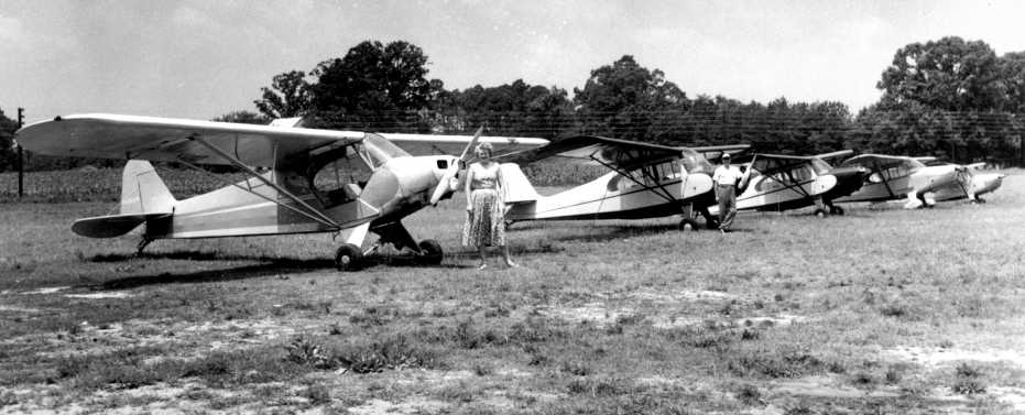
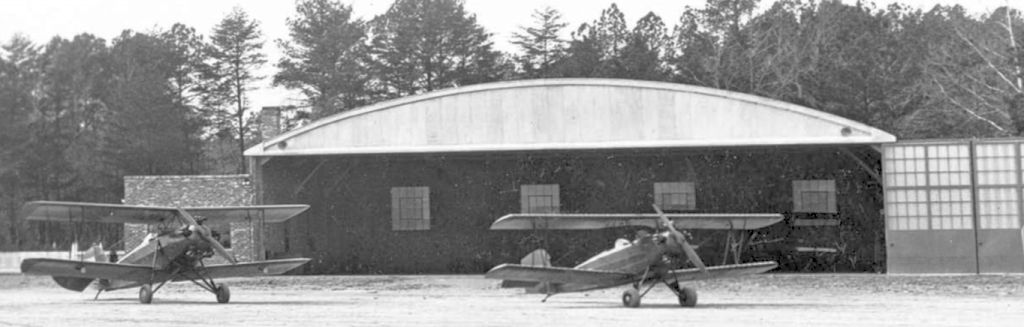
A circa 1940s photo of 5 Pipers at College Airport.
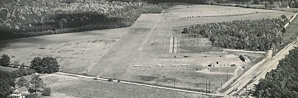
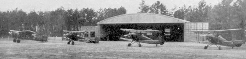
A circa 1940s aerial view looking northeast (courtesy of Page Brinkley) depicted College Airport as having 2 grass runways in an X-shape, with 9 light single-engine planes parked near the hangars on the southwest corner.
At some point between 1946-51 the field was evidently renamed College Airport,
as that is how it was depicted on the 1951 USGS topo map.
It depicted College as having 2 runways & one small building on the southwest side.
The January 1952 Sectional Chart depicted College Airport as having a 3,100' unpaved runway.
The July 1953 Chesapeake Bay USAF World Aeronautical Chart (courtesy of Chris Kennedy)
depicted College Airport as having a 3,100' unpaved runway.
It was still depicted as “William & Mary” Airport on the 1955 USGS topo map.
Page Brinkley reported, “In 1955 the College leased the airport to Floyd Clark.
The airport provided fuel & repair services, plane rentals, and flight instruction.
Clark had learned to fly in the 1920s, participated in Civil Air Patrol operations during World War II,
and had previously managed the Central Airport on Richmond’s east side.
During the mid-1950s the airport’s name was changed to 'Central Airport'. The runways were never paved.
The airport had radio communications, but they were not manned on a regular basis. Pilots were expected to see & be seen when taking off & landing.”
The 1957 Norfolk Sectional Chart depicted College Airport as having a 3,100' unpaved runway.
At some point between 1957-60 the field was evidently renamed Central Airport,
as that is how it was depicted on the May 1960 Chesapeake Bay World Aeronautical Chart (courtesy of Scott Kimball).
It depicted Central as having a 4,200' unpaved runway.
The renaming of the field was evidently prompted by the new operator, Floyd Clark,
who had left his Central Airport in Richmond to operate the field in Williamsburg.
Central Airport was depicted on the 1961 Norfolk Sectional Chart (according to Chris Kennedy).
Central Airport was described to be flourishing for a while in the 1960s.
Central Airport was described in the 1962 AOPA Airport Directory as having 2 turf runways: 4,200' Runway 6/24 & 3,100' Runway 9/27.
The operators were listed as Ruby & Guy Clark.
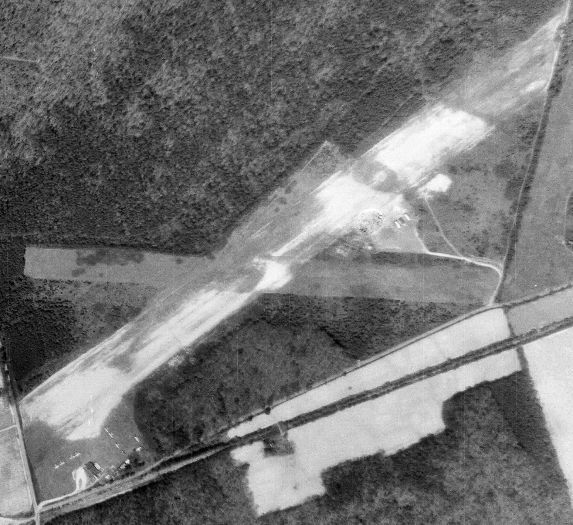
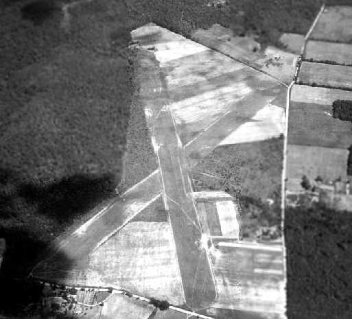
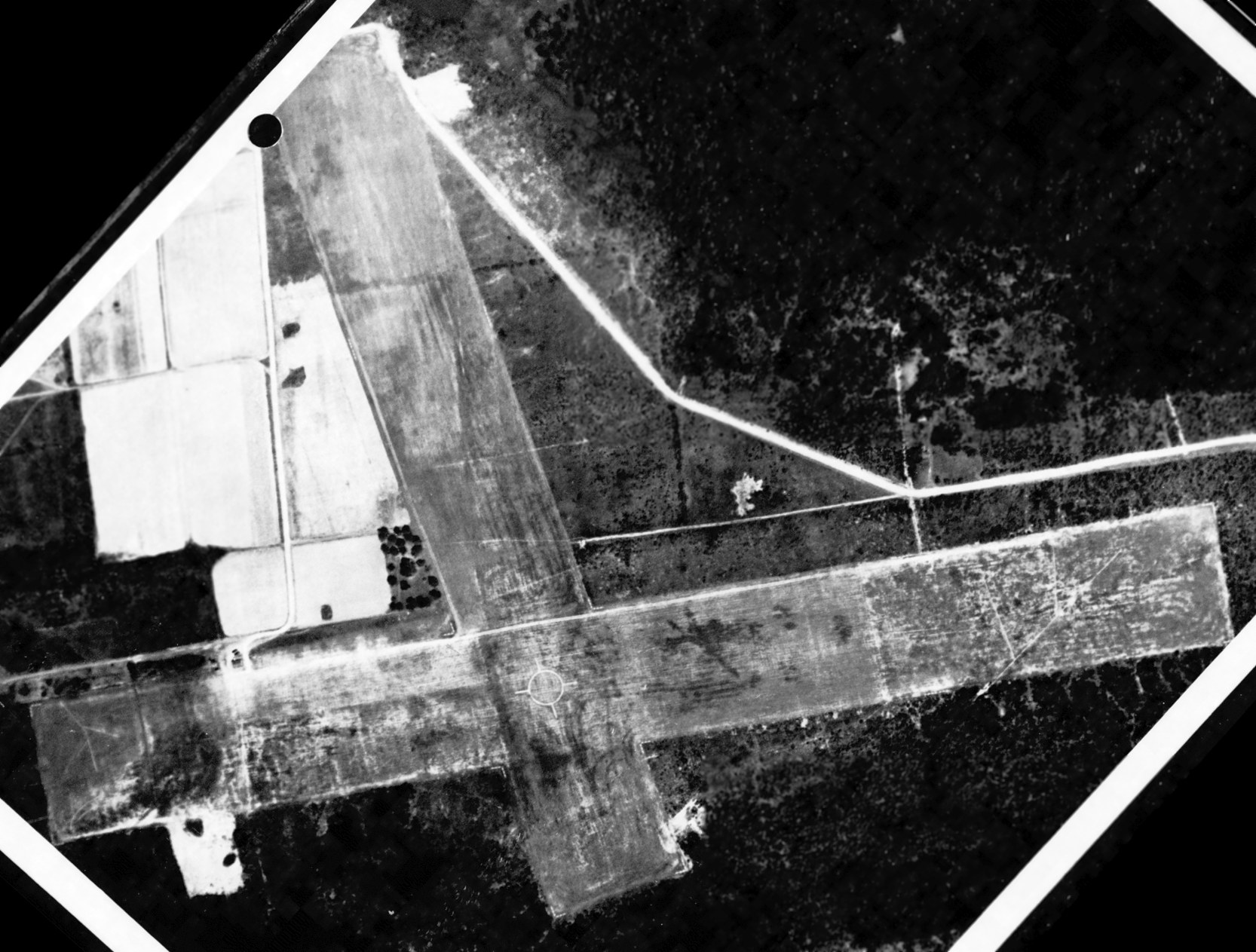
The last photo which has been located showing Central Airport in operation was a 4/3/63 USGS aerial view.
It depicted the field as having 2 grass runways, and a total of 11 light aircraft parked around several T-hangars on the southwest side of the field.
Page Brinkley recalled, “I took flying lessons from Floyd Clark at the Williamsburg Airport in 1963.
According to my pilot's flight log, I made 30 round trips from that Williamsburg airport.”
Page Brinkley reported, “Starting in 1963, the airport was used for flight training by William & Mary ROTC students with Mr. Clark as the flight instructor.
The first class included approximately 12 students who had undergone extensive Army physical tests, attended weekly classroom instructions, and took flying lessons at the airport.
Most of those students continued their flight training as officers in the Army after graduating.”
Randy Jones recalled, “I was stationed a Ft. Eustis in early 1965 & was an 18 year old private pilot.
On my first visit to Central Airport I rented a Tri-Champ (N9591B) from Mr. Clark & later flew his 90hp Champ (N4486E) & his 95hp Champ (N4446E).
The main runway had very little grass & you had to steer around the muddy areas.”
The Aerodromes table on the 1965 Norfolk Sectional Chart (courtesy of John Voss) described Central Airport as having 2 turf runways, with the longest being 4,200'.
The last aeronautical chart depiction which has been located of Central Airport was on the March 1965 Norfolk Local Aeronautical Chart (courtesy of John Ferrara).
It depicted Central Airport as having a 4,200' unpaved runway.
Sherwin Beck recalled, “With regards to Central Airport, I took my first flying lesson from Floyd Clark on 7/26/66 in an Aeronca 7EC (N4683E).
At that time there was one usable grass strip, T-hangars, maintenance hangar, gas pump, and perhaps 10 aircraft based at the field.
Floyd's wife (Helen) took care of the office work while he gave flight instruction & maintained the 3 aircraft used for rental & flight instruction -
the above mentioned Aeronca 7EC, a Champion 7FC (N7519B), and a Cessna 170.
I believe he also owned a second Aeronca 7EC which he was refurbishing.
Floyd Clark last signed my logbook on 2/5/67. About a week later he died of a massive coronary while visiting his son in Florida.
There was no interest on the part of the College of William & Mary to seek another operator
and, by the end of February 1967, Central Airport ceased as an operating entity.”
Randy Jones recalled, “I rented the Tri-Champ again in April of 1967 just before leaving for Vietnam. Good memories of that little airport.”
According to Chad Pritchard (who had an uncle who owned an airplane that was based there), Central Airport closed in 1967.
Tom recalled, “I landed at the Central Airport on 6/26/67.
I had spoken with someone who assured me it was open
but after landing it became obvious that it had either been officially closed or abandoned by this date.
The grass was overgrown, the buildings were dilapidated. I recall there was a beat-up phone booth still operating.”
Central Airport was no longer depicted (nor was any other airport in the Williamsburg vicinity)
on the 1970 Washington Sectional Chart (courtesy of John Clifford).
Page Brinkley reported, “The airport land was sold by William & Mary to the City of Williamsburg during the 1980-85 period.”
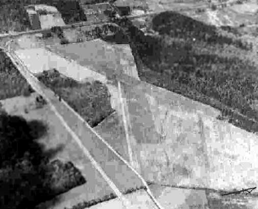
A 1982 aerial view showed the outline of Central Airport's 2 former runways still perceptible among the trees which had overgrown the site.
Airport Road had been built through the southwest portion of the southwest/northeast runway.
A 1987 photo of a collapsed T-hangar at the site of Central Airport.
A 1987 photo of the abandoned main hangar at the site of Central Airport.
The 1989 USGS topo map still depicted the clearing for one runway (northeast/southwest) of the former Central Airport.
A 1989 aerial view looking east at the site of Central Airport
showed the outline of the 2 former runways still barely perceptible among the trees which had overgrown the site.
An August 1993 aerial photo by Ray Tyson looking west at the Central Airport brick hangar/office which remained standing in the woods at the southwest corner of the site.
In the 3/12/94 USGS aerial photo, the outline for Central Airport's 2 former runways were still barely recognizable -
one running northeast/southwest, the other east/west.
The brick hangar/office still appeared to remain standing, in the woods at the southwest corner of the site.
According to the 2003 book "Virginia Airports", the airport site became a sand & gravel pit.
A 7/30/04 aerial view showed that the hangar had been removed at some point between 1994-2003,
with an empty grass clearing in the woods in its place.
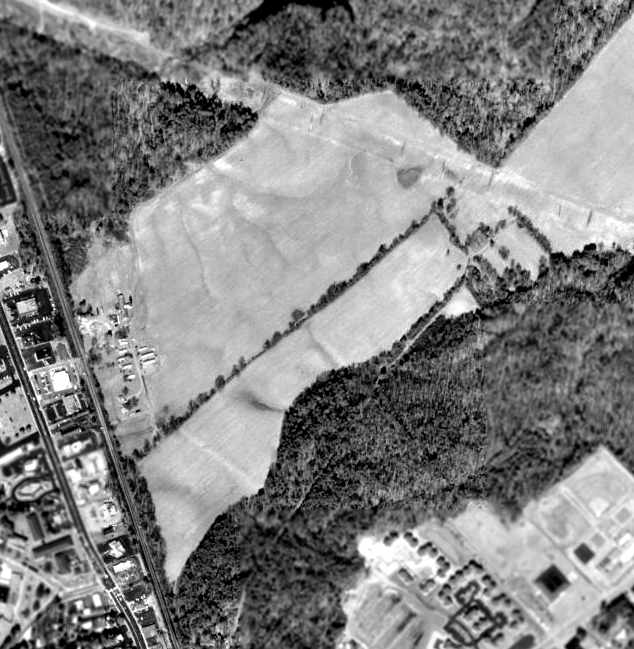
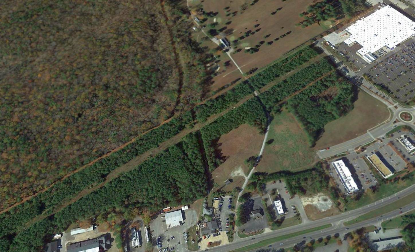
In a 4/7/10 aerial view of the site of College Airport, the outline of the 2 runways was still barely recognizable, running through the woods.
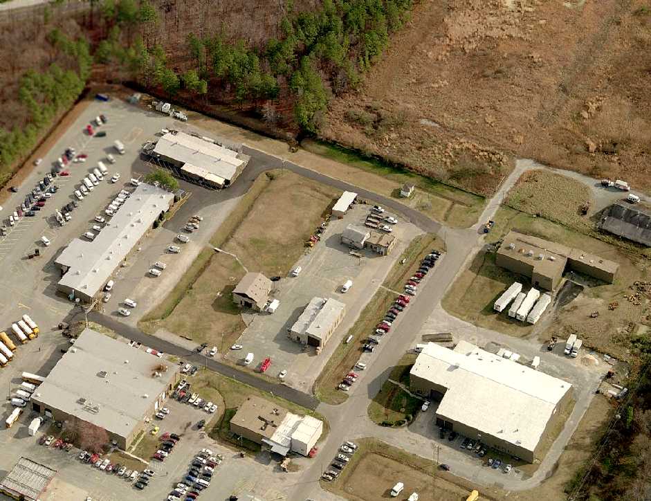
The site of College Airport, annotated by Michael McGurk over a 2014 aerial photo.
A 2022 photo looking northeast at the southwest corner of the Central Airport site, heavily wooded.
A 2024 photo by Page Brinkley) of the remains of the Central Airport hangar which remains languishing in the woods.
Page Brinkley reported, “Trees have camouflaged the former runways. Aerial views reflect a slightly different color for much of the growth covering the old runways.
Most of the original Airport Road was converted into a hiking/biking trail, and Airport Road was moved a short distance north of its original location.
As a result, a portion of Airport Road currently traverses through part of a former runway. Previously railroad tracks ran parallel to Airport Road.
A forest has erased most traces of the airport. The movements & sounds of the once-active airport have been replaced with silence & the occasional rustling sounds caused by wind passing through the trees.
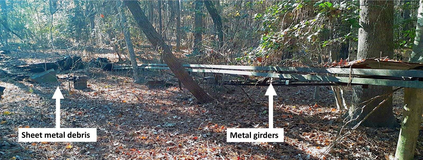
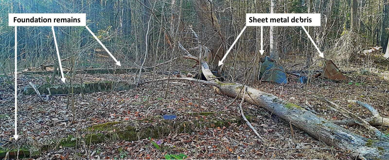
However, two airport remnants lie partially hidden like sleeping ghosts from the past – the operations building & a hangar.
The operations building still reflects portions of its foundation, and there are scattered sheets of twisted metal (probably from its roof).
The site of the former hangar contains collapsed metal girders & mangled sheets of metal.
In most theater plays, the stage curtain closes after the last act, but nature was the final curtain for the airport that was.”
A 2024 photo by Page Brinkley) of the remains of the Central Airport operations building which remains languishing in the woods.
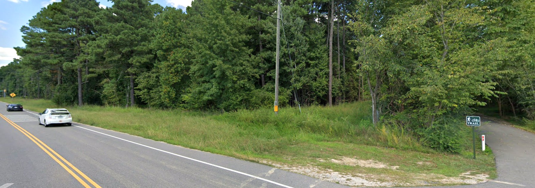
The site of Central Airport is located northeast of the intersection of Route 603 & Airport Road, appropriately enough.
Thanks to Jeff Mitchell for pointing out this field.
____________________________________________________
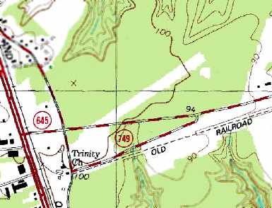
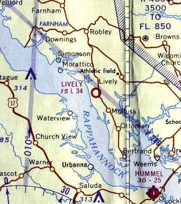
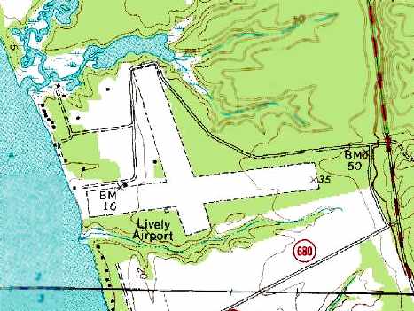
Lively Intermediate Field / Lively Airport, Lively, VA
37.755, -76.57 (North of Newport News, VA)
The Lively Intermediate Field, as depicted on the July 1941 Norfolk Sectional Chart (courtesy of Chris Kennedy).
According to an article by Bill Corbett in the 1/05 issue of the VAHS Virginia Eagles,
Lively was established by the 1936 Airport & Airways Act.
It was also known as Site 6, NW-WA, along the Norfolk - Washington air route.
Lively was not yet listed among active airfields in The Airport Directory Company's 1937 Airports Directory (courtesy of Bob Rambo).
The earliest depiction of the Lively Airport which has been located
was on the July 1941 Norfolk Sectional Chart (courtesy of Chris Kennedy).
A 1941 aerial view looking northwest at Lively showed the field to consist of 2 perpendicular grass runways.
Several private pilots were pictured in front of their plane at Lively in 1941
in the book "Virginia Airports" by Vera Rollo & Norman Crabill (published by the VAHS).
A circa 1942-45 aerial view looking east at Lively Intermediate Field
from the 1945 AAF Airfield Directory (courtesy of Scott Murdock) depicted the field as having 2 grass runways.
The 1944 US Army/Navy Directory of Airfields (courtesy of Ken Mercer) described Lively as having a 3,800' runway.
Lively was later used as one of several satellite airfields for Norfolk Naval Air Station during WW2.
An undated aerial view of Lively Field from the January 1945 “History of Naval Air Bases, 5th ND” (courtesy of John McDonald)
depicted Lively Field to have 2 grass runways, with a segmented circle at the runway intersection.
There appeared to be a small shed on the west side, but no hangars, and no aircraft were visible on the field.
Lively was depicted on the 1945 Norfolk Sectional Chart (courtesy of John Voss).
The 1945 AAF Airfield Directory (courtesy of Scott Murdock) described Lively Intermediate Field
as a 52 acre cross-shaped property within which were 2 sod runways, measuring 3,400' east/west & 2,600' north/south.
The field was said to not have any hangars,
to be privately owned, and operated by the Civil Aeronautics Administration.
The 1948 USGS topo map depicted Lively as having 2 runways, labeled simply as “Airport”,
and a small building & a beacon to the northwest of the runway intersection.
Merton Meade said, “I recall flying into Lively with a Champ.
I went down there to look at a Rearwin Ranger I was interested in.
I recall the runway I landed on was very smooth... a very nice grass strip.”
Lively was listed among active airports in the 1962 AOPA Airport Directory,
with the operator listed as: Northern Neck Squadron - Civil Air Patrol.
Lively Airport, as depicted on the 1965 Norfolk Sectional Chart (courtesy of John Voss).
According to an article by Bill Corbett in the 1/05 issue of the VAHS Virginia Eagles,
the 30-year lease for Lively Airport ended in 1966.
However, multiple sources indicate that the airfield continued in operation for several more years.
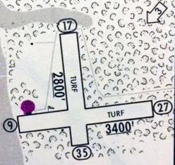
The 1967 Shell Airport Directory (courtesy of Kevin Walsh) depicted Lively
as having 2 turf runways: 3,400' Runway 9/27 & 2,800' Runway 17/35.
The only photo which has been located showing an aircraft at Lively Airport was a 1/24/67 USGS aerial view.
It depicted 5 T-hangars & 1 light single-engine aircraft to the northwest & southwest of the runway intersection.
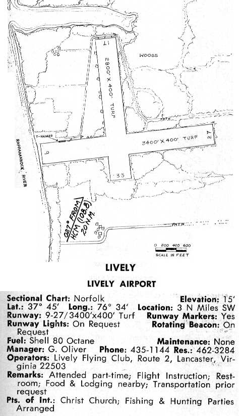
Lively Airport was described in the 1968 VA Airport Directory (courtesy of Don Thompson)
as having 2 turf runways (the longest being 3,400'), and the operator was listed as the Lively Flying Club.
Lively was still listed as an active airport in the 1971 Flight Guide (according to Chris Kennedy).
However it was evidently closed within the next year,
as it was not depicted at all on the 1972 Washington Sectional Chart (courtesy of Mike Keefe).
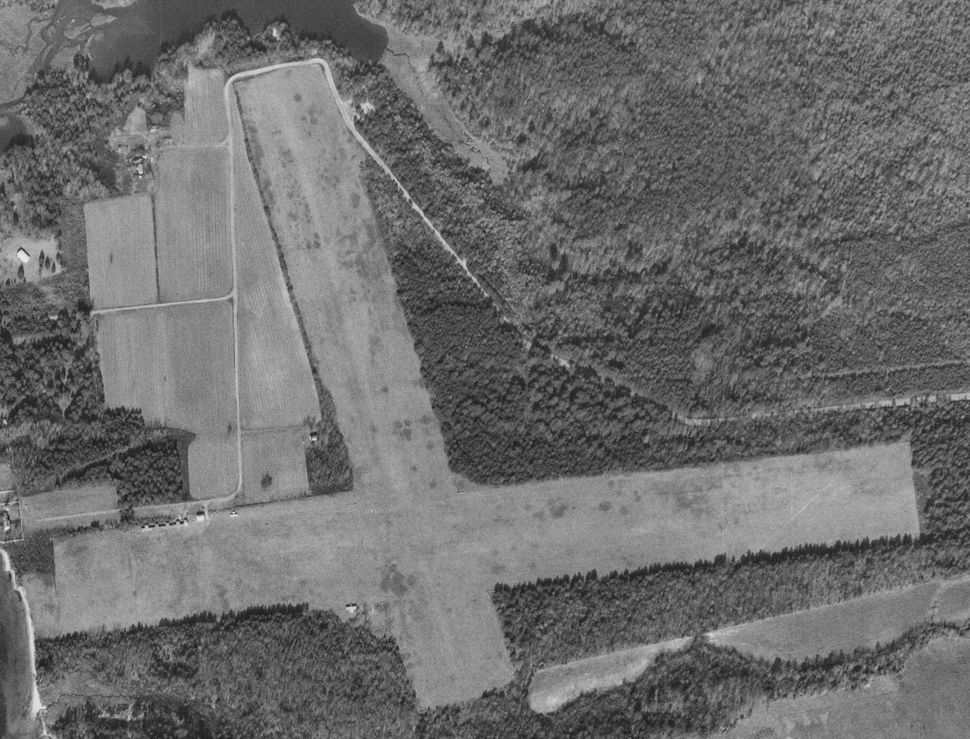
The 1992 USGS topo map still depicted the “Lively Airport” as having 2 grass runways,
with 2 small buildings to the northwest of the runway intersection.
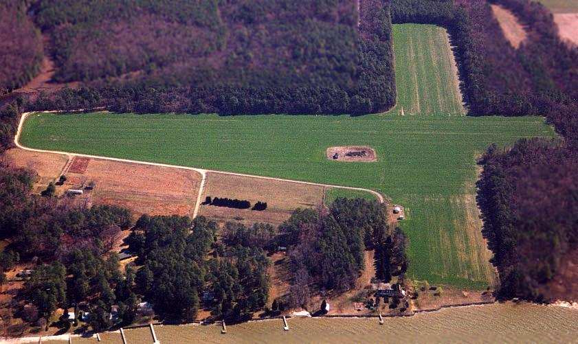
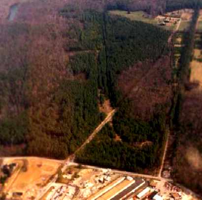
An aerial view looking east at the Lively runways, taken 3/01 by Paul Freeman from a Piper Warrior.
The 2 grass runways were still very evident, as they were being farmed.
The airfield consists of 2 grass runways (the largest is 2,700' long)
and a small road grid & one small building on the west side of the field.
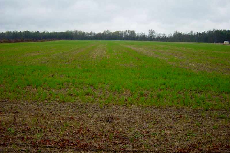
A 2003 view of the former Runway 17 by Russ Roslewski.
Russ Roslewski visited the site of Lively Field in 2003:
"Lively Field was really easy to find, I wouldn't have even needed the GPS, as you take an "Old Airport Road" to get to it.
The owner has undertaken what appears to be a major tree-removal project around the east side of former Runway 9/27.
The field is in very good condition, and could easily be landed on in an emergency.
The land is being farmed, but I have no idea what for - it's just very short grass.
A hunting club apparently uses the wooded area around the runway, as there are signs restricting entry."
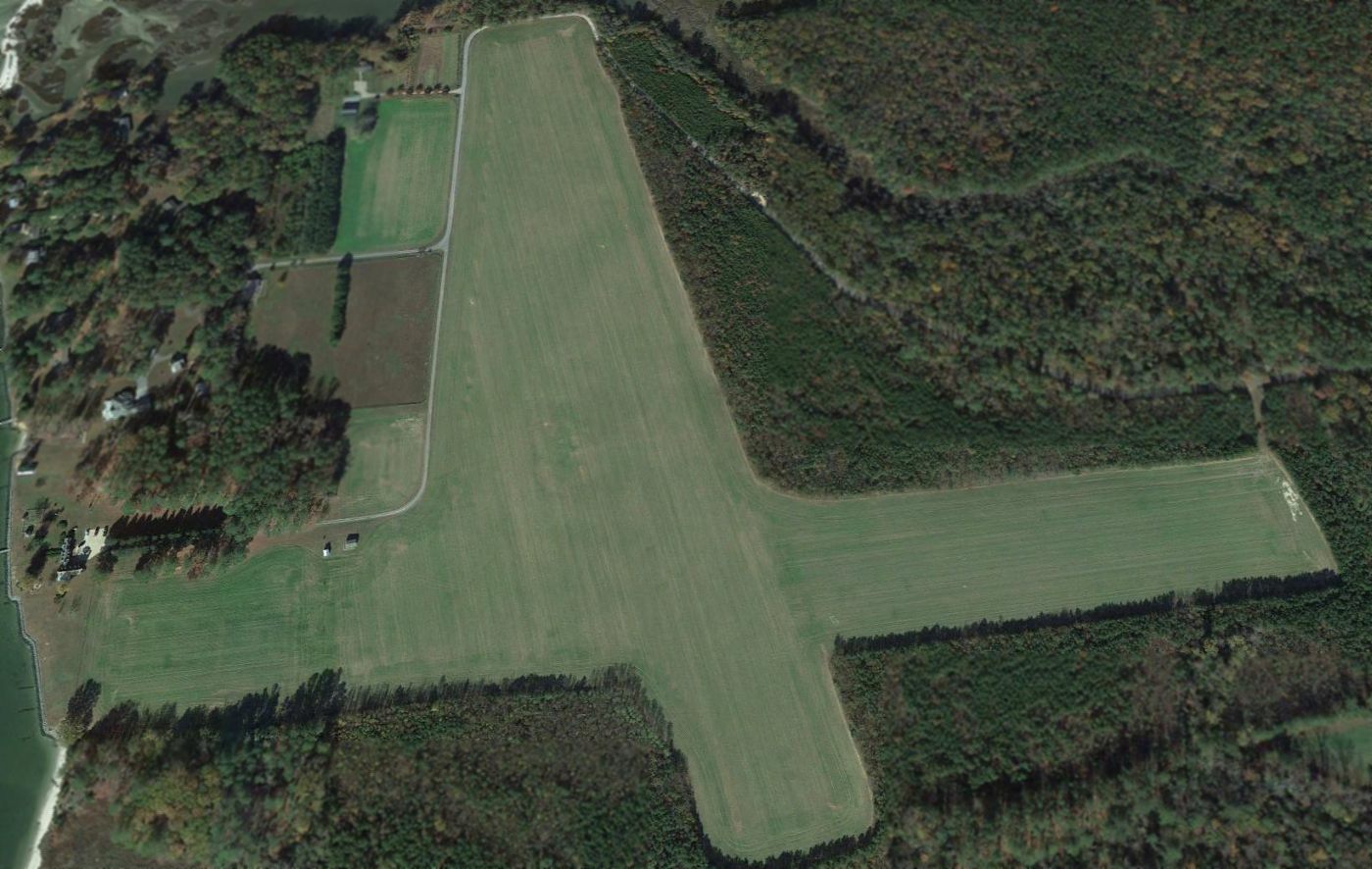
A 2015 aerial view looking north shows the Lively runways remain intact & very recognizable.
See also: http://www.airforcebase.net/aaf/if_list.html
____________________________________________________
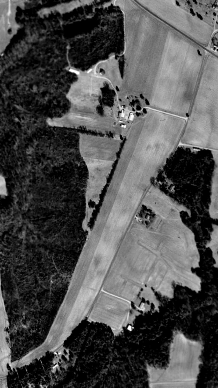
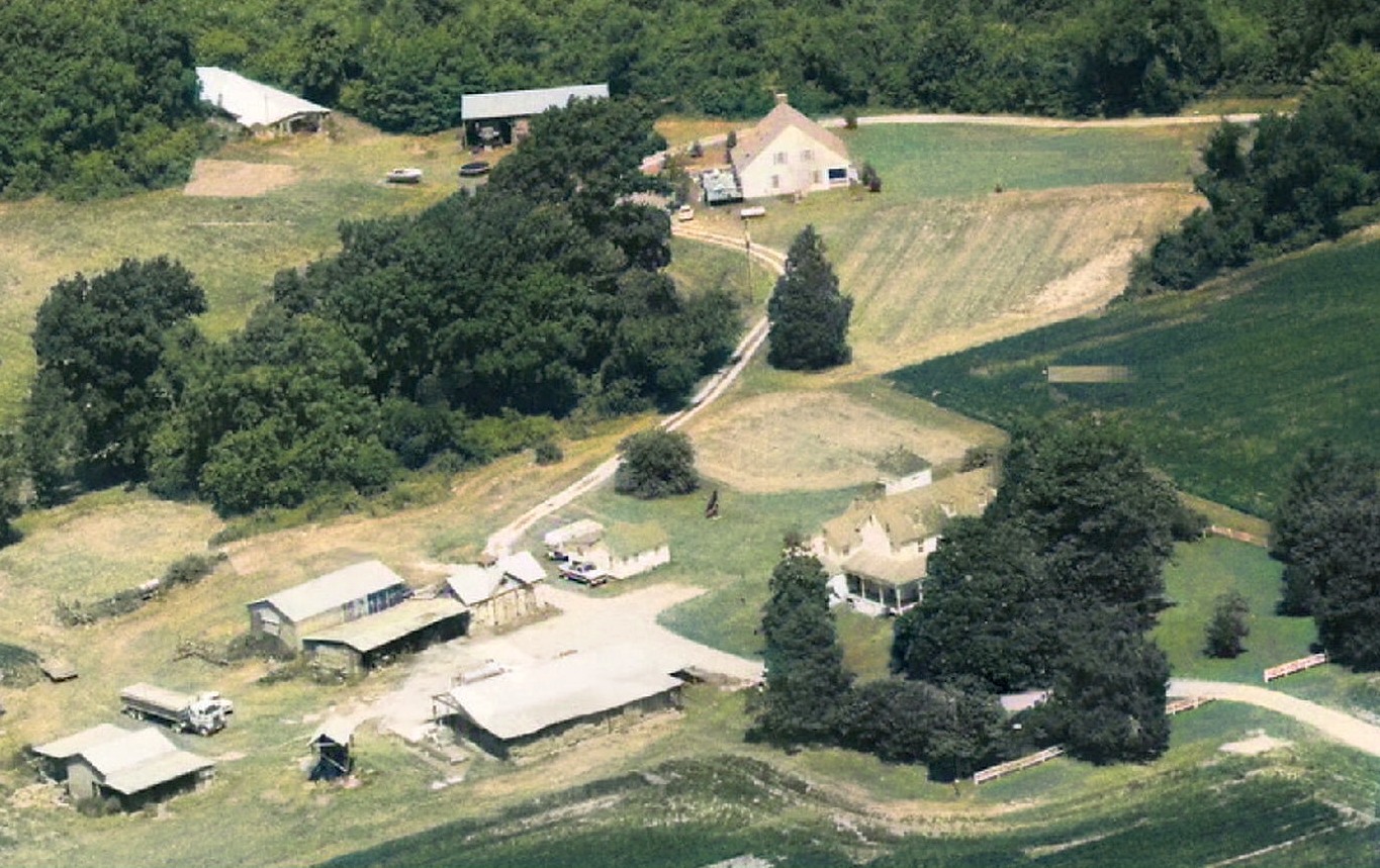
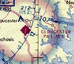
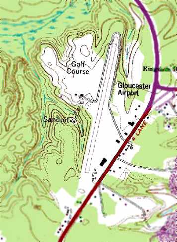
Evans Airport / Gloucester Airport / Francis J. Mellar Field (W57), Gloucester, VA
37.397, -76.53 (North of Hampton Roads, VA)
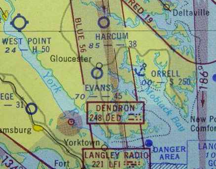
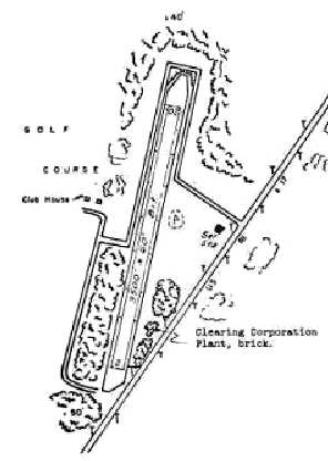
"Evans" Airport, as depicted on the 1952 Chesapeake Bay USAF World Aeronautical Chart (courtesy of Russ Roslewski).
According to an article by David Grow in the 1/05 issue of the VAHS Virginia Eagles,
Evans Airport was established in 1947 by Al Evans,
who operated the Evans Clearing Corporation at a plant at the south end of the airport.
At some point the airport was purchased by Fred Ames, a local lawyer but not a pilot.
The earliest depiction of the airfield which has been located
was on the 1952 Chesapeake Bay USAF World Aeronautical Chart (courtesy of Russ Roslewski),
which depicted "Evans" Airport as having a 4,500' unpaved runway.
The 1952 USGS topo map depicted Evans Airfield as having a single unpaved northeast/southwest runway,
with several small buildings along the southeast side of the field.
The May 1960 Chesapeake Bay World Aeronautical Chart (courtesy of Scott Kimball)
depicted Evans as having a 4,500' unpaved runway.
The 1962 AOPA Airport Directory described "Evans" Airport as having a single 4,500' sod runway.
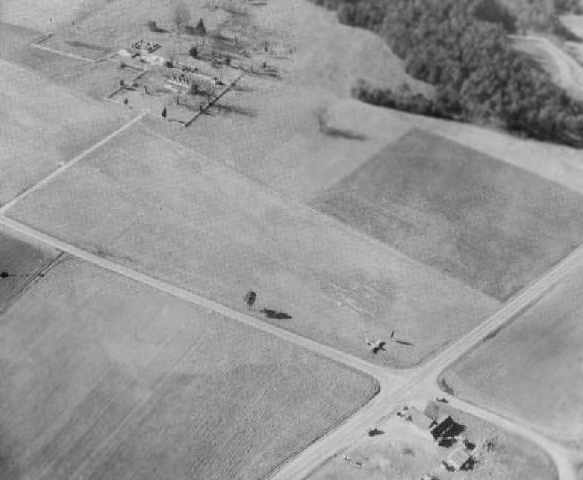
The earliest photo which has been located of Evans Airport was a 4/3/63 aerial view.
It depicted Evans as having a single northeast/southwest grass runway, with several light single-engine aircraft parked on the southeast side.
The March 1965 Norfolk Local Aeronautical Chart (courtesy of John Ferrara) depicted Evans Airport as having a 4,500' unpaved runway.
According to an article by David Grow in the 1/05 issue of the VAHS Virginia Eagles,
in 1965 the airport was purchased by Art Lazero, Horace Gray, Earl Robbins, Clyde Royals, Bill Brown, and Frances Mellar.
The new owners formed Gloucester Air, changed the airport's name to Gloucester Airport,
and hired W.J. Colby as manager.
Frances Mellar later purchased the entire company.
A photo from the 5/19/66 Gloucester-Matthews Gazette-Journal, captioned:
“Joseph Washington, chief of Education & Safety with the State Corporate Division of Aeronautics,
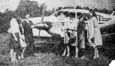
is shown explaining flight details to a group of Gloucester High School students prior to their first flight from the Gloucester Airport.
This group was the first to take the 10-minute ride in the state plane here Tuesday
in cooperation with special program offered by the state two years ago to interested persons who have never flown to become interested in that field.
The students shown with the pilot are, left to right: Deborah Strickland, Helen Stansell, Dianne Rowe, Connie Chambliss,
(Mrs. Louise Moorman, art teacher) and Linda Hudgins.”
Gloucester's runway was paved at some point between 1965-67 with the help of the Virginia Department of Aviation.
Fuel pumps, runway lights, and a rotating beacon (a slightly remodeled airway beacon) were also added.
A 1967 aerial view by Bruce Grow looking east at the Gloucester Airport ramp.
In 1967 the field was home to 15 aircraft, and conducted 5,500 takeoffs & landings (according to Scott Denny, Virginia Department of Aviation).
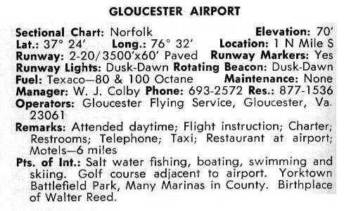
Gloucester Airport gained a paved runway at some point between 1965-68,
as the 1968 VA Airport Directory (courtesy of Don Thompson)
described Gloucester Airport as having a single 3,500' paved Runway 2/20.
The operator was listed as Gloucester Flying Service, and the manager was listed as W.J. Colby.
A circa 1960s photo by Willy Hayes of Bill Corbett departing Runway 2 at Gloucester.
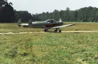
An undated photo by David Grow of Mike Tomlinson’s Ercoupe taxiing out at Gloucester.
An undated photo by David Grow of a Cessna 152 & a Piper at a snowy Gloucester Airport.
The 1970 VA Airport Directory (courtesy of Stephen Mahaley)
listed the operator & manager of Gloucester Airport as F. J. Mellar, Sr.
Gloucester Airport gained its first permanent building in the early 1970s,
when L.O. "Bud" Knight & Bob Grow opened Omni Enterprises,
a Citabria dealership which offered aircraft sales, primary & aerobatic instruction, aircraft rental, maintenance, and fuel.
Ron Jones recalled, “I did some training at the old Gloucester Airport in 1973-74 while stationed at the USCG Reserve Training Center in Yorktown.
I did my 1st solo there in a Citabria 7ECA on my 2nd flight in a taildragger with only 1 hour of taildragger time.
It was a great place to spend the weekend & there was a lot of activities all the time.
The chief flight instructor would teach ground school in trade for lunch
and there was a Taylorcraft BD12D with no side windows that everyone seemed to fly.
I didn't even know who owned it but I often helped work on it.
After my solo I flew about 10 hours out of there & remember that a water tower was built right off the end of Runway 20.
On final you could wave at the construction workers on top of it & they would wave back.
Also the row of trees halfway down the runway would cause the wind to do strange things while landing on Runway 2.
They gave aerobatic instruction & one afternoon a guy was flying his Mooney in to take instruction.
We had a habit of lining the runway to critique pilots' landing performance & this guy got some bad scores,
in fact he almost lost it & went around but kept going & didn't come back.
The 2nd time that I flew there I had an instructor that was a jet jock from Langley Air Force Base
and he had a reputation of buzzing W57 along with his wingman in tow.”
Gloucester Airport, as depicted on the 1975 Washington Sectional Chart (courtesy of Ed Drury).
According to an article by David Grow in the 1/05 issue of the VAHS Virginia Eagles,
in 1975 Gloucester Airport was home to 14 aircraft, and conducted 7,000 takeoffs & landings.
Omni Enterprises ceased operations at Gloucester in the late 1970s, and Jack Brandt ran the airport.
Brandt conducted flight instruction, and also operated a Queen Air out of Gloucester on charter.
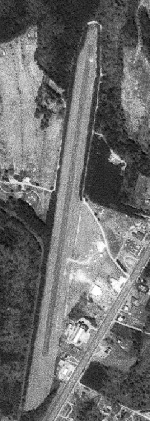
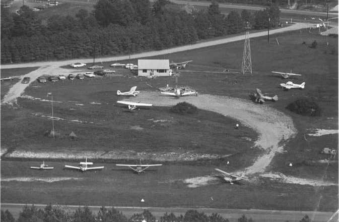
A 1978 USGS aerial view depicted Gloucester Airport as having a single northeast/southwest paved runway & a few buildings on the southeast side.
Gloucester Airport was described in the 1982 AOPA Airport Directory (courtesy of Ed Drury) as having a 3,500' paved runway.
After Jack Brandt left Gloucester, the airport was operated by the owners of the aircraft based at the field, and I.L. Aviation, run by Irv Linchner.
Irv was Gloucester's last Fixed Base Operator.
After the death of Frances Mellar in 1983, several attempts were made to purchase the airport, develop the adjoining property, but still keep the airport in operation.
Unfortunately none of these efforts were successful,
due to a lack of support from the County, the Department of Aviation, and local interests.
It was still named Gloucester Airport on a 1986 Approach Plate (courtesy of John Clifford).
The 1986 USGS topo map depicted Gloucester Airport as having a single paved runway,
with several small buildings along the southeast side of the field.
The last photo which has been located showing Gloucester Airport while still in operation
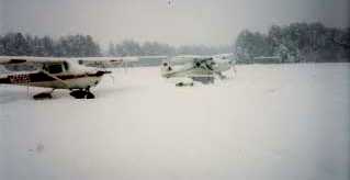
was a 2/27/87 photo by Kenneth Keeton of his 172C at a snowy Gloucester, with a building & several other aircraft in the background.
Gloucester Airport was evidently closed at some point between 1987-88,
as a 1988 aerial view looking south at the field clearly showed a closed-runway “X” symbol on the northern end of the runway.
At some point between 1986-91, the airport was purchased by Richard Mellar & reopened as Francis J. Mellar Field.
It was labeled Mellar Field on the 1991 Washington Sectional Chart (courtesy of Mike Keefe).
According to an article by David Grow in the 1/05 issue of the VAHS Virginia Eagles,
Mellar Airport was closed in 1991, but at least one source listed it as an operating airport several years later.
Raymond Balister recalled, “Mellar Field... About the time I had finished my private training (1992-93),
I was frequently driving [by] & always passed by Mellar Feild.
I remember always noting that single aircraft there & wondering if they would ever fly it. It never moved.
One day I stopped & noted the tail number. While I was there I did a quick walk around & checked it out.
When I sumped the tanks (it was green 100/130, not blue 100LL), some crud & water came out & the tires were low/flat.
During the walk around I was able to see the registered owner on the registration.
I looked up the owner & asked if they would be willing to sell it. Their response was that they were waiting for parts but they wanted to keep it.
From the condition that it was in, I doubt it ever flew again. It was a straight tail Cessna 172.
Eventually, it disappeared. I figure it went out by truck.”
The March 1993 Washington Sectional Chart (courtesy of Carl Taylor) labeled the single paved runway as “Mellar (closed)”.
Chad Pritchard contacted Georgette Hurley, the Gloucester Assistant County Administrator,
who said "According to County business license records for Gloucester Air Inc., 1994 is the last year that a license was issued."
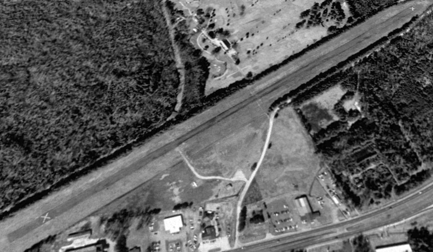
A 1994 USGS aerial view looking northwest at Mellar Field showed contradictory indications about the airport's operating status by that point:
the runway was clearly marked with closed-runway "X" symbols at both ends, yet one single-engine light plane was still on the field, in the tiedown area on the southeast side of the field.
Mellar Field was considered for expansion into a regional general aviation airport by a 1995 Gloucester County study, but was found to be too limited for expansion.
The Mellar Field property was sold after the completion of the study.
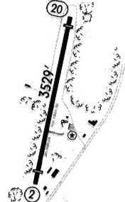
Mellar Airport was still depicted as an active airfield in a 1996 airport directory, with a single paved 3,529' Runway 2/20.
Mellar Field was apparently closed at some point between 1996-98, as it was labeled "Mellar Field (Closed) on the 1998 Washington Sectional Chart (courtesy of Mike Keefe).
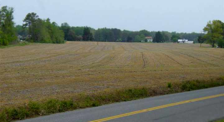
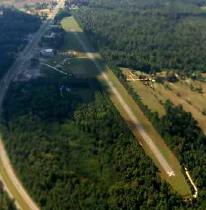
A March 2001 aerial view looking south at the remains of the Mellar runway, taken by Paul Freeman from a Piper Warrior.
The runway pavement was badly deteriorated (or had been broken up), and a driveway crossed the middle of the runway.
A 2003 view looking north along the former Runway 2 by Russ Roslewski.
Russ reported, "In the distance you can see the roof of the new Wal-Mart building.
They must have demolished part of the north end of the runway to make room for the store.
Just like I always say, we can certainly use more Wal-Marts & less airports.
Mellar field is all but obliterated. In fact, I flew overhead a few days ago & couldn't find it.
The north half is still paved, but the asphalt is in extremely deteriorated condition. The south half is basically all mud.
I think this is due to construction projects going on in the area - they may be using it to store dirt for a warehouse hardware store
that is undergoing construction next to the Super Wal-Mart that is already position just off the north end of the runway.
There is a large mound of dirt near the south end which leads me to believe this theory.
It was is such bad shape I honestly wasn't entirely sure if I was in the right place -
if I didn't know it used to be a runway, I could have driven across it and not even noticed."
According to an article by David Grow in the 1/05 issue of the VAHS Virginia Eagles,
Gloucester Airport's former rotating beacon was the only aviation artifact left on the property (presumably other than the remains of the runway).
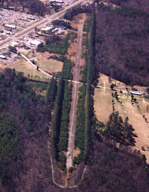
A 2015 aerial view looking northwest at the site of Mellar Field showed the Wal-Mart covering the northern part of the runway, but the majority of the former runway was still recognizable to the south.
And amazingly the airport office building appeared to remain intact (a small gray building at bottom-center).
Stan Braisted reported in 2016, The rotating beacon still stands, almost entirely vine-covered, behind 'Damon & Company' Restaurant.”
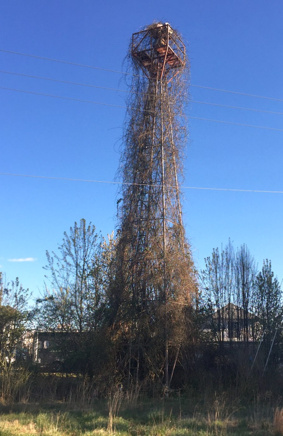
A 3/15/17 photo by Paul Freeman of the amazing sight of the Mellar Field rotating beacon, completely intact atop its tower, but also completely enshrouded in vines.
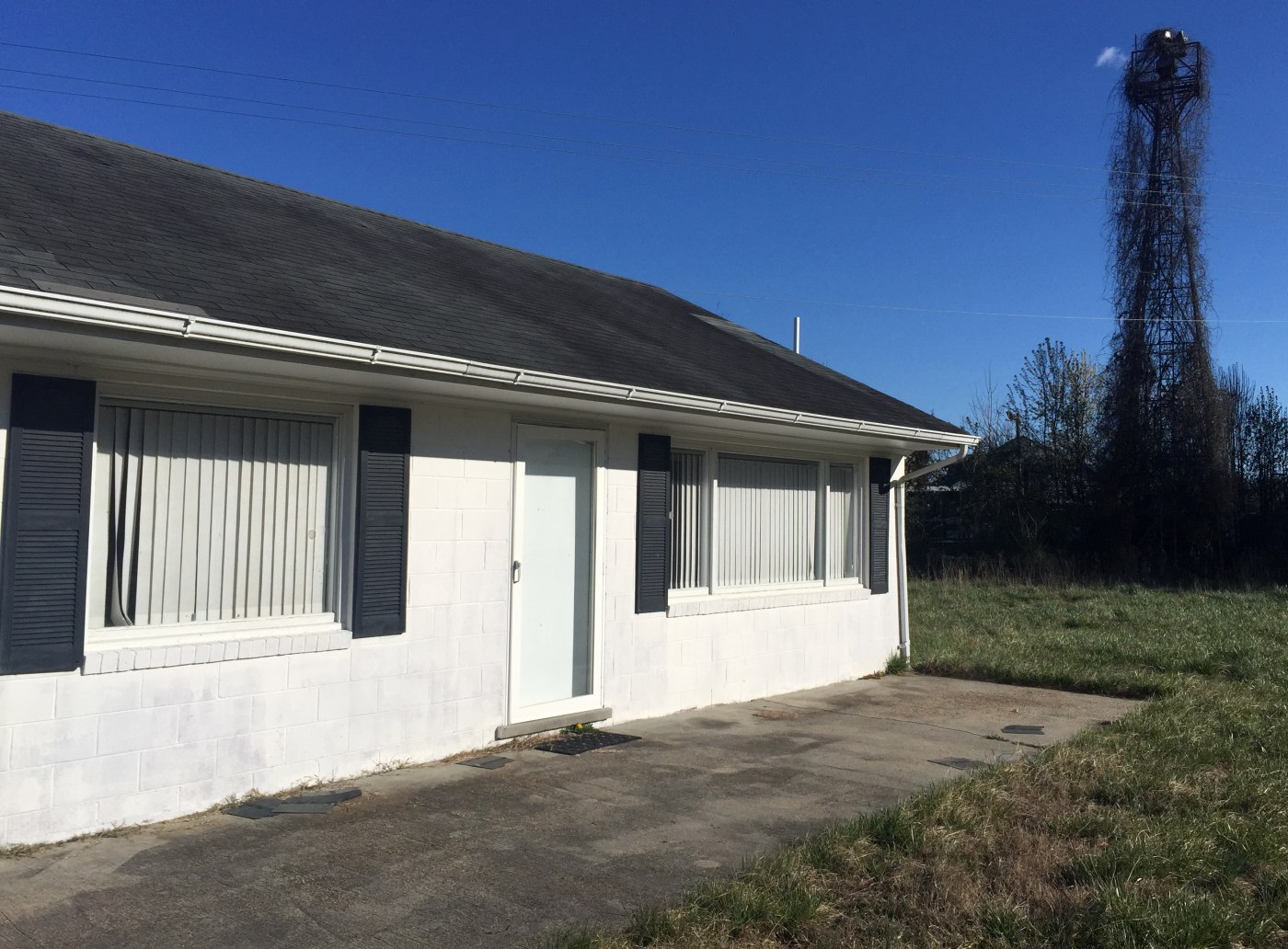
A 3/15/17 photo by Paul Freeman of former Mellar Field airport office building, with the rotating beacon tower in the background.
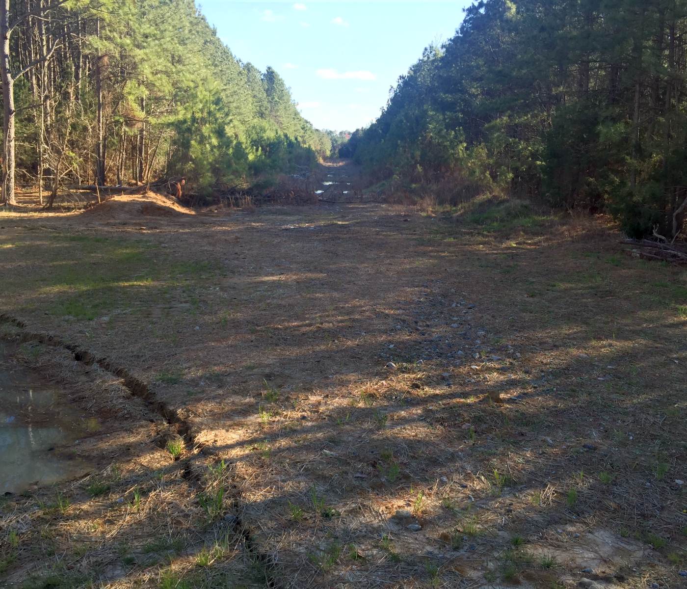
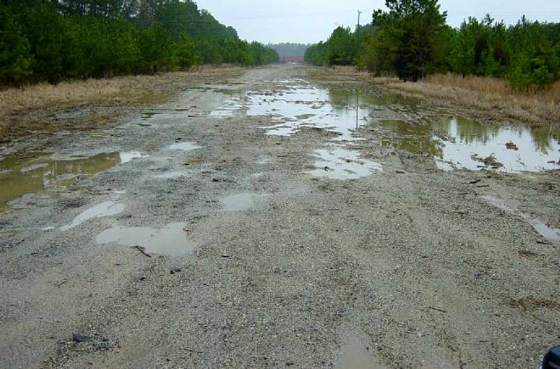
A 3/15/17 photo by Paul Freeman looking southwest along the former Mellar Field runway, taken from where Golf Club Road crosses the former runway midpoint.
Trees have grown right up to the edge of the former runway pavement, but apparently have been prevented by the pavement remains from growing on the runway itself.
A 3/22/18 photo by Dave Whittaker of the Mellar Field rotating beacon, completely intact atop its tower, but also completely enshrouded in vines.
Dave reported, “That overgrown beacon is quite visible from the highway!”
As of 2023, photos seem to show that Mellar Field's beacon tower was removed at some point between 2018-2023.
____________________________________________________
Walker Army Airfield (FYT), Fort Monroe VA
37.015, -76.303 (Southeast of Newport News, VA)
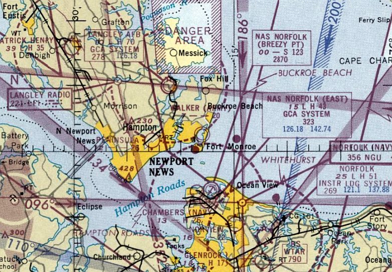
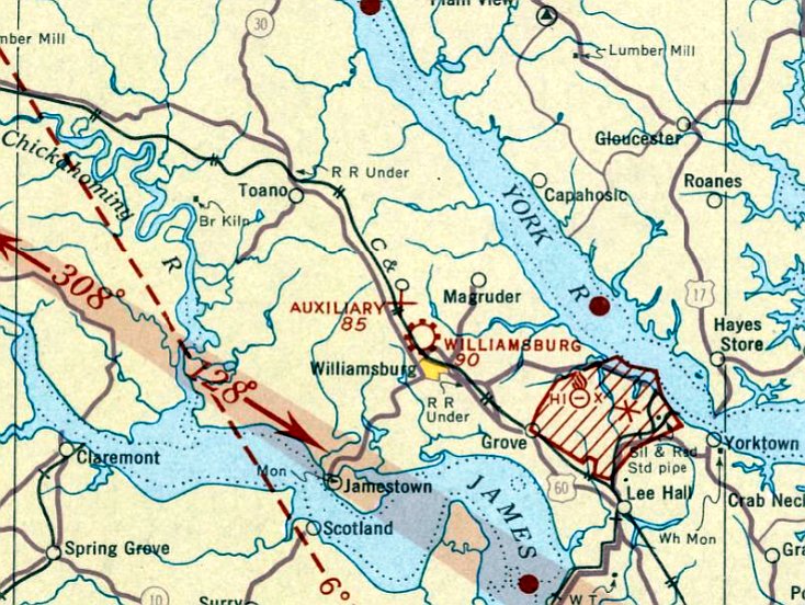
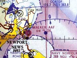
Walker AAF, as depicted on the July 1951 Norfolk Sectional Chart.
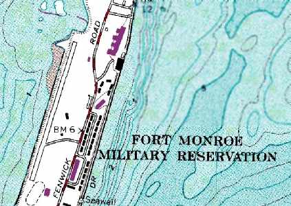
This Army Airfield is located on the grounds of Fort Monroe, which itself dates from 1818.
The airfield is situated along the west side of a narrow peninsula along the Chesapeake Bay.
Walker AAF was not yet depicted on the January 1951 Norfolk Sectional Chart.
Walker AAF was dedicated in 1951 in honor of Lt. Col. John Walker, who was killed in Italy in WW2.
The earliest aeronautical chart depiction of Walker AAF which has been located was on the July 1951 Norfolk Sectional Chart.
It depicted “Walker (Army)” as having a 2,000' unpaved runway.
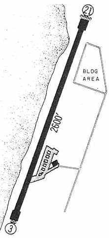
Walker AAF was depicted on the 1960 Jeppesen Airway Manual (courtesy of Chris Kennedy) as having a single 2,600' paved Runway 3/21,
with a small ramp on the east side having a single building (a hangar?).
Walker AAF was still depicted as an active airfield on the 1961 Norfolk Sectional Chart (according to Chris Kennedy).
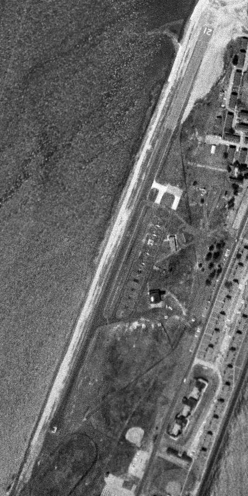
The earliest photo which has been located of Walker AAF was a 3/30/63 USGS aerial photo.
It showed several parking spots next to a small building on the east side of the runway.
Walker AAF was still depicted as an active airfield on the 1964 Norfolk Sectional Chart (according to Chris Kennedy).
After 1964 Walker AAF was used purely for helicopter operations.
Walker AAF was apparently closed at some point between 1964-65, as it was still depicted on the 1965 Norfolk Sectional Chart (courtesy of John Voss),
but the Aerodromes table on the listed the status of the field as "Closed".
It was described as consisting of a single 2,600' asphalt runway.
The September 1967 Norfolk Sectional Chart depicted Walker AAF as an abandoned airfield.
The 1986 USGS topo map still depicted the Walker runway, but did not label it.
Today, Fort Monroe remains an active Army installation,
but the only use of Walker AAF is for helicopter operations, as Walker Army Heliport.
According to Jim Campbell, as of 2002 the Walker AAF runway was being reused by
the Sports Car Club of America & the Tidewater Sports Car Club as a race track.
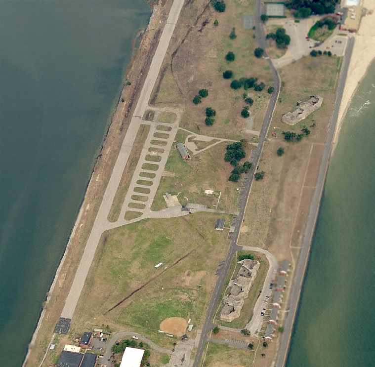
A circa 2006 aerial view looking north at the abandoned Walker AAF runway shows that the facility appears to remain completely intact,
with multiple parking spots to the east of the runway, and a helipad marked on the very southern end of the runway.
An article in the August 2006 issue of the Coast Defense Study Group Newsletter described plans to either preserve or redevelop various portions of Fort Monroe,
as part of the Base Closure And Realignment process.
According to the article, “The airfield is too short for today's aircraft & the Army primarily used it for helicopters.
It is not currently in service. Because of this, many people agreed to remove this airstrip.”
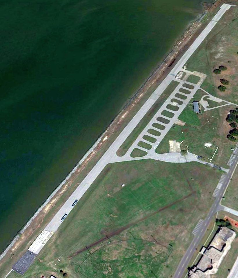
A 4/6/10 aerial view looking northwest showed the Walker runway remained in decent condition.
According to Micheal McGurk, “The post was closed in 2011.”
Micheal McGurk reported in 2014, “The runway is no longer used for flights. The local police do use it for some high speed driver training.”
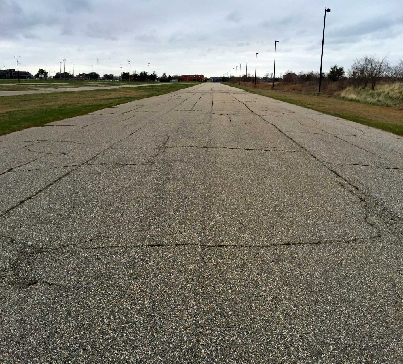
A 3/14/17 photo by Paul Freeman looking southwest along the abandoned Walker AAF runway.
A row of light poles has been installed along the western edge of the runway, which otherwise remains intact.
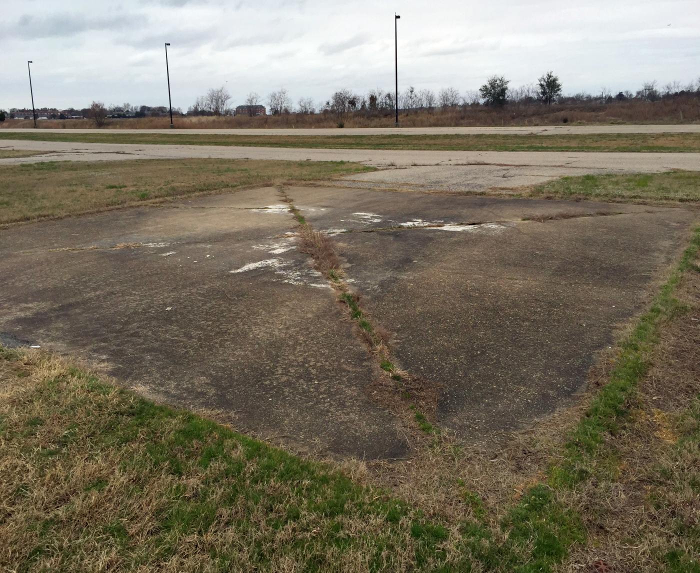
A 3/14/17 photo by Paul Freeman looking west at a former Walker helipad on the east side of the runway, with the “H” marking still recognizable.
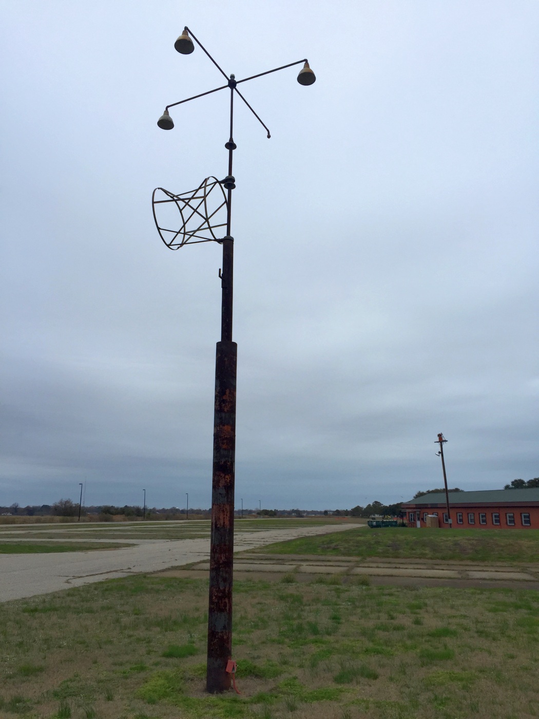
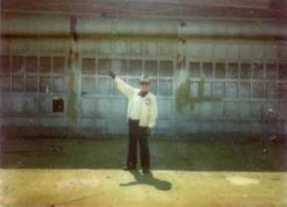
A 3/14/17 photo by Paul Freeman looking north at the windsock frame which remains at the Walker AAF, with the runway & operations building in the background.
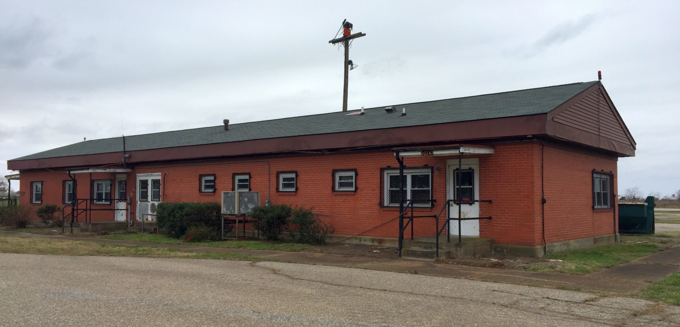
A 3/14/17 photo by Paul Freeman looking southwest at the former Walker AAF operations building.
____________________________________________________
Or if you prefer to contact me directly concerning a contribution (for a mailing address to send a check),
please contact me at: paulandterryfreeman@gmail.com
If you enjoy this web site, please support it with a financial contribution.
____________________________________________________
This site covers airfields in all 50 states.