
Abandoned & Little-Known Airfields:
Texas: Waco area
© 2002, © 2025 by Paul Freeman. Revised 12/31/25.
This site covers airfields in all 50 states: Click here for the site's main menu.
____________________________________________________
Please consider a financial contribution to support the continued growth & operation of this site.
Belton Airport (revised 12/22/25) - Blackland AF Auxiliary Airfield / Valley Mills Municipal Airport (revised 12/21/25) - Bryan AAF / Bryan AFB / TX A&M Flight Test Station Airport (revised 2/10/23)
(Original) Hillsboro Municipal Airport (revised 9/9/25) - Lake Whitney State Park Airport (revised 9/9/25) - Lesikar Farms Airport (added 2/10/23) - Lesikar Ranch Airfield (revised 12/6/25)
Nelson-Wood Airfield / De Leon Municipal Airport (added 4/19/21) - Rich Field (revised 3/29/23) - Waco Aux AAF #5 / Prairie Hill AF Aux (revised 12/31/25)
____________________________________________________
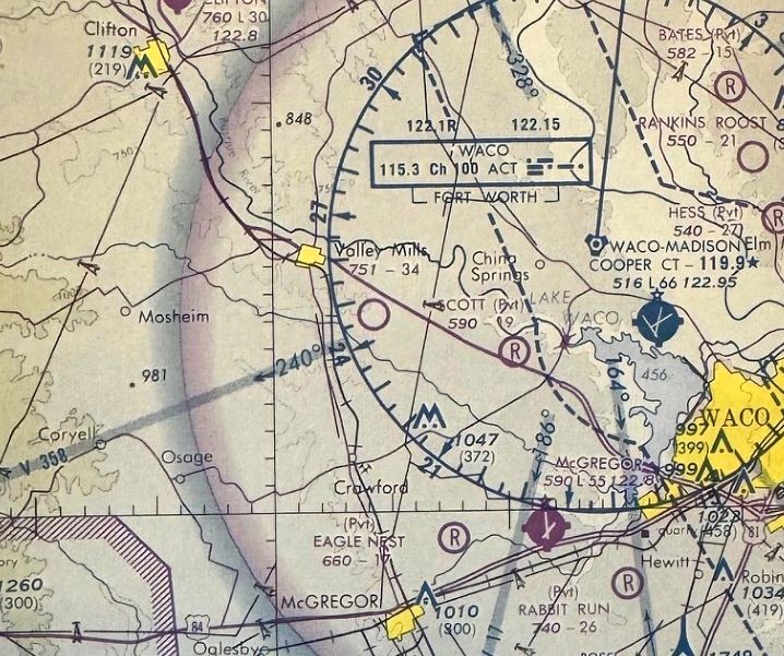
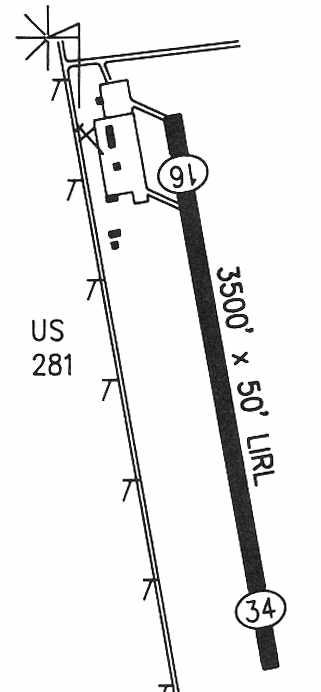
Blackland Air Force Auxiliary Airfield #3 / Crawford Auxiliary Field / Valley Mills Municipal Airport (9F1), Valley Mills, TX
31.644, -97.429 (Northeast of Waco, TX)
Blackland Auxiliary #3, as depicted on a circa 1943 map of Waco auxiliary fields (from the Air Force Historical Research Agency, courtesy of Brian Rehwinkel).
According to Brian Rehwinkel, Blackland Auxiliary Field “was one of at least four auxiliary fields for Blackland Army Airfield in nearby Waco.
The Army Air Forces leased approximately 493 acres & a large, grass (all-way) landing field was created.
The field was called Blackland Auxiliary Field # 3 or Crawford Auxiliary Field.
Based on the Project Ownership Maps [from the National Archives], it appears the land was leased in late 1942 or sometime in 1943 (it is not entirely clear based on the document).”

The earliest photo which has been located of Blackland Auxiliary #3 was an 8/13/45 aerial view looking north (from the National Archives, courtesy of Brian Rehwinkel).
Brian Rehwinkel noted, the photo showed “an open airfield where the landings & takeoffs probably occurred in the Northeast & Northwest portions of the field (similar to the runways that were later marked).”
Brian Rehwinkel reported, “The field lease was transferred to the War Assets Administration in February 1948.”
This airfield was not yet depicted on the 1948 Austin Sectional Chart.
Brian Rehwinkel reported, “The field was then leased to the City of Valley Mills & then re-acquired by the Air Force in February 1949.”
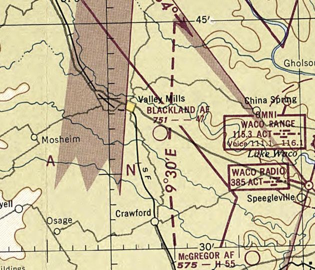
The earliest depiction which has been located of Blackland Air Force Auxiliary Airfield was on the 1949 Austin Sectional Chart.
It depicted “Blackland AF” as having a 4,700' unpaved runway.
It presumably supported flight training operations at the Air Training Command's nearby Connally AFB,
Brian Rehwinkel reported, “The lease with the Air Force was terminated at the end of June 1953.”
A 1955 aerial view depicted an open grass area, with no recognizable sign of an airfield.
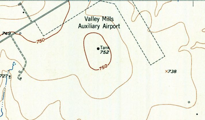
The 1957 USGS topo map depicted “Valley Mills Auxiliary Airport” as having 2 perpendicular unpaved runways
.
The last aeronautical chart depiction which has been located of Blackland Air Force Auxiliary Airfield was on the March 1958 Austin Sectional Chart.
Blackland Air Force Auxiliary Airfield was evidently closed (for reasons unknown) at some point between 1958-59 & reopened as Valley Mills Municipal Airport,
as that is how it was depicted on the April 1959 Austin Sectional Chart.
It depicted Valley Mills as having a 3,000' unpaved runway.

A 1965 Property Ownership Map (from the National Archives, courtesy of Brian Rehwinkel) depicted Blackland Auxiliary Field as a square property outline.
A 1970 aerial view continued to depict an open grass area, with no recognizable sign of an airfield.
The first photo which has been located showing recognizable elements of an airfield at this site was a 1981 aerial view,
which showed 2 unpaved runways, but no other aviation infrastructure.
The December 1985 San Antonio Sectional Chart depicted Valley Mills Airfield, but strangely without any label.
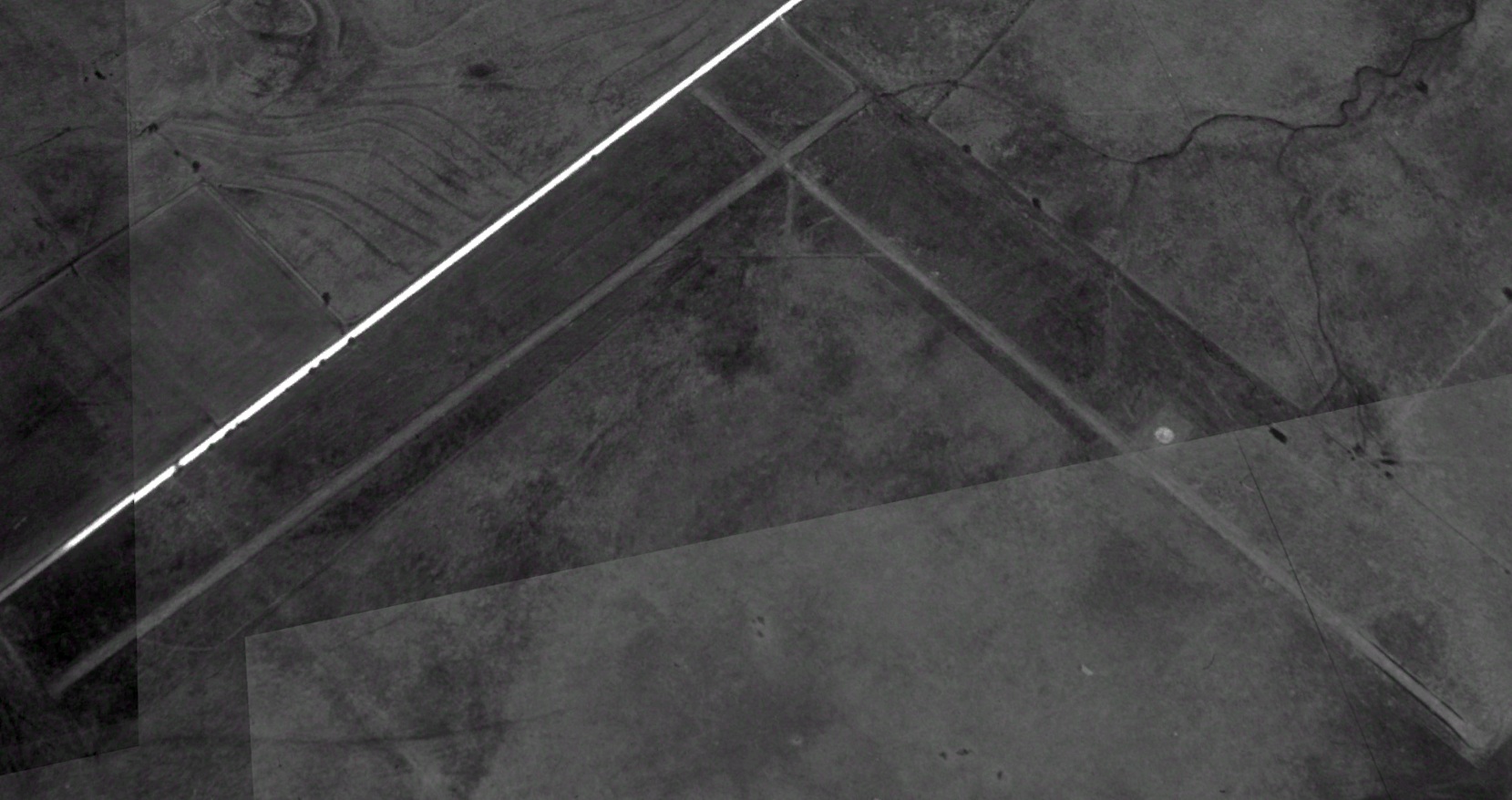
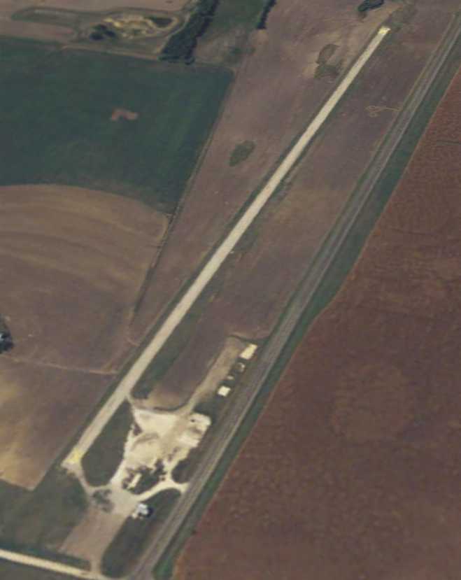
The earliest photo which is available of Valley Mills Municipal Airport was a 1995 aerial view looking north.
It depicted 2 unpaved runways, but no other aviation infrastructure.
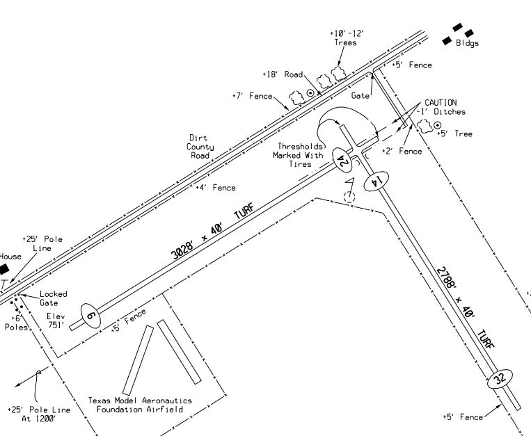
A 2013 TX Airfield Directory (courtesy of Randy Coller) depicted Valley Mills Municipal Airport as having 2 turf runways (3,028' Runway 6/24 & 2,788' Runway 14/32), but no hangars.
Note the TX Model Aeronautics Foundation Airfield adjacent to the southwest side.
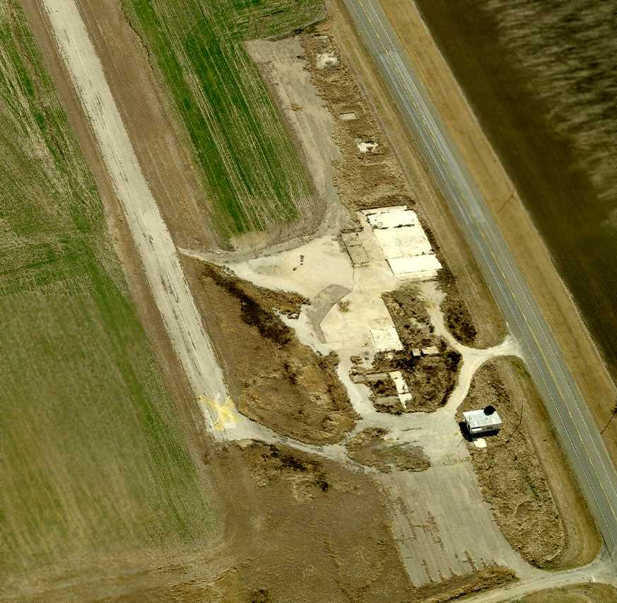
Randy Coller recalled, “When i first inspected Valley Mills Municipal Airport [2018], I went to city hall & suggested they close it if they couldn't maintain it.
It was in pretty bad shape.”
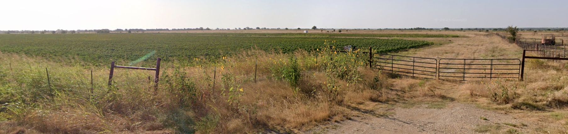
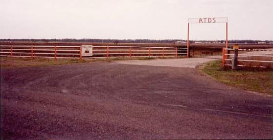
A 2023 photo looking southeast at Valley Mills Municipal Airport from its western gate.
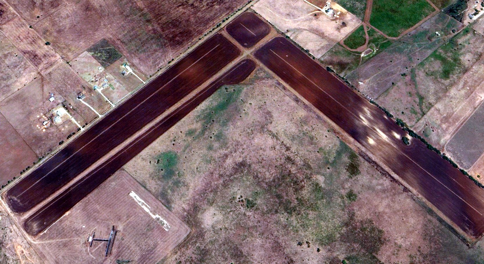
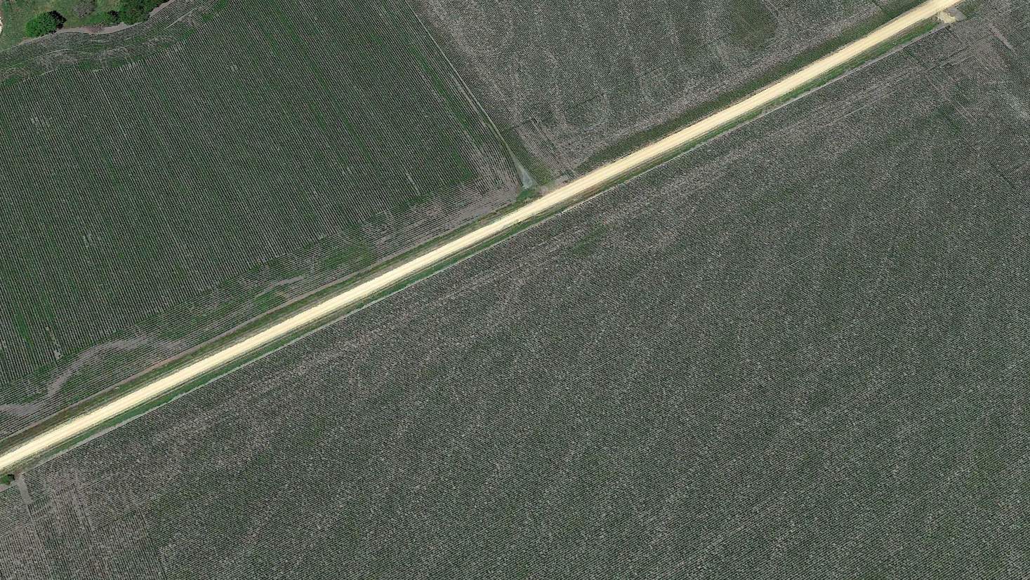
A 2024 aerial view looking northeast at the 2 runways of Valley Mills Municipal Airport, along with the TX Model Aeronautics Foundation Airfield adjacent to the southwest side.
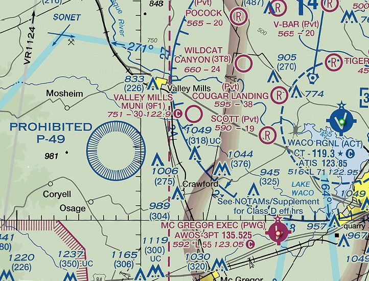
The 2024 Dallas Sectional Chart depicted Valley Mills Municipal Airport as having a 3,000' unpaved runway.
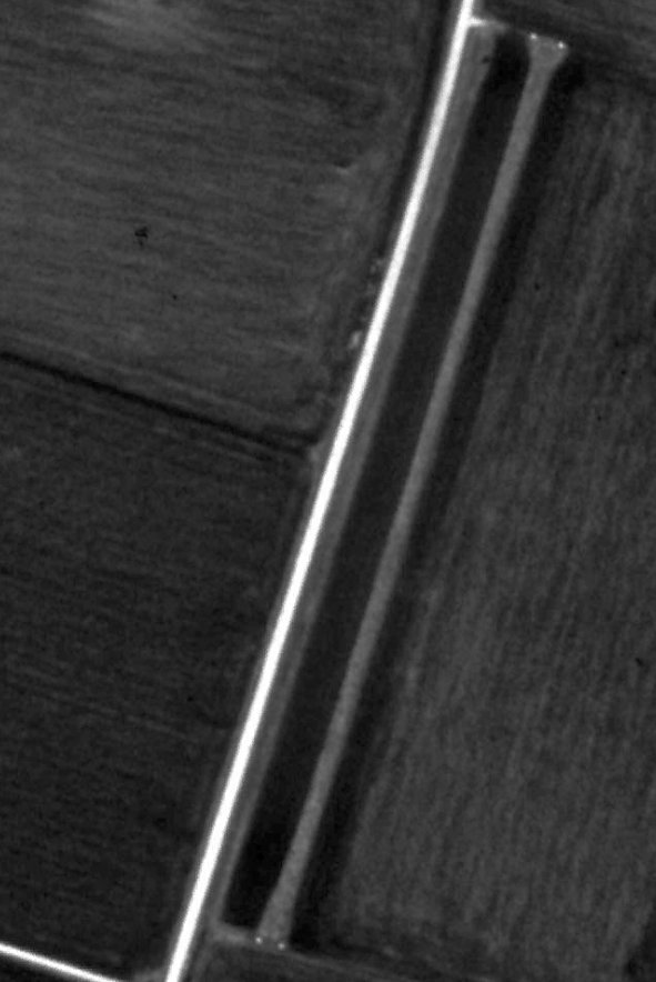
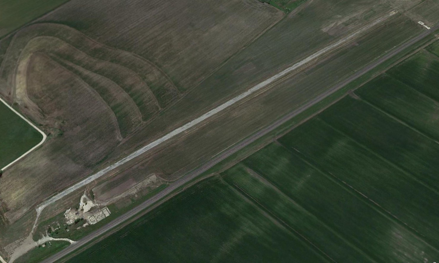
An 11/8/24 photo by Randy Coller looking along a Valley Mills Municipal Airport runway.
Randy Coller reported, “My last inspection of Valley Mills Municipal Airport was 11/8/24.
I'm not sure of official date of closing, but it was before the inspection today. I just verified that it was indeed closed.”
Thanks to Randy Coller for pointing out this airport.
____________________________________________________
Lesikar Ranch Airfield, Oakwood, TX
31.561, -95.897 (East of Waco, TX)
Lesikar Ranch Airfield, as depicted on the September 1972 Houston Sectional Chart (courtesy of Woody Lesikar).
Photo of the airfield while in use has not been located.
This small airfield was evidently established at some point between 1970-72,
as it was not yet depicted on the September 1970 Houston Sectional Chart.
A "Notice of Landing Area Proposal" was sent by owner Wood Lesikar to the FAA on 11/23/70,
describing the proposed private airfield having a 2,460' runway.
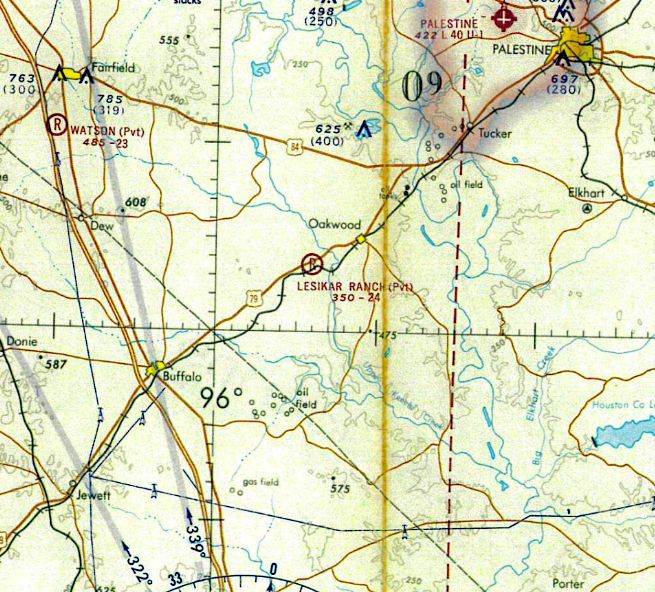
The earliest depiction which has been located of Lesikar Ranch Airfield was on the September 1972 Houston Sectional Chart (courtesy of Woody Lesikar).
It depicted Lesikar Ranch as a private airfield having a 2,400' unpaved runway.

The earliest topo map depiction which has been located of Lesikar Ranch Airfield was on the 1975 USGS topo map.
Lesikar Ranch Airfield was evidently closed at some point between 1975-92, as it was no longer depicted on the 1992 USGS topo map.

A 2023 aerial view showed no trace of Lesikar Ranch Airfield.
Thanks to Woody Lesikar for pointing out this airport.
____________________________________________________
Lesikar Farms Airport (91R), Zabcikville, TX
31.025, -97.186 (South of Waco, TX)
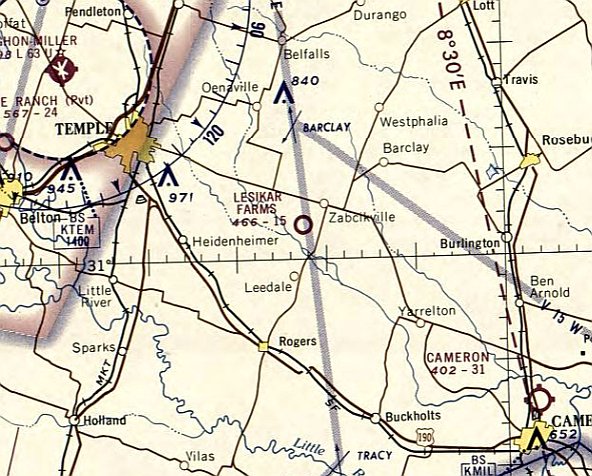
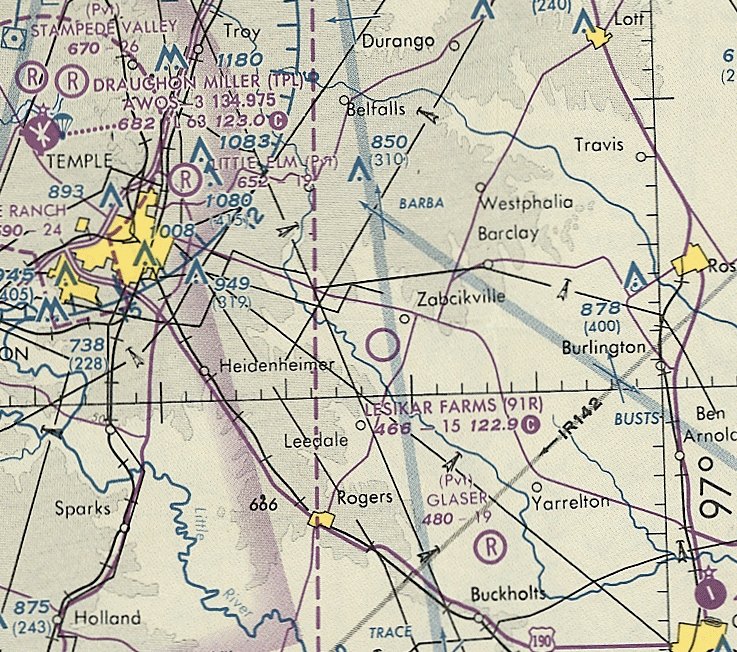
Lesikar Farms Airport, as depicted on the April 1967 Austin Sectional Chart.
Photo of the airfield while in use has not been located.
This small general aviation airport was evidently established at some point between 1966-67,
as it was not yet depicted on the April 1966 Austin Sectional Chart.
The earliest depiction which has been located of Lesikar Farms Airport was on the April 1967 Austin Sectional Chart.
It depicted Lesikar Farms as having a mere 1,500' unpaved runway.
The 1993 USGS topo map depicted Lesikar Farms Airport as a single unpaved northeast/southwest runway, generically labeled “Landing strip”.
The last aeronautical chart depiction which has been located of Lesikar Farms Airport was on the May 1993 San Antonio Sectional Chart.
It depicted Lesikar Farms as a public-use airport having a 1,500' unpaved runway.
The only photo which has been located showing the Lesikar Farms Airport runway was a 1995 USGS aerial view.
It depicted a single northeast/southwest runway, with no other improvements.
Lesikar Farms Airport was evidently closed (for reasons unknown) at some point between 1993-2016,
as it was no longer depicted on the November 2016 San Antonio Sectional Chart.
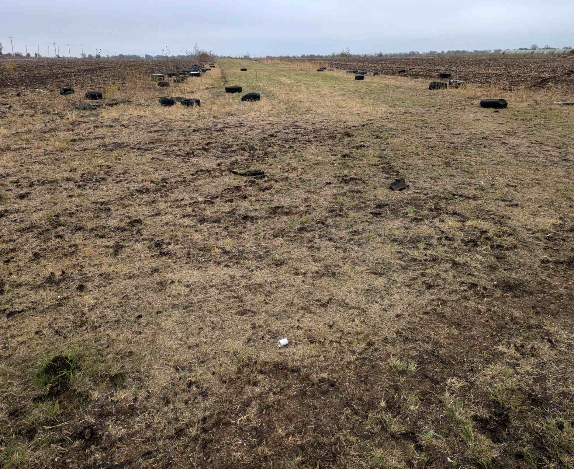
A 2021 aerial view looking northwest shows only the faintest trace remaining of the Lesikar Farms Airport runway, with the land having returned to agriculture.
Thanks to Woody Lesikar for pointing out this airport.
____________________________________________________
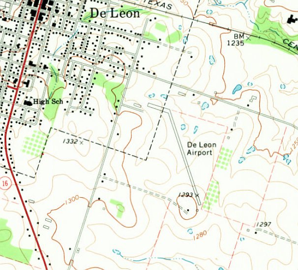
Nelson-Wood Airfield / De Leon Municipal Airport (04F), De Leon, TX
32.098, -98.525 (Northwest of Waco, TX)
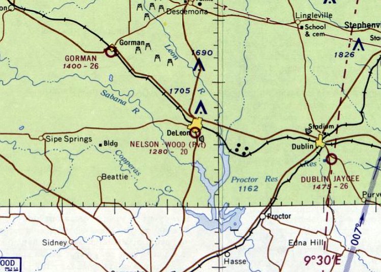
Nelson-Wood Airfield, as depicted on the February 1965 Dallas Sectional Chart.
Photo of the airfield while in use has not been located.
This private airfield was evidently established at some point between 1961-65,
as it was not yet depicted on the March 1961 Dallas Sectional Chart.
The earliest depiction which has been located of Nelson-Wood Airfield was on the February 1965 Dallas Sectional Chart.
It depicted Nelson-Wood as a private airfield having a 2,000' unpaved runway.
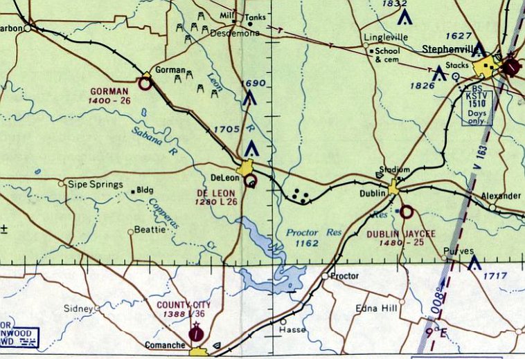
The last depiction which has been located of Nelson-Wood Airfield was on the July 1965 Dallas Sectional Chart.
At some point between 1965-66, the private Nelson-Wood Airfield was evidently transitioned into the public-use De Leon Airport,
as that is how the airfield was depicted on the February 1966 Dallas Sectional Chart.
De Leon Airport was depicted as having a 2,600' unpaved runway.
The last aeronautical chart depiction which has been located of De Leon Airport was on the July 1968 Dallas Sectional Chart.
It depicted De Leon Airport as having a 2,000' unpaved runway.
The 1970 USGS topo map depicted De Leon Airport as having a single paved northwest/southeast runway, with a ramp & a small building on the northwest side.
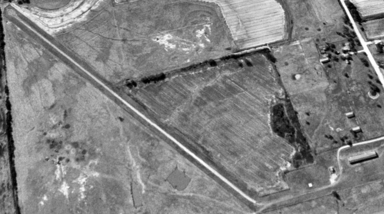
The earliest photo which has been located of De Leon Airport was a 1995 USGS aerial view looking southwest.
It depicted De Leon Airport as having a single paved northwest/southeast runway, with a ramp & a few small buildings on the northwest side.
There were no aircraft visible on the field.
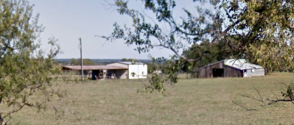
A 2013 photo looking east showed the former shade hangar on the northwest side of the site of De Leon Airport.
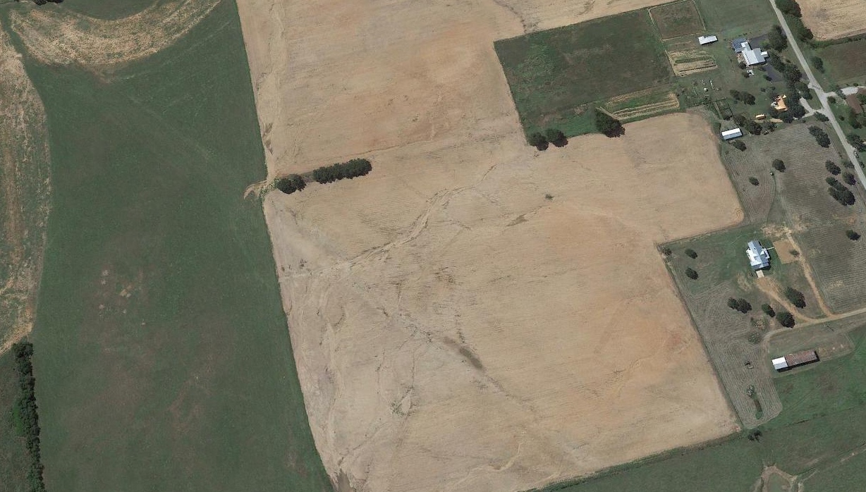
A 2016 aerial view looking southwest at the site of De Leon Airport showed the trace of the former hangar was only barely recognizable, with the land having returned to agriculture.
The former shade hangar remained at the northwest corner of the site (bottom-right).
Thanks to James Fitts for pointing out this airport.
____________________________________________________
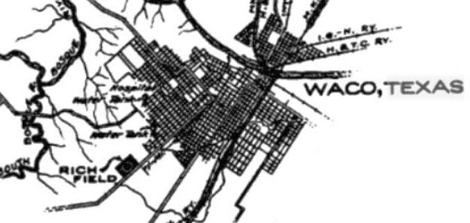
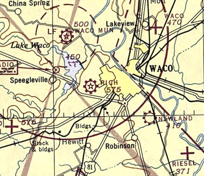
31.546, -97.188 (Southwest of Dallas, TX)
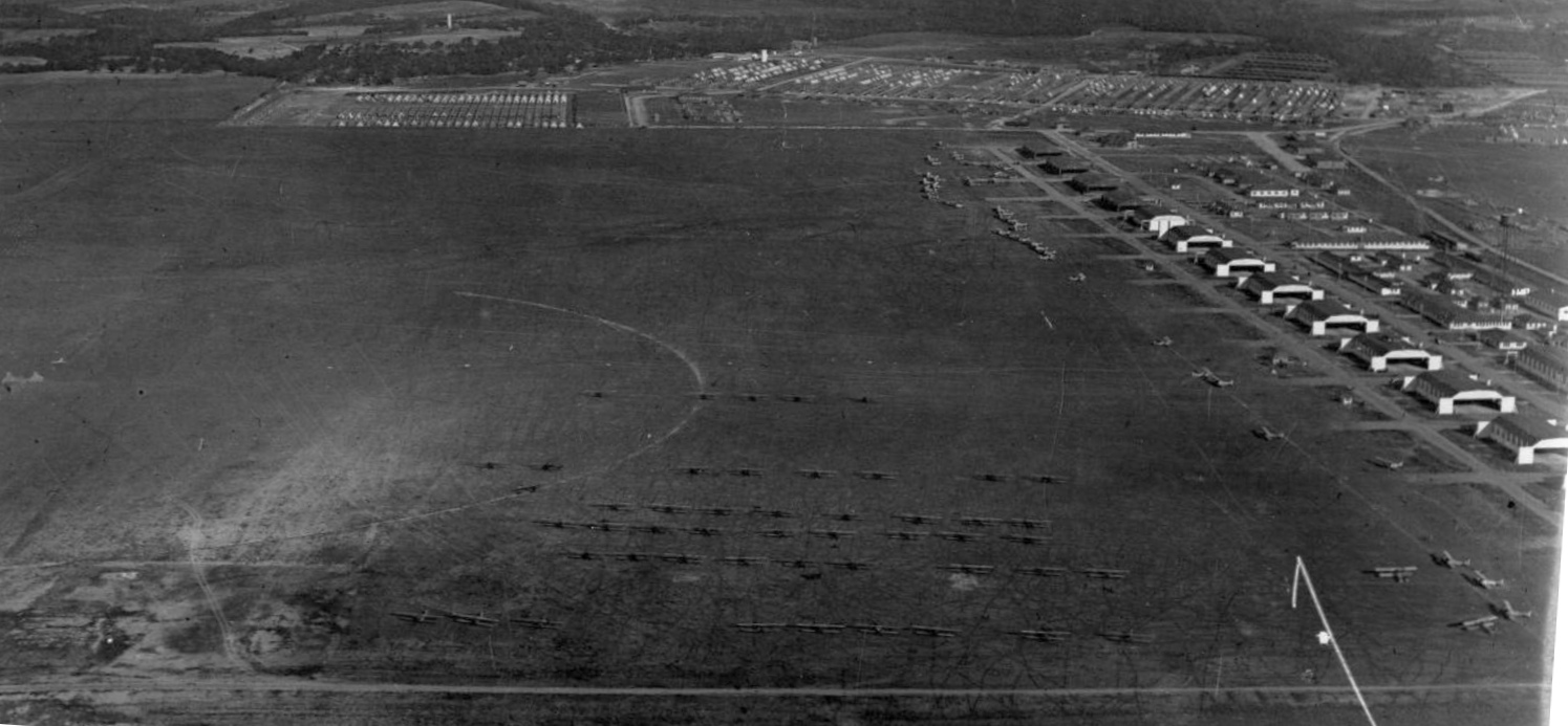
A 1918 aerial view looking north at Rich Field, showing a long row of 12 hangars along the east side & a large number of biplanes.
According to Wikipedia, “Rich Field operated as a training field for the Air Service, United States Army from 1917-19.
The airfield was one of 32 Air Service training camps established in 1917 after the United States entry into World War I.
The base was named Rich Field in honor of 2nd Lt. Perry Rich of the Philippine Scouts.
He crashed his Wright Model C into Manila Bay on November 14, the 10th U.S. pilot to die in a flying accident.
A contract was signed on 8/24/1917 giving the War Department title to the property, which was in private hands.
Formerly cotton fields, a significant number of farm buildings on the property had to be torn down.
A labor force of about 3,400, including 1,000 Mexican workers, erected buildings, poured concrete, and laid down pipes & an electrical system.”
Wikipedia continued, “On 9/17/1917, the first officer reported for duty, and various pieces of equipment & a group of personnel were assigned to set up the base as a primary flight training field.
The first shipment of 25 aircraft arrived on November 14 & were uncrated & assembled by the 150th Aero Squadron, moved from Kelly Field.
Twenty-five flight cadets reported for training on Thanksgiving Day 1917, and flight instruction began on December 1.
Eventually a total of 243 Standard J-1 trainers were assigned to Rich Field.
In June 1918, the J-1s were replaced by the Curtiss JN-4 which was standardized by the War Department as the standard training plane for the Air Service.”
Wikipedia continued, “Training units assigned to Rich Field were:
Post Headquarters, Rich Field, September 1917-December 1919,
39th Aero Squadron, December 1917, Re-designated "Squadron A", July–November 1918,
150th Aero Squadron, November 1917, Re-designated "Squadron B", July–November 1918,
249th Aero Squadron (Service), December 1917, Re-designated "Squadron C", July–November 1918,
Flying School Detachment, Formed November 1918 from personnel & assets of Squadrons A, B. C. inactivated in December 1919.”
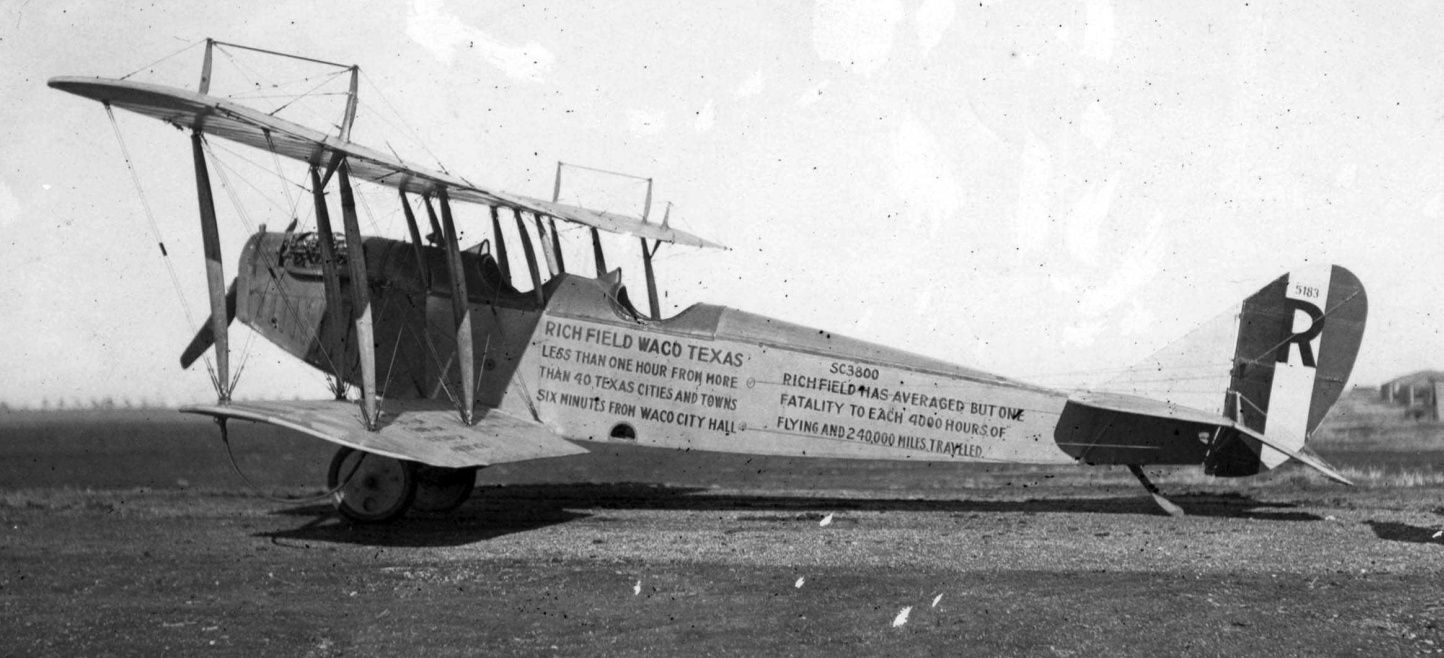
A 1918 US Army photo of a Curtiss JN-4 at Rich Field painted to brag of the low fatality rate at the field - one per 4,000 hours.
Wikipedia continued, “As the flight cadets graduated from the 6-week course at Rich Field,
they were sent to advance schools in the United States, England, or France for advanced training in either pursuit, observation or bomber aircraft.
Eventually some 400 pilots received their wings at Rich Field.”
Wikipedia continued, “Training units organized and equipped at Rich Field as core training squadrons for other Air Service training bases in the United States were:
71st Aero Squadron (II), Formed February 1918, transferred to Love Field, TX,
75th Aero Squadron (II), Formed February 1918, transferred to Gerstner Field, LA,
76th Aero Squadron (II), Formed February 1918, transferred to Carlstrom Field, FL, March 1918,
77th Aero Squadron (II), Formed February 1918, transferred to Taliaferro Field #1 (Hicks Field), TX,
78th Aero Squadron (II), Formed February 1918, transferred to Taliaferro Field #1, TX,
79th Aero Squadron (II), Formed February 1918, transferred to Taliaferro Field #1, TX,
80th Aero Squadron (II), Formed March 1918, transferred to Post Field, OK,
81st Aero Squadron (II), Formed March 1918, transferred to Post Field, OK,
82nd Aero Squadron (II), Formed March 1918, transferred to Taliaferro Field #1, TX,
106th Aero Squadron (II), Formed March 1918, transferred to Taliaferro Field #2 (Barron Field), TX,
107th Aero Squadron (II), Formed March 1918, transferred to Carlstrom Field, FL,
108th Aero Squadron (II), Formed March 1918, transferred to Carlstrom Field, FL,
109th Aero Squadron (II), Formed March 1918, transferred to Carlstrom Field, FL, April 1918,
110th Aero Squadron (II), Formed April 1918, transferred to Dorr Field, FL, May 1918,
111th Aero Squadron (II), Formed April 1918, transferred to Dorr Field, FL, May 1918,
112th Aero Squadron (II), Formed April 1918, transferred to Chanute Field, IL, May 1918.”
Wikipedia continued, “The following units were organized & given basic military indoctrination at Rich Field before being deployed to the American Expeditionary Forces in Europe:
72nd Aero Squadron (Service), Formed February 1918, to AEF, July 1918,
171st Aero Squadron (Service), Formed December 1917, to AEF, January 1918,
280th Aero Squadron (Service), Formed February 1918, to AEF August 1918,
355th Aero Squadron (Service), Formed May 1918, to AEF August 1918.”
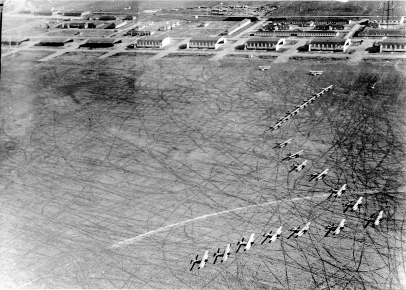
A circa 1918 aerial view looking northeast at Rich Field, showing a large number of biplanes on the airfield in front of the row of hangars.
Wikipedia continued, “After the November 1918 Armistice with Germany, those pilots who were in training were allowed to complete their studies, but no new cadets began training.
The airfield was ordered closed in May 1919, and in December the flag was lowered for the last time.”
The earliest map depiction which has been located of Rich Field was on the 1919 TIB Military Map of the US (courtesy of Jonathan Westerling).
Wikipedia continued, “Although it was closed as a military airfield after World War I, aviation activity continued at Rich Field as a civil airport.”
Rich Field, as depicted on the 4/10/26 Commerce Department Airway Bulletin (courtesy of Mike Denja).
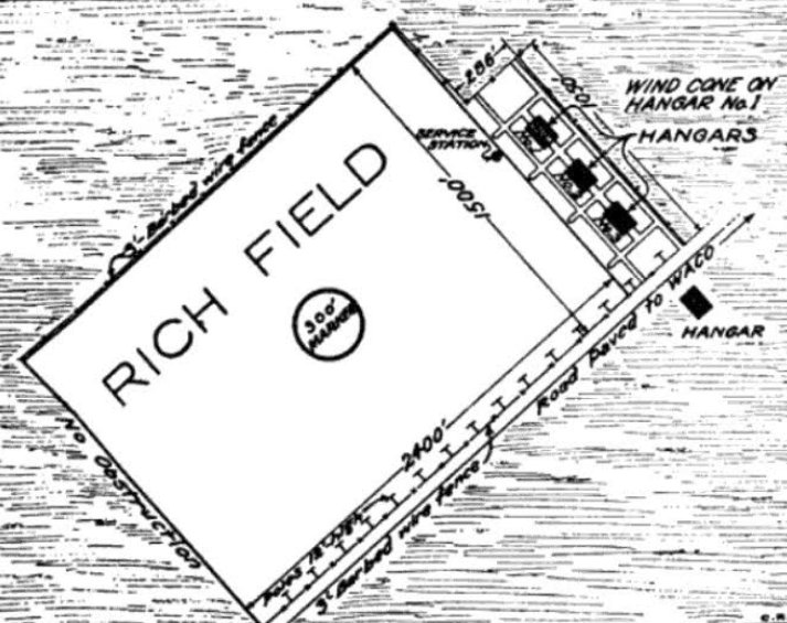
Oddly, the 4/10/26 Commerce Department Airway Bulletin (courtesy of Mike Denja) depicted the postwar civilian Rich Field as occupying only a small portion of original WW1-era military airfield,
noted as occupying “part of the old Rich Field", and showing only 4 of the original dozen hangars (including 1 on the opposite side of the road from the current airfield).
The rectangular airfield measured 2,400' northeast/southwest by 1,500' northwest/southeast, with a “barbed wire fence” along the northwest border evidently blocking-off the remainder of the original larger airfield.
According to Wikipedia, “Flying lessons were available & during the 1920s & 1930s traveling airshows occasionally visited Rich Field.
A Ford Trimotor offered the public a 10-minute flight to downtown Waco & back for $1.
On one visit the Trimotor was put into a spin (without passengers) for show.”
The earliest government aeronautical chart depiction which has been located of Rich Field was on the April 1934 Austin Sectional Chart.
According to Wikipedia, “For many years Braniff International Airways provided passenger service to Waco at Rich Field.
The airport was closed near the beginning of World War II.
Rich Field was reopened as an auxiliary training field to Waco Army Airfield in 1942.
Two gravel runways were laid down in an 'X' pattern, the northwest/southeast runway being 3,700' & the north-northwest/south-southeast runway being 3,500'.
It may also have been used as a storage depot & limited civil flight operations during the war.”
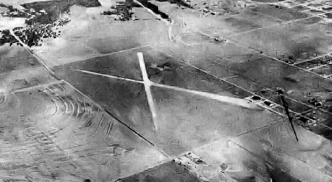
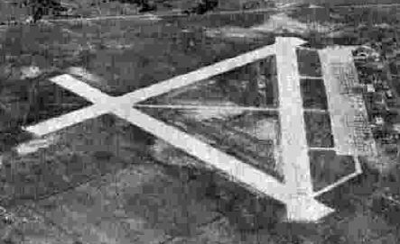
A 10/10/43 US Army aerial view looking north depicted Rich Field
as having 2 unpaved runways in an X-shape, with a few small buildings (hangars?) on the east side.
The last aeronautical chart depiction which has been located of Rich Field was on the August 1946 Austin Sectional Chart.
According to Wikipedia, “Flying ended from Rich Field after the end of World War II.”
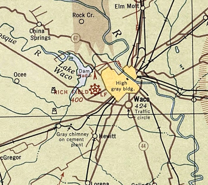
Rich Field was no longer depicted on the August 1950 Austin Sectional Chart.
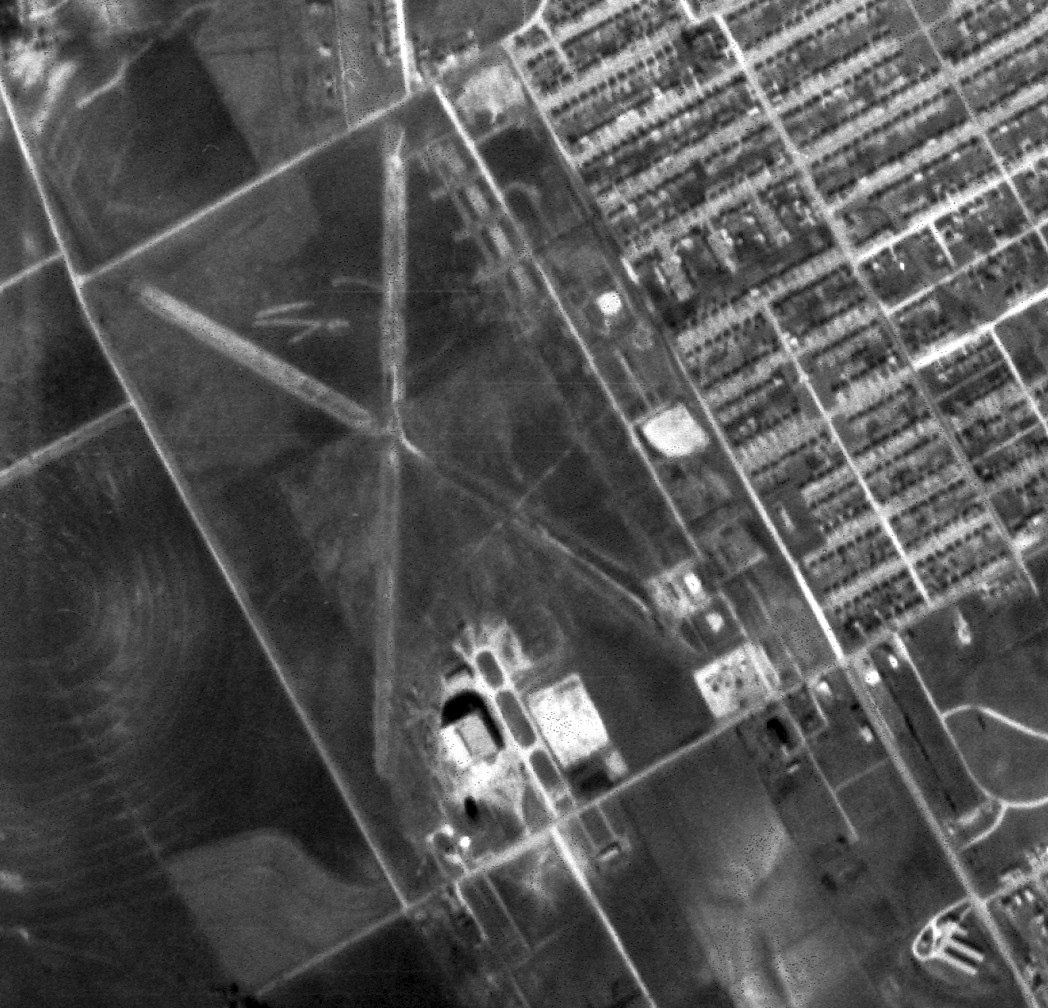
The last depiction which has been located of Rich Field was a 12/10/52 USGS aerial view.
Redevelopment of the site had not yet begun, and the WW2-era layout of 2 runways in an X-shape was still apparent.
The remains of the earlier WW1-era airfield was also still recognizable, with the foundations of multiple hangars along the east side still visible.
According to Wikipedia, “The site was subsequently used for 2 major civic facilities & numerous businesses.
The Heart O' Texas Fairgrounds & coliseum were built in the 1950s.
A high school was constructed on part of the site in the early 1960s & was called Richfield High School in honor of the former airfield.”
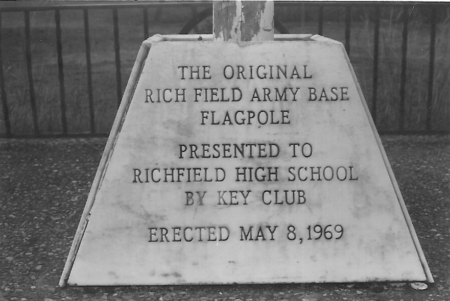
An undated photo of the base of the Rich Field military flagpole which was erected at Richfield High School on 5/8/69.
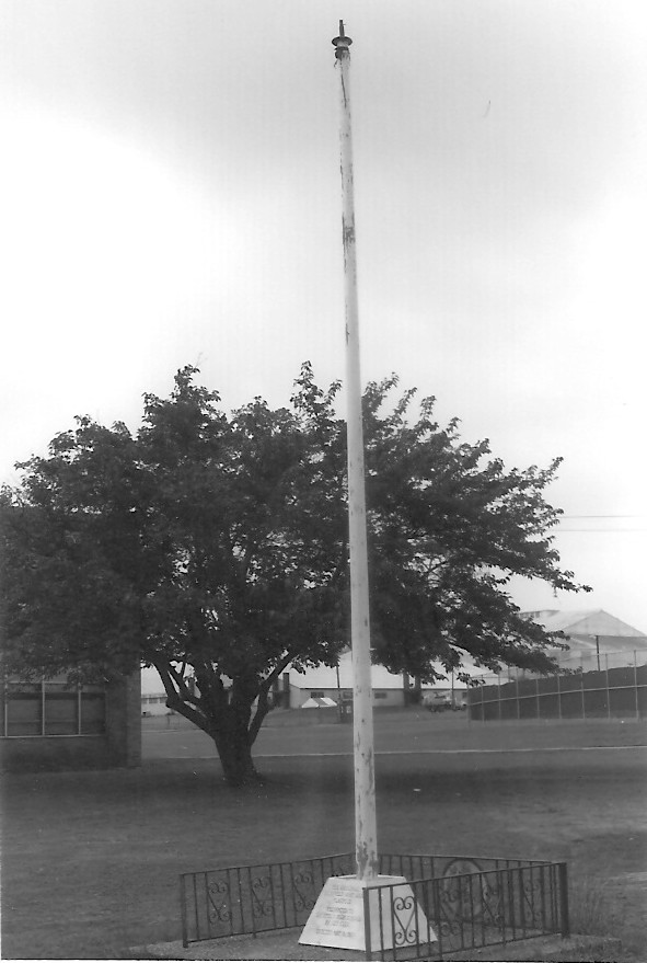
An undated photo of the Rich Field military flagpole which was erected at Richfield High School on 5/8/69.
A 1970 aerial view showed Rich Field's rectangular property outline remained intact, but the site was covered by the fairground & high school.
A 2017 aerial view looking north shows Rich Field's rectangular property outline remains quite distinct.
Jason Ward observed, “The current go-cart track near the intersection of Bosque & North New Road must be on the foundations of one of the hangars.
Also, just to the west of the go-cart track is a long section of what looks like old pavement, parallel to 42nd Street - maybe the old ramp by the hangars?
I think I see another hangar foundation near the intersection of Colcord & North New Road, also with what looks like the remains of an apron/ramp to the west.”
The site of Rich Field is located west of the intersection of Bosque Bouleavrd & North New Road.
Thanks to Jason Ward for pointing out this airport.
____________________________________________________
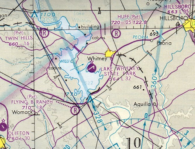
Lake Whitney State Park Airport (F50), Lake Whitney, TX
31.925, -97.365 (Northwest of Waco, TX)
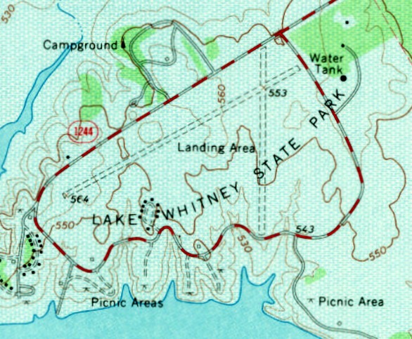
Lake Whitney State Park Airport, as depicted on the 1966 USGS topo map.
Lake Whitney was created as a flood-control measure in 1951.
At some point between 1951-66, the surrounding state park gained its own airport on the northeast lake shore.
The earliest depiction which has been located of Lake Whitney State Park Airport was on the 1966 USGS topo map,
which depicted 2 unpaved runways, labeled simply as “Landing Area”. There were no buildings depicted on the site.
Both of Lake Whitney State Park Airport's runways were apparently paved at some point between 1966-77,
as that is how they were depicted on the December 1976 San Antonio Sectional Chart (courtesy of Stu Sibitzky).
It depicted Lake Whitney State Park Airfield as having 2 paved runways, with the longest being 3,200'.
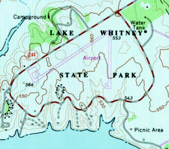
The 1979 USGS topo map depicted Lake Whitney State Park Airport as having 2 paved runways,
and a paved ramp had been added on the west side.

The last aeronautical chart depiction which has been located of Lake Whitney State Park Airport was on the December 1985 San Antonio Sectional Chart.
It depicted Lake Whitney State Park Airfield as having a single 2,000' paved north/south runway.
The earliest photo which has been located of Lake Whitney State Park Airport was a 1995 USGS aerial view.
It depicted the field as having 2 paved runways, with a paved ramp & a small shed on the west side.
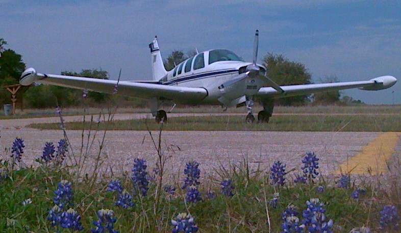
The earliest photo which has been located of an aircraft at Lake Whitney State Park Airport was a 4/8/09 photo of a 1979 Beechcraft A36 Bonanza.
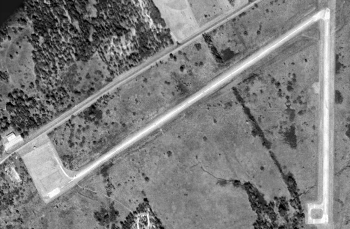
A 2011 aerial view showed that Lake Whitney State Park Airport lost its northeast/southwest runway at some point between 1995-2011,
but Runway 17/35 was still marked as active.
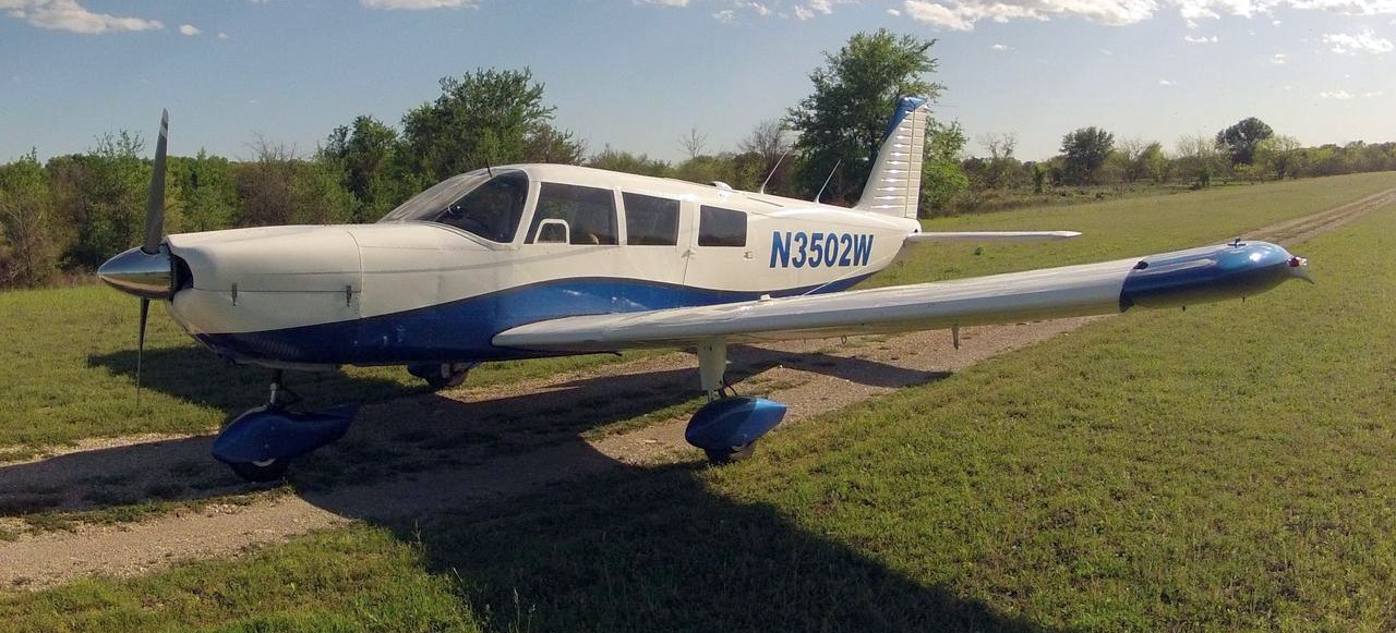
A 3/23/12 photo of a 1966 Piper PA-32-260 at Lake Whitney State Park Airport.
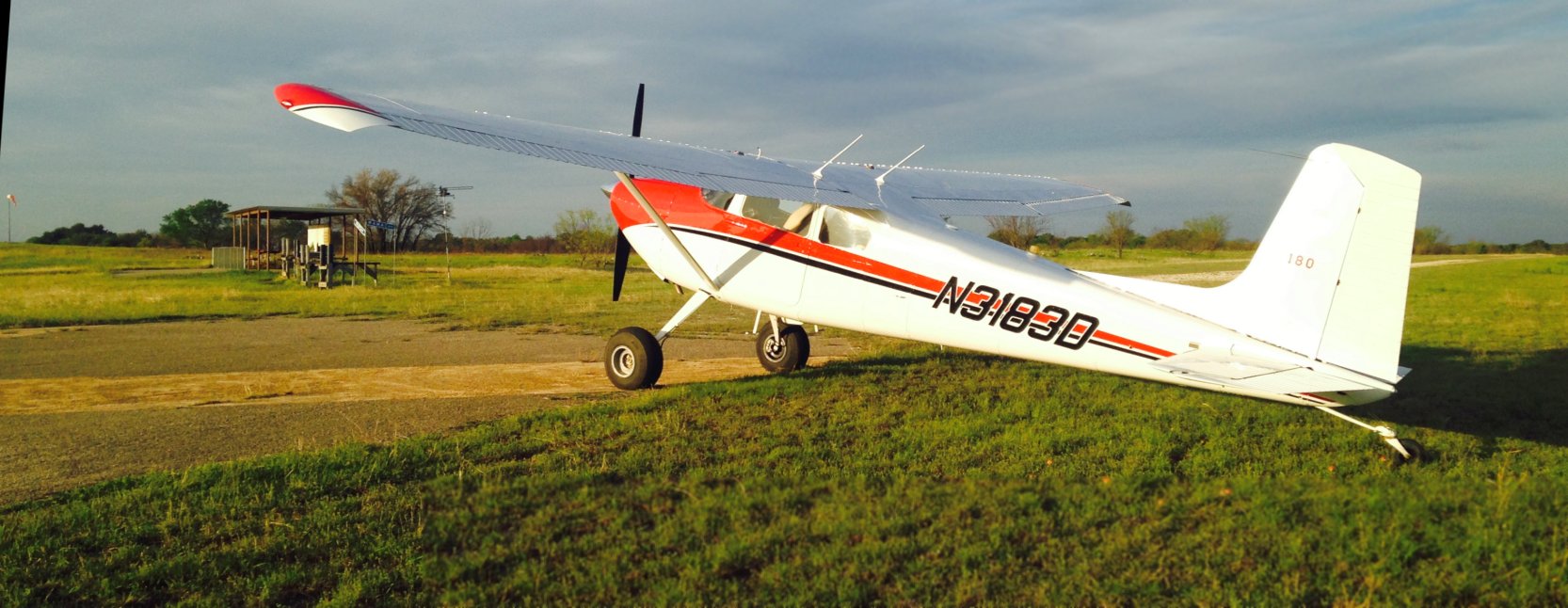
The last photo which has been located of an aircraft at Lake Whitney State Park Airport was 2016 picture by Keller Bradfield of his 1955 Cessna 180 the last time he landed at Lake Whitney.
As of 2016 the FAA Airport/Facility Directory described Lake Whitney State Park Airport as having a 2,000 asphalt Runway 17/35, “in fair condition”.
Lake Whitney State Park Airport was evidently closed (for reasons unknown) by 2016,
as a 2016 aerial view showed that Runway 17/35 was still intact, but was marked with closed-runway “X” symbols.
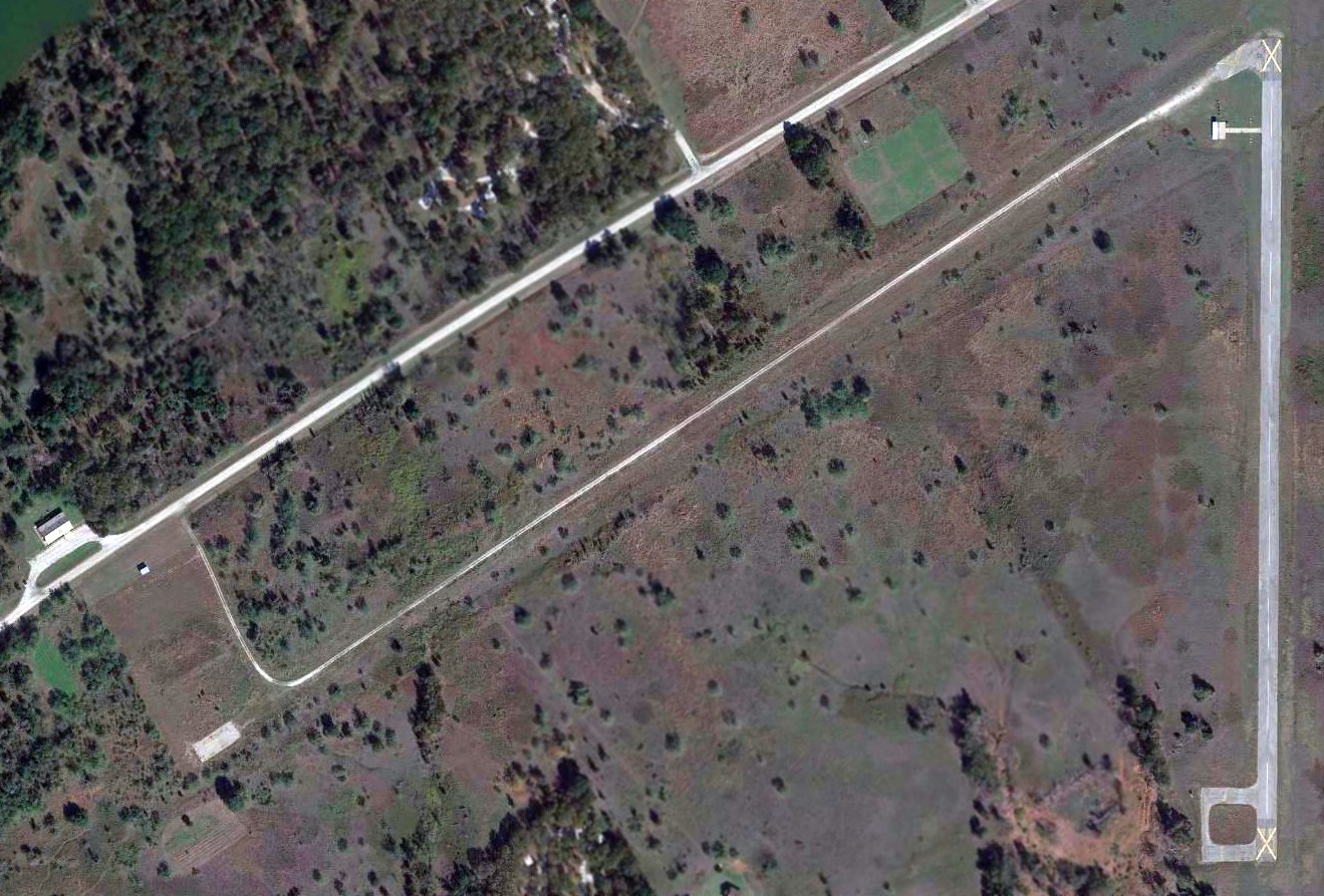
Most of the pavement of the northeast/southwest runway had been removed, and a radio-controlled model airplane flying facility had been built southwest of the runway intersection.
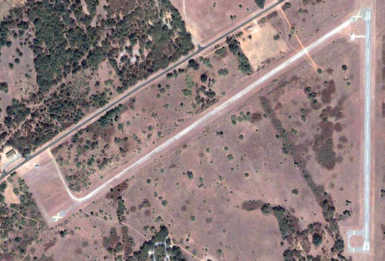
A December 2022 aerial view looking southwest at the 2 former Lake Whitney State Park Airport runways, with yellow closed-runway “X” symbols visible on both.
A radio-controlled model airplane flying facility is seen just southwest of the runway intersection.
Lake Whitney State Park Airport is located south of the intersection of State Park Road 47 & Route 1244.
Thanks to Bryan Fair for pointing out this airport.
____________________________________________________
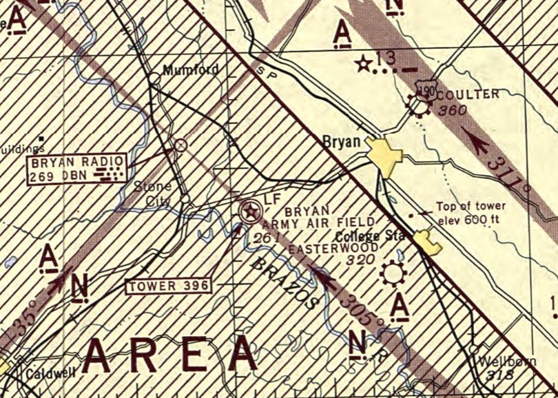
Bryan Army Airfield / Bryan Air Force Base / Texas A&M Flight Test Station Airport (83TX), Bryan, TX
30.634, -96.48 (Southeast of Waco, TX)
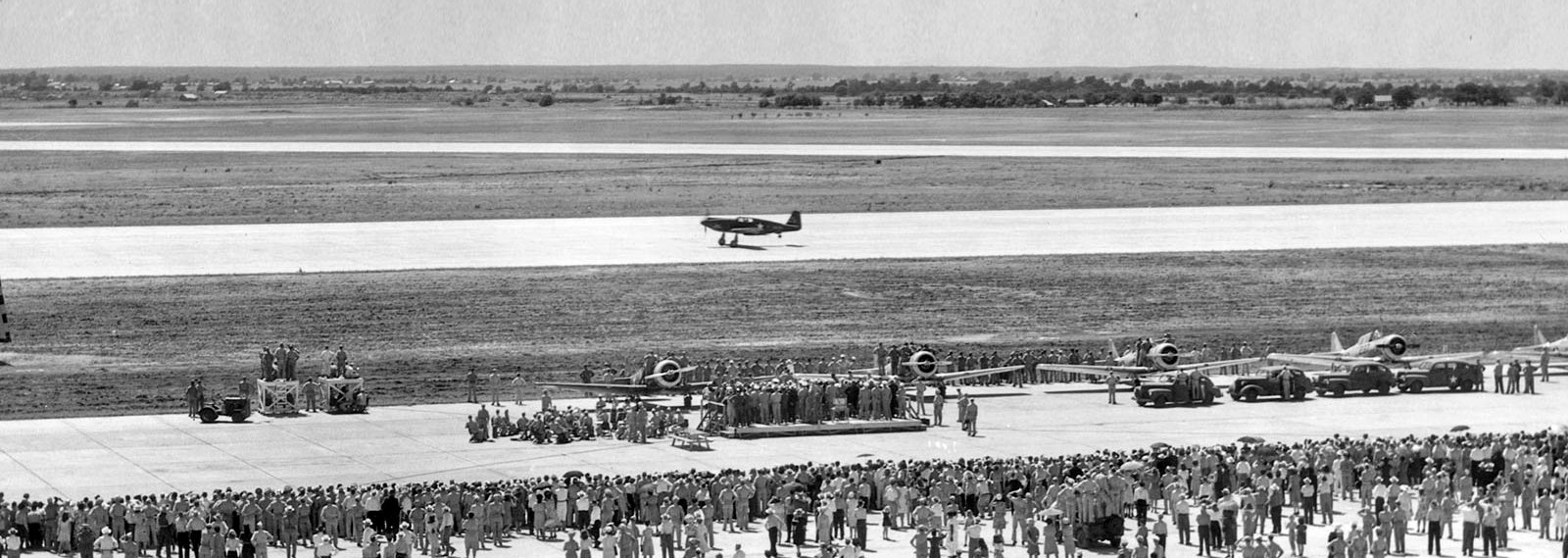
A 6/6/43 photo of P-51 Mustang “The Spirit of Bryan Field” landing at the Bryan Army Air Field dedication.
Bryan Army Airfield was not yet depicted on the June 1942 Austin Sectional Chart.
According to Wikipedia, Bryan Army Airfield was established in 1942 as part of the expansion of the flying training program by Army Air Forces Training command.
It was activated on 3/1/42 under the Central Flying Training Command (CFTC) 77th Flying Training Wing (Advanced, Single Engine), Foster Army Airfield, TX.
Bryan Army Airfield was constructed with 3 concrete runways, one main 5,500' north/south & 2 secondary 5,000' northeast/southwest & northwest/southeast.
A large parking apron was built with additional taxiways, landing aids & several hangars.
Buildings were ultimately utilitarian & quickly assembled.
Most base buildings, not meant for long-term use, were constructed of temporary or semi-permanent materials.
Although some hangars had steel frames & the occasional brick or tile brick building could be seen,
most support buildings sat on concrete foundations but were of frame construction clad in little more than plywood & tarpaper.
The base had its own hospital, 40-acre sewage plant, 9 administration buildings, 4 mess halls, supply rooms, officers' quarters, a guardhouse, a chapel, and 37 barracks.
Bryan AAF had 4 auxiliary fields which were constructed in the area:
Somerville Field (AAF Aux #1), Hearne Field (AAF Aux #2, later reused as Hearne Municipal Airport),
AAF Aux #3 (location unknown), and Easterwood Field (AAF #4).
Bryan AAF became the home of the Army Air Forces Instructors School (Instrument Pilot),
which was established as a means of strengthening the AAF instrument program.
A substantial improvement in the instrument proficiency of basic graduates was achieved;
this resulted from standardized employment of the more efficient system, proper training of instructors,
procurement of adequate equipment, and allocation of more flying hours to instrument work.
In 1943, Bryan Field was the starting point of the first intentional meteorological flight into a hurricane.
The earliest photo which has been located of Bryan Field was a 6/6/43 photo of early fastback-version P-51 Mustang “The Spirit of Bryan Field” landing at the field's dedication ceremony.
For the first time, the public was welcomed onto the installation & treated to an air show, music from the Waco Field Air Force Band, and the christening of “The Spirit of Bryan Field”.
Tens of thousands of area residents attended the festivities .
The earliest aerial photo which has been located of Bryan AAF was a 10/16/43 aerial view looking north from the 1945 AAF Airfield Directory (courtesy of Scott Murdock).
It depicted Bryan as having 3 concrete runways, with a large concrete ramp & numerous buildings on the east side.
Bryan AAF was assigned to the AAFTC Central Flying Training Command as an AAF Pilot School (Advanced, Twin-Engine).
The earliest aeronautical chart depiction which has been located of Bryan Army Air Field was on the June 1944 Austin Sectional Chart.
It depicted Bryan as having a control tower, and covered by a huge “Danger Area” that warned of intensive instrument flight training.
The 1945 AAF Airfield Directory (courtesy of Scott Murdock) described Bruan AAF as a 1,946 acre irregularly-shaped property having 3 concrete 5,000' runways.
The field was said to have 2 wooden 122' x 80' hangars,
and to have 2 auxiliary fields: #1 Somerville Field & #2 Hearne Field.
Bryan AAF was said to be owned by the U.S. Government, operated by the Army Air Forces, but to be inactive.
Instructor training continued at Bryan AAF until the base was inactivated in February 1947.
Following World War II, enrollment at nearby Texas A&M University soared.
Housing was in short supply, so between September 1946 & May 1950 an estimated 5,500 men were housed & attended classes at an annex on the former Bryan Army Airfield.
The Air Force retained a recapture right of the Bryan property, which it exercised to accommodate the Korean War training surge.
In the spring of 1951 the government purchased 1,376 acres at the site,
and Bryan Field was reactivated as Bryan Air Force Base under Air Training Command (ATC).
Much construction was necessary to bring the World War II training base up to postwar Air Force standards.
In 1951 additional land surrounding the base was appropriated for military facilities & extended runways.
A jet runway (18/36) was laid down along with accompanying taxiways, concrete block buildings & other support facilities
to replace the temporary wooden World War II structures that were viewed as substandard for a permanent Air Force base.
The 3530th Pilot Training Wing (Advanced Single-Engine) was activated by ATC on 10/14/51.
The primary mission of Bryan AFB was to provide advanced single-engine pilot training for student officers & aviation cadets of the USAF & foreign nationals.
The 3530th PTW qualified aviation cadets as officers in the USAF.
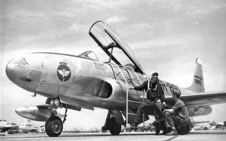
The 3531st Pilot Training Squadron flew T-28 Trojan single-engine trainers; the 3530th PTS flew F-80 & T-33 Shooting Star jet aircraft.
Gus Grissom, later one of the first astronauts, was a jet instructor at Bryan AFB in the 1950s.
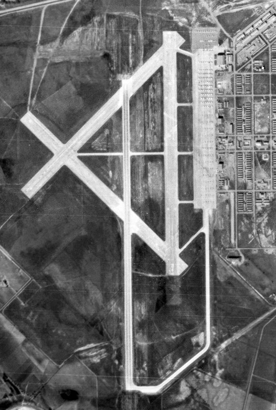
A 1/25/53 USGS aerial view depicted a large number of aircraft on the Bryan AFB ramp.
Also note the considerably longer 4th runway added for jet operations, compared to the 1943 photo.
In 1954 the 3530th PTW began transitioning to all-jet basic training using the T-33/F-80s & retired the propeller-driven T-28s.
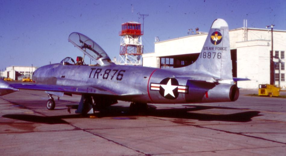
A 1954-55 photo of a Lockheed T-33A Shooting Star jet trainer in front of the Bryan AFB control tower.
The last Bryan T-28 was sent to storage in early 1956.
A 1956 photo of an instructor & student of the 3530th PTS discussing last-minute details with the crew chief before departing from Bryan AFB on a training flight.
In 1956 ATC transferred tanker & bomber training to Strategic Air Command & fighter training to Tactical Air Command.
Thus, ATC found itself with a much smaller advanced flying training program.
Jet qualification training had been taught at Craig AFB, AL, but by moving it to Randolph AFB, ATC was able to free Craig for basic pilot training & closed Bryan AFB.
Basic single-engine training ended at Bryan on 6/12/58.
The command discontinued Bryan's 3530th Pilot Training Wing on 10/25/58
and placed the base on inactive status until it transferred to Air Materiel Command on 4/1/60 for subsequent disposition.
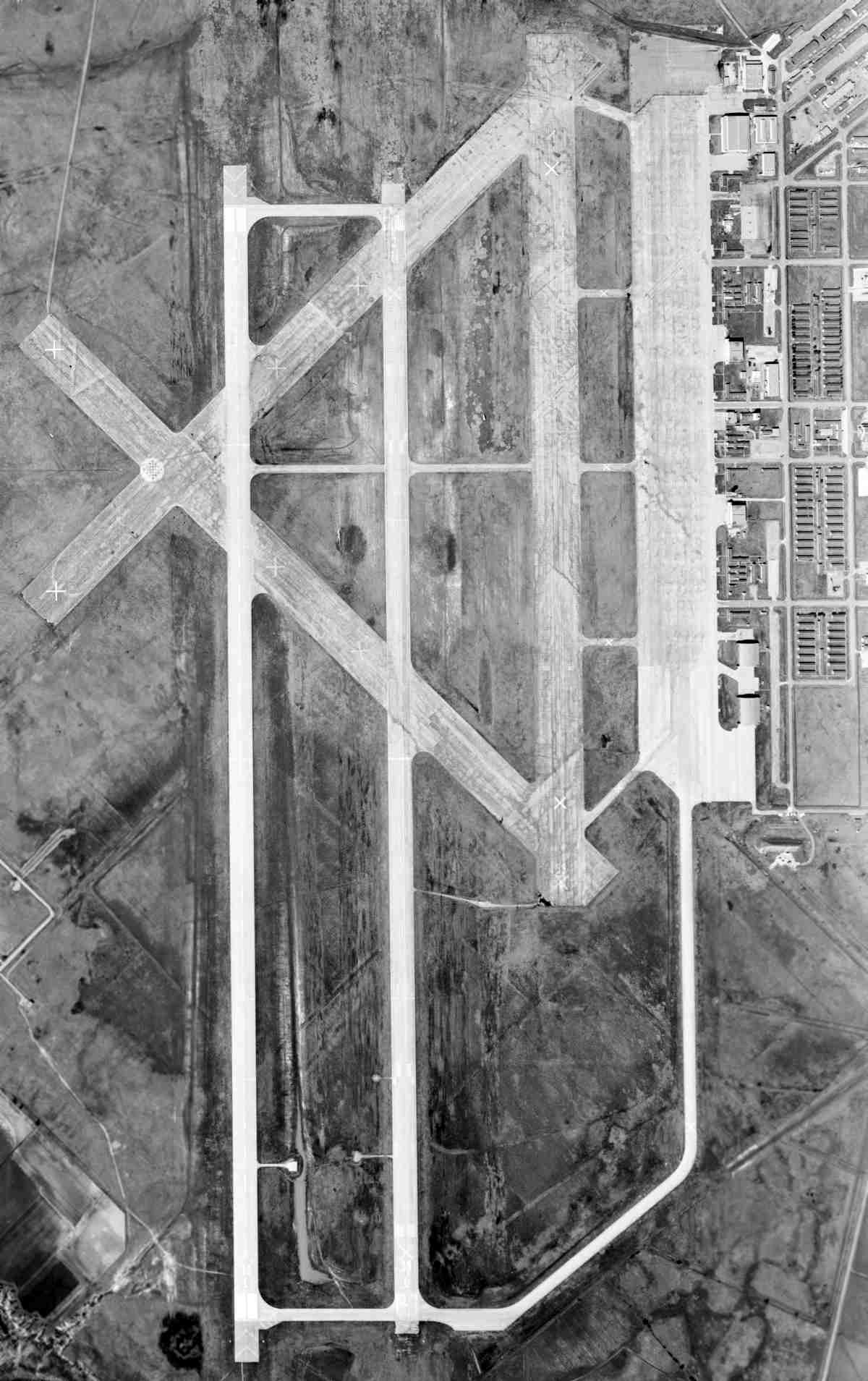
A 3/9/60 USGS aerial view depicted a dramatic difference at Bryan AFB, with the massive facility completely abandoned.
Note the 5th runway which had been added at some point between 1953-60, only a few years before the base's closure.
The abandoned Bryan AFB property was turned over to Texas A&M in May 1961.
The land & buildings were deeded to the Agricultural & Mechanical College of Texas in 1962,
eventually becoming the Texas A&M Riverside Campus.
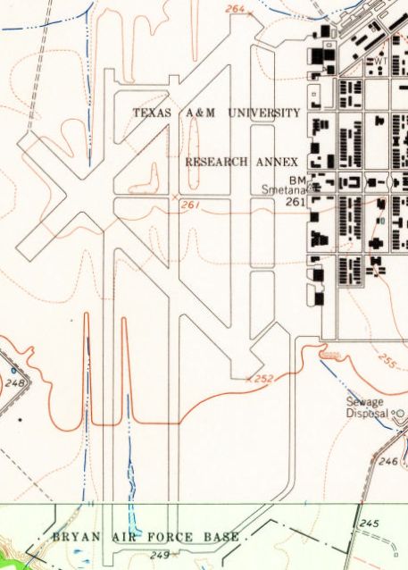
The 1962 USGS topo map labeled the massive airfield as the Texas A&M University Research Annex.
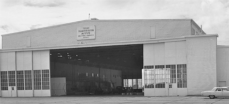
A circa 1960s photo of former Bryan AFB hangar, reused by the TX Transportation Institute (courtesy of Lee Denham).
Since October 1966, the runways have been reused as a private airfield, the Texas A&M Flight Test Station airport.
The Bryan runways have also been reused as an SCCA racetrack.
In 2005 the Texas Engineering Extension Service converted a World War II-era hangar at the Texas A&M Riverside Campus
into a training facility for electric power & telecommunications workers.
The hangar was gutted & modernized, with the installation of smart boards, audio-visual aids, and heating & air conditioning.
In 2006, the Texas A&M College of Architecture completed an 8,000-square-foot Built Environment Teaching & Research Facility also known as Architecture Ranch.
The building contains a woodshop, a metal shop, and 2 digital fabrication machines: a CNC Mill & a CNC Plasma Cutter.
Architecture Ranch is located on 12 acres of the Texas A&M Riverside Campus.
A joint Texas A&M / University of TX low-circulation library will begin construction in June 2012 at Bryan.
The facility is designed to hold one million books & eliminate redundancy in the collections of the 2 university systems.
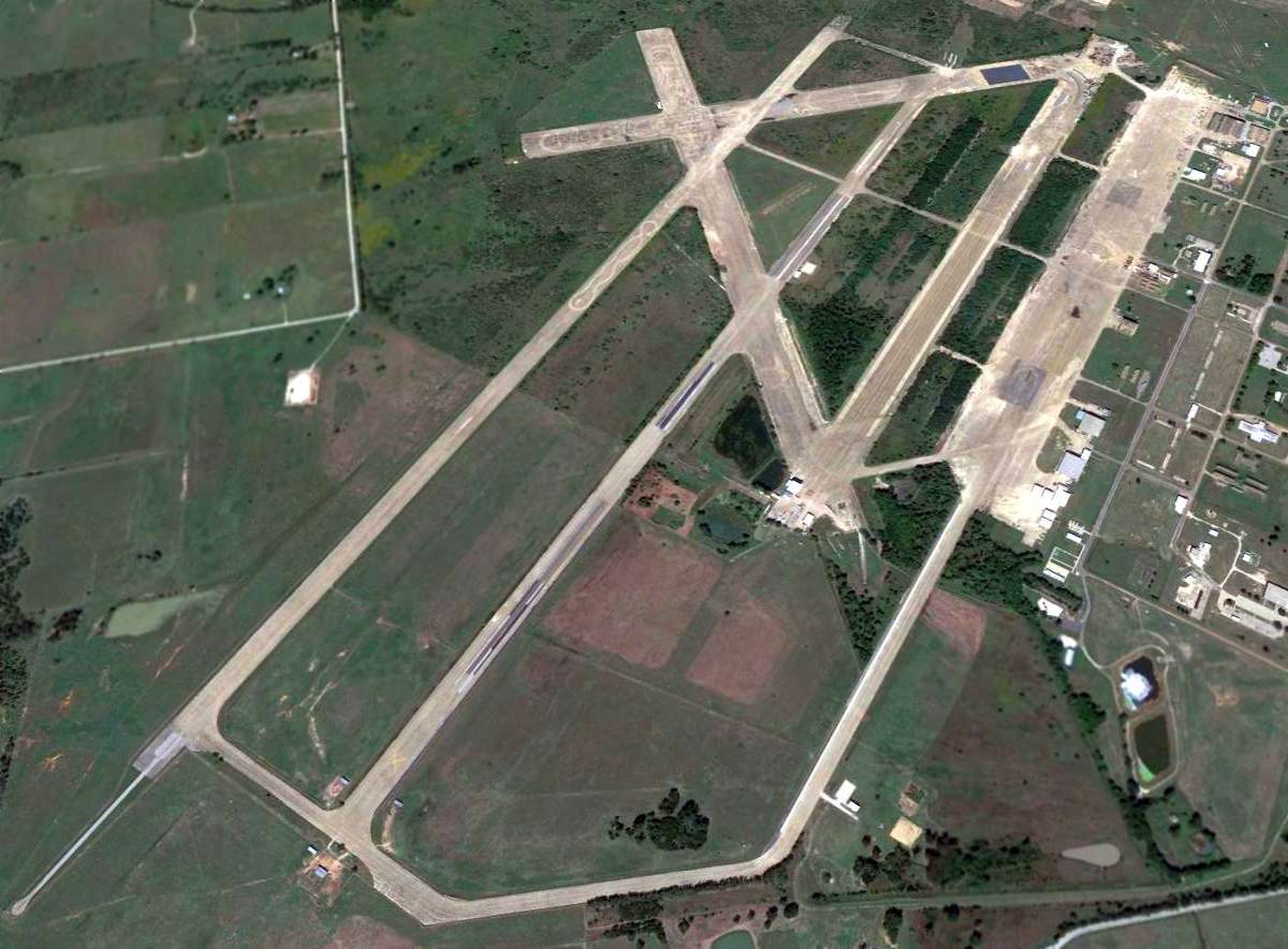
A 2014 aerial view looking northwest at the massive former Bryan AFB.
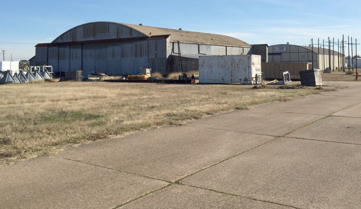
A 1/5/15 photo by Lee Denham of a former Bryan AAF hangar.
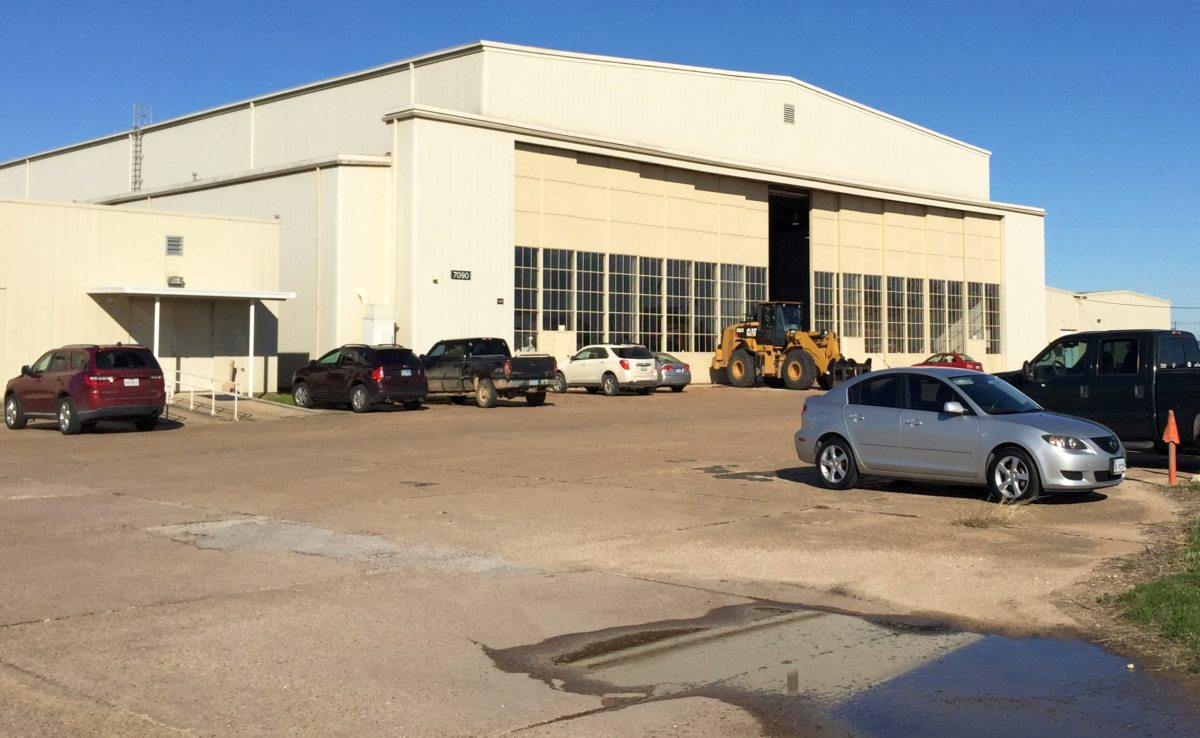
A 1/5/15 photo by Lee Denham of a former Bryan AAF hangar.
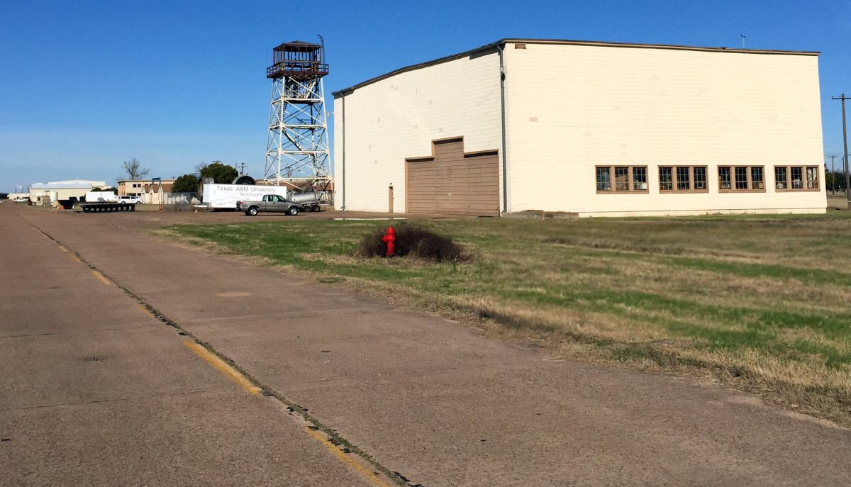
A 1/5/15 photo by Lee Denham of the former Bryan AAF control tower.
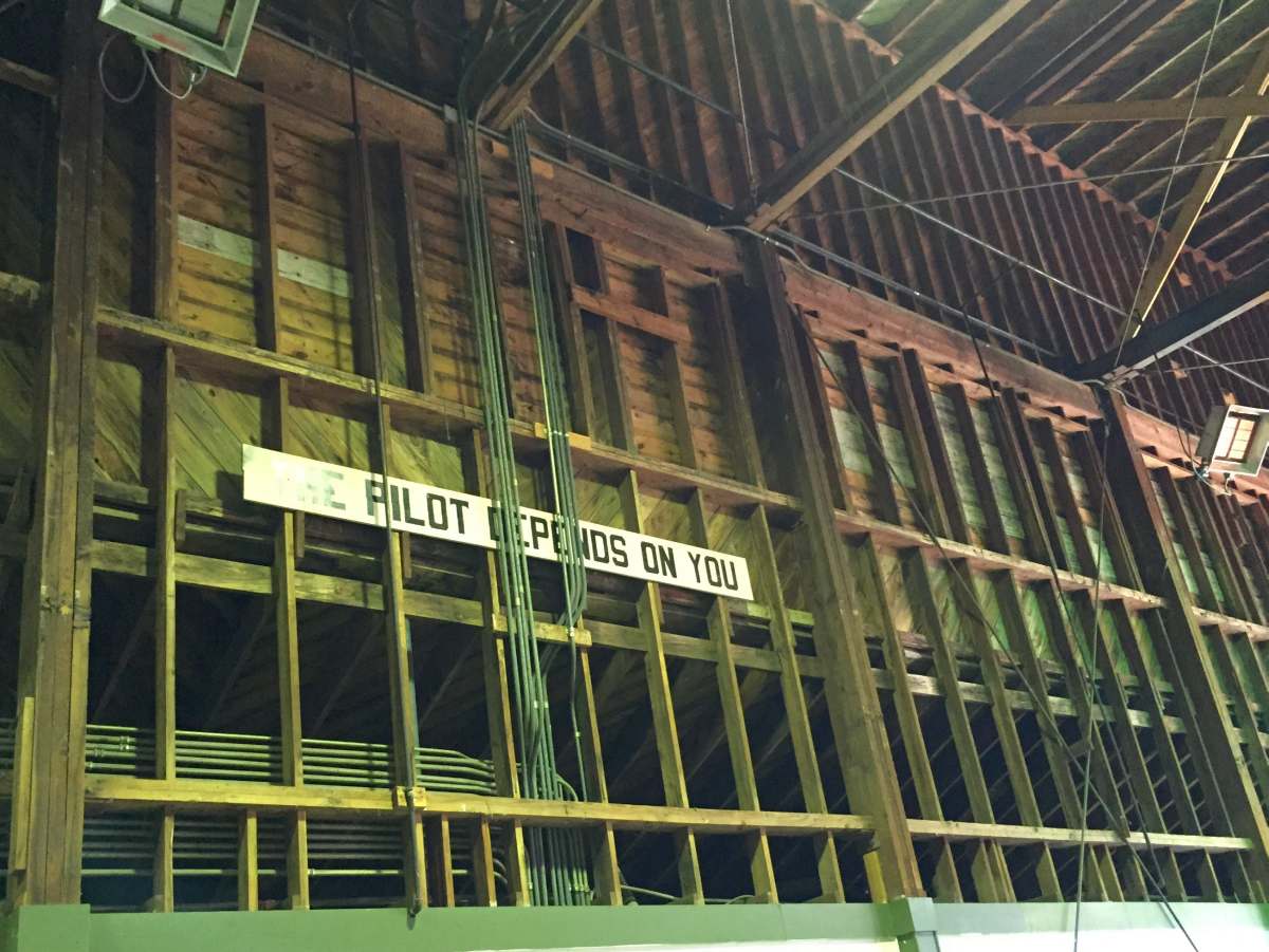
A 1/5/15 photo by Lee Denham of sign which remains inside a former Bryan AAF hangar, saying “The pilot depends on you.”
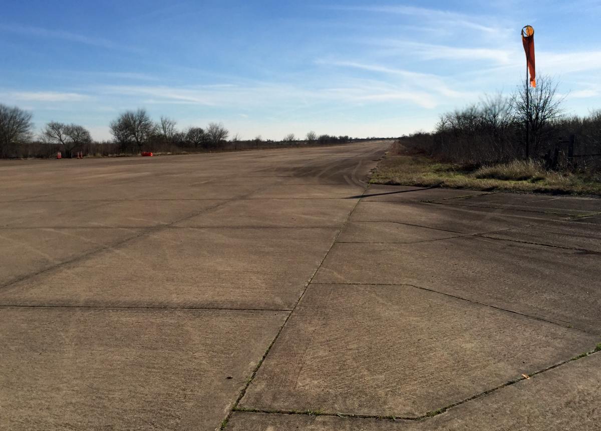
A 1/5/15 photo by Lee Denham of tattered windsock next to a former Bryan AAF runway.
Kenneth Veard reported in 2015, Lee Denham “is currently the only pilot authorized to fly in & out of [83TX, TX A&M Flight Test Station Airport].
He is a Pilot for the Texas A&M research department.”
Lee reported he flies an “Air Tractor 402B, Cessna Aghusky T188, Cessna T206, MD600N helicopter, all based at 83TX.”
Lee Denham reported in 2018, “TAMU Riverside Campus has now become the RELLIS Campus of the TAMU System.”
The 2023 Houston Sectional Chart depicted Texas A&M Airfield as having a single 7,000' paved north/south runway.
The site of Bryan AAF is located southwest of the intersection of Route 21 & Route 47.
____________________________________________________
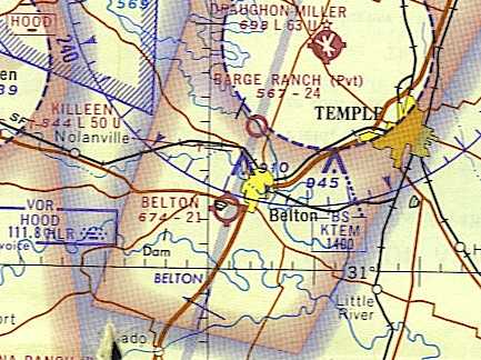
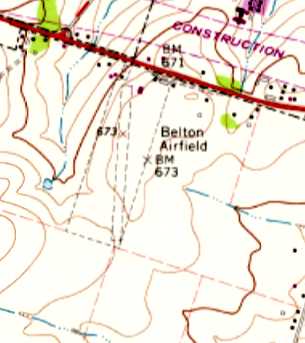
31.045, -97.483 (Southwest of Waco, TX)
Belton Airport, as depicted on the January 1946 Austin Sectional Chart.
This general aviation airport was evidently established at some point between 1945-46,
like hundreds of other small airports in the US post-WW2 aviation boom,
as it was not yet depicted on the July 1945 Austin Sectional Chart.
The earliest depiction which has been located of Belton Airport was on the January 1946 Austin Sectional Chart.
George Wilhite recalled, “In the early 1950s my Dad was a farmer/rancher & we lived in the country near Belton.
I had already developed an interest in aviation & ultimately persuaded my Dad to drop me off at the Belton Airport
on Highway 190 southwest of town on Saturdays when we went to town to grocery/supply shop.
To the best of my knowledge my first visit was sometime in 1954 at age 11.
I would sweep the office, clean the hangar, planes, etc. to try to somehow earn a 10-20 minute Cub ride.”
George continued, “The owner/operator of the airport was Mr. J.A. 'Pete' Reed.
I don’t know when he first opened the airport, but a cousin (5 years older than me) says he worked there in summers about 3 years (early 1950s)
and flew 20 or more hours of dual instruction in Cubs.
My cousin says that Mr. Reed started a flight/ground school to take advantage of VA flight training monies awarded to veterans.
I guess that money dried up and he restored Cubs, sold fuel, rented hangars & planes.
I first flew with his instructor, Billy Ford Palmer, in 1954.”
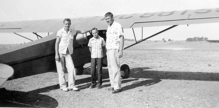
The earliest depiction of Belton Airport which has been located was a September 1954 photo (courtesy of George Wilhite)
“of an unidentified person, me [George Wilhite], and Billy Ford Palmer,
who took me for a flight in Cub NC98155” at Belton Airport.
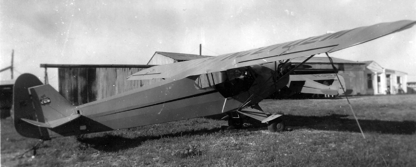
An undated photo of a Piper Cub in front of hangars at Belton Airport (courtesy of David Guthrie).
David Guthrie recalled, “I remember going to Belton Aero when I was very young. It was on West Avenue O &/or old Highway 190.”

Three November 1955 photos by George Wilhite of an Aeronca & several Pipers under Betlon Airport's hailshed hangar.
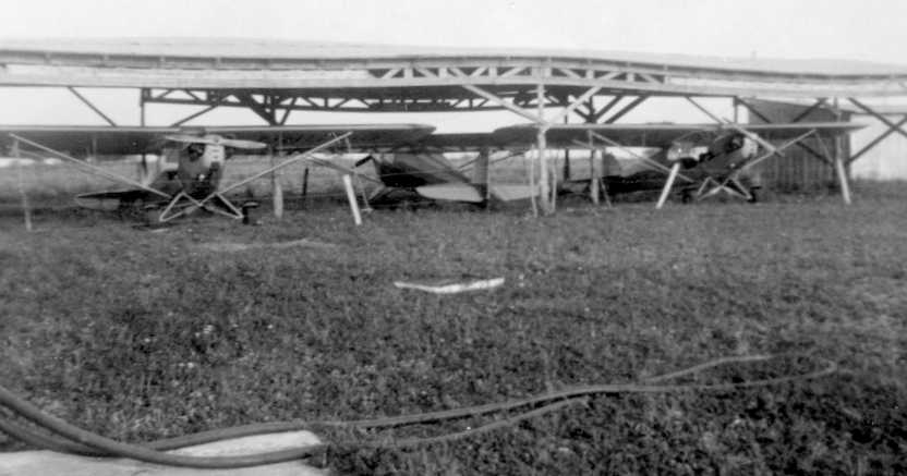
A September 1957 photo of 3 Piper Cubs inside Betlon's hailshed hangar (courtesy of George Wilhite).
George Wilhite recalled, “In 1959 I stopped going to the airport due to school & track competition during my high school years.”
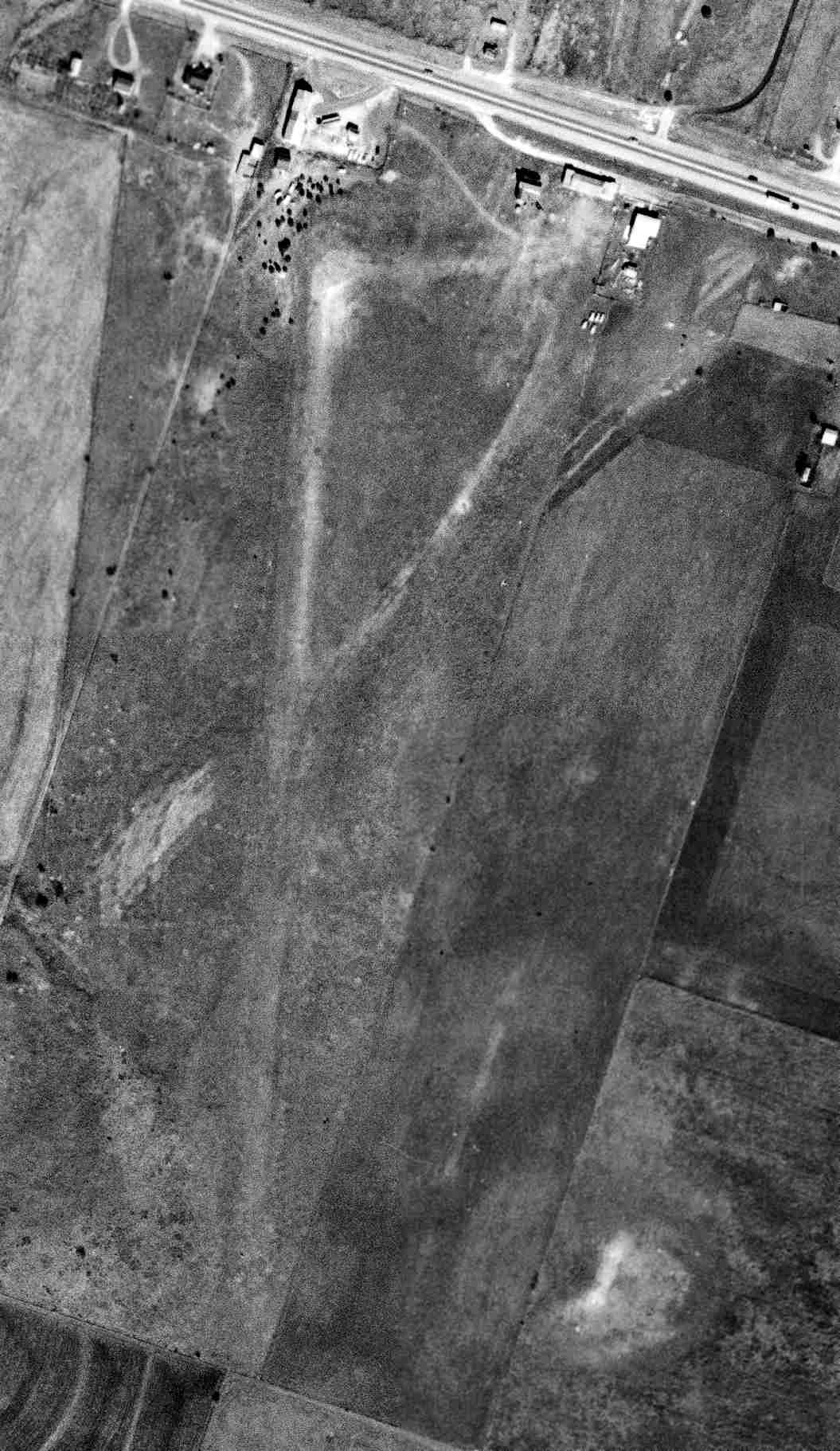
A 12/12/64 USGS aerial photo showed Belton to have a single unpaved north/south runway, with several small buildings on the north side.
No aircraft were visible on the field.
The November 1965 Austin Sectional Chart (courtesy of George Wilhite) depicted Belton as having a 2,100' unpaved runway.
The 1966 Austin Sectional Chart (courtesy of John Price) continued to depict Belton as having a 2,100' unpaved runway.
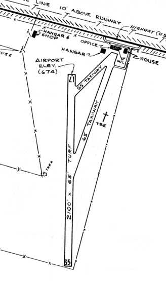
The 1966 TX Airport Directory (courtesy of George Wilhite) depicted Belton Airport
as having a 2,100' turf Runway 17/35, with 2 taxiways leading to a few small buildings on the northeast side.
However, George Wilhite observed, “I don’t exactly agree with the layout of buildings as depicted. The hail shed is not even shown.”
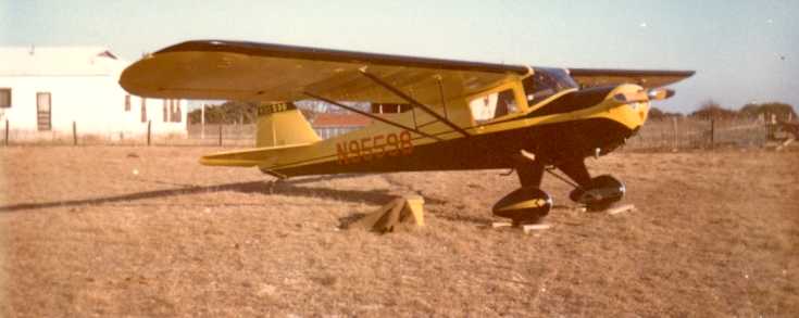
The last photo which has been located showing Belton Airport in operation was a photo by George Wilhite
“of Taylorcraft BC12D N95598 at the Belton Airport in June or July 1966.”
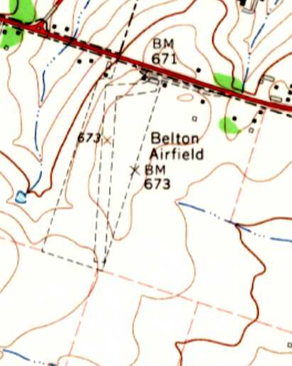
The earliest topo map depiction which has been located of Belton Airport was on the 1966 USGS topo map.
It depicted “Belton Airfield” as having a single north/south unpaved runway with a few small buildings on the northeast side.
George Wilhite recalled, “During the summer of 1966 I attempted to buy the Taylorcraft BC12D located at the Belton Airport.
It had already been sold when I contacted Mr. Reed.
I subsequently bought Piper J3C65 (NC70455), and I flew it to the Belton Airport several times during 1966-67 to visit relatives.
I made several flights to the Belton airport in the early 1970s.
Pete Reed died on 8/25/77, so it must have closed by then or earlier.”
The last topo map depiction which has been located of Belton Airport was on the 1978 USGS topo map.
It depicted “Belton Airfield” as having a single north/south unpaved runway with a few small buildings on the northeast side.
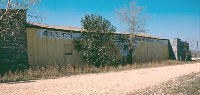
A 3/25/78 photo by George Wilhite, taken after the airport closed, of “the old Belton Airport main hangar/office
showing the old 'Reed’s Air Service Number Two' painted on the highway side of the hangar.”

A 3/25/78 photo by George Wilhite, “Inside the old main hangar, now being used for something other than planes.”

A 3/25/78 photo by George Wilhite of the Belton Airport office & main hangar.
George remarked, “It looked like they were about ready to fall down then.”
Belton Airport was evidently closed (for reasons unknown),
as it was no longer depicted on the December 1985 San Atonio Sectional Chart or the 1993 USGS topo map.
A 1995 USGS aerial photo showed that the former Belton Airport buildings remained intact,
but a road with a somewhat different orientation had been built over the former runway.
An 11/2/11 aerial photo showed the Belton Airport buildings remained intact, but no trace remained recognizable of the runway.
George Wilhite reported of the former Belton Airport buildings in 2021, “UNBELIEVEABLY, they are still standing (barely) at the present time.
The current resident uses the hangar for a storage shed, but the office is collapsing inside.”
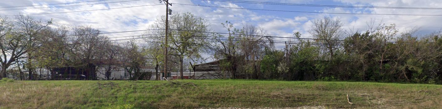
A 2024 photo looking southwest at the last remaining former Belton Airport buildings.
The site of Belton Airport is located southeast of the intersection of Route 190 & Texas 121 Loop.
____________________________________________________
Hillsboro Municipal Airport (original location) (F74), Hillsboro, TX
32.05, -97.12 (South of Fort Worth, TX)
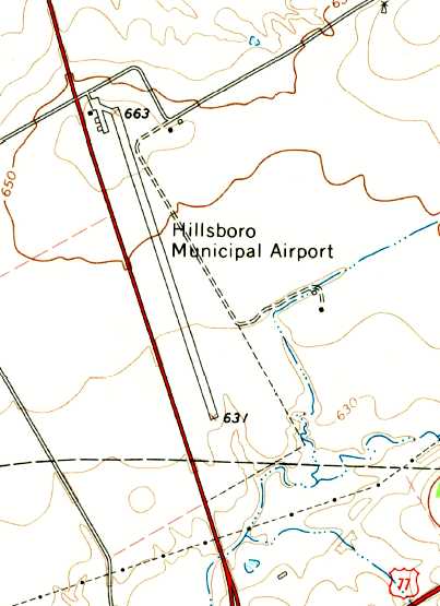
Hillsboro Municipal Airport, as depicted on the 1966 USGS topo map.
Photo of the airfield while open has not been located.
This general aviation airport was evidently established at some point between 1965-66,
as it was not yet depicted on the 1965 Dallas Sectional Chart (according to David Brooks).
The earliest depiction of the Hillsboro Municipal Airport which has been located was on the 1966 USGS topo map,
which depicted the field as having a single paved northwest/southeast runway, with a ramp & 3 small buildings on the northwest side.
The earliest aeronautical chart depiction of the Hillsboro Municipal Airport which has been located
was on the 1966 Dallas Sectional Chart (according to David Brooks).
The July 1968 Dallas Sectional Chart (courtesy of Chris Kennedy) depicted Hillsboro as having a single 3,500' paved runway.
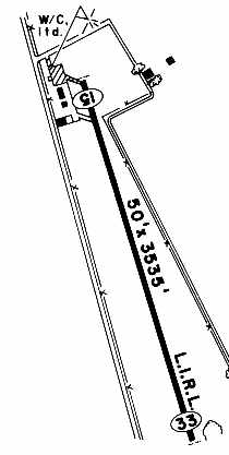
The 1983 TX Airport Directory (courtesy of Chris Kennedy) depicted Hillsboro Municipal as having a single 3,533' paved Runway 15/33,
with a small ramp on the northwest side of the field with a few small buildings or hangars.
The manager was listed as Ed Shronk.
The last aeronautical chart depiction which has been located of Hillboro Municipal Airport was on the December 1985 San Antonio Sectional Chart.
It depicted Hillsboro as having a single 3,500' paved runway.
The 1989 TX Airport Directory (courtesy of David Brooks) depicted Hillsboro Municipal as having a single 3,500' paved Runway 16/34,
with a small ramp on the northwest side of the field with a few small buildings or hangars.
The manager was listed as Ed Shronk.

Hillsboro Municipal still appeared to be an active airport in the 1995 USGS aerial view looking southeast,
as at least one small single-engine aircraft was visible on the ramp on the northwest side of the field.
The Hillsboro Municipal Airport was evidently closed at some point later in 1995,
when its replacement, the "New Hillsboro" Airport, was opened a few miles to the northeast.
The 1995 Dallas Sectional Chart (courtesy of David Brooks) depicted the original Hillsboro Airport as "closed",
in addition to the "New Hillsboro" Airport.
The original Hillsboro Municipal Airport was depicted as an abandoned airfield on the 2004 DFW Sectional Chart (according to Chris Kennedy).
A 6/28/05 aerial view looking southeast at the site of the original Hillsboro Airport
showed that the runway remained intact,
but all of the hangars except for one had been removed at some point between 1995-2005.
A circa 2008 aerial view looking south at the site of the original Hillsboro Airport showed that the runway remained intact,
but all of the buildings except for one had been removed.

A February 2008 photo looking north showed what appeared to be the original Hillsboro Airport office building as the only building remaining at the airport site.
A March 2013 photo showed the original Hillsboro Airport office building as having been removed at some point between 2008-2013.
A 2015 aerial view looking southeast at the site of the original Hillsboro Airport showed the runway remained intact though considerably deteriorated.
A December 2019 photo looking northeast showed no buildings remained at the site of the original Hillsboro Airport.
The site of the original Hillsboro Municipal Airport is located on the east side of Route 81, south of its intersection with HCR 4231.
____________________________________________________
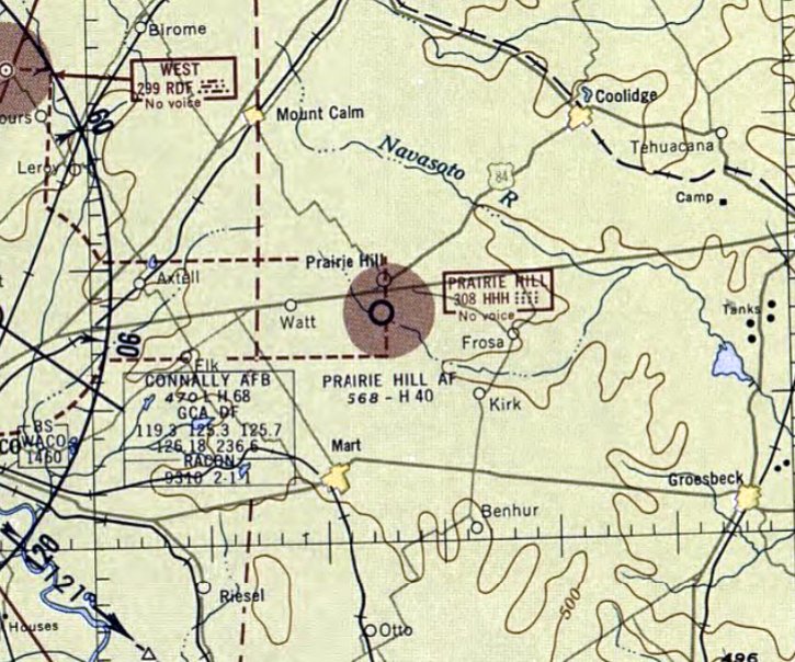
Waco Auxiliary Army Airfield #5 / Prairie Hill Air Force Auxiliary Field, Prairie Hill, TX
31.637, -96.788 (East of Waco, TX)
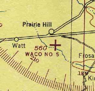
"Waco #5", as depicted on the January 1945 Austin Sectional Chart (courtesy of Chris Kennedy).
This airfield was used during WW2 as one of 3 satellite airfields for Waco AAF (20 miles west-southwest),
which was a training center for Army Air Force flight instructors.
Waco Auxiliary Field #5 was evidently constructed at some point between 1944-45,
as it was not yet depicted on the June 1944 Austin Section Chart.
The earliest depiction which has been located of Waco Auxiliary Field #5
was on the January 1945 Austin Sectional Chart (courtesy of Chris Kennedy).
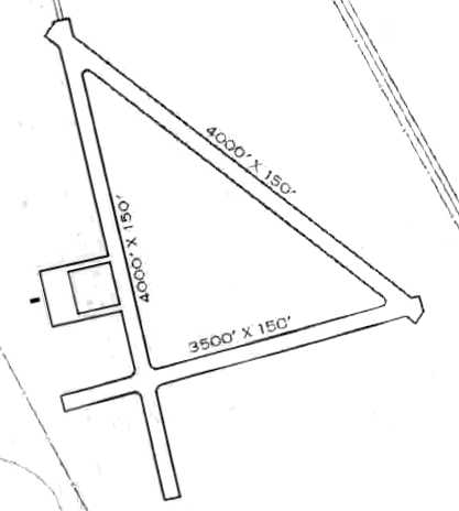
The 1945 AAF Airfield Directory (courtesy of Scott Murdock) described “Waco AAF Auxiliary #5 (Prairie Hill Field)”
as a 490 acre property within which were 3 concrete runways, measuring 4,000' north/south & northwest/southeast & 3,500' east/west.
The field was said to not have any hangars, but a ramp was depicted on the west side.
The field was said to be owned by the U.S. Government & operated by the Army Air Forces.
The earliest photo which has been located of Waco Auxiliary Field #5 was an 8/13/45 aerial view looking west (from the National Archives, courtesy of Brian Rehwinkel).
Brian Rehwinkel noted, “It looks like there may be an aircraft at the intersection of 2 of the runways (upper left side).
This is an example of a field in the middle of nowhere (and it still is isolated) for training purposes. I am sure it was an expensive field to build (two 4,000' & one 3,500' runways), particularly because it was all concrete.”
By the time of the February 1949 Austin Sectional Chart (courtesy of Chris Kennedy), the field had been renamed "Prairie Hill AF",
and it was described as having a 4,000' hard-surface runway.
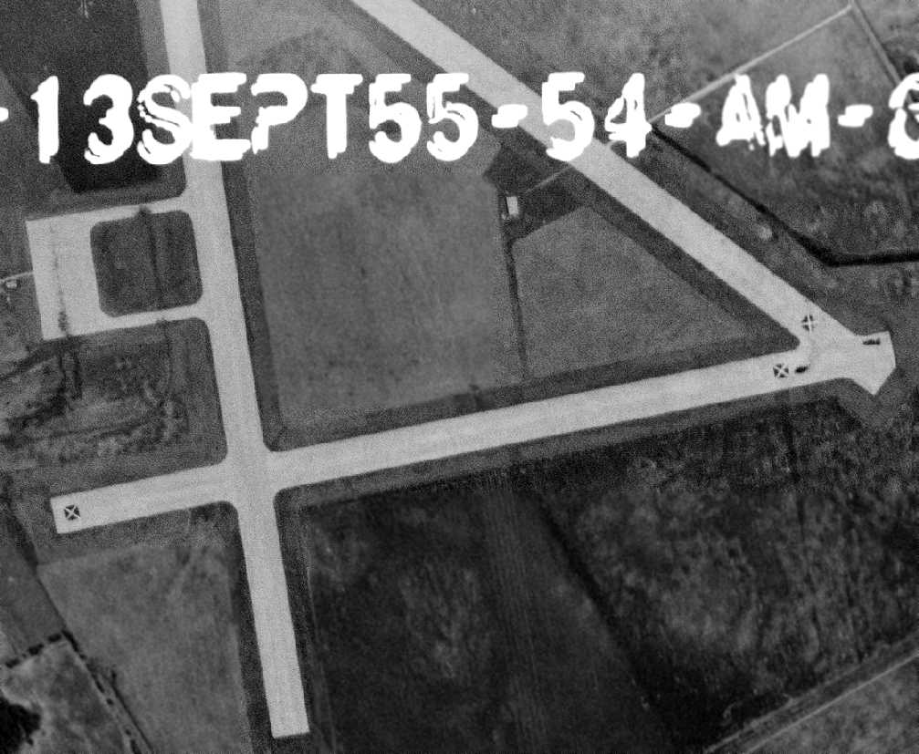
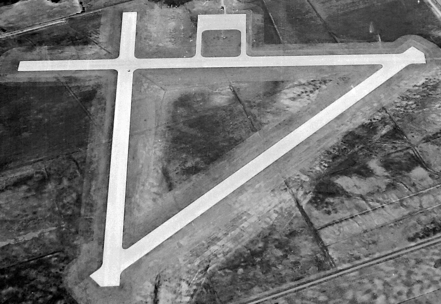
A 9/13/55 USGS aerial photo depicted Prairie Hill as having 3 paved runways, with closed-runway “X” symbols on the east/west & northwest/southeast runways.
A paved ramp was on the west side, but there were not any buildings seen on the field.

The 1957 USGS topo map depicted the "Prairie Hill Air Force Auxiliary Field"
as having 3 paved runways, with a paved ramp on the west side of the field.
It did not depict any buildings on the field.
The last aeronautical chart depiction which has been located of Waco Auxiliary Field #5 was on the April 1958 Austin Sectional Chart.
It depicted Prairie Hill AF airfield as having a 4,000' paved runway & a Non-Directional Beacon.
The Prairie Hill airfield was evidently abandoned by the Air Force at some point between 1958-59,
as it was no longer depicted on the April 1959 Austin Sectional Chart.
Vic Moreland recalled, “I drag raced a lot at Prairie Hill in the 1960s.”
Even after the airfield was disposed of, the northwest corner of the property was retained by the USAF.
It became the Prairie Hill Radio Beacon Annex & remained active for several years.
![]()
A 1994 photo by Scott Murdock of the building of the former Prairie Hill Radio Beacon.
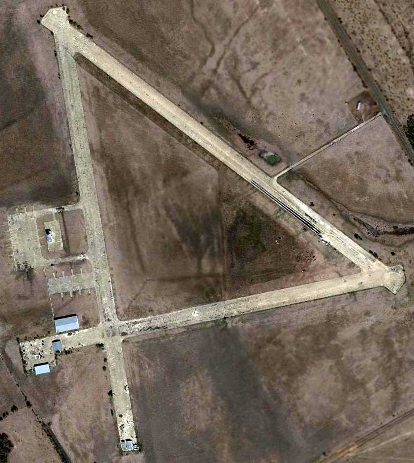
As seen in a 11/3/11 aerial photo, the Prairie Hill airfield consisted of 3 paved 4,100' runways, a small paved ramp & the radio beacon building.
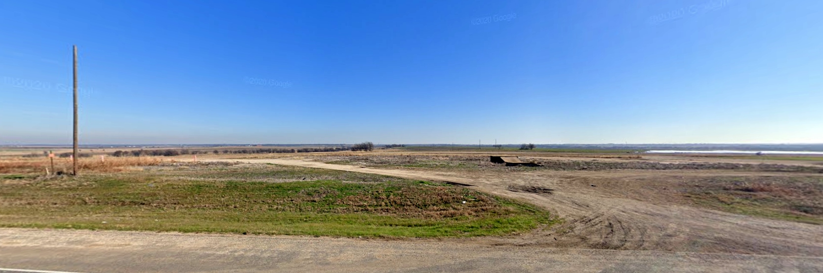
The Prairie Hill Airfield is located on the west side of Ranch Road 339, less than a mile south of the town of Prairie Hill.
____________________________________________________
Or if you prefer to contact me directly concerning a contribution (for a mailing address to send a check),
please contact me at: paulandterryfreeman@gmail.com
If you enjoy this web site, please support it with a financial contribution.
____________________________________________________
This site covers airfields in all 50 states.