
Abandoned & Little-Known Airfields:
Texas: Northeastern San Antonio area
© 2002, © 2025 by Paul Freeman. Revised 1/4/25.
This site covers airfields in all 50 states: Click here for the site's main menu.
____________________________________________________
Please consider a financial contribution to support the continued growth & operation of this site.
Cade Aux AAF (revised 9/21/19) - Davenport Auxiliary Field (added 1/4/25) - Dodd Field (revised 7/3/20) - Guadelupe County Airport / Seguin Municipal Airport / Geromino Field (revised 4/10/18)
Ireland Flying Field / Schneider Field / Seguin Airport (revised 11/22/21) - Northeast Airport (revised 7/28/24) - Yates Airport (revised 11/22/21)
____________________________________________________
Davenport Auxiliary Field, San Antonio, TX
29.6, -98.328 (Northeast of Downtown San Antonio, TX)
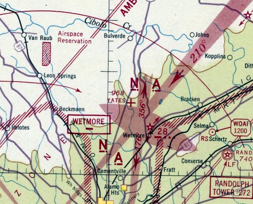
Davenport Field, as depicted on the January 1945 San Antonio Sectional Chart.
The date of establishment of Davenport Field has not been determined.
Davenport Field served as an auxiliary airfield supporting Army flight training operations at nearby Randolph Field.
According to Wikipedia, by 1932 Davenport Field was one of 7 auxiliary fields which supported Randolph Field, the others being Dodd, Cade, Marion, Krueger, Zuehl, and Martindale.
However, Davenport Field was not yet depicted on the 1932-44 San Antonio Sectional Charts.
The earliest depiction which has been located of Davenport Field was on the January 1945 San Antonio Sectional Chart.
It depicted Davenport as an auxiliary airfield.
A 47th School Squadron unit history listed a number of aircraft accidents at Davenport Field, involving C-7, PT-3, PT-13, and BT-9 aircraft.
The earliest photo which has been located of Davenport Field was a 1954 aerial view.
It depicted an open field, with no sign of any aviation usage.

The last aeronautical chart depiction which has been located of Davenport Airport was on the August 1955 San Antonio Sectional Chart.
It depicted “Davenport AF” as having a 3,400' unpaved runway.
Davenport Field was evidently closed at some point between 1955-56, as it was no longer depicted on the 1956 San Antonio Sectional Chart or the 1959 USGS topo map.

A 2004-2024 photo of a historical marker at adjacent Davenport Cemetery, which mentions Davenport Field.

Amazingly a 2023 aerial view shows the site of Davenport Field remains clear & un-redeveloped nearly 7 decades after it was abandoned as an airfield.
Thanks to Phillip Rathburn for pointing out this airfield.
____________________________________________________
Yates Airport (XS89), San Antonio, TX
29.621, -98.456 (Northeast of Downtown San Antonio, TX)
Yates Airport, as depicted on the October 1941 San Antonio Sectional Chart.
According to its FAA Airport/Facility Directory data, Yates Airport had an activation date of November 1939.
However, Yates Airport was not yet depicted on the March 1940 San Antonio Sectional Chart.
The earliest depiction which has been located of Yates Airport was on the October 1941 San Antonio Sectional Chart.
It depicted Yates as an auxiliary airfield.
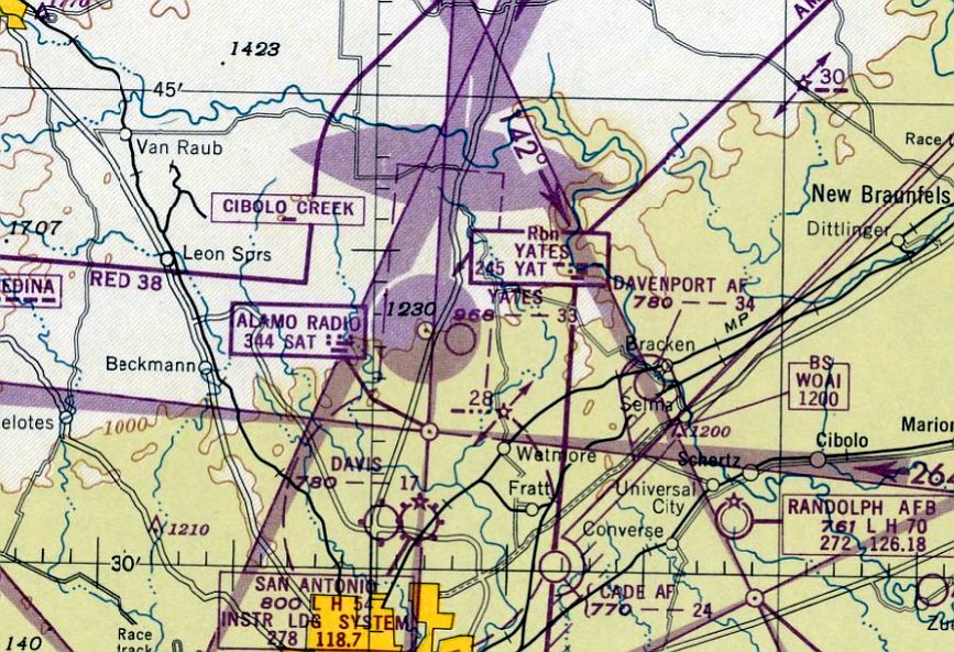
The last aeronautical chart depiction which has been located of Yates Airport was on the August 1949 San Antonio Sectional Chart.
It depicted Yates as having a 3,300' unpaved runway.
Yates Airport was no longer depicted on the February 1950 San Antonio Sectional Chart.
Ironically, aeronautical charts continued to depict the adjacent Yates Non-Directional Beacon navigational aid for at least a decade after Yates Airport closed.
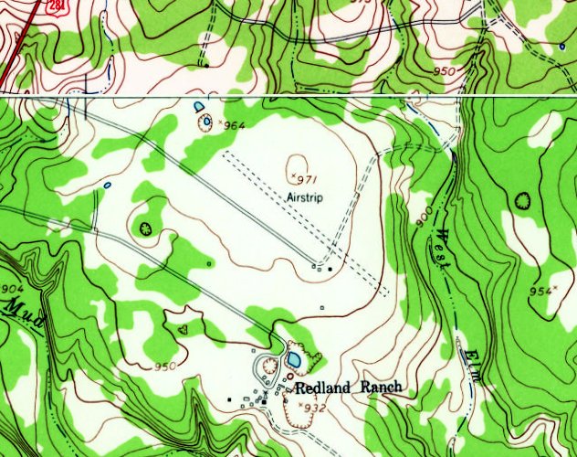
The 1953 USGS topo map depicted Yates Airport as a single unpaved northwest/southeast runway, generically labeled as “Airstrip”,
with a few small buildings on the south side.
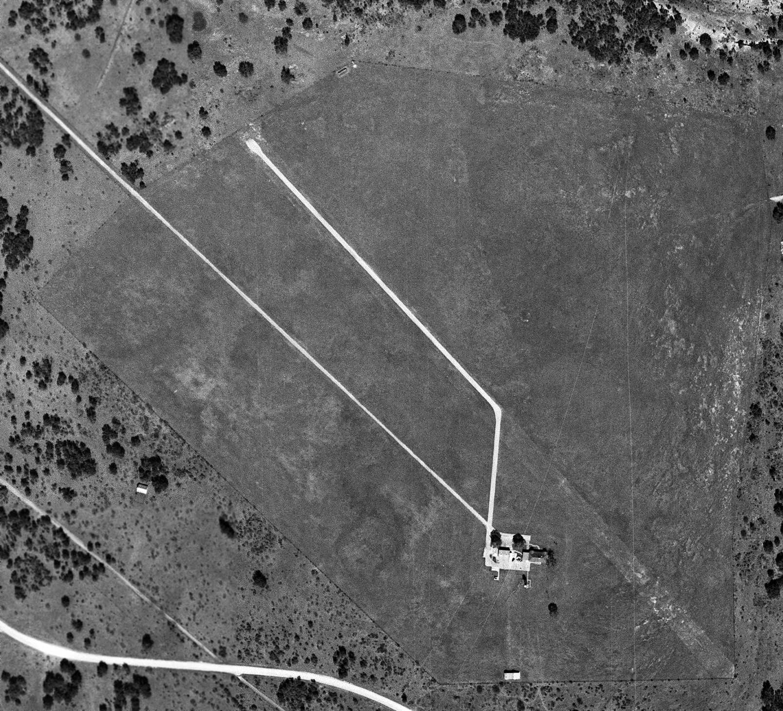
The earliest photo which has been located of Yates Airport was a 2/3/63 USGS aerial view.
It depicted a single paved northwest/southeast runway, with a paved taxiway leading toward a house & another small building (a hangar?) on the south side.
There were no aircraft visible on the field.
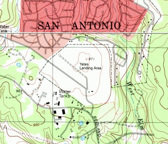
The 1992 USGS topo map depicted “Yates Landing Area” as having a single unpaved northwest/southeast runway, with 2 small buildings on the south side.

A 1995 aerial view looking northeast depicted Yates Airport as having a single paved northwest/southeast runway, which was deteriorated, and had a closed-runway “X” symbol adjacent to its northwest end.
Houses had surrounded the property. The entire property was being mowed, but there was no sign of any recent aviation use.
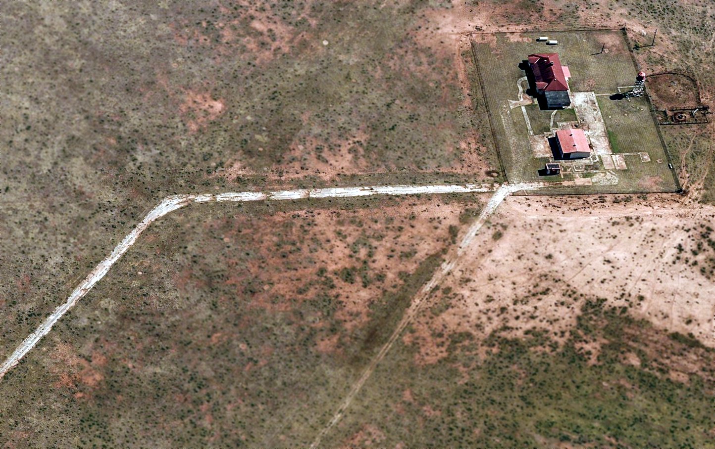
A circa 2010-2017 aerial view looking east depicted Yates Airport's hangar & house, along with the southeast end of its paved runway.
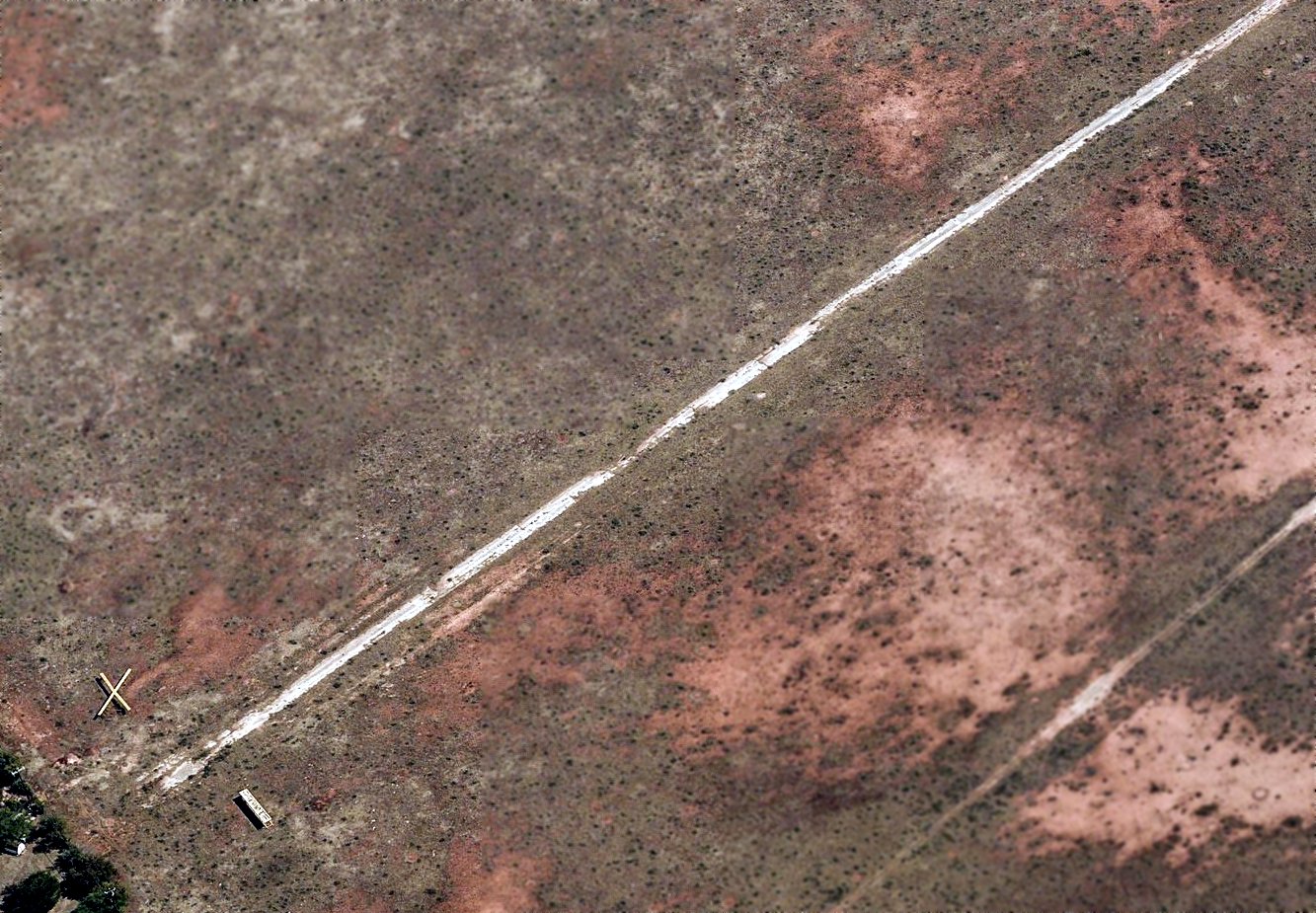
A circa 2010-2017 aerial view looking east depicted the closed-runway “X” symbols & a sign which evidently read “Private” on either side of the northwest end of Yates Airport's paved runway.
A 2017 aerial view looking northeast depicted Yates Airport in the same condition as seen in 1995, with the paved runway still recognizable though deteriorated, and the closed-runway “X” symbol still recognizable.
As of 2018, Yates Airport's FAA Airport/Facility Directory data described it a having three 2,500' turf runways: 8/26, 13/31, and 17/35.
It was said to be a private airfield owned by Lucille Yates.
Although it was still listed with the FAA, Yates Airport had evidently not been depicted on aeronautical charts for at least the past 57 years.
Unfortunately the end appeared to come for this little airport surrounded by suburbia in 2018:
James Taylor reported in 2018, “The old airfield will soon be growing houses.
I had dinner across the street last weekend & realized the dirt piles were on the old airfield.”
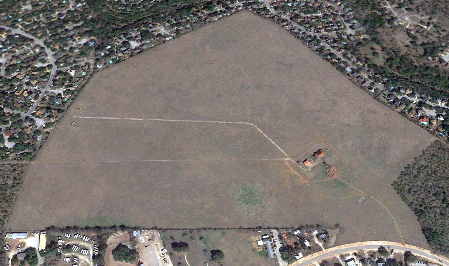
A 2018 aerial view looking northeast showed the Yates Airport property in the course of being developed with streets, presumably for more houses.
The site of Yates Airport is located east of the intersection of Redlands Road & Ridgewood Parkway.
____________________________________________________
29.48, -98.43 (Northeast of Downtown San Antonio, TX)
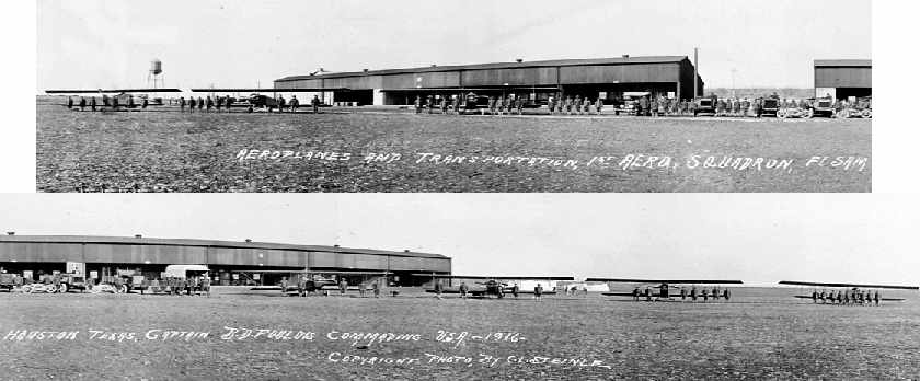
A panoramic view of "Aeroplanes & Transportation, 1st Aero Squadron, Ft. Sam Houston, 1916."
Following the successful experiments with aircraft at Fort Sam Houston in 1910-11,
the Chief Signal Officer decided to establish an Aviation Post at Fort Sam Houston near the old Target Range.
Captain Benjamin Foulois arrived in March 1915 to help establish the aviation field for the 1st Aero Squadron, scheduled to transfer to Fort Sam Houston.
Clearing of the land in the southwest corner of the tract & construction was underway at that time.
The pack train stable was converted into a garage & the existing quarters into a machine shop.
Material salvaged from the 2 hangars on main post was recycled to construct storage buildings.
The completed Aviation Post included one barracks for 120 men,
two five-plane corrugated, galvanized iron hangars, an administration or headquarters building,
quarters for the Commanding Officer & 2 Bachelor Officer Quarters with a capacity of twelve each.
An elevated water tank, which had been located in the Quadrangle, was erected in the southwest corner of the field.
The officers of the 1st Aero Squadron flew its six aircraft from Fort Sill to Fort Sam Houston, reporting for duty on 26 November 1915.
The remainder of the squadron drove its trucks & motorcycles along the route,
selecting landing sites & making arrangements to maintain the planes.
Captain Townsend Dodd arrived for duty the following month.
The 1st Aero Squadron's stay was of limited duration as it was ordered to accompany General Pershing's Punitive Expedition into Mexico in March 1916.
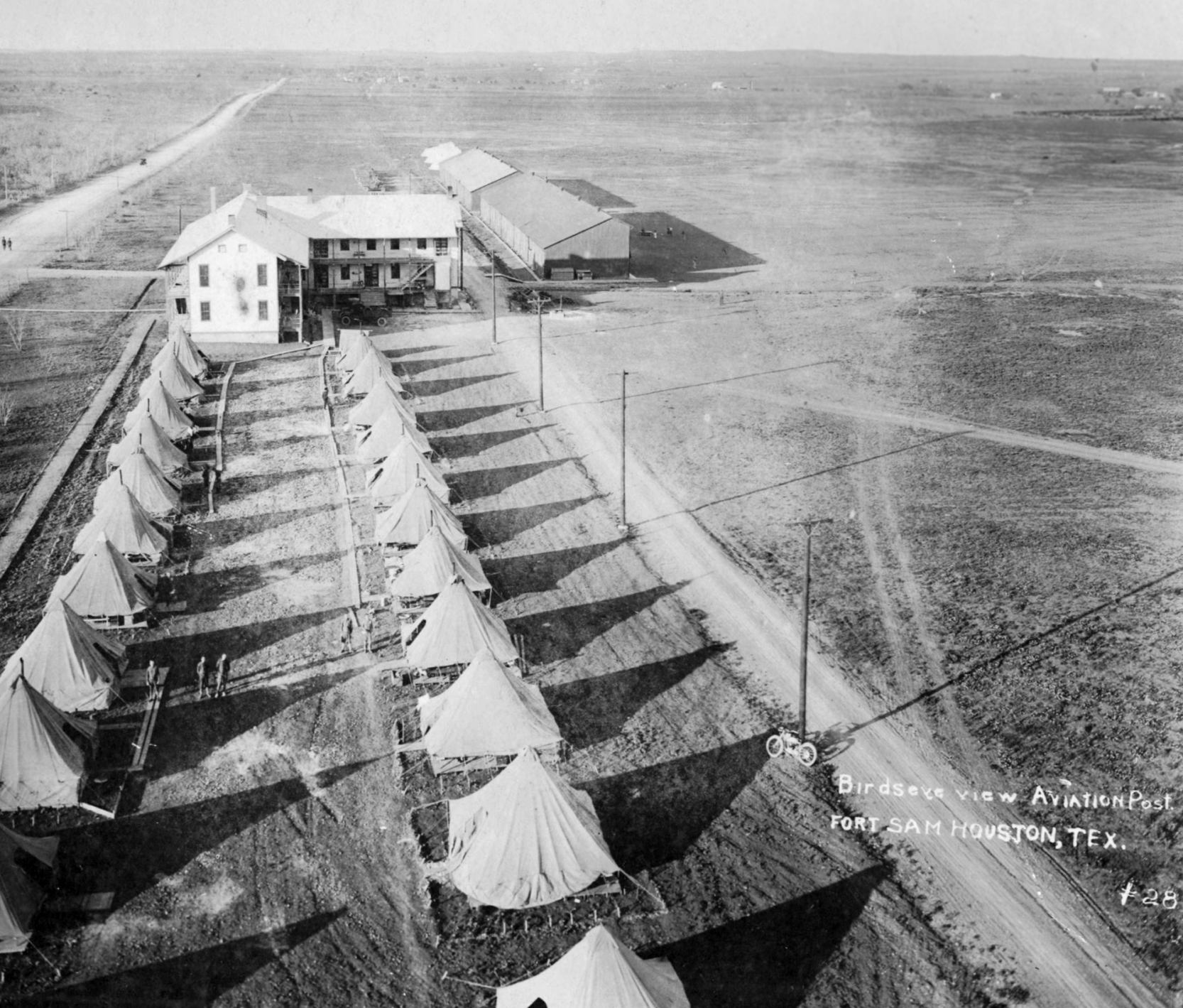
A circa 1910s aerial view (courtesy of John Manguso) looking north at tents & hangars along the west side of Dodd Field, captioned “Aviation Post, Fort Sam Houston”.
In August 1916, Fort Sam Houston's Aviation Post was selected to be developed as an Aviation Depot to organize & train additional Aero Squadrons,
and by September, supplies & equipment began arriving.
Major Foulois arrived in November to serve as the Department Aviation Officer
to oversee the organization of the 3rd & 4th Aero Squadrons.
One of the officers of the new 3rd Aero Squadron was Captain Carl Spaatz who also arrived in November.
Foulois soon reported that the existing Aviation Post was too small for the scale of operations planned for it & began looking for a more suitable site.
When Foulois was selected to replace Major William Mitchell as Assistant to the Chief of the Aviation Section in Washington,
Captain Townsend Dodd was appointed to replace Foulois as Departmental Aviation Officer, arriving in San Antonio on 19 March 1917.
Foulois selected a new site for the Aviation Depot southwest of the city & in May, 1917,
flight operations were transferred to what would become Kelly Field.
The Aviation Post was turned over to the Auxiliary Remount Depot
with the proviso that is would be returned if needed for flight operations.
Dodd Field was not depicted on the 1923 Beaumont – San Antonio Airway Map # 27 (according to David Brooks).
In June of 1925, the field once again reverted to use as an airdrome.
Preparations were made to receive the 12th Observation Squadron from Fort Bliss.
This unit would support the 2d Division, stationed at Fort Sam Houston. Flight operations resumed in August 1925.
A circa 1920 aerial view (courtesy of John Manguso) depicted Dodd Field as having a row of hangars along the west side of a grass airfield.
A circa 1920 aerial view (courtesy of John Manguso) depicted Dodd Field as having a row of hangars along the west side of a grass airfield.
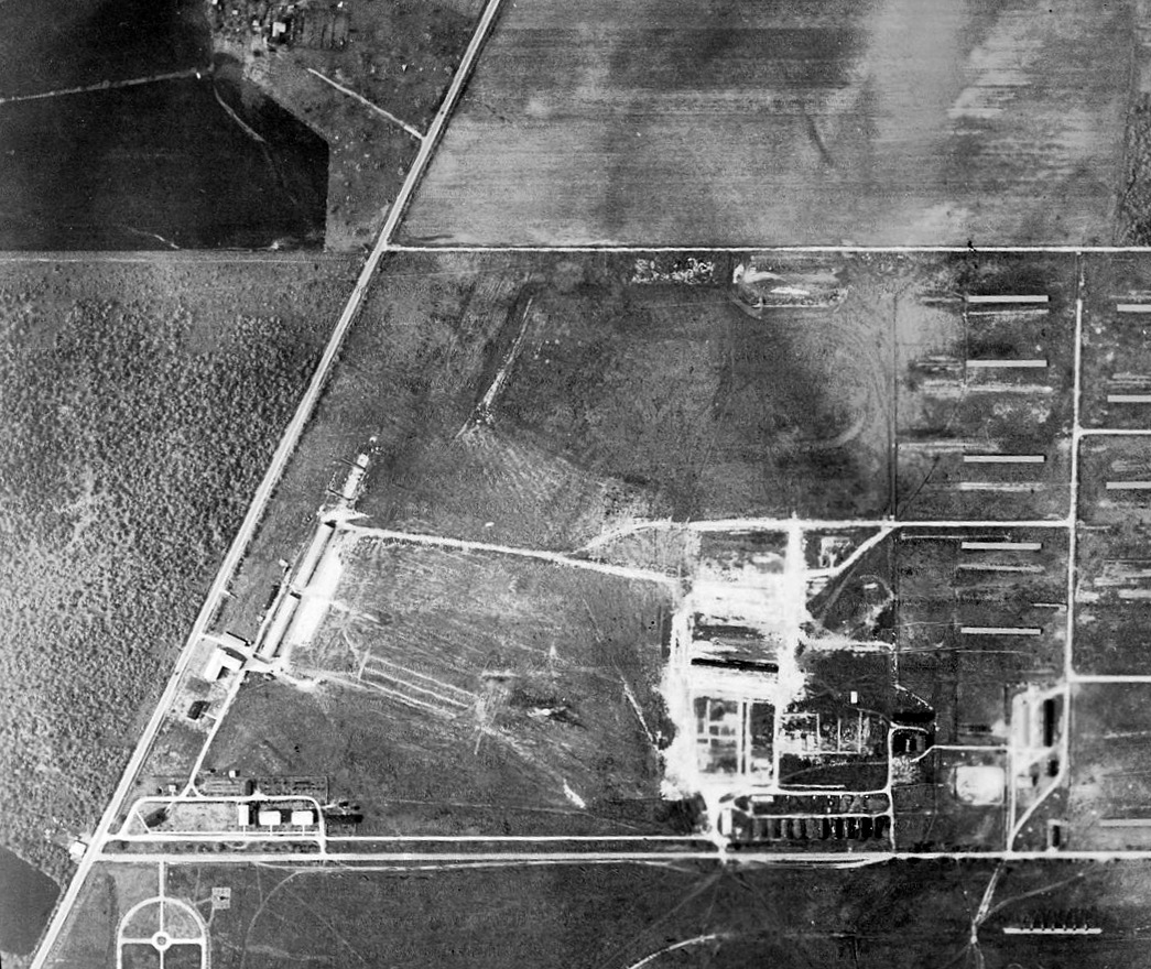
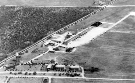
A 12/3/26 aerial view looking north at Dodd Field (courtesy of John Manguso).
The barracks & hangars were along Military Highway on the left, officers quarters along Dashiel Road, with the Administrative/headquarters building on the left.
As seen in the photo, the airfield itself was an open grass field, with no specific runway alignment.
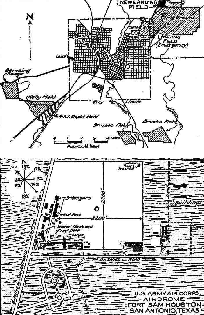
The 1927 Commerce Department Airway Bulletin #123 (courtesy of David Brooks) depicted the “New Landing Field” & “2nd Division Air Corps Field”
as being a 150 acre square sod field measuring 2,200' in each direction with 3 hangars along the southwest side.
On 5/10/28 the field was designated Dodd Field in War Department General Order Number 5.
It was named in honor of Colonel Townsend Dodd, Air Service,
who was killed in an aircraft accident on 10/5/1919 at Bustleton Field near Philadelphia.
He had served previously at the field which was given his name
and had been commander of the Aviation Post when the 3rd Aero Squadron was stationed there.
When the 12th Observation Squadron replaced its Douglas biplanes with the larger Consolidated O-19 aircraft,
the original hangars were rendered obsolete & converted to shops.
Dodd Field, as depicted on the 1929 Beaumont – San Antonio Airway Map # 27 (courtesy of David Brooks).
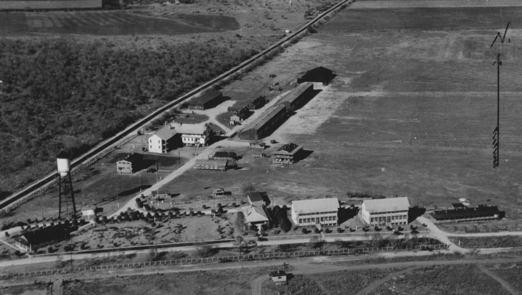
An undated aerial view looking north at Dodd Field from a 1930 postcard.
In October 1931, active flight operations were terminated & Major Frank Lackland moved the aircraft to Brooks Field.
After that, the area was used by the 2nd Division Air Service, for Reserve Component training & as a polo field.
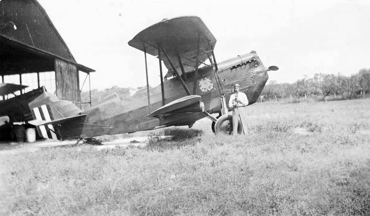
An undated view of a man & Curtiss Falcon biplane of the Coast Guard's 1st Border Squadron in front of a Dodd Field hangar (courtesy of John Manguso).
The Coast Guard reportedly used Dodd Field briefly in the 1930s.
According to Robert Tidwell, “The US Customs Air Patrol Detachment operated at Dodd Field from 1934-35 before being relocated to Del Rio.”
In 1937 the 8th Corps Area listed Dodd Field as an emergency field.
Some of the buildings were demolished or salvaged. At least one of the hangars was recycled.
A steel hangar built in 1917 was taken down & re-erected as a storage building (building 1198) along Wilson Street in 1939.
Enlargement of the field for aviation operations was still being considered as late as 1935.
A proposal was made to lengthening & widening the runways.
One gravel runway would be extended to 3,400' long & 200' wide. Another new 4,000' runway was to be added.
Both of these runways would have extended across Dashiell Road to the south, but neither was constructed.
The environs of Dodd Field were used to train Air Corps bombardiers in the 1930s.
After practicing their technique on a large scale terrain model of Dodd Field & the land to the south,
bombardiers-to-be from Kelly Air Force Base would make live bombing runs & drop black powder practice bombs on targets south of Dodd Field.
"Dodd" was depicted as an auxiliary airfield on the 1934 San Antonio Sectional Chart (courtesy of David Brooks).
The Second Division established a "Model Camp" at Dodd Field in 1937 for recruit training.
In December, 1939, facilities at the camp were improved by the addition of a mess & kitchen, lavatories & wood floors for the tents.
From time to time, troops from Fort Bliss would encamp at Dodd Field while enroute to maneuvers in Louisiana.
The facilities at Dodd Field at this time had a nominal capacity of 2,200 troops in the mobilization-type buildings
and another 4,800-6,400 troops in the tents.
Two of the former BOQs became barracks & the former hangars became mess halls.
The last aeronautical chart depiction which has been located of Dodd Field was on the March 1940 San Antonio Sectional Chart.
Dodd Field was evidently closed at some point between 1940-41,
as it was no longer depicted on the October 1941 San Antonio Sectional Chart.
A Prisoner of War Camp was established on Dodd Field on 10/21/43.
A double chain-link fence topped with barbed wire surrounded the compound,
and guard towers were spaced along the perimeter.
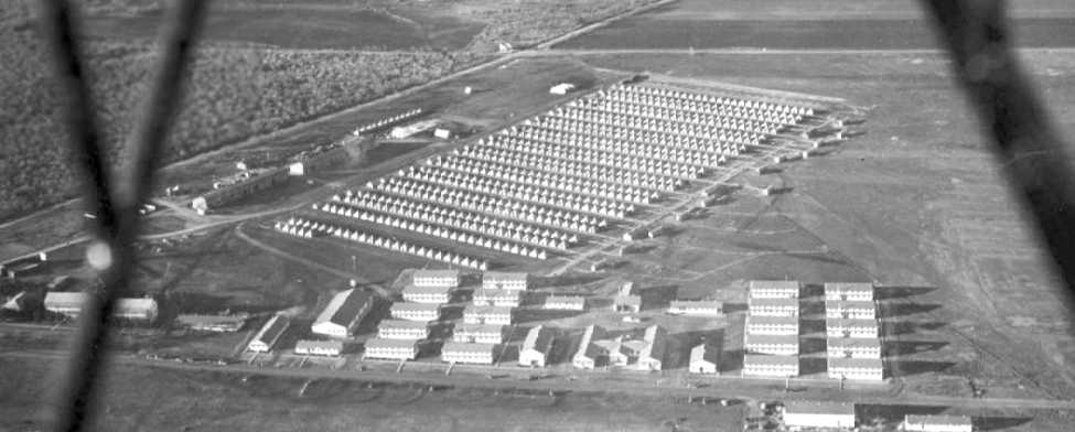
A 1944 aerial view looking northwest at the POW camp tents set up on Dodd Field.
The camp's normal capacity was 1,000 POWs but at the end of the war,
occupancy swelled to 3,500 as POWs from its satellite & sub-camps were returned to Fort Sam Houston as they closed.
The last group of 411 POWs left Fort Sam Houston on 6/17/46 for repatriation.
In 1949, the Wherry Housing development of 500 units was authorized for Fort Sam Houston,
to be constructed on 135 acres at the north end of Dodd Field, from the former site of the POW camp, eastward.
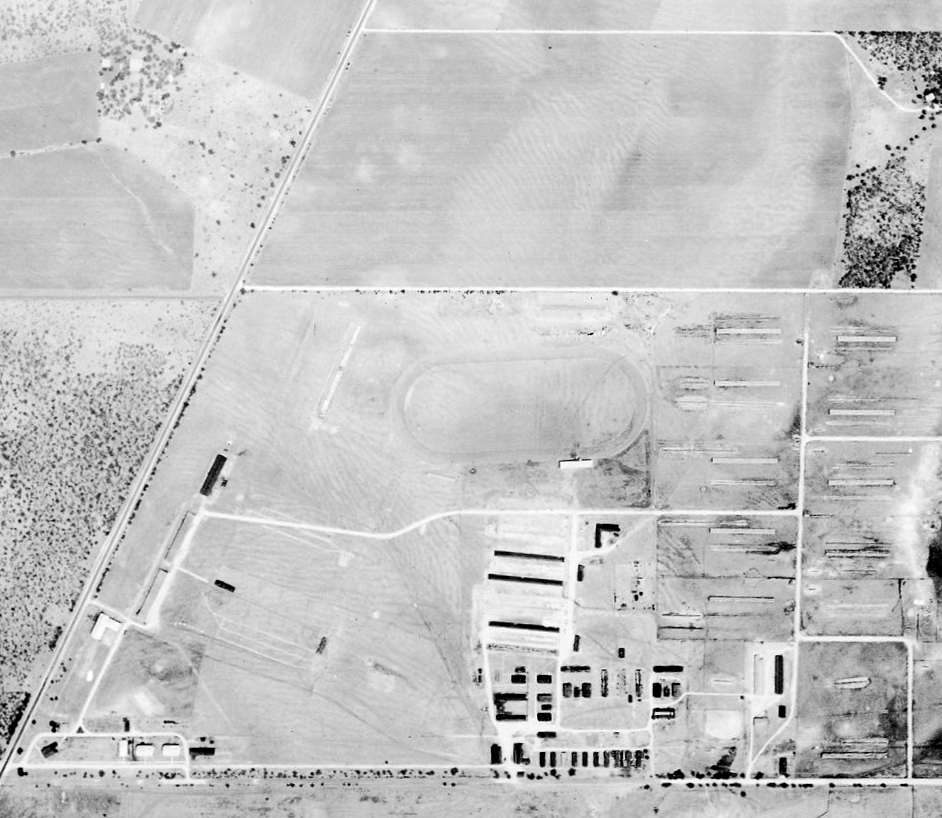
A 1955 aerial view showed the same row of hangars on the west side of the airfield site which were seen in the 1926 photo.
Ground breaking for the construction of a permanent, 1000-man Army Reserve Center (B-1610) occurred in 1959.
Built on the site of the former hangars, it was completed at a cost of $485,000 the following year.
A 1973 aerial view showed that the former hangars had been removed,
erasing the last aviation remnant from the site.
In the 1995 USGS aerial photo, the outline of the property of Dodd Field remained recognizable,
although several buildings had been constructed over portions of the site.
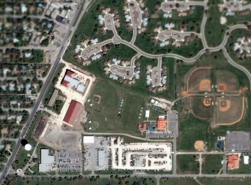
As seen in the 2005 USGS aerial photo,
the outline of the property of Dodd Field remained recognizable.
Amazingly, the water tower at the southwest corner of the field remained standing (the same water tower visible in the 1926 photo).
Roger Ritter reported in 2006, “The Pioneer Flight Museum in Kingsbury, TX,
has one of the original hangars from Dodd Field.
In the 1926 aerial shot, it's the smallish black one at the far end of the hangar row on the left.”
The site of Dodd Field is bounded on the north by Rittiman Road, on the west by Harry Wurzbach Memorial Highway,
on the south by Winans Road (formerly Dashiell Road), and on the east by the Fort Sam Houston Reservation boundary.
____________________________________________________
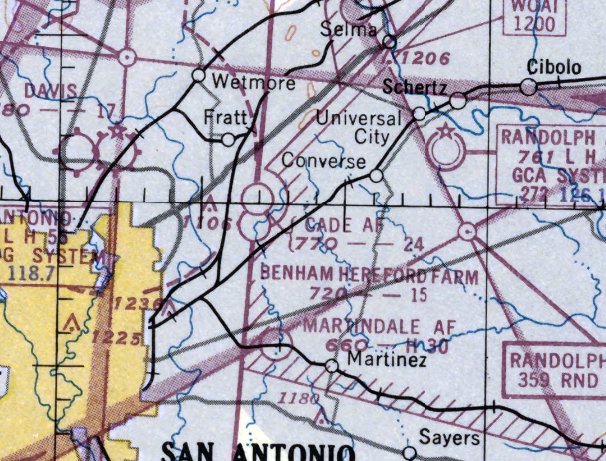
Cade Auxiliary Army Airfield, Kirby, TX
29.51, -98.36 (Northeast of San Antonio, TX)
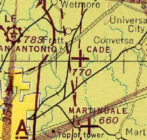
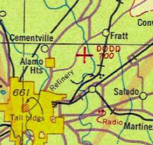
Cade Aux AAF, as depicted on the 1945 San Antonio Sectional Chart (courtesy of David Brooks).
Photo of the airfield while in use has not been located.
The date of establishment of Cade Aux AAF has not been determined.
The earliest reference which has been located of Cade Auxiliary Field
was a report of a 4/4/35 accident at the field involving Edward Flanick in a PT-11D (courtesy of Gary Ley).
Gary Ley observed, “There are numerous accidents reports concerning this field throughout the 1930s,
which would be understandable considering it was used by Air Corps student pilots.”
The 5/15/43 AAF list of airfields of the Gulf Coast Training Center (courtesy of Ron Plante)
listed Cade Auxiliary as one of the 8 satellite fields of Randolph Field, but did not specify any runway configuration.
Cade Aux AAF still was not yet depicted on the June 1944 San Antonio Sectional Chart.
The earliest depiction which has been located of Cade Field
was on the 1945 San Antonio Sectional Chart (courtesy of David Brooks).
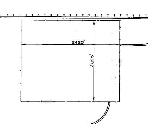
The 1945 AAF Airfield Directory (courtesy of Scott Murdock) described “Randolph Field Auxiliary (Cade Field)”
as a 116 acre rectangular property within which was a bare all-way field measuring 2,420' east/west by 2,095' north/south.
The field was said to not have any hangars,
to be owned by private interests, and to be operated by the Army Air Forces.
The Aerodromes table on the February 1950 San Antonio Sectional Chart (courtesy of David Brooks)
described Cade as having an "all way" unpaved landing area, measuring 2,400'.
According to David Brooks, "Looking at the terrain, I suspect that it was a square/rectangle with the longest side being 2,400'."
Cade was listed as not being maintained & use at own risk.
The last aeronautical chart depiction which has been located of Cade Field was on the February 1951 San Antonio Sectional Chart.
It depicted “Cade AF” as having a 2,400' unpaved runway.
Note that it also depicted a civilian Benham Hereford Farm airfield very close to the south.
Cade Field was evidently closed in 1951, as it was not longer depicted on the August 1951 San Antonio Sectional Chart.
Cade Field's closure came after primary flight training had moved from Randolph to other AFBs.
The Cade auxiliary airfield (with its unpaved runways) would not have been suitable
for the jet transition training (T-33s & T-37s) which was later conducted at Randolph.
Cade was no longer depicted on the 1953 USGS topo map.
Gary Ley observed, “I am certain Cade Auxiliary became a private airstrip, as there was a private strip at that exact location in the mid- to late-1960s.
I remember a pristine Beechcraft D-17 Staggerwing hangared in a pole barn there.
Cade was a rough, dirt strip with a slight rise in the middle that would explain the numerous landing accidents at the field.
Cade disappeared in the 1960s, consumed by contractors’ urban sprawl.”
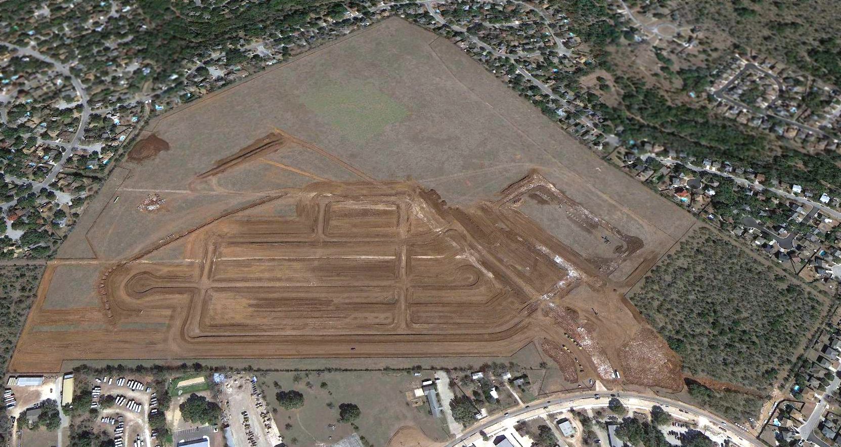
David Brooks recalled that the area around Cade was heavily built up by the 1980s, with numerous homes & businesses.
The 1/6/95 USGS aerial photo showed not a trace appeared to remain of Cade Field.
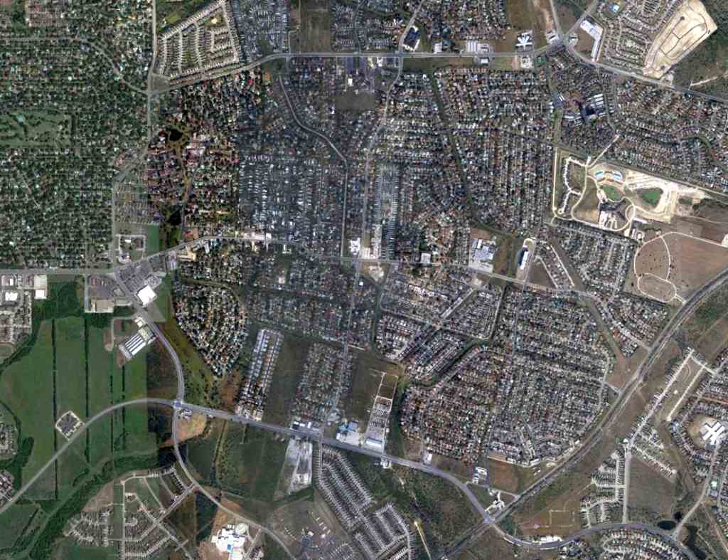
A 11/17/12 aerial photo showed no trace remaining of Cade Aux AAF.
The site of Cade Aux AAF is located at of the intersection of Montgomery Drive & New World Drive.
____________________________________________________
Northeast Airport, San Antonio, TX
29.513, -98.355 (Northeast of Downtown San Antonio, TX)
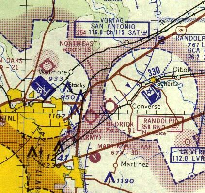
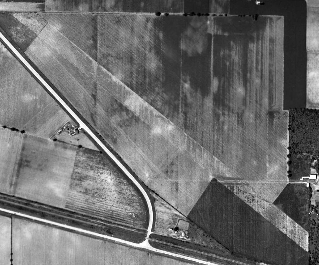
Northeast Airport, as depicted on the 1964 San Antonio Sectional Chart.
No airfield was yet depicted at this location on a 1955 USGS aerial photo nor on the 1959 USGS topo map.
The earliest depiction which has been located of Northeast Airport was on a 1963 aerial photo.
It depicted a single paved north/south runway, with a few small buildings on the east side.
The earliest aeronautical chart depiction which has been located of Northeast Airport was on the 1964 San Antonio Sectional Chart.
It depicted Northeast Airport as having an 1,800' unpaved runway.
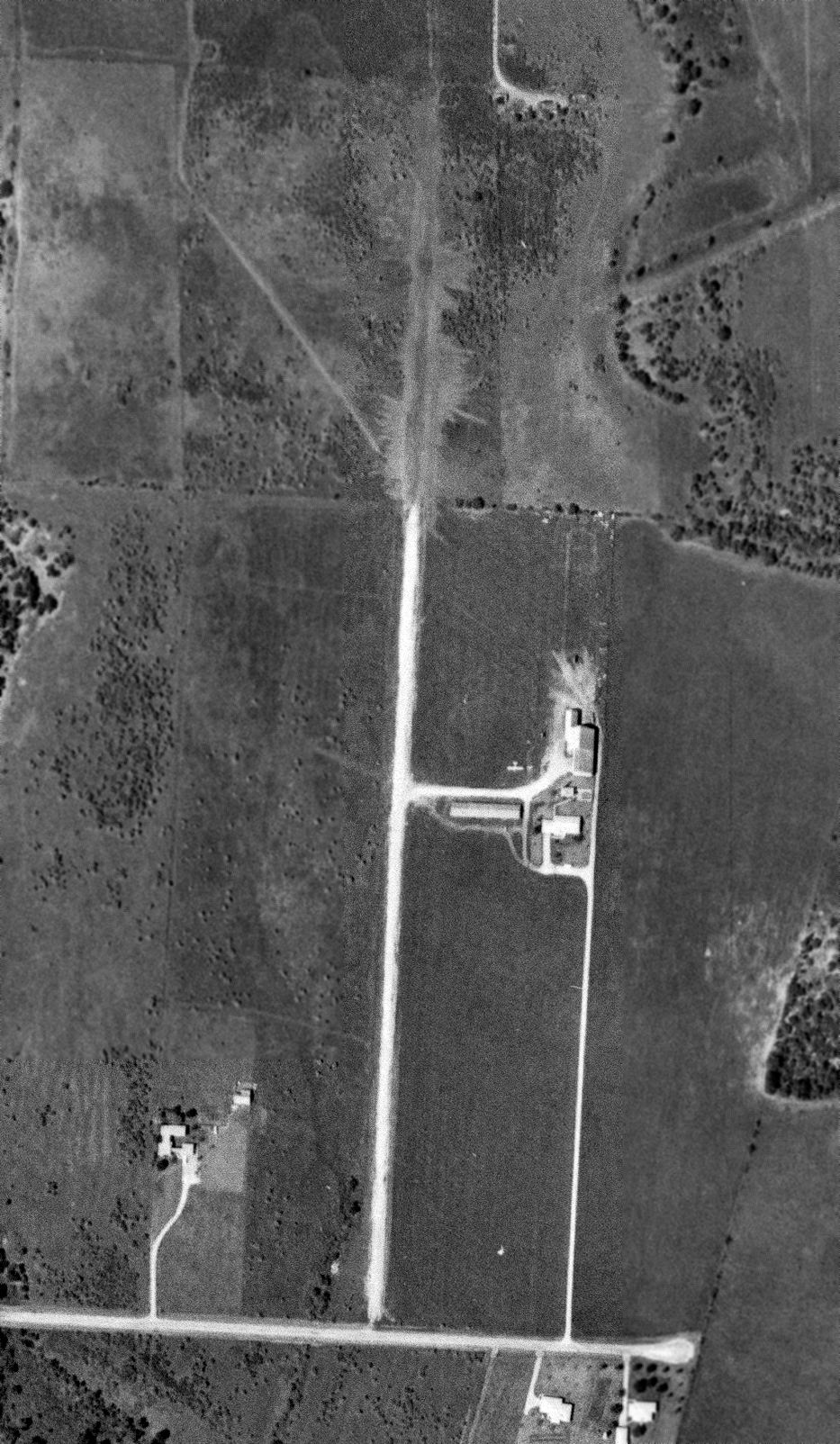
The only photo which has been located showing an aircraft at Northeast Airport was a 10/6/66 USGS aerial view,
which depicted one single-engine light aircraft parked near the buildings on the east side of the runway.
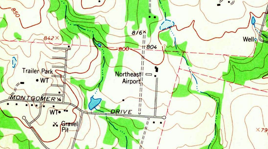
The earliest topo map depiction which has been located of Northeast Airport was on the 1967 USGS topo map.
It depicted Northeast Airport as having a north/south unpaved runway, with several small buildings on the east side.

The last aeronautical chart depiction which has been located of Northeast Airport was on the January 1972 San Antonio Sectional Chart (courtesy of Ron Plante).
It depicted Northeast Airport as a private airfield having a 2,400' unpaved runway.
A 1973 aerial view showed Northeast Airport remained in the same configuration.
The 1975 USGS topo map depicted Northeast Airport in the same configuration as on earlier topo maps.
Northeast Airport was evidently closed (for reasons unknown) at some point between 1972-76,
as it was no longer depicted on the December 1976 San Antonio Sectional Chart (courtesy of Jim Hackman).
Larry Lee recalled, “I think the airfield was between New World, Montgomery & Leyland streets,
We moved to Leyland in 1976 & there was an abandoned airstrip behind our house.
It even showed up on a map as an unnamed airfield.
It had a paved, deteriorated runway running north/south. It was mostly developed by 1978.”
A 1986 aerial photo showed no trace remaining of Northeast Airport, with houses covering the property.
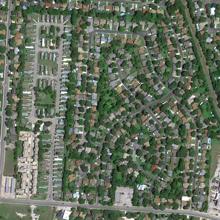
A 2016 aerial photo showed no trace remaining of Northeast Airport.
The site of Northeast Airport is located northwest of the intersection of Montgomery Drive & Tuxford.
____________________________________________________
Ireland Flying Field / Schneider Field / Seguin Airport, Seguin, TX
29.56, -98.01 (East of San Antonio, TX)
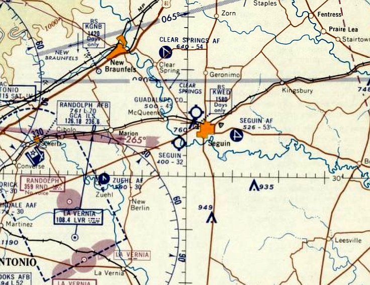
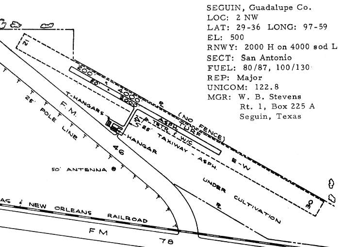
Schneider Field, as depicted in the January 1945 San Antonio Sectional Chart.
Photo of the airport while open has not been located.
This location was an airfield with at least 3 different names over the decades, starting in the First World War era.
According to “Under the Live Oak Tree: A History of Seguin” by John Gesick (courtesy of Fritz Schuetzeberg),
“Some Seguinites may remember the Ireland Flying Field.
It was located just west of Seguin near present day Lake Placid.
When Army aviation began in San Antonio, regional practice fields were needed.
Seguin offered a site & named it the Ireland Flying Field.
One of the first recorded crash landings at the airfield occurred 3/15/18.
Cadet Burtrell crash landed at the Ireland Flying Field just west of Seguin on a final test flight before becoming a Lieutenant.
He was treated by Dr. N. A. Poth in Seguin & returned to San Antonio on the evening train.”
The Ireland Flying Field was evidently abandoned at some point between 1918-34,
as it was not depicted on the 1934/36/38/40/42/44 San Antonio Sectional Charts.
This location was reopened at some point between 1944-45 as Schneider Field.
The earliest depiction which has been located of Schneider Field was on the January 1945 San Antonio Sectional Chart,
which depicted Schneider as a commercial/municipal airport.
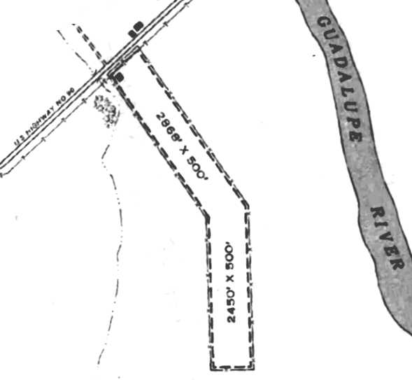
The 1945 AAF Airfield Directory (courtesy of Scott Murdock) described Scheider Airport
as a 53 acre irregularly-shaped property having 2 sod runways, measuring 2,868' northwest/southeast & 2,450' north/south.
The field was said to not have any hangars, but a single small building was depicted on the northwest side.
Schneider Airport was described as being owned & operated by private interests.
Fritz Schuetzeberg recalled, “I started flying here when I was 12 in 1956, with an man called 'Cap Schneider' at an airfield called Schneider Field.
There was a J-3 of Schneider's, a PT-22 of Cliff Kunkel, a Cessna 140 of Louie Souders, a Cessna UC-78, a CAP L-16 & L-4, and an Aeronca Chief of Stan Ownes.
Other pilots were Buggs Stoutsenberger & Less Bugi.
The airfield had 3 runways. One was north/south on the west side. One was northeast/southwest, the longest. One was east/west on the north end.
There were no trees between the airfield, office & the hangars in 1956.
I rode my bike 5 miles to get here, and helped around the field every afternoon, weekends & all summer for flying time.
My parents never really knew much about it. Have times changed.
I had a 1957 San Antonio [Sectional] Chart showing Schneider Field.
Schneider Airport Manager Stan Ownes... gave me my first airplane ride & then died in a duster crash in about 1958.
He owned a Chief.
I can not believe I remembered the names after 55 years.
People who also flew from this field were CAP pilots I flew with, USAF Lt. Sharpe in the L-4, John Gilbert in the L-16.
Kenny Hass, Sam Lyle & Paul Schroeder were also in the CAP cadets.
It seems like I could go there in the morning & they would all be there. Wow!”
Fritz continued, “I remember one summer day Stan was mad because someone stole avgas from the pump.
In those days we did not lock the pumps because someone may need fuel after hours to get home.”

The airport was evidently renamed Seguin Airport at some point between 1945-58,
as the 1958 USGS topo map depicted “Seguin Airport” as having 2 paved runways,
with 4 small buildings on the north side.
The last photo which has been located showing Seguin Airport still in operation was a 4/8/58 USGS aerial view.
It depicted Seguin Airport as having 2 runways, with 4 small buildings & 1 single-engine aircraft on the north side.
Fritz Schuetzeberg recalled, “Schneider Field closed in about 1959,
after Stan Owens death & Captain Schneider had moved to run the Luling TX Airport in about 1958.
The new Seguin Airport had just opened & the people & planes moved.”
The last aeronautical chart depiction which has been located of Seguin Airport was on the March 1960 San Antonio Sectional Chart.
It depicted Seguin Airport as having a 3,200' unpaved runway.
Seguin Airport was no longer depicted on the August 1960 San Antonio Sectional Chart.
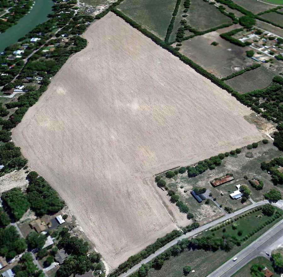
A 1973 aerial view depicted Seguin Airport as having a single grass north/south runway, with several buildings at the north end.
There was no indication of any recent aviation usage.
The 1975 USGS topo map still depicted “Seguin Airport”, even though it had evidently been closed for more than a decade by that point.
A 1986 aerial photo showed the area of the runway had been taken over for farming at some point between 1973-86, erasing any trace of the runway.
But the airport buildings on the north end remained intact.
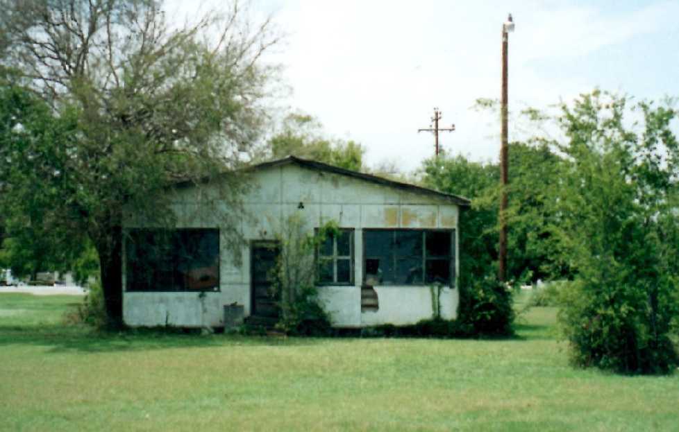
A 2002 photo by Fritz Schuetzeberg of the Schneider Field “flight office, cafe & airport manager's office as seen from the south.
There is a large sign on the west side of the office that says 'Airport Cafe'.”
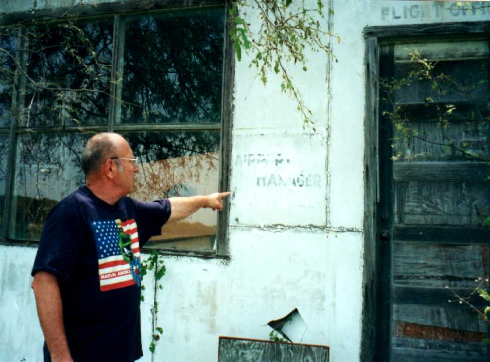
A 2002 photo of Fritz Schuetzeberg pointing out the “Airport Manager” sign at the Schneider Field office door.
Fritz reported, “The sign says 'Schneider Airport Manager Stan Ownes'.”
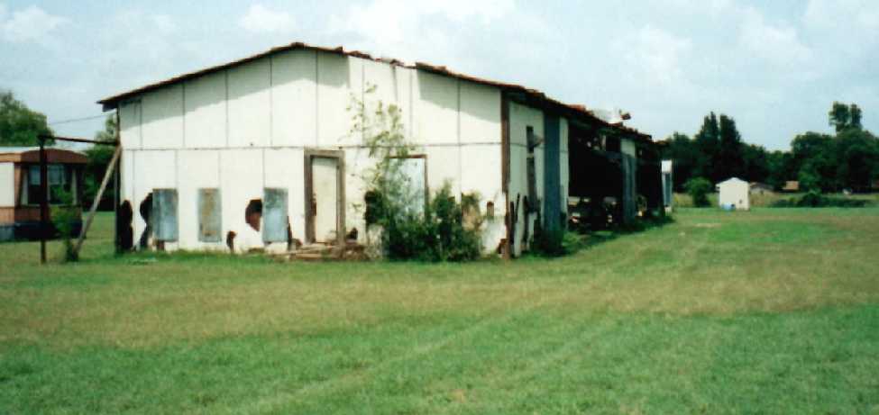
A 2002 photo by Fritz Schuetzeberg of the the west end of the Schneider Field T-hangars.
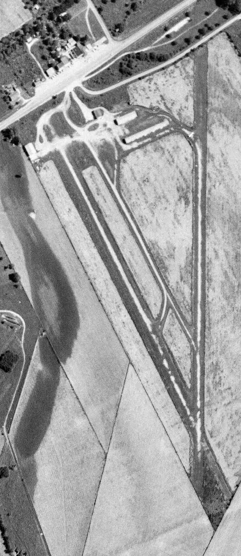
A 10/18/11 aerial view looking south at Schneider Field showed the runway area remains clear, and several buildings remain intact.
Fritz Schuetzeberg observed in 2012, “A large hangar in the northwest corner has been replaced by a house.
The hangar & office are easy to spot with the rusty roofs.”
The site of Schneider Field is located southeast of the intersection of West Kingsbury Street & Manor Drive.
____________________________________________________
Guadelupe County Airport / Seguin Municipal Airport (T90, TE70) / Geronimo Field,
Seguin, TX
29.59, -98 (East of San Antonio, TX)
Guadalupe County Airport, as depicted in a 5/4/58 USGS aerial photo.
This general aviation airport was evidently built at some point between 1949-58,
as it was not depicted on the 1949 San Antonio Sectional Chart (courtesy of Chris Kennedy).
The earliest depiction which has been located of Guadalupe County Airport was on a 5/4/58 USGS aerial photo,
which depicted a single grass northwest/southeast runway.
There did not yet appear to be any buildings associated with the airfield.
The earliest aeronautical chart depiction which has been located of Guadalupe County Airport was on the 1959 San Antonio Sectional Chart.
The 1962 AOPA Airport Directory described Guadalupe County Airport
as having a single 4,400' turf & asphalt runway, and listed the operator as Seguin Aviation.
The 1963 TX Airport Directory (courtesy of Steve Cruse) described Guadalupe County Airport
as having a 2,000' asphalt section set amidst a 4,000' turf Runway 12/30.
An asphalt taxiway led south toward a small ramp with 2 hangars. The manager was listed as W.B. Stevens.
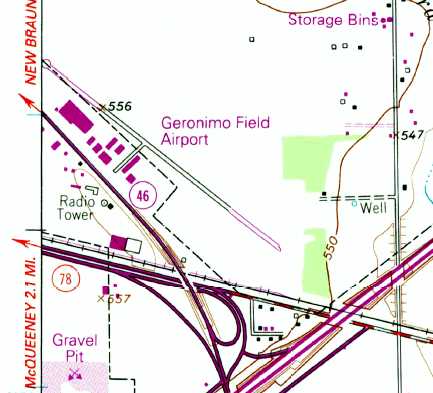
The 1964 USGS topo map depicted Geronimo Field Airport as having a single paved northwest/southeast runway
with several buildings along the southwest side.
According to William Suffa, Guadalupe County Airport
was depicted as an active airfield on the 1965 San Antonio Sectional Chart.
According to Stephen McNicoll, the airfield was labeled "Navion" on the 1967 San Antonio Sectional Chart,
and then as "Guadalupe County" on the 1968 chart.
"Guadalupe County" was depicted on the January 1970 San Antonio Sectional Chart (courtesy of Chris Kennedy)
as having a single 2,000' paved runway.
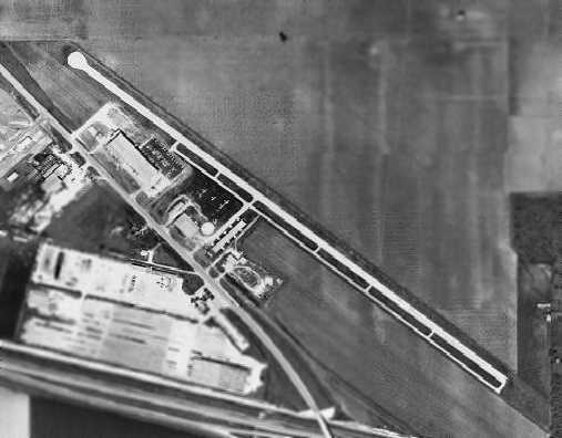
A 1973 aerial view depicted Guadalupe County Airport as having a single paved northwest/southeast runway,
a parallel taxiway, and a ramp & several small hangars on the west side of the field.
Several light aircraft were also visible on the ramp.
The 1973 USGS topo map depicted "Geronimo Field Airport” as having a single paved runway.
The field was labeled as "Guadalupe” on the 1976 USGS topo map.
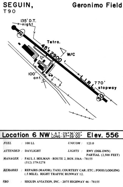
Having been renamed, the field was listed as "Geronimo Field" in the 1985 TX Airport Directory (courtesy of Steve Cruse).
The single runway was by then a 2,900' paved strip.
The operator was listed as Seguin Aviation Inc.
Henry Graeber recalled, “In 1985, I took flight lessons at Geronimo Field in Seguin.
I soloed but because of family obligations, never finished my private.
My flight instructor [was] Tripp Riedel, who was a young man at the time.
I've got between 55-60 hours in various planes there.”
Ken Smith reported, “Geronimo Field was the original home for the Piper Apache 'Geronimo' modifications.”
A 1986 aerial photo showed a total of 15 single-engine aircraft on the field.
The 1987 USGS topo map depicted "Geronimo Field” as having a single paved runway.
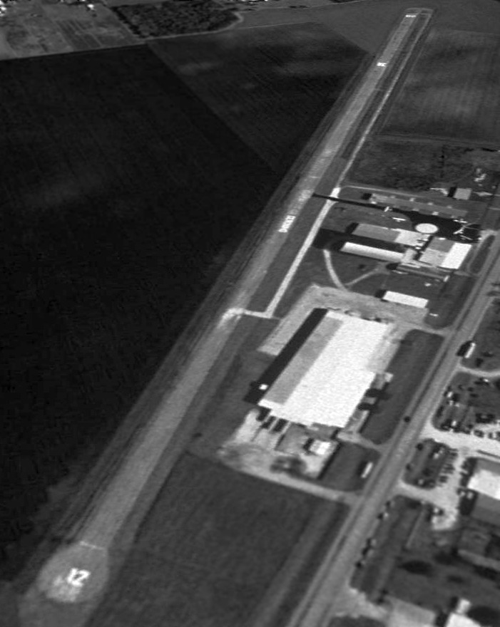
The last photo which has been located showing Geronimo Field still in operation was a 1/27/95 USGS aerial photo looking southeast.
It showed the airfield to have a single 4,000' paved Runway 12/30, a parallel taxiway, a small ramp & several small hangars.
Three light single engine aircraft were visible on the ramp.
Eric Bauer recalled, “In my logbook my last flight to Geronimo Field was in April 1998.
They told me that it was to be their last month of operation -
that they were selling to a mobile home manufacturing facility.”
Buck Wyndham reported in 2003 that "The site of the old Geronimo Airport is now used for mobile home manufacturing & distribution."
In 2003 a small private field, "Huber Airpark Civic Club LLC Airport",
opened a half mile east of the site of the old Geronimo Airport, but it is not the same airfield.
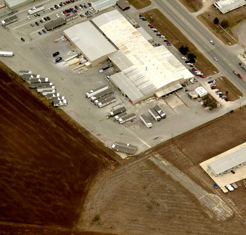
A 2004 aerial view showed a large industrial facility with a large paved ramp covering the middle portion of the former runway,
but portions of the original runway still extended toward the northwest & southeast.
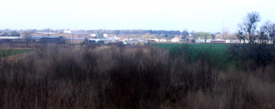
A 2008 photo by Eric Patrick looking from I-10 toward the site of Geronimo Field.
Eric reported, “I was unable to gain access to the back side of the mobile home factory to take pictures of what is left of the runway.
I was unable to see any concrete [runway remains] from my vantage point.
Unlike most Texans, I don't have a truck, so I'm unable to go 4 wheeling or off-roading. My Civic would not make it.”
A circa 2008 aerial view looking south shows the Runway 30 numbers still remaining recognizable.
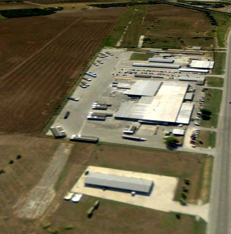
A 3/31/08 aerial view looking southeast shows the runway, ramp, and hangars which remain intact.
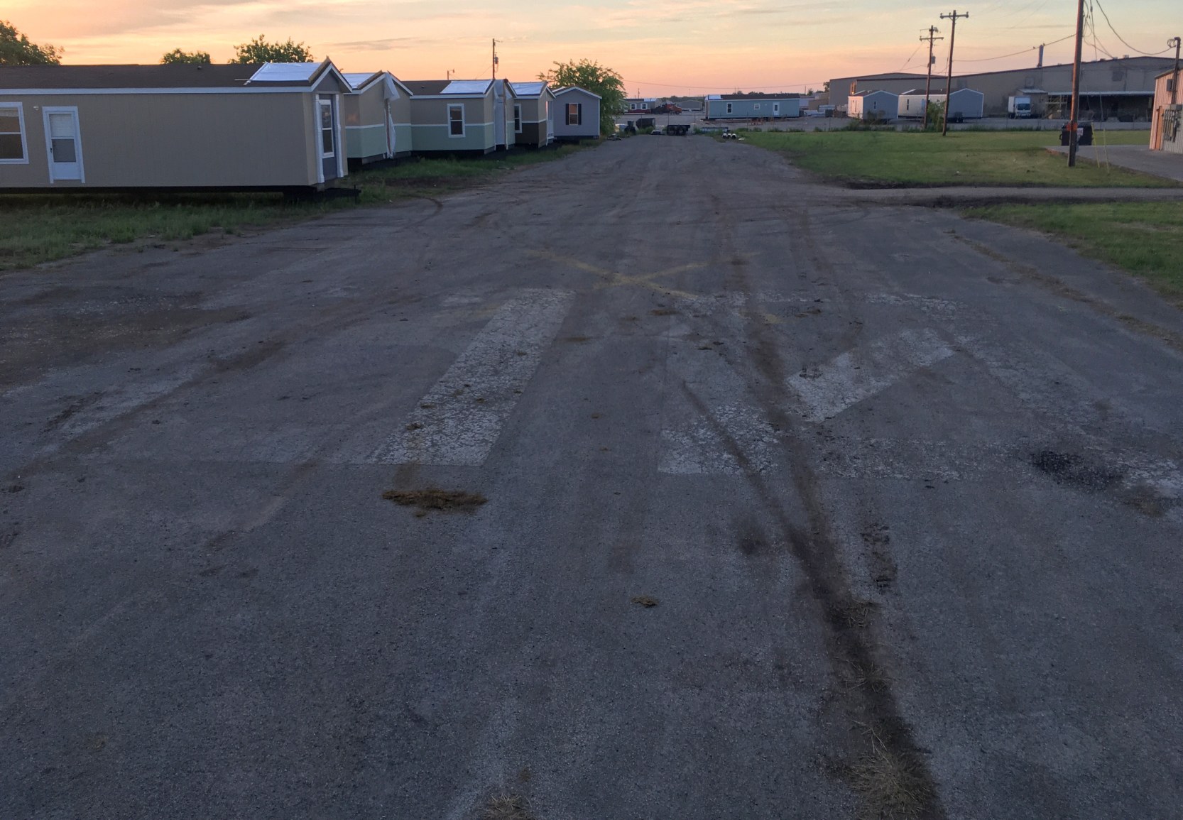
A 4/10/18 photo by Louis Meinhart looking southeast along the former Geronimo Field Runway 12.
Louis observed, “Runway 12, the numbers are faint but visible.”
____________________________________________________
Or if you prefer to contact me directly concerning a contribution (for a mailing address to send a check),
please contact me at: paulandterryfreeman@gmail.com
If you enjoy this web site, please support it with a financial contribution.
____________________________________________________
This site covers airfields in all 50 states.