Abandoned & Little-Known Airfields:
Pennsylvania: Delaware County
© 2002, © 2025 by Paul Freeman. Revised 2/6/25.
This site covers airfields in all 50 states: Click here for the site's main menu.
____________________________________________________
Please consider a financial contribution to support the continued growth & operation of this site.
Benedict Airport / Delaware County Airport (revised 2/6/25) - Bergdoll Field (added 7/15/18) - Buckman Airport (revised 4/14/13)
Piasecki Morton Factory Heliport (revised 12/18/21) - Platt-LePage Aircraft Factory (revised 10/15/22)
____________________________________________________
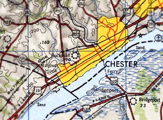
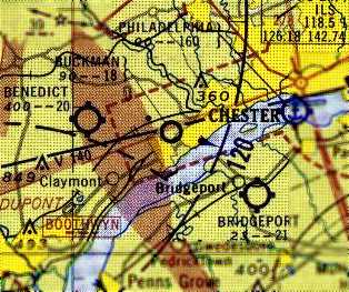
39.975, -75.321 (West of Philadelphia, PA)
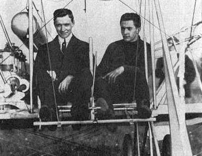
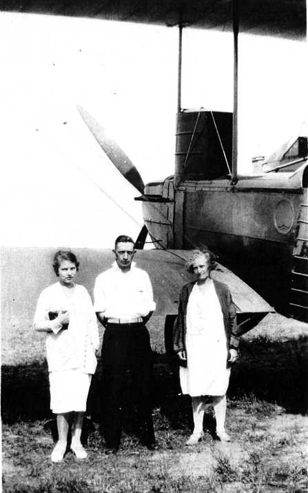
A 1912 photo of Louis & Grover Bergdoll in Grover's biplane (courtesy of Ed Stewart).
According to Ed Stewart, “Bergdoll Field [was] purchased by Grover Bergdoll in the spring of 1912 after he completed the Wright Flying School.
He purchased a Wright Model B which currently [2018] hangs in the Franklin Institute in Philadelphia.
On 5/11/12 Grover's Model B was delivered to the field by Arthur Welsh, Wright’s chief instructor pilot.
Because he didn’t think the field was long enough, Welsh had some trees cut down so Grover's acceptance flight didn’t take place until Sunday 5/12/12.
Orville Wright firmly disapproved of the flight because he did not allow any employees to work on Sunday.
It was from this field that Grover made the first flight ever between Philadelphia & Atlantic City on 8/16/12.
Grover was 19 years old at the time & carried 1 passenger; they landed on the beach at Atlantic City.”
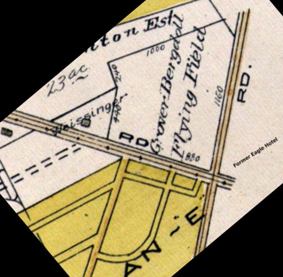
An undated map depicting “Grober Bergdoll Flying Field” (courtesy of Ed Stewart).
According to Ed Stewart, “The Pennsylvania Aero Club was based at the field for a time where they had a clubhouse & hangar.
Grover fell into disrepute during the First World War because he refused to fight his countrymen (he was a 2nd generation German who had many relatives in Germany).
He lived in Germany until 1939 when he returned & was tried & sentenced.”
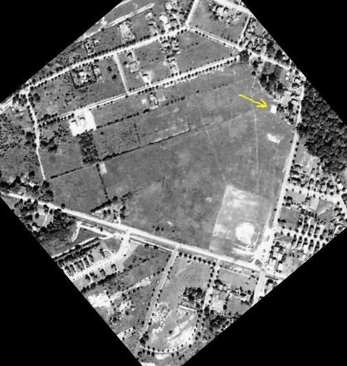
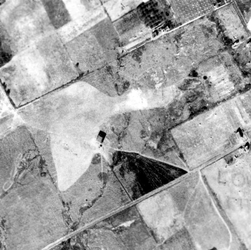
A circa 1929 aerial view depicting the hangar (yellow arrow) at the northeast corner of the site of Bergdoll Field (courtesy of Ed Stewart).
According to Ed Stewart, “All of Grover’s property was seized by the U.S. Government & the field was used as an anti-aircraft [artillery] emplacement during WW2.”
A 1948 aerial view depicted a rectangular remains, evidently of the WW2 anti-aircraft artillery emplacement, on the south corner of the Bergdoll Field.
There was no trace evident of the hangar or other Bergdoll Field remains.
A 1950 aerial view showed construction had started on the Bergdoll Field site for the Manoa Shopping Center.
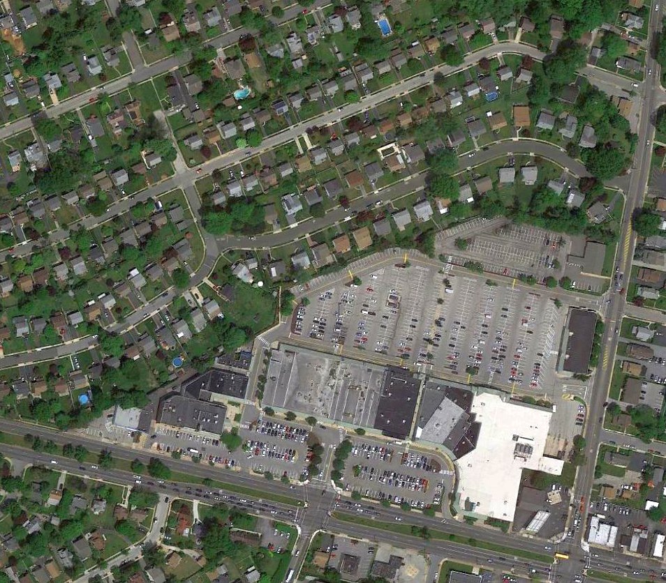
A 2016 aerial view showed no trace remaining of Bergdoll Field, with the site occupied by the Manoa Shopping Center & houses.
The site of Bergdoll Field is located at the northwest corner of West Chester Pike & Eagle Road.
Thanks to Ed Stewart for pointing out this airfield.
____________________________________________________
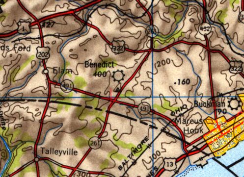
Benedict Airport / Delaware County Airport, Garnet Valley, PA
39.84, -75.49 (Southwest of Philadelphia International Airport, PA)
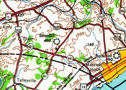
Benedict Airport, as depicted on the June 1945 Washington Sectional Chart.
This small general aviation airport was evidently established at some point between 1944-45,
as it was not yet depicted on the 1941 USGS topo map or the November 1944 Washington Sectional Chart (courtesy of Ron Plante).
The earliest depiction which has been located of Benedict Airport was on the June 1945 Washington Sectional Chart,
which depicted Benedict as a commercial/municipal airport.
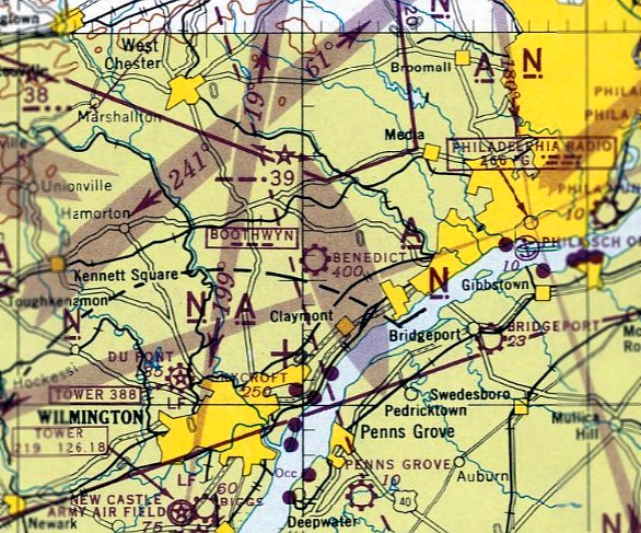
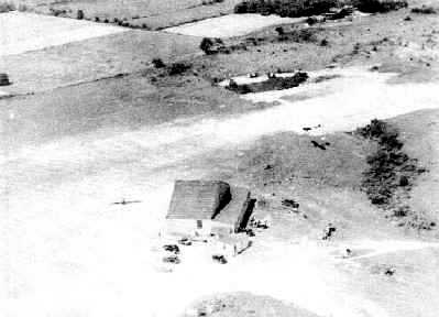
The earliest photo which has been located of Benedict Airport was an undated colorized aerial view looking north (courtesy of Dale Denisar),
showing a row of hangars & light planes on the south side of a grass airfield.
The hangars were reportedly capable of housing 20 aircraft.
The 1946 USGS topo map depicted Benedict as a commercial/municipal airport.
Dick Wolff was the first president of the Delaware County Aviation Association in 1946, and for a time leased Benedict Airport with a partner.
"We made money on airplane rides, flying instruction, plane rentals, gas and maintenance, and did a booming business on weekends," he recalled.
"The war created a tremendous interest in flying, and lots of veterans used their GI Bill to take lessons."
Wolff said rides costs $6 / person & lessons were $12 / hour.
In those days, it took a minimum of 35 hours to obtain a flying license, he noted.
According to Paul Nelson, the Army shipped a German helicopter that had been captured during the war to Benedict because the field was so remote.
"It was a big attraction, watching them test it, because it was supposed to be secret," he said.
A 1950 aerial view showed the row of hangars along the west side of Benedict Airport,
and the airfield remained clear, but there were no aircraft or other sign of recent aviation usage.
A 1953 aerial view showed a similar scene.
The last aeronautical chart depiction which has been located of Benedict Airport was on the July 1955 Washington Sectional Chart.
It depicted Benedict as having a 2,000' unpaved runway.
At some point between 1955-56, Benedict Airport was evidently renamed Delaware County Airport,
as that is how it was depicted on the January 1956 Washington Sectional Chart, with a 2,000' unpaved runway.
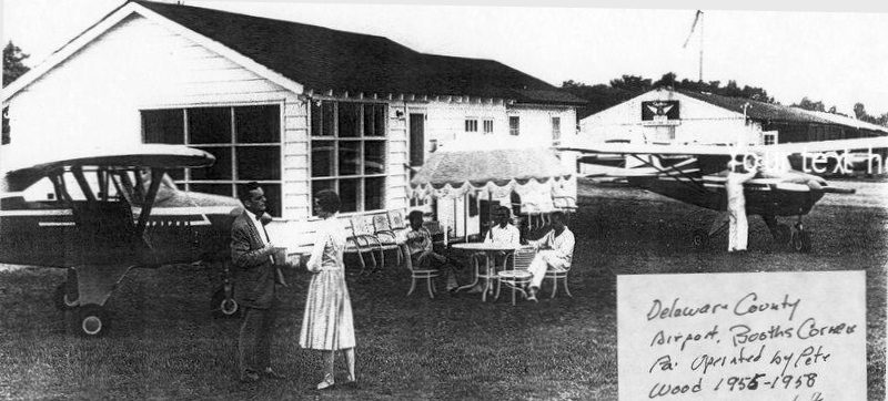
The last photo which has been located of Benedict / Delaware County Airport was a circa 1955-58 photo
of pilot Phil Kniskern & Benedict Airport operator Joan Wood in front of the airport office (courtesy of Terry Wood Abeyta).
Terry Wood Abeyta recalled, “My parents (Pete & Joan Wood) rented a house on-site at Benedict & kept the airport running between 1955-58. My dad sold Pipers out of Benedict then.”

The last aeronautical chart depiction which has been located of Delaware County Airport was on the July 1955 Washington Sectional Chart.
Delaware County Airport was evidently closed at some point between 1957-58,
as it was no longer depicted on the March 1958 Washington Sectional Chart.
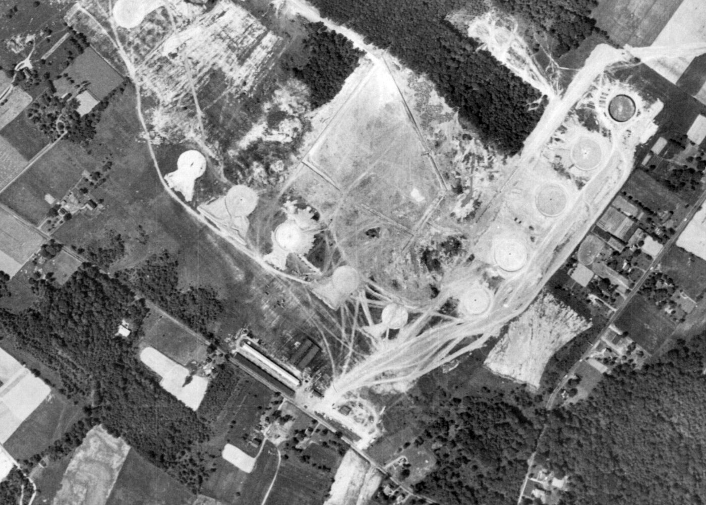
A 6/7/58 aerial view showed the row of hangars remained along the west side of the Delaware County Airport site,
but construction had started over the airfield for a complex of oil storage tanks which eventually replaced the airport.
Benedict Airport was still depicted on the 1959 USGS topo map.
A 1965 aerial view showed the oil storage tanks having replaced Benedict / Delaware County Airport,
but the foundation for the row of hangars was still recognizable along the west side of the property.
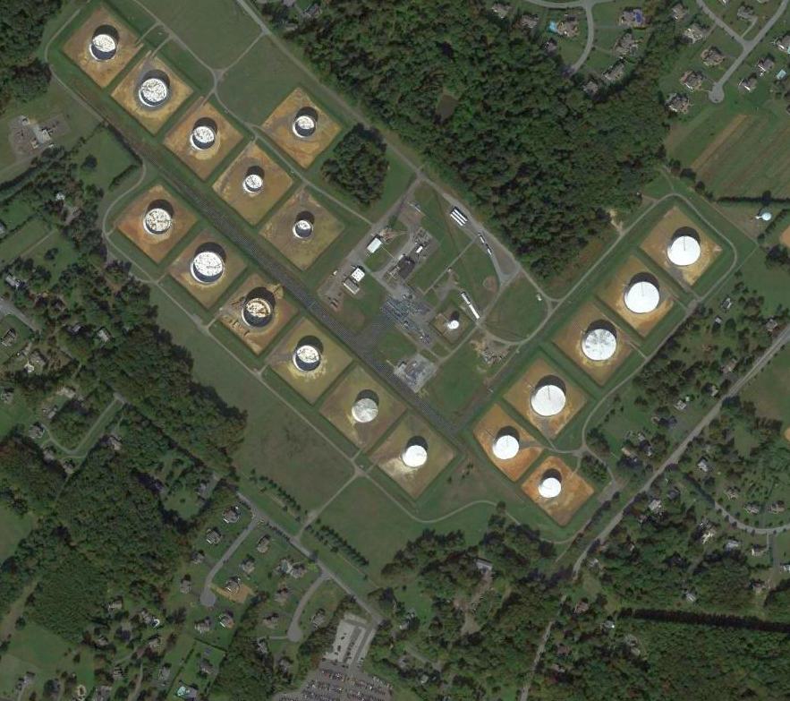
A 2011 aerial view shows the oil storage tanks which occupy the site of Benedict / Delaware County Airport.
The site of Benedict / Delaware County Airport is located north of the intersection of Kirk Road & Foulk Road.
Thanks to Dale Denisar for pointing out this airfield.
____________________________________________________
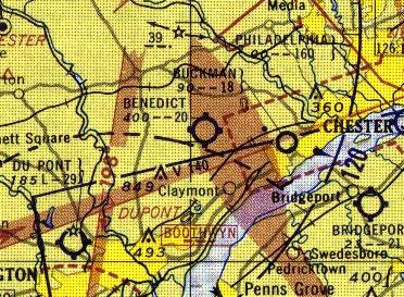
39.84, -75.4 (Southwest of Philadelphia International Airport, PA)
A circa 1927-28 photo of a Keystone XB-1B bomber believed to have been taken at Buckman Airport (courtesy of Robert Lloyd).
Sheri Brown recalled, “Buckman Airport was my family's legacy in aviation.
Before the airport existed it was farmland owned by my father's great-grandparents, the Boyd's.
Norman Smith use to barnstorm there long before the airport.
On one of his ferrying trips he stopped there & met a young boy who had been riding his horse through the field.
This meeting was the beginning of not only the airport but a great friendship between this boy (the instrument) and the pilot (his mentor).
Their chance meeting changed both their lives forever.
The boy sold rides for Mr. Smith as well as taking care of his airplane. He later became a mechanic & pilot.
When he was able he joined the Civil Air Patrol & then the Army where he became a flight instructor.
When be returned home Buckman Airport had become very successful
and this man had helped to make it all possible for without him the airport property would never have been acquired by Mr. Smith.
This man is my father Albert Brown (Brownie) and he has a story to be told.
He is a wealth of information about those early days when flying was considered a great risk & only attempted by daredevils.”
The earliest depiction which has been located of Buckman Airport was a circa 1927-28 photo of a Keystone XB-1B bomber (courtesy of Robert Lloyd).
According to Robert Lloyd, “I think the photo may have been taken at Buckman Airport.
My mother grew up nearby & we used to talk about it & my first plane ride there at age 3.”
The Buckman Airport reportedly originated in the early 1930s on the west side of Highland Avenue,
and It was built & operated by Norman Smith.
Ed Spellacy recalled, “I lived at 912 East 16th in Sun Hill when I was in grade school.
Every afternoon I would hear & then see the mail plane that had picked up the mail pouch.
I believe that the pouch was suspended from 2 poles.
The aircraft would hook the cable attached to the pouch & just about the time it went over my house the pouch was just being pulled in the door.
This always fascinated me & gave me a life-long interest in aviation.
I later had a chance to ride in a J3 cub at Buckman, a ride paid for by my uncle.”
The earliest dated depiction which has been located of Buckman Airport was an 11/4/37 aerial view (courtesy of Chris Kennedy).
It depicted a single hangar at Buckman Airport, with a grass landing area.
Buckman Airport was not yet depicted on the September 1940 Washington Sectional Chart.
An October 1940 aerial view of a hangar & 2 planes (one of which is airborne) at Buckman Airport (courtesy of Harvey Martin).
The October 1940 issue of The Delaware County Advocate reported, “Federal Government appropriations for civil airport expansion linked to defense plans
have included an allotment for Chester of $613,500.
It is expected that Buckman Airport, on the northwestern edge of the city, will be the subject for expansion & improvement.
It is situated directly on the radio beam of several present airlines,
and would be convenient for military as well as civil emergency landings.”
Charles Fehl recalled, “In May of 1941 we moved into a house on Anderson Avenue.
All I had to do was look west & on the opposite hill was the Buckman Airport.”
The 1941 USGS topo map (courtesy of Chris Kennedy) depicted Buckman Airport's single hangar (unlabeled),
but nothing else of the airport was depicted.
The earliest aeronautical chart depiction which has been located of Buckman Airport
was on the November 1941 Washington Sectional Chart (courtesy of Chris Kennedy).
It depicted Buckman as a commercial/municipal field.
Charles Fehl recalled, “The Second World War started the following December,
and the airport became a storage depot for military vehicles, Jeeps,
half-tracks, 4X4 trucks, etc., for the Ford Motor Company in Chester.
My father worked for Ford driving those vehicles to Buckman Airport from the Ford plant.
He would come from 9th Street, up Anderson Avenue (then a dirt road) to the airport,
as Anderson Avenue ran directly into the airport entrance.
Sometimes, my father would pick up me & my buddies and give us a ride in a Jeep or half-track.
There were thousands of vehicles stored there, and a military guard post was built at the airport entrance at Township Line Road.
As kids, we got to know the soldiers who guarded the airport & would hang out at the guard shack.
We would sit around a pot-bellied stove, fascinated by the war stories we were told.”
Charles continued, “The war ended & returning military pilots flocked to the airport as did I.
I was about 9 years old & spent every available moment helping to push airplanes in & out of the hangars
and sometimes they would give me an airplane ride.
I never asked for a ride but did not refuse an offer of one.”
Charles continued, “A field adjacent to the south end of the north/south runway was the pickup station for the Adams Airmail Pickup System.
My friends & I would help the Adams representative assemble 2 poles from shorter sections he carried in his car trunk.
The poles when erected stood 14' high & were placed 20' apart.
At approximately 4:30 PM, the aircraft could be seen at first as a dot coming from the south.
This dot became a Stinson Reliant SR-10F.
When it arrived, a mail pouch was dropped, and we kids would chase & retrieve it.
Sometimes, the drop would miss & end up in the underbrush.
One pouch was lost for a year or more. It was found in the culvert pipe beneath the airport driveway.
The aircraft would then circle around & come in approximately 20' off the ground & snatch the rope that was attached to the mail pouch.
This rope was extended between the 2 poles.
This was accomplished with a pole extended beneath the aircraft that used a hook & winch apparatus to grab the rope.”
Charles continued, “An airshow was held every summer & was very popular.
This show was attended by many people who relied on public transportation.
The bus stop was at 9th Street & Langley Avenue, with Anderson Avenue being the most direct route to the airport.
My father would position me at the curb in front of our store with a galvanized wash tub filled with ice & sodas.
The air show attracted visiting aircraft of various designs, both military & civilian.
There was the constant sound of aircraft flying.”
Charles continued, “I remember one year that a mock attack on the airport was held by the National Guard during the airshow,
complete with paper bags containing flour simulating bombs being dropped from airplanes.
Charles continued, “The airport had a restaurant/snack bar in a separate building that was opened seasonally.
The building was located near the airport entrance.”
Buckman Airport, as depicted on the 1946 USGS topo map.
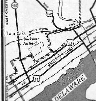
A 1946 USGS map depicted Buckman Airfield as having an L-shaped property outline.
The Chester Times Year Book for 1949 reported, “Buckman Airport lies along Township Line road, in Upper Chichester Township,
just a half-mile from the western boundary of Chester.
It has two 1,800' runways, north/south & east/west. There is hangar space for storing 17 planes.
Flying lessons are given by accredited instructors, and planes may be rented.
Norman Smith is manager; Norville Matthews is assistant manager. Both men are licensed pilots & instructors.”
The Chester Times Year Book for 1949 also reported, “Delaware County Flying Club: Meets at Buckman Airport, Chester.
Solo flight is qualification for membership. William Springer, president; Phil Larney, Vice-president, Harry Hladky, treasurer; Paul Nelson, Secretary.”
Rodger Phillips recalled, “In the 1950s, my brother & I used to rent the same J-3 Cub at Buckman that my uncle learned to fly in back in the late 1930s.
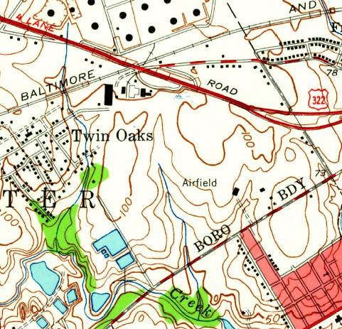
The 1953 USGS topo map depicted a single hangar at Buckman Airfield, labeled simply as “Airfield”.
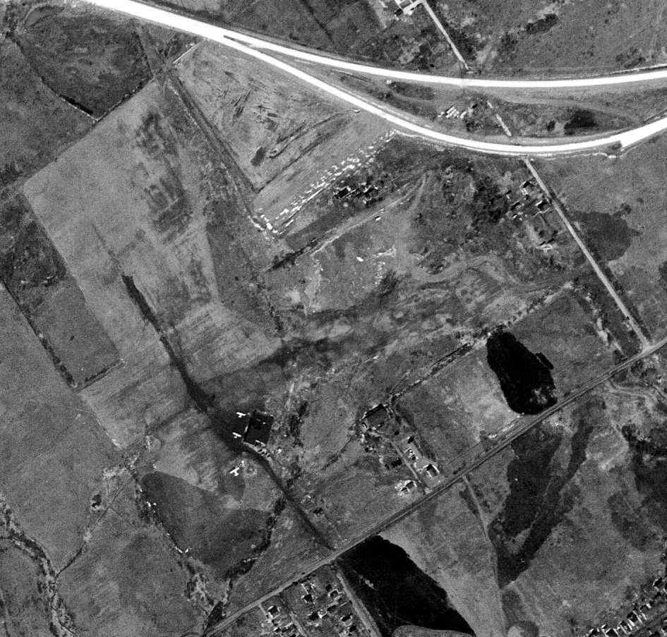
The last photo which has been located showing Buckman Airport while in use was a 3/11/53 USGS aerial view,
which depicted 3 light single-engine aircraft parked around the hangar.
The last aeronautical chart depiction which has been located of Buckman Airport
was on the January 1955 Washington Sectional Chart (courtesy of Mike Keefe).
It depicted Buckman as having an 1,800' unpaved runway.
Buckman Airport was evidently closed at some point in 1955,
as it was no longer depicted on the July 1955 Washington Sectional Chart.
Its closure was undoubtedly due to the construction of Interstate 95,
which was built along the northern edge of of the airfield property.
A 1958 aerial view still showed the hangar at Buckman, and the airfield area was still clear, but there was no sign of any active use.
A 1965 aerial view showed that Buckman's hangar had been removed at some point between 1958-65,
Two large buildings had been built just southeast of the former hangar location.
A 1970 aerial view showed that Interstate 95 had been built along the northern edge of of the airfield property at some point between 1965-70.
There were no aircraft present on the Buckman Airport site in a 2002 aerial photo.
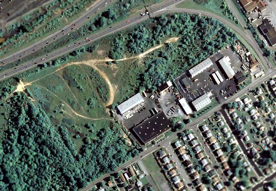
A June 2004 aerial photo shows that the majority of the Buckman Airport site remained clear, although no trace remained of the hangar.
Amazingly, close inspection of the photo will reveal a bright-red Lim-6 jet fighter (Polish-built version of the Soviet MiG-17) at the northeast corner of the photo.
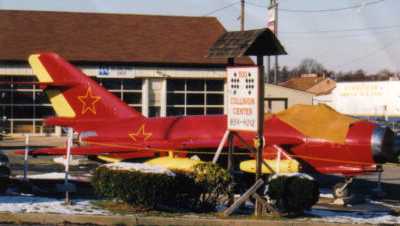
An undated photo by Brian Wenhold of the Lim-6 (Polish-built version of the Soviet MiG-17) which sits on the northeast corner of the site of Buckman Airport.
Brian reported in 2009, “An aircraft was spotted on the former Buckman Field.
Even though the rest of the airport seems to be missing or overgrown, this airport cannot help but attract another visitor.
I found out about the aircraft because it was purchased by a local businessman for an advertising publicity reasons.
The business is an auto garage/RV sales dealership. The aircraft comes from the Polish Air Force.
I was told that up to a few years ago the powerplant was operational & that it was occasionally fired up to entertain the neighbors.
The aircraft was on display at a local area business (advertising) and was repainted red but not well maintained so it's now quite faded.”
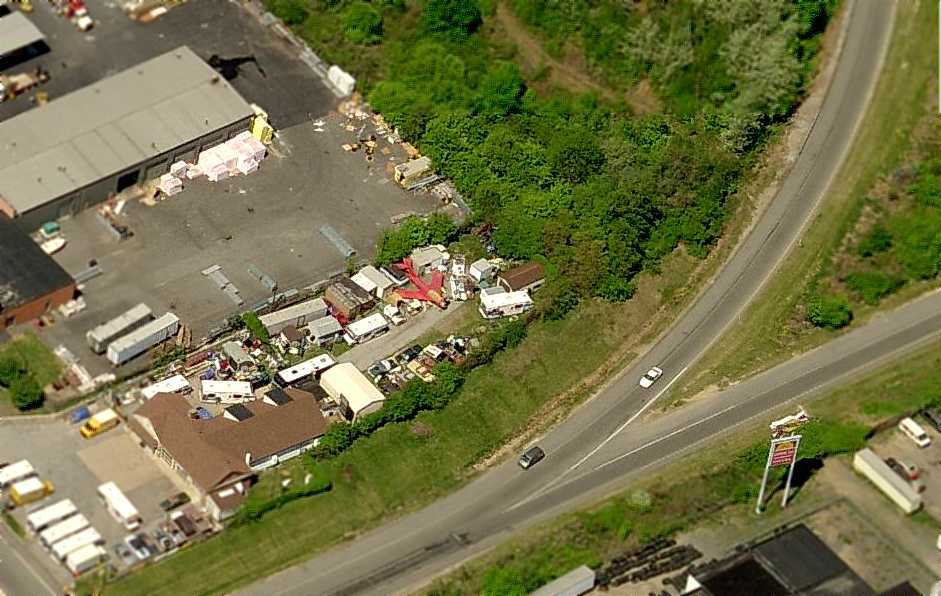
A circa 2007 aerial view looking west at the northeast corner of the former Buckman Airport property,
showing a bright-red Lim-6 jet fighter (Polish-built version of the Soviet MiG-17).
A 2008 photo still showed the red Lim-6 jet fighter on the former Buckman Airport property.
Micheal Denest recalled in 2008, “Long after this place closed,
there was a circular patch of ground left for us to fly radio-controlled model airplanes from.”
A 2009 photo showed the Lim-6 jet fighter had been removed from the Buckman Airport site, erasing the last aviation vestige of this former airport.
____________________________________________________
Platt-LePage Aircraft Factory, Eddystone, PA
39.86 North / 75.32 West (Southwest of Philadelphia International Airport, PA)
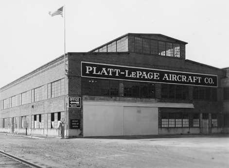
A circa 1941 photo of the Platt-LePage Aircraft Company factory, pictured during the early days of Platt-LePage's testing (courtesy of Jay Hendrickson of the Platt-LePage Aircraft Archives).
The suburban Philadelphia area can make a strong claim to being the birthplace of the American helicopter industry,
and one of the earliest helicopter firms in the area was the Platt-LePage Aircraft Company.
Dr. Laurence LePage was a pioneer rotary wing designer working with Harold Pitcairn, and later with Kellett Autogiro.
LePage designed the first line of autogiros, K-2, K-3, and K-4,
establishing Kellet as manufacturer of well-performing autogiros.
In 1935, due to the effects of the economic depression in the 1930s,
Laurence LePage left Kellett to become an independent engineer.
By 1935, LePage met & became partners with Haviland Platt,
a mechanical engineer & patent expert with a number of rotary wing patents.
They collaborated on a number of ideas for a helicopter, and then hearing of the early flights of the Focke FA-61,
they decided to investigate this promising development.
In 1938 Laurence LePage traveled to Germany to view the Focke Fw-61 helicopter,
and after much negotiation obtained an option to build Focke helicopters in the USA,
but the worsening conditions between the 2 governments prevented a deal going through.
In 1938, Platt & LePage formed The Platt-LePage Aircraft Company,
and proceeded on their own to design a helicopter based on their patents & ideas.
Design & construction was started on an experimental helicopter PL-1,
with Laurence LePage keeping the Air Corps informed of their progress during the early construction of their machine.
At this time there were no funds for the Air Corps to purchase a helicopter,
so the Platt-LePage design went forward as a private venture.
The Air Corps later held a competition for rotary winged aircraft,
and Platt-LePage redesigned the PL-1 to meet military needs & the design became known as the PL-3.
According to Jay Hendrickson (of the Platt-LePage Aircraft Archives), by 1940 Platt-LePage Aircraft Company
was located on the grounds of the former Baldwin Locomotive Works in Eddystone, PA.
Platt-LePage was "quite literally next to the Delaware river", on the river side of the old Industrial Highway near the old General Steel Plant.
A 1940 aerial photo showed what may have been a single hangar to the southeast of the former locomotive factory,
adjacent to a large grass field next to the river.
The building used by Platt-LePage was also the site of Baldwin's WW2 tank assembly works,
and the helicopters were test flown by the tank test course.
No airfield was depicted at this site on 1940/41/42/44 Washington Sectional Charts.
In 1940 the Platt-LePage Aircraft Company won the competition to build a helicopter designated XR-1.
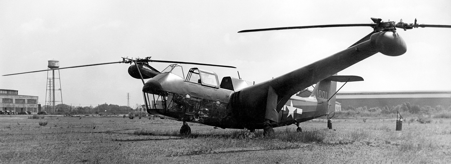
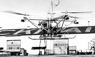
A circa 1941-46 photo of the Platt-LePage XR-1, 41-1, with the Platt-LePage plant visible in the background (along with the adjacent water tower marked “General Steel Castings”).
The first flight of the XR-1 took place in 1941. A number of teething problems developed with the control system,
causing delays in progress, along with test pilot Lou Leavitt refusing to fly the XR-1 in forward flight.
In 1943 Col. H.F. Gregory took the XR-1 up & proceeded to fly the XR-1 at speeds of up to 100 miles per hour,
and completed the first close course flight of the XR-1.
By the summer of 1943 the XR-1 was flying with much better control,
but the XR-1 was damaged due to the loss of a rotor blade, further slowing testing.
In 1943 the second model XR-1A made its first flight,
and was found to have better flying characteristics than the XR-1, numerous flight tests were carried out,
and by 1944 the XR-1A was flown from Eddystone, PA, to Wright Field, OH,
passing through a dangerous mountain pass & flying through a long stretch of bad weather,
during which the XR-1A encountered a grounded Sikorsky XR-4 along the way.
By August of 1944 rebuilt XR-1 was back in the air & slowly progress was made in solving the control problems.
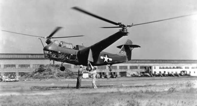
The Platt-LePage XR-1 hovering in 1944 (courtesy of Jay Hendrickson of the Platt-LePage Aircraft Archives).
But in March of 1945, just a few days after a new control system was installed that solved some the problems with longitudinal stability,
the Air Corps canceled all contracts with Platt-LePage, including 7 additional YR-1A helicopters that were to be built.
By this time the McDonnell Aircraft Company, which had invested in Platt-LePage Aircraft,
in exchange for having McDonnell personnel learn helicopter design,
had bought the rights to the PL-9 twin-engine twin-rotor design that became the McDonnell XHJD-1 Whirlaway,
the first twin engine helicopter to fly in the USA.
During this time period, Platt & LePage had proposed & patented the first tilt-rotor aircraft design in the US,
but the small size & lack of capital of Platt-LePage Aircraft,
along with lack of orders for military aircraft caused the Platt-LePage Aircraft Co. to shut down in 1946.
The McDonnell Aircraft Company obtained most of the helicopter patents from Platt-LePage during the liquidation of the company,
along with the personnel responsible for the twin engine project.
Robert Lichten, an ex-Platt-LePage engineer went to Bell Helicopter & developed the tilt-rotor idea into the XV-3.
One other notable designer came from Platt-LePage - a very young Frank Piasecki had his first helicopter design job at Platt-LePage,
before going off on his own, to a brilliant career as one of the great designers of helicopters.
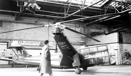
A 1947 photo of the Platt-LePage XR-1A, in the markings of Helicopter Air Transport.
According to Jay Hendrickson of the Platt-LePage Aircraft Archives, “The photo was at the Camden NJ Airport where HAT (Helicopter Air Transport) was located;
HAT had bought the XR-1A as part of a deal for a number of civil Platt-LePage helicopters
Both Platt-LePage & HAT would go out of business before the deal was concluded.
Ex PL-LP test pilot Lou Leavitt got the XR-1A flying, and the helicopter was sold to Frank Piasecki at HAT's bankruptcy sale
(Frank worked on the XR-1 at Platt-LePage early in his career).
The person walking in front of the XR-1A is an engineer from PL-LP, Alan Price, who did a great deal of design work at PL-LP.”
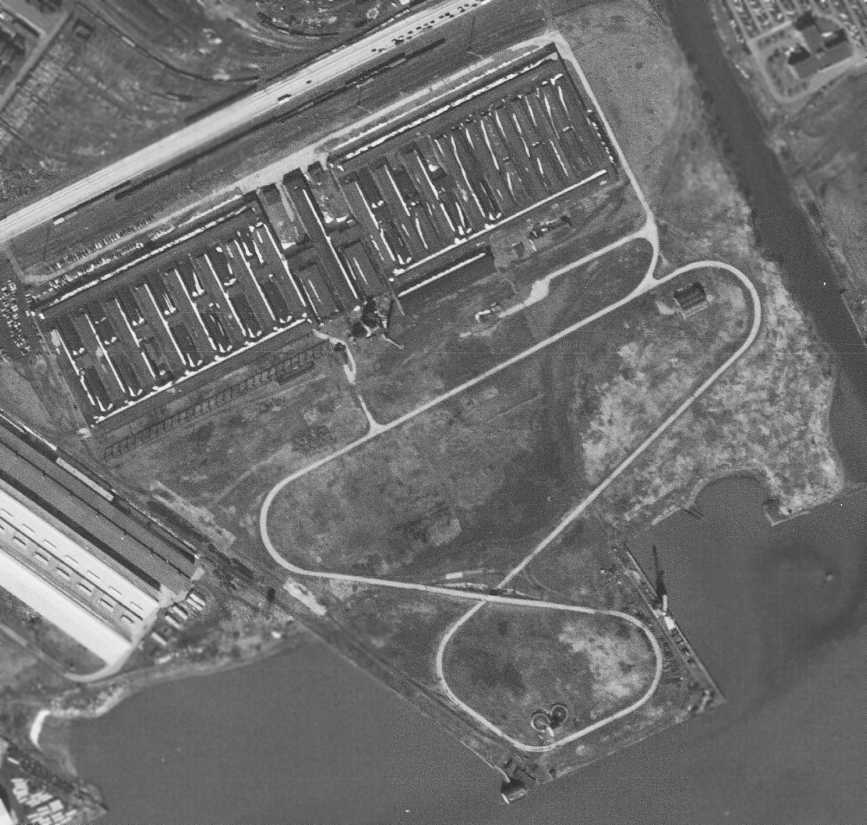
The last photo which has been located showing the former Platt-LePage facility still remaining intact was a 3/11/53 aerial photo.
What may have been a hangar was still located on the east side of the WW2-era tank test course.
The former Platt-LePage facility was evidently removed at some point between 1953-57,
as a 1957 aerial view showed the property having been cleared to make way for a powerplant which subsequently covered the site.
According to Jay Hendrickson, "Their location was in the area where PECO has their generating facility.
When PECO took over the area, all building were razed, so nothing remains.
A couple of longtime Eddystone residents confirmed this, as well as a surviving Platt-LePage engineer.
The Crum Creek or River separated the area between Platt-LePage & what was General Steel,
ironically Boeing took over the area once used by General Steel,
so Boeing & Platt-LePage were quite literally next to one another.
The area south of of the generating facility, that looks to be coal storage,
was where the (Baldwins) tank testing grounds were, this is were most of the flight tests were carried out,
where they were often right by the ship loading cranes seen in a number of hover tests (they often were right next to shore).”
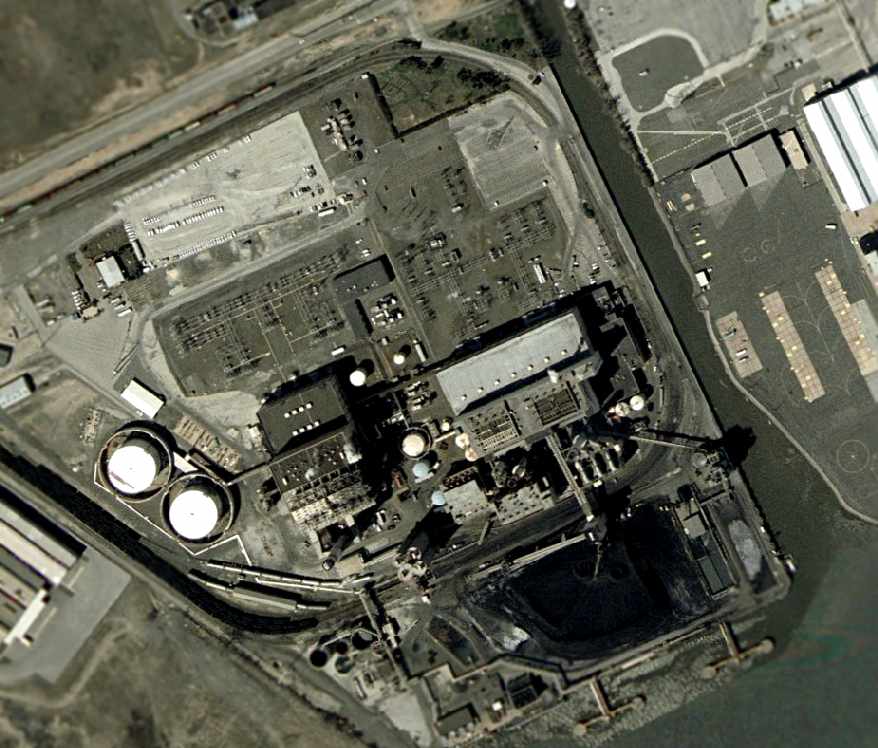
The 2005 USGS aerial photo of the site shows no evident remains of the former Platt-LePage facilities.
Ironically, note the extensive facilities of the Boeing Helicopter Company (home of the CH-47), just across the creek to the east.
The Platt-LePage site is located south of Industrial Highway, west of its intersection with Crum Creek,
adjacent to the west side of the present-day Boeing Helicopter factory.
See also:
http://www.aerofiles.com/_pl.html
http://www.helis.com/pioneers/f_plp.php
http://www.oldchesterpa.com/platt_lepage_aircraft_co.htm
____________________________________________________
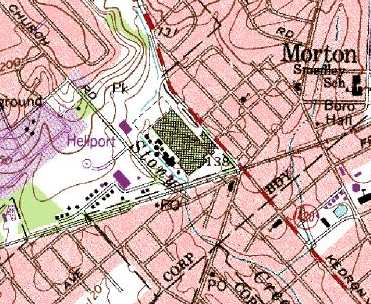
Piasecki Morton Factory Heliport, Morton, PA
39.91, -75.33 (Northwest of Philadelphia International Airport, PA)
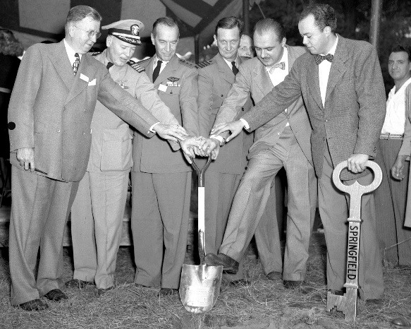
A Fall 1946 photo of the groundbreaking ceremony for the Piasecki Helicopter Corporation Morton factory.
The 1946 USGS topo map did not yet depict the Piasecki Morton factory.
A groundbreaking ceremony was held in Fall 1946 for the new Piasecki Helicopter Corporation Morton factory.
In 1947 Piasecki Helicopter Corporation moved from smaller facilities in Sharon Hill to a new manufacturing plant in Morton (according to Boeing).
A 1947 aerial view of the Piasecki Helicopter Corporation Morton factory.
The Piasecki Morton plant eventually consisted of a large factory, with a heliport west of the factory.
A control tower sat on top of the corner of the factory, overlooking the heliport.

An undated logo of the Piasecki Helicopter Corporation, Morton PA.
Jim Stahl recalled, “My father [Don Stahl] worked for Piasecki & then later for Boeing-Vertol.
My father's employee number was 007. My dad was probably hired in 1947 or 48.
He was working there when I was born in 1949.”
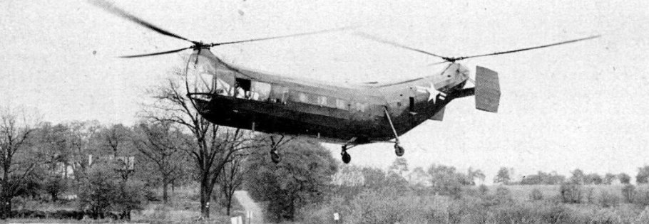
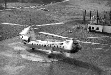
An undated photo of a Piasecki HUP helicopter flying low over their Morton facility (from a 1951 Popular Science article).
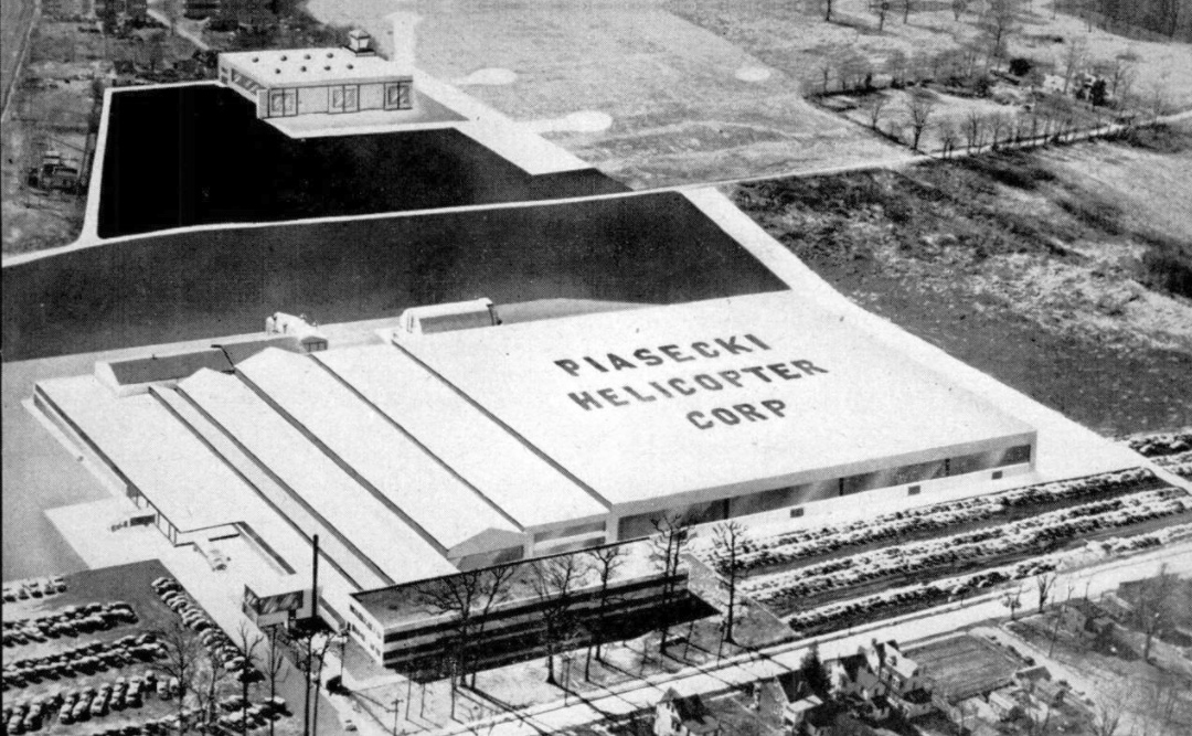
An artist's concept of the planned Piasecki Helicopter Corporation facility in Morton (from a 1951 Popular Science article),
showing a factory in the foreground, and a hangar with control tower & airfield with several landing spots in the background.
The first example of the tandem-rotor Piasecki PV-18 (later known as the HUP-1 Retriever) flew in 1952.
The larger tandem-rotor Piasecki PD-22 "Flying Banana" (later known as the H-21) first flew in 1953.
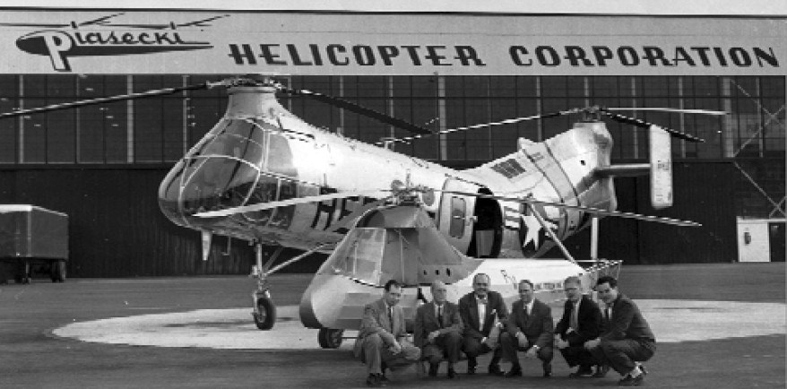
A 1953 photo commemorating the 10th anniversary of the Piasecki PV-2, with a Piasecki H-21 behind it, in front of the Morton Piasecki facility.
Pictured are Ken Meenen, Elliot Daland, Frank Piasecki, Don Meyers, Frank Mamrol, and Walt Swartz.
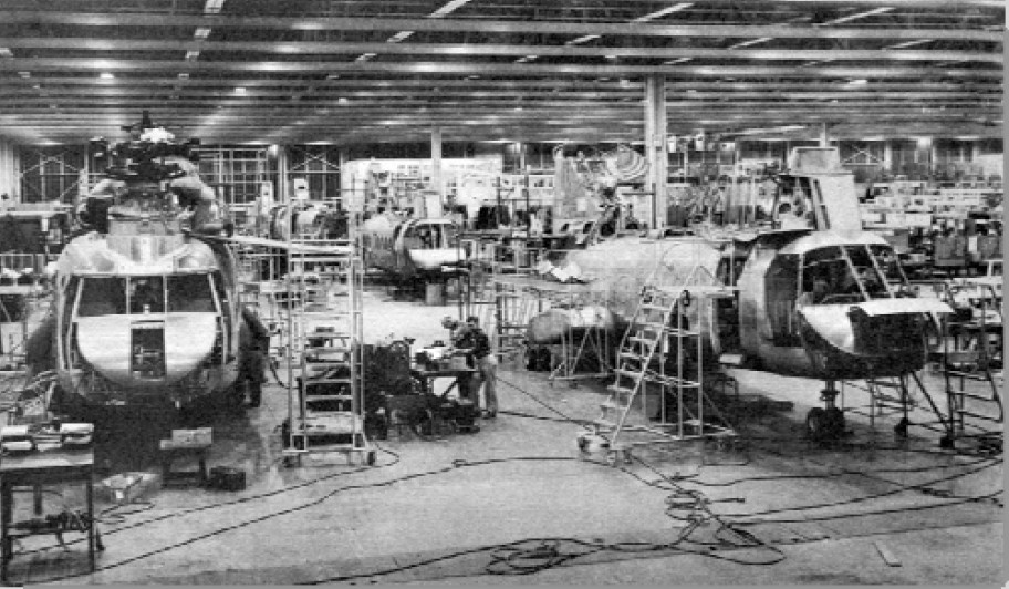
Two circa 1950s photos of Piasecki HUPs & H-21s in production in the Morton factory.
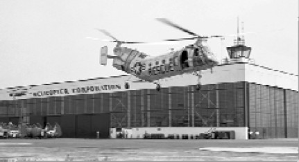
A circa 1950 photos of an Air Force rescue Piasecki H-21 flying in front of the Morton control tower.
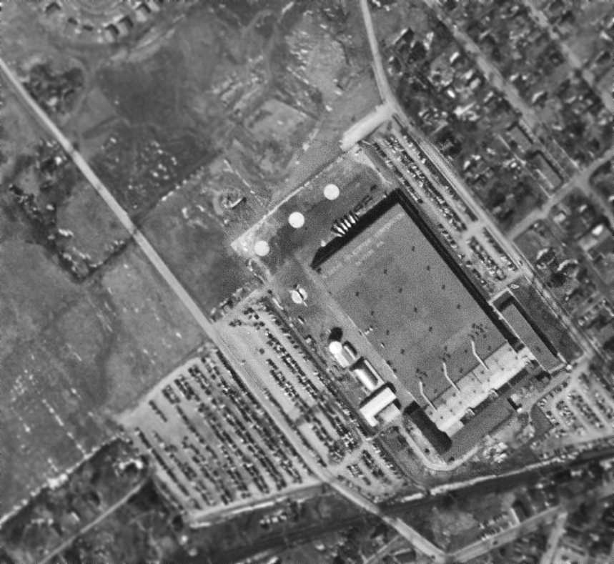
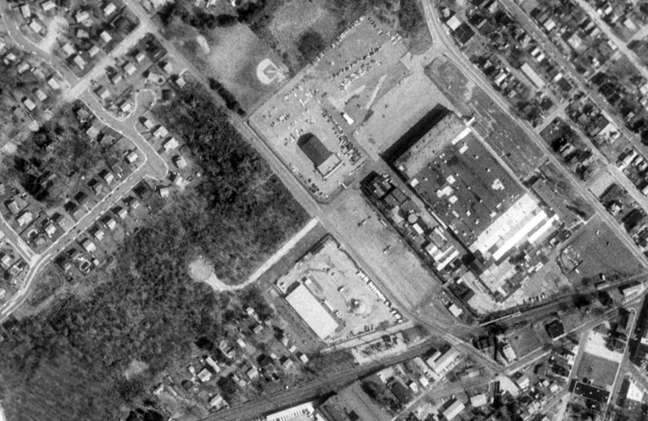
The earliest aerial photo which has been located of the Piasecki Morton facility was a 3/11/53 aerial view.
It depicted 4 helipads on the northwest side of the Piasecki factory, one of which had a helicopter parked on it.
“Piasecki Helicopter Company, Morton PA” was painted along the northwest side of the factory roof.
A 1953 photo of the huge Piasecki PV-15 / YH-16 Transporter, presumably taken at the Morton facility.
The YH-16 had 40 seats & was the world's largest helicopter.
According to Rich Kline (whose father in law worked for Frank Piasecki from the beginning),
"Frank would come out in the shop every day & talk to all the employees & knew all their families."
Additional manufacturing space was later acquired by renting 2 hangars at the nearby Philadelphia International Airport.
At the airport site, H-21 Shawnee fuselages were manufactured & completed H-21s were flight tested.
Company founder Frank Piasecki left the firm in 1955,
and established the Piasecki Aircraft Corporation at the Philadelphia International Airport.
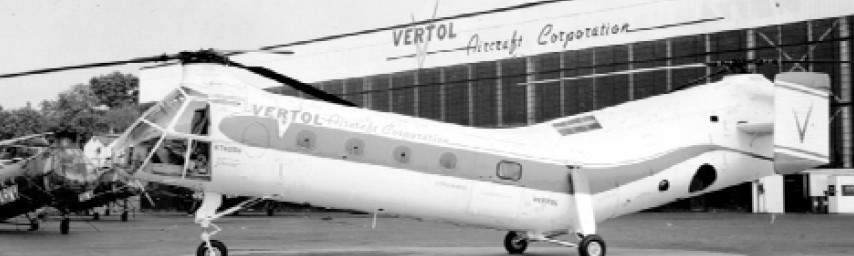
The company he founded was renamed Vertol Aircraft Company the following year.
Jim Stahl recalled, “As a child, I recall that Frank Piasecki used to have open houses for employees' families.
I recall him bringing antique cars into the hangars to display.
You could also tour the plant & climb into the helicopters.
At the one open house in 1955, we were allowed to climb into the massive Piasecki PV-15 / H-16 Transporter.
The big chopper had just set the speed record & the mood was festive.
Months later, it crashed, killing the test pilots.
Piasecki was up & down back in those days. My dad ended up leaving Piasecki. We moved to Tampa in 1956.”
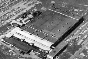
A 1956 aerial view of the Piasecki Morton plant.
Piasecki Helicopter Corporation was renamed Vertol Aircraft Company in 1956.

An undated logo of the Vertol Aircraft Corporation, Morton PA.
Lon recalled, “My earliest remembrance of the Morton facility is somewhere between 1956-58. We used to pass by the facility.
I remember that there were several WWII vintage propeller planes lined up in front of what would now be the entrance to BJ's & Forman Mills.
They were pretty small, blue, with the big star in circle, with some bars to the side. Obviously, they were not flown in there.”
The Piasecki company apparently established another facility in nearby Wilmington, DE in 1957,
as the former Bellanca Field was labeled "Piasecki" on the 1957 Washington Sectional Chart (courtesy of Chris Kennedy).
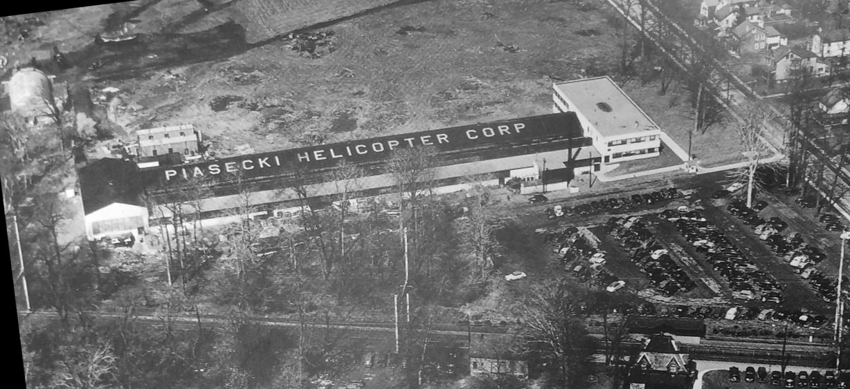
The maiden flight of the Piasecki PA-4 Sea Bat unmanned helicopter on 10/25/58, with a “Piasecki Aircraft” building in the background.
A 1958 aerial view depicted 4 helipads on the northwest side of the Piasecki factory.
The lettering painted on the northwest end of the factory roof had been changed to “Vertol Aircraft Corporation, Morton PA”.
A large open grass field to the west also was used for helicopter flight operations.
The earliest topo map depiction which has been located of the Piasecki Morton facility was on the 1958 USGS topo map.
Lon recalled, “My family moved to Forest Avenue; Our house was 0.4 mile from the tower.
Our house was one of 3 built in 1959.
I remember the big buildup of the Chinook activity started shortly after that.”
Vertol was acquired by Boeing in 1960, becoming known for many years as Boeing Vertol.

An undated logo of Boeing Helicopters, Vertol Division, Morton PA.
An undated photo of N74056, a Vertol 44C delivered in October 1960 to Russia in an executive transport configuration, in front of the Vertol Morton plant.
Jack Durant recalled, “I was employed by Boeing-Vertol in their Metallurgical Laboratory during a 6 month industrial work period as part of my Co-Op education at Drexel University in 1961.
They were building both the CH-46 Sea Knight & the CH-47 Chinook at that time.
Having served in the USMC I was somewhat more enthusiastic about expediting the testing of CH-46 components ahead of those for the CH-47.
It wasn't really a big deal just that unless I was told otherwise I would work the CH-46 before the CH-47 if they came in together.”
The Morton "Vertol Heliport" was listed in the 1962 AOPA Airport Directory,
which described it as consisting of a 1,000' x 300' dirt heliport.
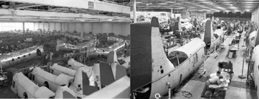
A circa 1960s photo of YCH-1B Chinooks & BV-107-II tandem helicopters under construction in the Vertol Morton plant.
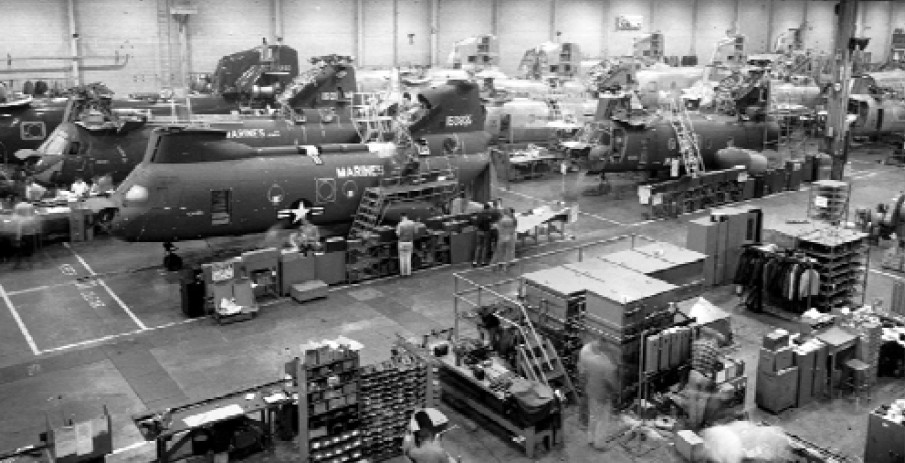
A circa 1960s photo of numerous tandem helicopters under construction in the Vertol Morton plant,
including CH-46A Sea Knights for the Marine Corps, CH-47A Chinooks for the Army, CH-113s for Canada, and HKP-4s for Sweden.
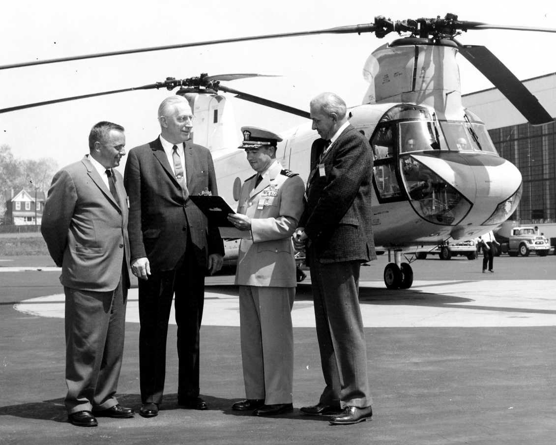
The last photo which has been located showing an aircraft at the Morton facility was a 4/27/62 photo
of an HC-1B Chinook being officially accepted by a member of the U.S. Government at the Morton manufacturing facility.
Amazingly, the Chinook is still in production (at Boeing's nearby Philadelphia plant) 54 years later.
In 1962, Boeing Vertol relocated to a newly-established, much larger development & manufacturing site along the Delaware River,
southwest of the Philadelphia International Airport, on property once occupied by a locomotive manufacturer.
The Morton plant was closed in the same year (according to Boeing).
Jim Stahl recalled, “We eventually moved back to Pennsylvania
and my dad went back to work for Piasecki's successor Vertol & then eventually Boeing-Vertol.
Vertol gave my father his original badge number from Piasecki – 007.
Boeing moved operations & test flights from the Morton facility in 1962.
But the [Morton] plant did not close however.
Parts & components continued to be manufactured at the site.”
Lon recalled, “I remember the big racket that the Chinooks created.
This started maybe in 1962, but no later than 1963,
because I remember my classes at Our Lady of Perpetual Help School being interrupted due to the noise.
My brother had a paper route from 1963-64.
We used to go home down Church Road, the back (West) side of the Vertol property.
Traffic was very heavy when the afternoon shift change happened at 4 or 4:30.
Traffic was also very heavy on PA 420 at the PRR (now SEPTA R-3).
That was prior to the automatic gates. There was a gate house with employees that controlled the gates.
In the afternoon, a Morton policeman directed traffic.”
A 1965 aerial view showed a circular helipad had been added to the west of the factory at some point between 1958-65.
Lon recalled, “I remember the mid-1960s & the Swarthmore College students coming by & protesting at Vertol.
A guy from my neighborhood was arrested for throwing eggs at them.
Boeing Vertol Morton had its own little union office right on Yale Avenue, across from what was then a Sinclair station.
The union hall was for AFL-CIO UAW, Vertol Boeing Local 1069.
I remember where the landing pad was, west of Church Road, south of Stewart Avenue. It was right next to a basketball court.
There were no houses on the south side of Stewart Avenue, and Millison Drive did not yet exist.
My brother remembers some aircraft being on the front lawn of the facility along PA 420.
I remember one summer day in the mid-1960s they had to move one of the Chinooks back to the Ridley facility through the streets.
I remember them going down Amosland Road. They had some long pole to push up the telephone lines crossing the road.”
Andrew Bisbing recalled, “Around late 1969-70-71 my father would take me to the circle pad West of Church Street behind the Boeing Vertol plant in Morton.
At that time quite a few control line [model aircraft] enthusiasts would gather there on the weekends. That old heli pad was appealing to them. It seeded my lifelong venture into model aviation.”
Lon recalled, “My recollection of the facility closing [was] in 1970.
For years afterward, I remember car dealerships along Baltimore Pike renting the parking lots for new car storage.”
According to the American Helicopter Society, on 2/2/71 the final production example of the CH-46F Sea Knight was rolled out of the Morton factory.
It was the last of approximately 2,000 helicopters produced by Piasecki, Vertol, and Boeing at the Morton plant from 1947-71.
A 7/5/71 aerial view of the Piasecki Morton facility, with the factory on the right.
At the center of the photo, west of the factory,
what appeared to be a paved taxiway led to a paved circular helipad or test facility.
A trail led to another more remote field to the west, perhaps used for other testing.
Jim Stahl recalled, “Parts & components continued to be manufactured at the site at least until 1971 or perhaps a little later.
I recall my father still working at that location & then eventually transferring to the Eddystone [Boeing Vertol] plant.
I worked right down the street from the facility back in the mid-1970s.
Boeing pulled out of the facility very gradually.
The hangar end of the building became a building supply store.
I believe it eventually became a Home Depot.”
Andrew Bisbing recalled, “In 1989-90 access to the heli pad was closed off [to model aircraft hobbyists] so instead I used the back parking lot over Church Street behind the plant
to learn & practice flying my first radio-controlled helicopter; it was isolated so I didn't draw much attention. Quite ironic since Piasecki started production there many years ago.”
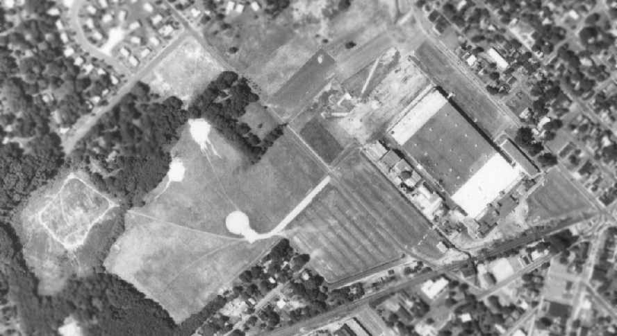
A 1992 USGS aerial view of the Piasecki Morton facility, with the factory on the right.
At the center of the photo, west of the factory, a paved circular helipad or test facility remained in the woods,
The "Heliport" west of the factory was still depicted on the 1998 USGS topo map.
As of the late 1990s, the former Piasecki factory building in Morton still existed,
with the control tower still atop one corner.
According to Rich Kline, the former Piasecki factory had been reused as a BJ's Wholesale Club.
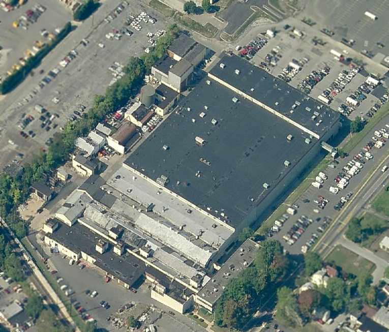
A circa 2006 aerial view looking west at the former Piasecki factory building,
showing the considerable amount of industrial infrastructure which remains at the site.
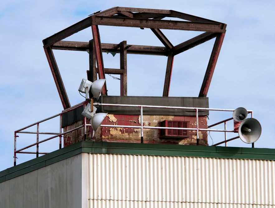
A January 2009 photo by Joe Burke, looking east at the control tower cab which still sits on top of the western corner of the former Piasecki factory building.
In contrast to the 2006 photo, only the steel frame of the tower cab remains, with the glass evidently having been removed at some point between 2006-2009.
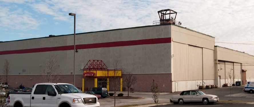
A January 2009 photo by Joe Burke, looking east at the control tower cab on top of the western corner of what is now the BJ's Wholesale Club building.
Surely this is the only BJ's Wholesale Club store with its own control tower!
Lon reported in 2010, “The tower is still there.”
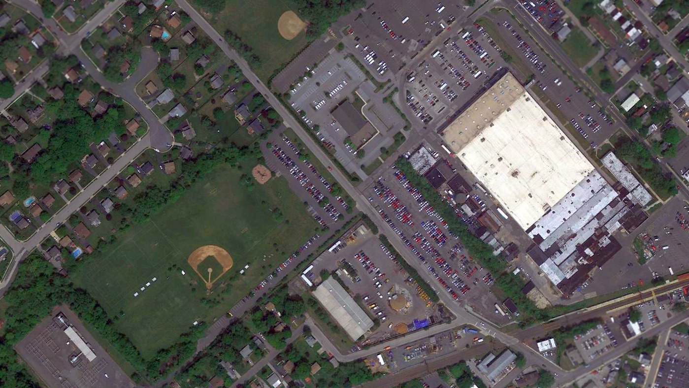
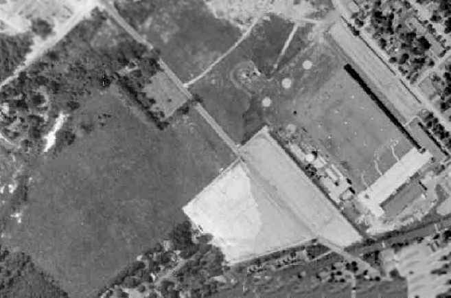
A 2016 aerial photo of the former Piasecki Morton factory & heliport shows the factory remains standing, but the heliport area to the west had been reused as a baseball field.
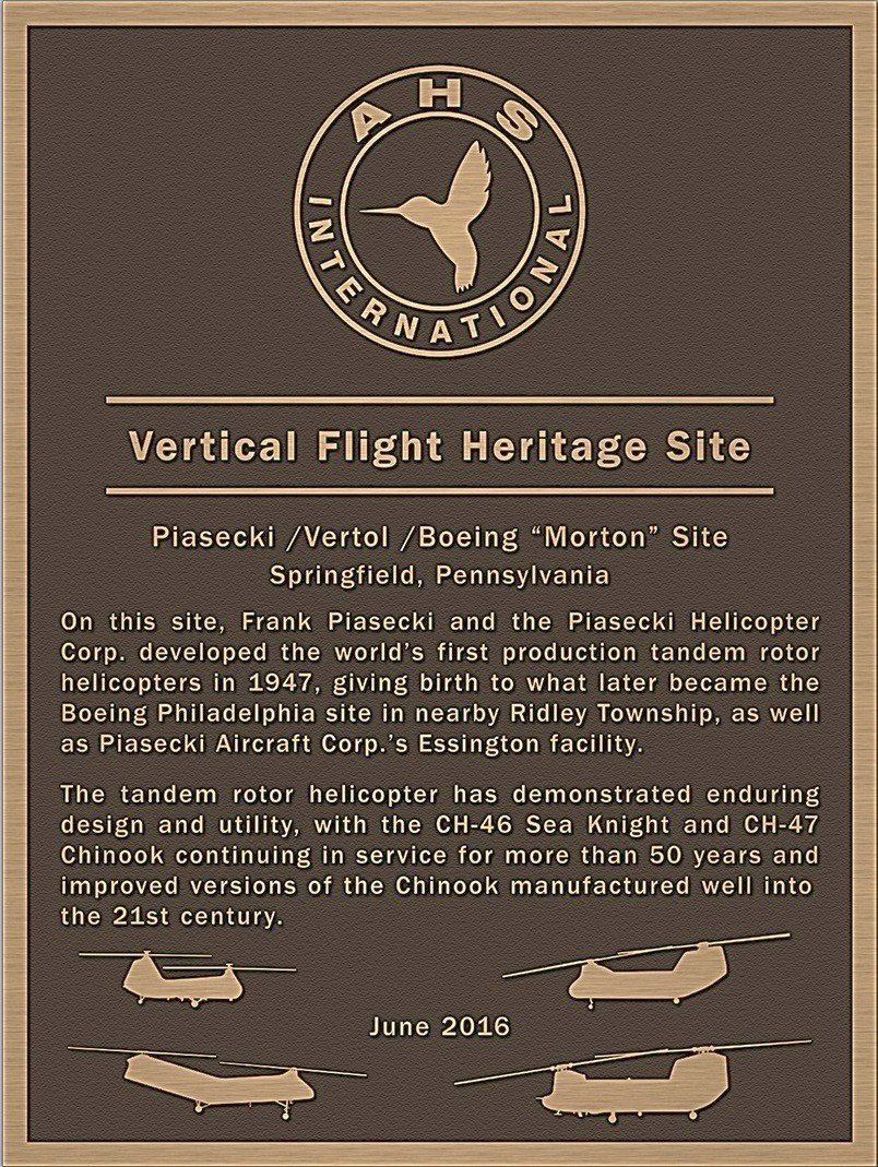
The 2016 historical marker commemorating the Piasecki Morton plant site as an American Helicopter Society Vertical Flight Heritage Site.
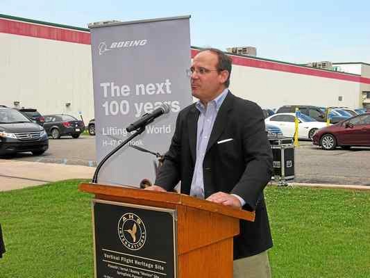
A 6/16/16 photo of John Piasecki, son of Piasecki Aircraft Corporation’s founder Frank Piasecki,
speaking at the dedication of a historical sign, with the former Morton Piasecki plant site in the background.
Ben King reported in 2017, “While shopping at BJ's (which used to be the old Piasecki factory), you can still see hangar doors & engine hoists.”
The former Piasecki Factory is located west of the intersection of Woodland Avenue & Yale Avenue.
____________________________________________________
Or if you prefer to contact me directly concerning a contribution (for a mailing address to send a check),
please contact me at: paulandterryfreeman@gmail.com
If you enjoy this web site, please support it with a financial contribution.
____________________________________________________
This site covers airfields in all 50 states.