Abandoned & Little-Known Airfields:
Pennsylvania: Allentown Area
© 2002, © 2025 by Paul Freeman. Revised 11/17/25.
This site covers airfields in all 50 states: Click here for the site's main menu.
____________________________________________________
Please consider a financial contribution to support the continued growth & operation of this site.
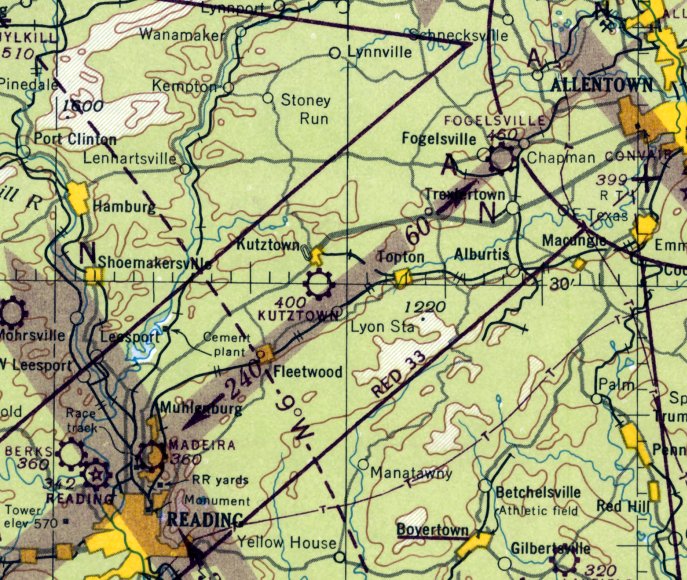
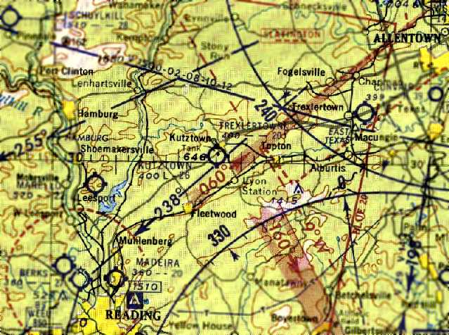
Barnesville Airport (revised 12/24/20) - Bedinsky Airfield (revised 11/17/25) - Berks Airport (revised 7/14/22) - Kutztown Airport (revised 10/23/22)
Madeira Flying Field (revised 7/7/19) - New Hanover Airport (revised 8/21/22) - Rich Airport / Buckwood Airport / Bethlehem Easton Airport (revised 10/13/22)
Schuylkill Airport (added 12/24/19) - Smiling Jack Airport (revised 12/24/20) - Sunnyrest Airfield (revised 11/17/25) - Trexlertown Airport (revised 11/17/25) - Whander Field (added 12/31/19)
____________________________________________________
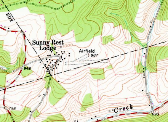
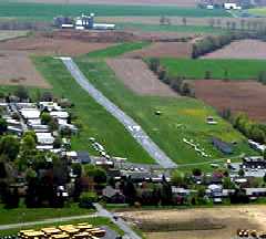
Sunnyrest Airfield (8PA8), Palmerton, PA
40.822, -75.646 (Northwest of Allentown, PA)
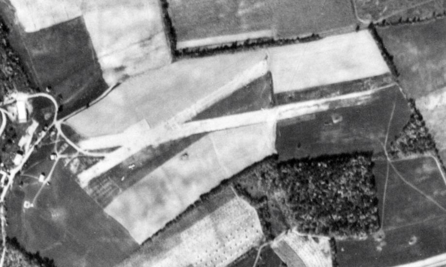
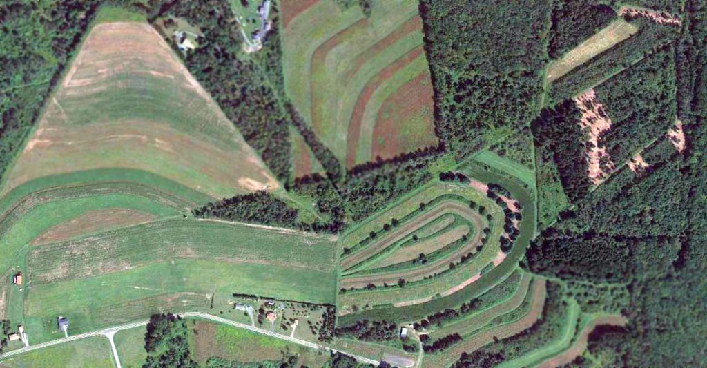
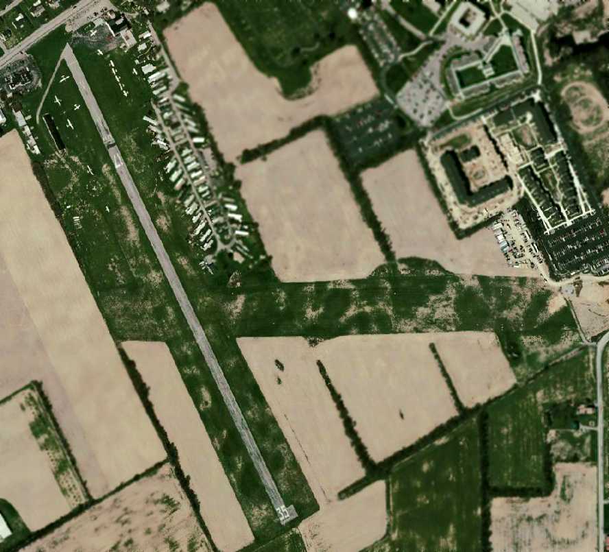
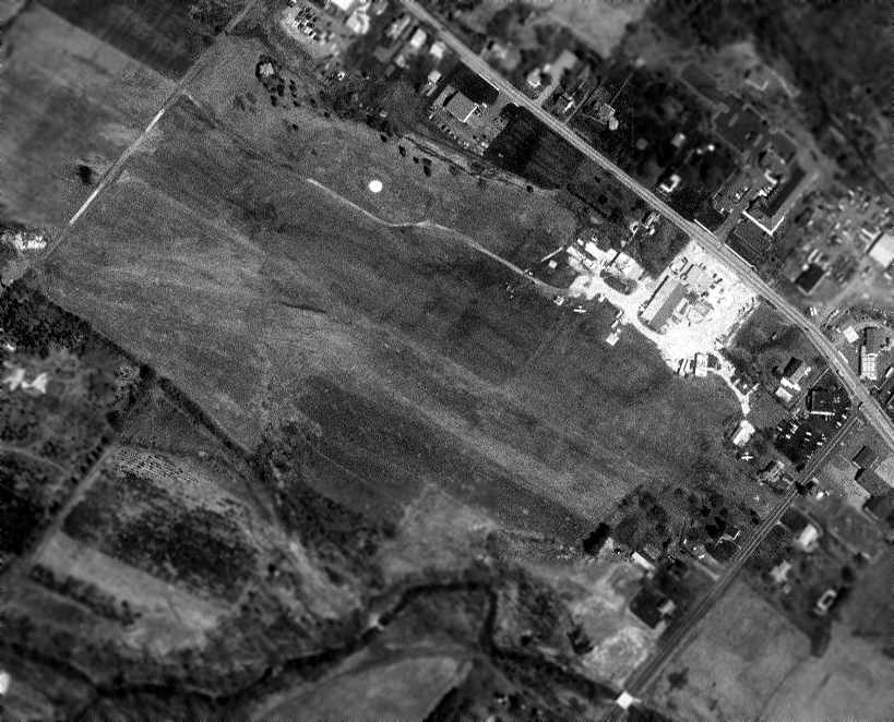
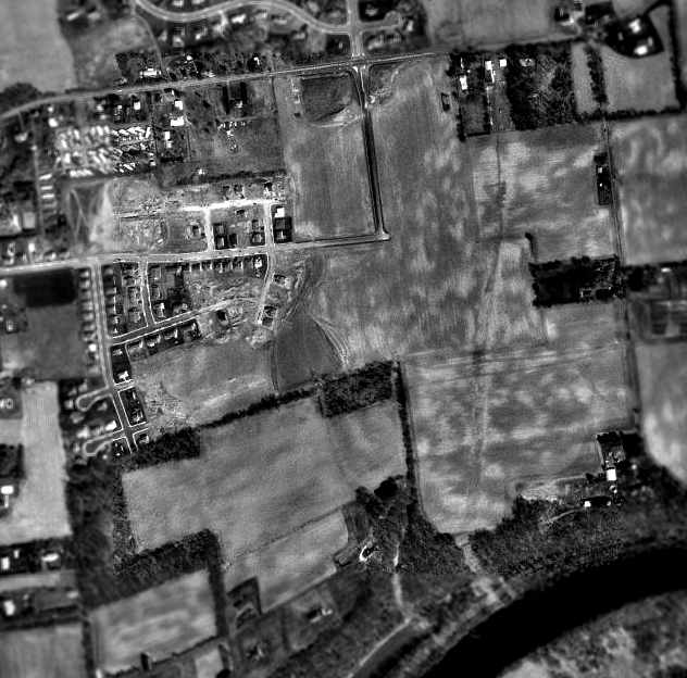
Sunnyrest Airfield, as depicted on a 10/21/50 aerial photo (from PennPilot).
The Sunny Rest Airfield was not yet depicted on a 10/4/38 aerial photo.
The Sunny Rest Resort was opened in 1945 as a nudist camp.
According to an article in the October 1950 Flying Magazine (courtesy of Andy Mudrak), in 1948 a general aviation pilot made a forced landing on a clearing at the resort,
which gave resort owners Reed & Zelda Suplee the idea to add an airfield to their facility.
The Suplee's friend Donald Johnson became Chairman of the Sunny Rest Airport Development Committee.
The new airport had its formal dedication on 5/13/50, after which Johnson conducted its first official landing.
The earliest depiction which has been located of Sunnyrest Airfield was a 10/21/50 aerial photo (from PennPilot),
which depicted 2 unpaved runways with one light single-engine aircraft parked on the southwest side.
No airfield was yet depicted at this location on the 1954 NY Sectional Chart.
The earliest aeronautical chart depiction which has been located of Sunnyrest Airfield was on the July 1955 NY Sectional Chart.
It depicted Sunnyrest as a private airfield having a mere 1,800' unpaved runway.
The last aeronautical chart depiction which has been located of Sunnyest Airfield was on the July 1960 NY Sectional Chart.
It depicted Sunnyrest as a private airfield having a 2,0800' unpaved runway.
Sunnyest Airfield evidently had a very short lifespan, and was evidently closed (for reasons unknown) at some point between 1960-61,
as it was no longer depicted on the 1961 NY Sectional Chart.
The earliest topo map depiction which has been located of Sunnyrest Airfield was on the 1970 USGS topo map.
It depicted 2 short unpaved runways, generically labeled “Airfield”.
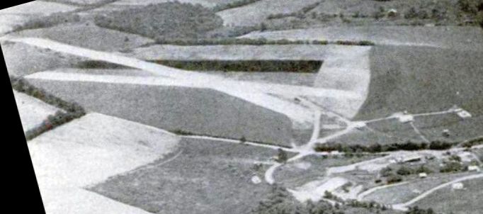
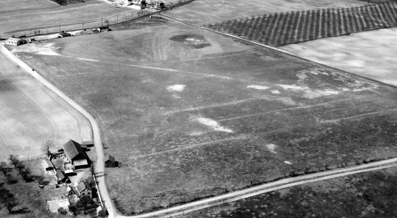
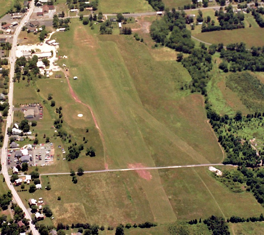
A 1970 aerial view depicted Sunnyrest to have 2 short unpaved runways, with but no aircraft or other signs of recent aviation use.
According to FAA Airport/Facility Directory data, Sunny Rest Airport was reopened in January 1974,
owned by Halsie Bowers & managed by Michael Mesher.
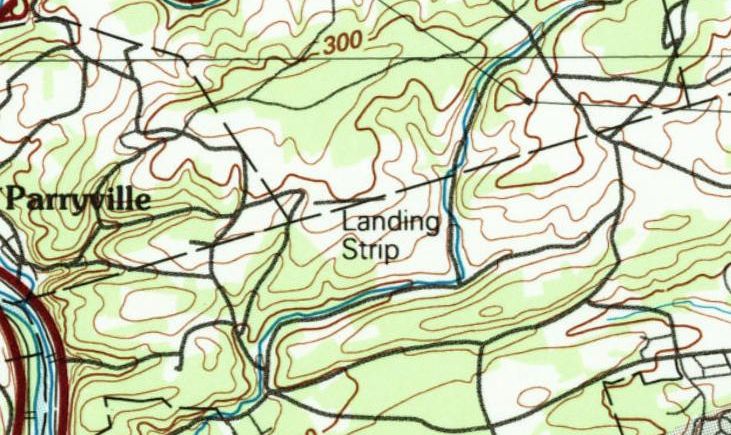
The 1984 USGS topo map depicted Sunnyrest Airfield as a single east/west runway, generically labeled “Landing Strip”.
A 1981 aerial view depicted the 2 Sunnyrest Airfield runways as remaining clear, but with no sign of recent aviation use.
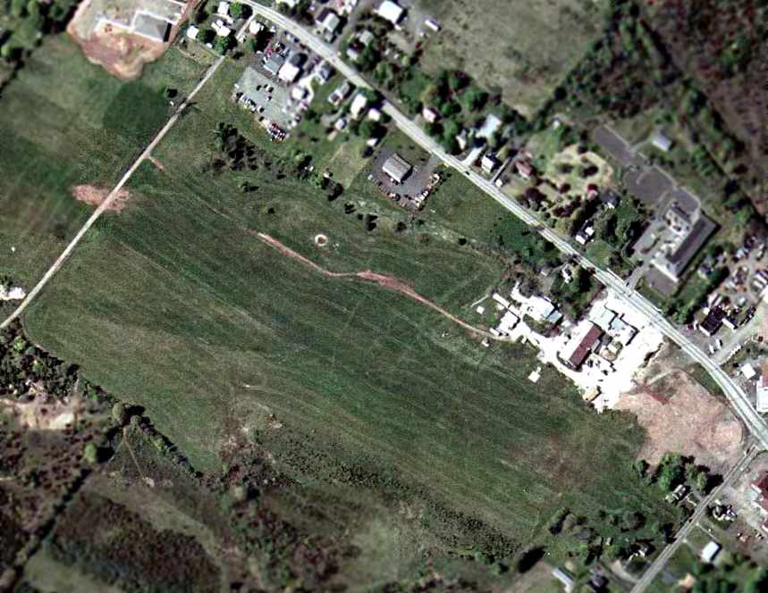
A 1992 aerial view showed that trailers had been situated along the former Sunnyrest Airfield runways.
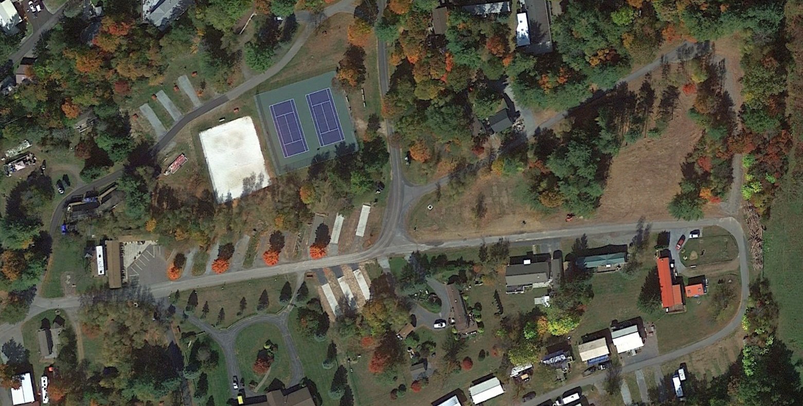
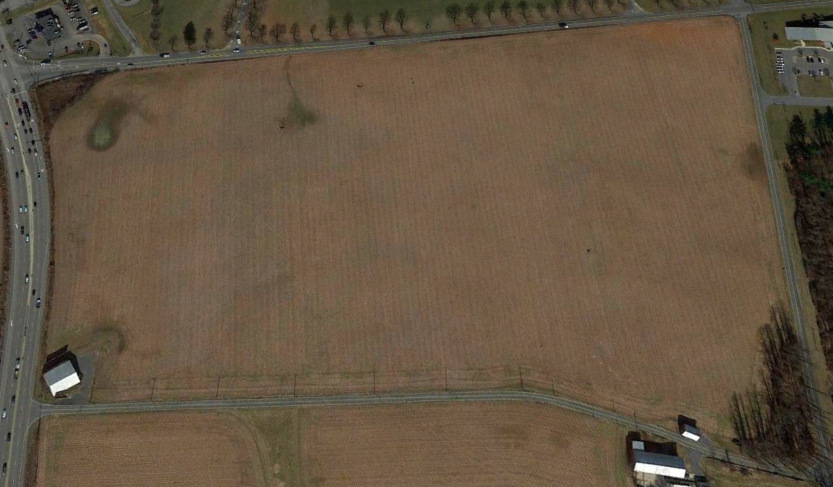
A 2022 aerial view showed the 2 Sunnyrest Airfield runways having been reused as streets, with the site no longer recognizable as a former airfield.
As of 2025, Sunny Rest Airport continues to be listed with the FAA as a private use airfield, but “Closed at present time for repairs.”
Given that the former runway has been covered with trailers for over 30 years, its continued listing with the FAA is very inappropriate.
The former Sunnyrest Airfield runway is now known as Airport Road, appropriately enough.
____________________________________________________
40.439, -75.943 (West of Allentown, PA)
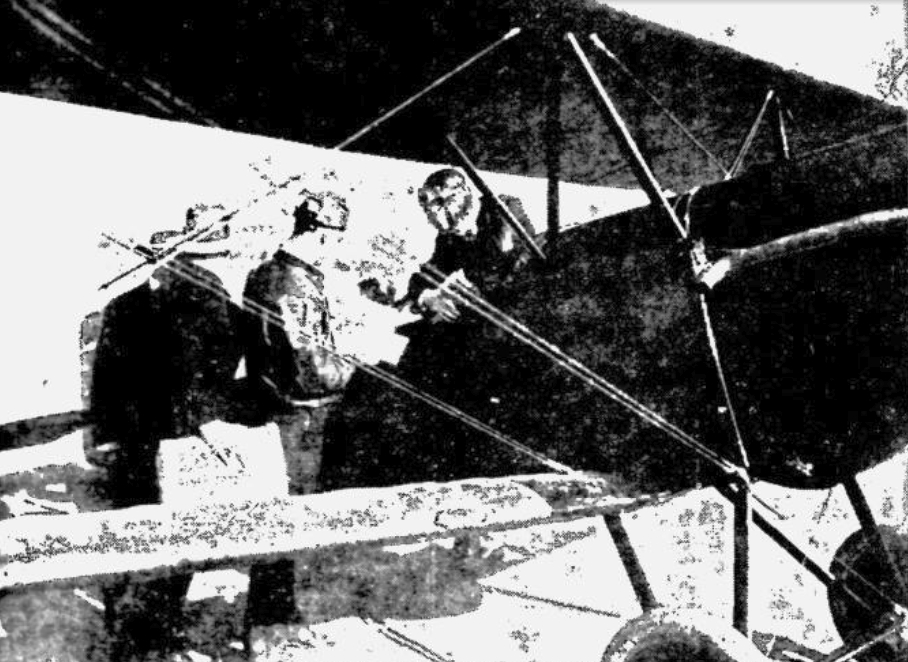
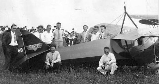
A 10/30/27 photo of multiple biplanes at Whander Airport's dedication (courtesy of Andrew Price).
According to the Berks History Center (courtesy of Andrew Price), “Reading's first airport to be managed by a company chartered for commercial flying was Whander Field.
The chartered company was Reading Airways, which was also the first company in Pennsylvania to receive a charter for commercial flying.
On 8/16/27 an application for a charter for Reading Airways was made by former Judge Edgar Richardson
on behalf of Allen Owen (President), F. H. Suender (Treasurer), and Russel Suender.
The amount of capital stock set forth in the charter application was $25,000.
The objects & purposes of the corporation were “maintaining & operating a commercial flying service
and transporting freight, passengers, baggage, mail & express by airplane,
and in connection therewith to purchase, lease, construct, equip, own, maintain & operate landing fields & hangars,
and to do all things incidental to said business & pertaining thereto.”
In the petition Allen Owen stated that he had purchased 3 airplanes from Pitcairn Aviation, Inc., of Philadelphia.
The planes, he said, were manufactured in April & September of 1927 and were powered by 100 HP Curtiss Ox-5 “Willy’s-Morrow” engines.
Two of the planes were Pitcairn PA-3s, and one was a Pitcairn PA-4, all biplanes.
Owen stated in the petition that he had spent $7,000 in the erection of a hangar,
and that the Aviation Committee of the Reading Chamber of Commerce was active in encouraging the enterprise,
and that the city of Reading had by ordinance provided for an Airport Commission.
Whander Field was dedicated on 10/30/27.
A 10/30/27 photo of airmail being loaded on a biplane at Whander Airport (courtesy of Andrew Price).
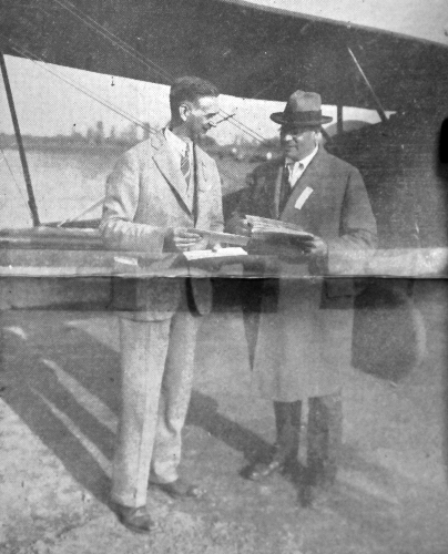
A 1927 photo of officials receiving Berks County's first batch of Air Mail at Whander Field (courtesy of Andrew Price).
According to the Berks History Center (courtesy of Andrew Price), That there was interest in aviation in Reading & Berks County
was indicated in the operating statement of Reading Airways for the 2-month period from 6/1/28-7/31/28.
During that period the gross revenue from airplane operations amounted to $3,844.
This revenue, according to the statement, came from 539 sightseeing flights, special flights, long-distance flights, student courses & miscellaneous instruction.
The following year, however, there were changes of names & ownerships.
Curtiss Airports Corporation was at that time interested in the purchasing & operating of various flying fields & companies.
Thus it was that Reading Airways sold its charter to Curtiss Airports Corporation, and Reading Airways came to be known as Eastern Air Transport, Inc.
Then on 12/7/29, Eastern Air Transport sold its assets at Whander Field to William Ham & Adam Spatz.
Because the old Reading Airways name had disappeared when it was changed to Eastern Air Transport,
it was possible for the new company to receive a charter under the name of Reading Airways.
The charter was received early in 1930.
Meanwhile, Eastern Air Transport had transferred its sphere of operation from Whander Field to the Atlantic Coast regions.
Some years later the operation of Whander Field was taken over by Richard Estler & Brooks McElroy.
The earliest aeronautical chart depiction which has been located of Whander Field was on the August 1932 NY Sectional Chart.
It depicted Whander as a commercial/municipal airport.
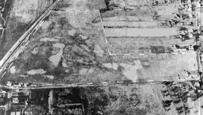
A 1937 aerial view looking west (courtesy of Andrew Price) depicted Whander Field as having a hangar & 2 smaller buildings on the west side of a grass airfield.
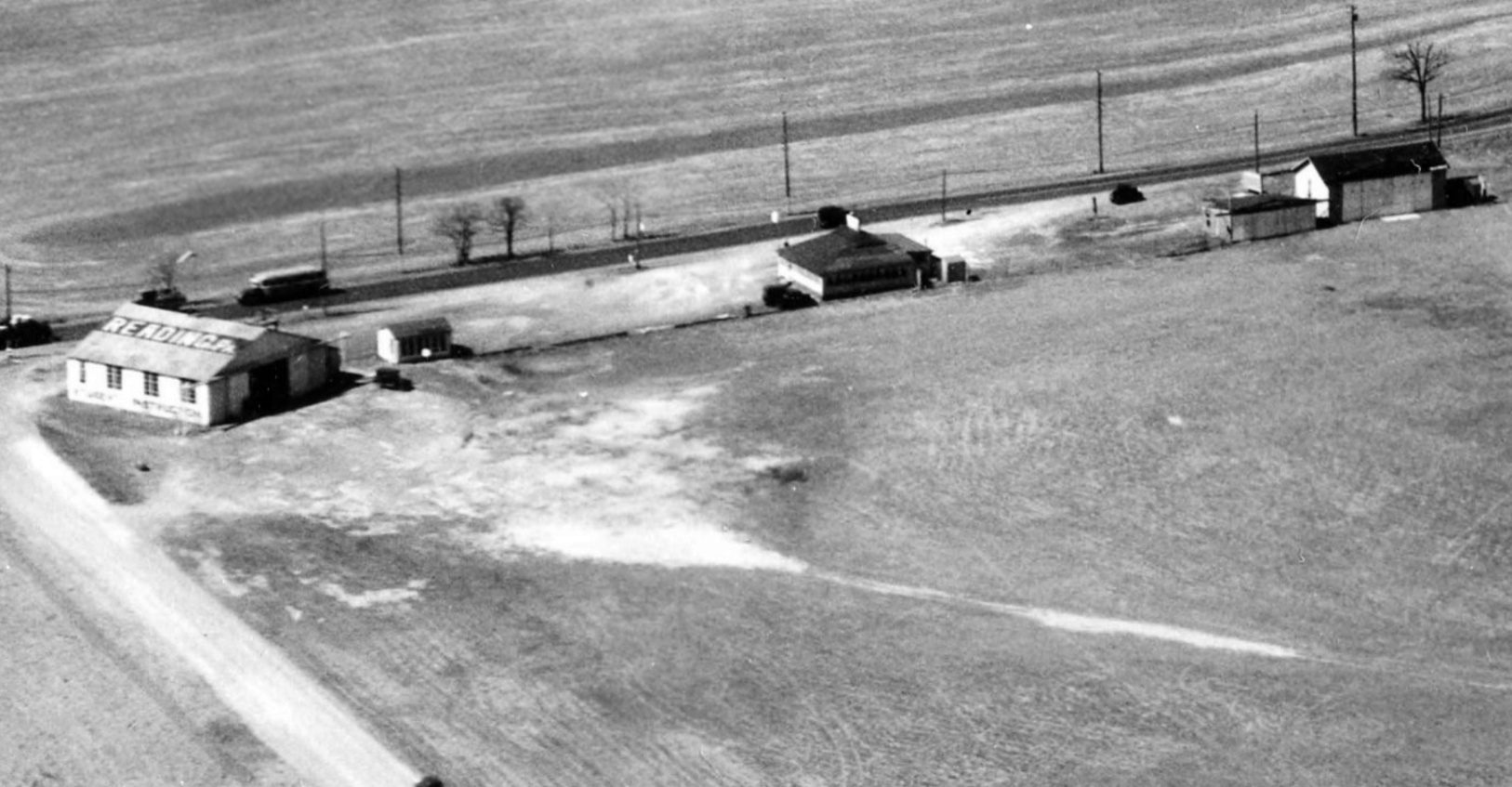
A closeup from the 1937 aerial view looking west at Whander Field (courtesy of Andrew Price) showed a hangar marked with “Reading PA” on its roof, and 2 smaller buildings on the west side.
A 9/14/37 aerial view depicted Whander Field as having a hangar & 2 smaller buildings on the west side of a grass airfield.
The last aeronautical chart depiction which has been located of Whander Field was on the November 1942 NY Sectional Chart.
It depicted Whander as a commercial/municipal airport.
Whander Field was evidently closed (for reasons unknown) at some point between 1942-43,
as it was no longer depicted on the May 1943 NY Sectional Chart.
Whander Field was not depicted on the 1944 USGS topo map.
According to Andrew Price, Whander Field “was still operating for recreational flying maybe up until the 1960s.”
However, it was no longer depicted on aeronautical charts or topo maps from the 1950s/60s.
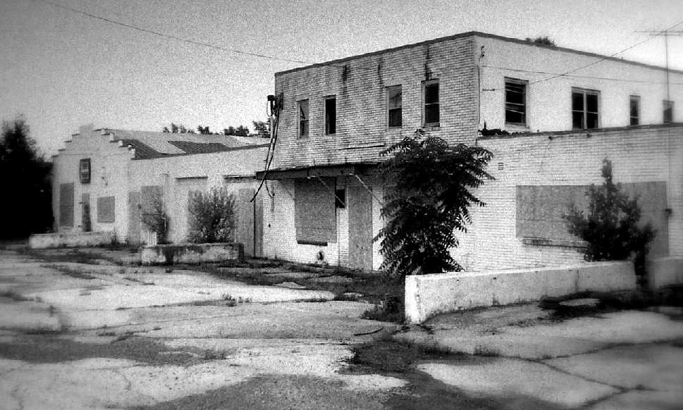
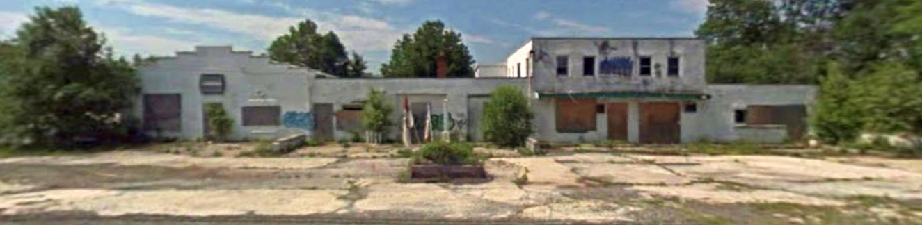
A 2018 photo looking east showed the Whander Field hangar remained standing, more than 7 decades after the airport closed.
A 2018 aerial view looking northwest showed the site of Whander Field remained clear, and the hangar remained on the west side.
Thanks to Andrew Price for pointing out this airfield.
____________________________________________________
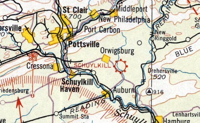
Schuylkill Airport, Orwigsburg, PA
40.638, -76.064 (West of Allentown, PA)
Schuylkill Airport, as depicted on the April 1933 NY Sectional Chart (courtesy of Lee Corbin).
The date of establishment of this early general aviation airport has not been determined.
The earliest depiction which has been located of Schuylkill Airport was on the April 1933 NY Sectional Chart (courtesy of Lee Corbin).
The earliest photo which has been located of Schuylkill Airport was a 9/25/38 USGS aerial view.
It depicted Schuylkill Airport as having a grass northwest/southeast runway.
One light single-engine aircraft was visible parked near 3 T-hangars on the north side, and another aircraft was visible on the center of the airfield.
The 1944 USGS topo map depicted Schuylkill Airport as a northwest/southeast property outline,
generically labeled as “Landing Field”, with a few small buildings on the northeast side.
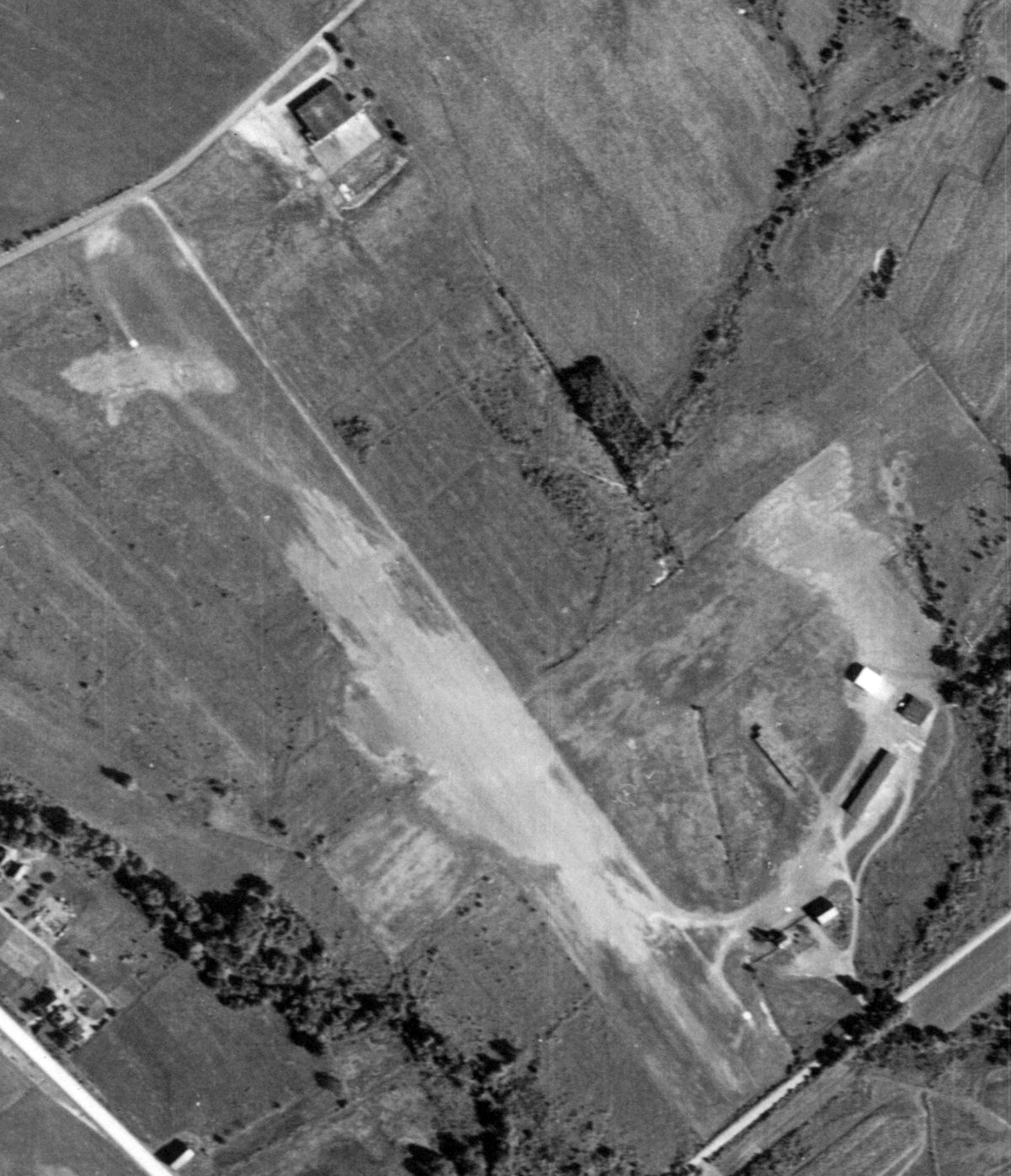
A 9/23/58 USGS aerial view depicted Schuylkill Airport as having a grass northwest/southeast runway.
A single larger hangar had replaced the 3 T-hangars on the north side at some point between 1938-58,
but there were no aircraft visible on the field.
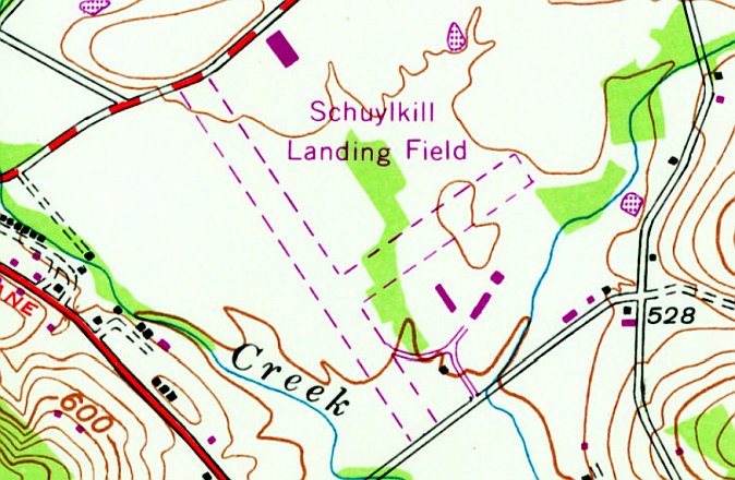
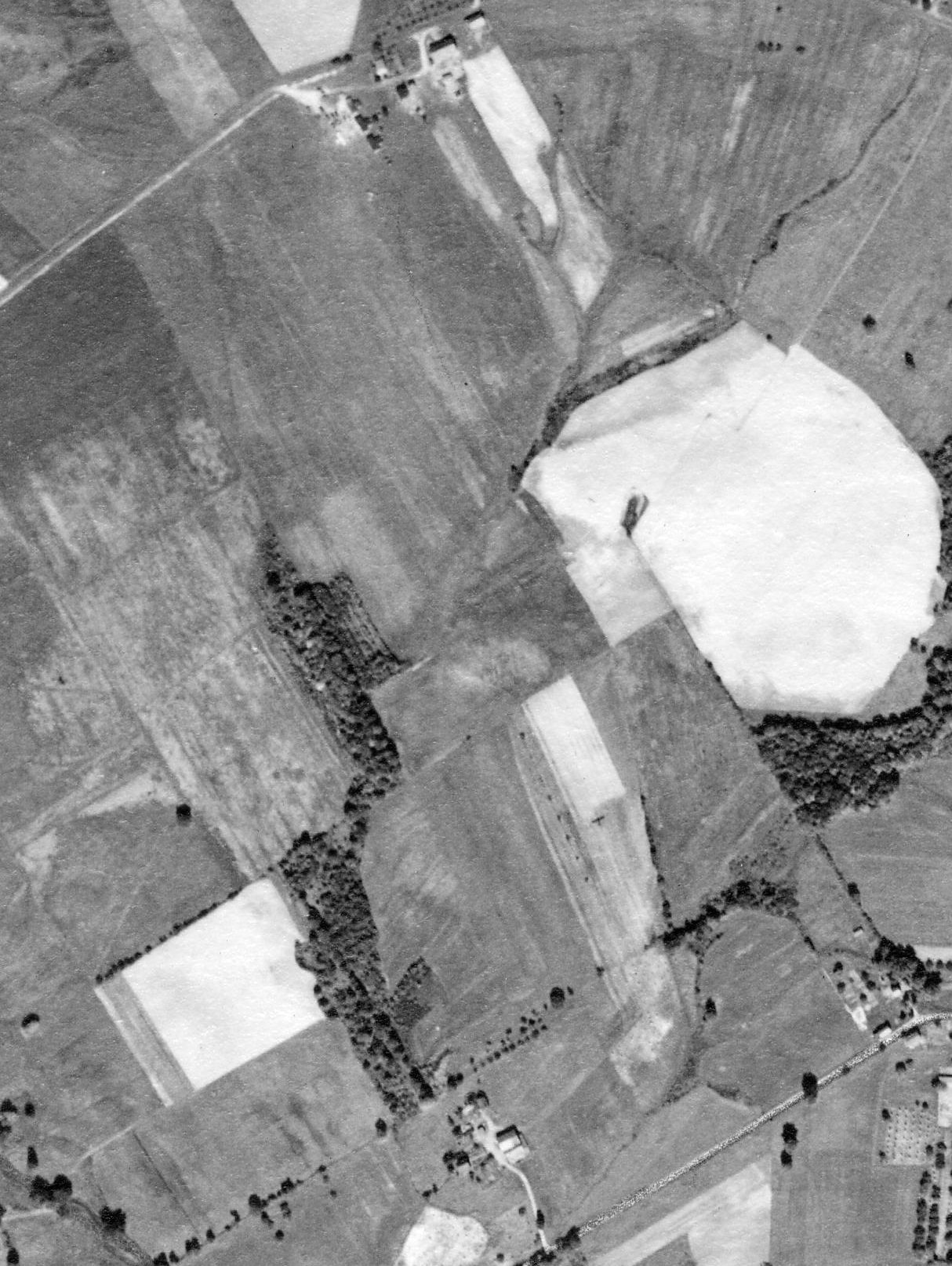
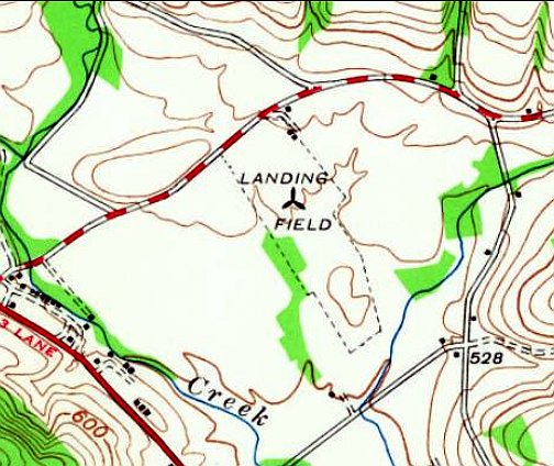
The 1968 USGS topo map depicted “Schuylkill Landing Field” as having 2 perpendicular unpaved runways & several buildings on the east side.
The last depiction which has been located of Schuylkill Airport was on the June 1973 NY Sectional Chart (courtesy of Ron Plante).
It depicted Schuylkill Airport as having a 2,800' unpaved runway.
Schuylkill Airport was evidently closed (for reasons unknown) at some point between 1973-79,
as it was no longer depicted on the December 1979 NY Sectional Chart (courtesy of Ron Plante).
The 1984 USGS topo map depicted “Schuylkill Landing Field” as having a northwest/southeast runway.
The 1999 USGS topo map no longer depicted Schuylkill Airport, but instead depicted several buildings which had been built over the site.
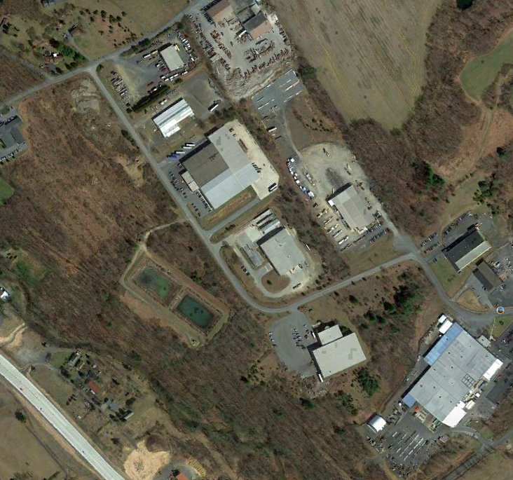
A 2016 aerial view showed several buildings covering the site of Schuylkill Airport.
Thanks to Lee Corbin for pointing out this airfield.
____________________________________________________
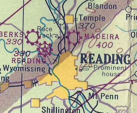
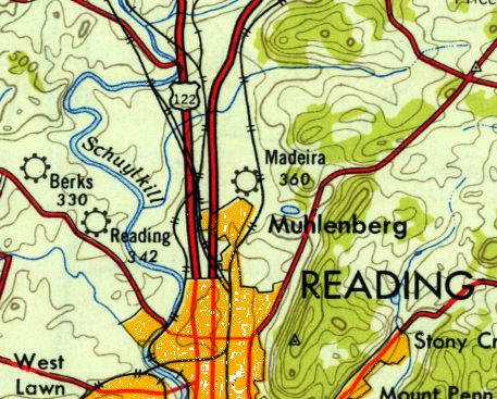
Madeira Flying Field, Reading, PA
40.38, -75.92 (West of Philadelphia, PA)
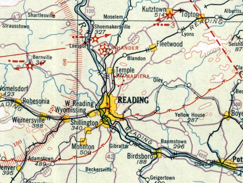
Madiera Field [sic], as depicted on the August 1932 NY Sectional Chart.
According to an article in the 5/7/09 Reading Eagle, “In the 1920s, a farmer named Charles Madeira
allowed pilots to land on his property near Kutztown Road & the road that later became the 5th Street Highway.
Over time, the landing site grew in popularity, with pilots building hangars & improving the 2 grass runways. It became known as Madeira Field.
It wasn't Berks County's first airport, but it played an important role in local aviation history,
said John Cianci, a Muhlenberg resident who has studied Berks County's early flying days.
The Reading Aero Club used the field as its base of operations for a time, and many pilots got their start in flying at Madeira, Cianci said.
The field was never used for commercial flights, but it was popular for sightseeing tours & flying lessons.”
The earliest depiction which has been located of Madeira Field was on the August 1932 NY Sectional Chart.
Note that this chart apparently misspelled the airport's name as “Madiera”.
The earliest photo which has been located of Madeira Field was a 1935 photo of an Aeronca "Flying Bathtub" with members of the Goodwill Air Service & Flying School.
According to the 1939 dedication program of Reading Airport, “Madeira Flying Field was host to many visiting airmen.
After a number of years the field was enlarged, hangars were erected & other improvements carried out.
With the arrival in Reading of Eddie Nibur, an excellent aviator of considerable experience,
Madeira Field ceased being just a barnstormer’s haven & became a commercial port for chartered flights & student instruction.
This field is still in operation, its services having recently been increased by the addition of a new plane.”
A 11/27/42 aerial view looking north from the 1945 AAF Airfield Directory (courtesy of Scott Murdock)
depicted Madeira Flying Field as being an L-shaped grass field with a few small buildings on the southwest & southeast sides.
The May 1943 NY Sectional Chart (courtesy of Michael Floriani) depicted Madeira as a commercial/municipal airport.
The 1945 AAF Airfield Directory (courtesy of Scott Murdock) described Madeira Flying Field
as a 42 acre L-shaped property having an all-way sod landing area measuring 2,000' east/west.
The field was said to have 6 wood & metal hangars, the largest measuring 76' x 40'.
Madeira was described as being owned & operated by private interests.
According to the article in the 5/7/09 Reading Eagle, “After World War II, more pilots began renting space at the larger Reading Regional Airport,
causing a slow decline at Madeira Field, Cianci said.”
"This went from birth to death just like the Kutztown Airport," said Robert Compton, who also has studied local aviation.
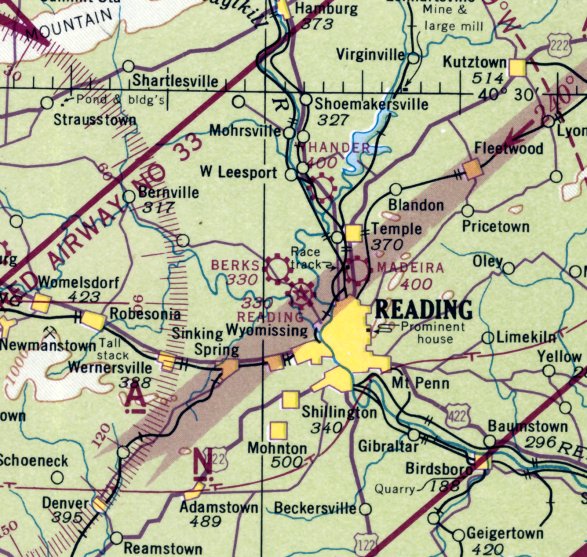
Madeira Field, as depicted on the 1949 USGS topo map.
The last depiction which has been located of Madeira Field was on the January 1960 NY Sectional Chart. It depicted Madeira as having a 2,000' unpaved runway.
Madeira Field was evidently closed at some point between 1960-65, as it was no longer depicted on the April 1965 NY Sectional Chart.
According to the article in the 5/7/09 Reading Eagle, “In 1967, Madeira Field was sold, and the land became a strip mall. When it closed, it was the oldest airport in Berks County.
Nowadays, the commercial strip that extends from Kmart to the Redner's Warehouse Market was once a hub of aviation.
That grass field is long gone. Hangars are just a memory, and there's no hint that small planes ever buzzed the skies over Muhlenberg. Madeira Field is a memory.”
"There's a lot of history there," Cianci said. "People pass by & have no idea."”
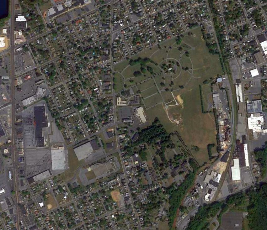
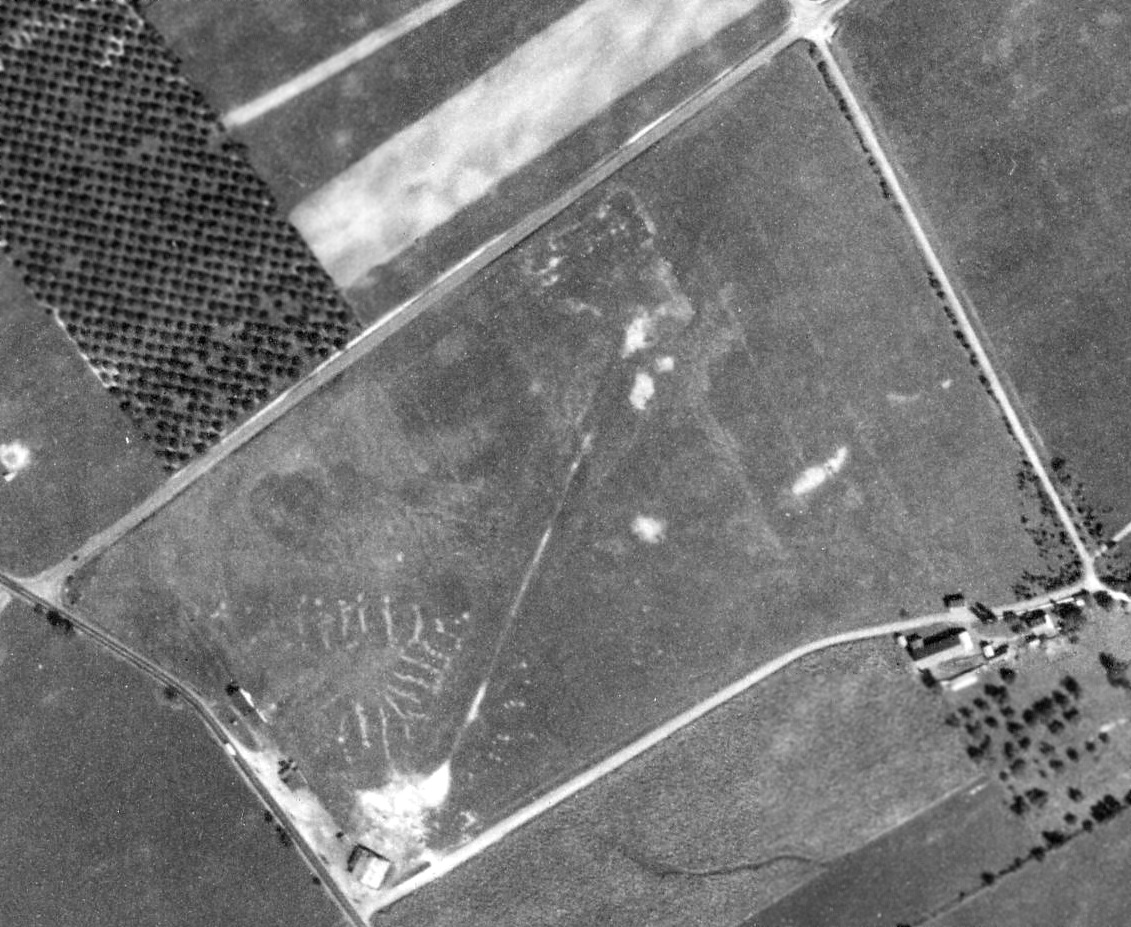
A 2015 aerial view showed no trace remaining of Madeira Field.
The site of Madeira Field is located northeast of the intersection of Route 222 & George Street.
____________________________________________________
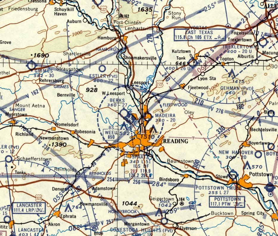
40.39, -75.99 (West of Philadelphia, PA)
Berks Airport, as depicted on the March 1942 NY Sectional Chart.
According to the dedication program of Reading Airport, “The Berks Airport, situated in Bern township a short distance beyond Reading Municipal Airport,
was laid out by a group of local flyers” in 1938.
However, Berks Airport was not yet depicted on the March 1940 NY Sectional Chart.
The earliest depiction which has been located of Berks Airport was on the March 1942 NY Sectional Chart.
Note the odd proximity of the larger Reading Airport, less than a half-mile to the southeast.
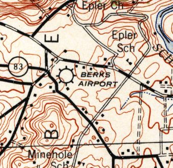
The 1944 USGS topo map depicted Berks Airport as having several buildings along the north side.
The 1945 AAF Airfield Directory (courtesy of Scott Murdock) described Berks Airport
as a 47 acre irregularly-shaped property having an all-way sod landing area measuring 1,800' east/west.
The field was said to have 5 hangars, the largest measuring 70' x 35'.
Berks Airport was described as being owned & operated by private interests.
Berks Airport, as depicted on the 1949 USGS topo map.
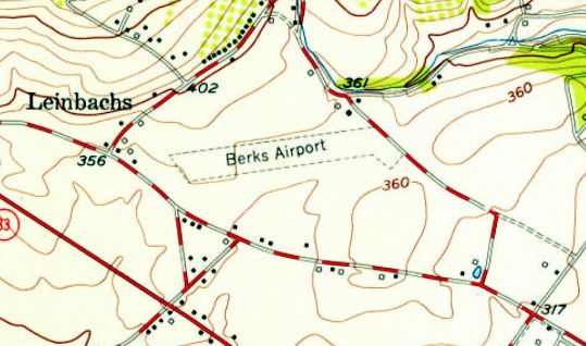
The 1956 USGS topo map depicted Berks Airport as consisting of an unpaved northeast/southeast runway, with 3 small buildings along the northeast side.
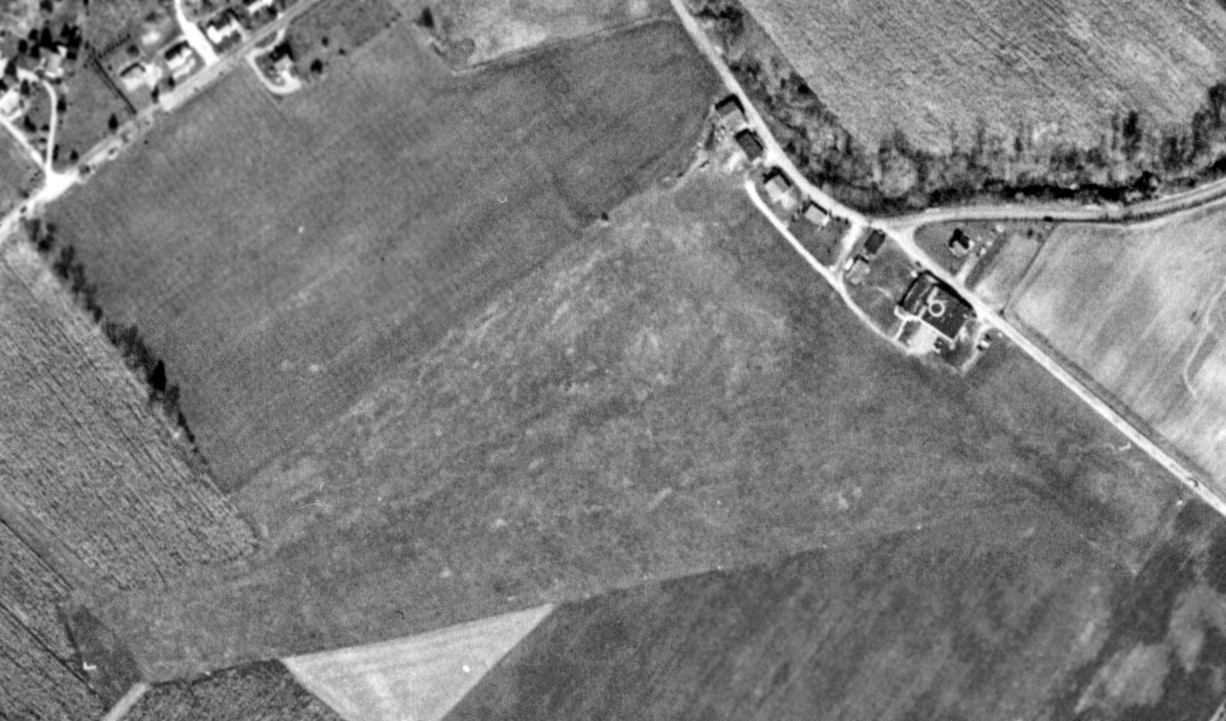
The earliest photo to be located of Berks Airport was a 10/31/58 USGS aerial view.
Although the runway remained clear & several hangars remained on the northeast side, there were no aircraft visible on the field or other indication of recent aviation use.
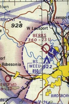
The last aeronautical chart depiction which has been located of Berks Airport was on the 1967 NY Sectional Chart.
It depicted Berks as having a 2,300' unpaved runway.
Berks Airport was evidently closed (for reasons unknown) at some point between 1967-68, as it was no longer depicted on the October 1968 NY Sectional Chart.
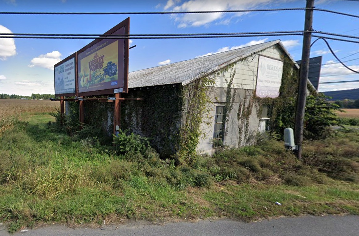
A circa 2010 aerial view looking west showed the distinctive arch roof of the 60+ year old hangar which remains on the northeast side of the Berks Airport property,
with 2 more recent additions built onto its southern & western sides.
A 2013 aerial view showed that the majority of the Berks Airport runway site remained clear, and one former hangar remained standing on the northeast side of the property.

An August 2019 photo looking south at the distinctive arch roof of the 65+ year old hangar which remains on the northeast side of the Berks Airport property.
As of 2015, street maps labeled the former Berks Airport hangar as the facility of Malsnee Tile & Stone.
The site of Berks Airport is located west of the intersection of Stinson Drive & Old Airport Road, appropriately enough.
____________________________________________________
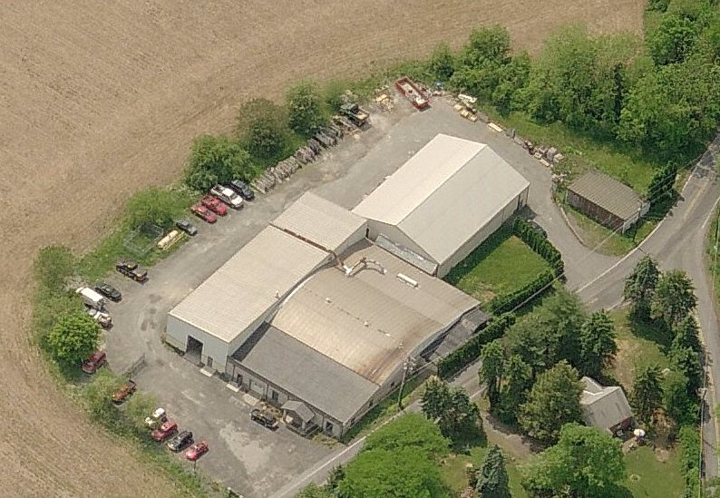
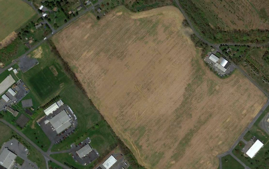
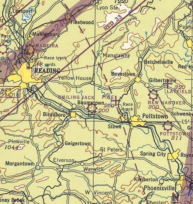
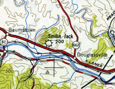
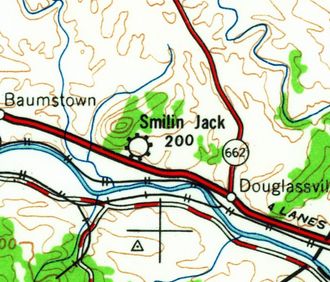
Smiling Jack Airport, Douglassville, PA
40.27, -75.75 (Southwest of Allentown, PA)
Smiling Jack Airport, as depicted on the November 1942 NY Sectional Chart.
Smiling Jack Airport was not yet depicted on the March 1942 NY Sectional Chart.
This short-lived little general aviation airport was “established in August 1942” (according to the Amity Township 300th Anniversary, courtesy of Benjamin Swearingen).
That would prove to be very unfortunate timing, as many small civilian airports near the coasts were eventually closed during WW2.
The article said the airport was “on the farm of William Schmale, bounded by [Airport] road & Route 422.
Smiling Jack Airport came into being through a ban on private flying in a corridor along the east coast of the U.S. during WW2.”
Smiling Jack Airport was opened on 9/9/42 (according to a newspaper article courtesy of Benjamin Swearingen).
Smiling Jack Airport was evidently named after the popular aviation-themed comic strip of the 1940s.
“There were about 20 light aircraft kept at this airport along with a shop & hangar for 6 planes” (according to the Amity Township 300th Anniversary, courtesy of Benjamin Swearingen).
The earliest depiction which has been located of Smiling Jack Airport was on the November 1942 NY Sectional Chart.
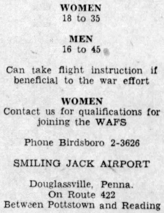
A circa 1942-45 advertisement for flight instruction beneficial to the war effort offered at Smiling Jack Airport (courtesy of Benjamin Swearingen).
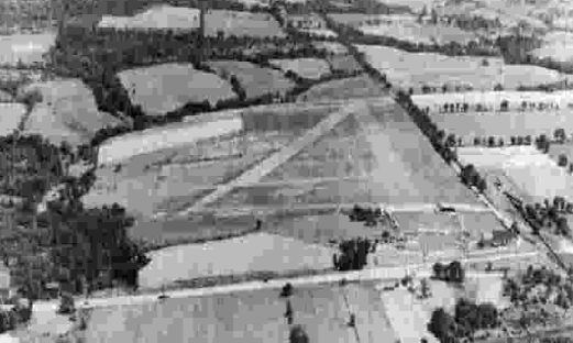
The earliest photo to be located of Smiling Jack Airport was a circa 1943-45 aerial view looking north from the 1945 AAF Airfield Directory (courtesy of Scott Murdock).
It depicted Smilin' Jack Airport as having 2 or 3 grass runways.
The 1945 AAF Airfield Directory (courtesy of Scott Murdock) described Smilin' Jack Airport
as a 60 acre triangular property having an all-way sod landing area measuring 2,400' northeast/southwest.
The field was said to have 2 metal & wood hangars, the largest measuring 90' x 42'.
Smilin' Jack Airport was described as being owned & operated by private interests.
The last aeronautical chart depiction which has been located of Smiling Jack Airport was on the January 1945 NY Sectional Chart (courtesy of Ron Plante).
Smiling Jack Airport “was vacated in 1946” (according to the Amity Township 300th Anniversary, courtesy of Benjamin Swearingen),
which was odd timing – it seemingly missed out on the post-WW2 boom in U.S. general aviation.
The 1949 USGS topo map depicted Smilin Jack as a commercial/municipal airport.
Smiling Jack Airport was no longer depicted on the July 1949 NY Sectional Chart (courtesy of Ron Plante).
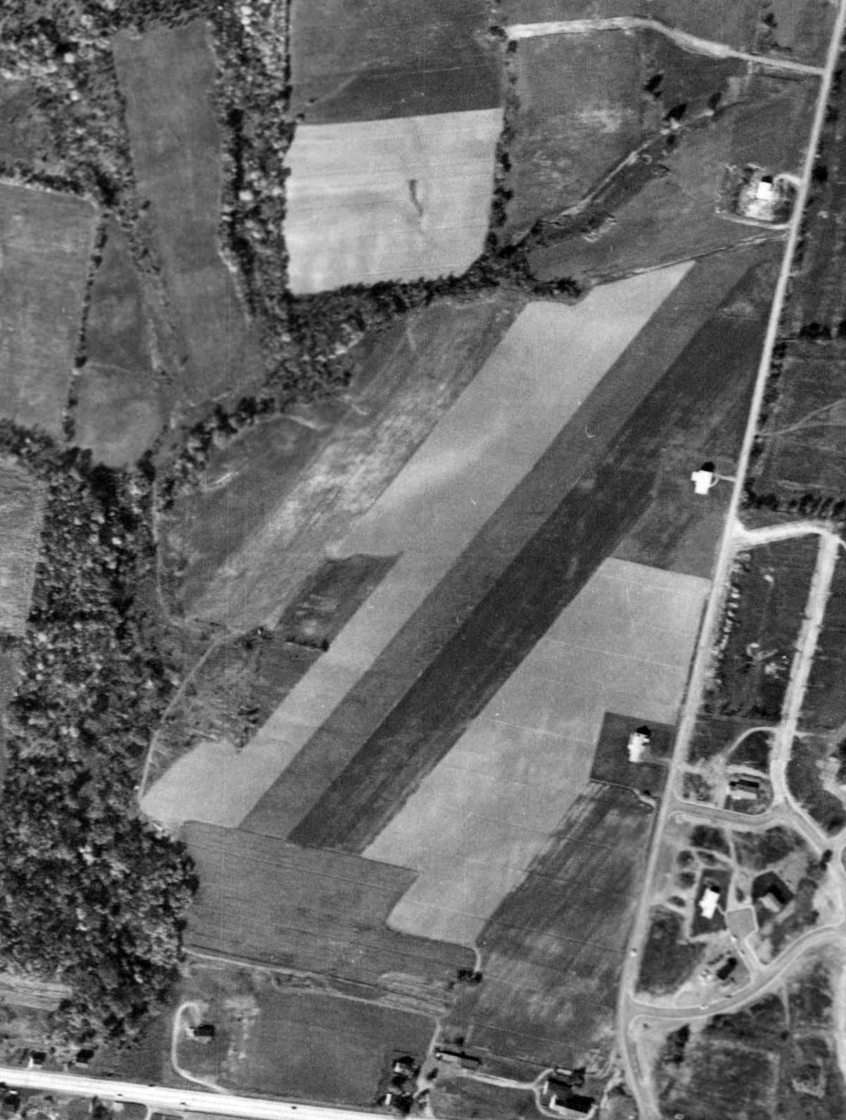
A 10/16/58 aerial view (from Penn Pilot) showed the runways of Smiling Jack Airport to remain clear.
Smiling Jack Airport was still depicted on the 1964 USGS topo map, even though it had evidently been closed for 18 years by that point.
A 1968 aerial photo showed that houses had been built along the east edge of the Smiling Jack Airport property.
A 1992 aerial photo showed that the majority of the Smiling Jack Airport property was still clear.
A 1998 aerial photo showed that houses had been built over the remainder of the Smiling Jack Airport property at some point between 1992-98.
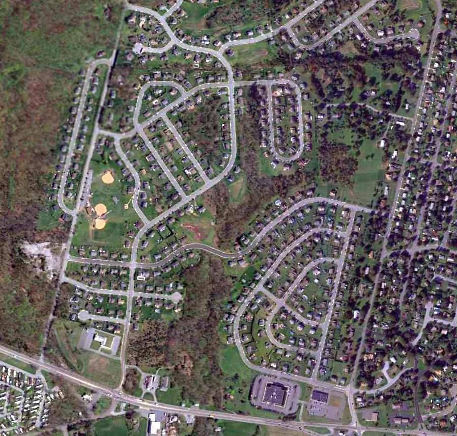
A 2013 aerial view showed no recognizable trace remaining of Smiling Jack Airport.
The site of Smiling Jack Airport is located northwest of the intersection of Route 422 & Old Airport Road, appropriately enough.
Thanks to Michael Floriani for pointing out this airfield.
____________________________________________________
Barnesville Airport, Barnesville, PA
40.81, -76.02 (Northwest of Allentown, PA)
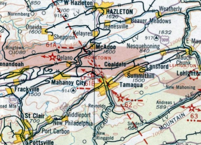
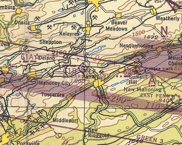
Barnesville Airport, as depicted on the August 1932 NY Sectional Chart.
The date of establishment of this small airport has not been determined.
According to Richard Finley, Barnesville “was one of the Federal Auxiliary airports
that were part of the Federal Lighted Airway System & had a directional beacon.”
The earliest depiction which has been located of Barnesville Airport was on the August 1932 NY Sectional Chart.
It depicted Barnesville as Commerce Department Site 61B.
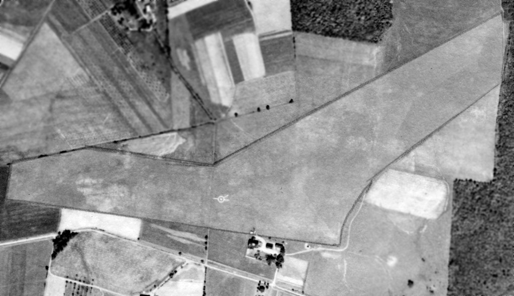
The earliest photo which has been located of Barnesville Airport was a 9/25/38 aerial view (from Penn Pilot).
It depicted Barnesville as having 2 grass runways, with a very distinct airport circle & runway indicator in the center.
A few small buildings were on the southern edge of the airfield, but there were no aircraft visible on the field.
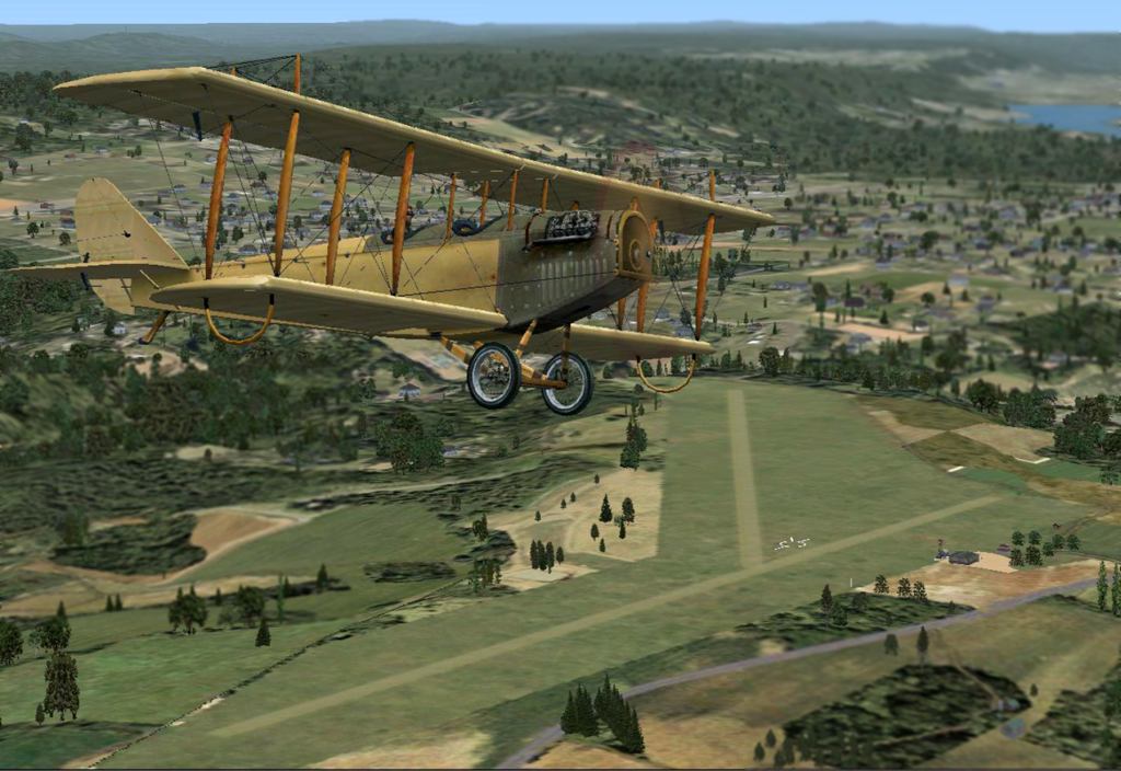
A flight simulation scenery depiction by Richard Finley looking northeast at a JN-4 Jenny overflying Barnesville Airport.
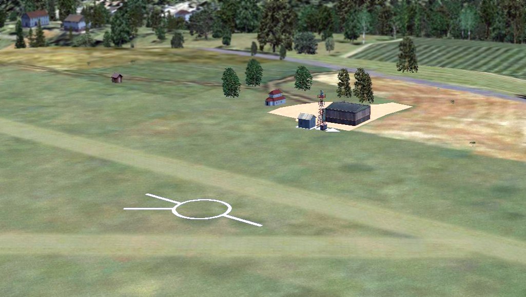
A flight simulation scenery depiction by Richard Finley looking southeast at Barnesville Airport,
showing the airport circle marking, the beacon light tower, hangar, and other buildings.
The last aeronautical chart depiction which has been located of Barnesville Airport was on the January 1945 NY Sectional Chart (courtesy of Ron Plante).
It depicted Barnesville as Commerce Department Site 61B.
Barnesville Airport was evidently replaced at some point between 1945-49 by the Tamaqua Airport, located only a mile to the northeast,
as was no longer depicted on the 1949 NY Sectional Chart.
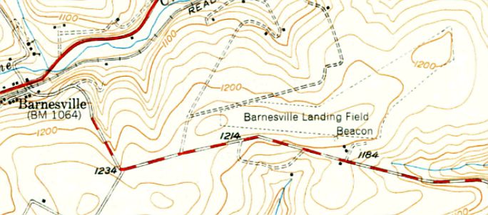
The last depiction which has been located of Barnesville was on the 1949 USGS topo map.
It depicted Barnesville Landing Field as an irregularly-shaped outline, with a beacon and 2 small buildings on the south side.
A 1958 aerial view (from Penn Pilot) showed that the site of Barnesville Airport had been returned to agriculture.
A circa 2010 aerial view showed that relatively modern houses occupied the site of the Barnesville Airport buildings.
Amazingly a 9/12/12 aerial view showed that the outline of the Barnesville Airport runways remained recognizable after having been abandoned for roughly 70 years.
The site of Barnesville Airport is located northeast of the intersection of Tuscarora Park Road & Route 1018.
Thanks to Richard Finley for pointing out this airfield.
____________________________________________________
Bedinsky Airfield, Mahanoy City, PA
40.8, -76.11 (Northwest of Philadelphia, PA)
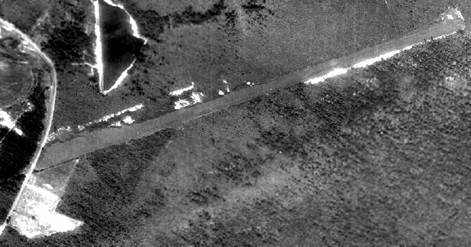
An 8/27/58 aerial view of Bedinsky Airfield (from Penn Pilot).
This private airfield was evidently established at some point between 1960-58,
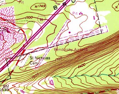
as it was not yet depicted on the 1954 USGS topo map, nor depicted on the January 1960 NY Sectional Chart.
The earliest depiction of Bedinsky Airfield which has been located was an 8/27/58 aerial view (from Penn Pilot).
It depicted Bedinsky as consisting of a single paved northeast/southeast runway.
There were not any buildings at the site, but there was a clearing on the southwest side.
The earliest aeronautical chart depiction of Bedinsky Airfield which has been located was on the January 1961 NY Sectional Chart.
It depicted Bedinsky as having a 4,000' unpaved runway. Note that Interstate 81 did not yet exist.
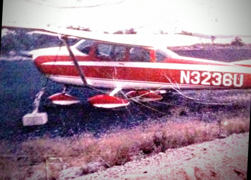
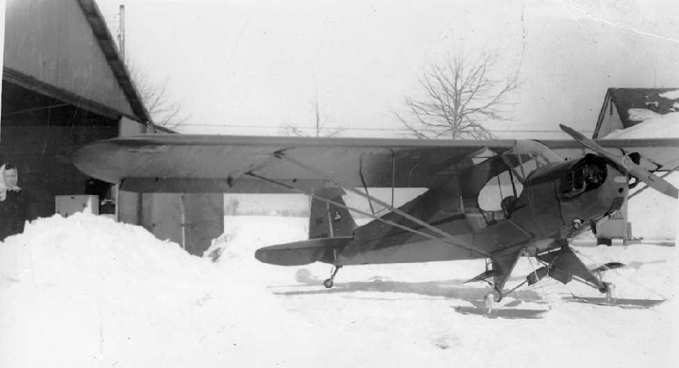
The only photo which has been located of an aircraft at Bedinsky Airport was a 1966 photo by Ed Trusky of N3236U, his father's 1963 Cessna 182F, in which he learned to fly.
The 1967 NY Sectional Chart (courtesy of Mike Keefe) continued to depict Bedinsky as a private airfield with a 4,000' unpaved runway.
Interestingly, it showed that the still-under-construction Interstate 81 had its southwestern terminus right next to the airfield.
The 1969 USGS topo map depicted Bedinsky Airfield
as having 2 unpaved runways, with a single small building to the northeast of the runway intersection.
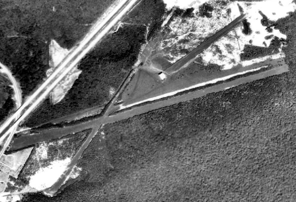
An 8/12/71 aerial view (from Penn Pilot) showed that Bedinsky had evidently gained 2 more paved runways at some point between 1958-71,
but one of them subsequently had a hangar situated over it.

The 1975 NY Sectional Chart (courtesy of Mike Keefe) depicted Bedinsky as a private airfield with a 4,000' unpaved runway.
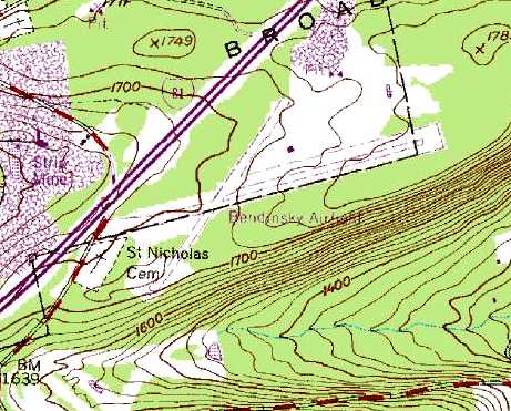
The 1987 USGS topo map depicted Bedinsky Airfield
as having 2 unpaved runways, with a single small building to the northeast of the runway intersection.
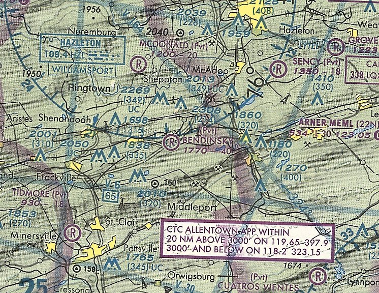
The last aeronautical chart depiction which has been located of Bedinsky Airfield was on the May 2001 NY Sectional Chart (courtesy of Ron Plante).
It depicted Bedinsky as a private airfield with a 4,000' unpaved runway.
The last photo which has been located of the Bedinsky hangar was a 4/1/04 aerial view. Although still standing, it appeared to be missing roof panels.
The Bedinsky hangar was removed within the next year, as it was no longer depicted in a 5/10/05 aerial photo.
Bedinsky Airfield was evidently closed (for reasons unknown) at some point between 1975-2011,
as it was no longer listed among active airfields as of 2011.
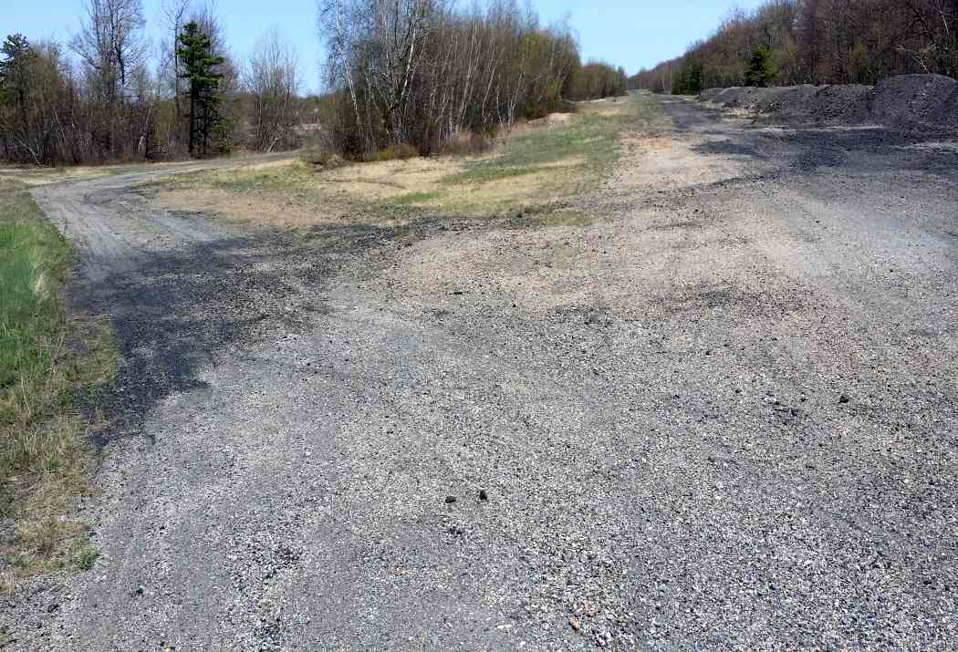
A 5/11/14 photo by Michael Dunsavage of the Bedinsky Airfield runway intersection.
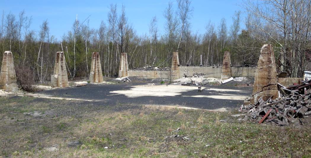
A 5/11/14 photo by Michael Dunsavage of the remains of the Bedinsky Airfield hangar.
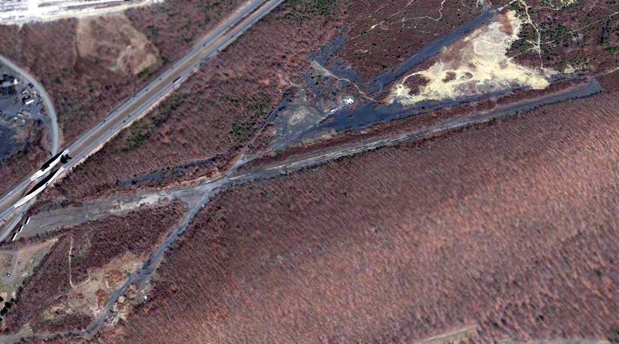
A 2016 aerial view looking north at the remains of Bedinsky Airfield.
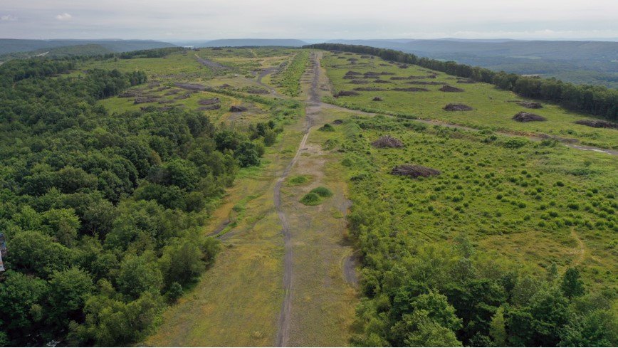
A 7/24/20 drone aerial view by John Hawranick looking east along the remains of the east/west Bedinsky Airfield runway.
John reported, “The airport is being cleared. There are rumors of the property adjacent being bought, so this may have something to do with that purchase.
You can still make out the runways & the area cleared for parking. The property is gated closed, so the best way to see what’s going on is from the sky.”
A 7/24/20 drone aerial view by John Hawranick looking northeast at the remains of Bedinsky Airfield.

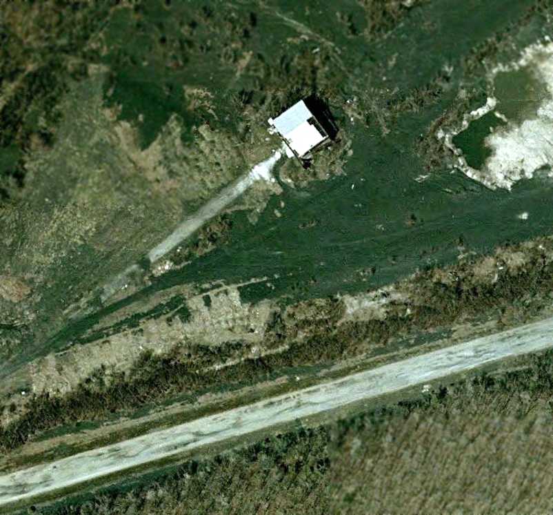
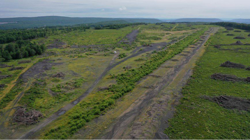
A 9/3/22 aerial view by Ed Figuli looking north at the remains of Bedinsky Airfield, showing a dramatic difference between 2020-2022.
Ed observed, “This was obliterated by the warehouse facility. The runways & any airport infrastructure are gone.”
The site of Bedinsky Airfield is located east of the intersection of Interstate 81 & Burma Road.
Thanks to Gary Bopp for pointing out this airfield.
____________________________________________________
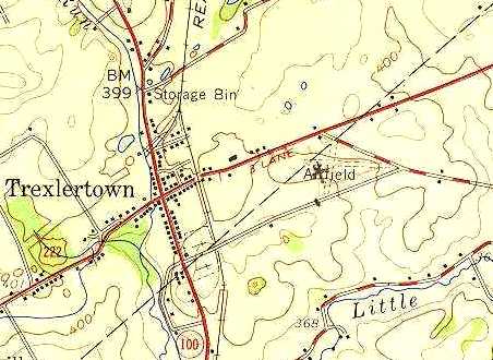
Trexlertown Airport, Trexlertown, PA
40.55, -75.59 (Northwest of Philadelphia, PA)
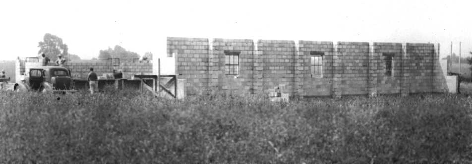
A circa 1945-46 picture of the construction of the Trexlertown Airport hangar (courtesy of Elwood Christ).
Elwood Christ recalled, “Either late 1944 or early 1945, my parents [started] an airport at Fogelsville.
After no more than a year, my father discovered a better site for an airport a mile east of the main intersection of Routes 222 & 100 near the center of Trexlertown.
On a 42-acre tract, my father started the process of converting farm land into a grass-covered airfield.
Besides turning portions of plowed fields into 2 relatively smooth grass runways,
he also had to chop down small trees that grew along the western property line at what became the west end of the main runway.
Sometime during 1945 or 1946, construction began on the airport hangar & office.”
The earliest depiction of Trexlertown Airport which has been located
was a circa 1945-46 picture of the construction of the Trexlertown Airport hangar (courtesy of Elwood Christ).
Elwood recalled, “I estimate that this image was taken from a spot about 20' south of Route 222 looking southwest.
As seen here, the north wall of the hangar has been completed with installed windows (they had metal frames).
To the left behind & the front half of the car, rises the east wall of what would become the first office / ground school classroom / residence.
The 2 men standing above & behind the car actually are leaning on part of the hangar’s south wall that rises only half its finished height.
The parapet-like structures seen at the hangar corners were constructed to stabilize the sliding hangar doors when they were opened.”
Elwood reported that his father “established Christ’s Aviation Service.
The Trexlertown Airport had 2 runways. The main one ran west-northwest to east-southeast, the minor runway ran north-northeast to south-southwest.
The areas off the runways was leased out to local farmers who planted alfalfa.
Apparently the hangar was a checkerboard [roof] possibly as early as its construction about 1946.
I have fond memories of the Trexlertown Airport, and can remember flying with my Dad to Braden Field at Easton & the Kutztown Airport.
Some of our longer trips were to Asbury Park, New Jersey, and to Montauk Point at the tip of Long Island.
My Dad owned a Piper Tri Pacer & 2 Piper J-3 Cubs.”
Trexlertown Airport was not yet depicted on the January 1947 NY Sectional Chart.
The earliest aeronautical chart depiction which has been located of Trexlertown Airport was on the July 1947 NY Sectional Chart.
It depicted Trexlertown Airport as a commercial/municipal airport.
A circa 1947-48 photo of a Piper J-3 Cub on skis at Trexlertown Airport (courtesy of Elwood Christ).
Elwood recalled, “This image looks northward from the southeast corner of the hangar/office,
past the snack bar (right edge) toward the old bank barn on the north side of Route 222.
The tall trees in the background stand on either side of Route 222. Sarah Christ can be seen at the left edge of the picture.
My father owned 2 Cubs. This is the one whose registration number ended in 'N'. The second one’s registration number ended in 'H'.”
Elwood continued, “Sometime within about 5 years of the construction of the hangar / office structures,
a one-story snack bar, about 20' square with a hipped-roofed, was built to the east of the hangar (just off the left edge of the image).”
A circa 1947-50 photo of the Trexlertown Airport Restaurant / Snack Bar (courtesy of Elwood Christ).
Elwood observed, “This view looks southeast from a point about 20 or so feet south of Route 222.
The hangar is located off the right edge of this image.
I recall my Mom saying this snack bar was built to make additional money feeding visitors to the airport.”
The July 1949 NY Sectional Chart (courtesy of Ron Plante) depicted Trexlertown Airport as having a 2,000' unpaved runway.
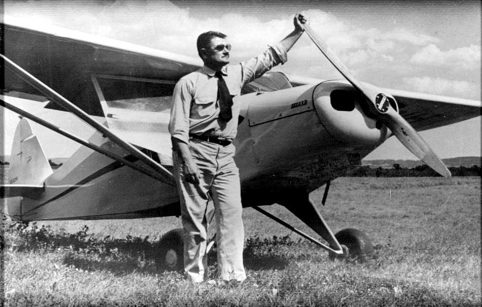
A circa 1950-54 photo of “Warren Christ, Aviator”, at Trexlertown Airport in front of a Piper Clipper (courtesy of Elwood Christ).
Elwood related, “This is my favorite photograph of Pop.
I believe this image was taken a short distance south of the main hangar looking southwest.”
Elwood Christ recalled, “By the mid 1950s, my father realized that there was not a large influx of people wanting to learn to fly,
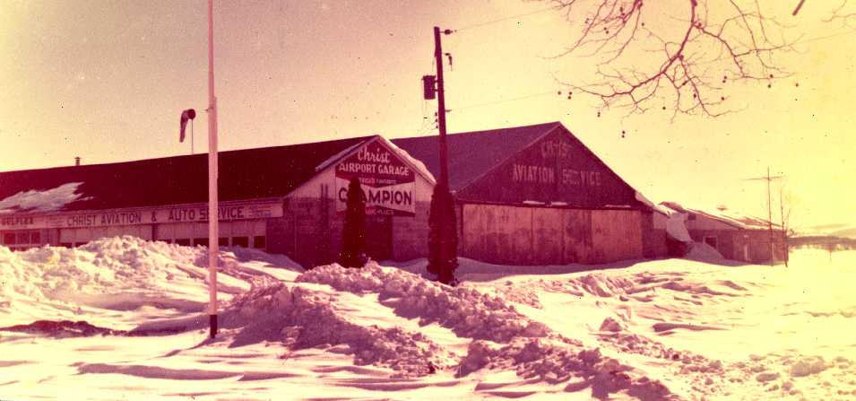
so he built an automotive garage onto the hangar where he established a Gulf Gasoline franchise.
About 1950-1955 or so, a one-story, concrete-block, side-gabled garage building was constructed onto the entire length of hangar’s north wall.
The left window opening, then, was turned into a doorway.
The level of the garage office area was almost about a foot higher than the hangar’s floor.
The gas pumps were installed just off the right edge of the image.
The space between the hangar & the camera position became part of the driveway onto the site.”
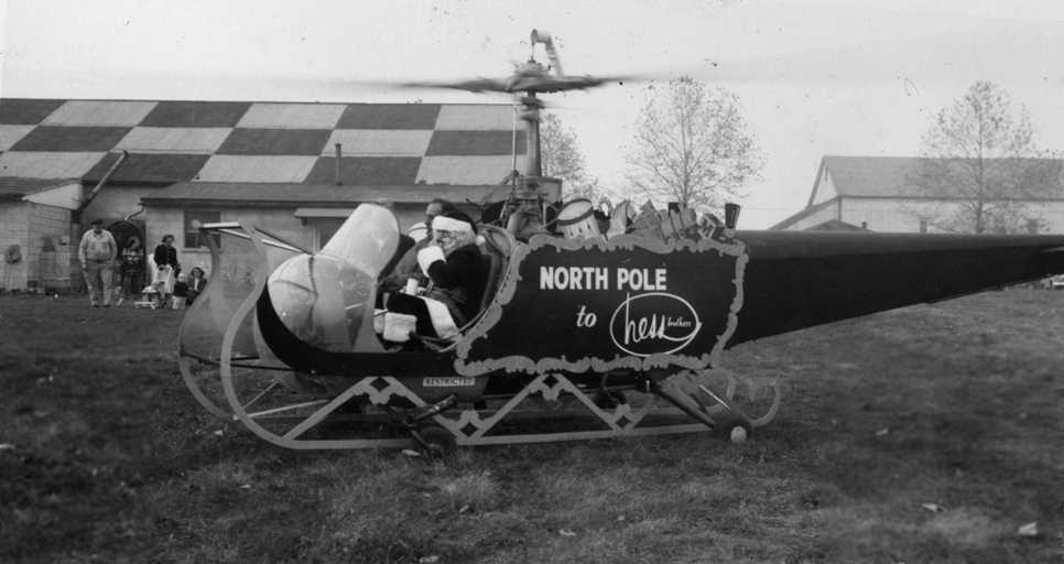
A December 1953 photo (courtesy of Elwood Christ) of Santa being flown on a Bell 47 helicopter elaborately modified into his “sleigh”, seen at Trexlertown Airport.
Trexlertown's checkerboard-roofed hangar was visible in the background.
Elwood recalled, “I suspect this image was taken Christmas 1953, for my mother, brother & I can be seen in the background.
The image was taken south of the main hangar looking north.
The ever-present bank barn on the north side of Route 222 is seen at upper-right image edge.
The large trees that lined Rt. 222 sprout above the copter’s tail section.
The 1-story, shed-roofed structure behind the front part of the helicopter was built about 1946-1947,
the same time as the main hangar, seen here with a checkerboard color scheme on the roof.
I suspect the 1-story structure’s original use was that of airport office & ground school classroom.”
The earliest map depiction of Trexlertown Airport which has been located
was on the 1957 USGS topo map (courtesy of Elwood Christ).
It depicted 2 perpendicular unpaved runways, labeled simply as “Airfield”.
Elwood Christ recalled of the Trexlertown Airport snack bar, “This enterprise ceased sometime before 1958. I do not recall it being open.”
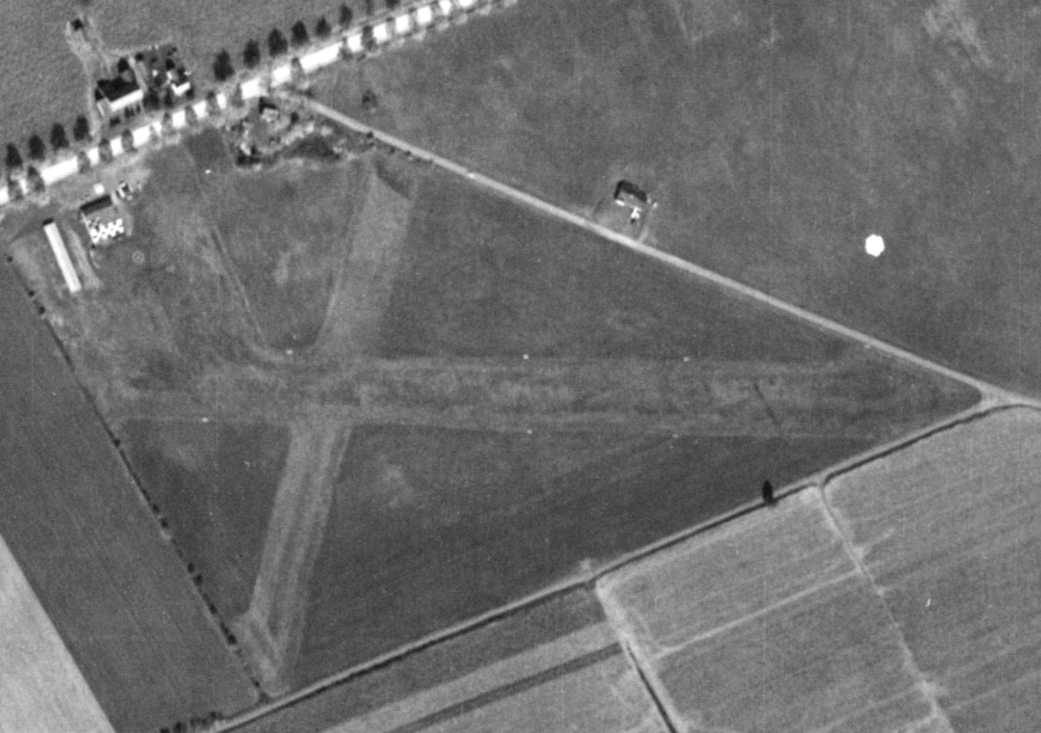
A 10/24/58 aerial view (from Penn Pilot) depicted Trexlertown Airport as having 2 grass runways, with a checkerboard-roofed hangar on the northwest side.
Elwood Christ observed, “The runways are clearly seen.
The main runway is oriented east/west, while the secondary strip runs NNE/SSW.
The west end of the grass main runway broadens out to form a rectangular taxi area from the buildings.
The white dots that appear along the main runway, I believe are runway lights that Pop had installed, though not all of them are visible.
The other areas of this 42-acre tract were leased out to a local farmer. I always remember them being planted in alfalfa.
The long light-colored structure toward the northwest corner of the airport property is a T-hangar that I believe could hold about 6-7 small aircraft.
During the early 1950s, as people wanted to store their planes at Trexlertown, the main hangar filled up, thus the need for the T-hangar.
They were made out of corrugated metal sheets attached to a steel frame.
The structure with the checkerboard paint scheme is the main hangar, and attached to its north side is the service station garage.
Attached to the hangar’s south side are the old office & the Christ family home.
The lighter circle seen below the hangar complex is a macadam area around the aviation fuel pump,
while the light rectangle above the hangar is the concrete pad marking the location of the service station gas pumps.
Just right of the the hangar complex is the snack bar structure, which by this time was used for storage.”
A circa late 1950s photo by LeRoy Ziegler (courtesy of Terry Ziegler) of Luther Delong & a Piper J-3 Cub in front of a Trexlertown Airport hangar.
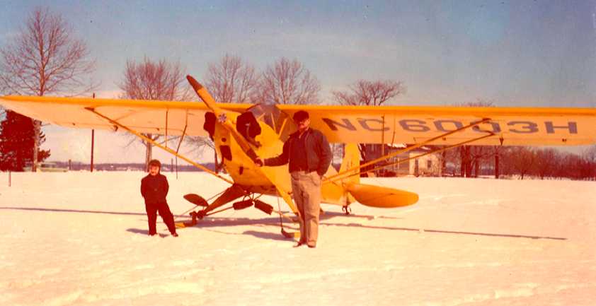
A December 1959 – January 1960 photo (courtesy of Elwood Christ)
in front of the main hangar at Trexlertown Airport, looking east-northeast towards the intersection of present-day Route 222 & Lower Macungie Road,
of Elwood Christ & Warren Christ in front of a ski-equipped Piper Cub NC6003H at a snowy Trexlertown Airport.
Elwood recalled, “My favorite picture of my father & I.
Following a 6 inch snowfall, Pop & I went for a plane ride. This image, I think, was taken after that flight.
The picture was shot in front of the main hangar looking northeasterly toward the tenant house.
I think this is the last of the 3 aircraft my father owned to be sold.”
Elwood Christ recalled, “One of the Cubs my father owned (NCC-6003H), was re-acquired by the Piper Aircraft Corporation about 1960,
and is, or was, on display at the Henry Ford Museum in Dearborn, MI.
Toward the early 1960s my father installed runway lights at Trexlertown.
I recall walking down the field & checking underneath the cones to chase the field mice nesting there.”
The last photo which has been located showing aircraft at Trexlertown Airport was a 1962 aerial photo,
which depicted 2 single-engine aircraft parked near the hangar.
The last photo which has been located showing Trexlertown Airport while still in operation
was a circa 1963 photo of the Christ Aviation buildings & hangars in the snow (courtesy of Elwood Christ).
Elwood recalled, “The view looks off Route 222 toward the southeast at the western-most driveway entrance to the service station.
From left toward right we see the service station addition.
Near the photo’s center is the west side of the main hangar. Very rarely do I remember this set of doors being opened.
The T-hangar is off the right edge of the image.”
Elwood Christ recalled, “About or shortly after the [above 1963 photo], signs of the changing demographics became evident.
Allentown had been growing & more & more people, who worked there, did not want to reside there; they looked for housing in the suburbs.
During the 15 years after the end of World War II, among some of the farms,
private homes sprung up on parcels sold by the farmers along Route 222 & side roads.
Then during the early 1960s, a developer purchased some farmland next to the airport on the south side of Church Lane.
There the developer, Michael Gatti, president of Mann Homes Inc, purchased farmland
on which he started the 'Ancient Oak' housing development during the summer of 1963.
Within 2 years, several of the development’s residents complained of some of the low-flying planes landing on the secondary runway.
At the northern end of that runway, the trees along Route 222 had grown so high,
that it was nigh impossible for some of the more modern aircraft with longer takeoff runs to clear them.
There was one non-fatal crash. I recall a newspaper image of a Cessna 150 or 172, nose down on Route 222.
During a takeoff run, the landing gears must have caught the trees.”
The 1964 USGS topo map depicted Trexlertown Airport as having 2 unpaved runways, with 2 small buildings on the northwest side.
The last aeronautical chart depiction which has been located of Trexlertown Airport was on the 1964 NY Sectional Chart.
It depicted Trexlertown Airport as having a 2,100' unpaved runway.
Elwood Christ recalled, “By the mid-1960s, the father was completely out of the flight training business,
and the people who based their planes at the Trexlertown Airport had either died or moved to other fields.
We still had a few planes land, but that became rare. The property was sold about 1965.”
According to Elwood, Trexlertown Airport closed in 1966.
Elwood continued, “After the sale of the airport to a developer, I believe named Pincus, my father continued to live on the site.
One of the disappointing events, though, for Pop was that the developer who purchased the airport grounds had died.
As his estate was probated, I suspect Pop was permitted to reside here.
What disappointed my Dad, when the estate sold the property to a new developer, the selling price was twice what my father had received.”
A 7/18/71 aerial photo showed that a north/south path had been cut across the runways, which otherwise remained intact.
The hangar remained standing, but no planes were visible.
Trexlertown Airport was no longer depicted on the June 1972 NY Sectional Chart (courtesy of Carl Buick).
A November 1972 photo (courtesy of Elwood Christ) showed that all of the Trexlertown Airport buildings had been removed,
with the site leveled in preparation for new construction.
A 10/22/74 photo (courtesy of Elwood Christ) showed that the new Trexler Mall was up & running, leaving no trace of Trexlertown Airport.
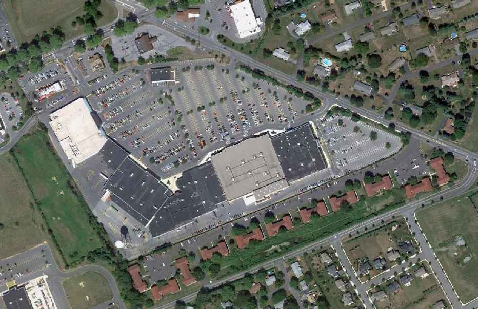
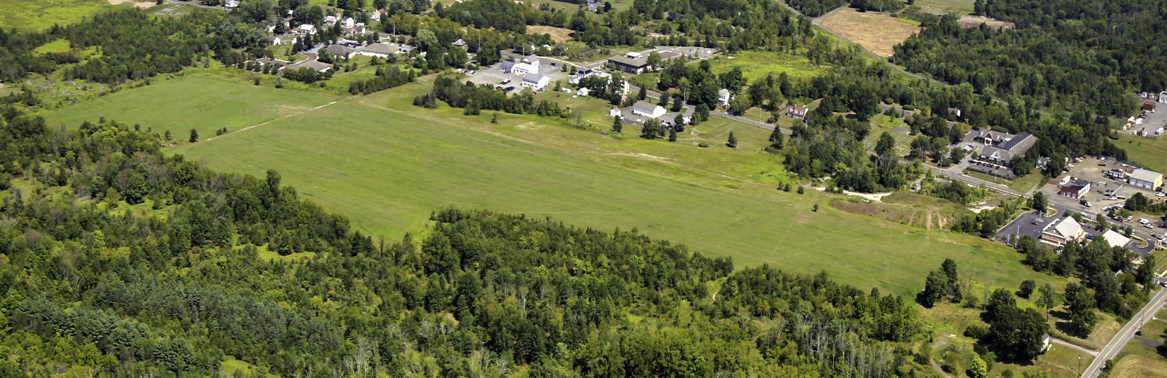
A 8/30/10 aerial view depicted no remaining trace of Trexlertown Airport.
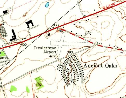
Elwood Christ reported in 2010, “The field was located on the ground that today is the home of apartment buildings,
a mall, a McDonald’s and Friendly's Restaurants and the Trexlertown Post Office.
The tract is bounded on the north by Route 222 (Hamilton Boulevard),
on the northeast by Lower Macungie Road, on the south by Church Lane, and on the west by another shopping center.”
____________________________________________________
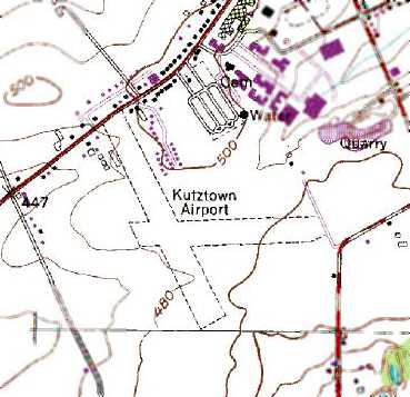
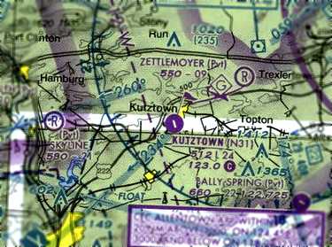
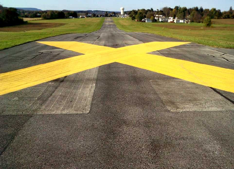
Kutztown Airport (N31), Kutztown, PA
40.5, -75.79 (Northwest of Philadelphia, PA)
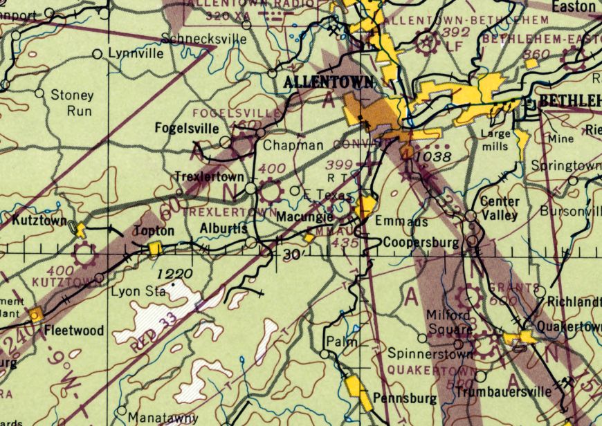
Kutztown Airport, as depicted on the January 1947 NY Sectional Chart.
Kutztown Airport was not yet depicted on the November 1945 NY Sectional Chart.
According to the Kutztown Airport website (courtesy of Benjamin Swearingen),
“World War II was over & the world could once again rest easy. It was during this postwar period that Kutztown Airport was started.
Two local businessmen caught 'the bug' for flying. Carl Bieber & Harold Miller earned their wings in Allentown.
Avid flyers, they rented planes at Allentown. Without superhighways, travel time to the Allentown Airport seriously cut into flying time.
Occasionally, one pilot would drive to Allentown, fly home & land in a field on the east end of Kutztown.
He'd pick up his buddy, and they share some piloting. The more the men flew, the more they hankered for an airfield closer to home.
The search was on for land, investors, and a manager.”
The Kutztown Airport website continued, “Carl & Harold found 2 investors: William Grim & Curvin Reichert.
Thus, 4 local businessmen signed an agreement & bought the 90 acre Charles Angstadt farm.
Construction of the Kutztown Airpark began: remodeling the barn as a hangar, runway preparation, purchase & transportation of a Trexlertown food stand to the Airpark.
The food stand served as the Airpark office for several years until the existing office was built about 1960.
The investors approached Fritz Bachman, manager of Berks Airport. Fritz agreed to a partnership which included managing the new airport.
Diverse backgrounds in business helped their venture succeed.
Bieber(trucking), Miller (lumberyard), Grim & 'Shorty' Reichert (owner & manager of a Studebaker dealership),
and Bachman (pilot, instructor & manager), created a team to cover all the contingencies.”
The Kutztown Airport website continued, “The Kutztown Airpark was officially opened 5/30/45 with Francis 'Fritz' Bachman as manager & instructor.
The airport offered flight instruction, aircraft maintenance & repair, and entertainment.
What is now the rear part of the main hangar served as both the hangar & maintenance shop.
Mechanics jockeyed planes downhill onto a clay ramp to make room for repairs & maintenance.
Entertainment was provided at the end of a rainy day when mechanics returned planes uphill on a wet clay to the hangar;
they slipped, slid, grunted & said few choice words until they accomplished the task.
Airpark employees included Gus Spanier, Clarence Stein, and Alton Stein.
Within the first year, the maintenance shop & pre-fab hangars were built.
The airpark's fleet consisted of a Piper Supercruiser, a Piper Cub, and a tandem Taylorcraft.”
The Kutztown Airport website continued, “'Fun Days' were held to attract attention & build up business for the new airport.
One of the challenges offered was A MOCK BOMBING RUN. The field was marked with an 'X'.
Pilots carrying bags filled with flour or lime would aim for the targeted area & drop their bombs.
Another attraction was fritz Bachman's aerobatic maneuvers in the Piper Cub.
He'd finish his performance with a bow from the Cub. Has most impressive bow ended with the tail in the air & the prop in the clay.
The crowd cheered Fritz's special effects, not knowing his 3-point finish was unintentional.”
The Kutztown Airport website continued, “From 1946-50 most small airports were doing a booming business.
By 1947 aviation in Kutztown was moving along well. Most students learning to fly were financed by the GI Bill.
The airpark's 3 flight instructors were kept busy.
By 1947, the cement block hangars, using a new nested design with cantilevered trusses, were built.
An impressive fleet of aircraft was available to students & pilots: Taylorcraft, Supercruiser, PT 19, BT 13, UC-78 Twin Cessna, Ercoupe, and 2 Cubs.”
The earliest depiction which has been located of Kutztown Airport was on the January 1947 NY Sectional Chart.
The Kutztown Airport website continued, “Merritt Smith, the newly hired A & P mechanic, worked the shop with Gus Spanier.
They restored fabric-covered airplanes, repaired engines, did auto body work & painted cars.
In 1950, they painted their first plane, a Cessna 170. Quality work & a word of mouth sold jobs. The shop grew to 9 people.
A Twin Beech for Air Products of Trexlertown, Arthur Godfrey's private plane, a Lockheed Loadstar for a the PA Evening Bulletin,
and an Aero-Commander which went to France are well-remembered paint jobs.
Over 4 years, 10 Supercubs (fish spotters) were recovered out of Lewes, DE.
Kibbie DuPont was a customer for painting & upholstery. Advertisements in Trade-A-Plane mentioning a paint job by Kutztown helped make sales.
In Kutztown's heyday, they painted an average of 3 planes a month.”
The Kutztown Airport website continued, “Parachutes were packed at Kutztown from 1946-50.
The tall section of the building behind the main hangar was the parachute loft.
Parachutes were hung up there to dry while the long narrow section was used for packing the parachute.
At that time, parachutes were made of silk & were required to opened & dried every 60 days.
In those days, stalls & spins were requirements for earning a private pilot's license. Parachutes were required for these maneuvers.
Packing parachutes for other airports was another money-maker for the airpark.”
The July 1949 NY Sectional Chart (courtesy of Ron Plante) depicted Kutztown as having a 2,300' unpaved runway.
The earliest photo which has been located of Kutztown Airport was a 1951 aerial view.
It showed the field as having 2 grass runways, with several T-hangars & 1 single-engine light plane on the northwest side.
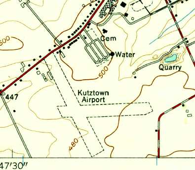
The 1956 USGS topo map depicted Kutztown Airport as having 2 unpaved runways.
The 1957 NY Sectional Chart (courtesy of Mike Keefe) depicted Kutztown as having a 2,600' unpaved runway.
A 10/16/58 aerial view (from Penn Pilot) depicted Kutztown Airport as having 2 grass runways,
with several T-hangars & 1 single-engine light plane on the northwest side.
According to the Kutztown Airport website, “About 1959-60, the office building was replaced & Runway 17/35 was paved.
For many years, Fritz advertised 'Learn to Fly $99.99.' The airport was also a dealer for Gulf fuel, Schweizer, and Cessna.
In the summer of 1959, gliders arrived at Kutztown: a Schweizer 222 & 126.
Fritz Bachman & Clarence Stein bought these from Reading Aviation. These gliders & the PA-18 Supercub towplane were the foundation of soaring at Kutztown.
As the gliding business took off, enthusiasts started the Soaring Dutchmen Club.
Many gliding competitions were entered. Schweizer 1-26 Regattas, assembly races, were held at Harris Hill.
The point of assembly was 50 yards form the start line. A crew of 4 would race to the assembly area & assemble the glider.
Officials would time the event from start to completion & inspect the finished product for airworthiness. The usual time was 7-8 minutes.
Kutztown won 3 years in a row & their best time was 3:23 minutes. Other times of competitions were held for the time & distance.
Gliders over Kutztown Airport were a familiar sight.
One nice day, a glider pilot was riding the waves over Kutztown. A passerby stopped at the office to tell Fritz a plane was 'stuck up there.'”
A 1962 aerial view depicted Kutztown in pretty much the same configuration as the 1958 photo.
A total of 11 light aircraft were visible on the field.
According to the Kutztown Airport website, “In 1965, Soaring Magazine's cover was a photograph of 3 gliders soaring in formation over Kutztown Airport.
Each Schweizer 126 were piloted by Kutztown pilots: Dave Beltz, Luther Moyer, and Doc Yund.
In June 1971, the land at Kutztown Airport was sold to Planned Development Corp;
However, Fritz Bachman purchased the aviation service & continued to operate the airport until 1977.”
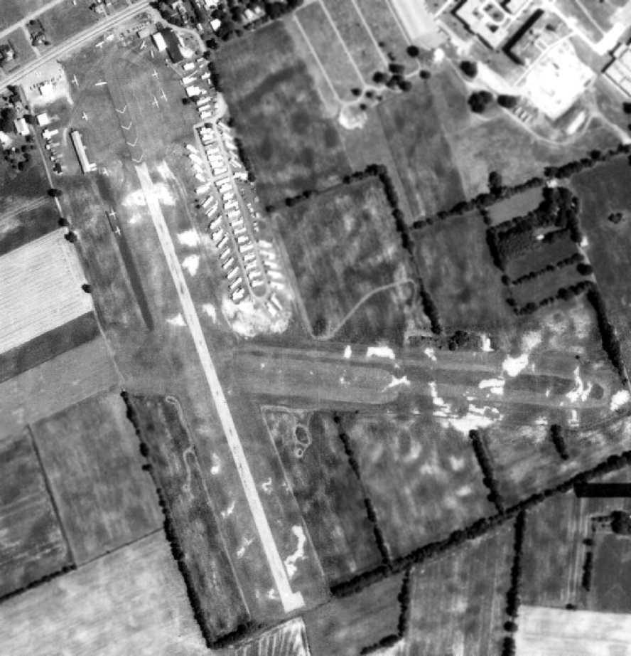
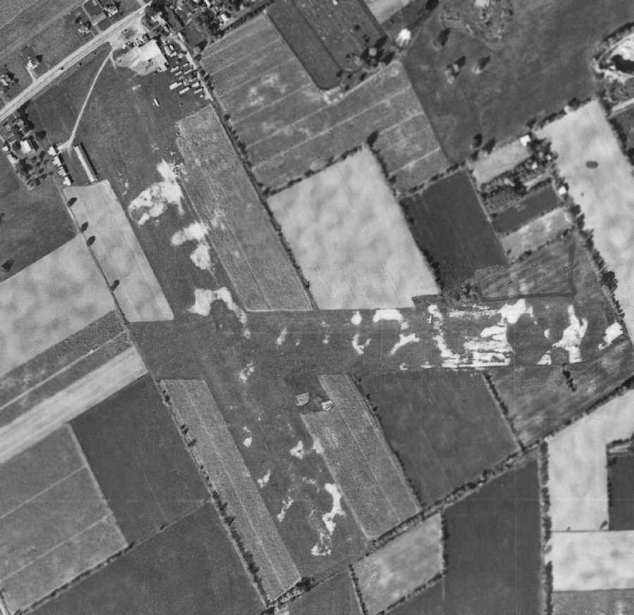
A 7/18/71 aerial photo showed Kutztown Airport as having a paved northwest/southeast runway & a grass crosswind strip.
According to the Kutztown Airport website, “Fritz Bachman continued to operate the airport until 1977.
At that time, Fred Clemens & Walt Sampson bought the aviation service.
Instruction in gliders & taildraggers became the mainstay of business at Kutztown. Partnerships changed several times throughout the years.”
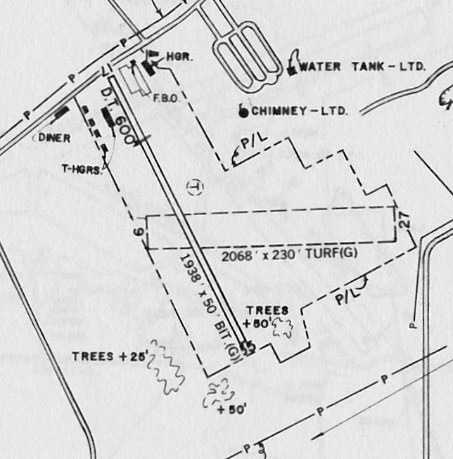
The 1983 PA Airport Directory depicted Kutztown Airport as having a 1,938' bituminous Runway 17/35 & a 2,068' turf Runway 9/27.
Several hangars were depicted on the northwest & northeast sides of Runway 17.
According to the Kutztown Airport website, “Earl Binder acquired the business in May 1993.
Since then, roofs on the main hangar, office, and flight school have been repaired.
Runway 17/35 was resurfaced & runway line/numbers painted, and runway lights & a beacon installed.”
The 1994 USGS topo map still depicted Kutztown Airport as having 2 unpaved runways,
even thought the primary runway had been paved for over 23 years at that point.
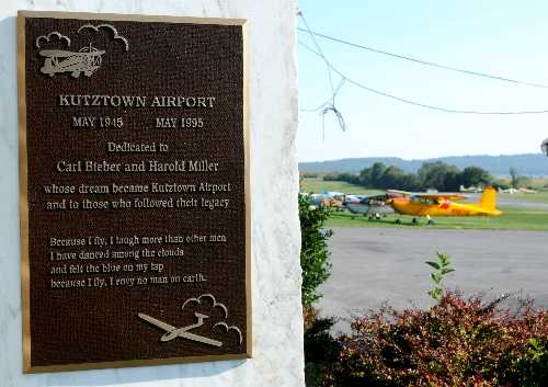
An undated photo of a plaque placed at Kutztown Airport in May 1995, commemorating the airport's 50th anniversary.
The Kutztown Airport website described in 2003, “Runway 10/28 (turf) remains active. Gliders continue to be a big attraction.
Tows are available by our 2 Cessna 182s & a Waco.
Kutztown Airport's power fleet consists of 5 Cessnas, a 150, a 152, a 172, two 182's, a Piper 140, and a Waco biplane.
The sailplanes are 2 PZl Krosnos & 232 (3-place). Banner tows are also available.”
An April 2004 aerial view showed 4 gliders & 9 single-engine aircraft at Kutztown Airport.
A6/30/04 aerial view by Yasir Raja looking north from short final to Kutztown's Runway 35, showing the pronounced dip along the runway.
The last airport directory listing which has been located of Kutztown Airport was in the 2005 PA Airport Directory (courtesy of John Clifford).
It described Kutztown as having a 2.460' concrete/turf Runway 17/35 & a 2,221' turf Runway 10/28.
The manager was listed as Earl Binder.
A circa 2006 aerial view looking south at the Sikorsky S-76 medevac helicopter
parked within a tight ring of Jersey walls on the north end of Kutztown Airport,
with gliders & single-engine aircraft parked on either side of the runway.
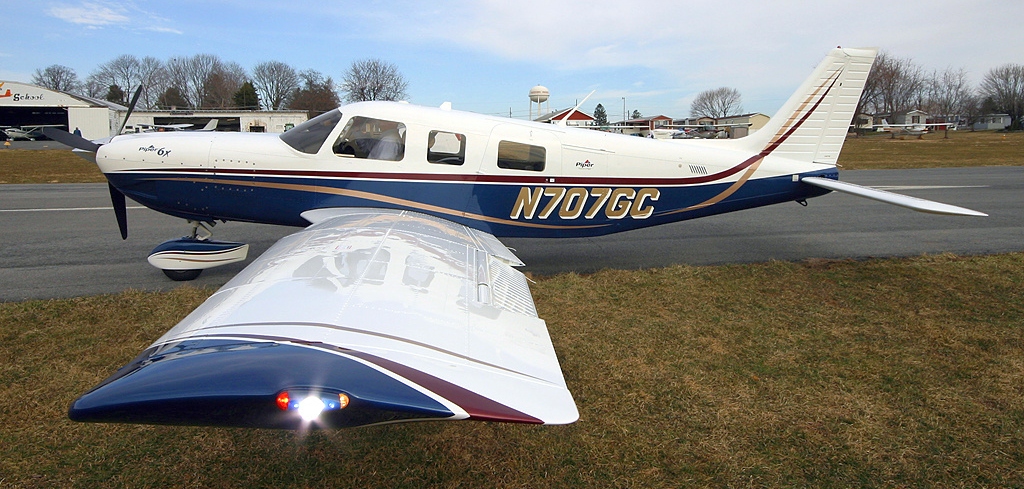
A March 2006 photo by Alex McMahon of Piper PA-32-301FT 6X N707Gc C/n 3232049 at Kutztown Airport.
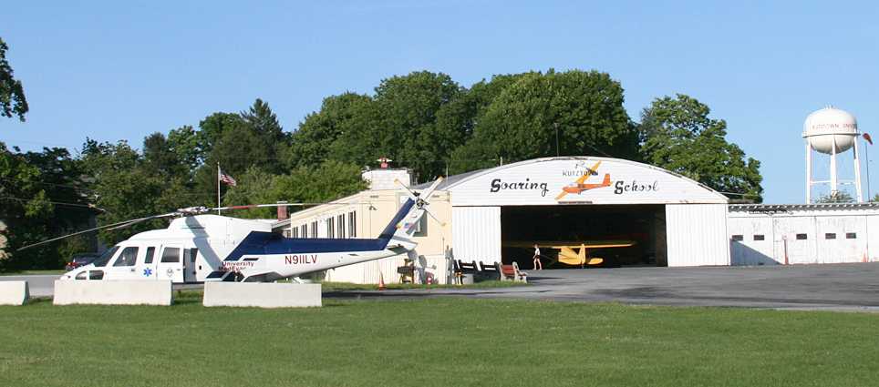
A 11/23/07 photo by Daniel Berek of a Lehigh County Medical Center Sikorsky S-76 in front of the Kutztown Soaring School hangar.
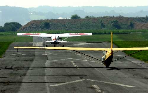
An undated photo from a 2008 article looking south as a Civil Air Patrol towplane pulls a glider along Kutztown's Runway 17.
The last aeronautical chart depiction which has been located of Kutztown Airport was on the November 2008 NY Sectional Chart.
Unfortunately a Notice To Airmen was published for Kutztown Airport in August 2008 that services & fuel were no longer available.
In a 10/6/08 letter to Maxatawny Township regarding the Kutztown Airport,
attorney Joseph A. O'Keefe wrote that his clients have no interest in keeping it open.
The letter does not name the owners, but Berks County records identify them as Nicholas Prikis & Sophie Pittas.
According to the letter: Airport operator Earl Binder's month-to-month lease is terminated,
and the owners are beginning the Federal Aviation Administration process of closing the airport.
Owners anticipate that no planes will be allowed to land at Kutztown Airport after 1/31/09.
Lehigh Valley Hospital has been instructed to remove its MedEvac helicopter within 30 days.
Construction of a shopping center is anticipated on the property.
The owners have agreements for the land totaling more than $14.5 million,
and they would expect to be paid that much by Maxatawny if the township would decide to condemn the land for its own use.
An article entitled “Kutztown Airport to close; site may become shopping center” by Michelle Park
appeared in the 10/10/08 issue of the Reading Eagle.
It said, “The Kutztown Airport will close, according to an 10/6 letter sent to Maxatawny Township on behalf of the owners,
identified in county records as Nicholas Prikis & Sophie Pittas.
The owners have no interest in allowing the 63-year-old airport on Kutztown Road to operate beyond the end of this year,
attorney Joseph O'Keefe of Kutztown wrote.
The Federal Aviation Administration requires a 30-day window to close an airstrip, he explained.
It's anticipated that planes will not be allowed to land at the airport after 1/31/09.”
The article continued, “There are pending agreements for the property totaling more than $14.5 million, the letter states,
and it's anticipated that a shopping center will be built on the 70-acre site.
Maxatawny supervisors discussed the letter at a township meeting Wednesday night.
Attempts to reach O'Keefe & Prikis for comment Thursday were unsuccessful.
Rumors that the small airport outside Kutztown would close have circulated for years,
and they increased recently when a flight school there shut & auctioned its contents.
Township officials said they'll be sorry to see the airport close.”
"I'm saddened because it's been a part of the community for 50 or 60 years," Supervisor Allen Leiby said.
"I'm not in favor of it becoming a shopping center."
Maxatawny resident Marc Nadeau & his wife, Theresa, have operated the Kutztown Skydiving Center at the airport for 6 years.
"I just wish that the landowner understood aviation & had an appreciation for aviation," Marc Nadeau said.
"This is a place to live the dreams of flight. I'm sure everybody has dreamt of flying."
The article continued, “As of Thursday, the Federal Aviation Administration, which requires 30-day notice before an airport can close,
had not been notified of a Kutztown Airport closure, FAA spokeswoman Arlene Salac said.
O'Keefe wrote the letter in opposition to a proposed zoning ordinance that would restrict the property to use as an airport
unless the township granted a conditional-use permit for another purpose.
The property is zoned as a mix of commercial & light-industrial use.
O'Keefe contends that by rezoning the parcel, the township would essentially be taking control of the land by regulation.
Maxatawny Township Solicitor Jill E. Nagy disputed that contention, however,
saying a shopping center would require a conditional-use permit under existing & proposed zoning.
According to O'Keefe, the airport has operated at a loss for more than 25 years.
In his letter, he notes that the township or other parties could have offered to buy the property to preserve it, but that didn't happen.”
The article continued, “News that Lehigh Valley Hospital has 30 days
to remove its medical helicopter from Kutztown Airport surprised hospital officials Thursday.
The deadline was mentioned in an 10/6/08 letter Kutztown attorney Joseph O'Keefe sent Maxatawny Township on behalf of the airport owners.
Brian Downs, spokesman for the Lehigh Valley Hospital & Health Network,
said hospital officials were aware that the airport could close but that they had not been informed of specifics.
The MedEvac 1 station based at the Kutztown Airport is the hospital's only station in Berks County.
The helicopter responds to medical emergencies, flying seriously ill or injured victims to the hospital near Allentown.
If the hospital is forced to remove its helicopter from the Kutztown Airport,
officials would evaluate other possible helicopter pad sites in Berks County, Downs said.”
A Notice To Airmen was published for Kutztown Airport in December 2008 that the airport was closed to transient aircraft.
Marlin Fausey reported in 2008, “What a shame this airport is closing.
General Aviation loses another great destination. Like we need another Mall?”
A pre-2009 aerial view looking south along Kutztown's Runway 17, showing the pronounced hump along the runway.
According to its 2009 listing in the FAA Airport/Facility Directory,
Kutztown Airport was owned by Kutztown Enterprises, with the manager listed as Earl Binder.
The field was said to have a 2,460 asphalt Runway 17/35 & a 2,221' turf Runway 10/28.
A total of 40 aircraft were based on the field, including 4 gliders & 11 ultralights.
The field was said to conduct an average of 121 takeoffs or landings per day.
Jim Gratton reported in 2009, “The Fixed-Base Operator was auctioned off last fall.
They have been trying to kill the place off for years
and the allegation now is they are going to be putting a mall in it's place (a mall!, in this economy).
The airport had a thriving FBO that did glider training & gave rides in a beautiful red Stearman biplane.
There is a restaurant on the field that you could park your aircraft directly in front of.
The airport was long known for it's tricky runway, with 2 very large dips which caught your attention upon arrival.
Also, parachute ops were standard operating procedure adjacent to the pattern, adding to the excitement of any arrival there.
Sad to see another one go.”
A 10/18/09 photo by Jim Scott looking northeast along Kutztown's runway, showing the prominent closed-runway symbols
Jim reported, “Further steps have been taken to permanently close the airport,
although it took all summer, crews finally crossed out the runway & painted-over the numbers.
A med-evac helicopter service is still working at the main hangar, and the grass fields & crosswind runway were mowed all summer.
The handful of runway lights still were turned on each evening until recently.
The local CAP group camped out & did glider flights this summer too.
The economics of developing the land have been somewhat hindered because of the recession,
but the local state university will surely draw money & bulldozers eventually.”
A 5/11/14 aerial view by Paul Freeman looking south at Kutztown Airport, showing the medevac helicopter which remains at the closed airport.
A 5/11/14 aerial view by Paul Freeman looking north at Kutztown Airport, showing the 2 runways which remain intact.
A 10/21/21 photo looking southeast at the only aircraft which remains operating from the former Kutztown Airport: a Eurocopter medevac helicopter, with the runway at right.
An 8/13/22 aerial view by Ed Figuli looking northeast at Kutztown Airport.
Kutztown Airport is located south of the intersection of Kutztown Road & Luckenhill Road.
Thanks to Jim Gratton for pointing out the closure of this airport.
____________________________________________________
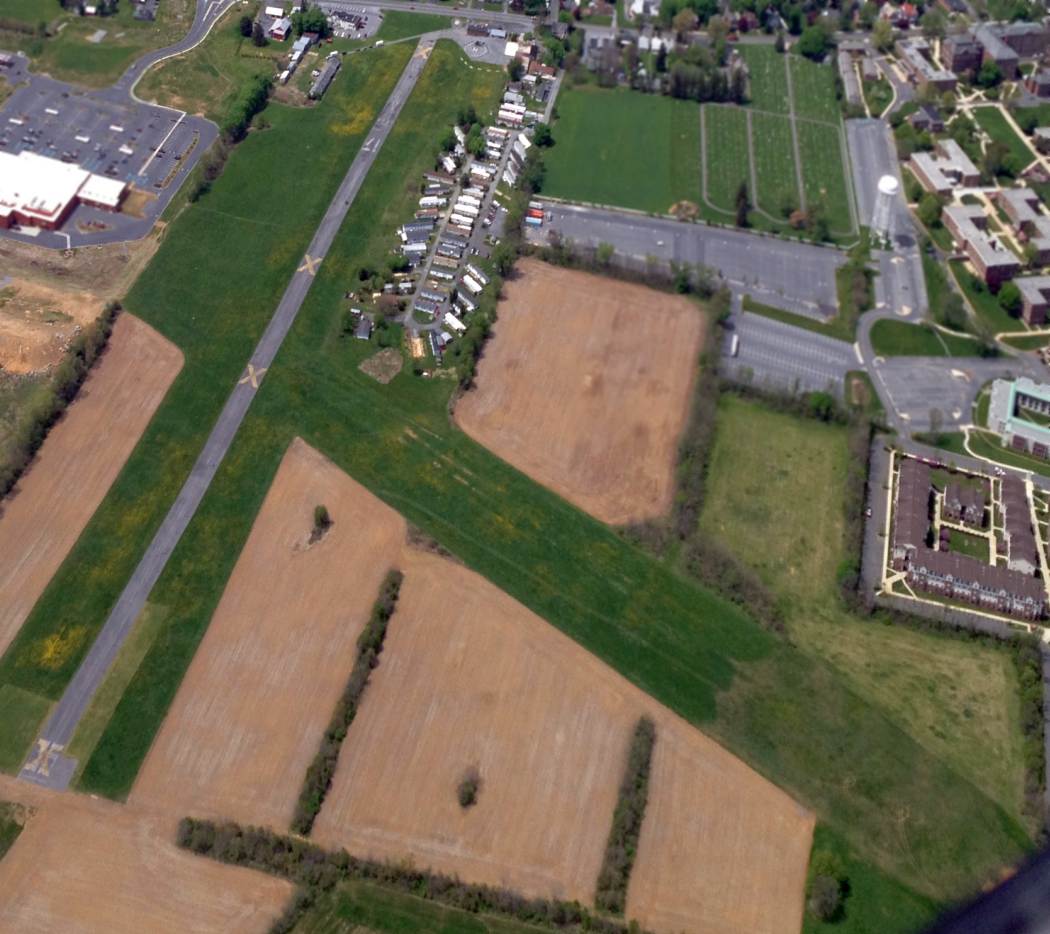
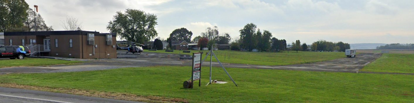
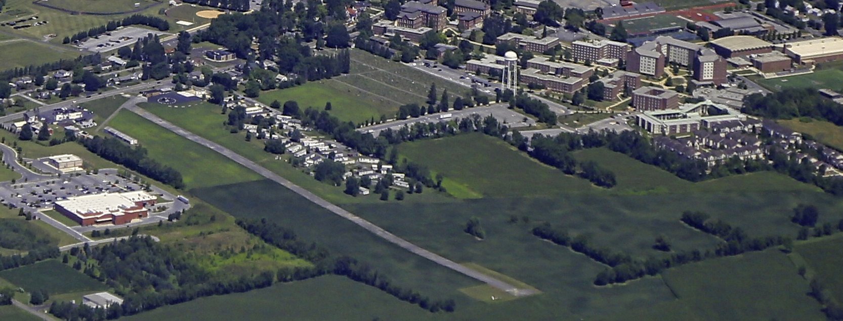
New Hanover Airport, New Hanover, PA
40.3, -75.59 (Northwest of Philadelphia, PA)
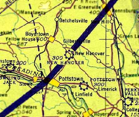
New Hanover Airport, as depicted on the May 1943 NY Sectional Chart (courtesy of Chris Kennedy).
Note that the airport was located right under the western boundary of the wartime "Vital Defense Area" that extended to the coast.
This small general aviation airport was evidently established at some point between 1942-43,
as it was not depicted at all on the March 1942 NY Sectional Chart (according to Chris Kennedy).
The earliest depiction of the New Hanover Airport which has been located
was on the May 1943 NY Sectional Chart (courtesy of Chris Kennedy).
It depicted New Hanover as a commercial/municipal airport.
The April 1944 U.S. Army & Navy Directory of Airfields (courtesy of Ken Mercer)
described New Hanover as a civilian airport having a 2,500' unpaved runway.
According to Hobbly, New Hanover Airport “was used to train WW2 pilots.”
The 1945 NY Sectional Chart (courtesy of John Voss) depicted New Hanover as a commercial/municipal airport.
The 1945 AAF Airfield Directory (courtesy of Scott Murdock) described New Hanover Airport
as a 58 acre irregularly-shaped property within which were 2 sod runways, measuring 2,450' northwest/southeast & 2,000' east/west.
The field was said to have 6 hangars, the largest being a 90' x 68' concrete & wood structure, and to be privately owned & operated.
The 1950 NY Sectional Chart (courtesy of Mike Keefe) depicted New Hanover Airport as having a 2,100' unpaved runway.
The 1957 NY Sectional Chart (courtesy of Mike Keefe) depicted New Hanover Airport as having a 1,900' unpaved runway.
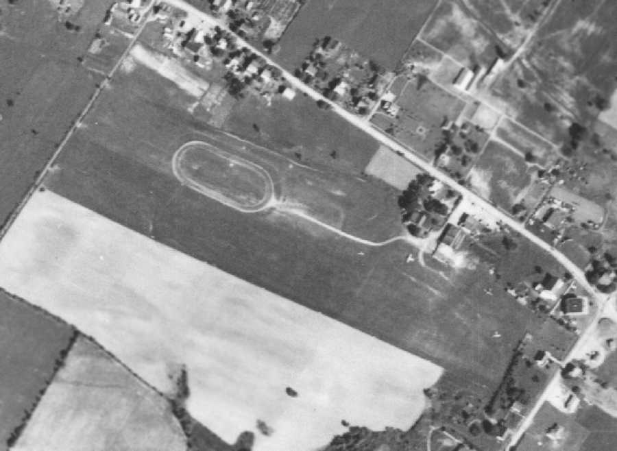
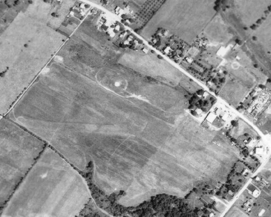
The earliest photo which has been located of the New Hanover Airport was a 10/4/57 aerial view (from Penn Pilot).
It depicted New Hanover as having a single northwest/southeast grass runways,
with several buildings & 2 light aircraft visible parked on the east side of the field.
The 1958 NY Sectional Chart, 1960 NY Sectional Chart, and 1965 NY Sectional Chart
all depicted New Hanover Airport as having a 1,900' unpaved runway.
Richard Finley recalled, “A month after I bought the C150 (5/29/70), I had taken a Saturday to go punch holes in the sky.
I landed at several airports & one of them was New Hanover.
I went there because the Sectional Chart indicated they had an active [parachute] drop zone.
I had my Para Commander with me. I got on a lift & jumped with them.
I did not stay for more than one lift. Their rules of conduct were different that the ones we practiced at Alliance Sport Parachute Club (Salem, OH).
ASPC had been in continuous existence since 1959 without a single fatality or serious injury.
At ASPC, we had beer at the hangar but it was kept in a locked refrigerator & the fridge could not be unlocked until the airplanes were put away.
At New Hanover, their only rule was you could not have beer in the airplane!”
An 8/6/71 aerial photo depicted New Hanover as having 2 grass runways, with at least 2 light aircraft visible parked on the east side of the field.
The last aeronautical chart depiction which has been located of the New Hanover Airport
was on the 1975 NY Sectional Chart (courtesy of Mike Keefe).
It depicted New Hanover Airport as having a 2,000' unpaved runway, and indicated that parachuting operations were conducted.

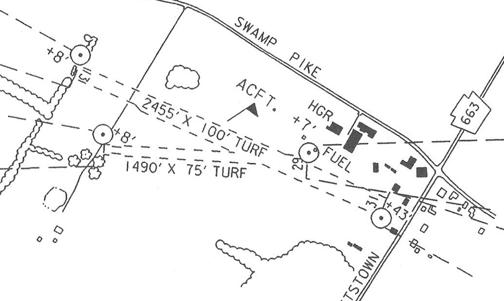
The 1986 Flight Guide (courtesy of Chris Kennedy) depicted New Hanover Airport
as having a 2,455' turf Runway 13/31 & a 1,490' turf Runway 11/29.
The field was said to conduct ultralight aircraft operations, and parachuting within a 2 mile radius.
According to Timothy Miller, “New Hanover Airport was once the home of United Parachute Club
and the 'Herd Boogie' (a skydiving festival).
I jumped there several times throughout my skydiving career, and had many good times there.
I remember it as a very active airport for skydiving, with Twin Otters,
King Airs, and a Skyvan being there at various times.”
Dan Morris recalled, “New Hanover Airport - I flew from this airport.
A large skydive operation operated from the airport in the 1990s up until closing.”
The 1992 USGS topo map depicted New Hanover Airport as having 2 unpaved runways,
with several buildings (hangars?) on the northeast side of the field.
The 1997 PA Airport Directory (courtesy of John Clifford) depicted New Hanover Airport as having 2 turf runways: 2,455' Runway 13/31 & 1,490' Runway 11/29.
The licensee was listed as the Charles Heinly Estate, the manager as Mary Kaas, and the Fixed Base Operator as United Parachute Club.
As seen in the 1999 USGS aerial photo, at least 2 light single-engine aircraft were visible on the northeast side of the New Hanover Airport.
According to Hobbly, New Hanover Airport “was in use until the 1990s.”
The last photo which has been located showing aircraft at New Hanover Airport was a 7/12/00 aerial view looking southwest (from the Dallin Aerial Survey Collection, courtesy of the Hagley Museum & Library).
It depicted at least 1 small single-engine plane parked next to the runway.
Timothy Miller reported in 2006, “The airport was closed several years ago.
The [skydiving] club was moved to northern PA. The site was sold to a land developer.”
According to Dan Morris, “It closed due to the owning family selling the property.”
The New Hanover Airport evidently closed (for reasons unknown) at some point between 2000-2001,
as a circa 2001 aerial photo showed that no planes were visible on the field anymore, although the runways remained intact.
A circa 2001-2005 aerial photo looking north at the former New Hanover Airport hangar, obviously in a state of abandonment.
A 7/25/07 photo of the buildings at the site of New Hanover Airport.
A 2009 photo looking southwest showed the former airport buildings remained on the northeast corner of the New Hanover Airport site.
A 2015 photo showed the former airport buildings had been removed at some point between 2009-2015 on the northeast corner of the New Hanover Airport site.
An 8/20/21 aerial view by Ed Figuli looking north at the site of New Hanover Airport.
Ed reported, “The grass strip is still there but not much else”, with the airport buildings having been removed several years prior.
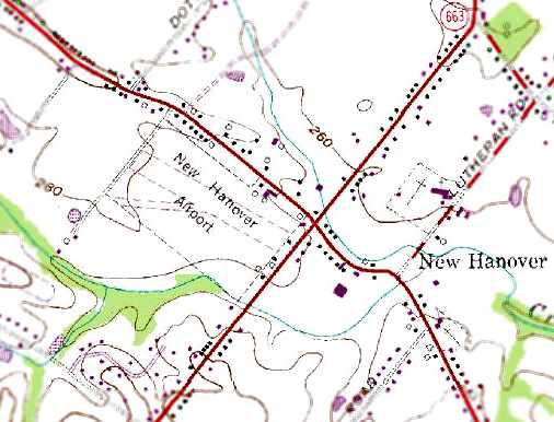
The site of New Hanover Airport is located on the west corner of Swamp Pike & North Charlotte Street.
____________________________________________________
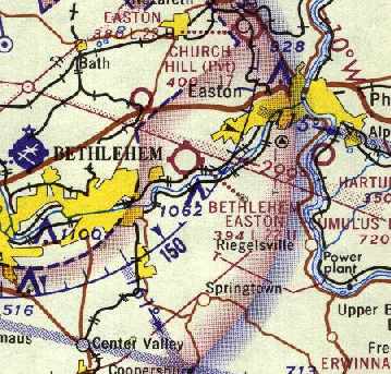
Rich Airport / Buckwood Airport / Bethlehem Easton Airport, Bethlehem, PA
40.65, -75.3 (Northwest of Philadelphia, PA)
Rich Airport, as depicted on the March 1940 NY Sectional Chart.
Photo of the airfield while open has not been located.
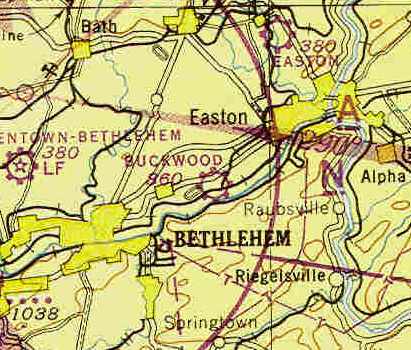
This small general aviation airport was located in between the towns of Bethlehem & Easton.
Rich Airport was evidently established at some point between 1939-40,
as it was not yet depicted on the June 1939 NY Sectional Chart.
The earliest depiction which has been located of Rich Airport was on the March 1940 NY Sectional Chart.
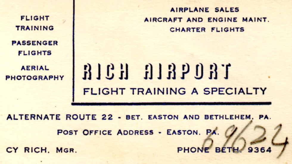
A circa 1940-42 business card for Rich Airport (courtesy of John Givre, found in his father's papers).
John reported, “My father was flying with a Student Pilot Certificate issued in September 1940
and got his pilot's license in April 1942, so maybe Rich was operating as early as 1940.
Also, the business card indicates Cy Rich as it's manager, hence the airport's original name.”
Rich Airport was still depicted on the 1944 NY Sectional Chart (courtesy of Chris Kennedy).
At some point between 1944-45, the airport was evidently renamed “Buckwood Airport”,
as that is how it was listed in the 1945 Haire Publishing Company Airport Directory (courtesy of Chris Kennedy).
It was evidently renamed after its owner, operator, and manager - Buck Woodward.
The field was described as a “class 1” airport, consisting of 75 acres,
within which were 3 sod runways, with the longest being a 2,700' northeast/southwest strip.
The field was said to have a 90' x 45' hangar, and to offer repairs, charter, storage, training, and fuel.
No airfield in Bethlehem or Easton was listed among active airfields in the 1945 AAF Airfield Directory (courtesy of Scott Murdock).
The November 1945 NY Sectional Chart (courtesy of Chris Kennedy) depicted Buckwood as a commercial/municipal airport.
The 1947 USGS topo map depicted the airfield as Buckwood.
The airport was evidently renamed “Bethlehem-Easton” Airport at some point between 1947-49,
as that is how it was labeled on the January 1949 NY Sectional Chart (courtesy of Chris Kennedy).
It was depicted as having a 2,700' unpaved runway.
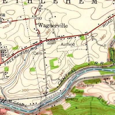
The 1957 USGS topo map depicted the airfield as having 2 unpaved runways,
but it was labeled simply as “Airfield”.
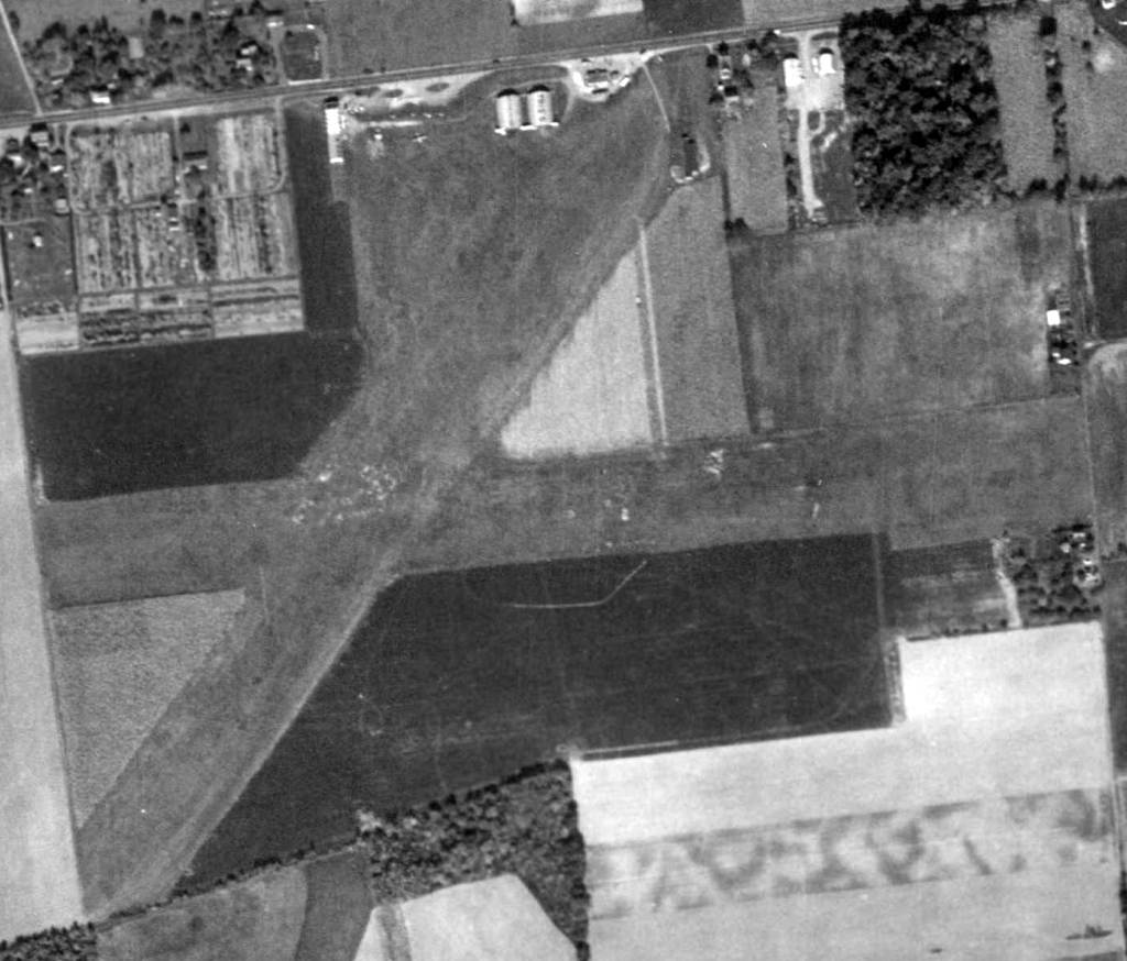
The earliest photo which has been located of the Bethlehem-Easton Airport was an October 16, 1958 aerial view (from Penn Pilot).
It depicted the field as having 2 grass runways,
with several buildings & 1 light aircraft visible on the north side of the field.
A 1962 aerial view depicted Bethlehem-Easton in pretty much the same configuration as the 1958 photo.
A total of 3 light aircraft were visible on the field, including one on the east/west runway.
The 1962 AOPA Airport Directory described Bethlehem-Easton as having 2 sod runways: 2,641' Runway 9/27 & 2,330' Runway 4/22.
The field was said to offer fuel, repairs, hangars, tiedowns, and charter. The operator was listed as Eugene Trigiani (a Cessna dealer).
According to Tom Beamer, “Gene Trigiani was the Bethlehem Steel Chief Pilot.”
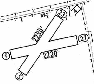
The 1965 Jeppesen Airway Manual (courtesy of Chris Kennedy)
depicted Bethlehem Easton Airport as having 2 turf runways: 2,230' Runway 5/23 & 2,220' Runway 9/27.
A few buildings were depicted on the north side of the field.
The manager was listed as Roger Laviolette.
The 1966 AOPA Airport Directory (according to Tom Beamer) Bethlehem-Easton as having 2 runways: 2,330' Runway 5/23 & 2,200' Runway 9/27.
The operator was listed as Lehigh Aircraft.
According to Tom Beamer, Lehigh Aircraft had been the Fixed Base Operator at nearby Allentown Bethlehem Easton Airport.
The last chart depiction of Bethelem Easton Airport which has been located was on the 1967 NY Sectional Chart (courtesy of Mike Keefe).
It depicted Bethelem Easton Airport as having a 2,200' unpaved runway.
A local resident recalled, “There were 2 prominent metal arched hangars along the road (Freemansburg Avenue) when you drove by the site.
I can remember seeing aircraft parked there when I was young (1960s). I also remember stories of skydiving there.”
Tom Beamer recalled, “I learned to fly, and began my career as an instructor, at Skyport; we sent our students to Braden's for their long X-C,
when Braden's was paved they would no longer prop our Champs so we began sending them to Bethlehem-Easton instead,
this probably occurred in 1967-68.
I believe Bethlehem-Easton closed shortly thereafter.”
The Bethlehem Easton Airport was evidently closed (for reasons unknown) at some point between 1967-69,
as it was no longer depicted at all on the 1969 USGS topo map.
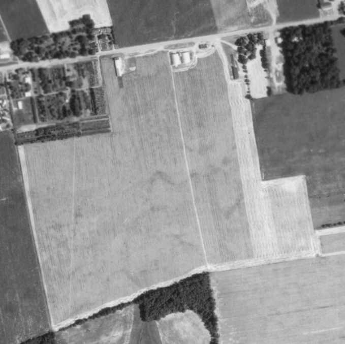
A 7/15/71 aerial photo did not show any obvious signs of current use of the Bethlehem Easton Airport.
The former grass runways were no longer evident, although the overall area remained clear.
The hangars on the north side of the field remained intact,
but there was no sign of any aircraft.
Tom Beamer recalled of Bethlehem Easton Airport, “It was reopened by Bill Shannon
by the time I moved to Bethlehem in 1972 & the runways could have been realigned.
By the 1970s there was only one runway.
The last owner was Bill Shannon & he kept it open as a private airport after the noted closure date.
There was some Skydiving there in the 1970s.”
But the Bethlehem Easton Airport was evidently closed (again) before 1972,
as it was no longer depicted on the June 1972 NY Sectional Chart (courtesy of Carl Buick) or subsequent charts.
A local resident recalled, “The site was apparently used for agriculture after it closed
and what looks like a silo & another building were added next to the hangars.”
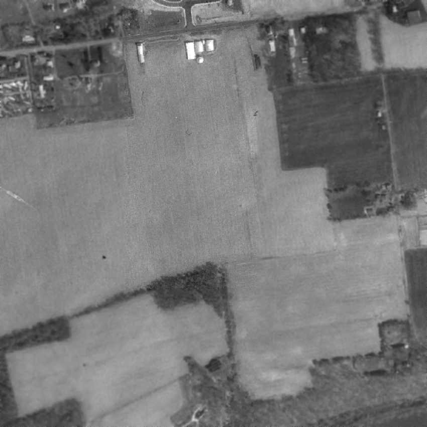
An April 1993 aerial photo (courtesy of a local resident) of the northeast corner of the Bethlehem Easton Airport site,
before it was developed with housing, with the 2 metal arched-roof hangars visible at the top-center of the photo.
The building to the left may have been the former airport administration building.
Tom Beamer recalled, “The Administration / Shop building & hangar were still standing about 10 years ago [1995].”
As seen in the 1999 USGS aerial photo,
the faint outline of both the former east/west & northeast/southwest runways at the site of Bethlehem Easton Airport were still recognizable.
The former administration / shop building & hangar had been removed at some point between 1993-99.
A 2005 aerial photo showed an odd sight on the southeastern corner of the Bethlehem Easton Airport site:
a helicopter landing marking on a small grass plot near a house, along with a twin-engine plane (presumably marooned after the runways had been covered with houses),
and what appeared to the framework of a 2nd plane.
A 2010 aerial photo (courtesy of Brent Bernstein) of the helicopter landing marking & the 2 planes parked on the southeastern corner of the Bethlehem Easton Airport site.
Tom Beamer reported in 2005, “The Administration / Shop building & hangar... have been removed for a housing development.”
The helicopter landing marking was still barely visible on a 2017 photo of the southeastern corner of the Bethlehem Easton Airport site.
A 2018 aerial photo showed the helicopter landing marking was gone from the southeastern corner of the Bethlehem Easton Airport site.
A 2021 aerial photo of the 2 planes parked on the southeastern corner of the Bethlehem Easton Airport site,
but the previously-seen helicopter landing marking was gone.
A 9/3/22 aerial view by Ed Figuli looking west at the site of Rich Airport / Buckwood Airport / Bethlehem Easton Airport.
Ed observed, “It has been wiped clean off the land. The maintenance & administration buildings were where the CVS now stands in the center-right of the picture.
Where all those homes are to the left of the CVS (south) is where the runways were. That used to be a large open field where the homes are now.”
The site of Bethlehem Easton Airport is located south of the intersection of Freemansburg Avenue & North Wagner Drive.
Thanks to Kevin Peterson for pointing out this airfield.
____________________________________________________
Or if you prefer to contact me directly concerning a contribution (for a mailing address to send a check),
please contact me at: paulandterryfreeman@gmail.com
If you enjoy this web site, please support it with a financial contribution.
____________________________________________________
This site covers airfields in all 50 states.