Abandoned & Little-Known Airfields:
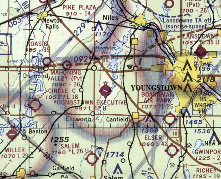
Ohio: Northeast Ohio
© 2002, © 2025 by Paul Freeman. Revised 6/13/25.
This site covers airfields in all 50 states: Click here for the site's main menu.
____________________________________________________
Please consider a financial contribution to support the continued growth & operation of this site.
Austintown Airport (revised 11/18/24) - Biglow Airfield (revised 6/20/16) - Garrettsville Airfield (added 6/13/25) - Hall Airport (added 9/30/22) - Hosmer Airfield (added 5/31/22) - Mills Airport (revised 10/24/24)
Port Warren Airport / Lyon Airport (revised 10/4/23) - Southern Airways Airport / Boardman Air Park (revised 5/30/22) - Warren Airport (added 11/17/24) - Youngstown Executive Airport (revised 3/18/22)
____________________________________________________
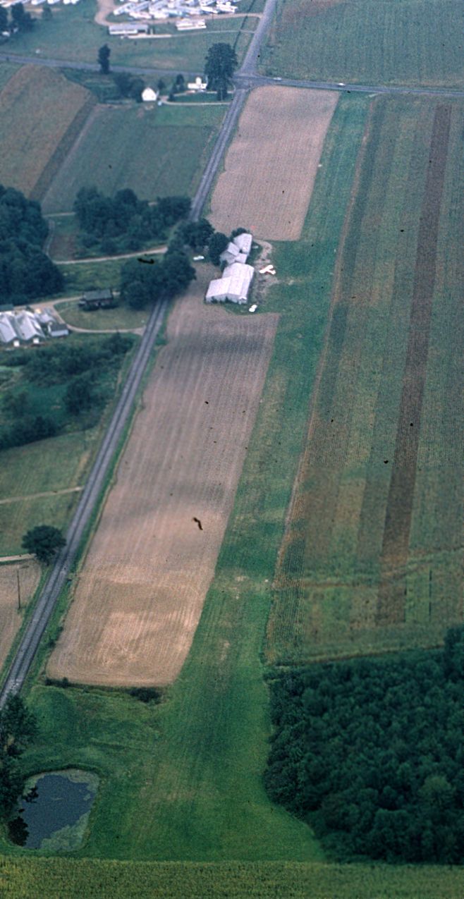
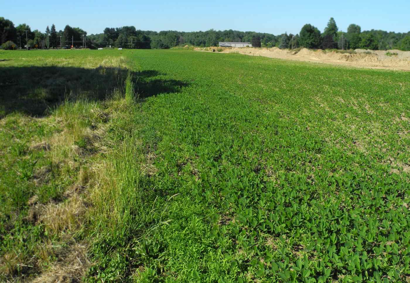
Garrettsville Airfield, Garrettsville, OH
41.306, -81.078 (Southeast of Cleveland, OH)
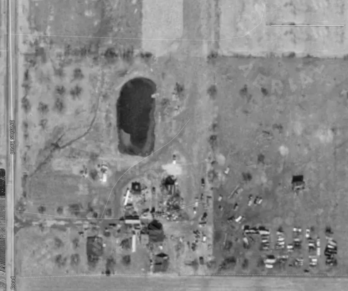
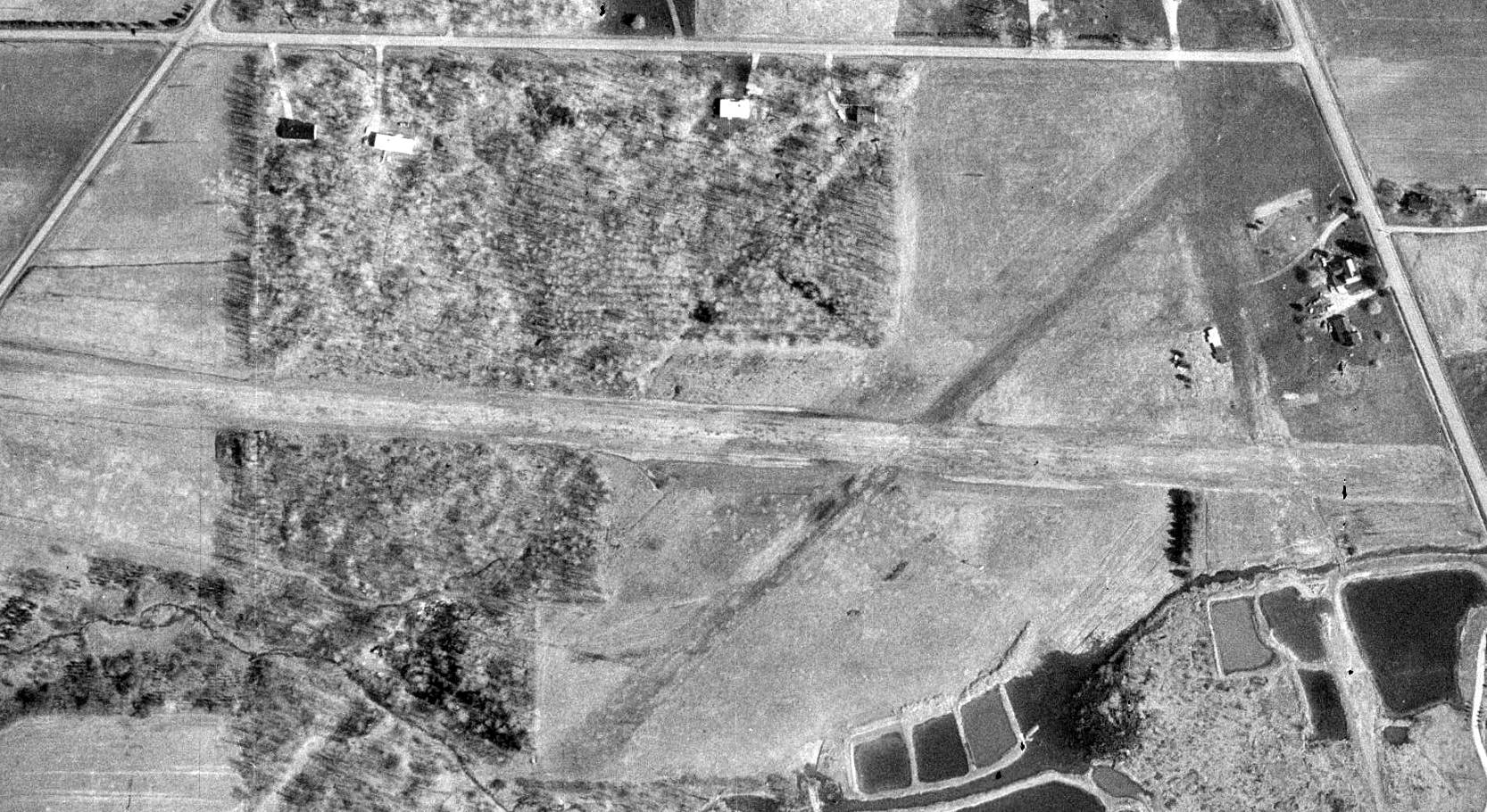
The Garrettsville Airfield, as depicted on a 1970 aerial photo (courtesy of Dennis Thompson).
Not much is known about this small private airfield, including its name or date of construction.
It was evidently built at some point between 1959-70, as it was not yet depicted on a 1959 aerial photo or the 1960 USGS topo map.
The earliest depiction which has been located of this airfield was on a 1970 aerial photo (courtesy of Dennis Thompson).
It depicted one light single-engine aircraft parked on the southwest side of a grass runway.
No airfield in Garrettsville was depicted on the 1970 Cleveland Sectional Chart (or subsequent aeronautical charts).
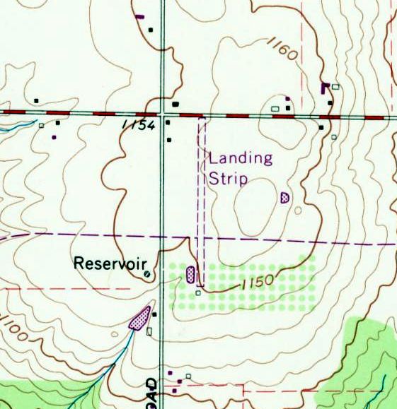
The earliest topo map depiction which has been located of the Garrettsville Airfield was on the 1971 USGS topo map.
It depicted a single unpaved north/south runway, generically labeled “Landing Strip”, with a small building on the south end.
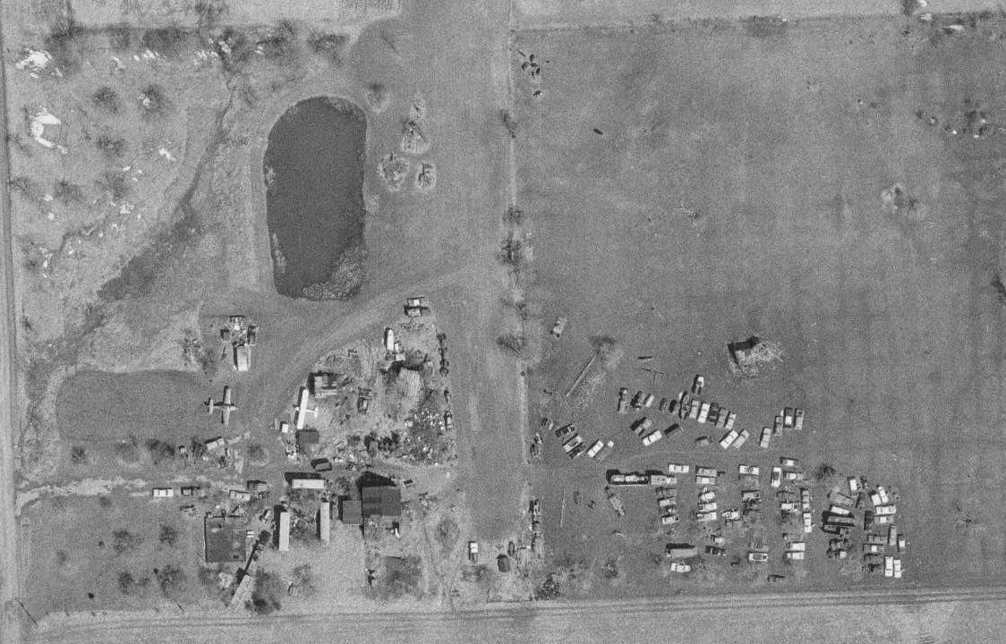
A 1975 aerial photo (courtesy of Dennis Thompson) depicted Garrettsville as having 2 light single-engine aircraft parked among a collection of vehicles.
A 1984 aerial photo (courtesy of Dennis Thompson) depicted Garrettsville as having 4 light single-engine aircraft parked on the southwest side.
A 1985 aerial photo (courtesy of Dennis Thompson) depicted Garrettsville as having 3 light single-engine aircraft parked on the southwest side.
The last photo which has been located showing an aircraft at Garrettsville was a 1994 aerial view,
which showed 1 light single-engine plane parked on the southwest side.
Garrettsville Airport was evidently closed (for reasons unknown) at some point between 1994-2006,
as a 2006 aerial photo showed the aircraft & vehicles on the field had been removed.
A 2025 aerial view looking northeast showed no trace remaining of the Garrettsville Airfield.
Thanks to Dennins Thompson for pointing out this airfield.
____________________________________________________
Warren Airport (original location), Warren, OH
41.25, -80.85 (Southeast of Cleveland, OH)
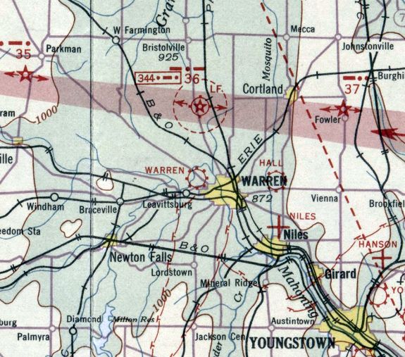
Warren Airport, as depicted on the December 1932 Cleveland Sectional Chart.
The date of establishment of this early general aviation airport on the west side of Warren has not been determined.
The earliest depiction which has been located of Warren Airport was on the December 1932 Cleveland Sectional Chart,
which depicted Warren as a commercial/municipal airport.
According to a historical plaque at the site, “On 7/26/36, at the age of 6, Neil Armstrong took his first flight in a Ford Tri-Motor airplane from Warren Airways located on this site.
Thus sparked his love of aviation.
Thirty-three years later history was made when Armstrong became the first man to walk on the moon.”
The March 1940 Cleveland Sectional Chart depicted Warren as a commercial/municipal airport.
Fred Erdman recalled, “When I was a kid my buddies & I would ride our bikes out to Warren Airport.
We get out to the airport & go into the hangar & buy a Coke for 5 cents, then we sit & watch airplanes.”
The only photo which has been located showing Warren Airport while it was open was a 4/27/50 USGS aerial view.
It depicted a grass airfield with a circular airport marker, and several buildings & 4 light single-engine aircraft on the east side.
The last aeronautical chart depiction which has been located of Warren Airport was on the June 1950 Cleveland Sectional Chart.
It depicted Warren Airport as having a 2,500' unpaved runway.
Warren Airport was evidently closed at some point in 1950,
as it was no longer depicted on the December 1950 Cleveland Sectional Chart.
It had been replaced by a larger Warren Airport 4 miles west.
Fred Erdman recalled, “They closed up the airport & put in a shopping plaza. I worked at the drug store they opened in the shopping center when I was 16.”
A 1951 aerial photo showed the Warren Airport hangars remained intact, but the field was devoid of aircraft.
The Warren Airport hangars remained visible in a 1970 aerial photo.
A 1982 aerial photo showed the former Warren Airport hangars had been removed at some point between 1970-82.
At some point between 1994-2006 a park was established at the site of Warren Airport, commemorating lunar astronaut Neil Armstrong's 1936 first flight, complete with a replica Lunar Lander.

A 2020 photo of the historical sign commemorating lunar astronaut Neil Armstrong's 1936 first flight at the Warren Airport.
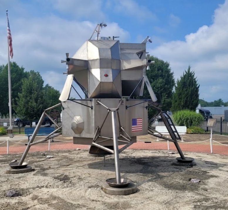
A 2022 photo of the replica Lunar Lander at the Warren Airport site, commemorating lunar astronaut Neil Armstrong's 1936 first flight.
A 2021 aerial view shows no trace remaining of Warren Airport, but the park with the Lunar Lander is visible at at top-right.
Thanks to Fred Erdman for pointing out this airfield.
____________________________________________________
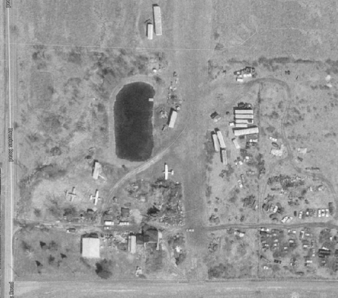
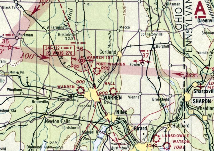
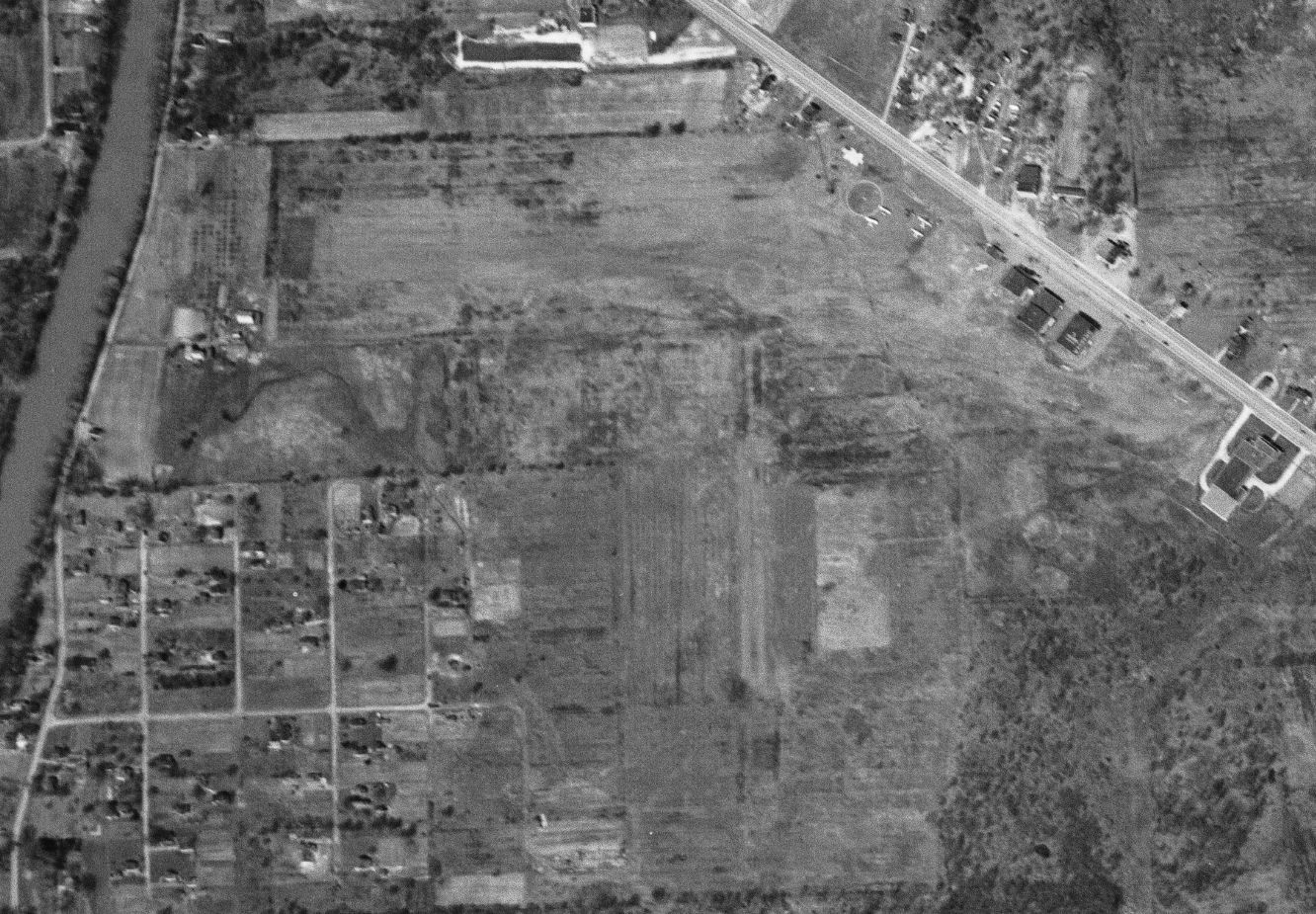
Port Warren Airport / Lyon Airport, Warren, OH
41.28, -80.808 (Southeast of Cleveland, OH)
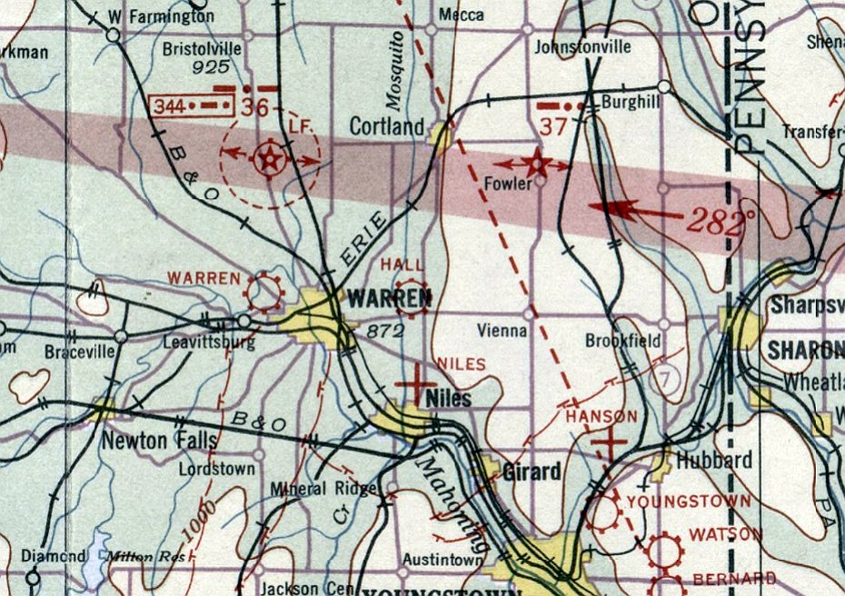
Port Warren Airport, as depicted on the March 1940 Cleveland Sectional Chart.
Photo of the airport while in use is not available.
This small general aviation airport on the north side of Warren was evidently established at some point between 1938-40,
as it was not yet depicted on the 1938 Cleveland Sectional Chart.
The earliest depiction which has been located of Port Warren Airport was on the March 1940 Cleveland Sectional Chart.
It depicted Port Warren as a commercial/municipal airport.
Port Warren Airport was still depicted on the 1947 Cleveland Sectional Chart.
Port Warren Airport was evidently renamed Lyon Airport at some point between 1947-50,
as that is how it was depicted on the November 1950 Cleveland Sectional Chart.
Lyon Airport was depicted as having a 2,600' unpaved runway.
The earliest photo which has been located of Lyon Airport was a 1952 aerial view.
It depicted Lyon Airport as having a single grass east/west runway, with 2 light single-engine planes & 5 T-hangars on the west side.
Fred Erdman recalled, “Lyon Airport is where I took my first training flight on 7/10/54.
Lyon was a Captain in our Civil Air Patrol Unit. He gave lessons with a Piper J-3 Cub.
The airport was located on the east side of North Park Road just before the northern city limits.”
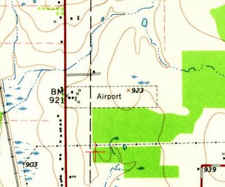
The earliest topo depiction which has been located of Lyon Airport was on the 1960 USGS topo map.
It depicted an east/west property outline, generically labeled as “Airport”, with several small buildings on the west side.
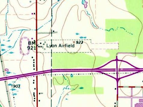
The 1970 USGS topo map depicted “Lyon Airfield” as an east/west property outline, with an extension to the east added at some point between 1960-70, and several small buildings on the west side.
The last photo which has been located showing Lyon Airport still in operation was a 1970 aerial view.
It depicted 5 light single-engine planes parked near the hangars on the west side.
The 1972 Detroit Sectional Chart (courtesy of Ron Plante) depicted Lyon Airport as having a 2,900' unpaved runway.
The last aeronautical chart depiction which has been located of Lyon Airport was on the 1974 Detroit Sectional Chart.
It depicted Lyon Airport as having a 2,900' unpaved runway.
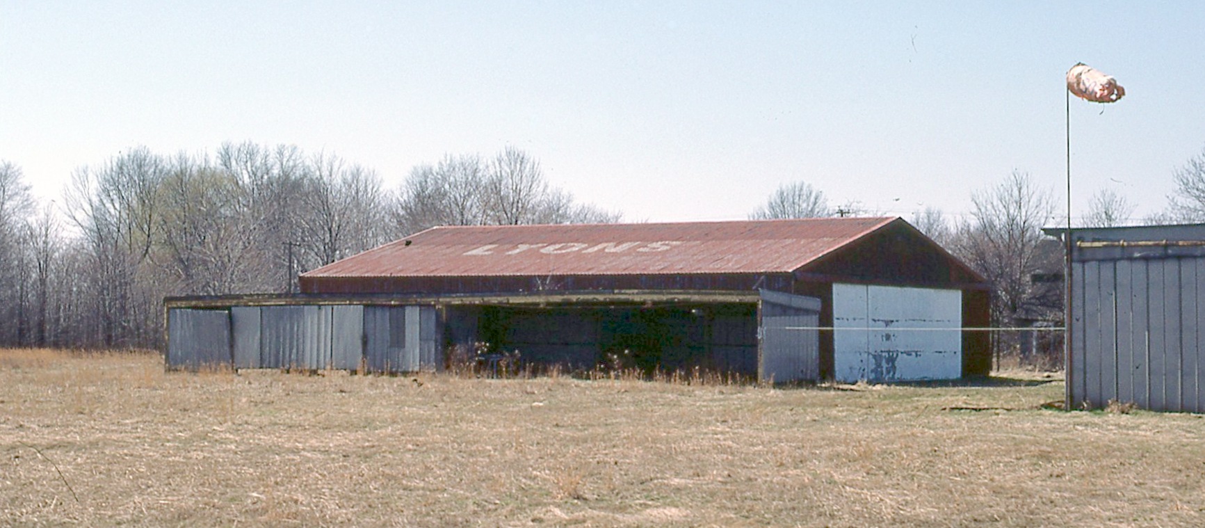
An April 1976 photo by Fred Erdman of the Lyons Airport hangar, with “Lyons” painted on its roof.
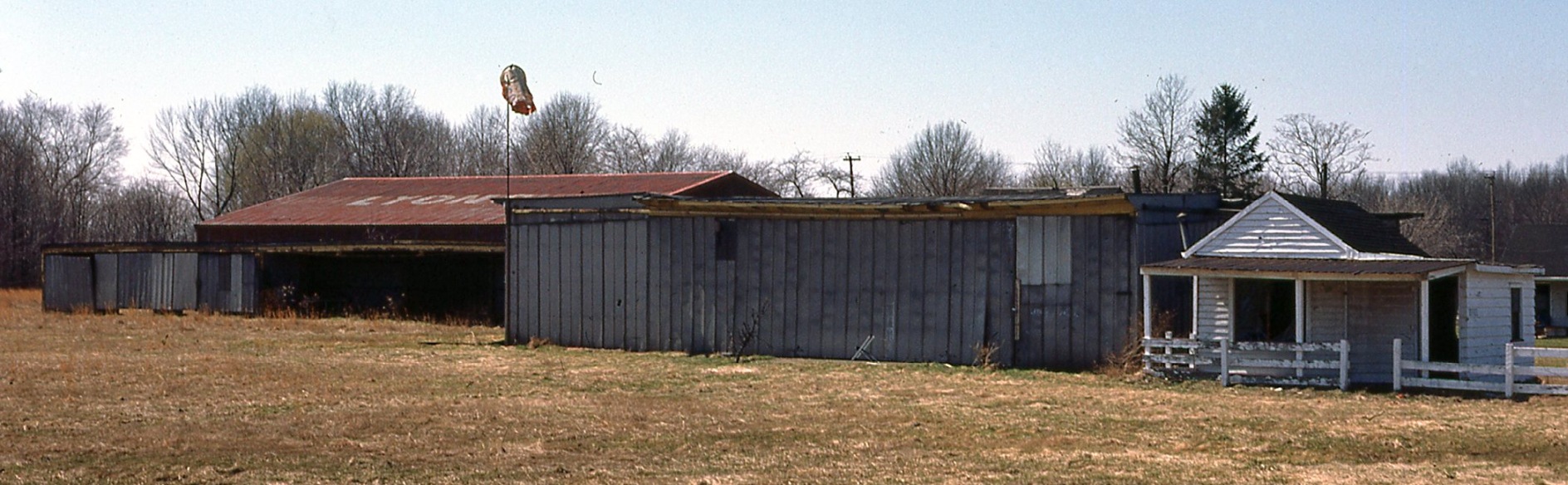
An April 1976 photo by Fred Erdman of the Lyons Airport hangar & office.
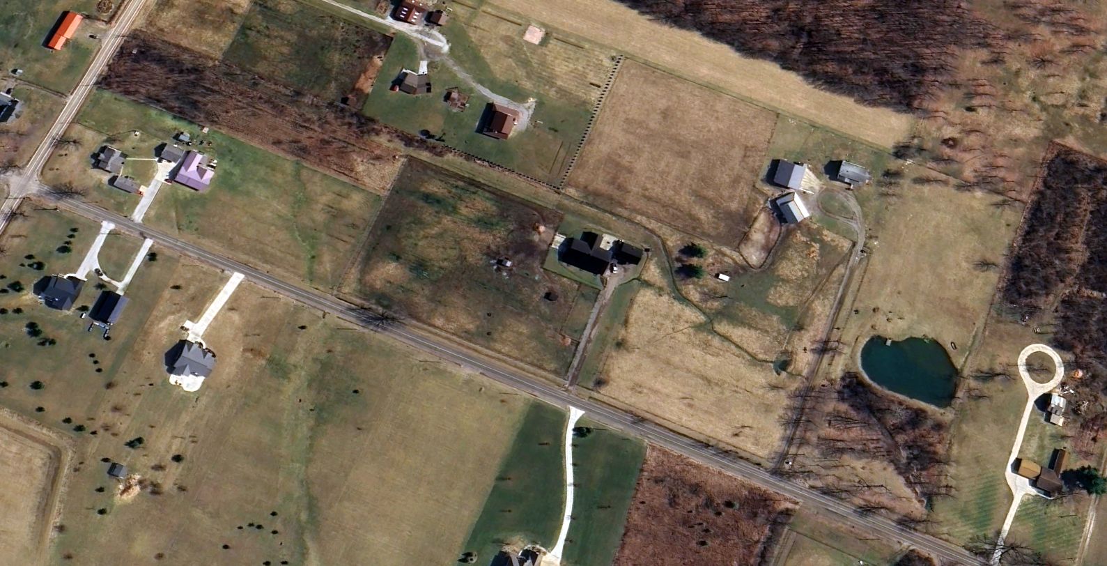
Lyon Airport was evidently closed at some point between 1974-81 (for reasons unknown),
as it was no longer depicted on the May 1981 Detroit Sectional Chart (courtesy of Ron Plante).
A 1982 aerial photo showed a giant warehouse having erased any trace of Lyon Airport.

A 2023 aerial view showed a warehouse covering the site of Lyon Airport.
Thanks to Fred Erdman for pointing out this airfield.
____________________________________________________
41.251, -80.75 (Southeast of Cleveland, OH)
Hall Airport, as depicted on the December 1932 Cleveland Sectional Chart.
Photo of the airport is not available.
According to Will Hubin, “Pioneer flight instructor Ernie Hall had a storied career but hasn't received proper recognition.
He built a Bleriort & flew it around 1912.
He apparently barnstormed, instructed for Curtiss, established his private airport in Warren, and in between was a civilian flight instructor for the Army.
He logged over 17,000 hours.”
The date of establishment of Hall Airport has not been determined.
The earliest depiction which has been located of Hall Airport was on the December 1932 Cleveland Sectional Chart.
It depicted Hall as a commercial/municipal airport.
The earliest photo which has been located of Hall Airport was a 1950 aerial view.
It depicted Hall Airport as having a single grass east/west runway, with a hangar & 1 light single-engine plane on the northeast side.
A 1951 aerial photo showed Hall Airport perhaps at its zenith of popularity, with 3 light single-engine planes on the northeast side.
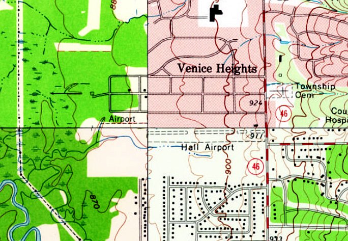
The earliest topo map depiction which has been located of Hall Airport was on the 1962 USGS topo map.
It depicted Hall Airport as having a single east/west unpaved runway, but surrounded on both sides by houses.
Will Hubin recalled, “In the Fall of 1968 I heard about Ernie Hall, a pioneer Certified Flight Instructor who was still flying & instructing out of Warren.
I flew with him in one of his 3 Piper J-3 Cubs (N2151M) on 5/3/69.
Ron CIminero remembers that his father took some lessons from Ernie.”
The last photo which has been located showing aircraft at Hall Airport was a 1970 aerial view,
which showed 2 light single-engine planes on the northeast side.
The last aeronautical chart depiction which has been located of Hall Airport was on the 1972 Detroit Sectional Chart (courtesy of Ron Plante).
It depicted Hall Airport as having a 3,500' unpaved runway.
Hall Airport was evidently closed at some point between 1972-74 (for specific reasons unknown, but presumably due to rising property values with houses having been built close on both sides),
as it was no longer depicted on the 1974 Detroit Sectional Chart (courtesy of Ron Plante).
A 1982 aerial photo showed Hall Airport's runway remained clear,
but the hangar had been removed at some point between 1970-82.
A 1994 aerial photo showed the Hall Airport site remained unredeveloped.
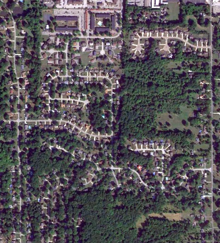
A 2004 aerial view showed streets & houses having erased the last trace of Hall Airport.
A 2021 aerial view showed no trace remaining of Hall Airport.
Will Hubin reported in 2022, “There is a museum close to Ernie's old airport”, the Ernie Hall Aviation Museum.
Thanks to Will Hubin for pointing out this airfield.
____________________________________________________
41.432, -81.113 (Southeast of Cleveland, OH)
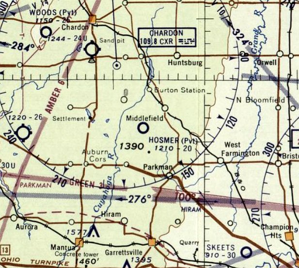
Hosmer Airfield, as depicted on the July 1959 Sectional Chart.
This private airfield was evidently established at some point between 1958-59,
as it was not yet depicted on the 1958 Sectional Chart.
The earliest depiction which has been located of Hosmer Airfield was on the July 1959 Sectional Chart.
It depicted Hosmer as a private airfield having a 2,000' unpaved runway.
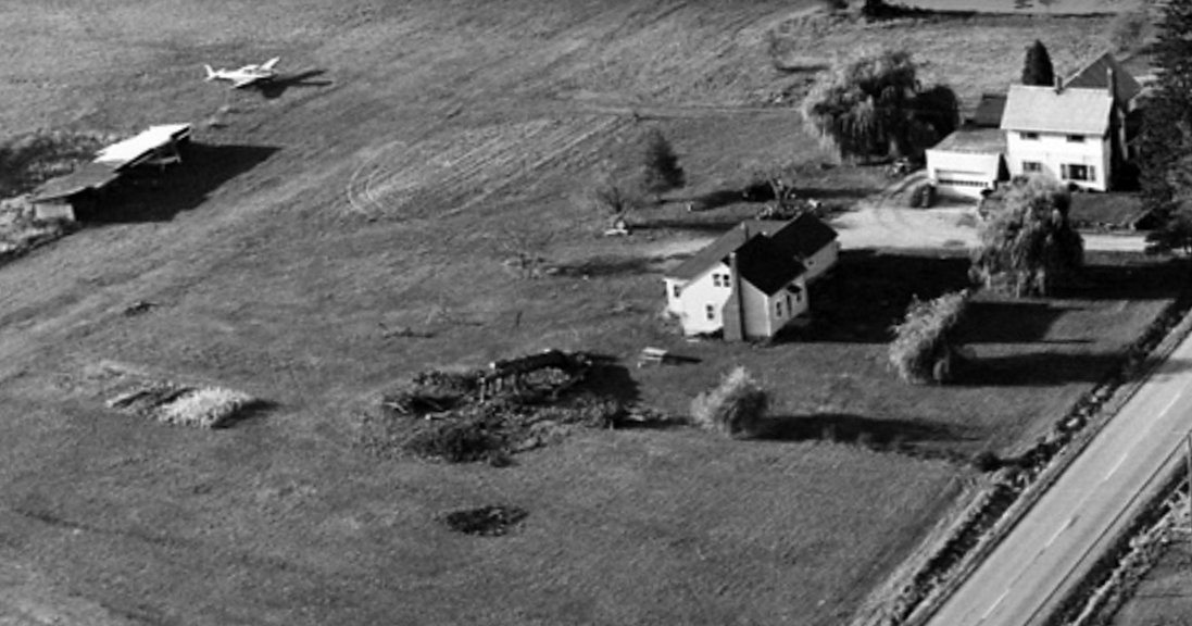
The earliest photo which has been located of Hosmer Airfield was a 1969 aerial view looking northwest (courtesy of Dennis Thompson).
It depicted a Navion next to 2 T-hangars, near several houses.
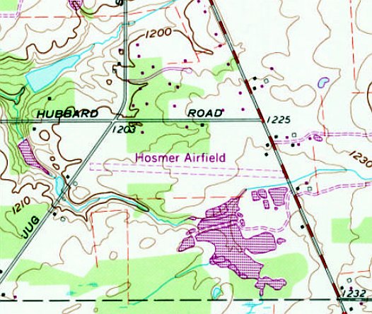
The earliest topo map depiction which has been located of Hosmer Airfield was on the 1970 USGS topo map.
It depicted Hosmer Airfield as having a single east/west unpaved runway, with 2 small buildings on the northeast side.
A 1970 aerial photo (courtesy of Dennis Thompson) depicted Hosmer Airfield as having 3 unpaved runways, with 2 T-hangars on the northeast side.
The last aeronautical chart depiction which has been located of Hosmer Airfield was on the May 1981 Sectional Chart (courtesy of Ron Plante).
It depicted Hosmer as a private airfield having a 3,100' unpaved runway.
Hosmer Airfield was evidently closed (for reasons unknown) at some point between 1981-93,
as it was no longer depicted on the October 1993 Sectional Chart (courtesy of Ron Plante).
A 1994 aerial photo appears to show that the 2 Hosmer Airfield T-hangars were removed at some point between 1970-94.

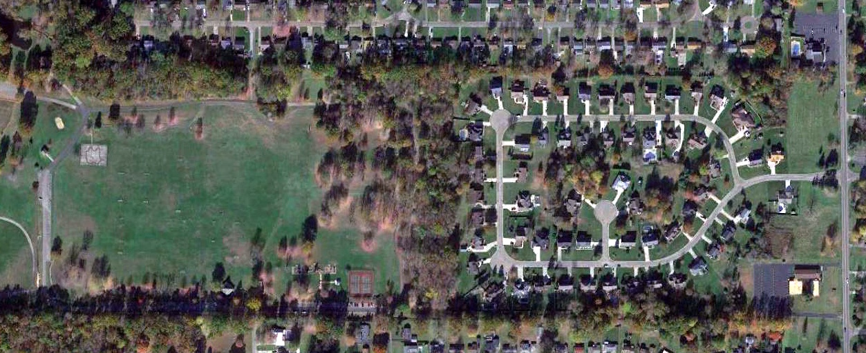
A 2021 aerial view showed the alignment of all 3 Hosmer Airfield runways remained recognizable.
Thanks to Dennis Thompson for pointing out this airfield.
____________________________________________________
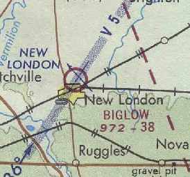
Biglow Airfield, New London, OH
41.095, -82.388 (Southwest of Cleveland, OH)
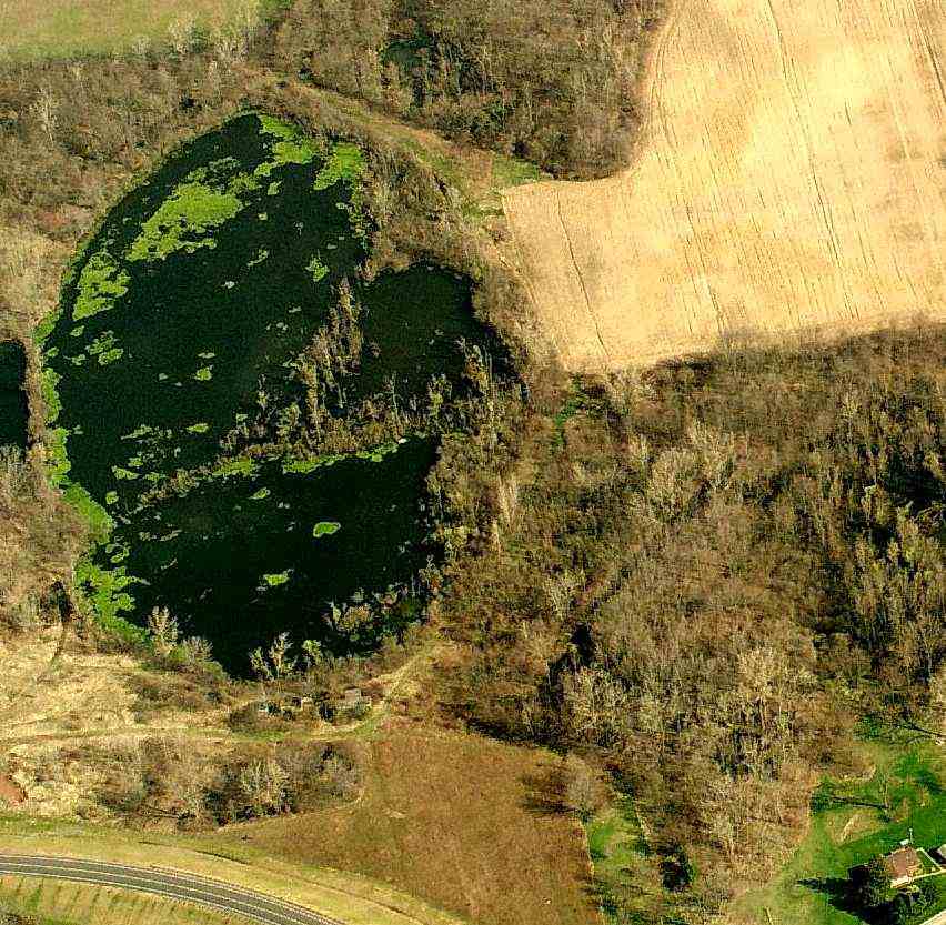
A 5/8/59 USGS aerial view of Biglow Airport.
According to property owner Ralph Danison, a tile plant on this property “was built in 1882 by Anthony Ruse.
The Biglow Company... sold out in the late 1920s or early 1930s.”
No airfield was yet depicted at this location on the 1948 USGS topo map.
At some point between 1948-55 an airfield was constructed on the property.
According to Ralph Danison, “The man who flew out of this airport was Earl Deer.
He was superintendent of the company's plants; they built that airport just for him.”
Ed Ganz recalled of the airfield, “I think it had 2 sod strips. Hangars were at the southwest corner of the property.
I hauled tile out of there in 1955 & it was still there. The buildings to the west are the tile company's.
They had a plane; I don't remember what kind. I think they had 2 more plants west of there & would fly between them."
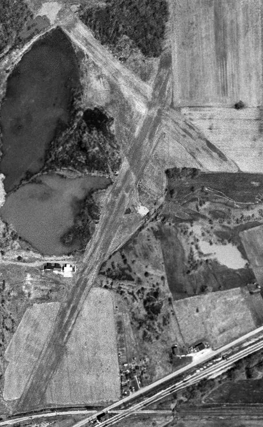
The only photo which has which has been located of aircraft at Biglow Airfield was on a 5/8/59 USGS aerial view.
It depicted the airfield as having 2 unpaved runways, with 3 T-hangars & one single-engine aircraft on the west side.
However, no airfield was depicted at this location on the 1960 Cleveland Local Aeronautical Chart (courtesy of Mike Keefe).
The earliest topo map depiction of which has been located of Biglow Airfield was on the 1960 USGS topo map.
It depicted the airfield as having 2 runways, labeled simply as "Landing Field".
Don Murray recalled, “I grew up in New London & frequented the Biglow property to fish in the ponds north of the hangars, roughly 1963-68.
There were 2 aircraft based there in this time period.
One was a Piper Apache twin. It was green & was kept in the 'still intact' hangar with the sliding doors.
We only saw this plane when it was coming or going, the hangar being locked otherwise.
The other was an all metal taildragger maybe a Cessna 170 & was kept in the open-front cement block hangar.
I think it was yellow. I remember that it had 2 venturis for vacuum instruments on the right side of the aircraft.”
Biglow Airfield still was not depicted at all on the 1965 or May 1970 Cleveland Sectional Charts.
Ralph Danison recalled of the property, “It was used by Hancock Brick until the late 1960s & early 1970s.
I would say that the early 1970s was the last [the airfield] was used, unless some one 'sneaked' a landing.
The gentleman who flew out of there used his single-engine aircraft to go on sales calls & business related trips.
Hancock Brick also had more than one factory.”
The only aeronautical chart depiction which has been located of Biglow Airfield was on the May 1971 Detroit Sectional Chart (courtesy of Chris Kennedy).
It depicted "Biglow" as a public-use airfield having a 3,800' unpaved runway.
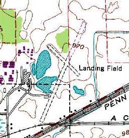
The 1972 USGS topo map depicted Biglow Airfield as having 2 runways (with the longest being the 2,800' northeast/southwest strip), labeled simply as "Landing Field".
The Biglow Airfield was not listed in the January 1972 Flight Guide (according to Chris Kennedy).
Ralph Danison recalled, “My father purchased the property in 1974.” The London Tile Company is their family business.
Ralph added, “The airstrip was maintained during our time down there, but was not used to my knowledge.”
The Biglow Airfield was not listed in the 1976 AOPA Airports USA Directory (according to Chris Kennedy),
or depicted on the 1977 or 1986 USGS topo maps.
Ralph Danison recalled, “We manufactured tile there until 1985 [when they moved a few blocks away].
We ran limited operations from the late 1980s until 2001 at the Ledgitt Street location.”
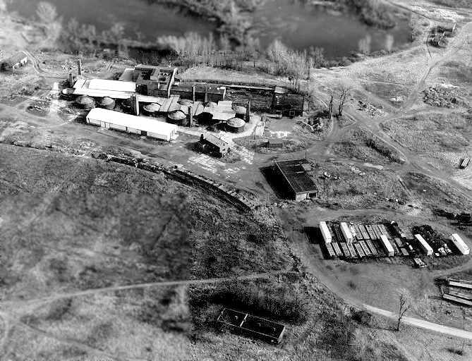
A 1991 aerial photo (courtesy of Ralph Danison) looking east at the Biglow Company factory, kins, garage, and a hangar (at the top-right).
A 1994 USGS aerial view looking north showed the cleared grass area of the 2 former runways at the site of Biglow Airfield was still barely recognizable.
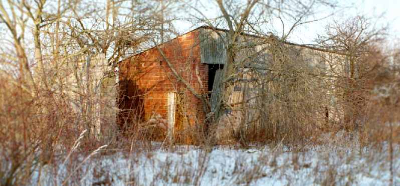
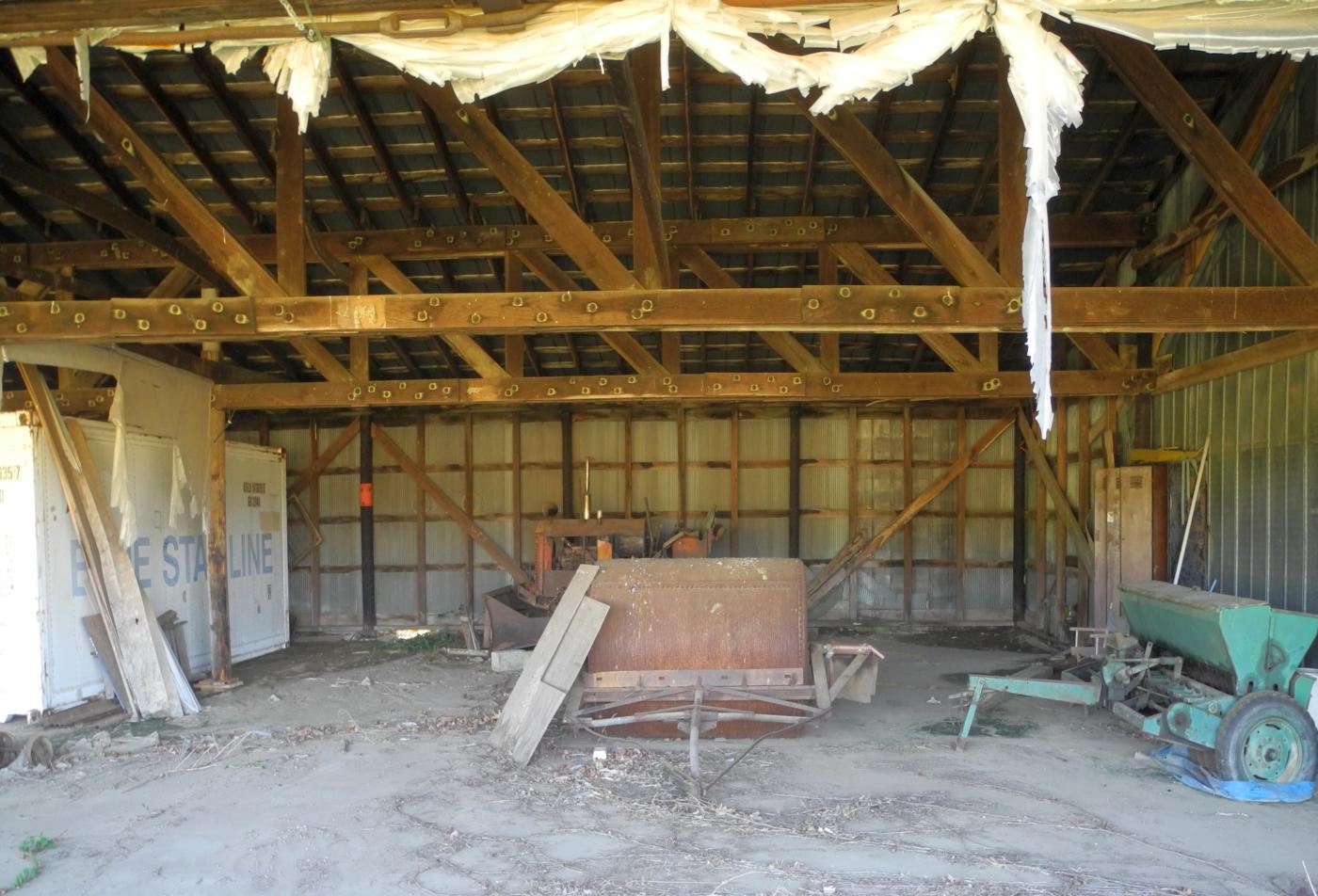
A December 2005 photo by Ralph Danison of the exterior of the Biglow hangar.

A December 2005 photo by Ralph Danison of the interior of the Biglow hangar.
Ralph Danison reported in 2005 that 2 former airfield buildings were still standing.
“They're made of brick & are intact in the weeds, and still in good shape!
One was made of cinder block, it looks like it was disassembled for spare blocks.
I'm not sure if it was a hangar or a storage building. The other building is certainly a hangar.
It is custom-built around an aircraft, that is the hangar is shaped somewhat like an airplane.
It is made E. Biglow Company's famous 'hollow' brick (they basically made their own hangar).
The red brick hangar is in fantastic shape, not one hole in the roof, the airplane door in still on the rack,
the entrance door is still on its hinges, and the hangar is free of vandalism & has not one loose brick.”
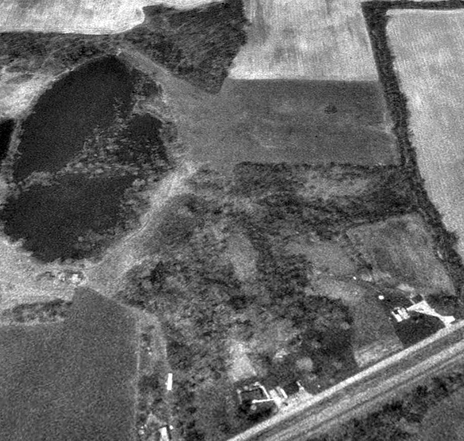
A circa 2006 aerial view looking north at the site of the Biglow Airfield, with the outline of the 2 runways still barely recognizable,
and the 2 former hangars visible just below the ponds.
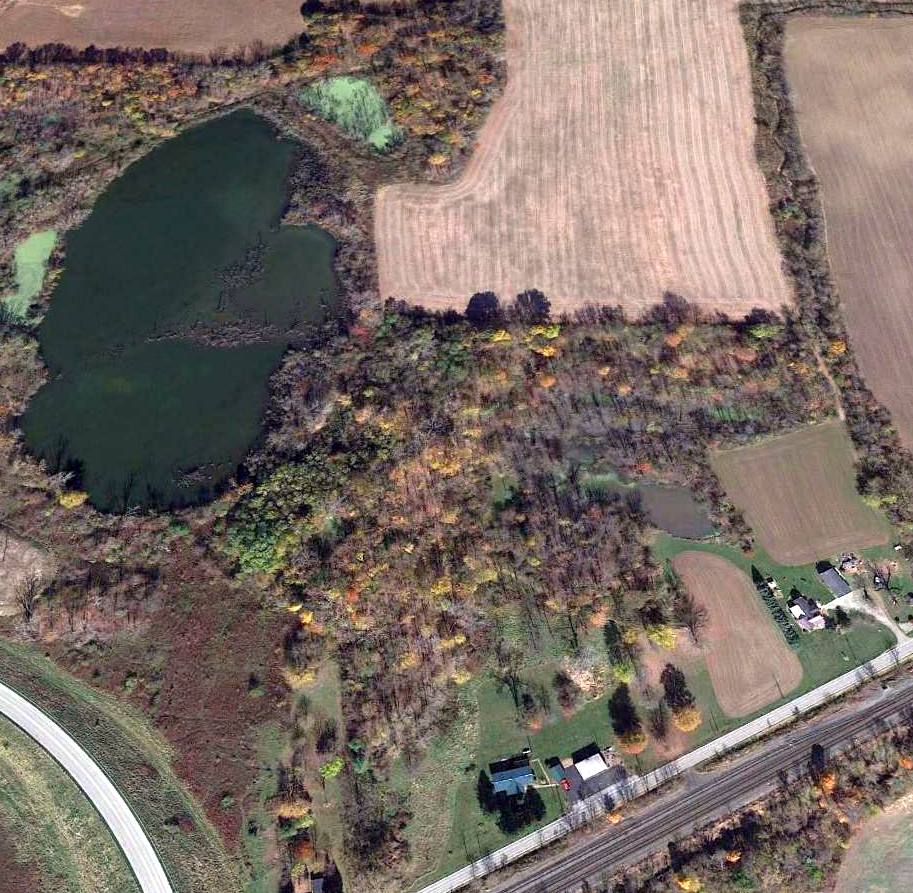
A 2015 aerial view looking north showed the site of Biglow Airfield was no longer recognizable as a former airfield.
The site of the Biglow Airfield is located east of the intersection of East Fir Street & Ledgett Street.
____________________________________________________
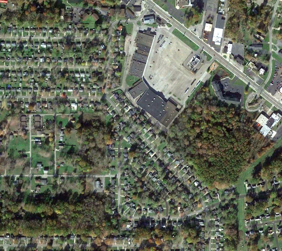
Austintown Airport, Austintown, OH
41.089, -80.76 (Southeast of Cleveland, OH)
Austintown Airport, as depicted on the July 1947 Cleveland Sectional Chart.
Austintown Airport was evidently established at some point in 1947,
as it was not yet depicted on the January 1947 Cleveland Sectional Chart.
The earliest depiction which has been located of Austintown Airport was on the July 1947 Cleveland Sectional Chart.
Eric Smith recalled, “My father & uncle (Eugene & Myron Smith) owned (or managed) the airport off of Highway 46 in Austintown.
I am not sure when it opened. They were both in the Air Force in WWII so I assume it was around 1947.
It housed 15-20 planes & did a pretty good maintenance business.
The office was a simple 2-story building that was adjacent to a large hangar.
The grass strip - I am not sure of the length, but I know that a DC-3 landed & took off from the field.
My dad had a couple of Cessna 195s in which he used to fly stretcher-bound passengers down to Florida in the winter.”
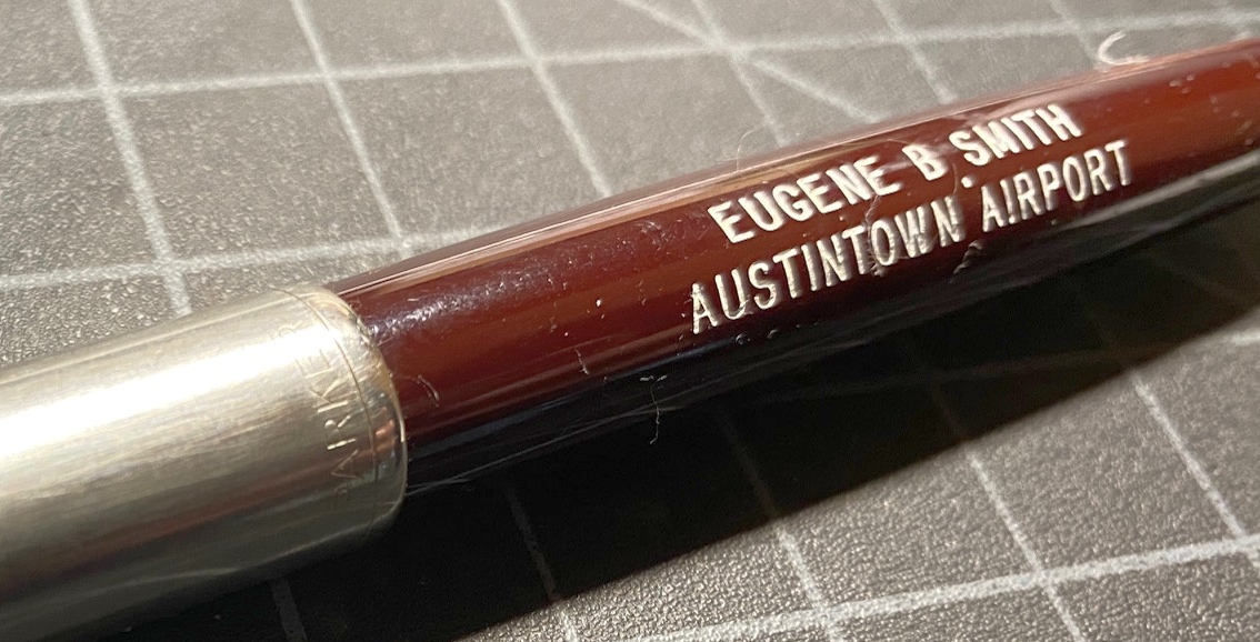
A 2019 photo by Eric Smith of Eugene Smith's Austintown Airport Marker pen.
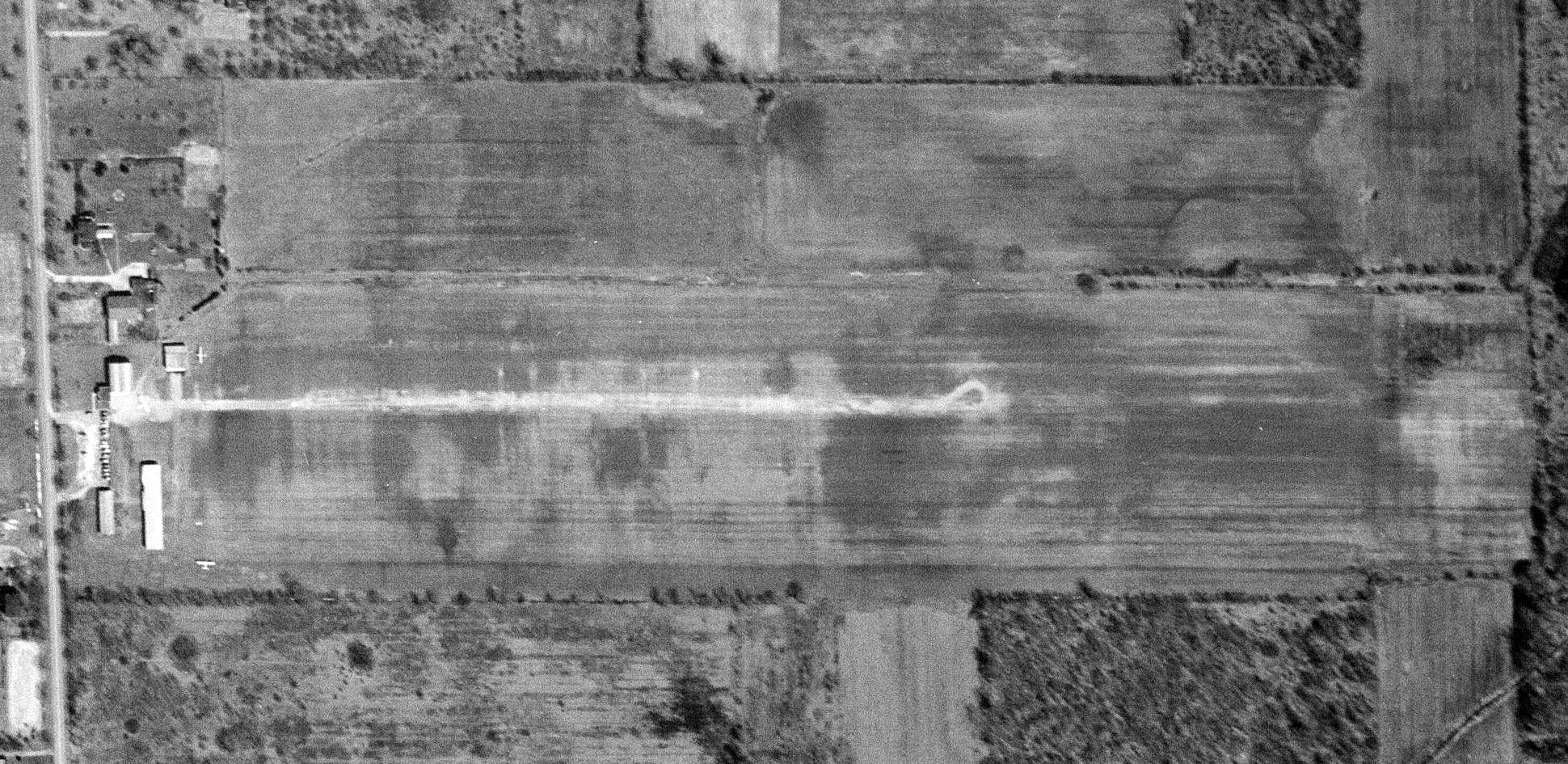
The earliest photo which has been located of Austintown Airport was a 4/16/50 USGS aerial view.
It depicted Austintown Airport as having a single east/west unpaved runway, with 2 light single-engine aircraft parked near some small hangars on the west side.
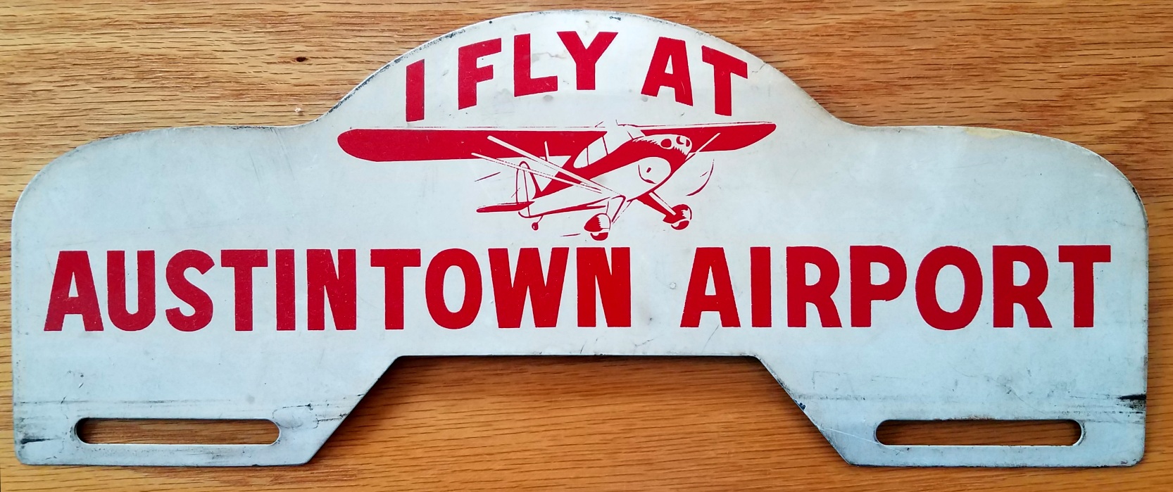
A 2021 photo by Nancy Wills of a circa 1950s license plate frame advertising Austintown Airport.
The 1952 USGS topo map depicted “Austintown Airfield” as having a single unpaved east/west runways, with several small buildings on the northwest & southwest sides.
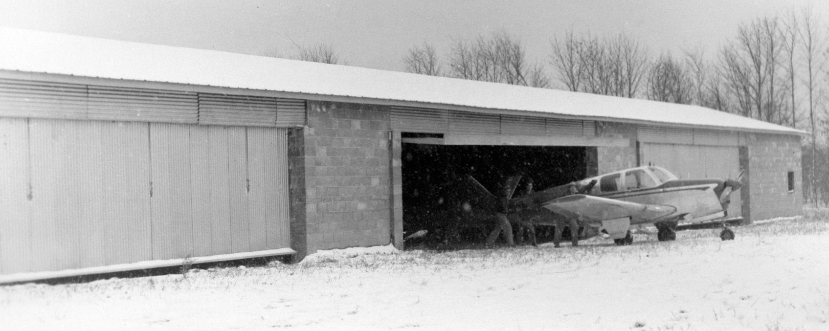
A late 1950s photo (courtesy of Eric Smith) of a V-tail Beech Bonanza being wheeled out of a Austintown Airport hangar into the snow.
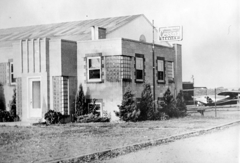
A late 1950s photo (courtesy of Eric Smith) of the Austintown Airport office building.
The last photo which has been located of Austintown Airport was a 1959 aerial view.
It depicted Austintown Airport perhaps at the zenith of its popularity, with 9 light single-engine aircraft parked on the west side.
The last depiction which has been located of Austintown Airport was on the January 1960 Cleveland Sectional Chart.
It depicted Austintown Airport as having a 3,100' unpaved runway.
Austintown Airport was evidently closed at some point in 1960, as it was no longer depicted on the July 1960 Cleveland Sectional Chart.
Eric Smith recalled, “My other uncle (Earl Bailey) owned the property & converted it to the housing development that now occupies the area.
He moved the Cessna 195s to the Youngstown Executive Airport in the early 1960s.”
A 1962 aerial photo showed streets & houses covering the site of Austintown Airport, but 2 hangars remained on the west side.
The 1963 USGS topo map showed streets & houses covering the site of Austintown Airport.
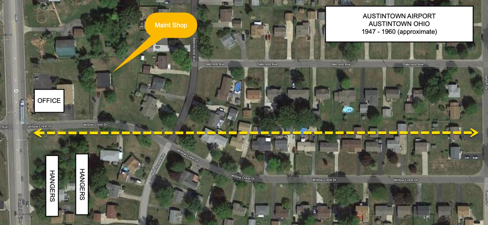
A 2018 aerial view of the site of Austintown Airport annotated by Eric Smith to show the location of the airport office & maintenance buildings which remain, along with the former location of the runway & hangars.
Eric Smith reported in 2019, the former Austintown Airport office “has been converted to a physical therapy building.
The maintenance building had a false front added to it & is now a house.”
Thanks to Eric Smith for pointing out this airfield.
____________________________________________________
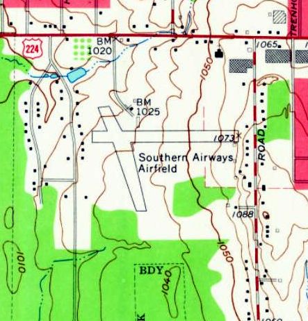
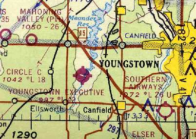
Southern Airways Airport / Boardman Air Park, Boardman, OH
41.02, -80.684 (Southeast of Cleveland, OH)
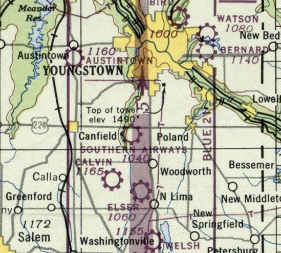
Southern Airways Airport, as depicted on the July 1947 Cleveland Sectional Chart.
Southern Airways Airport was evidently established at some point between 1945-47,
as it was not yet depicted on the June 1945 Cleveland Sectional Chart.
The earliest depiction which has been located of Southern Airways Airport was on the July 1947 Cleveland Sectional Chart.
The earliest photo which has been located of Southern Airways Airport was a 1947 ODoT aerial view (courtesy of Dennis Thompson).
It depicted Southern Airways Airport as having 2 unpaved runways, and a few small buildings & 4 light single-engine planes on the north side.
A 1950 aerial photo depicted Southern Airways Airport as having 2 unpaved runways,
with one single-engine light aircraft & 2 hangars on the north side.
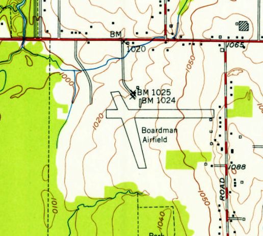
The 1951 USGS topo map depicted the airfield under a different name: Boardman Airfield.
It depicted the field as having 2 runways, with 2 small buildings just northeast of the runway intersection.
Fred Erdman recalled, “In 1954 I joined the Civil Air Patrol & we would do our search & rescue training at Southern Airways / Boardman Airpark.”
A 1958 ODoT aerial view (courtesy of Dennis Thompson) depicted Southern Airways Airport as having an assortment of light single-engine planes, some in pieces.
Timothy Moran recalled, “I was associated with Southern Airways / Boardman Air Park from October 1962 until July 1964.
This was a great time in my life. I earned a private pilot’s license on 6/13/63.
I logged over 220 hours during my association with Southern Airways. I also worked there as a lineboy for about 1 ½ years.
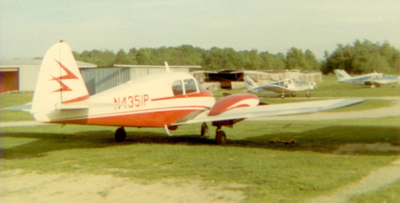
The airpark had several buildings: a main office / pilots' lounge, a maintenance shop, 2 rows of T-hangars, and a single hangar at the east end of the east/west runway.
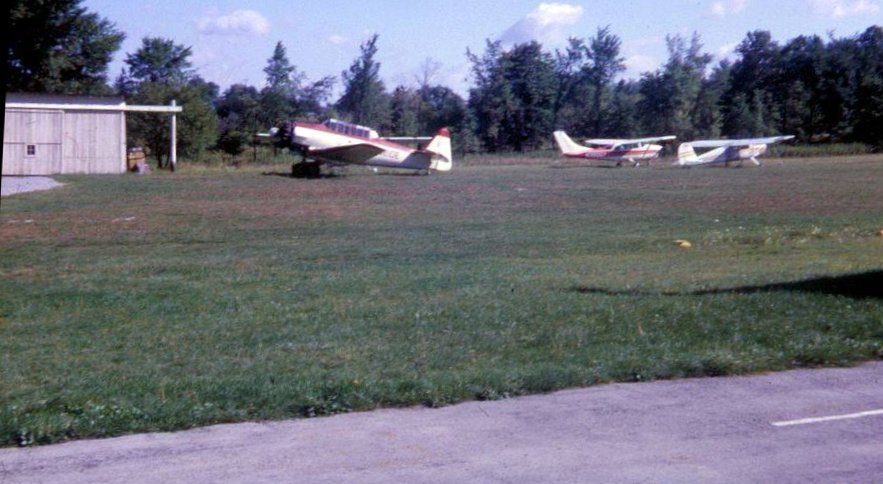
In the photo with Piper Apache N4351P [below], the hangar directly behind belonged to Don Paddon where he kept his Beechcraft Debonair.
The main north/south runway was grass, which was then converted to a loose cinder/gravel strip for better utilization during wet months.
The north/south runway had lights which were turned on from the ground by a switch. [Frequency] 122.8 Unicom was in place.
Southern Airways provided new aircraft sales, pilot training, aircraft & engine maintenance, charter flights, aircraft hangar rentals, outside tie downs, and fueling services.
Southern Airways was owned & operated by Nick Parish. Nick flew reconnaissance P-51s in the Second World War.
In the early 1960s Nick was an Air Force Reserve Officer & regularly flew Fairchild C-119s from Youngstown Airport. He had logged over 22,000 flight hours at that time.
Nick died sometime later in the crash of a Globe Swift GC1-B while instructing a student.
Southern Airways was a Piper Aircraft retail dealer.
There were at least 6 Piper Colts available for training & rental; along with 2 Piper Cherokees & a Piper Apache 150 twin.”
Timothy continued, “Some of the pilots & their aircraft I remember: Don Paddon: Beechcraft Debonair,
Eldon 'Buck' Weaver: Cessna 170B (Buck was a CFI), Frank Sadler: CFI, Al Segretti: CFI, Bill Bender: partner in a Cessna 120,
Frank Ferris: Piper Super Cub (used for professional aerial photography), Carl Bopp: Piper Comanche 250,
Dr. Foster: Piper Cherokee 180, Cliff Lawson: local pilot, Dr. Bender: Piper Aztec 160, Dr. Bloomberg: local pilot,
Tom Sweeney: A&P mechanic (worked at Lansdowne Airport at one time).”
The 1963 USGS topo map depicted the airfield in the same physical configuration, but once again with the name of Southern Airways Airfield.
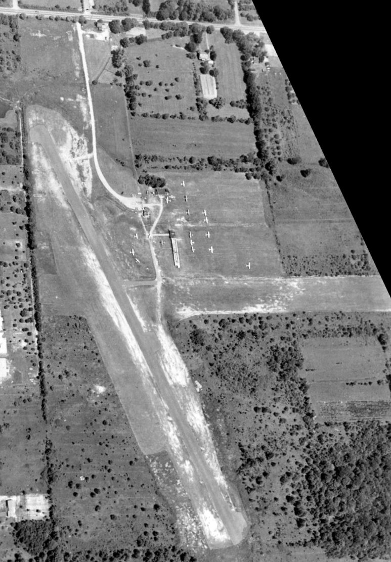
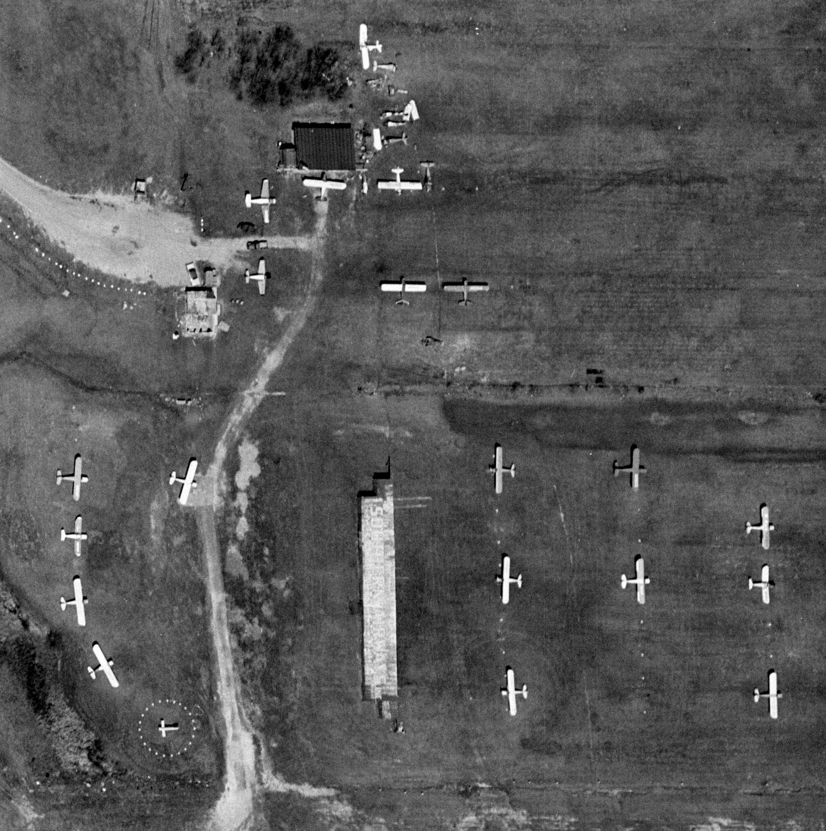
A circa 1963 aerial view (courtesy of Chuck Johnson) depicted Southern Airways Airport as having a paved northwest/southeast runway, an unpaved east/west runway,
and 18 light single-engine planes parked near some buildings on the northeast side.
A summer 1964 photo looking northeast at a North American AT-6 Texan in civilian markings at Southern Airways Airport (courtesy of Chuck Johnson).
The east end of the Southern Airways maintenance hangar is visible on the left side.
Chuck Johnson recalled of the AT-6, “This particular aircraft was based at Southern Airways; in addition, because of Andy Hammock’s expertise with the AT-6 & SNJ, several other of these aircraft were maintained at Southern Airways.
To the right of the AT-6/SNJ is a relatively new Cessna 205, either a 1963 or 1964 model. To the right of the C-205 is a Cessna 120 or 140.
The asphalt pad at the bottom of the photo is a paved ramp way leading into the first T-hangar (northside) of the first row or 'Row 1' as we called it, of the T-hangars.
During this period of time Arthur Nicolette kept is Beechcraft Model 33 Debonair in the first hangar.”
The 1965 Cleveland Sectional Chart (courtesy of Chris Kennedy) depicted Southern Airways Airport as having a 2,600' unpaved runway.
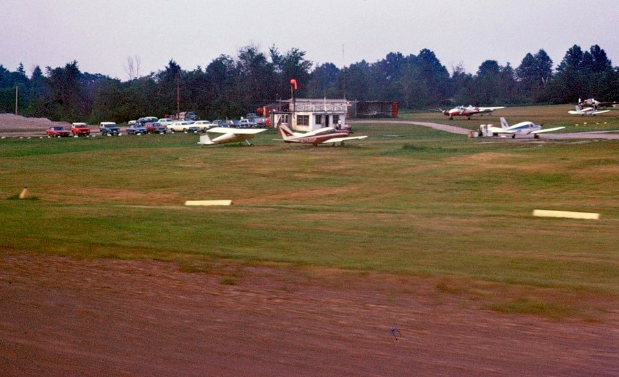
A 1968 photo taken during takeoff from Southern Airways Airport's Runway 16 (courtesy of Chuck Johnson)
showing a variety of general aviation aircraft.
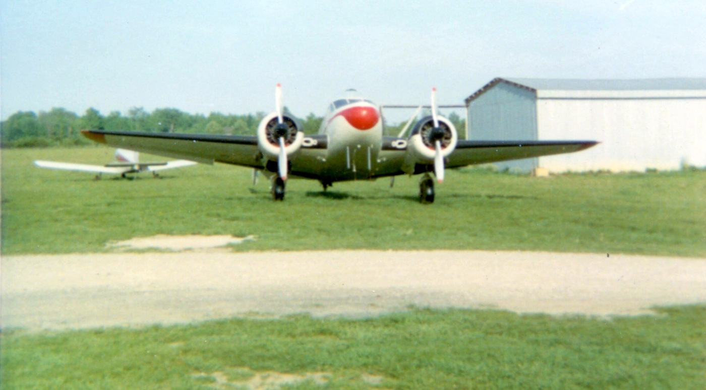
A circa late 1960s / early 1970s photo by Jim Croasmun of a Beech 18 in front of a Piper & some hangars at what appears to be Boardman Air Park.
Jim recalled, “The pictures were taken when a friend & I rode our bicycles out to a grass strip, and stood there hanging on the fence watching takeoffs & landings.
While I can't say with absolute certainty, I think it's very likely that we'd bicycled to Boardman Air Park.”
A circa late 1960s / early 1970s photo by Jim Croasmun of a Piper Apache, some other Pipers & several hangars at what appears to be Boardman Air Park.
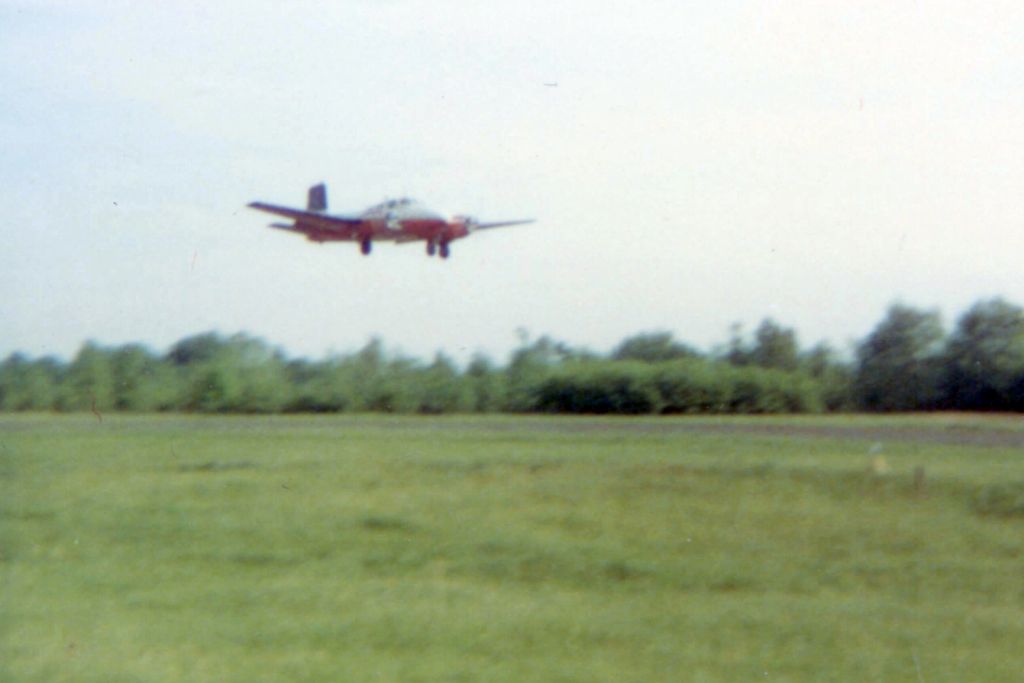
A circa late 1960s / early 1970s photo by Jim Croasmun of a Beech Twin Bonanza taking off or landing at what appears to be Boardman Air Park.
The last aeronautical chart depiction which has been located of Boardman Air Park was on the May 1970 Cleveland Sectional Chart.
It depicted Boardman as having a 2,600' unpaved runway.
Boardman Air Park was evidently closed at some point between 1970-72,
as it was no longer depicted on the November 1972 Detroit Sectional Chart (courtesy of Ron Plante).
The 1979 USGS topo map had an odd depiction – a neighborhood of new streets & houses was depicted over the site of Boardman Air Park,
but the label “Boardman Air Park” was still superimposed over the new streets.
A 1994 aerial view showed no trace remaining of Boardman Air Park.
A 2015 aerial view showed no trace remaining of Boardman Air Park.
The site of Broadman Air Park is located south of the intersection of Broadman-Canfield Road & West Boulevard.
Thanks to Jim Croasmun for pointing out this airfield.
____________________________________________________
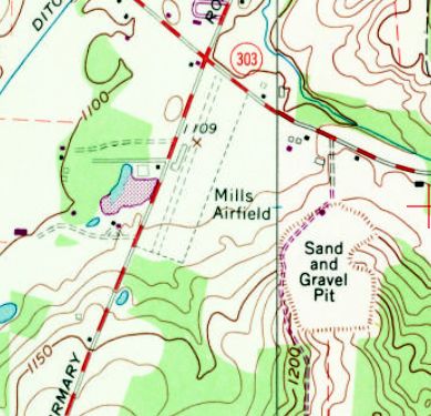
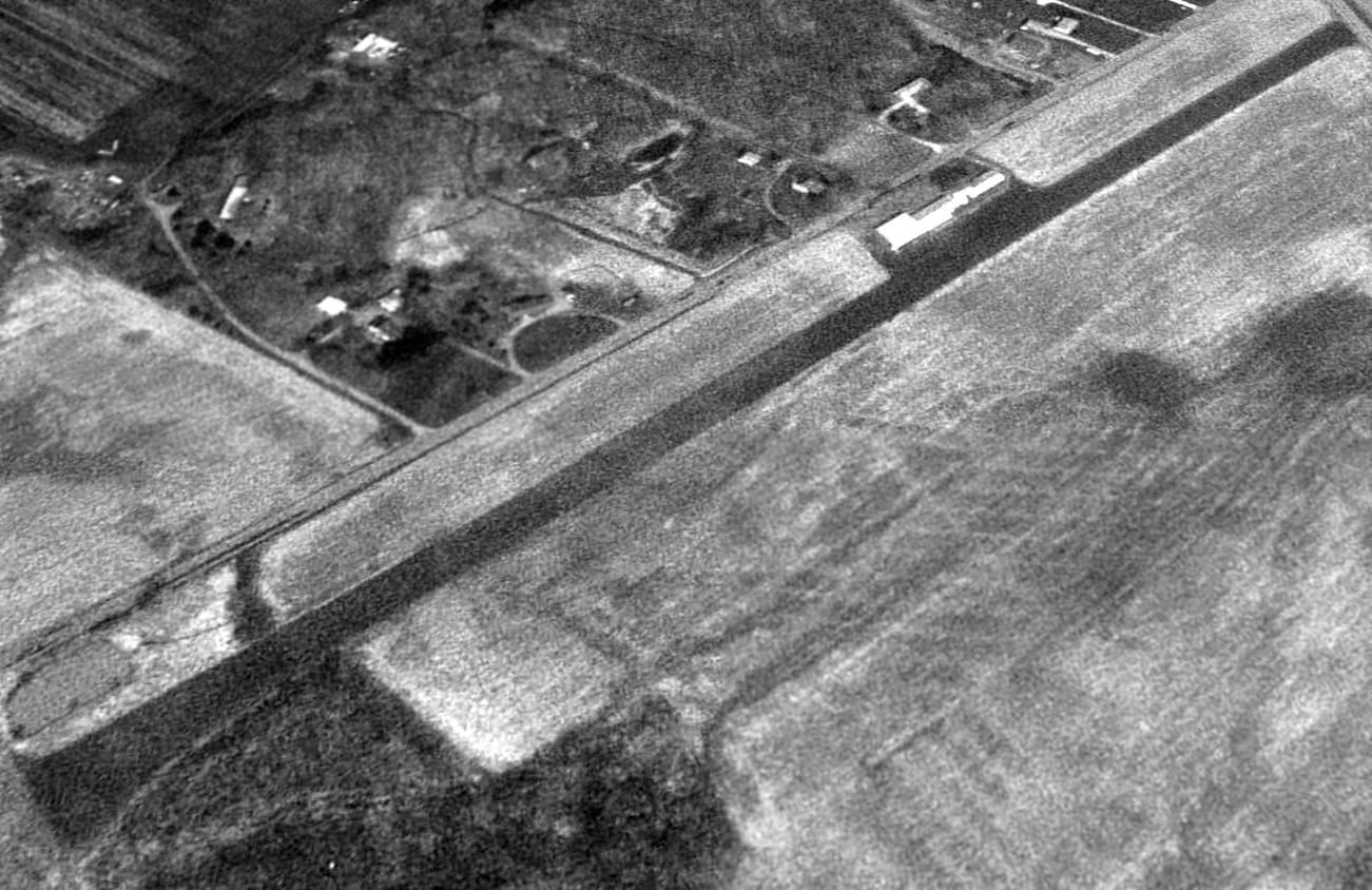
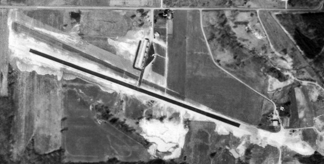
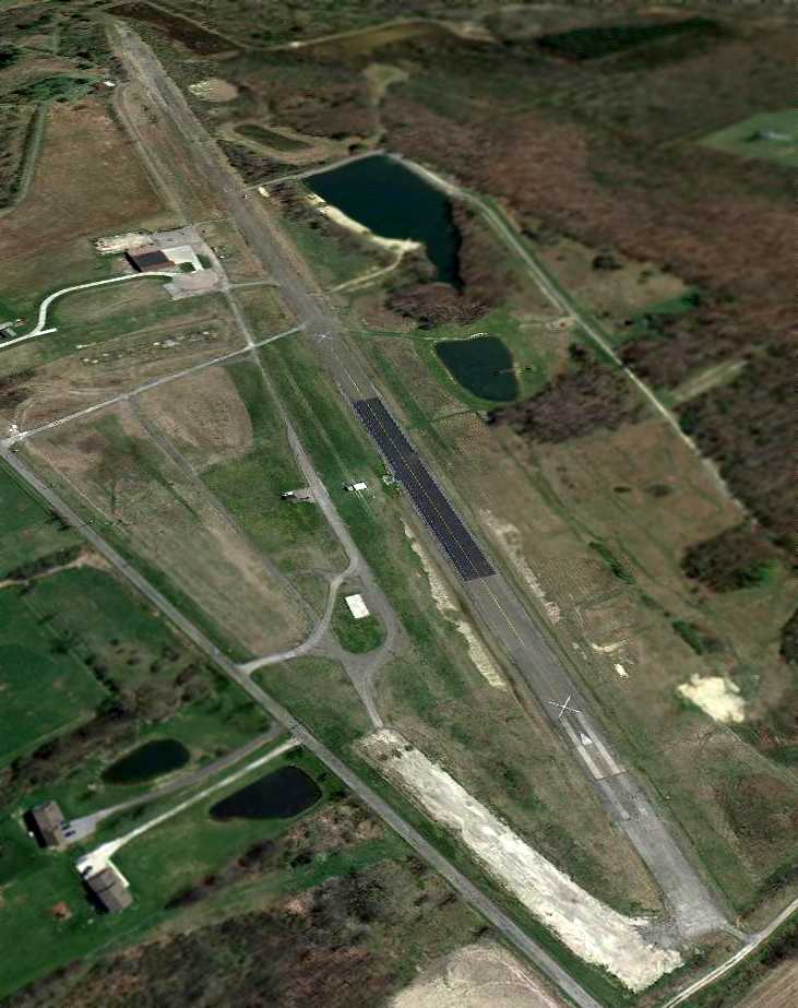
Mills Airport (7E3), Mantua, OH
41.238, -81.254 (East of Cleveland, OH)
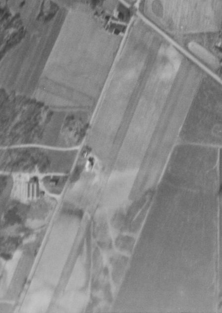
Mills Airport, as depicted on a 4/17/52 USGS aerial view.
The date of construction of this small general aviation airport has not been determined.
The earliest depiction which has been located of Mills Airport was a 4/17/52 USGS aerial view.
It depicted a single northeast/southwest unpaved runway, with a hangar & 1 light single-engine plane on the west side.
According to its FAA Airport/Facility Directory data, Mills Airport was “activated” in October 1953 (even though the 1952 photo predated that by a year).
However Mills Airport was not yet depicted on the January 1955 Cleveland Sectional Chart.
The earliest aeronautical chart depiction which has been located of Mills Airport was on the January 1958 Cleveland Sectional Chart,
which depicted it as a private airfield having a 1,900' unpaved runway.
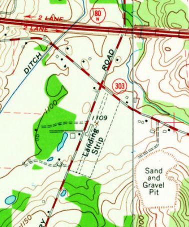
The 1960 USGS topo map depicted Mills airport as a single unpaved northeast/southwest runway, labeled simply as “Landing Strip”.
A single small building was depicted along the west side.
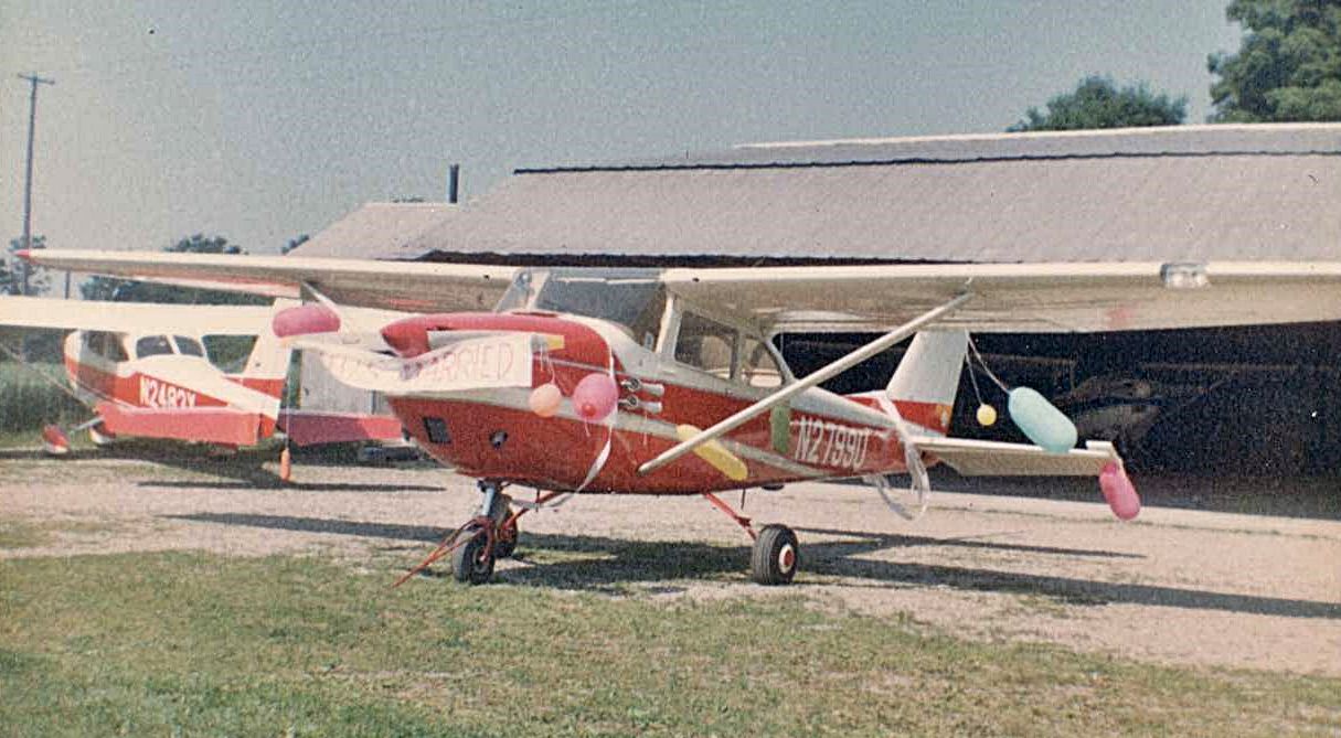
The earliest ground-level photo which has been located of Mills Airport was a June 1965 photo by Frank Doljck of a Cessna 172D of “Our friend [who was] just married & his plane was decorated.”
Frank Doljack recalled, “I rented & flew aircraft out of Mills Airport from 1965 to the end of 1978.
Mills Airport was situated on the farm of Ken Mills. He kept his Tri-Pacer in one of the hangars.
The airport & its runway paralleled the road on the west boundary of the farm, the farmhouse & buildings were on the northeast end, and a dormant (in 1965) gravel pit was situated on the southeast end.
The farm itself was about 100 acres. Ken Mills grew a hybrid corn used for animal feed & planted not only his property but also nearby properties that leased to him.
In summer the runway was surrounded on both sides with tall corn & Mills usually cut down a number of rows on each side so aircraft were less likely to catch a wing since the runway was not wide.
On one occasion a low-wing Piper did go into the corn before the corn was cut.
Mills usually cut it when it got high enough to bother the high-wing aircraft that were hangared at the field.
So, low-wing aircraft needed to strictly stay on the centerline throughout roll out during this time period.
Ken operated the farm with his wife & two sons, Larry (the youngest) and Alvin.
Alvin lived with his family on a property across the road from the airport near the south end of the runway.”
Frank continued, “The hangars were situated mid-field, close to the runway, and they connected in a row on each side of an old hay barn that certainly pre-dated the hangars.
Near the center of this row of buildings were a small office & a single gas pump. The far south end hangar had a small 'outdoor' potty.
In 1965 Lou Melter & his wife Ann relocated their business operations to Mills Airport after selling & closing Solon Airport (Solon, Ohio) that Lou founded before WW2.
At Mills he maintained 2 aircraft for rental & instruction & as an IA continued to do occasional annuals & repairs.
Everyone called him Louie & referred to him as Lou or Louie. Never Louis.”
Frank continued, “Operating in & out of Mills had its idiosyncrasies.
During the spring thaw before the frost entirely left the ground, usually the full month of April, the field was unusable due to the soft, wet ground.
In the winter the runway was left unplowed after significant snowfall because plowing normally lead to narrowing of an already narrow runway and would leave snow ridges that lasted well into spring.
Therefore, airport use went down a lot in snowy winters.
Traffic not associated with airport tenants of which there were few (about 10 aircraft) was usually instruction flights from nearby Kent State Airport
(later Portage County Airport which was built just south of Mills) attempting to obtain practice at a grass strip.
With no run-up area one taxied to the end & did the run-up facing more or less toward left base to make sure there was no surprise (with an eye toward right base for any non-compliant arrival).
Most often departure was to the southwest with a quartering cross-wind from the west.
Landing to the southwest found one making a left base parallel to & over the Ohio Turnpike & flying final over wires at the road at the north end of the airport.
The approach end of the runway had a low spot which rose uphill to about where one flared & touched down.
This made the flare tricky in order to avoid slamming into the hill. It was further aggravated by what seemed to be a perpetual downdraft as one passed over the road.
Landing to the northwest was much easier although it involved a downhill slope, which made the landing somewhat long.
If one stopped shortly after passing the hangars with not much runway left, this was normal.”
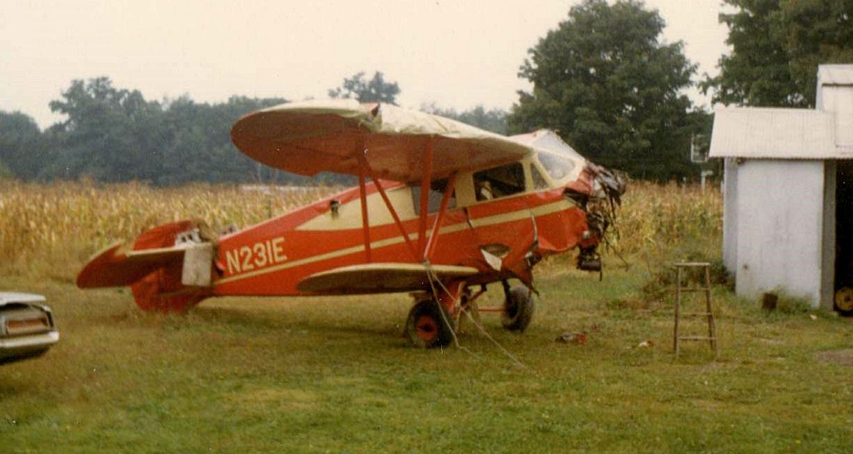
A September 1969 photo by Frank Doljck at Mills Airport of “Stan Howe’s wrecked rare 1936 Waco after landing in a corn field about a mile from the airport after the prop governor oil pump failed on climb out.
The new Portage County Airport runway was his first choice but some people were on it flying model airplanes, so Stan opted to try to return to Mills.
The Hamilton-Standard prop design was counter-weighted so loss of oil pressure put the prop into high pitch, which in turn caused the aircraft to lose altitude.
Unfortunately, Stan could not reach the airport & instead opted for a corn field.”
The 1970 USGS topo map depicted “Mills Airfield” as having a single unpaved northeast/southwest runway
along with a single small building along the west side.
A September 1970 aerial view by Frank Doljck looking northeast at Mills Airport, showing one light single-engine aircraft parked near the hangars on the west side of the grass runway.
A 1994 USGS aerial view looking northwest at Mills Airport showed that although the runway appeared distinct & maintained,
there were no aircraft visible, nor any other indication of recent aviation usage.
As of July 2011, Mills Airport's FAA Airport/Facility Directory data described it as conducting an average of 20 takeoffs or landings per week.
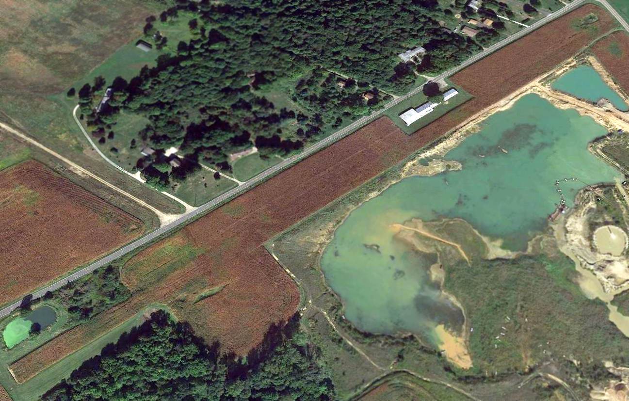
Mills Airport had evidently been abandoned by 2015, as the runway was planted with crops.
As of 2016, Mills Airport's FAA Airport/Facility Directory data described it as having a single 2,640' turf Runway 3/21, “in good condition”.
It was said to have a total of 10 single-engine aircraft based on the field,
and the owner & manager were listed as Larry & Alvin Mills.
The 2016 Terminal Aeronautical Chart continued to depict Mills Airport as a public-use airfield,
even though it was no longer suitable for aircraft operations by that point.
A 6/24/16 photo by Randy Coller looking along the former runway of Mills Airport.
Randy reported, “I talked to the owner - he thought the airport had been abandoned officially years ago.
Apparently no one did the proper paperwork to abandon the airport as the FAA still shows it on the charts.
The runway is planted in soybeans, with a gravel quarry adjacent. The airport is not suitable for aircraft.”
A 6/24/16 photo by Randy Coller of the interior of the Mills Airport hangar. Randy reported, “The hangar is vacant.”
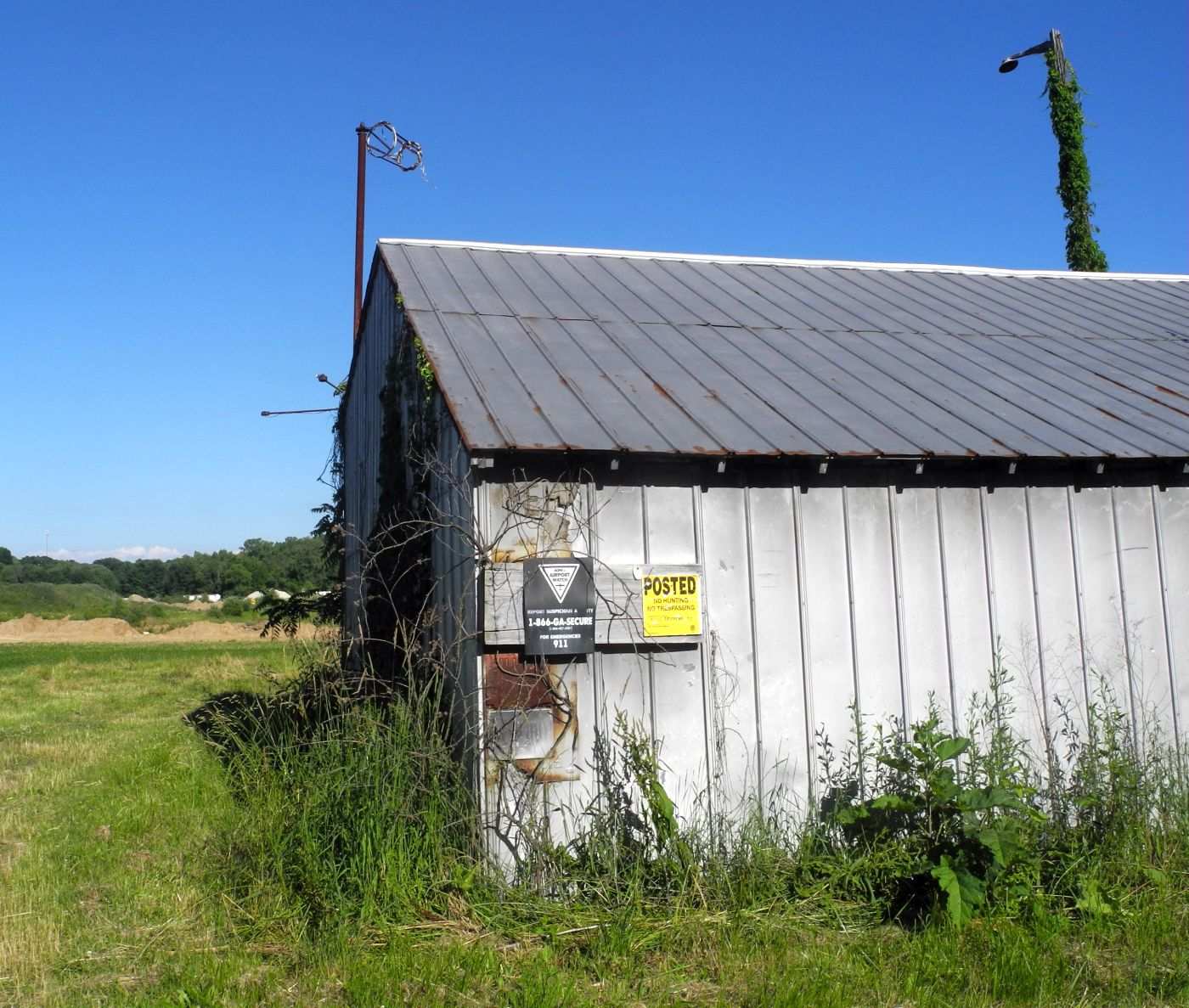
A 6/24/16 photo by Randy Coller of an abandoned Mills Airport hangar. Note the windsock frame on top, and the AOPA Airport Watch sign on the side.
Frank Doljack reported in 2017, “Ken Mills & the Melters have long passed & today one can see that all of the land parallel to & east of the runway is now gravel pit & water.
Apparently, at some point the sons Larry & Alvin decided leasing to gravel operations was a better deal than growing corn.”
Mills Airport is located southeast of the intersection of Infirmary Road & Ritchfield Hudson Road.
Thanks to Randy Coller for pointing out this airfield.
____________________________________________________
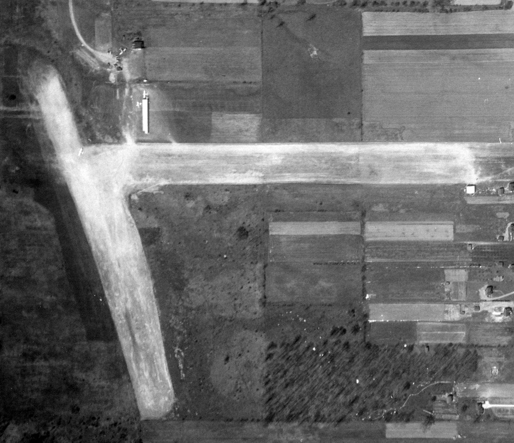
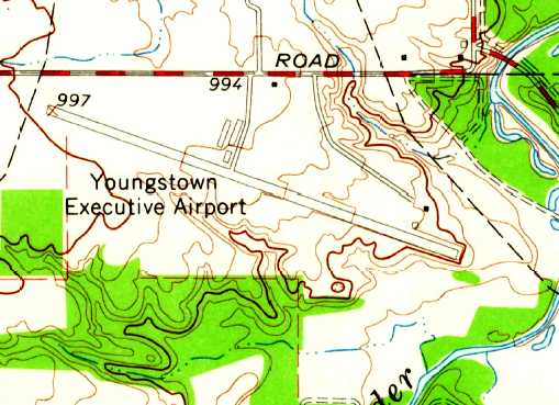
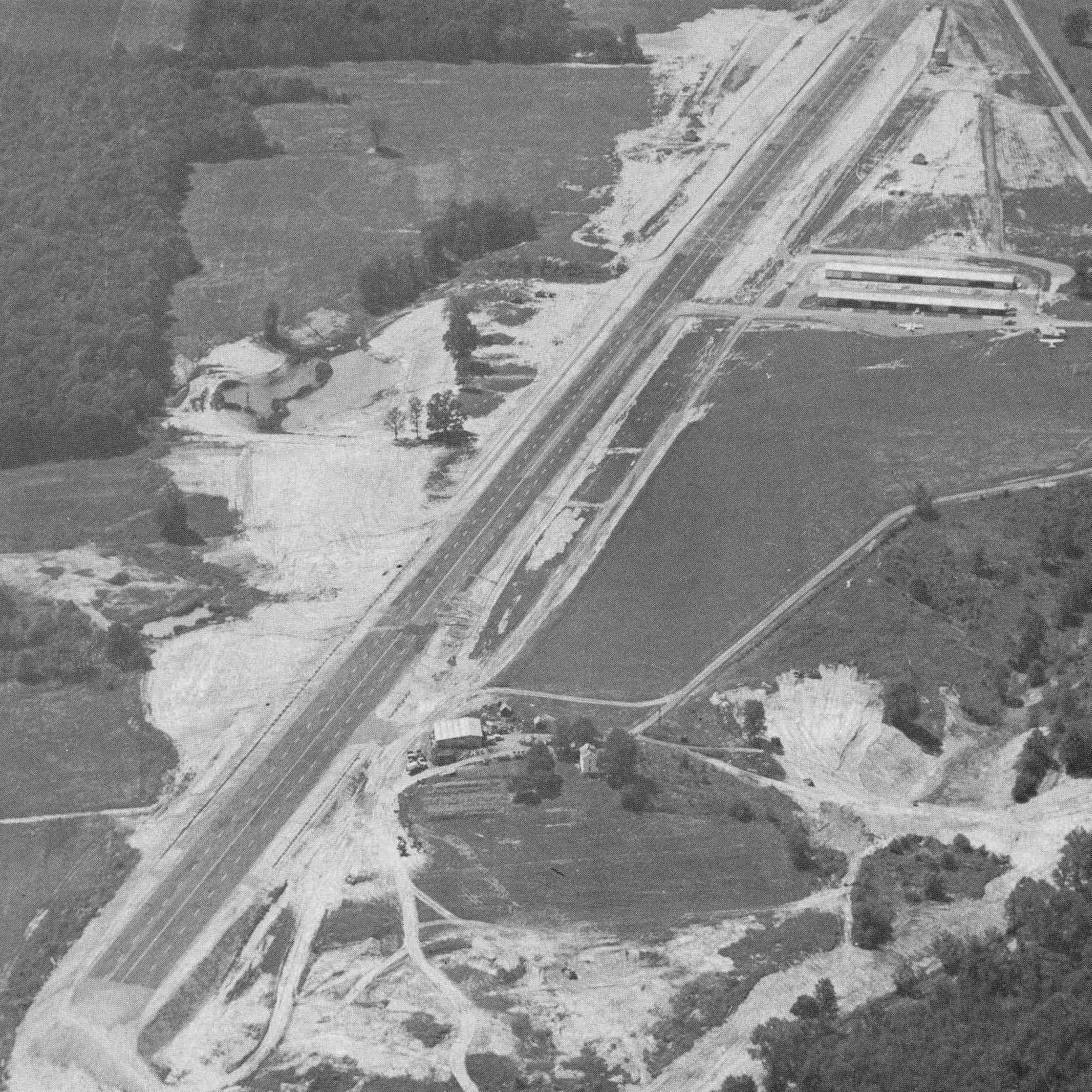
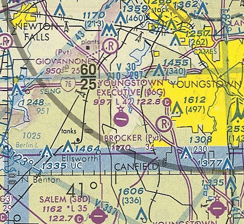
Youngstown Executive Airport (06G), Youngstown, OH
41.06, -80.83 (Southeast of Cleveland, OH)
Youngstown Executive Airport, as depicted not long after its construction on a 4/21/62 USGS aerial photo.
This small general aviation airport was apparently built at some point between 1960-62,
as it was not depicted on the 1960 Cleveland Local Aeronautical Chart (courtesy of Mike Keefe).
The earliest depiction which has been located of Youngstown Executive Airport was on a 4/21/62 USGS aerial photo.
The field appeared to be newly-completed, with a single asphalt northwest/southeast runway,
and an asphalt taxiway leading to a hangar on the north side, and a ramp on which were visible 3 aircraft.

The earliest aeronautical chart depiction which has been located of Youngstown Executive Airport
was on the 1963 Cleveland Local Aeronautical Chart (courtesy of Mike Keefe).
The Aerodromes table on the chart described the field as having a single 3,000' asphalt runway.
The 1963 USGS topo map depicted Youngstown Executive Airport
as having a single paved northwest/southeast runway & 3 small buildings on the north side.
An undated aerial view looking east at Youngstown Executive Airport from the February 1964 issue of “The Flyer” magazine (courtesy of Daun Yeagley).
It described Youngstown Executive Airport as having a 3,500 blacktop northwest/southeast runway.
The 1965 Cleveland Sectional Chart (courtesy of Chris Kennedy) described Youngstown Executive as having a 4,200' paved northwest/southeast runway.
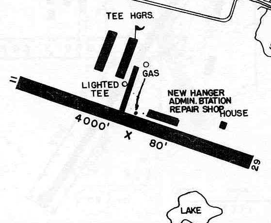
The 1966 OH Airport Directory (courtesy of Chris Kennedy)
depicted 2 rows of T-hangars on the north side of the runway,
as well as a new hangar & administration building.
Scott Tanner recalled, “Youngstown Executive Airport... I worked as a line boy at the airport around 1970.
It was run by Frank Corby, and his brother Mario. Some of the names I remember are Ray Penny, Scott Rapp, Jack Wilson, Scott Cory.
I took flying lessons there. I have lots of good memories from those days like watching the drag races & calling the tower when a plane was about to land.
One time, I even got to run the tug down the track on a Saturday night.
I don't remember my time but I'm sure it was a record for the slowest ever 1/4 mile ever.”
The May 1970 Cleveland Sectional Chart depicted Youngstown Executive as having a 4,200' paved northwest/southeast runway.
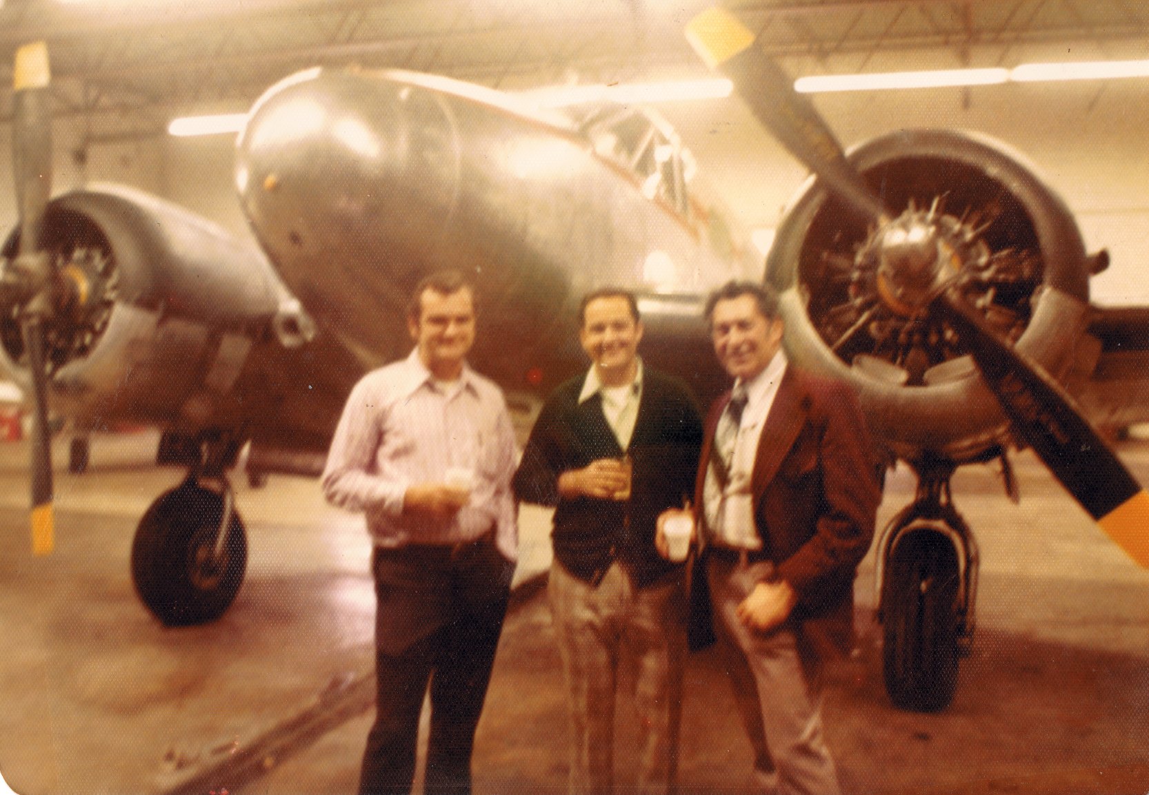
A 1972 photo (courtesy of Don Bodnar) inside Youngstown Executive Airport's main hangar of the owners of Executive Air Sales (Ron Carrol, Jim Williamson, and Frank Corbi) in front of a Beech 18.
Don Bodnar recalled, “Youngstown Executive Airport... I learned to fly at at that airport, continuing on to flight instruct, and than fly charter.
I held the tail of BE18s off until passing the drag race timing device many times on Friday nights.”
Jay McMurray recalled of Youngstown Executive Airport, "I started flying there in 1973
and worked as a 'Lineboy' fueling airplanes that summer.
We closed for the races on weekend nights.
The field was also used for a lot of cargo flights. Beech 18's were common.
I used to work till sundown & hop on a Beech 18 or some other lighter twin
and fly all night with the cargo pilot flying Packard Electric car parts
around to the various cities making cars: Oshawa Canada, Detroit, Andersen Indiana etc."
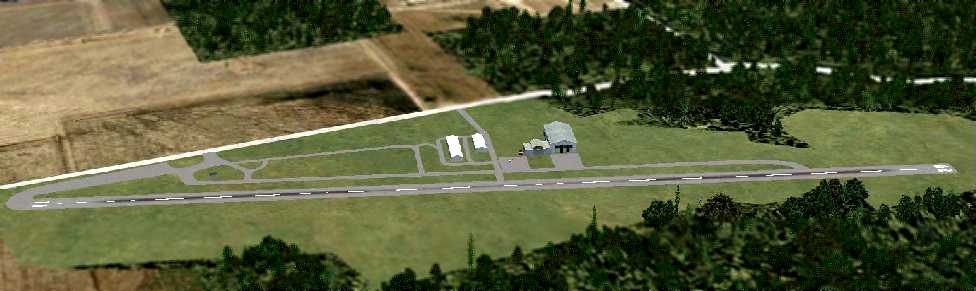
A flight simulation scenery re-creation looking northeast at Youngstown Executive Airport by Richard Finley.
Dan Anthony recalled, “I took my first flight lessons out of Youngstown Executive Airport
and was one of the 'line boys' from about 1973-75.
With my employee discount my hourly rate for a Cessna 150 or 152 & the instructor
was about $15 but I was making only minimum wage ($1.65 / hour at the time).
The airport was a Cessna Dealer & sold many new Cessnas
that ended up getting leased back into the flight training program.
One nice thing about taking lessons at this airport was there were always new airplanes to fly.
As a line boy one of my jobs was to clean & wax the airplanes.
The instructors liked when I scheduled a lesson because the plane I scheduled for myself
was pulled from the line & cleaned spotless just prior to my lesson, I made sure of that!”
Dan continued, “They also had a thriving charter service with a Cessna 421 (Golden Eagle),
a C-410, C-310s, Piper Navaho and the Beech 18s.
The Beeches were used as freight haulers & passenger planes
(as a line boy I was required to load & unload the freight & install/remove the seats).
They had a very active A&P shop to maintain the fleet of training aircraft
and the private planes hangared on the field as well as many that would fly in for their maintenance needs.
They also had an active radio shop.”
Dan continued, “During my time there they had an annual Fly-In
and planes from all over the country would drop in.
At the Fly-In the training fleet was used to give 'penny-a-pound' rides to anyone that wanted a ride in a small plane.
We had a bathroom scale & the person would step on & get weighed
and we collected a Penney for every pound & off they went.”
Dan continued, “The drag-racing that was every Friday & Saturday Night during the racing season...
One of my jobs was to work the radios once the FBO’s daytime staff left.
The pilots based at 06G didn’t like the fact that the airport closed for drag racing
and many would takeoff just prior to race time & then buzz the runway or interrupt the racing by landing.
One of the charter pilots would often take the B-18 down
and blow the racing timing lights or the 'Christmas tree' & starter shack over
with his prop-wash & run-up prior to a late evening take-off.
Because of these intentional pilot-induced delays the race sponsors hired an off-duty, uniformed police officer
to operate the radios & 'talk' to any pilot that wanted to land or takeoff.”
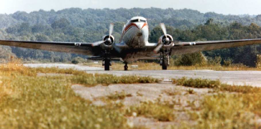
A 1978 photo by Charles Brasile (used by permission) of a Douglas DC-3 of Mannion Air Charter departing Youngstown Executive Airport.
The 1982 AOPA Airport Directory (courtesy of Ed Drury)
described Youngstown Executive as having a single 4,155' asphalt Runway 11/29.
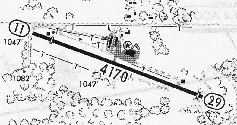
A 6/21/85 airport directory (courtesy of John Kielhofer) depicted Youngstown Executive Airport
as having a 4,170' paved Runway 11/29, and a ramp 4 buildings on the north side.
Dan Anthony recalled, “The large hangar to the right of the FBO building...
This hangar & most of the airplanes inside & tied-down all over the airport were destroyed by a tornado sometime in the mid 1980s.
Shortly after that the FBO folded & then the rest of the place fell apart.”
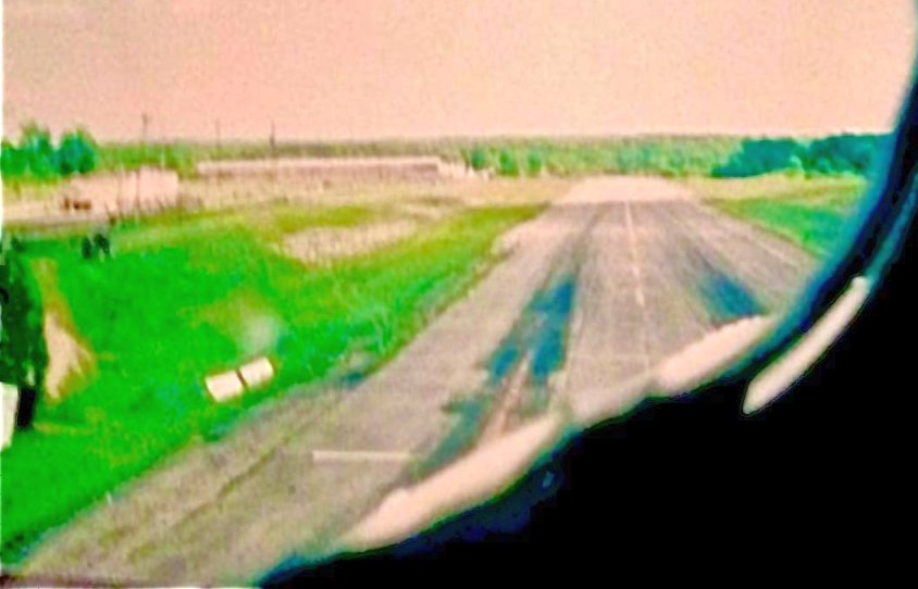
A 1991 aerial view by Tony Buttacavoli looking southeast at Youngstown Executive Airport from final approach to Runway 11.
Tony recalled, “All 4,000’ of her runway/ drag strip (cars racing on weekends) stretched out in front of us,
culminating in a sheer drop-off that tumbled down a little cliff face at strip's end,
the better to brief that after the tail is up we are going for broke despite any emergency that may surprise us, short of a complete engine failure prior to V1.
Its the high summer of 1991 & we are comfortably ensconced in the sky-weary & battered cockpit of N302SF, KHAWK’s last DC-3 standing,
holding the brakes, and running the motors up to 30” for one last power check before letting go & trundling forward into all that heat thinned 90° air.
Those R1830’s bellowing at their full rated, 1 minute-limited, 48” of MP, creating more noise & fury than actual thrust
as we strive to create enough lift over those thick chord wings to overcome the obstacles presented by weight, drag, and gravity.
Finally staggering aloft at 85 knots, climbing out at all of a miserly 400 fpm, sagging upwards slowly as the end of the runway drops beneath us
and we bank for Lake Erie tacking for JUNKR intersection hard by Pelee Island, with homeplate KYIP soon to follow.
After another exhausting hard nights day in the life, the things we do for love.”
The last aeronautical chart depiction which has been located of Youngstown Executive Airport was on the October 1993 Detroit Sectional Chart. (courtesy of Ron Plante).
It depicted Youngstown Executive as having a 4,200' paved northwest/southeast runway.
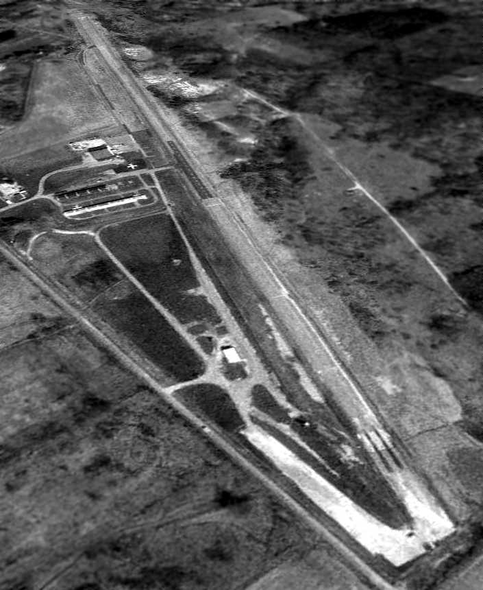
A 4/20/94 USGS aerial view looking southeast showed Youngstown Executive to consist of a single paved 4,100' runway & some small hangars.
A small middle portion of the runway appeared to have been recently repaved, possibly for radio-controlled model aircraft flights.
Only 1 (or possibly 2) aircraft were visible on the field.
Youngstown Executive was evidently closed (for reasons unknown) at some point between 1994-2002,
as it was depicted as an abandoned airfield on 2002 aeronautical charts.
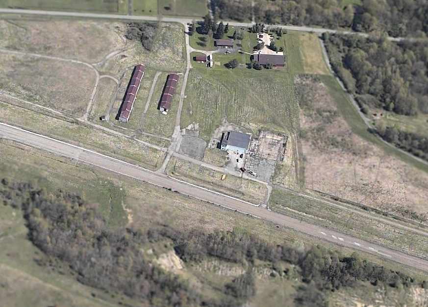
The rows of T-hangars were still standing in a 2005 aerial photo, but had been removed by the time of a 2006 aerial photo.
A circa 2001-2005 aerial view looking north at Youngstown Executive Airport,
showing that the hangars & runway remain in fine condition.
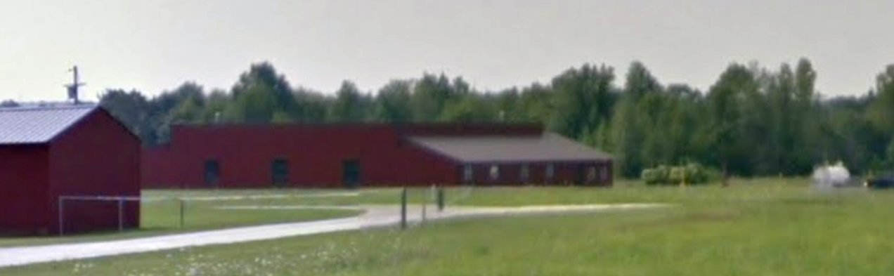
An August 2011 photo looking south at a former Youngstown Executive Airport hangar.
A 4/6/12 aerial view looking southeast showed Youngstown Executive to remain mostly intact, with the exception of the removed T-hangars.
In contrast to the 1994 photo, a different portion of the runway (further west) has been recently repaved, for radio-controlled model aircraft flights.
Kevin Marstellar reported in 2013, “My radio-controlled model aircraft club - The Nighthawks -
now uses the airstrip which we 'rent' from Allison Brothers who owns the property now.
Full-scale aircraft still do occasionally use it - but very rarely.
We have an annual Father's Day event where a local medevac helicopter usually comes & is available to check out.
We also host several other large RC events where a couple people will fly their full-scale planes in.”
In the words of Gene Zeigler, "Much aviation history in Northeast Ohio is lost
and very few of these facts have been recorded for the future generations to know about."
____________________________________________________
Or if you prefer to contact me directly concerning a contribution (for a mailing address to send a check),
please contact me at: paulandterryfreeman@gmail.com
If you enjoy this web site, please support it with a financial contribution.
____________________________________________________
This site covers airfields in all 50 states.