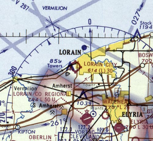
Abandoned & Little-Known Airfields:
Ohio: Western Cleveland area
© 2002, © 2026 by Paul Freeman. Revised 5/10/26.
This site covers airfields in all 50 states: Click here for the site's main menu.
____________________________________________________
Please consider a financial contribution to support the continued growth & operation of this site.
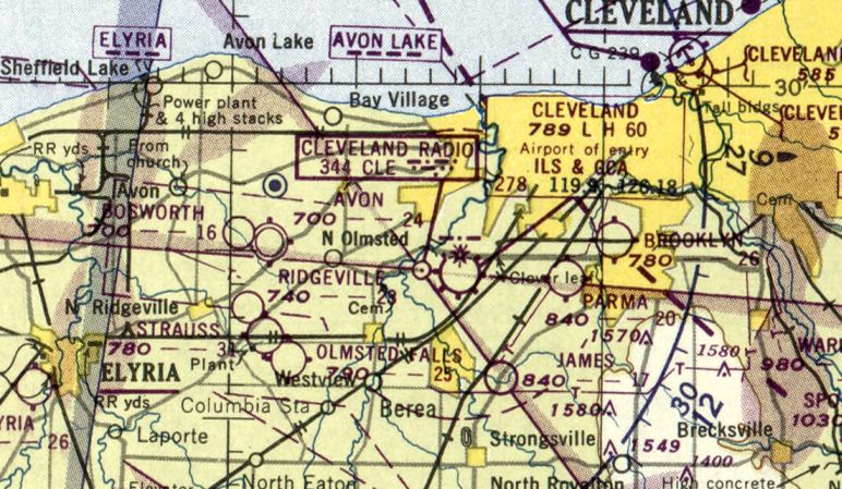
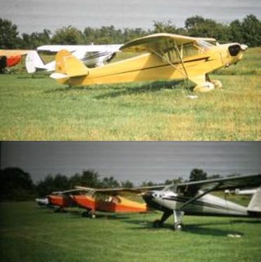
Avon Airport (revised 12/8/20) - Botsford Airport / Reader-Botsford Airport (added 2/12/21) - Brooklyn Airport (revised 2/6/25)
Lorain City Airport (revised 10/28/20) - Mather Airport (revised 7/9/18) - Meadow Aire Farm Airfield / Lagrange Airport / Harlan Airfield (added 12/11/22)
Oberlin Airport (revised 5/10/26) - Port Mills Airport / Lorain Sky Port (revised 7/8/22) - Strauss Airport (revised 5/10/26) - Strongsville Airpark (revised 2/10/21)
____________________________________________________
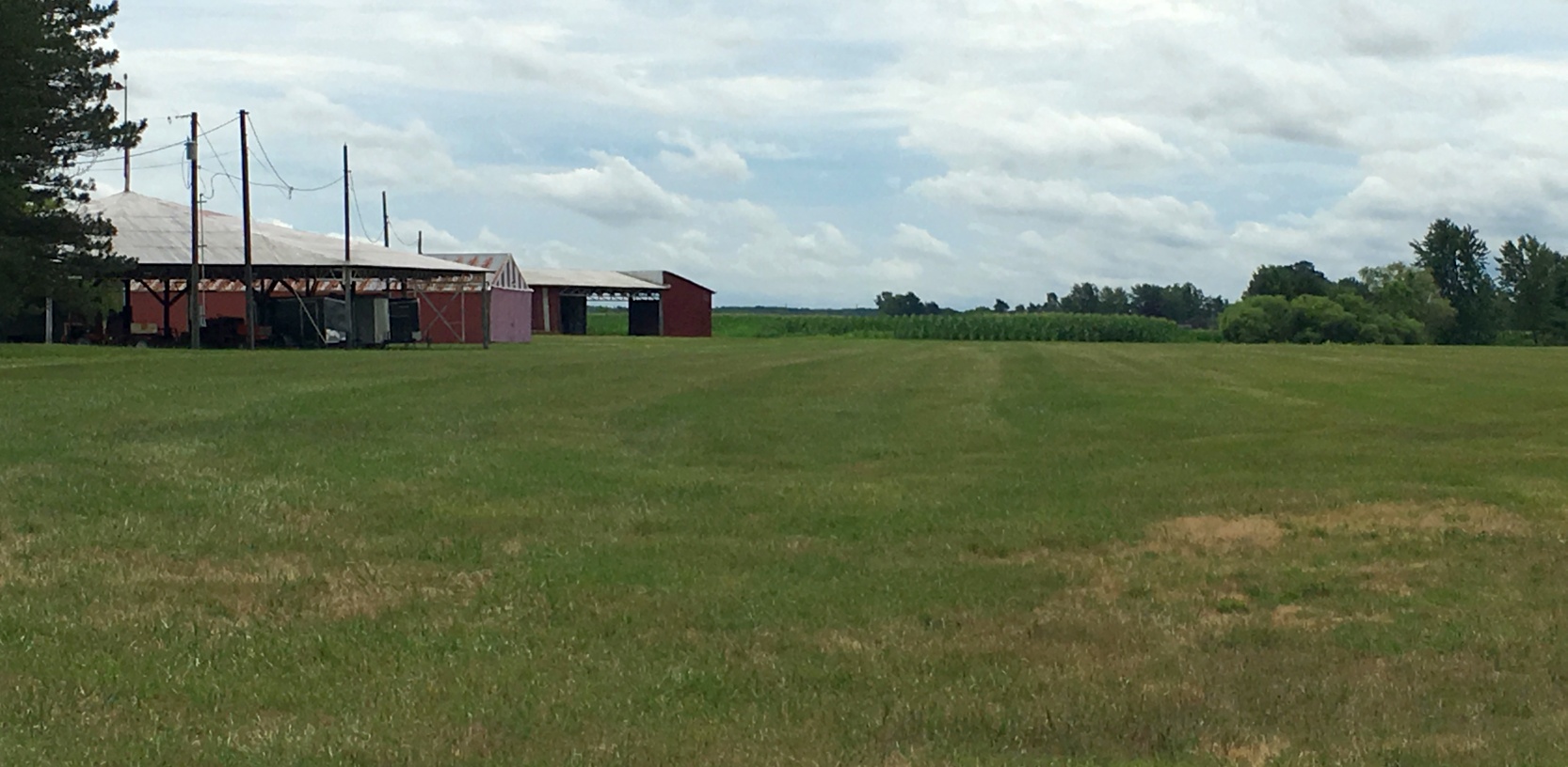
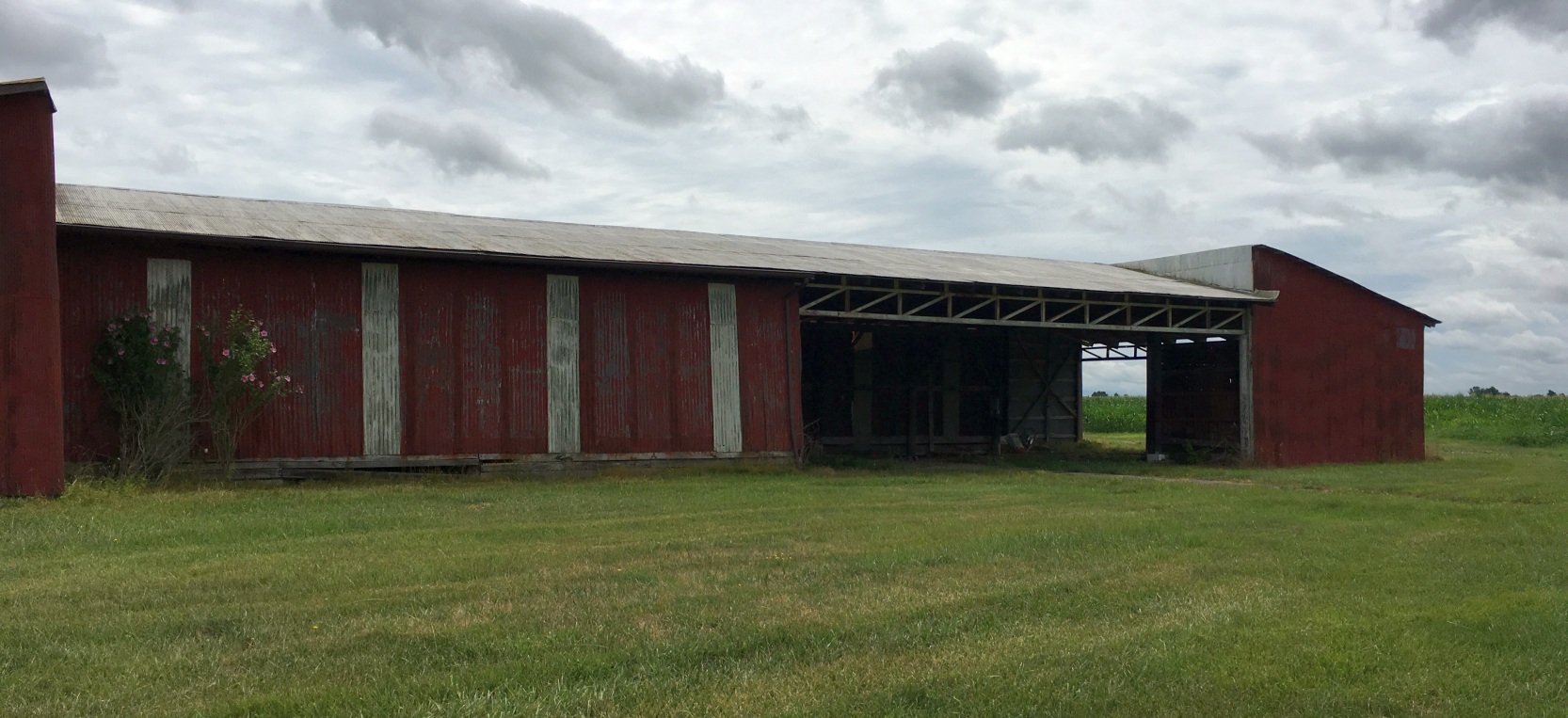
Meadow Aire Farm Airfield / Lagrange Airport / Harlan Airfield (92D), Lagrange, OH
41.203, -82.116 (Southwest of Cleveland, OH)
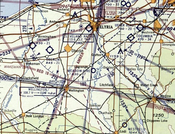
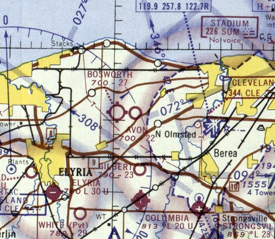
Meadow Aire Farm Airfield, as depicted on the December 1955 Cleveland Sectional Chart.
Meadow Aire Farm Airfield was not yet depicted on a 1952 aerial photo
or the July 1955 Cleveland Sectional Chart.
According to Dennis Thompson, “Meadow Aire Farm Airfield was founded in 1955.”
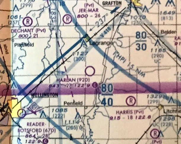
The earliest depiction which has been located of Meadow Aire Farm Airfield was on the December 1955 Cleveland Sectional Chart,
which depicted it as having a 2,700' unpaved runway.
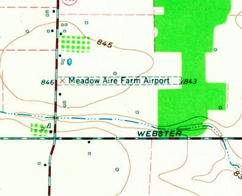
The earliest topo map depiction which has been located of Meadow Aire Farm Airport was on the 1960 USGS topo map,
which depicted it as having a single east/west unpaved runway with a few small buildings on the west side.
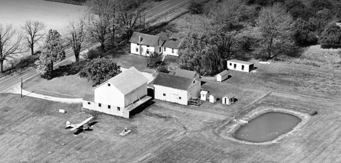
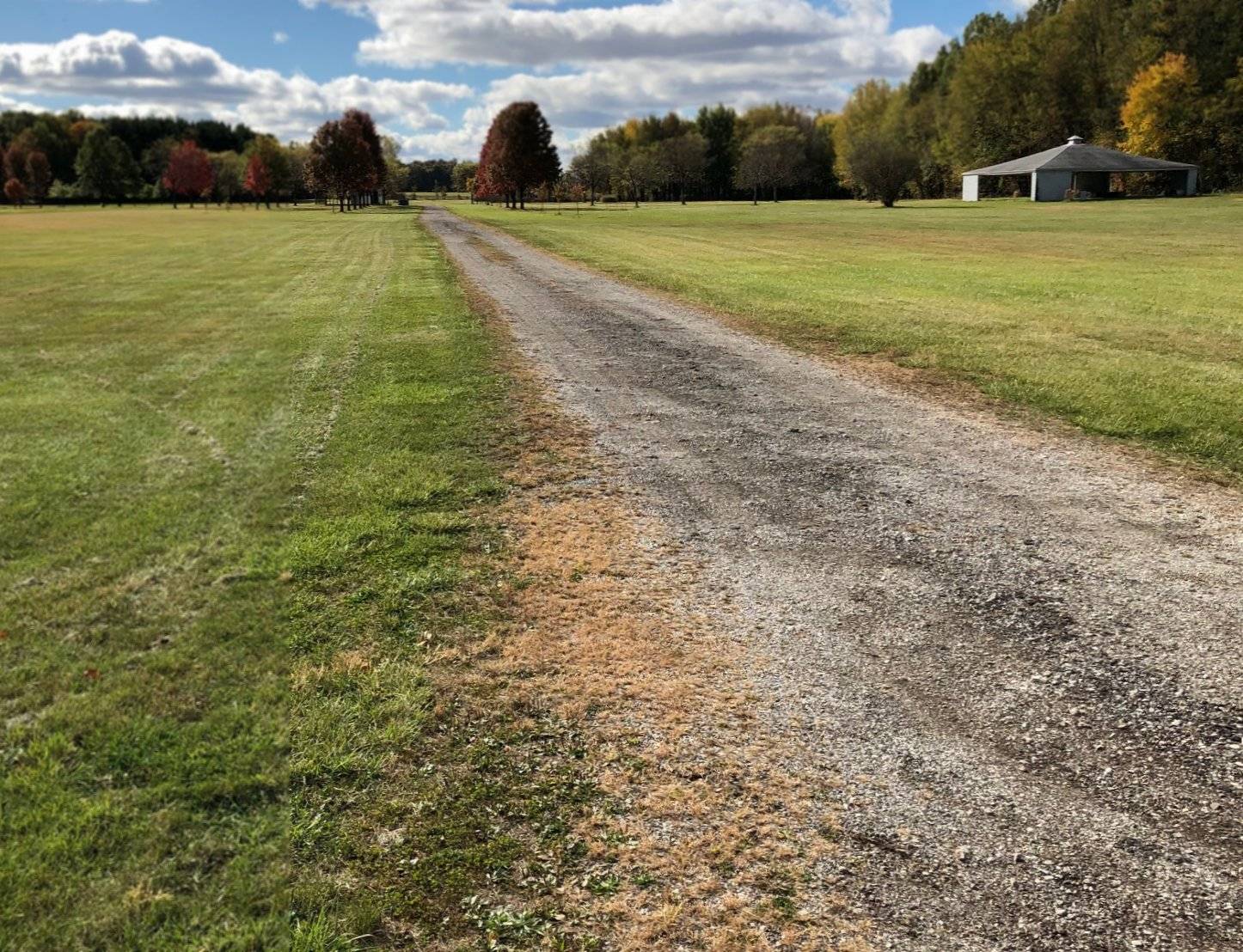
The earliest photo which has been located of Meadow Aire Farm Airfield was a 1963 aerial view (courtesy of Dennis Thompson) looking northwest at the buildings on the northwest side,
near which was 1 light single-engine taildragger.
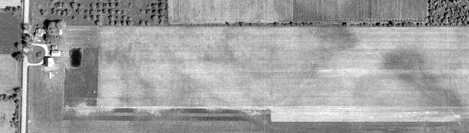
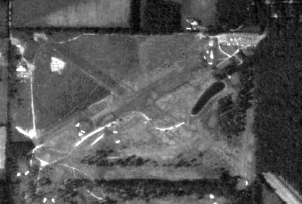
A 1970 aerial view (courtesy of Dennis Thompson) depicted Meadow Aire Farm Airfield as having a single grass east/west runway,
with a few small buildings & 1 light single-engine plane on the northwest side.
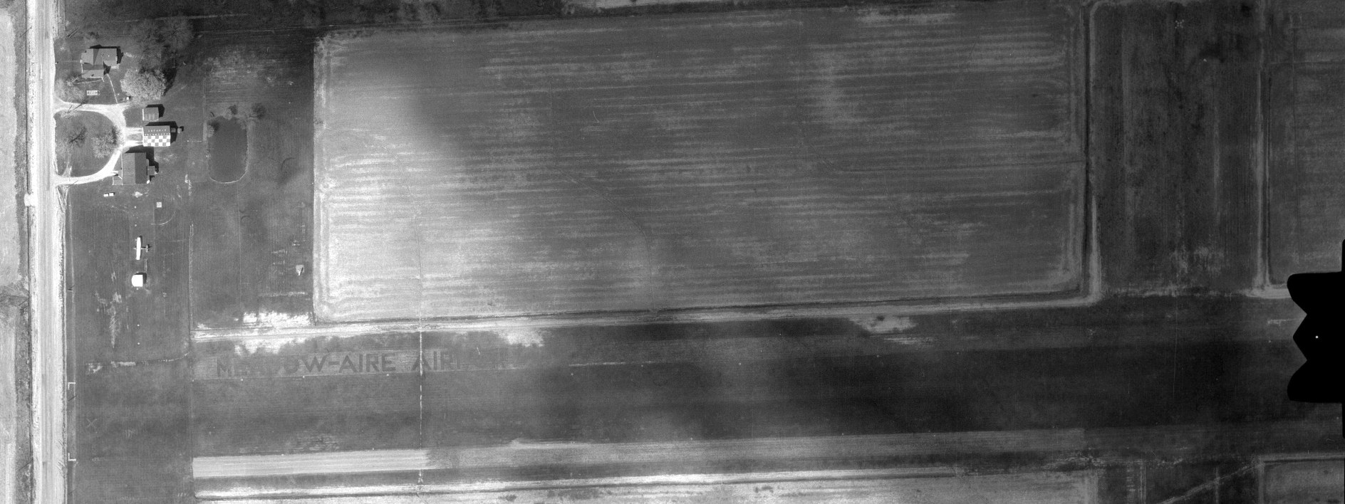
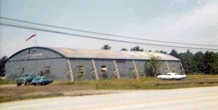
A 1978 aerial view (courtesy of Dennis Thompson) showed Meadow-Aire had gained a crosswind runway at some point between 1970-78.
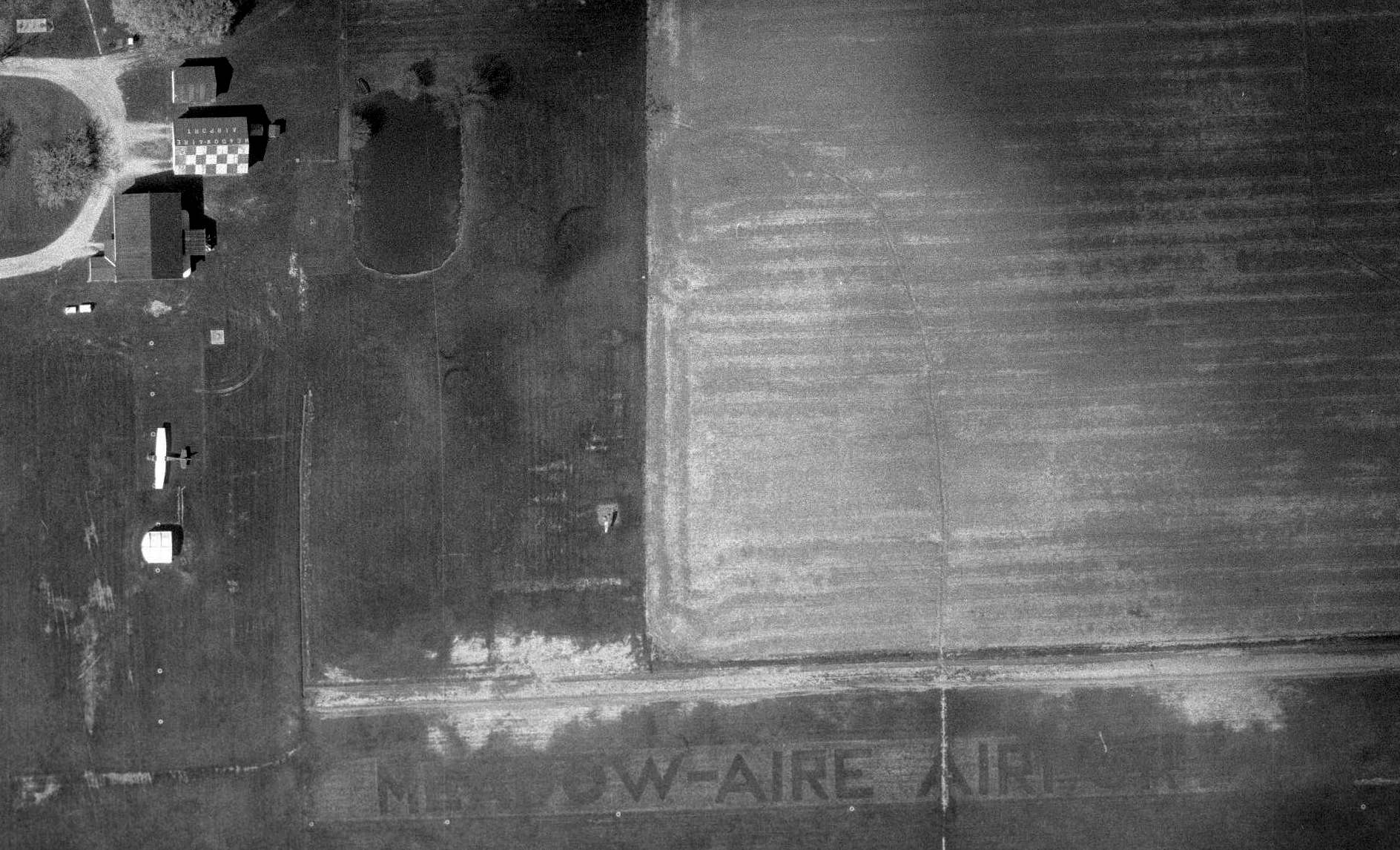
A closeup of the 1978 aerial view (courtesy of Dennis Thompson) showed Meadow Aire Airport as having a checkerboard-painted hangar with “Meadow-Aire Airport” on the roof, near which was 1 light single-engine plane.
“Meadow-Aire Airport” was cut into the grass north of the runway.
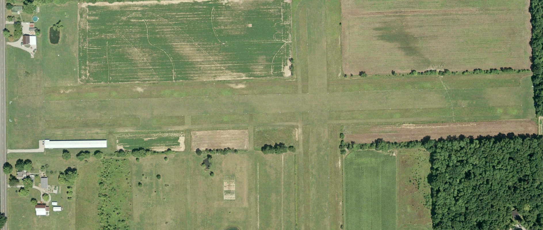
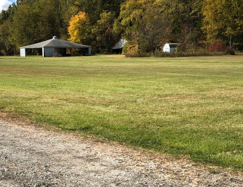
A 2007 aerial view depicted Meadow Aire Airport as remaining intact, but no aircraft were visible.
The April 2009 Cleveland Terminal Chart depicted Harlan Airport as having a 2,700' unpaved runway.
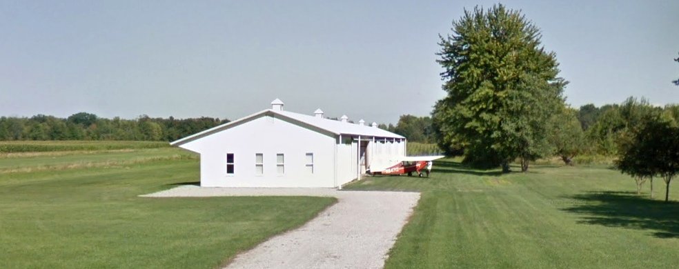
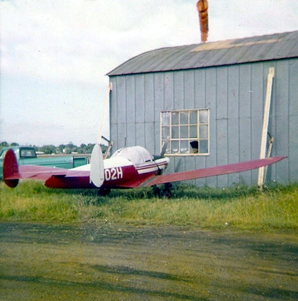
The last photo which has been located showing a plane at Harlan Airport was a 2014 photo (courtesy of Dennis Thompson), which showed a single-engine taildragger outside a hangar.
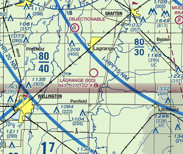
Harlan Airport was evidently renamed Lagrange Airport at some point between 2009-2018,
as the September 2018 Cleveland Terminal Chart depicted Lagrange as having a 2,700' unpaved runway.
Lagrange Airport was evidently closed (for reasons unknown) at some point between 2018-2021,
as it was no longer depicted on the 2021 Cleveland Terminal Chart.
Dennis Thompson reported in 2022 of Harlan Airfield, “Locals have confirmed it is closed & it is now a cornfield.”
Thanks to Dennis Thompson for pointing out this airfield.
___________________________________________________
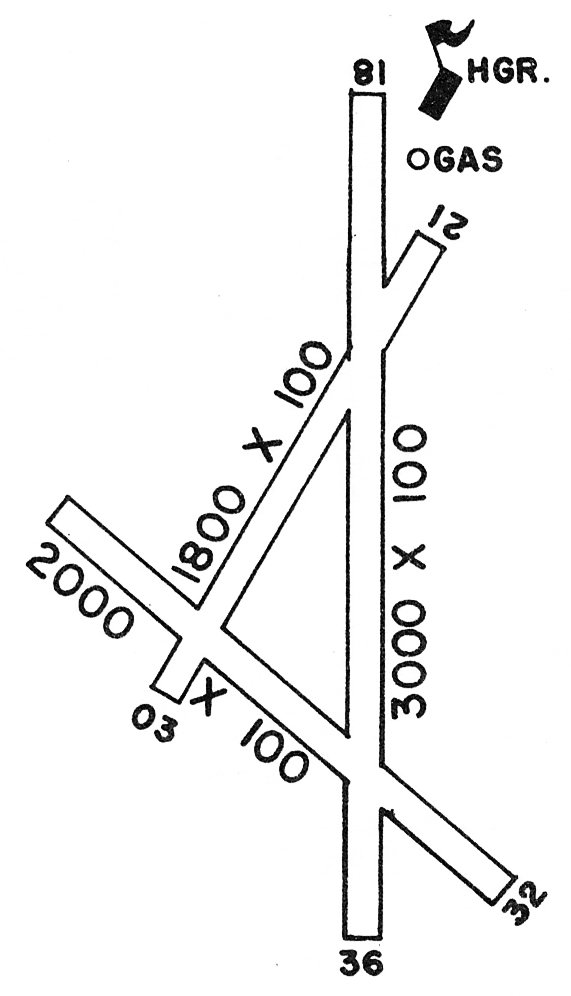
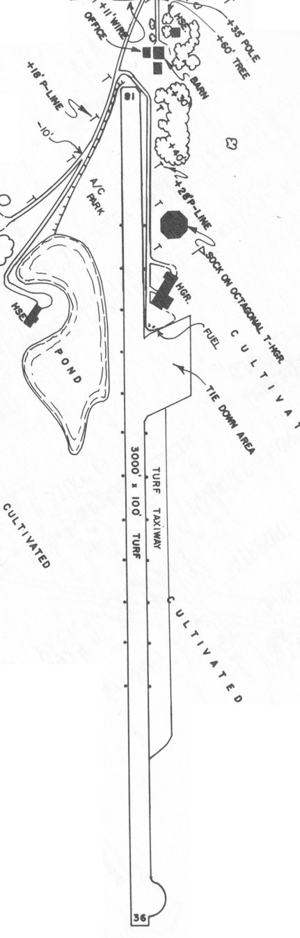
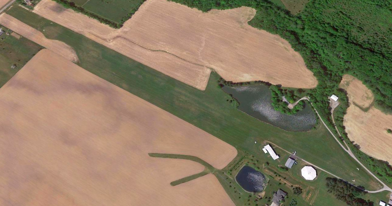
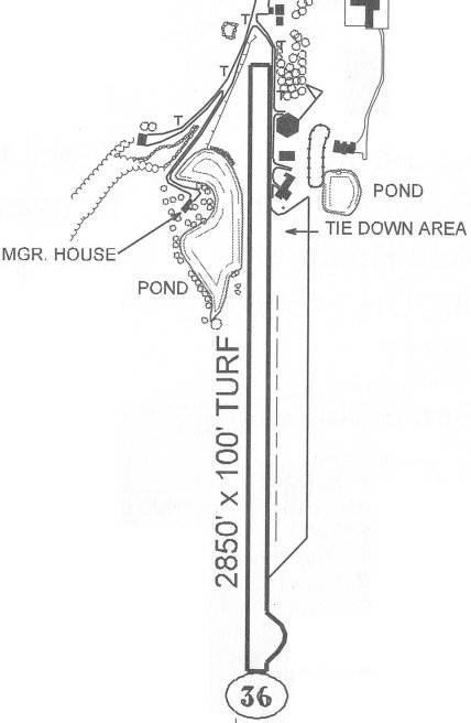
Botsford Airport / Reader-Botsford Airport (67D) , Wellington, OH
41.162, -82.201 (West of Cleveland, OH)
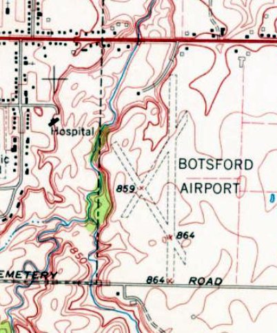
Botsford Airport, as depicted on the 1960 USGS topo map.
This small general aviation airport was evidently established at some point between 1952-59,
as it was not yet depicted on a 1952 aerial photo.
The earliest depiction which has been located of Botsford Airport was on a 1959 aerial photo of the western portion of the airport site,
which showed a northeast/southwest runway.
Botsford Airport was not yet depicted on the July 1960 Cleveland Sectional Chart.
The earliest depiction which is available of Botsford Airport was on the 1960 USGS topo map.
It depicted Botsford Airport as having 3 unpaved runways, with a few small buildings on the northwest & northeast sides.
The earliest aeronautical chart depiction which has been located of Botsford Airport was on the January 1963 Cleveland Sectional Chart (courtesy of Daun Yeagley).
It depicted Botsford Airport as having a 2,200' unpaved runway.
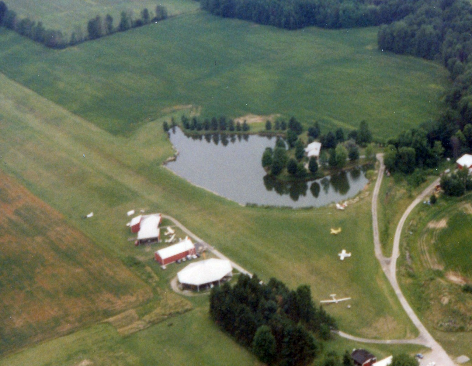
Daun Yeagley reported, “Bill [Botsford] ran an excavation & paving company, and excavated the pond that separated his house from the runway.
The earliest airport directory entry which has been located of Botsford Airport was in the 1971 OH Airport Directory (courtesy of Daun Yeagley).
It depicted Botsford Airport as having 3 unpaved runways, with the longest being the 3,000' Runway 18/36, and a hangar on the northeast side.
The 1973 USGS topo map depicted Botsford Airport in an unchanged fashion as compared to the 1960 USGS topo map.
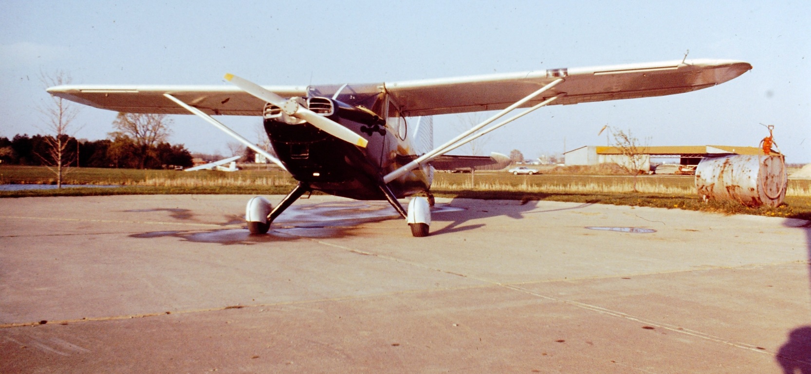
Daun Yeagley reported, “My dad (Daun Yeagley Jr.) kept his Stinson 108-3 at Botsford Airport in the mid-1970s & became good friends with Bill & his wife Marie.
My dad later sold the Stinson & bought an A-35 Bonanza which he also kept at Botsford Airport.
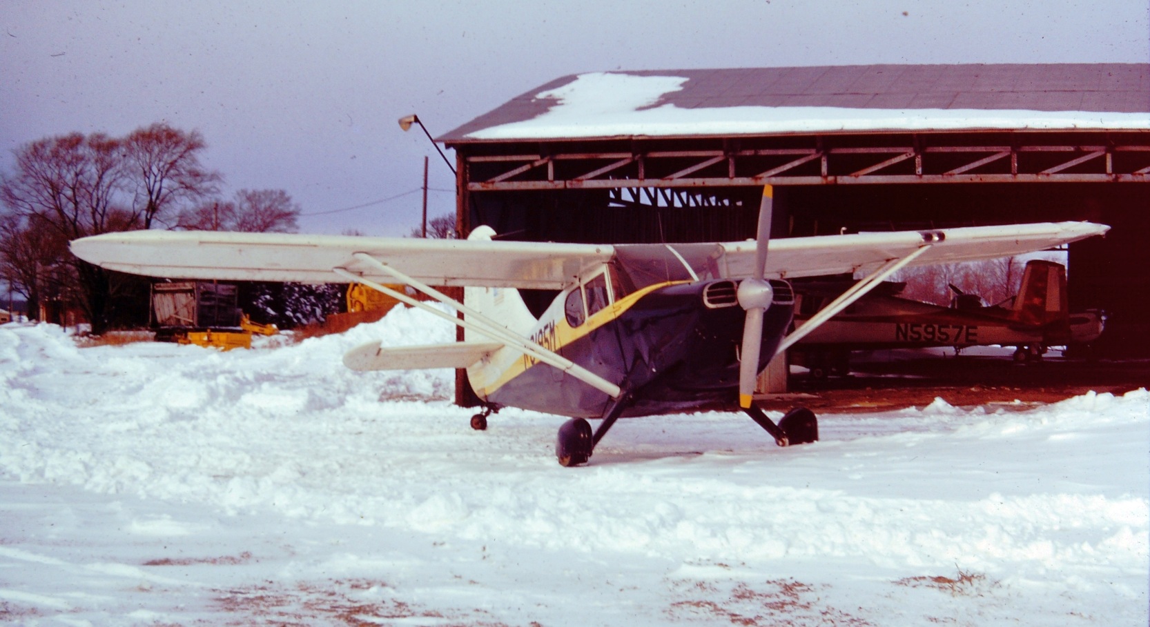
The earliest photo which is available of Botsford Airport was a circa 1976 by Daun Yeagley of “Stinson N6195M sitting outside of the south-facing hangar.
Dad would have been just about standing on the main North/South runway.”
A circa 1976 by Daun Yeagley at Botsford Airport, of “Stinson N6195M sitting in front of Bill & Marie's garage on the west side of the field.
It shows the pond, north/south runway and hangar, plus a Schweizer 2-33 glider that was part of the soaring club that also called the field home for many years.
This is before the octagonal hangar or soaring club hangar were built.”
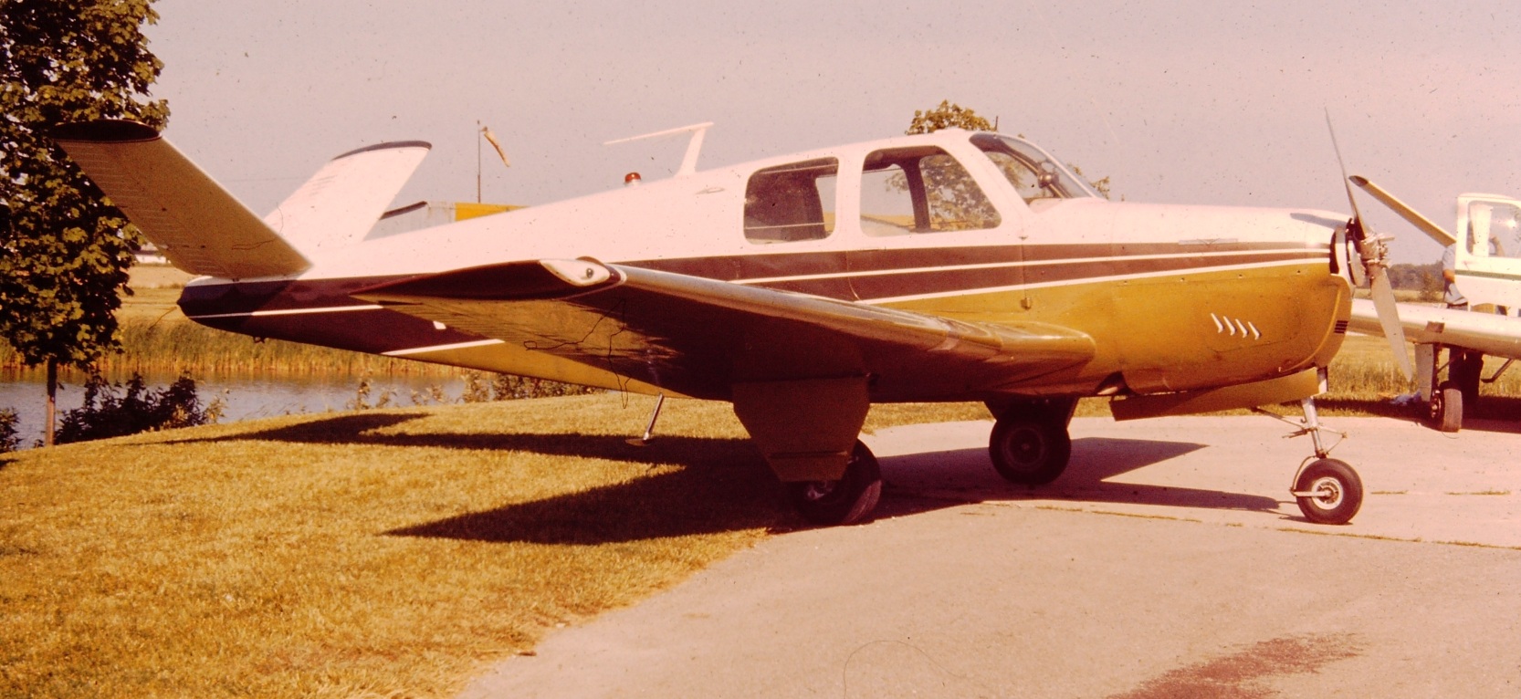
A circa 1976 by Daun Yeagley at Botsford Airport, of “Dad's A-35 Bonanza N504B & Bill's G-35 Bonanza N4276D in front of the house.”
The 1984 OH Airport Directory (courtesy of Daun Yeagley) showed that Botsford Airport had evidently lost 2 of its runways at some point between 1973-84,
with the sole remaining runway being the 3,000' Runway 18/36.
An octagonal hangar had also been added on the northeast side.
The earliest aerial photo which is available of Botsford Airport was an early/mid-1990s aerial view looking southwest by Daun Yeagley.
It depicted 6 light aircraft parked on the north end of the field, including a glider.
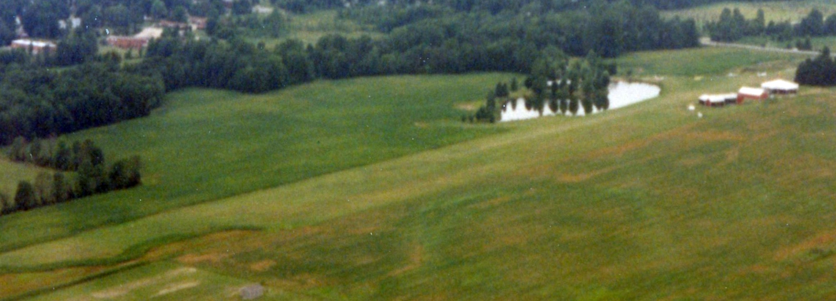
An early/mid-1990s aerial view looking southwest at Botsford Airport by Daun Yeagley.
A 1994 aerial view looking southwest at Botsford Airport depicted 1 light aircraft parked to the east of the runway.
Daun Yeagley reported, “The name changed to Reader-Botsford sometime after Bill's death in 1998.”
A June 2004 photo by Daun Yeagley looking north toward the Botsford hangar.
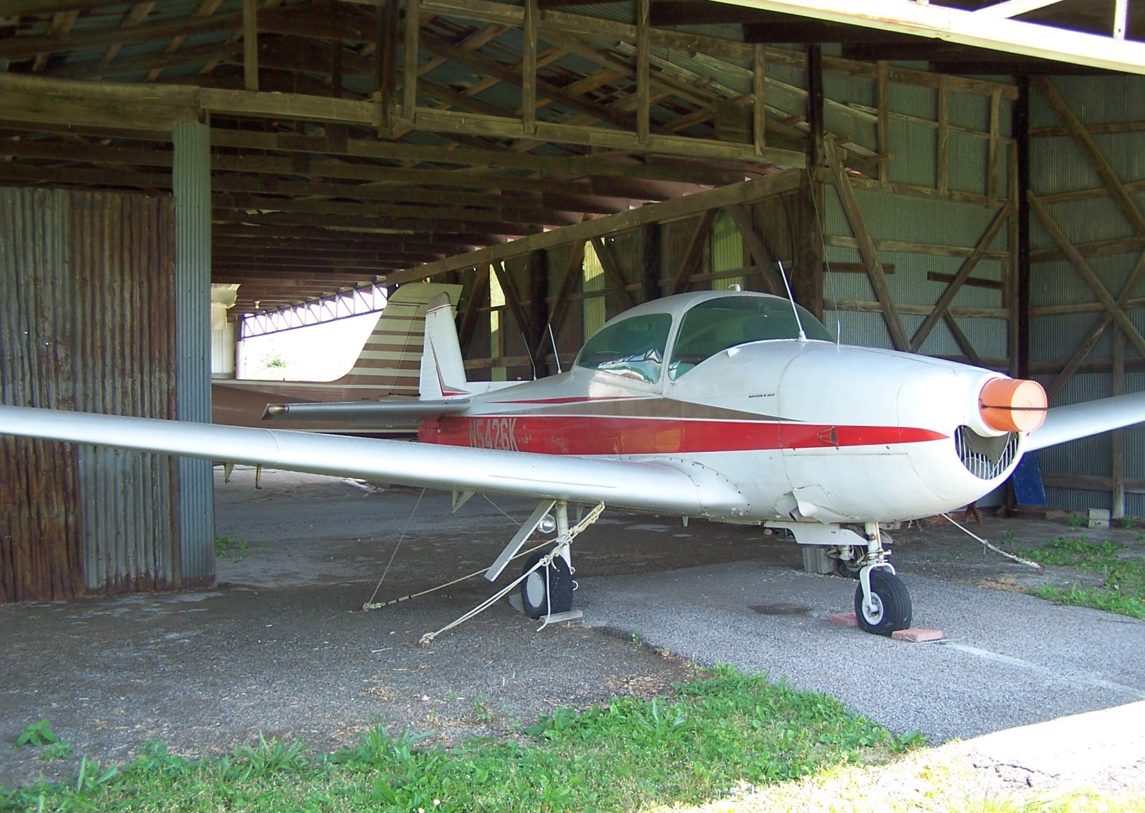
A June 2004 photo by Daun Yeagley at Botsford Airport, of “Bill's last airplane, a project Navion 260B he owned in partnership.
After he passed on the airplane sat derelict for a number of years.”
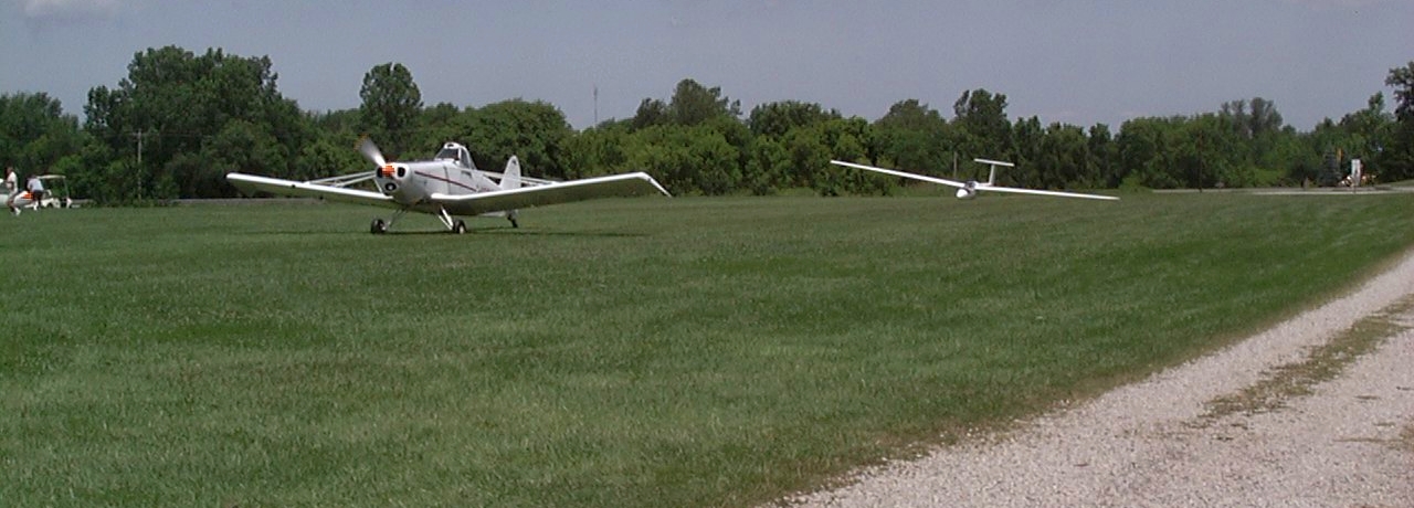
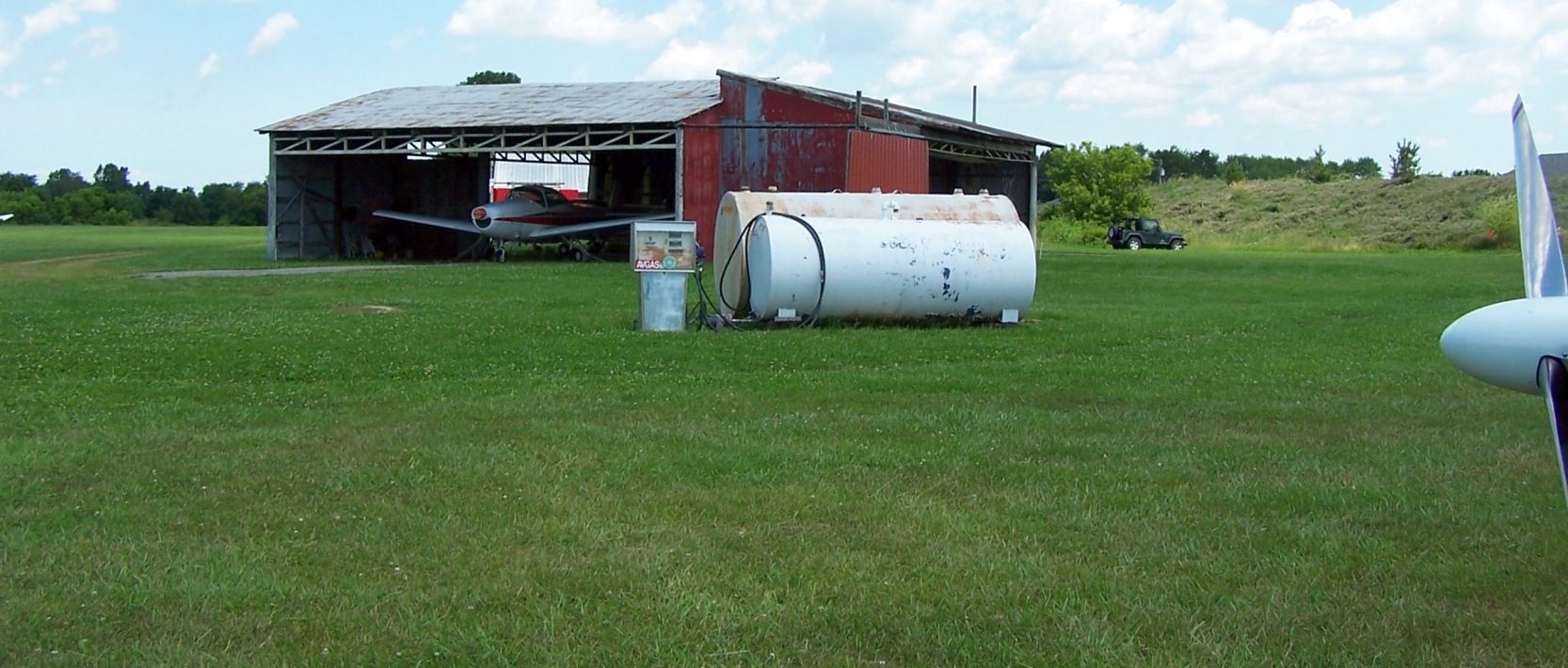
A June 2004 photo by Daun Yeagley at Botsford Airport, of a “Fun Country Soaring Piper Pawnee towing a sailplane off Runway 18.”
A June 2004 photo by Daun Yeagley at Botsford Airport, of a “Fun Country Soaring Piper Pawnee towing a sailplane off Runway 18.”
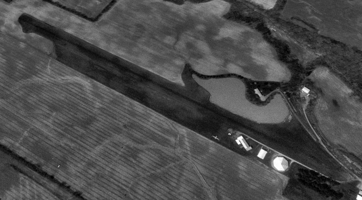
The last photo which has been located showing an aircraft at Botsford Airport was a 2012 aerial view looking southwest, which depicted 1 light single-engine aircraft parked next to the hangar.
The last airport directory entry which has been located of Botsford Airport was in the 2013 OH Airport Directory (courtesy of Daun Yeagley).
It depicted Botsford Airport as having a single 2,850' unpaved Runway 18/36, and 2 hangars on the northeast side.
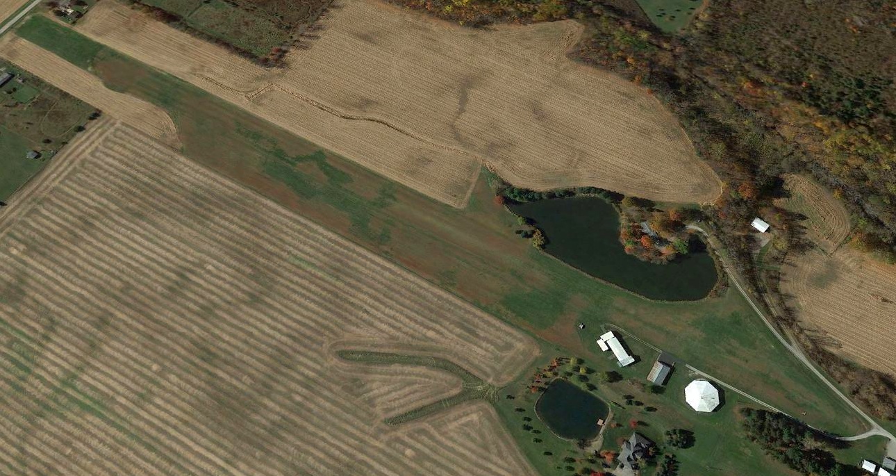
A 2015 aerial view looking southwest showed Botsford Airport remained intact, but no aircraft were visible on the field.
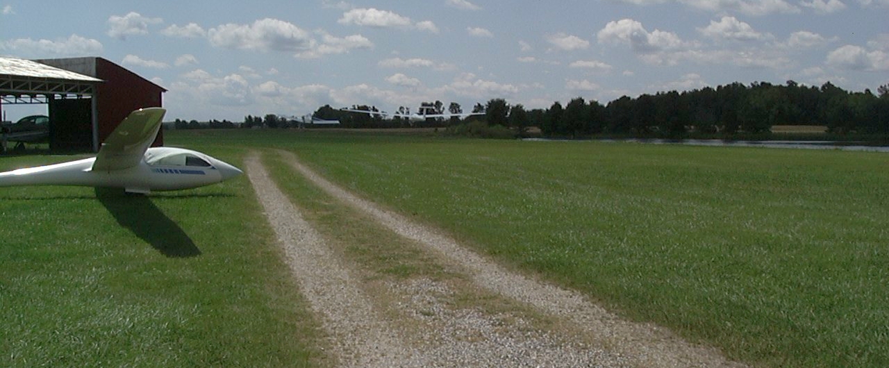
The last aeronautical chart depiction which has been located of Botsford-Reader Airport was on the September 2016 Detroit Sectional Chart,
which depicted Reader-Botsford Airport as having a 2,800' unpaved runway, and to conduct glider operations.
Daun Yeagley reported, “It looks like Fun Country Soaring moved out of Wellington at the end of the 2016 season, which I would infer to mean Botsford Airport closed by sometime in 2017.”
Botsford-Reader Airport was no longer depicted on the September 2018 Detroit Sectional Chart,
A July 2020 photo by Daun Yeagley at Botsford Airport, “Looking down Runway 18, which is now partially a cornfield.”
A July 2020 photo by Daun Yeagley at Botsford Airport, of “the old main hangar.”
Thanks to Daun Yeagley for pointing out this airfield.
___________________________________________________
Strauss Airport, North Olmstead, OH
41.38, -81.977 (West of Cleveland, OH)
Strauss Airport, as depicted on the January 1948 Cleveland Sectional Chart.
This short-lived small general aviation airport on the west side of Cleveland was evidently established at some point between 1947-48,
as it was not yet depicted on the July 1947 Cleveland Sectional Chart.
The earliest depiction which has been located of Strauss Airport was on the January 1948 Cleveland Sectional Chart.
The earliest photo which has been located of Strauss Airport was a late 1940s aerial view (courtesy of Mike Kmetz).
It depicted Strauss Airport as having a single unpaved runway, with an arch-roof hangar, and another adjacent hangar apparently under construction.
A total of 9 light single-engine general aviation aircraft were pictured parked very close to the runway,
including a Cabin Waco, N3N, Stearman, Ryan PT-22, Fairchild PT-19, and several Cubs & Champs.
The November 1950 Cleveland Sectional Chart depicted Strauss Airport as having a 3,100' unpaved runway.
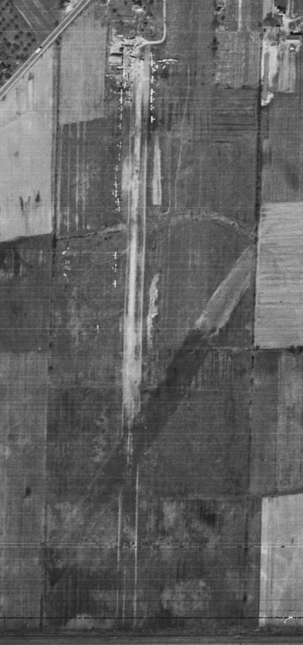
The last photo which has been located of Strauss Airport was a 4/17/52 USGS aerial view.
It depicted Strauss Airport as having 2 unpaved runways, with several small buildings o the northwest side.
Business was evidently very good, as over 28 light aircraft were parked on the northwest & northwest sides.
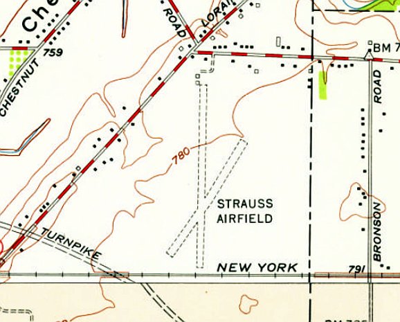
The earliest topo map depiction which has been located of Strauss Airport was on the 1953 USGS topo map.
It depicted Strauss Airfield as having 2 unpaved runways, with a few small buildings on the north side.
The last aeronautical chart depiction which has been located of Strauss Airport was on the January 1954 Cleveland Sectional Chart,
which depicted Strauss as having a 2,600' unpaved runway.
Strauss Airport was evidently closed (for reasons unknown) at some point in 1954, as it was no longer depicted on the July 1954 Cleveland Sectional Chart.
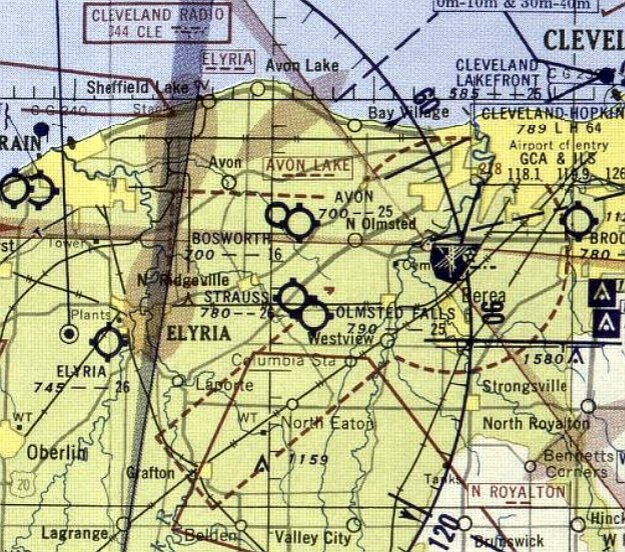
A 1958 aerial view depicted a pond having been built over the southern portion of the Strauss Airport site.
The 1963 USGS topo map depicted a pond covering the site of Strauss Airport.
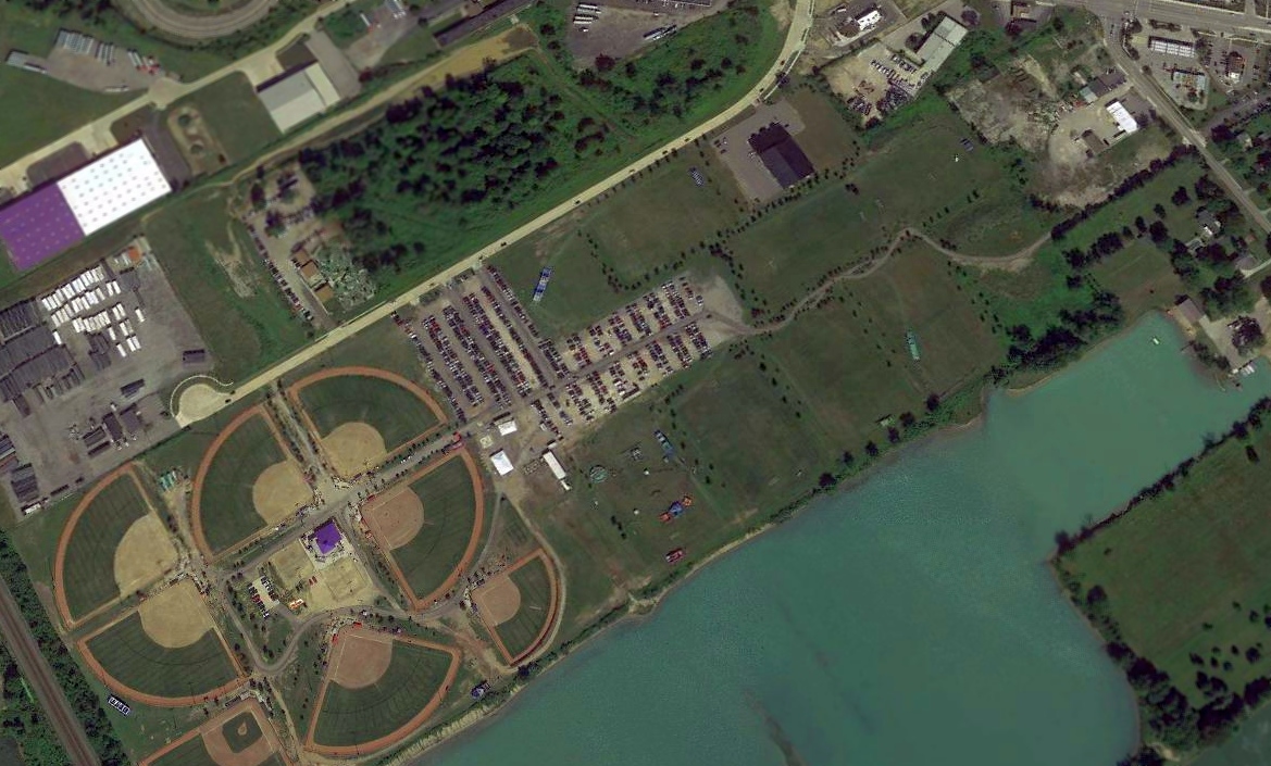
A 2018 aerial view looking northwest showed baseball fields covering the southern portion of the Strauss Airport site, with no trace recognizable of the former airport.
Thanks to Mike Kmetz for pointing out this airfield.
___________________________________________________
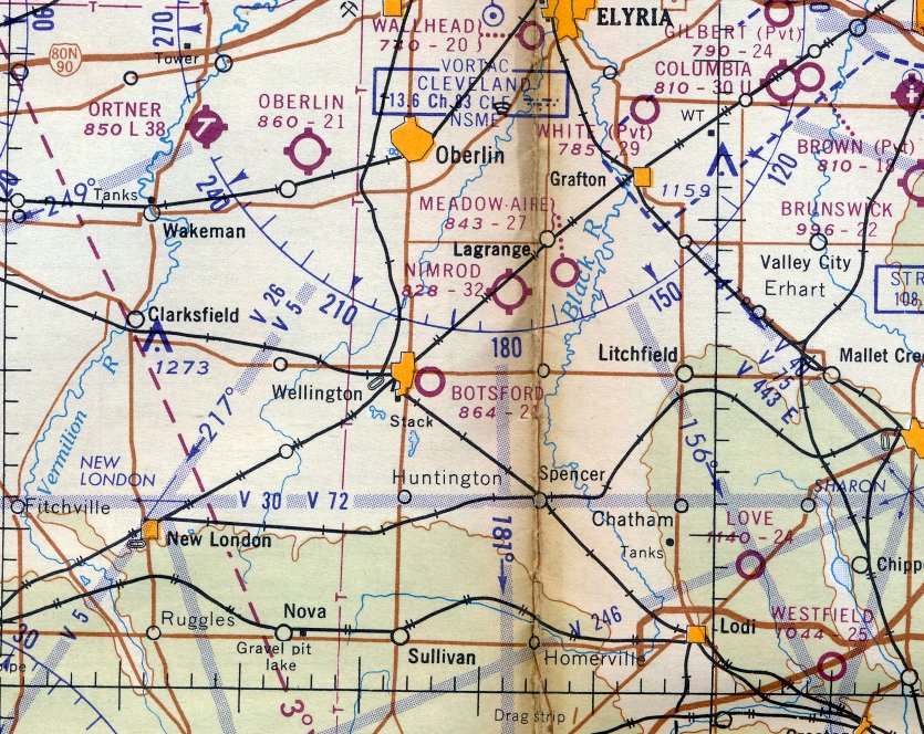
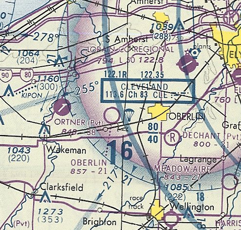
Oberlin Airport (I70), Oberlin, OH
41.286, -82.293 (Southwest of Cleveland, OH)
Oberlin Airport, as depicted on the January 1948 Cleveland Sectional Chart.
This small general aviation airport was evidently established at some point between 1947-48,
as it was not yet depicted on the July 1947 Cleveland Sectional Chart.
The earliest depiction which has been located of Oberlin Airport was on the January 1948 Cleveland Sectional Chart.
The earliest photo which has been located of Oberlin Airport was a 4/27/52 USGS aerial view.
It depicted Oberlin Airport as having 2 grass runways, and a few small buildings & 1 light single-engine plane on the northwest side.
The 1959 USGS topo map depicted Oberlin Airport as having 2 unpaved runways & a few small buildings on the northwest side.
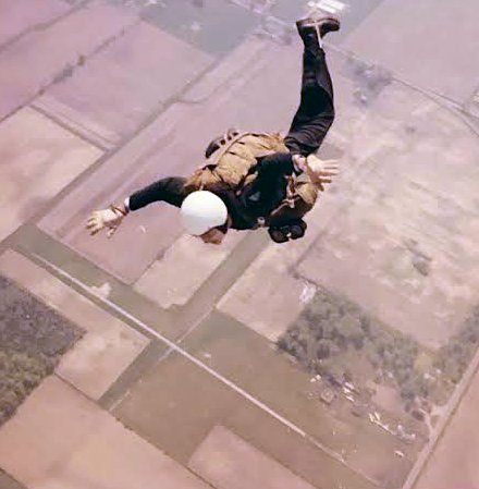
A 1965 aerial view (courtesy of Janice Koepp, via John Lewis) looking southwest at a skydiver freefalling toward Oberlin Airport.
A 1969 aerial photo depicted Oberlin Airport as having a north/south asphalt runway & an unpaved east/west runway.
A small hangar, a T-hangar, and 1 light single-engine plane were visible on the west side.
John Lewis reported that he flew in & out of Oberlin Airport circa 1969.
He recalled, “Richard & Beatrice Homestead kept their Cessna 172, N6992A at Oberline airport for many years.”
The last aeronautical chart depiction which has been located of Oberlin Airport was on the May 1981 Detroit Sectional Chart (courtesy of Ron Plante).
It depicted Oberlin as a public-use airport having a 2,100' unpaved runway & conducting parachute operations.
The 1986 USGS topo map depicted Oberlin Airport as having a single north/south runway.
Oberlin Airport was evidently closed at some point between 1981-93,
as it was no longer depicted on the October 1993 Detroit Sectional Chart (courtesy of Ron Plante).
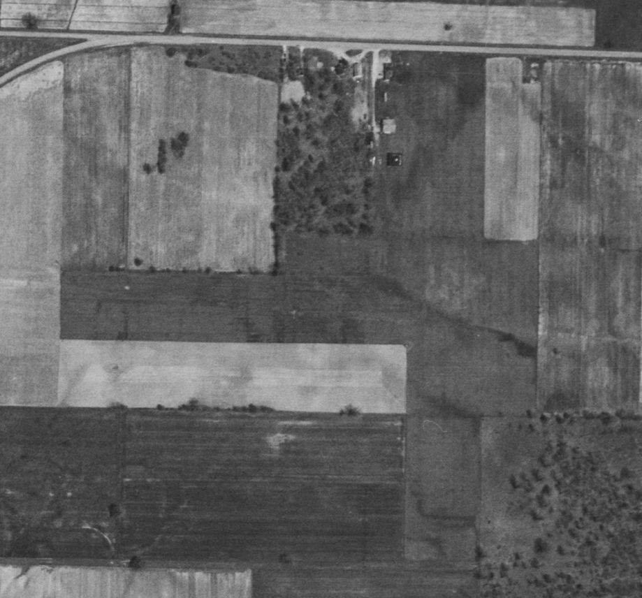
A 1994 aerial photo showed the former Oberlin Airport's paved north/south runway as deteriorated & less distinct,
Some of the small buildings remained on the northwest side, but there were no aircraft visible on the field.
Oberlin Airport was no longer depicted on the 2013 USGS topo map.
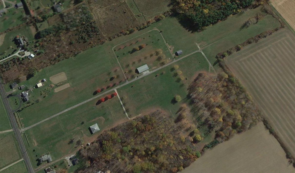
A 2015 aerial view looking southeast showed the former Oberlin Airport paved north/south runway has been reused as long straight driveway along the property.
John Lewis reported in 2019 that the site of Oberlin Airport “is now the site of dog shows.”
A 10/18/19 photo by Janice Koepp looking south along the former Oberlin Airport north/south runway.
A 10/18/19 photo by Janice Koepp looking southeast at 2 former hangars which remain at the site of Oberlin Airport.
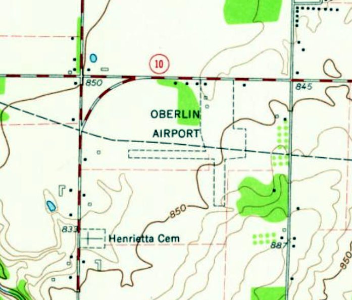
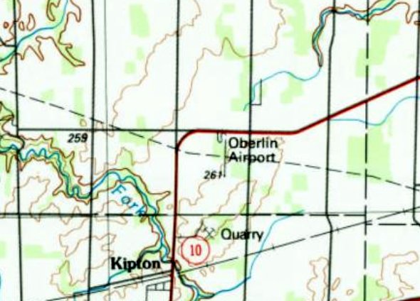
The site of Oberlin Airport is located Southwest of the intersection of Gifford Road & Route 511.
Thanks to John Lewis for pointing out this airfield.
____________________________________________________
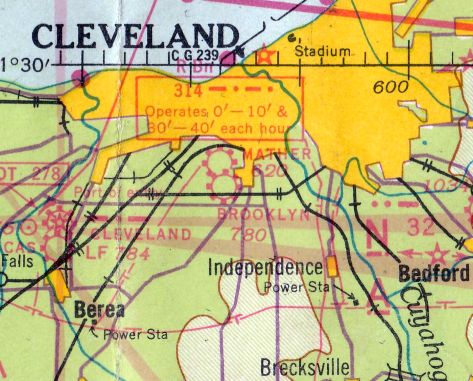
41.433, -81.738 (South of Cleveland, OH)
A 1936-37 aerial view looking east showing Mather Airport while under construction (courtesy of Bill Meixner).
Accoriding to a Brooklyn Historical Society flier (courtesy of Bill Meixner), “Mather Airport [was] established in 1936 by Arlo Mather.”
The earliest photo which has been located of Mather Airport was a 1936-37 aerial view looking east showing Mather Airport while under construction (courtesy of Bill Meixner).
It depicted Mather Airport as having possibly 3 unpaved runways.
A 1937 aerial view (courtesy of Bill Meixner) showed Mather Airport to have 2 unpaved runways & a small hangar.
There were no aircraft visible on the field.
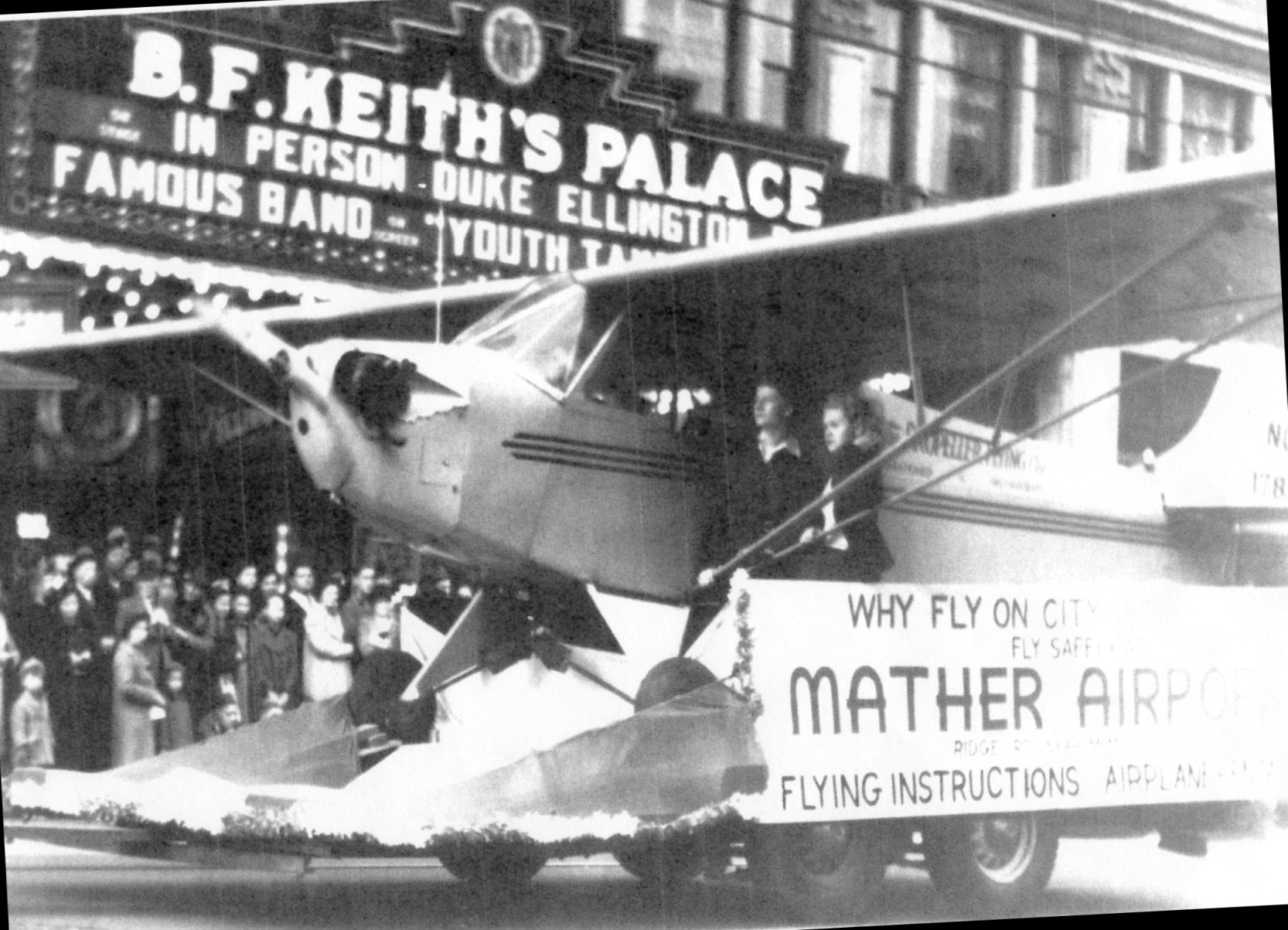
A circa late 1930s / early 1940s photo (courtesy of Bill Meixner) showed a Piper Cub from Mather Airport on parade in front of B.F. Keith's Palace.
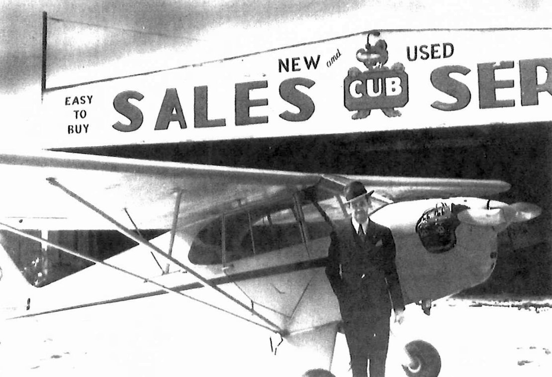
A circa late 1930s / early 1940s photo (courtesy of Bill Meixner) of airport founder Arlo Mather in front of a Piper Cub & a hangar at Mather Airport.
The earliest aeronautical chart depiction which has been located of Mather Airport was on the July 1938 Cleveland Sectional Chart.
The last aeronautical chart depiction which has been located of Mather Airport was on the June 1945 Cleveland Sectional Chart.
Accoriding to a Brooklyn Historical Society flier (courtesy of Bill Meixner), “Mather Airport [was] closed in 1947.”
Mather Airport was no longer depicted on the July 1947 Cleveland Sectional Chart.
A 1952 USGS aerial view showed empty fields at the site of Mather Airport.
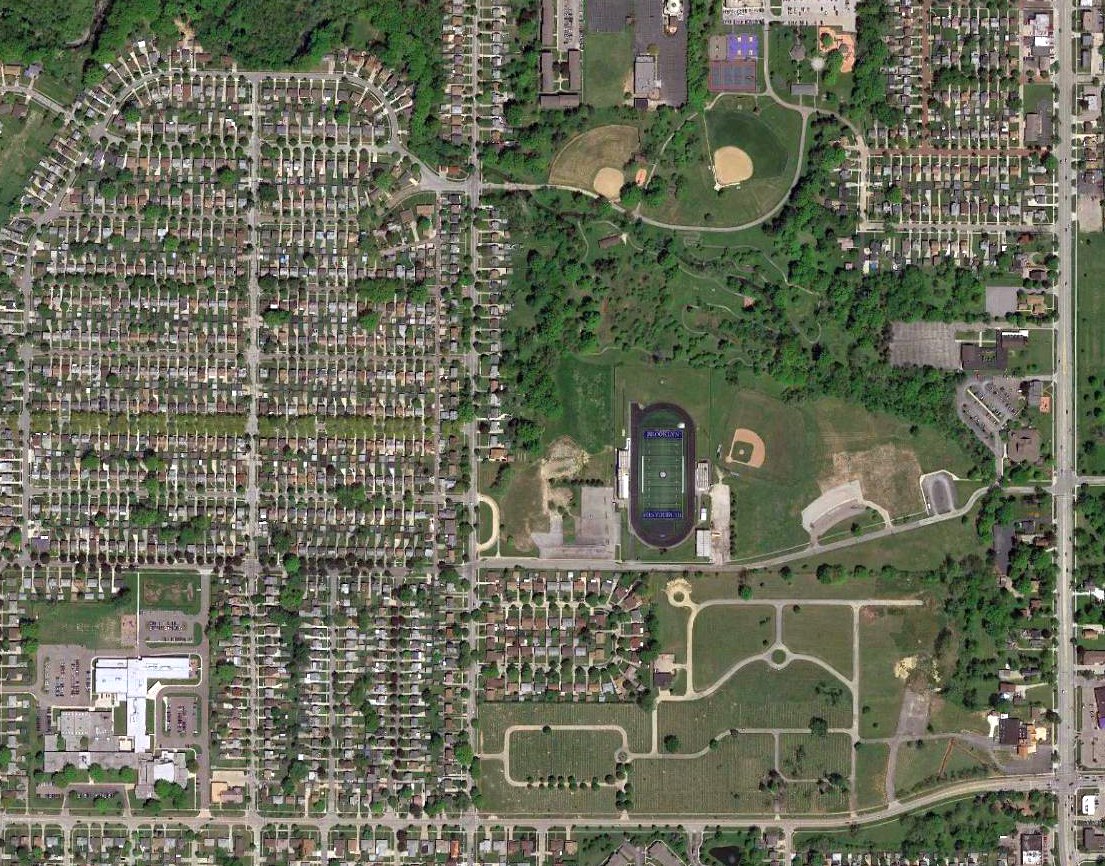
A 2017 aerial view showed no trace remaining of Mather Airport.
The site of Mather Airport is located northwest of the intersection of Biddulph Road & Ridge Road.
Thanks to Bill Meixner for pointing out this airfield.
____________________________________________________
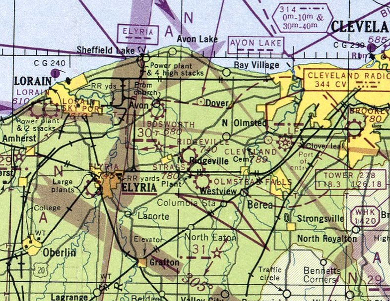
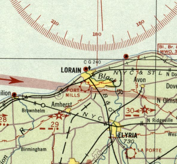
Port Mills Airport / Lorain Sky Port, Lorain, OH
41.444, -82.197 (West of Cleveland, OH)
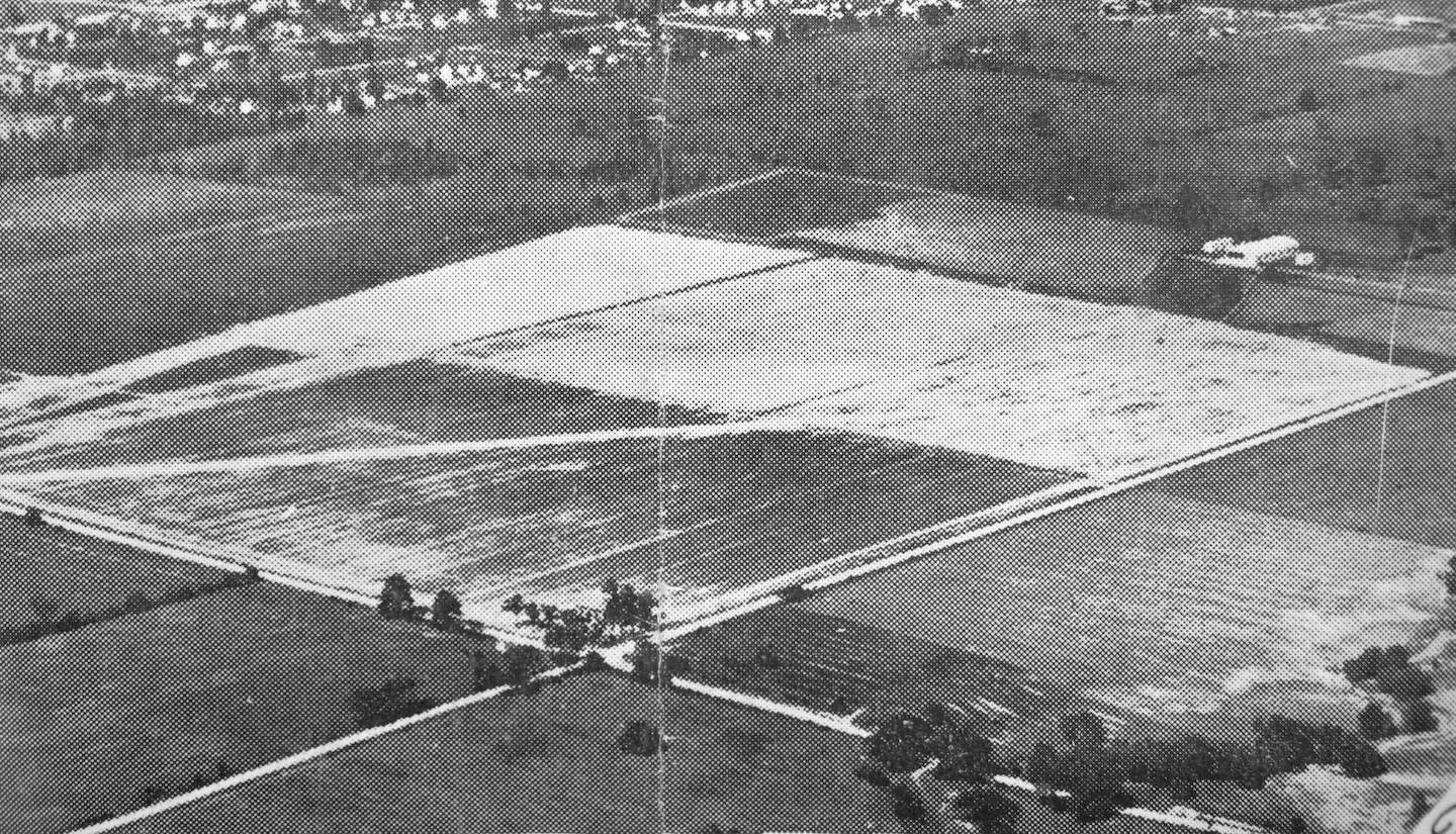
An undated aerial view looking northeast at Port Mills Airport, from a 7/26/29 newspaper article (courtesy of Lee Corbin).
Port Mills Airport was established in 1929, according to a 7/26/29 newspaper article entitled “Lorain Awaits Airport Opening” (courtesy of Lee Corbin).
The earliest depiction which has been located of Port Mills Airport was an undated aerial view from that article (courtesy of Lee Corbin),
which depicted Port Mills Airport as a square airfield within which was one runway.
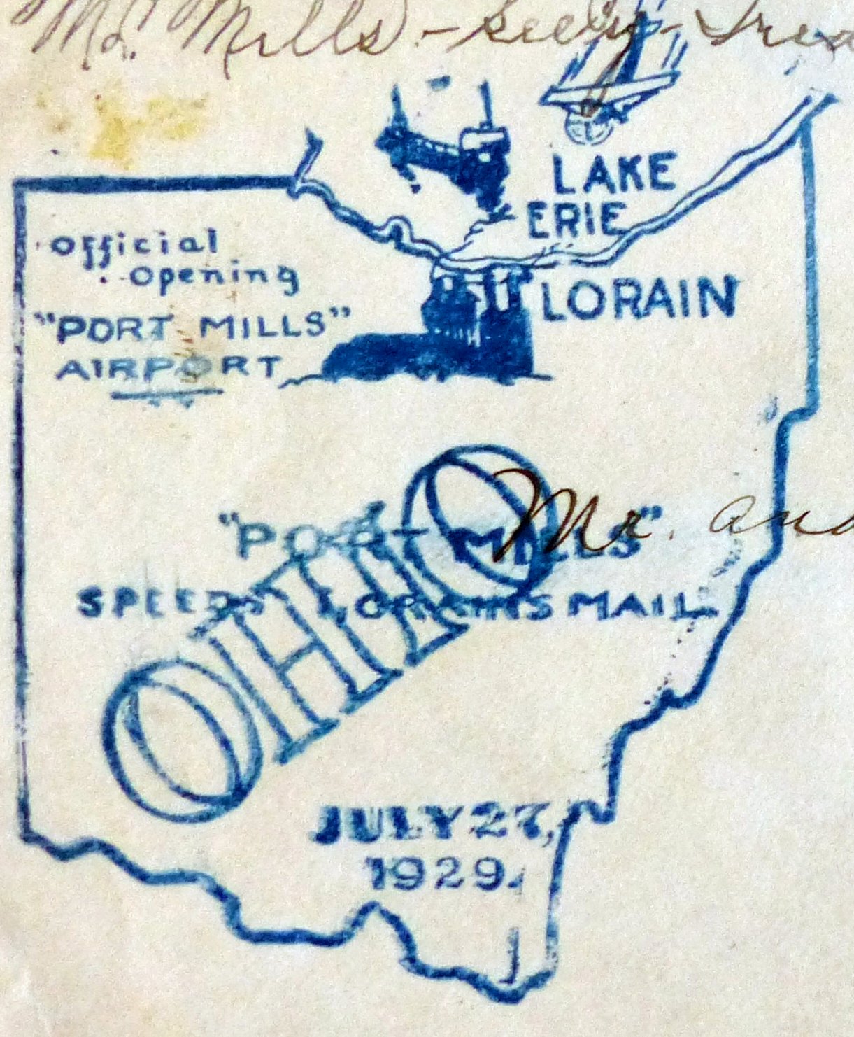
A postmark commemorating the 7/27/29 Official Opening of Port Mills Airport (courtesy of Jeffrey Meizlik).
According to Dennis Thompson, “One of the Wright Brothers was part of the opening ceremony.”
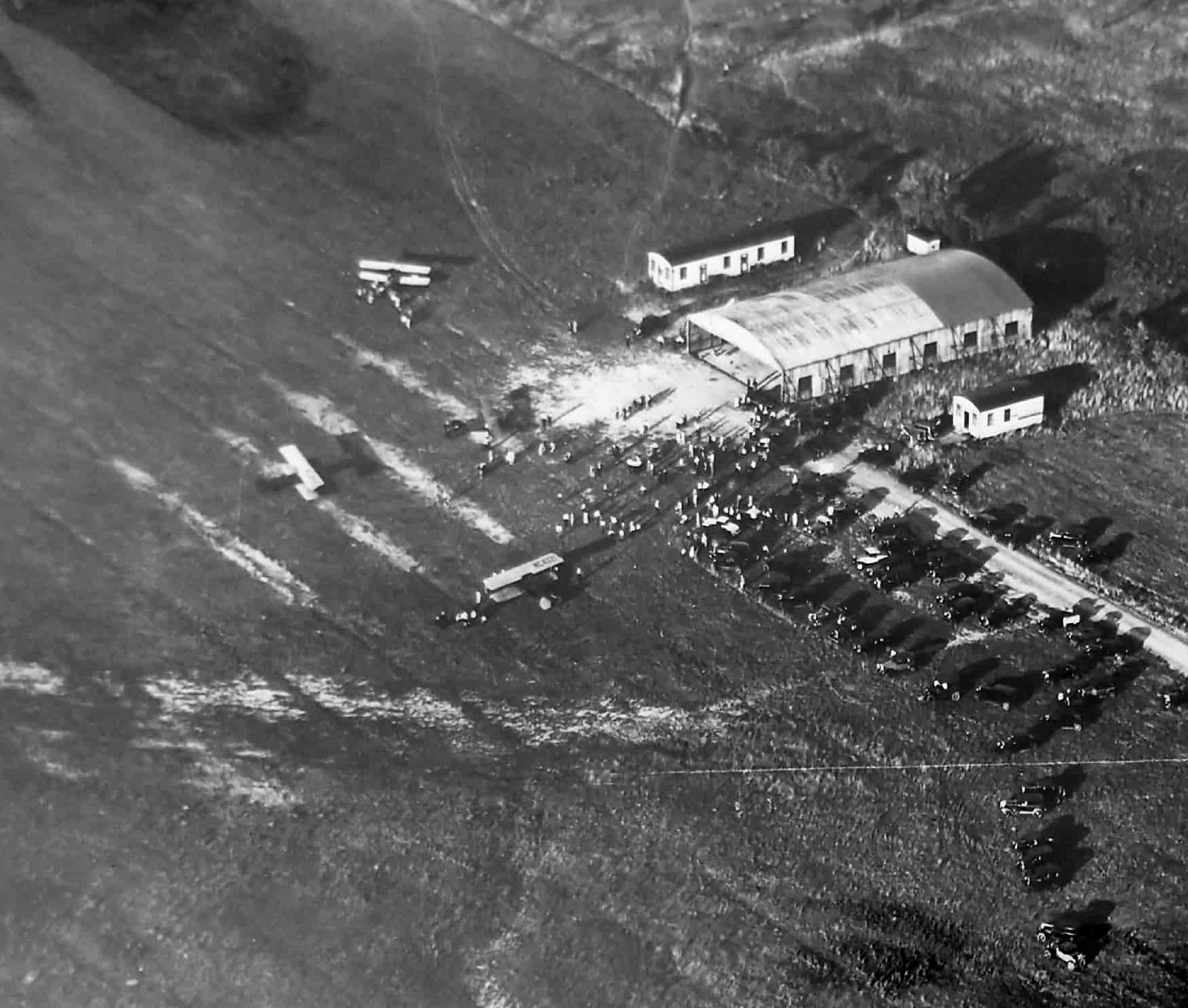
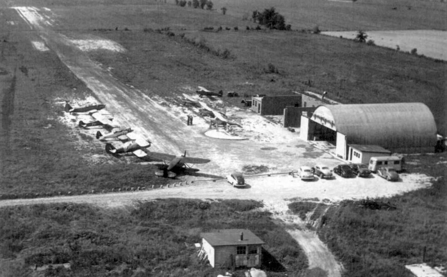
A 7/27/29 aerial view looking northeast at Port Mills Airport on the occasion of its dedication (courtesy of Pete Donatucci)
showed 4 biplanes & a hangar on the east side of the field.
An undated aerial view (courtesy of Pete Donatucci) showed a biplane over the 3 unpaved runways of Port Mills Airport.
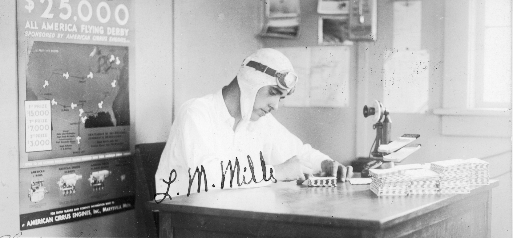
A 7/27/30 photo of L.M. Mills autographing covers commemorating the 1st anniversary of Port Mills Airport (courtesy of Tom Heitzman).
A circa 1930s photo of 2 biplanes outside a hangar at Port Mills Airport (courtesy of Lee Corbin).
A 1932 photo (courtesy of Pete Donatucci) of spectators & biplanes at Port Mills Airport.
The earliest aeronautical chart depiction which has been located of Port Mills Airport was on the December 1932 Cleveland Sectional Chart.
It depicted Port Mills as a commercial/municipal airport.
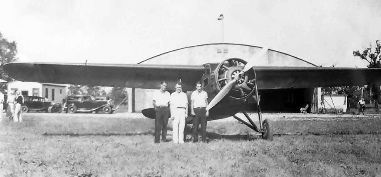
A 7/9/33 photo (courtesy of Pete Donatucci) of 3 men in front of an unidentified biplane & a hangar at Port Mills Airport.
It was still labeled as Port Mills Airport on the June 1945 Cleveland Sectional Chart.
According to a 5/28/00 Morning Journal article (courtesy of Pete Donatucci), “After World War II, Ray McClenaghan
bought 120 acres of land on the northeast corner of Meister Road at the intersection of Leavitt Road.
McClenaghan christened the area Lorain Skyport.
Along with teaching people how to fly, he also flew local corporate heads to locations across the U.S., Mexico and Canada in his Cessna 180.
Ruth also was a licensed private pilot.”
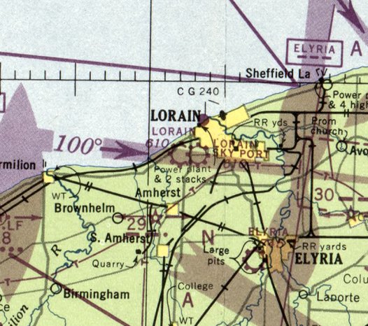
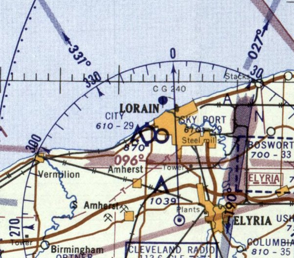
The July 1947 Cleveland Sectional Chart depicted an odd sight:
the Port Mills Airport has been renamed at some point between 1945-47 to Lorain Sky Port,
and a new Lorain Airport had been built on the opposite (west) side of North Leavitt Road.
The November 1950 Cleveland Sectional Chart depicted Lorain Sky Port as having a 2,700' unpaved runway.
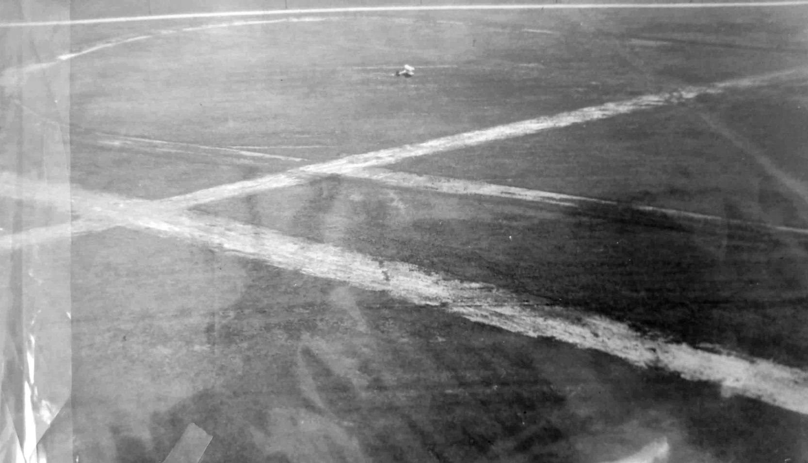
An April 1952 aerial view (courtesy of Lee Corbin) of Lorain City Airport depicted an odd sight:
the original airport (on the east side of North Leavitt Road), which consisted of 2 runways in an X-shape,
had been replaced by another airport on the opposite side of the road, with almost exactly the same runway configuration.
The last aeronautical chart depiction which has been located of Lorain Sky Port was on the January 1958 Cleveland Sectional Chart.
It depicted Sky Port as having a 2,900' unpaved runway.
Lorain Sky Port (on the east side of North Leavitt Road) was evidently closed at some point in 1958,
as the July 1958 Cleveland Sectional Chart only depicted Lorain Airport on the west side of the road.
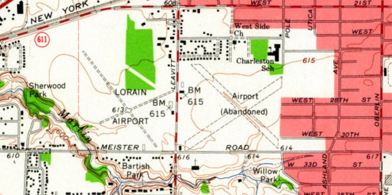
The 1960 USGS topo map (courtesy of Lee Corbin) depicted Lorain Airport (on the west side of North Leavitt Road)
along with the original Lorain Airport (labeled “Airport (Abandoned)”) on the east side of the road.
According to a 5/28/00 Morning Journal article (courtesy of Pete Donatucci), “McClenaghan finally sold his Lorain Skyport in the early 1960s to residential developers.”
McClenaghan recalled, “They were building houses all around the airfield. And here I was, sending young pilots out over these houses.
We never had an accident, thank God, but I had to sell it. It was heartbreaking.”
An April 1962 aerial view (courtesy of Lee Corbin) depicted Lorain City Airport (on the west side of North Leavitt Road),
but showed that the original airport on the opposite side of the road had been covered by new housing construction.
The 1969 USGS topo map (courtesy of Lee Corbin) depicted Lorain Airport (on the west side of North Leavitt Road),
but no longer depicted the original airport on the opposite side of the road, with that location having been covered by new residential streets.
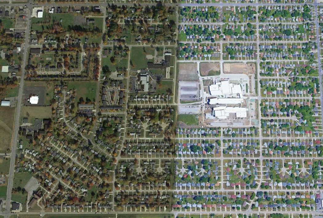
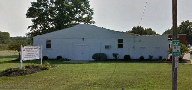
A 2016 aerial view looking north showed the only trace remaining of Port Mills Airport / Lorain Sky Port was the former hangar on the west side.
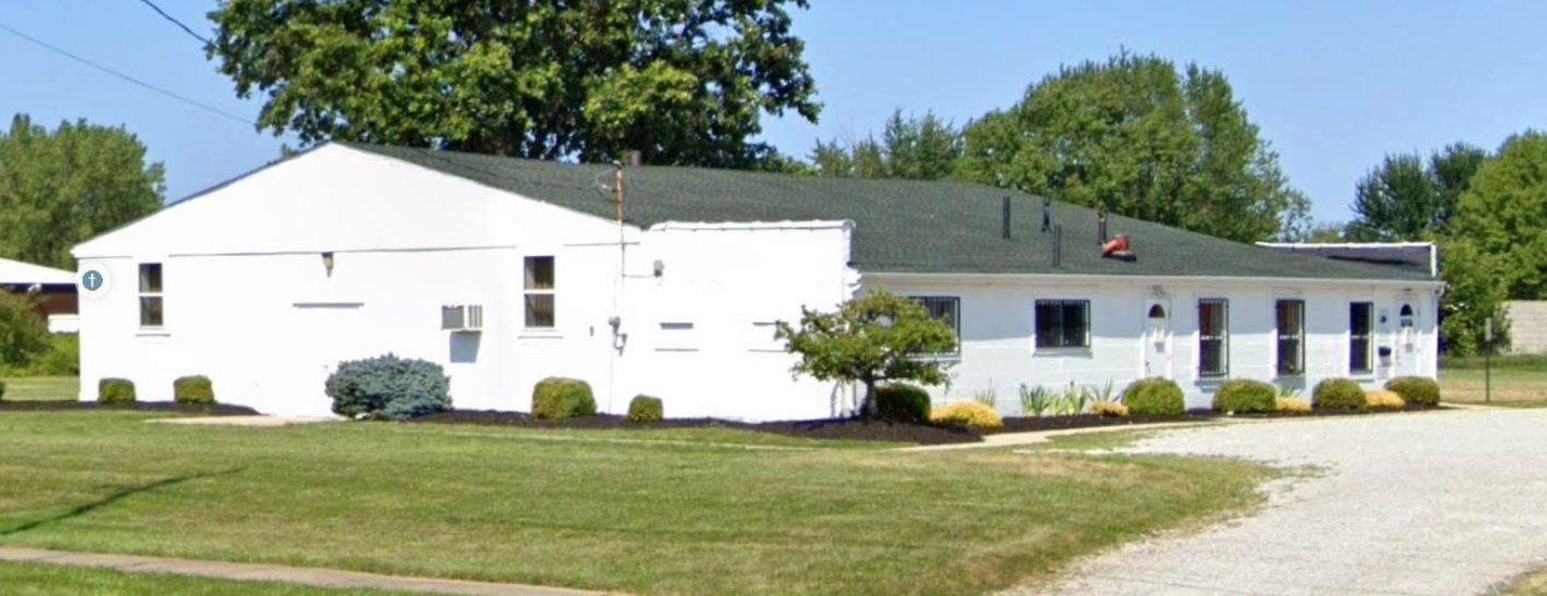
A July 2019 photo (courtesy of Dennis Thompson) looking northeast at the former Port Mills Airport hangar, reused as the Full Gospel Ministry church.
Dennis Thompson observed, “It has been a church for a long time.”
Thanks to Lee Corbin for pointing out this airfield.
___________________________________________________
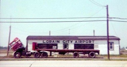
Lorain City Airport (1G4), Lorain, OH
41.444, -82.207 (West of Cleveland, OH)
Lorain Airport, as depicted on the July 1947 Cleveland Sectional Chart.
The Lorain Airport on the west side of North Leavitt Road was evidently built at some point between 1945-47,
as it was not yet depicted on the June 1945 Cleveland Sectional Chart.
The earliest depiction which has been locate of the Lorain Airport on the west side of North Leavitt Road was on the July 1947 Cleveland Sectional Chart.
The November 1950 Cleveland Sectional Chart depicted Lorain Airport as having a 3,000' unpaved runway.
An April 1952 aerial view (courtesy of Lee Corbin) of Lorain City Airport depicted an odd sight:
the original airport (on the east side of North Leavitt Road), which consisted of 2 runways in an X-shape,
had been replaced by another airport on the opposite side of the road, with almost exactly the same runway configuration.
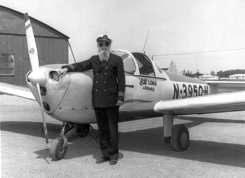
A circa 1950s photo of pilot Bill Long in front of his Ercoupe at Lorain City Airport (courtesy of Lee Corbin).
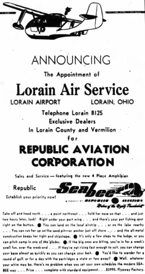
A circa 1950s advertisement for the Lorain Air Service at Lorain Airport (courtesy of Lee Corbin).
The January 1958 Cleveland Sectional Chart depicted Lorain City Airport as having a 2,900' unpaved runway.
The 1960 USGS topo map (courtesy of Lee Corbin) depicted Lorain Airport (on the west side of North Leavitt Road)
along with the original Lorain Airport (labeled “Airport (Abandoned)”) on the east side of the road.
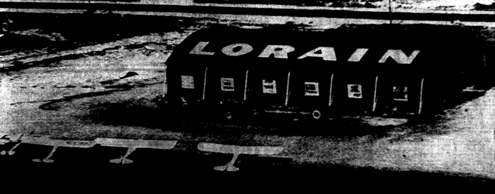
A 5/20/60 photo of several planes in front of a hangar painted with “Lorain” on its roof (courtesy of Lee Corbin).
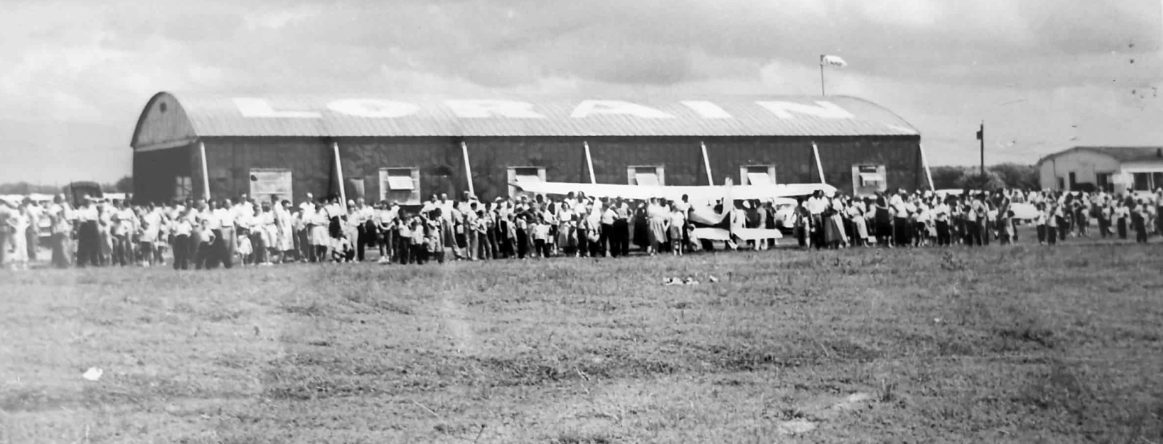
A 1960 photo (courtesy of Pete Donatucci) of the Lorain City Airport hangar during a fly-in / airshow.
Pete Donatucci observed, this was “the same hangar that that had been erected in 1929 at Port Mills.”
An April 1962 aerial view (courtesy of Lee Corbin) depicted Lorain City Airport (on the west side of North Leavitt Road),
but showed that the original airport on the opposite side of the road had been covered by new housing construction.
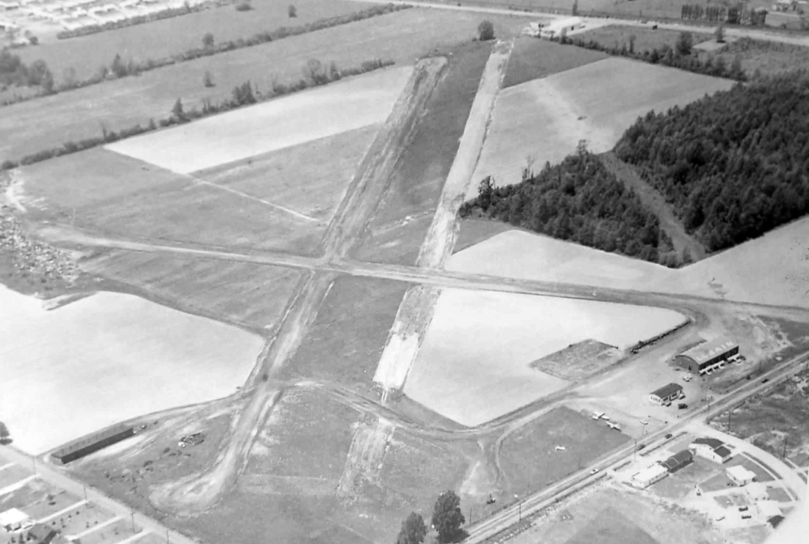
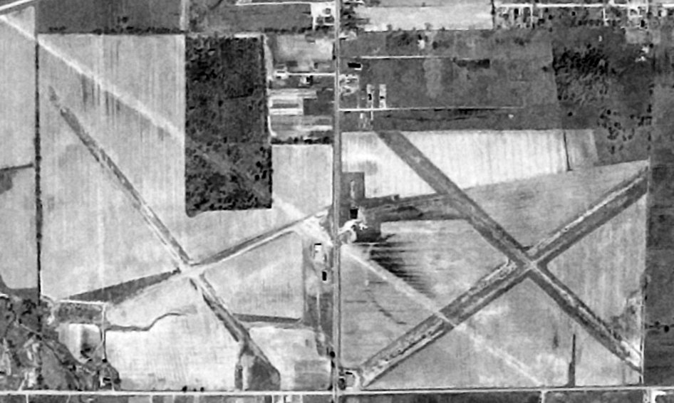
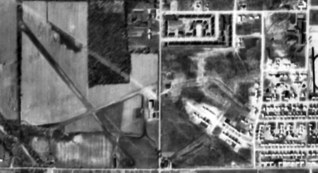
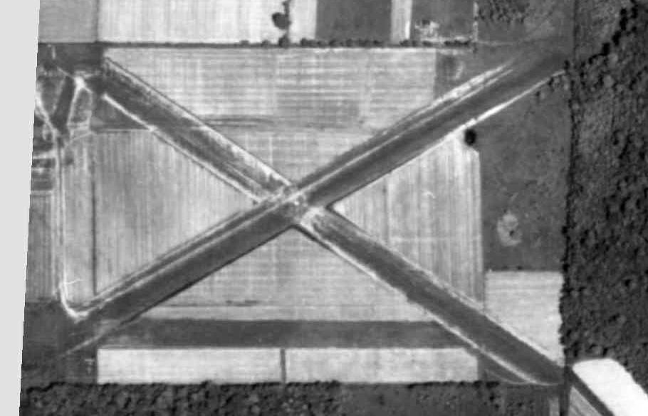
A 1964 aerial view (courtesy of Pete Donatucci) looking northwest at Lorain City Airport.
It showed a total of 3 unpaved runways (2 parallel northwest/southeast runways & a crosswind northeast/southwest strip),
a hangar, office building, and 6 light single-engine aircraft on the east side.
Pete Donatucci recalled, “I grew up just north of Lorain City Airport, on Wallace Lane.
The approach end of Runway 14 was maybe 1,000' from our backyard. So it wasn’t an unusual occurrence to see planes landing or departing over our back yard.
Lorain City Airport was a fairly primitive airport. Strictly VFR, with no lights, no published approaches, and of course, it didn’t have what could be considered a hard-surfaced runway.
Just dirt, cinders and light gravel. At some times of the year, takeoffs and landings were rough as a cob.
The FAA Identifier for it was 1G4. It made sense, because in the area, 1G3 is still in use for Kent State Airport, and 1G5 is still used as the Identifier for Medina.
The FAA has since recycled the identifier; it’s now used for the Grand Canyon West Airport in AZ.”
Pete continued, “I was a proverbial airport kid when I was growing up. I washed more than a few planes there for free, just to get a ride.
After Carl Nielsen’s first plane was destroyed due to carburetor failure during departure from Runway 32 on 12/31/64, the remains of that Navion were in the hangar as well.
The wreck was later sold, and it was rebuilt and is still flying.”
Pete continued, “When I was a kid in the 1960s, there was a crossing diagonal Runway, 6/24 if I remember correctly. However, it was rarely (if ever) used.
Matter of fact, it was hardly ever graded, and had a lot of potholes in it. Especially in the spring.
The vast majority of the time, pilots used the northwest/southeast runway, as it was longer, better maintained, and the predominate wind was generally out of the northwest, right off the lake.
By the early to mid-1960s, there were houses to the east as well as west of the airport.
Mainly where the old Mills Airport was located to the east of Lorain City Airport, as well as to the west in the Sherwood Allotment.
It was safer to use the longer northwest/southeast runway. As a result, use of the northeast/southwest runway really dropped off to next to nothing.”
A 1969 aerial view depicted a total of 9 light aircraft at Lorain City Airport.
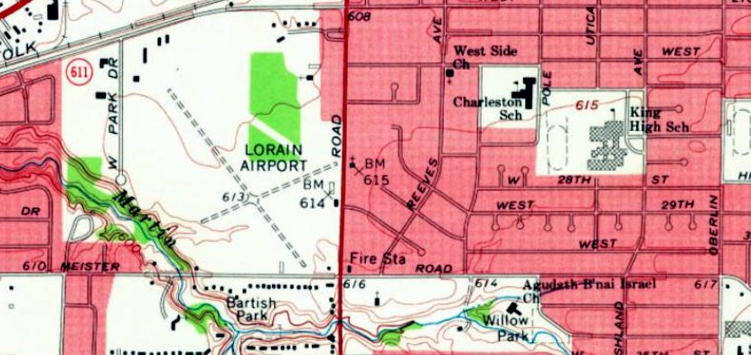
The 1969 USGS topo map (courtesy of Lee Corbin) depicted Lorain Airport (on the west side of North Leavitt Road),
but no longer depicted the original airport on the opposite side of the road, with that location having been covered by new residential streets.
The last aeronautical chart depiction which has been located of Lorain City Airport was on the November 1970 Cleveland Sectional Chart.
It depicted Lorain City Airport as having a 3,000' unpaved runway.
Pete Donatucci recalled, “After 1970, aircraft based at 1G4, and the activity there nosedived due to the building of the newer Lorain County Regional Airport.
More than likely, that's probably what finally killed off the old Oberlin Airport as well.”
The last photo which has been located showing an aircraft at Lorain City Airport was a 1972 photo by Bob Kovach of Bill Long's Ercoupe in front of the Lorain City Airport hangar.
A July 1972 photo by Bob Kovach of the Lorain City Airport hangar (courtesy of Lee Corbin).
The last photo which has been located of Lorain City Airport was a September 1972 photo by Bob Kovach of the Lorain City Airport office building (courtesy of Lee Corbin).
Lorain City Airport was evidently closed (for reasons unknown) at some point between 1972-77,
as it was no longer depicted on the May 1977 Detroit Sectional Chart.
Lorain City Airport was no longer depicted on the 1980 USGS topo map.
A 1994 aerial view showed that a school & several other buildings had removed any trace of the 2nd location of Lorain City Airport (on the west side of the road).
A circa 2010-2018 photo (courtesy of Lee Corbin) shows what appears to be a former hangar which remains standing on the east side of North Leavitt Road,
perhaps the last remnant of Lorain City Airport.
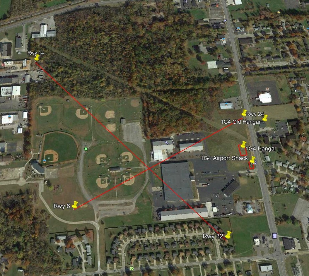
A 2015 aerial view annotated by Pete Donatucci to show the 1962-69 configuration of Lorain Airport.
Although there is no perceptible trace of the runways, and former hangar remains standing on the east side of North Leavitt Road.
Thanks to Lee Corbin for pointing out this airfield.
___________________________________________________
41.43, -81.97 (West of Cleveland, OH)
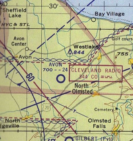
Avon Airport, as depicted on the November 1950 Cleveland Sectional Chart.
This small general aviation airport on the west side of Cleveland was evidently established at some point between 1947-50,
as it was not yet depicted on the July 1947 Cleveland Sectional Chart.
The earliest depiction which has been located of Avon Airport was on the November 1950 Cleveland Sectional Chart,
which depicted Avon Airport as having a 2,400' unpaved runway.
The earliest photo which has been located of Avon Airport was a 1951 aerial view (courtesy of Mike Kmetz).
It depicted Avon Airport as having 3 unpaved runways.
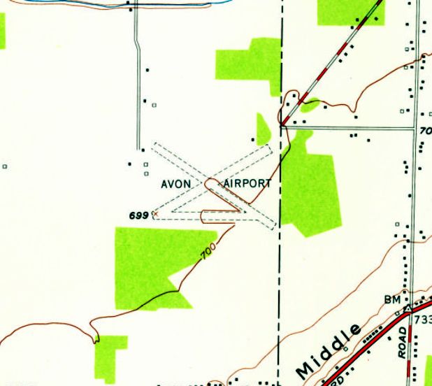
The earliest topo map depiction which has been located of Avon Airport is the 1953 USGS topo map.
It depicted Avon Airport as having 3 unpaved runways, with a few small buildings on the northwest side.
A circa 1954-59 aerial view looking south at Avon Airport (courtesy of Greg Hamilton),
showed several brightly-colored light planes parked near some small buildings on the northwest side.
Two circa 1954-59 photos (courtesy of Greg Hamilton) of Greg's father's Piper Cub & other aircraft at Avon Airport.
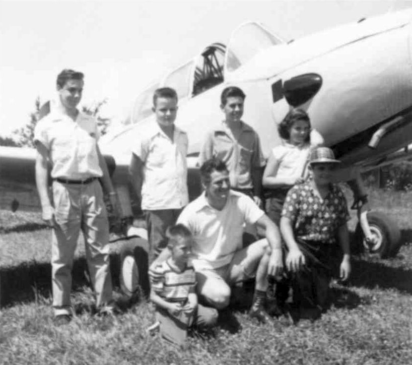
An August 1957 photo (courtesy of Mike Kmetz) of himself (far left) & others in front of a PT-26 flown by his friend’s uncle at an event at Avon Airport.
Mike Kmetz recalled, “In August 1957 I attended a competitive event for pilots there (spot landing; bomb drop).”
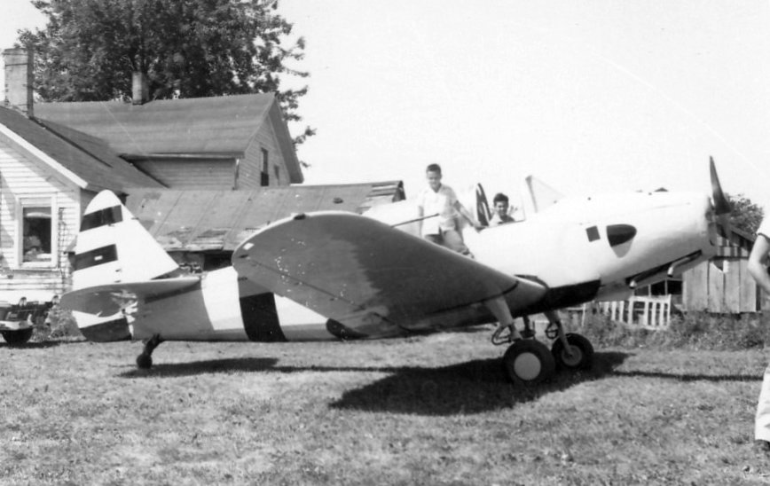
An August 1957 photo (courtesy of Mike Kmetz) of Matt Baratko's PT-26 & the old farmhouse at the northwest corner of Avon Airport which served as the airport office.
Mike Kmetz recalled, “Matt was my friend's uncle & the owner/pilot of the PT-26.”
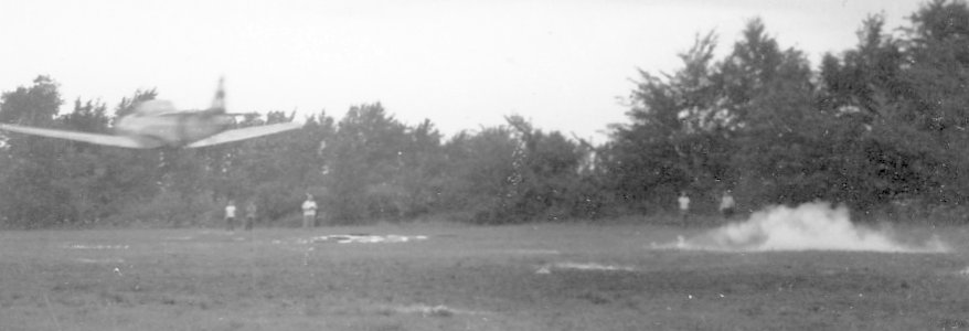
An August 1957 photo (courtesy of Mike Kmetz) of Matt Baratko's PT-26 participating in a flour bag "bomb drop" competition at Avon Airport.
Mike recalled, “He hit the target dead-center but was disqualified for unsafe flying.
It was not only that low pass, but on a return leg, he was still very low & nearly hit the trees behind the airport office.
I will never forget seeing that airplane pulled up almost vertical to avoid the trees.”
An August 1957 photo (courtesy of Mike Kmetz) of one of Matt Baratko's 2 PT-19s which he had at Avon Airport for spare parts.
Mike recalled, “There were a lot of kids there that day climbing on everything.”
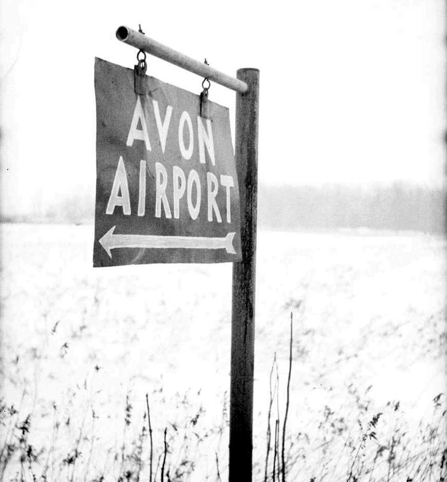
A winter 1958-59 photo by Tom Jones of the Avon Airport sign on Schwartz Road.
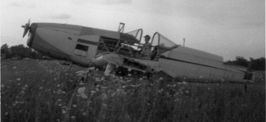
A November 1958 photo by Tom Jones of an Aeronca being hand-propped at Avon Airport.
Tom Jones recalled, “Set in an area of quiet farm fields and sections of hardwoods, Avon Airport was truly the essence of the 'small rural airport'.
During the mid-1950s, a wingnut pal Ken Smith & I would ride bikes from Bay Village out to Avon airport hoping that someone would 'take us up'.
Eventually after hanging around a few times, we got our wish.
Two very generous pilots, Orland VanGunten & Jerry McTigue gave us our first small plane rides in a Piper Vagabond, PT-19, and Aeronca Champ.
I usually carried an older box camera with black & white 620 film & captured various airport images during that mid-1950s period.
The simplicity of the airport 'office' was evident in the west side section of the rural farmhouse.
A small wood counter & glass display case filled the small entry space. A fellow named Charlie Cook was the manager at the time.
There was what we called 'the Boneyard' at the southwest corner of the field.
A few skeletal remains of surplus WW2 trainers & other 'bent' parts had brush & small trees growing through them.”
A winter 1958-59 photo by Tom Jones of 3 Cessnas around the Avon Airport hangars.
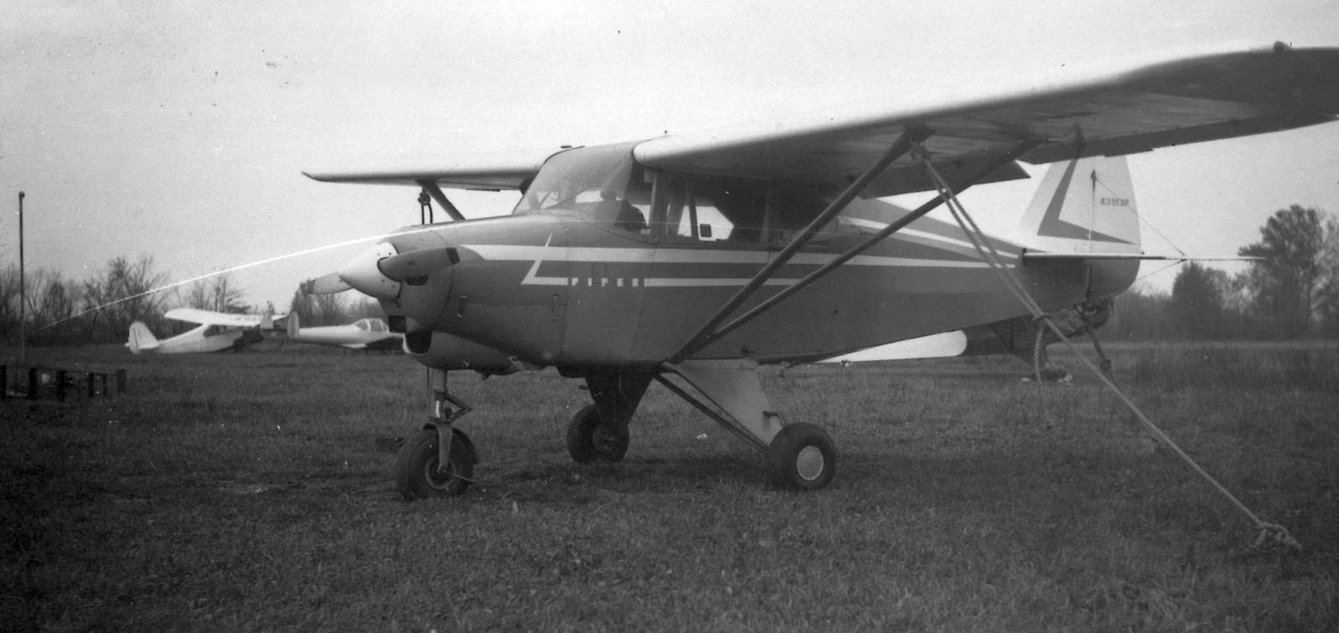
A January 1959 photo by Tom Jones of a Piper Tri-Pacer at Avon Airport, with an Aeronca, Ercoupe, and Piper Cub visible in the background.
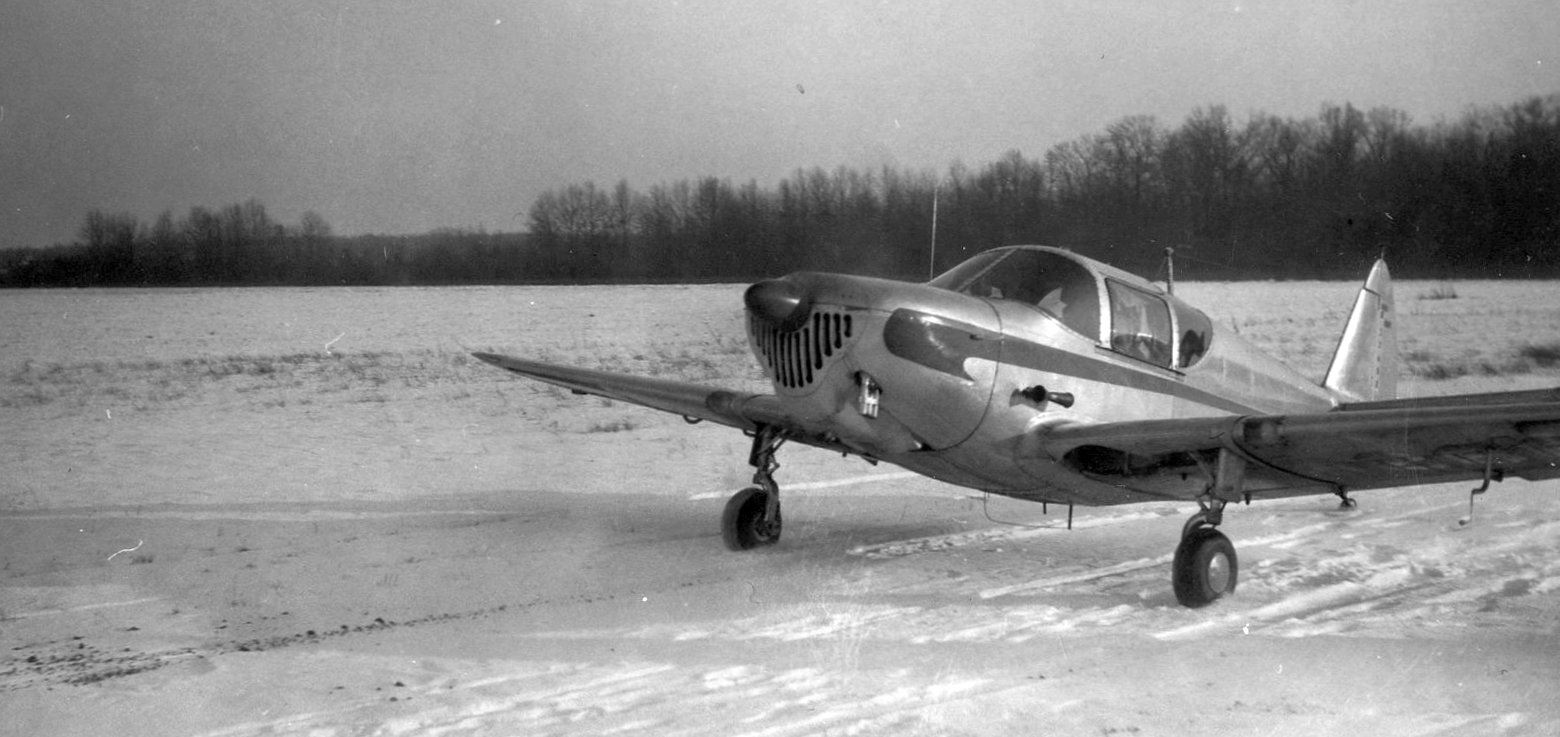
A 1959 photo by Tom Jones a beautiful natural metal Globe Swift taxiing at a snowy Avon Airport.
Tom Jones recalled, “It was hard watching the airport decline from 1958-61 with fewer aircraft tied down & more empty hangars.
Thankfully, many good memories remain.”
Mike Kmetz recalled, “Avon Airport... A friend gave me my first ride in a light plane there in his father’s Piper Tri-Pacer in 1959.
This was one of those relaxed airports where pilots socialized with their families.
I recall going west on Schwartz Road from Bradley, then turning left onto a long gravel road to the airport.
The grass runway was east/west.
There was an old farm house & hangars at the west end right by the gravel road.”
The 1960 Cleveland Local Aeronautical Chart depicted Avon Airport as having a 2,400' unpaved runway.
According to Greg Hamilton (whose father kept his plane at Avon), “Avon Airport... closed around 1961 for development.”
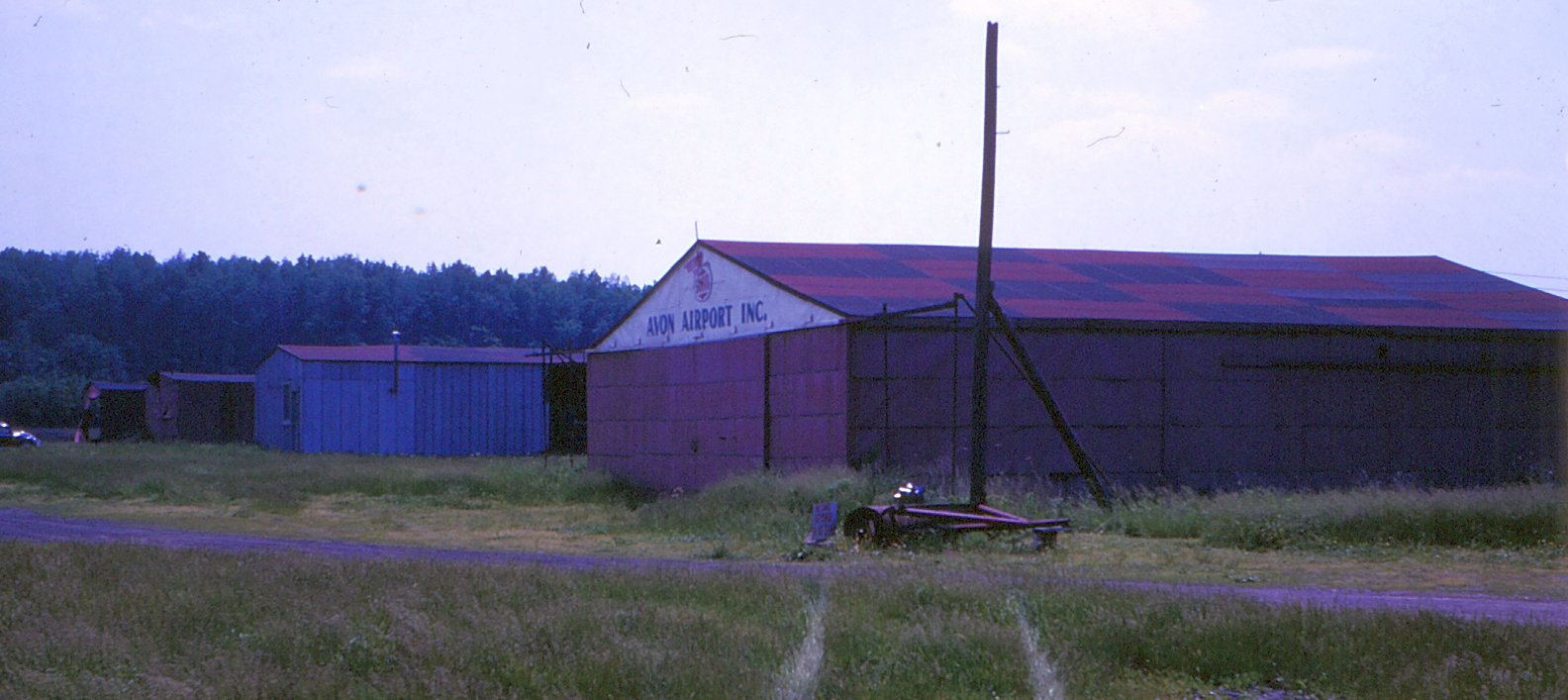
A sad 1964 photo by Tom Jones of the Avon Airport hangars, possibly after the airport's closure but before its redevelopement.
The last aeronautical chart depiction which has been located of Avon Airport was on the November 1966 Cleveland Sectional Chart,
which depicted Avon as having a 2,200' unpaved runway.
Avon Airport was evidently closed at some point between 1966-67, as it was no longer depicted on the May 1967 Cleveland Sectional Chart.
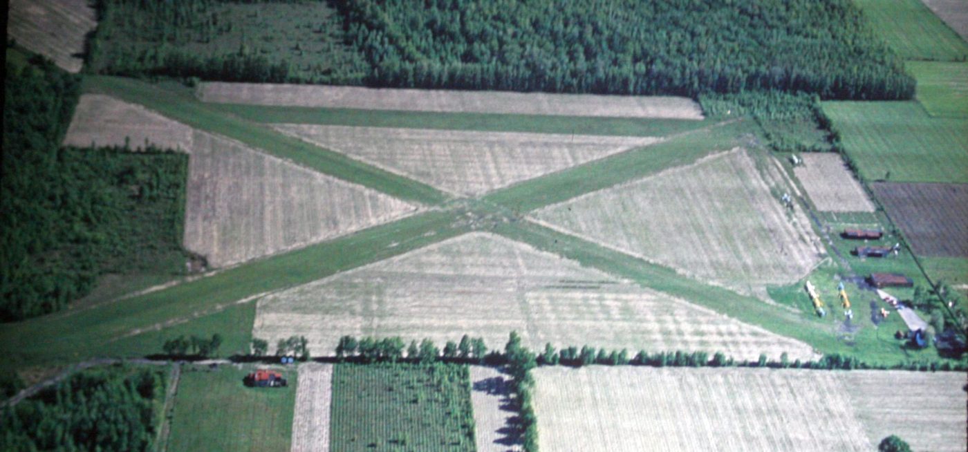
A 1979 aerial view (courtesy of Mike Kmetz) showed the X-shape remaining of Avon Airport's runways, but the property may have already been under redevelopment into a golf course.
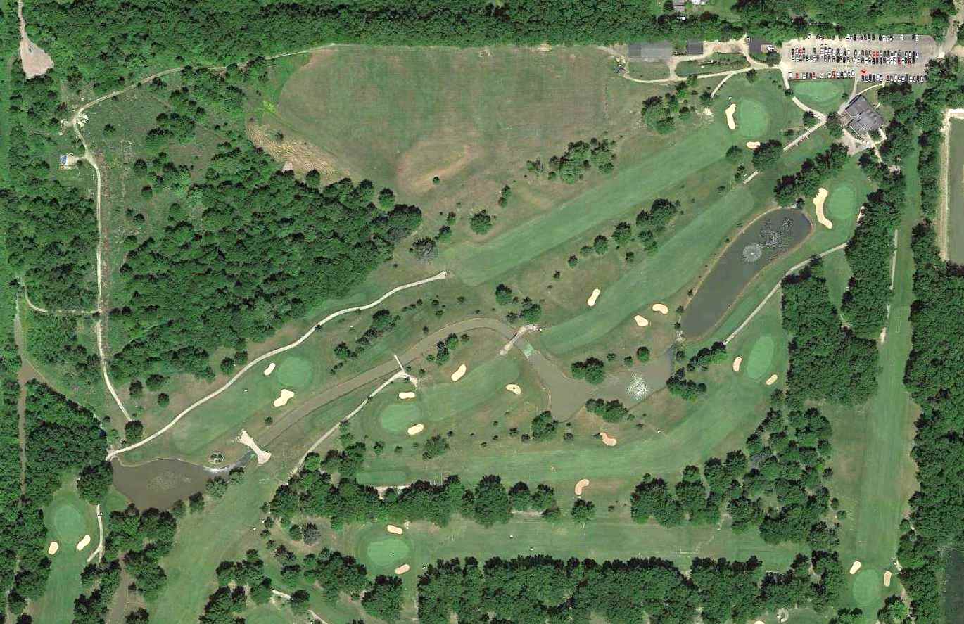
A 2014 aerial view showed the golf course covering the site of Avon Airport, but even after more than 50 years the X-shape of the former runways was still recognizable,
and the foundations of the hangars were still recognizable at the northwest corner.
As of 2015, street maps label the site of Avon Airport as Hillard Lakes Golf Club.
The site of Avon Airport is located at the western terminus of Lincoln Road.
Thanks to Mike Kmetz for pointing out this airfield.
___________________________________________________
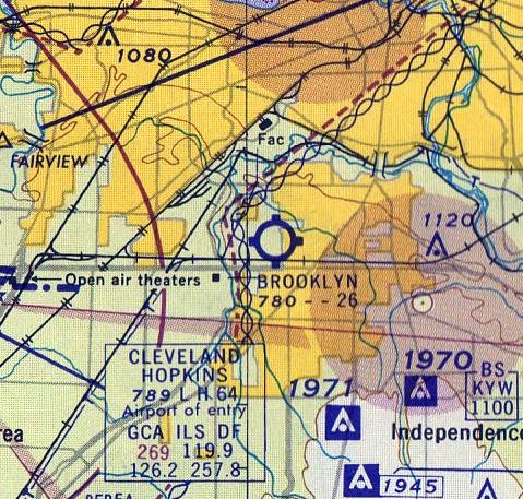
Brooklyn Airport, Brooklyn, OH
41.425, -81.74 (South of Cleveland, OH)
Brooklyn Airport was depicted as a commercial/municipal airport on the March 1940 Cleveland Sectional Chart.
The date of establishment of this small general aviation airport has not been determined.
Brooklyn Airport was not yet depicted on the February 1935 Cleveland Sectional Chart
nor on the 1939 USGS topo map.
The earliest depiction which has been located of Brooklyn Airport was on the March 1940 Cleveland Sectional Chart,
which depicted it as a commercial/municipal airport.
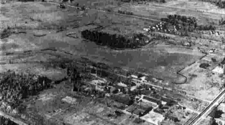
The earliest photo which has been located of Brooklyn Airport was a 10/2/43 aerial view looking northwest in the 1945 AAF Airfield Directory (courtesy of Scott Murdock).
It depicted Brooklyn as having 3 unpaved runways, with a few small buildings along the southeast side.
The 1945 AAF Airfield Directory (courtesy of Scott Murdock) described Brooklyn Airport
as a 80 acre irregularly-shaped property having 3 sod runways, the longest being the 2,640' northeast/southwest strip.
Brooklyn Airport was said to have a single 64' x 60' wooden hangar, and to be owned & operated by private interests.
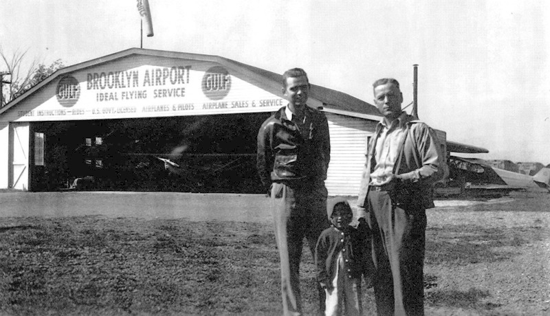
A post-1945 photo of 3 unidentified people in front of the Brooklyn Airport Ideal Flying Service hangar,
with a Piper Cub peeking out of the hangar & another on the side.
According to Larry Meal, “That photo I think was after 1945, because I can see the CG-4 glider wing attached to the side of the hangar behind them.
After the war was over they purchased 2 or 3 crated-up gliders to get the crates & pull the units out & dumped on the ground for classrooms for those CPT students.
My brother & I got lots of stick time in the fuselages. I still have one of the leading edge ribs hanging on the wall in my man cave [in 2018].”

A circa 1940s aerial view looking at a huge number of light aircraft parked at Brooklyn Airport (courtesy of Bill Meixner).
According to Rick Wargo, Brooklyn Airport is mentioned in Peter Fusco's book “Moondog's Academy of the Air & Other Disasters”.
Brooklyn Airport may have gone through a period of closure or inactivity, as a 4/1/52 USGS aerial photo showed the field devoid of any aircraft,
in marked contrast to the earlier photo.
The 1953 USGS topo map depicted Brooklyn Airport as having 3 unpaved runways, with a few small buildings along the southeast side.
Larry Meal recalled, “Brooklyn Field was a few blocks from my home & as a 12 year old boy I rode my bike out there to hang on the fence & watch the Cubs takeoff & land.
One day a pilot came over to the fence, with the usual 'Hey kid, you like airplanes? Wanna go for a ride?'
Heck yes... I had my first ride in his Monocoupe which was tied down in front of the little office building.
Later I started taking flying lessons in their old high-time J-3 Cubs. They had run a Civilian Pilot Training school with a few Cubs.
In the pilots' logbook rack in the office were a hundred or so logbooks.
My first logged flying lesson at Brooklyn was 7/18/56 in N98271, but before that I flew many rides with the old pilots out there.”
The 1960 Cleveland Local Aeronautical Chart depicted Brooklyn Airport as having a 2,600' unpaved runway.
Kathy Naugle recalled, “The Brooklyn Airport... our home was on a side street directly across the street.
I have a memory of seeing people run down to the end of my street & what I saw was a small private plane caught in the telephone lines hanging there.
I can't say exactly what year that would be but I would suspect around 1961.”
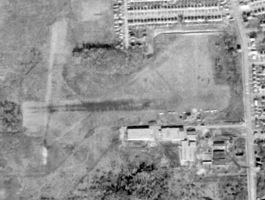
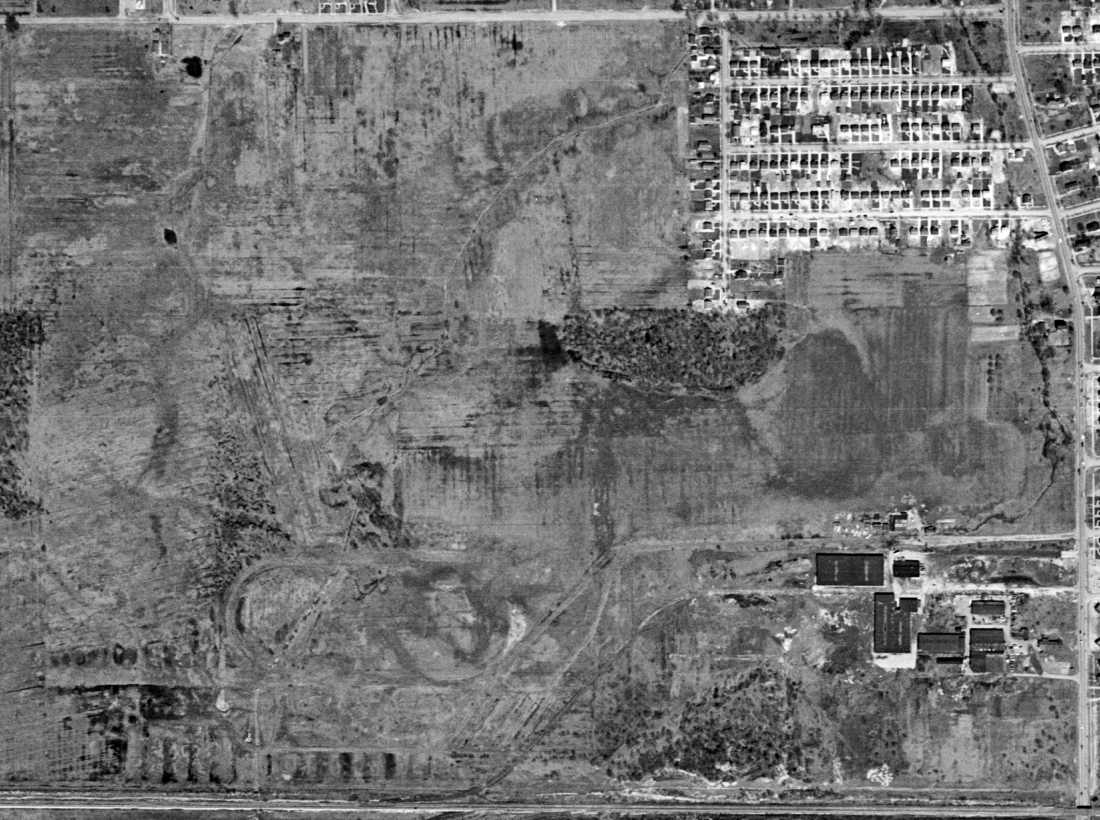
The last photo which has been located of Brooklyn Airport was a 12/1/62 USGS aerial view.
The 3 grass runways were still evident, but the number of aircraft on the field had dwindled to only a dozen.

The last aeronautical chart depiction which has been located of Brooklyn Airport was on the May 1963 Cleveland Sectional Chart.
It depicted Brooklyn Airport as having a 2,600' unpaved runway.
Brooklyn Airport was evidently closed (for reasons unknown) at some point between 1964-65,
as it was no longer depicted on May 1965 Cleveland Sectional Chart.
Kathy Naugle recalled of Brooklyn Airport, “I use to tramp around back in those fields up to 1965 & don't recall ever seeing any planes back there.”
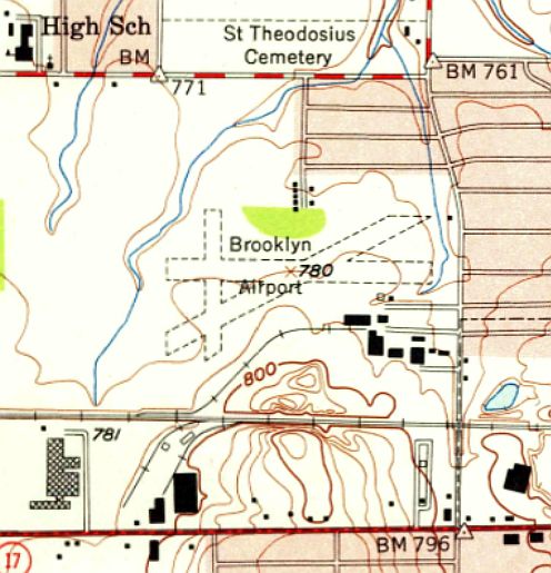
The last depiction which has been located of Brooklyn Airport was on the 1968 USGS topo map,
which depicted it in the same fashion as on the 1953 USGS topo map.
Brooklyn Airport was was no longer depicted on the 1971 USGS topo map, with simply an unlabeled clearing depicted instead.
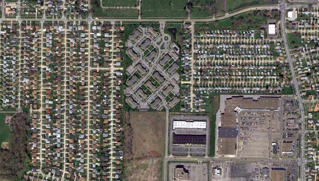
A 4/6/12 aerial view showed no trace remaining of Brooklyn Airport.
The site of Brooklyn Airport is located southwest of the intersection of Biddulph Road & Ridge Road.
Thanks to Rick Wargo for pointing out this airfield.
____________________________________________________
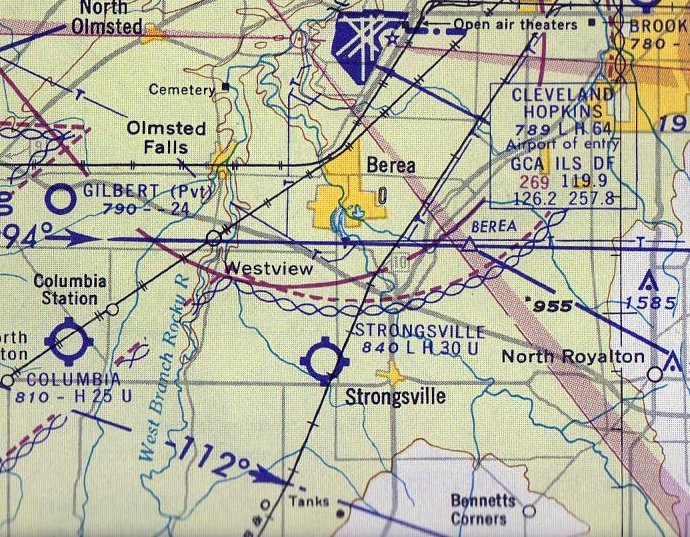
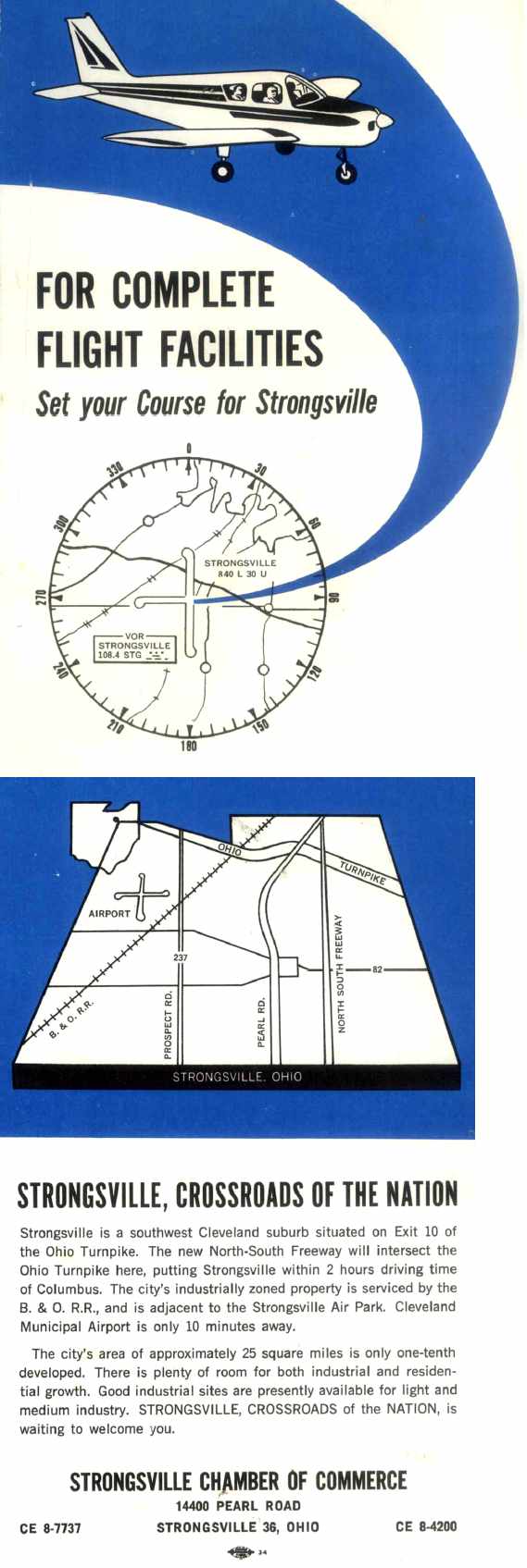
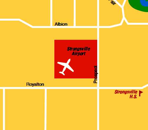
Strongsville Airpark (1G6), Strongsville, OH
41.325, -81.865 (Southwest of Cleveland, OH)
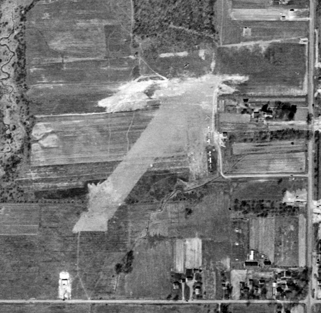
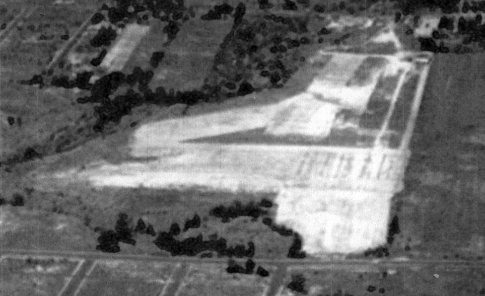
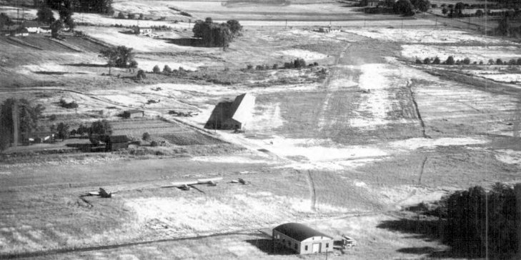
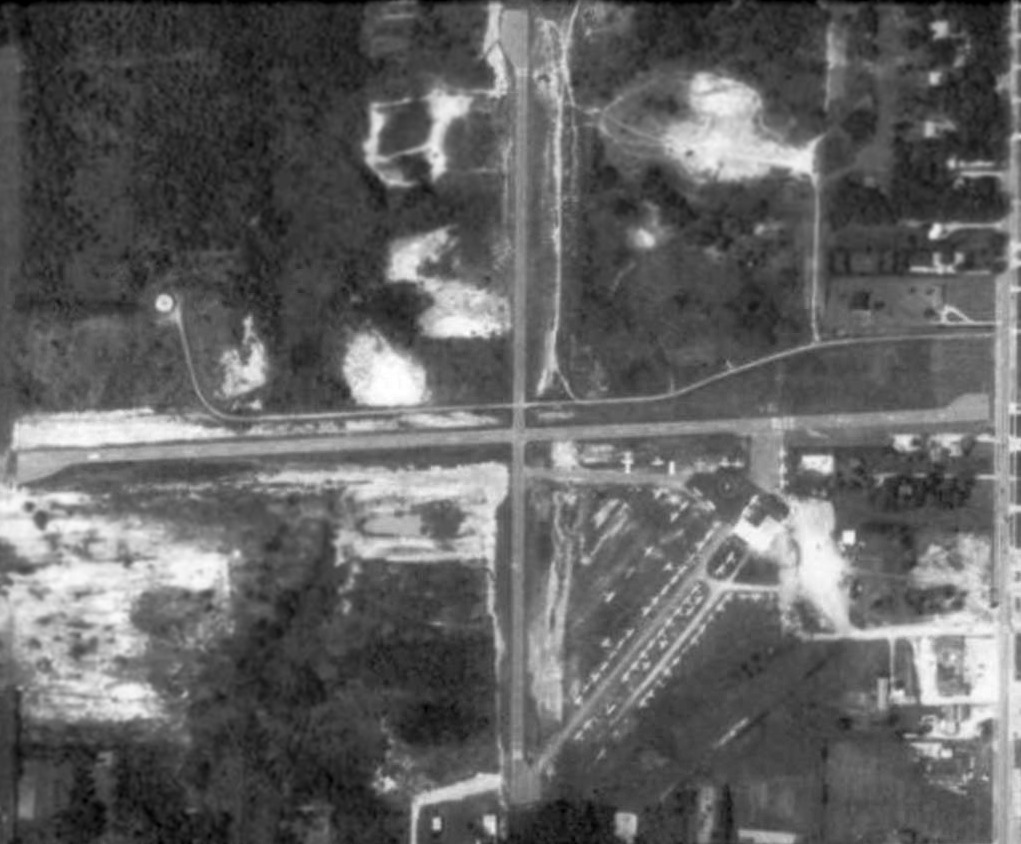
A 4/1/52 USGS aerial photo of Strongsville Airpark.
Yet another former general aviation airport, now lost to further housing construction.
Strongsville Airpark was founded by Melvin Peters.
The earliest depiction which has been located of the Strongsville Airpark was a 4/1/52 USGS aerial photo.
It depicted 6 light single-engine aircraft clustered around small shed on the east side of the field,
and 2 modest grass runways, oriented northeast/southwest & east/west.
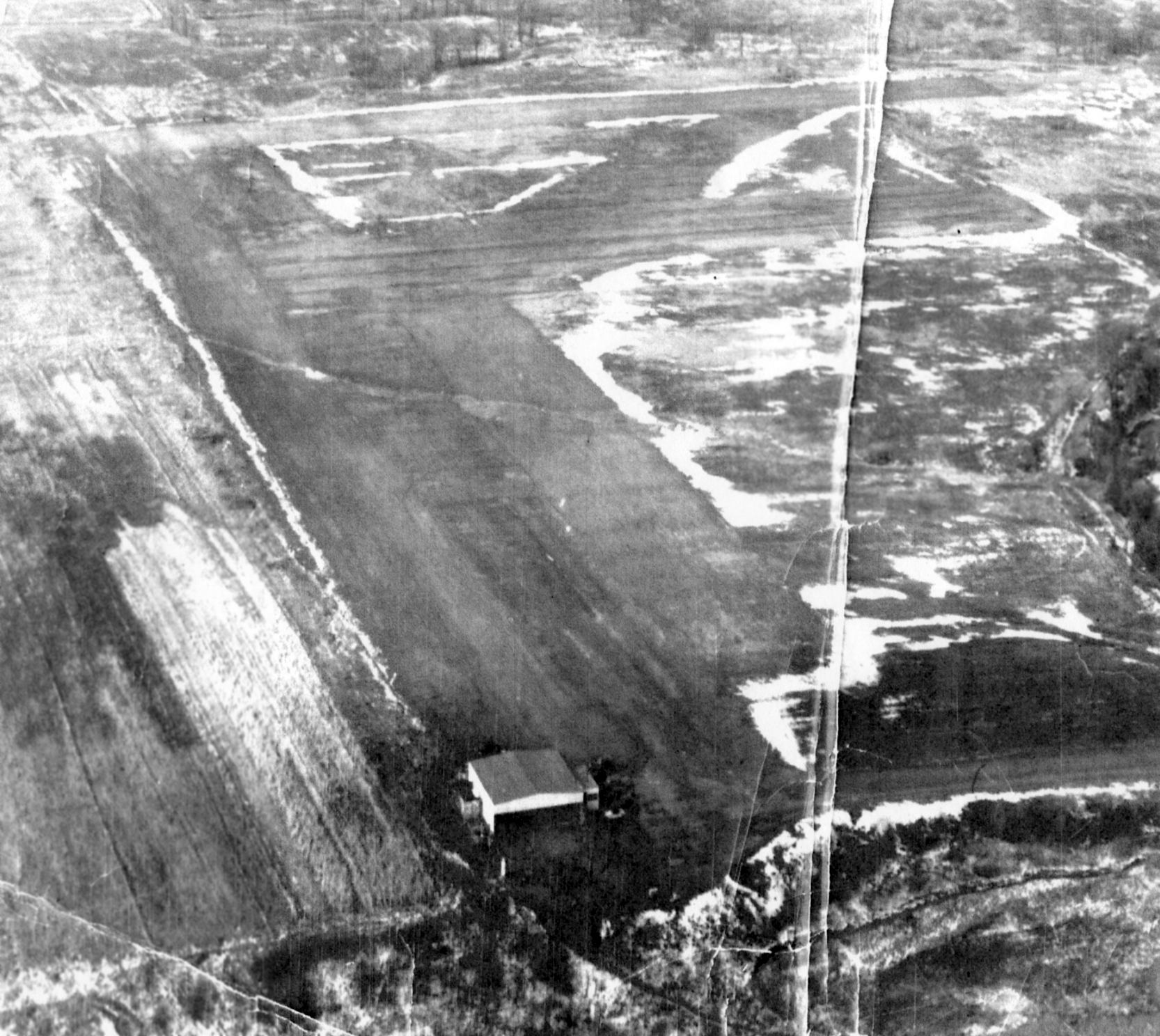
A July 1953 aerial view depicted Strongsville Airpark as having 4 light single-engine aircraft parked along a grass runway, and the field had 2 hangars.
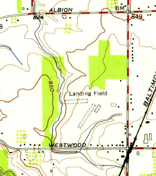
The 1953 USGS topo map depicted Strongsville Airpark as having 2 unpaved runways, labeled simply as “Landing Field”,
and a single hangar on the east side of the field.
Strongsville Airpark was was not yet depicted on the January 1955 Cleveland Sectional Chart.
The 1955 OH Airport Directory (courtesy of Stephen Mahaley)
depicted Strongsville Air Park as having 3 runways, with the longest being an 1,875' east/west strip.
It also indicated plans for all 3 runways to be extended.
Several hangars were located along the southeast side of the field.
The operator was listed as Melvin Peters.
Libby Thompson recalled of Strongsville Airport, “I grew up on the airport property until I was 9.
The owner, Melvin Peters, was my step-grandfather
and his son, Ron Peters, pretty much ran the airport until we moved out of state.
We lived in a house that was located on the property,
and my brother & I used to race our mini-bikes on the runways at night after the airport closed for the evening.”
The July 1956 Cleveland Sectional Chart (courtesy of Chris Kennedy)
depicted Strongsville as having a 1,900' unpaved runway.
Strongsville apparently gained paved runways at some point between 1956-60,
as the 1960 Cleveland Local Aeronautical Chart depicted the field as having a 3,000' paved runway.
The 1962 AOPA Airport Directory described Strongsville as having 2 asphaltic-concrete runways: 3,000' Runway 9/27 & 2,750' Runway 18/36,
and listed the operator as Melvin Peters.
A 1962 aerial view depicted Strongsville as having 2 paved perpendicular runways, and over 2-dozen light aircraft parked around the field.
An undated aerial view looking northeast at Strongsville Airport from the July 1964 issue of “The Flyer” magazine (courtesy of Daun Yeagley).
It described Max Peters' Strongsville Airport as having 2 paved runways, measuring 3,000' east/west & 2,750' north/south.
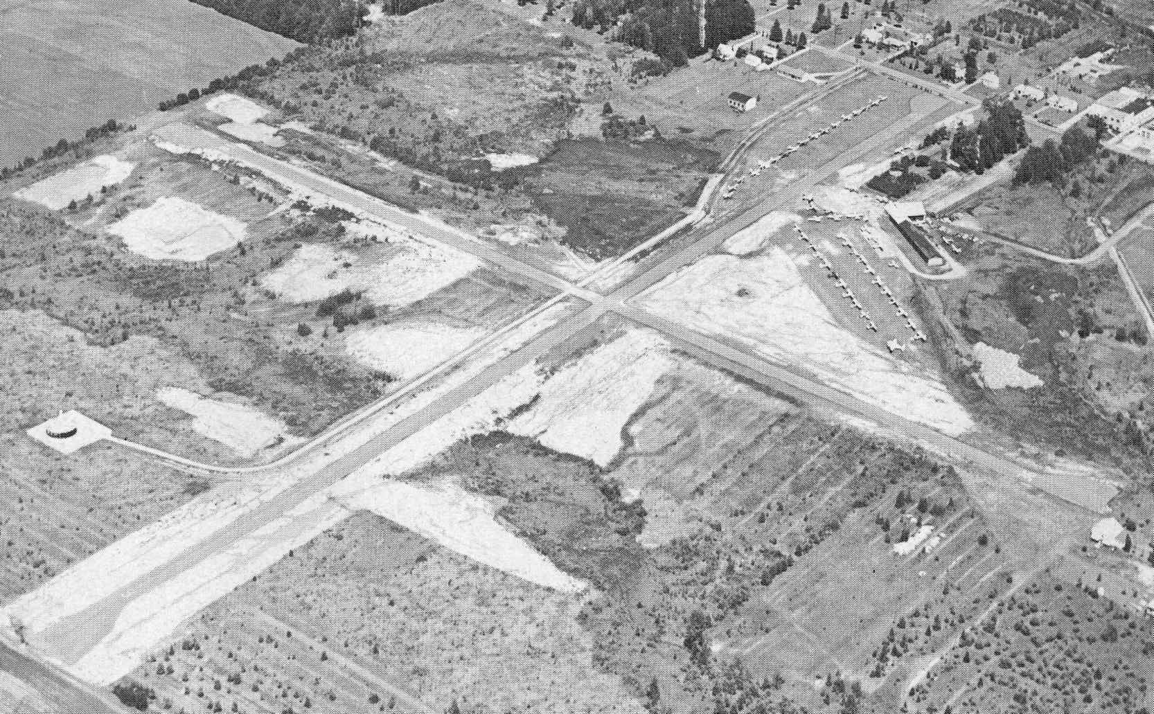
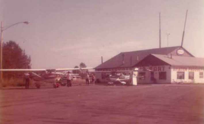
A circa 1965-66 aerial view looking west at Strongsville Airpark (courtesy of Wayne Peters).
It depicted the field as having 2 perpendicular paved runways,
with an office & main hangar on the southeast side,
and what may have been some smaller individual hangars along the east side of Runway 9/27.
Note the VOR beacon just beyond the runway intersection.
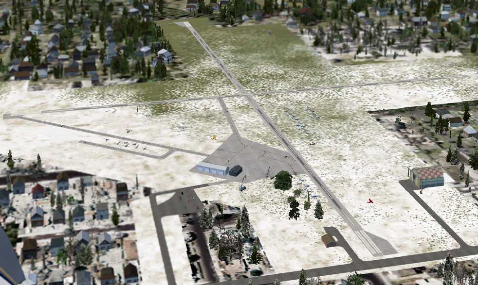
A flight simulator scenery depiction by Nick Newcomb showing Strongsville from the same perspective as the preceding photo.
Wayne Peters recalled, “I am the grandson of Mel Peters & the son of Ron [Peters].
It was quite a busy operation from the mid 1960s to the early 1970s.
We had a flight school & were a Cessna Dealer too.”
A 1965 brochure for Strongsville Airpark (courtesy of Wayne Peters).
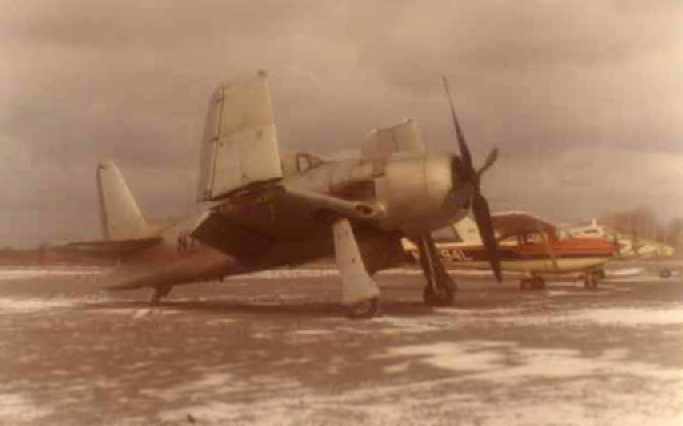
A January 1965 photo of a Grumman F8F Bearcat fighter & 2 Cessnas Strongsville Airpark (courtesy of Wayne Peters).
Wayne recalled, “A passing surplus Bearcat landed at our airport on its way west.”
Andy Dulay recalled, “I learned to fly at Strongsville & remember Mel Peters & his son running the operation.
A little-known fact is that Jim Bede's (BD-5, Bede Aircraft, etc) son was my original flight instructor at Strongsville!”
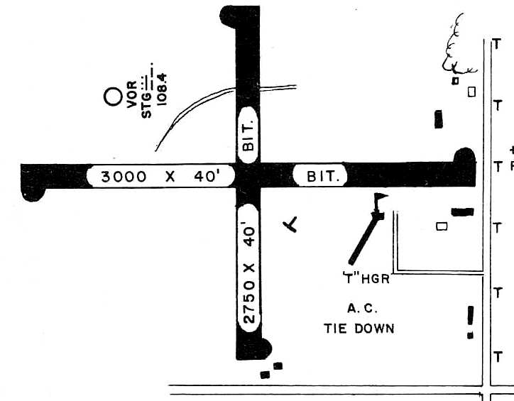
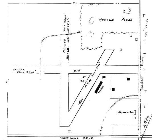
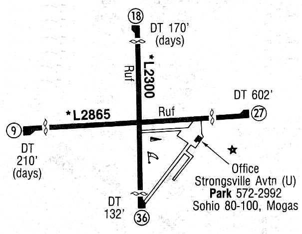
The layout of Strongsville Airport, as depicted on the 1966 OH Airport Directory (courtesy of Chris Kennedy).
The 2/5/68 State of Ohio Airport Certificate for Strongsville Airport (courtesy of Wayne Peters)
approved the field as a “Class II Airport”.
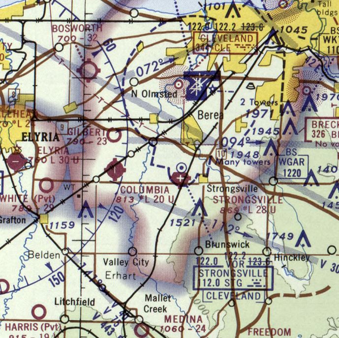
The May 1970 Cleveland Sectional Chart depicted Strongsville as having 2 paved runways, with the longest being 2,800'.
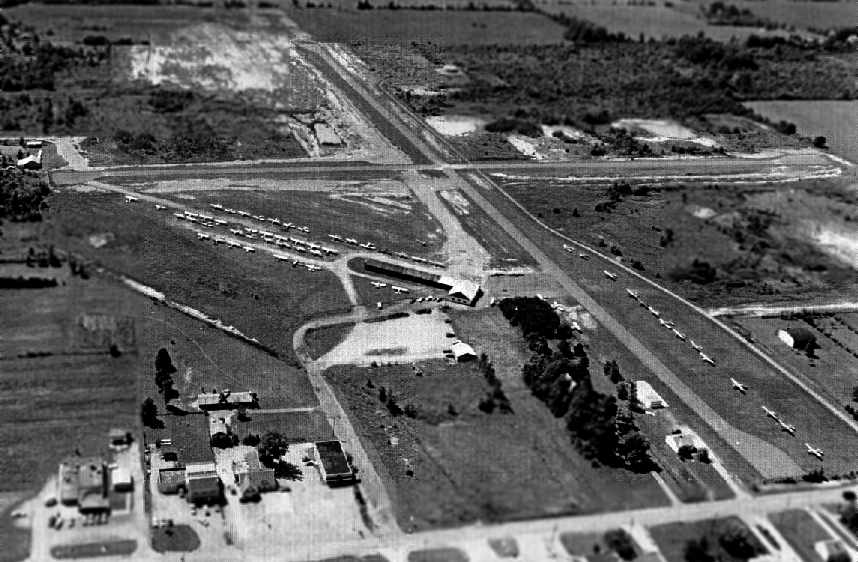
A 1970 aerial view depicted Strongsville as having 2 paved perpendicular runways, and over 2-dozen light aircraft parked around the field.
Ron Miska recalled, “I worked as a line boy a Strongsville Air Park from 1970-72.
Ron & Mel [Peters] were great bosses. Working at Strongsville Airport was my first job, and has remained my favorite over the decades.
My starting pay was $1.40/hour.
Others who worked there at the same time as I did include: Jim Blessing, Walt Maxim, Ron Mitchell, Ron Weber, Greg Lann (flight instructors),
and Howie Barkfelt & Dick Gross (mechanics).
The line boys immediately before me were Tim Ur & Duane Bulla.
Including me, 4 Rons worked there at the same time. It got confusing when Mel called out over the intercom: 'Ron will you come into the office please?'
I used to dump spent oil on the ground. Then one day I got the clever idea to use the oil to spell out my initials (RM) in huge letters on a gravel taxiway.
It took many oil changes & several months to do it. You couldn’t really notice the letters from the ground, but they were very noticeable from the air.
About a month after I finished, a pilot walked in the office & asked Mel what those letters meant.
Mel had no idea what the guy was talking about. I was there & had to fess up. Mel could be quite stern, but instead of being angry, he laughed.
After this, his son Ron, whose name was Ronald M. Peters (RMP), used spent oil to add a 'P' after my initials!”
An early 1970s picture of 2 Cessnas in front of the Strongsville Airpark office (courtesy of Wayne Peters).
Wayne Peters recalled, “I used to work at the airport as a lineboy starting at age 14 [1972].
I also soloed at the airport in 1973 at the age of 16
and took my checkride for my Private Pilots license one year later at 17 at the field in a Cessna 150.
After my Grandad sold Strongsville Airport & property (190 acres) in 1974
to the developer who eventually built all the houses that now occupy the site,
Dad & Grandad split the profits of the sale & moved west.”
Glenn Shaw recalled, “Strongsville... I landed there in 1976. It was a nice airport.”
The last photo which has been located of Strongsville Airpark was a 1979 aerial view,
which depicted the field as being very popular, with dozens of light aircraft visible parked on the southeast part of the field.
The last aeronautical chart depiction which has been located of Strongsville Airport was on the May 1981 Detroit Sectional Chart (courtesy of Ron Plante).
It depicted Strongsville as having 2 paved runways, with the longest being 2,800'.
The 1982 AOPA Airport Directory (courtesy of Ed Drury)
indicated that both Strongsville runways had unfortunately been shortened to 2,200' in length.
The operator was listed as Strongsville Airport Corp.
The condition of both runways at Strongsville was described in the 1985 Flight Guide (courtesy of Chris Kennedy) as "Ruf" [sic].
According to an EPA report, Strongsville Airpark was closed in 1987.
Strongsville Airpark was no longer depicted at all (even as an abandoned airfield) on the October 1993 Detroit Sectional Chart (courtesy of Ron Plante).
Ground was broken in 1994 for the Westwood Farms subdivision on the site of Strongsville Airpark.
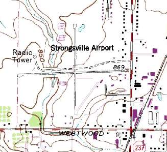
USGS topo map 1996.
By the time of a 2000 USGS aerial photo, the Strongsville Airpark site had been completely obliterated with a new housing development,
with not a trace remaining of the former runways.

A circa 2001-2005 aerial photo showed the Strongsville Airpark site had been completely obliterated with a new housing development,
with not a trace remaining of the former runways.
Bob Martel reported in 2003 that "At least one hangar is still standing & being used as a garage by a house on Prospect -
not part of the subdivision created on the former airport."
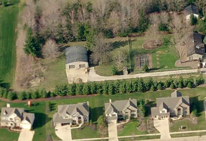
A circa 2006 aerial view looking north at a circa 1952-62 hangar which remains on the east side of the property,
apparently the last remnant of Strongsville Airpark.
Ironically, even though Strongsville Airpark has been closed for 13 years, it is still depicted on the 2010-2011 Cleveland Regional Transit Authority map (courtesy of Jimmy McGuire).
Cleveland: It might be time to update the map?
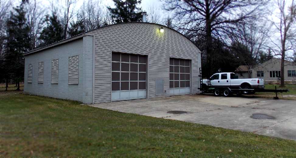
An 11/23/12 photo by Nick Newcomb looking northwest at the circa 1952-62 hangar which remains on the east side of the property,
apparently the last remnant of Strongsville Airpark.
The site of Strongsville Airpark is located northwest of the intersection of Prospect Road & Westwood Drive.
Thanks to Jonathan Westerling for pointing out this airfield.
____________________________________________________
Or if you prefer to contact me directly concerning a contribution (for a mailing address to send a check),
please contact me at: paulandterryfreeman@gmail.com
If you enjoy this web site, please support it with a financial contribution.
____________________________________________________
This site covers airfields in all 50 states.