Abandoned & Little-Known Airfields:
New York: Long Island, Western Suffolk County
© 2002, © 2026 by Paul Freeman. Revised 5/17/26.
This site covers airfields in all 50 states: Click here for the site's main menu.
____________________________________________________
Please consider a financial contribution to support the continued growth & operation of this site.
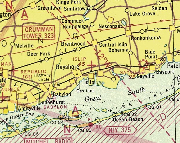
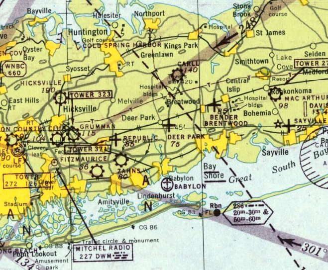
Brindley Field (revised 9/28/11) - Central Islip Field / Bender-Brentwood Airport (revised 4/21/22) - Deer Park Airport (revised 10/12/25) - (Original) Islip Airport (revised 6/21/19)
Smithtown Airport / Smithtown Aviation Country Club (revised 6/22/19) - Vanderbilt Seaplane Base (revised 4/5/21) - Zahn's Airport (revised 5/17/26)
____________________________________________________
Vanderbilt Seaplane Base, Centerport, NY
40.905, -73.365 (East of New York, NY)
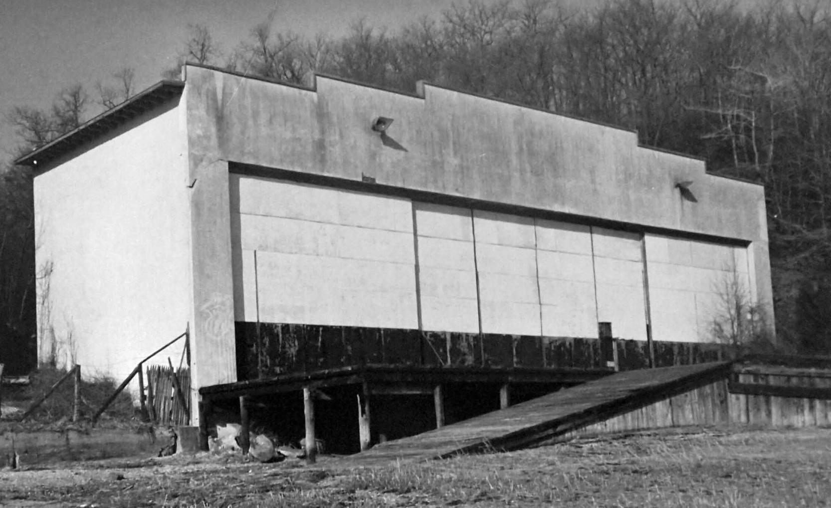
An undated photo looking west at the Vanderbilt seaplane hangar (courtesy of Chris Maione).
Photo of the seaplane base in use has not been located.
William Vanderbilt II's 43-acre Eagle's Nest estate was established in 1910.
His 24-room Spanish revival mansion was designed by famed NY architecture firm Warren & Wetmore.
At some point reportedly in the late 1920s - early 1930s, a seaplane hangar & ramp were added to the estate.
The Vanderbilt Seaplane Base was not depicted on 1932/33/34/35/40/44/47 NY Sectional Charts.
According to the book Long Island Airports, the Vanderbilt Seaplane Base started operation in 1936.
He built a large stucco seaplane hangar fronting Northport Bay,
and used his amphibian aircraft to shuttle between his estates & for exotic vacations.
The hangar was advanced for its day, featuring hydraulic doors & an electric winch to move the planes onto the ramp.
The Vanderbilt Seaplane Base was not depicted on 1938/45/47 USGS topo maps.
After William Vanderbilt II died in 1944, his will provided for donation of his property to the county,
with provision that the mansion & grounds be used for a museum.
According to the book Long Island Airports, the Vanderbilt Seaplane Base ceased operation in 1947.
The Vanderbilt Museum on the grounds opened in 1950.
A 1954 aerial photo showed the Vanderbilt seaplane hangar & ramp, but did not show any sign of recent aviation use.
The earliest depiction which has been located of the Vanderbilt seaplane hangar was an undated photo (courtesy of Chris Maione),
which appeared to show it after it had ceased to be used.
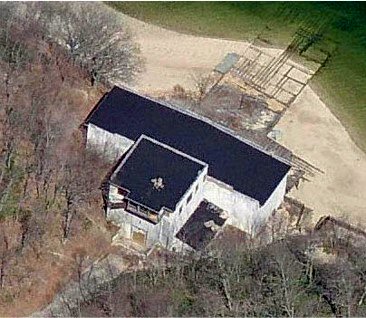
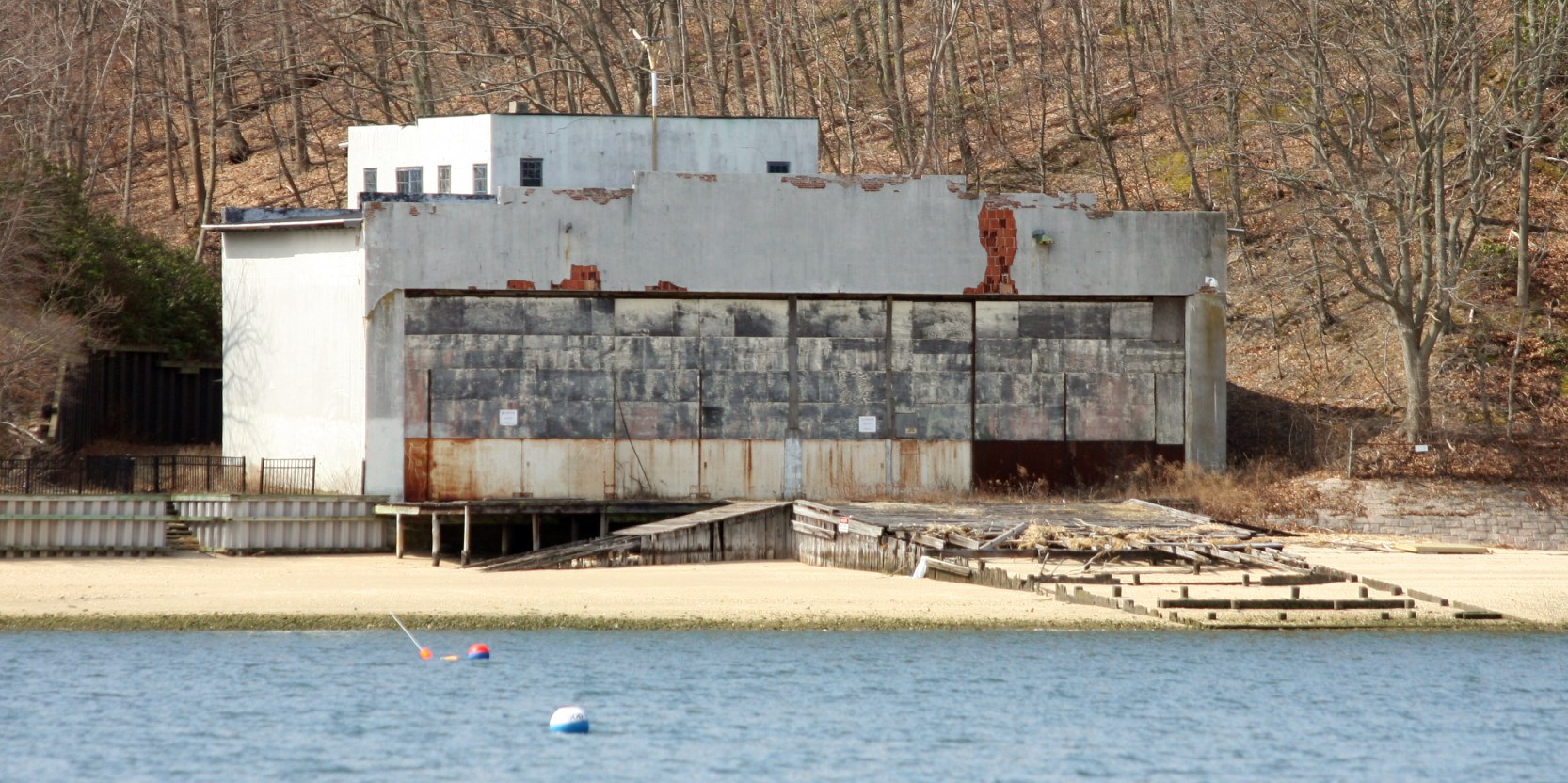
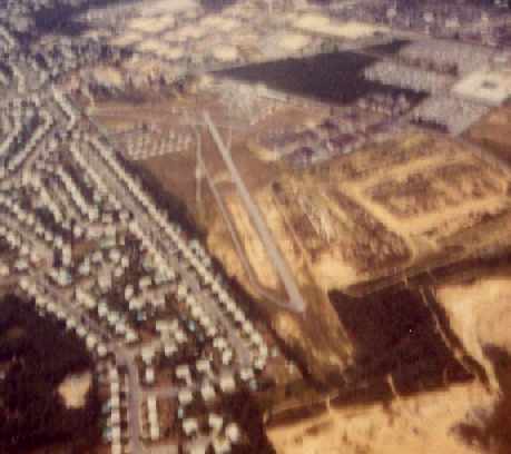
A circa 2000s-2021 aerial view looking north at the Vanderbilt seaplane hangar & ramp (courtesy of Chris Maione).
Chris Maione remarked, “There is a pilot's lounge consisting of a kitchen, living space, bedroom, and bath on top of the hangar; it's the square section. Inside it's dark & falling apart.”
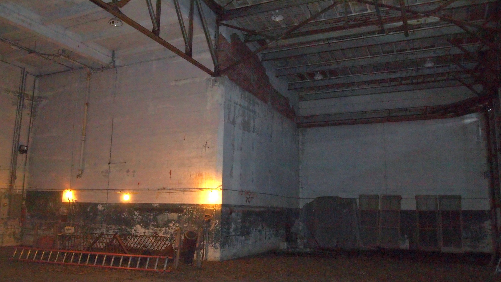
A 2011 photo of the interior of the Vanderbilt seaplane hangar.
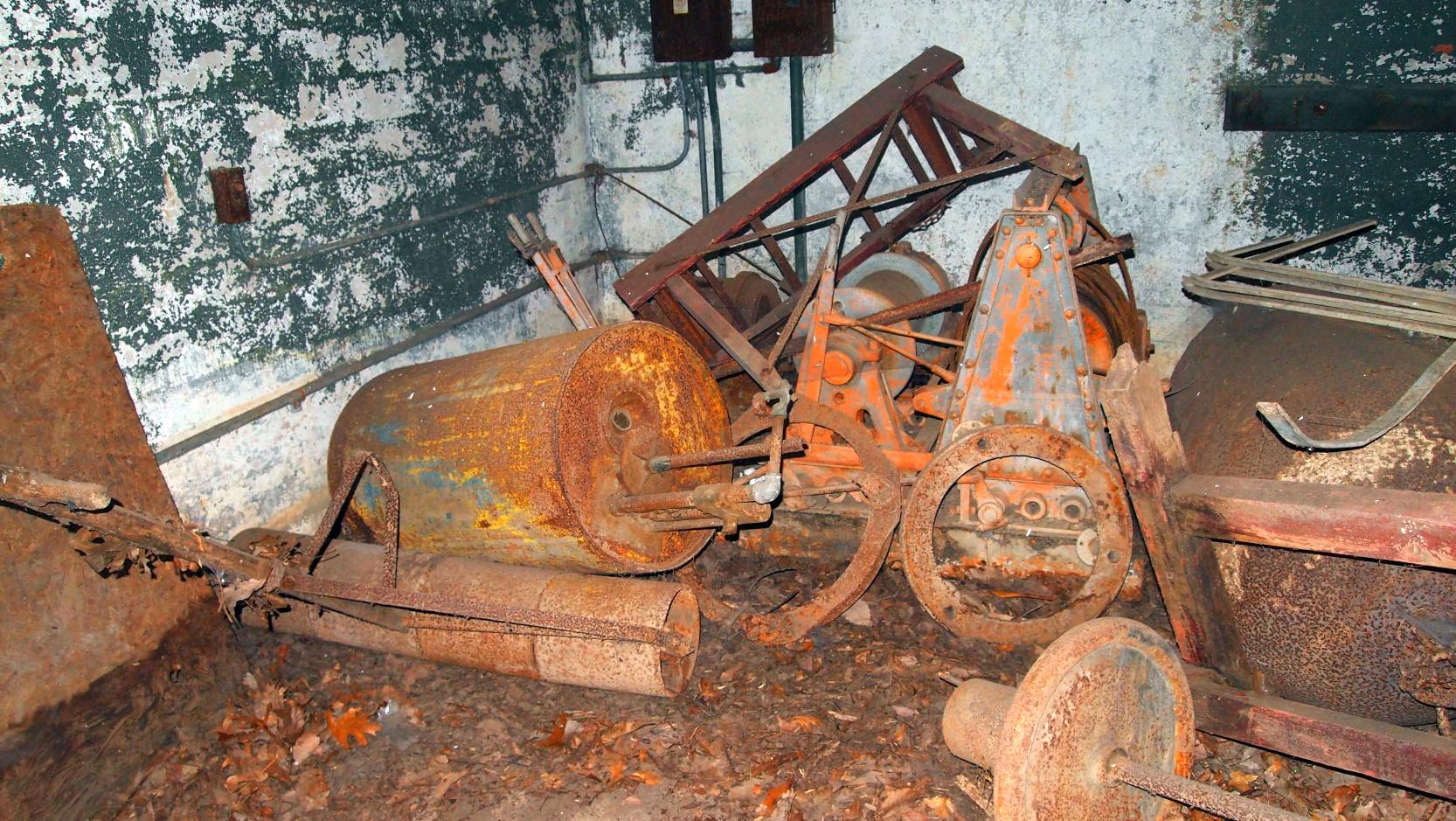
A 2011 photo of the interior of the Vanderbilt seaplane hangar, showing a rusted winch used to move Vanderbilt's seaplane from Northport Harbor.
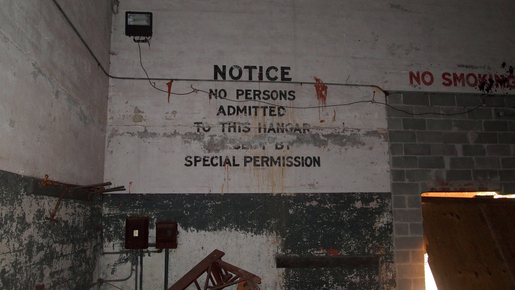
A 2011 photo of the interior of the Vanderbilt seaplane hangar, showing sign reading "Notice: No Persons Admitted To This Hangar Except By Special Permission."
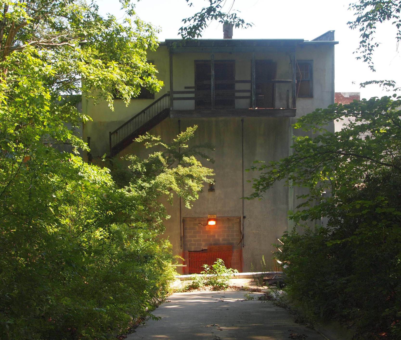
A 2011 photo of the back of the Vanderbilt seaplane hangar, showing an apartment on top for the pilot.
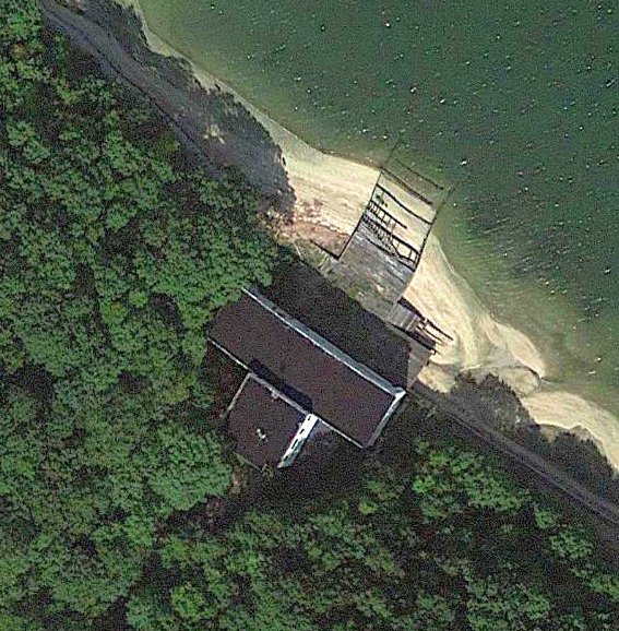
A 2019 aerial view of the Vanderbilt seaplane hangar & ramp.

A March 2021 photo by Chris Maione of the interior of the Vanderbilt seaplane hangar.
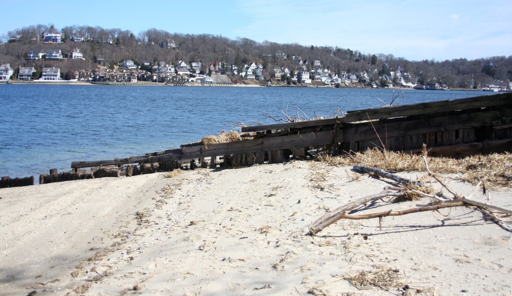
A March 2021 photo by Chris Maione looking southeast at the Vanderbilt seaplane ramp.
Chris Maione reported in 2021, the Vanderbilt seaplane hangar is “in a state of falling apart
and I am working with the Vanderbilt property to see what can be done to bring it back to its original glory.”
A 4/4/21 photo by Chris Maione looking southwest at the Vanderbilt seaplane hangar & ramp.
Thanks to Chris Maione for pointing out this seaplane base.
____________________________________________________
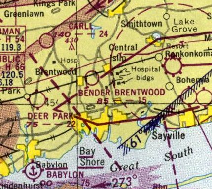
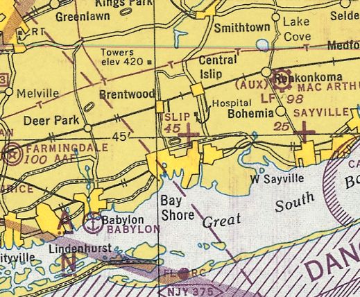
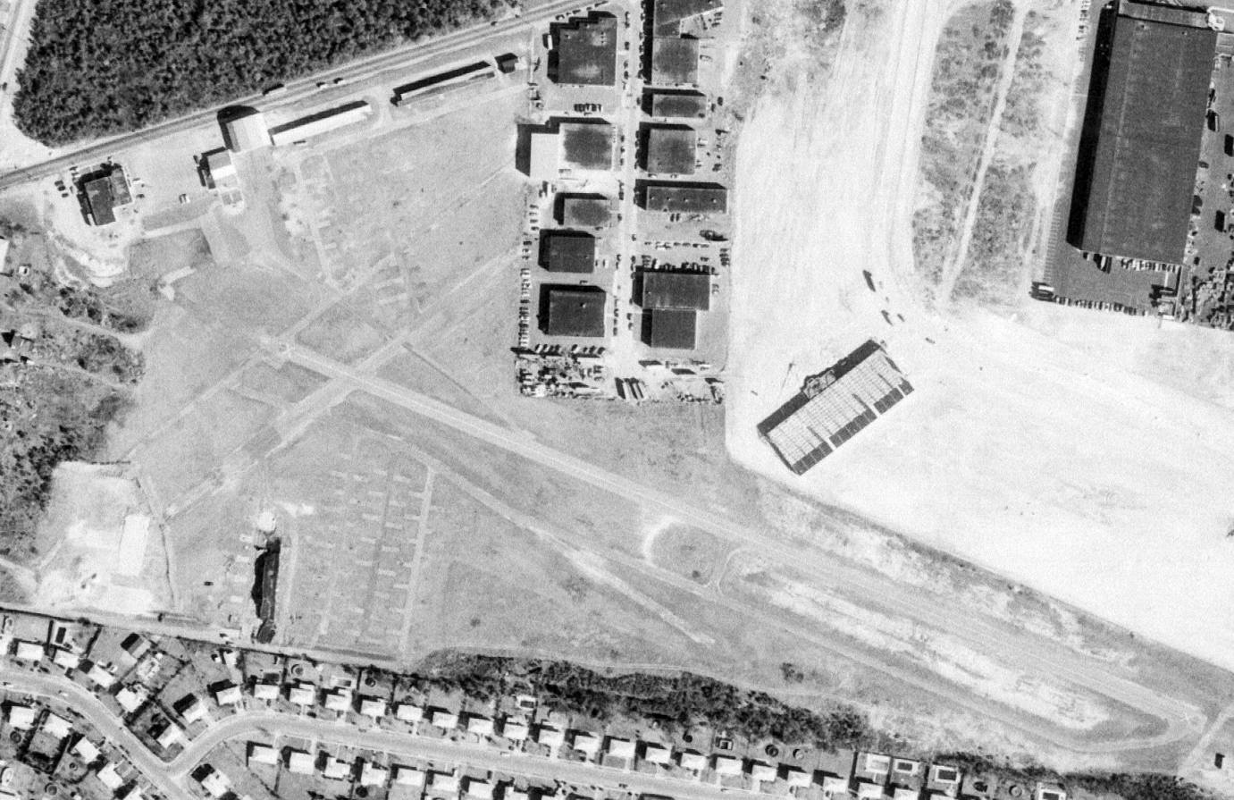
Central Islip Field / Bender-Brentwood Airport, Brentwood, NY
40.78, -73.22 (East of New York, NY)
Central Islip Airport, as depicted on the November 1931 NYC-Albany Air Navigation Map.
Central Islip Field was reportedly founded in 1929.
The earliest depiction which has been located of Central Islip Airport was on the November 1931 NYC-Albany Air Navigation Map.
Central Islip Airport was taken over by Harry Bender in 1933 & renamed Bender-Brentwood Airport.
Bender-Brentwood Airport was said to consist of 33 acres, and to have 1 hangar housing 3 planes, with several others tied down outside.
The earliest Sectional Chart depiction which has been located of Central Islip Airport was on the August 1932 NY Sectional Chart.
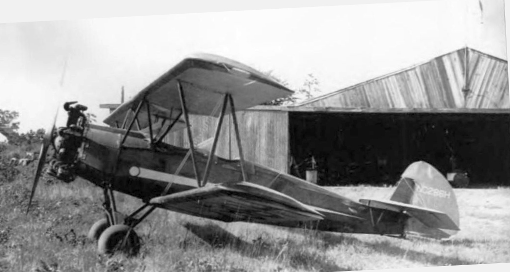
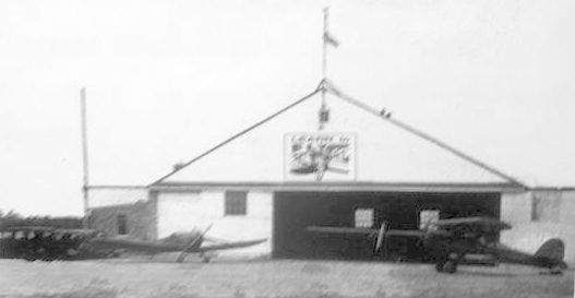
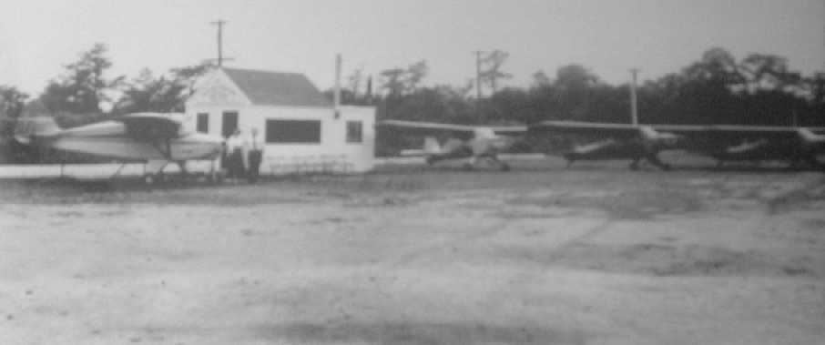
The earliest photo which has been located of Bender-Brentwood Airport was a circa 1940 photo of a Fleet Model 2 biplane in front of the wood-tin hangar.
Central Islip / Bender-Brentwood Airport was not depicted on the November 1942 NY Sectional Chart (courtesy of Ron Plante).
It was perhaps one of many small civilian airports closed during WW2.
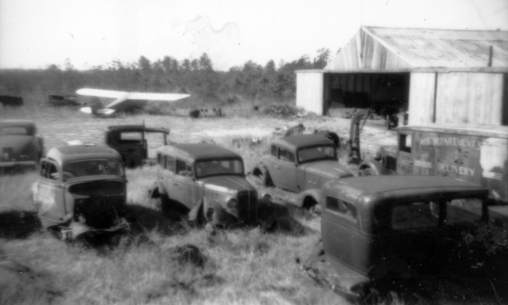
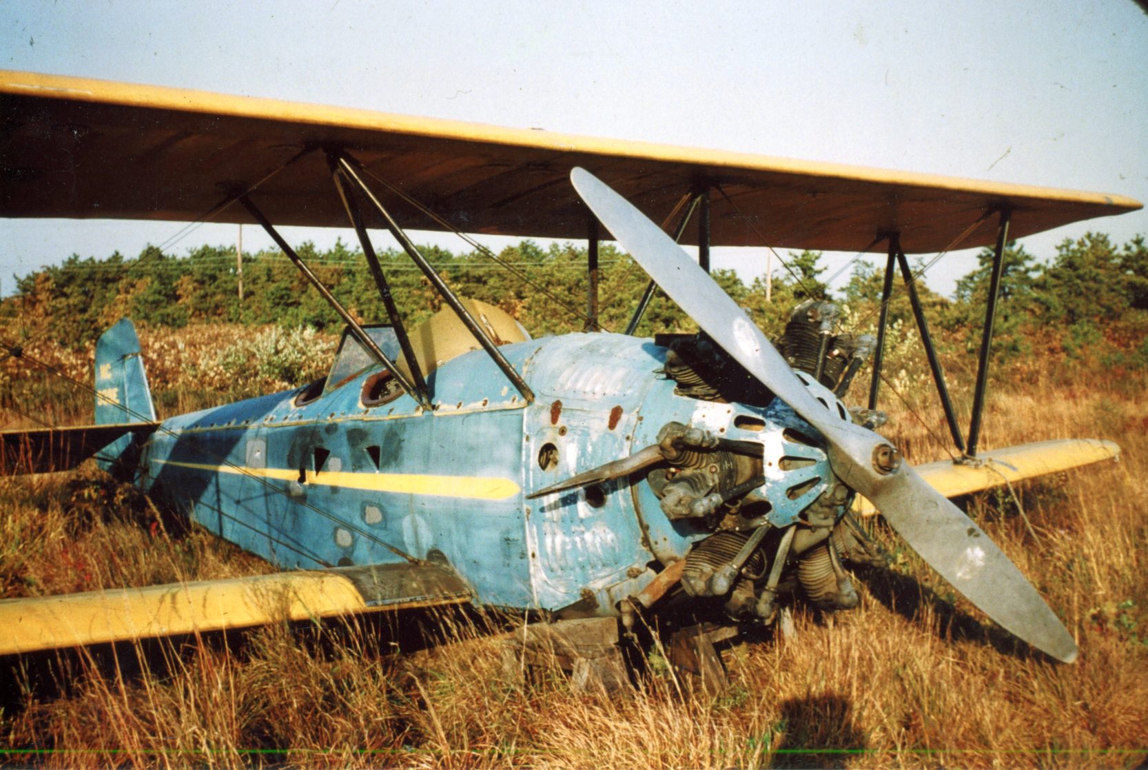
A circa 1947 photo by Danny Pflug of a variety of vintage cars & a plane in front of a Bender-Brentwood Airport hangar (courtesy of Bob Mott).
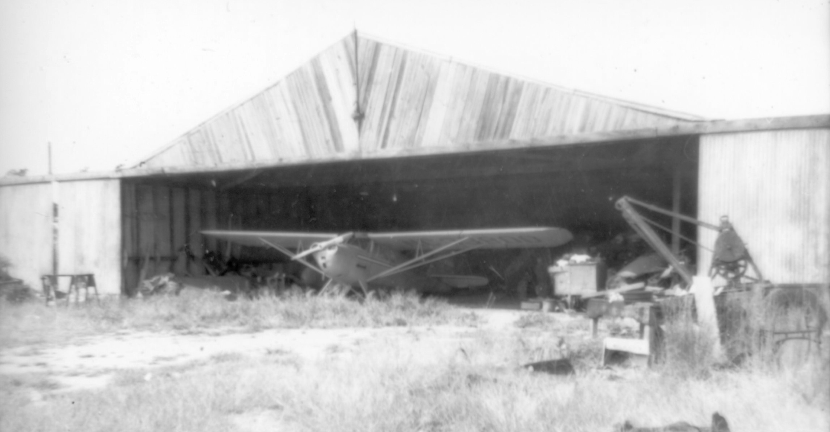
A 1948 photo by Danny Pflug of an unidentified single-engine taildragger inside the Bender-Brentwood Airport hangar (courtesy of Bob Mott).
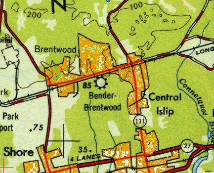
The 1949 USGS topo map depicted Bender-Brentwood Airport as a commercial/municipal airport.
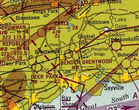
The July 1949 NY Sectional Chart (courtesy of Ron Plante) depicted Bender Brentwood as having a mere 1,500' unpaved runway.
The 1950 NY Sectional Chart (courtesy of Mike Keefe) depicted Bender Brentwood as having a 1,500' unpaved runway.
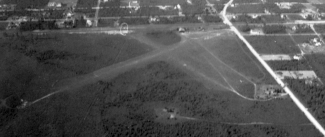
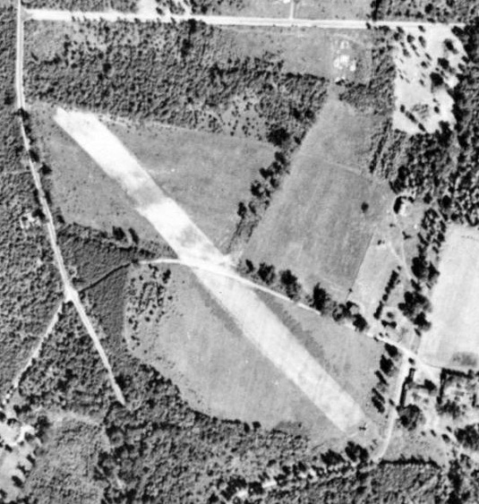
The earliest aerial photo which has been located of Bender-Brentwood Airport was a 1/1/51 aerial view looking north (courtesy of Bob Mott).
It depicted Bender Brentwood as having 2 unpaved runways, and possibly 1 light aircraft parked near a few small buildings on the southeast side.
The 1953 Aviation Week Airport Directory (according to Stephen McNicoll) described Bender-Brentwood Airport
as an S-1 commercial airfield with a 1,500' unpaved runway, a hangar, offering minor repairs & fuel.
A 2/15/54 USGS aerial view depicted Bender Brentwood as having 2 unpaved runways, and at least 5 light aircraft parked around some small buildings on the southeast side.
The last aeronautical chart depiction which has been located of Bender-Brentwood Airport was on the 1955 NY Sectional Chart (according to Stephen McNicoll).
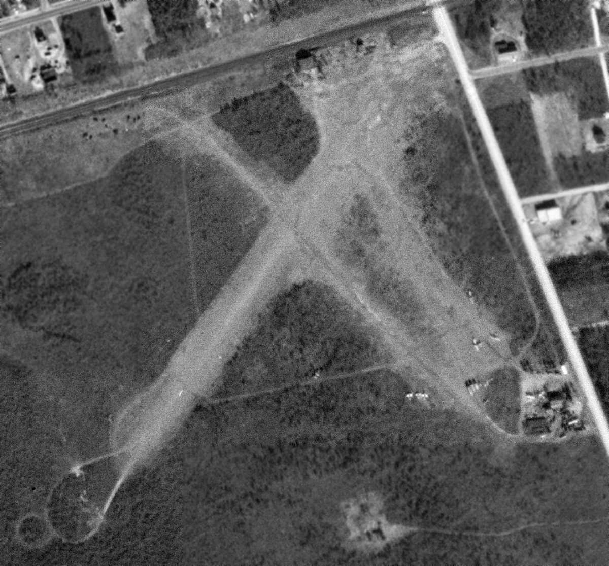
The last aerial photo which has been located of Bender-Brentwood Airport was a 1955 aerial view looking south (courtesy of Bob Mott).
A total of at least 10 aircraft (or fuselages) were visible on the southeast portion of the field.
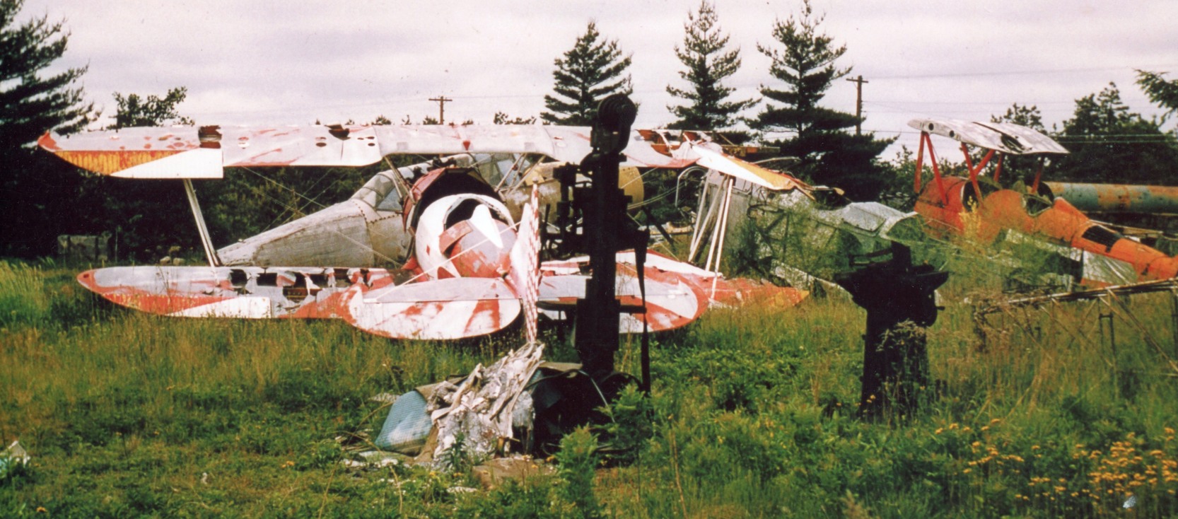
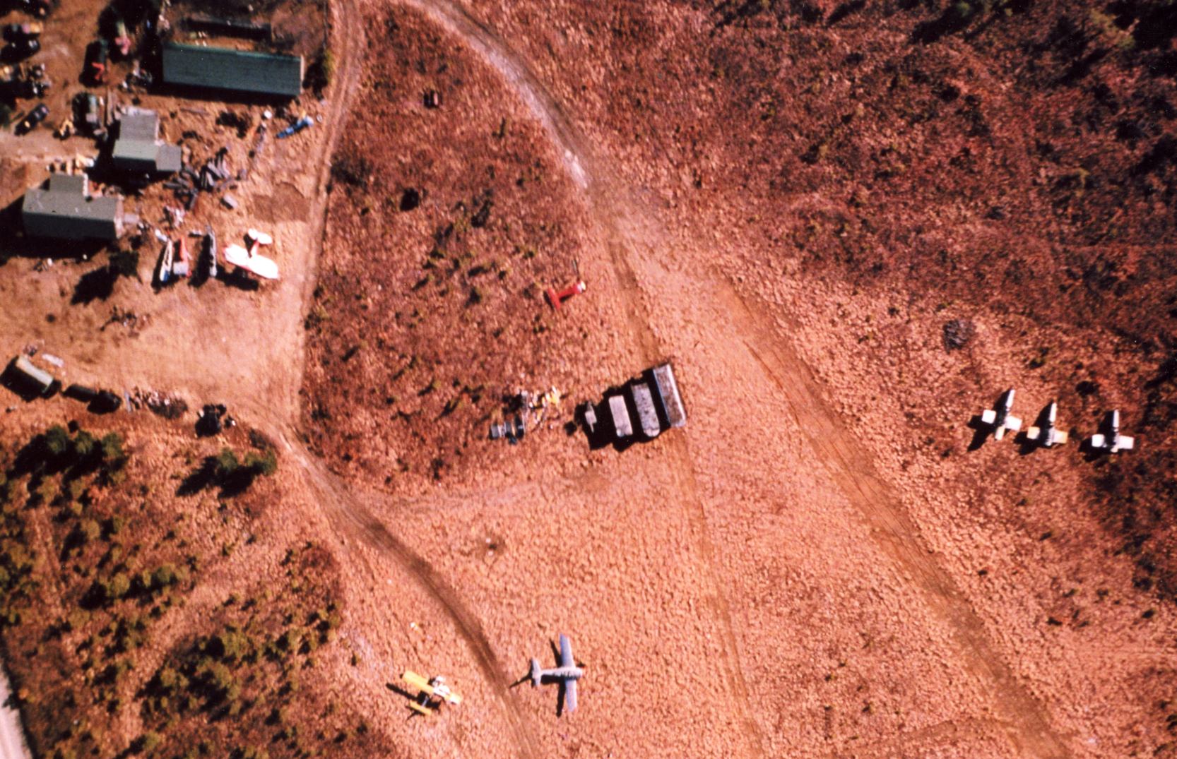
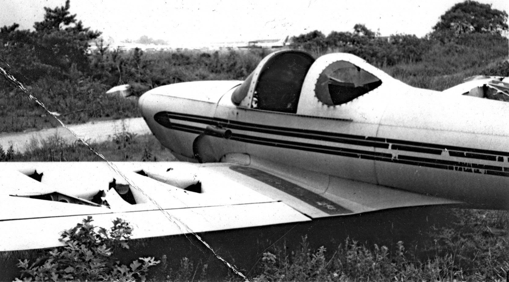
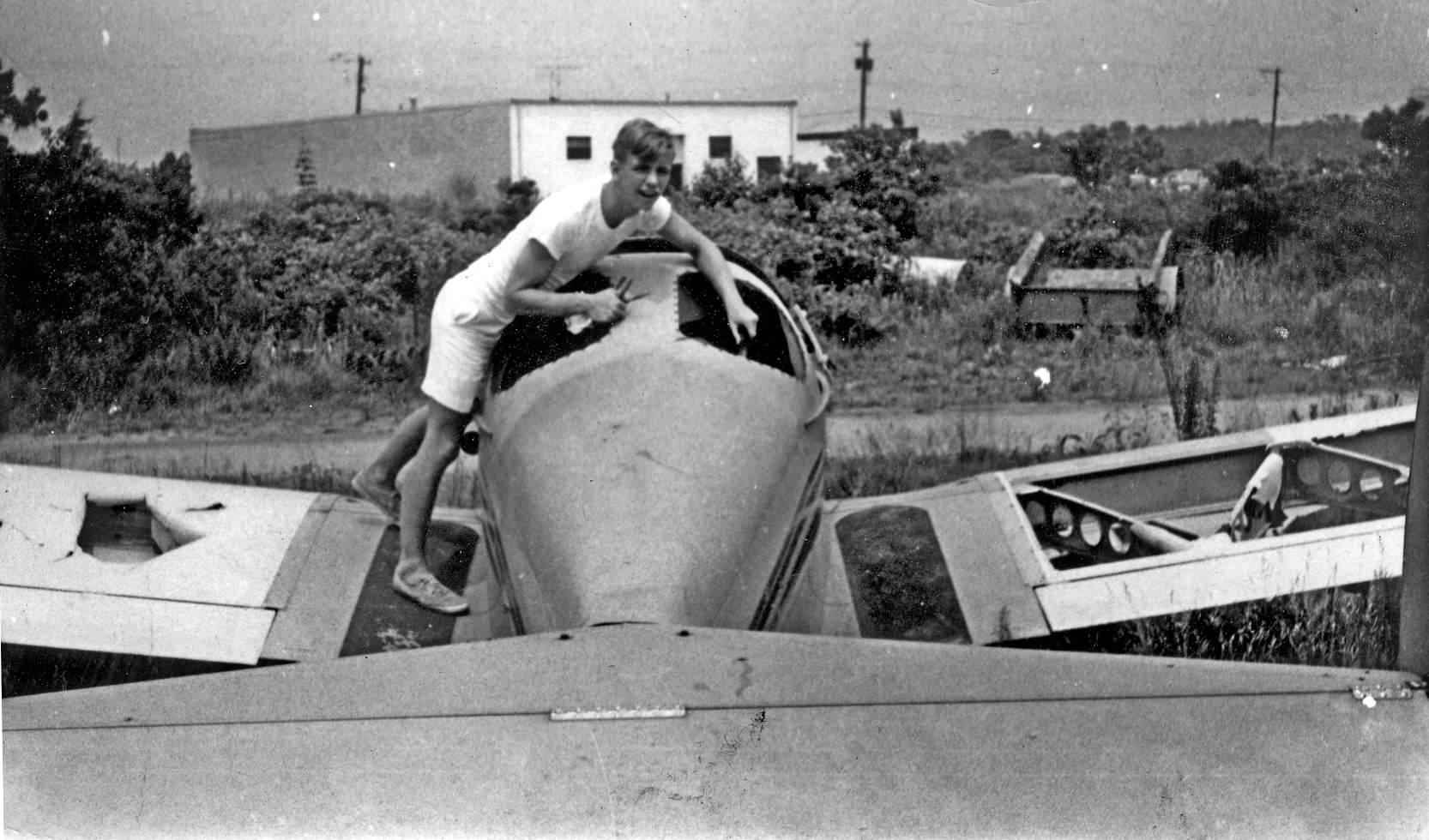
A circa 1955 photo by Frank Gudaitis of a variety of aircraft wrecks at Bender-Brentwood Airport (courtesy of Bob Mott).
Bob Mott reported, “All aircraft were just abandoned by their owners at Brentwood from the 1930s-1950s.
All the wrecks were saved by the Erale brothers of Brentwood. They owned a gas station & body shop nearby.
Bender gave them all the derelicts which they restored or were sold by them as projects.”
A circa 1955 photo by Frank Gudaitis of rare Command-Aire biplane with even more rare German Seimens-Halske engine at Bender-Brentwood Airport (courtesy of Bob Mott).
Bob Mott reported as of 2022, “It is now in Germany.”
The 1956 USGS topo map still depicted the clearings of Bender Brentwood's 2 runways, but no longer labeled the airport,
which may indicate that it had been closed by that point.
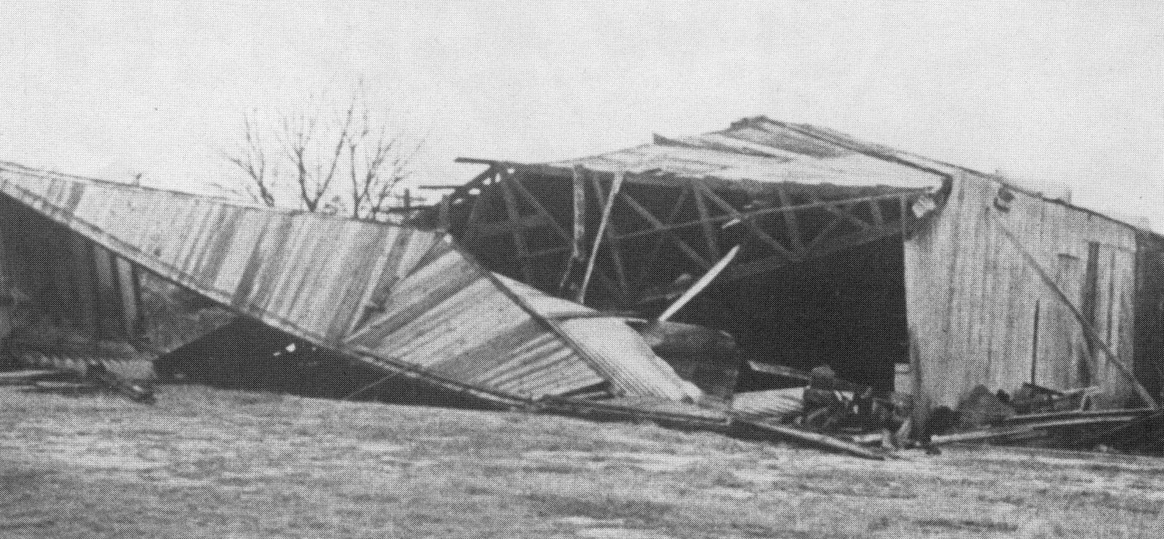
An undated photo by Danny Pflug of the Bender-Brentwood Airport hangar after its collapse on Thanksgiving weekend, 1956 (courtesy of Bob Mott).
Bender-Brentwood Airport was evidently closed (for reasons unknown) at some point between 1955-57,
as it was no longer depicted on the 1957 NY Sectional Chart (courtesy of Mike Keefe).
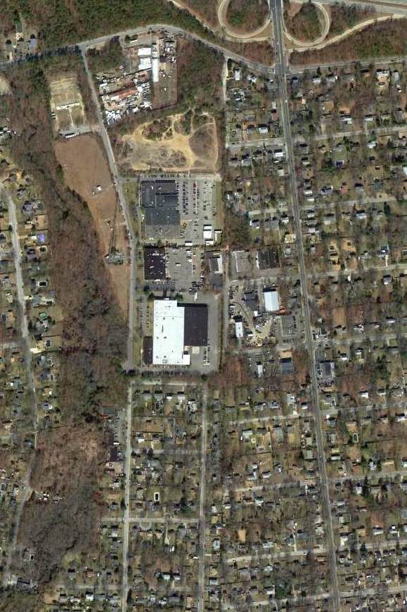
A 1966 aerial photo showed all traces of Bender-Brentwood Airport having been erased, with several buildings covering the site.
John Dolan reported in 2005, “The site is now a storage yard for the LI Power Authority.”

A 2014 aerial photo did not show any remaining trace of Bender-Brentwood Airport.
The site of Bender-Brentwood Airport is located southwest of the intersection of Route 111 & Route 100.
Thanks to John Dolan for pointing out this airfield.
____________________________________________________
(Original) Islip Airport, Islip, NY
40.75, -73.21 (East of New York, NY)
An 8/4/28 of the dedication ceremony at Islip Airport (courtesy of Andrew Muir).
The original airport for the town of Islip was located just north of the town along Route 111.
This 25 acre general aviation airport was established in 1928, having two 2,000' grass runways & 1 steel hangar.
It was founded by Charles Lawrence, the designer of Wright radial engines.
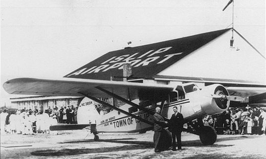
Islip Airport's 8/4/28 dedication ceremony was attended by Amelia Earhart.
The earliest depiction which has been located of Islip Airport were 2 photos of its 8/4/28 dedication ceremony (courtesy of Andrew Muir).
A photo of the 8/4/28 of the dedication ceremony at Islip Airport (courtesy of Andrew Muir)
depicted 2 monoplanes & a biplane in front of a hangar.
The earliest aeronautical chart depiction which has been located of Islip Airport was on the November 1931 NYC-Albany Air Navigation Map.
The earliest Sectional Chart depiction which has been located of Islip Airport was on the August 1932 NY Sectional Chart.
The 1935 Regional Aeronautical Chart depicted Islip as an auxiliary airfield.
John Dolan recalled, “The original Islip Airport... It's notable as the home of the first airline service between Long Island & Connecticut.
Licon Airways flew for awhile between Islip & New Haven CT.”
The 1938 Aviation Facilities in NY State (courtesy of Bob Parmerter) described Islip Airport as a 2,200' north/south sod field.
The earliest aerial photo which has been located of Islip Airport was a 1938 aerial view (courtesy of Andrew Muir).
It depicted Islip as an irregularly-shaped grass field with a single hangar on the southeast side.
A 5/19/38 photo (courtesy of Andrew Muir) of a Brightwaters Mayor Walker & pilot William Thies with his Travelaire 6000B
in front of a hangar marked “Islip Airport” during the occasion of Suffolk County's first airmail flight.
John Doxsee recalled, “Islip Airport... As a child (before 1940) I have vague memories of planes flying in & out & soldiers jumping with parachutes.”
John recalled, “I can remember visiting the site as a child (after it was deactivated)
and seeing the old hangar with the big airport rotating beacon on the roof.
My dad took me there once to see airborne paratroopers practice.
I have vague memories of a big antiaircraft flak gun off to one corner, covered by a netting of some sort.”
The November 1942 NY Sectional Chart (courtesy of Ron Plante) depicted Islip as an auxiliary airfield.
The last aeronautical chart depiction which has been located of Islip Airport was on the July 1945 NY Sectional Chart (courtesy of Ron Plante), which depicted Islip as an auxiliary airfield.
Islip Airport apparently ceased operation at some point in 1945,
as it was no longer depicted on the November 1945 NY Sectional Chart.
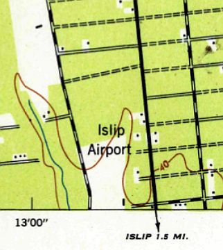
The last depiction which has been located of Islip Airport was on the 1947 USGS topo map, which depicted an open area with several small buildings along the east side.
The Islip Speedway began operation in 1947 on the Islip Airport property.
A 1954 aerial photo showed the Speedway has been constructed over the center of the Islip Airport site.
But the hangar remained on the eastern side, and the overall airport perimeter remained recognizable.
The former hangar remained visible in a 1962 aerial photo.
A 1978 aerial photo showed that the former hangar had been removed at some point between 1962-78.
The Islip Speedway ended operation in 1984.
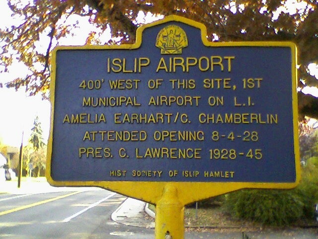
A 2007 photo by Larry Lund of a historical marker commemorating the original Islip Airport.
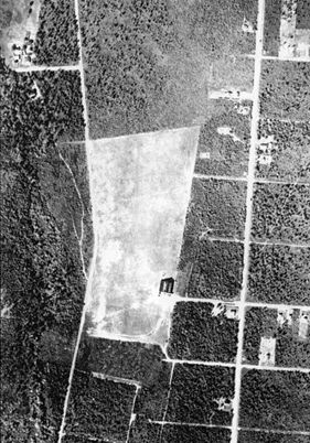
A 3/6/12 aerial photo did not show any remaining trace of the original Islip Airport.
The site of the original Islip Airport is located southeast of the intersection of Freeman Avenue & Spur Drive South.
____________________________________________________
40.84, -73.31 (East of New York, NY)
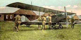
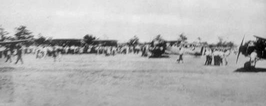
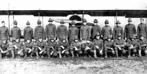
An undated postcard of a Jenny biplane in front of hangars at “Brindley Flying Field”.
Originally this installation was to be named Chapman Field after Lt. Col. C. G. Chapman who died while fighting in France.
The name was then changed just before it opened to Brindley Field in memory of Major Oscar Brindley
who had just died testing a new plane & was considered at the time to be one of the best pilots.
Brindley Field was a satellite field which supported flight training operations at Mitchell Field.
It was constructed on the former Randel Farm, and operated for less than one year.
According to an interview with lifelong Commack resident Henry Shea,
“The first thing we knew of Brindley Field, or any activity of it occurring there, was in June 1918.
The first sight of any of this activity was a long line of army trucks coming up the old Jericho Turnpike with soldiers in them.
To see a truck of any kind was a unique experience in those days.
They just didn't exist in Commack.
And they came around the corner into Larkfield Road, or it was known as Larkfield Avenue in those days,
and pulled right into the gates of the property on the north east corner of Jericho Turnpike & Larkfield Avenue.
Then we learned, or I did, that it was to become a training field for aviators to be sent to France during W.W.I to be fighter pilots.”
Shea continued, “The field itself consisted of 90 acres of land,
with the buildings, and barns, one large barn, and several other storage barns of a smaller size, and other out buildings.
And a main house which they immediately established as a headquarters for the field.
From that time on, for the next month or so, the place blossomed out into a tent city.
I'd say up until the middle of July it was a tent city, with all the troops stationed there.”
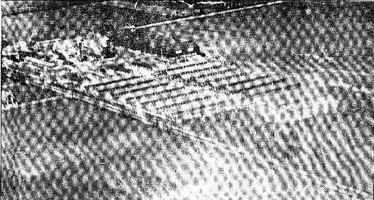
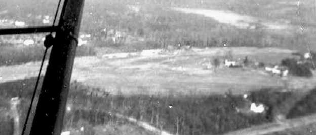
An undated aerial view of Brindley Field.
Shea continued, “The first thing I remember being built in there, in the way of buildings,
was the mess halls where the soldiers had to go to eat their meals.
The next permanent buildings being built were the barracks for the men to sleep in.
In the beginning the tent city was used as their sleeping quarters.
I also remember the set up of officers tents, and the medical center in a tent.
Then about the first of August they built quite a number of barracks.
I think all together about 16 or 20 of them all together.
They were built along the north side of Jericho. The nearest barrack was just inside the fence line on the pike."
Shea continued, “The field was protected every day by guards who would walk the parameter of the field.
After July there were no more visitors allowed inside the camp.
I had some access in the beginning being a kid, but they gradually phased me out.
This field was a satellite field of Mitchell Field in Mineola
and was the last training field for flyers before they went to France.
It was a very important field at the time & sometimes other planes would fly in for a few days.
Some were the DH-4 with the most powerful engine at the time.”
Shea continued, “Towards the end of that summer they found they needed more space so the rented some more land to the east.
In one case they had to condemn the land from the owner, but only temporarily.
They did some considerable clearing of woodland in the north east corner of the property.
They cleared that area of trees entirely. They cut them down, removed the stumps, and graded it off.
That was quite a project. Then they felt they had enough safe room to feel satisfied with.”
Shea continued, “In August of 1918 they started to build 5 big steel hangars,
the nearest one was about 150 feet from Larkfield Avenue.
They stood in a line behind the original hay barn that had been used to hold airplane parts at that time.
They were for what we called Jenny planes at the time. They had dogfights in their training over the field & surrounding areas.
One of the most serious accidents happened while they were having dogfights over the Havemeyer property east of Townline Road.
Two pilots were killed when their plane crashed into the ground after loosing control.
What happened was one of the wings crumbled. It as the only death during all that flying time.”
Shea continued, “I can actually remember when the accident happened
because someone had come over to our house & told us that there had been a crash over in east Commack.
In the medics' hurry to get there they tried to go straight instead of taking the roads
and that was a mistake because they ran into hedgerows & had to take down fences.
But it was no use to save them because they were both killed outright.
There was quite a service held for the 2 pilots at Mitchell Field,
and then they were shipped by train one to California, and one to Pennsylvania.”
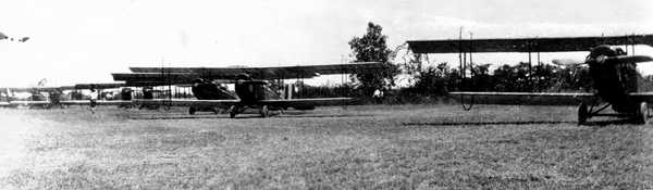
An undated postcard of unidentified biplanes at Brindley Field.
An undated photo of pilots at Brindley Field in front of an unidentified biplane.
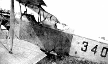
An undated photo of a biplane (a Jenny?) from Brindley Field which came down in Johnson's field.
Operations at Brindley Field ended in May 1919, less than one year after the field was established.
Lorraine Scudder reported, “Brindley Field...my family lived across from it on the south side of Jericho Turnpike.
My grandfather told me that right after the airfield was decommissioned,
my great-grandmother purchased 2 of the barracks & had them moved across the street. She had one of them converted into house for her.
When she passed away in the 1920s, it was left to my grandfather. He & his family moved in shortly after.”
The other sits directly in front of the house & was used as a barn & lodgings for migrant workers
for many years by a farmer who purchased it & land from my great-grandmother.”
Brindley Field was no longer depicted on the August 1934 NY Sectional Chart or the 1947 USGS topo map.
A 1953 aerial photo did not show any recognizable trace of an airfield – just open farm fields.
Mark Wilkinson recalled, “I moved to the area in 1961.
The site of the former airport, the corner of Larkfield Road & Route 25 (Jericho Turnpike), was a farm field at that time.
As a teenager, I worked as a pumpkin picker in the field, never knowing at the time the historical significance.”
Lorraine Scudder reported that her family's house (the former Brindley Field barracks)
“stayed in the family until my parents sold the house in 1983.
I'm pretty sure the current owners don't know this information. I know when my parents sold the house they didn't tell the buyer.
The barn is commercial property & has changed hands many times.”
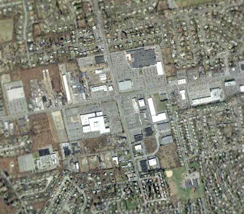
A circa 2000-2005 USGS aerial photo shows no trace remaining of the former Brindley Field.
Mark Wilkinson reported in 2005 of the site of the former Brindley Field, “It's now a shopping center.”
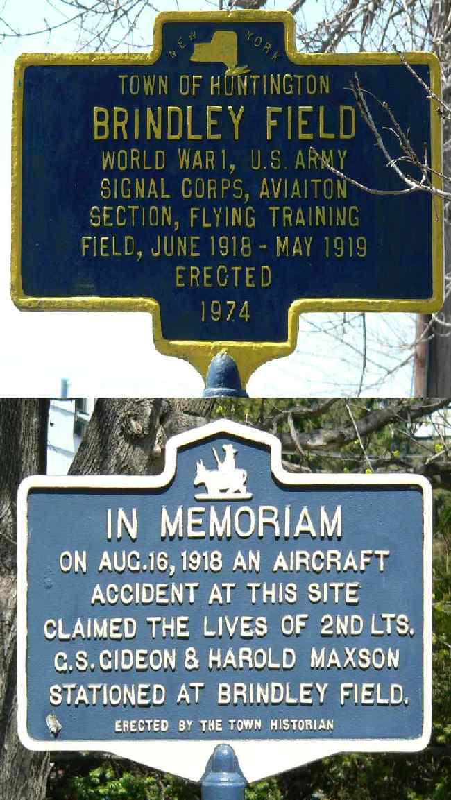
Two 2005 photos by Mark Wilkinson of historical plaques at the site of Brindley Field..
____________________________________________________
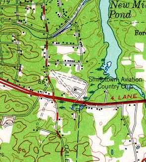
Smithtown Airport / Smithtown Aviation Country Club, Smithtown, NY
40.83, -73.23 (East of New York, NY)
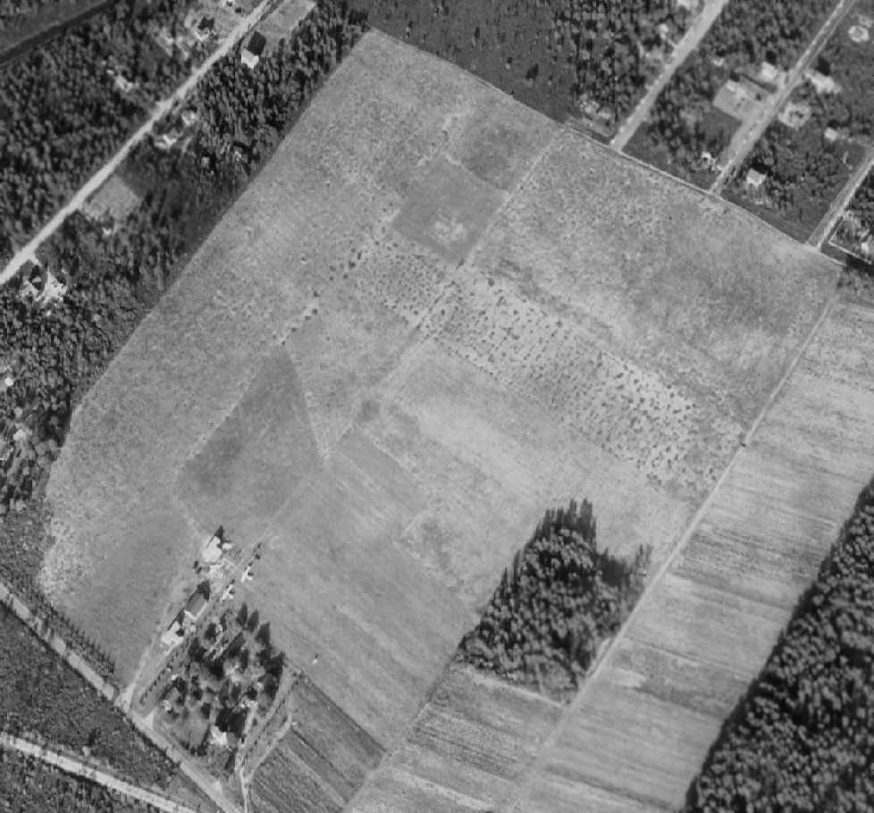
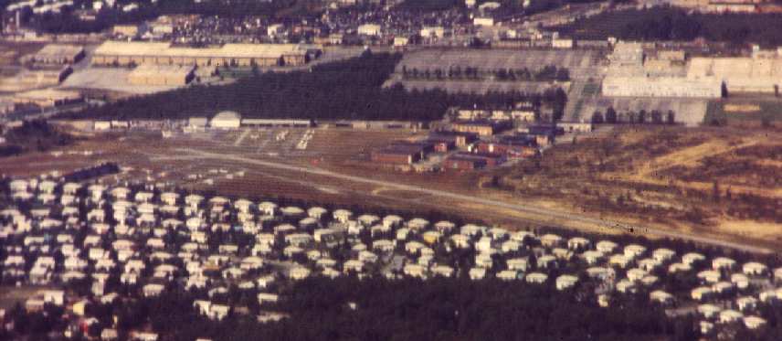
A 1947 aerial view of Smithtown Airport (courtesy of Jim Daly).
The date of construction of this small general aviation airport has not been determined.
The earliest depiction which has been located of the Smithtown Airport was a 1947 aerial view (courtesy of Jim Daly).
It depicted Smithtown as having a single unpaved northwest/southeast runway.
There were no hangars or buildings associated with the airfield, but there was one single-engine aircraft on the southeast runway end.
Smithtown Airport was not yet depicted on the 1947 USGS topo map.
An article by John Fleischman in the 2/99 issue of Air & Space / Smithsonian Magazine
described how the members of the former Hicksville Aviation Country Club
looked at "a small private airport at Commack" in 1950 as a possible replacement site for their former airfield in Hicksville,
which they had sold due to rising property values.
The club planning committee reported that it was only "15 minutes further away from NYC (by car) than our present location...
being readily adjacent to the new Northern State Parkway Extension."
The committee added that the 100-acre field could be acquired at $550 an acre,
and so with only 50 members paying $3,200 a year, the club could take to the air again.
The members, however, had lost interest, and that August, 90% voted to dissolve the club forever.
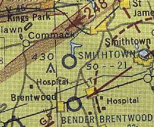
Smithtown was not yet depicted on the July 1951 NY Sectional Chart.
The earliest aeronautical chart depiction which has been located of Smithtown Airport was on the January 1952 NY Sectional Chart.
It depicted Smithtown as having a 2,000' unpaved runway.
Chris Bobka recalled, “I do remember the Smithtown Airport. I remember it from the earliest days of my airport bumming.
I may have been in diapers... As my parents moved to Huntington in 1952.
I can only remember that it had very tall original growth trees surrounding it
and that a horse stable where my older sister would go to rent horses was quite close by.
I also seem to vaguely remember seeing the V-tail of a Bonanza there.”
The 1953 NY Terminal Aeronautical Chart (courtesy of Tim Zukas) depicted Smithtown as having a 2,000' unpaved runway.
A 1953 aerial view looking northeast (courtesy of Carl Markmiller)
depicted Smithtown Airport as an open grass area with several buildings on the north & east sides of the field.
Carl recalled, “I kept my J-3 at this field. Those were the great flying days, almost no restrictions!”
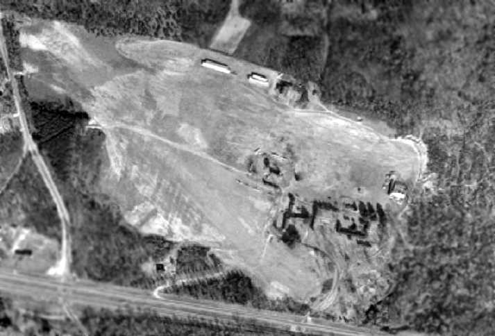
A 1954 aerial view depicted Smithtown as having 2 grass runways, with several hangars on the north & east sides of the field.
A closeup from the 1954 aerial photo depicted a total of 10 light aircraft visible parked outdoors at the Smithtown Airport.
The Aerodromes table on the January 1955 USAF NY Sectional Chart (courtesy of Chris Kennedy) described "Smithtown" Airport as having 2 runways,
with the longest being a 2,100' turf strip.
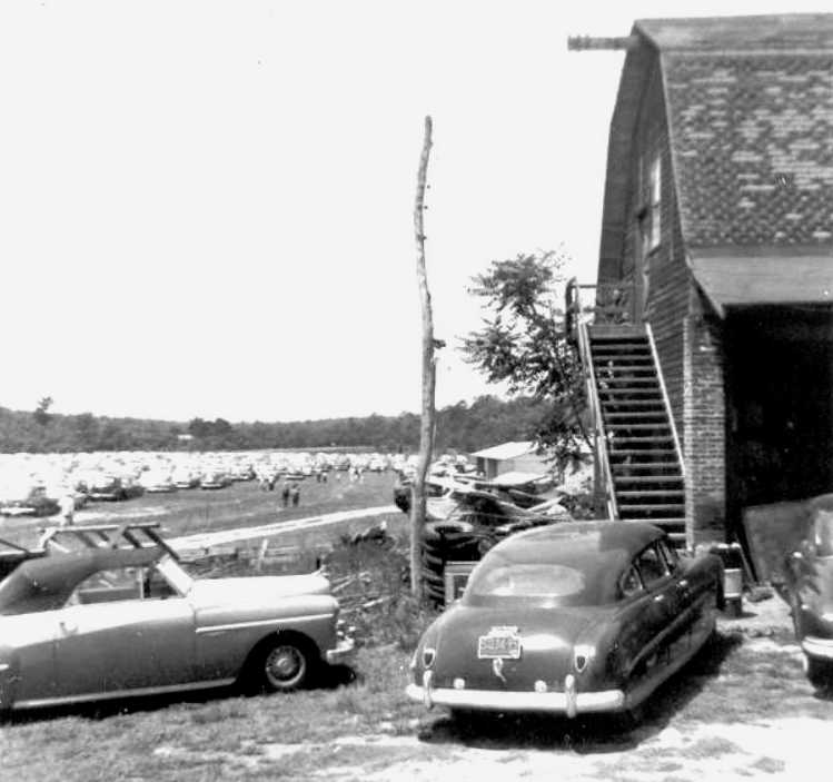
The last photo which has been located showing the Smithtown Airport was a 1955 photo (courtesy of Carl Markmiller)
showing large numbers of cars parked on the runway for the annual Republic Aviation picnic in 1955.
Note the barn used as a hangar, and several aircraft parked behind it.
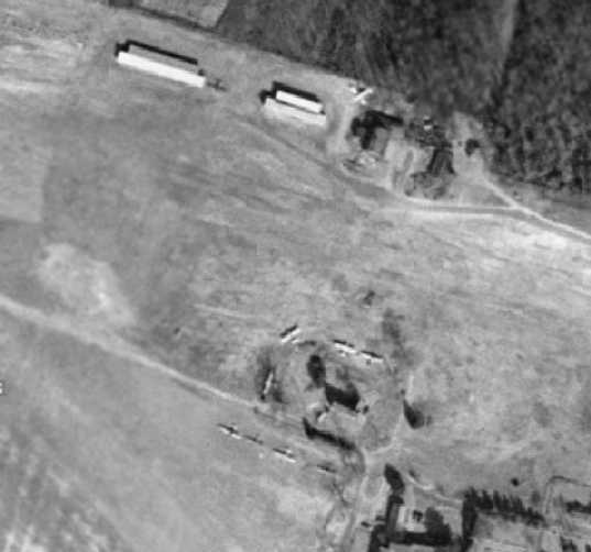
The 1956 USGS topo map depicted the "Smithtown Aviation Country Club"
as having two 2,000' unpaved runways, oriented southeast/northwest & east-southeast/west-southwest.
A single building was depicted on the east side of the field, in between the 2 runways.
The Smithtown airfield was evidently closed at some point between 1955-57,
as it was no longer depicted on the 1957 NY Sectional Chart (courtesy of Mike Keefe) or subsequent Sectional Charts.
A 1962 aerial view showed that a number of buildings had covered the site of the former airport,
but 2 former hangars still remained standing on the north side of the site.
The 1992 USGS topo map labeled the group of buildings occupying the site of the former airport as the "County Center".
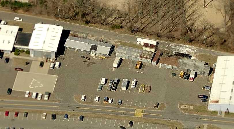
Amazingly, a circa 2006 aerial view looking north shows that 2 former hangars from the Smithtown Aviation Country Club remain standing: the 2nd & 4th buildings from the left.
Ironically, the location still has some aviation use, as a helipad is visible on the left (but there is no heliport listed at this location as of 2008).
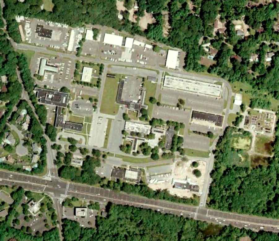
A 5/4/09 aerial photo shows the buildings covering the site of the former Smithtown Airport.
The site of the Smithtown Aviation Country Club is located northeast of the intersection of Route 347 & Old Willets Path.
____________________________________________________
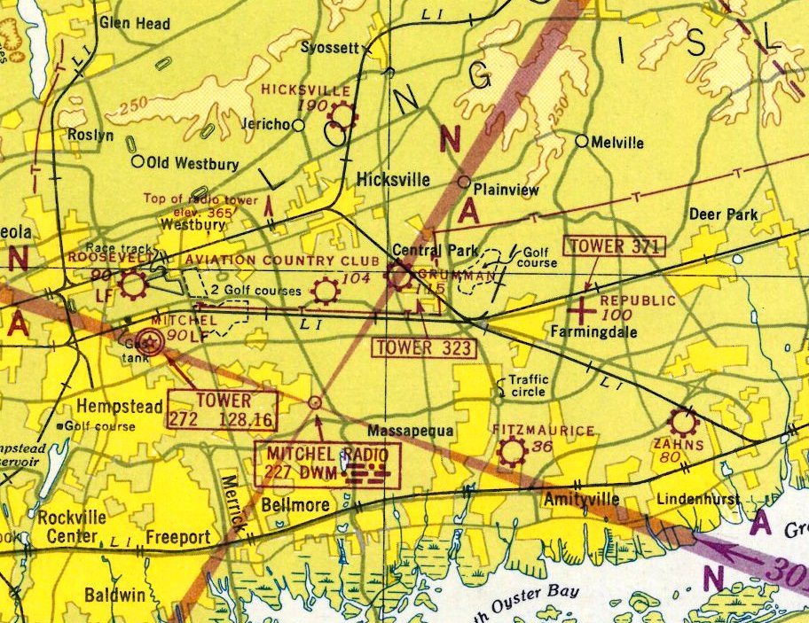
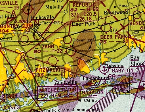
Zahn's Airport, North Amityville, NY
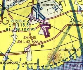
40.71, -73.4 (Southeast of Republic Airport, Long Island, NY)
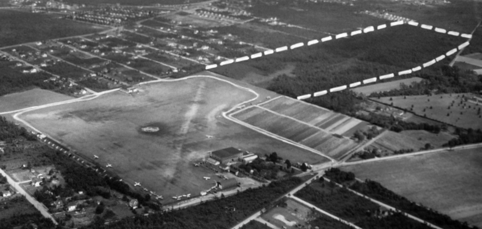
A 10/5/41 aerial view looking northeast at Zahn's Airport.
This general aviation airport was located along Albany Avenue, only a half-mile southeast of Republic Airport.
Joe Zahn first cut a 1,200' airstrip into part of his apple orchard in 1936.
The earliest depiction which has been located of Zahn's Airport was a 10/5/41 aerial view looking northeast.
It depicted the field as a square grass field, with 2 single-engine aircraft parked near a few small buildings on the southwest side of the field.
Joe Zahn & his friend Jack Looney flew a J-3 Cub from the strip until the early years of WW2,
when the land of the airstrip was returned to cultivation to help boost food production for the war effort.
No airfield at this location was yet depicted on the January 1945 NY Sectional Chart.
After the end of WW2, flight instructor Ed Lyons was determined to make a career in aviation & saw an opportunity to start a flying school on Long Island.
He leased land on Zahn's farm in 1945. Ed made a deal to rent an empty tool house adjacent to Zahn's strip in order to start a flying school.
Ed began teaching with a surplus Canadian Fleet trainer & a 45 horsepower Piper.
With GI money available for education for ex-servicemen, Ed soon had many students.
Students paid $10/hr for instruction, and the business boomed. Ed established Amityville Flying Service & looked for other partners.
Zahn became a partner & set aside 840 acres to establish Zahn's Airport.
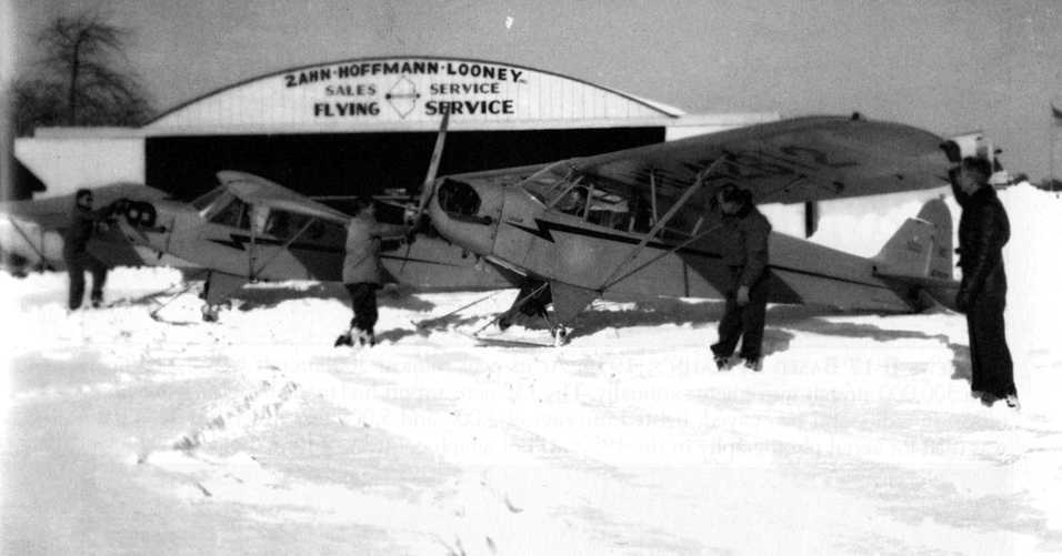
Don Brzezinski recalled, “In 1946 I took flying lessons at Zahn's on the GI bill.
Zahn, Looney, Hoffman, had their flying school one side of the airport, Lyons flying service on the other.
Ed Lyons (real name Ed Liebowitz) flew during the war in Spain as a fighter pilot.
Ed Lyons was a Colonel in the Civil Air Patrol. His aircraft were Piper J3s - yellow with a lion's head on the side.
There was only grass for the field runways & they were a different orientation than in later years.
The left-hand pattern intersected with Republic Airport's right-hand one.
This made a very interesting approach, either a Seabee, the Rainbow or some other military traffic going your way.
No traffic control at Zahn's - just landing aircraft on the final had the right-of-way.
Zahn's had the only hangar, the fueling was run by Weber (a former B-29 pilot).
The fueling & the snack bar were on Lyons' side of the field.”
The earliest aeronautical chart depiction which has been located of Zahn's Airport was on the June 1946 NY Sectional,
which depicted Zahns as a commercial/municipal airport.
A 1946 photo of Sig Uyldert's flight training office at the northwest corner of Zahn's Airport, showing a Piper Tri-Pacer & 3 Cubs.
The August 1946 NY Terminal Chart (courtesy of Tim Zukas) depicted Zahns as a commercial/municipal airport.
The 1947 USGS topo map depicted Zahn's Airport, along with a dizzying array of other general aviation airports, almost all of which are long-gone.
A circa late 1940s aerial view looking east depicted the original layout of Zahn's Airport, but with a planned runway expansion to the northeast outlined.
The July 1949 NY Sectional Chart (courtesy of Ron Plante) depicted Zahn's Airport as having a 2,200' unpaved runway.
Walker Hoffman began a second flying school on the opposite side of the field. The 2 flight schools eventually merged in 1950.
Zahn was bought out in 1950 by Ed Lyons, Jack Looney, and Walter Hoffman.
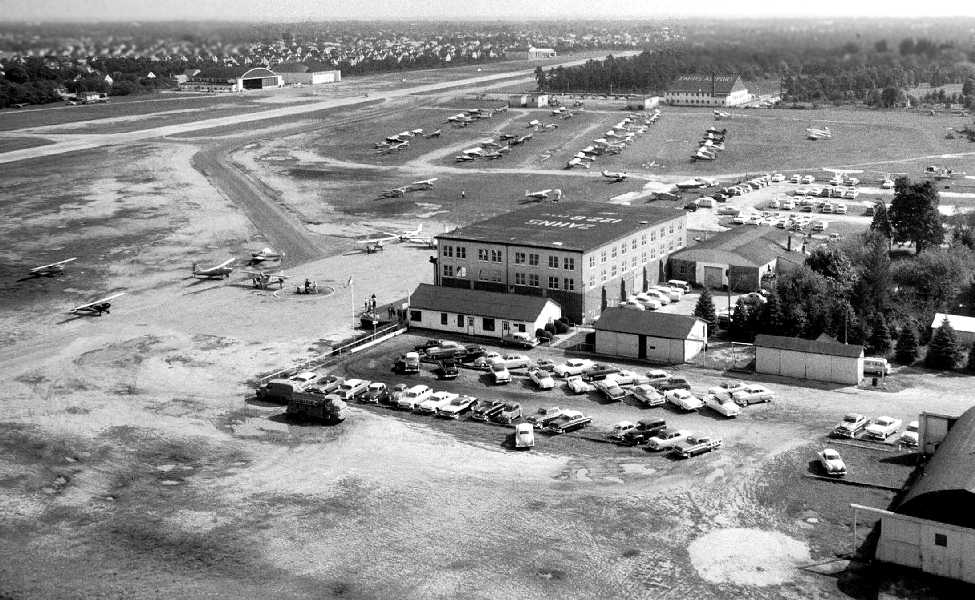
The business expanded, and Zahn's Airport became at the time the largest privately airport in America.
It eventually grew into the region's largest general aviation airport, with more than 200 resident aircraft & helicopters.
With the closure of Roosevelt Field in 1951, Zahn's became the busiest general aviation airport in NY State.
A 1951 aerial view looking south depicted Zahn's Airport as having several grass runways, with several hangars on the northwest & northeast sides of the field.
Dozens of light aircraft were visible on the field.
John Schaefer recalled, “I already had a Private Pilots License when I first went to Zahn's Airport & checked out in a Piper J-3 Cub (NC42859).
I'd rented Cubs at other airports so the flight check consisted of making a few wheel landings for 30 minutes of total flight time.
Then I rented the Cub & flew it solo for 1:45 just doing wheel landings, not 3-point landings.
Then another 30 minutes with an instructor making wheel landings; all in preparation to flying Lyons Flying Service Mooney Mite, which is a single-seat aircraft.
Then I got into the Mooney Mite's cockpit, studied it for a bit & then took off & practiced 90, 180 & 720 degree turns, stalls & various other air-work for 35 minutes.
I was then qualified to rent & fly the Mooney Mite any time.”
A circa 1950s photo of long-time Zahns flight instructor Bob Havecker teaching a flight student in a Link trainer (courtesy of Steve Moddle).
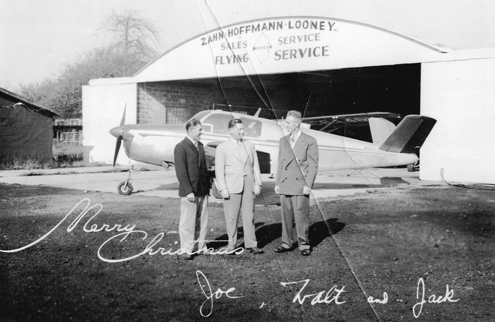
A circa 1950s Christmas photo of Joe Zahn, Walt Hoffman & Jac Looney in front of a Beech Bonanza & their hangar (courtesy of Steve Moddle).
The "Whitney Hangar" was located approximately halfway down the east side of the north/south runway.
The hangar was built to house the DC-3 of John Hay Whitney, but also hangared other corporate aircraft.
A 5/28/51 aerial view looking north at several hangars along the west side of Zahn's Airport,
with a Cessna T-50 Bamboo Bomber, Republic SeaBee, Ercoupe, and several other light general aviation aircraft.
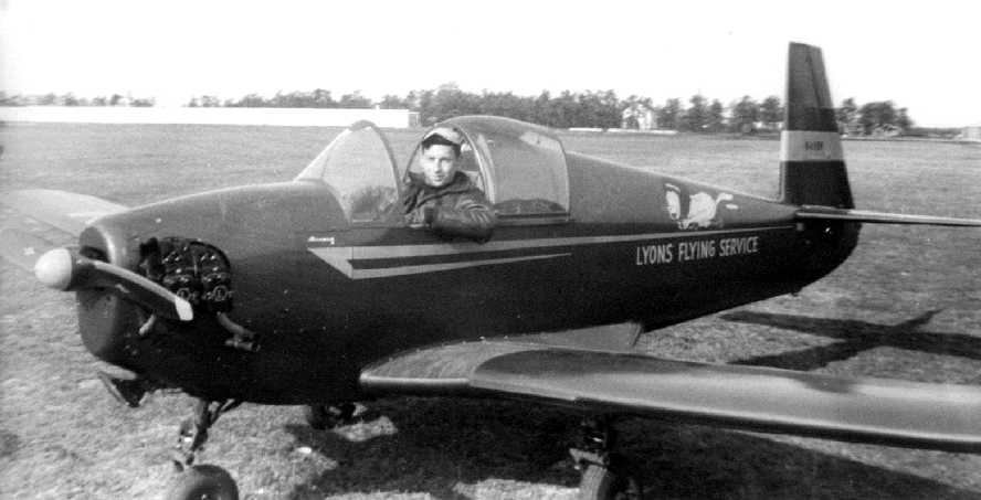
An 11/6/51 photo of John Schaefer in the cockpit of a single-seat Mooney Mite from Lyons Flying Service at Zahn's Airport.
John recalled, “I was 2 days shy of my 19th birthday.”
A circa 1953 photo (courtesy of Robert Brown) of the Zahn's hangar, with the Grumman Mallard of the NY Daily News,
and the Twin Beech in which the Levitt brothers commuted to the PA where they were building Pennsylvania's Levittown.
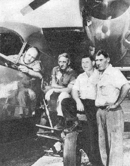
A circa 1953 photo (courtesy of Robert Brown) of the 4 partners of Zahn's Airport (left to right): Ed Lyons, Jack Looney, Walter Hoffman, and Joe Zahn.
A 1953 article in Flying Magazine (courtesy of Robert Brown) described Zahn's Airport as having a 4,200' paved runway, which was described as "handling DC-3s with ease."
The airfield had a total of 35 T-hangars & 2 larger concrete hangars.
Two more concrete hangars (described as "being large enough to house 4 DC-3s) were under construction, as was a 3,000' east/west runway & runway lights.
A National Guard unit had 40 L-19s & 2 Navions based at Zahn's, and it had a new hangar under construction for 10 helicopters which were planned to be based at Zahn's.
As of 1953, there were 3 flying clubs based at Zahn's, as well as a unit of the Civil Air Patrol.
A 1953 aerial photo depicted over 52 light aircraft visible parked outside at Zahn's.
It depicted the field as having 2 paved runways, with several hangars on the west & east sides of the field.
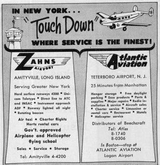
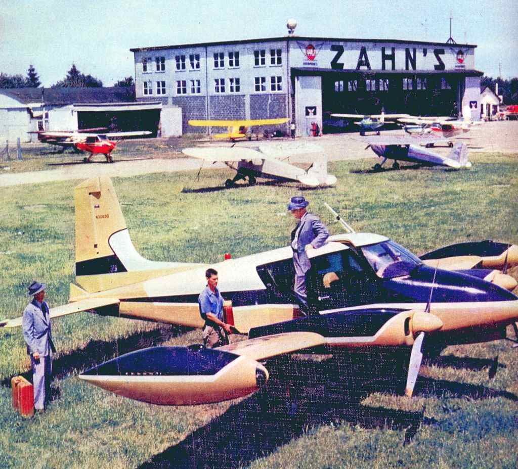
A circa 1950s advertisement for Zahns Airport.
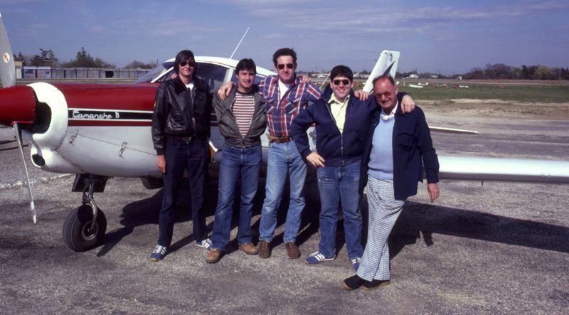
Charles Spence recalled of Zahns: “I learned to fly there in 1954.
Ed Lyons gave me my private flight examination, making me spin the J-3.
I later moved up to a Tri-Pacer & then flew a Comanche from there.
An ADF approach could be made from the signal on Mitchell Field to the West near Hempstead.
On a good Sunday afternoon it was not unusual to be 8th or 10th on downwind with every mix from J-3s to twins.
With that traffic, after moving to the Comanche I learned a lot about slow flight.”
A 6/22/54 aerial view (courtesy of Bill) of the Zahn's National Guard ramp & hangar, showing 17 Cessna L-19s & 2 North American L-17 Navions.
The 1954 USGS topo map depicted Zahn's as having 2 runways & several buildings scattered around the sides of the field.
Edward Materson recalled of Zahns, “I took a few lessons back in the 1950s.
I took lessons with Walter Hoffman who yelled at me for making a rather sharp correction close to the ground on the final approach.
I didn't realize then how dangerous that could be when flying close to the ground & close to the stalling speed.”
A 1957 photo of Charles Lindbergh & producer Leland Haywood supervising the filming of the takeoff recreation of the replica Spirit of St. Louis at Zahn's Airport, for the film Spirit of St. Louis.
According to Mike Machat, Zahns' “old T-hangars became stand-ins for Roosevelt Field
during filming of the 1957 aviation classic 'The Spirit of St. Louis' starring Jimmy Stewart as Charles Lindbergh.
Growing up on Long Island in the 1950s & 1960s, Zahn's Airport was Mecca for General Aviation.”
Zahn's was depicted on the 1958 NY Sectional Chart (courtesy of Norman Freed)
as having a 4,200' paved runway.
A circa 1950s-63 photo of John Fuchs in a National Guard L-17 Navion at Zahn's Airport (courtesy of William Fuchs).
According to William Fuchs, “My father, Major John Fuchs was the Commander of Army National Guard 42nd Infantry Division
air operations at Zahns during the 1950's until his retirement in April 1963.
Most of the aircraft were L-19 Bird Dogs; 1 or 2 L-20 Beavers & an L-17 Navion.
I made a few trips there [in] 1958-60. I remember 2 rows facing each other (6-8 aircraft in a row),
running from a open area in front of the hangar to a gate that opened on to the taxiway on the west side of the north-south runway.
The facility was on the west side of the airport diagonally across from the Nike missile battery.”
A circa 1950s-60s photo from the cover of a French aviation magazine, showing Ed Ferner & a Cessna 310 in front of the Zahn's hangar.
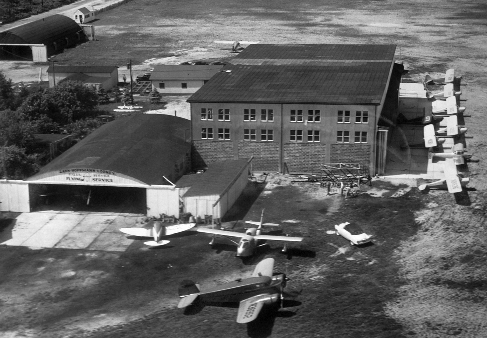
A circa late 1950s aerial view looking southeast at Zahn's Airport (courtesy of Carolyn Agenjo), showing 5 large hangars & a large number of general aviation aircraft.
According to William Fuchs, “The hangar in the background at the top right center is the Army facility.
There are at least 6 L-19s parked wingtip to wingtip between the hangar & the runway.”
A 1960 photo of 3 Piper Cubs (with 2 on skis) in front of the Zahn-Hoffman-Looney Flying Service hangar.
Zahn's was listed among active airports in the 1962 AOPA Airport Directory, with 2 asphalt runways (4,200' & 3,000' long),
and the operators listed as Amityville Flying Service & Uyldert Flying Service.
The Piper Cubs of Amityville Flying Service were known to their students as the "Amityville Horrors"!
Banner towing flights were conducted from Zanh's, using J-3 Cubs.
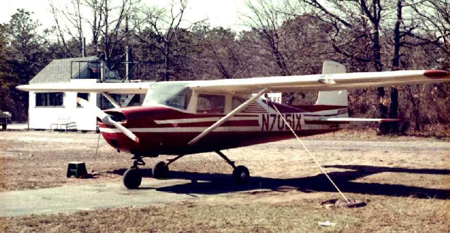
A 1963 photo by Steve Dobin (courtesy of Chris Bobka) of Chris's “1961 Cessna 150A N7051X at Zahn's Airport.
It was a school ship at Sig Uyldert flying school. It spent about 10 years at Zahn's.”
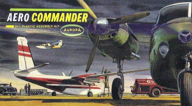
A circa 1960s cover of an Aurora plastic model of the Aero Commander featured the Zahn's hangar in the background.
Mike Machat observed, "This scene is dead accurate. Those aircraft were actually based there & the local gas service was indeed Gulf for as long as the airport existed.
The green & black Aero Commander 560F shown in the foreground belonged to a very cool guy named Stan.
His hangar was located directly across the field from the flight school & he used the plane for private charter & aerial ambulance work.
Sometimes Stan would jump into the cab of the gas truck during the fueling of his plane & floor the engine to expedite fuel flow
while rushing to launch for yet another emergency aeromedical mission.
His high-speed low passes before entering the landing pattern were legendary & it was easy to see why he was known around the airport as the 'Ace of the base'.”
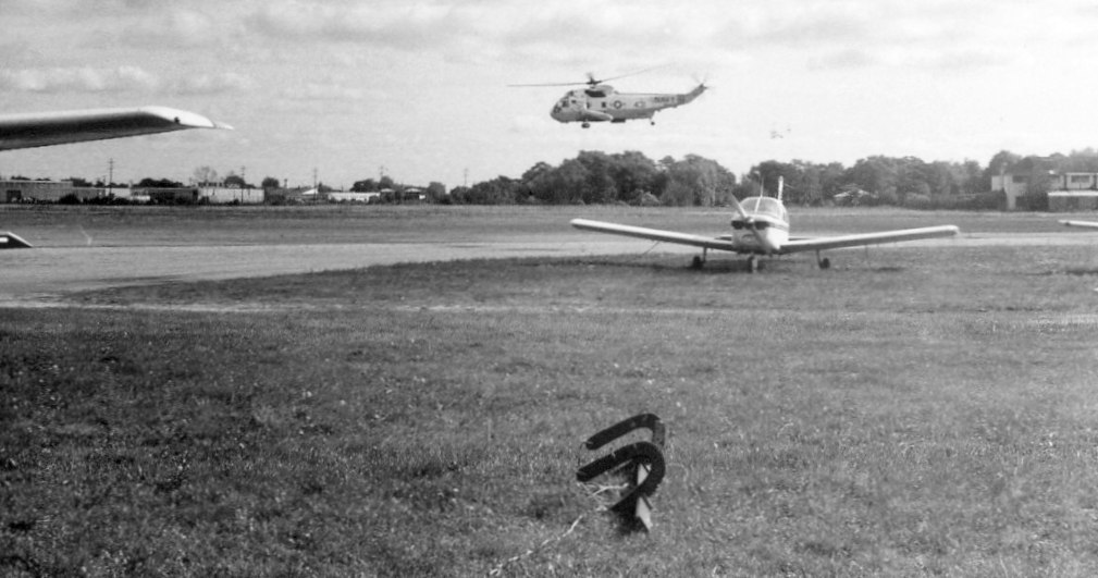
A circa 1960s photo of a Navy SH-3 Sea King helicopter visiting Zahn's (for what purpose?).
Mike Machat recalled of Zahn's Airport, “I worked there as a Line Boy & then took lessons before enlisting in the Air Force in 1967.
To this day, people don't believe me when I say I soloed in a hand-propped 1947 Piper J-3 Cub, or flew over downtown Manhattan VFR in a Cherokee.”
A January 1967 aerial view by Daniel Levy (courtesy of Mike Mchat) looking south at Zahn's Airport on crosswind leg after takeoff.
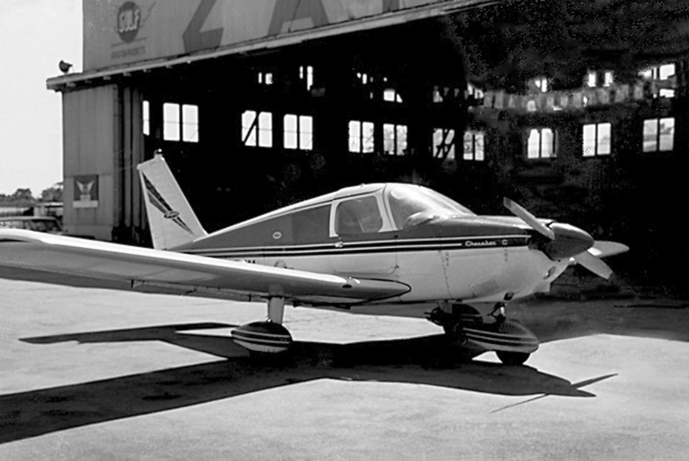
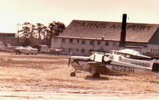
An April 1967 photo by Andrew Bonime (courtesy of Mike Machat) of a Piper Cherokee 180C N8496W in front of classic Zahn's Airport hangar.
John Biggers recalled, “I was a student pilot in 1969 at Amityville Flying Service & soloed in J-3 N70581 in November 1969.
I thought I was taking off in a jet fighter! ...the acceleration was exhilarating!
This flight was the ONLY one in my 18,000-hour career where I lost an engine.
I was so enamored by the fact that I was soloing that I forgot carb heat... and it was a cold day in November.
I took my private pilot written test at the FSDO at Zahns in 1970
and took my private check ride with Ed Lyons in August 1970 in a PA-28-140 N6749J.
I remember Dan Foote behind the desk... 'Zahn's landing North; Left-hand traffic.'
Zahns was the ONLY airport in the country that was a controlled on weekends using a light gun only
from a trailer towed to the approach end of the runway.”
Lonnie McLaughlin recalled, "Just before I bought my TriPacer in 1970,
I went to Zahn's to get checked out & get some familiarization flights in their PA-22-108 Colt (Like a TriPacer but with only front seats).
At that time the local FAA GADO was still there. The North/South runway had the beach at the South end & a row of T hangars at the North end.
The wind was almost always off the water all summer.
If you landed to the South (over the T-hangars) and came in too low,
they could plant you right where you crashed as there was a cemetery between the T-hangars & the railroad tracks.
Although the East/West runway was almost never used due to its shorter length & obstructions,
I logged over an hour of 90 degree crosswind take offs & landings on it that June."
Ray Jacobelli recalled, "I learned to fly with Amityville flying service between 1970-73; my 1st flight was in a Piper PA -28 Cherokee 180.
The east/west runway was used as often as the wind changed from the prevailing to east/west.
There was a slight dip in the east/west runway & I remember flying solo in a PA-28A 140 -
the dip occurred roughly at the rotation point of the take roll - you were airborne with little to no effort.
There were telephone lines on the approach to east runway -
same thing at the south runway approach over the T-hangars at the north end of the property.
When taking off north (from the south end of field) it was difficult to see traffic on final due to tree & houses.
Parked in a grass tie down area were a collection of Luscombes, Talyorcrafts, Ercoupes,
an old rotting away Fairchild PT-26, and later day C-150s.
I took my ground school in classrooms in the large hangar at the east end of the field - taught by Dan Foote."
Thomas Lembessis recalled, "I learned to fly at Zahn's in 1972. There was no other airport like it.
If they were around today, I would have definitely based my plane there. They weren't the newest.
Their facilities were a shambles. But these people knew how to fly, unlike anyone else.
In cleaning out my house recently, I came across a photo of N4372J, a Cherokee 140 owned by Zahns, in which I flew my first solo flight in. What a memory!"
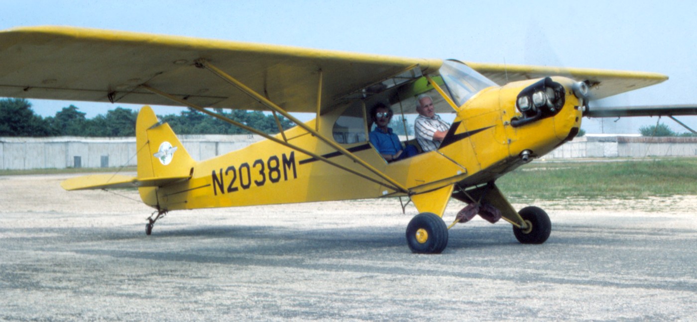
An August 1975 photo by Mike Machat of a Amityville Flying Service Piper J-3 Cub N2038M preparing to taxi out for takeoff at Zahn's Airport.
Joe Ricciardi reported, “The guy in the airplane [backseat] was me!
I remember the photo was taken not too long after my 14th birthday & I had long bushy hair.”
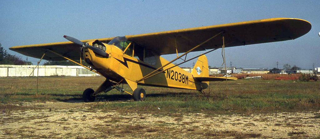
Steve Moddle recalled, “My son soloded at Zahn's on his 16th birthday in Cub N2038M.”
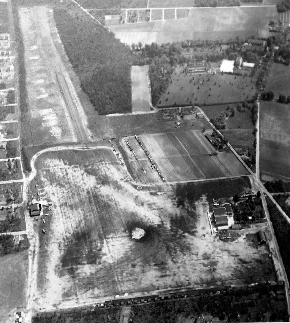
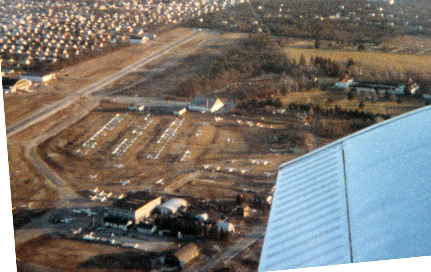
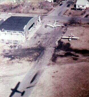
A 1978 aerial view showing the huge number of general aviation aircraft based at Zahn's Airport.
An October 1978 photo by Dave Welch of a Piper J3C-65 Cub at Zahn's Airport.
Dave recalled, “I used to rent it at $9/hour! Free pick up & drop off at the train station included!”
The 1979 USGS topo map depicted Zahn's as having 2 runways.
A circa 1978-79 aerial view by Gary Agranat of a hangar at Zahn's.
A circa 1978-79 photo by Gary Agranta of Ercoupes in front of a hangar at Zahn's.
According to Gary Agranet, Ed Lyons owned the field & also ran Amittyville Flying Service. In Gary's words, "My first flight lesson started here.
One day I just walked in to that shack on the right. I told the man behind the desk that I wanted to take flying lessons.
He had me fill out some paperwork. And then off I went. I continued to take lessons here for almost a year.
The type of aircraft I flew was the Piper Cherokee 140. The 140 was nothing fancy. But it was rugged.
The school also had Cherokee 180's & Piper Cubs, but I didn't get the chance to fly those."
Gary continued, "Zahns was a small uncontrolled airport with its own unique character.
It was home to lots of small airplanes, old hangar, and tall grass.
The field was quiet, but not too quiet. It was located on Long Island about 40 miles east of downtown New York City.
It was far enough from the city that you didn't have to compete with the city commercial air traffic.
But it was still close enough to get enough air traffic to keep you alert."
Gary continued, "The runway pattern was shaped like a 'T'. Most of the time I used the longer north/south runway.
The shorter east/west runway ran along the north side of the field. Just to the north of that was a line of small hangars.
And beyond that was a mainline track of the Long Island Railroad.
Both runways seemed to have potholes from years of 'wear & tear', but the east/west runway seemed to me to have more.
I only used that short runway once, when there was a strong westerly wind blowing right down it.
I don't know which scared me more, that strong gusty wind or that very short runway with its potholes & the hangars so close!"
Gary continued, "At Zahns you still did have to be aware of traffic. Just within a mile to the north was Republic Airport in Farmingdale.
It had a control tower, jet traffic & an ILS instrument approach. Zahns' airport traffic pattern fit just between the approaches to Republic's runways 1 & 32.
And above 3,000' overhead was the outer ring of the terminal control area for JFK International.
You learned the controlled airspace demarcations & prominent landmarks very quickly.
Unfortunately, Zahns closed about a year after I started flying."
Zahn's was still depicted as an active airfield on the 1979 NY TCA chart (courtesy of Bill Suffa).
It was depicted as having 2 paved runways, with the longest being the 4,200' north/south runway.
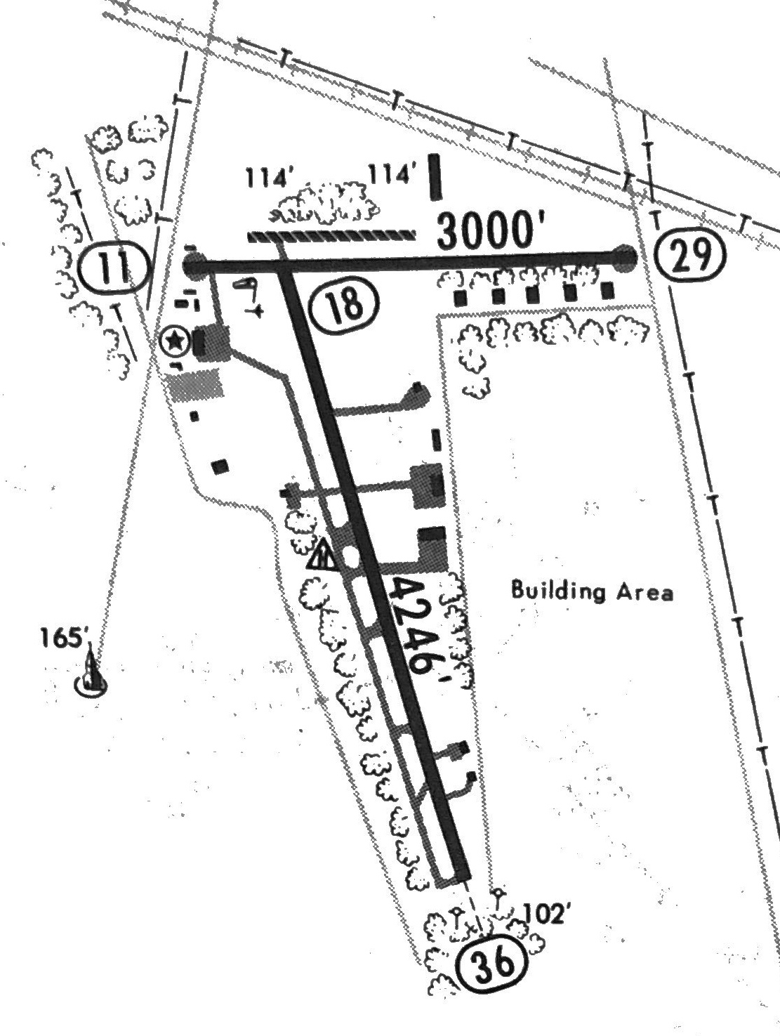
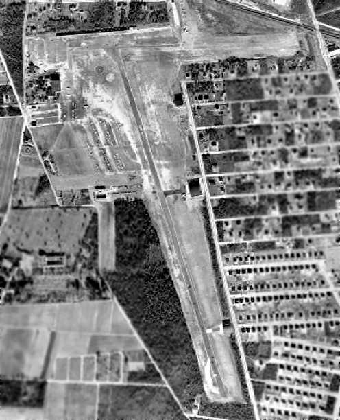
An 11/23/79 diagram (courtesy of Ethan Klapper) depicted Zahn's Airport as having 2 paved runways: 4,246' Runway 18/36 & 3,000' Runway 11/29, and numerous taxiways & hangars.
An undated photo at Zahns Airport (courtesy of Steve Moddle), which Steve Moddle observes is of “Walt Moddle (my son), ?, ?, Jim Bohlebor & Bob Havecker
after delivering the last of the J3 Cubs before the airport closed, with the PA24.”
An undated photo of the "Whitney Hangar", which was built to house the DC-3 of John Hay Whitney.
There were office/shop areas along both the north & south wall; hence, the windows were up high.
A 4/30/80 photo of the last plane to leave Zahn's Airport. The field was closed at sunset.
Steve Moddle recalled, “After Zahn's closed I was able to buy N2038M from Jack Looney, one of the owners of the airport.
In 2005 I donated N2038M to the Piper Museum in LockHaven PA where it is today in a hangar about 500' from where it was built.”
Zahn's was bought by the town in 1980 & turned into an industrial park.
A 1980 aerial view showed that the Zahn's Airport runway pavement & all of the hangars had been removed,
but the outlines of both former runways were still apparent.
The June 1981 NY Sectional Chart (courtesy of Ron Plante) depicted Zahns as an abandoned airfield.
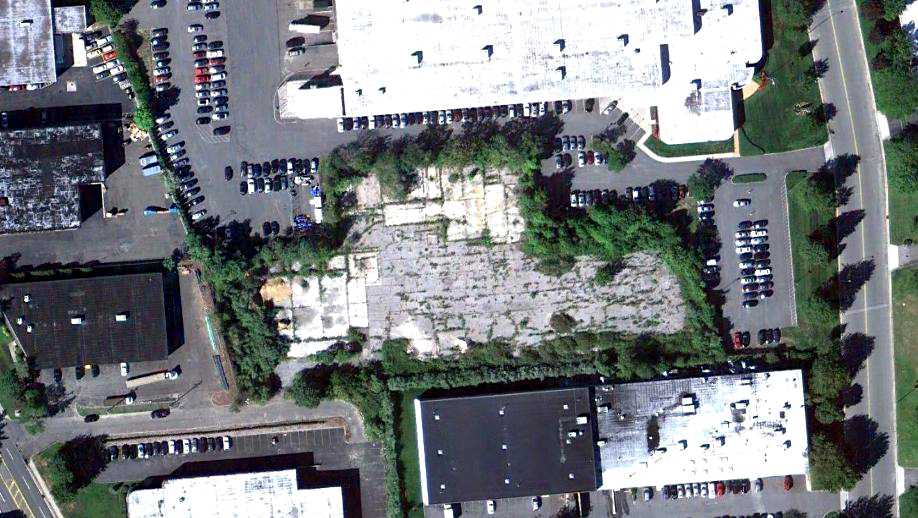
A 4/8/94 USGS aerial photo showed that not a trace remained of the field.
A 5/4/09 aerial photo showed no obvious trace remaining of Zahn's Airport.
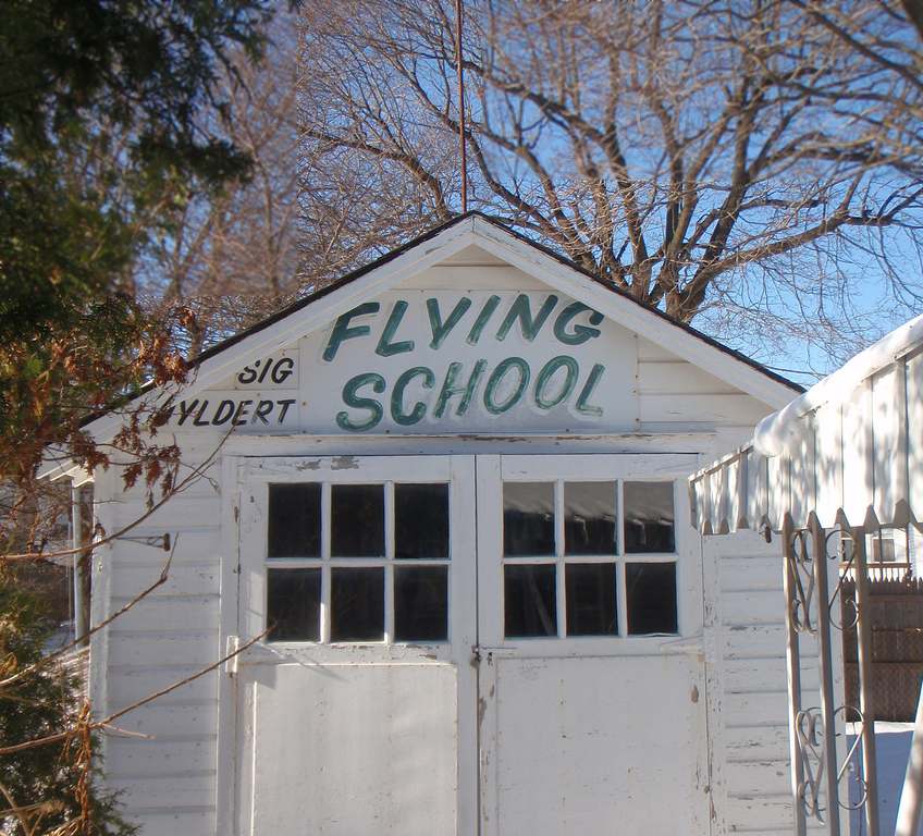
A 12/24/09 photo of a curious remnant of Zahn's Airport:
a shed located in Farmingdale (possibly relocated from the airport site?) bearing a sign for Sig Uyldert Flying School.
A September 2010 aerial photo of what appears to be the last remnant at the site of Zahn's Airport –
the rutted pavement which appears to be the foundation of the National Guard hangar on the west side of Zahn's Airport.
John LeVasseur reported, “I discovered what appears to be a remnant of Zahn's contained within the industrial park now located there.
I decided to go there & see if what I saw on the image was actually something left of the old airport.
I was able to find some post holes, foundation footings which match fairly well to your image [of the National Guard hangar].
I also found a brass metal strip sticking out of the ground.
I pulled it out & it was embossed with the phrase, 'Property of the U.S. DOD', so I suspect this may be the area of the National Guard hangar.
I did a little digging with the town & discovered there was a small parcel of land on the site that the town could not purchase due to the fact it was owned by the US Department of Defense.
I suspect it was sold by Zahn's for use for the National Guard area within Zahn's.
Incidentally, this spot is quite far from the only other US military sites in the area, the former Nike base located about 1 mile southwest of this parcel & across the road.”
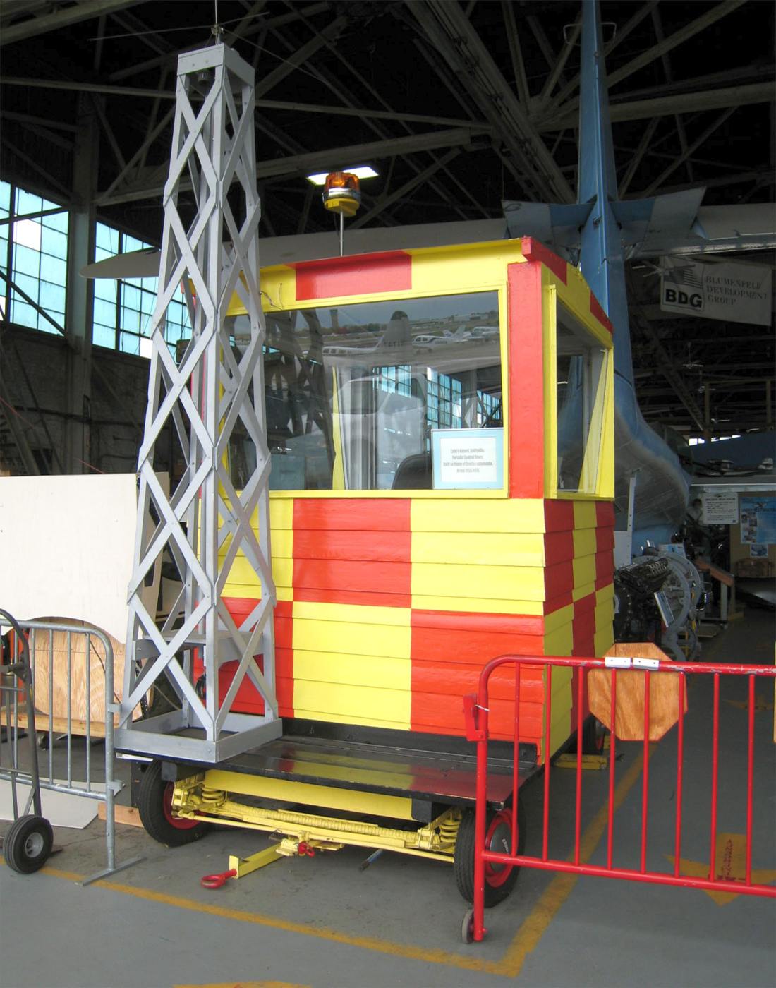
A 2012 photo by Mike Machat of a restored Zahn's Airport Mobile Tower, seen at the American Airpower Museum on Republic Field in Farmingdale.
Thanks to Brett for pointing out this airfield.
See also: Wings Magazine, 8/02.
…………………………………………………………….
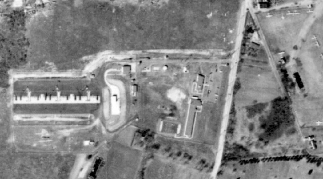
A 1962 aerial view of the Nike Battery NY-24 Launch Site, showing its proximity to the planes parked at Zahn's Airport across the street to the east.
In 1957, the Army built a Nike surface-to-air missile battery across the street, adjacent to the west side of Zahn's Airport.
Nike Battery NY-24 was situated to provide protection to Republic Aviation's plant at Republic Airport.
It was of a somewhat unusual configuration, having 3 of the larger type "B" missile magazines.
These accommodate 30 of the 1st-generation Nike Ajax missiles.
The battery was converted to fire the more advanced Nike Hercules missiles by 1959,
in which configuration it accommodated 18 of the larger Nike Hercules missiles.
Battery NY-24 was manned by the Army's A/505th from 1957-1958, and the A/3/51st from 1958-1964.
It was transferred to the Army National Guard in 1964, who manned it with the A/1/244th.
The earliest photo that has been located of the NY-24 Launch Site was a 1966 aerial view.
It depicted the concrete base of the missile launchers on the west side of the facility,
and an earthen berm for shielding missile fueling operations to the east of the launchers.
Battery NY-24 was one of the longest-lived Nike missile facilities in the New York Defense Area, remaining active until 1974.
During that year, an Army helicopter believed to be loaded with warheads from the site
made an emergency landing at nearby Jones Beach, a popular bathing beach on Long Island's south shore.
Armed soldiers kept startled onlookers & even the park police well away from the scene
until the mysterious cargo could be flown away in yet another helicopter.
A 1980 aerial view of the Nike Battery NY-24 Launch Site, after it had been abandoned.
The concrete base of the launchers were still recognizable, but the earthen berm to the east had been removed.
The entrance to the NY-24 Launch Site is on the west side of Albany Avenue, south of New Highway.
It has been reused as an Army Reserve center.
The missile magazines have been paved over & used as a motor pool, but were still identifiable in a 2006 aerial photo.
All other buildings are still intact as well as the double fence & original lights.
The Integrated Fire Control Site was located 1 mile to the northwest.
The entrance is on the west side of Baiting Place Road, south of Allen Blvd.
It has been reused as an Army National Guard training site, and was labeled "US Military Reservation" on the 1979 USGS topo map.
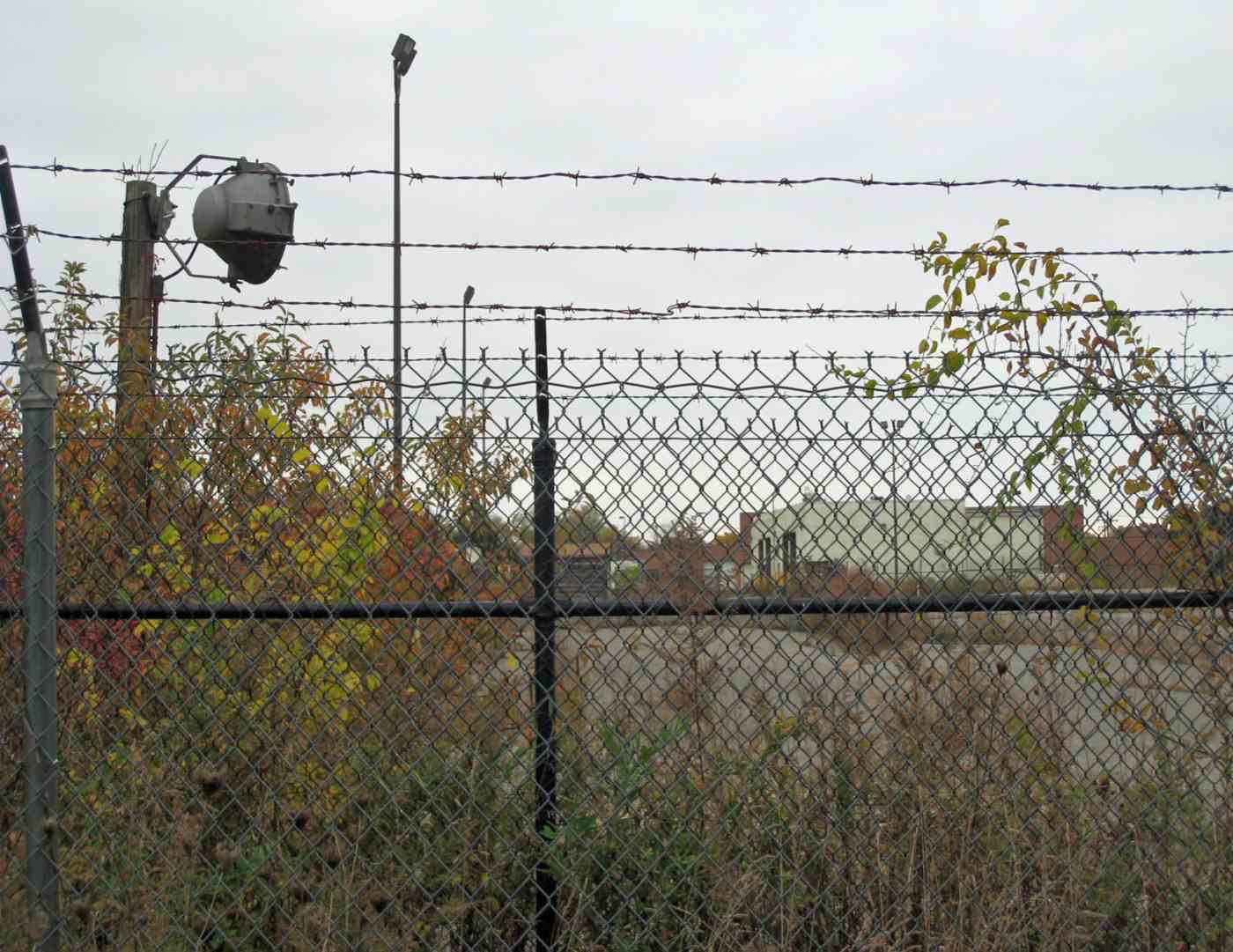
A 2012 photo by Mike Machat of the “Last remaining vestige of the Nike Hercules Site across the street from Zahn's Airport: an original perimeter light & barbed-wire fence.
Paved-over missile bay pads are still visible, although residential housing has now been built over the old Administration & missile assembly areas.”

A 2026 3-D aerial image looking north at the remains of the Nike Hercules NY-24 Launch Site across the street from the Zahn's Airport site,
showing the concrete pads poured over the former missile magazine doors.
For further details of Nike Site NY-24, see: http://alpha.fdu.edu/~bender/NY24.html
____________________________________________________
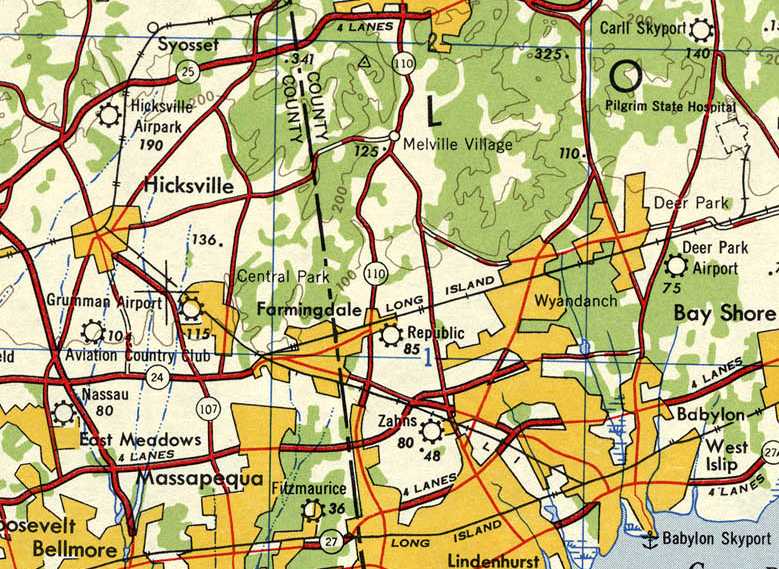
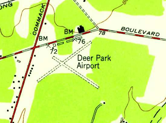
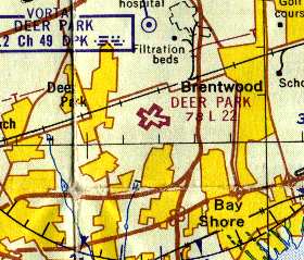
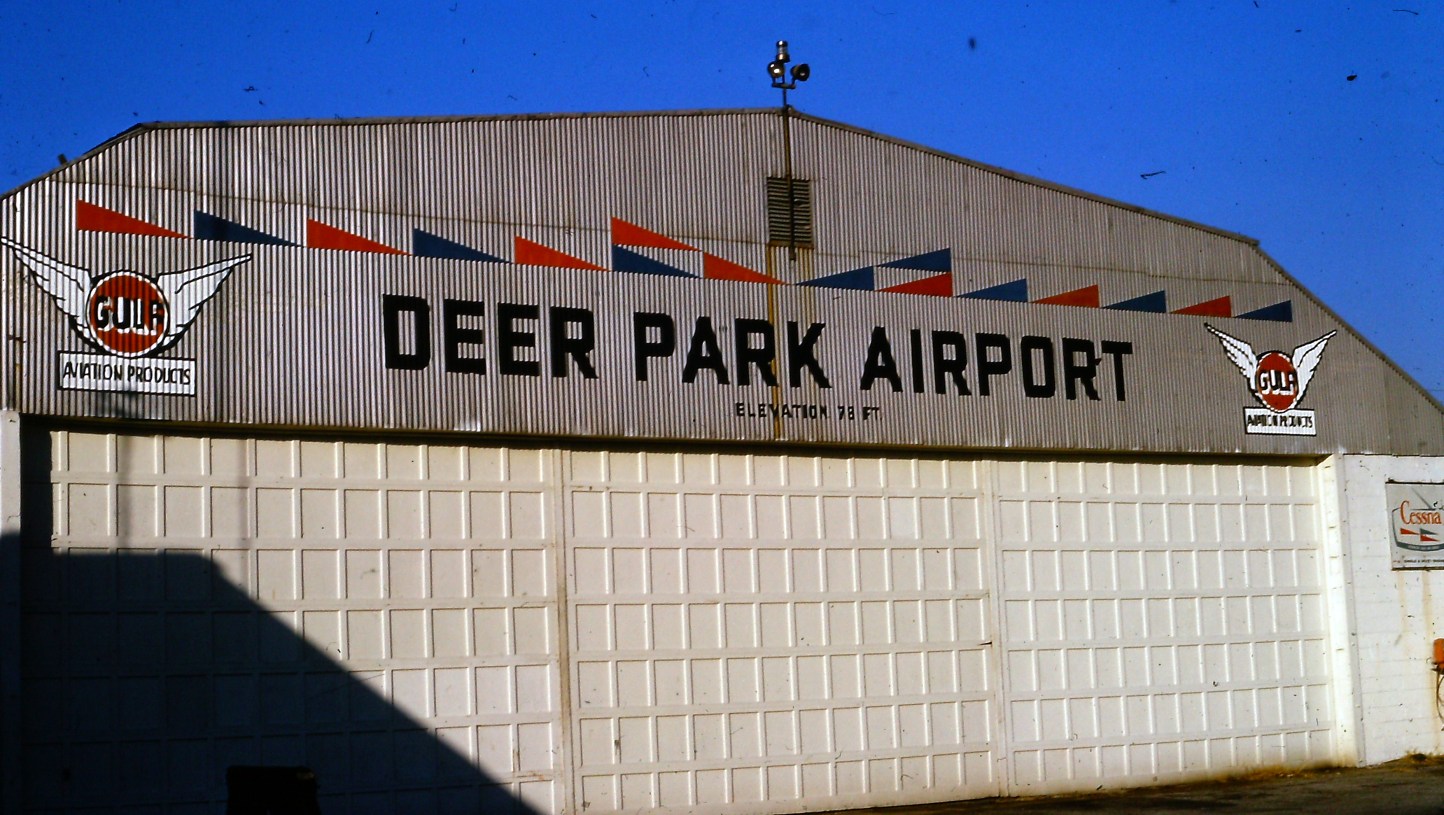
Deer Park Airport, Deer Park, NY
40.76, -73.31 (Northeast of Republic Airport, Long Island, NY)
Deer Park Airport, as depicted on the June 1946 NY Sectional Chart.
Deer Park Airport apparently opened at some point between 1945-46,
as it was not depicted on the November 1945 NY Sectional Chart.
The earliest depiction of Deer Park Airport which has been located was on the June 1946 NY Sectional Chart.
It depicted Deer Park as an auxilliary airfield.
According to Gail Mancuso Jensen, “My Dad, Louis Mancuso was the founder of Deer Park Airport.”
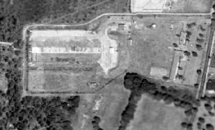
Deer Park Airport, one of an amazing number of airports depicted on Long Island on the 1947 USGS topo map.
The earliest photo of Deer Park Airport which has been located was a 1947 aerial view. It depicted Deer Park Airport as having 2 unpaved runways.
Several hangars were located along the north side of the field, and a half-dozen light aircraft were parked along the north & west sides of the field.
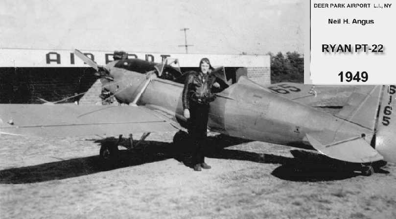
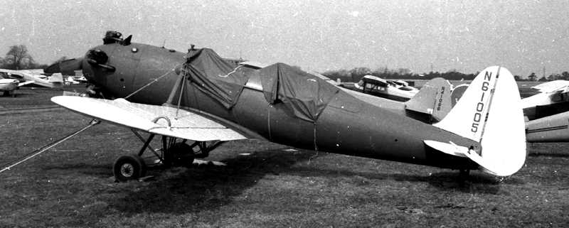
A 1949 photo of Neil Angus in front of a Ryan PT-22 & a Deer Park hangar (courtesy of Neil Angus Jr.).
The earliest aeronautical chart depiction of Deer Park Airport which has been located
was on the July 1949 NY Sectional Chart (courtesy of Ron Plante),
which described the field as having a 2,200' unpaved runway.
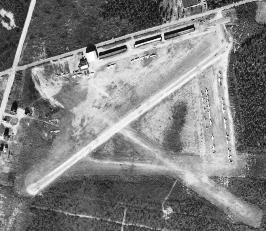
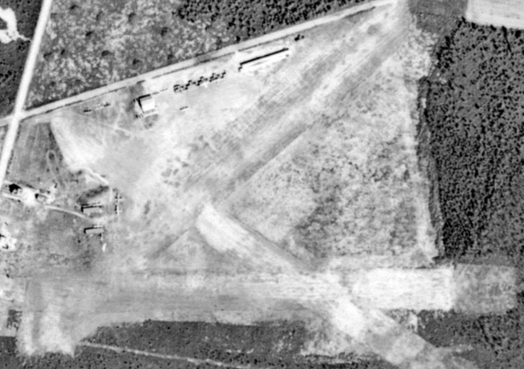
A 12/3/53 aerial view depicted Deer Park Airport as having 2 unpaved runways.
Several hangars were located along the north side of the field, and dozens of light aircraft were parked along the north & east sides of the field.
The 1954 USGS topo map depicted Deer Park Airport as having 2 unpaved runways, with several buildings along the north side.
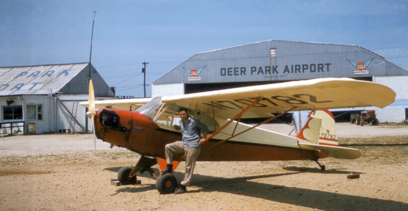
A 1954 photo (courtesy of Bob Mott) of Mario “Yogi” Barra at Deer Park Airport with the Piper Cub he bought for $750 at age 18 from Lou Mancuso who owned the field & operated Mid Island Air Service.
The 1958 NY Sectional Chart (courtesy of Norman Freed) described Deer Park as having 2 paved runways, with the longest being 2,200'.
A 1959 photo by Edd Weninger of a PT-22 at Deer Park Airport.
The primary runway at Deer Park had been lengthened by 1962,
as the 1962 AOPA Airport Directory described the field as having 2 paved runways (3,000' & 2,000' long),
listed & the operators as Mid-Island Air Service & Deer Park Aviation Center.
An early-1960s aerial view looking north at Deer Park Airport (courtesy of Gail Mancuso Jensen),
taken “before one runway was closed due to pressure from the neighboring development.”
The 1967 NY Local Aeronautical Chart (courtesy of Mike Keefe) depicted Deer Park as having 2 paved runways,
with the longest being 2,200'.
Andy Klarmann recalled, "Deer Park was owned by Lou Mancuso."
Lonnie McLaughlin recalled, "Deer Park Airport was located just East of Commack Road
with the entrance to Mid Island Air Service on the South side of Grand Boulevard.
Allied Flyers was located on the South side of the airport in the hangar buildings
(the black line in the aerial view pointing at the West end of Runway 12/30).
My TriPacer was tied down in the area just East of it.
I flew from there from 1967 until just before they closed in 1974.
During that time there was only one (paved) Runway 12/30.
The Southwest/Northeast runway (just barely visible in Britt's photo)
was probably closed due to complaints by the people in the housing development South of the airport,
as they continued complaining about noise even after it was closed.
After its closure, Tony must have sold off the Northeast corner of his property where most of it was
because there were industrial buildings in that area in 1967."
A 1968 photo by Ward Duffield of N2725H, a 1946 Ercoupe 415-C at Deer Park Airport.
Ward recalled, “The airplane was off in the weeds to the west side of the property, near Commack Road.”
A 1968 photo by Ward Duffield of N2725H, a 1946 Ercoupe 415-C at Deer Park Airport.
Ward recalled, “When we inquired at the hangars what its status was they said the owner was 'out of the country', the tiedowns unpaid & it was of no interest to anyone.
So we rounded up our plunder & escaped via bicycle.”
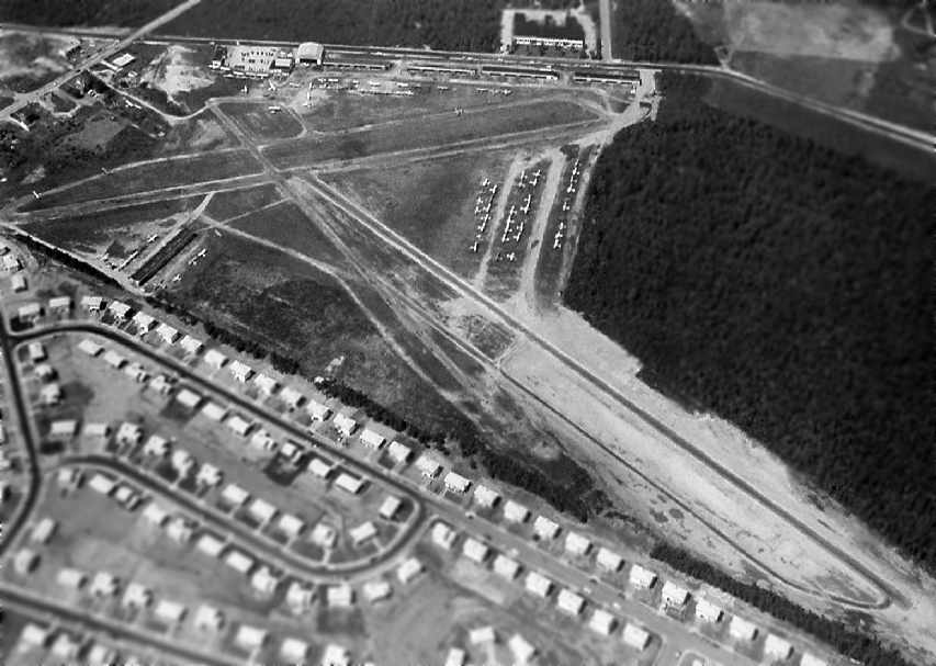
A circa 1971-73 aerial view by Andy Klarmann, from 2,000’ looking northwest at Deer Park's Runway 30 approach end.
A circa 1971-73 aerial view by Andy Klarmann while on final very short final approach to Deer Park's Runway 30.
"You used all 2,375’, but from the condition of the grass short of the runway we rarely landed short."
A circa 1971-73 photo by Andy Klarmann looking north at 2 Cessna 150s of the Allied Flying School,
with the Mid Island Air Service hangar across the field, and the Edgewood Hospital main building in the background.

A circa 1971-73 photo by Andy Klarmann looking north on Commack Road at the Allied sign at the entrance to Deer Park.
"It was Autumn in more ways than one."
An aerial view by Lonnie McLaughlin of Deer Park Airport in 1972 (note the X'ed-out crosswind runway).
A circa 1972-74 photo by James Kovacsik (courtesy of Bob Mott) of a Deer Park Airport hangar.
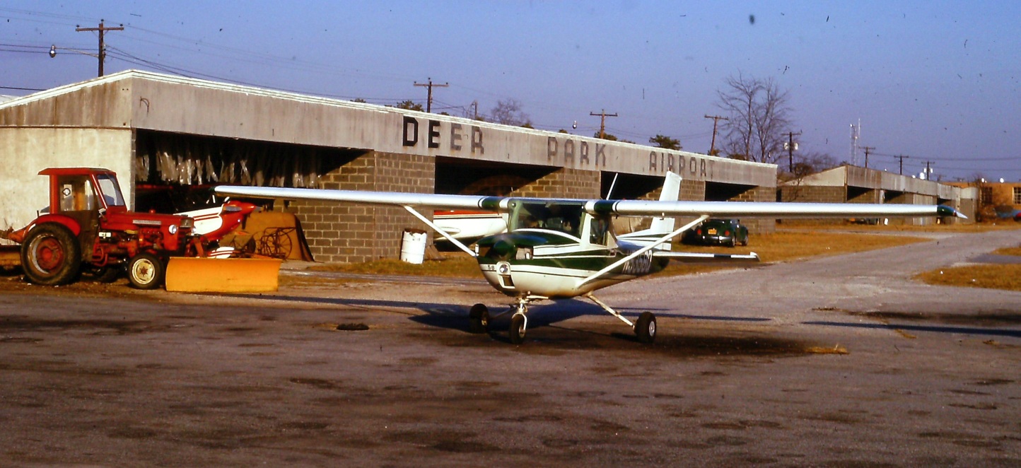
A circa 1972-74 photo by James Kovacsik (courtesy of Bob Mott) of a Cessna 150 or 152 in front of Deer Park Airport hangars.
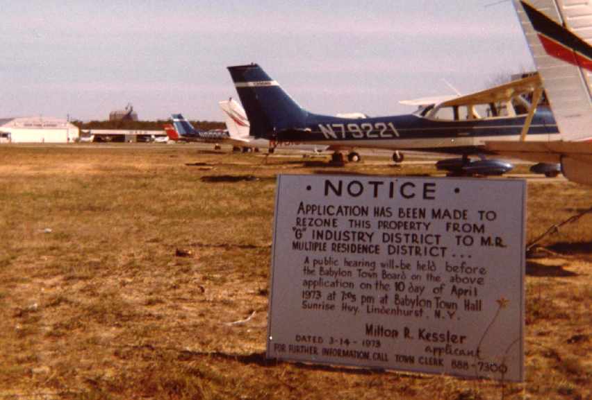
A 1973 photo by Andy Klarmann of "of the notice which appeared at the airport entrance one morning.
As with most things the deal was already done & Deer Park was closed by early 1974.
It was no longer a place where a kid on a bike could hang on the fence or trade working the line for flying lessons.
I think those days are gone forever."
According to Gail Mancuso Jensen, “Dad [Louis Mancuso] closed Deer Park Airport
and moved the branch to Islip Airport in 1973.”
The last aeronautical chart depiction which has been located of Deer Park Airport
was on the June 1973 NY Sectional Chart (courtesy of Ron Plante),
which depicted Deer Park as having 2 paved runways, with the longest being 2,400'.
According to Andy Klarmann, "The last 2 operators were Mid Island Air Service (airport owner) and Allied Flyers.
Allied relocated to Islip MacArthur Airport.
The airport closed in early 1974 & the last airplane to leave (N60594)
was flown by my flight instructor, Bill Burke.
This was about a week after the runways were X'ed out.
He got caught out with a student in a snow squall & could not get back into ISP."
A 3/14/74 USGS aerial photo showed Deer Park Airport shortly after its closure,
devoid of aircraft, and with a row of buildings having already covered the northeastern end of the southwest/northeast runway.
By the time of the December 1979 NY Sectional Chart (courtesy of Ron Plante),
Deer Park Airport was no longer depicted at all (not even as an abandoned airfield).
A 1980 aerial view showed that one former hangar still remained standing on the north side of the field.
A 2023 aerial photo showed no trace of Deer Park Airport remains.
The site of Deer Park Airport is located north of Headline Road, east of Commack Road, five miles northeast of Republic Airport.
Thanks to Brett for pointing out this airfield.
____________________________________________________
Or if you prefer to contact me directly concerning a contribution (for a mailing address to send a check),
please contact me at: paulandterryfreeman@gmail.com
If you enjoy this web site, please support it with a financial contribution.
____________________________________________________
This site covers airfields in all 50 states.