Abandoned & Little-Known Airfields:
New York State: Buffalo area
© 2002, © 2024 by Paul Freeman. Revised 7/9/24.
This site covers airfields in all 50 states: Click here for the site's main menu.
____________________________________________________
Please consider a financial contribution to support the continued growth & operation of this site.
Amherst Airport (revised 4/15/22) - Audubon Airport (revised 4/15/22) - Curtiss Aerodrome (revised 11/22/23) - Evans Airways Airfield / Angola Airways Airfield / Angola Airport (revised 11/14/19)
Becker Airport (revised 12/4/22) - Consolidated Aircraft / Bell Airport / Tonawanda Airport (revised 11/22/23) - County Line Airport (revised 9/24/19) - Fredonia Airport / Van Buren Flying Club (revised 5/8/18)
Goat Island Heliport (revised 11/30/18) - Hamburg Airpark (revised 1/15/23) – Lakeview Airport / Hayes Airport / Blasdell Airport (added 11/20/20) - Midway Airport (added 10/17/23)
Olean Airport (revised 6/12/20) - Orchard Park Airport (revised 4/30/18) - Proner Airport (revised 3/17/22) - Sheridan Airport (revised 1/15/23)
Transit Airport / North Buffalo Suburban Airport (added 7/9/24) - Original Wellsville Municipal Airport / Crowner Airport (revised 9/29/19)
____________________________________________________
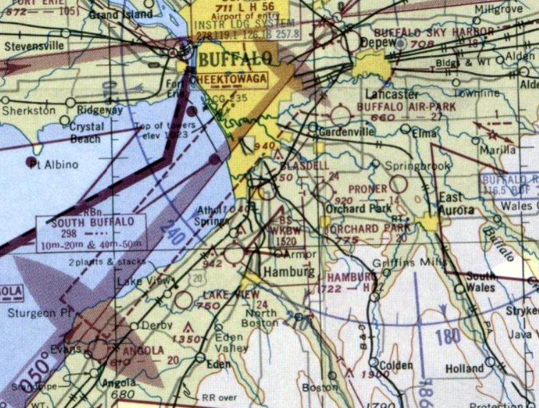
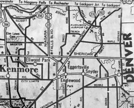
Transit Airport / North Buffalo Suburban Airport (0G0), Lockport, NY
43.103, -78.701 (Northeast of Buffalo, NY)
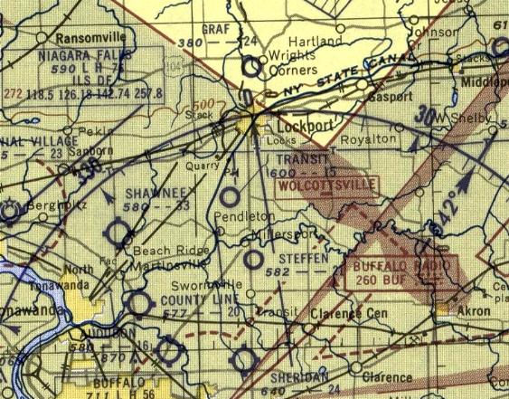
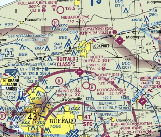
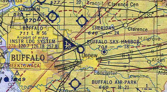
Transit Airport, as depicted on the May 1954 Detroit Sectional Chart.
This small general aviation airport was evidently established at some point between 1953-54,
as it was not yet depicted on the 1953 Detroit Sectional Chart.
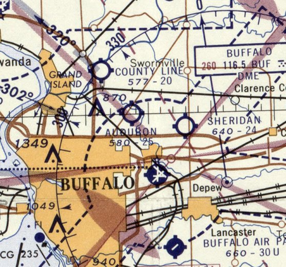
The earliest depiction which has been located of Transit Airport was on the May 1954 Detroit Sectional Chart.
It depicted Trabsit Airport as having a mere 1,500' unpaved runway.
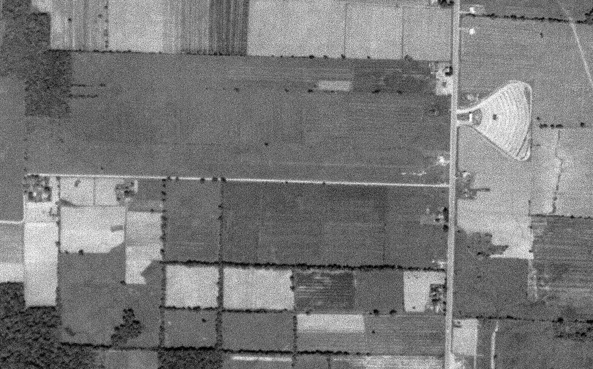
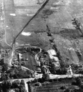
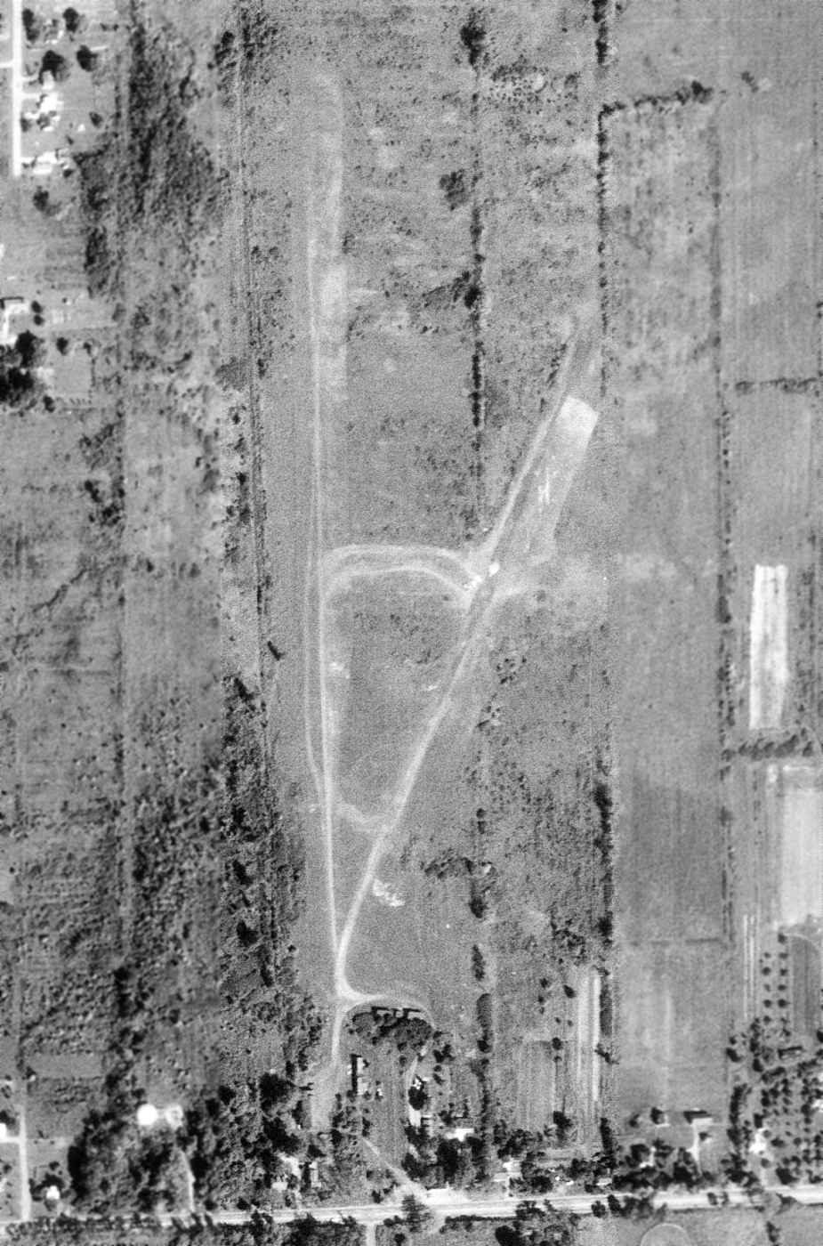
The earliest photo which has been located of Transit Airport was a 1958 USGS aerial view.
It depicted a single grass east/west runway. No planes or buildings were visible on the field. Note the drive-in movie theater across the street.
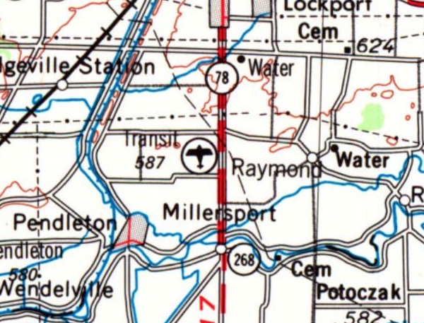
The earliest topo map depiction which has been located of Transit Airport was on the 1962 USGS topo map.
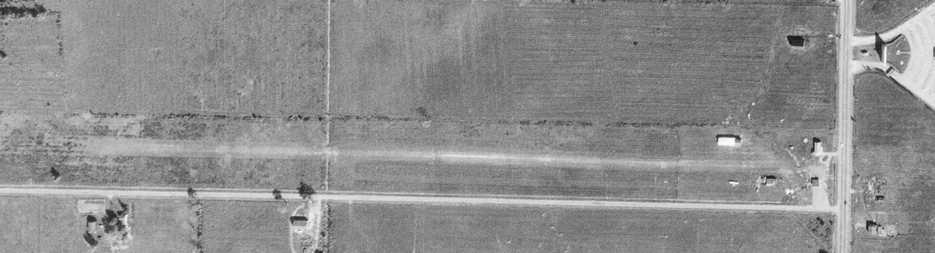
A 9/24/63 1958 USGS aerial view depicted Transit Airport as having a single grass east/west runway.
One light single-engine plane was parked near a few small buildings pn the east side.
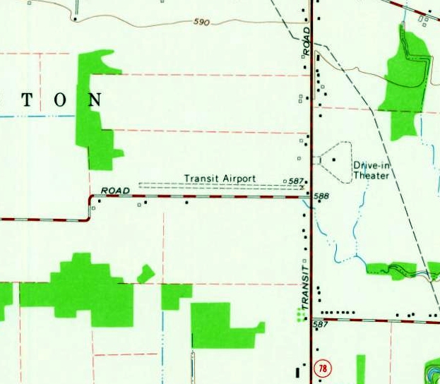
The 1965 USGS topo map depicted Transit Airport as having a single unpaved east/west runway, with 3 small buildings on the east side, and a drive-in movie theater across the street.
Transit Airport apparently gained a paved runway at some point between 1965-70,
as the 1970 Detroit Sectional Chart depicted it as having a 2,400' east/west paved runway.
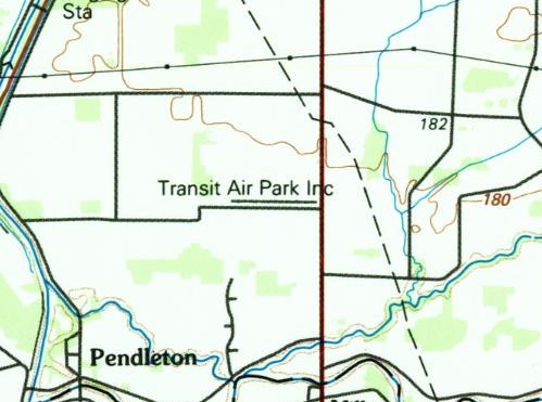
The 1984 USGS topo map depicted “Transit Air Park Inc.” as having a single paved east/west runway.
Transit Airport was evidently renamed North Buffalo Suburban Airport at some point between 1984-93,
as that is how it was depicted on the October 1993 Detroit Sectional Chart (courtesy of Ron Plante).
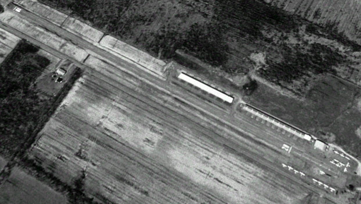
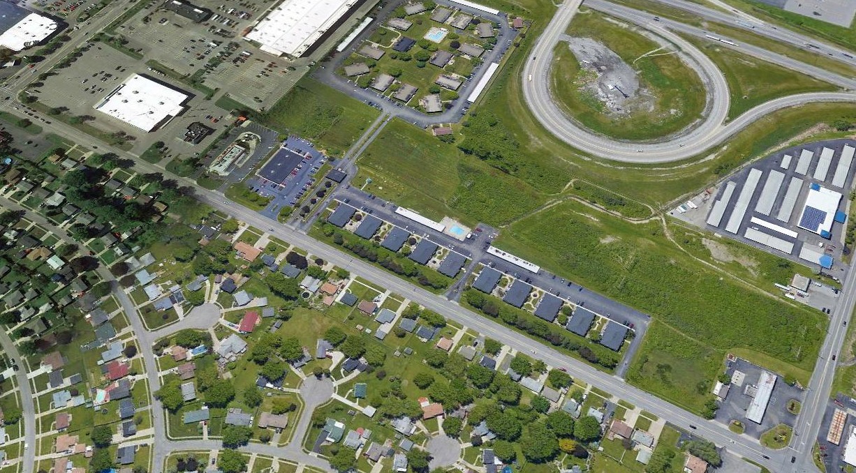
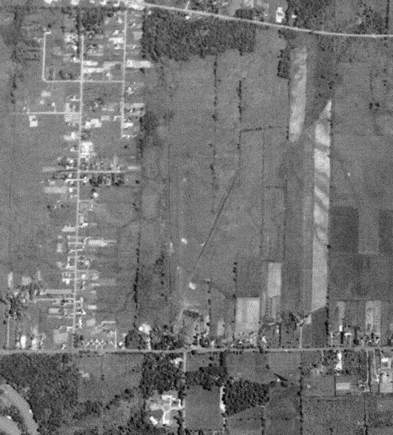
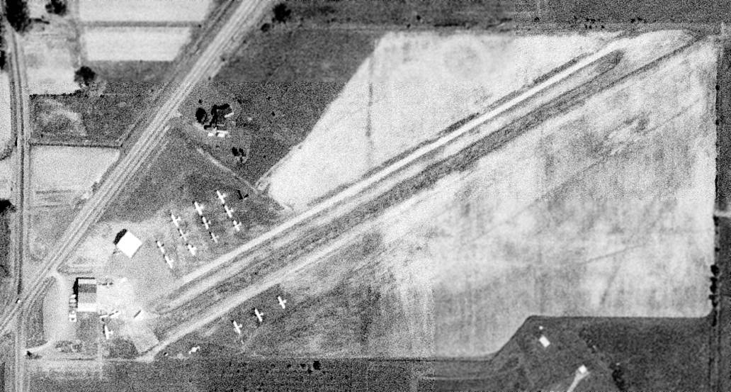
A 1995 aerial view looking northwest depicted North Buffalo Suburban Airport at perhaps the zenith of its popularity, with 18 light single-engine planes parked on the east side, and 2 long rows of T-hangars on the northeast side.
A 2011 photo looking northwest showed North Buffalo Suburban Airport devoid of aircraft.
The last aeronautical chart depiction which has been located of North Buffalo Suburban Airport was on the 2018 Detroit Sectional Chart.
It depicted North Buffalo Suburban Airport as having a single 2,800' paved east/west runway.
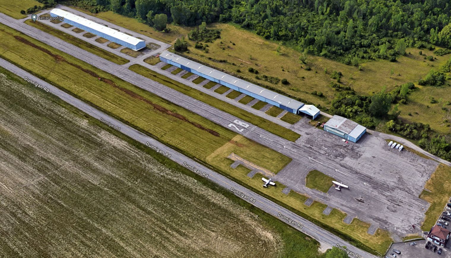
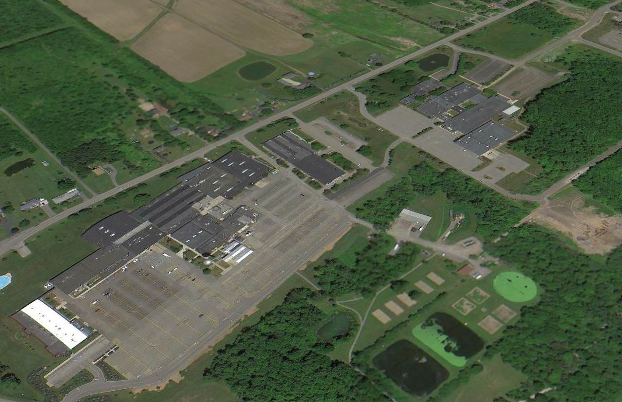
A circa 2020 3-D aerial image looking northwest showed North Buffalo Suburban Airport to have 2 light single-engine planes parked outside.
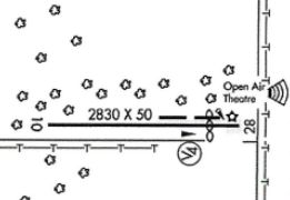
The 2022 Airport/Facility Directory (courtesy of Randy Coller) depicted North Buffalo Suburban Airport as haivng a 2,830' paved Runway 10/28.
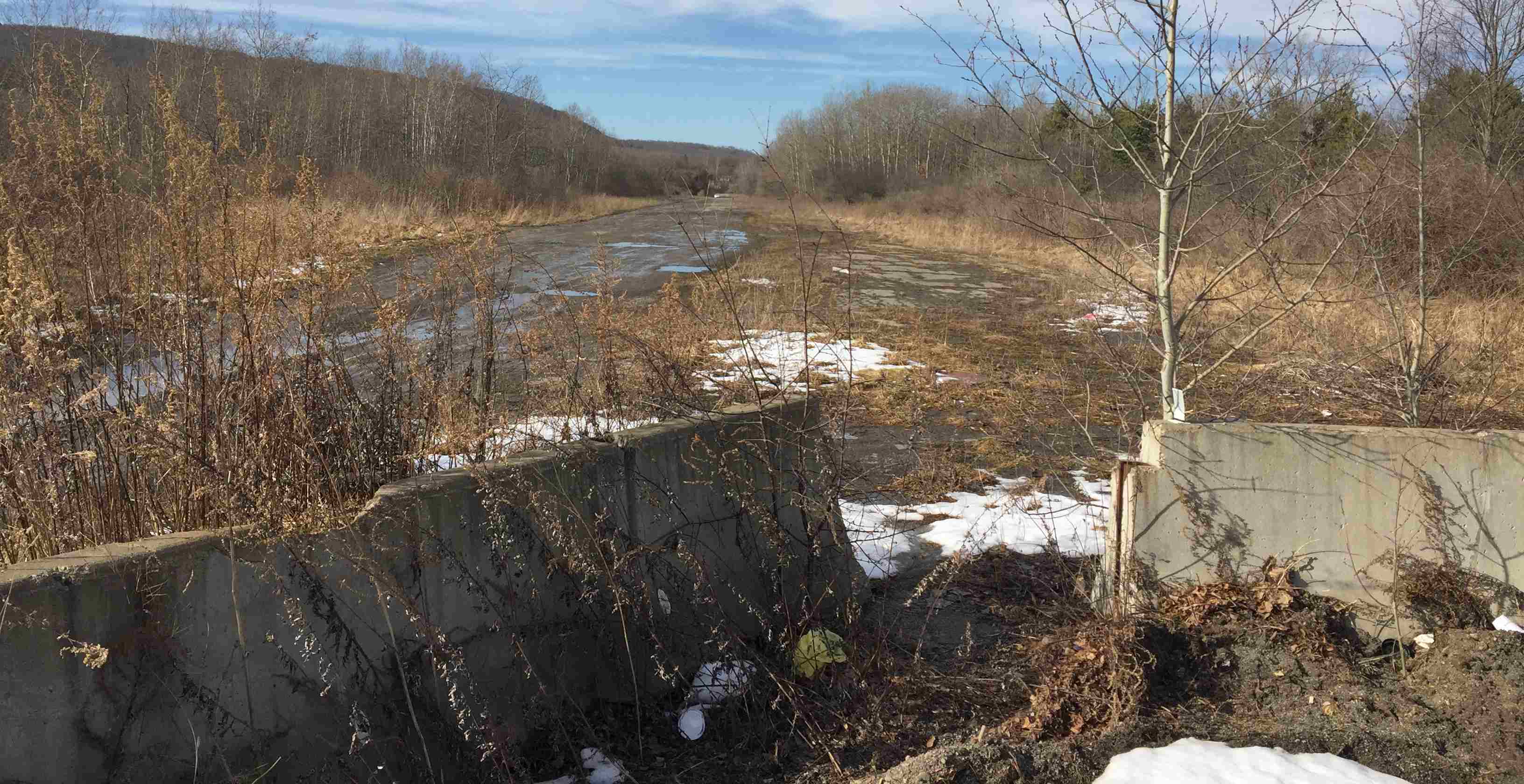
Randy Coller reported, “North Buffalo Suburban Airport... I inspected it 7/11/2022 & it was in the process of being abandoned.
When I was there it was being converted into a construction storage lot. There were 2 swimming pools on the runway.
Typical of a privately-owned airport in an urban area where the value of the property is more than the property is worth as an airport.”
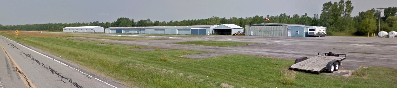
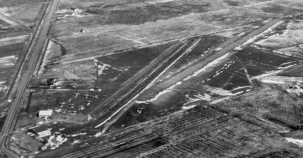
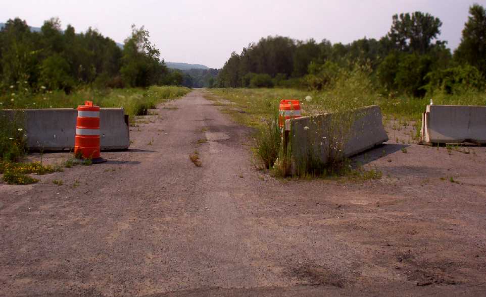
A 2023 photo looking northwest showed 1 Piper Cherokee to remain parked at North Buffalo Suburban Airport.
A 2023 photo looking west showed North Buffalo Suburban Airport to remain intact.
A 2023 aerial view looking northwest showed 1 Piper Cherokee to remain parked at North Buffalo Suburban Airport.
As of 2024, North Buffalo Suburban Airport was no longer depicted on Sectional Charts.
Thanks to Randy Coller for pointing out this airfield.
____________________________________________________
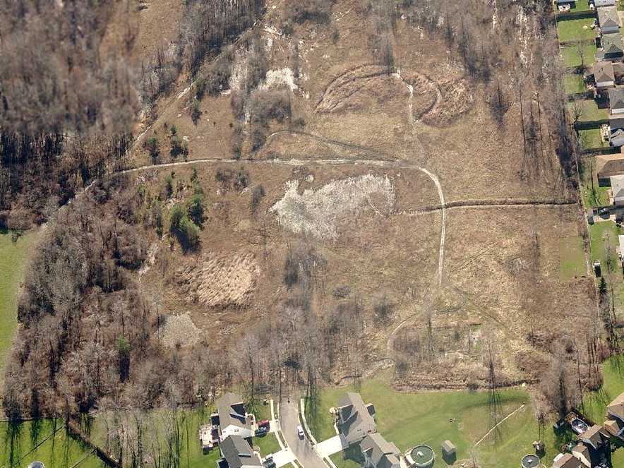
Midway Airport (0G5), Olean, NY
42.088, -78.478 (South of Buffalo, NY)
Midway Airport, as depicted on the 1949 Sectional Chart (courtesy of Jonathan Westerling).
Photo of the airport while open is unavailable.
This small general aviation airport was evidently established at some point between 1948-49,
as it was not yet depicted on the December 1948 Detroit Sectional Chart.
The earliest depiction which has been located of Midway Airport was on the 1949 Sectional Chart (courtesy of Jonathan Westerling).
It depicted Midway Airport as having a mere 1,900' unpaved runway.
The 1950 Sectional Chart (courtesy of Jonathan Westerling) described Midway Airport as having a single 1,850' runway.
The 1954 Airport Business & Flying Directory (courtesy of Jonathan Westerling) described Midway Airport as having 2 unpaved runways, measuring 1,850' east/west & 1,200' northwest/southeast.
The manager was listed as William Fox.
The earliest photo which has been located of Midway Airport was a 1955 aerial view.
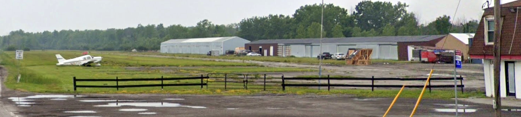
It depicted 4 light single-engine planes parked near 3 small buildings on the south side of the airfield, which consisted of a single grass northwest/southeast runway.
The last photo which has been located showing Midway Airport still open was a 1960 aerial view.
It depicted 1 light single-engine plane parked on the south side of the airfield, which otherwise remained unchanged.
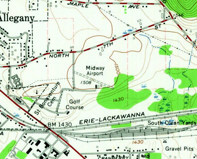
The earliest topo map depiction which has been located of Midway Airport was on the 1961 USGS topo map.
It depicted Midway Airport as having a single northwest/southeast unpaved runway, with 3 small buildings on the south side.
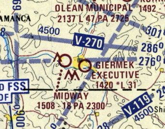
The last aeronautical chart depiction which has been located of Midway Airport was on the 1973 Flight Chart (courtesy of Jonathan Westerling).
It depicted Midway Airport as having an 1,800' unpaved runway.
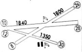
The depiction which has been located of Midway Airport was in the 1975 Flight Guide (courtesy of Jonathan Westerling).
It depicted Midway Airport as having 3 unpaved runways, with the longest being the 1,840' Runway 10/28,
and having 2 small buildings on the south side.
The last airport directory listing which has been located of Midway Airport was in the 1979 AOPA Airports USA directory (courtesy of Jonathan Westerling).
It described Midway Airport as having 3 unpaved runways, with the longest being the 1,840' Runway 10/28.
Midway Airport was evidently closed (for reasons unknown) at some point between 1979-85,
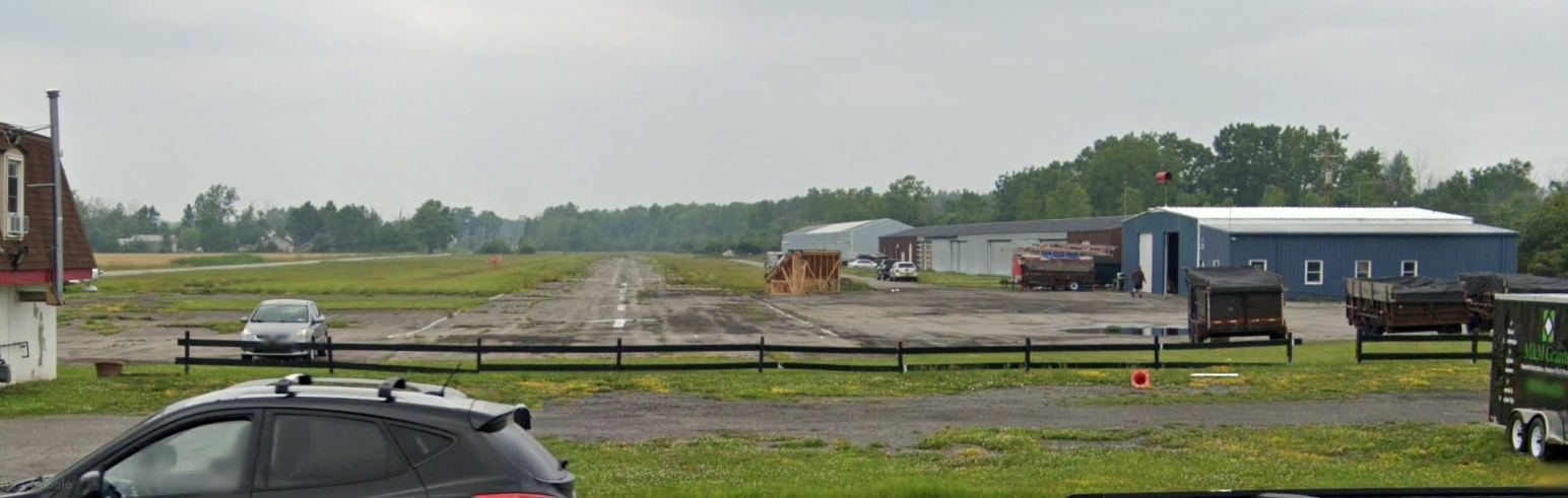
as a 1985 aerial view showed the airport buildings had been removed at some point between 1960-85.
The property otherwise remained clear & unredeveloped.
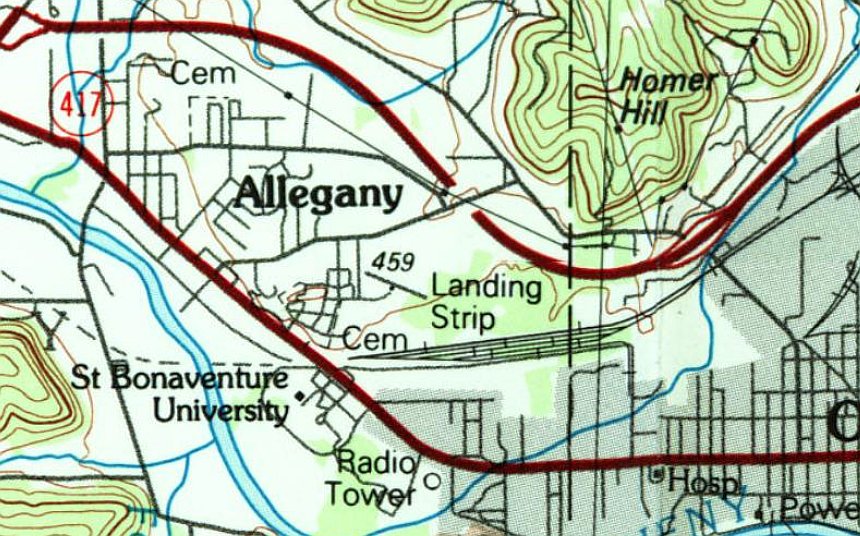
The last topo map depiction which has been located of Midway Airport was on the 1986 USGS topo map.
It depicted a single northwest/southeast runway, generically labeled as “Landing Strip”.
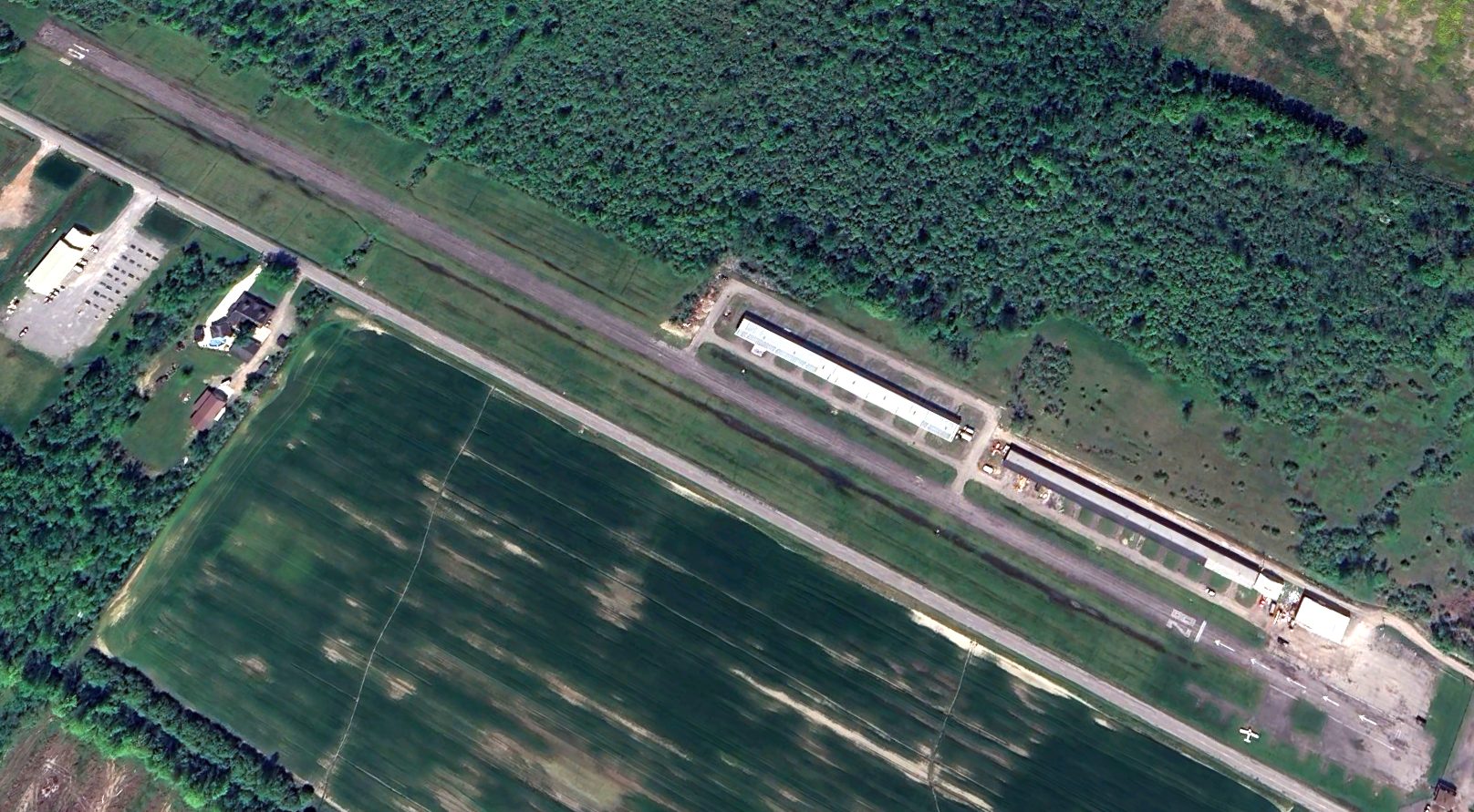
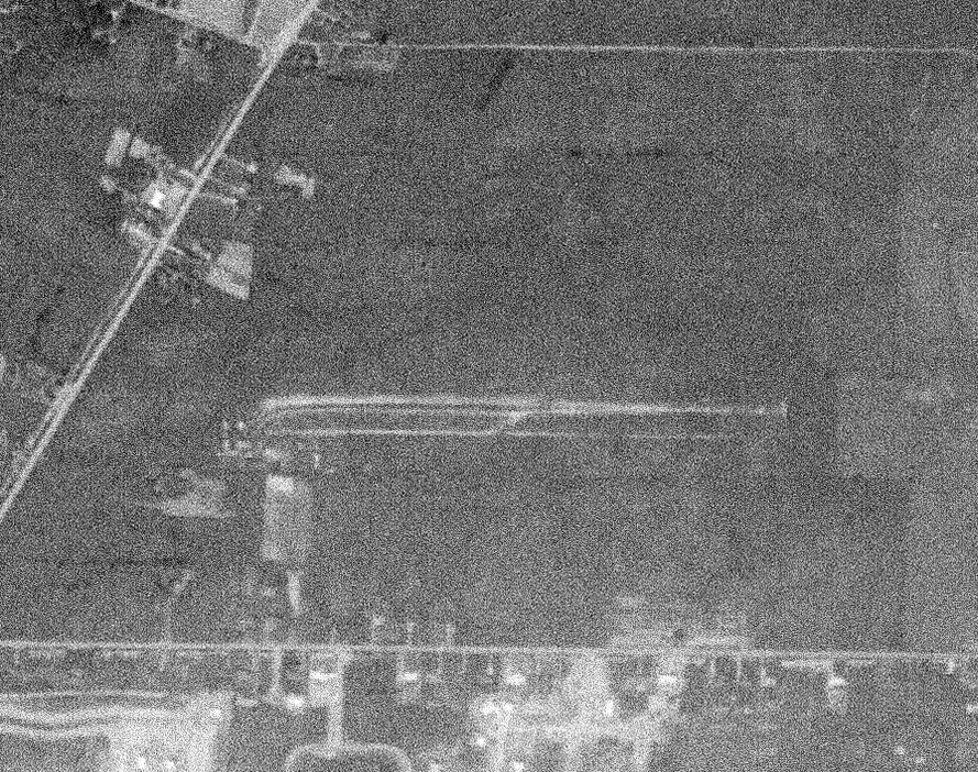
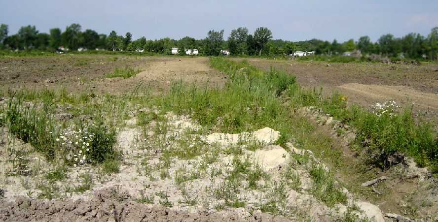
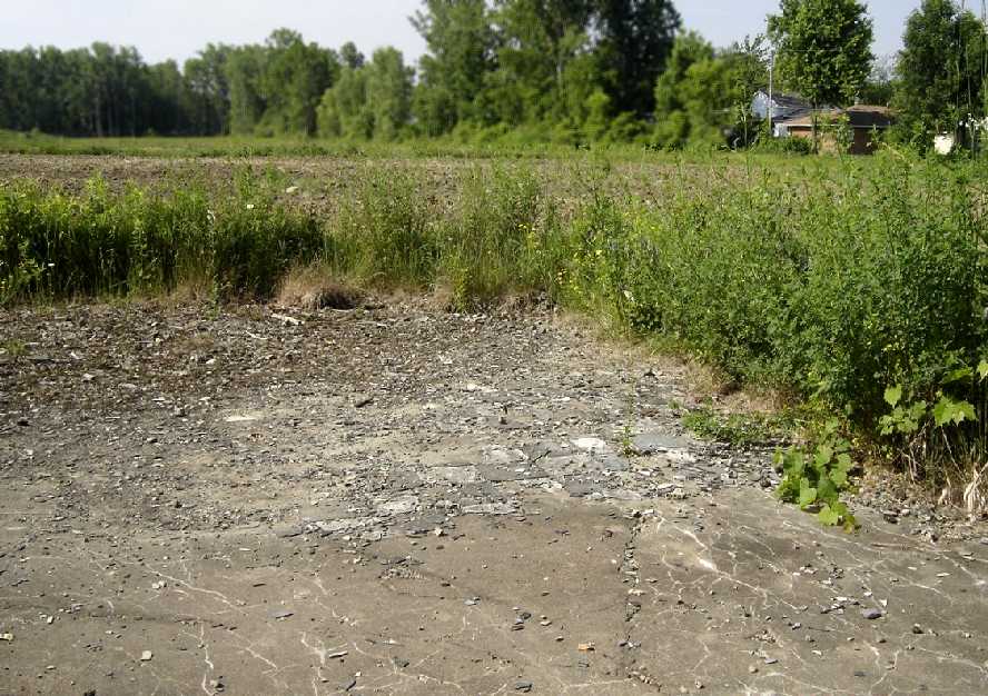
A 2022 aerial view depicted only the faintest ghosted trace of the former Midway Airport northwest/southeast grass runway, with the property remaining vacant roughly 4 decades after the little airport's closure.
Thanks to Jonathan Westerling for pointing out this airfield.
____________________________________________________
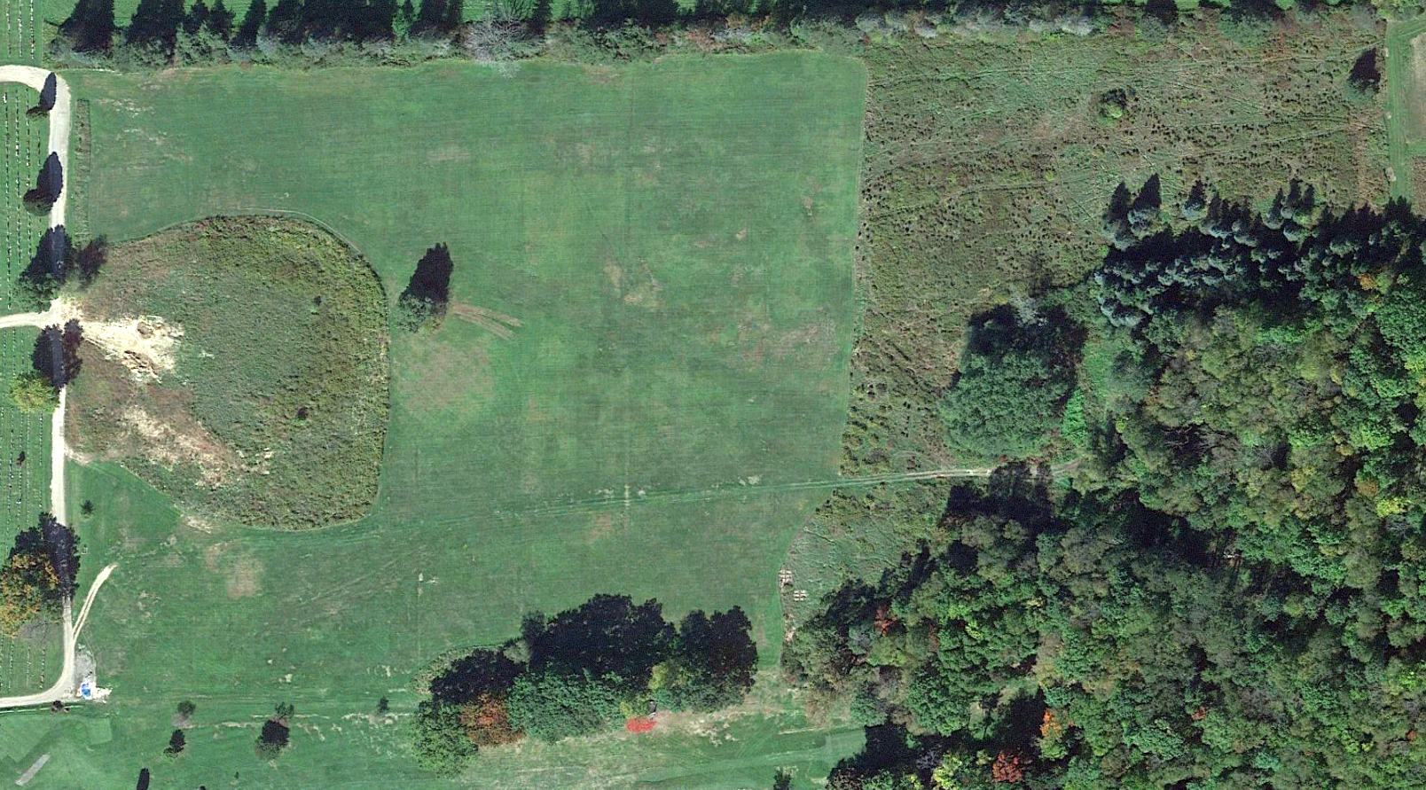
Curtiss Aerodrome, Buffalo, NY
42.984, -78.838 (Northeast of Downtown Buffalo, NY)
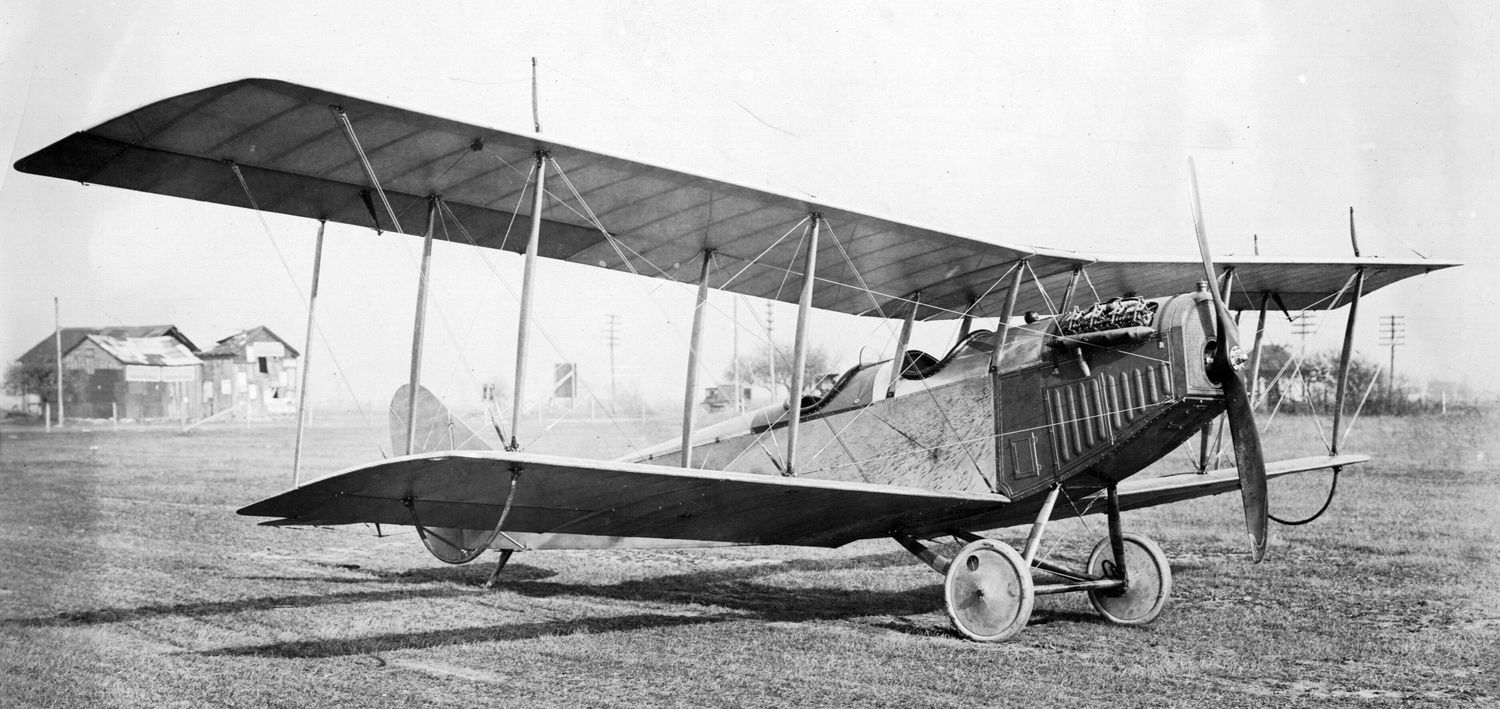
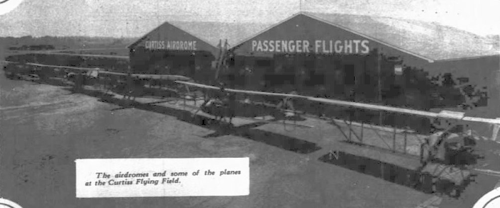
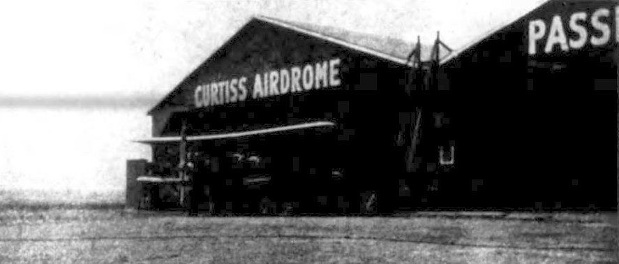
A 10/28/16 photo of a Curtiss JN-4A Jenny at the Curtiss Aerodrome.
According to the History of the Town of Tonowanda, the Curtiss Aerodrome opened in 1915.
“Initially, Curtiss leased the farmland to create an airstrip for the purpose of testing its military aircraft.
Over the next 2 years facilities were added as its focus shifted to the training of aviation students, including a group of young men from Harvard who camped out in an abutting orchard.
With the outbreak of World War I, the Aerodrome was taken over by the US Government & the airfield rededicated to the testing of military aircraft,
training of military aviators & observation including troops training at nearby Camp Kenilworth.
After the Armistice, the demand for military aircraft fell & the flooding of British aircraft into the government market
resulted in Curtiss somewhat shifting its product line to meet the needs of the nascent recreational & commercial aircraft markets.
The Aerodrome hence became primarily a demonstration field of its aircraft to private individuals & companies.”
The earliest photo which has been located of the Curtiss Aerodrome was a 10/28/16 photo of a Curtiss JN-4A Jenny.
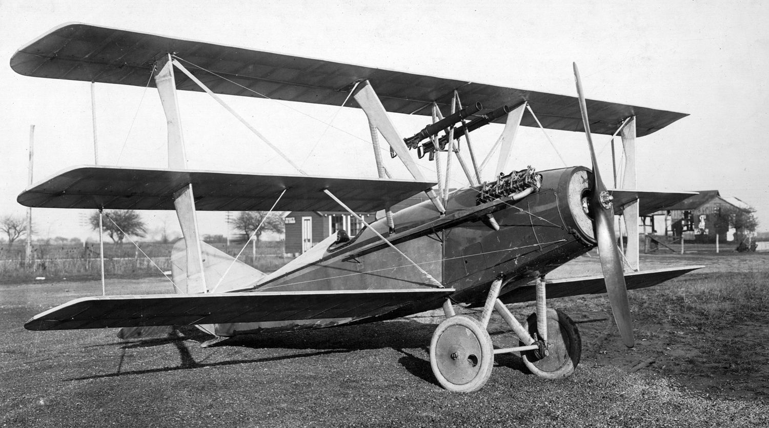
A 1917 photo of the sole prototype of the Curtiss S-6 pursuit plane at the Curtiss Aerodrome.
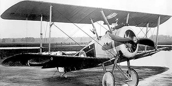
A 1918 photo of a Hale biplane at the Curtiss Aerodrome.
A 1919 photo of a construction crew at the Curtiss Aerodrome in Buffalo.
A 1919 photo of several unidentified biplanes at the Curtiss Aerodrome in Buffalo.
The Town of Tonowanda article continued, “The year 1920 would mark the beginning of the 'Barnstorming Era' in American aviation & thus a pivotal year in the airfield's history.
Although the Aerodrome was still used by Curtiss for the purposes stated above, the airfield came to also serve a variety of others.
The Aerodrome would hence become a very busy airfield indeed in and around the years that the Johnson Flying Service controlled it.
It had been during this same pivotal year when the Johnson Airplane & Supply Company was organized in Dayton, OH.
A flood of aviation companies were entering the burgeoning industry with most failing.
Yet the Johnsons had vision, business acumen & a wide web of industry connections - including a close one with Glenn Curtiss.
Within a few years the commercial aviation side had prospered to the extent that it was decided to split the company in two.
Conversations with Curtiss led to the decision to headquarter the new Flying Service at the Curtiss Aerodrome in 1924.
Curtiss had in reality not actively managed the Aerodrome since before US entry into WWI;
with the US Government running it during the War & mostly Lieutenant Edward Ronne afterwards on a revenue-sharing basis.
One of the two company presidents, James Johnson, relocated to Buffalo & 21 full-time employees were hired or relocated to Johnson's new headquarters at the Aerodrome.
To reiterate, Johnson's main interest in the airfield was stated as a base for its growing passenger flight business.
Johnson provided services to transport passengers & time-sensitive small freight shipments throughout the region.
It also provided individuals an opportunity to take a local touring flight with an experienced pilot.
It is a bit humorous to note that wives made up the majority of this business.
They were apparently much less afraid than their husbands who preferred to remain in the 'one-foot-on-the-ground-club'.”
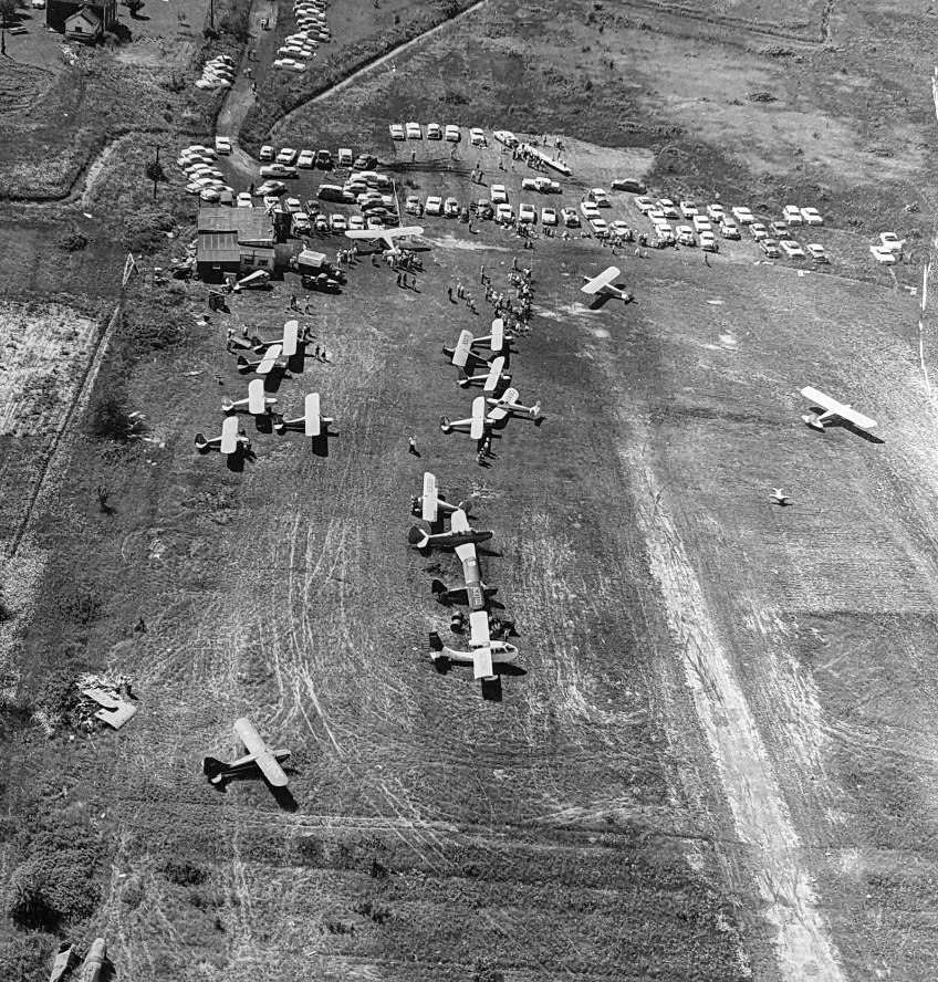
A 1920 aerial view looking northeast at the Curtiss Aerodrome in Buffalo during an airshow.
The Town of Tonowanda article continued, “The use of the Aerodrome for commercial flights had started back in 1920 at roughly 1,000 passengers for the year & then had grown annually.
Airplane safety had advanced rapidly in just a few years. Just a couple years previous 6 aviators had died at the airfield in one particularly bad stretch of only 7 weeks.
By mid-1925, the Curtiss & the Johnson Flying Services had flown 15,000 passengers without incident at the Aerodrome.
It was not until 8/1/26 when the only commercial accident would occur.
An airplane with 2 passengers hit a construction ditch during takeoff & struck an auto on new Sheridan Drive.
Five injuries resulted from the collision, but miraculously no fatalities occurred.”
The Town of Tonowanda article continued, “Mention should be made that the Aerodrome saw its first commercial takeoff & landing in 1919
when a Lawson Airliner C1 stopped at the airfield as part of a demonstration tour. It was considered the world's first airliner.
Its stop in the town was to drum up publicity & as the airfield was intended to be used in the future for part of its regular flight service.
A historical note is that a female boarded the 10-passenger airliner at the Aerodrome for the next hop to Syracuse.
She is considered the world's first female airline passenger.
Lawson's next model, the 26-passenger C2, did not include the Aerodrome as it was considered too small.
This would become an increasing issue as airplanes quickly began to grow in size & increase in speed.
As for Lawson's pioneering company, a crash of a test plane & funding issues led to the company folding before it could put its 1922 100-passenger aircraft into commercial production.”
A circa 1920s photo of Jimmy Doolittle & an unidentified biplane at the Curtiss Aerodrome in Buffalo.
The Town of Tonowanda article continued, “Johnson also became responsible for overseeing private recreational aviation at the airfield.
The popular Aero Club of Buffalo based its activities at the Aerodrome & was given as a major reason why by 1924 the Buffalo area boasted the most private airplanes in the United States.
Most were stored at the airfield but hangar space (each could only hold 6 airplanes)
had risen to a premium with few options for available land to build more hangars to store the growing recreational fleet.
A larger hangar [was] built by Johnson to accommodate some of the private aircraft on the corner of Sheridan Drive & Guideboard (Eggert) Road.”
A circa 1920s photo of hangars at the Curtiss Aerodrome in Buffalo.
The Town of Tonowanda article continued, “The Aero Club would coordinate with Curtiss & later Johnson the very popular aerial shows.
Spectators had flocked to the Aerodrome since its opening to see the wonders of the 'flying machines'.
Air shows became frequent at the Aerodrome & featured air races, acrobatic stunts, and feats of air superiority.
A 1924 'Air Carnival' featured Army aviators doing stunts, team aerial polo as pilots chased colored balloons,
and even included displays of day & nighttime fireworks dropped from airplanes.
Over 4,000 vehicles parked at or near the field with 50,000 spectators eager to witness stunt flying & parachute drops.
Spectators thronged the stands & law enforcement strained to keep the crowds back.
One stunt featured a returned veteran of the airfield, Jimmy Doolittle. The future WW2 general & national hero had been a test pilot at various airfields around the country.
He returned to the Aerodrome on this & other occasions to enthrall the crowd with his aerial wizardry.
On this day he shut off the engine to his giant Fokker & let the plane turn into a barrel spin as it fell like a leaf.
He waited until it descended all the way down to the height of the top of the main hangar's flagpole before turning on the engine & speeding away.”
The Town of Tonowanda article continued, “Moving on, Curtiss had started the formal instruction of pilots early on at the Aerodrome & would continue to do so for many years into the future.
Yet during the time when Johnson ran the airfield, one of the nation's first dedicated aviation colleges was established in addition to the recreational & military pilot training which continued to be offered.
The 45 day intensive program focused on preparing students for the surging employment opportunities in commercial aviation
with a focus on mechanics, straight flying instruction (control and balance), and finishing with courses on taking off & landing.
Unlike the military training at the field & elsewhere, stunt flying was by design not part of the curriculum at the Flying Service School.
It was also at this time that local photographer Milton Washburn made a breakthrough in the nascent field of aerial photography.
As a result, he and Ronne would take countless aerial photographs of WNY starting in 1924.”
The Town of Tonowanda article continued, “The airfield also came to represent a 'red carpet' of sorts during this eventful period of the airfield.
Many dignitaries, notables & celebrities had begun to use air travel as the most common means to travel long distances.
Buffalo's Mayor Schwab & other local dignitaries made frequent trips to the airfield to greet arriving VIPs, and of course, for the publicity of the photo ops such arrivals gave rise to.”
The Town of Tonowanda article continued, “In 1924, the airfield also gave birth to the Buffalo Aerial Police.
A handful of other large urban centers in the country were establishing aerial law enforcement squadrons, so it seemed only natural that Buffalo should do the same.
The news excited local politicians & the newspapers, but Chief Zimmerman of the Buffalo Police Department was skeptical that it would serve of great utility.
A major driver behind it was the common belief held at the time that within a handful of years airplane travel would replace that by automobile as the primary means of daily transportation in the country.
Aerial police would be needed to control air traffic & 'ticket' pilots who broke air travel ordinances.
In practice, the 6-plane squadron only proved beneficial in occasionally searching for missing & drowned individuals on Lake Erie & the Niagara River.
As the unit was composed of volunteers, and an airplane always remained on call, the Buffalo Police decided no harm could be done in swearing in the 6 pilots.
The unit would eventually be moved to the new Buffalo Airport.”
The Town of Tonowanda article continued, “One of the most exciting events for WNY in this same year was the arrival of the Shenedoah, the American 'Queen of the Air', at the airfield.
The large Navy dirigible went on a public relations ride over the East Coast.
After reaching Niagara Falls, the dirigible headed south to the Aerodrome where it was met by a small fleet of airplanes which served as an honor guard.
Traffic was backed up along Main Street as thousands tried to get to the airfield.
Those who could erupted in hysterical applause when a man in a lookout tower on top of a hangar shrieked, 'There it is! It's coming!'
The airplanes took off to more cheering & accompanied the Shenandoah as it cruised over Buffalo before turning back east.
The crowd waited for the pilots to return to give them a hero's welcome.”
A 1925 aerial view of the Curtiss Aerodrome in Buffalo during an airshow.
The Town of Tonowanda article continued, “It can not be determined why Johnson handed back control of the airfield to Ronne half way into 1925.
It was most likely due to the success of the airfield & the inability to expand southwards due to the Rochevot land estate.
1924 was also the year when land speculation & development hit the Town, and any expansion Johnson could have made would have been costly as land values soared for expected subdivisions.
Ronne thus successfully ran the Aerodrome again under the previous agreement with Curtiss.
The commercial side of the airfield dominated, with air shows still a regular occurrence & the new Flying College still accepting students.
It was during this time that Ronne's idea for a 'slow' parachute was invented by Irwin & tested at the Aerodrome.”
A 1925 photo of hangars at the Curtiss Aerodrome in Buffalo.
The Town of Tonowanda article continued, “The final fate of the Aerodrome would be determined in early 1926.
With an inability to expand, the decision for the new Buffalo Airport did not include the Town's airfield.
The small airfield, which had served so many purposes successfully over the previous decade,
had become an embarrassment for an area which was at or near the top for aircraft manufacturing as well as aeronautic invention & innovation.
In February, the Keane Estate of Pennsylvania sold the land of the airfield to a developer, H.J Carpenter.
Carpenter, along with the help of Aerodrome veteran McGuire, would continue running it as a passenger airfield along with the profitable 'fancy flying stunts'
until fall when construction of the Curtiss Park subdivision would begin.
Interestingly, the very original plan for Curtis Park was to include a landing strip.
This may have revolved around the reality that Buffalo would not possess any airfield if development started,
but a decision & the subsequent construction of the Buffalo Airport had not occurred in a timely enough manner.
The impending demise of the Aerodrome followed what was occurring in other American urban centers at the time.
The smaller older airfields were sold to developers with larger municipal airports being established.”
The Town of Tonowanda article continued, “Within a year the Aerodrome's physical presence had literally disappeared.
It appears that none of the airfield's many structures were relocated, but rather demolished & used as fill for the 3 creek beds which ran through & along the property.
It is mere coincidence that the eastern curved end of Curtiss Parkway follows the beginning of the original runway.”
The Curtiss Aerodrome was no longer depicted on the June 1931 NY Sectional Chart
or described in the 1938 Aviation Facilities in NY State (courtesy of Bob Parmerter).
The Town of Tonowanda article continued, “The straight stretch of Curtiss Parkway that was laid during the 1920s failed Curtiss Park subdivision was used as a landing strip during World War II.
Details on it remain very sketchy, but was likely a testing or emergency landing strip for military aircraft during the War.”
A 1958 aerial view showed no trace remaining of Curtiss Aerodrome, with the area having been heavily redeveloped.
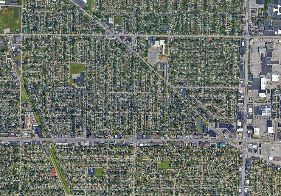
A 2021 aerial view showed no trace remaining of Curtiss Aerodrome.
The site of Curtiss Aerodrome is located between Eggert Street, Niagara Falls Boulevard & Sheridan Drive.
Thanks to Peter Vercruijsse for pointing out this airfield.
____________________________________________________
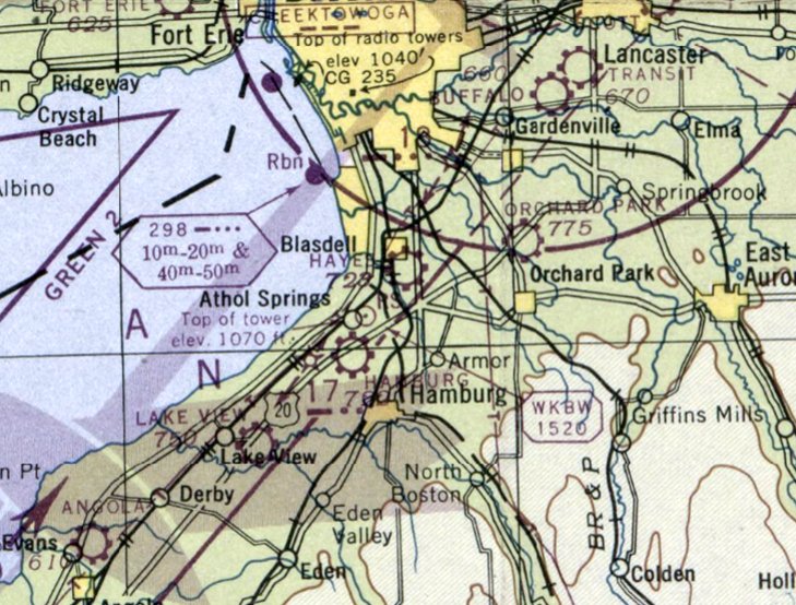
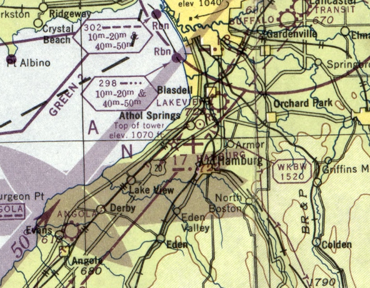
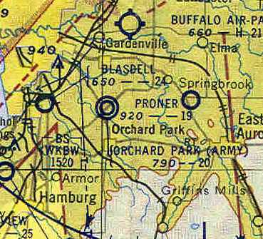
Lakeview Airport / Hayes Airport / Blasdell Airport, Blasdell, NY
42.796, -78.813 (South of Buffalo, NY)
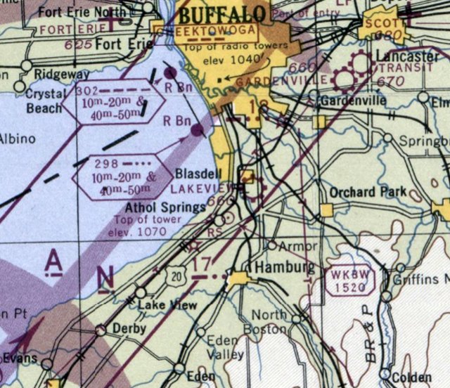
Lakeview Airport, as depicted on the October 1944 Detroit Sectional Chart.
This small general aviation airport on the south side of Buffalo was evidently established at some point in 1944,
as it was not yet depicted on the May 1944 Detroit Sectional Chart.
The earliest depiction which has been located of Lakeview Airport was on the October 1944 Detroit Sectional Chart.
It depicted Lakeview Airport as a commercial/municipal airport, adjacent to the southeast side of Blasdell.
It was still depicted as Lakeview Airport on the July 1946 Detroit Sectional Chart.
Lakeview Airport was evidently renamed Hayes Airport at some point in 1946,
as that is how it was depicted on the December 1946 Detroit Sectional Chart.
Tom Morgenfeld recalled, “The runway ran north/south, parallel to McKinley Parkway. I was born in 1943 & we lived in Blasdell until about 1946-47.
The airfield was a must-see item for me whenever we went out for a ride as it had a rather large crashed airplane (C-47/DC-3?) that absolutely fascinated me.
I remember the airfield existing for at least a short time after that.”
Hayes Airport may have closed at some point between 1946-47,
as it was no longer depicted on the July 1947 – June 1948 Detroit Sectional Charts.
The earliest topo map depiction which has been located of Blasdell Airport was on the 1948 USGS topo map.
It depicted 2 unpaved runways, generically labeled as “Airport”, with 1 small building on the northeast corner.
Hayes Airport was evidently reopened at some point in 1948,
as it was once again depicted on the June 1948 Detroit Sectional Chart, but this time as only an auxiliary airfield.
Hayes Airport was evidently closed (again) at some point between 1948-49,
as it was no longer depicted on the December 1949 – June 1951 Detroit Sectional Charts.
The only photo which has been located of Hayes Airport was a 1951 aerial view (courtesy of Bob Bialkowski).
It depicted Blasdell Airport as having 2 unpaved runways, with a small building & 1 light single-engine aircraft on the northeast corner.
The former Hayes Airport was evidently reopened as Blasdell Airport at some point in 1951,
as that is how it was labeled on the December 1951 Detroit Sectional Chart.
Blasdell Airport was depicted as having a 2,400' unpaved runway.
The 1957 AOP Airport Directory (courtesy of Bob Bialkowski) described Blasdell Airport as having 2 unpaved runways, measuring 2,400' north/south & 1,800' northeast/southwest.
The operator & manager was listed as Frank Matesic, and the field was said to have a restaurant.
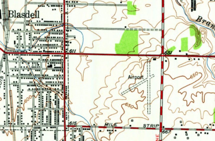
The 1959 USGS topo map continued to depicted Blasdell Airport as 2 unpaved runways, generically labeled as “Airport”.
The last aeronautical chart depiction which has been located of Blasdell Airport was on the January 1959 Detroit Sectional Chart.
It depicted Blasdell Airport as having a 2,400' unpaved runway.
Blasdell Airport was evidently closed at some point in 1959,
as it was no longer depicted on the May 1959 Detroit Sectional Chart.
The reason for Blasdell Airport's closure was evident on a 1959 aerial photo,
which showed a clover-leaf for Interstate 90 had been built on the west side of the airport property.
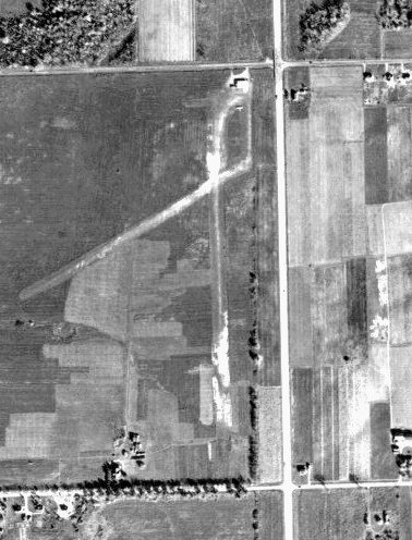
The north/south runway remained intact, though deteriorated, along with the airport building at the northeast corner.
A 1966 aerial photo showed the former Blasdell Airport building (hangar?) remained intact on the northeast corner.
The 1967 USGS topo map no longer depicted Blasdell Airport.
A 1995 aerial photo showed the former Blasdell Airport building (hangar?) on the northeast corner had been removed at some point between 1966-95.
A 2018 aerial view looking southwest showed no trace remaining of Blasdell Airport, with the majority of the site occupied by the Coach Lite Village Apartments.
Thanks to Thomas Morgenfeld for pointing out this airfield.
____________________________________________________
Audubon Airport, Getzville, NY
42.995, -78.779 (Northeast of Buffalo, NY)
Audubon Airport, as depicted on the November 1945 Detroit Sectional Chart.
This small general aviation airport on the northeast side of Buffalo was evidently established at some point in 1945
(like hundreds of other small US airports in the post-WW2 aviation boom),
as it was not yet depicted on the May 1945 Detroit Sectional Chart.
The earliest depiction which has been located of Audubon Airport was on November 1945 Detroit Sectional Chart.
It depicted Audubon as a commercial/municipal airport.
A circa 1940s/50s road map depiction of Audubon Airport (courtesy of Alan Bernheimer).
Stuart Leuthner recalled, “I learned how to fly at Audubon Airport in the 1950s.
One of my friends also took lessons & worked at Audubon.”

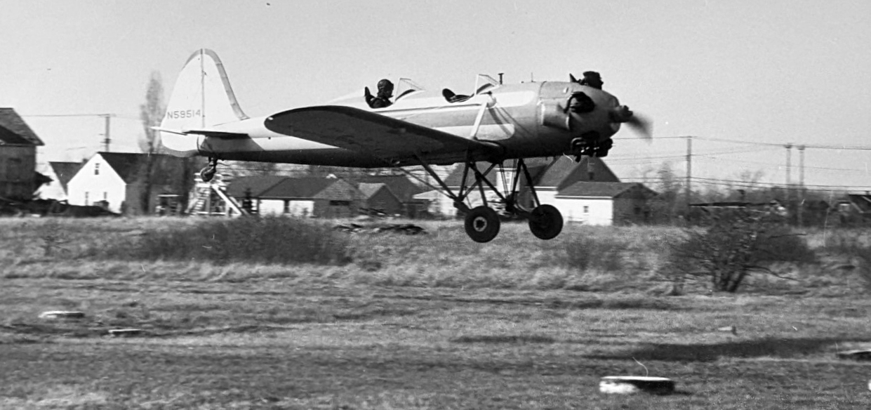
The earliest photo which has been located of Audubon Airport was a March 1955 photo of a Fairchild PT-19 & 2 Aeroncas
(courtesy of Matthew Favale, grandson of Frank Favale Sr. & son of Frank Favale Jr.).

A circa 1950s photo of a parachutist landing at Audubon Airport (courtesy of Matthew Favale, grandson of Frank Favale Sr. & son of Frank Favale Jr.).

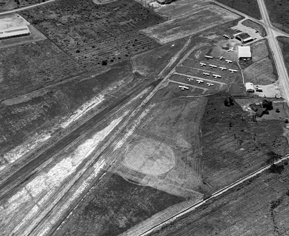
A circa 1950s aerial view looking west at planes at Audubon Airport (courtesy of Matthew Favale, grandson of Frank Favale Sr. & son of Frank Favale Jr.).
A circa 1950s photo of a Ryan PT-22 at Audubon Airport (courtesy of Matthew Favale, grandson of Frank Favale Sr. & son of Frank Favale Jr.).
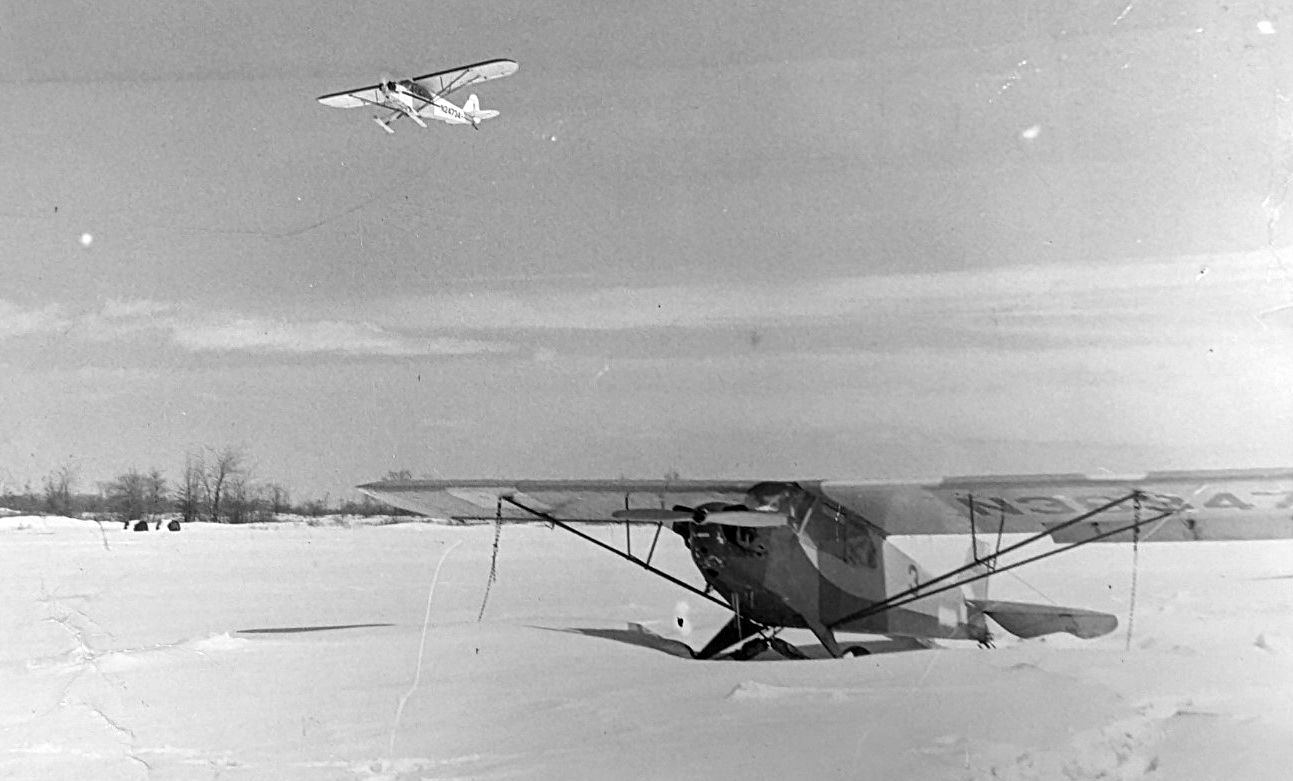
A circa 1950s photo of a ski-equipped Piper Cub overflying Audubon Airport (courtesy of Matthew Favale, grandson of Frank Favale Sr. & son of Frank Favale Jr.).
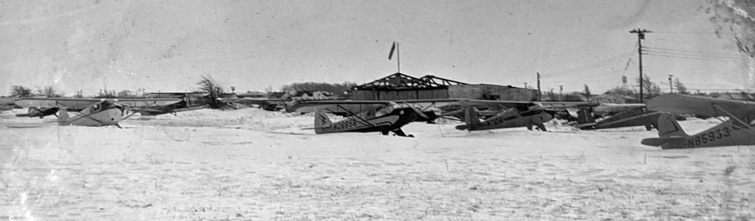
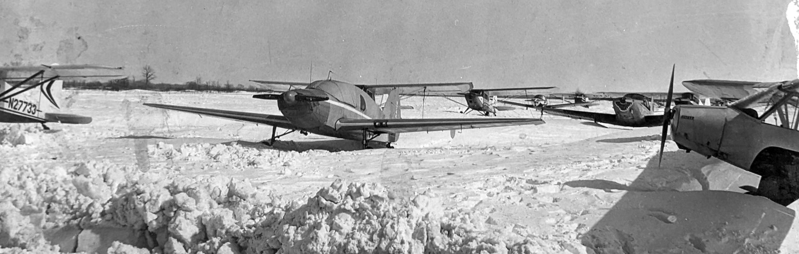
A circa 1950s photo of a snowy Audubon Airport (courtesy of Matthew Favale, grandson of Frank Favale Sr. & son of Frank Favale Jr.).
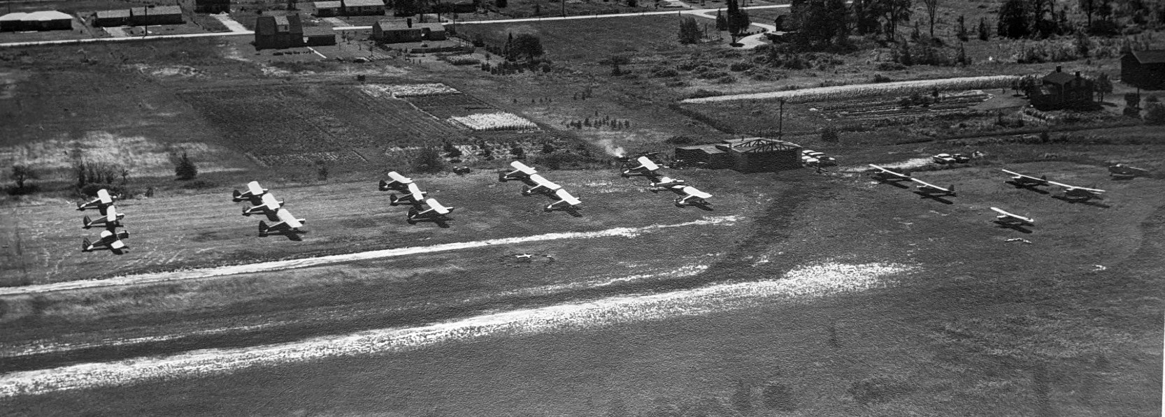
A circa 1950s aerial view looking southwest at many light planes parked near the Audubon Airport hangar (courtesy of Matthew Favale, grandson of Frank Favale Sr. & son of Frank Favale Jr.).
A circa 1950s aerial view looking west at many light planes parked near the Audubon Airport hangar (courtesy of Matthew Favale, grandson of Frank Favale Sr. & son of Frank Favale Jr.).
An admittedly poor-contrast 1958 USGS aerial view of Audubon Airport.
A better quality version of the same photo depicted Audubon Airport as having an east/west unpaved runway, with traces of a former crosswind unpaved runway.
A total of 16 light single-engine aircraft were parked near a small building on the southwest side.
The last aeronautical chart depiction which has been located of Audubon Airport was on the January 1959 Detroit Sectional Chart.
It depicted Audubon as having a 2,500' unpaved runway.
According to Bob Heavener, “Frank Favale operated at Audubon Airport”, before owning the Amherst Airport in the 1960s.
Audubon Airport was evidently closed at some point between 1959-60,
as it was no longer depicted on the May 1960 Detroit Sectional Chart.
A 1963 aerial photo depicted the ground of Audubon Airport having been cleared for construction,
and a 1966 aerial photo showed a building covering the western portion of the airport site.
The 1967 USGS topo map labeled the building as a Recreation Center.
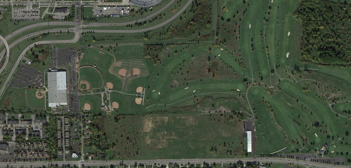
A 2016 aerial view showed no trace remaining of Audubon Airport, with the site covered by a recreation center building, ball fields, and a golf course.
Thanks to Alan Bernheimer for pointing out this airfield.
____________________________________________________
42.928, -78.761 (West of Buffalo International Airport, NY)
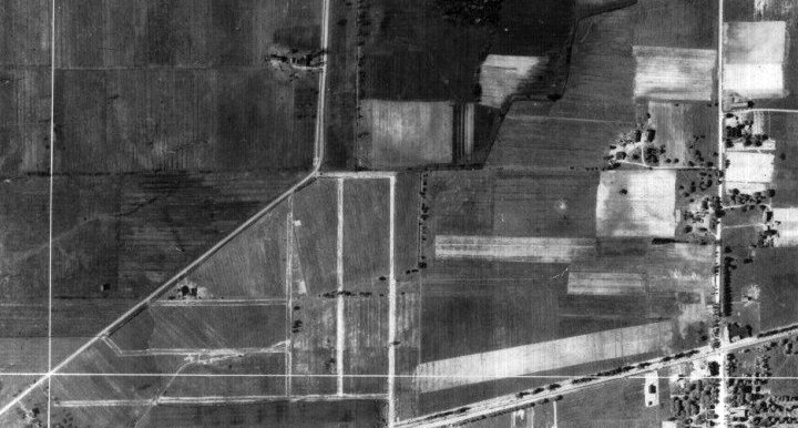
Becker Airport, as depicted on a 6/1/27 Erie County aerial photo (courtesy of Paul Friedrich).
Becker Airport was reportedly the original airport for the town of Buffalo.
According to Maureen Gleason, “Becker Airfield was a privately-owned airport located on the northwest corner of Union & Genesee in Cheektowaga.
Henry Becker owned The Becker Flying Service, the office being located at 254 Franklin Street near West Chippewa Street in Buffalo.
The small airport extended from Genesee Street to Maryvale Drive & from Union Road to Beach Road.
The airport was opened in the late 1920s.”
The earliest depiction which has been located of Becker Airport was a 6/1/27 Erie County aerial photo (courtesy of Paul Friedrich).
It depicted Becker Airport as having an east/west grass runway on the north side of Genesee Street.
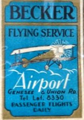
A circa 1920s matchbook for Becker Flying Service (courtesy of Scott Schuyler).
Scott Schulyler reported, “My grandfather’s logbook notes that he bought his first plane from the Becker Flying Service in 1930.”
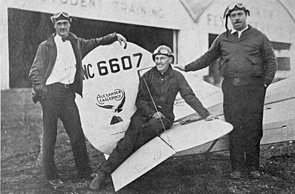
An undated photo (courtesy of Scott Schuyler) from the 1929 Alexander Aircrafter in front of the Becker Flying Service hangars
of “The Three Musketeers of the Becker Flying Service, Eaglerock distributors at Buffalo.
Walter Muth, Earl Marlau, and Don Gould, the heaviest licensed pilot.”
A 1930 Buffalo newspaper article described a crash at Becker Airport (according to Paul Friedrich).
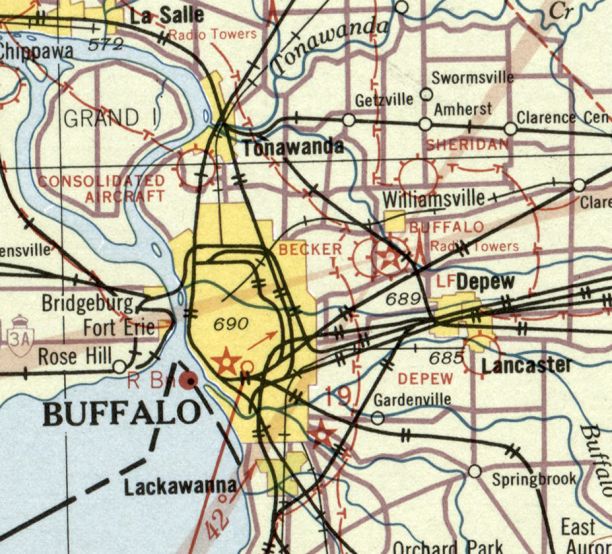
The only aeronautical chart depiction which has been located of Becker Airport was on the June 1931 NY Sectional Chart.
Becker Airport was depicted immediately adjacent to the west side of Buffalo Airport.
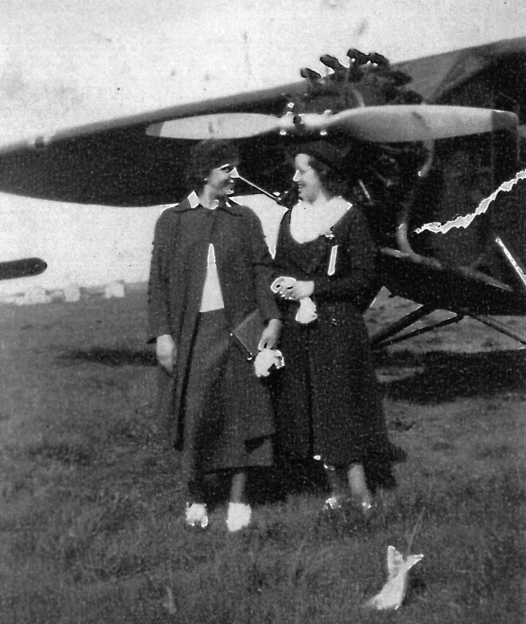
A May 1935 photo (courtesy of Anne Schuch) of Josephine Adornetto & Caroline Boccolucci (Anne's mother) in front of an unidentified high-wing monoplane at Becker Airport.
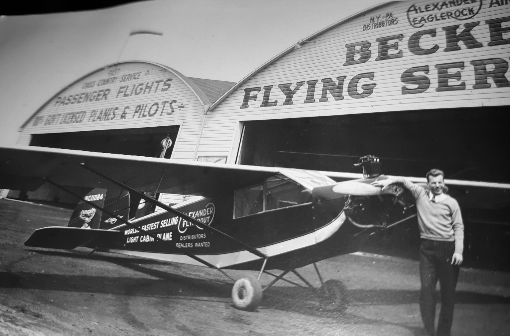
A circa 1930s photo (courtesy of Frank Procyshyn) of an unidentified man & an Alexander Flyabout in front of a Becker Flying Service hangar.
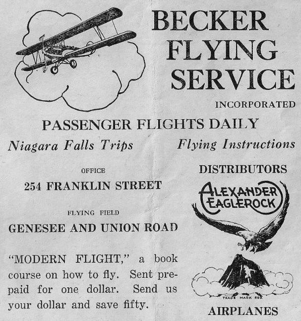
An undated advertisement for Becker Flying Service (courtesy of Maureen Gleason).
According to Maureen Gleason, “Becker Airport operated into the late 1930s when it was taken over by Erie County.
Jerry Felber reported, “Becker Airport... My great uncle Eddie Nartowicz told me about the airport & how his father would take him there on the weekends.”
The 1938 Aviation Facilities in NY State (courtesy of Bob Parmerter) described Becker Airport as having 2 cinder runways, measuring 2,800' northeast/southwest & 2,400' northwest/southeast, and 1 hangar.
Becker Airport was evidently closed at some point between 1938-39, as it was no longer depicted on the 1939 Sectional Chart.
It had evidently been eclipsed by the much larger Buffalo Airport located adjacent to the east.
According to Maureen Gleason, “At the beginning of World War II, Becker Airport was controlled by the Defense Department.
The 11 acre property was purchased in 1943 from Erie County at a tax foreclosure proceeding
and the Airport Plaza was planned by R. H. Guelich as a postwar project, to be built on the site as soon as materials & labor were available.
Construction did not begin until 1948. The original Airport Plaza was opened in March of 1949.”
A 2016 aerial view showed no trace remaining of Becker Airport.
Thanks to Ron Ciura for pointing out this airfield.
____________________________________________________
42.98, -78.71 (Northeast of Buffalo International Airport, NY)
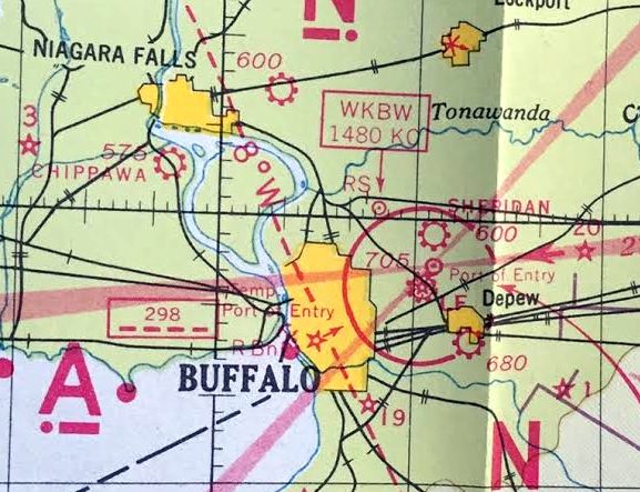
Sheridan Airport, as depicted on the June 1931 NY Sectional Chart.
The date of establishment of this small general aviation airport on the northeast side of Buffalo has not been determined.
The earliest depiction which has been located of Sheridan Airport was on the June 1931 NY Sectional Chart.
An aeronautical chart from the 1939 Commerce Department book “Practical Air Navigation” (courtesy of Kevin Walsh)
depicted Sheridan as a commercial/municipal airport.
Sheridan Airport may have been temporarily closed during WW2 (like many other small civilian airports),
as it was not yet listed among active airfields in the 1945 AAF Airfield Directory (courtesy of Scott Murdock).
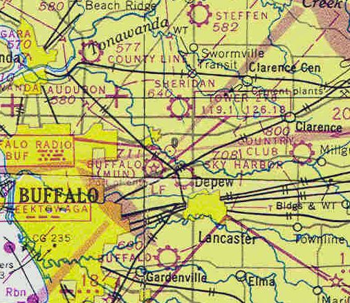
The December 1948 Detroit Sectional Chart (courtesy of Chris Kennedy) depicted Sheridan as a commercial/municipal airport.
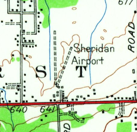
The 1948 USGS topo map depicted Sheridan Airport as having 2 unpaved runways, with a few small buildings on the south side.
The earliest photo which has been located of Sheridan Airport was a 1954 aerial view looking north (courtesy of James Pellow).
It depicted Sheridan Airport as having 2 unpaved runways, with 2 T-hangars on the south end.
The November 1954 Detroit Sectional Chart (courtesy of Chris Kennedy) depicted Sheridan Airport as having a 2,400' unpaved runway.
A 6/3/58 USGS aerial view depicted Sheridan Airport as having 2 unpaved runways.
The last aeronautical chart depiction which has been located of Sheridan Airport was on the November 1960 Detroit Sectional Chart.
It depicted Sheridan Airport as having a 2,400' unpaved runway.
Bob Heavener recalled, “A fellow had a gas station on the north side of Sheridan Drive near Transit Road.
He had a grass strip called Sheridan Airport that was probably active in 1960.”
The last photo which has been located of Sheridan Airport was a 9/24/63 USGS aerial view.
It depicted Sheridan Airport as having 2 unpaved runways, with a few small buildings on the south end.
No aircraft were visible on the field.
John Kramer reported, “Sheridan Airport... that was my grandfather’s, Arthur Seifert’s, airfield.
I never knew my grandfather since he had passed before I was born in 1963.
That was likely around the time the airfield ceased operations.”
The last depiction which has been located of Sheridan Airport was on the 1965 USGS topo map.
Sheridan Airport was evidently closed by 1965, as it was no longer depicted on the January 1965 Detroit Sectional Chart.
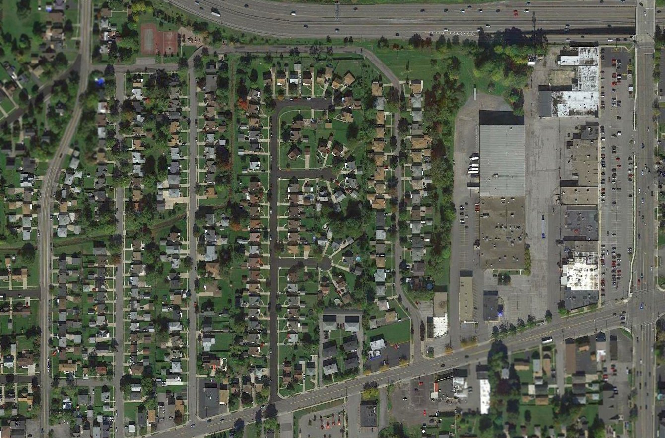
A 1966 USGS aerial photo showed residential construction covering the Sheridan Airport site,
the bane of general aviation airports all over the country.
John Kramer reported, “The airport was eventually was sold off to land developers of which I recall Stoneledge Apartments built in the 1970s.
I used to live in a cabin that was built around the area where the airfield once existed.”
A 2015 aerial view showed houses covering the site of Sheridan Airport.
The site of Sheridan Airport is located north of the intersection of Route 324 & Fruitwood Terrace.
Thanks to Bob Heavener for pointing out this airfield.
____________________________________________________
Goat Island Heliport, Niagara Falls, NY
43.08, -79.06 (South of Buffalo, NY)
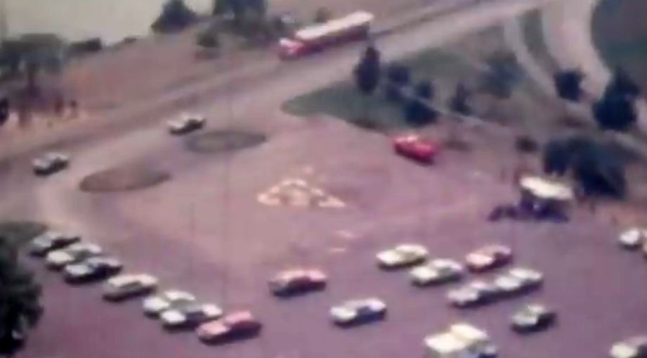
A 6/23/70 USGS aerial view of the Goat Island Heliport.
Jonathan Westerling reported, “The channel of the Niagara River splits in 2 above the falls, creating 2 sets of falls, one on either side of the island.
In 1959-60, the eastern side of the island was extended about 8 acres for additional parking & a helicopter pad.
Fill was provided from excavation for the construction of the Robert Moses State Parkway.
The waters immediately around Goat Island are relatively shallow & studded with islets & rocks, many of them scenes of dramatic rescues & rescue attempts.”
An article in a 1963 issue of the Niagara Falls Gazette (courtesy of Jonathan Westerling)
reported how Prior Aviation Service had been recommend to operate from a new private heliport on the east end of Goat Island.
Priot Aviation flew a Bell 47 helicopter from Goat Island giving tours, sanctioned by the State Park Service who owned the island.
The earliest depiction which has been located of the Goat Island Heliport was a 6/23/70 USGS aerial photo,
which depicted a yellow triangular helipad marking painted onto the south end of the parking lot on the east tip of Goat Island.
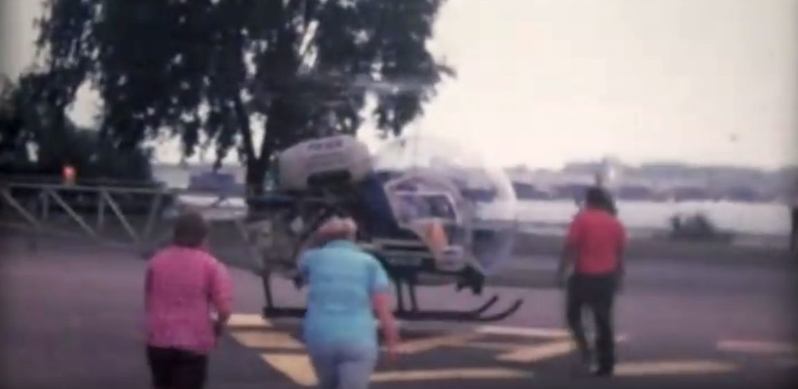
A still from a mid-1970s movie of a Bell 47 sightseeing helicopter making a stop at the Goat Island Heliport.
A still from a mid-1970s movie looking southwest from a helicopter on approach to the Goat Island Heliport.
The 1976 AOPA Airports USA (according to Jonathan Westerling) described the Goat Island Heliport as having a 50' x 75' asphalt landing area.
The 1979 AOPA Airports USA (according to Jonathan Westerling) described the Goat Island Heliport as having a slightly larger 100' x 75' asphalt landing area.
The Goat Island Heliport was no depicted on Sectional Charts from the 1970s/80s/90s.
The Goat Island Heliport reportedly was closed at some point after 1983.
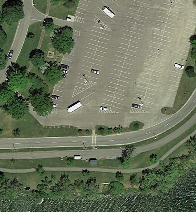
A 2015 aerial photo still showed a faint trace of the yellow triangular heliport marking at the site of the Goat Island Heliport,
between 2 light poles on the south end of the parking lot.
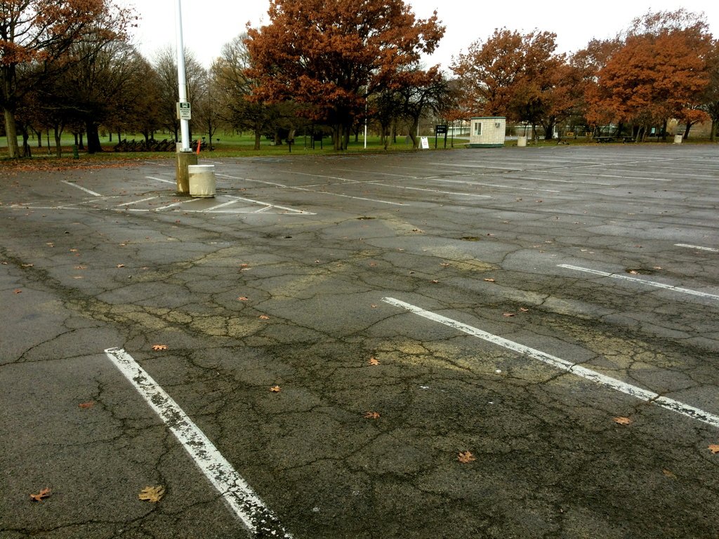
Amazingly an 11/20/18 photo by Jonathan Westerling still showed a barely-recognizable remnant of the yellow triangular heliport marking at the site of the Goat Island Heliport,
Jonathan observed, “As the memory of this heliport fades into the past, so does the big H painted on the asphalt which used to mark the landing zone -
but even 35 years later, one can still clearly make it out, if you know where to look.”
Thanks to Jonathan Westerling for pointing out this heliport.
____________________________________________________
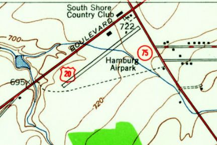
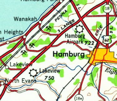
42.75, -78.86 (South of Buffalo, NY)
Hamburg Airpark, as depicted on the May 1946 Detroit Sectional Chart.
The date of establishment of this small general aviation airport has not been determined.
The earliest reference which has been located to Hamburg Airpark came from Tom Starr,
who recalled, “My dad & his parents found it by accident while traveling Route 20 during the 1930s.”
However Hamburg Airpark was yet depicted on Detroit Sectional Charts from 1935 or 1945.
The earliest depiction which has been located of Hamburg Airpark was on the May 1946 Detroit Sectional Chart.
It depicted Hamburg as an auxiliary airfield.
The 1948 USGS topo map depicted Hamburg Airpark as having a single northeast/southwest runway, with a few small buildings on the north side.
The last aeronautical chart depiction which has been located of Hamburg Airpark
was on the November 1954 Detroit Sectional Chart (courtesy of Chris Kennedy).
It depicted Hamburg as having a 2,200' paved runway, but being for Emergency use only.
Hamburg Airpark was evidently closed (for reasons unknown) at some point between 1954-58,
as it was no longer depicted on the January 1958 Detroit Sectional Chart.
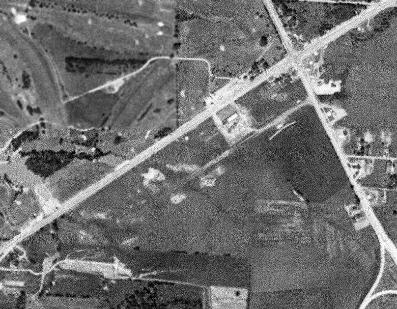
The earliest photo which has been located of Hamburg Airpark was a 6/3/58 USGS aerial view.
It was already been closed by this point, and there were no aircraft visible on the field nor any other indication of recent aviation use.
One northeast/southeast unpaved runway was visible, with a few small buildings on the north side.
The last topo map depiction which has been located of Hamburg Airpark was on the 1960 USGS topo map.
It depicted Hamburg as a commercial/municipal airport.
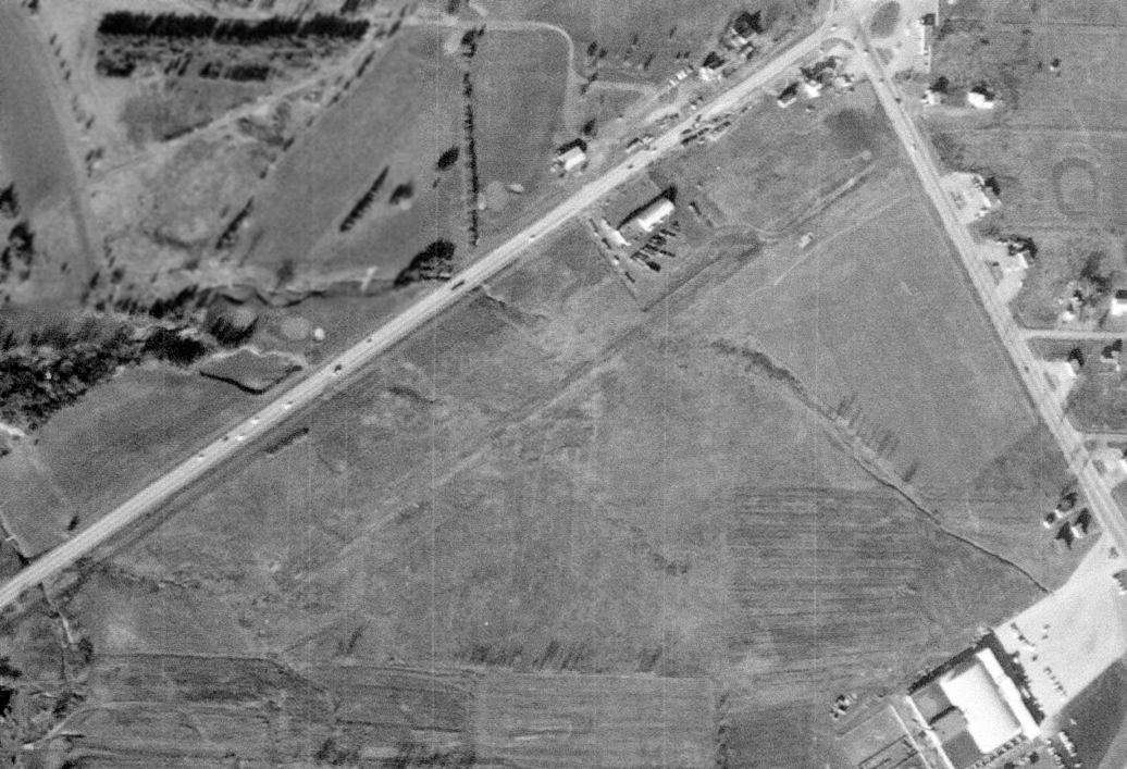
The last photo which has been located of Hamburg Airpark was a 11/26/62 USGS aerial view.
Although the runway remained intact, there were no aircraft visible on the field, nor any other indication of recent aviation use.
A 1995 aerial photo showed that a road & several buildings had been built over the site of Hamburg Airpark,
but one building (a former hangar?) remained standing, and traces of the runway were still recognizable.

A circa 2011 aerial view looking north showed one building (a former hangar?) remained standing on the north side of the Hamburg Airpark site.
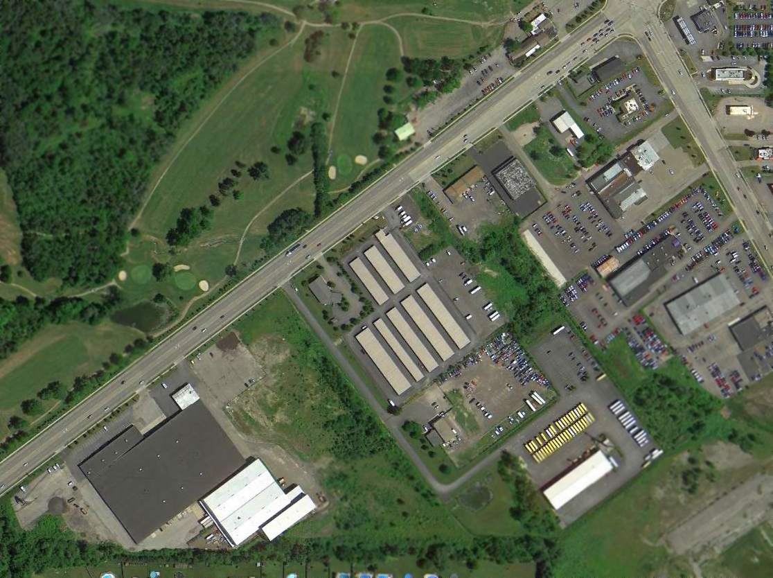
A 2014 aerial view showed that the site of Hamburg Airpark was no longer recognizable as a former airport,
but one building (a former hangar?) remained standing on the north side of the property.
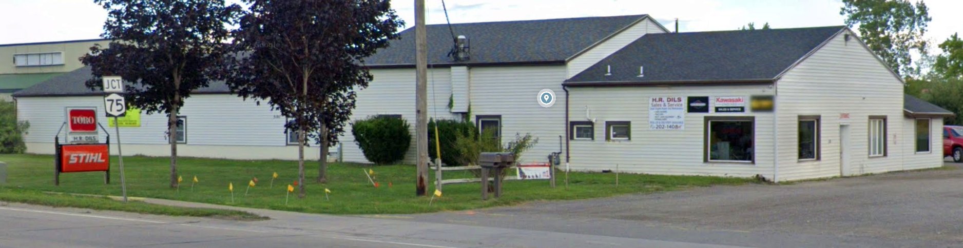
An August 2022 photo looking east at a former Hamburg Airpark hangar, unrecognizable as the last remnant of the little airport.
The site of Hamburg Airport is located south of the intersection of Route 20 & Route 75.
Thanks to Tom Starr for pointing out this airfield.
____________________________________________________
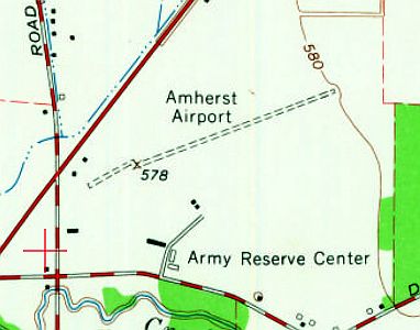
Amherst Airport, East Amherst, NY
43.06, -78.72 (Northeast of Buffalo, NY)
Amherst Airport, as depicted on a 9/24/63 USGS aerial photo.
This small general aviation airport was evidently established at some point between 1960-62,
as only an open grass field was depicted at its location on a 1958 aerial photo,
and Amherst Airport was not yet depicted on the November 1960 Detroit Sectional Chart.
The earliest reference which has been located to Amherst Airport came from Bob Heavener,
who recalled, “I learned to fly at Amherst Airport; I earned my private certificate while flying there in 1962.
I kept a Cessna 120 there from 1962-66. Frank Favale was the owner & operator of Amherst Airport.
Previously he operated at Audubon Airport.
The building on Millersport just Northeast of the 3 hangars was a restaurant with an aviation theme.
It was started by Fred Gage, a local radio personality.
Fred’s radio show featured episodes of Flaps Rickenbacker & his dog Fang.
Flaps flew an Edsel Tri Motor on the show.
At one time Fred acquired a wrecked Globe Swift, fitted it with 2 more engine mockups & displayed it outside of the 'Flaps' restaurant as the Edsel.
A World War One pilot named Don Coe had a mini aviation museum in the restaurant. Don had some interesting flying stories.”
The earliest depiction which has been located of Amherst Airport was on a 9/24/63 USGS aerial photo.
It depicted Amherst as having a single northeast/southwest unpaved runway.
A dozen light aircraft were parked around the west side of the field, along with 2 small hangars.
A circa 1960s aerial view looking east at Amherst Airport (courtesy of Matthew Favale, grandson of Frank Favale Sr. & son of Frank Favale Jr.)
depicted the field as having 2 unpaved northeast/southwest runways, and a dozen light aircraft parked near 2 hangars on the west side.
A circa 1960s aerial view looking west at Amherst Airport (courtesy of Matthew Favale, grandson of Frank Favale Sr. & son of Frank Favale Jr.)
depicted the field as having 2 unpaved northeast/southwest runways, and a dozen light aircraft parked near 2 hangars on the west side.
A circa 1960s photo (courtesy of Matthew Favale, grandson of Frank Favale Sr. & son of Frank Favale Jr.) of “Flaps” Rickenbacker & a Piper Tri-Pacer at Amherst Airport.
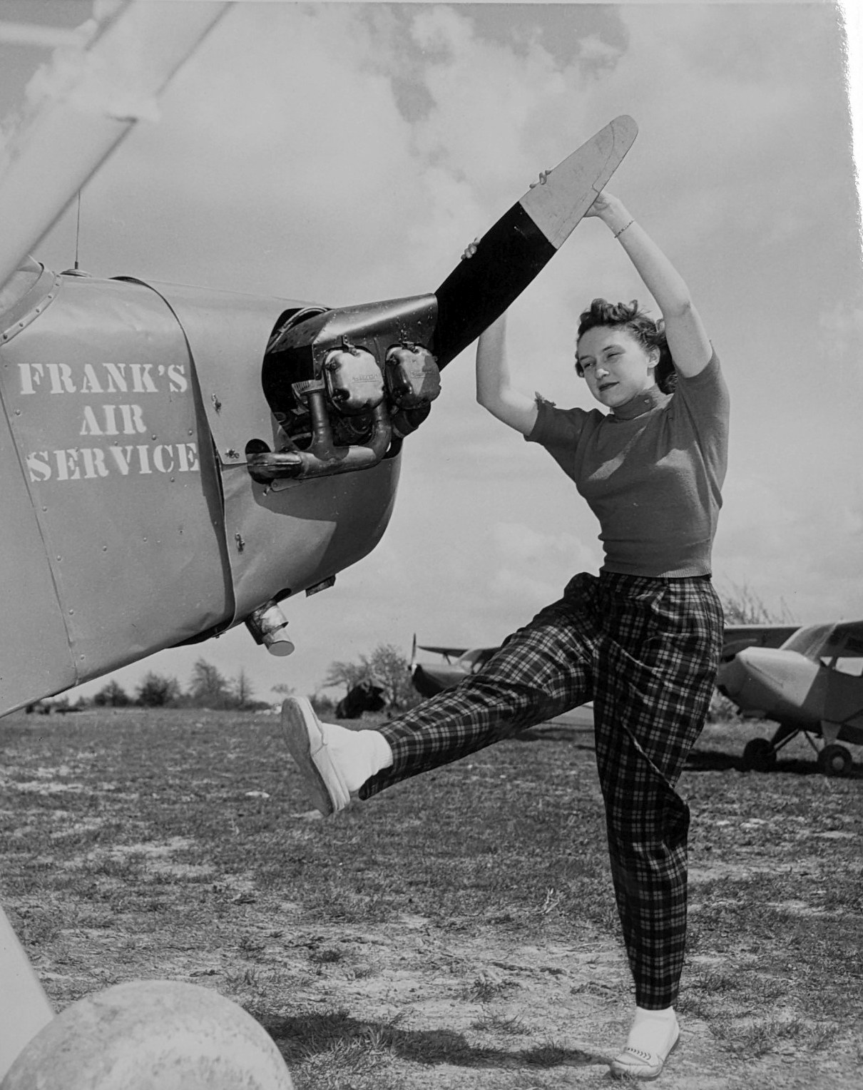
A circa 1960s photo (courtesy of Matthew Favale, grandson of Frank Favale Sr. & son of Frank Favale Jr.) of a young pilot hand-propping a Frank's Air Service Piper Cub at Amherst Airport.
A circa 1960s photo (courtesy of Matthew Favale, grandson of Frank Favale Sr. & son of Frank Favale Jr.) of a wingwalker on top of an unidentified airshow biplane at Amherst Airport.
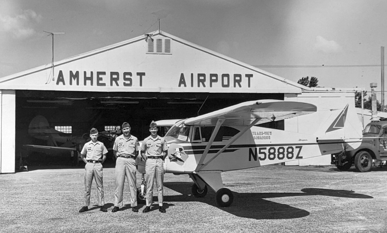
A circa 1960s photo (courtesy of Matthew Favale, grandson of Frank Favale Sr. & son of Frank Favale Jr.)
of 3 uniformed personnel in front of a Trans-View Squadron Piper Tri-Pacer & an Amherst Airport hangar.
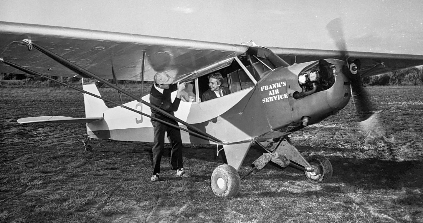
A circa 1960s photo (courtesy of Matthew Favale, grandson of Frank Favale Sr. & son of Frank Favale Jr.) of a Frank's Air Service Piper Cub at Amherst Airport.
A circa 1960s photo (courtesy of Matthew Favale, grandson of Frank Favale Sr. & son of Frank Favale Jr.) of a snowy Amherst Airport.
The 1965 USGS topo map depicted Amherst Airport as having a single unpaved northeast/southwest runway,
with a few small buildings on the west side.
The earliest aeronautical chart depiction which has been located of Amherst Airport was on the January 1965 Detroit Sectional Chart.
It depicted Amherst as having a single northeast/southwest 2,300' paved runway.
A 1966 aerial photo depicted Amherst Airport as having a northeast/southwest paved runway just to the south of the original unpaved runway.
A dozen light aircraft were parked around the west side of the field, along with 2 small hangars.
The last photo which has been located of Amherst Airport was on a 1972 aerial photo.
The number of aircraft visible on the field had markedly decreased since the 1966 photo,
with only 5 light aircraft parked outside.
The last aeronautical chart depiction which has been located of Amherst Airport
was on the November 1972 Detroit Sectional Chart (courtesy of Ron Plante).
It depicted Amherst as having a single east/west 2,300' paved runway.
Amherst Airport was evidently closed at some point between 1972-74,
as it was no longer depicted on the November 1974 Detroit Sectional Chart (courtesy of Ron Plante) nor the 1980 USGS topo map.
A 1995 USGS aerial photo showed that a composting facility had covered most of the runway of the former Amherst Airport.
A circa 2011 aerial view looking west at the remains of the western end of the Amherst runway,
with the remainder (at the top of photo) covered by a composting pile.
A circa 2011 aerial view looking south at what appears to be a former Art Deco airport office building along the west side of the site of Amherst Airport,
along with 2 former hangars at the top-right.
Chris Benke reported in 2013, “The Amherst runway is still there but in very poor shape & now serves as a Composting Center for the town.
I believe there still exists an Art Deco type terminal just off of Millersport Highway.”
The site of Amherst Airport is located east of the intersection of Route 263 & New Road.
____________________________________________________
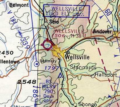
Original Wellsville Municipal Airport / Crowner Airport, Wellsville, NY
42.131, -77.969 (Southeast of Buffalo, NY)
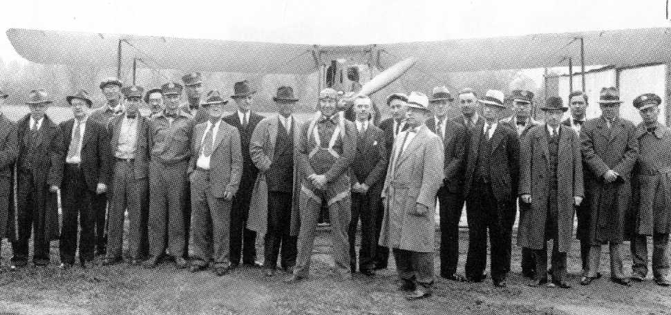
A 5/19/38 photo (courtesy of Oak Duke) of a group of men in front of an unidentified biplane at the original Wellsville Municipal Airport,
on the occasion of the first air mail flight to Buffalo.
William Piper reported, “According to local history books, the Wellsville Municipal Airport was established prior to 1938,
as the first air mail flight occurred on May 19th of that year to Buffalo.”
The earliest depiction which has been located of the original location of the Wellsville Municipal Airport
was a 5/19/38 photo (courtesy of Oak Duke) of a group of men in front of an unidentified biplane,
on the occasion of Wellsville's first air mail flight to Buffalo.
Wellsville Municipal Airport was not yet listed in the 1938 Aviation Facilities in NY State (courtesy of Bob Parmerter).
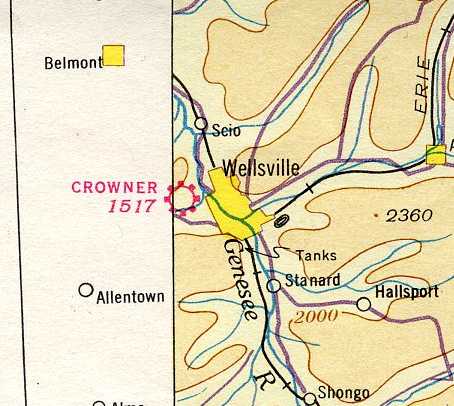
The earliest aeronautical chart depiction which has been located of the airport at Wellsville
was on the August 1939 Albany Sectional Chart (courtesy of Chris Kennedy).
It depicted the field “Crowner”, a commercial/municipal airport.
Crowner Airport was depicted on the 1950 USGS topo map.
The earliest photo which has been located depicting all of Crowner Airport was a 1952 aerial view.
It depicted Crowner as having 2 unpaved runways, with a single light plane parked near some small buildings on the southeast side.
The November 1956 Albany Sectional Chart (courtesy of Chris Kennedy) depicted Crowner Airport as having a 2,300' unpaved runway.
Crowner Airport was still depicted on the 1958 USGS topo map.
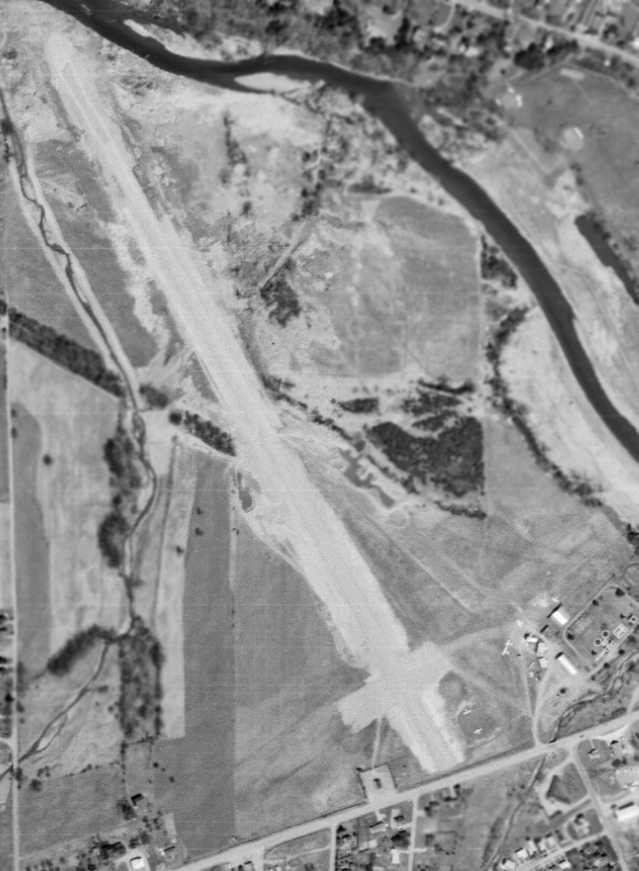
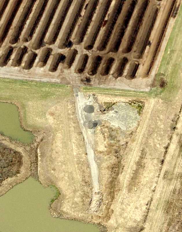
The last photo which has been located depicting Crowner Airport still in operation was a 4/28/63 USGS aerial view.
It depicted Crowner as having a possibly-paved northwest/southeast runway, a short grass crosswind runway.
A total of 6 single-engine planes were visible parked near some small buildings on the southeast side.
At some point between 1956-64 the airfield was evidently renamed Wellsville Airport,
as that is how it was depicted on the July 1964 Albany Sectional Chart (courtesy of Chris Kennedy).
The field was described as having a 3,800' unpaved runway.
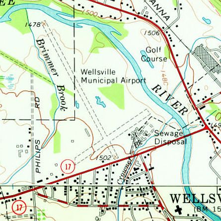
The 1965 USGS topo map depicted Wellsville Municipal Airport
as having 2 unpaved runways, with a few small buildings on the south & southeast sides.
Bob Heavner recalled, “I flew out of the old riverfront airport in Wellsville that was operated by Mote Tarantine in 1966.
Mote flew the 'Hump' in Burma during World War Two. The modern Wellsville Airport on the hill is named after him.”
Stephen Lawton recalled, “Wellsville Airport... I learned to fly there in 1968.
My instructors were Richardson & Gary Barnes. Mote Tarantine was the pilot examiner.”
William Piper recalled, “There was a single, paved runway extending northwest from Bolivar Road
and a smaller, southwest/northeast runway running parallel to the road.
Apparently, there were noise complaints & space limitations in the late 1960s due to building encroachment,
and a new site on a nearby hill was selected for the current Tarantine Field.
The new airport opened in November 1970, while the old Wellsville Municipal closed the next year after transitioning.”
The May 1971 Detroit Sectional Chart (courtesy of Chris Kennedy) depicted the new Wellsville Airport to the southwest,
and depicted the original field as an abandoned airfield.
Even though Wellsville Airport had been abandoned for 6 years, the 1976 USGS topo map still depicted Wellsville Municipal Airport.
It depicted the field as having 2 unpaved runways, with a few small buildings on the south & southeast sides.
William Piper recalled, “My dad grew up in Wellsville & remembers that the old airport sat vacant & abandoned for many years.
The younger kids would ride their bikes down the main runway, while the older teens regularly held drag races with suped-up fastbacks.
Beginning around 1980, the stretch of Bolivar Road (Route 417) south of the main runway was commercially developed with a McDonald's, K-Mart, etc.
This completely destroyed any trace of the smaller, southwest/northeast runway,
the ramp area, and the southern-most portion of the remaining main runway.”
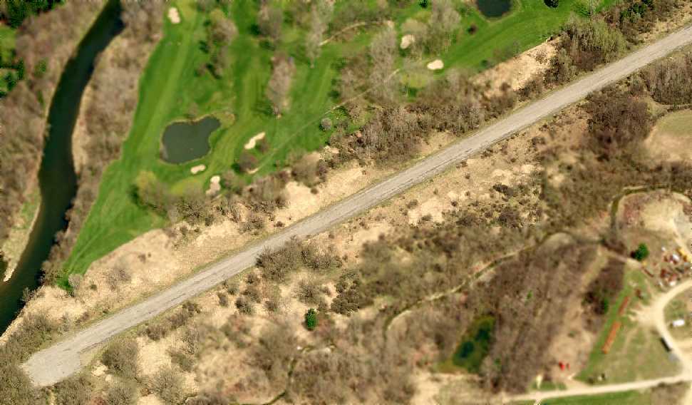
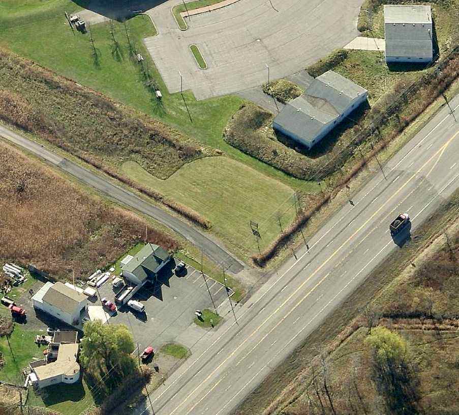
A circa 2007 aerial view looking east at the remaining pavement of the northwest end of the Wellsville Airport runway.
A July 2008 photo by William Piper looking northwest from behind the TSC building of the remains of the Wellsville Airport paved northwest/southeast runway.
William Piper reported in 2010, “Today, the existing strip mall is centered around a Tractor Supply Company store, located at 480 Bolivar Road.
There is also a small roadway named 'Airway Drive' on the former property.
The remaining runway is surprisingly intact, considering that the facility closed nearly 40 years ago.
There have been plans recently, however, to build a Wal-Mart superstore on top of the existing remains of the old airport.”
A 20913 aerial view looking northeast showed the remaining pavement of the Wellsville Airport northwest/southeast runway.
A 3/21/16 photo by Jason Harry looking along the remains of the Crowner Airport paved runway.
Jason repored, “I've made numerous deliveries to a store in a shopping center adjacent to the old field.
Leaving after my first visit many moons ago, I noticed the screen of my GPS depicting what looked like a runway & sure enough, after some research, I was right.
It was amazing to me that the runway was still in decent shape.
I could land my Champ on it with no problems, I'd only need a very good excuse to hand to the authorities.
I consider it a great honor to have stood on some macadam I never had a chance to fly off only because I wasn't around at the time.
It likely won't be much longer until something more resourceful gets built on this piece of aviation history, so I am happy to have had the moment.
It was so quiet that you could almost hear the old radial engines & what not from back in the golden age.
With that sound were stories, most long gone from the spot where they were born, held in the heavens by the men & women who by now have likely flown west for good.”
A 2017 photo by Stephen Lawton looking north along the remains of the Wellsville paved runway.
____________________________________________________
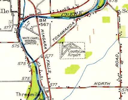
County Line Airport, North Tonawanda, NY
43.04, -78.82 (North of Buffalo, NY)

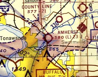
County Line Airport, as depicted on the May 1945 Detroit Sectional Chart.
County Line Airport was not yet depicted on the October 1944 Detroit Sectional Chart.
According to Mark Hess, “County Line Airport was officially opened in early April 1945 by George Graf.”
The earliest depiction which has been located of County Line Airport was on the May 1945 Detroit Sectional Chart,
which depicted it as an auxiliary airfield.
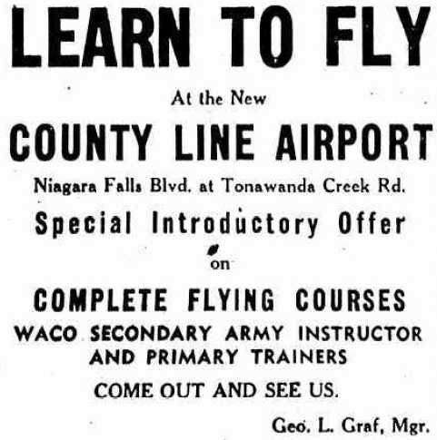
A 1945 advertisement promoted “Learn to Fly at the New County Line Airport” (courtesy of Mark Hess).
The July 1947 Detroit Sectional Chart (courtesy of Dick Merrill) depicted County Line as a commercial/municipal field.
The earliest topo map depiction which has been located of County Line Airport
was on the 1948 USGS topo map (courtesy of Jonathan Hull).
It depicted County Line as having 2 runways, 3 taxiways, and a single small building on the northwest side.
The earliest photo that has been located of County Line Airport is a 1951 aerial photo (from the Erie County Public Works courtesy of Jonathan Hull).
It depicted the field as having 2 paved runways, 3 paved taxiways, and a paved ramp on the northwest side with a hangar & 4 light single-engine planes.
The May 1957 Detroit Sectional Chart (courtesy of Jonathan Hull) depicted County Line as having a 2,000' runway.
The Aerodromes table listed County Line as having 2 turf runways, 80 octane fuel, and minor repair service.
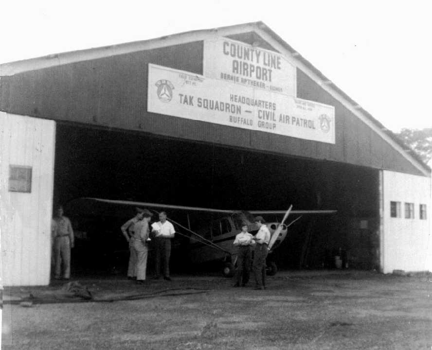
A circa 1950s photo (courtesy of Jonathan Hull) depicted an unidentified taildragger (Aeronca?) in a hangar at County Line Airport.
The hangar markings show that the airport was by Bernie Aptheker
and that it served as the Headquarters for the TAK Squadron of the Buffalo Group of the Civil Air Patrol.
A 1958 aerial view depicted 9 aircraft at County Line Airport.
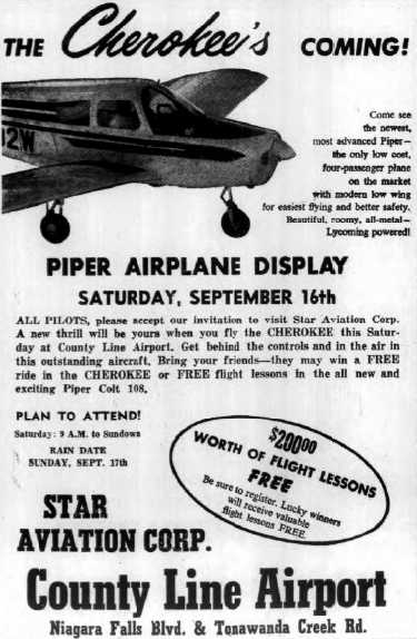
A 1961 advertisement for a Piper Cherokee airplane display at County Line Airport's Star Aviation Corporation (courtesy of Mark Hess).
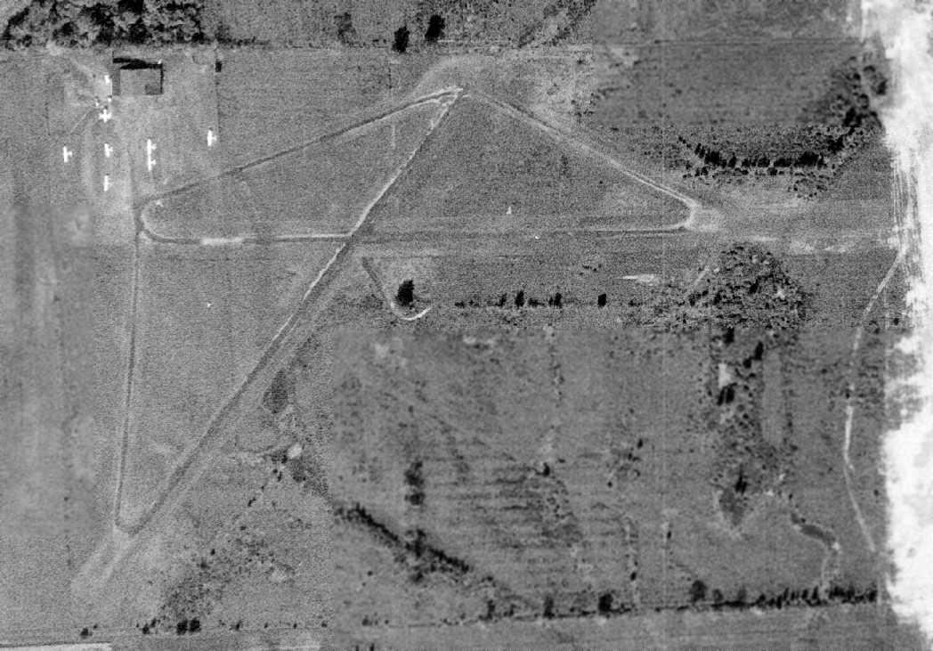
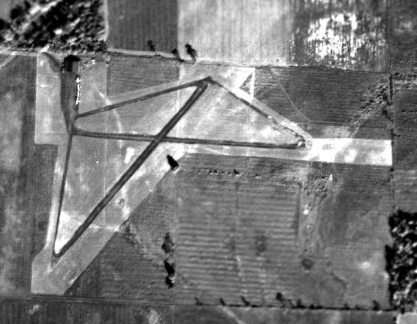
The last photo which is available of County Line Airport was a 9/24/63 USGS aerial view.
It depicted the field as having 2 paved runways, 3 paved taxiways, and a paved ramp on the northwest side with a hangar
and 7 light single-engine planes.
According to Mark Hess, “During 1965, there were 2 competing airports nearby that got government funding whereas County Line Airport was left out.
County Line Airport was unable to improve/extend it's runways to get more business to generate revenue.
As a result, it was sold to a real estate developer for housing sometime after 1965.”
Signs of County Line Airport's impending demise were perceptible in a 1966 aerial photo.
Only a single plane was visible on the ramp outside the hangar,
and areas off the departure ends of the West and Northeast runways had been cleared,
presumably for the housing developments which would shortly replace the little airport.
The last aeronautical chart depiction which has been located of County Line Airport
was on the July 1967 Detroit Sectional Chart (courtesy of Jonathan Hull).
It depicted County Line as having a 2,300' runway.
The Aerodromes table described the field as having 2 turf runways, 80 octane fuel, and major repair service.
County Line Airport was evidently closed at some point between 1967-68,
as it was no longer depicted on the June 1968 Detroit Sectional Chart (according to Jonathan Hull).
A 1972 aerial view showed that a housing development had been built at some point between 1966-72 adjacent to the west side of the airport,
which otherwise appeared to remain intact.
A 1978 aerial photo showed the site of County Line Airport (from the University at Buffalo Map Libraries, courtesy of Jonathan Hull).
Jonathan observed, “The photo clearly showed the outline of the runways & an apparently intact hangar.
However, the encroachment from nearby development is also obvious.
Undoubtedly, this was a major cause for the demise of the airport.”
A 1995 aerial view showed the hangar still remained standing on the northwest side of the County Line Airport site.
A 2002 aerial view showed the hangar had been removed at some point between 1995-2002, with only the foundation remaining.
A circa 2007 aerial view looking south at the site of County Line Airport showed the foundation of the hangar at bottom-right,
and the path of the northeast/southwest runway at top-left.
A June 2009 photo by Jonathan Hull “shows the view toward the departure end of the West runway.
The intersection of the crosswind runway can be seen in the distance.
A visit to the site by Jonathan Hull & Theodore Hull found that the area was recently cleared of brush
and graded, perhaps in anticipation of covering it with housing as was most likely the plan when the airport was closed more than 40 years ago.
However, traces of the airport can still be seen among the remains.”
A June 2009 photo by Jonathan Hull of “the hangar's concrete pad & the remains of indoor floor tiles at its southwest corner.
This was probably the airport office where Mr. Apthecker introduced aspiring pilots to the wonders of aviation.”
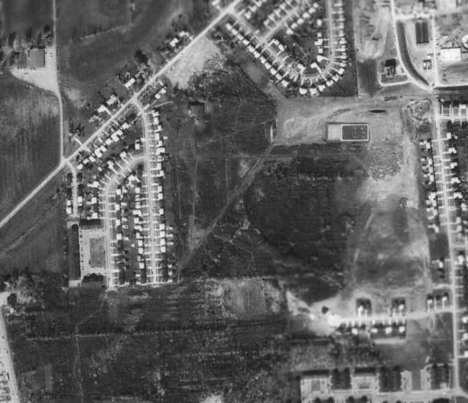
A 2014 aerial photo of the site of County Line Airport shows the majority of the property remains clear more than 46 years after the airport closed, inexplicably.
The hangar foundation also remains recognizable on the northwest side of the site.
The site of County Line Airport is located southeast of the intersection of Tonawanda Creek Road & East Summerset Lane.
Thanks to Jonathan Hull for pointing out this airfield.
____________________________________________________
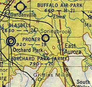
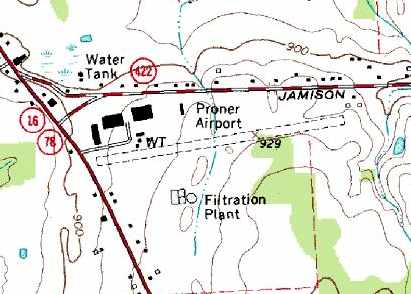
42.8, -78.65 (Southeast of Buffalo, NY)
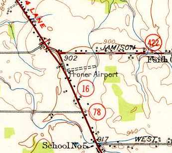
Proner Airport, as depicted on the 1948 USGS topo map.
This general aviation airport was evidently established at some point between 1948-49,
as it was not yet depicted on the December 1948 Detroit Sectional Chart.
The earliest depiction of this field which has been located was on the 1948 USGS topo map.
It depicted “Proner Airport” as having a single 1,400' unpaved east/west runway,
with a single building on the northwest side of the field.
Jim Birke recalled, “Proner Airport... I lived nearby.
When I was about 12, I helped guy repair the tail wheel on his Aeronca, I think it was the Champ model.
When I first saw him, I asked him if I could help him. He said 'Hand me a 9/16 combination wrench.'
Being a country boy, I knew what that was & handed him one. He said 'Yeah, you can help.'
After that, he'd let me know when he'd be at the field & we'd fix something or clean something.
For helping him he'd take me flying all over western NY in that little plane. Great experience for a young fella.”
The earliest aeronautical chart depiction which has been located of Proner Airport was on the December 1949 Detroit Sectional Chart.
It depicted Proner Airport as having a mere 1,500' unpaved runway.
A 1951 aerial view of Proner Airport (from the Erie County Department of Public Works, courtesy of Jonathan Westerling)
showed the field to have a single grass east/west runway, with a single hangar on the northwest side of the field.
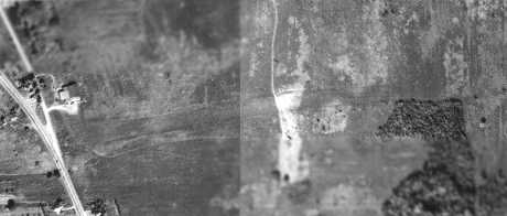
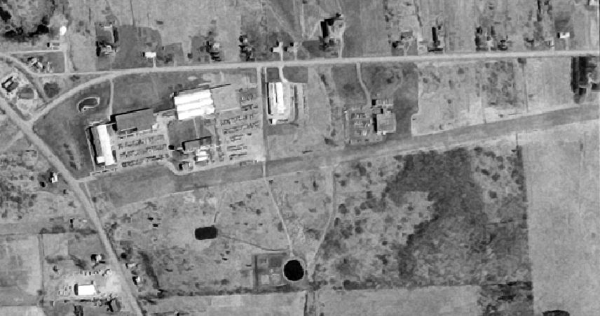
A 1958 aerial view showed that several large buildings & parking lots had been built adjacent to the hangar on the northwest side of Proner Airport.
A circa 1958 photo by Jim Birke of the former Proner Airport hangar, visible behind a recently added industrial building.
Jim Birke noted, “This was a couple of years after Moog Valve took it over.
The hangar doors are still intact but, I don't think there were any aircraft hangared there at that time.”
The November 1954 Detroit Sectional Chart (courtesy of Chris Kennedy) depicted Proner as having a 1,900' unpaved runway.
A 1966 aerial view depicted Proner Airport as having a single unpaved runway.
The last photo which has been located showing Proner Airport still largely intact was a 4/17/74 USGS aerial view.
It depicted Proner as having a single east/west unpaved runway, along with several buildings on the northwest side of the field.
There were no aircraft visible on the field, and it was not evident if it was still in operation at this point.
The last aeronautical chart depiction which has been located of Proner Airport was on the May 1977 Detroit Sectional Chart.
It depicted Proner as a private airfields having a 3,500' unpaved runway.
Proner Airport was evidently closed (for reasons unknown) at some point between 1977-85,
as it was no longer depicted on the October 1985 Detroit Sectional Chart.
The 1995 USGS topo map depicted Proner Airport as having a single 2,800' east/west unpaved runway,
along with several buildings on the northwest side of the field.

The 1995 USGS aerial view looking northeast showed a very different story compared to the topo map from the same year:
Proner Airport had been covered by buildings & parking lots, with only the outline of the runway still barely recognizable.
A 2014 aerial view looking northeast showed only some short runway pavement portions remained at the site of Proner Airport.
The site of Proner Airport is located southeast of the intersection of Jamison Road & Seneca Street.
____________________________________________________
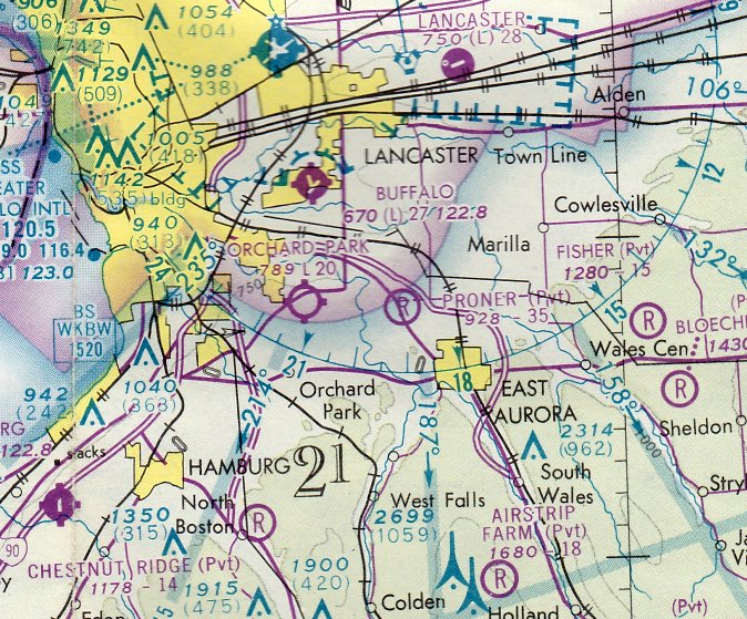
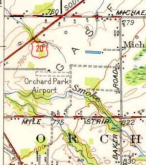
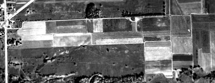
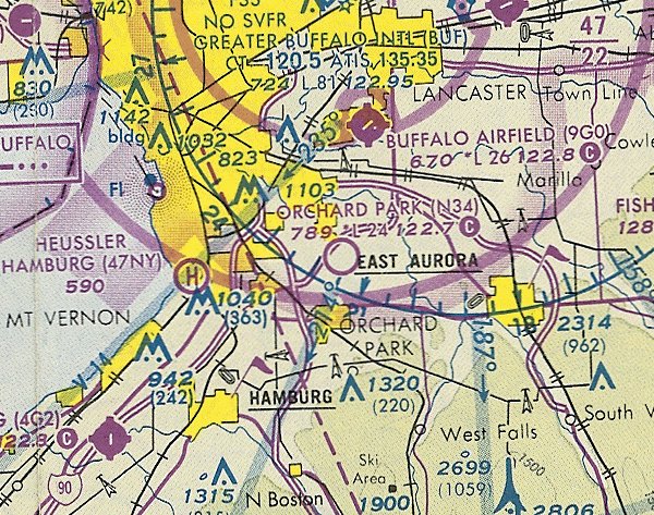
Orchard Park Airport (34D / N34) / Orchard Park Army Airfield, Orchard Park, NY
42.8, -78.74 (South of Buffalo, NY)
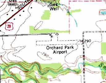
Orchard Park Airport, as depicted on the July 1947 Detroit Sectional Chart (courtesy of Dick Merrill).
This general aviation airport was evidently established at some point between 1946-47,
as it was not yet depicted on the July 1946 Detroit Sectional Chart (according to Chris Kennedy).
The earliest depiction of this field which has been located
was on the July 1947 Detroit Sectional Chart (courtesy of Dick Merrill).
The 1948 USGS topo map depicted “Orchard Park Airport” as having a single 1,800' unpaved east/west runway,
with a single building on the north side of the field.
The June 1949 Detroit Sectional Chart depicted Orchard Park Airport as having a 2,000' unpaved runway.
A 1951 aerial view of Orchard Park Airport (from the Erie County Department of Public Works, courtesy of Jonathan Westerling)
showed the field to have a single grass east/west runway.
What appeared to be a single light aircraft was visible parked on the north side of the field.
At some point between 1949-54, this little airfield was evidently taken over by the military,
as it was depicted as “Orchard Park (Army)” on the November 1954 Detroit Sectional Chart (courtesy of Chris Kennedy).
It was still depicted as “Orchard Park AAF” on the May 1957 Detroit Sectional Chart (according to Chris Kennedy).
A 1958 aerial view showed 4 light aircraft parked on the north side of the field.
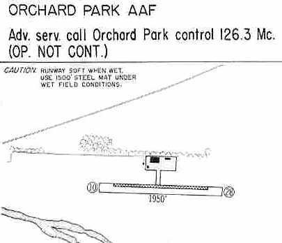
The 1960 Jeppesen Airway Manual (courtesy of Chris Kennedy)
depicted “Orchard Park AAF” as consisting of a 1,950' grass Runway 10/28,
on the north side of which was superimposed a 1,500' steel mat (to be used under wet field conditions).
According to Ronald Ciura, “In September 1962 the New York Army National Guard had moved out the L-19s
and the field was operated by DAB Aviation.
In May 1963 a fire destroyed the hangar & several aircraft.”
Orchard Park was not listed among civilian airfields in the 1963 AOPA Airport Directory (according to Chris Kennedy).
On the July 1965 Detroit Sectional Chart (according to Chris Kennedy),
Orchard Park was listed as a private (civilian) airfield.
A 1966 aerial view showed 3 light aircraft parked on the north side of the field.
A circa 1965-75 photo by Henry Hunt, of “my Dad W.F. Hunt in front of the snowbound lounge (we just called it 'The Lounge' not the Operations Building).”
Henry Hunt recalled, “I spent the majority of my weekends from circa 1965-75 at the Orchard Park Airport.
My Dad W.F. Hunt & his brother George started with a Taylorcraft, then switched to a Stinson Voyager,
then bought an Airknocker, sold the Voyager to add an L-5 & eventually had a glider & banner towing business (the L-5 was perfect for this) under Blasdell Luftwaffe, Inc.
They also rented the Champ. At the end they sold those last 2 & the Corporation & bought the Citabria.
The [airport] manger of the time was Martin Reiman.”
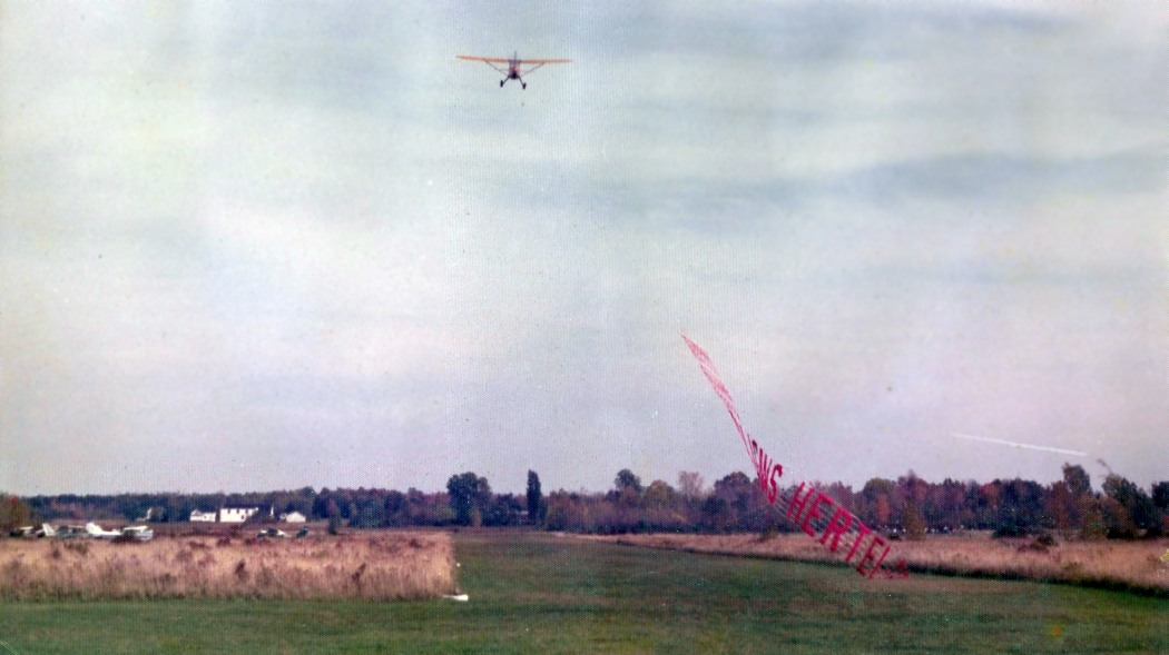
A circa 1965-75 photo by Henry Hunt of a Stinson L-5 "Flying Grasshopper" picking up a banner at Orchard Park Airport.
A 1974 photo by Henry Hunt of a Stinson L-5 at Orchard Park Airport.
Henry Hunt recalled, “There was a chapter of the Civil Air Patrol based there.
My Dad (aka Bill, Red) persisted thru hoops of research, letter writing, even organizing an event with an official
and generally bull charging against being put off... to divert the L-5 from being 'scraped out' to Israel.
It was flown in fully operational. Somebody had hammer-tapped an under-wing inspection plate to mark it as scrap.”
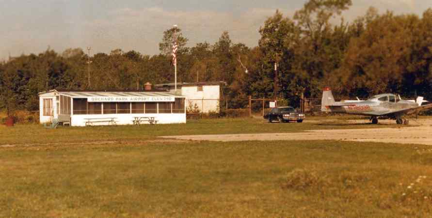
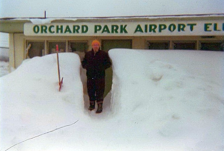
A 1983 photo by Mike Zimmer of the operations shack of Orchard Park Airport,
with a pretty natural-metal Navion on the right.
Mike Zimmer recalled, “When on leave from Offutt AFB in the early 1980s,
I would get checked out on a C-172 from Orchard Park & take my dad for a ride.”
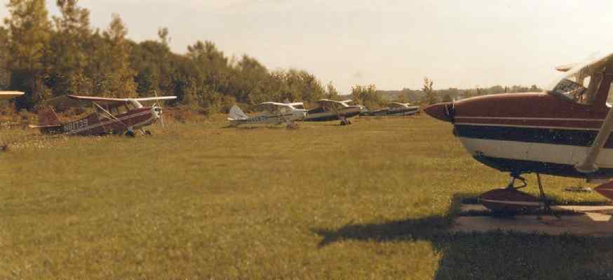
A 1983 photo by Mike Zimmer of several light single-engine aircraft in the tie-down area at Orchard Park Airport.
The 1982 AOPA Airports USA Directory (courtesy of Ed Drury) described Orchard Park Airport as having a single 2,120' turf Runway 9/27.
The field was said to offer fuel, repairs, tiedowns, flight instruction, and plane rental, and the operator was listed as Quaker Flying Service, Inc.
The 1993 Jeppesen Airport Directory described Orchard Park Airport as having a single 2,400' turf Runway 9/27.
The last aeronautical chart depiction which has been located of Orchard Park Airport was on the October 1993 Detroit Sectional Chart (courtesy of Ron Plante).
It depicted Orchard Park as having a 2,400' unpaved runway.
The 1995 USGS topo map depicted Orchard Park Airport as having a single east/west unpaved runway, and several buildings on the north side of the field.
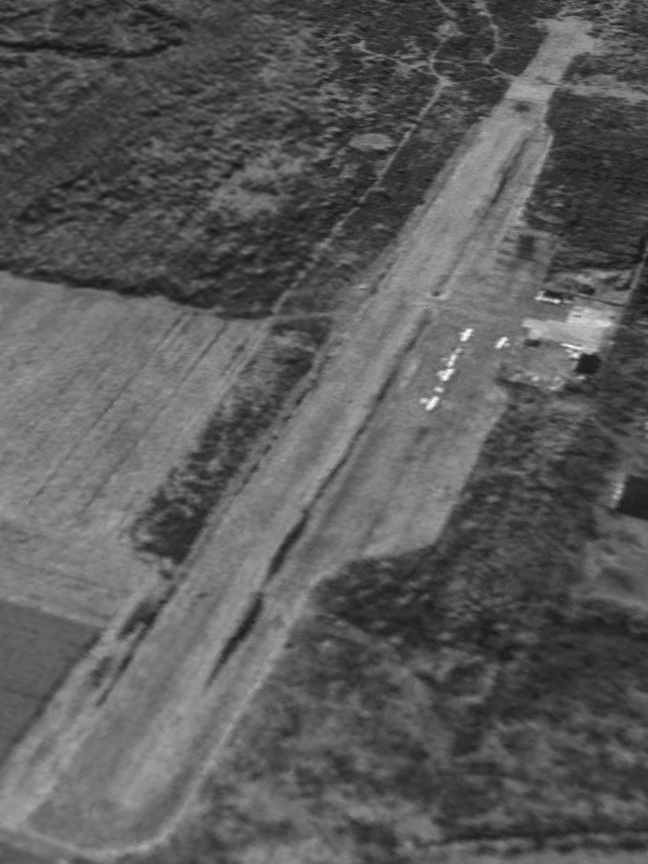
Orchard Park Airport was still operational in 1995, as the 1995 USGS aerial view looking southwest showed a total of 5 light single-engine aircraft visible parked on the field.
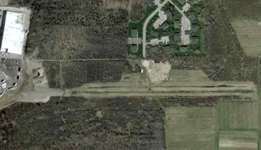
A 3/31/02 aerial view showed that Orchard Park Airport had been closed at some point after 1995,
as no aircraft were visible any longer on the field.
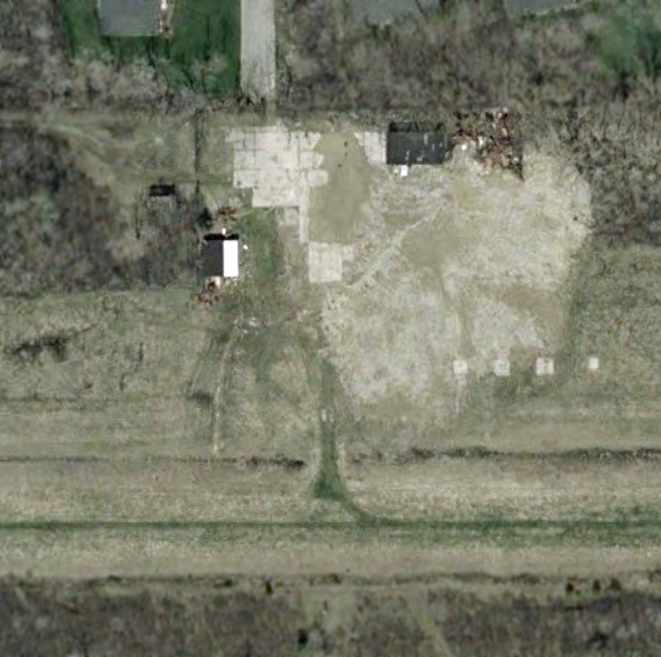
A closeup from the 3/31/02 aerial view showed that the former operations shack & hangar remained standing, but the field was devoid of any aircraft.
Mike Zimmer reported in 2005, “Today I would estimate the western half of the field is now a shopping mall & apartment complex.
I know because my apartment building is part of that complex.”
A circa 2005 aerial view looking north at the former operations building, hangar, and ramp at the former Orchard Park Airport.
A 10/5/11 aerial view looking southwest at the remains of Orchard Park Airport.
The site of Orchard Park Airport is located at the southern terminus of Countryside Lane,
southeast of its intersection with Southwestern Boulevard.
____________________________________________________
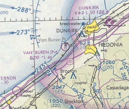
Fredonia Airpark / Van Buren Flying Club Airport, Fredonia, NY
42.44, -79.4 (Southwest of Buffalo, NY)

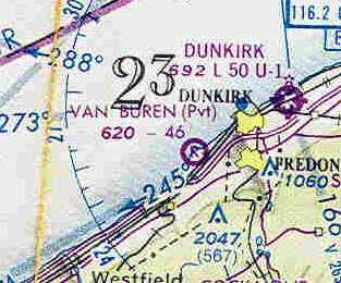
Fredonia Airpark, as depicted on the December 1946 Detroit Sectional Chart.
This general aviation airport was evidently established at some point in 1946,
as it was not yet depicted on the July 1946 Detroit Sectional Chart.
The earliest depiction which has been located of Fredonia Airpark was on the December 1946 Detroit Sectional Chart.
It depicted Fredonia as a commercial/municipal airport.
The earliest photo which has been located of Fredonia Airport was a 5/10/53 USGS aerial view.
The field was depicted as having 2 paved perpendicular runways, with a few small buildings to the northeast of the runway intersection.
No aircraft were visible parked outside.
The 1954 USGS topo map depicted Fredonia Airport as having a single unpaved east/west runway, with several small buildings along the north side.
Fredonia evidently gained a 2nd runway at some point between 1954-62,
as the 1962 AOPA Airport Directory described “Fredonia Airpark”
as having 2 gravel runways: 2,550' Runway 9/27 & 1,925' Runway 18/36.
The field was said to offer fuel, hangars, tiedowns, and charter. The operator was listed as Fredonia Airpark, Inc.
Mike Zimmer recalled, “The height of activity was during the late 1950s to mid-1960s.”
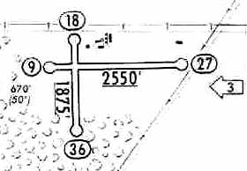
The 1965 Jeppesen Airway Manual (courtesy of Chris Kennedy) depicted Fredonia Airport as having 2 turf runways: 2,550' Runway 9/27 & 1,875' Runway 18/36.
A cluster of small buildings was depicted to the northeast of the runway intersection, and the manager was listed as A.J. Wahl.
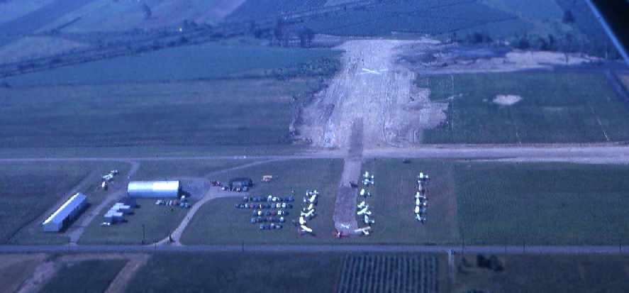
A circa 1966-69 aerial view by Len Zimmer of Fredonia Airport (courtesy of Mike Zimmer).
The field was depicted as having a single paved runway,
along with a former crosswind runway which was already marked as being closed.
Several small hangars were depicted, along with about 20 light single-engine aircraft.
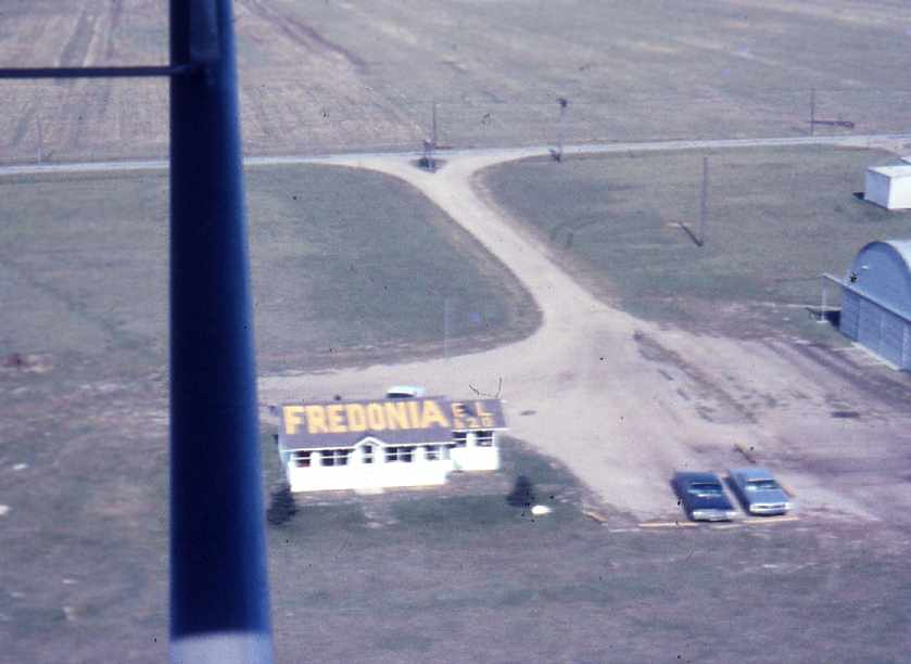
A circa 1966-69 aerial view by Len Zimmer of the Fredonia Airport office building (courtesy of Mike Zimmer).
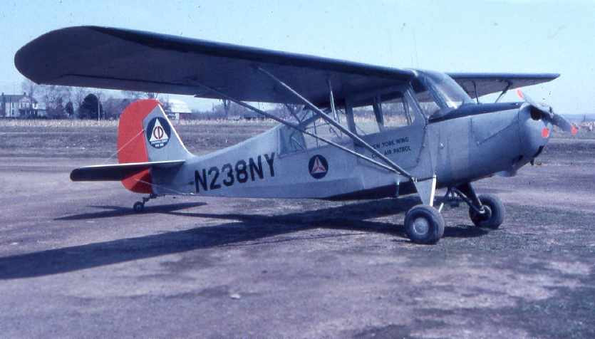
A circa 1966-69 photo by Len Zimmer of the Dunkirk-Fredonia Civil Air Patrol squadron's Aeronca (courtesy of Mike Zimmer).
Mike Zimmer recalled, “My dad flew his Luscombe 8E from this field
as well as the Dunkirk-Fredonia Civil Air Patrol squadron's Aeronca.
For several years, the Red Wing food company in Fredonia based its corporate airplane (a Cessna 310) at this strip.”
The November 1974 Detroit Sectional Chart (courtesy of Ron Plante) depicted Fredonia as a public-use airport having a 3,400' unpaved runway.
At some point between 1974-76, the field was evidently renamed the “Van Buren” Airport,
as that is how it was labeled on the December 1976 CF-18 World Aeronautical Chart (courtesy of Chris Kennedy).
The runways had also been significantly lengthened,
the field being described as having a 4,600' unpaved runway.
However, the status of the field had also changed to a private field.
The last aeronautical chart depiction which has been located of Van Buren Airport was on the May 1981 Detroit Sectional Chart.
It depicte Van Buren as a private airfield having a 4,600' unpaved runway.
The 1982 AOPA Airports USA Directory (courtesy of Ed Drury) described the “Van Buren Flying Club” Airport
as having 2 gravel runways: 4,650' Runway 9/27 & 2,850' Runway 18/36.
The status of the field was described as “Private. Closed to public.”
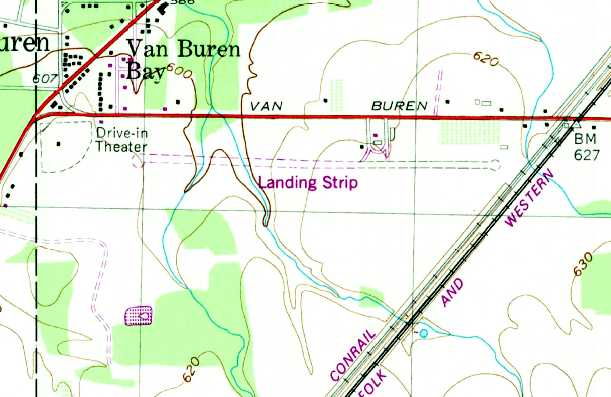
The 1986 USGS topo map still depicted 2 runways, but they were labeled simply as “Landing Strips”,
which may indicate that the airport was already closed by that point.
Mike Zimmer recalled, “I drove by the area about 15 years ago [1990] with my Dad.
All buildings were gone & there was major shrub growth along the road.
You could still glimpse the remains of a strip through the trees.”
The 1990 USGS topo map still depicted a single runway, but it was labeled simply as “Landing Strip”.
Van Buren Airport was no longer depicted on the October 1993 Detroit Sectional Chart.
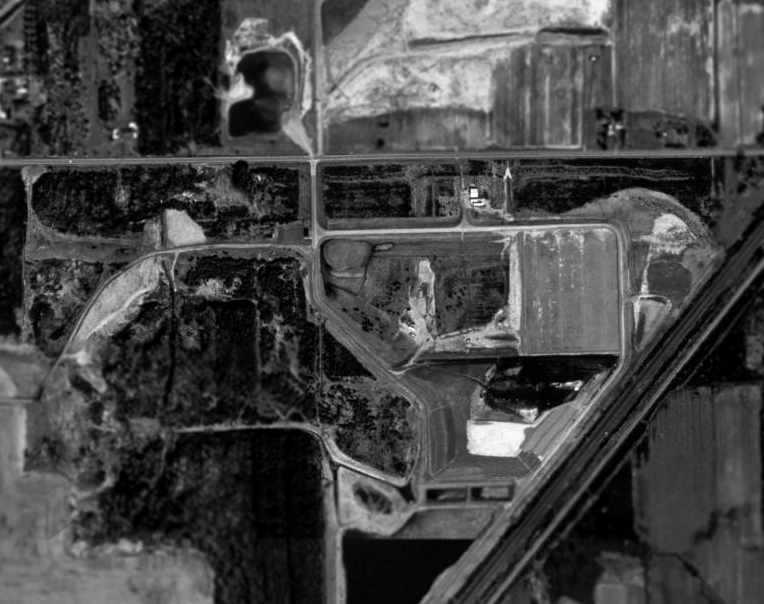
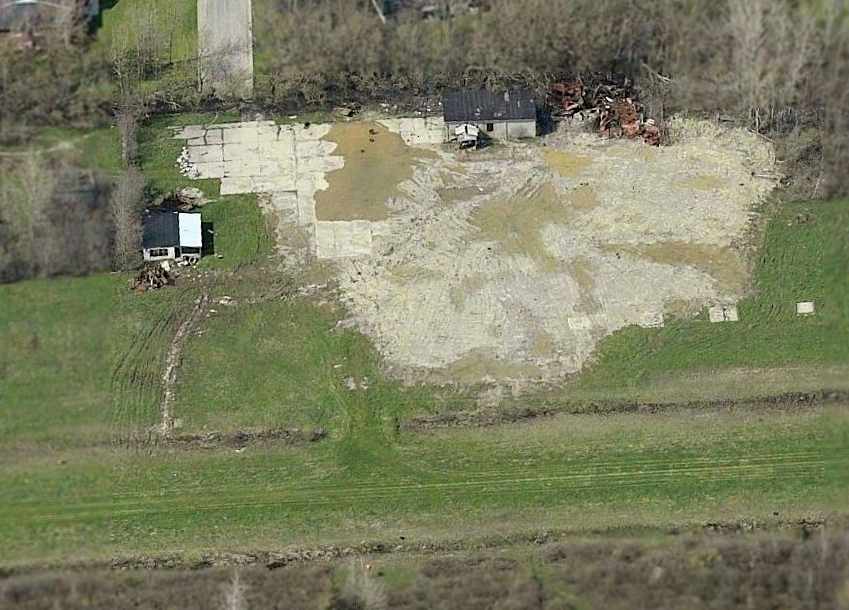
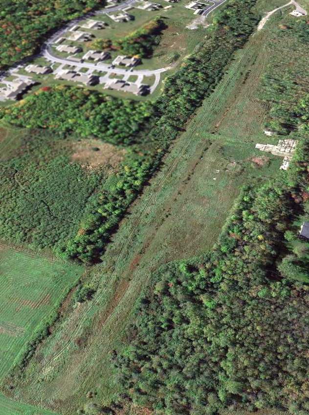
In the 1994 USGS aerial photo the majority of the property of the former Fredonia Airport had been covered by a landfill.
However, at least one of the former airport buildings appeared to remain,
and the western portion of the outline of the former runway was still recognizable as well.
Mike Zimmer reported in 2005, “I drove by the airfield last week and it is now a landfill site.”
A circa 2006 aerial view looking north at a former hangar & a portion of the remaining runway pavement at the site of Fredonia Airport.
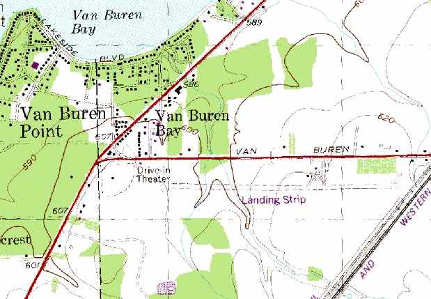
The site of Fredonia Airport is located southeast of the intersection of Route 5 & Van Buren Road.
____________________________________________________
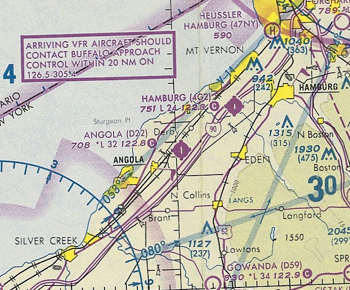
Evans Airways Airfield / Angola Airways Airfield / Angola Airport (D22), Angola, NY
42.66, -79 (Southwest of Buffalo, NY)
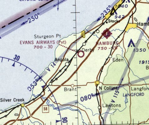
Evans Airways Airfield, as depicted on the July 1965 Detroit Sectional Chart.
This small airfield was evidently built at some point between 1960-65,
as it was not yet depicted on a 1958 aerial view nor on the May 1960 Detroit Sectional Chart.
The earliest depiction which has been located of Evans Airways Airfield was on the July 1965 Detroit Sectional Chart,
which depicted it as a private airfield having a 3,000' unpaved runway.
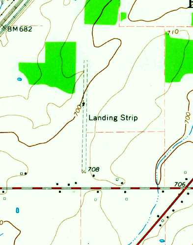
Evans Airways Airfield was depicted on the 1965 USGS topo map as a single north/south unpaved runway, labeled simply as “Landing Strip”.
A 1966 aerial view depicted Evans Airways Airfield in the same configuration as seen in 1963,
but a single light aircraft was visible next to the hangar on the south side.
Evans Airways Airfield was not yet listed in the 1967 AOPA Airport Directory (according to Chris Kennedy).
It had been renamed Angola Airways Airfield by the time of the January 1968 Detroit Sectional Chart.
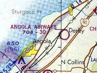
The 1971 Detroit Sectional Chart (courtesy of Chris Kennedy) depicted "Angola Airways" as having a 3,000' unpaved runway.
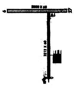
The 1982 AOPA Airport Directory (courtesy of Ed Drury)
described "Angola Airways" Airport as having a 3,200' asphalt Runway 1/19 & a 2,550' gravel Runway 9/27.
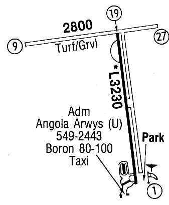
The 1986 Flight Guide (courtesy of Chris Kennedy) depicted Angola Airways Airport
as having a 3,230' paved runway 1/19 & a 2,800 turf/gravel Runway 9/27,
as well as several small buildings on the southwest side of the Runway 1/19.
The 1993 Jeppesen Airport Directory depicted Angola Airport
as having a single 3,212' paved runway 1/19 & a 2,915 turf/gravel Runway 9/27,
as well as several small buildings on the southwest side of the Runway 1/19.
The operators were listed as Angola Aircraft Services & Premier Airways.
The last aeronautical chart depiction which has been located of Angola Airport was on the October 1993 Detroit Sectional Chart (courtesy of Ron Plante).
It depicted Angola Airport as having a 3,200' paved north/south runway.
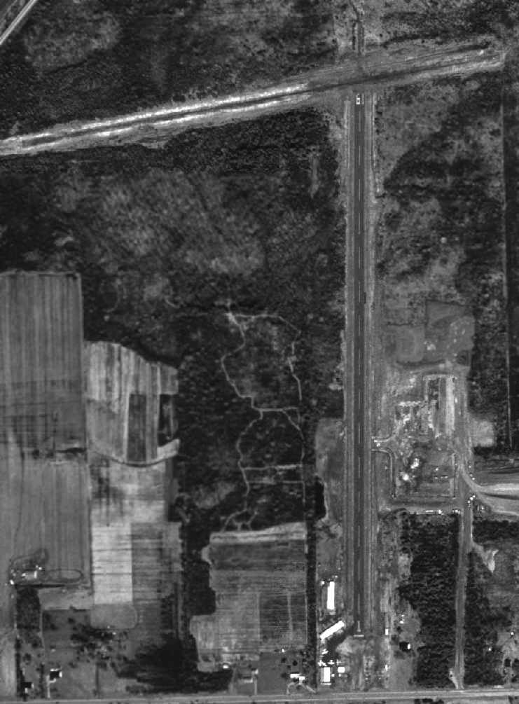
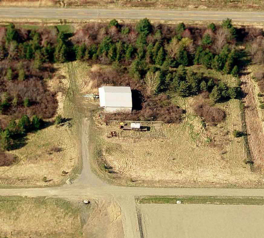
In the 1994 USGS aerial photo (taken while the field was still open),
a total of 5 light single-engine aircraft were visible on the field,
parked around a cluster of small buildings & hangars on the south end of the field.
The new ramp on the east side of the field was evidently under construction at this point.
Angola Airport was still listed in the 2001 AOPA Airport Directory.
The field was described as having a 3,212' asphalt Runway 1/19 & a 2,800' gravel Runway 9/27.
Dennis Sandow reported in 2003 that Angola had "a succession of owners who were more airplane lovers than businessmen.
I used to fly in there to visit my family nearby. Sometimes he had fuel, sometimes not.
If the office was closed, a sign on the door told you to call the owner at his (real) 9-5 job.
About 3-5 based aircraft, but no market."
According to the 2003 Annual Report of the NY Department of Transportation,
Angola Airport was one of 2 public use airports in NY which closed in 2002 (the other was Kamp).
"The operator of this airport declared bankruptcy & had a mortgage on the property;
the Town of Evans was not interested in purchasing the property with federal & state assistance."
According to Dennis Sandow, Angola Airport has "very awkward highway access & no sewers,
so it's not going to become a Wal-Mart or condos. Just abandoned."
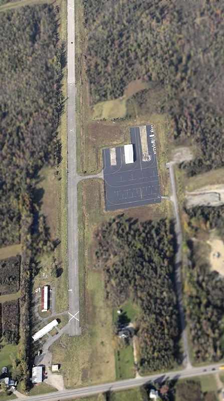
A circa 2001-2005 aerial view looking north at the south end of Angola Airport's Runway 1/19 shows that the airport remained completely intact.
A closed-runway “X” symbol was visible on the runway, and the hangars remained standing, on the southwest & east sides of the runway.
A 7/28/07 aerial view showed Angola Airport to remain largely intact.
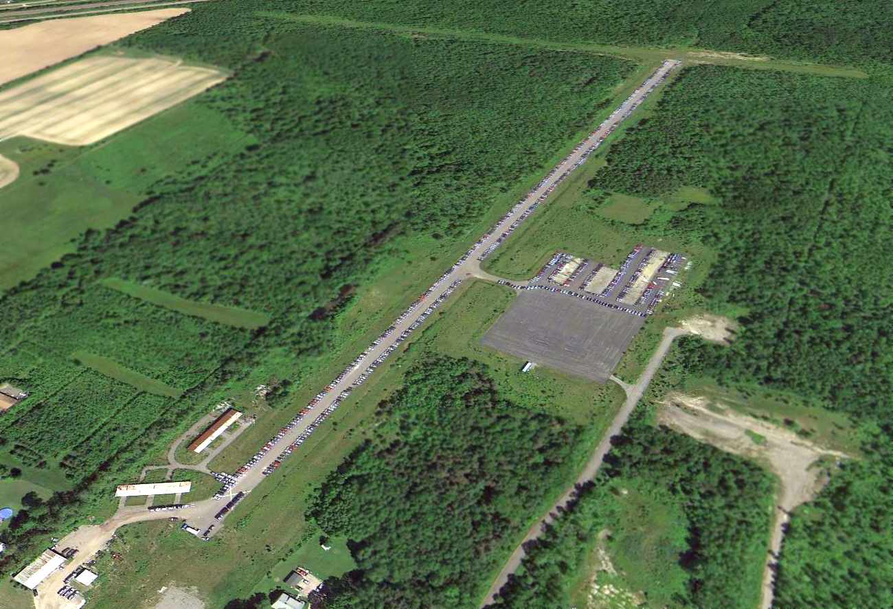 2014 aerial view looking
northwest showed Angola Airport to remain intact, but the runway &
ramps were being used to store hundreds of cars.
2014 aerial view looking
northwest showed Angola Airport to remain intact, but the runway &
ramps were being used to store hundreds of cars.
Angola Airport is located northwest of the intersection of Evans Center Road & Southwestern Boulevard.
____________________________________________________
42.177, -78.383 (Southeast of Buffalo, NY)
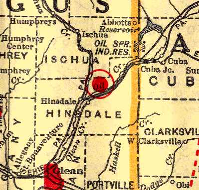
Olean Airport, as depicted on the 1929 Rand-McNally Standard Map of NY with Air Trails (courtesy of Chris Kennedy).
The date of construction of this small general aviation airport has not been determined.
The earliest depiction of the Olean Airport which has been located
was on the 1929 Rand-McNally Standard Map of NY with Air Trails (courtesy of Chris Kennedy).
It described the "Olean Airport" as a commercial airport, operated by D. Murphy.
The field was said to be 50 acres in size, and to have a 1,500' runway.
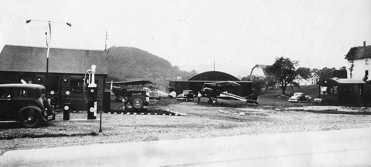
A 1930 photo by Archibald Schuyler of several biplanes at Hinsdale (courtesy of Scott Schuyler).
The gas station adjacent to the airport is at the left, and the airport office is the small dark building on the right.
The earliest photographic depiction of the airport in Hinsdale which has been located
was in a series of 1930 photos by Archibald Schuyler (courtesy of Scott Shuyler).
They depicted the airport as a grass airfield with a single arch-roof hangar & a small office building, adjacent to a gas station.
Several biplanes were depicted on the field.
Scott Schuyler reported that his grandfather, Archibald Schuyler,
"owned an Alexander Eaglerock Long Wing (NC3032) & flew from Hinsdale."
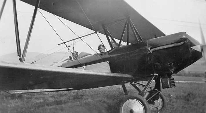
A 1930 photo of an Eaglerock Longwing at Hinsdale, with Archibald Schuyler in the back seat (courtesy of Scott Schuyler).
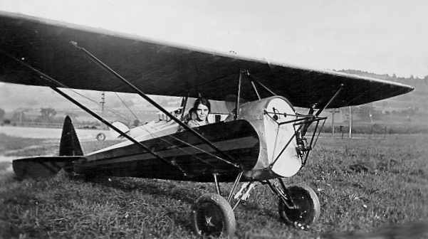
A 1930 photo by Archibald Schuyler of a woman in an unidentified parasol monoplane (missing its engine) at Hinsdale (courtesy of Scott Schuyler).
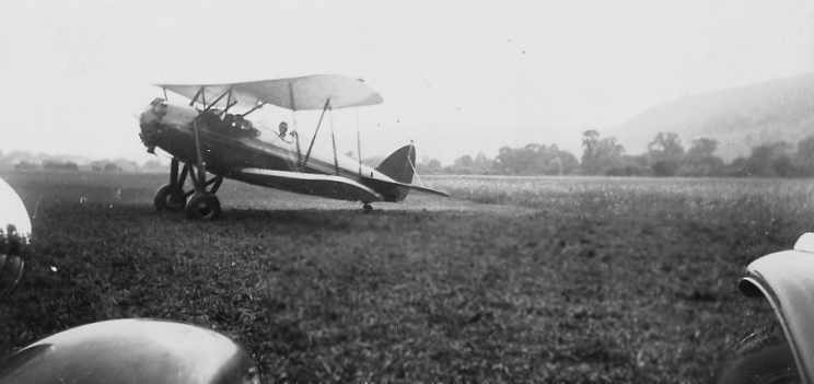
A 1931 photo by Archibald Schuyler of an unidentified biplane at Hinsdale (courtesy of Scott Schuyler).
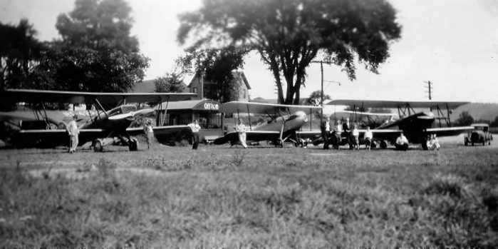
A 1931 photo by Archibald Schuyler of planes lined up at Hinsdale (courtesy of Scott Schuyler).
with the airport office visible in the background.
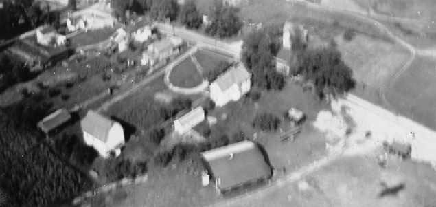
A 1932 aerial photo by Archibald Schuyler of the airport at Hinsdale (courtesy of Scott Schuyler),
showing a hangar (large building at bottom-center), the airport office (small building just to the right),
and what appears to be the shadow of the airplane from which the photo was taken (bottom right).
Scott Schuyler reported that the logbook of his grandfather (Archibald Schuyler) had entries for Hinsdale up to 1933.
The Airport Directory Company's 1933 Airport Directory (courtesy of Chris Kennedy)
described the "Olean Airport" in Hinsdale as a commercial airport.
The sod field was said to be 50 acres in size, measuring 1,800' x 1,000'.
A hangar was said to have "Olean Airport Hinsdale NY" painted on the roof.
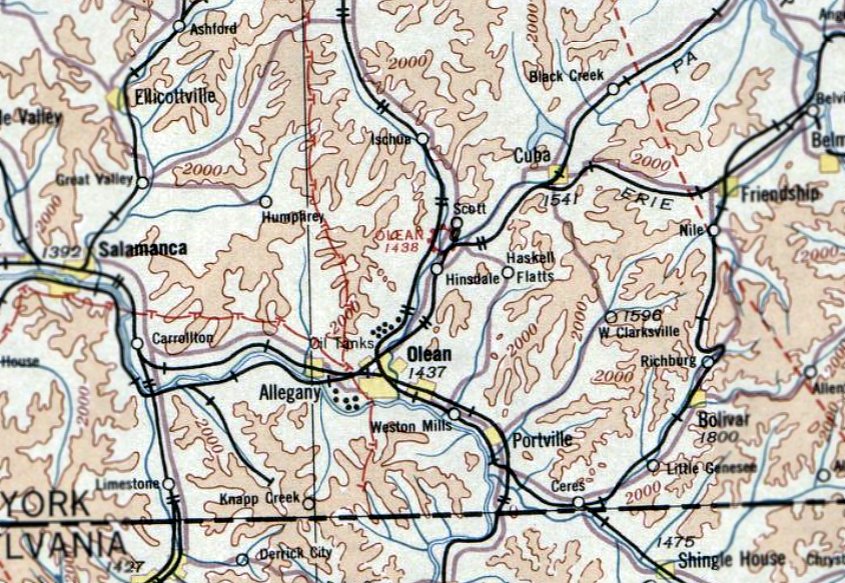
The earliest aeronautical chart depiction which has been located of Olean Airport was on the August 1933 Detroit Sectional Chart.
It depicted Olean as a commercial/municipal airport.
The 1934 Department of Commerce Airport Directory (courtesy of Chris Kennedy)
described the Olean Airport in the same fashion.
The last aeronautical chart depiction which has been located of Olean Airport was on the March 1936 Detroit Sectional Chart.
It depicted Olean as a commercial/municipal airport.
The Olean Airport evidently closed (for reasons unknown) at some point between 1936-37,
as it was no longer depicted on the February 1937 Detroit Sectional Chart,
listed among active airfields in The Airport Directory Company's 1937 Airports Directory (courtesy of Bob Rambo),
or depicted on the 1938 USGS topo map.
According to Sheila Brown, at some point before 1956 the Olean Airport office was
relocated about a quarter-mile northeast of the airport site, to the north side of Route 446.
Sheila recalled, “1956 is when we moved in.
The Office was moved to its current location and turned into 'The Glass House' for Mildred Booth’s business.
The Glass House windows were lined with shelving that held the delicate items for her business, 'Treasures, Trash and Trinkets'.”

Scott Schuyler has annotated the 1994 USGS aerial photo of the site of Olean Airport,
showing the location of the former runway, hangar, and other elements of the former airport.
Interstate 86 has been built over the southern portion of the airfield site.
Scott Schuyler recalled from a visit to the site of Olean Airport in 2003, "The airport is currently a vacant field,
and partially used by the state to house snowplows & heavy equipment.
The house located next to the airport is still standing.
The gas station appeared to be standing in the USGS photo, but it is not there now.
All visible signs of the airfield are long gone."
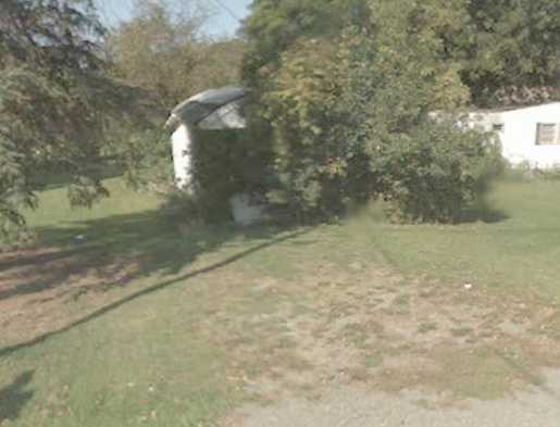
A circa 2011-2013 photo looking north at the circa 1920s/1930s Olean Airport office,
relocated about a quarter-mile northeast of the airport site, to the north side of Route 446.
Sheila Brown reported in 2013, “I own an old building (we call it 'The Glass House')
[seen in the 1930 pictures] that used to be the office for the Olean Airport.
It is located just a little up the road from its original location in Hinsdale.
It must have been a dark color back in the early 1930s. I only have ever known it painted white.
I want to DONATE this old building to some place that will save it as a part of AIRFIELD HISTORY.
It has most of the original glass. The Glass House is covered with the lilac bushes.
Only the front part of the building is The Glass House – the back half was added on (meaning one of the 4 glass walls is now wood).
The front part has a few broken windows but the glass is original – with maybe a couple replacements.
The roof in the back half (not the glass half part) has a hole in it.
The Glass House part is a really nice piece of history that I just don’t want to end up in a dumpster.
My daughter-in-law begged me to keep it. It really belongs with some historic preservation club – preferably aviation history.
I will be sad if I end up throwing this piece of history away.”
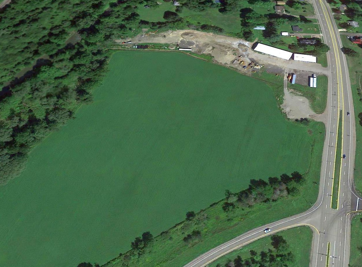
A 2016 aerial view looking north showed the site of Olean Airport no longer has any recognizable trace as a former airfield.
The site of Olean Airport is located northwest of the intersection of Interstate 86 & Route 16.
____________________________________________________
Consolidated Aircraft Airfield / Bell Airport / Tonawanda Airport, Tonawanda, NY
42.992, -78.889 (North of Buffalo, NY)
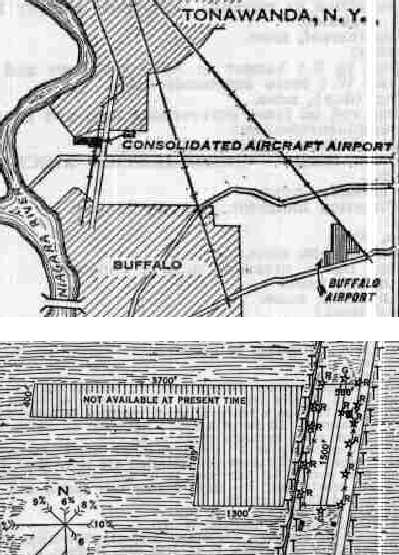
"Consolidated Aircraft Airport", as depicted on a 1929 Department of Commerce Airway Bulletin (courtesy of Jonathan Hull).
This airport in the town of Tonawanda was the factory airfield for the Consolidated Aircraft Company,
and later served as an airfield for the Bell Aircraft Company.
According to Phil Warner, “I am in possession of document RL893 from the Tonawanda-Kenmore Historical Society.
This document states that Consolidated Airfield was built starting in 1928 (by Reuben Fleet, President)
per permits 2315 (7/31/28), 225 (6/4/29), 553 (4/16/30), and 2568 (5/27/37).”
The earliest depiction which has been located of Consolidated Aircraft Airport
was on a 1929 Department of Commerce Airway Bulletin (courtesy of Jonathan Hull).
It depicted Consolidated Aircraft Airport as having a single 1,500' cinder runway, oriented north/south,
which was located in a narrow plot of land in between Route 265 & the NY Central Railroad.
However, there were already apparently plans to expand the airfield,
as the airfield diagram also depicted an "L"-shaped 3,100' x 2,100' plot of land on the opposite (western) side of the railroad,
which was labeled "Not available at the present time".
A single 80' x 60' metal hangar was located on the northeast side of the field, and was marked "Consolidated Aircraft Airport".

A 6/1/30-11/16/31 photo of Consolidated 20-2 Fleetster, C/n 3 CF-AIP at Tonawanda Airport.
The earliest aeronautical chart depiction which has been located of the Consolidated Aircraft Airport was on the June 1931 NY Sectional Chart.
Phil Warner reported that “The Consolidated Aircraft Field [was] where my father tested Fleet trainers.
He died as the result of a crash in 1936 while demonstrating Fleet trainers to the Mexican War Department.”
A circa 1930s photo possibly taken at Consolidated Aircraft Airport (courtesy of William Mackolin) of William Mackolin, a parachutist named Pee Wee, and Dick Benson in front of a 1933 Waco UIC cabin biplane.
William Mackolin reported, “The airport name at the time of photo, I do not know. The facility was located adjacet to Military Road,
west of the Niagara River, in the jurisdiction of either Kenmore, Tonawanda, or North Tonawanda,
at which my father William Mackolin flew, in which he had a form of ownership rights & a business association with a flyer named Richard Benson.
Benson was a talented flyer. He & my father trained individuals seeking [pilot's] license. Benson was also a stunt pilot who later preformed at airshows.
Benson also trained personnel in military in preparation for WW2. Pee Wee preformed jumps for spectators on weekends.
He died as a result a failed jump made over airport or nearby land.
The topographical maps conform to my recollection of the runway layout. There was at least one hangar . Aircraft housed included Piper Cubs, Waco, and Stinson.
A passenger ship landed periodically at the field. It traveled from Cleveland. The flying business - at least for my father - was conducted primarily on weekends.
Either $5 or $10 / person for a very brief tour around the immediate area. My Dad left the flying business shortly after Pee Wee was killed.”
The Consolidated Aircraft Airport may have gone through a period of abandonment,
as no field at this location was listed among active airfields
in the Airport Directory Company's 1937 Airports Directory (courtesy of Bob Rambo).
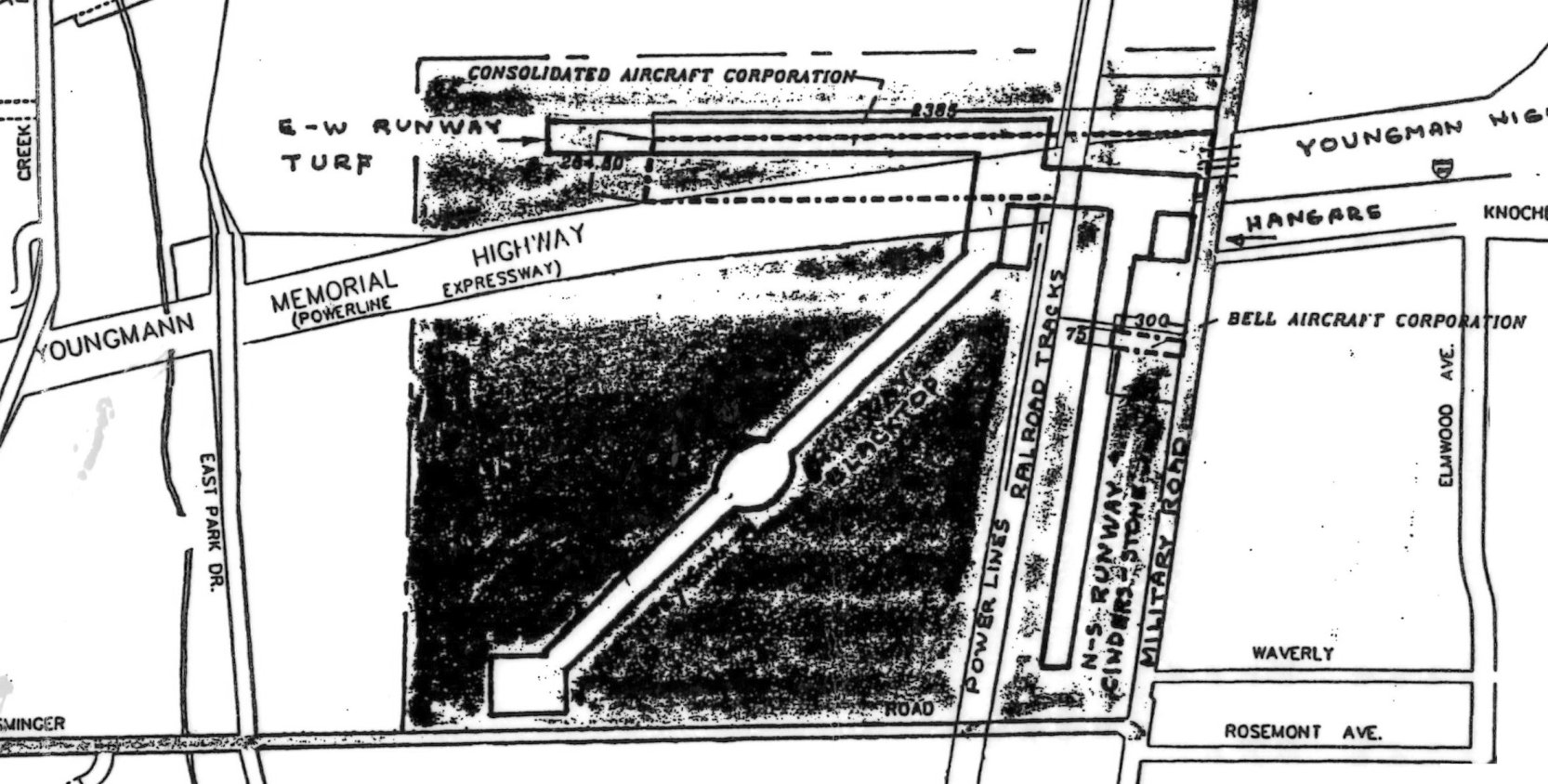
The airfield layout of Consolidate Airfield superimposed by Phil Warner & annotated to show the locations of the Consolidated Aircraft Corporation along the north side
and the Bell Aircraft Corporation on the east side, using building permits from 1928-37.
The airfield was shown to have 3 runways.
According to Jim Pellow, a 1937 video showed a flight of the prototype Gwinn Aircar at Consolidated Airport in Tonawanda.
The Aircar was designed & built by an aircraft manufacturing company set up by Joseph Gwinn, who had previously worked with Consolidated Aircraft.
The Aircar was a 2-seat single-engine biplane intended as a safe, easy to fly aircraft that would neither stall nor spin.
According to Phil Warner, the airfield “was acquired by Bell Aircraft in 1937, and by private owner, Dick Benson in 1938.
I'm not sure why Bell sold to a private owner, but I'm pretty sure it was because the runway wasn't big enough for the warplanes being developed
(Bell's Chief Designer Bob Woods had designed the P-30 pursuit plane, and was working on the Airacuda).
I imagine Bell moved to their Niagara Falls location.”
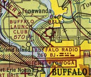
The airfield was still labeled as "Bell" Airport on the October 1943 Detroit Sectional Chart (courtesy of Mike Keefe).
The 1944 US Army/Navy Directory of Airfields (courtesy of Ken Mercer)
described Bell Airport as having a 3,600' hard-surfaced runway.
According to Phil Warner, “My friend & I spent many years there,
and we were witness to a great explosion in the hangar near Military Road that signaled the 'death knell' of the airport in the mid 1940s.
Bob & I (Bob was about 13 & I was about 11) had helped put planes away in the hangar the evening of the explosion.
We returned to our homes which were about a mile from the airport.
Around bedtime the tremendous explosion occurred.
The cause was determined to be a spark from the centrally-located furnace which shot out
and landed on large cans of dope (paint) which were stored next to the furnace so they wouldn't freeze in the cold weather.”
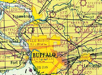
The July 1947 Detroit Sectional Chart (courtesy of Dick Merrill) depicted Tonawanda Airport as a commercial/municipal field.
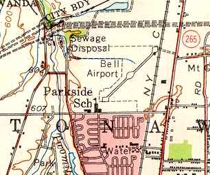
The most detailed depiction of Bell Airport which has been located was on the 1948 USGS topo map.
It showed the airport as having a single paved northeast/southwest runway,
with the curious design of having what appeared to be three turn-around areas:
one at each runway end as well as one in the middle of the runway.
Note that this runway on the west side of the railroad tracks replaced the earlier north/south runway on the east side of the tracks.
The only building depicted at the airfield was a single small building,
adjacent to the northeast end of the runway.
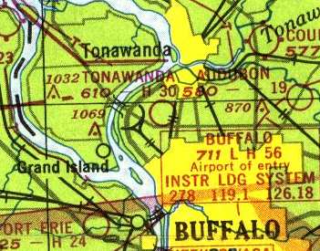
The last chart depiction of the airport which has been located was on the June 1949 Detroit Sectional Chart (courtesy of Donald Felton),
which depicted "Tonawanda" as having a 3,000' hard-surface runway.
Although some sources indicate that Bell Airport was closed in 1952,
the aeronautical charts seem to indicate that the field was closed at some point within 1949,
as it was no longer depicted at all on the December 1949 Detroit Sectional Chart (courtesy of Mike Keefe) or later charts.
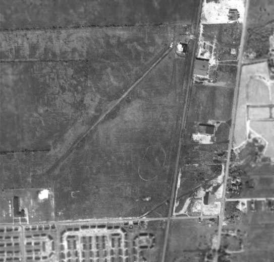
A 1951 aerial photo of the Bell Airfield (from the Erie County Public Works, courtesy of Jonathan Hull).
The northeast/southwest runway on the west side of the railroad tracks was still visible,
but there was no remaining trace of the former north/south runway on the east side of the tracks.
There was no indication that the airfield was still active at that point.
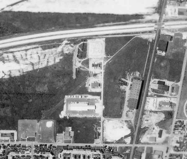
A 1966 aerial photo of the Bell Airfield (from the University at Buffalo Map Libraries, courtesy of Jonathan Hull).
Although the runway was still visible, the middle of the airfield had been covered at some point between 1951-66 by several buildings.
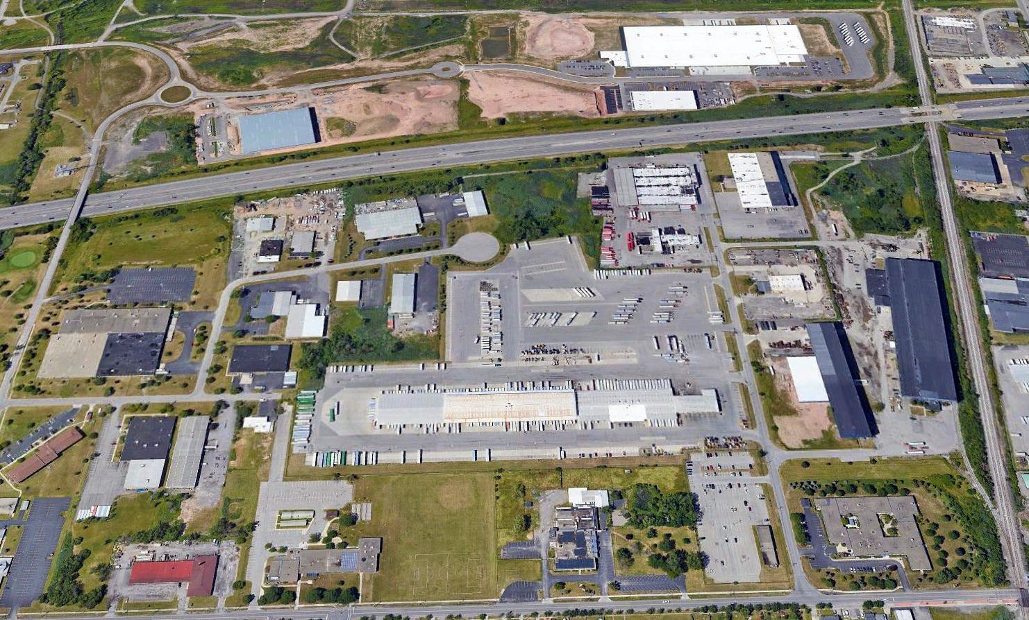
A 2017 aerial view looking north showed the site of Bell Airport had been bisected by Route 290, and a large number of industrial buildings occupied most of the site.
There did not appear to be any remaining trace of the former airfield.
The site of Bell Airport is located northwest of the intersection of Route 265 & Esminger Road.
____________________________________________________
Or if you prefer to contact me directly concerning a contribution (for a mailing address to send a check),
please contact me at: paulandterryfreeman@gmail.com
If you enjoy this web site, please support it with a financial contribution.
____________________________________________________
This site covers airfields in all 50 states.