Abandoned & Little-Known Airfields:
Northeastern Nevada
© 2002, © 2025 by Paul Freeman. Revised 6/6/25.
This site covers airfields in all 50 states: Click here for the site's main menu.
____________________________________________________
Please consider a financial contribution to support the continued growth & operation of this site.
Buffalo Valley Intermediate Field (revised 11/4/21) - Bush-Leland Airport (added 9/16/20) - Caliente Flight Strip (revised 6/6/25)
Delamar Lake Landing Strip (revised 8/10/19) - Dover Airport (added 9/15/20) - Pioche Municipal Airport (revised 3/10/24)
____________________________________________________
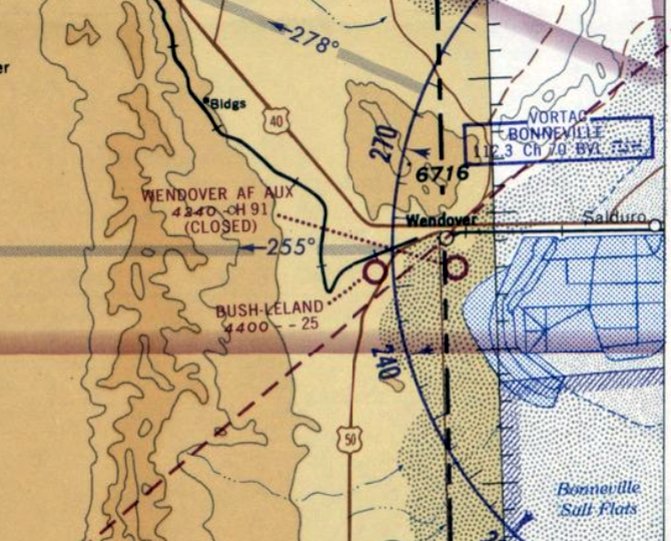
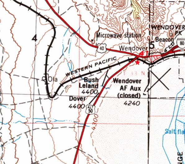
Bush-Leland Airport, West Wendover, NV
40.724, -114.083 (Northeast of Reno, NV)
Bush-Leland Airport, as depicted on the May 1965 Elko Sectional Chart (courtesy of Jonathan Westerling).
Photo of the airport while in use has not been located.
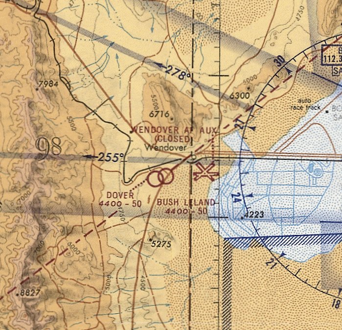
Bush-Leland Airport was one of 4 small general aviation airfields which were created in the vicinity of Wendover AFB.
Jonathan Westerling reported, “Until the early 1970s it wasn't possible for civil aircraft to land there,
so pilots living in the vicinity of the base created their own airfields since there were no other airports nearby.”
Bush-Leland Airport was evidently created at some point between 1960-65, as it was not yet depicted on the 1960 Elko Sectional Chart.
The earliest depiction which has been located of Bush-Leland Airport was on the May 1965 Elko Sectional Chart.
It depicted Bush-Leland Airport as having 2 dirt runways, with the longest being 2,500'.
The 1967 AOPA Airports USA directory (courtesy of Jonathan Westerling) described Bush-Leland Field as having 2 dirt runways, with the longest being 3,000' Runway 18/36.
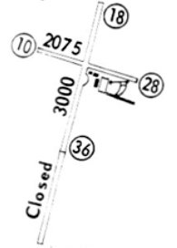
The 1967 Flight Guide (courtesy of Jonathan Westerling) depicted Bush-Leland Field as having 2 unpaved runways, with the southern 2,000' of Runway 18/36 being closed.
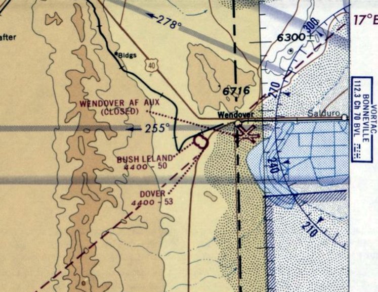
The May 1969 Elko Sectional Chart (courtesy of Jonathan Westerling) showed that Bush-Leland Airport's runway had been doubled in length, to 5,000'.
Note also that Dover Airport had been built, almost adjacent to Bush-Leland Airport.
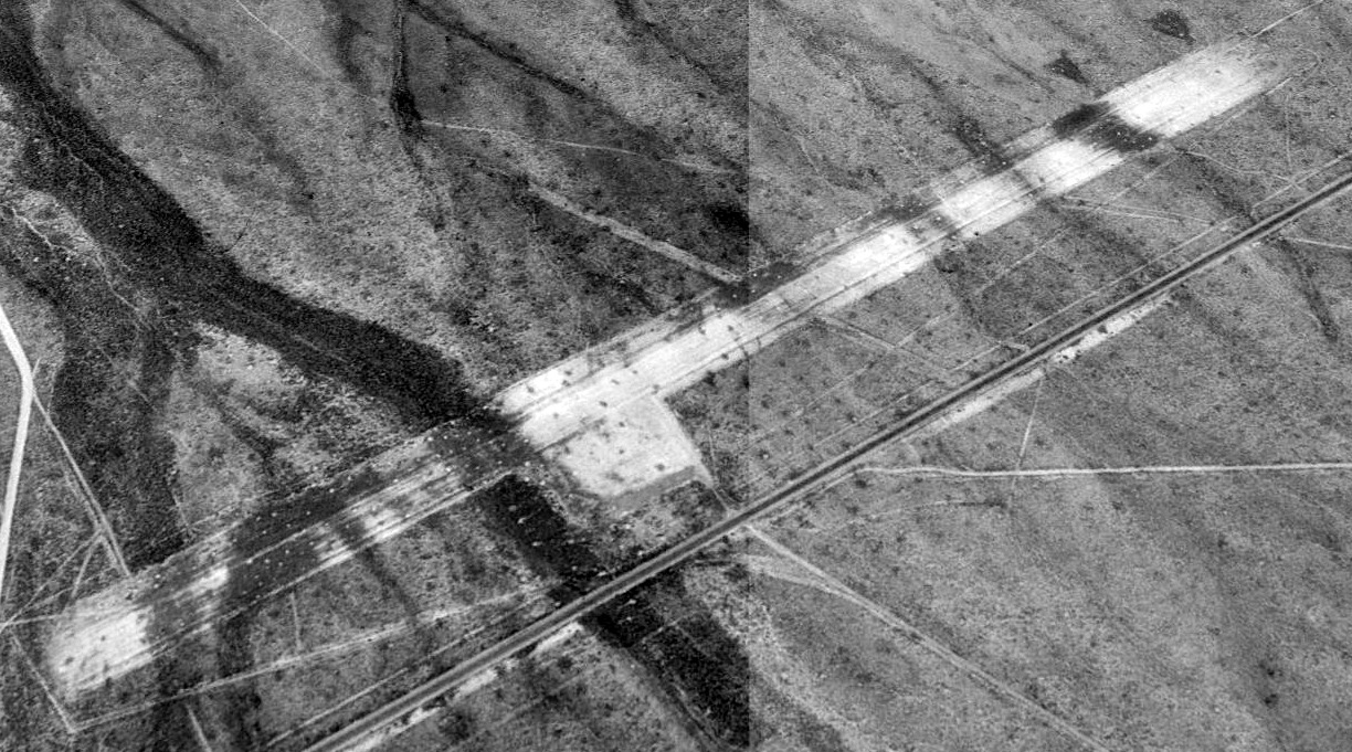
The earliest photo which has been located of Bush-Leland Airport was a 1970 aerial view.
It depicted Bush-Leland as having 2 unpaved runways, with 2 T-hangars to the south of the runway intersection.
The last aeronautical chart depiction which has been located of Bush-Leland Airport was on the May 1971 Salt Lake Sectional Chart (courtesy of Ron Plante).
It depicted Bush-Leland Airport as having a 5,000' unpaved runway.
The earliest topo map depiction which has been located of Bush-Leland Airport was on the 1972 USGS topo map.
Jonathan Westerling noted, “Once Wendover began allowing civil landings, there was no longer a need for any outlying civil field.”
Bush-Leland Airport was evidently closed at some point between 1971-77,
as the 1977 USGS topo map depicted the alignment of 2 unpaved runways, but did not label Bush-Leland Airport.
A 1980 aerial view show the 2 T-hangars had been removed from Bush-Leland Airport at some point between 1970-80.
Bush-Leland Airport was no longer depicted on the November 1993 Salt Lake Sectional Chart (courtesy of Ron Plante).
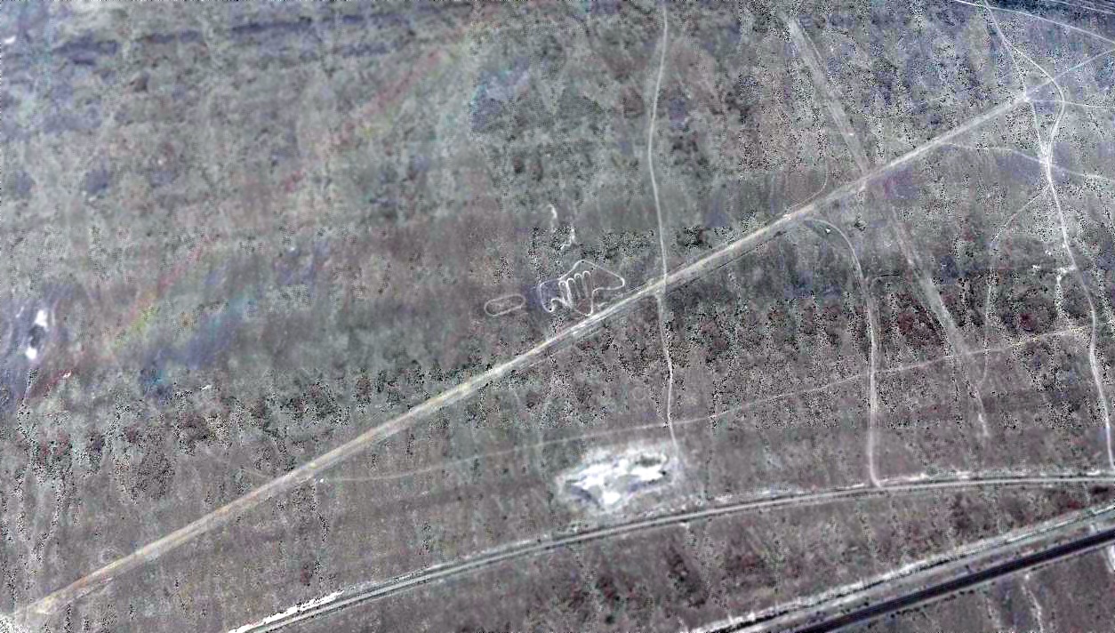
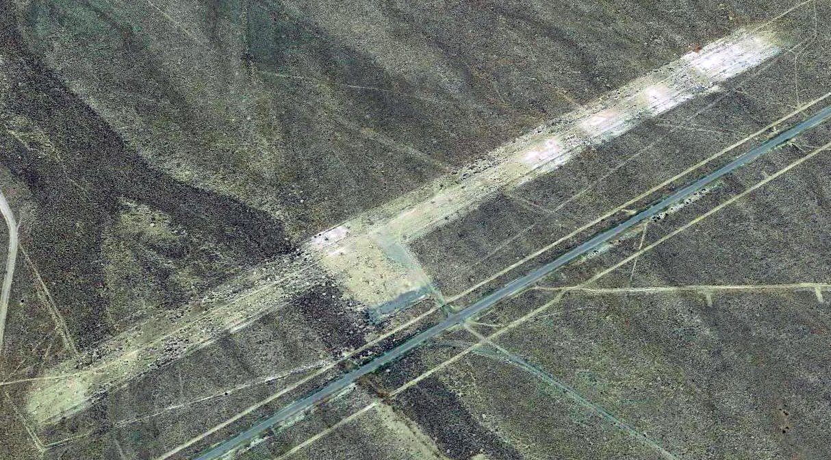
A 2019 aerial view looking northwest showed the remains were still recognizable of Bush-Leland Airport's 2 unpaved runways.
Thanks to Jonathan Westerling for pointing out this airfield.
____________________________________________________
Dover Airport, West Wendover, NV
40.706, -114.096 (Northeast of Reno, NV)
Dover Airport, as depicted on the May 1969 Elko Sectional Chart (courtesy of Jonathan Westerling).
Photo of the airport while in use has not been located.
Dover Airport was one of 4 small general aviation airfields which were created in the vicinity of Wendover AFB.
Jonathan Westerling reported, “Until the early 1970s it wasn't possible for civil aircraft to land there,
so pilots living in the vicinity of the base created their own airfields since there were no other airports nearby.”
Dover Airport evidently had a brief lifespan of no more than 6 years.
It was evidently created at some point between 1968-69, as it was not yet depicted on the 1968 Elko Sectional Chart.
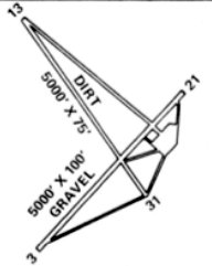
The earliest depiction which has been located of Dover Airport was on the May 1969 Elko Sectional Chart.
It depicted Dover Airport as having a 5,300' unpaved runway.
Jonathan Westerling noted, “It was practically adjacent to Bush Leland Airport.”
The earliest photo which has been located of Dover Airport was a 1970 aerial view.
It depicted Dover as having 3 unpaved runways. There were no aircraft or buildings visible on the field.
The last aeronautical chart depiction which has been located of Dover Airport was on the May 1971 Salt Lake Sectional Chart (courtesy of Ron Plante).
It depicted Dover Airport as having a 5,000' unpaved runway.
The earliest topo map depiction which has been located of Dover Airport was on the 1972 USGS topo map.
Jonathan Westerling noted, “Once Wendover began allowing civil landings, there was no longer a need for any outlying civil field.”
Dover Airport was evidently closed at some point between 1971-74,
as the 1974 Flight Handbook (courtesy of Jonathan Westerling) noted that it was “Abandoned”.
It was depicted as having 2 gravel 5,000' runways.
The 1977 USGS topo map depicted “Dover Field” as having 3 unpaved runways.
The 2014 USGS topo map no longer depicted Dover Airport.
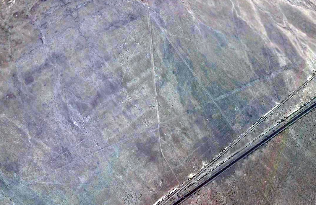
A 2019 aerial view looking northwest showed the remains were still recognizable of Dover Airport's 3 unpaved runways.
Thanks to Jonathan Westerling for pointing out this airfield.
____________________________________________________
Buffalo Valley Intermediate Field, Buffalo Valley, NV
40.35, -117.35 (Northeast of Reno, NV)
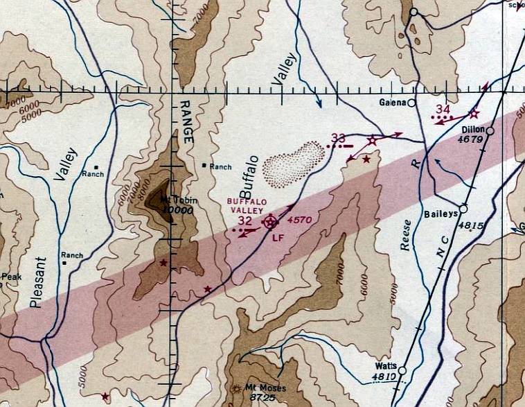
Buffalo Valley Intermediate Field, as depicted on the January 1936 Elko Sectional Chart.
The Buffalo Valley airfield was one of the network of Intermediate Fields
which was constructed by the Civil Aeronautics Administration in the 1920s & 1930s.
The Intermediate Fields were intended for the emergency use of commercial aircraft flying on airways between major cities.
The date of construction of the Buffalo Valley Intermediate Field has not been determined.
The earliest reference to the field which has been located was in The Airport Directory Company's 1933 Airport Directory (courtesy of Chris Kennedy).
It described Buffalo Valleyas the Department of Commerce's Intermediate Field Site 32 along the San Francisco - Salt Lake airway.
The landing area was said to consist of a 201 acre triangular sod field,
which was equipped with a beacon, boundary, and approach lights.
Describing the field as "sod" must have been quite optimistic - there probably wasn't much sod in the Nevada desert!
The earliest chart depiction of the Buffalo Valley airfield which has been located was on the January 1942 Elko Sectional Chart.
It depicted the Buffalo Valley airfield as Site 32.
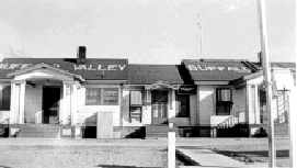
A 1942 photo of the Buffalo Valley Radio & Radio Beacon. The left side of the building consisted of living quarters.
The radio station was located in the center & the right side was temporary housing or bachelor quarters.
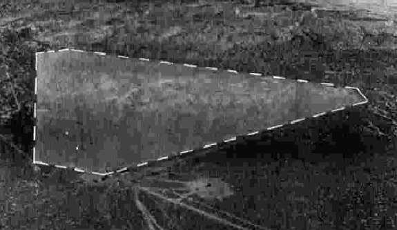
The only photo which has been located showing the Buffalo Valley Intermediate Field while in operation
was a 10/25/43 aerial view looking north from the 1945 AAF Airfield Directory (courtesy of Scott Murdock).
It depicted Buffalo Valley as a triangular unpaved area.
The 1945 AAF Airfield Directory (courtesy of Scott Murdock) described Buffalo Valley Intermediate Field
as a 193 acre triangular property containing 3 sand 3,400' runways.
The field was not said to have any hangars, to be owned by the U.S. Government, and operated by the Civil Aeronautics Administration.
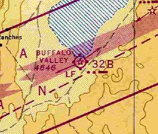
The last depiction which has been located of Buffalo Valley as an active airfield was on the November 1948 Elko Sectional Chart (courtesy of Chris Kennedy).
Buffalo Valley Intermediate Field was still depicted as Site 32B.
Being in a very remote area, the Buffalo Valley airfield remained operational (at least nominally)
much longer than most of the other Intermediate Fields. It apparently was closed at some point between 1948-54,
as it was no longer depicted on the October 1954 Elko Sectional Chart (according to Chris Kennedy).
The 1962 USGS topo map no longer depicted any trace of the airfield itself, but did still depict a “Beacon”.
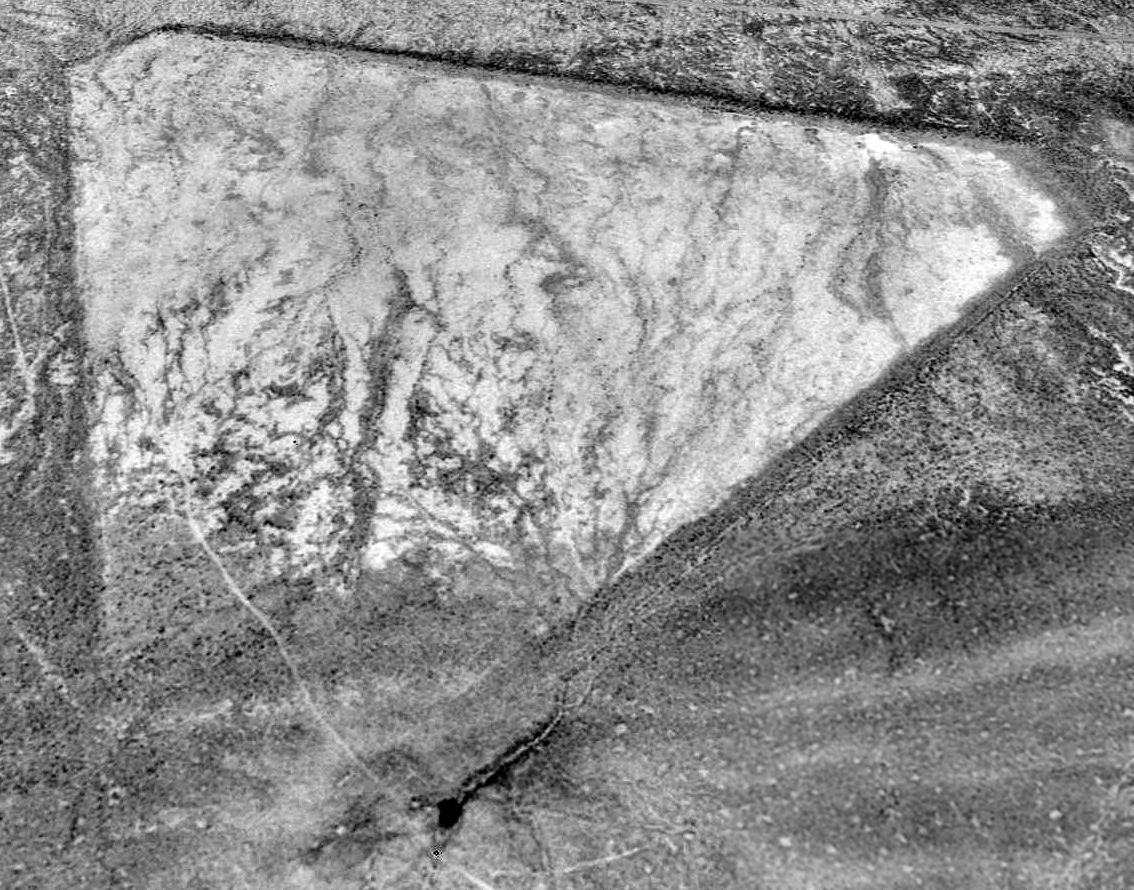
A 1994 USGS aerial view looking north showed the triangular layout of the Buffalo Valley Intermediate Field was still quite apparent,
more than 60 years after it was constructed.
There did not appear to be any signs of any buildings having been located at the airfield.
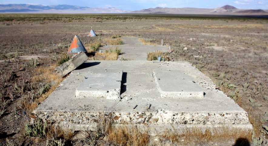
A September 2011 photo by Ben Ross of the remains of Buffalo Valley Intermediate Field, showing what “might have been the pad for the airport beacon.
A pad for generators then a pad with cut-off metal columns at each corner (tower?) then a cement arrow pointing approx 030 degrees.
There are still several large galvanized cones there.
I guess the runway/taxiway lights were mounted on top of the cones .
Ben also found a 1936 automobile license plate at the site.
He reported, “It looks like a rancher was using the well & a corral at one time, but no longer.
I found many pieces of thick red glass that were once marker lights for the taxi or runway lights.
I could not see anything left of the runways but I'm not sure I looked in the right area.”
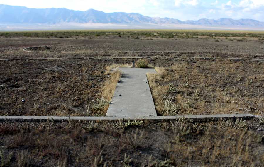
A September 2011 photo by Ben Ross of the remains of Buffalo Valley Intermediate Field, of what appears to have been “a walkway that goes out to a flag pole in front of the main building.”
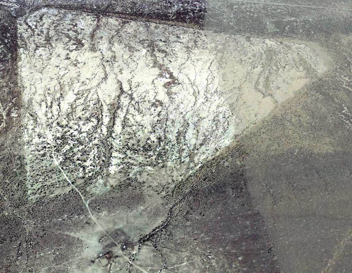
A 2014 aerial view looking north depicted the Buffalo Valley Intermediate Field as remaining in an unchanged condition.
The site of the Buffalo Valley Intermediate Field is located 18 miles east of Route 305,
25 miles southwest of Battle Mountain, NV.
____________________________________________________
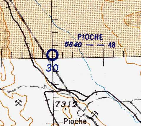
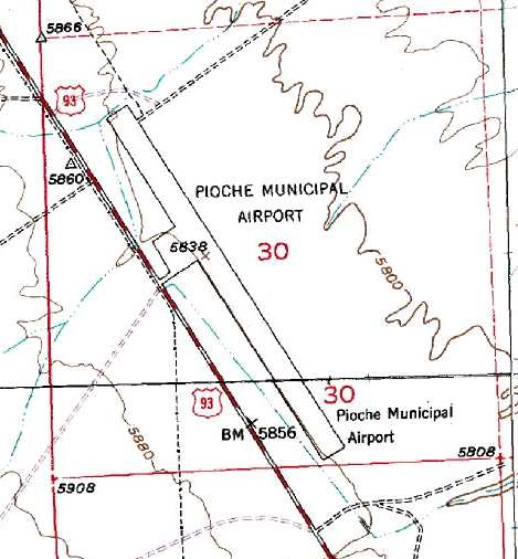
Pioche Municipal Airport (11U), Pioche, NV
38, -114.51 (North-northeast of Las Vegas, NV)
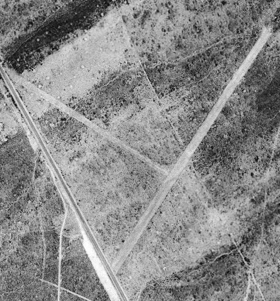
An 8/18/51 USGS aerial view of Pioche Airport.
The date of construction of this airport is unknown.
The earliest reference to the field which has been located was in The Airport Directory Company's 1937 Airports Directory (courtesy of Bob Rambo),
which described Pioche as an Auxiliary Airport, having a rectangular 1,000' x 600' gravel landing area.
The original Pioche Airport was apparently closed between 1937-40,
as the 1940 NV Airports & Airways Map (courtesy of Jim Mallery) depicted Pioche as a "proposed Class 1 Airport",
and no airfield was depicted at Pioche on aeronautical charts from 1944, 1945, 1949, or 1952.
The earliest photo which has been located of Pioche Airport was an 8/18/51 USGS aerial view.
It depicted Pioche as having 2 unpaved runways.
The Pioche Airport was apparently reopened at some point between 1952-54,
as the October 1954 Reno Sectional Chart (courtesy of Chris Kennedy)
depicted Pioche Airport as having a 4,800' unpaved runway.
Pioche Airport was described in the 1962 AOPA Airport Directory as having a single 4,800' bare Runway 13/31,
and it listed the operator as Lincoln County.
Pioche Airport, as depicted on the 1971 Las Vegas Sectional Chart (courtesy of Vince Granato).
Pioche Airport was described in the 1982 AOPA Airport Directory (courtesy of Ed Drury) as having a single 4,800' dirt Runway 13/31.
Pioche was depicted as a general aviation airport on the 1990 NV Airports & Landing Strips Map (courtesy of Jim Mallery).
The field was still labeled "Pioche Municipal Airport" on the 1991 USGS topo map, which may indicate that it was still open at that point.
Note that the single runway was on a different alignment compared to both of the runways depicted in the 1951 aerial photo.
However, Pioche Municipal Airport was apparently closed at some point between 1991-94,
as it was no longer listed among active airfields in the 1994 Flight Guide (according to Chris Kennedy),
nor depicted at all (not even as an abandoned airfield) on the 1998 World Aeronautical Chart.
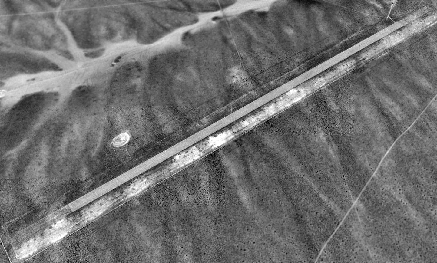
A 1999 USGS aerial view looking east showed the Pioche runway still existed in fairly decent condition.
A graded ramp area sat adjacent to the west side of the runway, but there was no indication of any buildings having existed at the site.
A 2016 aerial view looking east showed that the Pioche Airport site remained largely unchanged.
A 2022 photo looking northeast at the remains of the Pioche Airport ramp, with the runway in the backgroumnd.
Pioche Municipal Airport is located on the east side of Route 93, 6 miles northwest of Pioche, NV.
Thanks to Don Barrett for pointing out this field.
____________________________________________________
Caliente Flight Strip (0L2), Caliente, NV
37.6, -114.86 (North-northeast of Las Vegas, NV)
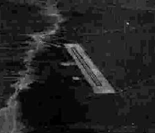
A 5/5/43 aerial view looking northeast from the 1945 AAF Airfield Directory (courtesy of Scott Murdock)
depicted the Caliente Flight Strip as having a single north/south paved runway.
Caliente Flight Strip was not yet depicted on the August 1942 Mt. Whitney Sectional Chart.
Caliente was one of the many Flight Strips which were built by the USAAF during WW2 for the emergency use of military aircraft.
The Caliente Flight Strip was listed on a 1943 table of 2nd Air Force Flight Strips (courtesy of John Voss),
which indicated that construction of the strip was completed in 1943.
The strip was described as consisting of a 6,400' paved runway.
The earliest depiction of the Caliente Flight Strip which has been located
was a 5/5/43 aerial view from the 1945 AAF Airfield Directory (courtesy of Scott Murdock).
It depicted Caliente as having a single north/south paved runway.
The 1945 AAF Airfield Directory (courtesy of Scott Murdock) described the Caliente Flight Strip
as a 197 acre rectangular property having a single 6,400' bituminous northeast/southwest runway.
The field was not said to have any hangars, to be owned by the U.S. Government, and operated by the U.S. Government (Public Roads Administration).
The earliest aeronautical chart depiction of the Caliente Flight Strip which has been located
was on the August 1943 Mt. Whitney Sectional Chart (courtesy of Chris Kennedy).
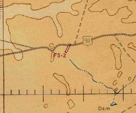
It depicted a single northeast/southwest runway, adjacent to the south side of Route 93, labeled merely as “FS-2”.
"Caliente Flight Strip, Army" was listed in the 1944 US Army/Navy Directory of Airfields (courtesy of Ken Mercer).
It is not known what military use (if any) the Caliente Flight Strip ever had.
The Caliente Flight Strip was reused after WW2 as a civil airfield.
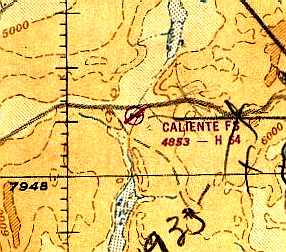
The September 1949 Mt. Whitney World Aeronautical Chart (courtesy of Donald Felton)
depicted “Caliente FS” as having a 6,400' hard-surface runway.
"Caliente FS" was still depicted on the May 1957 Mt. Whitney Sectional Chart (courtesy of Chris Kennedy),
but its status had changed to a private field.
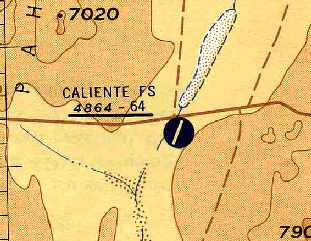
“Caliente FS” was depicted as a public-use airfield on the March 1959 Mt. Whitney Sectional Chart (courtesy of Chris Kennedy).
The Caliente Flight Strip was evidently closed at some point between 1959-67,
as no airfield at this location was depicted on aeronautical charts from 1967 & 1971.
However, it was not depicted at all (not even as an abandoned airfield) on the 1972 Sectional Charts.
Strangely, it was labeled "Delamar Landing Field" on the 1978 USGS topo map.
Caliente Flight Strip was evidently reestablished as an airfield at some point between 1972-89,
as it was listed as an active airfield in the 1989 Airport Facility Directory (according to Chris Kennedy).
The remarks said, "Unattended. Rwy extremely poor condition. Rwy 01 - 19 has ruts 1' deep."
A pilot recalled, “Caliente Landing Strip...I landed a C-130 on this strip on 7/20/89.
It was part of a Green Flag exercise. There was no one there; it was unattended.
There were USAF assault zone panels that that marked the landing zone in accordance with our regulations at the time.
These were temporary so a team would set them up before we landed & would later remove them after the exercise was complete.
It was funny, there was no one there to receive the 2.5 ton truck we were carrying.
Our loadmaster drove it off the back & left it sitting in the desert with the keys in the cab.
We informed the organizers of this when we returned so they would send someone out there to retrieve it.”
Caliente Flight Strip was depicted as a general aviation airport
on the 1990 NV Airports & Landing Strips Map (courtesy of Jim Mallery).
Strangely, the Caliente Flight Strip was labeled "Delamar Landing Field" on the 1991 USGS topo map.
In a 1999 USGS aerial view looking northwest, the Caliente Flight Strip runway was remarkably well preserved, considering that it was built 56 years prior.
There did not appear to be any trace of any buildings at the site.
Caliente Flight Strip was evidently abandoned (again) at some point between 1990-2000,
as it was no longer depicted at all (not even as an abandoned airfield) on the September 2000 Las Vegas Sectional Chart.
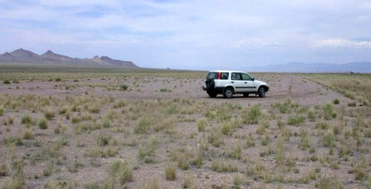
A 2003 photo of the Caliente Flight Strip by Don Barrett.
Don Barrett visited Caliente Flight Strip in 2003.
"On the BLM map that I was using, the field is listed as 'Delamar Landing Field'.
It is generally overgrown & difficult to tell apart from the general desert landscape until actually on it.
The field appears to have been gravel since it is a darker color stone than the surrounding desert.
There is no evidence of any structures having existed, and no evidence of taxiways or other peripheral surface areas.
The road to it is a one-lane rutted dirt road, though it is level enough to suggest that it may have been graded at some time in the past.
The cleared area is only about 60-80' wide (based on my car length),
and going from one end to the other in the cleared area, my odometer registered 1.2 miles.
The overgrowth is low enough that it could still be used as an emergency landing strip, though the nearby highway would be much better."
Don continued, "From nearby US 93, you can't even tell that there was an air strip here - it just looks like open desert.
I have no idea why it would ever have been used for civil aviation.
There is almost no population in the area, only very scattered ranches.
Caliente is about 20 miles east, and there is a well-maintained (but little used) Lincoln County Airport in Panaca
which is closer & more easily accessed for Caliente."
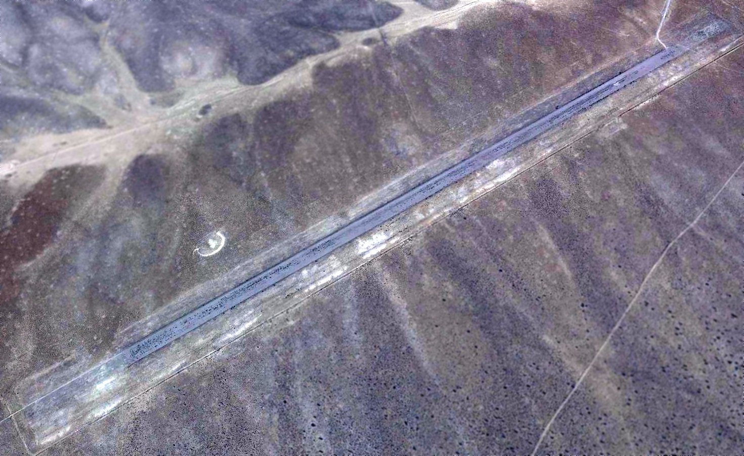
A 2016 aerial view looking northwest showed the Caliente Flight Strip runway remained intact.
Tom Bullard reported in 2017, “I recently camped at the Caliente Airstrip (OL2).
Interestingly, the airstrip is depicted on the Nevada DeLorme road map as the 'Caliente International Airstrip'! Go figure!
I pitched a tent on the surface & had to drive stakes through about 1.5-2 inches of degraded pavement or macadam surface.”
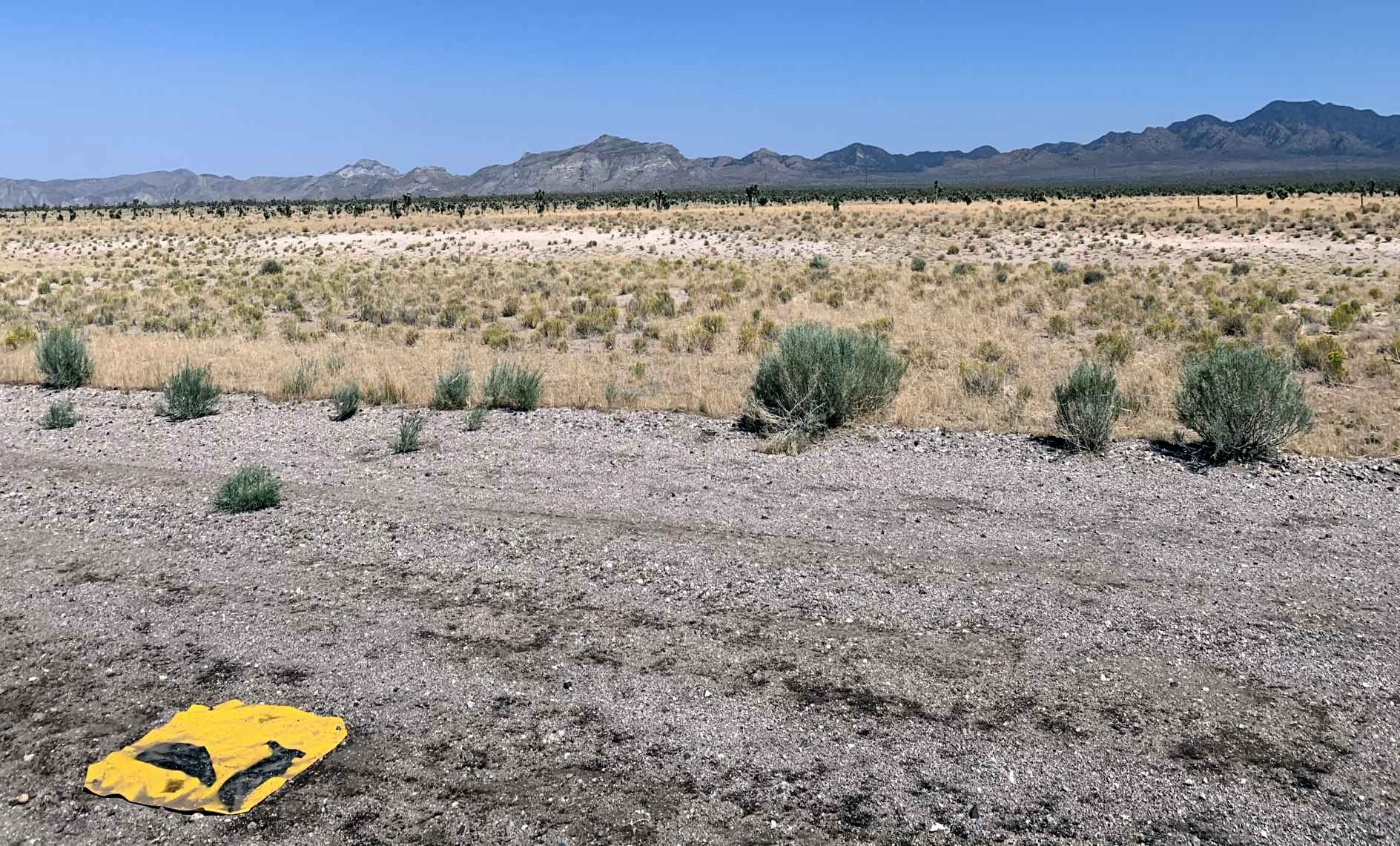
A 2020 photo by Jim Triggs of Caliente Flight Strip.
Jim recalled, “Our firefighting season in 2020... the Caliente Airport was our base for a fire out there.
The whole old airport was turned into a heli base & campground for fire crews. We had 2 fires we were working on.
When I saw where we were going, I could only think of the clip from Independence Day where Will Smith was dragging the alien through the desert.
I found an older-style grenade pin in the weeds, an old shot-up coffee can. Bats were everywhere as soon as the sun set, and when it did set, it went almost instantly pitch black.
You could see all of the milky way, which I never saw before being near a major city all my life.
One day, we were on standby & watching a movie, and afterwards we went outside, only to be asked if we saw the stealth flyover. We had no clue, but it was an F-117 that buzzed the airport.
Another day, we just had finished cleaning out our trailer from all the dust & sand, and as soon as we finished, we looked to the back of our trailer with the ramp open, only to see a dust devil heading our way.
It slammed into us, and the trailer was 10x sandier than before we cleaned it.”
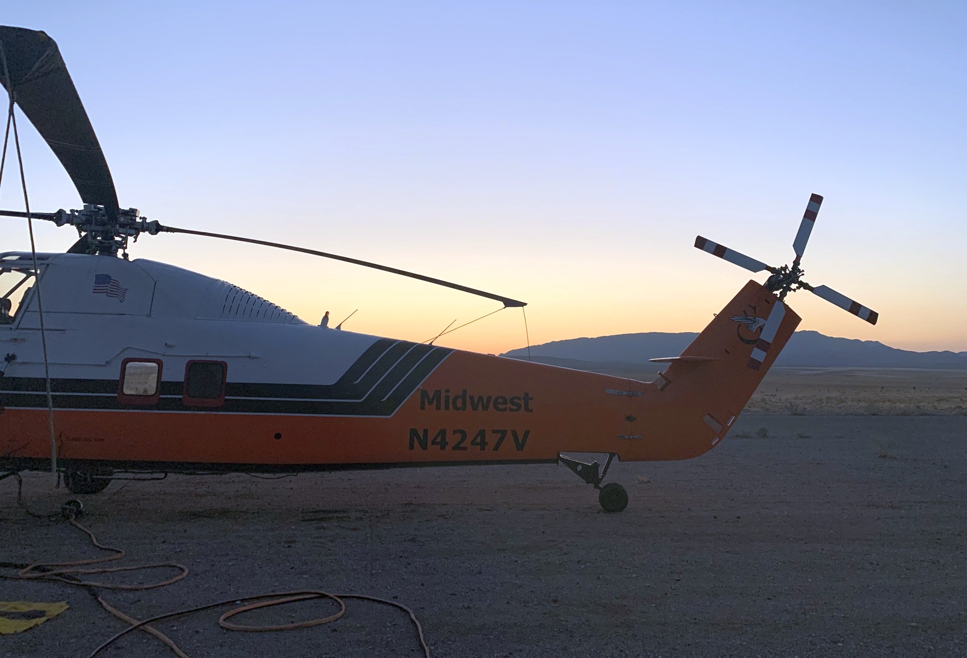
A 2020 photo by Jim Triggs of N4247V, a Midwest Helicopters Sikorsky S-58JT, at Caliente Flight Strip.
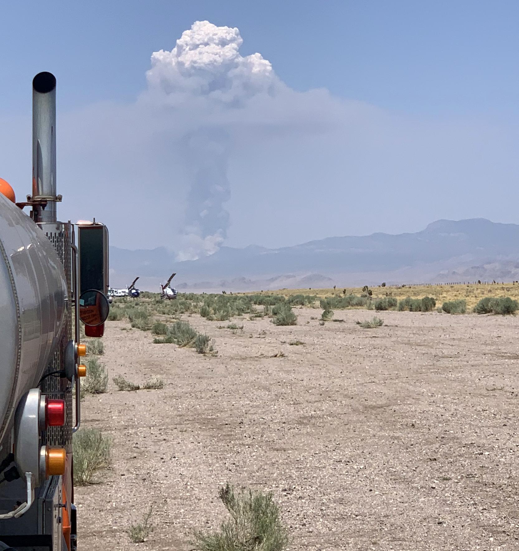
A 2020 photo by Jim Triggs of Caliente Flight Strip. Jim recalled, “We may have had a visitor from another world at one point.”
Caliente Flight Strip is located on the south side of Route 93, 19 miles west of Caliente, NV.
____________________________________________________
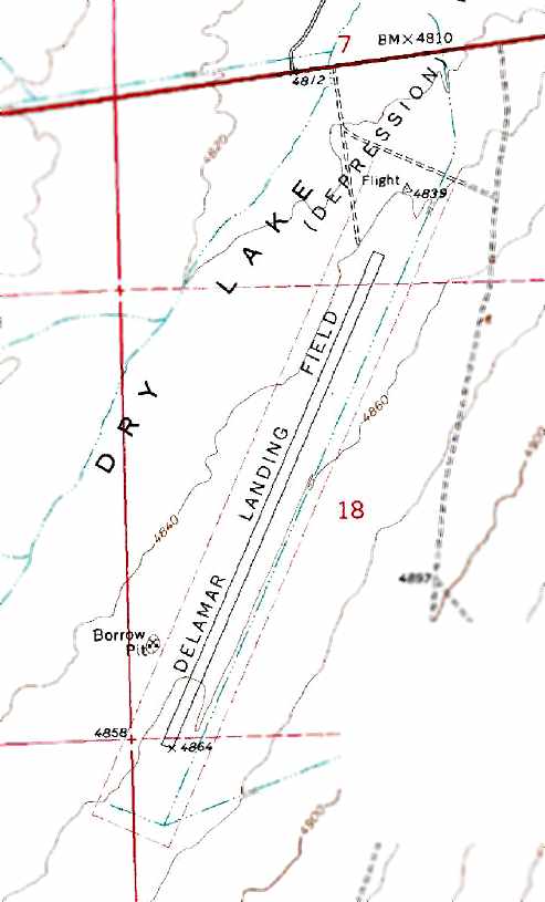
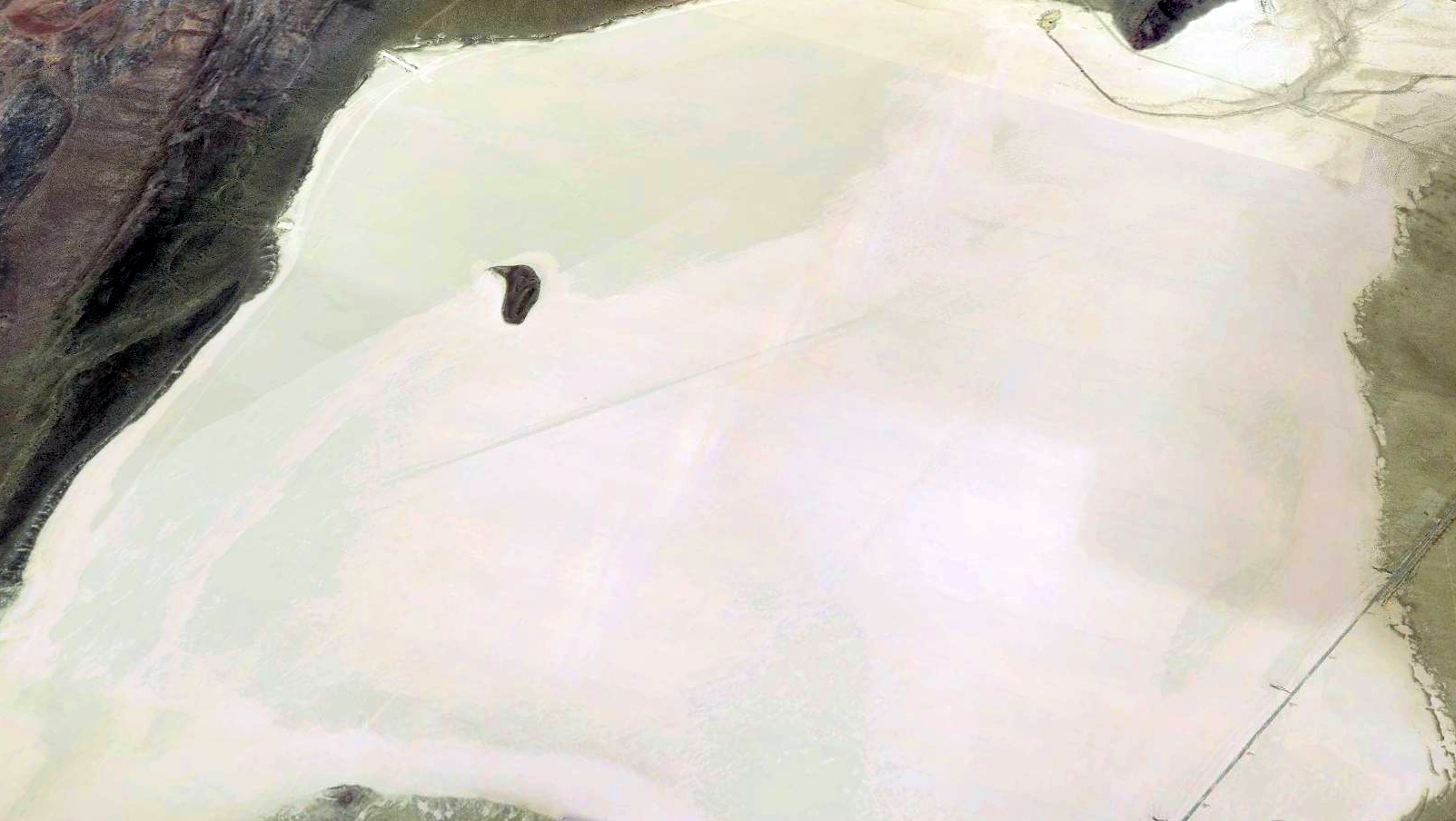
Delamar Lake Landing Strip, Alamo, NV
37.32, -114.94 (North-northeast of Las Vegas, NV)
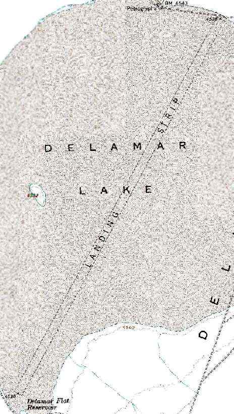
USGS topo map 1991.
In the 1960s, Delamar Lake was used as a drop point & emergency landing site for the X-15 rocket plane.
The NB-52 carrying the X-15 under its wing would take off from Edwards AFB,
fly north to Delamar, and drop the X-15 about 40,000' above the lakebed.
Normally the X-15 would ignite its rocket engine & be boosted on a suborbital trajectory back to Edwards,
but on flight 1-63-104 in 1966 the engine failed & X-15-1 made an emergency landing on the Delmar lakebed runway
after a flight that reached a 'mere' 115,000' altitude.
The Delamar Lake Landing Strip consists of a 15,000' long runway (almost 3 miles long!) laid out along the length of a dry lakebed.
The field was clearly depicted as a "Landing Strip" on the 1978 & 1991 USGS topo maps.
However, it was not depicted at all (even as an abandoned airfield) on aeronautical charts from 1949, 1967, 1971, 1972 or 2002.
A database of space launch sites includes entries for "Delamar Dry Lake", "Delamar Dry Lake Drop Zone #1" (southeast of the lake),
and "Delamar Dry Lake Drop Zone #2" (northwest of the lake).
All 3 are listed as being used by NASA/USAF from 1959-67.
No outline of a landing strip was discernible at all in the 1994 USGS aerial photo,
nor was there any indication of any buildings or other improvements.
Current ownership of the property is unknown.
The Delamar Dry Lake has been used in recent years for launches of large model rockets.
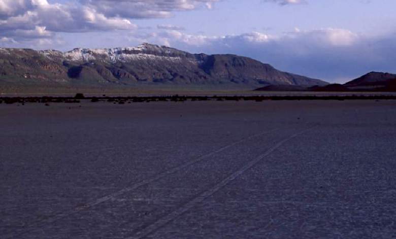
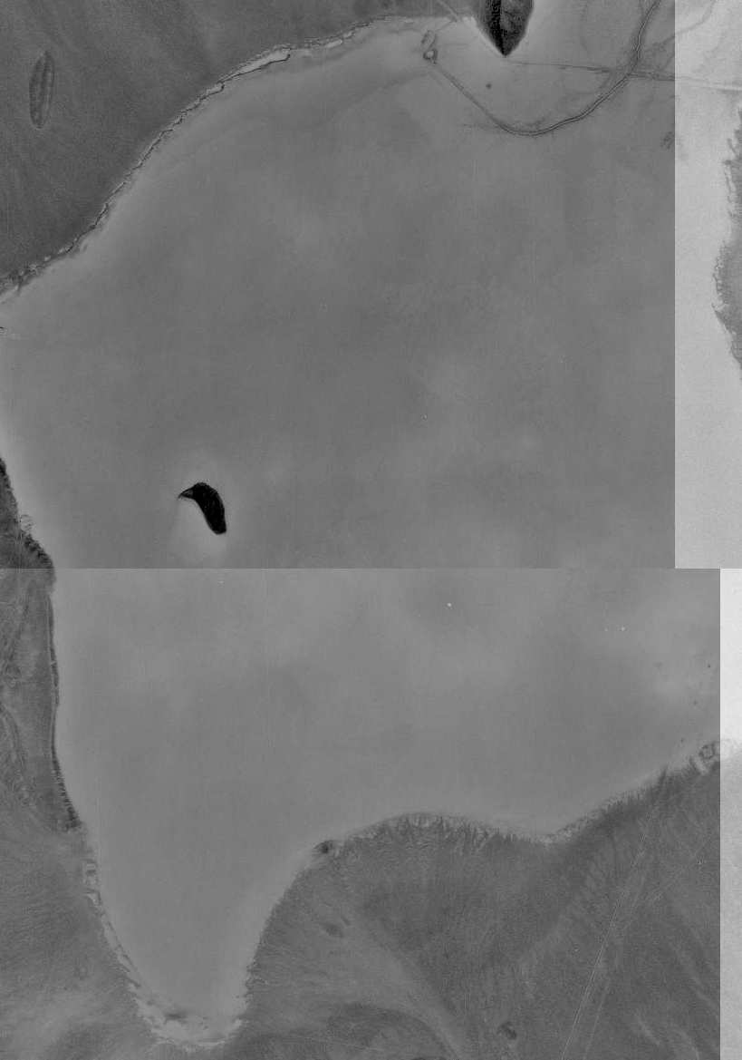
A recent shot of Delamar Lake.
Among military aircraft radio communications, the dry lake is referred to as "Texas Lake".
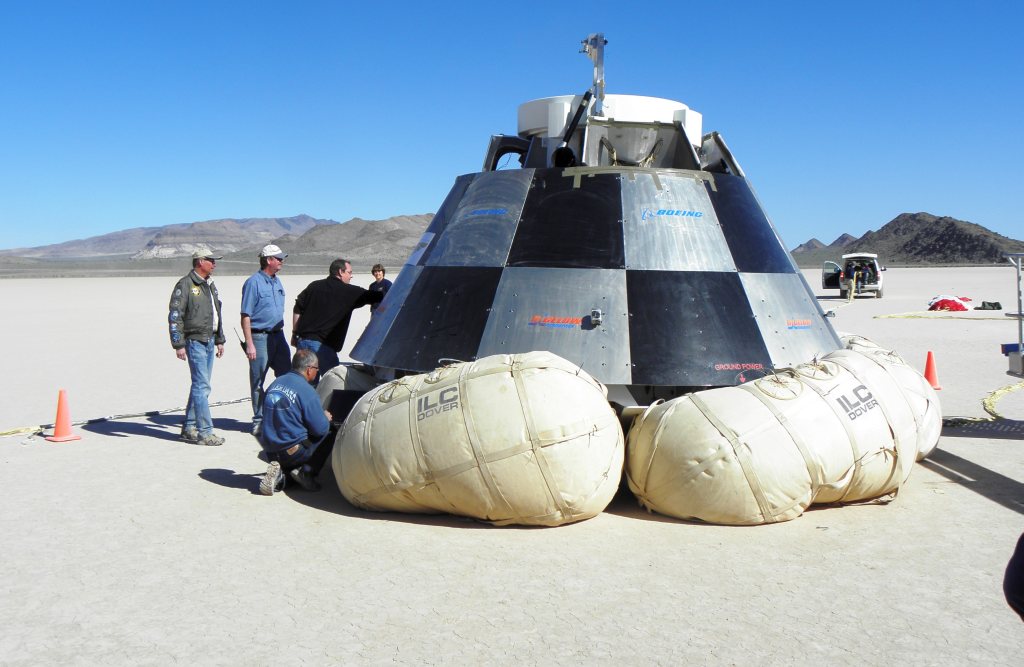
A 4/3/12 photo of personnel inspecting a Boeing CST-100 space capsule prototype following a parachute drop test at Delamar.
A 2016 aerial view looking northwest at Delamar Lake showed the orientation of the northeast/southwest runway.
Overall, this lakebed landing strip is very similar to the Bonnie Claire Dry Lake Landing Strip.
Delamar Lake is located west of "Pwr Line Maintenance Road",
12 miles east-southeast of Alamo, NV.
____________________________________________________
Or if you prefer to contact me directly concerning a contribution (for a mailing address to send a check),
please contact me at: paulandterryfreeman@gmail.com
If you enjoy this web site, please support it with a financial contribution.
____________________________________________________
This site covers airfields in all 50 states.