Abandoned & Little-Known Airfields:
Nevada: Las Vegas area
© 2002, © 2025 by Paul Freeman. Revised 12/25/25.
This site covers airfields in all 50 states: Click here for the site's main menu.
____________________________________________________
Please consider a financial contribution to support the continued growth & operation of this site.
Anderson Field / Rockwell Field (revised 12/23/23) - Barton Field (revised 12/7/25) - Bullock's Airport / (Original) Boulder City Municipal (revised 12/25/25)
Ranch Club Airfield / D4C Ranch Airfield (revised 12/27/23) - Sky Corral Airport (revised 11/13/20) - Voc-Tech Airfield (revised 6/19/18)
____________________________________________________
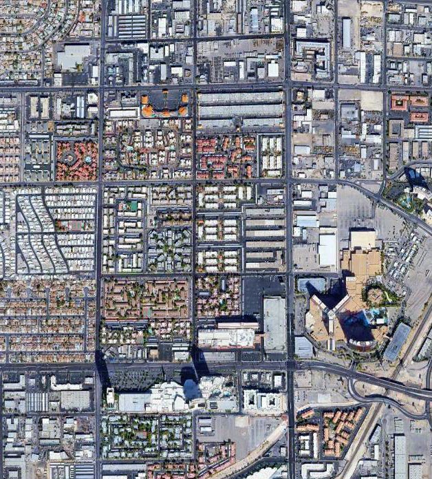
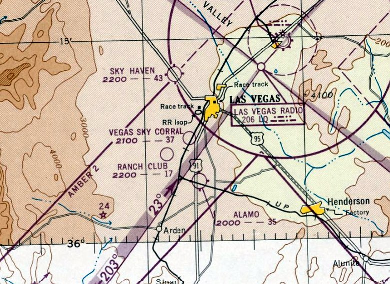
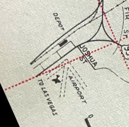
Ranch Club Airfield / D4C Ranch Airfield, Las Vegas, NV
36.122, -115.195 (Northwest of Las Vegas McCarran International Airport, NV)
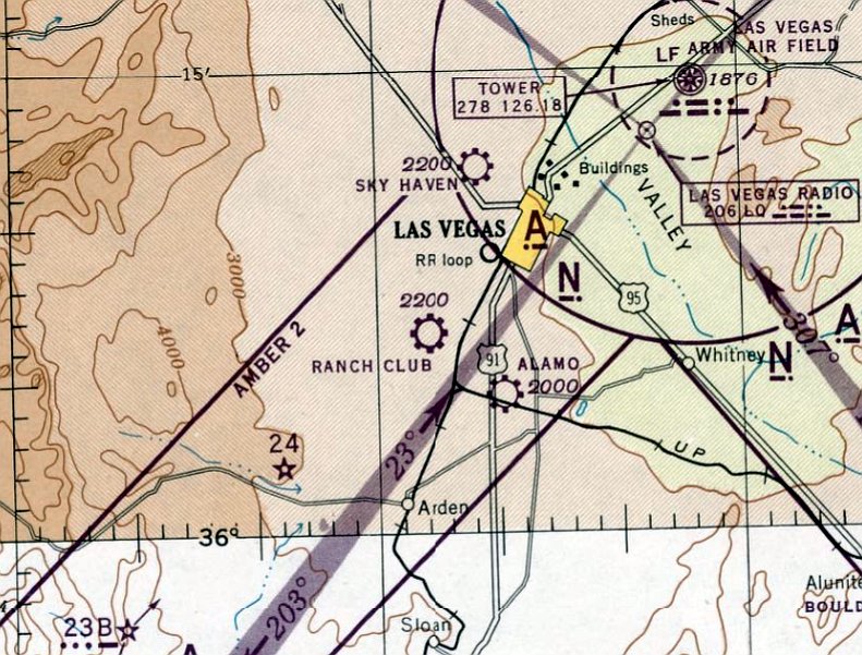
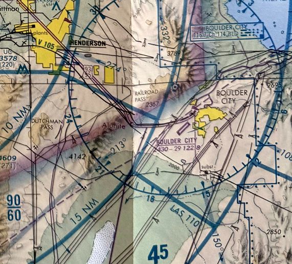
Ranch Club Airfield, as depicted on the September 1945 Mt. Whitney Sectional Chart.
This short-lived general aviation airport was evidently established at some point between 1944-45,
as it was not yet depicted at all on the August 1944 Mt. Whitney Sectional Chart.
According to casino.org, “Edmund 'Hoot' Gibson was one of the top box office stars of the silent Westerns of the 1920s, earning an almost-unheard-of $15K a week.
By the 1930s, however, he was knocked off his saddle by singing cowboys Roy Rogers & Gene Autry.
Gibson, his non-musical star dimmed, shot his final Western in 1944.”
This short-lived general aviation airport was evidently established at some point between 1944-45,
as it was not yet depicted at all on the August 1944 Mt. Whitney Sectional Chart.
The earliest depiction which has been located of Ranch Club Airfield was on the September 1945 Mt. Whitney Sectional Chart.
It depicted Ranch Club Airfield as a commercial/municipal airport.
According to casino.org, “Two years later [1946], a group of L.A. investors approached him with a proposal for Hoot Gibson’s D4C Ranch in Las Vegas.
In addition to a casino & bungalows, the 80-acre ranch boasted a rodeo stadium, clubhouse, Western-themed restaurant, and horseback riding.
To get there, the investors built an airfield, a dedicated train depot, and a mile-long private dirt driveway that would, in the late 1960s, become Spring Mountain Road.”
The February 1947 Mt. Whitney Sectional Chart depicted Ranch Club Airfield as having a 1,700' unpaved runway.
According to casino.org, “The D4C did decent business for 4 years [until 1948]. Then, other US states began liberalizing their divorce laws.
The easier divorces became to get, the harder Nevada’s divorce ranches became to sell. Gibson’s investors unloaded the D4C land in late 1950.”
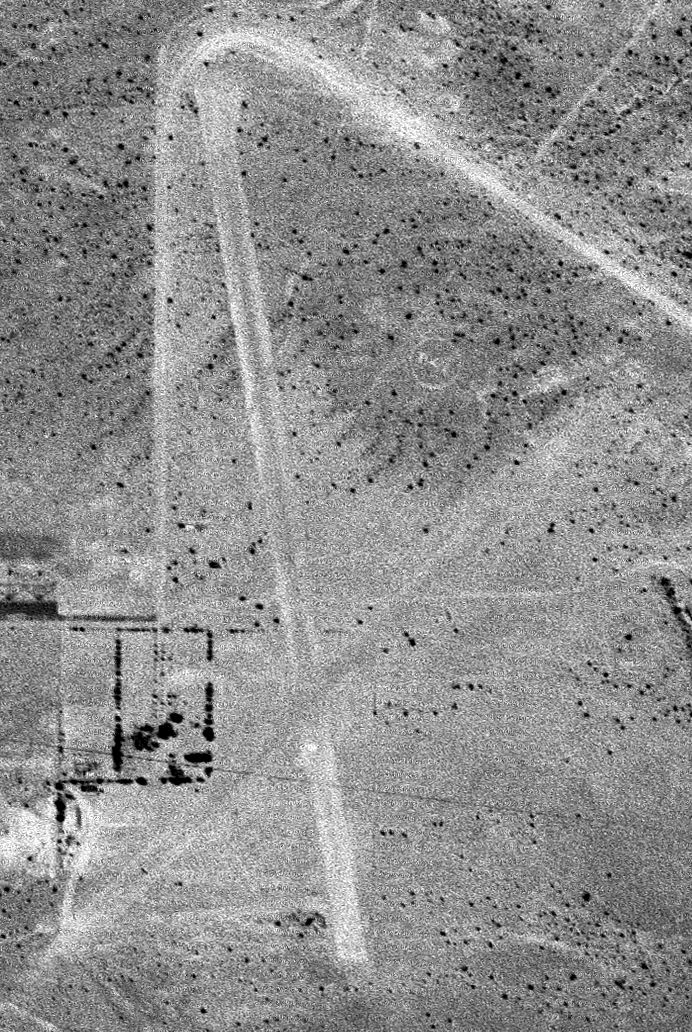
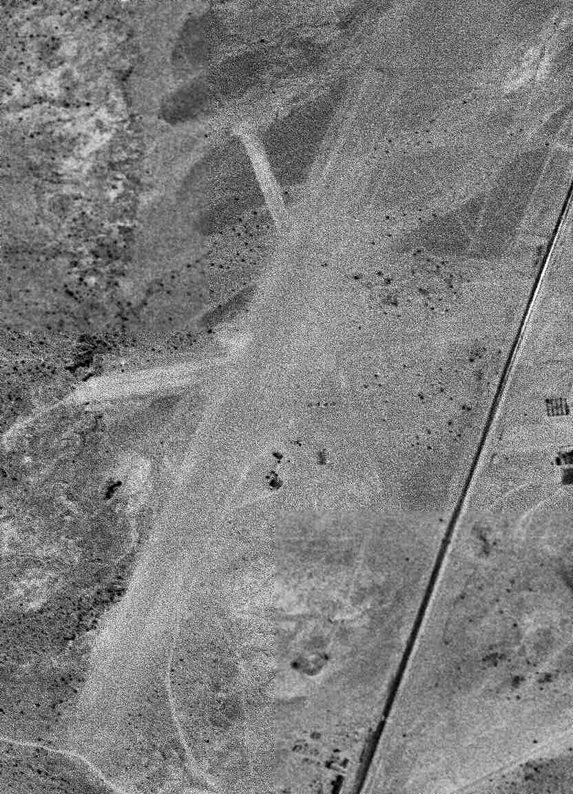
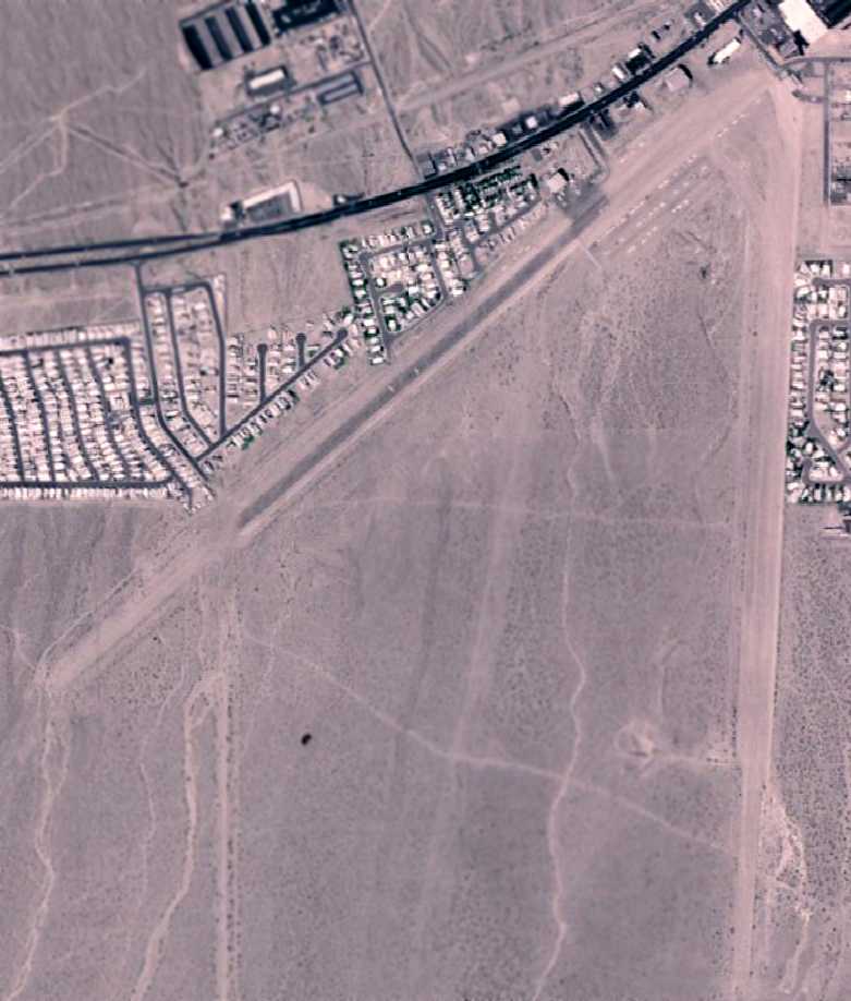
The earliest photo which has been located of Ranch Club Airfield was a 7/3/50 USGS aerial view, which depicted it as having 2 unpaved runways.
What appeared to be building foundations were on the west side, but there were no aircraft visible on the field.
The last aeronautical chart depiction which has been located of D4C Ranch Airfield was on the March 1951 Mt. Whitney Sectional Chart.
It depicted D4C Ranch Airfield as having a 4,000' unpaved runway.
D4C Ranch Airfield was evidently closed at some point in 1951,
as it was no longer depicted on the September 1951 Mt. Whitney Sectional Chart.
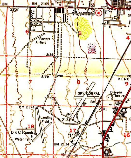
D4C Ranch Airfield (as well as 2 other small airfields), as depicted on the 1952 USGS topo map (courtesy of Bud Willson).
D4C Ranch Airfield was depicted as having 2 runways with a few small buildings on the west side.
A 1963 aerial view showed the D4C Ranch Airfield runways remained mostly intact, but a road had been built through the northern portion of the northwest/southeast runway.
A 1978 aerial view showed portions of the D4C Ranch Airfield runways remained recognizable, but buildings had been built over much of the site.
A 2020 aerial photo shows no trace remains of D4C Ranch Airfield.
Thanks to Tim Tyler for pointing out this airfield.
____________________________________________________
Anderson Field / Rockwell Field, Las Vegas, NV
36.142, -115.151 (South of Downtown Las Vegas, NV)
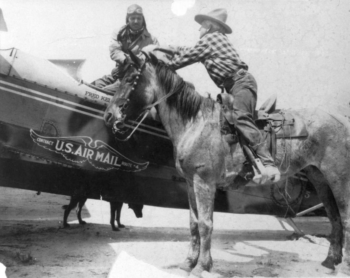
A 4/17/1926 photo (courtesy of Clark County Museum, via Bill Grasha) of the first Air Mail delivery to Las Vegas at Anderson Field
The pilot was Fred Kelly, one of the first 4 pilots who flew for Western Air Express, and the man on horseback was Bill Morgan.
According to Wikipedia, Anderson Field was the first airport to serve Las Vegas.
Construction on the field began when the surface was leveled.
According to Clark County, Anderson Field's opening on Thanksgiving Day, 11/25/1920 was a celebration in aviation.
Renowned fliers of the era like Clarence Prest & Emery Rodgers took part in the fly-in.
The field was designed by Robert Hausler. As an army pilot Hausler had flown over Las Vegas in 1918 en route from Los Angeles to Salt Lake City while scouting new air mail routes.
Hausler designed the airport to Army Service & Aero Club in Southern California standards, and strongly advocated establishing a local air mail route.
In those first years, both Clarence Prest & Emery Rogers returned to Las Vegas to try to start aviation businesses. Neither was successful.
Walter Varney, who later founded Varney Air in Northern NV, started a flying school at Anderson Field in 1923, but it too failed.
Anderson Field was operated by Hausler, who leased the land until 1925.
The 4/15/1925 Commerce Department Aeronautical Bulletin (courtesy of Bill Grasha) described Anderson Field
as a municipal airfield owned by Harry Anderson & operated by W.R. Hausler.
It was said to be a 40 acre square field.
The Anderson Field property was purchased on 12/21/1925 by brothers Earl & Leon Rockwell.
This proved fortuitous. Later that year, Harris Hanshue began negotiations with the Rockwells to bring his new airline, Western Air Express, to the field.
The contract was signed, and Western Air Express started flying to Las Vegas on 4/17/1926.
The first flights brought out the town, and put Las Vegas & Clark County on the commercial airline map.
Those first flights carried airmail only. Not until May 23 were the first passengers, Ben Redmen & J.A. Thompson, carried.
They were given coveralls, and rode perched on the mailbags in the forward compartment of the Douglas M-2 biplane.
Only 2 weeks later, the first woman to fly to Las Vegas arrived June 10. Maude Campbell paid $160 for round-trip passage from Salt Lake to Los Angeles via Las Vegas.
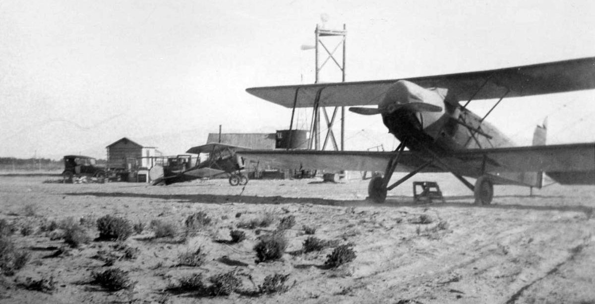
A circa late 1920s photo (courtesy of Clark County Museum, via Bill Grasha) of 2 biplanes & some small buildings at Anderson Field
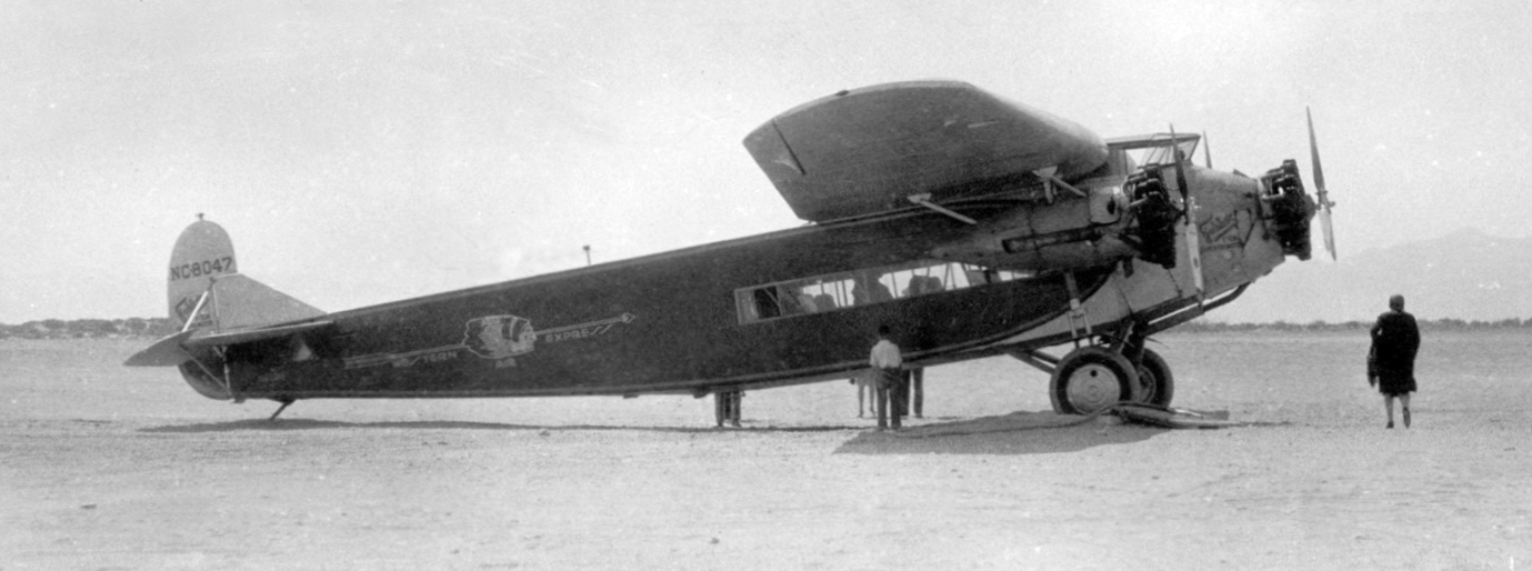
A 1929 photo of Western Air Express Fokker/Atlantic F.10 C/n 1006 NC8047 at Anderson Field
Western continued to use Anderson Field until 1929 when they moved to the new Alamo Landing Field to the northeast (which eventually became Nellis AFB).
Anderson Field was evidently closed at some point between 1929-31,
as it was no longer listed in the 1931 Commerce Department Airway Bulletin (according to Bill Grasha)
nor depicted on the 1935 Mt. Whitney Sectional Chart.
The 1956 USGS topo map showed the Las Vegas Race Track had been built over the site of Anderson Field,
and the 1968 topo map showed the race track had been replaced with the Las Vegas Convention Center & a golf course.

A 2017 aerial photo showed no trace remaining of Anderson Field.
The site of Anderson Field is located southeast of the intersection of Sahara Avenue & Paradise Road.
Thanks to Bill Grasha for pointing out this airfield.
____________________________________________________
Sky Corral Airport, Las Vegas, NV
36.132, -115.18 (West of Las Vegas McCarran International Airport, NV)
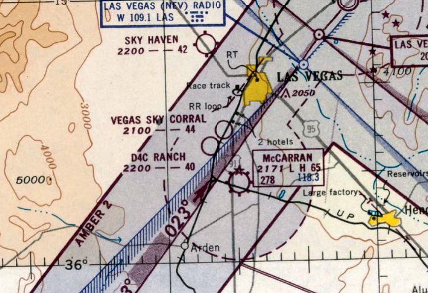
Sky Corral Airport, as depicted on the February 1947 Mt. Whitney Sectional Chart.
This short-lived general aviation airport was evidently established at some point between 1946-47,
as it was not yet depicted at all on the August 1946 Mt. Whitney Sectional Chart.
The earliest depiction of Sky Corral which has been located was on the February 1947 Mt. Whitney Sectional Chart.
It depicted “Vegas Sky Corral” as having a 3,700' unpaved runway.
Michael Dugan reported, “My father Elmo Dugan was a mechanic, flight instructor, and manager at Sky Corral between November 1949 - September 1950.
He flew charters between Ventura County Airport (Oxnard CA) & Sky Corral.
He said the charters were few & far between... over-estimating the need for service between Ventura & Las Vegas.
He loved flying the route but couldn't make a go of it & abandoned the airport.
When he left he had been reduced to his 'last nickel' & couldn't afford to gas his plane to get back to Ventura,
so he dropped it into a slot machine at the casino next door... and he won.”
The only photo which has been located of Sky Corral Airport was a 7/26/50 USGS aerial view, which depicted Sky Corral as having 3 dirt runways.
A cluster of small buildings was located south of the runway intersection, but there were no aircraft visible on the field.
The last aeronautical chart depiction which has been located of Sky Corral Airport was on the March 1951 Mt. Whitney Sectional Chart.
It depicted Sky Corral Airport as having a 4,400' unpaved runway.
Sky Corral Airport (as well as 2 other small airfields), as depicted on the 1952 USGS topo map (courtesy of Bud Willson).
Sky Corral was depicted as having 2 runways, oriented east/west & northeast/southwest.
Sky Corral was evidently closed at some point between 1951-52, after no more than 6 years of life,
as it was no longer depicted at all on the 1952 Mt. Whitney Sectional Chart (according to Chris Kennedy).
According to Las Vegas resident Rand Noel, “There were 3 primary reasons why [Sky Corral Airport was closed]:
The field was owned & operated by owners of the Last Frontier Hotel;
the hotel itself went out of business in the mid-1950s & by that time it had already come into disuse.
McCarran Field was [by then] the 'official' airport of Las Vegas; when Sky Corral was built it was out in the sticks.
By the 1950s 3 other hotels would be built right next to it (New Frontier, Royal Nevada and Stardust),
this made it totally impractical to raise the money & build it up to a proper airport.
Ninety-nine percent of cargo, passengers and mail was now going through McCarran anyway
so it didn't make much sense to do anything but let it go.”
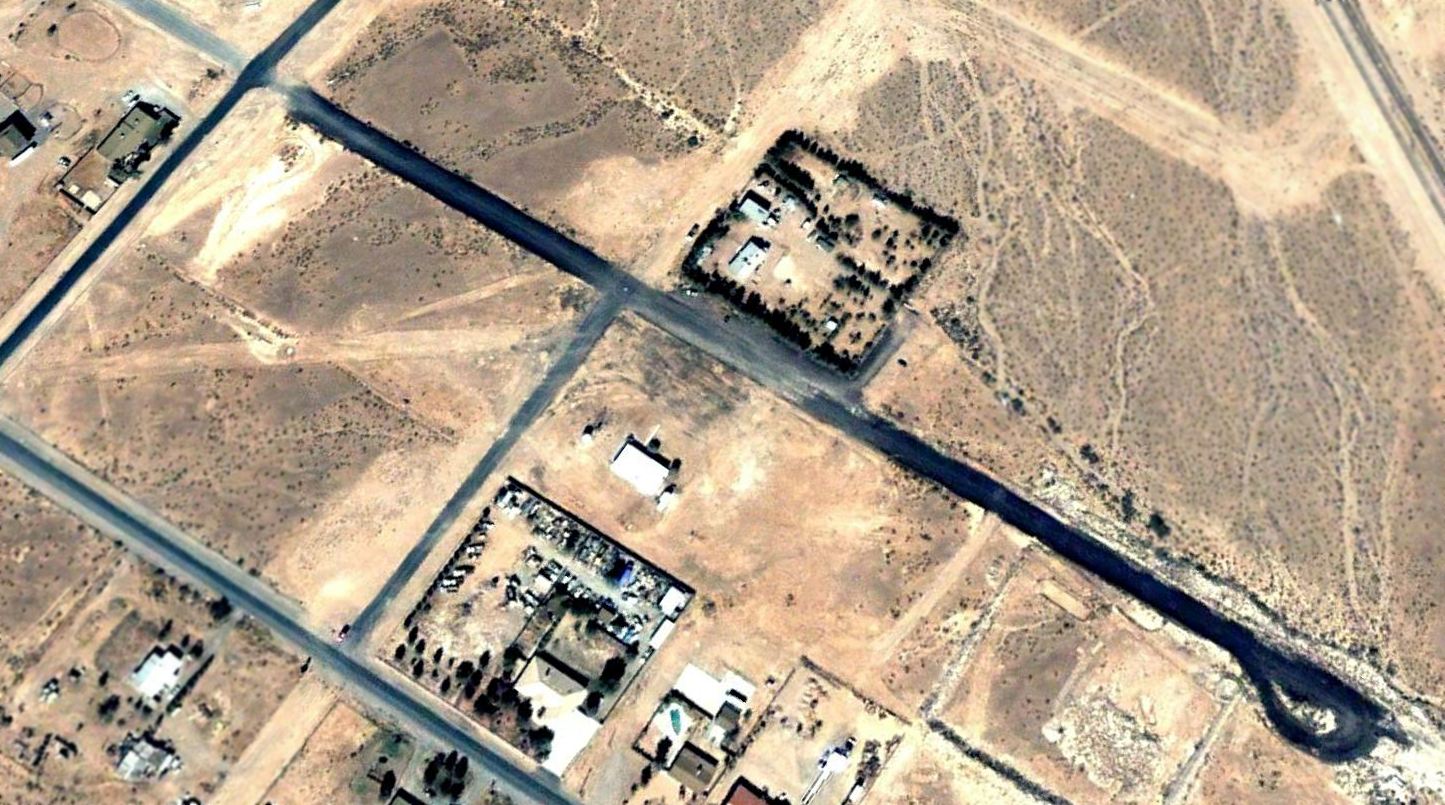
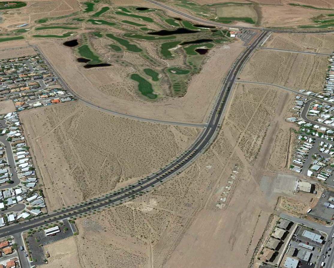
A 1965 aerial view showed that Interstate 15 had been built right through the center of the Sky Corral Airport site, of which not a trace remained.
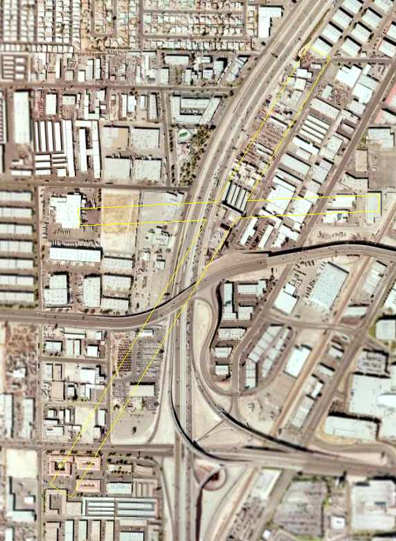
A 2006 aerial photo, annotated by Chris Kennedy to show the location of the former 2 runways of Sky Corral.
The site of Sky Corral is located north of the intersection of Interstate 15 & Desert Inn Road.
____________________________________________________
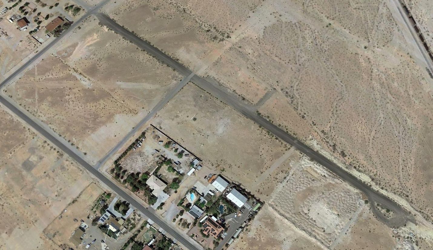
36.013, -115.25 (Southwest of Las Vegas McCarran International Airport, NV)
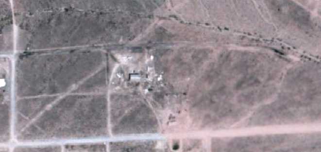
A 6/3/77 aerial view of Barton Field.
This odd little private airfield was located only 6 miles southwest of Las Vegas' McCarran International Airport.
This airfields was evidently constructed at some point after 1970,
as nothing but empty desert was depicted at the location on a 1970 aerial view,
and no airfield was yet depicted on the 1971 Las Vegas Sectional Chart (courtesy of Vince Granato), or subsequent aeronautical charts through 2006.
According to Las Vegas resident Dan Eikleberry, “In reality, Mr. Barton simply took over the street in front of his house (Gomer Road)
and made it into his own airport, approximately 1975-1980, maybe sooner.
He made the turnabouts at the east & west ends. He often had 8 or 9 airplanes there under reconstruction, sometimes a helicopter or two.
The rumor has it that the county would come out & post a street sign where his 'runway' crossed Tenaya Way every now & then.
'Someone' would just go out & cut the posts down to about 6 inches,
and replace the street signs way down low... so that an aircraft wing could pass over them!”
Dan continued, “At one time, there was a short diagonal runway that was more 'into the wind' (wind is always from the southwest in Las Vegas), from mid field.
Barton Field is physically located within the Las Vegas Class B airspace
where it goes all the way to the surface... inside 6 nautical miles from the Las Vegas VOR.
In reality, that's a no-fly zone without permission.
I would doubt, however, that anyone ever called Las Vegas Approach for clearance -
who would want to let them know there actually was an airport down there?”
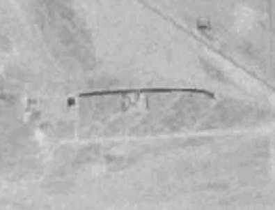
The earliest depiction which has been located of Barton Field was a very low-resolution 6/3/77 aerial view.
It depicted the field as consisting of a single east/west runway, with an odd curve to the south on the eastern end.
Several small buildings were on the south side of the field,
A 1983 aerial view depicted Barton Field as having an east/west unpaved runway, with a former northeast/southwest runway as well.
Several small buildings were on the south side of the field, around which were parked 5 single-engine aircraft.
Barton Field was not depicted at all on the 1983 USGS topo map.
A 1986 aerial view depicted 5 light aircraft at Barton Field.
A 1990 aerial view depicted only a single light aircraft at Barton Field.
The 1994 USGS aerial photo depicted the airfield as a single east/west runway, paved in asphalt.
At least one light single-engine plane was visible on the south side of the runway.
According to Dan Eikleberry, “About 1998, Nevada Power came in
and ran a very high set of high voltage power lines right down Rainbow Road,
just a thousand feet or so from the East end of the Gomer runway.
That made it a tricky approach into the Runway 27, a very close-in base leg, sharp left turn to final, flare & land.”
Dan continued, “The west end of the runway (again, we're talking about a city street here) simply ran up a hill...
darn near the ONLY hill in the entire southwest quadrant of the entire Las Vegas Valley!
A takeoff to the West was wisely followed with a hard turn to the South at liftoff.”
According to Dan Eikleberry, “When they repaved Interstate 15 in approximately 1999,
he [Mr. Barton] made a deal with the asphalt folks who simply dumped the surplus asphalt from each day's pour on his runway.
It was rough. Barton did not have the rollers to smooth it. But... it was better than dirt.”
A 1999 aerial view showed the newly-applied coat of asphalt on the runway.
On 12/17/00 an amateur-built experimental Lueck Avid Amphibian, N6013T, was substantially damaged
when it veered off the runway & struck a parked helicopter during an attempted takeoff from Barton Field.
The private pilot, the sole occupant, was not injured.
According to Dan Eikleberry, the former diagonal southwest/northeast runway
was blocked by the construction of a small building in “about 2003”.
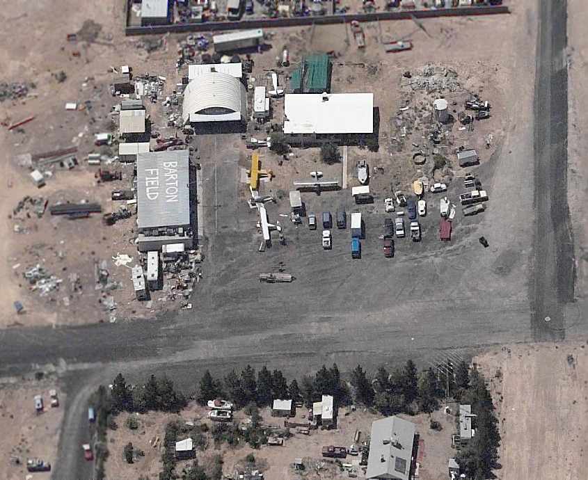
A circa 2003 aerial view looking south at the ramp at Barton Field, showing 4 intact planes, as well as at least 2 other fuselages,
as well as a hangar & several other buildings.
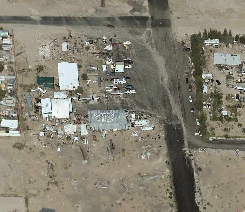
A circa 2003 aerial view looking west at the ramp at Barton Field, showing 5 intact planes, as well as at least 2 other fuselages,
as well as a hangar & several other buildings.
Note that the complement of aircraft is somewhat different from that depicted in the preceding photo.
The last photo which has been located showing planes at Barton Field was a 2/29/04 aerial view looking northwest,
showing 3 light single-engine planes parked south of the runway.
According to Dan Eikleberry, “Real estate values soared from 2000-2005 in Las Vegas.
The lots along Gomer Road are 2.5 acres, and used to sell (in 1998) for about $150,000.
The developers have scarfed up every acre that the Bureau of Land Management (BLM) would sell in their auctions every 6 months.
About 2004, the BLM sold almost all the vacant land you see around Barton airport.
Today [2006], a 2.5 acre parcel in that neighborhood sells for about $1.2 million.
The power line off the East end, the hill on the West end, the real estate values,
and the home developers pretty much put an end to the cozy Barton Airfield that we all loved.
Barton was forced to shut down his airport last year, 2005, and cease use of the 'runway'.
Mr. Barton cleaned out all the airplanes & his hangar.”
Dan continued, “The lot at 7100 Gomer Street was sold to Ron & Carolyn Mich'l in May of 2005,
The single 2.5 acre lot that Barton has his hangar on sold for $1.275 million. I think property values caused the demise of the airport.”
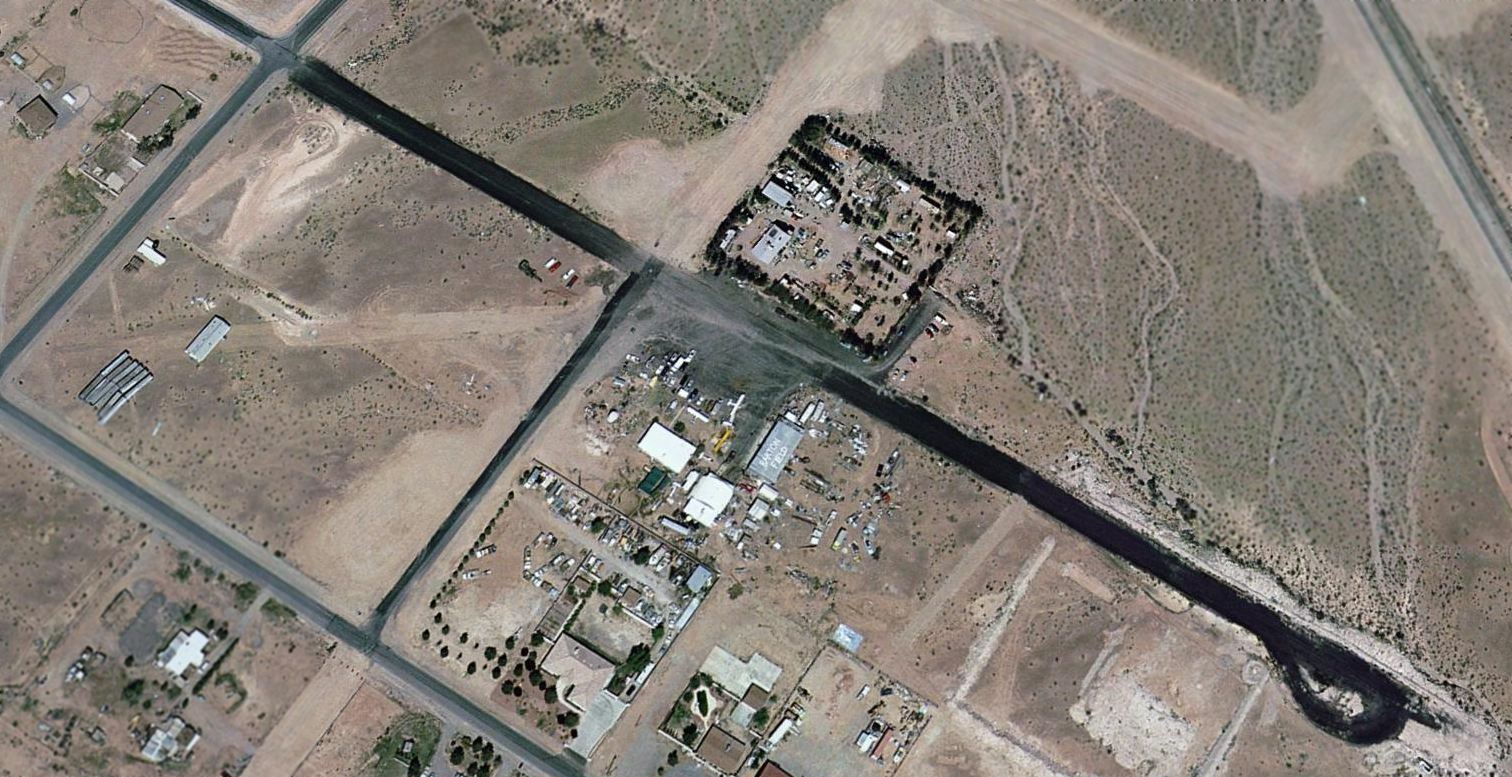
A 10/5/05 aerial view looking northwest at the site of Barton Field.
Dan observed that the photo “shows what it looked like after they totally erased all evidence of a parking ramp, hangar, airplanes, garbage and trash!
In fact, they also have removed the temporary building from the lot on the southwest
that was blocking the southwest diagonal runway (into the wind).”
A 2006 aerial view shows that everything on the lot on the north side of the runway has been scraped clean as well.
A 5/29/10 aerial view shows that the paved runway remains, but all other evidence of Barton Field has been removed.
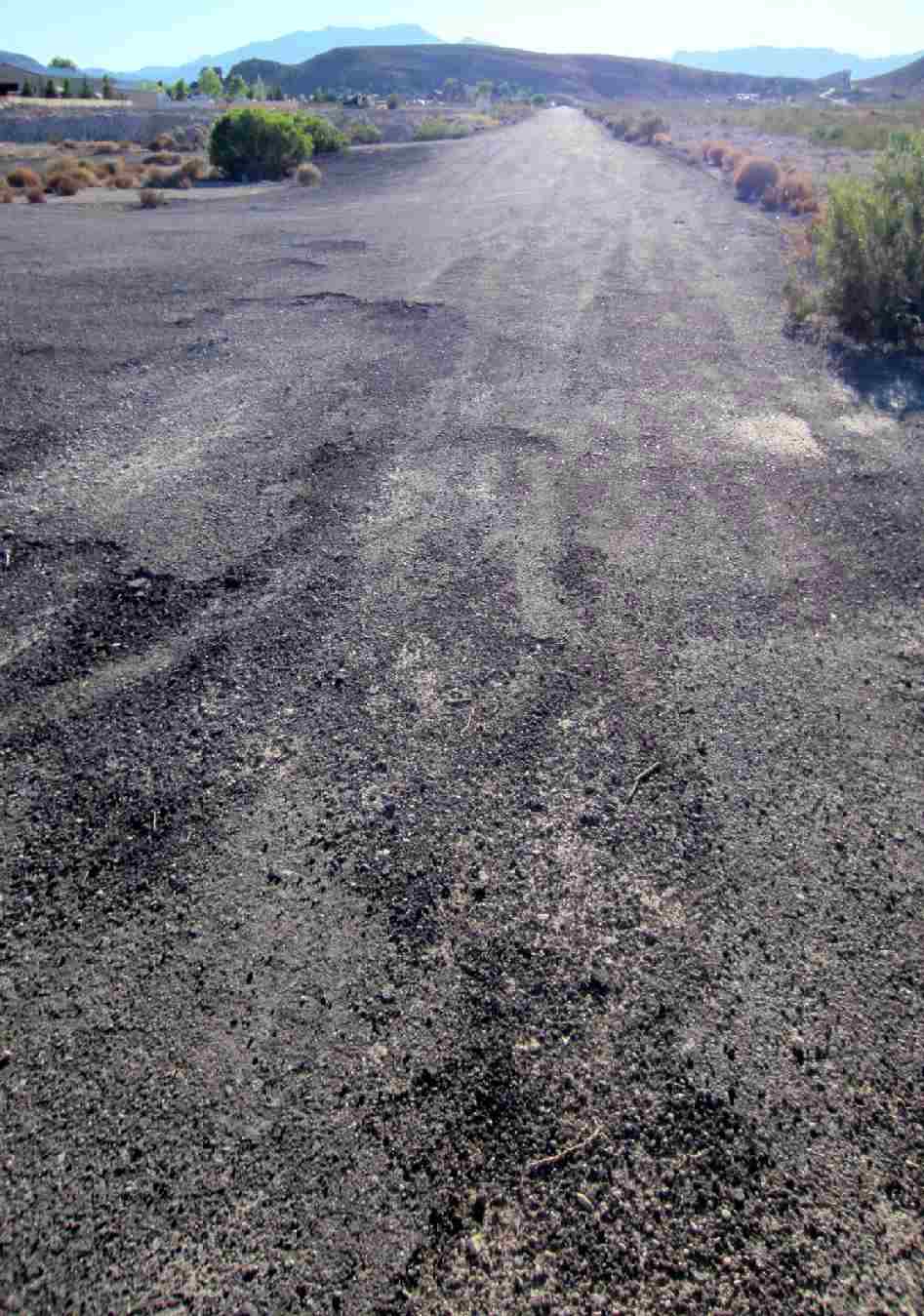
An August 2011 photo by Rob Erekson looking west along the remains of Barton Field's runway.
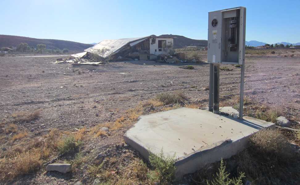
An August 2011 photo by Rob Erekson of a power meter next to where the Barton Field hangar stood, with the remains of a house in the background.
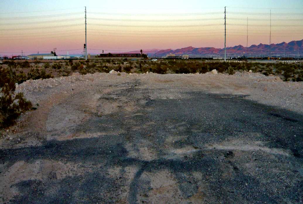
A February 2013 photo by Adam Taylor, “looking to the east... the end of the strip & the power lines that old man Barton had to contend with.”
A 2016 aerial view looking northwest at the site of Barton Field shows the paved runway remains, but the airfield buildings have been removed.
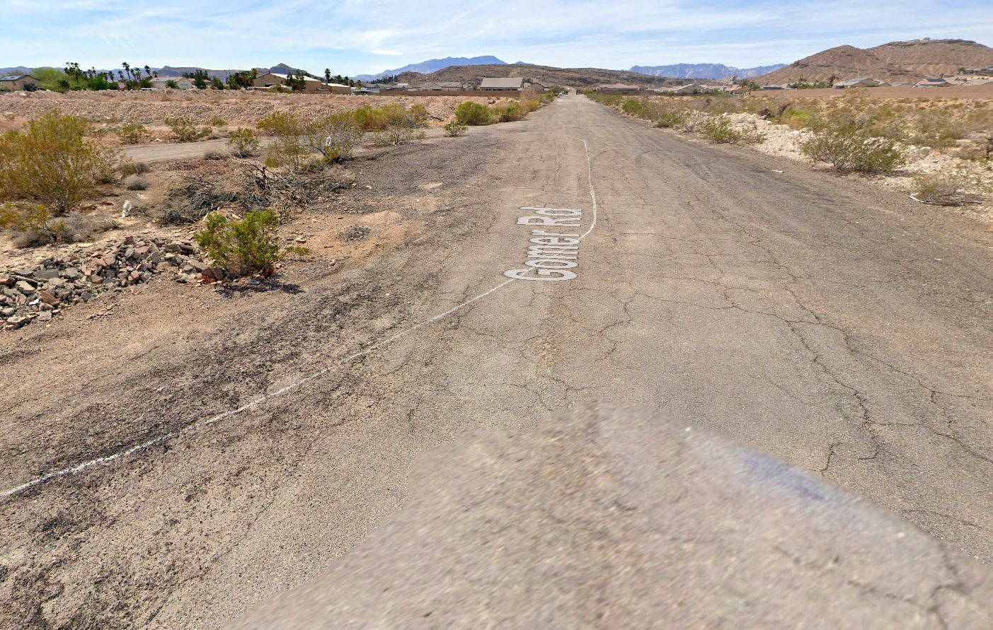
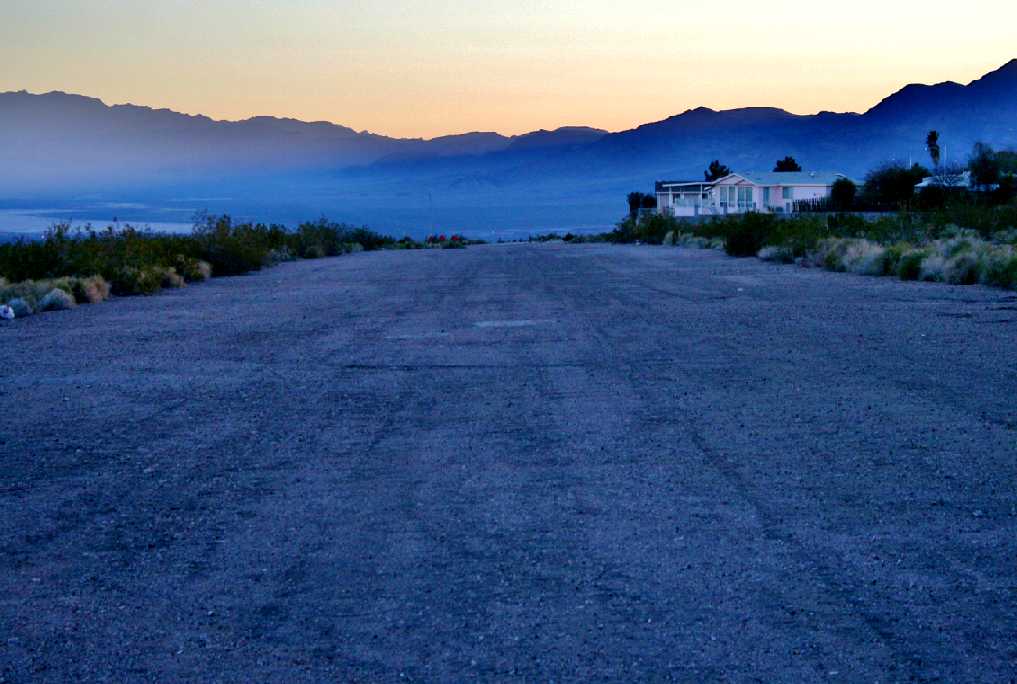
A 2025 photo looking west along the former Barton Field runway, reused as West Gomer Road. The western portion of the former runway is now lined with homes.
The site of Barton Field is located east of the intersection of Gomer Road & Tenaya Way.
____________________________________________________
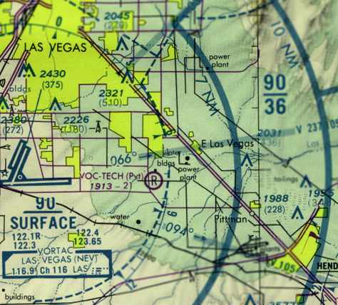
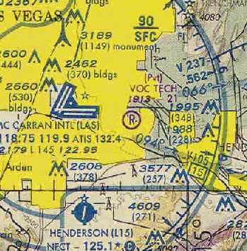
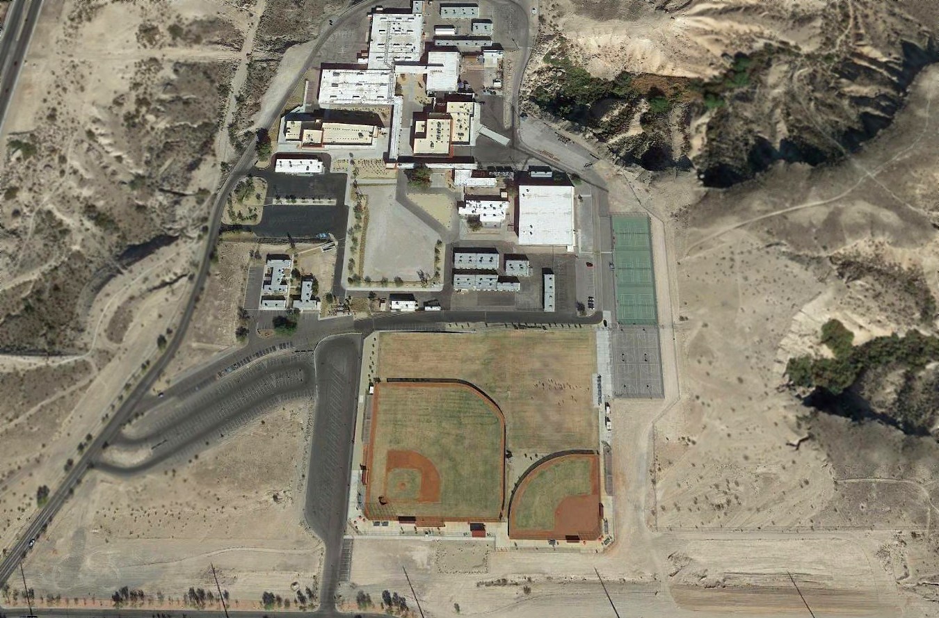
Voc-Tech Airfield, Las Vegas, NV
36.08, -115.068 (East of Las Vegas McCarran International Airport, NV)
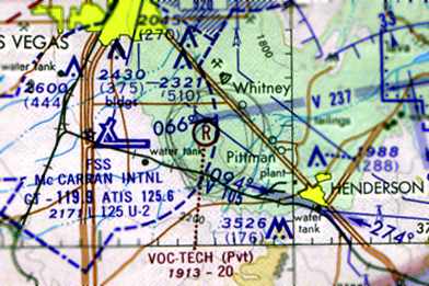
The earliest depiction that has been located of the Voc-Tech Airfield
was on the 1970 Las Vegas Sectional Chart (courtesy of Jonathan Westerling).
This little private airfield was located less than 3 miles east of Las Vegas' McCarran International Airport.
It was operated by the adjacent Southern NV Vocational Technical Center.
According to Jonathan Westerling, “The school was established in 1966 to offer multiple career & technical programs,
to young persons seeking additional choices to the regular high school curriculum.
Back in 1966, this part of the valley was a remote stretch of highway between Henderson & Vegas.”
The Voc-Tech Airfield was evidently established at some point between 1969-71, as it was not yet depicted on a 1965 aerial view
nor on the March 1969 Las Vegas Sectional Chart (courtesy of Paul Columbus).
The earliest depiction of the field which has been located
was on the 1970 Las Vegas Sectional Chart (courtesy of Jonathan Westerling).
It depicted Voc-Tech as a private airfield, having a 2,000' unpaved runway.
The 1971 Las Vegas Sectional Chart (courtesy of Vince Granato)
continued to depict Voc-Tech as a private airfield with a 2,000' unpaved runway.
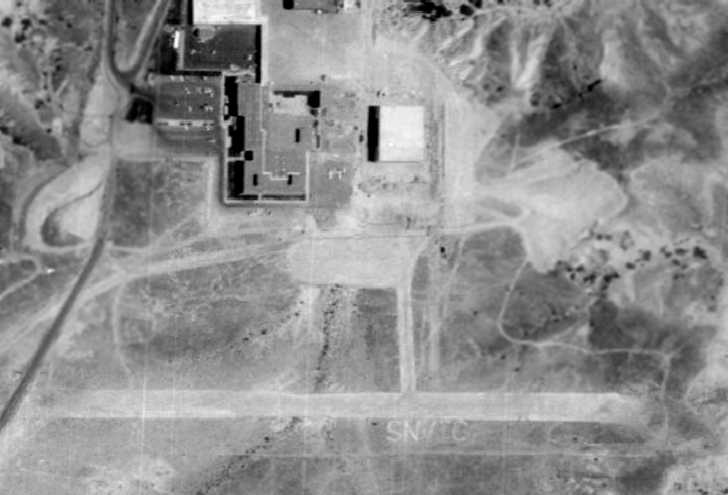
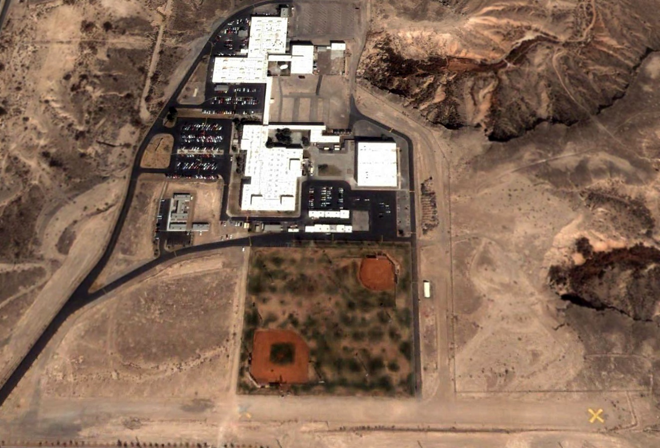
The earliest photo that has been located of the Voc-Tech Airfield was a 1973 aerial view.
It depicted the field as having a single unpaved east/west runway,
with a taxiway leading to a ramp on the north side of the field, adjacent to the school buildings.
Note the “SNVTC” marked in large letters in the ground on the south side of the runway.
The 1981 Las Vegas Terminal Area Chart (courtesy of Jonathan Westerling) depicted Voc-Tech as a private airfield having a 2,100' unpaved runway.
The 1982 AOPA Airports USA Directory (according to Chris Kennedy) described the Voc-Tech Airfield as having a single 2,100' gravel Runway 9/27.
The status of the field was listed as “Private. Closed to public.”
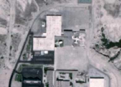
A closeup from the 1983 aerial view, showing the Martin 404 twin-engine airliner parked on the east side of the Voc-Tech school buildings.
It had been added at some point between 1973-83.
According to Mark Hall-Patton (of the Howard W. Cannon Aviation Museum),
“The Martin 404 was actually flown in to VoTech when it was given to them by EG&G.”
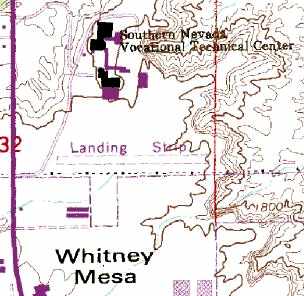
The Voc-Tech airfield was depicted as a single east/west "Landing Strip" on the 1984 USGS topo map.
What could have been 2 t-hangars were depicted on the southwest side of the field.
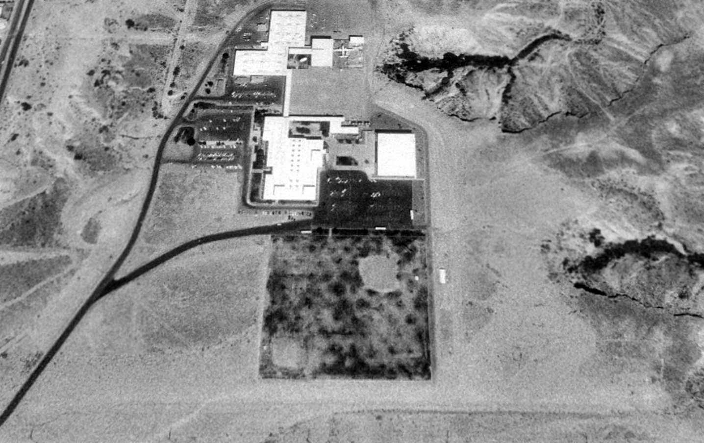
The outline of the single east/west dirt runway was barely discernible in a 1990 USGS aerial view looking north at the site of Voc-Tech Airfield.
However, the Martin 404 twin-engine airliner was still parked next to the school building at the top of the picture.
Jonathan Westerling reported, “The last documented [aviation] activity at this airstrip is an accident which occurred there in 1994.”
According to the NTSB report, “On 7/5/94 at 0900 hours Pacific daylight time,
a Mooney M20C, N6959U, collided with terrain during a takeoff attempt at Voc Tech Airport at Las Vegas.
The aircraft departed the end of a 2,100' long gravel runway, which is oriented east to west.”
The last depiction which has been located of the Voc-Tech Airfield as an active airfield was on the March 1999 Las Vegas Sectional Chart (courtesy of Chris Kennedy).
It depicted Voc-Tech as a private field, having a 2,100' unpaved runway.
According to Mark Hall-Patton (of the Howard W. Cannon Aviation Museum), “The VoTech had an aeronautics program for a number of years, but it was closed in the late 1990s.
The aircraft was sold & hauled away, though I do not know where.”
The Voc-Tech Airfield was no longer depicted at all on the September 2000 Las Vegas Sectional Chart.
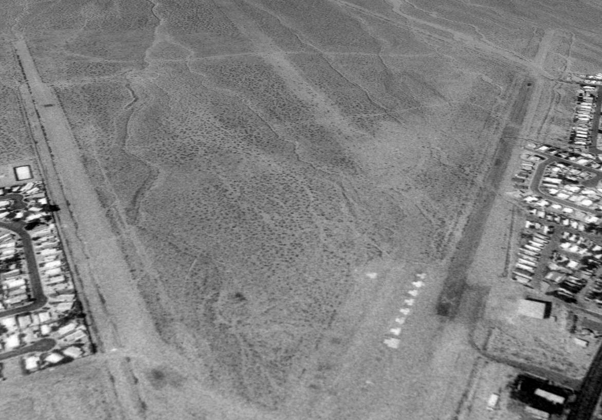
A 2002 aerial view looking north showed a closed-runway “X” symbol had been placed on the east end of the Voc-Tech runway.
The Martin 404 had also been removed at some point between 1990-2002.
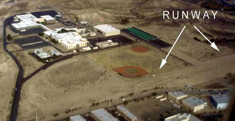
A 2006 aerial view by Jonathan Westerling looking northeast at the former Voc-Tech runway.
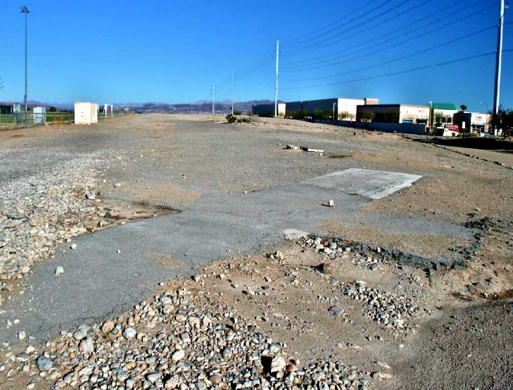
A February 2013 photo by Adam Taylor, of “the asphalt 'X' in the middle of the old strip, by the parking lot... which the field basically is now.”
A 2017 aerial view looking north showed the former Voc-Tech runway was still barely recognizable, but the closed-runway “X” symbol was no longer discernible.
The site of the Voc-Tech Airfield is located east of the intersection of Mountain Vista Street & Whitney Mesa Drive.
Thanks to Joe Merkert for pointing out this airfield.
____________________________________________________
Bullock's Airport / (Original) Boulder City Municipal Airport (BLD), Boulder City, NV
35.97, -114.85 (Southeast of Las Vegas, NV)
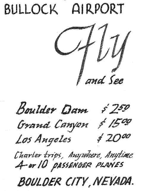
A 1933 flyer advertising flights from Bullock Airport (courtesy of Kraig Sullivan).
The original municipal airport for the town of Boulder City was located directly adjacent to the south edge of the town.
Boulder City Municipal Airport was not yet depicted on the October 1933 LA Sectional Chart.
“The Boulder City Airport was formerly known as Bullock Airport after Noel Bullock,
holder of the government permit for the airport”, according to Bullock's great-grandson, Kraig Sullivan.
“The airport opened for traffic in November 1933 & was formally dedicated a month later.
Noel operated a charter service & sightseeing tour business out of the airport for a year.”
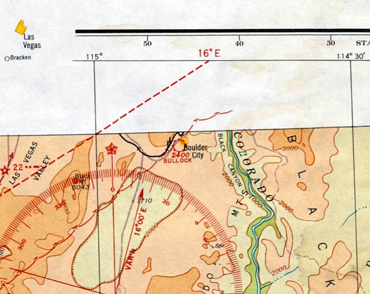
The earliest aeronautical chart depiction which has been located of Boulder City Airport was on the June 1934 LA Sectional Chart.
It depicted Boulder City Airport as a commercial/municipal airport.
The earliest directory reference to an airport in Boulder City which has been located
was in the 1934 Department of Commerce Airport Directory (courtesy of Chris Kennedy).
It listed "Bullock's Airport" located "one-half mile southwest of the center of Boulder City".
It described the field as having 3 sand runways, with the longest being a 4,000' north/south strip.
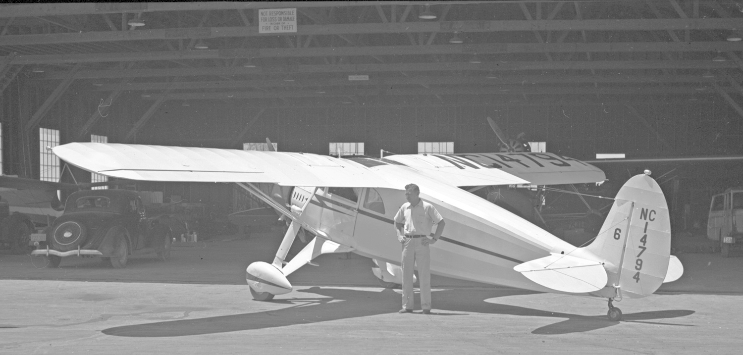
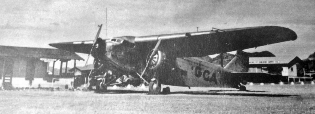
A 1935-39 photo of Fairchild 24 C8C Forwarder/Argus C/n 2666 NC14794 in front of a Boulder City Airport hangar.
A 7/29/36 BLR photo (courtesy of Tim Tyler) of a Grand Canyon Airlines Ford Tri-Motor, with the Boulder City Airport waiting room on the left side.
An aerial view looking northwest at Boulder City Airport from The Airport Directory Company's 1938 Airport Directory (courtesy of Chris Kennedy).
The directory described Boulder City as having three 4,000' hard-packed dirt runways, oriented north/south, east/west, and northwest/southeast.
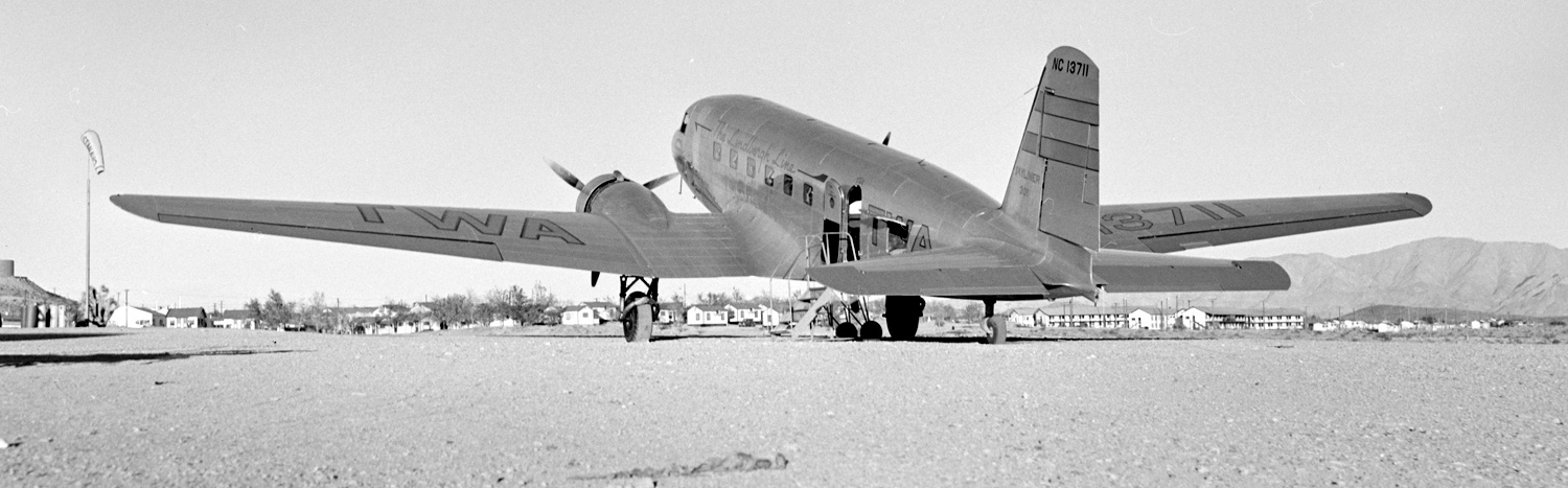
An 4/13/38 BLR aerial view (courtesy of Tim Tyler) looking north at 3 TWA DC-2s at Boulder City Airport during the inauguration of TWA's Boulder City service.
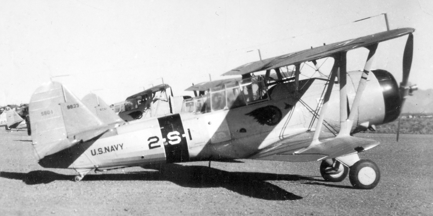
A 1/22/38 photo of several Vought SBU-1 Corsairs at Boulder City Airport.
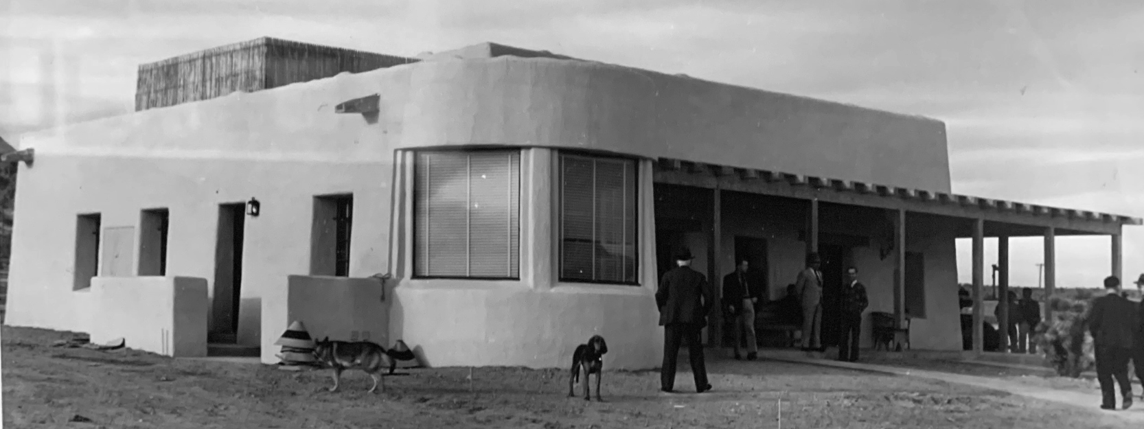
A 1938 photo (courtesy of Tim Tyler) of the Boulder City Airport ticket office & waiting room.
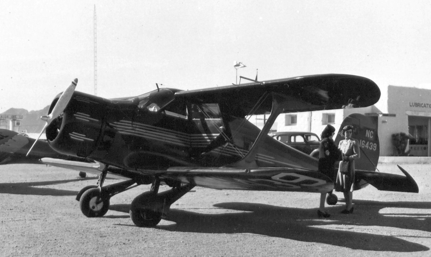
A 1938-39 photo of Beech C17B Staggerwing C/n 98 NC16439 at Boulder City Airport.
Boulder City was depicted as a "Class 3" airport on the 1940 Airports & Airways Map from the NV Division of Aeronautics (courtesy of Jim Mallery).
The October 1941 LA Sectional Chart (courtesy of Chris Kennedy) depicted Boulder City Airport as a commercial/municipal airport.
Boulder City Airport was reportedly used by the Navy during WW2, which also had an ammunition depot on the site.
Boulder City was depicted as a civil airfield on the 1944 LA Sectional Chart (courtesy of John Voss).
According to Kraig Sullivan, “TWA remained at the airport until the end of 1949
when the airport was condemned by the CAA & all equipment was transferred to Las Vegas.”
The 1949 Gila River World Aeronautical Chart (courtesy of Donald Felton)
depicted Boulder City Municipal Airport as having a 6,500' unpaved runway.
A 1957 street map (courtesy of Kevin Walsh) depicted Boulder City Airport as having 3 unpaved runways.
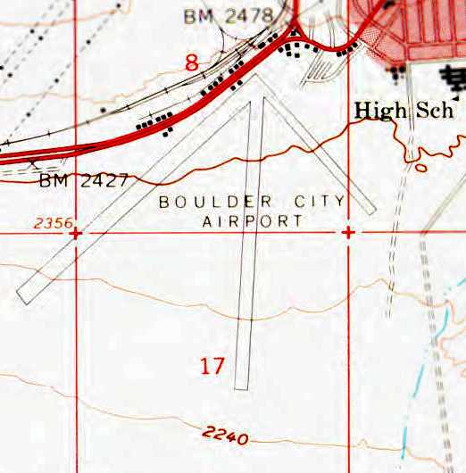
The 1958 USGS topo map depicted Boulder City Airport as having 3 runways,
with several small buildings along the northwest side of the field.
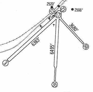
The 1960 Jeppesen Airway Manual (courtesy of Chris Kennedy)
depicted Boulder City as having 3 unpaved runways (with the 6,495' Runway 17/35 being the longest),
but the remarks said "Runways 17/35 & 12/30 not maintained."
A ramp was depicted on the northwest side of the field,
along with 3 small buildings.
The Boulder City Airport was described by the 1962 AOPA Airport Directory as having 2 unpaved runways.
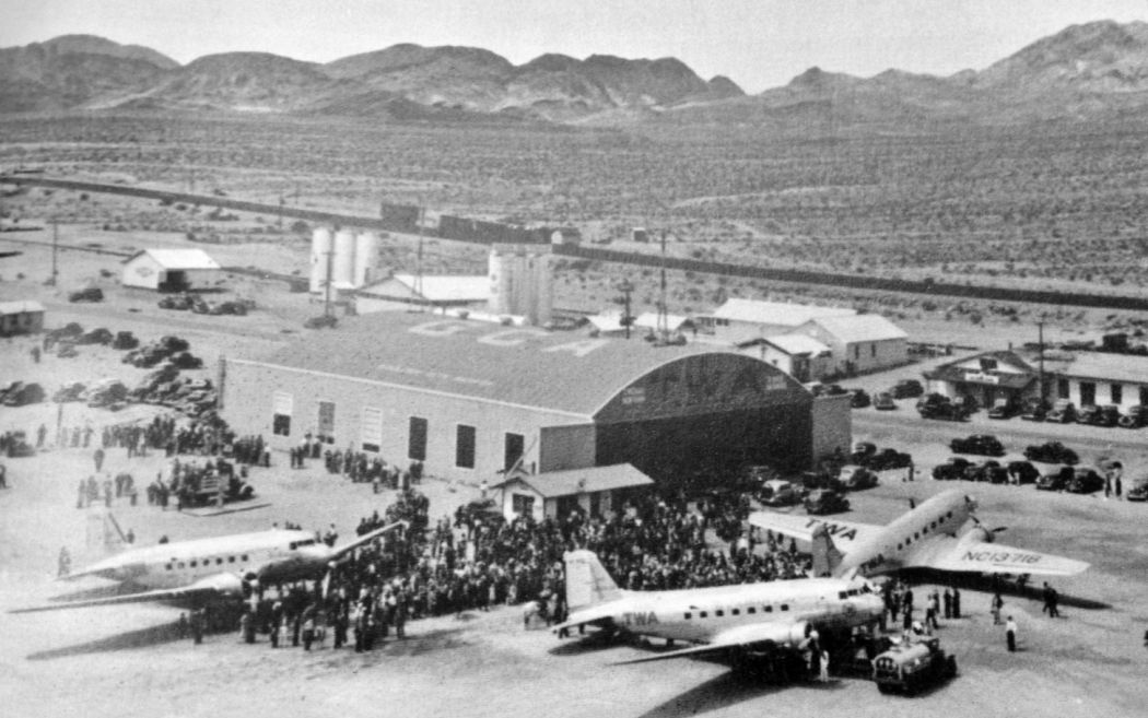
A 1962 BLR aerial view (courtesy of Tim Tyler) looking southwest at Boulder City Airport, showing several planes & hangars along a dirt runway.
According to Kraig Sullivan, “After a period of infrequent use,
he field was taken over by the Boulder City Aero Club in September 1964 under a lease agreement with the City for 10 years.
The City maintained the airport with FBO lease agreements to operate the airport.”
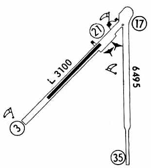
Boulder City apparently gained a paved runway at some point between 1962-67, as the 1967 Flight Guide (courtesy of Chris Kennedy)
depicted the field as having a 3,100' paved Runway 3/21 (set in the middle of a much longer unpaved runway), along with an 6,495' unpaved Runway 17/35.
Three buildings were depicted just west of the runway intersection, along the northwest side of Runway 3/21.
Note that the airport property had shrunken somewhat compared to the 1960 diagram,
as Runway 12/30 had been abandoned & was no longer part of the airport property.
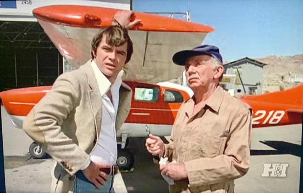
A still from the Vega$ episode “Milliken’s Stash” (originally aired 11/8/78) filmed at Boulder City Airport, showing Robert Ureich & another actor in front of a Cessna U206D (courtesy of Tim Tyler).
The episode purported the location to be “Lake Mead Airport”, an apparently fictitious location.
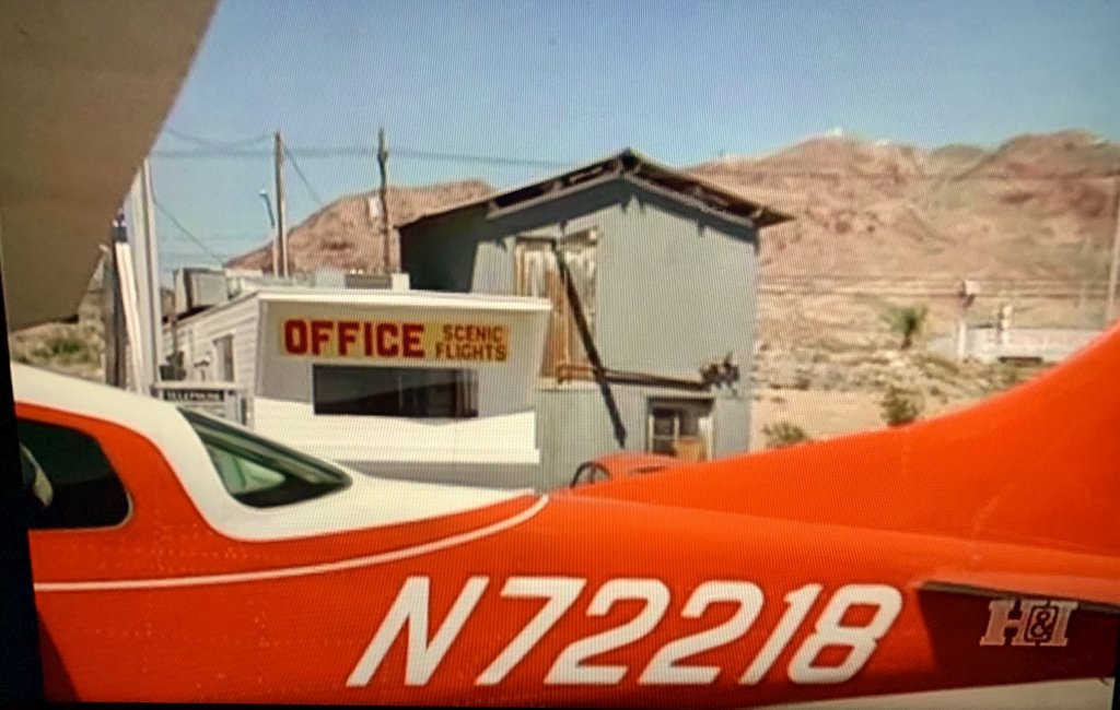
A still from the Vega$ episode “Milliken’s Stash” (originally aired 11/8/78) filmed at Boulder City Airport, showing a Cessna U206D (courtesy of Tim Tyler).
Tim Tyler observed, “Distant background in the upper right is Red Mountain & it faintly shows the ‘BLD’ Boulder City VORTAC as well as a land mobile radio repeater site that’s up there.”
The March 1980 Las Vegas Terminal Aeronautical Chart (courtesy of Mitchell Hymowitz)
still depicted Boulder City as having a single 3,100' paved runway.
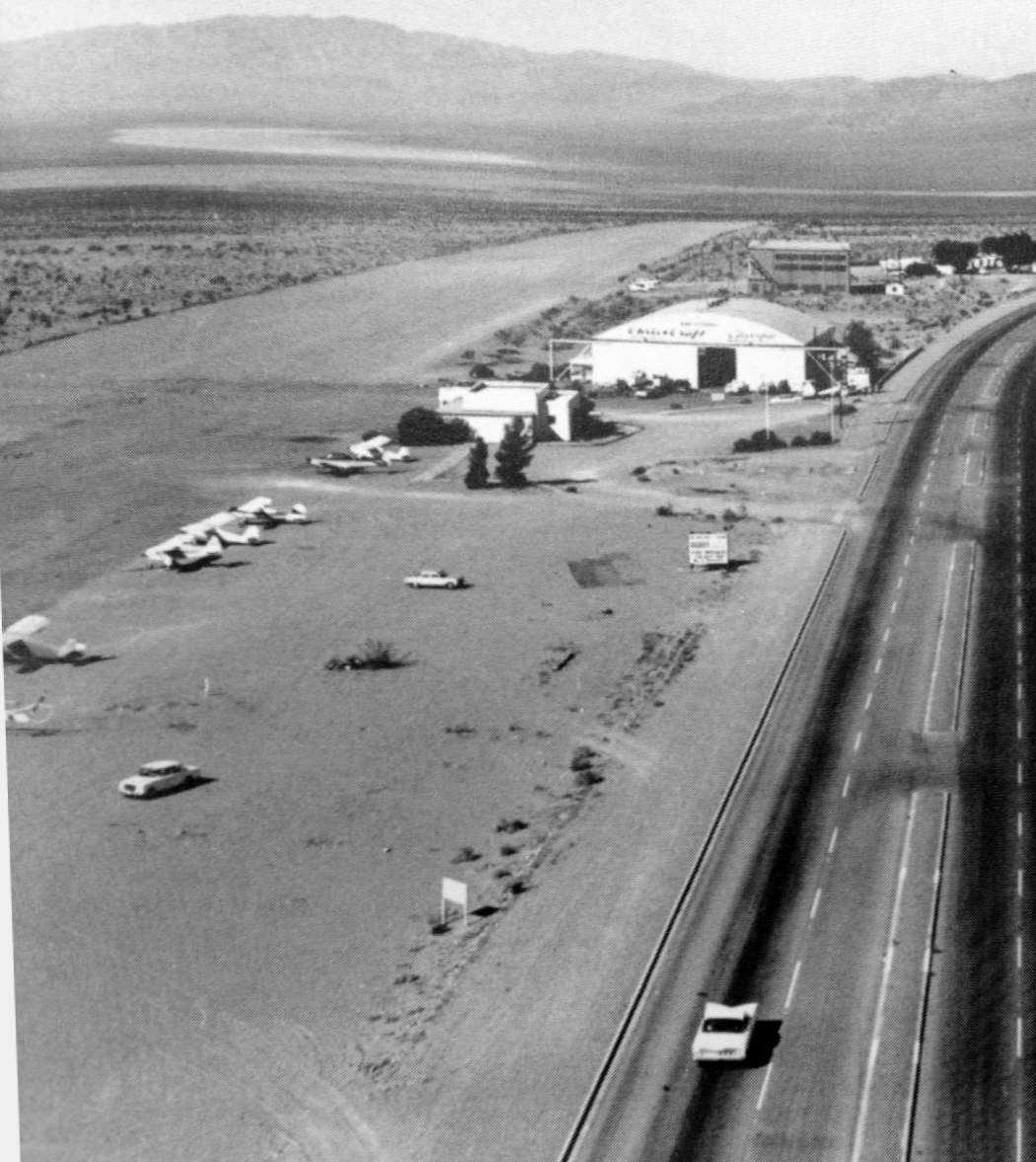
A 1980 aerial view depicted Boulder City as having a paved northeast/southwest runway & a dirt north/south runway.
A total of 30 light aircraft were visible parked on the north end of the field.
The 1982 AOPA Airport Directory (courtesy of Ed Drury) described Boulder City's runway configuration as a 3,100' asphalt Runway 3/21 & a 4,000' gravel Runway 17/35.
The operator was listed as Lake Mead Air.
Don Eikenberry recalled, “My first real job in aviation was with Lake Mead Air out of Boulder City.
Earl Leesburg owned the company. He was an aviation legend in the area. AOPA did an article on him in the 1990s.”
Peter Dan recalled of Boulder City Airport, “This is where I learned to fly sailplanes in high school way back in 1983-84 at Desert Soaring.
It was run by a WW2 glider pilot veteran of the Normandy invasion in Europe named Dick McKnight & his wife Carol.
Dick was a cigar chomping character.
My flight instructor was a Korean war era veteran Navy fighter pilot named Jim Jinesta who was rated in just about every kind of aircraft you could think of.
He was one of the best pilots I've ever known.
They ran an L-13 Blanik, a couple of SCHW 2-33s (01H & 79S), as well as some 1-26s.
They operated just to the left of the big Chevron hangar
out of a little orange trailer with a built in 'control tower / observation deck' sticking out of the top (very cute).
There was only one paved runway at the time (3/21) & it looks like they've dug up the pavement that was previously there
and tore down the numerous smaller hangars that used to be in the area opposite the large hangar.
The dirt Runway 17/35 was still there at the time but seldom used.
I only remember using it one time for training purposes to simulate off field landing & takeoff.
The dust blew so badly form the prop wash there was almost no visibility until after liftoff.
Runway 3/21 was set up to land on Runway 3 only & takeoff on Runway 21.
This was because there was a Safeway just past the end of Runway 3.
The Safeway parking lot & the water treatment plant were usually the sources of the strongest thermals
and in the summertime it was some of the best soaring conditions around.
Under the right conditions you could also get some ridge lift off the mountain to the North.
There is a dry lake bed nearby off-airport that was also used for ground launch training.
The field was sloped downward as you took off on Runway 21 which shortened the landings going uphill on Runway 3.
I remember a Learjet landed on Runway 3 one time
and because of the slope he actually had to add power after landing to make it all the way up to the tiedown area.”
The last aeronautical chart depiction which has been located of the original Boulder City Municipal Airport was on the September 1986 Las Vegas Terminal Chart (courtesy of Jonathan Westerling).
It depicted Boulder City as having a single 2,900' paved northeast/southwest runway.
According to Kraig Sullivan, “In the late 1980s, planning for a new airport was completed.
The present site was selected [the present-day Boulder City Airport, located one mile to the south],
and construction of the new airport was completed in 1990.
The old airport was closed to traffic.”
A 1990 aerial view still depicted about 20 light aircraft at the original Boulder City Airport.
The original Boulder City Airport had been closed by 1994, as it was depicted as an abandoned airfield (right next to the new Boulder City Airport)
on the May 1994 CG-18 Word Aeronautical Chart (courtesy of David Brooks).
A 1994 USGS aerial view looking southwest showed the original Boulder City Airport
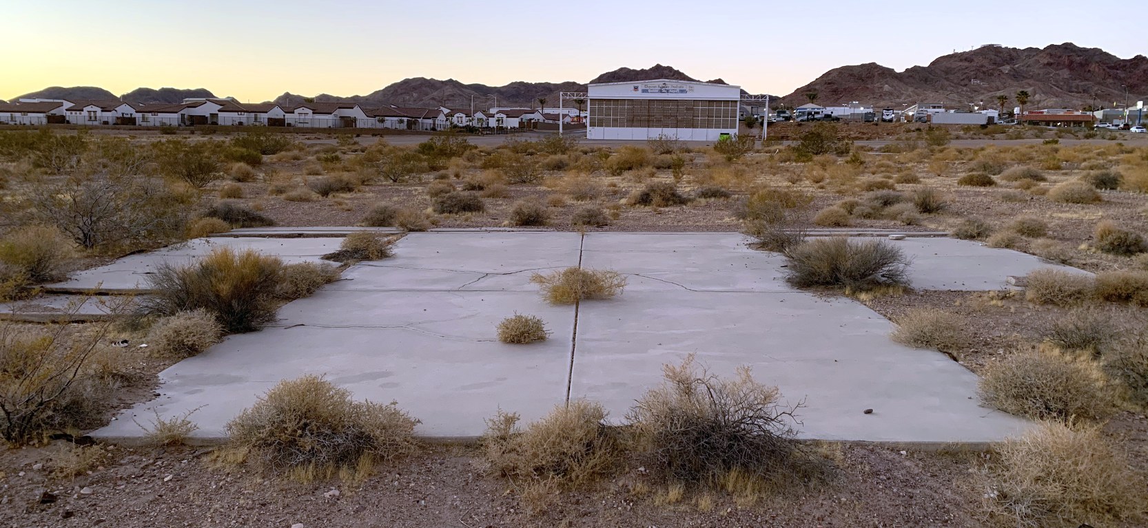
to still consist of an unpaved runway (left) & the remains of the paved runway (right), which was marked with “X” closed symbols.
A row of foundations from individual T-hangars were located opposite of the paved runway from the remaining hangar.
A September 2004 photo by Chris Kennedy looking along the former runway of the old Boulder City Airport.
He reported, "In Boulder City I was able to drive down what was apparently the last runway that was used.
It looks like gravel, but I guess it could be badly broken pavement.
There is a new road a short distance to the southeast of & pretty much parallel to the old runway,
and another road crosses it."
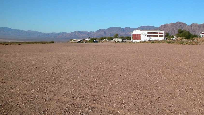
A September 2004 photo by Chris Kennedy of a former hangar which remains in perfect condition at the abandoned Boulder City Airport.
Kraig Sullivan reported in 2005, “The original TWA terminal building still stands; now occupied & owned by the Boulder City Elks.
The first hangar, constructed at the north end of the field, is now occupied by Boatcraft,
and another hangar constructed in 1941 by the military is still in use by the airport.”
Don Eikenberry reported in 2006, “I was just down there this fall & the hangar still stands.
You can drive right up to it.”
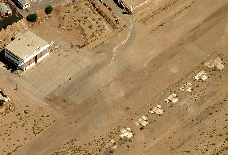
A circa 2007 aerial view looking north at the remaining Boulder City hangar,
along with the foundations of a row of T-hangars on the opposite side of the former runway.
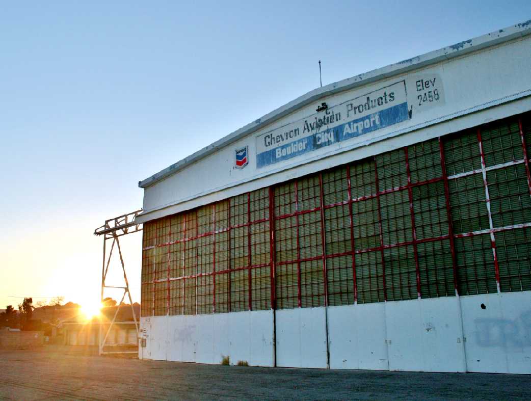
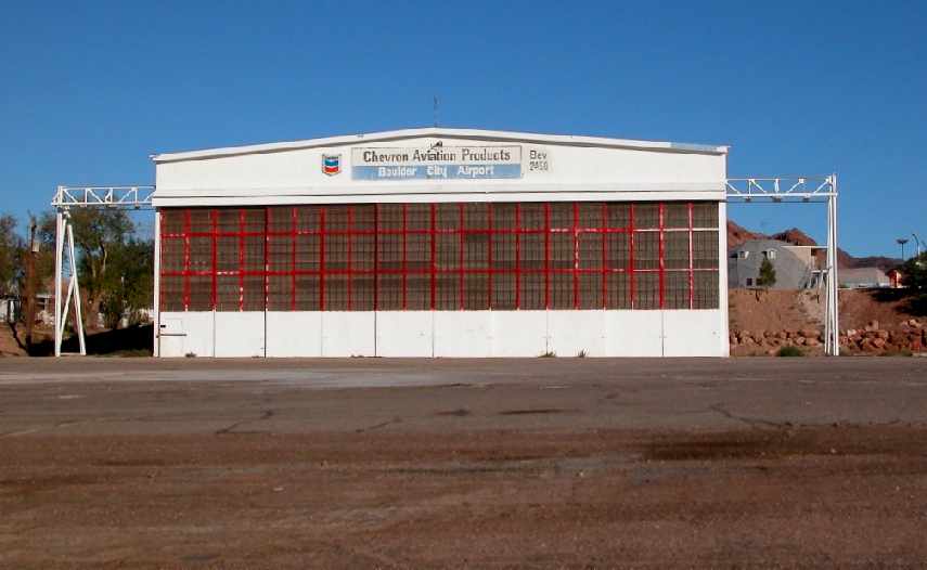
A February 2013 photo by Adam Taylor, who noted “Sunset view of the old Navy hangar.
The hangar & shack are now owned by a boat/RV dealership that sits behind the field.
The old terminal is now the Elks lodge.”
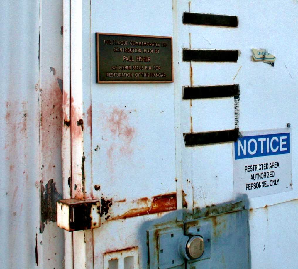
A February 2013 photo by Adam Taylor, who noted “Closeup of the door of the Navy hangar.
The plaque is dedicated to Paul Fisher, inventor of the Fisher Space Pen, for financing the restoration of the hangar.”
A February 2013 photo by Adam Taylor, who noted “A view straight down the main runway.”
A 2015 aerial view looking southeast showed that portions of both Boulder City Airport runways remained intact.
The main hangar also remained standing.
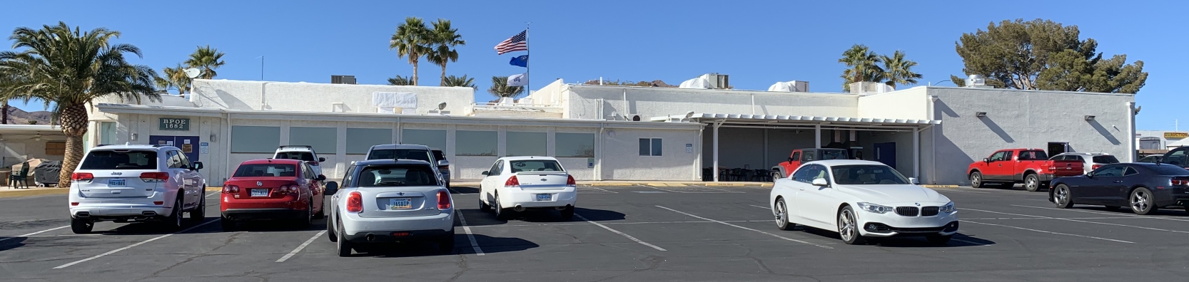
A 2/22/21 photo by Tim Tyler of the former Boulder City Airport TWA terminal building, now reused as the Boulder City Elks Lodge.
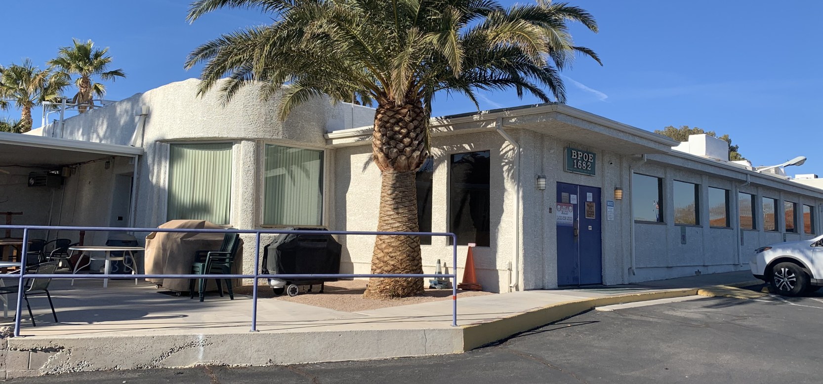
A 2/22/21 photo by Tim Tyler of the corner of the Boulder City Elks Lodge which contains the former Boulder City Airport TWA terminal building.
Note the similarity to the preceding 1938 photo, taken from the same perspective.
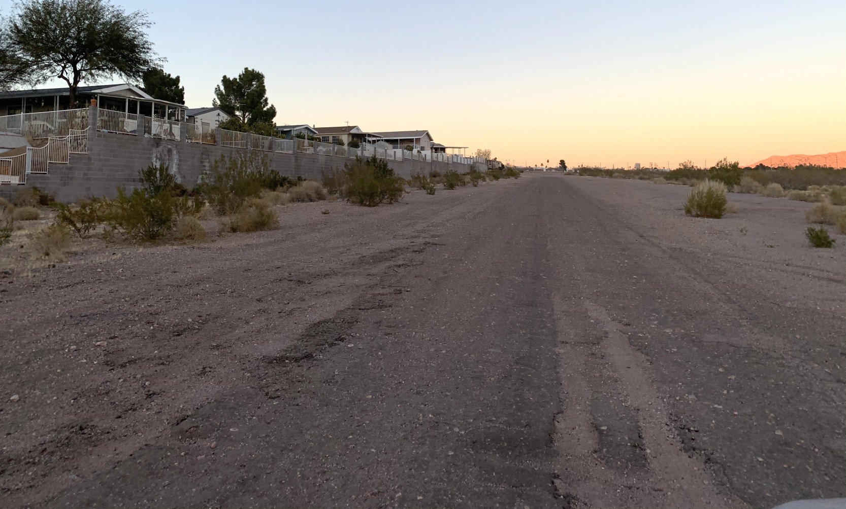
A 2/22/21 photo by Tim Tyler of a former Boulder City Airport runway.
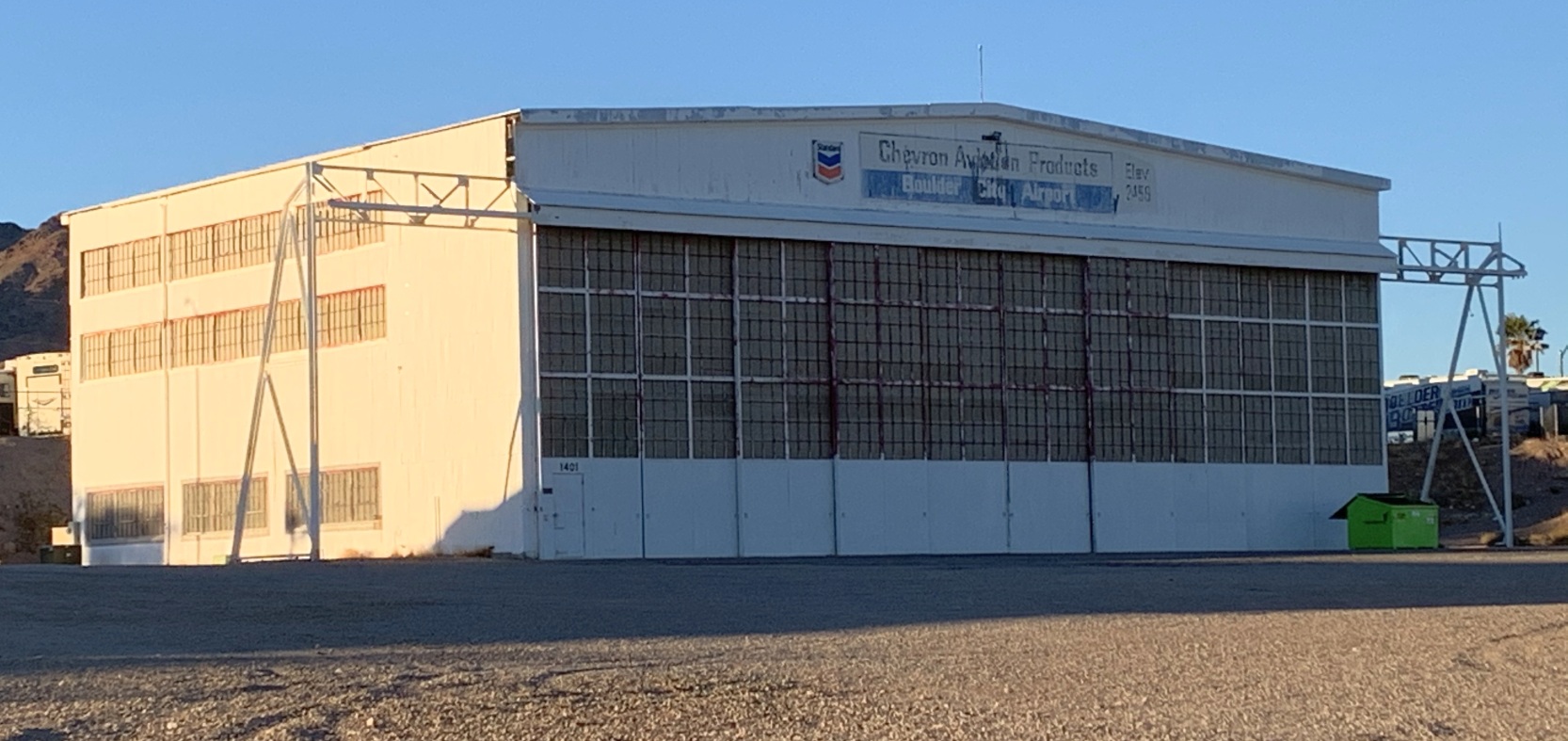
A 2/22/21 photo by Tim Tyler of the former Boulder City Airport “Navy hangar”.
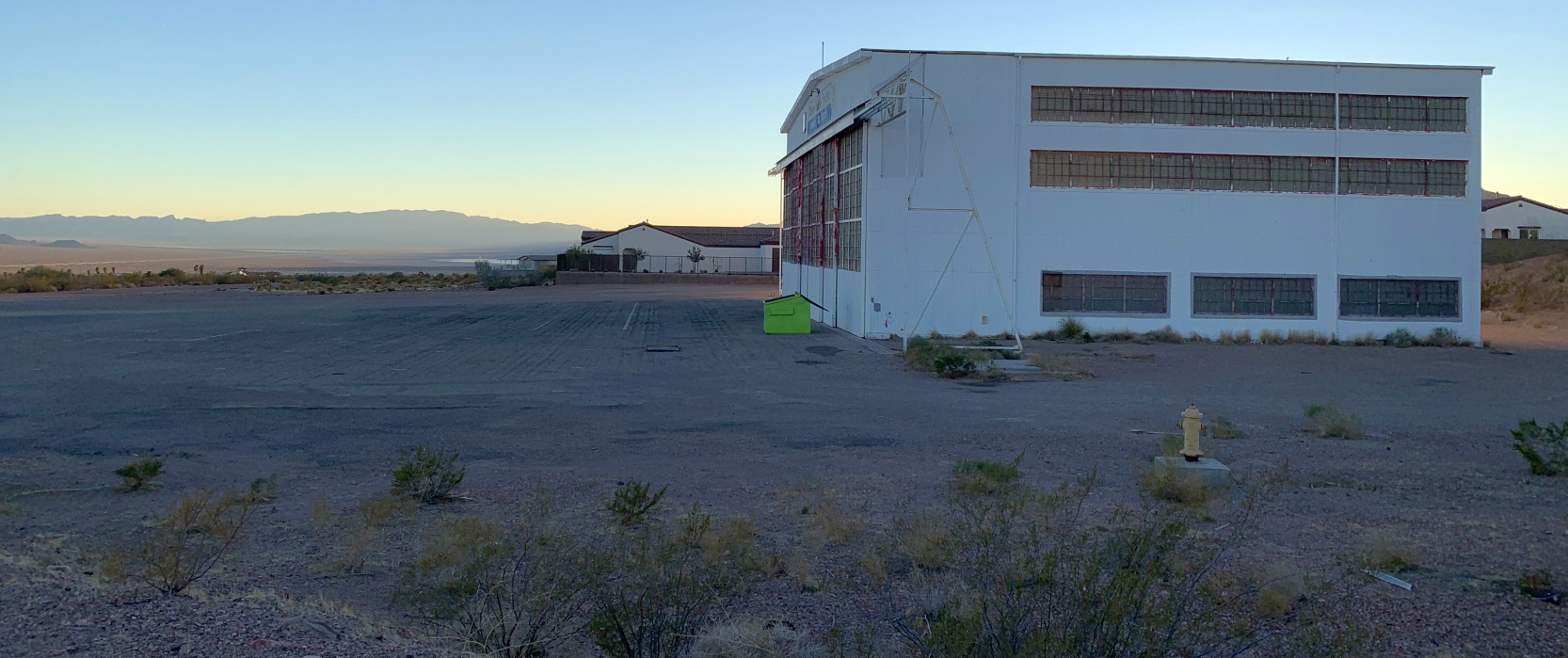
A 2/22/21 photo by Tim Tyler of the former Boulder City Airport “Navy hangar”.
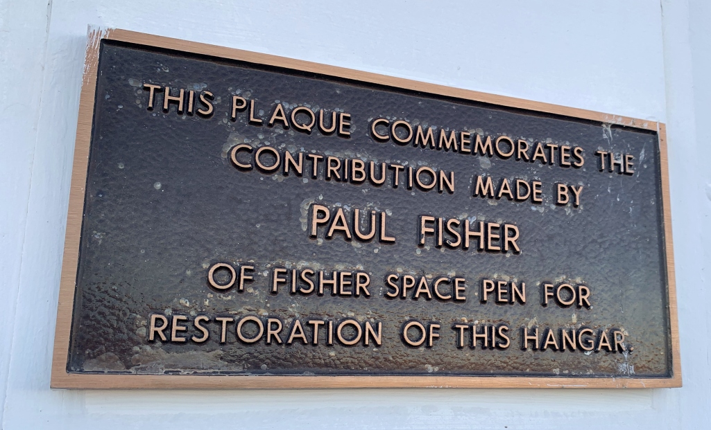
A 2/22/21 photo by Tim Tyler of a sign commemorating the support of Paul Fisher for his support of the restoration of the former Boulder City Airport “Navy hangar”.
A 2/22/21 photo by Tim Tyler of a Boulder City Airport T-hangar foundation, with the former “Navy hangar” in the background.
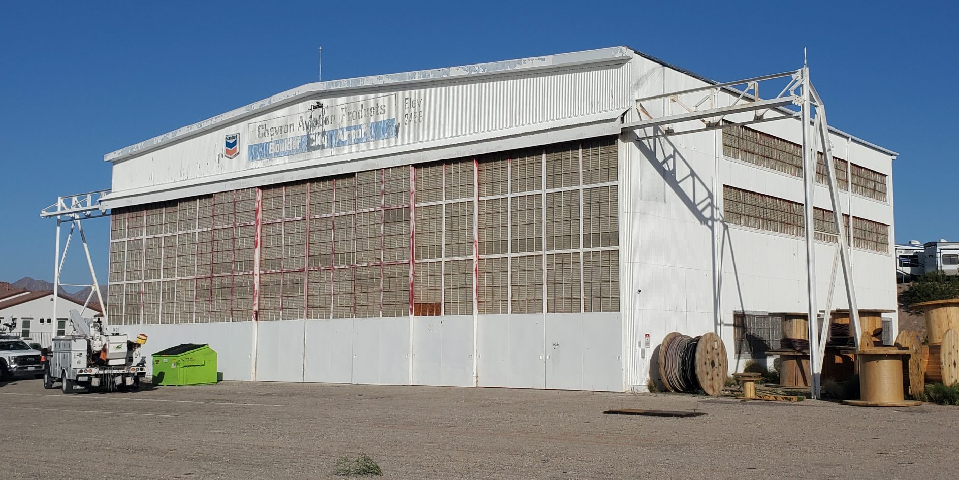
A 5/19/23 photo by Steve Primm of the former Boulder City Airport “Navy hangar”.
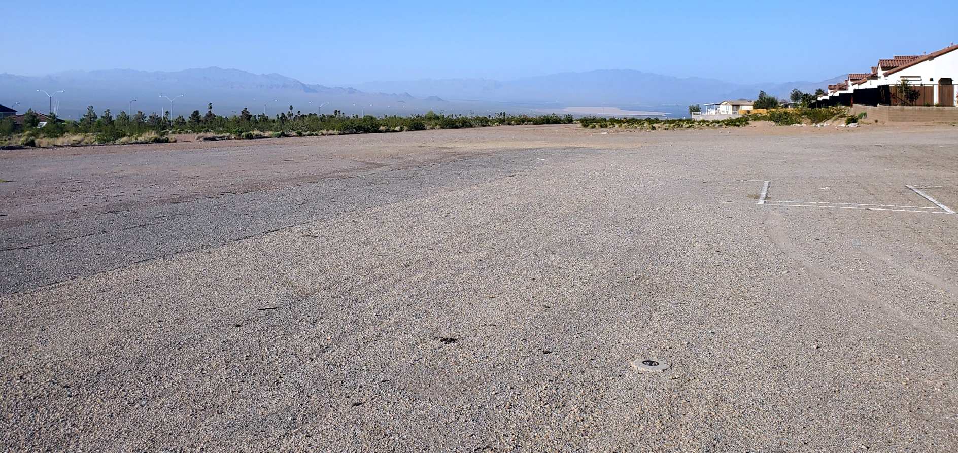
A 5/19/23 photo by Steve Primm of the remains of a former Boulder City Airport runway.
____________________________________________________
Or if you prefer to contact me directly concerning a contribution (for a mailing address to send a check),
please contact me at: paulandterryfreeman@gmail.com
If you enjoy this web site, please support it with a financial contribution.
____________________________________________________
This site covers airfields in all 50 states.