
Abandoned & Little-Known Airfields:
Northwestern New Mexico
© 2002, © 2025 by Paul Freeman. Revised 12/7/25.
This site covers airfields in all 50 states: Click here for the site's main menu.
For a 4th year, the NM pages of this website are sponsored by the New Mexico Pilots Association:
____________________________________________________
Please consider a financial contribution to support the continued growth & operation of this site.
Acomita Intermediate Field (revised 12/7/25) - Black Rock Airport (revised 9/19/19) - Chaco Canyon Airfield (revised 10/13/21) - Dulce Airport (revised 11/9/23)
(Original) Gallup Airport (revised 9/15/19) - Greater Grants Airport (revised 4/21/23) - Santa Fe Airport (original location) / Ashley Pond Airport (revised 7/18/15)
Santa Fe Municipal Airport (2nd location) (revised 10/13/21) - Tierra Amarilla Airport / El Vado State Park Airport (revised 8/29/23)
Torreon Airport (revised 11/9/23) - Tinian Airport (revised 11/9/23) - Transwestern #5 Airfield (revised 12/7/25) - Transwestern #6 Airfield (revised 12/7/25)
___________________________________________________________
Black Rock Airport, Black Rock, NM
35.084, -108.791 (West of Albuquerque, NM)
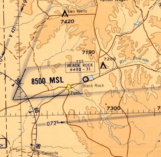
Black Rock Airport, as depicted on the September 1968 Prescott Sectional Chart.
This airport is located within the Zuni Reservation in western New Mexico.
Black Rock Airport was evidently established in 1968, as it was not yet depicted on the March 1968 Prescott Sectional Chart.
The earliest depiction which has been located of Black Rock Airport was on the September 1968 Prescott Sectional Chart.
It depicted Black Rock as having a 3,100' unpaved runway, and the Black Rock Flight Service Station on the field.
The 1971 Sectional Chart (courtesy of Fred DeGuio) showed Black Rock Airport's runway had been improved, to a 4,800' paved southwest/northeast strip.

The earliest topo map depiction which has been located of Black Rock Airport was on the 1972 USGS topo map.
It depicted a single paved southwest/northeast runway, labeled generically as “Airport”, with a taxiway leading to a ramp & a building on the northeast side.
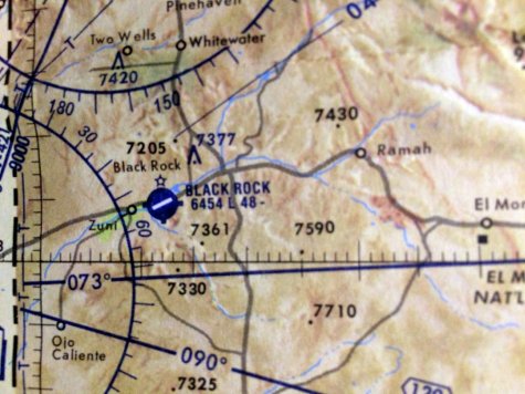
The last aeronautical chart depiction which has been located of Black Rock Airport was on the 1978 Sectional Chart (courtesy of Fred DeGuio).
It was depicted as having a beacon, and offering services.
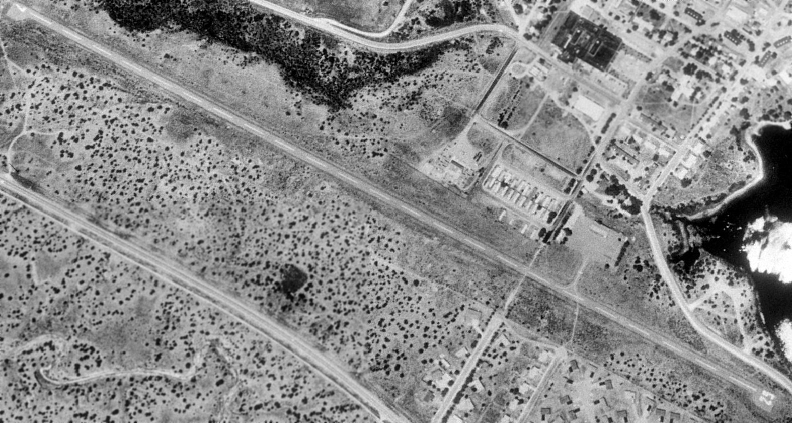
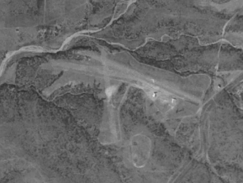
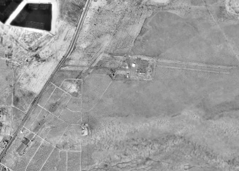
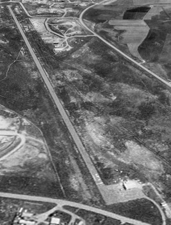
The earliest photo which has been located of Black Rock Airport was a 1991 aerial view looking northwest.
It depicted a single paved southwest/northeast runway, with a taxiway leading to a ramp & a building on the northeast side.
There were no aircraft visible on the field.
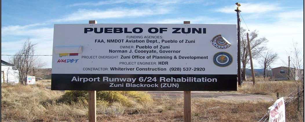
An 11/10/09 photo of a sign describing Black Rock Airport's Runway 6/24 rehabilitation.
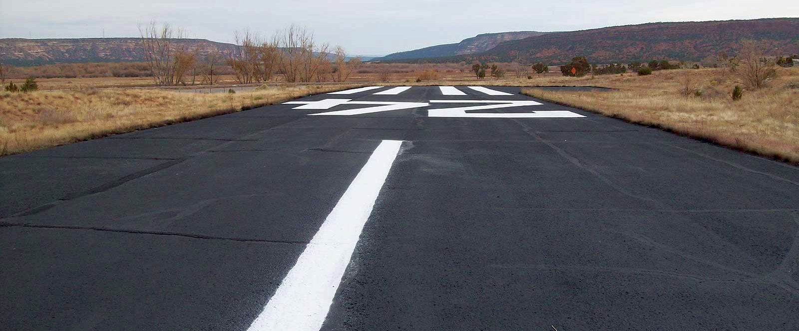
An 11/12/09 photo looking northeast at Black Rock Airport's Runway 24 numbers showing its newly repaved surface.
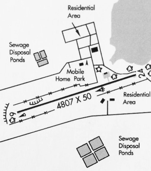
The 2016 NM Aeronautical Chart (courtesy of Fred DeGuio) depicted Black Rock Airport as having a 4,807' paved Runway 6/24,
with a taxiway leading to a ramp & a building on the northeast side.
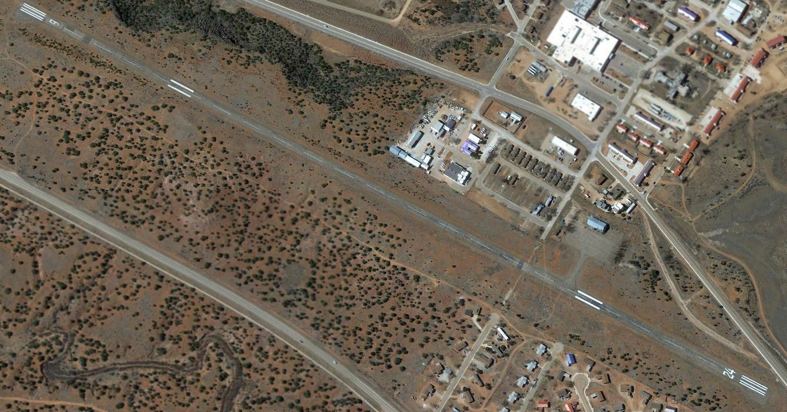
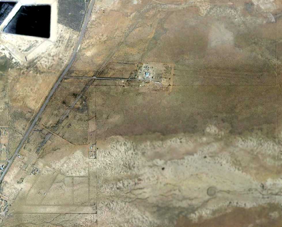
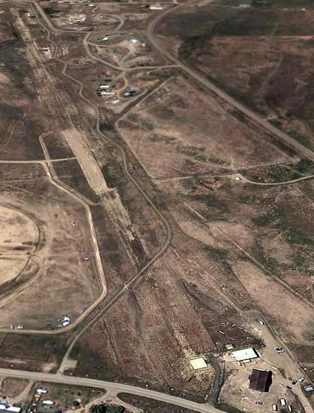
A 2016 aerial view looking northwest depicted Black Rock Airport in an unchanged manner, with a single paved southwest/northeast runway, and a taxiway leading to a ramp & a building on the northeast side.
There were no aircraft visible on the field.
According to Fred DeGuio, “On 5/2/17, a new airfield opened, the Andrew Othole Memorial Airport, about 4 miles west of Zuni.”
According to Ryan Miller, on 11/7/17 NOTAM 11/067 indicated Black Rock Airport was closed to all aircraft except medevac flights.
On 12/11/17, NOAM 12/079 then indicated it was further restricted only to medevac helicopters. Then on 2/12/18, Black Rock Airport finally closed to all traffic.
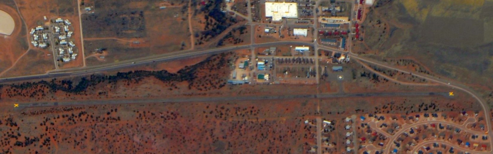
A 4/18/18 aerial view by Fred DeGuio looking south at Black Rock Airport, showing closed-runway “X” symbols painted on both runway ends. The airport otherwise appeared intact.
Black Rock Airport is located at the southern terminus of B Avenue.
Thanks to Fred DeGuio for pointing out this airfield.
______________________________________________________
(Original) Gallup Airport, Gallup, NM
35.532, -108.763 (Northwest of Albuquerque, NM)
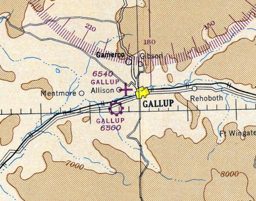
Gallup Airport, as depicted on the May 1935 Prescott Sectional Chart.
The original airport for the town of Gallup were located to the northwest, just east of Allison.
Gallup Airport was evidently established at some point between 1934-35,
as it was not yet depicted on the September 1934 Prescott Sectional Chart.
The earliest depiction which has been located of the Gallup Airport was on the May 1935 Prescott Sectional Chart.
It depicted Gallup as a commercial/municipal airport.
Dan Rhinehart reported, “I have a 1939 newspaper clipping mentioning the Gallup Flying Club & it mentions the club having an Aeronca Chief.”
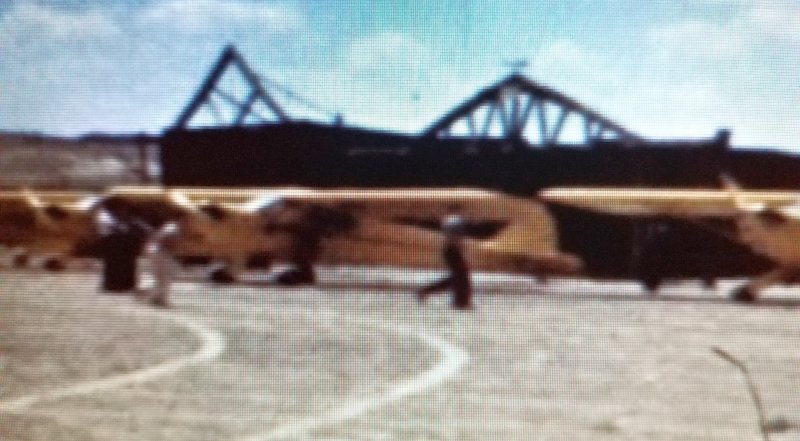
The earliest photo which has been located of Gallup Airport was a still from a September 1940 movie by James Bickle of a delivery flight of several new Piper Cubs
in front of the hangars of the original Gallup Airport (courtesy of Bill Bickel, via Dan Rhinehart).
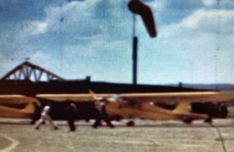
A still from a September 1940 movie by James Bickle of a delivery flight of several new Piper Cubs in front of the hangars of the original Gallup Airport (courtesy of Bill Bickel, via Dan Rhinehart).
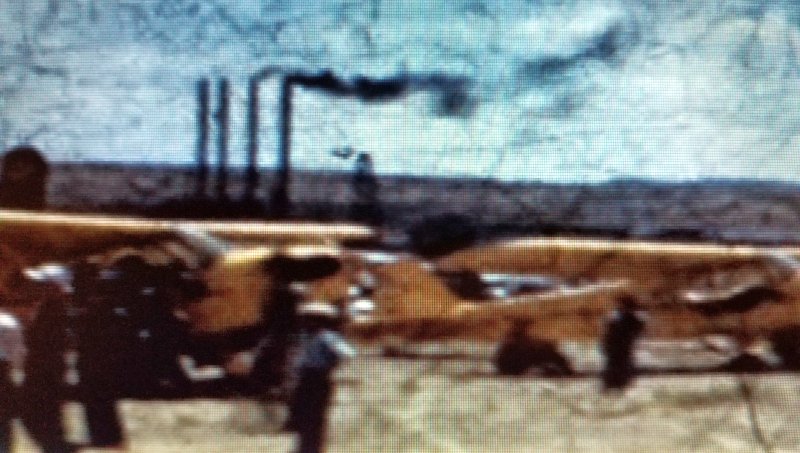
A still from a September 1940 movie by James Bickle of a delivery flight of several new Piper Cubs, in front of the hangars of the original Gallup Airport (courtesy of Bill Bickel, via Dan Rhinehart).
The last aeronautical chart depiction which has been located of the original Gallup Airport was on the May 1945 Prescott Sectional Chart.
It depicted the original Gallup Airport as an auxiliary airfield, located east of Allison,
along with the replacement Gallup Airport to the southwest.
The original Gallup Airport evidently ceased operation at some point between 1945-52,
as a 1952 aerial photo showed what appeared to be the remains of an unpaved northeast/southwest runway, surrounded by a large oval track.
A 1962 aerial view showed the remains in an unchanged fashion.
A 1997 aerial view showed the Rio West shopping mall had been built on the site, erasing any trace of the original Gallup Airport.
Dan Rhinehart reported, “The stories I always remember [were] that the old Gallup Airport was more or less in the present location of the Rio West shopping mall.”
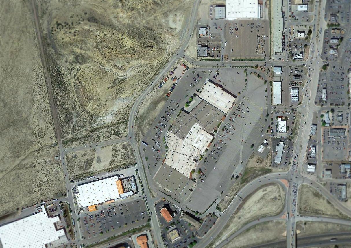
A 2016 aerial view showed the Rio West shopping center covering the site of the original Gallup Airport.
The site of the original Gallup Airport is located at the intersection of West Jefferson Avenue & Morello Avenue.
Thanks to Dan Rhinehart for pointing out this airfield.
______________________________________________________
35.838, -107.335 (Northwest of Albuquerque, NM)
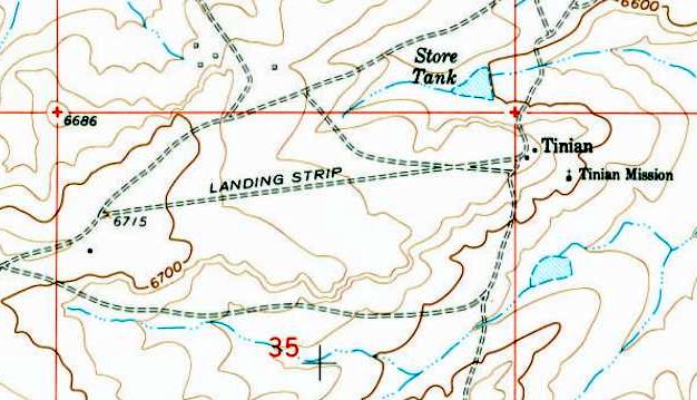
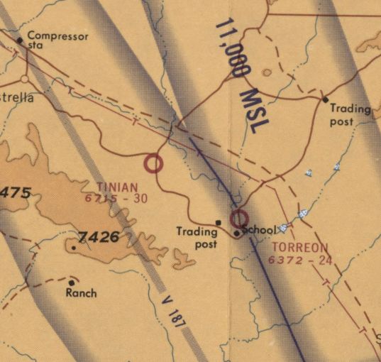
Tinian Airport, as depicted on the 1961 USGS topo map.
Tinian Airport was not yet depicted on the March 1960 Albuquerque Sectional Chart.
The earliest depiction which has been located of Tinian Airport was on the 1961 USGS topo map.
It depicted a single northeast/southwest unpaved runway, labeled simply as “Landing Strip”,
with the few small buildings of Tininan Mission across the road to the east.
The earliest aeronautical chart depiction which has been located of Tinian Airport was on the December 1964 Sectional Chart (according to Matt Franklin).
The earliest aeronautical chart depiction which is available of Tinian Airport was on the May 1967 Sectional Chart (courtesy of Matt Franklin).
It depicted Tinian Airport as having a 3,000' unpaved runway.
The February 1968 Albuquerque Sectional Chart depicted Tinian Airport as having a 3,000' unpaved runway.
The last aeronautical chart depiction which has been located of Tinian Airport was on the 1974 Denver Sectional Chart (courtesy of Jonathan Westerling).
It depicted Tinian as a private airfield having a 3,000' unpaved runway.
Tinian Airport was evidently closed (for reasons unknown) at some point between 1974-86,
as it was no longer depicted on the 1985 Denver Sectional Chart (courtesy of Jonathan Westerling).
The 1989 USGS topo map depicted Tinian Airport in the same fashion as the 1961 topo map.
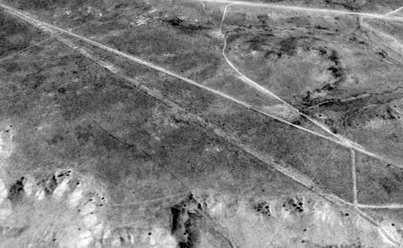
The earliest photo which has been located of Tinian Airport was a 1997 USGS aerial view looking northwest.
It depicted a single northeast/southwest unpaved runway.
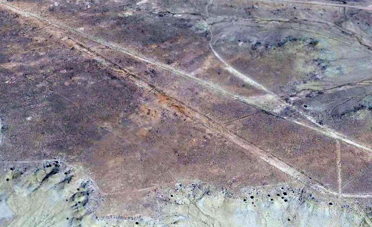
A 2014 aerial aerial view looking northwest showed the Tinian runway remaining recognizable but deteriorated.
A 2014 photo by Matt Franklin looking along the remains of the Tinian Airport runway.
Matt reported, “Tinian was another mission, but as far as I know it’s been erased from the map except for the roads that led to it.
The road pictured that clips the northwest corner of the runway was passable for a quarter of a mile & then turned to into a wash basin.
I was driving my dad’s Subaru Outback, and I didn’t feel like explaining where I was after high centering the car.
All the more reason to buy a Ford Raptor. I walked the remainder of the way to discover nothing of any real consequence.
The land is pretty flat so there was nothing to distinguish the runway, and the brush was even.
The only way I knew I had hit the runway was thanks to the GPS.”
The site of Tinian Airport is located northeast of the intersection of Tininan Road & Route 197.
Thanks to Matt Franklin for pointing out this airfield.
______________________________________________________
35.788, -107.243 (Northwest of Albuquerque, NM)
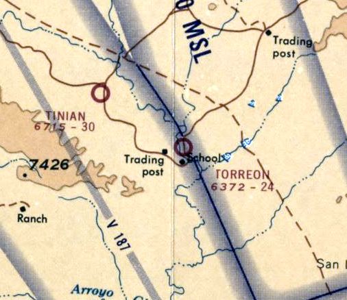
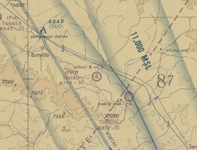
Torreon Airport, as depicted on the 1961 USGS topo map.
Torreon Airport was not yet depicted on the March 1960 Albuquerque Sectional Chart.
Matt Franklin reported, “To give some context of the area, there is but a few pueblos & houses nestled among the hills.
There are several religious-based missions in the area that provide schooling to the locals,
and apparently this warranted the construction of a runway (to the point that there were several airports with only miles apart) to support their activities.”
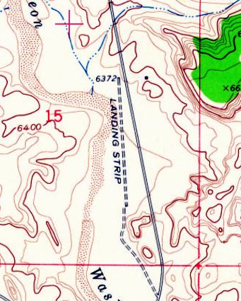
The earliest depiction which has been located of Torreon Airport was on the 1961 USGS topo map.
It depicted a single north/south unpaved runway, labeled simply as “Landing Strip”.
The earliest aeronautical chart depiction which has been located of Torreon Airport was on the May 1967 Sectional Chart (courtesy of Matt Franklin).
It depicted Torreon Airport as having a 2,400' unpaved runway.
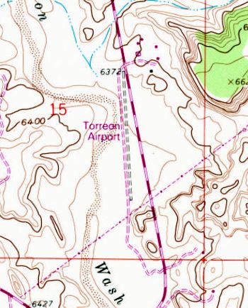
The 1989 USGS topo map depicted “Torreon Airport” as having as having a unpaved north/south runway.
There were no buildings or other improvements depicted at the airport.
The last aeronautical chart depiction which has been located of Torreon Airport was on the 1992 Denver Sectional Chart (courtesy of Jonathan Westerling).
It depicted Torreon Airport as having a 2,400' unpaved runway.
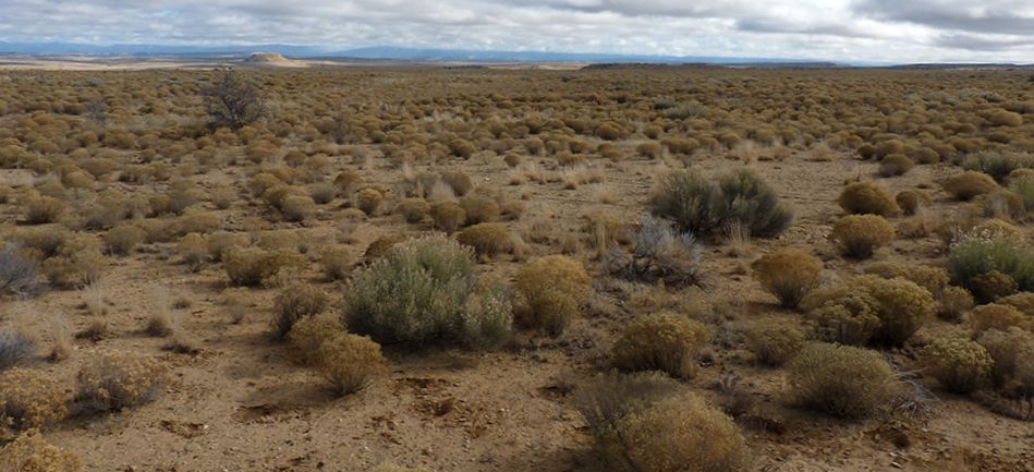
The earliest photo which has been located of Torreon Airport was a 1997 USGS aerial view looking northwest.
Matt Franklin noted, “I would venture to guess that Torreon had been unused for some years, but the 1997 image shows the reason it will stay closed.
The northern end of the runway had been gauged out via an adjacent arroyo.”
Torreon Airport was evidently closed by 2004, as it was no longer depicted on the 2004 Denver Sectional Chart (courtesy of Jonathan Westerling).
Matt Franklin observed that a “2006 [aerial photo] shows no change from the 1997 [photo)”,
and then a “2009 [aerial photo shows] a fire station was built on [Route] 197.”
A 2014 aerial view looking northwest shows the Torreon Airport runway remained unchanged compared to the 1997 photo.
A 2014 photo by Matt Franklin looking along the remains of the Torreon Airport runway.
Matt reported, “A barbed wire fence separates [Route] 197 from the airport,
so I approached the airport from the south where I climbed a gate & followed the service road.
It had been a long time since a vehicle had accessed the airport, but there were recent signs of horse tracks.
There is a 100' hill at the south end of the runway. I don’t think a straight in approach would have been an option, and a turn to final would’ve been required while over the runway.
There is significant buildup of scrub brush on the runway, but it’s certainly carved out of the terrain. The dirt on the surface is redder and relatively compacted.
I found no evidence of any facilities or navigation aids on the airport. The only thing of interest other than the random can was a chrome strip which looked to be from a car.”
A 2014 photo by Matt Franklin of the gauge which cuts out of the northern end of the former Torreon Airport runway.
Matt reported, “It’s about 50' straight down.”
The site of Torreon Airport is located on the west side of Route 197, 26 miles southwest of Cuba, NM.
Thanks to Matt Franklin for pointing out this airfield.
______________________________________________________
Chaco Canyon Airfield, Chaco Canyon, NM
36.096, -107.955 (Northeast of Albuquerque, NM)
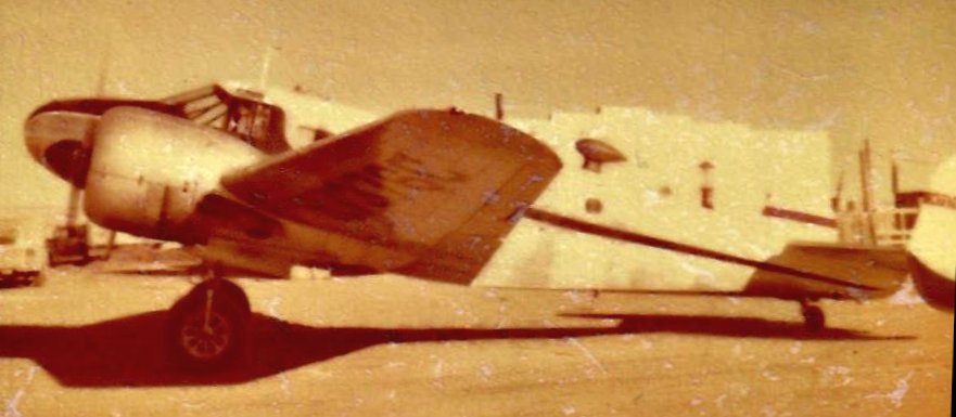
A late 1950s / early 1960s photo of a Twin Beech 18 at Chaco Canyon Airport (courtesy of Andy Bushnell).
Andy Bushnell recalled, “My Aunt & Uncle had a trading post near Chaco Canyon from the early 1950s into the 1960s.
I remember riding with my Uncle taking off on that runway in a V-tail Beechcraft.
My uncle would fly under the power lines at the end of the runway on the road on the left. He was a little wild.”
The earliest photo which has been located of Chaco Canyon Airfield was a late 1950s / early 1960s photo of a Twin Beech 18 (courtesy of Andy Bushnell).
Andy Bushnell recalled, “I can’t believe they landed the plane.”
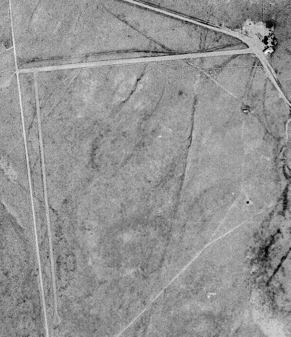
A 9/22/65 USGS aerial view depicted Chaco Canyon Airfield as having 2 unpaved runways, with the trading post on the east side.
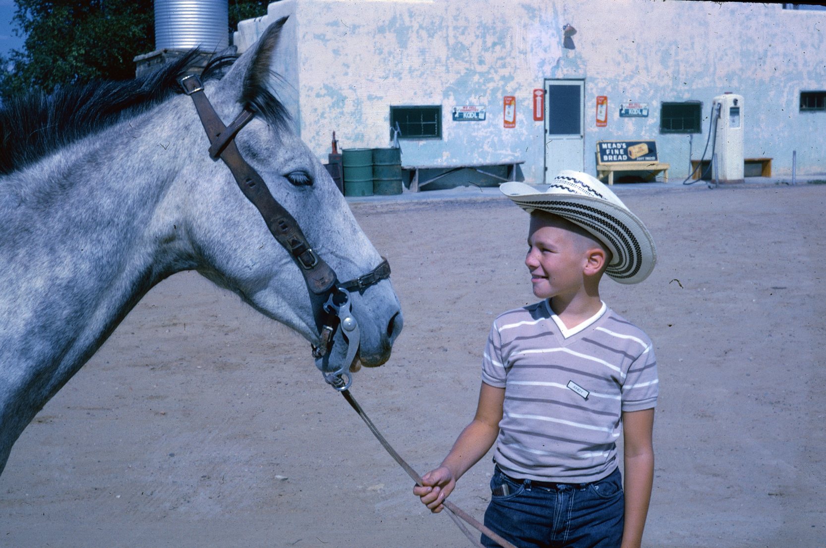
A 1965 photo of a horse & Andy Bushnell in front of the Chaco Canyon Trading Post.
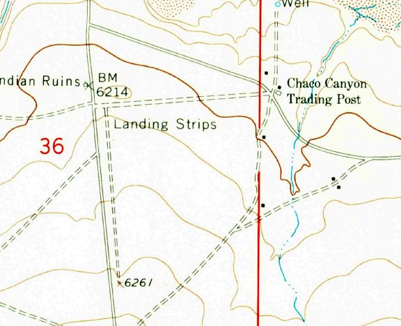
The 1966 USGS topo map depicted 2 unpaved “Landing Strips” to the west of the Chaco Canyon Trading Post.
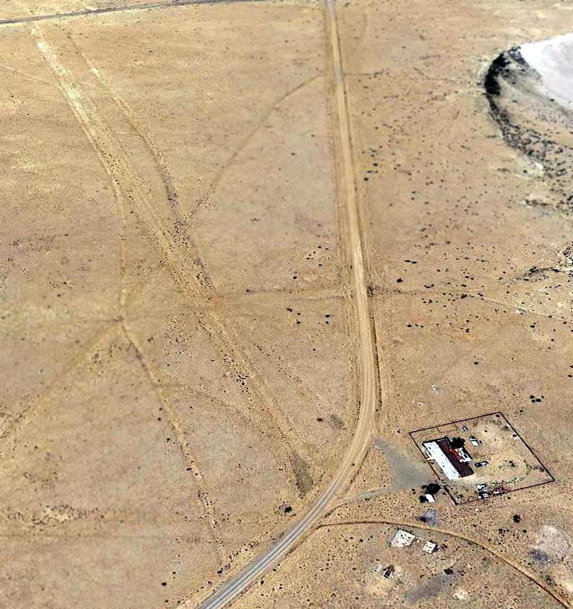
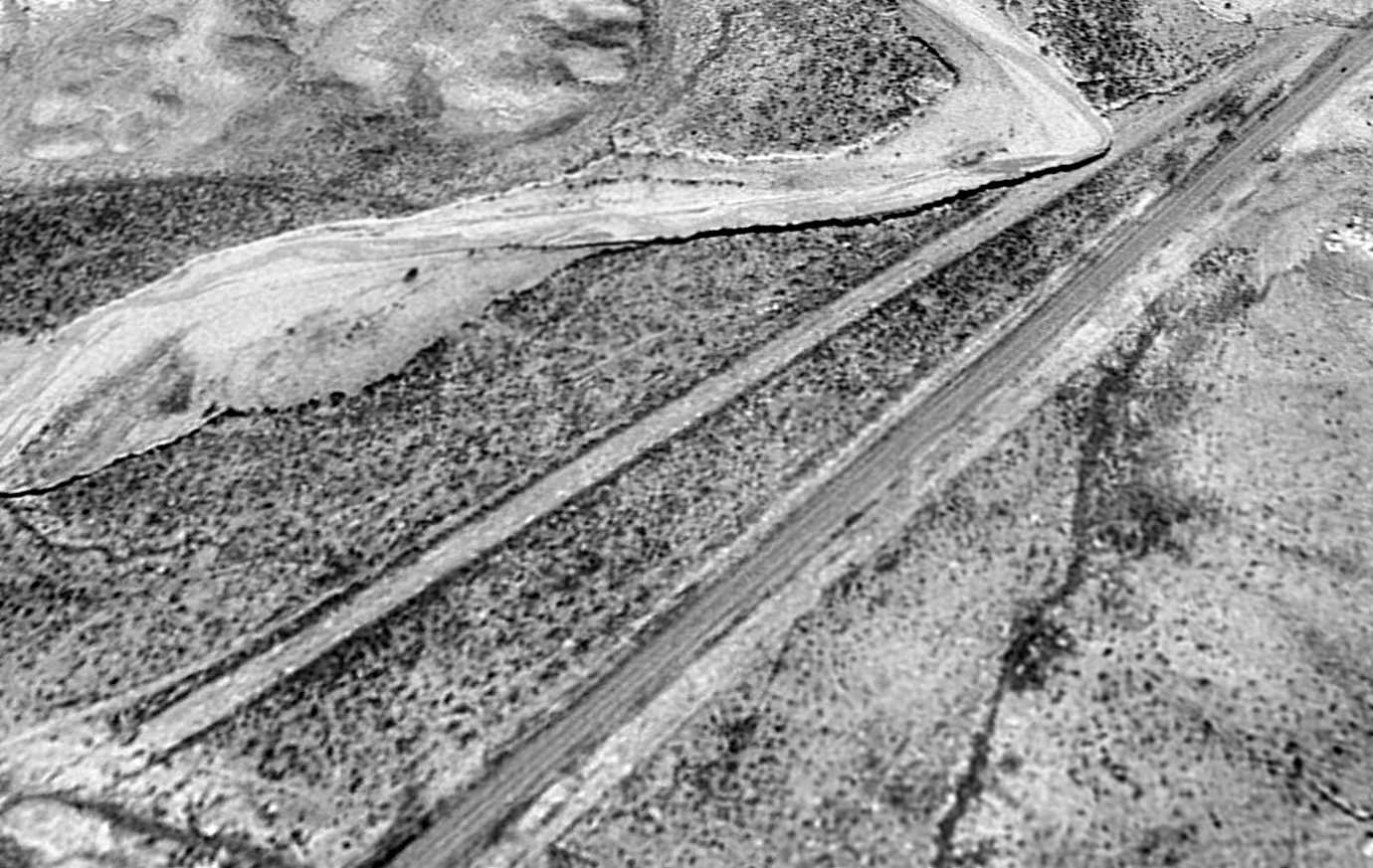
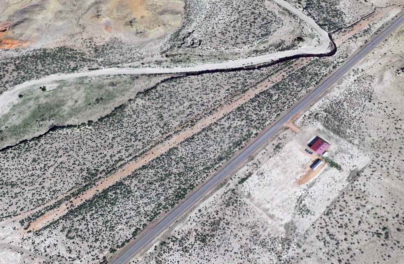
A 6/24/14 aerial view looking northwest shows the remains of the Chacho Canyon Airfield.
In the bottom-center is visible the ruins of the trading post, along with a later building (possibly a school).
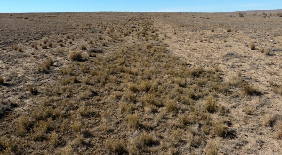
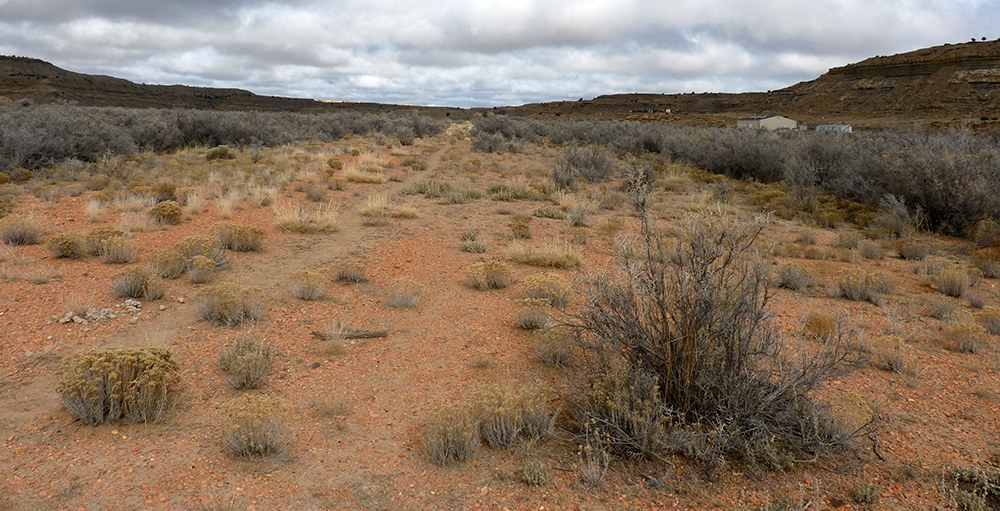
An 11/27/14 photo by Matt Franklin at the Chaco Canyon Airfield, “facing west along the runway from the edge of the road.
The length of the runway is an indention in the environment, which strikes me as kind of odd as it would bring a wingtip a good few inches closer to the ground.”
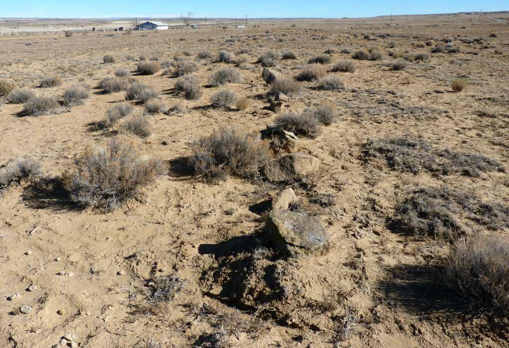
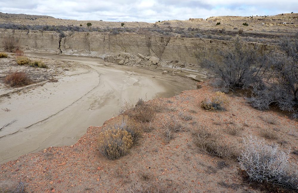
An 11/27/14 photo by Matt Franklin at the Chaco Canyon Airfield,
of “an unnatural line of rocks along the edge of the runway. Not sure if relevant, but someone put them there.”
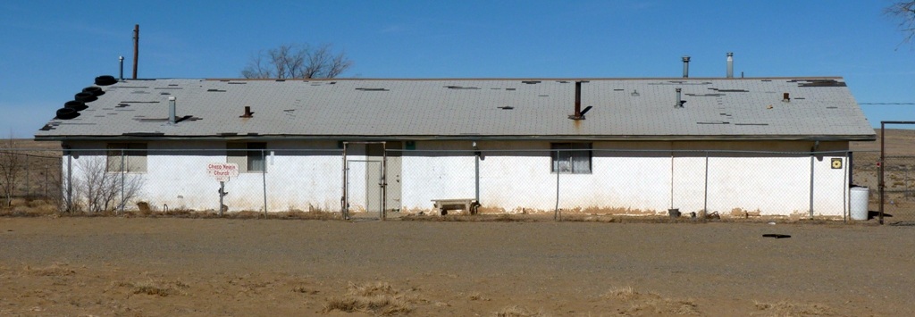
An 11/27/14 photo by Matt Franklin at the Chaco Canyon Airfield,
“of the building now occupying the end of the runway adjacent to the foundation of the trading post, which is the Chaco Navajo Church.
I had to drive through a gulley & over a barbed-wire fence to get here, so I guess they have some really devout followers.”
The site of Chaco Canyon Airfield is located east of the intersection of Route 57 & Route 7980.
Thanks to Andy Bushnell for pointing out this airfield.
______________________________________________________
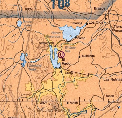
El Vado State Park Airport / Tierra Amarilla Airport, Tierra Amarilla, NM
36.63, -106.72 (Northeast of Albuquerque, NM)
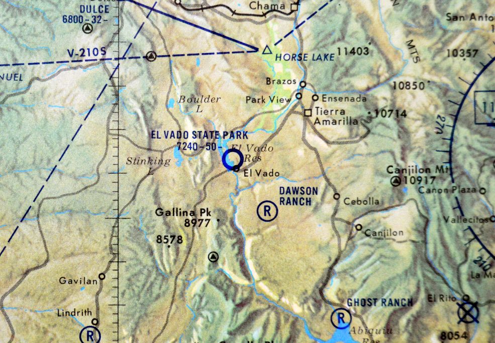
El Vado State Park Airport, as depicted on the 1968 NM Aeronautical Chart (courtesy of Fred DeGuio).
This obscure small airport was evidently constructed at some point between 1964-68,
as it was not yet depicted on the 1964 USGS topo map.
The earliest depiction which has been located of El Vado State Park Airport was on the 1968 NM Aeronautical Chart (courtesy of Fred DeGuio).
It depicted El Vado State Park Airport as having a 5,000' runway.
The 1982 USGS topo map depicted a single northwest/southeast runway, labeled simply as “Landing Strip”.
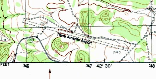
The 1983 USGS topo map depicted “Tierra Amarilla Airport” as having a single unpaved northwest/southeast runway.
No buildings were depicted at the airport.
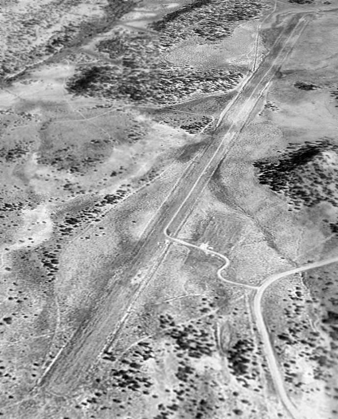
The earliest photo which has been located of Tierra Amarilla Airport was a 10/3/97 USGS aerial view looking east.
It depicted Tierra Amarilla as having a single unpaved northwest/southeast runway, with a ramp on the south side.
No buildings were depicted at the airport.
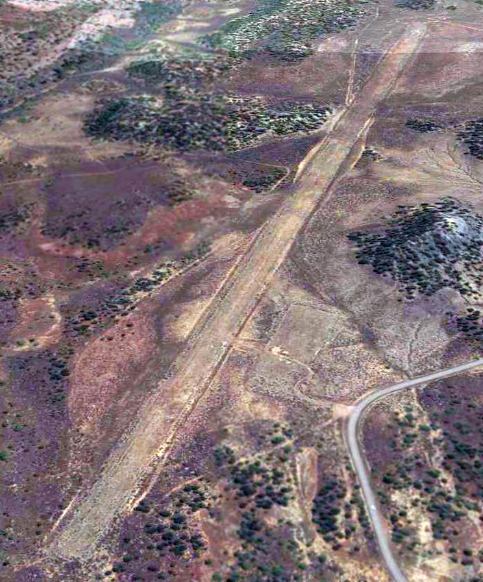
A 10/22/11 aerial view looking east showed Tierra Amarilla to remain intact though deteriorated.
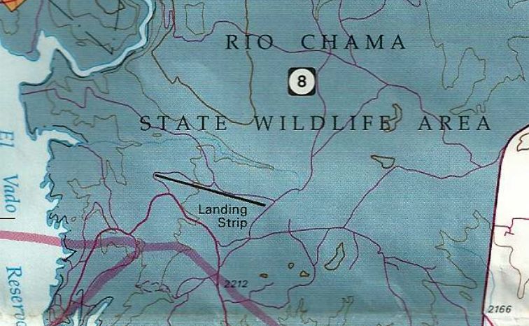
A 2012 BLM map (courtesy of Eric Hinz) depicted Tierra Amarilla Airport as having a single northwest/southeast runway, labeled simply as “Landing Strip”,
within the Rio Chama State Wildlife Area.
The 2013 Sectional Chart depicted Tierra Amarilla Airport as an “Unverified” airfield.
Eric Hinz reported, “Unverified is defined as: 'A landing area available for public use but warranting more than ordinary caution due to:
(1) lack of current information on field conditions, and / or (2) available information indicates peculiar operating limitations.'”
An August 2013 photo by Eric Hinz “taken facing roughly southeast just past the approach end (northwest) of the runway).
The strip is a prepared (graded) runway, unsurfaced. While a lot of plants have grown up on the field, the actual surface on the northwest end appears to be in fairly good shape.
A small bush plane might be able to land (the prop would take out some weeds).
A larger aircraft would be questionable without a good inspection of the field, and maybe some mowing.”
An August 2013 photo by Eric Hinz of “the segmented circle, built of drums cut in half, painted & mounted on posts.
The segmented circle is located on the south side of the field, between the road & the runway.”
An August 2013 photo by Eric Hinz of “the wind direction indicator (wind sock) base.
There was no other identifying information at the field that I saw. No sign of any operational activity was seen.”
As of 2013, road maps label the airfield as El Vado State Park Airport.
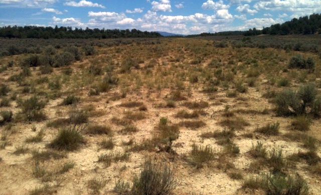
An 11/27/14 photo by Matt Franklin of El Vado State Park Airport, “a view down the runway. New Mexico sure can be pretty.”
An 11/27/14 photo by Matt Franklin of El Vado State Park Airport, of “a line of posts that define the edge of the ramp area.
The ramp area, as well as the runway, was easily picked out from the surrounding terrain.
The runway was filled in & graded, and the weeds were much lower in the airport space.
There had been significant precipitation in the days before that made the ground very soft & easy to sink in to.
I walked ¾ of the length of the field before a deer ran out & I didn’t want to bother it.
I also found a crushed can of red paint which was likely used to paint the barrels.”
An 11/27/14 photo by Matt Franklin of El Vado State Park Airport, which “shows this airport isn’t totally forgotten.
In addition to showing up as an unverified field on the current sectional, someone understands a closed runway is marked with an X,
which they had done with orange construction type mesh held in place with rocks.”
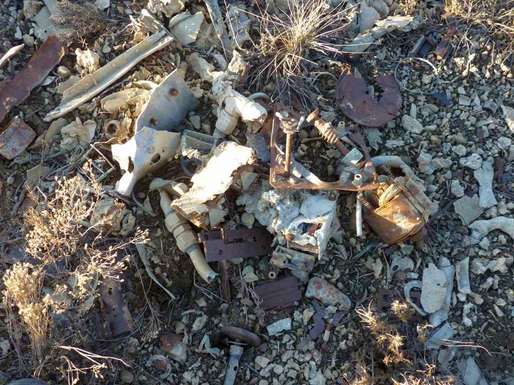
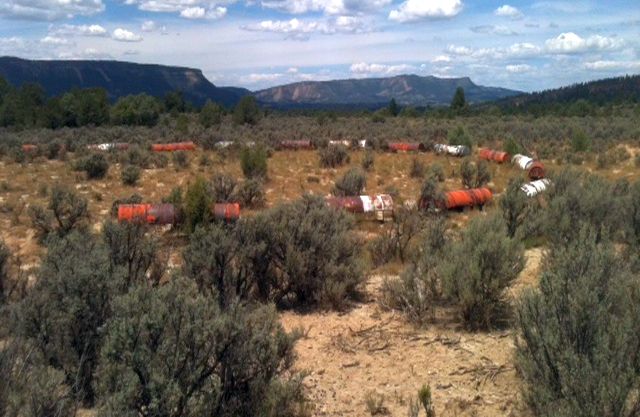
An 11/27/14 photo by Matt Franklin of a collection of aircraft parts which remain at El Vado State Park Airport from a 1/10/76 Beech TC-45G accident.
Matt summarized, “In 1976 some drug runners hit the barrels defining the runway edges in their Beech 18 & lit the airplane on fire.
These are the parts from that plane. While it would’ve been cool to find the charred Beechcraft fuselage, these parts will have to suffice.
The largest & most recognizable was an electrical generator made by Electric Specialties of Stanford Connecticut,
a brand that apparently existed in the 1950, consistent with the age of the aircraft.”
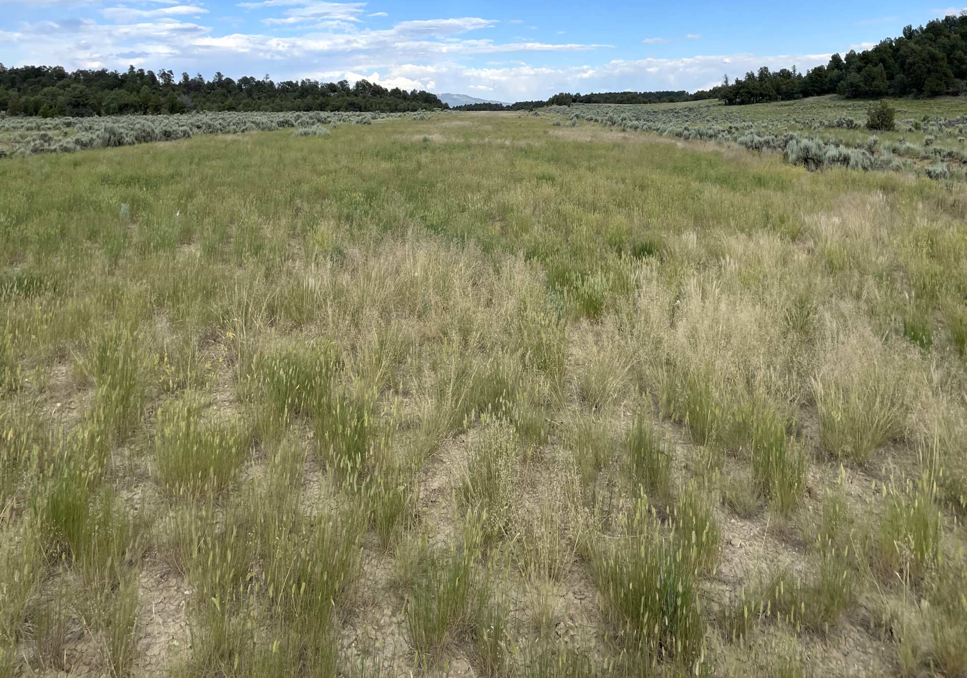
A 7/3/23 photo by Adam Thompson looking east along the site of the El Vado State Park Airport runway.
Adam reported, “I would describe the condition of the runway as unusable due to the lumpy weeds.”
The site of El Vado State Park Airport is located 3 miles north of NM State Road 112, east of El Vado Lake.
Thanks to Eric Hinz for pointing out this airfield.
______________________________________________________
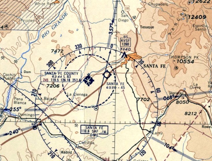
Santa Fe Airport (original location) / Ashley Pond Airport, Santa Fe, NM
35.64, -105.97 (Northeast of Albuquerque, NM)
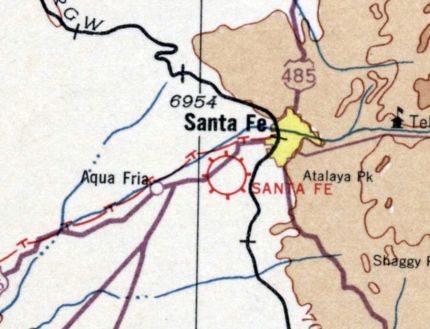
The original Santa Fe Airport, as depicted on the March 1932 Albuquerque Sectional Chart.
The original airport for the town of Santa Fe was located on the southwest side of the town, halfway between Santa Fe & Aqua Fria.
The date of establishment of Santa Fe Airport has not been determined.
The earliest depiction which has been located of Santa Fe Airport was on the March 1932 Albuquerque Sectional Chart.
At some point between 1932-35, a replacement Santa Fe Airport was built farther to the southwest, adjacent to the south side of the town of Aqua Fria,
and the original Santa Fe Airport was renamed Ashley Pond Airport,
as depicted on the 1935 Albuquerque Sectional Chart.
Ashley Pond Airport was evidently closed at some point between 1935-40,
as it was no longer depicted on the July 1940 Albuquerque Sectional Chart
nor listed among active airfields in the 1945 AAF Airfield Directory (courtesy of Scott Murdock).
An 11/1/48 USGS aerial photo depicted Ashley Pond Airport as having 3 unpaved runways
with a few small buildings on the southeast & northwest sides.
The 1952 USGS topo map (courtesy of Bruce Mergele) depicted 3 runways,
with a few small buildings on the southeast & northwest side, but labeled the field generically as “Airport”.
The last photo which has been located of the Ashley Pond Airport was an 8/18/60 USGS aerial photo.
The 3 runways were still intact, but all of the buildings except for 1 appeared to have been removed,
and there were no aircraft visible on the field.
The 1962 USGS topo map no longer depicted the runways at all, although the airport buildings remained depicted.
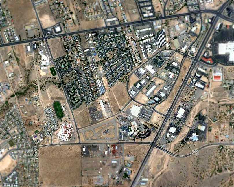
The 1991 USGS aerial photo showed that the site had become densely redeveloped with housing,
and not a trace appeared to remain of Ashley Pond Airport.
A 6/16/11 aerial photo did not show any recognizable trace of Ashley Pond Airport.
The site of Ashley Pond Airport is located northwest of the intersection of Interstate 25 & South St. Francis Drive.
Thanks to Bruce Mergele for pointing out this airfield.
______________________________________________________
Santa Fe Municipal Airport (2nd location), Aqua Fria, NM
35.632, -106.027 (Northeast of Albuquerque, NM)
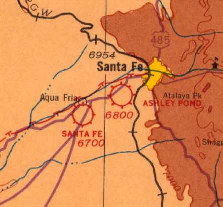
The 2nd location of the Santa Fe Municipal Airport, as depicted on the 1935 Albuquerque Sectional Chart.
At some point between 1932-35, the original Santa Fe Airport was replaced by a new Santa Fe Airport 6 NM southwest of Santa Fe, adjacent to the south side of the town of Aqua Fria.
The earliest depiction which has been located of the 2nd location of Santa Fe Municipal Airport was on the 1935 Albuquerque Sectional Chart.
The earliest photo which has been located of the 2nd location of Santa Fe Municipal Airport
was a 10/7/43 aerial view looking north from the 1945 AAF Airfield Directory (courtesy of Scott Murdock).
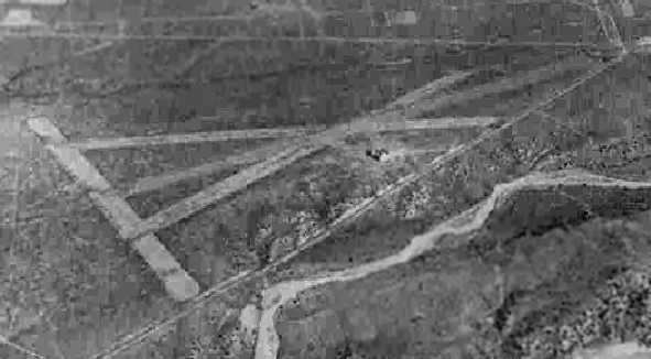
It depicted “Santa Fe Municipal Airport (Old)” as having 4 runways, with a single building on the east side.
Another 10/7/43 photo in the same directory showed that a new Santa Fe Municipal Airport had been constructed 4 miles further southwest.
The 1945 AAF Airfield Directory (courtesy of Scott Murdock) described “Santa Fe Municipal Airport (Old)”
as a 250 acre triangular property having a 4,500' bituminous northeast/southwest runway
and 3 shorter “turf” runways (which probably didn't have much turf!).
The field was said to have a single 160' x 60' concrete & metal hangar,
to be owned by the City of Santa Fe, and to be operated by private interests.
Robert Owens recalled, “I remembered flying into the old Santa Fe Airport.
My pilot's logbook has a note that the elevation of the old airport was 6,500' MSL.
I was very concerned about getting that Culver V off the short runway (3,400'?) in July. I barely made it at sunrise!
My pilot's logbooks show my flights into the old airport as follows: 7/1/50, Culver V, N44516, 1/1/53, Ercoupe 415CD, N3968H, 4/6/63, Cessna 182, N5603B.”
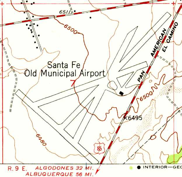
The 1951 USGS topo map depicted “Santa Fe Old Municipal Airport” as having 4 runways,
with taxiways leading to a single small building on the east side.
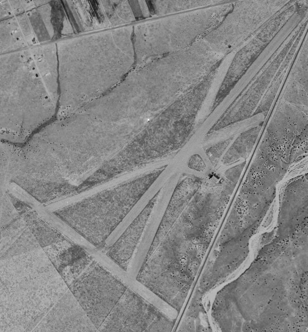
The last photo which has been located of the 2nd location of Santa Fe Municipal Airport was a 6/1/51 USGS aerial view.
It depicted Santa Fe Municipal Airport as having 4 unpaved runways.
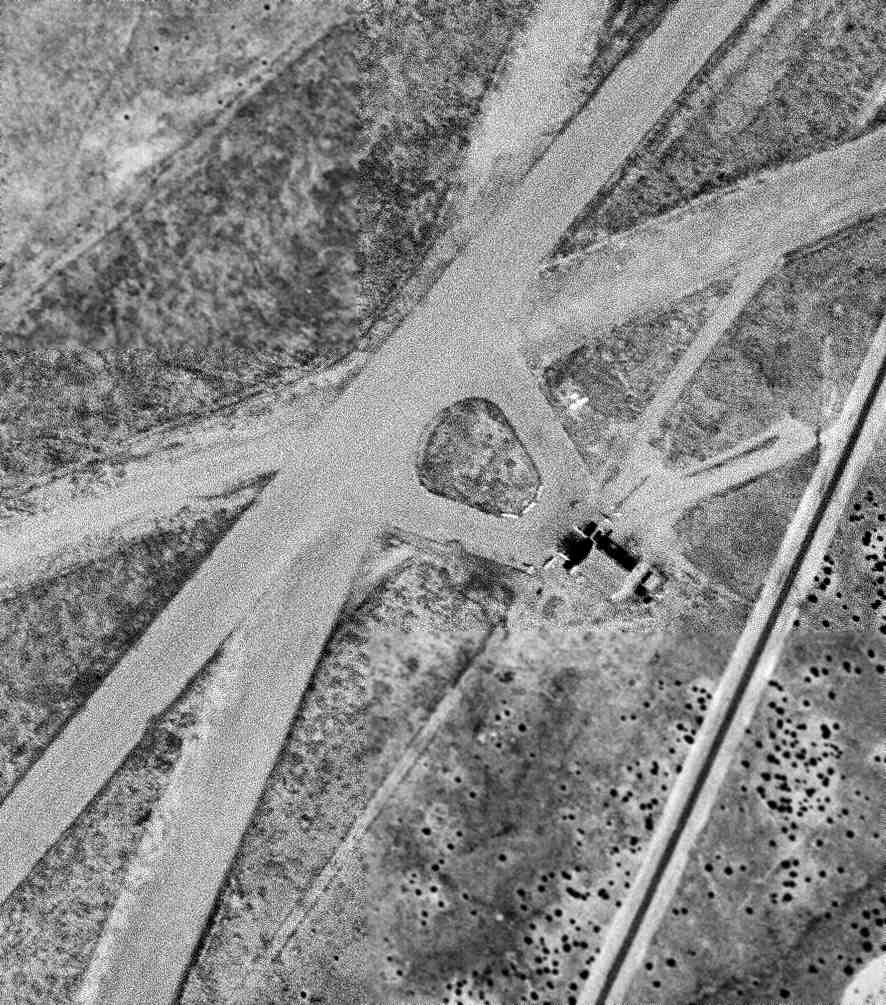
A closeup of the 6/1/51 USGS aerial view depicted 5 single-engine light planes & a single building on the east side of the 2nd location of Santa Fe Municipal Airport.
The 1955 Albuquerque Sectional Chart depicted the 2nd location of Santa Fe Airport as having a 4,500' paved runway,
along with the “Santa Fe (New)” airport to the southwest.
The last depiction which has been located of the 2nd location of Santa Fe Municipal Airport was on the March 1959 Albuquerque Sectional Chart,
which depicted the 2nd location of Santa Fe Airport as having a 4,500' paved runway,
along with the larger replacement Santa Fe County Airport to the southwest.
The 2nd location of Santa Fe Municipal Airport was evidently closed at some point in 1959,
as it was no longer depicted on the August 1959 Albuquerque Sectional Chart.
The 1973 USGS topo map continued to depict the “Santa Fe Old Municipal Airport” in an unchanged fashion.
The 2nd location of Santa Fe Municipal Airport was no longer depicted on the 1979 USGS topo map,
which instead showed several new streets & a variety of buildings over the airport site.
No trace was recognizable of the 2nd location of Santa Fe Municipal Airport in a 1996 USGS aerial photo.
Robert Owens reported in 2006, “After telling the lady at the [new Santa Fe Airport's] Director's Office what I remembered
I received a confirmation that there used to be an airport right at the intersection of Airport Road & Cerrillos Road.
At the location I remembered, but thereare now are severalgovernment buildings,
i.e. Police Substation, Fire Station, and Santa Fe County Juvenile Home.”
A 6/27/11 aerial photo did not show any recognizable trace of the 2nd location of Santa Fe Municipal Airport.
The site of the 2nd location of Santa Fe Municipal Airport is located northwest of the intersection of Route 14 & Airport Road, appropriately enough.
______________________________________________________
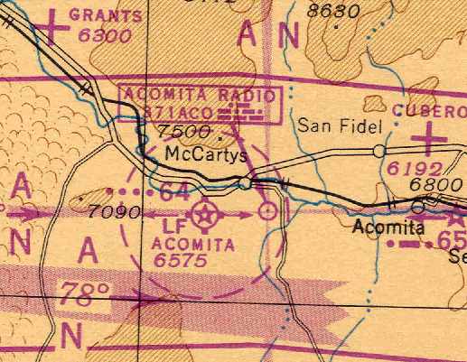
Acomita Intermediate Field, Acomita, NM
35.045, -107.71 (Northwest of Albuquerque, NM)
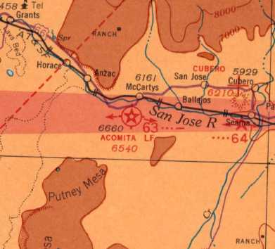
Acomita Intermediate Field, as depicted on the April 1935 Albuquerque Sectional Chart (courtesy of Dan Deloria).
The Acomita Intermediate Field was one of the network of airfields established by the Department of Commerce
for the emergency use of commercial aircraft flying along airways between major cities.
The Acomita Intermediate Field was evidently established at some point between 1929-31,
as it was not yet listed among active airfields in the 1929 Union Oil Airport Directory (according to Chris Kennedy).
The earliest reference to Acomita Intermediate Field which has been located
was a National Register of Historic Places Registration Form (courtesy of Matt Franklin), which said,
“By mid-1931, the revised Los Angeles - Albuquerque airway included intermediate fields at both Acomita & El Morro.”
The Airport Directory Company's 1933 Airport Directory (courtesy of Chris Kennedy)
described Acomita as the Department of Commerce's Site 63 on the Los Angeles – Amarillo airway.
The field was described as a 176-acre sod & dirt field,
with 3 runways (4,130' north/south & northeast/southwest, and 3,360' east/west).
The earliest depiction which has been located of the Acomita Intermediate Field
was on the April 1935 Albuquerque Sectional Chart (courtesy of Dan Deloria).
It depicted the Acomita Landind Field as being Site 63.
The April 1941 Albuquerque Sectional Chart (courtesy of Chris Kennedy) depicted the field as Site 63.
An 8/18/41 aerial view looking north from the 1945 AAF Airfield Directory (courtesy of Scott Murdock)
depicted Acomita Intermediate Field as having 3 unpaved runways.
The 1945 AAF Airfield Directory (courtesy of Scott Murdock) described Acomita Intermediate Field
as a 140 acre irregularly-shaped property having 3 sand runways,
the longest being the 4,130' NNE/SSW strip.
The field was not said to have any hangars.
Acomita was described as being owned by private interests, and operated by the Civil Aeronautics Administration.
The 1945 Haire Publishing Company Airport Directory (courtesy of Chris Kennedy)
described Acomita as the Civil Aeronautics Adminstration's Site #63.
The field was characterized as “Class 2”, privately owned, but operated by the CAA.
It was said to have 3 “sod” runways (which were almost certainly not sod),
with the longest being the 4,130' north/south strip.
The last aeronautical chart depiction which has been located of the Acomita Intermediate Field
was on the September 1948 Albuquerque Sectional Chart (courtesy of Chris Kennedy).
Its designation had evidently changed at some point between 1945-48 to Site 64.
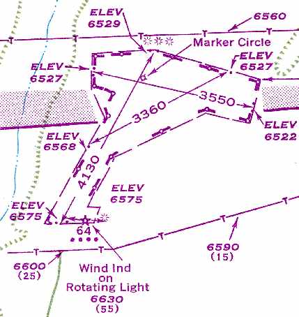
The most detailed depiction which has been located of the Acomita Intermediate Field
was in the November 1949 USAF Pilot's Handbook (courtesy of Chris Kennedy).
It depicted the field a having 3 unpaved runways, with the longest being the 4,130' northeast/southwest strip.
No buildings were depicted at the field.
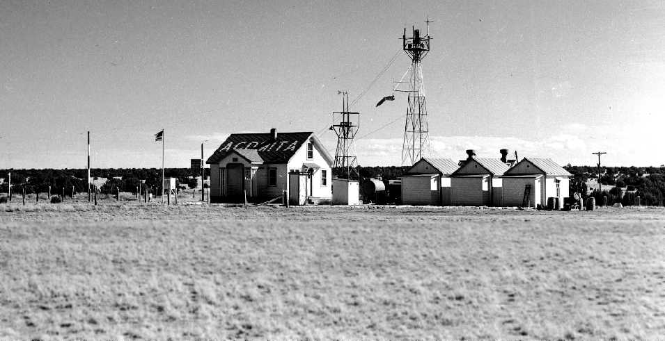
An undated (circa late 1940s – early 1950s?) photo of several buildings & the beacon tower at Acomita (courtesy of Trey Brandt).
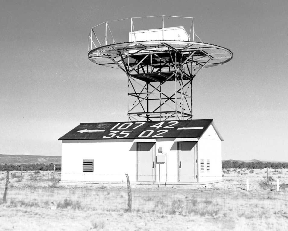
An undated (circa late 1940s – early 1950s?) photo of a navigational aid at Acomita (courtesy of Trey Brandt).
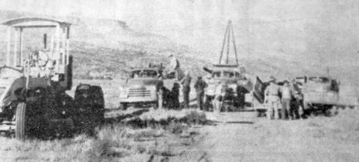
A November 1952 photo of the “Airport Day” ay the Acomita Airport (courtesy of Matt Franklin)., removing cables from Acomita to be reinstalled at Grants Airport.
According to a National Register of Historic Places Registration Form (courtesy of Matt Franklin),
“In November 1952, the Grants Chamber of Commerce held 'Airport Day' at the Acomita Airport.
The volunteer workers, consisting of 26 school children & approximately 40 businessmen or their representatives,
spent the day removing the lights & cables from the CAA airfield with the aid of trucks & machinery generously donated by various Grants business firm[s].”
The Acomita Intermediate Field was evidently closed at some point between 1949-54,
as it was no longer depicted at all on the September 1954 Albuquerque Sectional Chart (according to Chris Kennedy).
Advances in the range & reliability of commercial aircraft
had obviated the need for the system of Intermediate Fields by that point.
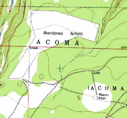
Acomita was labeled as an “Abandoned Airfield” on the 1959 USGS topo map.
Its former airway beacon was also still depicted, to the southeast of the airfield.
Even though the Acomita airfield had been abandoned for over 47 years,
it was still depicted as an “Abandoned Airfield” on the 1991 USGS topo map.
Its former airway beacon was also still depicted, to the southeast of the airfield.
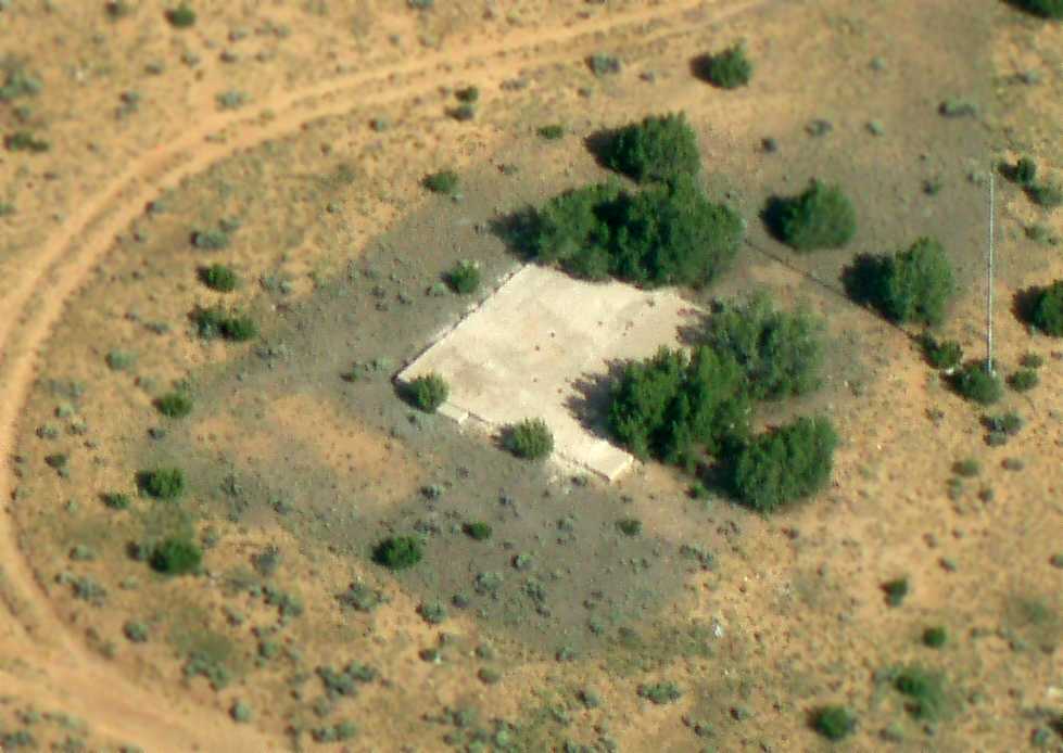
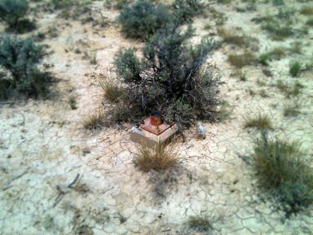
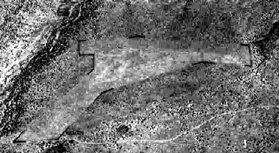
A 2012 aerial photo by Greg Farmer of what appears to be a foundation & a pole (flagpole, windsock pole?) at the site of Acomita Intermediate Field.
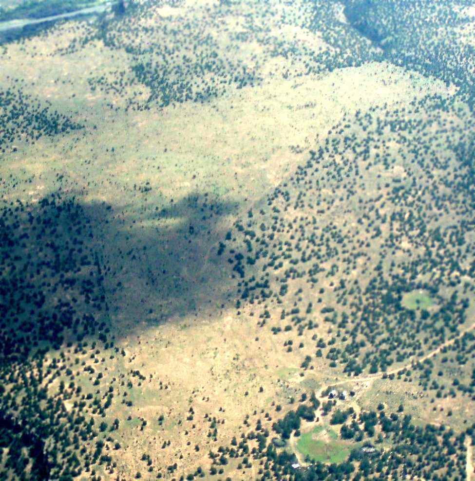
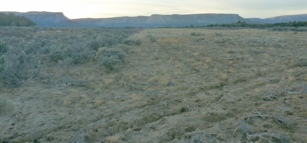
A 2012 aerial view by Greg Farmer looking northeast at the remains of the Acomita runways.
The outline of the former Acomita Intermediate Field was still quite recognizable on a 2023 aerial view looking northwest.
The site of Acomita Intermediate Field is located a half-mile south of Interstate 40, 8 miles west of Acomita, NM.
______________________________________________________
Greater Grants Airport, Grants, NM
35.235, -107.85 (West of Albuquerque, NM)
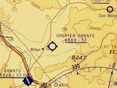
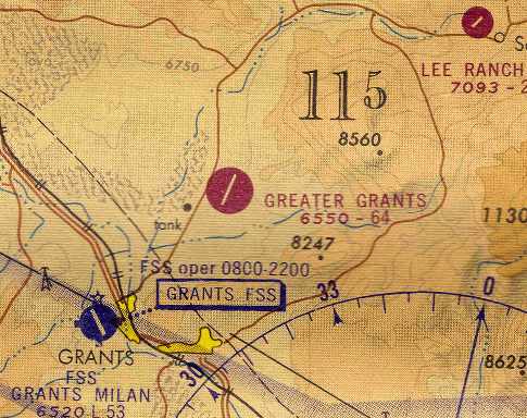
The Greater Grants Airport, as depicted on the September 1960 Albuquerque Sectional Chart (courtesy of Chris Kennedy).
This fairly large airport was located 5 miles north of Grants.
The Greater Grants Airport was evidently established at some point between 1958-59,
as it was not yet depicted on the May 1958 Albuquerque Sectional Chart (according to Chris Kennedy) nor on the 1959 USGS topo map.
According to Steve Owen, “The first newspaper mention that I found for Greater Grants was in 1959,
when the local Civil Air Patrol was offered land there for a radio building & office/hangar space.
It appears that Grants (GNT) [the other airport to the southwest] had limited space for the CAP membership, their vehicles & L-16 airplane, at the time.”
The earliest depiction of the field which has been located
was on the September 1960 Albuquerque Sectional Chart (courtesy of Chris Kennedy).
It depicted the field as having a 5,300' unpaved runway.
Explaining the reason why the small town of Grants had 2nd fairly large airport
(in addition to the Grants Airport just northwest of the town),
Steve Owen reported, “Greater Grants Airport... was located near the Homestake Mill & served several mining companies, being closer to the uranium district.”
According to Chris Kennedy, “Grants was apparently something of a boom town
at the time the airport was open, due to uranium mining.
Maybe somebody got the idea there was a market for an airline there,
or maybe the airport supported the mining activities.”
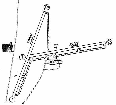
The 1960 Jeppesen Airway Manual (courtesy of Chris Kennedy)
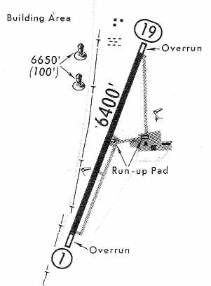
depicted the Greater Grants Airport as having 2 unpaved runways: 5,300' Runway 1/19 & 4,800' Runway 7/25,
each with parallel taxiways.
A ramp southeast of the runway intersection had 3 buildings.
According to Steve Owen, “In July 1962, the Civil Air Patrol held their air show at Greater Grants.”
An aerial view from a 9/20/62 newspaper article (courtesy of Steve Owen) looking northwest at
“the newly-constructed 7,000' plus runway at Uranium Frontier Airways Airport on San Mateo Road.”
The 1963 AOPA Airport Directory (courtesy of Chris Kennedy)
described the Greater Grants Airport as having 2 dirt runways: 6,500' Runway 18/36 & 5,000' Runway 9/27.
The field was said to offer minor repairs, fuel, hangars, tiedowns, charter,
and was operated by Uranium Frontier Airways.
Jim Axelson recalled, “Greater Grants Airport... my father Leon Axelson managed & operated the airport” until 1964.
According to Steve Owen, “'Swede' Axelson, who managed that airport, and ran Uranium Frontier Airways (a charter & training service),
died in a crash on takeoff at Greater Grants in April 1964,
It would appear that the airfield & its businesses lost energy from that point on.
Greater Grants Airport evidently gained a longer paved runway but lost its crosswind runway at some point between 1963-65,
as the 1965 Jeppesen Airway Manual (courtesy of Chris Kennedy)
depicted the field as having a single 6,500' paved Runway 1/19.
A ramp on the east side had 3 buildings.
The last aeronautical chart depiction which has been located of the Greater Grants Airport as an active airfield
was on the December 1968 Albuquerque Sectional Chart (courtesy of Chris Kennedy).
It depicted Greater Grants as having a single 6,400' paved runway.
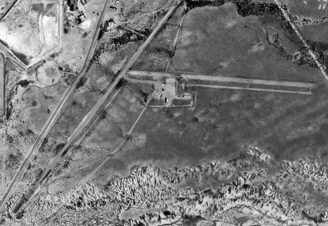
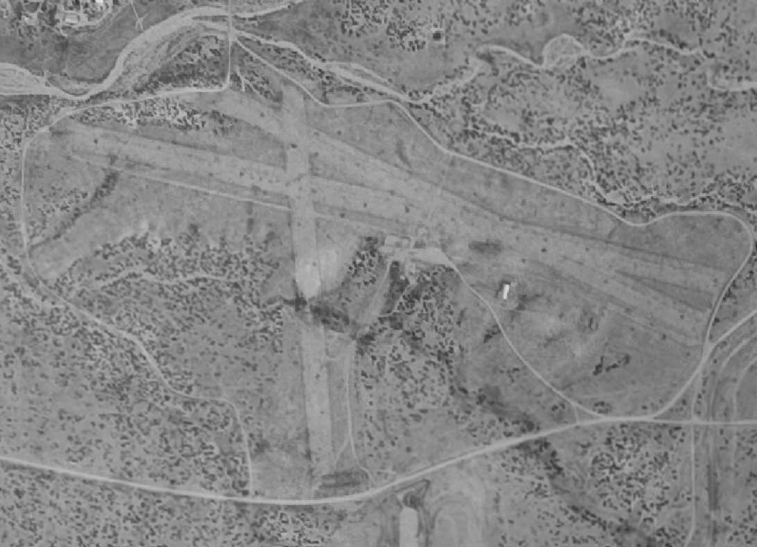
A 8/15/71 USGS aerial photo depicted the Greater Grants Airport as having 2 unpaved runways & a dirt ramp southeast of the runway intersection with 3 small buildings.
There were no aircraft visible on the field, and it was indeterminate whether the airport was still open at that point.
Steve Owen reported, “I did not find any more news stories on Greater Grants [Airport] clear up to 1973.”
The Greater Grants Airport was evidently abandoned (for reasons unknown) at some point between 1968-76,
as it was no longer listed among active airfields in the 1976 AOPA Airports USA Directory (according to Chris Kennedy).
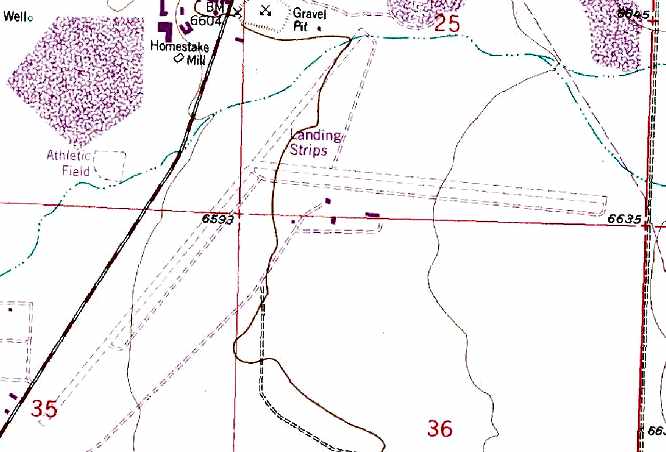
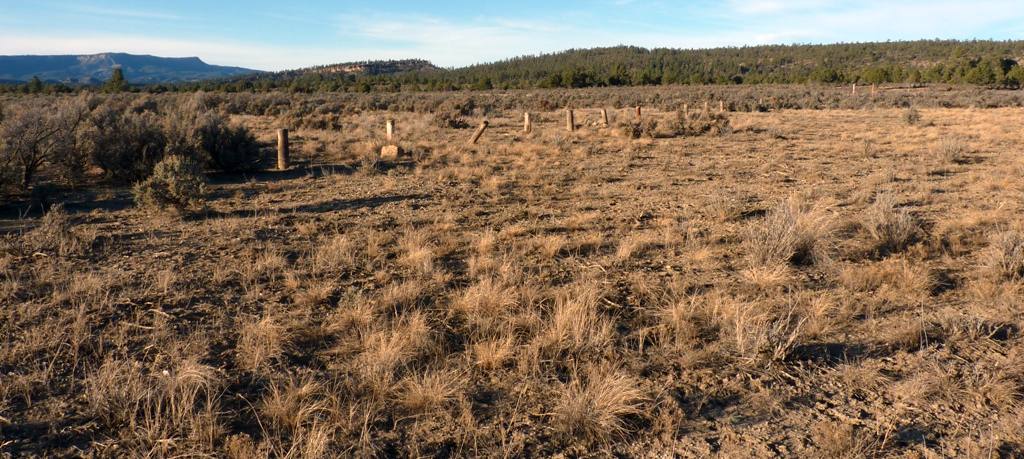
The 1978 USGS topo map still depicted the outline of the 2 former runways,
as well as four buildings at the site of the Greater Grants Airport, which was labeled simply as “Landing Strips”.
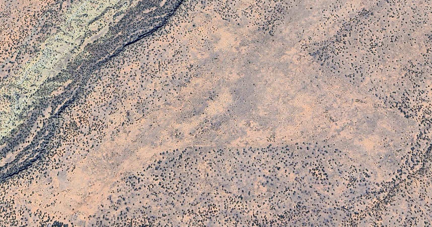
A 1997 USGS aerial photo of the Greater Grants Airport site showed that much of the former east/west runway & its parallel taxiway still remained intact.
Traces of the former northeast/southwest runway were still recognizable, but the southwest portion of it had been covered by a street grid.
The former airport buildings also remained standing.
A 5/4/12 aerial photo showed that much of the former Greater Grants Airport east/west runway & its parallel taxiway still remained intact.
Traces of the former northeast/southwest runway were still recognizable, and the former airport buildings also remained standing.
A 2021 photo looking east along the former Greater Grants Airport entrance road, showing several former airport buildings,
which a sign indicated were the site of the “Weather King” company.
The site of Greater Grants Airport is located northeast of the intersection of Route 605 & Tumbleweed Road.
______________________________________________________
Transwestern #5 Airfield (97E), Thoreau, NM
35.404, -108.25 (West of Albuquerque, NM)
![]()
Transwestern Pipeline #5 Airfield, as depicted on the August 1962 USAF Operational Navigation Chart (courtesy of Chris Kennedy).
Photo of the airfield while in use has not been located.
Transwestern #7 was apparently one of a string of former private airfields owned by the Transwestern pipeline company,
whose pipeline runs adjacent to the airfield to the north.
Each of the Transwestern airfields were constructed adjacent to one of a series of compressor stations
located along the pipeline (according to a map located by David Brooks).
Transwestern #5 Airfield was evidently constructed at some point between 1961-62,
as it was not yet depicted on the March 1961 Prescott Sectional Chart.
The earliest depiction which has been located of Transwestern #5 Airfield
was on the August 1962 USAF Operational Navigation Chart (courtesy of Chris Kennedy).
It described Transwestern #5 Airfield as having a 6,700' runway.
![]()
Transwestern #5 was depicted on the July 1977 World Aeronautical Chart (courtesy of Chris Kennedy)
as having a single 5,000' paved runway.
![]()
The 1980 USGS topo map still depicted the runway, labeled simply as "Landing Strip".
Transwestern #5 was still listed as a private airfield in the 1982 AOPA Airport Directory (courtesy of Ed Drury).
The Transwestern airfields were still depicted on the 1994 CG-19 Regional Aeronautical Chart (according to David Brooks),
but apparently were closed at some point between 1995-97, when they were no longer depicted on aeronautical charts.
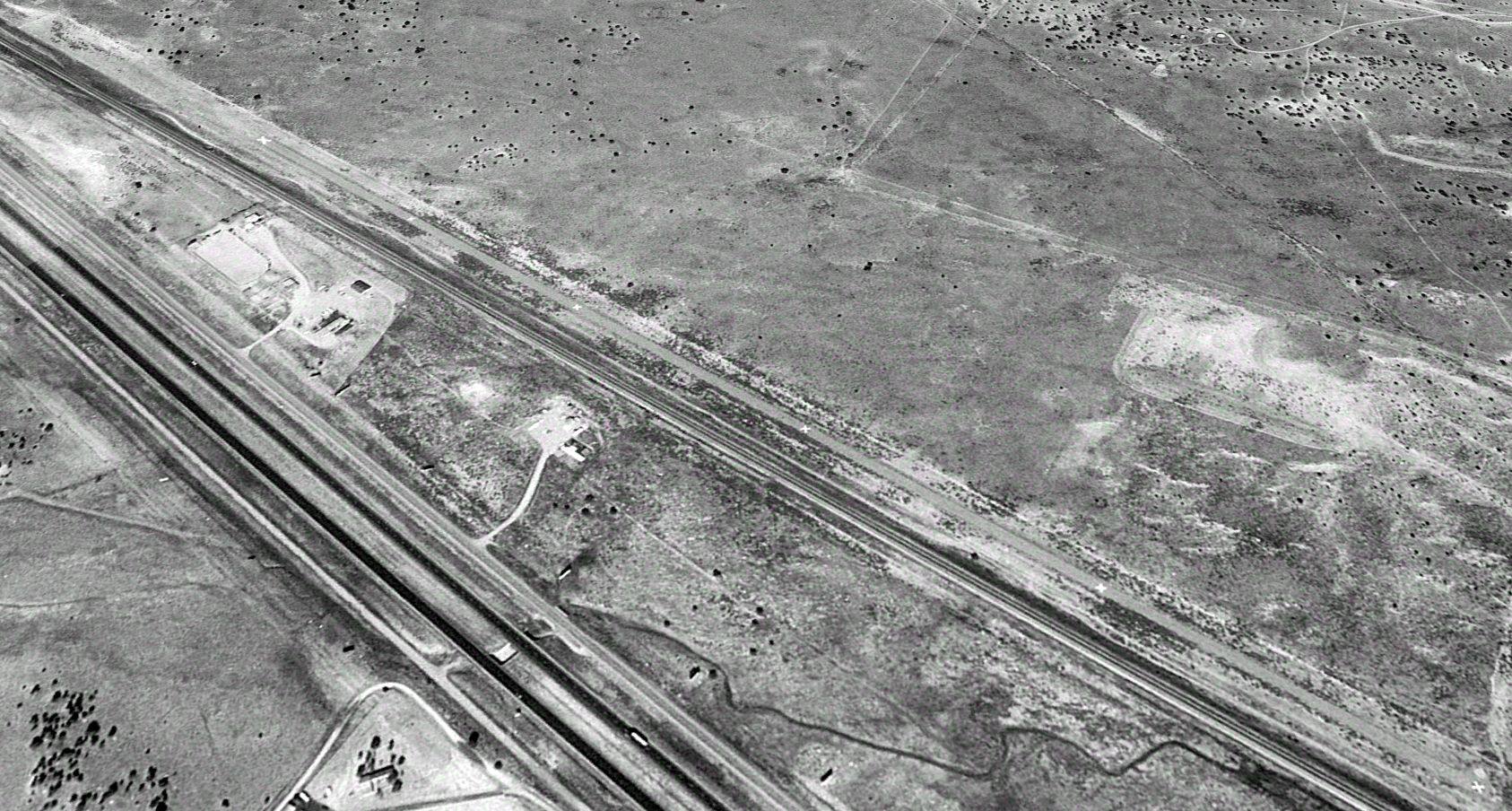
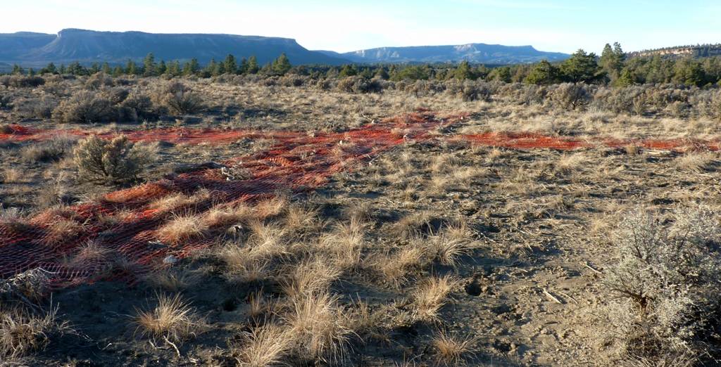
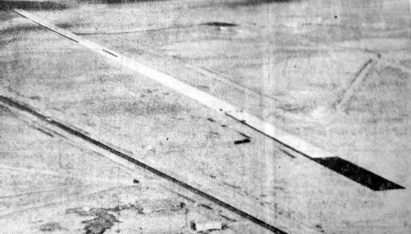
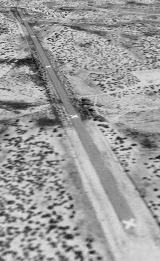
The Transwestern #5 airfield was apparently closed by 1997, as a 10/15/97 USGS aerial view looking northwest depicted the runway as being painted with "X" closed runway markings.
The runway had also apparently been lengthened at some point between 1977-97, as the aerial photo depicted the runway as being 7,000' long.
The closed-runway “X” markings were faded in a 2005 aerial view, but were no longer recognizable in a 2009 aerial view.
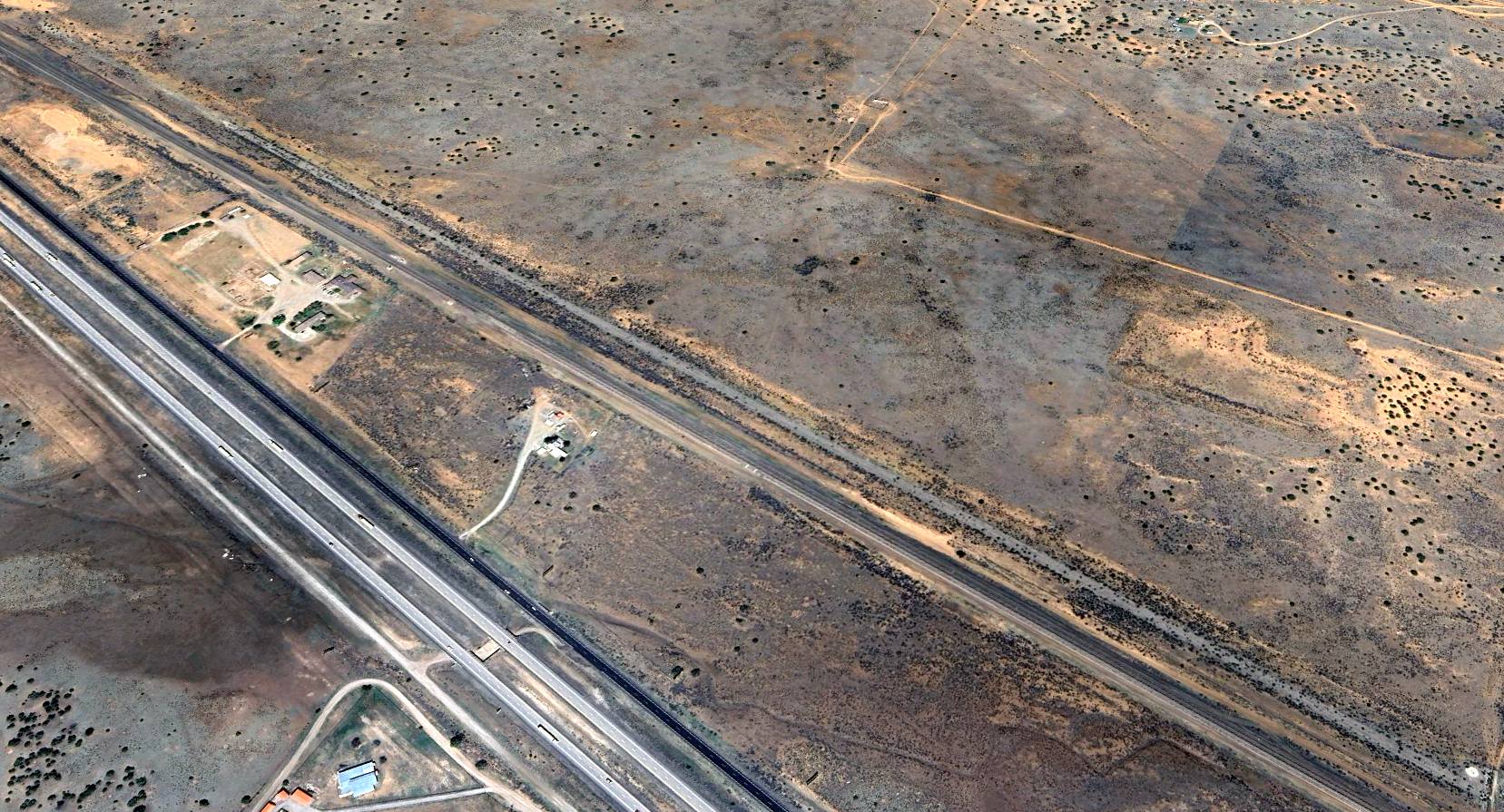
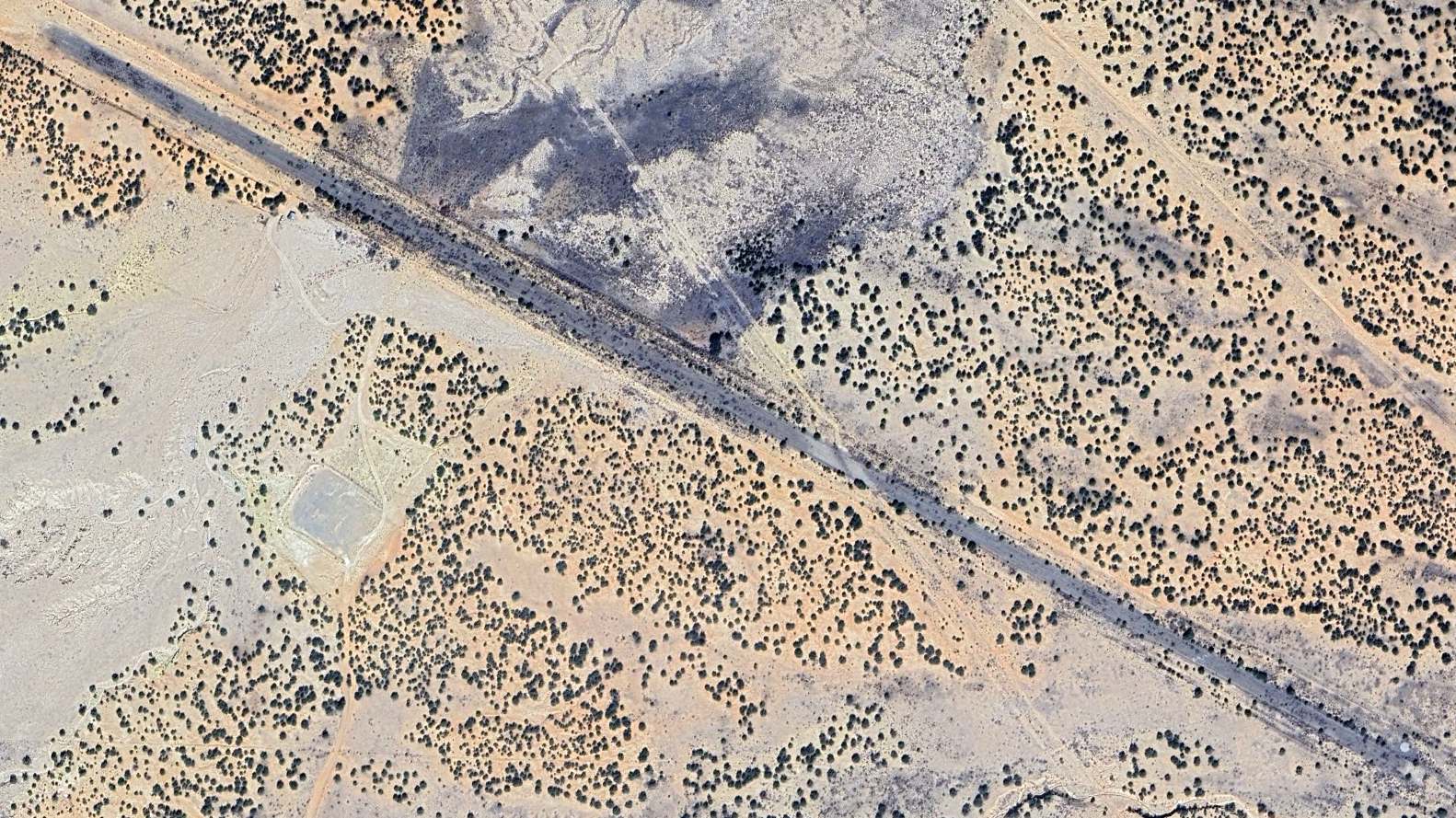
A 2024 aerial view looking northwest at the remains of the Transwestern #5 airfield showed the runway to remain intact but very deteriorated.
______________________________________________________
Transwestern #6 Airfield (70E), New Laguna, NM
35.02, -107.42 (West of Albuquerque, NM)
![]()
Transwestern #6, as depicted on the July 1977 World Aeronautical Chart (courtesy of Chris Kennedy).
Photo of the airfield while in use has not been located.
Transwestern #7 was apparently one of a string of former private airfields owned by the Transwestern pipeline company,
whose pipeline runs adjacent to the airfield to the north.
Each of the Transwestern airfields were constructed adjacent to one of a series of compressor stations
located along the pipeline (according to a map located by David Brooks).
The Transwestern #6 Airfield was evidently constructed at some point between 1959-77,
as it was not yet depicted on the February 1961 Albuquerque Sectional Chart.
The earliest depiction which has been located of Transwestern #6 Airfield
was on the July 1977 World Aeronautical Chart (courtesy of Chris Kennedy).
It described Transwestern #6 Airfield as having a single 5,000' paved runway.
It was listed as an active private airfield in the 1982 AOPA Airport Directory (courtesy of Ed Drury).
The Transwestern airfields were still depicted on the 1994 CG-19 Regional Aeronautical Chart (according to David Brooks),
but apparently were closed at some point between 1995-97, when they were no longer depicted on aeronautical charts.
The Transwestern #6 airfield was apparently closed by 1997, as a 10/1/97 USGS aerial view looking southeast depicted the 5,300' paved runway
as being painted with "X" closed runway markings.
A 2025 aerial view looking northwest showed the Transwestern #6 Airfield to remain intact though deteriorated, with the closed-runway “X” symbols remaining barely recognizable.
______________________________________________________
36.926, -106.995 (North of Albuquerque, NM)
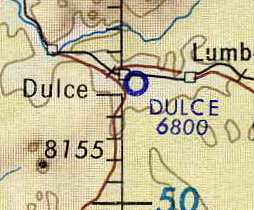
Dulce Airport, as depicted on the November 1960 Trinidad Sectional Chart.
Dulce Airport was evidently established at some point between 1959-60,
as it was not yet depicted on the November 1959 Trinidad Sectional Chart.
The earliest depiction which has been located of Dulce Airport was on the November 1960 Trinidad Sectional Chart.
It depicted Dulce as a private airfield with a 3,600' unpaved runway.
Dulce Airport, as depicted on the January 1966 USAF Operational Navigation Chart (courtesy of Chris Kennedy).
The "Low Use" airfields section of the 1967 Flight Guide (according to Chris Kennedy)
described Dulce Airport as having a single 3,200' unpaved Runway 13/31.
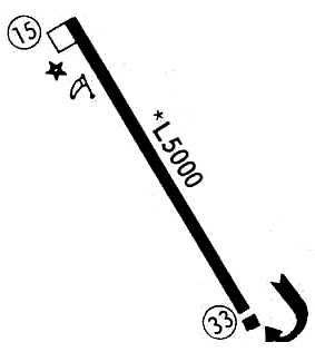
The runway at Dulce was apparently paved at some point between 1967-72,
as the 1972 Flight Guide (courtesy of Chris Kennedy) depicted the field as having a single 5,000' paved Runway 15/33,
with a small ramp at the northwest end of the runway.
The last aeronautical chart depiction which has been located of Dulce Airport was on the 1992 Denver Sectional Chart (courtesy of Jonathan Westerling).
It depicted Dulce Airport as having a single 4,800' paved northwest/southeast runway.
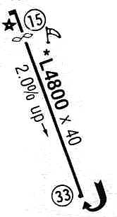
Dulce Airport depicted in the 1993 Flight Guide (courtesy of Chris Kennedy) as having a 4,800' paved Runway 15/33.
In a 10/4/97 USGS aerial view looking south, the ramp at the northwestern end of the runway
appeared to have a single small building (a hangar?),
but there was no other sign of any aircraft based at the field.
Dulce Airport was listed as being owned by the Jicarilla Apache Tribe in its later years.
Dulce Airport was apparently been replaced by the larger Jicarilla Apache Nation Airport,
which was built at some point between 1983-97, at a less constrained site 10 miles south of Dulce.
Dulce Airport was still depicted as an active airfield on the 1998 World Aeronautical Chart.
But Dulcer Airport apparently was closed at some point between 1998-2000,
as it was not listed among active airfields in the 2000 AOPA Airport Directory
and it was depicted as an abandoned airfield on the 2004 Denver Sectional Chart (courtesy of Jonathan Westerling).
Matt Franklin recalled in 2004, "I remember was driving past the airport in Dulce,
and I remember there being only one plane, which looked like a dumped Piper Navajo with wheel pants."
A 2005 aerial photo showed a strange juxtaposition – all of the runway pavement had evidently been removed at some point between 1997-2005,
but what appeared to be a new concrete helipad had been constructed where the northern end of the runway used to be,
just east of the hangar.
A 7/24/11 aerial view looking south showed the runway pavement all gone, but the orientation of the runway still apparent.
A helipad, constructed after the runway's removal, is at the bottom of the photo.
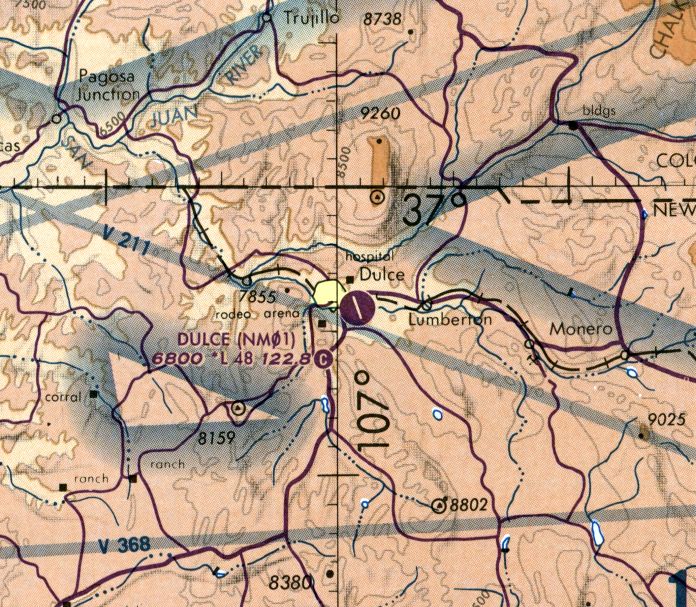
The site of Dulce Airport is located southeast of the intersection of Route 64 & Airport Road, appropriately enough.
____________________________________________________
Or if you prefer to contact me directly concerning a contribution (for a mailing address to send a check),
please contact me at: paulandterryfreeman@gmail.com
If you enjoy this web site, please support it with a financial contribution.
____________________________________________________
This site covers airfields in all 50 states.