
Abandoned & Little-Known Airfields:
Northeastern New Mexico
© 2002, © 2026 by Paul Freeman. Revised 2/8/26.
This site covers airfields in all 50 states: Click here for the site's main menu.
For a 4th year, the NM pages of this website are sponsored by the New Mexico Pilots Association:
____________________________________________________
Please consider a financial contribution to support the continued growth & operation of this site.
CCES Airfield (revised 9/7/20) - La Mesa Park Airport (revised 11/9/23) - Landing Field 78A / Anton Chico Intermediate Field (revised 10/15/18)
Landing Field 73A / Otto Intermediate Field (revised 10/15/18) - Pendaries Village Airfield (added 8/18/22) - Philmont Scout Ranch Airfield (revised 11/9/23)
Roy Municipal Airport (added 4/30/20) - (Original) Taos Airport / Kachina Airport / Downtown Airport (revised 11/9/23) - Ute Dam Airfield (added 8/12/23) - Zia Field (revised 2/8/26)
___________________________________________________________
Ute Dam Airfield (E97), Logan, NM
35.356, -103.438 (East of Albuquerque, NM)
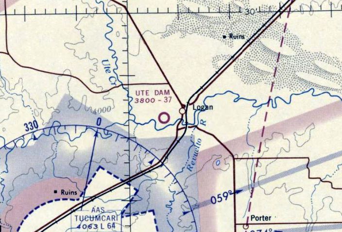
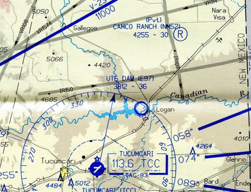
Ute Dam Airfield, as depicted on the March 1965 Albuquerque Sectional Chart.
Photo of the airport while in use has not been located.
The purpose of this remote rural airstrip has not been determined.
Ute Dam Airfield was evidently established at some point between 1956-65,
as it was not yet depicted on a 1956 aerial photo nor the February 1961 Sectional Chart.
The earliest depiction which has been located of Ute Dam Airfield was on the March 1965 Albuquerque Sectional Chart.
The earliest photo which has been located of Ute Dam Airfield was a 1967 aerial view.
It depicted Ute Dam Airfield as having a single southwest/northeast unpaved runway, with no other improvements.
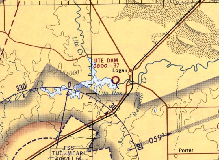
The last Sectional Chart depiction which has been located of Ute Dam Airfield was on the 1968 Albuquerque Sectional Chart.
It depicted Ute Dam Airfield as having a 3,700' unpaved runway.
The earliest topo map depiction which has been located of Ute Dam Airfield was on the 1977 USGS topo map.
Fred De Guio reported, “Prior to 1985, the NM Aeronautical Charts depicted the airfield as 'Logan-Ute Dam'.”
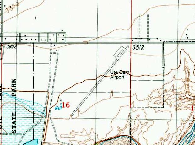
The last topo map depiction which has been located of Ute Dam Airfield was on the 1989 USGS topo map.
It depicted “Ute Dam Airport” as having a single unpaved southwest/northeast runway, with an unpaved ramp on the north side.
The earliest photo which is available of the Ute Dam Airfield was a 1991 aerial view. It showed the runway was intact though deteriorated.
The 2003 NM Aeronautical Chart (courtesy of Fred De Guio) depicted Ute Dam Airfield as having a 3,600' unpaved runway.
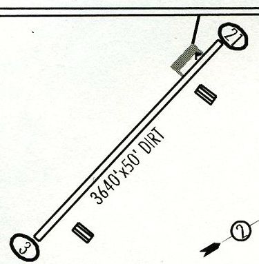
The 2003 NM Aeronautical Chart (courtesy of Fred De Guio) depicted Ute Dam Airfield as having a 3,640' dirt Runway 3/21, with an unpaved ramp on the north side, and 2 buildings southeast of the runway.
Fred De Guio reported that the Ute Dam Airfield was no longer depicted on NM Aeronautical Charts after 2005.
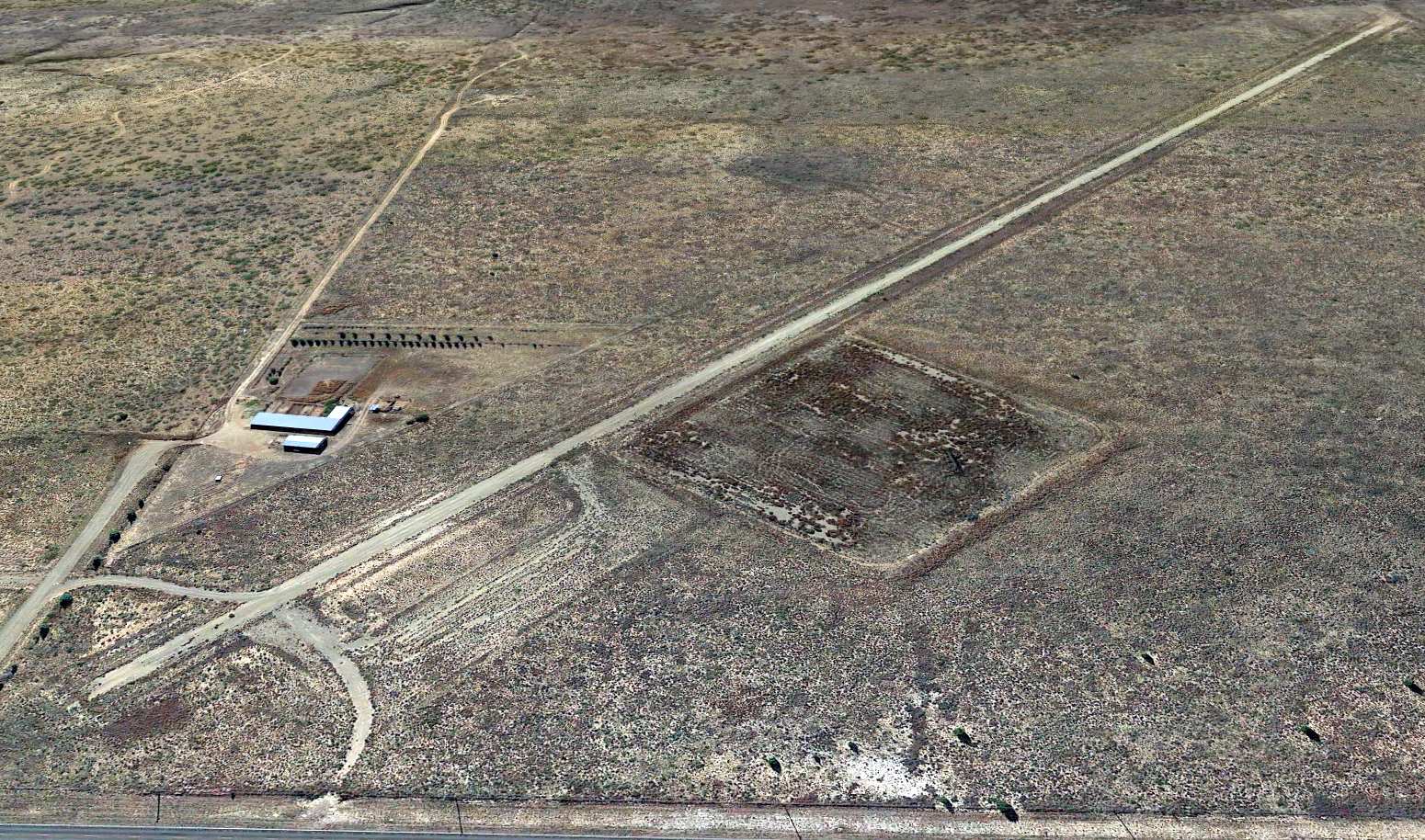
A 2017 aerial view looking south showed the Ute Dam Airfield runway remained intact.

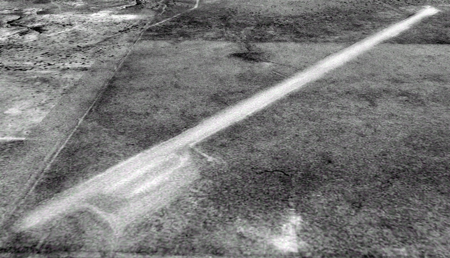
A 6/24/23 photo by Fred De Guio looking northeast along the former Ute Dam Airfield runway.
Fred reported, “I found the single dirt runway still largely intact but with significant shrub growth on the sides.”

A 6/24/23 photo by Fred De Guio looking southwest along the former Ute Dam Airfield runway.
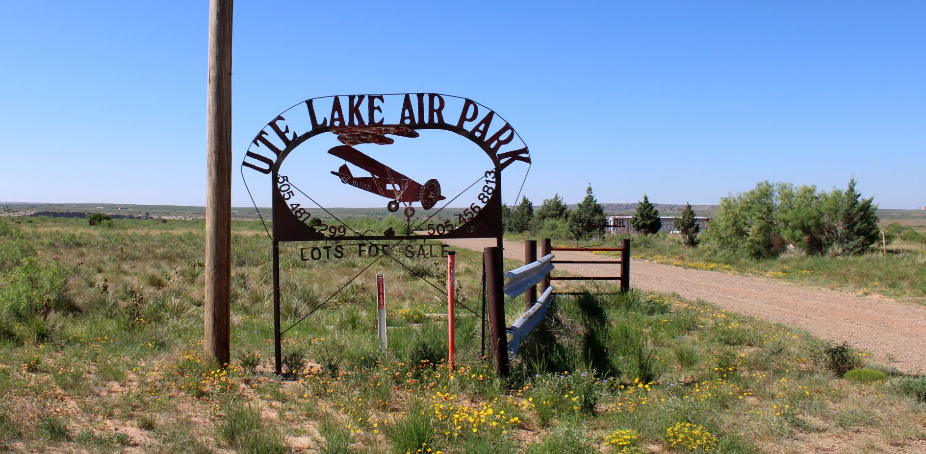
A 6/24/23 photo by Fred De Guio of the sign for the “Ute Lake Air Park”.
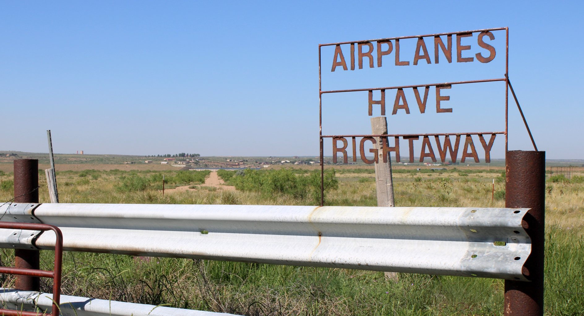
A 6/24/23 photo by Fred De Guio of the "Airplanes Have Rightaway" sign at the “Ute Lake Air Park”.
Thanks to Fred De Guio for pointing out this airfield.
______________________________________________________
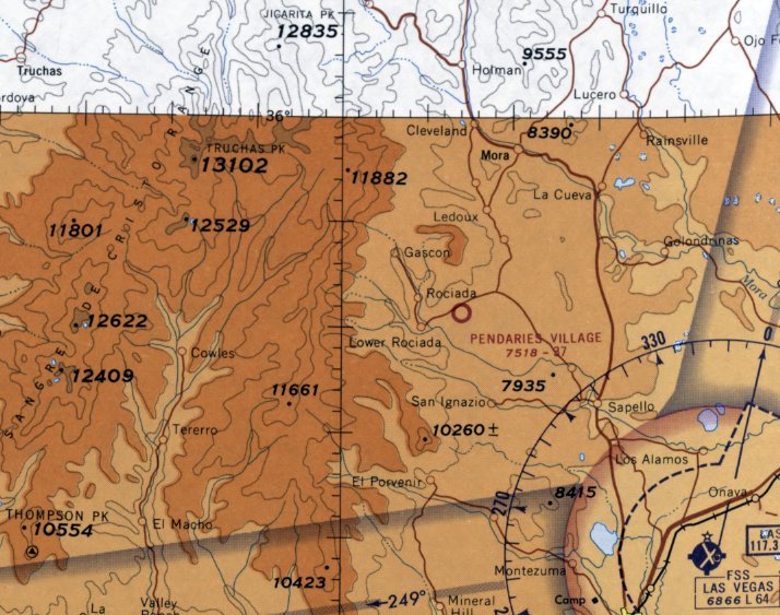
Pendaries Village Airfield, Camp Davis, NM
35.85, -105.38 (Northeast of Albuquerque, NM)
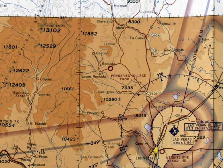
Pendaries Village Airfield, as depicted on the February 1965 Sectional Chart (courtesy of Matt Franklin).
Photo of the airport while in use has not been located.
Pendaries Village Airfield was evidently established at some point between 1961-65,
as it was not yet depicted on the February 1961 Sectional Chart (according to Matt Franklin).
The earliest depiction which has been located of Pendaries Village Airfield was on the February 1965 Sectional Chart (courtesy of Matt Franklin).
It depicted Pendaries Village Airfield as having a 3,700' unpaved runway.
Matt Franklin reported, “My hypothesis is that the airstrip was built in the 1960s to serve the resort of Pendaries,
which marketed itself to wealthy West Texan’s as a retreat in the mountains (as related to Pendaries Village advertisements in the Odessa American & Lubbock Avalanche newspapers).
The airstrips were intended as a quick means to traverse the distance from West Texas, a 3 or so hour flight.”
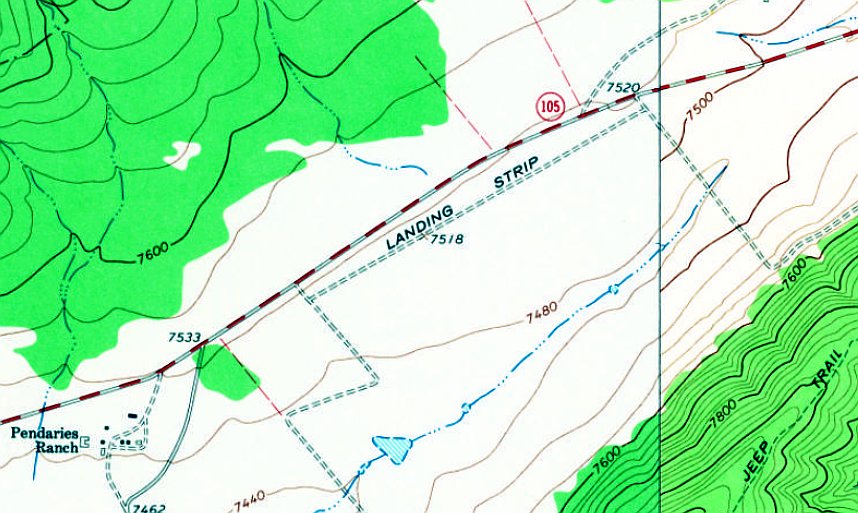
The earliest topo map depiction which has been located of Pendaries Village Airfield was on the 1965 USGS topo map (courtesy of Matt Franklin).
It depicted a single unpaved northeast/southwest runway, generically labeled as “Landing Strip”.
The last aeronautical chart depiction which has been located of Pendaries Village Airfield was on the February 1968 Sectional Chart (courtesy of Matt Franklin).
It depicted Pendaries Village Airfield as having a 3,700' unpaved runway.
A 1972 Report on Manpower Resources for San Miguel County (courtesy of Matt Franklin) described “Pendaries Village Airport”
as a private airfield having one 3,200' grass runway, but unattended & without any services.
Pendaries Village Airfield was evidently closed (for reasons unknown) at some point between 1968-88,
as it was no longer depicted on the 1988 Sectional Chart (according to Matt Franklin).
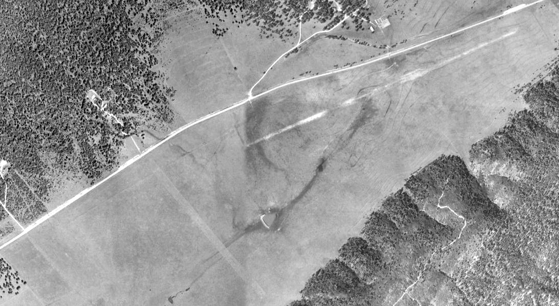
The earliest photo which has been located of Pendaries Village Airfield was a 1997 USGS aerial view.
It depicted 2 unpaved runways, having a similar (but not parallel) northeast/southwest orientation.
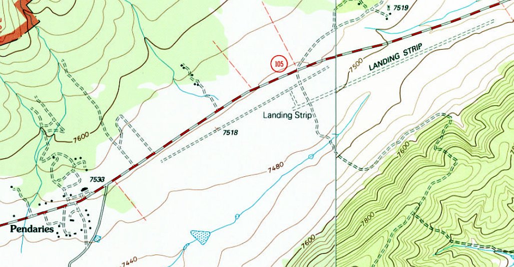
The 2002 USGS topo map depicted Pendaries Village Airfield as 2 unpaved runways, having a similar (but not parallel) northeast/southwest orientation, each generically labeled as “Landing Strip”.
Matt Franklin observed, “The airfield in temporary configuration has 2 runways: the western runway about 4,100' & the eastern runway at 5,000', connected by a taxiway.”
Pendaries Village Airfield was no longer depicted on the 2011 topo map.
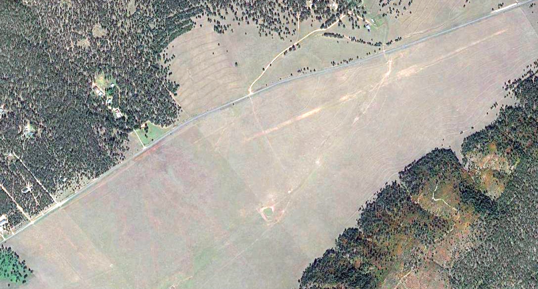
A 2016 aerial view depicted faint traces of the 2 runways of Pendaries Village Airfield.
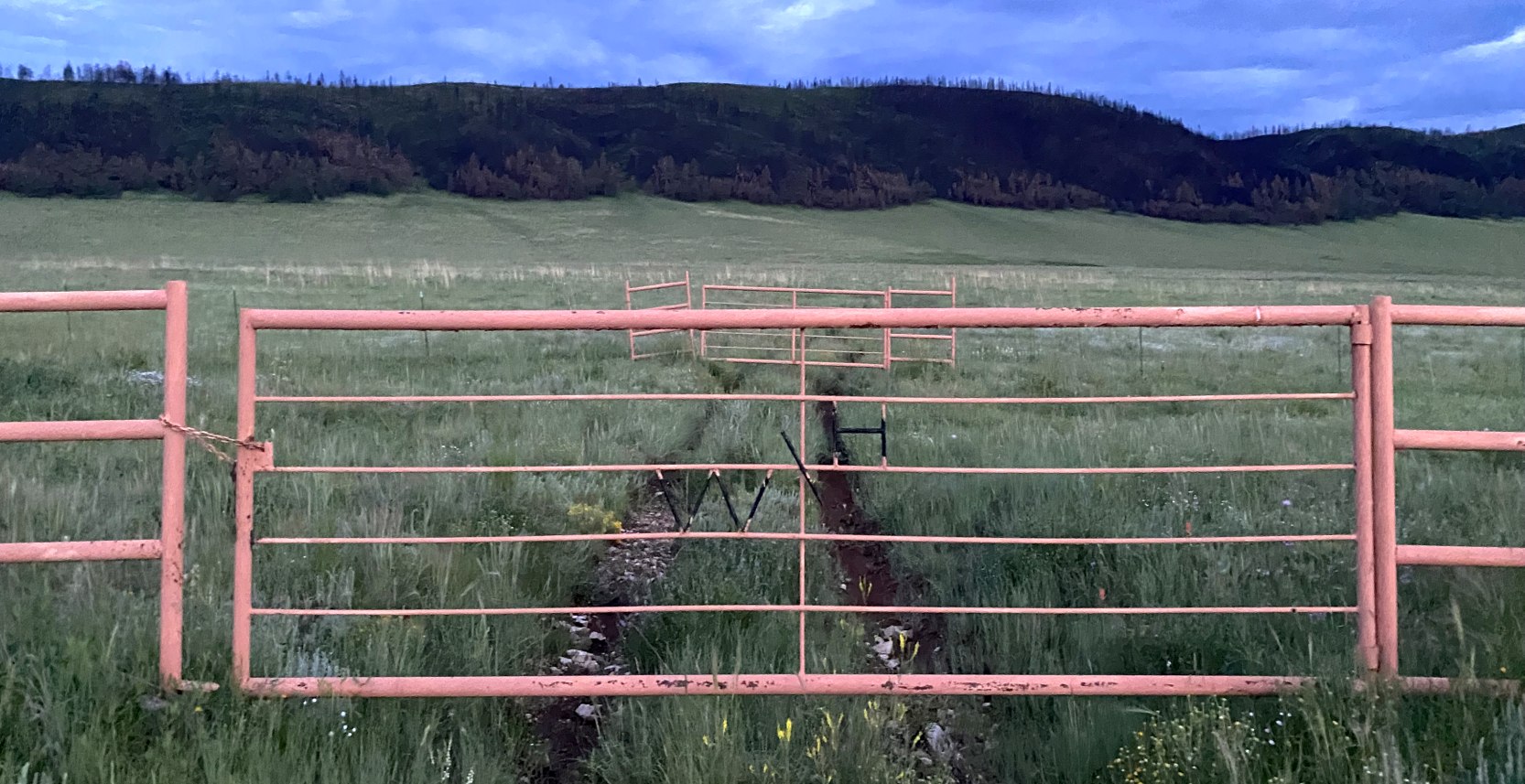
An 8/13/22 photo by Matt Franklin of the Pendaries Village Airfield access gate.
Matt reported the gate had “‘WH’ welded in. This is at the mid-section – in theory, both runways should be in view but I had no luck in identifying either.
The area had received a substantial amount of rain which prevented me from venturing to the centerline,
but I doubt I would’ve been able to tell where the surface is anyway through all the grass.”
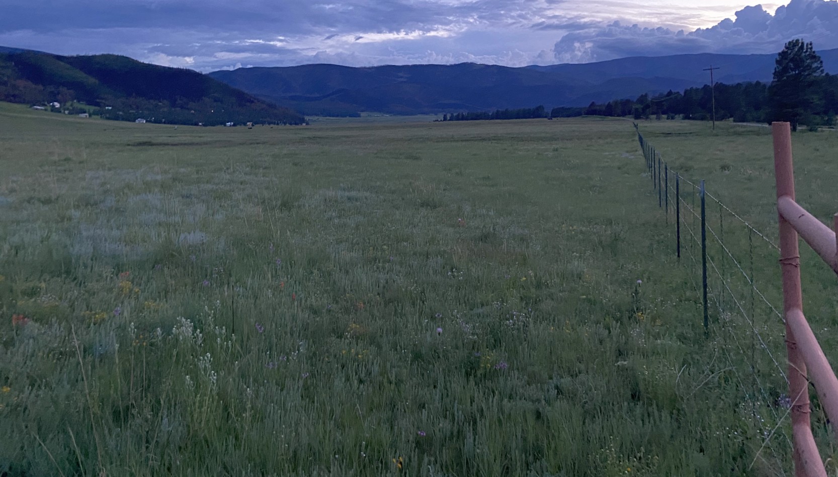
An 8/13/22 photo by Matt Franklin looking southwest along the former Pendaries Village Airfield 4,100' runway, toward Rociada.
Matt reported, “My guess is that no airplanes have landed here for quite some time.”
Thanks to Matt Franklin for pointing out this airfield.
______________________________________________________
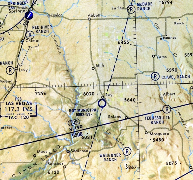
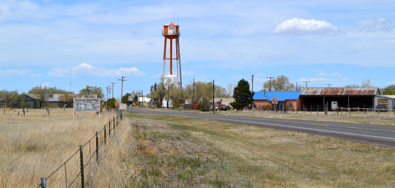
Roy Municipal Airport, Roy, NM
35.94, -104.195 (Northeast of Albuquerque, NM)
Roy Municipal Airport, as depicted on the March 1967 Albuquerque Sectional Chart.
Photo of the airport while in use has not been located.
Roy Municipal Airport was evidently established at some point between 1966-67,
as it was not yet depicted on the August 1966 Albuquerque Sectional Chart.
The earliest depiction which has been located of Roy Municipal Airport was on the March 1967 Albuquerque Sectional Chart.
It depicted Roy Municipal Airport as having a 6,400' unpaved runway.
The 1974 USGS topo map depicted Roy “Municipal Airport” as having a long unpaved northwest/southeast runway,
with several buildings along the northeast side.
The 1992-93 NM Aeronautical Chart (courtesy of Fred DeGuio) depicted Roy Municipal Airport as having a 5,100' unpaved runway.
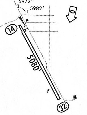
The 1992-93 NM Aeronautical Chart (courtesy of Fred DeGuio) depicted Roy Municipal Airport as having a 5,080' unpaved Runway 14/32,
and a number of small buildings along the northeast side.
According to Fred DeGuio, the 1995-96 New Mexico Aeronautical Chart depicted Roy Municipal Airport as "W",
and it was removed from the 1997-98 New Mexico Aeronautical Chart.
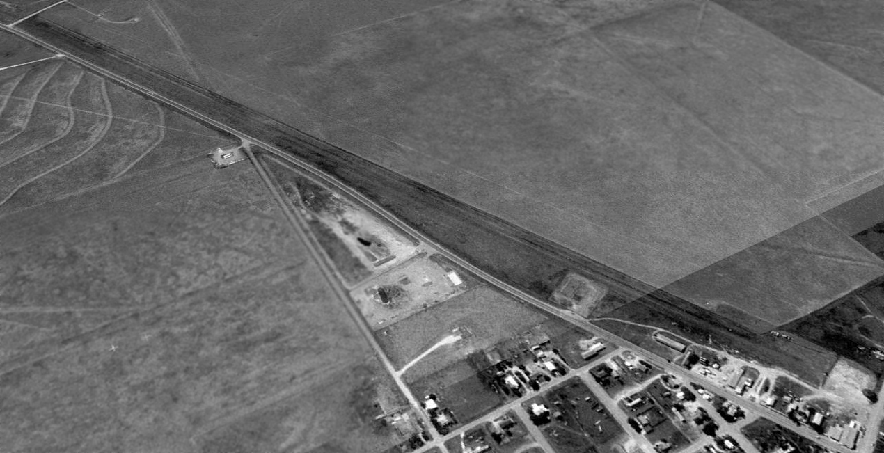
The earliest photo which has been located of Roy Municipal Airport was a 1997 USGS aerial view looking southwest.
It depicted Roy Municipal Airport as having an unpaved northwest/southeast runway, and a number of small buildings along the northeast side.
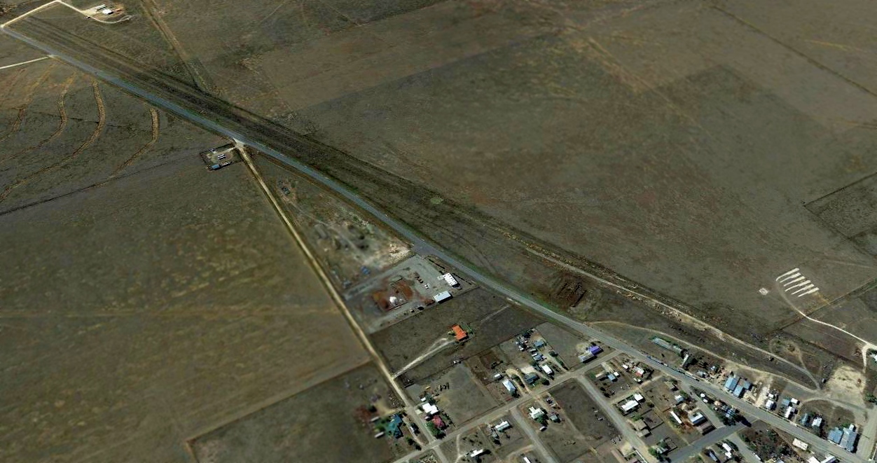
A 2015 aerial view looking southeast at the remains of Roy Municipal Airport showed it in an unchanged fashion.
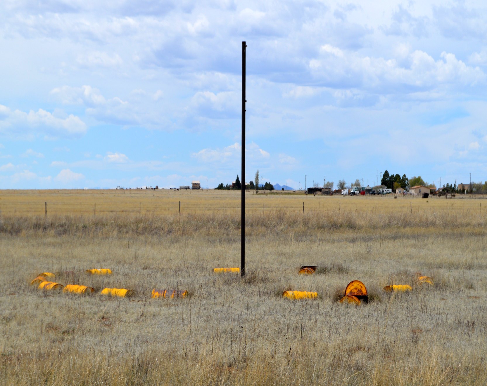
A 4/27/20 photo by Fred DeGuio at the site of Roy Municipal Airport.
Fred reported, “The only remnant I could see is a pole still standing at midfield surrounded with yellow barrels, most likely the windsock.”
A 4/27/20 photo by Fred DeGuio looking north at the site of Roy Municipal Airport.
Fred reported, “There is a fence now but the runway paralleled NM Highway 39 off the left side of the photo.
It appears the water tank was dangerously close to the approach end of Runway 14.
I wish I could have entered thru the fence & stood on what was the runway as there was no new development on it.”
Thanks to Fred DeGuio for pointing out this airfield.
______________________________________________________
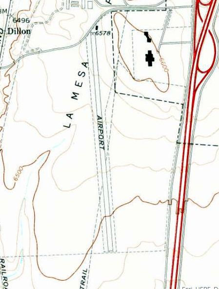
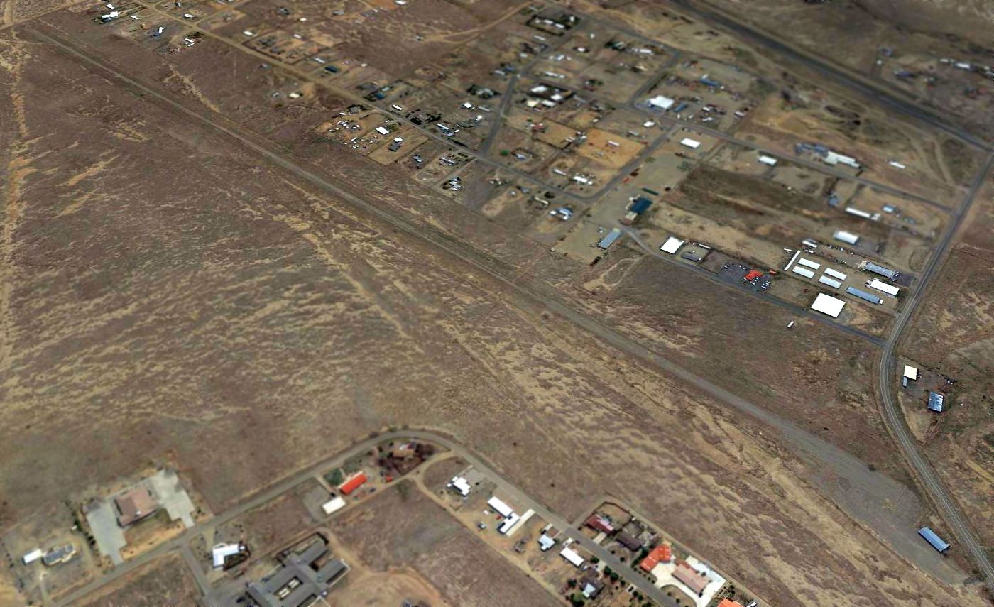
La Mesa Park Airport, Raton, NM
36.861, -104.449 (Northeast of Albuquerque, NM)
La Mesa Park Airport, as depicted on the September 1965 Trinidad Sectional Chart (courtesy of Ron Kunse).
According to Matt Franklin, “La Mesa Park (the racetrack, not the airport) was constructed & opened in 1946 & was New Mexico’s first horse racetrack.
The grandstand used for its construction came from Arlington Downs in Dallas & was reassembled in Raton.
In the 1940s, Raton had a wide reputation for such a small town thanks to the races that went on at the track.
The train originally brought out-of-towners, but the airport supplemented (or replaced) this in the 1960s.”
The earliest depiction which has been located of La Mesa Park Airport was on the September 1965 Trinidad Sectional Chart (courtesy of Ron Kunse).
It depicted La Mesa Park Airport as having a 5,000' unpaved runway.
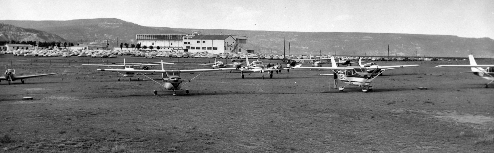
A 1960s era photograph of La Mesa Park Airport (courtesy of Raton city manager Scott Berry, via Matt Franklin).
Matt Franklin observed, the picture “showed a full dirt ramp of 13 airplanes, a full parking lot of the race track behind, and no buildings.”
According to Matt Franklin, “On 5/27/67, N8163P, a Piper Comanche, crashed into the barn area of the track when it tried to take off on a warm day with a density altitude of 9,000'.
La Mesa Park Airfield then modified the heading of the runway by about 20 degrees, removing the grandstand & stables from the direct path of the runway.
A 1969 aerial photo of La Mesa Park Airport (courtesy of Matt Franklin).
Matt Franklin observed, “You can clearly see the orientation of the previous runway with massive Xs carved into it, and one airplane on the field.”
The 1971 USGS topo map depicted La Mesa Park Airport as having a single paved northwest/southeast runway,
labeled simply as “Airport”, with one small building on the northeast corner.
A 1975 aerial photo of La Mesa Park Airport (courtesy of Matt Franklin).
Matt Franklin observed, “The photo was probably during a race, with 5 airplanes on the field.”
The last labeled depiction which has been located of La Mesa Park Airport was on the 1976 USGS topo map.
According to Matt Franklin, “The track started experiencing financial difficulties in the late 1980s, and closed in 1992.”
A 1992 aerial photo of La Mesa Park Airport (courtesy of Matt Franklin).
According to Matt Franklin, “A 1993 NMDOT report indicated the runway was in poor condition with broken lighting,
and the 1996 NMDOT inspection reported faded runway markings & weed encroachment.”
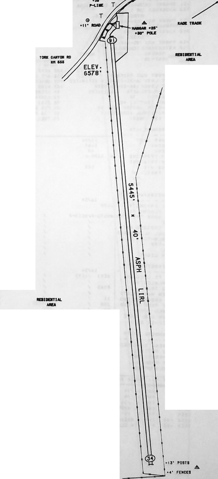
A 1996 NMDOT diagram of La Mesa Park Airfield (courtesy of William Fitzpatrick, via Matt Franklin).
According to Matt Franklin, “Closure of the airport was requested in 1996. The operator listed at the time was Joel Sanderson.”
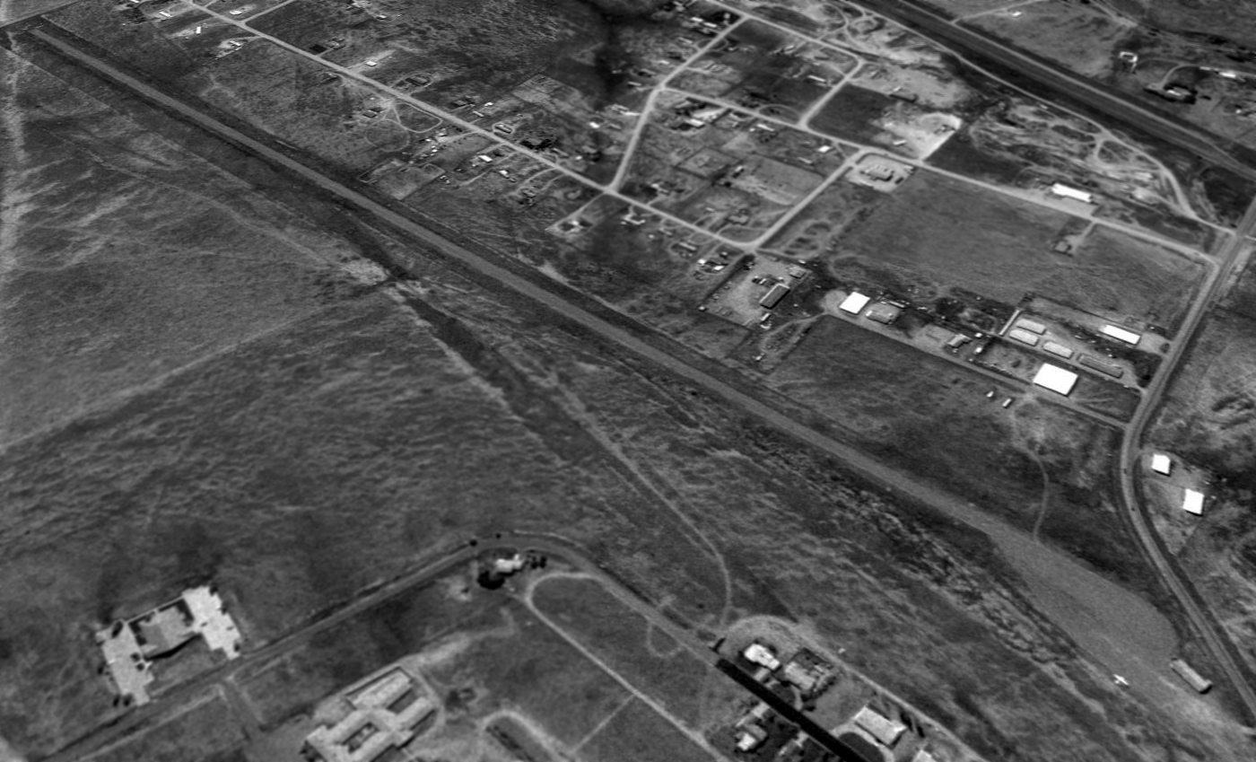
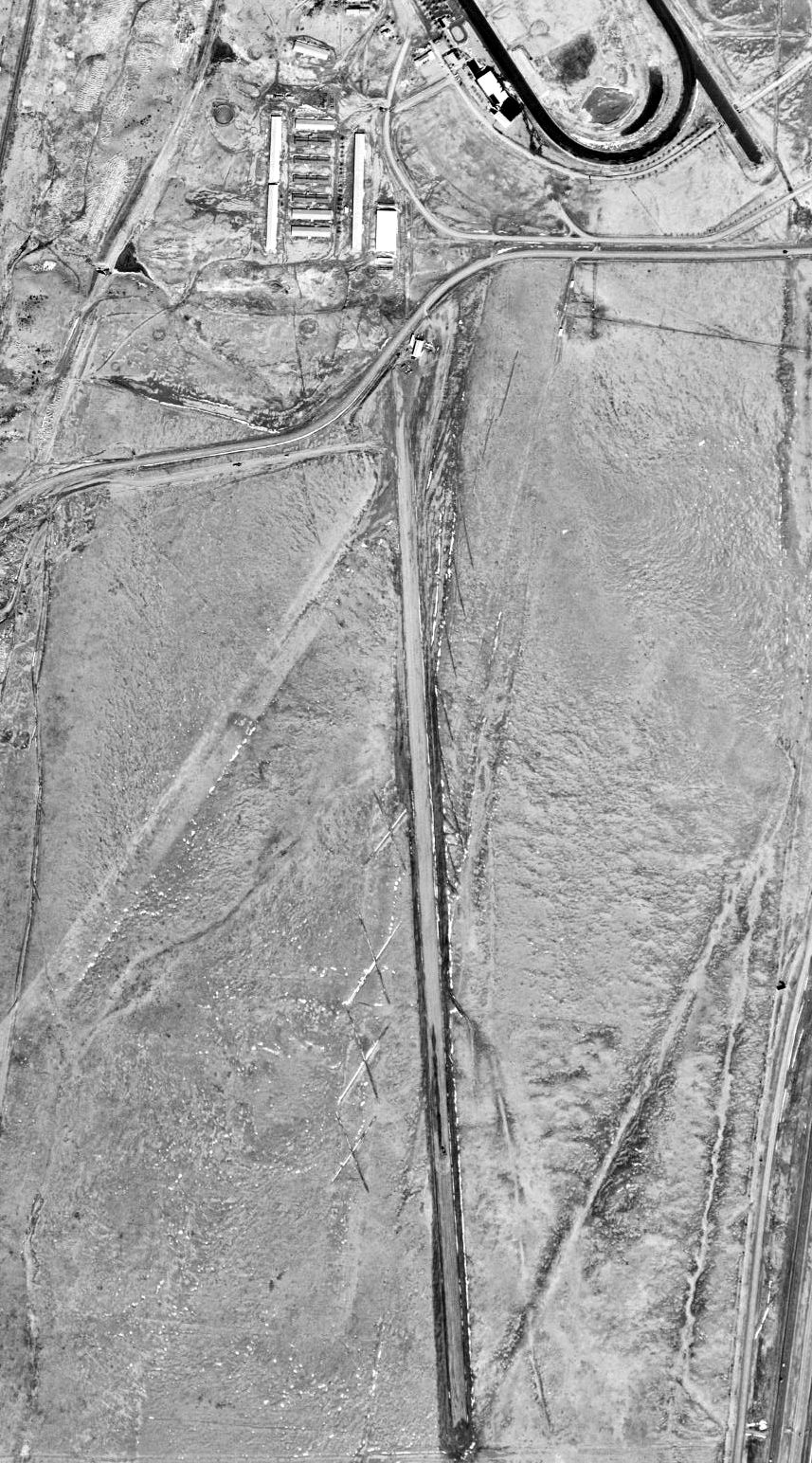
The last photo which has been located showing an aircraft at La Mesa Park was a 1997 USGS aerial view looking southwest .
It depicted one single-engine light aircraft parked on the ramp near the small building on the northeast side (bottom-right of photo).
According to Matt Frank, “I believe it is Joel Sanderson's Cessna that is pictured in the photo [the airfield owner].”
The last aeronautical chart depiction which has been located of La Mesa Park Airport was on the 2004 Denver Sectional Chart (courtesy of Jonathan Westerling).
It depicted La Mesa Park as a private airfield having a single 5,400' paved north/south runway.
A 2004 aerial view depicted multiple yellow closed-runway “X” symbols painted along the La Mesa Park runway.
According to Matt Franklin, “In 2004 it was being used for storing equipment.”
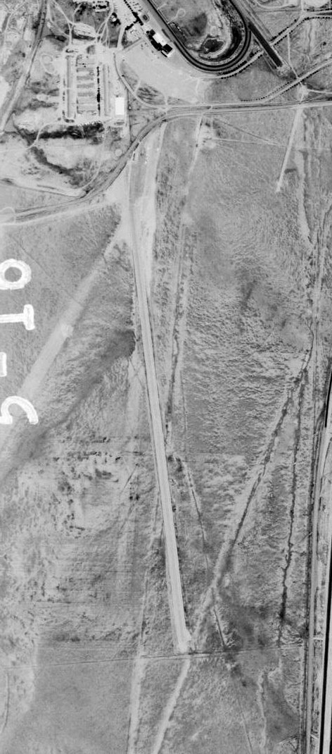
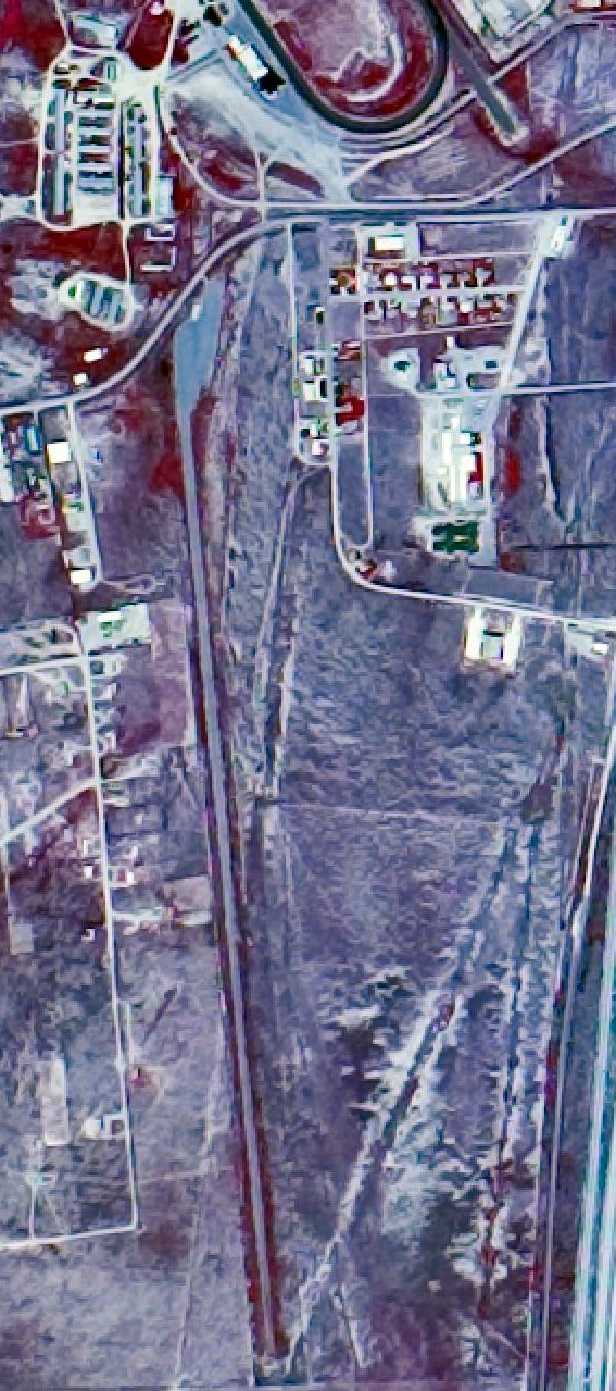
A 2014 aerial view looking southwest showed the La Mesa Park Airport remained intact, though deteriorated.
According to Matt Franklin, “In 2017 [La Mesa Park] was being used as a landing site for a balloon rally.
In 2018, the site was donated by the bank to Colfax County, and is being considered for use as an industrial park & it is doubtful that it will ever be used as an airport again.”
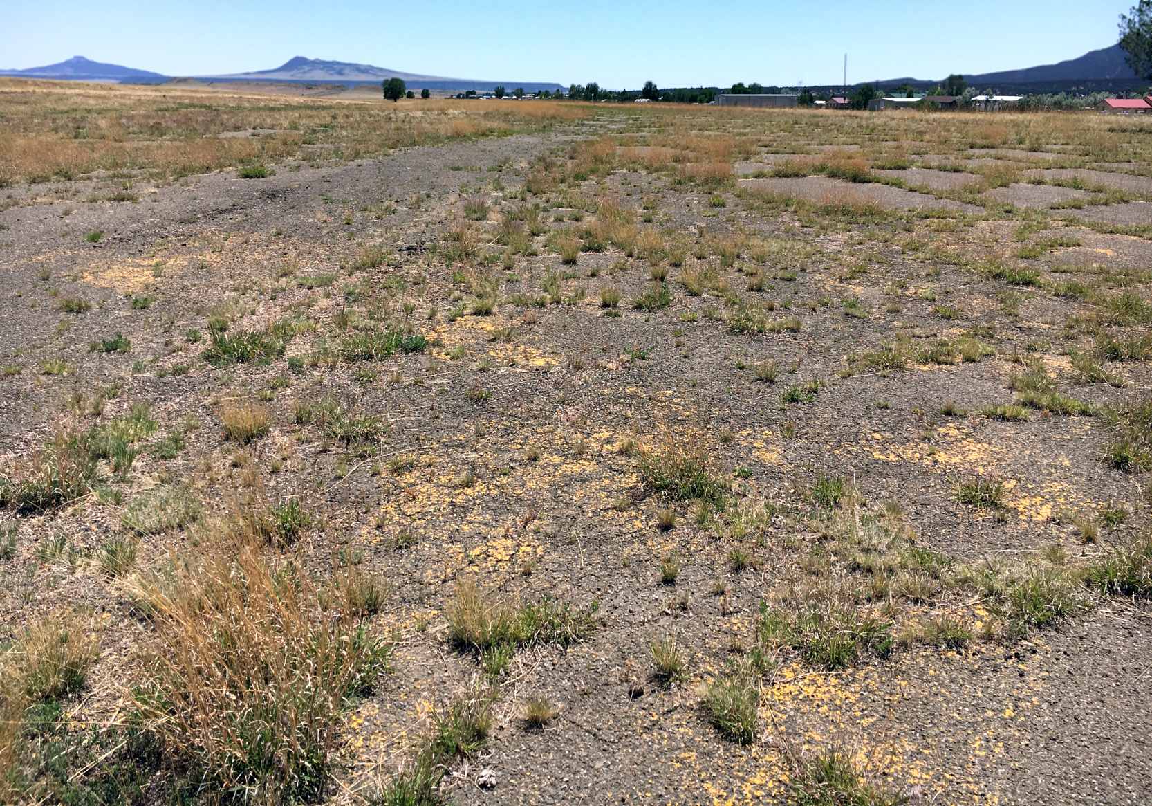
A 5/28/18 photo by Matt Franklin of the remains of the La Mesa Park runway, showing the remains of the yellow closed-runway X markings.
Matt observed, “A segment of the runway has weeds growing through the cracks, but was otherwise clear.
The remaining half or so of the runway was covered with 4' tall weeds, which I didn’t drive through, for some fairly obvious reasons.”
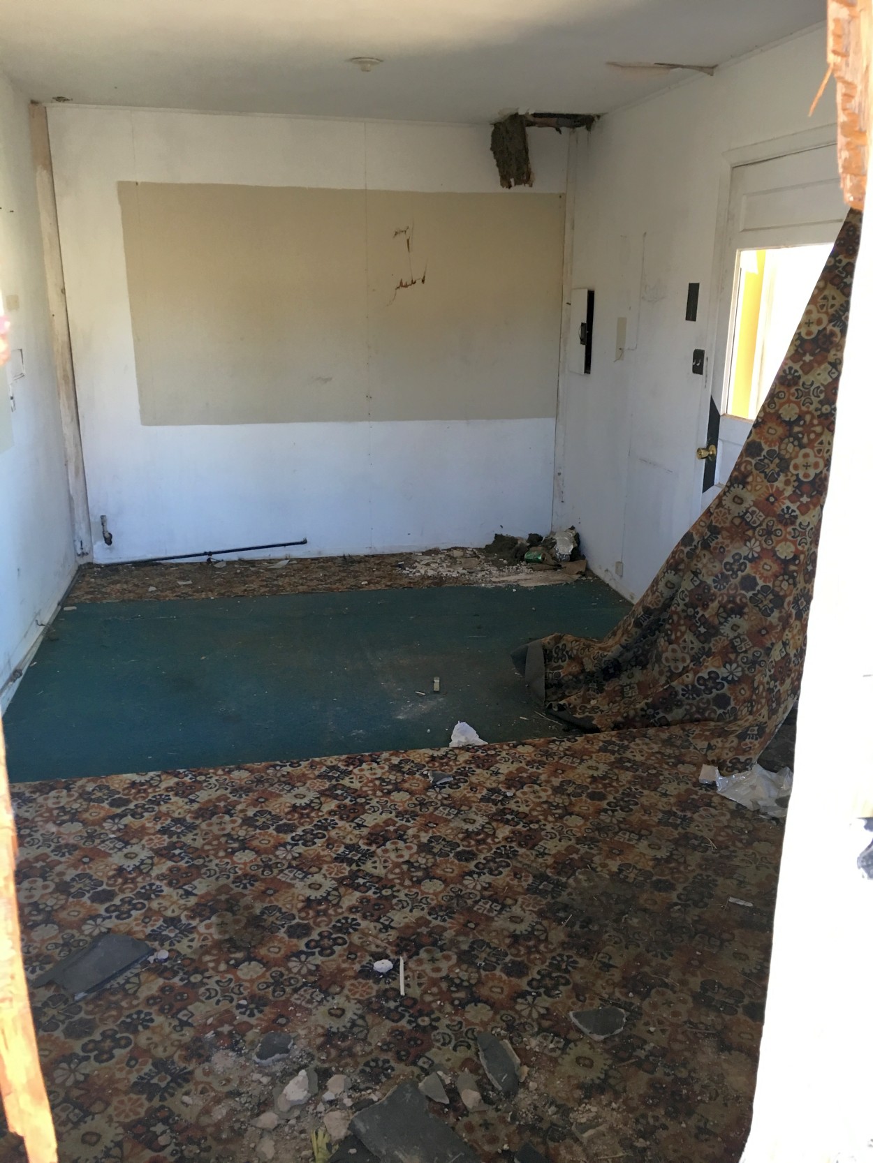
A 5/28/18 photo by Matt Franklin, showing “The Fixed Base Operator building is still there with parking for a couple of airplanes. Someone has breached their way into the office.”
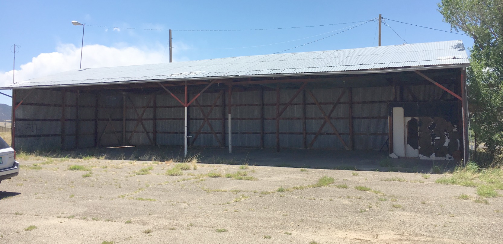
A 5/28/18 photo by Matt Franklin of a former La Mesa Park Airport open hangar.

A 5/28/18 photo by Matt Franklin, of the La Mesa Park “grandstands, which are in a deteriorating condition. An echo of the past. Glad I got to experience it while I was still there.”
La Mesa Park Airport is located southwest of the intersection of York Canyon Road & La Mesa Drive.
Thanks to Eric Karnes for pointing out this airfield.
______________________________________________________
Landing Field 73A / Otto Intermediate Field, Otto, NM
35.07, -106.01 (Northeast of Albuquerque, NM)
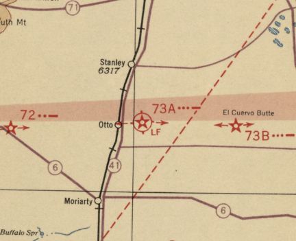
Otto Intermediate Field was depicted on the March 1932 Albuquerque Sectional Chart as Landing Field #73A.
Otto Intermediate Field was one of the nationwide network of Intermediate Fields
established by the Commerce Department in the 1930s along commercial airways between major cities.
The date of establishment of Otto Intermediate Field has not been determined.
The earliest reference which has been located of Otto Intermediate Field was its listing as an airfield & radio facility
in the September 1931 Commerce Department Airway Bulletin #1 (according to Steve Owen).
The earliest depiction which has been located of Otto Intermediate Field was on the March 1932 Albuquerque Sectional Chart,
which labeled it as Landing Field 73A.
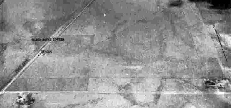
The earliest photo which has been located of Otto Intermediate Field was a circa 1943-45 aerial view
from the 1945 AAF Airfield Directory (courtesy of Scott Murdock).
It depicted Otto as a triangular-shaped unpaved landing area.
The 1945 AAF Airfield Directory (courtesy of Scott Murdock) described Otto Intermediate Field
as a 153 acre L-shaped property having 3 sand & sod landing strips, the longest being the 4,100' northeast/southwest strip.
The field was said to not have any hangars, to be owned by private interests, and operated by the Civil Aeronautics Administration.
A 9/16/53 USGS aerial view depicted Otto Intermediate Field as a triangular-shaped unpaved landing area with the radio facility & a few small buildings on the west side.
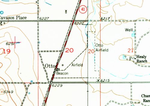
The 1956 USGS topo map depicted “Otto Airfield” as an L-shaped unpaved landing area.
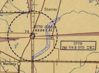
The last aeronautical chart depiction which has been located of Otto Intermediate Field was on the 1960 Albuquerque Sectional Chart,
which labeled it as “Otto (FAA)”, and depicted it as having a 4,100' unpaved runway.
Steve Owen reported, “The 1930s Otto airway station house was shut down as of 1962
and eventually moved to the new Moriarty Airport, as was the Otto beacon tower.
Meanwhile, the Otto FSS building & 'delta' antenna towers remained at the old site & became a private enterprise, ('ICE': Ionosphere Communications Experiments).”
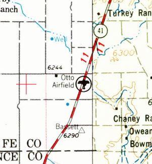
The last depiction which has been located of Otto Airfield was on the 1963 USGS topo map.
Otto Intermediate Field was evidently closed at some point between 1960-65,
as it was no longer depicted on the August 1965 Albuquerque Sectional Chart.
Steve Owen reported, “When the Otto CAA Intermediate Field was shut down, one story asserts that the town of Moriarty was offered the airfield.
However, it was too far from town so the Moriarty Airport was developed.
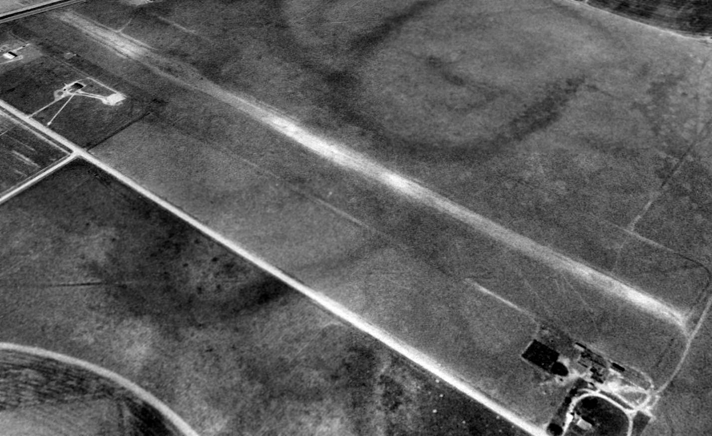
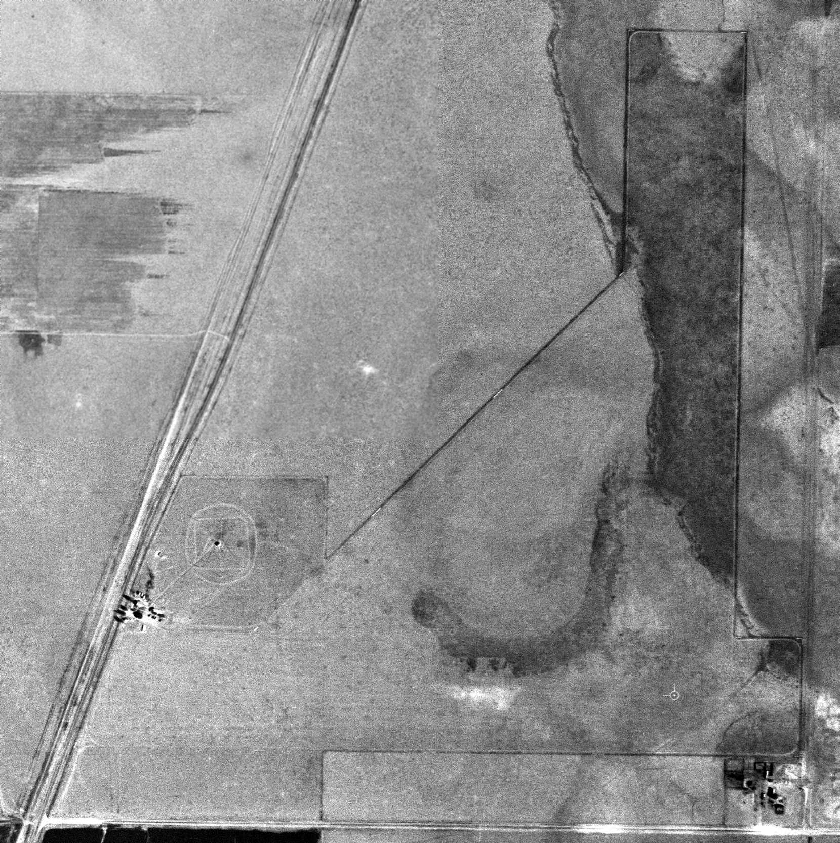
A 1996 USGS aerial view looking northwest showed the remains of the east/west runway at the site of Otto Intermediate Field.
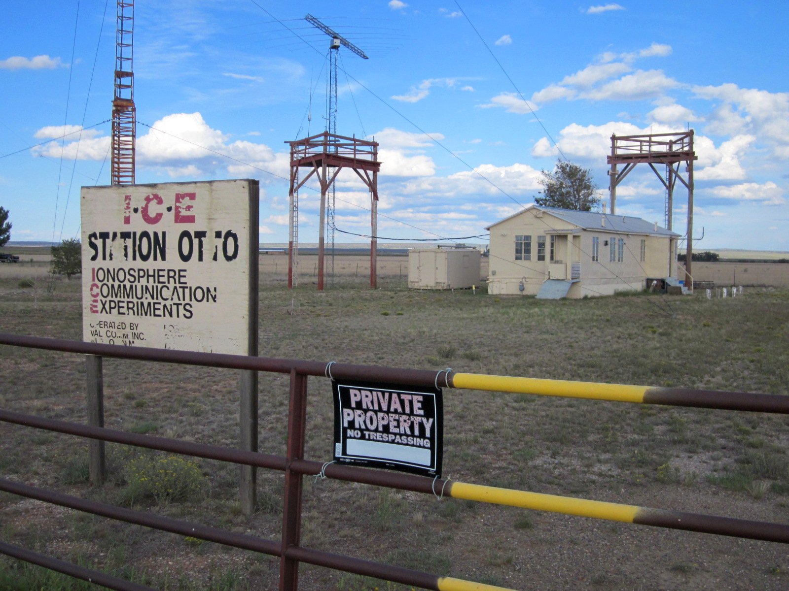
A 2011 photo by Steve Owen of the Otto FSS building, reused for Ionosphere Communications Experiments.
A 2014 aerial view looking northwest showed the remains of the east/west runway at the site of Otto Intermediate Field.

A 2016 photo by Steve Owen of the Otto airway station house (with “Otto” still visible on the roof).
The site of Otto Intermediate Field is located northeast of the intersection of Route 41 & County Road 6A.
Thanks to Matt Franklin for pointing out this airfield.
______________________________________________________
Landing Field 78A / Anton Chico Intermediate Field, Anton Chico, NM
35.14, -105.08 (Northeast of Albuquerque, NM)
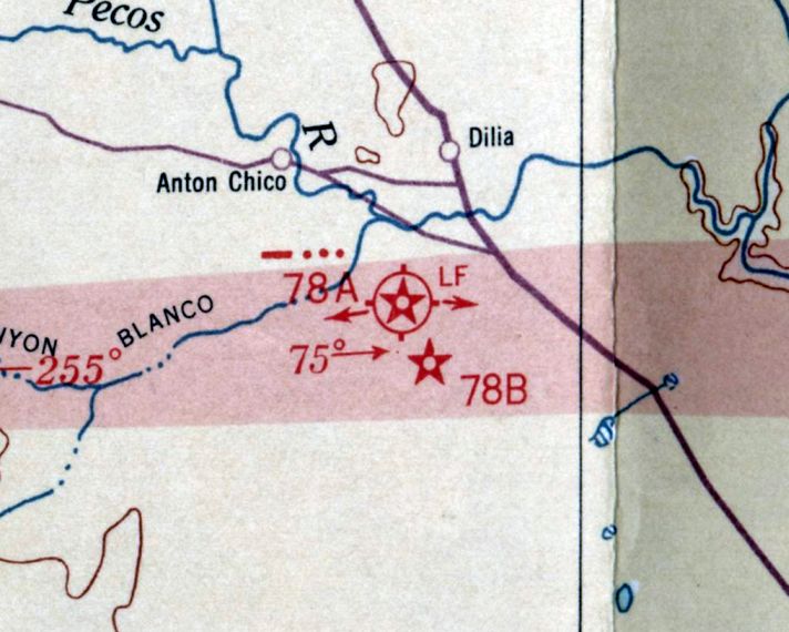
Anton Chico Intermediate Field was depicted on the March 1932 Albuquerque Sectional Chart as Landing Field #78A.
Anton Chico Intermediate Field was one of the nationwide network of Intermediate Fields
established by the Commerce Department in the 1930s along commercial airways between major cities.
The date of establishment of Anton Chico Intermediate Field has not been determined.
The earliest depiction which has been located of Anton Chico Intermediate Field was on the March 1932 Albuquerque Sectional Chart,
which labeled it as Landing Field 78A, and also depicted Airway Beacon 78B nearby to the southeast.
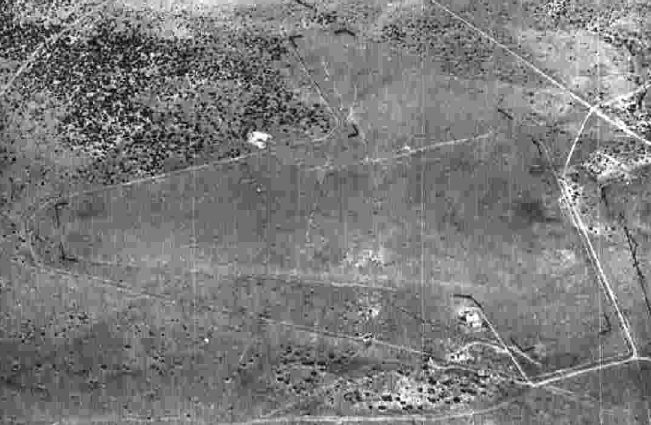
The earliest photo which has been located of Anton Chico Intermediate Field was a circa 1943-45 aerial view
from the 1945 AAF Airfield Directory (courtesy of Scott Murdock).
It depicted Anton Chico as an irregularly-shaped unpaved landing area.
The 1945 AAF Airfield Directory (courtesy of Scott Murdock) described Anto Chico Intermediate Field
as a 163 acre irregularly-shaped property having 2 sand & sod landing strips, measuring 4,273' north-northwest/south-southeast & 3,615' east-northeast/west-southwest.
The field was said to not have any hangars, to be owned by private interests, and operated by the Civil Aeronautics Administration.
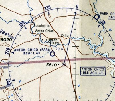
The last depiction which has been located of Anton Chico Intermediate Field was on the 1960 Albuquerque Sectional Chart,
which labeled it as “Anton Chico (FAA) 79A”, and depicted it as having a 4,300' unpaved runway.
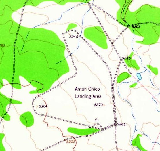
The 1963 USGS topo map depicted an irregularly-shaped property labeled “Anton Chico Landing Area”.
Anton Chico Intermediate Field was evidently closed at some point between 1960-65,
as it was no longer depicted on the August 1965 Albuquerque Sectional Chart.
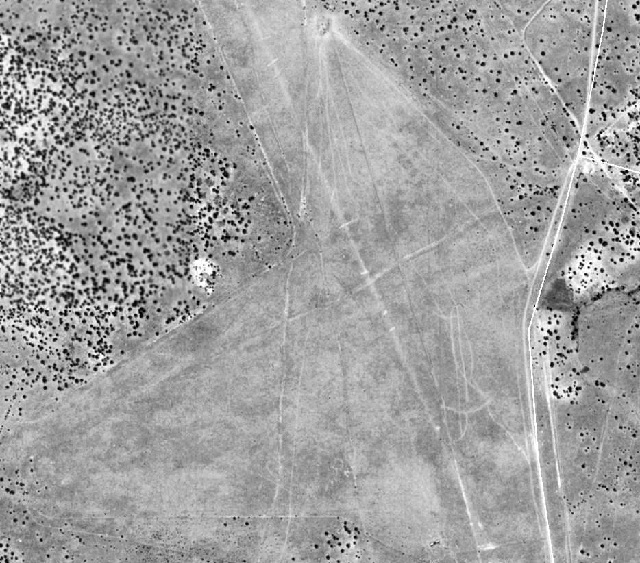
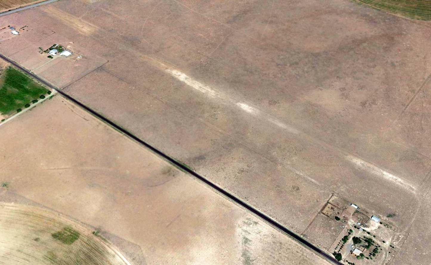
A 1991 USGS aerial view depicted the remains of Anton Chico Intermediate Field.
Matt Franklin observed, “The defined tracks measure 4,300' (oriented) 16/34 & 3,600' (oriented) 6/24.”
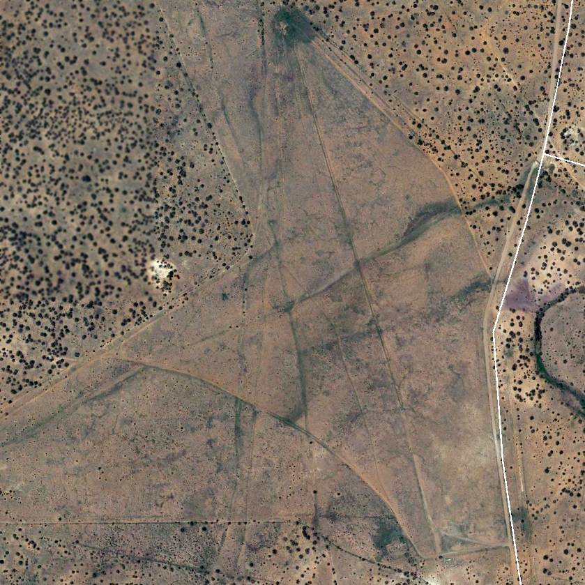
A 2014 aerial view showed Anton Chico Intermediate Field remained recognizable.
The site of Anton Chico Intermediate Field is located southwest of the intersection of County Road 4 L & Sun Ranch Road.
Thanks to Matt Franklin for pointing out this airfield.
______________________________________________________
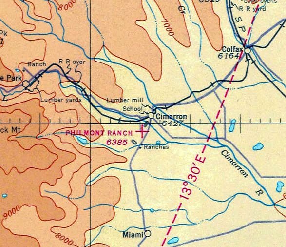
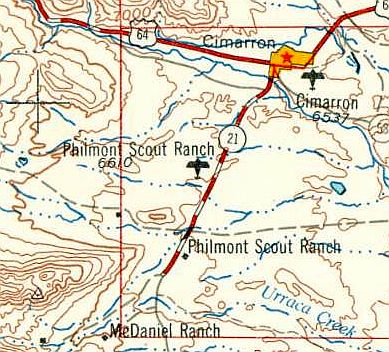
Philmont Scout Ranch Airfield, Cimarron, NM
36.49, -104.95 (Northeast of Albuquerque, NM)
The Philmont Scout Ranch Airfield, as depicted on the September 1936 Trinidad Sectional Chart.
Photo of the airfield while in use has not been located.
This airfield on the north side of the Boy Scout Philmont Ranch “was established in the 1920s”, according to Mark Stinnett (Editor of High Country, the magazine of the Philmont Staff Association).
The earliest depiction which has been located of the Philmont Scout Ranch Airfield was on the September 1936 Trinidad Sectional Chart.
It depicted Philmont Ranch as an auxiliary airfield.
Mark Rands recalled, “The air charts had a warning to make a pass over the field to chase the buffalo off the runway.”
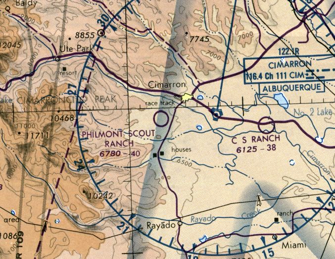
The Philmont Scout Ranch Airfield, as depicted on the 1958 USGS topo map.
The last aeronautical chart depiction which has been located of the Philmont Scout Ranch Airfield was on the 1986 Denver Sectional Chart (courtesy of Jonathan Westerling).
It depicted Philmont Scout Ranch as a public-use airfield having a 4,000' unpaved runway.
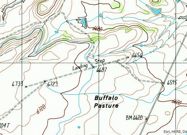
The 1987 USGS topo map depicted a single northeast/southwest “Landing Strip”.
The last reported aircraft use of the Philmont Scout Ranch Airfield was an NTSB summary of an 8/2/88 accident
in which a Beech B23 Musketeer departed from the field but subsequently crashed due to water contamination of its fuel.
The Philmont Scout Ranch Airfield was evidently closed (for reasons unknown) at some point between 1988-90,
as it was no longer depicted on the 1990 NM Aeronautical Chart (courtesy of Alex Hauzer).
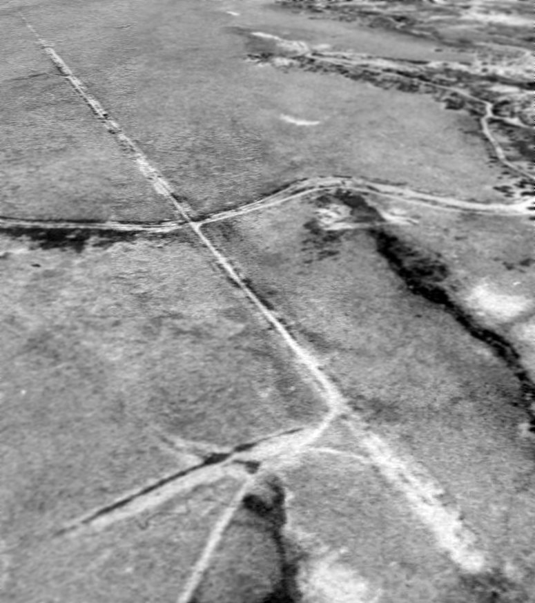
The earliest photo which has been located of the Philmont Scout Ranch Airfield was a 1991 USGS aerial view looking west.
The runway looked very deteriorated.
A 2010 aerial view looking west showed the Philmont Scout Ranch Airfield runway remained recognizable, along with a segmented circle marking in the lower-right.
The Philmont Scout Ranch Airfield is located on the west side of Route 21, one mile north of the Scout Ranch headquarters.
Thanks to Mark Rands for pointing out this airfield.
______________________________________________________
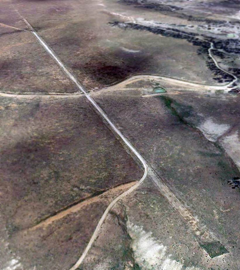
36.08, -104.43 (Northeast of Albuquerque, NM)
A 9/29/97 USGS aerial view looking southwest at the CCES Airfield.
No airfield at this location was yet depicted on the February 1968 Albuquerque Sectional Chart.
The Canyon Colorado Equine Sanctuary (CCES) was established by William Gruenerwald,
a petroleum geologist who made money in the oil business & proceeded to spend a lot of it on an extraordinary personal crusade.
His objective was to protect zebras, onagers, kulans and other wild relatives of the domestic horse from the threat of extinction.
The focal point of his work is the CCES, a 6,000-acre private preserve which includes solar-heated shelters, grain- & hay-storage sheds, water tanks,
residential buildings and a headquarters complex with an aircraft hangar, modern offices and a veterinary clinic.
John Love reported, “The first USGS image I found had an aircraft sitting next to the hangar & the airstrip was still in good condition.
As I remember the image was made in the late 1970s.
A building has C.C.E.S. lettering on the concrete apron of a small hangar.”
The earliest depiction which is available of the CCES Airfield was a 9/29/97 USGS aerial photo.
It depicted 2 paved runways, with a ramp & hangar to the southeast of the runway intersection.
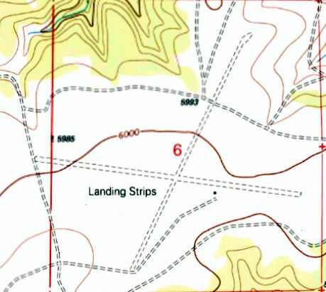
The 1998 USGS topo map depicted 2 unpaved runways, labeled simply as “Landing Strips”,
along with a single small building to the southeast of the runway intersection.
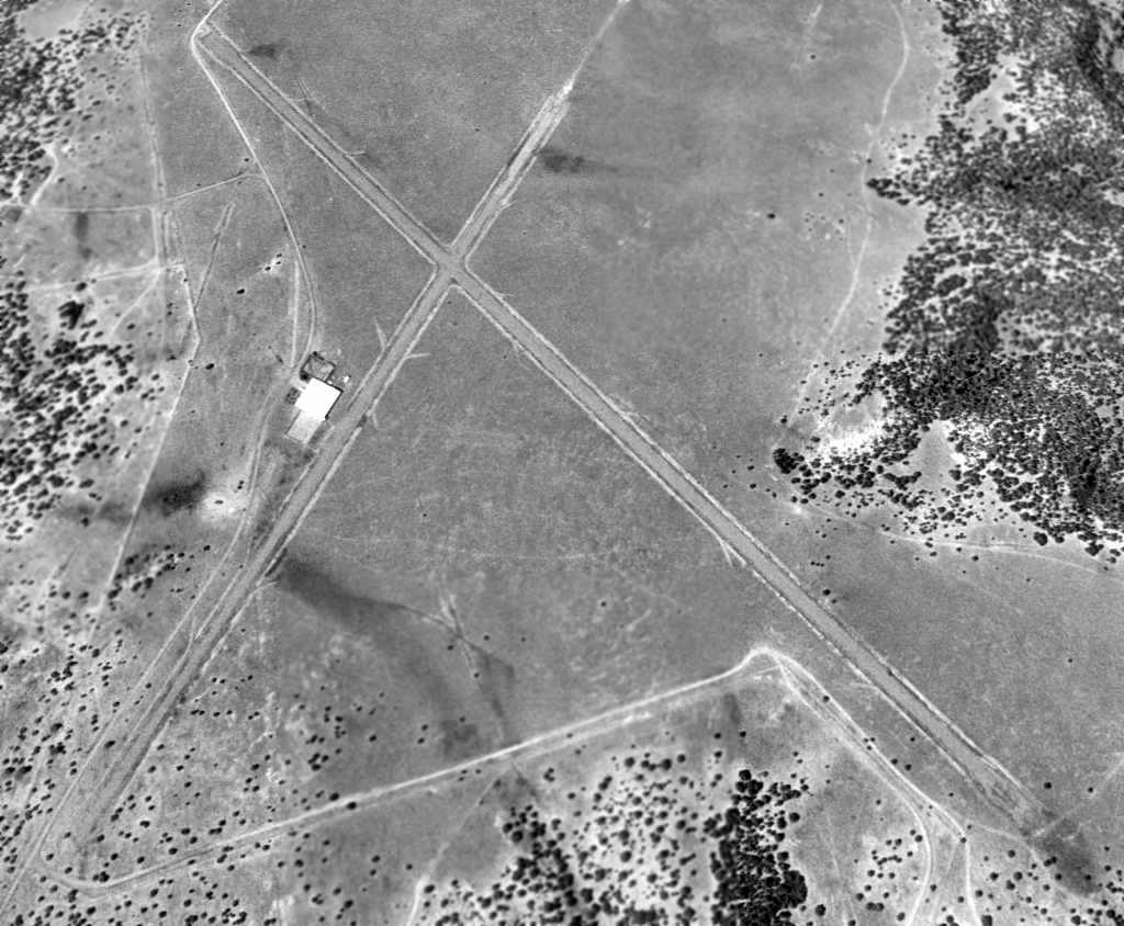
A 7/20/04 aerial photo showed large “C.C.E.S.” letters painted in black on the ramp in front of the hangar.

The only photo which has been located showing an aircraft at the CCES Airfield was an 8/13/04 aerial view,
showing a light twin-engine aircraft (Beech Baron?) on the ramp next to the hangar.
A 5/8/09 aerial photo showed the “C.C.E.S.” letters had been repainted in white on the ramp in front of the hangar.
As of 2013, no airfield was listed at this location in the FAA Airport/Facility Directory data nor depicted on aeronautical charts.
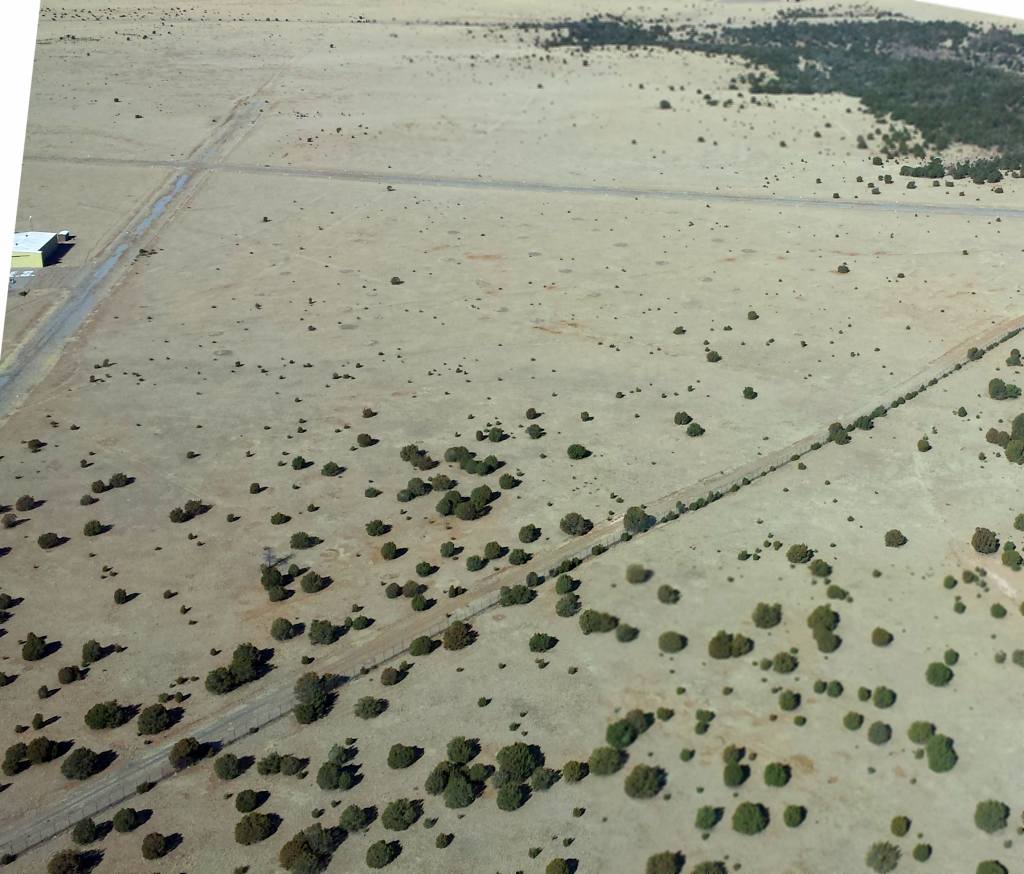
A February 2014 aerial view looking north at the CCES airfield.
The photographer observed, “The entire perimeter has a tall chainlink fence that appears to be in great condition.”

A February 2014 aerial view looking east at the CCES hangar & ramp.
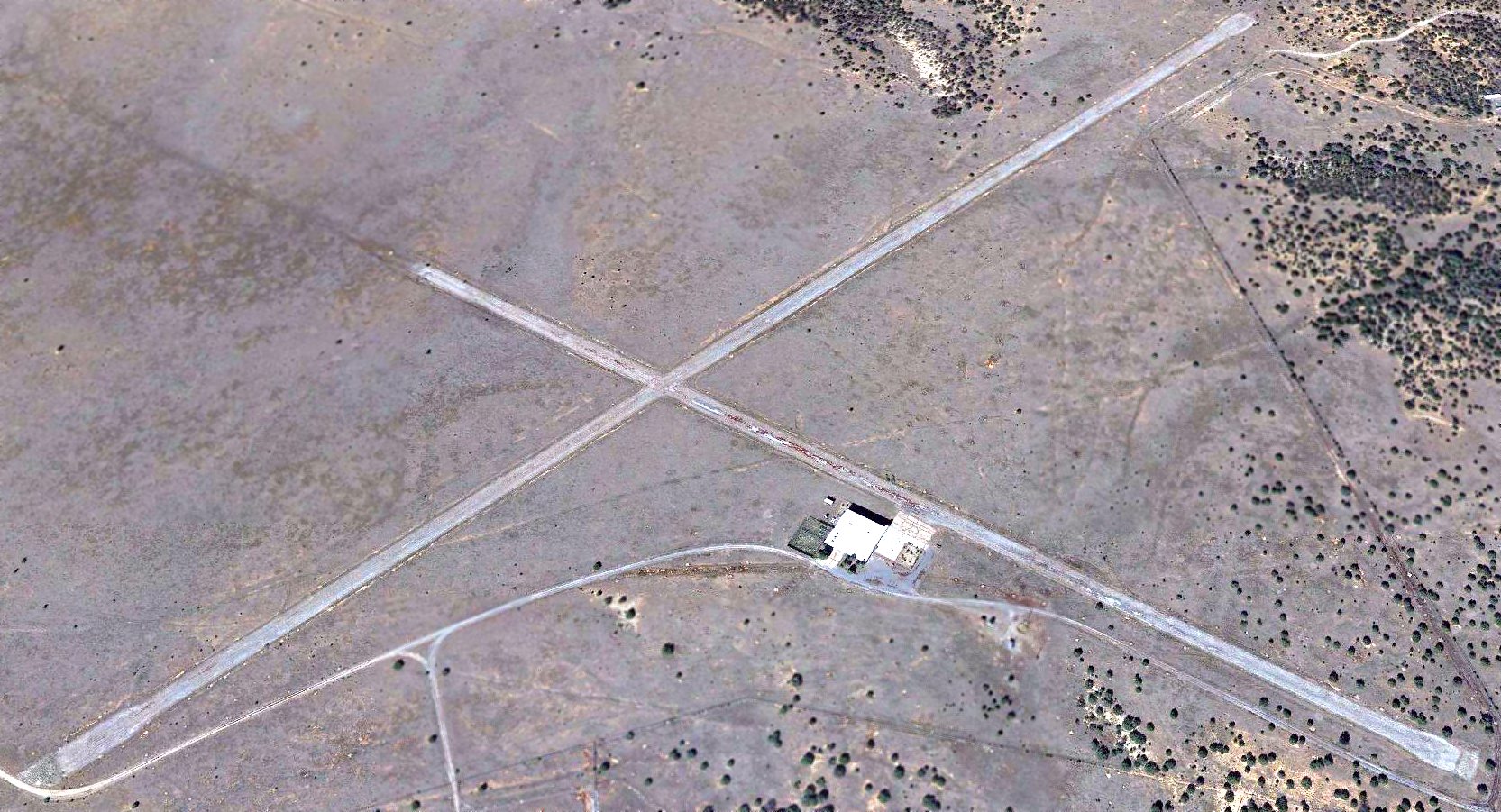
A 2015 aerial view looking northwest showed the CCES Airfield to remain intact, though the runways were somewhat deteriorated.
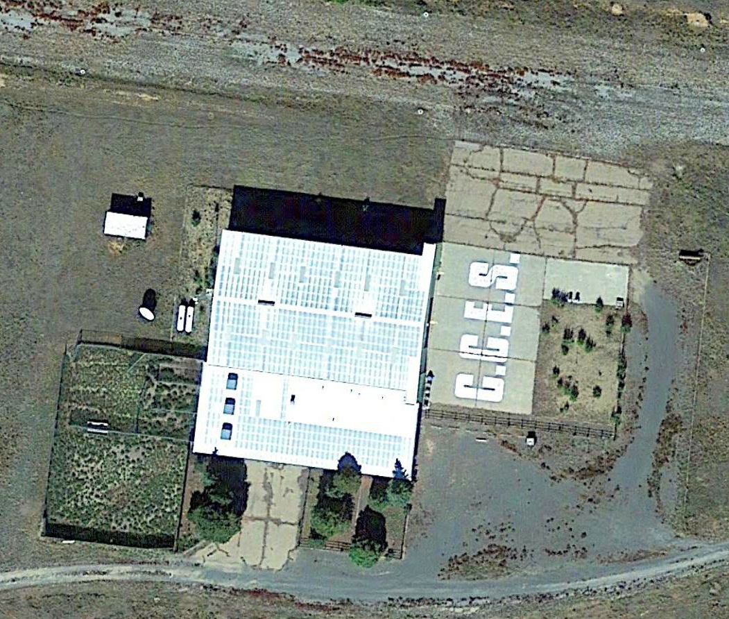
A 2015 aerial view of the CCES hangar & ramp.
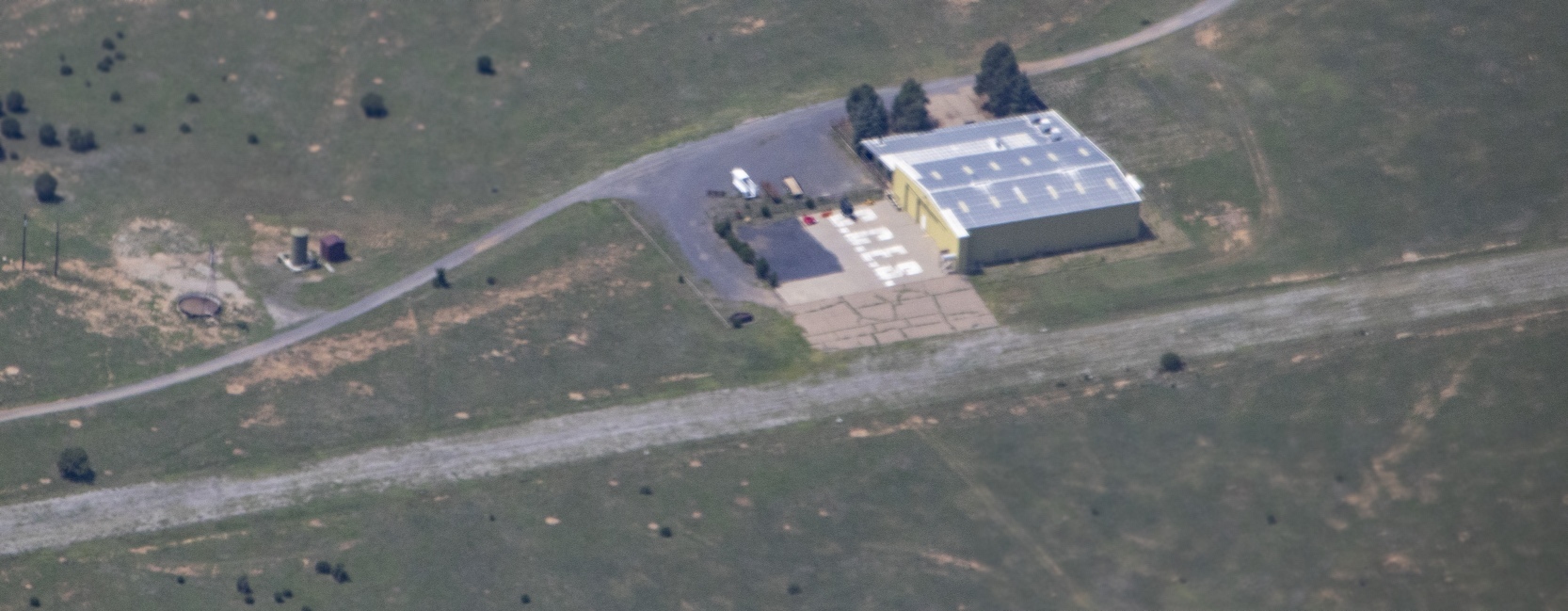
A September 2020 aerial view by Spencer Hamonds looking south at the CCES hangar, ramp, and runway remains.
Spencer Hamons reported, “It is marked on my Electronic Flight Bag as an emergency airfield, but I had to plot it myself as there is nothing on a Sectional.”
Thanks to John Love for pointing out this airfield.
______________________________________________________
(Original) Taos Airport / Kachina Airport / Downtown Airport, Taos, NM
36.38, -105.59 (Northeast of Albuquerque, NM)
Taos Airport, as depicted on the September 1946 Trinidad Sectional Chart
Photo of the airfield while open has not been located.
The original airport for the town of Taos was located on the southwest side of the town.
The Taos Airport was evidently established at some point in 1946,
as it was not yet depicted on the March 1946 Trinidad Sectional Chart.
The earliest depiction of the Taos Airport which has been located was on the September 1946 Trinidad Sectional Chart.
It depicted Taos as an auxiliary airfield.
The March 1949 Trinidad Sectional Chart (courtesy of Chris Kennedy) depicted Taos as having a 2,900' unpaved runway.
The last aeronautical chart depiction which has been located of the original Taos Airport was on the September 1952 Trinidad Sectional Chart.
It depicted Taos Airport as having a 2,900' unpaved runway.
The Taos Airport may have been closed at some point in 1952,
as it was not depicted at all on the October 1952 Trinidad Sectional Chart.
At some point around 1959, the airport was evidently reopened under the name of "Kachina"
as that is how it was listed in the 1959 Flight Guide (courtesy of Chris Kennedy).
It depicted Kachina as having 2 unpaved runways: 3,871, Runway 7/25 & 2,812' Runway 5/23.
Several buildings were depicted around a ramp at the northeast corner of the field.
A 1961 aerial photo depicted Kachina Airport as a barely recognizable east/west unpaved runway.
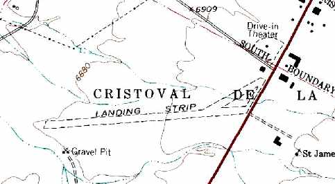
The original Taos Airport was labeled simply as "Landing Strip" on the 1964 USGS topo map,
and depicted as having a single unpaved southwest/northeast runway with a building on the northeast corner.
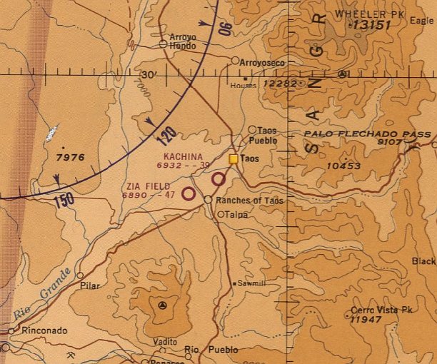
The March 1965 Trinidad Sectional Chart depicted Kachina Airport as having a 3,900' unpaved runway.
Kachina Airport was still depicted on the March 1969 Trinidad Sectional Chart.
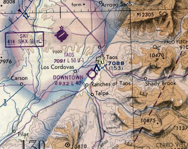
Kachina Airport was evidently renamed Downtown Airport at some point between 1969-74,
as that is how it was depicted on the 1974 Denver Sectional Chart (courtesy of Jonathan Westerling).
It depicted Downtown Airport as having a 4,000' unpaved runway.
Downtown Airport was evidently closed (after being replaced by the larger Taos Airport to the northwest) at some point between 1974-86,
as it was no longer depicted on the 1986 Denver Sectional Chart (courtesy of Jonathan Westerling).
The former Downtown Airport was still depicted in an unchanged fashion on the 1996 USGS topo map.
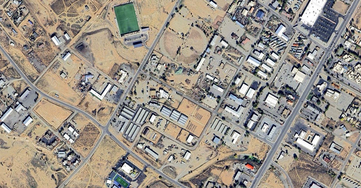
A 2025 aerial photo showed no trace remaining of Downtown Airport.
The site of Downtown Airport is located west of the intersection of Route 585 & Route 68.
______________________________________________________
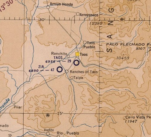
36.37, -105.64 (Northeast of Albuquerque, NM)
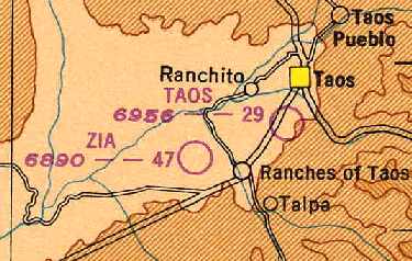
Zia Field, as depicted on the March 1949 Trinidad Sectional Chart (courtesy of Chris Kennedy).
Photo of the airfield while open has not been located.
This general aviation airport was evidently established at some point between 1945-49,
as it was not yet listed among active airfields in the 1945 AAF Airfield Directory (courtesy of Scott Murdock).
The earliest reference to Zia Field which has been located on the March 1949 Trinidad Sectional Chart (courtesy of Chris Kennedy).
It depicted Zia as having a 4,700' unpaved runway.
Zia Field had 3 unpaved runways: 4,700' Runway 8/26, 4,600' Runway 5/23, and 3,800' Runway 17/35.
The November 1957 Trinidad Sectional Chart (courtesy of David Brooks) depicted Zia Field as having a 4,700' unpaved runways.
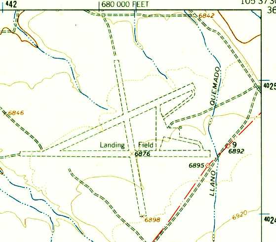
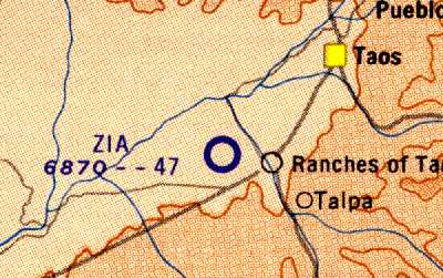
The 3 runways of Zia Field were still depicted on the 1964 USGS topo map, but it was labeled simply as "Landing Field".
An unpaved ramp was also depicted, east of the runway intersection, but no buildings were depicted.
The March 1965 Trinidad Sectional Chart depicted Zia Field as having a 4,700' unpaved runway.
Zia Field was described in the "Unattended Airports" section of the 1967 Flight Guide (according to Chris Kennedy)
as having 3 unpaved runways: 4,600' Runway 5/23, 2,700' Runway 8/26, and 3,800' Runway 17/35.
The last chart depiction of Zia as an active airfield which has been located
was on the February 1968 Trinidad Sectional Chart (according to Chris Kennedy).
Zia Field was evidently closed (for reasons unknown) at some point between 1968-74,
as it was no longer depicted on the 1974 Denver Sectional Chart (courtesy of Jonathan Westerling).
The 3 runways of Zia Field were still depicted on the 1979 USGS topo map,
but they were labeled simply as "Landing Strips", which typically indicates that the airfield was closed by that point.
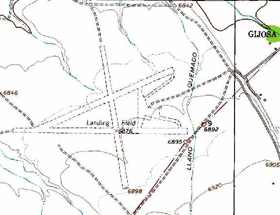
The 3 runways of Zia Field were still depicted on the 1996 USGS topo map, but it was labeled simply as "Landing Field".
An unpaved ramp was also depicted, east of the runway intersection, but no buildings were depicted.
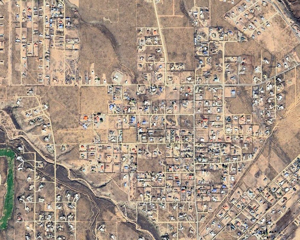
A 2025 aerial photo showed houses covering the site of Zia Field.
Zia Field is located west of the intersection of Cuchilla Road & West Romero Road.
____________________________________________________
Or if you prefer to contact me directly concerning a contribution (for a mailing address to send a check),
please contact me at: paulandterryfreeman@gmail.com
If you enjoy this web site, please support it with a financial contribution.
____________________________________________________
This site covers airfields in all 50 states.