Abandoned & Little-Known Airfields:
Southern Mississippi
© 2002, © 2026 by Paul Freeman. Revised 2/15/26.
____________________________________________________
Please consider a financial contribution to support the continued growth & operation of this site.
Alexander Airport / Picayune Airport / Alexandria Airport (revised 6/17/20) - Canton Airfield (revised 10/29/23) - CGAS Biloxi / Soule Seaplane Base / Rogers Seaplane Base (revised 2/15/26)
Forest Home Airport (added 8/11/20) - Hancock County Airport (revised 9/15/21) - K&R Airport / King Riddell Airport (added 10/19/19) - Natchez Airpark (added 7/4/19)
Raby Field / Pascagoulga Airport (1st location) / Jackson County Airport (revised 12/7/24) - Pascagoula Airport (2nd location) / Jackson County Airport (revised 9/15/21)
Picayune Municipal Airport (2nd location) / Picayune Pearl River County Airport (revised 10/25/21)
____________________________________________________
Coast Guard Air Station Biloxi / Soule Seaplane Base / Rogers Seaplane Base, Biloxi, MS
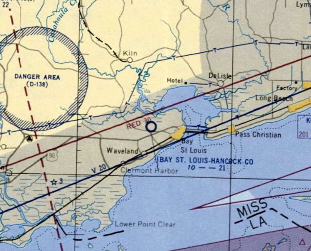
30.394, -88.858 (Northeast of New Orleans, LA)
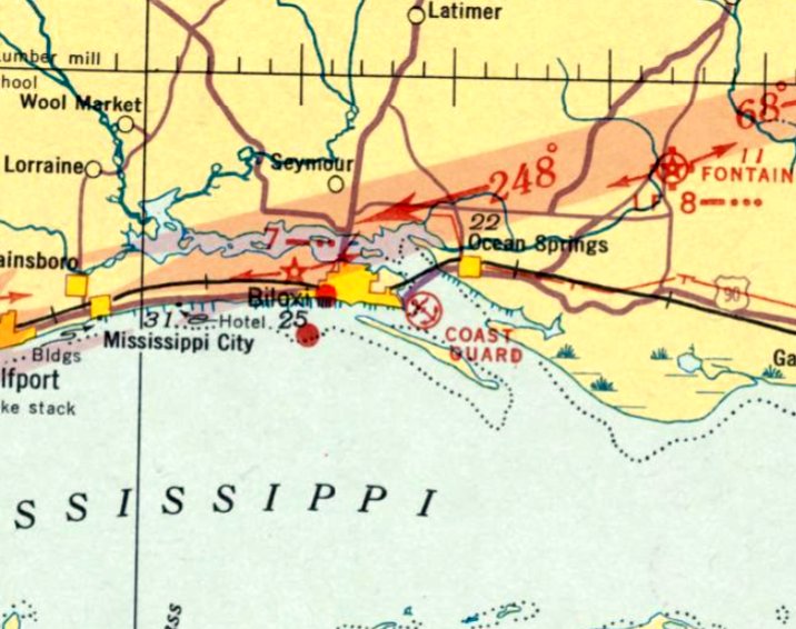
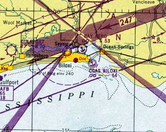
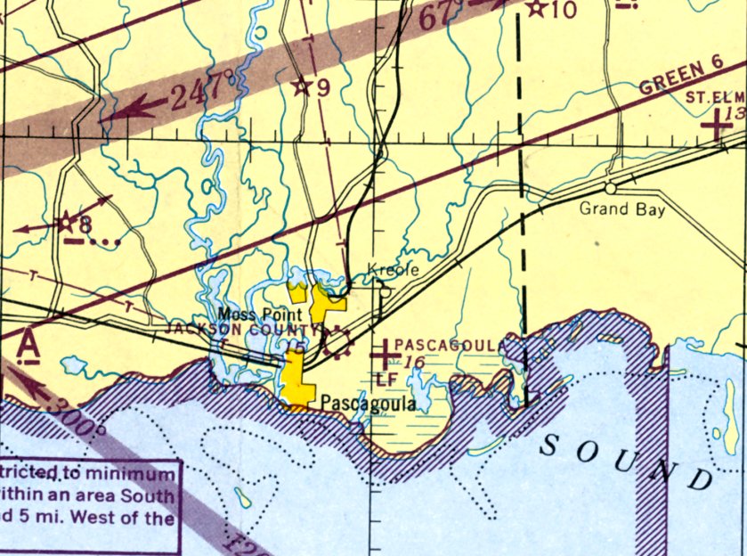
Coast Guard Air Station Biloxi, as depicted on the August 1935 Mobile Sectional Chart.
According to Ted Morris, “To provide more effective life saving using aircraft along the south coast, Coast Guard officials began a search for locations to place Air Stations.
Each would be equipped with a radio station & 3 or 4 amphibians or seaplanes, several of which would be classified as Air Ambulances.
These aircraft, capable of not only conducting aerial searches over the vast Gulf waters, were also able to land at sea, pick up ill or injured patients, and return them to needed medical care.
One well-situated site was Biloxi, Mississippi.”
Ted continued, “The Coast Guard team of LCdr C.G. von Paulsen, W.R. Kenley and M.P. Ulte conferred with Biloxi City Commissioners to find waterfront property suitable for an Air Station.
The City fathers made the 6 acre Point Cadet Park available.
It was ideally suited for an amphibian base, located on Biloxi's eastern edge with direct access to Biloxi Bay.”
Ted continued, “On 9/21/33, Mississippi Senator Pat Harrison & City Commissioner John Swanzy announced
that President Roosevelt had signed the bill authorizing $290,000 for construction of the Coast Guard Air Station Biloxi.
Initially, $100,000 of Public Works Administration funds were made available to begin clearing the land, dredging of Biloxi Bay, building a concrete seawall and constructing a seaplane ramp.
Also included was the construction of the 120' x 100' foot steel-framed, asbestos-sided hangar, with offices and maintenance shops along each side.
In addition, there were the aircraft parking & operating areas to be built, as well as the radio station.
Bids were opened & the winner, B. Knost & Company of Pass Christian began construction in November 1933.
The remaining $190,000 was spent in later years for a barracks, mess hall, garage and crash boat dock.”
The earliest depiction which has been located of Coast Guard Air Station Biloxi was on the August 1935 Mobile Sectional Chart.
It depicted “Coast Guard” as a seaplane base.
Ted continued, “Until the barracks & mess hall were completed in 1938, personnel had to find housing & messing in Biloxi.”
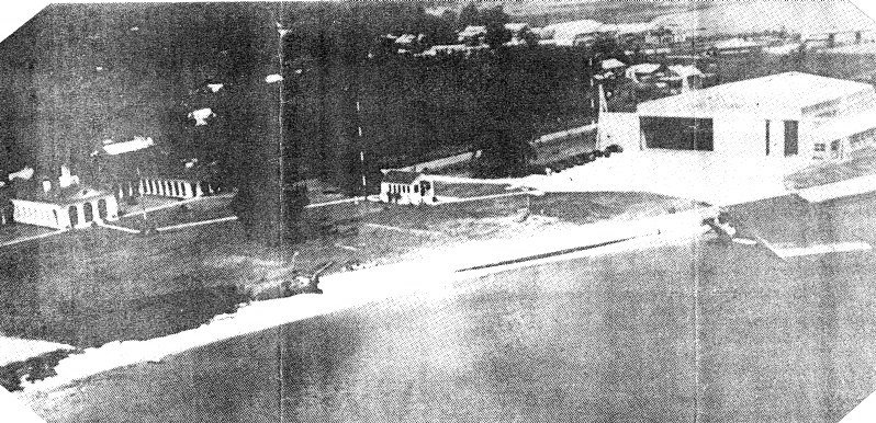
The
earliest photo which has been located of Coast Guard Air Station
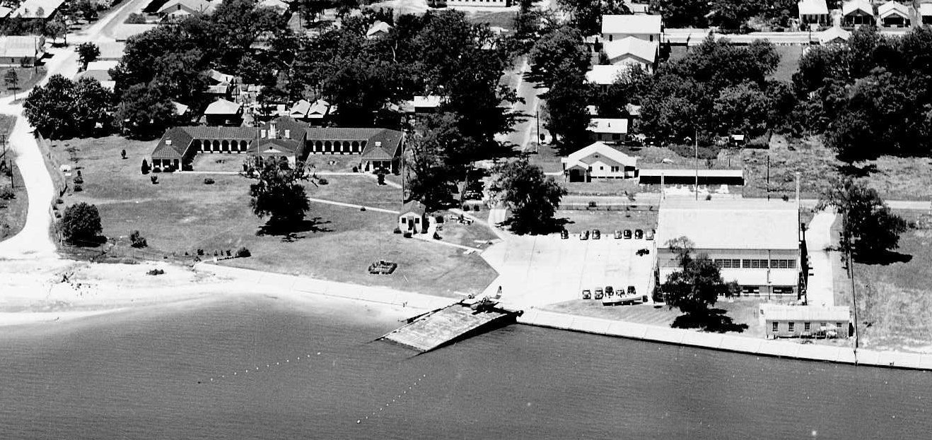
Biloxi was a 1938 aerial view by Tony Ragusim looking northwest.
Ted Morris observed, “In 1938, the Coast Guard Air Station had about 18 acres.
Shown here is the 12,000 square foot hangar with offices & shops, the paved aircraft parking area, and the seaplane ramp.
The small building at center is the radio station. Two wings of the E-shaped barracks & mess hall are at the left.
The highway bridge across Biloxi Bay to Ocean Springs is visible above the hangar.”
According to Ted Morris, “On 12/5/34, the Air Station & Coast Guard Radio Station 'NOX' were placed in commission, with Lt. W.S. Anderson as Commanding Officer.
A big ceremony was planned, including a fly-over by 3 large Navy patrol planes from Pensacola, ribbon cutting, and the arrival of the first 2 Coast Guard Grumman JF-2 amphibian aircraft.
It was all to be covered by Fox Movietone news, but the event was canceled due to very bad weather.
Everything, that is, except the arrival of the Coast Guard amphibians.
The first, JF-2 #163, was flown by Lt.Cdr. von Paulsen with Aviation Chief Machinist Mate Eddie English as crew member,
and the second, JF-2 #164, flown by Lt. E.E. Fahey with ACMM P.D. Hinder as crew member. The Air Station was in operation!”
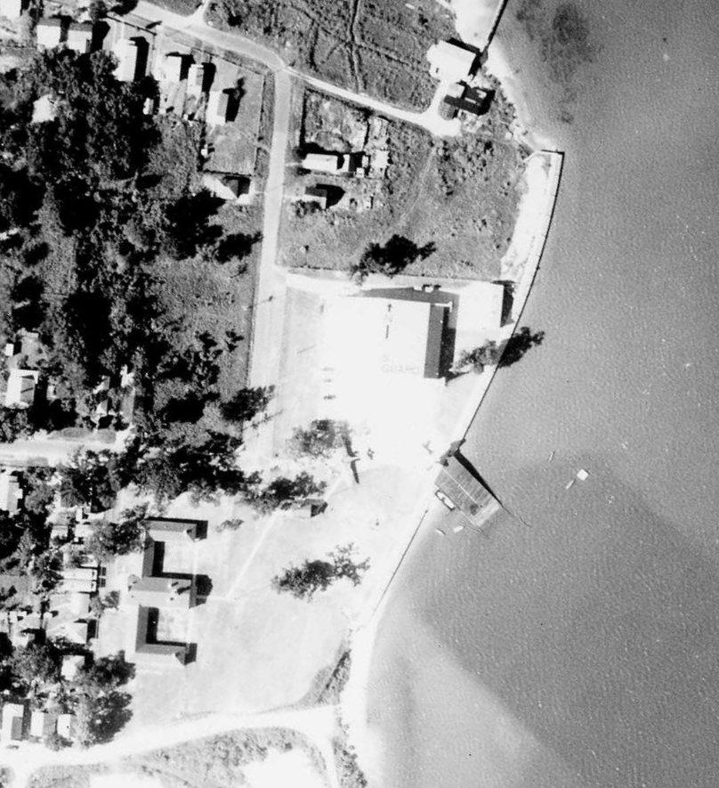
A 9/28/37 aerial view (from the National Archives, courtesy of David Upton) depicted Coast Guard Air Station Biloxi
as having an administration building, hangar, apron, and seaplane ramp, and 2 seaplanes were visible.
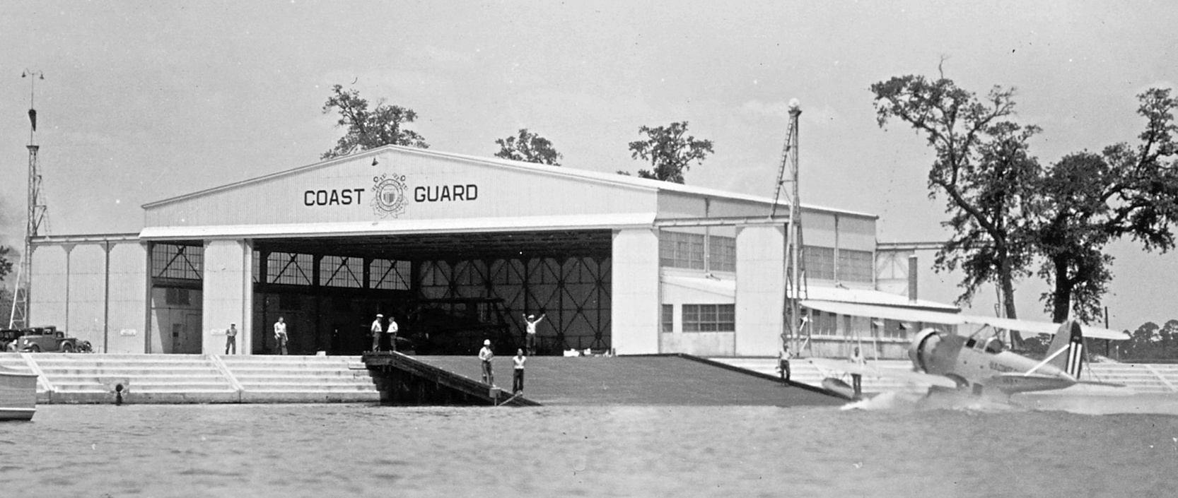
A circa 1936-42 Coast Guard photo (courtesy of David Upton) of a Coast Guard JF2 biplane floatplane coming up the ramp at CGAS Biloxi.
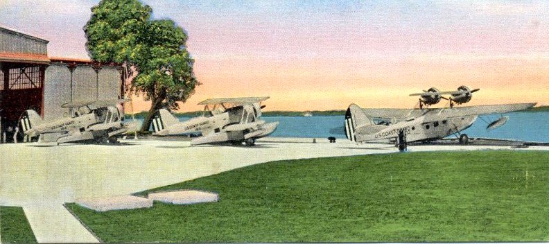
A circa 1938 colorized postcard photo of 2 JF2s & a PJ-1 on the CGAS Biloxi ramp.
A 4/24/41 aerial view looking west (from the National Archives, courtesy of David Upton) depicted Coast Guard Air Station Biloxi
as having an administration building, hangar, apron, and a twin-engine Grumman seaplane on the seaplane ramp.
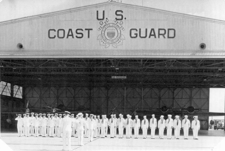
A 1946 photo of general muster of all hands at Coast Guard Air Station Biloxi, with 2 J4F-1s & 2 JRF-5s in the hangar.
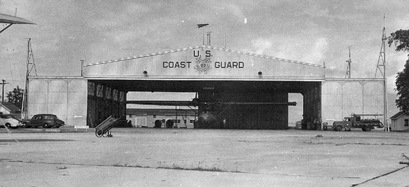
The last photo which has been located of Coast Guard Air Station Biloxi was a 1946 photo of a Consolidated PBY-5A undergoing maintenance inside the hangar,
with the wingtip of another PBY-5A is just visible at upper left, and the station's fire truck to the right of the hangar.
According to Ted Morris, “Biloxi was one of the smaller Air Stations, designed for pre-war biplanes capable of operations in relatively shallow water.
The post-war aircraft were proving larger & heavier than could safely be operated on Biloxi Bay, especially at low tide with a wind from the west.
One partial solution was to base the ready rescue aircraft & crew at Keesler Army Air Base,
but this proved to be time-consuming & awkward, and plans were made to relocate the assets of Coast Guard Air Station Biloxi.
In March 1947, the Air Station was placed in caretaker status.
The hurricane of 1947 did severe damage to the Air Station, especially the wartime built facilities,
and the land, hangar, seaplane ramps, original barracks & mess hall were turned over to the city of Biloxi.
These were used by elements of the Mississippi Army National Guard for several years.
Most of the station's personnel, aircraft & equipment were transferred to other Coast Guard Air Stations.
One of the station's aircraft (PBY-5A 46502) and a crew were established as a detachment at Keesler.”
The last aeronautical chart depiction which has been located of Coast Guard Air Station Biloxi was on the February 1949 Mobile Sectional Chart.
It depicted “CGAS Biloxi” as a seaplane base.
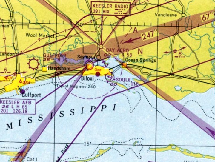
The former CGAS Biloxi was apparently reused at some point in 1949 as a seaplane base named “Soule”, as that is how it was depicted on the August 1949 Mobile Sectional Chart.
Soule Seaplane Base was still depicted on the February 1950 Mobile Sectional Chart.
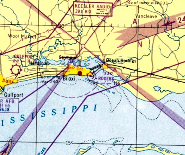
Soule Seaplane Base was apparently renamed Rogers at some point in 1950, as that is how it was depicted on the August 1950 Mobile Sectional Chart.
The last depiction which has been located of Rogers Seaplane Base was on the August 1951 Mobile Sectional Chart.
Rogers Seaplane Base was evidently closed (for reasons unknown) at some point between 1951-52, as it was no longer depicted on the February 1952 Mobile Sectional Chart.
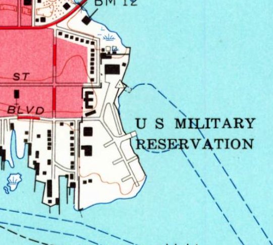
The former CGAS Biloxi was still labeled “US Military Reservation” on the 1954 USGS topo map,
so it presumably remained military property after the Coast Guard facility closed.
The 1967 USGS topo map depicted the CGAS Biloxi site unchanged.
The 1971 USGS topo map showed the Biloxi Bay Bridge had been built through the southern portion of the CGAS Biloxi site.
A 2005 aerial photo showed the former CGAS Biloxi administration building & seaplane hangar remained, but had sustained hurricane damage.
A 2006 aerial photo showed the former CGAS Biloxi seaplane hangar remained standing, but the administration building had been removed.
A 2007 aerial photo showed the former CGAS Biloxi seaplane hangar had been removed at some point between 2006-2007.
A 2015 aerial photo showed a new building for the Maritime & Seafood Industry Museum had been built on the site of the CGAS Biloxi administration building,
and a new Point Cadet park building had been built on the site of the CGAS Biloxi hangar & apron.

A 2019 aerial view looking northwest showed no recognizable trace of the former CGAS Biloxi seaplane base.
Thanks to David Upton for pointing out this airfield.
____________________________________________________
Forest Home Airport (MS23), Woodville, MS
31.007, -91.203 (North of Baton Rouge, LA)
Forest Home Airport, as depicted on a 1996 USGS aerial view looking west.
This short-lived small private airfield was not yet depicted on a 1983 aerial photo or the 1988 USGS topo map.
According to Jim Weller, Forest Home Airport was built in 1995.
The earliest depiction which has been located of Forest Home Airport was a 1996 USGS aerial view looking west.
It appeared to show the airport just having been constructed, with a new asphalt northwest/southeast runway, and a hangar on the east side.
According to Jim Weller, Forest Home Airport was disused after 2000.
A 2006 aerial photo showed no markings on the Forest Home Airport runway.
According to Jim Weller, various sources listed the Forest Home Airport owner as Boatner Howell.
Jim reported, “He was a friend of my parents; he died in 2007.”
A 2007 aerial photo showed multiple yellow closed-runway “X” symbols having been painted on the Forest Home Airport runway.
The 2012 USGS topo map depicted Forest Home Airport as having a single paved northwest/southeast runway.
According to Jim Weller, Forest Home Airport “was stricken from the FAA airport list in August 2013.”
The 2015 USGS topo map no longer depicted Forest Home Airport.
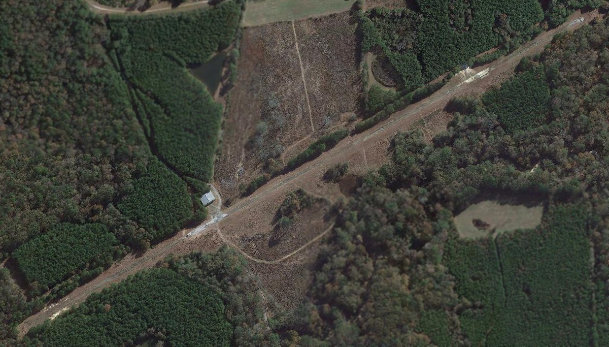
A 2019 aerial view looking west showed the remains of Forest Home Airport, with the paved runway deteriorated but intact, and several closed-runway “X” symbols still visible.
The hangar also remained intact.
Thanks to Jim Weller for pointing out this airfield.
____________________________________________________
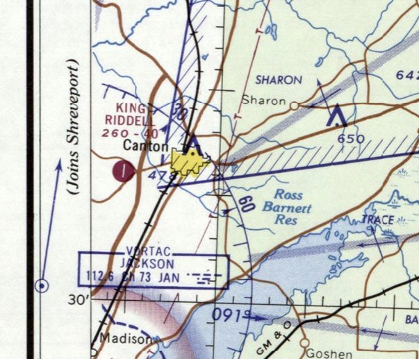
32.598, -90.069 (North of New Orleans, LA)
The Canton Airfield, as depicted on a 1/21/84 USGS aerial view.
Not much is known about this small cropdusting airfield.
It may have been established at some point between 1975-82,
as it was not yet depicted on the 1975 USGS topo map.
The earliest depiction which has been located of the Canton Airfield was on a 1982 aerial photo.
It depicted a very narrow asphalt runway squeezed into a narrow plot of land paralleling the east side of Interstate 55.
A total of 6 light single-engine planes were visible near a small hangar on the south end.
Charlie reported, “It had a couple thousand feet of 15-20' wide asphalt to help the agricultural planes get off the ground with a full load.
Part of my pleasure/torture during flight training in a Luscombe 8A was landing on this strip of pavement narrower than the Luscombe's wingspan.
My instructor liked to visit the ag pilot, who was a good friend.
In fact, I met my instructor at this airport when I drove by & stopped to see if they had a suitable training aircraft for sale.
The ag pilot built a new strip, 4MS9 when the town wanted to develop the land of the original strip.”
A 1983 aerial photo only showed a single plane on the field.
A 1/21/84 USGS aerial did not appear to show any planes on the field.
The 1989 USGS topo map depicted a single paved north/south runway, generically labeled “Landing Strip”,
with 2 small buildings on the southeast side.
Michael Meek recalled, “Canton Airfield was an agricultural airstrip operated by Kerry Rudder.
I used to see AgCats operating from this field when driving by on I-55 30 years or so ago [circa 1991].
The hangar was quite nice, as was the strip itself.”
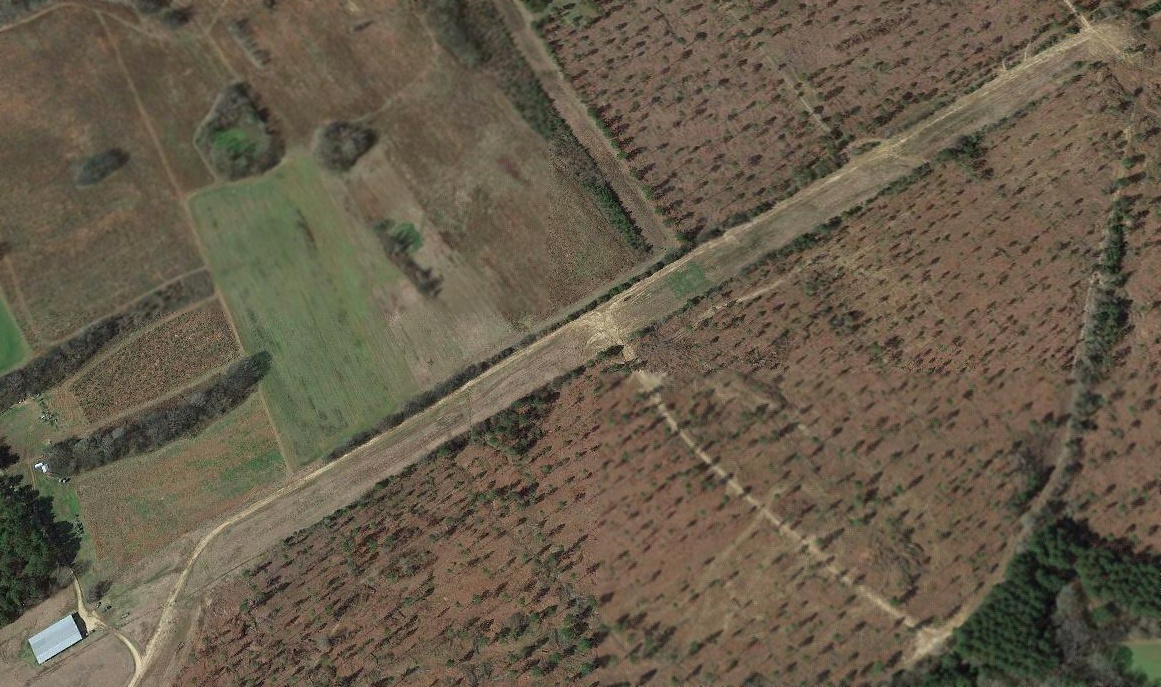
A 2019 aerial view looking northwest showed the remains of the Canton Airfield, with the remains of the middle portion of the runway, and one hangar remaining on the southeast end.
Charlie reported in 2019, “You can still see some evidence of the strip; it now has a car dealership & a La Quinta Inn covering the north end.”
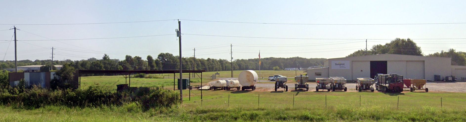
A 2023 photo looking east at the 2 former Canton Airfield hangars.
Thanks to Charlie for pointing out this airfield.
____________________________________________________
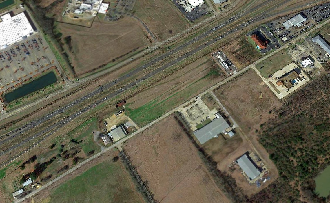
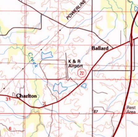
K&R Airport / King Riddell Airport, Canton, MS
32.596, -90.102 (North of New Orleans, LA)
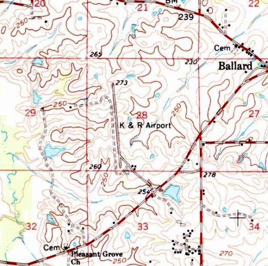
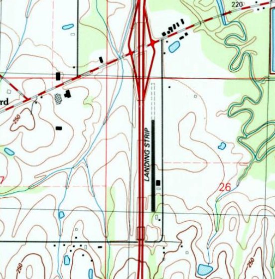
K&R Airport, as depicted on the 1961 USGS topo map.
Michael Meek recalled, “I had a couple of friends who crewed a DC-3 & a Twin Beech off King Riddell Airport back in the late 1950s / early 1960s for King Lumber Company of Canton.”
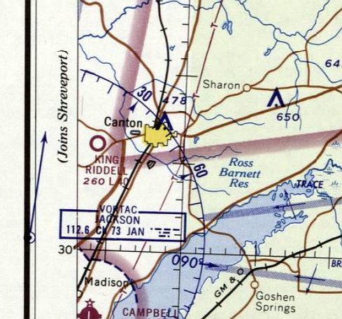
King Riddell Airport / K&R Airport was not yet depicted on the February 1961 Birmingham Sectional Chart.
The earliest depiction which has been located of K&R Airport was on the 1961 USGS topo map.
It depicted K&R Airport as having a single paved northwest/southeast runway, with 3 small buildings on the southeast side.
At some point between 1961-65 the airport was evidently renamed King Riddell Airport,
as that is how it was depicted on the April 1965 Birmingham Sectional Chart.
It depicted King Riddell Airport as having a 4,000' unpaved runway.
The last aeronautical chart depiction which is available of King Riddell Airport was on the April 1968 Birmingham Sectional Chart.
It depicted King Riddell Airport as having a 4,000' paved northeast/southwest runway,
a slightly different orientation than that depicted on the 1961 USGS topo map.
Strangely, the 1984 USGS topo map continued to depict the airport under the name of “K&R Airport”,
and also with a slightly different runway orientation than that shown on aeronautical charts.
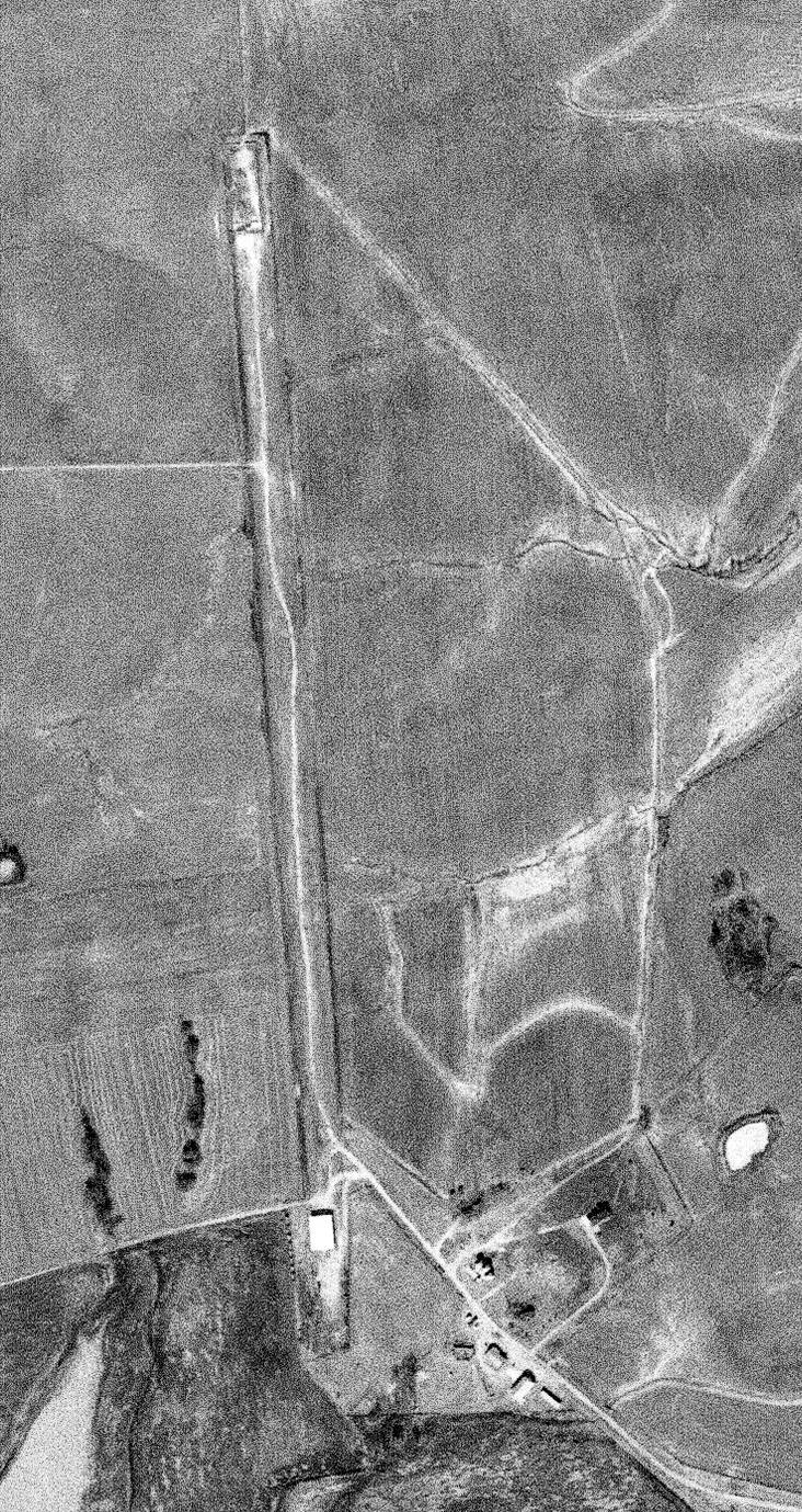
K&R Airport was evidently abandoned (for reasons unknown) at some point between 1968-84,
as a 1/21/84 USGS aerial photo depicted remains of a northwest/southeast runway, with a building directly on each end of the runway.
A 2019 aerial view looking northwest showed the remains of the former K&R Airport runway, with a building directly on the southeast end.
The site of K&R Airport is located northwest of the intersection of Route 22 & Nissan Parkway.
____________________________________________________
31.585, -91.382 (Northwest of New Orleans, LA)
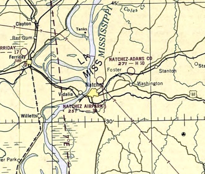
Natchez Airpark, as depicted on the February 1950 Beaumont Sectional Chart.
This small general aviation airport was evidently established at some point between 1949-50,
as it was not yet depicted on the 1949 USGS topo map or the August 1949 Beaumont Sectional Chart.
The earliest depiction which has been located of Natchez Airpark was on the February 1950 Beaumont Sectional Chart.
It depicted Natchez Airpark as having a 3,000' unpaved runway.
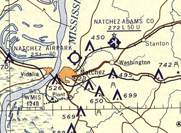
The last aeronautical chart depiction which has been located of Natchez Airpark was on the February 1960 Beaumont Sectional Chart (courtesy of Lee Corbin).
It depicted Natchez Airpark as having a 3,000' unpaved runway.
The earliest photo which has been located of Natchez Airpark was a 1962 aerial view.
It depicted Natchez Airpark as having an unpaved north/south runway & a hangar on the northwest side, but there was no sign of any aircraft.
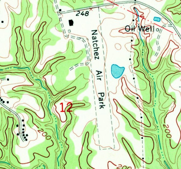
The 1963 USGS topo map (courtesy of Lee Corbin) depicted “Natchez Air Park” as having an unpaved north/south runway
and 2 small buildings on the northwest side.
The 1977 USGS topo map continued to depict Natchez Air Park in an unchanged fashion.
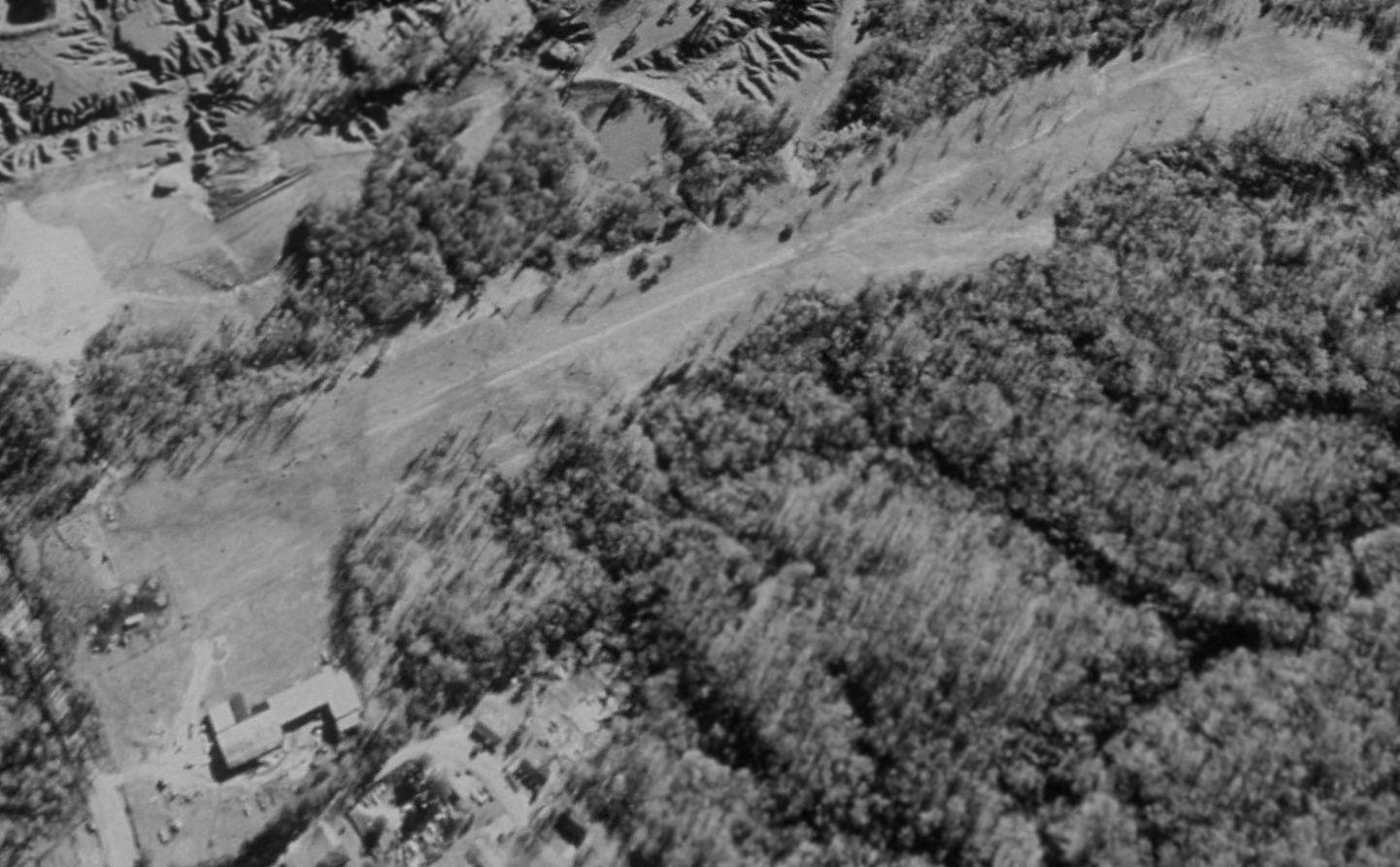
The earliest photo which is available of Natchez Airpark was a 1998 USGS aerial view looking southeast.
It depicted Natchez Airpark as having an unpaved north/south runway & a hangar on the northwest side, but there was no sign of any aircraft or other recent aviation use.
Natchez Airpark was evidently closed at some point between 1977-2012,
as the 2012 USGS topo map labeled it “Homewood Oil Field” - unfortunately a more lucrative property use than a small airport.
A 2012 aerial view looking southeast showed the site of Natchez Airpark remained intact, including the somewhat overgrown unpaved north/south runway & the hangar on the northwest side.
A 2012 aerial view looking southeast showed the former Natchez Airpark hangar.
Thanks to Lee Corbin for pointing out this airfield.
____________________________________________________
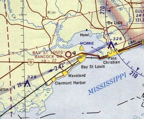
Hancock County Airport, Bay St. Louis, MS
30.31, -89.38 (Northeast of New Orleans, LA)
A 4/6/52 USGS aerial photo (courtesy of Dallam Oliver-Lee) depicted Hancock County Airport as having a single northwest/southeast unpaved runway.
Hancock County Airport was evidently established at some point between 1952-53,
as it was not yet depicted on the August 1952 Mobile Sectional Chart.
The earliest photo which has been located of this airfield was a 4/6/52 USGS aerial photo (courtesy of Dallam Oliver-Lee).
It depicted Hancock County Airport as having a single northwest/southeast unpaved runway.
The earliest aeronautical chart depiction which has been located of Hancock County Airport was on the February 1953 Mobile Sectional Chart.
It depicted Bay St. Louis - Hancock County Airport as having a 2,100' unpaved runway.
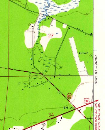
The 1956 USGS topo map (courtesy of Dallam Oliver-Lee)
depicted Hancock County Airport as a single unpaved northwest/southeast runway, labeled simply as “Airfield”,
with 2 small buildings on the southeast side.
Hancock County Airport, as depicted on the 1957 USGS topo map (courtesy of Dallam Oliver-Lee).
Hancock County Airport was still labeled on the 1963 USGS topo map (courtesy of Dallam Oliver-Lee).
A May 1964 NASA aerial photo (courtesy of Dallam Oliver-Lee) depicted a few more small buildings on the southeast side of Hancock County Airport,
along with possibly one light aircraft.
The last aeronautical chart depiction which has been located of Hancock County Airport was on the 1965 New Orleans Sectional Chart.
It depicted Hancock County as having a 2,200' unpaved runway.
Hancock County Airport was evidently closed at some point between 1965-71,
as it was no longer depicted on the January 1971 New Orleans Sectional Chart (courtesy of Ron Plante).
A 2/19/92 USGS aerial photo (courtesy of Dallam Oliver-Lee)
depicted some larger buildings having been built on the southern end of the runway, along with a small building on the north end,
probably indicating the closure of the airport.
The 1997 USGS topo map (courtesy of Dallam Oliver-Lee)
still depicted a single unpaved northwest/southeast runway, labeled simply as “Airfield”.
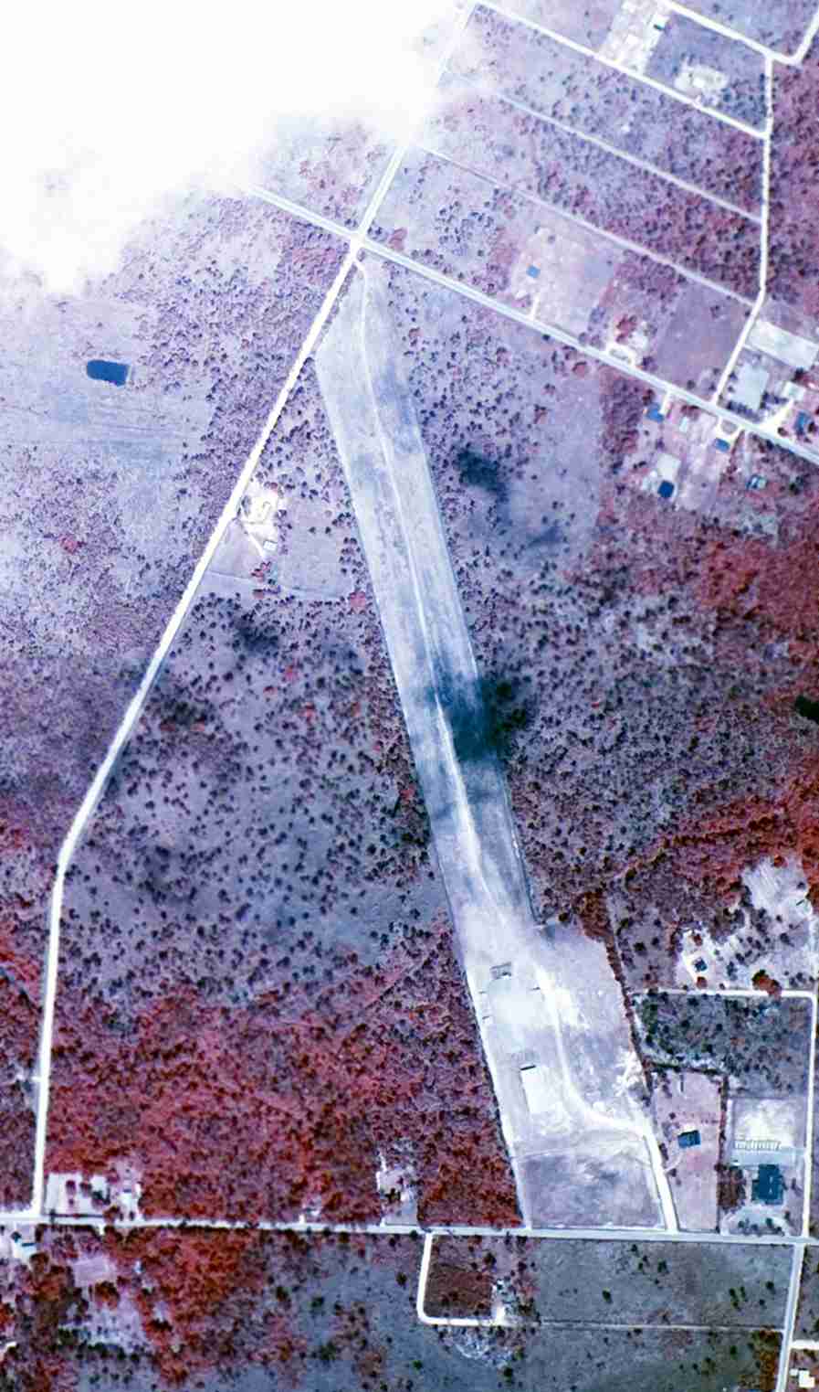
A 10/29/12 aerial photo (courtesy of Dallam Oliver-Lee) showed that the runway outline of the former Hancock County Airport remains recognizable.
The site of Hancock County Airport is located southeast of the intersection of Washington Street & Chapman Road.
Thanks to Dallam Oliver-Lee for pointing out this airfield.
____________________________________________________
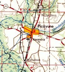
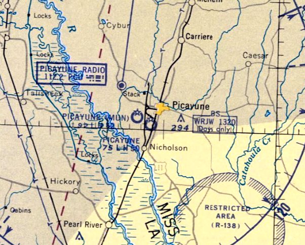
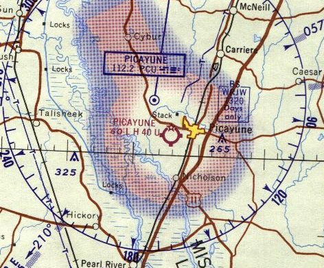
Alexander Airport / Picayune Airport / Alexandria Airport, Picayune, MS
30.52, -89.69 (Northeast of New Orleans, LA)
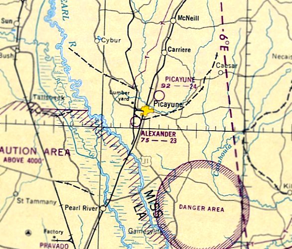
Alexander Airport, as depicted on the February 1950 Mobile Sectional Chart.
Alexander Airport, on the southwest side of Picayune,
was evidently established at some point between 1949-50,
as it was not yet depicted on the August 1949 Mobile Sectional Chart.
The earliest depiction which has been located of Alexander Airport was on the February 1950 Mobile Sectional Chart.
It depicted Alexander Airport as having a 2,300' unpaved runway.
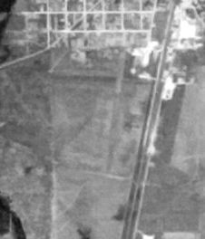
The earliest photo which has been located of Alexander Airport was a 5/12/52 USGS aerial photo (courtesy of Dallam Oliver-Lee).
It depicted Alexander Airport as having 2 unpaved runways.
The 1953 USGS topo map (courtesy of Dallam Oliver-Lee) labeled the field as Picayune Airport.
A 2/27/53 USGS aerial photo of Picayune Airport (courtesy of Dallam Oliver-Lee) showed one single-engine aircraft parked on the north end of a single unpaved north/south runway.
Some small hangars were located on the north side.
It was still depicted as Alexander Airport on the February 1957 Mobile Sectional Chart,
with a 2,200' unpaved runway.
The August 1957 Mobile Sectional Chart depicted the former Alexander Airport under a new name, Picayune Airport, with a 5,000' paved runway.
The 1957 USGS topo map (courtesy of Dallam Oliver-Lee) labeled the field under yet another name, “Alexandria” Airport.
The 1958 USGS topo map (courtesy of Dallam Oliver-Lee) no longer depicted the Picayune Airport on the southwest side of the town,
instead depicting the new Picayune Municipal Airport on the west side of town.
The last aeronautical chart depiction which has been located of the Picayune Airport on the southwest side of the town was on the March 1960 Mobile Sectional Chart.
It depicted Picayune Airport as having a 5,000' paved runway.
The Picayune Airport on the southwest side of the town was evidently closed at some point between 1960-61,
as it was no longer depicted on the February 1961 Mobile Sectional Chart.
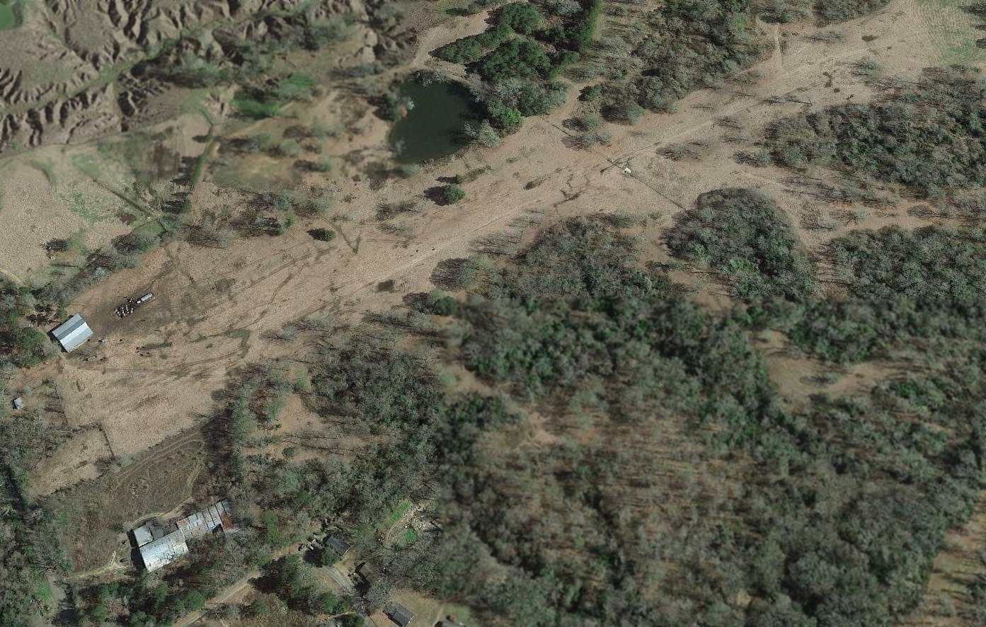
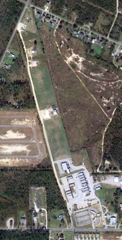
An 11/30/11 aerial view appears to show that at least one hangar from Alexander Airport remains intact.
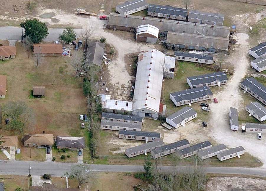
A circa 2011 aerial view looking east at a remaining hangar from Alexander Airport.
The site of Alexander Airport is located south of the intersection of Bruce Street & Hunt Street.
Thanks to Dallam Oliver-Lee for pointing out this airfield.
____________________________________________________
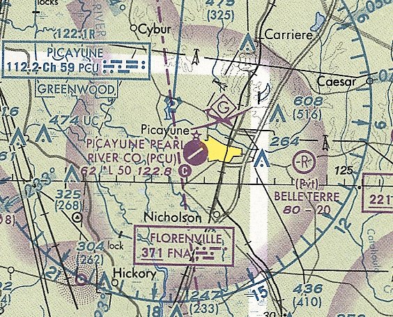
Picayune Municipal Airport (2nd location) (PCU) / Picayune Pearl River County Airport, Picayune, MS
30.52, -89.71 (Northeast of New Orleans, LA)
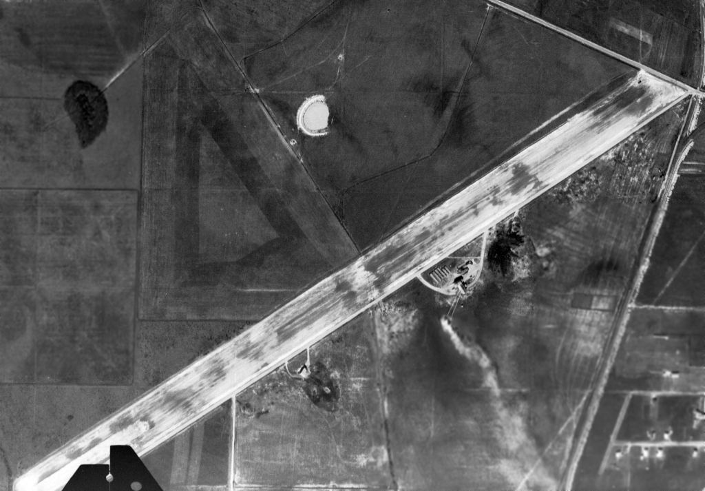
A 2/24/54 USGS aerial photo (courtesy of Dallam Oliver-Lee) depicted the paved runway of the 2nd location of the Picayune Municipal Airport under construction,
as well as a possible predecessor set of 3 unpaved runways.
The 2nd location of Picayune Municipal Airport (west of the town of Picayune) was evidently established at some point in 1954,
as a 2/24/54 USGS aerial photo (courtesy of Dallam Oliver-Lee) depicted a paved northeast/southwest runway under construction,
as well as a possible predecessor set of 3 unpaved runways located adjacent to the northwest side of the new paved runway.
The 2nd location of Picayune Municipal Airport was not yet depicted on the August 1957 Mobile Sectional Chart
or the 1957 USGS topo map (courtesy of Dallam Oliver-Lee).
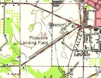
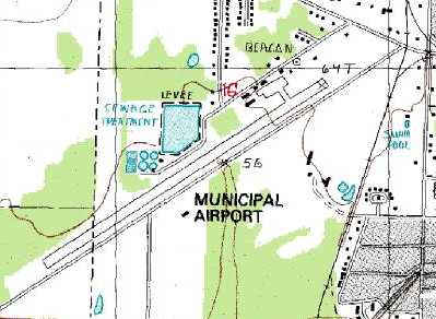
The 1958 USGS topo map (from the University of Alabama Map Library)
depicted the "Picayune Landing Field" as having a single northeast/southwest paved runway,
with a ramp & a beacon at the northeast corner of the field.
The earliest aeronautical chart depiction which has been located of the 2nd location of Picayune Municipal Airport was on the February 1958 Mobile Sectional Chart.
It depicted Picayune Municipal Airport as having a 4,000' paved runway.
The 1960 Jeppesen Airway Manual (courtesy of Chris Kennedy)
depicted Picayune Municipal as having a single 4,000' paved Runway 4/22,
along with a taxiway leading to a ramp on the northwest side of the runway with two buildings (hangars?).
The 1962 AOPA Airport Directory described the "City of Picayune" Airport as having a single 4,000' concrete Runway 4/22.
The 1964 Mobile Sectional Chart depicted the 2nd location of Picayune Municipal Airport as having a 4,000' paved runway.
The 1982 AOPA Airport Directory (courtesy of Ed Drury) described the "Picayune Pearl River County" Airport as having a single 4,000' asphalt Runway 5/23,
and listed the operator as Ray's Flight Service.
The 1985 USGS topo map depicted Picayune Municipal Airport as having a single northeast/southwest runway.
As depicted in a 1996 USGS aerial view looking south, Picayune Municipal consisted of a single paved 4,200' Runway 5/23.
A ramp with several hangars was situated on the northeast corner of the field, on which were parked at least 14 light aircraft,
and another small hangar was on the south side of the runway.
David Sims recalled, “I was one of the last pilots to use this airfield.”
The last aeronautical chart depiction which has been located of the 2nd location of Picayune Municipal Airport
was on the June 1999 New Orleans Sectional Chart (courtesy of Ron Plante).
It depicted Picayune as having a single 4,000' paved northeast/southwest runway.
In 1999, a new & larger Picayune Municipal Airport was opened on the southeast side of the town,
and the original airfield was presumably closed at the same time.
The original airport was depicted as an abandoned airfield on the 2003 Sectional Chart.
David Sims reported in 2005, “The property is & has always been owned by the Picayune school district.
After it was closed, the airstrip was used by a company to store large metal structures.
It is currently being used by FEMA for victims of Hurricane Katrina.
FEMA has set up several trailers on the old airfield to serve as temporary housing for relief workers & survivors.”
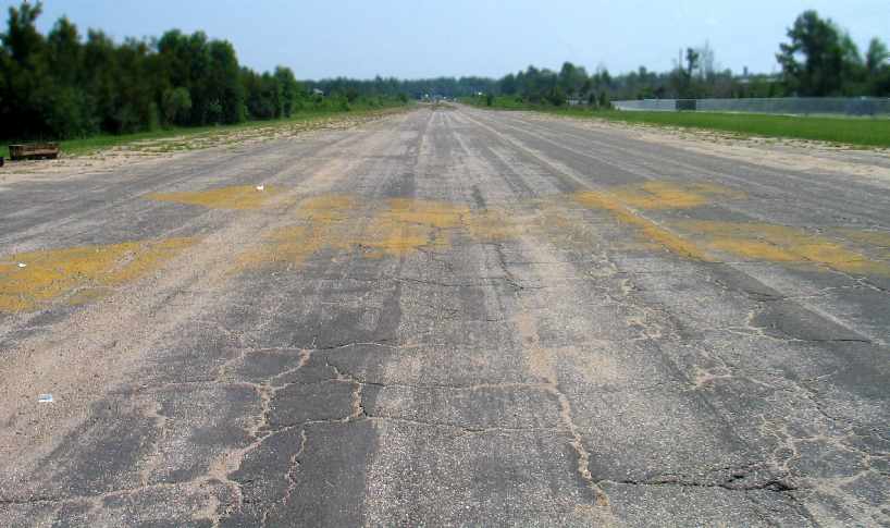
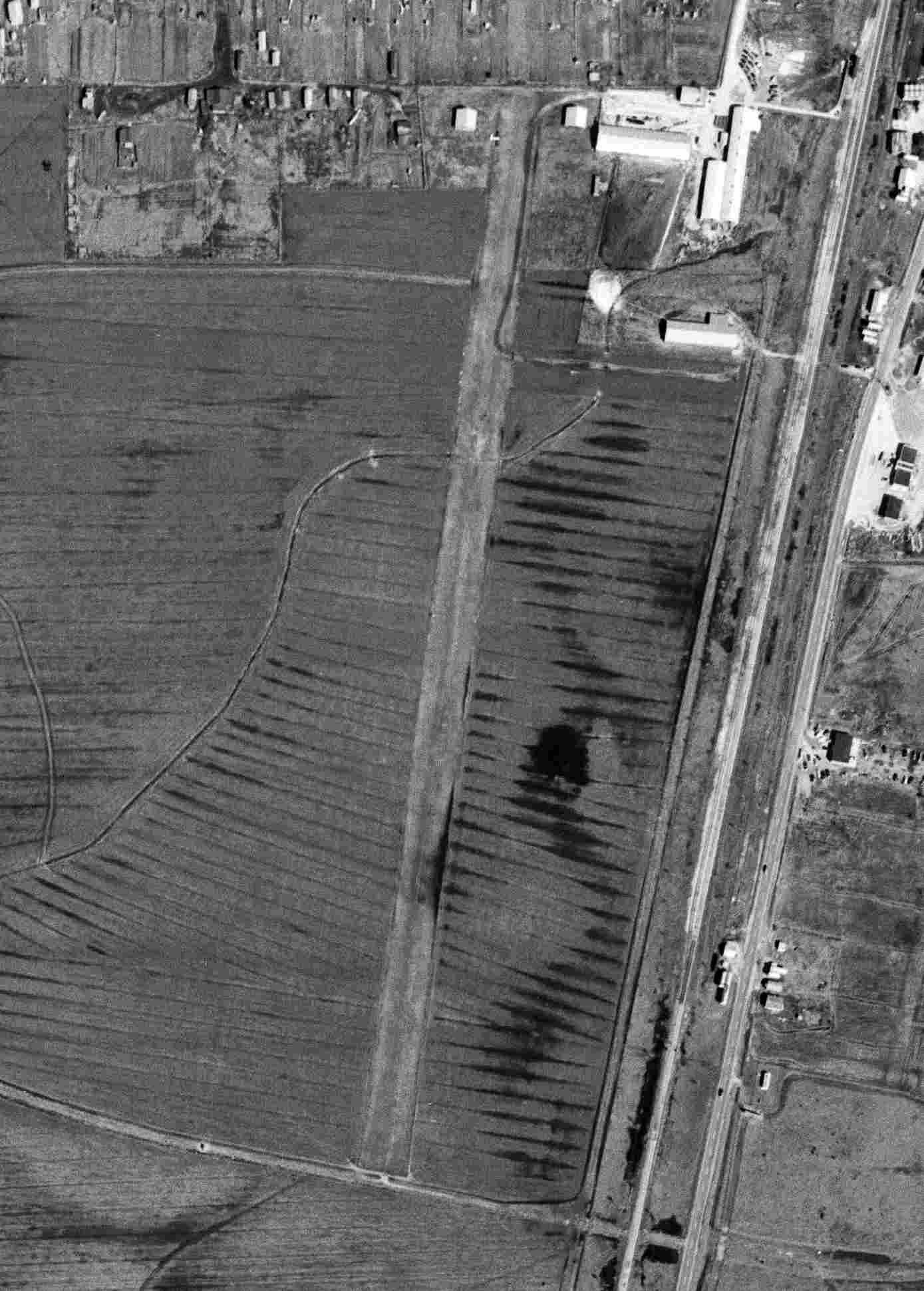
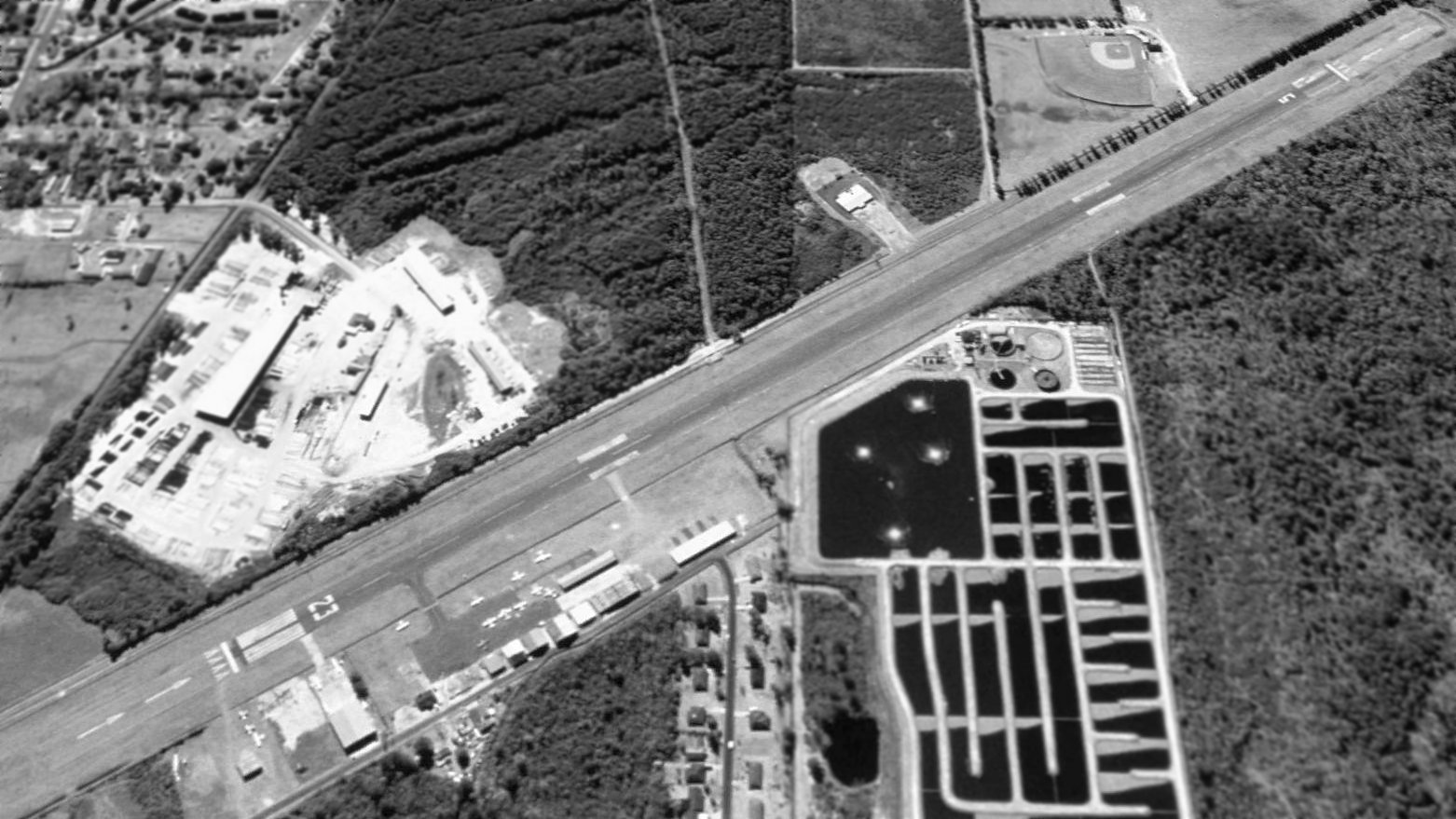
A 2006 photo by Ron Jackson, looking northeast along the abandoned former Runway 5 at Picayune.
Note the closed-runway yellow “X” symbol still visible on the pavement.
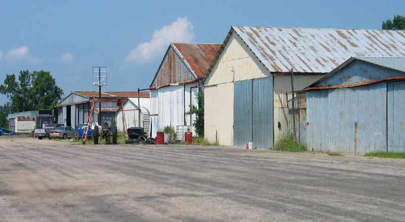
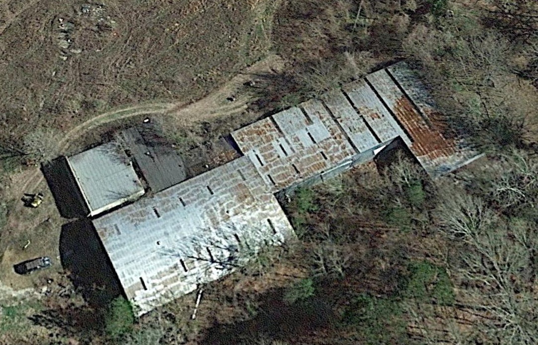
A 2006 photo by Ron Jackson, looking west at the former hangars on the north side of the field at Picayune.
A circa 2006 aerial view looking west along the row of hangars & former runway of the 2nd location of Piccayune Municipal Airport.
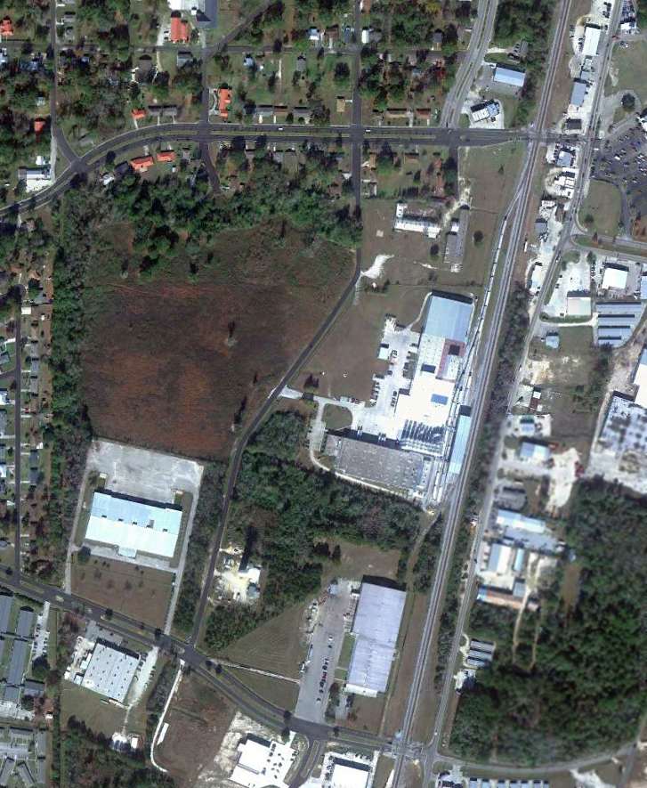
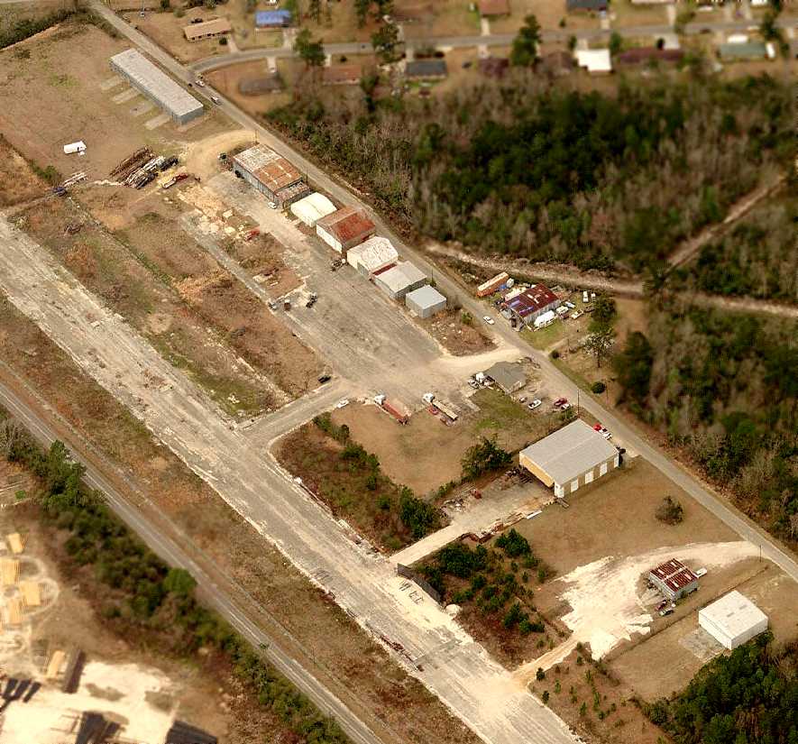
A 2017 aerial view looking southwest shows the hangars & runway of the 2nd location of Picayune Municipal Airport to remain intact.
The site of the 2nd location of Picayune Municipal Airport is located southwest of the intersection of Palestine Road & Airport Road.
Thanks to Chris Kennedy for pointing out this airfield.
____________________________________________________
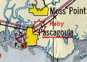
Raby Field / Pascagoula Airport (1st location) / Jackson County Airport, Pascagoula, MS
30.38, -88.53 (Southwest of Mobile, AL)
Raby Field, as depicted on the 1934 Navy Aviation Chart V-242 (courtesy of Chris Kennedy).
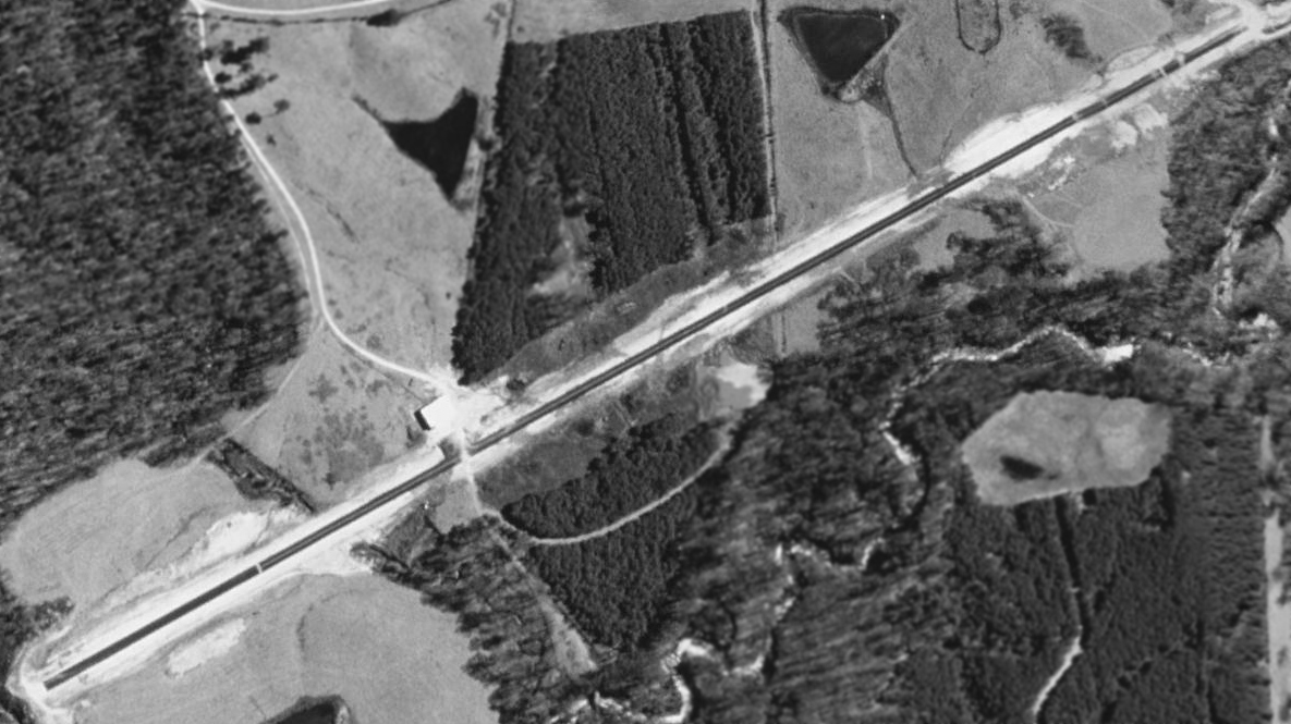
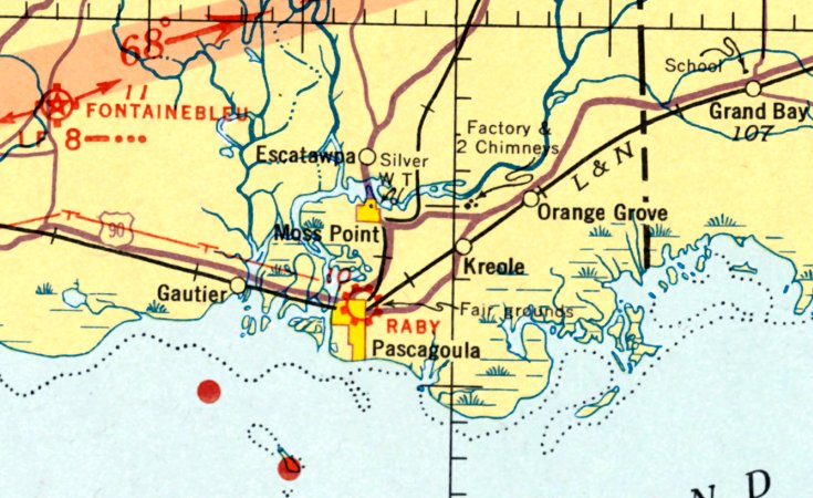
Raby Field, Pascagoula's first airport, was located adjacent to the northeast side of the town.
The date of construction of Raby Field is unknown.
The earliest reference to the field which has been located was on the 1934 Navy Aviation Chart V-242 (courtesy of Chris Kennedy).
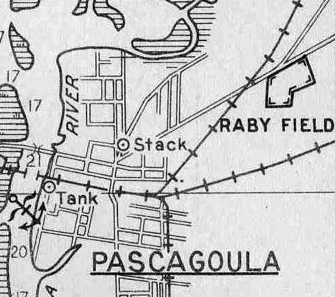
The location of Raby Field, from the 1934 Navy Aviation Chart V-242 (courtesy of Chris Kennedy).
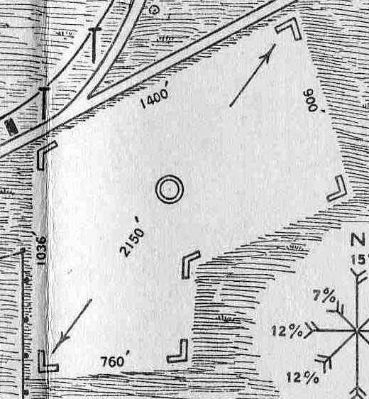
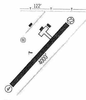
The layout of Raby Field, from the 1934 Navy Aviation Chart V-242 (courtesy of Chris Kennedy).
It described Raby Field as consisting of a irregularly shaped sod landing area, with the longest distance measuring 2,150'.
The field had no hangars or other facilities.
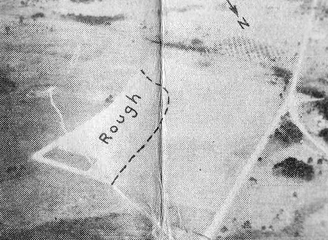
An aerial view looking southwest at Raby Field, from the 1934 Navy Aviation Chart V-242 (courtesy of Chris Kennedy).
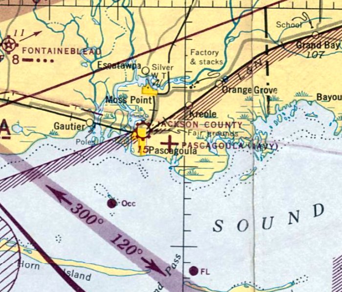
The August 1935 Mobile Sectional Chart depicted Raby Field as a commercial/municipal airport.
The Airport Directory Company's 1938 Airport Directory (courtesy of Chris Kennedy) described "Raby Auxiliary" Airport
as being located 1 mile northeast of the center of the city, and said that the field had a total of four 2,000' runways.
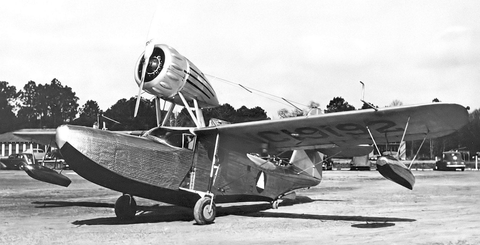
The only photo which has been located of an aircraft at Raby Field was a 1939-40 photo (courtesy of Bill Engle Jr.) of Fleetwings F-5 Sea Bird NC19192 C/n F-503.
Bill noted, “The third F-5 was photographed after delivery at Raby Field with a Civil Air Patrol badge on the side.”
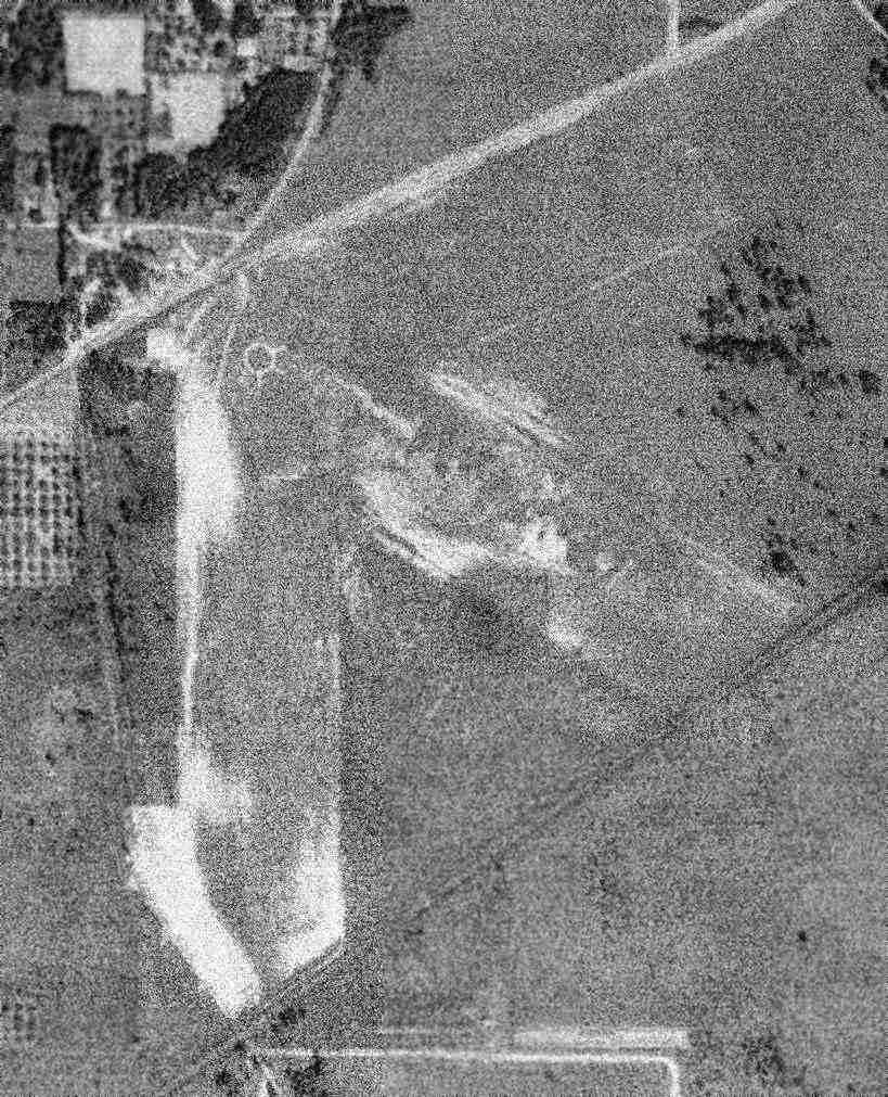
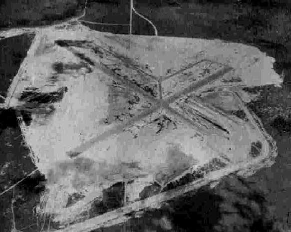
A 10/27/40 aerial view (courtesy of Dallam Oliver-Lee) depicted Raby Field as having 3 unpaved runways, with an airport circle marking at the intersection.
Raby Field had been renamed Jackson County Airport by the time of the January 1944 Mobile Sectional Chart,
which depicted it as a commercial/municipal airport.
The July 1945 Mobile Sectional Chart depicted Jackson County Airport, along with the new Pascagoula Airport which had been built a mile to the east.
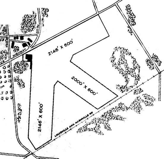
The 1945 AAF Airfield Directory (courtesy of Scott Murdock) described the Jackson County Airport
as a 81 acre irregularly-shaped property containing 3 sod runways, the longest being the 2,146' north/south & east/west strips.
The field was said to have 2 hangars, the largest being a 100' x 80' brick & steel structure.
Jackson County Airport was described as being owned by Jackson County, and operated by private interests.
The original Jackson County Airport was evidently closed at some point between 1945-46,
as only the new Jackson County Airport was depicted on the August 1946 Mobile Sectional Chart.
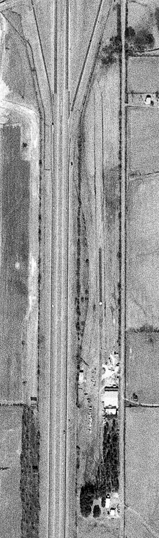
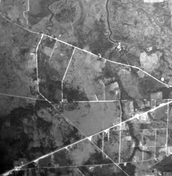
A 4/7/52 aerial view (courtesy of Dallam Oliver-Lee) showed a track had been built over the site of the original Pascagoula Airport,
but the outlines of the runways were still visible.
The runway outlines were still recognizable on a 2/13/55 aerial view (courtesy of Dallam Oliver-Lee).
A November 1971 aerial photo (courtesy of Dallam Oliver-Lee) showed the the original Pascagoula Airport site to have been redeveloped,
with no recognizable remnants of the airfield appearing to remain.
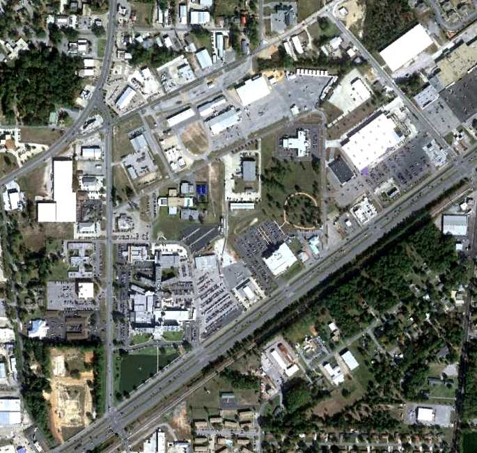
A November 2011 aerial photo (courtesy of Oliver Dallam-Lee) showed no recognizable remnants of the original Jackson County Airport.
The original location of the Jackson County Airport is north of the the intersection of Route 90 & Vega Street.
____________________________________________________
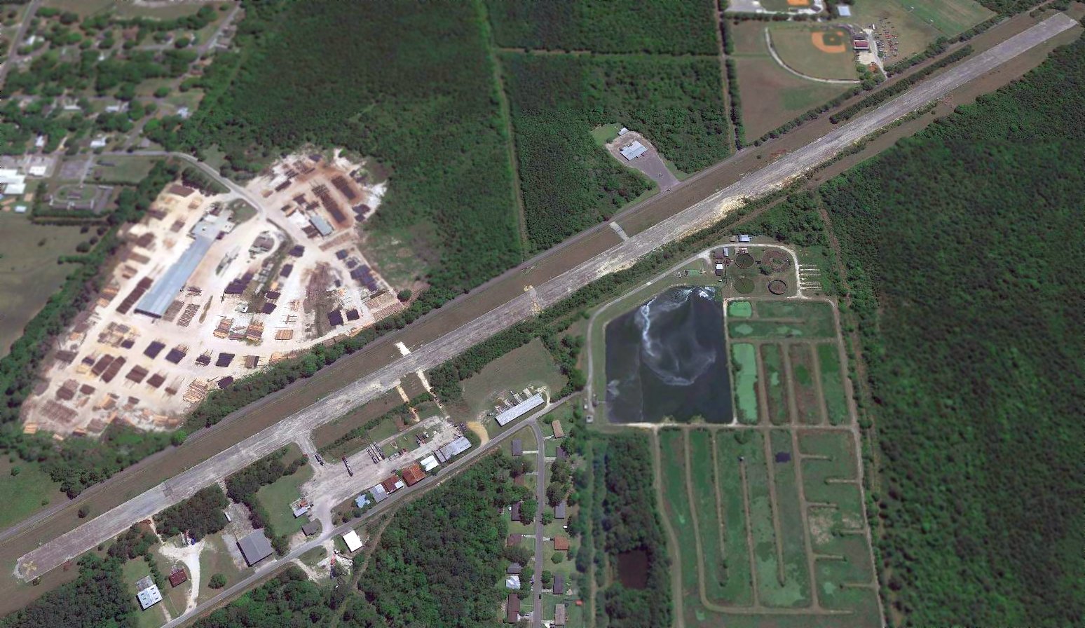
Pascagoula Airport (2nd location) / Jackson County Airport (PGL), Pascagoula, MS
30.38, -88.49 (Southwest of Mobile, AL)
A 4/27/43 aerial view looking north from the 1945 AAF Airfield Directory (courtesy of Scott Murdock)
depicted Pascagoula Municipal Airport as having 2 paved runways.
This airfield was apparently built at some point between 1942-43,
as it was not yet depicted on the December 1942 Mobile Sectional Chart nor on the 1943 USGS topo map.
The earliest depiction which has been found of the Pascagoula Municipal Airport at this location
was a 4/27/43 aerial view from the 1945 AAF Airfield Directory (courtesy of Scott Murdock).
It depicted Pascagoula Municipal Airport as having 2 perpendicular paved runways with parallel taxiways.
The earliest aeronautical chart depiction which has been located of Pascagoula Municipal Airport at this location was on the January 1944 Mobile Sectional Chart.
It depicted "Pascagoula (Navy)" as an auxiliary airfield.
The 1945 AAF Airfield Directory (courtesy of Scott Murdock) described the Pascagoula Municipal Airport
as a 660 acre square property containing 3 asphalt 4,500' runways, oriented north/south, northeast/southwest, and northwest/southeast.
The field was not said to have any hangars.
Pascagoula Municipal Airport was described as being owned by Jackson County, and operated by private interests.
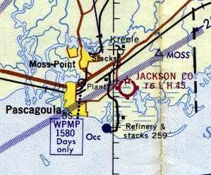
At some point between 1945-49, the new Pascagoula Airport apparently became renamed as Jackson County Airport,
after the original Pascagoula Airport was closed,
as that is how it was depicted on the 1949 Mobile Sectional Chart (courtesy of Chris Kennedy).
A 4/7/52 aerial view (courtesy of Dallam Oliver-Lee) depicted Pascagoula Airport as having 3 paved runways & taxiways.
Two small hangars were on the north side of the field, near which was visible one single-engine aircraft.
A 2/13/55 aerial view (courtesy of Dallam Oliver-Lee) showed that a 3rd small hangar had been added at some point between 1952-55.
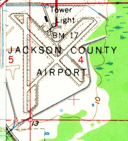
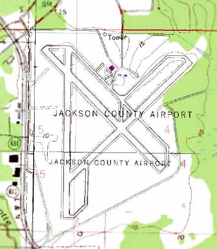
The 1958 USGS topo map depicted the Jackson County Airport as having 3 paved runways, taxiways,
and 1 building on the north side of the field.
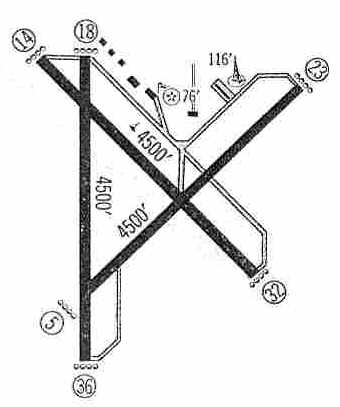
The 1960 Jeppesen Airway Manual (courtesy of Chris Kennedy) depicted the Jackson County Airport as having three 4,500' paved runways,
along with several buildings (hangars?) along the north side of the field.
The 1962 AOPA Airport Directory described the Jackson County Airport as having three 4,500' bituminous runways: 18/36, 14/32, and 5/23.
The operator was listed as Robert Neal.
According to Scott Schuler, “This airport had scheduled airline service from Southern Airways using Martin 404s, ending in the 1960s.
I have several items from Southern, including a route map, showing service there.
Southern, typical of that era, showed on the route maps little diagrams of the runway configurations of served airports.
An Official Airline Guide from November 1966 also shows service there with DC-3s with non-stop service to Mobile, Gulfport, and Hattiesburg.”
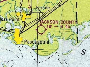
What was by then known as the Jackson County Airport (in its second location),
as depicted on the 1964 Mobile Sectional Chart (courtesy of John Voss).
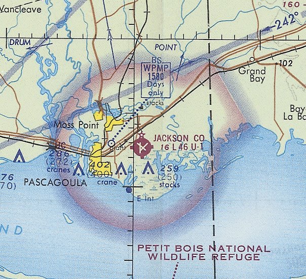
The earliest aeronautical chart depiction which has been located of Jackson County Airport was on the January 1971 New Orleans Sectional Chart (courtesy of Ron Plante).
It depicted Jackson County Airport as having 3 paved runways, with the longest being 4,600'.
The last photo which has been located showing the Jackson County Airport still operating
was a November 1979 USGS false-color aerial view (courtesy of Dallam Oliver-Lee).
The 1980 USGS topo map depicted Jackson County Airport as having 3 paved runways, taxiways,
and only 2 buildings (hangars?) on the north side of the field,
which was significantly less than the number of buildings depicted on the 1960 diagram.
In the 1982 AOPA Airport Directory (courtesy of Ed Drury), the runway configuration was still the same.
The operators was listed as General Aviation Corp., Gulf Coast Aircraft Sales, and Everon Air.
In a blatant example of pork-barrel politics, Jackson County Airport was replaced at some point between 1982-93
by the brand-new "Trent Lott International Airport" just north of the city.
Jackson County Airport was presumably closed upon completion of the new airport,
as it was depicted as an abandoned airfield on the June 1993 New Orleans Sectional Chart (courtesy of Ron Plante).
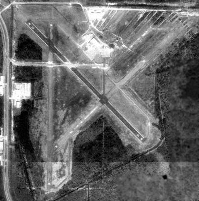
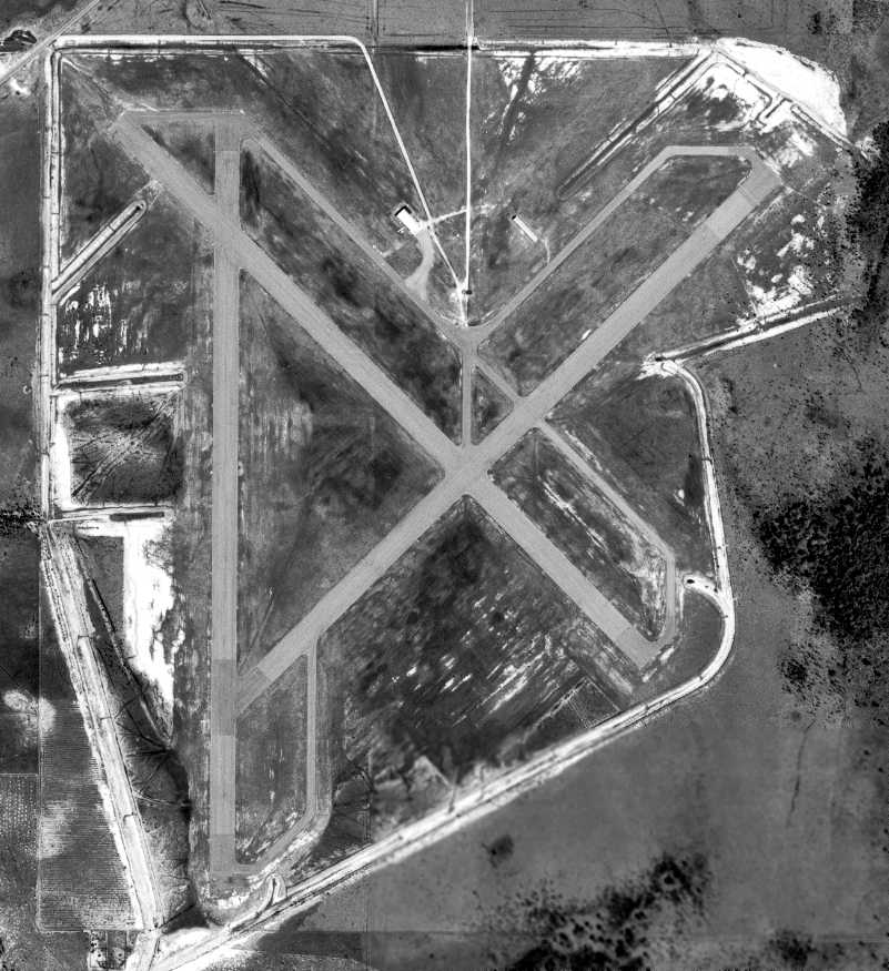
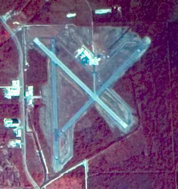
In the 1994 USGS aerial photo, Jackson County Airport was essentially still complete,
with all 3 runways still largely intact, and several hangars still standing north of the ramp.
At some point after Jackson County Airport's abandonment, the property was redesignated as the Bayou Casotte Industrial Park.
The 1994 USGS aerial photo was annotated by Bret Kepner to show the configuration of the Jackson County Airport site as of 2005,
with a large chemical plant having been constructed over the former terminal area on the north side of the field.
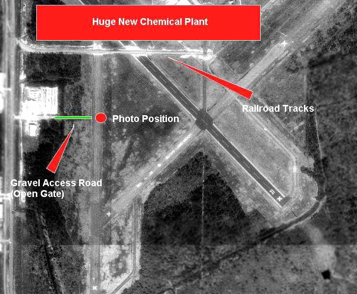
Bret Kepner visited the site of the Pascagoula Airport in February 2005.
He reported: “A huge new chemical plant now occupies most of the northern end of the property
above the train tracks which were built across the oldest runway.
As can be seen. the surface is really, really bad.
There was no access to the other runways, which may or may not even be there, anyway.”
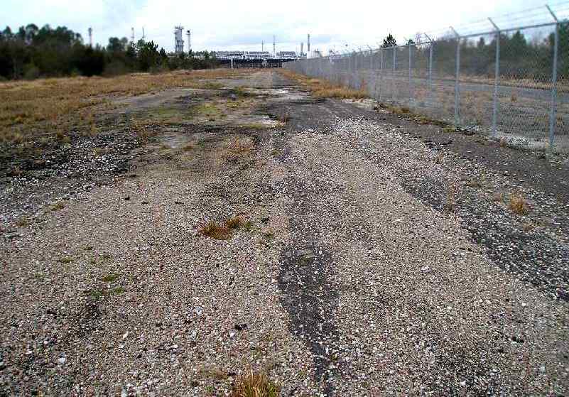
A February 2005 photo by Bret Kepner looking north along former Jackson County Airport Runway 18/36, toward the new chemical plant.
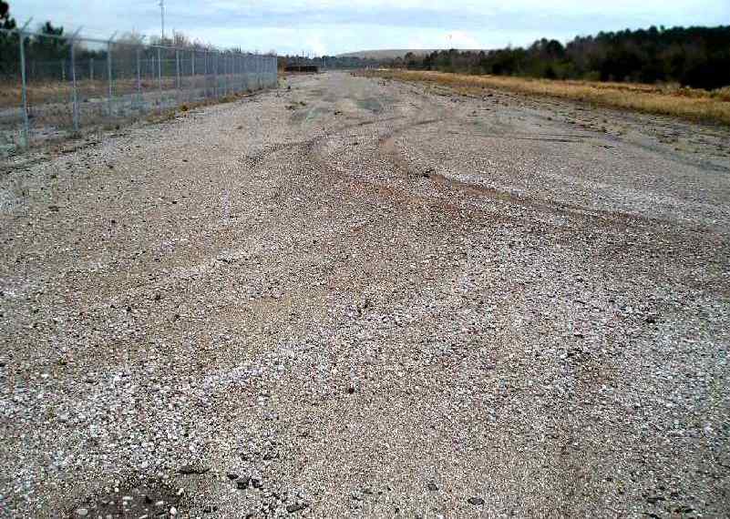
A February 2005 photo by Bret Kepner looking south along former Jackson County Airport Runway 18/36, toward its intersection with former Runway 5/23.
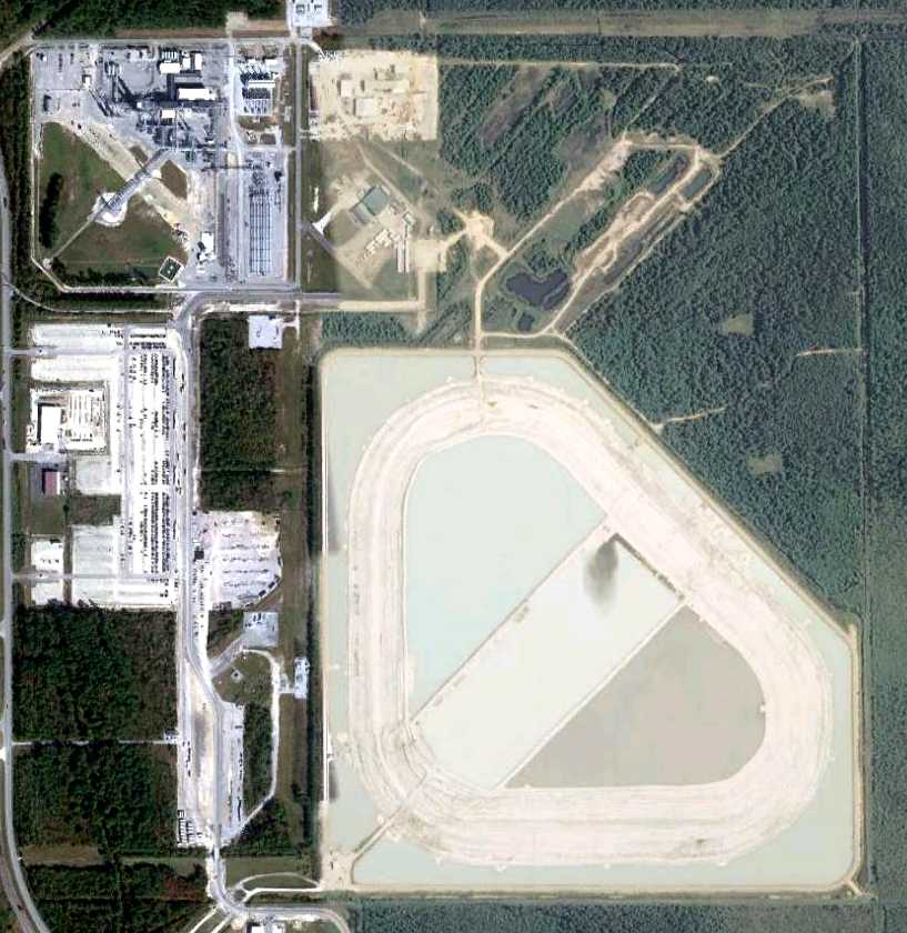
An 11/11/11 aerial photo showed that the majority of the Jackson County Airport site has been covered by a surface-mining quarry, filled with water.
Portions of several runways still remain intact on the west & north sides.
____________________________________________________
Or if you prefer to contact me directly concerning a contribution (for a mailing address to send a check),
please contact me at: paulandterryfreeman@gmail.com
If you enjoy this web site, please support it with a financial contribution.
____________________________________________________
This site covers airfields in all 50 states.