
Abandoned & Little-Known Airfields:
Southwestern Missouri
© 2002, © 2025 by Paul Freeman. Revised 1/4/25.
This site covers airfields in all 50 states: Click here for the site's main menu.
The MO pages of this website are sponsored by the Missouri Aviation Historical Society:
____________________________________________________
Please consider a financial contribution to support the continued growth & operation of this site.
Air Park South (revised 6/13/22) - Bolivar Memorial Airport (revised 12/14/22) - McFarland Airport (added 9/30/23) - Myers Field / Carthage Municipal Airport/ Myers Park Memorial Municipal (revised 12/14/22)
Ozarks Flying Patch Airport (revised 12/14/22) - Sullivan Memorial Airport (revised 1/4/25) - Timberline Airport (added 11/9/20) - West Plains Municipal Airport (revised 1/4/25)
____________________________________________________
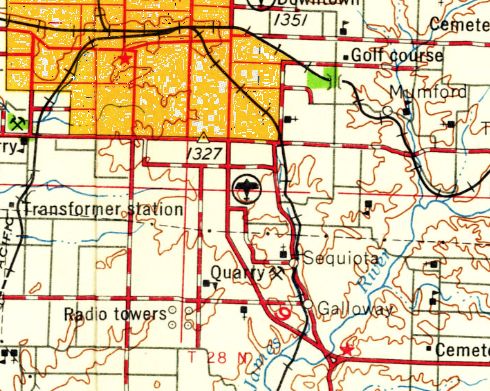
McFarland Airport, Springfield, MO
37.171, -93.259 (Southwest of St. Louis, MO)
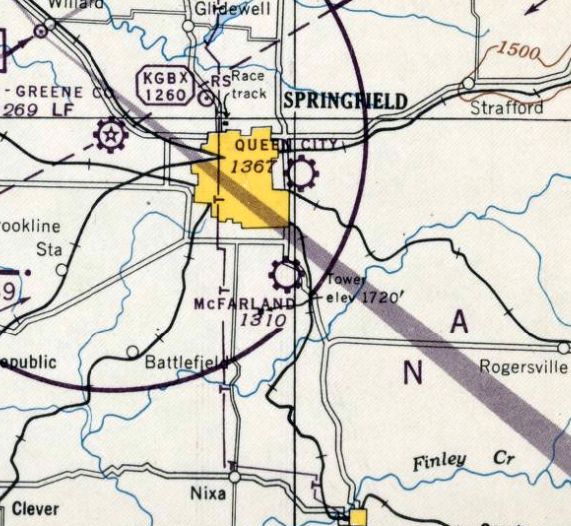
McFarland Airport, as depicted on the March 1946 Tulsa Sectional Chart.
This small general aviation airport was evidently established at some point between 1945-46
(like hundreds of other small airport's in the US post-WW2 aviation boom),
as it was not yet depicted on a the September 1945 Tulsa Sectional Chart.
The earliest depiction which has been located of McFarland Airport was on the March 1946 Tulsa Sectional Chart.
It depicted McFarland as a commercial/municipal airport.
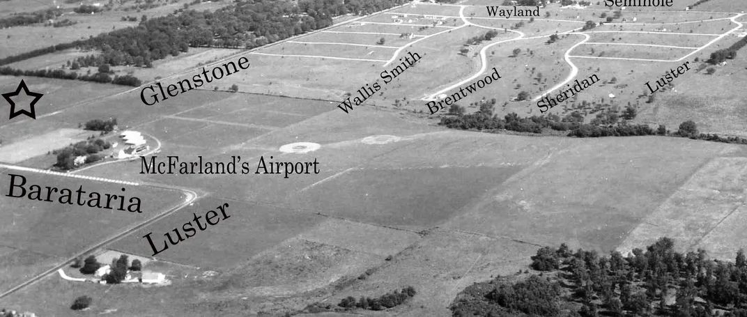
The earliest photo which has been located of McFarland Airport was a 1947 aerial view looking north (courtesy of David Massey-Brown), which depicted it as an open grass area
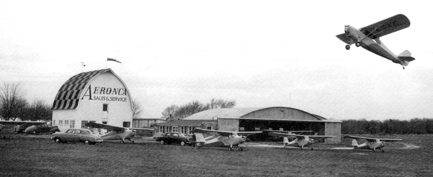
A circa 1940s photo of an Aeronca making an impressively steep departure from McFarland Airport (courtesy of David Massey-Brown),
with 4 other Aeroncas in front of a hangar & a checkerboard-roofed barn painted “Aeronca Sales & Service” on the end.

A circa 1950s map McFarland Airport as a rectangular property labeled generically “Air-Park” (courtesy of David Massey-Brown).

The last photo which has been located of McFarland Airport was a 1953 aerial view (courtesy of David Massey-Brown),
which depicted “McFarlands Airport” as having 3 grass runways with 4 hangars & other buildings on the northwest side.
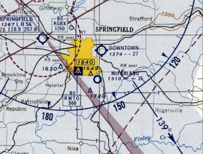
The last aeronautical chart depiction which has been located of McFarland Airport was on the June 1955 Tulsa Sectional Chart.
It depicted McFarland Airport as having a 2,600' unpaved runway.
McFarland Airport evidently closed (for reasons unknown) at some point in 1955,
as it was no longer depicted on the December 1955 Tulsa Sectional Chart.
A 1959 aerial photo showed no trace remaining of McFarland Airport, with houses having covered the area.
The only topo map depiction which has been located of McFarland Airport was on the 1959 USGS topo map, which still depicted the airport 4 years after its evident closure.
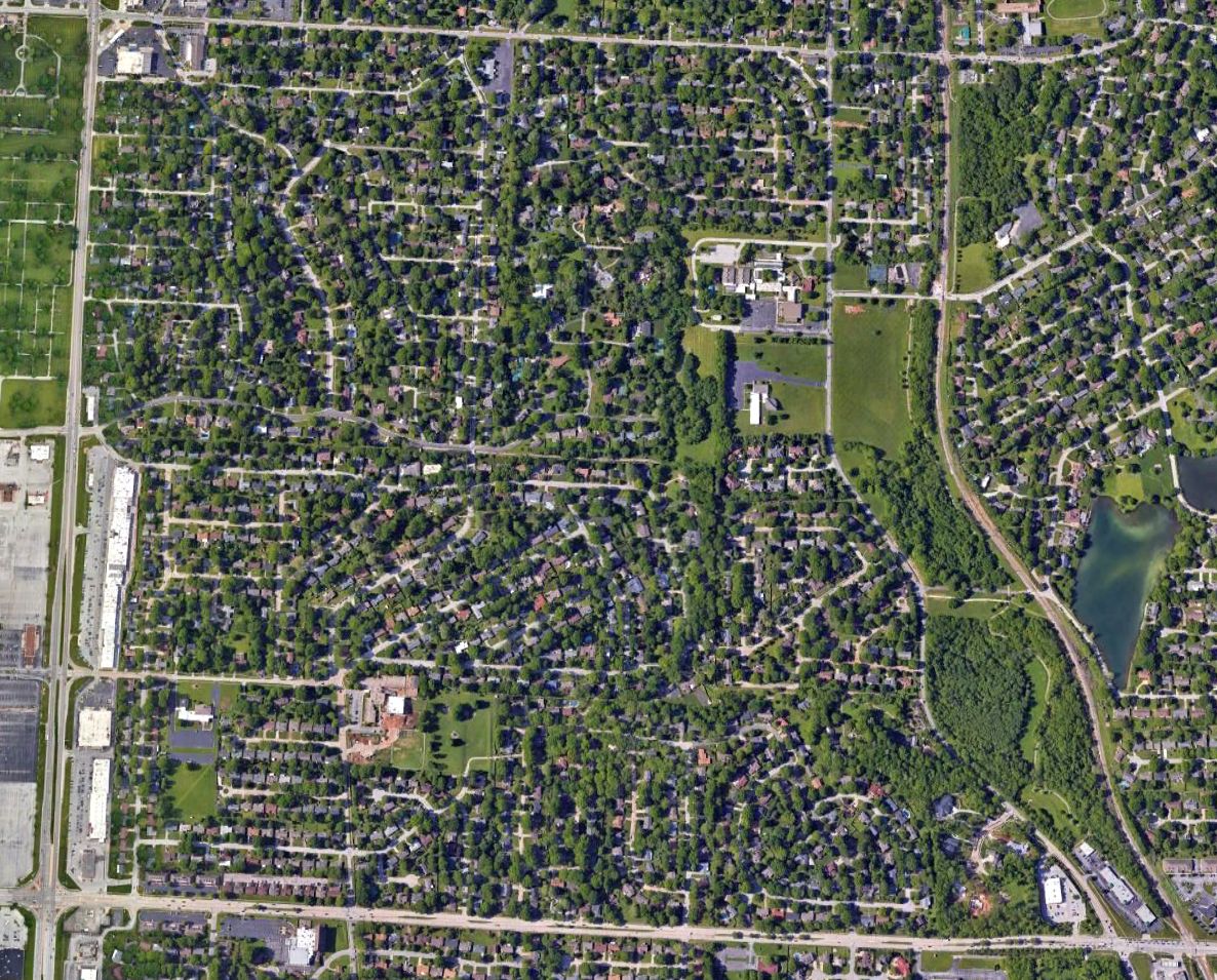
A 2022 aerial photo showed no trace remaining of McFarland Airport, with houses having covered the area.
Thanks to David Massey-Brown for pointing out this airfield.
____________________________________________________
Ozarks Flying Patch Airport, Bruner, MO
37.002, -92.9419 (Southwest of St. Louis, MO)
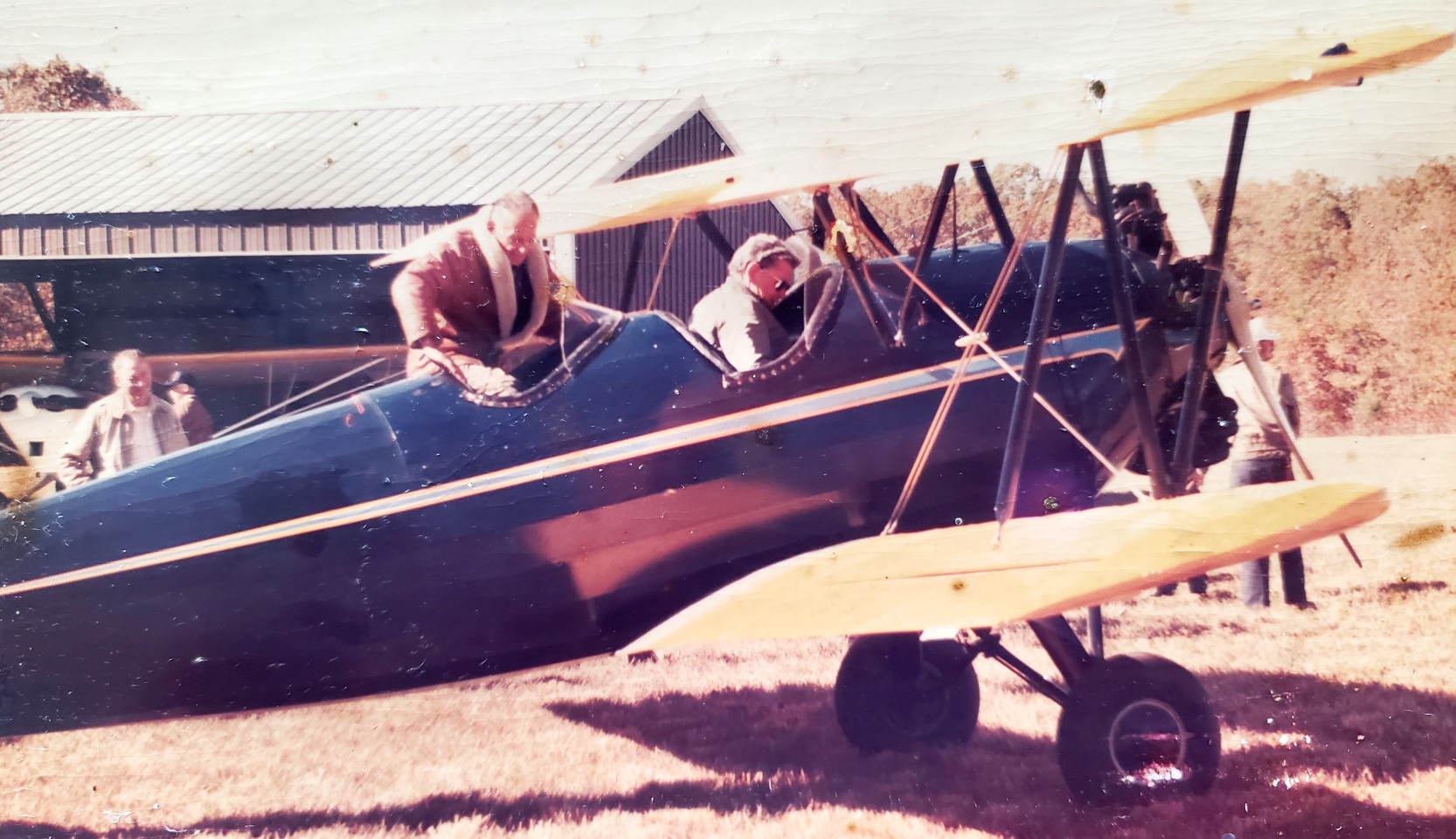
A circa 1980s/90s photo of 2 men in an unidentified biplane at Ozarks Flying Patch Airport (courtesy of John Dilsaver).
This general aviation airport may have been established at some point between 1968-80,
as it was not yet depicted on a 1955 aerial photo or the October 1968 Tulsa Sectional Chart.
The earliest dated depiction which has been located of Ozarks Flying Patch Airport was a 1985 aerial photo.
It depicted Ozarks Flying Patch Airport as having 2 unpaved runways, with 2 small hangars & 1 light single-engine aircraft on the west side.
John Dilsaver recalled, “Ozark's Flypatch was a very small-scale grass strip in eastern Christian County near the tiny towns of Bruner & Elkhead.
The owners were David & Joan Hickman. They had fly-ins there for their flying friends back in the 1980s or 1990s; photos show maybe 100 participants.
The Airman's Chapel was built at the extreme northeast end of the left-hand branch of the runway.
Local residents tell me there were occasional services here where some locals drove in & some individuals flew in.
I was visiting with a neighboring landowner, who'd bought their land in the mid-1980s & the chapel was already there at that time. It was built either by or for the Hickmans.”
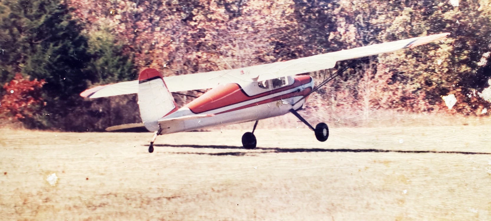
A circa 1980s/90s photo of a Cessna 170 landing or taking of at Ozarks Flying Patch Airport (courtesy of John Dilsaver).
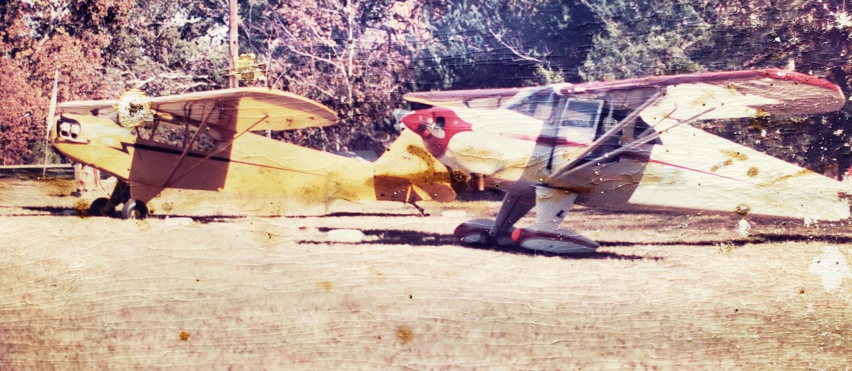
A circa 1980s/90s photo of a Piper J3 Cub & another taildragger at Ozarks Flying Patch Airport (courtesy of John Dilsaver).
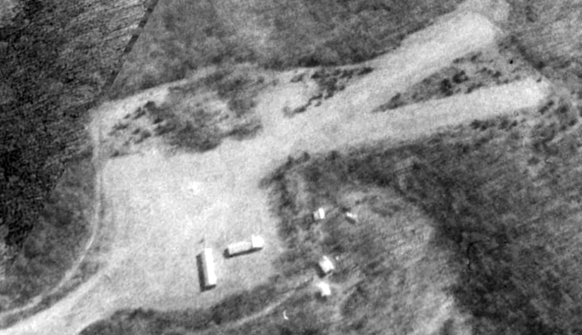
A 1995 aerial view looking east depicted Ozarks Flying Patch Airport as having 2 unpaved runways, with 2 small hangars on the west side.
John Dilsaver recalled, “They had 2 large hangars, only one of which still exists [as of 2021]. It's approximately 25' x 100', with space for 3 planes.
Their other large hangar had the same footprint but part was 2 stories tall. They burnt it down accidentally when a trash fire got out of control [circa 1997-98].
They'd had time to put up a 25' square Quonset hut hangar on the burnt-out footprint.
We purchased the 214 acres in late 2000. Both David & Joan were declining & didn't live too many more years.
David still had one plane, a beautiful radial engine biplane. The doctor had told him no more flying but I'm pretty sure he still did fly some.
He had hangar space rented out to one young fellow with an ultralight. He still maintained the runway, but in general you could tell things were starting to get a little neglected.”
John continued, “The chapel has a plaque which was - when I first took possession - filled with brass name tags of members of the flying group.
In the early years of my possession, I was occasionally contacted by individuals wondering if they could reclaim their name tag from the plaque, of course I always said yes.
Originally the horizontal part of the cross had a wooden propeller attached to it.
This has also disappeared; one hopes to the correct person. I think taking things that aren't yours, from a chapel, is known to be bad!”
The only labeled depiction which has been located of Ozarks Flying Patch Airport was on the 2012 USGS topo map.
It depicted a clearing labeled “Ozarks Flying Patch Airport”, but no runways or buildings were depicted.
Ozarks Flying Patch Airport was no longer depicted on the 2015 USGS topo map or the May 2017 Kansas City Sectional Chart.
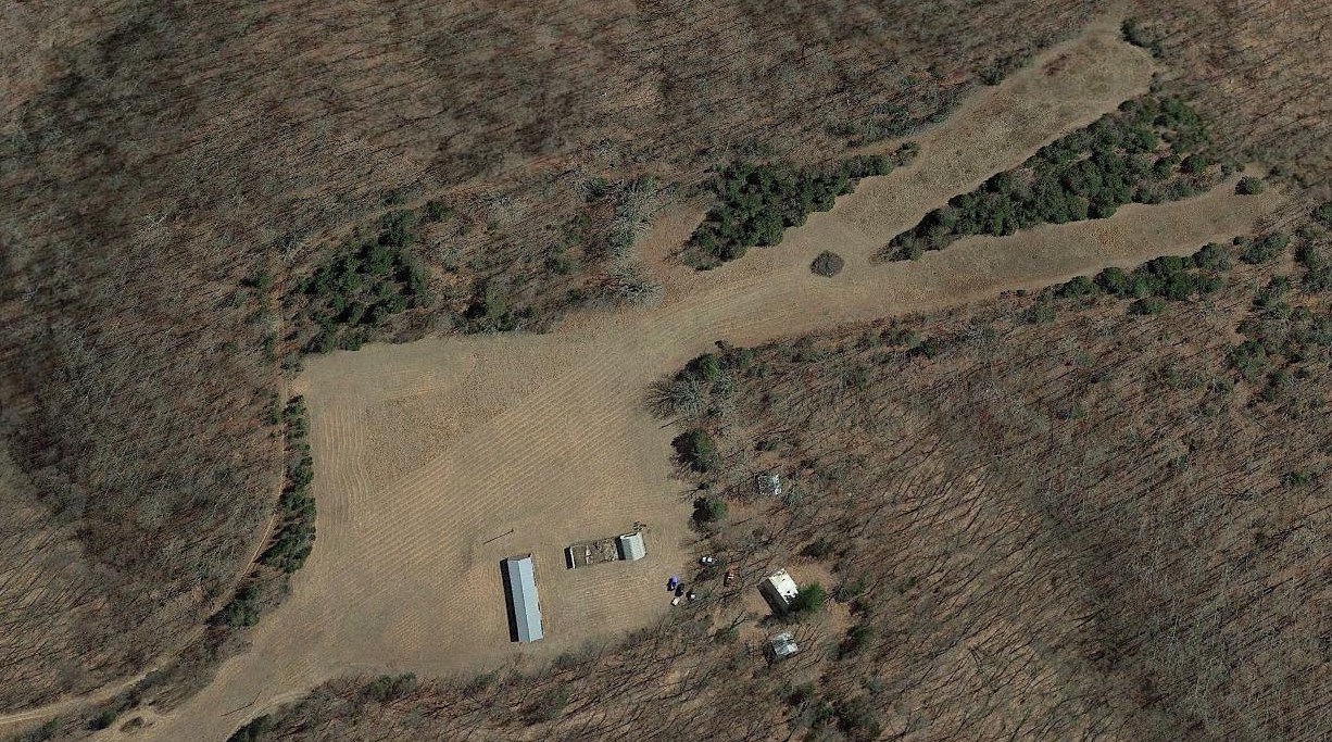
A 2019 aerial view looking east depicted Ozarks Flying Patch Airport as having 2 unpaved runways, with 2 small buildings on the west side.
Note that one of the buildings is built over part of the footprint of the former hangar, lost in a circa 1997-98 fire.
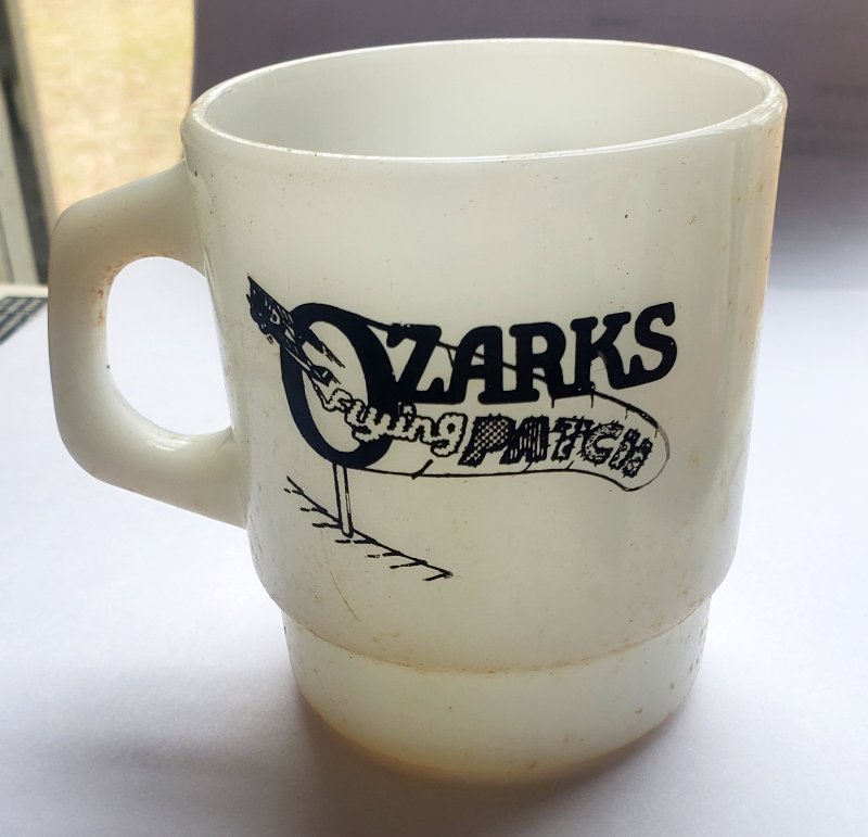
A 2020 photo by John Dilsaver of an Ozarks Flying Patch Airport mug (courtesy of John Dilsaver).
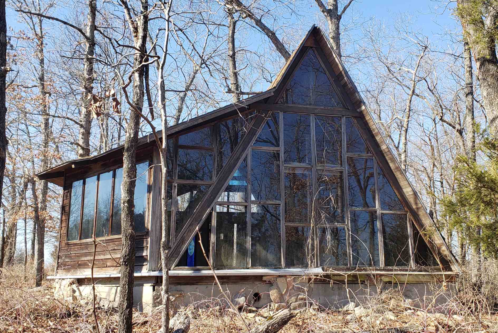
A 2021 photo by John Dilsaver of “the Airman's Chapel, at the extreme northeast end of the left-hand branch of the runway, before any work.”
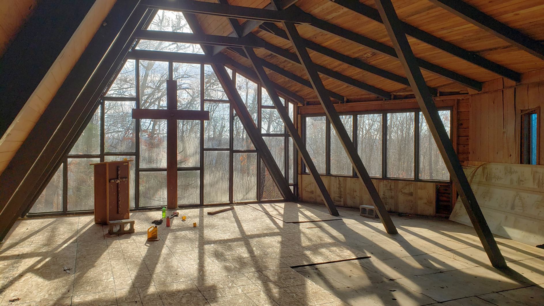
A November 2022 photo by John Dilsaver of the interior of the Airman's Chapel. John reported, “The roof work is finished & some interior work is continuing.
The aging process had been working on the chapel, and the roof was getting rather bad, so it was time to decide to either fix it up, or let it decay.
I haven't planned or done a full restoration by any means, but the roof is in good shape now, and some other problems have been addressed, so it should be stabilized for the next number of years.”
Thanks to John Dilsaver for pointing out this airfield.
____________________________________________________
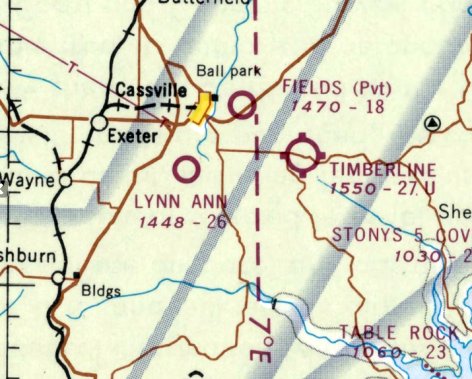
Timberline Airport / Timber Line Airport (2K2), Cassville, MO
36.654, -93.803 (Southeast of Kansas City, MO)
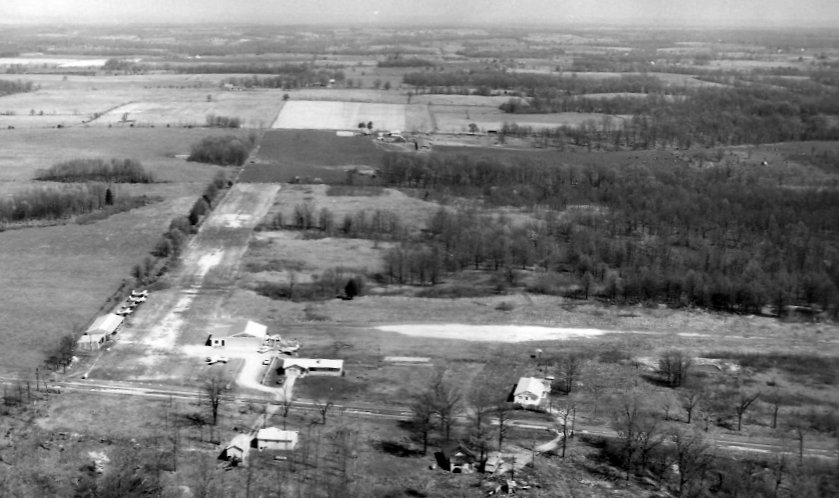
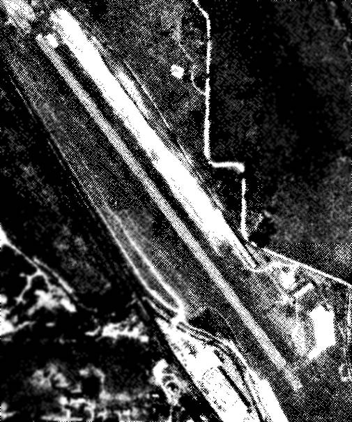
A 1959 aerial view looking north at Timberline Airport.
This general aviation airport may have been established at some point in 1959,
as it was not yet depicted on a 1955 aerial photo or the June 1959 Tulsa Sectional Chart.
The earliest depiction which has been located of Timberline Airport was a 1959 aerial photo looking north.
It depicted Timberline as having 2 unpaved runways, with a few small hangars & at least 6 light aircraft at the southwest side.
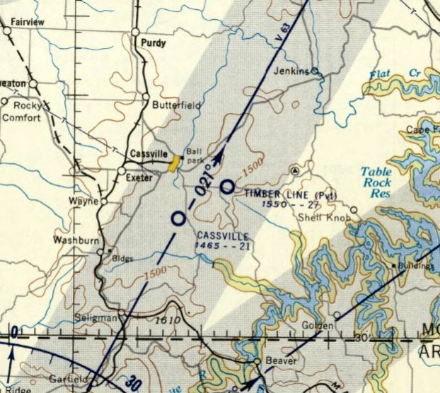
The earliest aeronautical chart depiction which has been located of Timberline was on the January 1960 Tulsa Sectional Chart.
It depicted “Timber Line” as a private airfield having a 2,700' unpaved runway.
The last aeronautical chart depiction which has been located of Timberline was on the October 1968 Tulsa Sectional Chart (courtesy of Lee Corbin).
It depicted “TimberLine” as a public-use airport having a 2,700' unpaved runway.
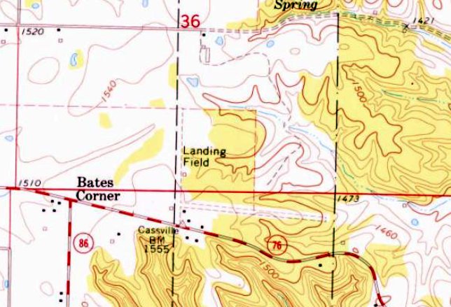
The 1974 USGS topo map depicted Timberline Airport as 2 unpaved runways, generically labeled “Landing Field”,
with a few small building on the southwest side.
A 1985 aerial photo showed Timberline Airport as having a grass north/south runway, with the former crosswind runway remaining clear but less distinct.
Several small hangars were on the southwest side, but there were no aircraft visible on the field.
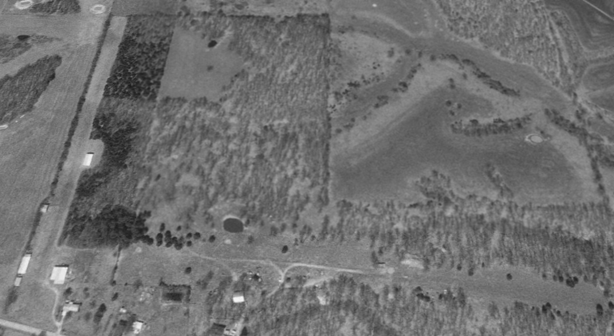
A 1997 USGS aerial view looking north showed a fence had been built across Timberline Airport's former east/west runway.
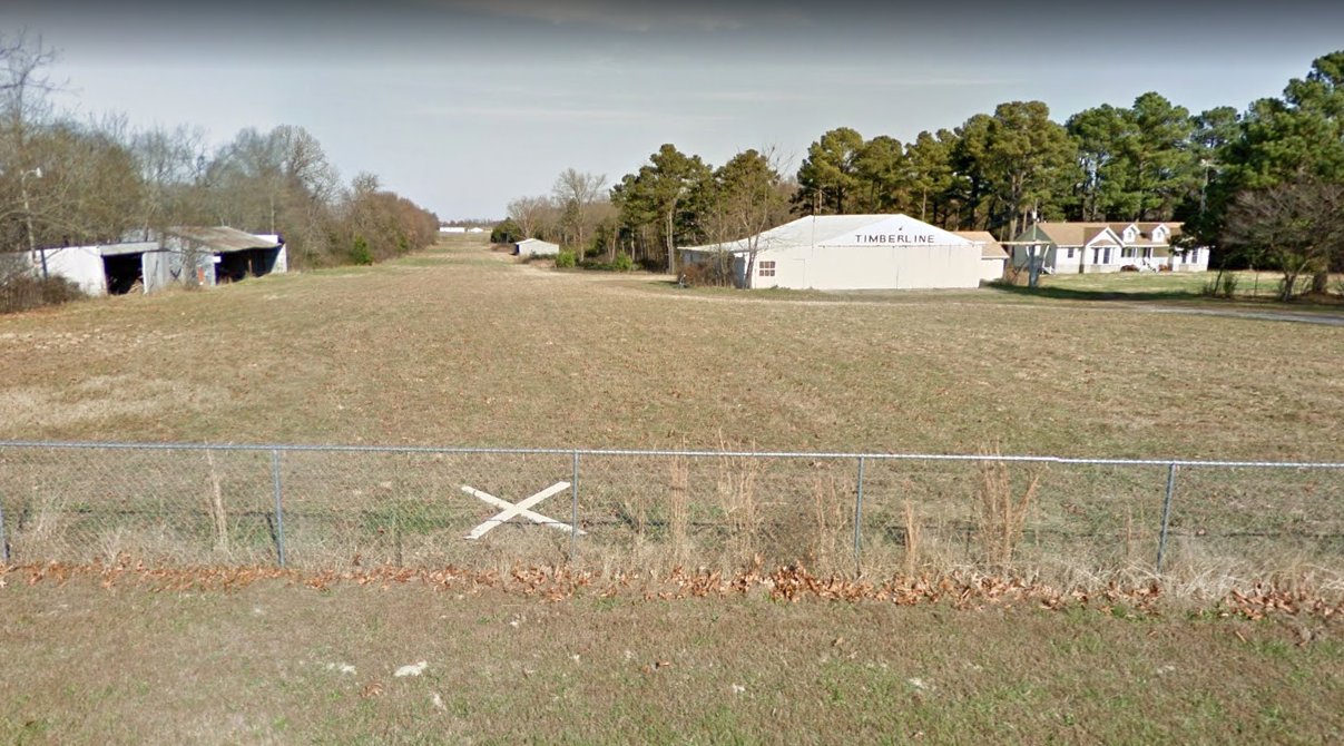
A December 2016 photo looking north (courtesy of Lee Corbin) showed Timberline Airport's runway & hangar remained intact,
yet with a very small closed-runway “X” symbol at the south end of the north/south runway.
The 2017 USGS topo map still depicted “Timber Line Airpark” as having a single north/south runway.
A 2017 aerial view looking north showed Timberline Airport's grass north/south runway as remaining intact,
along with several small hangars on the southwest side, but there were no aircraft visible on the field.
As of 2020, Timberline Airport was no longer listed with the FAA as an active airifeld.
Thanks to Lee Corbin for pointing out this airfield.
____________________________________________________
Air Park South (2K2), Ozark, MO
37.058, -93.233 (Southeast of Kansas City, MO)
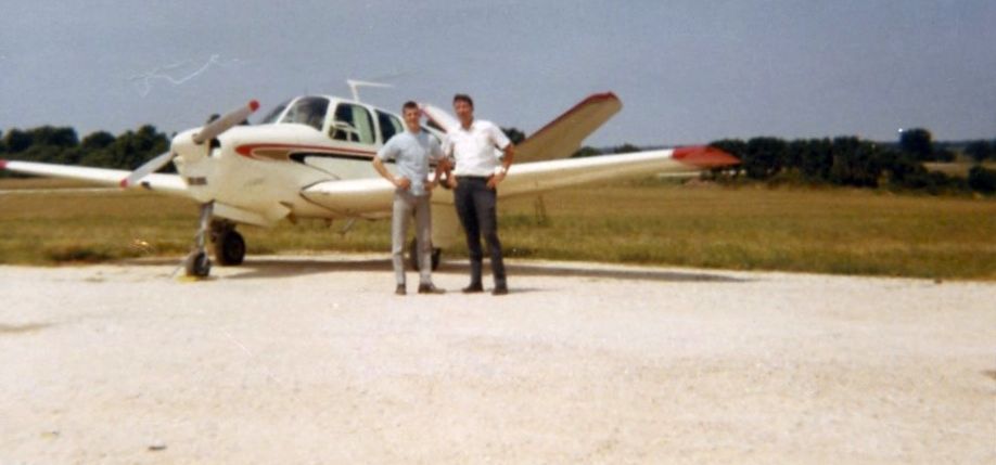
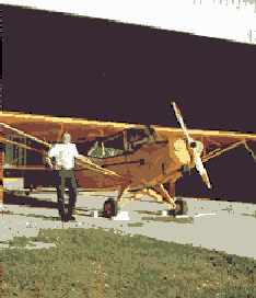
An August 1968 photo of Don Daugherty & airport owner Allen Case in front of a Beech Bonanza at Air Park South.
This general aviation airport was evidently established at some point in 1968,
as it was not yet depicted on a 1959 USGS aerial photo or the April 1968 Tulsa Sectional Chart.
The earliest depiction which has been located of Air Park South was an August 1968 photo of Don Daugherty & airport owner Allen Case in front of a Beech Bonanza.
Don Daugherty recalled, “Air Park South... I was the 2nd flight instructor at the airfield; Charlie Schneider was the 1st. I was there for about a year before being drafted into the Army [1968].
Al Case owned the airport & at that time we had only a base rock runway & a sod one.
We had a Mooney Exec single-engine & a Cessna 150. We had a trailer for an office & I was there when the hangar was built.
I have always intended to return there because I left a wooden propeller with a clock mounted at the center in my office & I have always wanted to get it back.”
The earliest aeronautical chart depiction which has been located of Air Park South was on the October 1968 Tulsa Sectional Chart.
It depicted Air Park South as having a 2,500' runway.
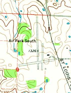
The 1970 USGS topo map depicted Air Park South as having 2 runways, one with a parallel taxiway, and a single small building northeast of the runway intersection.
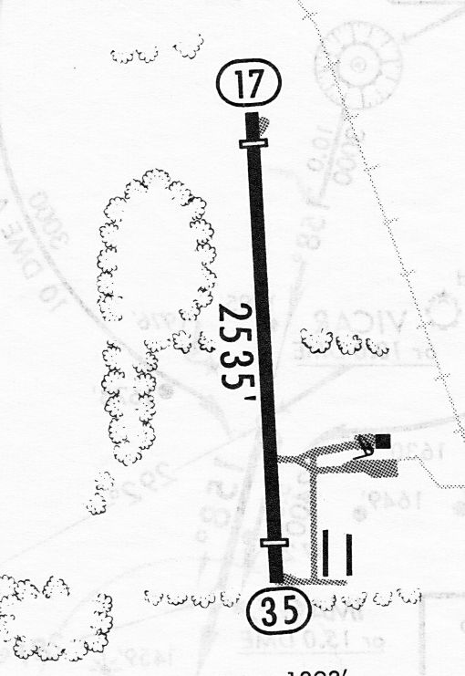
A 7/15/83 airport diagram (courtesy of John Kielhofer) depicted Air Park South
as having a single 2,535' paved Runway 17/35, with taxiways & 3 small buildings on the southeast side.
Jed Keck reported, “Dick Hill ran the main operation on the field (Dick Hill Helicopters in the big hangar) starting in the early 1980s.
He did helicopter flight instruction & ran the fuel farm for locals & passing-through aircraft.
I did helicopter training there in late 1984 & late 1986.
Later it became Dick Hill International Flight School.”
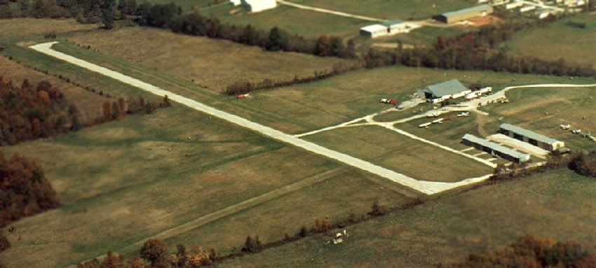
A 1986 aerial view by Jed Keck looking northeast depicted Air Park South to have a paved north/south runway & a grass crosswind runway, and at least 7 light planes parked outside.
A second & 3rd hangar had been added at some point between 1970-86.
A 4/1/96 USGS aerial view looking northwest depicted Air Park South as having only 2 light single-engine planes visible on the field.
The last photo which has been located showing aircraft at Air Park South was a 6/5/05 USDA aerial view looking northwest, which showed 4 light planes visible on the field.
A 2006 aerial photo showed closed-runway “X” symbols having been painted on both ends of Air Park South's runway.
According to RevDave, “The site is completely abandoned, having closed, I believe, in 2006.”
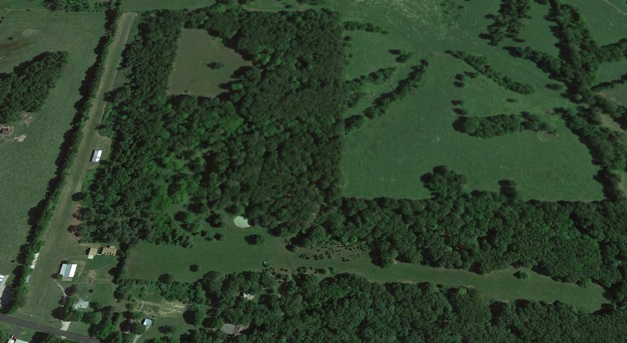
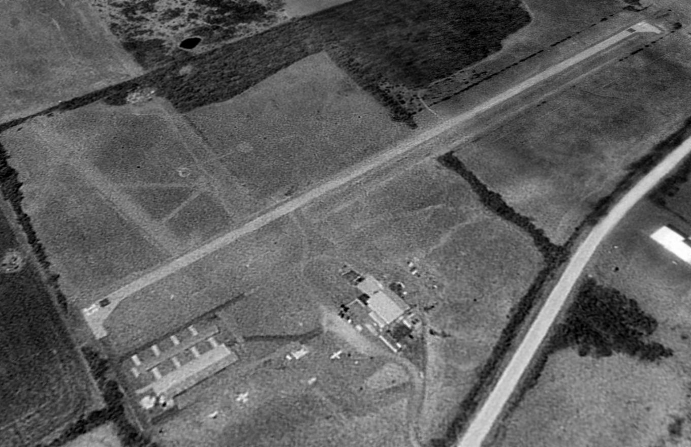
A circa 2006-2011 aerial view looking north showed the sad sight of a deteriorated Air Park South, with the runway & taxiways crumbling, and holes in the roof of one hangar.
Jed Keck reported in 2007, “Dick Hill, the guy who ran the main operation on the field (in the big hangar) died several years ago.
Sometime after the city closed the airport with the idea of expanding & making it into a corporate jet center.
That seems to have fallen by the wayside & if you look at photos today you can see houses moving in from the west.
My hunch is that people have been fighting it re-opening due to noise.”
A 12/12/12 aerial view by Jed Keck looking northwest showed Air Park South's paved runway in a further state of deterioration.
All 3 hangars remained standing.
A March 2014 photo looking northwest at 2 of the remaining Air Park South hangars.
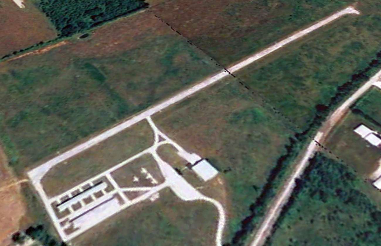
A 2015 aerial view looking northwest showed Air Park South remained intact though deteriorated, with all 3 hangars remaining erect.
The site of Air Park South is located west of the intersection of North 22nd Street & Airpark Road, appropriately enough.
____________________________________________________
Bolivar Memorial Airport, Bolivar, MO
37.61, -93.43 (Southeast of Kansas City, MO)
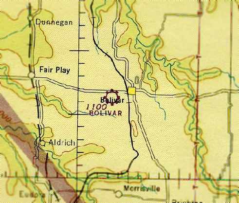
Bolivar Memorial Airport, as depicted on the March 1945 Tulsa Sectional Chart (courtesy of Chris Kennedy).
The first airport for the town of Bolivar was located on the southwest side of the town.
Bolivar Memorial Airport was evidently established at some point between 1944-45 (like hundreds of other airports across the U.S.),
as it was not yet depicted on the March 1944 Tulsa Sectional Chart (according to Chris Kennedy).
The earliest depiction which has been located of Bolivar Memorial Airport
was on the March 1945 Tulsa Sectional Chart (courtesy of Chris Kennedy).
It depicted Bolivar as a commercial/municipal airport.
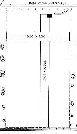
The 1945 AAF Airfield Directory (courtesy of Scott Murdock) described Bolivar Airport
as an 80 acre rectangular property having 2 perpendicular sod runways, measuring 2,500' north/south & 1,300' east/west.
The field was said to have a single 100' x 60' wooden hangar, depicted northeast of the runways,
and to be owned & operated by private interests.
Bolivar Airport was not depicted on the 1950 USGS topo map.
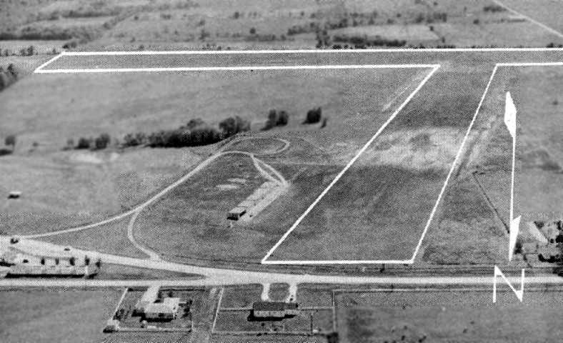
An aerial view looking south at Bolivar Memorial Airport, from a circa 1957-61 MO Airport Directory (courtesy of Chris Kennedy).
The field was depicted as having 2 grass runways, with a row of small hangars on the northeast side of the field.
A 2/11/5 USGS aerial photo depicted Bolivar Memorial Airport as having 2 grass runways, with a row of small hangars on the northeast side of the field.
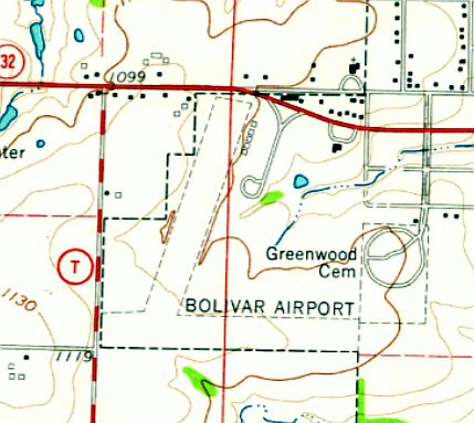
The 1981 USGS topo map depicted “Bolivar Airport” as having 2 unpaved runways,
and a row of small buildings on the northeast side.
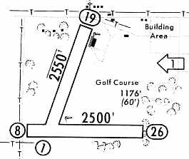
The 1965 Jeppesen Airway Manual (courtesy of Chris Kennedy)
depicted Bolivar Memorial as having 2 unpaved runways: 2,550' Runway 1/19 & 2,500' Runway 8/26.
The runway orientation was noticeably different from how they were depicted in the earlier photo & drawing.
A small buildings was depicted on the east side of the field.
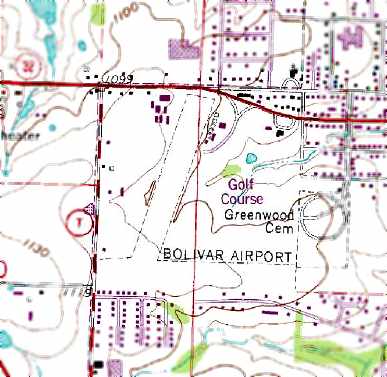
The 1981 USGS topo map continued to depict the “Bolivar Airport” as having 2 unpaved runways.
At some point between 1981-96, a new Bolivar Municipal Airport was constructed to the east of the town,
and the status of the original Bolivar Memorial Airport changed to a private airfield.
A 1984 aerial photo still showed the original Bolivar Municipal Airport having an unpaved runway.
Bolivar Memorial Airport had gained a paved runway at some point between 1984-97,
as a 1997 USGS aerial view looking south depicted the field was as having a paved north/south runway.
However, both the paved runway & the grass east/west runway were marked with “X” closed-runway symbols.
It is not clear if the field was closed at this point, or if the “X” markings were part of the field's private status.
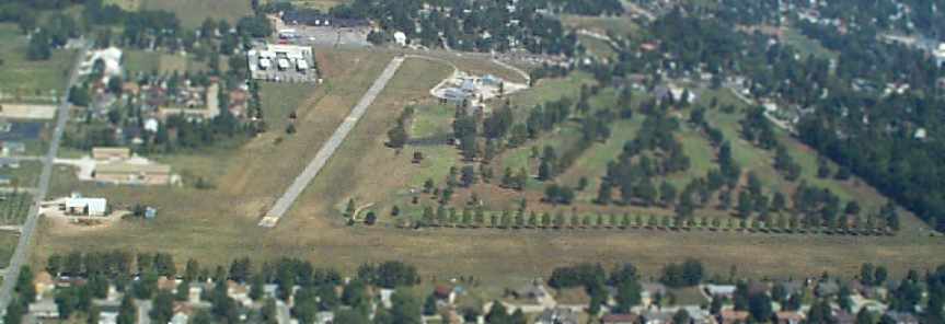
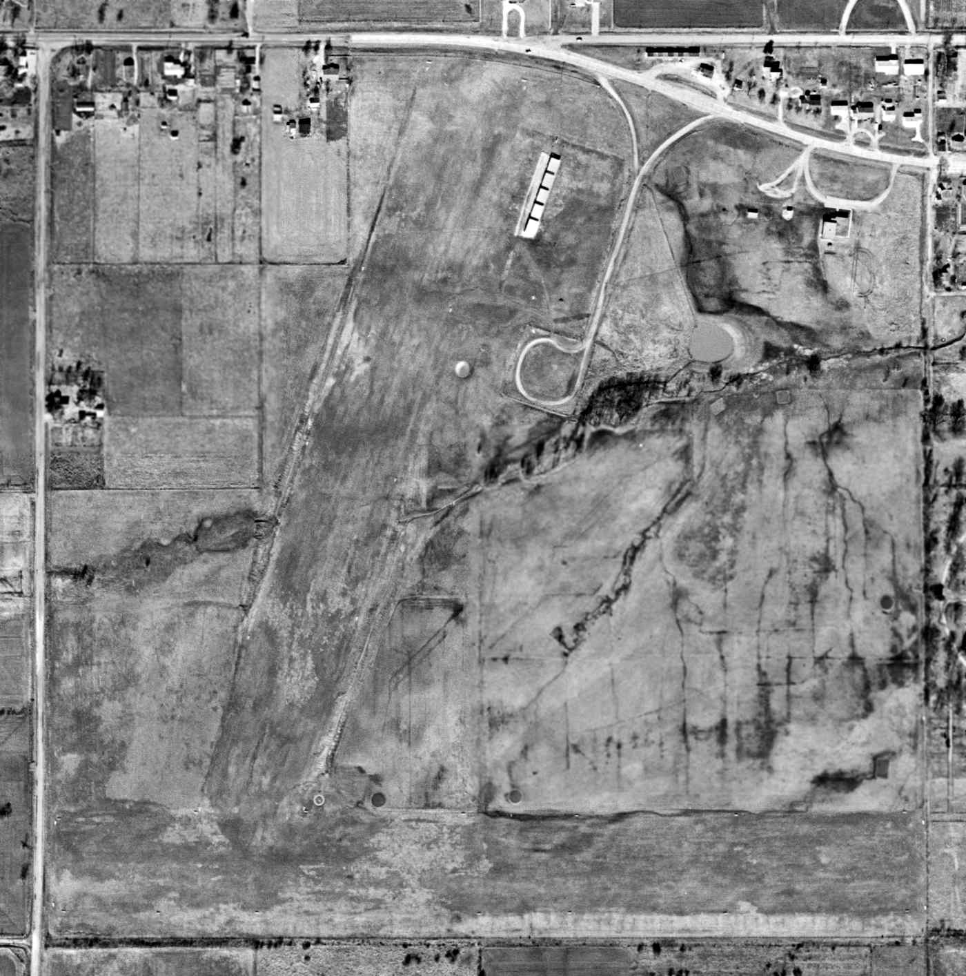
A circa 1990-2005 aerial view looking north at Bolivar Memorial Airport.
The July 1999 CG-20 World Aeronautical Chart (courtesy of Chris Kennedy) depicted Bolivar Memorial as a private airfield.
Bolivar Memorial Airport was evidently closed (for reasons unknown) at some point between 1999-2004,
as it was depicted as an abandoned airfield on the June 2004 Kansas City Sectional Chart (according to Chris Kennedy).
Richard G. reported, “I live outside of Bolivar & have seen the hangars
and I believe a hospital life flight helicopter maintenance company is working out of there now.”
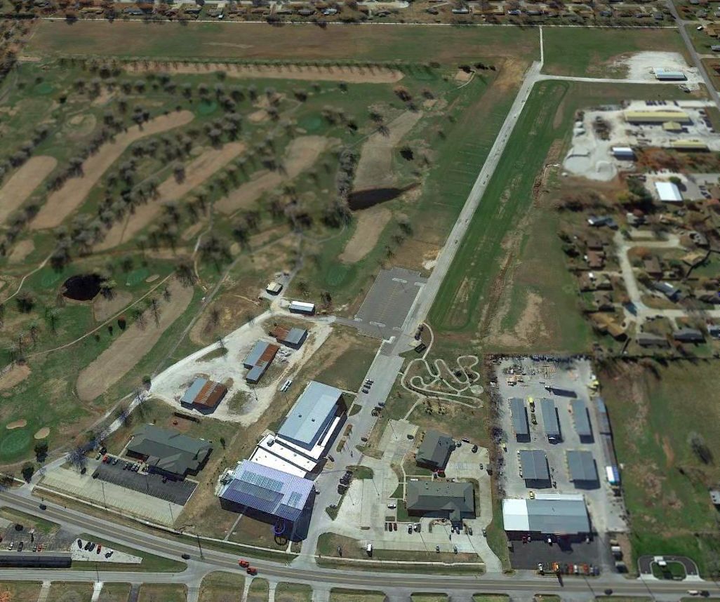
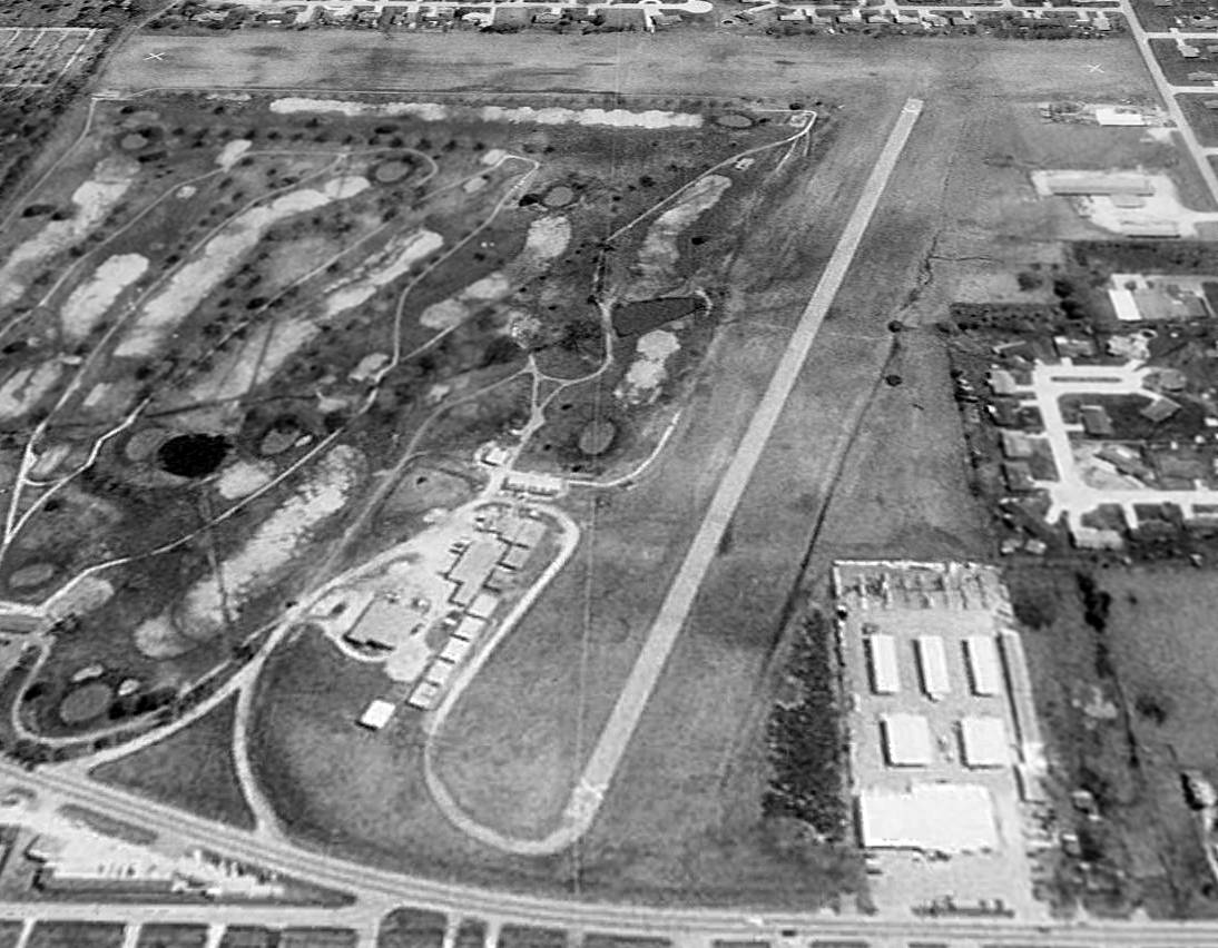
A 2013 aerial view looking south showed that several buildings had been built adjacent to the northeast side of the former Bolivar Memorial paved runway.
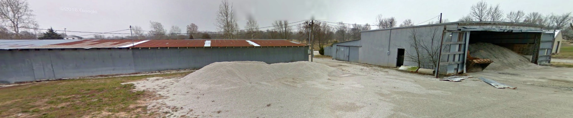
A December 2016 photo looking southeast at several former Bolivar Memorial Airport hangars.
A December 2016 photo looking southwest along the former Bolivar Memorial Airport runway.
The site of the Bolivar Memorial Airport is located southeast of the intersection of Route 13 & South Killingsworth Avenue.
____________________________________________________
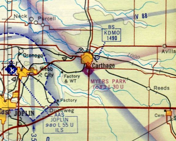
Myers Field / Carthage Municipal Airport / Myers Park Memorial Municipal Airport (H20), Carthage, MO
37.14, -94.31 (Southwest of St. Louis, MO)
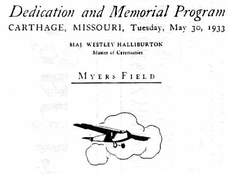
An article from the 5/30/33 issue of the Carthage Evening Press (courtesy of Robert Colson) describing that day's dedication of Myers Field.
This is yet another general aviation airport which has been lost to "redevelopment".
Meyers Field was dedicated on 5/30/33, according to an article in that day's Carthage Evening Press (courtesy of Robert Colson).
Edna Myers gave Myers Field Airport to the City of Carthage in memory of her husband Allen Myers.
The Airport Directory Company's 1937 Airports Directory (courtesy of Bob Rambo)
described the "Myers-Carthage" Airport as having 3 sod runways,
with the longest being a 3,000' northeast/southwest strip.
A hangar was said to have "Carthage" painted on the roof.
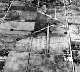
The earliest photo which has been located of Carthage Airport was a 10/8/43 aerial view looking north
from the 1945 AAF Airfield Directory (courtesy of Scott Murdock).
It depicted Carthage Airport as having 3 runways, with some buildings on the northeast side.
The 1945 AAF Airfield Directory (courtesy of Scott Murdock) described Carthage Airport
as an 160 acre square-shaped property having 3 gravel runways, the longest being a 2,300' east/west strip.
The field was said to have a single 50' x 36' metal hangar,
to be owned by the City of Carthage, and operated by private interests.
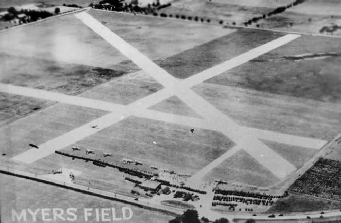
An undated aerial view of Meyers Field (courtesy of Robert Colson), showing a total of 3 runways.
According to Robert Colson, "This photo was framed & was hanging in Willis Buck's office when I soloed [in 1947]."
Robert Colson recalled, "I soloed the Piper J-3 Cub, tail number HC-6233-H, at Meyers Field on 2/20/47.
My instructor was Ernie Rowlette with the Carthage Air Service.
One of the runways we used the most often was taking off on a northerly heading straight into Carthage,
but pilots were required to make a SHARP climbing turn to the left
before reaching the power lines on the south side of South Garrison Avenue,
because the Civil Aeronautics Board would not let you fly over Carthage on takeoff.
I remember this well because my engine quit at about 600' altitude on a climbing turn to the left on takeoff.
I made a hard landing on the runway, bouncing my plane to a stop, but no damage to me or the plane."
According to Robert Colson, Meyers Park's Operations Building "was erected in 1948 - a year after I soloed."
The Lou Quinn Flying Service operated 450 hp Stearman biplane cropdusters from Carthage, according to a vintage envelope (courtesy of Robert Colson).
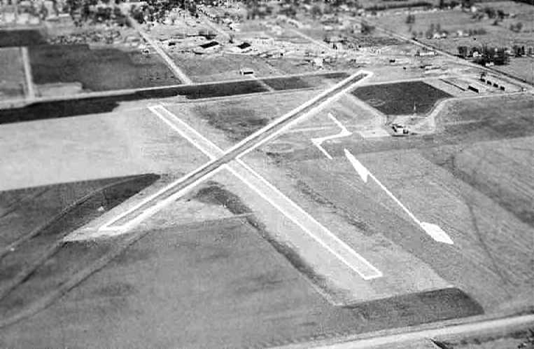
An aerial view looking northeast at Myers Municipal Airport, from a circa 1957-61 MO Airport Directory (courtesy of Chris Kennedy).
The field was described as having two 2,000' hard-surface runways: 16/34 & 3/21 (the former east/west runway was no longer visible).
A tiedown area was depicted on the northeast side of the field with several hangars, but no aircraft were visible on the field.
A 7/2/59 USGS aerial photo depicted Myers Park Airport as having 3 runways, with several T-hangars & 1 light aircraft on the northeast side.
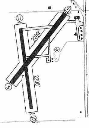
The 1960 Jeppesen Airway Manual (courtesy of Chris Kennedy) depicted Myers Park Airport as having 2 paved 2,200' runways: 3/21 & 17/35.
Taxiways led to a few small buildings on the east side of the field.
The 1962 AOPA Airport Directory described "Myers Memorial Airpark" as having two 2,000' hard-surface runways: 16/34 & 3/21.
The operator was listed as Executive Aircraft Company.
According to Mark Ingram, “In July of 1962, Eugene (Gene) Ingram
bought the FBO & Cessna dealership from Executive [Aircraft Company], and formed Carthage Airways, Inc.”
The October 1965 Tulsa Sectional Chart map depicted Myers Park Memorial Airport
as having 2 paved runways, with the longest being 3,000'.
According to an obituary by John Brown (courtesy of Mark Ingram):
“[Ingram] operated an aggressive charter department & flight school [at Myers Memorial Airpark],
along with [single- & multi-engine Cessna] sales & rentals.
Some of Gene's mainstays for charter were the Cessna 205 & 206, Cessna 310 & Cessna 320 'Skynight'.
His 2 sons helped with the flying after gaining their pilot certificates,
and his wife worked hard in the operations part of the business.
During 1968 Gene flew 1,300 hours, including giving 175 flight tests as a Designated Pilot Examiner.
During this period he flew a lot of freight for a company called Rocketdyne,
and a lot of passengers for a company called Tri-State Motor Transit.
In his service as a Designated Pilot Examiner for the FAA, he conducted 1,852 flight tests."
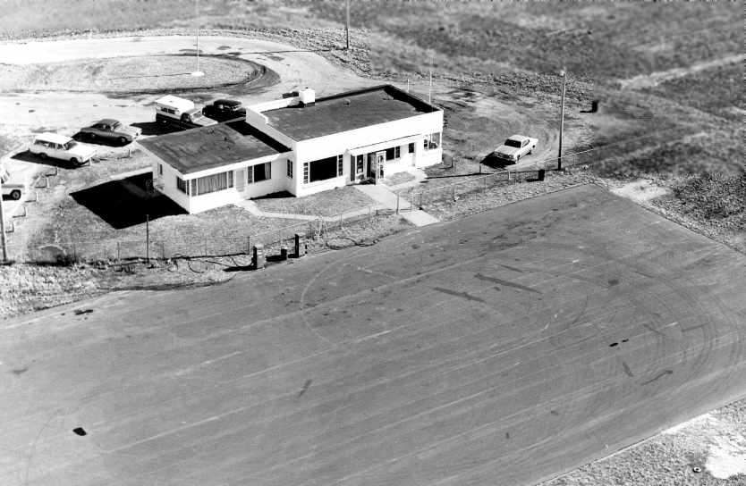
A 1970 aerial photo by Mark Ingram of the Carthage terminal building.
According to Mark Ingram, Eugene (Gene) Ingram & his family operated Carthage Airways, Inc.
“until 1973, at which time he sold it & joined Leggett & Platt, Inc., to found their corporate flight department.”
The 1978 USGS topo map depicted “Myers Park Memorial Airport”
as having 2 paved runways, with several buildings on the northeast side of the field.
The 1982 AOPA Airport Directory (courtesy of Ed Drury) described "Myers Park Memorial Municipal"
as having a 3,130' asphalt Runway 3/21 & a 2,000' asphalt Runway 17/35.
A 6/30/91 photo by Mary Colson of Robert Colson in front of the Operations Building at Meyers Field.
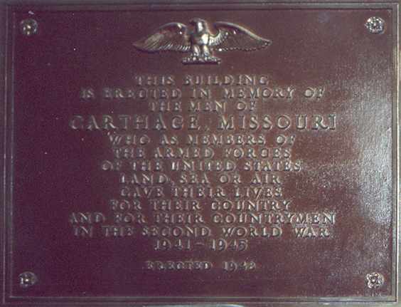
A 6/30/91 photo by Robert Colson of a memorial plaque mounted inside the Operations Building at Meyers Field.

A 6/30/91 photo by Mary Colson of Robert Colson in front of a cropduster biplane (a Stearman?) in a hangar at the northeast tip of Meyers Field.
"This plane was in this hangar for many years."
Note the cable stretched in front of the plane, with the signs reading "Danger" & "Poison".
The sign on the front of the hanger said "Quinn ????Service".
A 1991 photo by Mary Colson of Robert Colson in front of the same Piper J-3 Cub in which he had soloed at Meyers Field in 1947.
"Willis Buck, owner & manager of Carthage Air Service was still in operation [in 1991].
He still owned, maintained, and restored the original Piper Cubs we used in 1947."
In 1994, voters approved a proposal to sell Myers Municipal Airport
and rejected a proposal to use the proceeds to build a new airport.
Criticism that the ballot was confusing led to another election in 1995.
In that vote, residents approved building a new airport
and paying the city's share of construction costs with money from the sale of the current airport.
The council voted in 1996 to close the airport.
Members said they didn't want to invest city money in a new airport without a guarantee of federal grant funds,
and they said they wanted to develop Myers Park as a producer of sales-tax revenue.
Myers Municipal Airport was closed in 1997,
based on Circuit Judge George Baldridge's denial of a petition for a restraining order or injunction
against the city-imposed closing.
In the judge's ruling, he denied the plaintiffs' petition for an injunction
blocking the closing of the airport until a new one is built;
the plaintiffs' request for an injunction against further sale or transfer of the Myers Park property;
and the plaintiff's request for a judgment requiring the city to enforce the results of an April 1995 election
in which voters approved building a new airport using a portion of the proceeds from the sale of the Myers airport.
The judge's written decision contained only the findings of fact & his denial on all seven counts of the lawsuit.
He declined to elaborate.
The lawsuit filed by the residents' group against Mayor Don Riley & all members of the City Council alleged that:
- The results of the 1995 election were binding,
and the council's failure to enforce it by segregating the proceeds of property sales for a new airport is illegal.
- The city violated state law by not honoring a contract to keep the airport open for 20 years
after receiving grants for improvements to hangars & runways.
- The city violated its own initiative ordinance prohibiting the sale or substantial change in the use of donated property.
- Closing the airport without committing to build a new one is a breach of public trust that will harm the community.
Roger Brown was the last airport manager.
At its date of closing, about 15 planes (described as half the usual complement) still remained at the airport, Brown said.
Brown said he has tried to help aircraft owners relocate their planes,
but that he could find no hangars available in the area.
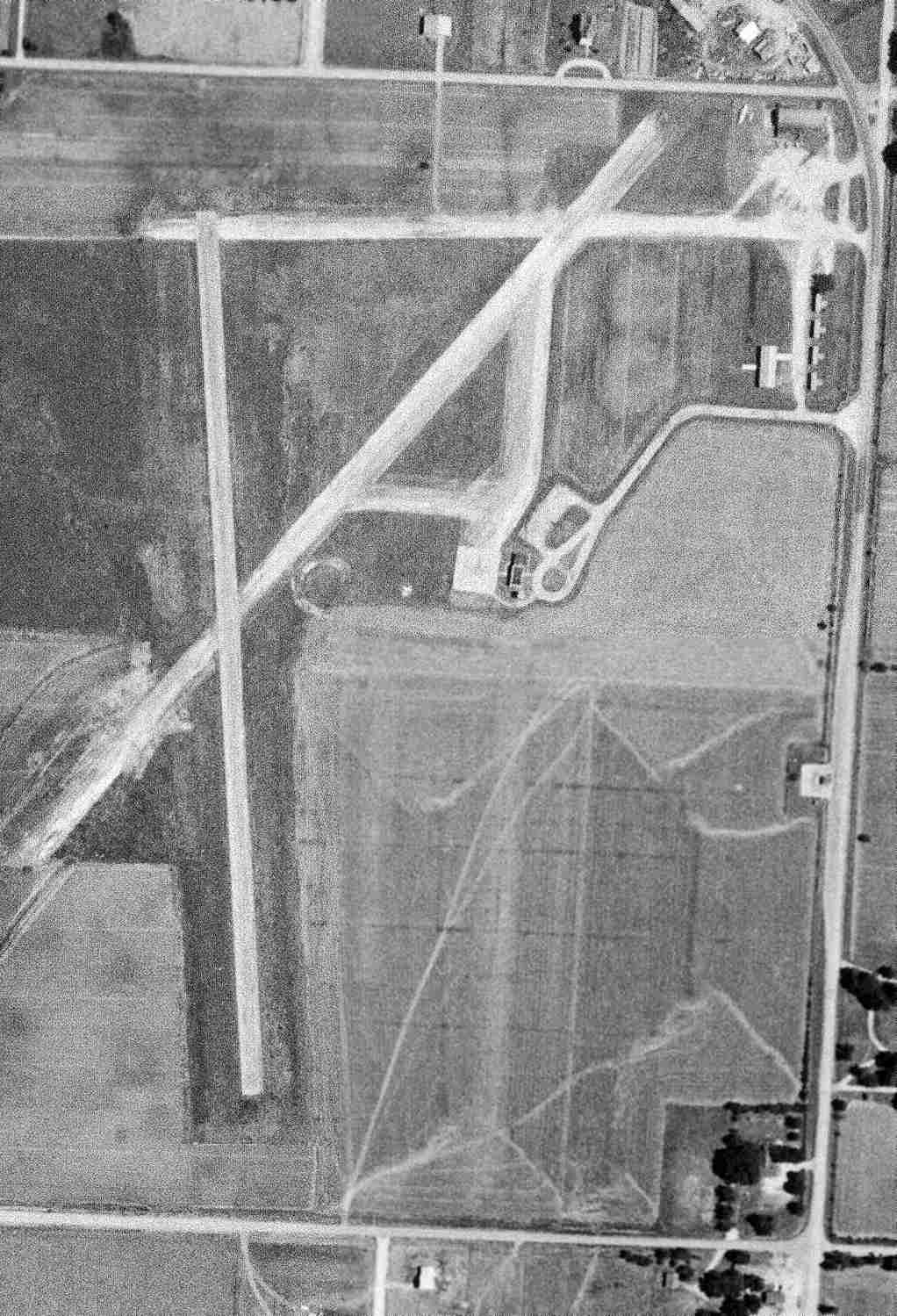
A 1997 USGS aerial view looking north shortly after Myers Park Airport was closed. The closed-runway "X" markings were clearly visible on both runways.
A set of 4 rows of T-hangars sat on the northeast corner of the field.
A new airport was apparently never built, as Carthage still has no public-use airport (as of 2003).
Unfortunately that is not the 1st time this kind of “deal” has been used to close an airport without ever providing a replacement.
The Carthage Airport was still depicted as an abandoned airfield on 2003 aeronautical charts.
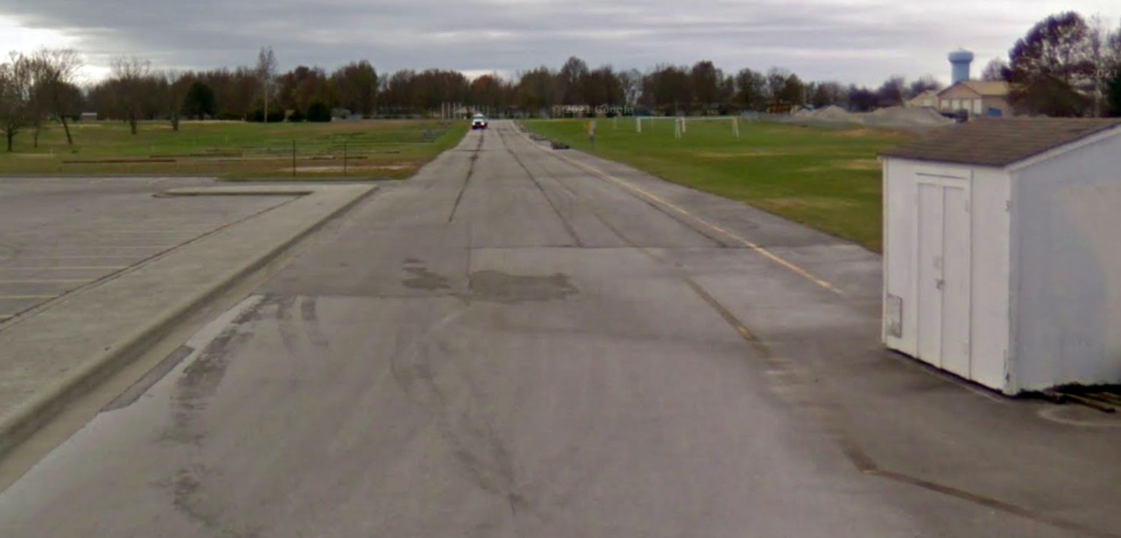
A May 2013 photo looking northeast at the remains of the southwest end of Myers Park Airport Runway 3.
A 2016 aerial view looking north shows that further construction had taken place on the site of Myers Park Airport,
with a new building & parking lot having obliterated the former T-hangars at some point between 1997-2006.
However, much of the length of the 2 former paved runways & taxiways still remained intact, and the Runway “3” marking was still plainly visible.
In the words of Mark Ingram, "It was a tragic story of greed & short-sighted 'powers that be',
and the bones of the formerly busy airport still protrude from the landscape - refusing for the moment to be completely buried."
The site of the Carthage Airport is located southwest of the intersection of Grand Avenue & West Airport Drive (appropriately enough).
Thanks to Chris Kennedy for pointing out this former airfield.
____________________________________________________
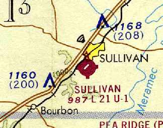
Sullivan Memorial Airport (H62), Sullivan, MO
38.2, -91.18 (Southwest of St. Louis, MO)
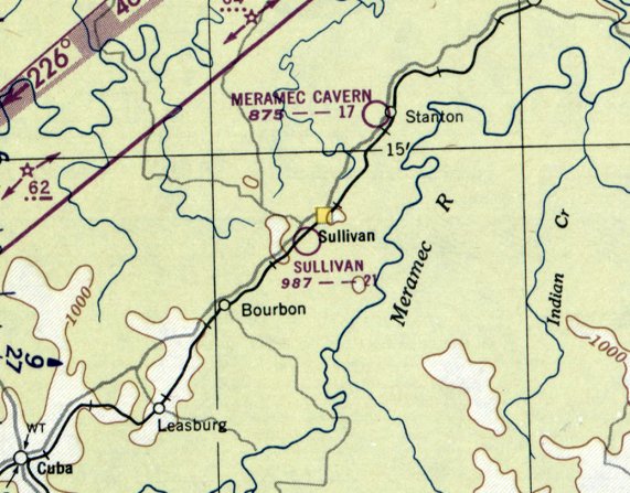
Sullivan Memorial Airport, as depicted on the May 1950 Kansas City Sectional Chart.
The Sullivan Airport was apparently established at some point between 1948-50,
as it was not yet depicted on the 1947 USGS topo map
nor on the September 1948 Kansas City Sectional Chart (according to Chris Kennedy).
The earliest depiction which has been located of Sullivan Airport was on the May 1950 Kansas City Sectional Chart,
which depicted Sullivan as ahving a 2,100' unpaved runway.
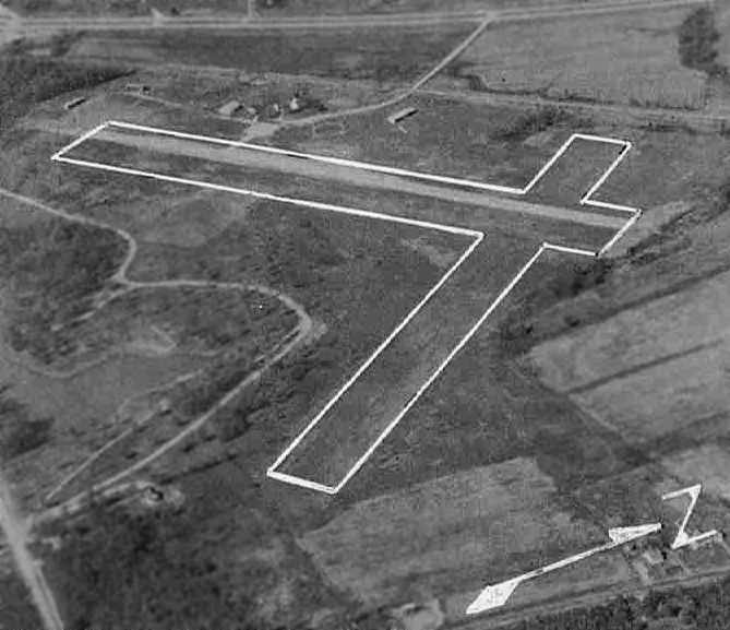
The earliest photo of Sullivan Airport which has been located
was an aerial view looking northwest from a circa 1957-61 MO Airport Directory (courtesy of Chris Kennedy).
The field was described as having a 2,100' hard-surface Runway 5/23 & a 1,900' turf Runway 14/32.
A few small hangars were depicted on the northwest side of the field,
which was said to offer fuel, hangars, and tiedowns.
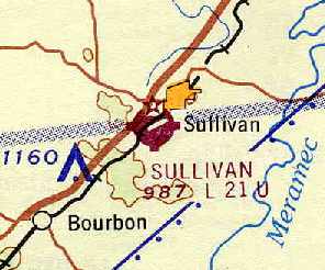
The June 1962 Kansas City Sectional Chart (courtesy of Chris Kennedy)
depicted Sullivan Airport as having a single 2,100' paved runway, oriented northeast/southwest.
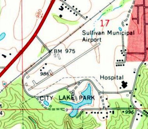
The 1969 USGS topo map depicted Sullivan Memorial Airport as having a single paved northeast/southwest runway,
with a few small buildings on the northwest side.
Sullivan Airport, as depicted on the July 1973 Kansas City Sectional Chart (courtesy of Chris Kennedy).
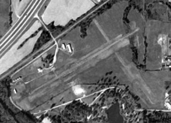
The last photo which has been located showing Sullivan Memorial Airport was a 10/28/78 USGS aerial view,
which depicted the field as having 1 paved runway & a crosswind grass runway.
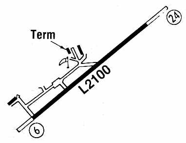
The 1986 Flight Guide (courtesy of Chris Kennedy) depicted Sullivan Memorial as having a single 2,100' paved Runway 6/24,
with a taxiway on the northwest side leading to a terminal building & 2 other buildings (hangars?).
In 1991 a larger Sullivan Regional Airport was opened one mile north of the town of Sullivan,
and the original Sullivan Memorial Airport was presumably closed at the same time.
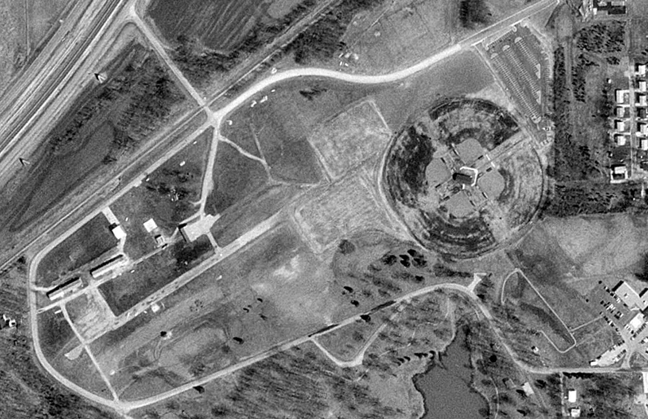
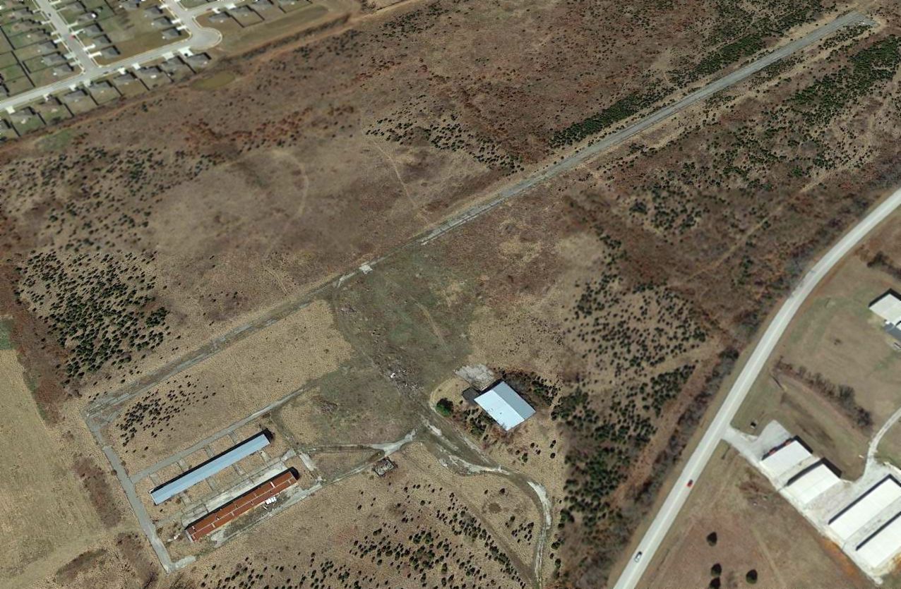
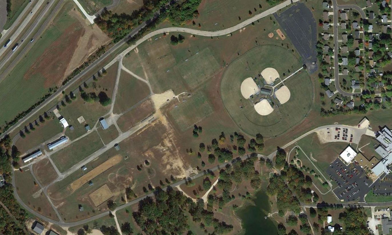
A 1996 USGS aerial photo showed the eastern half of the site of Sullivan Memorial Airport had been covered with 4 baseball diamonds & a parking lot.
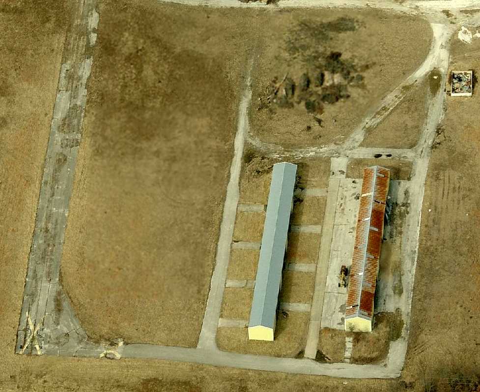
However, the western half of the former airport remained still largely intact, with about half of the runway length still remaining,
as well as several former hangars on the northwest corner of the site.
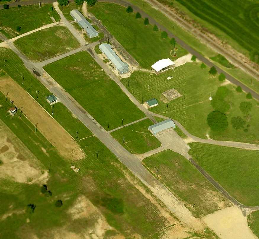
A circa 2008 aerial view looking west at the southwestern portion which remains of the Sullivan runway,
as well as 3 former hangars.
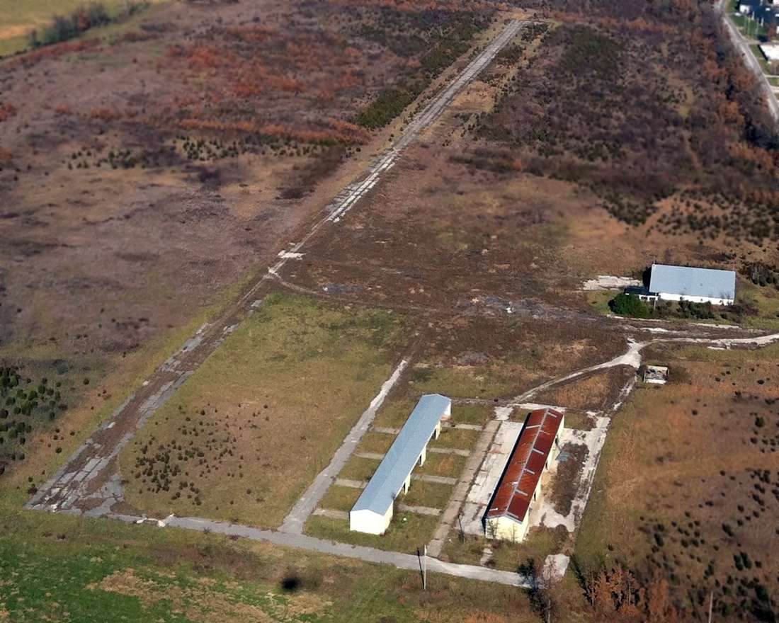
A 2015 aerial photo showed the southwestern half of the Sullivan Memorial Airport former runway pavement remained intact,
along with several former hangars on the northwest corner of the site.
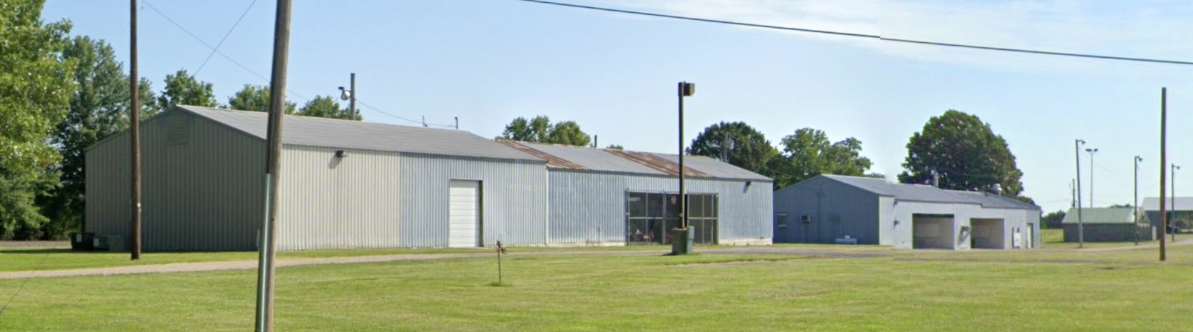
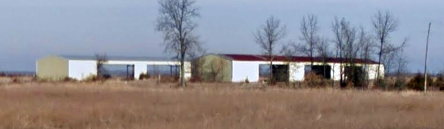
A 2024 photo looking northeast at former hangars which remain on the west side of the Sullivan Memorial Airport site.
The site of Sullivan Memorial Airport is located south of the intersection of Interstate 44 & Mattox Drive.
____________________________________________________
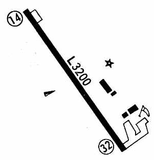
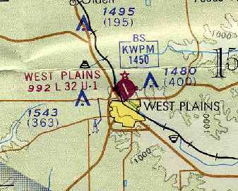
(Original) West Plains Municipal Airport (H63), West Plains, MO
36.75, -91.86 (Southwest of St. Louis, MO)
An undated aerial photo of West Plains Municipal Airport from the 1970 MO Airport Directory (courtesy of Ronald Casey).
The original West Plains Municipal Airport was located adjacent to the north side of the town.
West Plains Airport was not yet depicted on the December 1955 Tulsa Sectional Chart (according to Chris Kennedy).
According to Ron Casey (who lived 1/2 mile from the airport),
“West Plains Municipal was built around 1959 & replaced Baker Airport
which was located just North of the city adjacent to the Howell County fairgrounds.”
Kenneth Hand recalled, “The first operator at the West Plains Airport (in as I remember it we got the airport open around the spring of 1959),
William Brode was the first operator at the airport, he ran a flight school with a Piper PA-12
and had a Cessna 180 that he used for charter.
I was the first student to solo at the airport on 3/26/60 on a clear Saturday morning.
I worked the summer after my Senior year in High School as a line boy & various other tasks,
mowing the grassy runway & airport property etc.
The University of Chicago had a weather research cloud seeding project going on that summer,
they operated a Beech 18 & 3 Cessna 172s.
Bill operated the airport until the spring of 1961, when he passed away at a very early age with some health problems.”
The earliest directory reference to the West Plains Airport which has been located
was a listing in the 1963 AOPA Airport Directory (according to Chris Kennedy).
Ron Casey recalled, “West Plains Municipal in the early days was home to a Fixed Base Operator & 2 flight schools.
The FBO was Conrad Robinson who was a Cessna dealer in the mid 1960s, flight instructor & charter pilot.
Another flight school was that of Charles Hopkins.
Charles even had a Link Trainer [an early flight simulator] in one of the T-hangar corner offices.
The T-hangars were constructed of concrete blocks.
A row of open hangars were North of the Terminal on the East side of the runway.
During the summers of the mid-1960s the University of Missouri conducted an iodine cloud seeding test from West Plains Municipal.
I received my primary flight instruction & completed my Private check ride at West Plains Municipal in 1968.”
The earliest photo which has been located of West Plains Municipal Airport
was an undated aerial view from the 1970 MO Airport Directory (courtesy of Ronald Casey).
The directory described West Plains Municipal as having a single 3,200' asphalt Runway 14/32,
operated by the City of West Plains.
The 1971 Flight Guide (courtesy of Chris Kennedy) depicted West Plains Municipal Airport as having a single 3,200' paved Runway 14/32.
A ramp was located at the southeast corner of the field,
and a total of 4 buildings (hangars?) were located on the east side of the field.
West Plains Municipal was still depicted as an active airport
on the July 1973 Kansas City Sectional Chart (courtesy of Chris Kennedy).
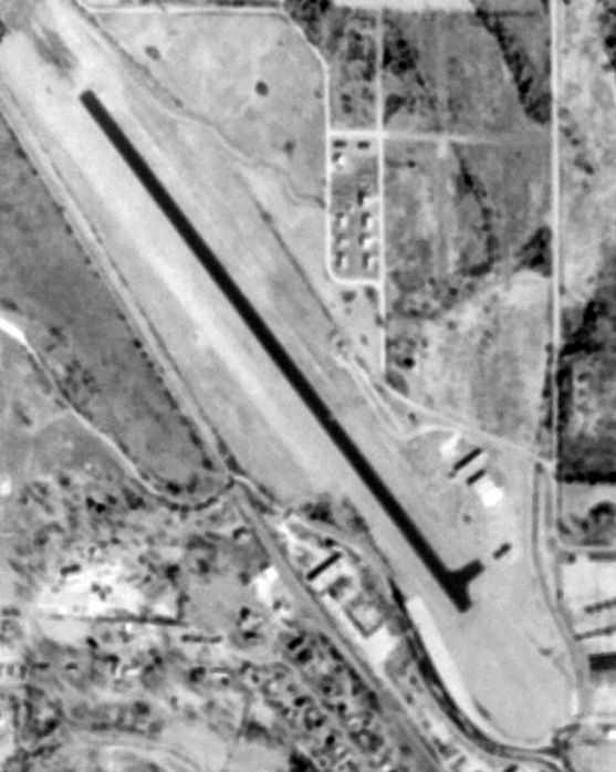
The last photo which has been located of West Plains Municipal Airport was a 2/14/81 USGS aerial view.
West Plains Municipal Airport was described in the 1982 AOPA Airport Directory (courtesy of Ed Drury)
as having a single 3,200' asphalt Runway 14/32.
It was said to provide flight instruction, aircraft rental, hangars, tiedowns, repairs, and fuel.
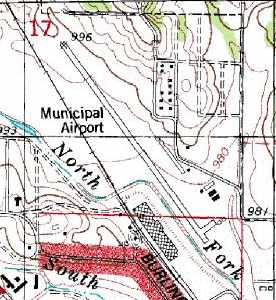
West Plains Municipal was still depicted on the 1983 USGS topo map.
West Plains was still depicted as "Municipal Airport" on the 1984 USGS topo map,
but that does not necessarily prove the airport was still open by that point.
The original West Plains Municipal Airport was evidently closed at some point between 1982-86,
as it was no longer listed in the 1986 Flight Guide (according to Chris Kennedy).
It was replaced by a new West Plains Municipal Airport, 10 miles northwest of the town.
According to Brad Weisenburger, “The former airport did not meet FAA design standards
nor was it capable of serving the aviation needs in the community.”
According to Ron Casey, “The old Municipal Airport was constrained by location & could not economically be extended to handle business jets.
An adjacent manufacturer needed additional land as well.”
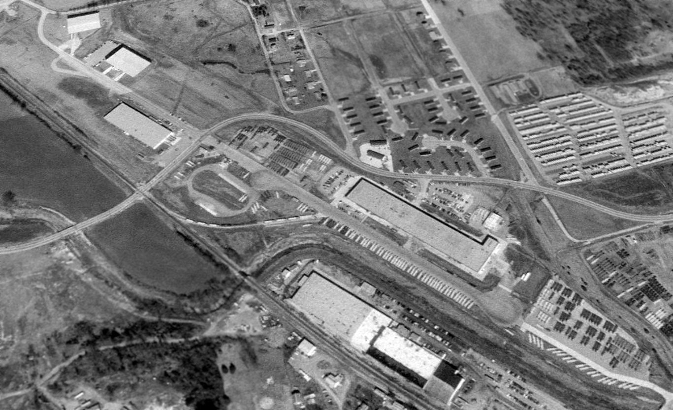
A 1995 USGS aerial view looking northeast showed the former runway of the original West Plains Municipal Airport has been reused as a street,
with several large industrial buildings having been built along both sides of it.
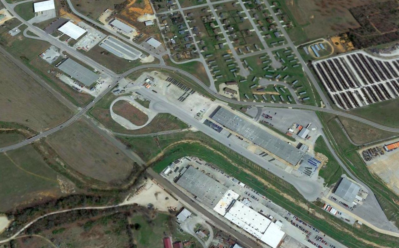
A 2016 aerial view looking northeast showed the former runway of the original West Plains Municipal Airport has been reused as a street.
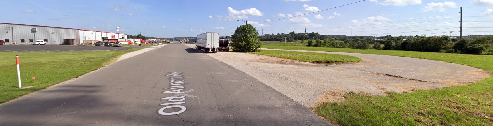
A 2024 photo looking southeast along the remains of the original West Plains Municipal Airport Runway 14, reused as Old Airport Road.
The site of the original West Plains Municipal Airport is located southeast of the intersection of Goodhard Drive & Old Airport Road, appropriately enough.
____________________________________________________
Or if you prefer to contact me directly concerning a contribution (for a mailing address to send a check),
please contact me at: paulandterryfreeman@gmail.com
If you enjoy this web site, please support it with a financial contribution.
Or if you prefer to contact me directly concerning a contribution (for a mailing address to send a check),
please contact me at: paulandterryfreeman@gmail.com
If you enjoy this web site, please support it with a financial contribution.
____________________________________________________
This site covers airfields in all 50 states.