
Attachments area
Abandoned & Little-Known Airfields:
Southeastern Missouri
© 2002, © 2026 by Paul Freeman. Revised 5/19/26.
This site covers airfields in all 50 states: Click here for the site's main menu.
The MO pages of this website are sponsored by the Missouri Aviation Historical Society:
____________________________________________________
Please consider a financial contribution to support the continued growth & operation of this site.
Arrowhead Airport (revised 2/15/26) - Bootheel Flying Service Airfield (revised 1/26/24) - Cooter Aux AAF #4 (revised 12/21/20) - Lobmaster Field / Lobmaster Sky Ranch (revised 8/26/20)
Lucas Airport / Festus Memorial Airport (revised 12/30/25) - Rolla Airport (added 5/19/26) - St Clair Municipal Airport (1st location) (added 12/23/19) - St Clair Municipal Airport (2nd location) / St Clair Regional Airport (revised 9/12/25)
Starling Airport (revised 3/31/19) - Steuby Airport / Maramec Airport / Meramec Airport / Southwest Airport (revised 4/23/24) - Sylvan Beach Airport / Naval Outlying Field 19715 (revised 4/14/24) - Weiss Airport (revised 9/9/25)
____________________________________________________
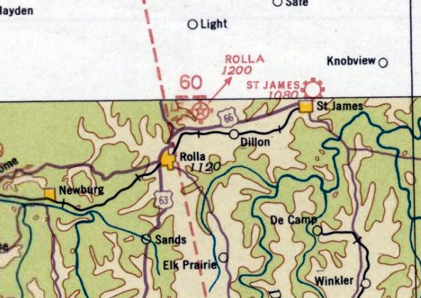
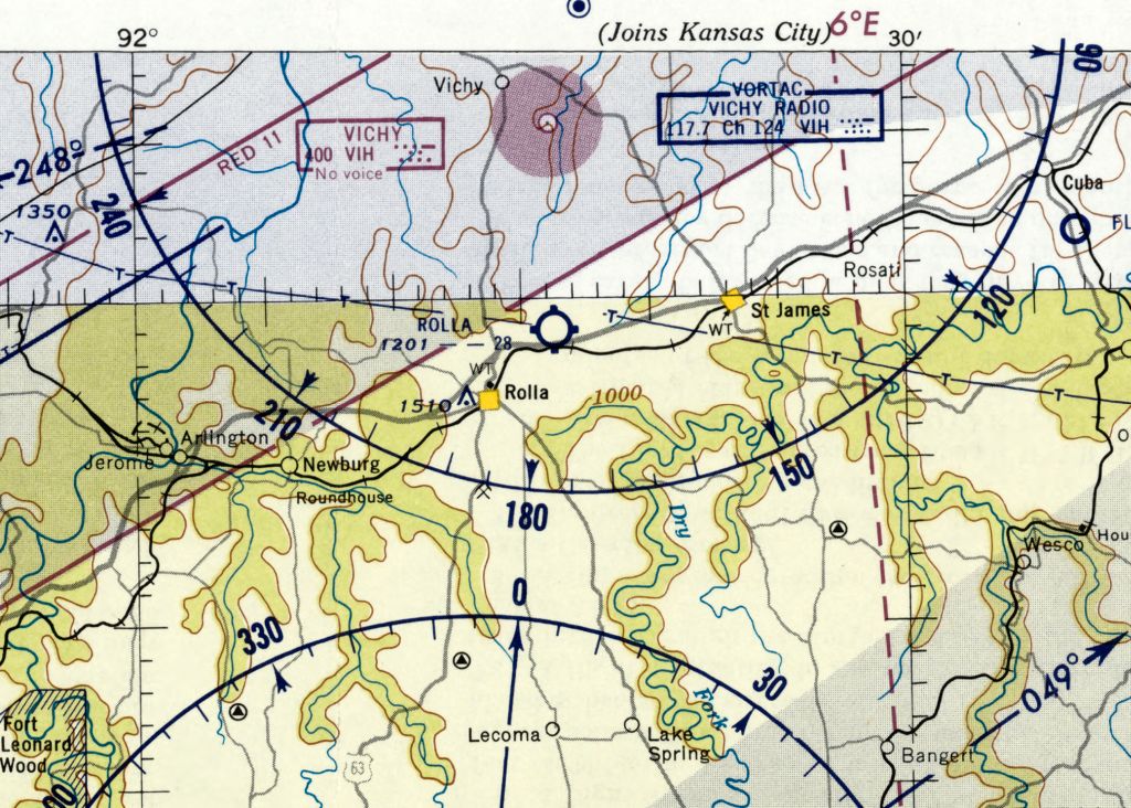
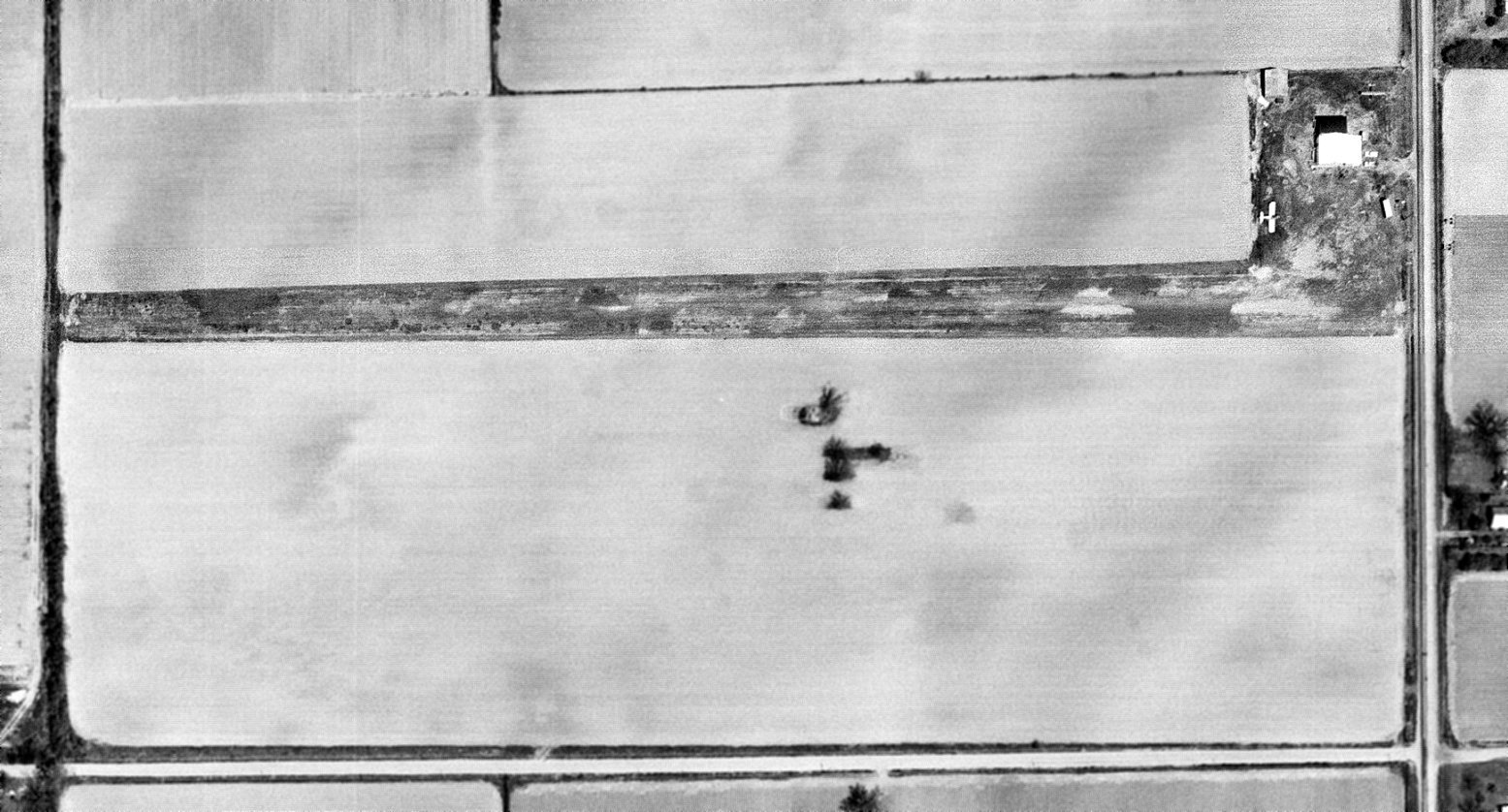
Rolla Airport (original location) (ROL), Rolla, MO
37.985, -91.723 (Southwest of St. Louis, MO)
Rolla Airport, as depicted on the January 1935 Tulsa Sectional Chart.
This early rural airport was evidently established at some point between 1934-35,
as it was not yet depicted on the August 1934 Tulsa Sectional Chart.
The earliest depiction which has been located of Rolla Airport was on the January 1935 Tulsa Sectional Chart.
It depicted Rolla as a commercial/municipal airport.
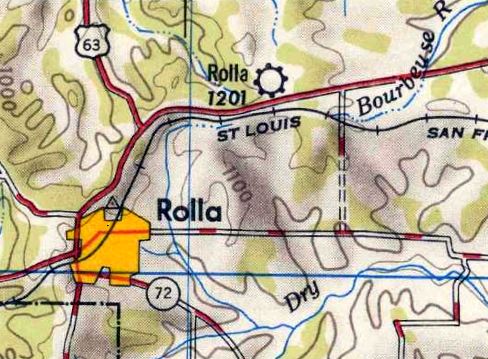
The earliest topo map depiction which has been located of Rolla Airport was on the 1950 USGS topo map.
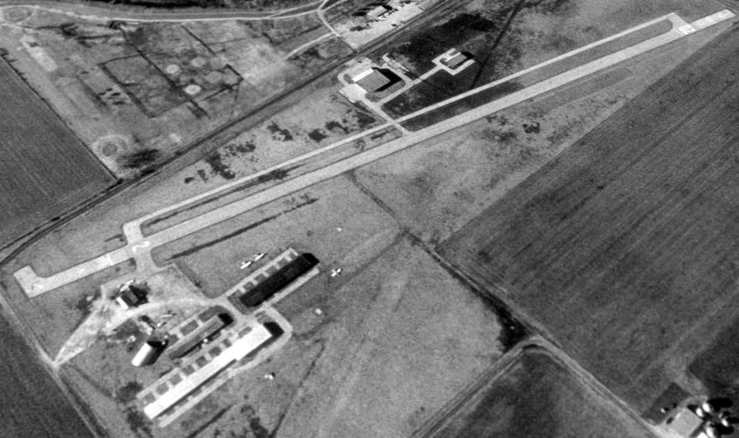
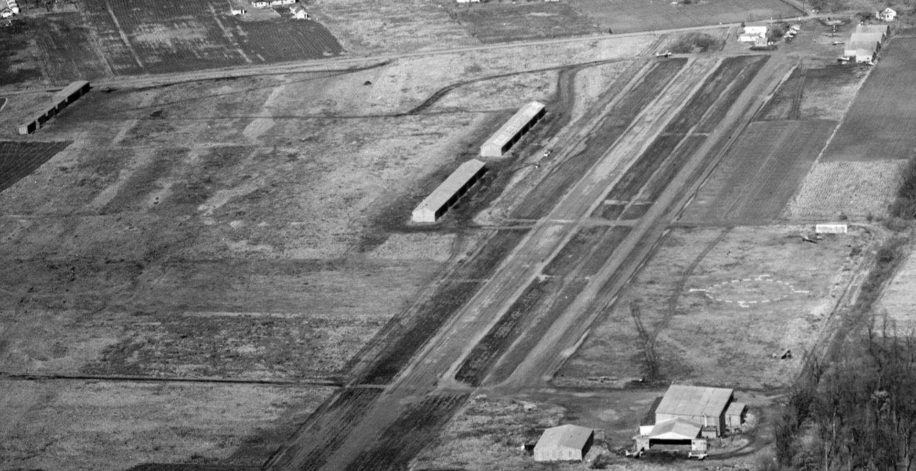
The earliest photo which has been located of Rolla Airport was on a 1959 USGS aerial view.
It depicted Rolla as having 2 unpaved runways, with several hangars & a few light planes on the southwest side.
The last aeronautical chart depiction which has been located of the original Rolla Airport was on the January 1960 Tulsa Sectional Chart.
It depicted Rolla as having a 2,800' unpaved runway.
Rolla Airport may have been closed by 1962, as a 1962 aerial photo showed the field intact but devoid of aircraft.
Rolla Airport was evidently closed at some point between 1960-63,
as it had been deleted from FAA 7350 Location Identifiers prior to 1963.
It had been replaced by the much larger Rolla National Airport to the north, a former WWII Army Air Forces airfield.
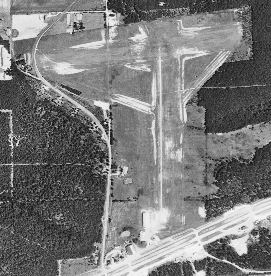
A 1976 aerial photo showed all of Rolla's hangars had been removed at some point between 1962-76,
and a large building had been erected over the center of the former airfield.

A 2023 aerial view showed all elements of the original Rolla Airport have been removed, with the only remaining trace being the curve of Hy Point Industrial Drive which previously curved around the western runway end.
Thanks to Tim Vasquez for pointing out this airfield.
____________________________________________________
Lucas Airport / Festus Memorial Airport (FES), Festus, MO
38.195, -90.386 (Southwest of St. Louis, MO)
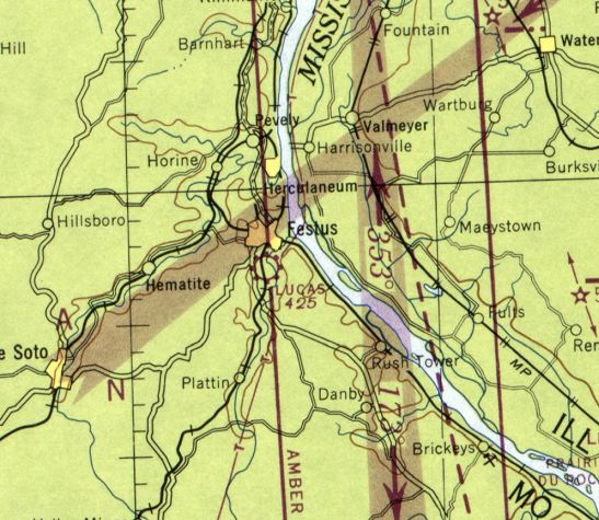
Lucas Airport, as depicted on the September 1946 Kansas City Sectional Chart.
Lucas Airport was not yet depicted on the 1939 Kansas City Sectional Chart.
But it may have existed in an unofficial capacity as early as 1940,
as a 1940 aerial view appeared to show a small hangar on the north side of a grass field.
Lucas Airport was still not yet depicted on the May 1945 Kansas City Sectional Chart.
The earliest depiction which has been located of Lucas Airport was on the September 1946 Kansas City Sectional Chart.
It depicted Lucas as a commercial/municipal airport.
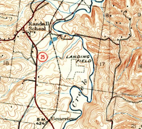
The earliest topo map depiction which has been located of Lucas Airport was on the 1950 USGS topo map.
It depicted 3 unpaved runways, generically labeled “Landing Field”.
The earliest photo which has been located showing aircraft at Lucas Airport was a 1955 aerial view,
which depicted 1 light single-engine aircraft parked next to a small hangar on the northwest side.
A 1965 aerial view depicted Lucas Airport still having unpaved runways,
but with a total of 8 light single-engine aircraft parked next to several small hangars on the northwest side.
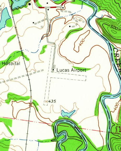
The 1965 USGS topo map depicted Lucas Airport as having 2 unpaved runways, with 4 small buildings on the northeast side.
The December 1977 Kansas City Sectional Chart (courtesy of Jonathan Westerling) depicted Festus Airport as having a single 2,200' paved north/south runway.
A 1984 aerial view depicted Lucas Airport having an asphalt Runway 18/36, and there was no longer any sign of the unpaved crosswind runway.
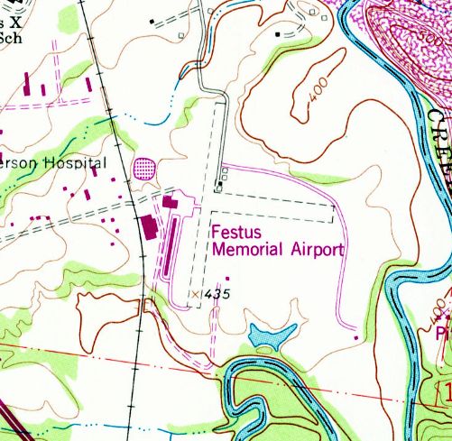
At some point between 1965-82, the airport was evidently renamed Festus Memorial Airport, as that is how it was labeled on the 1982 USGS topo map.
It depicted the airport as having 2 unpaved runways, with a ramp & 2 larger hangars having been added on the southwest side.
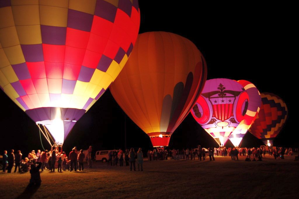
A 2011 photo of hot air balloons being launched from Festus Memorial Airport.
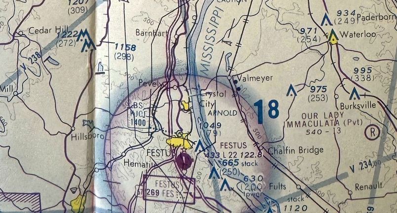
According to its FAA Airport/Facility Directory data, Festus Memorial Airport comprised 72 acres & had 1 asphalt 2,202' Runway 1/19.
For the year of 2019, Festus conducted an average of 25 takeoffs or landings per day, and it had 25 based aircraft: 24 single-engine & 1 multi-engine
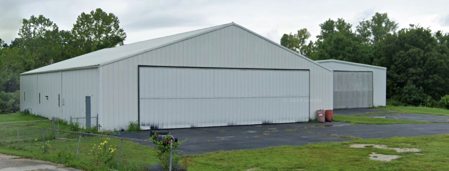
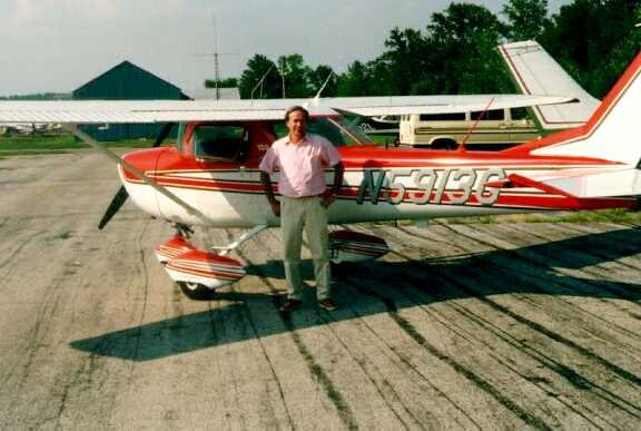
A 2022 photo looking east showing a single Cessna inside a Festus Memorial Airport hangar.
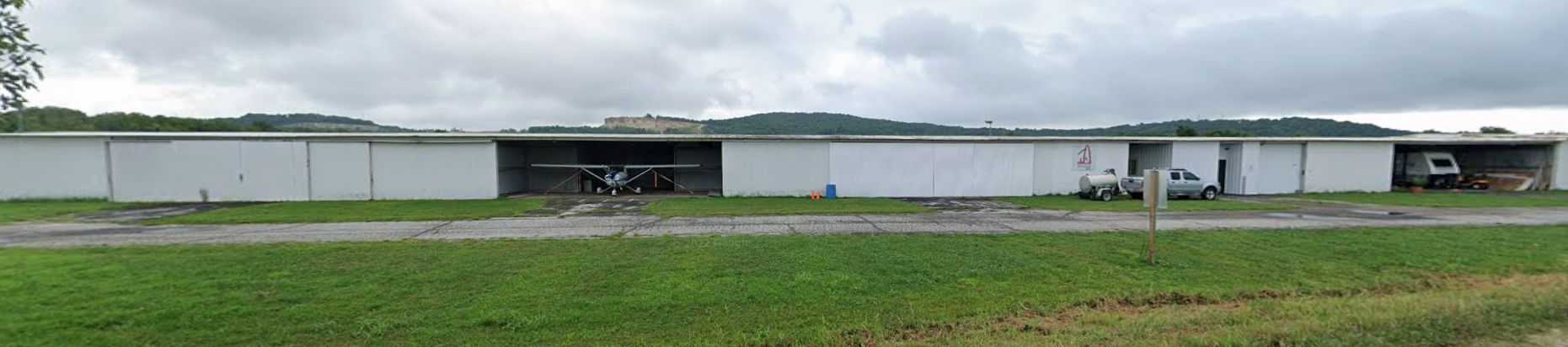
A 2022 photo looking northwest at 2 Festus Memorial Airport hangars.
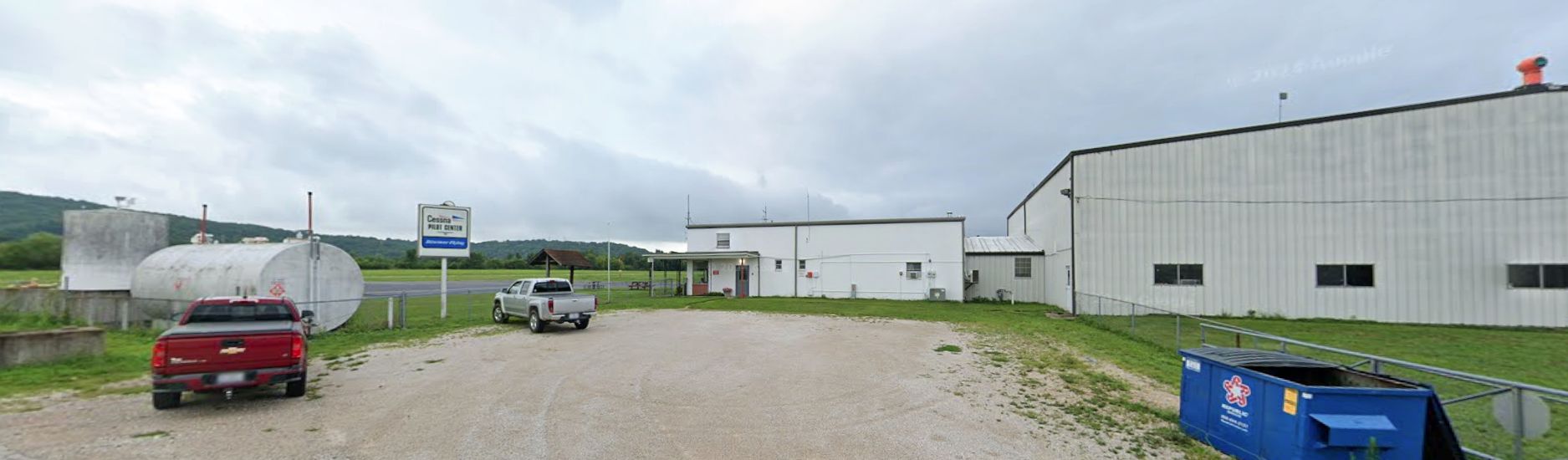
A 2022 photo looking south at the Cessna Pilot Center sign at Festus Memorial Airport.
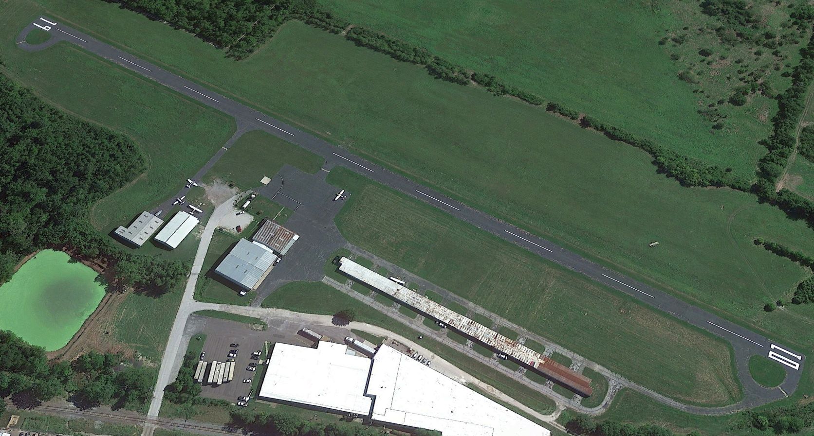
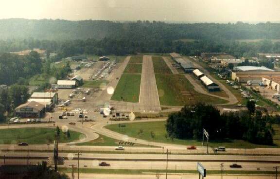
An 8/30/22 aerial view looking northeast showed Festus Memorial Airport less than a month before its closure, with 5 light single-engine aircraft still visible.
According to Wikipedia, in August 2022, after months of rumors it was announced that the owner was selling the Festus Airport property to develop a new industrial district.
The airport closed on 9/27/22. More than 20 aircraft had to be relocated from hangars due to the closure, yet there were not any other airports in Jefferson County.
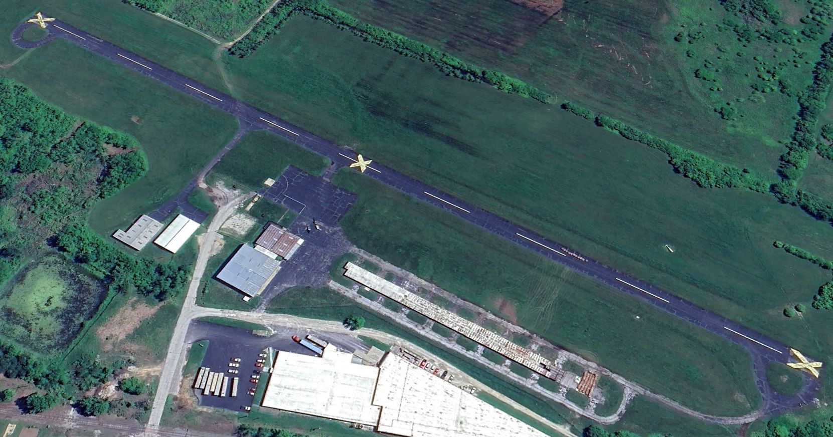
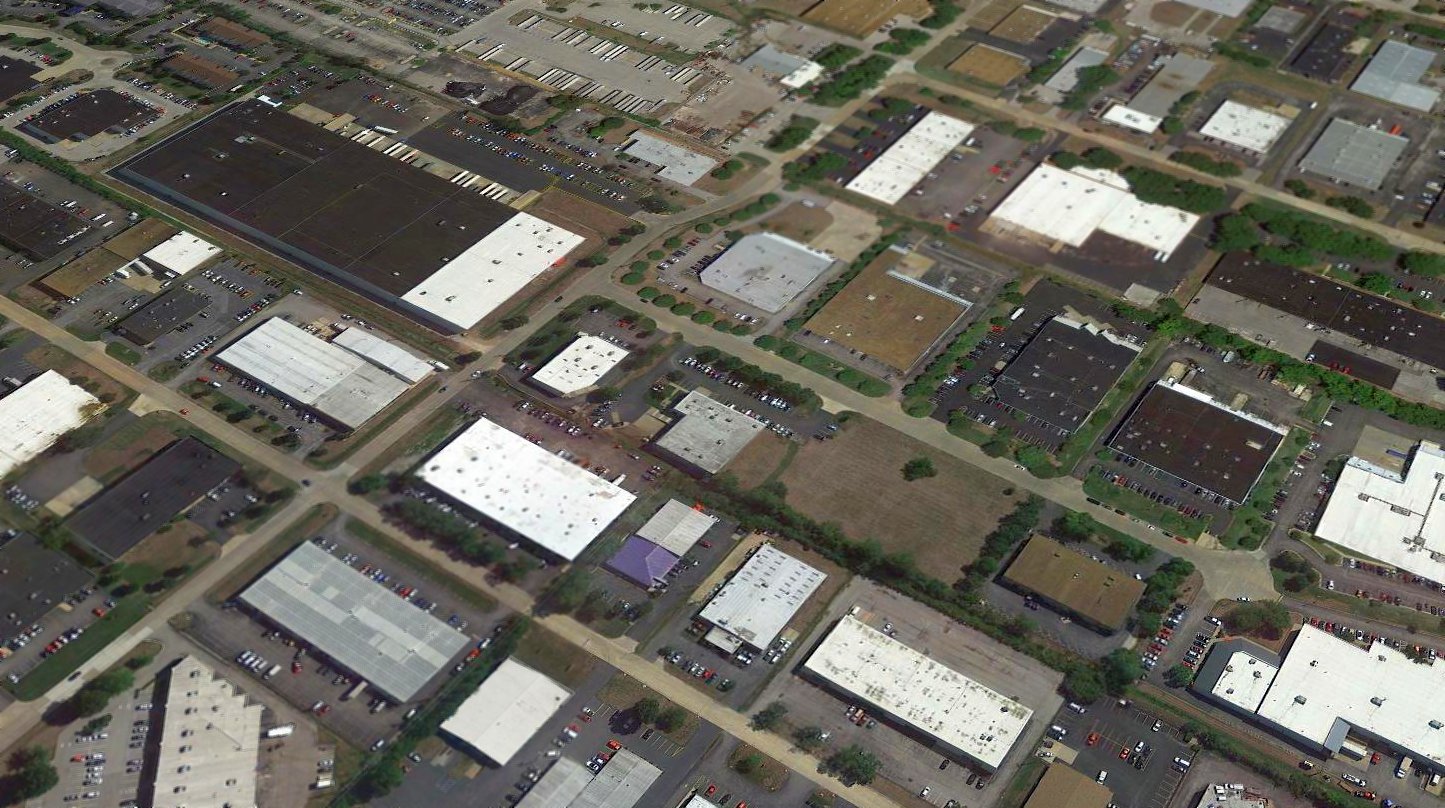
A 2025 aerial view looking northeast showed Festus Memorial Airport remained largely intact, though it appeared the long southwest hangar appeared to be in the process of being removed.
Thanks to Ron Plante for pointing out this airfield.
____________________________________________________
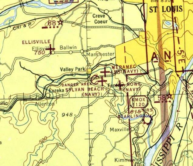
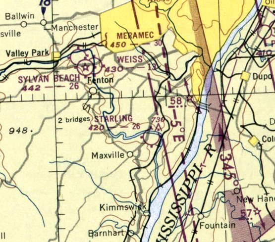
Sylvan Beach Airport / Naval Outlying Field 19715, Fenton, MO
38.534, -90.453 (Southwest of St. Louis, MO)
Sylvan Beach Airport, as depicted on the October 1942 Kansas City Sectional Chart.
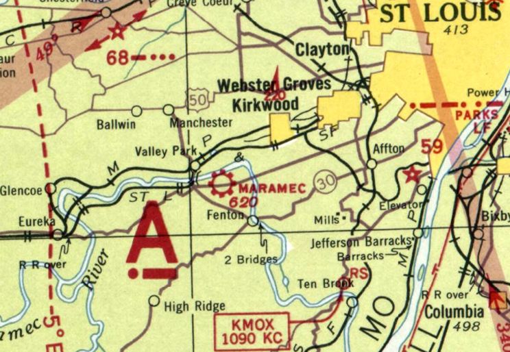
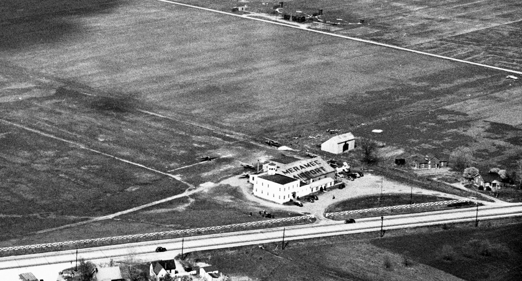
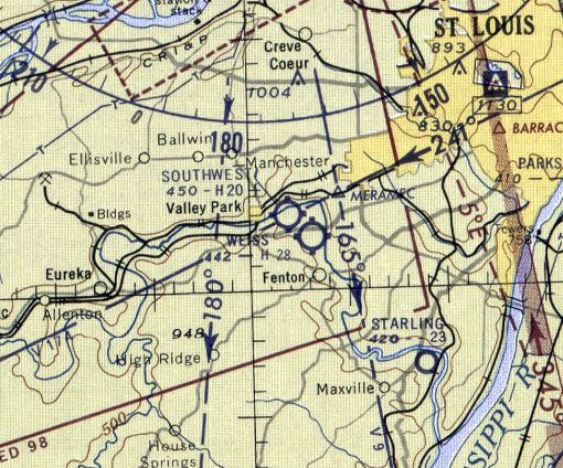
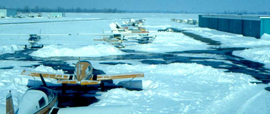
This was one of 3 small general aviation airports which were clustered in close proximity to each other, the other two being Meramec & Weiss Airports.
Sylvan Beach Airport was evidently established at some point in 1942,
as it was not yet depicted on the May 1942 Kansas City Sectional Chart.
The earliest depiction which has been located of Sylvan Beach Airport was on the October 1942 Kansas City Sectional Chart.
It depicted Sylvan Beach as a commercial/municipal airport.
Brian Rehwinkel reported, “According to Navy documents, Sylvan Beach Airfield was acquired by the Navy in 1942 via lease.
Sylvan Beach Airport (Field designation # 19715) I believe was a private airport before being leased by the Navy from Sylvan Beach Air Services Inc.
I say this for two reasons: it apparently had an existing hangar - with the name of the airport on the roof - (the Navy would not have built a hangar for a small grass OLF),
and the annual lease price was fairly high - about $6,400 / year for less than 100 acres.
This field was used by primary training aircraft attached to NAS St. Louis (at Lambert Field).
There were 8 Outlying Fields used by NAS St. Louis & 3 of those fields were grouped together south-southwest of the main station field.”

A 7/2/43 Navy plan depicted “Outlying Field (Sylvan Beach)” (from the National Archives, courtesy of Brian Rehwinkel)
as supporting Naval Air Station Lambert Field, and to consist of a 92 acre sod field, measuring 2,753' east/west, with a hangar & another small building on the east side.

A 10/9/43 Navy aerial view looking north (from the National Archives, courtesy of Brian Rehwinkel)
annotated to show the proximity of Sylvan Beach Airport, Meramec Airport, and the eventual Weiss Airport.

A closeup from the 10/9/43 Navy aerial view looking north (from the National Archives, courtesy of Brian Rehwinkel)
depicted Sylvan Beach Airport as having an east/west grass runway, with a airport circle marking in the center, and 2 buildings on the east side.

Sylvan Beach, Meramec, and Rowe Fields were shown in close proximity on a 3/2/44 Navy map of NAS St. Louis Outlying Fields (from the National Archives, courtesy of Brian Rehwinkel).
Sylvan Beach Airport was evidently used by the military during WW2, as the August 1944 Kansas City Sectional Chart depicted Sylvan Beach as a Navy airfield, with a circular “Danger Area” adjacent to the west.
Was this a bomb target?
The earliest photo which has been located of Sylvan Beach Airport was an undated aerial view looking southwest,
showing Weiss Airport (foreground) & the adjacent former Sylvan Beach Airport (grass area in the background),
from the 1947 MO Airport Directory (courtesy of Stephen Mahaley).
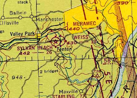
Sylvan Beach, Weiss, and Meramac Airports, all depicted in very close proximity on the 1948 Kansas City Sectional Chart (courtesy of Chris Kennedy).
Sylvan Beach was described as having a 2,600' unpaved runway.
The last depiction which has been located of Sylvan Beach Airport was on the May 1951 Kansas City Sectional Chart.
Sylvan Beach Airport was evidently closed (for reasons unknown) at some point in 1951, as it was no longer depicted on the November 1951 Kansas City Sectional Chart.
A 1958 aerial photo showed no recognizable trace of Sylvan Beach Airport.
A 2022 aerial view showed no trace remaining of Sylvan Beach Airport.
____________________________________________________
Steuby Airport / Maramec Airport / Meramec Airport / Naval Outlying Field 19714 / Southwest Airport, Fenton, MO
38.544, -90.457 (Southwest of St. Louis, MO)
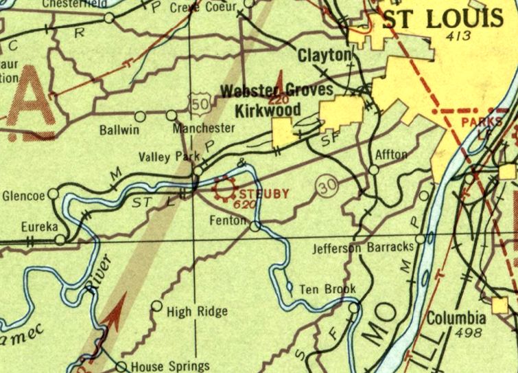
Steuby Airport, as depicted on the May 1934 Kansas City Sectional Chart.
Brian Rehwinkel reported, “According to Navy documents, Meremac had been an existing airfield for 12 years prior to its 1942 Navy acquisition, which would mean it was established in 1930, if the Navy information was correct.”
No airfield was yet depicted on the June 1932 Kansas City Sectional Chart.
The earliest depiction which has been located of an airfield at this location was on the May 1934 Kansas City Sectional Chart.
It depicted “Steuby” as a commercial/municipal airport.
Steuby Airport continued to be depicted on the May 1937 Kansas City Sectional Chart.

The earliest photo which has been located of Steuby Airport was a 1937 aerial view (courtesy of Mike Denja).
It depicted Steuby as having a single grass northwest/southeast runway, with an airfield circle marking in the center, and a single hangar on the southeast side.
At some point between 1937-38, Steuby Airport was evidently renamed Maramec Airport,
as that is how it was depicted on the May 1938 Kansas City Sectional Chart.
It was still depicted as Maramec Airport on the May 1939 Kansas City Sectional Chart.
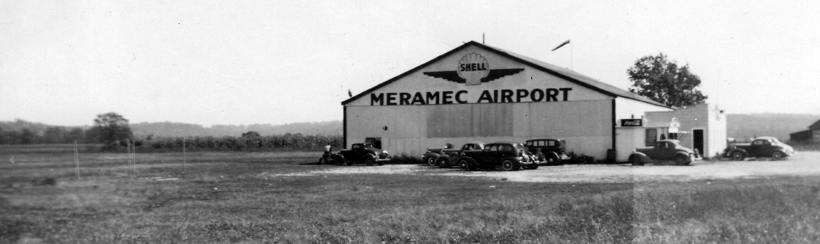
The earliest photo which has been located of Meramec Airport was a circa 1930s photo showing a hangar labeled “Meramec Airport”.
Note the slightly different spelling of the airport name compared to the 1938-39 Sectional Charts.
Meramec Airport was not yet depicted on the 1940 USGS topo map.
It was depicted as Meramec Airport on the January 1942 Kansas City Sectional Chart & subsequent charts.
Brian Rehwinkel reported, “According to Navy documents, Meremac Airport was acquired by the Navy in 1942 via lease.
This field was used by primary training aircraft attached to NAS St. Louis (Lambert Field).
There were 8 Outlying Fields by NAS St. Louis & 3 of those fields were grouped together south-southwest of the main station field.”

A 7/2/43 Navy plan depicted “Outlying Field (Meremac Airport)” (from the National Archives, courtesy of Brian Rehwinkel)
as supporting Naval Air Station Lambert Field, and to consist of a 114 acre sod field, measuring 1,954' east/west along its southern edge, with a hangar on the southeast side.
A 10/9/43 Navy aerial view looking north (from the National Archives, courtesy of Brian Rehwinkel)
annotated to show the proximity of Meramec Airport, Sylvan Beach Airport, and the eventual Weiss Airport.

A closeup from the 10/9/43 Navy aerial view looking north (from the National Archives, courtesy of Brian Rehwinkel)
depicted Meremac Airport as having an grass airfield with a airport circle marking in the center, and a large 2-story office & hangar on the south side.
Meramec, Sylvan Beach, and Rowe Fields were shown in close proximity on a 3/2/44 Navy map of NAS St. Louis Outlying Fields (from the National Archives, courtesy of Brian Rehwinkel).
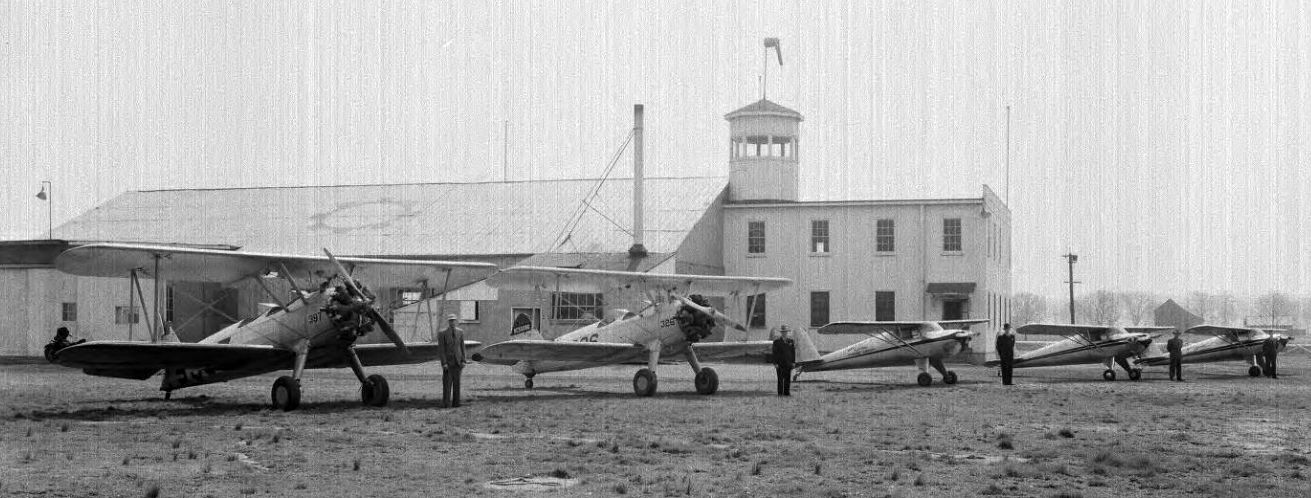
A 3/28/46 photo (courtesy of Jim Naumann) showing 2 Stearman biplanes & 3 Cessna 120s.
At some point since the 1930s a 2-story airport office building had been added next to the hangar, with a control tower on top.
Was the 2-story building an indication the field had been used for Civilian Pilot Training during WW2?
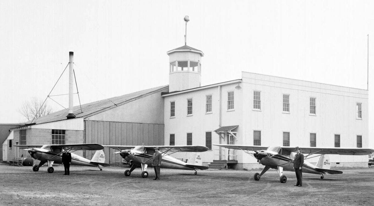
A 3/28/46 photo of 3 Cessna 120s in front of the Meramec Airport hangar & control tower.
The last photo which has been located of Meramec Airport was a 1947 aerial view looking north, showing the distinctive 2-story airport office building with the control tower on top, and the adjacent hangar with the airport name painted on its roof.
Weiss, Sylvan Beach, and Meramac Airports, all depicted in very close proximity on the 1948 Kansas City Sectional Chart (courtesy of Chris Kennedy).
Meramec was described as having a 3,000' unpaved runway.
Meramec Airport was not depicted on the 1954 USGS topo map.
It was still depicted as Meramec Airport on the December 1955 Kansas City Sectional Chart.
At some point between 1955-56, Meramac Airport was evidently renamed Southwest Airport, as that is how it was depicted on the June 1956 Kansas City Sectional Chart.
It had also gained a 2,000' paved runway.
The last depiction which has been located of Southwest Airport was on the June 1957 Kansas City Sectional Chart.
Southwest Airport was evidently closed at some point between 1957-58,
as it was no longer depicted on the August 1958 Kansas City Sectional Chart.
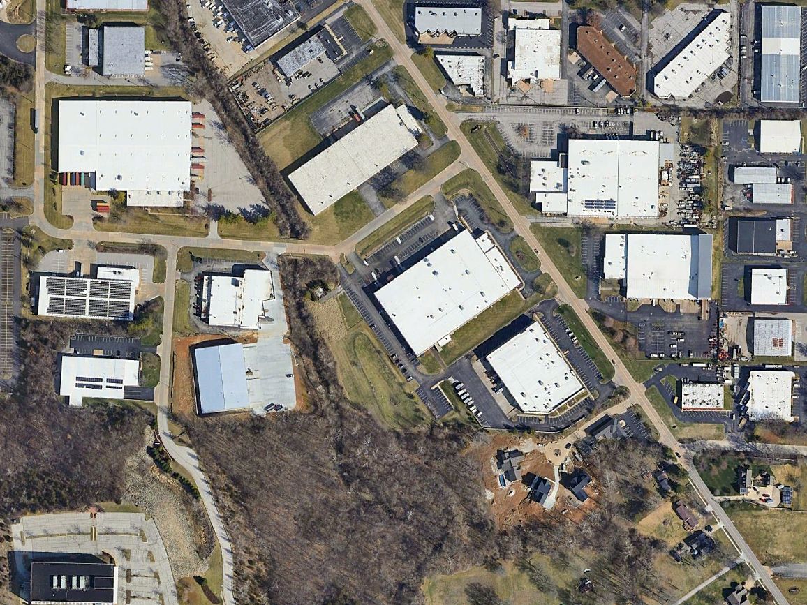
A 1958 aerial photo showed the Chrysler Saint Louis Assembly factory being built over the site of Southwest Airport.
The Chrysler Saint Louis Assembly factory ended production in 2009, and was razed in 2011.
In October 2016, groundbreaking began for the Fenton Logistics Park, which now covers the airport site.
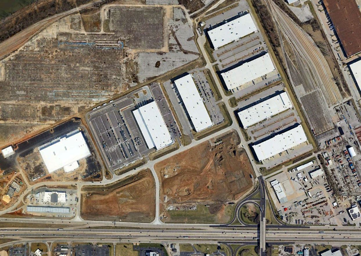
A 2022 aerial view showed no trace remaining of Meramec Airport.
____________________________________________________
St Clair Municipal Airport (1st location), St Clair, MO
38.353, -90.961 (Southwest of St. Louis, MO)
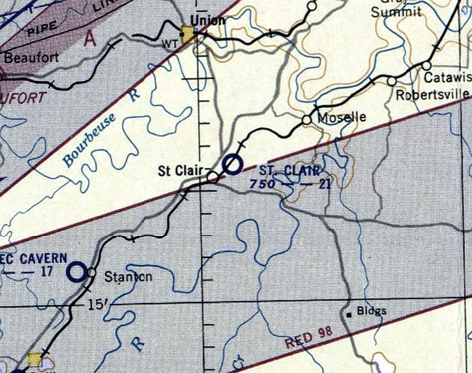
St Clair Municipal Airport, as depicted on the November 1952 Kansas City Sectional Chart.
Photo of the airport has not been located.
The original location of the St Clair Municipal Airport was east/northeast of the town, on the east side of the railroad.
The date of establishment of St Clair Municipal Airport has not been determined.
The earliest depiction which has been located of St Clair Municipal Airport was on a 1945 aerial view.
It depicted a single grass east/west runway, with 1 light aircraft parked on the southwest side.
The St Clair Municipal Airport was not yet depicted on the November 1951 Kansas City Sectional Chart.
The earliest aeronautical chart depiction which has been located of St Clair Municipal Airport was on the November 1952 Kansas City Sectional Chart.
It depicted St Clair Airport as having a 2,100' unpaved runway.
A 1958 aerial view depicted St Clair Municipal Airport as having 2 grass runways, with 2 light single-engine aircraft parked on the southwest side.
The last depiction which has been located of the original St Clair Municipal Airport was on the June 1960 Kansas City Sectional Chart.
It depicted St Clair Airport as having a 2,100' unpaved runway.
The
original St Clair Municipal Airport was evidently closed (for reasons
unknown) at some point in 1960,
as it was no longer depicted on the December 1960 Kansas City Sectional Chart, a 1964 aerial photo, or the 1965 USGS topo map.
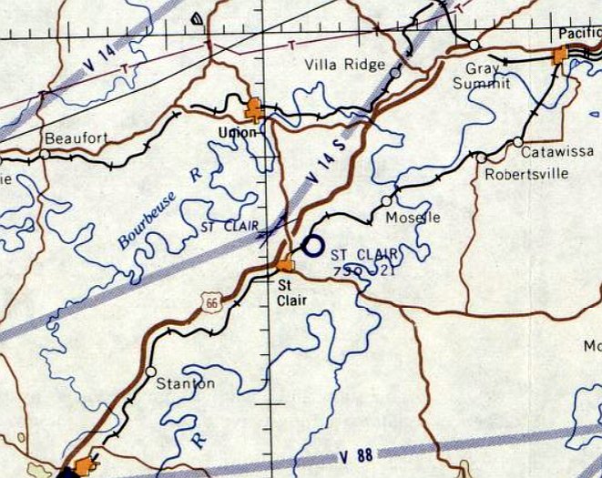
At some point in 1965, the original St Clair Municipal Airport was replaced by a new airport a half-mile to the northwest, on the northwest side of the railroad tracks.
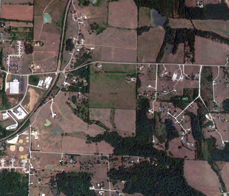
A 2018 aerial view of the general location of the original St Clair Municipal Airport did not show any recognizable trace of an airfield.
____________________________________________________
St Clair Municipal Airport (2nd location) / St Clair Regional Airport (K39), St Clair, MO
38.374, -90.974 (Southwest of St. Louis, MO)
The 2nd location of St Clair Municipal Airport, as depicted on the August 1965 Kansas City Sectional Chart.
At some point in 1965, the original St Clair Municipal Airport (on the east side of the railroad tracks)
was replaced by a new airport, a half-mile to the northwest, on the northwest side of the railroad tracks.
No airport in St Clair was yet depicted on the February 1965 Kansas City Sectional Chart.
The earliest depiction which has been located of the 2nd location of St Clair Municipal Airport
was on the August 1965 Kansas City Sectional Chart.
It depicted St Clair Airport as having a 2,500' paved northeast/southwest runway.
According to Stephen Deere's article “Tiny Franklin County airport faces headwind” in the 8/31/11 St Louis Post Dispatch,
“The St. Clair Regional Airport was built in the 1960s through the efforts of former World War II pilots & other aviation enthusiasts.
It was paid for with a mix of federal & city money & private donations. Pilot Gilbert Hoffman took out a $2,500 loan to help with the cause.
At its peak the airport was home to roughly 35 single-engine Cessnas.”
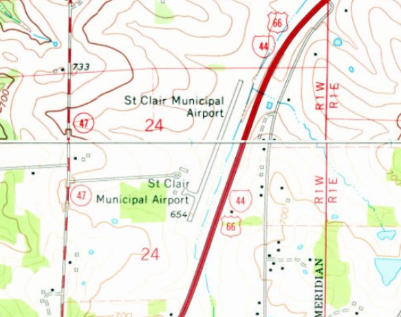
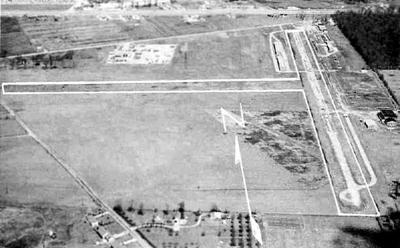
St Clair Municipal Airport, as depicted on the 1969 USGS topo map.
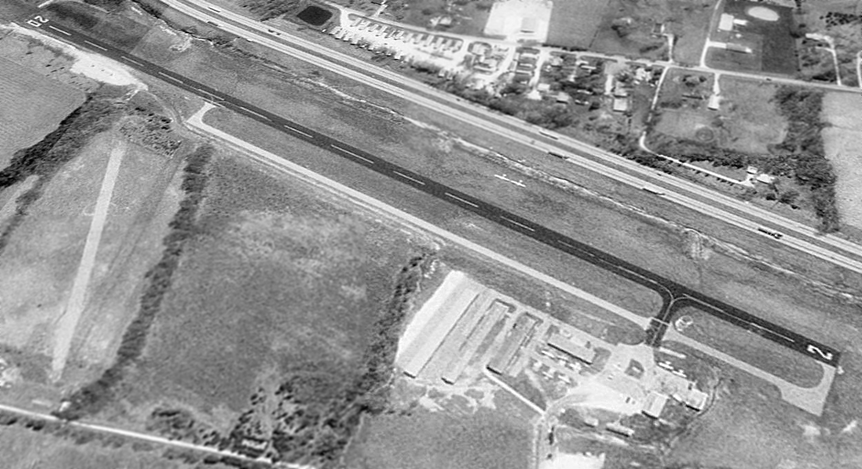
A 1995 aerial view looking east at St Clair Regional Airport depicted it as having an asphalt Runway 2/20 & paved parallel taxiway,
and 4 hangars & other buildings on the southwest side.
A total of 9 light single-engine aircraft were visible on the field.
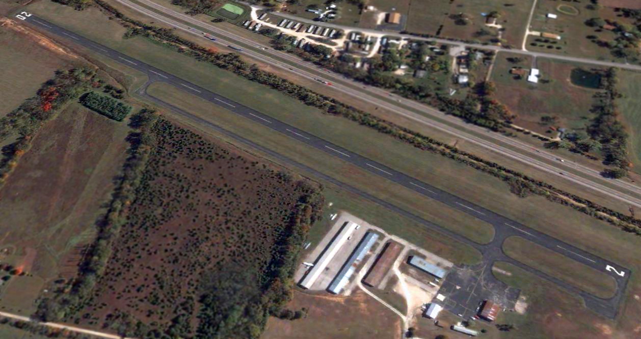
A 2004 aerial view looking east at St Clair Regional Airport depicted 3 light single-engine aircraft parked among the hangars.
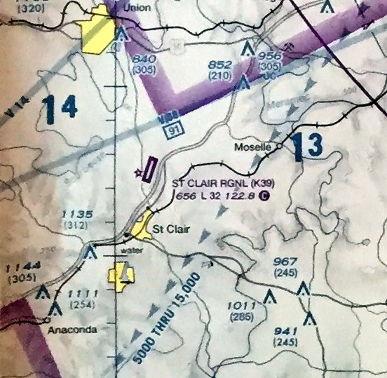
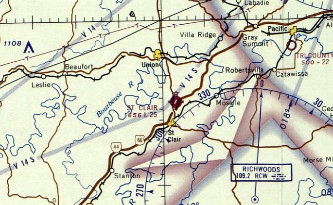
The last aeronautical chart depiction which has been located of St Clair Regional Airport was on the July 2009 Kansas City Terminal Chart.
It depicted St Clair Regional Airport as having a 3,200' paved northeast/southwest runway.
An 8/27/11 photo of hangars at St Clair Regional Airport.
According to Stephen Deere's article “Tiny Franklin County airport faces headwind” in the 8/31/11 St Louis Post Dispatch,
“The diminutive airport is disappearing, piece by piece.
Pilots must now fly elsewhere to get fuel. The restrooms have been condemned.
The soda machines are long gone. Two of the 4hangars, scarred with rust & filled with weeds, soon will be demolished.
And, if the city has its way, most of the operation would vanish to make room for a strip mall.”
“It was all done on purpose,” said pilot Gilbert Hoffman, 79, of the airport's decrepit condition.
In aviation parlance, the St. Clair Regional Airport in Franklin County is a 'federally obligated airport,' meaning it has accepted federal grant money for public use.
Closing a federally obligated airport, even a dying one, is no easy feat.
“Generally the difficulty is so monumental that they just don't close,” said Steve Taber, an aviation and airport attorney based in Irvine, Calif.
The Federal Aviation Administration hasn't kept statistics on how many of the nation's 3,300-plus federally obligated airports have been shuttered.
Although St. Charles Municipal Airport shuttered last year, it was privately owned.
Deere's article continued, “Joe Pestka, Missouri Department of Transportation's Administrator of Aviation, has already told city officials he opposes the closing.
But on Tuesday, St. Clair leaders made their case directly to the FAA at a meeting in Kansas City.”
The city claims that the airport "has never, in its history, provided any positive impact on the economic well-being of St. Clair,
and little if any positive impact of any kind," according to a 203-page document.
The city has offered to repay more than $760,000 in federal grants used to pay for improvements over the years.
A handful of pilots, however, want the airport saved.
The airport, they say, was never intended to boost St. Clair's economy, and if it is dying, it's only because St. Clair is killing it.
The pilots plan on meeting with the FAA next week.
"The purpose of the airport is to serve the public," said pilot Jim De Vries.
In recent years, the city claims, the airport has lost money, although it's not clear how much.
But whether the losses are $1,000 or $1 million, City Administrator Rick Childers said the land could be better used.
The airport sits in a prime location at the intersection of Interstate 44 & Highway 47.
Its flight path is in the way of a proposed strip mall to be built west of the property.
It appears the airport actually made $23,514 in 2008. But Childers said the budget numbers didn't account for expenses such as insurance & maintenance.
Pilots claim that the cost of running the airport has been inflated & that its poor condition has driven off customers.
"The city has created a self-fulfilling prophecy by ignoring it," said Bill Dunn, of the Maryland-based Aircraft Owners and Pilots Association.
Dunn, the AOPA's vice president of airport advocacy, has lobbied the state to keep the airport open.
Recently, De Vries sat in his hangar, under the wing of his blue and white Cessna 180.
He looked out over a patch of crumbling asphalt. His propeller once sucked up some asphalt chunks, costing $4,800 to repair.
So why does he keep his plane there?
This is where he learned to fly, he said. It's only about 15 minutes from his home near Pacific. More important, there are few options.
Demand is high for enclosed hangars in the area. Sullivan Regional Airport has none available. Neither does Washington Regional Airport.
"We have a waiting list of at least 30 people," said Larry Phillips, who handles maintenance for Washington's airport.
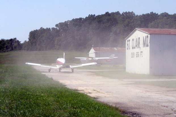
An 8/27/11 photo of a Piper taxiing at St Clair Regional Airport.
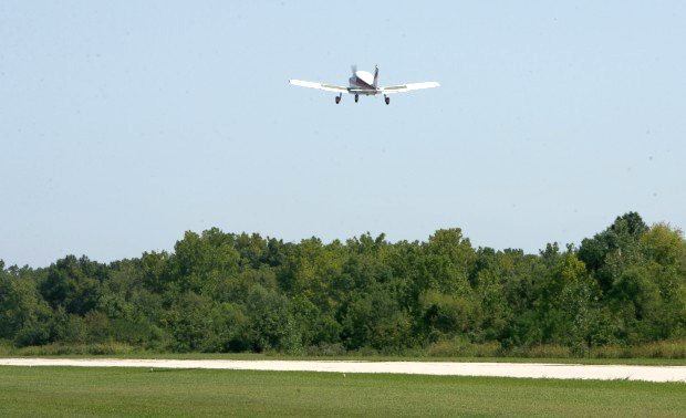
An 8/27/11 photo of a Piper taking off at St Clair Regional Airport.
Deere's article continued, “To close the airport, St. Clair must show that the decision would benefit general aviation, not just the city's economy.
The city's argument is simple: Limited federal dollars could be better spent at more viable airports.”
"That money goes back into the aviation system," said Ron Price, principal of QED, a consulting firm hired by the city. "The FAA could allocate it anywhere in the country."
But Dunn said small municipal airports were similar to freeway on & off ramps for pilots - you just can't do away with them.
Price said the FAA needed to be more friendly to local governments.
"We are working under a set of rules the federal government established in the mid-1940s when aviation was in its infancy," he said. "We can't continue to use policy from the mid-1940s."
The airport leases space to Air Evac EMS Inc., a medical emergency service that uses a helicopter pad. Under the city's plan, Air Evac would remain at the airport.
Hoffman, one of the airport's founding pilots, says he doesn't fly as much as he used to, in part because for medical reasons he can't fly alone.
He misses the days when the airport was a source of civic pride. Today, he said, "you can't even get a drink of water there."
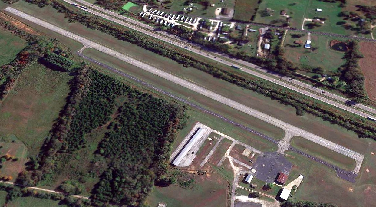
The last photo which has been located showing St Clair Regional Airport still marked with active runway markings was a 2016 aerial view.
However 2 hangars had been removed, and there were no aircraft visible on the field.
St Clair Regional Airport closed on 11/13/17, according to a Federal Register notice.
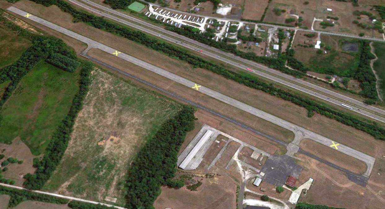
A 2018 aerial view looking east showed St Clair Regional Airport's runway marked with closed-runway “X” symbols.
Two hangars still remained.
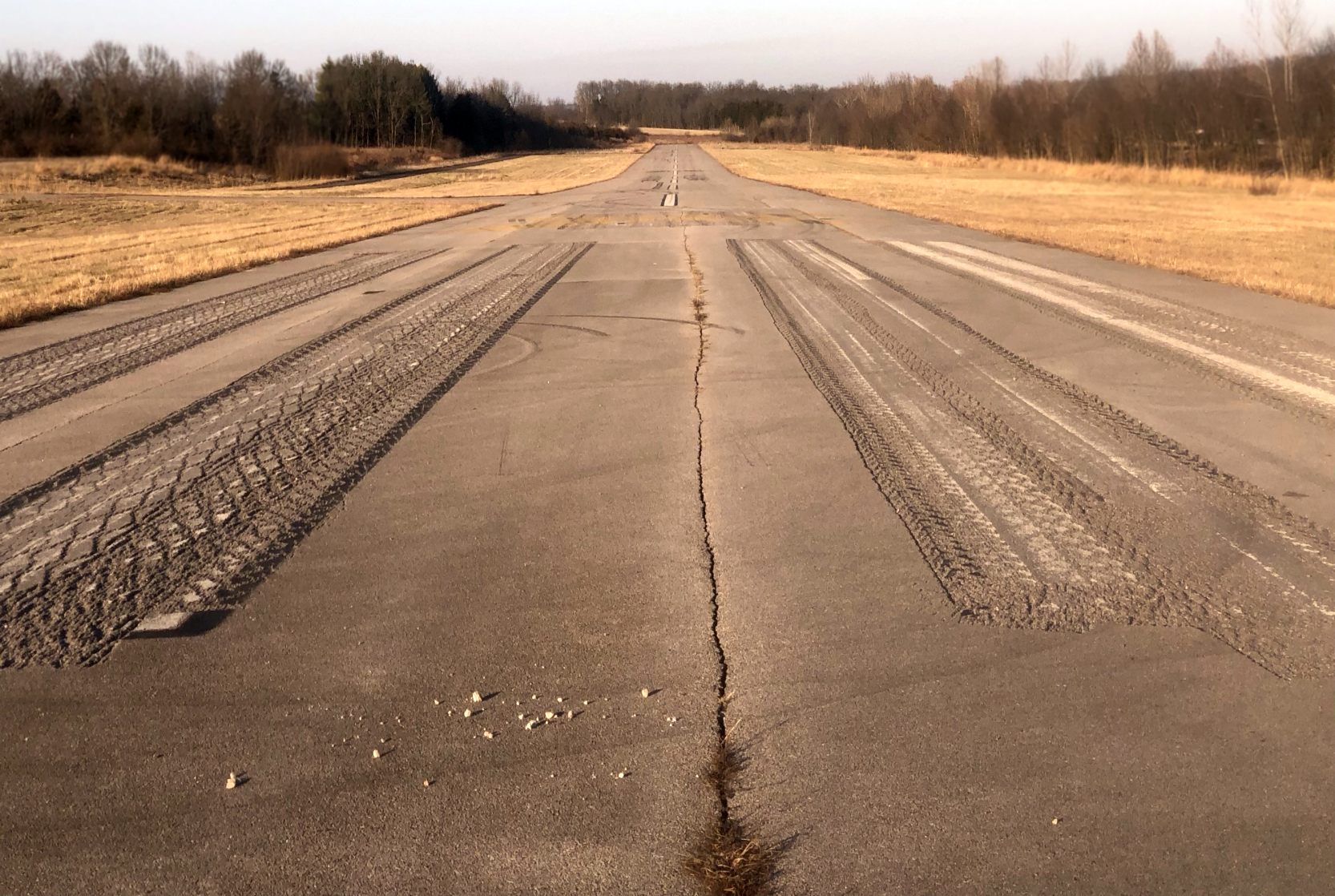
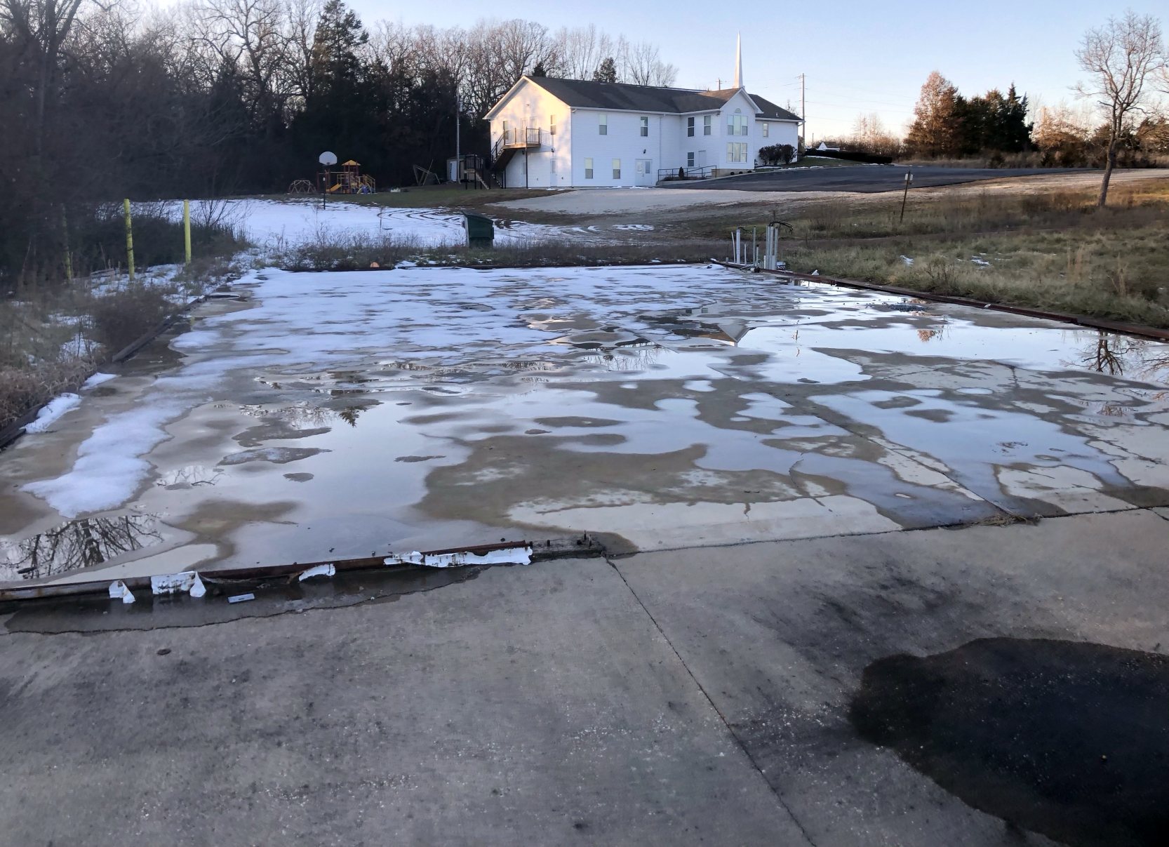
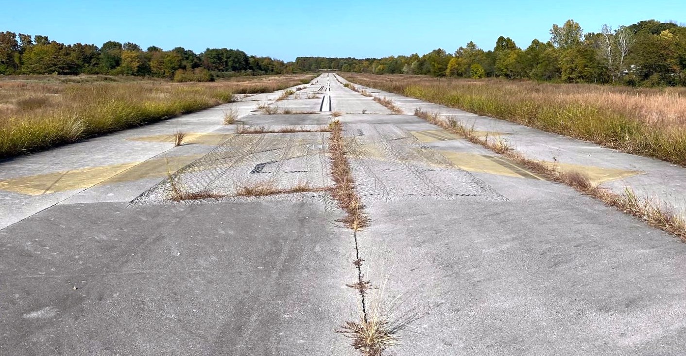
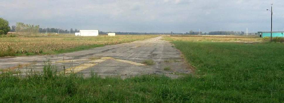
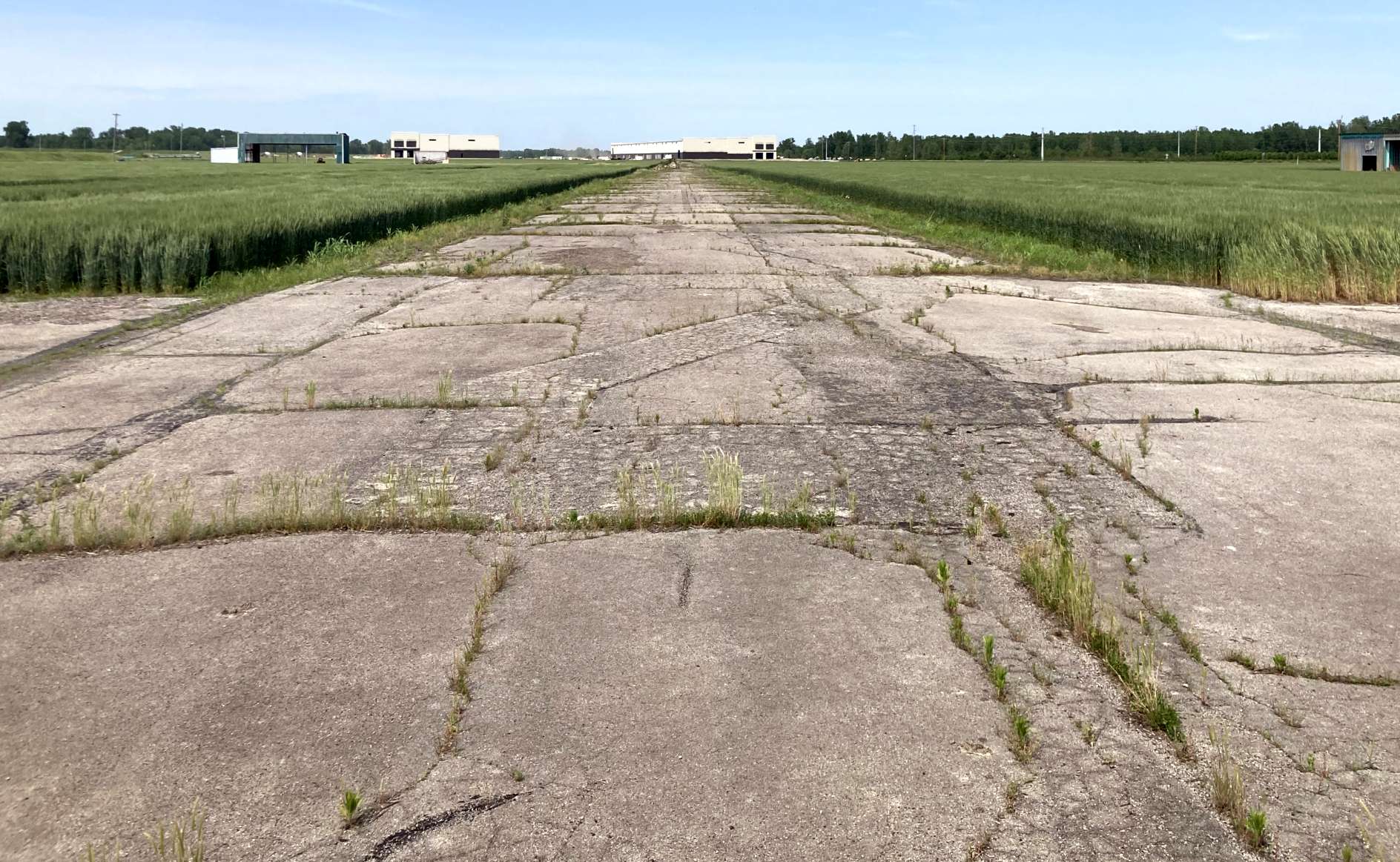
A 12/21/19 photo looking along the former St Clair Regional Airport Runway 2.
The photographer noted, “The runway was in very good shape with the exception of some weeds growing through the cracks on the north end.
The taxiway was also in fair condition with weeds growing through the cracks.”
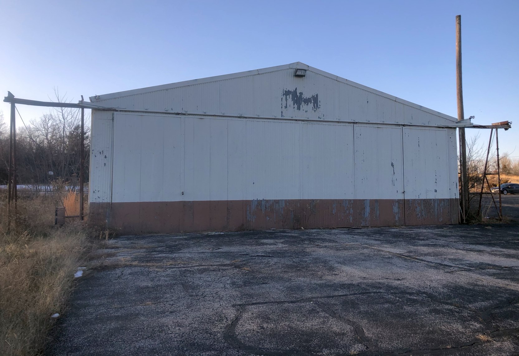
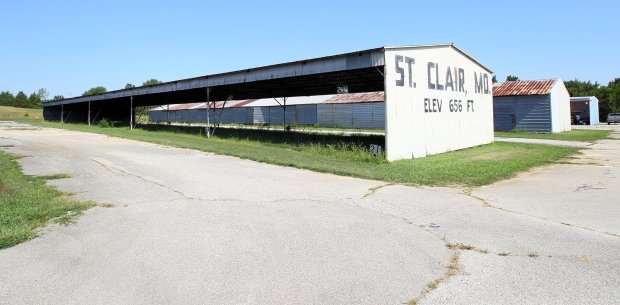
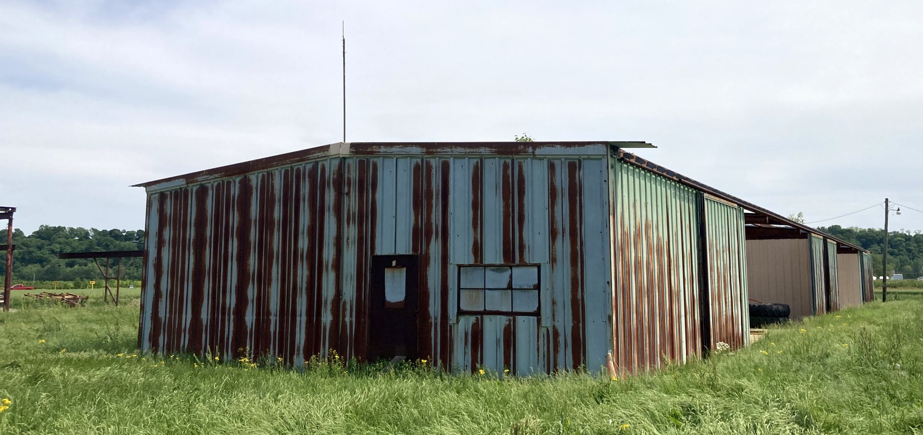
A 12/21/19 photo of the former St Clair Regional Airport main hangar.
The photographer noted, “The main hangar is still intact & locked, and looks to be completely empty.”
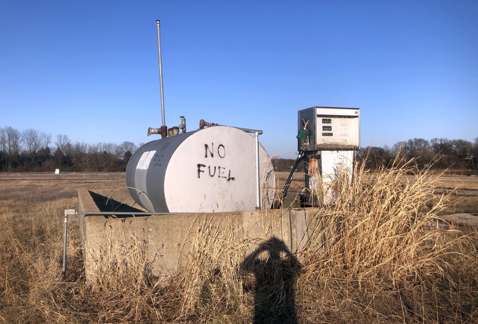
A 12/21/19 photo of the former St Clair Regional Airport fuel tank & pump.
A 12/21/19 photo of the foundation of a former St Clair Regional Airport hangar.
The photographer noted, “The far west hangar & the T-hangars have been demolished since 2018.”
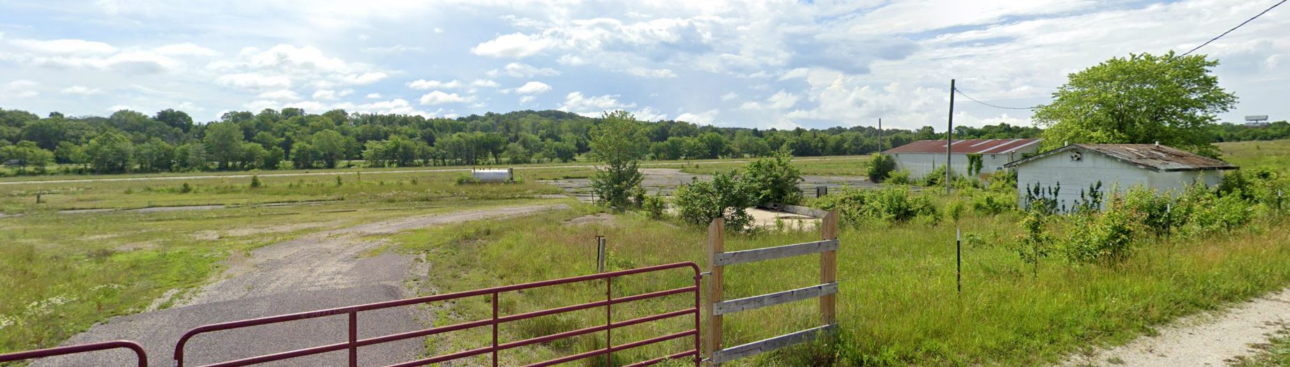
A June 2022 photo looking southeast at the remains of St Clair Regional Airport.
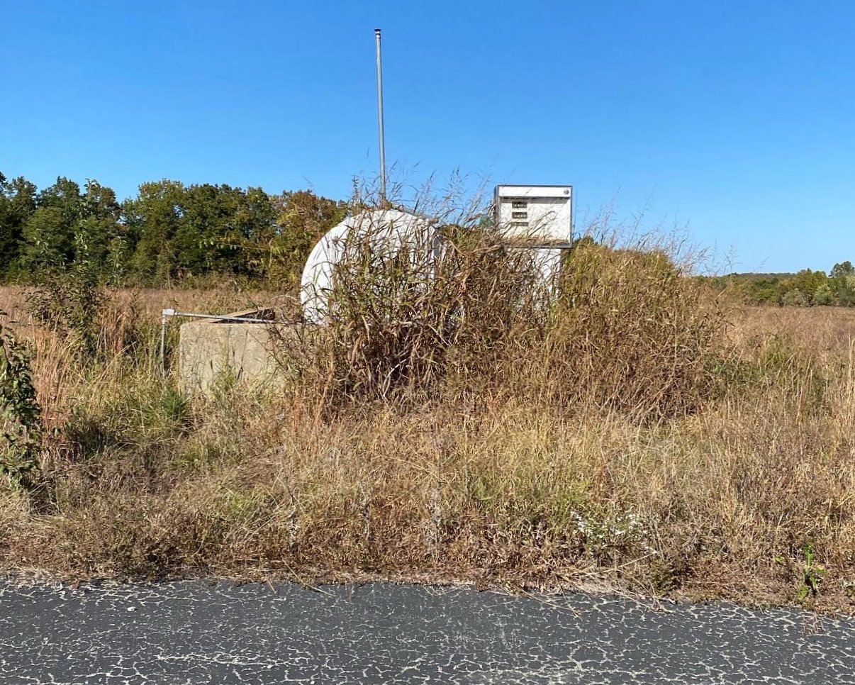
A 10/9/22 photo by Grant Hoevelmann of the former St Clair Regional Airport fuel tank & pump.
Grant reported, “The fuel pump is still fully intact & locked up.”
A 10/9/22 photo by Grant Hoevelmann of a former St Clair Regional Airport hangar.
Grant reported, “The old hangars are completely gone with almost no sign of where they were besides the taxiways.
The main hangar is still completely locked up & intact. The old restrooms are collapsing in on itself. The helipad is still there but heavily faded.”
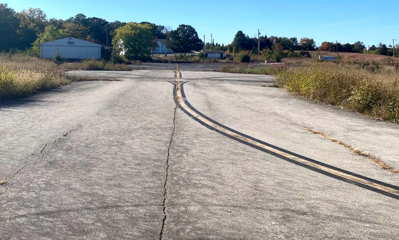
A 10/9/22 photo by Grant Hoevelmann looking northeast along the St Clair Regional Airport Runway 2.
Grant reported, “The runway is starting to show obvious signs of decay with the abundance of growth & cracks in the surface.”
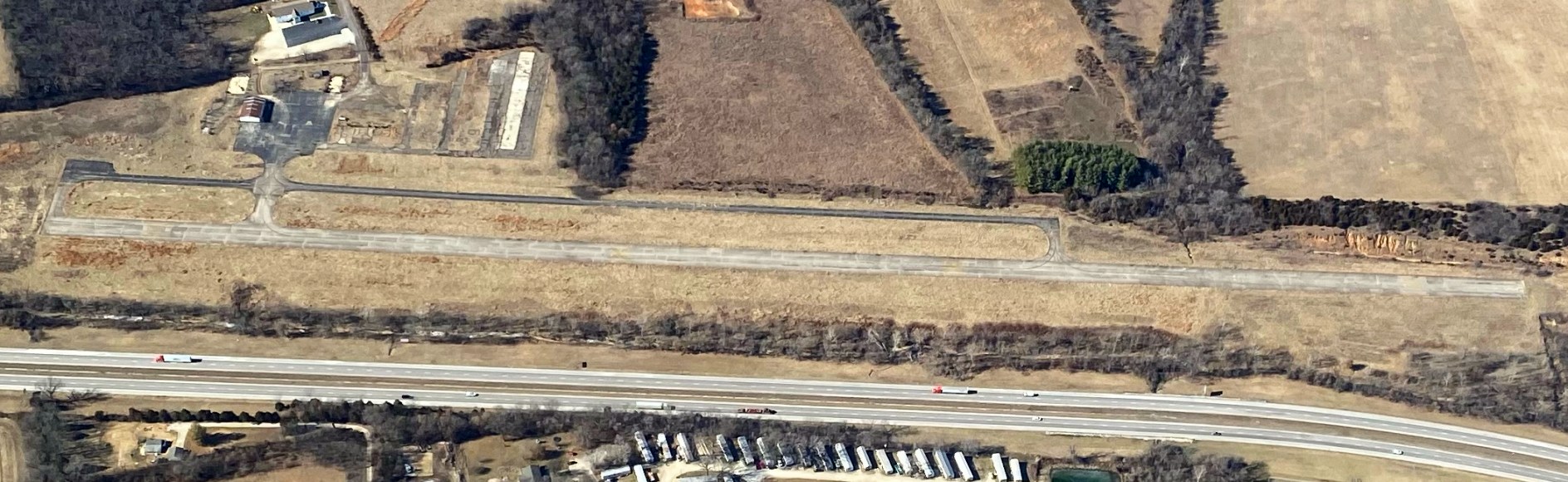
A 2/2/23 aerial view by Grant Hoevelmann looking northwest at the former St Clair Regional Airport, showing the runway, ramps, and 1 hangar remained intact.
____________________________________________________
Bootheel Flying Service Airfield, Caruth, MO
36.158, -90.079 (South of St. Louis, MO)
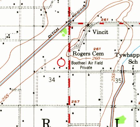
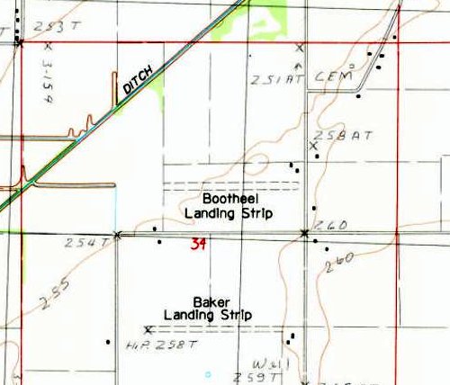
“Bootheel Air Field Private”, as depicted on the 1956 USGS topo map.
According to Jim Rice, “My dad, Richard Rice, operated Bootheel Flying Service from the 2,000' grass field.
I'm not sure when it opened, but dad was based there for almost 30 years [starting in the 1950s].
The earliest depiction which has been located of Bootheel Flying Service Airfield was on the 1956 USGS topo map.
It labeled the field as “Bootheel Air Field Private”.
Bootheel Flying Service Airfield was not depicted on Tulsa Sectional Charts from 1956/60/68.
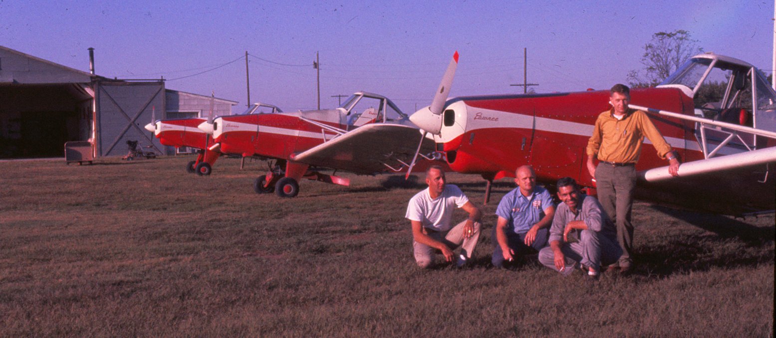
A circa 1950s-60s photo of Richard Rice, his pilots, and loader, in front of his 3 Piper Pawnee agplanes at Bootheel Flying Service Airfield.
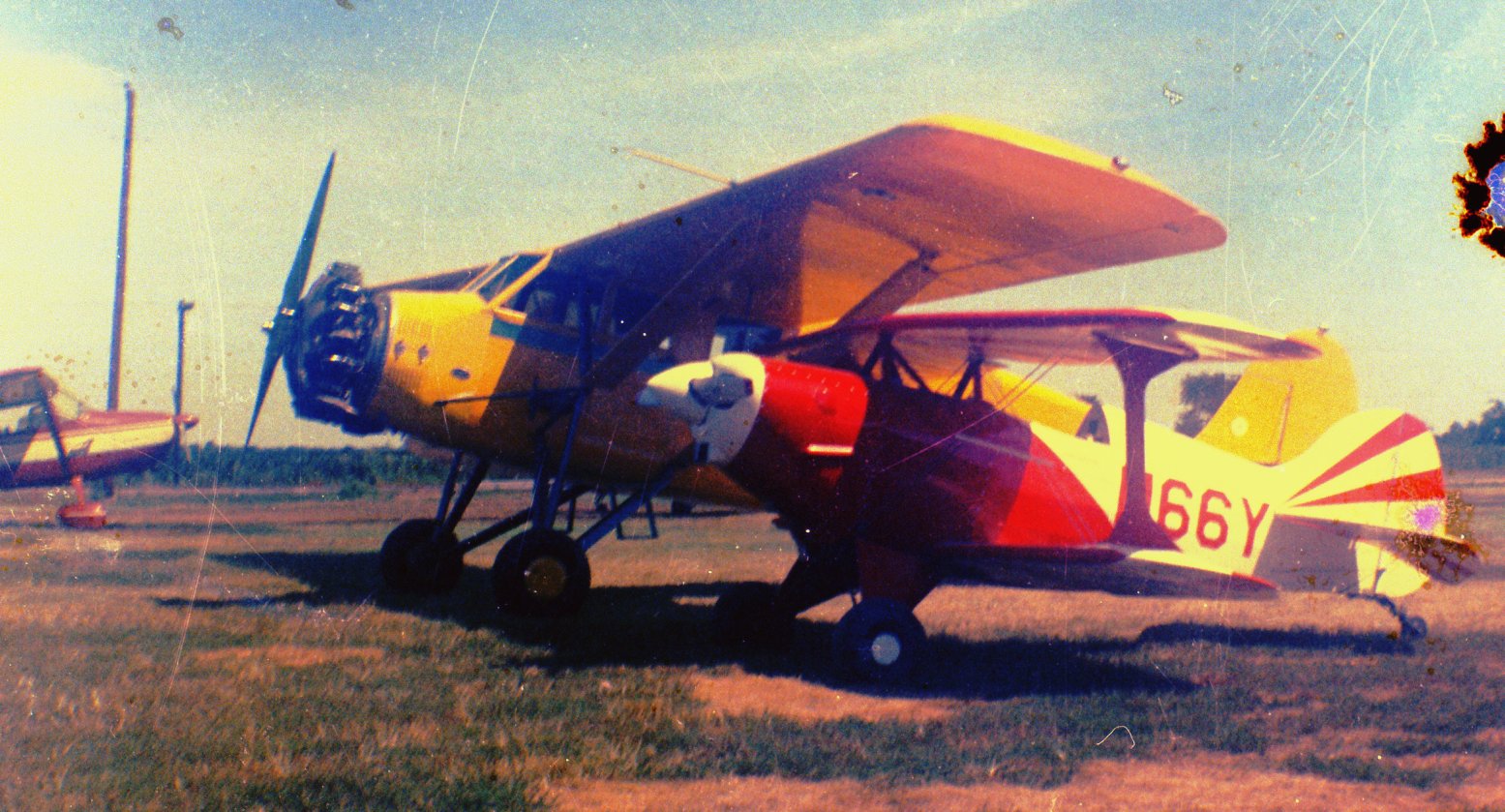
A circa 1950s-60s photo of 3 unidentified planes at Bootheel Flying Service Airfield.
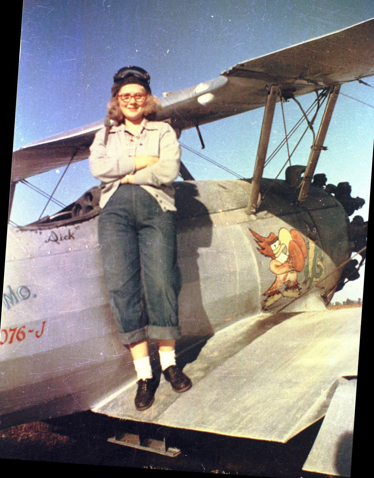
A circa 1950s-60s photo of Jim Rice's mother on a Stearman at Bootheel Flying Service Airfield.
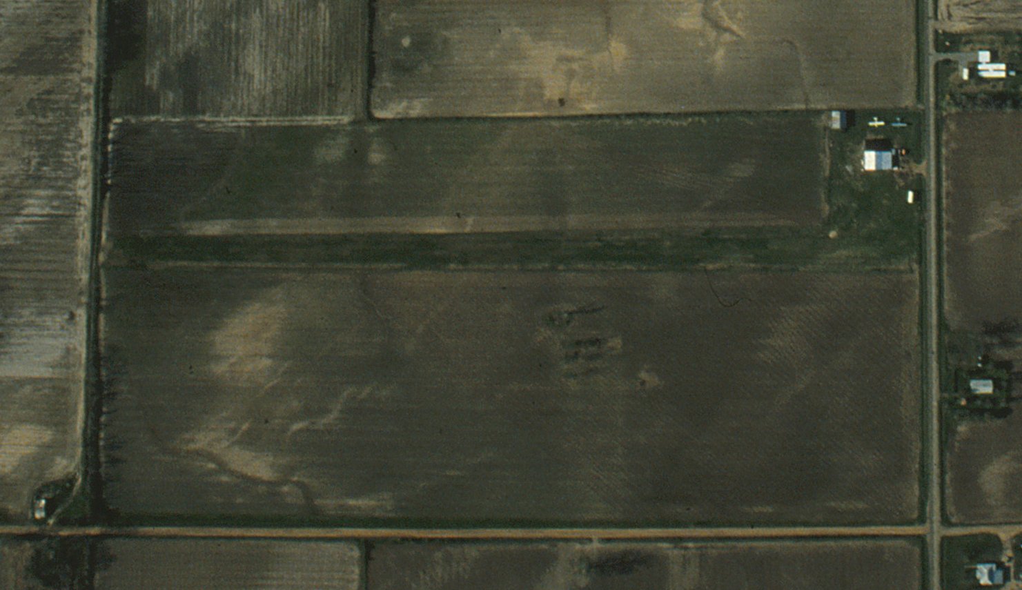
A September-October 1960 aerial view by Richard Rice (courtesy of Jim Rice) looking southwest at Bootheel Flying Service Airfield, showing 2 of their Piper Pawnee agplanes parked near the hangar.
A 4/13/78 USGS aerial view depicted Bootheel Flying Service Airfield as having an unpaved east/west runway, with 1 single-engine plane parked near the hangar on the northeast side.
A 1980 aerial view by Richard Rice (courtesy of Jim Rice) of Bootheel Flying Service Airfield
showed 2 single-engine planes parked near the hangar on the northeast corner.
The last depiction which has been located of Bootheel Flying Service Airfield was on the 1983 USGS topo map.
It depicted “Bootheel Landing Strip” as an unpaved east/west runway with 2 small buildings on the northeast side.
According to Jim Rice, “My dad, Richard Rice, left [the airfield] in 1983. When he left, it was soon plowed under & a few years later, both the hangars & shop razed.”
A 1984 aerial view no longer showed any aircraft at Bootheel Airfield, but the hangar remained standing.
A 1994 aerial view showed the Bootheel Airfield hangar remained standing.
A 2003 aerial view showed the Bootheel Airfield hangar had been removed at some point between 1994-2003.
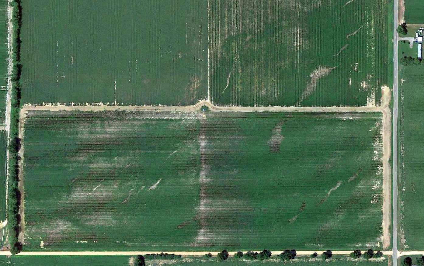
A 2015 aerial view showed no trace remaining of Bootheel Flying Service Airfield.
Jim Rice reported in 2018 of the Bootheel Flying Service Airfield, “It is totally gone now.”
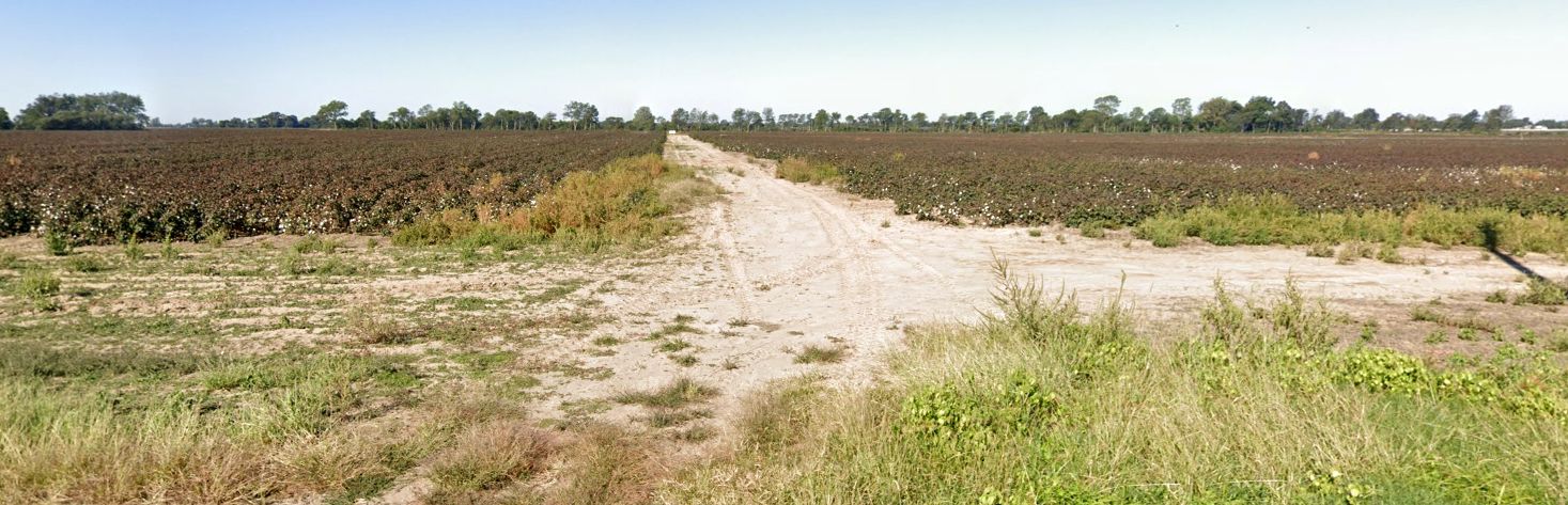
A 2022 photo looking west at the Bootheel Flying Service Airfield site.
Thanks to Jim Rice for pointing out this airfield.
____________________________________________________
Starling Airport, Starling, MO
38.451, -90.356 (Southwest of St. Louis, MO)
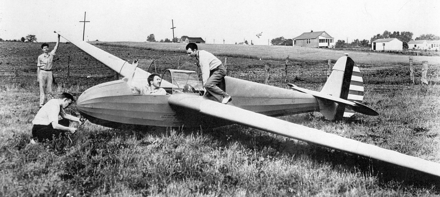
A 1942 photo captioned “Howard Blossom, pilot & Jack Laister, first passenger in LK-10/TG-4A, Starling Airport” (courtesy of Jack Abercrombie).
According to Mark Wilcox, “Starling Field is where Lasiter-Kaufman glider company tested their WW2 gliders.”
According to Wikipedia, “Jack Laister designed the [Yankee Doodle 2 training glider] aircraft
in response to the formation of the United States Army Air Corps' American Glider Program in 1941, basing it on his Yankee Doodle design of 1938 for Lawrence Tech.
Aside from the addition of a second seat, the Yankee Doodle 2 differed from it predecessor by having wings of constant dihedral instead of gull wings.
The USAAC expressed interest, but only if Laister could arrange for the manufacture of the type.
When Laister found a sponsor in businessman John Kauffman, they established the Laister-Kauffman Corporation in St Louis & the USAAC ordered 3 prototypes as the XTG-4.
When evaluation of the type proved positive, the Army placed an order for 75 aircraft, followed by an order for another 75.
These were operated as the TG-4A, along with the original, single-seat Yankee Doodle that was impressed into service.
All had been withdrawn from service prior to the end of the war when it was discovered that the flight characteristics of the aircraft were so different to those of a cargo glider,
that the experience gained on the TG-4 was not particularly relevant.”
The earliest photo which has been located of Starling Airport was a 1942 photo captioned “Howard Blossom, pilot & Jack Laister, first passenger in LK-10/TG-4A, Starling Airport” (courtesy of Jack Abercrombie).
Jack Abercrombie reported, “The photo was given to the Greater St. Louis Air & Space Museum by Rainey Bell, a local pilot [who] worked at the Laister-Kaufman factory.”
Starling Airport was not yet depicted on the May 1942 Kansas City Sectional Chart.
The earliest aeronautical chart depiction which has been located of the Starling Airport was on the October 1942 Kansas City Sectional Chart.
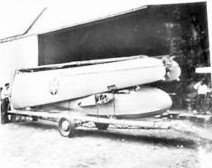
A circa 1940s photo depicted an Army Air Corps glider (model unidentified) on a trailer at Starling Airport.
A 1946 aerial view depicted Starling Airport as having a northwest/southeast grass runway, with 1 aircraft & a building with “Starling” on its roof on the west side.
An undated aerial view looking east at Starling Airport from the 1947 MO Airport Directory (courtesy of Joe Gurney).
The directory described Kratz as privately owned, managed by Carles Stockstrom.
It was said to have 2 turf strips, measuring 2,650' southeast/northwest & 1,800' north/south.
Two light aircraft were visible near a building with “Shell” painted on the roof.
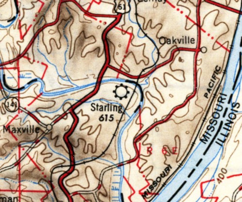
The 1949 USGS topo map depicted Starling Airport as a commercial/municipal airport.
The last aeronautical chart depiction which has been located of Starling Airport was on the May 1950 Kansas City Sectional Chart.
It depicted Starling as having a 2,600' unpaved runway.
Starling Airport was evidently closed (at least in an official capacity) at some point between 1958-51,
as it was no longer depicted on the October 1951 Kansas City Sectional Chart.
A 1955 aerial view depicted Starling Airport as having a northwest/southeast grass runway, with 1 aircraft & a building with “Starling” on its roof on the west side.
Arnold Mayor Mark Powell recalled, “I remember in the late 1950s watching biplanes taking off & landing.
It was a grass strip, and is now a subdivision of homes called Starling Estates.”
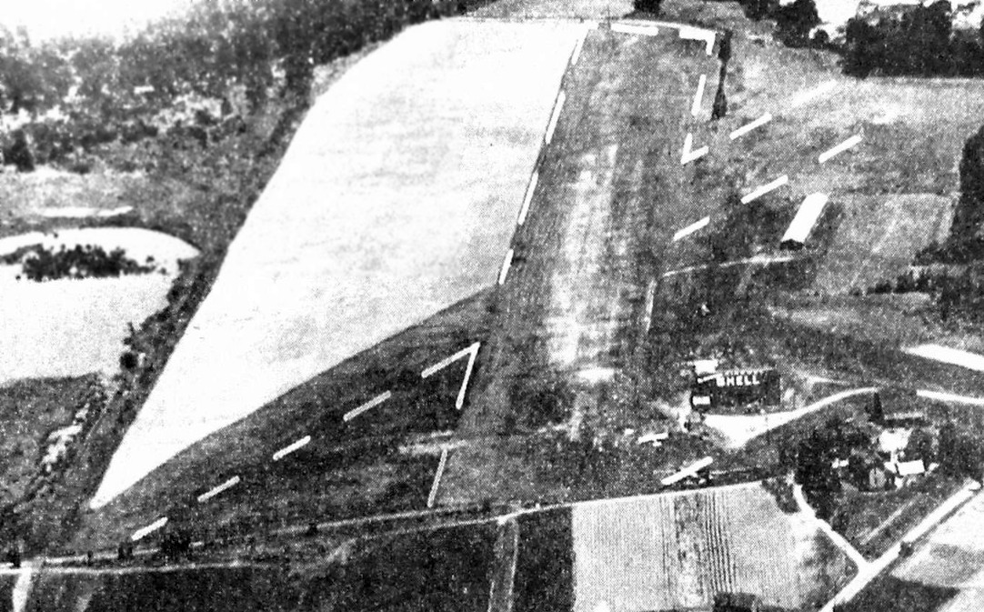
The last depiction which has been located of Starling Airport was a 1958 aerial photo.
It depicted Starling Airport as having a grass northwest/southeast runway.
A hangar with “Starling Airport” painted on its roof was on the west side,
near which were 6 aircraft, including 1 twin-engine aircraft.
A 1968 aerial photo showed the Starling Airport site covered by single-family housing.
Another grassroots aviation victim of America's insatiable appetite for suburban housing.
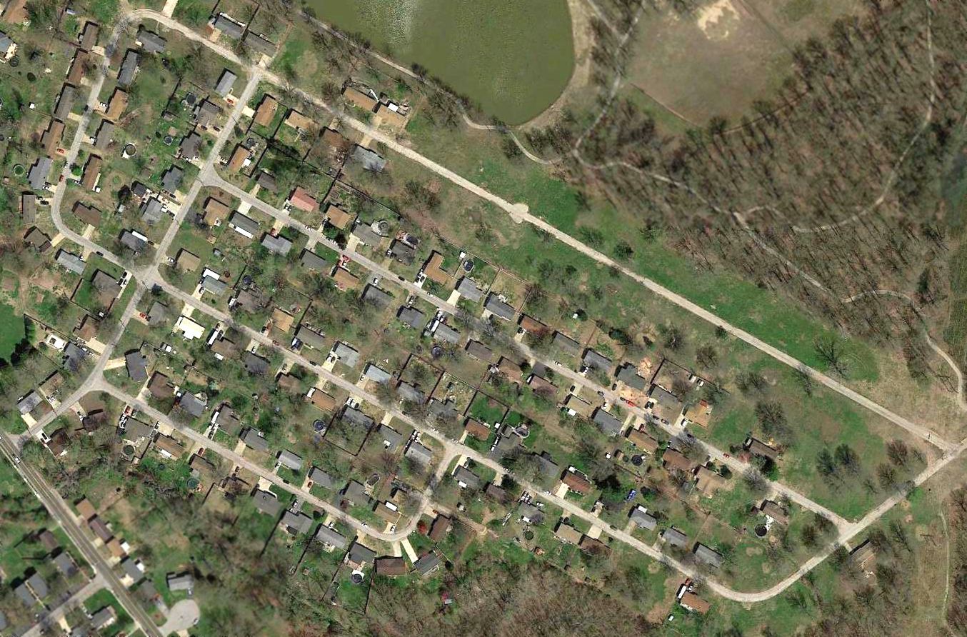
A 2016 aerial view showed no trace remaining of Starling Airport.
Today, the site of Starling Airport is commemorated via the street names of the residential development which occupies the property,
with names like Electra Drive, Piper Drive, Constellation Drive, Convair Drive, Boeing Drive, Douglas Drive, and Cessna Drive.
Thanks to Jim Hann for pointing out this airfield.
____________________________________________________
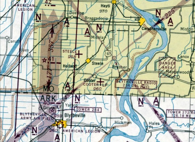
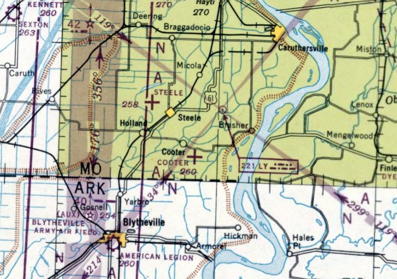
Cooter Auxiliary Army Airfield #4, Cooter, MO
36.03, -89.78 (North of Memphis, TN)

A 7/6/43 aerial view looking north from the 1945 AAF Airfield Directory (courtesy of Scott Murdock)
depicted “Blytheville AAF Auxiliary #5 (Cooter Field)” as having 2 paved runways.
This airfield was evidently built at some point between 1942-43, as it was not yet depicted on the October 1942 Nashville Sectional Chart.
The earliest depiction which has been located of Cooter Field
a 7/6/43 aerial view from the 1945 AAF Airfield Directory (courtesy of Scott Murdock).
It depicted “Blytheville AAF Auxiliary #5 (Cooter Field)” as having 2 paved runways.
Cooter Aux AAF was used during WW2 as one of 4 satellite airfields under the control of Blytheville Army Airfield,
which conducted basic through advanced training for the 50,000 Pilot Training Program,
and also trained crews of troop carrier crews.
The earliest aeronautical chart depiction which has been located of Cooter Auxiliary Airfield
was on the March 1944 Nashville Sectional Chart (courtesy of Chris Kennedy).
The April 1944 US Army/Navy Directory of Airfields (courtesy of Ken Mercer)
described "Cooter Aux, Army" as having a 4,000' hard-surfaced runway.
The 1945 AAF Airfield Directory (courtesy of Scott Murdock) described “Blytheville AAF Auxiliary #5 (Cooter Field)”
as a 699 acre irregularly-shaped property having 2 asphalt 4,000' runways, oriented north/south & northwest/southeast.
The field was not said to have any hangars,
and was described as being owned by the U.S. Government & operated by the Army Air Forces.
The date of closure of Cooter Aux AAF is unknown, but Blytheville AAF closed in 1945.
The last aeronautical chart depiction which has been located of Cooter Auxiliary Airfield was on the April 1947 Nashville Sectional Chart.
Cooter Field was apparently abandoned in 1947,
as it was no longer depicted on the September 1947 Nashville Sectional Chart.
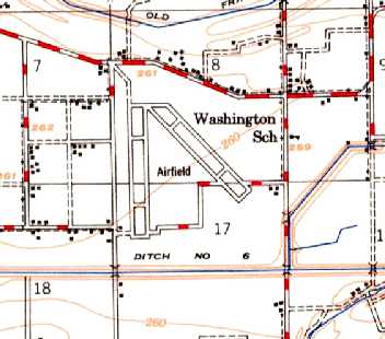
The 1955 USGS topo map depicted the 2 paved runways & parallel taxiways of the Cooter Auxiliary Field, labeled simply as “Airfield”.
No buildings were depicted on the airfield.
Blytheville was reactivated as an Air Force Base from 1955-92,
but it is unlikely that the Cooter Auxiliary field was reused during that period,
as its runways would have been insufficient to operate jet aircraft.
It does not appear as if Cooter was ever reused for civil aviation,
as it was not listed among active airfields in the 1962 or 1982 AOPA Airport Directories,
and it was not depicted at all on later USGS topo maps.
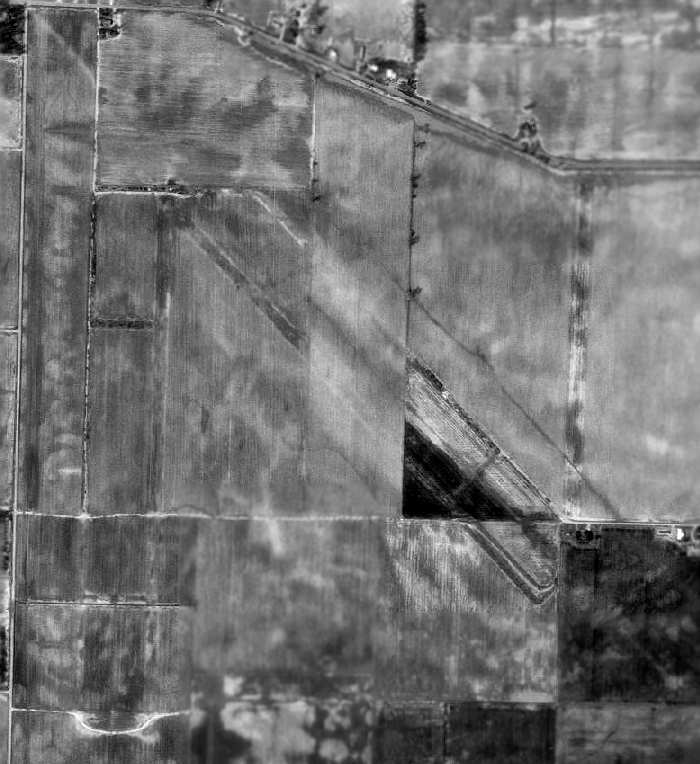
A 1996 USGS aerial photo showed the Cooter Airfield site had been taken over by farming,
but the outline of 2 former runways (each with a parallel taxiway) were still recognizable.
It is not known if there were originally any buildings at the airfield site.
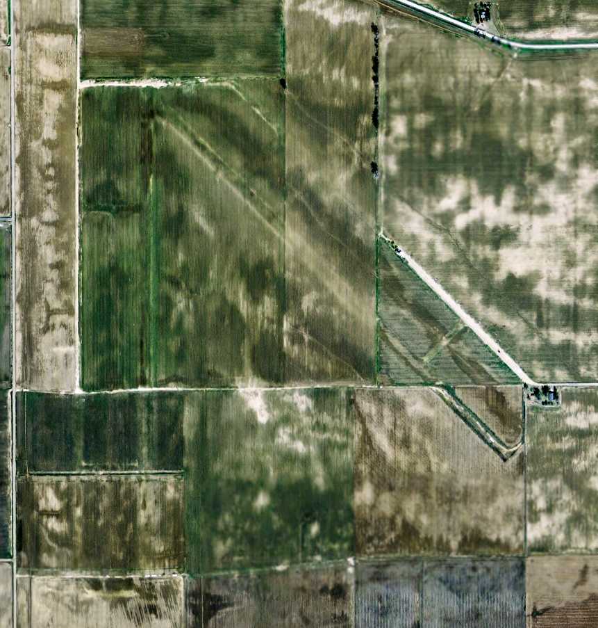
A 2006 aerial view showed the remains of the Cooter airfield remained unchanged from the 1996 photo.
A circa 2006-2010 aerial view showed a house which sits over the southeastern end of the NW/SE Cooter taxiway.
A 2007 aerial view of the site of the Cooter Airfield showed it virtually unchanged from the 1996 photo, with the outline of the 2 runways & taxiways still recognizable.
The site of Cooter Auxiliary AAF is located southeast of the intersection of State Highway E & Route 567, 2 miles southeast of Cooter, MO.
Thanks to Andy Kendig for pointing out this airfield.
____________________________________________________
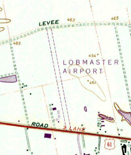
Lobmaster Field / Lobmaster Sky Ranch, Chesterfield, MO
38.68, -90.638 (West of St. Louis, MO)
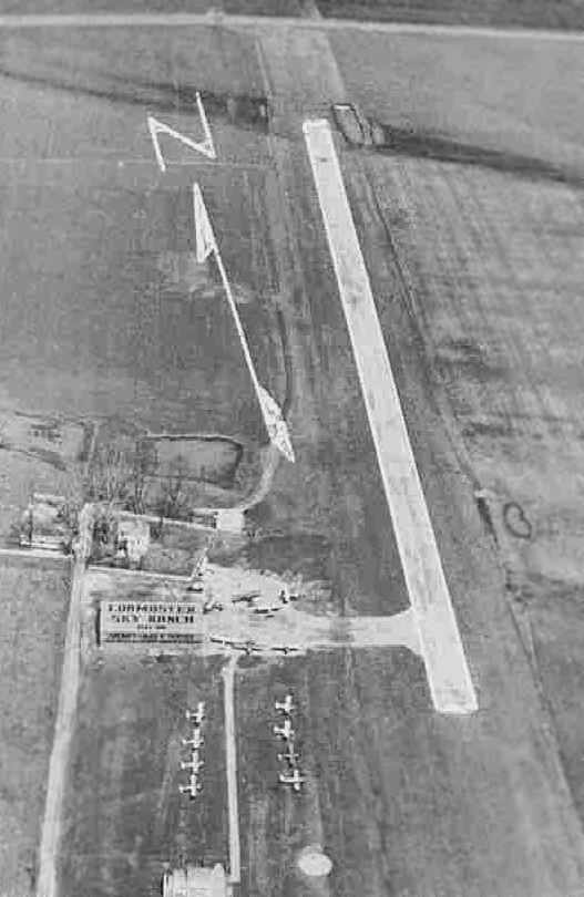
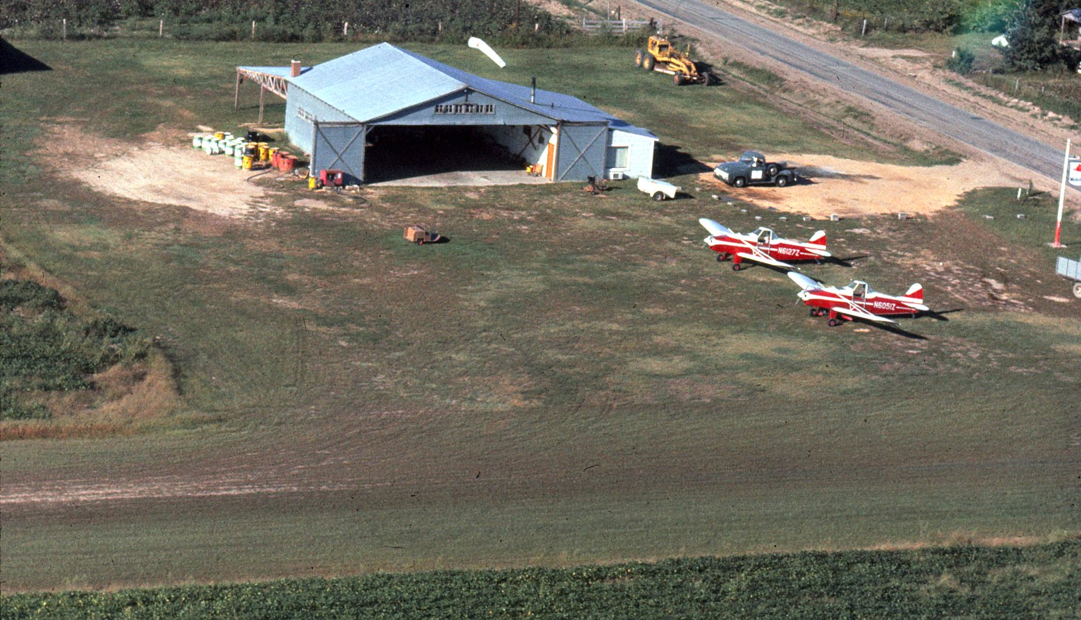
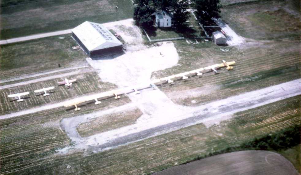
An aerial view looking north at the "Lobmaster Sky Ranch", from a circa 1957-61 MO Airport Directory (courtesy of Chris Kennedy).
A total of 16 light aircraft were visible parked on the southwest side of the field.
Lobmaster Field was not yet depicted on a 1952 Missouri Aeronautical Chart (according to David Brooks) or a 1958 aerial photo.
According to Brad Cleghorn, Lobmaster Field started operations in May 1959.
The earliest directory reference to Lobmaster Field which has been located
was in a circa 1957-61 MO Airport Directory (courtesy of Chris Kennedy).
It described the field as having a single 2,000' hard-surface Runway 17/35.
A taxiway led to a ramp on the southwest side of the runway,
with a single hangar which had "Lobmaster Sky Ranch" painted on the roof.
The field was said to offer fuel, hangar storage, tiedowns, and repairs.
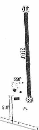
The 1960 Jeppesen Airway Manual (courtesy of Chris Kennedy) depicted Lobmaster as having a single 2,100' paved Runway 18/36,
with a few small buildings on the southwest side of the runway.
"[Dave] Lobmaster started the banner-tow advertising flights in 1960, and hired Harold Baker to get the banners off the ground",
according to a 1966 St. Louis Post Dispatch article (according to Brad Cleghorn).
“[Wayne] Baker came into command of Lobmaster & Baker Aeronautics by a series of fatal air accidents.
His older brother, Harold Baker, took over the field and the aerial banner advertising flights
after Dave Lobmaster died in a charter flight crash.”
The 1962 AOPA Airport Directory described Lobmaster as having a single 2,100' hard-surfaced Runway 18/36,
and said the field offered hangars, tiedowns, fuel, charter, and minor repairs.
The operator was listed as Samuel Lobmaster.
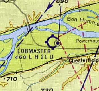
The January 1963 St. Louis Local Aeronautical Chart (courtesy of David Brooks) depicted Lobmaster as having a 2,100' hard-surface runway.
The Maryland Heights VORTAC navigational beacon was depicted immediately adjacent to the east side of Lobmaster.
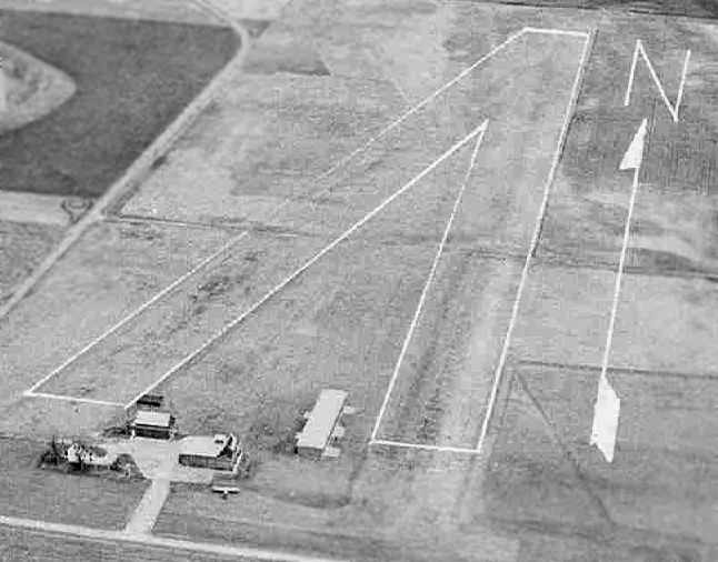
A 1964 aerial view by Brad Cleghorn looking west at Lobmaster Field.
Brad observed, “You can see the SNJ-4 along with several of the Cubs & Tri-Pacers that Harold Baker owned.”
The Greater St. Louis Parachute Club was reported to have operated at Lobmaster Field in the 1960s, after having moved from Weiss Airport.
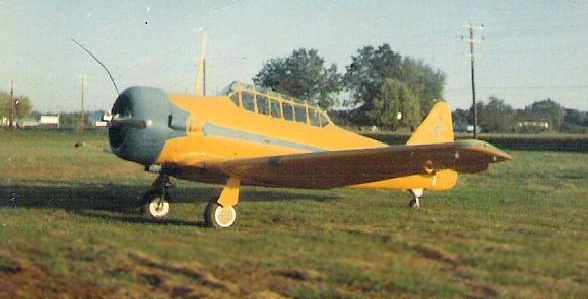
A 1965 photo by Jim Hoisington of Harold Baker's SNJ-4 at Lobmaster Field.
Jim recalled, “Wayne & I got that plane started one day (I pulled the prop standing on a step stool)
and he was attempting a take off when he got a flashing red light from the tower at the new Spirit Airport across the street.
It never did fly, it was taken apart & trucked out when he sold it.
I remember he had the parachutes hanging in his house. His house was about a hundred feet from the hangar.”
Jim Hoisington recalled, “Lobmaster Field... I worked there in 1965 for Wayne Baker.
He was a fine gentleman who enjoyed classical music.
He hired me at 50 cents/hour to cut grass, maintain the runway, refuel airplanes & do miscellaneous jobs around the airport.
I was 16 & loved that job.
They offered air plane rides over the St. Louis Arch (under construction at the time) for $5/person,
and as most passengers were boyfriend & girlfriend they would sit together in the back of the plane
and I would hop a ride as copilot for free.
Wayne let me attend the ground school classes for free
but making 50 cents/hour didn't give me much money for air time.”
Jim continued, “I only worked there that summer in 1965
and left because Wayne could not afford to pay me anymore,
I remember working for free for a little while, maybe a week or two.
Spirit put him out of business by diverting the traffic to them as we did not have a radio tower.”
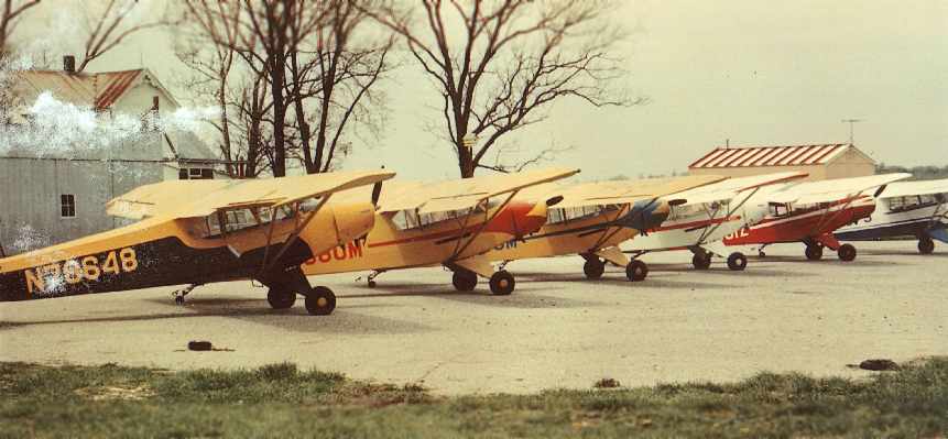
A 1966-67 photo of a multicolored lineup of Piper Cubs (4 PA-11s, a PA-18/90, and a PA-12)
belonging to Harold & Wayne Baker at Lobmaster Field (courtesy of Brad Cleghorn).
According to Brad Cleghorn, “The PA-12 (far right) was lost when the T-hangar on the far left in the photo caught fire.”
Brad Cleghorn recalled, “My uncle, Harold Baker, was the airport manager & a flight instructor at Lobmaster Field during the 1960s.
Unfortunately Uncle Harold died in a plane crash before I was born,
but his younger brother Wayne was also active at Lobmaster.”
David Brooks recalled, "I worked for McDonnell Douglas in St. Louis from 1968-83.
The strip was located off of US 40 before you got to the Missouri River bridge.
I clearly remember it was there because of the navigational VORTAC located next to it.
The runway looked like asphalt to me & not in very good condition.
Looked like it was only about 40-50' wide.
A number of those airfields in that general region (Arrowhead, Creve Coeur, etc.)
were built done on the flood plain of the Missouri river
so every time it flooded, those fields generally went underwater for a while."
Buz Heuchan recalled “Lobmaster Field where I learned to fly.
I soloed a Colt (N5467Z) there 9/29/66 with Dale Hand as my CFI.
The day I soloed, I recall a plane had crashed at the north end of the strip & was still there for my 1st solo.
I have many memories of this place.
The strip was in terrible shape, as well as the buildings.
To help with my instruction, I installed a PA system & an intercom system
between the small office & the hangar as there was about 100 yards between the two.”
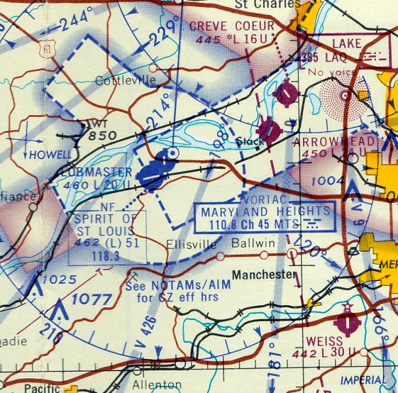
The last aeronautical chart depiction which has been located of Lobmaster Field was on the February 1967 Kansas City Sectional Chart (courtesy of William Willyard).
It depicted Lobmaster as having a 2,000' paved runway, and it depicted the new Spirit of St Louis Airport directly across the road.
The 1968 USGS topo map depicted Lobmaster Airport as having a single unpaved northwest/southeast runway with a few small buildings on the southwest side.
The last photo which has been located still showing Lobmaster Field in operation was a 1968 aerial view.
It depicted a dozen light single-engine aircraft parked on southwest side, near a single hangar.
However, the much larger Spirit of St. Louis Airport had been built immediately adjacent to Lobmaster (across Route 40) at some point between 1963-68,
and many of Lobmaster's aircraft had moved over to Spirit of St. Louis Airport.
David Brooks recalled, "My recollection is about 3-5 small single engine aircraft
and an old derelict [Harold Baker's SNJ-4] in bad shape off to the side were there.
One T-hangar was there & a couple of small out-buildings."
According to Brad Cleghorn, “The Greater St. Louis Parachute Club operated there until 1968,
and my Uncle Wayne also noted that the club crashed one his airplanes, a Cessna 182 (N7272E).”
Lobmaster Field ceased operations in October 1968 (according to Brad Cleghorn), thus lasting not even a decade.
The September 1969 St. Louis Sectional Chart (courtesy of Ron Plante) continued to depict Lobmaster as having a single north/south paved runway,
but the field was labeled "Closed".
The Maryland Heights VORTAC was still in operation at this point, though.
David Brooks recalled, "Then they decided to widen & move US 40 highway from Creve Coeur to the old US 40 bridge to accommodate growth.
The highway eliminated Lobmaster."
A 1970 aerial photo showed the new highway under construction through the middle of the former Lobmaster runway.
According to Andy Kendig, "I recall a VOR building being present for many years. It was converted to a concession building when the sports park was built."
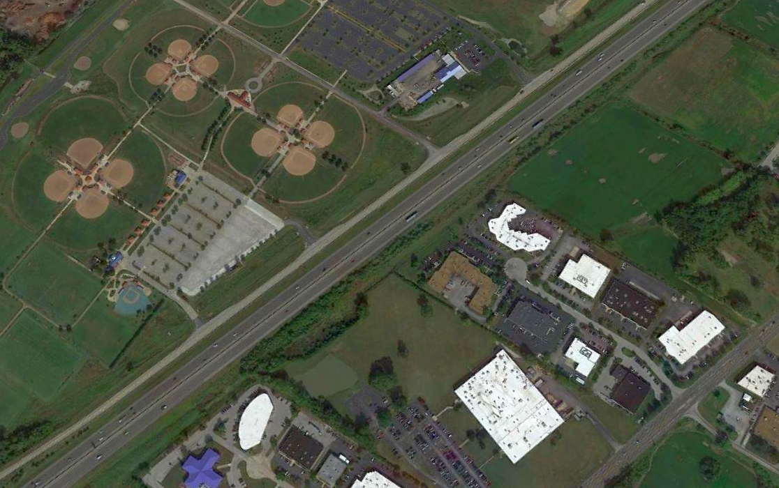
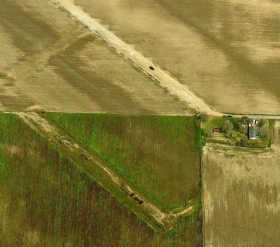
A 2019 aerial view looking northeast showed no trace was still perceptible of the Lobmaster runway,
with baseball diamonds, a highway, and other buildings covering the site of the airport.
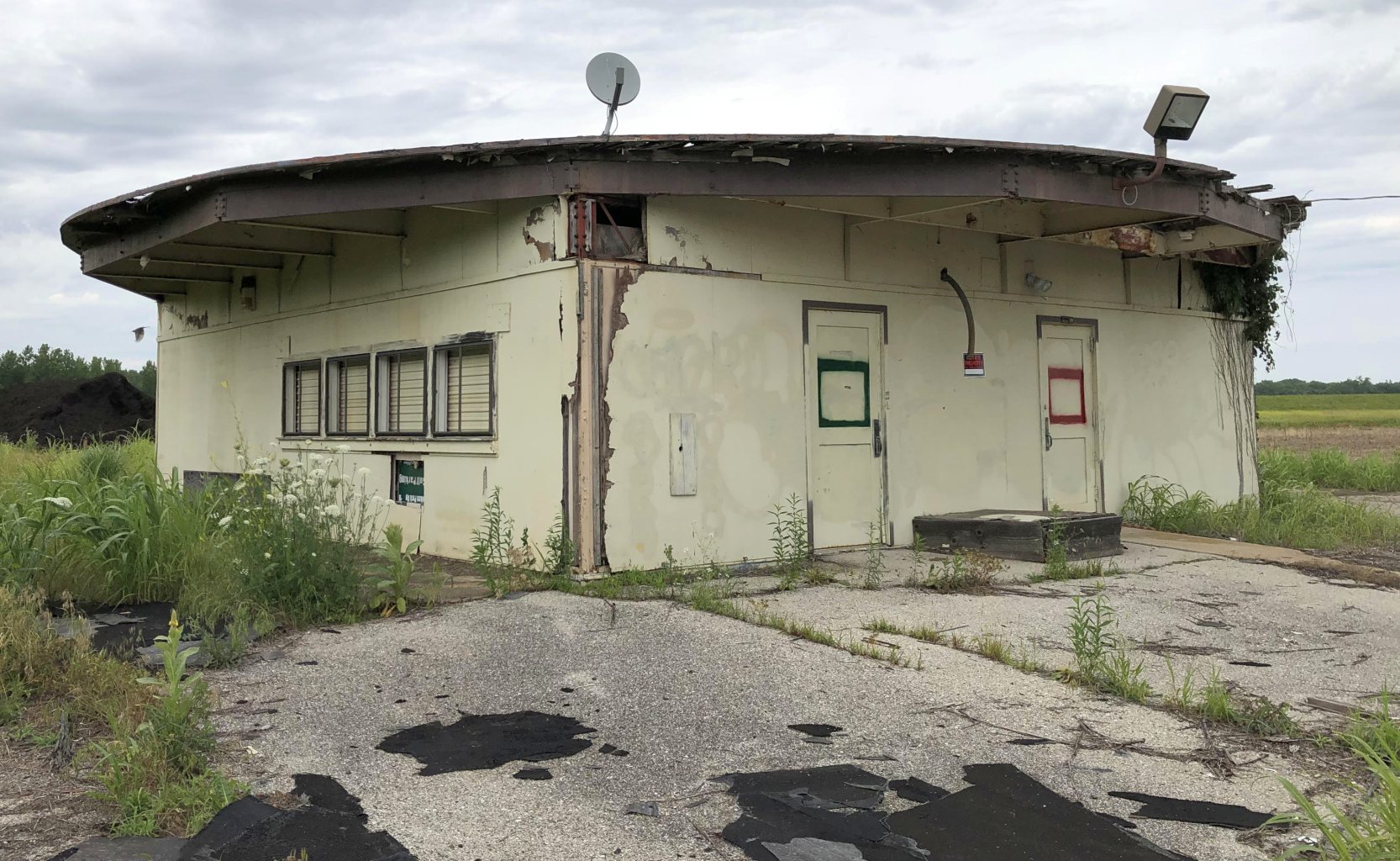
A June 2019 photo by Jim Hann of the remains of the Maryland Heights VOR (MTS/110.8) building to the east of the site of Lobmaster Field.
In contrast to previous reports, it appears to no longer be reused as a park concession building, but rather is abandoned.
Jim Hahn reported in November 2025, “As of last month the Maryland Heights VOR building was torn down & the debris removed.
Visible signs of Arrowhead Airport have disappeared as they have continued building warehouses on the site. So sad.”
The site of Lobmaster Field is located north of the intersection of Interstate 64 & Spirit of St. Louis Airport Boulevard.
____________________________________________________
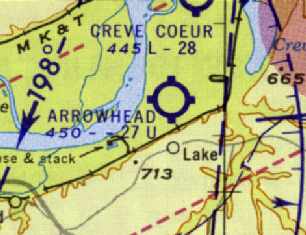
Arrowhead Airport (02K), St Louis, MO
38.7, -90.52 (Southwest of Lambert St Louis International Airport, MO)
An undated aerial view looking northwest at Arrowhead Airport, from a circa 1958-61 MO Airport Directory (courtesy of Chris Kennedy).
This small general aviation airport was evidently established at some point between 1946-58,
as it was not yet depicted on a 1946 aerial photo.
Arrowhead Airport was not yet depicted on the 1954 USGS topo map.
The earliest depiction of Arrowhead Airport which has been located was a 1958 aerial view.
It depicted 3 light single-engine aircraft parked near a few small buildings,
with a few short grass runways on the surrounding farm fields.
The earliest depiction of Arrowhead Airport which is available
was an undated aerial view in a circa 1958-61 MO Airport Directory (courtesy of Chris Kennedy).
The directory described Arrowhead as having two 2,750' turf runways: 3/21 & 1/19.
A few small hangars were located in between the 2 runways on the south side of the field,
which was said to offer fuel, hangars, tiedowns, and minor repairs.
Greg Pochapsky recalled, “Arrowhead Airport was the home of biplane & warbird owners including 2 F8F Bearcats.”
Arrowhead Airport was not yet depicted on the December 1960 Kansas City Sectional Chart.
The 1962 AOPA Airport Directory described Arrowhead as having a single 2,000' bituminous Runway 4/22.
The 1963 St. Louis Local Aeronautical Chart (courtesy of David Brooks)
depicted Arrowhead as having a 2,700' unpaved runway.
Leigh Hettick recalled, "I learned to fly in 1966 at Arrowhead Airport.
The airport was owned by folks named Heaton who were in the real estate business.
They had a fleet of 5 new Alon Aircoupes.
Several of us who went to college together in New York & who were working at McDonnell Aircraft took our training there.
After we soloed, we expanded their training syllabus several times to include formation flying.
They ran a relaxed & friendly little operation."
The February 1967 Kansas City Sectional Chart (courtesy of William Willyard) depicted Arrowhead as having a 2,400' paved runway.
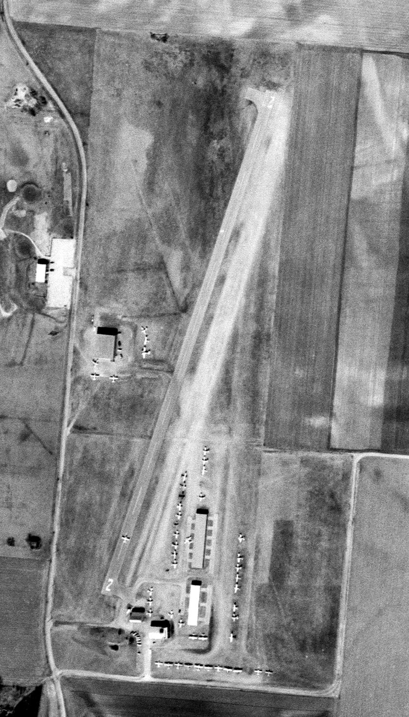
A 3/5/68 USGS aerial photo depicted Arrowhead as having a single paved Runway 2/20,
with over 2-dozen light aircraft parked near hangars on the west & southeast sides.
Kurt Beindorff recalled, “I worked for two summers at Arrowhead in 1976 & 77. They had lots of old warbirds.
We had a tornado go through one summer that did minor damage to the T-hangars & to the planes inside.
My jobs included scheduling lessons, gassing up planes, cutting grass (Moses did the big cutting) and anything else they wanted me to do.
The pay was poor but the experience was great.”
The 1978 USGS topo map depicted Arrowhead Airport as having 2 unpaved runways.
The May 1971 St. Louis Sectional Chart (courtesy of Robert Brown)
depicted Arrowhead as having a single 2,400' paved runway.
A 1971 aerial photo depicted Arrowhead as having a single paved runway, with a large number of aircraft visible parked outside.
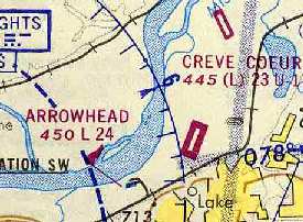
The July 1973 Kansas City Sectional Chart (courtesy of Chris Kennedy) continued to depict Arrowhead as having a 2,400' paved runway.

An October 1975-78 aerial view of an amazing assemblage of WW2 warbirds at Arrowhead Airport.
A circa 1975-78 photo by Albert Stix of Arrowhead Airport, “taken from the 'tower' built into the roof of the main office, a converted barn actually.”
Chris recalled, "I learned to fly in the St Louis area in the mid 1970s.
Arrowhead Airport was a hotbed of warbirds before everyone had a warbird.
I rented a [Cessna] 150 based at Lambert as a student (try to imagine student pilots based out of major hub airports!).
I did most of my touch & goes at Arrowhead. I remember a T-6, 2 T-28s, and a Bearcat at the airport.
Also at one time there was a cross grass runway that attracted a lot of taildraggers."
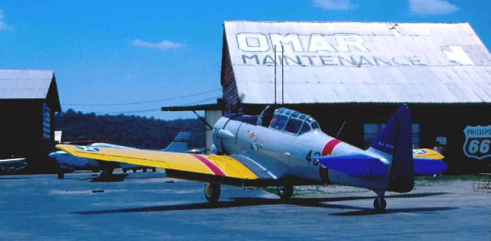
A circa 1979-80 photo by Albert Stix “of my father’s SNJ-5 arriving [ at Arrowhead] from Rockford, Illinois. That’s Mark Clark delivering the plane.
Omar was owned by Gene O’Connell. He was a long time A&P instructor at a local tech school.”
Arrowhead's runway was lengthened somewhat by 1982,
as the 1982 AOPA Airport Directory (courtesy of Ed Drury) described the field as having a 2,880' asphalt Runway 2/20 & a 2,700' turf Runway 15/33.
It listed the operators as Bryan Management Corp., Eagle Air, St. Louis Helicopter Airways, and Omar Aviation Maint.
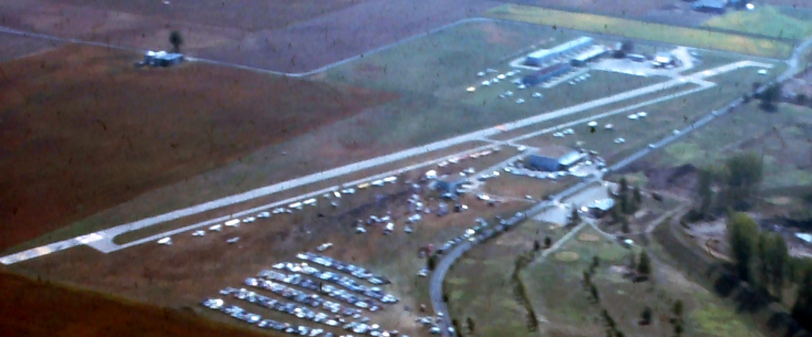
A 1983 aerial view looking southeast at Arrowhead Airport during an airshow held to benefit a fallen airman (courtesy of Jim Naumann).
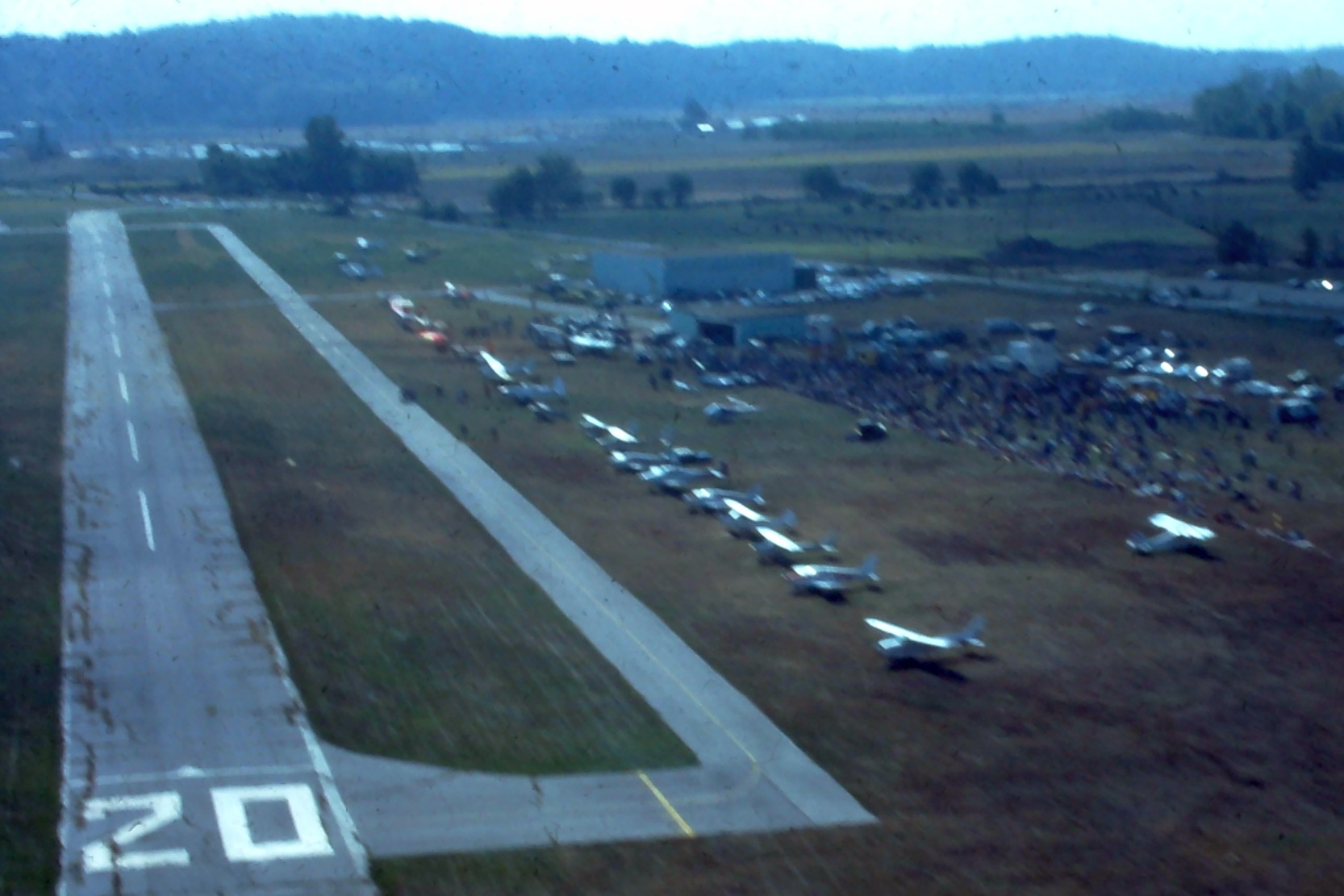
A 1983 aerial view on final approach to Arrowhead Airport's Runway 20 during an airshow held to benefit a fallen airman (courtesy of Jim Naumann).
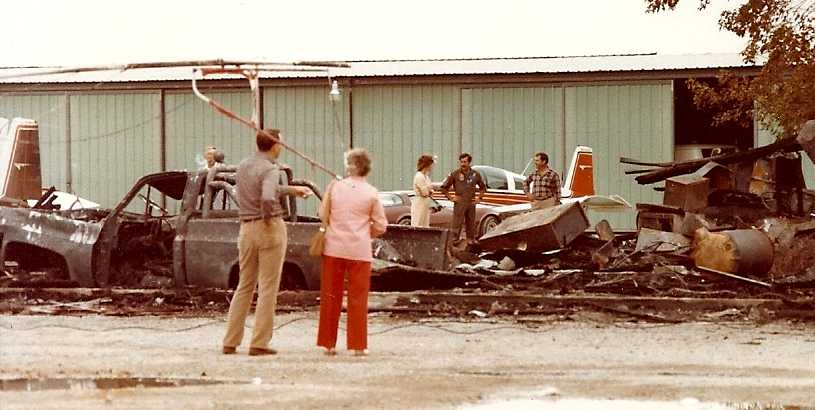
An October 1983 photo by Albert Stix of damage at Arrowhead Airport after a fire, “taken the morning after the fire.
The fire pretty much ended any chance of Arrowhead having a future.”
The last photo which has been located showing Arrowhead Airport while open was a 1990 USGS aerial view looking northwest.
Three light single-engine aircraft were visible parked near the hangars.
Arrowhead was almost immediately adjacent to Creve Cour Airport.
The 2 traffic patterns almost conflicted with each other.
Arrowhead probably had the better runway - but oddly Creve Cour survived instead.
Paul Swarthout recalled, “The flood of 1993 flooded the airport with more than 10 feet of water.
The flood waters severely damaged the runway & the buildings on the property.”
Arrowhead Airport closed shortly after the 1993 flood.
According to Paul Swarthout, “I suspect that the airport closed because they didn't have the funds to repair the airport buildings & runway.”
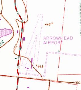
The last aeronautical chart depiction which has been located of Arrowhead Airport was on the May 1995 St. Louis Sectional Chart.
It depicted Arrowhead as having a 2,700' paved northeast/southwest runway.
Albert Stix recalled, “In the long run, Arrowhead was doomed.
Not because of the new bridge, it actually wound up being built alongside Creve Coeur Airport’s property and missed Arrowhead by several miles.
It was doomed because of Arrowhead’s proximity to the St. Louis County Water Works
and the residential neighborhoods along the bluff just South of the airport in Chesterfield, Missouri.
The flood of 1986 did not help either airport but The Great Flood Of 1993 ended Arrowhead for good
when the City of Maryland Heights stopped it from re-opening by not re-issuing its Conditional Use Permit.”
The 1996 USGS aerial photo showed the single paved runway, as well as a parallel taxiway & a few small hangars,
and the former grass runway was still discernible as well.
Arrowhead Airport was no longer depicted on the July 1999 St. Louis Terminal Chart.
According to Steve Collins, the owner of the Arrowhead Airport land was been approached many times
about allowing radio controlled model aircraft activities but flatly refused every time.
The owner was holding on to the land for speculation purposes.
A 2002 photo by Gavin Haslett looking north along the former Arrowhead Airport Runway 2.
Gavin Haslett reported there was a sign advertising the property for lease.
A 2002 photo by Gavin Haslett of former hangars at Arrowhead Airport.
Paul Swarthout reported in 2005, “Today, the damaged buildings remain standing,
a farmer grows corn on one end of the land, and several baseball diamonds have popped up since the spring of 2005.
Part of the paved runway is being used as a private road for access to the ball fields.”
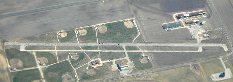
A March 2006 aerial photo by Andy Kendig looking east at the former Arrowhead Airport
shows the field remains almost completely intact, including the runway, taxiway, and hangars,
even though ball fields have been added on either side of the runway.
A 2016 aerial view looking northwest at the remains of Arrowhead Airport. What a shame to see this nice little general aviation airport wasting away.
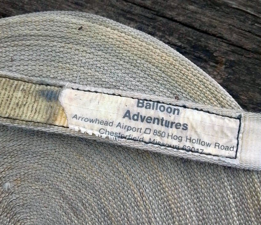
A 2022 photo by Jacob Lindaman of a coiled strap presumably used to tether a balloon, labeled “Balloon Adventures, Arrowhead Airport”.
A 5/17/22 photo by Ben Rasure looking along the remains of the Arrowhead Airport runway.
Ben Rasure noted, “You can still see some of the runway marking.”
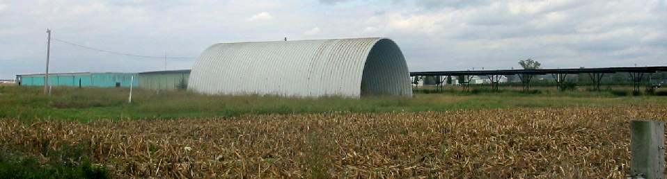
A 5/17/22 photo by Ben Rasure of a former Arrowhead Airport hangar.
Ben Rasure noted, “It was cool yet sad to see something that at one point had a lot of activity.”
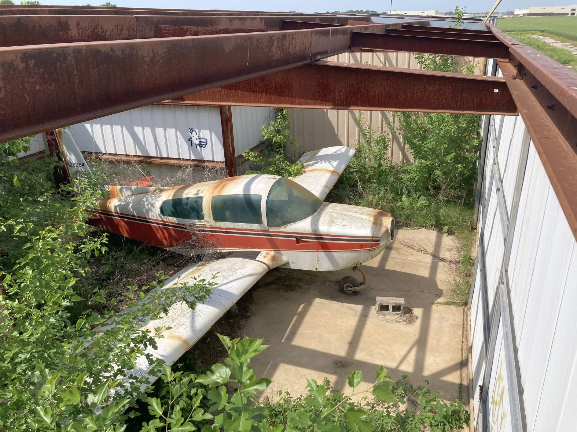
A 5/17/22 photo by Ben Rasure of 1978 Grumman AA-5A N26654, which remains inside an Arrowhead Airport hangar.
Ben Rasure noted, “Arrowhead Airport has an interesting old plane still in a hanger, fully exposed to the elements.
It was interesting to see something that looked like it was lost in the jungle in such a populated/ heavily traveled part of St. Louis.”

A 3/16/24 photo by Jim Naumann of the Arrowhead Airport site.

A 3/16/24 photo by Jim Naumann of a former Arrowhead Airport hangar.
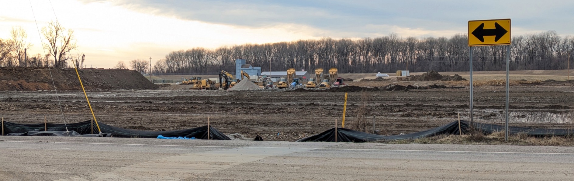
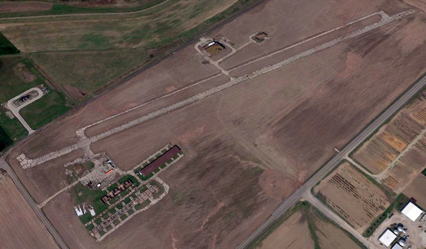
A 2/2/25 photo by Alex Calder looking southwest at the Arrowhead Airport site.
Alex reported, “The field had been bulldozed. The whole surrounding area has been sprouting up logistics parks in the last couple of years, so I’m pretty sure that’s what’s happening here as well.
The runway was visible up until a few months ago.”
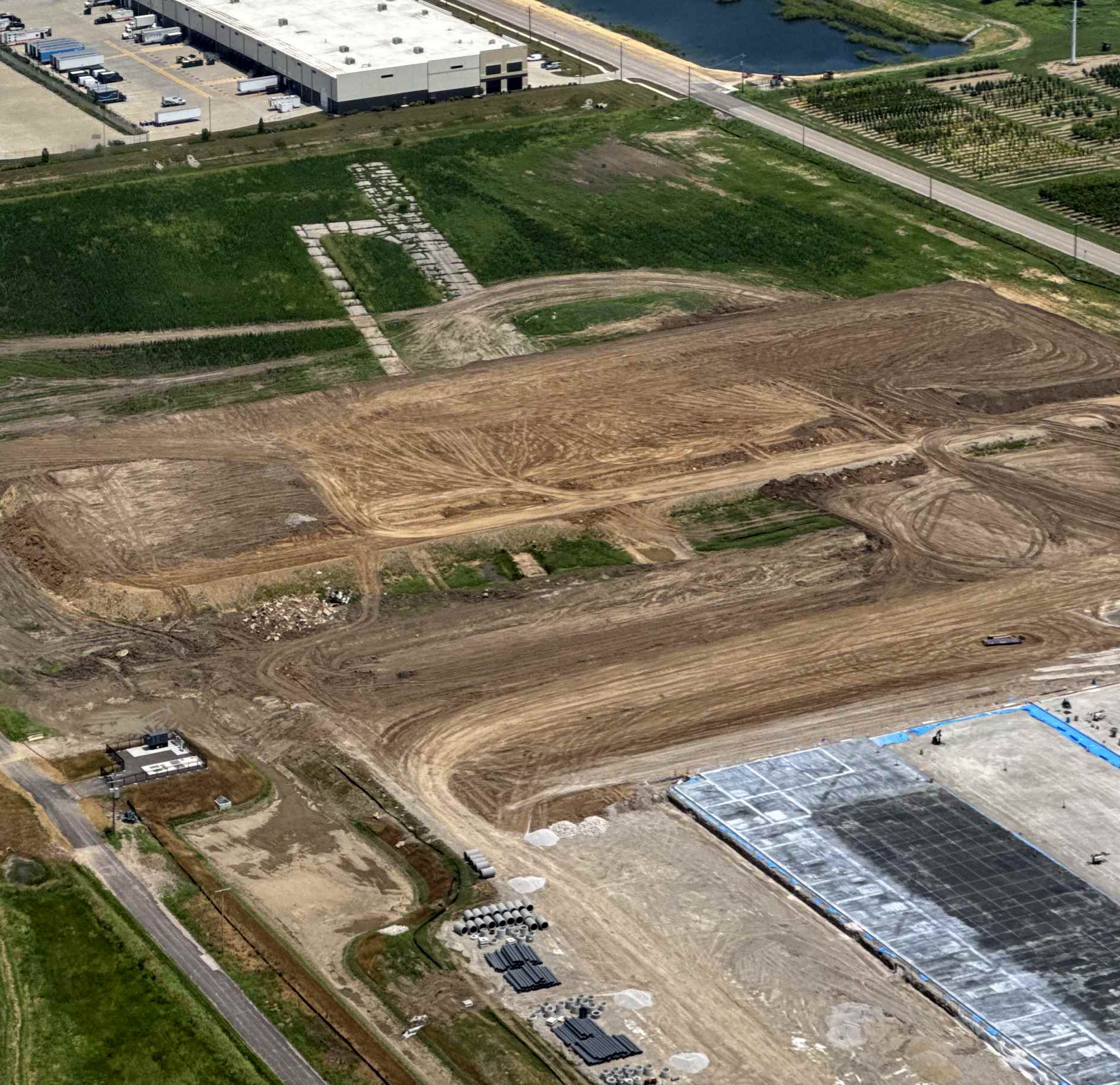
A 7/5/25 aerial view by James Hann looking northeast at the last remains of Arrowhead Airport: the northeast end of the runway & taxiway, being removed by construction.
James Hann remarked, “This is all that remains of the airport. So sad.”
The Arrowhead Airport site is located northeast of the intersection of River Valley Drive & Hog Hollow Road.
Thanks to Andy Kendig for pointing out the closure of this airfield.
____________________________________________________
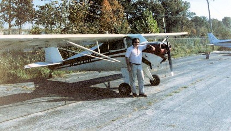
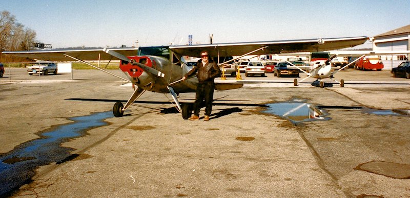
Weiss Airport (3WE), St Louis, MO
38.54, -90.45 (Southwest of Downtown St. Louis, MO)
A 10/9/43 Navy aerial view looking north (from the National Archives, courtesy of Brian Rehwinkel) annotated to show the proximity of the eventual Weiss Airport site with the pre-existing Sylvan Beach Airport & Meramec Airport.
This general aviation airport was evidently established at some point between 1945-47,
as it was not yet listed among active airfields in the 1945 AAF Airfield Directory (courtesy of Scott Murdock)
nor depicted on the September 1946 Wabash River World Aeronautical Chart.
An undated aerial view looking southwest at Weiss Airport (foreground) & the adjacent former Sylvan Beach Airport (grass area in the background)
from the 1947 MO Airport Directory (courtesy of Stephen Mahaley).
The directory listed the owner as Harley Weiss, and described Weiss as having a single north/south 1,500' turf strip.
The directory noted that the landing facilities of the adjacent Sylvan Beach Airport were also used.
Sylvan Beach was adjacent to the west, and had 3 turf runways (with the longest being a northeast/southwest 5,400' strip).
Weiss, Sylvan Beach, and Meramac Airports, all depicted in very close proximity on the 1948 Kansas City Sectional Chart (courtesy of Chris Kennedy).
Weiss was described as having a 1,300' unpaved runway - mighty short!
Sharon Irish recalled, “My Father, Glenn Irish, owned his own business at Weiss Airport from June 1948 - November 1949.
It was named Kirkwood Aero Repair Service.
I was 4 years old at the time & went flying every afternoon with my Dad when he tested his repair for the day.
We lived in a small house at the edge of the field.”
Keith Milton reported, "My father was Hugh Milton & started flying at Weiss in 1950
and began teaching around 1952 until the late 1960s when he had to stop due to health reasons.
There was also an east/west grass runway at Weiss
and next to the house was an in-ground swimming pool where I learned to swim when I was 4 years old
while my Mom sat & watched us kids & my dad gave flying lessons.
I also learned to fly there & really miss the old place."
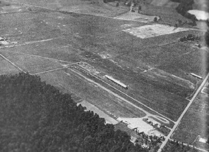
A circa 1950s aerial view looking northwest (courtesy of Jim Naumann) depicted Weiss Airport as having a north/south runway with hangars along the northwest & east sides.
Brian Rehwinkel reported, “When you look at historical aerial photos (from the 1950s onward), Weiss Airport used the same hangar (at the same location) as the Sylvan Beach Airfield was using in 1943.
Weiss Airport was originally located just to the North/Northeast of Sylvan Beach Airport and at some point took over a portion of the Sylvan Beach Airport.
In looking at the circa 1950s aerial photo, the original hangars for Sylvan Beach can be seen in the foreground & if you look very carefully you can still make out the landing circle from the Navy days in the left portion of the photo.
It looks like the owners of both coexisted for a short time after the second World War but, based on the photos, it looks like Weiss Airport had expanded & taken over some of the Sylvan Beach land & hangars by the 1950s.”
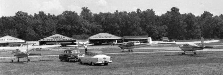
A circa 1950s photo of general aviation planes & the Midwest Aviation hangar at Weiss Airport (courtesy of Jim Naumann).
The Greater St. Louis Parachute Club was formed in May of 1957 & was originally located at Weiss Airport.
It later moved to Lobmaster Field.
An aerial view looking north at Weiss Airport, from a circa 1957-61 MO Airport Directory (courtesy of Chris Kennedy).
The field was described as having a 3,000' hard-surface Runway 17/35 & a 2,200' turf Runway 8/26.
Hangars lined the northeast & northwest sides of Runway 17/35.
Bruce Trent recalled, “I attended electronics school at Scott AFB in 1958
and was a member of the Scott AFB Aero Club.
The club had a least one Aeronca Champ & 2 Beechcraft T-34s.
A while back I began trying to remember the name of the airfield where the planes were located.
I remembered the physical location of the airport in relation to downtown St. Louis
and [I have] become pretty sure it was Weiss.
In [the circa 1957-61 aerial view] you can see what looks like a really short runway(s)
just to the left (West) & at 45 degrees to the 17/36 paved runway.
This
was an active automotive drag strip in 1958.”
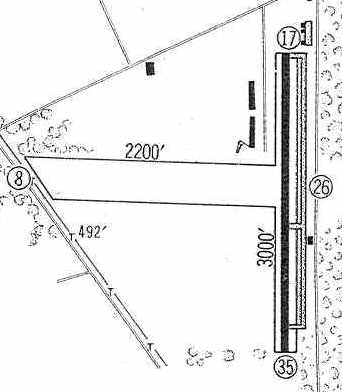
Weiss Airport was depicted in the 1960 Jeppesen Airway Manual (courtesy of Chris Kennedy)
as having a single 3,000 paved Runway 17/35 with a parallel taxiway on the east side,
as well as a 2,200' unpaved Runway 8/26.
Two rows of T-hangars were located on the northeast side of Runway 17/35,
as well as a few other small buildings on the northeast & southeast sides.
Weiss Airport was listed among active airports in the 1962 AOPA Airport Directory,
by which point the runway had been paved & extended to 3,200',
and the operator listed as Midwest Aviation.
The February 1967 Kansas City Sectional Chart (courtesy of William Willyard) depicted Weiss as having a 3,000' paved runway.
A 1968 photo of a Breezy at Weiss Airport (courtesy of Jim Naumann).
A 1969 photo of Pat Locke enjoying a beverage on a Piper at Weiss Airport (courtesy of Jim Naumann).
A 1971 aerial view shows that Weiss had a single paved north/south runway.
The crosswind grass runway had evidently been abandoned at some point between 1960-71,
as several new roads crossed over its former location.
The airfield was very well-used, with a large number parked on both the east & west sides of the paved runway.
The 1972 Flight Guide (according to Chris Kennedy) described Weiss as having a single 3,040' paved Runway 18/36.
Deborah King recalled, “I flew with my new husband out of Weiss Field.
We based our AA-1 Yankee at Weiss, starting in 1973.
It was a very active (and crowded) field then, with so many planes based there that taxiing was difficult.
I recall a real family atmosphere. The field was managed (owned?) by a fellow named Taylor.
Lot of good hangar flying back then, even when the real thing wasn't possible.”
The 1980 St. Louis Sectional Chart (courtesy of Ron Plante) depicted Weiss as having a 3,100' paved north/south runway.
The 1982 USGS topo map still appeared to depict Weiss Airport as having 2 perpendicular runways, although the east/west runway had ceased to exist more than a decade before.
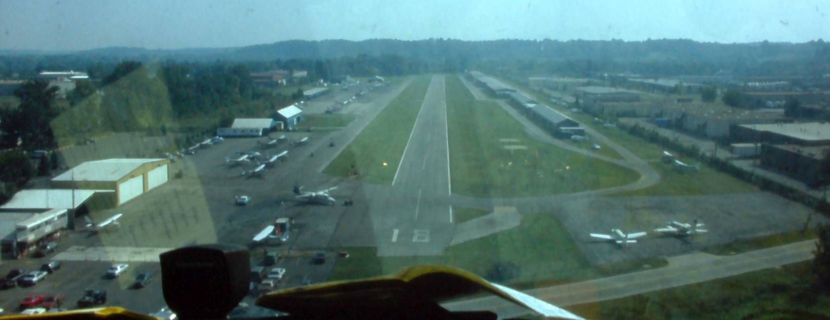
A 1983 aerial view from final approach to Weiss Airport's Runway 18 (courtesy of Jim Naumann).
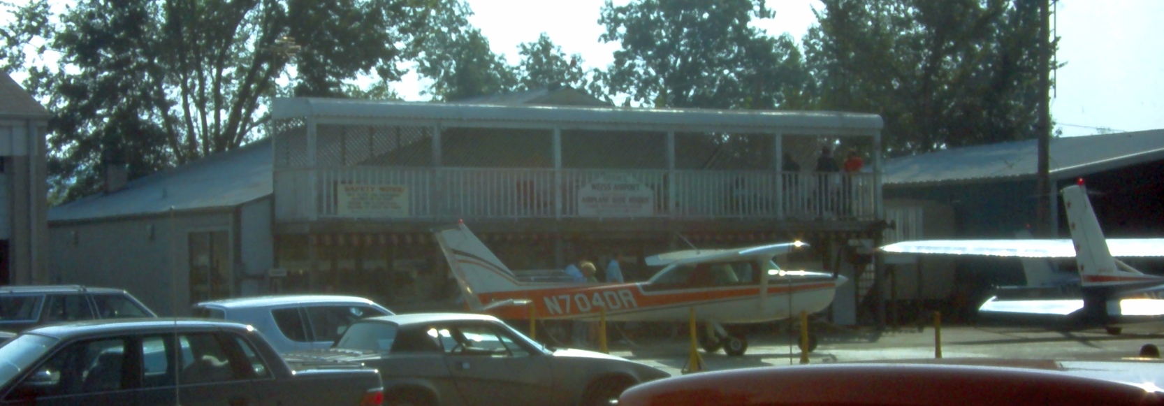
A 1983 photo of a Cessna 152 in front of Weiss Airport's Fixed-Base Operator (courtesy of Jim Naumann).
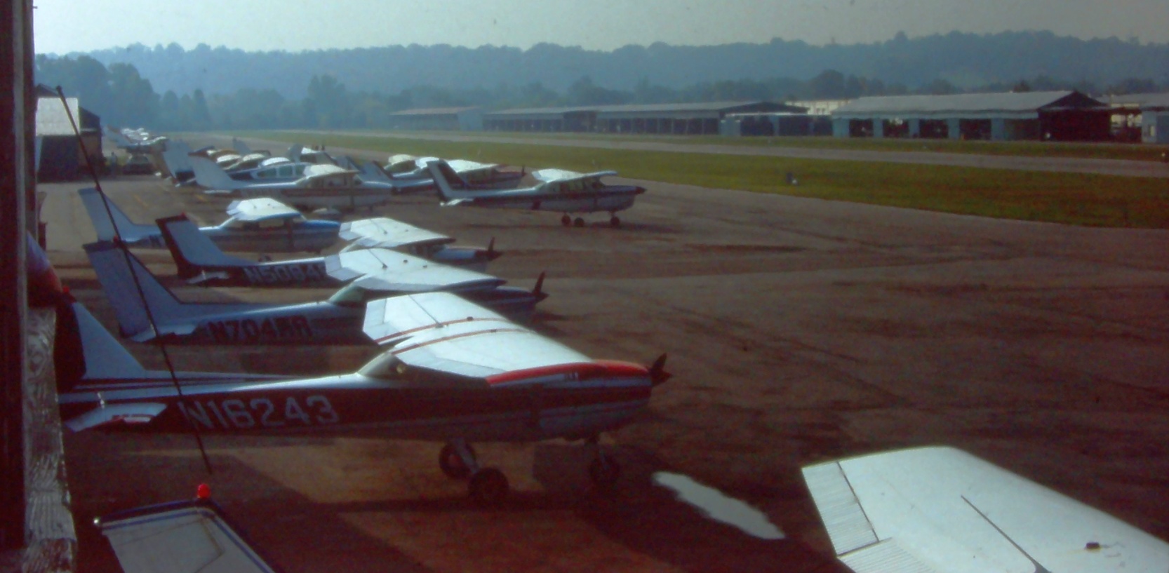
A 1983 photo of a numerous light planes & hangars at Weiss Airport (courtesy of Jim Naumann).
The 1984 St. Louis Sectional Chart depicted Weiss as having a 3,100' paved north/south runway.
A Summer 1988 photo of Artie Langston & his Luscombe NC28782 at Weiss Airport.
A Summer 1988 photo of Artie Langston & his Luscombe NC28782 at Weiss Airport.
As seen in a 4/8/90 USGS aerial photo looking northeast, Weiss Airport consisted of a single 3,000' paved runway & a large number of hangars.
Weiss was a very well-utilized airport, as over 47 aircraft were visible parked outdoors.
A local pilot recalled, “As you can see from the aerial photo, it was boxed in quite well by urban sprawl.
The public parking lot was CLOSE to the runway - it seemed like 20 or 30 ft
Until the mid-1980s there were a house & trees between the interstate & the access road
which was an obstruction & resulted in a 500' displaced threshold.
To the south, there was a fairly tall hill that looked scary to most 'flatland pilots', but which was not really a factor.
Most folks turned base leg between the hill & the runway.”
The last aeronautical chart depiction which has been located of Weiss Airport was on the November 1991 St. Louis Sectional Chart.
It depicted Weiss as having a 3,000' paved north/south runway.
A 1992 photo of Paul Schlipp in front of his Cessna 150 at Weiss Airport.
Weiss was a vital airport - during the flood of 1993, the Spirit of St. Louis Airport
(a state of the art, 2-runway, reliever airport) flooded & many of the aircraft went to Weiss
& the FAA established a temporary control tower there.
You would think this might have established Weiss as a key contingency to the St. Louis area.
The last photo which has been located showing Weiss Airport while still open was a 1994 aerial view by Paul Schlipp (courtesy of Andy Kendig),
looking south while on final approach for Runway 18.
Karl Reinhardt recalled, “I believe that I am the last person to do his 1st solo at Weiss.
I did my first solo flights at Weiss on 5/3/94. I did some more on May 4, 1994.
The FBO's airplanes were flown to Spirit of Saint Louis 5/5/94.
I remember the strip as 3,010' x 48' asphalt & pretty smooth.
The hill at the south end had a house up on the top right in line with the runway.
The traffic pattern was right traffic for Runway 36 & left traffic for Runway 18.
I believe that this was left over from the days of the other airport that was where the Chrysler plant was on the north side of I-44.
The 'standard' traffic pattern had the southwest corner cut off to miss the hill.
We did a couple of 45 degree turns instead of the normal 90 degree turn for the southwest corner.
They must have moved the house that was at the north end of the runway, but the tree line was still there in 1994.
Weiss was a great training airport, because we got to just learn to fly without a lot of traffic & we did not have to worry about a tower.
After we moved to Spirit, we learned to work with the tower & use the bigger runways & the extra exits to the taxiways.”
In 1994, the community markedly raised the property taxes & the airport was forced to close.
The FBO moved to Spirit of St. Louis Airport, but then closed after few years.
This airport closure is a very sore spot among local St Louis pilots.
It was the only airport convenient to the Southwest side of St. Louis.
It is about a 30 minute drive from Spirit of St. Louis Airport to the Southwest part of town.
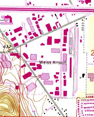
By 1996, a large industrial building was built over the center of the Weiss Airport site,
and numerous other buildings covered the entire property, with no trace remaining at all of the former airport.
A 2017 aerial view looking northeast at the site of Weiss Airport, sadly heavily redeveloped & no longer even recognizable as a former airport.
Thanks to Andy Kendig for providing information about Weiss.
____________________________________________________
Or if you prefer to contact me directly concerning a contribution (for a mailing address to send a check),
please contact me at: paulandterryfreeman@gmail.com
If you enjoy this web site, please support it with a financial contribution.
Or if you prefer to contact me directly concerning a contribution (for a mailing address to send a check),
please contact me at: paulandterryfreeman@gmail.com
If you enjoy this web site, please support it with a financial contribution.
____________________________________________________
This site covers airfields in all 50 states.