Abandoned & Little-Known Airfields:
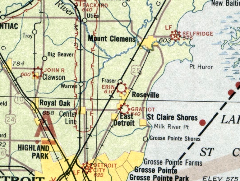
Michigan: Northeast Detroit area
© 2002, © 2025 by Paul Freeman. Revised 9/10/25.
This site covers airfields in all 50 states: Click here for the site's main menu.
____________________________________________________
Please consider a financial contribution to support the continued growth & operation of this site.
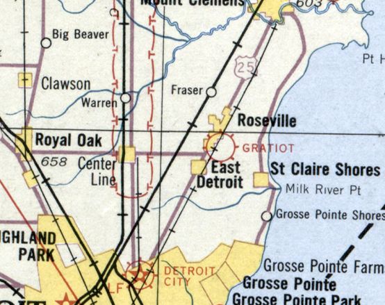
Allens Airport / Allen Airport / Oakland-Orion Airport (revised 5/28/20) - Berz Macomb Airport (revised 10/6/22) - Cobo Hall Heliport (revised 3/4/23)
Erin Airport / Thomas B. Joy Airport / Fraser Airport (revised 2/1/25) - McKinley Airport (revised 9/10/25) - Packard Field / Gratiot Airport / Hartung Field / Roseville Airport / Greater Detroit Airport (revised 3/4/23)
Packard Proving Ground Airfield (revised 5/27/20) - Utica Airport (added 9/9/18) - Wings Airport (revised 9/4/22)
____________________________________________________
Cobo Hall Heliport (84G), Detroit, MI
42.326, -83.048 (Downtown Detroit, MI)
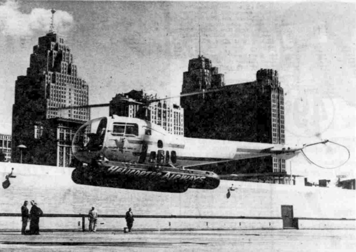
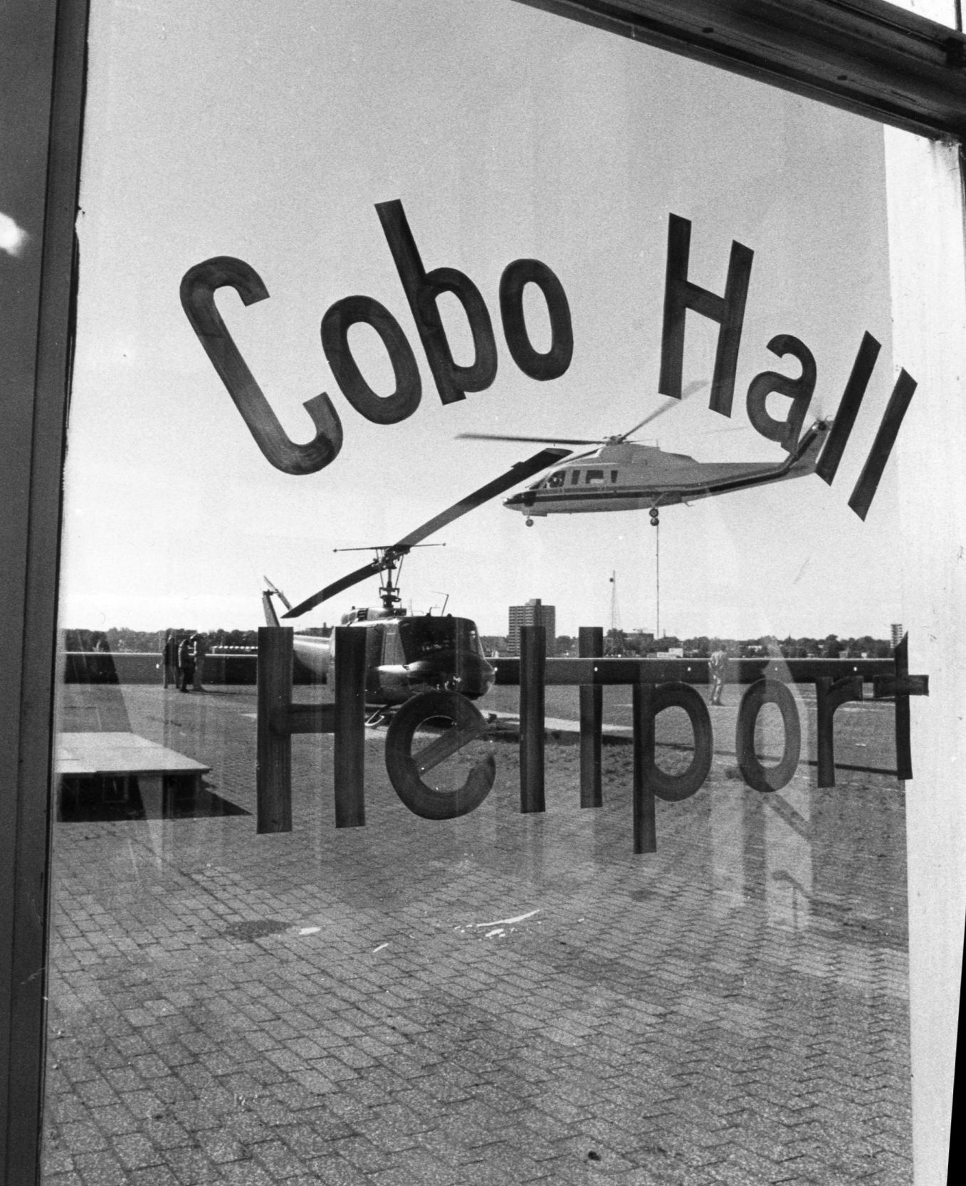
A 7/6/60 photo (courtesy of Mike Denja) of N2875B, Bell 47J Ranger msn 1712 of Helicopter Airways Service, seen making an unauthorized landing on the Cobo Hall roof, before the heliport was opened.
Detroit's Convention Center opened in 1960 along the city's riverfront.
An article entitled “Helicopter sneaks landing on Cobo Hall, irks Mayor” appeared on the cover of the 7/7/60 Detroit Free Press (courtesy of Mike Denja):
“A helicopter landed on Cobo Hall Wednesday – the 1st such landing & maybe the last.
Helicopter Airways Service made the unauthorized landing to publicize its attempts to get a heliport there.”
The sneak landing ruffled Mayor Miriani who said “This is a 'gimmick' & I don't like it at all.”
The first photo which has been located of a helicopter on the Convention Center's roof
was a A 7/6/60 photo of N2875B, Bell 47J Ranger msn 1712 of Helicopter Airways Service.
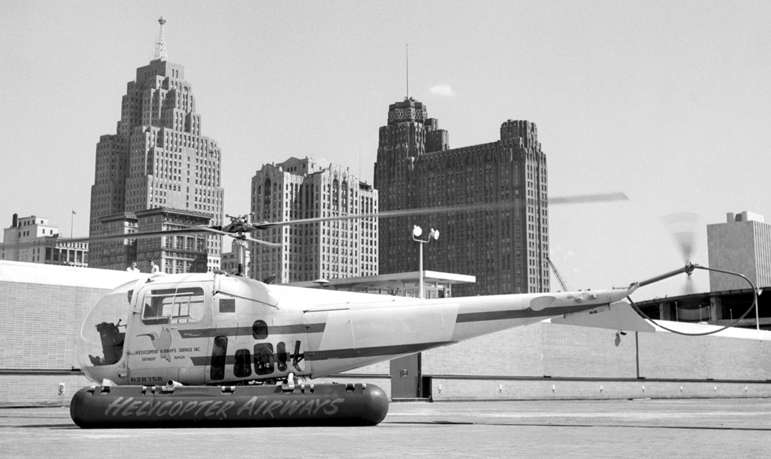
A 7/6/60 photo of N2875B, Bell 47J Ranger msn 1712 of Helicopter Airways Service, after making its unauthorized landing on the Cobo Hall roof, before the heliport was opened.
According to Jonathan Westerling, “Cobo Hall Heliport was designated & served as a public-use facility starting in 1970.”
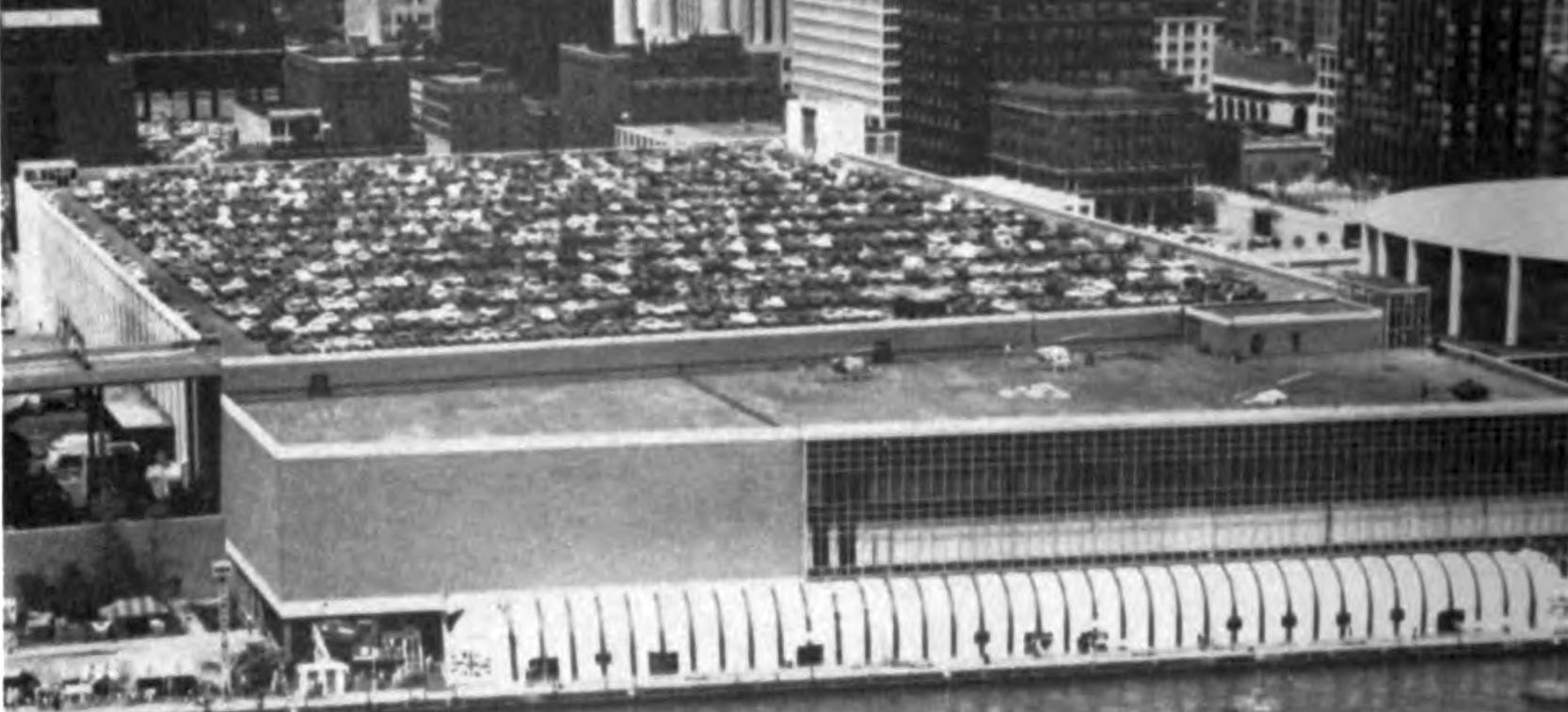
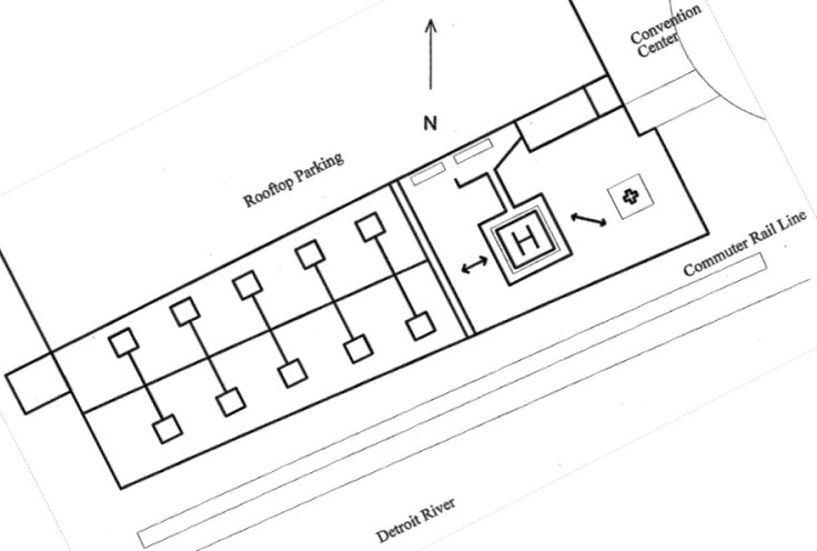
An undated aerial view from the 1977 FAA Heliport Design Guide (courtesy of Jonathan Westerling) looking north at the “Elevated public-use heliport, Cobo Hall Convention Center”.
It depicted the heliport as located on the center's southern rooftop, adjacent to the river,
and showed 4 light single-engine helicopters parked on the southeast side.
The 1977 AIA Directory of Heliports (according to Jonathan Westerling) listed the Cobo Center Heliport with a caption that it is "probably the world's largest public heliport.”
Cobo Hall Heliport was not depicted on the 1977 or 1985 Detroit Sectional Charts.
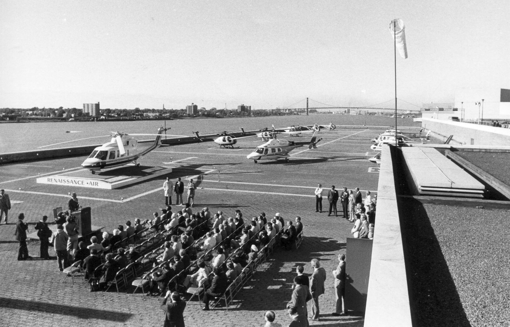
A 10/8/80 photo of the Cobo Hall Heliport ribbon-cutting ceremony (courtesy of Jonathan Westerling), showed no less than 11 Sikorsky, Hughes, and Bell helicopters at the heliport.
Cobo Hall Heliport was not depicted on the 1981 Detroit Sectional Chart.
A circa 1980s photo of a Bell Huey & a Sikorsky S-76 at the Cobo Hall Heliport (courtesy of Jonathan Westerling).
According to Jonathan Westerling, “A May 1985 NOTAM indicates that the heliport had been closed to public use.
In 1985 it was turned over to the Detroit Police Department.
The police did not particularly want it as they already had a heliport,
but accepted its management because they were a city agency, knew how to run a heliport, and could provide the best security.
The police department implemented a requirement that operators have a minimum of $1M of liability insurance & provide 24 hours prior notice to use the facility.
It was therefore no longer considered a public-use facility.”
The 1989 AOPA Airports USA Directory (courtesy of Jonathan Westerling) listed Cobo Hall's heliport as a private use facility with a 135' x 100' brick surface landing pad.
According to Jonathan Westerling, “The heliport was again turned over to the Airport Department in 1994, but was still not considered public-use.
In the fall of 1995, due to [Cobo hosting] a successful national helicopter safety meeting, the heliport was [again] granted a Class A Public-Use designation.”
A 1997 FAA report (courtesy of Jonathan Westerling) depicted the Cobo Hall Heliport as having 2 helicopter landing spots on the east side, and 10 parking spots on the west side.
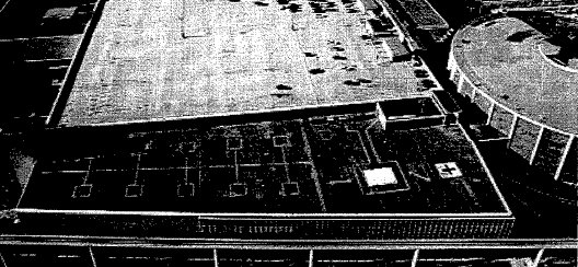
An undated aerial view looking north from a 1997 FAA report (courtesy of Jonathan Westerling) depicted the Cobo Hall Heliport as having 2 helicopter landing spots on the east side, and 10 parking spots on the west side.
An photo from a 1997 FAA report (courtesy of Jonathan Westerling) of the small building on the east side of the Cobo Hall Heliport.
The 1997 AOPA Airports USA Directory (courtesy of Jonathan Westerling) described Cobo Hall's heliport as a public landing facility albeit with a shrunken 30' x 24' landing pad.
Cobo Hall Heliport was not depicted on the April 1999 Detroit Terminal Chart.
The 2000 AOPA Airports USA Directory (courtesy of Jonathan Westerling) described Cobo Hall's heliport as having a 30' x 24' asphalt landing pad.
Cobo Hall Heliport was evidently closed at some point between 2000-2001, as the 2001 AOPA Airports USA Directory (courtesy of Jonathan Westerling) described it as "closed indefinitely".
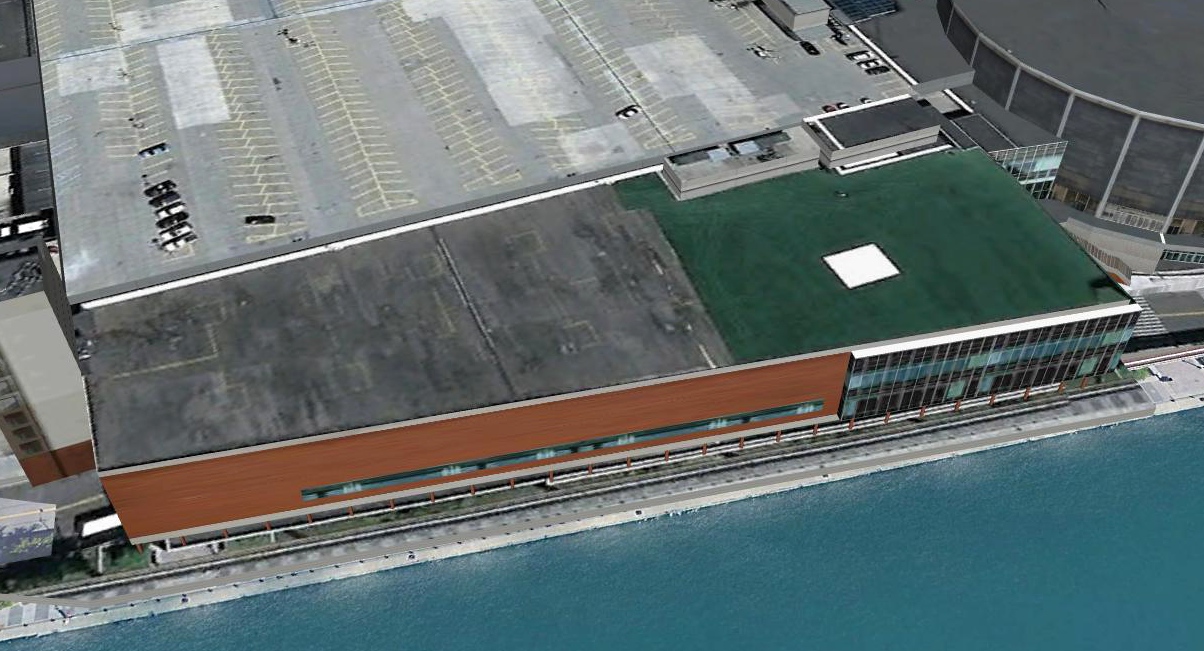
According to a 11/14/17 press release, Claude Molinari, general manager of SMG/Cobo Center announced the facility’s plan
to install a visitor observation area near the living green roof at Cobo Center at the old heliport location on the roof deck.
A 2021 aerial view looking north showed faint traces remaining of the helicopter parking markings on the west side of the site of Cobo Hall Heliport.
Thanks to Jonathan Westerling for pointing out this airfield.
____________________________________________________
42.642, -83.083 (North of Detroit, MI)
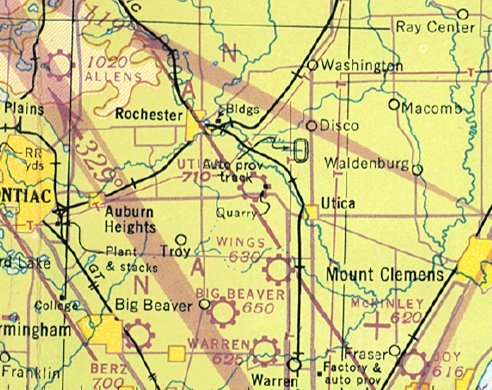
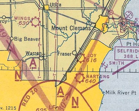
Utica Airport, as depicted on the July 1947 Detroit Sectional Chart (courtesy of Dick Merrill).
This short-lived small general aviation airport was evidently established at some point between 1946-47,
as it was not yet depicted on the May 1946 Detroit Sectional Chart.
The earliest depiction which has been located of Utica Airport was on the July 1947 Detroit Sectional Chart (courtesy of Dick Merrill).
It depicted Utica as a commercial/municipal airport.
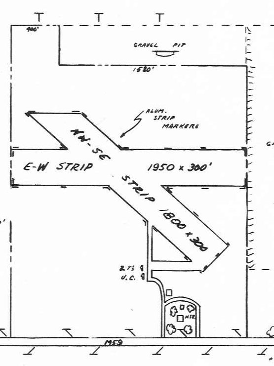
The 1947 MI Airport Directory (courtesy of Bill Grasha) depicted Utica Airport as having 2 unpaved runways, measuring 1,950' east/west & 1,800' northwest/southeast.
Two T-hangars were depicted as being under construction on the south side.
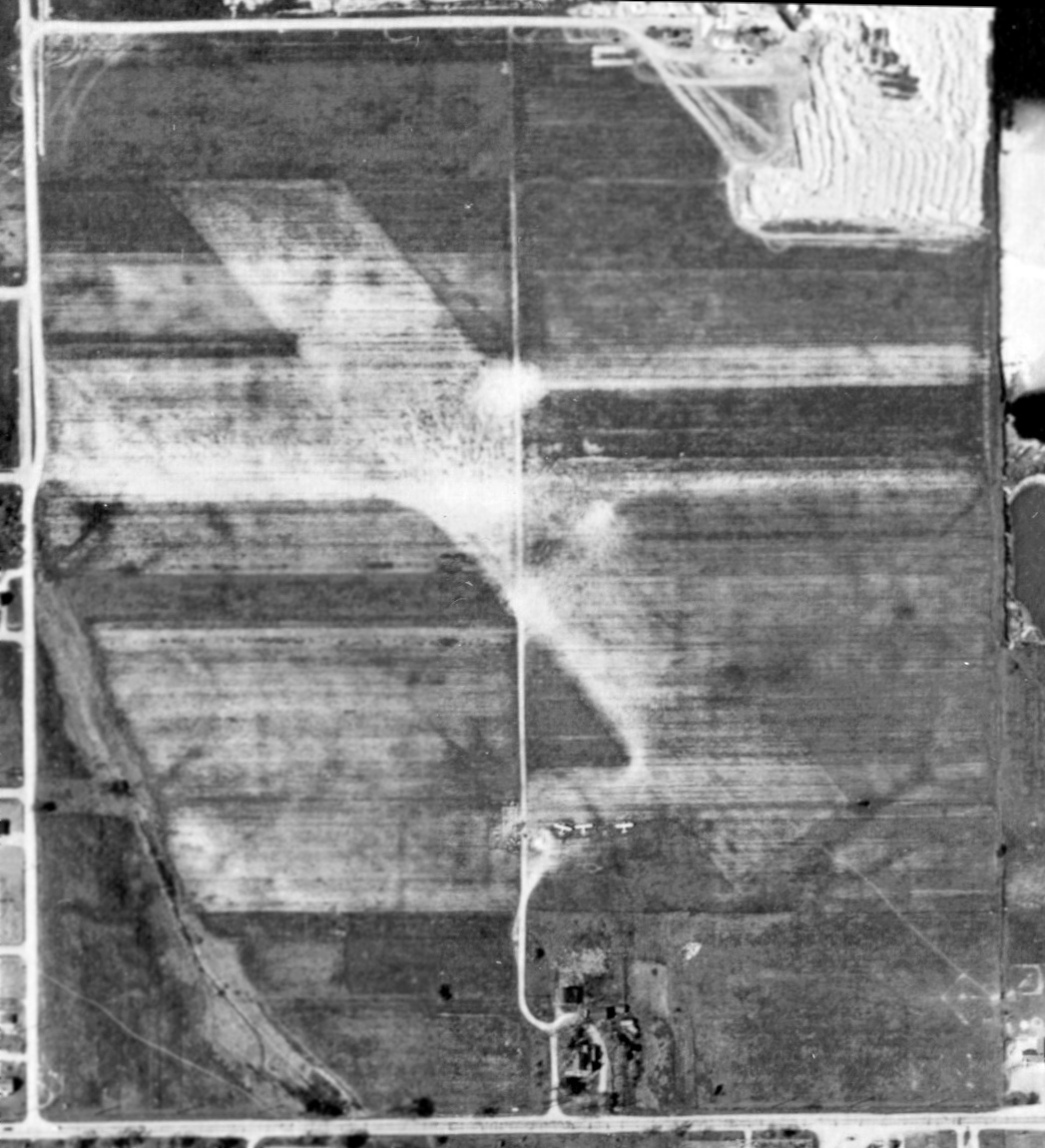
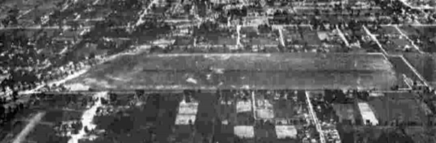
The only photo which has been located showing Utica Airport while in operation was a 4/28/49 Detroit Edision aerial view (courtesy of Bill Grasha).
It depicted 2 grass runways, with 3 light single-engine aircraft & a few small buildings on the south side.
Utica Airport evidently lasted no more than 3 years, and was evidently closed at some point in 1949,
as it was not longer depicted on the December 1949 Detroit Sectional Chart.
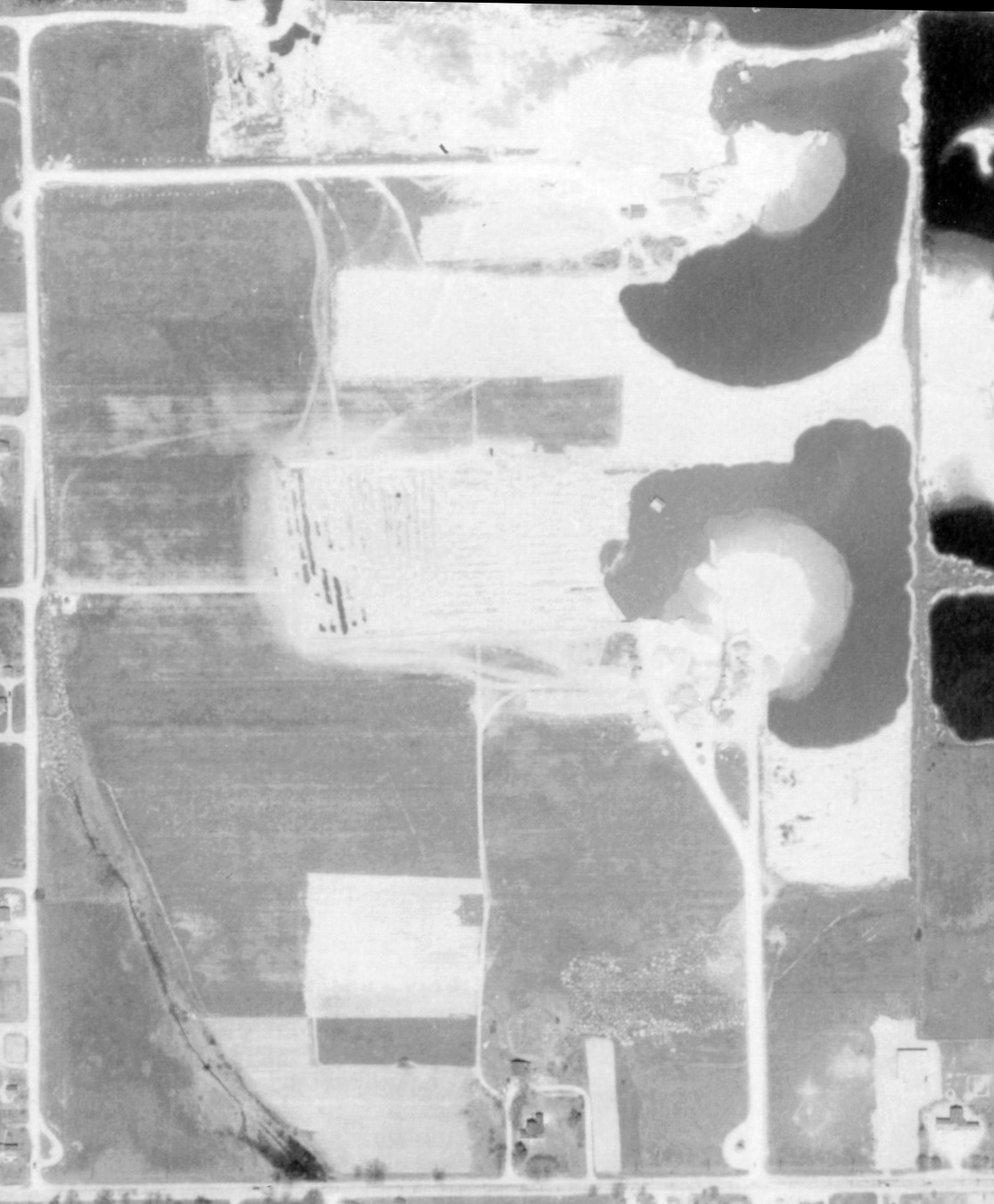
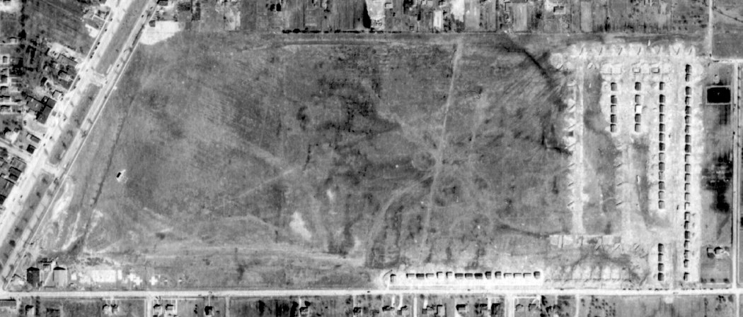
A 4/26/52 Detroit Edision aerial view (courtesy of Bill Grasha) showed the remnants of Utica Airport,
with portions on the east side having been covered by ponds (surface mining?).
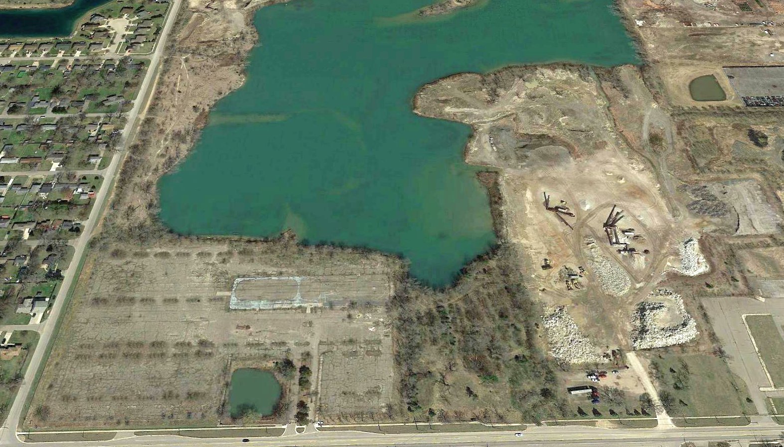
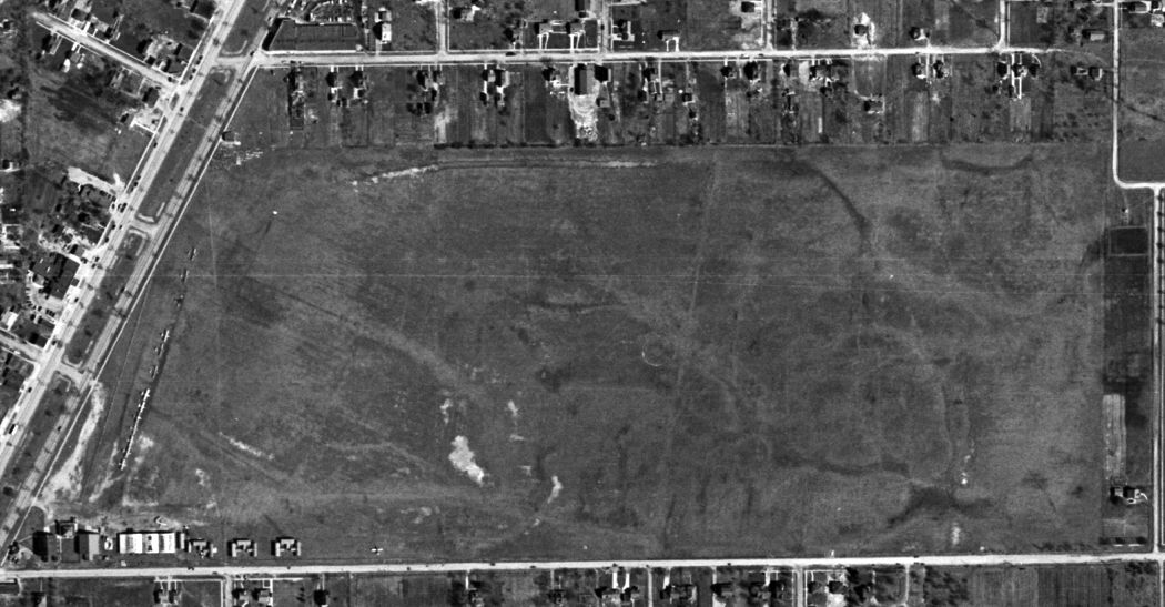
A 2017 aerial view looking north showed no trace remaining of Utica Airport, with more of the site occupied by ponds & a surface mining operation.
Thanks to Bill Grasha for pointing out this airfield.
____________________________________________________
Allens Airport / Allen Airport / Oakland-Orion Airport, Lake Orion, MI
42.716, -83.261 (North of Detroit, MI)
Allens Airport, as depicted on the August 1942 Detroit Sectional Chart (courtesy of Mike Denja).
This small general aviation airport was evidently established at some point between 1941-42,
as it was not yet depicted on a 1940 aerial view or September 1941 Detroit Sectional Chart.
The earliest depiction which has been located of Allens Airport was on the August 1942 Detroit Sectional Chart (courtesy of Mike Denja).
It depicted Allens as a commercial/municipal airport.
Allens Airport was not yet depicted on the 1943 USGS topo map (according to Mike Denja).
The 1947 MI Airport Directory (courtesy of Mike Denja) depicted Allen Airport as having 4 unpaved runways, with the longest being the 2,100' northeast/southwest strip.
A set of 5 hangars & buildings were located on the northwest side.
The earliest photo which has been located of Allens Airport was a 1949 aerial view (courtesy of Mike Denja).
It depicted 2 grass runways, with an airport circle marking on the south side, a segmented circle on the northeast side,
and 3 hangars & 1 light single-engine aircraft on the northwest side.
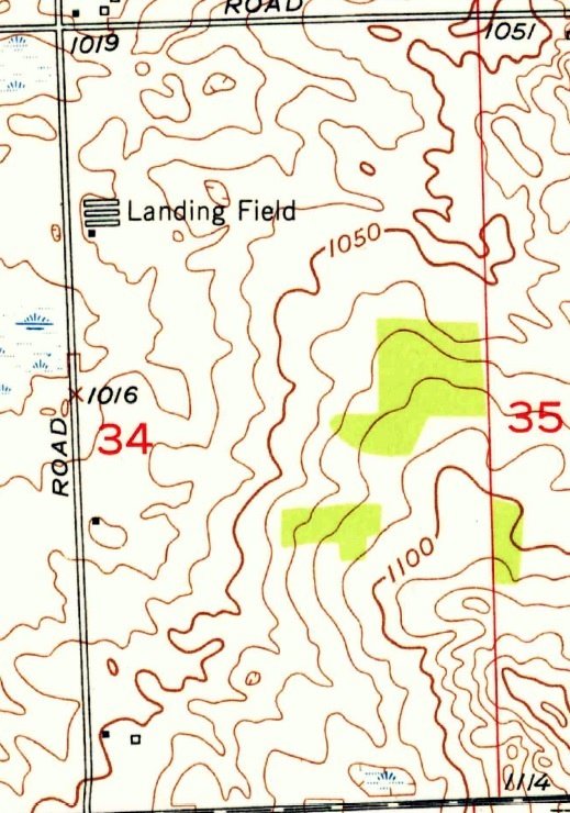
Allens Airport was labeled simply as “Landing Field” on the 1952 USGS topo map (courtesy of Mike Denja).
It depicted 4 buildings on the northwest side of an open field with no boundaries or runways.
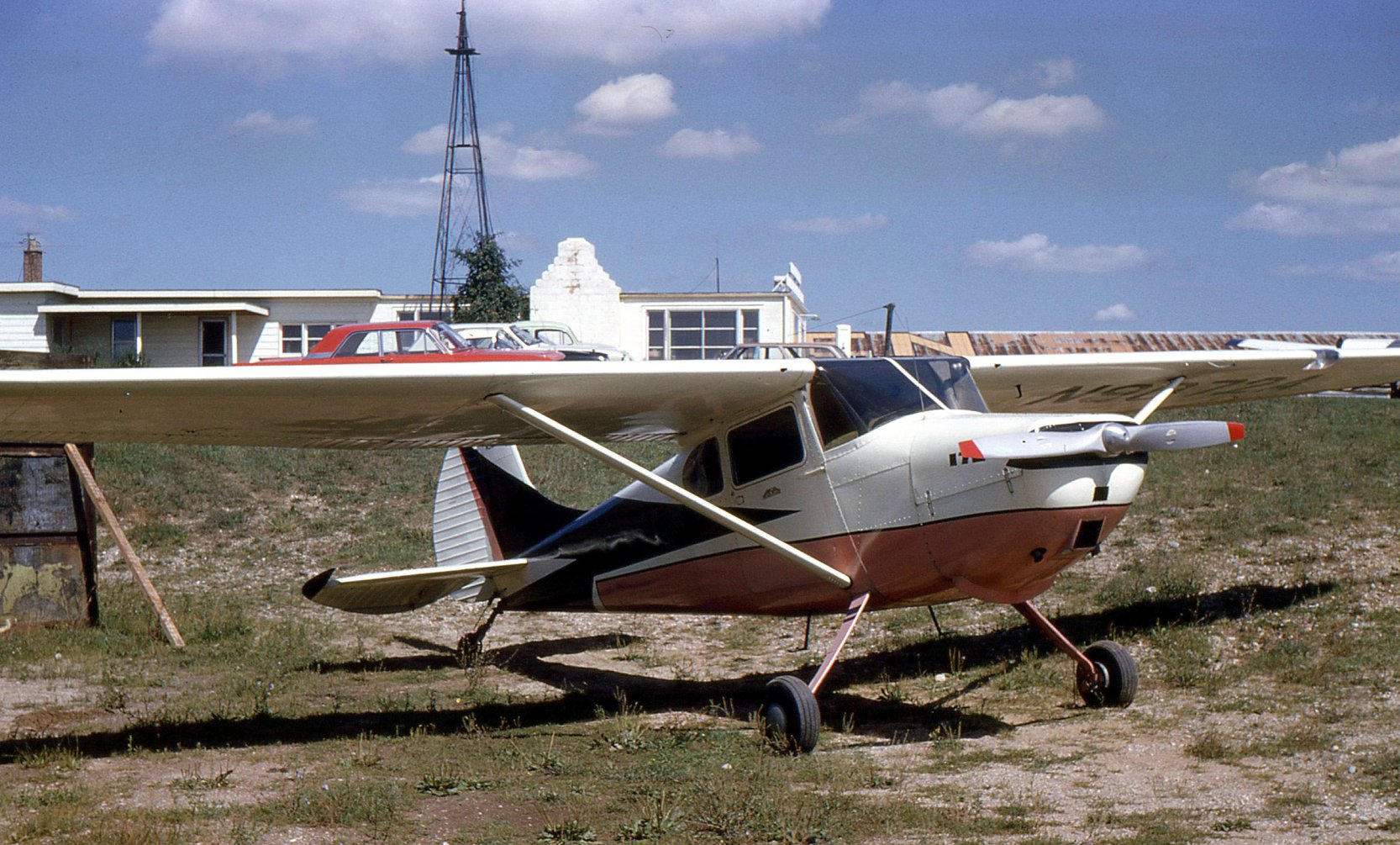
A circa 1964-65 picture (courtesy of Chris Wilson) of Wendell Wilson's Cessna 170 at Allen Airport.
Chris observed, “You can see the letters 'EN' on the end of the hangar roof just to the right of the white building.”
The July 1965 Detroit Local Aeronautical Chart depicted Allen Airport as having a 2,400' unpaved runway.
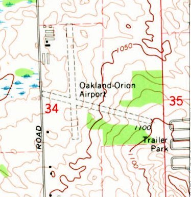
At some point between 1965-68 the airport was evidently renamed Oakland-Orion Airport, as that is how it was depicted on the 1968 USGS topo map.
It depicted Oakland-Orion Airport as having 2 unpaved runways, with several hangars on the northwest side.
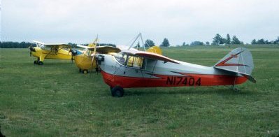
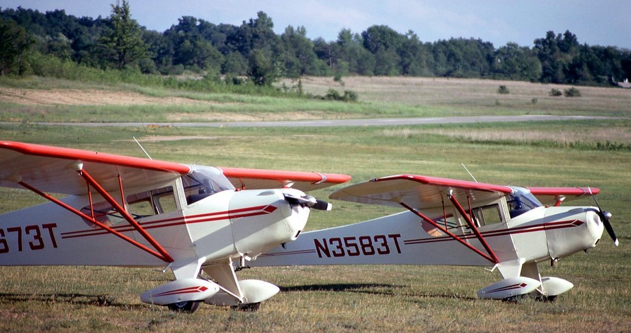
A July 1972 photo of an Aeronca C-3 N15252 (owned by Les Steen), K N22338 (owned by Tom Trainor), and C-3 N17404 at Oakland-Orion Airport.
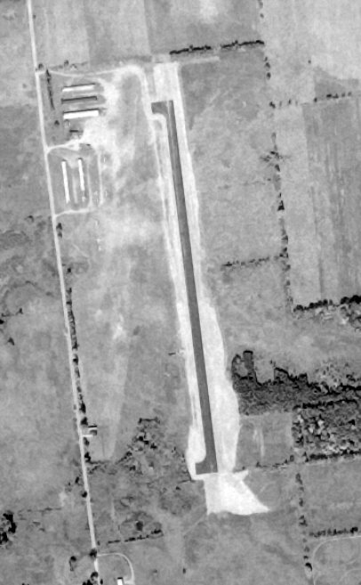
A 12/1/73 USGS aerial view (courtesy of Lee Corbin) depicted Oakland-Orion Airport as having a newly-paved asphalt runway, with the former crosswind unpaved runway barely recognizable.
Five hangars & several light aircraft were visible on the northwest side.
The last aeronautical chart depiction which has been located of Oakland-Orion Airport was on the May 1977 Detroit Sectional Chart.
It depicted Oakland-Orion Airport as having a 2,400' paved north/south runway.
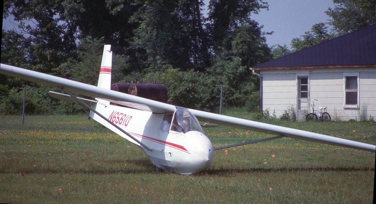
A 6/15/77 photo of a 1973 Schweizer SGS 2-33A glider at Oakland-Orion Airport.
A circa 1970s photo of 2 Taylorcraft F-19 Sportsmans at Oakland-Orion Airport.
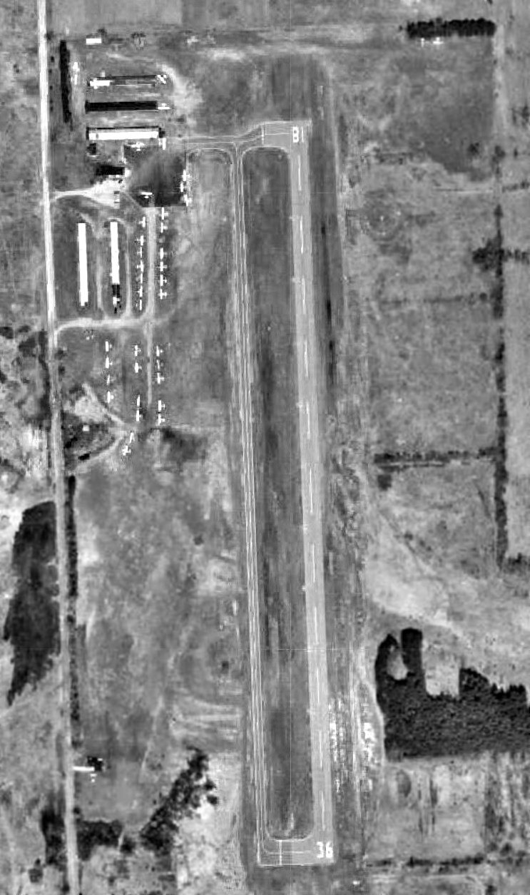
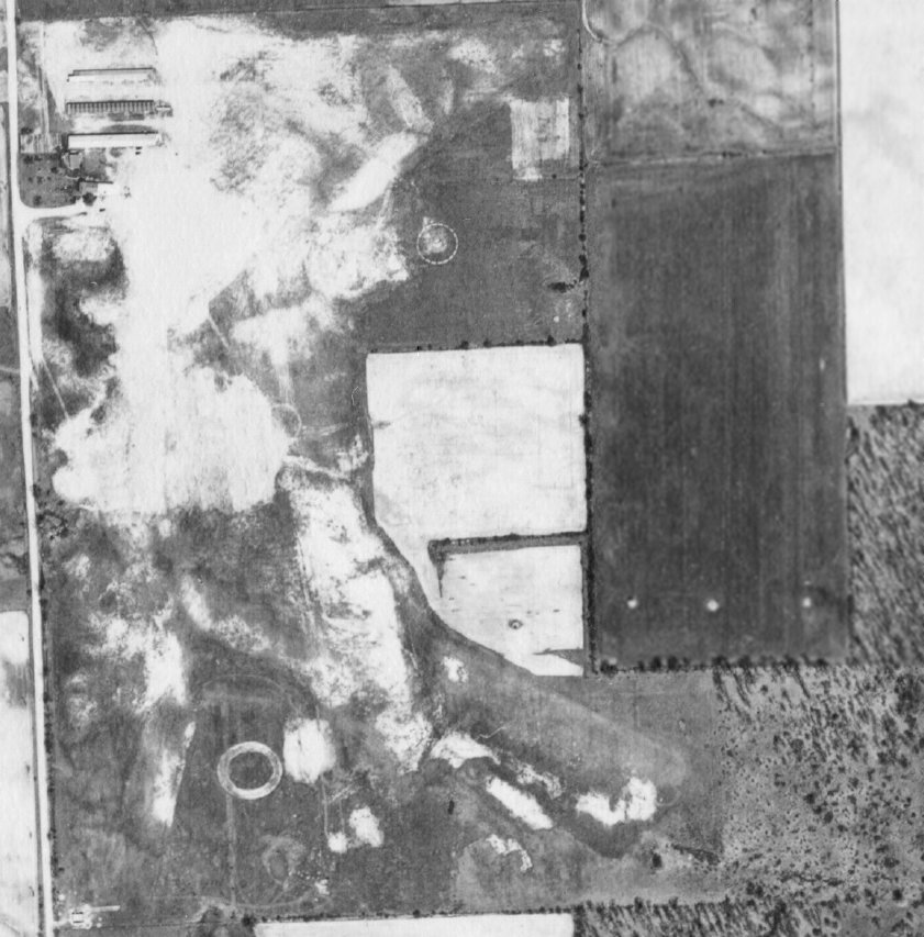
The last photo which has been located showing Oakland-Orion Airport was a 1980 aerial view (courtesy of Mike Denja), taken in its last year of operation.
It depicted a healthy airport, with over 30 light aircraft parked around the hangars on the northwest side.
According to a court case (courtesy of Mike Denja), “On 8/10/80 the Oakland-Orion Airport was permanently closed.”
Oakland-Orion Airport was depicted as an abandoned airfield on the 1981 Detroit Sectional Chart.
The property of Oakland-Orion Airport was reused to build General Motor's huge Orion Assembly plant.
According to Wikipedia, the Orion Assembly plant commenced production on 12/1/83.
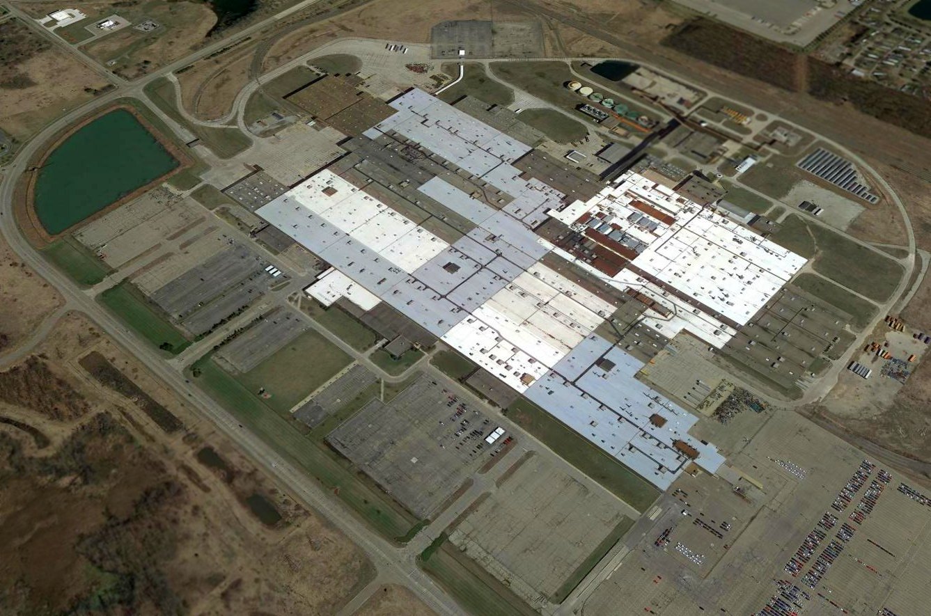
A 2017 aerial view looking northeast showed no trace remaining of Oakland-Orion Airport, with the site occupied by the massive GM Orion Assembly plant.
The site of Oakland-Orion Airport is located northeast of the intersection of Giddings Road & Brown Road.
Thanks to Lee Corbin for pointing out this airfield.
____________________________________________________
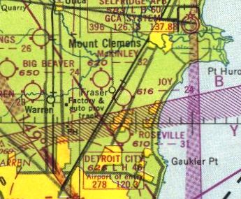
Erin Airport / Thomas B. Joy Airport / Fraser Airport, Fraser, MI
42.53, -82.94 (Northeast of Detroit, MI)
Erin Airport, as depicted on the August 1933 Detroit Sectional Chart.
This small general aviation airport may have been established at some point between 1931-33,
as it was not yet depicted on the June 1931 Detroit Sectional Chart.
The earliest depiction which has been located of Erin Airport was on the August 1933 Detroit Sectional Chart.
It depicted Erin as a commercial/municipal airport.
Erin Airport was not yet depicted on the 1936 USGS topo map (courtesy of Mike Denja).
It was still labeled Erin Airport on the April 1940 Detroit Sectional Chart.
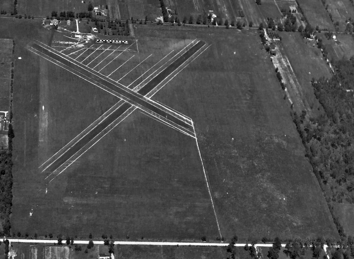
The earliest photo which has been located of Erin Airport was a 9/10/43 aerial view looking north from the 1945 AAF Airfield Directory (courtesy of Scott Murdock & Brian Rehwinkel).
It depicted 3 unpaved runways, 2 of which were prominently marked.
Two hangars with checkerboard-painted roofs were at the northwest corner, along with at least 5 light single-engine aircraft.
Erin Airport was evidently renamed Joy Airport at some point between 1940-43,
as it was how it was depicted on the October 1943 Detroit Sectional Chart.
Keith Smith recalled, “Joy Airport... I soloed there in the spring of 1944.
At that time, it was a part of the Navy V-5 training program & was operated through the CAA-WTS Program by the Highland Park Junior Collage.
WTS stood for War Training Service & was the renamed of the earlier college Pilot Training program.
The Navy had leased the Masonic Country Club on Masonic Boulevard nearby.
We had about 70-80 cadets billeted there & used the facilities of the club for ground school rooms, dinning, etc. We used the grounds of the club for physical training.
Cadets spent about 3-4 months there depending on where they were sent from there.
At that time WTS was the 3rd stage of pilot training & we went to Pre-flight from there.
Prior to that we were at Naval Air Stations as 'Tarmacs', servicing Primary Trainers & getting indoctrinated in the Navy.
After 3-4 months as Tarmacs we went to Flight Preparation Training at a college campus for 4 months then to WTS.
Our schedule was to fly half a day & have ground school the other half. The contact operator of the flight school had about 24 Piper J-3 Cubs.
There was a small tower at the field then with an operator giving us green & red lights to tell us when we were cleared for takeoff & landing.
The runways were cindered. That was a wet spring & we had lots of weather delays. Since I was there for 4 months, I got about 40 hours of flight training.”
Keith continued, “Henry Joy was the President of the Packard Auto Company & lived on the shore of Lake St. Clair, nearby.
His grandfather was named Thomas B Joy. Whether the airport was named for him or possibly Henry had a son by that name, I don't know.”
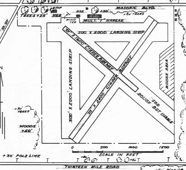
The 1945 AAF Airfield Directory (courtesy of Scott Murdock) described Thomas B. Joy Airport
as a 97 acre irregularly-shaped property having 4 cinder runways, the longest being the 2,400' northeast/southwest strip.
Joy Airport was said to have a single metal 60' x 28' hangar & 10 metal T-hangars,
and to be owned & operated by private interests.
The 1946 MI Airport Directory (courtesy of Mike Denja) depicted Joy Airport as having 4 cinder or sod runways, and several hangars along the north side.
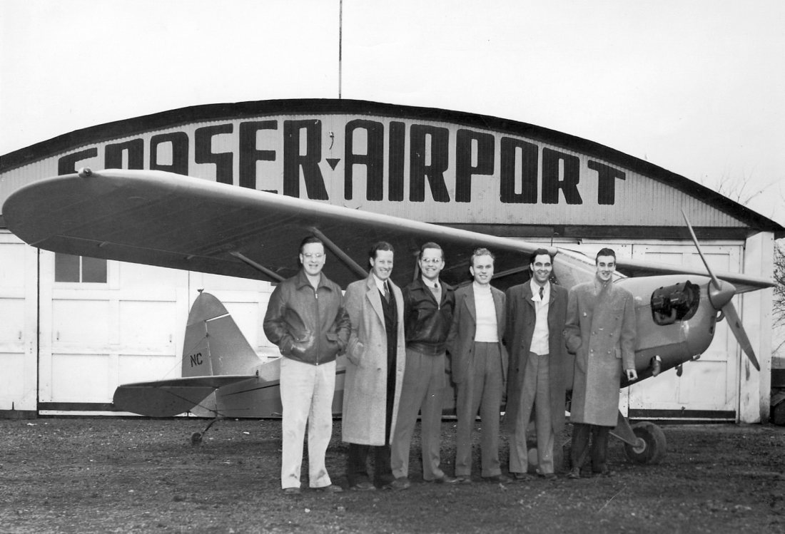
A circa 1946-48 photo (courtesy of Robert Basista) of his father Edward Basista (3rd from the left) along with an unidentified group in front of a Piper Cub & a hangar marked “Fraser Airport”.
The 1949 Detroit Sectional Chart (courtesy of Donald Felton) depicted Joy Airport as having a 2,400' unpaved runway.
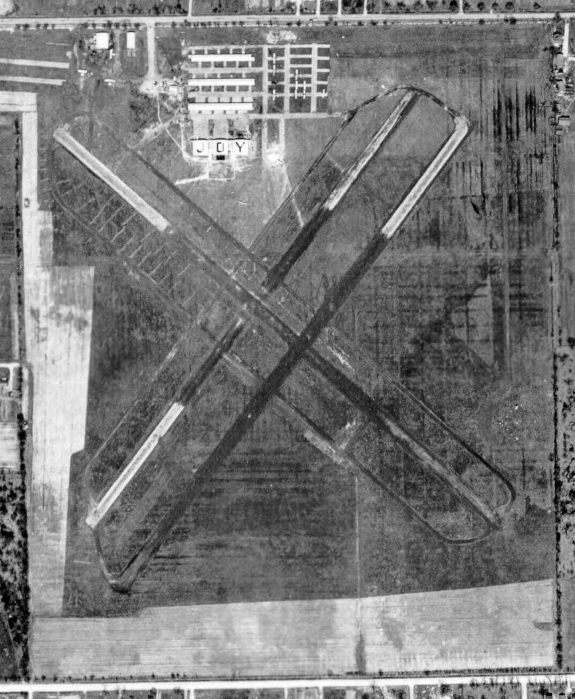
The last photo which has been located of Joy Airport was a 1949 aerial view (courtesy of Mike Denja). It depicted a total of 12 light aircraft visible on the field.
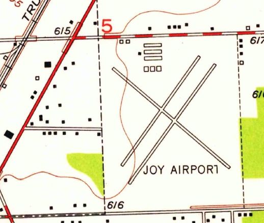
The last depiction which been located of Joy Airport was on the 1952 USGS topo map (courtesy of Mike Denja). It depicted Joy Airport as having 3 runways.
The last aeronautical chart depiction which has been located of Joy Airport was on the November 1954 Detroit Sectional Chart.
It depicted Joy Airport as having a 2,400' unpaved runway.
Joy Airport was evidently closed at some point between 1954-55,
as it was no longer depicted on the May 1955 Detroit Sectional Chart.
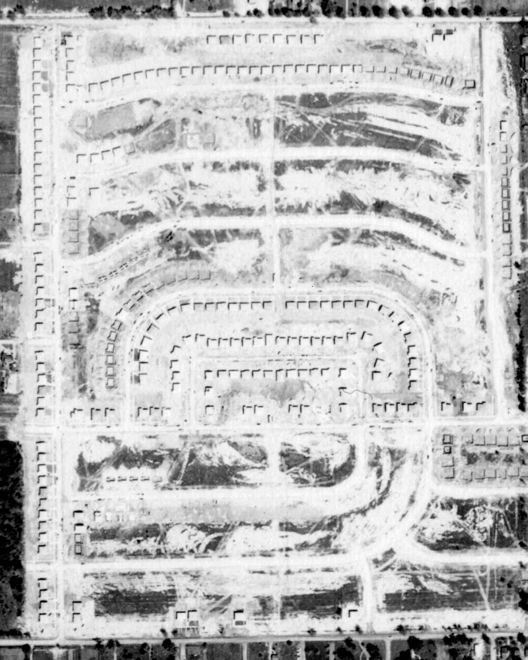
A 1956 aerial view (courtesy of Mike Denja) showed residential construction covering the site of Joy Airport, but traces of the diagonal runways could still be discerned.
The 1968 USGS topo map showed that Joy Airport had befallen the same fate of so many suburban general aviation airports,
as residential streets covered the site of the airport, including one named “Airport Road”.
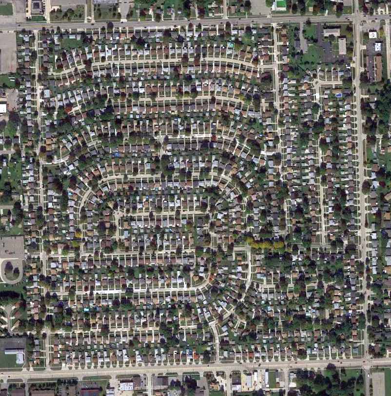
A 2013 aerial view showed no trace remaining of Joy Airport.
Thanks to Mike Denja for pointing out this airfield.
____________________________________________________
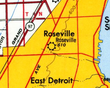
Packard Field / Gratiot Airport / Hartung Field / Roseville Airport / Greater Detroit Airport, Roseville, MI
42.49, -82.94 (Northeast of Detroit, MI)
The location of Packard Field, relative to the Packard plant, as depicted on the 5/15/24 Commerce Department Airway Bulletin (courtesy of Mike Denja).
According to Wikipedia, “Michigan’s first commercial airport, Packard Field, opened at Gratiot Avenue & Frazho Road in 1919.”
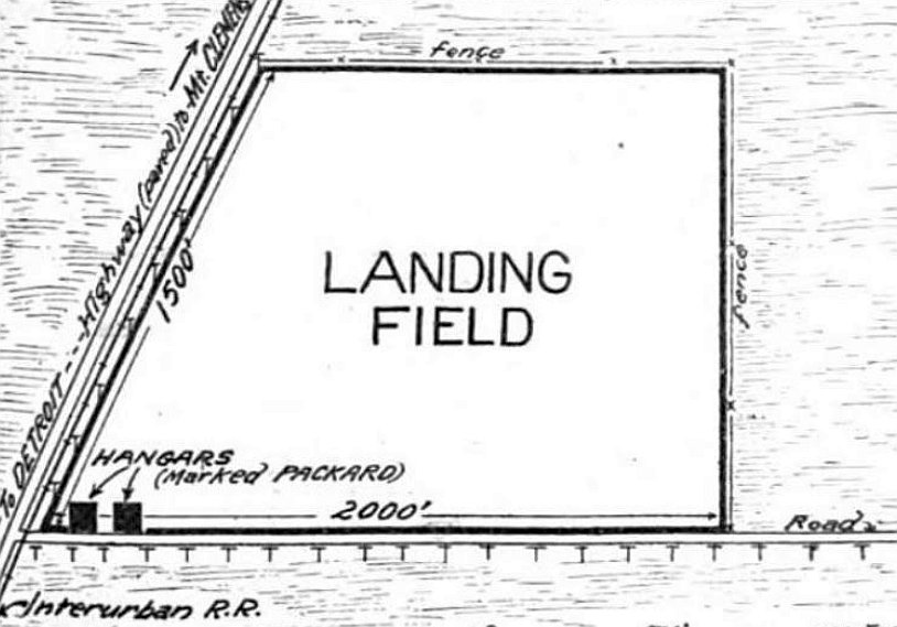
The earliest depiction which has been located of Packard Field was on the 5/15/24 Commerce Department Airway Bulletin (courtesy of Mike Denja).
It depicted Packard Field as an irregularly-shaped property measuring 2,000' east/west along its southern boundary,
and having 2 hangars (“marked PACKARD”) on the southwest corner.
According to Duke Nelson, his grandfather, pilot Austin Nelson, died in airplane crash at Packard Field (later renamed Hartung Field) in about 1925.
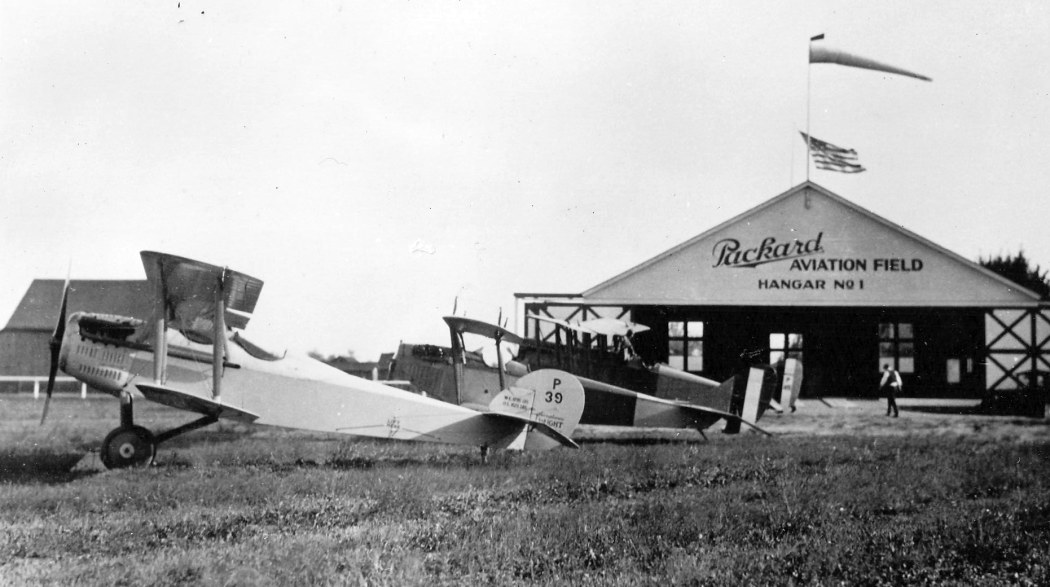
The earliest photo which has been located of Packard Field was a circa 1920s photo (courtesy of Bob Supina)
of several unidentified biplanes in front of a hangar marked “Packard Aviation Field Hangar #1”.
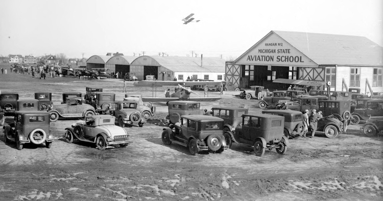
A circa 1920s photo of several unidentified biplanes & many cars
in front of the Michigan State Aviation School Hangar #2 at Packard Field (courtesy of Mike Denja).
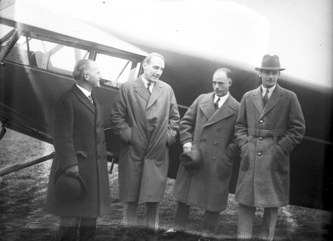
A circa 1920s photo of a visit by the Spanish Royal Family to Packard Airport
showing Infante Don Alfonso, Prince Alvaro De Orleans Bonibon, Alvin Macauley, and Captain Wodson in front of an unidentified plane (from the Wayne State University Library).
According to Wikipedia, “Packard Field was renamed Gratiot Airport in 1929.”
The earliest aeronautical chart depiction which has been located of Gratiot Airport was on the June 1931 Detroit Sectional Chart.
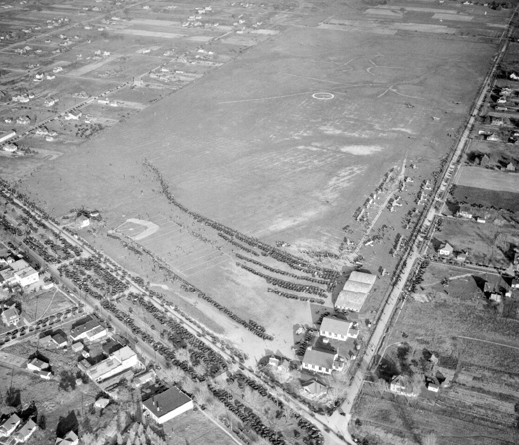
A 10/29/33 aerial view looking northeast (courtesy of Mike Denja) showed many spectators & a large number of aircraft at Gratiot Airport
In 1934, famous humorist Will Rogers visited the 104 acres then known as Gratiot Airport.
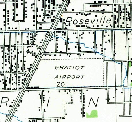
The 1936 USGS topo map depicted Gratiot Airport as a trapezoidal-shaped property having a row of buildings along the southwest side.
The 1940 USGS topo map depicted Gratiot Airport in an unchanged fashion.
It was still depicted as Gratiot Airport on the April 1940 Detroit Sectional Chart.
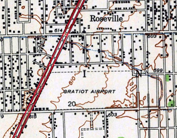
At some point between 1940-43, Gratiot Airport was renamed Hartung Field, after the air service company that managed it,
as depicted on the October 1943 Detroit Sectional Chart.
Howard Hartung established a special airport trophy for the women who flew, awarding it 8 consecutive years, from 1936-43.
The trophy bore an image of Howard's daughter Joyce on it.
Annual recognition was given to the most prolific female flyer for abilities in the following categories:
acrobatic, spot-landing, paper-strafing, balloon bursting with propellers, ribbon-cutting, and bomb drops using a sack of flour & a ground target.
"Some of them actually flew their planes in high heels, too," said Gail Elliott.
"Marion 'Babe' Weyant Ruth of the Michigan Women's Hall of Fame was one of them."
A circa 1943-45 aerial view looking north from the 1945 AAF Airfield Directory (courtesy of Scott Murdock)
depicted Hartung Airport as having as single east/west grass runway.
The October 1943 Detroit Sectional Chart (courtesy of Ron Plante) depicted Hartung Airport as a commercial/municipal airport.
The 1945 AAF Airfield Directory (courtesy of Scott Murdock) described Hartung Airport
as a 100 acre trapzedoidal-shaped property having a sod all-way landing field measuring 2,900' east/west.
Hartung was said to have 5 hangars, the largest being two 60' square wooden structures, and to be owned & operated by private interests.
At some point between 1943-45, Hartung Airport was renamed Roseville Airport, as depicted on the May 1945 Detroit Sectional Chart.
The May 1946 Detroit Sectional Chart depicted it under yet another name, Greater Detroit Airport.
The July 1947 Detroit Sectional Chart once again labeled it Roseville Airport.
The last photo which has been located showing Roseville Airport still open was a 4/16/51 USGS aerial view.
A total of 14 single-engine aircraft were visible on the southwest side of the field, along with a row of hangars.
The last aeronautical chart depiction which has been located of Roseville Airport was on the May 1941 Detroit Sectional Chart.
It depicted Roseville as having a 3,100' unpaved runway.
A 4/16/52 aerial view showing the site of Roseville Airport (courtesy of Mike Denja).
Mike observed, the picture is “Exactly one year to the day after the 1951 aerial. You can see many new homes already built in that one year.”
According to Wikipedia, “The Eastgate Shopping Center was constructed on the site in the 1950s.”
The 1954 USGS topo map continued to depict Roseville Airport, even though it had ceased to exist for 2 years by that point.
Roseville Airport was no longer depicted on the May 1958 Detroit Sectional Chart.
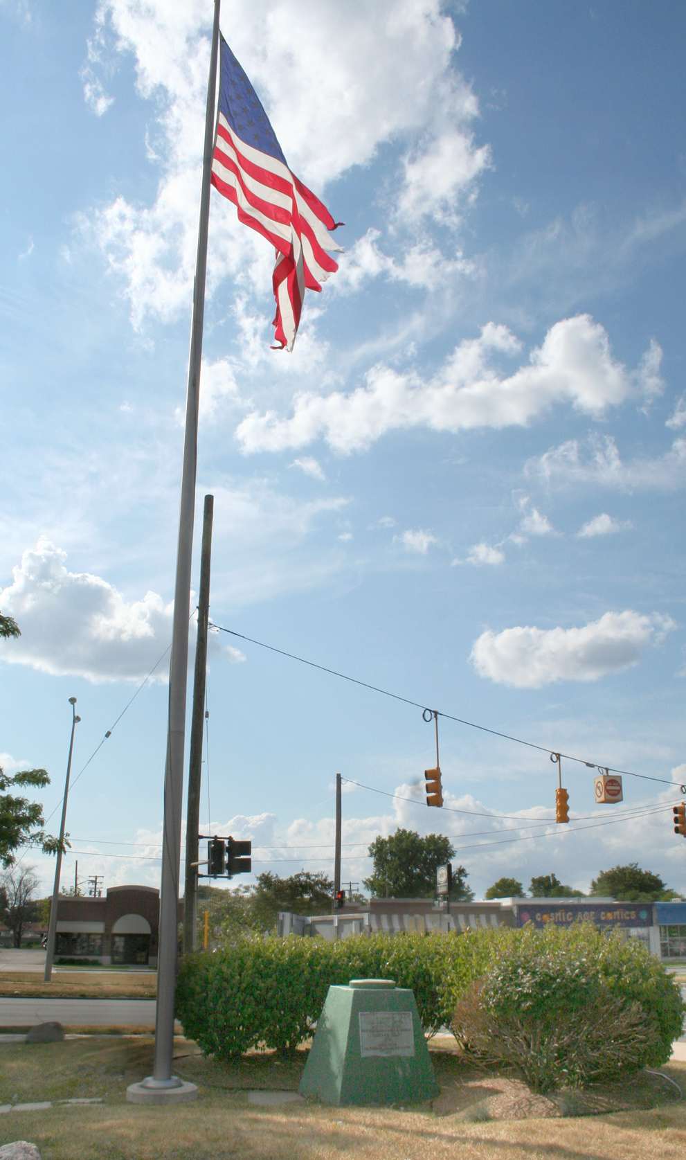
A 2014 photo by Bob Supina of the flagpole & plaque at the site of Packard Field.
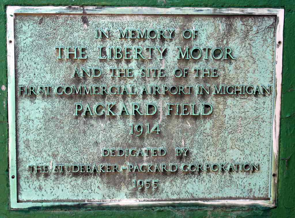
A 2014 photo by Bob Supina of the 1955 plaque at the site of Packard Field.
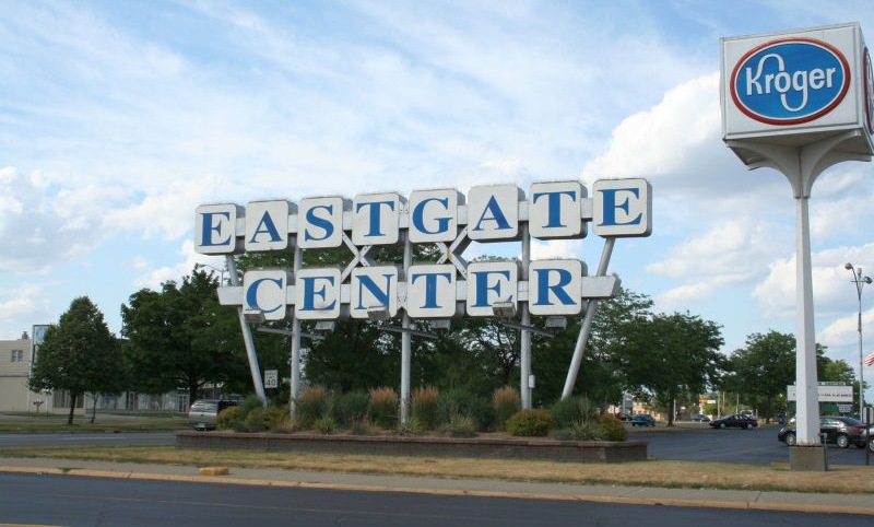
A 2014 photo by Bob Supina of the site of Packard Field, now the Eastgate Center shopping plaza.
Thanks to Bob Supina for point out this airport.
____________________________________________________
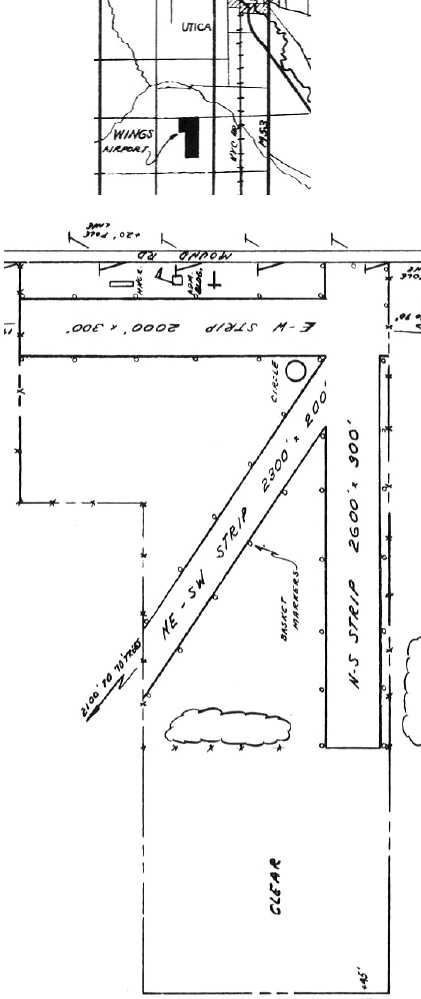
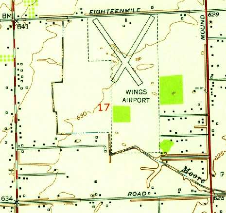
42.59, -83.06 (Northeast of Detroit, MI)
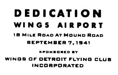
A postmark commemorating the 9/7/41 dedication of Wings Airport.
Wings Airport was not yet depicted on the April 1940 Detroit Sectional Chart.
This general aviation airport was evidently dedicated on 9/7/41, according to a postmark commemorating the event,
sponsored by the Wings of Detroit Flying Club Incorporated.
According to Darin Ninness, “Wings Field had been formerly been the home to the Polish Flying Club,
and at the outbreak of hostilities in WWII, they handed that airfield over the the Civil Air Patrol 'for the duration'.
CAP used Wings Field for their jumping, along with war bond rallies, cadet encampments, etc.”
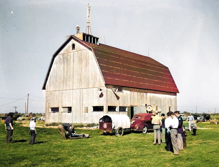
The earliest photo which has been located of Wings Airport
was a 1942 photo of a barn on the ground of Wings Airport, with a windsock on top (courtesy of Mark Hess, colorized by Mike Denja).
Mark reported, “The hangar barn was the [Civil Air Patrol] Michigan Wing Headquarters built in early 1942 at Wings Airport in Utica.”
A 10/4/42 postmark commemorated the “rededication” of Wings Airport (only a year after its dedication).
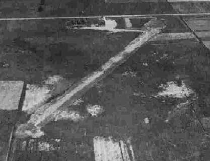
The earliest photo which has been located showing the extent of Wings Airport
was a circa 1943-45 aerial view looking north from the 1945 AAF Airfield Directory (courtesy of Scott Murdock).
It depicted the field as having an unpaved runway.
The earliest aeronautical chart depiction which has been located of Wings Airport
was on the October 1943 Detroit Sectional Chart (courtesy of Ron Plante).
The 1945 AAF Airfield Directory (courtesy of Scott Murdock) described Wings Airport
as a 152 acre irregularly-shaped property containing 3 sod runways, with the longest being a 2,600' northwest/southeast strip.
The field was said to have a single 120' x 24' wood & metal hangar, and to be owned & operated by private interests.
According to Darin Ninness, “Wings Field apparently faded from CAP's use pretty quickly after the war.”
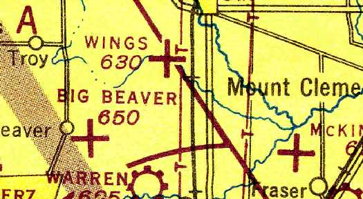
The 1946 Detroit Sectional Chart depicted Wings as an auxiliary airfield.
The location & layout of Wings Airport as depicted in the 1946 MI Airport Directory (courtesy of Doug Ranz).
It depicted Wings as having 3 unpaved runways, the longest being the 2,600' north/south strip,
with a hangar & administration building on the north side.
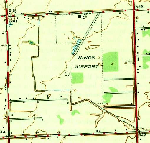
The 1946 USGS topo map (courtesy of Mike Denja) depicted Wings Airport as having a single northeast/southwest runway,
with several buildings along the north side.
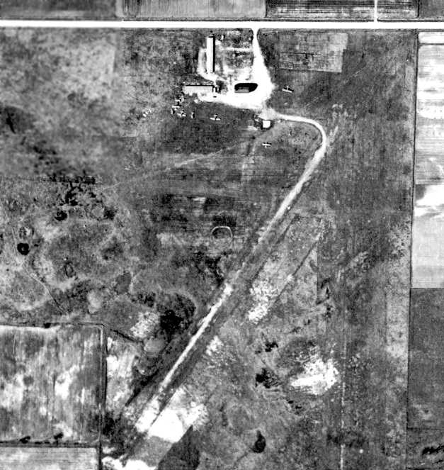
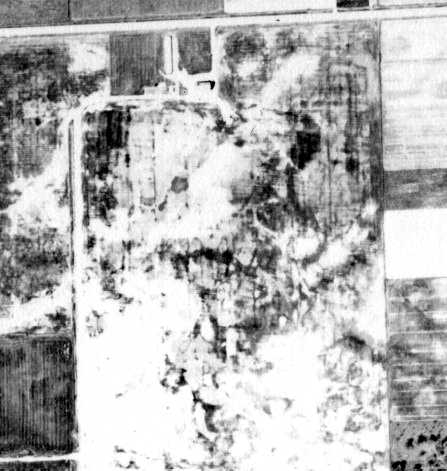
The earliest photo which has been located showing aircraft at Wings Airport was a 1949 aerial view (from the Wayne State DTE collection, courtesy of Mike Denja).
It depicted the field as having 2 grass runways, with a half-dozen light aircraft clustered around a few small buildings on the north end.
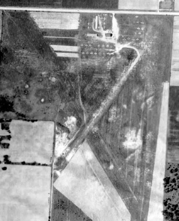
The last photo which has been located showing Wings Airport in operation was a 1952 aerial view (from the Wayne State DTE collection, courtesy of Mike Denja).
It depicted the field as having 3 grass runways, and the number of aircraft visible on the field had increased dramatically compared to the 1949 photo.
The 1952 USGS topo map (courtesy of Mike Denja) depicted Wings Airport as having 2 runways,
with several buildings along the north side.
Wings Airport evidently closed (for reasons unknown) at some point between 1949-56,
as a 1956 aerial view (from the Wayne State DTE collection, courtesy of Mike Denja)
showed the runways had been plowed up, but several buildings remained standing.
The last aeronautical chart depiction which has been located of Wings Airport was on the January 1958 Detroit Sectional Chart,
which was evidently at least 2 years after the airport had been closed.
It depicted Wings as having a 2,600' unpaved runway.
Wings Airport was no longer depicted on the May 1958 Detroit Sectional Chart.
Ironically, aerial photos from 1964 & 1967 showed the barn & 1 hangar still remained on the north side of the Wings Airport site.
Mike Denja observed, “The hangar & administration building were still standing in 1967
but finally razed in 1973 when the present development was built.”
A 1973 aerial photo showed houses covering the site of Wings Airport.
Kevin recalled of the site of Wings Airport, “I lived in the mobile home park there from 1979-87.
There was no trace left [of the airport] by that time, but the south end of the northwest/southeast runway ended right where my mobile home was.
As young men, my brother & would explore, and we found old mechanical equipment in the field just to the east, which is now an industrial park.
I had always wondered what the abandoned equipment was for. I figure the equipment was used for the airfield or planes.”
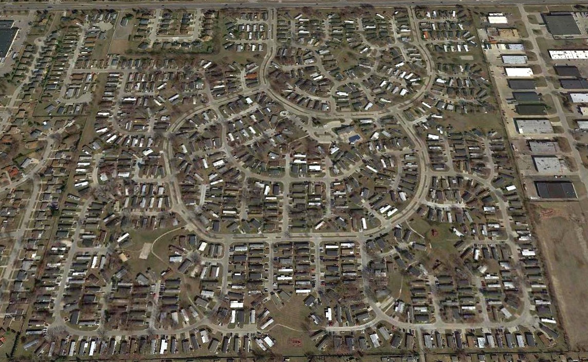
A 2021 aerial view looking north showed the site of Wings Airport filled with houses, with not a trace remaining of the former airport.
The site of Wings Airport is located southwest of the intersection of Mound Road & 18 Mile Road.
____________________________________________________
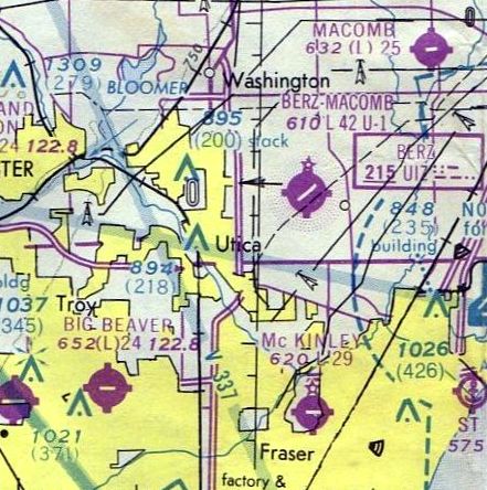
Berz Macomb Airport (UIZ), Utica, MI
42.665, -82.965 (North of Detroit, MI)
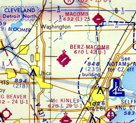
Berz-Macomb Airport, as depicted on the November 1972 Detroit Sectional Chart (courtesy of Richard Finley).
No airfield was yet depicted at this location on the 1968 USGS topo map.
According to the Berz Macomb Airport web site,
Milton Berz sold his original airport (what would eventually become today's Oakland-Troy Airport) in 1968,
and the Berz family established the Berz Macomb Airport in 1972.
The earliest depiction which has been located of the Berz-Macomb Airport
was on the November 1972 Detroit Sectional Chart (courtesy of Richard Finley).
It depicted the field as having a single 4,200' paved runway.
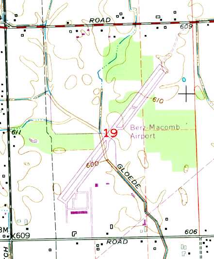
The 1973 USGS topo map depicted Berz Macomb Airport as having a single paved northeast/southwest runway, a parallel taxiway,
and a row of T-hangars & 2 smaller buildings on the south side.
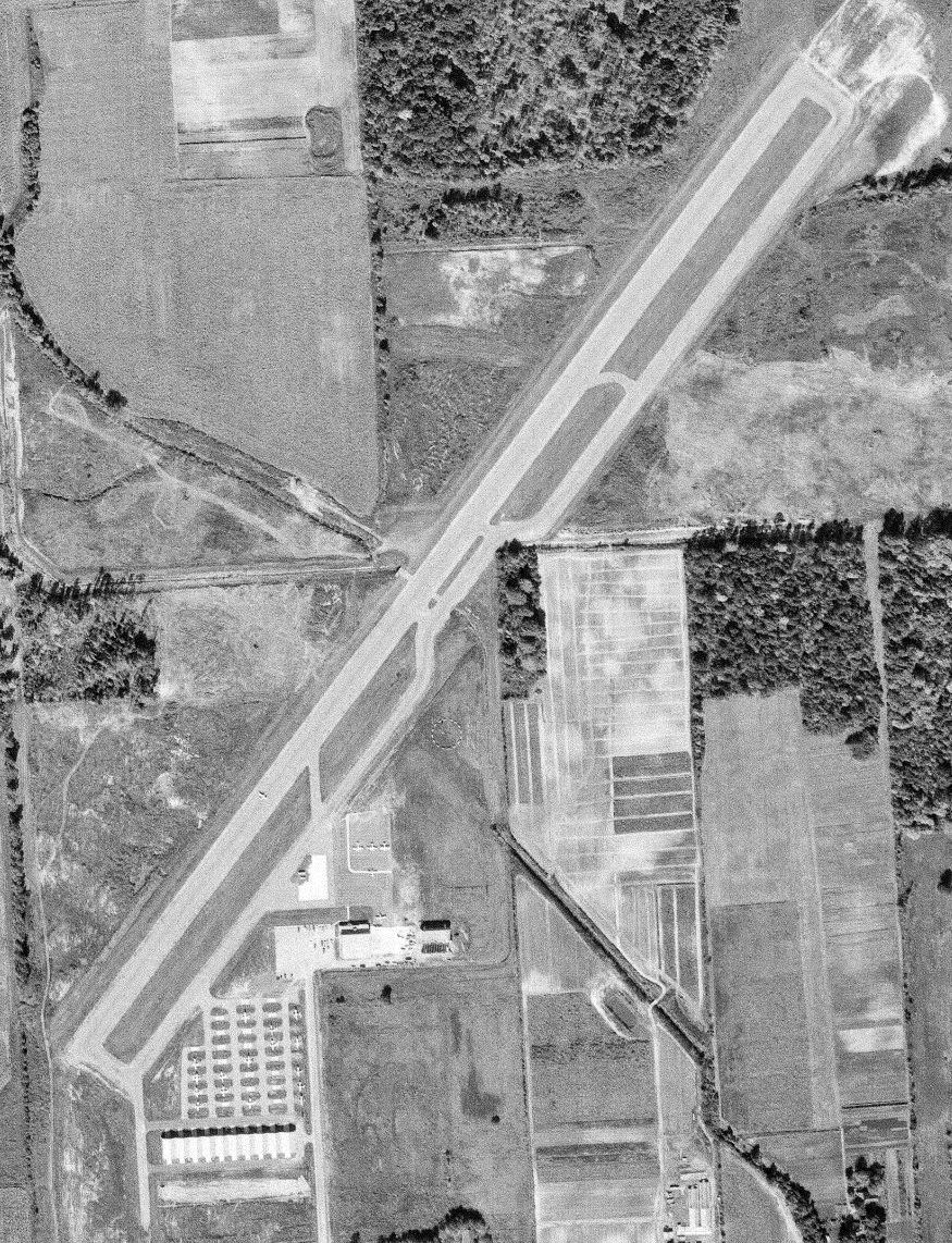
The earliest photo which has been located of Berz Macomb Airport was a 10/15/73 aerial view (courtesy of Mike Denja).
It depicted the field as having been constructed with substantial infrastructure,
with a single paved northeast/southwest runway, a parallel taxiway, and a large number of T-hangars.
A total of 19 light aircraft were visible parked outdoors.
The 1976 Detroit Sectional Chart (courtesy of Mike Keefe)
depicted Berz-Macomb as having a single 4,200' paved runway, and its own NDB navigational beacon.
The May 1977 Detroit Sectional Chart (courtesy of Mitchell Hymowitz)
depicted Berz-Macomb as having a single 4,200' paved runway, and its own NDB navigational beacon.
The 1982 AOPA Airport Directory (courtesy of Ed Drury) described Berz Macomb Airport as having a single 4,200' asphalt Runway 4/22,
and listed the operator as Berz Flying Service.
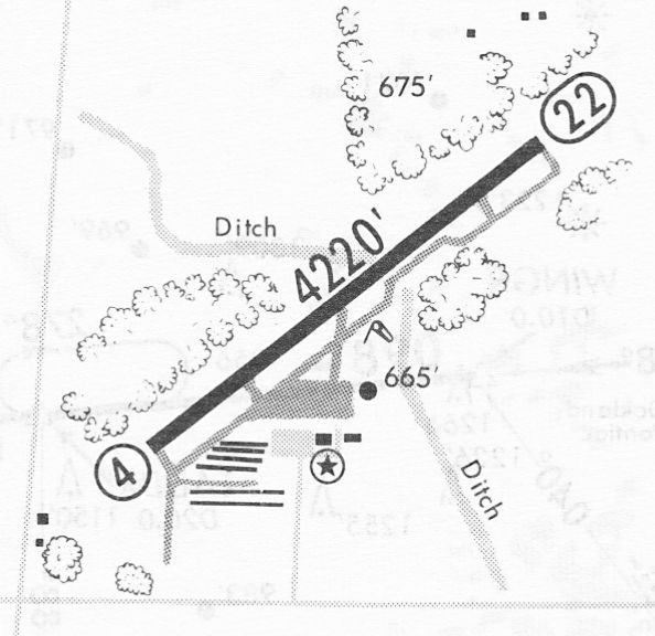
A 6/28/85 airport directory (courtesy of John Kielhofer) depicted Berz Macomb Airport as having a single paved 4,220' Runway 4/22, a parallel taxiway,
and a row of T-hangars & 2 smaller buildings on the south side.
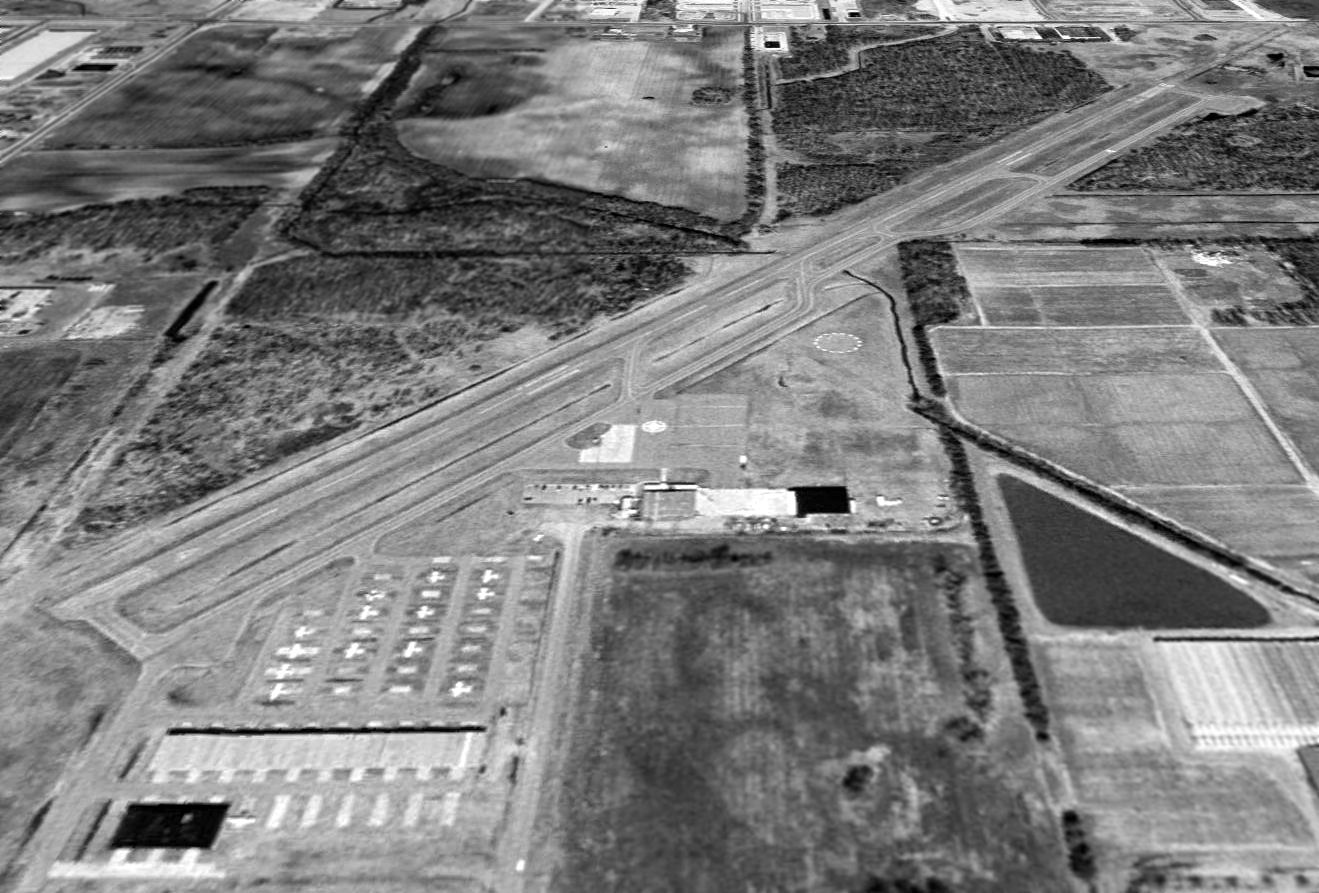
In a 1999 USGS aerial view looking north at Berz Macomb Airport, a total of only 14 light aircraft were visible parked on the field,
with the majority of the field's parking spots being empty.
The last aeronautical chart depiction which has been located of Berz Macomb Airport
was on the April 1999 Detroit Terminal Aeronautical Chart (courtesy of Ron Plante).
It depicted Berz-Macomb as having a single 4,200' paved runway, and its own NDB navigational beacon.
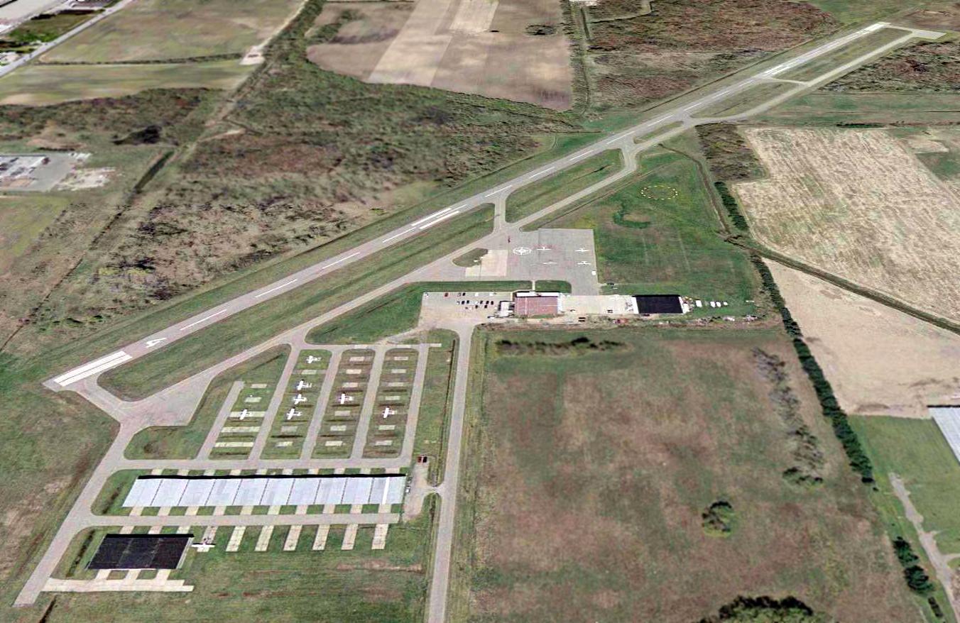
An April 2002 aerial view looking north showed the Berz Macomb Airport shortly before its closure.
A total of 14 light aircraft were visible parked on the field, but the great majority of the field's parking spots were empty.

An undated aerial view looking northeast at Berz Macomb Airport presumably shortly before its closure (courtesy of Mike Denja).
It depicted a dozen aircraft parked on the field.
Berz Macomb Airport eventually succumbed to the pressures that have become increasingly common
to privately-owned airports surrounded by increasingly dense suburban development.
An article by Mary Owen in the 12/26/02 issue of the Detroit Free Press
was entitled "Berz Macomb Airport hangs in there".
"While developers, courts & planners settle the details of a proposed luxury subdivision on his land,
Milton Berz Jr. is doing business as usual at the Berz Macomb Airport in Macomb Township.
Business is slower now because some customers assume the airport is preparing to close.
For the first time in years, there are empty hangars, and people have been flying elsewhere.
But flying lessons & aircraft hangar space are still available, and the small office looking onto the runway is full of activity.
Despite plans for 495 luxury homes on the airport's site,
members of the Berz family contend that they're not closing their business any time soon."
"Until the check is in our hands, we're going to be doing business as usual", said 3rd-generation pilot Jeff Berz.
The article continued, "For 4 years, Farmington Hills-based developer Grand Sakwa has had an option on the family's 330 acres,
which are between 22 Mile & 23 Mile & Hayes & Romeo Plank.
That means Grand Sakwa has the first option to buy the land.
In exchange, Grand Sakwa pays a yearly fee & pays the airport's property taxes."
The township assessed the land at about $9 million. The Berz family said Grand Sakwa offered more than that."
"It's one of those situations where property values have increased to the levels
where it doesn't make any sense to run an airport," said Milton Berz Jr.
"To see something you worked at for 30 years ultimately destroyed is not going to be easy."
The article continued, "A court battle between Macomb Township & Grand Sakwa began in 1999
after the township denied the developer's request to rezone the area from industrial to residential.
The township contends that a residential development on the site of the airport goes against its 30-year-old master plan,
even though there's a subdivision opposite the entrance to the airport.
Two years ago, a judge ruled in favor of the developer's request for rezoning.
However, the courts haven't determined whether Grand Sakwa is entitled to several million dollars in damages as a result of the delay in the project.
Grand Sakwa plans a 190-acre development that would have about 2.6 lots per acre."
"When - and if - the airport does close, it will leave only 2 Macomb County airports: Romeo State Airport & Macomb Airport in New Haven.
Berz had about 68,200 take-offs & landings in 2001.
Among Berz customers is the Warren Police Department, which stations 2 helicopters there.
Company executives & celebrities such as Bill Cosby & Cindy Crawford
have used the airport when flying into the Detroit area on private jets.
Medical teams transporting organs from St. Joseph's Mercy of Macomb in Clinton Township
also have taken advantage of the nearby facility."
"I think the county is really going to miss this airport," said Jeff Berz. "They don't realize what they have here."
The article continued, "Jeff Berz, whose wife is working on her pilot's license, said that after the airport is sold,
it will stay open for an additional 90 days to help customers find space elsewhere.
He said people taking flying lessons can transfer their hours.
With a hint of regret, Jeff Berz, who had planned to take over the family business,
says he wishes that the family had developed the land around the airport with restaurants, homes or a golf course.
He said the added revenue could have subsidized the airport."
"I grew up out here," he said. "My father flew me out here when they were bulldozing for the runway."
In 2003, their last year, the Berz Macomb Airport web site described their operation as such:
"Berz Flying Service operates as a full service FBO,
offering flight training, storage, fuel sales, and the maintenance of Piper Airplanes.
The flight department, operating Piper Cherokees, has a unique curriculum,
offering one-to-one training for both ground & flight training."
"Berz-Macomb Airport has a 4,200' paved & lighted runway.
There are both VOR, NDB and GPS instrument approaches, the NDB utilizing a radio beacon on the airport.
There are available most of the amenities to assist you when coming to the Macomb County area.
These include transient hangars & tiedowns, heater service, rental cars, waiting rooms,
nearby restaurants & motels, and both 100 octane & jet A fuel."

Berz Macomb Airport, as depicted in the 2003 MI Airport Directory.
Fred Kaluza reported in 2003, "The Berz Macomb Airport was just sold for a reported $15 million
because it lies smack in the middle of southeast Michigan's fastest sprawling area.
The number one cash crop among area farmers is 'subdivisions'.
It's getting to the point that flying over southeast Michigan is just as hazardous as if you were over the middle of the Pacific.
There's nowhere left to land if you have trouble!"
Russ Shreve recalled, "I took my private check ride with Milt Berz Jr,
and I bought Milt Berz Sr's house when he retired to Florida.
Their flight operation has now moved to Oakland Troy airport,
which oddly enough, formerly was the original Berz Airport the family sold to Rockwell."
A 2005 aerial view showed that sadly, all signs of this well-built modern airport had been erased,
replaced by streets for a new housing development.
Amazingly a 2016 aerial view looking north showed absolutely no trace remaining of Berz Macomb Airport.
Berz Macomb Airport is located northeast of the intersection of 22 Mile Road & Hayes Road.
____________________________________________________
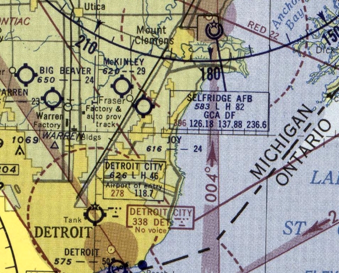
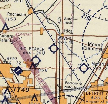
McKinley Airport (D13), Fraser, MI
42.549, -82.965 (Northeast of Detroit, MI)
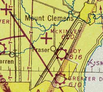
McKinley Airport was depicted as an auxiliary airfield on the July 1946 Detroit Sectional Chart (courtesy of Chris Kennedy).
According to Joseph McKinley, McKinley Airport was started by his uncle, the late Otis McKinley, in about 1944.
However, McKinley Airport was not yet depicted on the May 1945 Detroit Sectional Chart (according to Chris Kennedy).
The earliest depiction of McKinley Airport which has been located was on the July 1946 Detroit Sectional Chart (courtesy of Chris Kennedy).
It depicted McKinley Airport as an auxiliary airfield.
Joseph McKinley recalled, "I spent 3 summers there: 1946, 1949, and 1950, where in return for flying lessons I worked there - washing airplanes & mowing the grass strips.
He was an Aeronca dealer, and I took my first flying lessons in his Aeronca Champions, at age 12. I think it was 1946, but it may have been 1947."
The 1946 MI Airport Directory (courtesy of Doug Ranz) depicted McKinley Airport as consisting of an irregularly shaped landing area, measuring 2,600' x 2,300'.
The 1949 Detroit Sectional Chart (courtesy of Donald Felton) depicted McKinley Airport as having a 3,200' unpaved runway.
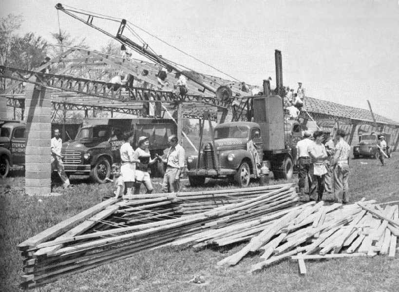
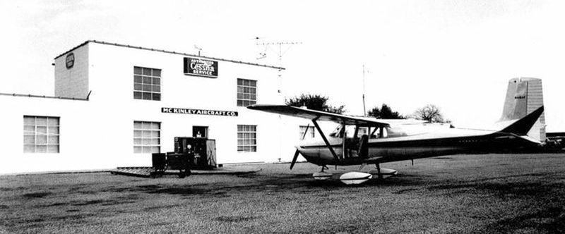
A 1951 issue of "Flying" magazine had an article entitled "The Hangar That Bombers Built" (courtesy of Jerry Sorrell),
which described how Mr. McKinley bought surplus B-17 bomber spars & wing skins
and reused the spars for trusses & the skins for roofing for the hangars built that year at McKinley Airport.
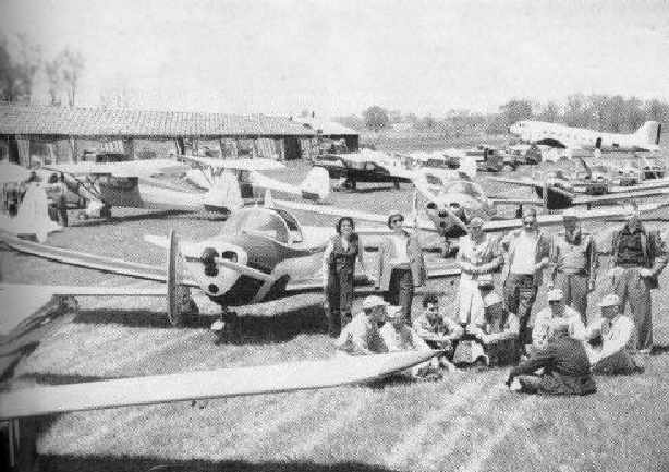
Ercoupes, Cubs, and even a DC-3 are pictured at McKinley Airport
during the construction of the hangar in 1951 (courtesy of Jerry Sorrell).
The 1952 USGS topo map (courtesy of Mike Denja) depicted McKinley Airport as having an irregularly-shaped property outine,
with several buildings on the northeast side.
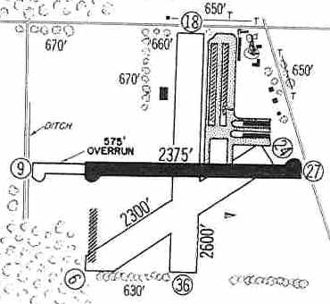
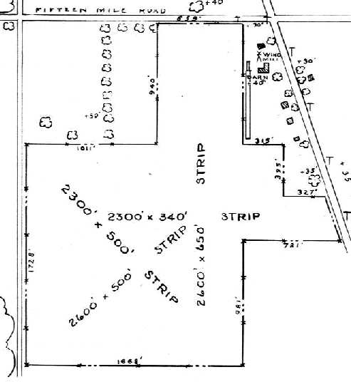
McKinley Airport had apparently gained a paved runway at some point between 1952-60, as the 1960 Jeppesen Airway Manual (courtesy of Chris Kennedy)
depicted the field as having a single 2,375' paved Runway 9/27 (with a 575' unpaved overrun), as well as 2 other unpaved runways.
Several long hangars were depicted on the northeast side of the field.
A 1961 Detroit Edison aerial photo of McKinley Airport (courtesy of Mike Denja)
depicted the field as having a single east/west paved runway.
However, also note what appeared to be a turn-around on the west side of a previous alignment of an east/west runway.
Five rows of T-hangars were depicted on the northeast side of the field, along with another one on the southwest side.
The 1962 AOPA Airport Directory described McKinley Airport as having 3 runways: 2,600' 18/36, 2,375' 9/27, and 2,300' 6/24.
The operator was listed as Otis McKinley.
A circa 1960s photo of a Cessna 172 in front of the McKinley Airport administration building (courtesy of Mike Denja)

The July 1965 Detroit Local Aeronautical Chart (courtesy of Ron Kunse) depicted McKinley Airport as having a 2,900' paved east/west runway.
The July 1969 Detroit Sectional Chart (courtesy of John Voss) depicted McKinley Airport as having a single 2,400' east/west paved runway.
The runway at McKinley had been lengthened slightly to 2,900' by the time of the 1976 Detroit Sectional Chart (courtesy of Mike Keefe).
The May 1977 Detroit Sectional Chart (courtesy of Mitchell Hymowitz) depicted McKinley as having a single 2,900' paved runway.
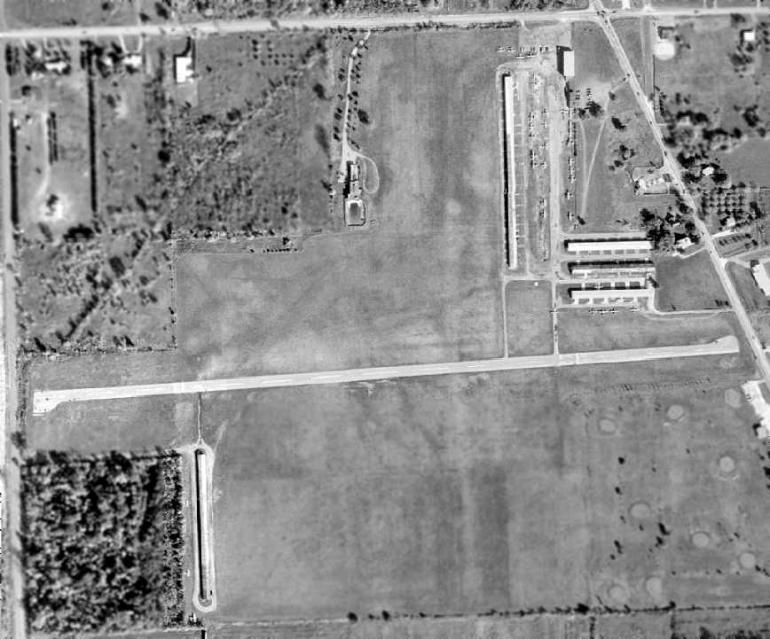
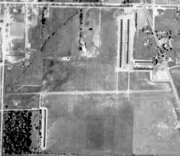
The aerial view which has been located of McKinley Airport was a 1977 aerial view.
It showed the airport to be very well-used, with over 40 light aircraft visible on the field.
The 1980 USGS topo map depicted McKinley Airport as having a single east/west paved runway.
The 1982 AOPA Airport Directory (courtesy of Ed Drury) described McKinley Airport
as having a 2,900' asphalt Runway 9/27 & a 2,600' turf Runway 18/36 (Runway 6/24 had apparently been abandoned).
The operator was listed as McKinley Aviation.
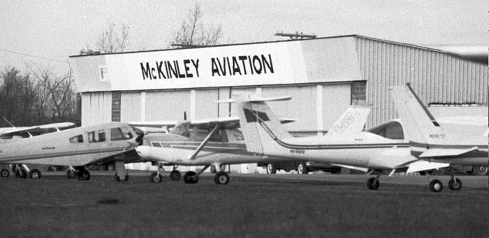
The last photo which has been located of McKinley Airport was a 1984 photo of a variety of light single-engine planes in front of the McKinley Aviation hangar (courtesy of Mike Denja)

The last aeronautical chart depiction which has been located of McKinley Airport was on the October 1985 Detroit Sectional Chart.
It depicted McKinley as having a single 2,900' east/west paved runway.
McKinley Airport was reportedly purchased by the city of Fraser in 1985.
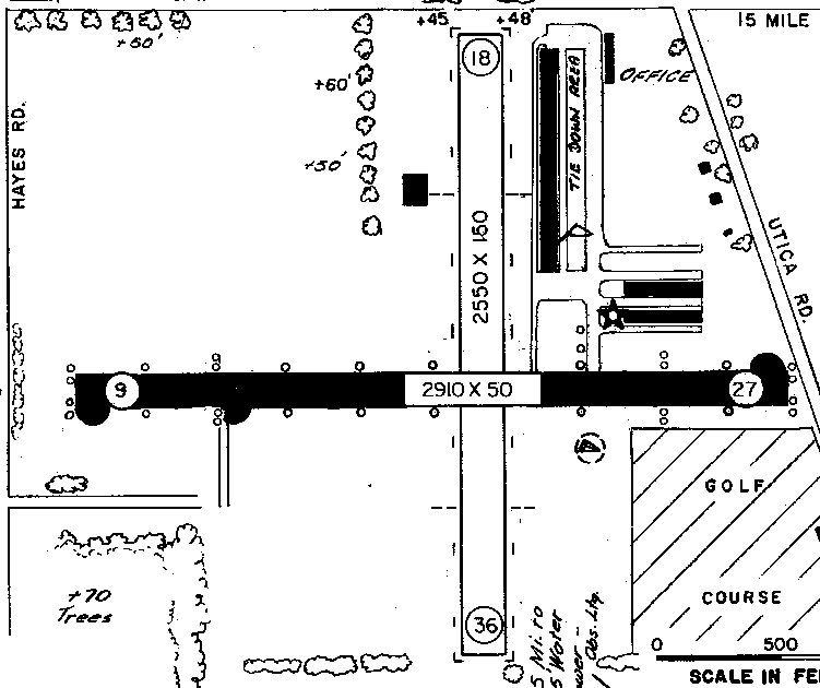
The last depiction which has been located of McKinley Airport was in the 1987 MI Airport Directory (courtesy of William Willyard).
It depicted McKinley as having a 2,910' paved Runway 9/27 & a 2,550' unpaved Runway 18/36.
Several long hangars were depicted on the northeast side of the field.
The city of Fraser closed McKinley Airport in 1987 & sold the property for redevelopment.
The October 1993 Detroit Sectional Chart (courtesy of Ron Plante) no longer depicted McKinley Airport.
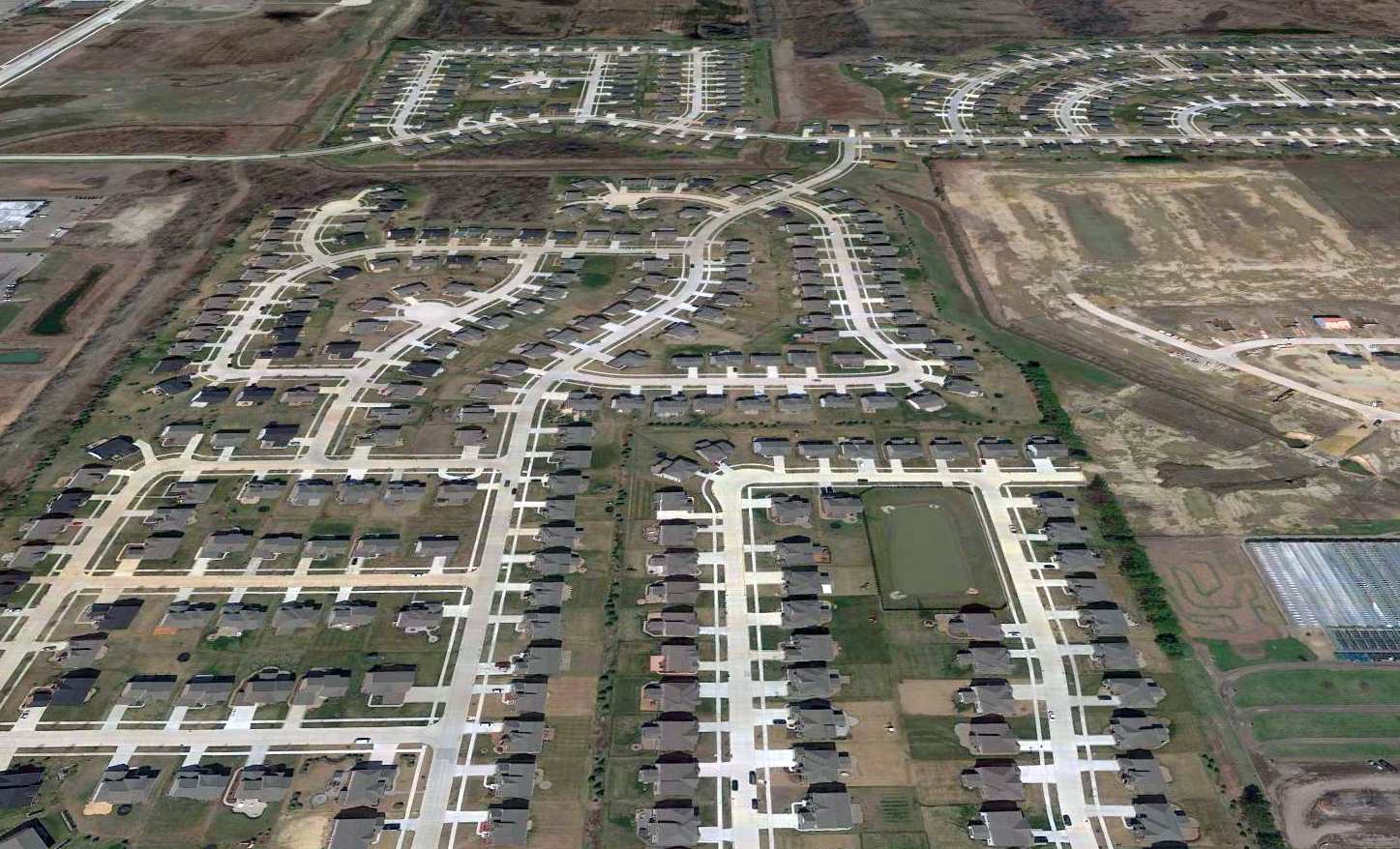
A 1999 aerial view showed no trace remaining of McKinley Airport.
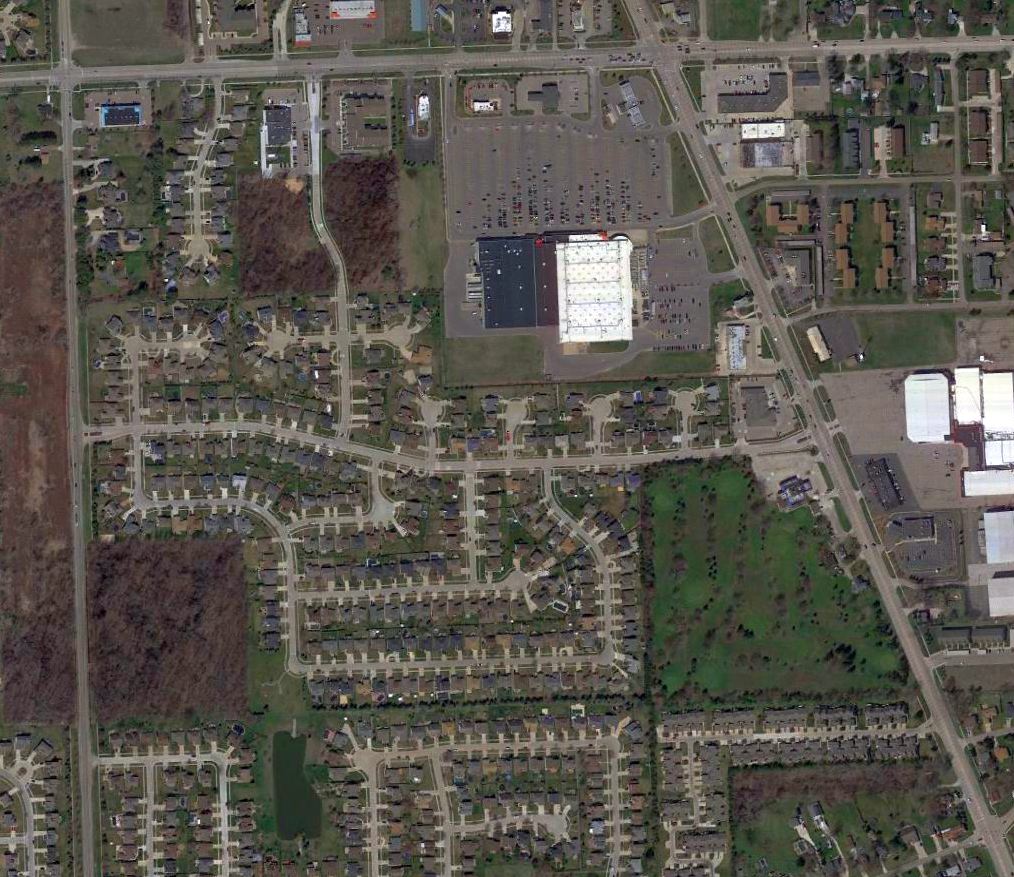
A 2016 aerial photo showed the site of McKinley Airport has been heavily redeveloped with housing & other construction, and not a trace of the former airport appears to remain.
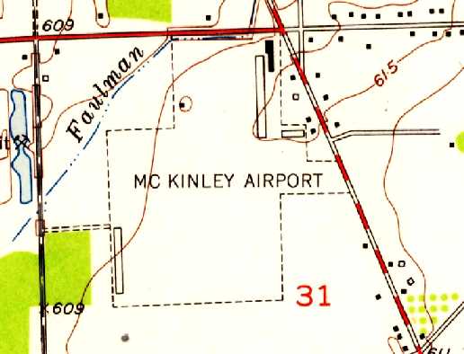
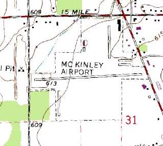
McKinley Airport was located southwest of the intersection of Utica Road & 15 Mile Road.
____________________________________________________
Packard Proving Ground Airfield, Utica, MI
42.66, -83.05 (North of Detroit, MI)
Packard was depicted as an auxiliary airfield on the August 1933 Detroit Sectional Chart (courtesy of Mike Denja).
The Packard Motor Car Company Proving Grounds were built starting in 1926.
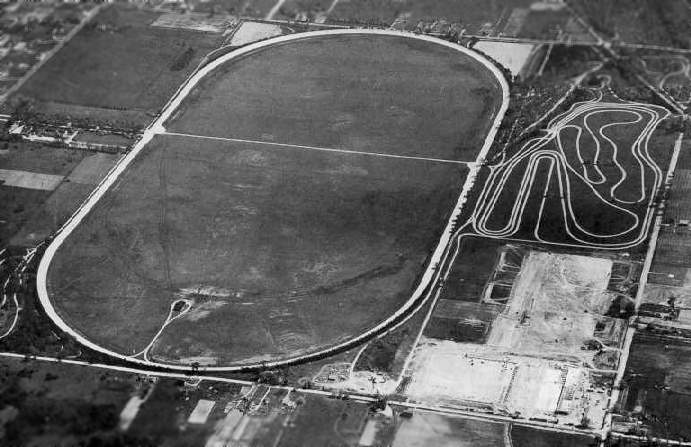
On a 370 acre site, the company built a 2.5 mile concrete oval automobile test track.
A metal airplane hangar & landing strip were constructed within the oval test track.
According to Roger Luksik, the “Proving Grounds were opened on 6/14/1928.”
The first diesel engine for airplanes was developed at the Packard Proving Grounds in 1929.
Roger Luksik reported, “On 6/3/1929 the first 2-way, radiophone communication took place over the skies of the Packard Proving Grounds.
Heretofore, gasoline powered aircraft caused too much electromagnetic interference for the weak voice signal to be heard over the static.
Only a strong Morse code signal could be heard.
As diesel engines neither have spark plugs, nor spark plug wiring the EM static was greatly reduced and allowed voice communication to be used.
The 2-way ground-to-plane voice communication was witnessed by the U.S. Department of Commerce.”
Captain Lionel Woolson, a test pilot for Packard, was killed in a plane crash near Attica, NY
and his ashes were scattered over the Proving Grounds.
Charles Lindbergh landed & visited here on several occasions.
In 1929 he visited the Proving Grounds to fly the Packard Stinson Detroiter, powered by the new radial diesel engine.
After flying the plane he drove the Vincent Speedster around the test track & was clocked at 112 mph.
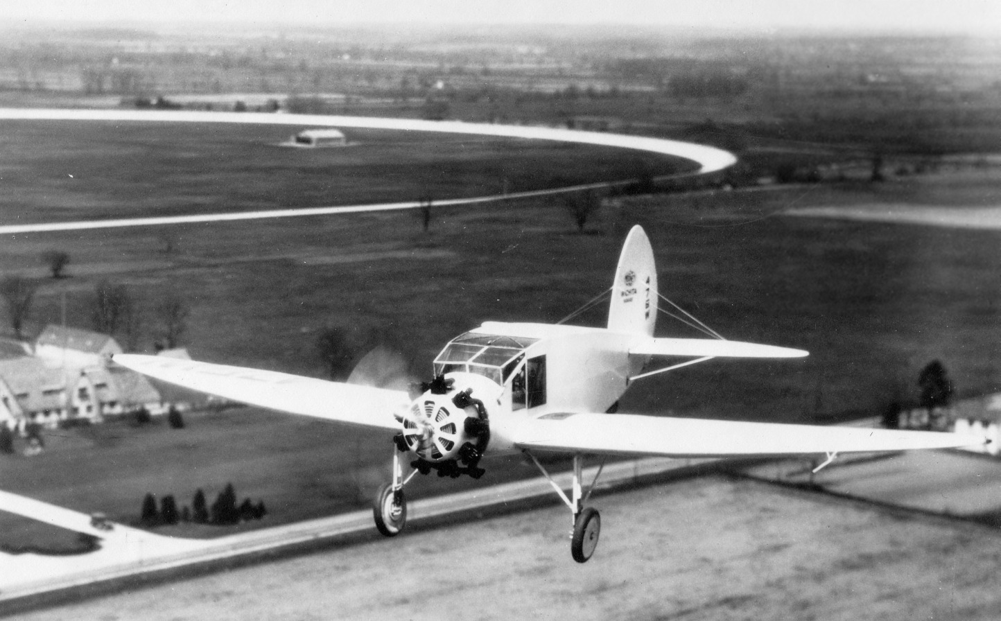
A circa 1931 aerial view of a Mooney A-1 (possibly the sole example) powered by a Packard DR-980 diesel radial engine overflying Packard Proving Ground Airfield (courtesy of Roger Luksik),
with the test track & hangar visible in the background.
The earliest aeronautical chart depiction which has been located of the Packard airfield
was as an auxiliary airfield on the August 1933 Detroit Sectional Chart (courtesy of Mike Denja).
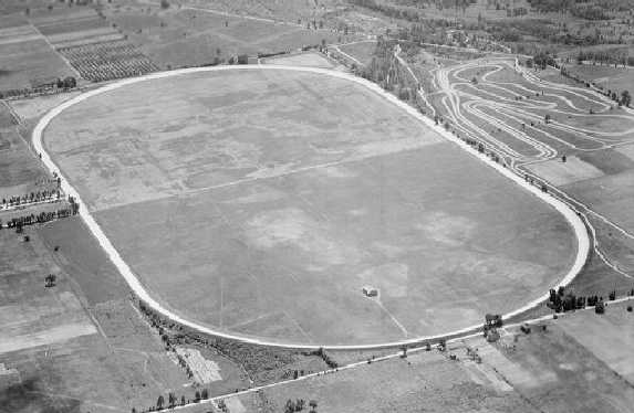
A circa 1930s aerial view (from Wayne State University's Virtual Detroit website, via Mike Denja)
looking southwest at the Packard Airfield showed the single hangar in the center of the test track.
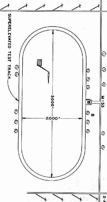
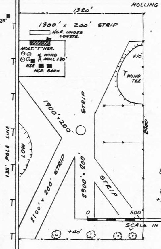
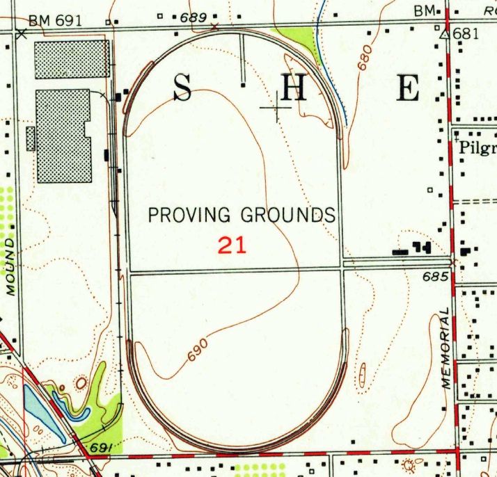
The 1940 MI Airport Directory (courtesy of Chris Kennedy) depicted the “Packard Proving Ground Field”
as consisting of a 5,000' x 2,000' grass area within the “Superelevated Test Track”, with a single building on the northwest side of the field.
The field was noted to be for “Emergency Use Only”.
During WW2, the Army used the Proving Ground as an auxiliary airfield.
The types of military aircraft operated from the Packard Airfield have not been determined.
The Proving Ground itself was leased by Chrysler during World War 2 to test tanks & other armored vehicles.
Chrysler constructed a new building on the site that was capable of servicing tanks.
A 9/10/43 aerial view looking north from the 1945 AAF Airfield Directory (courtesy of Scott Murdock)
depicted the Packard Motor Proving Grounds Airfield as a sod field within the test track.
"Packard" was depicted as a military airfield on the October 1943 Detroit Sectional Chart (courtesy of Mike Keefe).
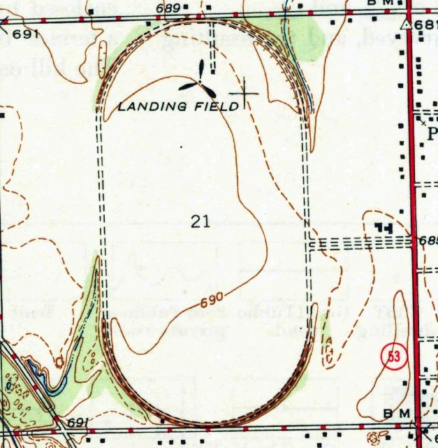
The earliest topo map depiction which has been located of the Packard Airfield was on the 1944 USGS topo map (courtesy of Mike Denja).
It depicted a “Landing Field” (with the propeller symbol used to designate airfields on topo maps of that era) inside the Packard Proving Ground.
The 1945 AAF Airfield Directory (courtesy of Scott Murdock) described the Packard Motor Proving Grounds Airfield
as a 301 acre oval property sod field containing a 5,100' x 2,400' all-way sod landing field.
The field was said to have a single 70' x 50' metal hangar, and to be owned & operated by private interests.
Following the war, the Packard Airfield was once again used as a civilian airfield,
as that is how it was depicted on the July 1946 Detroit Sectional Chart (courtesy of Chris Kennedy).
However, the Packard Airfield apparently closed at some point between 1946-47,
as the December 1947 Detroit Sectional Chart (courtesy of Chris Kennedy)
depicted the oval-shaped "Auto prov track", but no airfield.
1951 aerial view looking southeast at the Packard Proving Grounds.
1952 USGS topo map (courtesy of Mike Denja) depicted the Packard Proving Grounds, but no longer any airfield.
Packard operated the Proving Grounds until 8/15/56,
when the dire financial condition of the Studebaker-Packard Corporation forced it to consolidate all operations at Studebaker’s South Bend, IN facilities.
That same summer, Studebaker-Packard entered into a management agreement
with the Curtiss-Wright Corporation in a last-ditch attempt to avoid bankruptcy.
Curtiss-Wright retained possession of the Packard Proving Grounds after the management agreement with Studebaker-Packard ended in 1959,
as C-W was using Packard’s former engine & transmission plant (located on the northwest corner of the Proving Grounds property)
to overhaul jet aircraft engines, using 50' test cells.
Arthur Boyko recalled, “My dad was in security at the old Packard plant in Detroit until it closed.
The protection department was absorbed by the Curtis-Wright Corporation & was known as the Utica Bend Division.
Dad showed me the test cells that are visible on the Mound Road complex.
Curtis Wright had a contract to overhaul the General Electric J-47 jet engines
that were used on the 6-engine B-47 bomber aircraft.
He told me about the danger involved with the test cells.
Any emergency you had less than a minute to evacuate and, the doors would close and, the CO2 would activate.
Basically you would freeze to death. From what I gather no loss of life ever occurred.”
Curtiss-Wright sold the property to the Ford Motor Company in 1961.
Ford used the former engine plant to manufacture automotive interior trim, known as the Ford Utica Trim Plant .
Ford at various times used the lodge & engineering buildings to make small service runs of prior model year trim parts.
Ford also used the test track for early emission control testing, saving its main test track in nearby Romeo, Michigan for higher-priority testing.
Darin Ninness recalled, “The old Packard Airfield in the 1980s was a happening place for model airplane flying.
The area AMA club used to host a heck of a model fly-in there,
and I spent many summers as a cadet dashing around the infield of that track chasing model rockets & large-wingspan gliders.”
As of the 1990s the former Ford Utica Trim Plant on the northwest portion of the site was transferred to Visteon, a Ford spin-off.
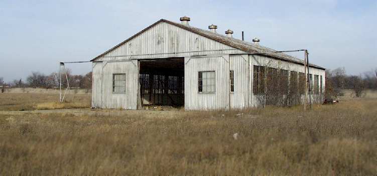
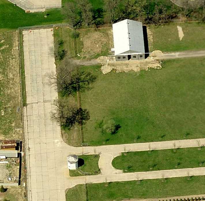
A circa 1990s photo of the Packard hangar.
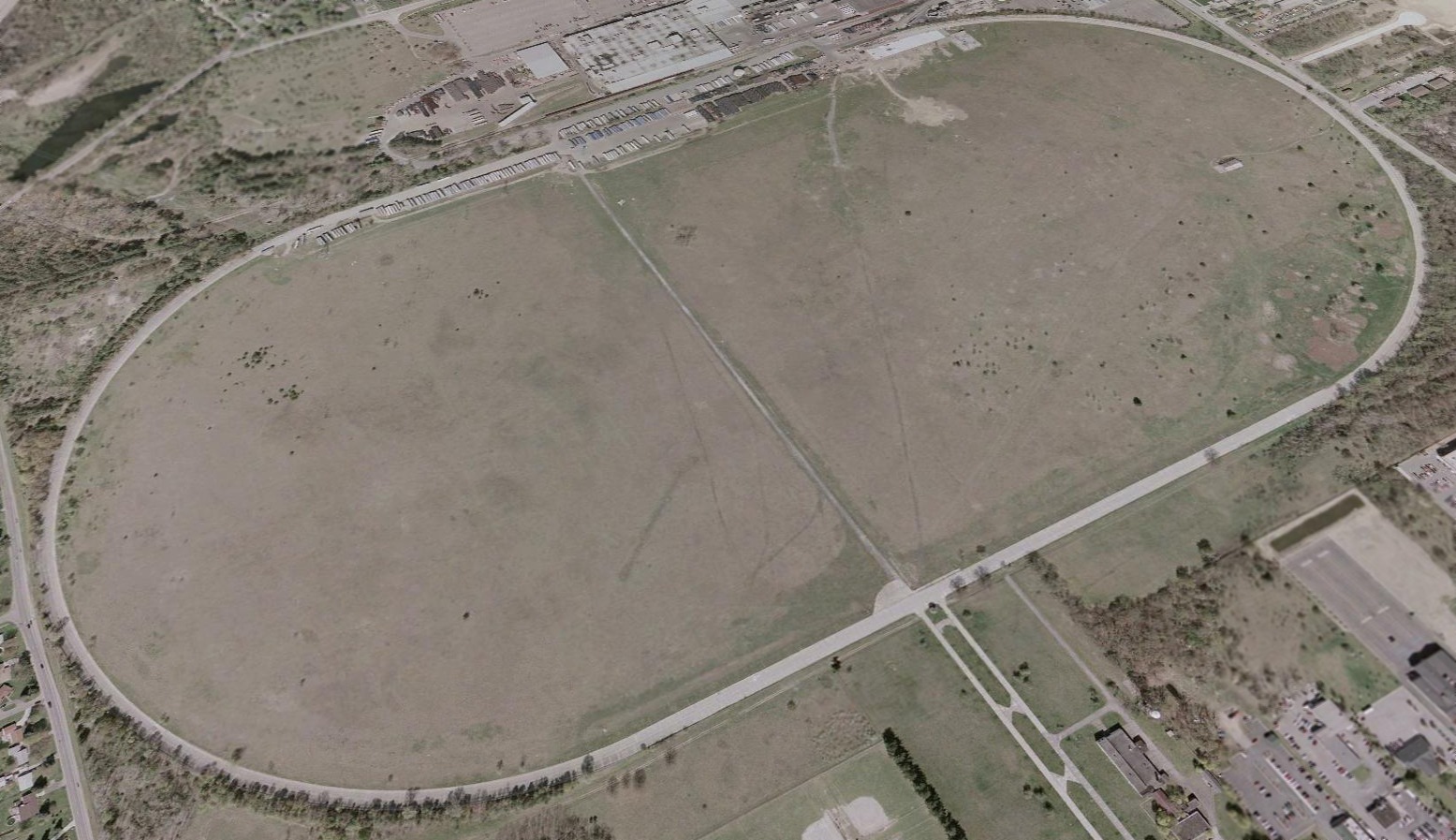
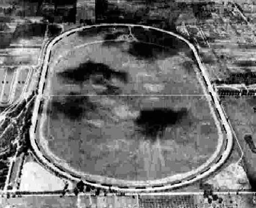
A 2002 aerial view looking northwest at the former Packard Proving Ground, before its removal.
A 2002 aerial view showed that the metal airplane hangar built by Packard still sat in its original location, within the test track,
which also remained intact.
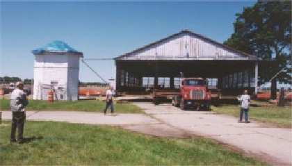
An undated photo of the Packard hangar being relocated.
Mike Montgomery reported in 2003 that the Packard "hangar has been moved
outside the loop of the former test track & closer to the other Proving Grounds Buildings.
The fate of the site is also now secure.
The Packard Motor Car Foundation is acquiring from Ford 2 pieces of the former Proving Grounds -
including the Hangar, 'Lodge', Repair Garage, Engineering Building, Timing Tower and some support structures -
for restoration as an automotive history museum/attraction."
According to the Packard Motor Car Foundation,
"The Lindbergh aircraft hangar has been rescued from the infield
and transported to our 14 acre site where it was securely installed on a new foundation.
It had to be carefully moved between some trees & the Timing Tower to get it onto the property.
This type of small hangar has all but disappeared from the American landscape
and will be one of the few preserved for posterity.
Its connection to a period of industrial growth where Packard branched out into aeronautical & nautical areas
will add further dimension to the historical site."
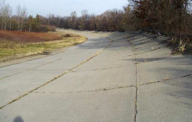
A 2005 aerial view showed a dramatic transformation of the Proving Ground property within the past 3 years,
with the pavement of the historic oval track having been removed, the hangar having been relocated outside of the track,
and much of the southern portion of the former test track having been covered by development for – what else – more houses.
In 2005, ownership of the former Ford Utica Trim Plant on the northwest portion of the site was transferred back to Ford,
under Automotive Components Holdings LLC.
A circa 2006 aerial view looking north at the relocated Lindberg hangar,
now located just east of the only remaining portion of the original test track.
Note also the timing tower at the bottom of the photo.
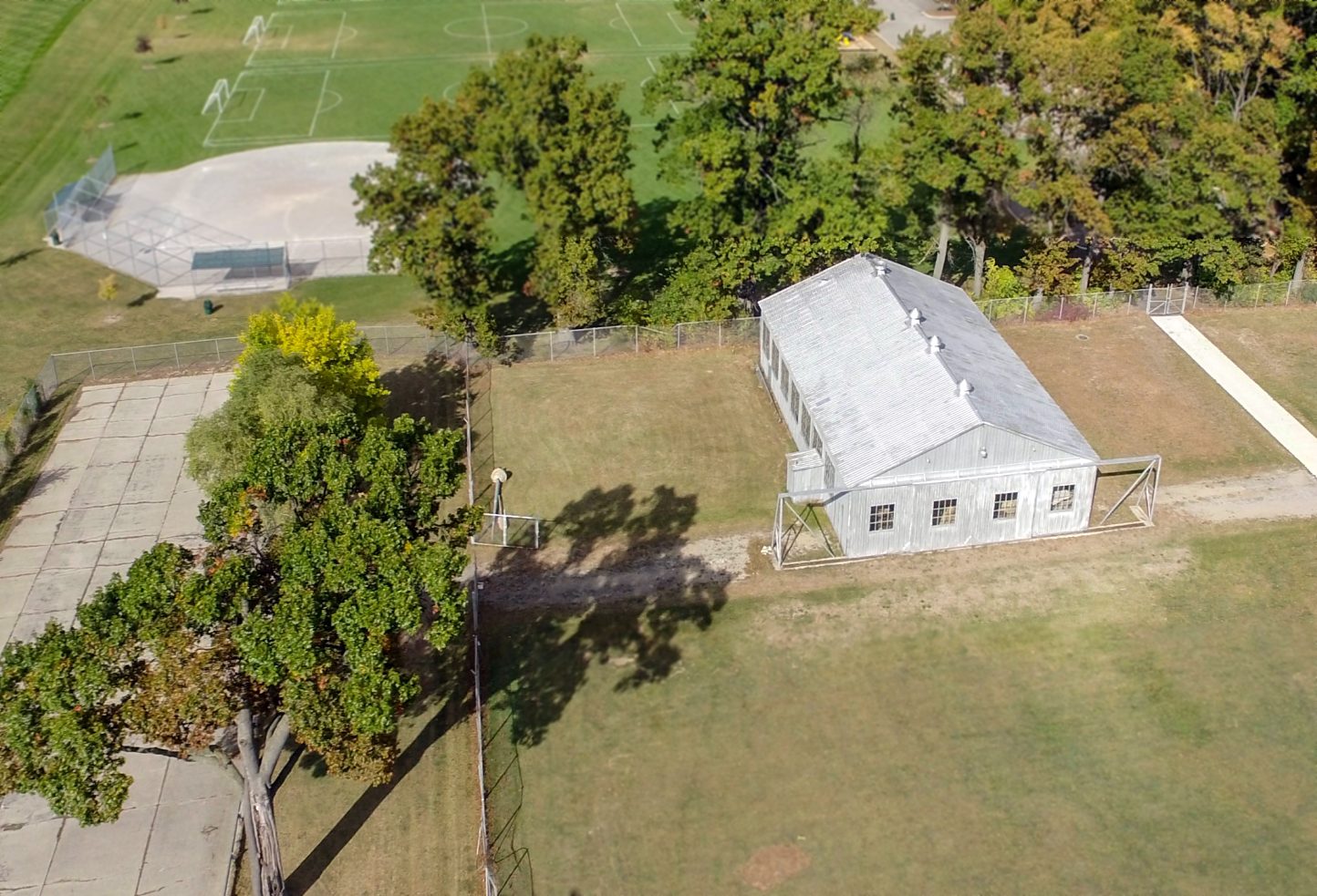
A 10/18/15 aerial view (courtesy of Roger Luksik) looking north at the Packard Proving Ground hangar, relocated to the southeast,
with the small remaining portion of the test track visible on the left.
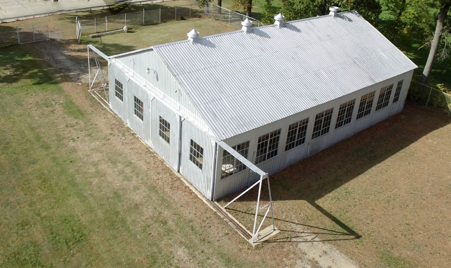
A 10/18/15 aerial view (courtesy of Roger Luksik) looking northeast at the Packard Proving Ground hangar, relocated to the southeast.
Roger Luksik reported in 2017, “When we moved the hangar from the infield of the PPG many years ago we mounted it on only a perimeter foundation.
Earlier this year we poured a new concrete floor in anticipation of creating some aviation exhibits in a few years.”

A 2017 aerial view looking northwest at the site of the Packard Proving Ground, showing only faint traces of the oval track.
____________________________________________________
Or if you prefer to contact me directly concerning a contribution (for a mailing address to send a check),
please contact me at: paulandterryfreeman@gmail.com
If you enjoy this web site, please support it with a financial contribution.
____________________________________________________
This site covers airfields in all 50 states.