Abandoned & Little-Known Airfields:
Maryland, Southern Prince George's County area
© 2002, 2026 by Paul Freeman. Revised 2/13/26.
This site covers airfields in all 50 states: Click here for the site's main menu.
____________________________________________________
Please consider a financial contribution to support the continued growth & operation of this site.
For a suburban community, Prince George's County has a remarkable aviation heritage.
A total of 12 airfields are profiled on this website's Prince George's County pages.
Unfortunately, the county's proud aviation heritage is not very widely known.
Bower Field (revised 10/29/22) - Cheltenham Navy Airfield (revised 2/17/17) - Hyde Field (revised 2/13/26)
Piscataway Airport (added 6/22/13) - Riverside Field / Columbia Air Center / Croom Field (revised 9/16/25)
____________________________________________________
38.75 North / 76.93 West (Southeast of Washington, DC)
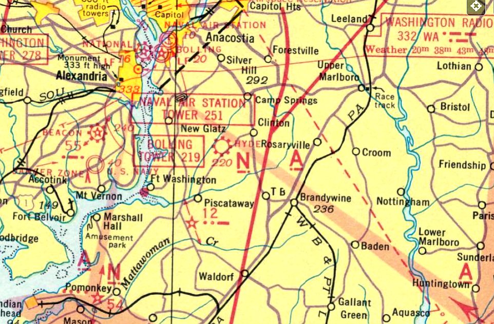
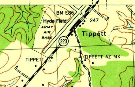
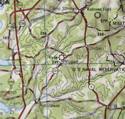
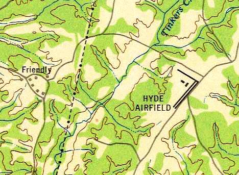
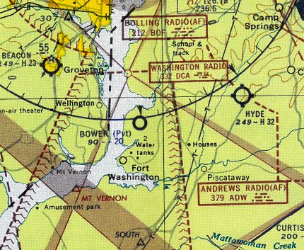
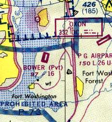
Hyde Field, as depicted on the November 1941 Washington Sectional Chart.
A 1938 aerial photo of the Hyde Field property did not yet show any recognizable trace of an airfield, just farmland.
Hyde Field was not yet depicted on the September 1940 Washington Sectional Chart.
According to the book "Maryland Aloft" by Preston, Lanman, and Breilhan, "Hyde Field opened in 1939 or 1940."
It was built by Arthur Hyde, who at one point also owned Congressional Airport in the Maryland suburbs.
The 1940 Airport Directory Company's Airport Directory described Hyde as a new facility, having a 3,950' x 2,600' sod field.
The earliest depiction which has been located of Hyde Field was on the November 1941 Washington Sectional Chart,
which depicted Hyde Field as a commercial/municipal airport.
According to Brian Rehwinkel, Hyde was one of several outlying fields used to support primary flight training
at Naval Reserve Aviation Base Anacostia during WW2 (the others being Beltsville, Hybla Valley, Cheltenham, Nottingham, and Riverside).
Brian remarked, “Hyde served more as an Auxiliary Air Station role in that training planes were actually 'based' at the field
and were only sent back to Anacostia for maintenance & repairs
(this concept was used at other stations such as Minneapolis, Dallas, and St. Louis).”
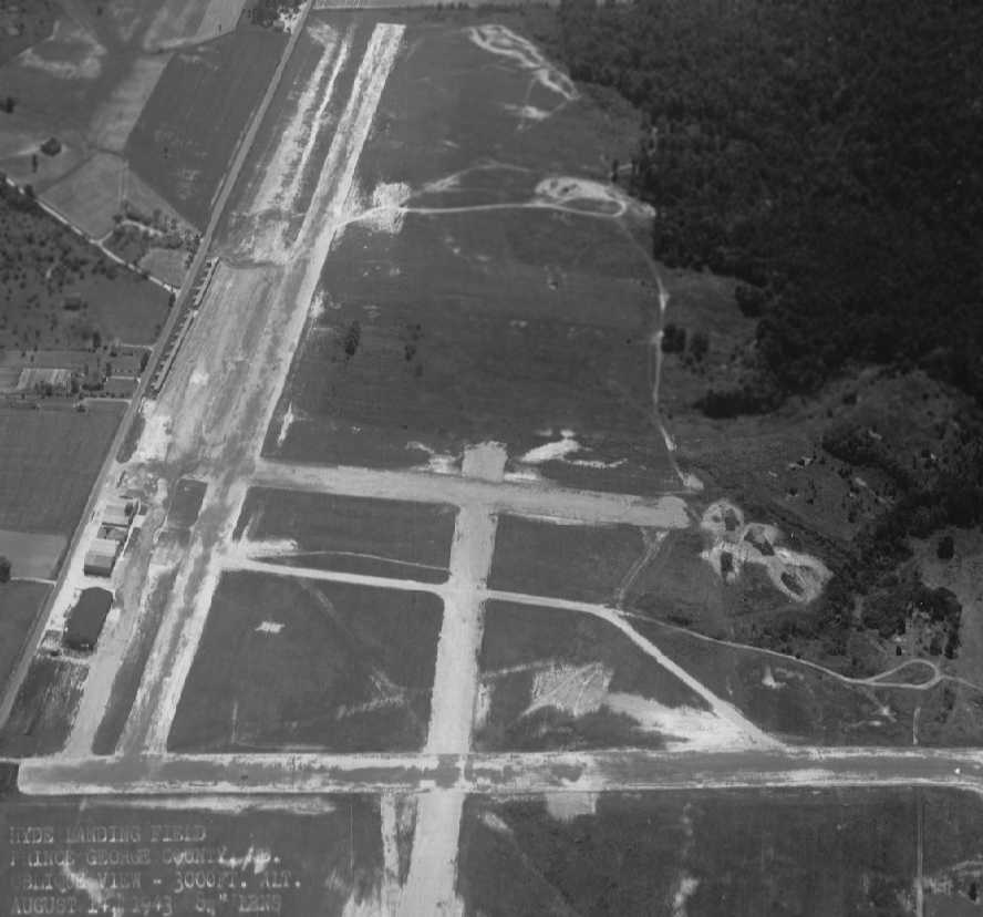
The earliest photo which has been located of Hyde Field was an 8/14/43 U.S. Navy aerial photo captioned “Hyde Landing Field” (courtesy of Brian Rehwinkel).
It depicted Hyde Field as having a total of 4 runways, with numerous hangars along the southeast side of the field.
Brian observed, “I believe this photo was taken after the primary training had ended, as there are no planes present in the picture.“
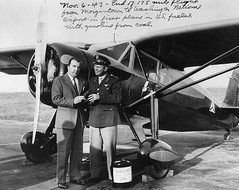
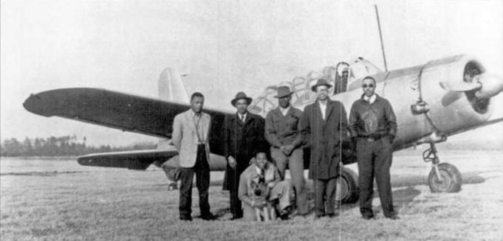
A 1943 photo of Rep. Jennings Randolph (left) & Civil Air Patrol Major Arthur Hyde (the founder of Hyde Field) in front of a Fairchild 24.
Hyde Field was used during WW2 by the Civil Air Patrol, in which organization Arthur Hyde held the rank of Major.
Tom Beamer reported, "I have a cute little book called 'Love at First Flight', published in 1943, that takes a humourous look at Navy Flight Training.
The author began his training at Hyde in a N3N ['Yellow Peril' biplane] after a daily bus ride from quarters, and classrooms, at Anacostia."
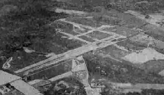
A 10/23/43 aerial view looking north at Hyde Field from the 1945 AAF Airfield Directory (courtesy of Scott Murdock)
depicted Hyde as having 2 perpendicular runways.
Hyde Field was described by the 1944 US Army/Navy Directory of Airfields (courtesy of Ken Mercer) as having a 3,100' hard-surface runway.
“Hyde Field Army Air Base” was depicted on the 1944 USGS topo map as having 2 paved runways, with hangars along the southeast side.
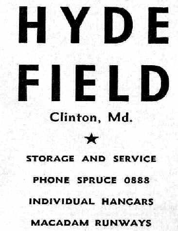
An advertisement for Hyde Field from the Haire Publishing Company's 1945 Airport Directory (courtesy of Chris Kennedy).
The 1945 AAF Airfield Directory (courtesy of Scott Murdock) described Hyde Field
as a 125 acre irregularly-shaped property within which were 4 asphalt runways, the longest being a 3,120' NNE/SSW strip.
Hyde was described as being privately owned & operated, and said to have 4 hangars, the largest being a 150' x 50' metal structure.
A circa 1945 photo (courtesy of Debbie Campbell) of her mother “(Jo Conrad on right) & some of her co-owners of a 1942 Aeronca F-65 hangared at Hyde Field.”
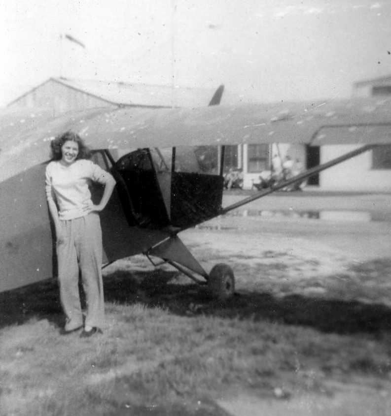
A circa 1945 photo (courtesy of Debbie Campbell) of her mother, Jo Conrad, in front of her 1942 Aeronca F-65 at Hyde Field.
Hyde Field, as depicted on the 1946 USGS topo map.
According to the book "Maryland Aloft", a 1947 MD Airport Directory said that Hyde Field had 28 hangars (most of which were small T-hangars).
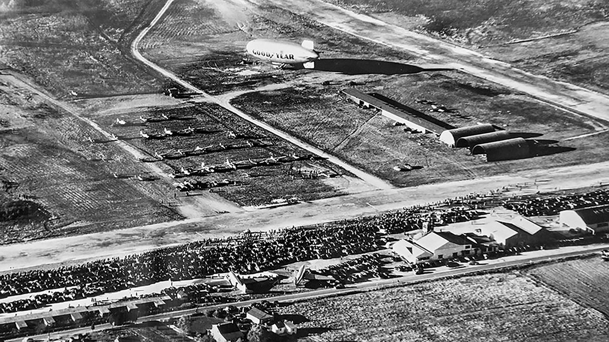
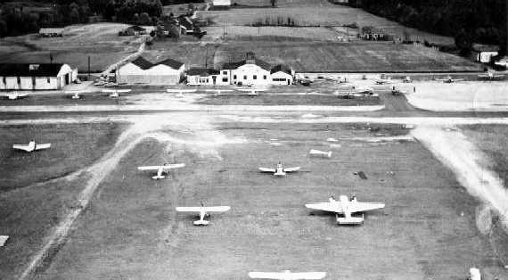
A circa 1940s aerial view looking northwest at Hyde Field showing a huge number of spectators on the field for an unknown event.
Note the 2 DC-3s at the bottom, and the Goodyear blimp at the top.
A 1949 aerial view depicted Hyde Field as having 2 runways, with a long row of hangars along the southeast side of the field.
A closeup from the 1949 aerial view showed a DC-3 among the aircraft parked on the west side of Hyde Field.
Hyde Field, as depicted on the 1949 USAF Target Complex Chart.
Hyde Field was depicted on the January 1951 Washington Local Aeronautical Chart (courtesy of Tim Zukas) as having a 3,600' paved runway.
The Aerodromes table on the 1951 Washington Sectional Chart (courtesy of Mike Keefe) described Hyde Field as having 2 runways,
with the longest being a 3,200' hard-surface strip.
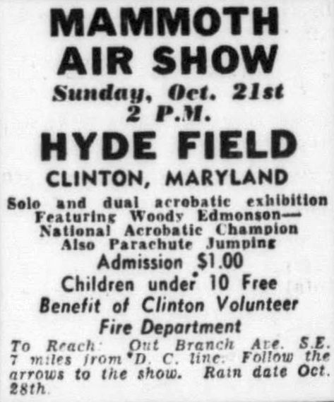
An advertisement for a 10/21/56 “Mammoth Air Show” at Hyde Field.
Dana Shifflett recalled, “I literally grew up at Hyde in the 1950s & 1960s.
My Dad, Paul Shifflett, had a Bellanca N74475 which he owned with partners Bob Moffat & Bob Williams in the mid-1950s.
They kept it in Hangar 21. In late 1957 they sold it & bought a Bonanza.”
Cleve Stanley recalled, “I was born & raised less than 1 mile from the airport & learned to fly there in the late 1950s / early 1960s
when my dad was manager of the airport's day-to-day operations for Mr Hyde.”
According to the book "Virginia Airports" by Vera Rollo & Norman Crabill (published by the VAHS),
Harry Lehman moved his flying business to Hyde Field after the closing of Virginia's Beacon Field in 1959.
Merton Meade recalled, “Harry Lehman & Franklin Reid made a deal with Art Hyde in 1959 to locate Beacon Flying Service at Hyde & operate the airport.
Harry was the manager & Franklin was the president of Beacon Flying Service.”
Many Beacon Field customers resumed training & transported their airplanes to hangars & tiedowns at Hyde field.
Beacon Flying Service also assumed the Hyde Field Fixed Based Operator & Airport Manager responsibilities
which included gas and oil concessions, primary training, and airport maintenance.
The Aerodromes table on the 1960 Washington Sectional Chart (courtesy of John Voss)
described Hyde Field as having 2 runways, with the primary being a 3,200' bituminous strip.
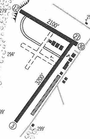
The 1960 Jeppesen Airway Manual (courtesy of Chris Kennedy) depicted Hyde Field as having 2 paved runways (3,200' Runway 3/21 & 2,100' Runway 12/30),
along with what appeared to be 2 other unpaved runways.
Several hangars (including the extremely long hangar on the east side of Runway 3/21) were depicted on the field.
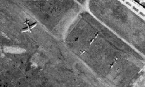
A 1960 aerial view looking northeast at Hyde Field, showed a large number of aircraft on the field,
and a row of hangars & buildings, including one which appeared to have a observation tower cab on top.
Dana Shifflett recalled, “In early 1960, Dad [Paul Shifflett] bought an A35 Bonanza, N8415A.
He originally tied down at Rose Valley. He still had friends at Hyde & we visited there often.
A couple of years later he moved back to Hyde, at first tying down on the grass on the north side of the main runway.
For a while there was a wrecked twin something-or-other, about the size of a twin Beech,
just a few yards northeast of our tie-down - I spent some time crawling through it.
A year or two later, Dad moved into Hangar 23.
We built a concrete ramp in front of Hangar 23, with a couple of troughs for the main gear
which, together with a slight ridge for the nosewheel, allowed the V-tail to dip enough to clear the rafters.
[The ramp is barely visible in the 2005 aerial photo, at which point it would've been 40 years old.]
There was a kerosene stove which couldn't do anything to warm that drafty hanger, a cluttered workbench,
and a back room in the northeast notch of the 'T' with lots of old stuff in it.
The stovepipe, which went out the back wall, was spaced away from the roof's eave with an oil can.
For years, I looked for that can every time I passed the airfield, which was twice a day when I attended Surrattsville.”
Dana continued, “Dad had friends a few doors to the southwest (Hangar 28?) - one of them was Bill Ernst.
They also had a Bonanza. Bill had an early Corvette with the Blue Flame 6.
We all ate in the cafe in the northeast end of our hangar row, next to the Bolling (Andrews?) flying club.
At some point, dad had Bonanza N8415A's engine rebuilt by a fellow operating in the old main hangar, the one with the control tower.
I got to explore it, too. It was run-down, just like Hangar 23. What could be better?
(as I recall, it burned down sometime after I left the DC area in the mid-'70s.)
After the engine was re-installed, we spent hours running it in by the approach end of Runway 3.”
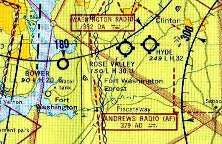
Hyde Field was depicted on the February 1961 Washington Local Aeronautical Chart (courtesy of Scott Kimball) as having a 3,200' paved runway.
Also note the close proximity of Bower Field & Rose Valley Airport.
The 1962 AOPA Airport Directory described Hyde Field as consisting of a 3,800' bituminous Runway 4/22 & a 2,400' "semi-paved" Runway 13/31.
The operator was listed as Harry Lehman (Piper).
According to Ace Stutz, “Professional Pilots, Inc., was started by Bob Jenkins & Joannie Miller at Hyde Field & later run by Norman Mowbray.”
A 1965 aerial photo showed Hyde Field to have 2 paved runways, numerous hangars, and a large quantity of based aircraft.
The September 1965 Washington Local Visual Navigation Chart & the 1967 Washington Sectional Chart (courtesy of Mike Keefe)
depicted Hyde as having 2 paved runways, with the longest being 3,200'.
Dana Shifflett recalled, “During the riots in 1968, my Civil Air Patrol squadron stood (if you could call it that) guard overnight at the field.”
Brian Brengle recalled, “My father would take me to Hyde Field to watch aircraft take off & land.
One of my earliest memories, early 1970s, was climbing on a derelict North American F-86 Sabre
that was sitting in the open at Hyde Field between Piscataway Road & some buildings.”
Sources indicate it was F-86H serial # 53-1348 C/N 203-120, 121st Fighter Interceptor Squadron.
Brian continued, “I also remember watching an autogiro takeoff & land there.”
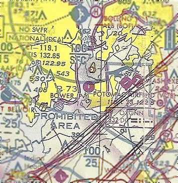
Hyde Field's primary runway had continued to be shortened by the time of the 1973 Washington Sectional Chart (courtesy of Mike Keefe),
as it was described as being only 2,800'.
Dana Shifflett recalled, “Dad [Paul Shifflett] sold Bonanza N8415A in 1975 or 1976.
As I recall, the FAA wanted him to install a transponder altimeter which was worth more than the plane.
Dad kept Hangar 23 & sub-let it to his EAA co-horts.”
According to Tom Reed, "I used to take flying lessons in 1976 at Hyde Field while I was in high school.
Harry [Lehman] & his wife ran Hyde Field & also ran their FBO, Beacon Flying Service. They where very nice folks."
A 1979 photo of a Beech Sierra of the FAA Flying Club at Hyde Field,
with a red & white checkerboard observation tower atop a Hyde hangar in the background.
The 1982 AOPA Airport Directory (courtesy of Ed Drury) listed the Hyde runway configuration as a 2,800' asphalt Runway 5/23 & a 2,000' asphalt Runway 13/31.
The operator was listed as Beacon Flying Service.
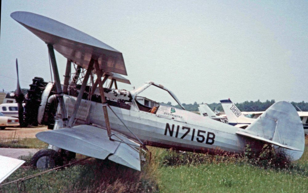
A 6/27/82 photo of Boeing Stearman N2S-5 Kaydet E75 N1715B C/n 75-8682 at Hyde Field.
According to Shawn Gilson, Arthur Hyde had some legal troubles in the 1980s
(including an indictment on charges of conspiracy to murder his wife).
He sold the airport to a beer distributor named William Albright back in 1985.
A circa 1985-86 aerial view by Don Wright (used by permission) looking east from a left base for Hyde's Runway 5.
A circa 1985-86 aerial view by Don Wright (used by permission) from final approach for for Hyde's Runway 5, showed the DC-3 parked next to the end of the runway.
Don recalled of Hyde's DC-3, “'The plane was used for jumpers. It was gutted inside.
It was my understanding that the plane would appear at W32 for maintenance & was left there in the off-season.
The folks down at the start of Runway 5 would work on it. I also have a picture of it landing with the left engine dead & the prop feathered.
Strange to see it in pattern like that! Stranger still to see it land like that!”
Don Wright recalled, “The field boasted many unusual aircraft in its better days.
Included on the list were Fred Wimberly's home-built VeriEz, a Lake Amphibian,
a pair of Sea-Bee's, a few J-3's, a Rearwind Cloudster (owned by Bob Howard), Mike Panjea's 1941 WACO biplane,
a dead Steerman duster that use to sit over by the Quonset huts at the end of the field (Jim Hodge use to do maintnence out of that Quonset hut),
a BD-5 that was in pieces & stored in the same hangar with the VeriEZ,
the typical 4 or 5 Piper Trashpickers, a Ted Smith Aerostar, a Fly Baby, that DC-3.
The airfield was a never-ending stream of interesting aircraft.
W32 seemed to really catch a lot of unusual traffic... to the point where those things seemed mundane.”
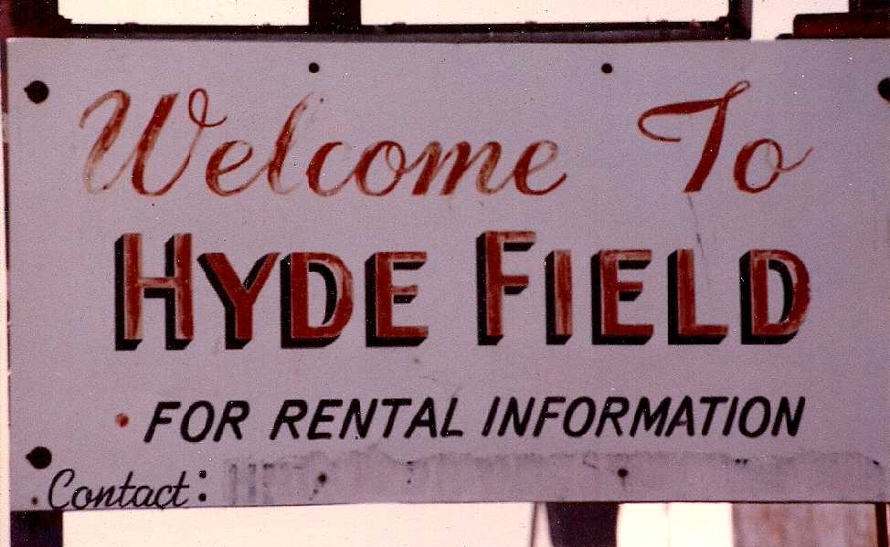
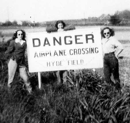
A circa 1985-86 photo by Don Wright (used by permission) of the Hyde Field welcome sign.
Dana Shifflett recalled, “Mom & Dad retired back to Iowa in late 1986.
I was home to help them move, and I went with him to turn the hangar over.
We stood on our ramp, now 21 years old, looked at our open hangar, and moved on.”
According to Ace Stutz, “In 1988 [Professional Pilots, Inc.] became Blue Sky Aviation run by Marianne Boone & was very successful.
She sold out & Stan Fetter has what's left at Hyde Field now.”
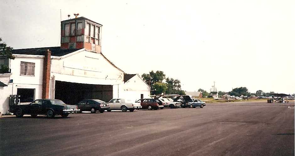
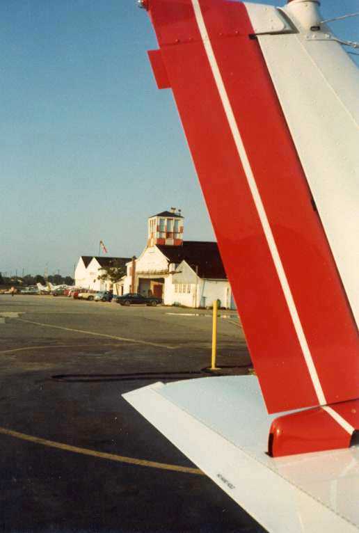
A circa 1980s photo looking south at the Hyde Field control tower atop a hangar, with a collection of stylish 1980s cars in the foreground.
In its heyday Hyde was home to a large number of aircraft.
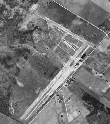
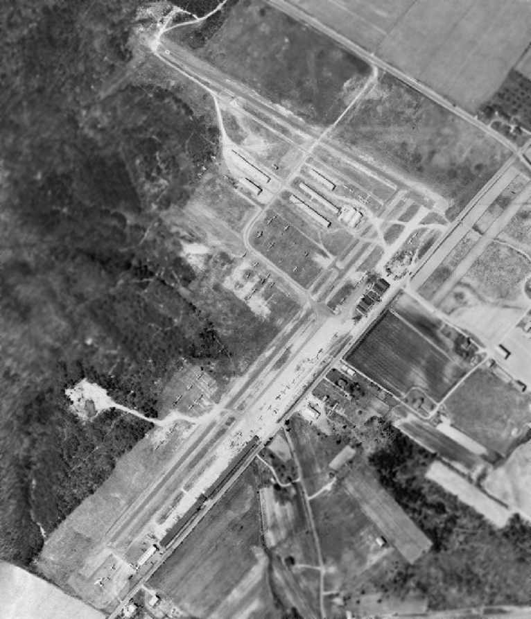
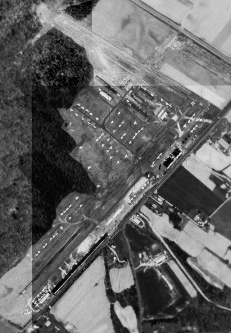
As seen in a 1988 USGS aerial photo, a row of hangars was along the eastern side of the primary runway,
and several T-hangars were just west of the former runway intersection.
The crosswind Runway 13/31 was still open , and note the DC-3 parked at the southwest corner.
Was this the same aircraft seen at Hyde Field in the 1949 aerial photo?
A circa 1988-90 aerial view by Bob McLean looking northeast at Hyde Field.
Bob observed, “It looks like the crosswind runway was still in service.
I'm not sure I understand the X [closed-runway marking] on Runway 5, probably an old X.”
Hyde Field was renamed Washington Executive Airport at some point between 1982-89,
as it was labeled as "Washington Executive (Hyde Field)" on the 1989 USGS topo map.
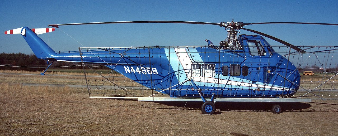
A 3/15/89 photo of Sikorsky S-55B N44688 MSN 57-5928 at Hyde Field, modified with what looks to be an aerial advertising light array.
Hyde Field's crosswind Runway 13/31 was closed in 1990.
Beacon Flying Service's owner Harry Lehman retired in 1990 after 30 years at Hyde Field.
The 1993 Jeppesen Airport Directory depicted Washington Executive / Hyde Field as having a single 3,000' paved Runway 5/23.
The operators were listed as Beacon Flying Service, Blue Sky Aviation, and Freedom Air.
In Shawn Gilson's words, "There were heavy plans to turn Hyde into something spectacular.
From what I can gather, the plans were to build another Manassass [Regional Airport], with 3 runways, the longest over 5,000'.
Everything was approved, and ready to go by the county. There was considerable community resistance to the airport.
Somewhere in the middle 1990s everything seemed to vanish into thin air."
According to Shawn Gilson, "A doctor purchased the airfield in there somewhere from a different owner.
The good folks over at Maryland have told me that they understood that the doctor plans to sell the airport after the latest round of NOTAMs."
A circa 1990s aerial view of Hyde Field looking southwest.
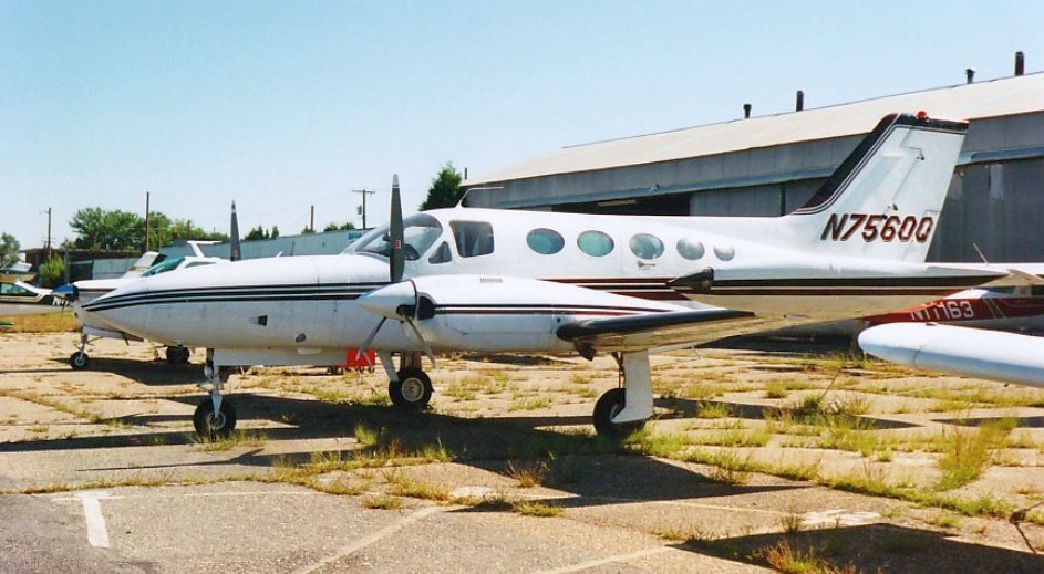
A 9/20/96 photo of Volare Air Charter Cessna 421B Golden Eagle N7560Q in front of the Hyde Field hangars.
The February 2001 Washington Terminal Chart (courtesy of Ron Plante) depicted Hyde Field as having a single 3,000' paved runway.
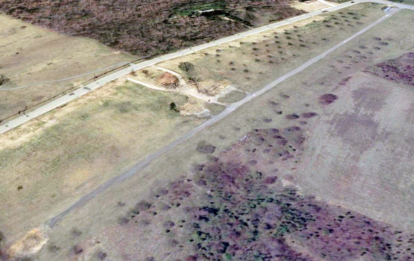
A circa 2001 aerial photo showed the contraction of Hyde Field:
the eastern end of the former crosswind runway was still visible (being used as a taxiway),
whereas the western end of the former runway was no longer even discernible.
Unfortunately, due to Hyde's proximity to DC, in the wake of the 9/11 attacks,
it was placed under onerous security procedures, along with nearby Potomac Airport & College Park Airport.
Among other things, these regulations outlawed any transient aircraft landings at Hyde, which decimated its business.
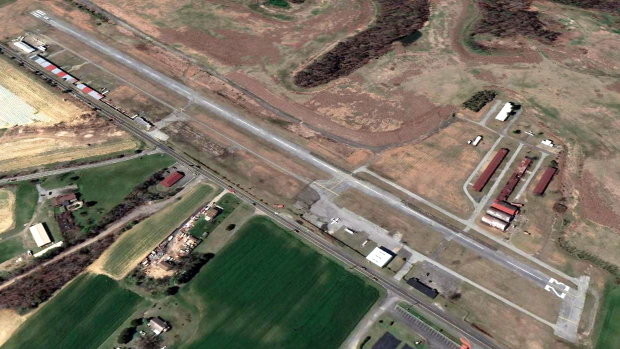
A 2002 USGS aerial photo looking southwest along Hyde's Runway 23,
showing the drastically reduced number of aircraft based at Hyde following the post-9/11 “security restrictions”.
As of 2003, the airfield configuration at Hyde consists of a single 3,000' asphalt Runway 5/23, described as being "in fair condition".
A total of 112 aircraft were listed in the FAA records as being based at Hyde in 2003.
However, in light of the government restrictions placed on the field,
it is unlikely that a fraction of that number of planes remained at the field in 2003.
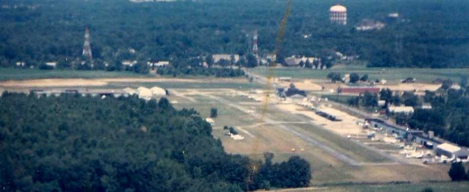
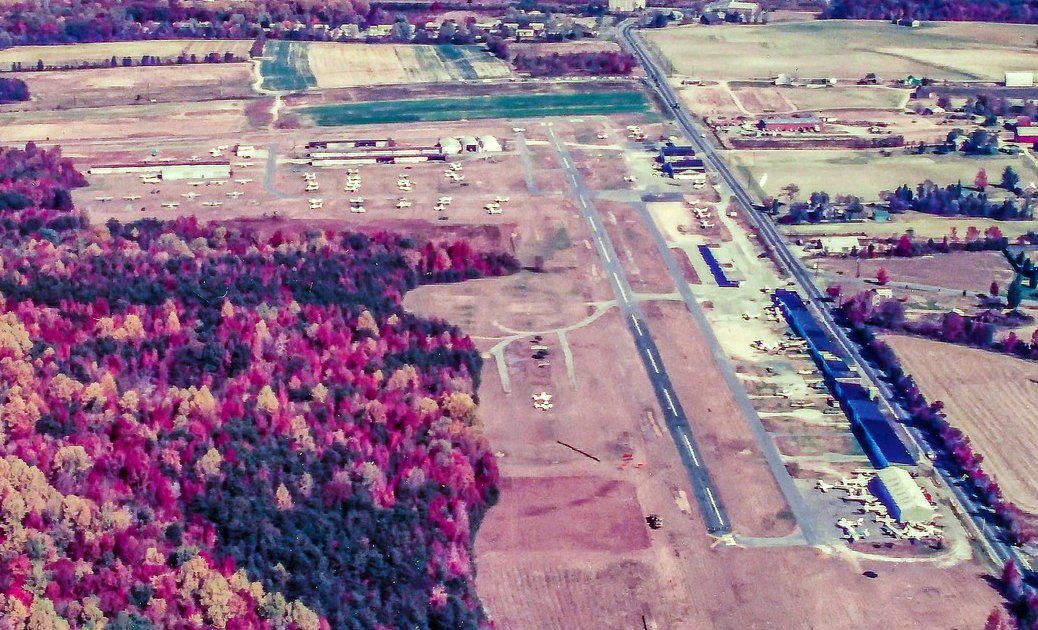
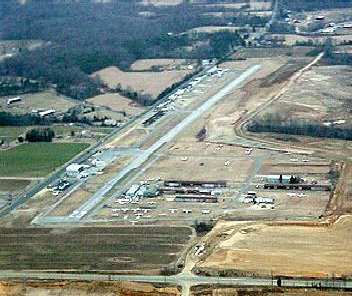
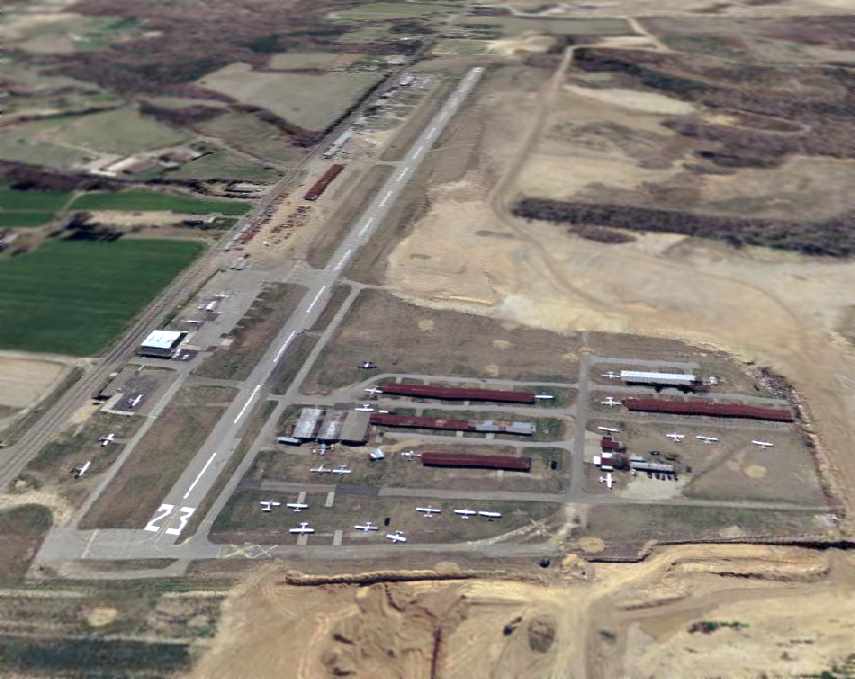
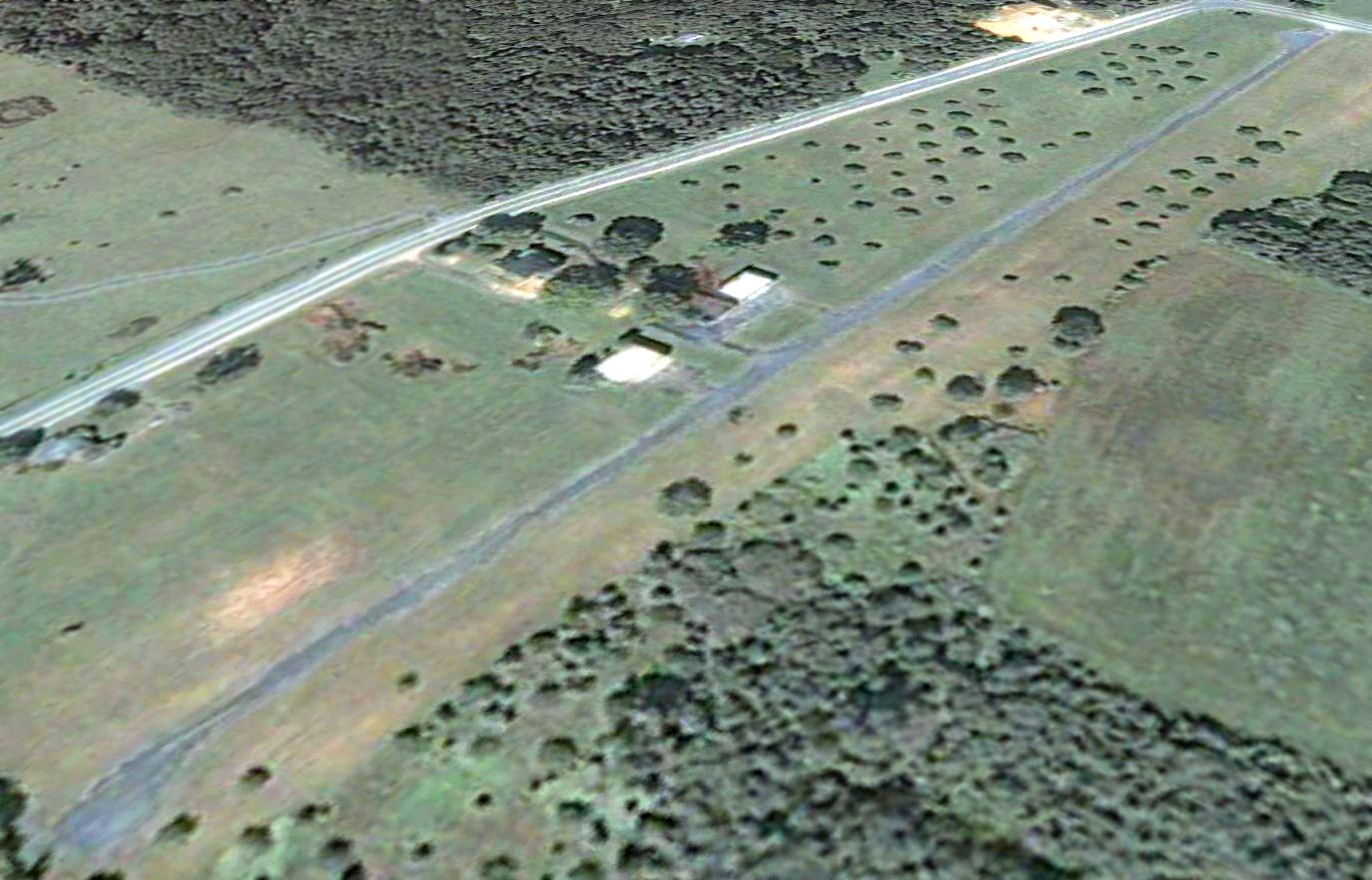
A circa 2000s aerial view looking north at Hyde Field.
The following operators were based at Hyde in 2003: Fetter Aviation, Beacon Flying Service,
Clinton Aero Maintenance, Cloud Club Flying Club, Gilley Aviation Repair,
and the Prince George's County Police Aviation Section (which operated MD520N NOTAR helicopters).
As of 2003, Hyde Field was owned by Nabil Asterbadi, a Washington D.C. Ob/Gyn doctor, who was described as rarely even visiting the field.
According to the FAA pilot database, he is evidently not a pilot.
When the Baltimore Business Journal prepared an article about the plight of the airport,
Asterbadi would not return phone calls seeking his comment (which is evidently his usual response about the airport).
In 2003, an employee at Hyde Field said, "We are in danger of being closed down because of the onerous restrictions put on flight to & from the airport,
which was headed downhill anyway because the succession of owners has sold off all the hardwood
and mined the gravel on the 450+ acre property, sucking the airport dry - taking everything out & returning nothing.
What was a viable, thriving airport when I came here in 1981 has steadily deteriorated so that even before the Homeland 'Security' restrictions,
we have steadily lost pilots, planes and patrons. Pity."
Unfortunately, the director of the new Transportation Security Administration, Admiral James Loy,
was quoted in 2003 as saying that the government may proceed to "buy out" the operators at the "DC-3" airports, and close the airports.
Very sad.
Ben Selig reported in 2004, "I still keep my aircraft at Hyde because I hope it will show the TSA that there is a need for the DC-3 airports.
I can't seem to find out anything about it's future anytime.
Doctor Asterbadi never answers to anyone.
Stan Fetter who runs Trafficplanes.com doesn't seem to know which way his future there is heading either.
Milton Gilley at Gilley aviation is still working everyday at his hangar...
well he is at least watching guard hoping someday that the FRZ will be lifted so he can get his loyal customers back.
Danny Fugazzi is still working maintenance also at the other end of the airfield with hopes too of a reopening.
Herb Jones at Cloud Club is still flying a few students out of the FRZ
but not much there more than a few hours a week from some loyal pilots.
Without the FRZ clearing there isn't any traffic Pattern work and no students.
I will keep N3741V on the airfield as long as possible.
It doesn't get the flight time it deserves anymore but it does get some even with the heavy restrictions on the DC-3 airports."
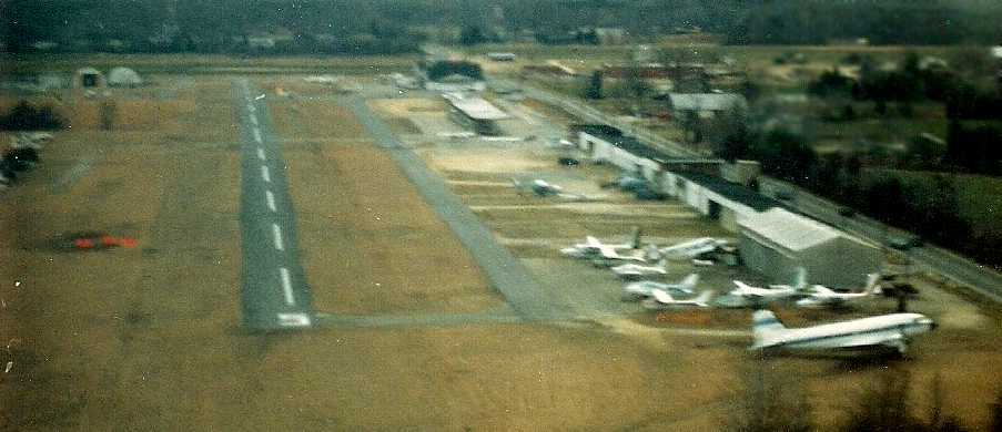
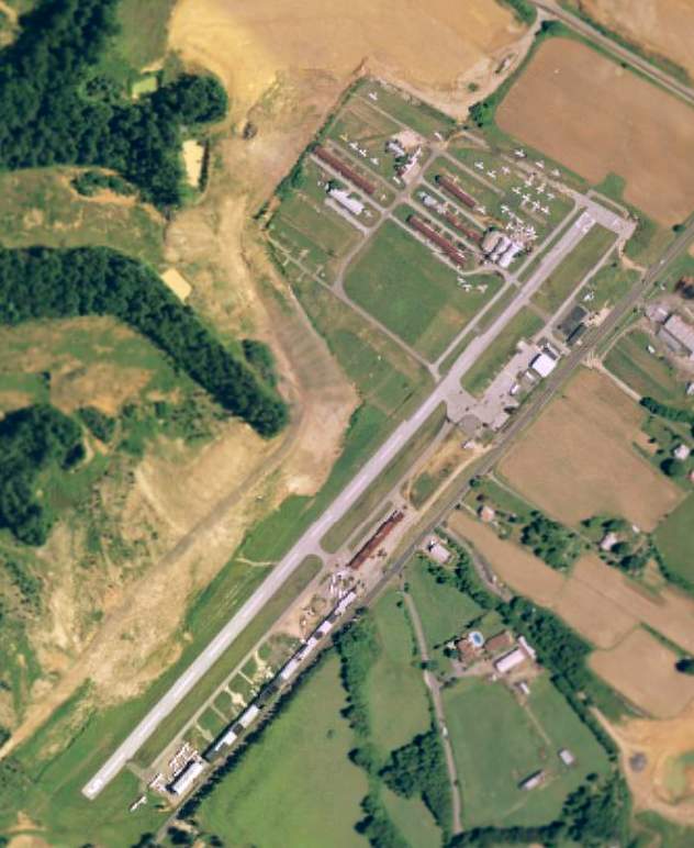
A circa 2005 aerial photo looking north at hangars & planes on the southern portion of Hyde Field.
SW reported in 2008, “The field will be gone in the next couple of years.
We understand that the property is under contract to a developer.
The guys say 2-3 years & it will be houses & there was an article in the local paper talking about its demise.
No matter what you hear it's not gone because of the regulations. The owner is taking his profit.
There are surveyor's makings all around the field & many of the tenants have confirmed the sale.
They appear to be in phase 1 of construction & I think Phase 2 is the part which includes the runway.”
Dana Shifflett observed, “No part of Maryland is closer to me than Hyde.
I read that surveyor's stakes are sprouting all over the field, and I'm really glad I'm in Kansas.”
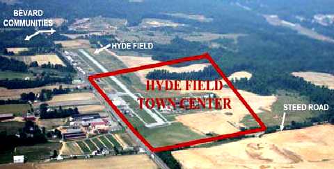
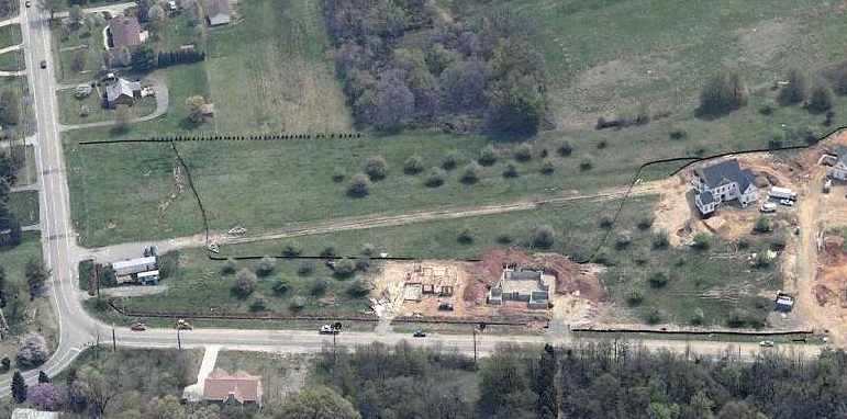
A 2009 plan for the “Hyde Field Town Center”, superimposed over an aerial view looking southeast at Hyde Field.
Why must the “solution” always be to build more houses?
Our airports are a finite resource - certainly PG County will never again get a new airport -
so why must we continue to replace our airports with more & more houses?
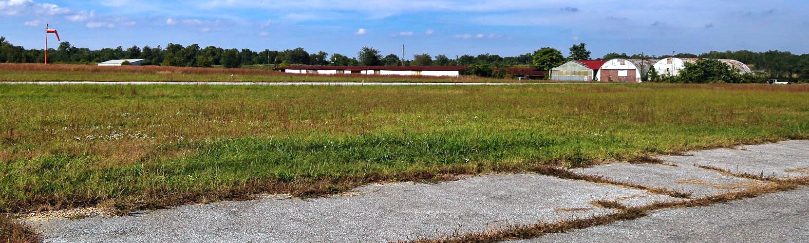
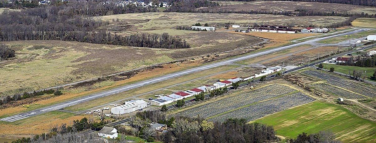
A 10/2/21 photo by Ed Figuli looking north at the Hyde Field hangars.
A May 2022 photo looking northwest at the southern-most Hyde Field hangar, with a few non-flyable planes adjacent.
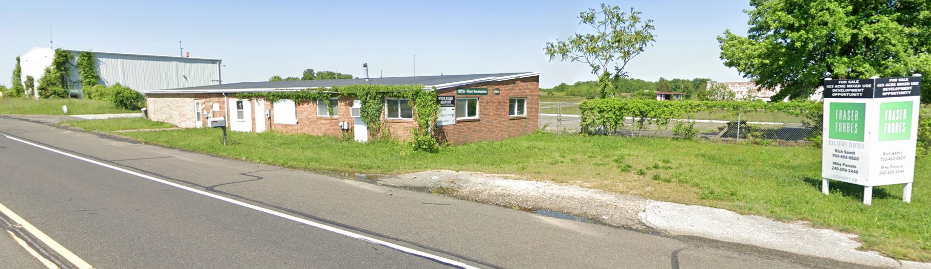
A May 2022 photo looking at the Hyde Field airport office, with the sad sight of an adjacent “Development Opportunity” for sale sign.
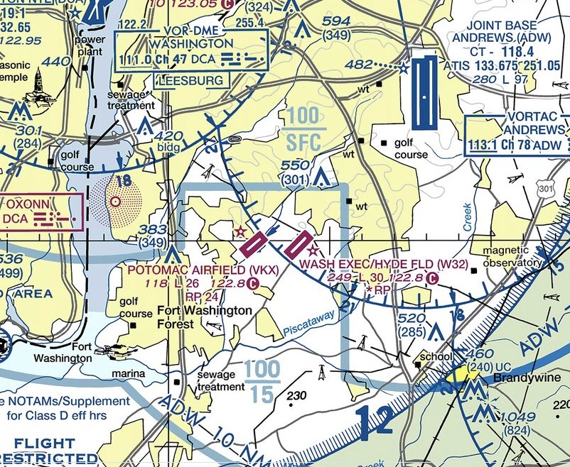
The 2022 Washington Terminal Chart depicted Hyde Field as having a 3,000' paved runway.
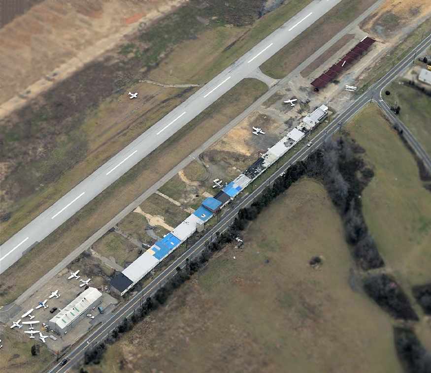
A sad 2022 aerial view looking west at Hyde Field showed only 5 intact light single-engine aircraft, and 3 others partially disassembled.
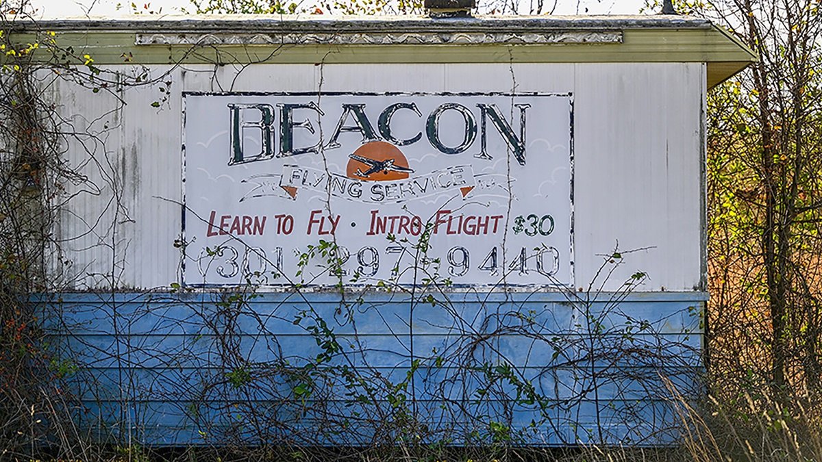
A November 2022 photo by David Tulis of a Beacon Flying Services advertisement on the side of a Hyde Field building, offering intro flights for only $30.
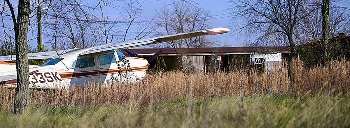
A November 2022 photo by David Tulis of a Cessna 210 at Hyde Field.
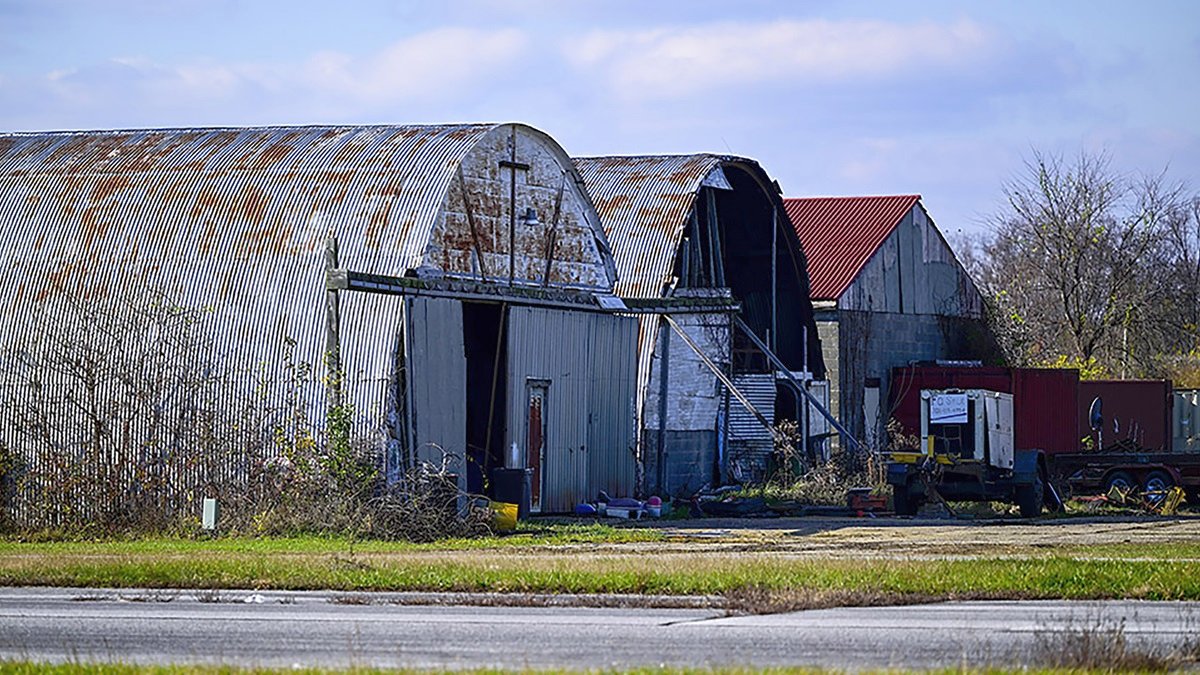
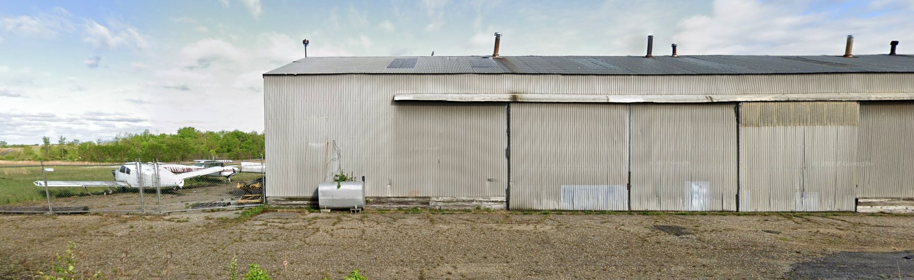
A November 2022 photo by David Tulis of a Hyde Field hangars.
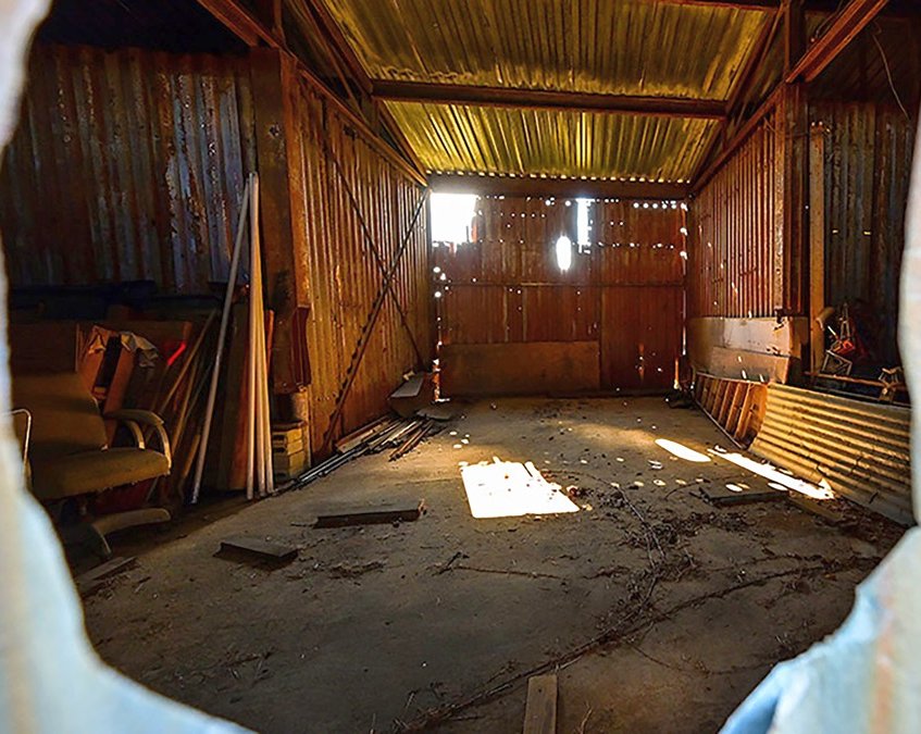
A November 2022 photo by David Tulis of the interior of a Hyde Field hangar.
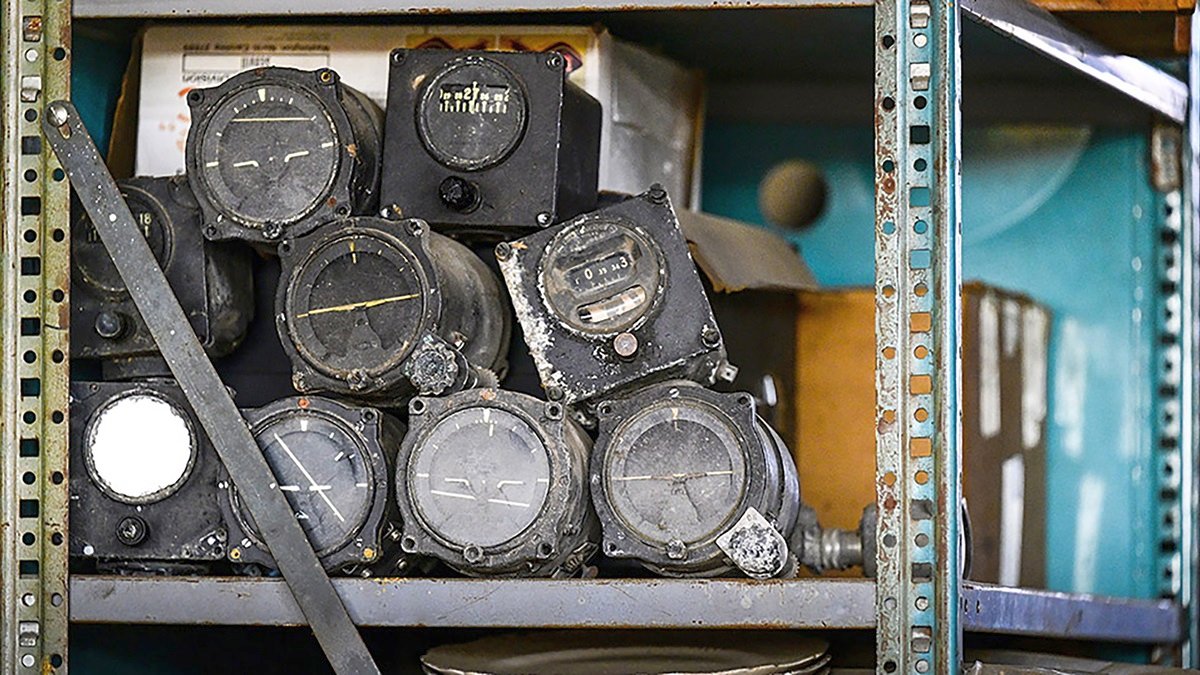
A November 2022 photo by David Tulis of aircraft instruments at Hyde Field.
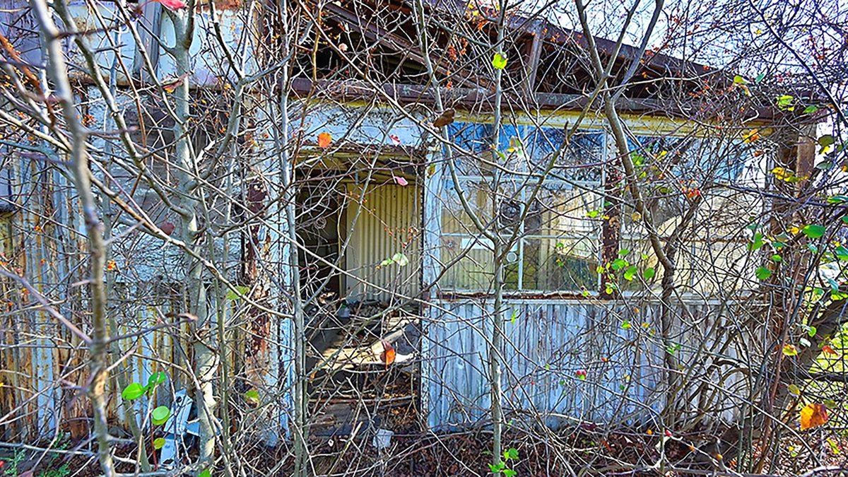
A November 2022 photo by David Tulis of an overgrown Hyde Field building.
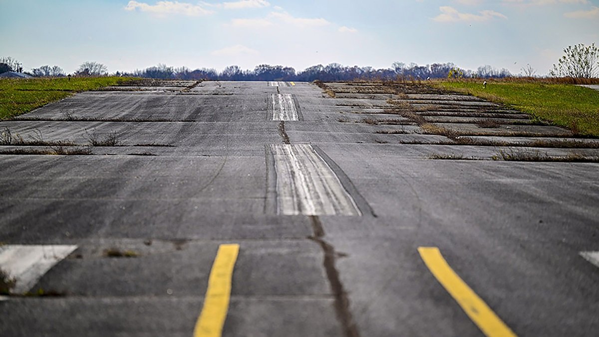
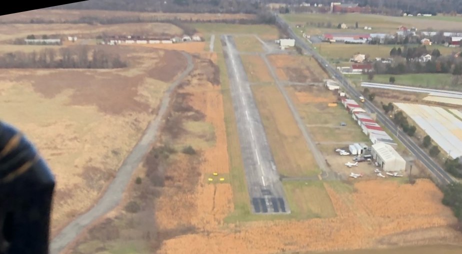
A November 2022 photo by David Tulis looking along Hyde Field's sloping Runway 5.
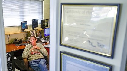
A November 2022 photo by David Tulis of Hyde Field Airport Manager Stan Fetter.
Stan Fetter reported in 2022, “It's official: Hyde has been sold for redevelopment & we're shut down as of the end of November.
The airport property has been ordered sold by the US Bankruptcy Court.
We will cease to operate as of 11/30/22. There will be no flight operations & no access after that time.”
Mark Buchner reported on 11/30/22, “Hyde Field closed an hour ago. I was a tenant there for about 18 years.”
A sad 12/1/22 aerial view by Patrick Jennings looking northeast at Hyde Field the day after its closure, with the runway numbers having been painted-out.
Patrick reported, “I fly out of Potomac Airfield just a few hundred yards away & have landed at Hyde just to get it in my log book before it closed.
It is interesting to see a number of aircraft still on-site.”
See also: http://www.hydeair.com/hydefieldmain.htm
____________________________________________________
Piscataway Airport, Piscataway, MD
38.68, -76.98 (South of Washington, DC)
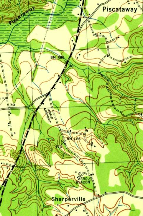
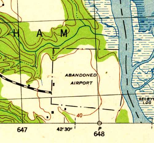
“Abandoned Airport”, as depicted on the 1944 USGS topo map.
Nothing was depicted at this location on the 1934 USGS topo map,
nor was any airport depicted at this location on the 1934 Washington Sectional Aeronautical Chart.
Dana Shifflett passed along the following, from Catherine Allen (Prince George's County Assistant Parks Division Chief,
who described a 1996 oral history recorded from Dotty Warren, “a local pilot who worked for ERCO for Henry Berliner.
She noted that another small airport in Prince George’s County was Piscataway Airport.
Doug Schall owned & operated the airport in the late 1930s. The runways were all grass.”
According to Dana Shifflett, “I posted a request for information in my high school's alumni website & received replies from 3 folks.
The airport was located in a triangle formed on the south side of the junction of Berry, Livingston, and Farmington Roads.
The airport was owned by Doug Schall. He sold Luscombe aircraft.
It had one grass runway; I suspect it was oriented roughly northeast/southwest.”
No airport was depicted at this location on Washington Sectional Aeronautical Charts from 1935, 1940 or 1944.
The only depiction which has been located of this airport was on the 1944 USGS topo map.
It depicted a single building south of the intersection of Livingston Road & Berry Road,
with a northwest/southeast clearing labeled “Abandoned Airport”.
An “Aero Beacon” was also depicted about a half-mile further southeast.
Nothing was depicted at this location on the 1946 USGS topo map.
According to Dana Shifflett, “My best guess: When the post-war interest in private aviation didn't work out,
Schall took note of nearby residential developments & closed his field to follow that course in the early 1950s.
I say it was his own action because of the names given the streets: Schall & Airport. The bank didn't foreclose & he wasn't bought out.
Houses were already occupied on the site in the mid-1950s.”
A 1957 USGS aerial photo depicted houses & new streets covering the site,
but the single building depicted on the 1944 USGS topo map (a hangar?) was still depicted.
According to Dana Shifflett, “I think I recall a beacon tower in the area in 1960.”
A 1963 aerial photo still depicted the possible hangar.
A 1980 aerial photo showed the possible former hangar had been removed, erasing the last possible remnant of this enigmatic small airport.
Nearby resident Patricia Keimig reported in 2008, “I asked a neighbor
who has lived in this self-contained neighborhood for upward of 50 years whether there had ever been an airport here.
He said that there had been, and that some of the homes near the intersection of Livingston & Berry were once the airport offices.”
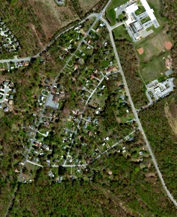
A circa 2012 aerial photo did not show any recognizable trace of the airport previously in Piscataway.
Dave Nordeloos reported in 2013, “I passed a road named Airport Lane in Accokeek. No airport was visible on site.”
____________________________________________________
Cheltenham Navy Airfield, Cheltenham, MD
38.74, -76.83 (Southeast of Washington, DC)
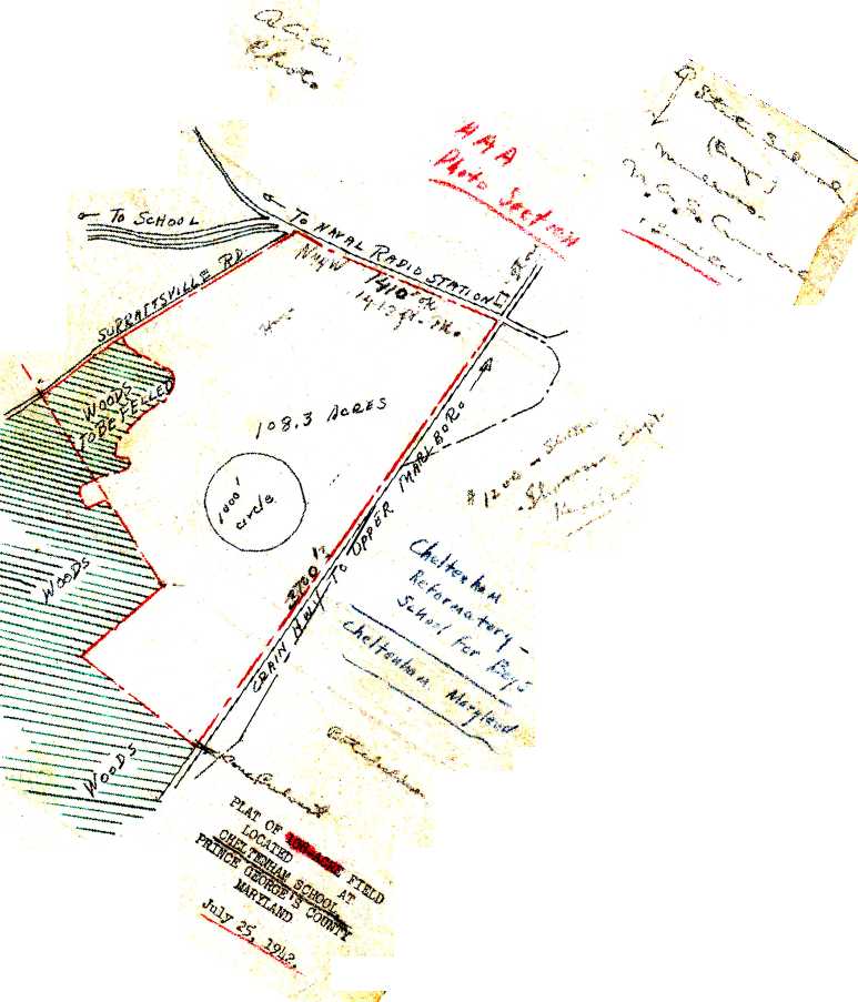
A 7/25/42 Navy “Plat of 108-acre field located at Cheltenham School” (courtesy of Brian Rehwinkel).
This is the unusual tale of a Washington area military airfield which was planned, and actually charted before it was ever constructed,
and eventually canceled before being built.
A 1938 aerial photo of the property did not yet show any recognizable trace of an airfield, just farmland,
and no airfield at Cheltenham was depicted on the 1942 or 1943 Washington Sectional Charts.
Brian Rehwinkel reported, “According to a May 1943 memo from the Commanding Officer of the US Naval Reserve Aviation Base Anacostia,
(informal) negotiations to use 'Practice Landing Field #13212 (Cheltenham Field)' as an outlying practice field for NRAB Anacostia were begun in May 1942.
The field was to be used by NE-1 aircraft [the Navy version of the ubiquitous Piper Cub] from the NRAB.
The small field (in the range of 120 acres) was suitable for the NE-1 aircraft because, according to the Navy document,
the aircraft had a 'very low landing speed & a rapid take-off.'”
The earliest depiction which has been located of the Cheltenham Airfield
was a 7/25/42 Navy “Plat of 108-acre field located at Cheltenham School” (courtesy of Brian Rehwinkel).
It showed the field to have an irregular outline, with the longest dimension being
Brian observed, “The plat says the field was 108 acres, however other documentation shows the size of the land for the field was eventually 120 acres.
The plat shows a 1,000' circle in the middle of the field.
This appears that the plans called for a sod landing mat similar to the mats originally placed (for primary training) at 2 other [Navy] fields:
OLF Switzerland & OLF Francis in the Jacksonville area.”
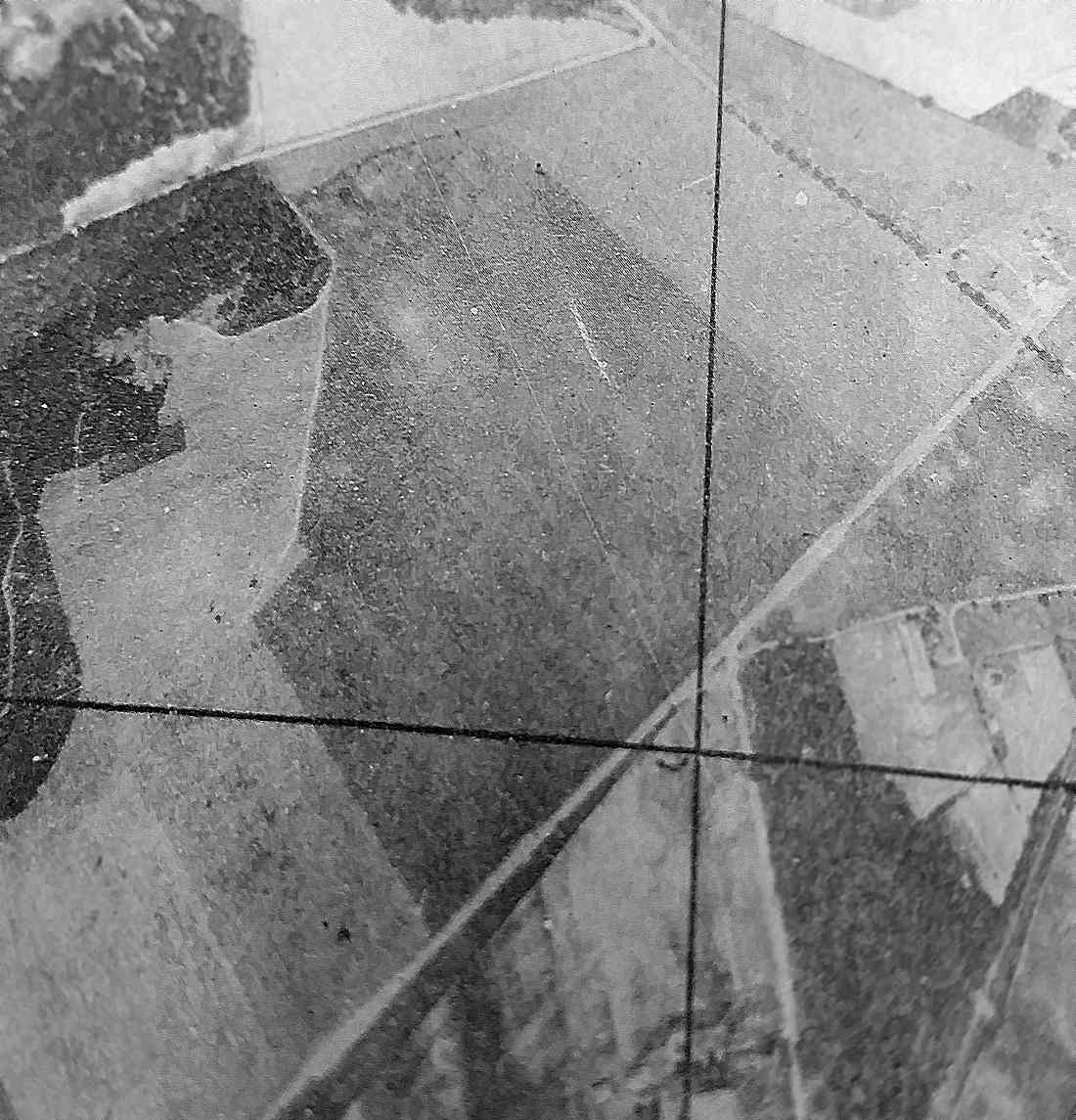
The earliest photo which has been located of the Cheltenham Airfield site was a 1943 Army Corps of Engineers aerial view looking north (from the National Archives, courtesy of Oscar Gregory).
It depicted an irregularly-shaped grass field which matched the outline seen in the 1942 plat, but with no specific sign of any aviation use.
Brian Rehwinkel continued, “Soon after the negotiations for the use of the field were initiated,
NRAB Anacostia replaced the NE-1 with N2S [Stearman] aircraft, which had a 'higher landing speed & a lower rate of climb', according the Navy memo.
The memo goes on to say that because of the small size of the field, additional costs would be required to make the field suitable for use by the N2S aircraft.
Although it is not clear if the field was ever used by the Navy as a landing field, it is clear the field was not in the plans for use by the base after May 1943.”
Brian continued, “A June 1943 Navy memo asked the Bureau of Yards & Docks (which handled the Navy’s real estate acquisition projects)
to terminate 'as soon as possible' the Navy’s condemnation proceedings to acquire the use of this field.
This land was condemned to acquire a leasehold interest (the owners would be compelled to lease the land to the Navy) for the land
(as opposed to the US Government attempting to acquire fee simple title for the land).
Interestingly enough, the land was apparently owned by the state of Maryland.
Of course, the primary training at Anacostia ,for which the field was originally needed, was discontinued in mid-1943
(Anacostia began disposing of all of the leased outlying fields when primary training ended at the base).”
The Cheltenham Navy airfield was not yet depicted on the November 1943 Washington Sectional Chart.
Brian Rehwinkel continued, “By January 1944, the US Government had officially dismissed the condemnation proceedings for use of the field –
with the state of Maryland agreeing not to seek any claim for compensation against the US for the Navy’s use of the field.”
Mike Doll reported, “I worked at the [Cheltenham] Naval Communications Unit in the mid-1980s.
While looking for history on the base I found some info that indicates
that the Navy considered moving air operations from the Anacostia NAS to Cheltenham in the 1940s
due to limited expansion room along the Anacostia River.
The Navy apparently owned additional land in Cheltenham that was to be used for this purpose.
Apparently this idea was scrapped for whatever reason.
I don't know if any type of strip was actually built” [at Cheltenham].
The earliest aeronautical chart depiction which has been located of the Cheltenham Airfield was on the May 1944 Washington Sectional Chart (courtesy of Ron Plante),
which depicted "Cheltenham (Navy)" as an auxiliary airfield, even though it was apparently never constructed, and never used as an airfield!
The Cheltenham Navy airfield was also depicted on the November 1944 Washington Sectional Chart (courtesy of Ron Plante).
According to Brian Rehwinkel, “In the end, this field was a good example
of the challenges posed by the rapid expansion of the war effort in the early part of World War Two.
In this instance, the Navy needed to expand the pilot training program, and as such, acquired as many fields as possible for the training effort.
As the war progressed, and needs changed (and missions changed for Navy facilities), the Navy was left with property that was no longer suitable.
This was the case with land acquired for outlying fields acquired by the Navy, but never fully utilized.”
The 1944 & 1946 USGS topo maps labeled the Cheltenham property outline as “U.S. Naval Reservation”,
but did not show anything related to an airfield.
The Cheltenham Navy airfield was no longer depicted on the June 1945 Washington Sectional Chart (courtesy of John Voss) or later Sectional Charts.
A 1963 aerial photo of the site of the Cheltenham airfield showed the property to remain an open field.
A 1980 aerial photo showed that the Cheltenham Veterans' Cemetery had been built at some point between 1963-80 on the western portion of the airfield site.
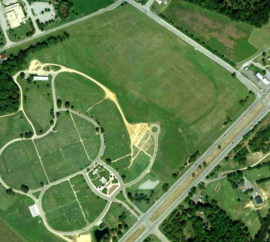
An 8/29/10 aerial photo shows the western portion of the site of Cheltenham airfield is occupied by the Cheltenham Veterans' Cemetery, while the eastern portion remains an open field.
The site of the Cheltenham airfield is located west of the intersection of Crain Highway & Frank Tippett Road.
____________________________________________________
38.736, -77.022 (South of Washington, DC)
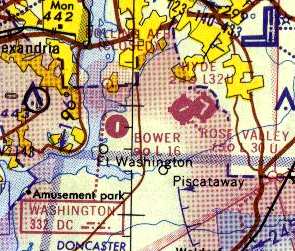
Bower Field, as depicted on the 1956 Washington Local Aeronautical Chart (courtesy of Tim Zukas).
This very short private paved strip was located along the east bank of the Potomac River, 7 miles south of Reagan National Airport.
The date of construction of Bower Field is unknown.
A 1938 aerial photo of the property did not yet show any recognizable trace of an airfield, just farmland.
Bower Field was apparently built at some point between 1955-56,
as it was not yet depicted on the 1955 Washington Local Aeronautical Chart (courtesy of Mike Keefe).
The earliest depiction which has been located of Bower Field was on the 1956 Washington Local Aeronautical Chart (courtesy of Tim Zukas),
which depicted Bower as a private airfield having a 2,000' unpaved runway.
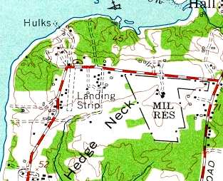
Bower Field (labeled simply "Landing Strip"), as depicted on the 1956 USGS topo map.
Merton Meade recalled, “I remember Don Bowers & his wee field. Don used to keep his Cessna 310 there & also had a Cessna 180.”
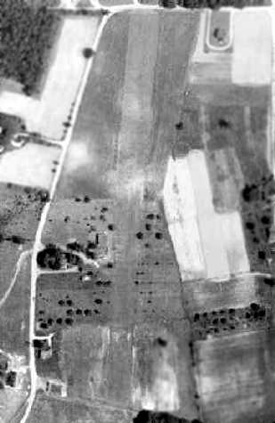
The earliest photo which has been located of Bower Field was a 1957 aerial view, which depicted Bower as having a single grass runway.
The Aerodromes table on the 1957 Washington Sectional Chart described Bower Field as having a single 2,000' turf runway.
The runway at Bower was apparently paved within the next 3 years,
as the Aerodromes table on the 1960 Washington Sectional Chart
described Bower Field as having a single 2,000' hard-surfaced runway.
Stan Fetter (of Hyde Field's Fetter Aviation) said that "The guy that built it had a [Cessna] 310 in there, believe it or not.
He'd go out light & pick up fuel & passengers at Hyde."

Bower Field was depicted on the February 1961 Washington Local Aeronautical Chart (courtesy of Scott Kimball) as having a 2,000' paved runway.
Also note the close proximity of Rose Valley Airport & Hyde Field.
The 1962 AOPA Airport Directory described Bower Field as a private field consisting of a single 2,000' blacktop Runway 18/36.
Apparently, Bower Field's runway length was shortened somewhat by 1964, as the Aerodromes table on the 1964 Washington Sectional Chart (courtesy of John Voss)
described Bower Field as consisting of a single 1,660' asphalt runway.

A 1965 aerial photo showed Bower Field to have a single paved runway, and what appeared to be 2 aircraft parked on the west side of the runway.
Also note the airport circle marking on the east side of the field.
Ben Selig recalled, "I grew up in Ft. Washington just down the street from the Bower airfield.
My first airplane ride was from there at the age of about 3 from the original owner Don Bowers about 32 years ago [circa 1970].
Don had a [Cessna] 210 and a yellow 172.
With my brother about 4 years & myself screaming at the offer for a ride from Don my mother couldn't say 'No.'
Off we went my brother & I standing in the back of the 172, out over the roller coaster at Glenn Echo & around southern PG county."
Bower Field, as depicted on the 1975 Washington Terminal Area Chart (courtesy of Ed Drury).
The last photo which has been located showing aircraft still on Bower Field was a 1980 aerial view.
It showed 2 single-engine aircraft parked on the southwest side of the runway.
The airport circle marking previously seen on the east side of the field had evidently been removed at some point between 1965-80.
The 1982 AOPA Airport Directory (courtesy of Ed Drury) described Bower Field as having a single 1,660' asphalt runway.
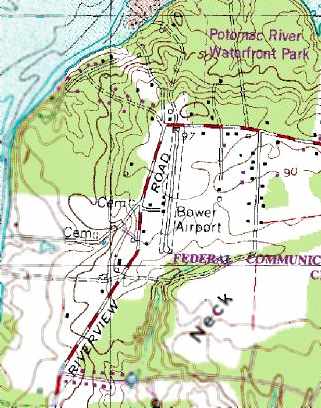
The 1983 USGS topo map depicted Bower as having a single paved runway with buildings along the west side.
The March 1993 Washington Sectional Chart (courtesy of Carl Taylor) depicted Bower as having a single 1,600' paved runway.
The last aeronautical chart depiction which has been located of Bower Field was on the February 2001 Washington Terminal Chart (courtesy of Ron Plante),
which depicted Bower as having a single 1,600' paved runway.
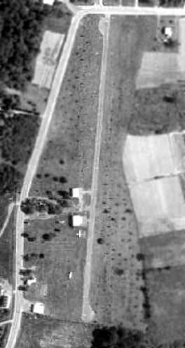
A 2001 aerial view looking north showed 2 small hangars were situated west of the single runway at Bower Field.
There did not appear to be any aircraft parked outside at the field.
Unfortunately a 2002 aerial view looking northwest at Bower Field showed that the house & hangars on the west side of the runway had been removed between 2001-2002,
although the runway still remained intact.
A sad sight – a circa 2002-2004 aerial view looking east, showing the Bower Field runway in the process of being replaced by new houses.
Stan Fetter said in 2003 that the Bower Airport property was sold a couple of years ago to a real estate developer
"and it's been dug up to become the backyards of some very expensive homes."
Ben Selig reported in 2004, "It's completely gone & 20 or so homes have been built there,
and a plan for another 30 or so to be built along the Potomac River waterfront area."
Bower Field was no longer depicted on the 2004 Washington Terminal Chart.
A 2015 aerial view looking northwest at showed no trace remaining of Bower Field, with houses covering the property.
____________________________________________________
Riverside Field / Columbia Air Center / Croom Field, Croom, MD
38.754, -76.705 (East of Andrews AFB, MD)

A circa January 1941 photo of Roland Brawner, John Pinkett Jr., Jimmie Lunceford, and John Greene Jr. in front of a Piper at Riverside Field (from the Edward Fletcher Collection, DC Public Library People's Archive).
A 1938 aerial photo of this property did not yet show any recognizable trace of an airfield, just farmland.
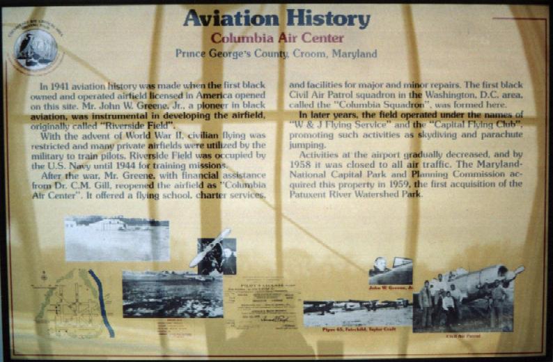
In 1941 aviation history was made when Riverside Field,
the first black owned & operated airfield licensed in America, opened on this site.
The property, a 450 acre potato field, was leased by The Cloud Club, a group of black pilots from Washington, for $50 / month from Rebecca Fisher.
John Greene, a pioneer in black aviation, was instrumental in developing the airfield.
The earliest depiction which has been located of Riverside Field
was a circa January 1941 photo of Roland Brawner, John Pinkett Jr., Jimmie Lunceford, and John Greene Jr. in front of a Piper (from the Edward Fletcher Collection, DC Public Library People's Archive).
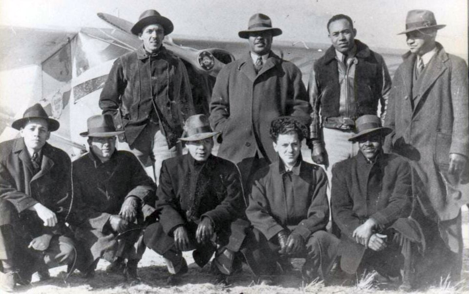
A January 1941 photo of the Cloud Club (courtesy of College Park Aviation Museum). Top row: John Pinkett Jr. (Treasurer), Jimmie Lunceford (Director of Publicity), John Greene Jr. (Airport Manager), and Roland Brawer (Vice President).
Bottom row (far right): Harold Smith, (President).
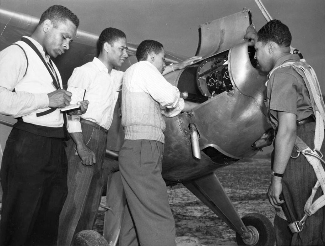
A circa 1941 photo by Robert McNeill of Howard University Civilian Pilot Training Program students at Riverside Airfield (Library of Congress, Robert H. McNeill Family Collection).
According to the book "Maryland Aloft" by Preston, Lanman, and Breilhan, "Riverside Field opened in February 1941.”

A March 1941 photo (Library of Congress, Robert H. McNeill Family) of Willa Brown, the famed “aviatrix” from Chicago, visiting Howard University’s Civilian Pilot Training Program at Riverside Airfield.
Club President John Pinkett Jr. was hand-propping the propeller of the Cloud Club’s plane.
The Washington Afro-American newspaper wrote on 8/16/41, Riverside "is the only field solely operated by a colored staff."
According to the book "Maryland Aloft" by Preston, Lanman, and Breilhan,
"In August [1941], an air show there drew 800 spectactors, about 150 of whom went aloft for rides.
During this same general period,
students from the Civilian Pilot Training Program at Howard University did their flight training at the field."
With the advent of WW2, civilian flying was restricted & many private airfields were utilized by the military to train pilots.
Wartime restrictions halted private flying at Riverside.
According to Brian Rehwinkel, “The Navy first attempted to lease the field in late 1941 or early 1942”,
to support flight training at nearby NAS Anacostia.
However, Brian Rehinkel reported, “The Navy’s use of the field was complicated because the owner of the field could not sell the property to the Navy.
According to Navy records, she held a 'life estate' for the property, and upon her death, the land would revert to her late husband’s heirs.
The airfield was situated on a 470 acre farm & the Navy wanted to lease the 120 acres for the existing airfield,
as well as an additional acres to expand the field for training.”
Brian continued, “Of course, the challenge was that the 120 acres for the airfield was already being leased by the Cloud Club, Inc.
The members of this club were leasing the field (according to Navy documents) for $50 / month.
The Navy did not want to pay much for the lease of this field & apparently was not willing to sub-lease from the Cloud Club
because they did not think the lease rate offered by the Club was reasonable.
However, the Cloud Club claimed they had invested, at least, $12,000 in improvements to the field.”
The Cloud Club's Secretary sent a 2/4/42 letter (courtesy of Brian Renhwinkel) to the Navy, which was marked “Defendant’s Exhibit #6”
evidently because the letter was an exhibit in the drawn-out legal proceedings for this field.
An undated (believed to be 1942) U.S. Navy aerial view looking southwest at Riverside Field (courtesy of Brian Rehwinkel), “annotated to show the airfield boundaries.”
It depicted Riverside as having 6 unpaved runways, with a few small buildings along the west side.
An undated (believed to be 1942) U.S. Navy aerial view looking southwest at Riverside Field (courtesy of Brian Rehwinkel),
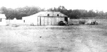
showing a single hangar, a small office building, and a truck, but no aircraft.
Brian Rehwinkel observed, “At this time, according to Navy records, the buildings consisted of a 45’ x 40' wooden hangar
and a small building that was divided into 2 rooms – a locker room & a radio room.”
Strangely, Riverside Field was not depicted on the 1942, 1943, 1944, or June 1945 Washington Sectional Charts.
The Navy's usage of Riverside Field ended in 1944. According to Brian Rehwinkel, “I don’t think the legal proceedings were completed until 1944.”
The earliest map depiction which has been located of Riverside Field was on the 1944 USGS topo map.
It depicted a rectangular property outline, with one small buildings on the west side. Ironically, it was already labeled as “Abandoned Airport”.
After the war, John Greene reopened the airfield as "Columbia Air Center".
The earliest aeronautical chart depiction which has been located of Columbia Air Center was on the December 1945 Washington Sectional Chart.
It depicted “Columbia” as an auxiliary airfield.
It continued to be depicted as "Columbia" on the and the 1946 Washington Sectional Chart (courtesy of Mike Keefe).
An undated (presumably post-WW2) photo of members of the Cloud Club at Columbia Air Center in front of a surplus Vultee BT-13.
“Columbia Air Center”, as depicted on the 1946 USGS topo map.
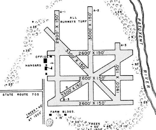
According to the book "Maryland Aloft", in 1946, Columbia Air Center consisted of 130 usable acres with 7 marked runways.
The airport had one 100' x 60' hangar, one 40' square hangar, and a 20' square office building.
The management's fleet included a Fairchild PT-19 trainer, Piper J3L, Aeronca Champion, and Aeronca L3.
Columbia Air Center offered a flying school, charter services, and facilities for major & minor repairs.
The first black Civil Air Patrol squadron in the Washington DC area, called the Columbia Squadron, was formed here.

A 1948 aerial view of Columbia Air Center (courtesy of the Julianne Bethea Loan) depicted 2 hangars, an office building, and 1 light single-engine aircraft.
The two buildings in the center, a small hangar & office building, were the only buildings original to Riverside Airfield.
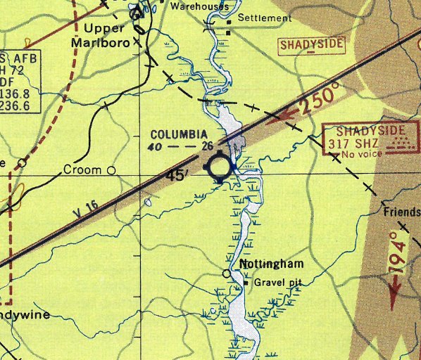
"Columbia" airfield was described on the 1949 Washington Sectional Chart (courtesy of Mike Keefe) as having a 3,300' unpaved runway.
The 1950 MD Airport Directory (courtesy of Stephen Mahaley) depicted "Columbia Air Center"
as boasting a total of no less than 8 runways, all grass, of which the longest was a 3,300' north/south strip.
The airport office building & 2 hangars were situated west of the runways.
The January 1951 Washington Local Aeronautical Chart (courtesy of Tim Zukas) depicted Columbia Air Center as having a 3,300' unpaved runway.
Columbia Air Center was described on the 1951 Washington Sectional Chart (courtesy of Mike Keefe)
as having five runways, with the longest being a 2,600' unpaved strip.
Undated photo of a hangar at Columbia Air Center.
The only dated photo that has been located showing aircraft on the field at Columbia Air Center was a 12/17/53 USGS aerial view (courtesy of Brian Rehwinkel).
Brian observed, “This photo shows the original 2 structures (the small hangar & building) as well as what looks like the larger hangar.
You can also see what appears to be 3 aircraft on the field east of one of the hangars.”
After John Greene's retirement, the airport was managed by Charles Wren & Herbert Jones,
whose firm was named "W & J Flying Service".
The "Capital Flying Club" also was based here, promoting such activities as skydiving & parachute jumping.
The July 1956 Washington Local Aeronautical Chart (courtesy of Tim Zukas)
depicted Columbia Air Center as having a 2,600' unpaved runway.
The flying service at Columbia Air Center operated until 1956, when the Fisher family refused to renew the lease.
However, Columbia Air Center was still depicted as an active airfield
on the 1957 Washington Sectional Chart (courtesy of Mike Keefe),
and described as having five runways, with the longest being a 2,600' turf strip.
Bruce Perrygo recalled, “Croom Airport... In 1957 my family moved to a farm on Mt. Calvert Road & lived there until 1966.
We were often told that radio & TV personality Arthur Godfrey often used the Croom Airport.
For several years there was a skydiving club stationed there. We could easily see the planes & parachutists from our house; these were the old big round chutes.”
A 6/16/57 Washington Post article (courtesy of Larry Jendras) said, “Vista Cycle Races: Harvey Bigelow will lead a field of 17 motorcycle drivers into action at the Columbia Airport.”
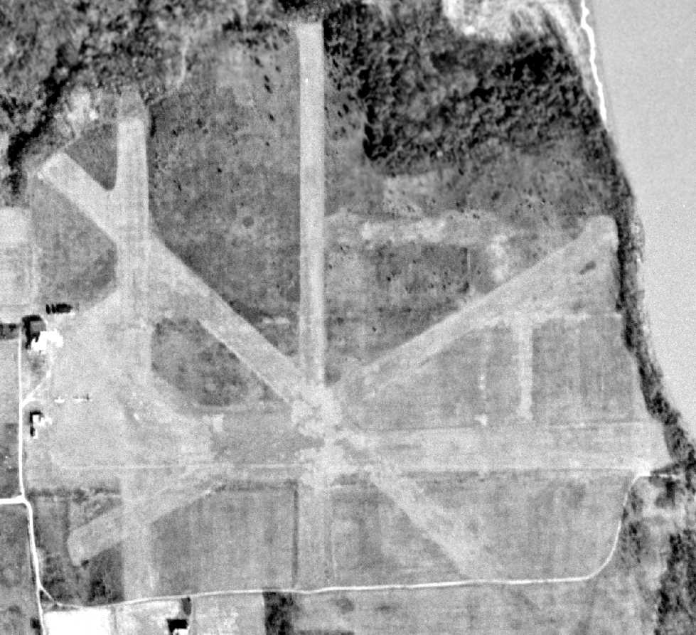
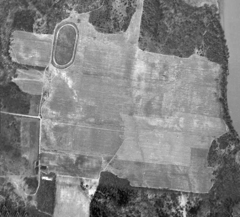
A 1957 aerial photo of Croom Field showed a dramatic change compared to the 1953 aerial photo.
The multiple runways previously seen were no longer evident, with most of the property having been plowed for farming.
The hangar on the west side had been removed, and the oval racetrack of Columbia Airport Raceway had been built on the northwest side of the property.
Columbia Air Center was closed to all air traffic in 1958.
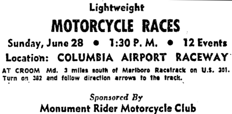
A 6/26/59 Washington Post advertisement (courtesy of Larry Jendras) described the “Lightweight Motorcycle Races” held at “Columbia Airport Raceway”.
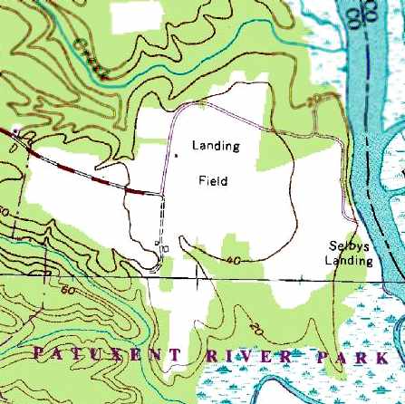
In 1959, the property became the first acquisition of the Patuxent River Watershed Park.
Columbia Air Center was no longer depicted on the 1961 Washington Local Aeronautical Chart (courtesy of Mike Keefe).
However, this airfield may have briefly reopened at some point between 1961-63,
as a "Croom" Field was depicted at the same location
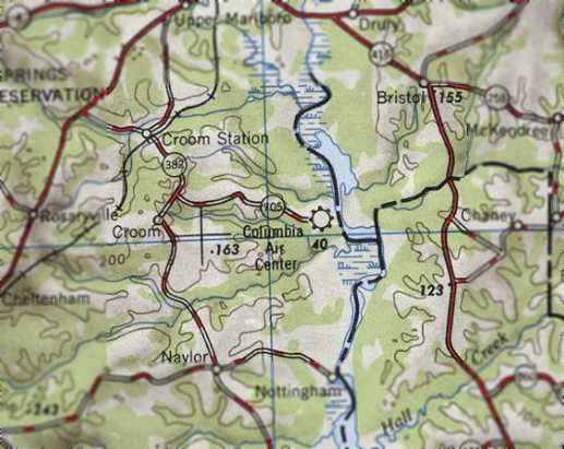
on the 1963 Washington Local Aeronautical Chart (courtesy of Mike Keefe).
It was described as having 2 runways, with the longest being a 3,200' turf runway.
Croom Field evidently lasted only one year,
as nothing was depicted at the site on the 1964 Washington Local Aeronautical Chart (courtesy of Mike Keefe).
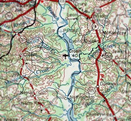
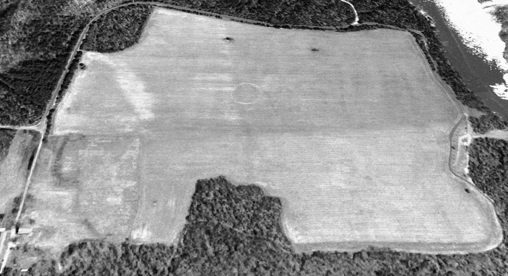
A 1965 aerial photo of Croom Field showed a large open grass area.
The oval track of the former Columbia Airport Raceway was visible on the northwest side of the property.
Traces of the former airport buildings on the west side of the field were evident, but it is not certain if they were still standing at that point.
There was no sign of any based aircraft.
Dana Shifflett observed, “runways... I see traces of something extending upper right to lower left, or at least to center.
I remember flying over that field with Dad in the mid-1960s & him pointing out traces of it in soil color & vegetation.”
The 1969 USGS topo map still depicted Croom Airport, even though it had evidently already been closed for several years.
The 1979 USGS topo map still depicted the site as a “Landing Field”,
with 2 small buildings along the west side of the field.
A 1980 aerial photo of the site of Croom Field showed the majority of the airfield was being used for farming,
and the oval racetrack of Columbia Airport Raceway on the northwest side had been overgrown with trees.
The 1983 MD Aeronautical Chart no longer depicted the field at all (not even as an abandoned airfield).
A 1993 USGS aerial view looking north at the site of Croom Field showed a somewhat smaller cleared area compared to the 1965 photo.
However, an airport circle marking was visible in the center of the field, which was not visible on the 1965 photo.
A circa 2000 aerial view of Riverside Field showed that the cleared area was the only trace remaining of the airfield.
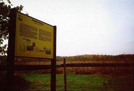
A circa 2000 photo of a historic marker at the site of Columbia Air Center.
A circa 2000 photo of a historic sign about Columbia Air Center which is displayed at the College Park Aviation Museum.
The 2002 book "Maryland Aloft" reported that a fuel pump remained at the site of Columbia Air Center.
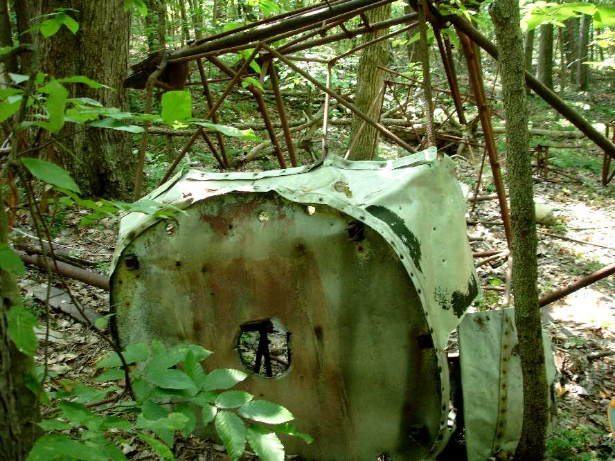
A 2007 photo by Michael Regen of the wreck of an unidentified light single-engine aircraft
found in the woods only a few hundred feet northwest of the northwest corner of Croom Field.
Micheal reported, “September 2007 the Civil Air Patrol Maryland Wing had a SAREX (Search & Rescue Exercise)
in the area that was Croom Airport & surrounding Jug Bay.
None of us at the time knew that this area had previously been an airport.
I was leading a ground team searching for a practice ELT & ran across this aircraft frame in the woods at 38.767, -76.71.
You can probably guess at the shock & surprise when I radioed back to mission base that we had found a wrecked aircraft
since no one knew of either this plane’s existence or the fact that it had once been an airport.
I could not identify the old aircraft tube frame. Pieces of it were scattered around the site.
It had wooden wing spars with the bolted ends still in the upper tube frame but badly deteriorated.
There was no trace of wings other than the spar ends and the tubular struts so the wing may have been all wood & long since deteriorated.
It was obviously a fabric-covered high-wing aircraft.”
Stanley Braisted reported in 2009, “My son had also found the airframe [pictured above].
The throttle quadrant & frame positively identify it as a J-3 Cub.
Engine & wings & internals are missing, so we theorize that it landed short,
and they cannibalized & recovered everything useful, but left the airframe, which was pretty badly bent up & likely not worth the trouble.
Elsewhere in the woods is another large & heavy high-wing center section box similar to a DH Beaver,
but I have yet to find anything diagnostic to ID it.”
However, Harvey Cash reported, “A J-3 never had welded diagonal braces extending outward from the fuselage, and never had a 3-piece windscreen.
From the photo, the physical size of the frame seems too large to be a J-3 sized aircraft.
Most likely the aircraft is a Stinson Junior.
The photo clearly still shows the 3 segments of retaining trim still on the cowl of the wreckage.”
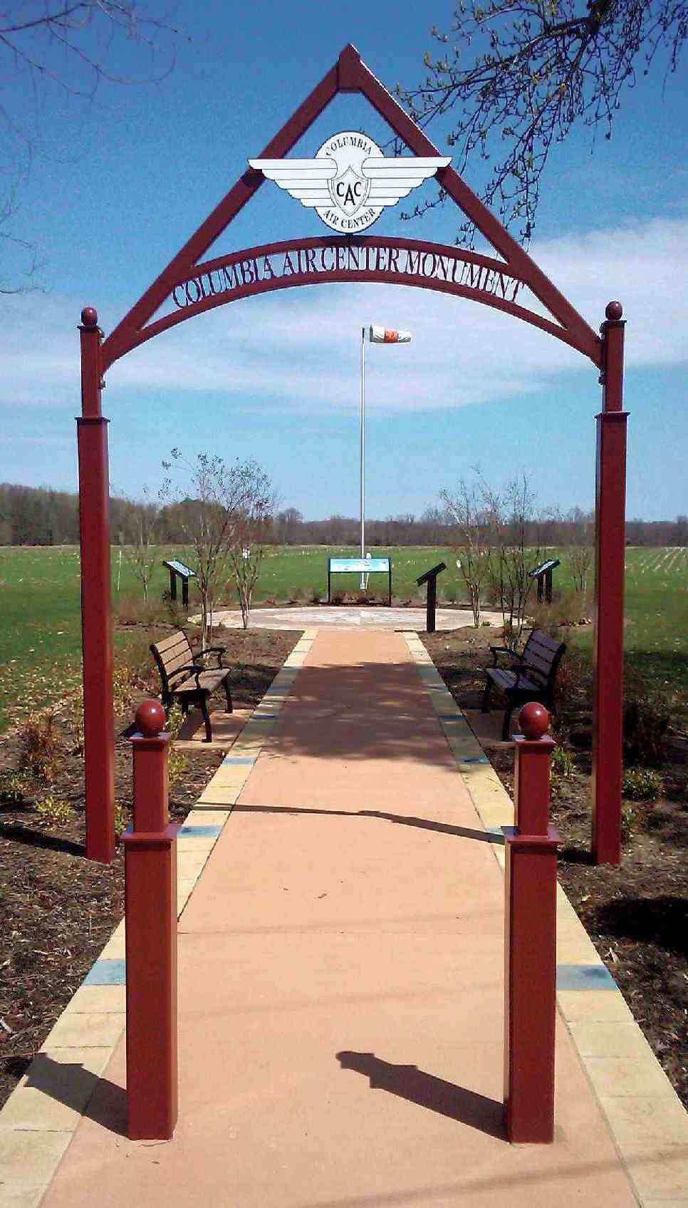
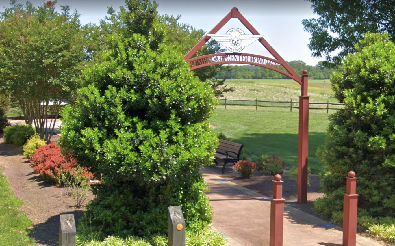
An April 2011 photo by Greg Wright of the “Columbia Air Center Monument”.
Greg reported, “The State Park that the former field is located on has put up a formal type of memorial for the field.”
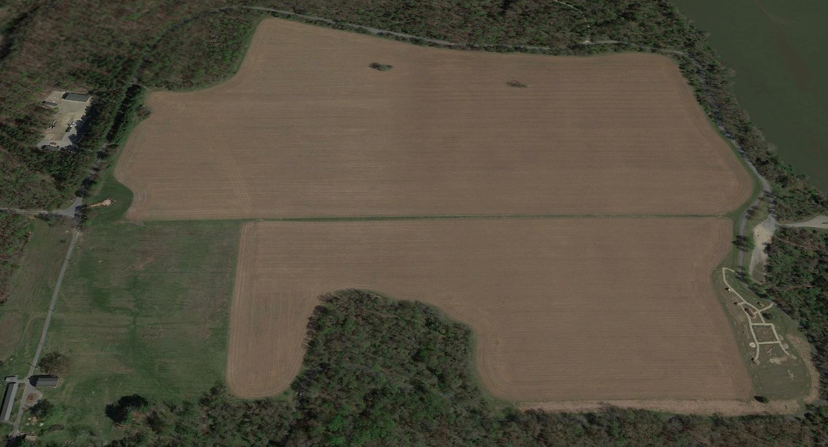
A 2016 aerial view looking north at the site of Croom Field showed that the airfield are remained clear, with the recent historical monument on the west side.
A 2021 photo looking southeast at the “Columbia Air Center Monument” at the Croom Field site.
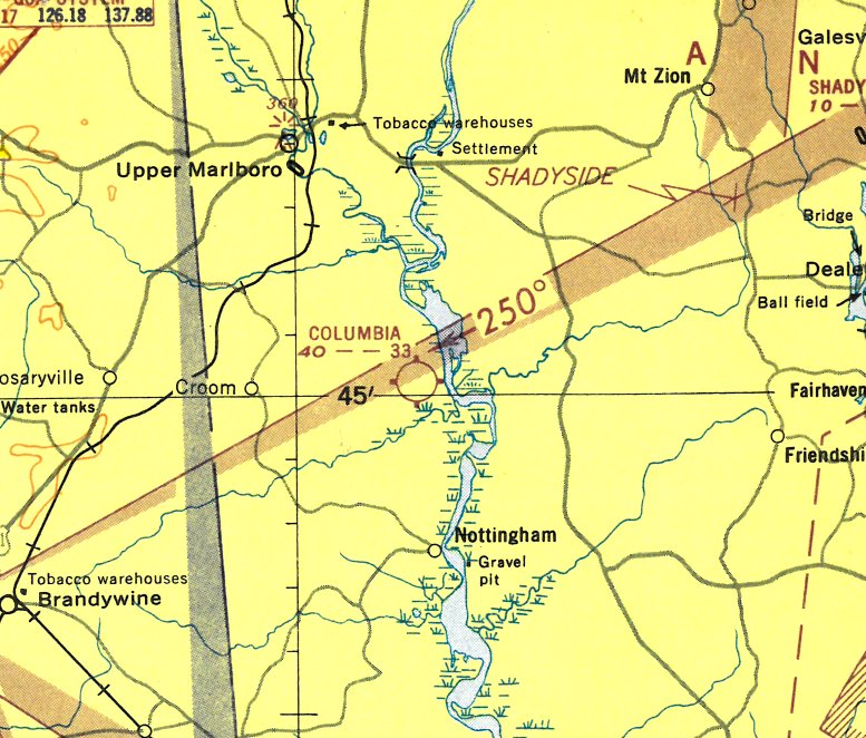
Croom Field is located along "Croom Airport Road", on the western shore of the Patuxent River.
See also:
http://www.geocities.com/cd19/croom.html
http://www.tc-solutions.com/croom/airport/airport.htm
____________________________________________________
Or if you prefer to contact me directly concerning a contribution (for a mailing address to send a check),
please contact me at: paulandterryfreeman@gmail.com
If you enjoy this web site, please support it with a financial contribution.
____________________________________________________
This site covers airfields in all 50 states.
For the site's main menu: Home