Abandoned & Little-Known Airfields:
Maryland: Howard County
© 2002, © 2025 by Paul Freeman. Revised 8/16/25.
This site covers airfields in all 50 states: Click here for the site's main menu.
____________________________________________________
Please consider a financial contribution to support the continued growth & operation of this site.
Bassler Airfield (revised 6/2/24) - Beaverbrook Airfield (revised 8/16/25) - Greer Airport (revised 5/16/25) - Haysfield Airport (revised 8/16/25)
Mape Airport / Mapes Airpark (added 8/16/25) - Turf Valley Airport (revised 6/10/21)
____________________________________________________
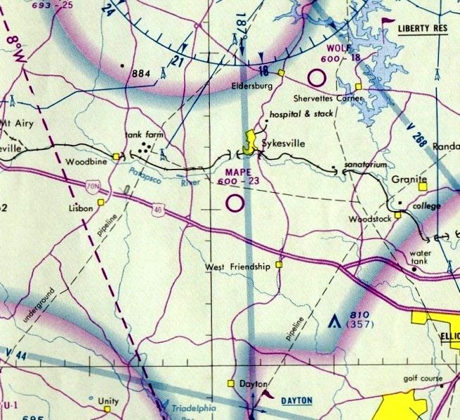
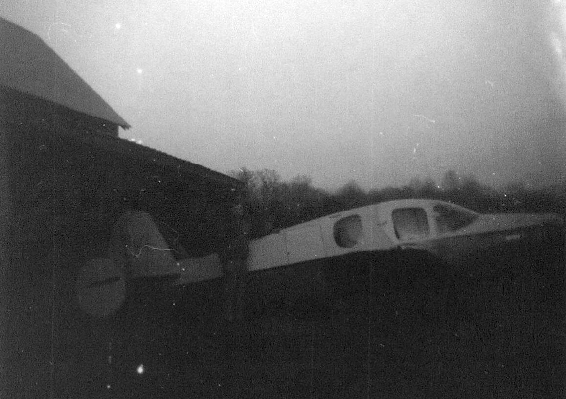
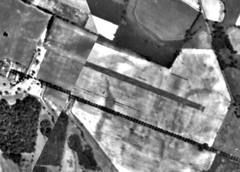
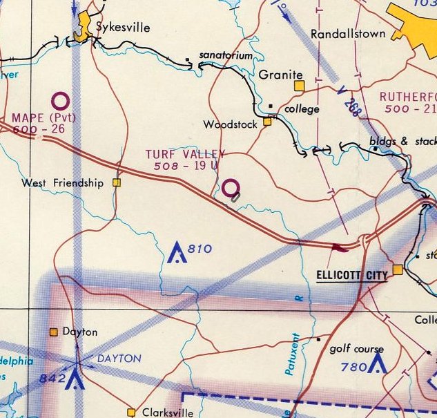
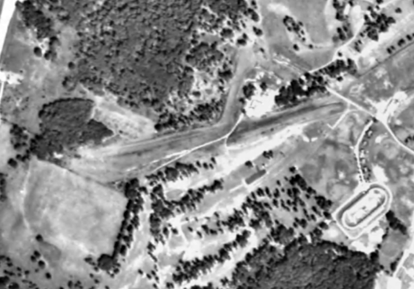
Mape Airport / Mapes Airpark, Sykesville, MD
39.338, -76.985 (Northwest of Baltimore, MD)
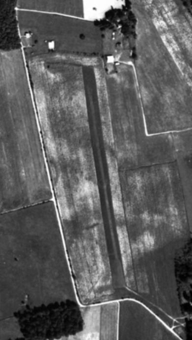
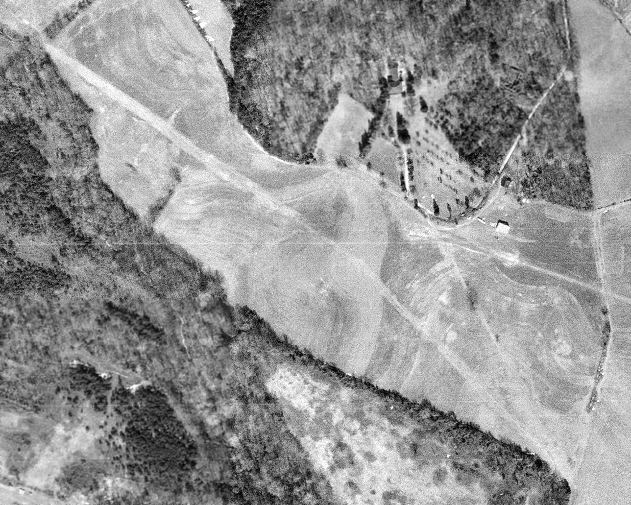
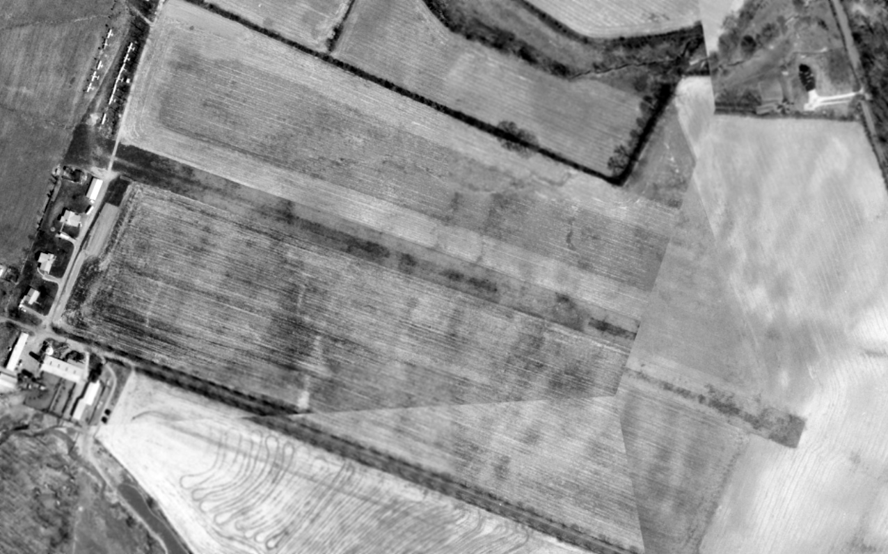
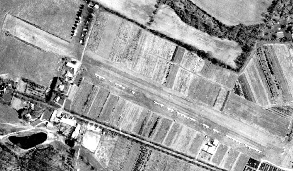
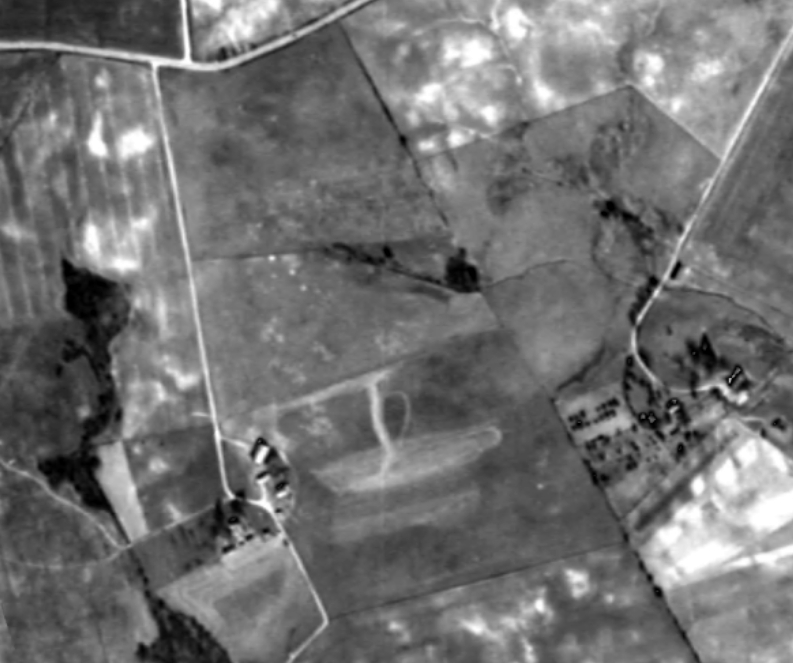
Mape Airport, as depicted on a 1952 aerial photo (courtesy of Jim Blanchard).
The date of construction or original name of this small rural general aviation airport has not been determined.
The earliest depiction which has been located of Mape Airport was a 1952 aerial view (courtesy of Jim Blanchard).
It depicted a single grass northwest/southeast runway, with a few small buildings (hangars?) on the northwest & northeast sides.
Mape Airport was not depicted on USGS topo maps from 1954/65/71/79.
Jim Blanchard reported, “In 1961 Roland Masek & his wife bought a 17-acre lot on Underwood Road in Howard County (near Sykesville).
They named their field 'Mapes Airpark.' Masek began landing his plane there that year.”
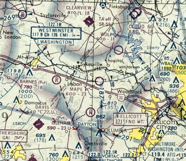
Mape Airport was not yet depicted on the 1962 Washington Sectional Chart.
Jim Blanchard reported, “In 1964 Masek obtained a state license for the airfield as a non-commercial landing field.”

The earliest aeronautical chart depiction which has been located of Mape Airport was on the 1964 Washington Sectional Chart.
It depicted Mape as a private airfield having a 2,800' unpaved runway.
The April 1965 Washington Local Aeronautical Chart depicted Mape as a private airfield having a 2,800' unpaved runway.
A 1966 aerial photo showed 1 light single-engine plane parked on the west side of Mape Airport's runway.
Jim Blanchard reported, “In 1968 a small plane hit power lines and crashed while attempting to land at Mape Airport.
The pilot survived with minor cuts, but the plane flipped & landed upside down on the 2,600' runway.”
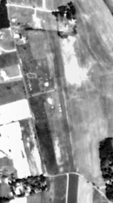
A 1970 aerial photo (courtesy of Jim Blanchard) depicted Mape Airport, possibly with 3 light planes parked on the west side of the runway.
Jim Blanchard reported, “In January 1972 Masek began a 3-year battle with Howard County authorities & complaining neighbors concerning his airport.
At first the authorities couldn’t decide whether the airport was acting as a commercial airport or not, but they did issue some conditions that Masek had to adhere to.
One of them was to give up the name 'Mapes Airpark'.”
Jim continued, “Next, the county Circuit Court got involved & decided that county zoning laws did not permit private airfields, and therefore Masek’s airfield was an illegal use of land.
Masek complained discrimination because county officials did not issue similar restrictions for any of the other small airports in the county.
At the time Masek had 9 planes tied down at his field, only one of them being his.”
Jim continued, “In the meantime, people had begun building houses around his property.
There was a row of houses on the west side of his field. Masek’s runway was right behind their backyards.
The neighbors didn’t mind at first, but when Masek took in other airplanes there, they complained.
One neighbor built a garage right at the north end of the runway, which should have been part of the airport’s clear zone.
And the dairy farmer to the south – in the other clear zone – planted corn. Masek complained to that neighbor, telling him not to plant tall crops within 1,000' of the runway & that he also might have to put lights on his silos. That didn’t sit well.”

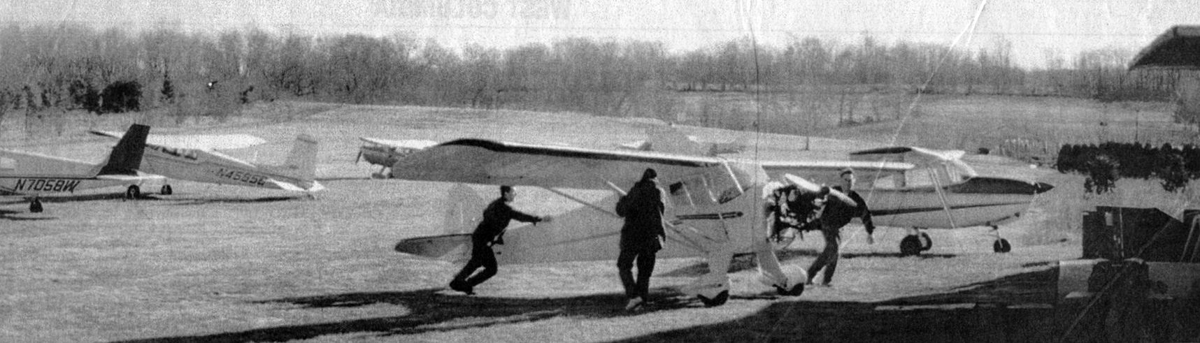
An undated photo from the 1/24/70 Baltimore Evening Sun (courtesy of Jim Blanchard) showed 3 light single-engine planes at Mape Airport.
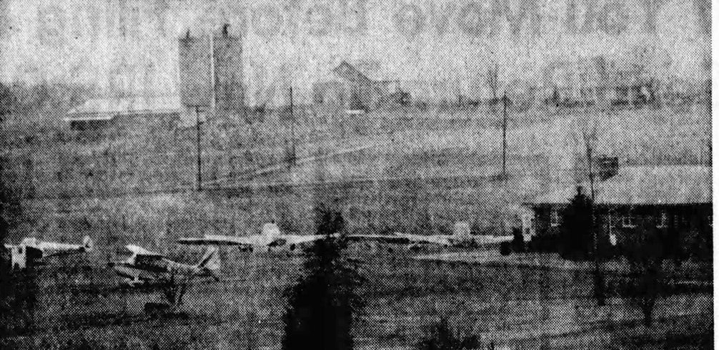
An undated photo from the 1/24/70 Baltimore Evening Sun (courtesy of Jim Blanchard) showed 4 light single-engine planes at Mape Airport.
Jim Blanchard reported, “Finally, in October 1974 Masek was told by the Circuit Court that he had 90 days to remove the planes from his property. That was the end of Mape Airport.”
The February 1975 Washington Terminal Chart depicted Mape as a public-use airport having a 2,300' unpaved runway.
The last aeronautical chart depiction which has been locate of Mape Airport was on the 1976 Washington Sectional Chart.
It depicted Mape as a public-use airport having a 2,300' unpaved runway.
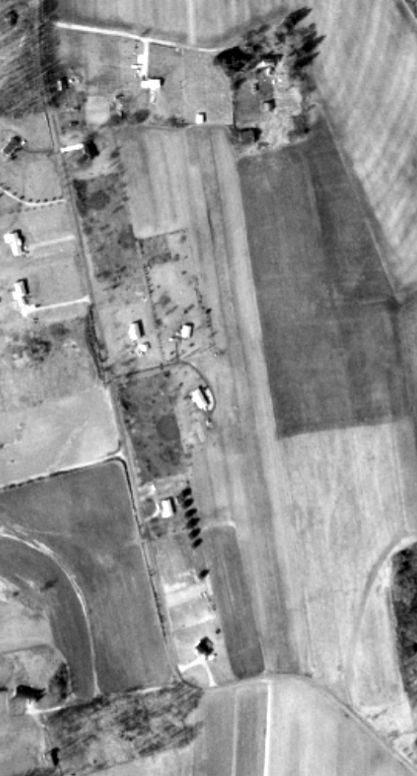
The last photo which has been located showing Mape Airport remaining intact was a 1977 aerial view (courtesy of Jim Blanchard).
It depicted the runway remaining intact, but devoid of aircraft.
A 1989 aerial photo showed the first of several houses which were eventually built over the Mape Airport site.
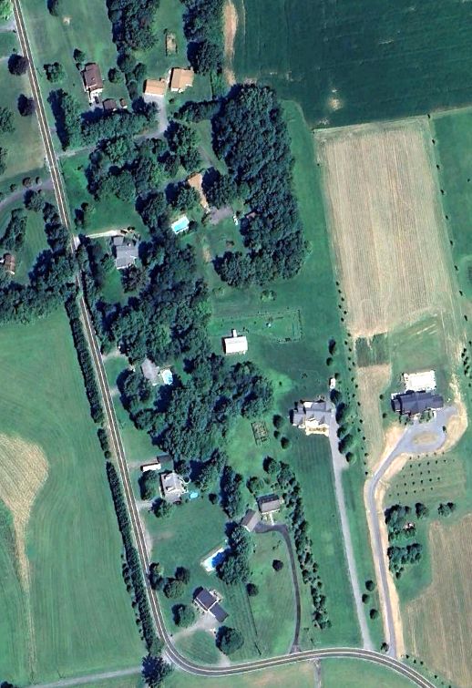
A 2024 aerial photo showed no trace remaining of Mape Airport.
Thanks to Jim Blanchard for pointing out this airfield.
____________________________________________________
Greer Airport, Elkridge, MD
39.202, -76.763 (Southwest of Baltimore, MD)
Greer Airport, as depicted on a 2/21/66 USGS aerial photo.
Greer Airport was evidently constructed at some point between 1957-66,
as it was not yet depicted on a 1957 aerial photo.
The earliest photo which has been located of Greer Airport was a 2/21/66 USGS aerial view.
It depicted an unpaved northwest/southeast runway, with 1 light single-engine plane & a small building (hangar?) on the southeast side.
Ray Stinchcomb recalled, “Between 1968-72 I flew in & out of Greer Airport.
Some was just general flying, but much of it was flight instruction in a Howard County Civil Air Patrol airplane, a PA-18 (N212T) that I instructed in.
So there was a time when there was more than one airplane based there. The earliest date that I see [in my logbook] is 8/12/68.”
According to Dan Materazzi of the Howard County Historical Society, “A property search of that area (near the Route 100 / I-95 Interchange)
[determined] that the owners of the property around 1970 were Joel & Joan Greer. He was retired Air Force.”
Greer evidently later operated a private airfield in Taneytown, Greer Airport MD20.
No airfield at this location was depicted on aeronautical charts or topo maps from the 1960s or 1970s
(the airfield was presumably overlooked, as a relatively minor private airfield).
Ray Stinchcomb recalled, “The runway was slightly repositioned when Interstate 95 was put in.
The east end had to be cut short for the Interstate, so the runway was extended on the west end.”
The last photo which has been located showing aircraft at Greer Airport was a 9/25/80 USGS aerial view, which depicted 5 light aircraft parked near a small building on the southeast end.
Interstate 95 had been built along the southeastern edge of the airfield property.
Jim Tully recalled, this “grass strip was located off of Montgomery Road near Hunt Club Road,
It was visible from I-95 when that opened in the early 1970s.
It seemed to my young self a very basic setup: a grass strip, I don't recall more than 2 planes sitting there, a row of open sheds off to the side to store the planes in.
I can't remember seeing a plane takeoff or land the dozen or so times I went past there - this would have been approximately 1970-74.”
Ray Stinchcomb recalled, “The last date that I found [in his logbook for Greer Airport] was 2/27/72.”
A 1977 aerial view (courtesy of Dan Materazzi of the Howard County Historical Society)
showed the runway & hangar of Greer Airport remained intact, but there were no aircraft visible on the field.
Greer Airport was evidently abandoned at some point between 1970-84,
as an 8/84/84 aerial view showed the hangar & runway were still largely intact, but a road had been built over a portion of the runway.
Jim Tully recalled of Greer Airport, “It was still around, or at least its shed-like / T-hangars were in 1989.”
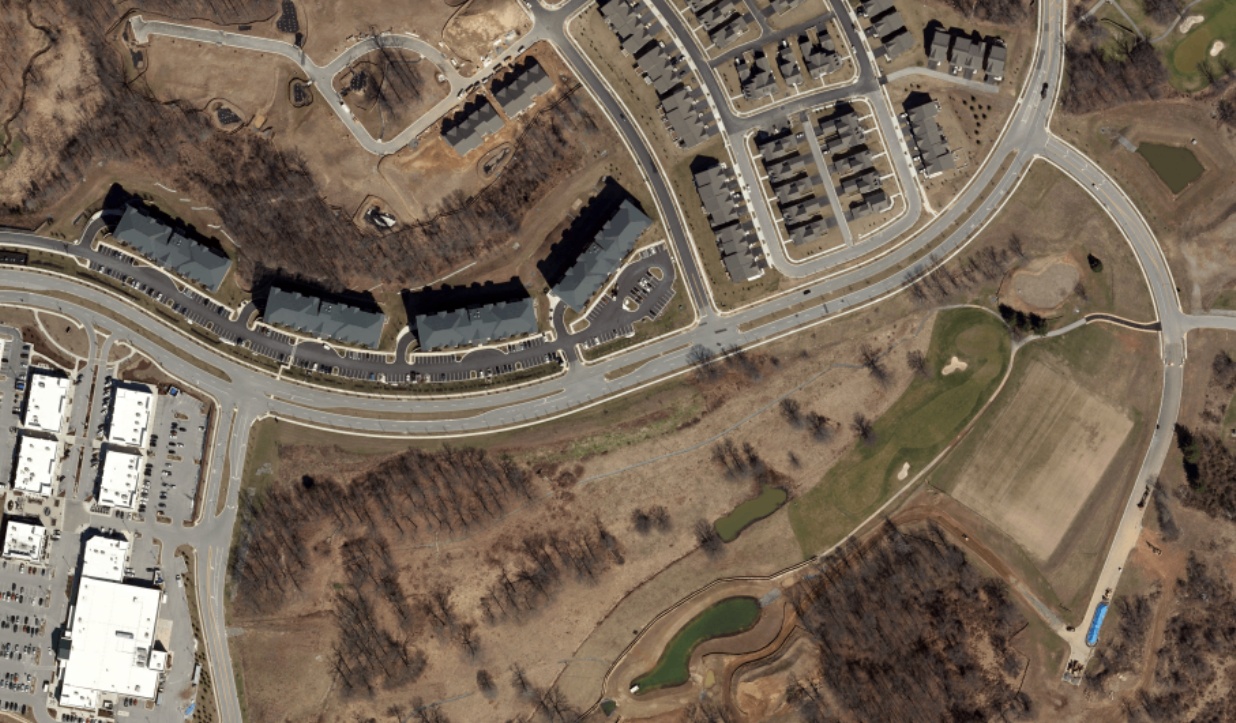
A 2002 aerial photo showed the site of Greer Airport had been covered by the Timbers at Troy Golf Course.
A 2019 aerial photo showed no trace remaining of Greer Airport, with the covered by the Timbers at Troy Golf Course.
Thanks to Jim Tully for pointing out this airfield.
____________________________________________________
Bassler Airfield, Columbia, MD
39.217, -76.886 (Southwest of Baltimore, MD)
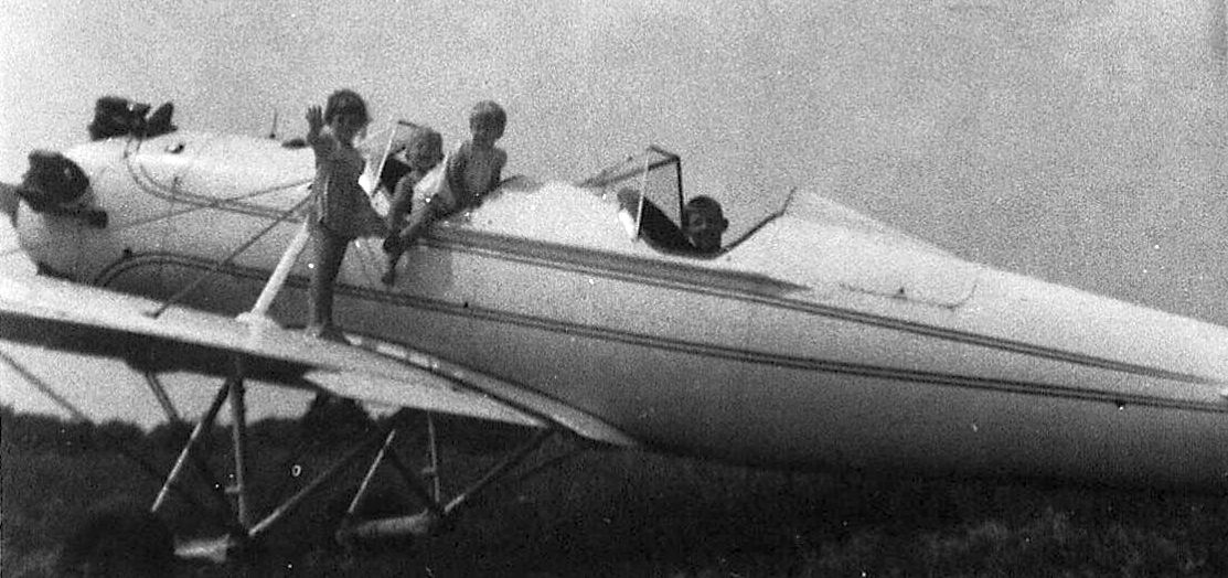
A July 1959 photo of kids playing in a Ryan PT-22 Recruit at Bassler Airfield (courtesy of David Suter).
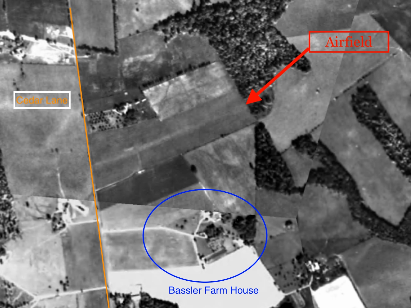
According to a 7/20/03 Baltimore Sun article, George Bassler had a 400-acre farm off Cedar Lane.
George eventually split the land into 4 pieces & gave one to each son, including Benjamin.
After 1952, Benjamin's son Alfred established a poultry farm on 5 acres of his dad's share of the property.
He also mowed a grass runway there that he & a handful of pilots shared with cows, pigs and mules
that had to be "scattered out of the way" during takeoff & landing, he recalled.
Cathy Bassler Dymek recalled, “My uncle Alfred was the second of my grandparents 8 children & he had the plane & used the cow pasture as the original airfield.”
The earliest photo which has been located of Bassler Airfield was a July 1959 photo of kids playing in a Ryan PT-22 Recruit (courtesy of David Suter).
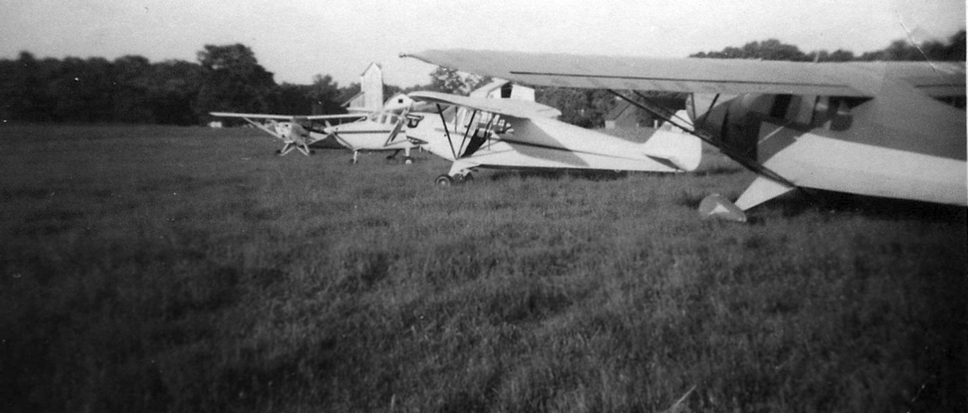
A circa 1950s-60s photo of 4 light single-engine aircraft at Bassler Airfield (courtesy of David Suter).
No airfield at this location was depicted on aeronautical charts or topo maps from the 1950s or 1960s
(the airfield was presumably overlooked, as a relatively minor private airfield).
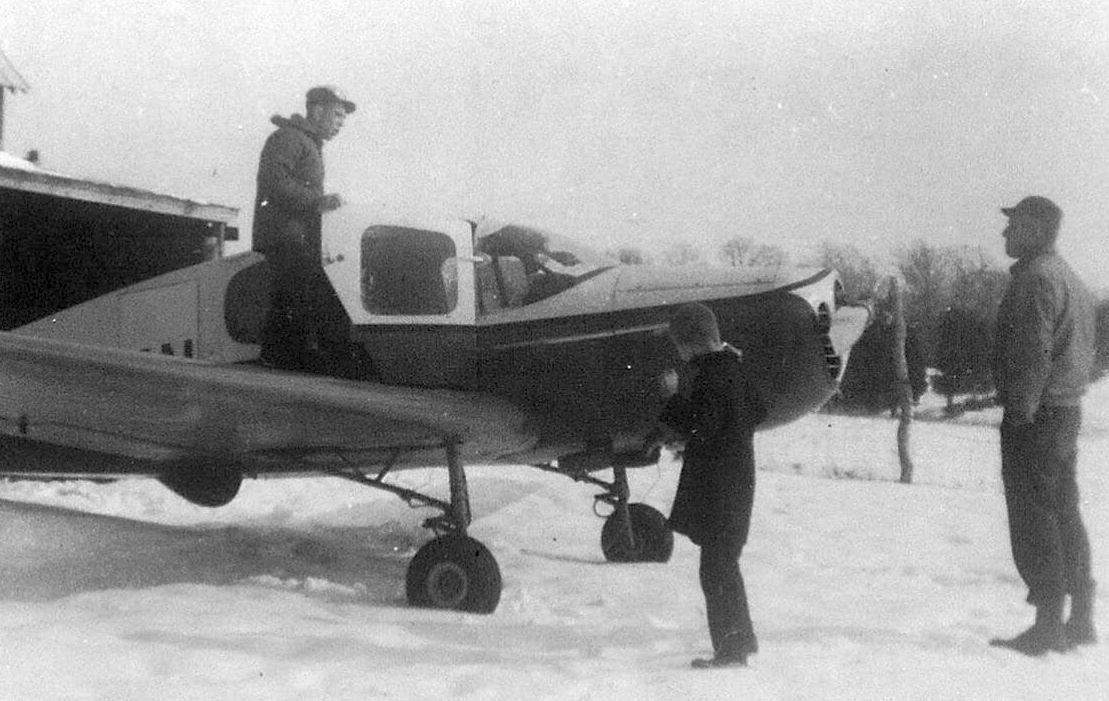
A circa 1950s-60s photo of several people with a Bellanca at a snowy Bassler Airfield (courtesy of David Suter).
Joe Zamoyta reported, “I’ve discovered guys who know all about it & have landed there.
The field was private & was owned by Al Basler, who now owns Hays Field Airport, also in Columbia.”
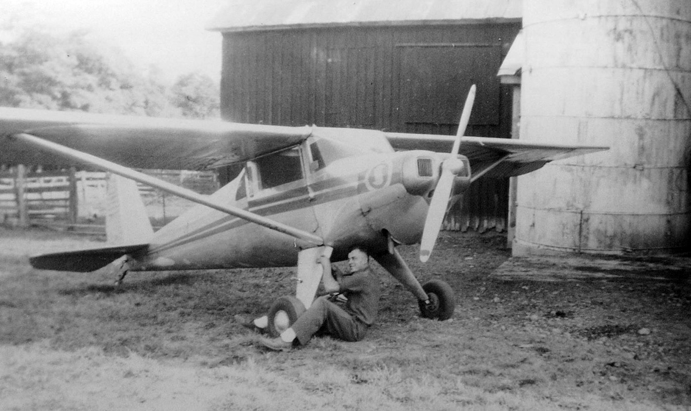
A circa 1950s-60s photo of an unidentified man working on a Luscombe at Bassler Airfield (courtesy of David Suter).

A 1960 aerial photo (courtesy of Susan Kain via Jim Blanchard) looking east/southeast at the Bassler Farm, with Alfred Bassler's 1st plane (a Piper J-4) parked halfway down the "driveway" from what is Cedar Lane to the farmstead.
Susan remarked, "Yes, his hangar was located behind the barns." Jim Blanchard observed, “The barns look like they're on the left (north) side of the property, which would put them closest to the airstrip.”
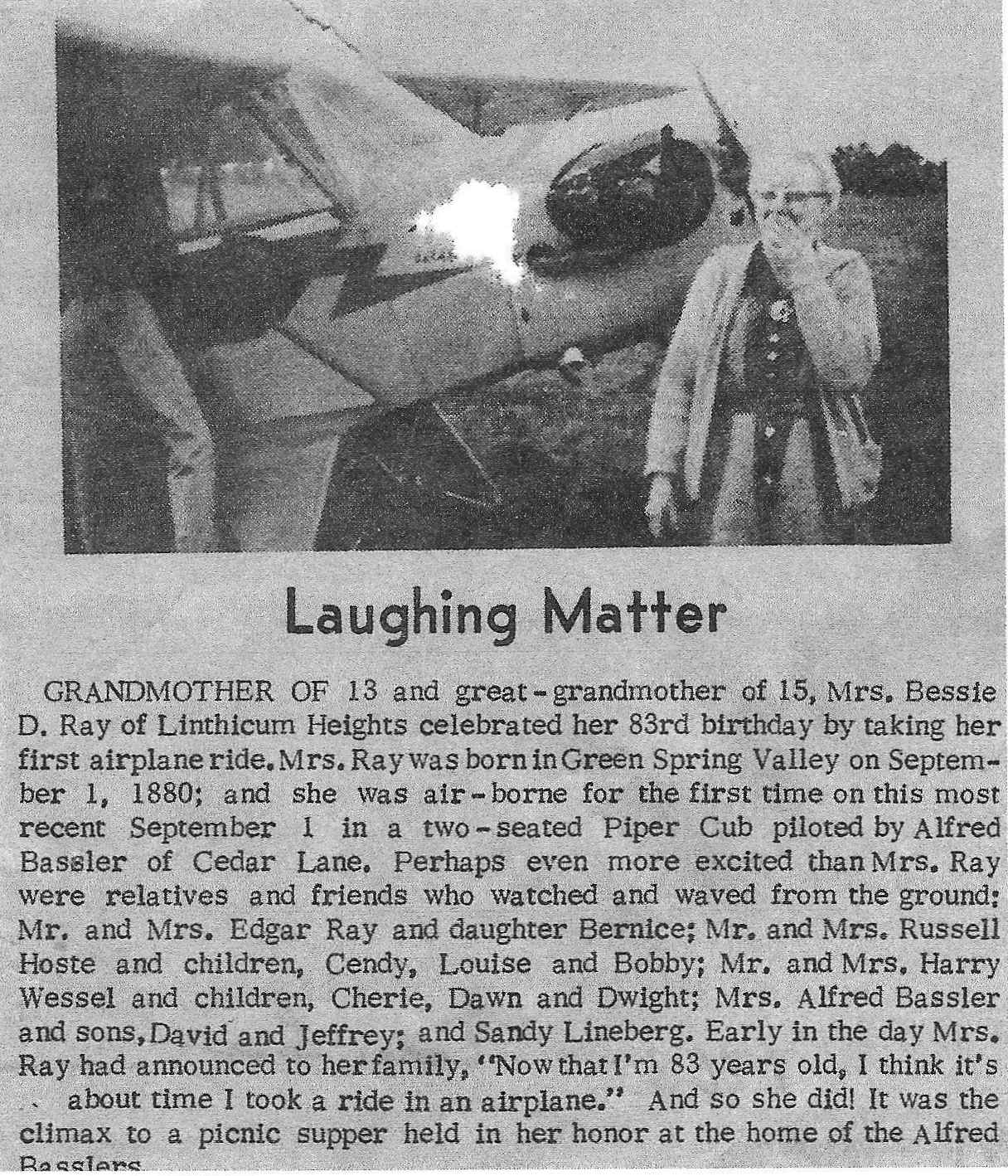
A 1963 article describing Bessie Ray celebrating her 83rd birthday by taking a Piper Cub flight piloted by Alfred Bassler (courtesy of David Suter).
A 1963 aerial photo (courtesy of Jeffrey Bassler) showed Bassler Airfield to have a single unpaved northeast/southwest runway.
No aircraft were visible on the field.
A May 1964 photo of an Ercoupe & other aircraft at Bassler Airfield (courtesy of David Suter).
A 1966 aerial photo showed Bassler Airfield to have a single unpaved northeast/southwest runway.
No aircraft were visible on the field.
The last ground-level photo which has been located of Bassler Airfield was a January 1966 photo of a Bellanca (courtesy of David Suter).

The last photo which has been located of Bassler Airfield was a 2/21/66 USGS aerial view.
It depicted a single unpaved northeast/southwest runway, with 2 light single-engine aircraft parked on the south side.
According to a 7/20/03 Baltimore Sun article, in 1968 Ben Bassler decided to swap his land with James Rouse,
who viewed the property as a strategic piece of the rural jigsaw puzzle he was assembling to become his planned city of Columbia.
Ben traded his 92-acre portion of the Cedar Lane farm for 504 acres off Sheppard Lane so Rouse could build Howard County General Hospital.
Cathy Bassler Dymek recalled, “After the long negotiation process with Rouse & Moxleys, the 92-acre farm was traded for the 504-acre farm on Sheppard Lane.
My uncle Alfred built & maintained Hays Airfield on that family farm.”
A 1970 aerial photo showed Little Patuxent Parkway being built over the site of Bassler Airfield.
A 2014 aerial photo showed no trace remaining of Bassler Airfield.
The site of Bassler Airfield is located at the intersection of Cedar Lane & Little Patuxent Parkway.
____________________________________________________
Haysfield Airport (MD24), Clarksville, MD
39.238, -76.948 (Southwest of Baltimore, MD)
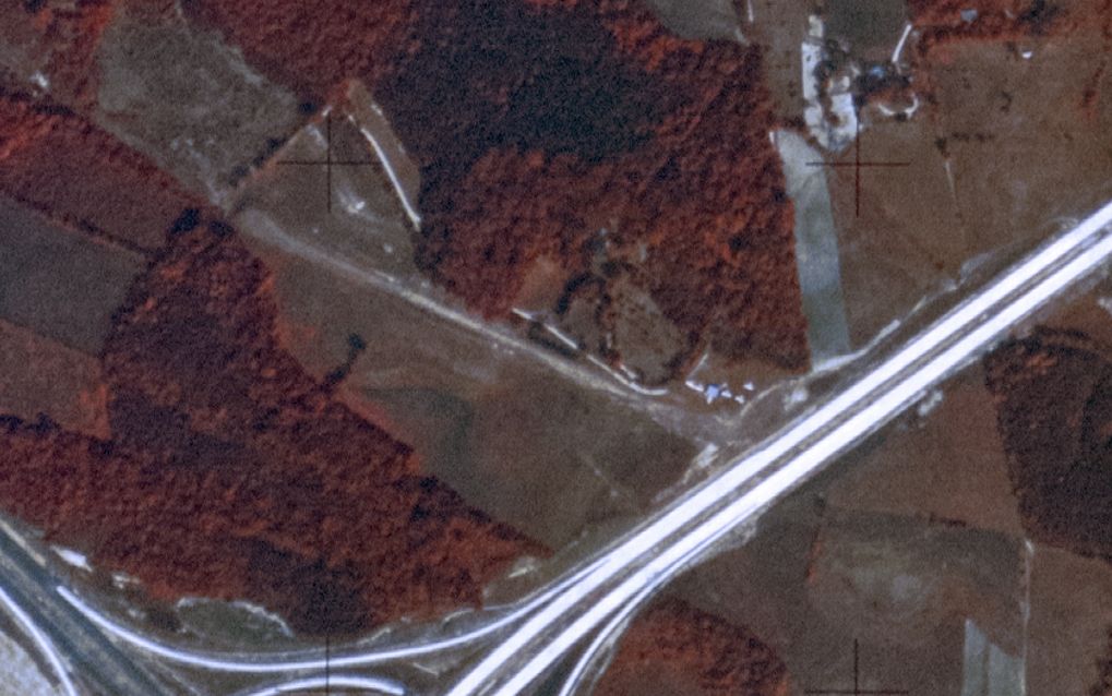
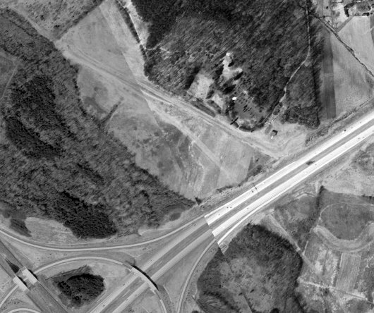
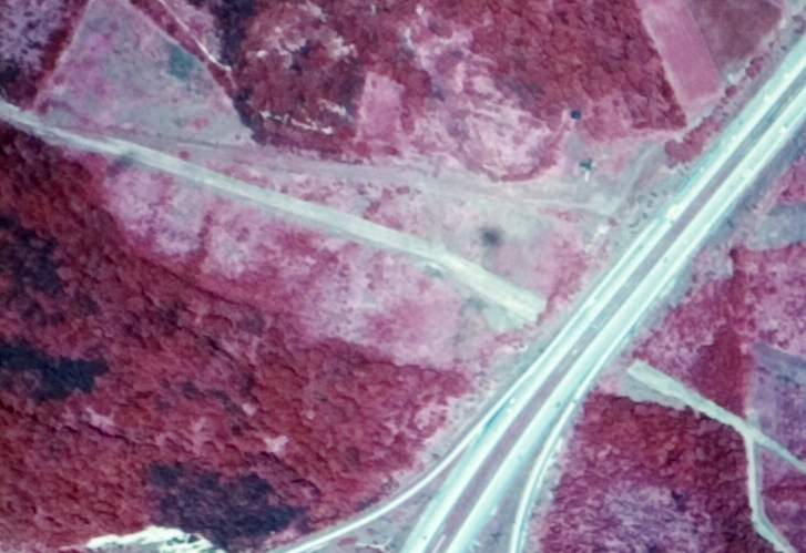
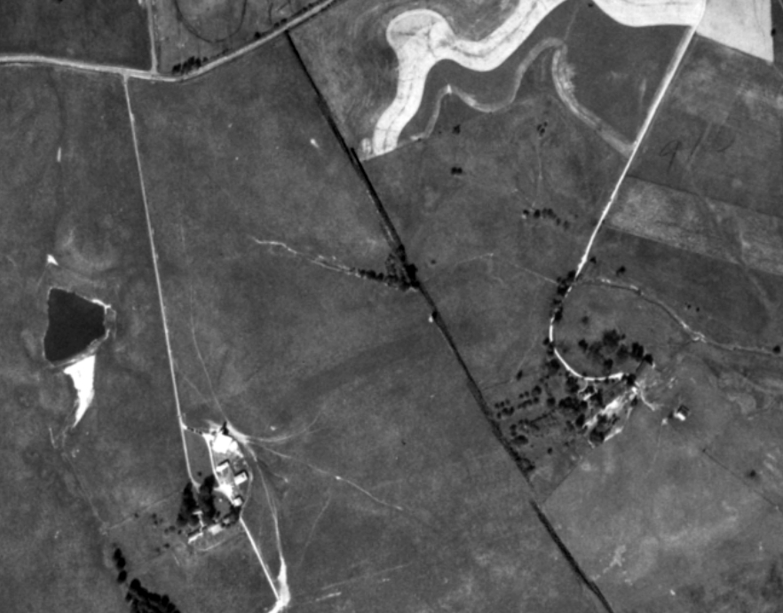
A 1970 aerial view depicted the beginnings of the Haysfield runway.
A 1966 aerial photo did not yet show any sign of Haysfield Airport.
Sherry Peruzzi reported, “When Columbia was planned, Al [Bassler] & his family were one of the last landowners to sell;
in order to get the land to build the hospital, he was given a sum of money plus 500 acres off Shepard Lane in Clarksville.
He built a new grass strip there, which is has been operating since the late 1960s as Haysfield Airport (MD24).”
Cathy Bassler Dymek recalled, “After the long negotiation process with Rouse & Moxleys, the 92-acre farm [where Bassler Airfield was located] was traded for the 504-acre farm on Sheppard Lane.
My uncle Alfred built & maintained Hays Airfield on that family farm.”
According to a 7/20/03 Baltimore Sun article, Haysfield was “opened in 1968 by Alfred Bassler.”
However, a slightly later timeframe is given in a 12/19/13 Baltimore Sun article (courtesy of Ron Plante):
“After moving to Sheppard Lane in May 1970, building a hangar & establishing a grass airstrip on his share of the land were Alfred's top priorities.
He created a 3,000' runway that started at the top of a hill.”
The earliest depiction which has been located of Haysfield was a 9/2/70 USGS aerial view.
It depicted a single unpaved northwest/southeast runway, but no aircraft were visible.
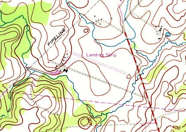
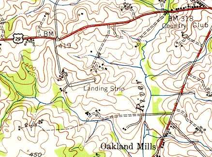
The 1971 USGS topo map depicted Haysfield as a single unpaved northwest/southeast runway,
with a few small buildings along the west side, labeled simply as “Landing Strip”.
According to its FAA Airport/Facility Directory data, Haysfield was established in September 1974.
According to a 12/19/13 Baltimore Sun article (courtesy of Ron Plante): “He [Alfred Bassler] and opened for business in 1974.”
"I felt I was doing the county a favor by establishing a public-use airport," he said, adding that some people didn't share that view.
Zoning battles played out over the years, but all were resolved.
Haysfield was the culmination of a long-held dream for Alfred, going all the way back to his model-airplane-building days in 5th grade.
He & Patsy approached running their airport with gusto.
The couple joined a chapter of Flying Farmers, whose members flew to each other's farms in the county.”
The earliest photo which has been located showing aircraft at Haysfield was a 1975 aerial view,
According to a 12/19/13 Baltimore Sun article (courtesy of Ron Plante),
“In 1978 they helped establish the Howard County Pilots Association, which boasted a roster of 120 members.”
The 1979 USGS topo map depicted a single unpaved northwest/southeast runway,
with a few small buildings along the west side, but the field was not labeled.
According to a 12/19/13 Baltimore Sun article (courtesy of Ron Plante): “Though Alfred was a pilot before he & Patsy became sweethearts,
she remained afraid of flying for many years, even after establishing a plane rental company & flight school called Flite Rentals in 1982 with older son, David.”
Haysfield still wasn't depicted on the March 1982 Washington Sectional Chart.
Sherry Peruzzi reported, “I learned to fly at Haysfield in 1983, and was friends with the Basslers for some years.”
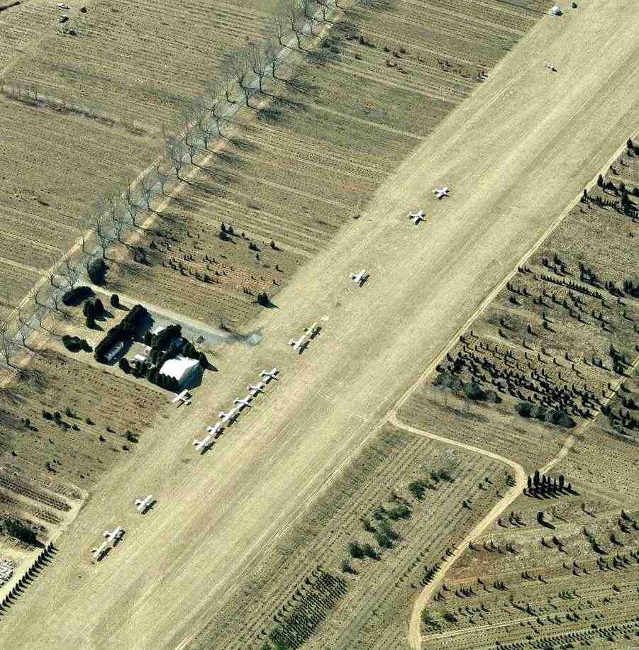
A 1984 aerial photo depicted Haysfield with 42 light aircraft parked on the northwest & south sides.
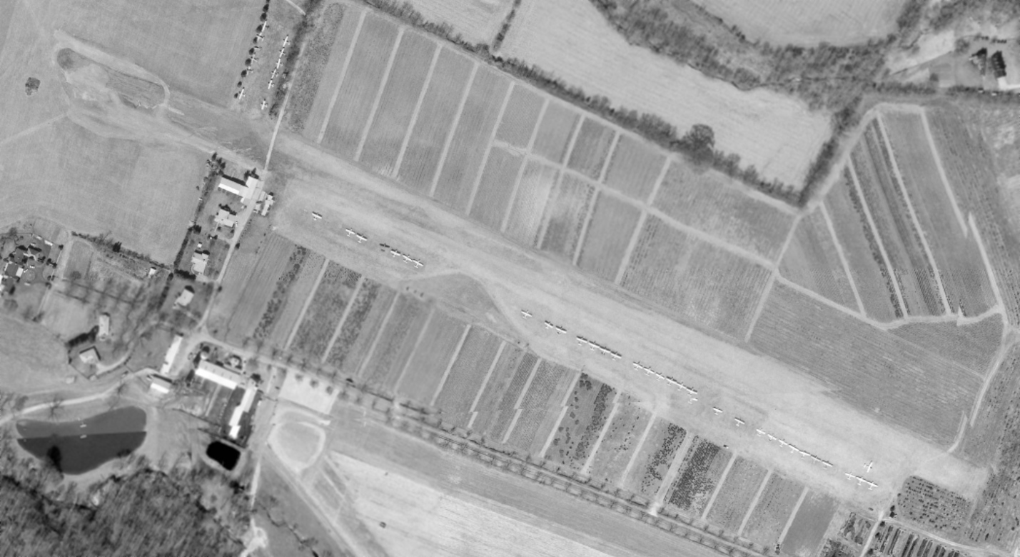
A 1985 aerial photo depicted Haysfield perhaps at its zenith of popularity, with 44 light aircraft parked on the northwest & south sides.
The earliest aeronautical chart depiction which has been located of Haysfield was on the March 1987 Washington Sectional Chart.
It depicted “Hays” as a private field having a 2,000' unpaved runway.
The 4/7/93 USGS aerial photo depicted 39 single-engine aircraft parked at Haysfield,
both along the south side of the runway & along an offshoot on the northwest side.
An undated photo from a 1/5/95 newspaper article (courtesy of Jim Blanchard) of Jeff Byrd, Dick Krels, and John Walter moving a Piper Cub into a Haysfield hangar.
Jan Smith recalled of Haysfield, “The airport had been used for many years as a summer meeting spot for the local Quiet Birdmen.
Area pilots have fond memories of Haysfield.
A pilot who was getting his tail-dragger endorsement there... When he went up with his examiner,
another pilot on the ground thought he'd help out by walking to the end of the runway, dropping his drawers, and presenting the approaching aircraft with a vertical VASI of sorts.
Back in the airplane, the pilot & examiner first asked each other what that was by the end of the runway.
As they approached closer, the pilot realized what they were looking at & started laughing so hard he had to make a go-around.”
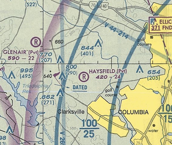
The February 2001 Washington Terminal Aeronautical Chart (courtesy of Ron Plante) depicted Haysfield as a private airfield with a 2,400' unpaved runway.
A 2002 photo by Paul Freeman showing several light single-engine aircraft parked at Haysfield.
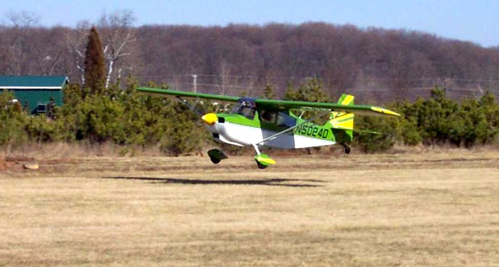
A 2002 photo by Paul Freeman showing a Citabria taking off at Haysfield.
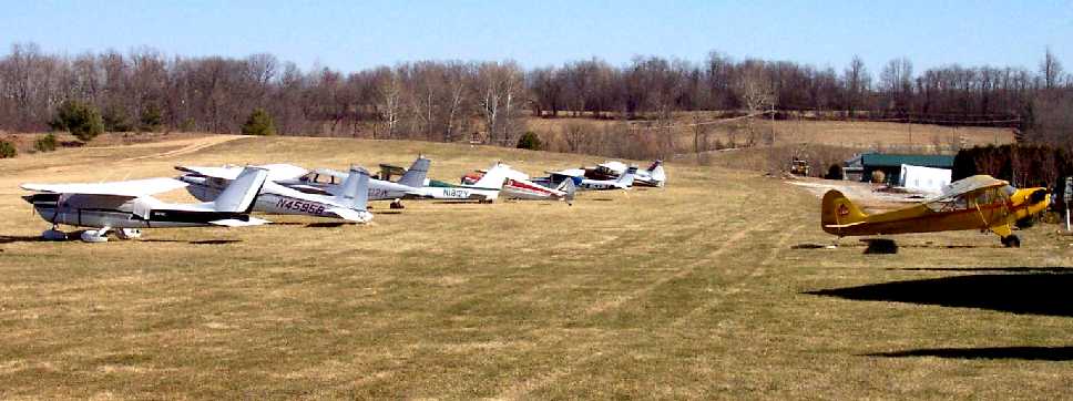
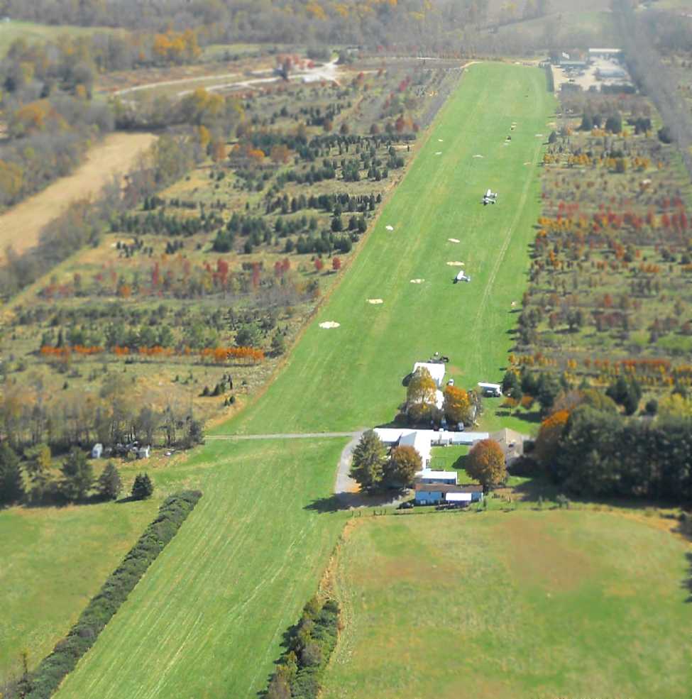
A circa 2006-2010 aerial view looking west at 15 light single-engine aircraft parked at Haysfield.
Jan Smith reported, “It was supposed to close & be redeveloped in 2007 but the Great Recession hit just then
and the developer's plans were put on hold allowing the airport to function for another 6 years.”
LeRoy Froom reported in 2009, “There are about 25 planes at Haysfield.
I went over there recently just to walk around.
I decided to get checked out in a 1968 Cessna 172 run by PugAir.
Got to do a couple of grass field takeoffs & landings.
They have no fuel on the field so you have to fill up elsewhere.
Since there was no GPS in the Cessna, I was taught the landmarks for pilotage back into the SFRA and into MD24 (Haysfield).
It was like flying back in the 1970s I suppose.
I was told that the property will probably be sold & that there may only be a couple of years left for the field. Too bad.
When I went out there for the first time, I felt like I was in the middle of Kansas (just a hilly part of Kansas).
It's worth a weekend drive, just to walk around. It's not like going to your local airport!”
Bo Bowman reported in 2009 of Haysfield, “The restrictions brought on by 9/11 pretty much did it in.
Years ago when I started using it there were 40-some airplanes there. Now it is probably under 10.
However, the owner, who lives on the property, seems intent on keeping it an airport - at least for now.
It is surrounded by a tree nursery.”
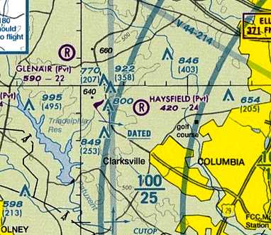
The 2010 Washington Terminal Aeronautical Chart depicted Haysfield as a private airfield with a 2,400' unpaved runway.
In 2010, the FAA Airport/Facility Directory data for Haysfield described the field as having a single 2,400' turf Runway 13/31,
and said a total of 27 aircraft were based at the field.
The owner & manager were listed as Alfred Bassler.
In 2010, reportedly the owner of Haysfield was referring to the “projected closure” of the field.
In 2010, Kim Trout reported, “There are about 10 of us who have planes at Hays & fly actively (multiple times a week / month)
plus the PUGAIR rental 172.
A very nice quite airport like flying used to be (except for the SFRA of course).
I expect it will be around for a few years after the recession ends.
But the land has been sold & the bulldozer will eventually come through.”
As of 2010, Haysfield was one of only 2 remaining grass airfields within the 15 NM Class B ring of Baltimore airspace.
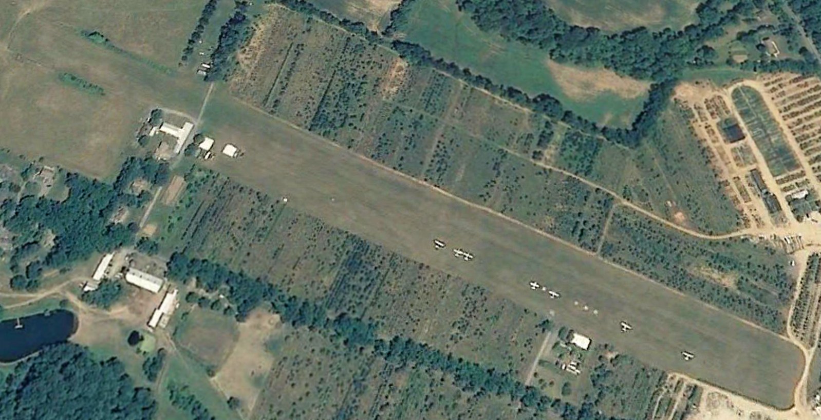
A 6/3/11 aerial view showed only 7 light single-engine aircraft parked at Haysfield.
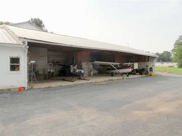
An undated (pre-2012) photo of a Robinson R-22 & a Cessna 172 inside a Haysfield hangar.
Robert Schapiro reported in 2012, “Developers have started to move in on the runway.
By the end of this month, there will likely be a paved road crossing Runway 31/13 a few hundred feet down from the threshold to Runway 31.
Some of the airplane owners have started to move their airplanes to Fort Meade,
however there are still about 9 airplanes, 2 ultra-lights, and 1 helicopter based at the field.
I operate the helicopter (www.bootcamphelicopters.com) and I’ve told Al Basler that I’ll keep paying rent until the hangar comes down – I don’t need a runway.
The airport doesn’t have fuel but if you’re good at grass strip, short-field, sloped landings, it’s a great airport to visit.
Just a 5 minute drive from the heart of Clarksville & a 15 minute drive from downtown Columbia.”
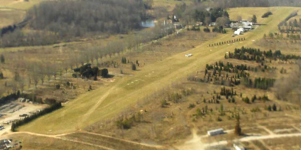
A sad October 2012 aerial view looking east at Haysfield by Tom Henry, taken on his last day at the field, before moving to W18.
Tom reported the picture shows “water wells drilled into [the] runway, for new home construction.
The field is 'useable' but the remaining planes haven't flown in years.”
Robert Schapiro reported in 2012, “I received a phone call from Al Basler on Wednesday [1/16/13]
telling me that they are dropping the 'airport insurance' & that the airport is officially closed.”
According to Jan Smith, “With the reviving economy, development plans were renewed & that was the end of the airport.”
A 1/19/13 aerial view by Robert Schapiro looking southwest at Haysfield, on the sad occasion of the last flight out of Haysfield.
Robert reported, “I moved the helicopter out yesterday, as the last remaining airworthy aircraft
(there are still a few unairworthy aircraft sitting on the grass).
You’ll notice that they planted pine trees across the runway…
that was done this past week, I think as a way of telling the rest of us, 'It’s time to go.'”
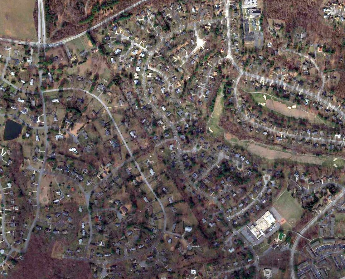
A 2014 aerial view showed houses covering the site of Haysfield,
thus closing the chapter of Howard County aviation, sadly leaving this wealthy & populous county with not a single public-use airport.
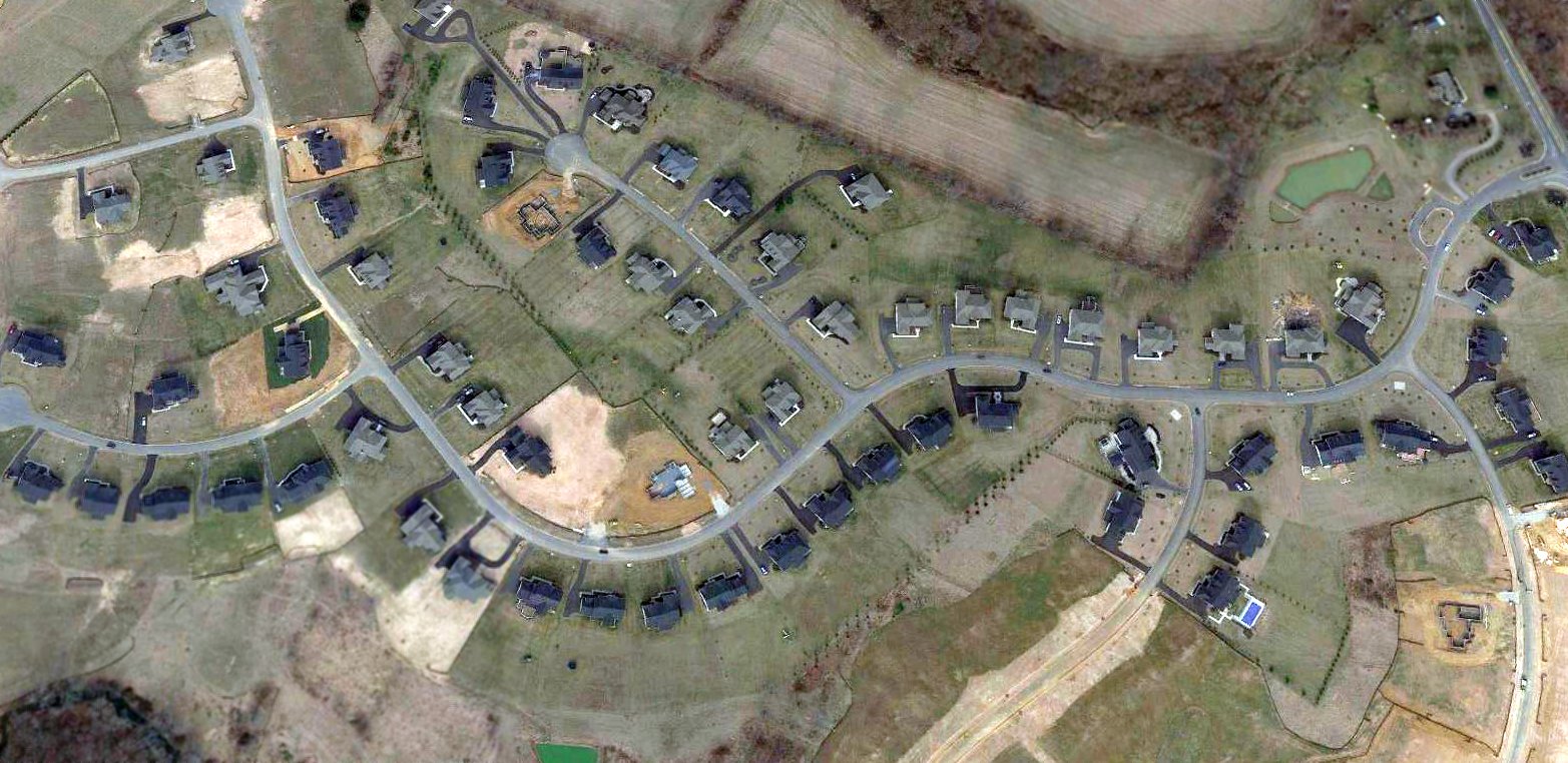
A sad sight for anyone who loves aviation: a 2017 aerial view showed no trace remaining of Haysfield.
Yet another of America's hundreds of grassroots airfields lost to our instatiable desire for more housing.
____________________________________________________
Beaverbrook Airfield, Columbia, MD
39.24, -76.84 (Southwest of Baltimore, MD)
Beaverbrook Airfield, as depicted on a 1943 aerial photo.
No airfield at this location was depicted on aeronautical charts from 1940-66
(but this airfield may simply have been overlooked, as a relatively minor private airfield).
In a July 2025 interview with Alfred Bassler (see Bassler Airfield and Haysfield Airport), Howard County Historical Society volunteer Jim Blanchard asked him about what had been known as Columbia Airport, which was in Beaverbrook.
Bassler immediately said, “Oh, that was Jim Brown.” He explained that Beaverbrook was Jim Brown’s farm, and after he developed his place, he called it Beaverbrook.
Blanchard asked if that was where Brown’s landing strip was, and he said yes. Brown had one airplane there, and he built a hangar at the bottom of a hill.
The runway was up the hill. Blanchard asked if the airfield had a name. Bassler didn't know of any name for this airfield.
James Brown bought his farm in 1942 after giving up his grocery business in Ellicott City. He started flying in 1945.
He was known as “The Flying Rancher” – he had two cattle ranches in Howard County totaling over 1,000 acres. One was his Beaverbrook Farm & the other was in Sykesville.
Aside from just enjoying flying, Brown used his 2-seater Cub as a time-saver.
Instead of driving or walking to monitor his cattle pastures or inspect fields where he intended to buy hay or corn, he would just take off on the hill in back of his house & fly to make the rounds.
He would occasionally fly to Staunton, VA, to buy steers, or he would fly to Harrisburg, PA, to be there for the sale of his steers that had been delivered there by truck.
The earliest depiction which has been located of Beaverbrook Airfield was a 1943 aerial photo.
It depicted a single short unpaved northeast/southwest runway. No aircraft were visible on the field.
The only topo map depiction of Beaverbook Airfield which has been located was on the 1949 USGS topo map.
It depicted a single 1,600' runway, labeled simply as "Landing Strip".

An undated photo from the 8/5/51 Baltimore Sun (courtesy of Jim Blanchard) presumably showing Beaverbrook Farm,
captioned “Hopping from pasture to pasture by plane, James Brown keeps track of his Howard County ranches.”
A 1952 aerial photo still depicted a trace of Beaverbrook Airfield, but it was not apparent if the airfield was still in use by this point.
A 1963 aerial photo showed the neighborhood of Beaverbook under construction.
The area of the former airfield appeared to be newly-graded, with no trace remaining.
By the 1960s, the entire area around the former Beaverbrook Airfield was developed into the City of Columbia, a large planned community.
The Beaverbrook Airfield site became the Beaverbrook residential development.
A 1970 aerial photo showed the site of Beaverbrook Airfield had been replaced with suburban streets,
and not a trace appeared to remain of the airfield.
A 2017 aerial photo showed no trace appeared to remain of Beaverbrook Airfield.
According to Beaverbrook resident Jason Ludicke, “The airfield was exactly where Darlington Road is today.”
____________________________________________________
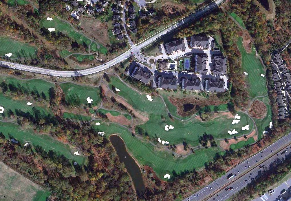
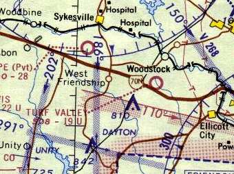
Turf Valley Airport, Ellicott City,MD
39.3, -76.89 (West of Baltimore, MD)
Turf Valley Airport, as depicted on the February 1962 Washington Sectional Chart (courtesy of Chris Kennedy).
Most suburban golfers who play on the course of the Turf Valley County Club
are probably unaware that the club used to have its own private airfield for the use of members.
The Turf Valley Airport was apparently built at some point between 1961-62,
as it was not depicted on the 1953 USGS topo map, a 1957 aerial photo,
nor on the 1961 Washington Local Aeronautical Chart (courtesy of Mike Keefe).
From research in local newspapers, Jim Blanchard reported, “At the very end of December 1961, a flight training company called Dane Air, Inc.
advertised 'flying lessons in 1962 models at Baltimore’s newest airport' (which turned out to be Turf Valley Airport).
In early January 1962, Dane Air advertised 'Flying club now forming at Baltimore’s newest airport.'
Then in February 1962 the 40 West Flying Club was formed at Turf Valley Airport. Its name was based on its location just off U.S. Route 40, west of Baltimore.”
The earliest depiction which has been located of Turf Valley Airport was on the February 1962 Washington Sectional Chart (courtesy of Chris Kennedy),
which described Turf Valley Airport as a 2,000' unpaved runway.
Jim Blanchard reported, “In its first newspaper ad dated 4/6/62, the 40 West Flying Club offered a (Piper) Tri-Pacer for rent at $6 / hour.
In the next couple of months it added another Tri-Pacer and a 1962 Comanche AutoFlite.
For some reason, in the summer of 1962, ads for the 40 West Flying Club stopped mentioning it being located at Turf Valley Airport,
but it was obviously still there, and they kept the same contact telephone number.”
Jim Blanchard reported, “In August 1962, a ground school having a Sanderson Audio Visual System began advertising itself as being at Turf Valley Airport,
and a private pilot class was scheduled to start on September 4.
Interested people could register with Dane Air (which had already mentioned the Sanderson ground school in an ad in June 1962).
But something must have happened – that ad only ran for 10 days in the newspaper!”
Jim Blanchard reported, “In March 1963 the club’s ad boasted that they were 'Baltimore’s Largest Flying Club'.
Then, sometime between mid-May and mid-June 1963, the 40 West Flying Club, Inc. moved its operation to Baltimore’s Friendship Airport (now Baltimore/Washington International),
confirming in an ad that it had formerly been located at Turf Valley Airport.”
Joe Zamoyta recalled, “My logbooks indicate that I flew from Turf Valley Airport from 6/15/63 to 12/7/63.
I received my twin instruction in my Piper Apache N1163P there from Ed Roggero,
who was chief instructor there for Fran Dane, who operated the field for Sam Pistorio,
a local contractor who built what was then Turf Valley Golf Course.
Fran & Ed had come over from Mrs. McNemar’s United Flying Service,
who operated Frederick Municipal Airport after Rutherford Field closed.
Turf Valley field was rough, rough, rough. It was composed of 3 parallel levels. On top was the trailer office.
The runway was below that & there was a parallel taxiway farther down the hillside.”
The 1963 Washington Local Aeronautical Chart (courtesy of Mike Keefe) described Turf Valley Airport as having a single 1,950' runway (turf, of course!).
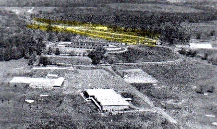
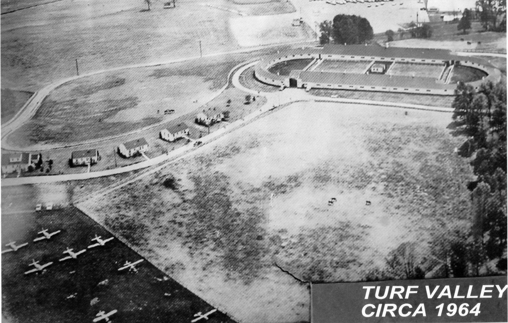
The earliest photo which has been located showing the Turf Valley Airport was a 1963 aerial photo looking west (courtesy of Tina Kloss).
Tina reported, “I am the great niece of Samuel Pistorio who was the original owner/architect of the Turf Valley Country Club.
You can see the runway which I have highlighted in yellow.”
A 1963 aerial view depicted the Turf Valley Airport as a single unpaved northeast/southwest runway.
Turf Valley Airport, as depicted on the 1964 Washington Sectional Chart (courtesy of John Voss).
A circa 1964 aerial view looking southeast at Turf Valley Airport (courtesy of Ray Stinchcomb), showing 8 light single-engine aircraft parked on the field.
The 1965 Washington Local Visual Navigation Chart depicted Turf Valley as having a 1,900' unpaved runway.
Pilot John Gruver moved to Turf Valley in 1965.
He recalled, "The runway was over the hill about a half mile due west of the clubhouse, where it flattens out between the barns.
There is a maintenance shack along were it was that is still there. It ran northeast/southwest. I remember planes landing there as a child."
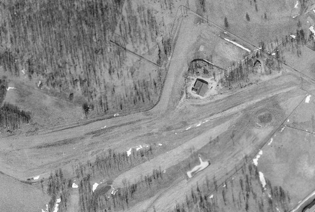
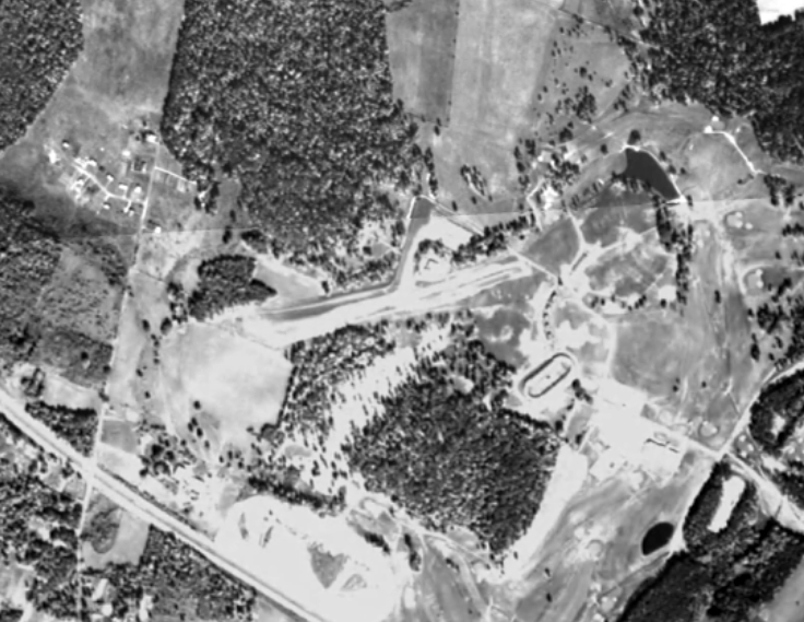
The last photo which is available showing the Turf Valley runway was a 2/21/66 USGS aerial view.
It depicted a single grass northeast/southwest runway on the northwest side of the golf course,
which was marked with 2 closed-runway “X” symbols on the southwest end, presumably to discourage uninvited drop-in visitors.
The March 1966 Washington Local Aeronautical Chart depicted Turf Valley Airport as having a 1,900' unpaved runway.
The last aeronautical chart depiction which has been located of Turf Valley Airport was on the March 1967 Washington Sectional Chart.
Ray Stinchcomb recalled, “I flew in & out of Turf Valley Airport. My family joined 40 West Flying Club when it was formed at Turf Valley.
At that time I was too young but I remember helping work on club aircraft there.
The airport was closed (or at least inactive) for a time & then reopened for a period in 1967.
My first logbook entry for that period is 6/9/67. I worked there that summer mowing grass & such while I built time for my commercial pilot certificate.”
Jim Blanchard reported, “On 7/16/67 the first ad appeared for a new outfit called Turf Valley Aviation, also located at Turf Valley Airport.
Oddly enough, an article appeared in the 7/19/67 Baltimore Sun newspaper stating that the Turf Valley Airport was one of 3 airports that had been closed 'in recent years' & had been converted to a golf course!
That wasn’t true; it may have been closed, but it was not yet a golf course. It was still in operation.
On July 22 their ad read 'Turf Valley Airport now opened & operating.'”
Jim Blanchard reported, “By September 1967, the services that Turf Valley Aviation offered at Turf Valley Airport included:
Fly for $8 / hour, FAA approved instructors, 80 octane gas 38 cents / gallon, 100 octane gas 42 cents / gallon, Monthly tie down, $10, UNICOM.
The company was still located at the country club at Highway 40 West.
The last ad for Turf Valley Aviation at Turf Valley Airport appeared on 12/17/67.
It looked like a going-out-of-business sale. They advertised 5 aircraft for sale.
But, they also included this: 'Top prices paid for clean aircraft.' There were no subsequent articles that announced the airport’s closing.”
Ray Stinchcomb recalled, “My last logbook entry for Turf Valley was in January 1968.”
The last airport directory listing which has been located of Turf Valley Airport was in the 1968 Flight Guide (courtesy of Bob Levittan),
which depicted Turf Valley as having a 1,950' unpaved Runway 8/26, with 3 small buildings on the northeast side.
According to John Gruver, "The last plane I remember [at Turf Valley] was around 1969."
According to Tina Kloss (great niece of Samuel Pistorio), “My husband was an assistant pro at Turf Valley in the late 1960s
and he told me that there was a problem with one of the planes landing there at that time that may have caused the airport to close.”
Joe Zamoyta recalled, “[Fran] Dane & [Sam] Pistorio didn’t get along very well so the field closed & eventually became part of the golf course.”
Turf Valley Airport was apparently closed by 1970, as it was no longer depicted on the 1970 Washington Sectional Chart (courtesy of John Clifford).
A 1970 aerial view still showed the cleared area of Turf Valley's northeast/southwest runway, but there was no sign of any recent aviation use.
The 1979 USGS topo map did not depict any airfield at Turf Valley.
A 2017 aerial view showed Resort Road had been built over the site of Turf Valley Airport, erasing the last trace of this vestige of Howard County aviation.
The site of the Turf Valley Airport is located northwest of the intersection of Route 40 & Turf Valley Road.
____________________________________________________
Or if you prefer to contact me directly concerning a contribution (for a mailing address to send a check),
please contact me at: paulandterryfreeman@gmail.com
If you enjoy this web site, please support it with a financial contribution.
____________________________________________________
This site covers airfields in all 50 states.
For the site's main menu: Home