
Abandoned & Little-Known Airfields:
Massachusetts: Southwestern Boston area
© 2002, © 2024 by Paul Freeman. Revised 6/9/24.
This site covers airfields in all 50 states: Click here for the site's main menu.
____________________________________________________
Please consider a financial contribution to support the continued growth & operation of this site.
Ames Airport (revised 8/10/23) - Canton Airport / Massachusetts Air Terminal / Boston Metropolitan Airport (revised 9/28/22) - Kallander Field (added 6/9/24)
State Muster Field / Framingham Airport (1st location) (revised 12/28/14) - Gould Farm Airport / Framingham Airport (2nd location) (revised 8/10/23)
____________________________________________________
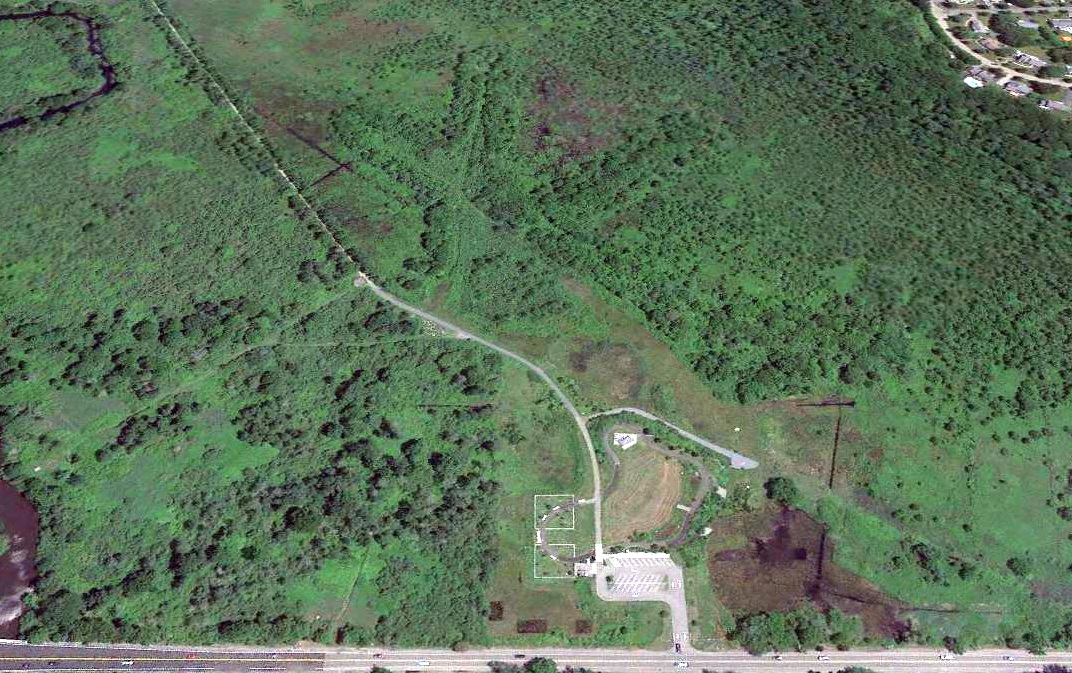
Kallander Field (09MA), Southborough, MA
42.305, -71.506 (West of Boston, MA)
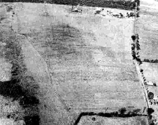
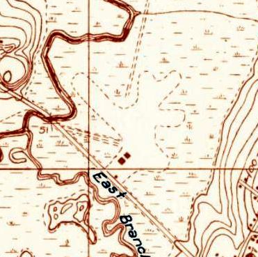
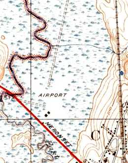
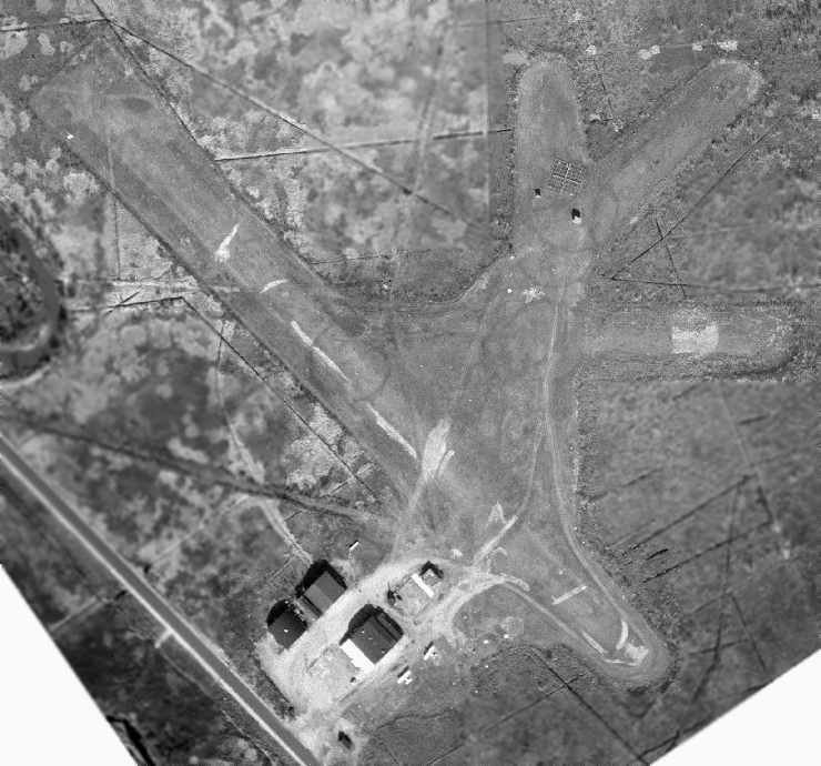
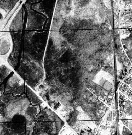
Kallander Field, as depicted on a 1995 USGS aerial view.
This unusual property had the distinction of having both a private ski slope & 2 private runways.
Kallander Field was not yet depicted a 1978 aerial photo.
The earliest depiction which has been located of Kallander Field was on a 1980 aerial view, which depicted a single east/west unpaved runway.
Kallander Field was owned by Peter Kallandar, a Delta Airlines pilot.
He built & operated a private ski slope with a tractor-powered tow rope on the small Kallander Hill on the site, until 1983.
Mark O'Connor reported, “Kallander Hill was north facing, and had two purposes.
In the summer & fall, Peter told me if the conditions were right, he would take his plane up the hill & take off.
I never saw him take off on that side of the hill because my property was a few hundred yards southwest, and the ski slope faced pretty much due north.
Around the time I moved away he had purchased an amphibious plane (either a Lake or a Seabee), with a large prop high & behind the cockpit.
I did see him taking off & even doing the last part of his landings on the side of the mountain with that & its predecessor plane, sort of like touch & goes.
It was an amazing sight for me & all the other neighbors that could see it.
I think he bought the rear prop plane because there wasn't enough prop clearance on the west-facing hillside given the steeper grade.”
A 1985 aerial view depicted Kallander Field in an unchanged configuration.
A 1992 aerial view showed the hill which previously held a private ski slope (to the south of the east/west runway)
had gained a 2nd runway, an unpaved northwest/southeast strip.
One light single-engine aircraft was parked near a hangar to the southwest of the runway intersection.
A 1995 aerial view depicted Kallander Field in an unchanged configuration.
FAA Airport/Facility Directory data described Kallander Field as a 68 acre private airfield owned by Peter Kallander,
and having 2 turf runways: 2,000' Runway 15/33 & 1,700' Runway 9/27.

The only photo which is available showing an aircraft at Kallander Field was a 2000 photo showing a Cessna 172 at the base of the sloping northwest/southeast runway.
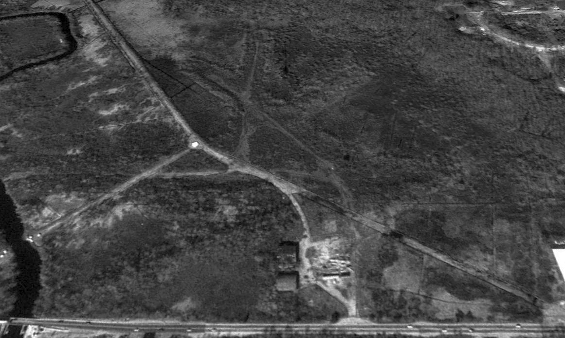
A 2001 aerial view showed Kallander Field's northwest/southeast runway had been cleared for construction of new houses.

A 2003 aerial photo showed the original northwest/southeast Kallander Field unpaved runway had been covered with houses,
the east/west runway to the north was being paved with asphalt.
Airport owner Peter Kallander passed away in 2007.

The only aeronautical chart depiction which has been located of Kallander Field was on the May 2009 Boston Terminal Chart.
It depicted Kallander as a private airfield having a 2,000' unpaved runway.

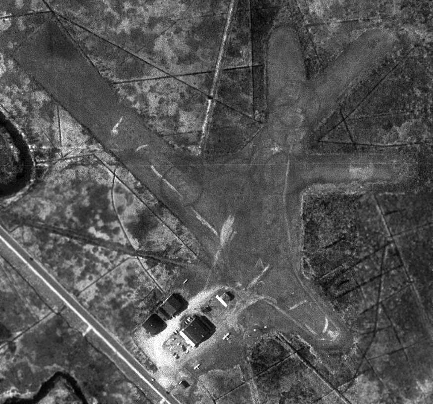
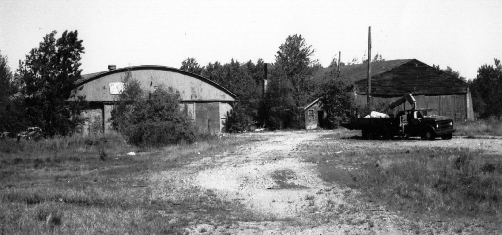
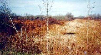
A 2011 photo looking north at the former Kallander Field hangar.

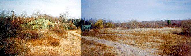
A 2011 photo looking west down Kallander Field's asphalt east/west runway.
Kallander Field was evidently closed at some point between 2009-2016,
as it was no longer depicted on the 2016 Boston Sectional Chart.
A 2021 aerial view showed the Kallander Field paved runway remained intact.

A 2023 photo looking west down Kallander Field's asphalt east/west runway.

A 2023 photo looking north at the former Kallander Field hangar.

A 2024 aerial view showed the majoritty of Kallander Field's asphalt east/west runway remained intact, but a western portion had been covered by a yard for an adjacent house.
Thanks to Matthew Foster for pointing out this airfield.
____________________________________________________
42.296, -71.412 (Southwest of Boston, MA)
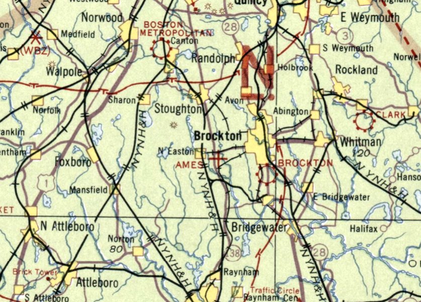
Ames Airport, as depicted on the March 1933 Boston Sectional Chart.
Picture of the airport has not been located.
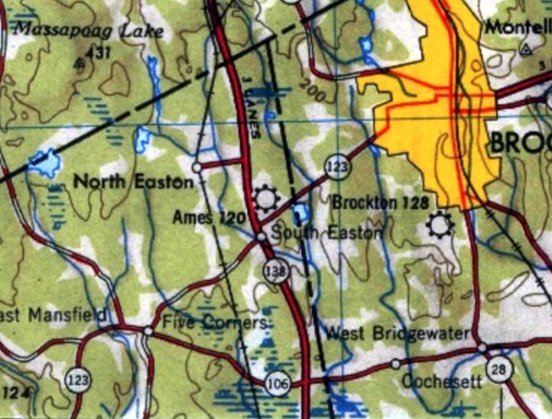
According to the Stonehill College website, “In the late 1920s, Frederick Ames acquired a passion for aviation & had an airfield built on his family's property.
The Ames Flying Field was one of 3 airfields in Easton, and was recognized by the Civil Aeronautics Administration.
The flying field included 2 runways, an office, and a hangar.
The 2 runways were located on the land next to the present-day Holy Cross Center, and remnants of the tie-downs can still be found in the ground today.
The first plane to land on the Ames Flying Field was the Curtiss JN-4 Jenny used during World War I. Freddy used the field for flying to & from Boston.”
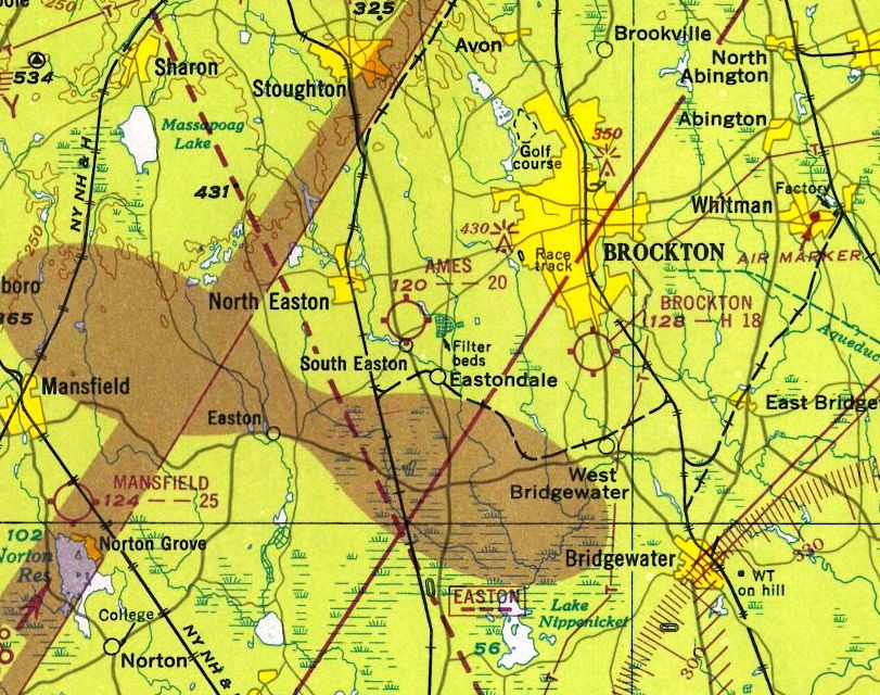
According to the Easton Historical Society, “Ames Field was located near the junction of Route 138 & Belmont Street.
In later years, the field grew to have 2 runways & a hangar. There was a repair and office building near the hangar. Gas tanks and a tie down area completed the facilities.
The field served as a home base for the air shows which performed at the Brockton Fair in 1923 & 1924.
The first commercial plane to land in Easton came to Ames Field in 1923 as part of a barnstorming act.
The following year the Fair offered a true aerial spectacle. Several planes came from Mitchell Field on Long Island & others came from the airport in East Boston.
Stunt flying, parachute jumping, and mock combats all thrilled the crowds at the fair.
Probably the most spectacular performance was made by Lieutenant Jimmy Doolittle, the man who was later to lead the first bombing attack on Japan.
Battling 65mph winds, he flew stunts over both the fairgrounds & Ames Field. His speedy PW8 pursuit plane was clocked at 175mph.
The Mitchell Field squadron at Ames Field drew thousands of people away from the fairgrounds.
This group of planes included the SE5, a single seat fighter designed by the British during World War I, and the DH4, a British two seater.
The arrival of the squadron was marred when the squadron commander, Major Hensley, piloted his DH4 into a tree to avoid hitting a crowd of spectators.
The Major & his passenger were unhurt, but the plane required a new tire, propeller, and wing panel.
The DH4 must have been a marvelous sight; it was almost 30' long with a 42' wingspan.
A very dangerous accident was narrowly averted when the single engine in a DH4 weakened in mid-air.
Despite a strong wind, the pilot was able to make a landing at Ames Field after this nearly total loss of power.
The rather frightening record of near disaster coupled with the complaints of the fair management that attendance was hurt by the Ames Field
display led Congressman Louis Frothingham to actively support legislation prohibiting government aircraft from participating in public activities.
This ended the air displays at Ames Field.
According to the Easton Historical Society, “From 1925-32 Ames Field was used as a private field for Frederick Ames.
Ames’ company, East Coast Aircraft, was an East Boston based firm that sold Travel Air aircraft.
Ames used the Easton field to fly to & from work in East Boston until his death in a plane crash in Randolph on 11/6/32.”
Ames Airport was not depicted on USGS topo maps from 1932/36/40/41/51.
The earliest depiction which has been located of Ames Airport was on the March 1933 Boston Sectional Chart.
It depicted Ames as an auxiliary airfield.
According to the Easton Historical Society, “From 1936-41, George Malouin managed the airfield & operated a flying school & charter service there.”
According to the Easton HIstorical Society, “The first air mailing from Easton occurred 5/19/38 at Ames Airfield.
The land at the time was leased from Our Lady of Holy Cross Seminary.
More than 500 people from Easton & surrounding towns witnessed the takeoff ceremony.
Eighteen hundred air mail letters from Easton, Mansfield, and Norton, 2 packages, and 3 miniature Ames shovels were aboard. The plane left at 2:30pm for Logan Airport.
By 5:17pm the return flight had delivered to the North Easton Post Office one of the miniature shovels addressed to Postmaster Clement Coughlin's wife.”
According to the Stonehill College website, “After the property was bought by the Congregation of Holy Cross,
the airfield was leased to the Navy during WW2 & private companies before & after the war.
The Navy used the field for training exercises.”
The only topo map depiction which has been located of Ames Airport was on the 1943 USGS topo map (courtesy of Brian Steele).
According to the Easton Historical Society, “During WW2 the airfield was used as an auxiliary field for training planes based in Mansfield.
After the war, the flight school & charter service was resumed under the direction of Charles DelSordo.
Several private planes were also based at the field.
Passengers on the charter flights included the late Rocky Marciano, the then heavyweight boxing champion, who used the service to fly to fights in NY.
The Holy Cross fathers of Stonehill also used the field to fly to Martha’s Vineyard to conduct mass.”

A 1/15/49 receipt for $17 of flying lessons from the Ames School of Aviation for Harold Barter (courtesy of Jim Locke).
The 1949 Boston Local Aeronautical Chart depicted Ames Airport as having a 2,000' unpaved runway.
Brian Steele reported, “My father is almost positive that his dad did his flight training at Ames. My grandfather earned his private pilot license in May 1954.”
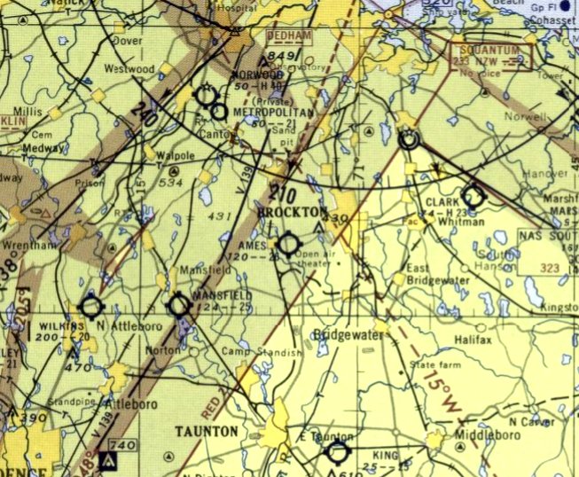
The last depiction which has been located of Ames Airport was on the May 1955 Boston Sectional Chart.
It depicted Ames as an auxiliary airfield.
According to the Stonehill College website, “The airfield was closed in 1955 due to increasing student enrollment.”
Ames Airport was no longer depicted on the November 1955 Boston Sectional Chart.
A 1960 aerial photo did not show any trace of Ames Airport.
A 2019 aerial view looking north showed no trace remaining of Ames Airport.
____________________________________________________
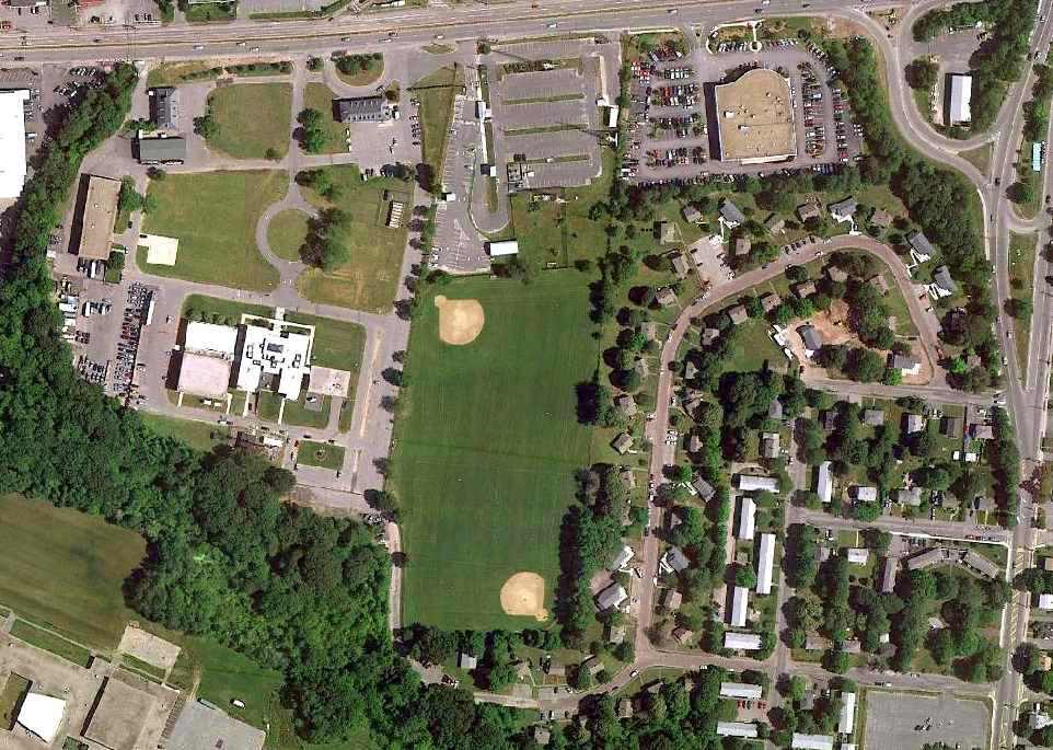
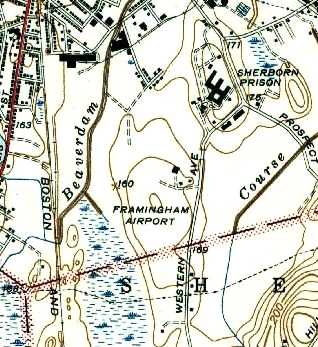
State Muster Field / Framingham Airport (1st location), Framingham, MA
42.296, -71.412 (West of Boston, MA)
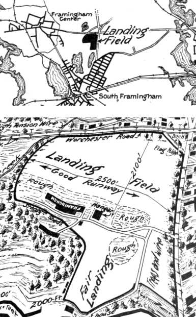
Framingham “State Muster Field”, as depicted on a 1924 Commerce Department Aeronautical Bulletin (courtesy of Jonathan Westerling).
Jonathan Westerling wrote, “According to an article about Massachusetts high school sports team names,
Framingham High School’s mascot, the Flyers, came about thanks to the town's aviation history which began almost 100 years ago.”
According to local historian Stephen Herring, "During the time from the teens to the late 1940s, Framingham was known as an aviation-minded town.
It was a time when aviation was new. It was becoming a new thing & people were excited about it."
Jonathan continued, “The first airfield in Framingham was known as Musterfield Airport.
According to Framingham Legends & Lore by James Parr & Kevin Swope,
the property was known as the Musterfield, or State parade grounds & was used as an airfield beginning in 1920.
(though the field was not listed in the 1920 or 1921 Flying Guide & Logbook).
The government (it’s unclear whether it was the state or federal government) established an airport in Framingham
in the very early on in the days of aviation to function as an intermediate landing field from 1923-31.”
The first reference to the Framingham Airport which has been located
was in the 1923 United States Touring Information Bureau’s “Official Directory of Aeroplane Landing Fields” (according to Jonathan Westerling)
which described the airfield as consisting of a 2,500’ by 2,100’ field with a hangar & supplies.
According to Jonathan Westerling, “Framingham Legends & Lore noted 2 historic events which occurred at this airfield.
The first was the inaugural airmail flight to New England which landed in October 1921, flown by Lt. Reuben Moffat.
The air mail was trucked to Boston which did not yet have an airport (Logan Airport not being constructed until 1923).
The second historic flight was a ferry service for a shipment of asparagus from New Jersey which was arranged by the Commissioner of Agriculture on 5/17/22.
The Commissioner promised the Mayor of Boston & Governor of Massachusetts a side of freshly-picked asparagus at lunch,
presumably to demonstrate the promise of shipping fresh vegetables by air.
The event was covered by several newspapers, but unfortunately the pilot got lost & didn’t arrive until 3:30 in the afternoon.”
The earliest depiction of the Framingham Airport which has been located
was a listing in a 1924 Commerce Department Aeronautical Bulletin (courtesy of Jonathan Westerling).
It depicted Framingham's “State Muster Field” at the intersection of Worcester Road & Concord Street.
Jonathan Westerling noted, ”It was operated by the Skywriting Company of America, though the directory lists the prior operator as the US Air Corps.”
A circa 1920s aerial view looking north at Framingham Airdrome (courtesy of Phillip Perry)
showed the field to be L-shaped, with hangar near the center of the field.

A circa 1920s aerial view looking north at a snowy Framingham Airdrome (courtesy of Phillip Perry)
showed the field to be L-shaped, with a row of small buildings (hangars?) on the southwest, and a larger hangar near the center of the field.
Jonathan Westerling noted that the 1927 Commerce Department Aeronautical Bulletin “shows the Framingham Airport
had made significant advances in only 3 years with an all-way landing field & border lights.
By now, the Boston to New York Airway had been formally established, and Framingham’s airport was designated 'Site 20' along this airway.
Interestingly, even though the layout & size of the field appear to be identical to what is depicted in the 1924 aeronautical bulletin,
the measurements given for the airfield decreased substantially.
Likely, this was due to improved or actual measurements being made.
The dimensions of the airfield as of 1927 were reduced to 1,980’ x 1,600’.”
The 1929 USGS topo map labeled the site as “Mass. State Muster Grounds”.
Jonathan Westerling reported, “According to the May 1929 Boston Globe, the Massachusetts State Legislature entertained debate
as to whether they should sell the Musterfield property to a private interest so that it could become a commercial (as opposed to government) airfield.
The proposal was shot down, however the airport continued to exist as an emergency landing field for a few more years.”
Jonathan continued, “The last reference to the original location of the Framingham Airport was in the 1931 Bulletin #2 (courtesy of David Brooks)
which listed the airfield as being largely unchanged since 1927.”
Jonathan continued, “The 1932 Airway Guide shows that the Framingham Airport no longer existed along the New York to Boston Airway,
however the rotating beacon located on the airfield was kept operational to mark the Airway.”
The March 1933 Boston Sectional Chart no longer depicted an airfield at this location,
instead depicting a Framingham Airport to the southeast of the town.
The 1938 USGS topo map continued to label the site as “Mass. State Muster Grounds”.
The 1943 USGS topo map depicted a school on the northeast corner of the airport site.
The 1951 USGS topo map showed a radio tower having been added to the northwest part of the airport site,
and several residential streets covering the southeastern portion.
A 1957 aerial photo no longer depicted any recognizable trace of an airfield.
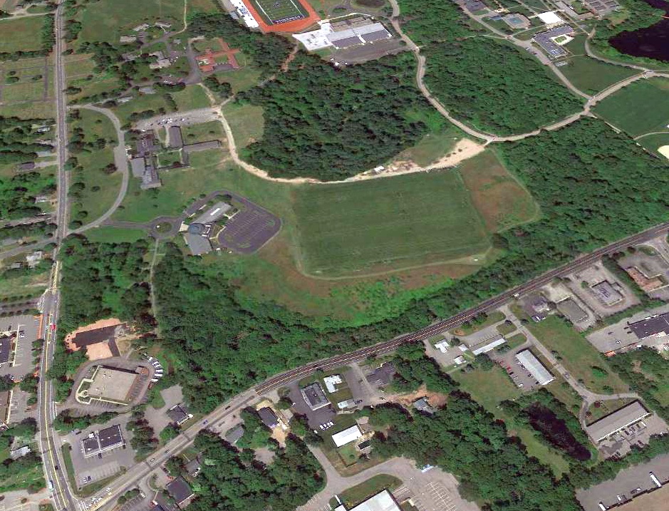
A 6/19/10 aerial photo showed no trace remaining of the original Framingham Airport.
Jonathan Westerling reported, “Interestingly, as of 2012 there is still a heliport at this location, serving the Massachusetts State Police Headquarters.”
The site of the first location of Framingham Airport is located southwest of the intersection of Worcester Road & Concord Street.
____________________________________________________
Gould Farm Airport / Framingham Airport (2nd location), Framingham, MA
42.26, -71.41 (West of Boston, MA)
Framingham Airport, as depicted on the March 1933 Boston Sectional Chart.
Jonathan Westerling wrote, “A second Framingham airport was built about a mile & a half south of the original Framingham Airport.
According to framinghamhistory.org, this location was known as Gould Farm & became the Gould Farm Airport or Framingham Airport.
This new airfield was about twice the size of the original Framingham Airport.”
According to “Framingham Legends & Lore” by James Parr & Kevin Swope,
“Opening day festivities took place on November 8-9,1930, with almost 10,000 people in attendance.
Spectators thrilled to airplane races & stunts, and over 700 people took rides.”
The first airport directory reference to this new airport which has been located was in the 1931 Airway Bulletin #2 (courtesy of David Brooks)
which described Framingham as consisting of a 2,335’ x 2,200’ landing field.
According to Jonathan Westerling, “Confusingly for pilots, both of Framingham’s airports had 'Framingham' written in large white letters on the hangar roof.
Both airports coexisted for a short time, but the original Framingham airport was closed by 1932 as it is not indicated in the 1932 Airway Guide.”
The 1932 Bulletin #2 (according to Jonathan Westerling) listed the Framingham Airport with 3 grass runways (instead of a rectangular field):
2,800' northwest/southeast, 2,000' north/south, and 1,900’ east/west.
The earliest aeronautical chart depiction which has been located of Framingham Airport was on the March 1933 Boston Sectional Chart.
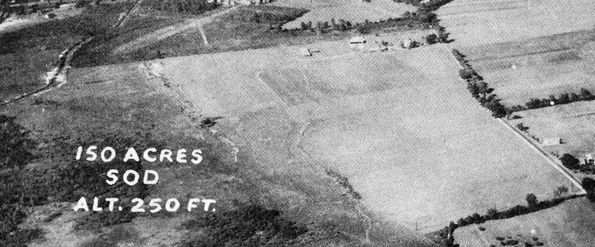
The earliest photo which has been located of Framingham / Gould Farm Airport was an undated aerial view looking north from The Airport Directory Company's 1933 Airport Directory (courtesy of Jonathan Westerling).
It described Framingham Airport as a 150 acre rectangular sod field, managed by LeRoy Gould.
A circa 1930s aerial view of what may be the Framingham / Gould Farm Airport (courtesy of Phillip Perry)
depicted a hangar with “... Airport” on roof, and a monoplane & a biplane parked next to it.
A circa 1930s photo of an unidentified group in front of a Bird CK (serial #4028) biplane at the Framingham Airport (courtesy of Ken Gray, via David Gray).
David Gray reported, “The buildings in the background are the Framingham Work Farm Hospital Jail, now the Womens State Prison.”
The 1937 MA Airport Directory (courtesy of Jonathan Westerling) depicted the 2nd location of Framingham Airport as having 3 runways,
with a cluster of buildings on the northeast side.
It listed the owner as Helen Gould & the FBO as Air Service, Inc.
According to the 75th anniversary publication of Fitts Insurance Services,
the 1938 New England Hurricane took out the hangar at Framingham Airport along with 4 planes.
The second location of Framingham Airport was not depicted at all on the 1938 USGS topo map.
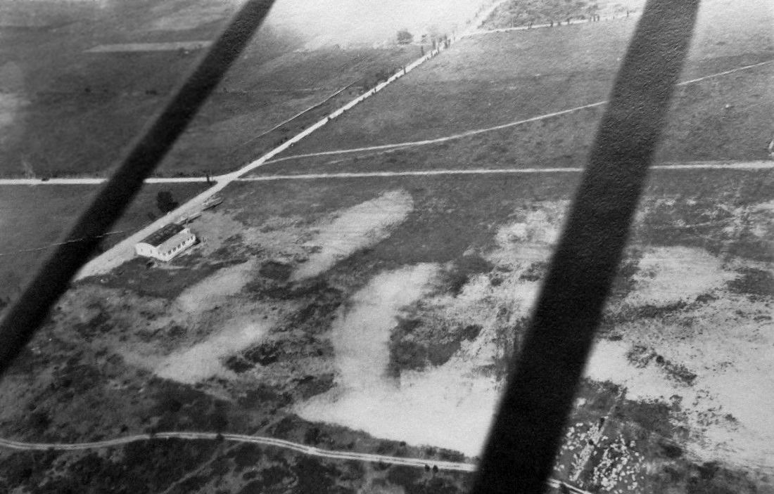
A still of a Kinner Playboy from a 1940 movie taken at Framingham Airport (courtesy of Warren Wheeler).
Warren recalled, “My father's [Warren Wheeler] logbook shows he took lessons there in 1940.”
A still of a Piper Cub from a 1940 movie taken at Framingham Airport (courtesy of Warren Wheeler).
According to Jonathan Westerling, Framingham “airport [was] closed to all but military operations since 1942 since it was located within 25 miles of shore.”
The only dated photo which has been located showing the Framingham Airport
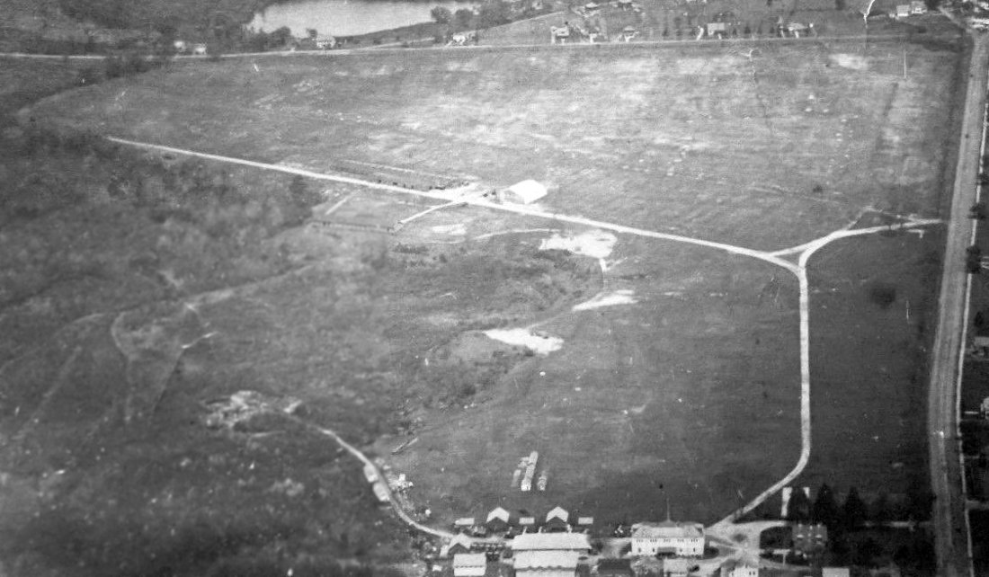
was a 10/30/42 aerial view looking north from the 1945 AAF directory (courtesy of Scott Murdoch).
It depicted Framingham as being an irregularly-shaped grass field with several buildings on the northeast corner.
The 1943 USGS topo map depicted Framingham Airport as an open area with 3 small buildings on the northeast side.
The 1944 Directory of Airfields (courtesy of Scott Murdoch) listed the longest runway at Framingham as having been reduced to 1,900'.
The 1945 AAF directory (courtesy of Scott Murdoch) described Framingham Airport as a 110 acre rectangular field
within which was an all-way field having 4 runways, the longest being a 1,900' northwest/southeast strip,
with the note, “Caution: Rough.”
Framingham was said to have a single 70' x 60' steel hangar, and to be owned & operated by private interests.
The last depiction which has been located of the Framingham Airport was on the June 1945 Boston Sectional Chart.
It depicted Framingham as a commercial/municipal airport.
According to “Framingham Legends & Lore” by James Parr & Kevin Swope,
“After the war, town officials were working on a plan to make the site a municipal airport when Teddy Gould sold the land to General Motors,
ending Framingham’s almost 30-year association with the aviation business.”
According to Joanathan Westerling, “In November 1945, ground was broken for a new GM plant on the location of the Framingham Airport.”
Framingham Airport was no longer depicted on the December 1945 Boston Sectional Chart.
According to Joanathan Westerling, “Framingham Assembly [the GM plant] opened in 1947, and the first vehicle, a Buick, was produced on 2/26/48.
The 1951 USGS topo map depicted the large GM factory covering the airport site,
and a 1957 aerial photo no longer showed any trace of Framingham Airport.
The GM plant was closed on 8/1/89, after a long period of contention between local & state politicians.
As of 2012, Wikipedia reports, “The facility is now the location of an ADESA automobile, truck, and boat warehouse & live auction site.”
The second location of Framingham Airport is located west of the intersection of Western Avenue & Herring Avenue.
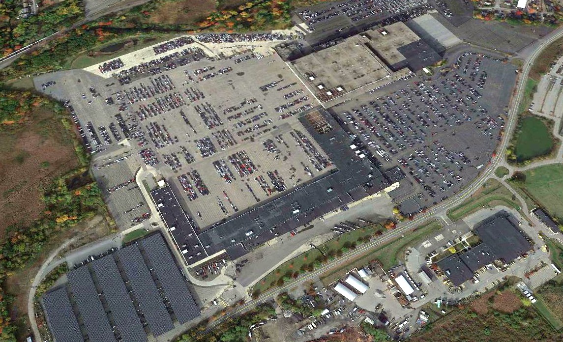
A 2020 aerial view looking northwest showed no trace remaining of the second location of Framingham Airport, with the property covered by the former GM factory.
The site of the second location of Framingham Airport is located southwest of the intersection of Worcester Road & Concord Street.
____________________________________________________
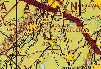
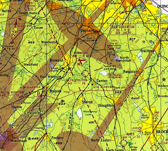
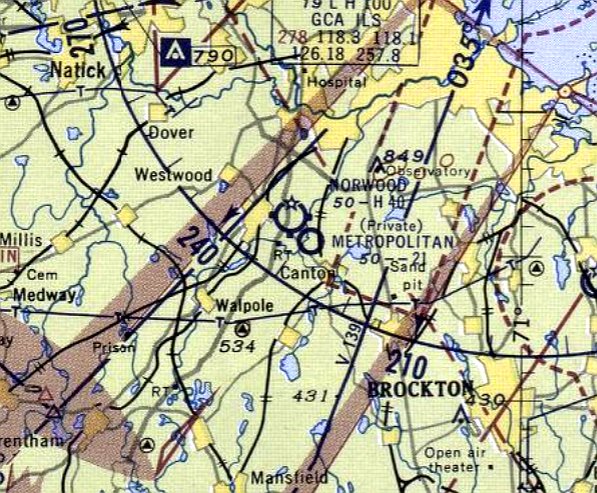
Massachusetts Air Terminal & Arena / Canton Airport / Massachusetts Air Terminal /
Boston Metropolitan Airport, Canton, MA
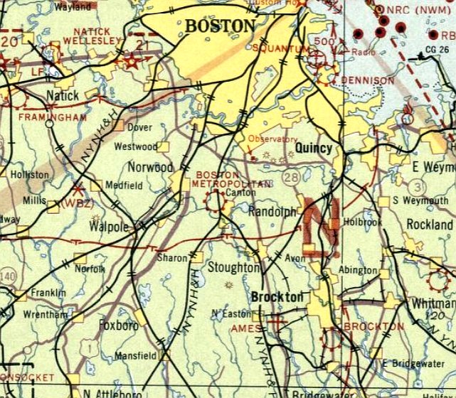
42.17, -71.16 (Southwest of Boston, MA)
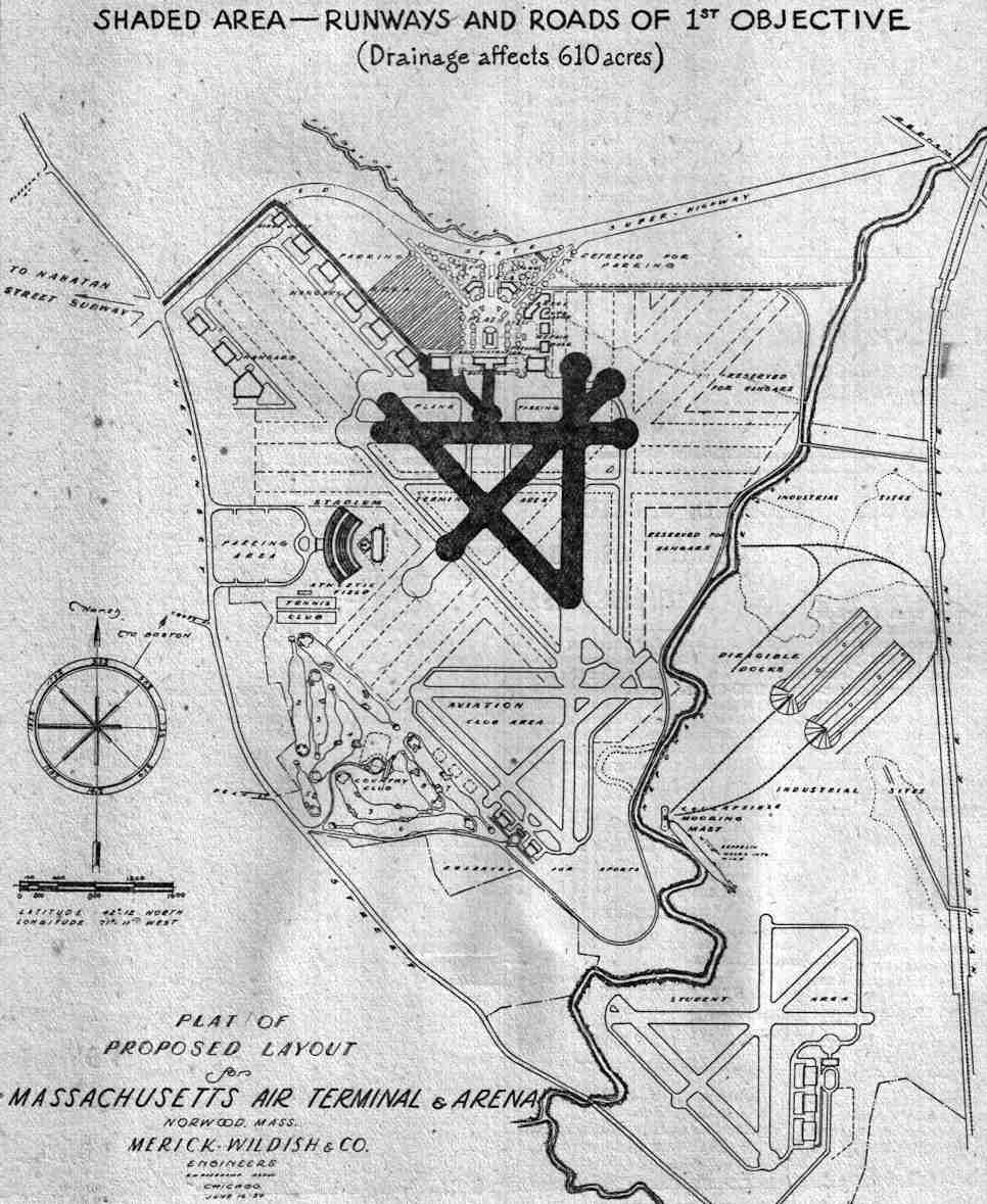
According to A Postcard from Canton, “There are long-lost plans of men and women that, if implemented, would have changed Canton forever.
The most notable of these plans was the development of the Massachusetts Air Terminal & Arena.
The ambition of the men who devised the plan was to construct a major air terminal along the border of Canton & Norwood -
in essence an airport that would become one of the nation’s hubs for the fledgling passenger & commercial air industry.
A small group of men gathered together to discuss the ambition for building landing fields, hangars, and assorted recreational facilities
for the Massachusetts Air Terminal and Arena (MATA).
In the spring of 1930 the engineering firm of Merick Widlish & Co. of Chicago began the engineering plans and study for the new airport.
Merick Wildish specialized in community-based airfield development.
On June 16 the engineers unveiled a masterful plan that would begin the transformation of 1,298 acres from a shallow wetland of thick peat to the proposed 'world-class airport'.”
A Postcard from Canton continued, “Investors in MATA had purchased land in the Fowl Meadows along Neponset Street
and bordered by a new state superhighway off of present-day Route 1.
One important feature was that the land bordered almost a mile & a half of railroad lines & proposed industrial land.
The purchase, when recorded in the Dedham Registry of Deeds,
was said to be the largest single parcel of land ever to be assembled by a private company in the Commonwealth.
These were heady dreams: the plans included 8 runways, hangars, dirigible docking bays & a mast,
a separate area exclusively for aviation club members, hotels, and a fire department base.
In addition, the arena areas included a 9-hole golf course with country club buildings, a tennis club, athletic fields, and a small stadium.
The plans were unique from any other development in the country at this time.”
[However these grandiose plans seem to have been created by someone lacking any aviation knowledge,
as it featured essentially 3 separate airfield complexes in close proximity,
which would have put their traffic patterns in conflict with each other.
Not to mention, most problematically, a “student area” airfield at the southeast corner
which sat directly adjacent to the dirigible area, with one runway ending right at the dirigible mooring mast.]
A Postcard from Canton continued, “On a balmy Sunday afternoon, 2,500 people attended the tour of the property
and viewed flagged lines where the runways would be laid out.
Their imaginations were set loose on that October day.
Gathering at Glider Hill - Inspiration Point - were the managers, engineers, and leaders of the project, as each one took a hand at explaining the vision.
More than 200 cars visited the site & caused a general ruckus that probably had never been seen in this small town previously.
Within weeks of the open house the excitement reached a fevered pitch.
A general committee was formed in several towns, and Canton named over 170 members - all leading individuals in the community.
The general sentiment was in favor of the new airport, and what was once pasture & grazing land would be transformed into an economic engine for the region.”
A Postcard from Canton continued, “Work began in January 1931 and a steam shovel began bringing up gravel on the site to compact the new runways.
J.P. White Contracting was awarded the bid to build the project, and it would take 4 months to get the land ready for the construction of the hangars & administration building.
Most of the laborers on the project were Canton men who were badly in need of work while in the throes of the Great Depression.
Despite the weak economy, more than $130,000 was raised through private investors in the fledgling company.
The first planes to land in Canton touched down in the spring, and the town was abuzz with excitement. It is hard to overstate the interest.
Every week the front page of the local paper blazed headlines about the airport, and advertisements regularly invited locals to climb aboard & see the town from the air.”
A Postcard from Canton continued, “Officially, the first air service to use the hangars & field were operated by Lt. Robert S. Fogg, reputedly the 'safest flyer in New England'.
Fogg had a considerable record, carrying over 27,000 passengers on his charter service without a mishap.
On a Wednesday afternoon in early June, a brilliant black and orange, open cockpit biplane, powered with a Wright motor & capable of a top speed of 135 MPH,
taxied to a stop in front of the newly-completed hangar that would soon hold 15 planes.
When Fogg touched down purely by chance, he was met by Selectman Joseph Wattles & Paul Draper.”
A Postcard from Canton continued, “On 6/26/31, the Canton Airport was opened for business.
When it opened it was the 3rd largest in the state. Traffic around the airport snarled as curiosity reigned supreme.
Every weekend hundreds of people would come to see the aeroplanes land & take off from the Canton Airport.
In fact, while there was an airport in East Boston (now Logan International), at times passenger flights hampered by fog in Boston would be forced to land in Canton,
where passengers would be transferred to Canton Junction to complete the trip into Boston.”
American Airways constructed a hangar & an administration building on the property along with E.W. Wiggins Airways.
The airport was not yet depicted on the 1932 USGS topo map.
According to Cindy Bates, “In 1932 the name was changed to Boston Metropolitan Airport, Inc.”
The 1930s were a very exciting time for the fledgling little airport, including a visit from Charles Lindbergh.
The earliest aeronautical chart depiction which has been located of Boston Metropolitan Airport was on the March 1933 Boston Sectional Chart.
The 1934 Department of Commerce Airport Directory (according to Chris Kennedy)
described Boston Metropolitan Airport as having 4 gravel runways.
The 1936 USGS topo map depicted 4 unpaved runways & 2 hangars at Boston Metropolitan Airport, but without any labeling.
The huge airship Hindenberg conducted practice approaches at Boston Metropolitan.
After the 1937 destruction of the Hindenburg in New Jersey & the decline in the use of the dirigibles,
plans for a transatlantic dirigible base at Boston Metropolitan were dropped.
During the years of the depression, the airport failed to grow as expected,
but air shows & other demonstrations drew large crowds.
The 1937 “Progress Report of the Committee For Aeronautics of the Commonwealth of MA” (courtesy of Jonathan Westerling)
depicted Boston Metropolitan Airport as an irregularly-shaped 127 gravel field,
within which were 4 gravel runways, the longest being the 2,100' northwest/southeast strip.
It was described as a commercial airport, owned by the Dennison Airport Corporation & operated by the Dennison Airport Operating Company.
Two hangars, an administration building & a repair shop were depicted on the southeast side of the field.
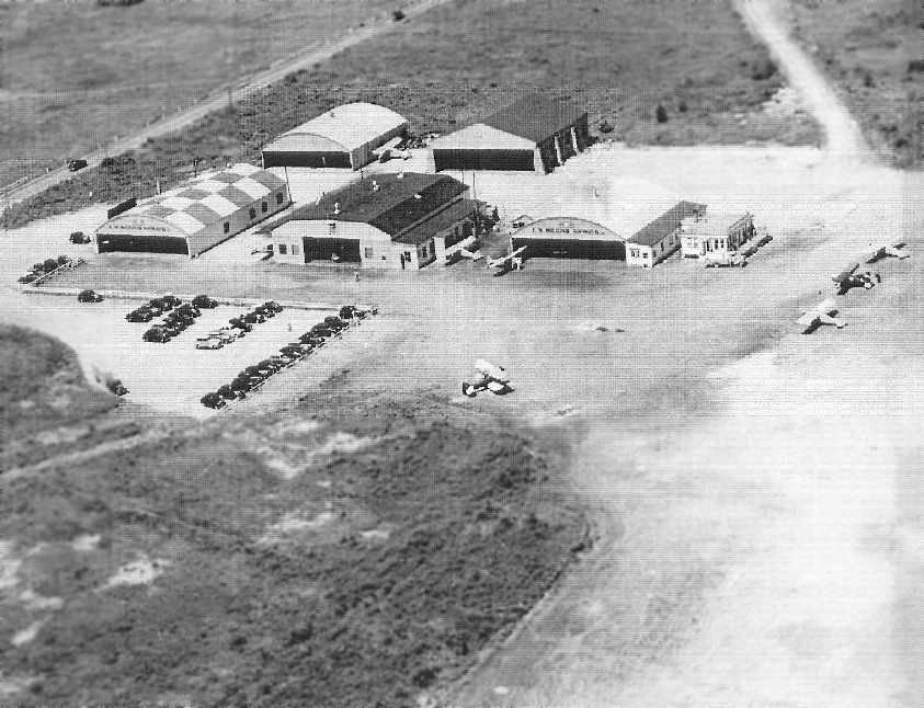
The earliest photo which has been located of Boston Metropolitan Airport
was an undated aerial view looking southwest from The Airport Directory Company's 1937 Airports Directory (courtesy of Bob Rambo).
It described Boston Metropolitan as having 4 sod runways, with the longest being the 2,500' northwest/southeast strip.
The photo depicted 2 hangars on the southwest corner of the field.
The Airport Directory Company's 1938 Airports Directory (courtesy of Chris Kennedy)
described Boston Metropolitan in the same manner as the 1937 directory had.
According to Cindy Bates, “A 1940 study recommended removing the airport to the Norwood side.”
The 1941 USGS topo map labeled the site simply as "Airport",
and depicted the 2 hangars, but did not depict any runways.
Dick Bicknell recalled, “I soloed in 1942 at Canton Airport.”
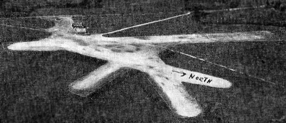
A 1/2/42 aerial view looking north at Canton Airport (from the National Archives, via Marc Frattasio),
showing 4 grass runways, 5 hangars, and several light planes.
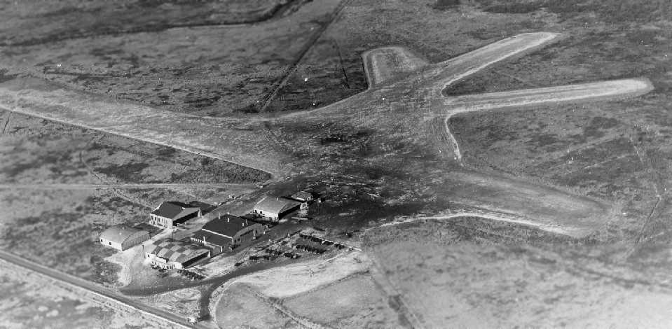
An undated (circa early 1940s?) aerial view looking northwest at 5 hangars at Canton Airport (courtesy of Roger Pinel),
two of which bear “ E.W. Wiggins Airways” legends.
Seven biplanes & monoplanes were visible on the field.
During WW2 the airport was part of the defense system & flight training program along the East coast.
It was during this time that the Canton Airport came into competition
with Bedford Airport for government contracts & expansion.
Bedford won the competition because the overall geographic area was more suitable,
and today it is still a busy, active concern.
The failure of the town to modernize Canton Airport guaranteed its death.
Boston Metropolitan, as depicted on the November 1944 Boston Sectional Chart (courtesy of Chris Kennedy).
In 1946, Wiggins Airways moved across the river to Norwood where it remains today.
An undated photo of Peter “Richie” Sarra with his 1947 Mcclish Funk B85C at Canton Airport.
The 1949 Boston Local Aeronautical Chart depicted Boston Metropolitan Airport as having a 2,400' unpaved runway.
The last aircraft-related company at Canton Airport was Helio Aircraft Corporation.
In the late 1940s, Otto Koppen of MIT & Dr. Lynn Bollinger of Harvard
developed the first Helioplane experimental prototype, a short take off & landing (STOL) light aircraft.
The two college professors noted the precipitous drop-off of the earlier high demand for light airplanes in the immediate post war years
and determined that the market for the standard light planes that required a normal airport had been grossly overestimated.
The two professors correctly assessed that a major part of the problem was the unfulfilled postwar promise of an airplane in every garage.
They felt that the ability to land in your own back yard, providing you had a big one, was an achievable goal.
Thus they conceived the idea of an inexpensive STOL light airplane that was controllable at very low flight speeds.
The professors arranged for Greater Boston Metropolitan Airport fixed base operator,
E.W. Wiggins Airways & volunteers to convert a Piper PA-17 Vagabond to the 2-place Helio No.1.
The only unmodified part of the Vagabond was the fuselage cabin area.
The original engine was replaced with a fuel-injected 85 hp Continental
fitted with a multi-belt reduction unit that drove a specially designed nine-foot Koppers Aeromatic propeller.
This extra large diameter propeller with its large thrust component was a major contributor to the success of the Helio-1.
The propeller's wide slipstream coverage of the wing slats & slotted flaps
provided a substantial added lift component during the take-off, landing and the slow/near hover flight regimes.
The wing had a complete array of the high lift devices available at that time,
including leading edges with retractable full span Handley Page automatic slats
and trailing edges with the equivalent of full-span slotted flaps.
The ailerons could be drooped in the slow speed configuration to act as flaps & still perform for banking purposes.
Most of these devices had been individually demonstrated previously
but Professor Koppen was the first in the United States to successfully
take advantage of the synergism of their combined capabilities.
The successful first flight was in 1949.
While the Helio-1 had a top speed slightly faster than the Vagabond,
its slow speed capability of 30 mph was far superior to any fixed wing aircraft available at that time.
The takeoff, landing and slow speed performance was spectacular.
Its takeoff roll was less than 100 feet & the distance to clear a 50 foot obstacle was less that 300 feet.
The Helio Aircraft Corporation had initially planned to market the 2-place version
but the market saturation of lightplanes caused the company to redirect its efforts.
The aircraft in every garage remained a dream & so the 4-place Courier,
with more utility & payload, was developed for both the civilian & military markets.
Stan Richardson recalled, “I went to Wiggins A.& E. school in 1949-50 & was there when Koppen & Bollinger built the 'Helioplane'.
I watched its first test flight (I wish I still had the picture I took, standing by the office building).”
The Courier was certified by the Civil Aeronautics Administration in 1953.
The last aeronautical chart depiction which has been located of Boston Metropolitan Airport was on the May 1956 Boston Sectional Chart.
It depicted Boston Metropolitan as a private airfield with a 2,100' unpaved runway.
In 1956, the Helio Aircraft Corporation merged with Mid-States Manufacturing Corporation of Pittsburgh, KS.
The Canton location was then primarily research & development with some limited amounts of construction.
Stu Brennan recalled, “I grew up in Norwood, with a great view of the early Helio Courier test flights out of the Canton Airport. And I frequently visited town airport just to watch.”
At one point, the Helio company employed about 46 people in Canton.
A November 1956 aerial view by Mark L. Thaisz of Col-East, Inc.
depicted Canton Airport as having 3 hangars, 4 unpaved runways, and 2 single-engine aircraft.
Boston Metropolitan Airport apparently closed at some point in 1956,
as it was no longer depicted on the December 1956 Boston Sectional Chart.
Although it may have been officially closed by that point, a 4/22/57 USGS aerial photo still depicted 2 single-engine aircraft at Canton Airport
The 1958 USGS topo map continued to label an open area simply as "Airport".
Jim D'Attilio recalled “Canton Airport... Interstate 95 was constructed through the north east edge around 1959,
with Norwood Airport being located on the other side.
Neponset Street itself (the street nearest the hangars) was widened & moved somewhat around the same time.”
The 1960 USGS topo map depicted Canton Airport as having 4 short unpaved runways,
with several buildings along the southwest side.
Helio’s first plane manufactured in Canton went into the Smithsonian Institute in Washington in 1963.
The Helio company remained in Canton until 1964 when it moved to Bedford Airport.
The 1966 USGS topo map continued to depict Canton Airport as having 4 short unpaved runways, with several buildings along the southwest side.
Bob Sission recalled, “Canton Airport... After Helio Aircraft Corp left the site,
the hangars were used by United Consultant Corporation [later known as STOL Aircraft Corporation]
to convert the Republic Seabee to the UC-1 Twin Bee.
That activity continued until 1969. I live in Canton & visited the site many times.
I re-checked my information with Peter Annis the test pilot for all of the conversions.
Peter flew the test flight from Canton & if there was no problem he would land it at the Norwood Airport.”
Canton Airport appeared closed in a November 1965 aerial view by Mark Thaisz of Col-East, Inc..
It showed that a road had been constructed running right through the center of the hangars,
and continuing north through the center of the runways.
The 3 hangars still remained, though, and the outline of all 4 runways still remained recognizable.
A 1965 photo by Edward Galvin of 2 remaining hangars on the southwest side of Canton Airport (from the MA Digital Commonwealth).
A 1965 photo by Edward Galvin of a remaining hangar on the southwest side of Canton Airport (from the MA Digital Commonwealth).
The 1966 USGS topo map depicted Canton Airport as having 4 short unpaved runways, with several buildings along the southwest side.
Jim D'Attilio recalled “Canton Airport... I may have had the privilege of seeing one of the last planes ever to take off from there.
In 1969 a number of small companies were using parts of the property for parking, etc.
On a Sunday morning, my dad & I drove over there to look at a truck.
When we did, we spotted a very unusual plane taxiing away from the hangar area.
We were shocked as neither of us believed there had been any planes there in decades.
The plane was unusual too, as it was a 'pusher' type - which I had never seen before.
My father drove some ways down the remains of the main runway to see where it had gone.
We soon gave up & drove back toward the hangars.
The runway bed was quite poor condition at this point, but still drivable.
Minutes later we were shocked to see the plane come roaring low overhead as we reached the hangar area.
We never were able to learn if it was just someone who had put down by mistake,
or a private pilot who was renting space at one of the old hangars.”
A 1969 aerial photo showed that the airfield appeared to remain largely intact, with the exception of the road cutting through the center.
No aircraft were visible on the field.
The former airfield property was used as an automobile junkyard starting in 1970.
The 1972 USGS topo map still depicted the cluster of buildings along the southwest side,
but the runways were no longer depicted, and the site was no longer labeled as an airport.
A 4/1/77 USGS aerial view showed that Canton Airport remained largely intact.
A 1978 aerial photo showed that all 3 hangars remained standing.
The use of the airfield property as an automobile junkyard ended in 1980.
From 1980-2000, the former airfield site was the property of MDC, which used it for a sewer pipe run.
A circa 1991 photo of the 2 remaining hangars on the southwest side of the former Boston Metropolitan Airport.
A 1995 USGS aerial view looking northeast showed the former Boston Metropolitan Airport runways were still barely recognizable,
and 2 hangar at the southwest corner of the field remained intact.
A 1999 photo by Peter Kodis of the 2 remaining hangars on the southwest side of the former Boston Metropolitan Airport.
A 1999 photo by Peter Kodis looking along the remains of a runway at Boston Metropolitan Airport.
Boston Metropolitan Airport originally had a total of 5 hangars.
Two of these hangars still existed (as of 2000) on the southwest side of the property,
while at least 1 of the other 3 hangars was relocated to nearby Norwood Airport.
A May 2003 aerial photo by John Ford of Les Vants Aerial Photos
showed that only 2 of the hangars still remained, although one of them had mostly fallen down.
A fence surrounded a square parcel around the former hangars.
A circa 2005 aerial photo looking north at the 2 remaining circa 1930s hangars on the southwest side of the former Boston Metro Airport.
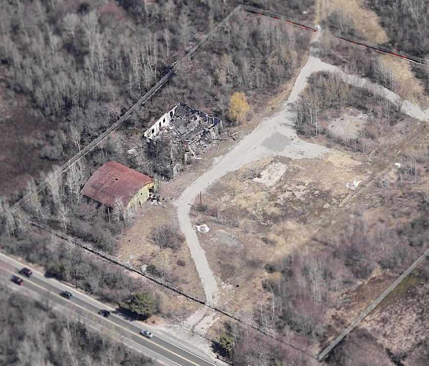
A circa 2006-2009 aerial view shows that the remains of the last hangars were evidently removed at some point between 2006-2009.
A sign on a fenced gate on Neponset Street says “Former Canton Airport”.
A 6/23/15 photo by Eric Wickberg looking along the site of a Canton Airport runway.
According to the Army Corps of Engineers' Dave Larsen, the pipes sticking up from the ground “are groundwater monitoring wells” (which do not date from the site's airport days).
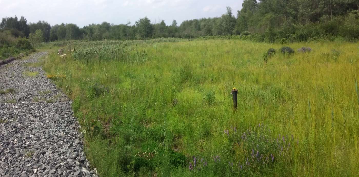
Eric Wickberg reported in 2015, “The Canton Airport... They have changed that site into a town park.
It's still under some minor construction, but the majority of it is completed. You can see the construction trailer in the lower left of the area.
It appears that all the hangars have been removed, and that they have probably re-graded the areas that were once the runways.
There was a construction trailer there a week ago. It's gone now. I think they ran out of money.
There are a ton of sign frames there with no signs, also the structures you see have cross members where a roof would go, but no roof.
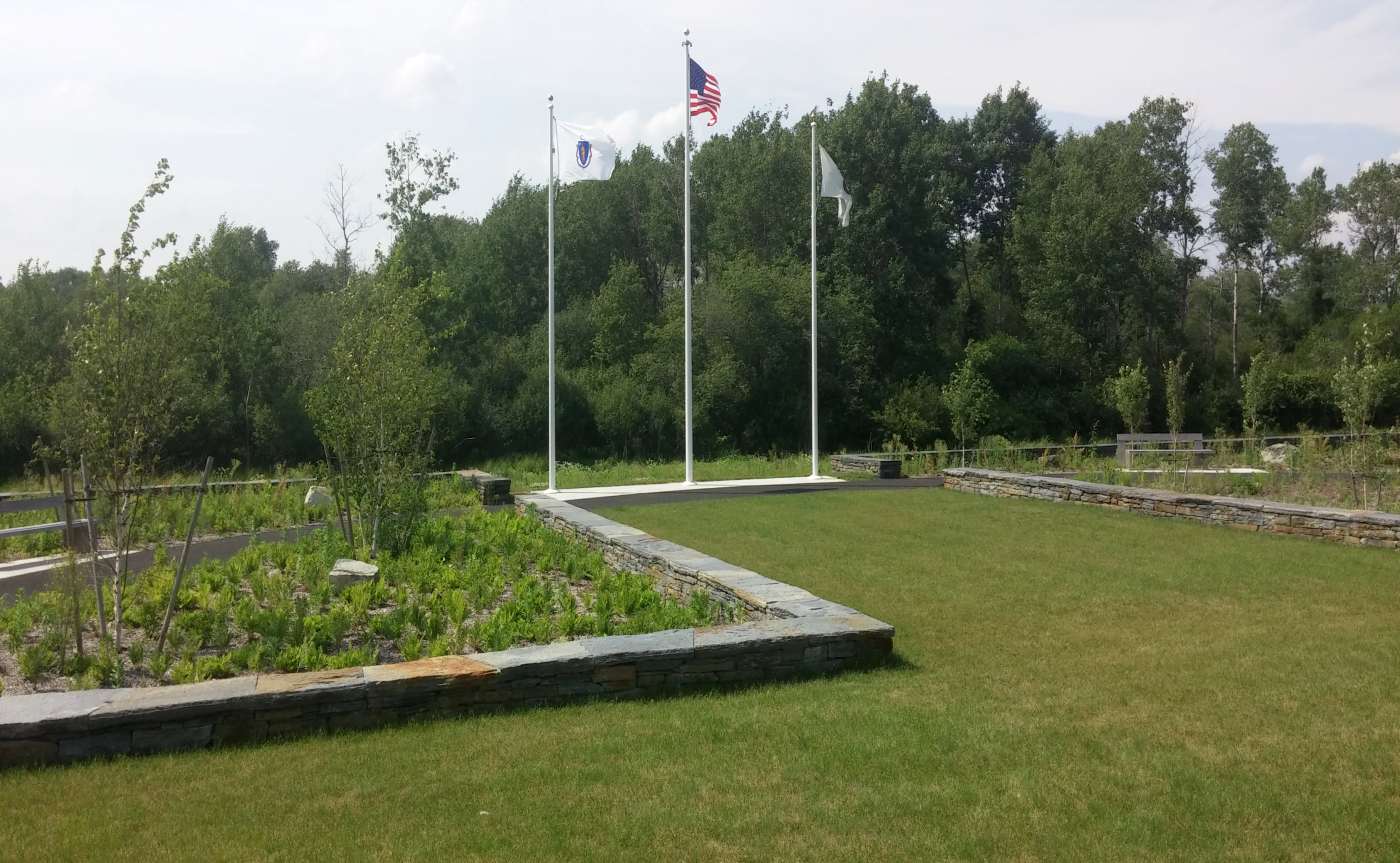
A 6/23/15 photo by Eric Wickberg of a newly-constructed park facility at the site of the Canton Airport hangars.
A 2019 aerial view looking northeast showed the former Boston Metropolitan Airport runways were still barely recognizable in the woods, with the site of the 2 hangars at the southwest corner of the field.
The Boston Metropolitan Airport property is located east of the intersection of I-95 & Neponset Street.
It sits only a mile directly under the final approach path to Norwood Airport's Runway 35.
Thanks to Peter Kodis for pointing out this airfield.
See also:
http://www.nasm.si.edu/nasm/aero/aircraft/helio.htm
http://www.geocities.com/Heartland/Hills/1496/book/bibook2.htm
____________________________________________________
Or if you prefer to contact me directly concerning a contribution (for a mailing address to send a check),
please contact me at: paulandterryfreeman@gmail.com
If you enjoy this web site, please support it with a financial contribution.
____________________________________________________
This site covers airfields in all 50 states.