Abandoned & Little-Known Airfields:
Southern Indiana
© 2002, © 2025 by Paul Freeman. Revised 10/17/25.
This site covers airfields in all 50 states: Click here for the site's main menu.
____________________________________________________
Please consider a financial contribution to support the continued growth & operation of this site.
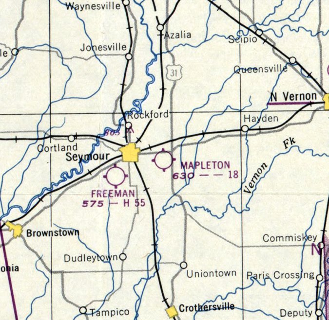
Aurora Industrial Airfield (revised 5/6/24) - Dresser Field / Paul Cox Field (revised 8/5/17) - Freeman Field Auxiliary #1 / Walesboro Field / Columbus Airport (revised 9/5/23)
Hap's Airport (revised 5/6/24) - Hillside Airpark (revised 9/5/23) - Madison AAF / Madison Municipal Airport (revised 10/17/25)
Mapleton Airport (added 10/25/17) - New Albany – Jeffersonville Airport / Bush Airport (revised 5/5/24)
____________________________________________________
New Albany – Jeffersonville Airport / Bush Airport, Clarksville, IN
38.305, -85.758 (North of Louisville, KY)
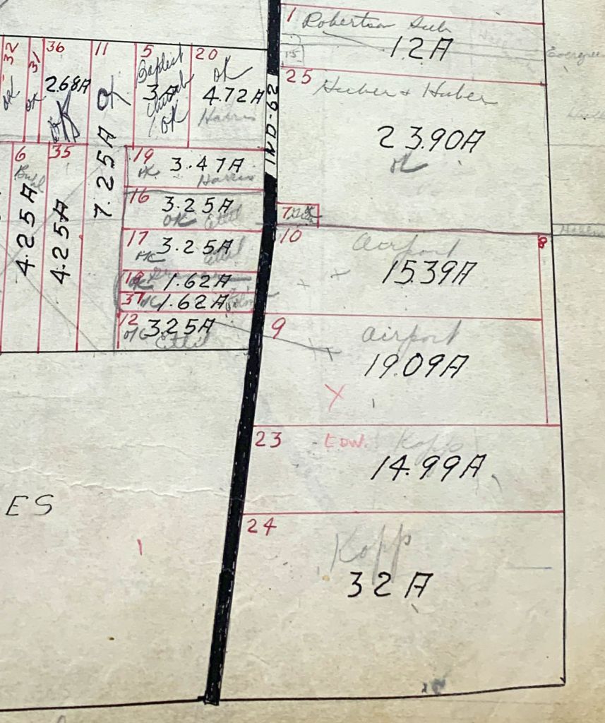
A 1938 Clark County Assessor’s Plat Book showed Parcels 9 & 10 labeled “Airport” (courtesy of Joe Schneid).
The date of establishment of this small general aviation airport has not been determined.
The earliest reference which has been located to this airfield came from Joe Schneid, who reported,
“I visited the Clark County Plat Room & Recorders Office to see what I could find on my Uncle Charlie Bush’s Airport.
The clerk in the Plat Room was surprised to find 'Airport' written in the plat book.”
The Assessor’s Plat Book shows three entries for the property that made up the airport: Lines 8, 9 & 10 with a total acreage of 35 acres.”
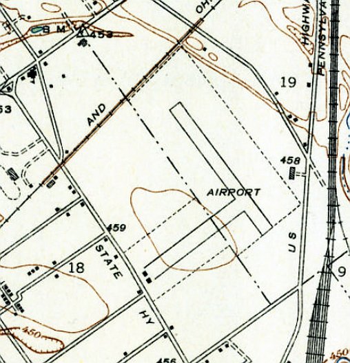
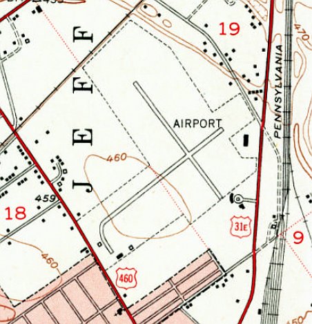
The 1939 USGS topo map depicted 2 perpendicular paved runways, generically labeled “Airport”, with 2 small buildings on the southwest end of the northeast/southwest runway.
However, no airport at this location was depicted on 1939/41/43/45 Cincinnati Sectional Charts.
According to a photo caption (courtesy of Joe Schneid), “Charles Bush & his brothers Francis & Andrew purchased the airport property from the Curtiss-Wright Corporation on 10/30/45.”
The airport was still not yet depicted on the 1946 Cincinnati Sectional Chart.
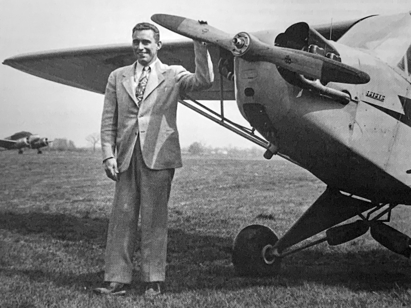
The earliest photo which has been located of Bush Airport was a March 1946 photo of new airport owner Charles Bush & a Piper J-3 Cub (courtesy of Joe Schneid).
The earliest aeronautical chart depiction which has been located of this airfield was on the April 1947 Cincinnati Sectional Chart.
It depicted the “New Albany – Jeffersonville” Airport as a commercial/municipal airport.
The last photo which has been located showing New Albany – Jeffersonville Airport in operation was a 1949 aerial view.
It depicted a paved northeast/southwest runway, an unpaved crosswind runway, and 20 light aircraft & several small buildings on the southwest side.
New Albany – Jeffersonville Airport was evidently renamed Bush Airport at some point between 1947-50,
as that is how it was labeled on the 1950 Cincinnati Sectional Chart.
The last topo map depiction which has been located of Bush Airport was on the 1951 USGS topo map.
It depicted 2 perpendicular paved runways, generically labeled “Airport”, with 3 small buildings on the southwest side.
The last aeronautical chart depiction which has been located of Bush Airport was on the January 1954 Cincinnati Sectional Chart.
It depicted Bush as having a 2,600' paved runway.
Bush Airport evidently closed (for reasons unknown) at some point in 1954, as it was no longer depicted on the June 1954 Cincinnati Sectional Chart.
Joe Schneid recalled, “Bush Airport... My uncle Charlie Bush sold his airfield to a company that was going to build a shopping center.
This was in the 1950s when shopping centers were a new concept; the proposed center was going to be called Miracle Mile Shopping Center.
Construction on the center began but stalled early when they had financial or legal problems. The property sat for years with some partially constructed buildings.”
The 1955 USGS topo map depicted Bush Airport's paved northeast/southwest runway, ramps, and a few buildings, but the airport was no longer labeled.
A 1955 aerial view showed Bush Airport after its closure.
The 2 runways remained intact, but all buildings except for 1 Quonset hut had been removed at some point between 1949-55, and no aircraft were visible.
A 1959 aerial view showed Bush Airport's Quonset hut had been removed at some point between 1955-59,
and houses had been built on the northeast end, but a substantial portion of the paved runway remained.
A 1971 aerial view showed a portion of Bush Airport's paved runway remained.
A 1983 aerial view showed the last portion of Bush Airport's paved runway had been removed at some point between 1971-83, erasing the last trace of the airport.
A 2019 aerial view looking north showed no trace of Bush Airport.
According to Eric Karnes, “Clarksville Airport... [was located] on Eastern Boulevard at what is today Little League Boulevard.”
Thanks to Eric Karnes for pointing out this airfield.
____________________________________________________
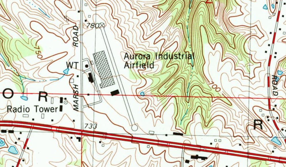
Aurora Industrial Airfield, Aurora, IN
39.035, -84.965 (Southwest of Cincinnati, OH)
Aurora Industrial Airfield, as depicted on the August 1967 Cincinnati Sectional Chart.
No airfield was yet depicted at this location on a 1965 aerial photo.
This private airfield was established by the Aurora Casket Company, whose factory was adjacent to the west side of the airfield.
An 11/1/66 Daily Journal article (courtesy of Lee Corbin) reported,
“Approved a private industrial airport near Aurora at the site of the Aurora Casket Company.”
Aurora Industrial Airfield was not yet depicted on the February 1967 Cincinnati Sectional Chart.
The luster of the company having its own on-site private airfield was very quickly diminished,
when only a few months after the airfield's construction, 6 people (including the company's chief pilot) were killed in the crash of their Cessna Skyknight less than a mile from the airfield,
as described in a 5/16/67 Indianapolis News article (courtesy of Lee Corbin).
The earliest depiction which has been located of Aurora Industrial Airfield was on the August 1967 Cincinnati Sectional Chart.
It depicted the Aurora Industrial Airfield as having a single 2,300' paved northwest/southeast runway.
The last aeronautical chart depiction which has been located of Aurora Industrial Airfield was on the August 1969 Cincinnati Sectional Chart.
It depicted the Aurora Industrial Airfield as having a single 2,400' paved northwest/southeast runway.
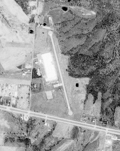
The earliest photo which has been located of the Aurora Industrial Airfield was a 4/7/78 USGS aerial view.
It depicted Aurora Industrial Airfield as having a single asphalt northwest/southeast runway, with a circular turnaround pad on each end.
The Aurora Casket Company factory was depicted adjacent to the west side of the runway, along with a building which might have been a hangar.
The 1981 USGS topo map (courtesy of Lee Corbin) depicted the Aurora Industrial Airfield to have a single paved northwest/southeast runway, with a circular turnaround pad on each end.
The Aurora Casket Company factory was depicted adjacent to the west side of the runway, along with a building which might have been a hangar.
A 1999 USGS aerial view looking northeast depicted Aurora Industrial Airfield as having a single asphalt northwest/southeast runway, with a circular turnaround pad on each end.
The runway did not appear to still be in use for aviation, as it was being used to park cars.
The Aurora Industrial Airfield was evidently closed at some point between 1969-2011,
as it was no longer depicted on the 2011 Cincinnati Sectional Chart or the 2013 USGS topo map.
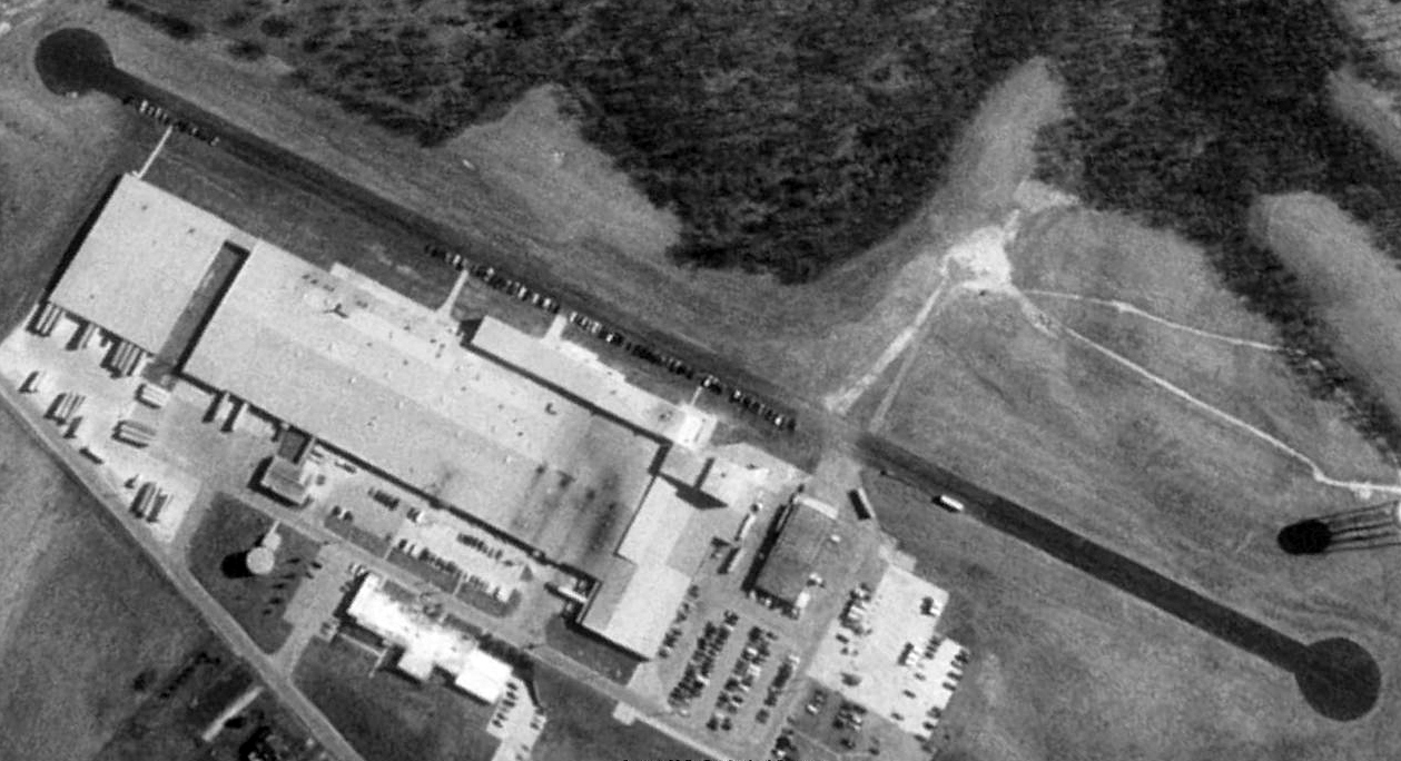
A 2016 aerial view looking northeast showed the Aurora Industrial Airfield to remain intact, including the runway & the possible former hangar.
A June 2019 photo looking northwest along the former Aurora Industrial Airfield runway, intact but blocked by a trailer.
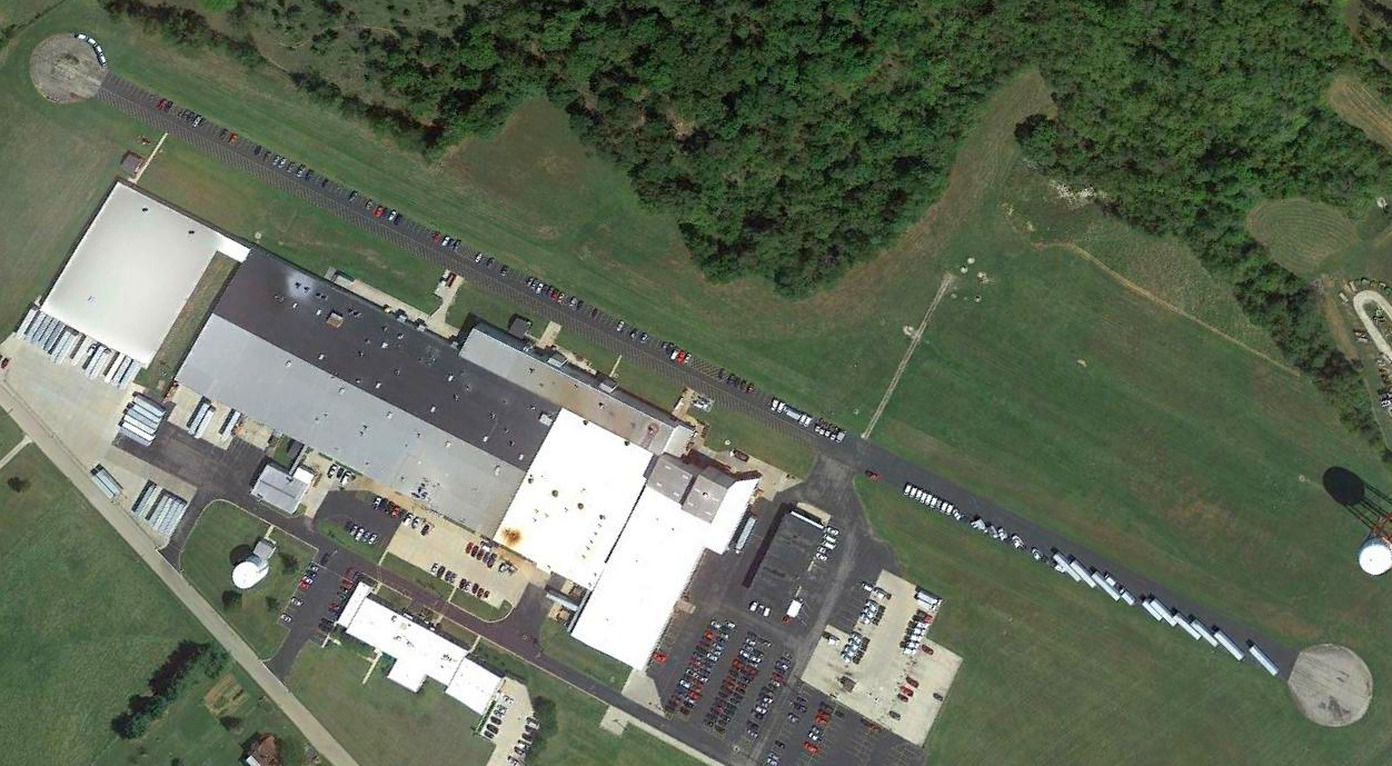
As of 2024, the Aurora Industrial Airfield site was labeled Matthews Aurora Funeral Solutions on street maps.
Thanks to Lee Corbin for pointing out this airfield.
____________________________________________________
39.544, -87.323 (Northeast of Terre Haute, OH)
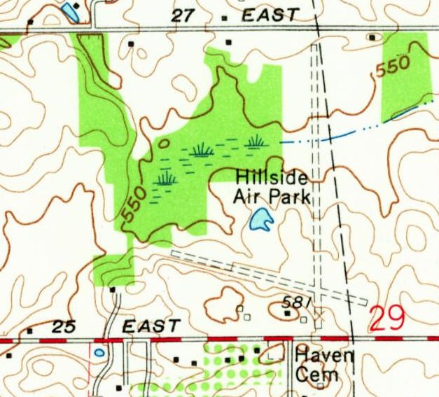
Hillside Airpark, as depicted on the 1962 USGS topo map.
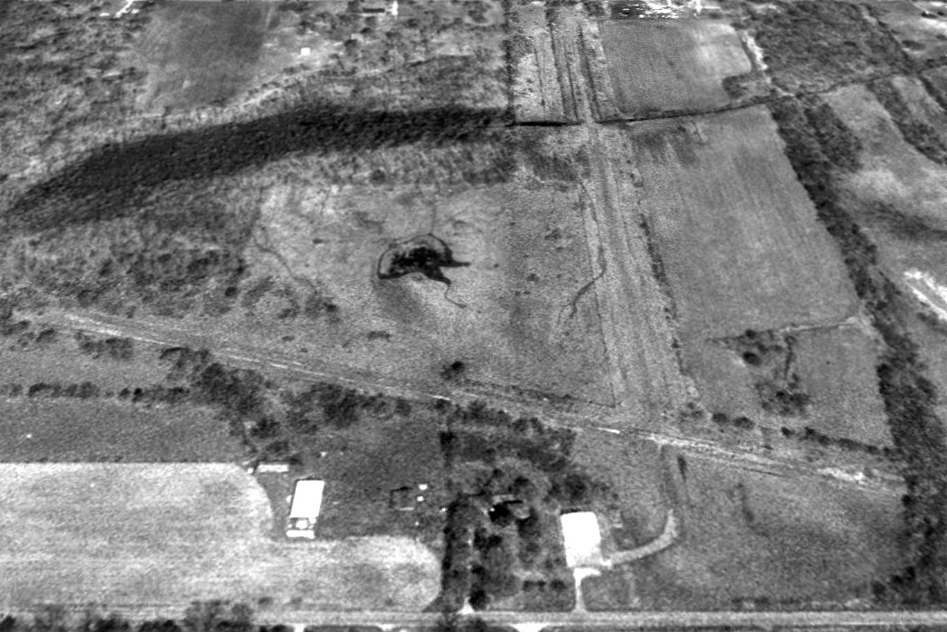
This small general aviation airport was evidently established at some point between 1952-62,
as it was not yet depicted on a 1949 aerial photo nor on the 1952 USGS topo map.
Hillside Airpark was not depicted at all on Cincinnati Sectional Charts from 1953/55/60/65/69.
The earliest depiction which has been located of Hillside Airpark was a 1962 aerial photo.
It depicted Hillside Airpark as having a north/south unpaved runway & a ramp & small hangar on the southwest side.
The 1962 USGS topo map depicted Hillside Airpark as having 2 unpaved runways & 2 small buildings on the southwest side.
A 1972 aerial photo depicted Hillside Airpark's northwest/southeast runway as having been paved.
Jeff Johnston recalled of Hillside Airpark, “When I was a flight instructor in the 1980s I would look down & wonder who may have owned it & what type of flying was done from it.”
A 1998 USGS aerial view looking north at Hillside Airpark showed the northwest/southeast runway pavement had deteriorated considerably.
There was no sign of any recent aviation use.
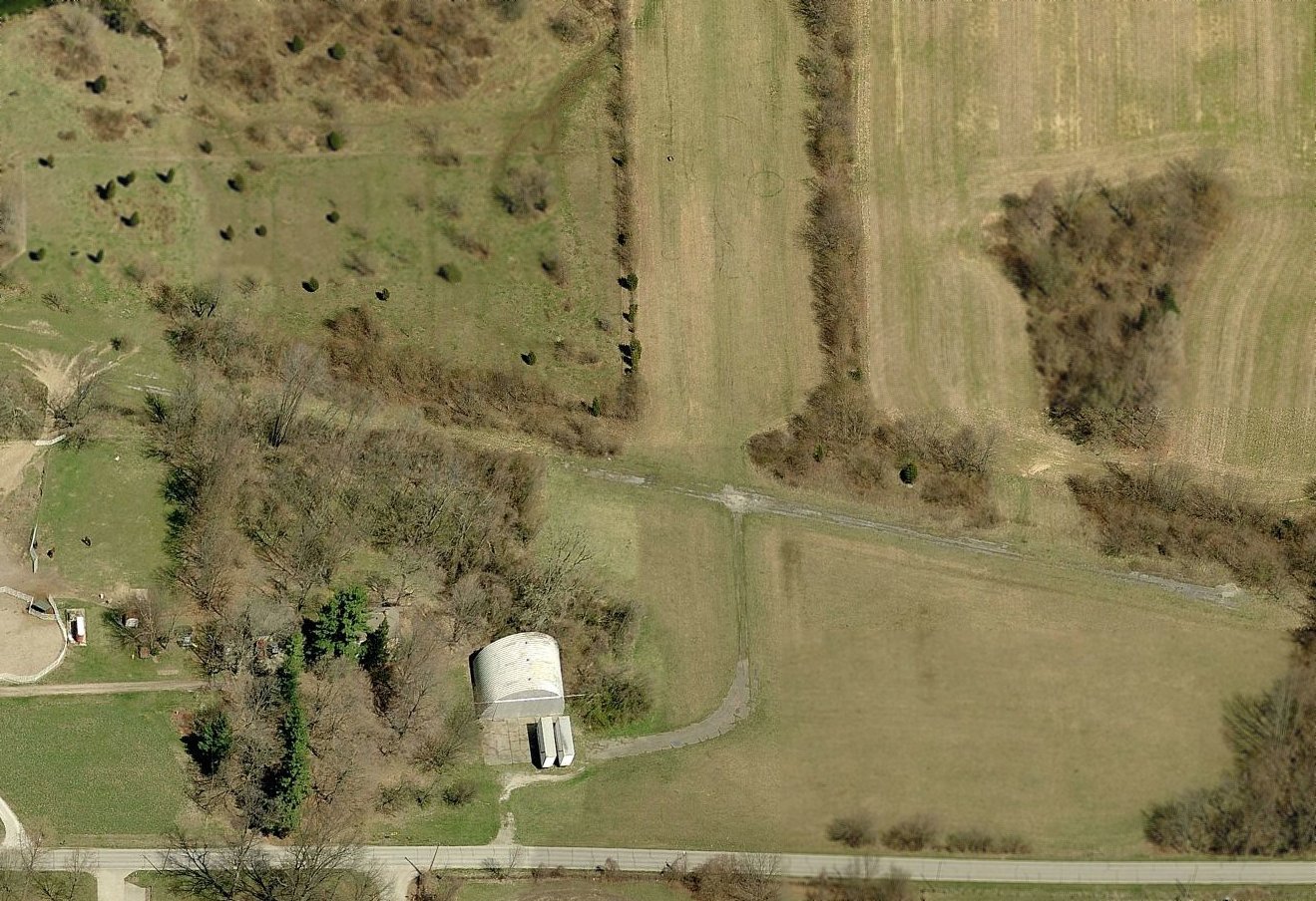
A circa 2010-2017 aerial view looking north showed Hillside Airpark's northwest/southeast runway pavement had deteriorated considerably.
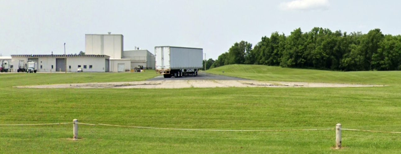
A Quonset hut hangar remained on the southwest side.
A 2016 aerial view looking north showed Hillside Airpark's 2 runways remained recognizable though deteriorated.
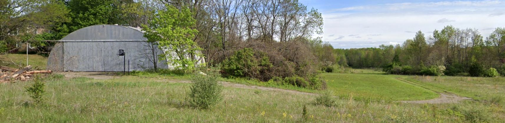
A 2023 photo looking north at the Quonset hunt hangar which remains at the south side of the Hillside Airpark site.
Thanks to Jeff Johnston for pointing out this airfield.
____________________________________________________
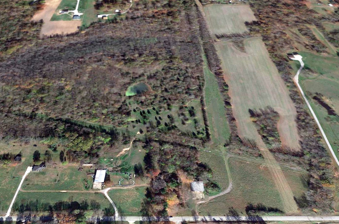
38.955, -85.837 (West of Cincinnati, OH)
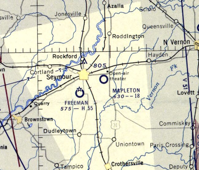
Mapleton Airport, as depicted on the June 1950 Cincinnati Sectional Chart.
This small general aviation airport was evidently established at some point between 1946-50,
as it was not yet depicted on the 1946 Cincinnati Sectional Chart.
The earliest depiction which has been located of Mapleton Airport was on the June 1950 Cincinnati Sectional Chart.
It depicted Mapleton Airport as having a 1,800' unpaved runway.
The earliest photo which has been located of Mapleton Airport was a 4/1/56 USGS aerial view (courtesy of Lee Corbin).
It depicted Mapleton Airport as having 3 grass runways, with a few small buildings on the northeast side.
The last aeronautical chart depiction which has been located of Mapleton Airport was on the June 1956 Cincinnati Sectional Chart.
It depicted Mapleton Airport as having a 1,800' unpaved runway.
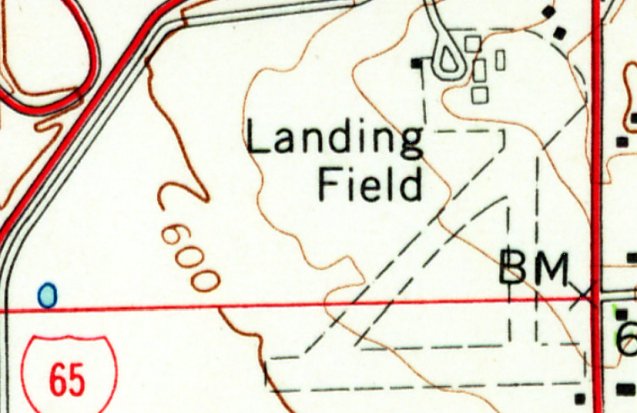
The 1959 USGS topo map (courtesy of Lee Corbin) labeled Mapleton Airport simply as “Landing Field”, which may indicate that it had closed by that point.
It depicted Mapleton as having 3 unpaved runways, with a few small buildings on the northeast side.
Mapleton Airport was evidently closed at some point between 1956-60,
as it was no longer depicted on the 1960 Cincinnati Sectional Chart.
It had presumably closed due to competition from the much larger Freeman Field, only a few miles to the southwest.
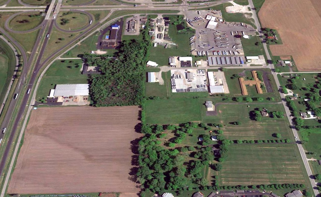
A 2015 aerial view looking north showed no sign remaining of Mapleton Airport.
Thanks to Lee Corbin for pointing out this airfield.
____________________________________________________
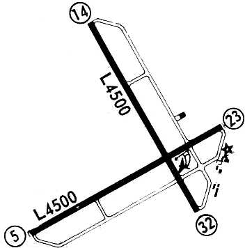
Hap's Airport, Clarksville, IN
38.34, -85.76 (North of Louisville, KY)
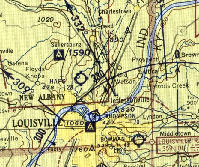
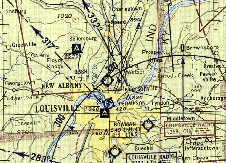
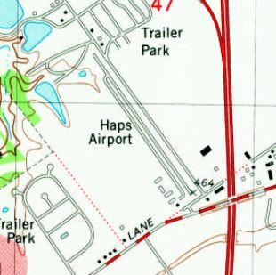
Hap's Airport, as depicted on the June 1955 Cincinnati Sectional Chart.
This small general aviation airport may have been established at some point between 1951-55,
as it was not yet depicted on the June 1950 Cincinnati Sectional Chart nor on the 1951 USGS topo map.
The earliest depiction which has been located of Hap's Airport was on the June 1955 Cincinnati Sectional Chart.
It depicted Hap's Airport as having a 2,300' unpaved runway.
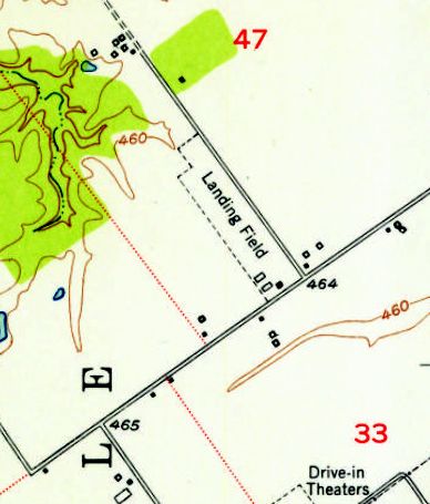
The 1955 USGS topo map depicted Hap's Airport as a northwest/southeast rectangular property outline, labeled simply as “Landing Field”,
with 3 small buildings on the south end.
Eric Karnes recalled, “Hap's Airport was located on Old Potter's Lane at Addmore Lane. I think he was a Piper dealer.”
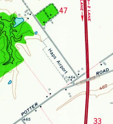
The earliest labeled depiction which has been located of Hap's Airport was on the 1960 USGS topo map.
The 1965 USGS topo map continued to depict Hap's Airport in an unchanged fashion.

The last aeronautical chart depiction which has been located of Hap's Airport was on the August 1969 Cincinnati Sectional Chart.
Hap's had evidently gained a paved runway at some point between 1965-69,
as it was depicted as having a 2,200' paved northwest/southeast runway.
The 1971 USGS topo map depicted Hap's Airport as having a single paved northwest/southeast runway.
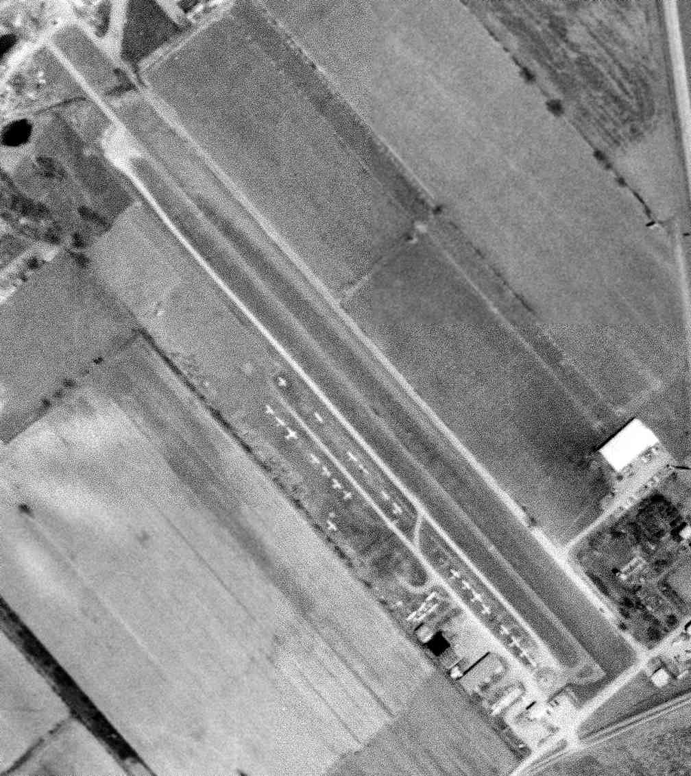
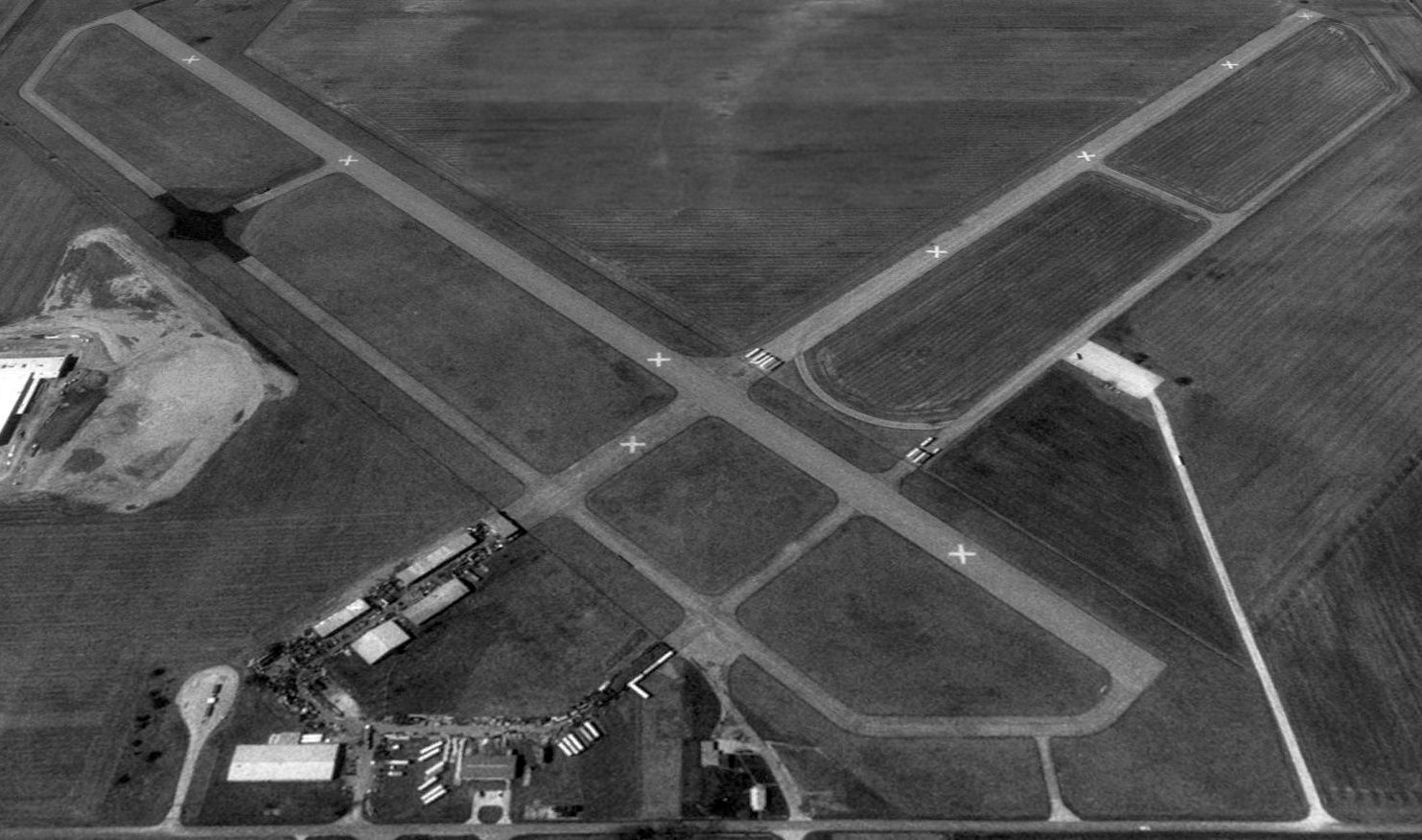
The earliest photo which has been located of Hap's Airport was a 4/15/71 USGS aerial view.
It showed the little field to be quite popular, with several dozen light aircraft parked on the west side of a paved runway with a parallel taxiway.
Larry Whitlow recalled, “Hap's Airport... There were usually 20-30 airplanes based at the field, and if the weather was good somebody would always be flying.
The airport was owned & the Fixed-Base Operator operated by William 'Hap' Happel under the business name of Hap’s Aerial Enterprises.
Hap’s rentals had in the fleet a Cessna 150, a C-150 re-engined with an engine from a C-172, and a C-172.
The C-150 with the big engine was preferred in the heat of the summer with a couple of 'pilots of size' aboard
to get off the ground in the 2,000’ of runway available you had & to get over the overpass (and any cement mixers).
The runway was 50’ wide & approximately 2,000’ long with a displaced threshold when landing to the northwest, due to the overpass on Potters lane.
There was a cement plant just past the airport on Potters Lane & the combination of the overpass, a cement mixer and a low approach made for some interesting landings.
When landing to the southeast the approach was made through a gap in the tree line that is still there today.
A helicopter operation,Whirl-a-Way, operated there as well. They provided traffic helicopter services to WHAS Radio using Bell 47Gs.”
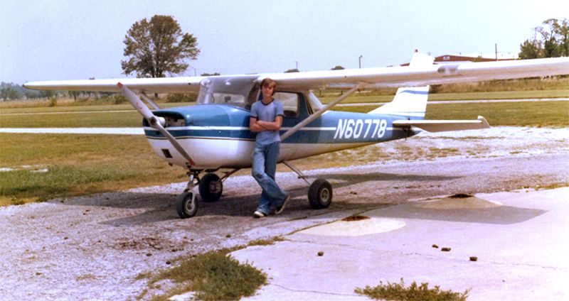
The last photo which has been located showing Hap's Airport still in operation
was a 1977 photo by Bobby Whitlow of Larry Whitlow in front of Cessna 150J N60778 on the occasion of his first solo flight, “When I was 16 & 1 month old.
The airplane & I are at the fueling circle located by the office on the southwest corner of the airport. Hap was Navy Pilot in WW2 & was my flight instructor.”
According to Larry Whitlow, “The airport closed in 1981 when the new Clark County Airport opened (JVY) about 5 miles to the north northeast.
The county made him close his operation & Hap’s Aerial Enterprises now operates at JVY.”
The last depiction which has been located of Hap's Airport was on the 1982 USGS topo map.
Hap's Airport evidently closed at some point between 1981-87, as it was no longer depicted at all on the 1987 USGS topo map.
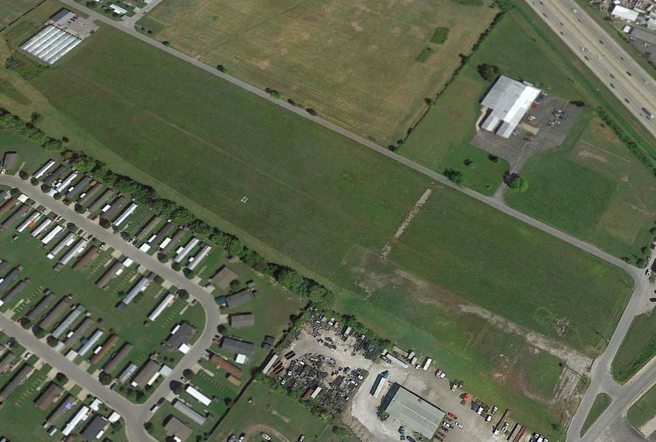
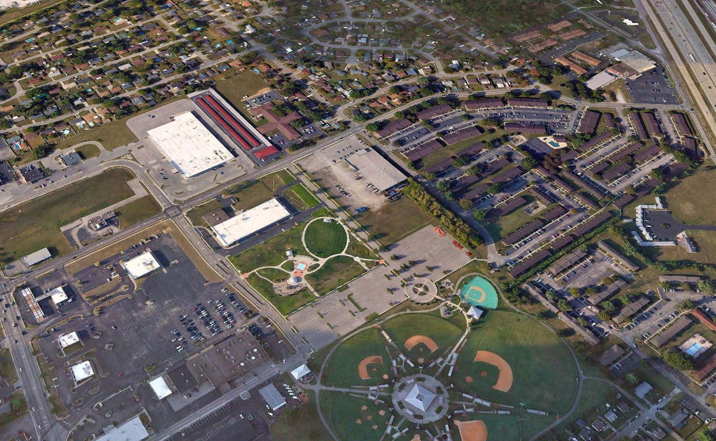
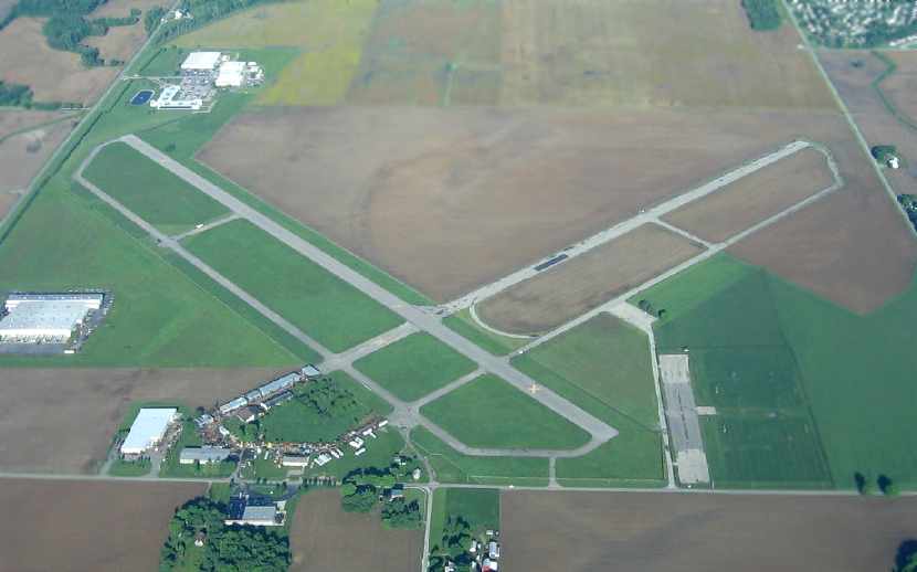
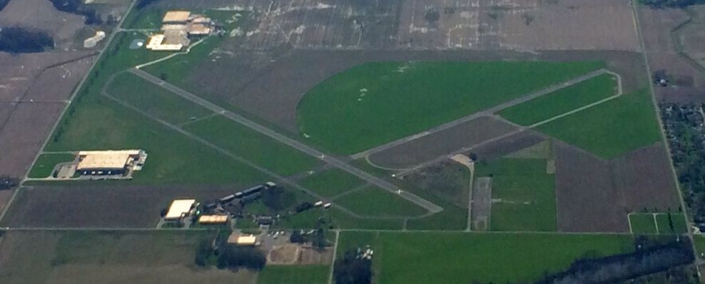
A 2014 aerial view looking northeast shows the site of Hap's Airport remains largely unredeveloped.
Eric Karnes observed, “You can still see the remains of the foundations”, at bottom-right.
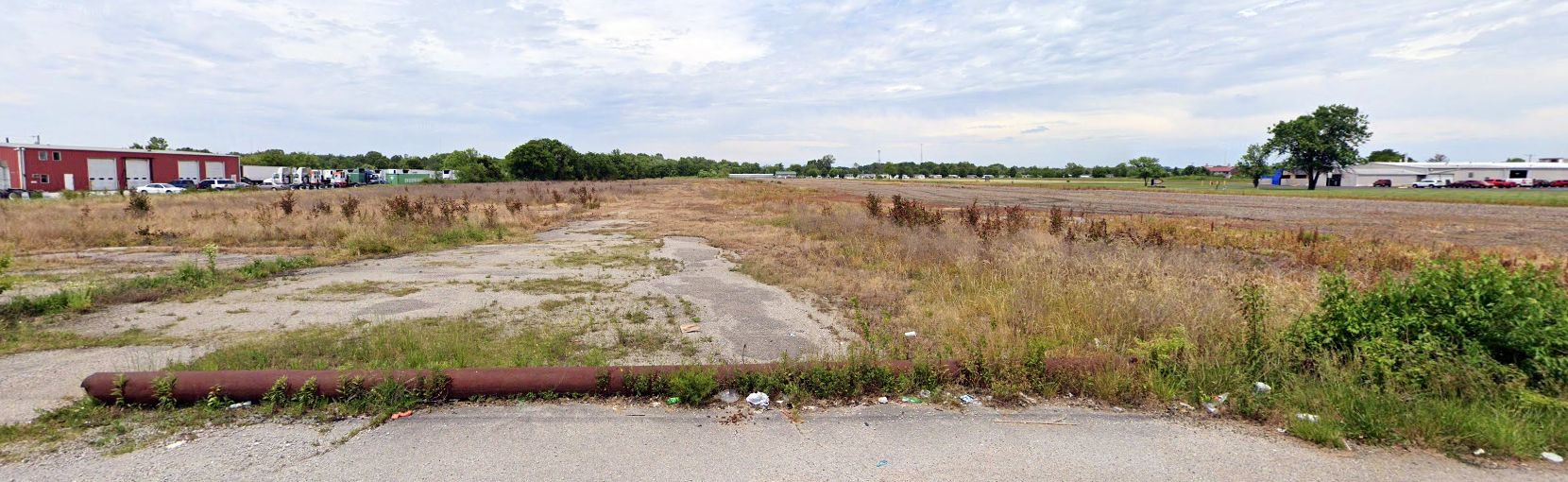
A May 2019 photo looking northwest at the Hap's Airport site, showing the hangar foundations at left.
Thanks to Eric Karnes for pointing out this airfield.
____________________________________________________
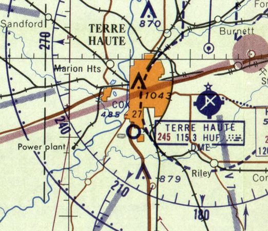
Dresser Field / Paul Cox Field, Terre Haute, IN
39.42, -87.41 (Southwest of Indianapolis, IN)
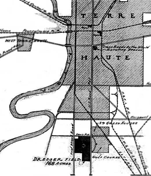
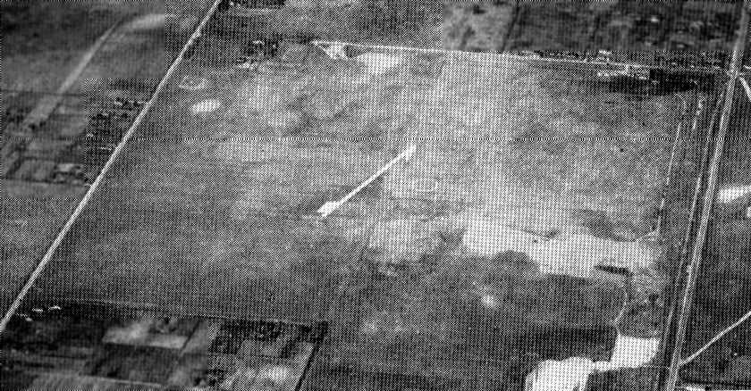
A pre-1933 map of Dresser Field (courtesy of Greg Haxton).
According to a history from the Terre Haute First National Bank,
in 1926 former Army pilot Paul Cox directed the formation of the Terre Haute Airport (Aero) Club,
which leased 168 unimproved acres on the city’s south edge for an airfield.
Receiving support from Fort Harrison American Legion Post #40,
Cox & other aviation enthusiasts organized Terre Haute Airways Inc. to develop a public airport.
With President Cox spearheading the crusade, the organization convinced reluctant politicians that the city needed the facility.
Designated Dresser Field, the property was acquired in 1929 for $82,175,
and the venture was an immediate success.
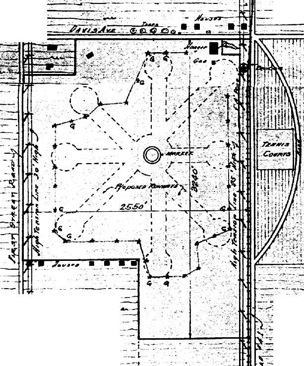
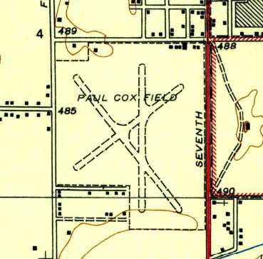
A pre-1933 diagram (courtesy of Greg Haxton) depicted Dresser Field as an irregularly-shaped property within which were 2 unpaved runways, with 2 other “proposed runways”.
A single hangar was located at the northeast corner.
The man chiefly responsible for Dresser Field did not enjoy its benefits long.
On 6/23/32, Paul Cox, only 35, and 30-year-old passenger William Root were killed
when Cox’s private aircraft crashed at dusk in a field near Farmersburg.
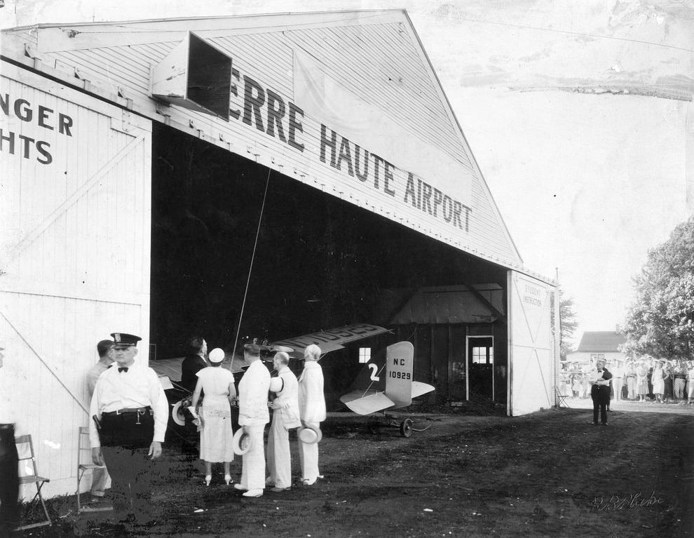
A 6/11/33 photo of the rededication of Dresser Field as “Paul Cox Field”, showing the new name on the hangar shortly before it was unveiled.
The rededication was accompanied by a spectacular aerial show.
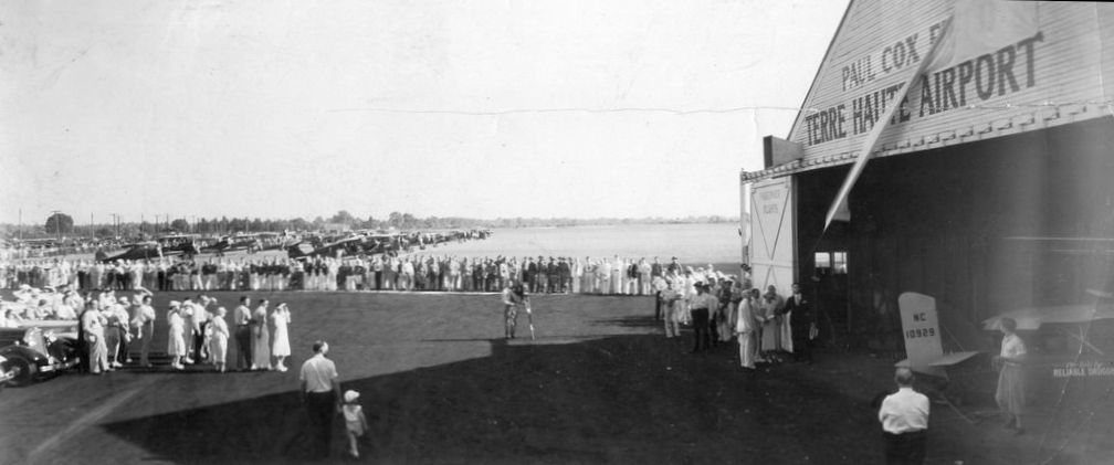
A 6/11/33 photo of the rededication of Dresser Field as “Paul Cox Field”, showing the banner being pulled off to reveal the new name on the hangar.
The earliest aeronautical chart depiction which has been located of Paul Cox Field was on the November 1933 Cincinnati Sectional Chart.
It depicted Paul Cox as a commercial/municipal airport.
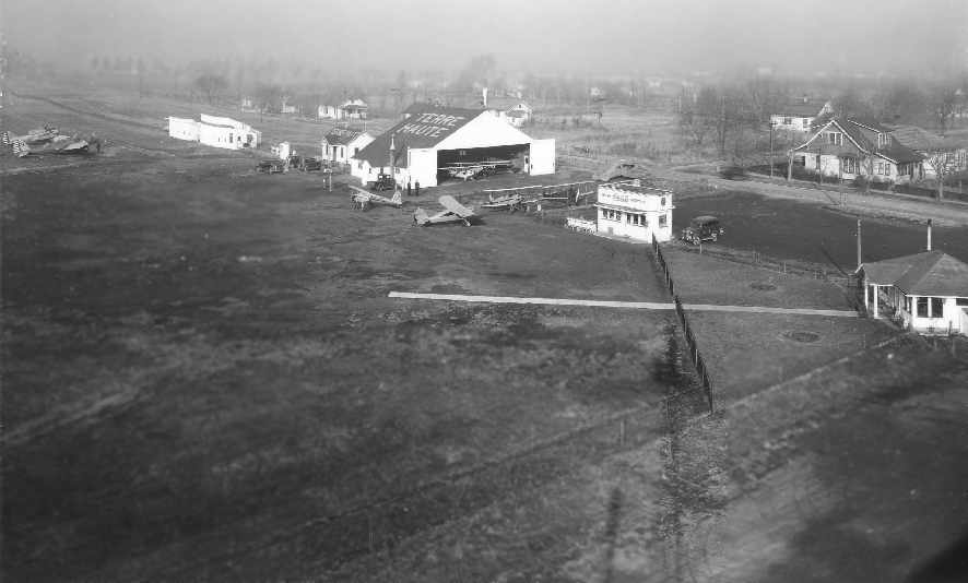
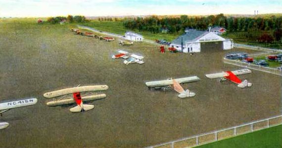
An undated aerial view looking north at Dresser Field from The Airport Directory Company's 1937 Airport Directory (courtesy of Bob Rambo).
It described Dresser as a municipal airport, consisting of a 168 acre rectangular sod field, measuring 3,240' x 2,550'.
A hangar roof was said to be painted with “Dresser Field”.
A circa 1936-37 aerial view looking at Paul Cox Field (from the Martin Collection of the Vigo County Public Library, courtesy of Bill Foraker),
showing a hangar & several aircraft, including 2 twin-engine Army Martin B-10B bombers.
According to Bill Miller, the “B-10Bs were first delivered in early 1935... The photo must have been taken around 1936-37,
because the markings are the older style used by the Air Corps.”
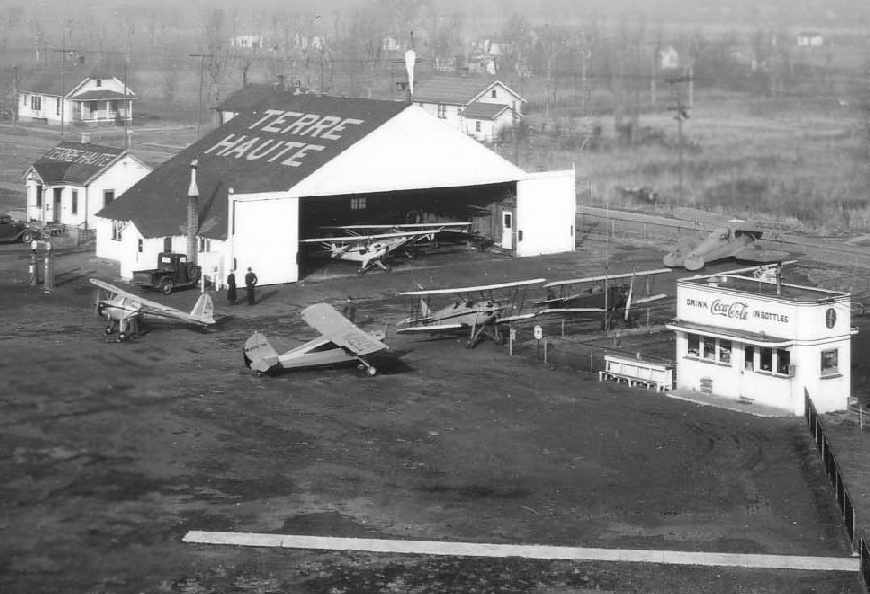
A closeup from the circa 1930s aerial view (from the Martin Collection of the Vigo County Public Library, courtesy of Bill Foraker),
showing Paul Cox Field's hangar, several monoplanes & biplanes, and a snack bar.
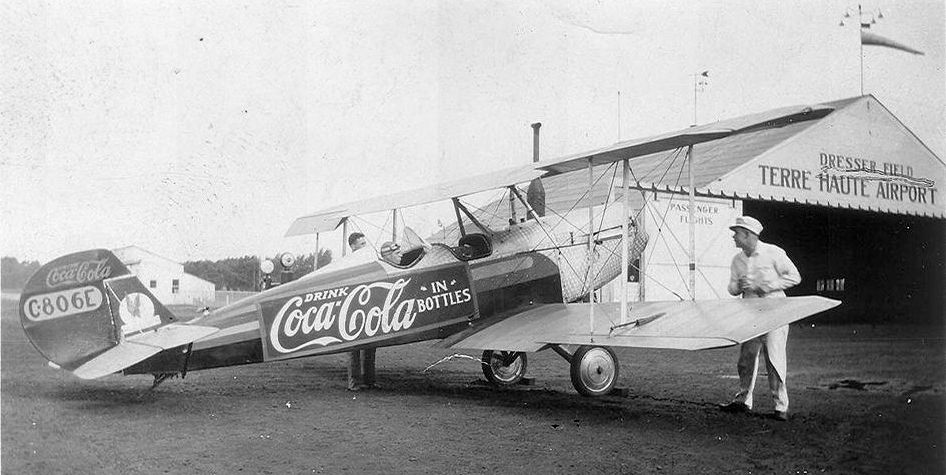
A 1930s photo of a biplane (model unidentified) used to advertise Coca-Cola in front of the Dresser Field hangar.
Greg Haxton recalled, “Dresser Field... My grandfather John Haxton was the airport manager their for quite a few years.
My grandfather was a friend of Roscoe Turner, who used this field a bit
and my Uncle even had a pilot's log book where he had received flight lesson from Roscoe.”
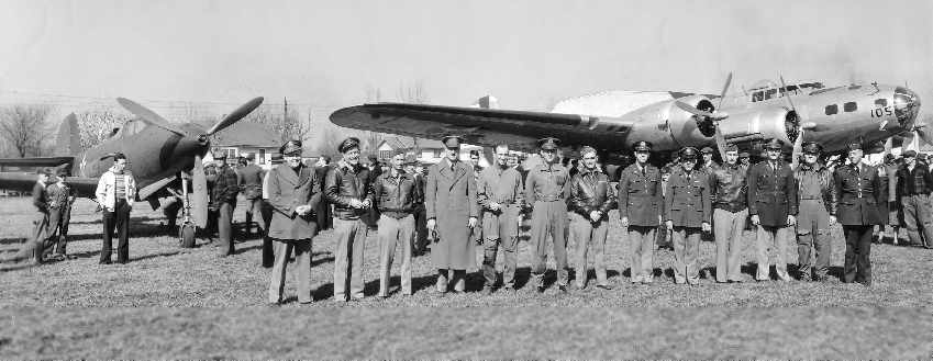
A 1941 photo showing an Army Bell P-39 fighter & an early-model Boeing B-17 bomber at Paul Cox Field (courtesy of Bill Foraker).
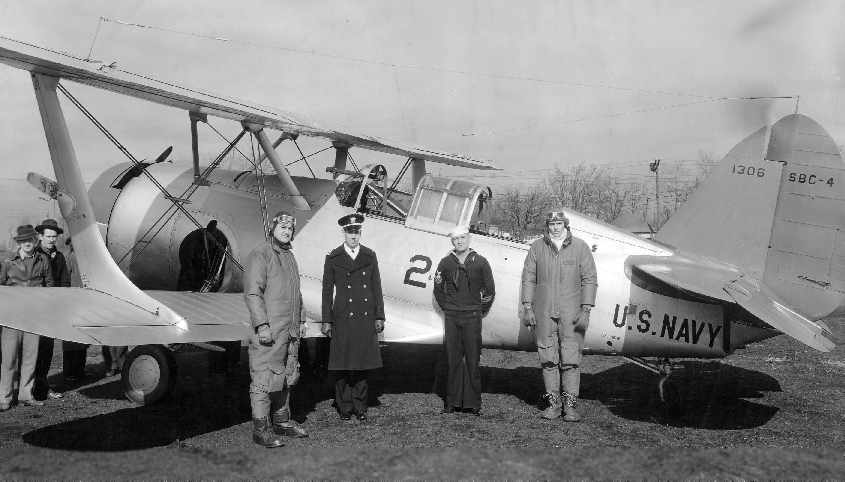
A 1941 photo showing a Navy SBC-4 dive bomber at Paul Cox Field (courtesy of Bill Foraker).
The 1941 USGS topo map depicted Paul Cox as having 3 unpaved runways, with a few small buildings on the north side.
Due to the limited size of Cox Field, plans to handle proposed transcontinental service were rejected by the federal government in 1942,
placing the airport’s future in jeopardy.
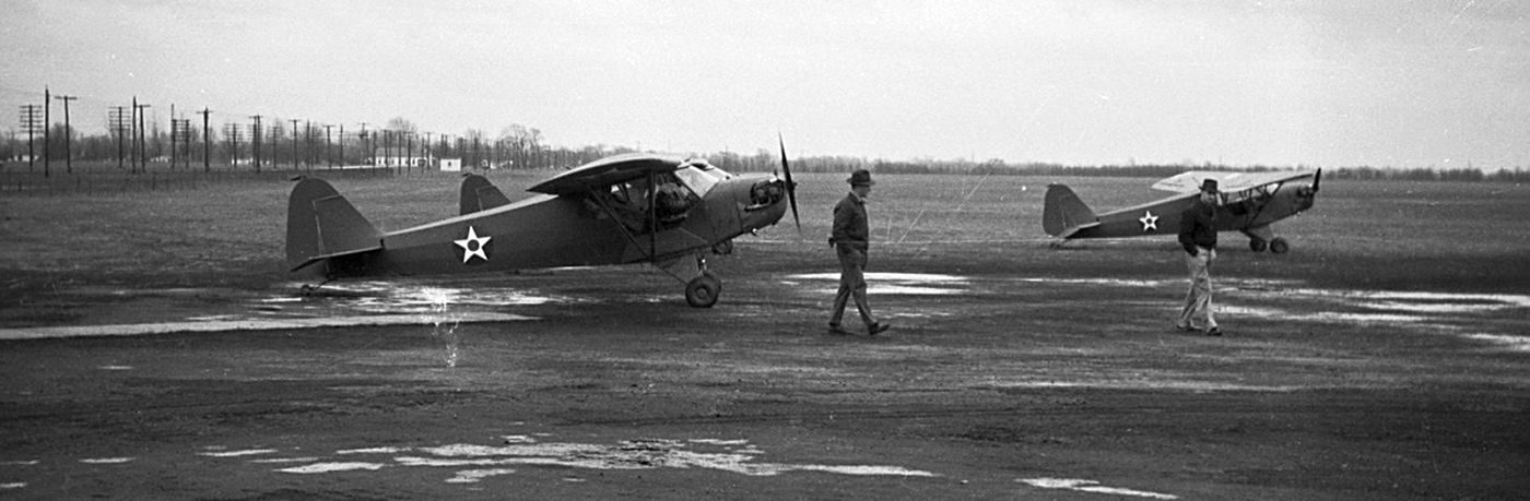
A circa 1942 photo by Harold Bitzegaio of several Army L-4 Piper Cubs at Paul Cox Field (courtesy of Jim Bitzegaio).
Jim Bitzegaio recalled, “My Dad [Harold Bitzegaio] flew out of Paul Cox Field. I believe he got his [pilot's] license there so that he could join the Navy as a pilot.
He lived just east of the field on Springhill Road.
The view looks like the power lines would have been along 7th Street (the street that ran along the east boundary of the airport & is the current east boundary of the South High School).
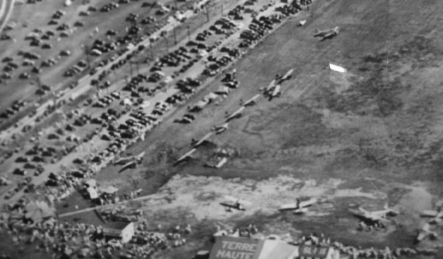
An 8/14/43 aerial view of Dresser / Cox Field (courtesy of Greg Haxton), showing numerous single & twin-engine aircraft on the field.
Was this some type of special occasion?
A larger airport, Hulman Field, was dedicated on 10/3/44.
Cox Field's U.S. Weather Bureau facilities & and the Civil Aeronautics Administration office were relocated to Hulman Field in late 1946.
Cox Field continued to serve the community as a general aviation airport for several more years.
An undated postcard of planes in front of a hangar at Paul Cox Field.
The last photo which has been located of Paul Cox Field was a 9/25/52 USGS aerial view, which depicted unpaved runways.
Tthe June 1954 Cincinnati Sectional Chart (courtesy of Chris Kennedy) depicted Paul Cox as having a 2,700' unpaved runway.
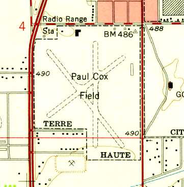
The last depiction which has been located showing Paul Cox Field while still open was on the 1958 USGS topo map.
It depicted Paul Cox as having 3 unpaved runways, with a few small buildings on the north & east sides.
Paul Cox Field was closed on 12/18/59.
The last aeronautical chart depiction which has been located of Paul Cox Field was on the January 1960 Cincinnati Sectional Chart.
It depicted Paul Cox as having a 2,700' unpaved runway.
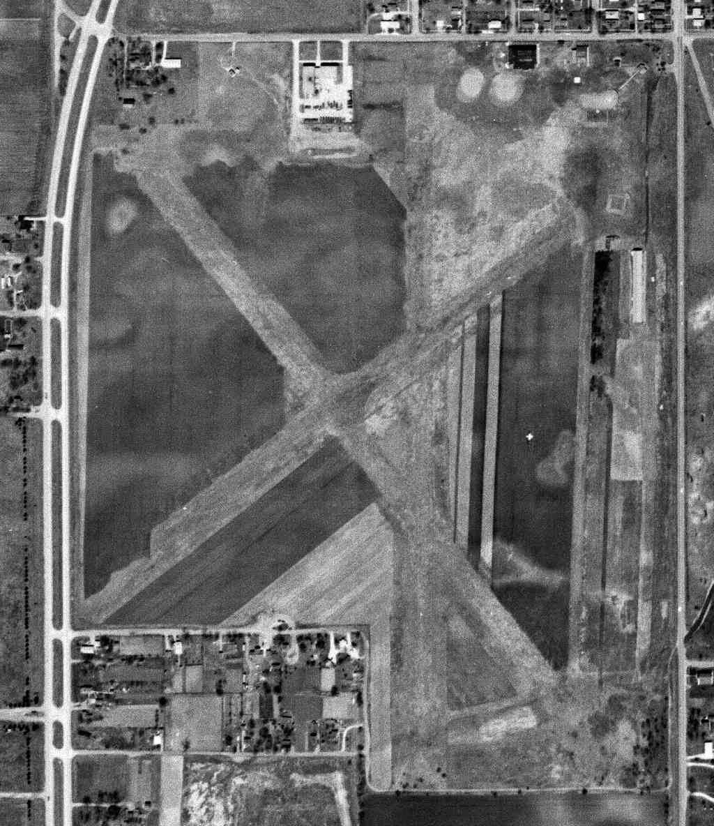
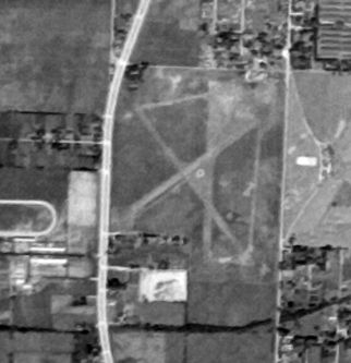
A 5/3/62 USGS aerial photo still showed the majority of Paul Cox Field's 3 runways still existed, but construction was starting to cover the site.
Paul Cox Field was no longer depicted on the August 1965 Cincinnati Sectional Chart.
Terre Haute South Vigo High School opened on the Paul Cox Field site in 1971.
A 1998 aerial photo showed no trace remaining of Paul Cox Field.
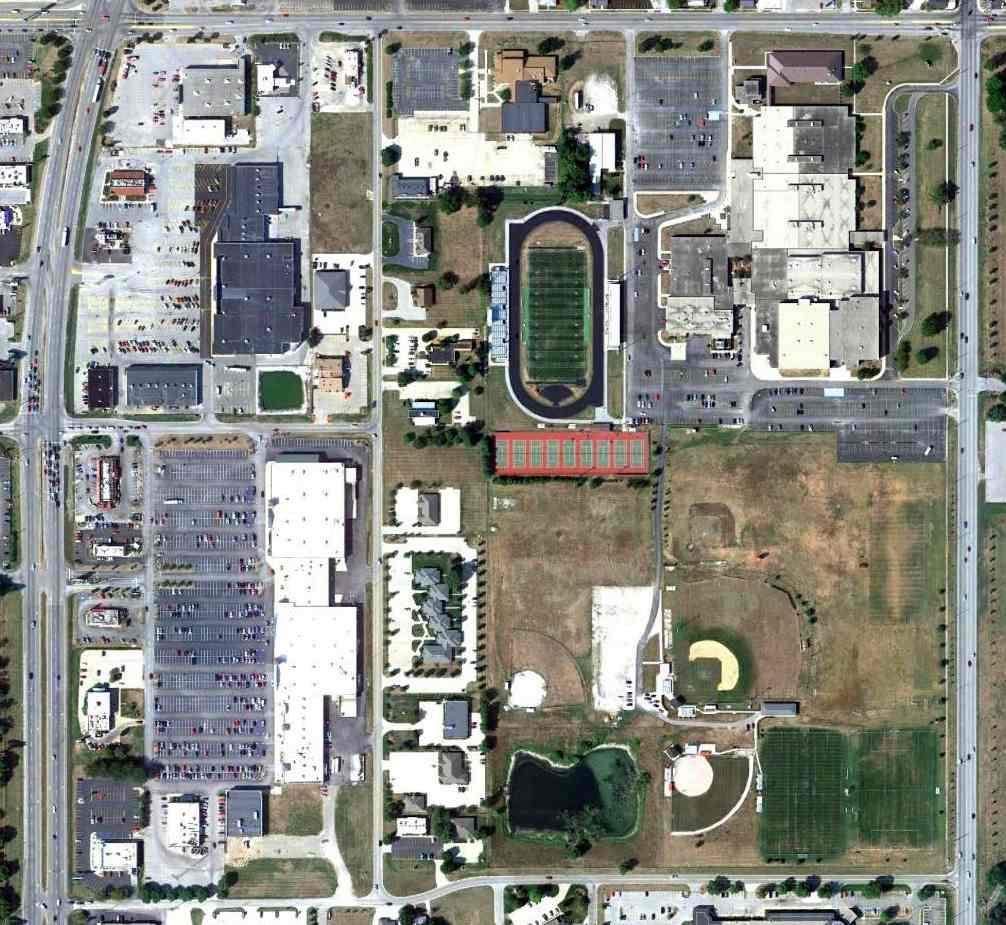
A 9/11/11 aerial photo showed South Vigo High School occupied the site of Paul Cox Field, and not a trace of the airport appeared to remain.
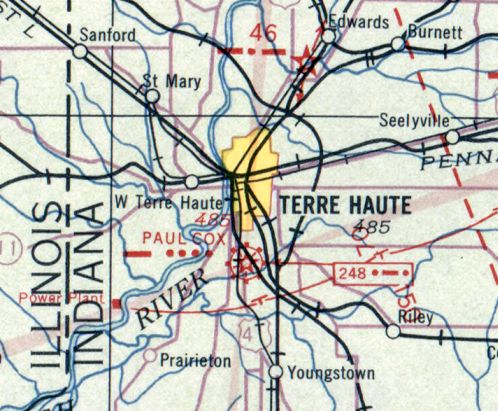
The site of Paul Cox Field is located southwest of the intersection of East 33rd Street & South 7th Street.
____________________________________________________
Freeman Field Auxiliary #1 / Walesboro Field / Columbus Airport (IFR), Walesboro, IN
39.142, -85.925 (South of Indianapolis, IN)
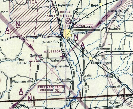
Walesboro Field, as depicted on the November 1943 Cincinnati Sectional Chart.
This airfield was built during WW2 as one of 5 satellite airfields for Freeman AAF,
which provided advanced flight training for crews of multi-engine aircraft.
Walesboro Field was evidently built at some point between 1942-43, as it was not yet depicted on the October 1942 Cincinnati Sectional Chart.
The earliest depiction which has been located of Walesboro Field was on the November 1943 Cincinnati Sectional Chart,
which depicted Walesboro as an auxiliary airfield.
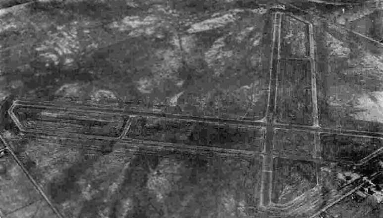
The earliest photo which has been located of this airfield was a circa 1943-45 aerial view looking northwest at “Freeman Field Auxiliary #1 (Walesboro Field)”
from the 1945 AAF Airfield Directory (courtesy of Scott Murdock).
The 1944 US Army/Navy Directory of Airfields (courtesy of Ken Mercer) described Walesboro Auxiliary AAF as having a 4,500' hard-surface runway.
The 1945 AAF Airfield Directory (courtesy of Scott Murdock) described “Freeman Field Auxiliary #1 (Walesboro Field)”
as an 805 acre square-shaped property having 2 bituminous 4,500 runways, oriented northwest/southeast & northeast/southwest.
The field was not said to have any hangars, to be owned by the U.S. Government, and operated by the Army Air Forces.
A 4/1/56 USGS aerial photo showed 1 (or possibly 2) light aircraft on the east side of Walesboro Field.
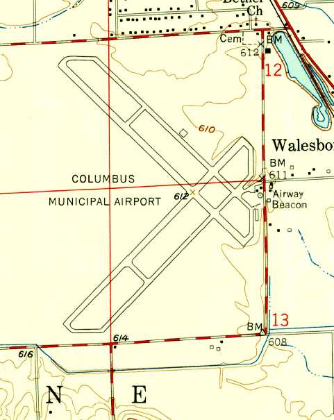
At some point between 1945-58, Walesboro was reused as a civil airport for the town of Columbus,
and became known as Columbus Municipal Airport.
The 1958 USGS topo map depicted Columbus Municipal Airport as having 2 paved runways each with a paved parallel taxiway,
and with an Airway Beacon on the east side.
The 1962 AOPA Airport Directory described Columbus Municipal Airport
as having 2 bituminous 4,500' runways: 4/22 & 13/31, and listed the operator as James Owens.
Gary Sublette recalled, “I learned to fly from the old Columbus Airport in 1966. At that time it was managed by John Owens.
John managed the Airport from after WW2 & had a 25 year lease. John had a son who might have managed it for a while.
He took me for a ride & signed my logbook as J. Owens. That was probably James.”
The earliest aeronautical chart depiction which has been located of Columbus Airport was on the August 1968 Cincinnati Sectional Chart.
It depicted Columbus as having 2 paved runways, with the longest being 4,500'.
Columbus Municipal was still depicted as an active airport in the 1971 Flight Guide (courtesy of Chris Kennedy).
However, Columbus Municipal Airport was apparently closed at some point between 1971-82,
after the much larger Bakalar AFB (a few miles to the northeast) had become the new Columbus Bakalar Airport.
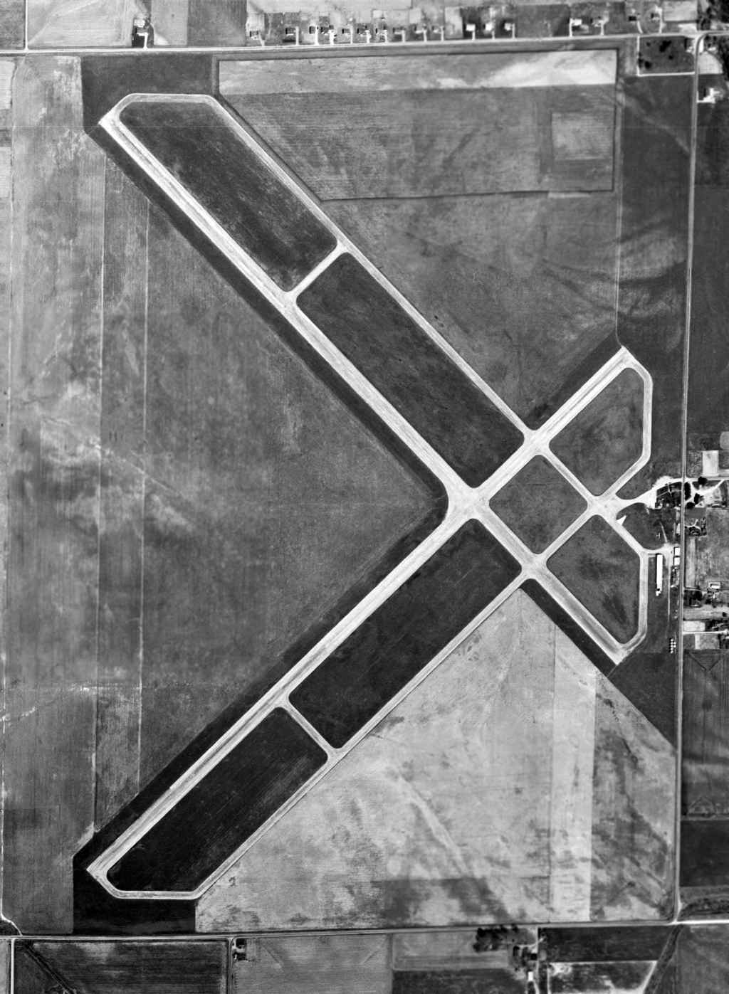
A 1998 USGS aerial view looking west showed Columbus Municipal Airport to have 2 paved runways (the longest is approximately 4,500').
Several buildings had been constructed over the southeast end of the former Runway 14/32.
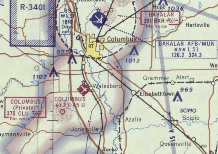
Walesboro was still depicted on the 1998 World Aeronautical Chart as an abandoned airfield.
According to former nearby resident Paul Smith, the Walesboro runways have been reused as an automotive testing ground by Arvin Industries in Columbus, IN.
Both runways have been maintained for automotive testing & are in good condition, with "X" closed markings painted on them.
The white building in the south is the main plant, with newer buildings north & east.
The usage of the runways is also rented to other local industries, including Cummins engine & others.
A 2006 aerial view by Phil Brooks looking west at the former Walesboro airfield
showed that the former runways & taxiways remained in fine shape.
A 4/11/15 aerial view by Nick Newcomb looking west at the former Walesboro airfield.
Nick observed, “It looks like Runway 5/23 is in great shape; I've heard rumors its used as a drag strip.”
A 2015 aerial view looking west at the former Walesboro airfield showed that the former runways & taxiways remained in fine shape.

A 2023 photo looking southwest along the former Walesboro Runway 23.
____________________________________________________
Madison Army Airfield / Madison Municipal Airport (MDN), Madison, IN
38.82, -85.43 (Southeast of Indianapolis, IN)
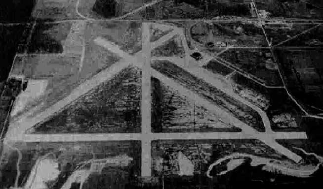
A 11/25/43 aerial view looking north at Madison AAF from the 1945 AAF Airfield Directory (courtesy of Scott Murdock).
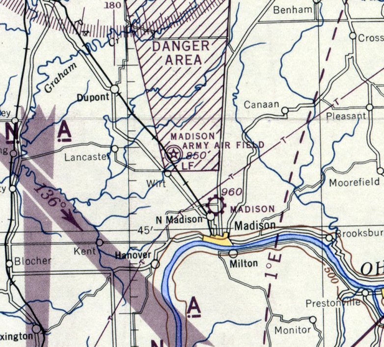
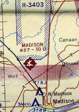
This military airfield is located on the grounds of the Jefferson Proving Ground, which consisted of over 55,000 acres.
According to an Army Corps of Engineers report, the mission of the Jefferson Proving Ground was to test & evaluate all types of munitions.
The land for the Jefferson Proving Ground was acquired starting in 1940.
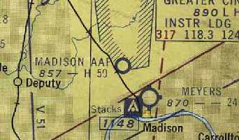
Madison Army Airfield was not yet depicted on the April 1941 Cincinnati Sectional Chart.
Madison Army Airfield was constructed on the proving ground property so that large bombers could test airborne ordnance.
The first reference to the airfield's construction which has been located was a 1/18/41 newspaper article (according to Ted Schuneman),
entitled “Contracts Awarded for 70,000 Bags of Cement.”
A 3/9/41 newspaper article (according to Ted Schuneman) was entitled “Jefferson Proving Grounds set to Complete by July 1.”
Included in the article was the following list: 14 miles of railroad, 43 miles of roadway, 120 buildings,
airport hangar, waterline from the Ohio River, and assorted other buildings.
The $4,500,000 contract was awarded to J.L. Simmons Company of Indianapolis & J.C. O'Connor Company of Fort Wayne.
Lt. Col. DeRosey C. Cabell was in command of the project.
A 5/10/41 newspaper article (according to Ted Schuneman) was entitled “First Powder Tests Monday May 12.”
The grounds were reported as 40% complete & the article included, "An all-purpose airfield, 6 square miles in area,
is included in the military reservation for airplanes used in testing air bomb.
An Army bomber & a pursuit plane will be based at the airfield
and installations at the airport will provide facilities for day & night flying."
Russ & Harrison Company of Indianapolis was listed as having the architectural contract.
A 7/12/41 newspaper article (according to Ted Schuneman) reported “First concrete was poured today for the airport runways,
a construction project that is expected to be completed about the First of September.
The concrete foundation for the large hangar has been completed & the steel framework is expected to take form soon.”
A 10/19/41 newspaper article (according to Ted Schuneman) reported “Almost ready for occupancy on the JPG near Madison
is the hangar that will house planes to be used for dropping bombs in the area for test purposes.”
A 10/30/41 newspaper article (according to Ted Schuneman) reported “Air Corp Detachment Arrives at JPG Field, Captain Charles E. Walton commanding.”
The earliest photo which has been located of Madison AAF was a 11/25/43 aerial view from the 1945 AAF Airfield Directory (courtesy of Scott Murdock).
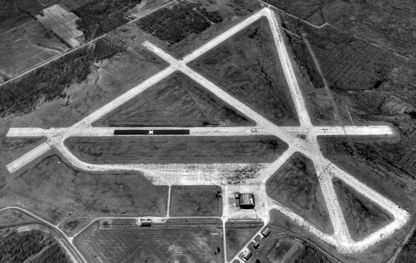
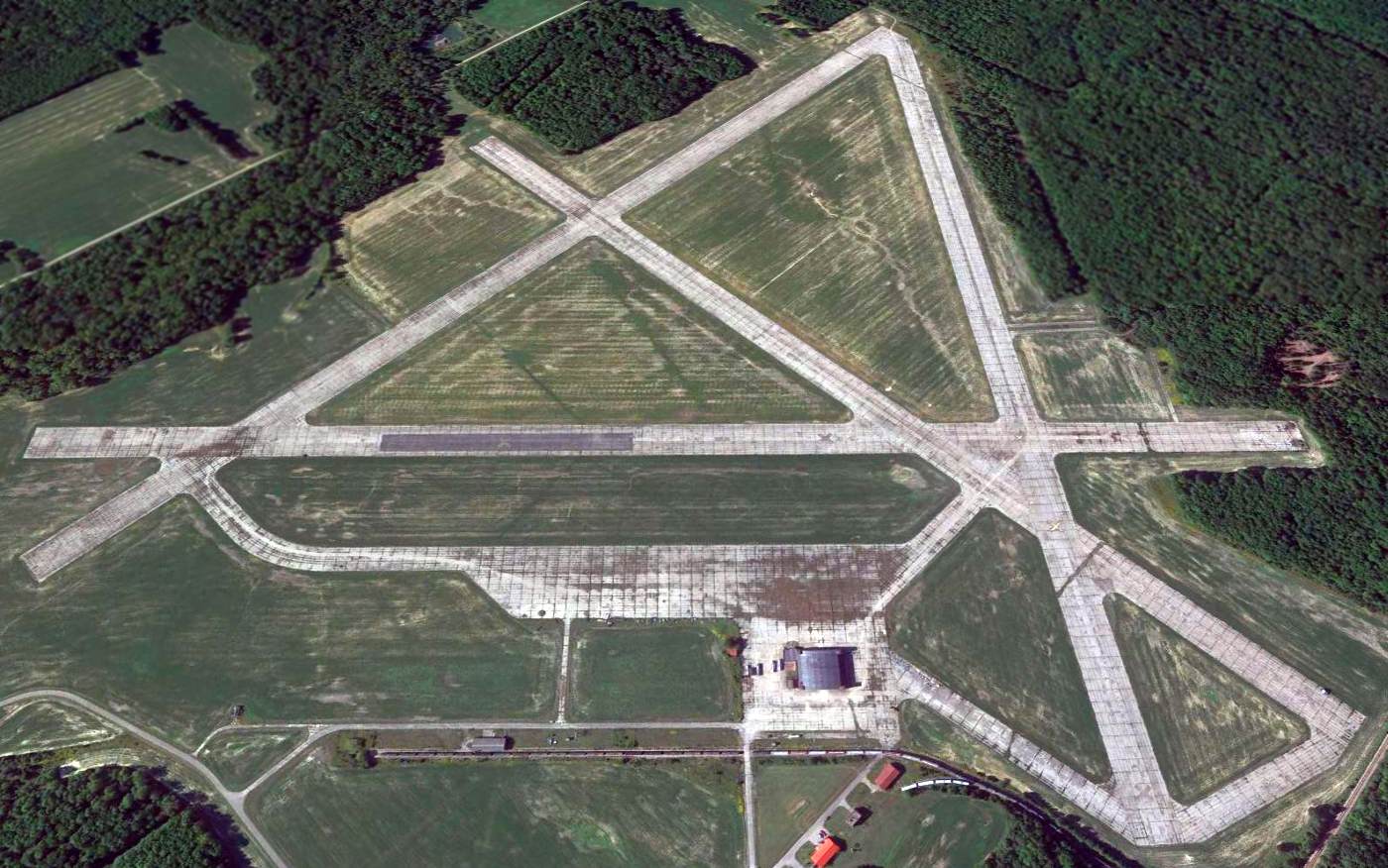
It depicted the field as having 4 paved runways, with a hangar on the northeast side.
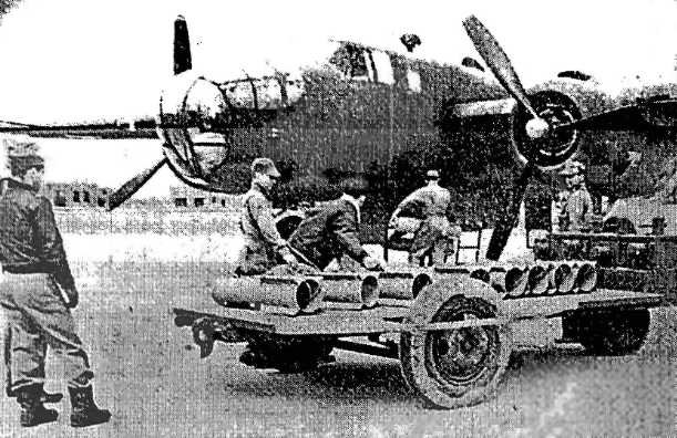
A 1943 photo (courtesy of Ted Schuneman) depicted a B-25 Mitchell bomber
at the Jefferson Proving Ground's Madison AAF being loaded with parachute flares.
The 1944 US Army/Navy Directory of Airfields (courtesy of Ken Mercer)
described "Madison AAF (Jefferson Proving Ground)" as having a 5,000' hard-surface runway.
The 1945 AAF Airfield Directory (courtesy of Scott Murdock) described Madison AAF
as a 637 acre rectangular property having 4 concrete runways, the longest being the 5,000' northeast/southwest & east/west strips.
The field was said to have a single 140' x 121' brick & steel hangar.
Madison AAF was described as being owned by the U.S. Government, and operated by the Army Air Forces.
The earliest aeronautical chart depiction which has been located of Madison Army Airfield was on the April 1945 Cincinnati Sectional Chart.

A 3/1/55 USGS aerial view depicted Madison AAF as intact but not appearing to be actively used.
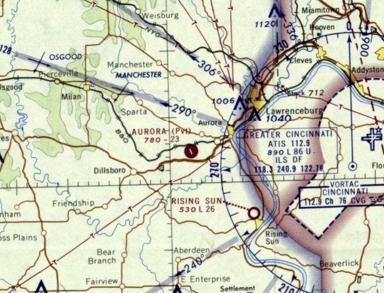
"Madison AAF" was still depicted as an active military airfield on the July 1955 Kanawha River World Aeronautical Chart (courtesy of Chris Kennedy),
and described as having a 5,000' hard-surface runway.
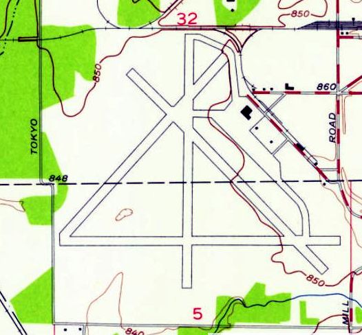
The 1956 USGS topo map depicted Madison's 4 paved runways, but did not label the airfield at all,
which possibly indicated that it had been closed by the military by that point.
Madison AAF was closed by the military & reopened as a civil airport named Madison Municipal Airport, as listed in the 1960 Jeppesen Manual.
It depicted Madison Airport as having 4 paved runways, with the longest being the 5,000' Runway 18/36 & Runway 9/27.
Taxiways led to a ramp on the northeast side of the field, with at least one hangar.
The 1962 AOPA Airport Directory described Madison Municipal Airport
as having a total of 4 cement runways, with the longest being a 5,300' Runway 9/27,
and listed the operator as Don Ledgerwood.
"Madison" was still depicted as a civilian airport on the 1964 Cincinnati Sectional Chart (courtesy of Chris Kennedy).
The Madison Municipal Airport was apparently closed at some point between 1964-66,
as it was depicted as "Abandoned airport" on the 1966 Cincinnati Sectional Chart (according to Chris Kennedy).
After civil use of the airfield ended, the airfield property returned to the control of the military.
It is not known if the military actually ever used the airfield again, though.
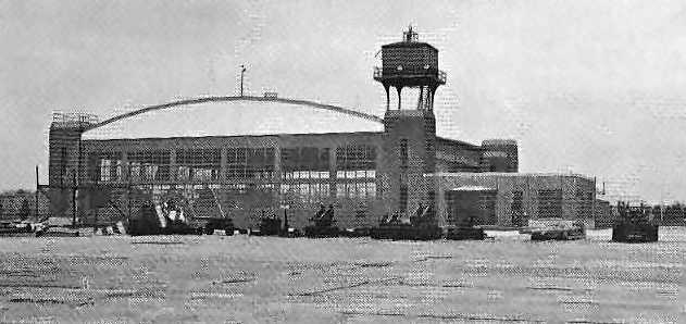
An undated (circa 1970s?) photo (courtesy of Ted Schuneman) showing the original control tower cab on top of the corner of Madison's hangar,
with a variety of artillery pieces in front.
The original caption noted that aircraft from Wright-Patterson AFB used portions of Jefferson for artillery drop tests.
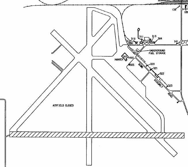
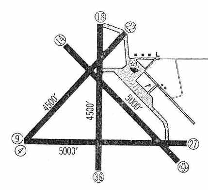
A pre-1988 diagram of the Madison airfield from an environmental impact report (courtesy of Rex Ricks)
depicted the field as having 4 paved runways (with one marked differently than the others) and a single hangar.
According to a 9/20/06 Associated Press article (courtesy of Phil Brooks), the 90 square-mile Jefferson Proving Ground closed on 9/30/95.
The Jefferson Proving Ground property was being offered for redevelopment by the Madison-Jefferson County Industrial Development Corporation.
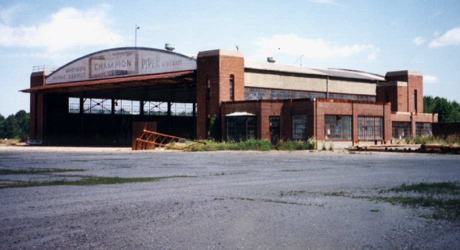
A 1995 photo by Lou Thole (author of the book "Forgotten Fields of America") of the abandoned hangar at Jefferson.
The hangar still bears the painted lettering over the main door of the "Madison Flying Service", from the airfield's days as a civil airport.
The former airport administration building is attached to the right side of the hangar.
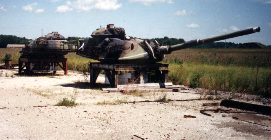
Contrasting starkly with the previous photo, this 1995 photo by Lou Thole depicts 2 former tank turrets (from M-60 tanks?)
mounted on test stands on part of the former airfield pavement.
Their purpose is unknown.
A 1995 photo by Lou Thole (author of the book "Forgotten Fields of America") of a former runway at Jefferson.
The purpose of the sheds in unknown.
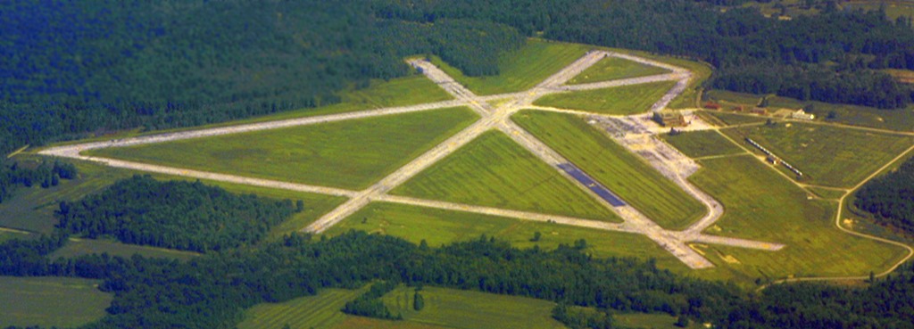
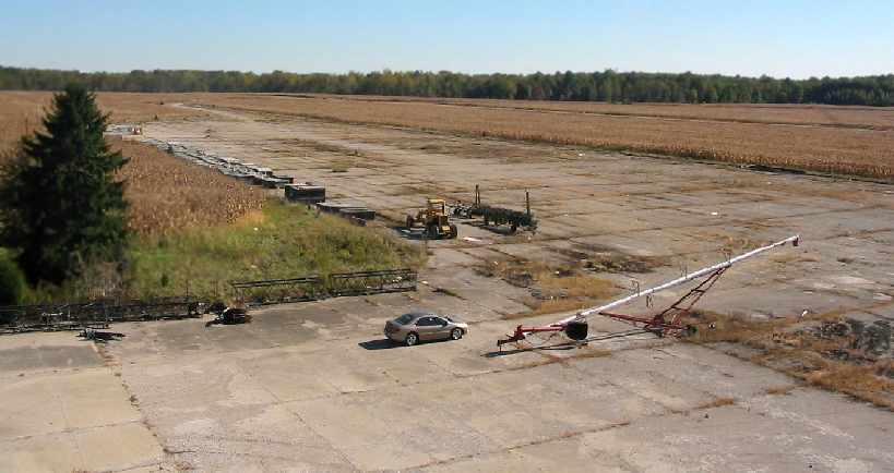
A 1998 aerial view looking southwest at Madison AAF, showing the airfield to remain in decent condition.
An 8/16/04 aerial view looking north at Madison AAF.
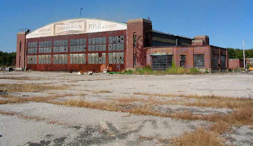
An October 2004 photo by Phil Brooks of the former Madison Flying Service hangar, which is prepared for reuse to store grain.
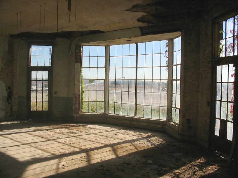
An October 2004 photo by Phil Brooks of what appears to be the former operations office in the Madison hangar.
An October 2004 photo by Phil Brooks looking south along the ramp, from the roof of the abandoned hangar.
According to a 9/20/06 Associated Press article entitled “FEMA to store trailers in Indiana” (courtesy of Phil Brooks),
“A shuttered firing range has become a place to store mobile homes & trailers
used to shelter those left homeless after a disaster - the first in the Midwest.
The Federal Emergency Management last week signed a 2-year agreement
to set up the storage at the former Jefferson Proving Ground airport
and began placing hundreds of mobile homes on the southeastern Indiana property.
The equipment includes some mobile homes & trailers
used to house people along the Gulf Coast after Hurricane Katrina last year.
FEMA site director Gary Collins said the storage area is the first of its kind in the Midwest.
FEMA believes the facility on an abandoned runway will be more reliable than other locations.
James McIntyre, a spokesman from FEMA headquarters in Washington, D.C.,
said the agency has signed a 2-year agreement with state & local officials to stay in Madison.
McIntyre said he did not did not know how much FEMA paid for the land.
Dean Ford, who owns most of the former proving ground south of the Big Oaks National Wildlife Refuge,
would not divulge any details on payment.”

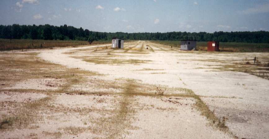
An artistic 2008 shot by Ted Schuneman of the runway conditions at Madison.
Ted Schuneman reported, “The hangar at the former Madison AAF was to me the quintessential example
of what I had always thought a 1940s era hangar should be.
When I realized it was not far off of US Route 50 I decided to make a road trip of it
since I enjoy traveling across country on state highways.
I live in Fairfax Station, VA not far from Route 50 so it was a great weekend trip.
My wife thought I was crazy to drive all that way just to see what she thought was nothing but an old abandoned building.
When I got to the airfield they were working to renovate the hangar
and they have replaced all of the office windows & the 2 hangar doors.
It is now owned by AEP which is the area power company.
It appears they will be using the hangar for storage of large generators & parts.”

A 2008 photo by Ted Schuneman of Madison's hangar office,
showing how much the building has been restored compared to the 2004 photo.
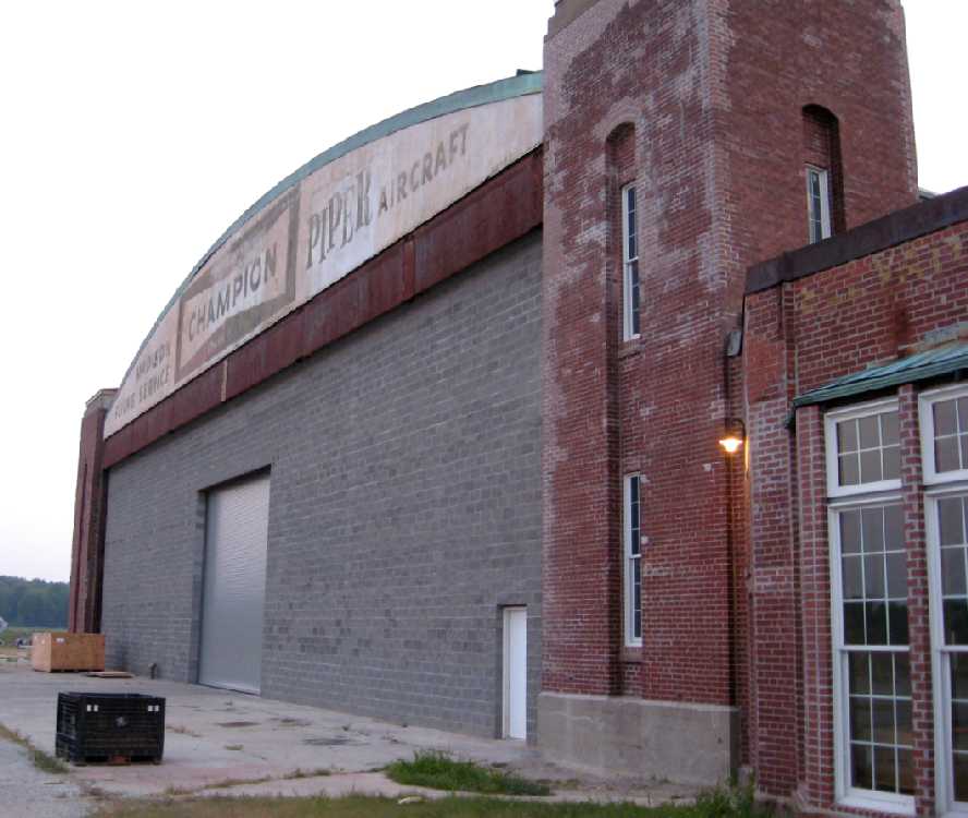
A 2008 photo by Ted Schuneman of the front of Madison's hangar, showing the “Madison Flying Service, Piper Aircraft” still visible.
Note the bricked-up hangar door opening, though.
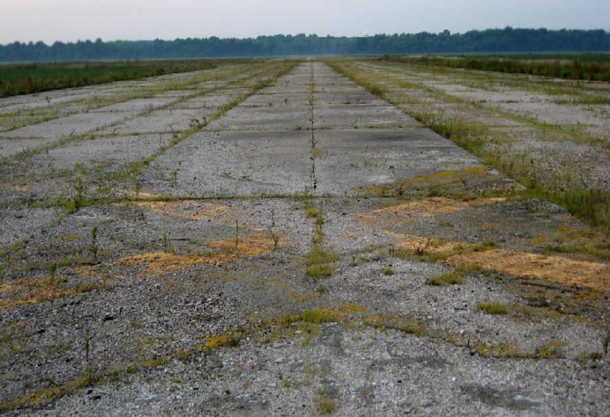
A 2008 photo by Ted Schuneman looking south along Madison's former Runway 18, showing the closed “X” symbol still visible.
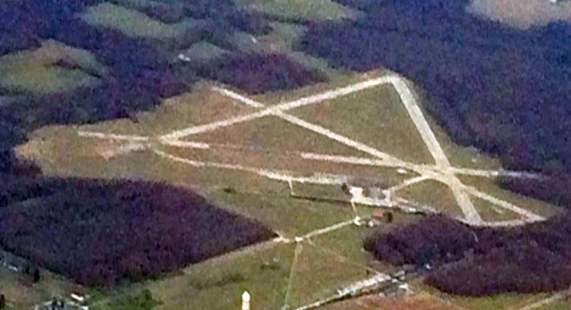
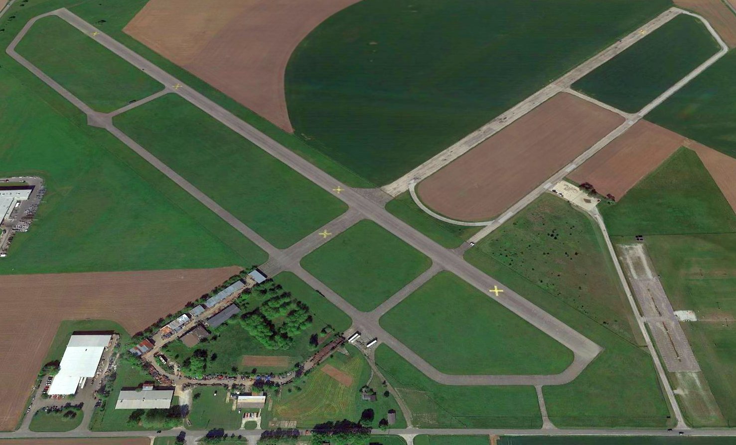
A 3/18/16 aerial view by Nick Newcomb looking southwest at Madison AAF. Nick observed, “From afar it looks to be in decent enough condition.”
A 2016 aerial view looking southwest at Madison AAF, showing the airfield to remain in decent condition.
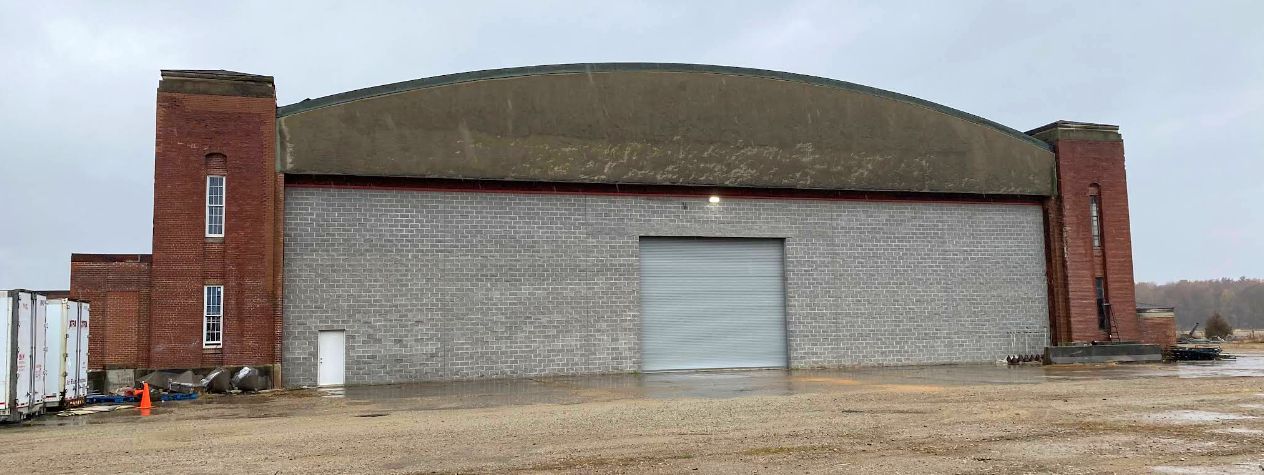
A November 2022 photo of the rear of Madison's hangar.
____________________________________________________
Or if you prefer to contact me directly concerning a contribution (for a mailing address to send a check),
please contact me at: paulandterryfreeman@gmail.com
If you enjoy this web site, please support it with a financial contribution.
____________________________________________________
This site covers airfields in all 50 states.