Abandoned & Little-Known Airfields:
Central Georgia
© 2002, © 2026 by Paul Freeman. Revised 5/28/26.
This site covers airfields in all 50 states: Click here for the site's main menu.
____________________________________________________
Please consider a financial contribution to support the continued growth & operation of this site.
____________________________________________________
Please consider a financial contribution to support the continued growth & operation of this site.
(Original) Columbus Municipal Airport (revised 2/2/25) - Dionne Auxiliary Field (added 11/24/24) - McDonough Airport (revised 3/17/22) - Miller Field (revised 11/25/24)
Putnam County Airport (revised 11/28/23) - Reginald Grant Memorial Airport (revised 5/28/26) - Yawn Auxiliary Field (added 11/24/24)
____________________________________________________
Yawn Auxiliary Field, Waynesboro, GA
33.199, -82.061 (Southeast of Atlanta, GA)
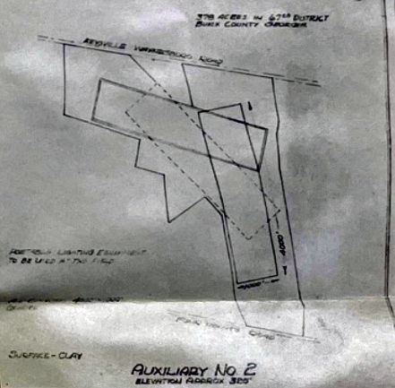
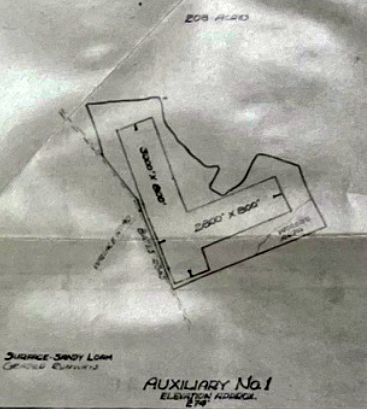
“Yawn Auxiliary #2”, as depicted on a circa 1941-45 map (from the National Archives, courtesy of Anderson Knap).
Photo of the airfield while in use has not been located.
Yawn Auxiliary Field was one of 2 airfields which supported the Contract Pilot School at Bush Field (7 miles northeast),
the other being Dionne Auxiliary Field.
The date of establishment of Yawn Auxiliary Field has not been determined, but its parent Bush Field was constructed in 1941.
The earliest depiction which has been located of Yawn Auxiliary Field was a circa 1941-45 map (from the National Archives, courtesy of Anderson Knap).
It depicted “Yawn Auxiliary #2” as having 3 runways.
Yawn Auxiliary Field was not yet depicted on the 1941/42/44 Savannah Sectional Charts.
The earliest reference which has been located of flying at Yawn Auxiliary Field was a report (courtesy of Anderson Knap)
of a 1/13/43 taxi accident of BT-13A 41-1464 by James Harris & Henry Brown.
The last reference which has been located of flying at Yawn Auxiliary Field was a report (courtesy of Anderson Knap)
of a 4/12/44 landing accident of BT-13A 41-1213 by Boyd Hughes of the 72nd Army Air Force Fighter Training Detachment.
By early 1944, WW2 pilot training requirements began to decrease, and Bush Field was closed by the Army Air Force in September 1944, after training over 5,000 students.
Yawn Auxiliary Field was presumably closed at the same point, and probably never saw any civilian aviation reuse.
The earliest aeronautical chart depiction which has been located of Yawn Auxiliary Field was on the April 1945 Savannah Sectional Chart, which depicted Yawn as an auxiliary airfield.
The last aeronautical chart depiction which has been located of Yawn Auxiliary Field was on the October 1945 Savannah Sectional Chart.
Yawn Auxiliary Field was no longer depicted on the April 1946 Savannah Sectional Chart, and thus was in operation for only 1-5 years.
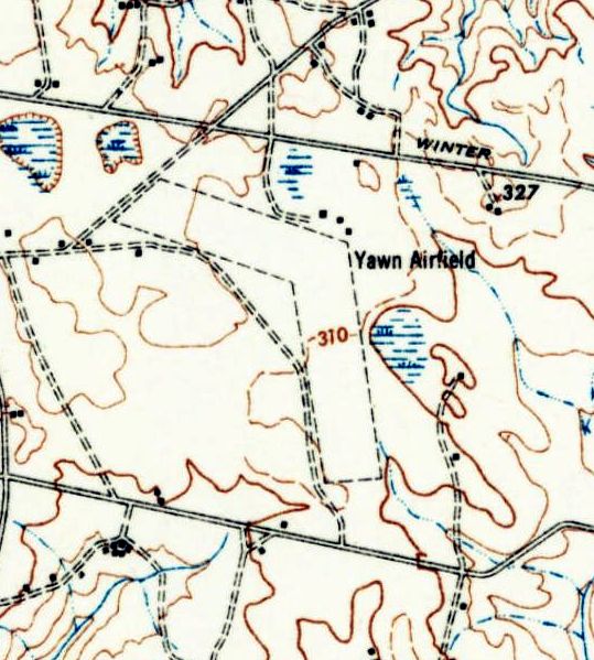
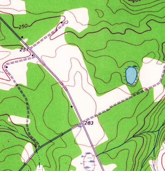
The earliest topo map depiction which has been located of Yawn Auxiliary Field was the 1948 USGS topo map.
It depicted “Yawn Airfield” as having 2 unpaved runways & a few small buildings on the northeast corner.
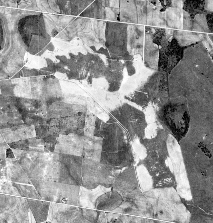
The earliest photo which has been located of Yawn Auxiliary Field was a 10/12/50 USGS aerial view.
The outline of the 3 unpaved runways was still recognizable, but there was no sign of recent aviation use.
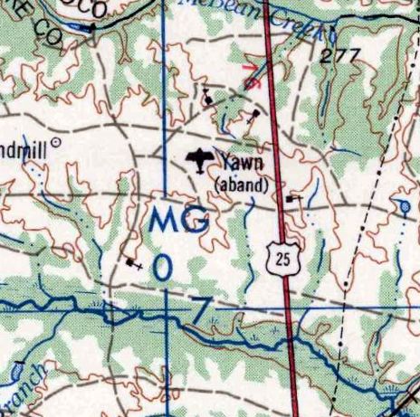
The last topo map depiction which has been located of Yawn Auxiliary Field was the 1963 USGS topo map, which labeled it “Yawn (abandoned)”.
A 1981 aerial view showed the majority of Yawn Auxiliary Field's 2 runways remained clear.
A 1993 aerial view showed trees had covered the Yawn Auxiliary Field site.
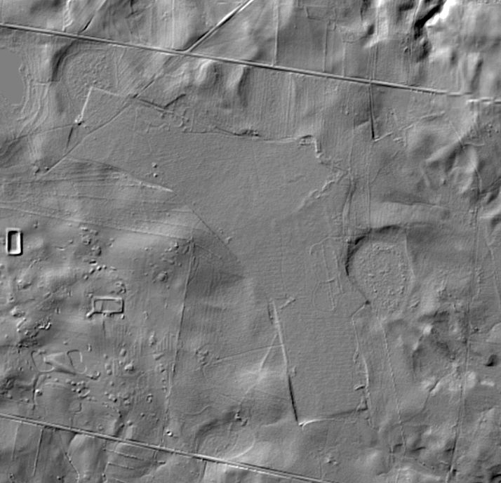
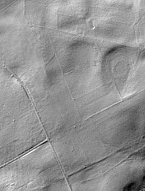
A pre-2024 Lidar image (courtesy of Anderson Knap) still showed the characteristic outline of Yawn Auxiliary Field.
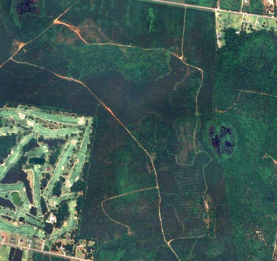
A 2023 aerial view still showed the characteristic outline of Yawn Auxiliary Field.
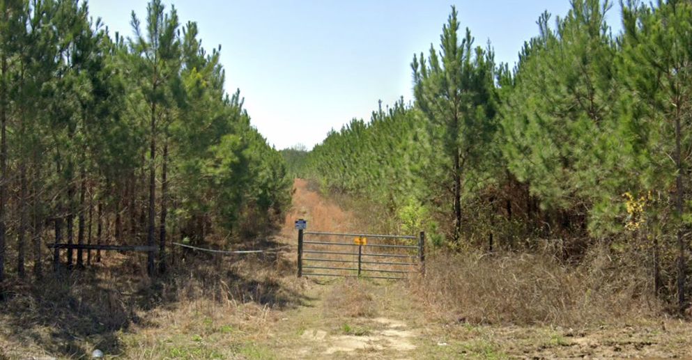
A 2024 photo looking south at the entrance gate on the north side of the Yawn Auxiliary Field site.
Thanks to Anderson Knap for pointing out this airfield.
____________________________________________________
Dionne Auxiliary Field, Waynesboro, GA
33.097, -81.954 (Southeast of Atlanta, GA)
Dionne “Auxiliary #1”, as depicted on a circa 1941-45 map (from the National Archives, courtesy of Anderson Knap).
Photo of the airfield while in use has not been located.
Dionne Auxiliary Field was one of 2 airfields which supported the Contract Pilot School at Bush Field (12 miles north),
the other being Yawn Auxiliary Field.
The date of establishment of Dionne Auxiliary Field has not been determined, but its parent Bush Field was constructed in 1941.
The earliest depiction which has been located of Dionne Auxiliary Field was a circa 1941-45 map (from the National Archives, courtesy of Anderson Knap).
It depicted Dionne “Auxiliary #1” as having 2 runways.
Dionne Auxiliary Field was not yet depicted on the 1941/42/44 Savannah Sectional Charts.
The earliest reference which has been located of flying at Dionne Auxiliary Field was a report (courtesy of Anderson Knap)
of a 5/18/43 taxi accident of BT-13A 41-10981 by Clair Wheaton of the 72nd Air Force Fighter Training Detachment.
The last reference which has been located of flying at Dionne Auxiliary Field was a report (courtesy of Anderson Knap)
of a 5/24/44 landing accident of BT-13A 41-10821 by Edward Launius of the 2150 Army Air Force Base Unit.
By early 1944, WW2 pilot training requirements began to decrease, and Bush Field was closed by the Army Air Force in September 1944, after training over 5,000 students.
Dionne Auxiliary Field was presumably closed at the same point, and probably never saw any civilian aviation reuse.
The earliest aeronautical chart depiction which has been located of Dionne Auxiliary Field was on the April 1945 Savannah Sectional Chart, which depicted Dionne as an auxiliary airfield.
The last aeronautical chart depiction which has been located of Dionne Auxiliary Field was on the October 1945 Savannah Sectional Chart.
Dionne Auxiliary Field was no longer depicted on the April 1946 Savannah Sectional Chart, and thus was in operation for only 1-5 years.
The Dionne Airfield itself was not depicted on any topo maps which have been located,
but the 1965 USGS topo map still depicted a clearing in the characteristic outline which matched the Dionne Auxiliary Field runway layout.

The earliest photo which has been located of Dionne Auxiliary Field was a 5/30/51 USGS aerial view.
The outline of the 2 unpaved runways was still recognizable, but there was no sign of recent aviation use.
A 1981 aerial view showed the majority of Dionne Auxiliary Field's 2 runways remained clear.
A 1993 aerial view showed houses had been constructed at some point between 1981-93 along the west side of the Dionne Auxiliary Field site.
A pre-2024 Lidar image (courtesy of Anderson Knap) still showed the characteristic outline of Dionne Auxiliary Field.
A 2019 photo looking northeast at the west side of the Dionne Auxiliary Field site, occupied by a row of houses.
A 2023 aerial view still showed the characteristic outline of Dionne Auxiliary Field.
Thanks to Anderson Knap for pointing out this airfield.
____________________________________________________
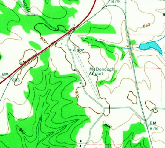
McDonough Airport, McDonough, GA
33.41, -84.154 (Southeast of Atlanta, GA)
McDonough Airport, as depicted on the May 1935 Birmingham Sectional Chart.
McDonough Airport was evidently established at some point between 1934-35,
as it was not yet depicted on the 1934 Birmingham Sectional Chart.
The earliest depiction which has been located of McDonough Airport was on the May 1935 Birmingham Sectional Chart,
which depicted McDonough Airport as an auxiliary airfield.
Jim Daigneau reported, “Charlie Norton grew up in McDonough. He remembered several people keeping Aeroncas & Taylorcrafts at McDonough Airport.
He said it was part of the Ruben Greer Farm. There were some sheds / T-hangars on the northwest corner of the field.
It was a good, level pasture with about 2,000-2,500' available. The runway was located just east & parallel to the current King Mill Road.
He remembered an Ercoupe taking off one day that could not climb enough to clear the power lines at the south end of the field so the pilot flew under them.
He mentioned Gene Hudson, who had been a B-24 pilot in WW2, was the high school principal, and kept a Taylorcraft at the field.
One day, as he was about to walk into school, Mr. Hudson called him over & asked if he would like to fly over to Carrolton with him. Needless to say, Charlie said yes.”
The earliest photo which has been located of McDonough Airport was a 1955 aerial view.
It showed McDonough Airport to consist of an northwest/southeast unpaved runway, with a few small buildings on the northwest end.
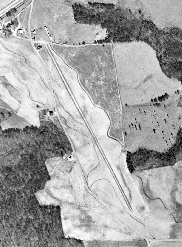
The earliest photo which is available of McDonough Airport was a 1962 aerial view (courtesy of David Henderson).
It depicted McDonough Airport as having a much more-distinct northwest/southeast unpaved runway, with a few T-hangars on the northwest end.
The earliest topo map depiction which has been located of McDonough Airport was on the 1964 USGS topo map.
It depicted McDonough Airport as having a northwest/southeast unpaved runway, with a few small buildings on the northwest end.
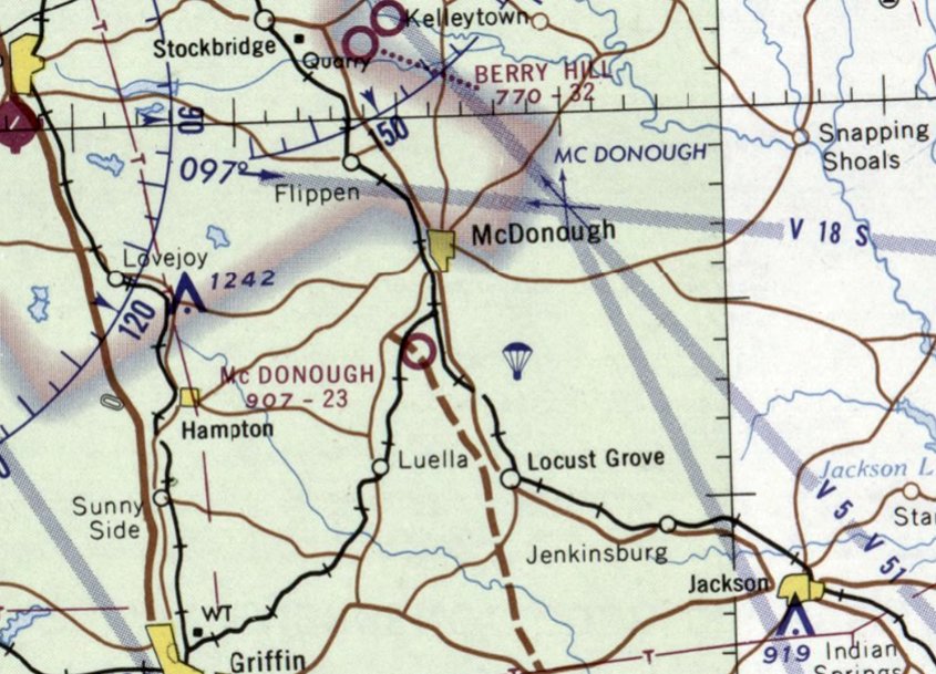
The last aeronautical chart depiction which has been located of McDonough Airport was on the 1968 Birmingham Sectional Chart.
It depicted McDonough Airport as having a 2,300' unpaved runway, with a parachute drop zone to the east.
McDonough Airport was evidently closed (for reasons unknown) at some point between 1968-74,
as it was no longer depicted on the 1974 Atlanta Sectional Chart.
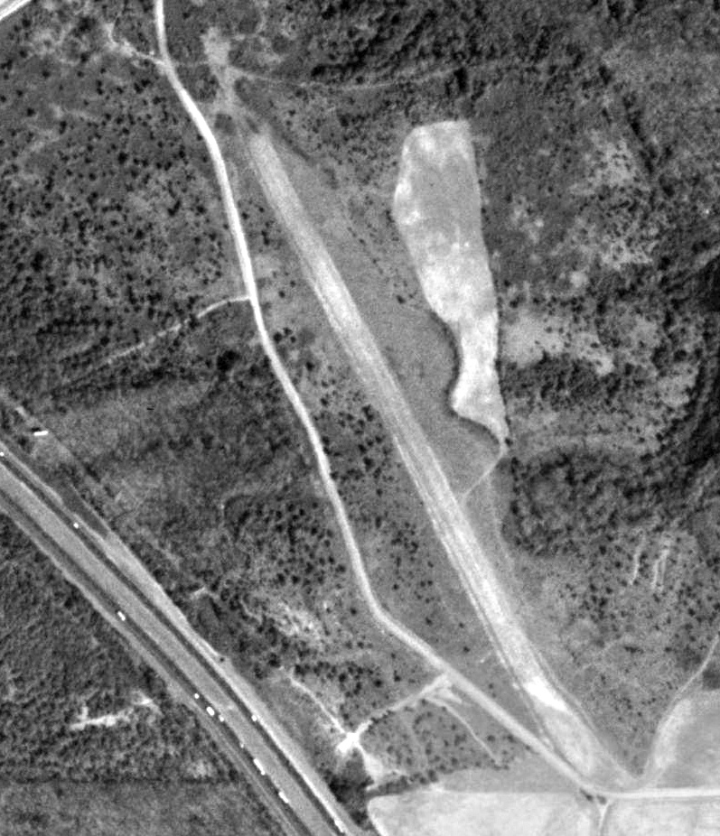
A 1981 aerial view (courtesy of David Henderson) showed the McDonough Airport T-hangars
to have been removed at some point between 1964-81, but the runway remained intact.
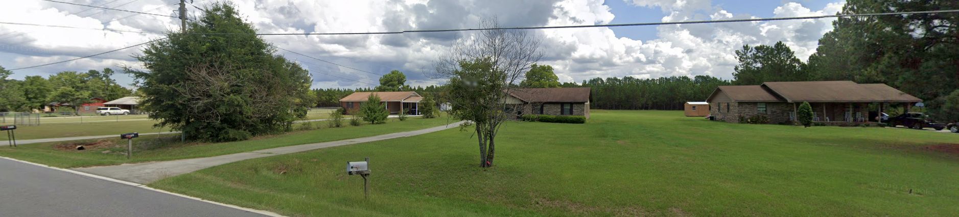
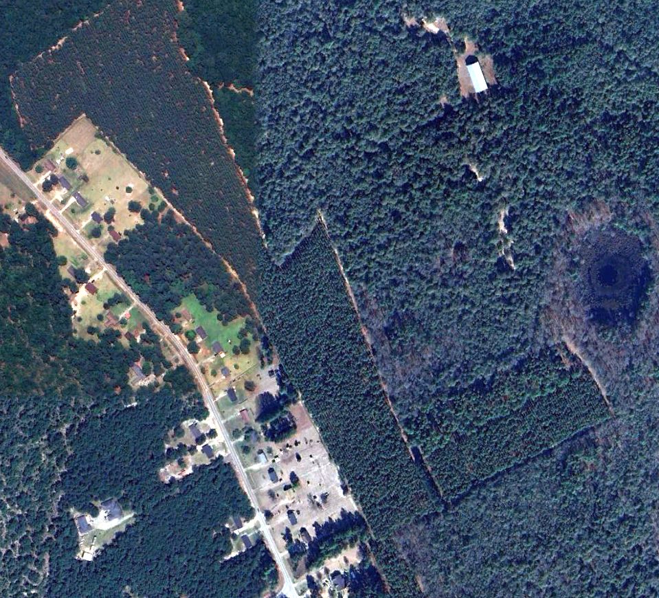
A 1993 aerial view showed a large industrial building having covered the majority of the McDonough Airport site, but a portion of the former runway remained to the southeast.
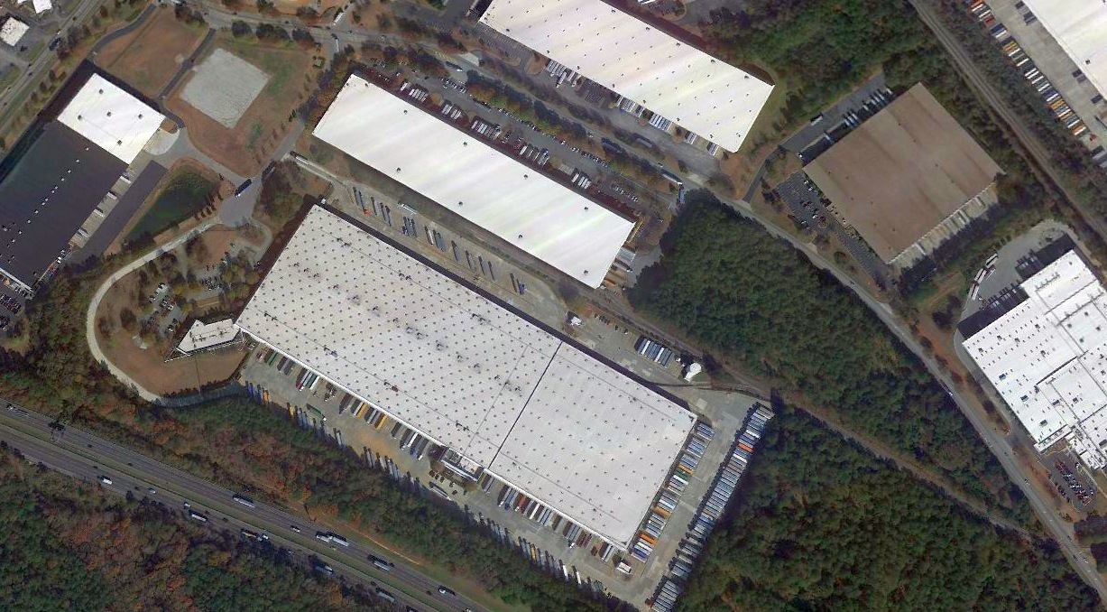
A 2020 aerial view showed a large industrial building covering the majority of the McDonough Airport site, but a portion of the former runway remained to the southeast (bottom-right).
Jim Daigneau observed in 2022, “The current area is an industrial park & completely covered with warehouses.”
As of 2022, street maps label the large building covering the McDonough Airport site as a Nestle facility.
Thanks to Jim Daigneau for pointing out this airfield.
____________________________________________________
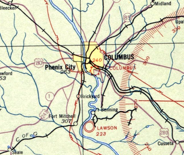
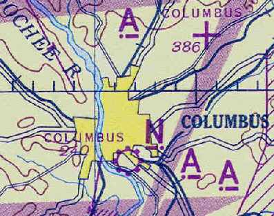
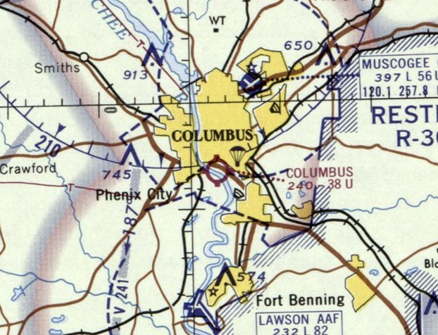
(Original) Columbus Municipal Airport, Columbus, GA
32.448, -84.971 (Southwest of Atlanta, GA)
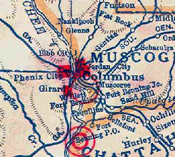
The original Columbus Municipal Airport, as depicted on the 1929 Rand McNally Air Trails Map (courtesy of Chris Kennedy).
The original Municipal Airport for the town of Columbus was located adjacent to the south side of the town.
The date of construction of the airport has not been determined.
The earliest depiction of the field which has been located was on the 1929 Rand McNally Air Trails Map (courtesy of Chris Kennedy).
It described Columbus as an auxiliary airfield, operated by the Department of Public Works.
The field was said to measure 3,400' x 2,550'.
The 1931 USGS topo map did not depict the Columbus Municipal Airport.
The Airport Directory Company's 1933 Airports Directory (courtesy of Chris Kennedy) described the Columbus Municipal Airport as having 2 sod runways,
2,800' northwest/southeast & 2,200' northeast/southwest.
The earliest aeronautical chart depiction which has been located of Columbus Municipal Airport was on the April 1933 Birmingham Sectional Chart.
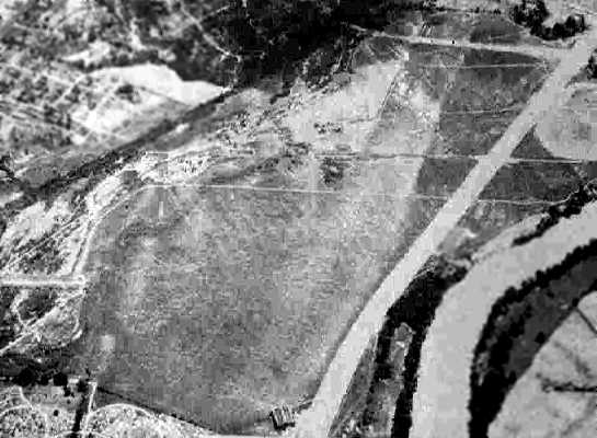
A 4/28/43 aerial view looking east from the 1945 AAF Airfield Directory (courtesy of Scott Murdock)
depicted the “Columbus Municipal Airport (Old)” as having an open grass area with a single hangar at the southwest corner.
The November 1944 Birmingham Sectional Chart (courtesy of Chris Kennedy) depicted Columbus as a municipal/commercial airport.
The 1945 AAF Airfield Directory (courtesy of Scott Murdock) described the “Columbus Municipal Airport (Old)”
as a 210 acre irregularly-shaped property within which were 3 sod runways, the longest being the 4,500' east/west strip.
The field was said to have a single 100' square steel hangar, to be owned by the City of Columbus, and to be privately operated.
The 1945 USGS topo map did not depict the Columbus Municipal Airport.
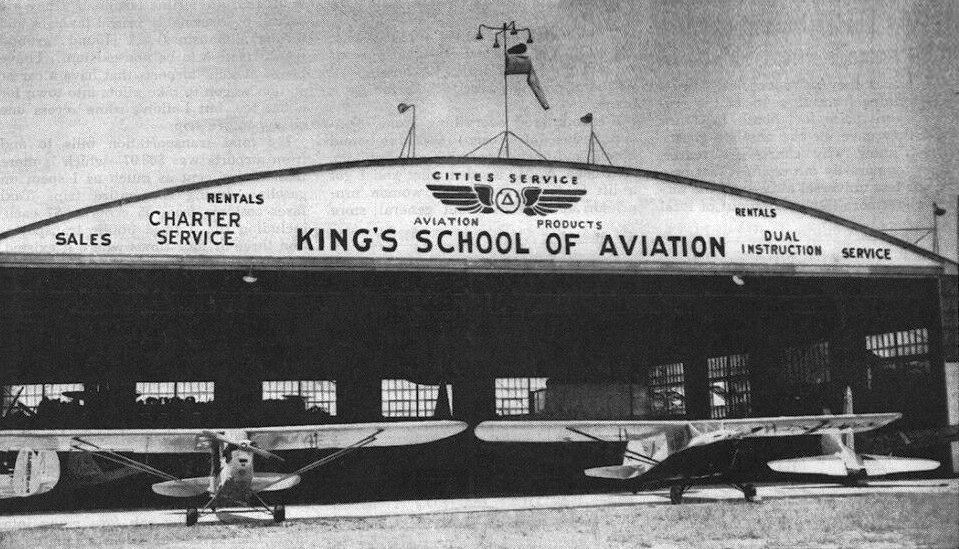
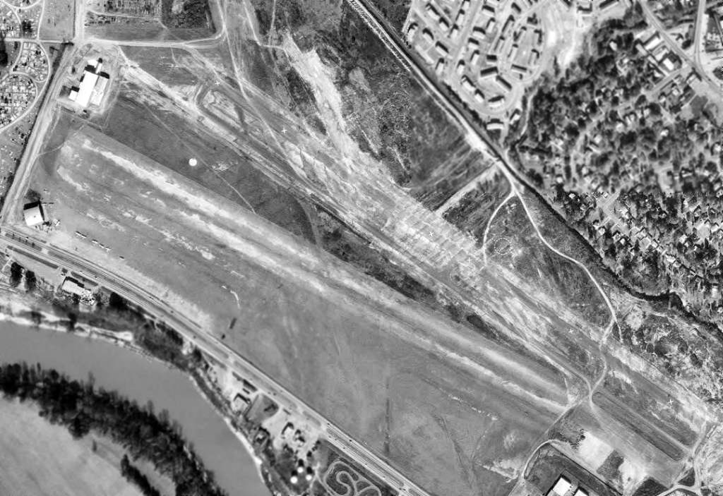
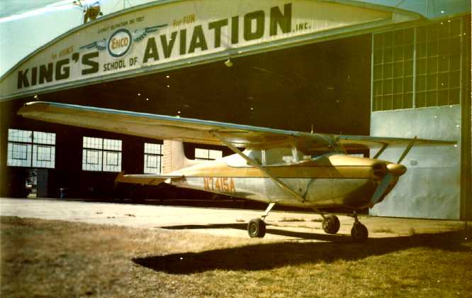
An undated photo from a December 1947 advertisement (courtesy of David Henderson) showing 2 Pipers outside Columbus Municipal Airport's King's School of Aviation hangar.

A 1949 USDA aerial photo of the Columbus Municipal Airport depicted the field as having 2 unpaved runways.
A parking apron was located on the southeast side of the field, but there did not appear to be any buildings or hangars at the airport.
The 1949 USGS topo map depicted Columbus Municipal Airport as an open area with a few small buildings on the west side.
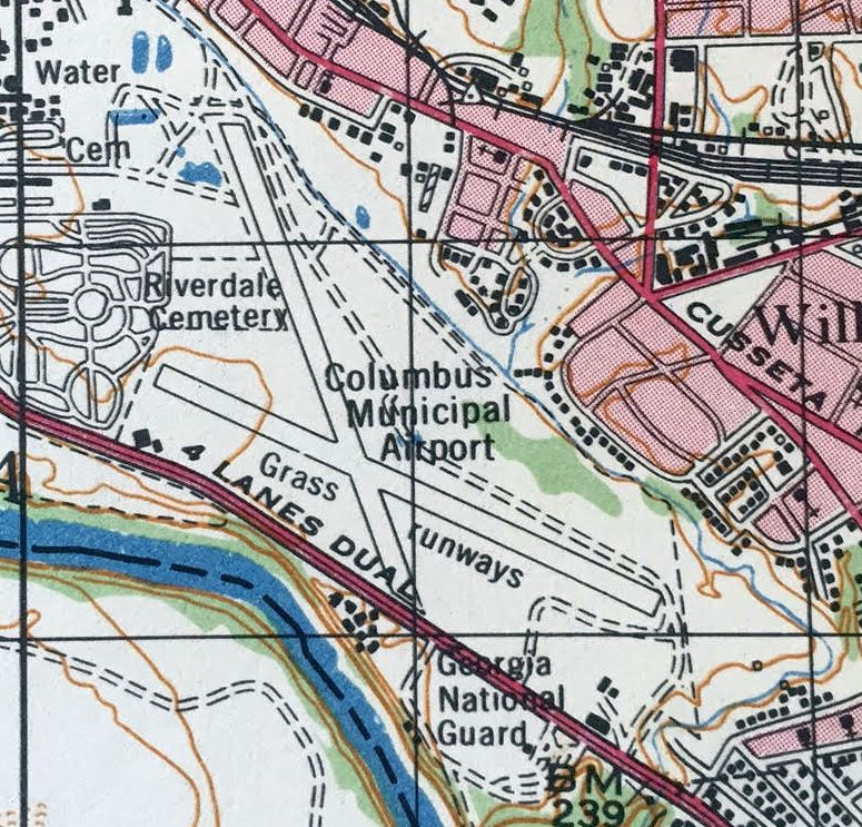
The 1959 USGS topo map depicted Columbus Municipal Airport as having 2 grass runways & a few small buildings on the west side.
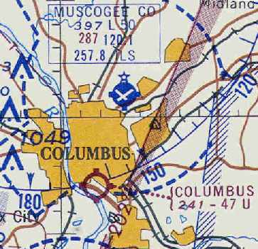
The August 1962 Birmingham Sectional Chart (courtesy of Chris Kennedy) depicted Columbus as having a 4,700' unpaved runway.
The 1967 AOPA Airport Directory (courtesy of Chris Kennedy) described the Columbus Municipal Airport as having 2 sod runways:
4,700' Runway 12/30 & 4,000' Runway 16/34.
The field was said to offer fuel, repairs, hangars, tiedowns, and charters.
The operators were listed as G. Dean Allen King & Jack A. King (Cessna dealers).

The 1968 Flight Guide (courtesy of Robert Levittan) depicted Columbus Municipal Airport
as having a single 4,700' unpaved Runway 11/29, along with a closed crosswind runway, and one building on the west side.
Inexplicably, a 1968 USGS aerial photo of Columbus Municipal Airport (courtesy of David Henderson)
appeared to depict a paved runway (with 5 closed-runway “X” symbols) to the northeast of the unpaved runway,
even though all previous indications are that the Columbus runways were always unpaved.
The last aeronautical chart depiction which has been located of Columbus Municipal Airport was on the September 1968 Birmingham Sectional Chart.
It depicted Columbus as having a 3,800' unpaved runway.
A circa 1968-69 photo (courtesy of Richard Ogletree) of his father's Cessna in front of the King's School of Aviation hangar at Columbus Airport.
Richard recalled, “I was exposed to general aviation at the age of 10 when my father started flying for pleasure.
He started flying out of the old Columbus airport. At that time [1968-69] there was only one sod runway.”
Cham Watkins recalled, “I spent quite a bit of my childhood under Dean [King's] watchful eye.
My father who flew B-17s & B-29s in the war & kept his license current
and it was a great treat to go to this airport & rent a plane from King's School of Aviation for a father/son jaunt around the city.
Later, it became a Saturday ritual for my parents to drop me off there
and I would spend the day begging rides from very benevolent airplane owners
who for some reason put up with me while I learned about flying & operating off a grass strip.
In 1969, I was 14 & vividly remember the closing & moving of King's School of Aviation over to the current Columbus Airport. It was a sad day.
By now, Dean had purchased the business from his brother Jack & was the sole owner.
Sadly, Dean had a son who was an excellent pilot & he had much hope to hand him the business one day
but as fate would have it, his son was killed in an automobile accident at the age of about 18.
Dean never fully recovered, and the move to the other airport,
which was made necessary because of a decision the local government made during that time to not renew his lease
so that they could develop the land as industrial, was never profitable.”
The 1970 USGS topo map depicted a single paved northwest/southeast runway, generically labeled as “Landing Strip”,
presumably after the original Columbus Airport's closure.
The original Columbus Municipal Airport was no longer depicted at all on the April 1974 Atlanta Sectional Chart (according to Chris Kennedy).
The 1975 USGS topo map showed that a road (Blanchard Boulevard) had been built along the alignment of the former Columbus Airport's Runway 12/30.
The airport site had been reused as the Blanchard Industrial Park.
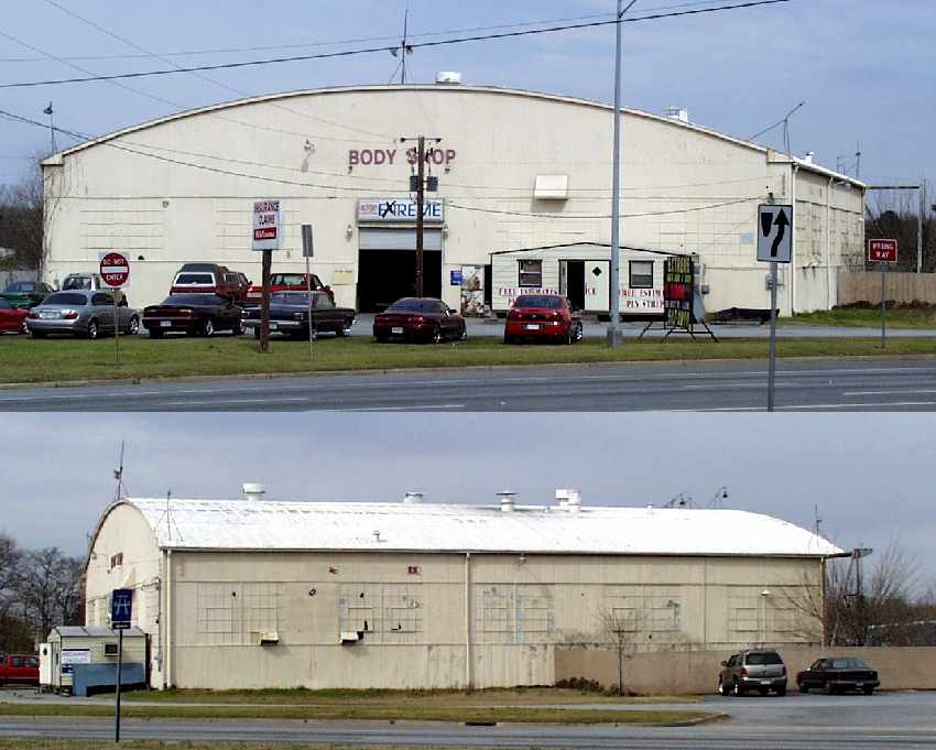
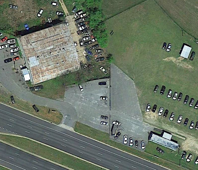
A 2005 photo by Bengie Phillips of the front & side of the former Columbus Airport hangar
which sits at the eastern corner of the intersection of Jackson Avenue & Victory Drive.
The former windsock pole appears to remain on top of the hangar.
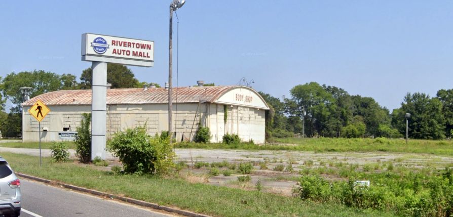
According to Bengie, the former hangar “is currently being used as a body shop by one of the local car dealers.”
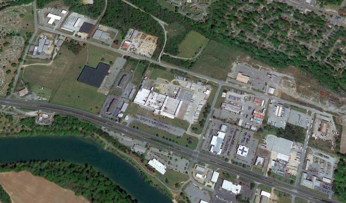
A 2017 aerial view looking northeast showed Blanchard Boulevard was built over the former Columbus Airport Runway 12/30.
The hangar which was visible in the 1949 aerial photograph is still visible, at the southwest corner of the former airport property.
The remainder of the former airport site is covered with a variety of buildings.
According to Bengie Phillips, just east of the hangar is the Interstate Brands Corporation (Dolly Madison) Bakery,
then the Georgia National Guard Armory, then the now-closed RC Cola Bottling Plant.
All of this lies in the Blanchard Industrial Park.
A 2017 aerial view showing the former hangar & paved ramp which remains at the southwest corner of the original Columbus Municipal Airport property.
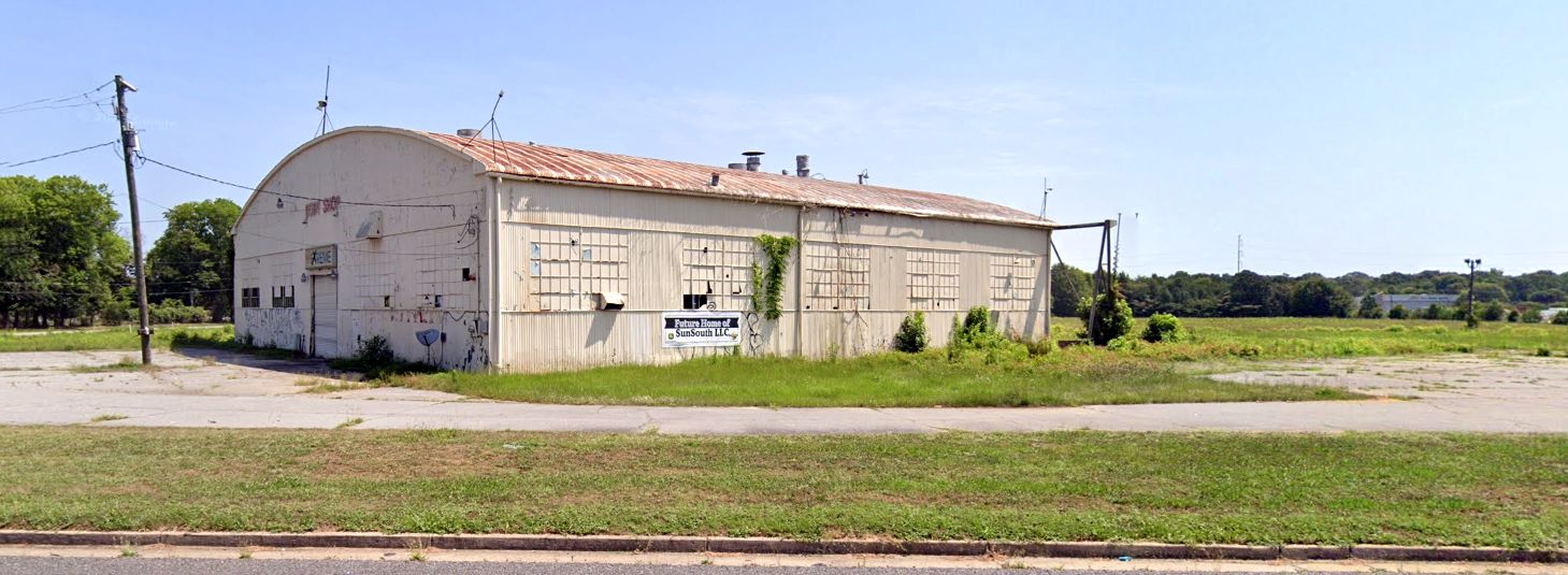
A 2022 photo looking northeast at the former Columbus Airport hangar.
A 2022 photo looking northwest at the former Columbus Airport hangar.

A 2/1/25 photo by Daniel Adams looking east at the former Columbus Airport hangar shows a dramatic transformation compared to the 2022 photo.
Daniel reported, “The old hangar was entirely gutted & all but its metal framework were removed.
The building was modified to become a showroom for a John Deere dealer so I have hope that the airport's legacy will live on for many decades to come.”
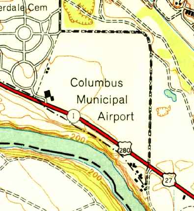
The site of the original Columbus Municipal Airport is located at the intersection of Blanchard Boulevard & Jackson Avenue.
____________________________________________________
32.862, -83.569 (Southeast of Atlanta, GA)
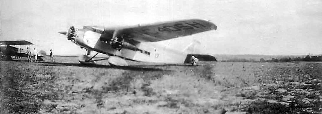
A 1929 photo (either 10/12/29 or 2/20/29) of a Curtiss Condor visitng Miller Field as part of the 1929 National Air Tour (courtesy of James Preston).
The first airport for the town of Macon was located on the northeast side of the town.
The date of construction of Miller Field has not been determined.
The earliest depiction which has been located of Miller Field was a series of photos, from either 10/12/29 or 2/20/29,
of several aircraft visitng Miller Field as part of the 1929 National Air Tour (courtesy of James Preston).
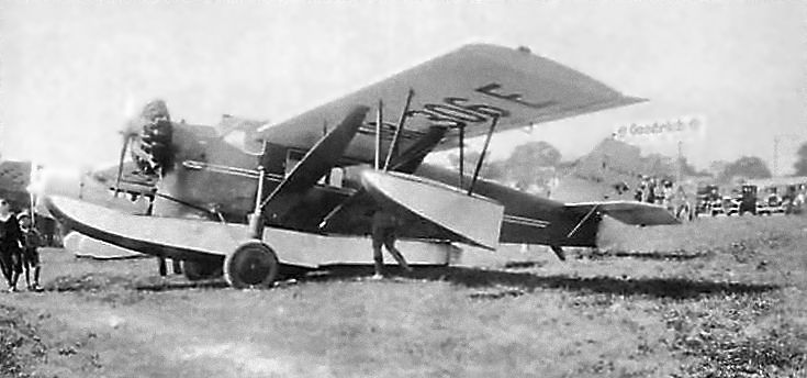
A 1929 photo (either 10/12/29 or 2/20/29) of an amphibian (a Loening?) visitng Miller Field as part of the 1929 National Air Tour (courtesy of James Preston).
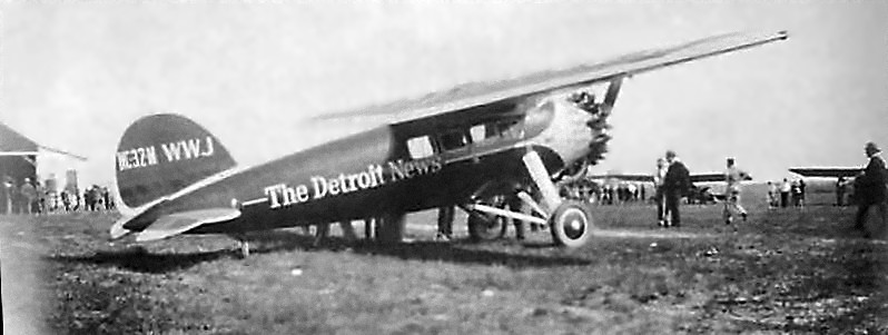
A 1929 photo (either 10/12/29 or 2/20/29) of a Lockheed Vega 5C Special NC32M from The Detroit News visitng Miller Field as part of the 1929 National Air Tour (courtesy of James Preston).
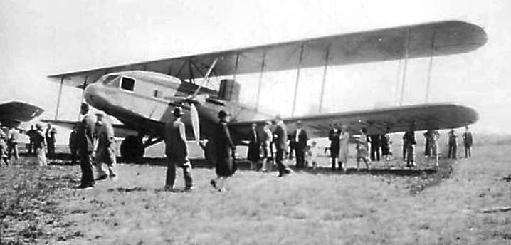
A 10/12/29 photo of a Ford Trimotor & a smaller biplane at Miller Field during the 1929 National Air Tour (courtesy of Marty Steiner).
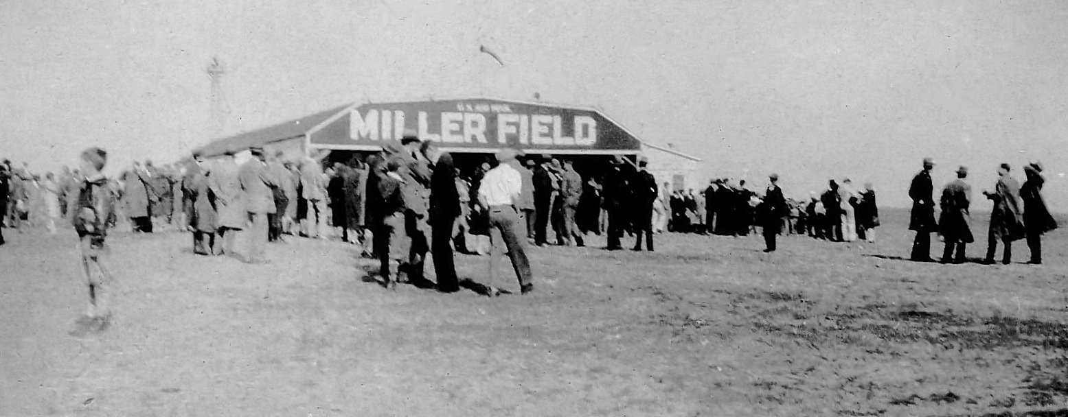
A Spring 1930 photo of a large gathering (possibly for the airport's opening) in front of a hangar marked “U.S. Air Mail, Miller Field” (courtesy of Tom Sicks).
Tom Sicks reported, “I found this picture when going through my father's pictures. At the time he worked for Sparks Circus which had its winter quarters in Macon, GA.”
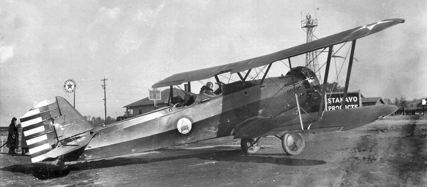
A December 1932 photo (courtesy of Jim Preston) of an Army Air Corps Douglas O-38 biplane leaving Miller Field, piloted by General Blanton Winship.
The plane might have been from Bolling Field, as the fuselage logo of the Capitol Dome is very similar to the Army Air Corps Bolling Field Detachment insignia.
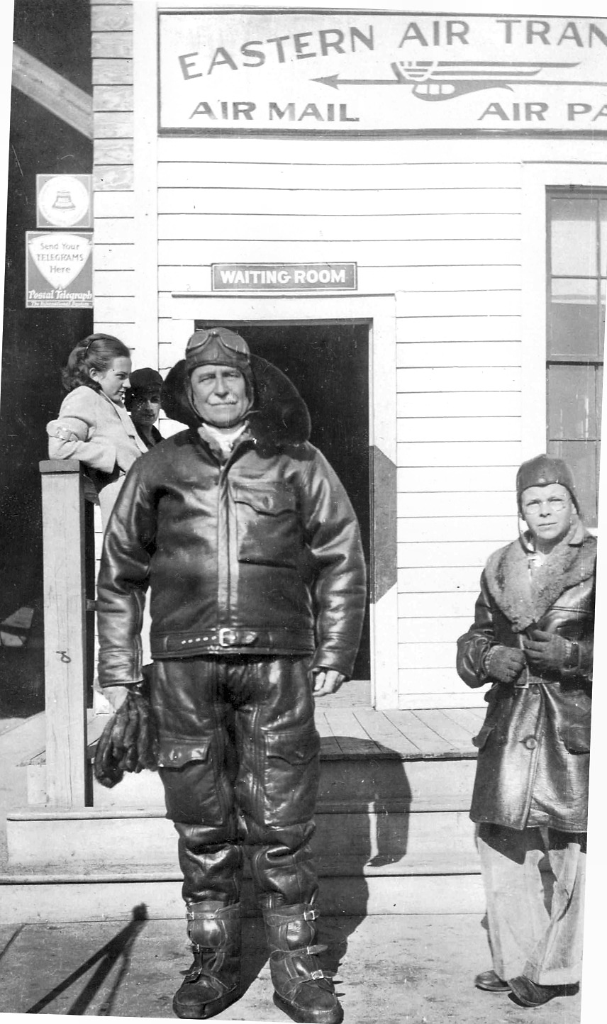
A December 1932 photo (courtesy of Jim Preston) of General Blanton Winship & his nephew David Walker in front of the Eastern Air Transport building at Miller Field.
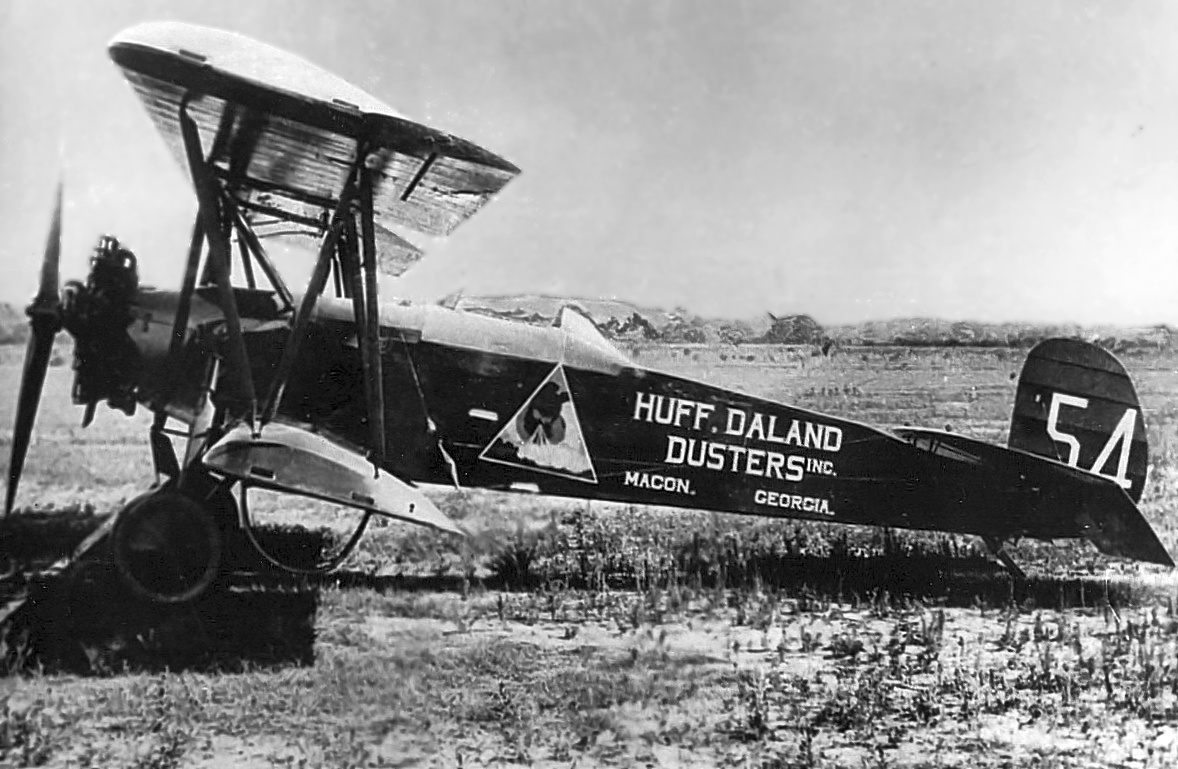
A circa 1930s photo (courtesy of Jim Preston) of a Huff Daland Duster biplane at Miller Field.
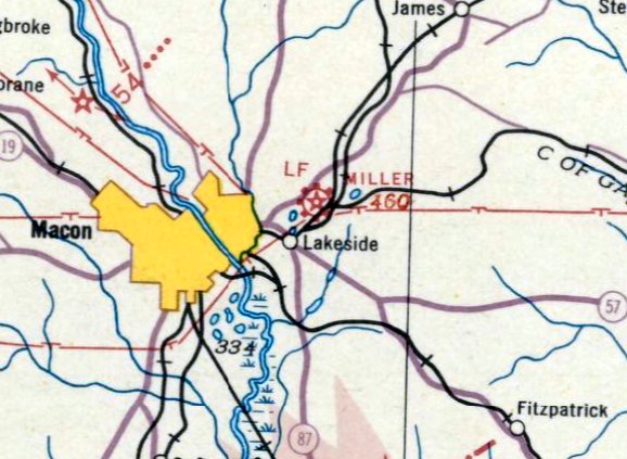
The earliest aeronautical chart depiction which has been located of Miller Field was on the January 1935 Savannah Sectional Chart.
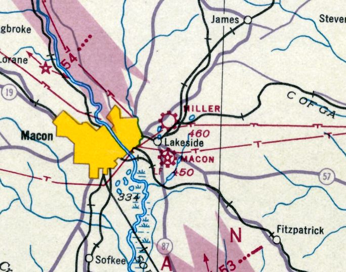
The last aeronautical chart depiction which has been located of Miller Field was on the June 1937 Savannah Sectional Chart.
Note that it also depicted the new Macon Airport located nearby to the south, which would shortly replace Miller Field.
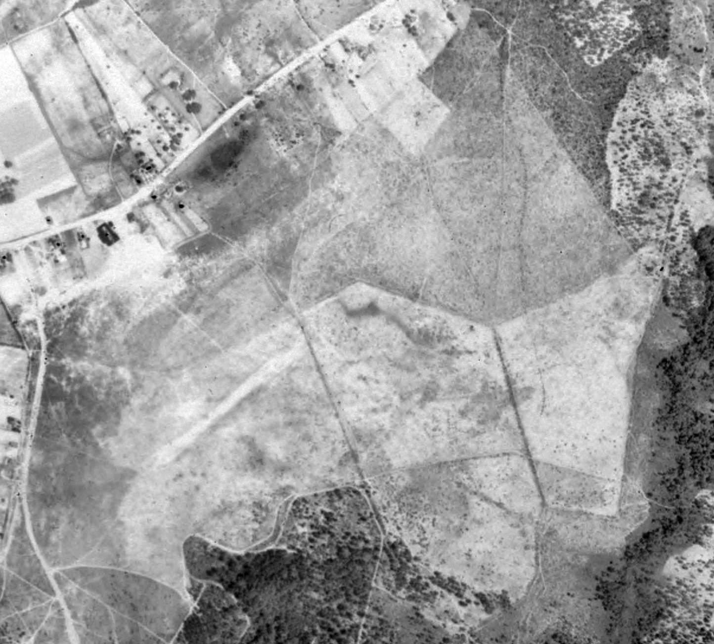
A 5/13/38 USGS aerial view (courtesy of Jim Preston) depicted Miller Field possibly after its closing.
The field appeared to consist of an unpaved landing area, possibly containing a northeast/southwest runway,
with a few buildings (hangars?) on the northwest side.
Miller Field was evidently closed at some point between 1937-38,
as it was no longer depicted on the December 1938 Savannah Sectional Chart.
Charles Bowden golf course was built on the site of the “vacant” Miller Field & opened in September 1940.
A 1954 aerial photo showed the golf course covering the site, with no trace perceptible of Miller Field.
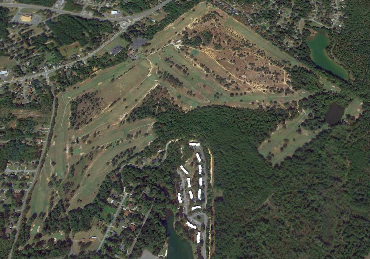
A 2015 aerial view of the site of Miller Field, occupied by the Charles Bolden Golf Course.
The site of Miller Field is located south of the intersection of Shurling Drive & Millerfield Road, appropriately enough.
Thanks to Jim Preston for pointing out this airfield.
____________________________________________________
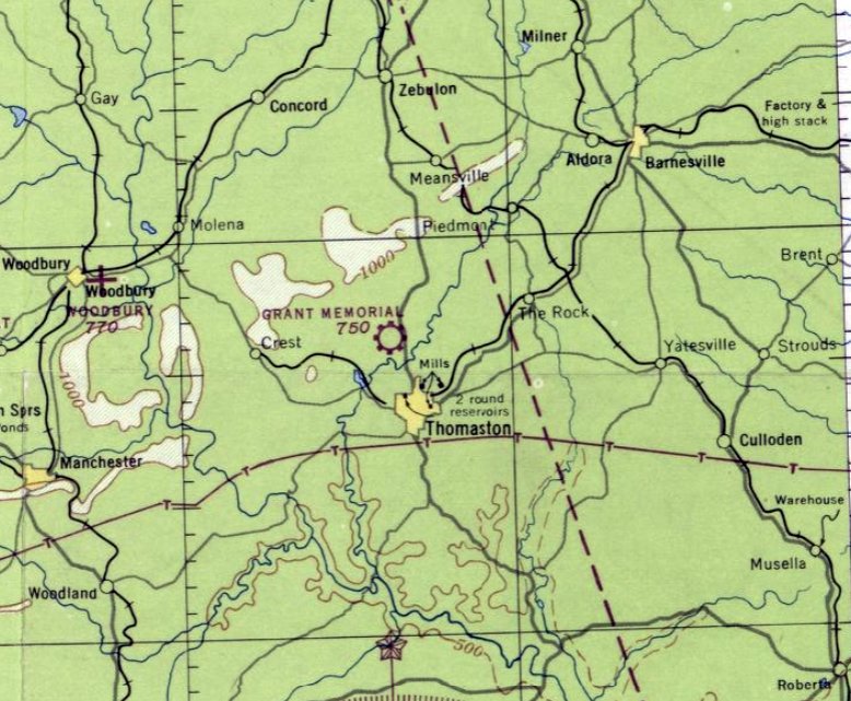
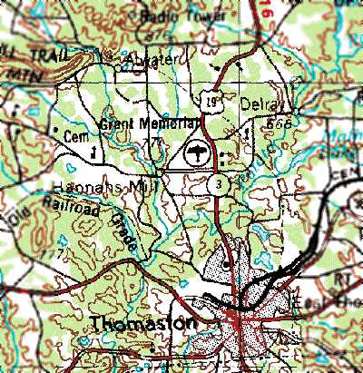
Reginald Grant Memorial Airport (2A2), Thomaston, GA
32.94, -84.34 (South of Atlanta, GA)
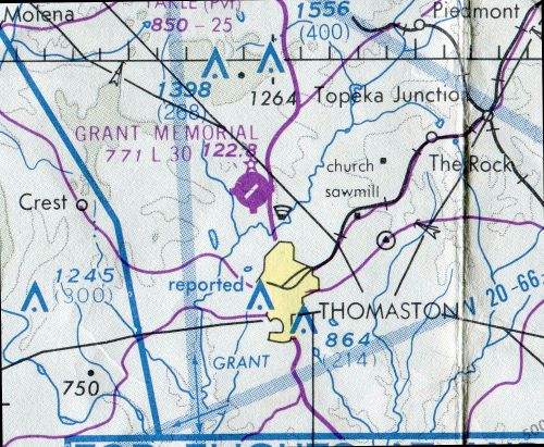
Grant Memorial Airport, as depicted on the October 1947 Birmingham Sectional Chart.
Grant Memorial Airport was evidently established at some point between 1946-47,
as it was not yet listed among active airfields in the 1945 AAF Airfield Directory (courtesy of Scott Murdock)
nor depicted on the April 1946 Birmingham Sectional Chart.
The earliest depiction which has been located of Grant Memorial Airport was on the October 1947 Birmingham Sectional Chart.
It depicted the Grant Memorial as a commercial/municipal airport.
The earliest photo which has been located of Grant Memorial Airport was a 4/4/51 aerial photo (courtesy of David Henderson).
It depicted the field as having 2 unpaved runways, but there did not appear to be any airport-related structures.
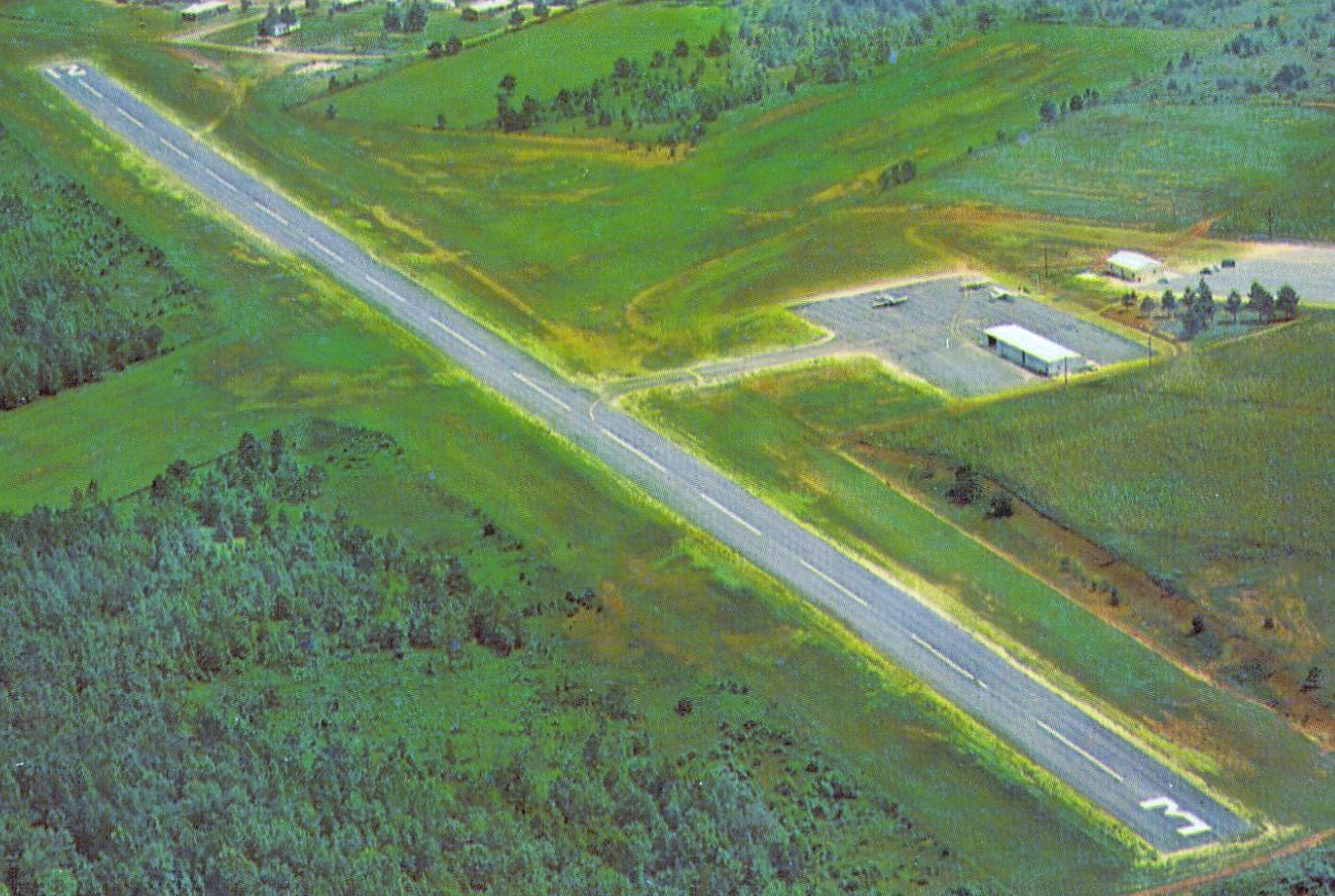
An undated aerial view looking northeast at Grant Memorial Airport from a circa early 1960s postcard (courtesy of Robert Adams) showed 3 light single-engine planes on its ramp.
The postcard's caption described Grant Memorial as having a 3,080' paved runway, and said the field offered flight instruction.
Grant Memorial Airport evidently gained a paved runway at some point between 1951-68,
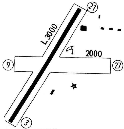
as the 1968 Flight Guide (courtesy of Robert Levittan) depicted the field as having a single 3,000' paved Runway 3/21,
along with an unpaved Runway 9/27.
Six small buildings were depicted on the east side of the field.
Grant Memorial Airport evidently gained a paved runway at some point between 1951-69,
as a 2/26/69 aerial view showed Runway 3/21 had been paved & an 2 small buildings had been added to the southeast of the runway intersection.
Seven single-engine aircraft were visible on the field.
The earliest topo map depiction which has been located of Grant Memorial Airport was on the 1972 USGS topo map.
The last aeronautical chart depiction which has been located of Grant Memorial Airport was on the 1978 Atlanta Sectional Chart (courtesy of David Henderson).
It depicted Grant Memorial as having a single paved 3,000' northeast/southwest runway.
The 1985 USGS topo map (courtesy of David Henderson) depicted Grant Memorial Airport as having a single paved northeast/southwest runway,
with a ramp & 2 small buildings on the southeast side.
The clearing for the crosswind runway was still depicted, but no longer as a runway.
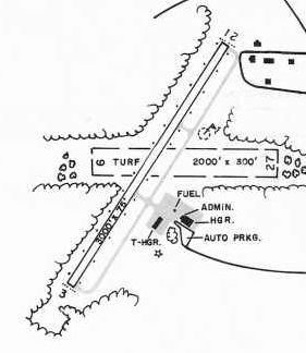
The 1985 GA Airport Directory (courtesy of Charlie Evans) depicted Reginald Grant Airport as having a 3,000' paved Runway 3/21 & a 2,000' turf Runway 9/27,
and an administration building & 2 hangars on the southeast side.
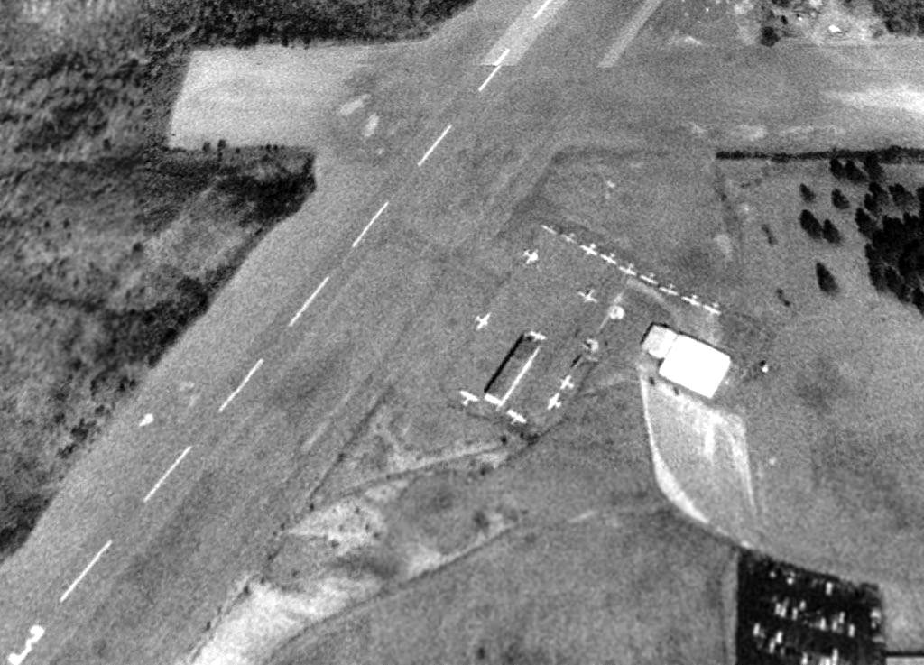
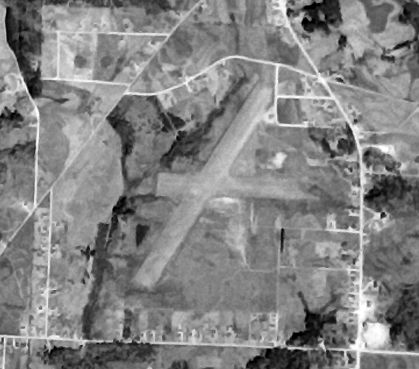
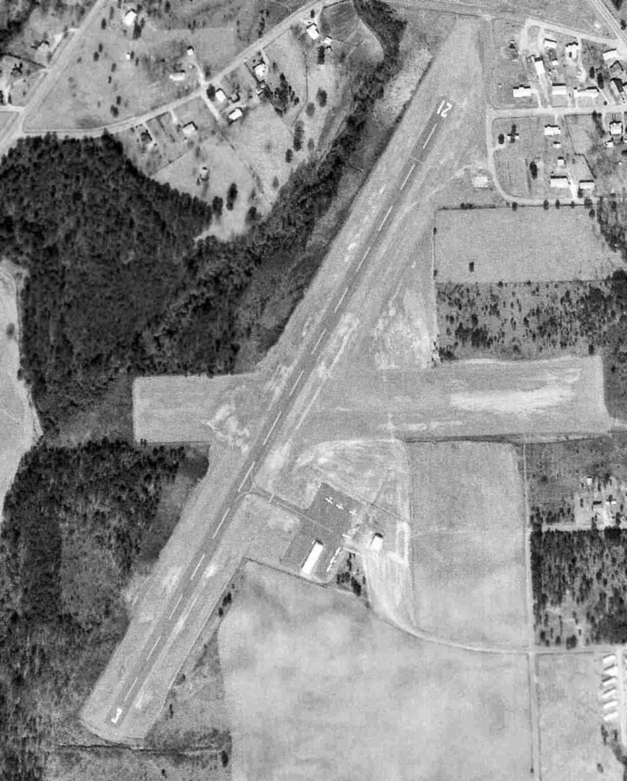
A 1/26/93 aerial view (courtesy of David Henderson) showed Grant Memorial Airport perhaps at its zenith of popularity,
with a total of 18 light aircraft visible on the field.
Taxiways had been constructed & a hangar had been added on the east side of the FBO at some point between 1969-93.
According to David Henderson, “Grant Memorial closed in 1994
shortly after the opening of the newly-constructed Thomaston Upson County Airport several miles to the east.”
According to the Thomaston Airport website, “The existing airport (Reginald Grant Field) had one 2,900' runway,
a circle-to-land NDB approach, 6 T-hangars & 15 based aircraft.”
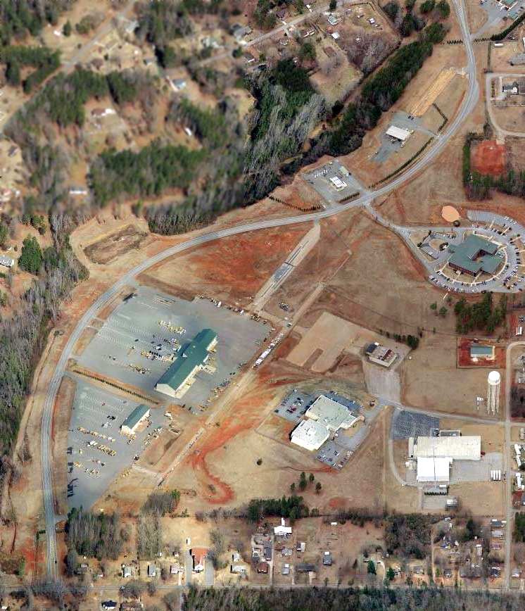
A circa 2011 aerial view looking north (courtesy of David Henderson) of the site of Grant Memorial Airport.
David observed, the photo “shows the old FBO & hangar along with small sections of taxiways & runway still intact.”
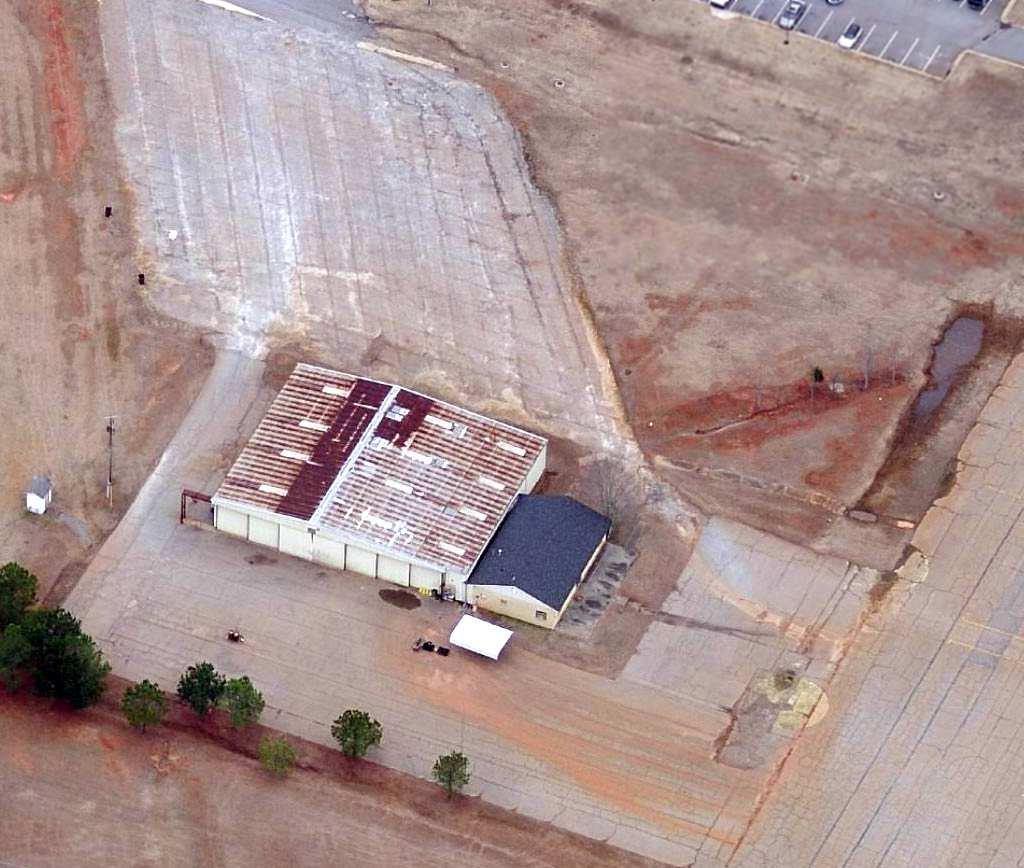
A circa 2011 aerial view looking north (courtesy of David Henderson) of the hangar which remains at the site of Grant Memorial Airport.
David Henderson reported in 2013, “Transportation Boulevard winds along the length of the former airport
and the road leading to the old FBO is still named Aviation Drive.
The Georgia DOT occupies most of the buildings on the former airport site.”

A 2019 photo looking north at the former hangar on the east side of the Grant Memorial Airport site.
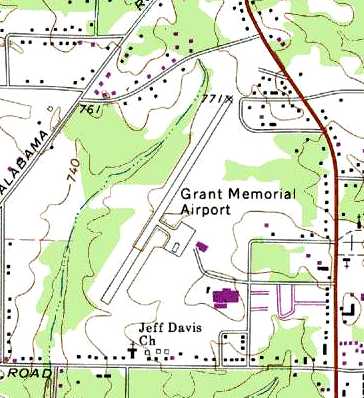
The site of Grant Memorial Airport is located at the western terminus of Aviation Drive, appropriately enough.
____________________________________________________
Putnam County Airport (32A), Warfield, GA
33.3, -83.38 (Southeast of Atlanta, GA)
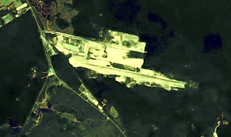
Putnam County Airport, as seen while under construction in a 3/17/71 USGS aerial view.
Putnam County Airport was evidently constructed in 1971, as it was not yet depicted on a 1955 aerial photo nor listed in the 1968 Flight Guide (courtesy of Robert Levittan),
and it appeared to have been under construction in a 3/17/71 USGS aerial view.
It depicted land being clearing for a single northwest/southeast runway on the south side of 2 industrial buildings.
Putnam County Airport was not yet depicted on the 1972 USGS topo map.
A 4/29/74 USGS aerial view depicted Putnam County Airport as having a single paved northwest/southeast runway.
Putnam County Airport was not yet depicted on the October 1975 Atlanta Sectional Chart (according to Chris Kennedy).
The earliest aeronautical chart depiction of Putnam County Airport which has been located was on the October 1976 Atlanta Sectional Chart (courtesy of Chris Kennedy).
It depicted Putnam County Airport as having a single 3,000' paved runway.
The April 1980 Atlanta Sectional Chart (courtesy of Chris Kennedy) depicted Putnam County as having a single 3,000' paved runway.
The earliest photo which has been located showing aircraft at Putnam County Airport was a 1981 aerial view,
which depicted 1 light single-engine aircraft parked on the northwest ramp.
The 1982 AOPA Airport Directory (courtesy of Ed Drury) described Putnam County Airport as having a single 3,000' asphalt Runway 10/28.
The last photo which has been located showing aircraft at Putnam County Airport was a 1981 aerial view,
which depicted 2 light single-engine aircraft parked on the northwest ramp.
Marion Seckinger recalled, “I'd stop on occasion at the Putnam County Airport just to see what was parked there.
During one visit in the mid to late 1980s, I stopped to talk with a aircraft owner.
He related that he was going to be forced to move to the Baldwin County Airport in the near future.
It seemed that a local businessman, Dudley Horton, had a mobile-home manufacturing facility adjacent to the airport.
He coveted that wide-open & paved space to park finished mobile homes on.
The story was that he was to purchase & donate a tract so that another airport could be built, but that has never come to pass.”
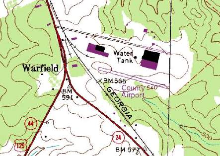
The 1985 USGS topo map depicted the “County Airport” as having a single paved northwest/southeast runway,
with a few buildings to the west & north.
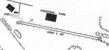
The 1985 GA Airport Directory (courtesy of Charlie Evans) depicted Putnam County Airport as having a 3,000' paved Runway 10/28, and a ramp on the northwest side.
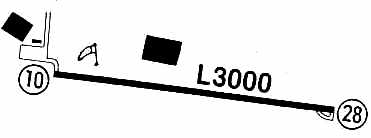
Putnam County Airport was described by the 1986 Flight Guide (according to Chris Kennedy) as being unattended.
The field was depicted as having a single 3,000' paved Runway 10/28. A ramp was located north of the western end of the runway.
A single small building was located on the north edge of the ramp, and 2 much larger buildings were located on the northern side of the field.
Putnam County Airport was apparently closed at some point between 1986-93.
According to Brad Turner, “The airfield was closed because Horton Homes needed room to expand its production & storage of mobile homes & trailers.
A political solution was reached in which the Horton Corporation agreed to hire more locals if they were permitted to close the airport & use the room for expansion.
Only a few persons, myself included, used the field since the Milledgeville airfield at the southern end of Lake Sinclair was more populated & built adjacent to the water.
At the time of the closure, the prospect of more local employment outweighed the needs of only a few local pilots & a decision was made to close the airfield. I still miss it.”
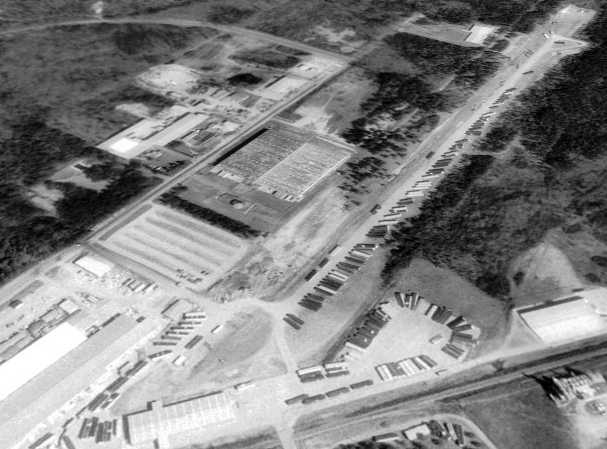
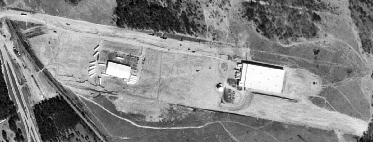
A 1993 USGS aerial view looking northeast at the site of Putnam County Airport showed the runway was still intact, used to store trailers.
What may have been the former airport office building remained on the northwest side (lower-right of photo).
A 2007 aerial photo showed that the former airport office building had been removed, covered by a larger industrial building.
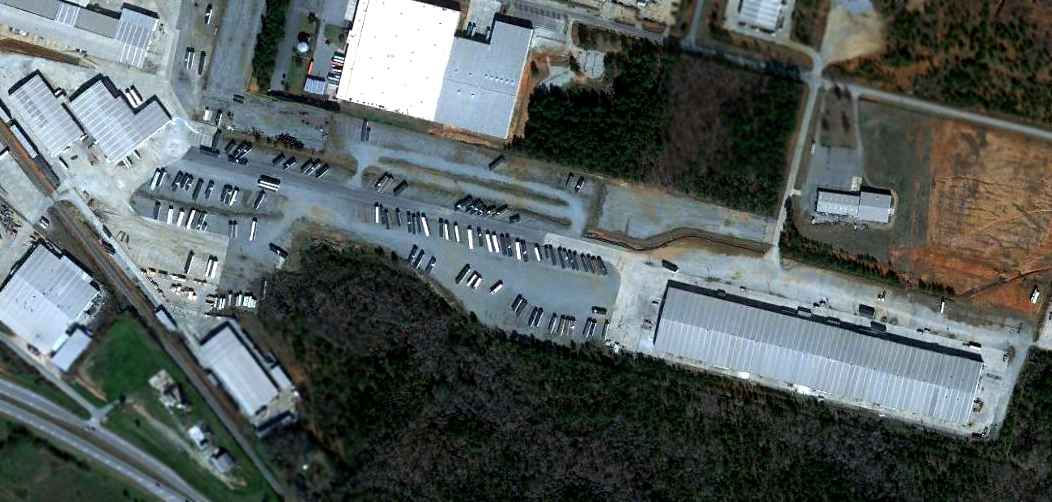
A 1/29/12 aerial photo of the site of Putnam County Airport shows that the majority of the runway pavement remains, but the site is hardly recognizable as a former airport.
The site of Putnam County Airport is located east of the intersection of Routes 441 & 129, one mile south of Eatonton.
____________________________________________________
Or if you prefer to contact me directly concerning a contribution (for a mailing address to send a check),
please contact me at: paulandterryfreeman@gmail.com
If you enjoy this web site, please support it with a financial contribution.
____________________________________________________
This site covers airfields in all 50 states.