Abandoned & Little-Known Airfields:
Florida, Southwestern Jacksonville area
© 2002, © 2025 by Paul Freeman. Revised 9/26/25.
This site covers airfields in all 50 states: Click here for the site's main menu.
____________________________________________________
Please consider a financial contribution to support the continued growth & operation of this site.
Belmore NOLF (revised 2/1/09) - Bostwick Airport / Bostwick Naval Outlying Field (revised 10/19/22) - Branan NOLF (revised 1/8/21) - Fleming Island NOLF (revised 11/14/17)
Foremost NOLF (revised 9/11/16) - Middleburg Airport / Middleburg NOLF (revised 4/21/18) - Stengel Airport (revised 9/26/25)
____________________________________________________
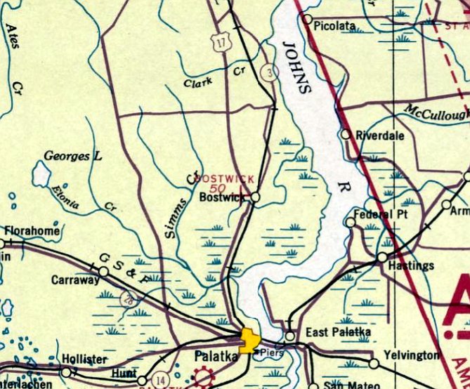
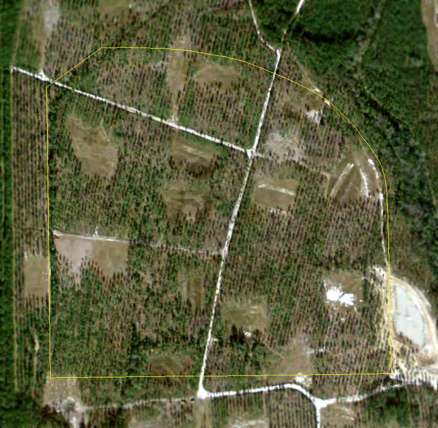
Bostwick Airport / Bostwick Naval Outlying Field, Bostwick, FL
29.782, -81.648 (South of Jacksonville, FL)
Bostwick Airport, as depicted on the January 1939 Orlando Sectional Chart.
Bostwick Airport was evidently established at some point between 1937-39,
as it was not yet depicted on the June 1937 Orlando Sectional Chart.
The earliest depiction which has been located of Bostwick Airport was on the January 1939 Orlando Sectional Chart.
It depicted Bostwick Airport as an auxiliary airfield.
Brian Rehwinkel reported, “Bostwick Outlying Field was used by the Navy from the early 1940s.
According the the station history for NAAS Green Cove Springs, it was one of the original 6 outlying fields used when that station was conducting primary training.
As with many of the other small grass outlying fields in the Jacksonville area, their mission changed with that of NAS Jacksonville
and these small fields (because they were not suitable for training with the larger, more powerful fighters)
became emergency landing fields & bomb targets or were transformed into larger paved outlying fields.
Even though it was not suitable for training use with larger aircraft, it still offered some safety if a larger plane needed an an emergency landing space in the sea of pine trees in the area.”
Brian Rehwinkel reported, “I don't know what type of airfield was there before the Navy constructed its outlying field.
I am surprised the Navy records don't mention the previous airfield... normally something like that will be mentioned.
I am pretty sure whatever airfield existed before the Navy field was very different.
The Navy records indicate they spent just short of $47,000 clearing & grubbing on their airfield.
That was a significant amount & obviously they didn't just use an existing airport for an Outlying Field.
In some cases during WWII, they did purchase or lease existing airfields and use them as an Outlying Field.
The design for this field was somewhat similar to a couple of other Outlying Fields. Bostwick OLF was comprised of 397 acres.”
Brian Rehwinkel reported, “Interestingly enough, this Outlying Field was not used as a bomb target for the rest of the war, it was only used as an emergency landing field.
There was already a bomb target just a couple of miles west of this field.
This is why the chart shows a 'danger zone' circle for the 'Bostwick' or sometimes called 'Putnam' bomb target in the area.”
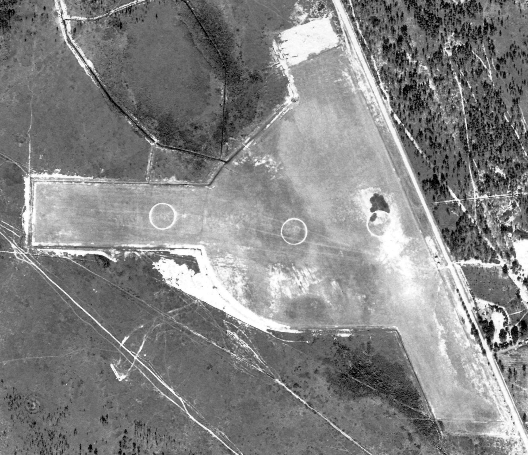
The earliest photo which has been located of Bostwick Airport was a 1/17/43 USDA aerial view (courtesy of Brian Rehwinkel).
It depicted Bostwick Airport as an irregularly-shaped grass airfield, with an east/west & northwest/southeast runway, with 3 airfield circle markings,
and a few small buildings along the east edge.
There were no aircraft visible on the field.
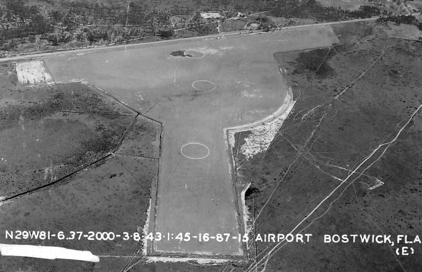
A 3/8/43 aerial view (from the National Archives, courtesy of Brian Rehwinkel) depicted Bostwick Airport in the same fashion as the earlier photo.
Ginger DiMaggio recalled, “Some of the old-timers from the area told me that it was an old practice field back in WW2.
I was told that on the Bostwick Park Road side was a airline-hangar-type thing where they'd work on the planes & fuel them up
and the road on the other side is named Old Airport Estates Road.
That's where they used to have the practice landing strip.
Someone has a photo of one of their relatives in his pilot's gear standing next to his plane at the field in Bostwick.”
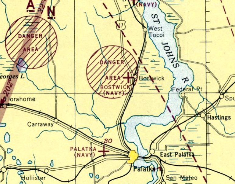
The July 1944 Orlando Sectional Chart depicted “Bostwick (Navy)” as a military auxiliary airfield,
overlapped by a circular “Danger Area” (presumably a bombing range).
Brian Rehwinkel reported, “Bostwick Outlying Field was used by the Navy until it was disposed of in 1948.
In March 1948, the US government conveyed the land, via quit claim deed for the airfield (not bomb target) to Putnam County.”
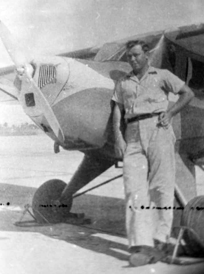
The only ground-level photo which has been located of Bostwick Airport was a circa 1940s photo (courtesy of Ginger DiMaggio) of Spencer Besser after landing his plane at Bostwick, presumably at the Bostwick Airport.
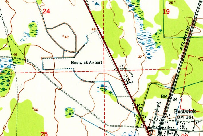
The only labeled topo map depiction which has been located of Bostwick Airport was on the 1949 USGS topo map.
It depicted Bostwick Airport as an irregularly-shaped property outline, with one small building on the east side.
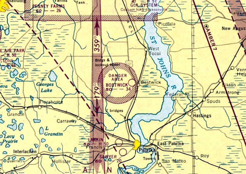
The last aeronautical chart depiction which has been located of Bostwick Airport was on the January 1950 Orlando Sectional Chart.
It depicted Bostwick Airport as a civilian airport having a 3,400' unpaved runway,
but it also depicted (once again) a circular “Danger Area” overlapping the airport, which must've made for interesting flying!
Bostwick Airport was evidently closed (for reasons unknown) at some point between 1950-51,
as it was no longer depicted on the 1951 Orlando Sectional Chart.
A 1967 aerial view of the site of Bostwick Airport showed its property outline was still recognizable,
but the site was overgrown & there was no indication of any recent aviation use.
Brian Rehwinkel reported, “The Navy didn't dispose of the bomb target until the late 1970s.”
A 1983 aerial photo showed that Airport Estates Road had been built over the former Bostwick Airport east/west runway.
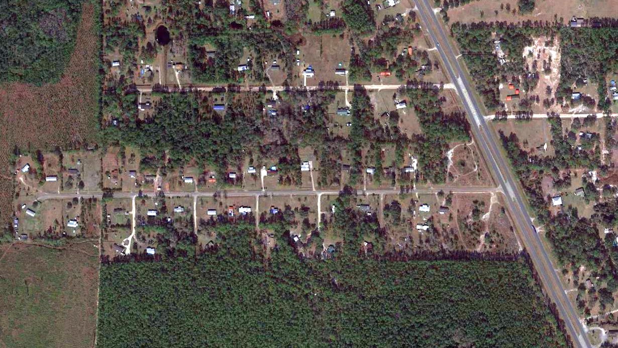
A 2021 aerial view showed no recognizable trace remaining of Bostwick Airport.
Thanks to Ginger DiMaggio for pointing out this airfield.
____________________________________________________
Belmore Naval Outer Landing Field, Maxville, FL
29.92, -81.89 (Southwest of Jacksonville, FL)
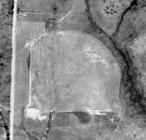
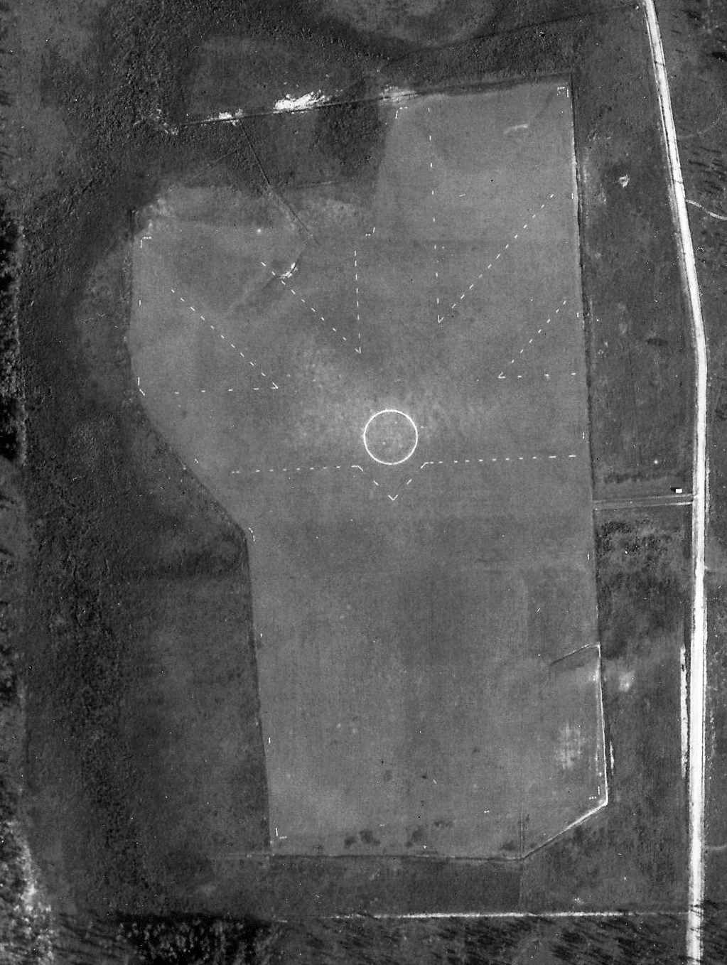
An August 1943 aerial photo of Belmore NOLF (from the University of FL Library, courtesy of Chris Kennedy).
This military airfield was one of a large number of satellite airfields used during WW2 by NAS Jacksonville.
The date of establishment of Belmore NOLF has not been determined.
The earliest reference which has been located of Belmore NOLF was a report of a 6/21/41 Navy SNJ-3 accident at the field (in the AAIR database, courtesy of Stewart Lanham).
The earliest depiction which has been located of Belmore NOLF was an August 1943 aerial photo (from the University of FL Library, courtesy of Chris Kennedy).
It depicted Belmore as a grass field, similar in shape to a baseball diamond. No hangars or aircraft were visible on the field in the photo.
According to WW2-era Navy memos (via Brian Rehwinkel), as of April 1944 Belmore OLF was assigned to NAAS Green Cove Springs for Maintenance purposes.
The Belmore airfield was not yet depicted on the February 1944 Orlando Sectional Chart (according to Chris Kennedy).
The earliest aeronautical chart depiction of Belmore which has been located
was on the July 1944 Jacksonville Sectional Chart (courtesy of Chris Kennedy).
The last chart depiction of Belmore as an active airfield which has been located
was on the February 1945 Orlando Sectional Chart (courtesy of Chris Kennedy).
According WW2-era Navy memos (via Brian Rehwinkel), Belmore was not being used by late 1945.
However, unlike many other small WW2-era military auxiliary airfields
Belmore was a Navy owned field & was declared "surplus-retained".
The Belmore airfield was no longer depicted on the August 1946 Jacksonville Sectional Chart.
Belmore OLF showed up in an NAS Jacksonville memo (according to Brian Rehwinkel)
as late as February 1947 (assigned to NAS Jacksonville), but it was described as being "not in use".
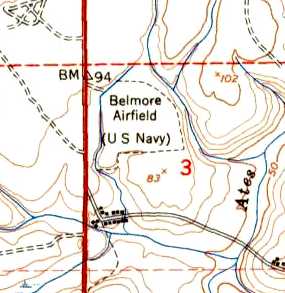
The 1949 USGS topo map still depicted “Belmore Airfield (U.S. Navy)”, but the field was evidently closed by this point.
Belmore evidently was never reused as a civilian airfield, as it was never again depicted on subsequent aeronautical charts.
The Belmore airfield outline was annotated over a 2004 aerial photo by Chris Kennedy, showing no trace remained of the airfield.
The site of Belmore NOLF is located southwest of the intersection of Dade Road & Airport Road, appropriately enough.
____________________________________________________
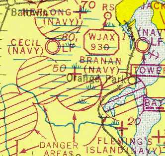
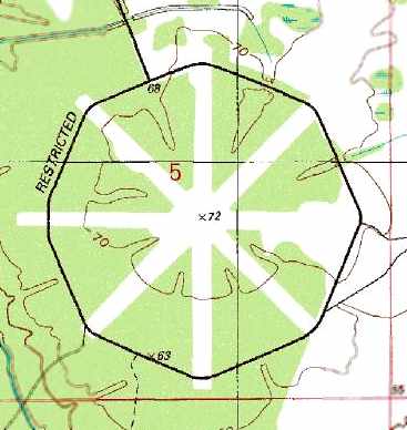
Branan Naval Outer Landing Field, Orange Park, FL
30.18, -81.82 (East of Jacksonville NAS, FL)
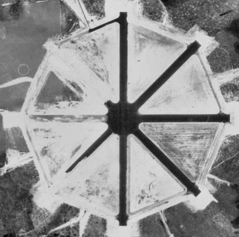
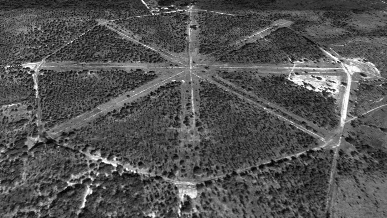
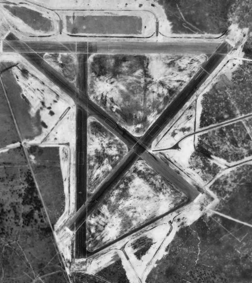
A 10/1/42 aerial view of Branan Field in its original (grass runway) configuration (U.S. Navy photo from the National Archives via Brian Rehwinkel).
This abandoned field is located only 3 miles southeast of Cecil Field, on Branan Field Road.
According to a report prepared by Myles Bland in 2002 as part of the federal compliance process for the property's redevelopment,
Alvord & Mary Branan acquired this property in 1940.
During the period just before WW2, the Department of the Navy began identifying parcels of land suitable for use in support of NAS Jacksonville.
Among those selected included the Branan's land, in part, because of its close proximity to NAS Jacksonville & an outlying field - Cecil Field,
which stood northwest of the Branan's property.
In 1941, the Navy & Jacksonville engineering consultant Robert Angas identified the Branan's property as a suitable outlying field for NAS Jacksonville.
The Federal government instituted proceedings against the Branan's real estate in the same year.
In 1941, Angas supplied the Department of the Navy with preliminary plans for "Outlying Field L,"
or "Branan Field", indicating that the property then consisted of an "improved farm" maintained by A. W. Branan.
No airfield at Branan was yet depicted on the June 1942 17M Regional Aeronautical Chart (courtesy of Chris Kennedy).
The earliest photo which has been located of Branan Field was a 10/1/42 aerial view (U.S. Navy photo from the National Archives via Brian Rehwinkel).
It depicted Branan Field in its original configuration, with 4 grass runways, with a circular airfield marking at the intersection.
There were not any buildings at the airfield.
According to Brian Rehwinkel, “Because of the changing demands for training…and the change in mission for NAS Jacksonville, the training fields changed as well.
The grass field was used by the primary training aircraft until the station’s mission changed & the hard-surface runways were added in mid-1943.
At least 6 of the outlying paved outlying fields were previously grass fields.”
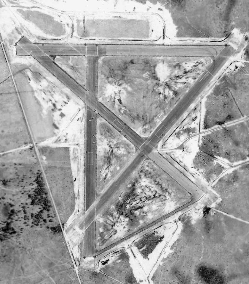
A July 1943 U.S. Government aerial photo (courtesy of the FL DOT, via Brian Rehwinkel) depicted Branan Field as the runways were being paved.
The eastern half of Branan's 4 runways had been paved already,
and construction trucks were visible in the northwest portion of the field.
The airfield at Branan had a unique configuration – consisting of 4 paved 4,000' runways,
which all intersected at the same point, with the ends of the runways ringed by a taxiway.
Brian Rehwinkel observed, “You can see the original field on the left side the new field.
Most of the original field remained intact… and the landing circle remained prominent.”
A large cleared area approximately one mile south of OLF Branan was used as the Spencer Bomb Target, perhaps for dive bombers.
A July 1943 U.S. Government aerial photo (courtesy of the FL DOT, via Brian Rehwinkel)
showed the target to consist of a cleared rectangular area, with a simple small circle in the middle.
The earliest chart depiction which ha been located of the Branan airfield
was on the August 1943 17M Regional Aeronautical Chart (courtesy of Chris Kennedy).
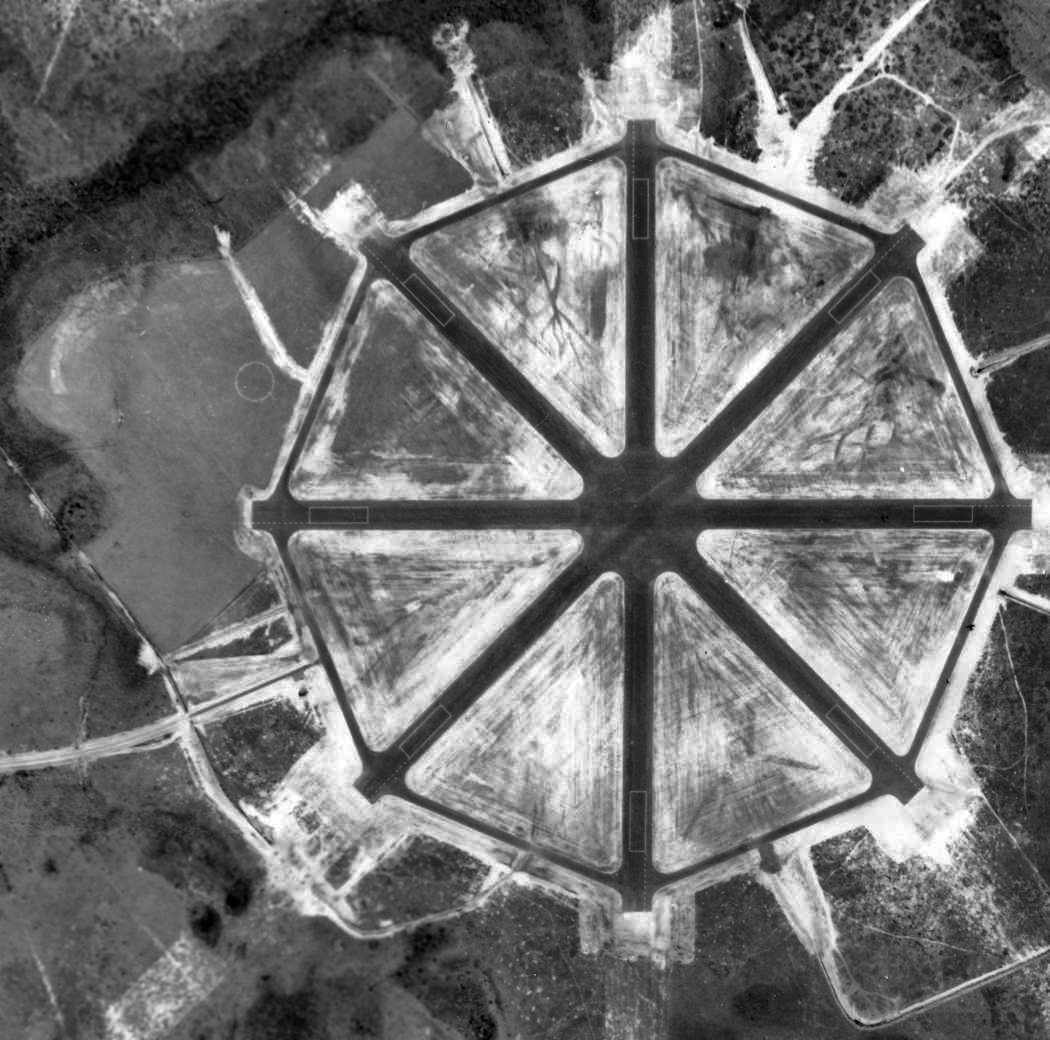
A 1/5/44 aerial photo (U.S. Navy photo from the National Archives via Brian Rehwinkel) depicted painted lines in rectangular shapes near the ends of each runway.
These markings were used by trainee pilots to practice landing aircraft in the specific dimensions provided by aircraft carriers,
a technique also employed at neighboring OLF Switzerland.
No buildings were depicted at the site in WW2-era photographs.
An accident summary lists Branan Field as the site of crashes of Douglas SBD-4 Dauntless & Curtis SB2C Helldiver aircraft in 1944-1946.
Following the Second World War, Branan Field was used for the development of the US Navy Flight Demonstration Squadron,
later to be known as the "Blue Angels".
Although NAS Jacksonville is listed as the birthplace of the Blue Angels,
most of the preliminary training was done at Branan in private.
The peculiar geometry of Branan Field made it particularly suitable for training by he Blue Angels -
the large symmetrical shape of Branan Field with its convergence of runways facilitated visualization
by pilots approaching a single central spot from various compass points in jet aircraft.
It was labeled as "Branan (Navy)" on the February 1949 Jacksonville Sectional Chart (courtesy of Chris Kennedy),
and depicted as having a 4,000' hard-surface runway.
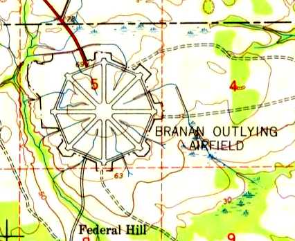
The 1949 USGS topo map labeled the property as “Branan Outlying Airfield”.
Branan Field was abandoned at an unknown point after 1949.
According to Brian Rehwinkel, “Branan OLF has its asphalt removed in 1953 for use in the conversion of nearby Cecil Field to a Master Jet Base.
The Navy sold the land soon after.”
A 1953 aerial photograph (courtesy of Brian Rehwinkel) showed the paved surfaces at OLF Branan had been largely removed,
although the octagonal shape was still apparent.
In contrast, the bombing range south of the OLF had been improved into an enhanced bull's-eye with directional arrows pointing east & north.
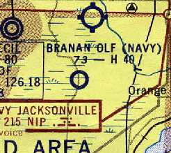
The February 1956 Jacksonville Sectional Chart (courtesy of Chris Kennedy)
depicted "Branan OLF (Navy)" as having a 4,000' hard-surface runway.
However, the remarks in the Aerodromes table said "Closed to all aircraft. Leased for grazing."
Branan Field was no longer depicted at all on the August 1956 Jacksonville Sectional Chart.
Branan Field was labeled "Abandoned airport" on the 1964 Jacksonville Sectional Chart (courtesy of John Voss).
A 1964 topo map indicated that the octagonal outline of Branan Field was paved, but that the runways had been eliminated.
A paved road extended from Naval Air Auxiliary Station Cecil Field to the former OLF Branan,
and an unimproved road extended southward to the bombing range.
Chris Alvarez recalled visited the abandoned site of Branan Field in the early 1970s:
"We would ride our bikes what seemed like 100 miles (but was more like 5) through the woods
to the roughly circular field that was Branan Field
and imagine that it was a UFO landing site, a Secret Government base & other mysterious things!
Cecil Field was still in use then but no bombing or other military use happened at Branan Field when we were there.
We would spend most of the day exploring & looking for traces of military stuff but never really found anything -
there wasn't much left by then but the wide, cleared landing strips & crumbling tarmac."
The outline of the former Branan Field runways were still depicted on the 1993 USGS topo map, along with the ring taxiway,
but the site was unlabeled.
Branan Field was no longer depicted at all (even as an abandoned airfield) on 1990s aeronautical charts.
As seen in a 1994 USGS aerial view looking north, Branan Field's distinctive runways remained relatively untouched, although trees had grown up through several of them.
As seen in the 1999 USGS aerial photo, the Spencer Bomb Target south of Branan Field was still quite recognizable,
being very similar to its rectangular layout as seen in the 1943 aerial photo.
A large road project was being built through the Branan Field site in 2001,
so the remains of the airfield might not last must longer.
According to Ray (a Comair pilot), a visit to the site in 2002 confirmed that it looks nothing like an airport anymore.
The land is currently owned by a gentleman that has a hunting club on the grounds.
The perimeter road & segments of the runways (including one segment still retaining its painted markings) still remain,
although trees have grown up all throughout the area.
According to Myles Bland, "The airfield was built over in 2002 & 2003.
I too was sorry to see it go, but pleased that it was properly documented before-hand.
The site of the former airfield "is now a very nice subdivision".
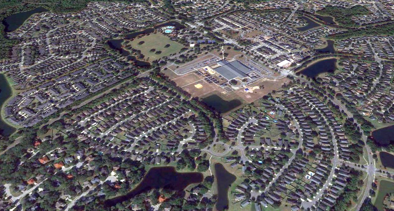
A 2018 aerial view looking north showed the site of Branan Field thoroughly redeveloped with housing, with not a trace remaining of the Navy airfield.
More of our aviation heritage lost to a never-ending desire for more suburban housing.
Thanks to Ed Hines for pointing out this airfield.
____________________________________________________
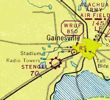
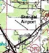
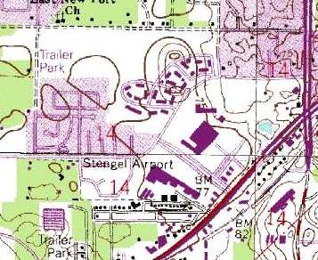
Stengel Airport, Gainesville, FL
29.63, -82.38 (Southwest of Jacksonville, FL)

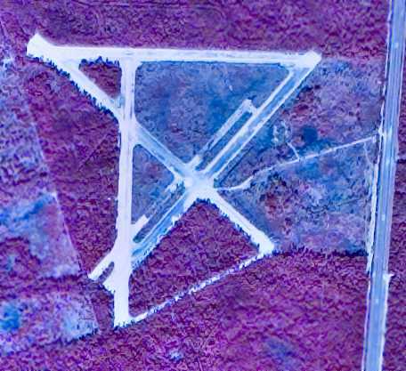
Stengel Field, as depicted on a 3/8/43 aerial view looking north (courtesy of Brian Rehwinkel).
Stengel Airport is yet another general aviation airport which has completely disappeared due to urban sprawl.
According to the Alachua County Library website,
Carl Stengel bought his first plane in 1930, long before most people even imagined getting into one.
He had operated Stengel's Flying School starting in the late 1930s from the Gainesville Municipal Airport.
Stengel Field was yet not depicted on a 12/10/37 USDA aerial photo (courtesy of Dallam Oliver-Lee),
nor listed in the Airport Directory Company's 1937 Airports Directory (courtesy of Bob Rambo),
When the Alachua Army Airbase took over Gainesville Municipal Airport in 1941,
Stengel moved to his operations to Stengel Field, located on Archer Road.
Stengel Field was not yet listed in the Airport Directory Company's 1941 Airports Directory (according to Chris Kennedy),
nor depicted on the January or July 1942 Orlando Sectional Charts (according to Chris Kennedy).
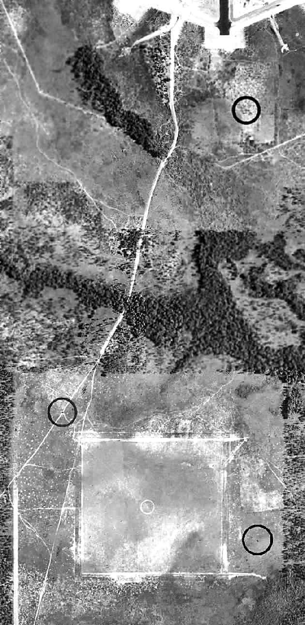
The earliest depiction which has been located of Stengel Field was a 3/8/43 aerial view looking north (courtesy of Brian Rehwinkel).
It depicted Stengel Field as an irregularly-shaped grass airfield, with 3 hangars & several smaller buildings on the southeast side.
Brian Rehwinkel observed, “This is interesting because there are planes present at the field at a time when many other civilian fields were closed.
This field provided some civilian pilot training during the war, so maybe that is why you see planes at the field.”
The earliest aeronautical chart depiction which has been located of Stengel Field was on the July 1943 Orlando Sectional Chart (courtesy of Chris Kennedy).
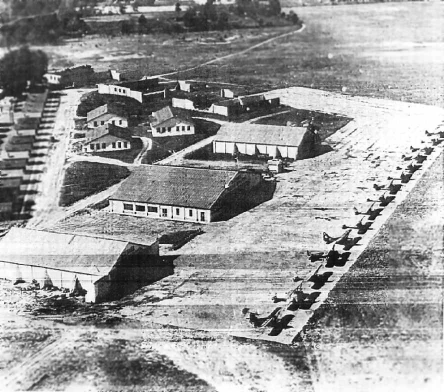
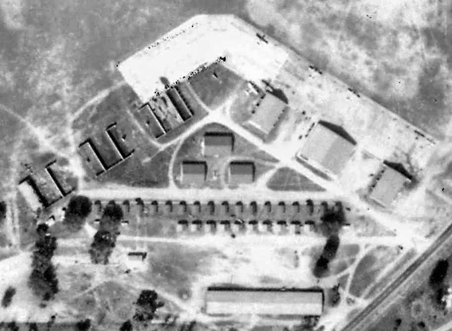
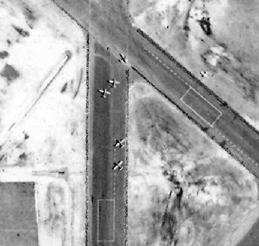
An undated (circa 1940s?) aerial view looking west at the Stengel Field ramp,
showing over a dozen of what appear to be Civilian Flight Training program aircraft.
Note the very unusual complement of 3 completed hangars in the foreground,
along with what appear to be another set of 3 unfinished hangars on the west side of the ramp.
The 1944 US Army & Navy Directory of Airfields (according to Brian Rehwinkel)
described Stengel as having a 3,800' sod runway.
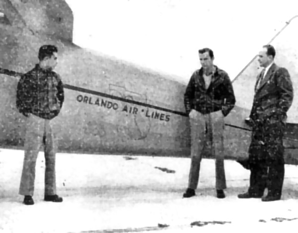
Shown in front of an aircraft (type unidentified) of Orlando Air Lines are Ernest Marquis (pilot),
Jack Frierson (Stengel Field operator), and Don Dobbins (field business manager).
The 1945 Haire Publishing Company Airport Directory (courtesy of Chris Kennedy) described Stengel Field as having 3 hangars,
and listed the operator as Don Dobbins.
According to the University of FL Housing website,
following WW2, faculty apartments were constructed at the Stengel Air Field & managed by the University.
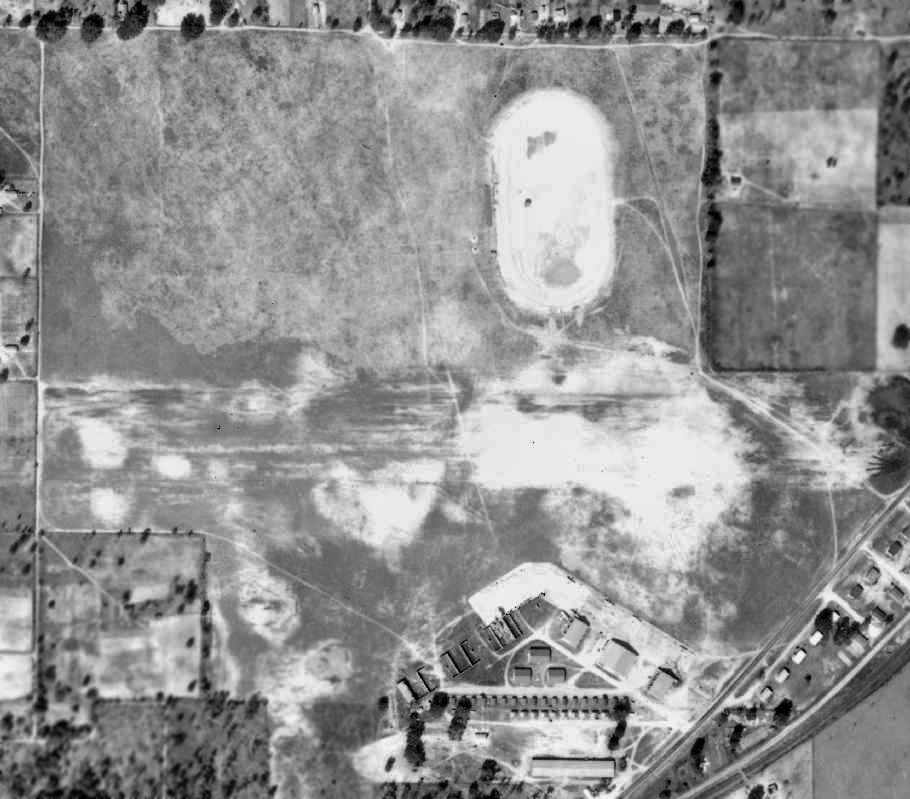
A February 1949 aerial photo of Stengel Airport, from the FL DOT (courtesy of Brian Rehwinkel).
The airfield consisted of an open grass area, with a single east/west runway.
A closeup of the ramp of from the 1949 aerial photo of Stengel Airport, from the FL DOT (courtesy of Brian Rehwinkel).
Three hangars remained standing on the east side of the ramp,
while on the west side of the ramp had the uncompleted set of another 3 hangars.
A total of 6 aircraft were visible on the ramp.
Bob Jamieson recalled, “Stengel Field [had] a single grass runway of about 3,000'.
The Triangle Flying Club was based there.
I learned to fly at that field in a Flying Club Aeronca L3 in 1964.”
The 1962 AOPA Airport Directory described Stengel Field as having a single 3,500' sod Runway 9/27,
but described the field as unattended.
The last aeronautical chart depiction which has been located of Stengel Field was on the November 1967 Orlando Sectional Chart.
It depicted Stengel's runway length as having decreased to 2,600'.
Don Loftus recalled, “I flew into Stengel Field just before it closed back in the late 1960s.”
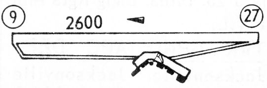
The 1968 Flight Guide (courtesy of Robert Levittan) depicted Stengel Field as having a 2,600' unpaved Runway 9/27,
with taxiways leading to a ramp with several buildings on the south side.
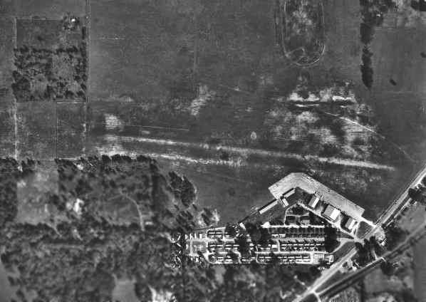
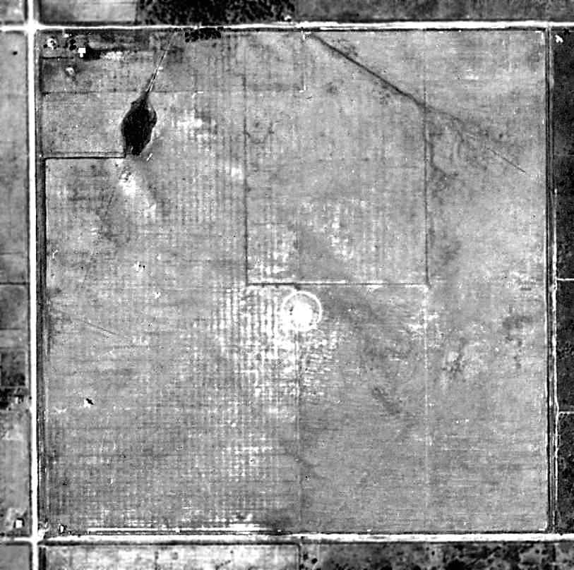
A January 1971 USDA aerial photo (from the University of Florida Online Library, courtesy of Brian Rehwinkel)
of Stengel Airport in its final year of operation.
Note that the orientation of the single grass runway appeared to have changed somewhat, compared to the 1949 aerial photo.

A closeup of several planes still on the ramp at Stengel Airport
from the January 1971 USDA aerial photo (from the University of Florida Online Library, courtesy of Brian Rehwinkel).
Stengel Airport was apparently closed within the next year,
as it was not listed among active airports in the 1/15/72 Flight Guide (according to Chris Kennedy).

Almost exactly one year after the 1971 photo, this January 1972 FL DOT aerial photo (courtesy of Brian Rehwinkel)
shows that the airport property was already being subjected to redevelopment -
the airplanes have been replaced by the construction equipment & materials
being used to convert the airport site into a residential and commercial development.
"Apparently, no time was wasted after the airport closed in transforming the site."
The 3 Stengel Field hangars still remained standing on the 2/4/74 USDA aerial photo (courtesy of Dallam Oliver-Lee).
The 11/13/77 USDA aerial photo (courtesy of Dallam Oliver-Lee) showed that the hangars had been removed, replaced by a shopping center.
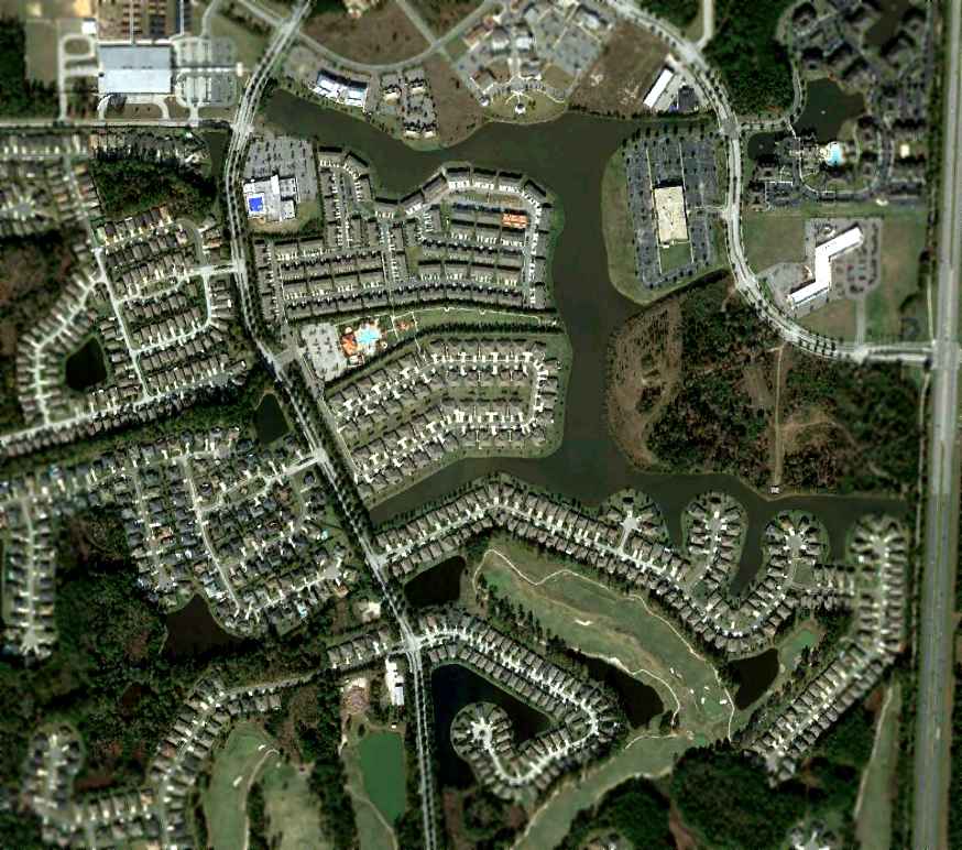
The site of the former Stengel Airport was redeveloped as the Butler Plaza & Archer Square Shopping Centers.
Brian Rehwinkel recalled, "When I was in school at the University of Florida,
I used to shop at a grocery store located on the site of this former airport
and I had no idea there was ever an airport there."
Stengel Airport continued to be depicted on the 1977 USGS topo map,
even though it had apparently been redeveloped several years before then.
The field was depicted as having a single northwest/southeast runway.
Inexplicably, the 1993 USGS topo map continued to label the site as "Stengel Airport",
even though it also depicted that the site had been completely redeveloped with shopping centers & a trailer park.
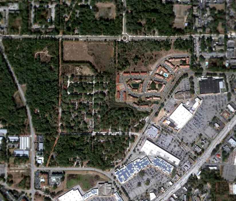
A 1/18/12 aerial photo showed not a trace remained of Stengel Airport, it having been replaced by Butler Plaza & houses.
The site of Stengel Airport is located on the northwest corner of Southwest 34th Street & Archer Road.
____________________________________________________
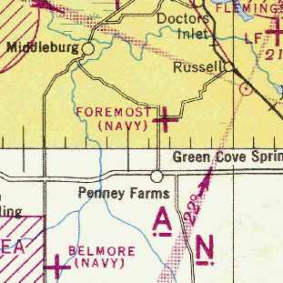
Foremost Naval Outer Landing Field, Penny Farms, FL
30.016, -81.802 (South of Jacksonville, FL)
A 1943 aerial photo of Foremost NOLF (from the FL DOT, courtesy of Brian Rehwinkel).
The photo is remarkable, as not only does it show at least 2 aircraft (type undetermined) parked on the field (center-left),
but it even depicts 2 aircraft in flight over the field (one at bottom-left, the other at top-right).
This airfield was evidently established during WW2,
as one of the many satellite airfields used to support Navy flight training in the Jacksonville area.
The date of construction of the Foremost airfield has not been determined.
The earliest depiction of the field which has been located
was the above 1943 aerial photo of Foremost NOLF (from the FL DOT, courtesy of Brian Rehwinkel).
It depicted the airfield at Foremost as consisting of a 2,600' square grass all-way landing field.
What appeared to be a small pond occupied part of the northwest corner of the field,
along with what may have been a group of small buildings (farm houses?).
No airfield at Foremost was yet depicted on the January 1944 Jacksonville Sectional Chart (courtesy of Chris Kennedy).
An April 27, 1944 Navy memo (according to Brian Rehinkel) described Foremost Field
an outlying field assigned to NAAS Green Cove Springs (located a few miles to the east).
Foremost was not listed among active airfields in the April 1944 US Army/Navy Directory of Airfields (courtesy of Ken Mercer),
presumably due to its status as a relatively small airfield.
The earliest chart depiction which has been located of the Foremost airfield was on the July 1944 Jacksonville Sectional Chart (courtesy of Chris Kennedy).
It depicted “Foremost (Navy)” as an auxiliary airfield.
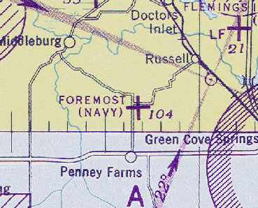
The last aeronautical chart depiction which has been located of the Foremost airfield
was on the February 1945 Jacksonville Sectional Chart (courtesy of Chris Kennedy).
According to Brian Rehwinkel, "As with most of the OLFs, it was not needed after the war,
and by November 1945, it had been declared surplus property."
By the time of the February 1949 Jacksonville Sectional Chart (courtesy of Chris Kennedy),
Foremost was no longer depicted at all (not even as an abandoned airfield).
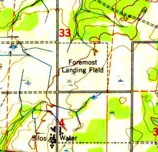
The 1949 USGS topo map still depicted the property as “Foremost Landing Field”, even though the field was evidently already closed by that point.
It was still labeled as “Foremost Airfield” on the 1972 USGS topo map.
The 1978 USGS topo map still depicted the square clear area, but it was no longer labeled at all.
A 1994 USGS aerial view showed the square airfield property outline was still recognizable, but the property was overgrown.
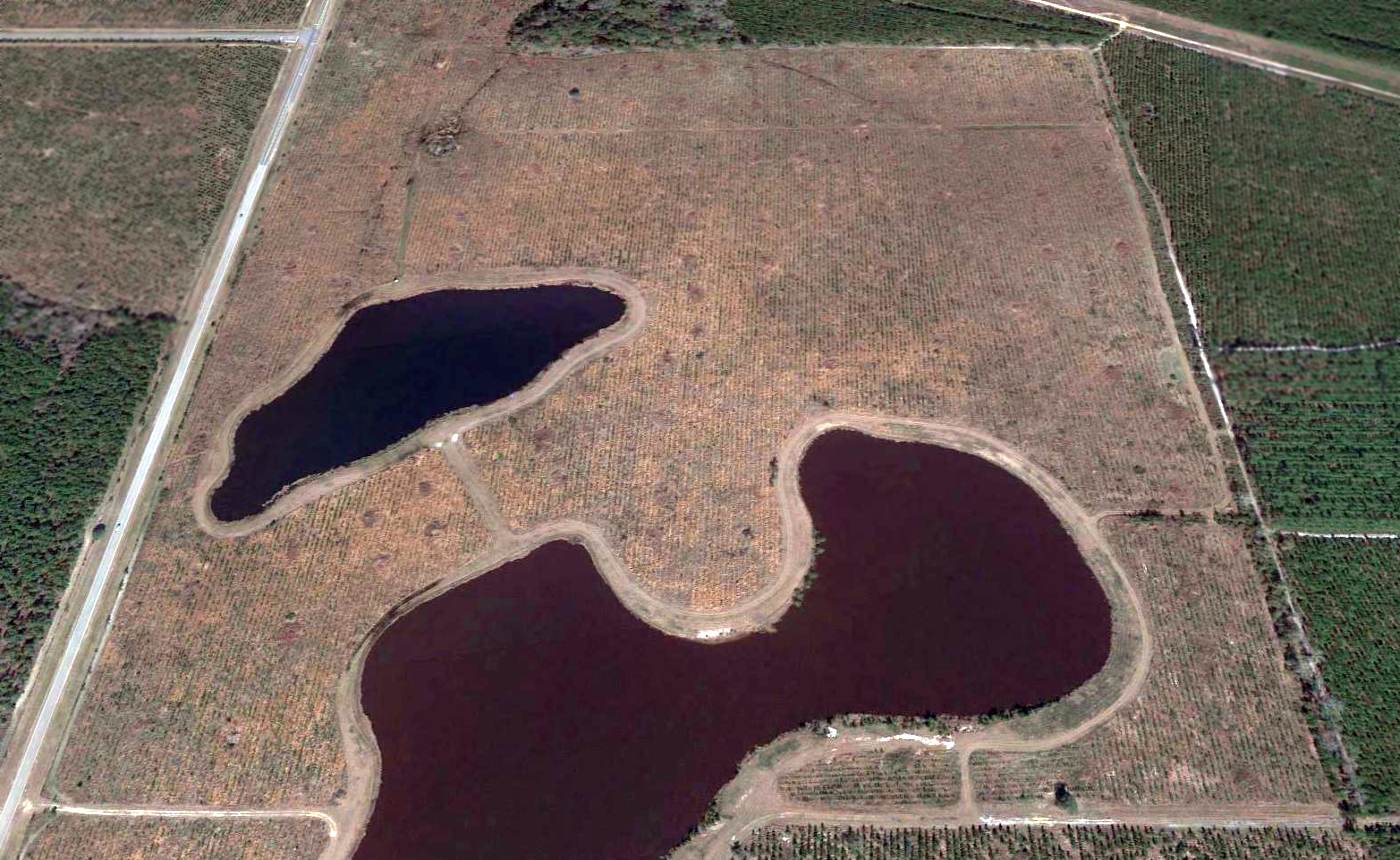
A 2016 aerial view looking north showed the square outline of Foremost NOLF remained recognizable, but 2 ponds had been created on the southern half of the airfield site.
____________________________________________________
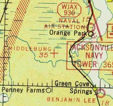
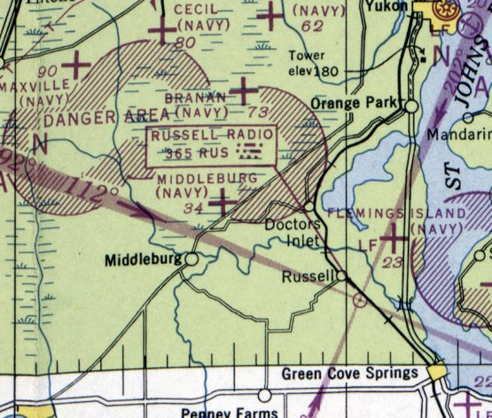
Middleburg Airport / Middleburg Naval Outer Landing Field, Middleburg, FL
30.11, -81.83 (South of Jacksonville, FL)
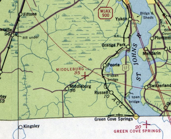
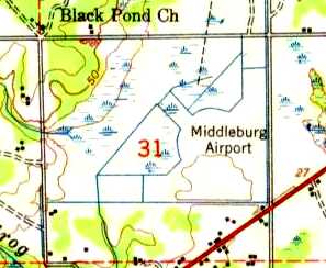
Middleburg Airport, as depicted on the August 1941 Jacksonville Sectional Chart.
This small airport was evidently established at some point between 1935-37,
as it was not yet depicted on the August 1935 Jacksonville Sectional Chart.
The earliest reference to the Middleburg Airport which has been located
was in The Airport Directory Company's 1937 Airports Directory (courtesy of Bob Rambo).
It described Middleburg as an auxiliary airfield, located 2 miles northeast of the town of Middleburg.
The field was described as having 2 sod runways, in an “L” shape, measuring 2,500' north/south & east/west.
The earliest aeronautical chart depiction which has been located of Middleburg Airport
was on the August 1941 Jacksonville Sectional Chart.
It depicted Middleburg as an auxiliary airfield.
The June 1942 17M Regional Aeronautical Chart (courtesy of Chris Kennedy)
depicted Middleburg Airport as an auxiliary airfield.
The Middleburg Airport was evidently abandoned at some point between 1942-43,
as it was no longer depicted at all on the August 1943 17M Regional Aeronautical Chart (courtesy of Chris Kennedy).
At some point in 1943, the Middleburg Airport was evidently reused by the Navy
as one of the many satellite airfields used to support Navy flight training in the Jacksonville area.
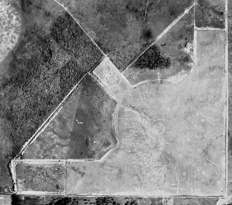
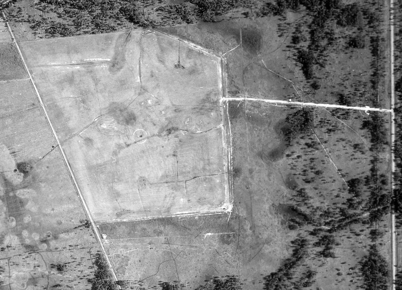
The earliest photograph which has been located of Middleburg Field was the 1943 aerial photo (from the FL DOT, courtesy of Brian Rehwinkel).
It depicted Middleburg as having 3 grass runways. No aircraft or buildings were depicted at the airfield.
No airfield at Middleburg was depicted on the January 1944 Jacksonville Sectional Chart (courtesy of Chris Kennedy).
The April 1944 US Army/Navy Directory of Airfields (courtesy of Ken Mercer)
described "Middlebrurg, Navy" as having a 3,500' unpaved runway.
“Middleburg (Navy)” was depicted as an auxiliary airfield
on the July 1944 Jacksonville Sectional Chart (courtesy of Chris Kennedy).
The December 1944 US Army & Navy Directory of Airfields (according to Brian Rehinkel)
described Middleburg OLF as being assigned to NAS Jacksonville,
and described the field as having a 3,200' runway.
According to Brian Rehwinkel, "According to Navy property documents,
Middleburg was listed as being 'inactive' by 1945."
The last aeronautical chart depiction which has been located of the Middleburg airfield
was on the August 1946 Jacksonville Sectional Chart.
According to Brian Rehwinkel, "According to Navy property documents,
Middleburg no longer showed up on the property list for NAS Jacksonville by June 1948."
By the time of the February 1949 Jacksonville Sectional Chart (courtesy of Chris Kennedy),
Middleburg was no longer depicted at all (not even as an abandoned airfield).
The 1949 USGS topo map still depicted the “Middleburg Airport”, but the field was evidently closed by this point.
Nothing at the site was depicted on USGS topo maps from 1981 or 1993.
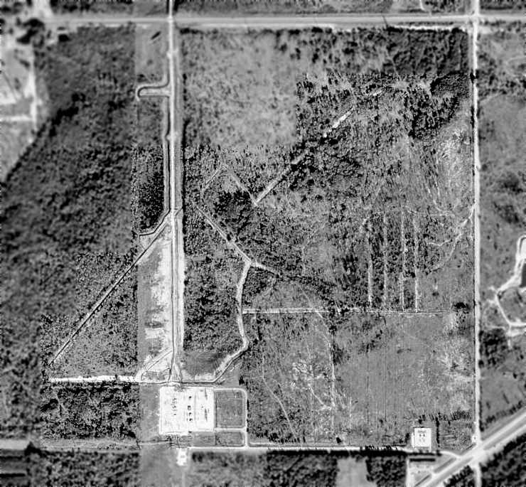
As seen in the January 1999 USGS aerial photo, the majority of the property of the former Middleburg NOLF remained undeveloped,
with the distinctive outline of the 3 former runways still recognizable.
The only change at the property is that 2 substations (labeled as such on USGS topo maps)
have been built along the southern edge of the property,
with a new road cutting north/south along the western edge of the former airfield.
Jim Burnett reported in 2004, "The Middleburg OLF is now bordered by a high tension power line easement to the west,
and the site soon be home to a new Super Wal-Mart."
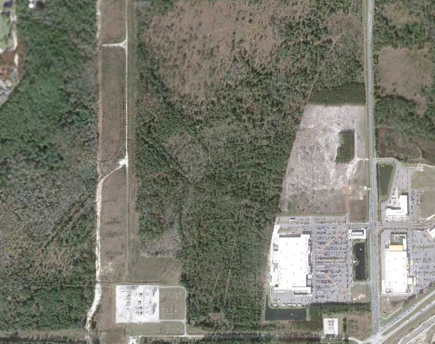
A 12/17/11 aerial photo shows the Wal-Mart which was constructed over the southeast corner of the Middleburg NOLF site.
Amazingly though, a careful examination will show that the outline of the airfield is still recognizable in the center & southwestern portions of the airfield site.
____________________________________________________
Fleming's Island Naval Outer Landing Field, Hibernia, FL
30.08, -81.72 (South-Southwest of Jacksonville NAS, FL)
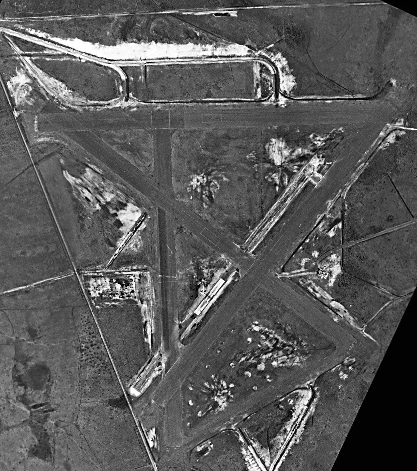
A 7/14/42 USN aerial view of Fleming's Island NOLF (from the National Archives, courtesy of Brian Rehwinkel).
This WW2-era military airfield was built as a satellite airfield for Jacksonville NAS.
The date of construction of Fleming's Island NOLF has not been determined.
Fleming's Island NOLF was not yet depicted on the June 1942 17M Regional Aeronautical Chart (courtesy of Chris Kennedy).
The earliest depiction which has been located of Fleming's Island NOLF was a 7/14/42 USN aerial view (from the National Archives, courtesy of Brian Rehwinkel).
It depicted Fleming's Island NOLF in its original configuration, built to support primary flight training, with an irregularly-shaped grass airfield, with an airfield circle marking in the center.
There were no buildings visible on the airfield, or any other improvements.
At some point between 1942-43, Fleming's Island NOLF was completely transformed into its “2nd generation” configuration, with 4 paved runways.
According to Brian Rehwinkel, the “airfield was completely changed when the mission of NAS Jacksonville shifted away from primary training in 1942.
This airfield, along with Branan OLF, Herlong OLF, Switzerland OLF, and Whitehouse OLF were originally small grass landing fields that were transformed into airfields with multiple paved runways.”
The earliest depiction which has been located of the “2nd generation” Fleming's Island airfield (with newly-paved runways)
was a 5/28/43 USDA aerial view (courtesy of Dallam Oliver-Lee).
It depicted Fleming's Island as having 4 asphalt runways, and 2 single-engine aircraft were visible on the runways.
The last photo which has been located showing Fleming Island NOLF in use
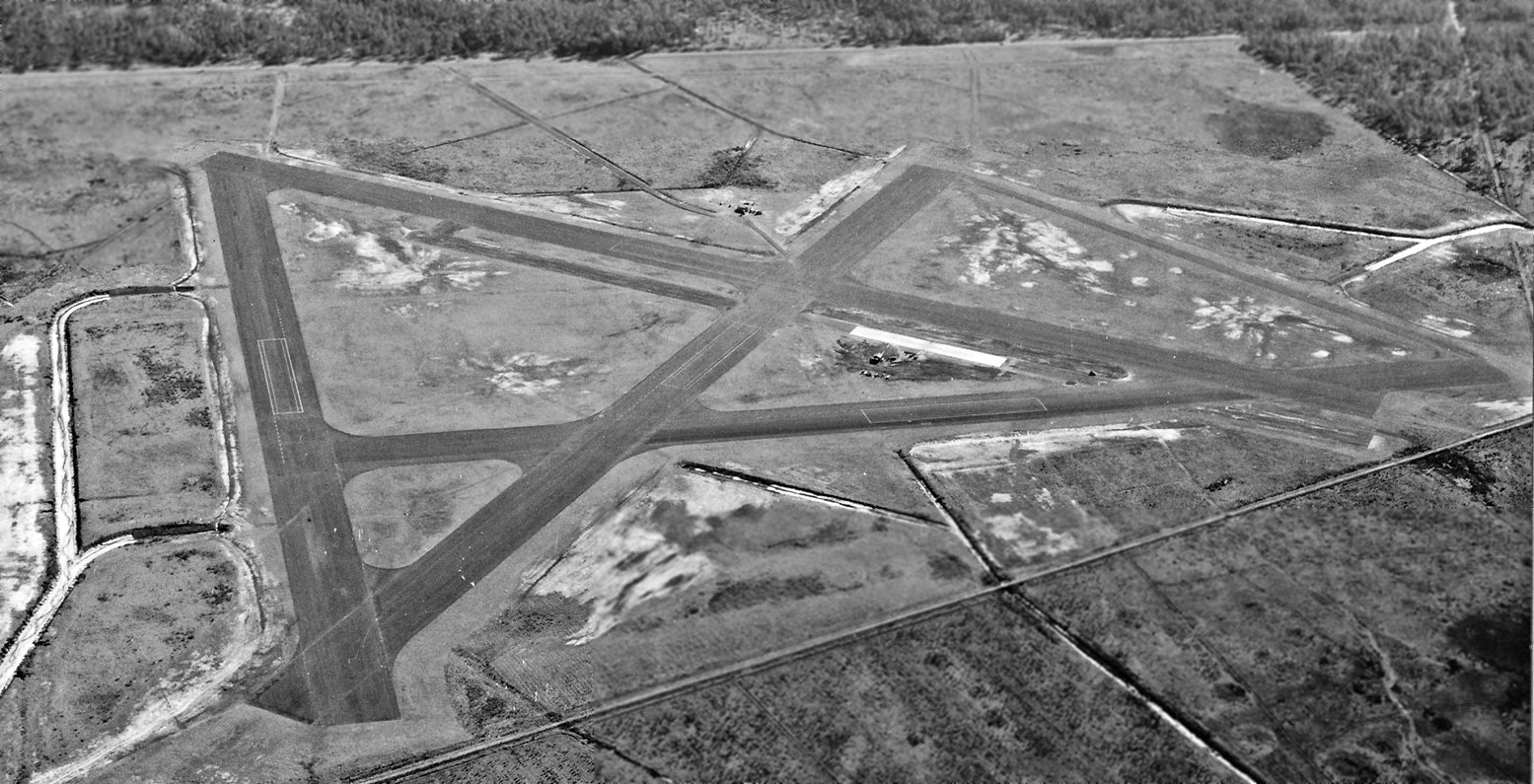
was a June 1943 US Government aerial view (courtesy of FL DOT, via Brian Rehwinkel).
A closeup of 6 Navy planes (unidentified, but they appear to be of at least 2 different types)
from the June 1943 US Government aerial view (courtesy of FL DOT, via Brian Rehwinkel)
The earliest chart depiction which has been located of the Fleming's Island airfield
was on the August 1943 17M Regional Aeronautical Chart (courtesy of Chris Kennedy).
It depicted “Fleming's Island (Navy)” as an auxiliary airfield.
According to Brian Rehwinkel, “In the case of Flemings Island OLF, the airfield was modified after the paved runways were added when the field –
which was used for Field Carrier Landing Practice (FCLP) - received equipment for practicing landings on carriers with arresting wires.”
A 8/16/44 USN aerial view of Fleming's Island NOLF (from the National Archives, courtesy of Brian Rehwinkel),
showing the newly-added Field Carrier Landing Practice 'runway' (the white rectangle just west of the northeast/southwest runway).
An 11/23/45 USN aerial view looking southeast at Fleming's Island NOLF (from the National Archives, courtesy of Brian Rehwinkel),
showing the Field Carrier Landing Practice 'runway', with arrestor gear.
The February 1949 Jacksonville Sectional Chart (courtesy of Chris Kennedy)
depicted "Flemings Island (Navy)" as having a 4,000' hard-surface runway.
A 1/3/52 USDA aerial view (courtesy of Dallam Oliver-Lee) showed the Fleming Island runways remained intact,
but there was no sign of recent aviation usage.
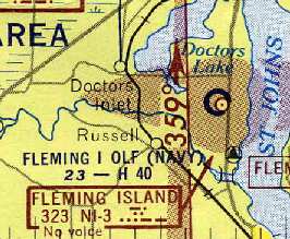
The February 1956 Jacksonville Sectional Chart (courtesy of Chris Kennedy)
depicted "Fleming I OLF (Navy)" as having a 4,000' hard-surface runway.
It also depicted that the airfield had its own NDB navigational beacon - very unusual for a satellite airfield.
However, the remarks in the Aerodromes table said "Closed."
Fleming Island was no longer depicted on the January 1958 Jacksonville Sectional Chart.
As of 1965 Fleming Island's northern runway was being reused for drag racing, known as Thunderbolt Dragway.
Drag racing historian Bret Kepner confirms that "Thunderbolt Dragway was located on the property of the abandoned Fleming Island NOLF.
Local racers, (and there were plenty; this was a very popular track),
insist the name came from a large stockpiling of P-47s [Thunderbolts] & the NOLF before it was decommissioned."
According to Bret, Thunderbolt Dragway closed “in the early 1970s.”
Chris Alvarez recalled visiting the Flemming Island airfield in 1974.
"The field was approximately a half mile down an overgrown road into the pine woods. I knew it then as 'Thunderbolt Speedway'.
But by 1974 it was not being used & the paved runways had pretty much disintegrated."
According to Sam Fischer, “In the fall of 1989 it [Fleming Island NOLF]
was used to film the airstrip portion of a TV movie called 'The Road Raiders'.
It was set in the Philippines in 1942 & was about a band of left-behinds using the hulks of aircraft & trucks to carry on the fight.
They had a P-37 fuselage mounted on a truck chassis.
I remember they flew a P-51 into the strip & parked it along one of the runways.
They used black paper & silver tape glued to look like bullets or shrapnel had torn up the metal.”
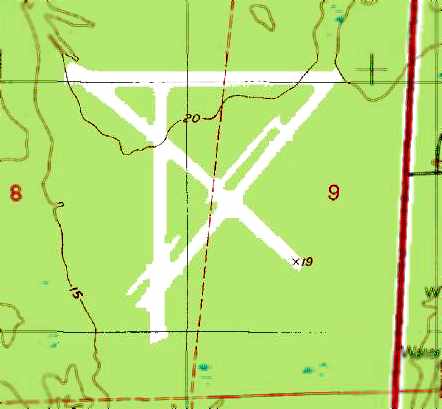
The 1992 USGS topo map still depicted the outline of the 4 former Fleming Island runways, but the site was unlabeled.
Matthew Smith recalled, “Fleming Island NOLF was still pristine when I took a bicycle down the dirt road off US 17 to check it out [in 1997 or 1998],
having seen 'abandoned airfield' marked on some older maps.
The paving was still there, the old start/finish lines were still there. The big construction project started the next year.
The name Thunderbolt Elementary was very controversial at the time the school board picked it,
as the drag strip had apparently not been well-liked by everyone in the area
(not that there ever WERE any people in the area, but Clay County, my home,
has plenty of people to give you the what-for whether they have a reason to or not).”
The last photo which has been located showing the Fleming Island airfield was a 1/7/99 USGS aerial view (courtesy of Dallam Oliver-Lee).
Bret Kepner pointed out that the "image clearly shows the remains of the dragstrip on the northern East/West runway,
and even the finish line is still clearly defined."
Bret Kepner noted that "Upon my arrival to Fleming Island NOLF in late 2000,
I was greeted by one of the largest construction projects I've yet seen.
The entire area... had been plowed & crews were simultaneously building malls, housing, and schools in the area.
Incredibly, an elementary school built on the site has been named Thunderbolt Elementary in honor of the dragstrip."
A 12/31/01 aerial photo (courtesy of Dallam Oliver-Lee) showed that all traces of the 4-runway Fleming Island airfield had been completely removed,
with the site covered by housing & a new lake.
A 12/17/11 aerial photo (courtesy of Dallam Oliver-Lee) showed no recognizable trace of Fleming Island NOLF.
Fleming Island NOLF was located on the west side of Route 17, along west shore of the St. Johns River,
approximately 10 miles South of Jacksonville Naval Air Station.
____________________________________________________
Or if you prefer to contact me directly concerning a contribution (for a mailing address to send a check),
please contact me at: paulandterryfreeman@gmail.com
If you enjoy this web site, please support it with a financial contribution.
____________________________________________________
This site covers airfields in all 50 states.