Abandoned & Little-Known Airfields:
Florida, Southeastern Jacksonville area
© 2002, © 2023 by Paul Freeman. Revised 6/7/23.
This site covers airfields in all 50 states: Click here for the site's main menu.
____________________________________________________
Please consider a financial contribution to support the continued growth & operation of this site.
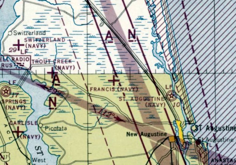
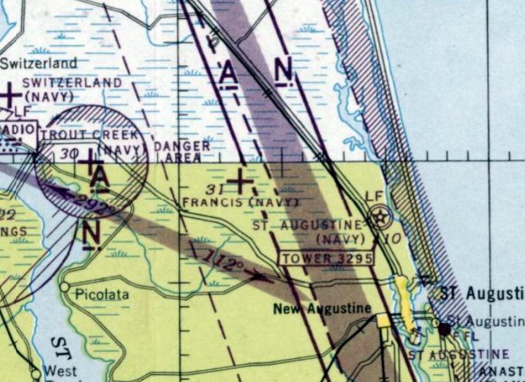
Francis NOLF (revised 5/29/23) - Richard Bull Airport (revised 4/21/18) - Switzerland NOLF (revised 6/7/23) - Trout Creek NOLF (revised 5/29/23)
____________________________________________________
Richard Bull Airport, Atlantic Beach, FL
30.34, -81.41 (East of Jacksonville NAS, FL)
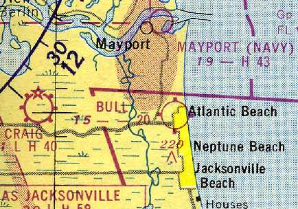
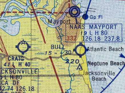
Bull Airport, as depicted on the July 1950 Jacksonville Sectional Chart (courtesy of Brian Rehwinkel).
This short-lived little general aviation airport was located only a mile from the Atlantic coast.
Richard Bull Airport was evidently established at some point between 1949-50,
as it was not yet depicted at all on the February 1949 Jacksonville Sectional Chart (according to Chris Kennedy) nor on the 1949 USGS topo map.
The earliest depiction of Bull Airport which has been located was on the July 1950 Jacksonville Sectional Chart (courtesy of Brian Rehinwinkel).
It depicted the field as having a 2,000' unpaved runway.
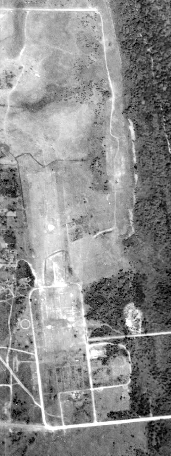
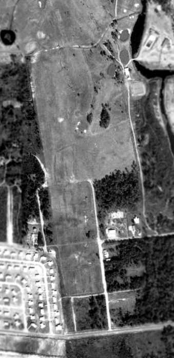
A 5/16/952 USDA aerial photograph of Bull Airport
(courtesy of the Digital Library Center / University of Florida George A. Smathers Libraries, via Brian Rehwinkel).
Note the airfield circle on the west side of the grass runway.
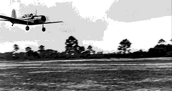
A 1953 photo of Bill Mize landing a Vultee BT-13 at Bull Airport.
The July 1954 Jacksonville Sectional Chart (courtesy of Chris Kennedy) also depicted Bull Airport as having a 2,000' unpaved runway.
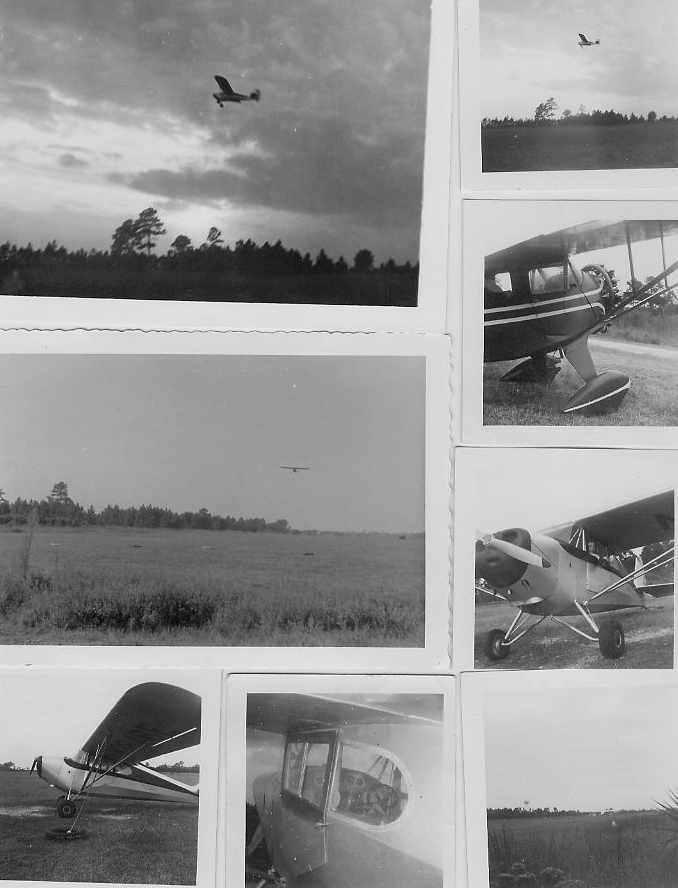
A montage of 1956 photos taken at Bull Airport (courtesy of Bill Bull, via Terry Brant).
“The radial engined plane is a Monocoupe; the other aircraft depicted is an Aeronca Scout that was owned by Beach Flying Club.
The Aeronca was put together in a bicycle shop with frame welding being done there & completed at the airport.
Much of the work was done by Forrester 'Wilkie' Wilkinson an A&E mechanic,
who for a time during the mid & late 1950s lived on the airport with his wife & children.”
Terry Brant recalled, “An interesting field was Bull Airport in Atlantic Beach,
where I took my first lightplane ride in an Aeronca Scout in 1956 at age 15.
The airport was an idyllic place to learn to fly, always exciting, and with a host of characters I have never forgotten.
Nor have I forgotten my J-3 Cub, nor all the other classic planes based at the field or often visiting -
like Stinsons, Ercoupes, a Fairchild 24 used for banner towing,
Aeronca Champion & Scout, Cessna 140, 170 & 170B, Monocoupe, and so on.
The field was 2,000' long, in a north/south orientation when I started flying there, later lengthened to 2,500'; the south end being quite rough.
The airport was owned by Harcourt Bull of Atlantic Beach, a well known local businessman, active in real estate development.
That place was once a young man's dream & a real life adventure.
The host of characters was absolutely unbelievable, and it was pure grass roots aviation;
the distinct smell of fabric covered airplanes mixed with the aroma of 80 octane fuel & carefree summer days.”
The runway at Bull Airport had evidently been lengthened at some point between 1954-56,
as the July 1956 Jacksonville Sectional Chart (courtesy of Chris Kennedy) depicted the field as having a 3,000' unpaved runway.
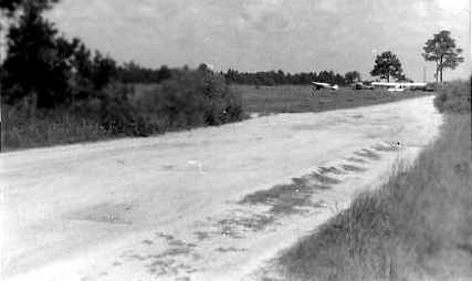
A 1957 photo of Bull Airport looking north along the dirt entrance road from Plaza (courtesy of Bill Bull, via Terry Brant).
“You can see the 2,000' sod runway immediately to the left of the 3 parked planes.”
Richard Bull Airport was not depicted at all on the 1958 USGS topo map.
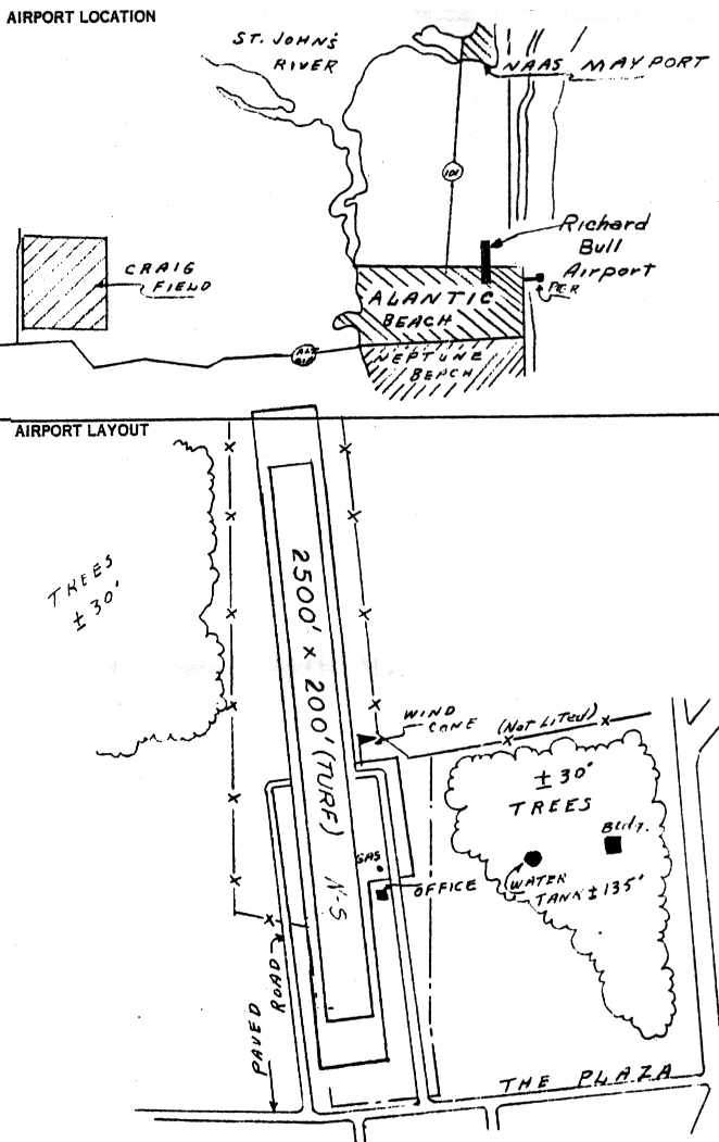
The December 1959 Civil Aeronautics Administration Record of Airport Facilities (courtesy of Terry Brant)
depicted Richard Bull Airport as consisting of a single 2,500' turf north/south runway,
on the east side of which was a small office building.
The owner was listed as RCRS Corporation, the operator as Harcourt Bull Jr., and the manager as W.T. Brant.
The field was said to offer fuel & minor repairs, and it was said to be home to 4 single-engine aircraft.
Terry Brant recalled, “In 1959, at the age of 18, I was the manager of Bull Airport as listed on the CAA Record of Airport Facilities.”
The last aeronautical chart depiction which has been located of Bull Airport was on the August 1960 Jacksonville Sectional Chart.
It depicted Bull as having a 2,500' unpaved runway.
The 1960 Jeppesen Airway Manual (according to Chris Kennedy) described Bull airport as having a 2,500' runway.
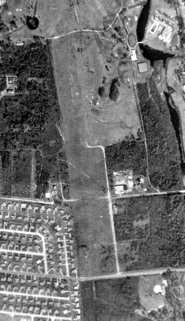
A 10/23/60 USDA aerial photograph of Bull Airport (courtesy of the Digital Library Center / University of Florida George A. Smathers Libraries, via Brian Rehwinkel),
taken while the field was still open - note at least 2 light aircraft parked east of the runway.
Terry Brant recalled, “Although I'm not sure if it appeared on 1961 charts,
I know the airport still had limited activity before I left for college in that year.”
It appears as if Bull Airport was closed at some point between 1961-62,
as it was no longer listed among active airfields in the 1962 AOPA Airport Directory,
nor depicted at all on the 1964 Jacksonville Sectional Chart (courtesy of John Voss).
It apparently lasted no more than 13 years.
Terry Brant recalled, “Sadly, Richard Bull Airport is no more. It was sold at some point in time for development.”
By the time of an April 1966 aerial view (courtesy of Reggie Brandley of FDOT, via Terry Brant),
Bull Airport was evidently closed, as all of the aircraft were gone.
In an August 1969 aerial view (courtesy of Reggie Brandley of FDOT, via Terry Brant), the length of the Bull Airport runway was still clear.
According to Terry Brant, “The 2,500' sod runway is clearly visible to the left of the clubhouse, scanning down (southward).
Approximately 2/3 of the way down the runway from the north end, you will see a sand path across the runway.
This path was used by pedestrians crossing the runway going to & from their homes on the west side of the runway.
When the original 2000' runway was extended to 2,500', the south end was immediately north of Plaza.”
As of a 1999 USGS aerial photo, not a trace appeared to remain of Bull Airport.
The north end of the field had been covered by the golf course of the Selva Marina Country Club,
while the south end of the property had been filled in with houses.
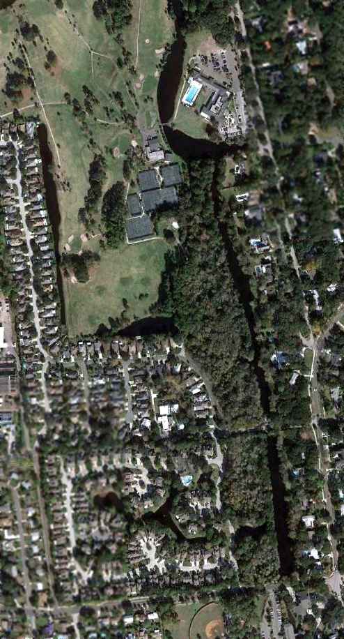
A 12/18/11 aerial photo showed not a trace appeared to remain of Bull Airport.
The site of Bull Airport is located at the intersection of 11th Street & Park Side Drive.
____________________________________________________
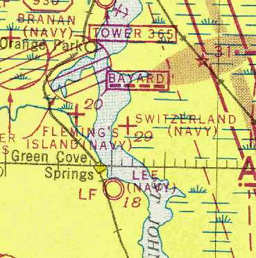
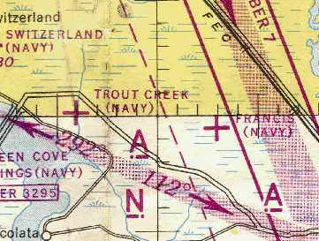
Switzerland Naval Outer Landing Field, Switzerland, FL
30.05, -81.64 (South-Southeast of Jacksonville NAS, FL)
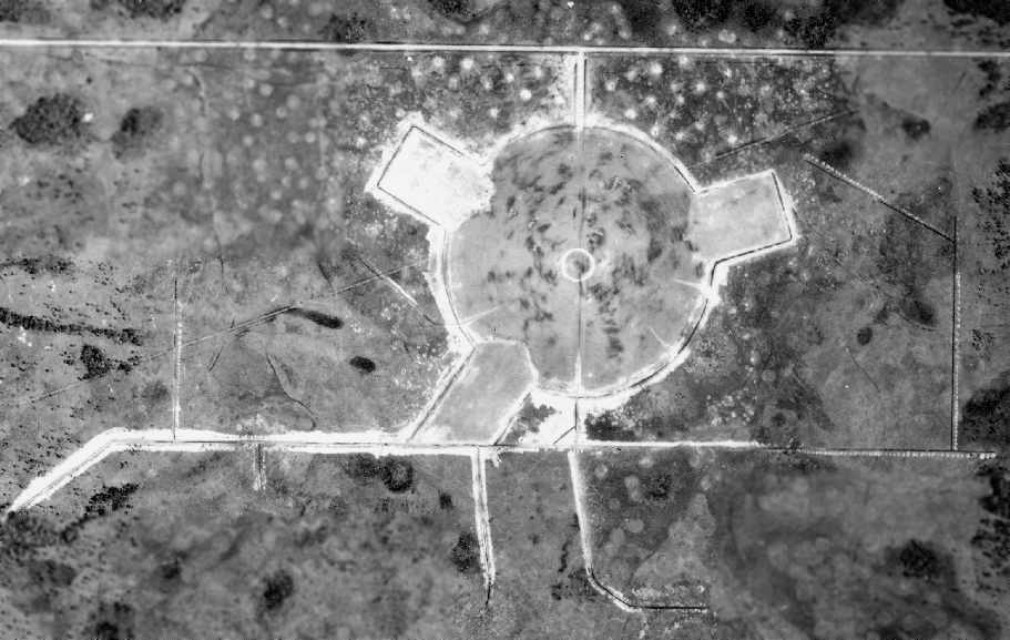
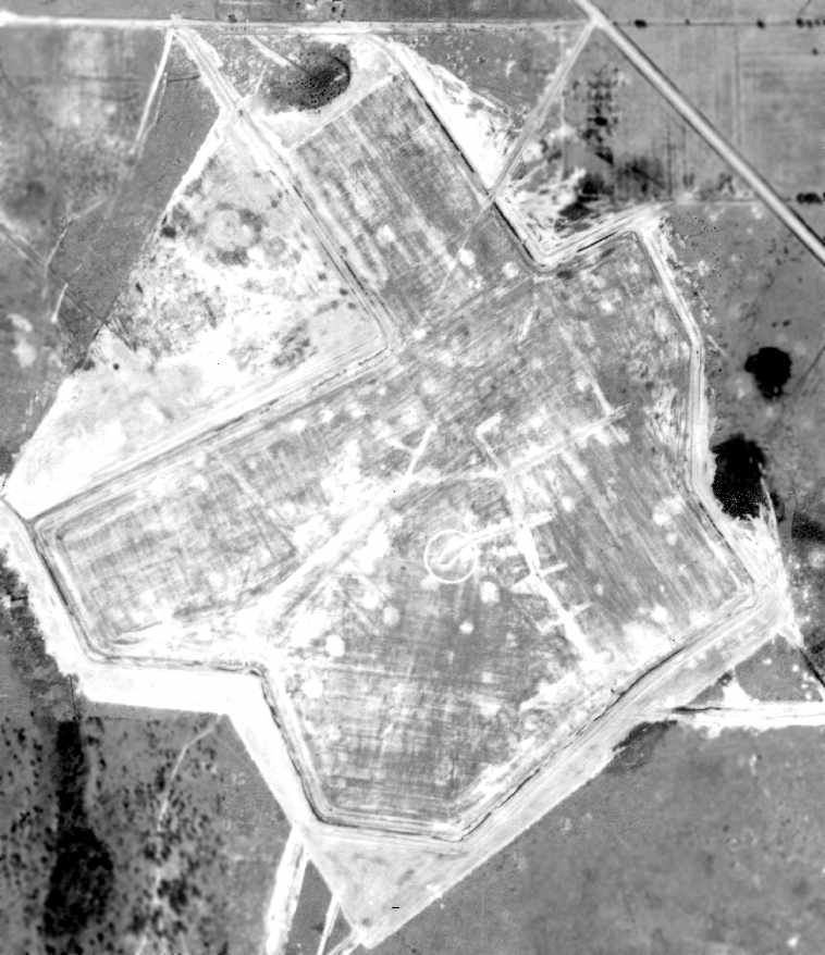
A March 1942 aerial view of Switzerland NOLF (US Government photo, courtesy of FL DOT, via Brian Rehwinkel).
According to a 1999 US Army Corps of Engineers report, in 1940 a total of 1,782 acres were acquired in Switzerland, FL
to build a satellite airfield & bombing target for aircraft from Jacksonville NAS.
According to Brian Rehwinkel, “Switzerland OLF was one of the early outlying fields for NAS Jacksonville.
It was opened before April 1941, and the original configuration was a circle.
This field layout was used or planned for several fields at this training station (the best example would be Francis OLF).
This field was probably 1,500' or so across. At some point in 1941 or 1942, there were 3 runway extensions added to this field.”
The earliest photo which has been located of Switzerland OLF was a March 1942 aerial view (US Government photo, courtesy of FL DOT, via Brian Rehwinkel).
It depicted a circular airfield, with 3 runways extending out from the circle.
No airfield at Switzerland was yet depicted on the September 1942 Jacksonville Sectional Chart or the 1942 USGS topo map.
According to Brian Rehwinkel, “When the mission of this field shifted away from primary training, these small grass fields didn’t have a role as regular airfield any longer.
They were designated as emergency fields or as bomb targets.
For this field, the paved runways were finished by May or June 1943 and much of the original field was covered.”
A 7/2/43 article in the Jacksonville Florida Times-Union (courtesy of Myles Bland) described OLF Switzerland
as a “grass encrusted spot, cris-crossed with runways.”
Naval personnel painted portions of the grass runways white, matching the exact dimensions of the landing surface of an aircraft carrier.
Then, using the field for simulated aircraft carrier landings, veteran signal officers instructed trainee pilots
how to safely land F4U Corsairs, F6F Hellcats, and other naval aircraft in the relatively short distances.
The earliest chart depiction which has been located of the Switzerland airfield
was on the August 1943 17M Regional Aeronautical Chart (courtesy of Chris Kennedy).
It depicted “Switzerland (Navy)” as an auxiliary airfield.
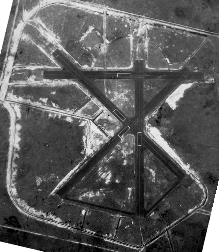
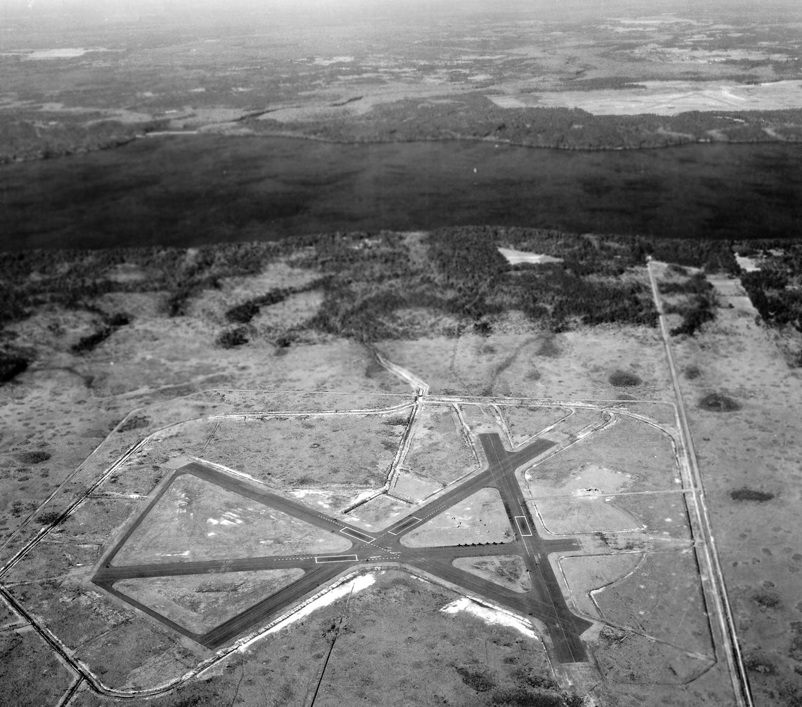
A 3/19/45 U.S. Navy aerial view (courtesy of Brian Rehwinkel) depicted NOLF Switzerland as having 4 asphalt runways.
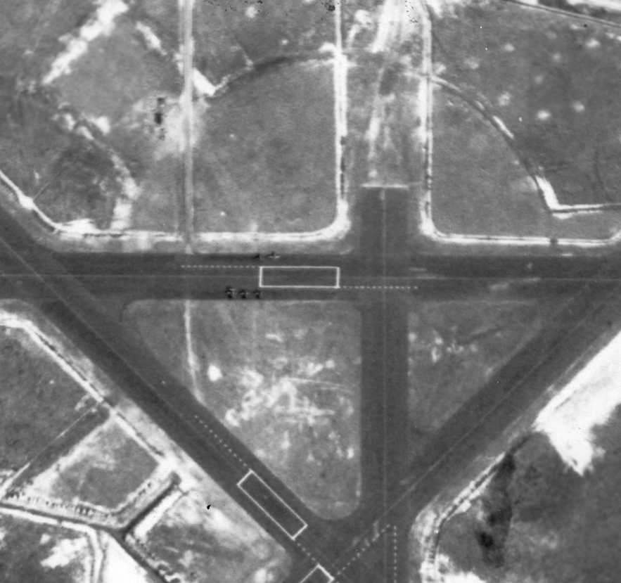
A closeup from the 3/19/45 U.S. Navy aerial view of NOLF Switzerland (courtesy of Brian Rehwinkel),
showing 5 single-engine aircraft on a taxiway on the north side of the field.
An aerial view looking east at the “Jacksonville Naval Air Station Auxiliary (16912 Switzerland Outlying Field)” from a 1945 Army Airfield Directory (courtesy of Bob Widner).
It depicted the field as havng 4 bituminous runways, with the longest being the 4,000' northwest/southeast & northeast/southwest strips.
The field was said to have portable lighting, but to have no fuel or hangars.
A remarkable 11/23/45 aerial view looking west (from the National Archives, via Brian Rehwinkel), showing a total of 4 Naval Outlying Fields:
Switzerland OLF in the foreground, Flemings Island OLF just across the river (top-right), Middleburg OLF (clearing to the west), and Foremost OLF to the southwest.
Brian Rehwinkel observed, “When all of the fields were being used in the first half of 1942, the airspace must have been crowded.”
Switzerland OLF was used as an outlying field until 1946.
In 1947 the Switzerland facility was designated as Naval Bomb Target & was used for that purpose until 1961.
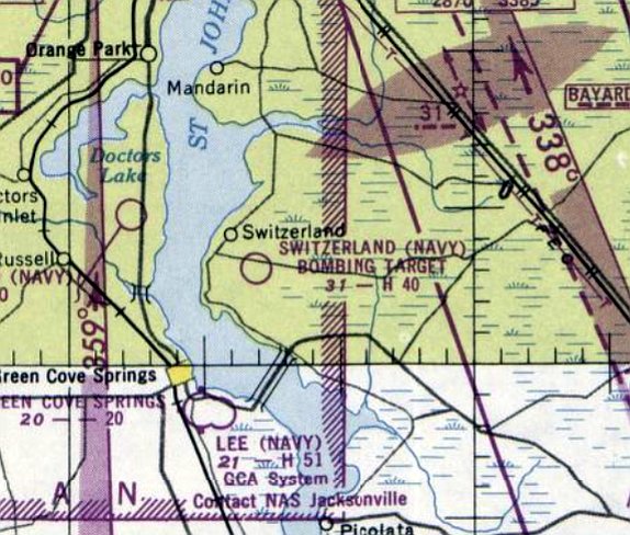
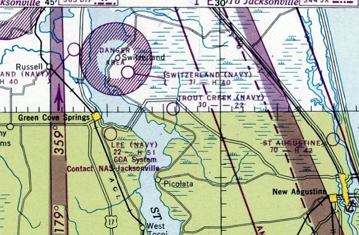
The last aeronautical chart depiction which has been located of Switzerland NOLF was on the February 1950 Jacksonville Sectional Chart.
It depicted "Switzerland (Navy) Bombing Target" as an airfield having a 4,000' paved runway.
Switzerland NOLF was evidently abandoned at some point in 1950, as it was no longer depicted on the July 1950 Jacksonville Sectional Chart.
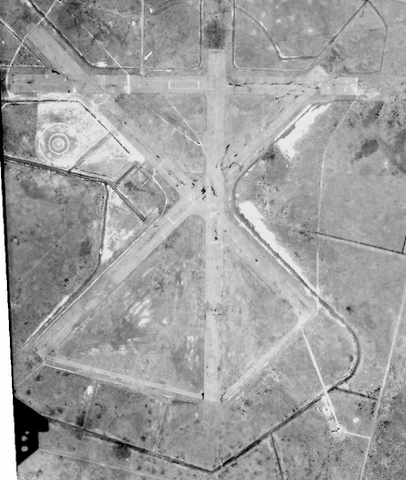
This January 1952 aerial view of Switzerland NOLF (US Government photo, courtesy of FL DOT, via Brian Rehwinkel)
was taken during a period when it was no longer being used as an airfield, but once again as a bomb target.
According to Brian Rehwinkel, Switzerland OLF... was used as a rocket target in the early 1950s.”
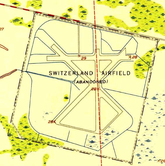
The 1952 USGS topo map depicted “Switzerland Airfield (Abandoned)” as having 4 paved runways.
In 1961 the FAA announced revisions to the restricted air space designation in the Jacksonville complex.
Due to these restrictions, the use of this property as a bomb target was no longer feasible
and it was determined excess to the needs of the Naval Air Station.
Chris Alvarez recalled that in the early 1970s the Switzerland Field "was a popular area for teenagers to party & hang out…
it had been pretty much reclaimed by the pine forests & scrub oaks of north Florida & not much trace of prior military use was evident."
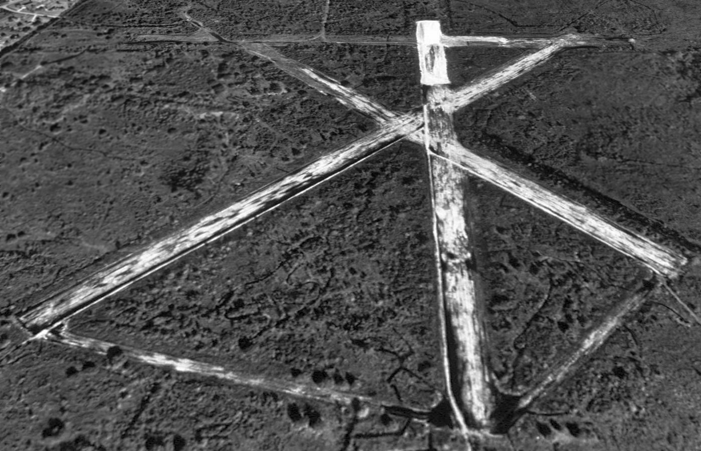
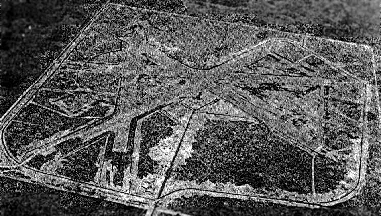
A 1994 USGS aerial view looking north at the site of Switzerland NOLF showed the remains of 4 paved runways (the largest was 4,000') & taxiways still existed.
A 2003 photo by Jason Durbin, looking to the southwest of the remains of Switzerland NOLF,
with the remains of the north/south runway (on the left) & the northeast/southwest runway (on the right).
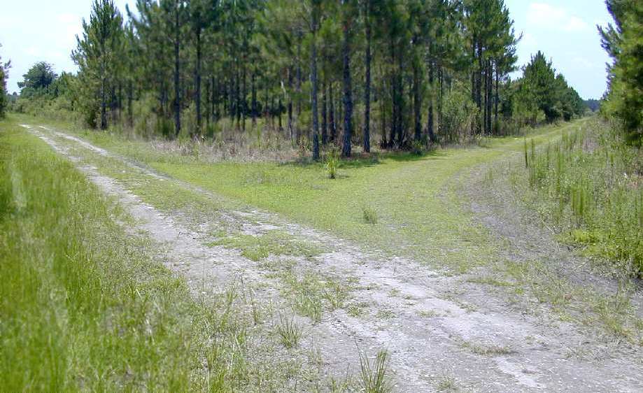
A 2003 photo by Jason Durbin looking to the north along the remains of the north/south runway at Switzerland NOLF.
Jason reported, "I looked at the old paved road (badly broken up) that leads to the Switzerland NOLF site.
It's blocked by some concrete barriers & a fallen tree."
He went back into the airfield site, and reported "there's really not much to see.
You can't really tell from the ground that it used to be an airfield."

A 2004 photo by Jason Durbin of the road leading to the former Switzerland NOLF.
Jason reported, “I happened to drive by the broken paved road that lead back to the old airfield
and noticed that the entire area has been cleared of trees in preparation for yet another neighborhood.
The concrete rubble & dirt mounds blocking the road have been removed with just a padlocked cable blocking the road now,
with a very large NO TRESPASSING sign posted.
Looks like the last remnants of this airfield are finally being obliterated."
A July 2004 aerial view by Neil Bankston looking east at the site of Switzerland airfield,
showing the characteristic outline of the intersecting runways was still quite recognizable.
Mike Strobach reported in 2006, “I fly over NOLF Switzerland a lot. It is still clearly visible.”
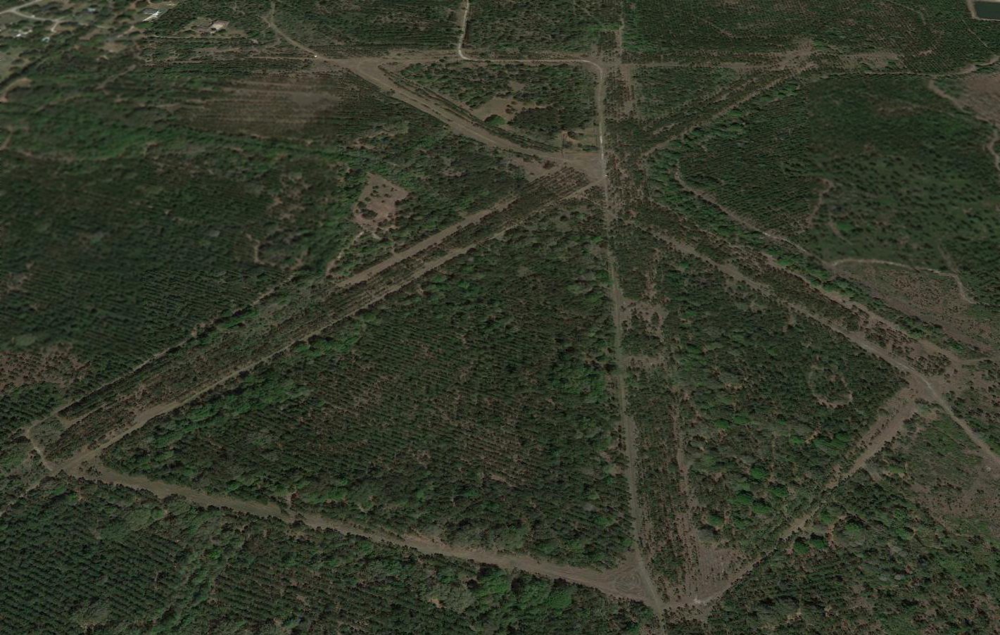
A 2017 aerial view looking north shows the outline of the Switzerland runways remain quite recognizable.
A 2/25/23 photo by Brad Watts looking south at the site of NOLF Switzerland. Brad Watts reported, “The clearing through the trees to the left would be the northwest/southeast runway.
I'm standing on what would be roughly the edge of the runway.
I sometimes imagine Corsairs & Grummans approaching & departing in the airspace low over my house.
I wonder how many of those missed practice bombs landed where my house is, to the North.”
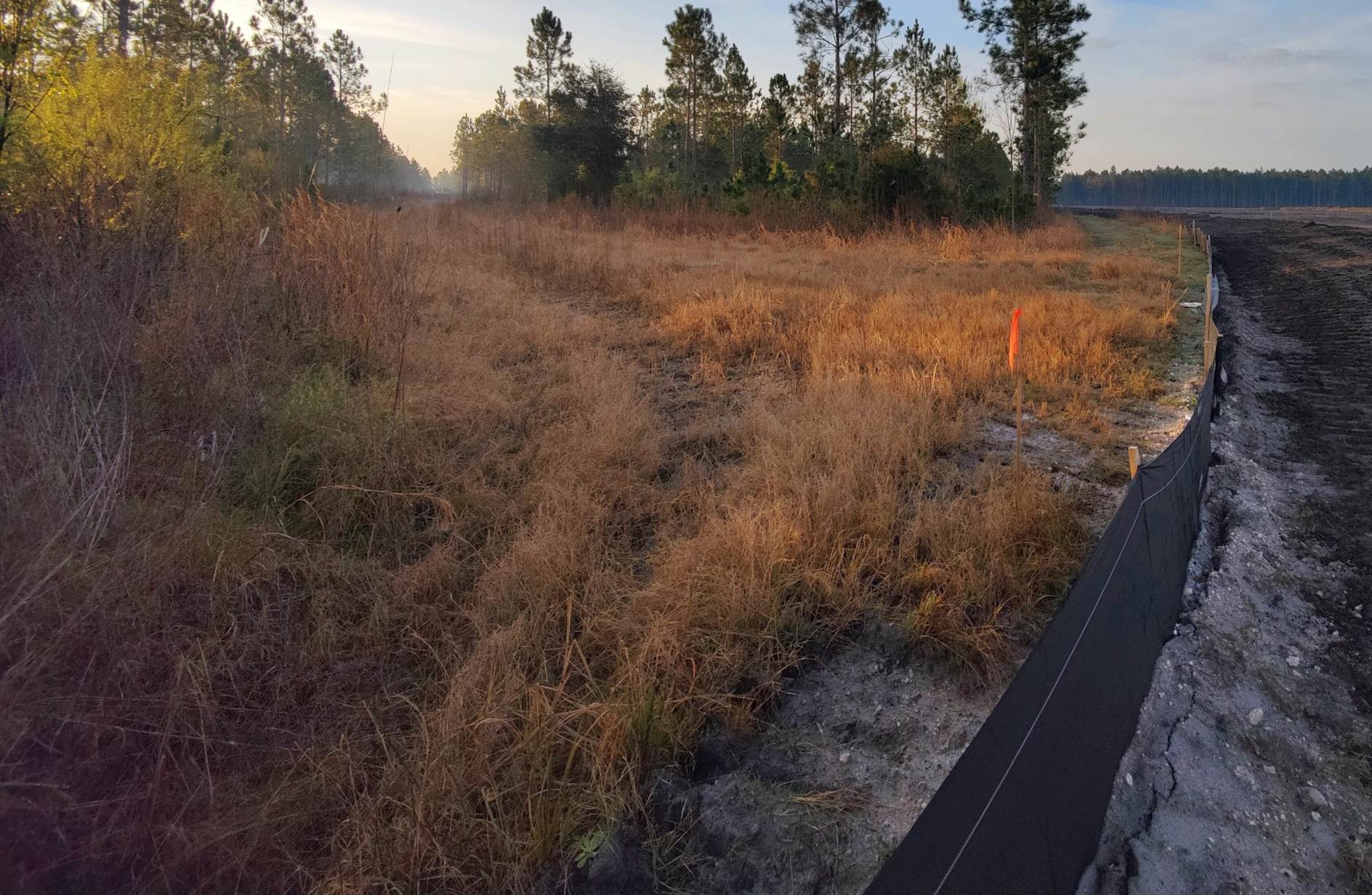
A 2/25/23 photo by Brad Watts looking northwest at the site of NOLF Switzerland. Brad Watts reported, “New construction in the distance.”
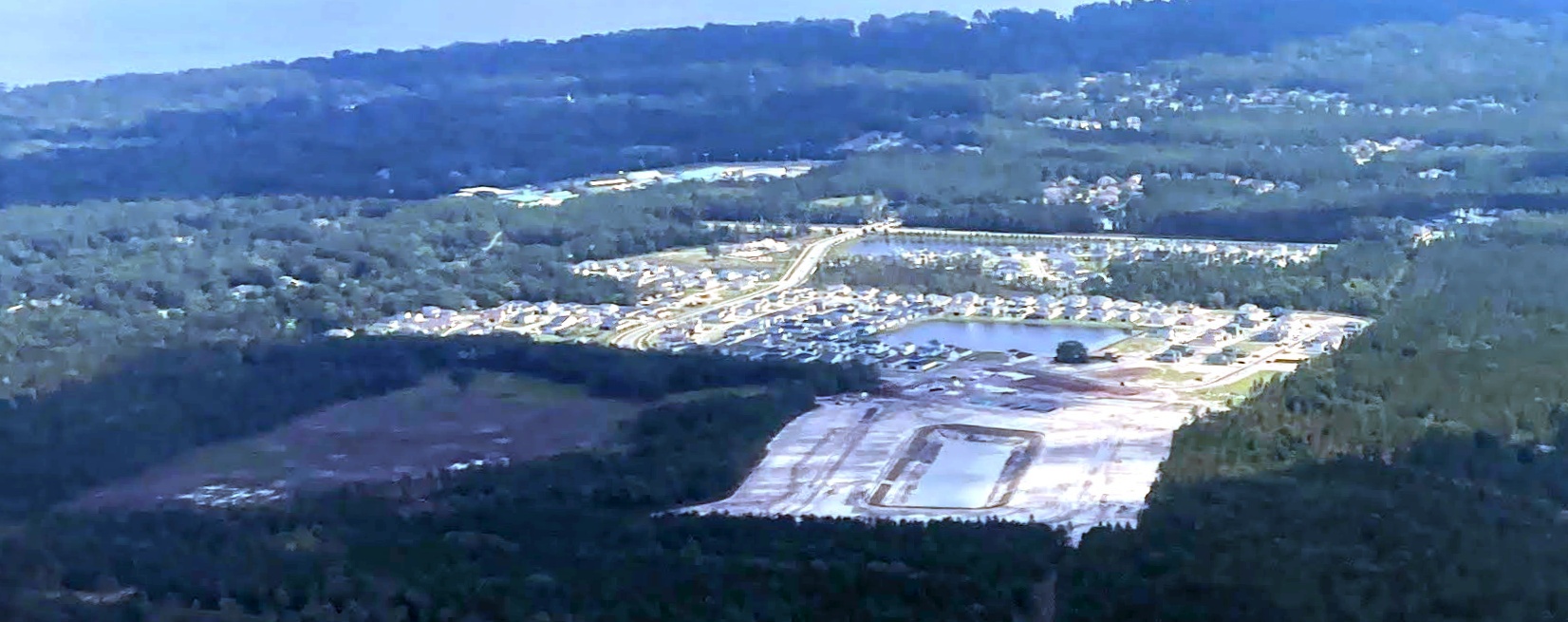
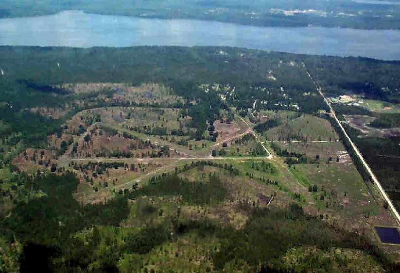
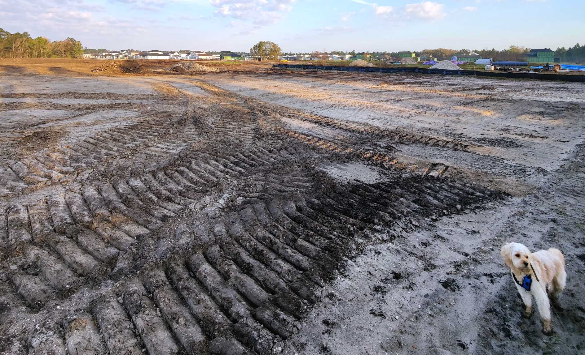
A 5/31/23 aerial view by Brad Baisley looking northwest at the site of NOLF Switzerland, showing construction having covered most of the airfield site.
The site of Switzerland Field is located on the east side of the St. Johns River, between the towns of Mandarin & Switzerland,
approximately 11 miles South of Jacksonville Naval Air Station.
____________________________________________________
Trout Creek Naval Outer Landing Field, Elwood, FL
30, -81.55 (South-Southeast of Jacksonville, FL)
A March 1942 U.S. Government aerial view of Trout Creek NOLF (courtesy of the FL DOT, via Brian Rehwinkel).
This military airfield was one of the large number of satellite airfields
built to support Navy flight training in the Jacksonville area during WW2.
Trout Creek was one of the outlying fields fully owned by the Navy.
The date of construction of Trout Creek has not been determined.
Like most of the WW2-era satellite airfields, it was apparently built during the war, not a reused pre-war civilian field,
as it was not listed in the Airport Directory Company's 1937 Airports Directory (courtesy of Bob Rambo).
Trout Creek was apparently one of the earlier Jacksonville-area outlying fields to be constructed,
as it was depicted on the above March 1942 U.S. Government aerial photo (courtesy of the FL DOT, via Brian Rehwinkel).
It depicted the airfield as consisting of an irregularly-shaped grass field, containing two 2,400' runways.
No buildings were depicted at the site.
Trout Creek was not yet depicted on the February 1944 Orlando Sectional Chart,
nor listed among active airfields in the 4/1/44 US Army & Navy Directory of Airfields (courtesy of Ken Mercer).
Trout Creek Field was assigned to NAAS Green Cove Springs (which was 6 miles to the west), according to a 4/27/44 Navy document.
The earliest chart depiction which has been located of the Trout Creek airfield
was on the July 1944 Jacksonville Sectional Chart (courtesy of Chris Kennedy).
It depicted “Trout Creek (Navy)” as an auxiliary airfield.
The Navy apparently considered turning Trout Creek into a bomb target
(as was the case later in the war with many other outlying fields),
according to a an August 1945 memo (according to Brian Rehwinkel), but it is not known if this ever happened.
The last aeonautical chart depiction which has been located of the Trout Creek airfield was on the February 1947 Orlando Sectional Chart.
It depicted “Trout Creek (Navy)” as having a 2,200' unpaved runway.
By the time of the August 1947 Orlando Sectional Chart,
Trout Creek NOLF was was no longer depicted at all (not even as an abandoned airfield).
Tout Creek OLF was no longer listed on the June 1948 NAS Jacksonville real property list (according to Brian Rehwinkel).
The 1948 USGS topo map depicted a “Trout River” auxiliary airfield on the other side (west) of the Trout Creek,
but this was probably the same as the Trout Creek Airfield.
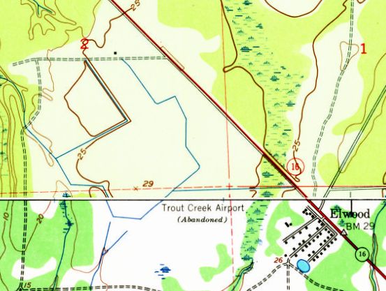
The 1949 USGS topo map depicted the “Trout Creek Airport (Abandoned)” as a property outline.
The airfield outline was depicted on the 1956 USGS topo map, but it was unlabeled.
A 1960 aerial view showed the airfield outline remained intact.
The January 1999 USGS aerial photo showed that the irregularly-shaped outline of the former airfield was still quite recognizable,
with the majority of the former airfield seemingly reused for crops.
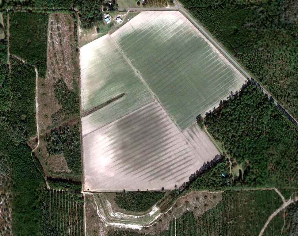
A 12/18/11 aerial photo showed that the irregularly-shaped outline of the former Trout Creek NOLF was still quite recognizable, with the majority of the former airfield seemingly reused for crops.
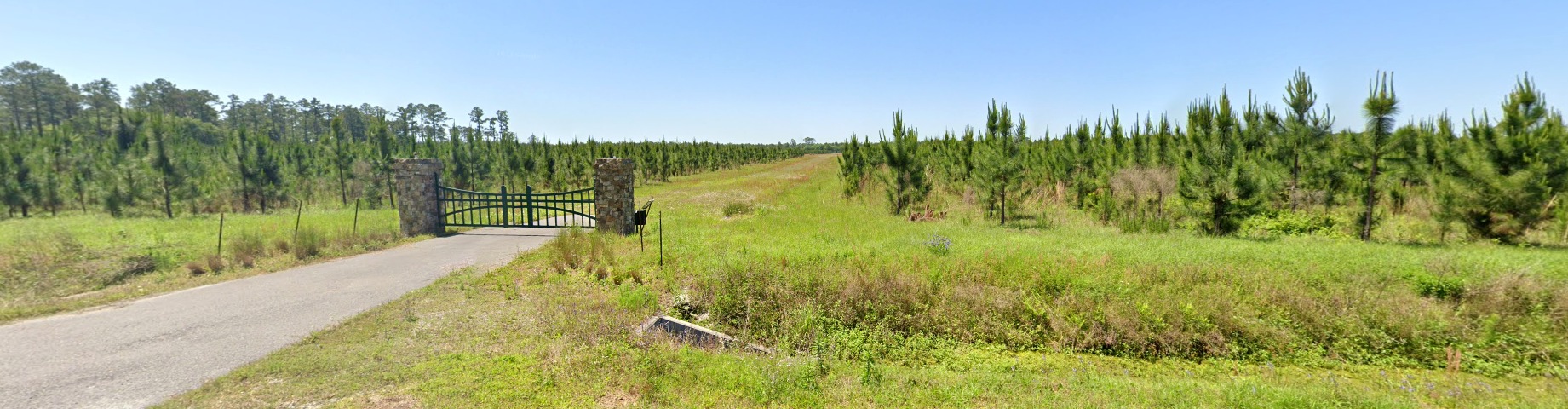
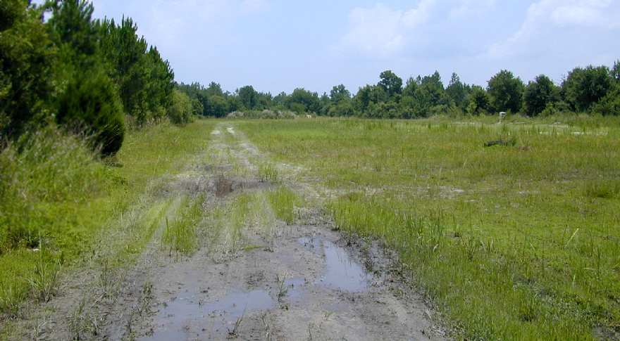
A 2022 photo looking southwest at the site of Trout Creek NOLF.
The site of Trout Creek NOLF is located southwest of the intersection of Route 16A & Hardwood Landing Road.
____________________________________________________
Francis Naval Outer Landing Field, Elwood, FL
29.98, -81.45 (Southeast of Jacksonville, FL)
A 3/29/42 USDA aerial photo of Francis NOLF,
from the Digital Library Center / University of Florida George A. Smathers Libraries (courtesy of Brian Rehwinkel).
According to Myles Bland, “In September 1940, the government filed suit in federal district court in Jacksonville,
and shortly thereafter secured the property to develop Francis Outlying Field (OLF) in St. John County, Northeast Florida.
The expropriation & subsequent development was part of a larger program of military preparedness
in the months leading up to the United States’s formally entry into World War II.
The tract was named Francis Outlying Field (OLF Francis Field) in the Francis Naval Reservation,
which was part of a system of outlying fields & auxiliary Naval Air Stations in support of Jacksonville Naval Air Station
During the war, the Department of the Navy identified rural parcels in northeast Florida suitable for use in support of NAS Jacksonville.
The location of Francis OLF was selected, in part, because of its close proximity to NAS Jacksonville
and another larger outlying field, Cecil Field, which stood north of the property.
Typically, during World War II, the United States government entered takings proceedings
through federal district courts to acquire land for military-related purposes.”
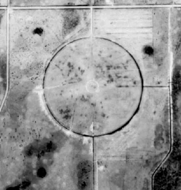
The earliest depiction of Francis NOLF which has been located was on the above 3/29/42 USDA aerial photo.
The airfield at Francis NOLF had a distinctive configuration –
it consisted of a 1,700' diameter circle, consisting of a graded grass field surrounded by a drainage ditch.
According to Myles Bland, “The only known improvements made on the site by the Navy consisted of a graded circular grass landing field,
one small building mounted on skids, a drainage ditch, and fencing.
Older, local, residents report that Navy training planes, originating from Naval Air Station Jacksonville, performed touch-n-go’s at Francis OLF.
The training plane consisted primarily of the aptly nicknamed, ‘Yellow Peril,’ an open cockpit biplane [a nickname used for the N3N & N2S biplanes].”
Zachary Gramana reported, “A local resident, Dan Holiday, confirmed that the airfield was built 'round'
so that pilots could always land/takeoff into a headwind.
He reported that the field was used to train pilots flying a '2-seated Stinson', most likely the L-5
(which the Navy had received over 500 from the Army).
The L-5 featured a short 650' takeoff roll, which would comfortably fit in just one radius of the circle.
Dan also confirmed that the road circumscribing the airfield had never been paved.
The name of field likely came from the Francis family who owned/leased the property to the government.
Francis Road, which runs adjacent to the airfield, apparently predated the construction of the facility.
Herbie Wiles, a longtime local resident, said Mr. Francis used to host aviators at his ranch just north of the airfield.
Pilots were invited to eat barbeque, drink beer, and swim in his pool.
In addition, the timberland surrounding the airfield is known to have been used for bombing target practice,
though there we no reports of the airfield itself succumbing to that fate.
Several of the surrounding roads were closed for many years due to hazardous ordnance.”
Francis NOLF was not depicted at all on the 1943 USGS topo map or the February 1944 Orlando Sectional Chart.
The earliest chart depiction which has been located of the Francis airfield was on the July 1944 Orlando Sectional Chart.
It depicted “Francis (Navy)” as an auxiliary airfield.
The last chart depiction which has been located of the Francis airfield was on the February 1946 Jacksonville Sectional Chart.
The Francis airfield was most likely closed shortly after the end of WW2, like many other military satellite fields.
It was no longer depicted on the August 1946 Orlando Sectional Chart.
Strangely, neither the 1973 or 1992 USGS topo maps depicted the circular airfield remains at Francis.
The 1999 USGS aerial photo showed that Francis' circular airfield remained intact, but no buildings remained at the site.

A July 2004 aerial view by Neil Bankston looking northeast at the remains of the Francis airfield.
A 2006 aerial view (courtesy of Myles Bland) showed that several streets
had been built over the southwestern corner of the property at some point between 2004-2006,
but they did not intrude on the circular landing field itself, which remained completely intact.
It is amazing that this WW2 airfield has remained intact more than 60 years after being abandoned.
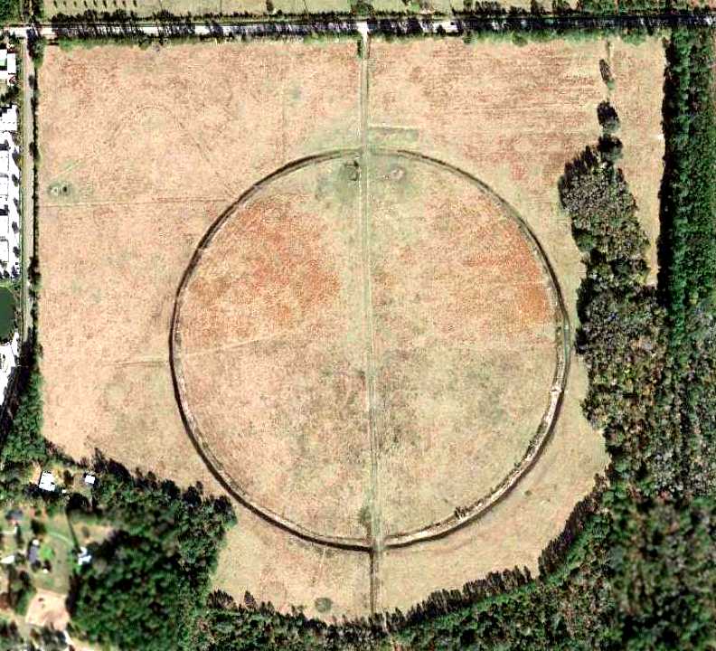
A 12/18/11 aerial photo depicted Francis' circular airfield to remain completely intact.
Eric Conklin reported in June 2015, “Francis Naval Outer Landing Field... this property is in the process of being prepared for a subdivision.
I was on International Golf Parkway this weekend & as usual, looked in on the old field.
It has been completely leveled, graded, and a construction trailer is on-site.
Signage at the property entrance indicated it’s the future home for another residential subdivision.”
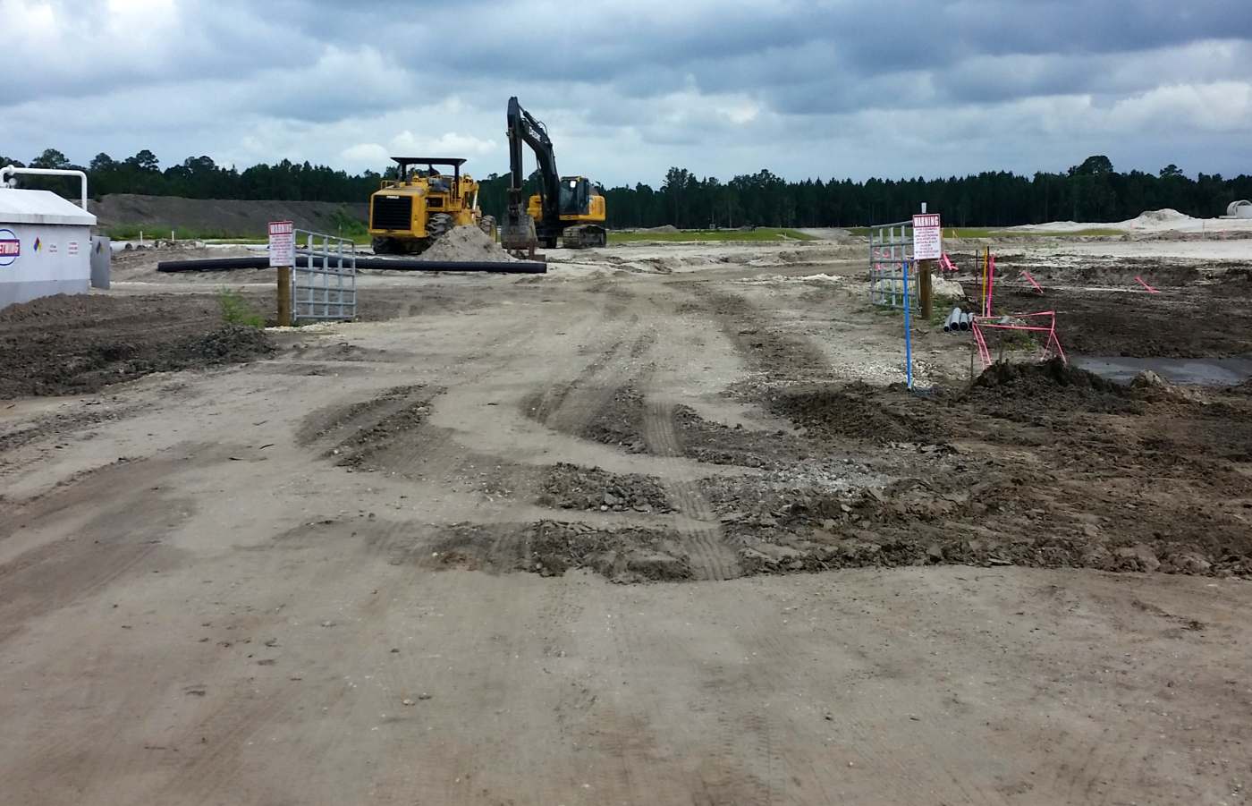
A 7/17/15 photo by Eric Conklin of the construction being conducted on the site of Francis NOLF.
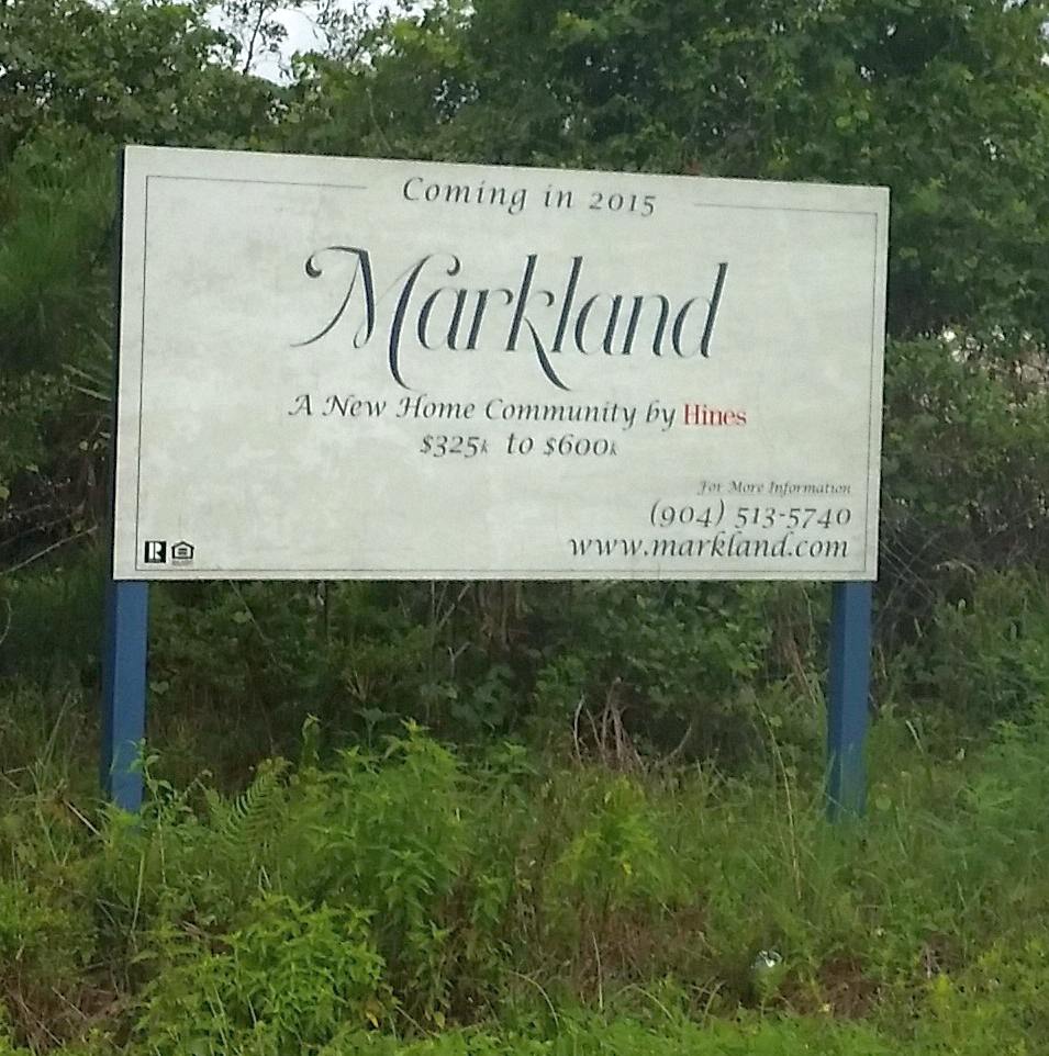
A 7/17/15 photo by Eric Conklin of the sign for the Markland development being built on the site of Francis NOLF.
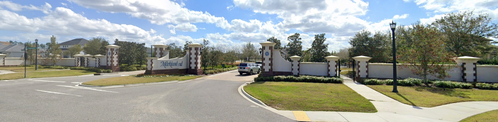
A 2022 photo looking southeast at the entrance of the Markland development which covers the site of Francis NOLF.
The site of Francis NOLF is located southeast of the intersection of International Golf Parkway & Francis Road, just east of Interstate 95.
____________________________________________________
Or if you prefer to contact me directly concerning a contribution (for a mailing address to send a check),
please contact me at: paulandterryfreeman@gmail.com
If you enjoy this web site, please support it with a financial contribution.
____________________________________________________
This site covers airfields in all 50 states.