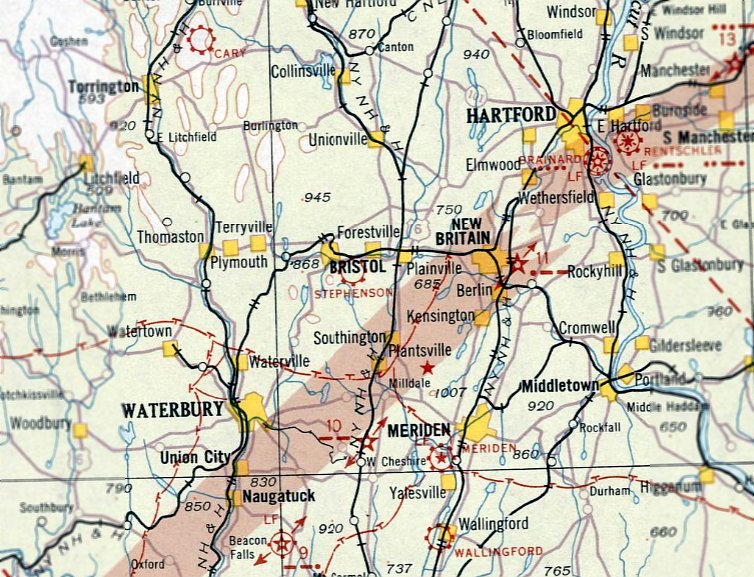
Abandoned & Little-Known Airfields:
Central Connecticut
© 2002, © 2026 by Paul Freeman. Revised 2/24/26.
This site covers airfields in all 50 states: Click here for the site's main menu.
____________________________________________________
Please consider a financial contribution to support the continued growth & operation of this site.
Ansonia Airport (revised 9/5/25) - Bethany Airport (revised 2/24/26) - Griswold Airport / Hammonasset Airport (revised 9/5/25)
H & H Airport / West Haven Airport (revised 11/3/22) - Rentschler Field (revised 7/5/24) - Stephenson Field / Bristol Airport (revised 4/18/20)
____________________________________________________
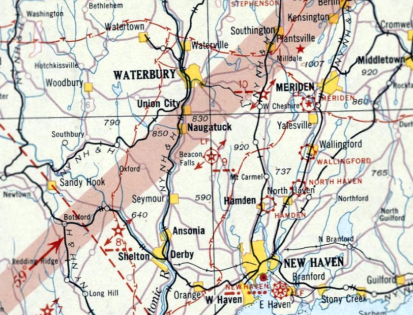
Bethany Airport, Bethany, CT
41.44, -72.99 (Northwest of New Haven, CT)
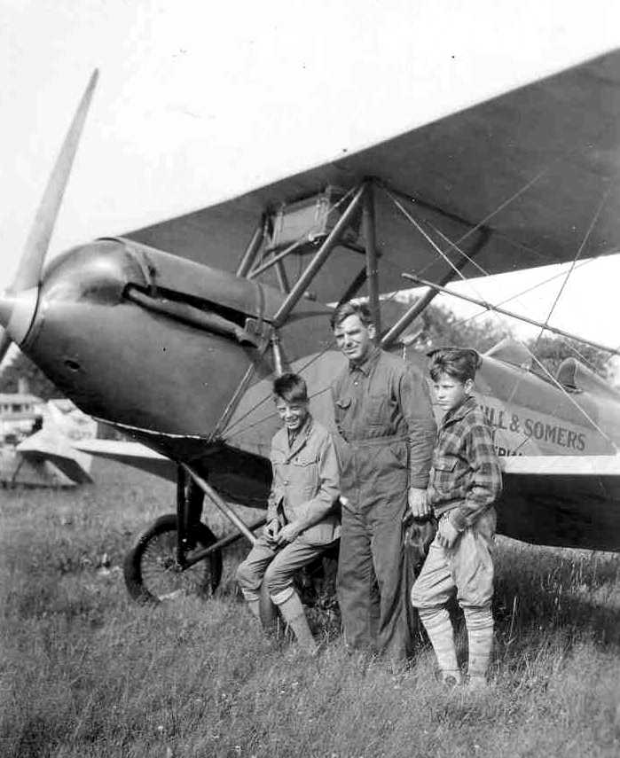
A 1927 photo of Ernest Markham & two unidentified boys in front of a Waco 10 biplane at Bethany Airport (courtesy of Linda Markham Scialabba).
The date of construction of this small general aviation airport has not been determined.
The earliest depiction of the Bethany Airport which has been located
was a 1927 photo of an unidentified biplane at Bethany Airport (courtesy of Linda Markham Scialabba).
The photo pictured Linda's grandfather, Ernest Markham, and two unidentified boys in front of a biplane marked with “Hill & Somers”.
Linda noted, “My uncle tells me they were some type of business, he is not sure if they owned the airport.
My grandfather... worked at Bethany Airport from 1927-28; he may have been a flight instructor there.”
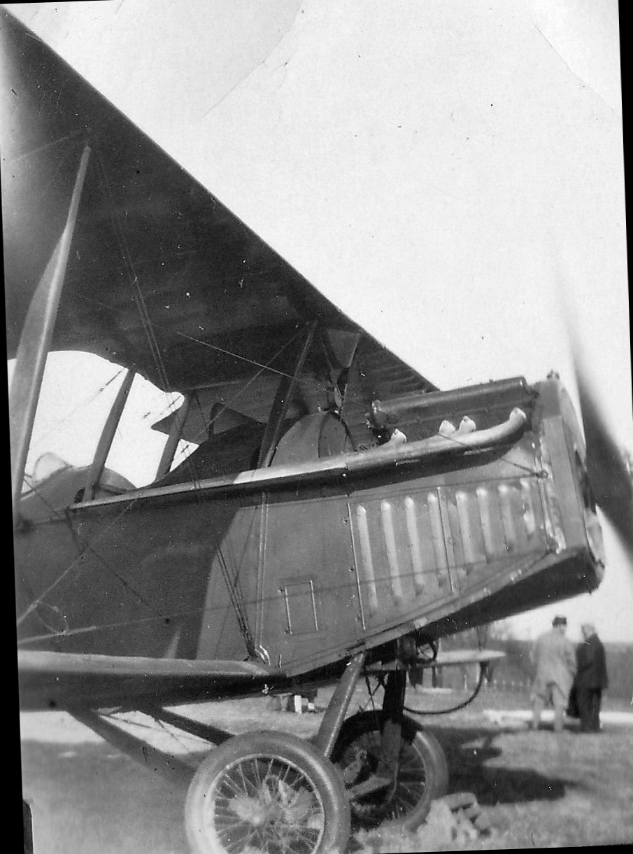
An undated photo of a Jenny biplane at Bethany Field, chocked but with the engine running, from a 4/12/27 family photo album (courtesy of Cynthia Stulpin).
An undated photo of an unidentified biplane at Bethany Field, chocked but with the engine running, from a 4/12/27 family photo album (courtesy of Cynthia Stulpin).
According to Richard Turnure, Gus Graf [his wife's grandfather] “helped found the airport.”
According to Tom O'Connell, “Bethany Airport was rumored to be the 2nd oldest airport in New England after Boston.
It was supposed to have been an auxiliary field for the first planes from Newark to Boston.”
Bethany Airport, as depicted on the Boston Chamber of Commerce's 1931 "Airports & Landing Fields of New England" (courtesy of Chris Kennedy).
It described Bethany as a Department of Commerce Intermediate Field.
The field was said to consist of a 33-acre irregularly-shaped sod field, measuring 2,400' x 1,000', with the entire field available for flying operations.
The field was also said to have a 100' x 80' hangar.
The earliest aeronautical chart depiction which has been located of Bethany Airport was on the August 1932 NY Sectional Chart.
It depicted Bethany Airport as the Commerce Department's Intermediate Field Site 9 along the New York - Boston Airway.
The Airport Directory Company's 1933 Airport Directory (according to Chris Kennedy) described Bethany as a auxiliary airfield,
serving as the Department of Commerce's Intermediate Field, Site 9 along the New York - Boston Airway.
The airfield was described as consisting of an irregularly-shaped 36 acre plot.
According to John Boyce, Bethany “was a historic airport, being a stop on Contract Air Mail 1 on the Boston-New York run.”
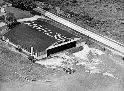
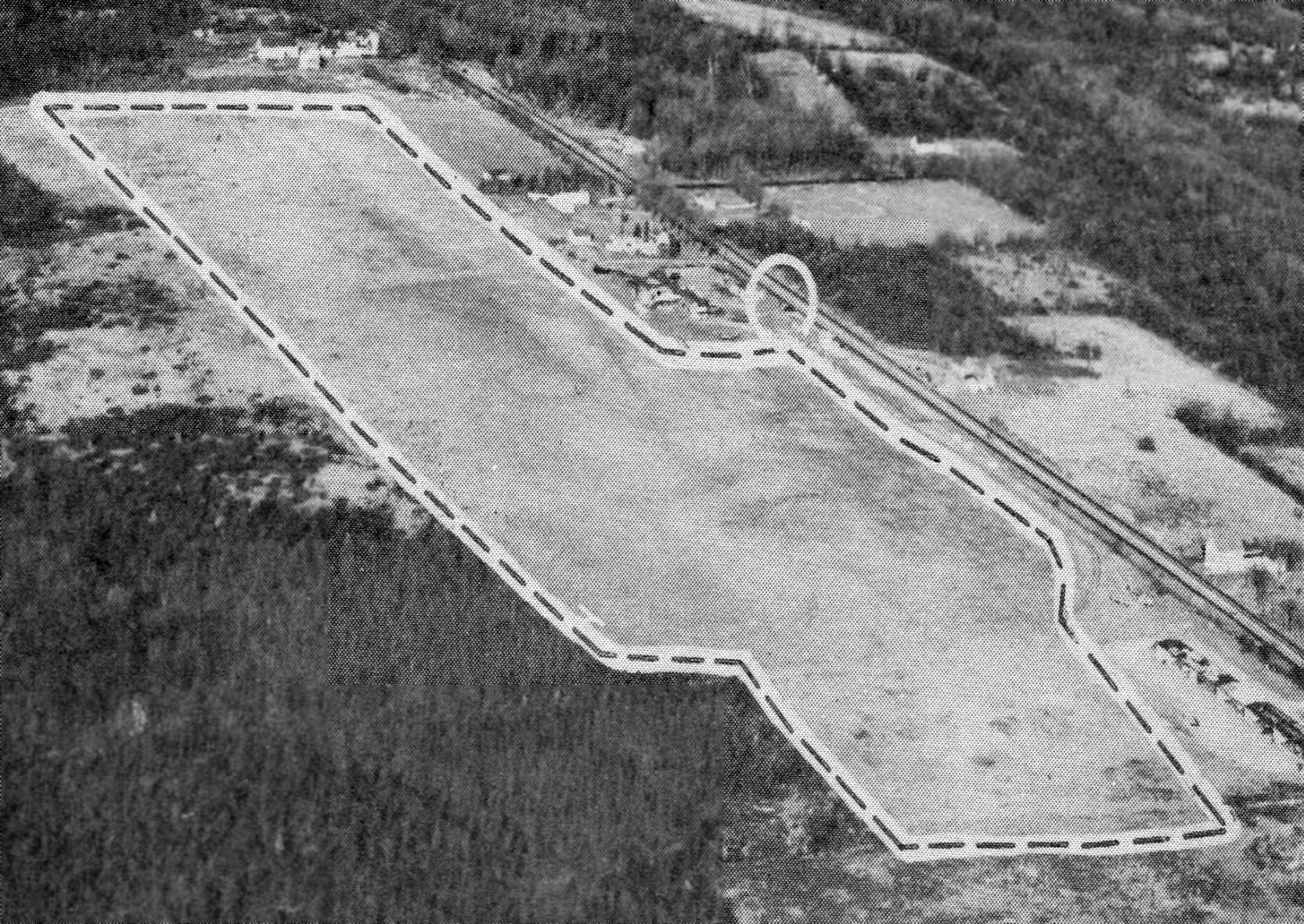
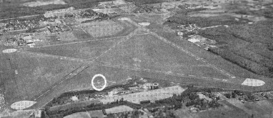
A 1934 aerial view of Bethany Airport, taken by the Fairchild Aerial Survey Company (courtesy of Chris Kennedy).
A close-up from the 1934 aerial view of Bethany Airport (courtesy of Chris Kennedy) showing the unusual airport marker, and the hangar marked with “Bethany” on the roof.
Bobs Macaleenan recalled, “I flew with Jack & Chappy Lenox back in 1929, when I was 7. That is when I started flying.
We used to have Fly in breakfasts at Bethany in 1936-38.
I remember the circle drawn in the middle of the field & a prize for whoever could land & stop in it.”
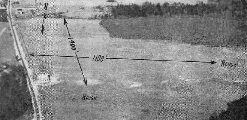
An aerial view looking north at Bethany Airport, from the Airport Directory Company's 1937 Airport Directory (courtesy of Bob Rambo).
The directory described Bethany as a commercial airport having 2 sod runways: 2,450' north/south & 1,400' east/west.
A single hangar & some other small buildings were depicted along the east side of the field.
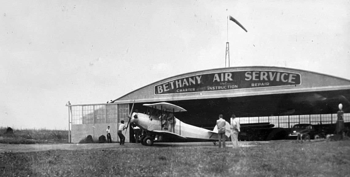
A circa 1930s photo by Pete Weston (courtesy of his grandson Chris Yengo) of an unidentified biplane in front of the Bethany Air Service hangar.
According to Ron Rex, Bethany Airport "was very well known in the 1930s & many famous pilots visited there... Bert Acosta for one."
An undated aerial view looking northeast at the Bethany Air Service hangar.
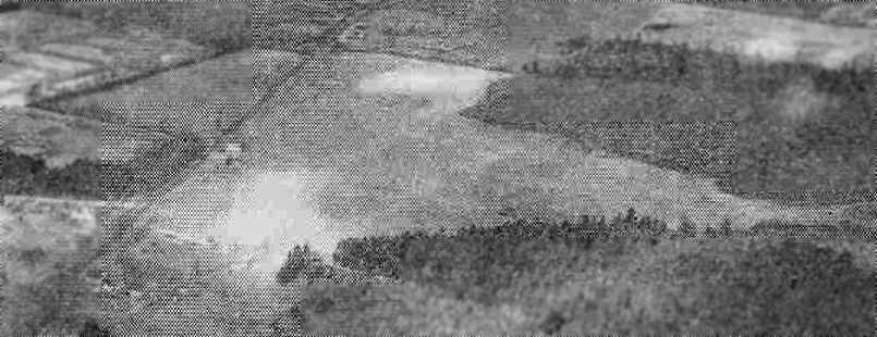
An aerial view looking northwest at Bethany Airport, from the Airport Directory Company's 1941 Airport Directory (courtesy of Chris Kennedy).
The directory described Bethany as a commercial airport consisting of a 52 acre rectangular field, measuring 2,280' north/south.
A single hangar & some other small buildings were depicted along the east side of the field.
Bethany Airport was depicted on the November 1942 Regional Aeronautical Chart (according to Chris Kennedy).
The April 1944 US Army/Navy Directory of Airfields (courtesy of Ken Mercer) described Bethany Airport as having a 2,100' unpaved runway,
Bethany Airport, as depicted on the January 1945 NY Sectional Chart (courtesy of Ron Plante).
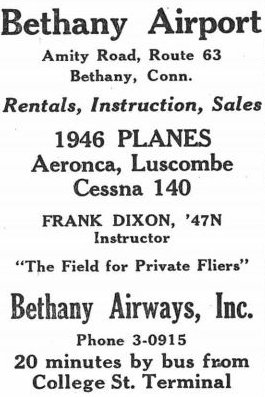
A 10/24/46 advertisement for Bethany Airport (courtesy of Lee Corbin) described rentals, instruction, and sales.
According to John Boyce, “The original hangar burned down some time after the war.”
A 1949 aerial photo showed the remains of the original hangar, lost in a fire a few years before.
Miles Reese recalled, “My father learned to fly at Bethany in a Aeronca 7AC.
He had taken a ride at the airport for $3 & got the bug. I think that was in 1953.
He had kept a Taylorcraft BC12D on the south end of the airport.
The Fixed Base Operator was owned by Bob Jones & his wife.
Bob had taken off in a pretty new Baron that had been bought for charter work. He crashed.
He was a very proficient pilot but was very troubled at that point of time.
There was a huge push to shut down the airport by then WNHC, Channel 8 in New Haven CT.
The tower that was erected was thought to be a potential problem but Robertson in Bristol CT
has a taller tower adjoining it closer to the airport than Bethany's was.”
The 1954 USGS topo map depicted Bethany Airport as an irregularly shaped clearing, with a few small buildings,
but did not depict any runways.
A 1955 aerial photo showed the remains of the original hangar, still not replaced with another structure.
Harwood Loomis recalled, “My grandfather flew out of Bethany airport in the 1950s. We knew Bob Jones, the operator.
He was killed when his plane lost power on takeoff & he tried to reverse course & make it back to the airport.
He crashed in woods south of the airport. My cousin & I bicycled to the crash site from home.
Bethany had an old Link trainer stashed in a corner of its hangar.”
An undated aerial view looking northeast at Bethany Airport from the 1956 CT Airport Directory (courtesy of Bill Hecht).
It described Bethany Airport as having a 2,800' sod north/south runway, and the manager was listed as Robert Jones.
According to John Boyce, “The original hangar... was replaced with the present structure, a Quonset hut type.”
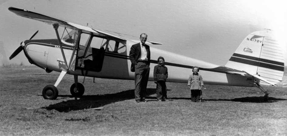
An undated photo of Henry Jones & 2 children in front of a Cessna 170 at Bethany Airport.
AeroMotiveDist recalled, “Bethany Airport... I soloed in a 65 hp Aeronca Champ in 1958, I was 18 years old.”
Edd Wininger recalled, “Bethany Airport... I was learning to fly there during my high school years.
I was a 15 year old in 1957 (and on into 1958) who pumped the avgas, pushed around airplanes, propped those who needed a start, etc. on weekends & summers.
Drove the old Ford tractor & grass mower around. All for a few 15 minute evening rides. Rode my bike up from Hamden.
My Dad did flight instruction on weekends, along with passenger rides & banner towing.
Bob Jones & his wife Fran owned & ran the airport.
Al Porto was another weekend pilot who also flew the Wacos on occasion with some minor aerobatics for the folks.
Bob Jones died following the crash of a newly acquired Beech Travelair, bought for charter use.
Al Porto helped Fran to continue to run the airport & they eventually married.”
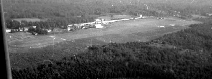
A summer 1958 aerial view by Edd Weninger looking east at Bethany Airport.
Edd recalled, “I learned to fly & soloed at Bethany Airport, 1958.”
A 1958 photo (courtesy of Edd Weninger) of his father, “Gus” Weninger
“hopping passengers” in a Waco UPF-7 biplane at Bethany Airport.
Edd recalled, “The black & white Waco UPF-7 was used for passenger rides & banner towing.”
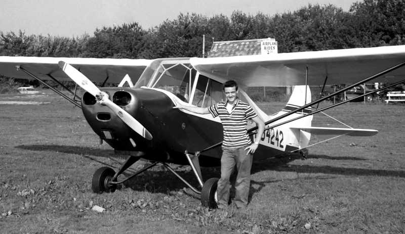
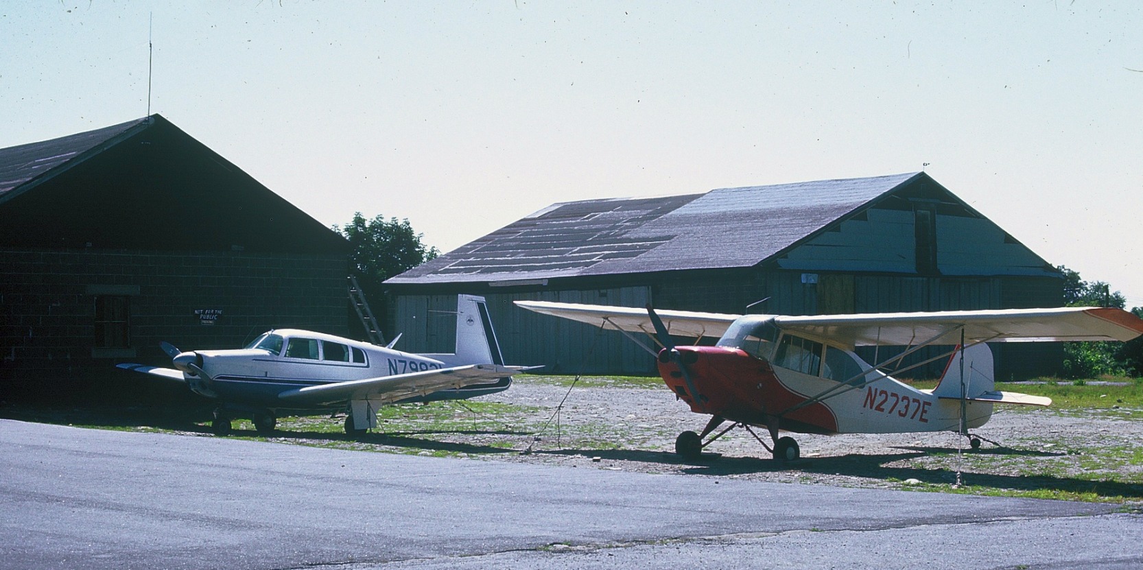
A 1958 photo (courtesy of Edd Weninger) of Edd Weninger with his Aeronca 7AC at Bethany Airport,
with the “burger joint just across the fence” visible in the background,
and a sign pointing out “Airplane rides $2.50”.
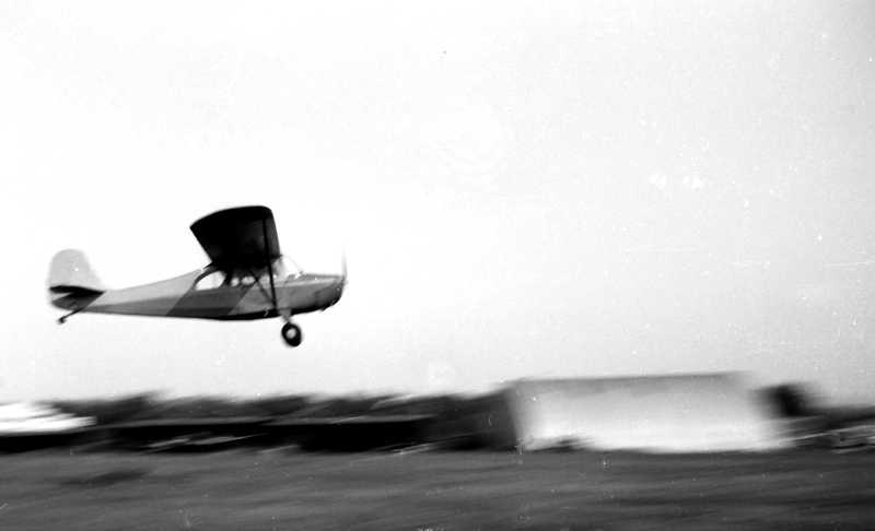
A 1958 photo by Edd Weninger of “one of the rental [Aeronca] 7ACs landing” at Bethany Airport.
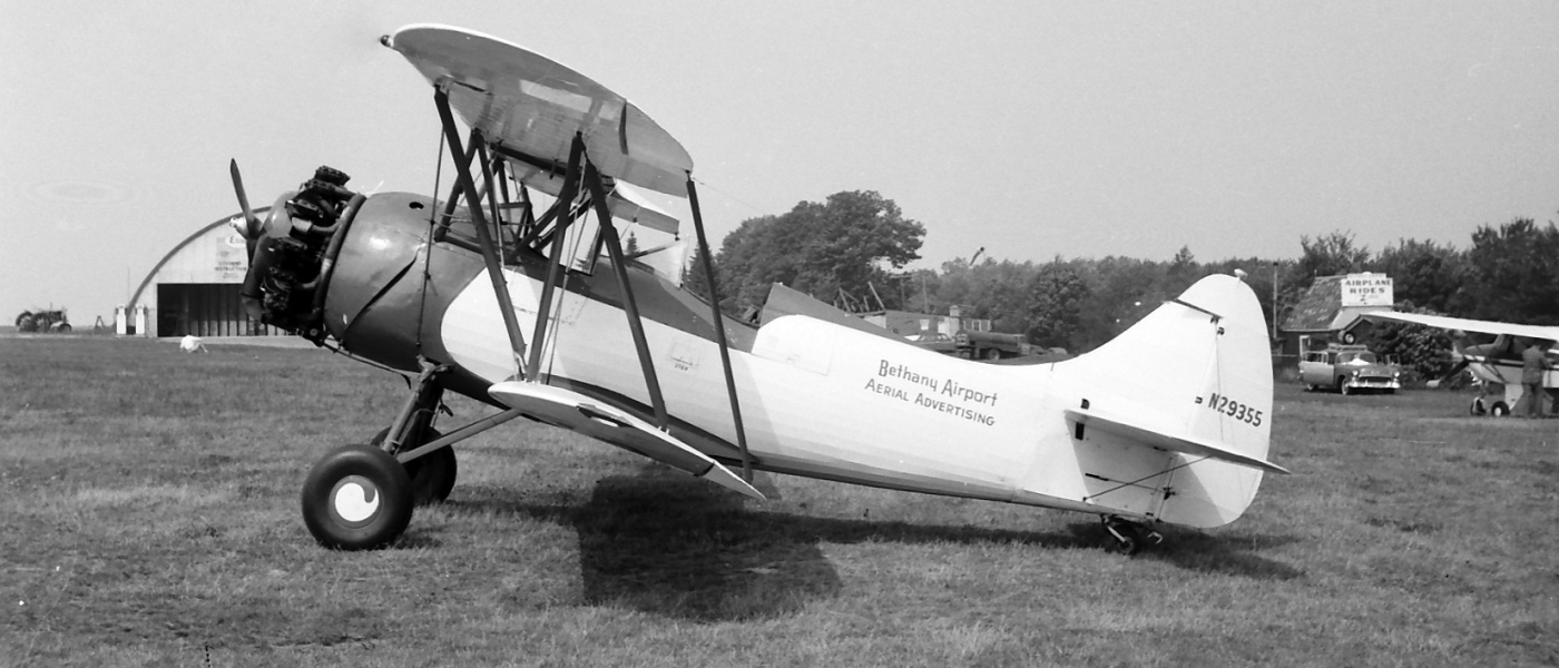
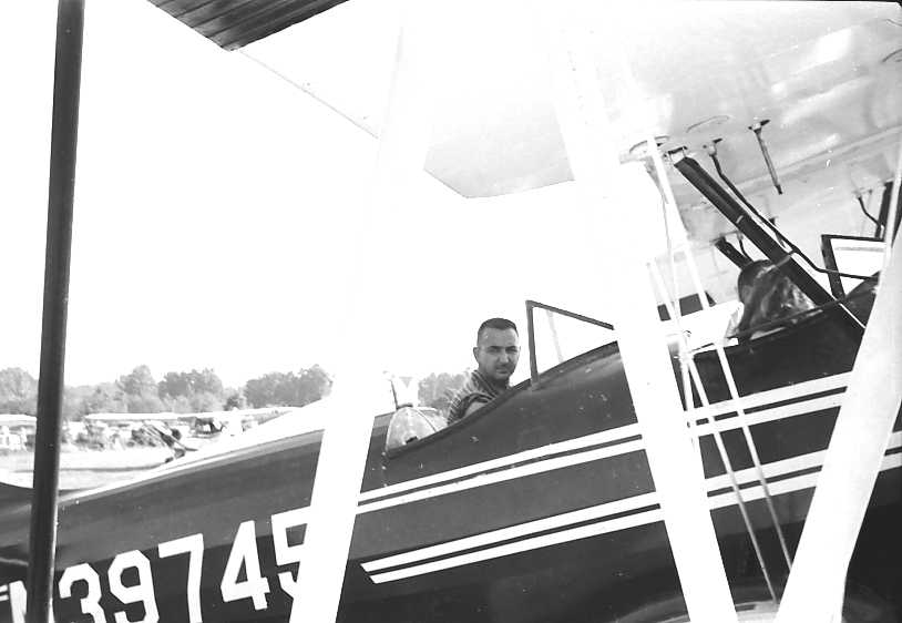
A 1958 photo (courtesy of Edd Weninger) of a Waco biplane of Bethany Airport Aerial Advertising, with the Bethany hangar visible in the background.
Edd reported in 2017, “This airplane is still flying today in NJ, carrying passengers on sightseeing flights over the shore.”
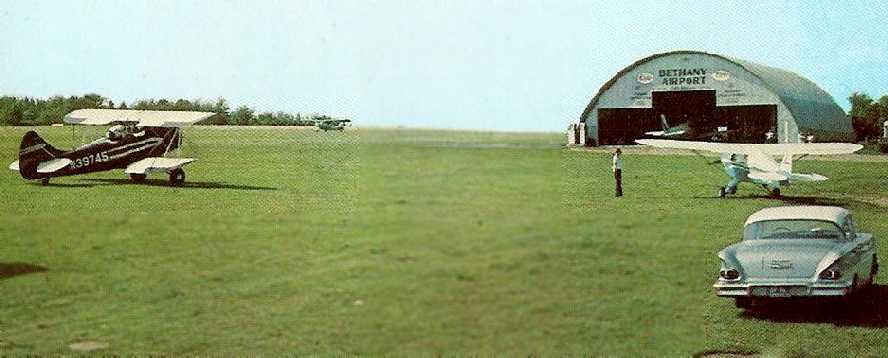
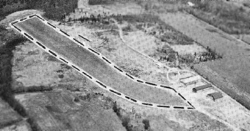
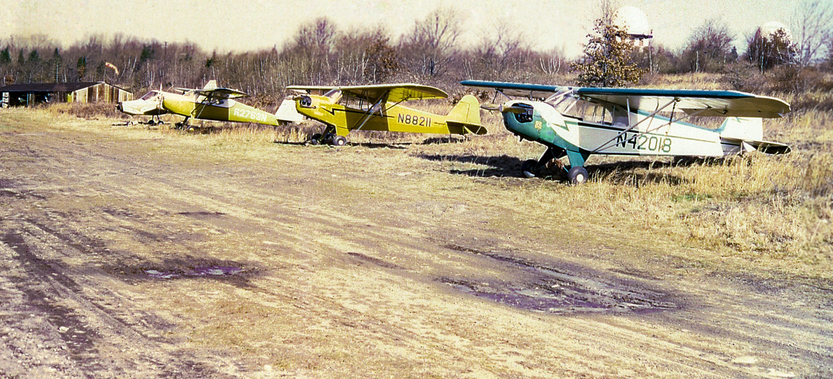
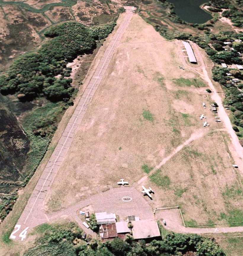
A circa 1958 view looking northwest at a biplane & several monoplanes around the Bethany Airport hangar (courtesy of Jonathan Westerling).
The caption described Bethany as the “Oldest airport in continuous operation in New England.”
Jonathan noted that the “Age of this card is estimated as circa 1960, because the car shown is a 1958 Chevrolet,
and there is no Zip Code on the card (zip Codes were mandated in 1965).”
Edd Weninger observed, “It looks like a typical Sunday where a Waco & the Tripacer were used for passenger rides.
I believe the plane landing on the runway rolling out near the center of the picture is my Aeronca 7AC.”
The 1962 AOPA Airport Directory described Bethany Airport as having a single 2,800' turf Runway 18/36.
The field was said to offer fuel, repairs, hangars, tiedowns, and charter, and the operator was listed as Albert Porto.
Greg Ploski recalled, “I learned to fly at Bethany Airport in 1964 & have the logs of a Aeronca 7AC 2737E.”
The last photo which has been located showing Bethany Airport in operation was a 1965 aerial view (from the CT State Library, via Chris Kennedy).
It depicted Bethany as having a single north/south grass runway,
with the Quonset hut hangar on the east side of the field, and 3 single-engine aircraft on the east side of the field.
The last aeronautical chart depiction which has been located of Bethany Airport was on the 1965 NY Sectional Chart.
It depicted Bethany as having a 2,400' unpaved runway.
John Boyce recalled, “I was flying out of Bethany when it closed toward the end of 1965.
It was the oldest airport in New England in continuous operation.
Clarence Chamberlain was another one of the great old-timers who flew there.
Another notable was William F. Buckley, who earned his private certificate there while a student at Yale.
Al Porto was the last Fixed Base Operator to operate there, with a lease.
The land was owned by Triangle Publications. and the rent Al paid didn't even cover the taxes, so they bought him out.
In its last years, the airport was home to the Nutmeg Soaring Association, which thereupon moved to Johnnycake.
After a lot bickering, the town bought the airport for $250,000.
The plan was to develop an industrial park to boost the tax base. It never happened.”
Frank Podgwaite recalled, “I had my first airplane ride with my Dad at the Bethany Airport prior to its closure in 1966.”
Bethany Airport was no longer depicted on the March 1966 NY Sectional Chart.
A single large white closed-airport “X” was visible in between the hangar & runway on a 1966 aerial photo.
Ron Rex reported in 2004, "The last time I was there, probably 20 years ago, there were still some original hangars in existence."
According to Ed Walsh (who moved to Bethany in 1993), the Bethany Airport had closed as
"The airport surrendered air rights so a television/radio tower could be put up not far away down the hill."
Walsh continued, "The airfield has had horse show pens & exhibit areas,
a golf driving range & soccer field built on it in the early 1990s & a recycling center was put near the hangar in 1995."
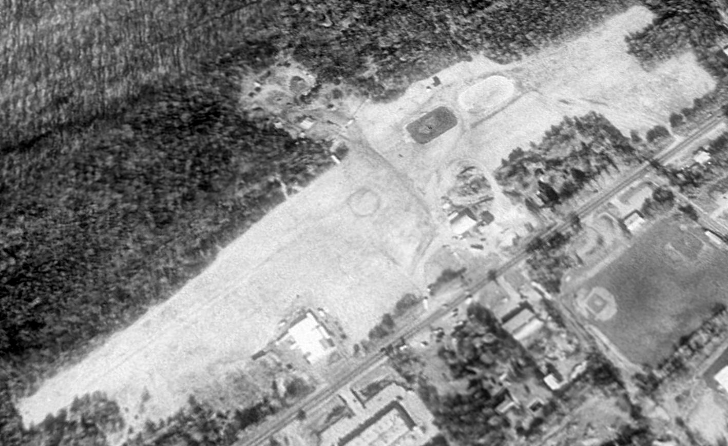
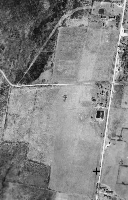
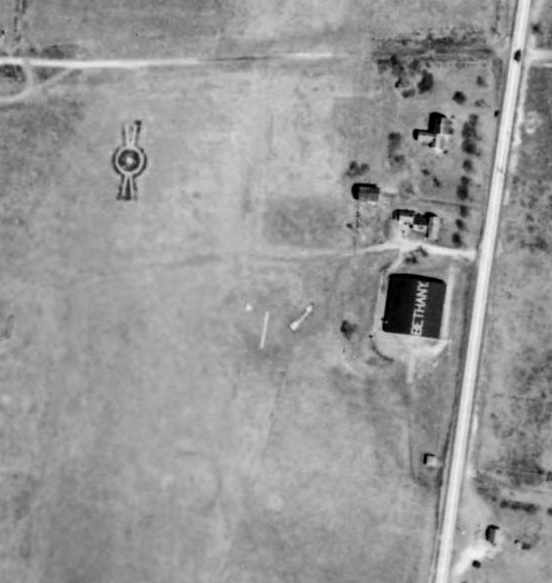
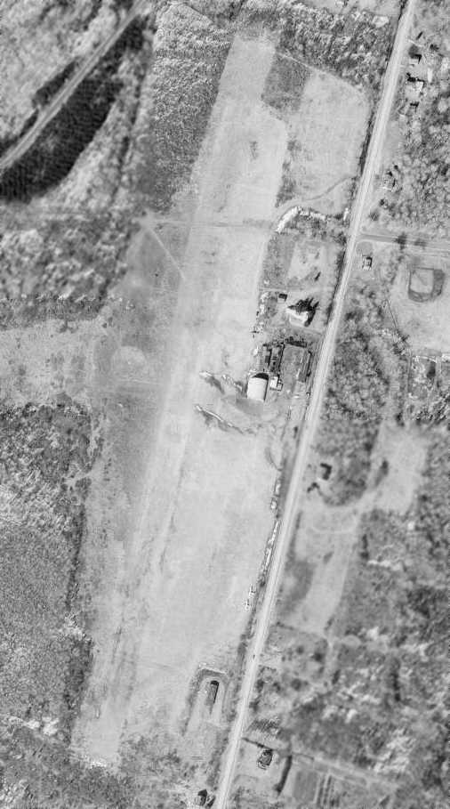
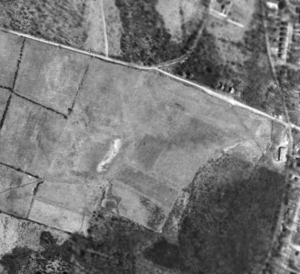
Remarkably, a 1991 USGS aerial view looking northwest showed that after more than 54 years the Bethany Airport site remained almost completely intact,
with the areas of the north/south & east/west runways remaining largely clear.
Most significantly, the original hangar remained standing (the white building just right of the center of the photo)
and even the circular airfield marker (used in the 1930s & 1940s to mark a grass airfield) also remained (in the center of the photo).
Ed Walsh reported in 2005, "The hangar is now a DOT office & storage area.
You could never land a plane of any size there anymore."
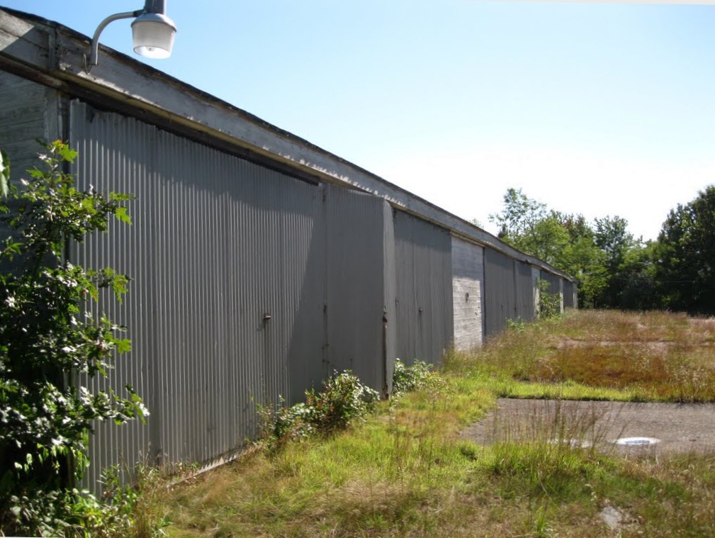
A circa 2006 aerial view looking north at the former Bethany Airport hangar.
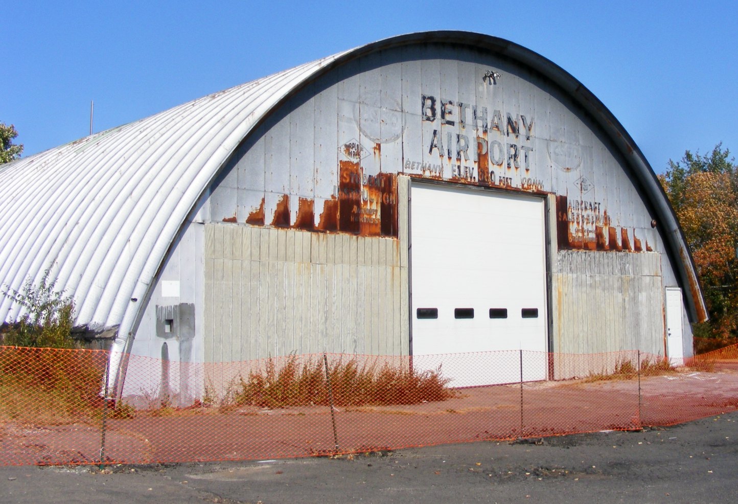
A 2007 photo of the former Bethany Airport hangar, with its markings faded yet still readable.
A 2007 photo of the former Bethany Airport property, with the former hangar visible in the background.
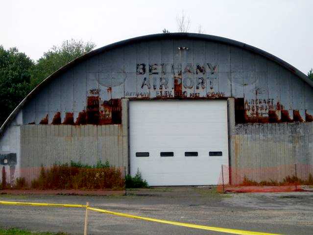
A 2008 photo by Matt Baker of the former Bethany Airport hangar.
According to Matt, “It was used until recently as a town garage but will soon be converted for use as recreation space for the town of Bethany.”
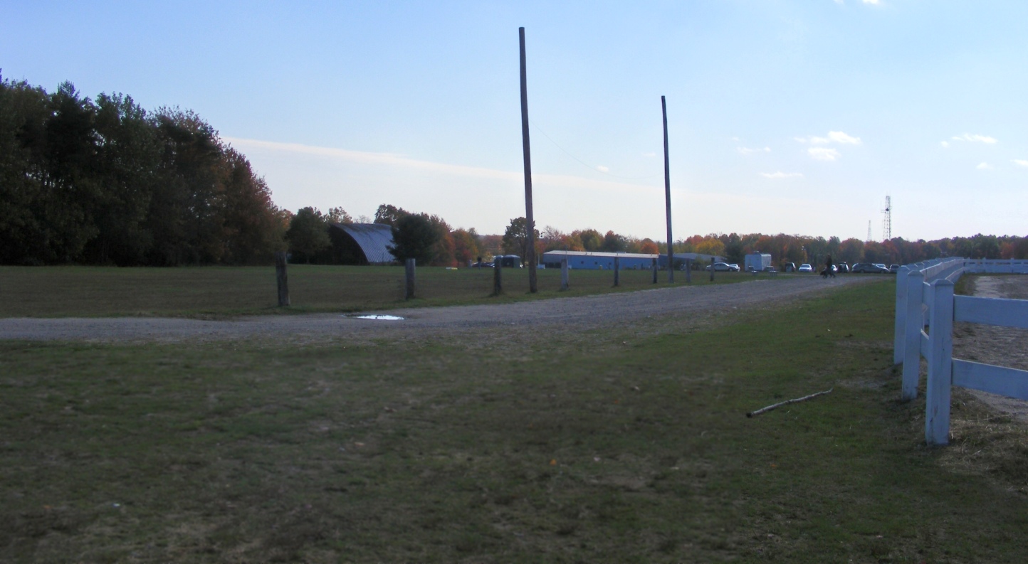
John Boyce reported in 2009 of the Bethany Airport site, “Most of the open space is used for horse-oriented activities.
It is also the home of our recycling facility, the Highway Department, and the Bethany Volunteer Firemen's Association.
There is a mattress factory & a driving range, too. Hardly what was envisaged.
[The hangar] is nearing the end of its days. It is badly rusted-out where the arches join the concrete footings.”
A 9/19/13 aerial photo showed the Bethany hangar remained standing.
Bethany resident Mark Scott reported in 2014, “Volunteers have torn down the old Quonset hangar which was falling down anyway.
The old hangar was literally falling down. It was very rusted out.”
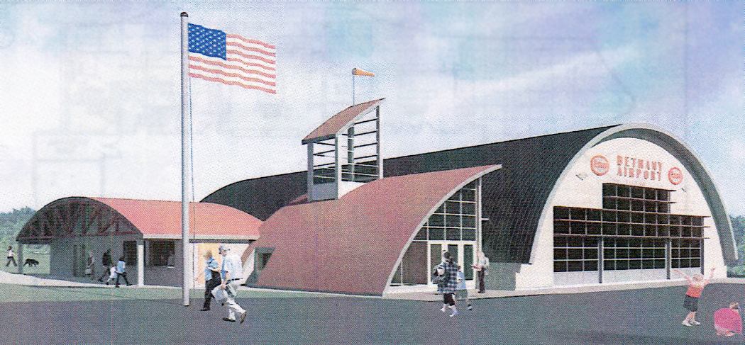
A 2014 rendering of the planned “Bethany Airport Community Center” (courtesy of Mark Scott).
Mark reported, “The town historical committee & volunteers are going to build a town community center
in the form of a Quonset hangar with large doors & a side building.
The old airport property is used for many town activities. The community center is a good use of the space.
The best part is that we found the old airmail arrow depicted clearly in one of [the preceding] photos.
We plan to uncover the grass & restore it.”
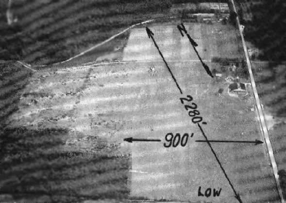
![]()
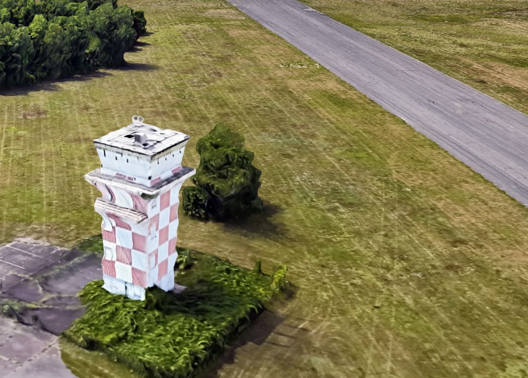
A 2014 photo by Mark Scott looking southwest at the remains of Bethany Airport's 80 year old concrete airmail arrow marker.
Mark reported, “I hope to uncover it soon.”
Mark Scott reported in December 2014, “The Bethany Connecticut Airport Community Center being built in the design look of the old Quonset hangar is now underway.”
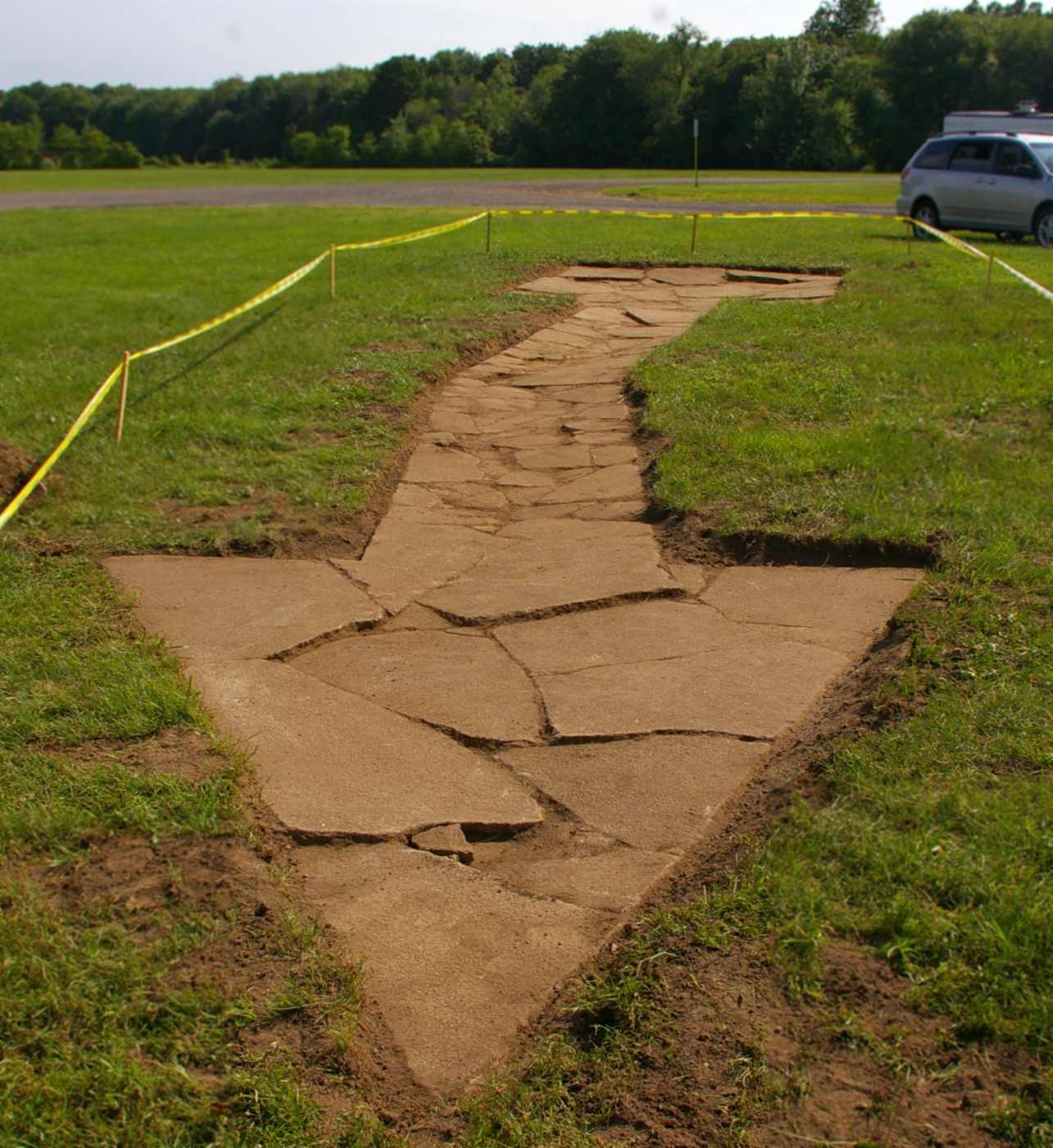
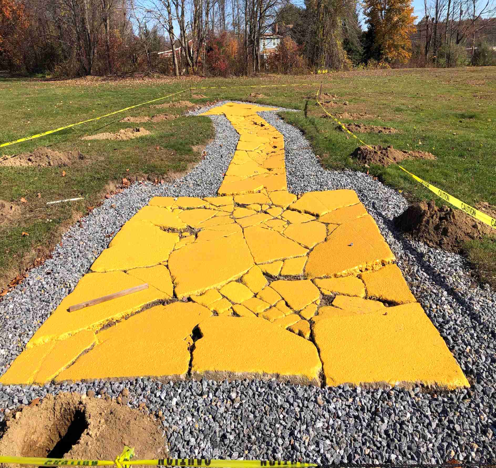
A 6/5/16 photo by Mark Scott of the remains which were uncovered that day of Bethany Airport's 80 year old concrete airmail arrow marker.
Mark reported, “I am on a committee that is recreating the old Bethany Airport hangar as a community center.
Last Saturday the committee uncovered this concrete directional arrow at the old Bethany Airport.
It's really cool. It was made in the 1920s for air mail pilot navigation. It is 70' long. The tail points towards New York, the tip towards Hartford.
This is about the time the arrows were made obsolete by radio navigation. We think it has been covered for about 40 years.
It is quite broken up from all the frost heaving but it is all there. We are not sure if we will leave it as is or restore it.
We are looking for donations to erect a suitable fence to protect it & a plaque about its history.”
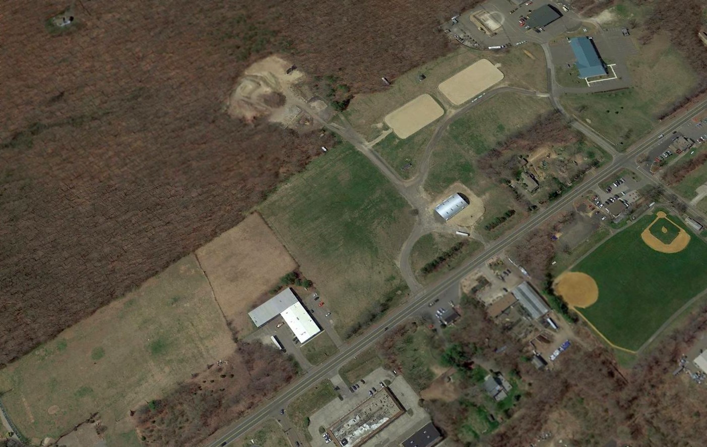
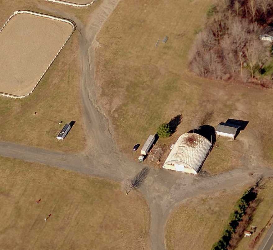
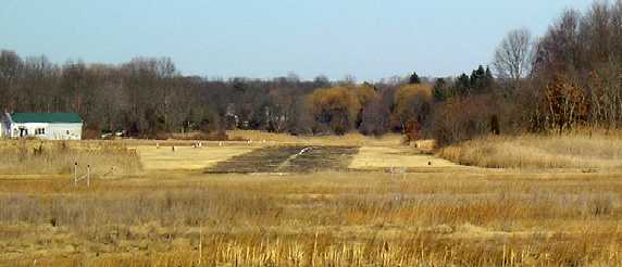
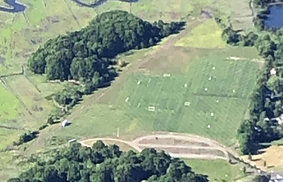
A 2016 aerial view looking northwest showed that Bethany Airport's runway was no longer recognizable,
but the silver arch-roofed hangar remained standing (in the center of the photo).
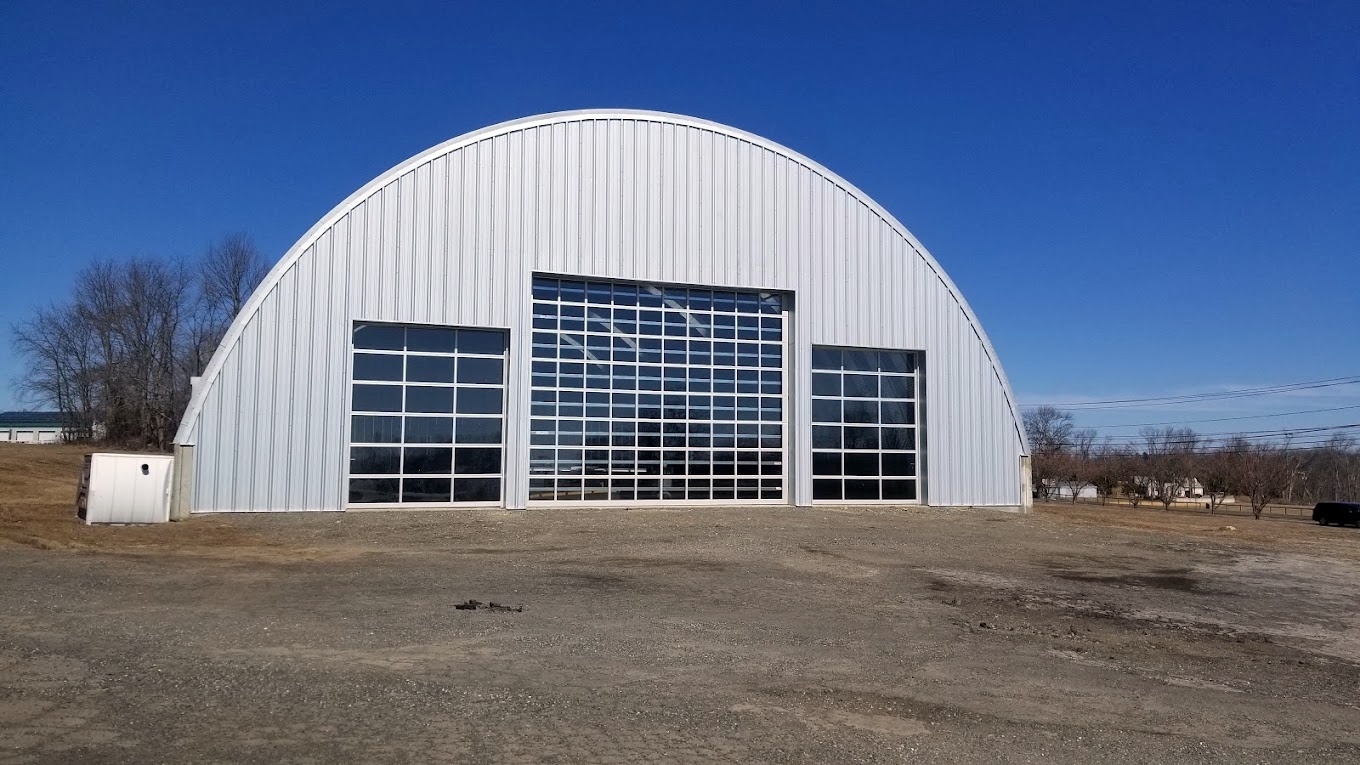
A March 2021 photo looking north at the restored former Bethany Airport hangar.
An 11/3/22 photo by Johnny Kurp of the restored concrete airmail arrow marker at the Bethany Airport site.
Johnny Kurp reported, “A group of volunteers have uncovered & are restoring the airmail arrow.”
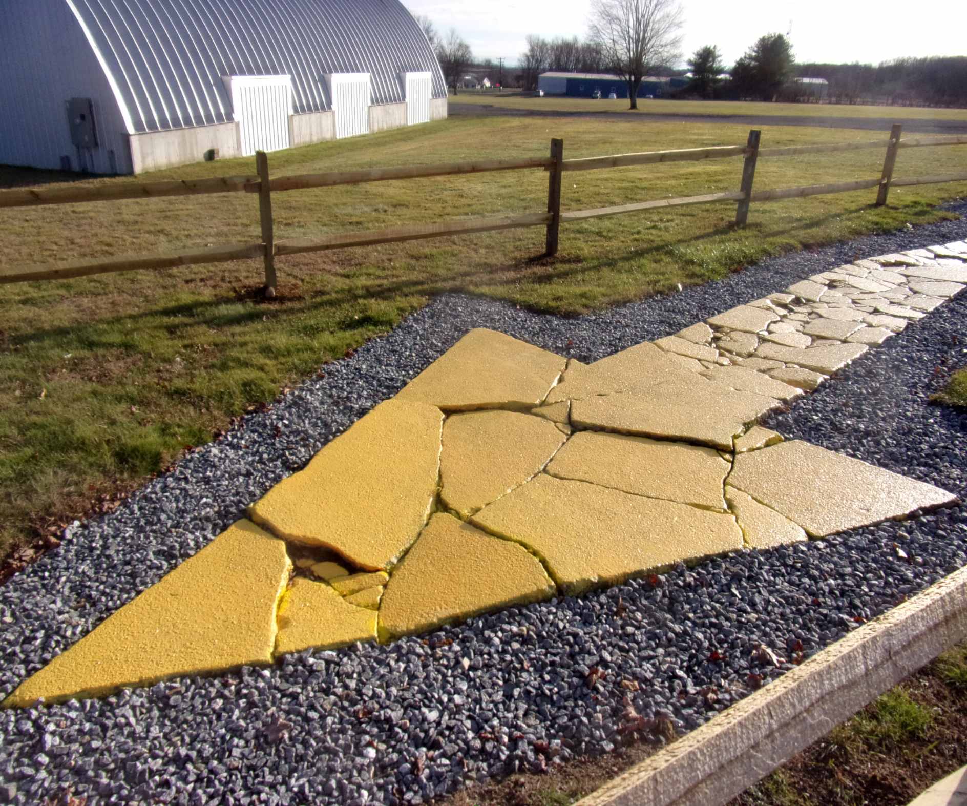
An 11/28/22 photo by Lester Warner of the restored concrete airmail arrow marker at the Bethany Airport site, newly fenced-off.
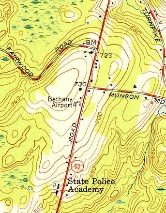
The site of Bethany Airport is located west of the intersection of Amity Road & Munson Road.
Thanks to Ron Rex for pointing out this airfield.
____________________________________________________
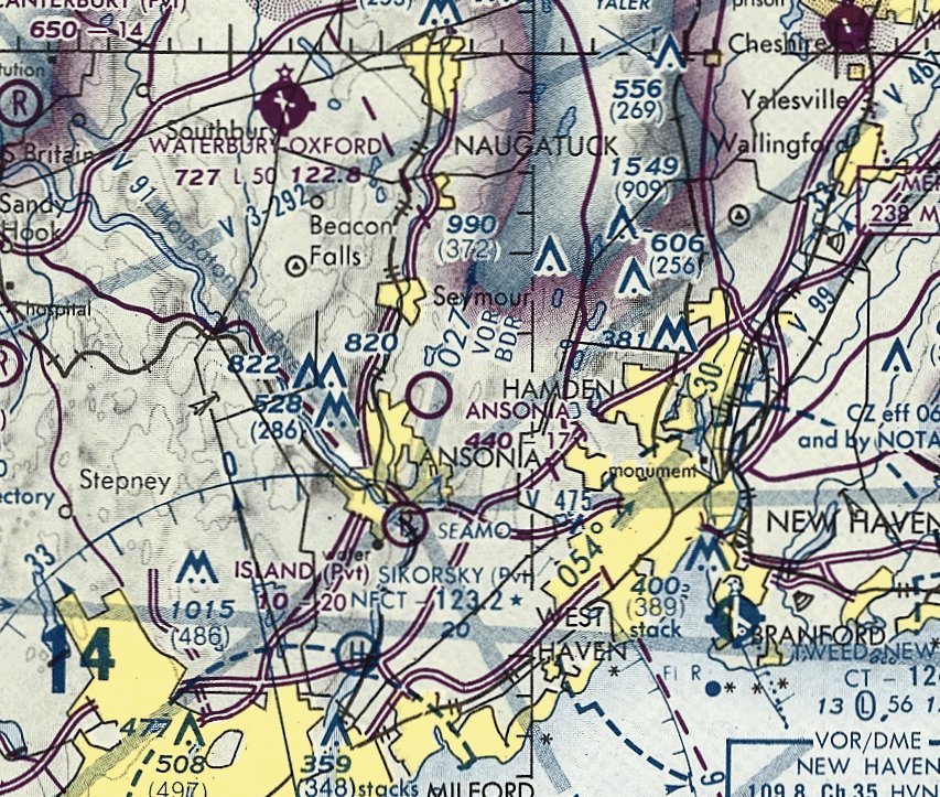
41.34, -73.05 (Southwest of Hartford, CT)
Ansonia Airport, as depicted on rhe July 1947 NY Sectional Chart.
Ansonia Airport was evidently established at some point in 1947,
as a 1934 aerial photo did not yet depict an airfield at this location,
and it was not yet depicted on the January 1947 NY Sectional Chart.
The earliest aeronautical chart depiction which has been located of Ansonia Airport was on the July 1947 NY Sectional Chart.
It depicted Ansonia as a commercial/municipal airport.
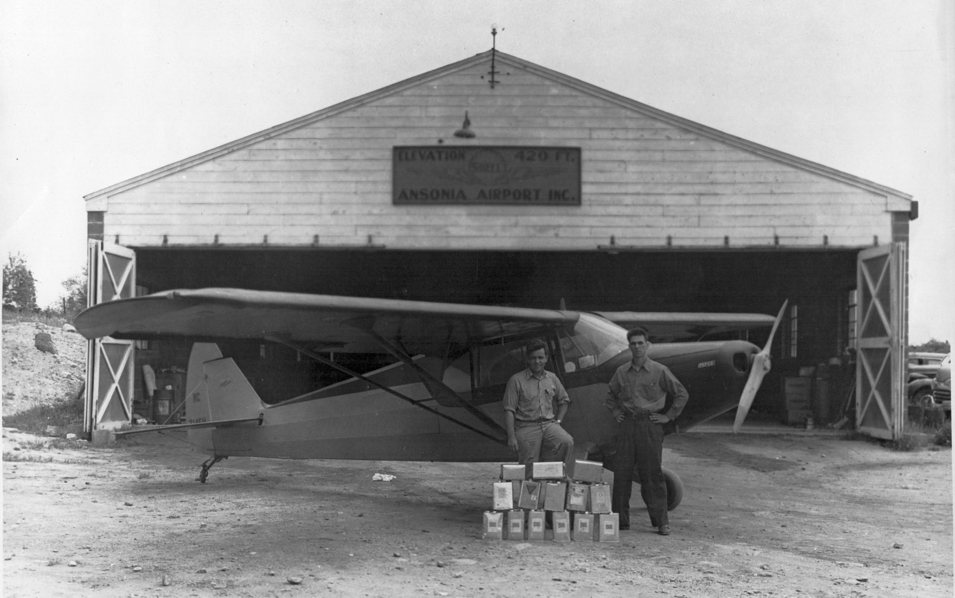
The earliest photo which has been located of Ansonia Airport was a circa 1948 photo of Allen & Fred Turner with a Piper Cub in front of the Ansonia hangar (courtesy of Mary Baker).
Doug Baker observed that the photo's caption indicated they had just brought in a load of maple syrup for the Civic Association Fair.
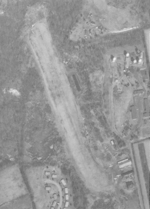
The earliest aerial photo which has been located of Ansonia Airport was a 4/21/49 USGS aerial view.
It depicted a grass northwest/southeast runway, with a single hangar & some smaller buildings at the southeast side.
A June 1949 aerial view looking east at Ansonia Airport (courtesy of Mary Baker).
Harwood Loomis recalled, “Ansonia had a Civil Air Patrol squadron.
Ansonia had an old Link trainer stashed in a corner of its hangar.
By the 1950s, when my cousin & I used to bicycle to the airport, the Link was in bad shape & seemed to be inoperative,
but we kids nonetheless liked to sit in it & pretend we were flying.”
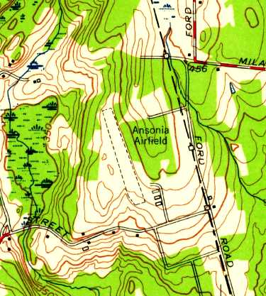
The 1953 USGS topo map depicted “Ansonia Airfield” as having a northwest/southeast unpaved runway with 3 small buildings on the southeast side.
On 7/8/55 the Army announced that they would be acquiring several parcels of land for a Nike Ajax missile installation in Ansonia, in close proximity to the airport.
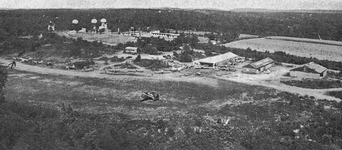
An undated aerial view looking northeast at Ansonia Airport from the 1956 CT Airport Directory (courtesy of Stephen Mahaley).
The directory described Ansonia as having an 1,800' sod north/south runway, and 3 hangars were depicted at the southeast side.
The operator was listed as Ansonia Airport Inc., and the manager as Chester Zebrowski.
Nike battery BR-04 was activated in 1957 as part of the Nike system's Bridgeport Defense Area,
equipped with the 1st-generation Nike Ajax missile.
The Nike Integrated Fire Control Site was located adjacent to the east side of Ansonia Airport,
and the Launch Site was located less than a mile to the north.
Quite the odd juxtaposition: a grass airport operating light planes,
right next to a military installation housing radar-guided supersonic surface-to-air missiles.
According to Robert McGuire, “Stories from some of the old timers said that they used to bring in DC-3s (the military version) to bring in supplies for the missiles.”
Martin Goldfarb recalled, “In 1960, I learned to ride horses at the Ansonia Airport.
The Governor’s Horse Guard, 2nd Company led by Jules Shanbrom housed their horses in the large maintenance hangar.
The shed on the north side was converted to stalls & the main hangar was the riding ring.”
In the mid-1960s, Ansonia Nike Site BR-04 was the only Nike battery in the Bridgeport Defense Area to be upgraded to the 2nd-generation Nike Hercules missile.
The residents of the small town probably had no idea that some of the Nike Hercules missiles were equipped with a nuclear warhead.
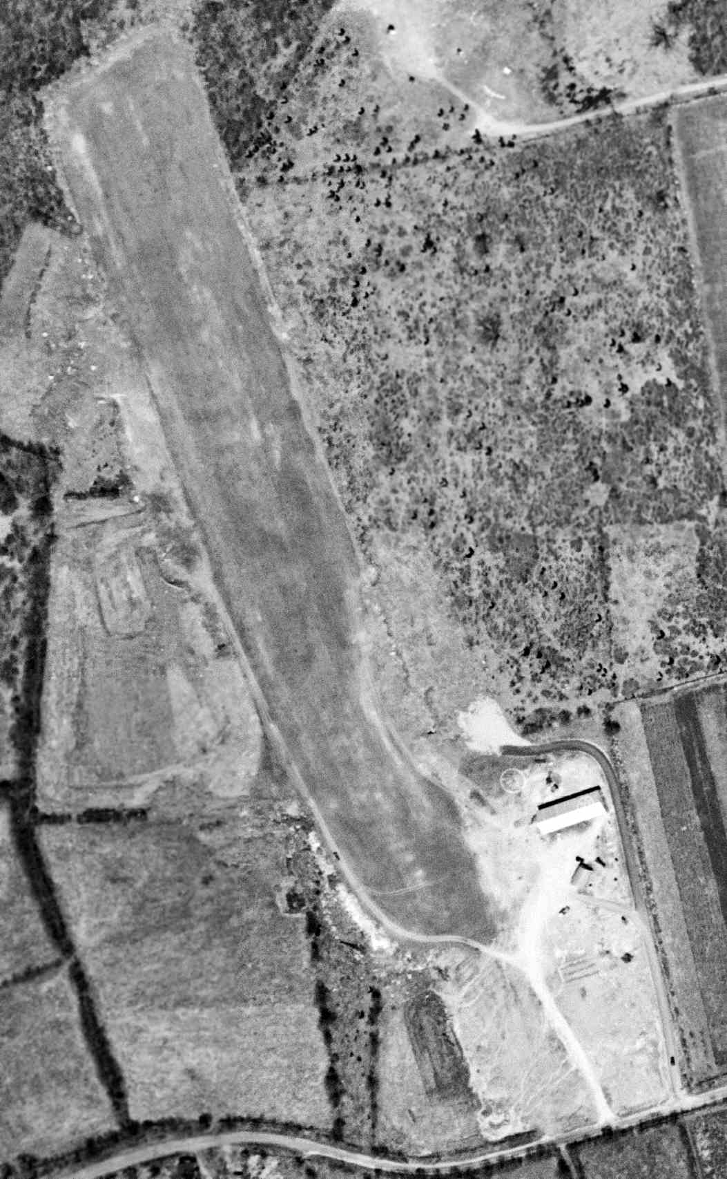
A 1963 aerial photo showed that Ansonia had gained a 2nd hangar at some point between 1949-63.
A single light plane was visible near the hangars.
The 1965 NY Sectional Chart depicted Ansonia Airport as having a 1,700' unpaved runway.
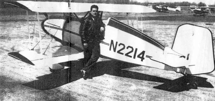
A 1960s photo of Karl Benner in front of his Jungster 1 at Ansonia Airport.
Von Moody recalled that he “Soloed [at Ansonia Airport in January 1966.
Fairchilds, Stearmans, PT-22 & 23, F8F Bearcat, Waco's, Stinson, Cubs, Aeroncas and many other classics were based there, lots of history.
One of my instructors was an Me-109 Pilot. There was also the 4-place version, with a Lycoming 720 conversion in it.”
This was actually a Nord (SNCAN) 1002 Pingouin II, a post-WW2 French-built version of the Messerschmitt Bf 108 Taifun.
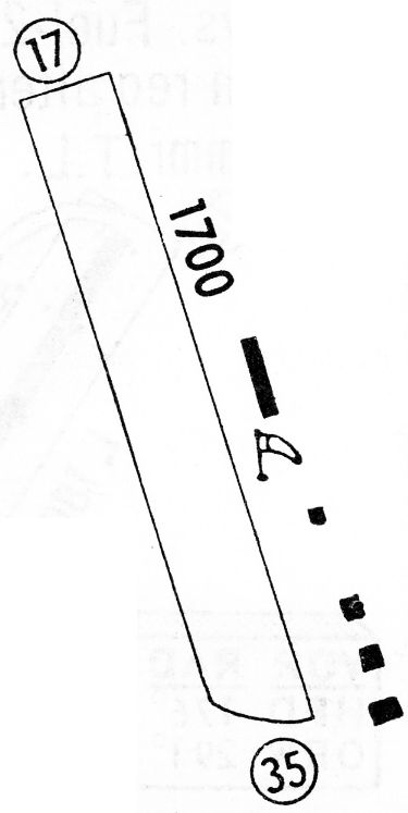
The 1968 Flight Guide (courtesy of Bob Levittan) depicted Ansonia Airport as having a 1,700' unpaved Runway 17/35 with 5 small buildings on the southeast side.
Fred Ouweleen recalled, “I discovered Ansonia Airport when I moved nearby in January of 1969. I was 16 & decided to learn how to fly.
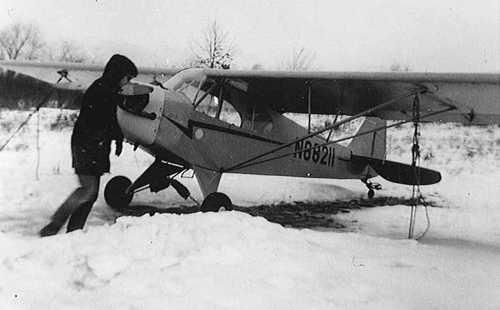
My father decided to pursue this as well & he purchased a 1946 Piper J-3 N88211 for $2,300 which we based at Ansonia.
My instructor was Stanley. We would fly together without headsets making communication difficult if not nearly impossible.
Funny how it didn’t occur to the majority of the pilot population at the time to wear headsets.
He was said to have been a Luftwaffe pilot but my guess is that this was a story that was attributed to him & which he didn’t deny.
He was patient & friendly & taught me & my father to fly our Cub.
On one occasion he & I took off behind a brown Super Cruiser flown by the airport owner/manager whose first name was Ted.
We engaged in a mock dogfight low over the changing autumn leaves. I will never forget that experience.”
Fred continued, “I would play hookie from high school & head to the airport to clean or fly the Cub.
On one of these occasions, a Bearcat owned by a TWA pilot from Danbury circled the field to land.
I watched as he drifted halfway down the short field before touching down.
I figured he would try to go around but he stuck it on & then proceeded off the runway towards the hangars on the southeast side of the strip.
I was sure he was going to flip over & explode but he managed to bring it to a halt after a slow ground loop.
He never got out of the plane to inspect for damage but stayed in the cockpit with those big 4 blades continuing to turn.
Ted came out & pulled out a branch that was stuck in the landing gear well & he then took off in the other direction.
I later retraced the tire tracks of his sojourn off the runway & he missed rocks & potholes by inches.
The hangars contained some beautiful airplanes. I recall a Bf 108 [actually a Nord 1002], a Staggerwing & a WACO biplane.
Ted also rented J-3s & he would equip them with skis in the winter.”
Eric Peterson recalled, “I remember Stanley & Leon. Stanley was a little bit nuts but sweet, and always had stories.
My dad used to wonder if maybe Stanley had ever had a chance to shoot at him over Europe, since my dad had flown transports.
Leon was a little crotchety, but he was a stickler &a perfectionist, as anyone signing off on annuals should be.
My Dad & Leon would sit on their respective pickup tailgates & dicker over details & procedure.
The comments about the Quonset hut are dead-on: the old stove always fired up,
the old pilots sitting around waiting for the Big City Fellers to come by & miss their touch & goes on the short field, so they could laugh at them.
My dad kept his 180 there, and later, the little black scallops & yellow Pitts S-1S he bought from the US Aerobatic Team's Mary Gaffaney when they switched to Christen Eagles.
I spent a lot of summer days up on that hilltop, or over it. All the regulars called it 'Ansonia International'.”
Doug Baker recalled, “I moved to Ansonia in 1969. I have vague memories of the airport & remember the Nike site though it was to us, almost an urban legend or myth.
My brother-in-law had an airplane at the Ansonia Airport.”
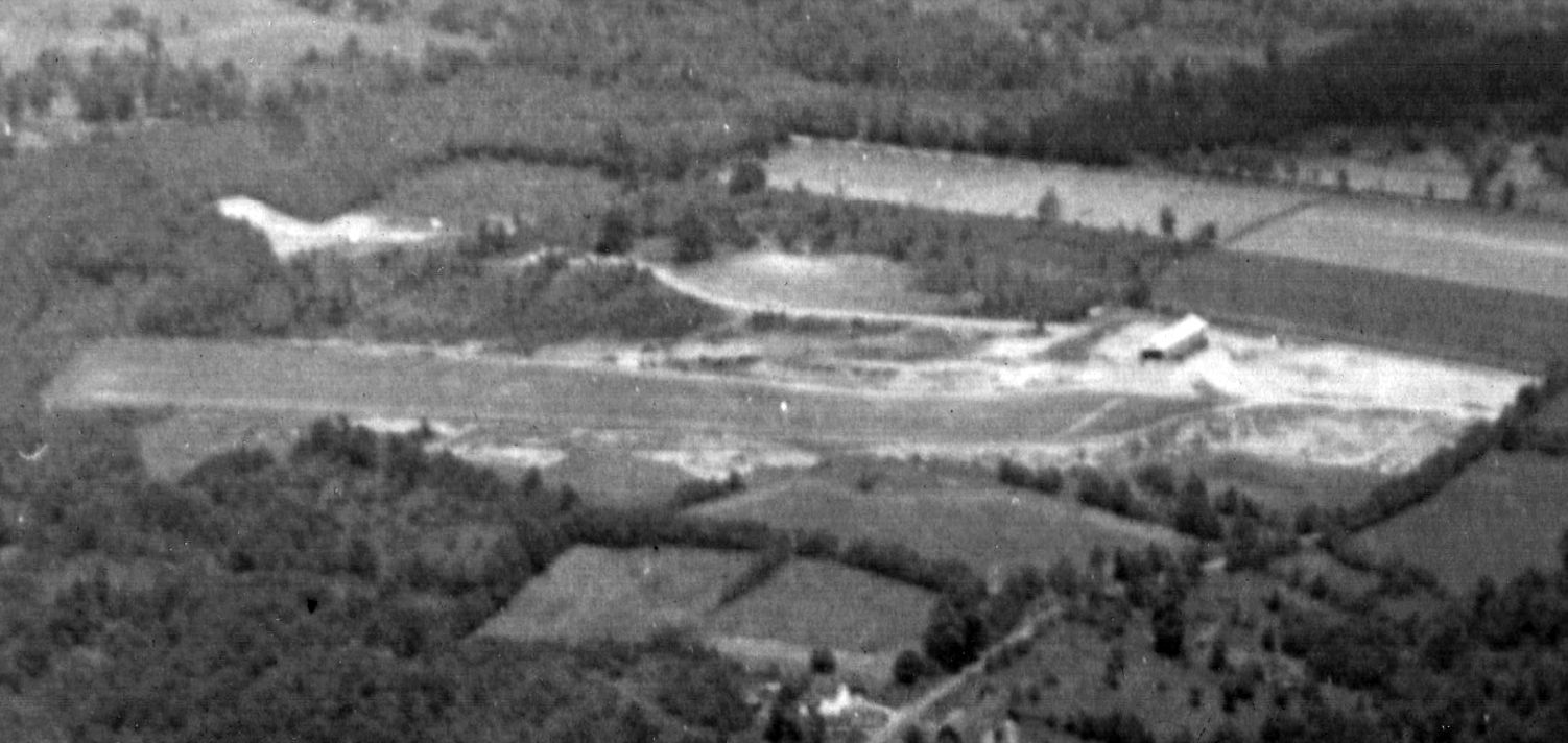
An aerial view of Ansonia Airport from an 8/31/69 newspaper article (courtesy of Fred Ouweleen), captioned “Ansonia Airport lies just off Ford Street & Ford Road in the Hilltop section of Ansonia.
The 1,750' grass strip, one of the smoothest in New England, is home to a unique variety of planes.”
Note the radomes of Nike missile battery BR-04 visible in the background.
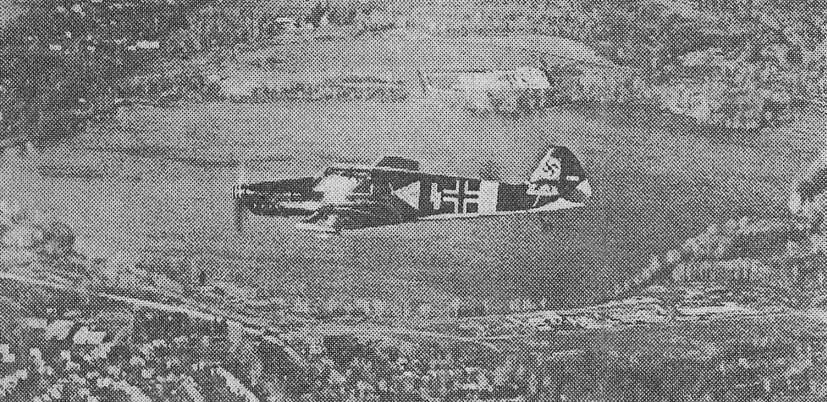
An undated photo from an 8/31/69 newspaper article (courtesy of Fred Ouweleen), captioned “John Van Andel’s ME-108 World War II Luftwaffe pane flies past the camera.
Van Andel, of Westport & a TWA pilot, has converted the plane to an American Lycoming engine. The craft, which has made 5 movies & a TV documentary, is based at the Ansonia Airport.”
In reality the plane was not actually a Messerschmitt, but rather an Nord 1002 (a post-WW2 French-built version of the Messerschmitt Bf 108 Taifun).
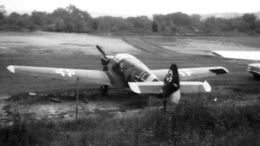
A Summer 1969 photo by Ed Cox of Ansonia, showing “N108U, a Nord 1002 (I always thought that this was a Bf 108 but apparently was a French-built variant).”
A Summer 1969 photo by Ed Cox of Ansonia, showing “the hangar which included the office. The Nord is visible close to the hangar.
This hangar had a serious hangar fire in which all aircraft, including the Nord, were lost.
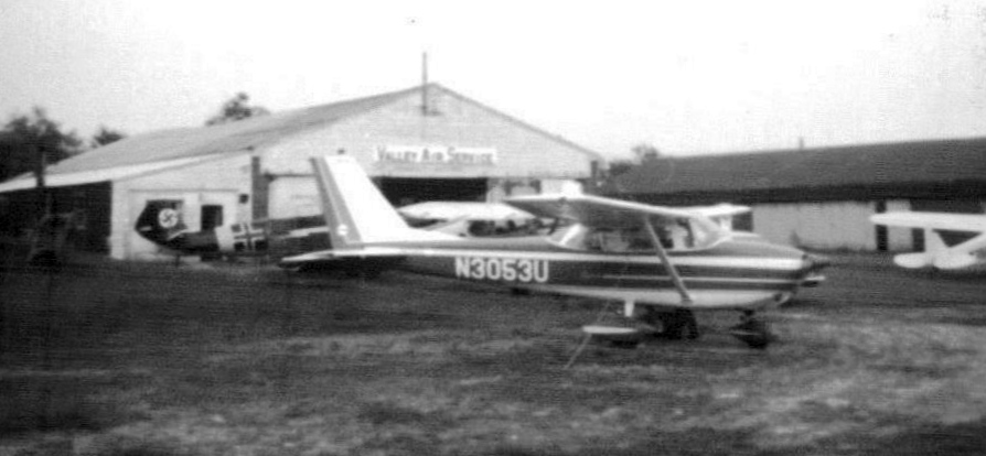
The FBO in 1969 was Valley Air Service. This was owned by two pilots: Ted, Bob Sayles, and a mechanic whose name escapes me.”
Ed Cox recalled, “I took some of my early lessons at Ansonia. They had 2 J-3s (N2086M & N35515) & a Cessna 150 (N3274J).
I also had an opportunity to fly 5-6 times with Stan.
He was from Eastern Europe (Lithuania?) and told me he had been impressed into the Luftwaffe where he had flown Stukas.
Back in the late 1960s there were a number of classic aircraft in the hangars or that dropped in to visit.
A number of these were the first or only examples I have seen.
These included a Mooney Mite, a Waco Model A, a Spartan Executive and a Stearman that never saw military service.”
A circa 1969 photo by Fred Ouweleen of a row of single-engine light planes & a hangar on the east side of Ansonia Airport, with the radars of Nike missile battery BR-04 visible in the right background.
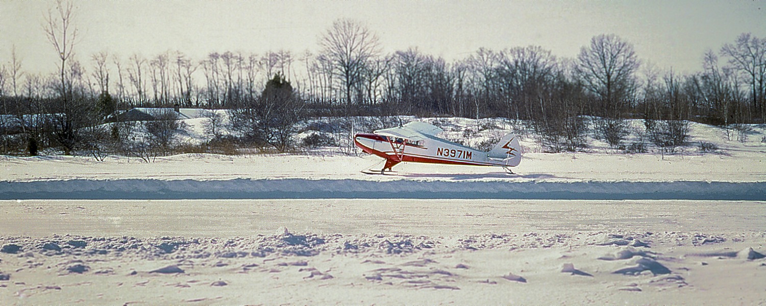
A 1969 photo by Fred Ouweleen of a Piper Supercub taxiing on skis on a snow-covered Ansonia Airport.
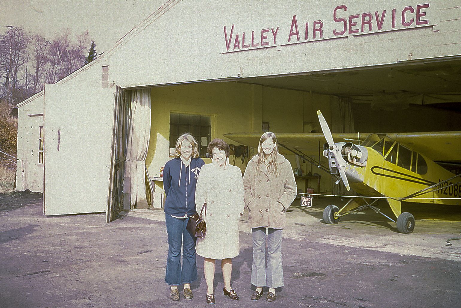
A 1969 photo by Fred Ouweleen of Debbie Ouweleen, Flora Ouweleen, Cheryl Ouweleen, and one of the Piper Cubs that was available for instruction & rental inside Ansonia Airport's Valley Air Service hangar.
A 1969-70 photo of Fred Ouweleen with his Piper Cub at a snowy Ansonia Airport.
Also note the Nike installation to the northeast.
Fred Ouweleen recalled, “In the summer of 1970, our family moved away.
I flew the J-3 out of Ansonia for the last time on a long cross country to St. Louis. We sold the J-3 & bought a Cessna 170.”
A 1971 photo by Fred Ouweleen of flight instructor Stanley Cekanouskas at Ansonia Airport.
Fred Ouweleen recalled, “In the summer of 1971 or 72 I flew a Cessna 170 from St. Louis to CT.
I intended to fly it out of Ansonia with a friend to Long Island to go camping.
We had full fuel & halfway down the runway I could see we just might fly into the trees on the north end.
So fortunately I aborted the takeoff, off loaded fuel & asked my friend to meet me at Tweed New Haven.
That runway was short & with the obstacles on the north end, it was really only suitable for Aeroncas, Cubs and Luscombes…
not for heavily-loaded Cessnas or Bearcats.”
Fred continued, “I have many warm memories of Ansonia & the adventures I had there.
For someone of my age at the time & new to town, it was a place to commune with flying & our beautiful J-3
and become connected with an eclectic group of people.
I am grateful to my parents who supported my flying & made this experience possible.
And yes, they knew about my playing hookie!”
According to Jerry O'Neil, Cliff Robertson's “old Bf 108 [actually a Nord 1002] was destroyed in a hangar fire at Ansonia Airport.”
John Boyce recalled, “I made a few flights out of Ansonia.
Teddy Tsovaris rented me a Cub that was probably not airworthy, lacking some required instruments. But cheap. I think it was $8/hour.
The maintenance operation was run by a former EAL flight engineer, Bill Neukom.
I flew my Fairchild 24 in there for an annual, but it never got done.
I couldn't get hangar space & it deteriorated badly, so I took it apart, improvised some sort of trailer hitch-up & towed it home.
The F8F was flown by TWA Captain Ron Reynolds. There were some beautiful aircraft lost in that fire. A Waco & Stearman, among others.”
Melillo recalled, “I flew out of the Ansonia Airport when I first got my private [pilot's license] in 1971.”
Ansonia's Nike Battery BR-04 was decommissioned in June 1971.
A 1972 aerial photo showed 8 light planes parked at Ansonia Airport.
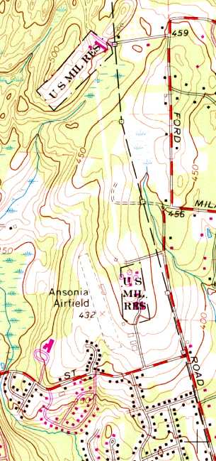
The last map depiction which has been located which still labeled Ansonia Airport was on the 1972 USGS topo map.
It it also depicted the 2 adjacent Nike missile installations (the Integrated Fire Control site to the east, and the Launch Site to the north), each labeled as “U.S. Mil. Res.”
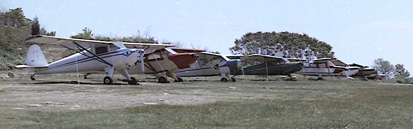
A 1973 photo by Bob Biancur of a row of 8 single-engine planes at Ansonia Airport.
John Boyce observed, “The pictures showed a good-looking PA-12 that had been well equipped to serve Neukom as an instrument trainer.”
A 1973 photo by Bob Biancur of Martin Goldfarb's 1948 Piper PA-15 Vagabond & an Ercoupe at Ansonia Airport.
Bob Biancur reported that upon finding his photos of Ansonia Airport, “They bring back pleasant memories of a really special place,
though calling that grass patch an airport is a bit of a stretch.
Ansonia Airport consisted of a 1,750' grass runway, a cobbled-together wood-burning stove for heating the Quonset hut,
a few leaky-roofed hangars, and a faded windsock that looked like a relic from barnstorming days.
It wasn’t much, but it was the next-best thing to heaven for a bunch of aviators who could only afford to fly on a shoestring budget.
Our planes were an odd assortment of vintage aircraft with such names as: Aeronca, Taylorcraft,
Luscombe, Bellanca, Aircoupe, Stinson, and of course the venerable Piper & Cessna.
The few amenities we had were not without quirks. For example, we had to avoid congregating in certain areas of the hut to avoid weak spots in the floor.
In summer the antique refrigerator chilled our beverages, but in winter it served an even more important purpose
by preventing contents from freezing when the hut was unattended.”
Bob continued, “One unique aspect of the flying club, perhaps taken for granted, were the veteran pilots who were always ready to lend a hand.
Without that special camaraderie the airport would never have lasted as long as it did.
Most memorable was Stan Cekanouskas, our flight instructor.
He could hold us spellbound with exciting exploits of Stuka dive bombing during WWII.
John Uhock, airport manager & keeper of the books. Chet Zembrowski, principal owner of the field.
Pete Peterson, the the go to person for technical advice. Leon Redmond, our chief mechanic, kept ‘em patched & flyin’.
Coonie Hewitt, a former Army Air Corps flight instructor, always ready to help a novice flyer 'straighten out & fly right'.
Walter Schlagel, sold me my first plane, and Joe Sliby, a fellow aviator who scoffed at the notion that something couldn’t be done.
These are but a few of the old-timers who shared their time & talent, and honed our skills.”
A 1975 aerial view by Bob Biancur looking east at Ansonia Airport from his Cessna 120.
Bob recalled, “I spent quite a bit of time there & met some fine pilots. It was my all-time favorite place.”
The Nike Integrated Fire Control Site was visible right behind the airport.
Martin Goldfarb recalled, by 1975 the horses were gone from Ansonia Airport.
“In May 1975, I purchased a 1948 Piper Vagabond that was based there & continued to be based there until April 1976.”
Joe Ursone recalled, “I was 14 years old when I was first introduced to Ansonia Airport in 1977.
My father flew a 1946 Ercoupe out of Ansonia. I got my flying career started at Ansonia & have fond memories.”
A 1978 photo of Bob Biancur at Ansonia Airport “posing with my 1946 rag-wing Luscombe 8A.”
The last aeronautical chart depiction which has been located of Ansonia Airport was on the June 1981 NY Sectional Chart (courtesy of Ron Plante).
It depicted Ansonia Airport as having a 1,700' unpaved runway.
A 1980s photo by Bob Biancur of a Mooney & Aeronca in front of Ansonia Airport hangars.
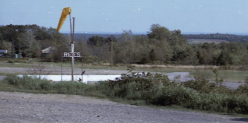
A 1980s photo by Bob Biancur of the Ansonia Airport windsock, “Looking south toward Long Island from the hut.”
Matt Valleau recalled, “I moved to Connecticut in 1988, and the airport was in it's final throws then.
It closed shortly after I moved here (1988-89).”
Martin Goldfarb recalled, “Coonie Hewitt’s Piper J-3 Cub, which previously had been based at Bethany Airport, was the last airplane to leave before the airport was sold.”
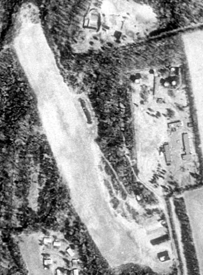
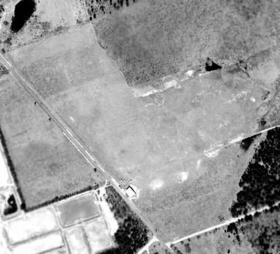
The last photo which has been located showing Ansonia Airport still intact was the 4/3/91 USGS aerial view.
The runway & hangars were still intact, but there did not appear to be any recent aviation usage.
The adjacent Nike Integrated Fire Control Site to the east also remained largely intact.
Robert McGuire recalled, “We tried to buy the airport several time from the last of 3 original owners
but he sold out to a developer & he died a short time after. Now there are houses there.”
Ansonia Airport was no longer depicted on the December 1993 NY Sectional Chart (courtesy of Ron Plante).
A 2004 aerial photo showed that houses were built over the site of Ansonia Airport at some point between 1991-2004.
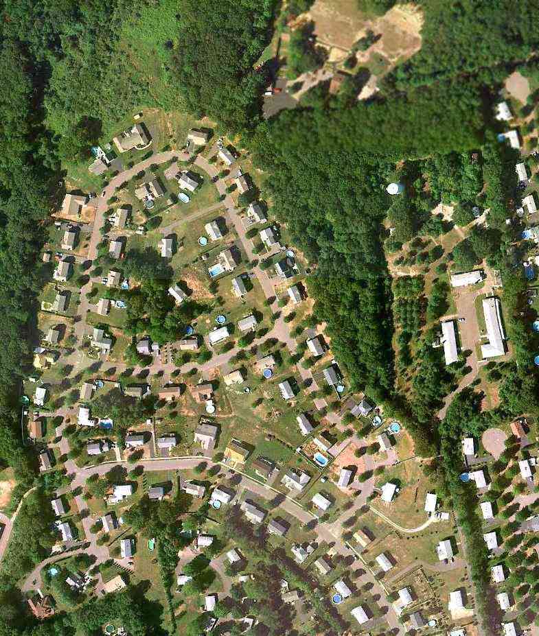
A 9/11/10 aerial view depicted houses covering most of the site of Ansonia Airport,
with only a clearing remaining at the site of the north end of the runway.
Bob Biancur reported in 2012, “Ansonia Airport is gone now, along with her sister airports Bethany & Monroe;
all having succumbed to the pressure of land developers, excessive regulation, exorbitant costs & lack of affordable planes.
The old flyers are gone too; though when I hear the fading drone of a little airplane climbing for the clouds,
or the chance passing of a biplane with its unmistakable throaty radial engine, I’m reminded of Ansonia’s halcyon days.
It was a hoot while it lasted. I drove out to see if I could recognize anything of the airport.
Nope. Just another housing development. Kinda brought a tear to my eye.”
The site of Ansonia Airport is located northwest of the intersection of Ford Street & Sobin Drive.
____________________________________________________
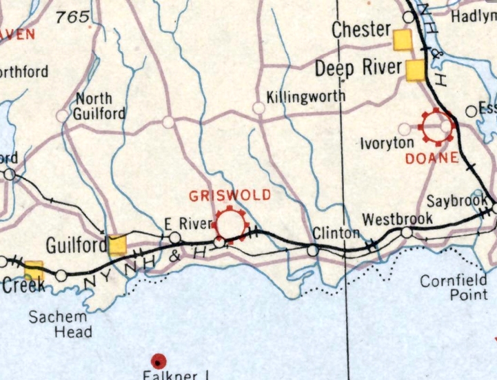
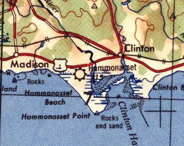
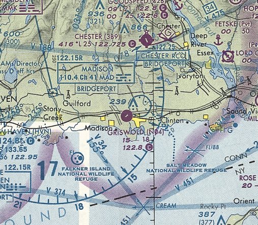
Griswold Airport / Hammonasset Airport (N04), Madison, CT
41.272, -72.55 (East of Hartford, CT)
Griswold Airport, as depicted on the August 1932 NY Sectional Chart.
According to Wikipedia, “Griswold Airport opened in 1931.”
The earliest depiction which has been located of Griswold Airport was on the August 1932 NY Sectional Chart,
which depicted Griswold as a commercial/municipal airport.
A 1934 aerial photo depicted an open field, with possibly a small building along the west side.
The earliest directory reference which has been located to Griswold Airport
was in the Airport Directory Company's 1937 Airport Directory (courtesy of Bob Rambo).
It described Griswold as a commercial airport, being an 80 acre T-shaped sod field
having 2 runways (measuring 1,800' north/south & 1,400' east/west) and a hangar.
Griswold Airport may have been temporarily closed during WW2 (like many other small civilian airports along the coasts due to wartime security concerns),
as it was not listed among active airfields in the 1945 AAF Airfield Directory (courtesy of Scott Murdock),
and it was not depicted on the 1945 NY Sectional Chart.
The airport evidently reopened under a new name of Hammonasset Airport at some point between 1945-47,
as that is how it was labeled on the 1947 USGS topo map.
It was once again depicted as Hammonasset Airport on the 1948 USGS topo map.
It was once again depicted as Griswold Airport on the January 1949 NY Sectional Chart (courtesy of Chris Kennedy),
with a 1,700' unpaved runway.
A 1949 aerial photo depicted a grass airfield oriented north/south, with several small buildings along the west side.
Griswold Airport may have gone through another period of closure, as the 1951 USGS topo map didn't depict anything at all at the airport location, just a clearing.
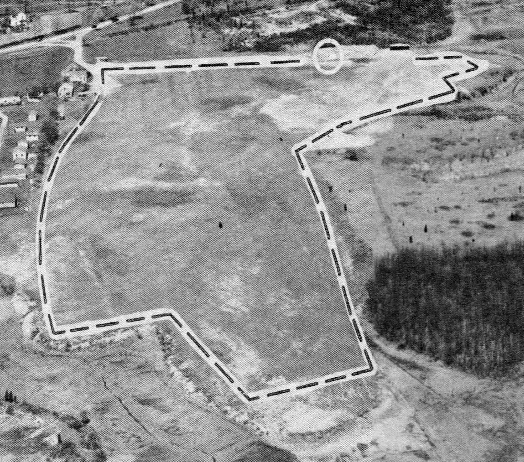
The earliest photo which has been located of Griswold Airport was an undated aerial view looking northeast from the 1956 CT Airport Directory (courtesy of Bill Hecht).
It described Griswold Airport as having a 1,800' sod northeast/southwest runway, and listed the manager as John Griswold.
A 1957 aerial photo depicted Griswold Airport having a grass airfield oriented north/south, with several small buildings along the west side.
The 1961 USGS topo map depicted Griswold Airport as having 2 unpaved runways.
The 1965 NY Sectional Chart depicted Griswold as having an 1,800' unpaved runway.
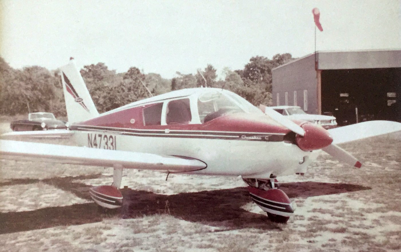
A 6/27/67 photo by Brian Coupe of a Piper Cherokee in front of a Griswold Airport hangar
Brian recalled, “I know the time was late morning. A pilot friend & I had each graduated from the same high school in Syracuse, NY the evening before.
I flew the rented plane to Griswold & he flew it back to Syracuse.
I am confident the paved runway had not yet been installed (or construction even started) for two reasons:
We landed on the turf & I remember discussing enroute that we would have to land on turf,
and I have no recollection of seeing a paved runway when we got to the airport vicinity.
The picture is of the hangar showing a windsock & 4 side windows which are visible in [later] pictures.
While this picture doesn’t show much, it does show the hangar from ground level in much happier days!”
Griswold Airport evidently gained a paved runway at some point between 1967-70,
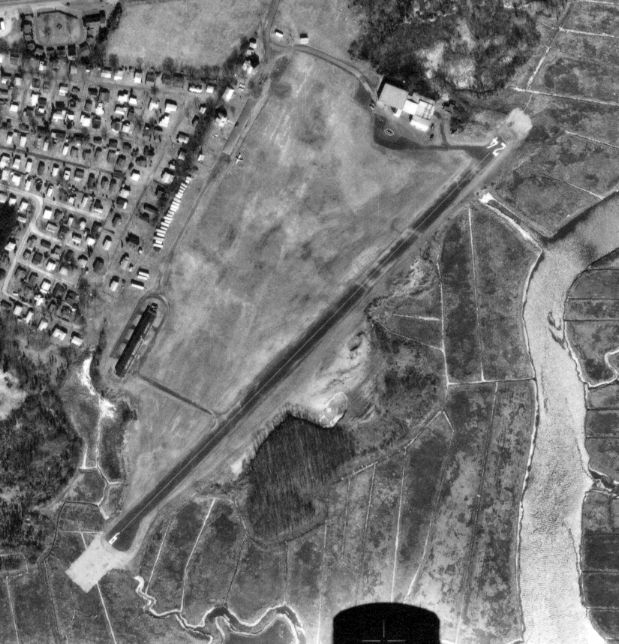
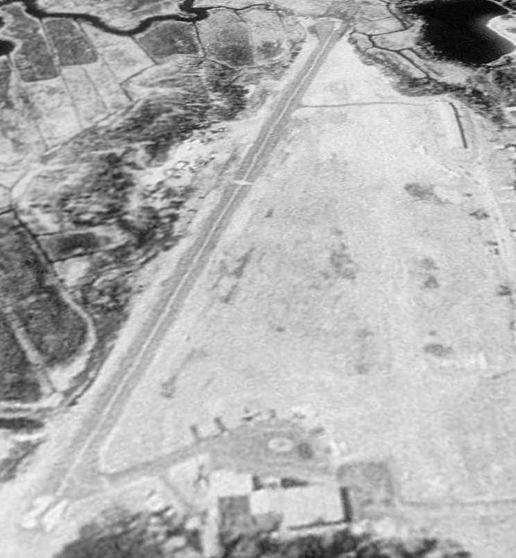
as a 2/26/70 aerial photo depicted Griswold as having an asphalt Runway 6/24 to the east of the original grass airfield.
A single aircraft was visible on the field.
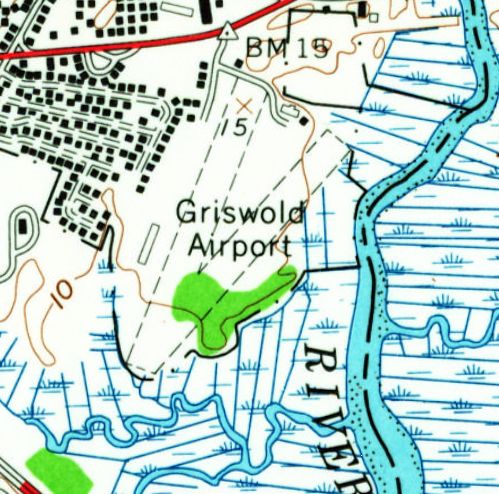
The 1970 USGS topo map depicted Griswold Airport as having a paved northeast/southwest runway.
The 1975 NY Sectional Chart (courtesy of Mike Keefe) depicted Griswold as having an 1,800' paved northeast/southwest runway.
According to Wikipedia, “In 1985, the Griswold family offered to sell the airport to the town of Madison.”
An undated photo of a Piper Cub & an ultralight (model unidentified) at Griswold Airport.
A 4/23/90 aerial view looking southwest showed 4 light aircraft at Griswold Airport.
A undated aerial view looking southwest at Griswold Airport showed at least one aircraft on the field.
According to Wikipedia, “In November 2000, Leyland Development Corporation obtained an option to purchase the land,
and submitted plans for a 260-unit housing development, which was approved by the towns' Planning & Zoning Commission.
A lawsuit against the town to stop the development failed, but local opposition was so strong that Leyland withdrew its original proposal.”
The last aeronautical chart depiction which has been located of Griswold Airport was on the May 2001 NY Sectional Chart (courtesy of Ron Plante).
It depicted Griswold as a private airfield having an 1,800' paved northeast/southwest runway.
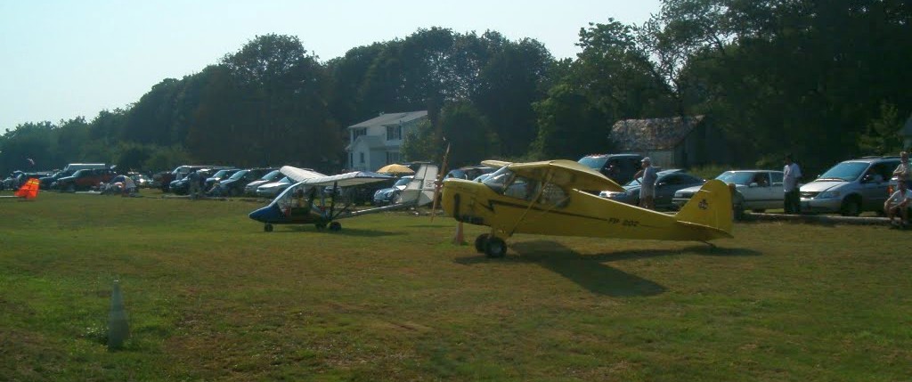
A circa 2002-2003 photo of Ray Jacobelli of his Flightstar II SL ultralight at Griswold Airport.
A circa 2002-2003 photo of Ray Jacobelli instructing as BFI with student Roger Vines in Ray's Flightstar II SL ultralight at Griswold Airport.
Ray recalled, “This airplane could takeoff in 80' at 30MPH, climb 600FPM, cruise at 55 & max out at 64MPH, turn on a dime & make change,
land on a football field to a complete stop by the 40 yard line, burn 4.5 gals of MOGAS/hr.”
According to Wikipedia, “In the fall of 2003, the developer (renamed LeylandAlliance), submitted a revised proposal to build 131 units.
In May 2004, the new proposal was approved by the PZC.”
Brett Heuer recalled, “One of my fellow instructors landed there with a student, in 2004, so it was still open then.”
A circa 2005-2007 aerial view looking north showed one single-engine Cessna on amphibious floats at Griswold Airport.
The runway was still marked with active-runway markings, although noticeably deteriorated.
A paved ramp led to a small set of buildings & hangars, one of which appears to be falling in.
The FAA's Airport/Facility Directory indicated that in 2005 Griswold Airport conducted 3,000 takeoffs or landings, 100% of which were general aviation.
A 7/2/06 photo of a sign for Griswold Airport's Action Airlines.
Ironically the last photo to be located showing aircraft at Griswold Airport is also the one showing the most aircraft there:
a total of 4 light aircraft were visible in a 10/1/06 aerial view looking southwest.
As of 2007, the FAA A/FD listed the owner as Griswold Airport, Inc.
Griswold Airport was described as consisting of 42 acres which contained a single 1,863' asphalt Runway 6/24.
According to Wikipedia, “LeylandAlliance completed the purchase in February 2007.
The airport has been closed since the beginning of 2007.
According to the Hartford Courant, the owner sold the property to make way for a proposed 127-unit development for people 55 & older.”
A 2/4/07 photo by Matt Zwilling of the Griswold Airport hangar & office.
An undated photo of a Griswold Airport hangar.
A 2/25/08 photo by Craig LeMoult looking along the Griswold runway.
A 4/30/08 aerial view showed small closed-runway X symbols had been pained on either end of Griswold's runway.
The last photo to be located showing Griswold Airport to remain largely intact was an 11/29/10 aerial view looking north.
An October 2012 photo by Dan Potter of the Griswold Airport hangars.
Dan reported that the Madison Volunteer Fire Department conducted a live burn at the airport: “We burned the old owner's house for practice.
The hangars were still standing but were just bulldozed in the past weeks.”
An October 2012 photo by Dan Potter, “Looking down the torn-up runway toward the west end hangars with construction trucks in foreground.
All buildings are now down to the ground. It will be a town park now.”
Griswold Airport was no longer depicted on the April 2016 NY Sectional Chart.
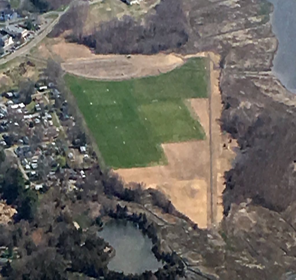
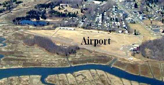
A 5/1/18 aerial view by Kevin Bachand looking northeast at the site of Griswold Airport.
The runway was still recognizable, but the area of the hangars had been replaced by athletic fields.
A 6/8/19 aerial view by Kevin Bachand looking south at the site of Griswold Airport,
with the former runway still recognizable to the left of the athletic fields which now cover most of the former airport.
The site of Griswold Airport is located south of the intersection of Boston Post Road & Cottage Road.
____________________________________________________
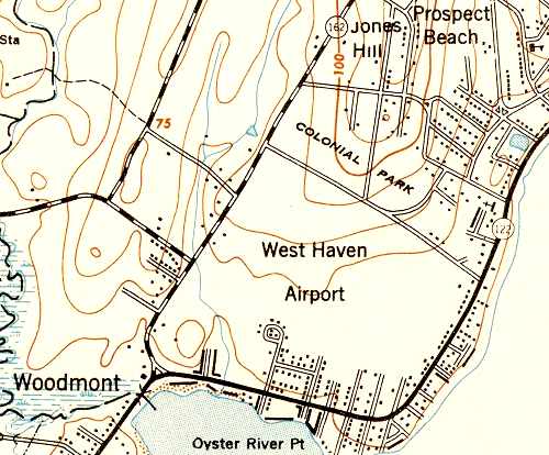
H & H Airport / West Haven Airport, West Haven, CT
41.24, -72.98 (Southwest of Hartford, CT)
A 1934 aerial view of West Haven Airport by the Fairchild Aerial Survey Company (courtesy of Chris Kennedy).
The airport in West Haven was established in 1925, according to the website of the Haley Elementary School (which eventually occupied the site of the airport).
The airport reportedly was a “small but bustling municipal airfield
that specialized in chartered commuter flights, flight instruction, freight service, and aerial photography.”
The earliest directory reference which has been located to an airport in West Haven
was in the 1931 "Airports & Landing Fields in New England" (courtesy of Chris Kennedy).
It described “H & H Airport” as being located “2 miles from West Haven”, but did not give any more specific location.
It was described as being an oblong sod field,
with 2 runways measuring 2,500' northwest/southeast & 1,000' north/south, and an 80' x 60' hangar.
H & H Airport was said to be a private field, operated by Chappy Lenox of the Lenox Brothers Flying Service.
The H & H Airport may have closed at some point between 1931-32,
as no airport in West Haven was depicted on the August 1932 NY Sectional Chart
or listed in The Airport Directory Company's 1933 Airport Directory (according to Chris Kennedy).
The earliest depiction which has been located of the airport in West Haven
was a 1934 aerial view, taken by the Fairchild Aerial Survey Company (courtesy of Chris Kennedy).
The airport may not have been operational at this point,
as there were no aircraft or other signs of activity on the field.
A single hangar was visible on the east side of the property.
No airport in West Haven was depicted on the June 1936 NY Sectional Chart.
The earliest chart depiction of West Haven Airport which has been located was on the January 1937 NY Sectional Chart.
It depicted West Haven as a commercial/municipal airport.
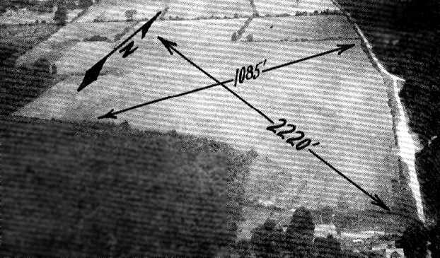
An aerial view looking northwest at West Haven Airport, from the Airport Directory Company's 1937 Airport Directory (courtesy of Bob Rambo).
The field had evidently been reopened under the name “West Haven Airport” at some point between 1934-37, as that is how it was listed in the directory.
It described West Haven as a commercial airport, being 66 acres in size.
The field was said to consist of a turf field, with 2 runways, measuring 2,220' east/west & 1,085' north/south.
A hangar was said to be marked with the field's name.
The 1945 NY Sectional Chart continued to depict West Haven as a commercial/municipal airport.
The 1947 USGS topo map depicted West Haven Airport as an open area, but did not depict any other features (no runways or buildings).
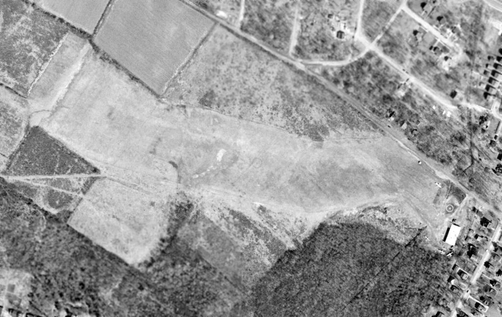
The only photo which has been located showing aircraft at the West Haven Airport was a 4/12/49 aerial view.
It depicted 4 single-engine aircraft parked around the hangar on the east side of the field.
The last chart depiction of West Haven Airport which has been located was on the January 1950 NY Sectional Chart,
which depicted West Haven as having a mere 1,800' unpaved runway.
The West Haven Airport was evidently closed (for reasons unknown) at some point in 1950,
as it was no longer depicted on the July 1950 NY Sectional Chart or the 1951 USGS topo map.
Haley Elementary School opened in 1952 on the west side of the airport property, according to the website of the Haley Elementary School.
A 1960 aerial photo showed that the former airport property had been covered by the school & a number of residential streets.
Many of the streets on the former airport property bear names which recall the former field,
like Compass Lane, Aircraft Road, Skyline Drive, Tower Road, Wing Tip Road, etc.
The 1991 USGS aerial photo showed no remaining trace of the former airport.
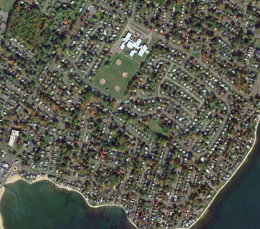
A 2014 aerial view showed not a trace still remains at the site of West Haven Airport.
The site of West Haven Airport is located south of the intersection of South Street & Aircraft Road.
____________________________________________________
Stephenson Field / Bristol Airport, Bristol, CT
41.66, -72.914 (Southwest of Hartford, CT)
Bristol Airport, as depicted on the Boston Chamber of Commerce's
1931 "Airports & Landing Fields of New England" (courtesy of Chris Kennedy).
The date of construction of this former small general aviation airport has not been determined.
The earliest depiction of Stephenson Field which has been located
was in the Boston Chamber of Commerce's 1931 "Airports & Landing Fields of New England" (courtesy of Chris Kennedy).
It described Stephenson as a commercial field.
The field was said to consist of a 30-acre T-shaped turf field, measuring 2,000' x 1,700',
having 4 runways, of which the longest was the 1,950' northwest/southeast strip.
The field was said to have a 60' x 50' hangar.
The commercial operator was the Reliable Flying Service, Inc., and the manager was Gordon Warner.
The Pilots Handbook Publishing Company's 1931 Pilots Handbook (courtesy of Chris Kennedy)
described Stephenson Field as being 1,900' x 1,500' in size.
The earliest aeronautical chart depiction which has been located of Stephenson Field was on the August 1932 NY Sectional Chart.
The Airport Directory Company's 1933 Airport Directory (courtesy of Chris Kennedy)
described Stephenson as a commercial airport, being 90 acres in size.
The field was said to consist of a turf field, measuring 1,475' north/south by 1,380' east/west, and it was said to have a hangar.
A 1934 aerial view of Stephenson Field, taken by the Fairchild Aerial Survey Company (courtesy of Chris Kennedy).
It depicted the field as having a single hangar on the south side, around which were visible 2 aircraft.
An aerial view looking north at Stephenson Airport,
from the Airport Directory Company's 1938 Airport Directory (courtesy of Chris Kennedy).
The directory described Stephenson as a commercial airport consisting of a 52 acre rectangular field, measuring 2,280' north/south.
A single hangar & some other small buildings were depicted along the east side of the field.
An aerial view looking northwest at Stephenson Airport,
from the Airport Directory Company's 1941 Airport Directory (courtesy of Chris Kennedy).
The directory described Stephenson as a commercial airport consisting of a 52 acre rectangular field, measuring 2,280' north/south.
A single hangar & some other small buildings were depicted along the east side of the field.
Angelo Alessio Decrisantis noted, “In the lower left corner (corner of Middle Street & Redstone Hill Road) is my grandfather's farm, the Alessio Decrisantis family.”
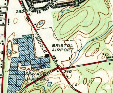
The 1941 USGS topo map did not depict Bristol Airport.
A 10/13/41 USGS aerial view depicted the Bristol Airport as having an irregularly-shaped outline, with 2 small buildings along the road on the southwest corner of the field.
Stephenson was depicted as a commercial / municipal airport on the March 1943 NY Sectional Chart (courtesy of Chris Kennedy).
Angelo Alessio Decrisantis recalled, “Lots of family memories about the airfield. I recall going there as a youngster with my dad before it was closed & the Superior Electric plant was built. Cool place!
Around 1943 a Lockheed P-38 Lightning overshot its landing heading south, ran across Redstone Hill Road & into my grandfather's farmland (photo & story in the Bristol Press).
The Army sent a squad of armed guards to guard the aircraft for several days (setting up tents & perimeter fence) until it could be removed.
They covered it with tarps so no one could see it. They would not let my family near the plane as the P-38 was a top-secret aircraft at the time unknown to the general public.
My aunt tells me the guards were very friendly, but insisted she stay away from the area. They used to give her some candy everyday.”
The Haire Publishing Company's 1945 Airport Directory (courtesy of Chris Kennedy)
described Stephenson Field as a "class s-1" field, owned by Bristol Flying Field, Inc., operated by Aviation School, Inc.,
and listed the manager as H. E. Darling.
The field was said to have 3 sod strips, with the longest being the 1,600' north/south strip, and it was said to have 3 hangars.
The 1946 USGS topo map depicted the Bristol Airport
as having an irregularly-shaped outline, with 3 small buildings along the road on the southwest corner of the field.
The 1954 USGS topo map no longer depicted the Bristol Airport,
but continued to depict the 3 small buildings along the road on the southwest corner of the field.
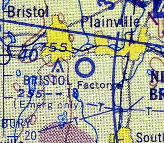
The January 1955 NY Sectional Chart (courtesy of Chris Kennedy)
still depicted Bristol as an active airfield, although with the note "Emergency only".
It was depicted as having an 1,800' unpaved runway.
The 1956 USGS topo map no longer depicted the Bristol Airport,
but continued to depict the 3 small buildings along the road on the southwest corner of the field.
The Bristol Airport was evidently closed (for reasons unknown) at some point between 1955-58,
as it was no longer depicted at all on the January 1958 NY Sectional Chart (according to Chris Kennedy).
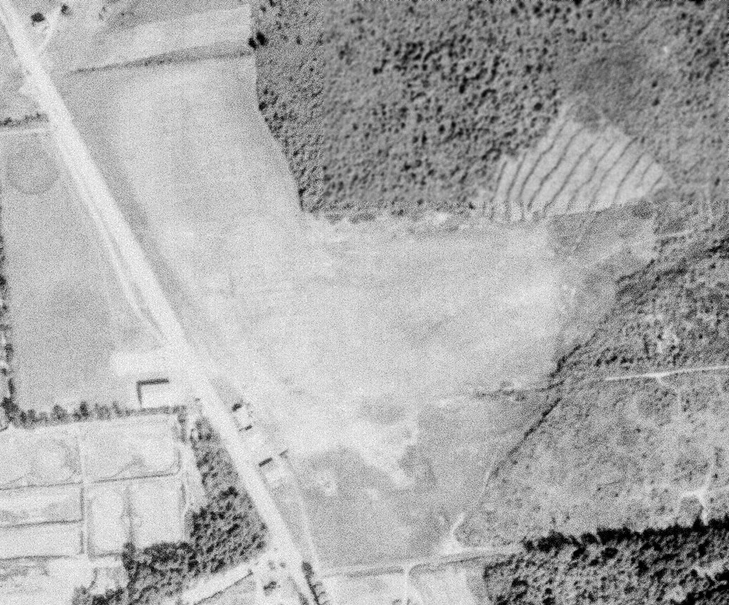
A 1965 aerial photo depicted a large building having been constructed over the site of Bristol Airport, erasing any trace of the airport.
According to Doug Kern, the “factory belonged to Superior Electric, which eventually grew to 400 employees & was one of Bristol's biggest claims to fame.
Superior finally left town in 2001; ESPN & others then rented out various amounts of space in the building until the network eventually bought up the whole thing in either 2010 or 2011.”
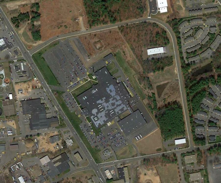
A 2016 aerial photo showed the ESPN facility covering the site of Bristol Airport.
The site of Bristol Airport is located north of the intersection of Route 229 & Redstone Hill Road.
____________________________________________________
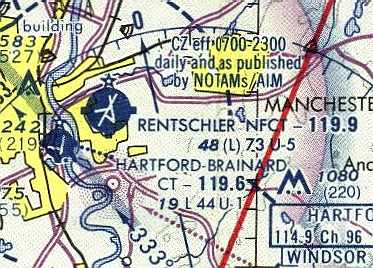
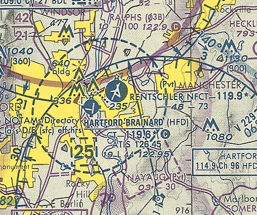
Rentschler Field (EHT), Hartford, CT
41.75, -72.62 (East of Hartford Brainard Airport)
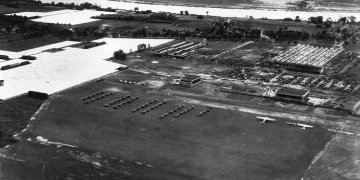
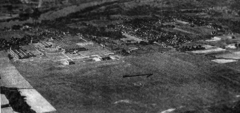
An aerial view looking southwest at Rentschler Field during its 5/24/31 dedication,
showing several dozen aircraft on the grass airfield, with hangars & factories to the west.
Rentschler Field was the factory airfield for the Pratt & Whitney aircraft engine company.
According to Pratt & Whitney, “Rentschler Field was dedicated in 1931, several years after work first began on the $450,000 hangar complex, runway and associated facilities.
The field covered 165 acres and was of grass, not concrete. According to one report, it took 11 tons of grass seed to create the field, and drainage was engineered with 5 miles of perforated pipe.
High-ranking officials at every level of government flocked to the gala event on 5/24/31, and attended by a crowd of 15,000.”
Army airplanes put on a flight demo, colorfully described by the Hartford Courant as "A display of bird-like acrobatics unprecedented in Connecticut."
Politicians & military officers paid tribute to Pratt & Whitney for its contributions to aviation & national security, and to the "genius" of United Aircraft & Transport Chairman Fred Rentschler.
The earliest aeronautical depiction which has been located of Rentschler Field was on the August 1932 NY Sectional Chart.
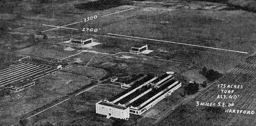
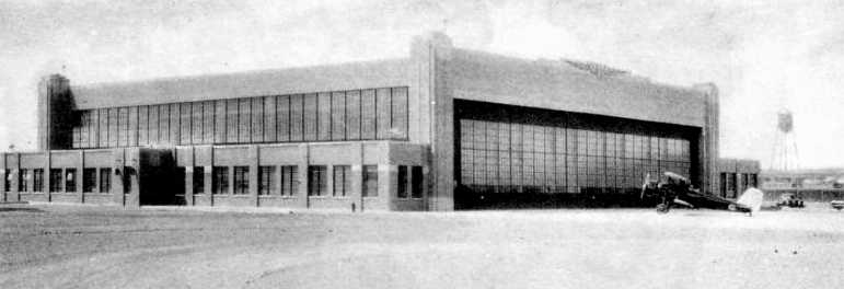
An undated aerial view looking northeast at Rentschler Field from from The Airport Directory Company's 1933 Airports Directory (courtesy of Chris Kennedy).
It also depicted the large Pratt & Shitney factory buildings in the foreground.
The Airport Directory Company's 1933 Airports Directory (courtesy of Chris Kennedy) described Rentschler Field as consisting of a 2,700' x 2,500' turf landing area.
The manager of Rentschler Field was listed as B.L. Whelan, and the operator was American Airways, which provided scheduled transport along the New York - Boston route.
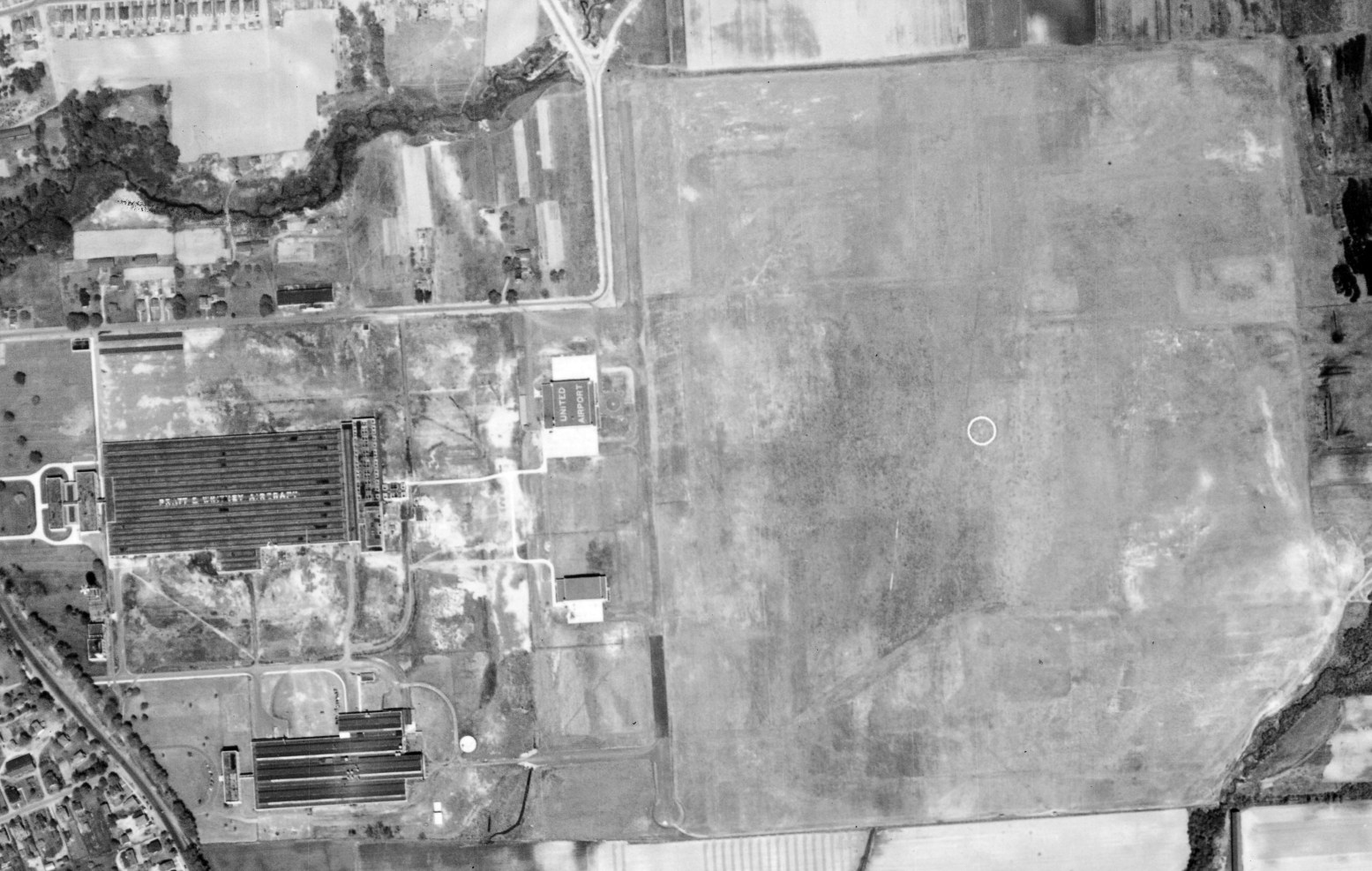
A 1934 aerial view of Rentschler Field, taken by the Fairchild Aerial Survey Company (courtesy of Chris Kennedy).
It depicted the field as consisting of a square grass field, along the west side of which was located a hangar marked “United Aircraft”, and a large factory marked “Pratt & Whitney Aircraft”.
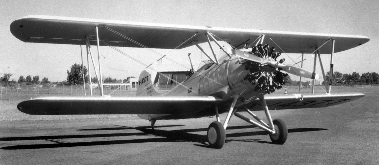
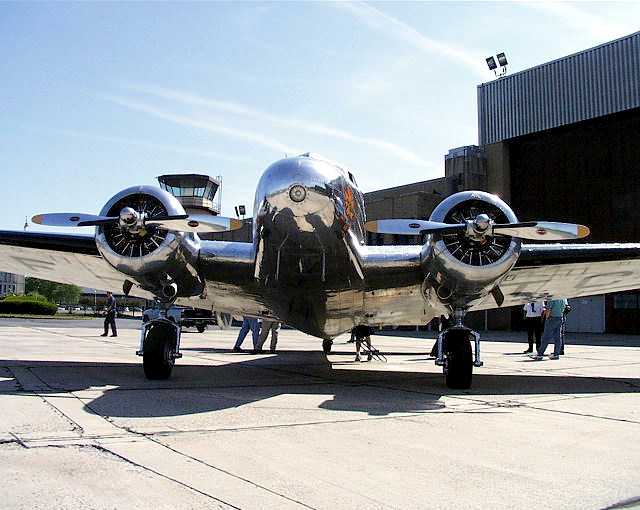
An 8/30/34 photo of the sole Vought V-100 Corsair Junior, C/n 1923 NX14377, at Rentschler Field.
The V-100 was a trainer aimed at export markets, with a 400hp Pratt & Whitney Wasp Junior. But no sales transpired, and its registration was canceled in November 1934 as "destroyed".
The 1934 Department of Commerce Airport Directory (according to Chris Kennedy) described Rentschler Field as being a 2,750' x 2,500' rectangular sod field, with a hangar with "United Airport" painted on the roof.
An aerial view looking west at Rentschler Field from The Airport Directory Company's 1937 Airports Directory (courtesy of Bob Rambo),
showing the grass airfield, hangars, and the Pratt & Whitney factories.
The directory described Rentschler Field as consisting of a 2,700' x 2,500' sod landing area.
Airline service was listed as being provided by American Airways.
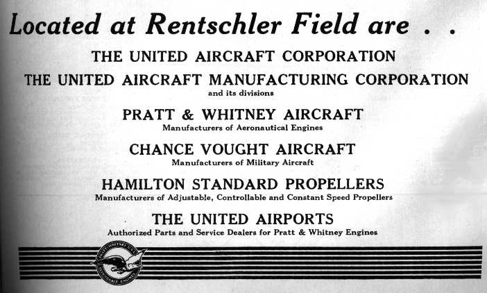
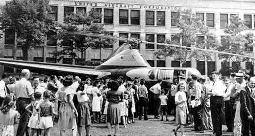
An advertisement for the companies of the United Aircraft Corporation at Rentschler Field,
from The Airport Directory Company's 1937 Airports Directory (courtesy of Bob Rambo).
The earliest photo which has been located of an aircraft at Rentschler Field was a circa 1938 photo of a hangar along with an unidentified biplane.
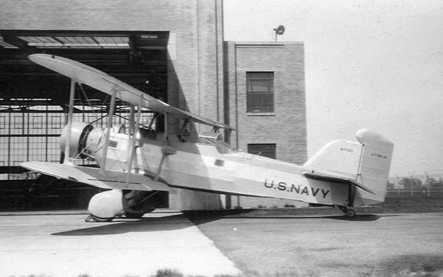
A circa late 1930s photo by Luer Drewes of the Navy's modified 2nd example of the Douglas XT3D biplane which appears to be in front of a Rentschler Field hangar (courtesy of Luer Drewes Jr.).
A 1996 Army Corps of Engineers report mentioned that Rentschler was used as a temporary Army fighter base in 1941.
Rentschler Field, as depicted on the November 1942 NY Sectional Chart (courtesy of Ron Plante).
The 1944 US Army/Navy Directory of Airfields (courtesy of Ken Mercer)
described Rentschler Field as having a 3,500' hard-surfaced runway,
but the remarks included, "4,000' northeast/southwest strip available."
A 1946 USAAF KS-NY Pilot's Handbook (courtesy of Chris Kennedy)
depicted Rentschler Field as having 3 paved runways,
with the longest being the 5,800' Runway 18/36.
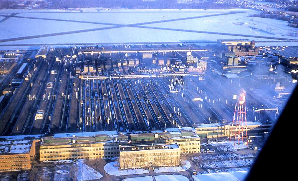
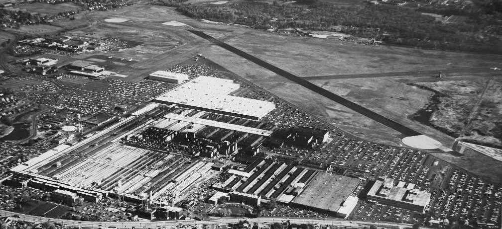
A 1949 aerial view looking southwest at Rentschler Field (courtesy of Chuck Eisenhardt),
showing at least 6 planes in the foreground, and the massive Pratt & Whitney factory in the background.
Chuck Eisenhardt observed, “You can see the Wilgoos Labs in the upper left, near the river, named for Andy Wilgoos.
This is where they moved the majority of the static test stands.
Also, just across the river, you can see the neighboring Brainard Field in Hartford. Pilots often landed in the wrong place!”
Chuck Eisenhardt recalled, “I grew up in East Hartford, we moved there in 1950 from Hartford when I was not yet a year old.
My Dad was the General Foreman of the carpenters, and later had all of Plant Engineering.
He still kept his office in the Carpenter's Shop on Willow Street.
Growing up in East Hartford in the 1950s would have been like growing up in Canaveral in the 1970s & 1980s,
in the middle of the most game-changing technology of the time.
I think they used the B-45 as a flying testbed. I can still hear it flying over the back yard.”
A 5/8/52 aerial view of Rentschler Field depicted the field as having 3 paved runways, with 2 aircraft visible parked near the hangar on the northwest side.
An aerial view looking northeast at Rentschler Field,
from the 1956 CT Airport Directory (courtesy of Stephen Mahaley).
The directory described Rentschler Field as having 3 paved runways, with the longest being the 5,800' Runway 18/36.
The operator was listed as United Aircraft Corporation.
A photo (courtesy of Bill Bradshaw) of “an S-51 Helicopter at PWA 400 Main Street during an open house they had sometime in the late 1950s.”
Bill Bradshaw recalled, “I grew up in East Hartford, right on the airport boundary fence of Rentschler Field.
We just called it Pratt & Whitney.
I lived on 113 Risley Street which was in the landing path of then Runway 14.
In years past it was Runway 13/31 but changed in the 1950s to Runway 14/32 due in part to the magnetic variance.
There was a great amount of activity at that airport & it was the deciding factor in my interest & career in aviation.
At one time for a while the East/West taxiway was used as a runway in the late 1950s / early 1960s as Runway 9/27.
I know this by the landing & departures that took place which were right over my house.
During the summer vacations from school I used to ride my bike to 400 Main Street
and watch the S-51 helicopters land in the morning & afternoon that would drop off & pick-up Mr. Horner, the President of PWA.
One day the pilot asked me if I would like to sit in the pilots seat, dog wanna bone, I was hooked on aviation ever since.
There were a great many aircraft at Rentschler:
CV-340, DC-3, BE-18, HU-16, L-14/18, S-51, B-17, B-45; these were at experimental.
I later became friends with the pilot of the B-17 & B-45 - Harry Beech, a real fine person.”
Bob Melusky recalled, “Rentschler... I know someone that grew up in the projects next to the airport
and he remembers when an early B-52 that came in for repairs took off & clipped the only TV antenna in the neighborhood off the roof of the house.
They stripped off the weight they could, modified the flaps & loaded just enough fuel to make it to Bradley.”
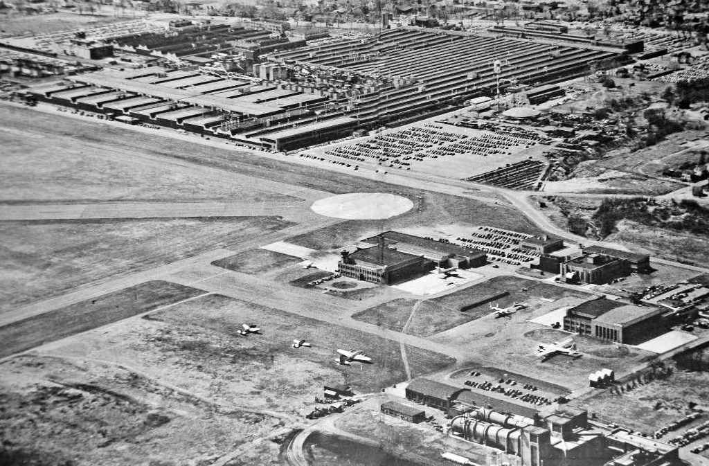
A January 1960 aerial view by Bob Parrick looking east at the massive Pratt & Whitney factory, with Rentschler Field in the background.
A 1962 aerial view looking northeast at Rentschler Field (courtesy of Chuck Eisenhardt),
showing massive Pratt & Whitney factory in the foreground, and at least 3 planes visible on the ramps in the background.
Rentschler was listed among active airports in the 1962 AOPA Airport Directory with 3 paved runways, and the operator listed as "Pratt & Whitney".
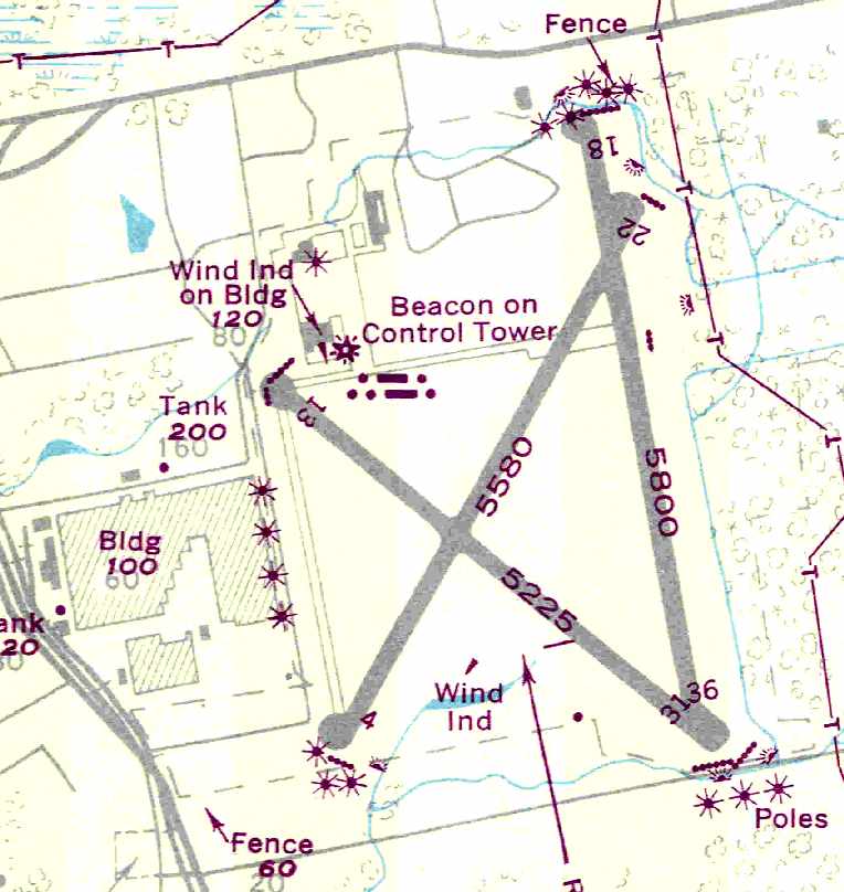
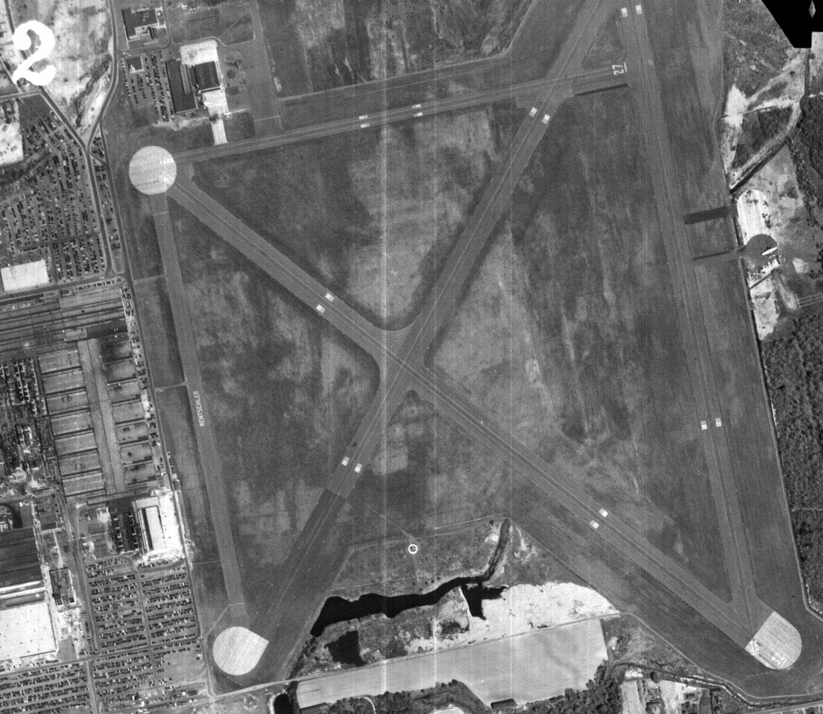
The 1965 NY Sectional Chart (courtesy of John Voss) depicted Rentschler Field as having a total of 4 runways, with the longest being 5,400'.
A 1965 aerial view of Rentschler Field (from the CT State Library, via Chris Kennedy)
showed the field to still have 3 active runways.
showed a total of 6 twin-engine aircraft on the northwest side of the field, including one DC-3.
Chuck Eisenhardt recalled, “I worked there a couple of summers - a kitchen utility worker in 1965 & in 1967 at 816 Final Assembly on the line with JT8D & J-75 builds.”
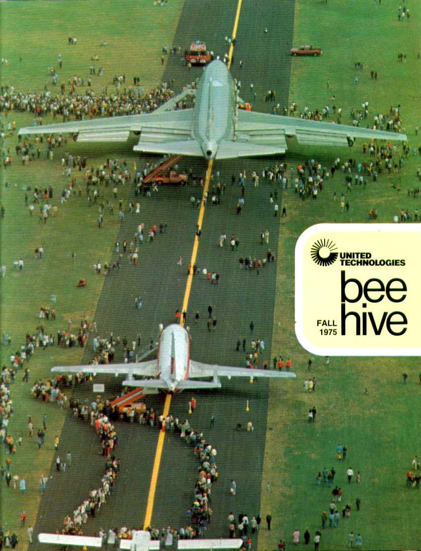
The Fall 1975 issue of the United Technologies Bee-Hive magazine featured an article about the 50th anniversary celebrations at Rentschler,
and the cover photo, showing tours of a 747 & 737, presumably was taken at Rentschler.
The 1975 NY Sectional Chart (courtesy Mike Keefe) depicted Rentschler Field as having a 7,300' paved runway & a non-federal control tower.
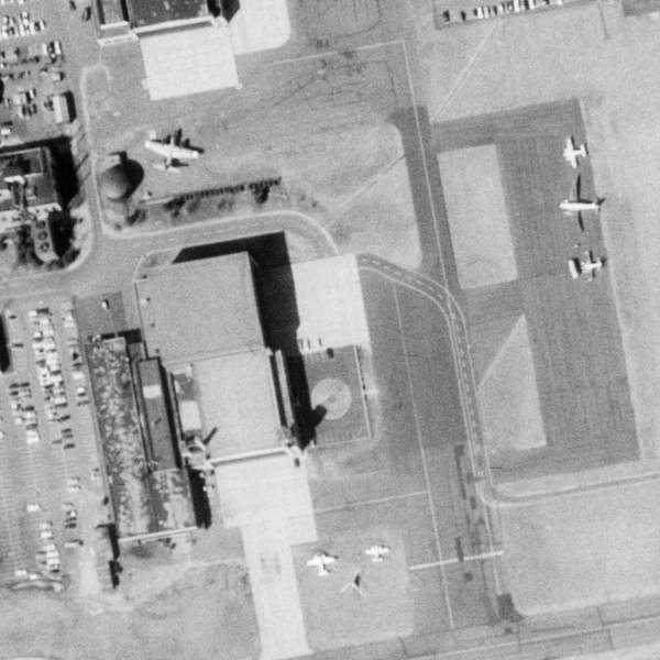
A 1990 aerial view showed a total of 7 planes on the Rentschler Field ramp, including 2 swept-wing business jets & 2 helicopters.
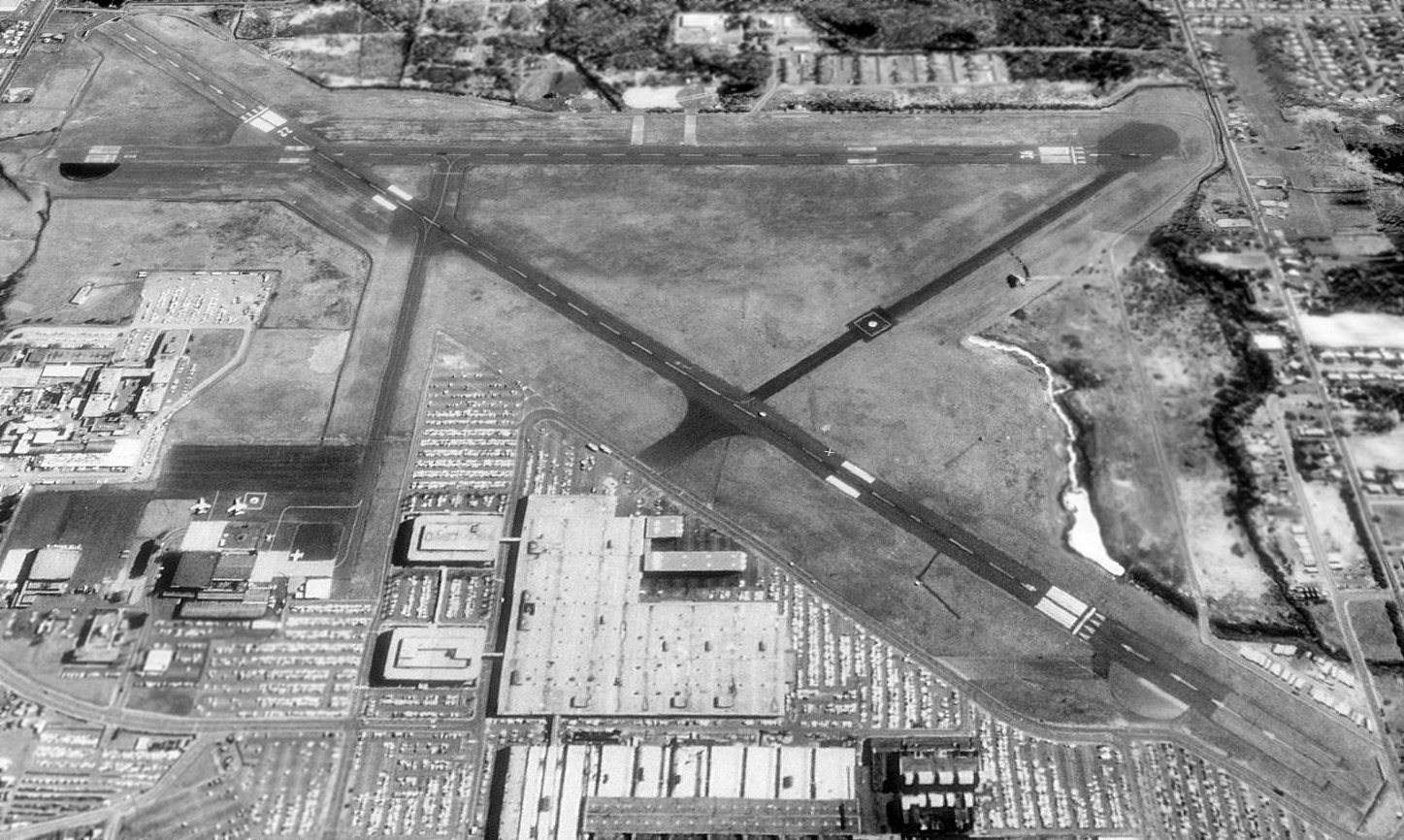
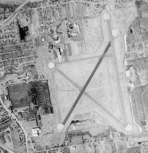
At the time of a 1992 USGS aerial view looking east, Rentschler Field still had 2 active runways: 4/22 & 18/36.
Two swept-wing jets were visible on the ramp on the left (northwest side of the field).
The last aeronautical chart depiction which has been located of Rentschler Field as an active airfield
was on the December 1993 NY Sectional Chart (courtesy of Ron Plante).
It depicted Rentschler as a private airfield having 4 paved runways, with the longest being 7,300', and a privately-operated control tower.
According to Wikipedia, the Rentschler Field airfield was decommissioned in 1995.
Rentschler Field was depicted as an abandoned airfield on the 1997 World Aeronautical Chart.
A 6/10/98 photo by Chris Clements of a beautifully-restored Trans Canada Airlines Lockheed 10A Electra
which visited Pratt & Whitney at Rentschler Field.
Note: this visit was evidently after the airfield had formally closed.
According to Wikipedia, the Rentschler Field airfield property was donated to the state of Connecticut in 1999.
Bill Bradshaw recalled, “I was invited to PWA about 8 years ago [2002] and their Library archive has many photos of their existence with the aircraft.”
At some point between 1994-2003, a portion of the former airport was redeveloped as Rentschler Field,
the University of Connecticut's new football stadium.
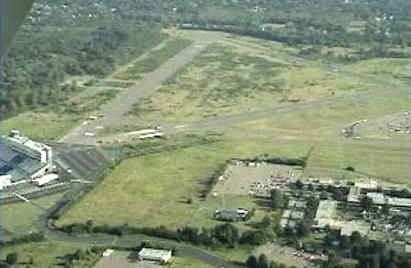
A 2003 aerial view by Jeff Franklin of the remaining runways at Rentschler Field, with the new UConn stadium on the left.
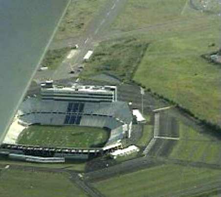
A 2003 close-up aerial view by Jeff Franklin of the new UConn stadium which has been built over a portion of the former Rentschler Field.
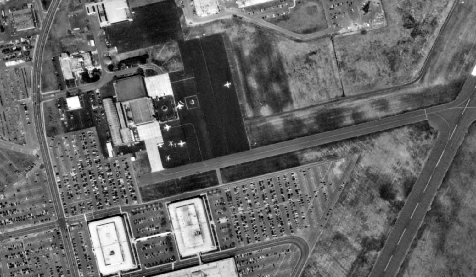
As of 2006, the only remaining aviation use on the site was the Rentschler Heliport, a private facility operated by Pratt & Whitney.
John Marchesseault reported in 2007, “Brainard Airport (an active airport a very short distance away) has a runway at about the same heading.
A pilot friend of mine was telling me it was not uncommon for pilot unfamiliar with the area to land at the wrong airport!
Last summer a pilot from Westchester NY did exactly that!
Apparently not noticing the giant 'X' on the runway... or the football stadium at the other end.
It was discovered by a Fire marshal at a meeting in one of the stadium offices.
In the middle of the meeting he saw the plane on final & for a short time it hit the fan.
The plane landed safely & took off again, returning to NY.”
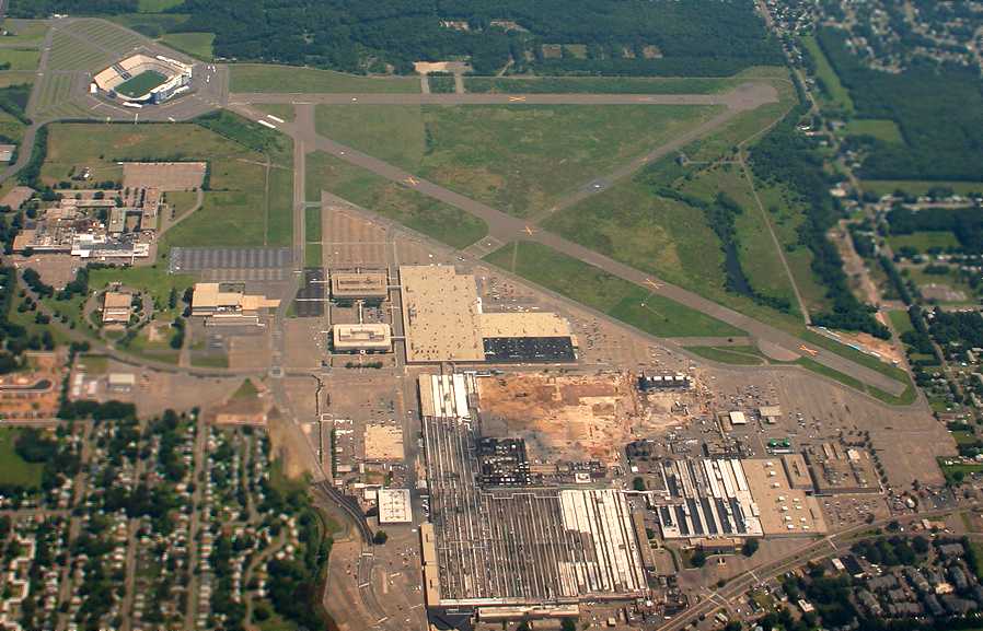
A 7/29/06 aerial view by John Jaucher looking east at the remaining runways at Rentschler Field,
with the new UConn stadium at top-left, and the Pratt & Whitney factory in the foreground.
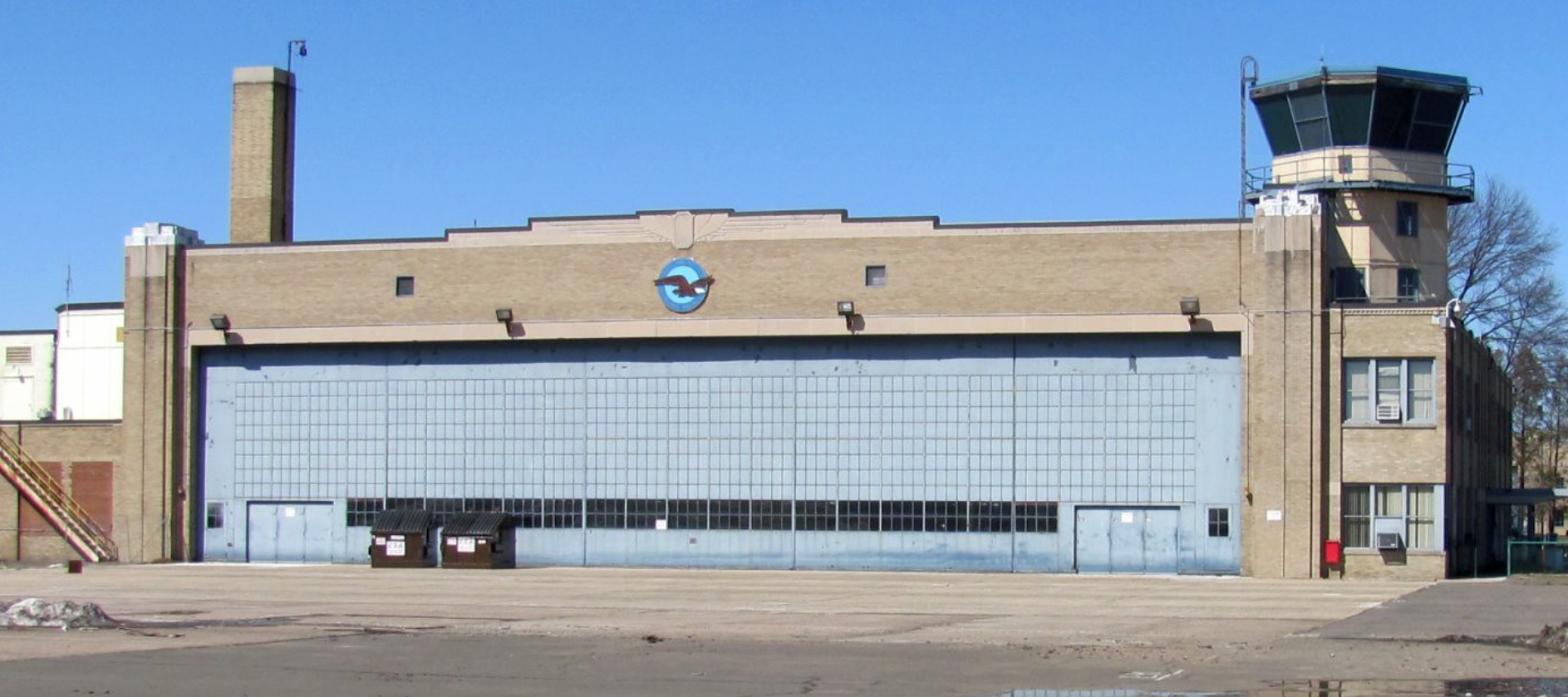
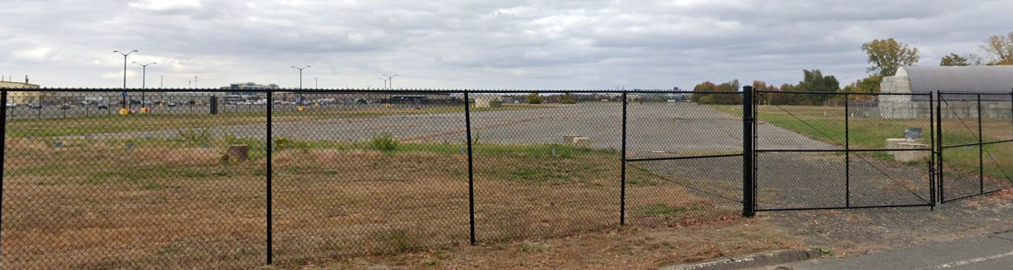
A 3/27/11 photo of a Rentschler Field hangar with a control tower on the corner.
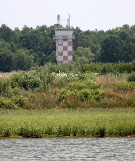
A 7/8/12 photo of the Rentschler Field control tower.
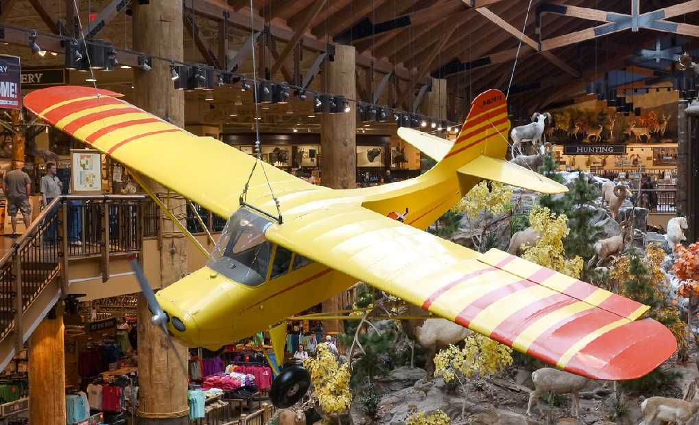
A 7/28/12 photo by Dan Vincent of an Aeronca 7AC Champion which hangs in the middle of the Cabela's sporting goods store
which was built on the site of the intersection of Rentschler Field's Runways 4/22 & 18/36.
Dan observed, “This Champion greets visitors as they walk in to the store to remind them of the history of aviation that the store stands upon.”
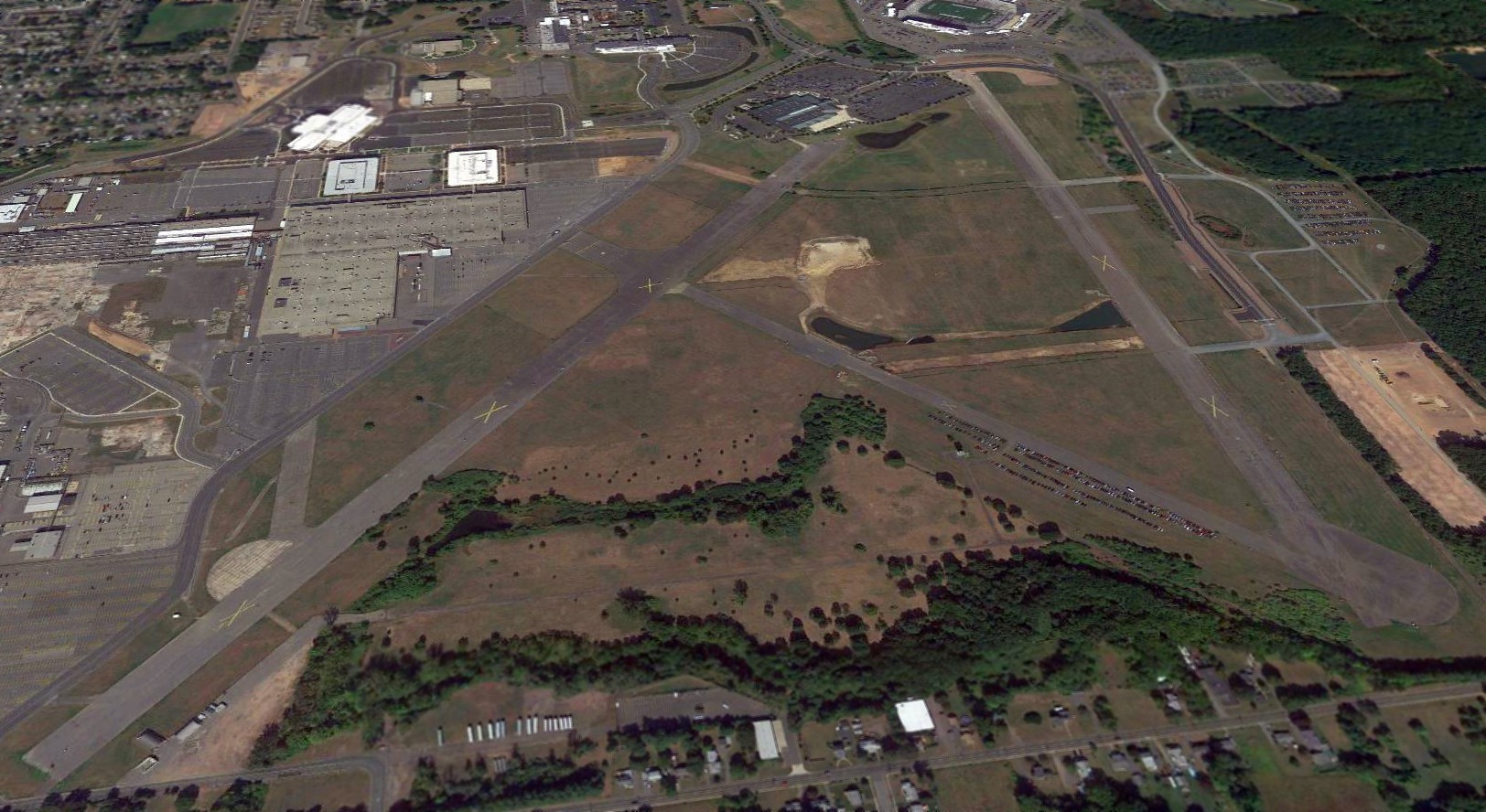
A 2017 aerial view looking north at the remaining runways at Rentschler Field.
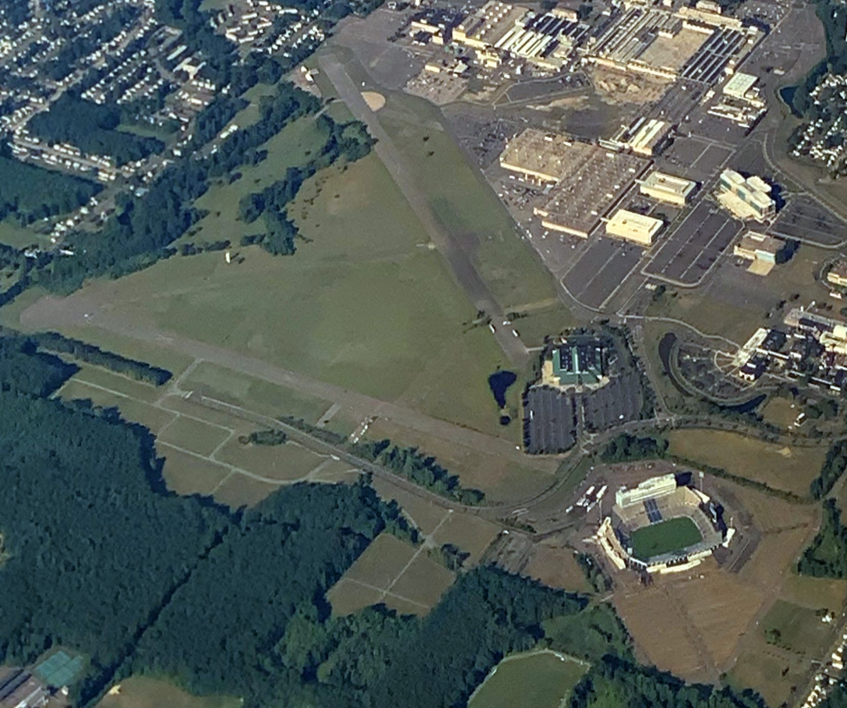
A 7/14/20 aerial view by Mike Rademacher looking southwest at the remaining runways at Rentschler Field.
A 2020 photo looking northeast along the remains of Rentschler Field's Runway 4.
An October 2020 photo looking west at Rentschler Field's Pratt & Whitney Hangar Museum, with a control tower on the corner.
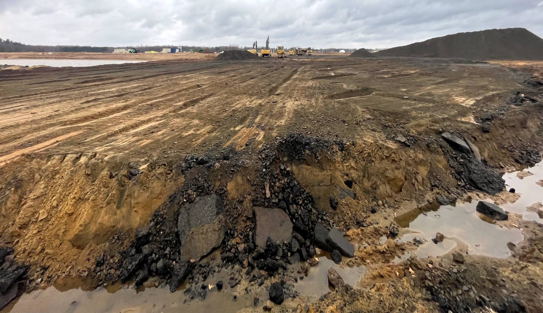
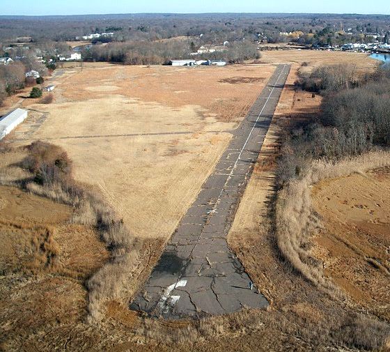
A 3/25/23 photo by Alex Neisloss looking at the site of Rentschler Field's Runway 4/22.
Alex reported, “The remainder of Rentshler Field's Runway 4/22 has been removed.
There is a very large pile of millings on the south side of the field towards the Runway 4 side which is presumably what’s left of Runway 4/22.
The remainder where the grass was on either side is graded off & the last runway still remains on what looks to be very borrowed time with milling machines, excavators & loaders staged on the remaining runway.”
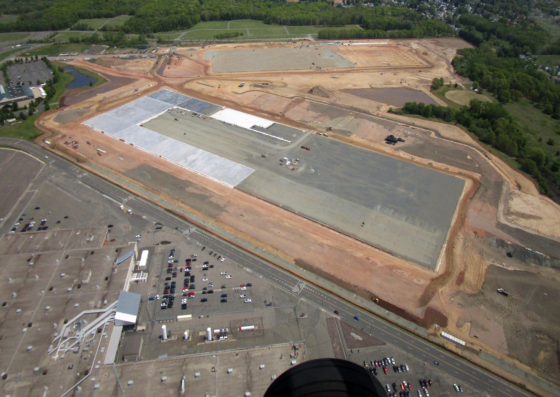
A 5/10/23 aerial view by Carl Stidsen looking east (courtesy of Thomas Morehouse) showing construction of a "logistics & technology" park obliterating the former Rentschler Field runways.
Thomas Morehouse noted, “Sic transit gloria mundi.”
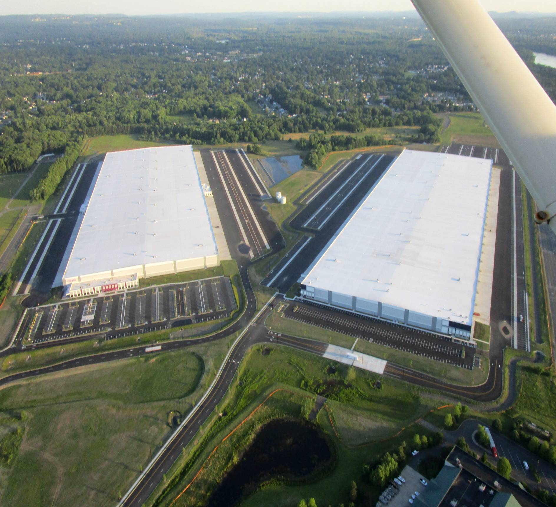
A 6/1/24 aerial view by Carl Stidsen looking south, which Thomas Morehouse observed, shows “the sad end of Rentschler field. Now covered with warehouses. What a fascinating - and historic - life those runways had.”
A 2024 3-D aerial image looking northwest at the former Rentschler Field control tower & a taxiway.
Thanks to Andy McKee for information about Rentschler Field.
____________________________________________________
Or if you prefer to contact me directly concerning a contribution (for a mailing address to send a check),
please contact me at: paulandterryfreeman@gmail.com
If you enjoy this web site, please support it with a financial contribution.
____________________________________________________
This site covers airfields in all 50 states.