
Abandoned & Little-Known Airfields:
California: Northeastern Sacramento area
© 2002, © 2025 by Paul Freeman. Revised 1/6/25.
This site covers airfields in all 50 states: Click here for the site's main menu.
For a 10th year, the CA pages of this website are sponsored by the California Pilots Association:
____________________________________________________
Please consider a financial contribution to support the continued growth & operation of this site.
Baldani Airfield (added 3/29/22) - Del Paso Airport / Lingbergh Field (revised 11/1/16) - Fair Oaks Airport (revised 1/6/25) - North Sacramento City Airport (revised 2/1/22)
Phoenix Field / Fair Oaks Airport(revised 1/6/25) - Skyridge Airport (revised 1/6/25)
____________________________________________________
Baldani Airfield, East Sacramento, CA
38.57, -121.436 (East of Downtown Sacramento, CA)
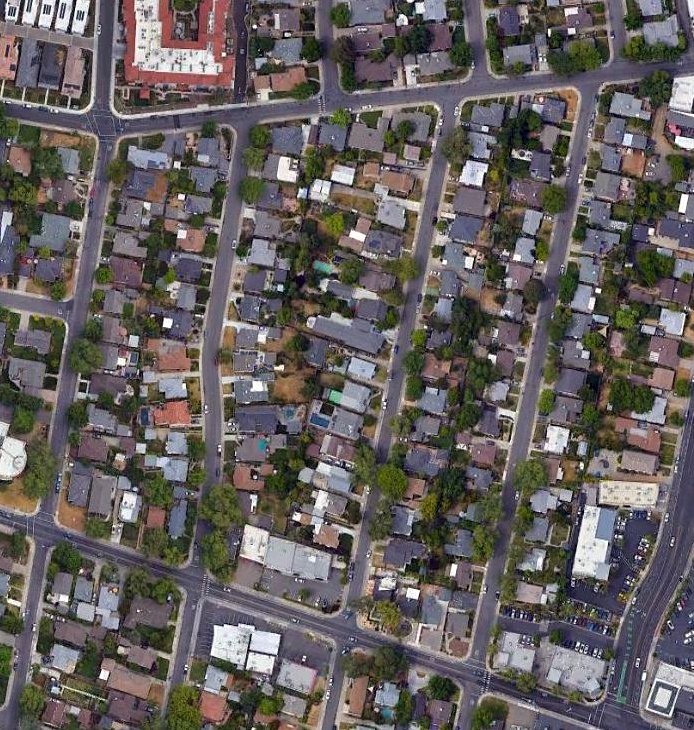
The site of Baldani Airfield, as seen in a 2021 aerial photo.
Photo of the airfield has not been located.
Howdy Hoover reported, “I've talked to a couple people in the Baldani family that owned the airstrip & the Baldani descendant that owns the hangar.
The owner said his wife’s grandfather came over from Italy in 1899 & bought a large parcel of land in East Sacramento.
The land was not yet developed & the dirt road north from J Street was called Baldani Road.
His son, Jack Baldani (1909-1999) built the hangar & smoothed the field for the airstrip.
The hangar is on the west side of 54th Street 3 houses south of F Street.
After WW1 Jack bought a Curtis Jenny which was being surplused out.
Around 5,000 of these trainers were still around & being sold for $200-$400.
The plane was flown to the airstrip & kept in the hangar.”
Howdy continued, “I was told the airstrip ran north/south & was just east of where 54th Street is now. I would estimate the length at 1,500’ or less.
This area was not developed until the 1940s so flying probably occurred in the late 1920s – 1930s.
The Jenny was sold to Red Jensen when developers closed down the strip.”
No airfield was depicted at this location on the 1936/39 Sacramento Sectional Charts.
Howdy Hoover reported, “The house in front of the hangar was built after WW2. Jack served in the Army in WW2 enlisting in 1944 at an older age of 35.”
No airfield was depicted at this location on the 1947 USGS topo map.
A 1947 aerial photo depicted the site of the Baldani Airfield having been covered by a dense block of houses.
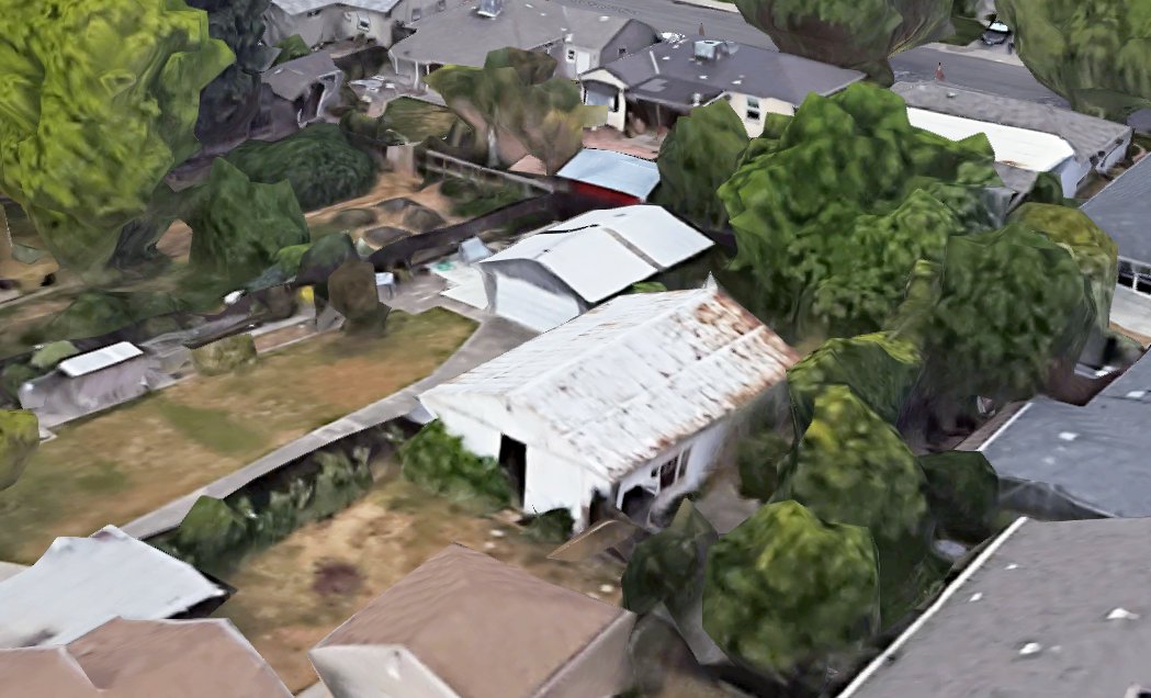
A 2022 3-D image looking southwest at the Baldani Airfield hangar.
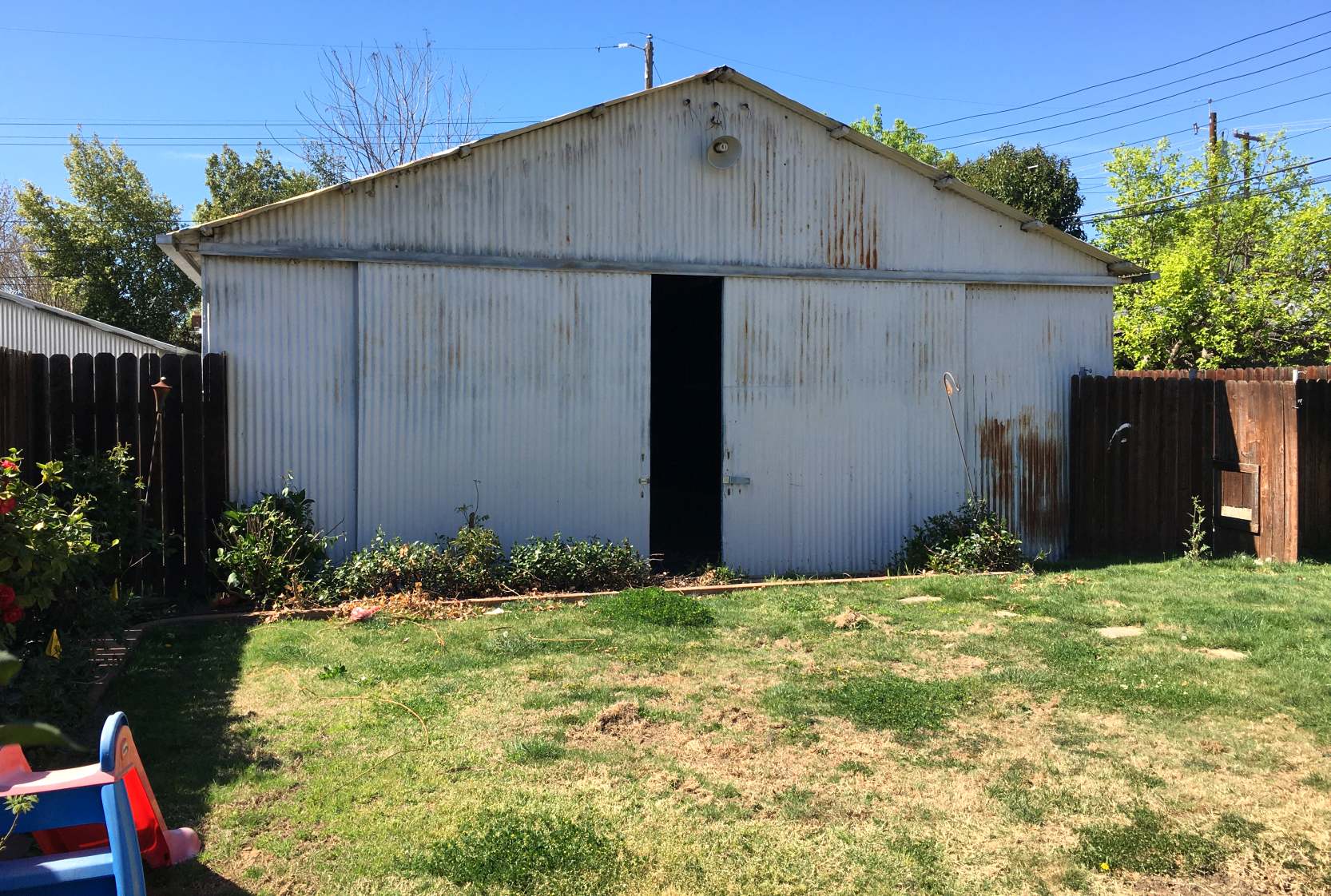
A 2022 photo by Harry Hoover of the exterior of the Baldani Airfield hangar.
Howdy Hoover reported, “For the last 75 years the hangar has been hidden behind a house in a deep lot.
Earlier this month the house was torn down to build a newer, bigger house. I saw the hangar & started asking questions.
The owner said the hangar will stay as long as he owns the property.
Luckily the hangar has survived all these years & hopefully will remain many more.”
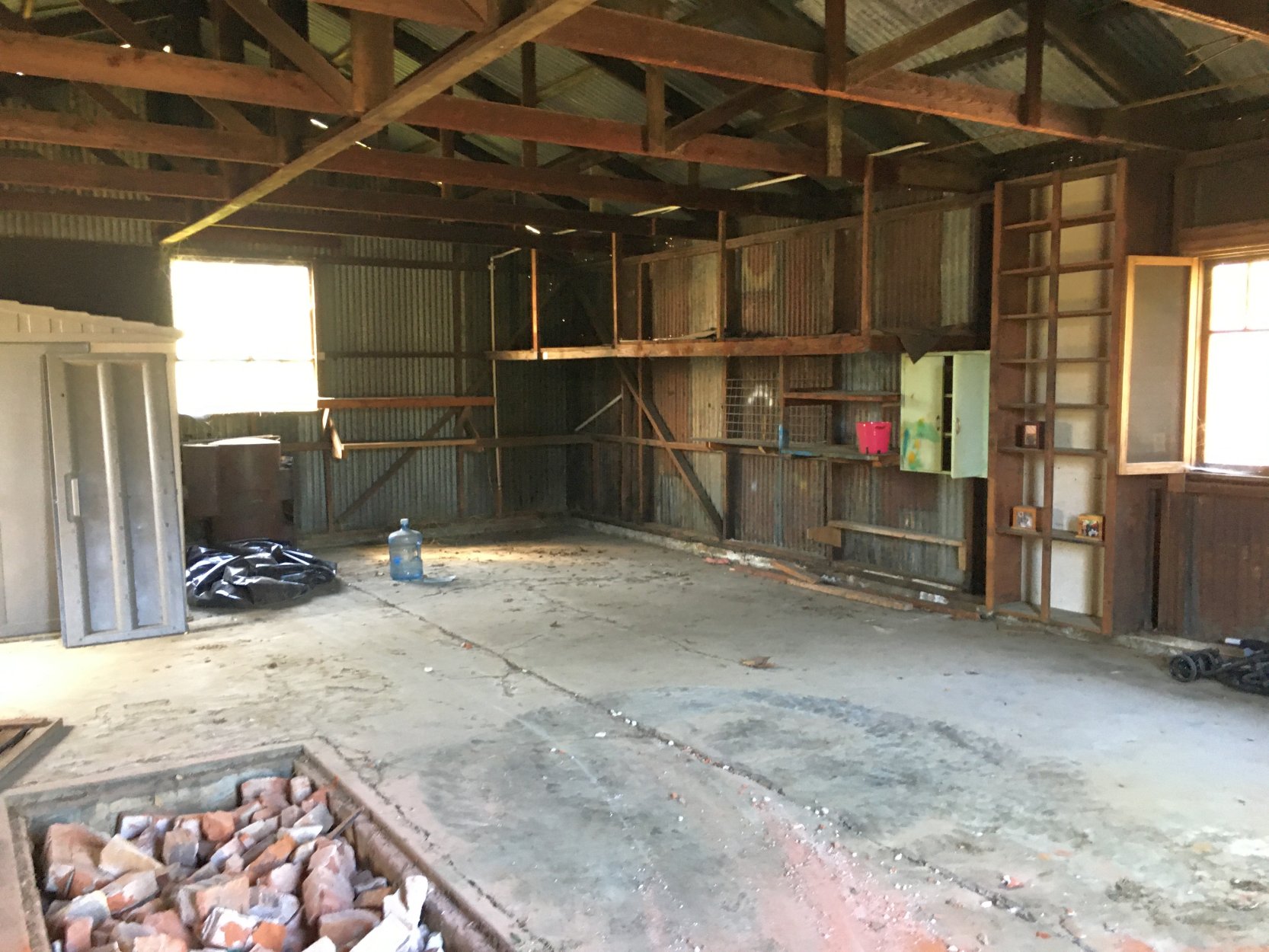
A 2022 photo by Harry Hoover of the interior of the Baldani Airfield hangar.
Howdy Hoover reported, “The hangar is basically unchanged inside, still being heated in the winter by an old wood stove Jack got out of an SP Railroad caboose.”
Thanks to Howdy Hoover for pointing out this airfield.
____________________________________________________
Del Paso Airport / Lingbergh Field, Sacramento, CA
38.639, -121.391 (Northeast of Downtown Sacramento, CA)
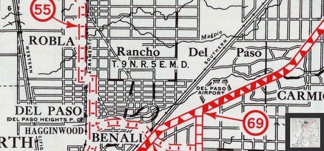
The only map depiction which has been located of Del Paso Airport was on a 1920s street map (courtesy of Dann Shively).
According to Dann Shively, “Del Paso Airport, sometimes referred to as Lindberg Field,
was a very early airport located on the property now occupied by Haggin Oaks golf course in the north part of Sacramento.
It was in operation during the 1920s. The main tenant, and possibly the only one, was Ingvald Fagerskog.
He built airplanes, taught students to fly, crop dusted, sold scenic rides, was an airplane dealer, and did maintenance.”
The earliest depiction which has been located of Del Paso Airport was on a 1920s street map (courtesy of Dann Shively).
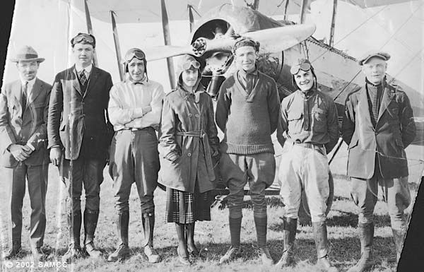
A circa 1920s photo of Del Paso Airport operator Ingvald Fagerskog & others, presumably taken at Del Paso Airport (courtesy of Dann Shively).
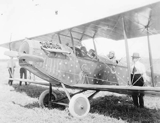
A circa 1920s photo of Del Paso Airport operator Ingvald Fagerskog & others with a JN-4 Jenny biplane, presumably taken at Del Paso Airport (courtesy of Dann Shively).
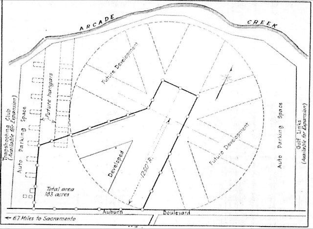
A map from the 7/19/28 Engineering News (courtesy of Dann Shively) a possible expansion of Del Paso Airport if it had been chosen for development as Sacramento's municipal airport.
That didn’t happen, as a site south of downtown Sacramento was chosen instead.
A 1929 CA Airport Guide (courtesy of Dann Shively) described the Sacramento Municipal Airport as being located 6 miles northeast of the State Capitol.
It was described as being a 1,500' x 1,500' L-shaped field, with am 1,800' northeast/southwest sandy clay soil runway, with 2 hangars on the east side.
Two hangars were said to be on the east side. The operator was listed as C.E. Morris.
The last reference which has been located to Del Paso Airport was its listing in the 9/1/31 Commerce Department Airway Bulletin.
It described Del Paso Airport as a commercial airport, located 6 miles northeast of the city.
It was described as being a 183 acre rectangular sod field, having two 1,800' runways oriented north/south & east/west.
According to Dann Shively, “Ingvald Fagerskog may have moved his operation to McClellan at some time as a photo is labeled as such.
Del Paso Airport was probably closed by the mid-1930s
as the large Pacific Air Terminal (later McClellan AFB) was established just north of that location in 1935.”
Del Paso Airport was no longer depicted on the May 1936 Sacramento Sectional Chart or the 1942 USGS topo map.
A 1947 aerial view shows the site of Del Paso Airport as an open field, but without any recognizable trace of an airfield.
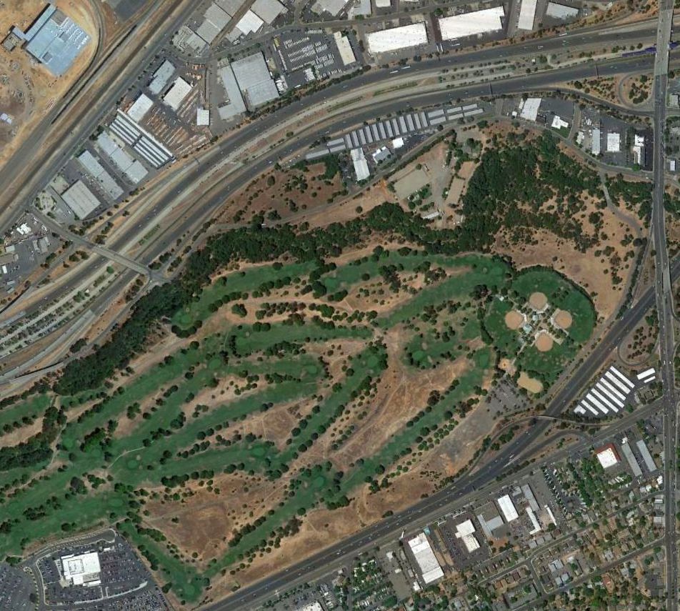
A 2016 aerial view shows the site of Del Paso Airport to be occupied by the Haggin Oaks Golf Complex & Del Paso Park.
The site of Del Paso Airport is located northwest of the intersection of Watt Avenue & Auburn Boulevard.
Thanks to Dann Shively for pointing out this airfield.
____________________________________________________
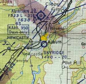
38.88, -121.07 (Northeast of Sacramento, CA)

The single runway of Skyridge Airport was labeled simply as “Landing Strip” on the 1953 USGS topo map.
According to Dann Shively (who obtained information from Gene & Marilyn Herrington),
"In 1938 contractor Greeley Herrington purchased 300 acres of property just south of where the Auburn fairgrounds now sit.
It overlooked the American River but was on 'the other side of the tracks', so he couldn't get financing from local banks.
He arranged to buy the property on time from the owners. By the end of WW2, the property was paid for.
Greeley moved his business to the area & continued heavy construction projects with an eye toward eventually developing the property.
Greeley was also a pilot & began building his own airstrip on the highest part of his property above his shop.
Since he owned a quarry he surfaced the runway with decomposed granite.
It took nearly 3 years to complete the airport. He, his son, some friends & eventually other pilots started using his strip."
Skyridge Airport was not yet depicted on the September 1953 Sacramento Sectional Chart.
The earliest depiction of Skyridge Airport which has been located was on the 1953 USGS topo map.
It depicted a single north/south runway (labeled simply as “Landing Strip”), along with 3 small buildings on the northwest side.

The earliest aeronautical chart depiction of Skyridge Airport which has been located was on the March 1954 Sacramento Sectional Chart.
It depicted Skyridge as a private field having a 2,300' unpaved runway.
The status of Skyridge Airport had apparently changed from private to public-use at some point between 1954-61,
as that is how it was depicted on the 1961 Sacramento Sectional Chart (courtesy of Dann Shively).
The field was depicted as having a 2,000' unpaved runway.
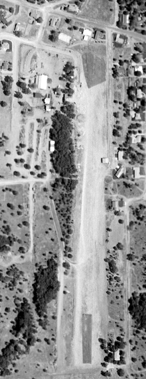
An 8/2/62 aerial view of Skyridge Airport (courtesy of Bill Calmes of Cartwright Aerial Surveys, Inc.)
depicted the field as having a single unpaved north/south runway.
But it was not apparent if the field was still in use by that point, as there were no aircraft visible on the field.
Skyridge Airport was apparently closed at some point between 1961-65,
as it was no longer depicted on the June 1965 Sacramento Sectional Chart (courtesy of Ron Kunse).
According to Dann Shively, "Greeley Herrington's dream of developing the area eventually was fulfilled.
By 1968 there were houses covering most of the property & the airport was closed to make room for more."
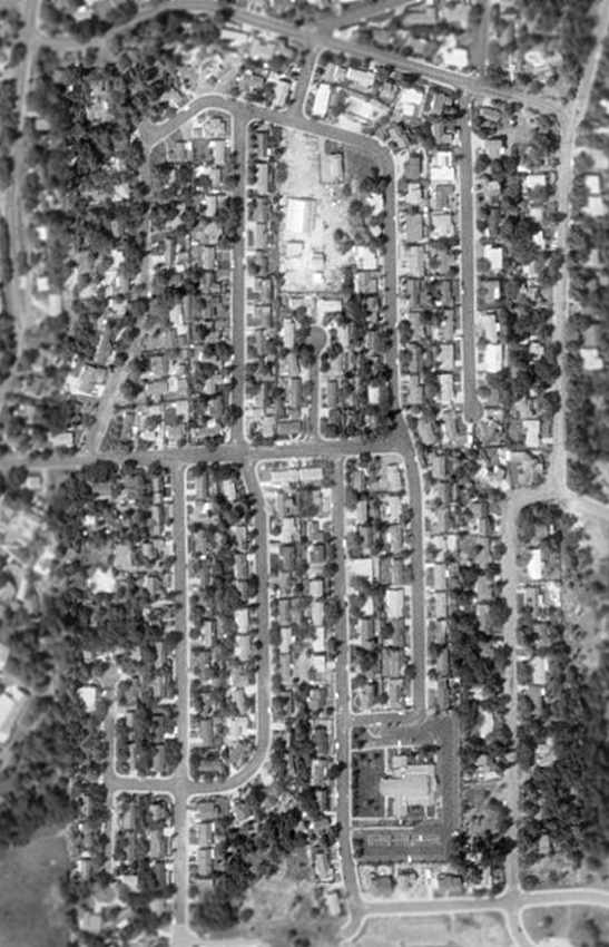
By the time of the 1993 USGS aerial photo, the site of Skyridge Airport has been filled in with houses,
and not a trace of the airport remained.
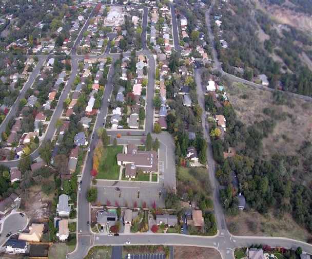
A 2004 aerial photo (by Dann Shively) looking south at the site of Skyridge Airport.
"You can see a commercial area right in the middle of the houses [at the bottom of the photo].
That's the original site of the family business which is still in use.
Just up the hill on the east side is Herrington Drive & the runway site."
A 2004 aerial photo (by Dann Shively) looking north at the site of Skyridge Airport.
"At the bottom is a Mormon Church. The runway extended to the rear of the church's parking lot."
Dann Shively reported in 2004, "The area on which no bank would lend money has become one of the most desirable parts of the city now.
Today nothing remains of the airport except references in a street name that runs north of the airport site
and an elementary school that sits just to the south.
Most of the runway's location is aligned with what became Herrington Drive (named after the developer).
Gene Herrington (who's the son of Greeley & who lives on Herrington Drive)
says that the middle of the runway sat right where the middle of the street is now.
Gene & his wife Marilyn operate Herrington Pre-cast concrete
and have carried on the family construction business [at the same location - the commercial building now amidst the houses]."
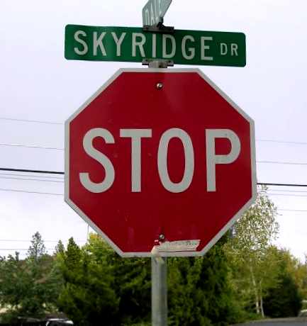
A 2004 photo (by Dann Shively) of the street sign for Skyridge Drive.
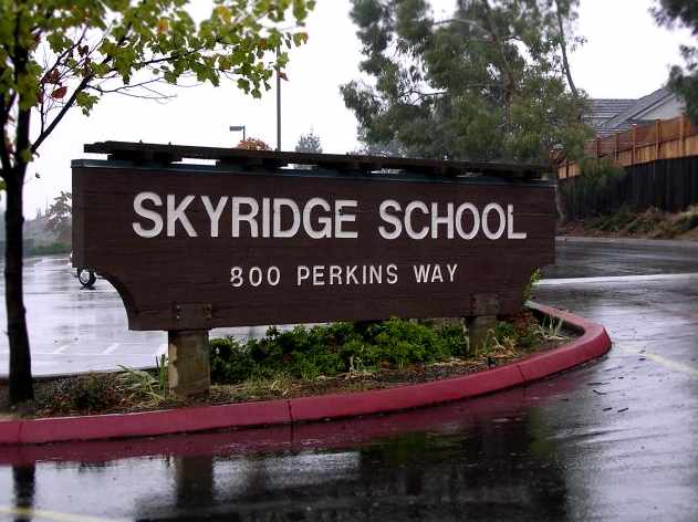
A 2004 photo (by Dann Shively) of the Skyridge School.
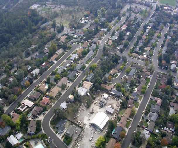
A 2015 aerial view looking southeast at the site of Skyridge Airport.
____________________________________________________
North Sacramento City Airport, Sacramento, CA
38.625, -121.465 (Northeast of San Francisco, CA)
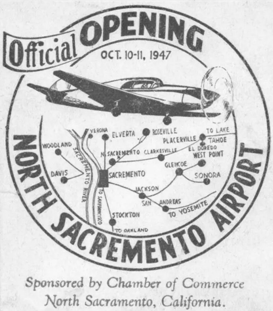
A postmark commemorating the 10/10/47 Official Opening of the North Sacramento Airport (courtesy of Gordon Lew).
This short-lived little general aviation airfield was one of many to be established in the years immediately after the end of WW2.
North Sacramento City Airport was not yet depicted on the February 1946 Sacramento Sectional Chart.
According to the 9/26/47 Times newspaper, “Grand opening of the North Sacramento City Airport,
with a special program, air show, aerobatics, parachute jumps, pilot contests, and queen coronation, [will be] October 10-11.”
A postmark commemorated the 10/10/47 Official Opening of the North Sacramento Airport (courtesy of Gordon Lew).
The earliest depiction of North Sacramento City Airport which has been located was on the August 1948 Sacramento Sectional Chart,
which depicted it as having a 2,000' unpaved runway.
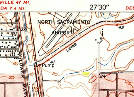
The 1949 USGS topo map (courtesy of Daniel Bierwirth) depicted North Sacramento Airport as having 2 perpendicular runways.
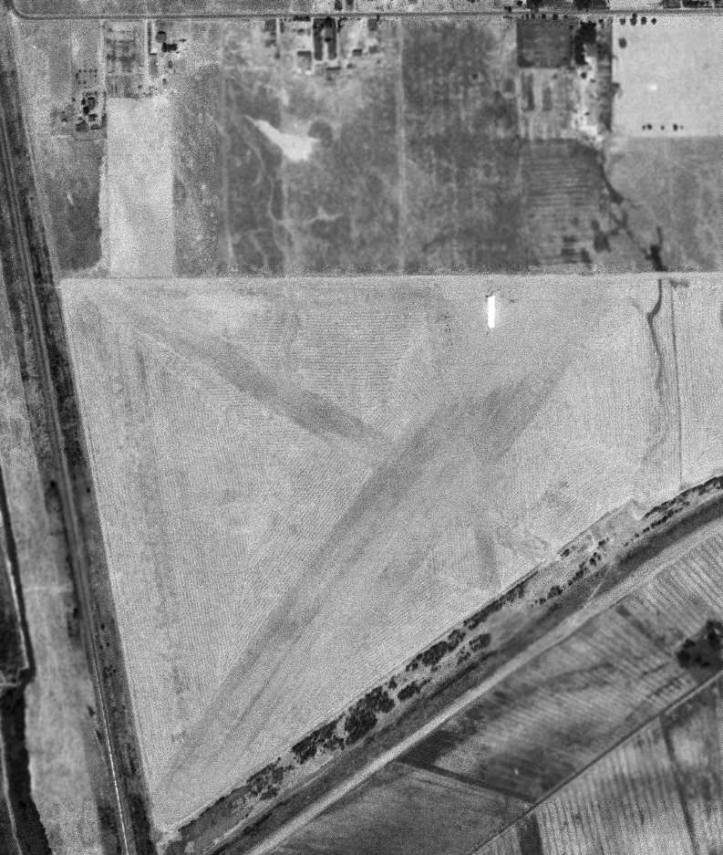
The only photo which has been located of the North Sacramento City Airport was an 8/5/49 USGS aerial view.
It depicted the field as having 2 unpaved runways, with a single hangar on the northeast side. No aircraft were visible on the field.
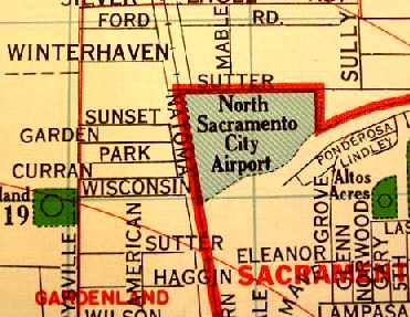
A 1950 County Map (courtesy of Dann Shively) depicted the North Sacramento City Airport
as occupying a small plot of land bordered by the Western Pacific Railroad tracks on the west,
Sutter Street (later renamed Fairbanks Avenue) on the north, and the Arcade Canal on the South.
No runways or other details of the airport were depicted.
Dann Shively recalled, "I first heard about this airport when I owned Aeronca Champ…
a previous owner was a mechanic who said he worked out of the North Sacramento Airport in the 1950s."
The last depiction which has been located of North Sacramento City Airport was on the October 1956 Sacramento Sectional Chart.
It depicted North Sacramento City Airport as having a 1,700' unpaved runway,
but also with the note “Emerg only”, which evidently foreshadowed the airport's impending closure.
North Sacramento Airport was closed at some point between 1956-57,
as it was no longer depicted at all on the April 1957 Sacramento Sectional Chart.
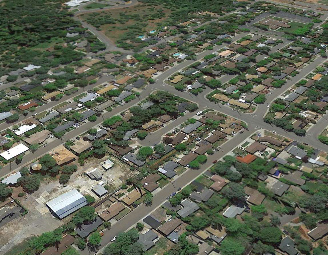
As seen in the 2002 USGS aerial photo, the site of North Sacramento City Airport has been covered with houses, and no trace of the airport remained.
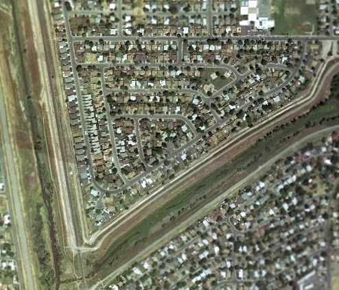
A 2004 photo (by Dann Shively) looking north at the site of North Sacramento City Airport.
"That's Arcade Creek on the lower portion & the railroad tracks & drainage canal on the left (west)."
____________________________________________________
Phoenix Field / Fair Oaks Airport, Fair Oaks, CA
38.657, -121.217 (Northeast of Sacramento, CA)
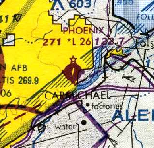
Phoenix Field, as depicted on the August 1948 Sacramento Sectional Chart.
According to Don House, “The Fair Oaks Flying Club started & owned Phoenix Field from its inception in 1937.”
The earliest reference which has been located of Phoenix Field came from Andy Beach,
who recalled, “Phoenix Field Fair Oaks...My father Gaston Beach instructed & we lived on the far end of the main hangar
which turned into a radio shop from 1/26/47 until 6/10/50.
He was the instructor mechanic, I have a picture of mom & dad at the airport in front of an Aeronca.
My dad used my collie as counterbalance for the student pilots; "Chum Boy" would fly while I was in school.
My dad was shipped to Japan with the Korean War & we had to move away leaving "Chum Boy" as the airport dog.”
Phoenix Field was not yet depicted on the February 1948 Sacramento Sectional Chart.
The earliest depiction of Phoenix Field which has been located was on the August 1948 Sacramento Sectional Chart,
which described Phoenix as having a 2,200' unpaved runway.
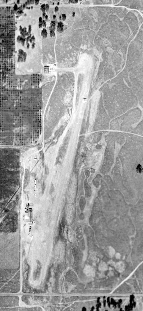
The earliest photo which has been located of Phoenix Field was a 10/4/52 aerial view (from the UCSB Library).
It depicted Phoenix Field as having a single unpaved northeast/southwest runway,
with a small building on the southwest side, and 8 light single-engine aircraft visible on the field, including one taking off.
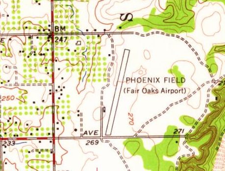
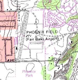
The 1954 USGS topo map depicted “Phoenix Field (Fair Oaks Airport” as having a single paved northeast/southwest runway,
with a small building on the southwest side.
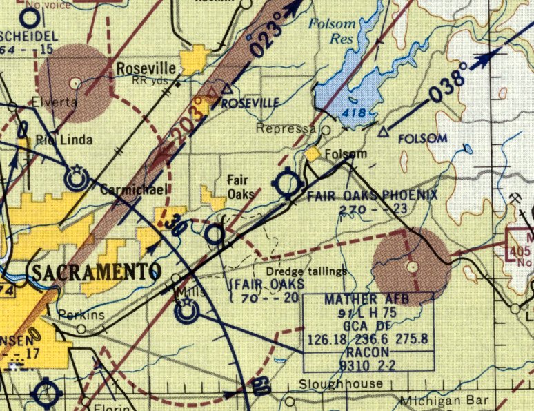
The field was labeled as "Fair Oaks-Phoenix" on the March 1954 USAF Sacramento Sectional Chart.
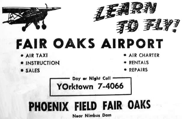
An advertisement for "Phoenix Field Fair Oaks" from a December 1957 telephone directory (courtesy of Dann Shively, enhanced by Bill Grasha).
The field was labeled as "Fair Oaks-Phoenix" on the 1957 Sacramento Sectional Chart (courtesy of Chris Kennedy).
Dann Shively said, "As I recall from old timers around the area, the strip began as the Phoenix Flying (or Fliers) Club.
One of the founders was the father of former ABC newswoman Joan Lunden.
He was a local physician. He & his family lived in a house adjacent to the field.
He could keep a plane in his yard & taxi right onto the taxiway. Tragically, he was killed in a plane crash."
The 1962 AOPA Airport Directory described Phoenix Field
as having a single 2,300' oiled Runway 18/36, and listed the operator as Engle Flying Service.
Nick Johnson recalled, “Born & raised in Sacramento, I learned to fly at Phoenix Field in Fair Oaks.
My first instructor was Glenn Engle, owner of the Engle Flying Service at Phoenix Field.
He & his sweet wife were lovely people!
They lived in the house on the corner where fliers would turn into the airport property.
My mother & father bought me my first flying lesson at Engle Flying Service for my 18th birthday – 7/16/65... I absolutely loved it!
I went to ground school in the old hangar there in the evenings all summer long, and earned my Private License by November of 1965.
After my first lesson with Glenn Engle, Jim Hackney took me on to my Private License.
In 1966-67, the Engles hired me to work for them as a part-time line-service tech (aircraft fueler).
What great memories!”
Phoenix Field was depicted on the 1967 Sacramento Sectional Chart (courtesy of John Voss) with a single 2,600' concrete runway.
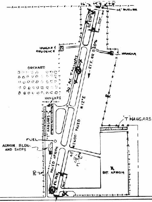
An October 1967 FAA Airport Facilities Record (courtesy of Stanley Dodge)
depicted Phoenix Field as having a single 2,600' paved north/south runway, with a parallel taxiway on the west side.
Paved aprons on the southeast & southwest sides of the field each had adjacent T-hangars.
The owner & operator was listed as the Fair Oaks Flying Club, and the operator was listed as Glenn Engle.
The 1968 Flight Guide (courtesy of Chris Kennedy) depicted Phoenix Field as having a single 2,600' paved Runway 18/36,
with a parallel taxiway on the west side.
Paved aprons were on the southeast & southwest sides of the field, and 2 rows of T-hangars were depicted on the west side.
Jim Vanicek recalled of Phoenix Field, “I grew up there with my father. In 1969 I was a very young kid.
I remember being able to walk all over the place.
I used to walk from the tarmac across the runway to the fuel pump to talk to everyone.
My Dad would fly with all his friends & sometimes we would have pie at the cafe at Hazel & Sunset.”
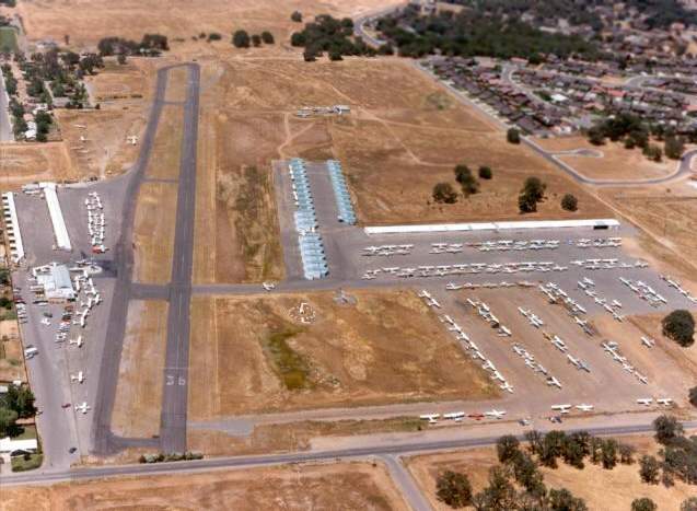
A 3/21/71 USGS aerial view depicted Phoenix Field as having a single paved north/south runway.
It was a very popular airport, with dozens of light aircraft parked on the southwest & southeast sides.
Note that the housing which would eventually subsume the airport had appeared on the west side, but had not yet surrounded the airport.
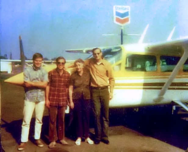
A 1972 photo (courtesy of Jerry Thomas, enhanced by Bill Grasha) of Jim Koester, Ralph Seymor, Eva Hunt, and Jerry Thomas in front of a Cessna 337 Skymaster at Phoenix Field.
Jerry recalled, “The Cessna 337 was just rebuilt by Bob, Jim & myself,
and Jim took it up to test it as it was wrecked in San Jose & we hauled it back in pieces on a trailer.”
According to Don House, “In 1972 my wife & I bought all of the shares in the Fair Oaks Flying Club, Inc. after buying all of the shares of Engle Flying Service, Inc.”
Joe Hitch recalled, “In 1972 Don House purchased the assets of The Phoenix Flying Club & became the sole owner of Phoenix Field.
My wife & children all learned to fly at Phoenix Field with Glenn Engle as their instructor.
My daughter Rachael was attending Sacramento City College’s Aeronautics class
and belonged to their flying club, flying out of Sacramento Executive Airport.
One day while flying out of Executive there was a lot of traffic & the radio was going wild
so she went to Phoenix, landed & called the college.
All the college people couldn’t figure why she would land on such a short airport & wouldn’t let her fly the airplane back to Executive.”
Joe continued, “In July 1974 there was a Stearman Fun Day to benefit the California Air Museum, at Phoenix Field.
Steve Williams & I had just completed the restoration of a PT-17 Stearman
and we invited my long time friend Bob Cummings, who was on the board of the California Air Museum to bring Lloyd Stearman & attend.
There were 5 Stearman airplanes there & Bob Cummings took Lloyd for a ride in our Stearman.
That was the last light airplane ride for Lloyd because he passed away in April 1975.
Bob learned to fly in a Travelair, an airplane designed by Lloyd Stearman.
On the night Bob was born his father, a doctor in Joplin, MO was called to a hotel to treat a sick patient
who turned out to be Orville Wright & he was named Robert Orville Cummings
and later got to know & became friends with Orville Wright.”
John Hockenbury recalled, "Before I bought my aircraft in 1978, I used to go to Phoenix just to watch all the activity, those were the days.
Hundreds of airplanes were based there. When these old airports go away, it is like losing an old friend."
Tim Carter recalled, "I got out of the Air Force in 1977 while living in Sacramento, and went to work as a CFI at Phoenix Field.
I worked at Engle flying service which was owned by Don House.
Chief Pilot then was Marty Keene & the assistant was Lincoln White, both retired Air Force, I believe."
Greg Avella recalled, “I worked at Phoenix Field from 1978-80.
I started at the gas pumps & eventually became Parts Manager for the field.
Tim Carter was my first flight instructor, followed by Lincoln White. I did my checkride with Marty Keene.
Greg Anderson (a mechanic) & I would rent the Cessna 152s
and see who could land on Runway 36 & make the 1st exit on to the taxiway.
That required you touch the oleanders at the end of the runway.
Don House caught us & gave us the business because we were wearing out his brakes.
Every now & then a plane would land hot on Runway 18 & end up nose first into the oleanders.
What a fun place to learn to fly it was. Glenn Engle would come out & do some instructing at times. He was a character.”
Nearby resident Jason Evart recalled, "I remember this airport since I was a little boy.
I am now 21 years old, but this airport inspired me to become a pilot (airline pilot specifically).
I remember walking along the tarmac with my dad watching the planes take off -
in fact, I live about a quarter mile northeast away from the airport, so would see planes fly over my house every day."
A 1981 aerial view looking north at Phoenix Field (copyright by John Hockenbury, used by permission).
John Hockenbury recalled, "Sunset Avenue still runs across the foreground. You can see tall bushes off the approach end of Runway 36.
I've seen aircraft drag their wheels through them on landing. This was one exciting airport."
The 1985 Sacramento Sectional Chart (courtesy of Dann Shively) depicted Phoenix Field as having a single 2,600' paved runway.
Dann Shively recalled, "I don't know how the ownership progressed but the last owner who operated the airport was Don House.
It was very sad when it closed."
According to Don House, “The Fair Oaks Flying Club owned Phoenix Field until its closure in 1986.”
Phoenix Field was no longer depicted on the on the 1987 CA Aeronautical Chart (courtesy of John Voss).
Jason Evart recalled, after its closure, "Phoenix Field was built up with weeds & then eventually demolished.
For about 2 years it turned into a makeshift 4X4/dirtbike area of mud & dirt.
Soon the housing development started construction (the housing development is actually called "Phoenix Field")
with every street named with some aviation related word, like Immelman Court, Flyway Drive, Airport Circle, etc.
I have a friend that lives about 100 feet away from where the original runway used to be."
Matt Strand recalled in 2003, "I grew up at the old Phoenix Field, in fact from 1990-99 I lived about 1/4 mile from the approach end of what used to be Runway 18.
That subdivision was home to me until I went away to college; my parents still live there.
Before the southeast 1/4 of the subdivision was built, the ramp was still there & my friends & I would ride bikes around trying to avoid the weeds.
At one point I found a tip of a prop & some rusty parts, not much else.
That area was razed & developed in 1996 or so."
Showing that you can't always trust the USGS topo maps, Phoenix Field was still depicted on the 1995 USGS topo map,
with a single 2,600' runway & a parallel taxiway.
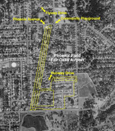
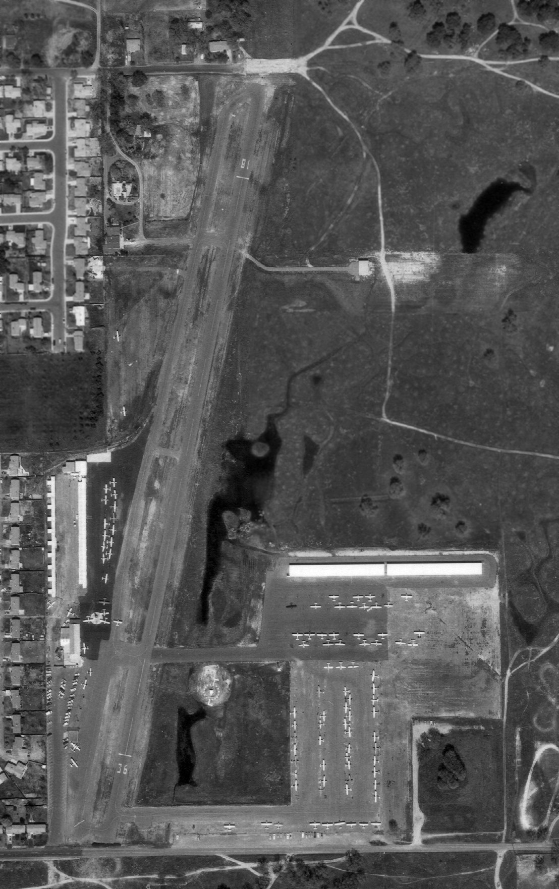
A 1998 USGS aerial view overlaid with the layout of Phoenix Field, by Jason Evart.
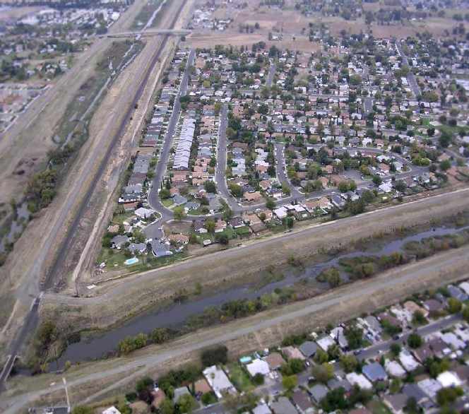
The site has been totally redeveloped as a housing development, with not a trace remaining of the airport.
A 2004 photo (by Dann Shively) of the sign at the entrance to the housing development which occupies the site of Phoenix Field.
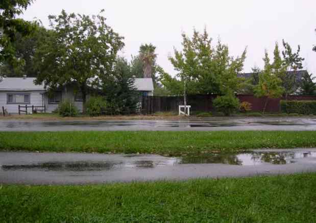
A 2004 photo (by Dann Shively) of the approximate location of the Phoenix Field airport entrance.
Dann observed, "Just to the right side of the house was the entrance."
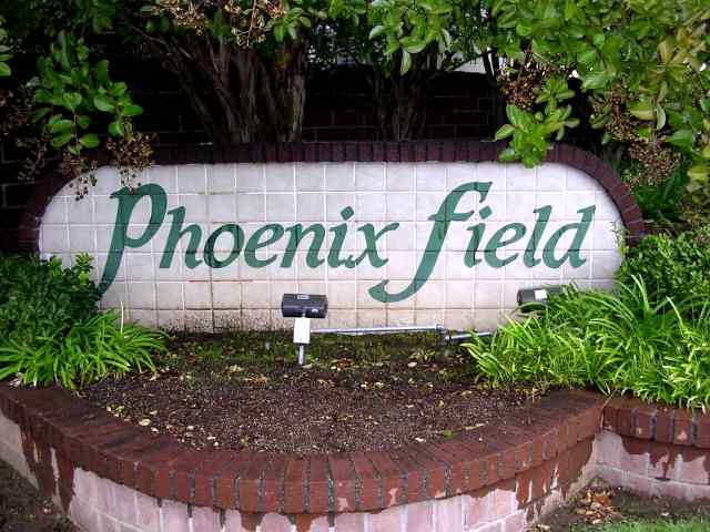
The site of Phoenix Field is located southeast of the intersection of Phoenix Avenue & Hazel Avenue.
____________________________________________________
Fair Oaks Airport, Rancho Cordova, CA
38.608, -121.267 (Northeast of Sacramento, CA)
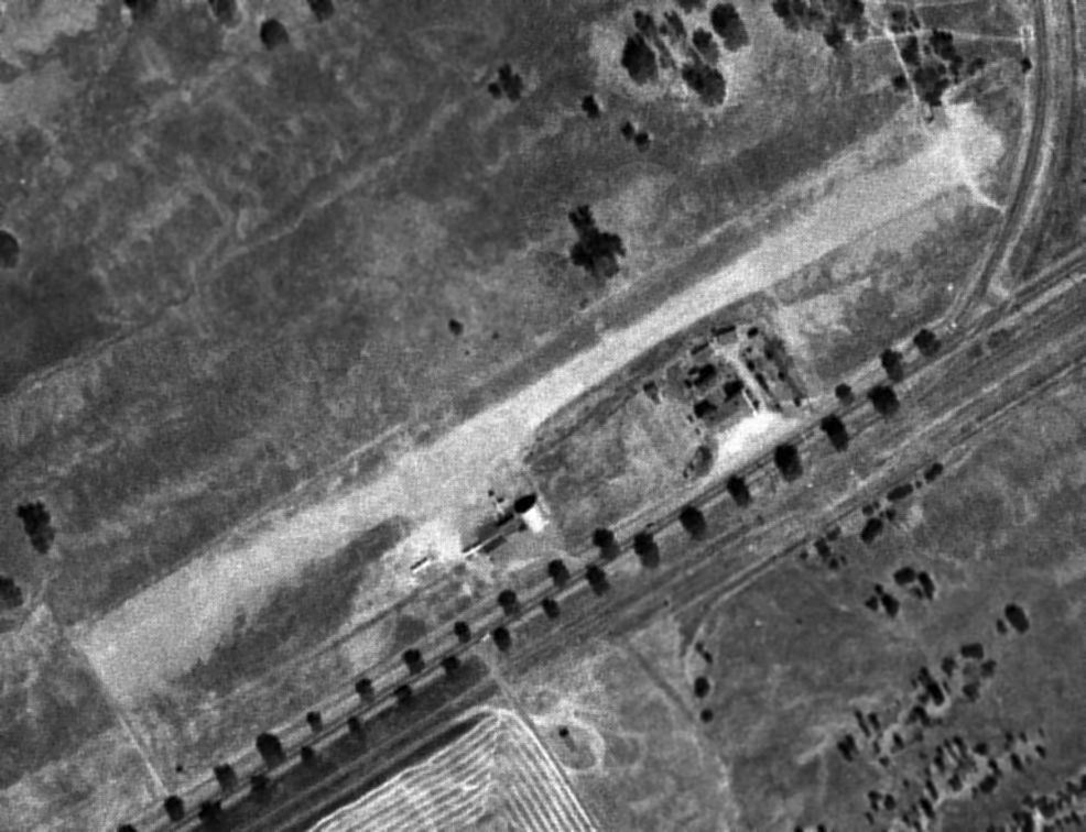
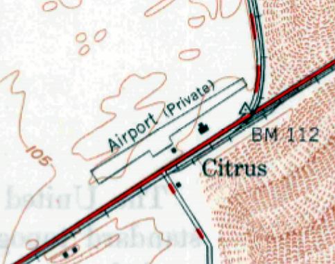
Fair Oaks Airport, as depicted on an 8/5/47 USGS aerial photo (enhanced by Bill Grasha).
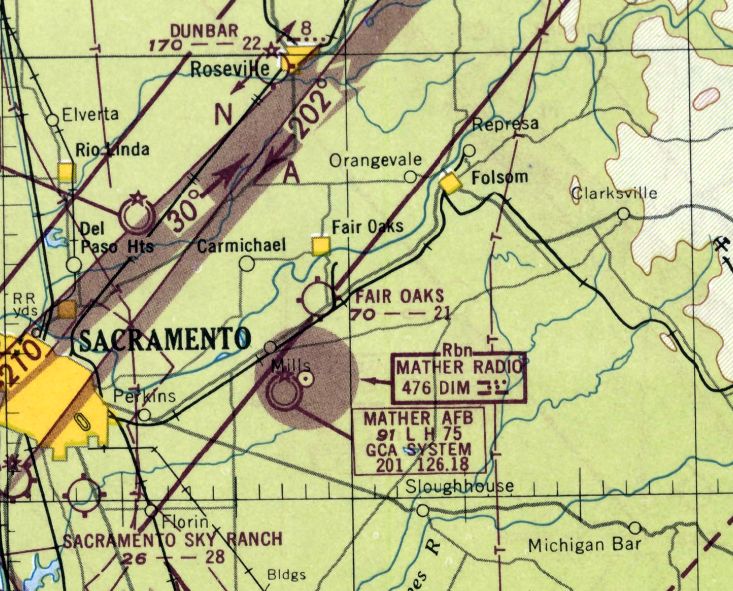
This small general aviation airport is not to be confused with the nearby Phoenix - Fair Oaks Airport (located a few miles to the northwest).
The Fair Oaks Airport was evidently opened at some point in 1947,
as it was not yet depicted on the February 1947 Sacramento Sectional Chart.
The earliest depiction of Fair Oaks Airport which has been located was on an 8/5/47 USGS aerial photo.
It depicted Fair Oaks Airport as having a single unpaved northeast/southwest runway,
with 3 light planes parked near a small building on the south side.
The earliest aeronautical chart depiction of Fair Oaks Airport which has been located was on the February 1948 Sacramento Sectional Chart,
which depicted it as having a 2,100' unpaved runway.
The 1949 Sacramento Sectional Chart (courtesy of Chris Kennedy) also depicted Fair Oaks Airport as having a 2,100' unpaved runway.
The 1950 USGS topo map depicted a single short northeast/southwest runway,
labeled simply as “Airport, private”, with 2 small buildings on the southeast side.
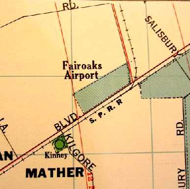
A 1950 County Map (courtesy of Dann Shively) depicted "Fairoaks Airport" as a rectangular property running along Folsom Boulevard,
but it did not depict any runways or other airport details.
The 1954 Sacramento Sectional Chart (courtesy of Dann Shively) depicted Fair Oaks Airport as having a 2,000' unpaved runway.
The 1955 USGS topo map not longer depicted Fair Oaks Airport or its runway, but it did continue to depict the airport's 2 small buildings.
The last aeronautical chart depiction which has been located of Fair Oaks Airport was on the Apri;l 1957 Sacramento Sectional Chart.
Note that it also showed that the nearby Phoenix Field was depicted as "Fair Oaks - Phoenix",
which undoubtedly must have caused some confusion at the time.
The last photo which has been located of Fair Oaks Airport was a 1957 aerial photo.
It depicted 1 single-engine aircraft parked between 2 small hangars to the southeast of an unpaved airfield.
The Fair Oaks Airport evidently closed (for reasons unknown) at some point between 1957-60,
as it was no longer depicted at all on the March 1960 Sacramento Sectional Chart.
A 1964 aerial photo showed that a cloverleaf intersection for Route 50 having been built adjacent to the west side of the airport.
The airport buildings remained intact, along with a portion of the runway.
The 1965 USGS topo map depicted a clearing on the site of the airport.
The 1968 USGS topo map depicted the Route 50 cloverleaf intersection adjacent to the west side of the airport,
and a drive-in movie theater had been built to the southwest.
According to Dann Shively, a Highway 50 intersection was built forming the western boundary of what was the airport site.
From 1973-83, the southwestern portion of the airport site was occupied by the Thunderbird Drive-In movie theatre.
Matt Strand recalled, "I saw my first movie there when I was very, very young,
and it was closed not long after in 1983, which, for a 5-year old, was tragic."
According to Dann Shively, "The 1990s saw extensive development in the area."
By the time of the 1998 USGS aerial photo, not a trace of Fair Oaks Airport remained.
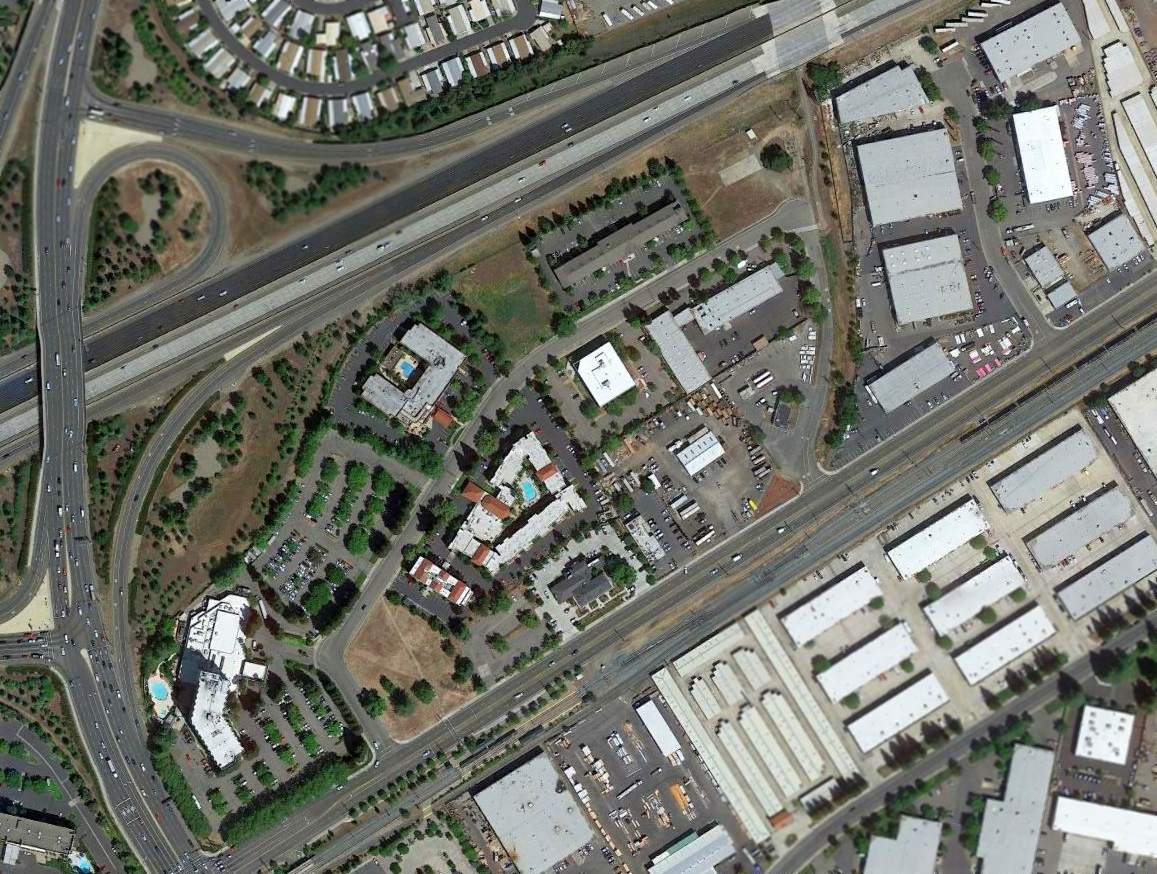
As seen in a 2015 aerial photo, not a trace of Fair Oaks Airport remained.
The site of Fair Oaks Airport is located northwest of the intersection of Folsom Boulevard & Sunrise Boulevard.
____________________________________________________
____________________________________________________
This site covers airfields in all 50 states.