
Abandoned & Little-Known Airfields:
California: Southwestern Fresno area
© 2002, © 2026 by Paul Freeman. Revised 3/24/26.
This site covers airfields in all 50 states: Click here for the site's main menu.
____________________________________________________
Please consider a financial contribution to support the continued growth & operation of this site.
For a 10th year, the CA pages of this website are sponsored by the California Pilots Association:
Coalinga Municipal Airport (original location) (revised 4/1/23) - Lemoore AAF / Lemoore Airport (revised 6/12/24)
Lemoore Auxiliary Army Airfield A-3 / Indian Field (revised 6/19/20) - Lemoore Auxiliary Army Airfield A-7 / Helm Field #6 (revised 7/7/15) - Skylark Field (revised 3/24/26)
____________________________________________________
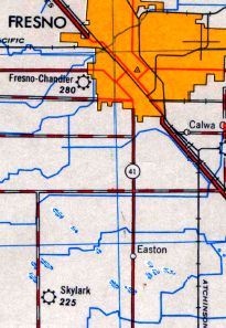
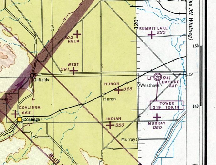
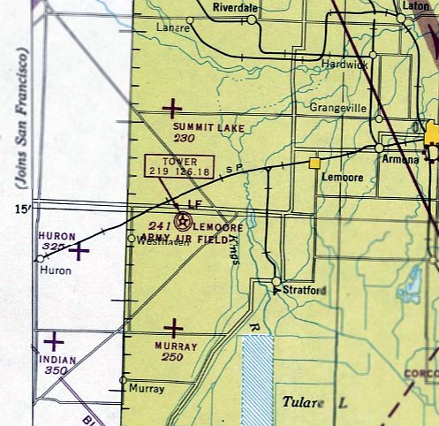
36.63, -119.84 (Southwest of Fresno, CA)
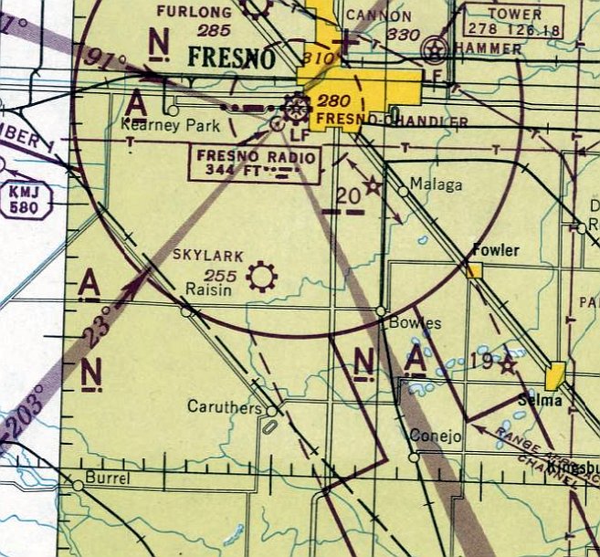
Skylark Field, as depicted on the September 1945 Mt. Whitney Sectional Chart.
This small general aviation airport was evidently established at some point between 1944-45
(like hundreds of other small small airports in the American post-WW2 aviation boom),
as it was not yet depicted on the 1944 Mt. Whitney Sectional Chart.
The earliest depiction which has been located of Skylark Field was on the September 1945 Mt. Whitney Sectional Chart.
It depicted Skylark Field as a commercial/municipal airport.
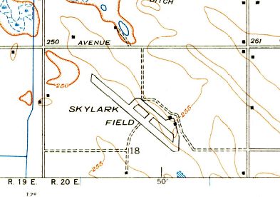
The earliest topo map depiction which has been located of Skylark Field was on the 1946 USGS topo map (courtesy of Dallam Oliver-Lee).
It depicted Skylark Field as having a northwest/southeast runway with a parallel taxiway, and a ramp on the east side with 2 small buildings.
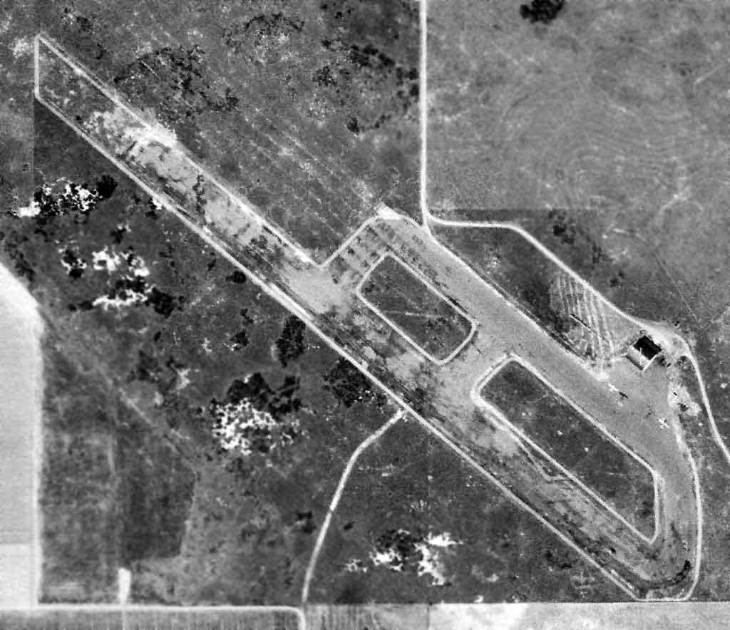
The only photo which has been located of Skylark Field was a 4/23/46 USGS aerial view (courtesy of Dallam Oliver-Lee).
It depicted Skylark Field as having a northwest/southeast runway with a parallel taxiway,
and a ramp on the east side with 3 single-engine aircraft & a hangar with “Skylark” painted on the roof.
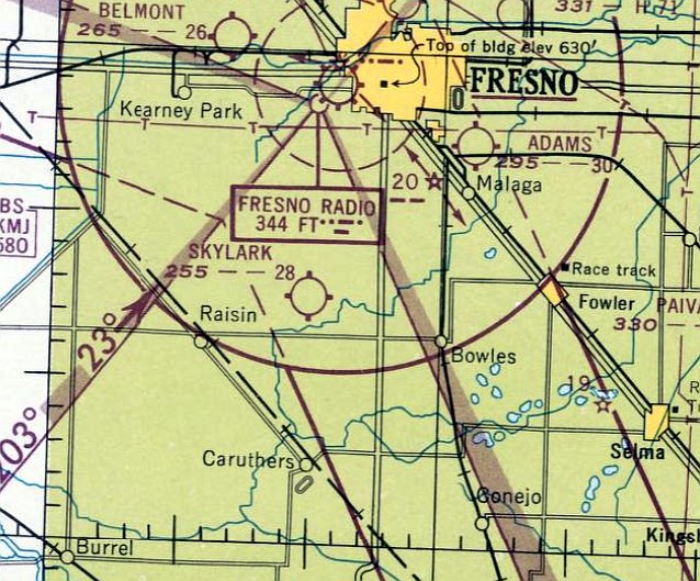
The last aeronautical chart depiction which has been located of Skylark Field was on the February 1947 Mt. Whitney Sectional Chart.
It depicted Skylark Field as having a 2,800' unpaved runway.
The 1948 USGS topo map (courtesy of Dallam Oliver-Lee) depicted Skylark as a commercial/municipal airport.
Skylark Field evidently did not last long, as it was no longer depicted on the February 1948 Mt. Whitney Sectional Chart.
A 1956 USGS aerial view (courtesy of Dallam Oliver-Lee) showed the site of Skylark Field had been returned to farming.
The runway was gone, but the hangar remained as the only trace of Skylark Field.
The 1960 USGS topo map (courtesy of Dallam Oliver-Lee) continued to depicted Skylark Field,
even though it had evidently ceased to exist several years before that point.
Skylark Field was no longer depicted on the 1962 USGS topo map (courtesy of Dallam Oliver-Lee)
or on the October 1962 Mt. Whitney Sectional Chart (courtesy of Paul Columbus).
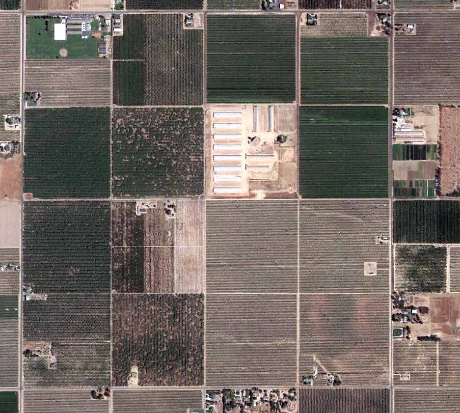
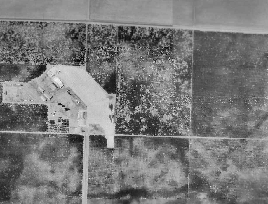
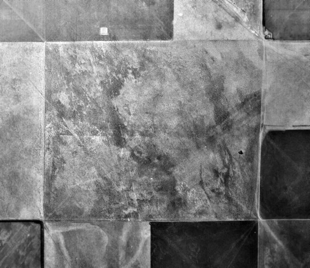
An 8/26/12 aerial view (courtesy of Dallam Oliver-Lee) showed the hangar remained as the last trace of Skylark Field -
the brown building in the center of the long rectangular buildings in the center of the picture.

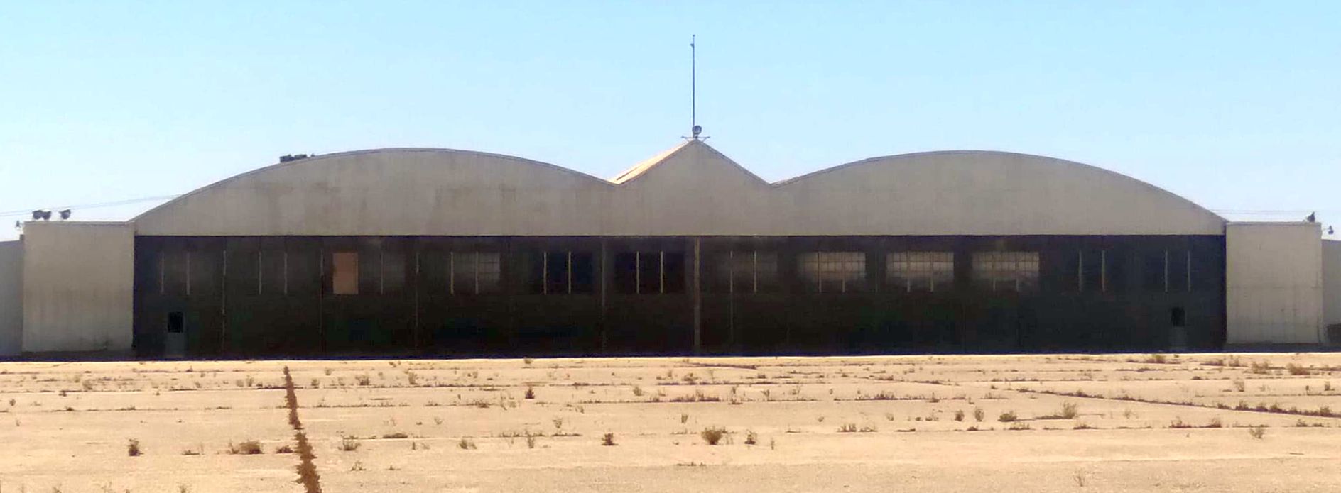
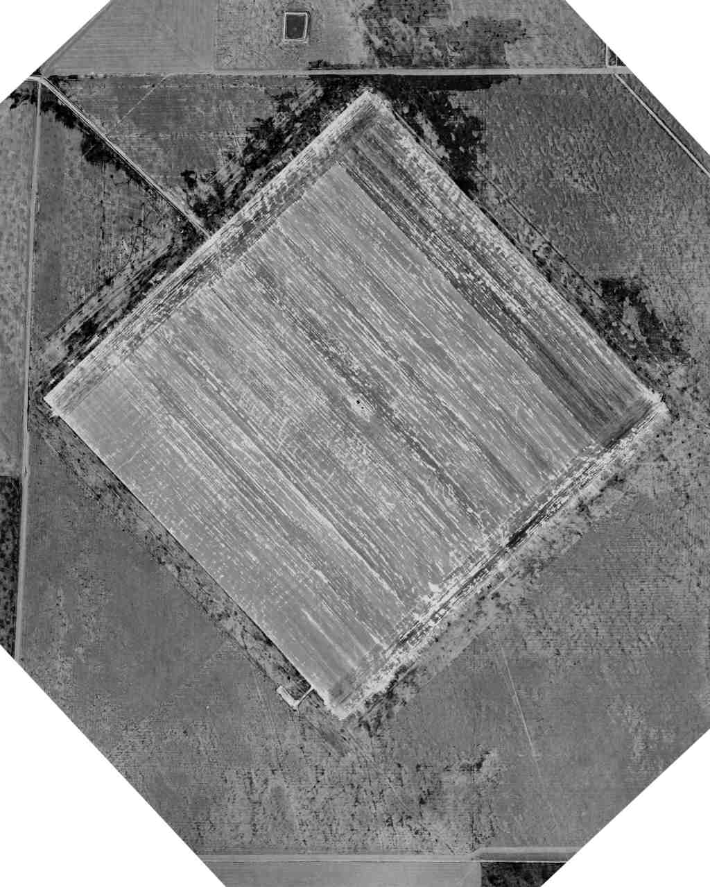
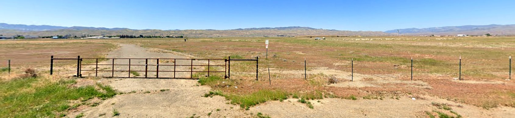
A 2025 aerial view of the last trace of Skylark Field: the 1940s hangar.
The site of Skylark Field is located southwest of the intersection of West Adams Avenue & South West Avenue.
____________________________________________________
Lemoore Army Airfield / Lemoore Airport / Willett Airfield, Lemoore, CA
36.25, -119.942 (South of Fresno, CA)
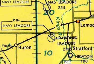
Lemoore AAF, as depicted on the July 1942 Mt Whitney Sectional Chart.
This obscure former Army Airfield is not to be confused with the later-day Lemoore Naval Air Station,
which is a separate airfield on the opposite (north) side of Route 198.
The Lemoore airfield was evidently not a prewar airfield,
as no airfield was depicted at this location on the 1932 San Francisco - LA Air Navigation Map (courtesy of Herbert Haar)
or the August 1941 Mt Whitney Sectional Chart.
The Federal Government acquired 1,466 acres for the Lemoore Basic Flying School in 1941-42 (according to a 1989 Army Corps of Engineers report).
Approximately 488 acres were acquired in fee by grant deed from individual land owners, 963 acres were leased from the City of Lemoore,
and 14 acres were acquired by transfer from the National Housing Agency.
The site was used by the Department of the Army for a basic flying school & civilian war housing.
Site maps of the former Lemoore site dated June 1941 & 1942 identified the following facilities located at the site:
PX gas station, 10 gas tanks, a truck fill station, oil & lube station, motor repair shop with 4 grease racks & 4 underground tanks,
fire station, cadet quarters, warehouses, officers quarters, mess hall, utilities shop, chapel, classrooms,
water reservoir & water well, taxiways, runway, landing field, and 2 hangars.
Additional structures constructed by the Army for the Lemoore site were located south of the area shown on the 1941 & 1942 site maps,
including an amphitheater & swimming pool.
According to the Lemoore 1943 Class Book (courtesy of Greg Mosholder), “Although the initial class graduated in February 1942,
official dedication ceremonies were held over to 4/26/42, with Colonel Harry Wisehart, then Commanding Officer, acting as host.”
The earliest depiction which has been located of Lemoore AAF was on the July 1942 Mt Whitney Sectional Chart.
It depicted Lemoore as a military airfield having a control tower.
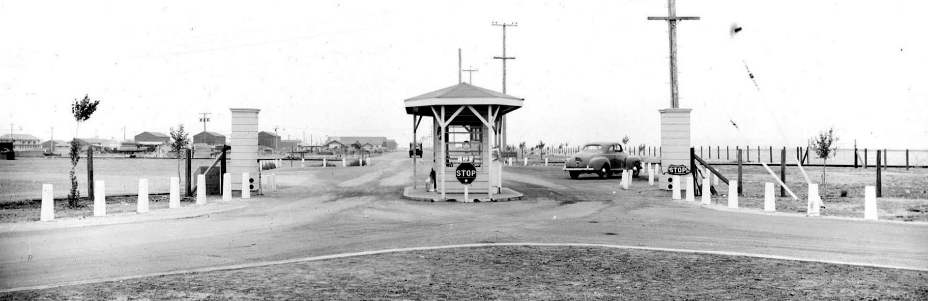
The earliest photo which has been located of Lemoore AAF was an 8/8/42 of its entrance guard shack.
An 8/8/42 photo of Lemoore AAF's parachute building.
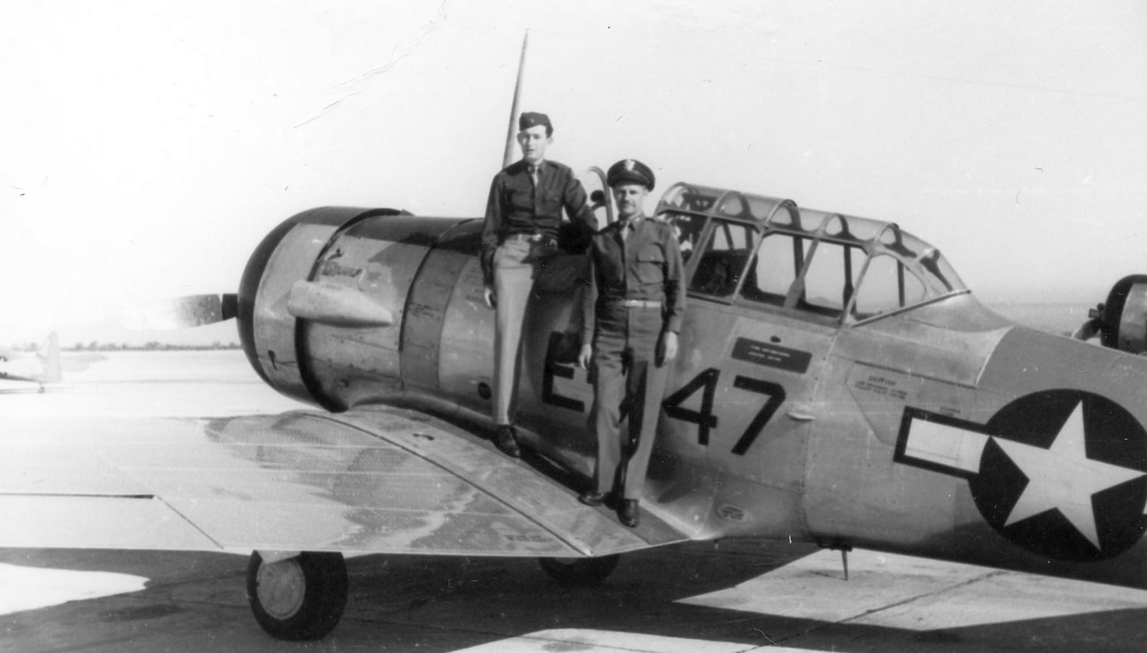
A circa 1942-45 photo of flight instructor George Baldrick & another officer on a North American AT6 Texan at Lemoore AAF.
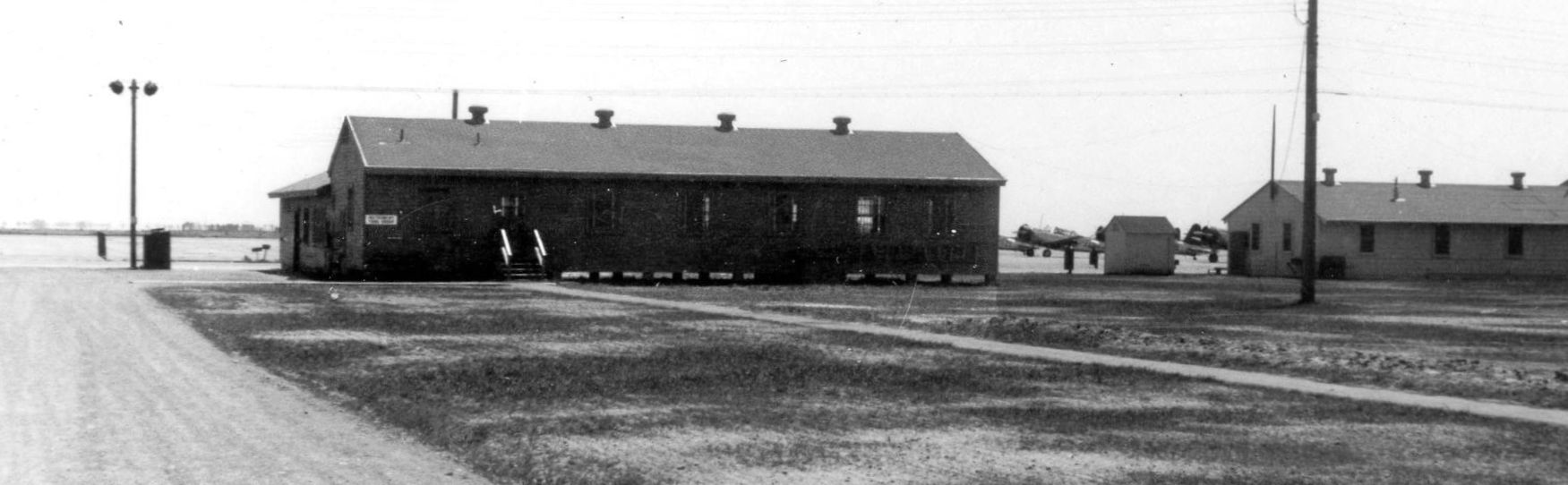
A circa 1942-45 photo of a Lemoore AAF group classroom building, with several Vultee trainers in the background.
Three fliers were killed at Lemoore Army Flying School on 11/42:
2nd Lt. Don Crook, Aviation Cadet Edgar Poleski, and Aviation Cadet Dino Berardo,
according to the Lemoore Army Flying School Class 43B yearbook (courtesy of Dallam Oliver-Lee).
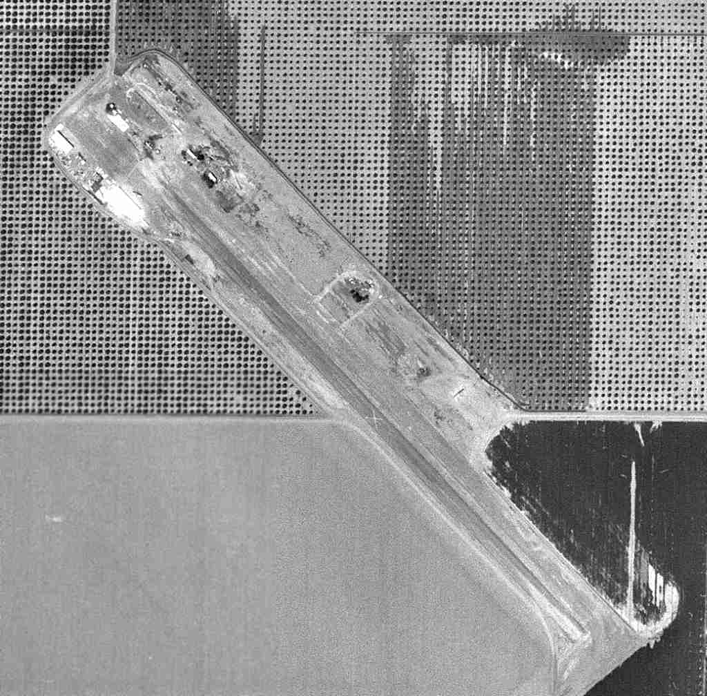
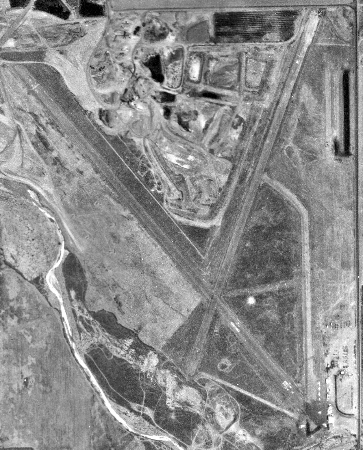
The earliest aerial view which has been located of Lemoore AAF was a 6/21/43 National Archives aerial photo (courtesy of Brian Renhwinkel).
Brian noted, it “shows a very busy ramp (approximately 230 aircraft).”
It depicted an extensive airfield, with a long concrete ramp on the west side, on which were parked no less than approximately 230 single-engine aircraft.
Two hangars on the northwest portion of the ramp were painted in a camouflage pattern,
which certainly did little to make this installation not stand out among the surrounding farmland.
Over a hundred buildings were located west of the ramp.
Two asphalt taxiways led to an unusually-configured airfield area,
with asphalt runways oriented north/south, east/west, and a wide northwest/southeast strip divided into no less than 6 runways.
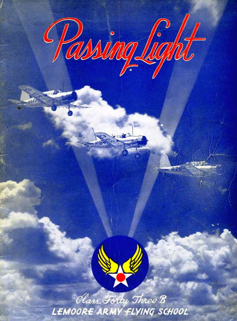
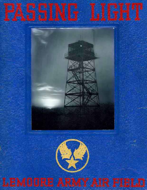
The cover of the Lemoore Army Flying School Class 43B yearbook, “Passing Light” (courtesy of Dallam Oliver-Lee).
The book listed the commanding officer as Col. Donald Phillips.
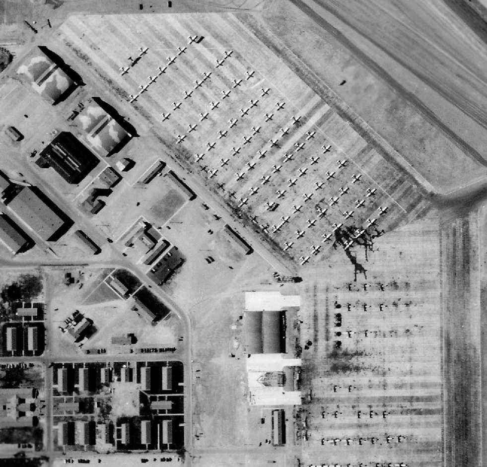
A closeup of the 6/21/43 National Archives aerial view (courtesy of Brian Renhwinkel) of Lemoore AAF,
showing the huge number of aircraft, and the camouflage pattern on 2 of the hangars at the northwest.
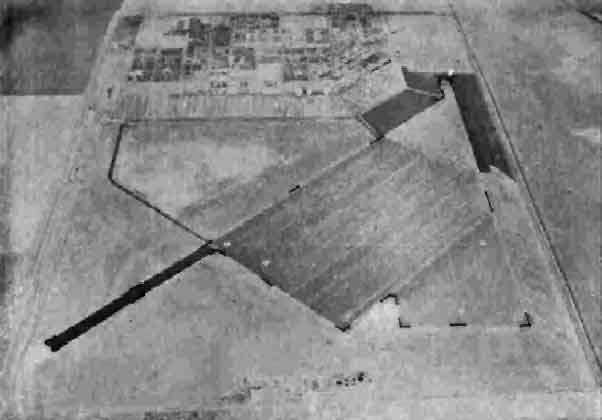
A 7/30/43 aerial view looking east at Lemoore AAF from the 1945 AAF Airfields Directory (courtesy of Chris Kennedy).
It described Lemoore as a 1,440 acre rectangular field, within which were 3 runways,
with the longest being the 4,600' northwest/southeast strip with a 1,875' extension on the southeast end.
The field was said to have a total of 5 hangars, the largest being 180' x 99'.
The 1943 Mt Whitney Sectional Chart (according to Chris Kennedy) slightly misspelled the name of the field, as "Le Moore Army Air Field".
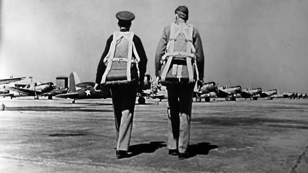
An undated photo of pilots walking out to rows of Vultee BT-13 trainers from the Lemoore 1943 Class Book (courtesy of Greg Mosholder).
The cover of the Lemoore AAF Class 44D yearbook, with an undated photo of the field's control tower (courtesy of Walter Barber).
Walter Barber recalled, “I was one of the cadets that trained at Lemoore in November & December 1943.
We were the class of 44D, meaning that we would get our wings April 1944.
I recall using the subsidiary fields such as Indian in practicing instruments takeoffs & various forms of emergency procedures.
We flew the Vultee BT-13 (Vibrator)
and some of us were moved up to twin-engine Cessna AT-17 Bobcat (Bamboo Bomber) which we flew out of Coalinga.
They would bus us over to Coalinga early in the morning from Lemoore AAF & after training bus us back to LAAF.”
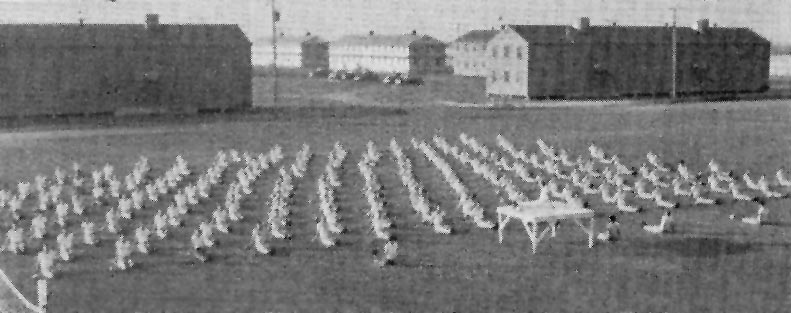
An undated photo of Lemoore AAF cadets conducting physical training, in front of the large number of barracks at the base
(from the Lemoore AAF Class 44D yearbook, courtesy of Walter Barber).
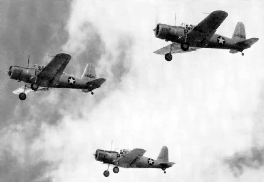
An undated photo of a formation flight of Vultee BT-13 Vibrators from Lemoore AAF
(from the Lemoore AAF Class 44D yearbook, courtesy of Walter Barber).
Walter recalled, “I flew this ship during the first half of my stay at Lemoore & then switched to the twin engine AT-17 for the last half.”
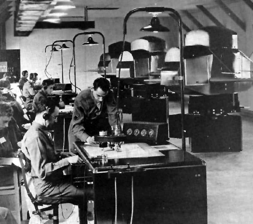
An undated photo of flight training at Lemoore AAF using Link Trainers
(from the Lemoore AAF Class 44D yearbook, courtesy of Walter Barber).
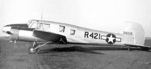
A WW2-era USAAF photo of a rare AT-20 trainer (a Canadian-built Avro Anson) marked with a Lemoore AAF “R” fuselage code.
Lemoore AAF was described by the 4/1/44 US Army/Navy Directory of Airfields (courtesy of Ken Mercer)
as having a 6,500' hard-surface runway, although the remarks included, "Entire field available only when dry."
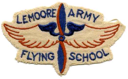
A 1944 patch for the Lemoore Army Flying School.
According to Tim McCoy, “Lemoore was used later in the war as a training base for night fighters, probably 1944-45.
There were P-70s, the night fighter version of the Douglas A-20, and P-61 Black Widows based there.
My father was an instructor in night fighters & I have photos of some of the planes plus a couple of log books, and the books used for training.
When the war ended the P-70s were flown to Ontario, and the P-61s to San Jose.”
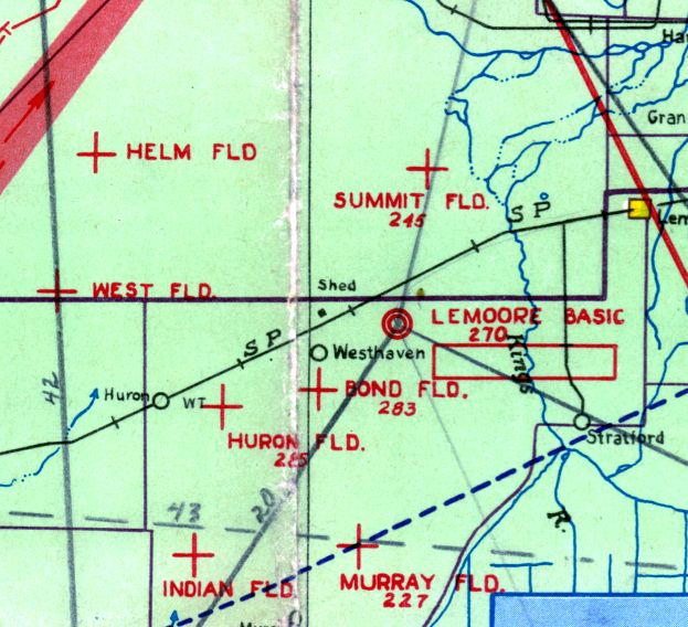
A circa 1944 Tulare Lake AAF Aeronautical Chart (courtesy of Roger Connor)
depicted “Lemoore Basic” along with its many auxiliary airfields.
Dennis Vasquez recalled, “Richard Seay was an air cadet at Lemoore class 44-A.
I still have his edition of the 'Passing Light'. It also records 2 cadet fatalities from class 44-A.”
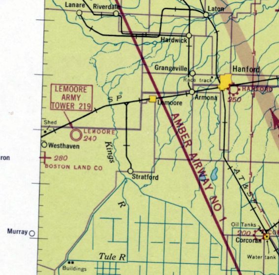
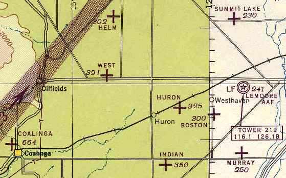
Lemoore AAF had a total of 6 satellite airfields for the use of its cadets:
A-2 Huron (7 miles west-southwest), A-3 Indian (13 miles southwest),
A-4 Murray (8 miles south), A-5 West (14 miles west),
A-6 Summit Lake (7 miles north), and A-7 Helm (15 miles northwest).
The satellite fields each consisted of a 3,000' square landing mat, with either a "road mix" or oiled surface.
Additionally, the "Coalinga Emergency Landing Field" (22 miles west-southwest) was also designated for use by Lemoore AAF.
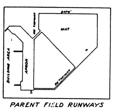
A WW2-era diagram of Lemoore AAF (courtesy of John Voss) depicted Lemoore AAF as consisting of a roughly triangular shaped landing mat,
which measured 3,470' along its longest side.
A 3,700' long north/south apron sat to the southwest of the landing mat, and west of the apron was the building area.
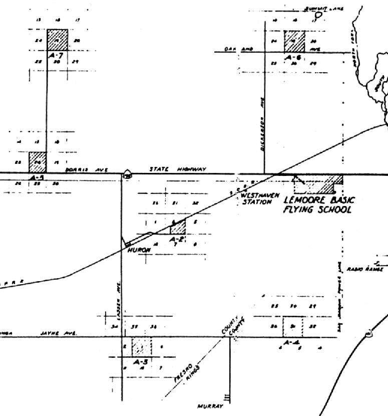
A WW2-era diagram of Lemoore AAF & its 6 satellite airfields (courtesy of John Voss).
The 1945 USAAF Pilot's Handbook (according to Chris Kennedy) described Lemoore AAF as having 3 bituminous runways:
6,475' northwest/southeast, 4,800' east/west, and 3,000' north/south.
It said, "Runways marked on all-way landing area", so the only concrete was apparently the ramp areas.
The last aeronautical chart depiction which has been located which showed Lemoore AAF as a military airfield was on the September 1945 San Francisco Sectional Chart.
It also depicted Lemoore's numerous auxiliary airfields.
The Lemoore AAF site was declared surplus by the War Assets Administration on 1/11/46,
according to a 1989 Army Corps of Engineers report.
The former Lemoore AAF was evidently reused as a civilian airfield,
as the February 1946 San Francisco Sectional Chart depicted “Lemoore” as an auxiliary airfield, with no indication of military use.
The War Assets Administration transferred ownership of 750 acres of the site to the City of Lemoore on 11/16/48 (according to a 1989 Army Corps of Engineers report).
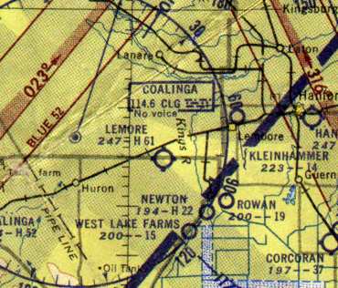
The 1949 Mt Whitney Sectional Chart (according to Chris Kennedy) depicted “Lemoore” as a public-use civilian airport having a 6,100' hard-surface runway,
which was significantly longer than the WW2-era diagram above had indicated.
Ron Villi recalled, “Lemoore Army Air Base... George Willett conducted crop dusting operations out of the site for years.
Willett Flying Service was operational from the early 1950s.
He flew Stearmans originally. George Willett pioneered the night dusting operations.
The air was much calmer. They would modify the Stearman, employing a 450 hp engine.
George was an old barnstormer & flew with The Tex Richards Flying Circus group.”
Lemoore was depicted as a public-use civil airfield on the 1953 San Diego - San Francisco Flight Chart (courtesy of Scott O'Donnell),
with a 6,100' paved runway.
The last photo which has been located showing aircraft at the former Lemoore AAF (by this point reused as a civilian airport)
was a 6/23/55 USDA aerial view (courtesy of Dallam Oliver-Lee).
The airfield remained completely intact, including all 3 hangars,
and several runways still had prominent runway numbers visible.
A closeup from the 6/23/55 USDA aerial view (courtesy of Dallam Oliver-Lee) showing 3 single-engine aircraft (Vultees) on the Lemoore AAF ramp.
Also note the checkerboard pattern apparent on the roof of the 2 hangars on the northwest side of the ramp.
Dennis Vasquez recalled, “The Vultee trainers that were parked in front of the small building where I lived with my family...
The photo shows those trainers parked in a drainage that is located just off of the paved tarmac area in front of the 2 hangars.”
Dennis Vasquez recalled, “Lemoore Army Airfield...I lived there at the base in the early 1950s.
Some of my earliest memories, at about 3 years old, are of playing on the Vultee trainers that were parked in front of the small building where I lived with my family.
I recall one night after a bad winter storm with high winds. My father & others had to recover one of the Vultees that was pushed by the winds across the paved tarmac area.
The building that I lived in is one of 2 long narrow buildings located behind the 3 parked Vultees. I think that the 2 buildings were likely fire stations.
I recall that there were small living quarters on either side of a central garage-like parking area.
The living quarters each had a small kitchen area, bathroom & central sleeping area.
Harry Black, a local Lemoore farmer, leased & farmed land located on the perimeter of the base.
My father & my uncle both worked for Black. I think that my uncle & his family were likely still living and working there in 1955 when that photo was taken.
I remember getting punished for climbing the long stairway going up to the control tower that was still located in the area near the bottom of the photo.”
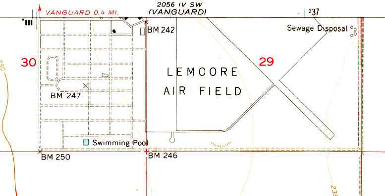
The 1956 USGS topo map depicted the runways & ramp of Lemoore Air Field,
along with the street grid of the former military installation, including its swimming pool.
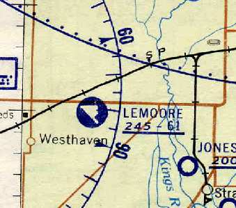
Lemoore was depicted as a civil airfield on the May 1957 Mt. Whitney Sectional Chart (courtesy of Chris Kennedy).
It depicted the runway layout of Lemoore, with at least 2 paved runways, the longest being a 6,100' northwest/southeast strip.
According to the 2/1/57 issue of the Fresno Bee, the 1,460 acre former Army Airfield site was sold by the City of Lemoore in 1957 to the Navy,
to be used as part of the site for the new Lemoore Naval Air Station.
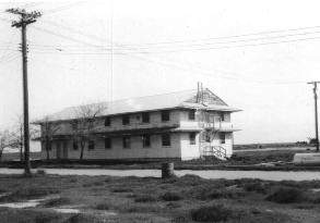
A barracks building at Lemoore AAF in 1958.
The building was later relocated to the near the Grangeville gate of Lemoore NAS & used as the ROICC Office.
The Lemoore airfield had evidently been abandoned at some point between 1957-59,
as nothing at all was depicted at the site on the March 1959 Mt. Whitney Sectional Chart (according to Chris Kennedy).
The 1963 World Aeronautical Chart depicted the “Abandoned Lemoore” airfield as having a single northwest/southeast runway.
It also showed that a “Navy Lemoore” radio beacon had been added on the north side of the Lemoore AAF site,
and the much larger runways of the newly-constructed NAS Lemoore were also depicted to the north.
Ironically, the northern end of the runways of the huge Lemoore NAS
were constructed on the same ground previously occupied by Lemoore AAF's satellite field A-6 Summit Lake.
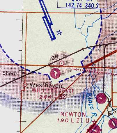
At some point between 1963-64, the former Lemoore AAF was evidently reused as a short-lived private civilian airfield,
as the June 1964 Mt. Whitney Sectional Chart (courtesy of Chris Kennedy) depicted a “Willett” private airfield at the site.
The private airfield presumably used a portion of the former paved ramp area as its 2 runways,
as the Aerodromes table on the chart described Willett as having 2 concrete runways
with the longest being only 3,200' (roughly half the length listed on the 1957 chart).
Steve Speerly recalled, “From 1965-67 I was stationed at NAS Lemoore.
Being in the crash fire unit we worked 24 hours on with 48 hours off.
In our off hours some of us worked Willet Flying Service [at the former Lemoore AAF].
When I left Lemoore the Flying Service was still in operation.
There were also 2 or 3 WW2 planes in a hangar at the back of the field that were left behind by the military,
with a waiting period before they could be restored.
George Willett was a collector of old airplanes & had plans to restore them to flying condition.”
An 8/19/66 USGS aerial photo (courtesy of Dallam Oliver-Lee) depicted the Lemoore airfield as remaining largely intact.
The Willett airfield was no longer depicted on the June 1966 Mt. Whitney Sectional Chart (according to Chris Kennedy) or subsequent aeronautical charts.
A 3/12/69 USGS aerial photo (courtesy of Dallam Oliver-Lee) showed that much of the Lemoore runways to the east of the ramp were starting to become less distinct.
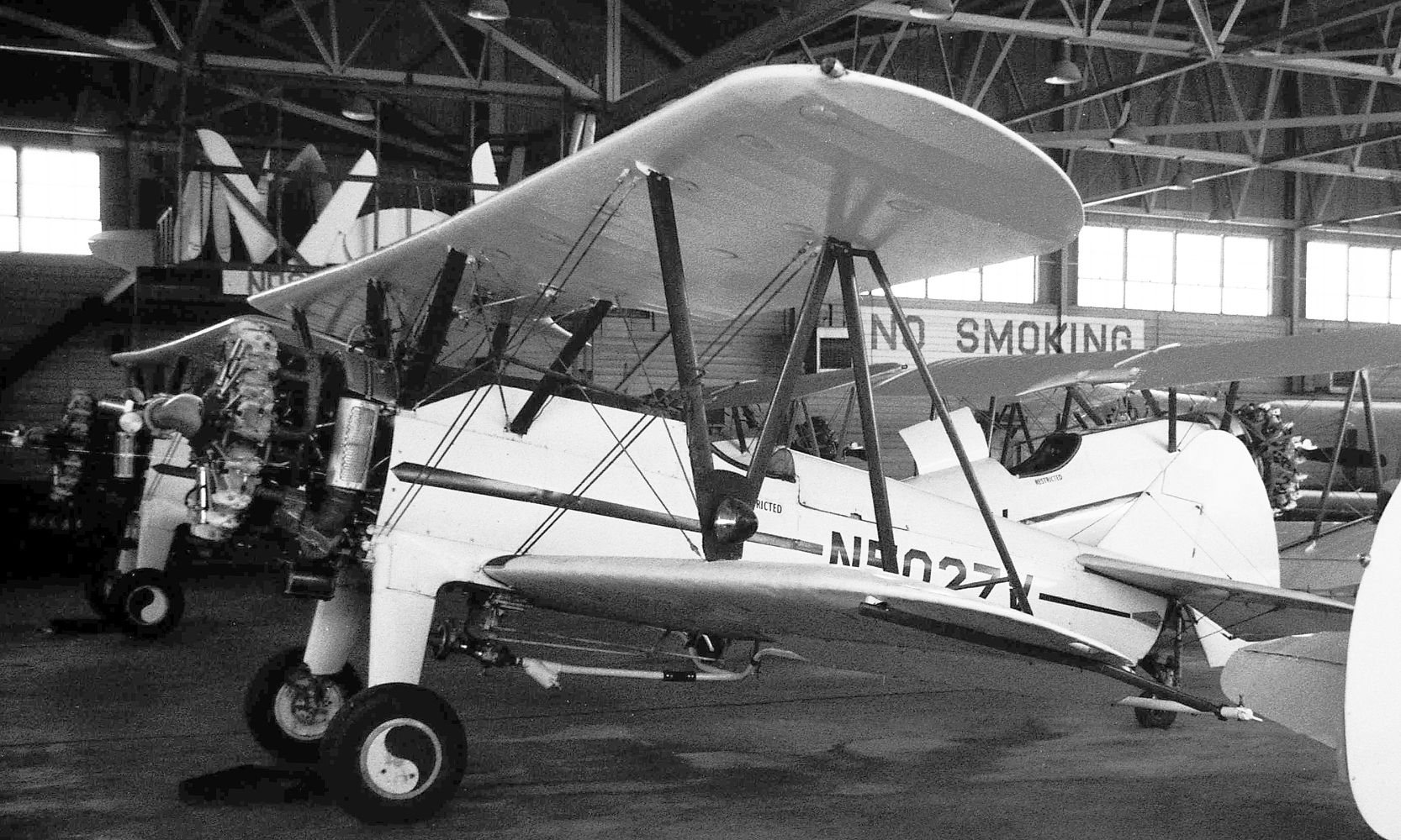
The last photos which have been located showing aircraft at the former Lemoore AAF were a series of May 1971 photos by Jay Sherlock,
this one showing Stearman PT-17 N502V inside the Willet Flying Service hangar at the former Lemoore AAF.
Jay Sherlock recalled, “The Willet Flying Service was still in operation at the site of Lemoore AAF as late as May, 1971.
After driving past on the highway a number of times, one day I noticed the hangar door was partially open, so I drove over.
The owner was out flying in his Cub, but once he landed I was somewhat grudgingly allowed to photograph some of the Stearmans inside the hangar; 9 different aircraft.
I don't know when the agricultural operations stopped.”
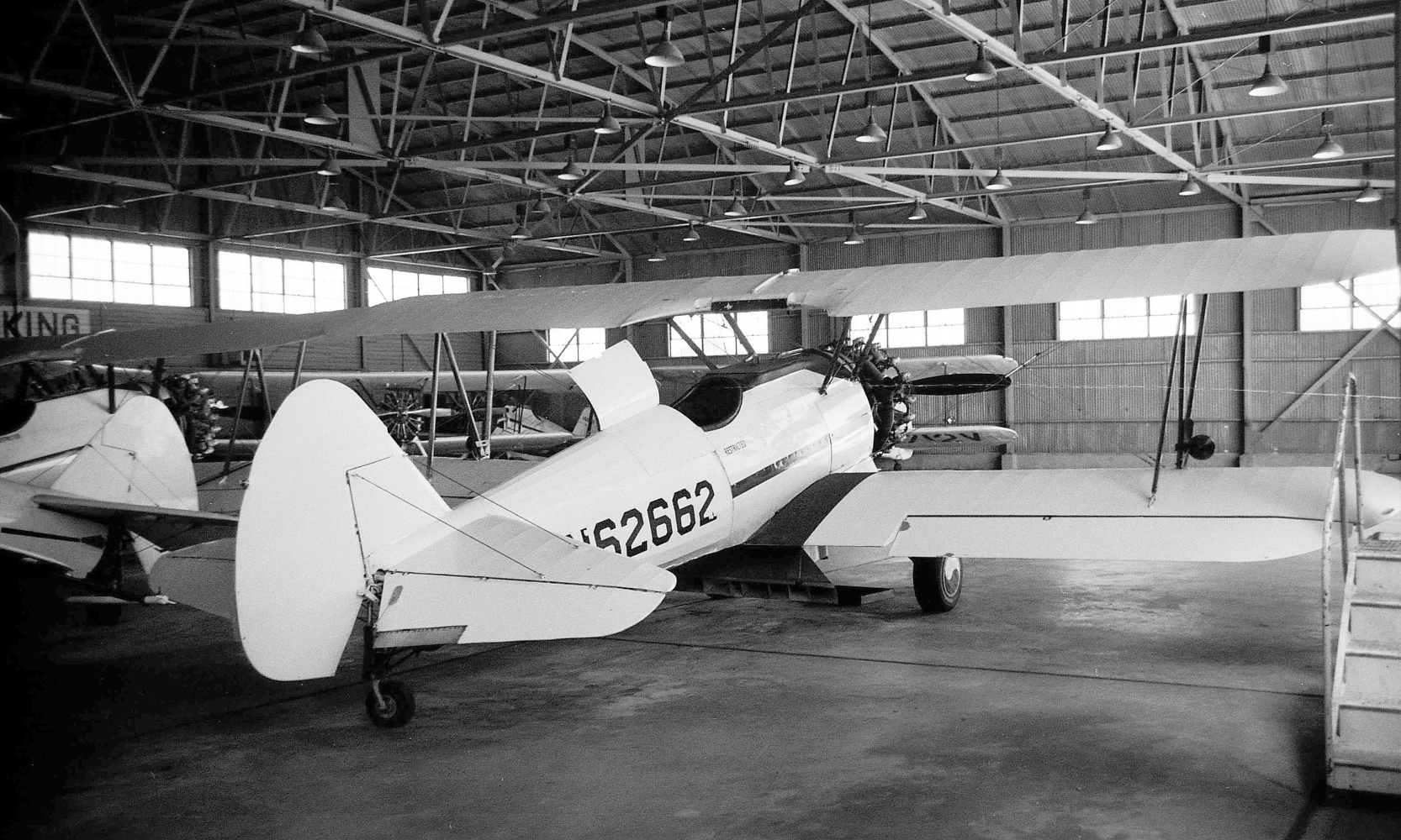
A May 1971 photo by Jay Sherlock of Stearman PT-17 N62662 inside the Willet Flying Service hangar at the former Lemoore AAF.
In the early 1970s the western portion of the former airfield site was leased by McCarthy Land Company
which used the facility for the manufacture of farming supplies
and utilized some of the former airfield structures for an agricultural chemical laboratory
(according to Joe Simpson, as reported in a 1989 Army Corps of Engineers report).
Dianne Avila acquired the western 964 acres of the former site in 1973, which included all of the former airfield facilities.
Information available from the County of Kings Department of Public Health Division of Environmental Health Services
indicates that the airfield was operated as a crop dusting airstrip for a number of years by intervening owners,
and approximately in 1975 the runway was removed & the area developed for agriculture purposes.
A 9/25/75 USGS aerial photo (courtesy of Dallam Oliver-Lee)
showed that the runways to the east of the ramp had been removed & the land returned to cultivation.
The eastern 464 acres of the former Lemoore site was acquired in 1980 by the Leonard Oliveira Farming Company.
As of a 1989 Army Corps of Engineers report, the former Lemoore AAF site was owned by 2 private individuals.
Dianne Avila owned the western portions of the former airfield site
that included the aircraft maintenance buildings, hangars, and parking areas.
She used her property as an orchard.
The Leonard Oliveira Farming Company (also known as the Double 0 Ranch) owned the eastern portion of the former airfield site
which previously contained the taxiways, runways and parking area for the airplanes.
That property was also used to raise crops.
The report described the remaining structures on the site as 2 hangars, 3 warehouses and Z barracks-type buildings,
which were described as appearing to be structurally sound.
Two other buildings appeared to be less well-maintained.
One of the 2 buildings appeared to be abandoned with windows broken & no doors in the doorways.
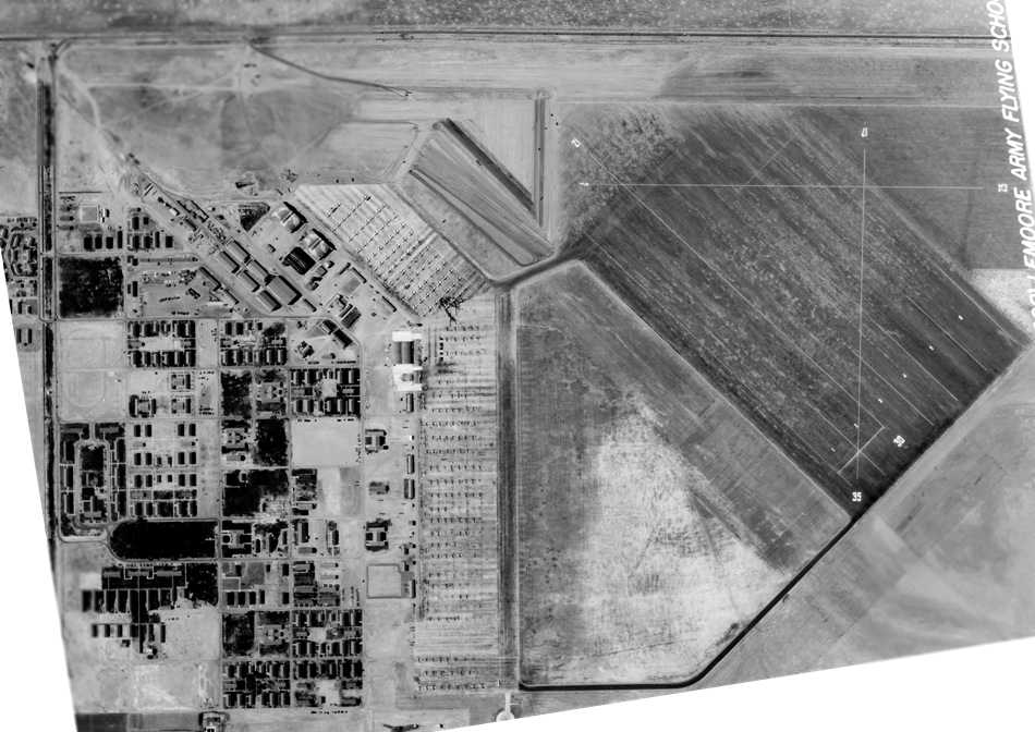
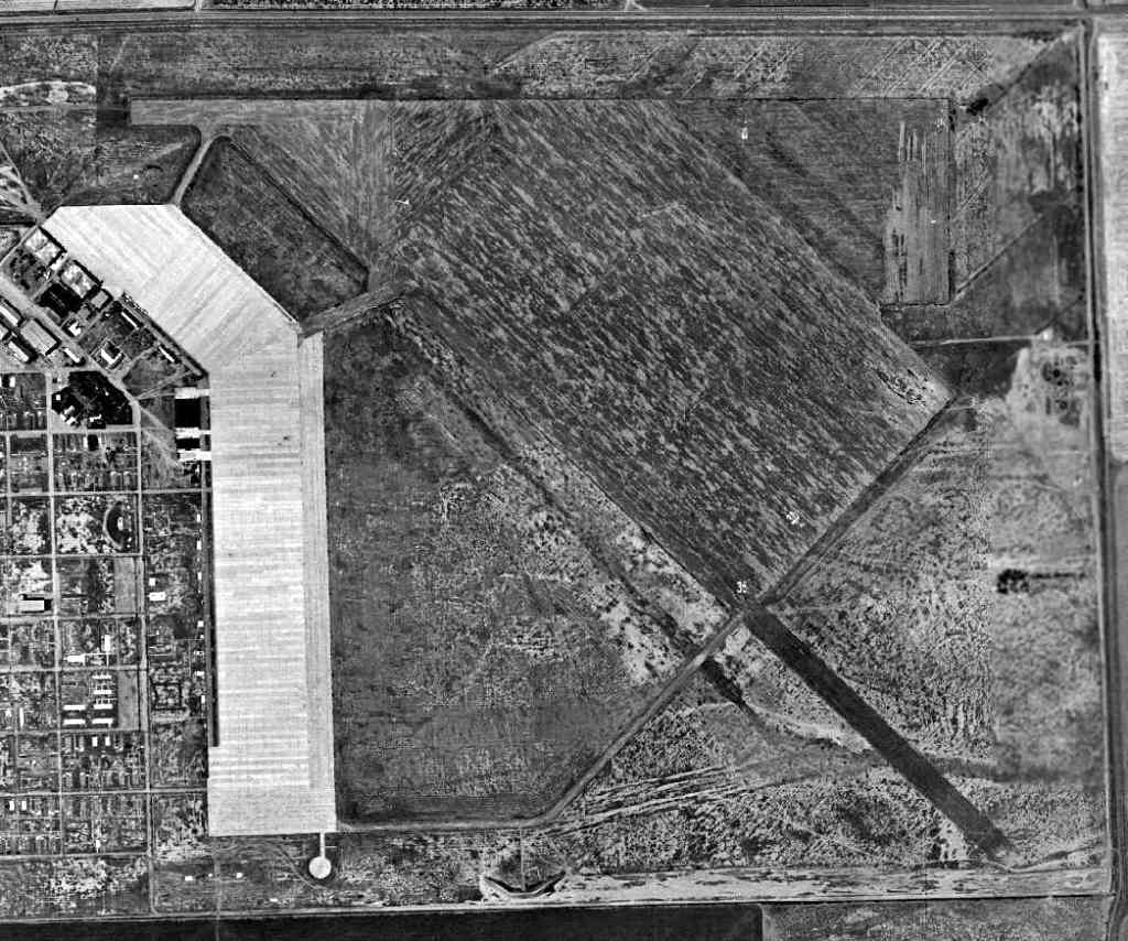
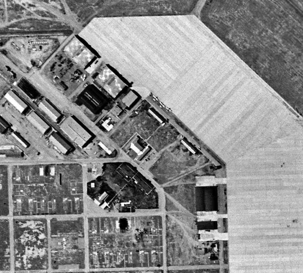
As seen in the 1994 USGS aerial photo, the cleared concrete area in the west half of the photo was once the ramp of the airfield.
The light-colored building along the northwest end of the ramp is an original WW2-vintage hangar (with a 2-section arched roof),
while another former hangar is at the southwest end of the ramp.
A 3rd hangar (at the northwest) had been removed at some point between 1955-94.
The pavement of the landing mat & taxiways has been long removed, with the land returned to cotton fields.
However, by examining the southeast corner of the above 1994 aerial photo,
a faint diagonal outline is still barely perceptible in the cotton fields of the former taxiways.
Paul Freeman visited the Lemoore AAF site in 1994.
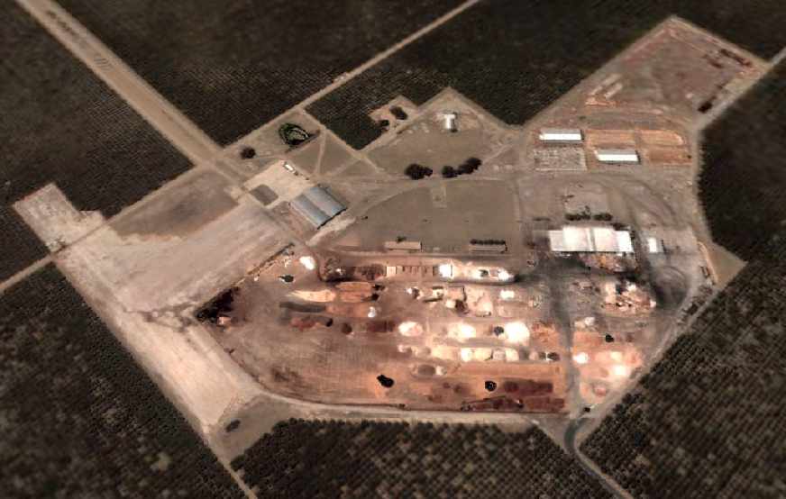
A circa 2000-2005 USGS aerial photo looking southwest at the remaining paved ramp areas of the former Lemoore AAF.
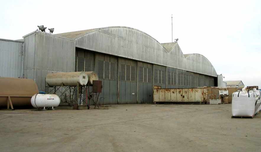
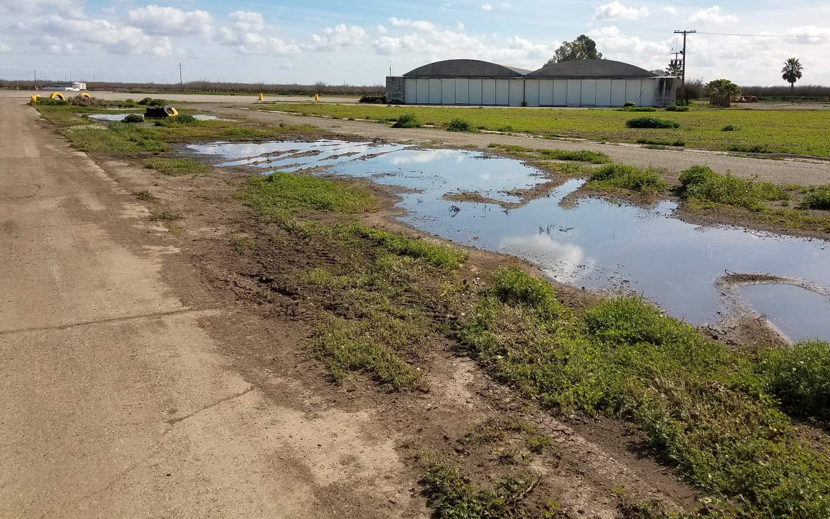
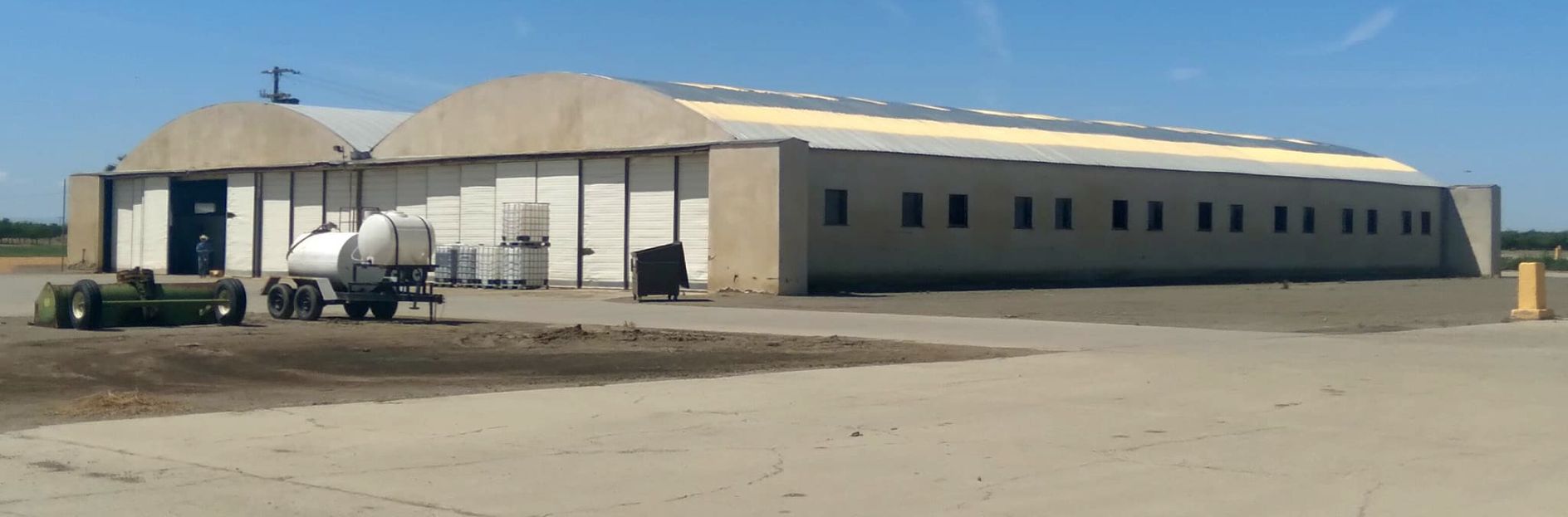
A 2004 photo of the remaining hangar at the northwest end of the Lemoore AAF ramp.
A 2004 photo of the ramp & northwest hangar at Lemoore AAF.
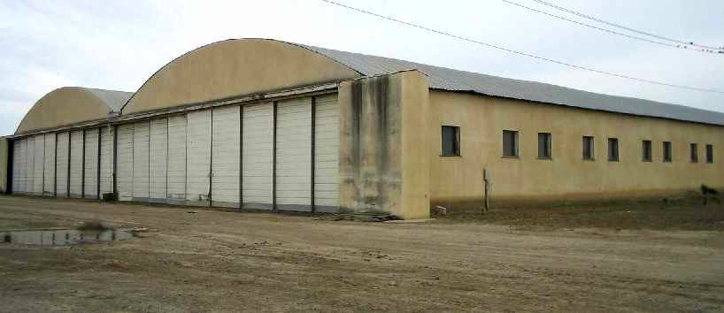
A 2004 photo of the remaining hangar at the southwest end of the Lemoore AAF ramp.
No trace appears to remain of any of Lemoore AAF's 6 satellite airfields.
Brian Rehwinkel noted, “Lemoore AAF's story is interesting.
I think is fascinating that such a large facility can almost completely disappear - both physically & historically.”
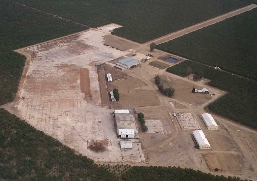
A 5/5/13 aerial view by Dallam Oliver-Lee looking southeast at the remaining ramp & hangars of the former Lemoore AAF.
Dallam remarked, “We had to get special permission to enter in [NAS] Lemoore's airspace to close to the old Lemoore Army Airfield.”
Note the checkerboard pattern still barely recognizable on the roof of the hangar in the foreground.
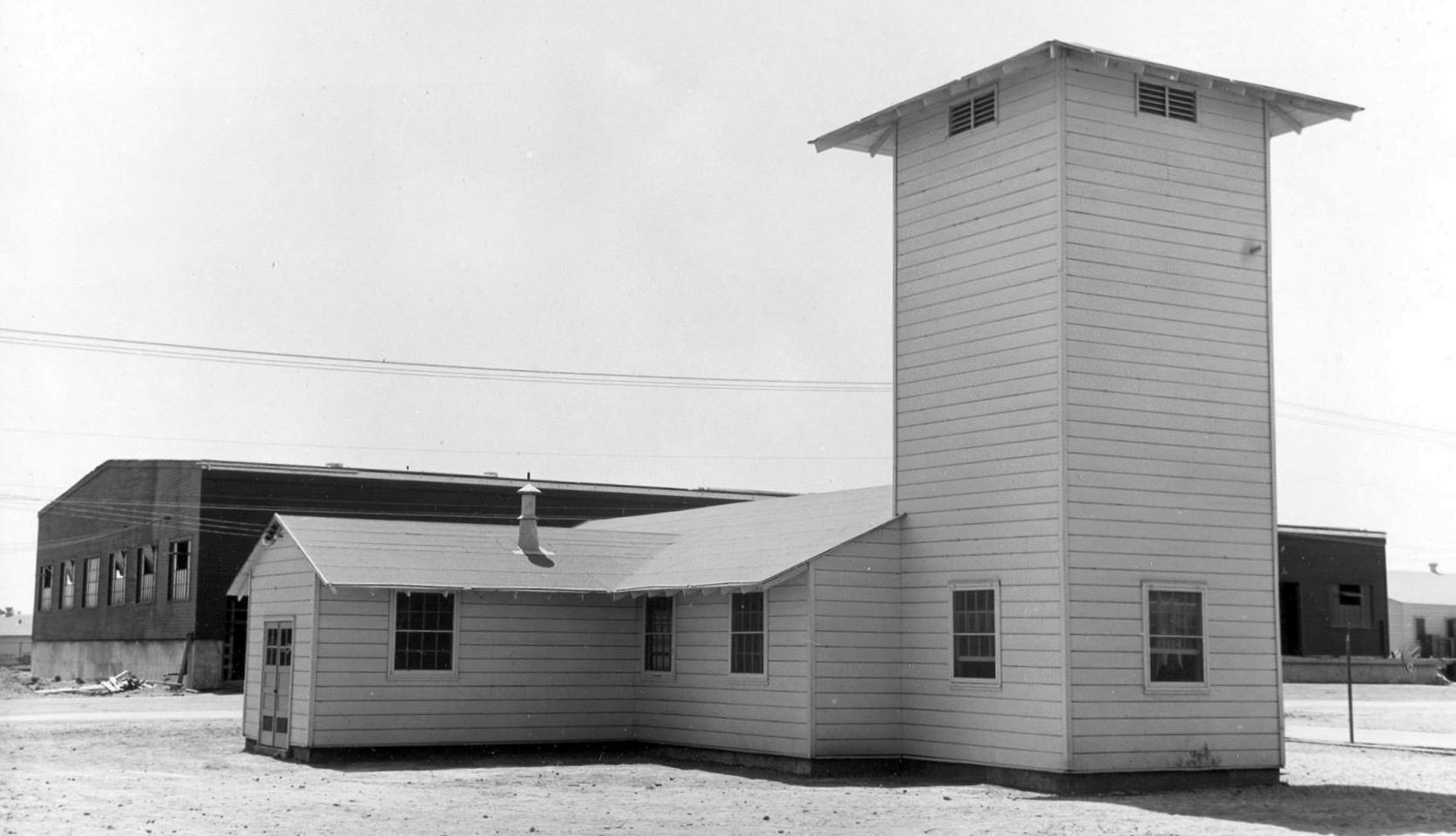
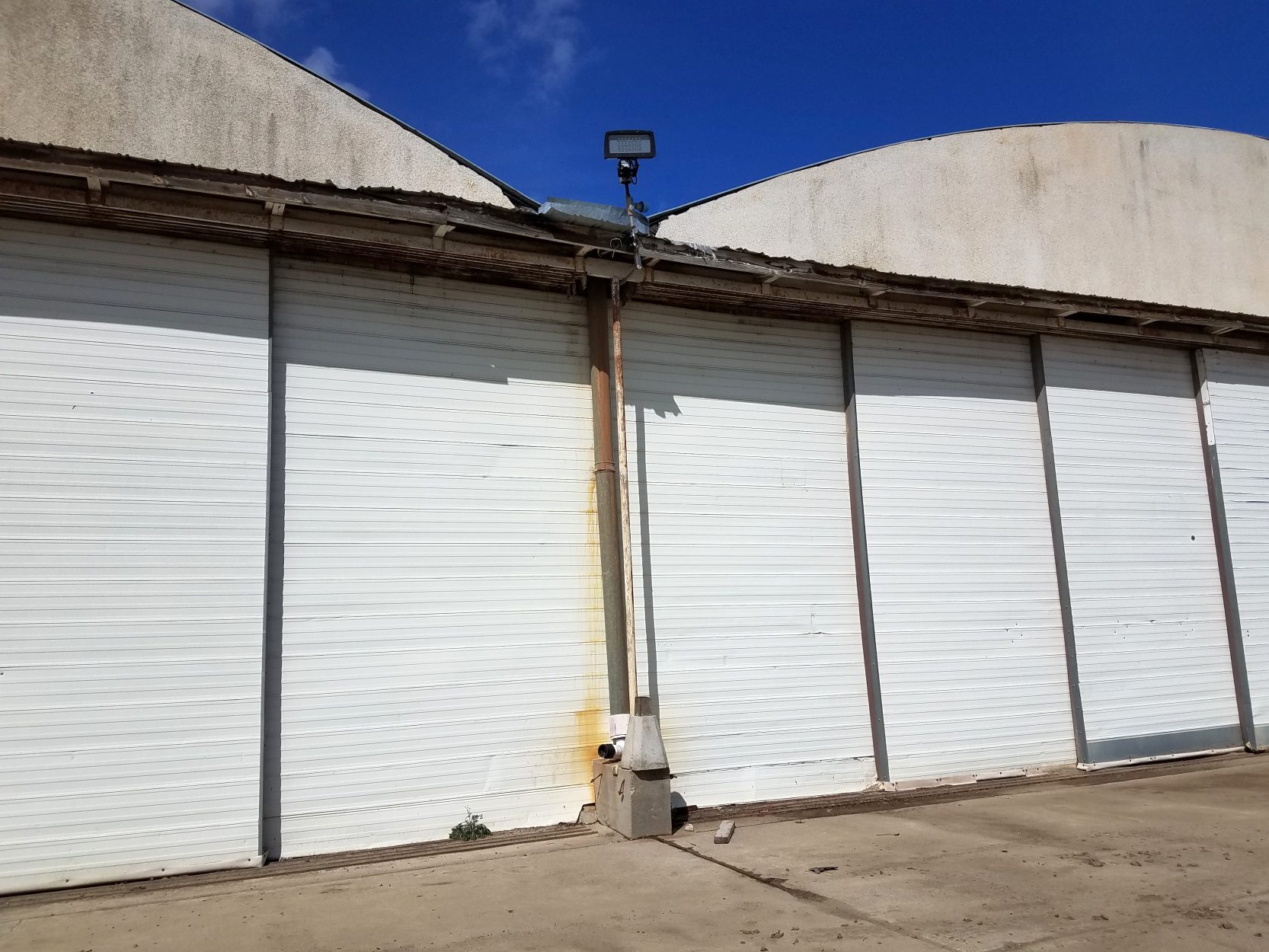
A 3/10/19 photo by Gary Alexander looking southwest at the northern hangar of the former Lemoore AAF.
A 3/10/19 photo by Gary Alexander looking southwest at the northern hangar of the former Lemoore AAF.
A 3/10/19 photo by Gary Alexander of the southern hangar of the former Lemoore AAF.
A 3/10/19 photo by Gary Alexander of the southern hangar of the former Lemoore AAF.
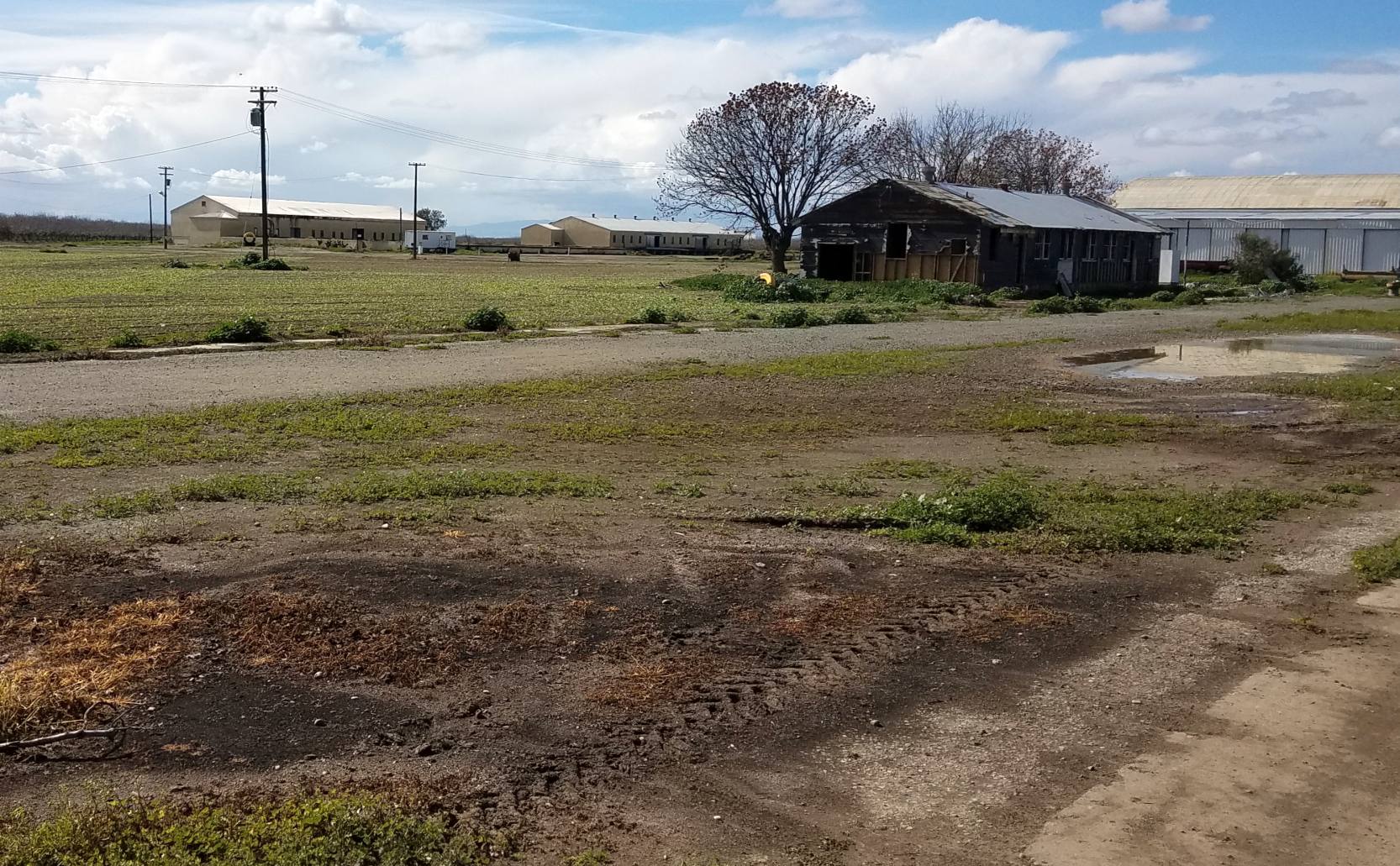
A 3/10/19 photo by Gary Alexander of other buildings at the former Lemoore AAF.
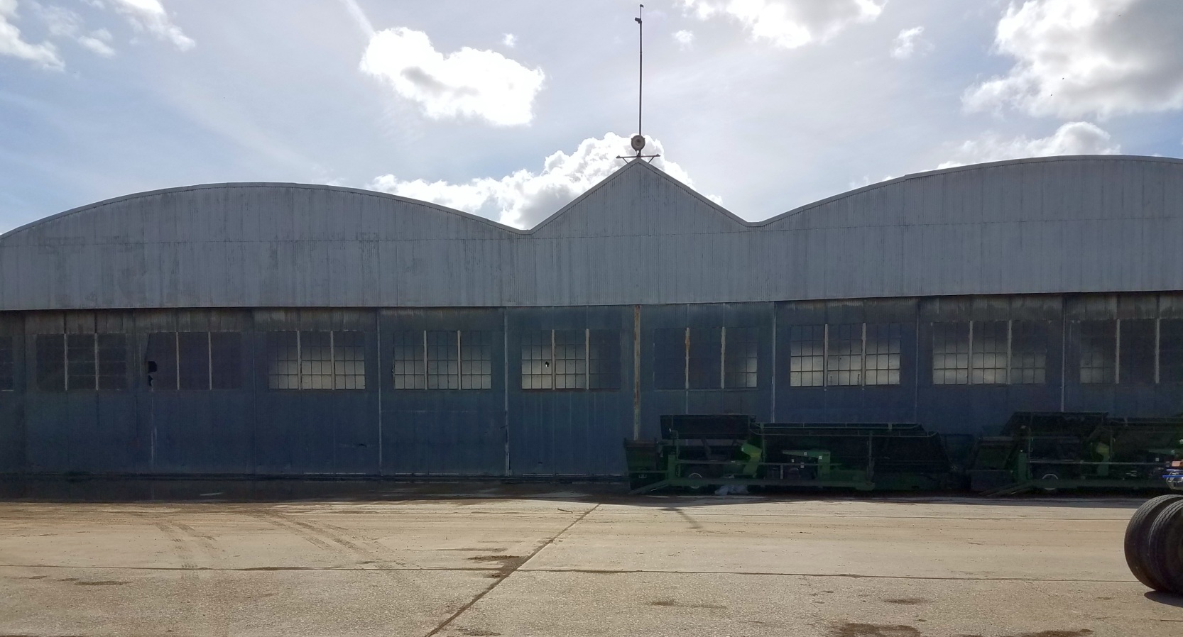
A 2022 photo looking southwest at the northern hangar of the former Lemoore AAF.
A 2022 photo of the southern hangar of the former Lemoore AAF.

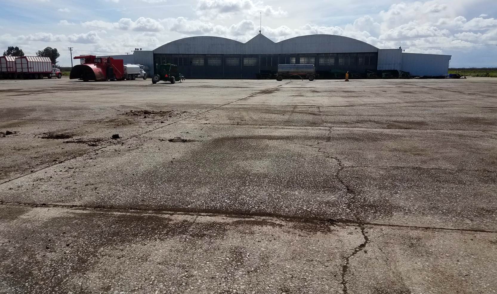
A June 2024 aerial view by Anthony Jackson looking northeast ramp & hangars which remain from the former Lemoore AAF.
Note the eastern hangar has “NAVY F***'N ROCKS!” painted on its roof, facing the approach of nearby NAS Lemoore.
The site of Lemoore AAF is located south of the intersection of Route 198 & 27th Avenue, 2 miles west of the main gate of Lemoore NAS.
____________________________________________________
Lemoore Auxiliary Army Airfield A-3 / Indian Field, Huron, CA
36.132, -120.088 (South of Fresno, CA)
Indian Field, as depicted on a circa 1944 Tulare Lake AAF Aeronautical Chart (courtesy of Roger Connor).
Indian Field was one of 7 Army Auxiliary Airfields that were established during WW2
to support flight training operations at nearby Lemoore Army Airfield.
According to an Army Corps of Engineers report, “The 642 acres that compose Indian Auxiliary Field
were acquired by the U.S. Government by Declaration of Taking in 1944.
Prior to acquisition, the site was native pasture & had not been farmed.
The site was developed as an auxiliary landing field by the Army Air Forces in connection with the Lemoore Basic Flying School.
The improvements were hard surfaced runways, fencing, crash truck shelter, stage house, control tower, motor house, and latrine.”
The Lemoore satellite fields each consisted of a 3,000' square landing mat,
with either a "road mix" or oiled surface.
The earliest depiction which has been located of Indian Field was on a circa 1944 Tulare Lake AAF Aeronautical Chart (courtesy of Roger Connor).
A WW2-era diagram (courtesy of John Voss) showing Lemoore A-3 along with the parent Lemoore AAF & its other satellite airfields
According to an Army Corps of Engineers report, “On 10/15/44, the site was declared surplus by the War Assets Administration.”
The last aeronautical chart depiction which has been located of Indian Field was on the September 1945 Mt. Whitney Sectional Chart.
Indian Field was no longer depicted on the February 1946 Mt. Whitney Sectional Chart.
According to an Army Corps of Engineers report, “The WAA assumed accountability of the site on 9/12/46.
Available records do not indicate if any deed clauses, provisions, or restrictions existed for the site.”
Indian Field was no longer depicted on the 1947 USGS topo map.
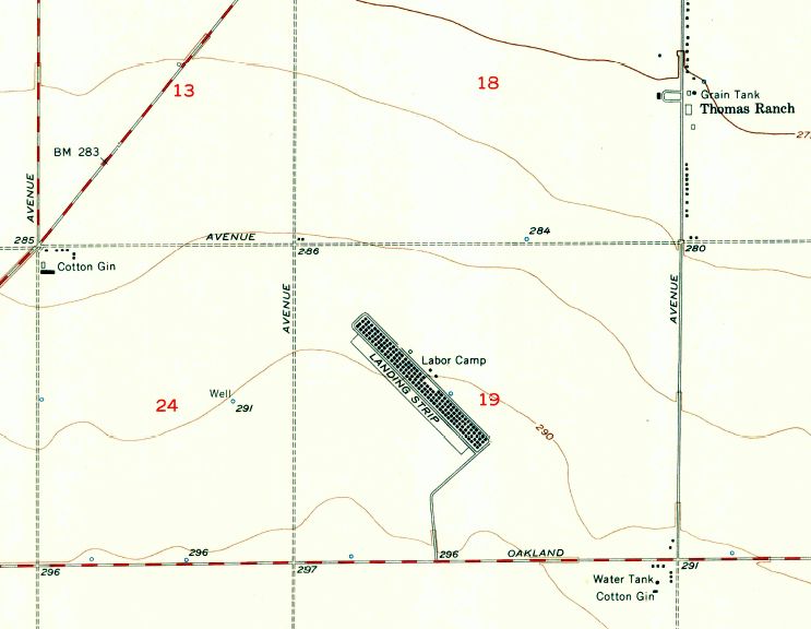
The earliest photo which has been located of Indian Field was a 3/13/50 USDA aerial photo (courtesy of Dallam Oliver-Lee).
It depicted Indian Field as having a square landing mat oriented along a diagonal axis.
The 1957 USGS topo map (courtesy of Dallam Oliver-Lee) depicted the Indian Field property
as a labor camp with a large number of small buildings oriented along a northwest/southeast axis (a former runway orientation?).
No airfield features were depicted.
An 8/1/61 USDA aerial photo (courtesy of Dallam Oliver-Lee) still showed remains of the labor camp.
The labor camp was still depicted on the 1964 USGS topo map (courtesy of Dallam Oliver-Lee).
Dennis Vasquez recalled, “I recall going to what was the old Indian Auxillary Field located off Jayne Avenue near the city of Huron.
In the early to mid-1960s there was still a 2-story military-type barracks building located at the site. It was used to house migrant farm working families.”
A 1965 USDA aerial photo (courtesy of Dallam Oliver-Lee) showed the remains of the labor camp had been erased by farming.
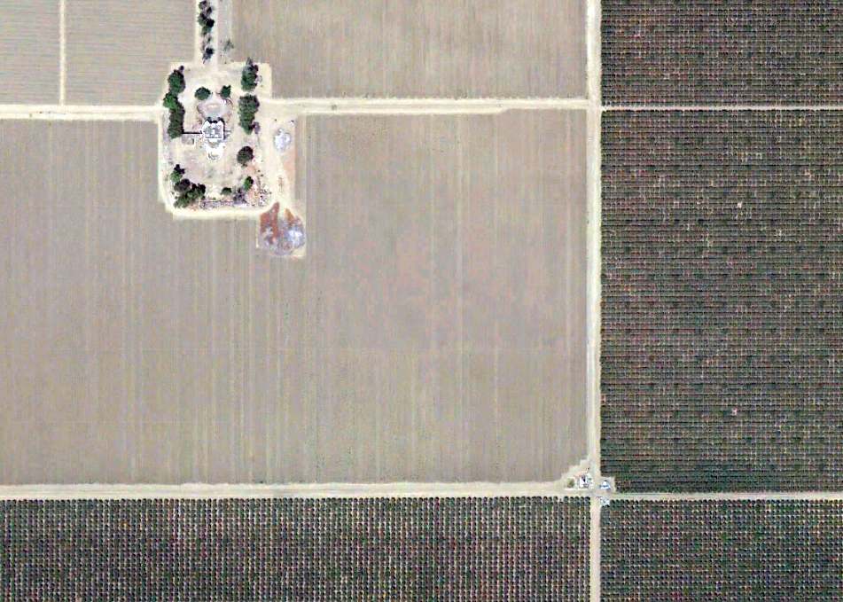
An 8/27/12 aerial view (courtesy of Dallam Oliver-Lee) showed no remaining trace of Indian Field.
The site of Indian Field is located south of the intersection of South Siskiyou Avenue & West Jayne Avenue.
Thanks to Dallam Oliver-Lee for locating this airfield.
____________________________________________________
Lemoore Auxiliary Army Airfield A-7 / Helm Field #6, Coalinga, CA
36.35, -120.174 (South of Fresno, CA)
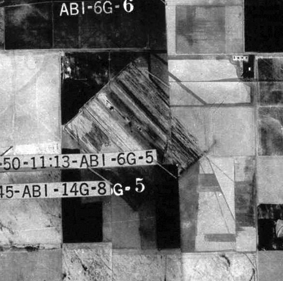
A 12/12/40 USGS aerial view (courtesy of Dallam Oliver-Lee) appeared to show the faint outline of 2 unpaved runways at the site of Lemoore Aux AAF #7.
It is possible that Helm Field was a pre-WW2 civilian airfield (possibly for cropdusting?), as a 12/12/40 USGS aerial view (courtesy of Dallam Oliver-Lee)
appeared to show the faint outline of 2 unpaved runways, oriented east/west & northwest/southeast.
According to an Army Corps of Engineers report, “The 773 acres that comprised Helm Auxiliary Field #6 was purchased by the U.S. Government on 1/11/43.
The site was developed into an auxiliary landing field & basic flying school by the Army Air Corps in connection with the Lemoore Basic Flying School.
The improvements were roads, hard-surfaced runways, fencing, a crash truck shelter, a stage house, a control tower, a motor house, and latrines.”
The Lemoore satellite fields each consisted of a 3,000' square landing mat, with either a "road mix" or oiled surface.
A WW2-era diagram (courtesy of John Voss) showing Lemoore A-7 along with the parent Lemoore AAF & its other satellite airfields.
A 4/20/43 aerial view (courtesy of Brian Rehwinkel) showed Lemoore A7 as having a diagonal square landing mat.
Brian observed, “As with many other AAF auxiliary fields, this field has a shack in the middle of the field (it just seems that must have been dangerous!).
You can also see how dry the area around the field was in 1943 – before all of the massive irrigation efforts transformed this region into a massive agricultural area.”
Helm Field, as depicted on a circa 1944 Tulare Lake AAF Aeronautical Chart (courtesy of Roger Connor).
According to an Army Corps of Engineers report, “On 10/15/44, the site was declared surplus by the War Assets Administration.”
The March 1946 Mt. Whitney Sectional Chart (courtesy of Chris Kennedy) depicted Helm Field, along with Lemoore AAF & its other satellite airfields.
According to an Army Corps of Engineers report, “The WAA assumed accountability of the site on 9/12/46.
Available records do not indicate if any deed clauses, provisions, or restrictions existed for the site.”
The 1947 USGS topo map didn't depict anything at the site of Helm Field.
Helm Field was no longer depicted on the August 1948 San Francisco Sectional Chart.
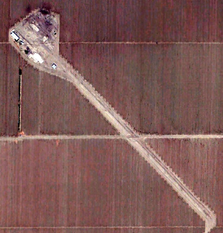
A 6/23/55 USGS aerial photo (courtesy of Dallam Oliver-Lee) depicted the Helm Field property
as having a labor camp with a large number of small buildings adjacent to a single northwest/southeast runway.
No aircraft or aviation-related buildings were visible on the field.
The Helm Field property was evidently reused after WW2 as a labor camp,
as the 1956 USGS topo map (courtesy of Dallam Oliver-Lee) depicted a labor camp with a large number of small buildings
adjacent to a single northwest/southeast runway labeled “Landing Strip”.
Helm Field was evidently reused as a civilian airfield at some point between 1955-71,
as a 5/22/71 USGS aerial photo (courtesy of Dallam Oliver-Lee) depicted 2 single-engine aircraft
parked next to a few small buildings (hangars?) which had been added to the northwest of the runway,
which was painted with a single closed-runway “X” symbol in the middle.
The 1987 USGS topo map (courtesy of Dallam Oliver-Lee) still depicted a single northwest/southeast runway, labeled “Landing Strip”.
A 5/10/94 USGS aerial photo (courtesy of Dallam Oliver-Lee) no longer showed any aircraft at Helm Field.
According to a 1990s Army Corps of Engineers report, “Available information does not indicate when the property was acquired from the WAA.
The site is currently owned by several private parties & is primarily used as farmland."
An 8/27/12 aerial view (courtesy of Dallam Oliver-Lee) showed the Helm Field runway remained intact, but there was no sign of recent aviation usage.
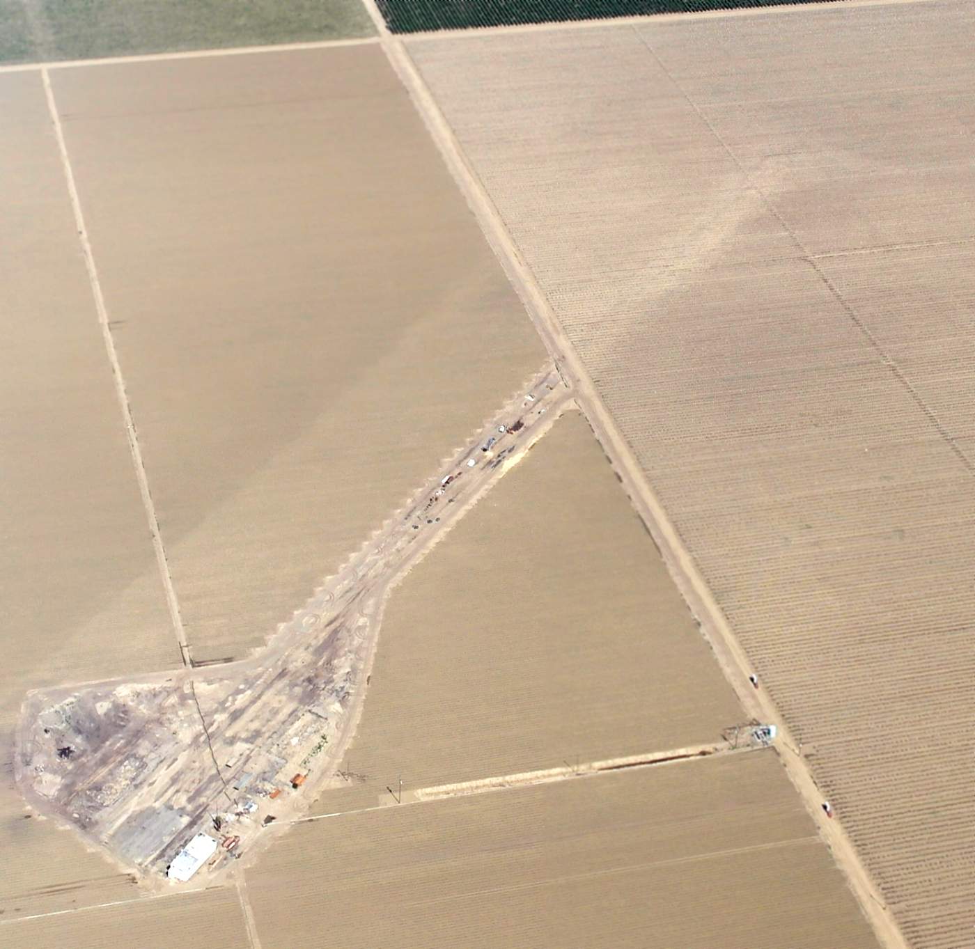
A 4/26/15 aerial view by Dallam Oliver-Lee looking east at the remains of the Helm Field runway.
A 2024 aerial view showed the Helm Field site had been replanted, with barely the slightest trace remaining of the former runway.
The site of Helm Field is located southeast of the intersection of South Yuba Avenue & West Cadillac Avenue.
Thanks to Dallam Oliver-Lee for locating this airfield.
____________________________________________________
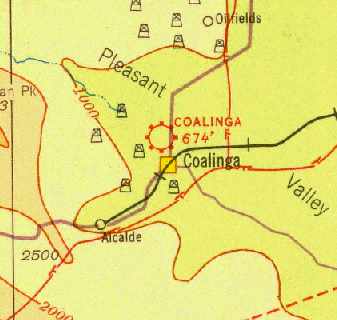
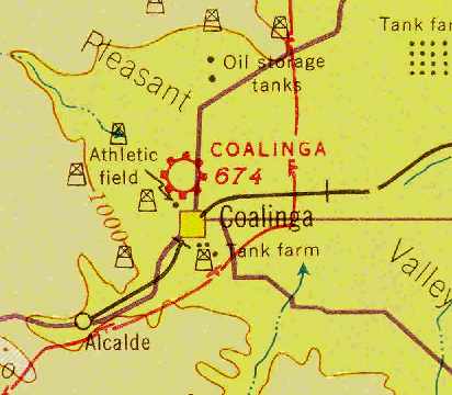
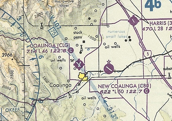
Coalinga Municipal Airport (original location) (CLG), Coalinga, CA
36.16, -120.36 (Southwest of Fresno, CA)
Coalinga Airport, as depicted on the 1929 Rand-McNally Air Trails Map of CA (courtesy of Chris Kennedy).
The original airport for the town of Coalinga was located adjacent to the northwest side of the town.
The date of construction of the former small general aviation airport is unknown.
The earliest depiction which has been located of the Coalinga Airport was on the 1929 Rand-McNally Air Trails Map of CA (courtesy of Chris Kennedy).
It described Coalinga as a municipal airport operated by the Chamber of Commerce, and the field was said to measure 2,000' x 1,400'.
The Standard Oil Company's 1929 "Airplane Landing Fields of the Pacific West" (courtesy of Chris Kennedy)
described Coalinga Airport as having an irregularly shaped 2,750' x 2,100' landing area.
The 1932 San Francisco - LA Air Navigation Map (courtesy of Herbert Haar) depicted Coalinga as a commercial or municipal airport.
The 1933 San Francisco Airway Map (courtesy of Chris Kennedy) depicted Coalinga as a commercial or municipal airport.
According to K.O. Eckland, in 1936 Coalinga had 2 runways, with the longest being a 4,200' northwest/southeast strip.
The Airport Directory Company's 1937 Airports Directory (courtesy of Bob Rambo) described Coalinga Municipal as having 2 oiled runways,
with the longest being a 4,200' northwest/southeast strip.
It was also described as having a hangar, with "Coalinga" painted on the roof.
The earliest photo which has been located of the Coalinga Airport
was an undated aerial view looking south from The Airport Directory Company's 1938 Airports Directory (courtesy of Jonathan Westerling).
It described Coalinga Municipal as having 2 oiled runways, with the longest being a 3,000' northwest/southeast strip.
It was also described as having a hangar, with "Coalinga" painted on the roof.
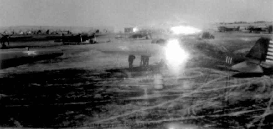
A circa 1930s photo of Army Matrtin B-10 bombers at Coalinga.
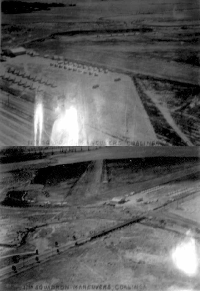
Two circa 1930s photo of Army maneuvers at Coalinga Airport.
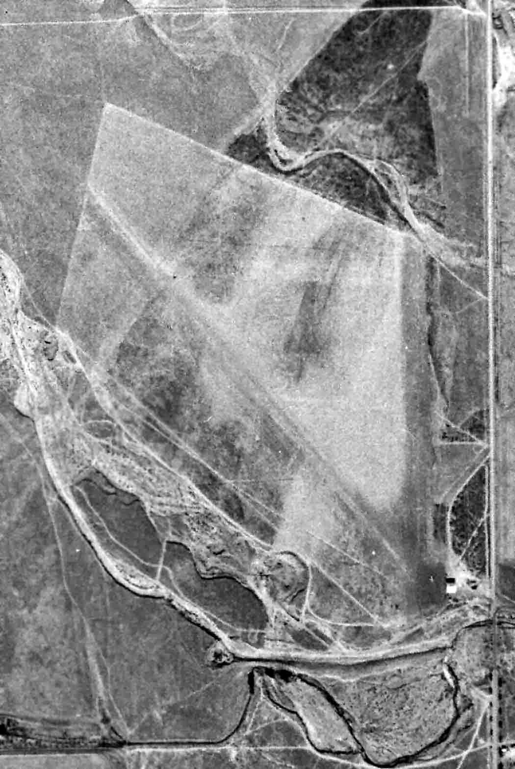
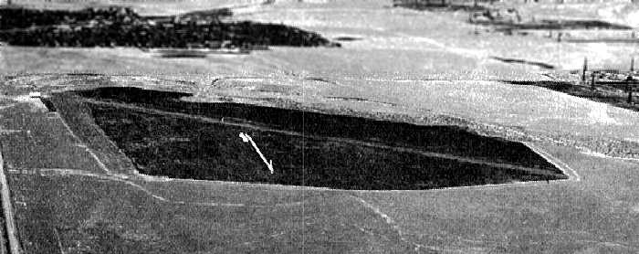
An 11/28/40 USGS aerial photo depicted Coalinga Airport as having 2 unpaved runways, with a small hangar on the southeast side.
An undated aerial view looking southwest at Coalinga Airport from The Airport Directory Company's 1941 Airports Directory (courtesy of Jonathan Westerling).
It described Coalinga Municipal as a 220 acre field having 2 oiled runways, with the longest being a 3,000' northwest/southeast strip.
It was also described as having a hangar, with "Coalinga" painted on the roof.
The December 1941 San Francisco Sectional Chart (courtesy of Chris Kennedy) depicted Coalinga as a commercial or municipal airport.
In 1942, a total of 221 acres were leased by the Federal Government
from Standard Oil Company of CA & the Coalinga Chamber of Commerce (according to a 1992 Army Corps of Engineers report).
Thus the Coalinga Airport was reused during WW2 as the Lemoore Emergency Landing Field,
an auxiliary field used to train pilots from the Lemoore Army Airfield, 25 miles to the east.
A 3,600 square foot hangar was leased from the Coalinga Chamber of Commerce by the Army Air Force.
Coalinga Airport was also reportedly used as an auxiliary airfield for Minter AAF during WW2.
"Coalinga, Army" was described in the 1944 US Army/Navy Directory of Airfields (courtesy of Ken Mercer) as having a 3,600' runway.
The 1944 USGS topo map depicted an open area north of the town, simply labeled as “Airport”, without any other detail.
With the end of WW2, the Coalinga Airport site was declared surplus by the military on 4/21/45,
and both leases were terminated on 5/19/45 (according to a 1992 Army Corps of Engineers report).
A 1945 aeronautical chart (courtesy of Dan MacPherson) depicted Coalinga as an auxiliary airfield.
Ike Stephenson recalled, “Old Coalinga Airport... this airport was once served by Southwest Airlines DC-3s.
I often rode through Coaling on Southwest en route to/from Monterey.”
The September 1949 Mt. Whitney World Aeronautical Chart depicted Coalinga as having a 5,300' unpaved runway.

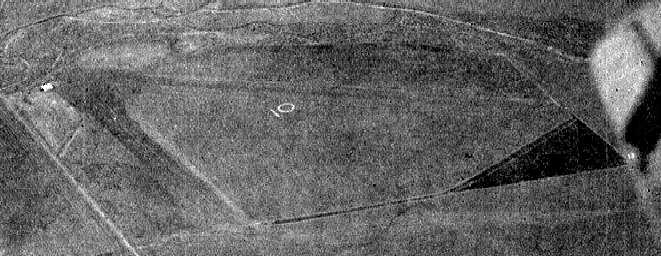
An undated aerial view looking north at Coalinga Municipal Airport from the 1950 Air Photo Guide (courtesy of Kevin Walsh).
It described Coalinga Municipal Airport as having 3 runways, with the longest being the 5,000' blacktop northwest/southeast strip, and listed the manager as N.T. MacCollom.
The 1956 USGS topo map depicted the Coalinga Municipal Airport as having 2 paved runways.
Coalinga Municipal was listed among active airports in the 1962 AOPA Airport Directory,
with 2 paved runways, and the operator listed as "Crumpton Flying Service".
Coalinga Airport was used by crop-dusting aircraft from the mid-1960s to the mid-1970s (according to a 1992 Army Corps of Engineers report).
An 8/19/70 aerial view (from the UCSB Library) depicted Coalinga Municipal Airport as having 2 paved runways, with 6 light single-engine aircraft on the southeast ramp.
The runway at Coalinga had evidently been lengthened by 1976,
as the 1976 Pilot's Guide to CA Airports (courtesy of Chris Kennedy)
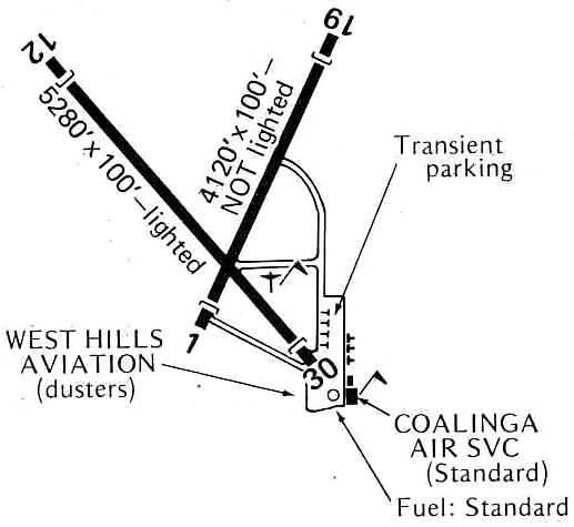
depicted Coalinga Municipal as having 2 paved runways: 5,280' Runway 12/30 & 4,120' Runway 1/19.
Several taxiways led to a ramp at the southeast corner of the field, where Coalinga Air Service & West Hills Aviation (a crop dusting service) were located.
In the 1982 AOPA Airport Directory (courtesy of Ed Drury),
Coalinga was described as having 2 asphalt runways (12/30: 5,280' & 1/19: 4,120'), and the operator was listed as Kiwi Kopters.
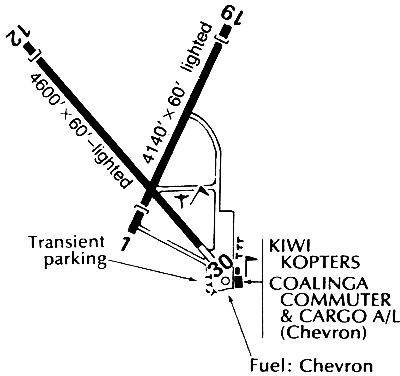
A 1984 airport directory (courtesy of Kevin Walsh) depicted Coalinga Municipal as having a shorter Runway 12/30, having decreased to 4,600'.
Several taxiways led to a ramp at the southeast corner of the field, where Kiwi Kopters & Coalinga Commuter Cargo Airline were located.
As of a 1992 Army Corps of Engineers report, the Coalinga Airport property was owned by Chevron U.S.A.
The property was leased by Chevron to the City of Coalinga, and was subleased to Spencer Aviation Company.
A site visit showed there to be 11 structures located on the site.
All of the structures were either built by the City of Coalinga or private individuals.
Three of the 11 structures were built within 1987-92.
All of the structures were described as well maintained and in good physical condition.
An above-ground storage tank located west of the Spencer Aviation office
was used by the California Highway Patrol to store aviation fuel for their helicopters.
Paul Freeman flew a Cessna into Coalinga Airport in 1994 in a Cessna 152,
to find it a very lonely place with weeds growing up through badly deteriorating runways.
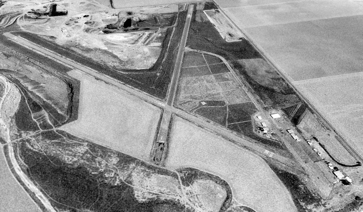
The last photo which has been located showing the original Coalinga Airport still in operation was a 1994 USGS aerial view looking northeast.
Two light single-engine aircraft were visible on the southeast ramp.
The last aeronautical chart depiction which has been located of the original Coalinga Airport
was on the September 1997 San Francisco Sectional Chart (courtesy of Ron Plante).
It depicted Coalinga as having 2 paved runways, with the longest being 4,600'.
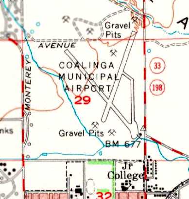
Note that it also depicted the replacement New Coalinga Municipal Airport,
which had been built a few miles to the east at some point between 1994-97.
Both Coalinga airports were still depicted as active airports on 1998 aeronautical charts.
The original Coalinga Airport was evidently closed at some point between 1998-2002.
According to Ike Stephenson, “The reason the old airport was closed is that Chevron Oil owned the land & mineral rights.
No FAA or CA monies are available for leased-land airports.”
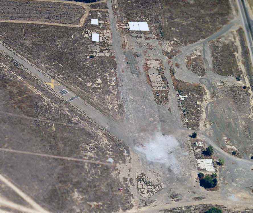
A circa 2006 aerial view looking north at the remains of the original Coalinga Municipal Airport,
showing the foundations of the hangars at the southeast corner of the site, and the X'd out markings for Runway 30.
A 5/5/13 aerial view by Dallam Oliver-Lee looking northwest at the remains of the original Coalinga Municipal Airport, showing the foundations of the hangars at the southeast corner of the site.
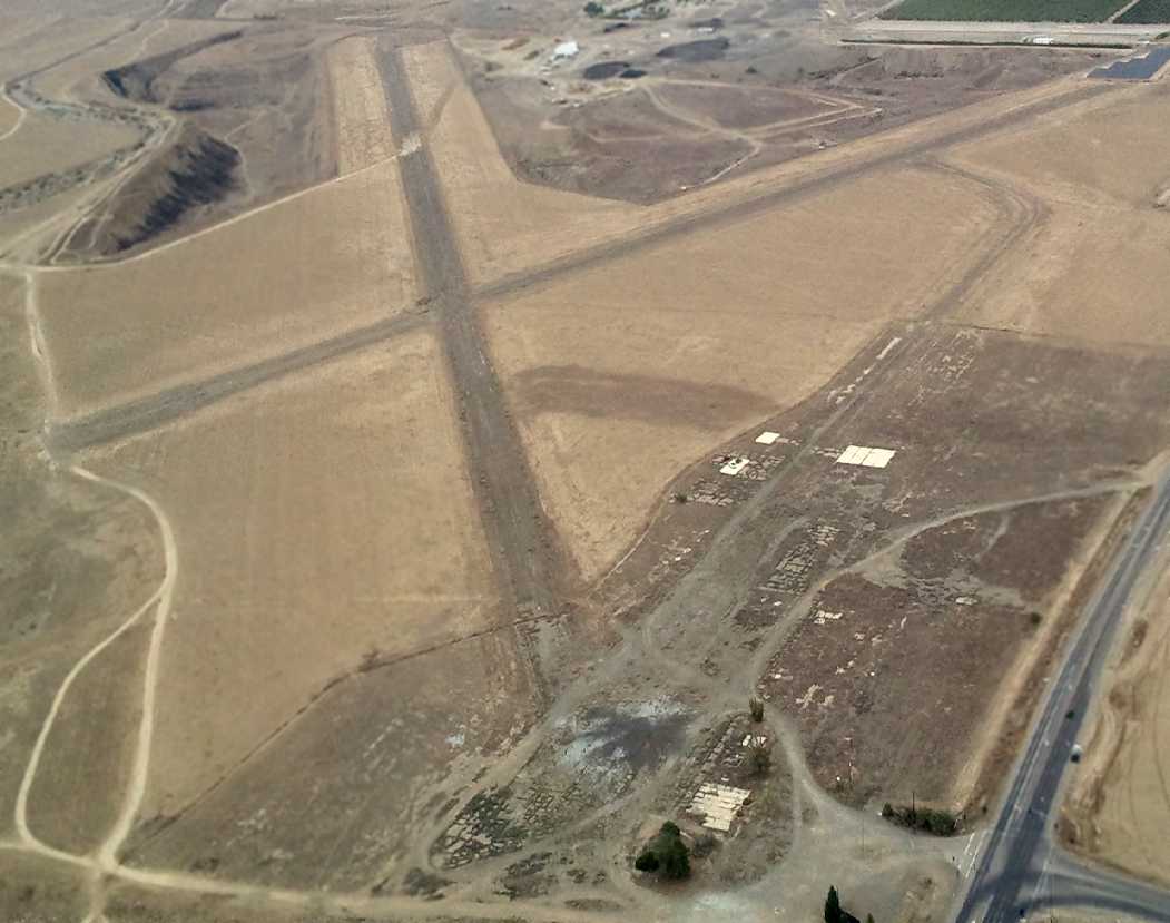
A 2015 aerial view looking northeast at the remains of the original Coalinga Municipal Airport.
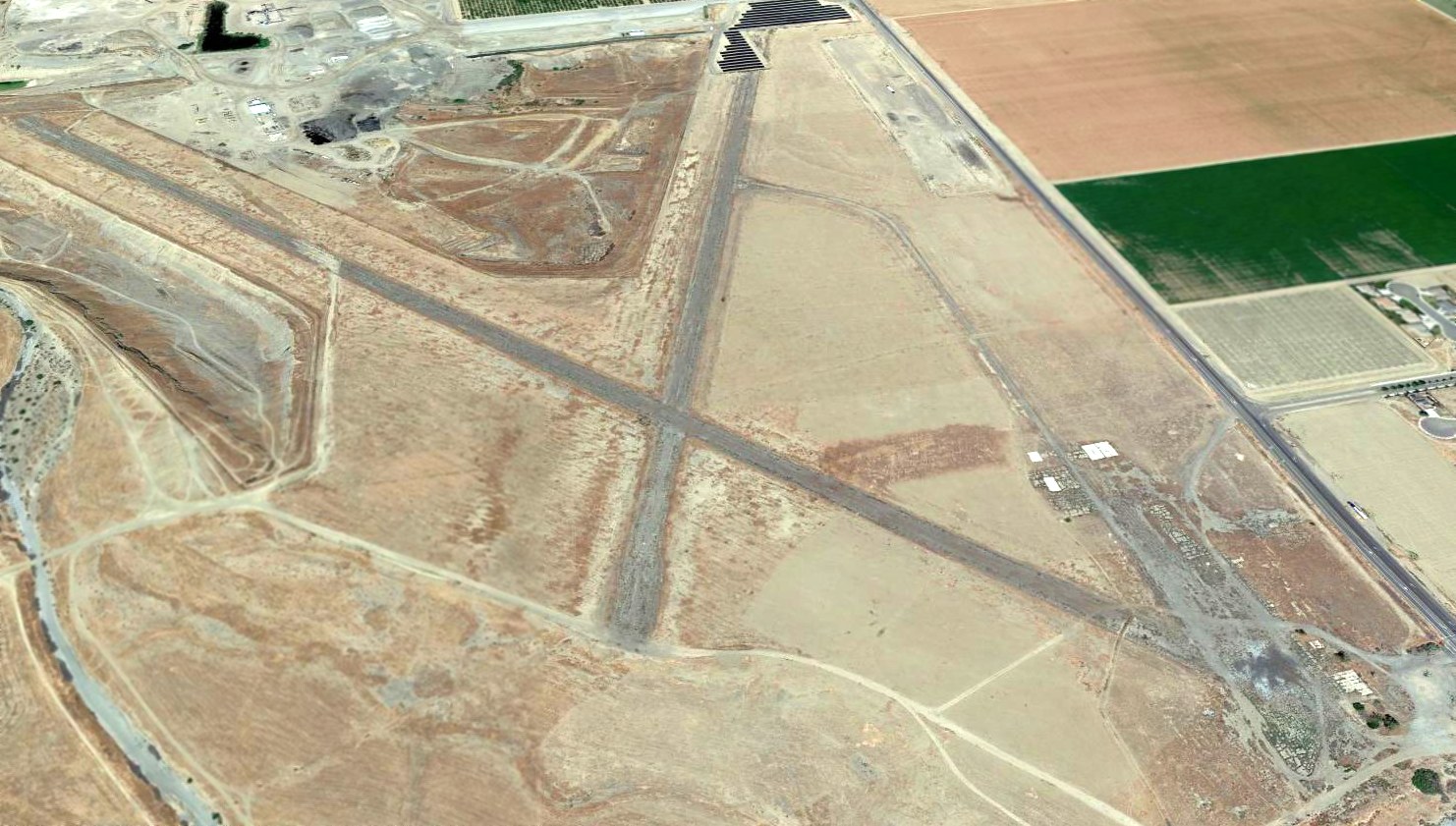
An April 2021 photo looking west shows no trace remains of the original Coalinga Municipal Airport.
____________________________________________________
____________________________________________________
This site covers airfields in all 50 states.