Abandoned & Little-Known Airfields:
Arizona - Yuma area
© 2002, © 2025 by Paul Freeman. Revised 10/20/25.
This site covers airfields in all 50 states: Click here for the site's main menu.
____________________________________________________
Please consider a financial contribution to support the continued growth & operation of this site.
Camp Horn Army Airfield (revised 10/5/14) - Colfred Aux AAF #2 / Colfred Airport (revised 11/9/21) - Dateland AAF (revised 10/20/25)
Gringo Pass Airfield (added 1/7/18) - Marsh Downtown Airport (revised 11/11/23) - McDaniel Field (revised 11/11/23) - Smiley Field (revised 6/8/20) - Stoval Field (revised 11/9/21)
Wellton Aux AAF / Wellton Airport (revised 11/11/23) - Yuma Aux AAF #1 (revised 4/27/19) - Yuma Aux AAF #2 (revised 11/9/21)
Yuma Aux AAF #3 (revised 7/6/16) - Yuma Proving Ground North AAF (revised 7/6/16)
____________________________________________________
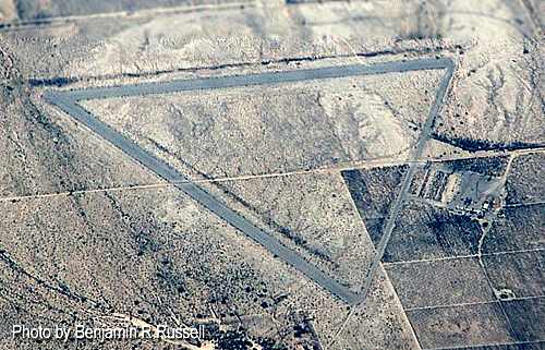
Gringo Pass Airfield, Lukeville, AZ
31.88, -112.812 (East of Yuma, AZ)
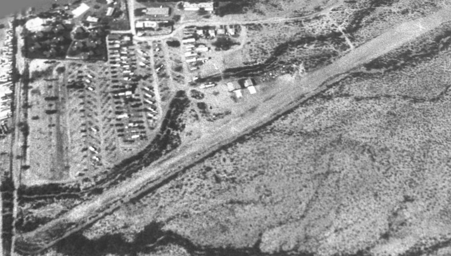
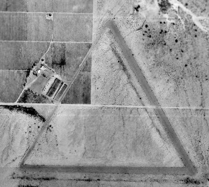
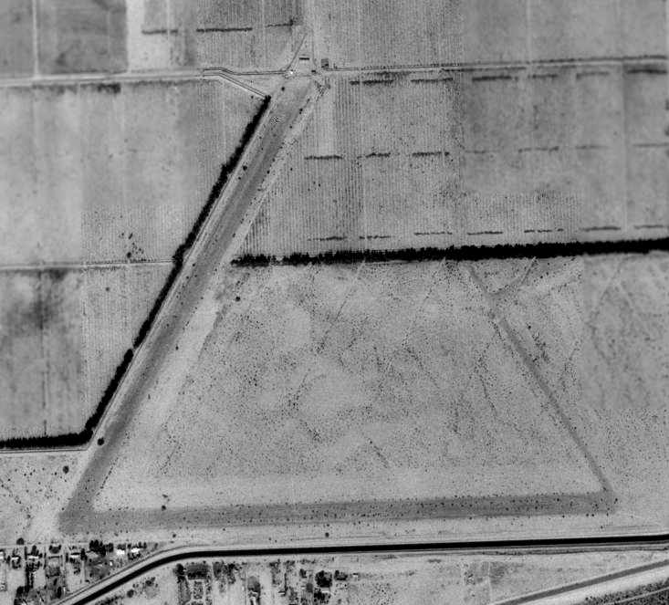
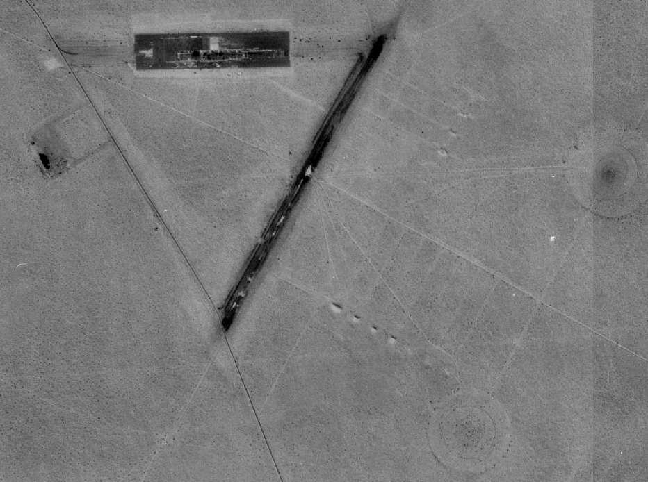
A 1992 USGS aerial view looking northwest at Gringo Pass Airfield.
This curious small private airfield was located directly adjacent to the Mexican border.
With the runway being aligned perpendicular to the border, it presumably was a “one-way” operation,
with takeoffs to the north, and landings to the south, so as to avoid crossing into Mexican airspace.
The date of establishment of Gringo Pass Airfield has not been determined.
The earliest depiction which has been located of Gringo Pass Airfield was a 1983 aerial view.
It depicted a single north/south runway, with 2 closed-runway “X” symbols, and 2 small buildings on the west side.
Gringo Pass Airfield was not yet depicted on the 1988 USGS topo map.
Richard Carlson reported in 2018, “According to a Border Patrol agent I spoke to the airstrip was part of the adjacent RV/trailer park owned by a local that may have been part of the Frontier Airlines ownership.
According to the agent he died a few years ago & his heirs abandoned the operations.
News articles describe the owner, Al Gay, as a bit of a character, known for trying to change the name of the town to match his company name of Gringo Pass
and fighting with the government over the operations of the Border Patrol, post office, border wall & the Organ Pipe National Monument nearby.”
According to a 7/15/04 Tucson Weekly article, property owner Al Gay would fly down in his Beechcraft often.
If the stories about him are true it is a good bet he never registered the airstrip.
The earliest depiction which is available of Gringo Pass Airfield was a 1992 USGS aerial view.
It depicted a single north/south runway, with a closed-runway “X” symbol visible on the north end, and 2 small buildings on the west side.
Gringo Pass Airfield was not depicted on the 1998 or 2006 Phoenix Sectional Charts (courtesy of Jonathan Westerling).
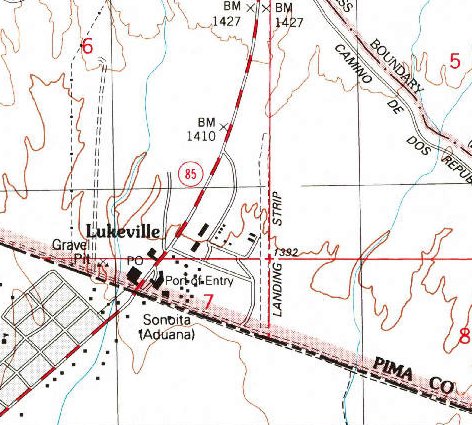
The only topo map depiction which has been located of Gringo Pass Airfield was on the 2000 USGS topo map.
It depicted a single unpaved north/south runway, labeled simply as “Landing Strip”, with 2 small buildings on the west side.
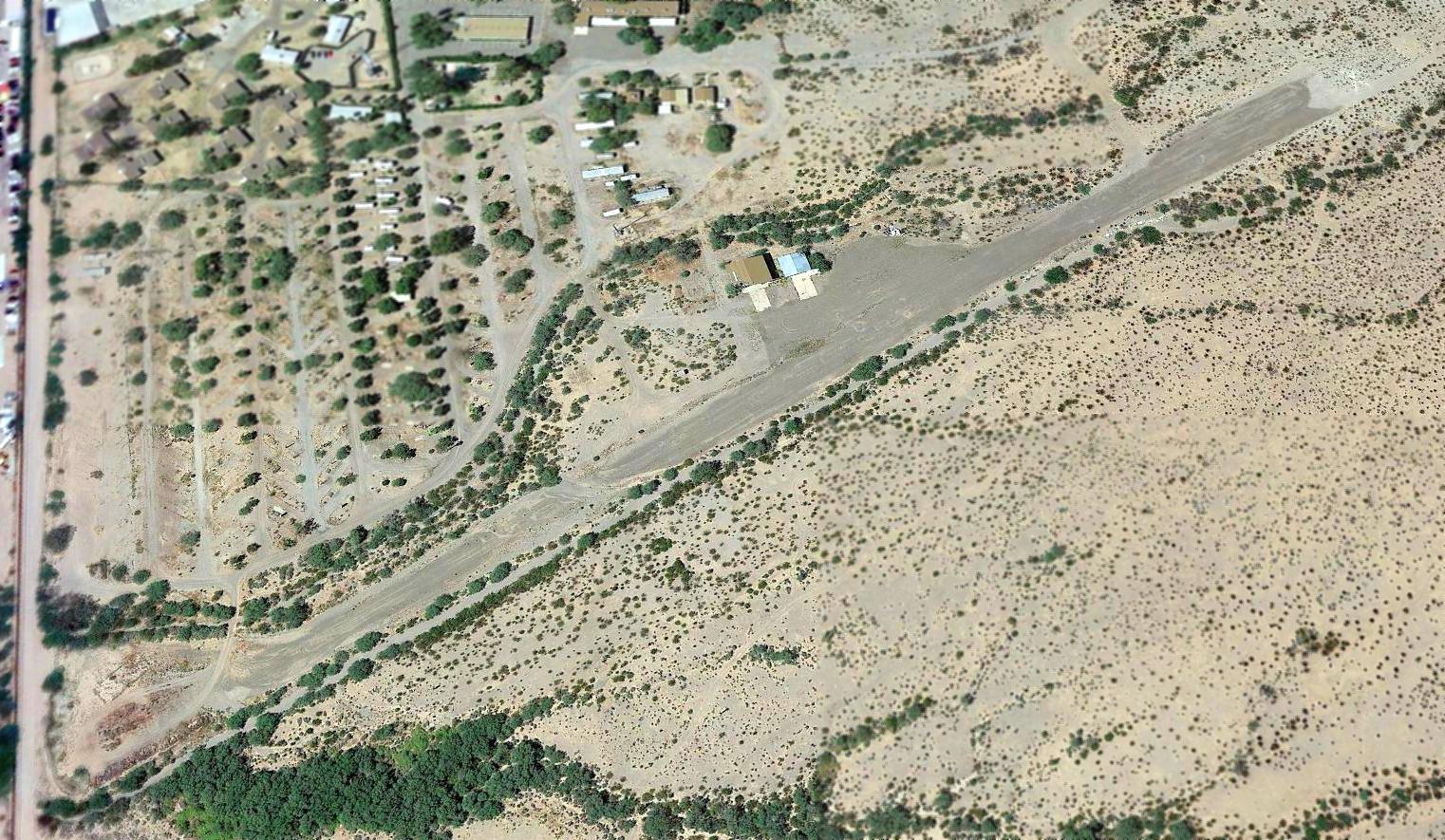
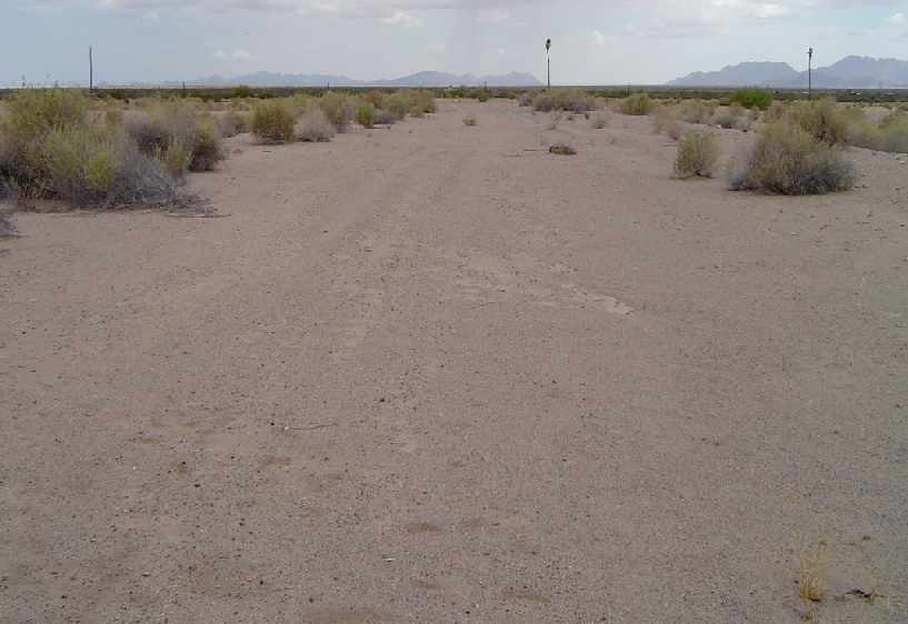
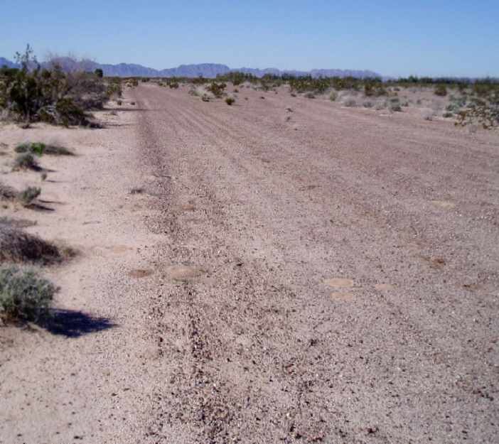
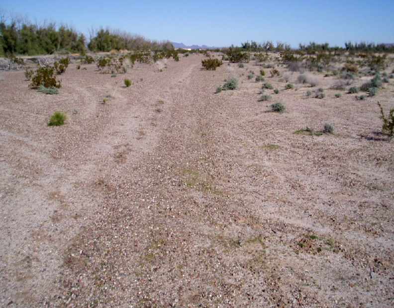
A 2017 aerial view looking northwest depicted the remains of Gringo Pass Airfield.
The majority of the runway remained intact, though deteriorated, and the closed-runway “X” symbol still barely recognizable on the north end.
The 2 hangars also remained on the west side.
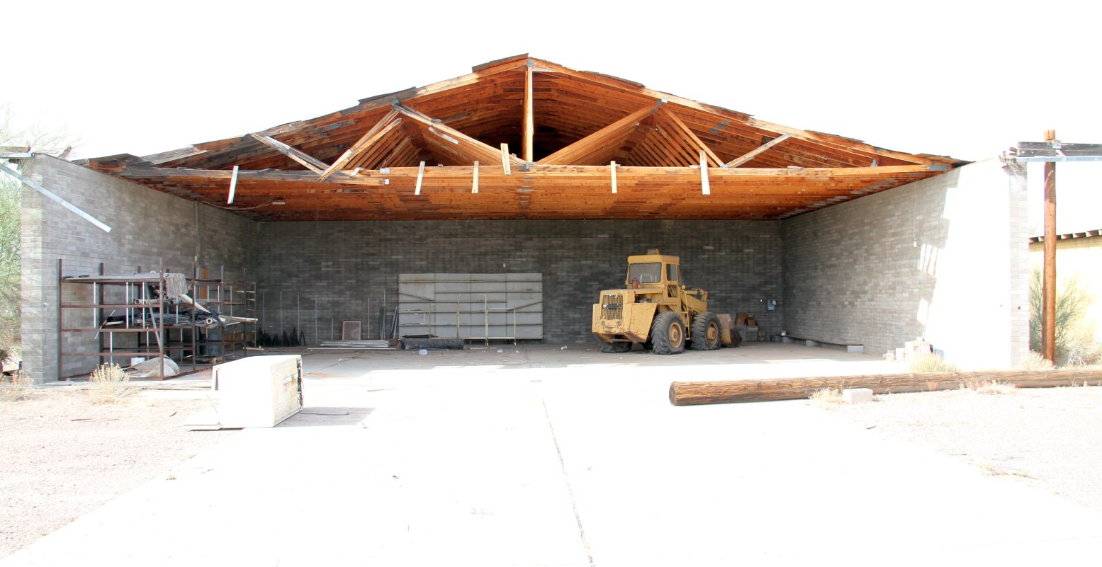
A 1/6/18 photo by Richard Carlson of the larger remaining hangar at Gringo Pass Airfield.
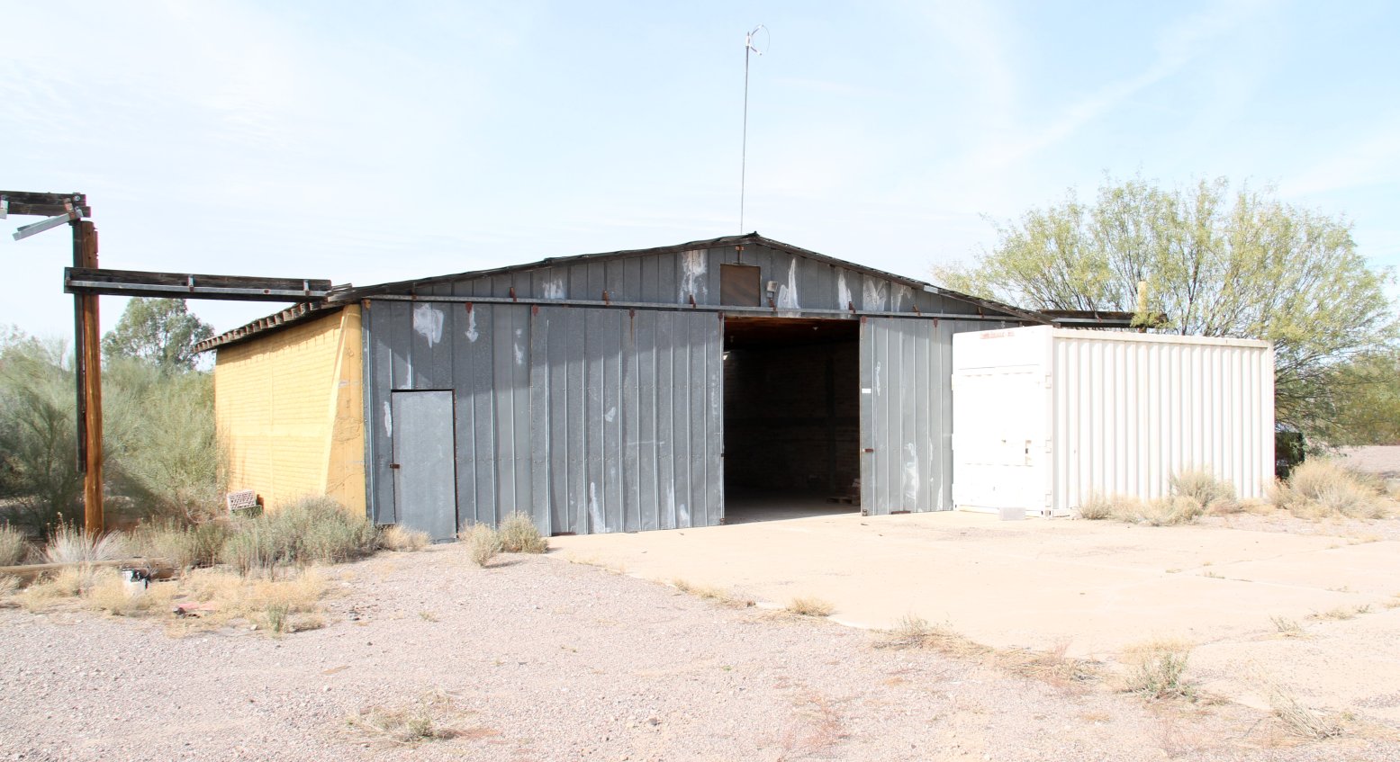
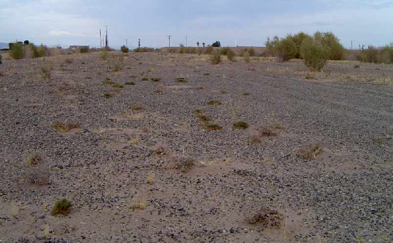
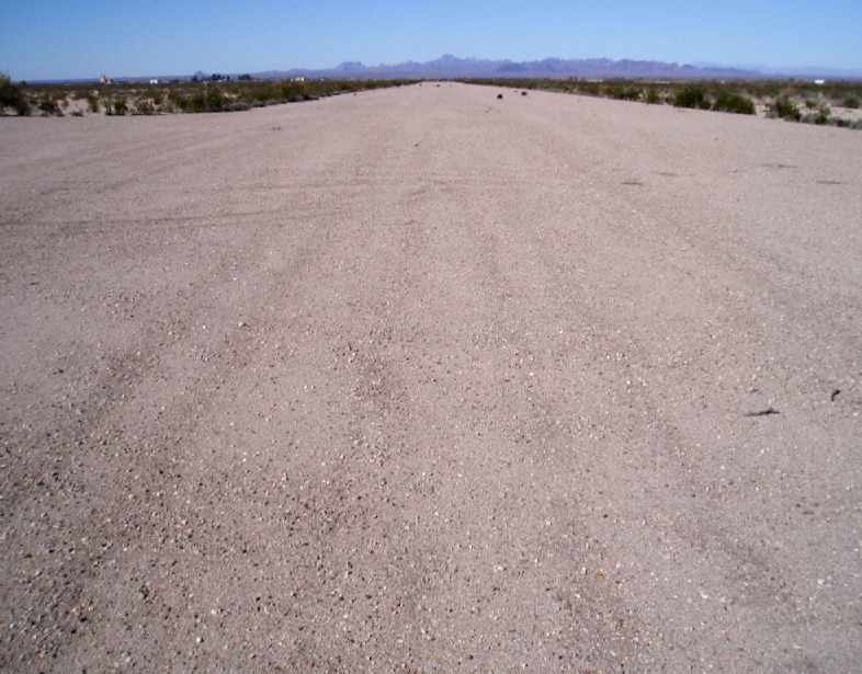
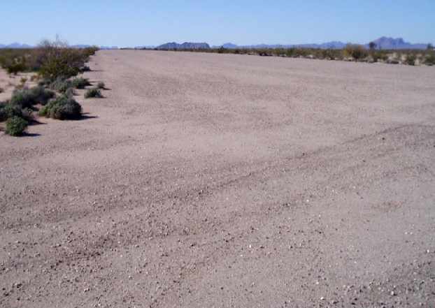
Richard Carlson reported in 2018, “Hard by the Mexican border in Lukeville, 40 miles south of Ajo, this pea-gravel airstrip is still in decent condition although likely has not seen a legal movement in years.
The south end of the airstrip is about 250' from the border wall. The airstrip is about 2,000’ x 50’, surfaced with pea gravel.
I was unable to travel to the ends of the runway due to the presence of the Border Patrol.
About midway on the runway is a pea gravel tarmac with 2 small hangars. The larger one has a wood truss roof & is currently sans door.
It is apparently used for storage as there is an end-loader inside along with an owl’s nest.
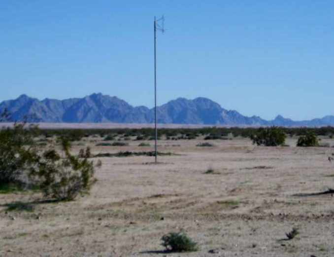
Directly north of this building is a smaller hangar with the skeleton of a windsock still on a pole of the roof.
Parts of the tin door remain & there was nothing inside. Each building has a concrete hardstand. A closed shipping container sits along the north end of the north building.”
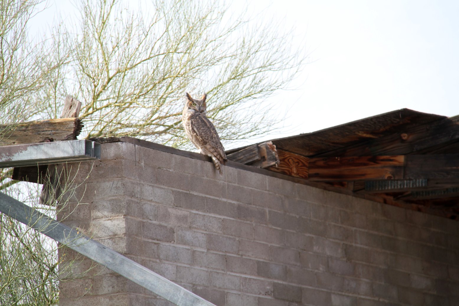
A 1/6/18 photo by Richard Carlson of the only aviator who still uses Gringo Pass Airfield: a majestic-looking owl perched on top of the larger hangar.
A 1/6/18 photo by Richard Carlson of the smaller remaining hangar at Gringo Pass Airfield, topped by a windsock frame.
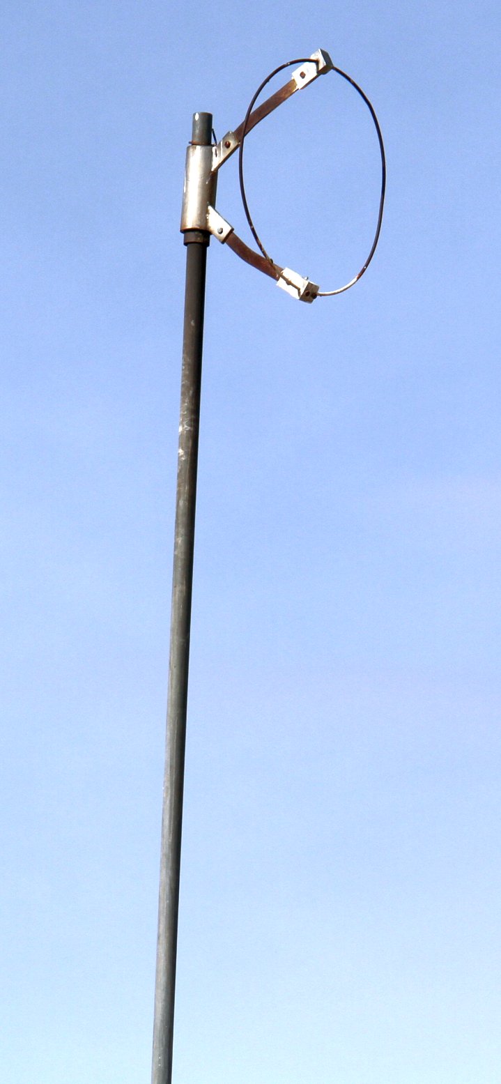
A 1/6/18 photo by Richard Carlson of the remains of a windsock frame on top of the smaller Gringo Pass hangar.
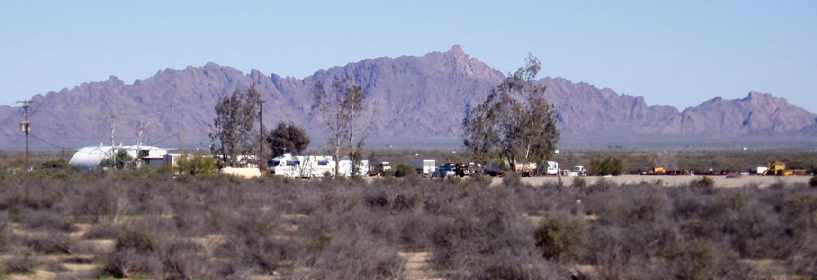
Richard Carlson reported in 2018, “When I visited there the trailer park had about a dozen trailers but none seemed occupied. A couple cars were parked at them but covered in dust.
The office was locked & peering inside the window there was a heavy layer of dust there (if you have never been here, dust is more common than dirt).
The only activity I saw on the property was a Border Patrol truck parked next to the north building watching for border jumpers.
As I left the area I flagged down another Border Patrol agent & spoke to him. He told me the owner died a few years back & the place was pretty much abandoned.
The gas station & store were sold by the family but actual ownership of the RV park & airstrip is unknown now.
It is unknown if anyone other than Al Gay ever used the airstrip.
Due to the fractured relationship with the government it is very unlikely that it was ever used for any official use.
It is unlikely to have been used often for drug smuggling due to the proximity to the border crossing & armed CBP agents all over the area.”
Thanks to Richard Carlson for pointing out this airfield.
____________________________________________________
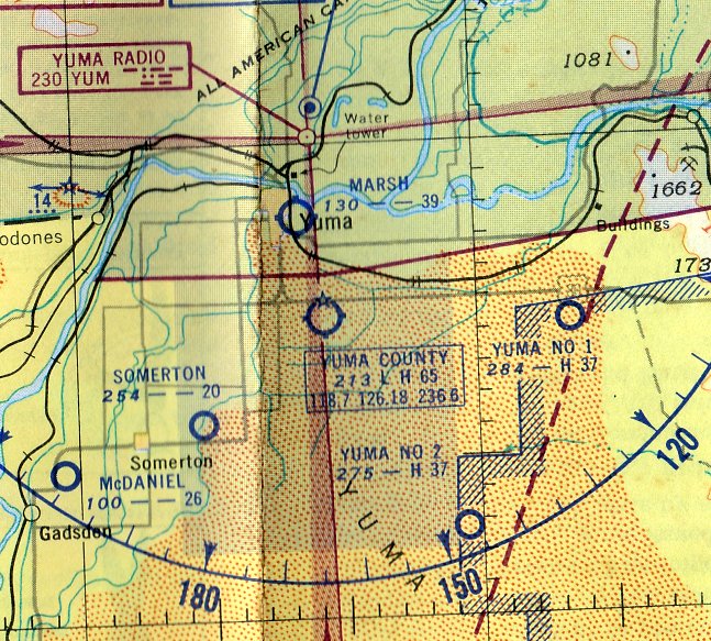
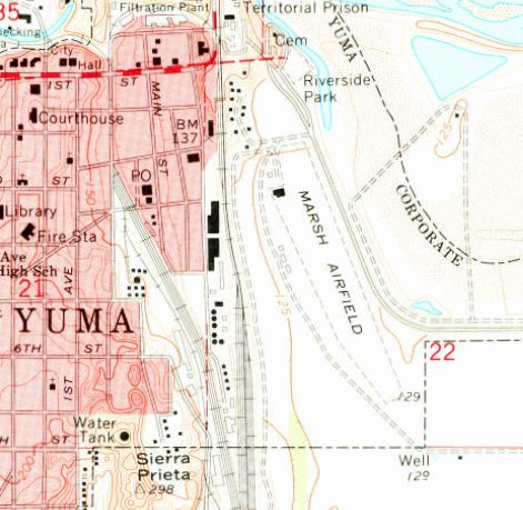
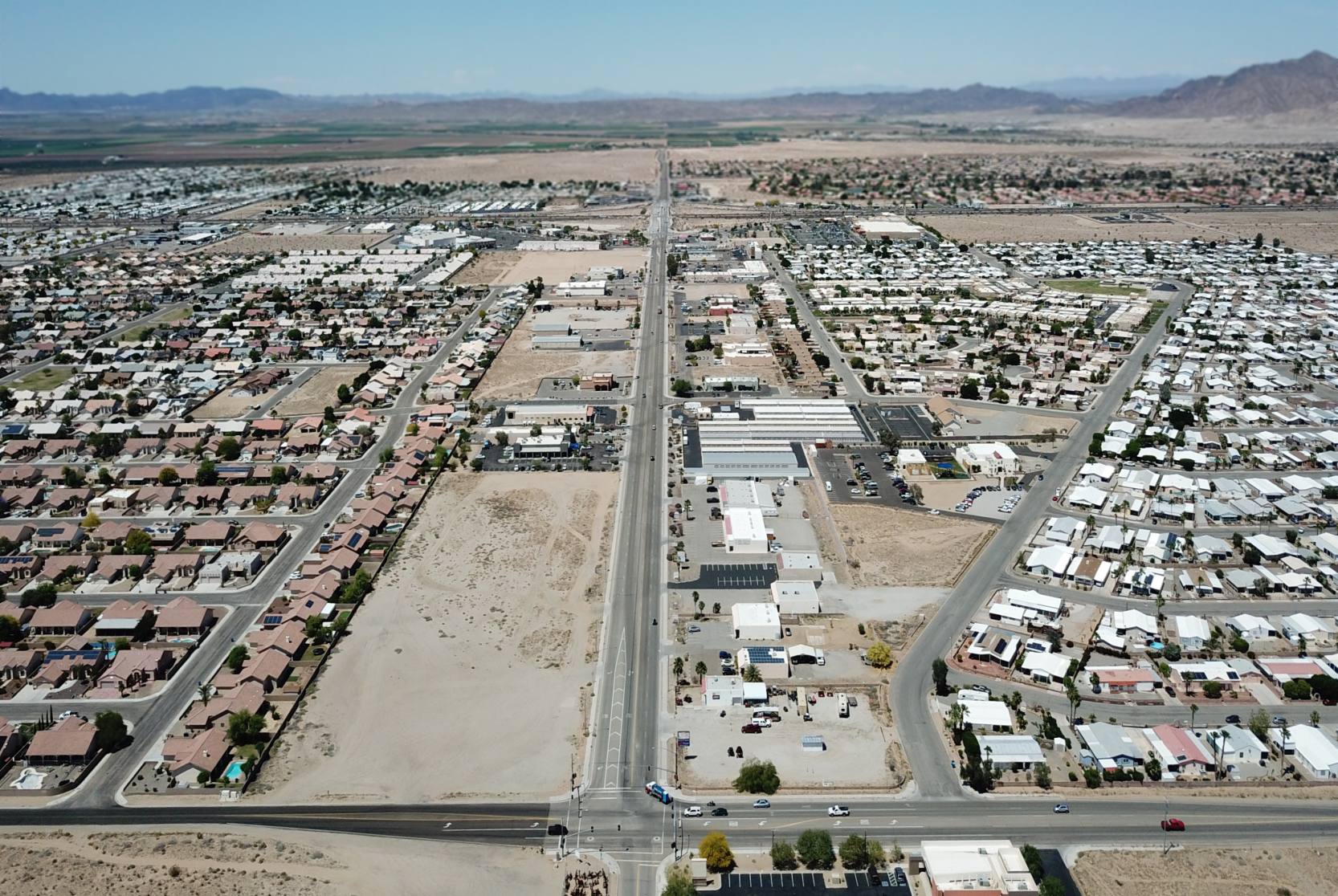
Marsh Downtown Airport, Yuma, AZ
32.71, -114.61 (East of Downtown Yuma, AZ)
A 7/12/48 USGS aerial view of Marsh Downtown Airport.
This small general aviation airport was located adjacent to the east side of Downtown Yuma.
Marsh Downtown Airport may have been established at some point between 1945-48,
as it was not yet listed among active airfields in the 1945 AAF Airfield Directory (courtesy of Scott Murdock).
The earliest depiction which has been located was on a 7/12/48 USGS aerial view,
which depicted it as having a single unpaved northwest/southeast runway.
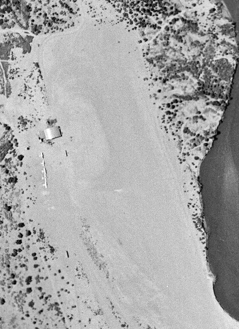
A closeup of Marsh Downtown Airport from the 7/12/48 USGS aerial view,
showing 6 light single-engine aircraft parked next to a hangar on the northwest side of the field.
The earliest aeronautical chart depiction which has been located of Marsh Downtown Airport was on the March 1952 San Diego Sectional Chart.
It depicted Marsh as having a 3,900' unpaved runway.
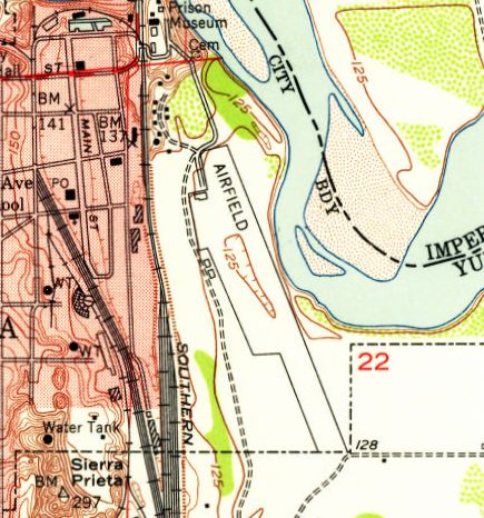
The 1952 USGS topo map depicted Marsh Downtown Airport as an unpaved northwest/southeast runway,
labeled simply as “Airfield”, with a ramp & a single building on the northwest side.
The 1955 Phoenix Sectional Chart depicted Marsh as having a 3,900' unpaved runway.
According to Duncan Woods, “'The Longest Flight – Yuma’s Quest For The Future', by Shirley Murdock & James Gillaspie...
mentions Marsh Airfield, which was also called Marsh Downtown Airport.
It was located east of downtown Yuma, just east of the railroad tracks & the Yuma Territorial Prison, on the south side of the Colorado River.
I remember it pretty well, as we used to have picnics on the south river bank
and on July 4, watch the fireworks which were set off from a large raft anchored out in the river.
My brother & I also flew out of Marsh Field once when Mr. McVay, a friend of our dad’s, took us for a short hop in a Cessna 172 around 1958.
In those days, Marsh Aviation was a pretty sizeable crop duster operation in Yuma (also in Phoenix),
so that was the airfield’s primary purpose, although a number of pilots used the field to avoid the busier Yuma Airport (combined civilian & military)
and I believe flight instruction was also offered there.”
A 1962 aerial photo depicted Marsh Downtown Airport at perhaps its zenith of popularity,
with a dozen light single-engine aircraft parked near the hangar on the northwest side,
and 3 individual T-hangars had also been added at some point between 1948-62.
The 1965 USGS topo map depicted “Marsh Airfield” as an unpaved northwest/southeast runway,
labeled simply as “Airfield”, with a ramp & a single building on the northwest side.
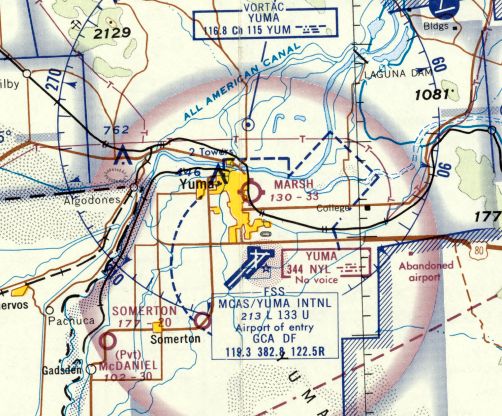
The last aeronautical chart depiction which has been located of Marsh Downtown Airport was on the 1969 San Diego Sectional Chart.
It depicted Marsh as having a 3,300' unpaved runway.
Marsh Downtown Airport was evidently closed at some point between 1969-71,
as it was no longer depicted on the 1971 Phoenix Sectional Chart.
The 1975 USGS topo map continued to depict Marsh Airfield in an unchanged manner.
The 1979 USGS topo map showed Interstate 8 had been built right over the Marsh Airport runway, obliterating the little airport.
A 1994 aerial view showed no trace of Marsh Downtown Airport.
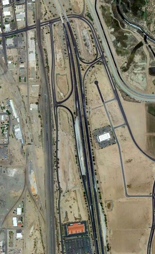
A 2011 aerial view showed no trace remaining of Marsh Downtown Airport.
The site of Marsh Downtown Airport is located at the intersection of Interstate 8 & Harold Giss Parkway.
Thanks to Duncan Woods for pointing out this airfield.
____________________________________________________
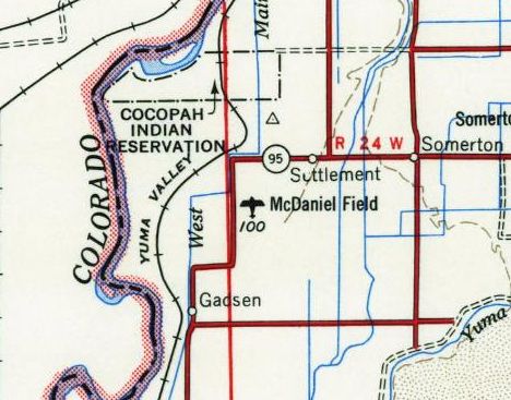
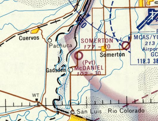
32.58, -114.77 (Southwest of Yuma, AZ)
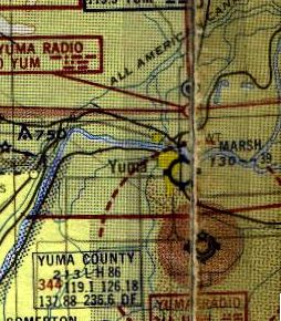
McDaniel Field, as depicted on the March 1952 San Diego Sectional Chart.
Photo of the airfield while in use is not available.
This small general aviation airport was located less than 2 NM east of the Mexican border.
Duncan Woods recalled, “McDaniel Field was a tiny private field, never used by the military;
it was established some time in the early or mid-1930s by my uncles, the McDaniel boys: Ted, Howard, and Ralph.
Ted was the first of the boys to learn to fly & get his license.
Other aircraft kept there before my time (my uncle Ted told me about them): One was a Beech Staggerwing,
which they owned for a number of years and was eventually replaced by the Bonanza.
Other plane was a Luscombe 8. They only had it for a short time. They sold it & replaced it with the Cessna 140A.”
McDaniel Field was not depicted on the 1945 Sectional Chart (courtesy of John Voss),
nor listed among active airfields in the 1945 AAF Airfield Directory (courtesy of Scott Murdock),
perhaps overlooked due to its small size.
The earliest depiction which has been located of McDaniel Field was on the March 1952 San Diego Sectional Chart.
It depicted McDaniel Field as having a 2,600' unpaved runway.
McDaniel Field, as depicted on the 1954 USGS topo map.
Duncan Woods recalled, “Ted was the one who was teaching me to fly.
By the time I came along, he had several thousand hours in the air & a commercial ticket.
The north/south packed-dirt runway was about 2,100'. My Uncle Ralph lived in the house out near Highway 95 for many years.
The aircraft were kept there: a Beech Bonanza, a Cessna 140A, and a Piper PA-18 Super Cub. The Cessna was the one I learned in.
Every now & then, other local pilots would drop in for a visit, and sometime local students would use the strip to do touch-&-goes.”
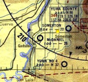
The 1955 Phoenix Sectional Chart (courtesy of John Voss) depicted McDaniel as having a 2,600' unpaved runway.
The only photo which has been located showing McDaniel Field was a 1963 aerial view.
It depicted McDaniel Field having 2 unpaved runways,
with 1 small single-engine plane near a few small hangars on the west side.
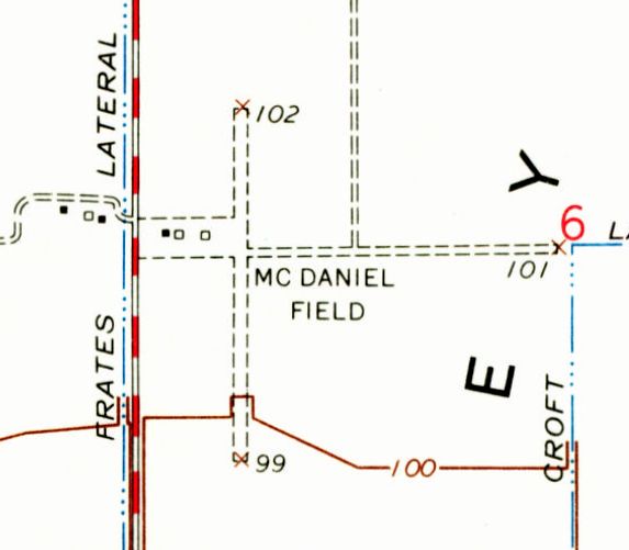
The last depiction which has been located of McDaniel Field was on the 1965 USGS topo map.
It depicted McDaniel Field as having an unpaved north/south runway, with an unpaved ramp with 3 small buildings on the west side.
Although it also appeared to depict an east/west runway, Duncan Woods recalled, “As far as I know, the only runway was the north/south strip.”
Duncan Woods recalled, “Ted died in 1968.”
The last aeronautical chart depiction which has been located of McDaniel Field was on the 1969 Sna Diego Sectional Chart.
It depicted McDaniel as having a 3,000' unpaved runway.
Duncan Woods recalled, “Surviving family members liquidated the McDaniel Corporation (a produce growing firm) & sold off the properties in 1970.
All the aircraft had been sold long before, as both Ted & Ralph had stopped flying.
Whoever bought the property pretty quickly tore down the hangars & put the entire property back into crop production, according to Ted's son, my cousin Mike.
Sadly another little airfield bit the dust, one that I was particularly attached to.”
McDaniel Field was no longer depicted on the 1971 Phoenix Sectional Chart.
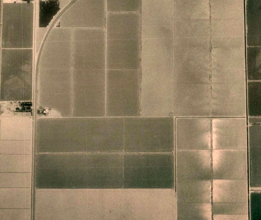
A 2012 aerial view showed no trace remaining of McDaniel Field.
Duncan Woods reported in 2017, “I visited my cousin Malcolm McDaniel in Yuma a couple of months ago.
He actually grew up in the house by the airfield & lived there until the mid-1950s. His dad was my uncle Ralph.
He told me it's the same house & it's still there. However, after 50 years & a number of owners,
it's been renovated & modified so much that it's unrecognizable as the original house that's been there for around 70 years.”
The site of McDaniel Field is located northeast of the intersection of Route 95 & West County 17th Street.
Thanks to Duncan Woods for pointing out this airfield.
____________________________________________________
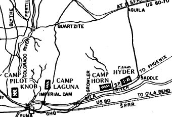
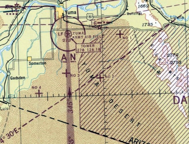
Camp Horn Army Airfield, Horn, AZ
32.95, -113.53 (Northeast of Yuma, AZ)
Camp Horn, as depicted on a circa 1942 Army map of the Desert Training Center.
The Desert Training Center was a massive area spread over the Southern California - Arizona desert
which was established in 1942 to train Army & Air Corps units to live & fight in the desert,
to test & develop suitable equipment, and to develop tactical doctrines, techniques & training methods.
The DTC's first commander was none other than General George Patton,
who reportedly piloted his own plane to examine DTC facilities & units.
The DTC was renamed the California-Arizona Maneuver Area in 1943,
and eventually encompassed a set of over 11 camps & 9 airfields.
Camp Horn was one of the DTC/CAMA camps which featured its own airfield.
According to Mike Jamison, “Camp Horn [was] a fairly large base that was comprised mostly of tents.”
When the Allied victory came in North Africa, the need for desert-trained units faded, and CAMA was closed in May 1944.
Camp Horn & its airfield were presumably never reused for any civilian purpose.
The airfield was not depicted on the 1945 Phoenix Sectional Chart.
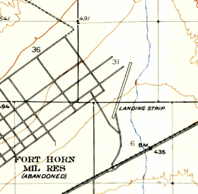
The Camp Horn “Landing Strip” was depicted on the 1950 USGS topo map as a single northeast/southwest runway,
located east of the extensive street grid of the “Fort Horn Military Reservation (Abandoned)”.
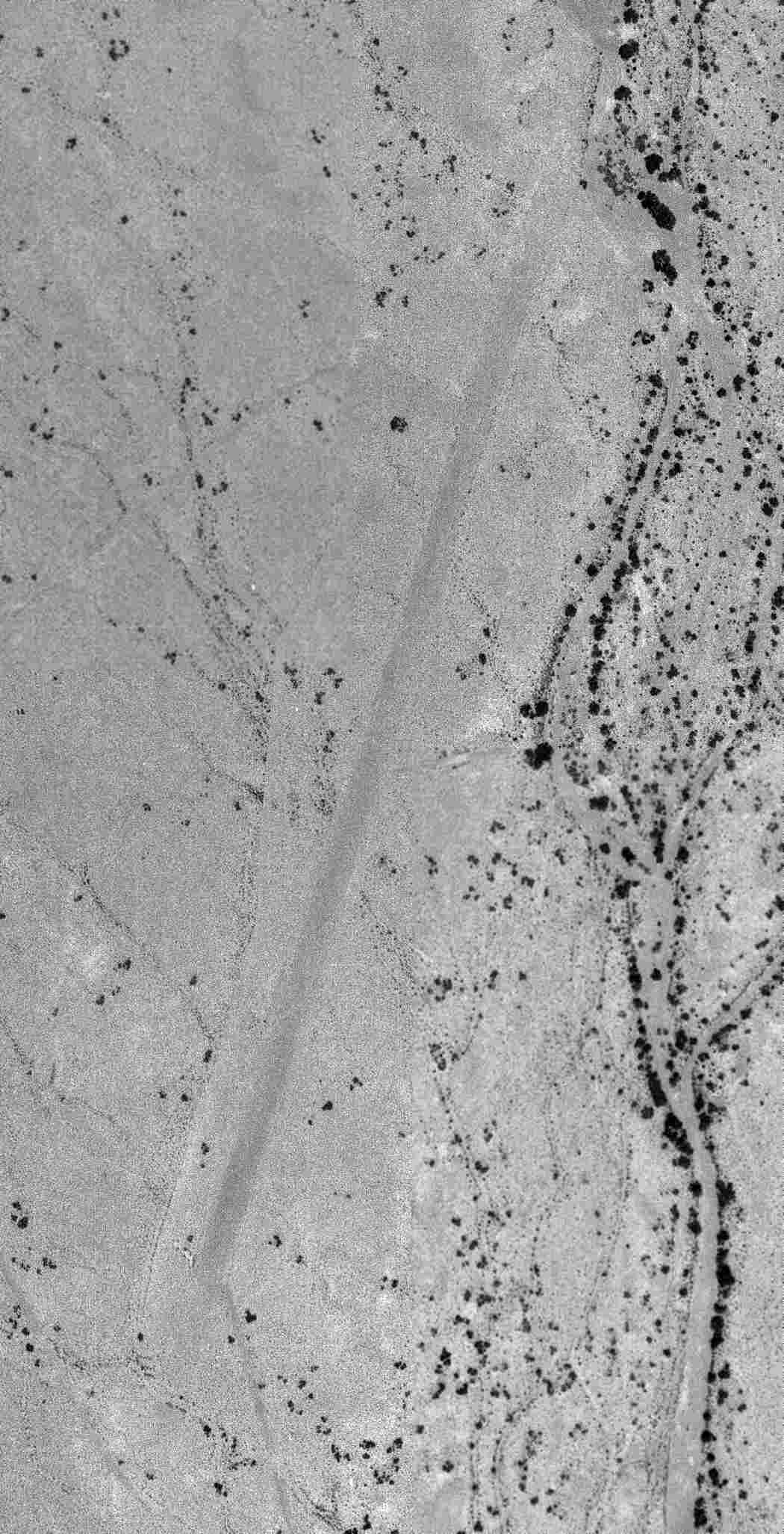
The earliest photo which has been located of the Camp Horn Airfield was a 7/2/63 USGS aerial view,
in which the single northeast/southwest runway was barely recognizable.
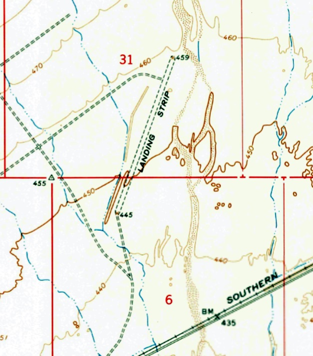
The 1965 USGS topo map depicted the Camp Horn “Landing Strip” as a single northeast/southwest runway.
A 3/1/13 aerial view looking north along the remains of the Camp Horn runway, still recognizable 70 years after being abandoned.
A 2014 photo by Mike Jamison looking south along the Camp Horn runway.
Mike observed, “You can just notice color differences between paving gravel & regular sand on the shoulder.”
Mike Jamison reported in 2014, “A dirt road leading north from the Camp Horn monument accesses a series of similar roads that form a large & distinctive grid pattern.
The gridded area is Camp Horn, which contains several more roads extending east to an airstrip.
As for Camp Horn itself, I was transfixed & had a hard time leaving.
Innumerable rock-trimmed pathways lead past untold numbers of empty sites that once provided space for tents.
Most of the rock trim survives & period refuse still litters the ground -
so much so that one gets an eerie feeling that Patton's troops might have vacated only months ago.
The place gave me goose bumps. I can just picture Patton setting down unannounced for some sort of sneak inspection.”
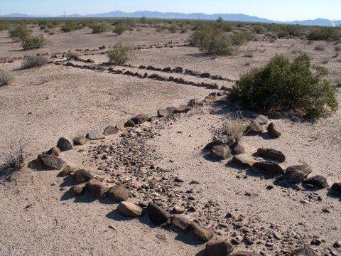
A 2014 photo by Mike Jamison of a “Camp Horn rock-trimmed pathway, located west of the airstrip & north of the monument.”
The site of Camp Horn is located northeast of the intersection of Palomas Road & Avenue 64E.
Thanks to Mike Jamison for pointing out this airfield.
____________________________________________________
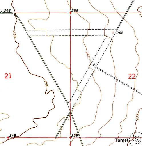
32.71, -113.92 (Northeast of Yuma, AZ)
Smiley Field was not yet depicted on the January 1941 Phoenix Sectional Chart.
According to Douglas Bell, Smiley Field "was a civilian pilot training field used from 1942 for a few years.
During this period, it was operated by the United School of Aeronautics.
The buildings consisted of a large ranch house & small hangar for repairs.
My father was a flight instructor at Smiley Field from February 1942 until April or May 1943.
I have pictures of the field, buildings, airplanes (Ryan) and pilots there
plus a collection of letters he wrote during that period to his parents.
He married my mother in September 1942 & they lived in an adobe house in Wellton - she described it as 'a great time'.
He may have also instructed Navy students at a 'Loyko Field' closer to Wellton during this time -
at least that is the caption on one pictures."
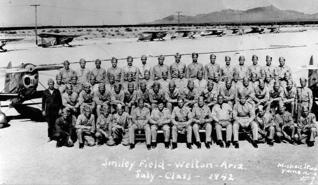
The only photo which is available of Smiley Field was a photo of the July 1942 CPT class at Smiley Field,
bracketed by 2 Ryan trainers, and with 8 Pipers & other taildraggers in the background.
The cadets had barracks and a mess hall at the field & were enlisted reservists.
Between primary & secondary training, there were about 60 cadets in all.
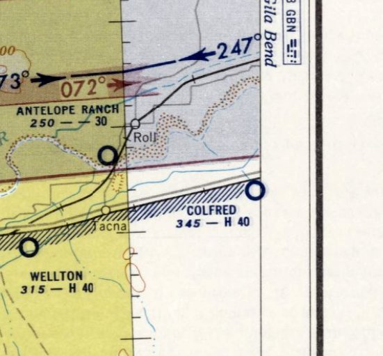
Scott Thompson reported, "While talking with some old-timers who live in the Mohawk & Antelope Valleys
near the communities of Tacna, Roll, and Wellton in southwestern AZ, I learned of an old airfield constructed around 1942.
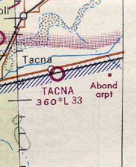
The old-timers called it Smiley Field & claim it was located in the town of Tacna where the post office now stands.
The curator of collections at the Arizona Historical Society in Yuma showed me a group photo of what appear to be aviation cadets
(all are in uniform, however, I can't make out the insignia on their left shoulders)
and 3 active duty non-commissioned officers standing on a runway with a single-engine aircraft parked behind them
(very little of the airplane is visible; it is a high wing type, consistent with those used in the civilian pilot training program as opposed to a primary training aircraft).
The photo caption reads, "Smiley Field, Welton [sic], Arizona, 1942."
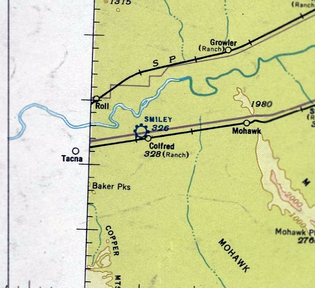
The earliest chart depiction of Smiley Field which has been located was on the September 1942 Phoenix Sectional Chart.
It depicted Smiley as a commercial airport located just northwest of the Colfred siding along the Southern Pacific railroad, approximately 3 miles east of Tacna.
The April 1944 US Army/Navy Directory of Airfields (courtesy of Ken Mercer) described Smiley Field as having a 3,000' unpaved runway.
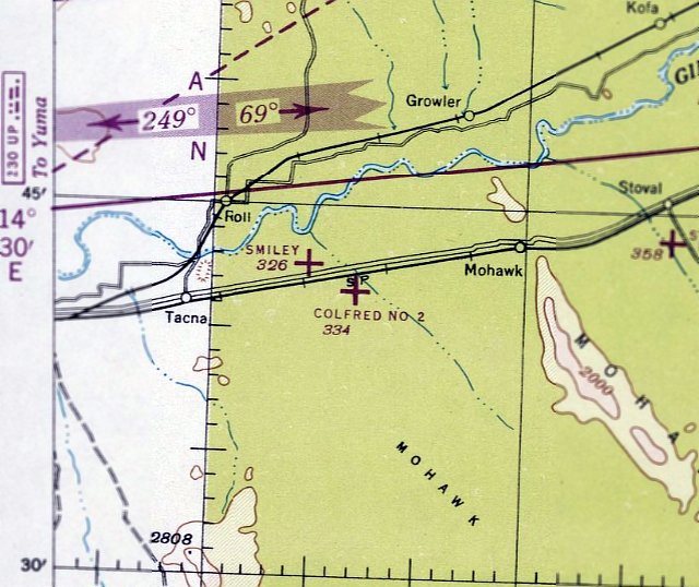
The last chart depiction of Smiley Field which has been located was on the March 1947 Phoenix Sectional Chart.
It depicted Smiley as an auxiliary airfield.
Smiley Field was evidently abandoned at some point in 1947, as it was no longer depicted on the September 1947 Phoenix Sectional Chart.
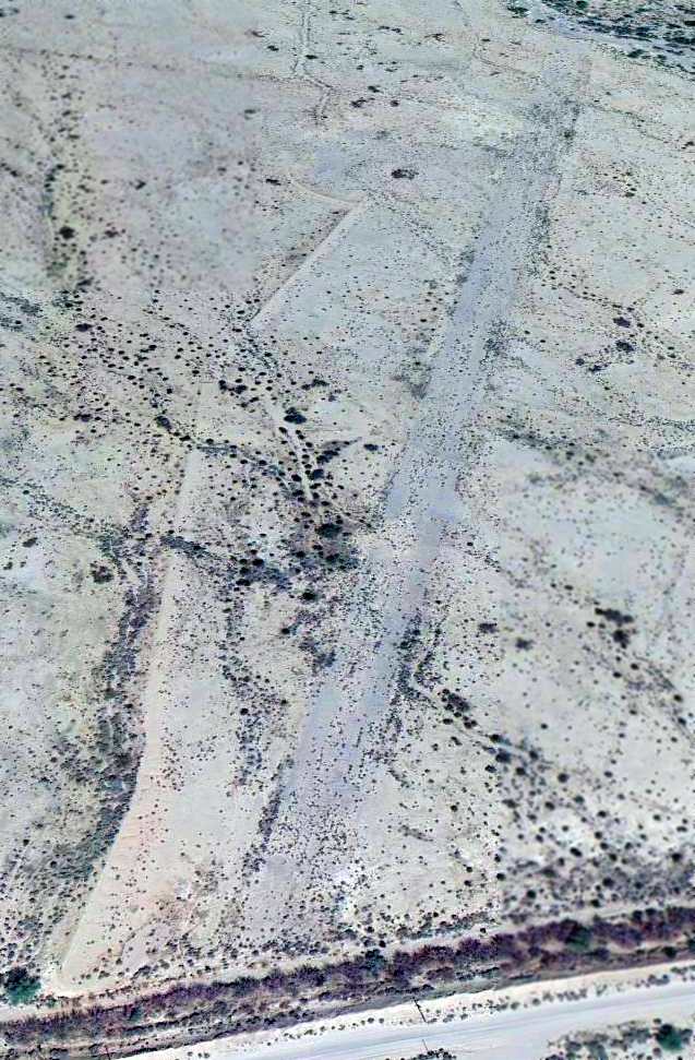
A 7/18/53 USGS aerial photo of what may have been the site of Smiley Field:
a rectangular patch of ground on the north side of Route 80, with a few small buildings on the east side.
Smiley Field was no longer depicted at all on the 1965 USGS topo map.
In the 1992 USGS aerial photo, not a trace appeared to remain of the former Smiley Field.
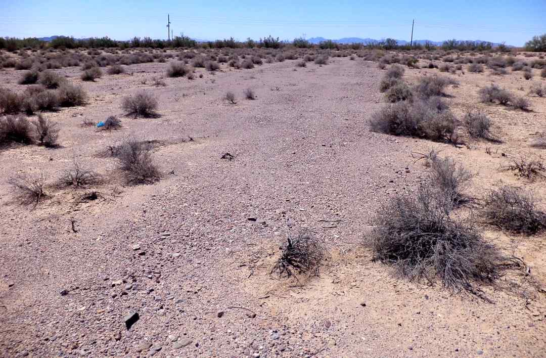
A 2004 photo by Scott Thompson looking north-northeast at the remains of the runway pavement of Smiley Field.
Scott reported, "I searched for the airfield & found a section of what I believe to be runway running in a roughly north-south direction.
It appears to be macadam, or field-mixed asphalt, on a gravel bed.
The approximately 200 yard section is surrounded by farm land with concrete lined laterals & farm turnouts, although the area isn't under active cultivation."
"The runway remains are the north-south swath of land equidistant from the cluster of salt cedars
(sandwiched between U.S. 80 & the railroad tracks) and the Colfred siding.
As you can see in the photo, the laterals run along both sides of the runway.
I forgot to measure the width of the runway, but estimate it to be 100' wide.
The width of the Auxiliary Fields built by the Army Air Forces (e.g., Wellton, Colfred, Stoval, etc.) during WW2 was generally 150'.
The dark, east-west line just north of the cultivated area is the Mohawk Canal, part of the larger Wellton-Mohawk Division of the Gila Project.
The canal & attendant laterals were constructed 1951-53."
A 2004 photo by Scott Thompson looking South-southwest at the remains of the runway pavement of Smiley Field.
Scott reported, “The [presumed runway] width is narrower than the military standard but consistent with many of the other landing strips in the area.
At one time, the runway may have been wider; perhaps the outer edges of this section were lopped off to accommodate the construction of the irrigation laterals.
The macadam surface is what leads me to believe this short section is all that remains of Smiley Field.
I have recorded the current conditions of other WW2-era auxiliary airfields in southwestern AZ
and the surface of the site in question is identical to what I've seen at Wellton, Colfred, Stoval, and Aux Fields 6-11 between Ajo & Gila Bend.
I've driven the entire length of the Antelope & Mohawk Valleys
documenting the features of the Wellton-Mohawk irrigation system & have yet to encounter a road section with this type of surface.
If this is indeed the location of Smiley Field, my guess is the Army modified the (presumably) dirt landing strip
by applying the macadam to handle the heavier wheel loads of military training aircraft.
As an aside, I found a large trash scatter around the stand of salt cedars southwest of the 'runway.'
Included in the piles were large chunks of poured concrete that may represent the remains of a foundation.
The structural debris could be associated with railroad activities."
The site of Smiley Field is located east of the intersection of Route 80 & Avenue 42E.
____________________________________________________
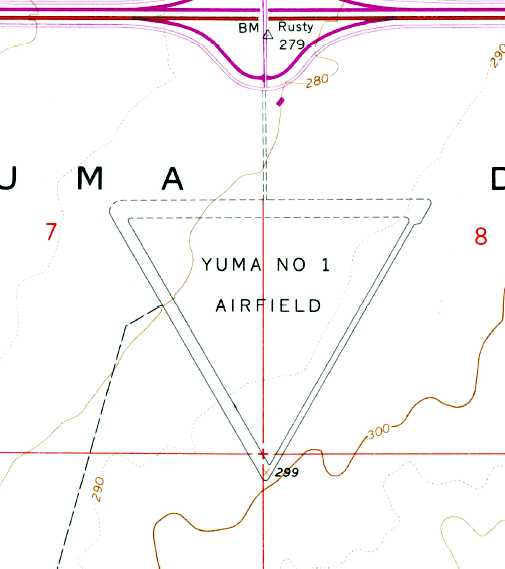
Yuma Proving Ground North Army Airfield, Northeast of Yuma, AZ
33.34, -114.29 (Northeast of Yuma, AZ)
A 1996 USGS aerial view looking southeast at the Yuma Proving Ground North Airfield.
No airfield was yet depicted at this location on a 1981 aerial photo.
This dirt airfield is located in an extremely desolate northeast corner of the Army's huge Yuma Proving Grounds.
Jim Stewart reported, “YPG North Airfield was a strip of desert malpais with a few ruts worn into it;
it was never an airfield until it was constructed as a 'Small Austere Airfield' specifically for the C-17.
It has always been referred to as the 'C-17 Strip' & used to evaluate the aircraft performance on this dirt runway.
It received a name by the SF troops who lost a man out there, but the local workforce never adopted the name.
It has always been in restricted military airspace & never used by other than military testing
except for some early drug smugglers who used many of the malpais flats in the area.
I was involved from its inception.”
No airfield was listed at this location in 2003 FAA records,
and no airfield was depicted at all on 2003 aeronautical charts, or USGS topo maps from 1969, 1981, 1986, or 1992.
Charles Marcum reported in 2004, "This was my test site for a project about 15 years ago, and later used for C-17 testing."
A 2003 photo taken from 16,000' looking southwest, by Bill Suffa (enhanced by Bil Grasha).
A 2013 aerial view looking southeast showed the Yuma Proving Ground Airfield to consist of a single 6,300' unpaved north/south runway,
along with the remains of an encampment or building foundations along the west side of the runway.
The Yuma Proving Ground North Airfield is located 4 miles west of Route 95, 40 miles northeast of Yuma.
____________________________________________________
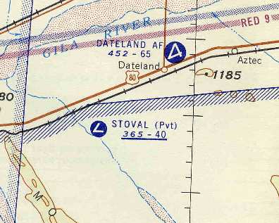
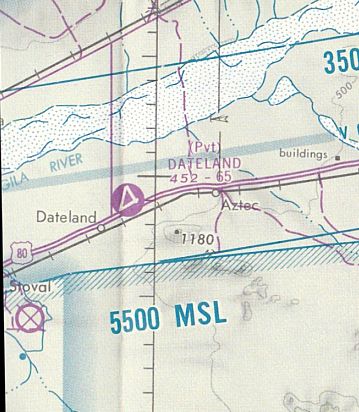
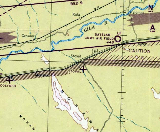
Dateland Army Airfield (AZ06), Dateland, AZ
32.82, -113.53 (East of Yuma MCAS, AZ)
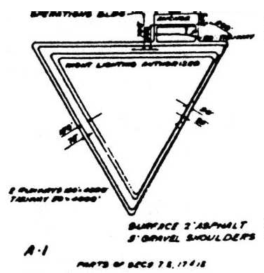
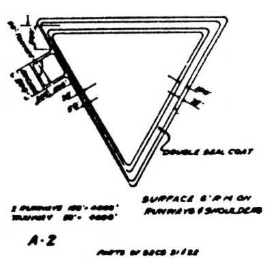
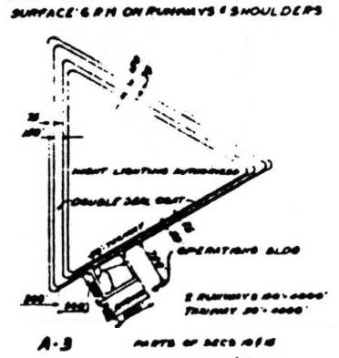
A January 1943 General Layout Plan of Dateland AAF.
No airfield was yet depicted at this location on the 1930 USGS topo map.
This field was established as a WW2 Army Air Corps training base.
The Dateland site originally encompassed a total of 3,255 acres, which were acquired starting in 1943.
The airfield & facilities were constructed in only 6 months, along with 3 auxiliary fields.
Originally it started out as a gunnery training base, as an auxiliary field for the Yuma Aerial Flying School Gunnery Range.
It eventually converted to B-25 bomber training. A total of 11,000 hours of flight training were logged at Dateland during WW2.
DoD improvements constructed at the site between 1943-1946 were 95 buildings, 3 runways, 4 taxiways,
gasoline station, water system, electrical distribution system, sewage disposal system & perimeter fences.
The earliest depiction which has been located of the Dateland airfield
was a 6/23/43 aerial view looking east from the 1945 AAF Airfield Directory (courtesy of Scott Murdock).
It depicted “Datelan Army Air Field” as having 3 asphalt runways & a parallel taxiway leading to a large concrete ramp on the south side.
The 1945 AAF Airfield Directory (courtesy of Scott Murdock) described “Datelan Army Air Field”
as a 3,200 acre irregularly-shaped property within which were 3 asphalt runways, the longest being the 6,598' NNE/SSW strip.
The field was said to have a single 122' x 80' wood hangar, to be owned by the U.S. Government, and to be operated by the Army Air Forces.
However, the field was said to be inactive.
The base was reduced to caretaker status in 1945. It was left with a contingent of 12 men & an officer to maintain the base.

The earliest aeronautical chart depiction which has been located of the Dateland airfield was on the 1949 Phoenix Sectional Chart (courtesy of Chris Kennedy).
Note that it labeled the field as "Datelan AF" (with no 'd' at the end), described as having a 6,600' paved runway.
Note that it also depicted a much smaller “Dateland” Airport to the southwest,
so the misspelling of “Datelan” may have been an attempt to distinguish between the 2 airfields.
In the early 1950s Dateland Air Force Auxiliary Field was reportedly used
by various special forces squadrons of the MATS Air Resupply & Communications Service for training.
A 1953 aerial view of Dateland (with a property outline superimposed on the bottom-right)
showed a large number of unknown objects parked to the southwest of the ramp.
The 1956 Phoenix Sectional Chart (courtesy of John Voss) labeled it as "Dateland AF",
and described the field as having a 6,500' hard-surface runway.
In 1957 the hangar & the other flight line buildings mysteriously burned down.
The military sent in an investigation team to do an inventory on the B-25 parts & found none.
The officer was court-martialed & the base was closed permanently in 1957.
Although the Dateland base had been closed by the military in 1957,
the Dateland airfield was still depicted as an active military airfield on the 1958 Phoenix Sectional Chart (courtesy of Chris Kennedy).
The Dateland real estate was auctioned off in 1960 to private parties.
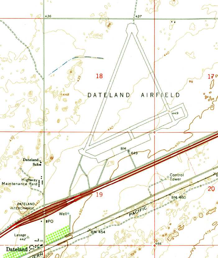
The 1965 USGS topo map depicted the site as “Dateland Airfield”,
and showed that the newly-constructed Interstate 8 had been built in between the control tower & the rest of the airfield.
In 1970 the base was subdivided into 3,300 lots leaving the airport intact.
One owner was going to subdivide the airport area into lots & build small lakes.
"Dateland AF Aux" was labeled as "closed" on the August 1971 USAF Tactical Pilotage Chart (courtesy of Chris Kennedy).
The Dateland airfield was apparently reopened as a private airfield at some point between 1971-77,
as that is how it was depicted on the December 1977 Phoenix Sectional Chart (courtesy of Ron Plante).
It depicted Dateland as having 3 paved runways, with the longest being 6,500'.
Another set of owners bought the Dateland property in 1995 to save the airport from extinction.
They planned to redevelop the airfield as a fly-in community, El Camino Del Sol Airpark,
taking advantage of the extensive airfield facilities abandoned by the military.
The developers touted it as "the largest fly in community in the USA", with a total of 427 lots having taxiway connections to the airfield,
and a concrete ramp area big enough to park 300 planes.
A motel & a museum were among the planned attributes.
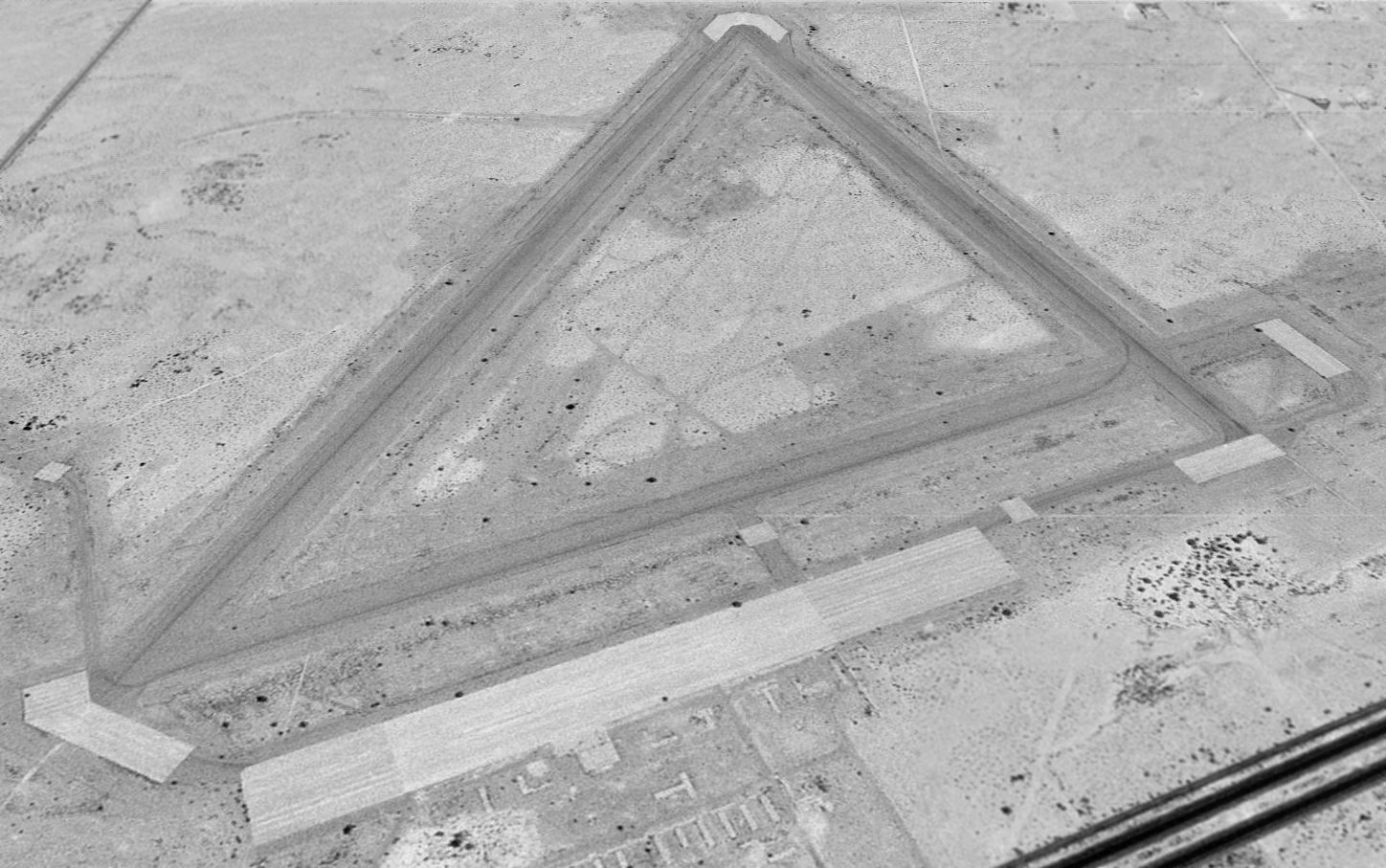
As seen in a 1996 USGS aerial view looking north, Dateland's 3 runways still remained (6/24, 16/34, and the longest - 1/19, 6,600' long), along with a large concrete ramp area.
The only building remaining was a sand-filled concrete bunker previously used to sight the machine guns of the B-25 Mitchell bombers.
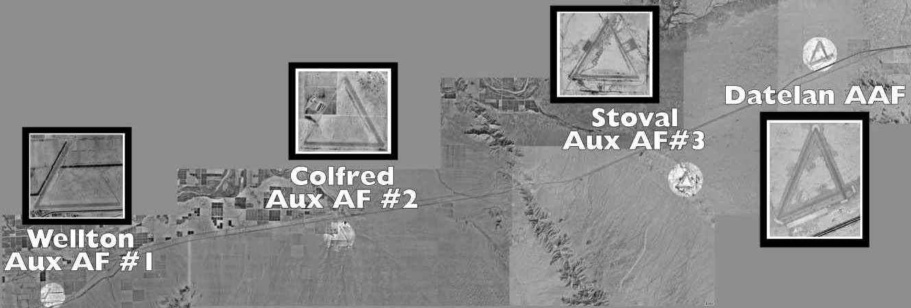
A composite picture by David Brooks in which close-up views of 4 nearby former satellite airfields
were superimposed over the 1996 USGS aerial photo of the area.
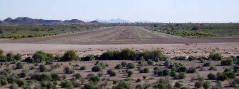
A 1997 aerial view by Steve Hoza, looking north at the Dateland airfield.
The photo is courtesy of Steve Hoza, from the book "Best Place in the Country", by Mike & Steve Hoza.
Steve Hoza reported, "I phoned Luke AFB to get permission to fly into the Ajo corridor, which is normally off limits (it's a MOA).
Getting permission was simple & we flew on a Sunday when they weren't doing any flying.
After 9/11 I am sure it would be next to impossible to get that same permission."
The Dateland airfield was once again added to the Airport Facility Directory in 2000 as a new private airfield.
The developer intended to make the field public, and hoped to attract an FBO.
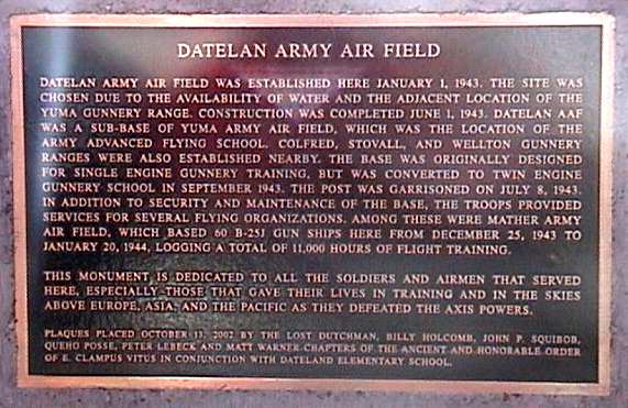
A photo (courtesy of Chris Kennedy) of a memorial plaque which was mounted in 2002,
about 100' southeast of the restaurant at Exit 67 on Interstate 8, commemorating “Datelan Army Air Field”.
Chris Miller overflew Dateland in 2003, and reported, "Dateland looked great;
the pavement looked pretty fresh, and the parking area appeared to have revetments or tie downs.
It looked huge! Very wide runways."
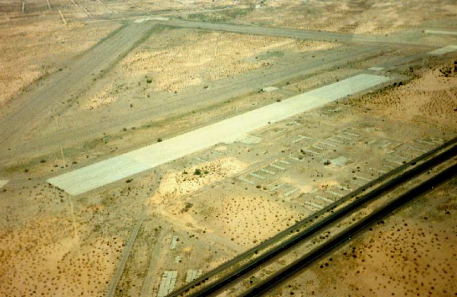
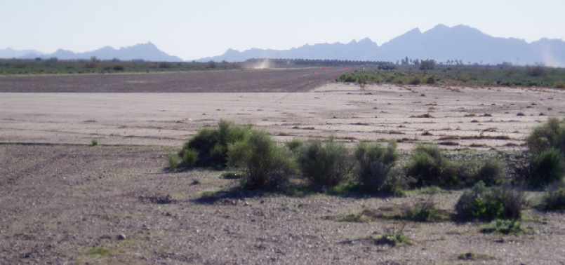
A June 2004 aerial photo by Dwight Furleigh (enhanced by Bill Grasha), looking southeast at the Dateland airfield.
Dwight Furleigh visited the Dateland airfield in 2004.
Unfortunately, he found that the commercial venture to reopen Dateland as a residential airpark had evidently failed.
He reported, "I saw the remains of a sales trailer/office in the southwest corner related to this,
and it was boarded up & abandoned, which indicates this venture must have peetered out.
The base was posted with 'No trespassing' signs so I stayed off the complex
but did drive up to the North end of the main runways & took some photos.
The runways look to be in good shape, but no activity in terms of airplanes was seen.
There are small low-income homes & trailers in the desert to the north & east of the base.
Some of this area used to be a POW camp; I read on the plaque near the other Dateland plaque at the south side of the Interstate at the restaurant."
A 2004 photo by Dwight Furleigh, looking southeast along Dateland's southeast/northwest runway.
A 2004 photo by Dwight Furleigh, looking southwest along Dateland's southwest/northeast runway.
Dwight observed, "There was some activity on the northeast/southwest runway when I was there,
you can see the small dust cloud of a Jeep/Hummer and some orange cones or flags on the runway,
but was too far away to see the details."
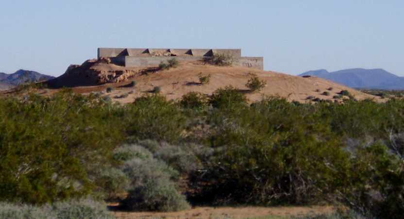
A 2004 photo by Dwight Furleigh, looking southeast at the sand-filled concrete bunker
previously used to sight the machine guns of Dateland's B-25 Mitchell bombers.
It is located just west of the southwest corner of the airfield.
Jim Stewart reported in 2011, “Stoval & Datelan see a fair amount of use, mostly at night for Special Ops training.
That's why they appear to be so well maintained.
During Marine Corps WTIs, these look more like commercial airfields; lots of aircraft, vehicles, people, etc.”
As of 2011, street maps depict a network of dozens of streets laid out around the airfield, many with aviation-themed names.
However, the vast majority of these streets are devoid of houses or any other construction.
A February 2012 photo by Andy Gulley of a Dateland bunker previously used to sight the machine guns of Dateland's B-25 Mitchell bombers.
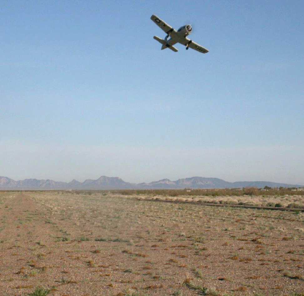
A February 2012 photo by Andy Gulley of his radio-controlled T-28 Trojan model aircraft flying over the remains of the Dateland runways.
Andy reported, “The runways are slowly degrading but still useable.
I stopped there, got a Date Shake and checked out the airfield. It’s amazing that they built the entire airfield only for 4 weeks [of] training.”
Douglas Johnson reported in 2012, “Dateland Airfield... I live in the house just off a runway & I own about 2,000 lots in the area.
In February I was building roads & taxiways to lots. I own about 150 lots with taxiways to the lots.
Mr. McHenry owns about 200 with taxiways to those lots + 640 more lots.
I owned these since 1996 & a friend of mine owned the remainder but died & is now owned by Mr. McHenry.”
Francis Blake reported, “On 5/7/15 I stopped at Dateland for a quick inspection of the WWII airfield.
It is the same as the last report [above] - No change.”
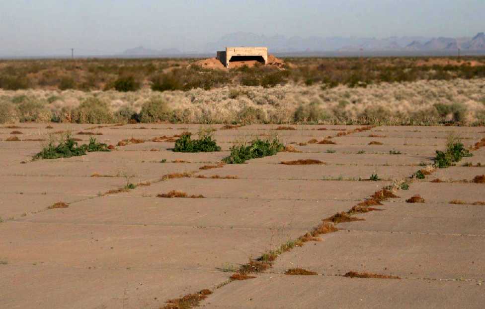
A November 2015 photo by Mike Jamison of the Dateland AAF ramp.
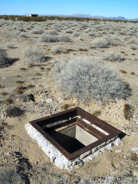
A November 2015 photo by Mike Jamison of a “Trap door accessing Dateland's underground water supply & sewage.
An aircraft target-practice facility lies on the horizon.”
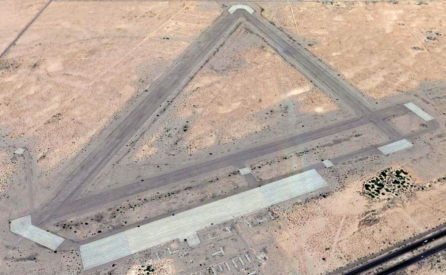
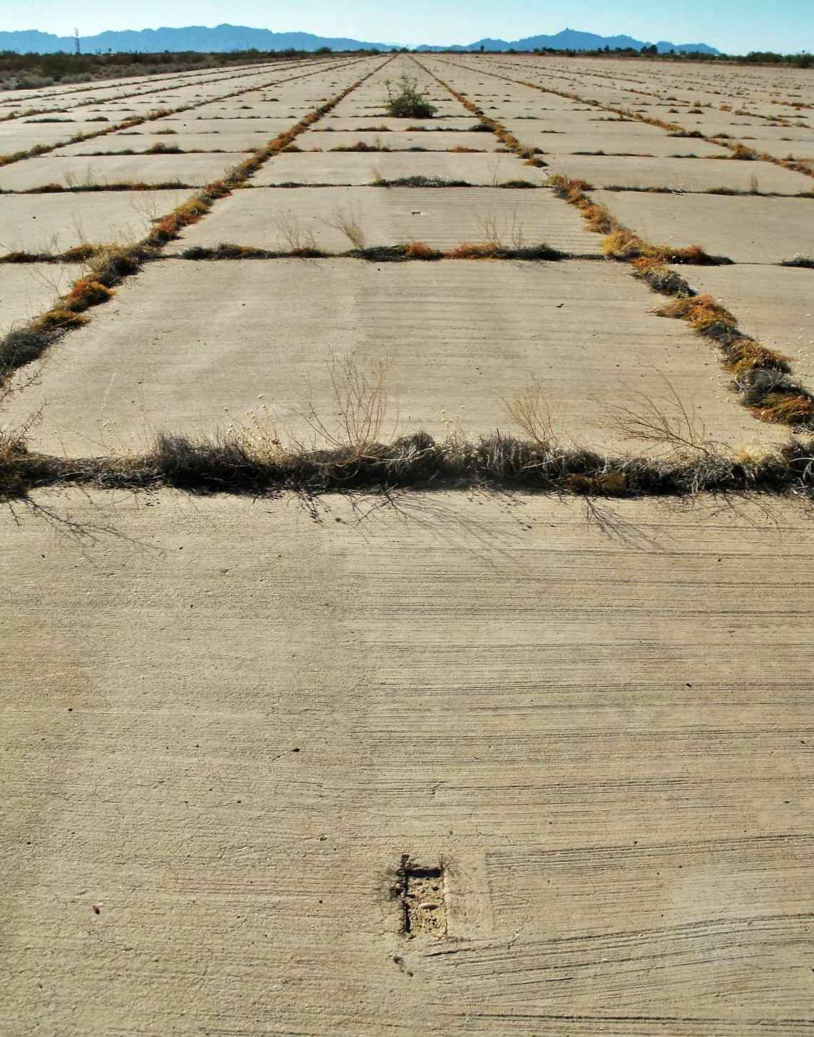
A 2016 aerial view looking north showed Dateland's 3 massive runways still remained intact, along with a large concrete ramp area.
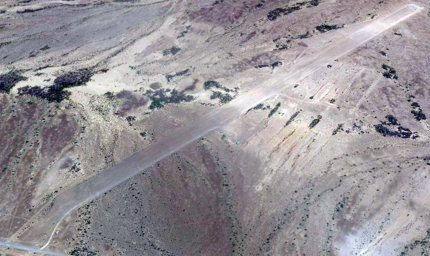
A 2024 photo looking south at the north end of the Dateland AAF runways.
____________________________________________________
32.72, -113.62 (East of Yuma MCAS, AZ)
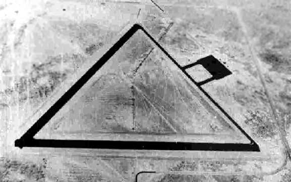
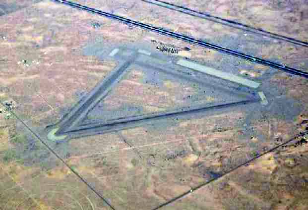
A 6/23/43 aerial view looking north from the 1945 AAF Airfield Directory (courtesy of Scott Murdock)
depicted “Yuma Army Air Field Auxiliary (Stoval Ground Gunnery Range)” as having 2 asphalt runways.
Photo of the airfield while in use has not been located.
This field was built during WW2 to support military flight training at nearby Dateland AAF.
The earliest depiction which has been located of the Stoval airfield
was a 6/23/43 aerial view looking north from the 1945 AAF Airfield Directory (courtesy of Scott Murdock).
It depicted “Yuma Army Air Field Auxiliary (Stoval Ground Gunnery Range)” as having 2 asphalt runways
and an asphalt ramp on the northeast side.
Stoval Field was not yet depicted on the March 1944 Phoenix Sectional Chart.
The earliest aeronautical chart depiction which has been located of Stoval Field was on the September 1945 Phoenix Sectional Chart.
It depicted Stoval as an auxiliary airfield.
The 1945 AAF Airfield Directory (courtesy of Scott Murdock) described “Yuma Army Air Field Auxiliary (Stoval Ground Gunnery Range)”
as having 2 asphalt 4,000' runways, oriented northeast/southwest & east/west, but not having any hangars.
Stoval was described as being operated by the Army Air Forces, but inactive.
At some point between 1947-55, the field apparently was relinquished by the military & reused as a private airfield,
as Stoval Airport was depicted as a private field on the 1955 Phoenix Sectional Chart (courtesy of John Voss).
The Aerodromes table on the reverse side of the chart described the airfield
as having 2 asphalt runways (the longest being 4,000').
Stoval was still depicted as a private airfield on the 1958 Phoenix Sectional Chart (courtesy of Chris Kennedy).
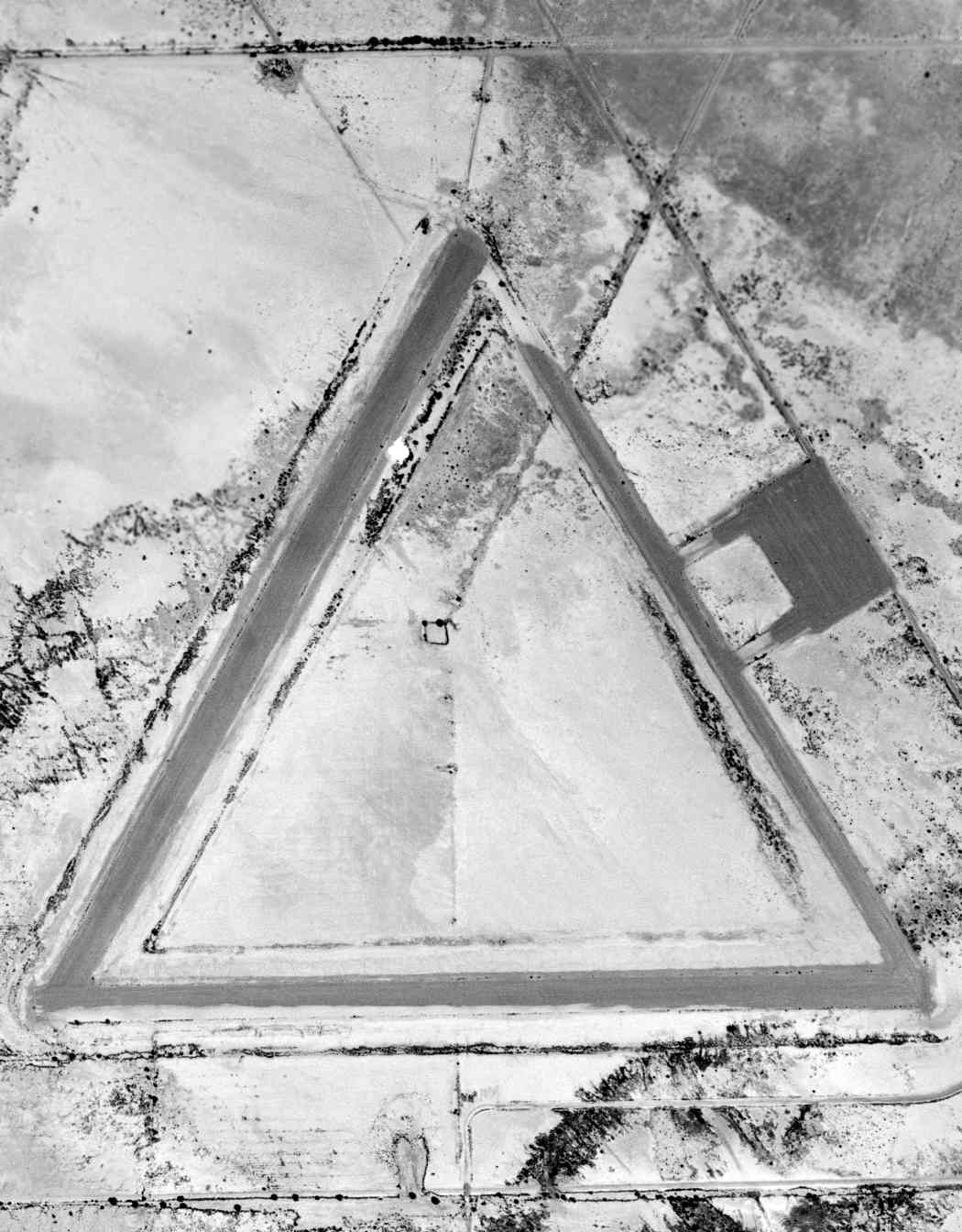
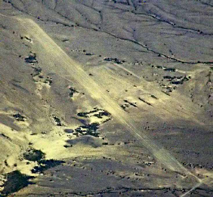
A 9/30/61 USGS aerial photo showed the remains of three 4,000' paved runways & 2 paved ramps at Stoval.
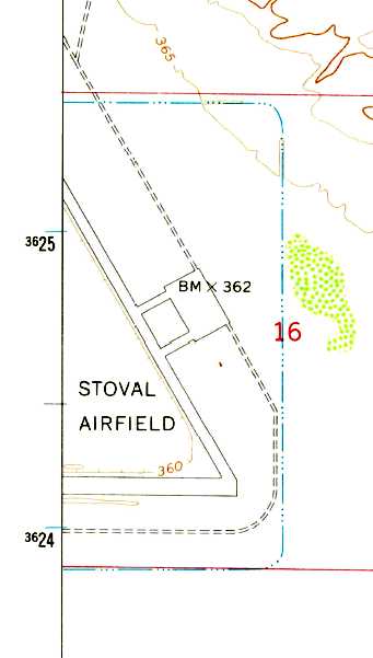
The 1965 USGS topo map depicted “Stoval Airfield” as having 2 runways & a connecting taxiway.
Stoval was apparently closed at some point between 1958-71,
as it was labeled "abandoned" on the August 1971 USAF Tactical Pilotage Chart (courtesy of Chris Kennedy).
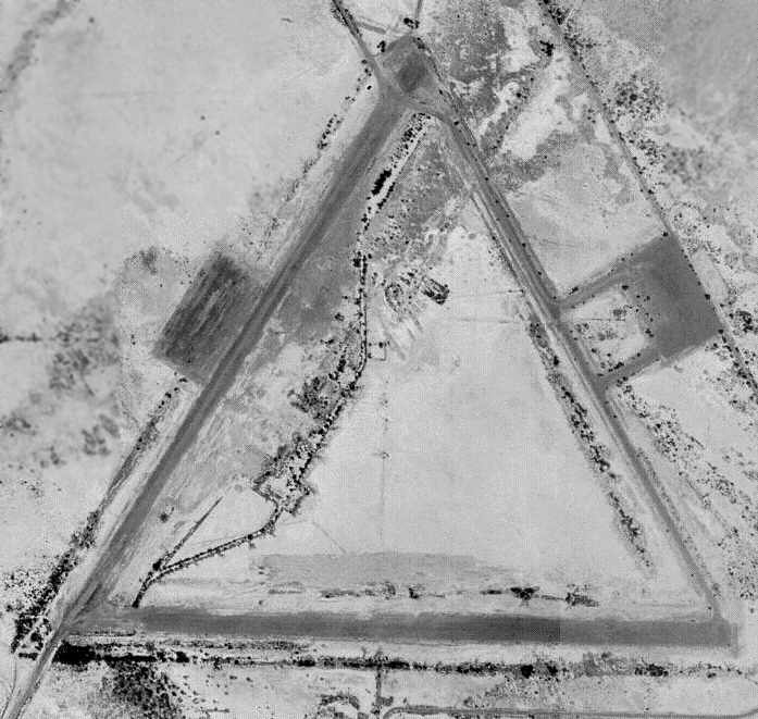
The 1996 USGS aerial photo showed the remains of three 4,000' paved runways at Stoval.
Interestingly, a 2nd paved ramp (on the west side) had been added (for what purpose?) at some point between 1961-96.
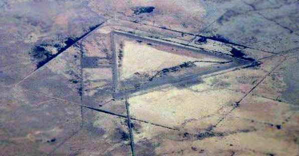
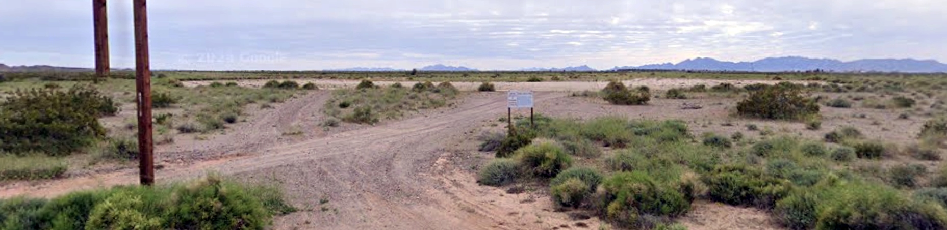
A 2004 photo by Dwight Furleigh looking southeast at the Stoval airfield.
A 2005 photo by Dwight Furleigh looking southwest from the midpoint of Stoval's northeast/southwest runway.
Dwight reported: “This airfield is on the Barry Goldwater Range and is at the end of the old Highway 6 miles east of Dateland.
This road is from the 1950s and was used before Interstate 80 was built - now it isn't even maintained by the county.
There is a short unmaintained road to the base itself.
There is a row of porta-potties sitting in the middle of the desert so apparently some visits do occur there.
At least one of the runways (the northeast/southwest runway) has no debris & is graded & maintained,
so perhaps it is used for practice landings.
Most everything is grown over & you really can't see much on the ground.”
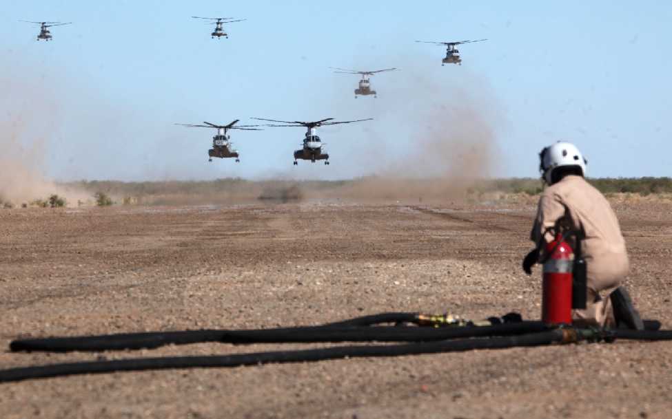
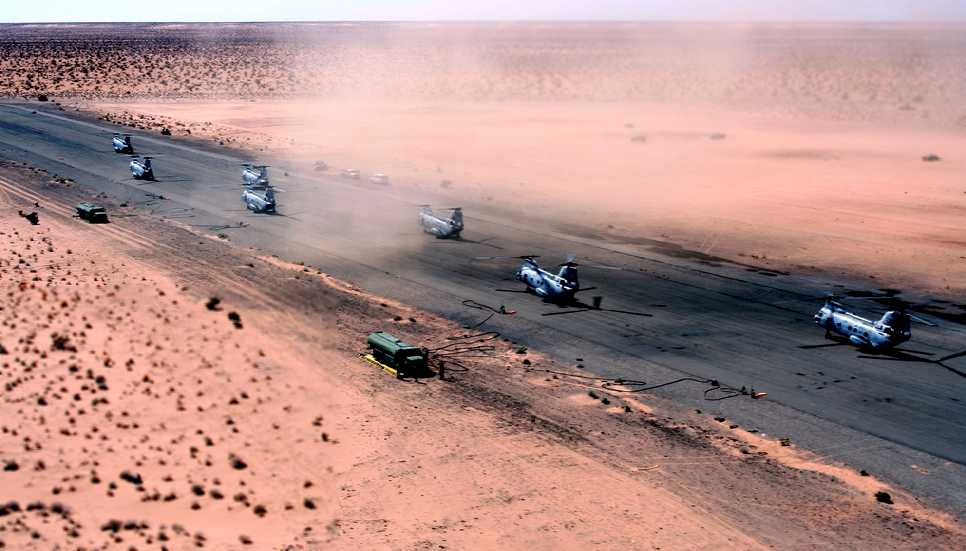
A 10/9/09 DoD photo by Benjamin Reynolds of 6 Marine Corps CH-46 Sea Knight helicopters landing at Stoval Airfield.
The helicopters were to refueled by Marine Corps KC-130 pilots & prospective weapons & tactics instructors
as part of a training mission for Weapons & Tactics Instructor Course 1-11, which is hosted by Marine Aviation & Weapons Tactics Squadron 1.
A 10/15/09 DoD photo by Benjamin Reynolds of Marine Corps KC-130 prospective weapons & tactics instructors
running fuel lines from a KC-130 Hercules to refueling points at Stoval Airfield.
Instructors, pilots and aircrew were conducting this training mission as part of Weapons & Tactics Instructor Course 1-11,
which is hosted by Marine Aviation & Weapons Tactics Squadron 1.
Jim Stewart reported in 2011, “Stoval & Datelan see a fair amount of use, mostly at night for Special Ops training.
That's why they appear to be so well maintained.
During Marine Corps WTIs, these look more like commercial airfields; lots of aircraft, vehicles, people, etc.”
Stoval is located along Interstate 8 between Yuma & Phoenix.
____________________________________________________
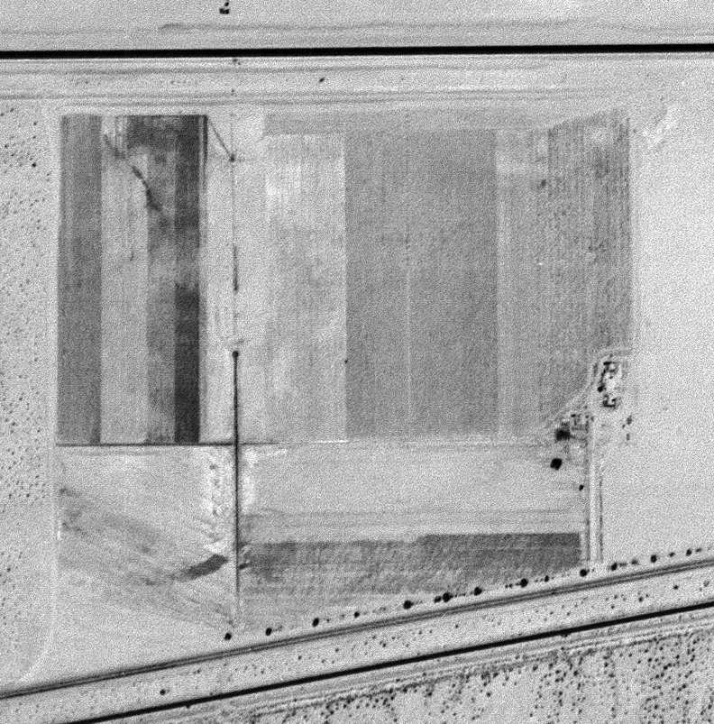
Colfred Auxiliary Army Airfield #2 / Colfred Airport, Tacna, AZ
32.69, -113.88 (East of Yuma MCAS, AZ)
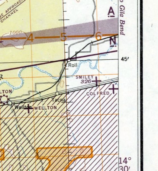
Colfred Field, as depicted on the March 1945 San Diego Sectional Chart.
Photo of the airfield while in use has not been located.
Located between Yuma & Phoenix, this WW2-era airfield was originally part of the 800 acre Colfred Ground Gunnery Range #2,
which was a WW2-era undeveloped range used for small arms training.
According to Scott Thompson, Colfred was one of several auxiliary airfields constructed around November 1943
to support the training activities at nearby Yuma Army Airfield.
Colfred Field was not yet depicted on the March 1944 San Diego Sectional Chart.
The earliest depiction which has been located of Colfred Field was on the March 1945 San Diego Sectional Chart.
It depicted Colfred as an auxiliary airfield.
Colfred Field was evidently deactivated by the military at some unknown point after WW2.
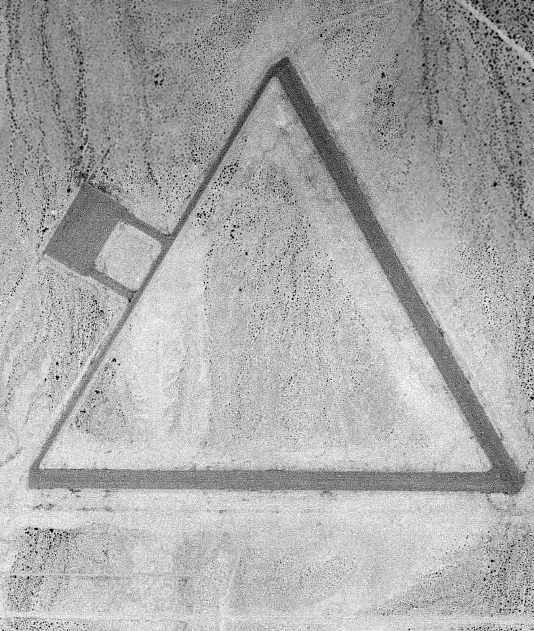
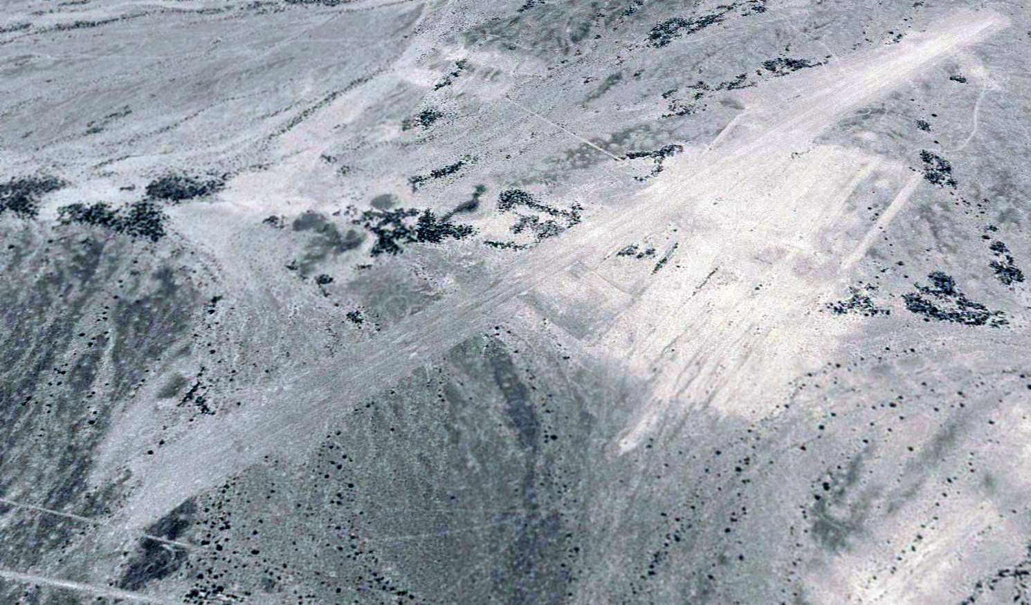
The earliest photo which has been located of Colfred Field was a 6/19/53 USGS aerial view.
It depicted Colfred as having two 4,200' runways & a ramp on the west side.
At some point between 1945-48 Colfred Field was reused as a civilian airport.
The March 1948 San Diego Sectional chart depicted Colfred as a civilian airfield with an unpaved 4,000' runway.
The 1955 San Diego Sectional chart (courtesy of John Voss) depicted Colfred as a civilian airfield with a paved 4,000' runway.
The last aeronautical chart depiction which has been located showing Colfred Field still operational was on the March 1956 San Diego Sectional Chart.
A 646 acre parcel was reacquired by the Air Force in 1956 to build the Colfred Operational Control Annex,
a facility for the construction of a remote operational control site for Q-2 drone aircraft (the original version of the Ryan Firebee).
Colfred Field was no longer depicted on the October 1956 San Diego Sectional Chart.
Military improvements at the Colfred site between 1956-58 included covered storage, operational & troop facilities, fencing,
access road improvements & a power generation plant.
The Colfred Operations Control Annex site was declared surplus in 1961.
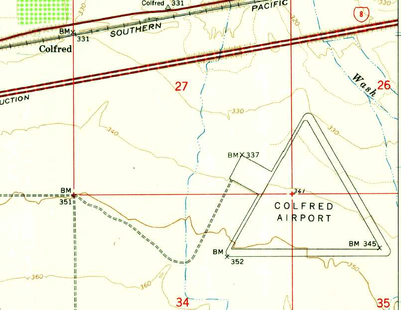
The earliest topo map depiction which has been located of Colfred Airport was on the 1965 USGS topo map.
It depicted “Colfred Airport” as having 2 paved runways with a connecting taxiway,
and a paved ramp on the northwest side.
By the time of the 1966 San Diego Sectional Chart (courtesy of Chris Kennedy), the Colfred airfield was labeled as "Aband arpt".
Greg Nelson (of Yuma County Planning & Zoning) reported that he visited & spoke with the airfield property owner, Gary Waggoner.
“There was an attempt to raise jojoba on much of the property in the area
in the late 1970s or early 1980s but it was not successful.”
According to a 1991 Army Corps of Engineers Report,
at that point the Colfred site was owned by 3 private individuals, and none of the original military buildings remained.
The remains of three 4,200' runways were still barely perceptible in the 1992 USGS aerial photo.
The western portion of airfield was evidently being used for farming.
Douglas Bell reported in 2004, "I was in the area last February [2003].
We did visit Colfred Field which was used for the planting of jojoba plants (possible source of protein) years ago
and now the plants are all dead but the runways are still there in fair condition."
A 2004 photo by Dwight Furleigh looking northwest along the northwest/southeast runway.
Dwight reported, "The abandoned base was a little complicated to get to,
as it was about 5 miles east of the exit for Tacna, AZ, down a sand road & pretty primitive.
It is only about 1/2 mile from the interstate highway but very hard to see from it unless you know what you are looking for."
He found the northeast/southwest runway to be "narrower than he rest but still clear & usable if needed."
The northern portion of this was "where crops had been planted some time ago but appear to not be used anymore."
The northwest/southeast runway was "very wide & appears to still be well maintained."
The east/west runway was "also in good shape."
A 2004 photo by Dwight Furleigh looking west along Colfred's east/west runway.
A 2004 photo by Dwight Furleigh looking northeast at the Quonset huts & trucks on the site of Colfred's former ramp area.
It is not clear if the Quonset huts dated from the site's airfield days, or if they were added later.
There was no sign of any aircraft.
A 2004 photo by Dwight Furleigh looking southeast at the windsock pole which remains standing in the middle of the field at Colfred.
A 2004 photo by Benjamin Russell, taken from a commercial airliner looking south at the Colfred airfield.
Greg Nelson (of Yuma County Planning & Zoning) reported in 2005
that “property containing a portion of the Colfred Airfield is the subject of a rezoning application.
I recently visited the property & spoke with the owner, Gary Waggoner.
Mr. & Mrs. Waggoner own 60 acres on which the apron area & a portion of the taxiway were located.
I asked Mr. Waggoner about the condition of the runways.
He said they are in good shape under about 6 inches of sand.
He said someone, perhaps when the airfield was abandoned,
deliberately covered the airfield with sand to protect it from the sun.
The land is not in use other than as a place for the Waggoners to spend the winter.”
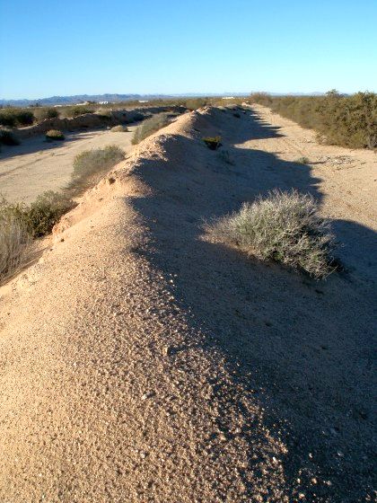
An April 2014 photo by Mike Jamison, of “part of the airfield's perimeter berm; a dirt wall that surrounds most of the field. Shown here is a section of the wall's west side.
I guess having such a barrier could harm descending aircraft. Nevertheless, I can't figure out what else the berm could have been.
It seems purposely constructed to surround the place. From aerial views, I at first thought the feature was a fence. Walking around on site revealed the mound.”
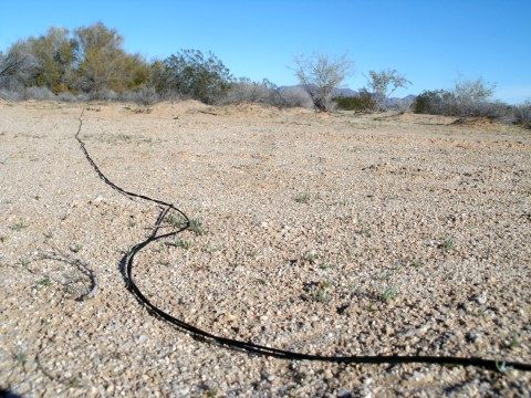
An April 2014 photo by Mike Jamison, of “a length of communication wire found near Colfred's south runway.
Cloth insulation probably means the wire is pretty old. I've seen similar lengths, strung for thousands of feet in and around Wendover Army Airfield.
The piece shown here seemed equally endless.”
____________________________________________________
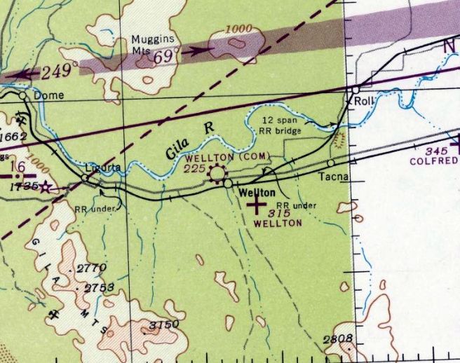
Wellton Auxiliary Army Airfield / Wellton Airport, Wellton AZ
32.66, -114.1 (East of Yuma MCAS, AZ)
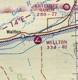
Wellton Auxiliary Airfield, as depicted on the August 1947 San Diego Sectional Chart.
Photo of the airfield while in use has not been located.
Wellton airfield was built during WW2 as one of 7 satellite airfields for Yuma AAF,
which conducted primary flight training & training of bomber aircrews.
According to the Bureau of Land Management, the Wellton airfield was used starting in 1943.
No airfield at this location was yet depicted on San Diego Sectional Charts from 1943 – February 1947
The earliest depiction which has been located of the Wellton Airfield was on the August 1947 San Diego Sectional Chart.
It depicted Wellton as an auxiliary airfield.
According to the Bureau of Land Management, the Wellton airfield was used until 1950,
but that may have been specifically the end of its military use.
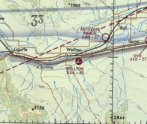
Apparently Wellton airfield was still active as of 1955,
as "Wellton" Airport was listed among active airfields in the "Aerodromes" table
on the 1955 San Diego Sectional Aeronautical Chart(courtesy of John Voss).
It described the field as having 2 bituminous runways (the longest being 4,000').
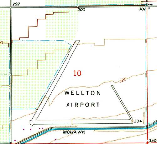
The 1965 USGS topo map depicted “Wellton Airport” as having 2 runways & a taxiway, with a gap in the taxiway on the northeast side.
Wellton was still depicted as an active airfield on the 1966 San Diego Sectional Chart (courtesy of Chris Kennedy).
Wellton was still depicted as an active airfield on the 1971 Phoenix Sectional Chart (courtesy of Ron Plante).
It depicted Wellton as having 2 paved runways, with the longest being 4,000'.
Wellton Airport was apparently closed at some point between 1971-78,
as it was depicted an an abandoned airfield on the 1978 Phoenix Sectional Chart (courtesy of Jonathan Westerling).
The remains of the two 3,700' runways & connecting taxiway were still barely perceptible in the 1992 USGS aerial photo.
A December 2004 photo by Dwight Furleigh looking west along the remains of Wellton's east/west runway.
Dwight reported, "I visited Wellton AAF field & others in the Yuma area in December 2004.
This airfield has fallen into complete disuse.
The runways are made of pea gravel & scrub brush has grown up over much of the area.
There is the usual empty beer bottles & trash in the area, but the runways are indeed still identifiable as you can see."
A December 2004 photo by Dwight Furleigh looking northeast along the remains of Wellton's northeast/southwest runway.
A December 2004 photo by Dwight Furleigh of "old rusting debris that looks to be associated with aircraft, but was unable to identify them."
A 2016 aerial view looking north at the site of Wellton Field shows the remains of 2 runways & a connecting taxiway.
The outline of a parking ramp on the east side of the taxiway is barely recognizable.
The Wellton airfield is located northeast of the intersection of East Mohawk Canal Road & Avenue 31E,
three miles southeast of the town of Wellton.
____________________________________________________
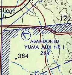
Yuma Auxiliary Army Airfield #1, Fortuna Foothills, AZ
32.66, -114.44 (East of Yuma MCAS, AZ)
A 6/23/43 aerial view looking west at Yuma Aux #1 from the 1945 AAF Airfield Directory (courtesy of David Brooks).
This field was built during WW2 as one of 7 satellite airfields for Yuma AAF,
which conducted primary flight training & training of bomber aircrews.
The date of construction of Yuma Aux #1 has not been determined.
The earliest depiction which has been located of Yuma Aux #1
was a 6/23/43 aerial view looking west from the 1945 AAF Airfield Directory (courtesy of David Brooks).
It depicted Yuma Aux #1 as having 2 asphalt runways connected by a taxiway, and a ramp on the north side.
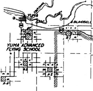
A 1944 Army map of the Yuma Advanced Flying School & its surrounding fields (courtesy of John Voss)
depicted Yuma Aux #1 as having 2 asphalt runways connected by a taxiway, and a ramp on the north side.
Yuma Aux #1 was listed in a directory of AZ Airports
in the 5/47 issue of Arizona Highways (courtesy of George Miller),
which described the field as being unattended, and the longest runway as being 3,800'.
Yuma Aux #1 was still active in 1955,
as it was listed among active airfields in the "Aerodromes" table
on the 1955 San Diego Sectional Aeronautical Chart(courtesy of John Voss).
It described the field as having 2 bituminous runways (the longest being 3,740').
The 1965 USGS topo map depicted “Yuma #1 Airfield” as having 2 runways connected by a taxiway.
Yuma Aux #1 was apparently closed at some point between 1955-71,
as it was labeled "abandoned" on the August 1971 USAF Tactical Pilotage Chart (courtesy of Chris Kennedy).
Jim Stewart recalled, “I used to jump at Aux #1 in the foothills back around 1980 when all that was there was a Stuckey's (now a Texaco)
and the large concrete structure across Fortuna Road.
It was flyable only on the north/south runway. The rest was drivable but with a lot of brush.”
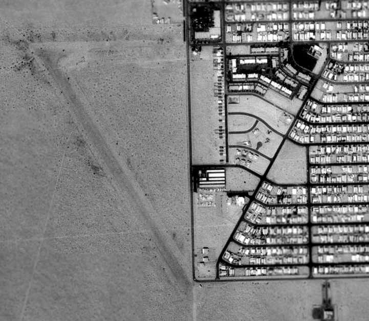
As seen in the 1992 USGS aerial photo, in an unusual reuse,
the runways & taxiways of the eastern half of the former airfield
have been reused as streets of a residential neighborhood.
The eastern half of the former east/west runway is now East 35th Place,
and the former northeast/southwest taxiway is now South Mesa Drive.
As of 1992, the western half of the former airfield remained undeveloped,
with the remains of the western portion of the runways still plainly apparent.
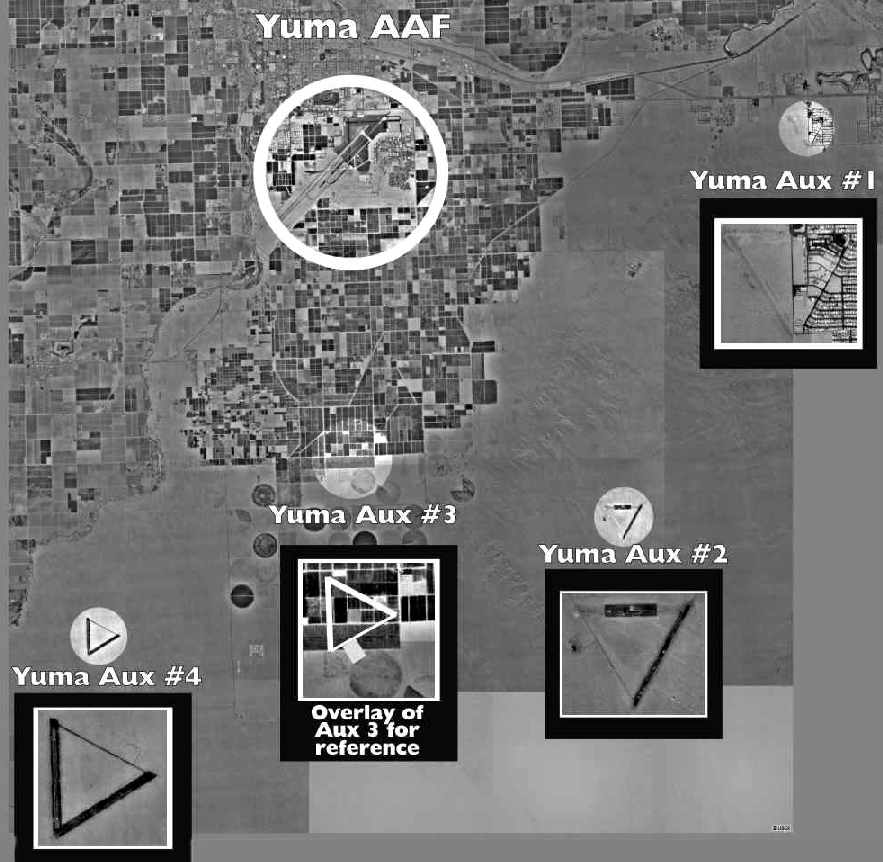
A remarkable composite picture, in which David Brooks has superimposed close-up views of 4 nearby former satellite airfields
over the 1994 USGS aerial photo, showing their location relative to the former Yuma AAF (the present-day MCAS Yuma).
The Yuma Aux #1 airfield remained in basically the same condition in this 1997 aerial view by Steve Hoza,
looking northeast at Yuma Aux #1.
The photo is courtesy of Steve Hoza, from the book "Best Place in the Country", by Mike & Steve Hoza.
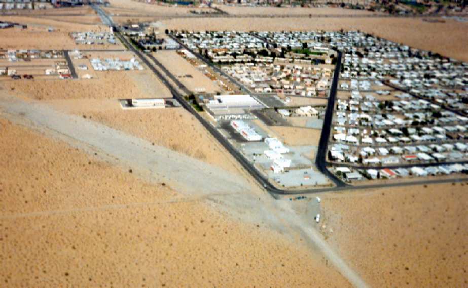
A 4/23/19 aerial view by Alexz Schasfoort looking north at the site of the Yuma Aux #1 airfield, showing it progressively covered with more housing,
with the only clue to the property's airfield past being the diagonal orientation of South Mesa Drive which overlays the former taxiway.
The former airfield is located south of the intersection of Interstate 8 & South Fortuna Road.
____________________________________________________
Yuma Auxiliary Army Airfield #2, Yuma, AZ
32.55, -114.51 (Southeast of Yuma, AZ)
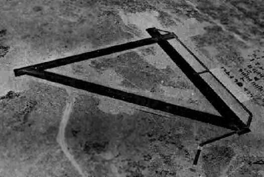
The layout of Yuma Aux #2, from a 1944 Army map of the Yuma Advanced Flying School & its surrounding fields (courtesy of John Voss).
Yuma Auxiliary Airfield #2 was built during WW2 as one of 7 satellite airfields for Yuma AAF,
which conducted primary flight training & training of bomber aircrews.
It is located within the present-day Barry Goldwater Air Force Bombing Range.
The earliest depiction which has been located of Yuma Auxiliary Airfield #2
was on a 1944 Army map of the Yuma Advanced Flying School & its surrounding fields (courtesy of John Voss).
Yuma Auxiliary Airfield #2 was not yet depicted on the March 1945 San Diego Sectional Chart.
The earliest aeronautical chart depiction which has been located of Yuma Auxiliary Airfield #2 was on the August 1945 San Diego Sectional Chart.
It depicted “#2” as an auxiliary airfield.
Yuma Aux #2 was still active in 1955, as it was listed among active airfields in the "Aerodromes" table
on the 1955 San Diego Sectional Aeronautical Chart (courtesy of John Voss).
It described the field as having 2 bituminous runways (the longest being 3,740').
The 1965 USGS topo map depicted 2 runways & a connecting taxiway at Yuma Aux #2, but without any labeling.
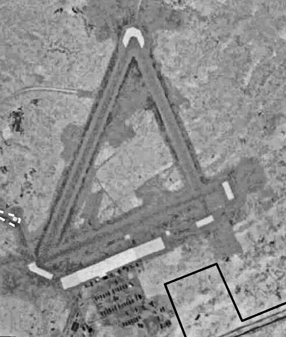
As seen in the 1992 USGS aerial photo,
the Yuma Aux #2 airfield consists of two 4,000' paved runways,
along with a taxiway connecting the runways on the western side, forming an equilateral triangle.
What was formerly the taxiway has now been reused as a portion of a road, E County 19th Street.
Remains are visible of the parking apron, west of the taxiway.
Two bombing range target circles are visible adjacent to the airfield to the southeast.
The Southwest/Northeast runway is now used as a firing line
and the area to the southeast is all firing range for ground units deployed to Yuma.
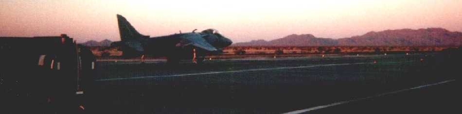
A 1998 photo by Brandon Ball of an AV-8B Harrier from Yuma MCAS,
seen at Yuma Aux #2 while conducting shipboard operations practice, prior to a deployment.
The refueling probe is extended on the aircraft,
the signal for the maintenance guys to refuel the aircraft.
For day trips to Aux #2, the bulk fuel handlers would bring out a truck so that the aircraft could be turned around at Aux #2,
rather than having to make the trip back to Yuma.
Although no longer listed in the Airport Facility Directory as an active airfield of any kind,
and not depicted at all (even as an abandoned airfield) on current aeronautical charts,
Yuma Aux #2 is very much still in service.
However, the airfield's role is quite different from its original function,
according to Brandon Ball (former avionics technician with Yuma Marine Attack Squadron 513).
The center portion of the East/West runway has been widened,
and upon it has been painted the outline of an LHA-class amphibious assault ship.
AV-8B Harrier pilots from Yuma come to Yuma Aux #2 to make practice landings on the LHA outline.
It is a pre-deployment training area for pilots needing to get back up to speed on their shipboard operations,
without the costly expense of flying to an actual ship.
In addition to the ship outline, there is a fully functional island for the Landing Signals Officer to give instruction via radio
& a realistic lighting system for night operations.
Aux #2's "ship" has also been used in the past for Harrier squadron deployments.
When the squadron wouldn't have enough money to actually go somewhere,
it would pack up all the necessary gear, make the 20 minute drive to Aux #2 & live in tents for a week in the desert,
while pretending to operate from a ship.
The future of Aux #2 isn't certain.
While a valuable training aid, it occasionally closed in the past due to instances of foreign object damage (FOD) to Harrier engines.
Ham-fisted, less experienced Harrier pilots have a tendency to approach Aux #2 too low,
and during the hover transition phase, blow desert (dirt, rocks, bushes & the unfortunate lizard) all over the landing area,
which the Harrier ingested upon touchdown.
There was an instance of a Harrier that was grounded at Aux #2 due to a FOD'ed engine,
and rather than change the motor at Aux #2 (which is a huge affair that requires special equipment),
it was decided to tow the aircraft the 15 or so miles back to MCAS Yuma,
a 5 hour affair that was accomplished in the middle of the night.
Luckily, a Harrier is small enough to pass under streetlights & stoplights.
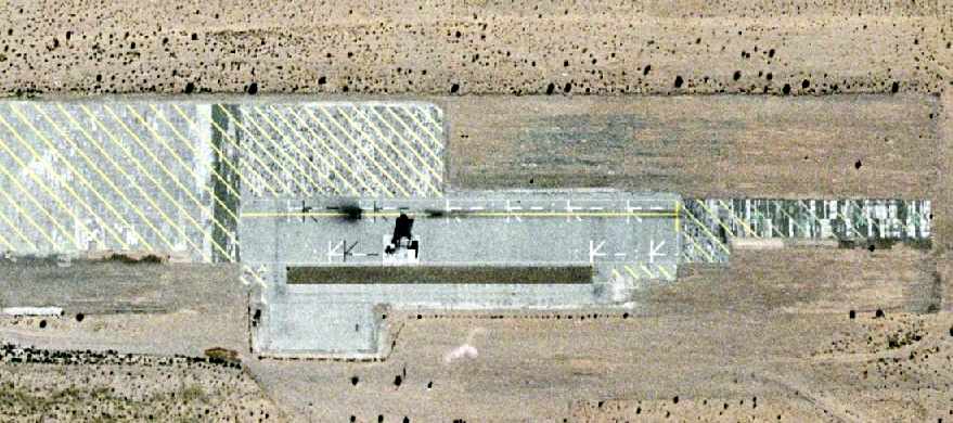
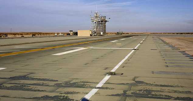
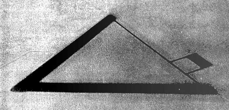
A circa 2006 aerial photo of the simulated LHA deck (complete with island superstructure)
which has been built over the east/west runway at the Yuma Aux #2 airfield.
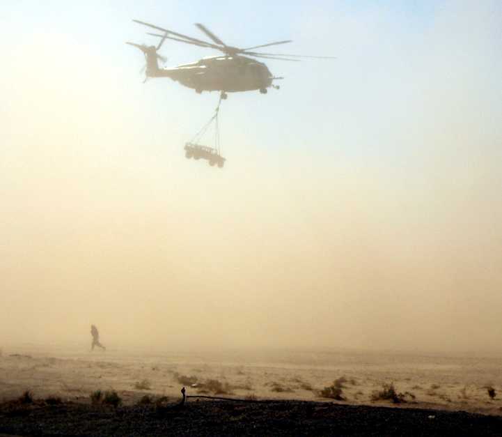
A 10/7/06 photo of a Marine CH-53E lifting a HUMVEE from Aux #2.
A 10/16/06 aerial view of 7 CH-46 Sea Knights lined up at Yuma Aux #2's Forward Arming & Refueling Point.
A 5/31/07 view of Marine Capt. James Traylor & Lt.Col. Eric Austin watching for other AV-8B Harriers
with a Harrier moving down the tram line during VMA-211's Field Carrier Landing Practice at Yuma Aux #2.
A 6/1/07 photo looking west at the Yuma Aux #2 runway during its use by Harriers of VMA-211
for Field Carrier Landing Practice before going out to the boat, USS Tarawa LHA-1.
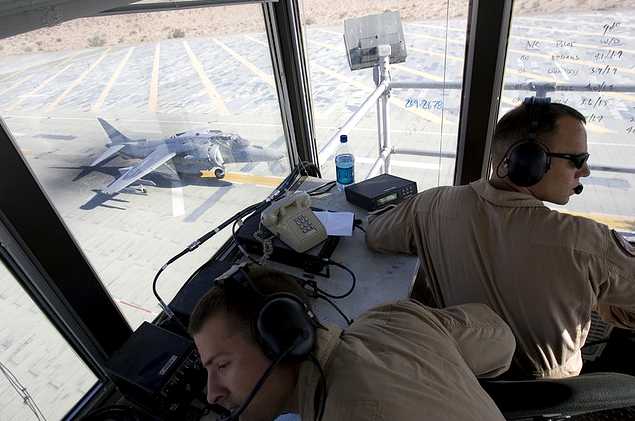
The Aux #2 landing surface is made of AM-2 matting, and the tower out of heavy duty scaffolding structure.
____________________________________________________
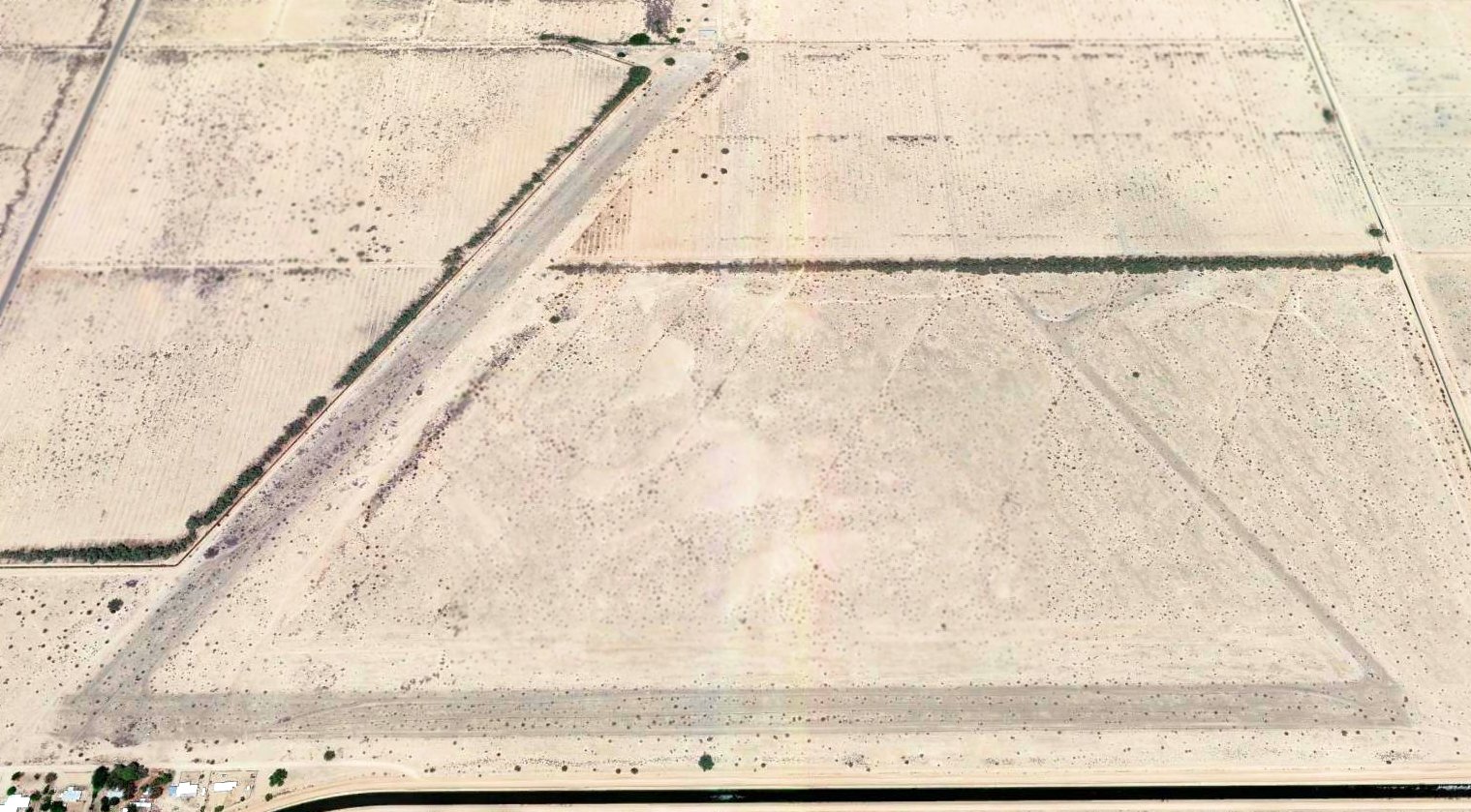
Yuma Auxiliary Army Airfield #3, Somerton, AZ
32.57, -114.6 (South of Yuma, AZ)
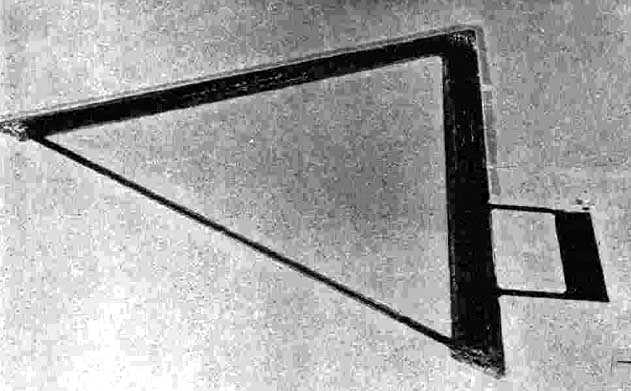
A 6/23/43 aerial view looking southeast at Yuma Aux #3 from the 1945 AAF Airfield Directory (courtesy of David Brooks).
Yuma Auxiliary #3 was one of 4 satellite airfields constructed during WW2
to support training operations at Yuma Army Airfield.
The date of construction of Yuma Aux #3 has not been determined.
The earliest depiction which has been located of Yuma Aux #3
was a 6/23/43 aerial view looking southeast from the 1945 AAF Airfield Directory (courtesy of David Brooks).
It depicted Yuma Aux #1 as having 2 asphalt runways connected by a taxiway, and a ramp on the south side.
As depicted on a 1944 Army map of the Yuma Advanced Flying School & its surrounding fields (courtesy of John Voss),
Yuma #3 had basically the same configuration as the other Yuma Auxiliary fields,
with 2 paved 4,000' runways & a taxiway forming an equilateral triangle.
A ramp area with an operations building was south of the taxiway.
The location of Yuma Aux #3,
As depicted on a 1944 Army map of the area of the Yuma Advanced Flying School (courtesy of John Voss).
Yuma Aux #3 was listed in a directory of AZ Airports
in the 5/47 issue of Arizona Highways (courtesy of George Miller),
which described the field as being unattended, and the longest runway as being 3,800'.
"Yuma AAF #3" was still depicted as an active airfield on the 1948 San Diego Sectional Chart (according to Chris Kennedy),
and was described as having a 4,000' runway.
Apparently Yuma Aux #3 had been closed by 1949,
as it was not depicted at all on the 1949 San Diego Sectional Chart (according to Chris Kennedy),

The last photo which has been located of Yuma Aux #3 was a 1955 USGS aerial view.
The northern tip of the airfield had been covered by agricultural fields,
but most of 2 paved runways & a connecting taxiway still remained.
Yuma Aux #3 was not depicted at all on the 1965 USGS topo map.
As can be seen in the 1992 USGS aerial photo,
the area of Yuma Auxiliary #3 has been completely reused for agriculture,
and not a trace appears to be discernible of the former airfield.
____________________________________________________
____________________________________________________
This site covers airfields in all 50 states.