Abandoned & Little-Known Airfields:
Arizona: Northern Tucson area
© 2002, © 2026 by Paul Freeman. Revised 2/16/26.
This site covers airfields in all 50 states: Click here for the site's main menu.
____________________________________________________
Please consider a financial contribution to support the continued growth & operation of this site.
Gilpin Airport / Freeway Airport (revised 2/16/26) - Marana Aux AAF #1 / Picacho Field (revised 5/5/21)
Marana Army Aux #3 / Coronado Field (revised 7/4/19) - Marana Aux AAF #4 / Avra Field (revised 5/5/21) - Marana Aux AAF #5 / Sahauro Field (revised 5/5/21)
Redrock Airport (revised 1/8/20) - Taylor Field (revised 11/11/23) - Tucson Airpark (revised 1/8/20)
____________________________________________________
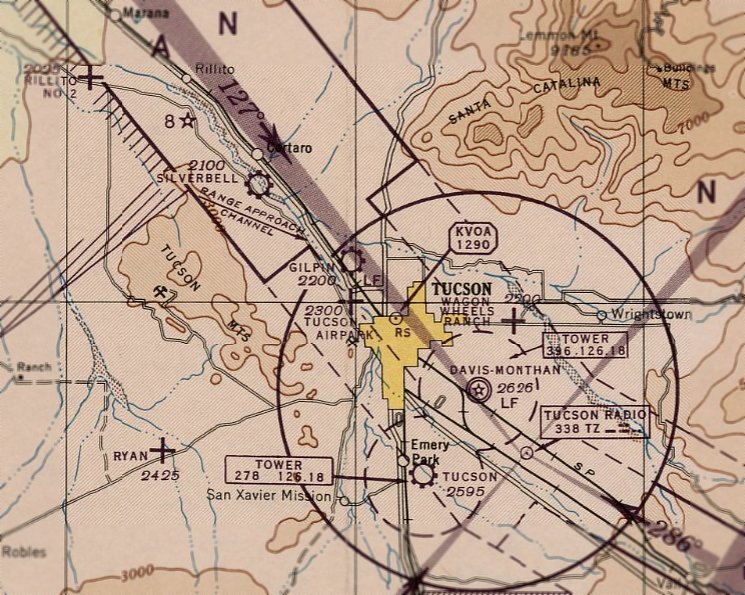
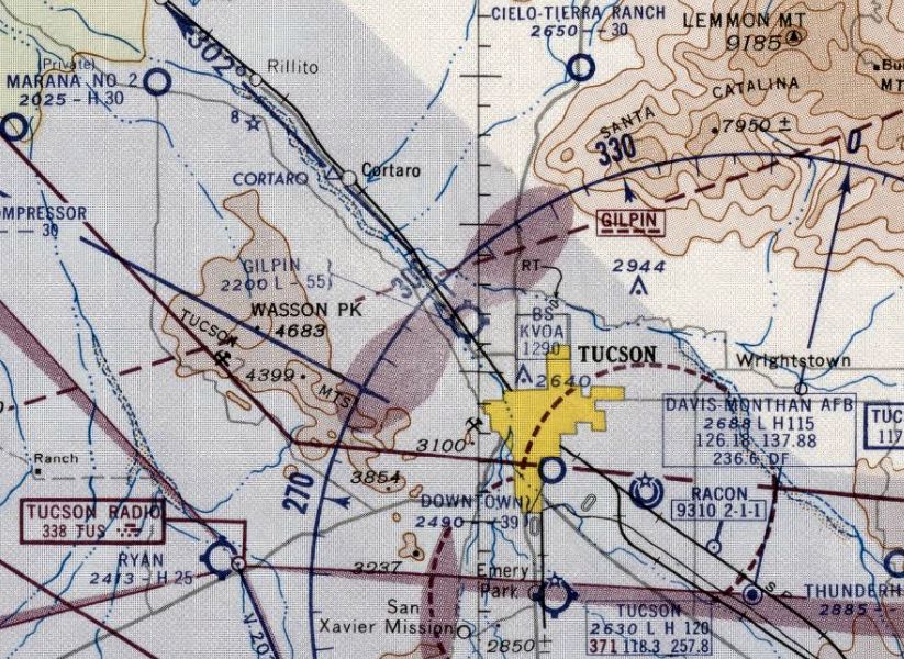
32.254, -111.005 (Northwest of Downtown Tucson, AZ)
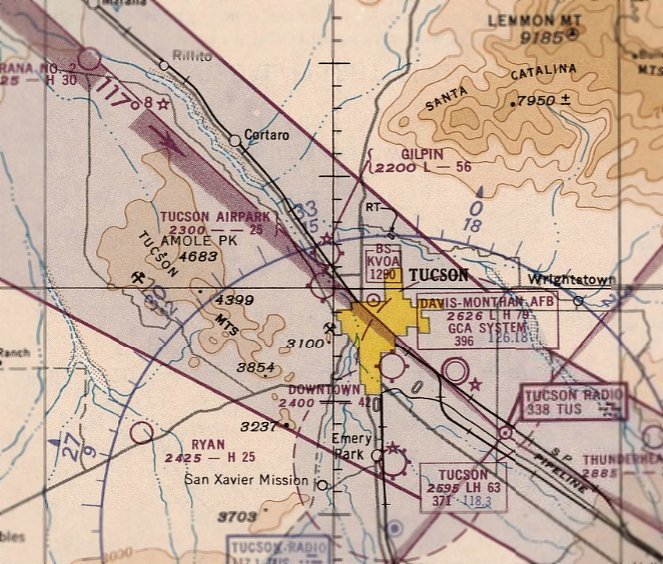
Tucson Airpark, as depicted on the March 1946 Phoenix Sectional Chart.
This short-lived small general aviation airport was evidently established at some point between 1947-49 (during the post-WW2 US general aviation boom),
as it was not yet depicted on the September 1945 Phoenix Sectional Chart.
The earliest depiction which has been located of Tucson Airpark was on the March 1946 Phoenix Sectional Chart.
It depicted Tucson Airpark as an auxiliary airfield.
According to Bruce Thompson, “Tucson Airpark was located northwest of the City of Tucson along the west side of the Santa Cruz River
and north of what is now known as Grant Road which runs east/west.
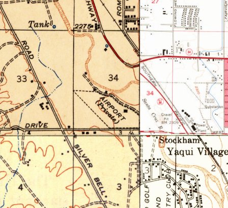
The 1947 USGS topo map depicted Tucson Airpark as an irregularly-shaped property outline,
labeled generically as “Airport (Private)”, with a small building on the east side.
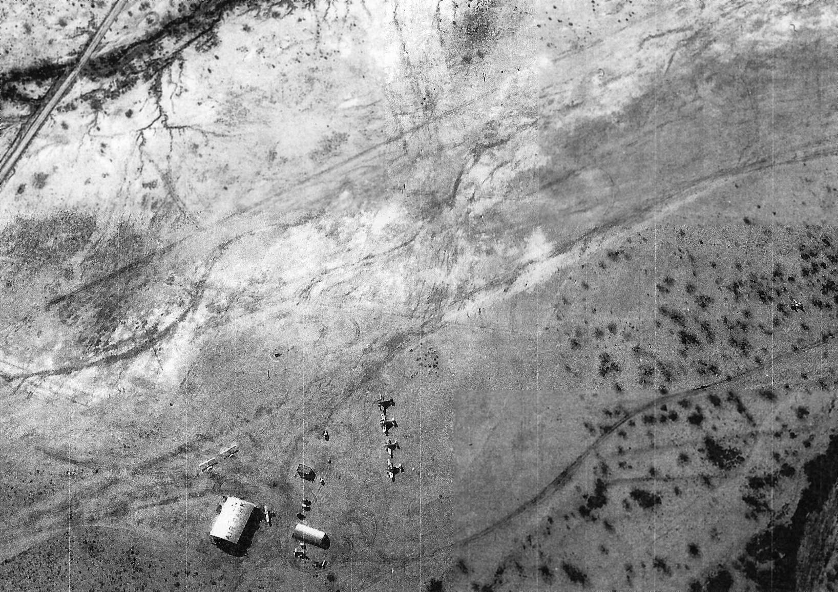
A circa 1940s aerial view (courtesy of Bruce Thompson) depicted Tucson Airpark as having 7 light single-engine aircraft parked near a hangar with “Tucon Airpark” painted on its roof.
A circa 1940s aerial view (courtesy of Bruce Thompson) depicted Tucson Airpark as having 2 unpaved runways, with several light aircraft parked near a hangar.
The last aeronautical chart depiction which has been located of Tucson Airpark was on the March 1951 Phoenix Sectional Chart,
which depicted it as having a 2,500' unpaved runway.
Tucson Airpark was evidently closed at some point in 1951,
as it was no longer depicted on the September 1951 Phoenix Sectional Chart.
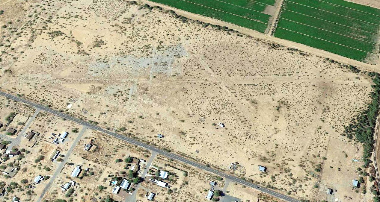
A 1958 aerial photo showed the former Tucson Airpark hangar remained standing, but the airfield area appeared to have been put into cultivation.
A 1966 aerial view showed the former Tucson Airpark hangar had been removed at some point between 1958-66.
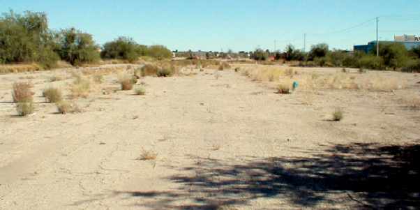
A 2017 aerial view showed no trace of Tucson Airpark.
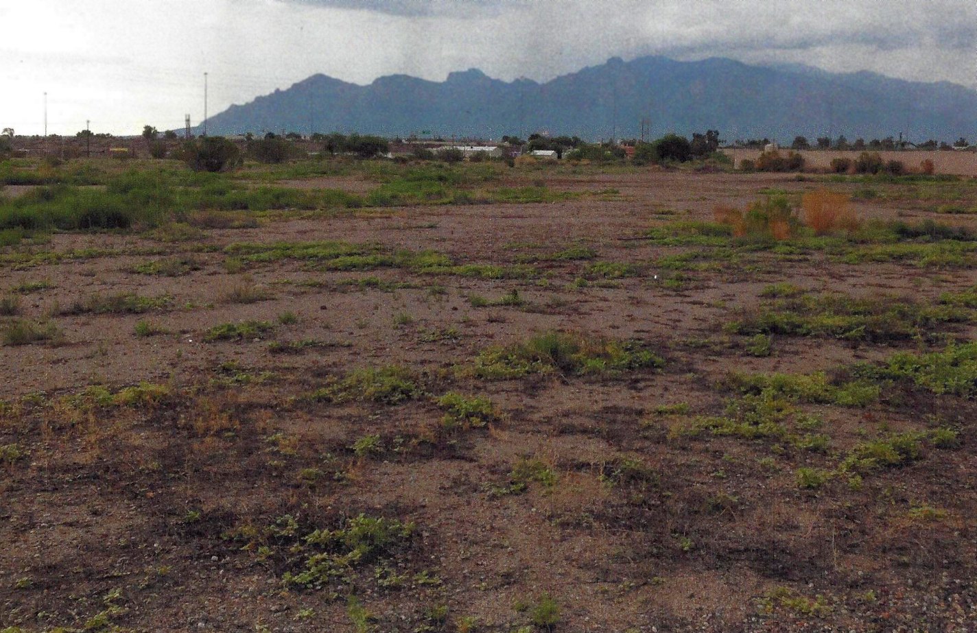
A 2018 photo by Bruce Thompson showed no trace remains of Tucson Airpark.
Bruce observed, “There is nothing left of the airpark as far as buildings or runway markings.
On one edge Tucson has built a regional city park & the other is privately owned by businesses as this is now considered an industrial park.”
The site of Tucson Airpark is located north of the intersection of Grant Road & North Huachuca Road.
Thanks to Bruce Thompson for pointing out this airfield.
____________________________________________________
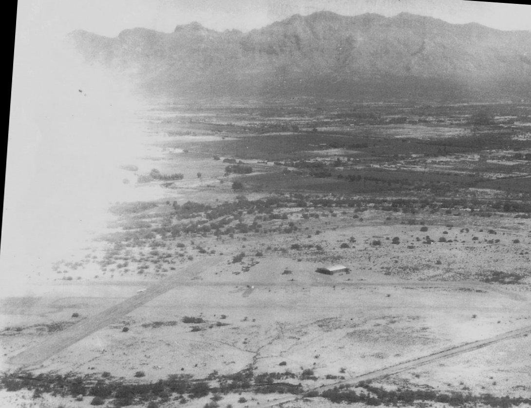
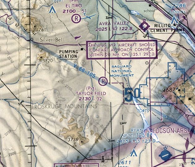
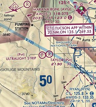
Taylor Field (0AZ1), Marana, AZ
32.3, -111.32 (Northwest of Tucson, AZ)
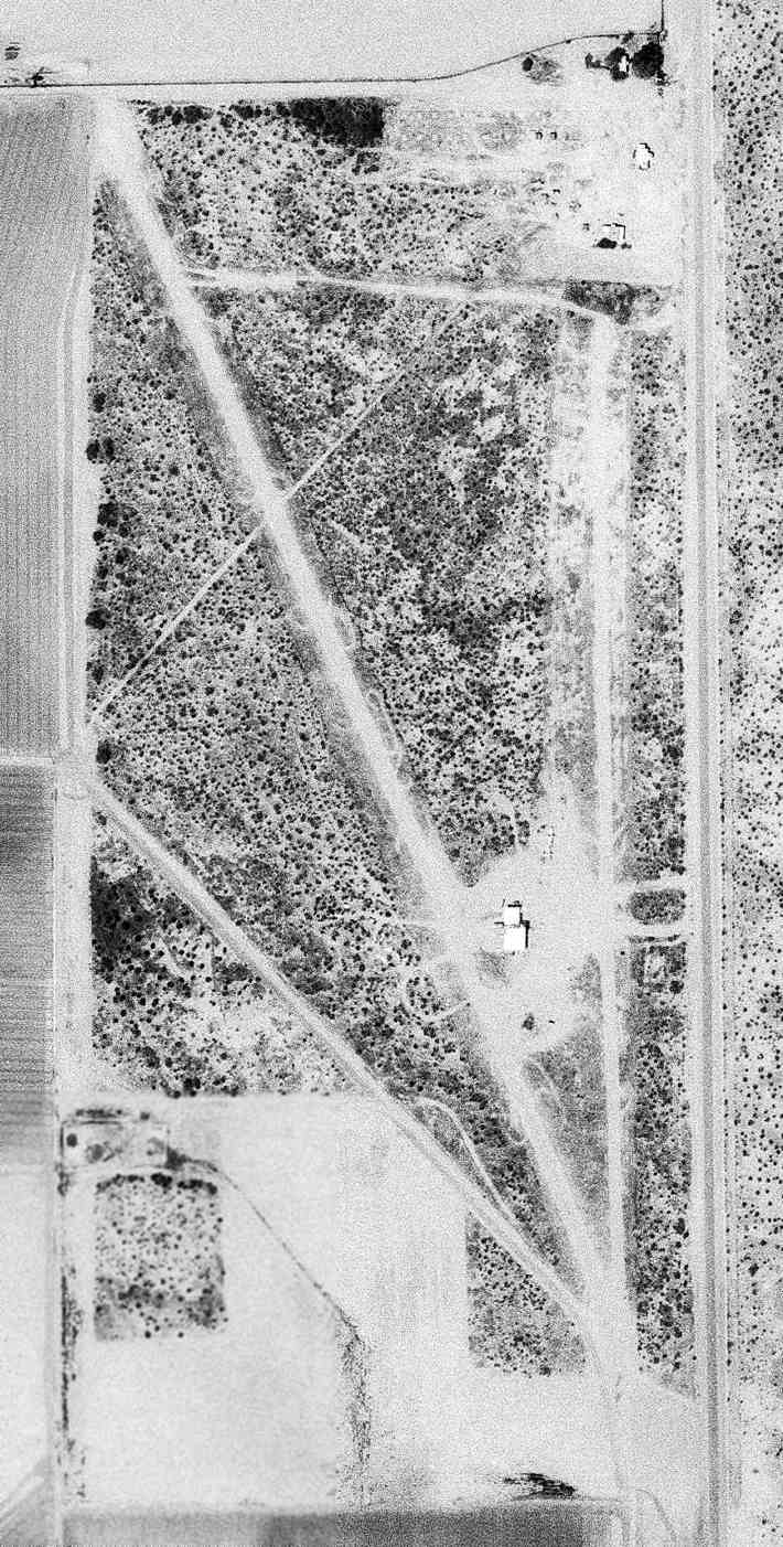
A 4/1/74 USGS aerial photo depicted Taylor Field as having 2 unpaved runways & a few small buildings on the east side.
The date of establishment of this small general aviation airport northwest of Tucson has not been determined.
The earliest depiction which has been located of Taylor Field was a 4/1/74 USGS aerial photo,
which depicted Taylor Field as having an unpaved northwest/southeast runway & a few small buildings on the east side.
Taylor Field was not yet depicted on the November 1985 Phoenix Sectional Chart (courtesy of Ron Plante).
According to its FAA Airport/Facility Directory data, Taylor Field had an “activation date” of 7/1/86,
but that may simply have been when the field was officially registered.
The earliest aeronautical chart depiction which is available of Taylor Field was on the 1988 Phoenix Sectional Chart (courtesy of Jonathan Westerling).
It depicted Taylor as a private airfield having a 3,200' unpaved runway.
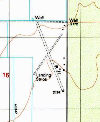
The earliest topo map depiction which has been located of Taylor Field was on the 1989 USGS topo map.
It depicted 2 unpaved runways, labeled simply as “Landing Strips”, with several small buildings on the east side.
The earliest aeronautical chart depiction which has been located of Taylor Field was on the May 1993 Phoenix Sectional Chart (courtesy of Ron Plante).
It depicted Taylor as a private airfield having a 3,200' unpaved runway.
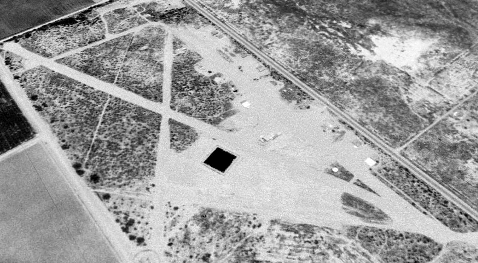
A 1996 aerial view looking northeast showed Taylor Field to have 3 unpaved runways, but there were no aircraft visible on the field.
A circa 2010 aerial view looking east showed several individual hangars on the east side of Taylor Field, several of which had collapsed.
The 2015 Phoenix Sectional Chart still depicted Taylor Field as a private airfield, with a 3,200' unpaved runway.
As of 2015, the FAA Airport/Facility Directory described Taylor Field as “Airport closed indefinitely.”
It listed the owner & manager as Doug Somerville, and described the field as having 3 dirt runways,
the longest being the 3,250' Runway 14/32.
Taylor Field was said to have a total of 23 based aircraft, including 1 multi-engine aircraft & 1 glider.
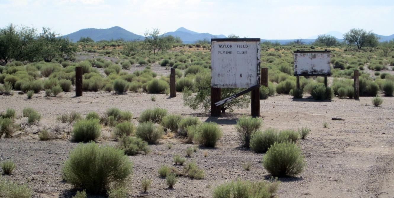
A 4/22/15 photo by Ed Cieslak (courtesy of Francis Blake) of the sign for the “Taylor Field Flying Club” at Taylor Field.
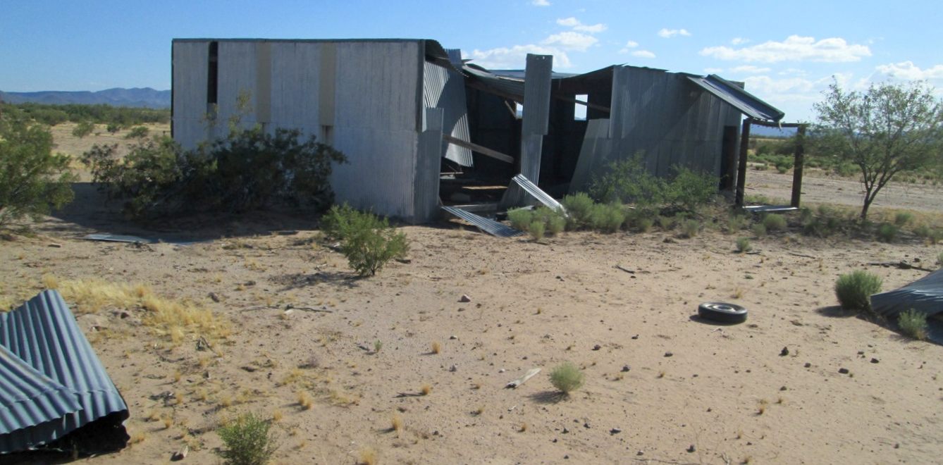
A 4/22/15 photo by Ed Cieslak (courtesy of Francis Blake) of a partially collapsed hangar at Taylor Field.
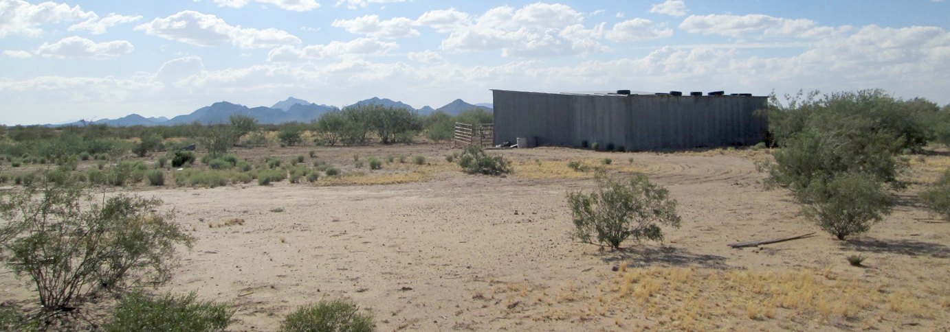
A 4/22/15 photo by Ed Cieslak (courtesy of Francis Blake) of a hangar at Taylor Field.
According to Francis Blake, as of 2015 Taylor Field was listed for sale & owned by the State of AZ.
Taylor Field was no longer depicted on the 2016 Phoenix Sectional Chart.
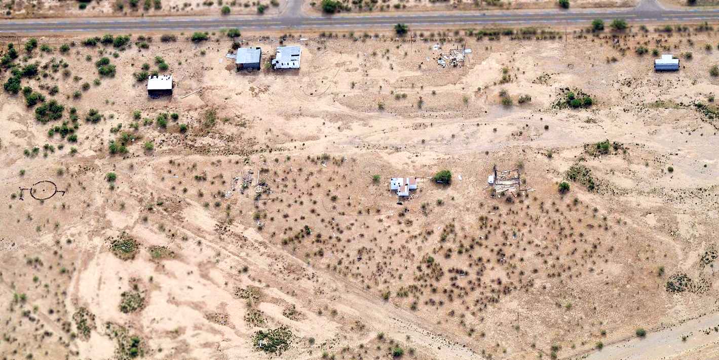
A 2020 aerial view looking southwest showed no sign of any recent aviation usage of Taylor Field, but the 2 unpaved runways & several buildings remained on the site.
The site of Taylor Field is located west of the intersection of North Anway Road & West Midway Road.
Thanks to Francis Blake for pointing out this airfield.
____________________________________________________
Gilpin Airport / Freeway Airport, Tucson, AZ
32.28, -111 (Northwest of Davis-Monthan AFB, AZ)
A 1940 aerial photo by Cooper Aerial Survey, looking east at Gilpin Airport (courtesy of Thomas McAllister).
Tomas recalled, “My father & grandfather farmed land in & around the airport.
In the photo there are crops being raised alongside the runways & taxiways.
I don't know how long this farming on the airport went on but it did for a few years.”
Gilpin Airport was founded by flight instructor Walter Douglas, who also later went on to found Grand Canyon Airlines.
An article in the 12/1/04 issue of the Arizona Daily Star (courtesy of John Sparks) stated that Gilpin Airport "moved" from nearby Davis-Monthan Field in 1940.
The earliest depiction of Gilpin Airport which has been located was a 1940 aerial photo by Cooper Aerial Survey (courtesy of Thomas McAllister).
It depicted Gilpin as having a total of 4 runways, with traces of a 5th runway also visible.
Gilpin Airport was not yet depicted on the January 1941 Phoenix Sectional Chart.
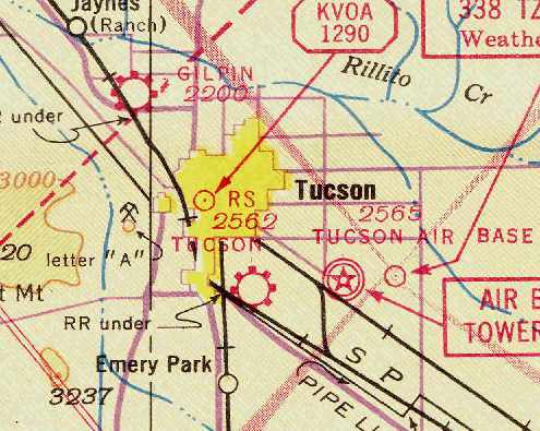
The earliest aeronautical chart depiction of Gilpin Airport which has been located was on the September 1941 Phoenix Sectional Chart (courtesy of Chris Kennedy).
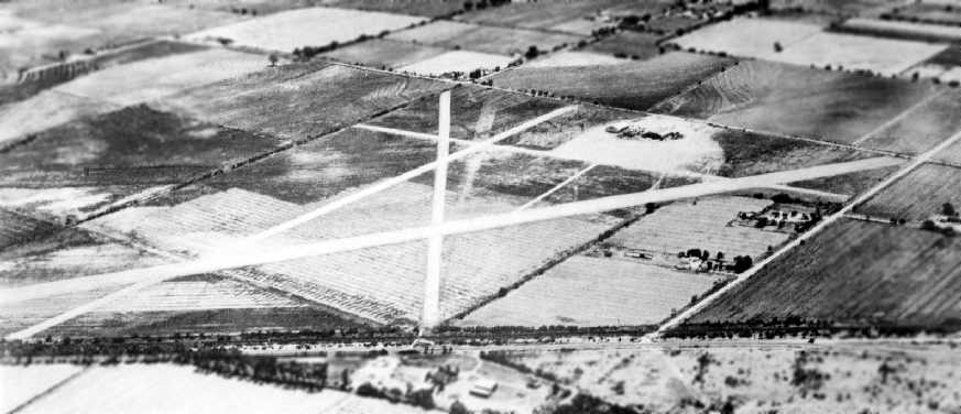
A 6/13/43 aerial view looking north at Gilpin Airport from the 1945 AAF Airfield Directory (courtesy of Scott Murdock)
depicted the field as having 4 unpaved runways, with several hangars along the east side.
According to the book "Best Place in the Country" by Steve Hoza & Mike Hoza,
in 1944 Gilpin was used by a flight school owned by Bill Marsh & Herb Franklin,
which conducted contract flight training for Navy flight students using the Waco UPF & the Fairchild PT-19.
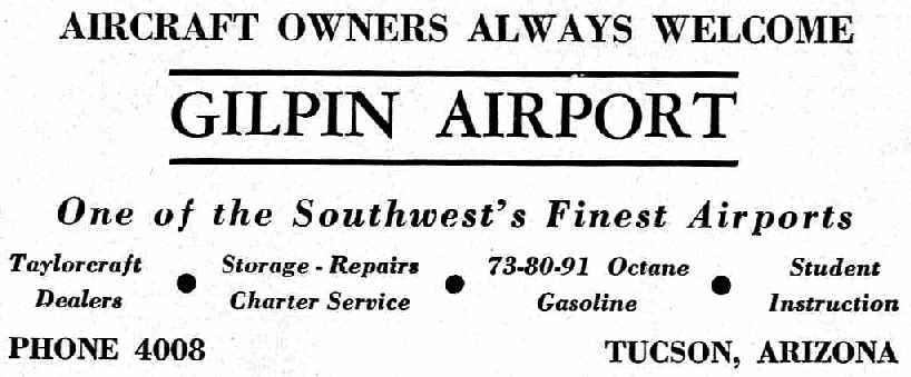
An advertisement for Gilpin Airport from the Haire Publishing Company's 1945 Airport Directory (courtesy of Chris Kennedy).
The 1945 AAF Airfield Directory (courtesy of Scott Murdock) described Gilpin Airport
as a 200 acre irregularly-shaped property having 4 sod & gravel runways, with the longest being the 4,200' northwest/southeast strip.
The field was said to have 3 hangars, with the largest being a 100' x 90' brick, steel, and concrete structure.
Gilpin was described as being owned & operated by private interests.
Anne Hartley recalled, “Gilpin Airport.. I used to play around the hangars when I was about 2-3 years old
and remember when my father used to put me in the cockpit of old Taylorcrafts, etc.
while he worked on them as a mechanic for Walt Douglas back in the 1940's.
I had many a dish of ice cream at the old coffee shop.”
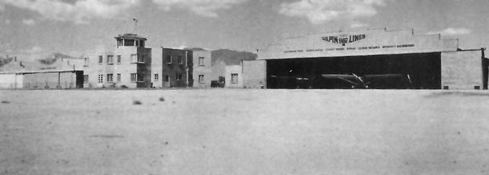
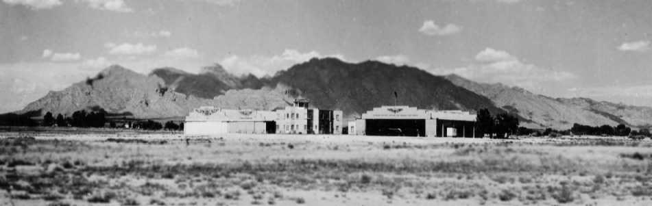
An undated photo of Gilpin Airport from the 1947 book "Airport Operation & Management" by Charles Zweng (courtesy of Steve Cruse, enhanced by Bill Grasha).
It was captioned, "Gilpin Airport, Tucson, AZ (Courtesy Gilpin Air Lines)”,
and depicted the airport as having a 2-story terminal building, with control tower on top, and hangars on either side.
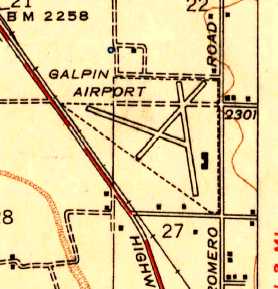
The 1947 USGS topo map depicted Gilpin Airport as having 3 runways, with several hangars along the east side.
Norma recalled, “In the late 1940s I often attended the Jalopy & Stock Car races that were held at Gilpin.”
A circa 1940s view looking east at Gilpin Airport from a postcard (courtesy of C. Westergoord).
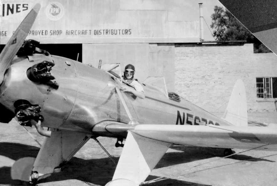
A 1951 photo of Aldine von Isser in a Ryan PT-21 at Giplin Airport (courtesy of Jon Karkow).
According to an article in the 12/1/04 issue of the Arizona Daily Star (courtesy of John Sparks),
in 1955 the airport property was annexed by the City of Tucson & local developer Arthur Pack started to upgrade the facility.
The 1956 Phoenix Sectional Chart (courtesy of Chris Kennedy) depicted Gilpin Airport as having a 5,600' unpaved runway.
Thomas McAllister recalled, “Having spent the first 14 years of my life just a mile from Gilpin
I have many fond memories of the airport. My Father & Grandfather knew Walter Douglas well.”
Gregory Gustafson reported that his father, J. Shannon Gustafson, and his friend John Kim established Flysafe Aviation at Freeway Airport in the 1950s.
"I have very fond memories of the place as a child & later when in the 1970s I earned my pilots license there."
A 1956 photo of Ike Russell & Malcolm Parker with a Taylorcraft BC-12D N43086 cn 6745 at Gilpin Airport (courtesy of Jon Karkow).
Ike was well known around Tucson as a bush pilot. His biography was recently published: "Backcountry Pilot: Flying adventures with Ike Russell".
The last aeronautical chart depiction which has been located of Gilpin Airport was on the March 1956 Phoenix Sectional Chart (courtesy of John Voss).
It depicted Gilpin Airport as having a 5,500' unpaved runway.
Gilpin Airport apparently closed (at least in an official capacity) at some point between 1956-57,
as it was no longer depicted on the May 1957 Phoenix Sectional Chart.
The chart continued to depict the "Gilpin" radio fan marker beacon at the site, but no airfield.
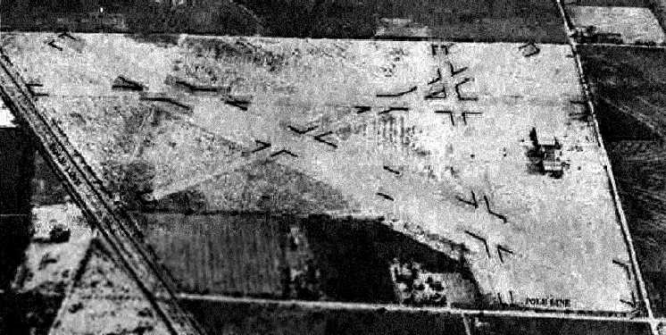
The last photo which has been located showing Gilpin Airport in operation was a 1958 aerial view.
It depicted the field as having 4 unpaved runways. The hangars & terminal were visible on the east side of the field.
The airport did not appear very healthy, though, as there was a total of only 3 light aircraft visible on the whole field, parked on the ramp in front of the terminal.
Paul Eisenberg recalled, “When we were kids we were friends with the Douglas family: Walter & Annabelle, and daughter Ellie with whom my twin brother & I played at their home.
Dad learned to fly with Walter in the twin to the pictured plane, also a Talorcraft BC12D. That plane, N43584 today hangs in the Pima Air Museum.
On Saturday mornings while Dad flew, David & I played in the hangars & outside, pretending to fly in the stripped fuselage of an old Cessna 170, and in that Beech B18 hulk pictured.
Walter had some amazing things, including an old-chain drive Mac Truck, a grader, and some other ancient vehicles.
I remember that he had a gorgeous & beloved Waco UPF7 biplane that we occasionally jumped in to play if no one was around,
a V-tail Bonanza, a working C-170, the 2 Taylorcrafts, and the planes he used for his airline.
There were airplane parts everywhere. We got to watch them re-cover & dope a Taylorcraft wing, and repair/replace wooden wing ribs.
Walt took us up in the Bonanza once, and I remember him laughing as he released the single yoke & flipped it over so Dad could fly the plane for a bit.
I have the fondest memories of Gilpin airport, the airplanes, and the Douglas family.”
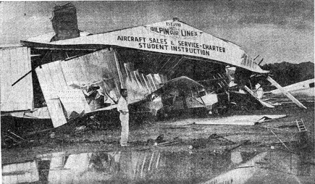
An undated photo of the 80' x 75' sheetmetal Gilpin hangar which had been ripped off its foundation by a 70 mph windstorm on 6/19/59.
Six aircraft were tossed about & “stacked like cordwood.” Debris was deposited in a crumpled heap about 80' away.
The total loss was estimated at $14,500, including the planes.
Paul Eisenberg recalled, “The photo reminded me of Annabelle's frantic phone call to Dad about the wind storm & hangar collapse.
We all raced out to help, but the storm was over by the time we got there & there was not much we could do. It was a very sad sight.”
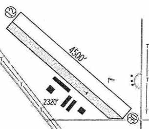
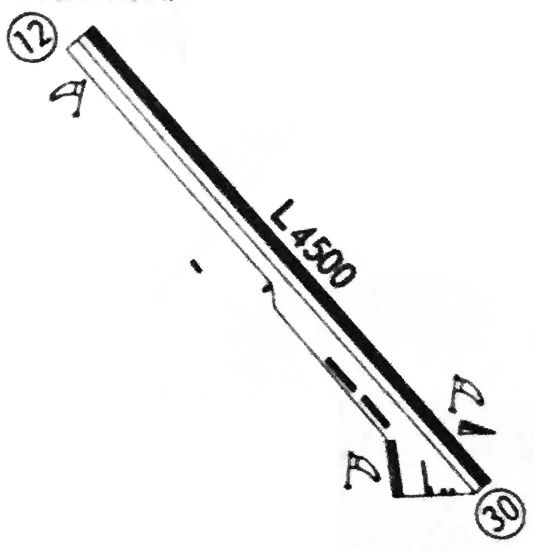
At some point between 1958-60, the field was evidently reopened as Freeway Airport, as that is how it was depicted in the 1960 Jeppesen Airway Manual (courtesy of Chris Kennedy).
The airport was in a radically reduced configuration though, compared to its previous incarnation, as the new field had only a single 4,500' Runway 12/30.
Several new hangars on the southwest side evidently replaced the original hangars & terminal on the east side, which were evidently never used again by the airport (for reasons unknown).
The earliest photo which has been located showing the reopened Freeway Airport was an undated aerial view looking northwest from the 1960 Airport & Business Flying Directory (courtesy of Jonathan Westerling).
It depicted Freeway Airport as having a single northwest/southeast runway, with several hangars & at least 8 light aircraft on the southwest side.
The 1962 AOPA Airport Directory described Freeway Airport as having a single 4,500' paved runway, and listed the operators as ANP Airports & Flysafe Aviation.
The earliest aeronautical chart depiction which has been located of Freeway Airport was on the July 1965 Phoenix Sectional Chart (courtesy of Ron Kunse).
It depicted Freeway Airport as having a 4,500' unpaved runway.
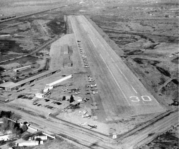
A 1966 aerial view looking northwest along Freeway Airport's Runway 30 (enhanced by Bill Grasha).
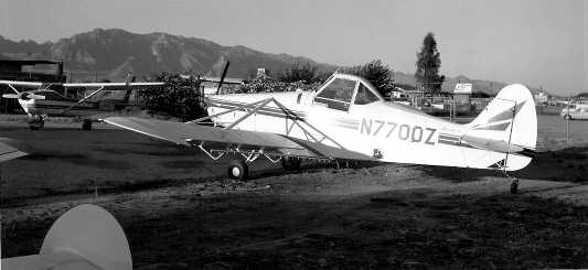
A 1966 photo by Brian Baker of Piper PA-25-235 sprayer N7700Z cn 25-3859 at Freeway Airport.
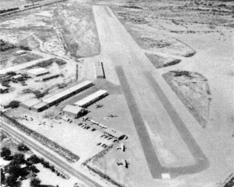
A 1967 aerial view depicted Freeway Airport as having a single northwest/southeast Runway 13/30.
Several rows of T-hangars were on the southwest side of the runway.
The airport appeared very well-used, with several dozen light aircraft parked on the southwest side of the runway.
Strangely though, the original Gilpin hangars & terminal on the east side appeared to have been fenced-off from the remainder of the airport.
The 1968 USGS topo map depicted Freeway Airport as having 3 a single paved northwest/southeast runway, with several building along the southeast side.
Jim Branch recalled of Freeway Airport, “My father [Ken Branch] owned it during the 1960s & sold it to Mr. Borst.”
Freeway Airport came under the ownership of Thomas Borst in 1970,
according to an article in the 6/15/78 issue of the Arizona Daily Star (courtesy of John Cramer).
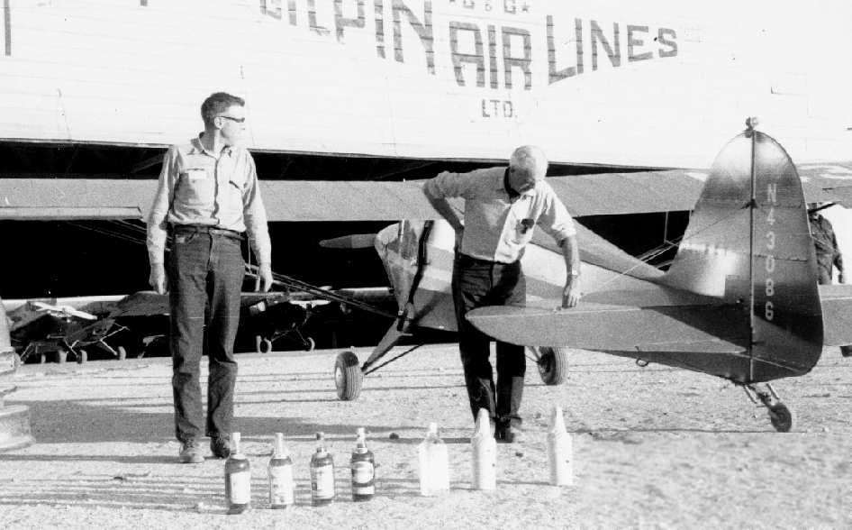
Lufthansa 747 Flight Engineer John Barnitz recalled, "I too grew up around Freeway Airport.
A fella named Tony Prosser had a PA-12
and lived right on the property next to the hangar pictured with the rum bottles next to the plane.
This is the southern of the 2 hangars pictured.
We also had a Super Cruiser parked there in 1970-1972
and we were flying a J-3 Cub owned by Al Freeze out of there up until around 1980."
John continued, "The other hangar (with the tower which is still there!)
is over near Romero Road near the Coca Cola warehouse.
I guess this main hangar for the Gilpin Airlines venture.
Al's Cub was parked on the end of Walter Douglas' maintenance & parts shack
which was located near Walter's southern hangar.
I got to see inside that building when Al was working on engines or whatever.
All of the tools he needed were in there, and in the back, all covered in dust, was an old Link Trainer,
the kind that would spin around slowly for instrument training.
Mister Douglas probably used this to train pilots during WW II."
John continued, "Tony used to take me through the old hangar now & again, rummaging.
There was a Fleet Bipe, and other airframes & even an old Dusseldorfer automobile.
Pretty impressive to an boy of 11.
All of the Walter Douglas collection was donated to the Pima Air Museum & the Fleet Bipe has even been restored.
Some fine Arizona aviation history around that airport."
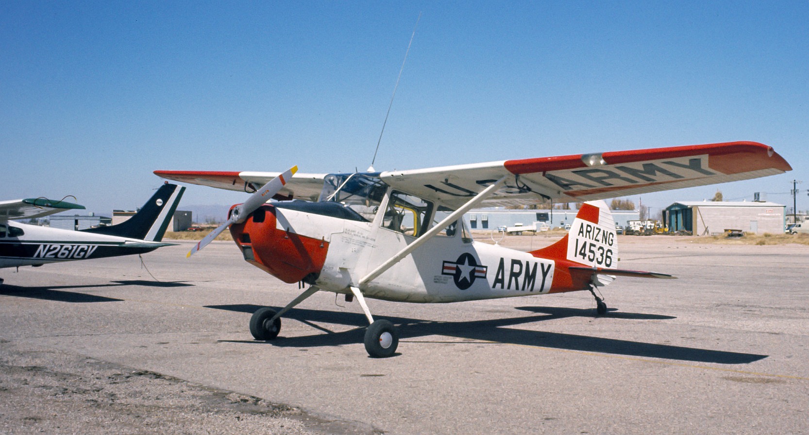
A 1971 photo of an Arizona National Guard Cessna O-1A 51-4536 at Freeway Airport.
A 1/6/72 USGS aerial view depicted Freeway Airport as having a single northwest/southeast runway.
Several rows of T-hangars were on the southwest side of the runway.
The airport appeared very well-used, with over 36 light aircraft visible on the field.
Strangely though, the original Gilpin hangars & terminal on the east side appeared to have been fenced-off from the remainder of the airport.
Phil Preston recalled, “Freeway Airport... I used to drop in over the Circle K convenience store in my Cessna 120 when landing there on Runway 30.
There was an old hangar at the south end of the field with Gilpin Airways above the door that belonged to Walter Douglas.”
Art recalled, “My buddy Howard & I worked at Freeway Airport in the summer of 1974.
At that time we were responsible for the flight control tower R/T & refueling general aviation aircraft.
We operated a STAR of the American Road Texaco.
Freeway Airport was home to Civil Air Patrol 111th Squadron Sentinel.
The financial situation was precarious & we were offered free flight training in return for out work. Grumman Yankees.
At that time only Runway 30 was used.
A Vietnam era A-4 Skyhawk once augered-in north of the airstrip by night.
We were 14 years old & it was an unbelievable adventure for us.
Van Horn was the most interesting pilot to use Freeway that summer.
He had a Piper Cherokee 140 with a specially-chromed spinner
and before each takeoff he would meticulously clean it & polish it with 409 spray cleaner. He was an excellent pilot.
FWJHS math instructor Stewart taught many Flowing Wells students ground school & rudimentary flight skills at Freeway Airport.
He was a blessed & excellent pilot.
He even recovered a landing Piper Cherokee 140 upon landing
when one of my friend intentionally side-slipped it into the line of parked aicraft on the ramp.
After we landed I asked my buddy how come he did that because we almost all died.
He said he wanted see what would happen if we crashed into the parked aircraft.
1970s... It's far worse on the streets nowadays, huh?”
A 9/20/74 photo of a Cessna 210 (missing the top of its vertical stabilizer) at Freeway Airport.
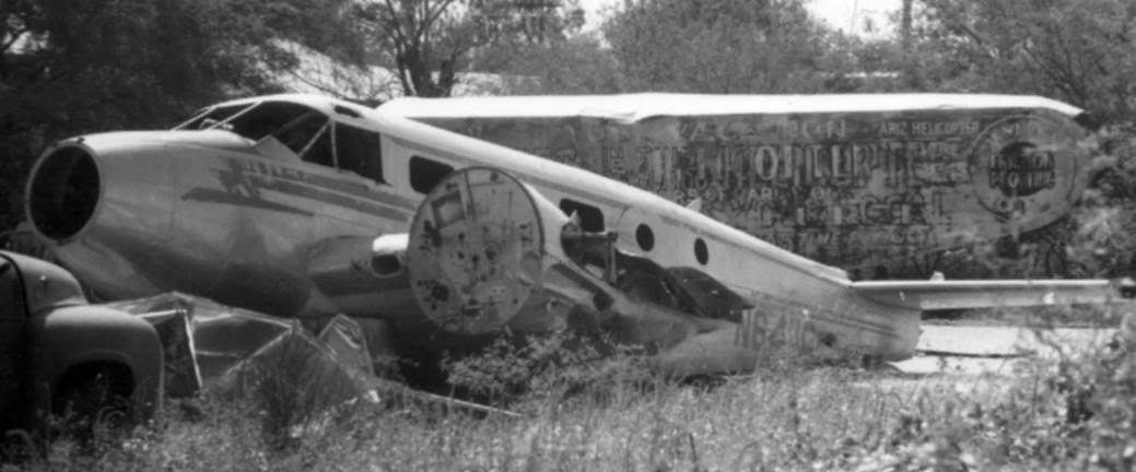
A 9/21/74 photo by L.R. Fizia of Beech N6411C C-45G c/n 6862 ex 44-47063 wreck at Freeway Airport.
L.R. observed, “The Beech 18 was in only slightly better condition than [as seen in the photo below] in 1980!”
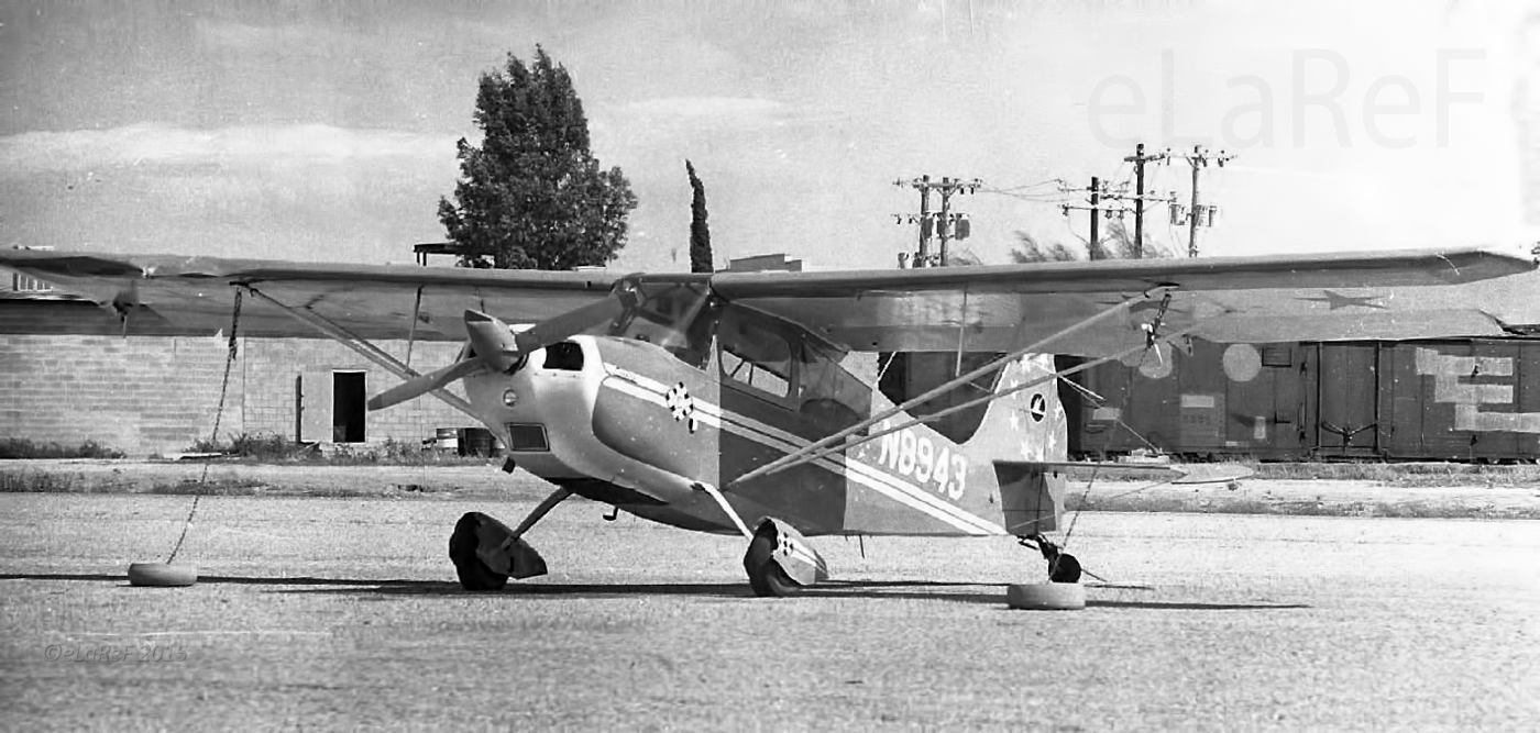
A 9/21/74 photo by L.R. Fizia of N8943 Champion 7GCBC Scout c/n 607-74 at Freeway Airport.
He also saw the following aircraft that day at Freeway: N1179B Luscombe Silvaire 8A 5806, N1179K Luscombe Silvaire 8A 3906, N6275L Grumman American AA1 Trainer AA1B-0075,
N6348L Grumman American AA1 Trainer AA1A-0348, N6427L Grumman American AA1 Trainer AA1A-0427, N8868L Grumman American AA1 Trainer AA1B-0368,
N2910T Aero Commander 200D 316, N6122V Beech Model 35 Bonanza D-7786, N739D Beech Model 35 Bonanza D-3009, N8941A Beech Model 35 Bonanza D-2695,
N4191N Cessna C120 13662, N2188N Cessna C140 12424, N2304V Cessna C140 14540, N2555N Cessna C140 12811, N72930 Cessna C140 10128, N22706 Cessna C150 15068461,
N4138U Cessna C150 15060138, N8358M Cessna C150 A1500058, N8968S Cessna C150 15062268, N123DS Cessna C170 17702373?, N4410B Cessna C170 26754,
N5591T Cessna C172 Skyhawk 17251491, N8316L Cessna C172 Skyhawk 17256516, N2822Y Cessna C182 18253822, N8375S Cessna C182 18256475, N8931T Cessna C182 52831,
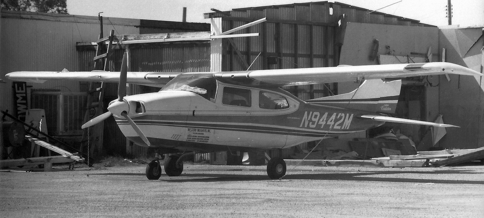
XC-DIG Cessna C182 18256494, N55M Cessna C195 7408, N8122Z Cessna C205 205-0122, N8246M Cessna C210 Centurion 21059246, N9433M Cessna C210 Centurion 21059333,
N9442M Cessna C210 Centurion 21059342, N605M Fleet Canuck 181, N7299 Hiller H-12B Raven 729, N1948Y Mooney M20 255, N6511B Mooney M20 1178, N6829U Mooney M20 188,
N9668M Mooney M20 670004, N43584 Taylorcraft l2 Model D 7243, N3816P Piper Pa22 Tri-Pacer 22-3506, N3300P Piper Pa23 Apache 23-1250,
N8242P Piper Pa-24 Comanche 24-3496, N14050 Piper Pa27 Aztec 27-4662, N15933 Piper Pa-28 Cherokee 28-7325203, N5521W Piper Pa-28 Cherokee 28-611,
N7357W Piper Pa-28 Cherokee 28-1237, N95279 Piper Pa-28 Cherokee 28-25872, N7591Y Piper Pa-30 Twin Comanche 30-659, N7799Y Piper Pa-30 Twin Comanche 30-631,
N4077W Piper Pa-32 Cherokee 6 32-40119, N5199K Ryan S290 Navion NAV-4-2099B, N27619 Taylor Monoplane 2261.
John Walker recalled, “I worked at Freeway Airport in the mid-1970s as the 'lineboy' responsible for fueling aircraft.
The job paid the minimum wage of $1.60/hour. I worked 8 hours/day, 7 days/week, but the owner was too cheap to pay overtime for the 16 hours past the first 40.
He was also unpopular with the few employees, so turnover was high.
Law enforcement officers would drop by to try & identify anyone buying aviation gas in cans, assuming they were drug smugglers refueling airplanes at remote airstrips.
Once they asked me if anyone buying gas in cans looked like the lineboy I replaced, a nice guy who wore his hair long.
Navigating the fuel truck around the tightly-parked aircraft in the tie-downs was a little nerve-wracking.
Worse was a careless pilot who, on his way through the small single-story terminal forgot about the short runway & said 'Fill it up with 90 octane.'
He returned a couple of hours later & when he went to pay for the fuel, noticed how much had been pumped into the wing tanks.
He then claimed he told me to put in only a small amount (I don't remember the exact gallonage) since he couldn't take off with full tanks on that runway.
The airport mechanic & I went out with a garden hose & siphoned gas from the tanks. We both swallowed gas to get the siphon to flow, and I remember belching the taste of gas for days afterwards.
The owner was one of the worst bosses I ever worked for & quitting was a great relief.”
Kerry Tiller recalled, “Sometime circa 1974/75 (recently out of college) myself & a couple of other young bachelors
took up residency in a house on Windsor Street, not far from the Freeway Airport.
There wasn't much activity at the airport at that time (although the windsock was clearly maintained & the runway was serviceable).
My fondest memory of that time in my life is of an old Cessna 195 parked near one of the hangars.
The tires were flat & the paint was badly faded.
As I recall, the most recent registration sticker indicated it had been registered in Florida in 1962.
That brutish looking radial engine & large tail-dragging rudder reminded me of half of a DC-3.”
Kerry recalled the "Dusseldorfer" automobile in the old Gilpin hangar:
“I remember that car, but a little differently.
There was a bar down the street from our house & across the street from the airport called 'The Idle Hour'.
One night after a few beers a couple of us hopped the airport fence to go exploring
(we may have been trespassing, but we took no souvenirs & committed no vandalism).
We went into one of the Gilpin Airlines hangars (the one to the West of the tower).
I don't remember how we got in, but I don't guess it was secured very well.
Anyway, there was a lot of neat stuff in there (we only looked at it, honest!)
and among the stuff was a Duesenberg with the bodywork cutaway behind the front seat
and a flat bed fashioned in its place, turning the vehicle into a utility truck.
The Gilpin Airlines logo was on the doors to the 'cab'.
I suspect this was the "Dusseldorfer" car John Barnitz recalled at age 11.”
The 1976 Flight Guide (courtesy of Alex Hauzer) depicted Freeway Airport as having a single paved 4,500' Runway 12/30, with a few small buildings along the south side.
The last aeronautical chart depiction which has been located of Freeway Airport was on the 1978 Phoenix Sectional Chart (courtesy of Jonathan Westerling).
It depicted Freeway Airport as having a 4,500' paved northwest/southeast runway.
An article entitled "Airport closes, but runway still in use" in the 6/14/78 issue of the Arizona Daily Star (courtesy of John Cramer)
reported that Freeway Airport was closed on 6/5/78.
"The owner of Freeway Airport in Tucson has closed the airport, but pilots are still using the runways, an FAA official said last night.
The FAA was notified June 5 that Freeway Airport was closed until further notice, said James Gould, air traffic control specialist.
But planes are still landing on & taking off from the runway, at Prince Road & Interstate 10,
because airport owner Thomas Borst failed to paint an 'X', the FAA's official closure symbol on the runway, Gould said.
Fuel has not been sold at the airport for the past several weeks & some planes are still stored on the field, said Walter Douglas Jr.,
owner of a small tract near the airport & operator of Gilpin Airlines Ltd.
The airport had been rumored as the site for a multinational industrial operation,
but a deal to sell the airport & adjacent land fell through last year."
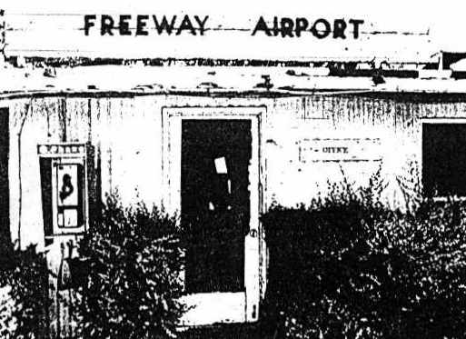
A 1978 photo of the office at Freeway Airport (by Jack Sheaffer, courtesy of John Cramer).
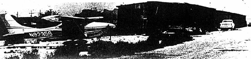
A 1978 photo of a Cessna 182N N92359 cn 18260171 in front of a hangar at Freeway Airport (by Jack Sheaffer, courtesy of John Cramer).
Another article entitled "Bankruptcy filing furls Freeway Airport windsock" appeared in the 6/15/78 issue of the Arizona Daily Star (courtesy of John Cramer).
"Last week, Freeway Aviation Inc. filed for bankruptcy.
FAA official Carl Swanson said the bankruptcy filing came at a time Tucson needs more airports, not fewer.
'It's a terrible tragedy', he said. 'The airport has been a great asset to many people for a long time.'"
John Cramer also reported that "The movie 'Stir Crazy' [released in 1980] filmed the ending of the movie there, and it appears abandoned then."
A circa 1980 “sad photo of the Beech [described below] by the Gilpin Airways hangar” by Phil Preston at Freeway Airport.
Dave Fagan reported that "I visited Freeway in 1981… The airfield was definitely closed by then.
The runway was obstructed by parked vehicles.
From the state of everything I would guess it had been closed for years rather than months
although it was still shown on a 1980 issue Rand McNally road map as an airfield.
Some of the buildings that remained were in use by various non-aviation businesses.
The only aircraft present was N6411C, a very badly damaged Beech [C-45F cn 6862], which looked like it had been there a long time."
Freeway Airport was depicted as an abandoned airfield on the June 1981 Phoenix Sectional Chart.
The 1992 USGS aerial photo showed the remains of Freeway Airport's single northwest/southeast runway to be still barely perceptible.
According to John Edwards, Freeway Airport's tower building still exists in the commercial buildings east of the runway, and seems to still be in good shape.
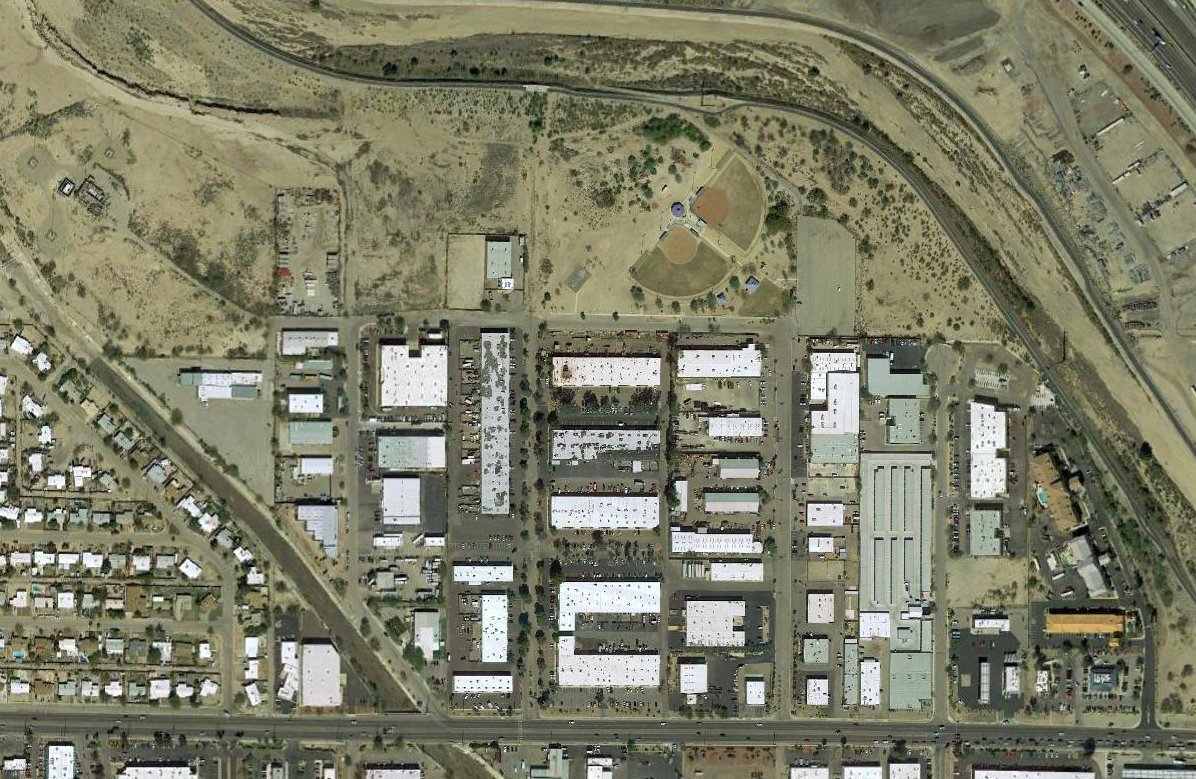
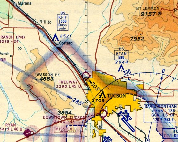
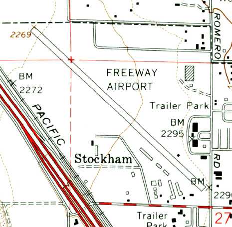
The area surrounding Freeway Airport's former runway is heavily developed.
The road running parallel to the west side of the runway is named North Runway Drive.
In the words of Gregory Gustafson, Freeway Airport founder "Walter Douglas was a wonderful person
and fully deserves the elementary school named after him a few blocks from Freeway."
Jim Dowling reported, “In the 1990s the city of Tucson used imminent domain & took what is now Sun Tran drive for the bus company here in Tucson.
Before that, Abrams Airborne owned the whole length of the runway. But after Sun Tran drive was installed the Abrams family sold all property north of Sun Tran Drive.”
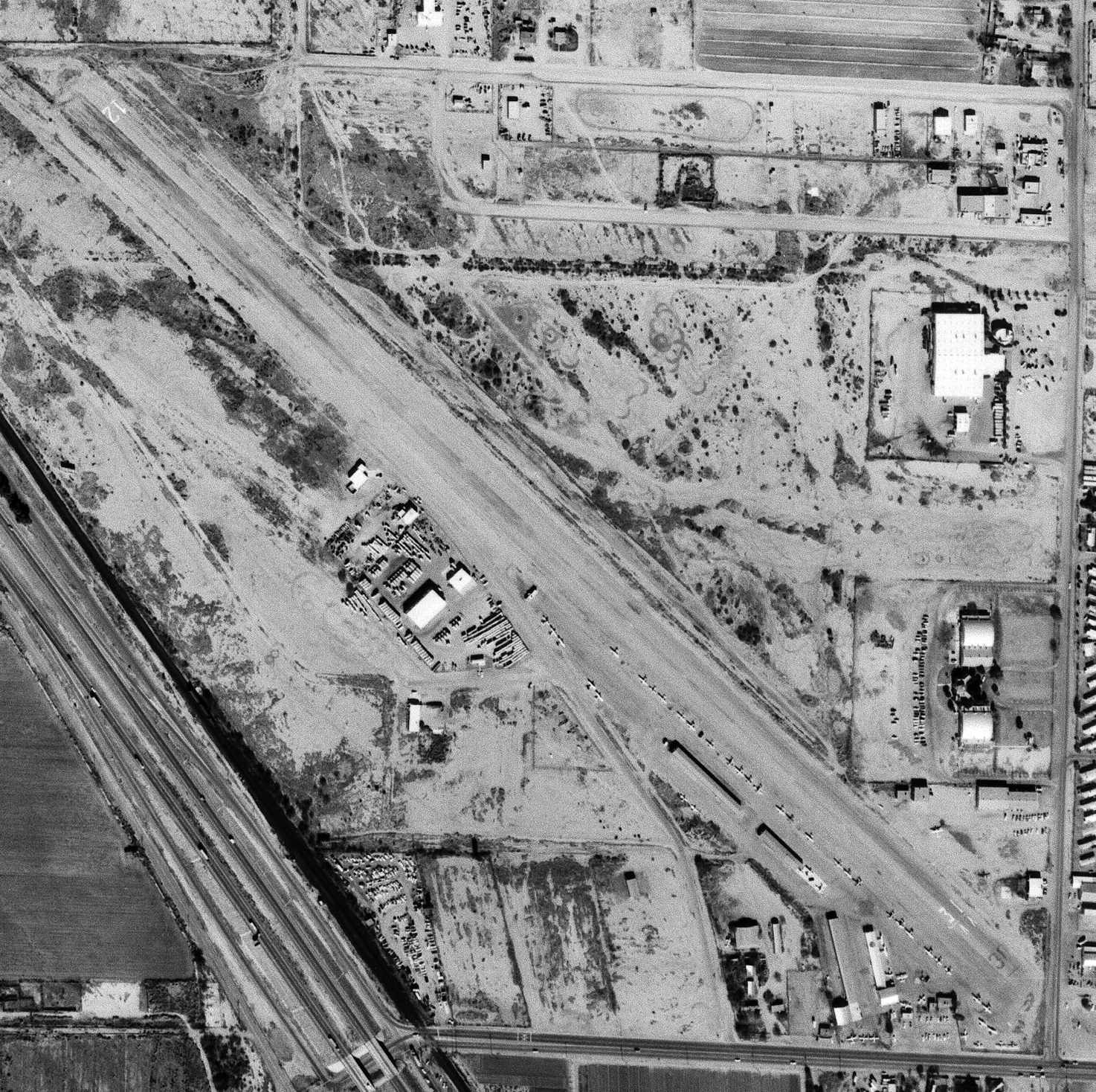
A 2003 aerial photo of the remains of Freeway Airport (courtesy of John Sparks).
The arched silver roofs of the hangars were still visible in the bottom-right corner of the photo,
with the former control tower building in between them.
John Sparks reported in 2003 that the county GIS system indicated the former airport property had been subdivided by "Abrams Airborne Manufacturing Inc."
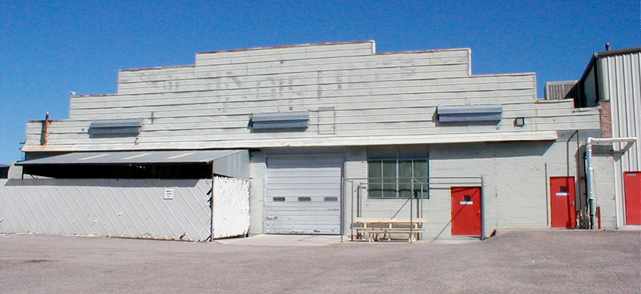
According to John, "As far as I know the hangars were converted for manufacturing & used by R.E. Darling company. The property seems to have various companies listed as users."
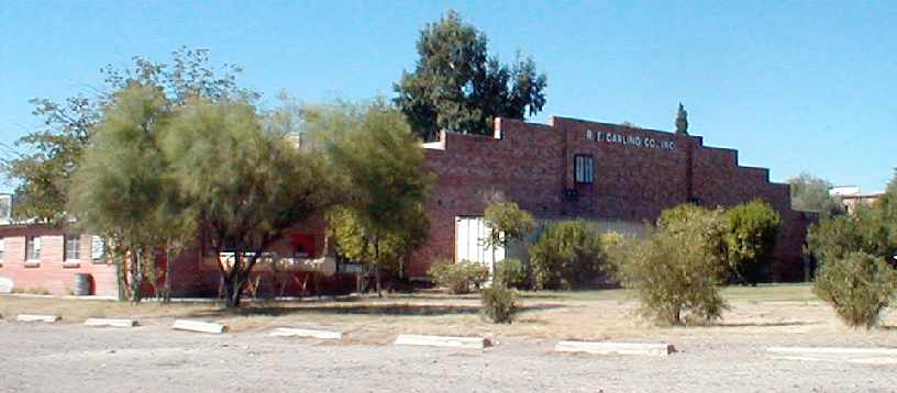
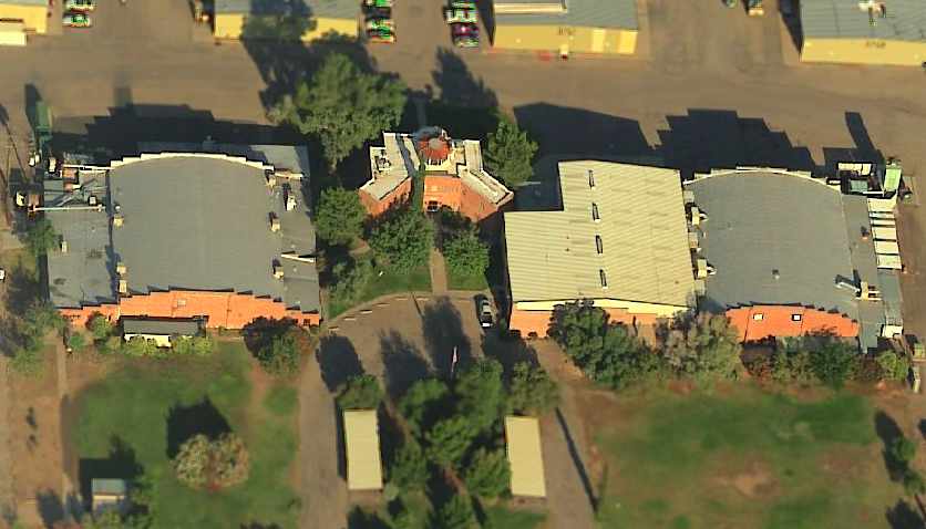
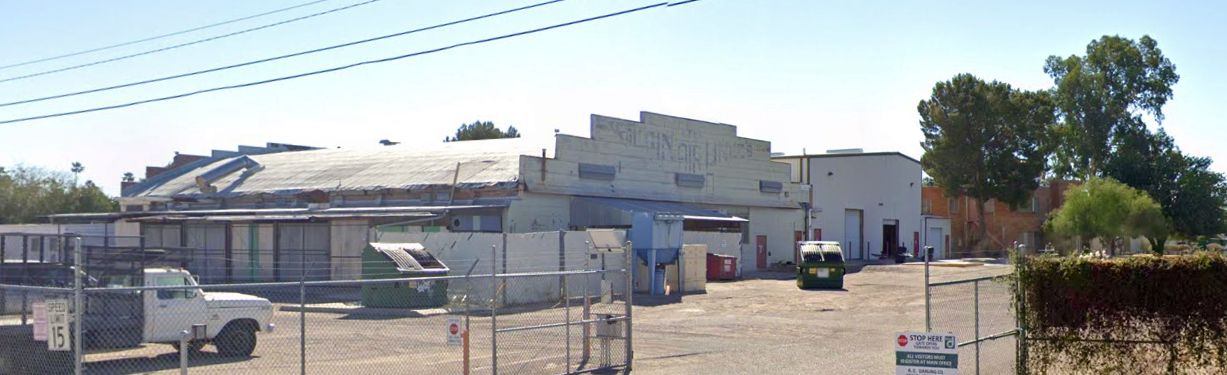
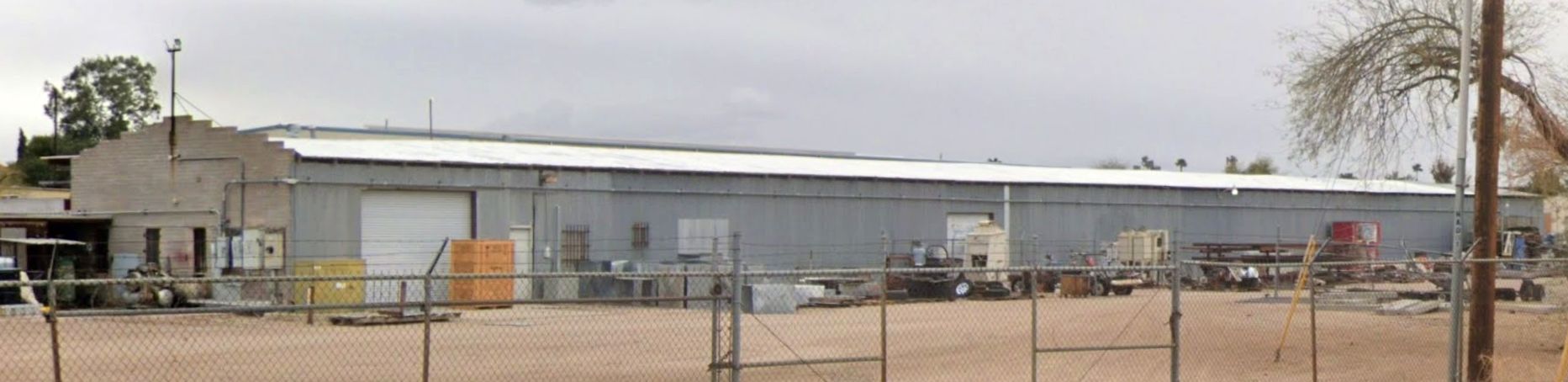
A 2004 photo by Jonathan Westerling (enhanced by Bill Grasha) of the southern exterior of the former Gilpin Airport control tower & terminal building.
"The building is maintained as the headquarters for the R.E. Darling fabrication company.
Happily, the receptionist was well aware & proud of the building’s history.
A sandstone of the Gilpin Airlines logo persists as a nice Art Deco touch to the entrance of the old terminal building."
Jonathan Westerling reported, "I visited the site of the Gilpin/Freeway Airport in September 2004.
Unfortunately, the city has negotiated a right-of-way, and constructed a new road bisecting the old runway in the middle.
Other than that 80% of the runway remains intact, with a few shrubs poking up through the pavement.
It appears that at some point after 1960 the runway was repaved,
creating a narrower airstrip with a parallel taxiway on top of the older wide runway.
I am trying to work with the Arizona Historical Society
who has literally hundreds of knockout beautiful 8x10 shots of the airport in its heyday."
A 2004 photo by Jonathan Westerling looking south along the remains of Gilpin Airport's Runway 12.
A 2004 photo by Jonathan Westerling of Walter Douglas’ former maintenance & parts hangar.
A 2004 photo by Jonathan Westerling of "One of the hangars adjacent to the control tower.
The logo for Gilpin Air Lines can still be easily made out."
[This hangar was visible on the left side of the 1947 photo.]
A 2004 photo by Jonathan Westerling of "The rear of the other, larger hangar adjacent to the terminal at Gilpin/Freeway Airport."
[This hangar was visible on the right side of the 1947 photo.]
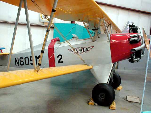
A 2004 photo by Jonathan Westerling of Fleet 2 N605M cn 181,
formerly operated by Gilpin Airlines, as restored & on display at Tucson's Pima Air Museum.
A circa 2005 aerial view looking west at the former Freeway Airport control tower, flanked by former hangars.
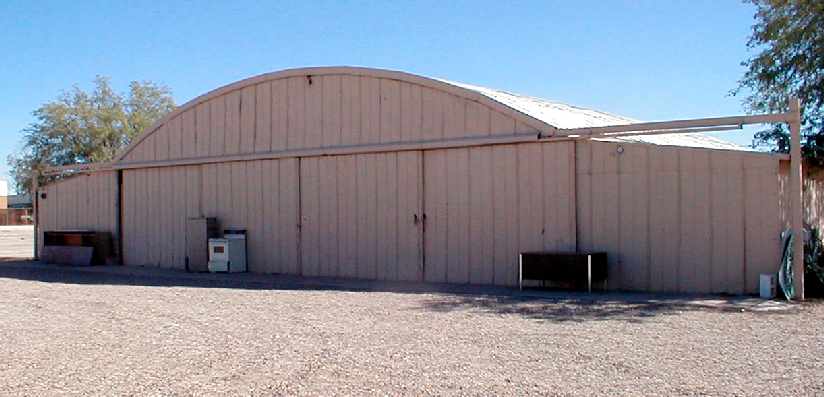
A September 2012 photo by Dennis Boykin of Walter Douglas’ former maintenance & parts hangar at the site of Freeway Airport.
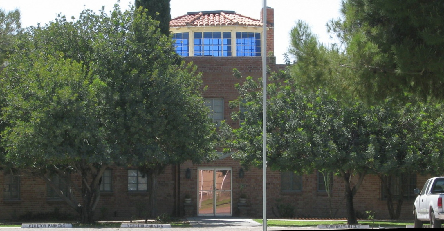
A 5/3/14 photo of the former Gilpin Airport control tower & terminal building, reused as the headquarters for the R.E. Darling fabrication company.
A 2022 photo looking southwest shows the “Gilpin Airlines” markings on the northern-most former hangar.
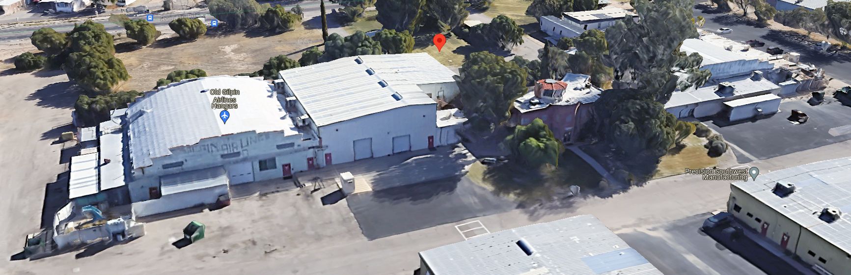
Amazingly, a 2024 3-D aerial image looking southwest shows the northern-most former hangar still bears the “Gilpin Airlines” markings after 80 years, and the control tower remains intact.
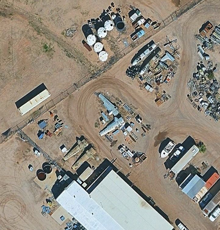
Amazingly, nearly 5 decades after Freeway Airport's closure, a 2/13/24 aerial view shows wings, fuselages, and tail surfaces of several aircraft still remain just north of the former Gilpin hangar.
A 2025 photo looking east at 2 aircraft fuselages which remain just north of the former Gilpin hangar.
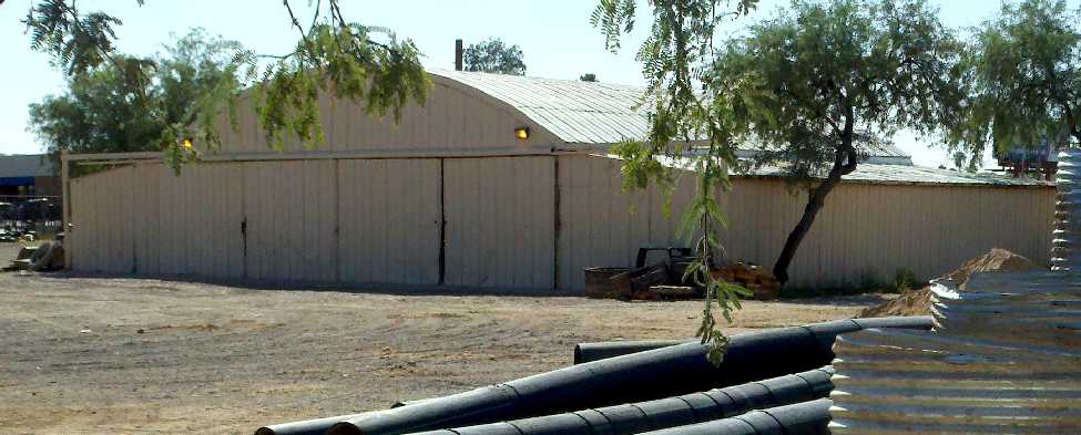
A 2025 photo looking east at the former Gilpin hangar which remains on the southeast side of the Freeway Airport site, reused by Adams Airborne.
Jim Dowling reported in 2025, “I work for Abrams Airborne. Our facility is located at what would be the southeast end of the runway.
Our founder Harold 'Bud' Abrams was a pilot in WW2 & lived not far from where our facility is located today.
R.E. Darling just north of us is still in existence. They rent building spaces out to other companies. The control tower is still there.”
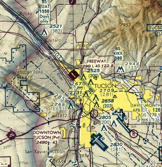
The site of Freeway Airport is located east of Interstate 10, north of West Prince Road.
____________________________________________________
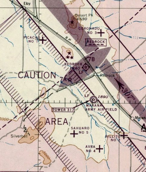
Marana Auxiliary Army Airfield #1 / Picacho Field, Picacho, AZ
32.66, -111.48 (Northwest of Marana, AZ)
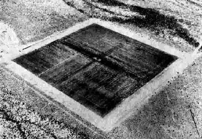
A 6/13/43 aerial view looking north at “Marana AAF Auxiliary #1 (Picacho Field)” from the 1945 AAF Airfield Directory (courtesy of Scott Murdock).
This field was built during WW2 as one of 5 satellite airfields for Marana Army Airfield (located a few miles southeast),
which conducted basic flight training & the training of transport pilots in instrument flying & navigation.
Picacho Field was not yet depicted on the March 1944 Phoenix Sectional Chart.
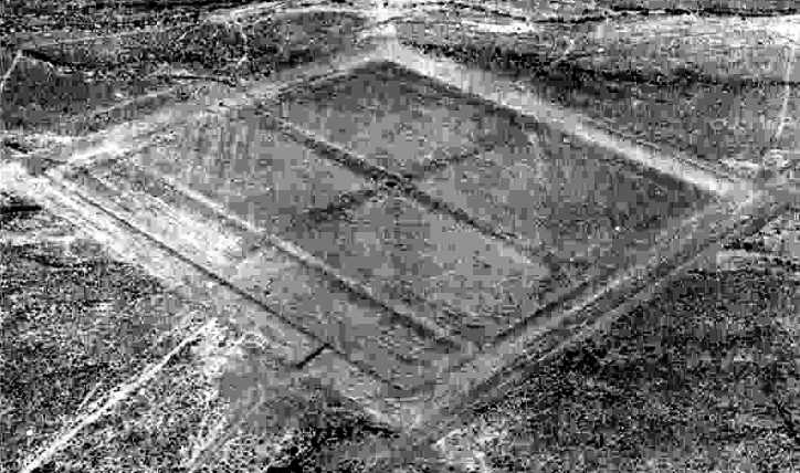
The earliest depiction which has been located of Picacho Field
was a 6/13/43 aerial view looking north from the 1945 AAF Airfield Directory (courtesy of Scott Murdock).
It depicted “Marana AAF Auxiliary #1 (Picacho Field)” as a square asphalt landing mat.
The earliest aeronautical chart depiction which has been located of Picacho Aux #1 was on the September 1945 Phoenix Sectional Chart.
The 1945 AAF Airfield Directory (courtesy of Scott Murdock) described “Marana AAF Auxiliary #1 (Picacho Field)”
as a 206 acre square-shaped property having a 3,000' square asphalt landing mat.
The field was not said to have any hangars, and to be operated by the Army Air Forces.
However the title of the entry indicated Picacho was inactive.
Picacho Aux #1 was listed in a directory of AZ Airports
in the 5/47 issue of Arizona Highways (courtesy of George Miller),
which described the field as consisting of a 3,000' square landing mat, and being unattended.
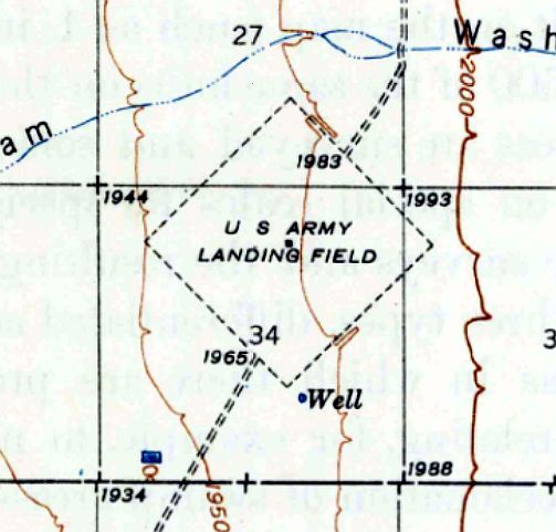
The 1947 USGS topo map depicted Picacho as a square landing mat, labeled “US Army Landing Field”.
"Marana #1" was on depicted on the September 1953 Phoenix Sectional Chart as having a 3,000' paved runway.
"Marana #1" was noted on the March 1954 Phoenix Sectional Chart as being “Emergency only”.
It was still in use by the USAF in 1957, which operated T-34 & T-28 training aircraft into the field.
The 1958 Phoenix Sectional Chart (according to Chris Kennedy) labeled the field as "Marana #1 (Pvt)",
and the remarks in the Aerodromes table said "Private. Flying school under contract to USAF."
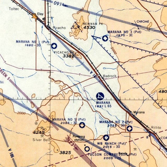
The last aeronautical chart depiction which has been located of Marana #1 was on the September 1960 Phoenix Sectional Chart.
It depicted Marana #1 as a private airfield having a 3,000' square paved landing mat.
Picacho Aux #1 was apparently abandoned at some point between 1950-61,
as it was labeled It was labeled "Abandoned airport" on the March 1961 Phoenix Sectional Chart.
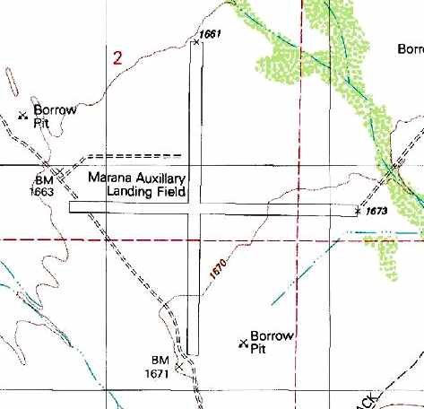
The 1981 USGS topo map labeled the field as "Marana Auxiliary Landing Field",
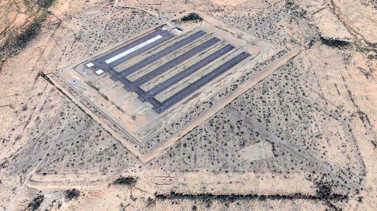
and depicted 2 perpendicular runways (the largest is 4,400') which had been overlaid on the original square landing mat.
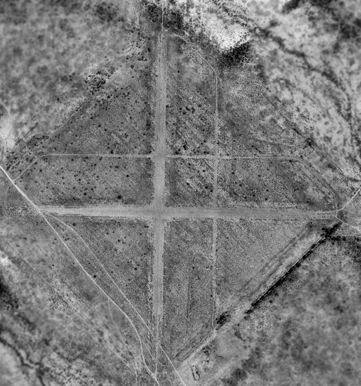
A 1992 USGS aerial photo showed the original square landing mat to be still visible,
as well as 2 perpendicular paved runways (the largest is 4,400') which had been overlaid on the square mat.
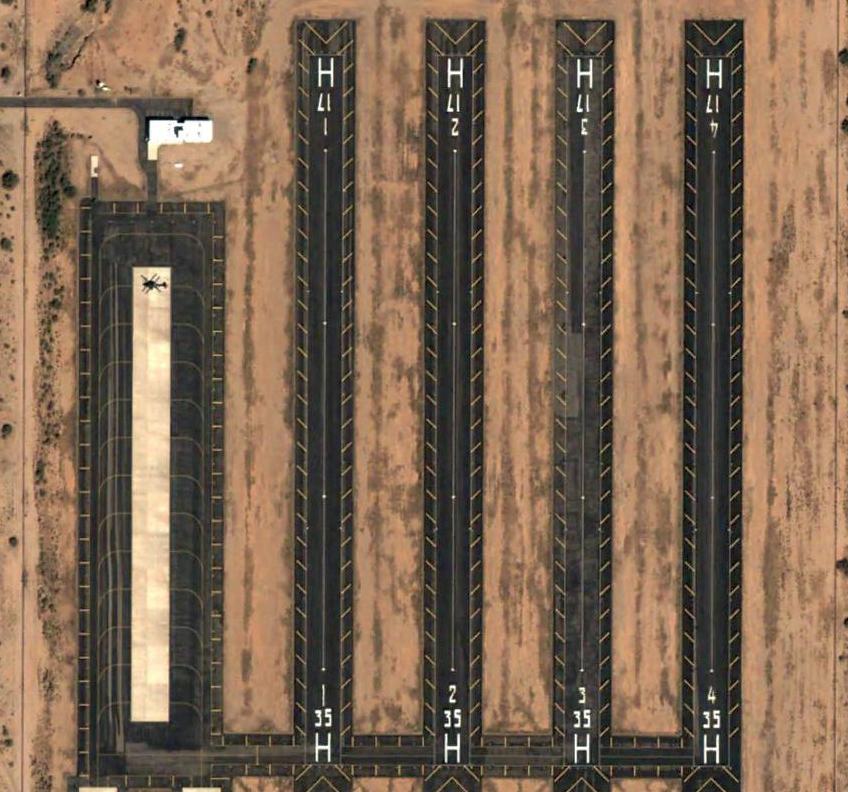
A 1996 aerial photo showed that at some point between 1992-96 Picacho Aux #1 was reused as the site of a newly constructed heliport.
The heliport consists of 6 short paved runways,
built over the center of the original square landing mat, but set due north/south.
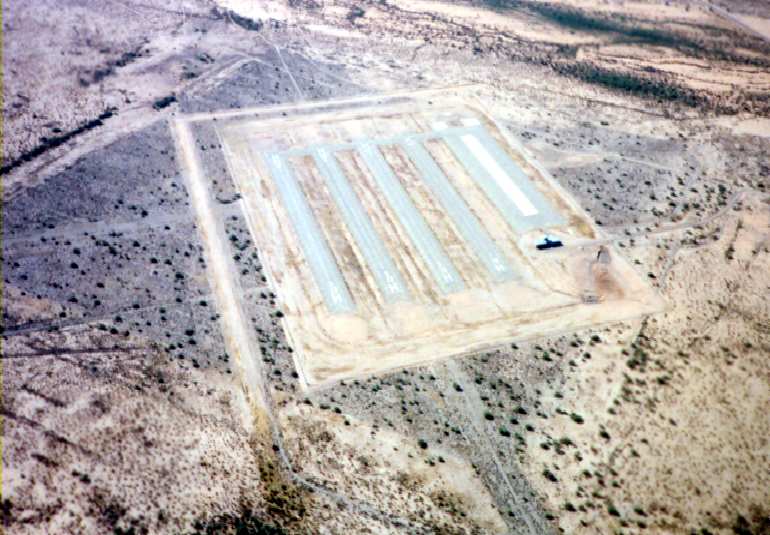
The heliport is used by helicopters of the AZ National Guard,
based at the nearby Silverbell Army Heliport (at the former Marana AAF).
A 1997 aerial view of Picacho Aux #1 by Steve Hoza
(courtesy of Steve Hoza, from the book "Best Place in the Country", by Mike & Steve Hoza),
showing the heliport of the AZ National Guard built over the WW2 airfield.
A 10/31/04 aerial view of what appears to be a Boeing AH-64 Apache on the northwest ramp at the heliport built at the site of Marana Aux #1.
A 2018 aerial view looking northwest showing the 6 helicopter runways of the modern AZ National Guard heliport built over the remains of the WW2-era Marana Aux #1 airfield.
Thanks to Jack Young & James Smith for information about Picacho.
____________________________________________________
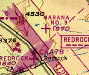
Marana Auxiliary Army Airfield #3 / Coronado Field, Red Rock, AZ
32.69, -111.28 (North of Marana, AZ)
A 6/13/43 aerial view looking north at “Marana AAF Auxiliary #3 (Coronado Field)” from the 1945 AAF Airfield Directory (courtesy of Scott Murdock).
This field was built during WW2 as one of 5 satellite airfields for Marana Army Airfield (located a few miles south),
which conducted basic flight training & the training of transport pilots in instrument flying & navigation.
The Army Air Force acquired 632 acres for Marana Auxiliary Field #3 starting in 1943.
Improvements consisted of a 3,000' square asphalt landing mat, a crash truck station, a tower, and a perimeter fence.
Coronado Field was not yet depicted on the March 1944 Phoenix Sectional Chart.
The earliest depiction which has been located of Coronado Field
was a 6/13/43 aerial view looking north from the 1945 AAF Airfield Directory (courtesy of Scott Murdock).
It depicted “Marana AAF Auxiliary #3 (Coronado Field)” as a square asphalt landing mat.
The earliest aeronautical chart depiction which has been located of Coronado Aux #3 was on the September 1945 Phoenix Sectional Chart.
The 1945 AAF Airfield Directory (courtesy of Scott Murdock) described “Marana AAF Auxiliary #3 (Coronado Field)”
as a 206 acre square-shaped property having a 3,000' square asphalt landing mat.
The field was not said to have any hangars, and to be operated by the Army Air Forces.
However the title of the entry indicated Coronado was inactive.
An Army Corps of Engineers report said that Marana Auxiliary Field #3 was classified as surplus in 1946.
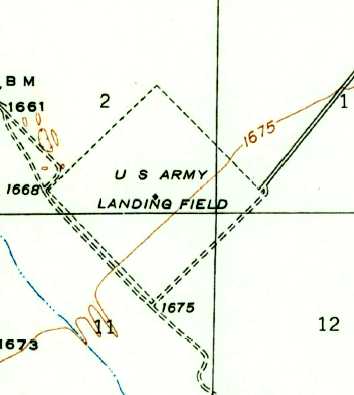
The 1947 USGS topo map depicted “U S Army Landing Field” as an diamond-shaped outline.
Marana #3, as depicted on the 1948 El Paso - Los Angeles Flight Chart (courtesy of David Brooks).
It was labeled "Marana #3" on the 1949 Phoenix Sectional Chart (according to Chris Kennedy).
However, it was apparently still operated as a contract flying school into the 1950s.
"Marana #3" was listed among active airfields in the "Aerodromes" table
on the 1956 Phoenix Sectional Aeronautical Chart(courtesy of John Voss).
It described the field as consisting of a 3,000 foot asphalt "All way" landing area,
and included the remark, "Private. Flying school under contract to USAF."
The 1958 Phoenix Sectional Chart (according to Chris Kennedy)
labeled the field as "Marana #3 (Pvt)",
and the remarks in the Aerodromes table said "Private. Flying school under contract to USAF."
The last aeronautical chart depiction which has been located of Marana #3 was on the September 1960 Phoenix Sectional Chart.
It depicted Marana #3 as a private airfield having a 3,000' square paved landing mat.
Marana #3 was apparently abandoned at some point between 1960-64,
as it was labeled It was labeled "Abandoned airport"
on the 1964 Phoenix Sectional Chart (according to Chris Kennedy).
According to an Army Corps of Engineers Report,
the current owners of the property include the Bureau of Land Management & the State of Arizona.
Their on-site investigation concluded that remains were still barely visible
of the airfield's diamond-shaped asphalt landing mat (3,500' square),
which was in an advanced stage of decay due to heavy vegetative overgrowth.
The only remaining building was a collapsed wooden structure, believed to be the crash truck station.
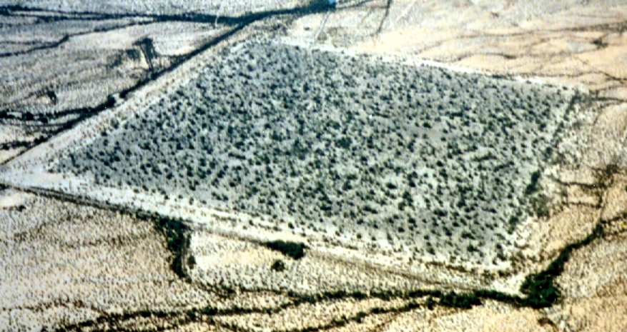
A 1997 aerial photo of the Coronado airfield by Steve Hoza,
from the book "Best Place in the Country" by Mike Hoza & Steve Hoza (courtesy of Steve Hoza).
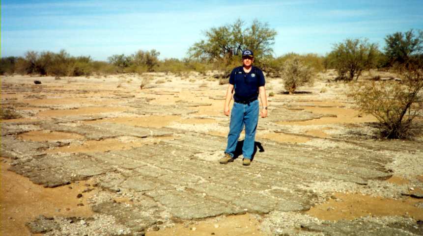
Mike Hoza, pictured on the remains of the Coronado airfield pavement in a 2003 photo by Steve Hoza,
from the book "Best Place in the Country" by Mike Hoza & Steve Hoza (courtesy of Steve Hoza).
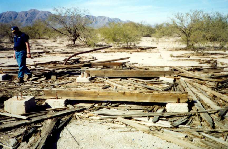
Mike Hoza, pictured among the remains of the Coronado control tower building in a 2003 photo by Steve Hoza,
from the book "Best Place in the Country" by Mike Hoza & Steve Hoza (courtesy of Steve Hoza).
The auxiliary field is currently used by the Arizona Army National Guard based in Marana
for occasional touch-and-go helicopter landings.
Marana Auxiliary Field #3 was not depicted at all (even as an abandoned airfield)
on recent aeronautical charts or USGS topo maps.
A 2/24/13 aerial view of the Coronado airfield.
Mike Taylor reported in 2017, “Several years ago I visited an old airfield North of Tucson [Marana Aux #3] while looking for ancient ruins of the Hohokam who inhabited the area.
We visited in early Spring when desert wildflowers were emerging & clustered nicely on the foundation lines of ancient adobe structures which were abandoned over 1,000 years ago.
We were able to see clearly the remains of tarmac & some wooden building materials on the site.”
____________________________________________________
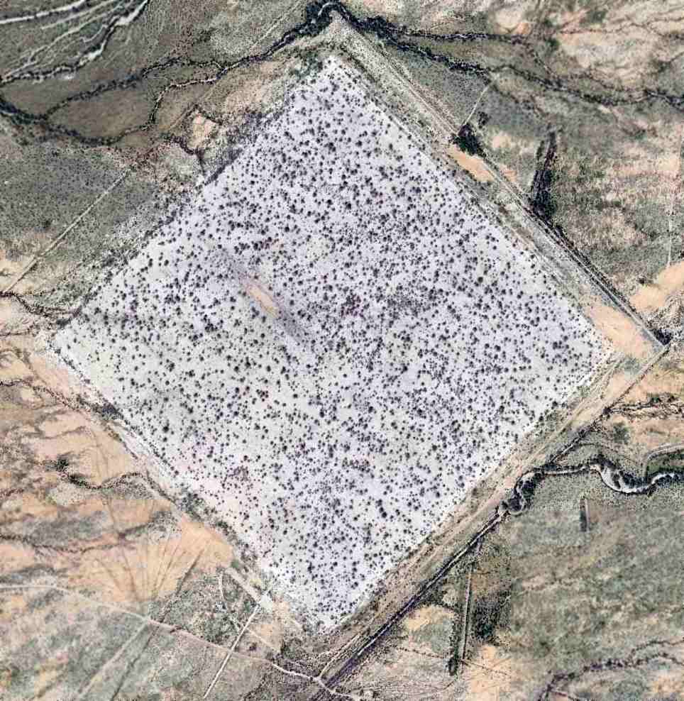
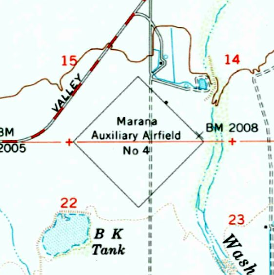
Marana Auxiliary Army Airfield #4 / Avra Field, Marana, AZ
32.38, -111.3 (Northwest of Tucson, AZ)
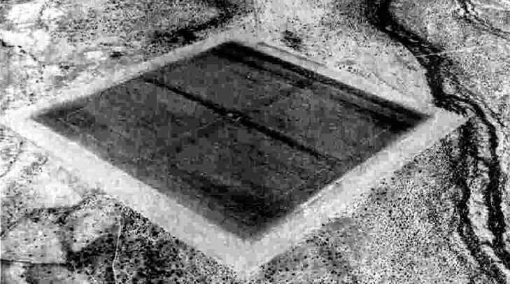
A 6/13/43 aerial view looking north at “Marana AAF Auxiliary #4 (Avra Field)” from the 1945 AAF Airfield Directory (courtesy of Scott Murdock).
This field was built in 1942 as one of 5 satellite airfields for Marana Army Airfield (located a few miles north),
which conducted basic flight training & the training of transport pilots in instrument flying & navigation.
The site consisted of a total of 575 acres.
Facilities included a 3,000' square landing mat, stage house, crash truck shelter, and latrine.
Avra Field was not yet depicted on the March 1944 Phoenix Sectional Chart.
The earliest depiction which has been located of Avra Field
was a 6/13/43 aerial view looking north from the 1945 AAF Airfield Directory (courtesy of Scott Murdock).
It depicted “Marana AAF Auxiliary #4 (Avra Field)” as a square asphalt landing mat.
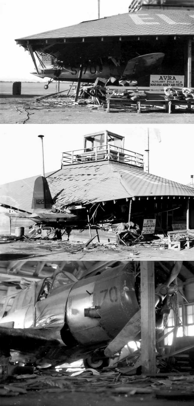
A series of photos of a 1945 accident at Avra Aux #4, from the book "Best Place in the Country" by Steve Hoza & Mike Hoza (courtesy of Steve Hoza).
"The accident happened 1/17/45. Chinese cadet Fei-Peng Wu was waiting to take off from Marana Auxiliary Field #4 (Avra) at night.
He got the green light from the control building. He became disoriented & headed straight for the light.
His BT-13 crashed into the building, killing Private Thomas Burch, a truck driver,
who was asleep inside at the time of the accident."
The earliest aeronautical chart depiction which has been located of Avra Aux #4 was on the September 1945 Phoenix Sectional Chart.
The 1945 AAF Airfield Directory (courtesy of Scott Murdock) described “Marana AAF Auxiliary #4 (Avra Field)”
as a 206 acre square-shaped property having a 3,000' square asphalt landing mat.
The field was not said to have any hangars, and to be operated by the Army Air Forces.
However the title of the entry indicated Coronado was inactive.
The airfield was declared surplus in 1945,
and portions of the property were sold to a private owner & transferred to Pima County.
Marana Aux AAF #4 was still listed in a directory of AZ Airports
in the 5/47 issue of Arizona Highways (courtesy of George Miller),
which described the field as being unattended.
It was labeled "Marana #4" on the 1949 Phoenix Sectional Chart (according to Chris Kennedy).
The 1956 USGS topo map depicted “Marana Auxiliary Airfield #4” as an diamond-shaped outline.
A 1958 aerial view depicted the square landing mat of the Marana #4 airfield,
but a road had been cut across the airfield area.
The 1958 Phoenix Sectional Chart (according to Chris Kennedy)
labeled the field as "Marana #4 (Pvt)",
and the remarks in the Aerodromes table said "Private. Flying school under contract to USAF."
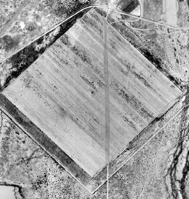
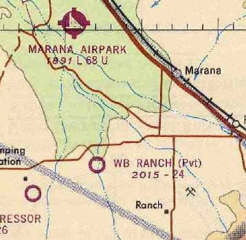
At some point between 1958-60 the airfield was evidently renamed “WB Ranch”, as that is how it was labeled on the September 1960 Phoenix Sectional Chart.
It depicted WB Ranch as a private airfield having a 3,000' square paved landing mat.
The Aerodromes table on the on the January 1966 Phoenix Sectional Chart (courtesy of Chris Kennedy)
described the WB Ranch Airfield as having 3 runways,
with the longest being 2,450', and with "Disintegrated asphalt" surface.
The remarks said "Private. Restricted by pole lines. Land with caution. Runway 12R/30L closed."
"Sounds like a pretty inhospitable airport", in the word of Chris Kennedy.
A 1967 aerial view showed the airfield essentially unchanged from as depicted in the 1958 photo.
The WB Ranch was described as a private airfield in the 1967 AOPA Airport Directory.
It was described as having 3 asphalt runways,
including a 2,450' Runway 17/35, and 2 parallel runways: a 2,400' Runway 12L/30R & a 1,750' Runway 12R/30L.
Quite an elaborate runway configuration for a private ranch airfield!
Those multiple runways were presumably marked off over the former square landing pad.
The operator was listed as Mona Wong.
Charles Reeves recalled, “My father was a farmer/rancher in Avra valley between 1955-85.
Our farm was about 1 mile southwest of Auxiliary Field Avra #4. Mona Wong was our neighbor.
Her husband was killed in a Beechcraft accident in about 1960 somewhere in Texas on his way home to his farm.
I remember seeing him tow the V-tail Beechcraft to the dirt strip many times.
There was an operations building on the east side of the field which was towards the midpoint.
I remember my dad pointing out the field elevation still visible on the side, 2,045'.
I visited the site many time while growing up on the farm.
I actually found aircraft panels, radio gear, headsets, and ammunition on our grazing land south of Auxiliary #4 along the power line about 2 miles south.
This would have been in the late 1960s. I presumed it was a crash site.”
The WB Ranch Airfield was apparently abandoned at some point between 1967-93.
According to a 1993 Army Corps of Engineers Report, none of the original military structures still existed at Avra at that point.
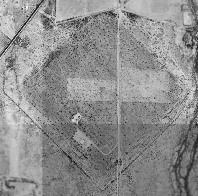
The 1996 USGS aerial photo shows that the original square landing mat area was still quite recognizable, although somewhat deteriorated.
Several small buildings had been built at some point between 1958-96 over the southwest portion of the landing mat.
A 1997 aerial view looking south at Avra Aux #4 by Steve Hoza, author of the book "Best Place in the Country".
Steve said, "Mike [Hoza] has visited this one & said that it was difficult to realize you were on it once you were on it."
The Avra airfield was not depicted at all (even as an abandoned airfield) on 1990s aeronautical charts or USGS topo maps.
John Sparks reported in 2003, "The land has been divided up & is held mostly by 'Bench S Partnership'.
The small block (40 acres) is held by the Federal Government still although it could never bee used as a strip again.
I am unable to find a reason for this still being in federal hands
other than it has some strategic reason that is not visible from the air.
I have checked the Superfund site [EPA cleanup] list & it does not appear on the list.
Trico Road runs through the property & the vegetation has taken back more of the property."
Note that the small structure visible in the 1996 & 1997 aerial photos on the southwest portion of the airfield
was apparently removed at some point between 1997-2003, as it was no longer present in the 2003 aerial photo.
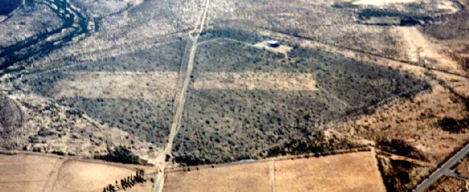
A 2020 aerial view looking northwest at the remains of Avra Aux #4.
____________________________________________________
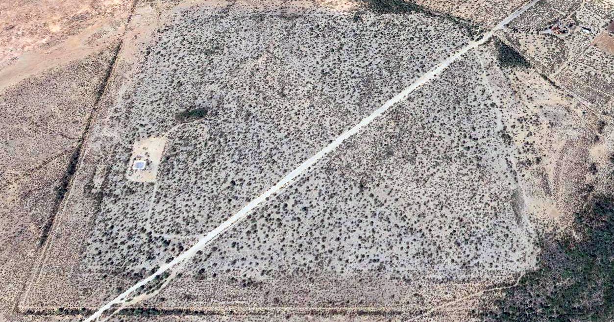
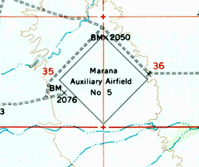
Marana Auxiliary Army Airfield #5 / Saharuo Field (AZ67), Marana, AZ
32.43, -111.39 (Northwest of Tucson, AZ)
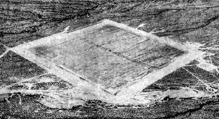
A 6/13/43 aerial view looking north at “Marana AAF Auxiliary #5 (Sahuaro Field)” from the 1945 AAF Airfield Directory (courtesy of Scott Murdock).
This field was built in 1942 to build one of 5 satellite airfields for Marana Army Airfield (located a few miles north),
which conducted basic flight training & the training of transport pilots in instrument flying & navigation.
The property consisted of a total of 579 acres.
Facilities consisted of fencing, a landing mat, and 3 buildings.
Sahuaro Field was not yet depicted on the March 1944 Phoenix Sectional Chart.
The earliest depiction which has been located of Sahuaro Field
was a 6/13/43 aerial view looking north from the 1945 AAF Airfield Directory (courtesy of Scott Murdock).
It depicted “Marana AAF Auxiliary #5 (Sahuaro Field)” as a square asphalt landing mat.
The earliest aeronautical chart depiction which has been located of Sahuaro Aux #5 was on the September 1945 Phoenix Sectional Chart.
The 1945 AAF Airfield Directory (courtesy of Scott Murdock) described “Marana AAF Auxiliary #5 (Sahuaro Field)”
as a 206 acre square-shaped property having a 3,000' square asphalt landing mat.
The field was not said to have any hangars, and to be operated by the Army Air Forces.
However the title of the entry indicated Sahauro was inactive.
This field was listed in a directory of AZ Airports
in the 5/47 issue of Arizona Highways (courtesy of George Miller),
which described the field as consisting of a 3,000' square landing mat, and being unattended.
The property was relinquished to the War Assets Administration in 1947.
It was labeled "Marana #5" on the 1949 Phoenix Sectional Chart (according to Chris Kennedy).
The 1956 USGS topo map depicted “Marana Auxiliary Airfield #5” as an diamond-shaped outline.
Marana Aux #5 was once again used by the USAF in 1957,
which operated T-34 & T-28 training aircraft into the field.
The 1958 Phoenix Sectional Chart (according to Chris Kennedy) labeled the field as "Marana #5 (Pvt)",
and the remarks in the Aerodromes table said "Private. Flying school under contract to USAF."
The September 1960 Phoenix Sectional Chart depicted Marana #5 as a private airfield having a 3,000' square paved landing mat.
Sahuaro #5 was apparently abandoned at some point between 1958-64,
as it was labeled It was labeled "Abandoned airport" on the 1964 Phoenix Sectional Chart (according to Chris Kennedy).
A 1967 aerial view showed the airfield essentially unchanged from as depicted in the 1943 photo.
According to a 1992 Army Corps of Engineers Report,
at that date the property was owned by the State of Arizona & the Department of the Interior.
Most of the portion owned by the Department of the Interior had been leased by the Tucson Soaring Club since 1983,
which had made numerous improvements to the property, and operated it under the name of the El Tiro Gliderport.
There are no signs of the previous military facilities except the general outline of the landing pad.
Airport facilities, including runways & taxiways, have been constructed over the old landing pad.
There is no sign of the original military buildings & the current occupants have no recollection of any being present.
A 1997 aerial view of Sahuaro Aux #5 by Steve Hoza (courtesy of Steve Hoza, from the book "Best Place in the Country", by Mike & Steve Hoza).
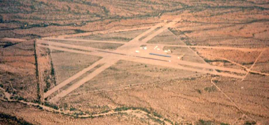
The airfield consists of five 5,000' runways, both dirt & paved.
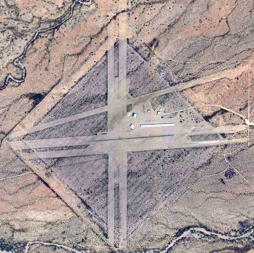
A 3/24/13 aerial view of Sahuaro Aux #5.
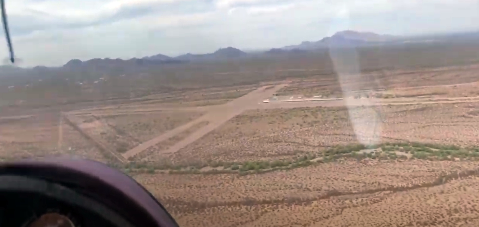
A still from a 5/2/21 video by Tom Serkowski looking north at Sahuaro Aux #5 / El Tiro Gliderport.
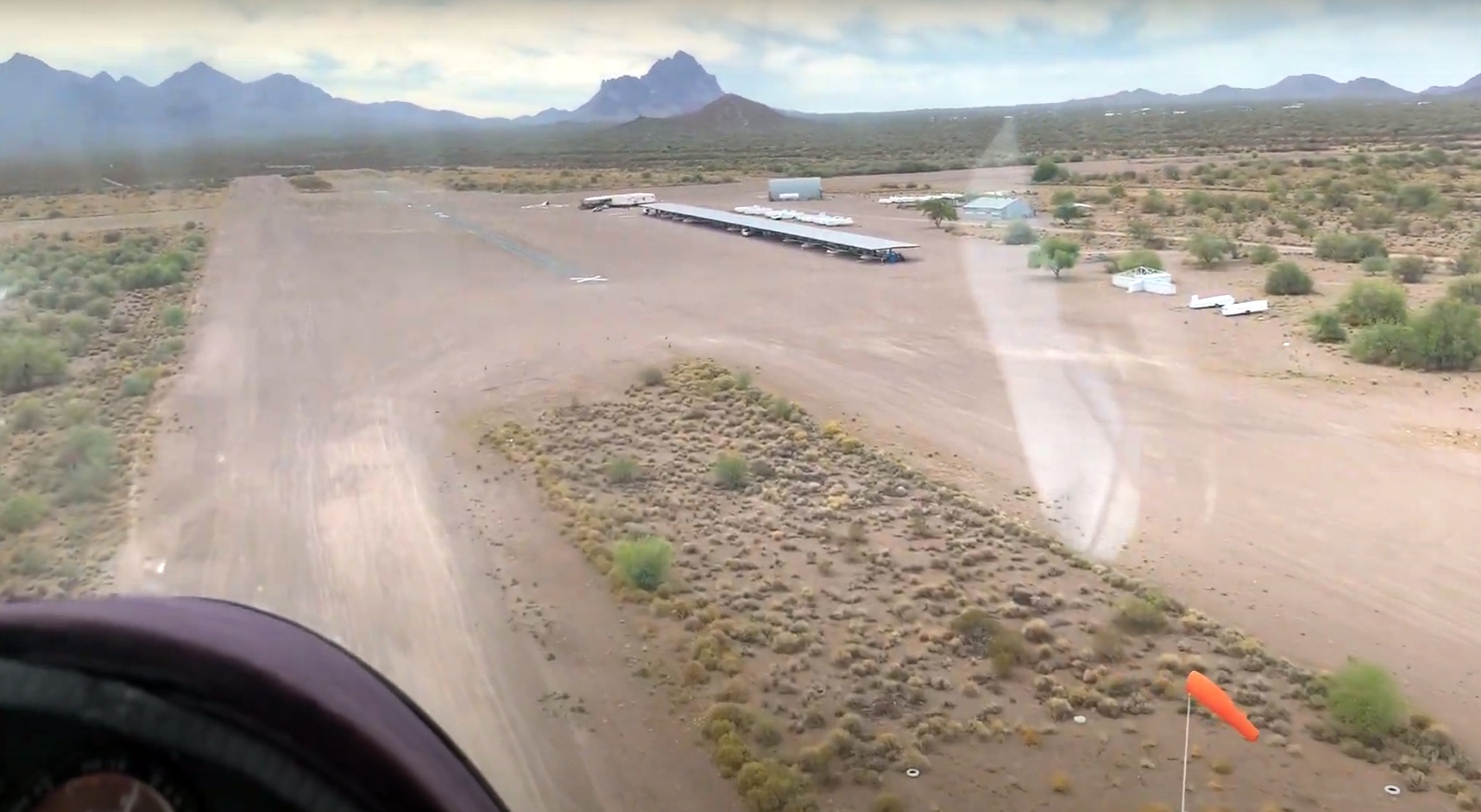
A still from a 5/2/21 video by Tom Serkowski looking west from final approach to Sahuaro Aux #5 / El Tiro Gliderport.
Thanks to Jack Young for information about Sahuaro.
____________________________________________________
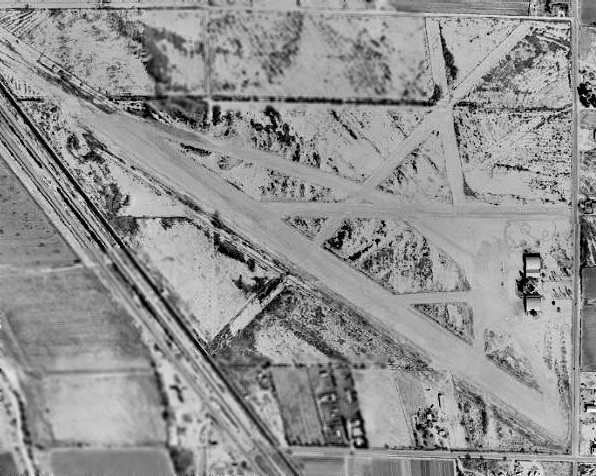
32.6, -111.34 (Northwest of Tucson, AZ)
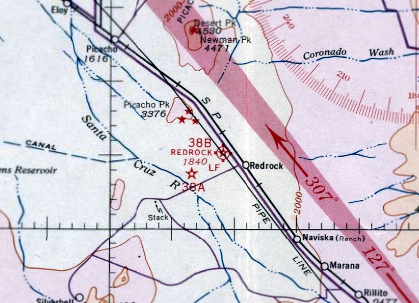
Redrock Airport, as depicted on the October 1935 Phoenix Sectional Chart.
The Redrock Airport was originally built as one of the Department of Commerce's network of Intermediate Fields,
which were established in the 1920s & 1930s to serve as emergency landing fields
for commercial aircraft flying along airways between major cities.
The date of construction of the Redrock Airport has not been determined.
The earliest reference to the airfield which has been located was on the October 1935 Phoenix Sectional Chart,
which depicted it as Site 38B along the San Diego - El Paso Airway.
The Airport Directory Company's 1937 Airports Directory (courtesy of Bob Rambo)
described Redrock as being the Department of Commerce's Site 38 along the San Diego - El Paso Airway.
The field was said to have 2 gravel runways: 3,040' northeast/southwest & 2,700' northwest/southeast.
By the time of the 1943 Phoenix Sectional Chart (courtesy of David Brooks),
the Redrock Airport had been redesignated as Site 7B of the Phoenix - El Paso Airway.
A fan radio range had also been added to the Redrock site.
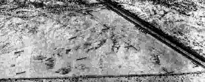
The earliest photo which has been located of Redrock Airport
was a 6/13/43 aerial view looking north from the 1945 AAF Airfield Directory (courtesy of Scott Murdock).
It depicted “Redrock Intermediate Field” as having 2 soil runways in a T-shape.
The 1945 AAF Airfield Directory (courtesy of Scott Murdock) described “Redrock Intermediate Field”
as a 110 acre irregularly-shaped property having 2 soil runways, measuring 3,040' northeast/southwest & 2,700' northwest/southeast.
The field was not said to have any hangars, to be owned by the U.S. Government, and operated by the Civil Aeronautics Administration.
Redrock Airport, as depicted on the September 1945 Phoenix Sectional Chart.
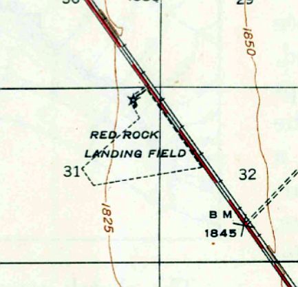
The 1947 USGS topo map depicted “Red Rock Landing Field” as an irregularly-shaped outline with a beacon at the north corner.
The last aeronautical chart depiction which has been located of Redrock Airport was on the September 1949 Phoenix Sectional Chart.
It depicted “Redrock (CAA)” as having Commerce Department Airway Beacon 7B,
and having a 3,000' unpaved runway.
The Redrock Airport was apparently closed at some point between 1949-50,
as it was no longer depicted on the February 1950 Phoenix Sectional Chart.
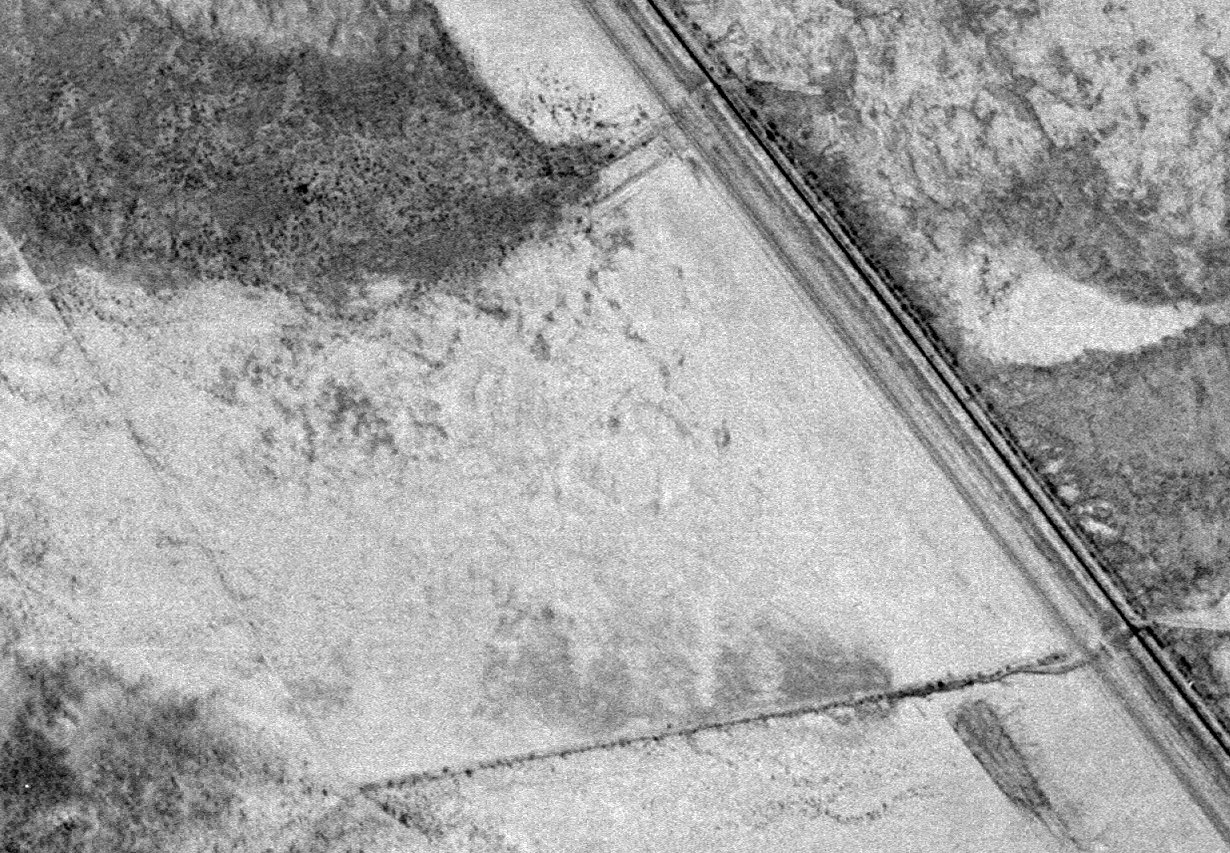
A 2/19/56 USGS aerial photo showed an irregularly-shaped outline at the site of Redrock Airport,
which may be the boundaries of the former airfield, but there are no other recognizable remnants of a former airfield.
The 1980 USGS topo map still bore the legend of a survey monument named "Airport",
although nothing else was depicted at the site of the former airfield.
A 10/2/13 aerial photo showed an irregularly-shaped outline at the site of Redrock Airport,
which may be the boundaries of the former airfield, but there are no other recognizable remnants of a former airfield.
The site of Redrock Airport is located on the southwest side of Interstate 10,
two miles northwest of Redrock, AZ.
____________________________________________________
____________________________________________________
This site covers airfields in all 50 states.