Abandoned & Little-Known Airfields:
Northern Arizona
© 2002, © 2025 by Paul Freeman. Revised 10/22/25.
____________________________________________________
Please consider a financial contribution to support the continued growth & operation of this site.
Ash Fork Airport / Jay Hasbrook Airport / Santa Fe Airport (revised 10/17/24) - Ashfork Intermediate Field (revised 10/17/24)
Grand Canyon North Rim Airport / V.T. Park Airport (revised 10/16/24) - Koch Field (revised 10/17/24) - Red Butte Airport / Grand Canyon Airport (revised 10/22/25)
Tuba City Airport (1st location) (revised 4/11/21) - Tuba City Airport (2nd location) (revised 4/11/21) - Winona Intermediate Field (revised 4/11/21)
____________________________________________________
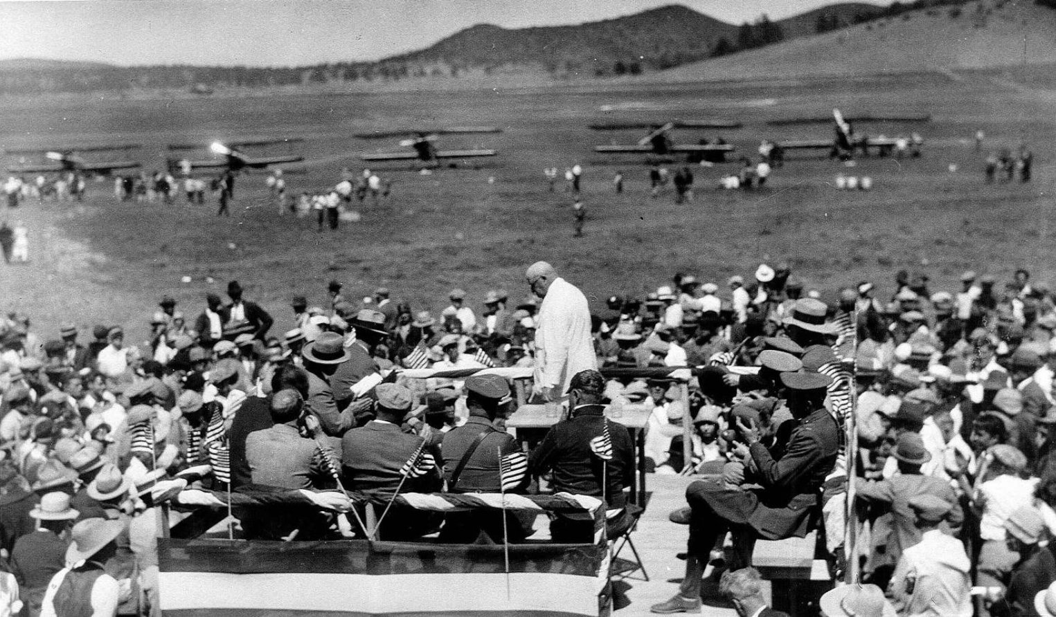
35.27, -111.514 (North of Phoenix, AZ)
A 7/7/28 photo of Governor George W.P. Hunt returning to the speaker's stand at the Flagstaff Koch Field dedication day ceremonies (courtesy of Carlos Ross).
According to the article “Airport expands from early roots to new routes” in the 3/29/18 Lumberjack (courtesy of Carlos Ross),
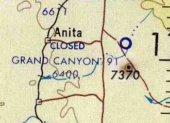
“Flagstaff’s first airfield was just that: a field. The exact location is not known, but it was most likely located north of downtown near what is now Coconino High School’s football field.
Flagstaff’s second airfield was built in 1928 and named Koch Field, on Flagstaff’s east side in Doney Park.
It was named after the Flagstaff mayor at the time Ignacio Tony Koch.
In March 1928, the first airplane touched down there.”
The earliest photo which has been located of Koch Field was a 7/7/28 photo of Governor George W.P. Hunt returning to the speaker's stand
at the Koch Field dedication day ceremonies (courtesy of Carlos Ross).
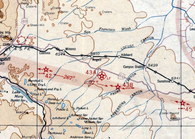
The earliest aeronautical chart depiction which has been located of Koch Field was on the June 1932 Prescott Sectional Chart.
The only topo map depiction which has been located of Koch Field was on the 1947 USGS topo map.
The last aeronautical chart depiction which has been located of Koch Field was on the March 1950 Prescott Sectional Chart.
It depicted Koch Field as having a 6,000' unpaved runway.
According to the article “Airport expands from early roots to new routes” in the 3/29/18 Lumberjack (courtesy of Carlos Ross),
“While the airfield's suited the needs of the locals in Flagstaff,
the decision to move the airfield south of town was likely influenced by United States Army officials
conducting training at Fort Tuthill who wanted it moved from Doney Park so it could be more accessible.”
Koch Field was evidently replaced during 1950 by the new Flagstaff Airport to the southwest of the town,
as only the new airport was depicted on the September 1950 Prescott Sectional Chart.

A 3/7/54 USGS aerial view showed faint traces of 2 runways at the site of Koch Field.
A 2017 aerial view showed no trace remaining of Koch Field.
The site of Koch Field is located east of the intersection of Yancey Lane & Koch Field Road, appropriately enough.
Thanks to Carlos Ross for pointing out this airfield.
____________________________________________________
Tuba City Airport (1st location), Tuba City, AZ
36.13, -111.26 (North of Flagstaff, AZ)
The original Tuba City Airport, as seen in a 6/20/43 aerial view looking northeast from the from the 1945 AAF Airfield Directory (courtesy of Scott Murdock).
The date of establishment of Tuba City Airport has not been determined.
The Tuba City Airport was not yet depicted on the 1938/42/44/45 Grand Canyon Sectional Charts.
The earliest reference which has been located to Tuba City Airport
was in the 1945 AAF Airfield Directory (courtesy of Scott Murdock).
It described Tuba City Airport as being located 1 mile southwest of the town,
and consisting of a 100 acre oval-shaped property having a 4,000' east/west unimproved surface landing area.
The field was said to not have any hangars, to be owned by the U.S. Government,
but not be in operation (possibly closed during WW2 like many other small civilian airports).
The Tuba City Airport was still not depicted on the March 1949 Grand Canyon Sectional Chart.
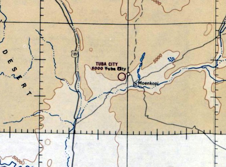
The earliest aeronautical chart depiction which has been located of Tuba City Airport was on the March 1951 Grand Canyon Sectional Chart.
It depicted Tuba City Airport as being located southwest of the town.
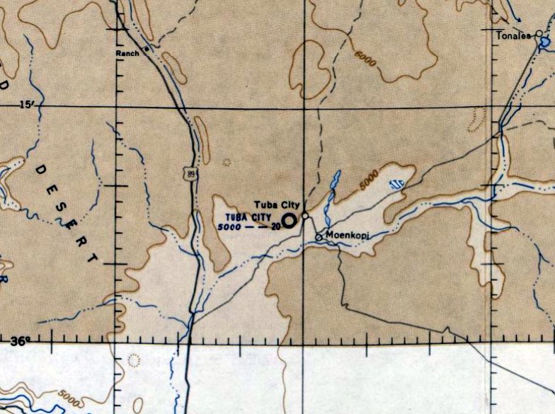
The last aeronautical chart depiction which has been located of the original Tuba City Airport (southwest of the town)
was on the September 1953 Grand Canyon Sectional Chart.
It depicted Tuba City Airport as having a 2,000' unpaved runway.
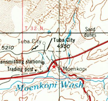
At some point between 1953-56, the Tuba City Airport was evidently relocated to a site adjacent to the east side of the town,
as that is where it was depicted on the October 1956 Grand Canyon Sectional Chart.
The site of the original location of Tuba City Airport is occupied with a smattering of houses, with no trace recognizable of the airport.
The site of the original Tuba City Airport is located southwest of the intersection of Moenave Street & Old Airport Road, appropriately enough.
____________________________________________________
Tuba City Airport (2nd location), Tuba City, AZ
36.134, -111.234 (North of Flagstaff, AZ)
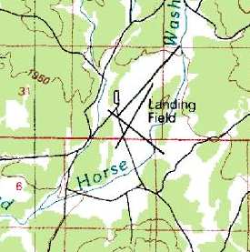
The 2nd location of the Tuba City Airport, as depicted on the 1956 USGS topo map.
At some point between 1953-56, the original Tuba City Airport to the southwest of the town
was evidently relocated to a site adjacent to the east side of the town, as depicted on the 1956 USGS topo map.
It depicted Tuba City Airport as having a single northeast/southwest runway.
The last aeronautical chart depiction which has been located of the 2nd location of Tuba City Airport (east of the town)
was on the October 1956 Grand Canyon Sectional Chart.
It depicted Tuba City Airport as having a 4,400' unpaved runway.
The 1969 USGS topo map depicted the 2nd location of Tuba City Airport as having an unpaved northeast/southwest runway,
with a taxiway leading to the northwest toward the hospital.
David Stevens recalled of the 2nd location of Tuba City Airport, “My dad & I took an off-airport excursion in 1972.
He had just bought a 1960 Cessna 182 a few months earlier & this was his first long-distance flight (El Monte to Michigan)
and failed to monitor his fuel as we were in a long left bank to survey the field for landing (he had to pee & this was the nearest field I could find on the sectional).
The older Cessna gauges were notoriously inaccurate...his excuse not mine, and not being a pilot yet I couldn't chime in.
He was fighting a crosswind from the left, and it took out one of the wooden runway markers.
The plane was dismantled a few days later & trucked back to Van Nuys.
When we had our emergency landing there, the strip was mainly being used by plane owners who served as air ambulance pilots for the Native American population.”
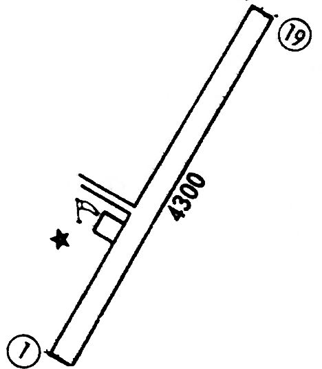
The 1973 Flight Guide (courtesy of Fred Udall) depicted the 2nd location of Tuba City Airport as having an 4,300' unpaved Runway 1/19,
with a taxiway & a ramp on the west side.
The last dated map depiction which has been located of the 2nd location of Tuba City Airport was on the 1983 USGS topo map.
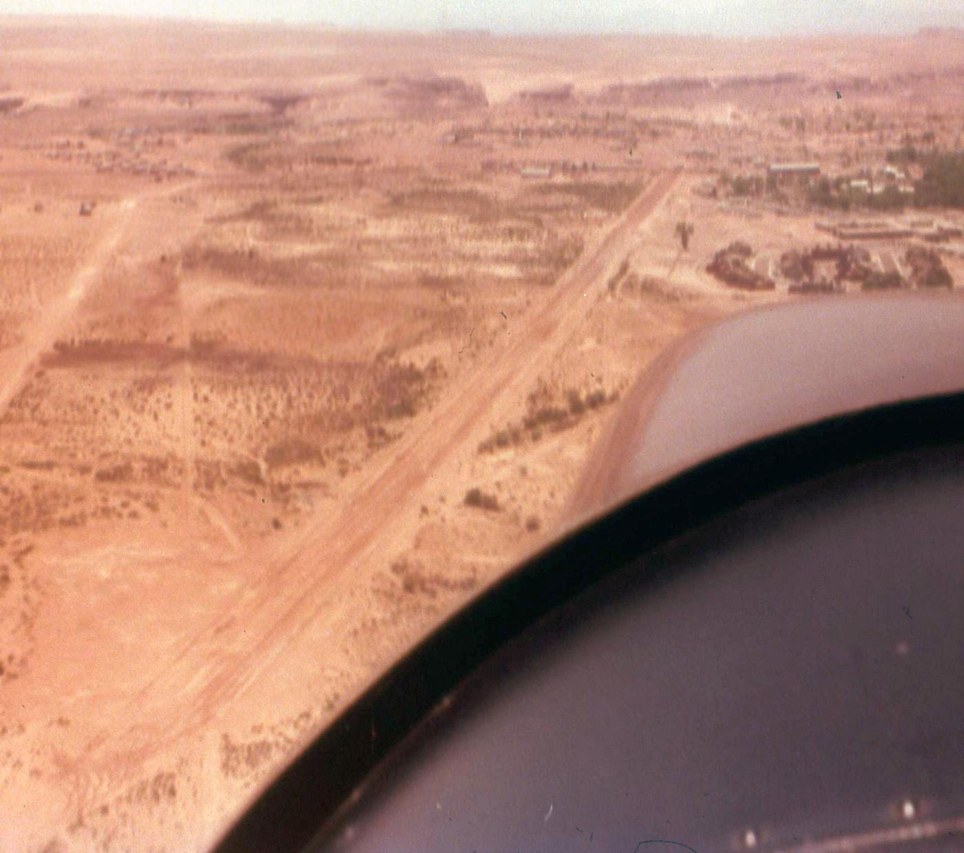
A circa late 1980s aerial view by David Stevens looking south along the unpaved runway of the 2nd location of Tuba City Airport.
A replacement Tuba City Airport with a longer paved runway opened 5 miles west of the town in 1992,
at which point presumably the 2nd location of Tuba City Airport was closed.
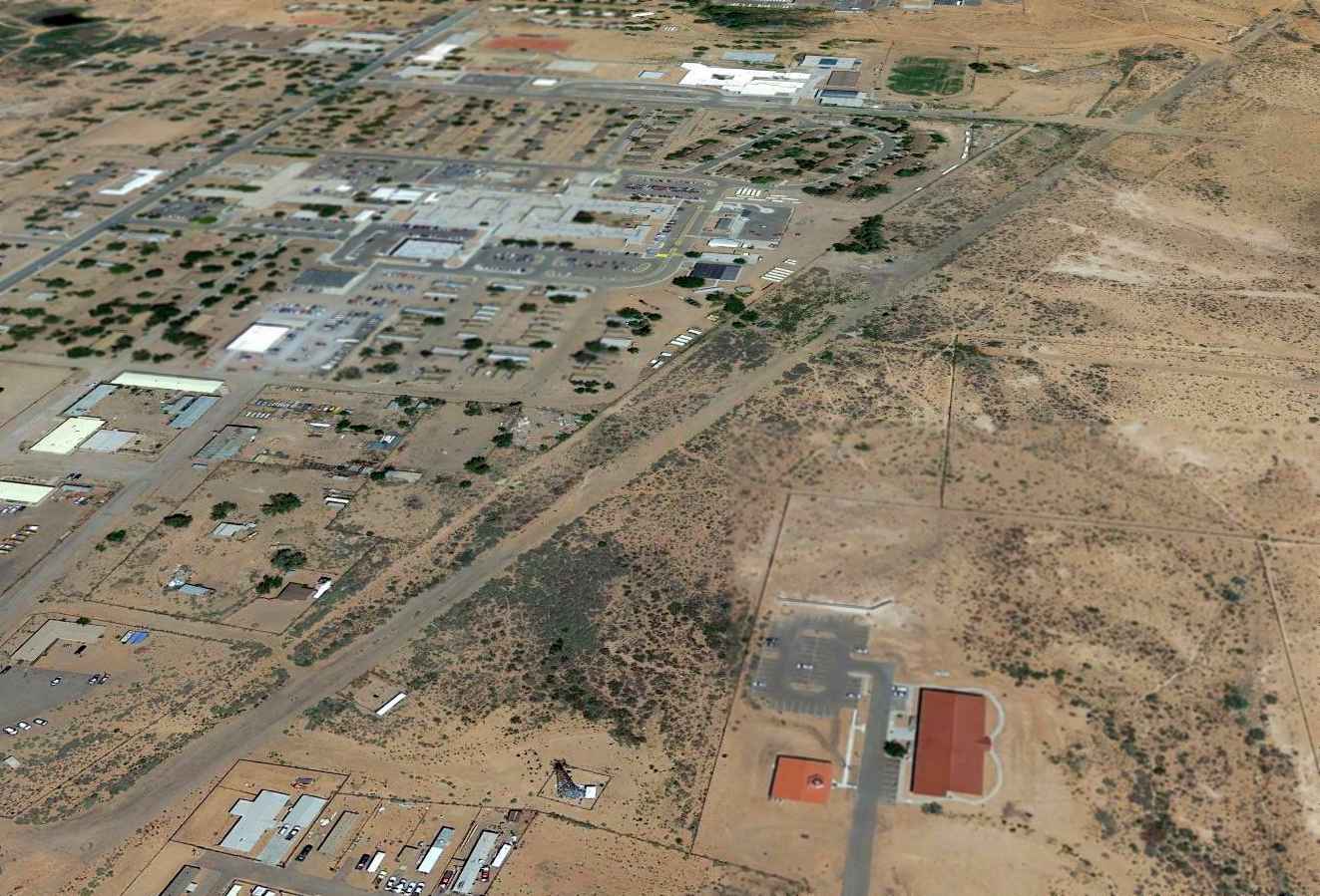
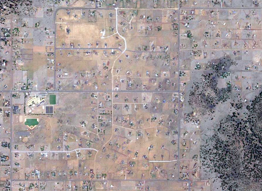
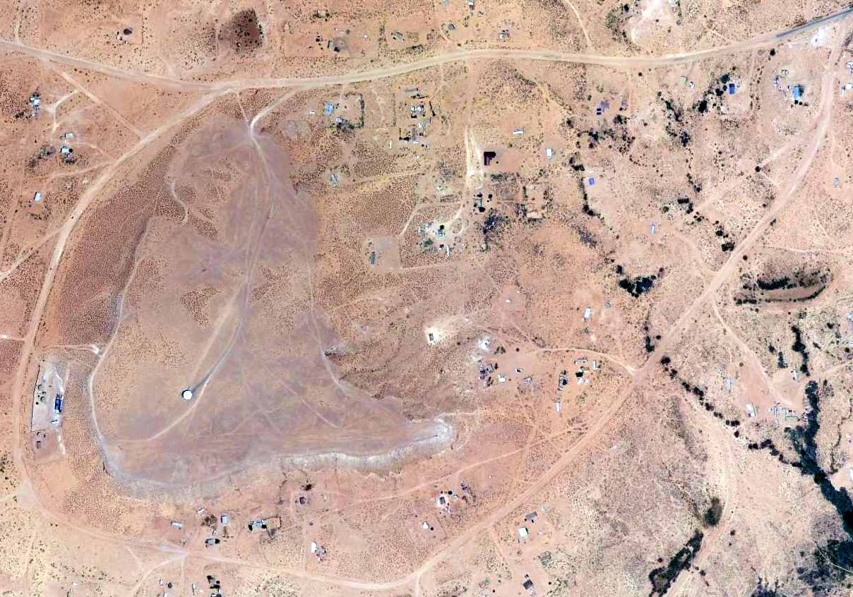
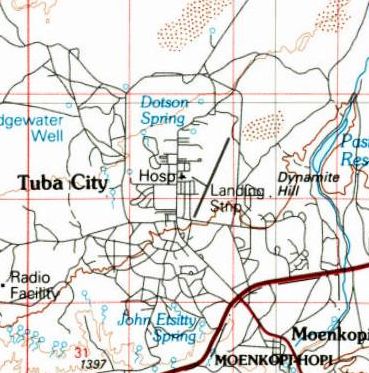
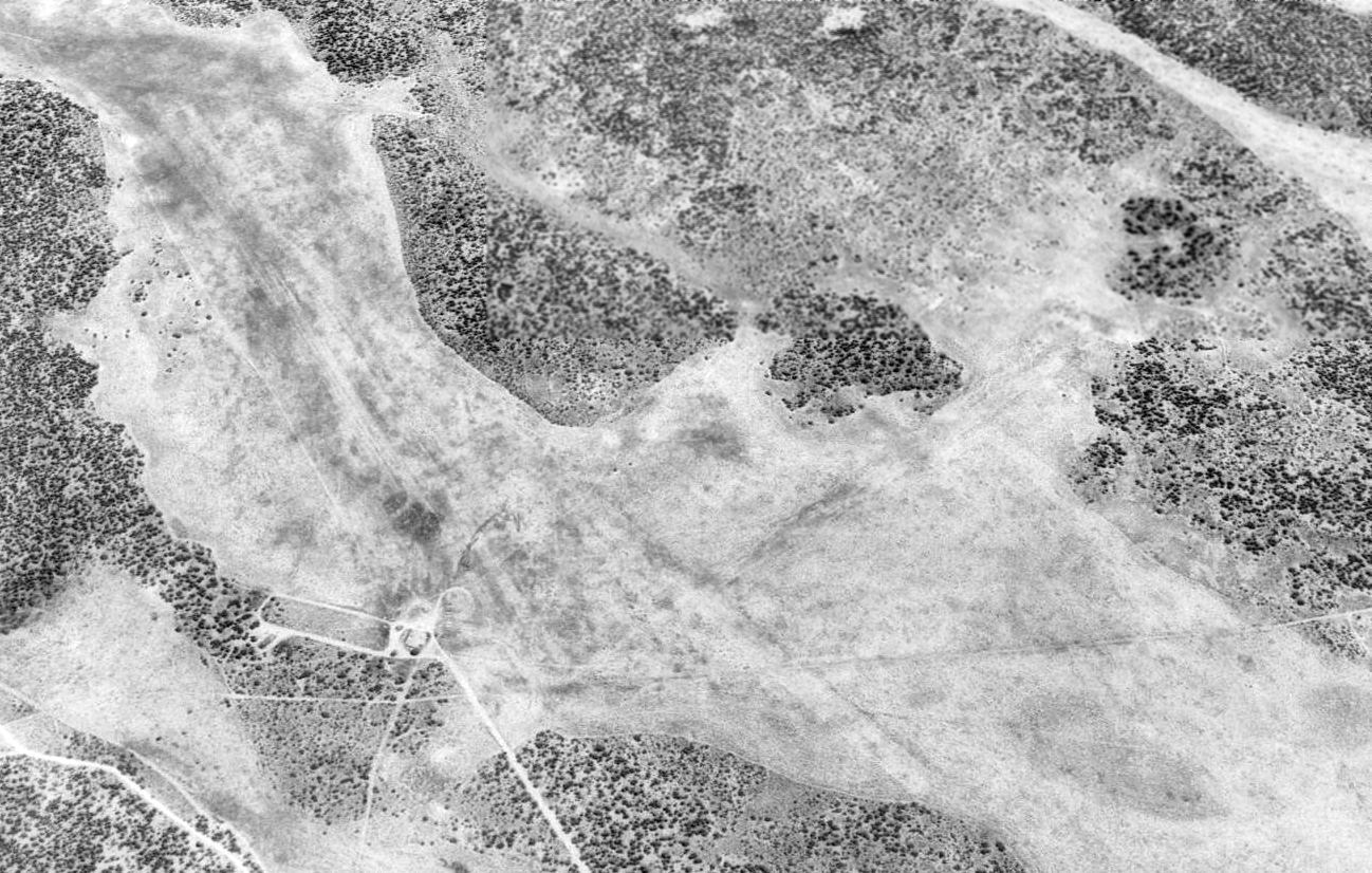
A 2014 aerial view looking north shows the runway of the 2nd location of Tuba City Airport remains recognizable,
and there are a few foundations along the west side of the midpoint of the runway, possibly for some hangars or other airport-related buildings.
As of 2015, street maps label the 2nd location of Tuba City Airport's runway as Grandview Street,
although it does not appear to be actively reused as a street, because there are no houses or buildings built along it.
Thanks to David Stevens for pointing out this airfield.
____________________________________________________
Winona Intermediate Field, Winona, AZ
35.143, -111.27 (Northeast of Phoenix, AZ)
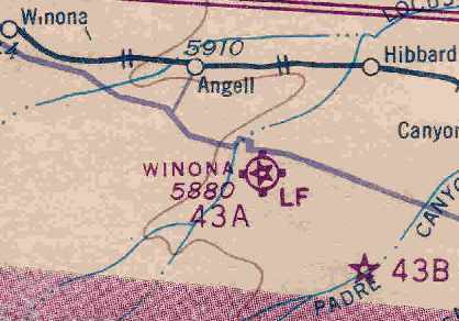
Winona Intermediate Field 43A, as depicted on the February 1932 Prescott Sectional Chart.
Winona Intermediate Field was apparently established as one of the Department of Commerce's network of airfields
built for the emergency use of commercial aircraft flying along airways in between major cities.
Winona Intermediate Field was apparently established at some point between 1929-32,
as it was not yet listed among active airfields in the 1929 Airplane Landing Fields of the Pacific West (according to Chris Kennedy).
The earliest depiction of Winona Intermediate Field which has been located was on the February 1932 Prescott Sectional Chart.
It depicted Winona Intermediate Field as Commerce Department Site 43A.
The earliest airfield directory listing which has been located of Winona Intermediate Field
was in The Airport Directory Company's 1933 Airport Directory (courtesy of Chris Kennedy).
It described Winona as the Department of Commerce's Site 43A, along the Los Angeles - Amarillo airway.
The field was said to measure 145 acres in size,
and to have 2 sod & dirt runways: 3,887' east/west & 3,300' north/south.
The field was said to have beacon, boundary, and approach lights, but no service.
Winona apparently gained a 3rd runway within the next year,
as the Department of Commerce's 1934 Airport Directory (courtesy of Chris Kennedy)
described the field as having 3 sod & dirt runways (with the longest being the 3,960' north/south strip).
A shed was said to have "43A" & "LA-A" marked on the roof, and the field was said to have emergency aviation gasoline.
The January 1942 Prescott Sectional Chart (courtesy of Chris Kennedy)
depicted Winona Intermediate Field as Commerce Department site 43A.
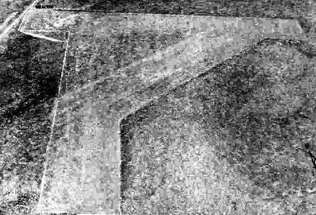
The earliest photo of the Winona Intermediate Field which has been located
was a 6/20/43 aerial view looking north from the 1945 AAF Airfield Directory (courtesy of Scott Murdock).
It depicted Winona as having 3 unpaved runways.
The 1945 AAF Airfield Directory (courtesy of Scott Murdock) described Winona Intermediate Field
as a 155 acre L-shaped property having 3 “sod” runways, with the longest being the 3,960' north/south strip.
The field was not said to have any hangars, was described as being owned by the U.S. Government,
and operated by the Civil Aeronautics Administration
The last aeronautical chart depiction which has been located of Winona
was on the September 1946 Prescott Sectional Chart (according to Chris Kennedy).
The Winona Intermediate Field was evidently abandoned at some point between 1946-49,
as it was no longer depicted at all on the March 1949 Prescott Sectional Chart (according to Chris Kennedy).
The need for the network of intermediate fields had largely been eliminated by that point,
as advances in the range & safety of commercial aircraft made such emergency fields unnecessary.

A 4/1/54 USGS aerial photo showed that the outline of 3 runways at the Winona Intermediate Field was still recognizable.
Nothing at all was depicted at the site of the Winona Intermediate Field
on USGS topo maps from 1968, 1970, 1982, or 1983.
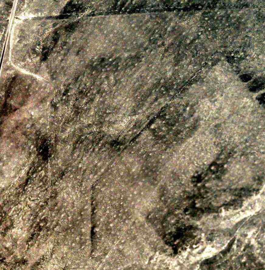
After being abandoned for more than 60 years,
a 6/20/07 aerial photo showed that the outline of 3 runways at the Winona Intermediate Field was still quite recognizable.
There did not appear to be any traces of any buildings at the site.
The Winona Intermediate Field is located a mile southeast of the intersection of Interstate 40 & Forrest Service Road (exit 219).
____________________________________________________
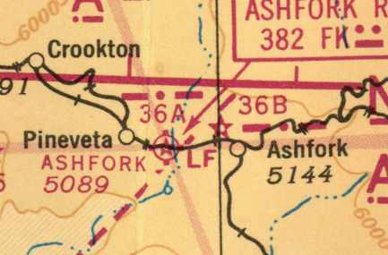
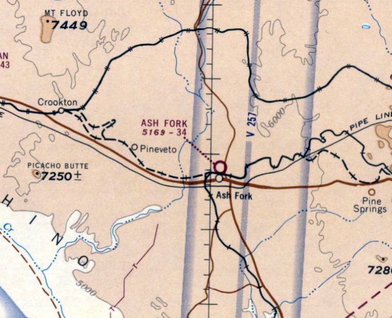
Ashfork Intermediate Field, Ash Fork, AZ
35.23, -112.55 (Northwest of Phoenix, AZ)
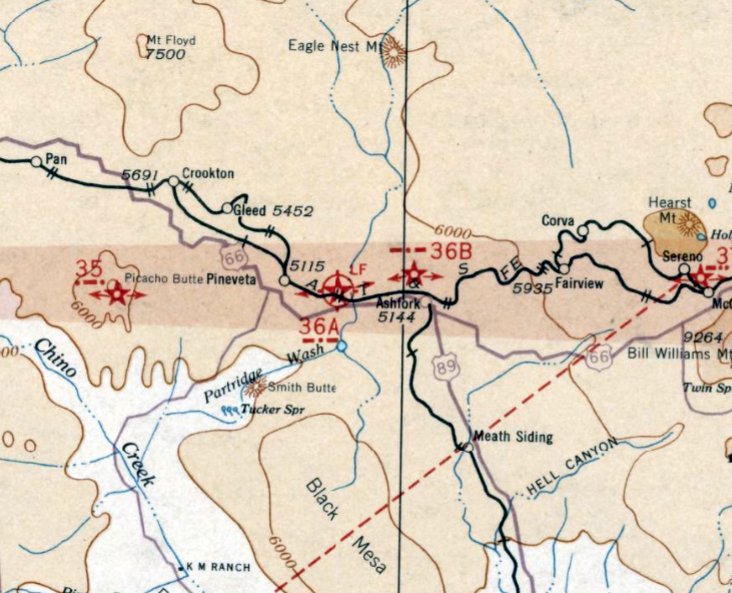
Ashfork Intermediate Field, as depicted on the February 1932 Prescott Sectional Chart.
Ashfork Intermediate Field was one of the network of airfields built along commercial airways between major cities by the Commerce Department.
The date of establishment of Ashfork Intermediate Field has not been determined.
The earliest depiction of the Ashfork Intermediate Field which has been located was on the February 1932 Prescott Sectional Chart.
It depicted Ashfork as being Commerce Department Site 36A.
The earliest airfield directory listing which has been located of Ashfork Intermediate Field
was in The Airport Directory Company's 1933 Airport Directory (courtesy of Chris Kennedy).
It described Ashfork as Site 36A along the Los Angeles - Amarillo Airway,
one of the Department of Commerce's network of Intermediate Fields.
Ashfork was said to have two 3,960' sod & dirt runways, oriented north/south & east/west.
The Airport Directory Company's 1937 Airport Directory (courtesy of Bob Rambo) described Ashfork in the same manner.
The earliest photo of the Ashfork Intermediate Field which has been located
was a 6/20/43 aerial view looking west from the 1945 AAF Airfield Directory (courtesy of Scott Murdock).
It depicted Ashfork as having 3 unpaved runways.
The 1943 11M Regional Aeronautical Chart (courtesy of David Brooks) depicted Ashfork as Intermediate Field 36A,
and depicted Ashfork Radio (a 4-way radio navigational range) on the field.
Ashfork was described in the April 1944 US Army/Navy Directory of Airfields (courtesy of Ken Mercer) as having a 4,100' unpaved runway.
It was still listed as "Site 36A" along the Los Angeles - Amarillo Airway.
The March 1945 Prescott Sectional Chart (courtesy of Chris Kennedy) still depicted Ashfork as Site 36A.
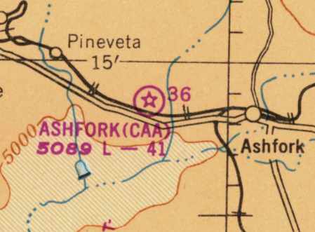
The March 1949 Prescott Sectional Chart (courtesy of David Brooks) depicted "Ashfork (CAA)" as Site 36,
and described the field as having a 4,100' unpaved runway.
Ashfork Intermediate Field was evidently closed at some point between 1949-50,
as it was no longer depicted on the March 1950 Prescott Sectional Chart.
The need for the network of intermediate fields had largely been eliminated,
as advances in the range & safety of commercial aircraft made such emergency fields unnecessary.

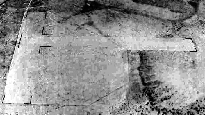
A 3/7/54 USGS aerial view showed that the outline the Ashfork Intermediate Field was still quite recognizable.
Nothing at all was depicted at the site of the Ashfork Intermediate Field on the 1970, 1973, or 1983 USGS topo maps.
A 1997 aerial view looking north showed that the outline the Ashfork Intermediate Field was still quite recognizable.
The remains of the CAA compound was visible on the southeast edge (bottom-right of photo).
A 1/30/12 photo by Steve Owen of the airway beacon tower base at the site of the CAA facility on the southeast edge of the Ashfork Intermediate Field site.
Steve observed, “The 4 notched corners show how the tower was erected & later removed.”
A 1/30/12 photo by Steve Owen of a flagpole & other remains at the site of the CAA facility on the southeast edge of the Ashfork Intermediate Field site.
Nearly 70 years after it was constructed, a 2015 aerial view looking north showed that the outline the Ashfork Intermediate Field was still quite recognizable.
The remains of the CAA compound are still visible on the southeast edge (bottom-right of photo).
The site of Ashfork Intermediate Field is located on the north side of Interstate 40, 4 miles west of the town of Ash Fork.
____________________________________________________
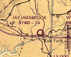
Ash Fork Airport / Jay Hasbrook Airport / Santa Fe Airport, Ash Fork, AZ
35.231, -112.49 (Northwest of Phoenix, AZ)
Ash Fork Airport, as depicted on the September 1968 Prescott Sectional Chart.
Dan Lawler reported that in a phone conversation with the person responsible for the Acheson, Topeka, and Santa Fe Railroad's land leases,
“He told me the original use of the site for aircraft operations dated all the way back to the World War One era
when Ash Fork was still a major stop along the rail line, and still contracted with a 'Harvey House' lodge.
I remember him using the phrase, '...one of the earliest landing fields in the country'."
[Note that this Ash Fork Airport north of the town was a separate airfield from the original Ash Fork Intermediate Field,
located a few miles to the west of the town.]
The Ash Fork Airport north of the town was not yet depicted on the September 1967 Prescott Sectional Chart.
The earliest depiction which has been located of this Ash Fork Airport was on the September 1968 Prescott Sectional Chart.
It depicted Ash Fork Airport as having a 3,400' unpaved runway.
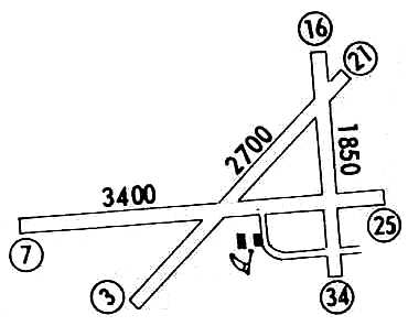
The 1972 Flight Guide (courtesy of Chris Kennedy) depicted Ash Fork as having 3 unpaved runways (with the longest being the 3,400' Runway 7/25)
and 2 small buildings (hangars?) south of the runway intersection.
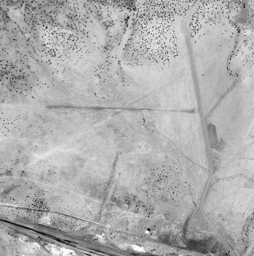
The earliest photo which has been located of Ash Fork Airport was a 4/2/72 USGS aerial view, which depicted 3 unpaved runways & a few small buildings.
Dan Lawler recalled, "In the summer of 1975 I was beginning to set up my business, Air Grand Canyon.
I was seeking a location along the US 66 / Interstate-40 corridor from which to conduct commercial Grand Canyon air tours.
Since at that time the AZ Corporation Commission required a flight operator to obtain a certificate from them,
and would almost never issue one where another operator was already in business,
most of the otherwise prime locations like Williams & Flagstaff were effectively ruled out."
Dan continued, "Ash Fork, however, had no operator, and was a location from which a one-hour round-trip air tour could be conducted.
Having flown over the town I had seen the old dirt runways,
and through some local inquiries I determined that the airport was on land owned by the Acheson, Topeka, and Santa Fe Railroad."
Dan continued, "With a phone call to the Santa Fe headquarters in Chicago I began the particularly lengthy process of leasing the airport land from them.
I learned from Santa Fe’s guy in charge of land-leases that the land was then being used for cattle grazing, and had been since the 1950's."
Ash Fork Airport was listed as an active airfield in the 1976 AOPA Airport Directory (according to Chris Kennedy).
It was depicted as Santa Fe Airfield on the June 1976 Phoenix Sectional Chart (according to David Brooks).
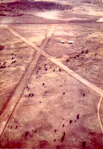
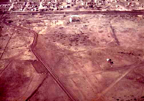
An April 1976 aerial view by Dan Lawler looking east at the Ash Fork Airport.
"The runways had at some time in the past received some well done grading, and were crowned, and still drained effectively.
[Runway] 7/25 had quite an up-slope toward the west."
An April 1976 aerial view by Dan Lawler looking south at the Ash Fork Airport.
Dan Lawler continued, "There was a small very run-down open-front hangar & a big shack on the airport property,
along with several piles of old lumber & debris.
A local guy told me the buildings had been erected in the post-war 1940s.
By 1977 the hangar was ratty, but if you had a 'third-world' mindset, it was still usable for a single-engine airplane.
The shack on the other hand, while nearly as large as the hangar, was so tumble-down it wasn’t even safe to walk into."
Dan continued, "Brahma cattle roamed the runways at will, leaving an incalculable number of cowpies,
and the whole property was pockmarked with prairie dog holes.
Of the 3 runways, 16/34 was rutted to the point of being not usable,
but the other 2 runways were still marginally serviceable rough dirt.
That summer, after first driving them several times in my car, I landed there in a Cessna 210, a Cessna 172, and a Piper Warrior."
Dan continued, "That September my step-brother, Jay Hasbrook,
was killed in a sailplane accident in the Sierra Estrella mountains southwest of Phoenix
(Jay was a commercial pilot & flight instructor, the son of aviation safety expert Howard Hasbrook).
I was the one who had the airport renamed in his honor,
simply by sending a letter to the AZ Department of Transportation’s Aeronautics Division."
Dan continued, "As the lease negotiations with Santa Fe dragged on, a different opportunity presented itself.
A Floridian named Carl Antone contacted me about helping to develop an airport
on property he owned south of the town of Ash Fork.
Carl convinced me to abandon the frustrating effort to secure the old Santa Fe airport,
and we cooperated in creating a 4,300’ black cinder airstrip on his property.
I’ll always fondly remember that first abortive start at the old Santa Fe Airport at Ash Fork."
Air Grand Canyon finally began sightseeing flights from this new Jay Hasbrook airfield in the summer of 1977,
but their operations at that location lasted less than a year, after the new runway was destroyed in a flood.
Air Grand Canyon eventually moved to the Williams Airport,
and finally to the Grand Canyon Airport, where it was the airport's 2nd largest fixed-wing air tour operator in 2004.
The July 1977 World Aeronautical Chart (courtesy of Chris Kennedy) depicted the "Jay Hasbrook" Airport as having a 3,400' unpaved runway.
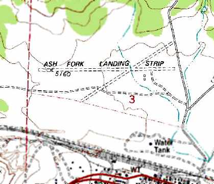
The 1979 USGS topo map depicted the “Ash Fork Landing Strip” as having 2 unpaved runways,
with 2 small buildings just southeast of the runway intersection.

The last aeronautical chart depiction which has been located of Santa Fe Airfield
was on the November 1980 Phoenix Sectional Chart (courtesy of David Brooks).
It depicted Santa Fe as a private airfield with a 3,400' unpaved runway.
The Santa Fe Airfield was evidently closed (for reasons unknown) at some point between 1980-81,
as it was no longer depicted on the 1981 Phoenix Sectional Chart (according to David Brooks) or later aeronautical charts.
In the 1992 USGS aerial photo, the outlines of Runways 7/25 & 3/21 were still apparent,
but not a trace appeared to remain of Runway 16/34, or any buildings at the site.

A 2023 aerial photo showed traces of all 3 Ash Fork Airport runways remained apparent.
The Ash Fork Airport is located northwest of the intersection of Double A Ranch Road & Railroad Avenue.
____________________________________________________
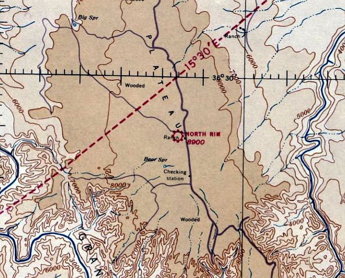
Grand Canyon North Rim Airport / V.T. Park Airport / V T Park STOLport (L42, NGC), North Rim, AZ
36.388, -112.132 (North of Grand Canyon, AZ)
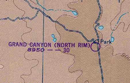
"Grand Canyon (North Rim)" Airport, as depicted on the September 1937 Grand Canyon Sectional Chart.
Photo of the airport while open has not been located.
Steven Sund recalled, "There was an airstrip at the Grand Canyon's north rim
presumably to connect the more remote north rim with the south rim villages.
It was on the west side of the main access road & was possibly operated by the US Forest Service."
The date of construction of the North Rim / V.T. Park Airfield has not been determined.
The Grand Canyon North Rim Airport was not yet depicted on the December 1936 Grand Canyon Sectional Chart.
The earliest reference which has been located of this airfield came from Mike Mauer,
who reported that George Dock wrote of a 1936 trip to the north side: “We took the airplane ride of 80 miles from V.T. Park.”
The Grand Canyon North Rim Airport was not yet listed among active airfields in The Airport Directory Company's 1937 Airport Directory (courtesy of Bob Rambo).
The earliest depiction which has been located of the Grand Canyon North Rim Airport was on the September 1937 Grand Canyon Sectional Chart.
It depicted North Rim as a commercial/municipal airport.
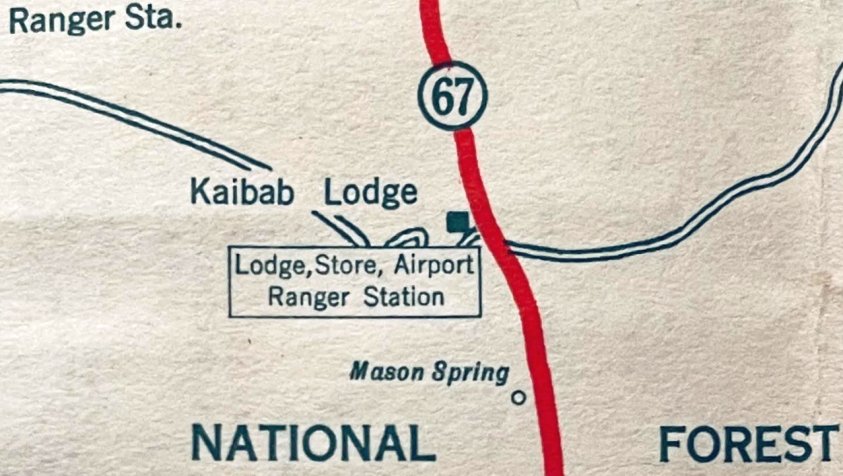
A 1938 road map (courtesy of Kevin Walsh) labeled the Grand Canyon North Rim “Lodge, Store, Airport, Ranger Station”.
The earliest airport directory listing which has been located of the Grand Canyon North Rim Airport
was in The Airport Directory Company's 1938 Airport Directory (courtesy of Chris Kennedy).
It described Grand Canyon North Rim as a commercial airport located 18 miles north of Canyon Rim.
It was said to have 2 runways: 3,800' north/south & 2,500' northeast/southwest.
The Grand Canyon North Rim Airport was described in the same fashion
in The Airport Directory Company's 1941 Airport Directory (according to Chris Kennedy).

The only photo which has been located showing an aircraft at the Grand Canyon North Rim Airport was a circa 1930s photo (photographed in 2024 by Peter on the wall of the Kaibab Lodge)
showing a Stinson SM-2AB, NC455H, S/N 1098 parked in front of the Lodge.
The Grand Canyon North Rim Airport was apparently closed for a few years during WW2
(like many other small civilian airports),
as it was not depicted at all on the February 1944 Grand Canyon Sectional Chart (according to Chris Kennedy)
or listed among active airports in the April 1944 US Army/Navy Directory of Airfields (courtesy of Ken Mercer)
or the 1945 AAF Airfield Directory (courtesy of Scott Murdock).
The Grand Canyon North Rim Airport was evidently reopened at some point between 1945-49,
as it was depicted on the March 1949 Grand Canyon Sectional Chart (courtesy of Chris Kennedy).
It depicted "Grand Canyon (North Rim)" Airport as having a 3,000' unpaved runway.
The Grand Canyon North Rim Airport was evidently closed again (for reasons unknown) at some point in the next 4 years,
as it was no longer depicted at all on the September 1953 Grand Canyon Sectional Chart (courtesy of Chris Kennedy)
or subsequent aeronautical charts.
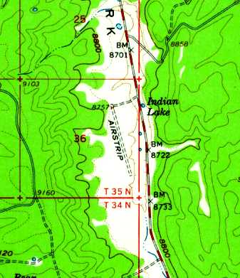
The 1962 USGS topo map continued to depict a single unpaved northwest/southeast runway, labeled simply as "Airstrip".
The 1968 AOPA Airport Directory (according to www.airfields.database) listed this field as “V.T. Park”, with a 3,500' dirt Runway 15/33.
The North Rim / V.T. Park Airport was no longer depicted on the 1971 Grand Canyon Sectional Chart (courtesy of Vince Granato).
A single 3,400' northwest/southeast runway was still depicted on the 1984 USGS topo map, labeled simply as "Landing Strip".
The 1985 FAA Airport/Facility Directory (courtesy of Kevin Walsh) listed “V T Park STOLport” as a public-use airport having a single 3,500' dirt Runway 17/35.
It was still listed as V.T. Park Airport in the 1986 AOPA Airport Directory (according to www.airfields.database).
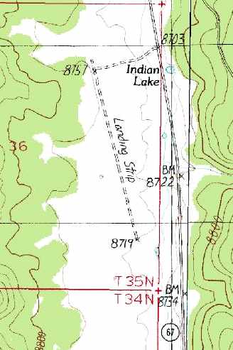
The 1988 USGS topo map continued to depict a single 3,400' northwest/southeast runway, labeled simply as "Landing Strip".
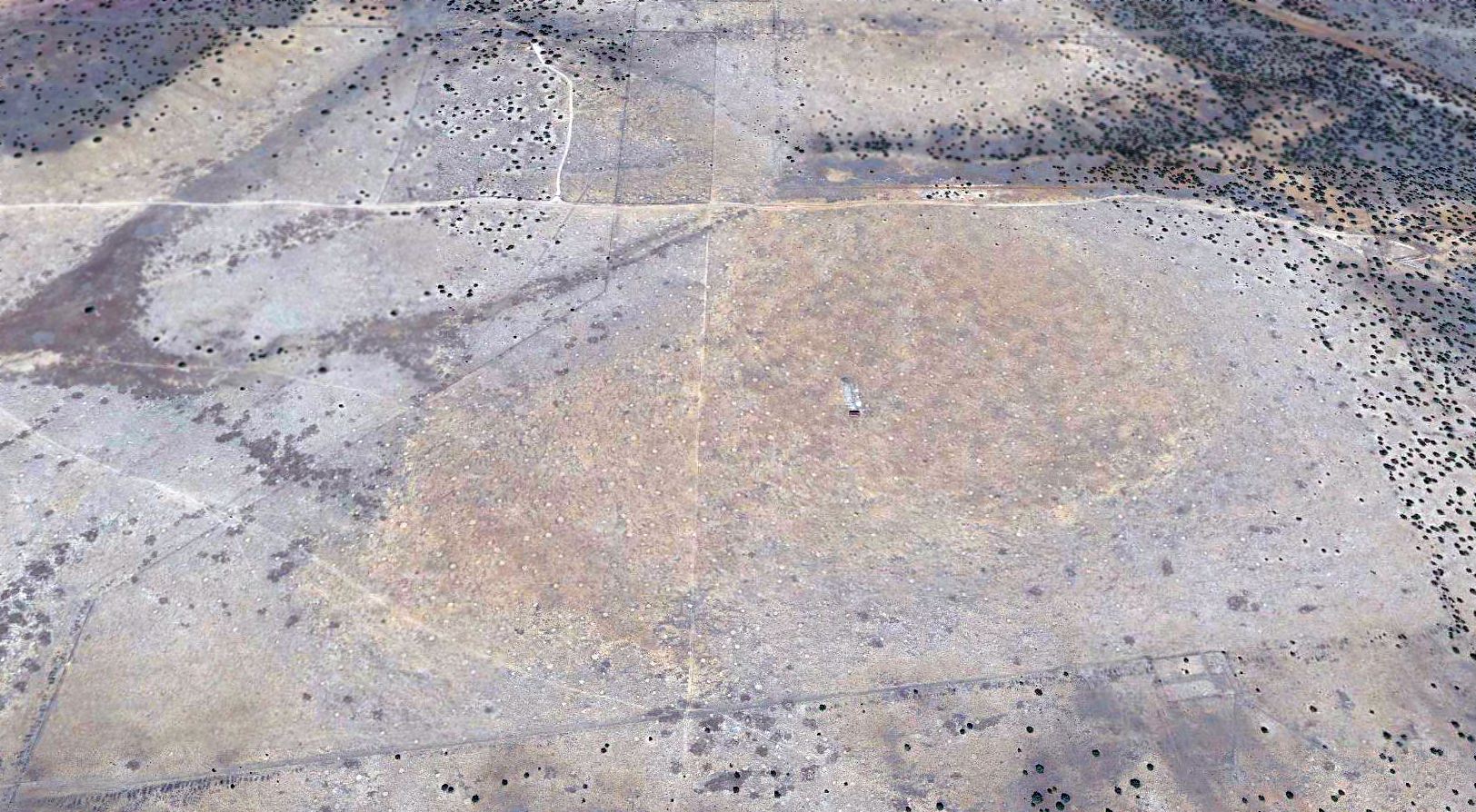
The remains of the single runway at North Grand Canyon was still quite apparent in a 1992 USGS aerial view looking northwest.
There did not appear to be any remains of any buildings at the site.
A 2014 aerial view looking northwest at the remains of the Grand Canyon North Rim Airport's runway.

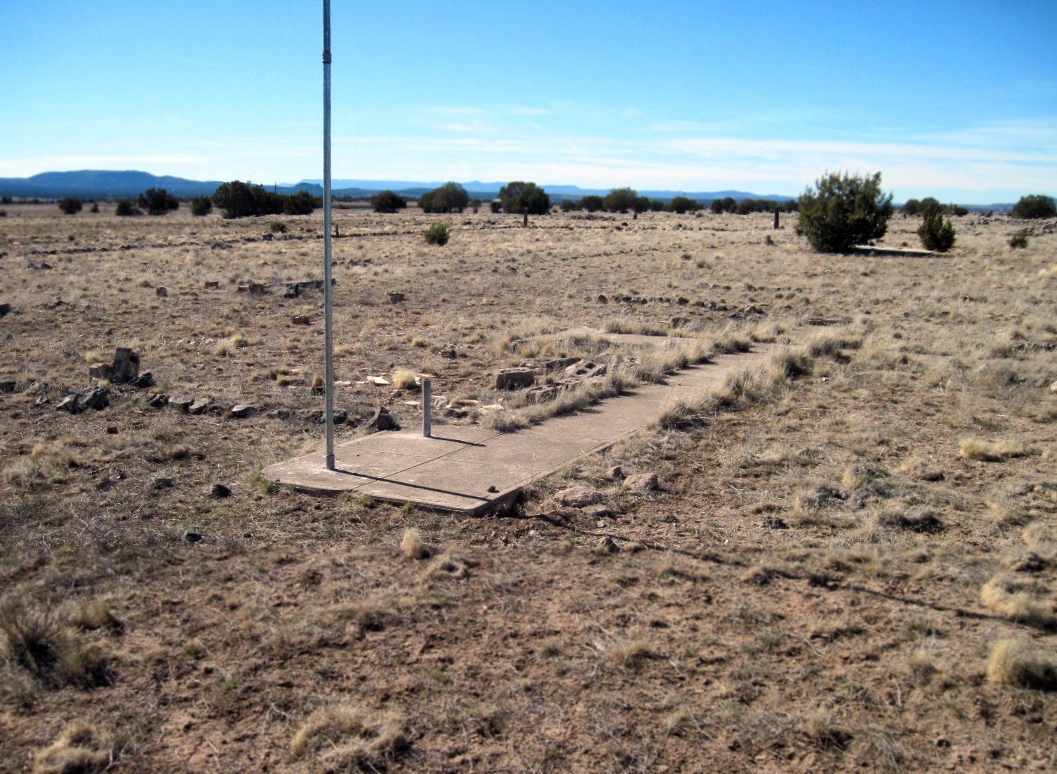
A 10/7/24 photo by Peter Steinmetz looking west at Grand Canyon North Rim Airport's Runway 17/35 as seen from Highway 67.
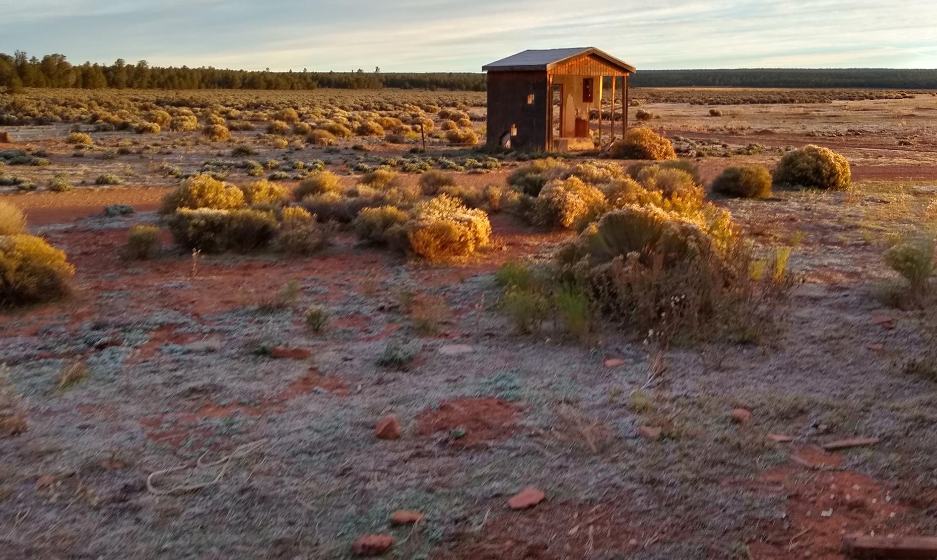
Peter Steinmetz visited the Grand Canyon North Rim Airport site on 10/7/24, and reported,
“One can still see this old airstrip from the road & walk out to view the runways & several artifacts.
It is located near the
middle of Demotte Park, west of AZ Highway 67, 1.5 sm south of the
Kaibab Lodge & 0.8 sm south of FR 22.
The primary runway
is now oriented 17/35 & is 3,400' long, counting an extension
south of a junction which contains a relatively flat clear area.
Runway 35 has about an average 4 degree uphill slope with a steeper more-worn section in the middle.
The northern & southern 1/3 north of the junction might be landable in a tailwheel with tundra tires, though there are several small pine trees growing in it.
There is an older more-faded runway from this junction oriented 5/23 which is 1,800' long & somewhat flatter. It is hard to see on the ground.
There is also what
appears to be an old approach road from Highway 67 to the north
end.
The cleared area around the junction contained an old
bottle which had the letter 'W' on it.”

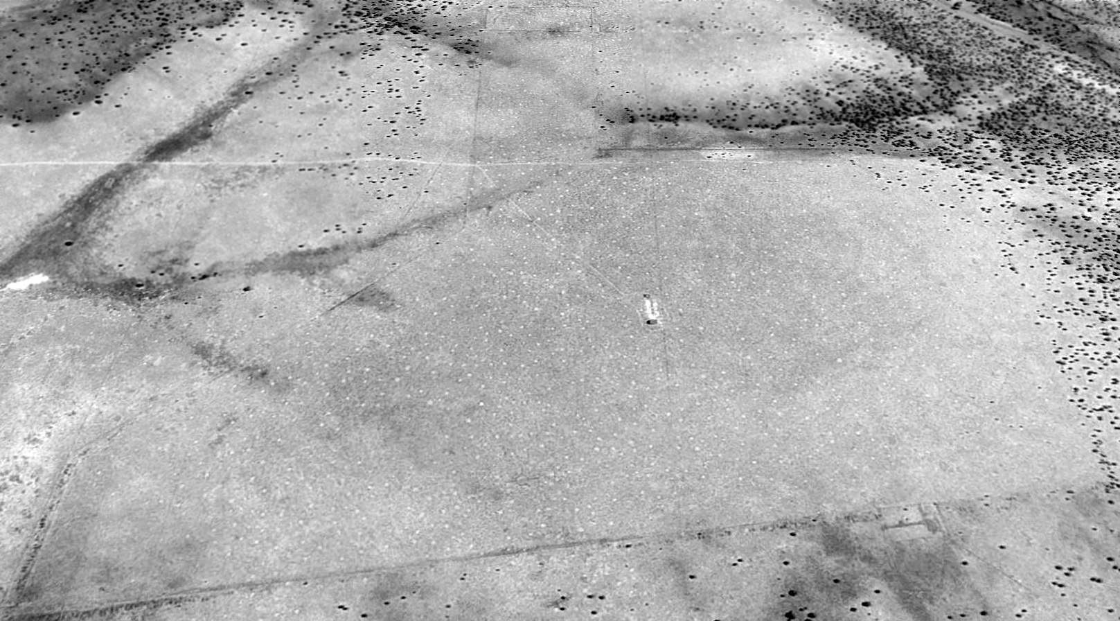
A 10/7/24 photo by Peter Steinmetz of the north side of the Grand Canyon North Rim Airport site,
where Peter observed “The northern end was quite a bit more interesting & had a cross made of 4 concrete rectangles.
These were oriented on 176 & 37 magnetic headings, so not quite square.”

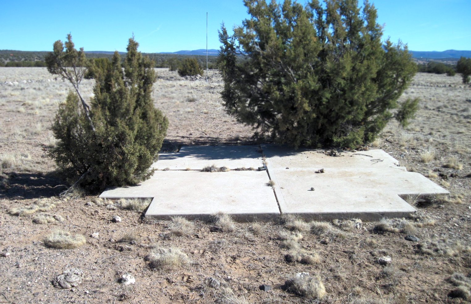
A 10/7/24 photo by Peter Steinmetz of the north side of the Grand Canyon North Rim Airport site, of a hoop for a windsock lying on the ground next to the concrete cross.

A 10/7/24 photo by Peter Steinmetz of the north side of the Grand Canyon North Rim Airport site, where Peter observed “On the east side were 3 pillow-shaped concrete blocks of uncertain function (maybe tie-down anchors?).”
The Grand Canyon North Rim Airport is located along the west side of Route 67, just south of the Kaibab Lodge.
____________________________________________________
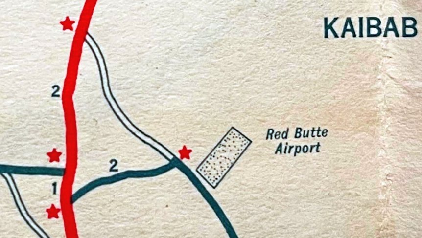
Red Butte Airport / Grand Canyon Airport, Tusayan, AZ
35.852, -112.09 (South of Grand Canyon, AZ)
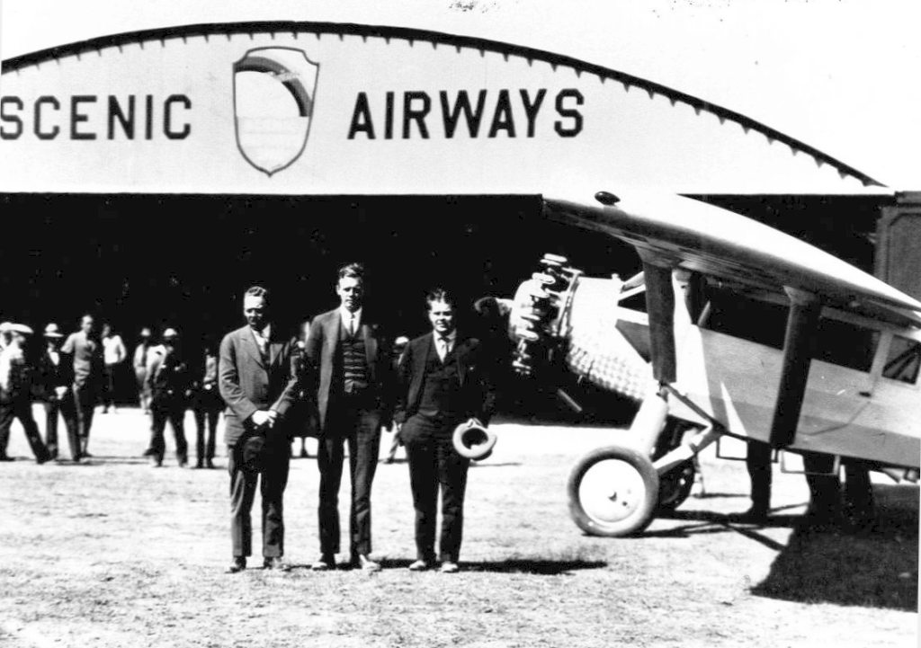
An April 1928 photo of Charles Lindbergh, 2 of his backers, and his Ryan B-1 Brougham in front of the Scenic Airways hangar at Grand Canyon Red Butte Airport.
In 1927, former WW1 Army flyer, entrepreneur & promoter Parker Van Zandt
created a runway across a northern Arizona meadow at a place called Red Butte,
built a hangar, and launched the first commercial air tours over the nearby Grand Canyon.
His Scenic Airways was bankrolled by some of the biggest names in American business (such as Henry Ford).
Its first flights carried National Park Service & Fred Harvey Company officials over the Canyon in a Stinson Detroiter.
Scenic Airways flew its first paying sightseers over the Grand Canyon in April 1928,
a month later bringing online the first of more than a dozen AT-4 & AT-5 Tri-Motors purchased from the Ford Motor Company.
In addition to a large hangar at Red Butte, 4 cottages & a Great House were built.
The Great House was of the same quality as the El Tovar Lodge.
Grand Canyon Red Butte Airport had a very famous visitor in April 1928,
as documented by a photo of Charles Lindbergh, 2 of his backers, and his Ryan B-1 Brougham in front of the Scenic Airways hangar at Red Butte.
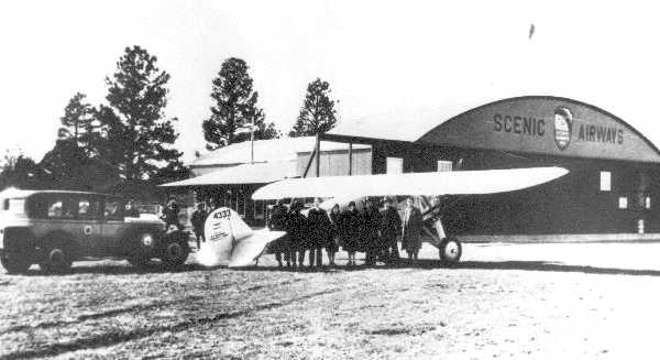
An April 1928 photo of Charles Lindbergh's Ryan B-1 Brougham in front of the Scenic Airways hangar at Grand Canyon Airport.
The Standard Oil Company's 1929 "Airplane Landing Fields of the Pacific West" (courtesy of Chris Kennedy)
described the Grand Canyon Airport as being operated by Scenic Airways.
The airfield was said to measure 9,250' x 3,700', with a sandy loam surface, with the entire field available for landings.
A T-shaped hangar, marked "Scenic Airways" in front, was said to be at the northwest corner of the field.
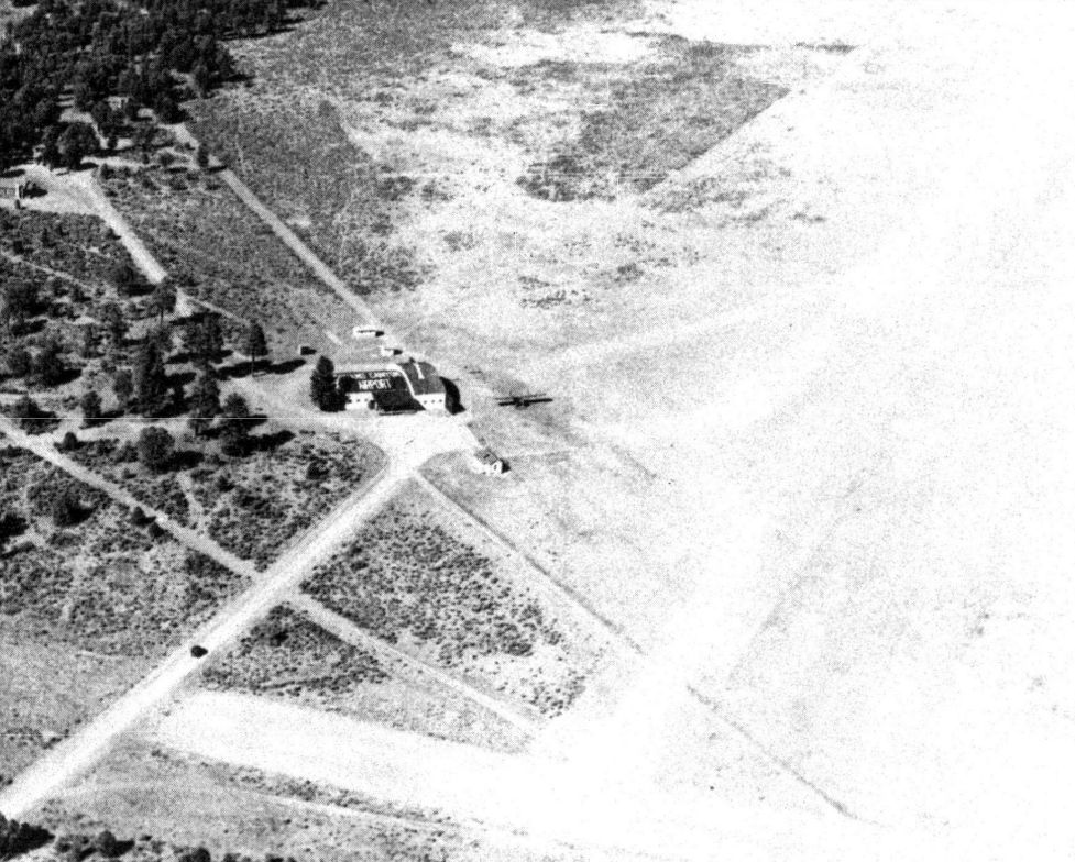
depicted a plane next to the hangar on the west side of Grand Canyon Airport, with the airport's name marked on its roof.
The onset of the Great Depression spelled the end for overextended Scenic Airways.
By 1930, Scenic’s assets, including the Red Butte Airport & its maintenance hangar, along with 17 aircraft had been sold off.
A group headed by one Jack Thornburg bought the Canyon tour operation & reopened the Red Butte airport for the 1931 summer season,
flying as Grand Canyon Air Lines using a three-engine Bach & a Curtiss Robin.
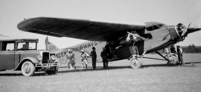
A circa 1930s photo of a Scenic Airways Ford Trimotor.
From 1931 onward - except for WW2 when pleasure flying was suspended -
the aerial tour service has operated from the South Rim under several names.
In the mid-1930s the airline enjoyed a symbiotic relationship with Transcontinental & Western Air,
with side trips to the Canyon from TWA stops at Winslow, AZ, to the Red Butte field via Ford Tri-Motor.
A winter 1935 view of a snowy scene of the Grand Canyon Airlines hangar at Red Butte.
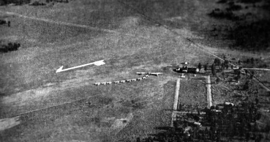
An aerial view of the "Grand Canyon Airport" from The Airport Directory Company's 1937 Airports Directory (courtesy of Bob Rambo).
The directory described "Grand Canyon Airport" as having 2 sod landing strips, with the longest being an 8,000' northeast/southwest runway.
The aerial photo in the directory depicted a single hangar along the west side of the field, as well as a total of 12 aircraft parked on the field.
A description of Grand Canyon Airport in the 1930s is provided in Giacinta Koontz's book “The Original Grand Canyon Airport”.
A 1938 road map (courtesy of Kevin Walsh) depicted Red Butte Airport as a rectangular property outline.

showed an American Airways Douglas DC-3 & A Grand Canyon Airlines Travel Air A-6000A in front of the Grand Canyon Airport hangar.
Things hummed along until WW2. Some sources indicate that only military flights flew out of the Red Butte Airfield from 1942-45.
However, the field may have been closed at some point during the war
(as was the case with many other small civilian airports),
as no airfield was depicted at Red Butte on the 1945 Prescott Sectional Chart (courtesy of Chris Kennedy)
nor listed among active airfields in the 1945 AAF Airfield Directory (courtesy of Scott Murdock).
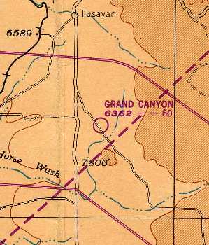
It evidently reopened at some point between 1945-49, as "Grand Canyon" Airport was depicted on the 1949 Prescott Sectional Chart (courtesy of John Voss).
It was described as having a 6,000' unpaved runway.
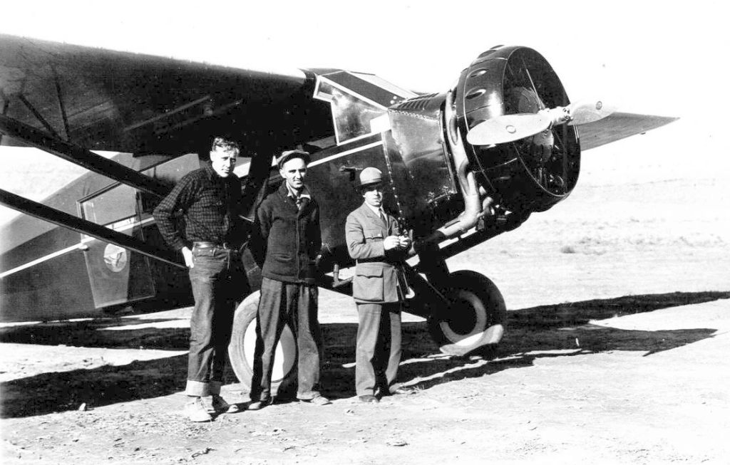
In 1951 civil aviation began again at Red Butte with the Hudgins brothers.
The Aerodromes table on the 1956 Prescott Sectional Chart (courtesy of John Voss)
described "Grand Canyon (South Rim)" as having 2 unpaved runways, with the longest being 6,000'.

The 1956 USGS topo map depicted Grand Canyon Airport as having 2 perpendicular runways with 2 buildings on the west side of the field.
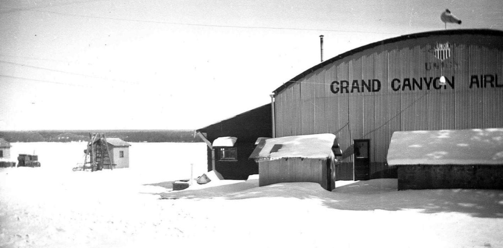
Since 1957, the airline service at the field has been called Grand Canyon Airlines, Inc.
Grand Canyon Airport was still depicted as an active airfield
on the August 1962 USAF Operational Navigation Chart (courtesy of Chris Kennedy).
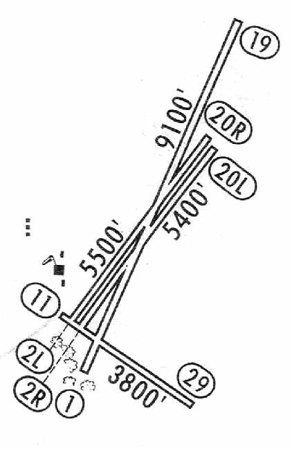
The 1964 Jeppesen Manual (courtesy of Chris Kennedy)
depicted the Grand Canyon Airport as having a total of 4 runways, including parallel Runway 2L/20R & 2R/20L.
The longest runway was the 9,100' Runway 1/19.
Several small buildings were depicted along the west side of the field.
By the time of the January 1966 USAF Operational Navigation Chart (courtesy of Chris Kennedy),
the original Red Butte / Grand Canyon Airport had been closed,
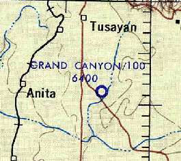
after it was replaced by the new Grand Canyon National Park Airport, built 13 miles to the northwest in Tusayan.
All of the structures at the Red Butte Airport (the hangar, 4 cottages & the Great House)
either burned down or were taken down by the 1970s.
The airfield was not depicted at all on the 1970 USGS topo map.
Mike Borck recalled, “The Grand Canyon Airport on the South Rim... I grew up there.
We were ranchers; I moved there in 1972, I was 7 years old.
We used the hangar as a barn, when we first moved there we lived in the north side of the duplex,
Mason Meeks & his wife, the ranch foreman at the time lived in the house that burnt down.
Mr. Meeks retired & we moved into the bigger house, the one that burnt down years after I left home for the Marine Corps in 1982.
My Mom Delma & step Dad Marion 'Sonny' Wallmark stayed on at the hangar as 10 x & 77 Bars Ranches for several more years.
My brother & I while carrying water to some of our animals witnessed this plane crash, tail number N2541W, in April of 1976 out on the old runway.
When we first moved there hanging on the wall of the hangar was what I was told were a pair of ailerons for a biplane.
The hangar was in very good shape in the days when we were there.
Sad to see but it looks to have really taken a beating since we left.”
At the site of Red Butte Airport, the 1980 USGS topo map depicted 3 runways, labeled simply "Landing Field".
It also depicted the oval driveway (west of the runways) of the former airport terminal.
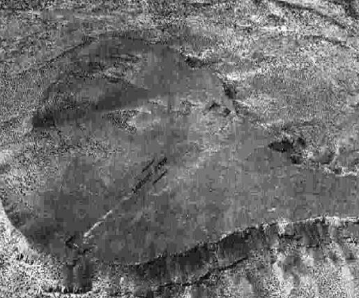
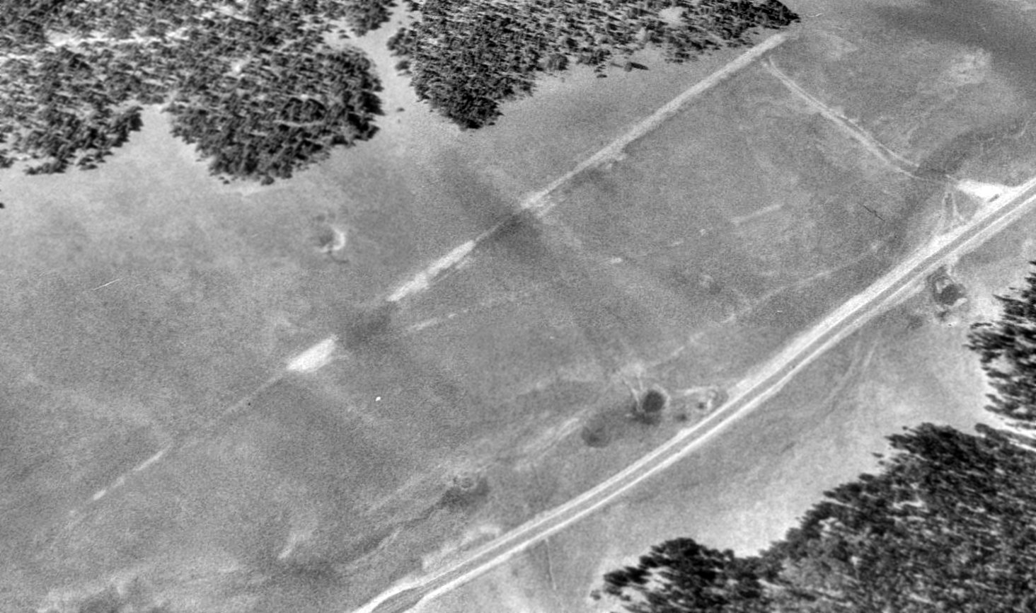
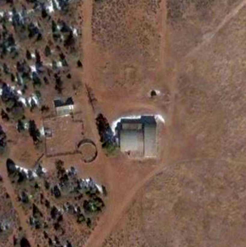
The outlines of Red Butte Airport's 3 former runways were still barely perceptible in a 1992 USGS aerial view looking northeast,
as well as the oval driveway of the former airport terminal (on the west side of the field).
The former hangar was also still visible, at bottom-left.
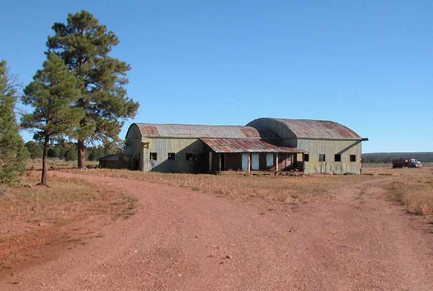
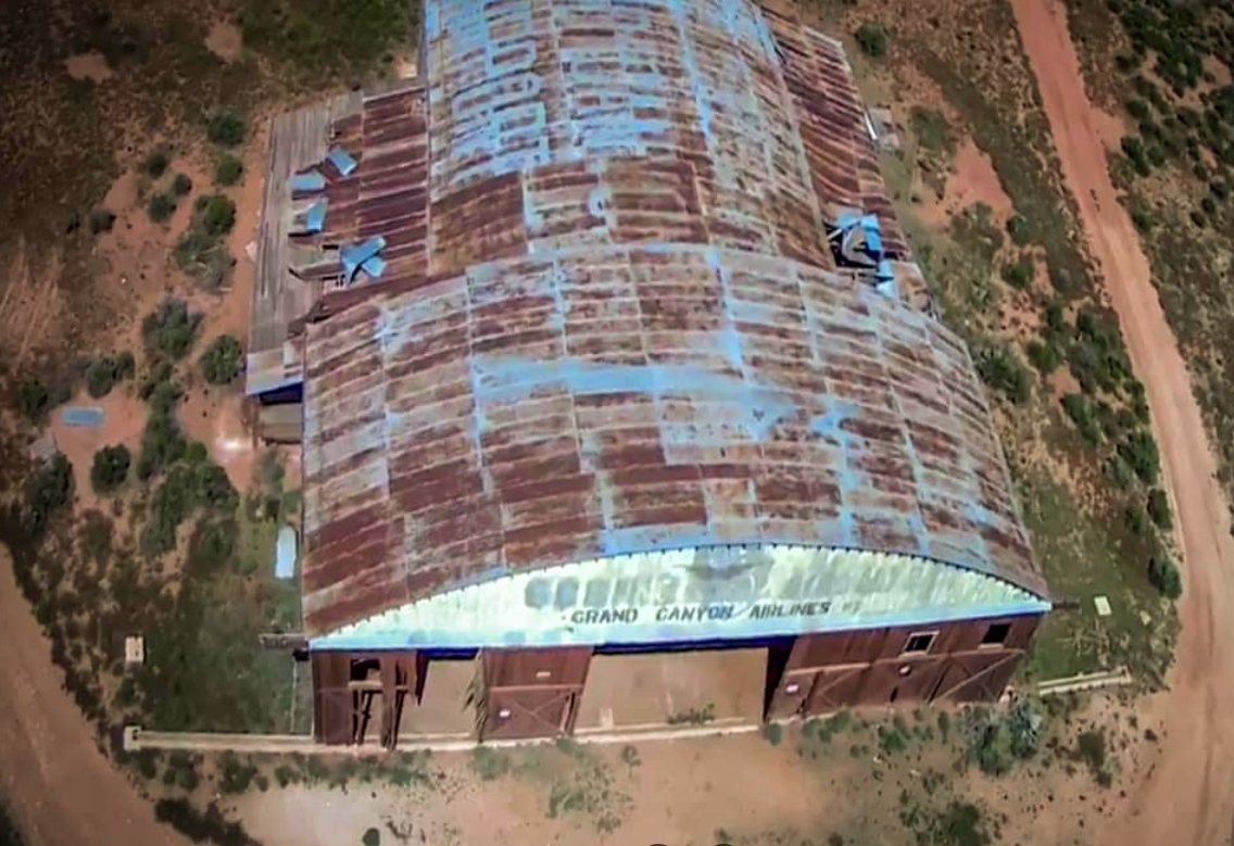
A September 2004 photo by Chris Kennedy of the hangar which remains standing at the site of the Old Grand Canyon Airport.
Chris observed: "The site is actually in a wooded area (except for what was the runway area, which is cleared)
down a short dirt road which starts about 2 miles down a good gravel National Forest road.
I think it's private property, although the road into it was not posted as private, or I wouldn't have gone down it.
There were a bunch of trucks parked near the hangar building, so somebody is using the property for something.
I couldn't tell in my brief visit if the building itself was still in use."
As of 2005, it was reported that the entire Red Butte Airport property (850 acres) was owned by the U.S. Forest Service, which leased the property to ranchers.
Until 2005, this historic site was used for cattle, horses and other ranching commerce, resulting in considerable neglect and vandalism to the site.
Toxic waste accumulated & buildings either burned down or were torn down. Souvenir hunters removed artifacts left unguarded.
Giacinta Koontz is the Director of the Red Butte Aerodrome Preservation Project.
She has been preparing a nomination to place Red Butte on the National Register of Historic Places.
Giacinta reported in 2005, “The buildings are privately owned.
The buildings sit upon land owned by the Forest Service (Kaibab National Forest).
After the rancher's land use permit to graze cattle expired he sold the buildings to the new owners (my employers) last February 2005.
The Forest Service had plans to knock everything down (the bulldozer was sitting outside the bungalow)
when the new owners stepped in & halted that demolition.”
A closeup from the circa 2006 aerial view showing the hangar which remains standing at the site of the Grand Canyon Red Butte Airport.

A 2007 Interior Department National Historic Places nomination form (courtesy of Noah Rechtin)
depicted Grand Canyon Airport as having 2 runways & the hangar & other buildings on the west side.
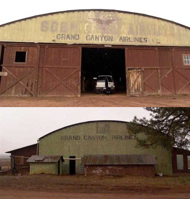
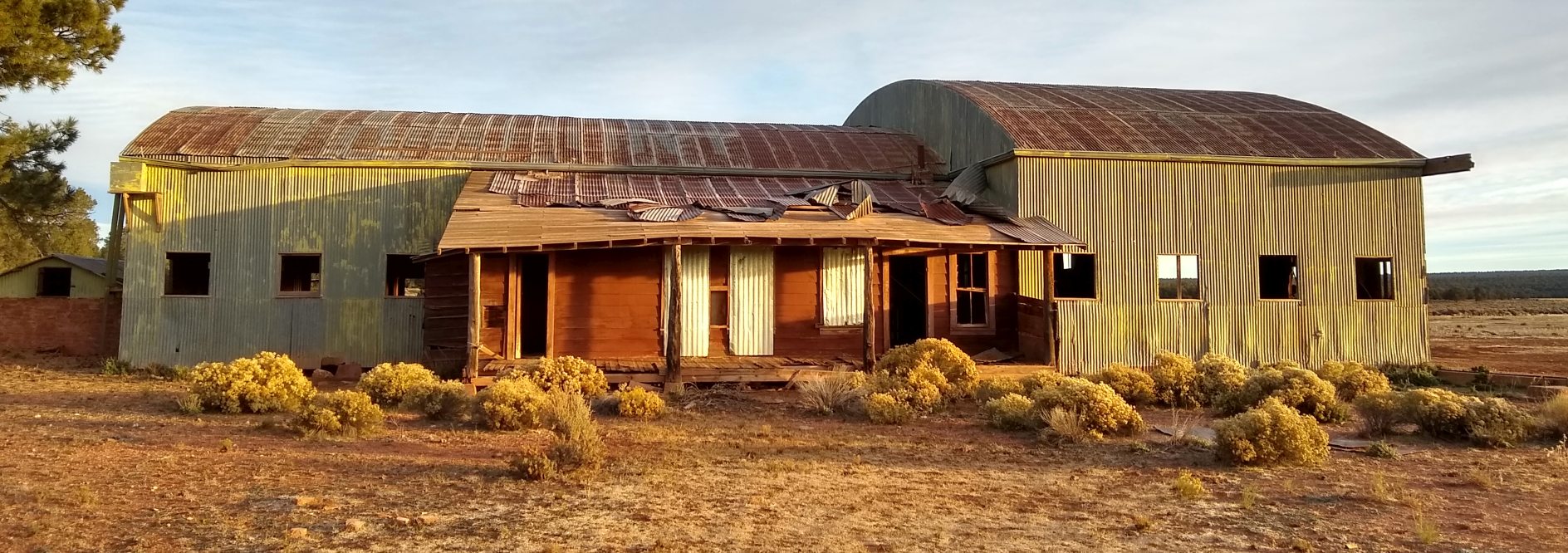
A pair of pre-2008 photos of the front & rear of the 70-year-old hangar
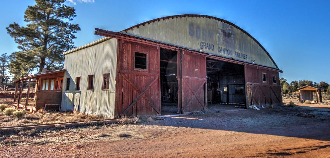
which remains standing at Grand Canyon Red Butte Airport (courtesy of Bob Wilson).
The lettering “Grand Canyon Airlines” still remains on both the front & back,
whereas the “Scenic Airways” lettering was evidently removed (but still readable) from the front of the hangar.
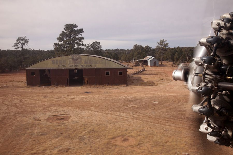
A circa 2008 aerial view looking southwest at the Red Butte Airport hangar by Barry Schiff.
Barry recalled, “When I was training for my Ford Trimotor type rating at the Valle Airport just south of the Grand Canyon Airport,
I got to do some low flying in the area & discovered an ancient airport used by TWA when it & then Grand Canyon Airlines served the Grand Canyon in the 1920s & 1930s.
The photo is when I flew low & abeam the old hangar still remaining; the photo speaks for itself.”
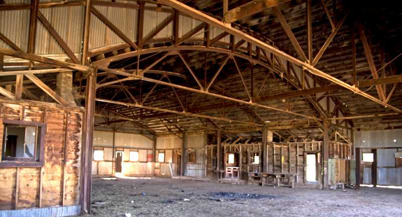
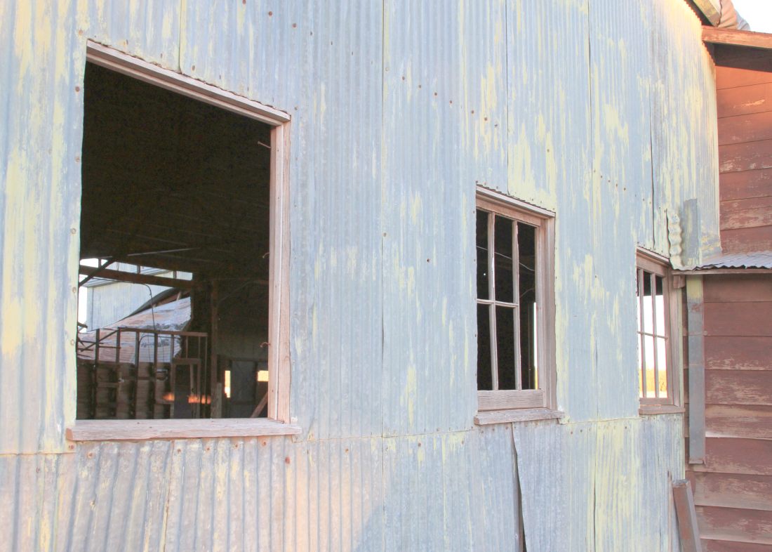
A circa 2008 photo of the interior of the 70-year-old hangar which remains standing at Grand Canyon Red Butte Airport.
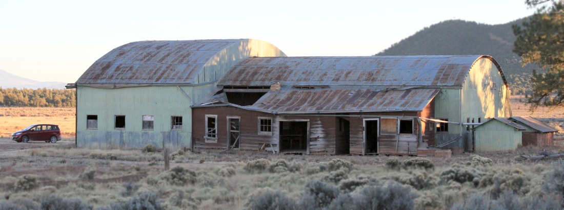
A November 2012 photo by Jim Jordan of the 80+ year-old hangar which remains standing at Grand Canyon Red Butte Airport.
A November 2012 photo by Jim Jordan of the 80+ year-old hangar which remains standing at Grand Canyon Red Butte Airport.
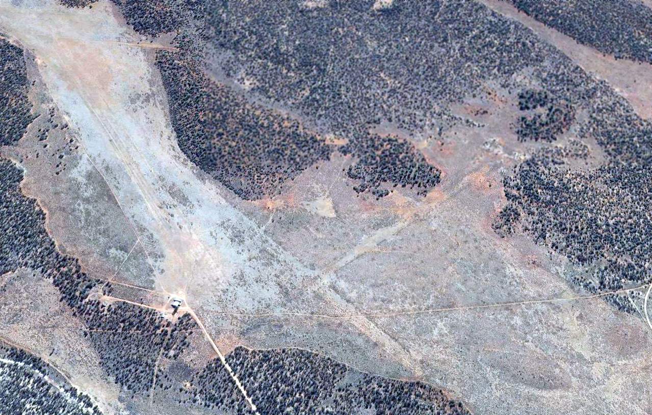
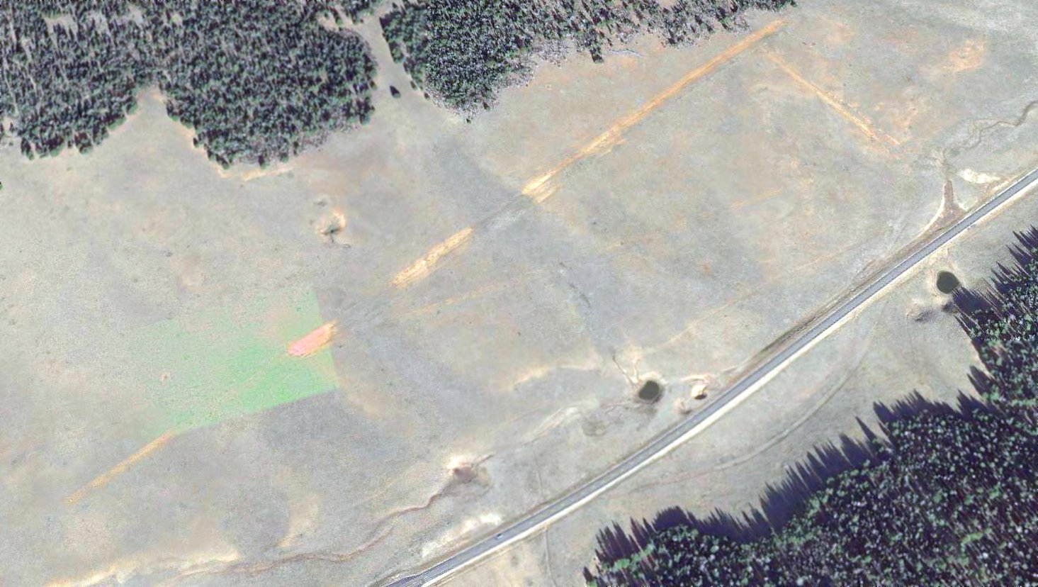
A 2014 aerial view looking northeast showed the Grand Canyon Red Butte Airport remained in an unchanged state.
A 2/8/15 photo by Paul Griffiths of Lost Viking Photography of the 80+ year-old hangar which remains standing at Grand Canyon Red Butte Airport.
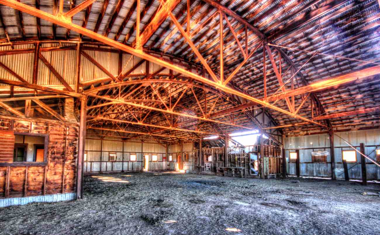
An evocative 2/8/15 photo by Paul Griffiths of Lost Viking Photography of the interior of the Grand Canyon Red Butte Airport hangar.
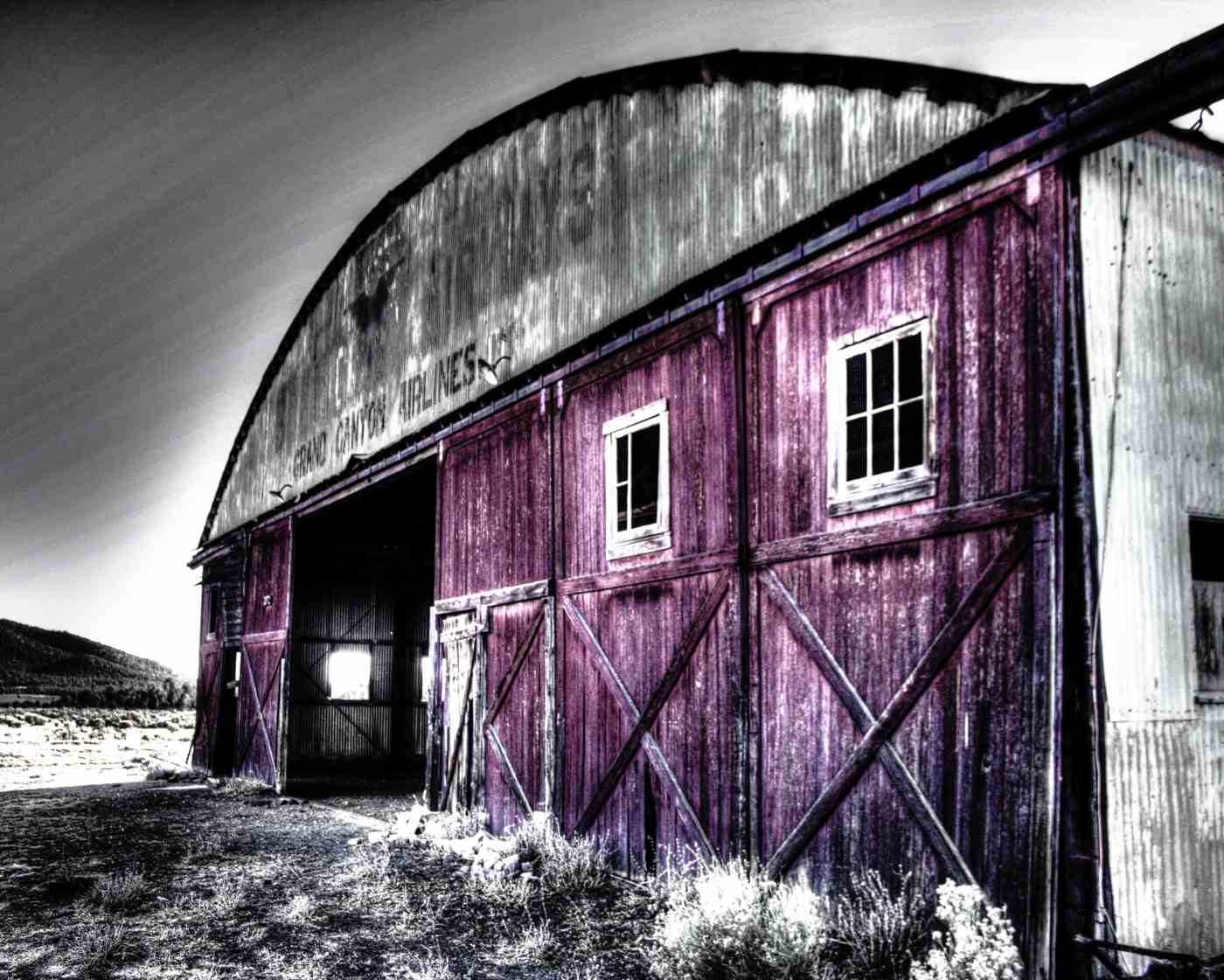
A retouched 2/8/15 photo by Cassy Borg of the 80+ year-old hangar which remains standing at Grand Canyon Red Butte Airport.
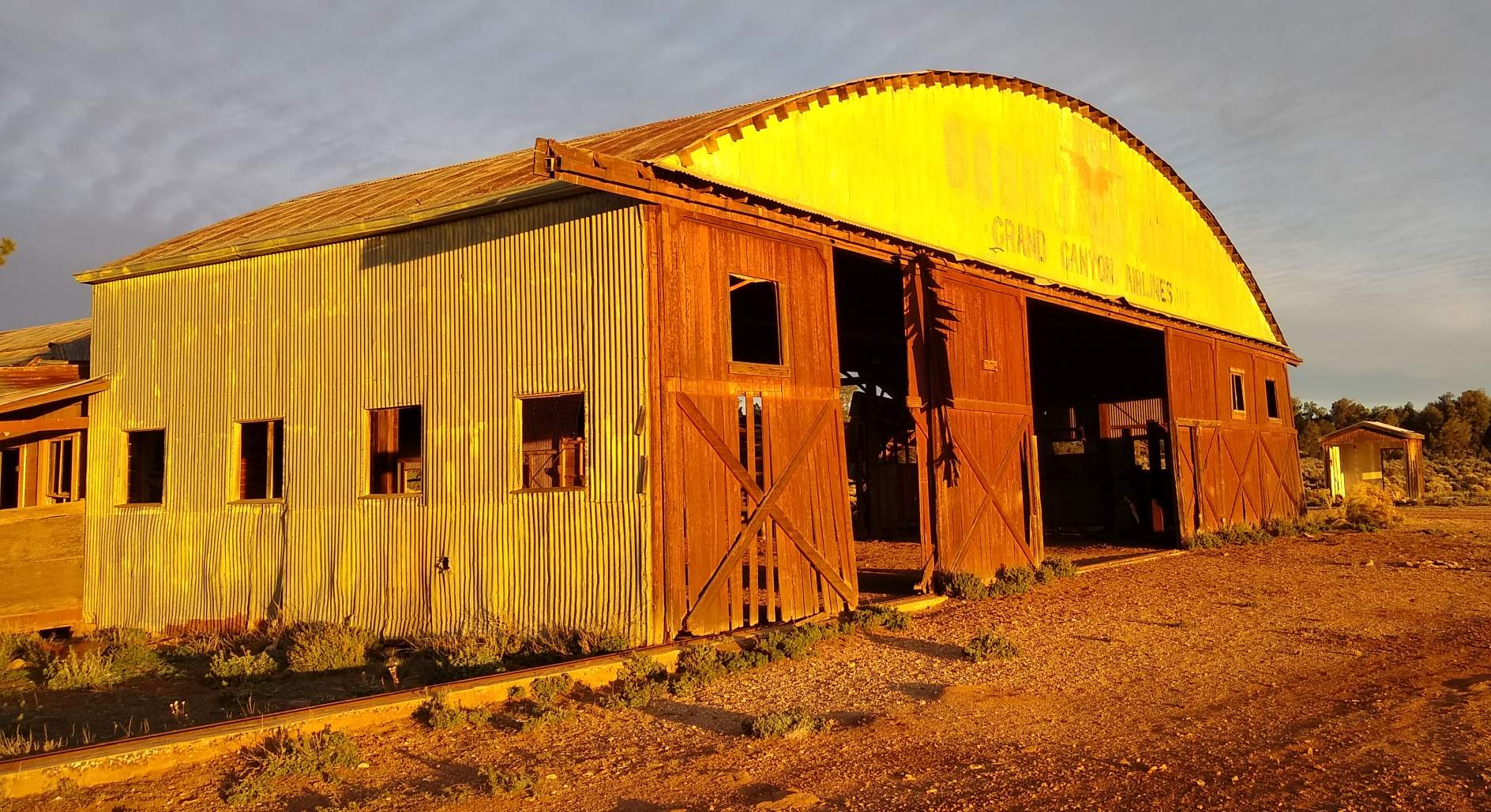
A 2018 photo by Michael LaRose of the front of the 80+ year-old hangar which remains standing at Grand Canyon Red Butte Airport, still bearing the “Grand Canyon Airlines” lettering.
Michael reported, “It was the golden hour so the colors haven't been touched by anything other than the sun.”
A 2018 photo by Michael LaRose of the side of the 80+ year-old hangar which remains standing at Grand Canyon Red Butte Airport.
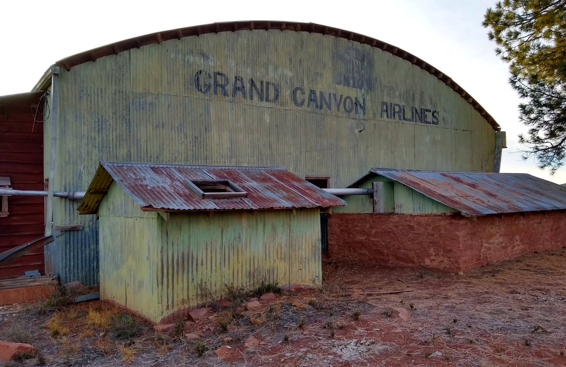
A 2018 photo by Michael LaRose of the rear of the 80+ year-old hangar which remains standing at Grand Canyon Red Butte Airport, still bearing the “Grand Canyon Airlines” lettering.
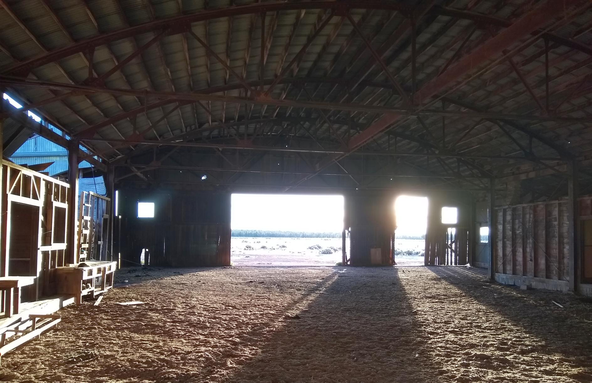
A 2018 photo by Michael LaRose of the interior of the 80+ year-old hangar which remains standing at Grand Canyon Red Butte Airport.
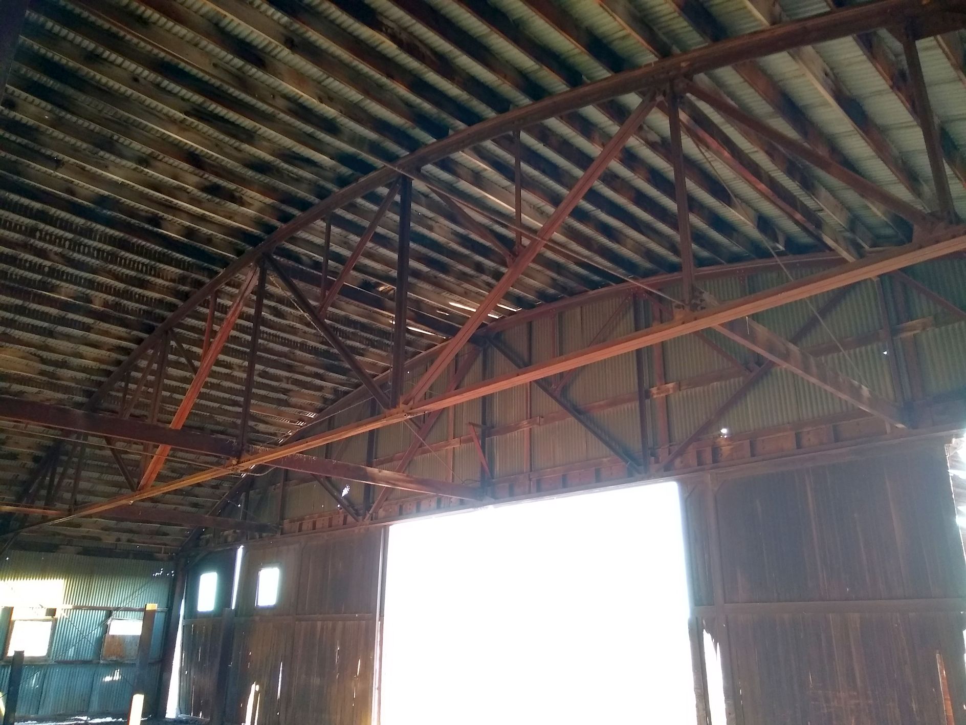
A 2018 photo by Michael LaRose of the roof trusses inside the 80+ year-old hangar which remains standing at Grand Canyon Red Butte Airport.
A 2018 photo by Michael LaRose looking out toward the Grand Canyon Red Butte Airport runway area, showing a shack.
A 2019 aerial view looking southwest at the 80+ year-old hangar which remains standing at Grand Canyon Red Butte Airport.
Grand Canyon Red Butte Airport is located 2 miles east of Route 64, 11 miles south of Tusayan, AZ.
____________________________________________________
____________________________________________________
This site covers airfields in all 50 states.