Abandoned & Little-Known Airfields:
Northeastern Alabama
© 2002, © 2025 by Paul Freeman. Revised 11/24/25.
This site covers airfields in all 50 states: Click here for the site's main menu.
____________________________________________________
Please consider a financial contribution to support the continued growth & operation of this site.
Albertville Airport (revised 3/8/24) - Davenport Airport (revised 3/8/24) - Ft. McClellan AAF / Reilly AAF (revised 8/17/21)
Ft. Payne Airport / Jacoway Airport (added 10/20/21) - Gadsden Airport (Original) / Gulf Steel Airport / Republic Steel Airport (revised 3/11/20)
Jacksonville Airport (revised 3/8/24) - McMinn Airport (revised 11/24/25) - Valley Head Airport (added 5/23/14)
____________________________________________________
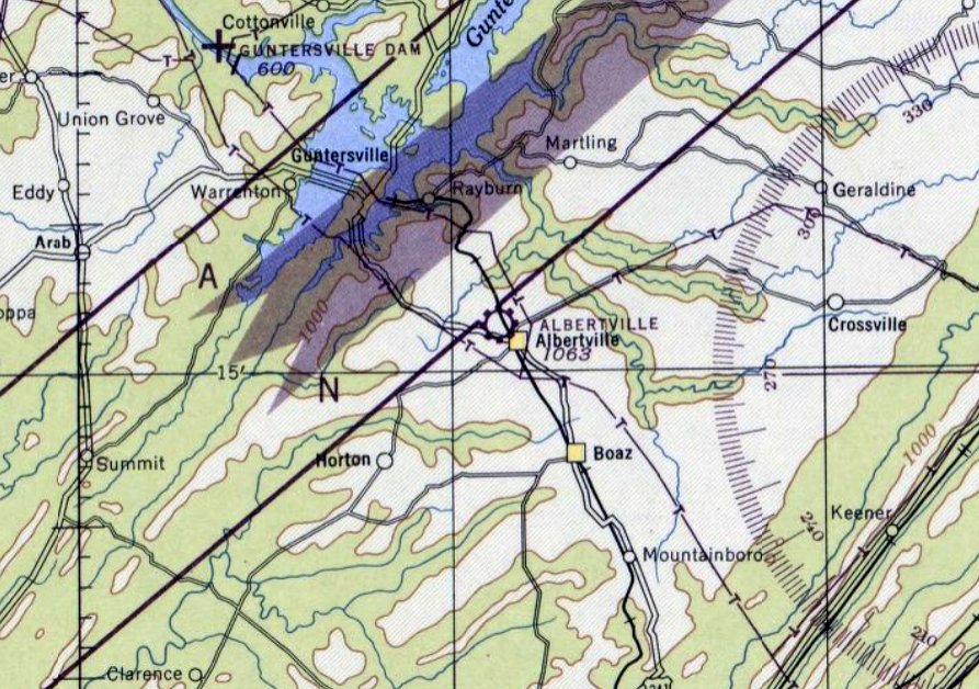
Albertville Airport (original location), Albertville, AL
34.275, -86.218 (Southeast of Huntsville, AL)
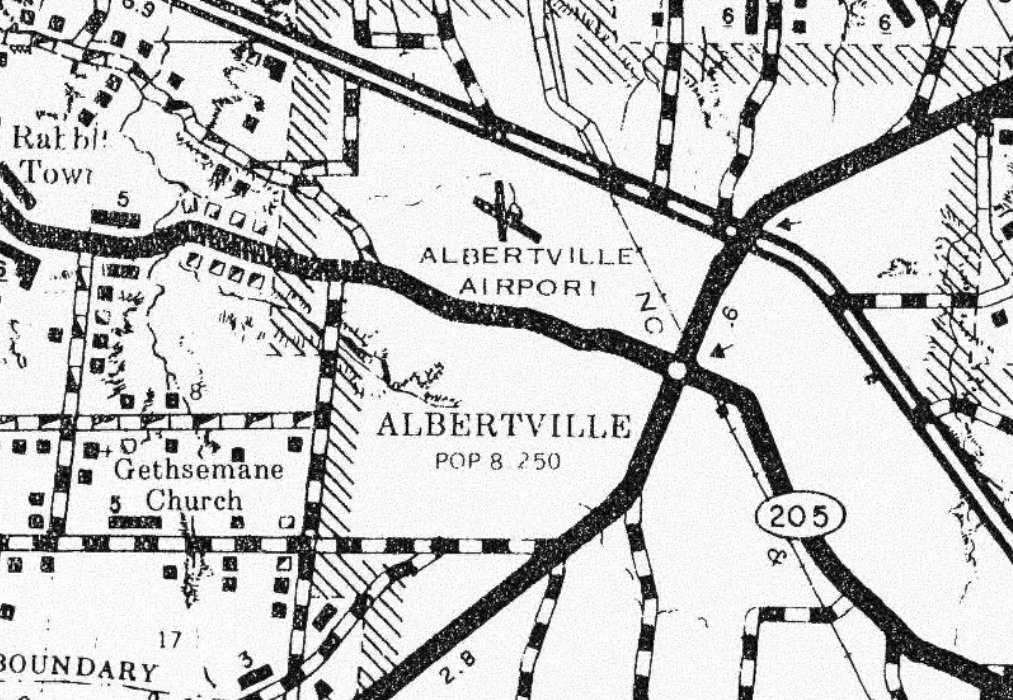
Albertville Airport, as depicted on the April 1946 Chattanooga Sectional Chart (courtesy of Rob Grant).
Albertville Airport was not yet depicted on the October 1945 Chattanooga Sectional Chart.
Rob Grant reported, “This is Albertville's first airport. It first appeared in 1946.”
The earliest depiction which has been located of Albertville Airport was on the April 1946 Chattanooga Sectional Chart (courtesy of Rob Grant),
which depicted Albertville as a commercial/municipal airport.
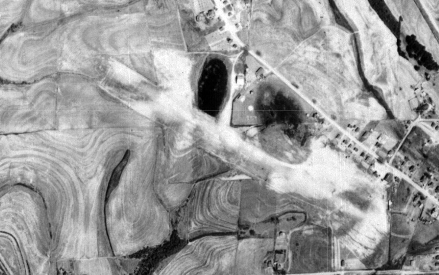
The only photo which has been located showing Albertville Airport in use was a 1949 aerial view (courtesy of Rob Grant).
It depicted Albertville as having 2 unpaved runways, with 1 light single-engine plane on the east side.
The Aerodrome table on the 1950 Sectional Chart (courtesy of Rob Grant) described Albertville as a commercial airport having 2 runways, the longest being 2,800'.
Rob Grant reported, “Albertville Flying Service was based there & offered training for private, commercial, and flying instructor certificates.”
Delwyn Powell recalled of Albertville Airport, “My uncle Carl Robertson kept his plane there & I remember going up in the plane with him.”
Jan Morgan recalled of Albertville Airport, “We played in old abandoned planes on the end of the runway. Sweet memories!”
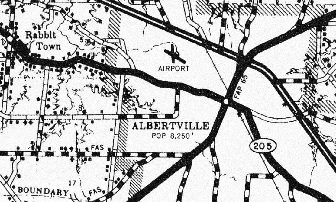
A 1960 county highway map (courtesy of Rob Grant) depicted Albertville Airport as having 2 runways.
The last aeronautical chart depiction which has been located of Albertville Airport was on the January 1961 Chattanooga Sectional Chart.
It depicted Albertville as having a 2,800' unpaved runway.
The original Albertville Airport was replaced by a larger Albertville Regional Airport, which opened to the south in 1962.
The original Albertville Airport may have closed coincident with the opening of the new airport.
The last depiction which has been located of the original Albertville Airport was on a 1965 county highway map (courtesy of Rob Grant).
The original Albertville Airport was no longer depicted on the February 1965 Chattanooga Sectional Chart.
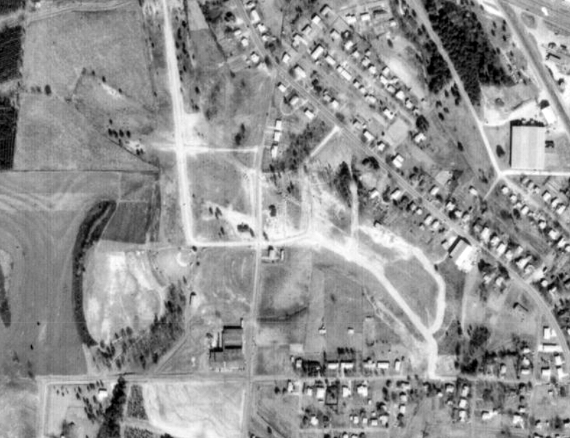
A 1970 aerial view (courtesy of Rob Grant) showed houses & streets beginning to cover the site of the original Albertville Airport.
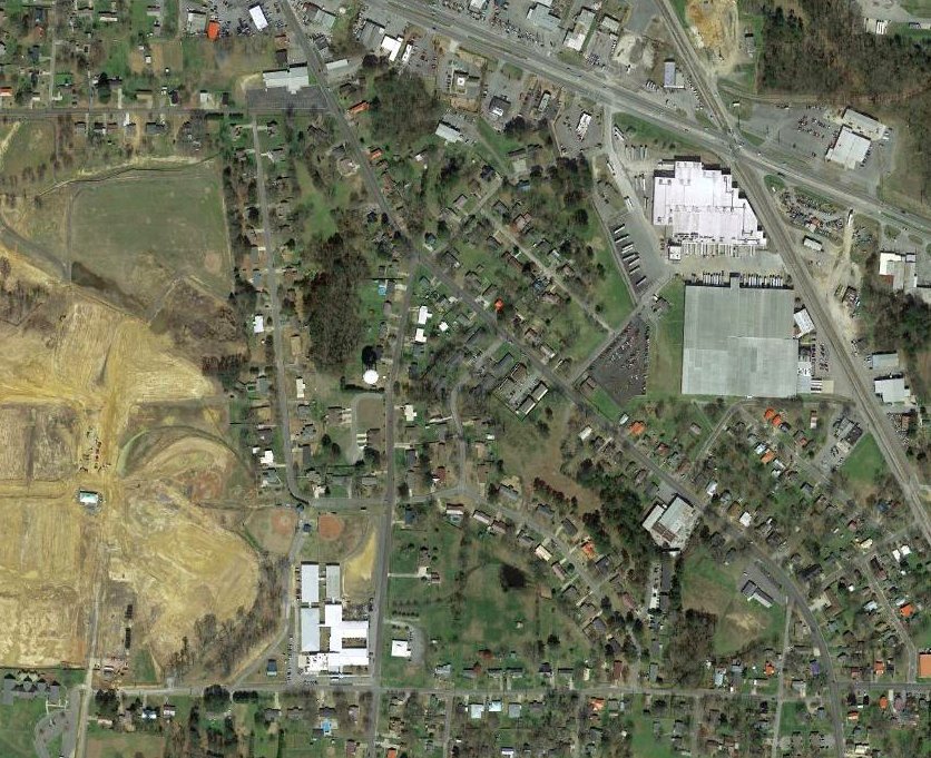
A 2019 aerial view showed no trace remaining of the original Albertville Airport.
Thanks to Rob Grant for pointing out this airfield.
____________________________________________________
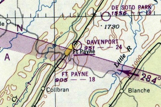
Davenport Airport, Ft. Payne, AL
34.458, -85.706 (West of Atlanta, GA)
Davenport Airport, as depicted on the April 1947 Chattanooga Sectional Chart (courtesy of Rob Grant).
Davenport Airport was not yet depicted on the October 1946 Chattanooga Sectional Chart.
Rob Grant reported, Davenport Airport was “Undoubtedly one of many little airports which sprung up shortly after the end of WW2 offering flight training under the GI Bill.”
The earliest depiction which has been located of Davenport Airport was on the April 1947 Chattanooga Sectional Chart (courtesy of Rob Grant),
which depicted Davenport as a commercial/municipal airport.
The 9/15/47 Directory of CAA Schools (courtesy of Rob Grant) described the Davenport Air Service
as offering primary, commercial, and flight instructor schools.
The earliest topo map depiction which has been located of Davenport Airport was on the 1947 USGS topo map (courtesy of Rob Grant).
It depicted an irregularly-shaped property outline, generically labeled “Airfield”, with 2 small buildings on the northeast side.
The earliest photo which has been located of Davenport Airport was a 1949 aerial view (courtesy of Rob Grant).
It depicted an single unpaved northeast/southwest runway, with a few small buildings on the northeast side.
There were no aircraft visible on the field.
The Airdrome Directory on the January 1950 Chattanooga Sectional Chart (courtesy of Rob Grant)
described Davenport as a private airfield having a single 2,400' runway.
The last aeronautical chart depiction which has been located of Davenport Airport was on the July 1950 Chattanooga Sectional Chart (courtesy of Rob Grant),
which depicted Davenport as having a 2,400' unpaved runway.
Davenport Airport was evidently closed (for reasons undetermined) at some point between 1950-51,
as it was no longer depicted on the January 1951 Chattanooga Sectional Chart.
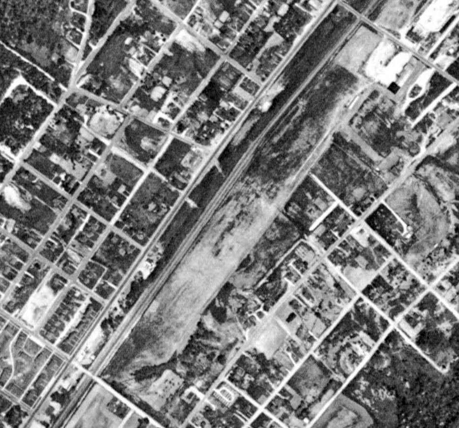
A 1954 aerial view (courtesy of Rob Grant) depicted Davenport Field as remaining intact, but there was no sign of any recent aviation use.
A 1969 aerial view (courtesy of Rob Grant) showed a road had been built across the center of the former Davenport Field,
but some of the former airport buildings may have remained standing on the northeast side.
A 2009 aerial view (courtesy of Rob Grant) showed some of the former Davenport Airport buildings may have remained standing on the northeast side.
As of 2021, street maps label the site of Davenport Field as the Dekalb County VFW Agricultural Fairgrounds.
____________________________________________________
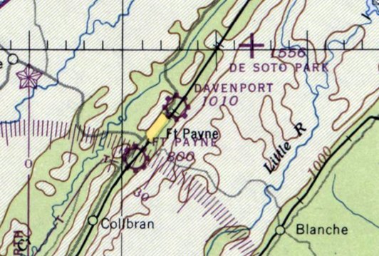
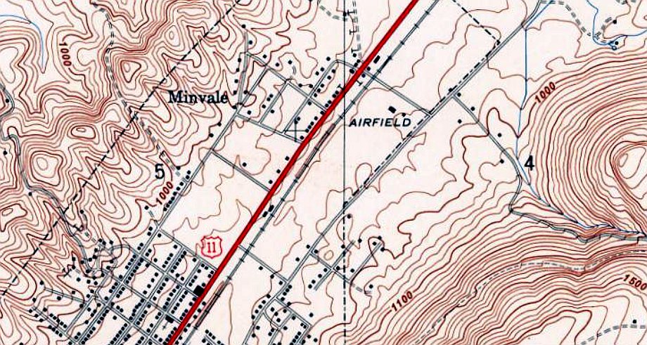
Ft. Payne Airport / Jacoway Airport, Ft. Payne, AL
34.414, -85.744 (West of Atlanta, GA)
Ft. Payne Airport, as depicted on the April 1947 Chattanooga Sectional Chart (courtesy of Rob Grant).
Rob Grant reported, Ft. Payne Airport was “Undoubtedly one of many little airports which sprung up shortly after the end of WW2 offering flight training under the GI Bill.”
The earliest depiction which has been located of Ft. Payne Airport was on the April 1947 Chattanooga Sectional Chart (courtesy of Rob Grant),
which depicted Ft. Payne as a commercial/municipal airport.
The 9/15/1947 Directory of CAA Schools (courtesy of Rob Grant) described the Ft. Payne Air Service
as offering primary, commercial, and flight instructor schools.
The earliest topo map depiction which has been located of Ft. Payne Airport was on the 1947 USGS topo map (courtesy of Rob Grant).
It depicted Ft. Payne Airport as a northeast/southwest oriented generically labeled “Airfield”, with 2 small buildings on the southeast side.
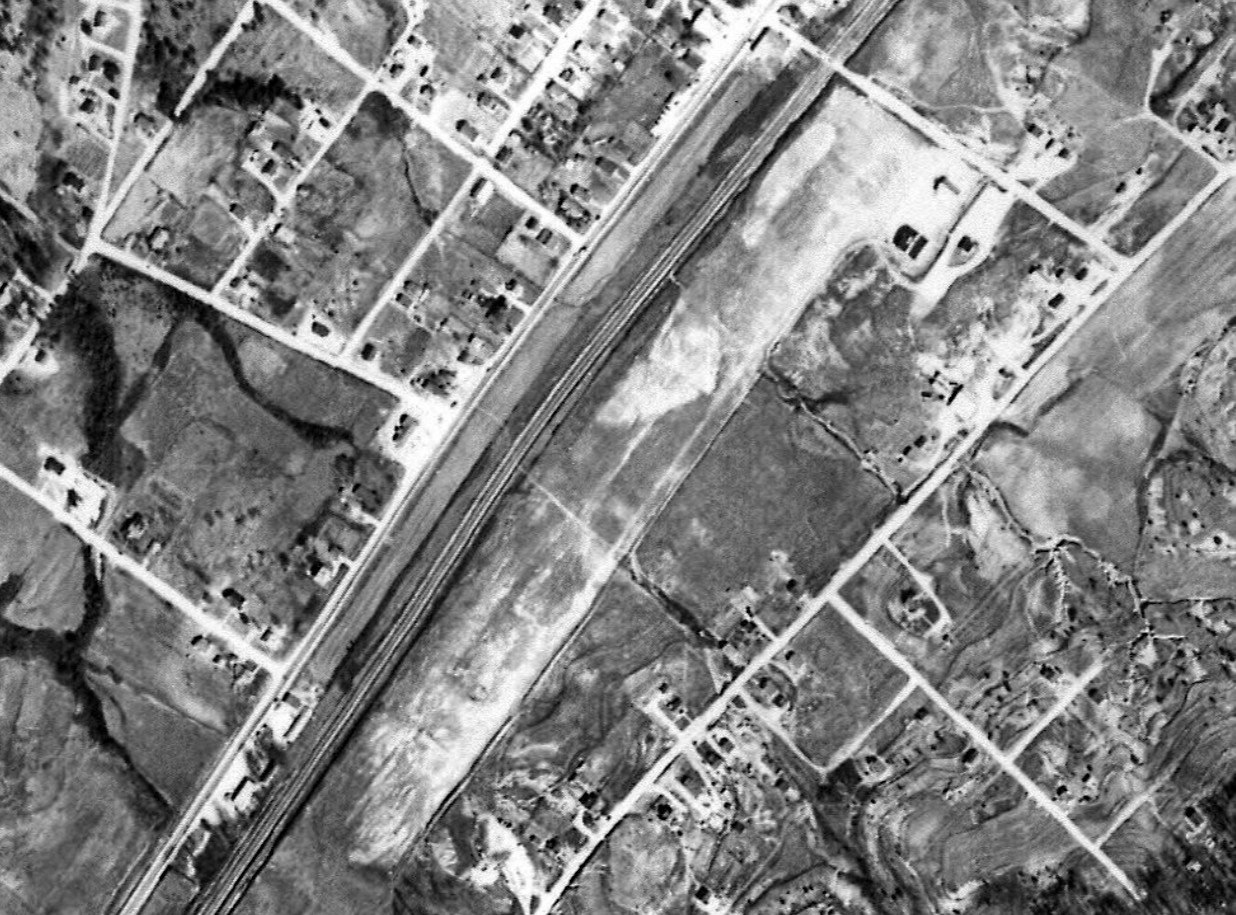
The earliest photo which has been located of Ft. Payne Airport was a 1949 aerial view (courtesy of Rob Grant).
It depicted Ft. Payne Airport as a northeast/southwest oriented grass airfield, with 2 light single-engine aircraft & a row of small hangars on the southeast side.
The July 1950 Chattanooga Sectional Chart (courtesy of Rob Grant) described the Ft. Payne Flying School as a commercial airfield having a single 1,800' runway.
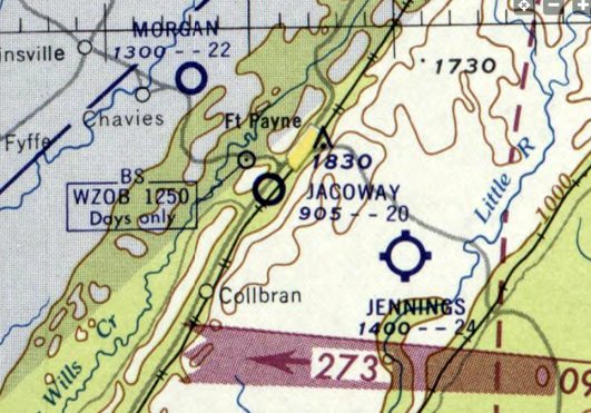
At some point between 1950-59, Ft. Payne Airport was evidently renamed Jacoway Airport,
as that is how it was depicted on the February 1959 Chattanooga Chattanooga Sectional Chart (courtesy of Rob Grant).
It described Jacoway as a private airfield having a single 1,800' turf runway.
The 1967 USGS topo map continued to depict Jacoway Airport as a generically labeled “Airfield”.
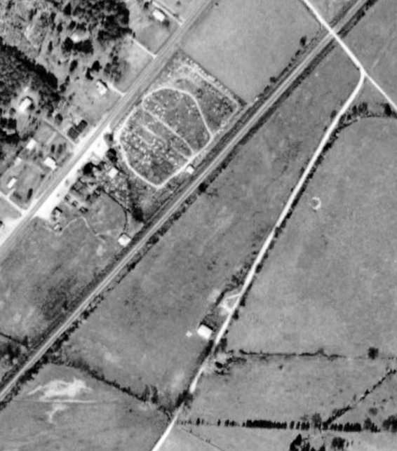
A 1969 aerial view (courtesy of Rob Grant) showed that Jacoway Airport remained mostly intact,
but there were no aircraft on the field, and all of the hangars except for 1 had been removed at some point between 1949-69.
Jacoway Airport was evidently closed (for reasons unknown) at some point between 1967-72,
as it was no longer depicted on the 1972 USGS topo map.
A 1981 aerial view showed the last former Jacoway Airport hangar had been removed at some point between 1969-81.
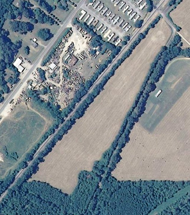
A 2000 aerial view (courtesy of Rob Grant) showed that the Jacoway Airport property remained clear.
____________________________________________________
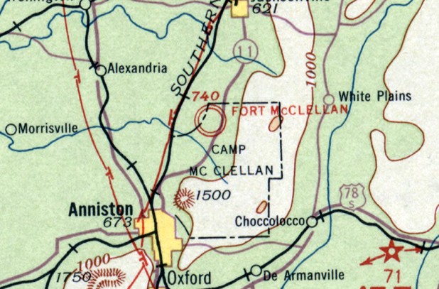
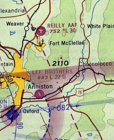
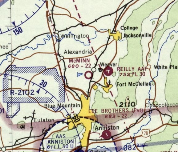
Ft. McClellan Army Airfield / Henry J. Reilly Army Airfield, Anniston, AL
33.745, -85.782 (West of Atlanta, GA)
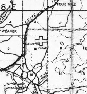
A 1930 AL Map (courtesy of Dallam Oliver-Lee) depicted an “Aviation Field” with 2 perpendicular runways on the north side of Ft. McClellan.
This former airfield was located on the grounds of Fort McClellan, which conducted infantry & Military Police training.
The date of construction of Ft. McClellan's airfield has not been determined.
The earliest depiction which has been located of the Ft. McClellan Airfield was a 1930 AL Map (courtesy of Dallam Oliver-Lee),
which depicted an “Aviation Field” with 2 perpendicular runways on the north side of Ft. McClellan.
The earliest aeronautical chart depiction which has been located of the Ft. McClellan Airfield
was on the April 1933 Birmingham Sectional Chart.
The Airport Directory Company's 1937 Airport Directory (courtesy of Bob Rambo)
described the Ft. McClellan Army Airfield as a 44 acre T-shaped field,
measuring 2,600' east/west by 1,800' north/south.
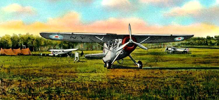
An undated colorized postcard photo of the “Airport at Ft. McClellan” (courtesy of Mark Hess), showing 3 unidentified Army observation/liaison aircraft).
At some point between 1938-40, the airfield was renamed Henry J. Reilly AAF,
as that is how it was labeled on the April 1940 Birmingham Sectional Chart
and the October 1942 Birmingham Sectional Chart (courtesy of Ron Plante).
Reilly AAF was evidently abandoned (for reasons unknown) at some point between 1942-43,
as it was not depicted on the March 1943 14M Regional Aeronautical Chart (according to Chris Kennedy).
A 1944 map (courtesy of Rex Ricks) depicted Reilly Field as having 2 perpendicular runways.
Reilly AAF was not depicted on the 1944 or 1945 Birmingham Sectional Charts (courtesy of Chris Kennedy),
nor in the 1945 AAF Airfield Directory (courtesy of Scott Murdock),
or on the April 1946 Birmingham Sectional Chart.
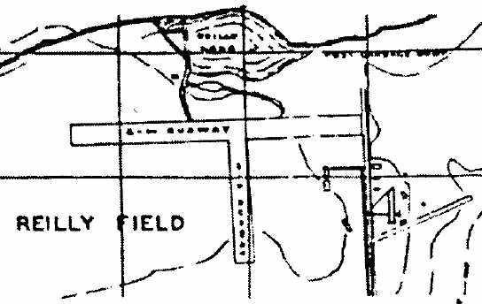
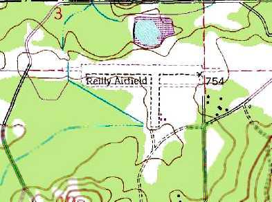
The 1947 USGS topo map (courtesy of the University of Alabama Map Library)
depicted “Reilly Airfield” as having 2 runways & a taxiway leading to a few small buildings on the north side of the field,
but it was also labeled “Abandoned”.
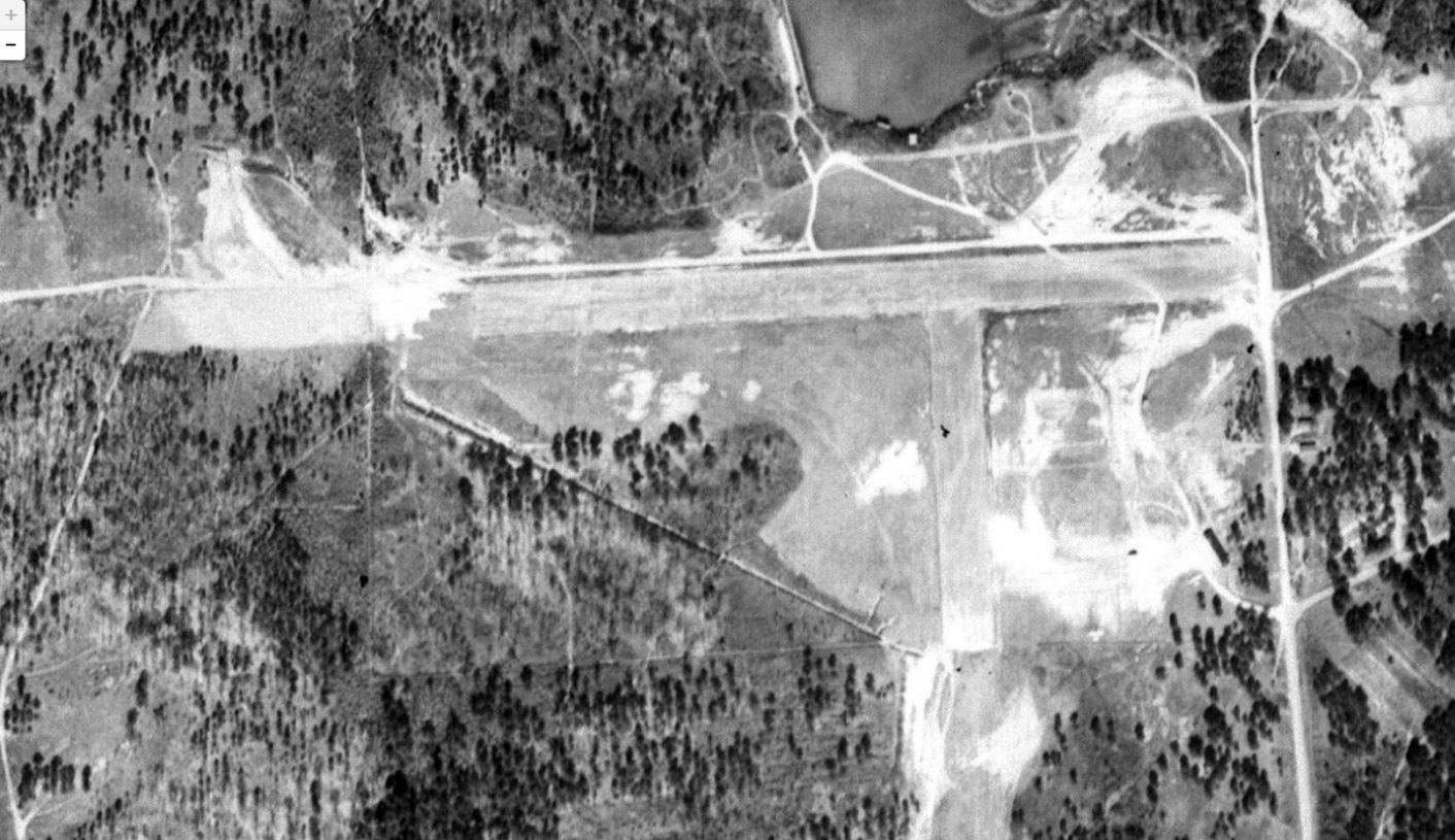
The earliest photo which has been located of Reilly AAF was a 1949 aerial view (courtesy of Rob Grant), which depicted Reilly as having 2 paved runways.
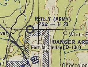
Reilly (Army) was described on the Aerodromes table of the August 1954 Birmingham Sectional Chart (courtesy of Chris Kennedy)
as being "Inactive", with "no facilities."
It was depicted as having a 2,300' hard surface runway.
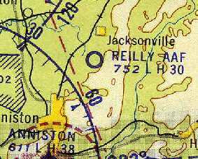
Reilly's runway was apparently somewhat lengthened at some point between 1954-61,
as the 1961 Great Smoky Mountains World Aeronautical Chart (courtesy of Chris Kennedy)
depicted the field as having a 3,000' hard-surface runway.
Two paved runways were depicted for "Reilly AAF"
on the January 1962 Birmingham Sectional Chart (courtesy of Chris Kennedy),
but the remarks in the Aerodromes table said "North/South runway closed."
A 1961 Soil Conservation Service aerial view (courtesy of Thomas Kallsen of the University of AL Map Library) depicted Reilly AAF as having 2 paved runways.
The 1963 Birmingham Sectional Chart depicted Reilly AAF as having 2 paved runways, with the longest being 3,000'.
Jeff Morgan recalled, “I lived at Fort McClellan from 1969-72.
As a child, I remember my father, an Army officer, taking me to the airfield many times & seeing several UH-1 Hueys on a flight line.”
John Sabol recalled, “I was stationed at Ft. McClellan between the years 1970-73.
I was an Army Aviator & the operations officer of Reilly Army Airfield.
We had an aviation detachment of about 20 pilots, plus a maintenance group.
The aircraft we had were 4 or 5 UH-1 Hueys, and a T-41, U-6, and U-8 fixed-wing aircraft.
At the time, Ft. McClellan was the home of the Women’s Army Corps & the Army Chemical Corps.
We flew in support of both of the above. Great job at the time.
Additionally, Reilly frequently hosted training flights of the CH-47 Chinook helicopters.
They came from Ft. Benning to use our facilities.”
Reilly AAF was still listed as an active airfield in the 1971 Flight Guide (according to Chris Kennedy).
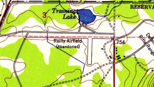
The 1972 USGS topo map depicted the 2 runways of “Reilly Airfield”.
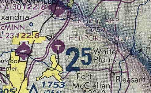
The status of the airfield had been downgraded to that of a heliport by 1980,
as "Reilly AHP" was depicted as "Heliport Only" on the April 1980 Atlanta Sectional Chart (courtesy of Chris Kennedy).
Reilly was apparently closed (again) at some point between 1980-86,
as it was not listed among active airfields in the 1986 Flight Guide (according to Chris Kennedy).
According to a Corps of Engineers Environmental Impact Statement (courtesy of Rex Ricks),
“The airfield, which was closed prior to 1988 by the Federal Aviation Administration because of inadequate glide ratio,
is currently used for defensive driving training by the Military Police School.”
Jeff Morgan recalled, “It was somewhat surprising to me, when in 1990-91, as a military police lieutenant,
I stumbled on to the airfield by accident & learned it had been inactive for some time & was now a vehicle driving range.”
Fort McClellan was closed during the 1990s, and the property containing the airfield became a National Guard installation.
Reilly AAF was depicted on late 1990s aeronautical charts as an abandoned airfield.
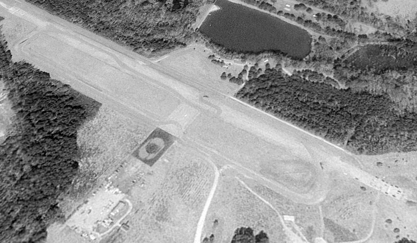
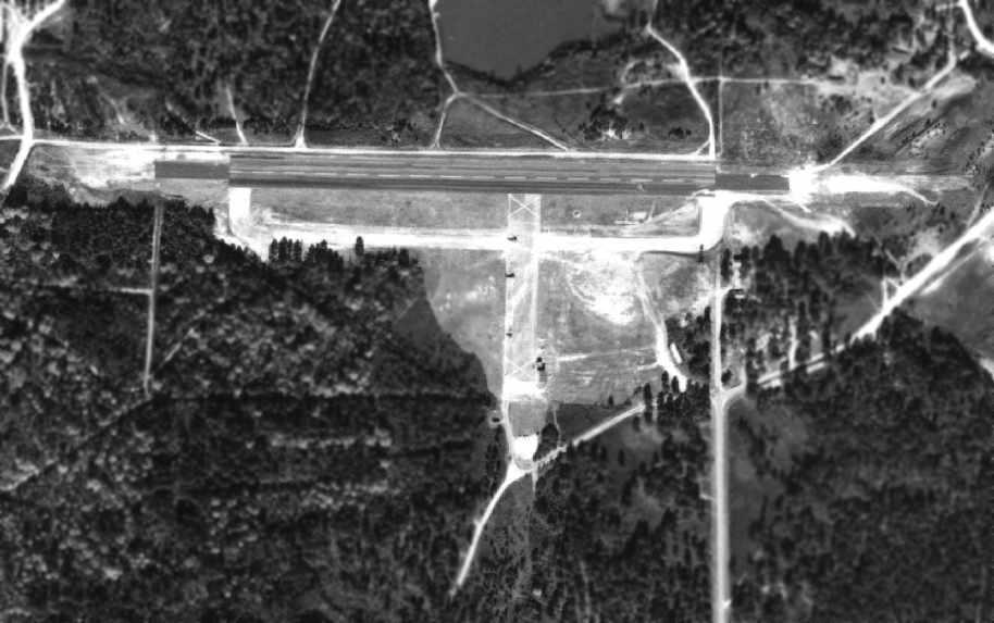
A 1998 USGS aerial view looking northwest showed Reilly AAF to consist of 2 paved runways (the largest is 3,700’ long) and a taxiway.
According to retired Infantry Officer Gary Waters, a serpentine driving course (used for Military Police driver training) has been overlaid on the primary runway.
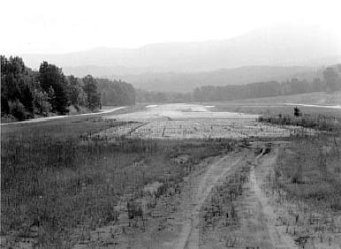
A circa 1990s view looking east at Reilly Field by Gary Waters.
The mountain due east of the airfield is Choccolocco Mountain.
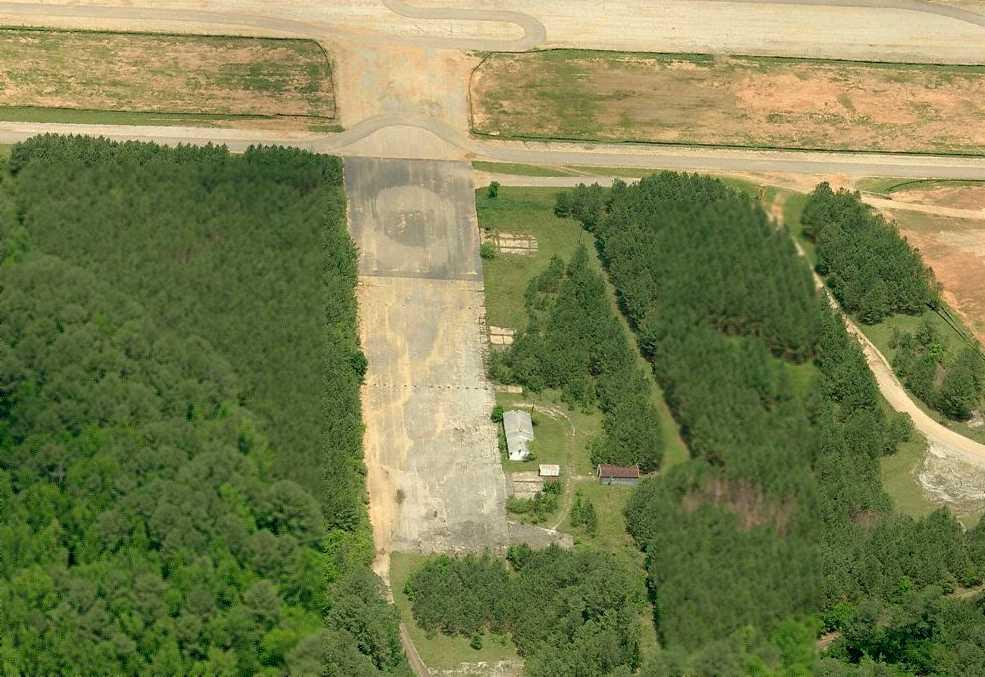
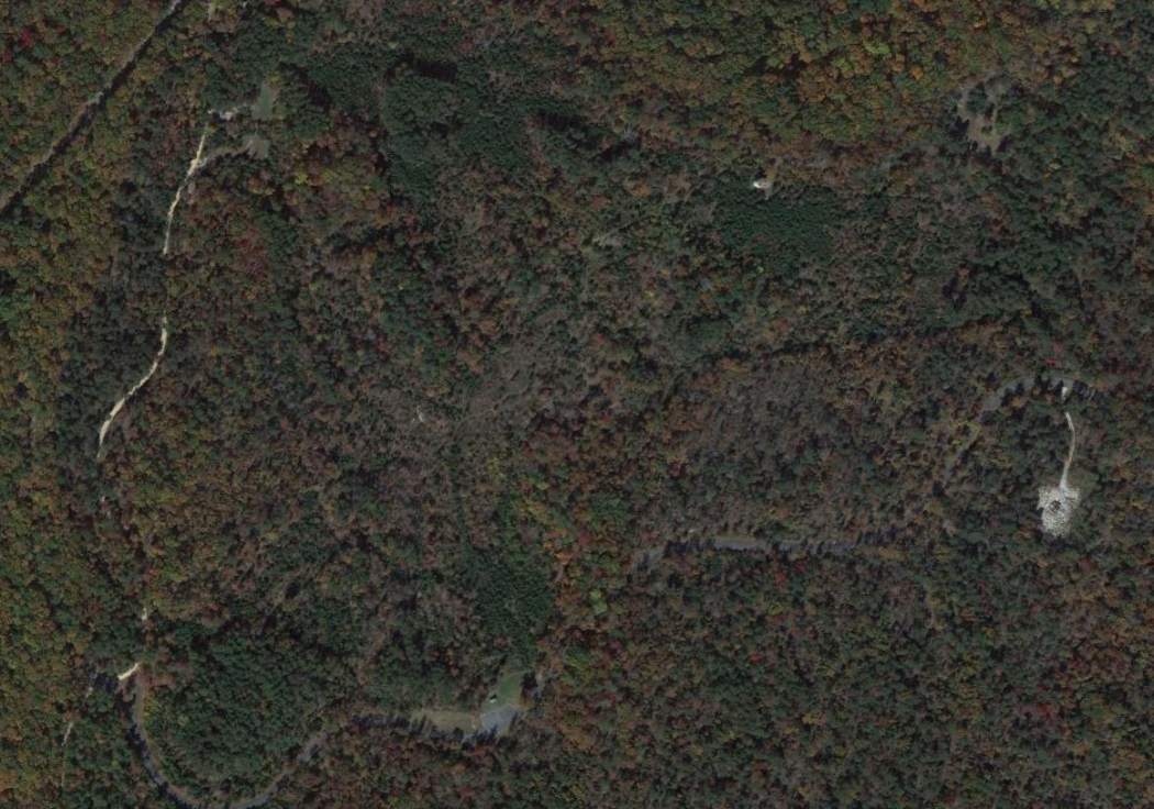
A circa 2006 aerial view looking north at Reilly Field, showing several buildings & foundations along the southeast side of the north/south runway.
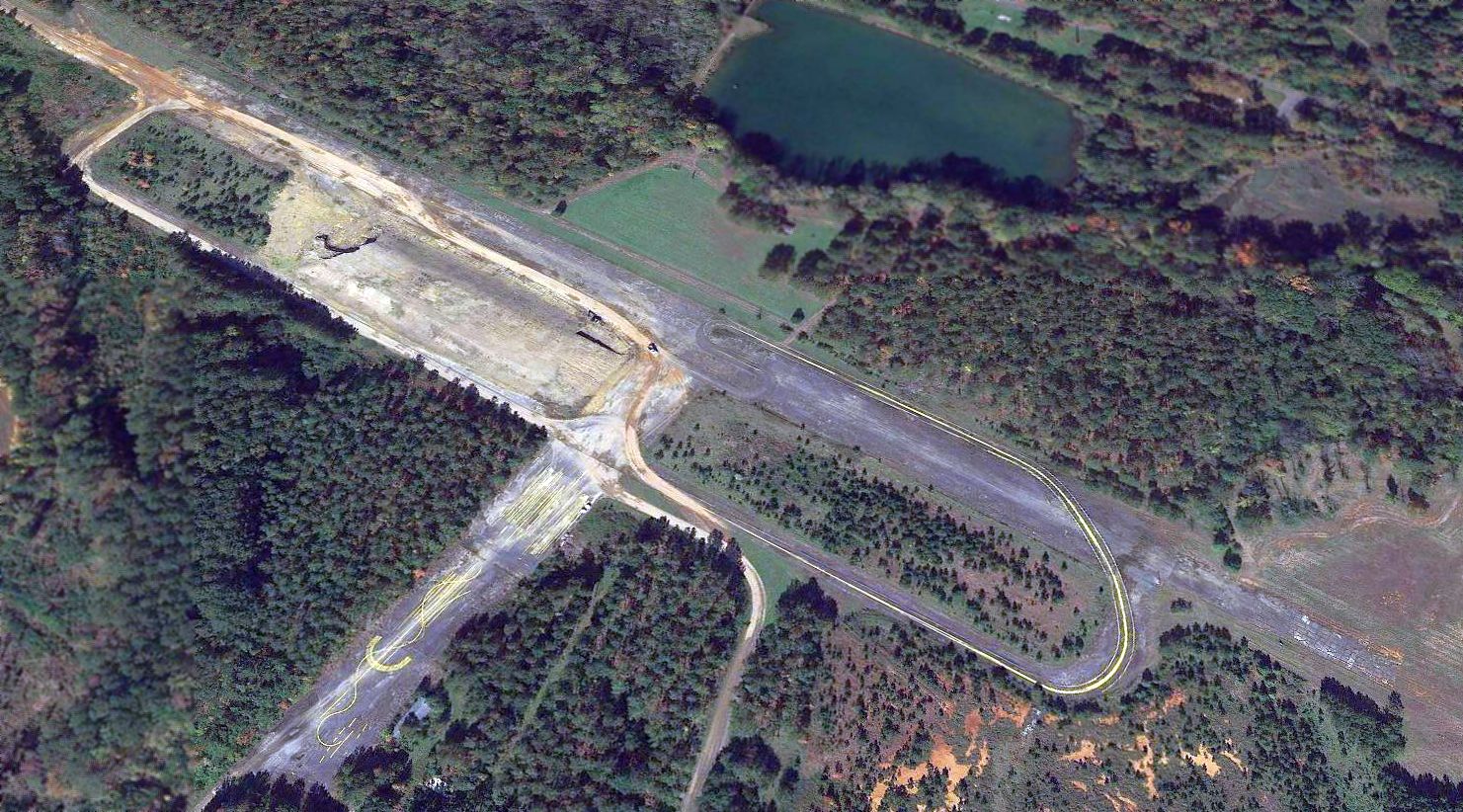
A 2015 aerial view looking northwest showed Reilly Field to remain intact though deteriorated.
____________________________________________________
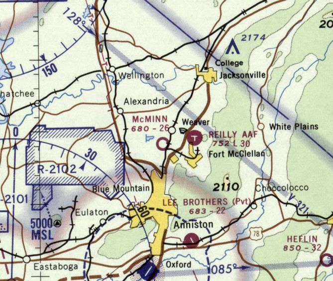
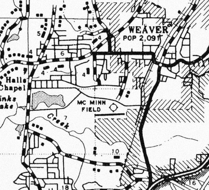
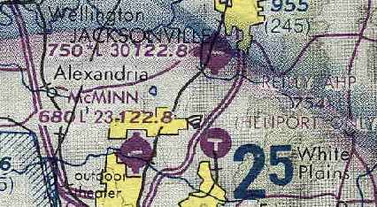
McMinn Airport (25A), Anniston, AL
33.74, -85.825 (Northeast of Birmingham, AL)
McMinn Airfield, as depicted on the April 1965 Birmingham Sectional Chart.
This small general aviation airport was evidently established at some point between 1963-65,
as it was not yet depicted on a 1961 aerial photo (courtesy of Rob Grant) nor on the 1964 Birmingham Sectional Chart.
The earliest depiction which has been located of McMinn Airfield was on the April 1965 Birmingham Sectional Chart.
It depicted McMinn Airfield as having a 2,200' unpaved runway.
The last aeronautical chart depiction which has been located of McMinn Airfield was on the October 1968 Birmingham Sectional Chart.
It depicted McMinn as having a 2,600' unpaved runway.
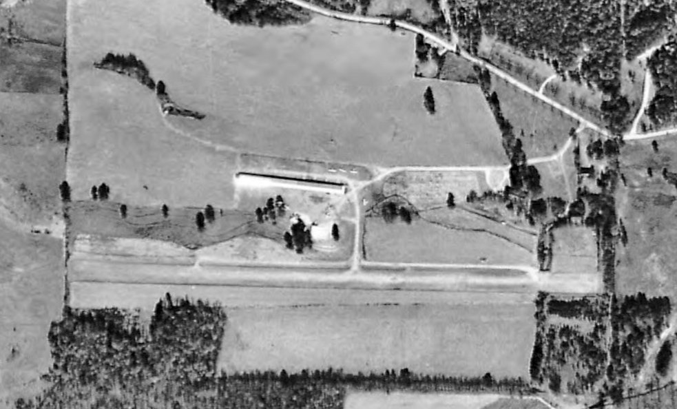
The earliest photo which has been located of McMinn Airport was a 1969 aerial view (courtesy of Rob Grant).
It showed the field as having a single unpaved east/west runway, with 4 light planes parked around an elongated hangar on the north side.
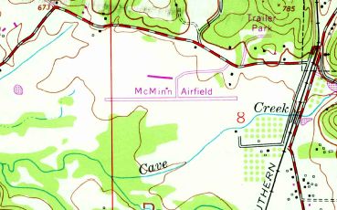
The 1972 USGS topo map (courtesy of Dallam Oliver-Lee) showed that McMinn Airfield has gained a paved runway at some point between 1969-72.
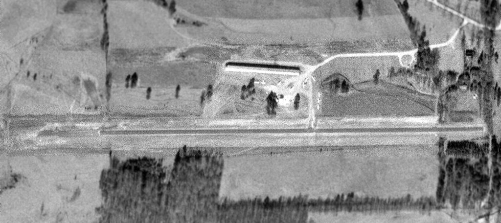
A 1/8/72 USGS aerial view (courtesy of Dallam Oliver-Lee) showed McMinn Airport as having a single asphalt east/west runway, with 10 light planes parked around an elongated hangar on the north side.
A 1977 county highway map (courtesy of Rob Grant) depicted McMinn Field as having a single paved east/west runway.
McMinn Airport was depicted in the same configuration on a 1/16/92 USGS aerial photo (courtesy of Dallam Oliver-Lee).
McMinn Airport was still labeled on the 1996 AL DOT map (courtesy of Dallam Oliver-Lee).
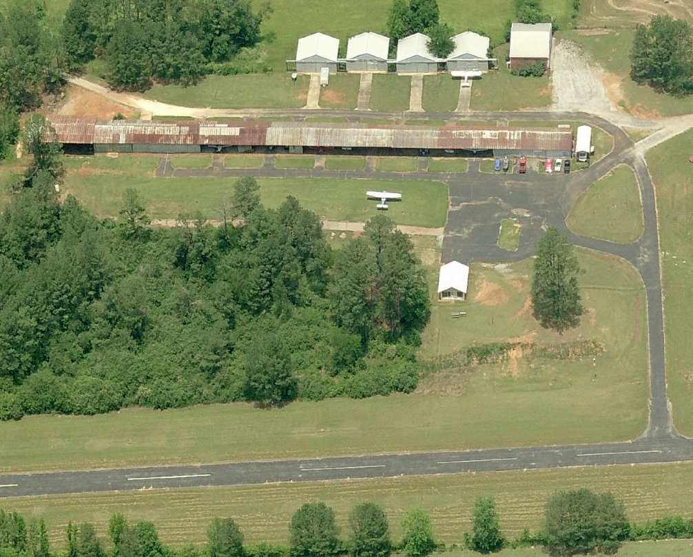
A circa 1990s aerial view looking west at McMinn Airport.
A row of 5 individual hangars to the north of the original hangar was evidently added at some point between 1992-97,
as shown on a 3/7/97 USGS aerial photo (courtesy of Dallam Oliver-Lee).
According to FAA Airport/Facility Directory data, McMinn Airport consisted of 20 acres, had 1 asphalt 2,650' Runway 8/26, and was owned by Pat McMinn.
For the year ending 5/12/98, McMinn Airport had an average of 17 takeoffs or landings per day, all general aviation, and it had 24 single-engine based aircraft.
McMinn's Runway 8/26 was still marked as an active runway on a 6/14/06 aerial photo (courtesy of Dallam Oliver-Lee),
but only 1 single-engine aircraft was visible on the field.
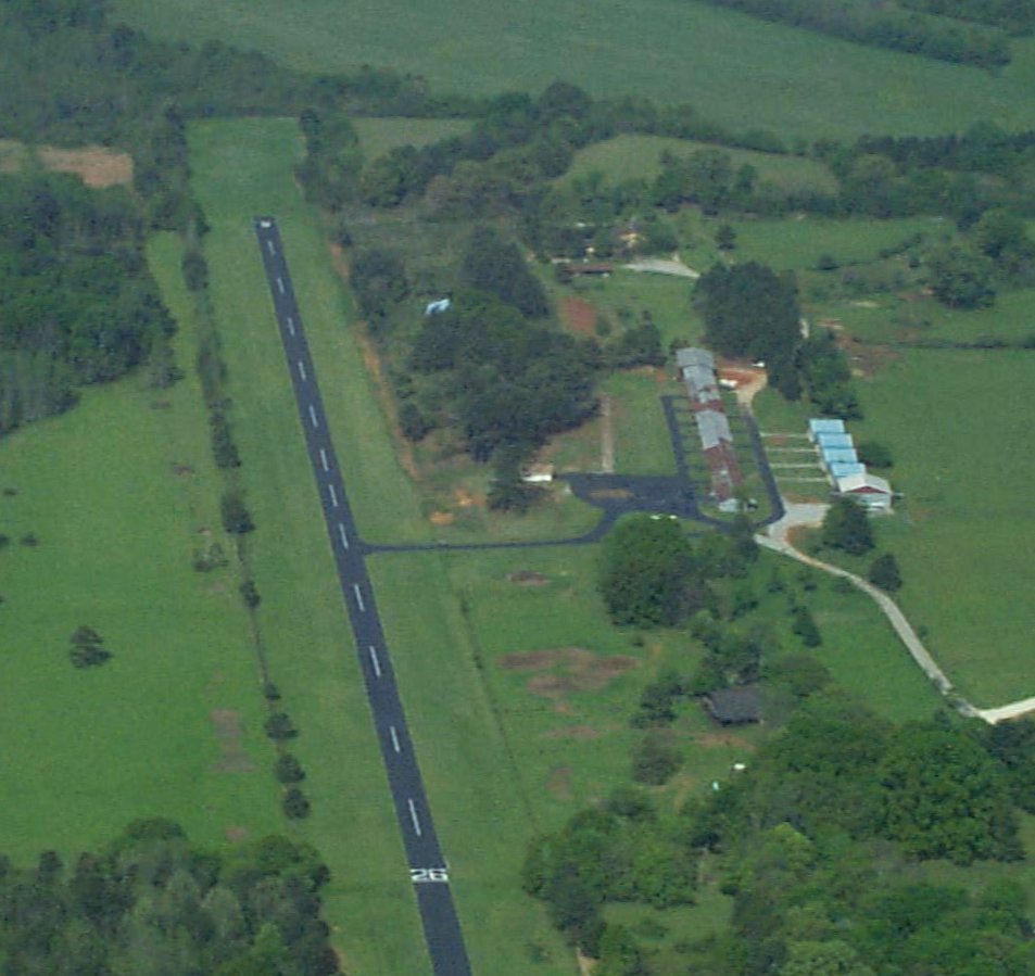
A circa 2010 aerial view looking north showed at least 6 light aircraft at McMinn Airport.
Closed-runway “X” symbols had been painted on McMinn's runway by the time of a 10/10/10 aerial photo (courtesy of Dallam Oliver-Lee),
but 3 single-engine aircraft were still visible on the field.
The last photo which has been located showing aircraft at McMinn Airport was a 7/31/11 aerial view looking northwest (courtesy of Dallam Oliver-Lee).
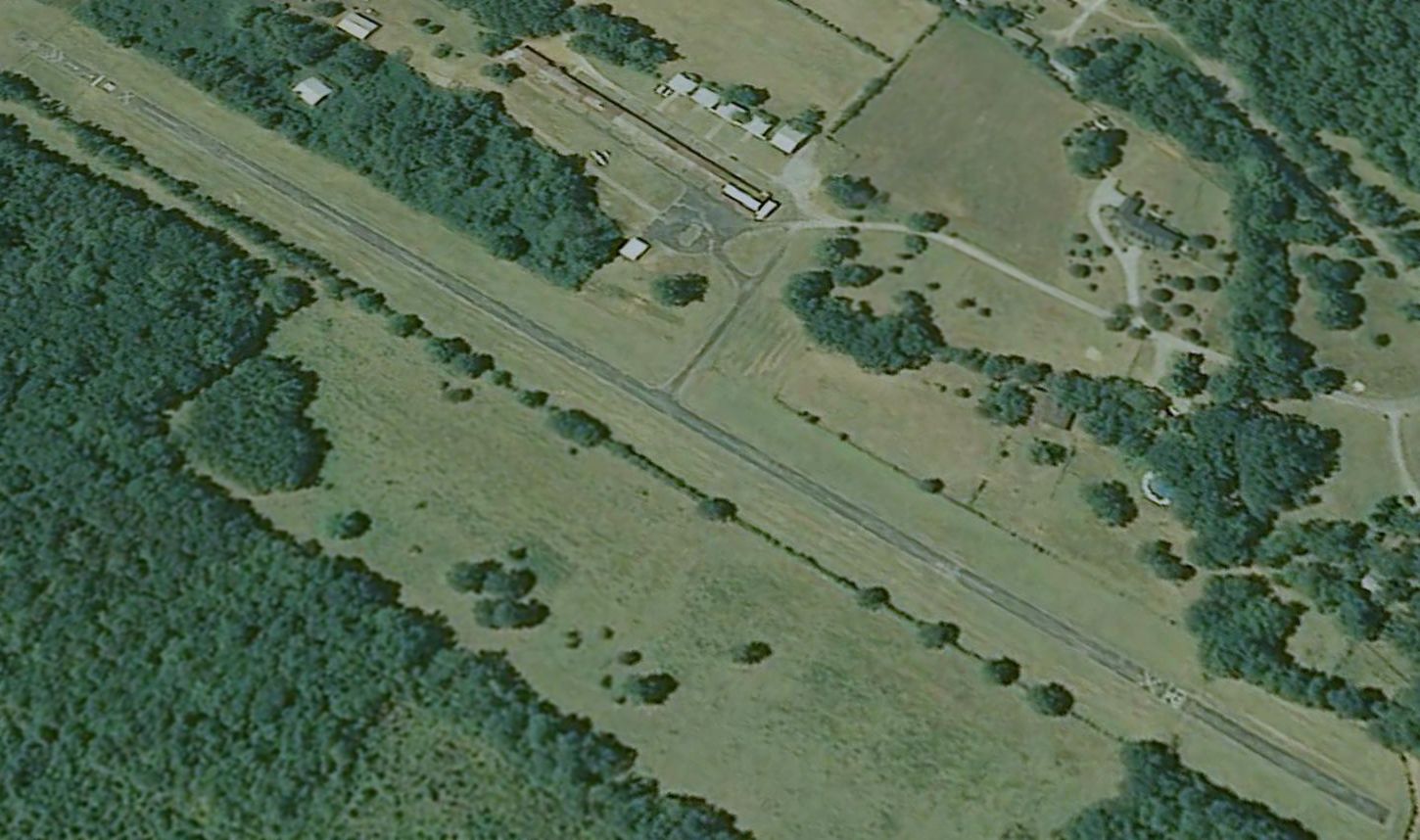
Although the runway had been marked closed for a few years, there was still 1 single-engine aircraft parked on the field.
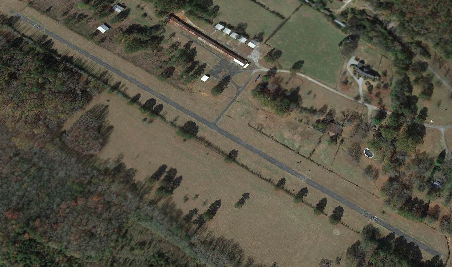
An 11/28/12 aerial view looking northwest shows that McMinn Airport remained intact – what a shame for this nice little general aviation facility to go unused.
A 2014 county highway map (courtesy of Rob Grant) still depicted McMinn Field, even though it had evidently been closed for several years by that point.
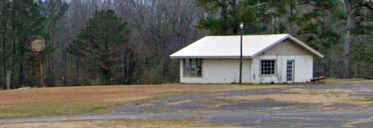
A February 2022 photo looking southwest at the former McMinn Airport office building.
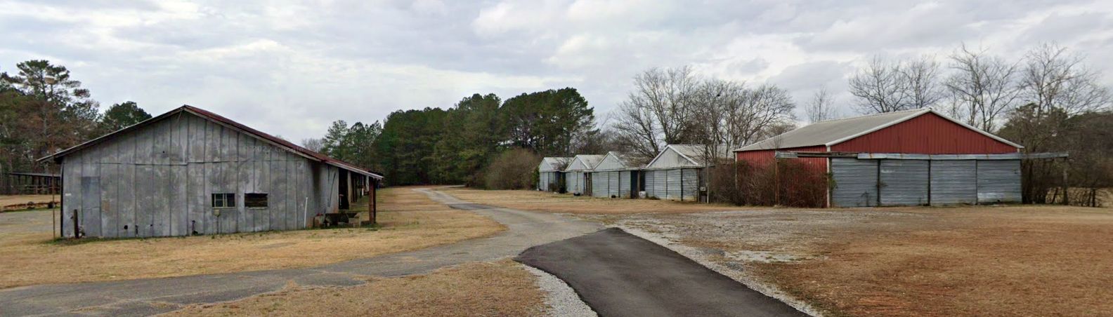
A February 2022 photo looking west at former McMinn Airport hangars.
McMinn Airport is located southwest of the intersection of McMinn Road & Airport Road – tricky, huh?
Thanks to Dallam Oliver-Lee for pointing out this airport.
____________________________________________________
(Original) Gadsden Airport / Gulf Steel Airport / Republic Steel Airport, Gadsden, AL
34.003, -86.04 (East of Huntsville, AL)
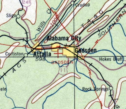
The original Gadsden Airport, as depicted on the April 1933 Birmingham Sectional Chart.
According to the book “Gadsden City of Champions” by Mike Goodson, in “1931, Gadsden acquired its first real airport.
An airfield was constructed on property owned by Republic Steel in South Gadsden near the rear of the steel plant.
This airport had a large wooden hangar & a runway where small- to medium-sized airplanes could land & take off.
This landing field was used throughout the 1930s as Gaden's airport, and people often came out to the airfield to watch the planes land & take off.
Interest was always high, and young & old alike were fascinated by airplanes.
The City of Gadsden had taken its first real steps into modern times with the building of this first small airport.”
The earliest depiction which has been located of the original Gadsden Airport was on the April 1933 Birmingham Sectional Chart.
It depicted Gadsden Airport as an auxiliary airfield.
Gadsden Airport was still depicted on the April 1940 Birmingham Sectional Chart.
The airport name had changed to “Gulf Steel” on the October 1942 Birmingham Sectional Chart.
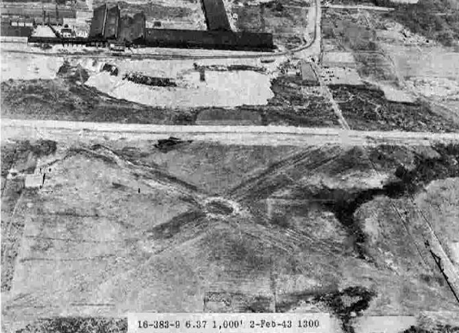
The earliest depiction which has been located of Republic Steel Airport
was a 2/2/43 aerial view looking north from the 1945 AAF Airfield Directory (courtesy of Scott Murdock).
It depicted Republic Steel Airport as having 2 asphalt runways in an X-shape, with a single hangar on the west side,
and the Republic Steel mill directly across the road to the north.
The 1945 AAF Airfield Directory (courtesy of Scott Murdock) described Republic Steel Airport
as a 40 acre rectangular property having 2 asphalt stabilized runways, measuring 2,000' northeast/southwest & 1,550' northwest/southeast.
The field was said to have a single 95' x 60' wood & metal hangar,
to be owned by private interests, and operated by the City of Gadsden.
An undated aerial photo (courtesy of Rob Grant) depicted 16 single-engine monoplanes & biplanes parked near a hangar at Gulf Steel Airport.
The airport name had reverted to “Gadsden” on the April 1945 Birmingham Sectional Chart.
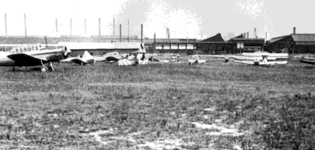
The only photo which has been located showing aircraft at Republic Steel Airport was an undated (circa 1940s?) photo looking north
showing a surplus Vultee BT-13, an Ercoupe, and several other light general aviation aircraft parked on grass.
Note the Republic Steel mill in the background.
The last depiction which has been located of the original Gadsden Airport
was on the April 1946 Birmingham Sectional Chart.
It depicted Gadsden Airport as a commercial/municipal airport.
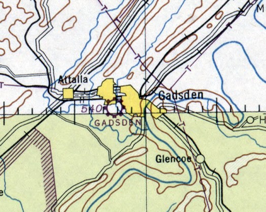
The original Gadsden Airport was evidently closed at some point between 1946-48,
as it was no longer depicted on the October 1948 Birmingham Sectional Chart,
which instead depicted the replacement Gadsden Airport which had been built a few miles to the southwest.
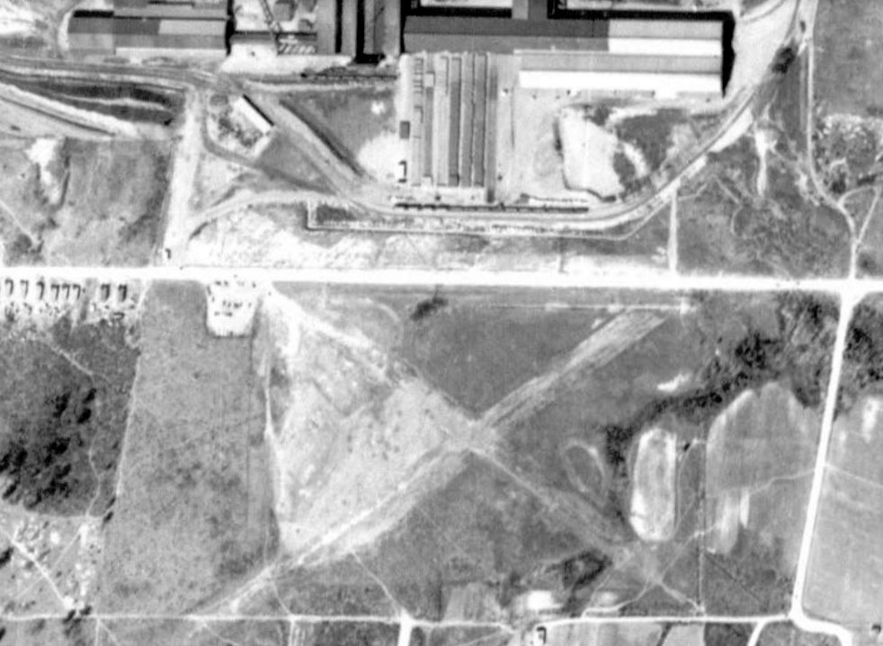
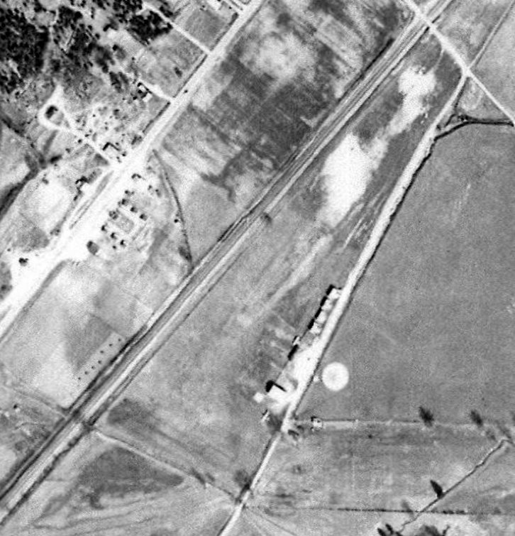
The last photo which has been located showing the Republic Steel Airport was a 1950 aerial view (courtesy of Scott Murdock).
It depicted the remains of 2 runways in an X-shape.
The former hangar on the west side had evidently been removed at some point between 1943-50.
The original Gadsden Airport was no longer depicted on the 1959 USGS topo map.
A 1998 aerial view showed no trace remaining of the original Gadsden Airport.
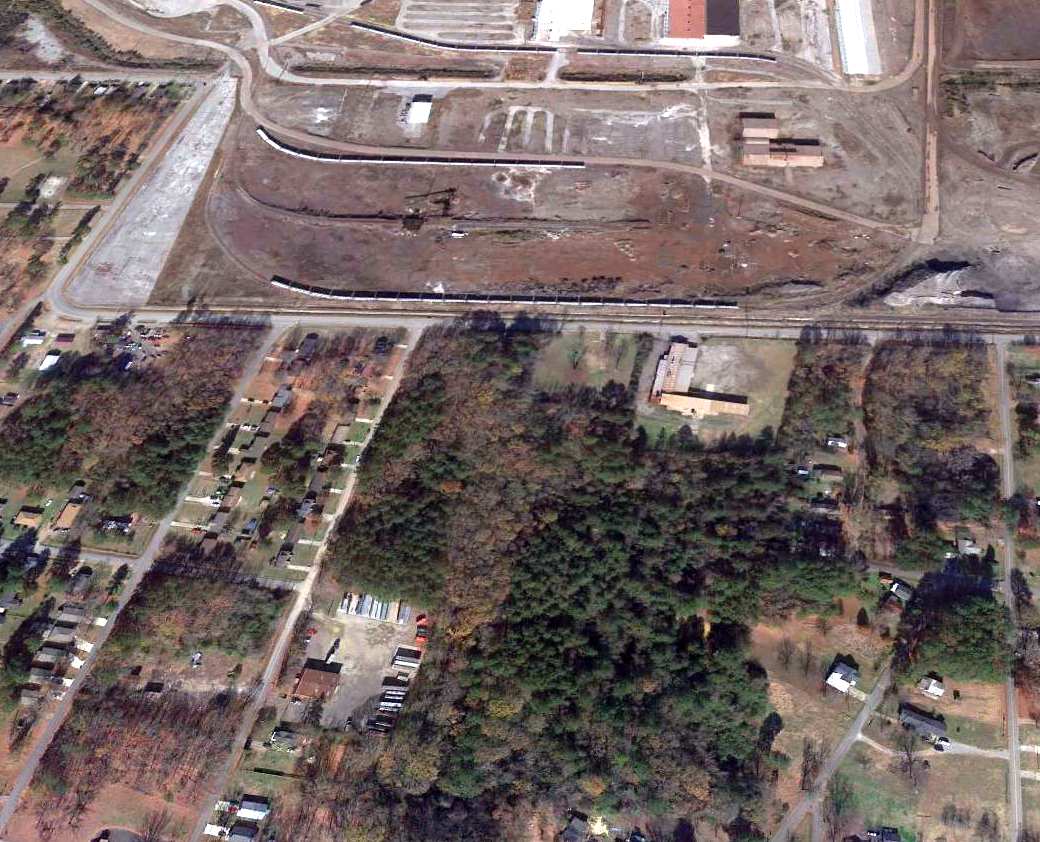
A 2012 aerial view looking north showed no trace remaining of the original Gadsden Airport.
The site of the original Gadsden Airport is located southeast of the intersection of Hickory Street & Mount Zion Avenue.
____________________________________________________
Valley Head Airport, Fort Payne, AL
34.5, -85.63 (East of Huntsville, AL)
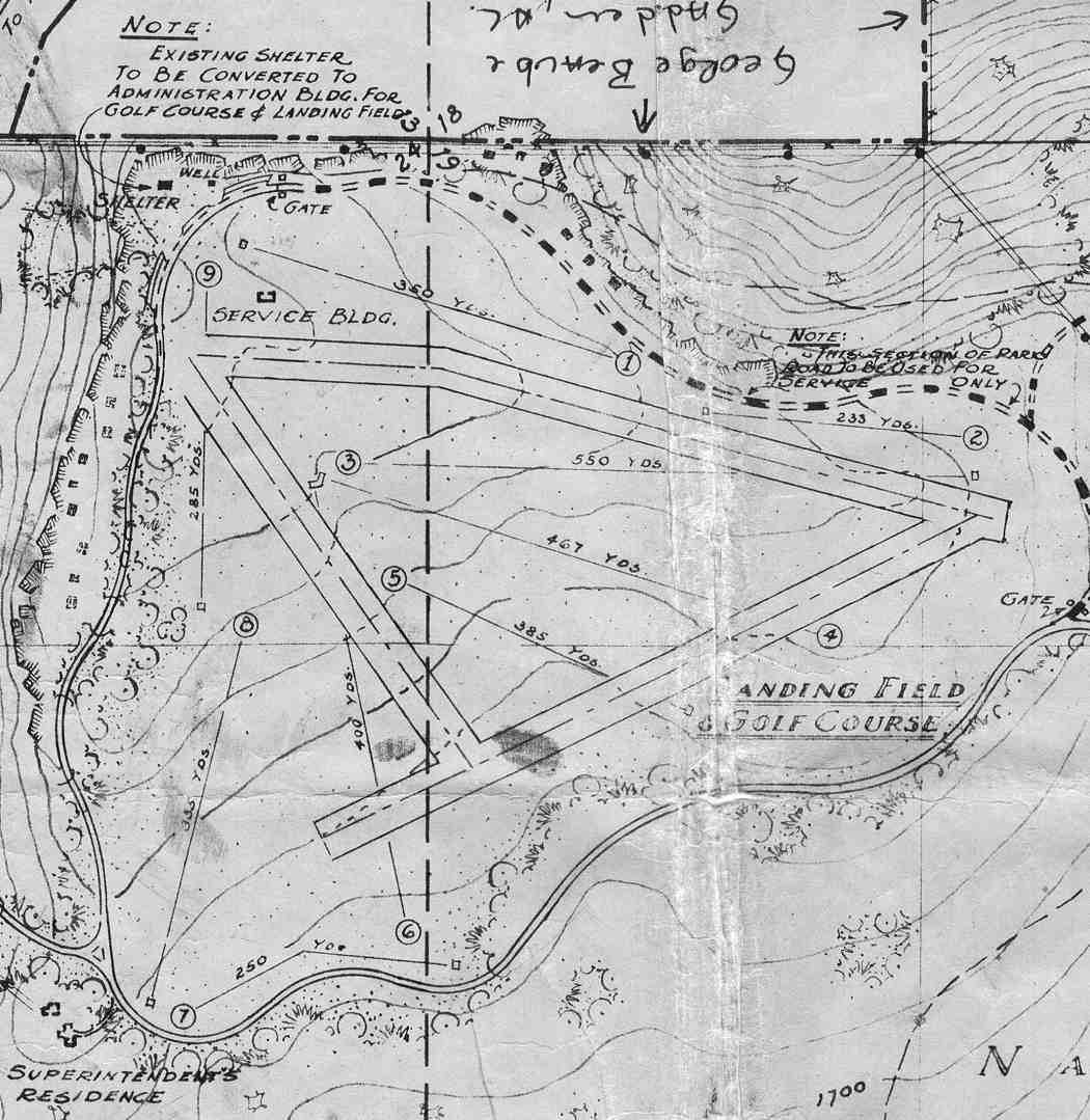
The “Landing Field & Golf Course” within DeSoto State Park, as shown on a 5/25/38 National Park Service General Development Plan (courtesy of Ken Thomas via Rob Grant).
The date of establishment of this small general aviation airport has not been determined.
The earliest dated depiction which has been located of Valley Head Airport
was on a 5/25/38 National Park Service General Development Plan (courtesy of Rob Grant).
It depicted the “Landing Field” as having 3 runways, with a small “Service Building” on the northwest side.
Several holes of the golf course were superimposed over the airport.
According to “The Civilian Conservation Corps At DeSoto State Park” (courtesy of Rob Grant),
“DeSoto Park was once surrounded by what was known as the Valley Head Airport.
Airplanes were available during the dedication [5/24/39] of the park.”
However no airfield at Valley Head was depicted on the August 1939 Chattanooga Sectional Chart (or any subsequent aeronautical charts).
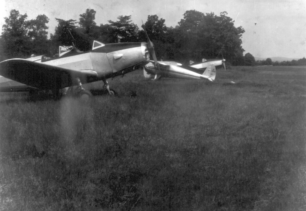
The only photo which has been located of Valley Head Airport was a circa 1940s photo of 2 Fairchild PT-19s & a Cessna 140 (courtesy of Ken Thomas via Rob Grant).
The date of closure of Valley Head Airport has not been determined.
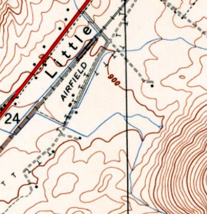
It was not listed among active airfields in the 1945 AAF Airfield Directory (courtesy of Scott Murdock),
nor depicted on the 1947 USGS topo map.
A 1965 aerial photo showed no recognizable trace of Valley Head Airport, with the site covered in trees.
A 10/23/12 aerial view showed the only remaining recognizable trace of Valley Head Airport was the perimeter road.
The site of Valley Head Airport is located east of the intersection of DeSoto Parkway & Valley View Drive.
Thanks to Rob Grant for pointing out this airfield.
____________________________________________________
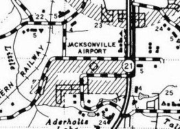
Jacksonville Airport, Jacksonville, AL
33.788, -85.774 (Northeast of Birmingham, AL)
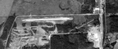
A 11/17/75 USGS aerial photo (courtesy of Dallam Oliver-Lee) showing Jacksonville Airport while under construction.
This small general aviation airport was apparently built at some point between 1972-75,
as it was not yet depicted on a 1/8/72 USGS aerial photo (courtesy of Dallam Oliver-Lee).
The earliest depiction which has been located of Jacksonville Airport
was on a 11/17/75 USGS aerial photo (courtesy Dallam Oliver-Lee),
which showed a single east/west runway, possibly still under construction.
Greg Gaugler recalled, “As a teenager I worked at the Jacksonville Airport from 1976-79.
It was opened by Charlie Murray who owned an aviation school operating out of the field in Weaver.
I think the strip was paved in late 1975. Charlie was also an Airframe & Powerplant mechanic & a helicopter instructor.
Originally the strip was carved out of some rolling hills that ran along the Jacksonville-Weaver Road (now known as the George Douthit Road)
and was adjacent to Stoney Brook Golf Course.
The strip ran roughly 9/27; the tarmac was on the south side of the strip.
The hills existed there until 1976 when I spent part of a summer bulldozing & planting grass.
The original office was just a beat up double wide trailer with a couch in the living room, a small kitchen, Charlie’s office & a bathroom.
The airport had roughly 3 Cessna 150s, a Cessna 152, a Cessna 172, a twin-engine Seneca, and a Hughes helicopter (300B?) for flight training.
A couple private owners tied down there for a fee.”
Greg continued, “I recall that whenever there was a coming storm I would have to check the tie downs on all of the planes.
The original strip was unlit at night & if there was a plane coming in during the evenings
I would have to go out and fill & then light smudge pots that ran along about 1,000' of the runway to give the pilot a visual cue.
Later we installed lights that were simply made from an electrical box, a socket, a 100 watt household light bulb & a jar-like globe.”
The earliest labeled depiction of Jacksonville Airport which has been located
was on the 1977 AL Highway Department map (courtesy of Dallam Oliver-Lee).
It labeled the site as "Jacksonville Airport", but did not depict any runways or other details of the airfield.
Greg Gaugler recalled, “In around 1978 a small jump school located there & they trained out of a Cessna 180. I left for college in 1979.”
Roy Helsing recalled, “I did fly into Jacksonville on occasion.
I even had an emergency engine failure on take-off once in a Cessna 150 & somehow actually got it back to the runway!”
The earliest aeronautical chart depiction which has been located of Jacksonville Airport
was on the April 1980 Atlanta Sectional Chart (courtesy of Chris Kennedy).
It depicted Jacksonville as having a single paved 3,000' east/west runway.
Strangely, Jacksonville Airport was not depicted at all on the 1982 USGS topo map.
The 1986 Flight Guide (courtesy of Chris Kennedy)
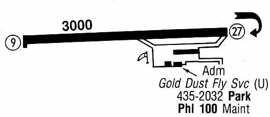
depicted Jacksonville Airport as having a single 3,000' paved Runway 9/27.
Taxiways led to a ramp on the southeast side of the field, with a total of three buildings (hangars?).
The office of the Gold Dust Flying Service was located in one of the buildings.
Jacksonville Airport was apparently closed (for reasons unknown) at some point between 1986 & the early 1990s.
Greg Gaugler recalled, “In the early 1990s I flew a remote-controlled airplane from the strip. The airport was abandoned by then.”
Jacksonville Airport was no longer depicted at all on the 1996 AL Highway Department map.
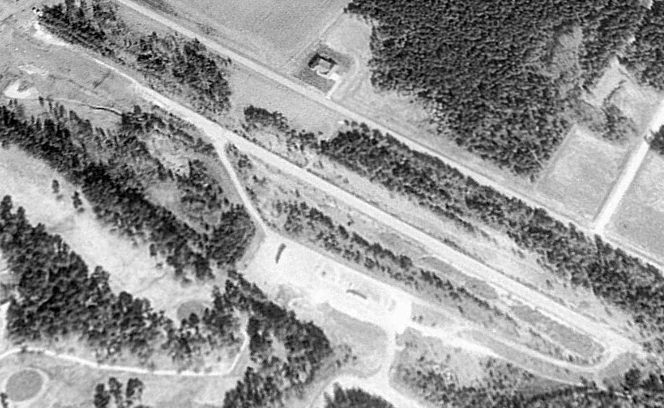
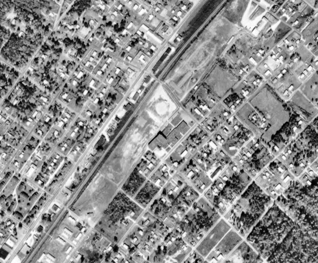
A 1997 USGS aerial view looking northwest showed the western half of the Jacksonville Airport site had been covered by construction for the new Jacksonville High School.
However, the majority of the former runway remained intact, as well as the taxiway & the ramp.
It appeared as if all of the former airport buildings & hangars had been removed.
A 1/7/04 aerial view (courtesy of Dallam Oliver-Lee) showed that the eastern half of the former runway & taxiway still remained.
A circa 2007 aerial view looking west at the remains of the Jacksonville Airport ramp & the eastern half of the runway.
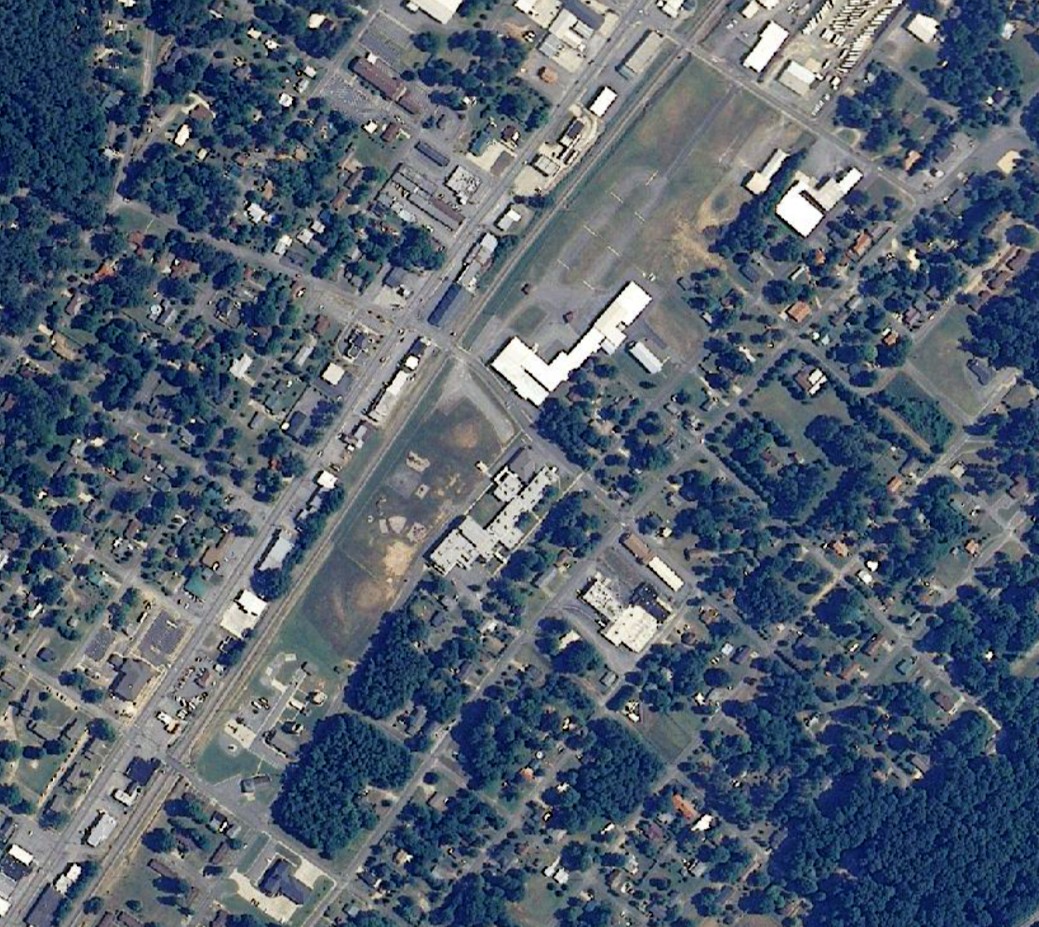
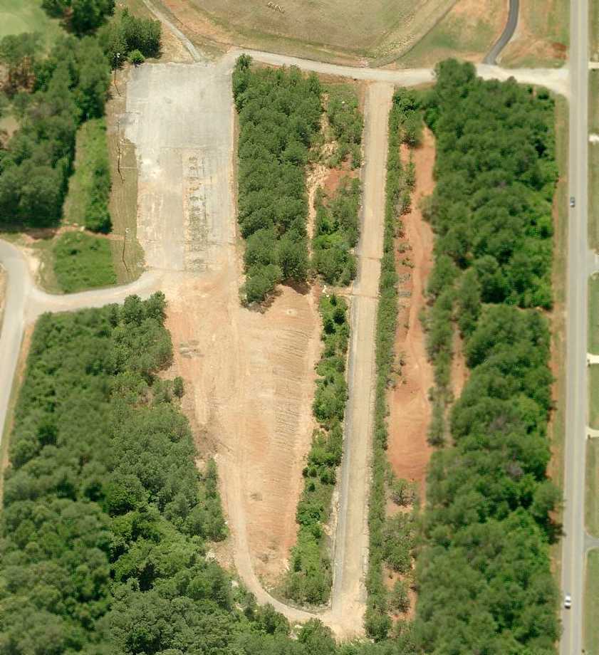
A 2012 aerial view looking northwest showed the eastern half of the former Jacksonville Airport runway remained intact, as well as the taxiway & the ramp.
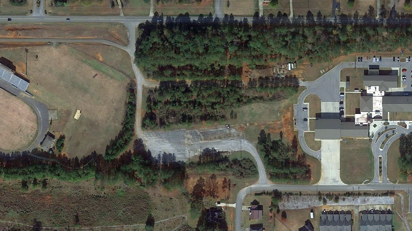
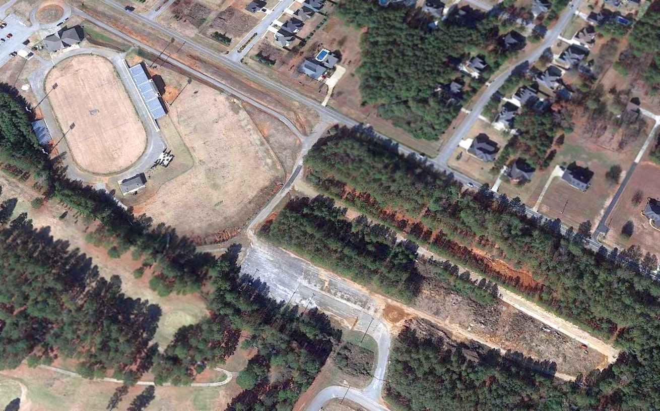
A 2021 aerial view of the last remains of Jacksonville Airport: its ramp & a central portion of the runway.
The eastern portion of the runway had been covered by buildings at some point between 2012-2015.
The site of Jacksonville Airport is located southeast of the intersection of George Douthit Drive & James Hopkins Road.
____________________________________________________
____________________________________________________
This site covers airfields in all 50 states.