Abandoned & Little-Known Airfields:
Central Washington State
© 2002, © 2023 by Paul Freeman. Revised 12/26/23.
This site covers airfields in all 50 states: Click here for the site's main menu.
____________________________________________________
Please consider a financial contribution to support the continued growth & operation of this site.
Bowers Auxiliary Airfield (revised 3/12/23) - Cameron Airfield (added 3/12/23) - East Stevens Pass Airport / Nason Creek State Airport / Dardanelles Landing Strip (revised 12/26/23)
Fancher Field (revised 10/21/22) - Hanford Auxiliary Field (added 12/24/23) - Hanford Field (revised 7/1/23)
Jackass Field #9 / NOLF 35911 (revised 9/27/19) - Pasayten Airstrip (revised 5/5/18) - Vantage Airport (added 12/24/23)
____________________________________________________
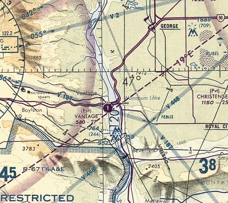
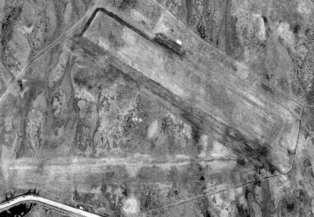
46.937, -119.987 (Southeast of Seattle, WA)
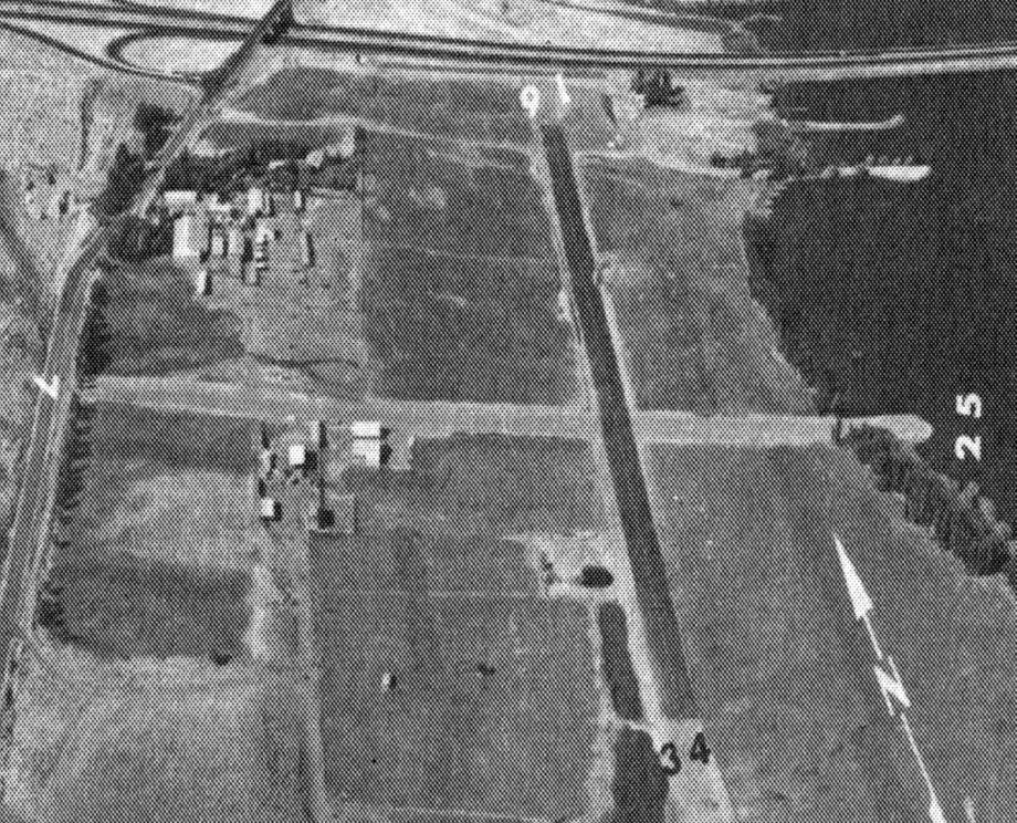
An undated aerial view looking north at Vantage Airport from the 1983 WA Airport Directory (courtesy of Scott Kimball).
This small general aviation airport was evidently established at some point between 1979-83,
as it was not yet depicted on a 1964 aerial photo or the 1979 USGS topo map.
The earliest depiction which has been located of Vantage Airport was a 1981 aerial photo,
which depicted an asphalt north/south runway & an unpaved crosswind runway,
which may have doubled as a seaplane ramp, as its east end projected into the Columbia River.
The earliest aeronautical chart depiction which has been located of Vantage Airport was on the 1994 Seattle Sectional Chart.
It depicted Vantage as a private airfield having a single north/south paved 2,700' runway.
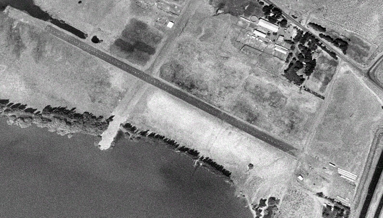
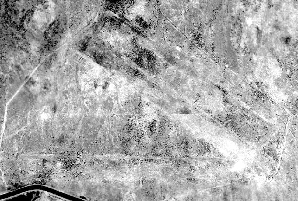
A 1996 aerial view looking southwest depicted Vantage Airport as having an asphalt north/south runway & unpaved crosswind runway, but there were no aircraft visible on the field.
The last aeronautical chart depiction which has been located of Vantage Airport was on the June 1999 Seattle Sectional Chart.
It depicted Vantage as a private airfield having a single north/south paved 2,700' runway.
Scott Kimball reported of Vantage Airport, “I believe it was open until sometime in the 1990s.”
Vantage Airport was evidently closed (for reasons unknown) at some point between 1999-2016,
as it was no longer depicted on the 2016 Seattle Sectional Chart.
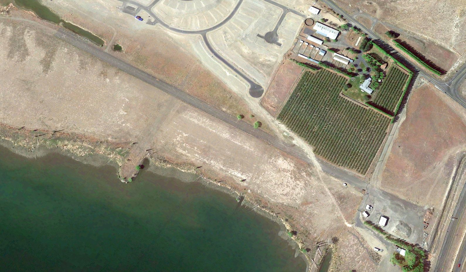
A 2021 aerial view looking southwest depicted Vantage Airport's asphalt north/south runway as remaining largely intact, but with a closed-runway “X” symbol on its south end.
The former crosswind runway was much less evident, with newly-constructed roads having covered the western portion.
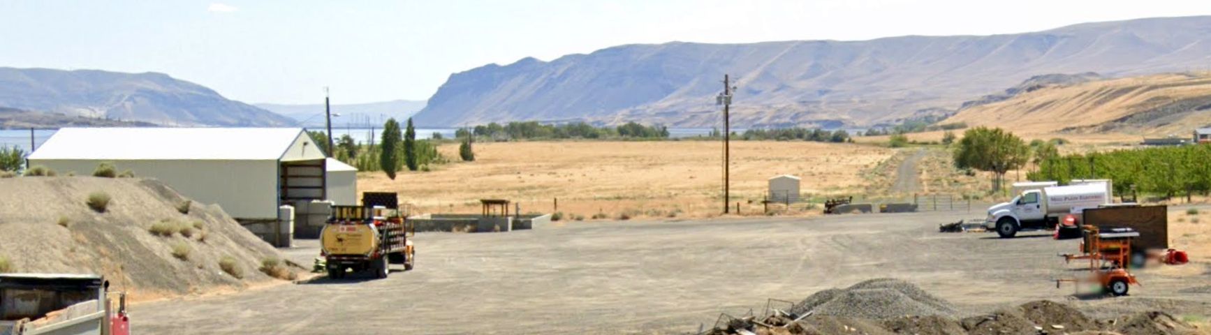
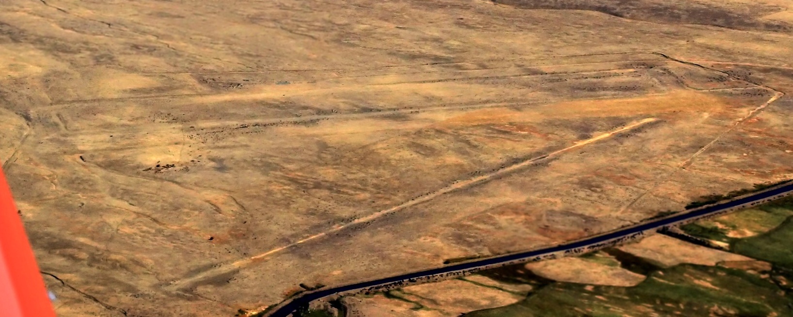
A 2023 photo looking south along the remains of the Vantage Airport paved north/south runway.
Thanks to Scott Kimball for pointing out this airfield.
____________________________________________________
Hanford Auxiliary Field, Hanford, WA
46.447, -119.505 (Southeast of Seattle, WA)
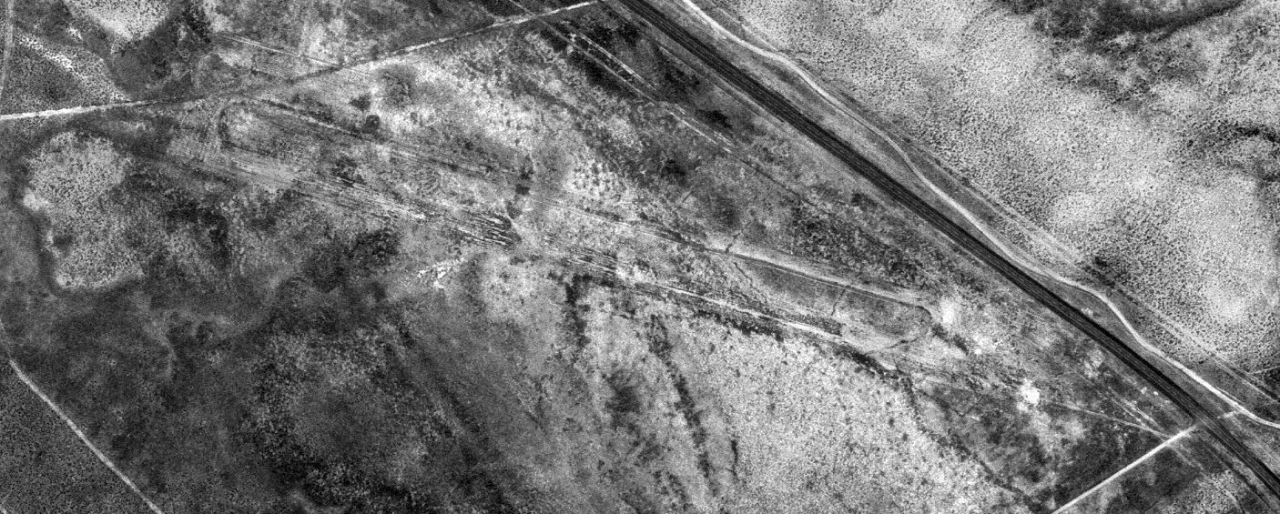
A 6/29/73 USGS aerial photo of the Hanford Auxiliary Airfield.
Photo of the airfield while in use has not been located.
Not much is known about this airfield, including its name, purpose, or date of construction.
The Hanford Site was established in late 1942 as part of the Manhattan Project for the large-scale production of uranium & plutonium.
At some point between 1942-44, a larger airfield (Hanford Field) was established several miles north, next to the site of the town of Hanford.
According to Scott Kimball, there were 5 other airfields on the Hanford Site, including this one.
No airfield at this location was depicted on the 1942/44/45/46 Spokane Sectional Charts, or 1950s/60s/70s USGS topo maps.
The earliest depiction which has been located of this airfield was a 1964 aerial view.
It depicted a deteriorated 3,300' northwest/southeast runway & parallel taxiway.
The earliest depiction which is available of this airfield was a 6/29/73 aerial view. The runway & taxiway remained recognizable.
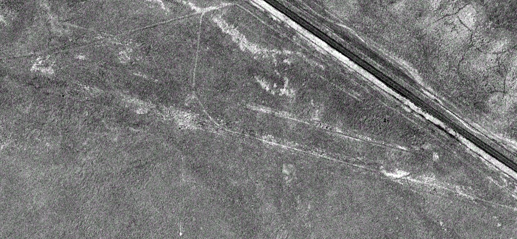
A 1996 aerial view depicted the Hanford Auxiliary Airfield runway & taxiway as deteriorated but still recognizable.
A 2020 aerial view depicted the Hanford Auxiliary Airfield runway & taxiway as deteriorated but still recognizable.
Thanks to Scott Kimball for pointing out this airfield.
____________________________________________________
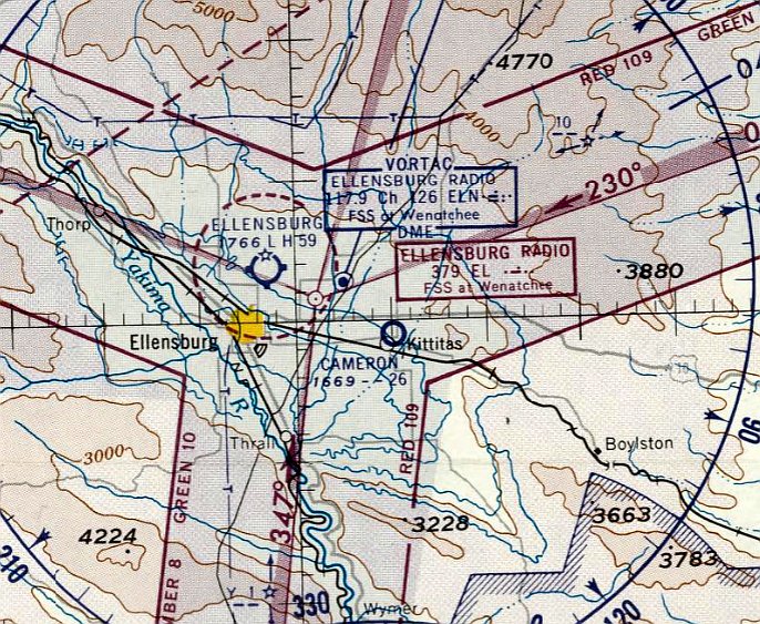
Cameron Airfield, Kittitas, WA
46.99, -120.419 (Southeast of Seattle, WA)
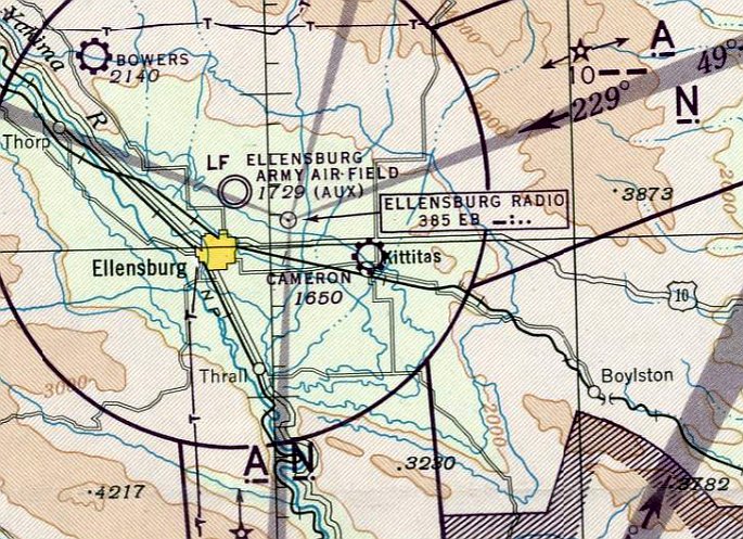
Cameron Airfield, as depicted on the October 1945 Seattle Sectional Chart.
This small general aviation airport was evidently established at some point in late 1945
(like hundreds of other small airports in the American post-WW2 aviation boom),
as it was not depicted on the April 1945 Seattle Sectional Chart.
The earliest depiction which has been located of Cameron Airfield was on the October 1945 Seattle Sectional Chart.
It depicted Cameron as a commercial/municipal airport.
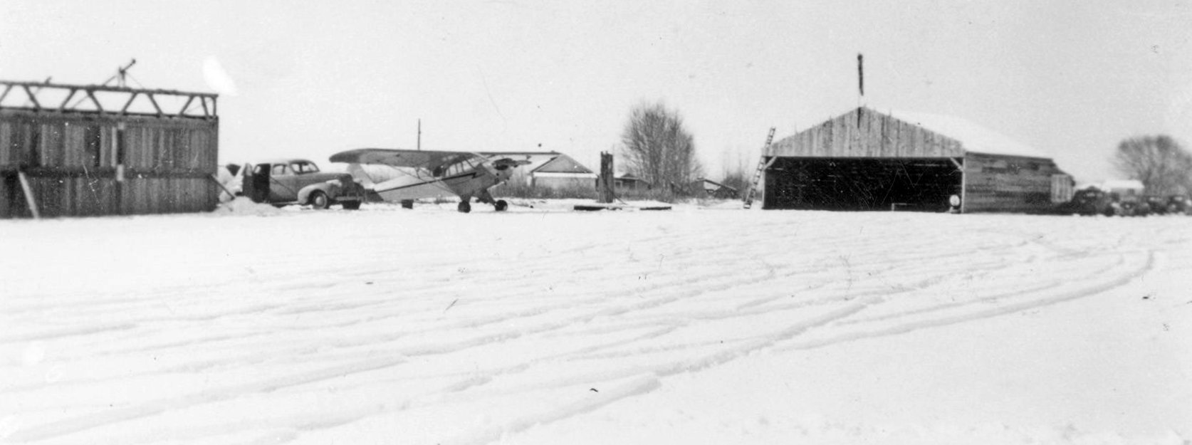
The earliest photo which has been located of Cameron Airfield was a circa 1940s photo (courtesy of Lee Corbin)
showing a snowy scene of a Piper Cub & a fuel pump between 2 hangars.
Cameron Airfield was not yet depicted on the 1947 USGS topo map.
The earliest topo map depiction which has been located of Cameron Airfield was on the 1950 USGS topo map (courtesy of Lee Corbin).
The last aeronautical chart depiction which has been located of Cameron Airfield was on the October 1960 Seattle Sectional Chart.
It depicted Cameron Airfield as having a 2,600' unpaved runway.
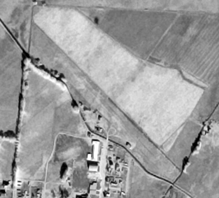
A 11/2/64 aerial view (courtesy of Lee Corbin) depicted Cameron Airfield as having a single unpaved northwest/southeast runway,
with a few small buildings along the southwest side, near which was possibly parked 1 light single-engine aircraft.
Cameron Airfield was evidently closed (for reasons unknown) at some point between 1960-65,
as it was no longer depicted on the 1965 Seattle Sectional Chart.
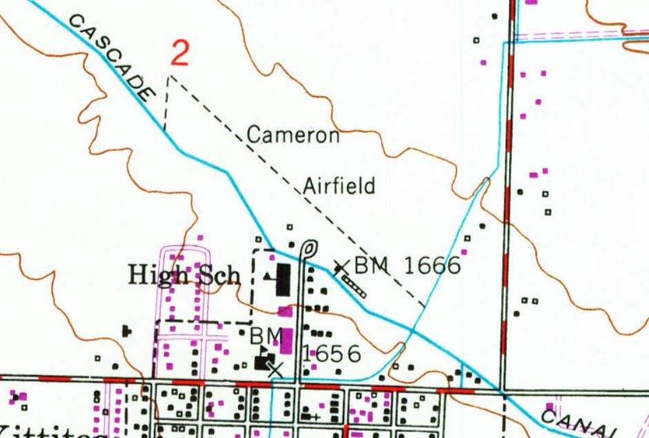
The 1978 USGS topo map (courtesy of Lee Corbin) depicted Cameron Airfield as a northwest/southeast property outline,
with a few small buildings along the southwest side.
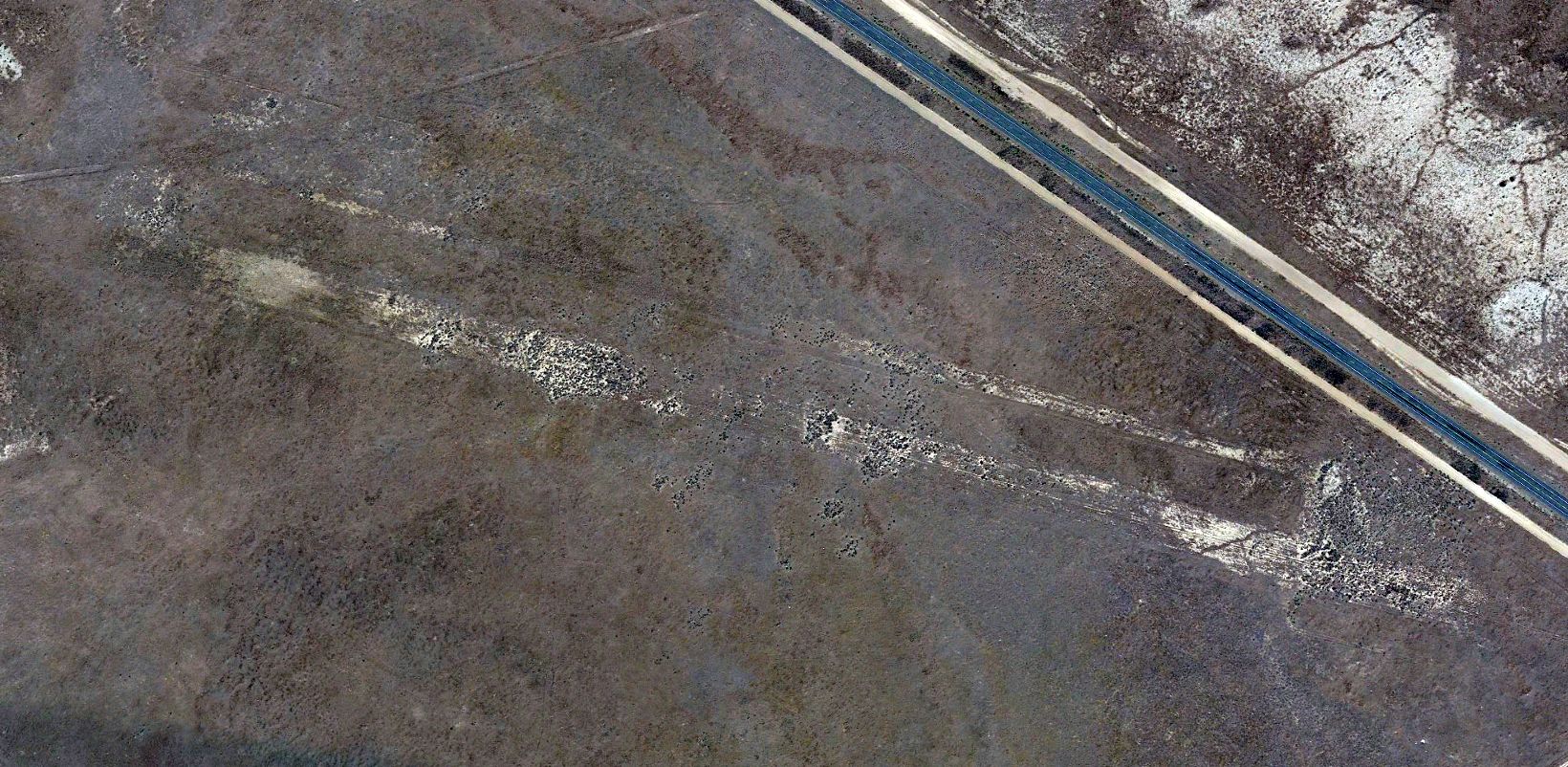
A 1981 aerial view showed Cameron Airfield remained intact, but there were no aircraft visible or any other sign of recent aviation use.
A 1983 aerial view showed a small building had been built over the middle of the former Cameron Airfield runway,
but the hangar remained standing.
A 2006 aerial view showed the former Cameron Airfield hangar had been removed at some point between 1983-2006.
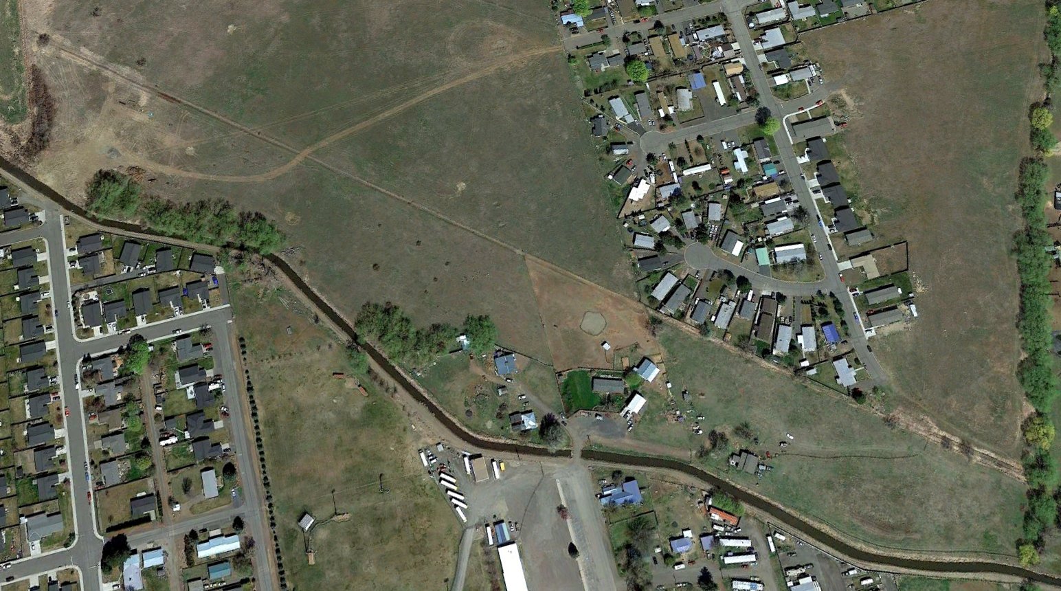
A 2021 aerial view looking northeast showed the Cameron Airfield runway orientation remained recognizable.
Thanks to Lee Corbin for pointing out this airfield.
____________________________________________________
46.6, -119.41 (Southeast of Seattle, WA)
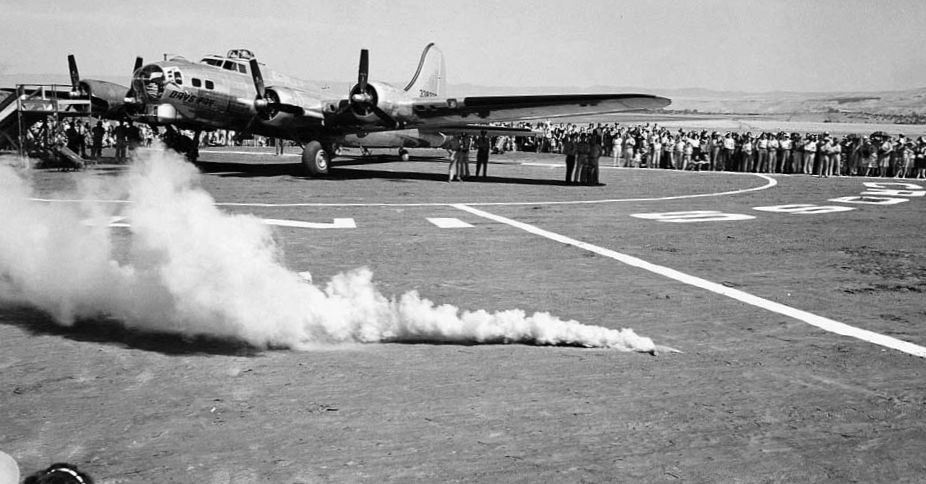
A 7/23/44 photo of the christening of the Boeing B-17G “Day's Pay” at Hanford Field.
The Hanford Site was established in late 1942 as part of the Manhattan Project
for the large-scale production of uranium & plutonium.
At some point between 1942-44, Hanford Field was established next to the site of the town of Hanford,
which was depopulated in order to establish the massive Hanford weapons facility.
Hanford Field was not depicted on the 1942/44/45/46 Spokane Sectional Charts.
According to www.historylink.org, “As World War II wore on, employees at the Hanford Engineer Works wondered how they could help.
Carpenter Max Blanchard is generally credited with coming up with the idea for buying a warplane to send overseas.
Shortly after the D-Day landing of 6/6/44, Blanchard received a letter from his son, who was fighting overseas.
The letter was full of praise for the offensive support the troops received from the air.
Blanchard knew then that a plane was the right gift for the Army & that it would be appreciated more than anything else.
Blanchard told his crew about his idea, and they quickly spread the word.”
According to www.historylink.org, “Soon the whole Hanford Site was enthusiastically supporting the idea of buying the war machine.
Over the course of the next month, the payroll department collected a day’s pay from each of some 51,000 employees.
The 'Give a Bomber' committee held a contest to pick a name for the plane.
Eleven people submitted the name 'Day’s Pay', since the campaign was conducted under the slogan 'Give a day’s pay & send a bomber on its way.'
All employees who contributed to the cause received a certificate acknowledging their 'share' of the bomber.
After the money was collected, the Army Air Forces was asked what type of plane it needed.
The answer came back quickly - the B-17 Flying Fortress. The cost of the bomber was approximately $300,000.”
According to www.historylink.org, “On 7/23/44, hundreds gathered at the Hanford Airport to witness the christening of a special airplane.
The dedication celebration began with a military demonstration performed by Company D of the 744th Military Police Detachment.
This was followed by singing of the National Anthem, accompanied by the U.S. Army Band & the Hanford Engineer Works Band.
After the anthem, Hanford Site commander Lt. Col. Frank Matthias & prime contractor Dupont General Manager G. P. Church addressed the crowd.
Finally John Hidebrink, chairman of the 'Give a Bomber' Committee, presented the bomber to Colonel David Wade, Base Commander at the Walla Walla Army Air Field.”
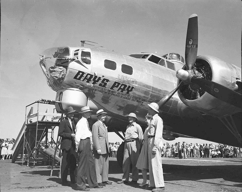
According to www.historylink.org, “Attention then turned to the airplane itself.
Katie Belle Harris, whose son had been lost in action in Germany earlier in the year, was given the honors of christening the B-17.
She broke a champagne bottle over the nose of the airplane.
Under the 'Day’s Pay' moniker painted on the nose,
the words 'Presented to the Army Air Forces as a Result of Cash Contributions by Employees of Hanford Engineer Works' explained the origin of the plane.
There was also a plaque mounted on the inside of the plane.”
A closeup 7/23/44 photo of the christening of the Boeing B-17G “Day's Pay” at Hanford Field.
According to www.historylink.org, “After the christening, Brigadier General James E. Parker, Commanding General of the 4th Air Force in San Francisco,
told the Hanford workers how much he appreciated their sacrifice.
Then it came time for the B-17 to be taken to its new home of the 8th Army Air Force in England.
Members of the Ferry Command boarded the plane, revved it up, and flew away.
The plane, escorted by 4 fighter planes, dipped her wing in salute three times before flying on.”
It is not known if Hanford Field's use in support of the adjacent weapons facility ended with the close of WW2.
Hanford Field was not depicted at all on the 1947 USGS topo map (nor subsequent topo maps from 1955 & 1966).
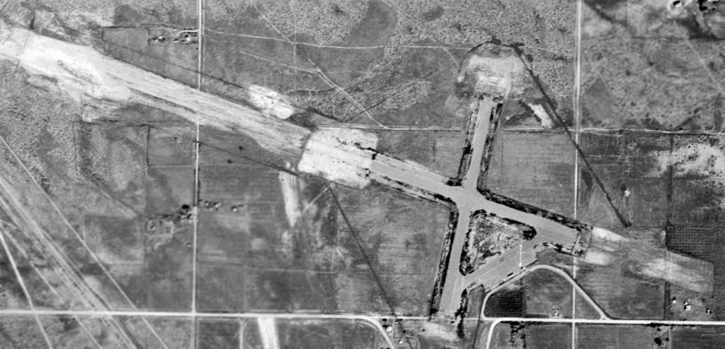
The earliest photo which has been located showing the layout of Hanford Field was a 6/23/48 USGS aerial view.
Hanford Field consisted of a 2 paved runways (with unpaved extensions toward the northwest & southeast) & a paved ramp with a few small buildings.
There did not appear to be any hangars. There were no aircraft visible on the field, nor any other sign of recent aviation use.
According to Scott Kimball, “This one was partially re-activated during the 1980s for practice use by the Hanford Patrol’s Helicopters.”
A March 2012 aerial view by Don Hinton looking north at Hanford Field showed the very recognizable though deteriorated outline of the 2 runways & the ramp.
A 2020 aerial view showed the remains of Hanford Field's 2 runways & ramp.
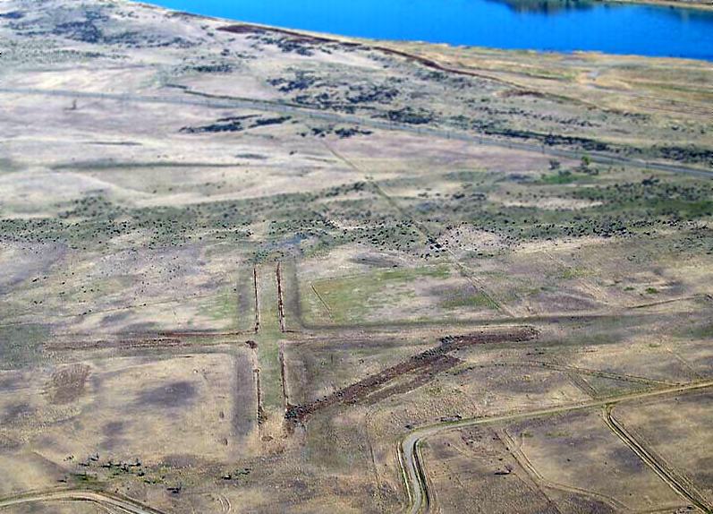
A 6/30/23 aerial view by Mark Neubauer looking east at the remains of Hanford Field's 2 runways & ramp.
The site of Hanford Field is located northwest of the intersection of Glade North Road & Hanford Road.
____________________________________________________
Bowers Auxiliary Airfield, Thorp, WA
47.11, -120.63 (Southeast of Seattle, WA)
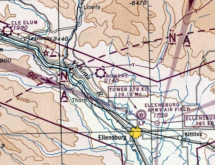
Bowers Field, as depicted on the May 1944 Seattle Sectional Chart.
Photo of the airfield while operational has not been located.
Bowers Field was not yet depicted on the October 1942 Seattle Sectional Chart.
The earliest depiction which has been located of Bowers Field was on the May 1944 Seattle Sectional Chart,
which depicted Bowers as a commercial/municipal airport.
According to an article in the 9/22/44 Ellensburg Capital (courtesy of Timothy Zacher) entitled “Auxiliary Field Listed 'Surplus'”,
“The auxiliary field was constructed last year when the temporary closing of the Ellensburg Airport
by the Army Air Forces necessitated providing facilities for the Ellensburg Flying Service,
which was then training aviation students in the training detachment at the Central Washington College.
The Government took over the 483 acres of land, principally from the Smithson company,
and when this concern & other owners refused to accept the amounts offered by the Government,
condemnation action was instituted.”
The article continued, “A unit of the Army engineers was brought here & did a considerable part of the runway construction work.
Birch & Sons finished up the runway construction & the Gasland Construction Company erected the buildings.
The Government built an office building, a hangar, and T-hangars for 4 planes.
The Flying Service built T-hangars for 8 additional planes.”
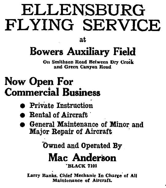
An 8/5/44 advertisement for Ellensburg Flying Service at Bowers Auxiliary Airfield (courtesy of Timothy Zacher)
said the field was “Now open for commercial business”, offering flight instruction, aircraft rental, and maintenance.
The owner & operator was listed as Mac Anderson.
This Bowers airfield apparently had a short life, as described in an article in the 9/22/44 Ellensburg Capital (courtesy of Timothy Zacher) entitled “Auxiliary Field Listed 'Surplus'”:
“Reecer Creek Airport will be put up for disposal by Government.
The Ellensburg Auxiliary War Training Service Field in Reecer Creek has been declared 'surplus'
to the Reconstruction Finance Corporation by the military services & is to be disposed of on or about September 15.
However, it was learned that the Federal Government never has secured title to much of the land taken for the airport
and is consequently not in a position to dispose of it.”
The article continued, “The Flying Service took a lease for the duration & 6 months on the field when the AAF training program was completed
and now operates the field as a commercial airport.
The field was 2 runways, 3,000' x 300', one of which has a 100' strip surfaced over steel mats its full length.
The other is a graded runway. The field however is too far from the city for practical permanent operation.”
Bowers Auxiliary Airfield was not listed among active airfields in the 1945 AAF Airfield Directory (courtesy of Scott Murdock).
Military use of its parent Ellensburg AAF had ended in February 1945.
The last depiction which has been located showing Bowers Auxilliary Field in operation was on the October 1946 Seattle Sectional Chart,
which depicted “Bowers (Aux)” as having a 3,000' unpaved runway.
There was apparently not ever any post-WW2 aviation reuse of Bowers Auxiliary Field, as it was no longer depicted on the April 1947 Seattle Sectional Chart or the 1948 USGS topo map.
It thus was in use for no more than 5 years & possibly as little as 2 years.
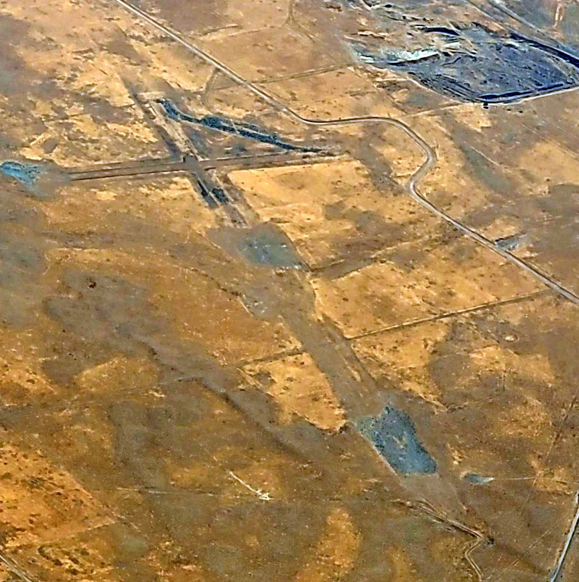
The earliest photo which has been located of Bowers Auxiliary Airfield was an 8/9/56 USGS aerial view.
It still showed the recognizable outline of 2 runways, along with a ramp & a foundation on the north side.
A 6/15/00 USGS aerial view still showed the recognizable outline of 2 runways at the site of Bowers Auxiliary Airfield.

A 9/3/11 aerial view still showed the ghostly outline of 2 runways at the site of Bowers Auxiliary Airfield.
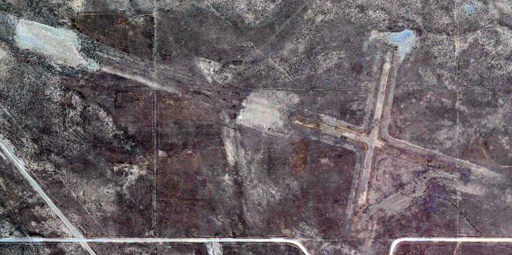
A 3/16/13 photo by Bob Schweitzer of Bowers Auxiliary Airfield, looking west along the axis of the east/west primary runway.
Bob reported, “The whole area had burned 9 months before in some very nasty fire.”
He also found concrete remnants scattered about, presumably of some sort of drainage system:
“They had some kind of drainage system & then it was broken up & placed there. It seemed some place must have had drainage at the field.”

A 6/26/15 aerial view looking south-southwest at the remnants of Bowers Field by Dorian Jepsen,
who observed, “The remnants of the runways as well as the taxiway for the northwest/southeast runway are still visible.”
A 10/24/18 aerial view by Bob Bogash looking northeast at the remnants of the Bowers Field runways & taxiway.
The site of Bowers Auxiliary Airfield is located northwest of the intersection of Smithson Road & Howard Road.
____________________________________________________
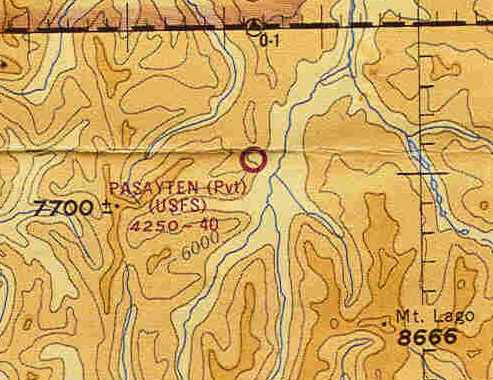
Pasayten Airstrip, Pasayten, WA
48.92, -120.63 (Northeast of Seattle, WA)
A 1932 photo of the 1st plane to land at Pasayten Airstrip, a Curtis Robin which came from Felts Field (courtesy of John Townsley).
According to John, “The photo was taken by Charles Johnson, a Forest Service lookout, using a pinhole box type camera.”
According to John Townsley, the Pasayten Airstrip was built in 1931 by the Works Progress Administration.
John noted, “The Pasayten Airstrip was listed from 1931-68 on the annual facilities inventory for the Pasayten,
then the Winthrop Ranger Districts of the Okanogan National Forest.”
The first aircraft to land there was a Curtis Robin, which came in 1932 from Felts Field.
The earliest chart depiction which has been located of the Pasayten Airport was on the September 1936 Bellingham Sectional Chart.
It depicted Pasayten as an auxiliary airfield.
A circa 1936 photo of the Pasayten Airstrip, possibly during its construction (courtesy of John Townsley).
The Pasayten Airstrip was reportedly used fairly consistently throughout the years, primarily for fire suppression.
It was used by a variety of aircraft, including Ford Trimotors, Norseman, DC-3, Beech 18, and other fixed wing aircraft.
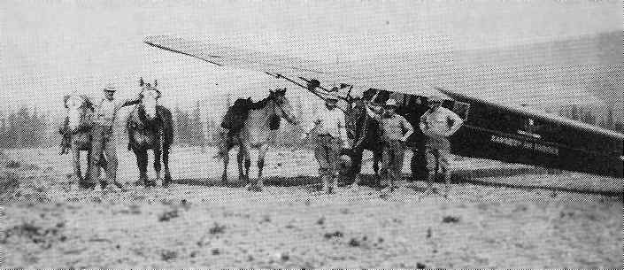
A 1944 photo of a military fire suppression mission at Pasayten in 1944 (courtesy of John Townsley),
with 2 Cessna UC-78 Bobcats in the background.
According to John, “A bunch of brass went into the airstrip to assess fire fighting needs.”
According to John Towsley, “The strip was later in [1944] used to extract the all-black paratrooper battalion, the Triple Nickel,
after they finished up on the Bunker Hill Fire.”
The 1963 WA Pilot's Guide (courtesy of Ron Dupas)
depicted Pasayten Airport as consisting of a single 3,400' sod north/south runway.
The May 1965 Bellingham Sectional Chart (courtesy of Chris Kennedy)
depicted “Pasayten (USFS)” as a private field with a 4,000' unpaved runway.
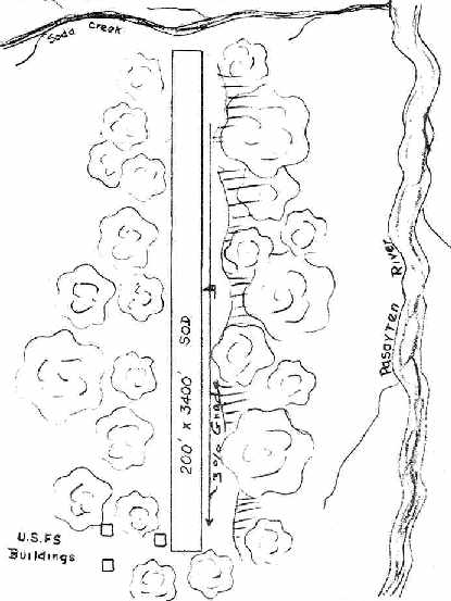
The 1966 WA Pilot's Guide (courtesy of Chris Kennedy) depicted Pasayten Airport as consisting of a single 3,400' sod north/south runway.
Three U.S. Forest Service buildings were depicted along the southwest side of the runway.
It was described as a private field, closed to the public except in emergency.
The Pasayten Airstrip was closed in October 1968 with the establishment of the Pasayten Wilderness by Congress.
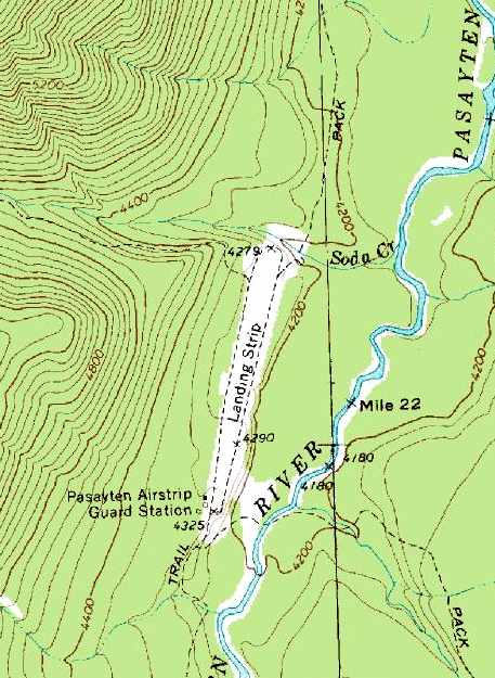
The 1969 USGS topo map depicted the “Landing Strip” as consisting of a single 3,000' north/south unpaved runway.
The “Pasayten Airstrip Guard Station” was depicted on the southwest corner of the airfield.
The Pasayten Airstrip was no longer depicted on the May 1970 Bellingham Sectional Chart.
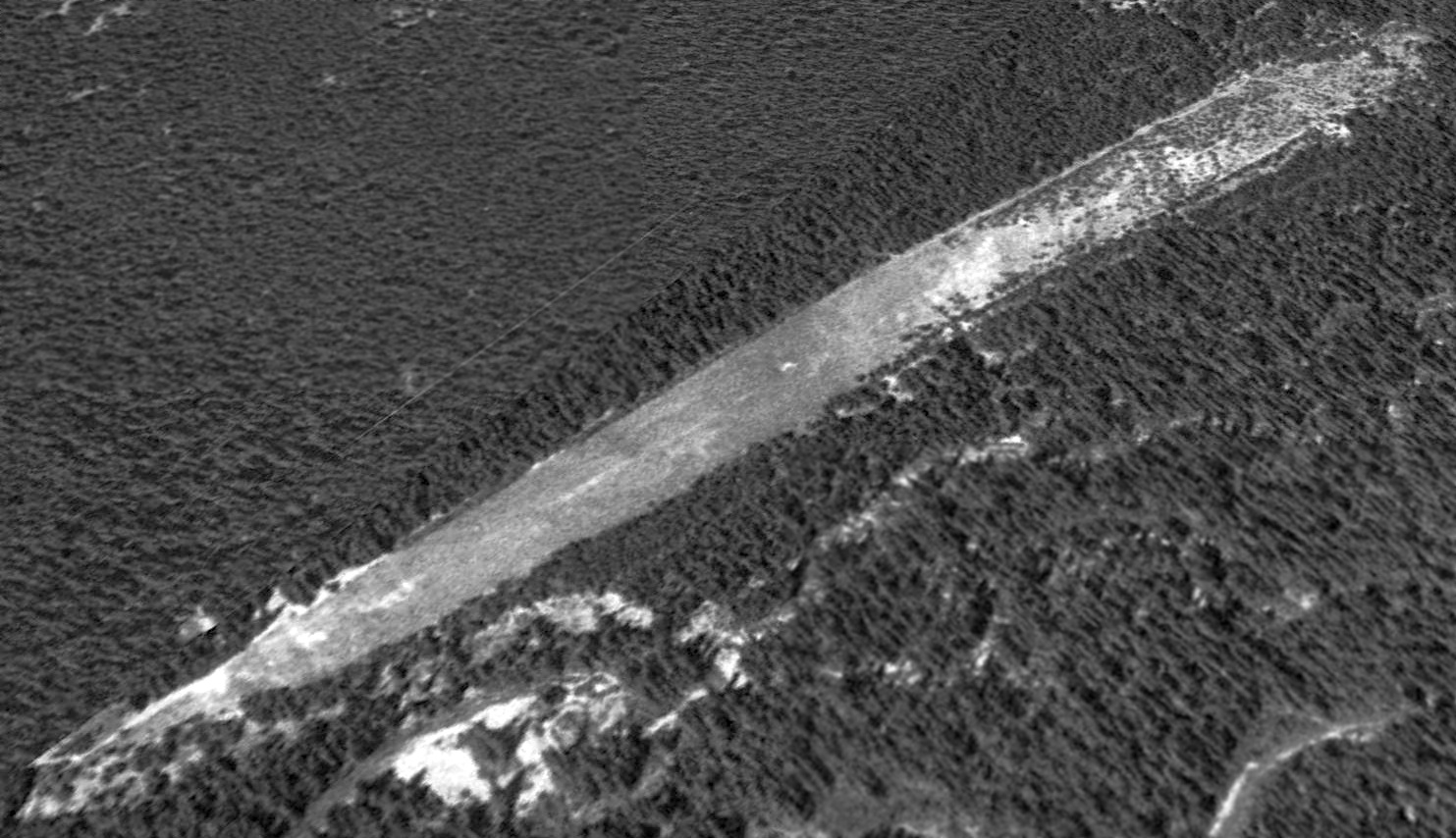
The Pasayten Airstrip was still largely clear as seen in a 1998 USGS aerial view looking northwest.
John Townsley remarked, “There's talk about trying to get the field on the National Register of historic places.
It's pretty unique, both in terms of size & configuration, but also its close connection with the national smoke jumper program.”
A 2016 aerial view looking northwest showed the Pasayten Airstrip to remain clear.
____________________________________________________
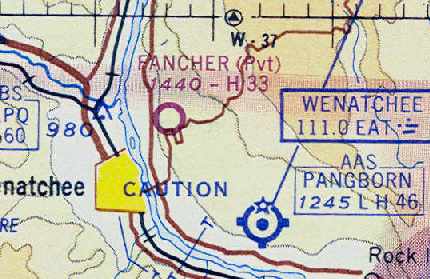
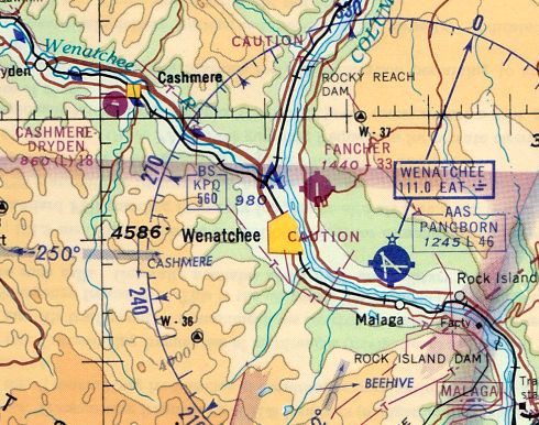
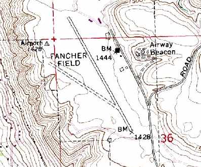
47.45, -120.28 (East of Seattle, WA)
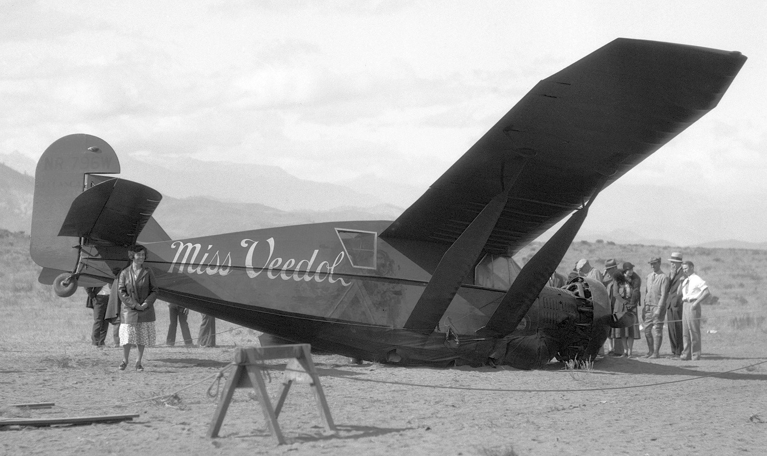
An October 1931 photo of Miss Veedol, a 1931 Bellanca CH-400/J-300, which made a belly-landing at Fancher Field on 10/5/31 after its historic 1st Trans-Pacific flight.
The date of establishment of Fancher Field has not been determined.
The earliest reference which has been located of Fancher Field was from the 10/5/31 crash-landing of Miss Veedol, after completing the world's first Trans-Pacific flight.
Clyde Pangborn & Hugh Herndon flew Miss Veedol, a 1931 Bellanca CH-400/J-300, on a 41 hour flight from Sabishiro Beach, Misawa Japan, across the northern Pacific.
Upon reaching the Pacific Northwest, they found that the weather was cloudy & rainy over most of the area.
They first considered going on to Boise, Idaho to add the 'longest flight' to their already accomplished 'nonstop Pacific crossing' record.
Soon, they found that weather would prevent their landing in Boise, so they turned towards Spokane.
When the weather also prevented their landing there, they headed southwest towards Pasco.
When that failed, they finally headed towards Wenatchee to land at Fancher Field.
There, they had to make a belly landing because they had disposed of Miss Veedol's landing gear over the western Pacific.
She was damaged, but repairable, and her propeller was wrecked, but Herndon & Pangborn came through the landing intact,
winning the pair the 1931 Harmon Trophy in recognition of the greatest achievement in flight for that year.
The earliest aeronautical chart depiction which has been located of Fancher Field was on the September 1934 Seattle Sectional Chart.
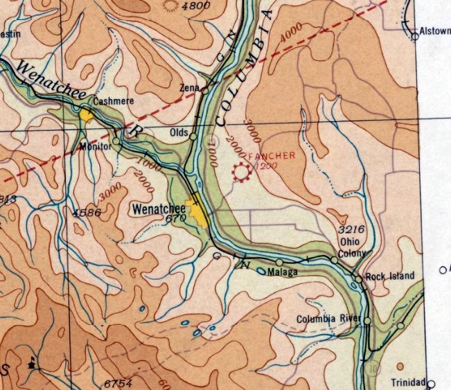
The 1934 Department of Commerce Airport Directory (courtesy of Chris Kennedy) described Fancher Field as being located 2 miles northeast of Wenatchee.
The field was described as having 2 oiled runways (2,500' northwest/southeast & 1,650' northeast/southwest),
along with a hangar with the field's name painted on it.
The earliest photo which has been located of Fancher Field was an undated aerial view looking southwest from the Airport Directory Company's 1938 Airport Directory (courtesy of Chris Kennedy),
It depicted the field as having 2 runways, and 3 hangars along the east side.
The directory described Fancher Field as having 2 gravel runways (3,500' north/south & 2,400' northwest/southeast).
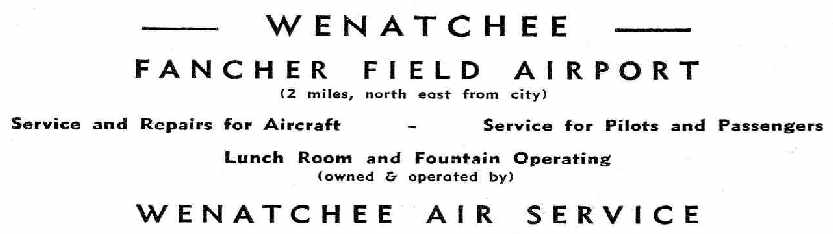
An advertisement for Fancher Field's Wenatchee Air Service,
from the Haire Publishing Company's 1945 Airport Directory (courtesy of Chris Kennedy).
The Haire Publishing Company's 1945 Airport Directory (courtesy of Chris Kennedy)
described Fancher Field as a privately owned & operated "Class 2" airfield.
The field was said to have two gravel runways (3,500' north/south & 3,000' northeast/southwest) and three hangars.
The manager was listed as J. R. Parkhill.
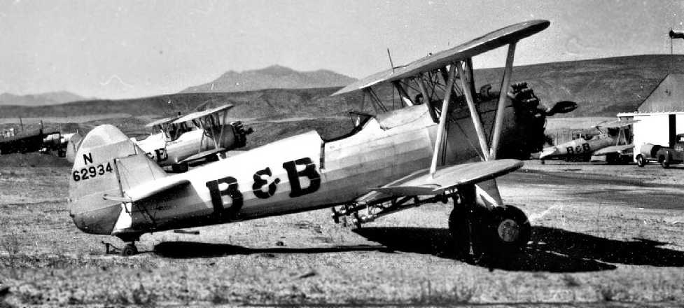
A circa 1952 photo by George Churchill (courtesy of Candice Floyd) of several Stearman biplanes in front of the Fancher hangar.
Candice reported, “My father, George Churchill, was a flight instructor, crop duster, & barnstormer.”
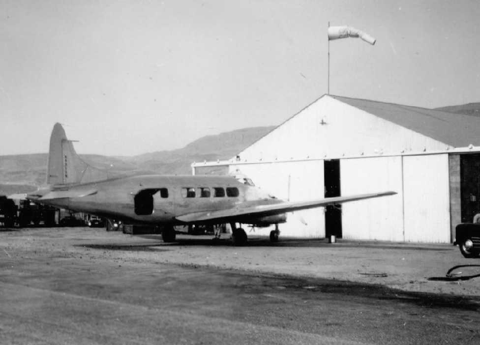
A circa 1952 photo by George Churchill (courtesy of Candice Floyd) of a rare de Havilland Dove in front of the Fancher hangar.
Fancher Field was depicted as a commercial or municipal airport
on the October 1954 Seattle Sectional Chart (courtesy of Chris Kennedy).
The Cascade Soaring Society relocated from Puget Sound to Fancher Field in the 1950s,
before eventually relocating again to nearby Pangborn Memorial Airport.
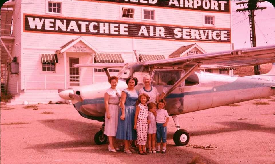
A 1958 photo by Williard Spencer (courtesy of Sheila Spencer Lein) of his family in front of their Cessna 172 & a Wanatchee Air Service building at Fancher Field.
Sheila recalled, “My dad was a WWII pilot & we had a little 4-seater Cessna to buzz around in.
Several years ago my husband & I drove from Seattle to Wenatchee.
We were driving around the hills in E Wenatchee & drove up to a spot where there was an old WWII Quonset Hut.
Boy did I ever have a flashback of landing there in the 50s.”
Fancher Field was not listed at all in the 1960 Jeppesen Airway Manual (according to Chris Kennedy),
possibly because it had become a private field by that point.
The 1963 WA Pilot's Guide (courtesy of Ron Dupas) depicted Fancher Field as having 2 gravel runways, the longest being 3,340'.
By the time of the June 1964 Seattle Sectional Chart (courtesy of Chris Kennedy),
Fancher Field was depicted as a private field, with a 3,300' hard surface runway.
The last aeronautical chart depiction which has been located of Fancher Field
was on the June 1965 Seattle Sectional Chart (courtesy of Ron Kunse).
It once again depicted Fancher Field as a public-use airport, with a 3,300' paved runway.
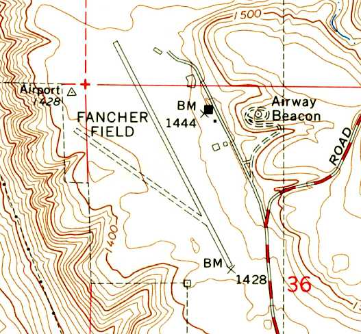
The 1966 USGS topo map depicted Fancher Field as having one paved runway & one unpaved runway, along with a few small buildings & an airway beacon on the east side.
Fancher Field was evidently closed (for reasons unknown) at some point between 1964-66,
as it was no longer depicted at all on the March 1966 USAF Operational Navigation Chart,
listed in the 1967 AOPA Airport Directory,
or depicted on the December 1968 Seattle Sectional Chart (according to Chris Kennedy).
Fancher Field may have continued to operate in some capacity after it was no longer depicted on aeronautical charts,
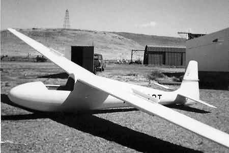
as the above picture (courtesy of Ron Dupas) of a Schleicher K-6E glider was taken at Fancher Field in September 1969.
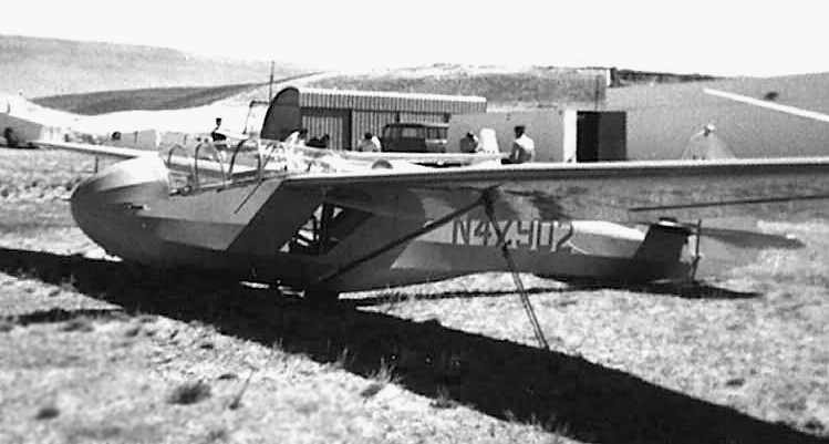
A 1969 photo (courtesy of Ron Dupas) of a Schweizer SGS 2-8 (TG-2) glider at Fancher Field.
The glider belonged to Phil Entz, who recalled, "It is now located in the Silent Wings Museum in Terrell, TX.
My father donated it after an accident in which I put my head through the rear canopy.
A close inspection of the image shows the missing rear canopy."
Don Eikenberry recalled, “I learned to fly in the late 1970s in Wenatchee. Fancher was owned & operated by a crop-duster outfit.
It was private but nobody seemed to mind if you landed there without permission.
I did many a practice engine-out landing there. The runway was a bit rough but not a problem.
I'm not sure when the crop-duster outfit went out of business but the land was eventually sold to developers.”
Mark Baker recalled, “In 1983 I made arrangements with Don Eikenberry that if I filled his tank for his Cessna 150 each flight, he would teach me to fly!
That helped Don to build hours as a Certified Flight Instructor.
We practiced in the Wenatchee valley up & down the Columbia River as well as over Badger Mountain.
One time we were over the Columbia River at the North end of Wenatchee & Don reached over & turned off the power saying, 'Your engine died, find a place to land!'
So I spiraled down toward Fancher field & landed there.
So I can personally vouch that Don indeed was using Fancher field for training right up to 1983!”
According to pilot & life-long Wenatchee resident Doug Miller, “Fancher Field was operated by WENAIRCO, Inc at the time of it's closing in 1985.
Portions of the property were sold to a Fancher Heights Developer for new homes.”
Fancher Field was still depicted on the 1987 USGS topo map.
It was depicted as having one paved runway & one unpaved runway, along with a single building on the northeast side of the field.
An Airway Beacon was also still depicted, on a hill to the east of the airport.
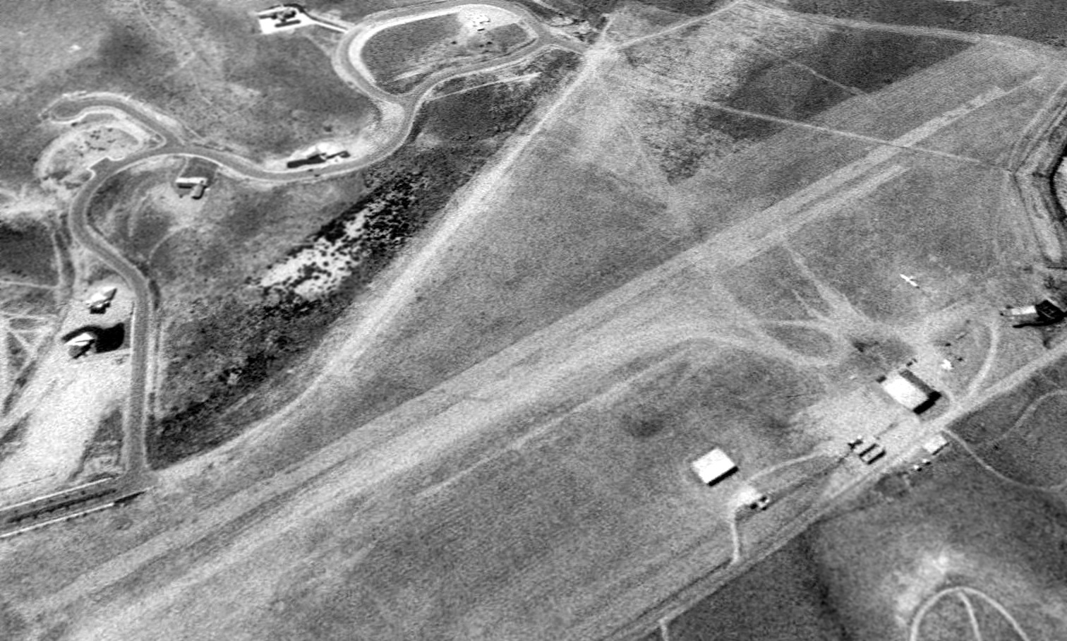
The last photo which has been located showing Fancher Field while still in operation was a 6/21/90 USGS aerial view looking northwest,
showing the 2 runways, several small hangars, and at least one light single-engine aircraft visible parked on the east side of the field.
According to pilot & life-long Wenatchee resident Doug Miller,
“In the late 1990s the remaining WENAIRCO property was sold for development to the northwest of the airfield.
The airfield has not been active since that time.”
An 8/2/98 USGS aerial photo showed the southern portion of the site of Fancher Field had been redeveloped with housing,
with a street (Fancher Heights Boulevard) with homes having been built over the former unpaved runway.
The former paved runway remained largely intact, along with at least one former hangar (the light colored building on the east side).
Wenatchee resident Doug Miller reported in 2008, “Three buildings remain today along the former ramp area (Fancher Field & Gun Club Rd):
One is a large hangar with a new mural on the south face - owner is Greg Howland.
One is the old pilot lounge / fountain - owner is Stimac Construction (developer).
One is the old metal hangar (shown in the glider photos [1969 photos above]) - owner is Eastmont School District.
I spoke with Greg Howland yesterday, he purchased the hangar about 4 years ago from a private owner (the mural painter).
He has developed the building for commercial use & mini storages were built adjacent to the old hangar.”
According to Doug Miller, “Each year the landing [of the Miss Veedol at Fancher Field back in the 1930s]
is remembered by a local aviation day the first weekend in October.
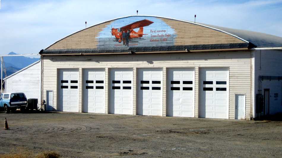
A 10/14/08 photo by J.L. Campbell of the remaining Fancher Field hangar, showing the nice mural commemorating Fancher Field's history.
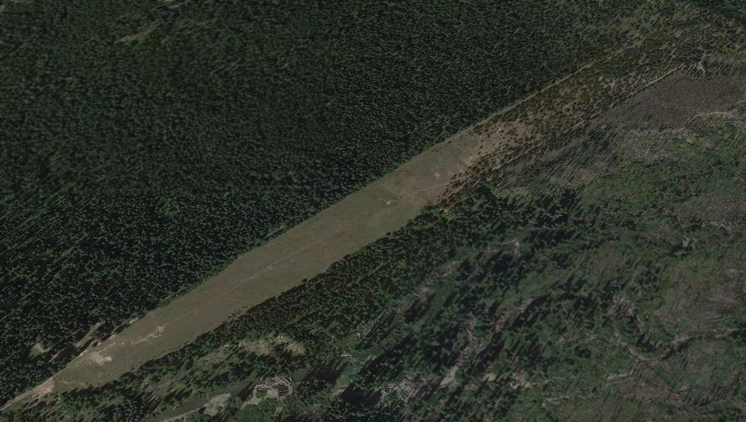
A 2017 aerial view looking northwest showed the site of Fancher Field almost completely covered with houses,
with the only remnant being the former hangar (large white building) on the northeast (right) side.
The site of Fancher Field is located northwest of the intersection of Badger Mountain Road & Fancher Boulevard,
appropriately enough.
____________________________________________________
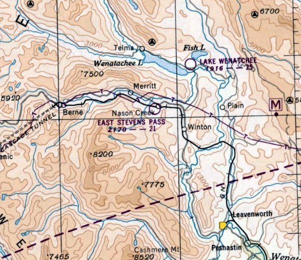
East Stevens Pass Airport / Nason Creek State Airport / Dardanelles Landing Strip, Nason Creek, WA
47.76, -120.8 (East of Seattle, WA)
East Stevens Pass Airport, as depicted in the March 1950 Seattle Sectional Chart.
This general aviation airport was evidently built at some point between 1949-50,
as it was not depicted on the October 1949 Seattle Sectional Chart.
The earliest depiction of the field which has been located was on the March 1950 Seattle Sectional Chart.
It depicted the East Stevens Pass Airport as having a 2,100' unpaved runway.
It was still labeled East Stevens Pass Airport on the October 1954 Seattle Sectional Chart (courtesy of Chris Kennedy).
At some point between 1954-63, the field was evidently renamed “Nason Creek Emergency Airport”,
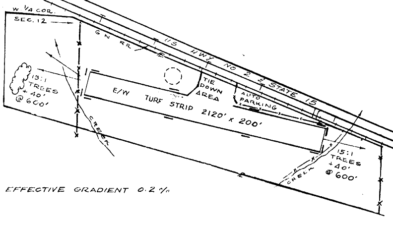
as that is how it was listed in the 1963 WA Airport Directory (courtesy of Ron Dupas).
It depicted the field as having a single 2,120' turf east/west runway.
A tie-down area was depicted along the north side of the runway, but there were no buildings depicted.
The manager was listed as the WA State Aeronautics Commission.
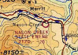
The June 1964 Seattle Sectional Chart (courtesy of Chris Kennedy) depicted "Nason Creek State Emerg" as having a 2,000' unpaved runway.
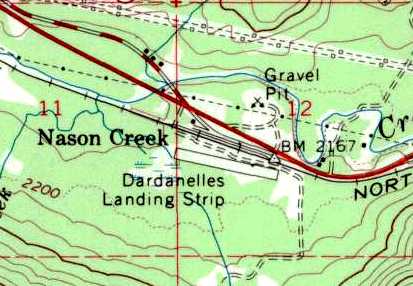
The 1965 USGS topo map depicted the airfield as Nason Creek as the “Dardanelles Landing Strip”.

A wintry aerial view looking north at the Nason Creek State Airport, from the 1971 WA State Airport Directory (courtesy of Chris Kennedy).
The directory depicted Nason Creek State Airport as having a single 2,120' turf Runway 8/26.
The airport offered no services, and was described as "Closed winters. Use at own risk."
The manager was listed as the WA State Aeronautics Commission.
The last aeronautical chart depiction which has been located of Nason Creek State Airport was on the June 1971 Seattle Sectional Chart.
It depicted Nason Creek State Airport as having a 2,000' unpaved runway.
Nason Creek State Airport still listed in the 1976 AOPA Airport Directory (according to Chris Kennedy) as an "Emergency airfield closed winters".
Nason Creek State Airport was still listed in the 1982 AOPA Airports USA Directory (according to Chris Kennedy), but labeled "Use at own risk."
The 1989 USGS topo map still depicted "Nason Creek State Airport",
but that doesn't necessarily indicate it was still an open airfield at that point.
Nason Creek State Airport was evidently closed at some point between 1976-93,
as it was no longer listed among active airfields in the 1993 Flight Guide (according to Chris Kennedy)
nor depicted on the January 1994 Seattle Sectional Chart.
Bill Hamilton (former WA Director of Aeronautics) recalled, “Nason Creek was closed
simply because it was rather short for the summer's high temperatures & it's elevation.
The thought in the office was that with Lake Wenatchee so close, the potential risk required the action.
The property was sold by bid to a private party.”
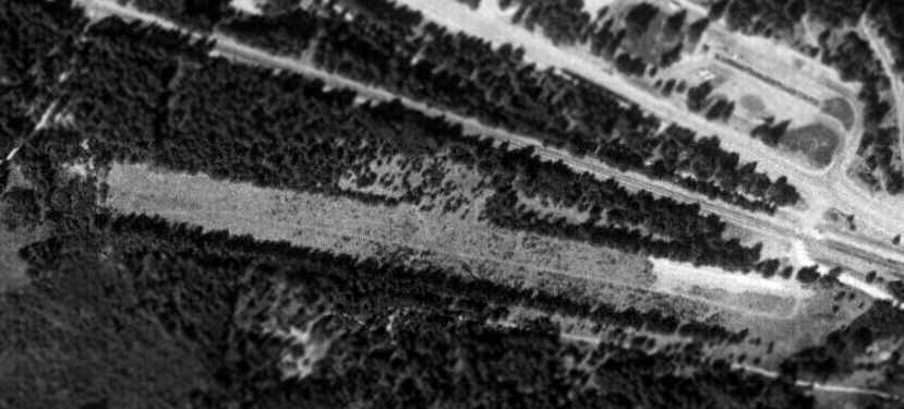
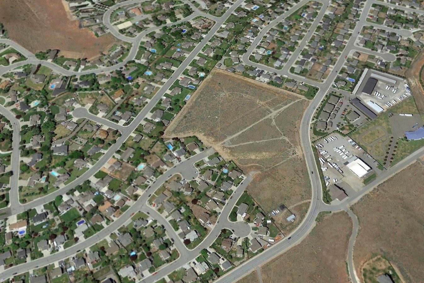
As seen in the 1998 USGS aerial photo, the runway at Nason Creek remained clear.
There did not appear to be any buildings or other facilities at the airfield.
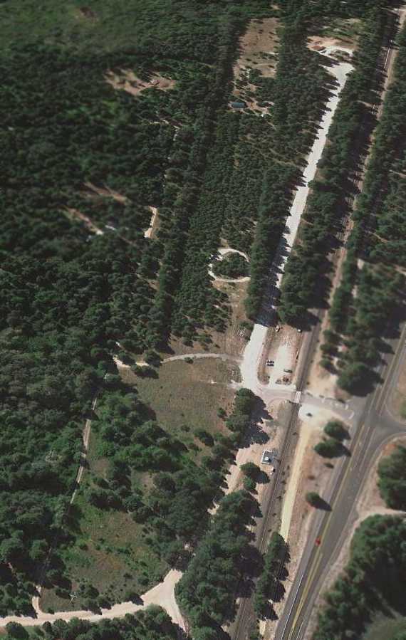
An 8/8/11 aerial view looking west showed the Nason Creek runway to be overgrown, but the outline was still barely recognizable.
Nason Creek State Airport is located southeast of the intersection of Route 2 & Coulter Creek Road.
____________________________________________________
Jackass Field #9 / Naval Outlying Landing Field 35911, Eltopia, WA
46.43, -119.13 (Southwest of Spokane, WA)
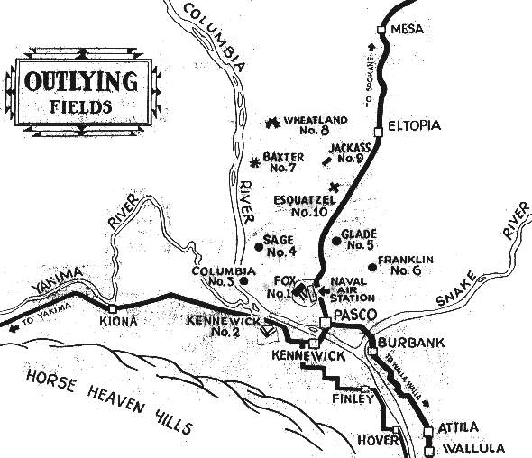
A undated WW2-era map of some of the Outlying Fields of NAS Pasco,
with Jackass #9 northeast of the center (courtesy of John Voss).
This small airfield was was established in 1942 as one of 21 outlying airfields for Pasco Naval Air Station.
According to Brian Rehwinkel, Navy records indicate the Jackass airfield “was first used in 1942.
A lease for 80 acres was consummated on 3/1/42 (and subsequently extended in 1943 through June 1946).
The remaining half of the field (80 acres) was already owned by the federal government.”
Brian reported that a Navy document described the land before the OLF was built as “desert wasteland”.
An undated WW2-era table of outlying fields for Pasco NAS (courtesy of John Voss) described the Jackass site as consisting of 159 acres.
The airfield was described as having a single 1,800' x 200' soil oil surface.
The undated WW2-era map of outlying fields for Pasco NAS (courtesy of John Voss)
depicted “Jackass #9” as having a single northeast/southwest runway.
According to Brian Rehwinkel, “This field was used for aviation training until primary training ended at NAS Pasco in December 1943.
At that time, 10 of the 21 Outlying Landing Fields - including Jackass OLF - were designated for use as bomb targets.
During its use, the Navy spent almost $45,000 on improvements (including the runway) for the airfield.”
The Jackass airfield (or any of the other NAS Pasco Outlying Fields) was not depicted at all on the April 1944 Spokane Sectional Chart.
Even though the November 1944 Spokane Sectional Chart did not depict the Jackass airfield,
it did depict a circular Cautio Area around it (& each of the other NAS Pasco Outlying Fields).
The Jackass airfield was evidently not reused for civilian aviation,
as it was not depicted at all on 1945 or 1946 Spokane Sectional Charts.
Brian Rehwinkel reported, “According a navy memo, Jackass OLF was declared surplus to the needs of the Navy on 3/25/46
and the lease for privately-owned half of the field – for $24 annually - was allowed to expire on 6/30/46.”
The Jackass airfield was not depicted at all on the 1947 USGS topo map.

A 6/2/48 USGS aerial photo of the Jackass airfield (courtesy of Brian Rehwinkel).
The field consisted of a single northeast/southwest runway, surrounded by an oval fence or drainage ditch.
There did not appear to be any buildings at the airfield, nor any aircraft.
The Jackass airfield was not depicted at all on USGS topo maps from 1951 or 1966.
A 1996 USGS aerial photo showed no trace remaining of the Jackass airfield, with the land returned to farming.
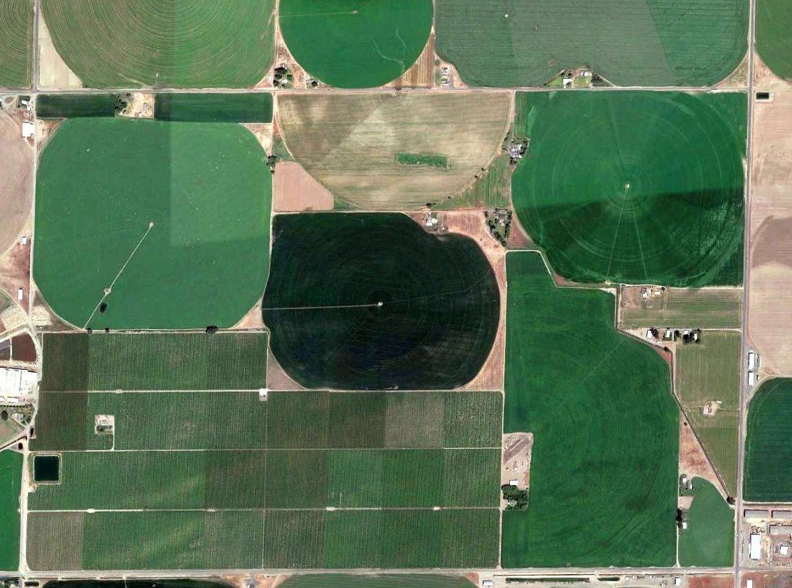
A 2017 aerial photo showed not a trace remains of the Jackass airfield.
It is remarkable to see how much the landscape has been changed by irrigation (compared to the 1948 photo).
Jackass NOLF is located northwest of the intersection of North Glade Road & Dogwood Road, 5 miles southwest of Eltopia.
____________________________________________________
Since this site was first put on the web in 1999, its popularity has grown tremendously.
If the total quantity of material on this site is to continue to grow,
it will require ever-increasing funding to pay its expenses.
Therefore, I request financial contributions from site visitors,
to help defray the increasing costs of the site
and ensure that it continues to be available & to grow.
What would you pay for a good aviation magazine, or a good aviation book?
Please consider a donation of an equivalent amount, at the least.
This site is not supported by commercial advertising –
it is purely supported by donations.
If you enjoy the site, and would like to make a financial contribution,
you
may use a credit card via
![]() :
:
Please consider checking the box to make a monthly donatation.
For a mailing address to send a check, please contact me at: paulandterryfreeman@gmail.com
If you enjoy this web site, please support it with a financial contribution.
please contact me at: paulandterryfreeman@gmail.com
If you enjoy this web site, please support it with a financial contribution.
____________________________________________________
This site covers airfields in all 50 states.