Abandoned & Little-Known Airfields:
Texas: Laredo area
© 2002, © 2022 by Paul Freeman. Revised 9/21/22.
This site covers airfields in all 50 states: Click here for the site's main menu.
____________________________________________________
Please consider a financial contribution to support the continued growth & operation of this site.
Faytor - Crystal City Airport / Crystal City Municipal Airport (revised 10/27/21) - Eagle Pass Aux AAF #1 (revised 4/7/20)
Eagle Pass Aux AAF #3 / Barnard Ranch / Chittim Ranch (revised 9/21/22) - Eagle Pass Municipal Airport (revised 11/7/18) - Lakefront Lodge Airport (revised 9/6/21)
Laredo AF Aux #2 (revised 9/6/21) - Laredo Municipal Airport (revised 9/21/22) - Link Ranch Airfield (revised 4/7/20) - Val Verde County Airport (revised 9/21/22) - Winn Exploration (revised 9/6/21)
____________________________________________________
Faytor - Crystal City Airport / Crystal City Municipal Airport, Crystal City, TX
28.698, -99.818 (Northwest of Laredo, TX)
A 1974 USGS aerial view depicted Lakefront Lodge Airport as a single northwest/southeast runway.
Crystal City Airport is yet another of America's hundreds of disappearing small-town airports.
This small general aviation airport was evidently established at some point between 1943-45,
as it was not yet depicted on the December 1943 Del Rio Sectional Chart.
According to an EPA Superfund report (courtesy of John Loizeaux-Witte), “The Crystal City Airport began operating during World War II as a military installation.”
Other sources indicate that the eventual site of the Crystal City Airport was occupied by the Crystal City Internment Camp during WW2.
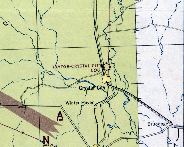
The earliest depiction which has been located of Faytor - Crystal City Airport was on the January 1945 Del Rio Sectional Chart.
It depicted Faytor - Crystal City as a commercial/municipal airport.
The January 1946 Del Rio Sectional Chart still labeled it as Faytor - Crystal City Airport.
According to an EPA Superfund report (courtesy of John Loizeaux-Witte), “In 1949, the U.S. Government deeded the airport to the city.”
It was labeled simply as Crystal City Airport on the February 1950 Del Rio Sectional Chart, and depicted with a 2,000' unpaved runway.
According to an EPA Superfund report (courtesy of John Loizeaux-Witte), “Beginning in the 1950s, several aerial pesticide application businesses began operating at the site.”
The September 1955 Del Rio Sectional Chart depicted Crystal City Municipal Airport as having a 3,500' paved runway.
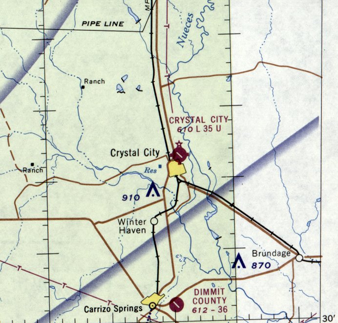
The last aeronautical chart depiction which has been located of Crystal City Airport was on the November 1967 Del Rio Sectional Chart.
It depicted Crystal City Airport as having a 3,500' paved northwest/southeast runway.
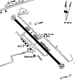
The 1970 TX Airport Directory depicted Crystal City Municipal Airport as having a 3,350' asphalt Runway 12/30,
with a paved taxiway leading to a paved ramp on the southwest side with a few small buildings.
According to an EPA Superfund report (courtesy of John Loizeaux-Witte), “By 1982, several aerial pesticide application businesses operations ceased
and the businesses declared bankruptcy & abandoned their equipment & deteriorated drums at the site.
In 1983, the state inspected the site & found over 70 drums of waste pesticides in various stages of decomposition.”
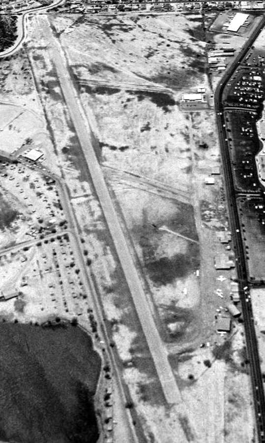
The earliest photo which has been located of Crystal City Airport was a 1995 USGS aerial view looking north.
It showed Crystal City Municipal Airport to have a single asphalt Runway 13/31,
with a paved taxiway leading to a paved ramp on the southwest side with a few small hangars.
A 2008 aerial view still showed the Crystal City Municipal Airport runway markings to remain intact.
Crystal City Municipal Airport may have been closed (for reasons unknown) at some point between 2008-2012,
as a 2012 aerial view appeared to show the runway markings had been removed.
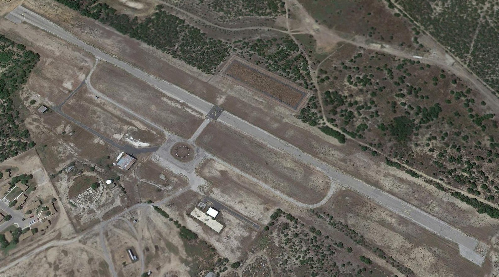
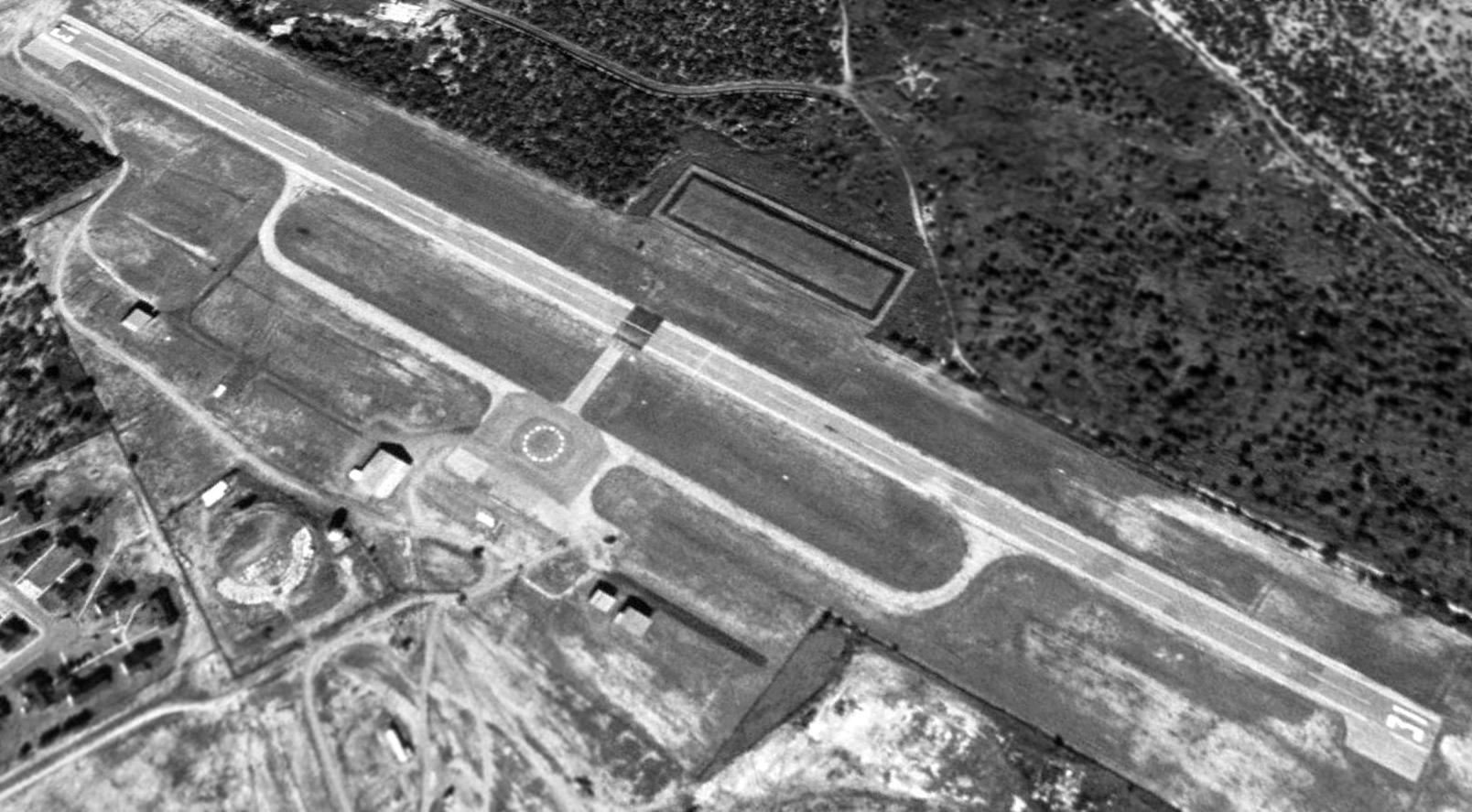
Crystal City Municipal Airport had definitely been closed by 2014, as a 2014 aerial view looking north showed 3 yellow closed-runway “X” symbols on the runway.
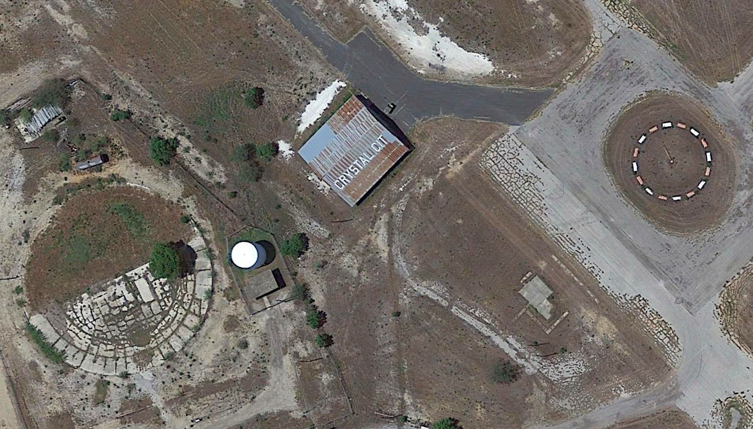
A 2014 aerial view showed the largest former hangar at the site of Crystal City Municipal Airport still had “Crystal Cit” painted on its roof, and the red & white segmented circle remained to the east.
John Loizeaux-Witte also pointed out the "circular concrete foundation of the swimming pool built by resident internees of the WW2 Crystal City Family Internment Camp”, at the bottom-left.
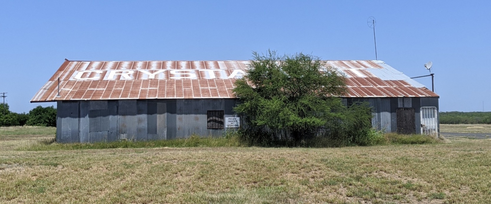
A 5/14/20 photo by Michael Kersten of the former Crystal City Municipal Airport hangar, with “Crystal Cit” still painted on its roof, and a windsock frame at one end.
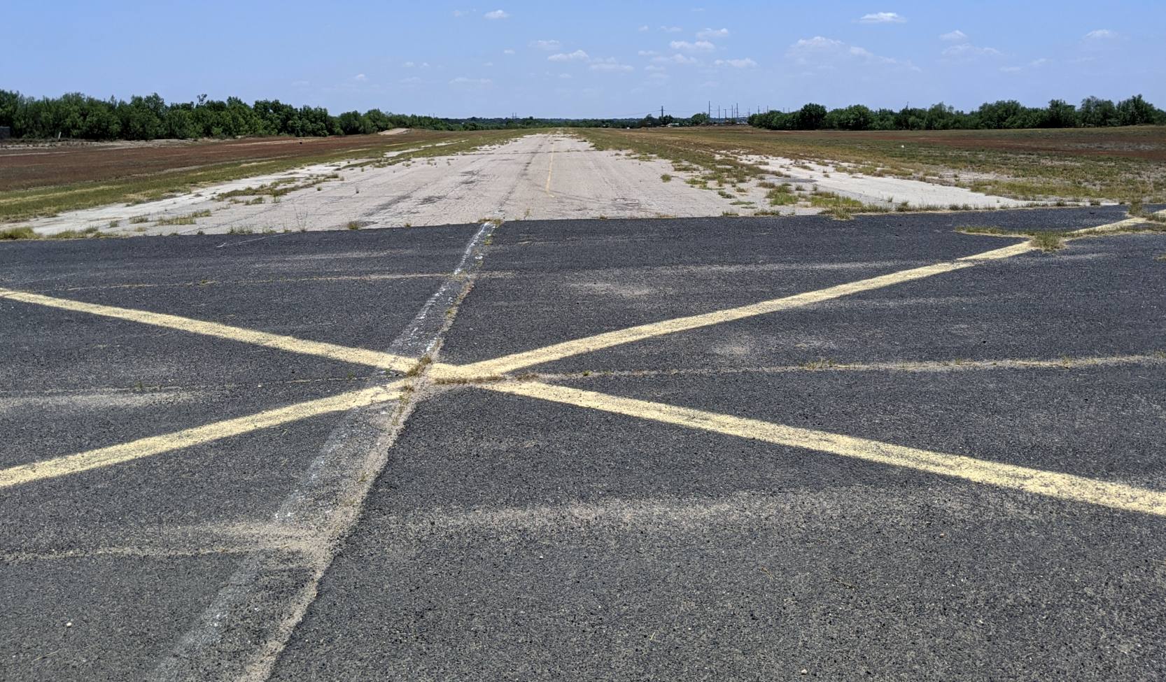
A 5/14/20 photo by Michael Kersten looking along the remains of the paved Crystal City Municipal Airport runway, with the closed-runway “X” symbol still visible.
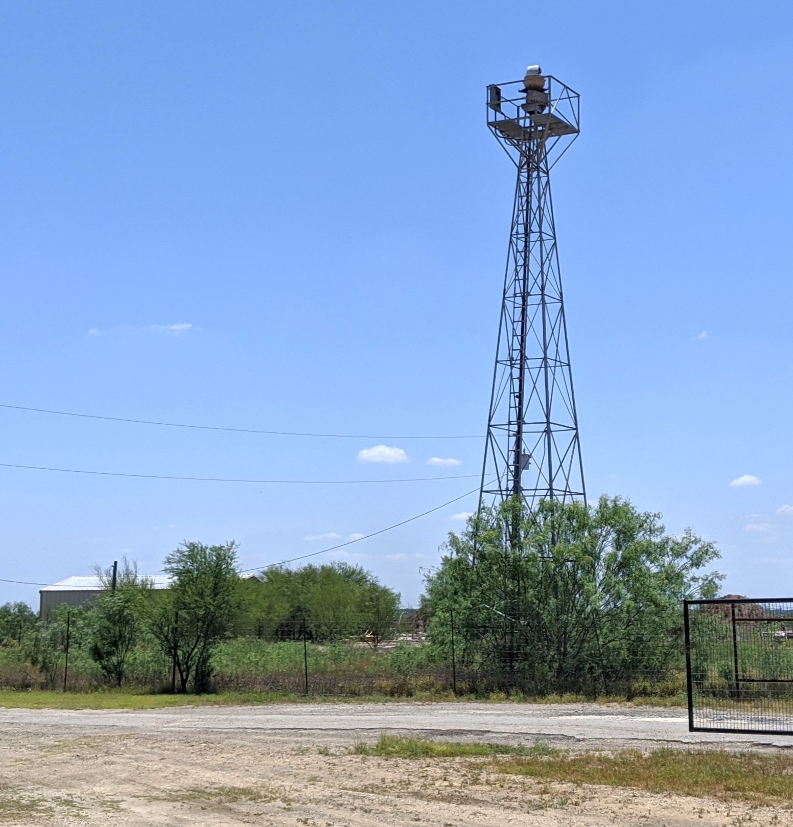
A 5/14/20 photo by Michael Kersten of the former Crystal City Municipal Airport beacon light tower.
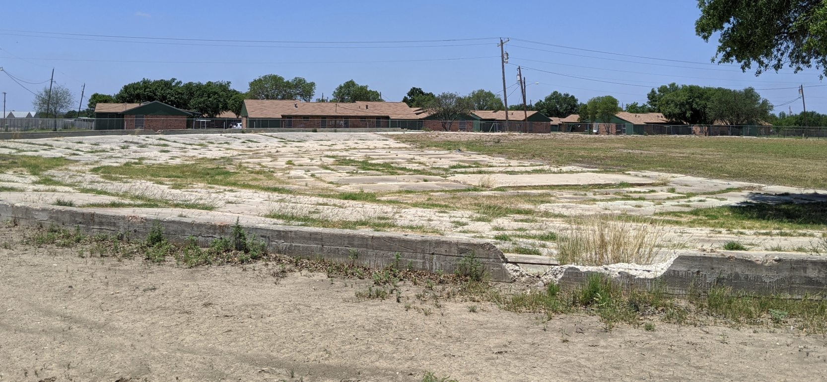
A 5/14/20 photo by Michael Kersten of the remains of the circular concrete foundation of the swimming pool built by resident internees of the WW2 Crystal City Family Internment Camp, adjacent to the airport site.
Thanks to Lee Corbin for pointing out this airfield.
____________________________________________________
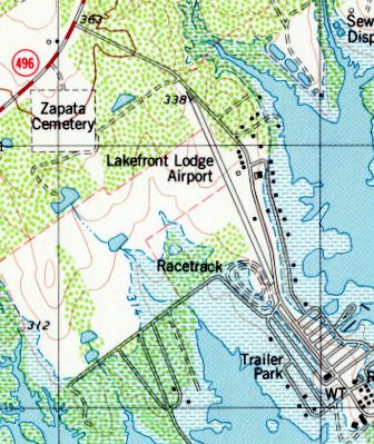
Lakefront Lodge Airport, Zapata, TX
26.89, -99.275 (Southeast of Laredo, TX)
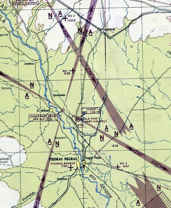
Lakefront Lodge Airport, as depicted on the January 1972 Brownsville Sectional Chart (courtesy of Ron Plante).
This small airfield was located along the shore of Falcon Reservoir, directly on the U.S./Mexico border.
Lakefront Lodge Airport was evidently constructed at some point between 1962-72,
as it was not yet depicted on the 1962 USGS topo map.
The earliest depiction which has been located of Lakefront Lodge Airport was on the January 1972 Brownsville Sectional Chart (courtesy of Ron Plante).
It depicted Lakefront as having a single 2,500' paved northwest/southeast runway.
The earliest photo which has been located of Lakefront Lodge Airport was a 1974 USGS aerial view.
It depicted Lakefront Lodge Airport as a single northwest/southeast runway.
Lee Denhan recalled of the Lakefront Lodge Airfield, “I flew there in the late 1970s.
My parents owned a lot in Siesta Shores Subdivision with a mobile home & fishing boat.
I would fly up from KMFE & take everyone for a flight & we'd fly down to the Falcon Lake dam.
There was was a stop sign that said 'Watch for airplanes' & you had to taxi down the road to get to the tie-down area.
The look on the the drivers' faces when you taxied up behind was priceless!”
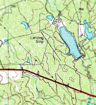
The 1979 USGS topo map depicted Lakefront Lodge Airport as a single northwest/southeast runway
with a few small buildings along the east side.
Lakefront Lodge Airport was evidently closed (for reasons unknown) at some point between 1972-83,
as it was depicted as an abandoned airfield on the 1983 Brownsville Sectional Chart.
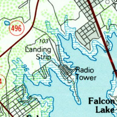
The 1985 USGS topo map depicted a single northwest/southeast runway, but labeled simply as “Landing Strip”.
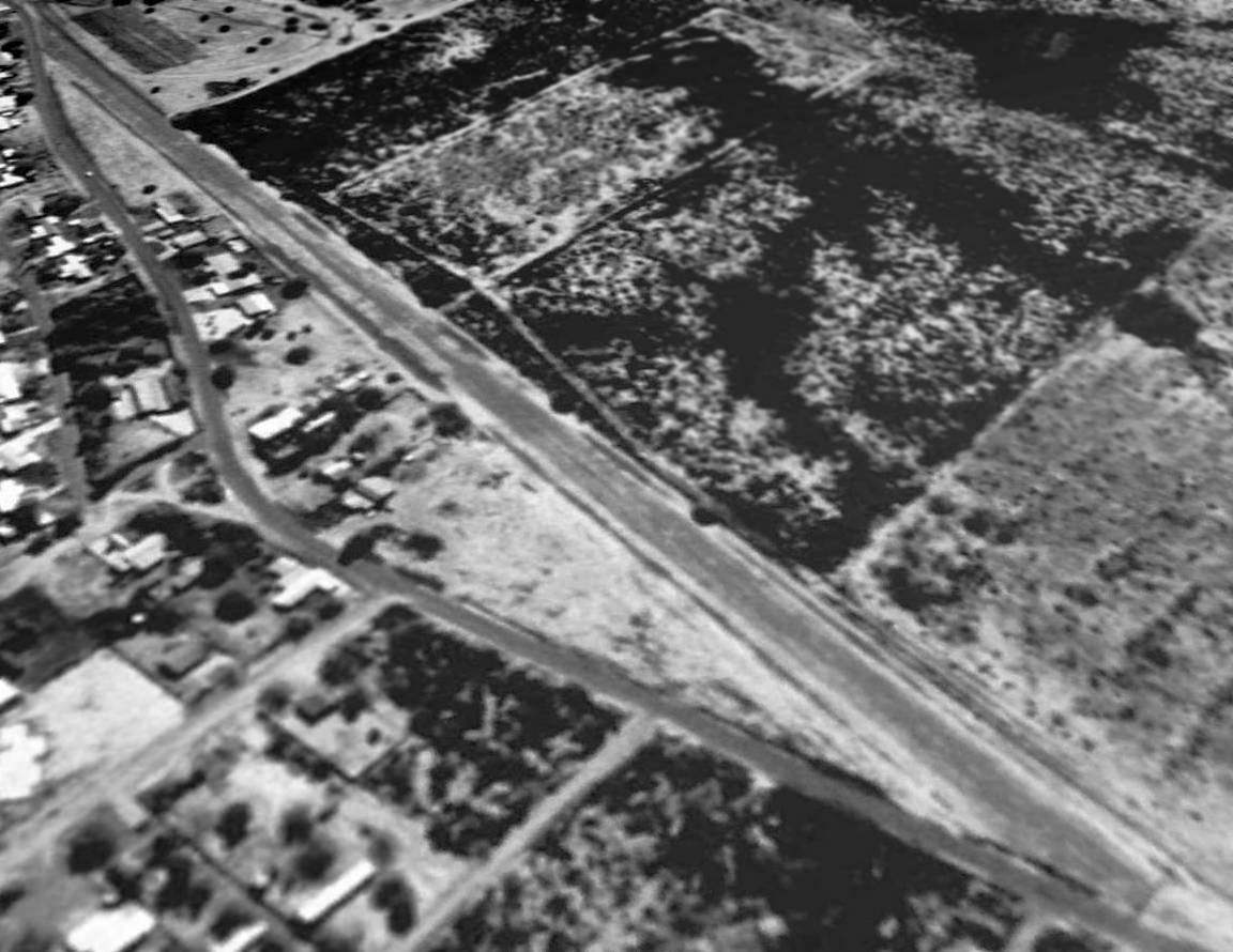
A 1995 USGS aerial view looking southwest showed the Lakefront Lodge Airport runway to remain intact,
though without any indication of recent aviation usage.
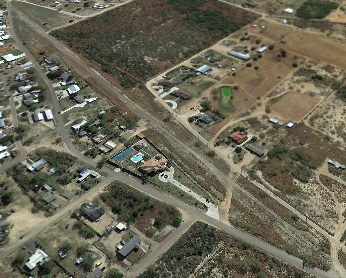
A 2014 aerial view looking southwest showed the Lakefront Lodge Airport runway to remain intact, with houses along the east side,
though without any indication of recent aviation usage.
The site of Lakefront Lodge Airport is located southeast of the intersection of Oak Street & Doyle Street.
Thanks to Lee Denham for pointing out this airfield.
____________________________________________________
Laredo Air Force Auxiliary Airfield #2, Aguilares, TX
27.475, -99.225 (East of Laredo, TX)
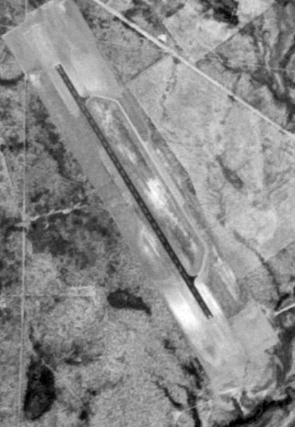
A 4/15/55 USGS aerial view of Laredo AFB Aux Field #2.
No airfield was depicted at this location on the 1940 USGS topo map.
According to "Air Force Bases" (USAF Historical Division, courtesy of Steven McNicoll),
this airfield was activated in 1953 as Ike Hirsch Auxiliary Airfield, a satellite field for Laredo AFB.
A pilot recalled recalled, “I graduated from Laredo 2/1/54. At that time we flew T-28A & T-33 aircraft.
I instructed at Laredo in both aircraft from summer 1954 until June 1957.
We used the field [Laredo Aux #2] primarily for touch & go landings & simulated flameout patterns.
Sometimes with & sometimes without mobile control. I was mobile controller there several times.
We used a mobile tower mounted on a truck frame which was a top-heavy monster to drive back & forth to the field.
It contained radios & flare chutes into which you could fix the flare guns.
It sometimes got a bit hairy with T-33s flying simulated flameouts & no-flap approaches.
A good friend & roommate died in a mid-air collision there.”
However, no airfield was depicted at this location on 1954/55 Corpus Christi Sectional Charts.
The earliest depiction which has been located of Laredo Aux #2 was on a 4/15/55 USGS aerial view.
It depicted the field as having an asphalt northwest/southeast runway with a parallel taxiway & ramp on the east side.
No airfield was depicted at this location on the March 1956 Corpus Christi Sectional Chart.
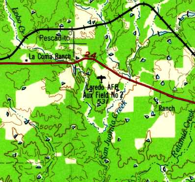
“Laredo AFB Aux Field #2”, as depicted on the 1956 USGS topo map.
The earliest aeronautical chart depiction which has been located of Laredo Aux #2 was on the September 1956 Corpus Christi Sectional Chart.
It depicted “Laredo Aux #2 AF” as having a 5,000' paved runway.
Tom Dowling recalled, “I was a student of Laredo AFB Class 71-02.
One Friday night before graduation from T-37s, about 10 of use went out to Barfly [Laredo Aux #2]
and painted our class numerals in 49 foot high letters on one end of the runway.
The following Tuesday Colonel Robert Parsons, then the base commander had our class stay after.
He sad the usual things like defacing government property, etc.
He then described us as one of the most '**** hot classes' he had seen at Laredo.
He then joined us the following Friday after flying to cover over the yellow with gray. I have no idea if the gray still shows.”
According to USAFR Col. Carl Gough Jr. (a student & T-37 Instructor Pilot at Laredo AFB from 1970-73),
Auxiliary Field #2 was used by T-37 trainers practicing VFR patterns, and was known as "Bar Fly".
Every student pilot that attended pilot training at Laredo AFB soloed out in the T-37 at Bar Fly.
The instructor would shut down the right engine, exit the aircraft & watch while the student started the right engine.
After restarting the engine the student would call for take off & the instructor would walk across the runway & observe from the mobile unit.
After 4 or 5 landings the student would clear the runway & pick up the instructor for the return to Laredo AFB.
The 2 small teardrop-looking areas on the west side of the runway were the locations of the mobile units for controlling traffic.
An instructor & 2 students would drive from Laredo AFB & spend about 6 hours in the mobile unit directing traffic & grading landings.
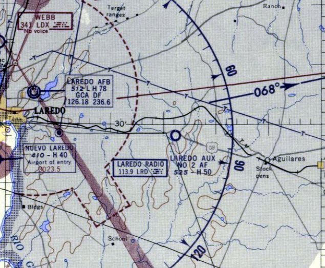
The last aeronautical chart depiction which has been located showing Laredo Auxiliary #2 in operation was on the January 1972 Brownsville Sectional Chart.
It depicted “Laredo Aux #2 (AF)” as having an 8,200' paved northwest/southeast runway.
According to USAFR Col. Carl Gough Jr. (a student & T-37 Instructor Pilot at Laredo AFB from 1970-73),
the airfield was inactivated by the Air Force in 1973.
The 1977 USGS topo map depicted the field as having a single paved northwest/southeast runway, labeled as "Laredo Aux (Closed)".
“Laredo Aux #2 (AF)” was depicted as a closed airfield on the July 1979 Brownsville Sectional Chart.
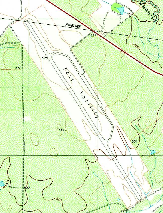
The 1980 USGS topo map depicted Laredo Aux #2 as having a massive 10,400' paved northwest/southeast runway with a parallel taxiway,
labeled as "Test Facility".
As seen in a 1995 USGS aerial view looking southeast at Laredo Aux #2,
several new buildings or other construction had been placed over the center of the runway & the taxiway,
apparently in the facility's new role as a "Test Facility".
It is not known exactly what the current use of the facility is.
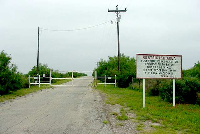
A 2003 photo by Scott Murdock of the entrance sign at the former Laredo Aux #2 Airfield.
The entrance road was gated, with a sign saying "Restricted Area. Test vehicles in operation.
Permission to enter must be obtained before proceeding into the proving ground."
However, the sign fails give any indication about from whom permission must be obtained.
A 2005 aerial view showed the Laredo Aux #2 runway to remain in fine condition.
Marvin Whiteley reported in 2007, “This runway is under private control & is used at times for cropdusters.
My nephew is the manager of this 25,000 acres, running cattle & deer hunters (as of 2005), his name is D.J. Fruge.
Michelen tire ran a testing facility at this location for some time in the past.”
Evan Hodgden reported in July 2007, “The sign at the Laredo AFB Aux Bar-fly is exactly the same as depicted in the 2003 picture.
Lots of the students simply referred to Bar-fly as Barf, as in 'We'll also be going to Barf today.'”
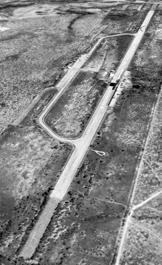
A circa 2007 aerial view looking north at several buildings located along the Laredo Aux #2 runway & ramp.

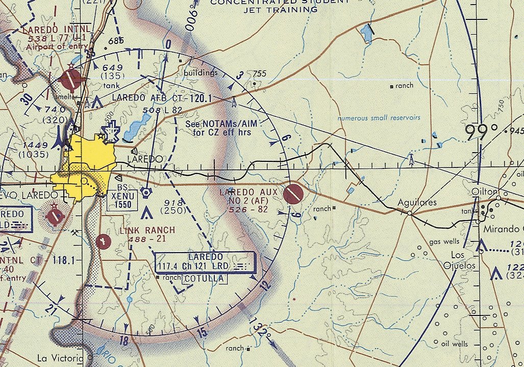
The only aeronautical chart depiction which has been located of the Laredo Aux #2 Airfield was on the 2009 Brownsville Sectional Chart.
It depicted “Laredo Aux 2 (AF)” as being closed, and having a single paved northwest/southeast runway.
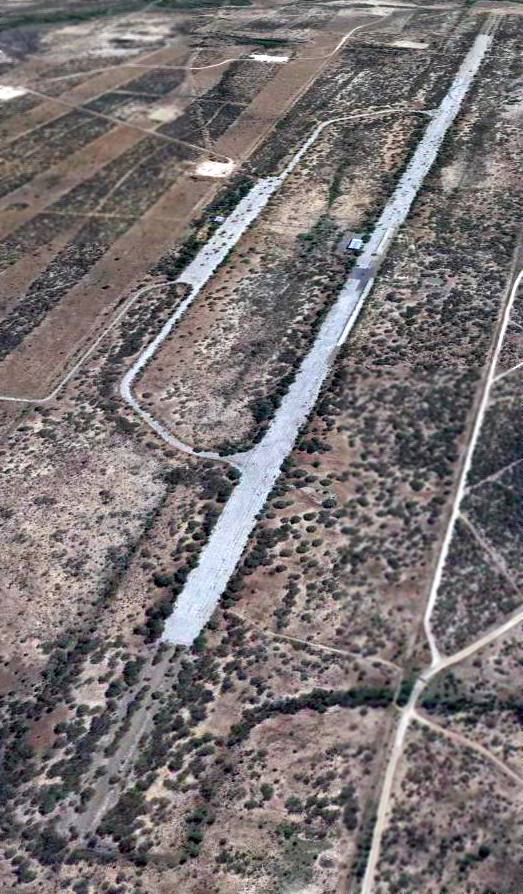
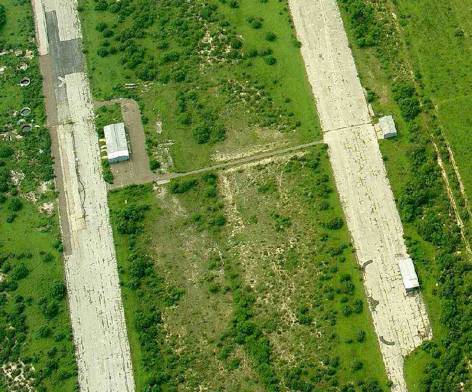
A 12/17/12 aerial view looking southeast at the Laredo Aux #2 runway showed it to be considerably deteriorated,
with many plants poking up through the pavement.
____________________________________________________
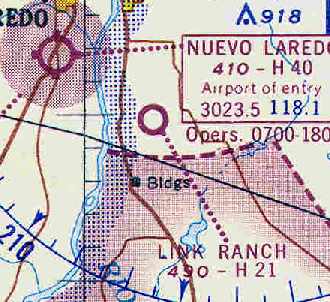
Link Ranch Airfield, Laredo, TX
27.427, -99.473 (Southwest of San Antonio, TX)
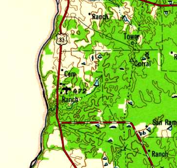
Link Ranch Airfield, as depicted on the 1956 USGS topo map.
Photo of the airfield while open has not been located.
The date of establishment of Link Ranch Airfield has not been determined.
It was not depicted on the August 1955 Corpus Christi Sectional Chart.
Spencer Wood recalled, “In 1955 I started flying with my father and in 8/56 soloed at Laredo Municipal Airport.
When my father purchased a metal prop, and considering the gravel which saturated the runway at Laredo Municipal, he started looking for a new base to fly from.
He had met George Link at his place of business in Laredo.
From that initial meeting Mr. Link extended rights for my father to tie down our Ercoupe at the Link Airport.
The photos & sketches do not 'do justice' to Link. It was developed by someone who had no concept of prevailing winds.
Generally you could count on a 45-90 degree 15-20+ knot crosswind.
With a pond at one end & a cliff at the other up & down drafts were a real pain, and for a young pilot it was a real challenge, but I never had an incident.
At Link we were never bothered by theft problems, which were rampant at Laredo Municipal.”
The earliest depiction which has been located of Link Ranch Airfield was on the 1956 USGS topo map.
The earliest aeronautical chart depiction which has been located of Link Ranch Airfield was on the August 1957 Corpus Christi Sectional Chart.
It depicted the Link Ranch Airfield as having a 2,100' paved runway.
Spencer Wood recalled, “I got my private [pilot's license] in 8/57 & flew out of Link with my dad until late 1958.”
The 1962 AOPA Airport Directory described Link Ranch Airfield as having a single 2,100' asphalt Runway 13/31,
and listed the operator as G.F. Link.
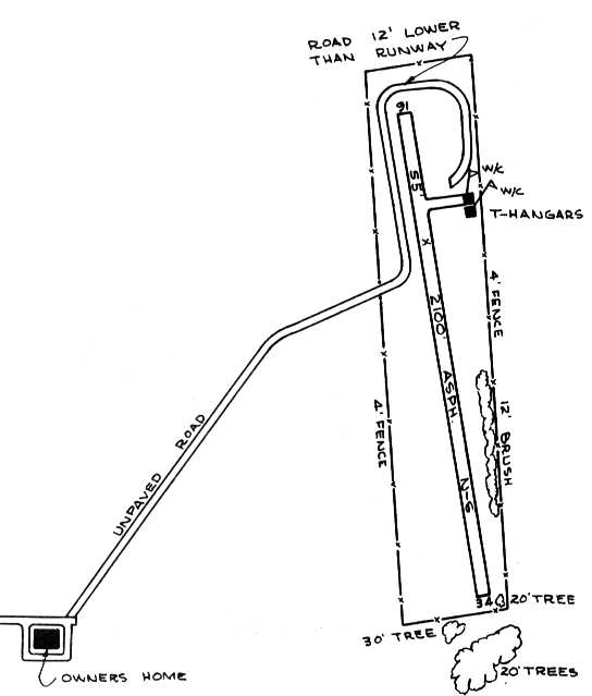
The 1963 TX Airport Directory (courtesy of Steve Cruse) depicted Link Ranch as having a single 2,100' asphalt Runway 16/34,
with 2 T-hangars east of the runway.
The February 1964 Corpus Christi Sectional Chart (courtesy of Chris Kennedy)
depicted the Link Ranch Airfield as having a 2,100' hard-surface runway.
Link Ranch Airfield was apparently still in use in 1969,
as a cropduster Cessna 188 was destroyed that year after suffering an engine failure upon takeoff at the Link Ranch, according to an NTSB report.
Of that crash, George Frank Link III (grandson of the Link Ranch Airfield founder) recalled,
"I was born in 1969 so I missed the event but spent many years crawling on & around the wreckage
after my grandfather hauled it to his dump located behind his house.
N317UP was George Link Sr.'s last airplane (a Skylane); he owned up until he lost his medical.
N417UP was a British Islander we used for La Posada Airways
which back in the day used to haul ritzy folk from hotel to hotel back when money flowed a little easier.
My dad George Link Jr. was the pilot of that bird. His co-pilot's name was Skip Reed."
The Link Ranch airfield was evidently closed at some point between 1969-79,
as it was no longer depicted on the July 1979 Brownsville Sectional Chart.
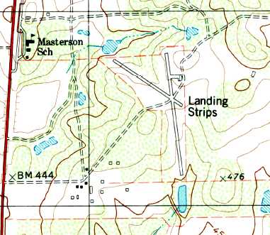
The 1979 USGS topo map depicted Link Ranch as having 2 paved runways, labeled “Landing Strips”, and a ramp northeast of the runway intersection.
In the 1995 USGS aerial photo, the primary runway still remained intact,
with closed runway "X" markings still recognizable.
A crosswind runway of approximately 1,000' had apparently been added at some point, as well.
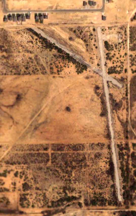
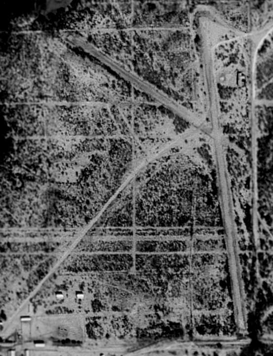
At some point between 1995-2004, the northern end of the former Link Ranch Airfield was covered by what else – a new housing development,
as seen in the 2002 USGS aerial photo.
The majority of the pavement of the 2 runways remained intact.
The hangar on the northeast side of the field had also been removed.
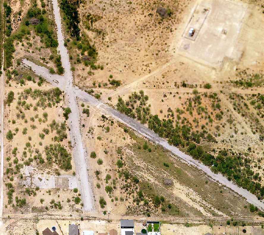
A circa 2006 aerial view looking south at the remains of the 2 runways, as well as the foundation of the hangar.
The Link Ranch Airfield is located on the east side of Route 83, 5 miles south of Laredo.
It is only one mile from the Mexican border.
____________________________________________________
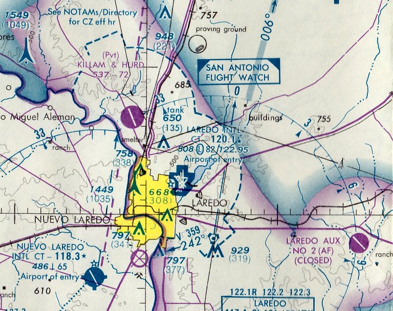
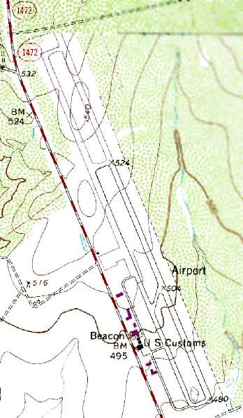
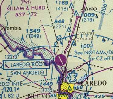
Laredo Municipal Airport / Killam & Hurd Airfield, Del Mar, TX
27.61, -99.52 (North of Laredo, TX)
Laredo Municipal Airport, as depicted on the September 1952 Corpus Christi Sectional Chart.
This municipal airport was apparently built at some point in 1952,
as it was not depicted on the March 1952 Corpus Christi Sectional Chart.
The earliest depiction which has been located of Laredo Municipal Airport was on the September 1952 Corpus Christi Sectional Chart.
It depicted Laredo Municipal Airport as having a 3,000' unpaved runway.

Laredo Municipal Airport, as depicted on the 1956 USGS topo map.
Spencer Wood recalled, “In 1955 I started flying with my father and in 8/56 soloed at Laredo Municipal Airport.
In those days this airport was a step above landing on any bad county road.
When my father purchased a metal prop, and considering the gravel which saturated the runway at Laredo Municipal, he started looking for a new base to fly from.
Theft problems were rampant at Laredo Municipal, not to mention the crop dusters which like to depart from the taxiways, with looking for other traffic.”
The 1962 AOPA Airport Directory described Laredo Municipal Airport as having a single 3,300' asphalt runway (13/31),
and listed the operator as the City of Laredo.
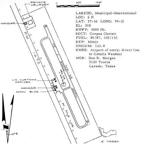
The 1963 TX Airport Directory (courtesy of Steve Cruse) showed that the field had a US Customs office,
and a private heliport & hangar sat northwest of the runway.
The earliest photo which has been located of Laredo Municipal Airport was a 2/25/64 USGS aerial view.
It depicted the field as having a single paved northwest/southeast runway with a parallel taxiway,
and a dozen light aircraft & several small hangars on the southwest side.
Robert Johnston recalled, “The old Laredo Airport on Mines Road where I started my professional flying career.
During 1965-1968 I was a Sergeant at Laredo Air Force Base.
I took my first airplane instructional flight with Don Morgan & his red & white Piper Cherokee.
Sometime after that first flight, during my off-duty hours from the air base,
I went to work for Roy Jennings & Doug Henson at International Aero Aviation, Mr. Morgan’s competitor,
fueling airplanes, including the LaPosada Islander of George Link and Skip Reed.
The airport was run on a very limited budget so I was assigned the task of painting the taxiway centerline with 2 boards as a template & a bucket of yellow paint with a 4 inch brush.
I used a string to lay out the radius for the turns into the ramp areas.
That job provided me with enough money to receive flight instruction from Rex Goff, a T-41 Instructor Pilot.”
A 1967 photo by George Wilhite of Air Force Cessna T-41s based at the north end of Laredo Municipal Airport in 1967.
George recalled, “The Air Force bused students to Laredo Municipal Airport for the T-41 phase.”
Max Hottell recalled, “The Laredo Municipal Airport located on the Old Mines Road also had military operations on it in the late 1960s.
The Air Force had a contract flight school operation using civilian contract instructors flying T-41 aircraft.
The T-41 was a Cessna 172 with only 2 seats & a climb prop. Students spent the first 6 weeks of their pilot training in the T-41 program.
To administer the program 3 Air Force Instructor Pilots & 1 enlisted maintenance man
were assigned as Technical Representatives for The Contracting Officer (TRCO).
I was the senior TRCO in 1968, 1969 and early 1970.”
Evan Hodgden recalled, “I went to Laredo AFB Undergraduate Pilot Training Class 72-07 from April 1971 - March 1972.
The Laredo Municipal Airport was the site of T-41 training for Laredo AFB, pre-T37 training (the T-41 flying closed in 1973).”
Due to its location less than 2 miles northeast of the Mexican border,
in the 1960s & 1970s the old Laredo Airport was often the scene of flights to & from Mexico
carrying goods which were not necessarily legal to be imported or exported.
This included liquor, gold, narcotics, illegal aliens, mercury, lime oil, guns, consumer electronics, etc.
Evan Hodgden recalled, “I went to Laredo AFB UPT Class 72-07 from April 1971 – March 1972.
Laredo Municipal was the site of T-41 training for Laredo AFB, pre-T37 training. The T-41 flying closed in 1973.
I believe it moved to HDO & became part of OTS, rather than screening after the pilot candidates were commissioned.”
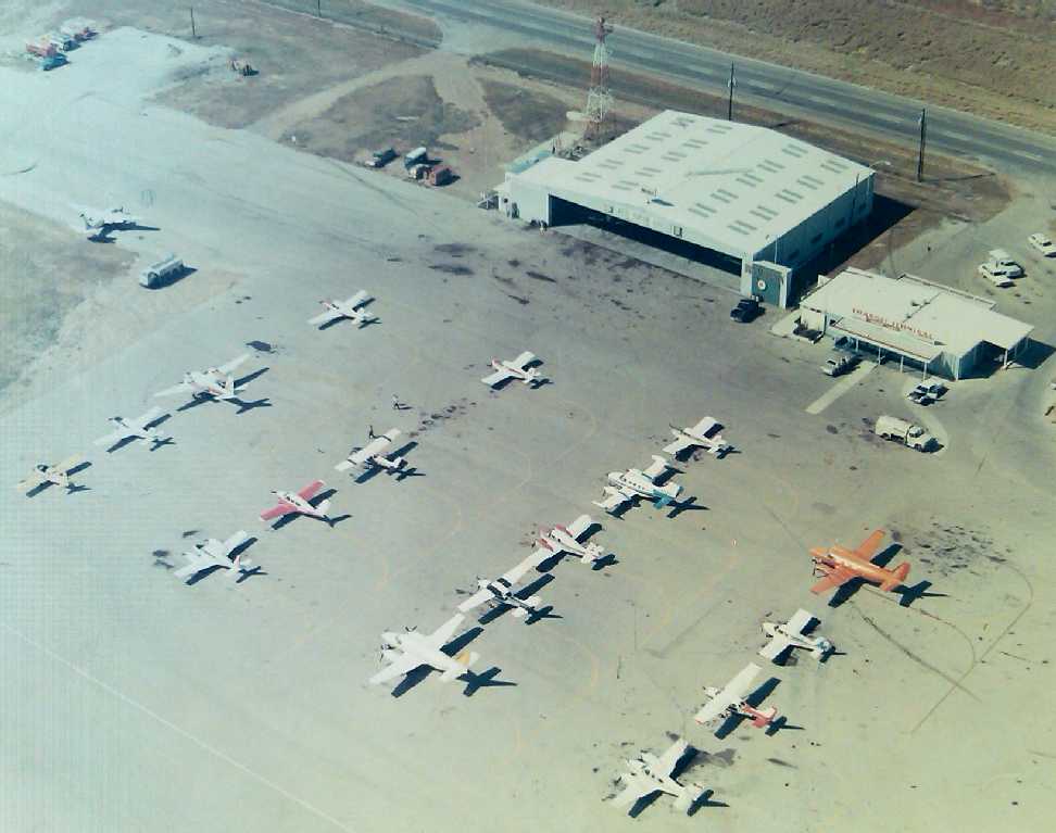
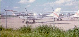
A circa 1972 aerial view looking west at the Laredo Municipal hangar & FBO building (courtesy of Mike Hoover),
with a large variety of planes on the ramp.
Mike recalled, “I was a junior in High School and happened to be employed there in the summer of 1972.
At the time I was there Mrs. Betty Morgan was the proprietor. Her husband, Don Morgan, had passed away sometime earlier; I never met him.
It was my understanding that Mr. Morgan was a key player at the airport in its early history.
The FBO was known, of course, as Morgan Aviation Services. If you look closely I believe you can see Don Morgan’s name at the edge of the hangar.
I have very fond memories of that summer. Mrs. Morgan was very good to me.
Of course the LAFB closed the very next year & shortly thereafter became the main Laredo Civil Airport.
That event marked the end of the line for the old airport.”
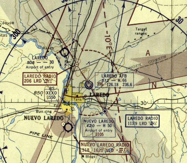
The much larger Laredo AFB (a few miles southeast) closed in 1973,
at which point it became the new Laredo International Airport.
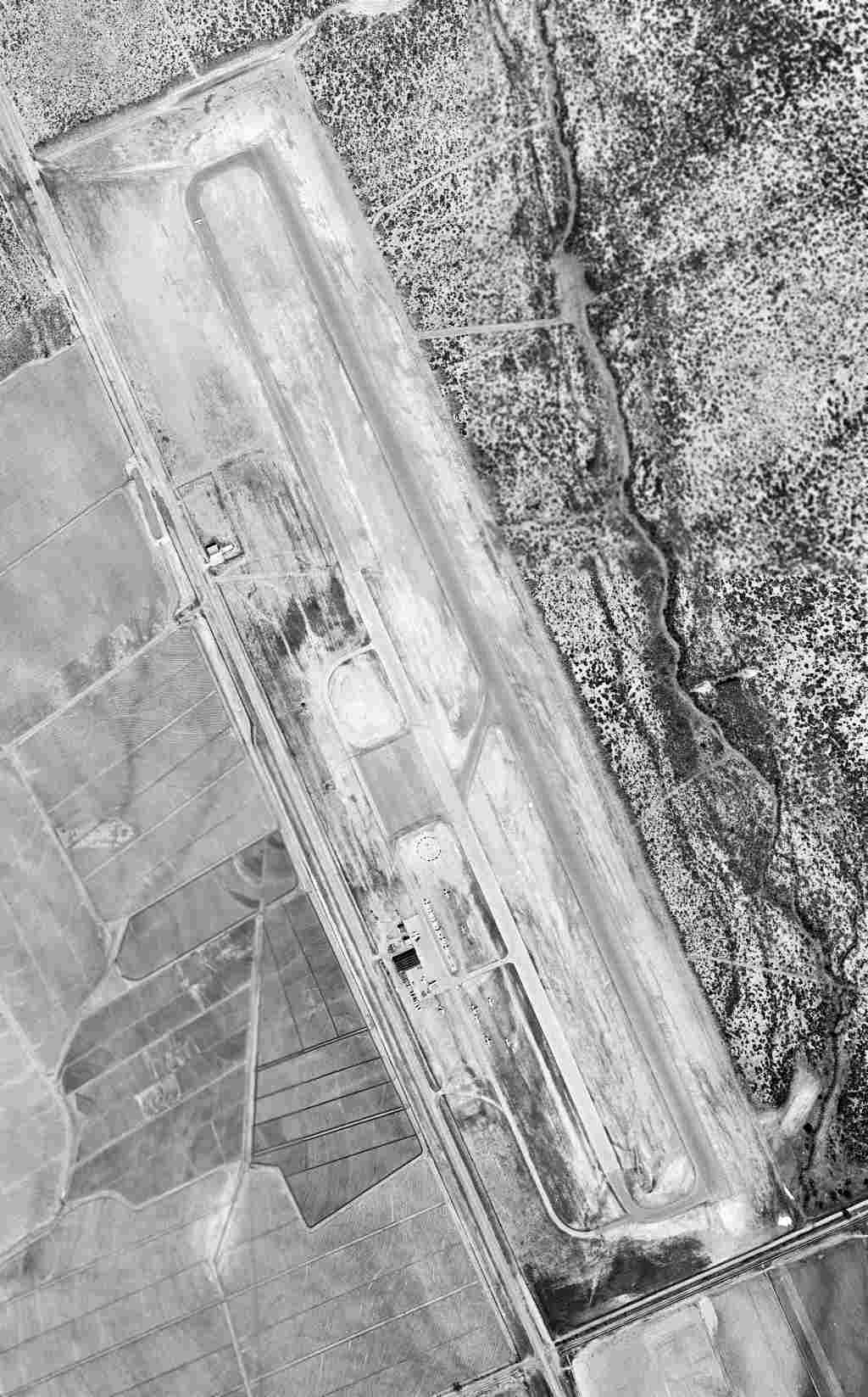
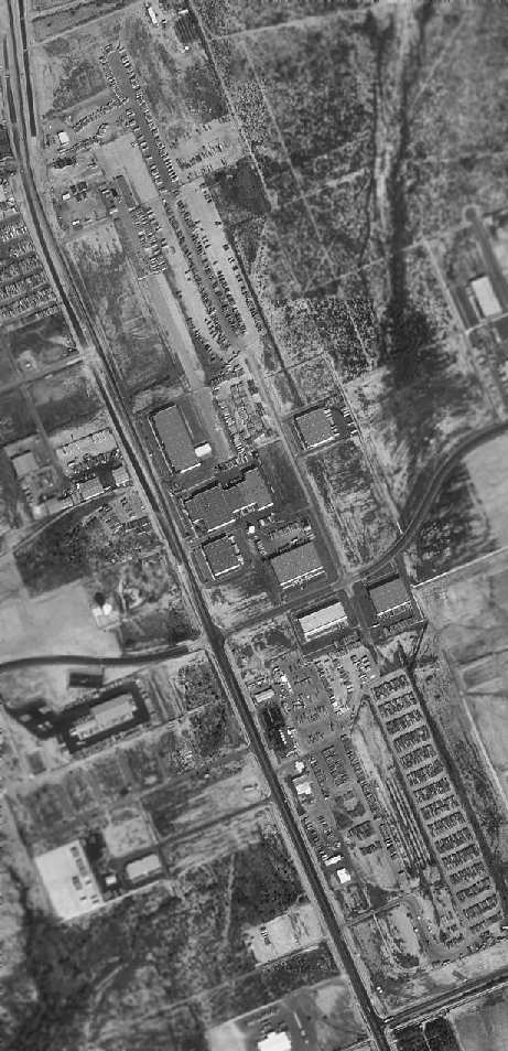
At some point between 1973-79, the former Laredo Municipal Airport became a private airfield named “Killam & Hurd”,
as that it how it was labeled on the July 1979 Brownsville Sectional Chart.
The 1980 USGS topo map showed that the runway at Laredo Municipal (labeled generically as “Airport”) had been lengthened to 7,700'.
It also had a parallel taxiway, a ramp, and several hangars west of the southern end of the runway.
The former Laredo Municipal Airport was labeled "Abandoned Landing Strip" on the 1983 USGS topo map.
The last aeronautical chart depiction which has been located of the "Killam & Hurd" Airfield was on the 1991 CH-23 World Aeronautical Chart (courtesy of David Brooks).
It depicted Killam & Hurd as a private airfield having a 7,200' paved northwest/southeast runway.
The Killam & Hurd Airfield was evidently closed at some point between 1991-95,
as the 1995 USGS aerial photo showed that the site had been redeveloped as an industrial park,
with numerous buildings being erected over the former runway.
Several thousand feet of runway pavement still existed both north & south of Killam Industrial Boulevard in the 1995 photo.
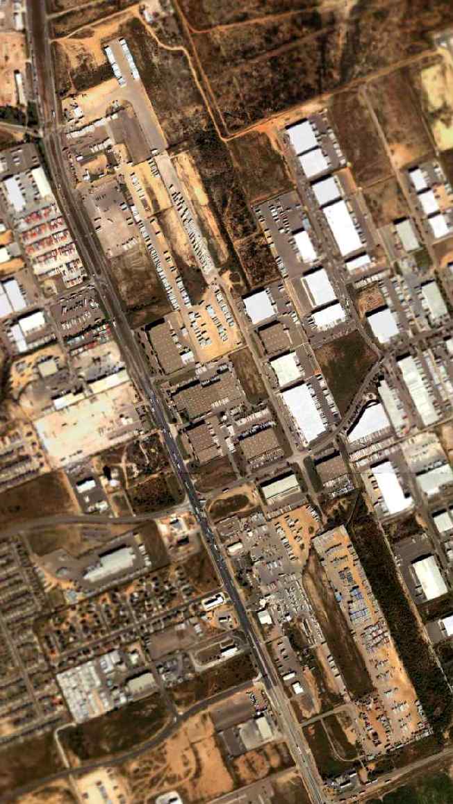
As seen in the 2004 USGS aerial photo, the area around the Laredo Municipal Airport site has become even more developed,
but the remains of the former runway are still very much recognizable.
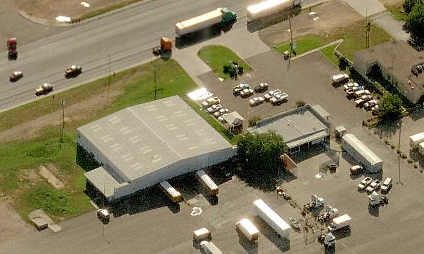
A circa 2007 aerial view looking west at a former Laredo Municipal Airport hangar & the former FBO building.
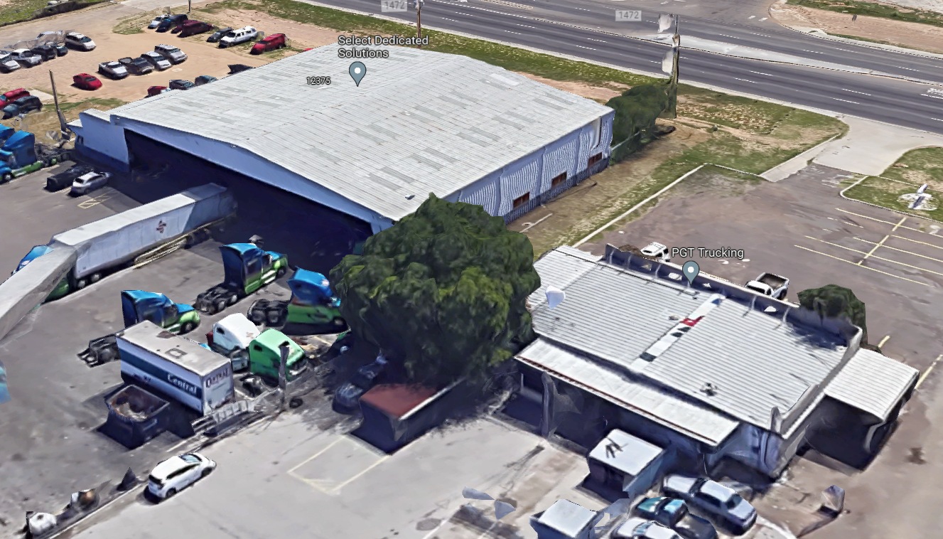
A circa 2022 3-D aerial view looking southwest at a former Laredo Municipal Airport hangar & the former FBO building.
The Laredo Municipal Airport site is located east of Mines Road,
at Killam Industrial Boulevard (which was built over the midpoint of the former runway).
Thanks to Todd Greenberg for pointing out this airfield.
See also:
http://www.aerobourne.com/11laredo.htm
http://www.aerobourne.com/12speckl.htm
____________________________________________________
Eagle Pass Auxiliary Army Airfield #1 / Cueves Field, Spofford, TX
29.03, -100.53 (South-Southeast of Laughlin AFB, TX)
 r
r
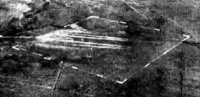
A 10/26/43 aerial view looking north at “Eagle Pass AAF Auxiliary #1 (Cueves Field)”
from the 1945 AAF Airfield Directory (courtesy of Scott Murdock).
This field was used during WW2 as one of 4 satellite airfields for Eagle Pass AAF,
which conducted basic & advanced single engine flight training.
The date of construction of Eagle Pass Aux #1 has not been determined,
but Eagle Pass AAF itself became operational in 1942.
A 5/15/43 AAF list of airfields of the Gulf Coast Training Center (courtesy of Ron Plante)
listed Eagle Pass Auxiliary #1 but did not specify any runway configuration.
The earliest photo which has been located of Eagle Pass Aux #1 was a 10/26/43 aerial view from the 1945 AAF Airfield Directory (courtesy of Scott Murdock).
It depicted “Eagle Pass AAF Auxiliary #1 (Cueves Field)” as an unpaved square landing area within which may have been 2 unpaved east/west runways.
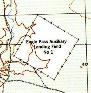
The 1944 USGS topo map depicted Eagle Pass Auxiliary Landing Field #1 as consisting of a square landing area.
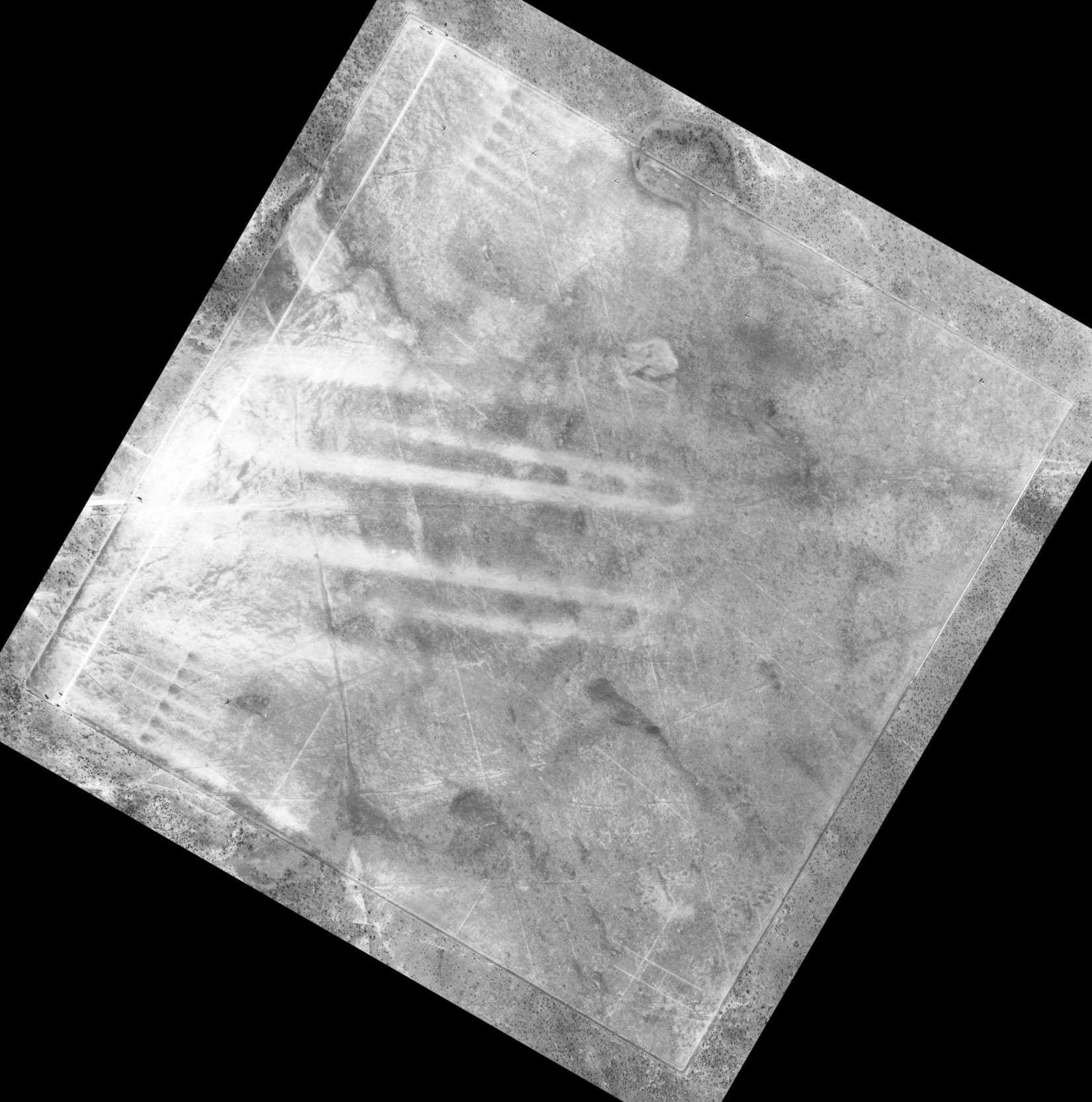
A 1/19/44 USAAF aerial view of Eagle Pass Aux #1 (from the Air Force Historical Research Agency, courtesy of Brian Rehwinkel).
Brian Rehwinkel observed, “If you look closely, you can see various markings on the field – presumably for different training procedures.”
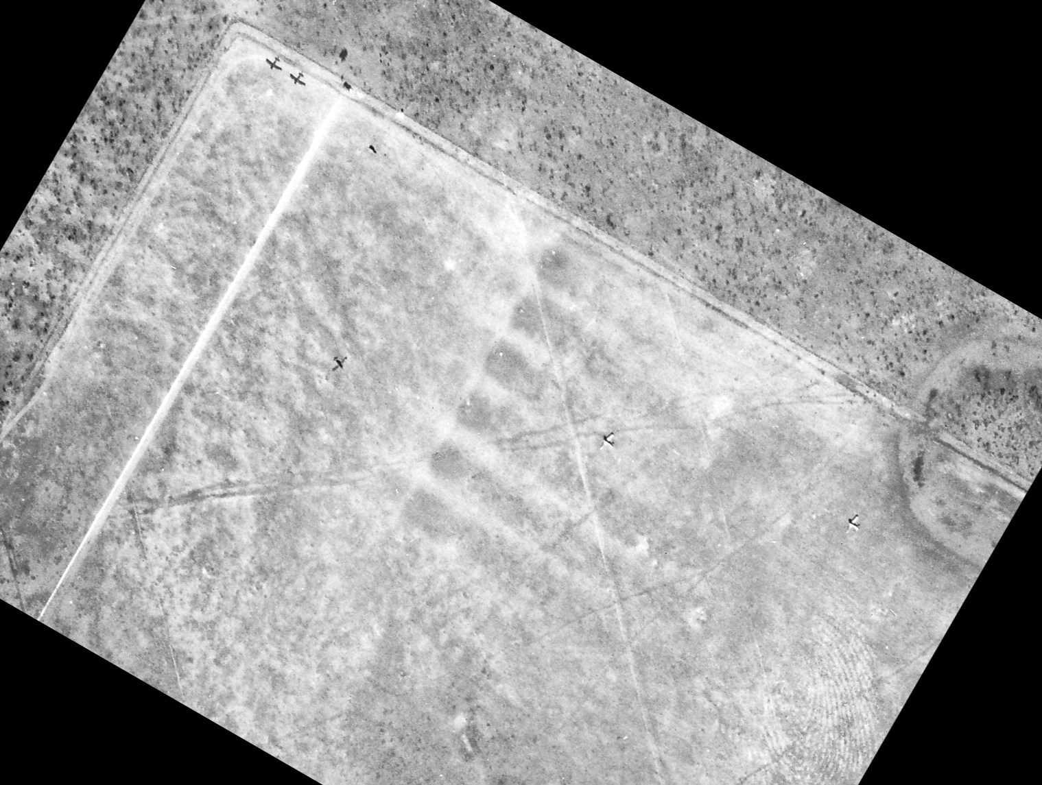
A closeup from the 1/19/44 USAAF aerial view of the north corner of Eagle Pass Aux #1 (from the Air Force Historical Research Agency, courtesy of Brian Rehwinkel), showing 5 single-engine aircraft.
Brian Rehinwinkel reported, “According to a US Army Air Forces information document,
this 640 acre leased field was used for advanced single-engine flying training & the landing surfaces consisted of 'native grasses'.
The field also had 2 'Shelter Houses', an Auxiliary Power Unit House, and 1 storage building.”
The earliest aeronautical chart depiction of Eagle Pass Aux #1 which has been located was on the January 1945 Del Rio Sectional Chart.
Eagle Pass Aux #1 was already described as “Inactive” in the 1945 AAF Airfield Directory (courtesy of Scott Murdock).
It described “Eagle Pass AAF Auxiliary #1 (Cueves Field)”
as a 625 acre square property within which was a “sod” all-way field measuring 5,303' by 5,247'.
The field was said to not have any hangars,
to be owned by private interests, and to be operated by the Army Air Forces.
Eagle Pass Auxiliary #1 was apparently never reused as a civil airfield, due to its remote location.
It was no longer depicted at all on the 1952 Edwards Plateau World Aeronautical Chart (according to Chris Kennedy),
the 1966 Del Rio Sectional Chart (courtesy of John Price), or on the 1969 USGS topo map.
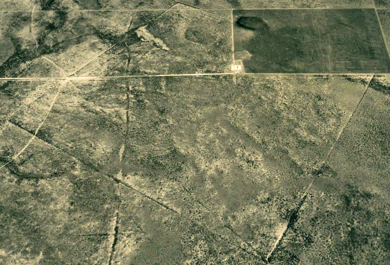
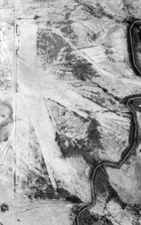
A 3/7/96 USGS aerial view looking north showed the former Eagle Pass Auxiliary Army Airfield #1 to be a one-mile square.
An unknown structure (an oil well?) had been constructed on the middle of the former airfield.
A 3/31/08 aerial view showed the Eagle Pass Auxiliary Army Airfield #1 site is still recognizable,
as a one-mile square, oriented diagonally (into the prevailing wind).
This orientation also matches the alignment of the runways at Eagle Pass Aux #3.
The site of Eagle Pass #1 is located 3 miles west of Route 131, 12 miles southwest of Spofford.
Thanks to Chris Kennedy for locating this field.
____________________________________________________
Eagle Pass Auxiliary Army Airfield #3 / Barnard Ranch Airfield / Chittim Ranch Airfield,
Eagle Pass, TX
28.69, -100.35 (South-Southeast of Laughlin AFB, TX)
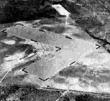
A 10/26/43 aerial view looking north at “Eagle Pass AAF Auxiliary #3”
from the 1945 AAF Airfield Directory (courtesy of Scott Murdock).
This field was used during WW2 as one of 3 satellite airfields for Eagle Pass AAF,
which conducted basic & advanced single engine flight training.
The date of construction of Eagle Pass Aux #3 has not been determined, but Eagle Pass AAF itself became operational in 1942.
A 5/15/43 AAF list of airfields of the Gulf Coast Training Center (courtesy of Ron Plante)
described Eagle Pass Auxiliary #3 as having 2 asphalt runways, measuring 4,000' northwest/southeast & 3,000' northeast/southwest.
The earliest depiction which has been located of Eagle Pass Aux #3 was a 10/26/43 aerial view from the 1945 AAF Airfield Directory (courtesy of Scott Murdock).
It depicted “Eagle Pass AAF Auxiliary #3” as an unpaved L-shaped landing area.
Eagle Pass Aux #3 was not yet depicted on the December 1943 Del Rio Sectional Chart.
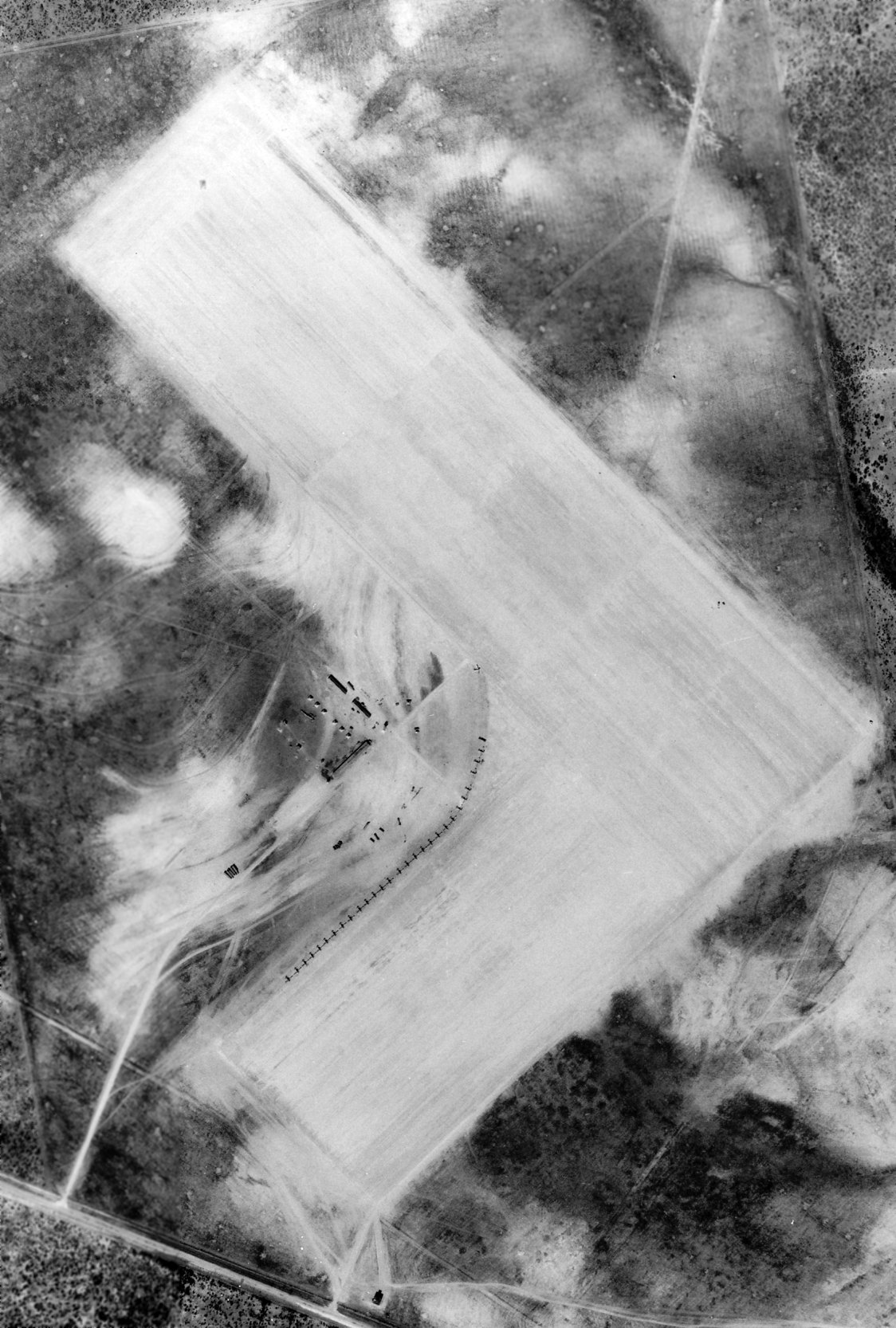
The only photo which has been located showing Eagle Pass Aux #3 while in use was a 1/19/44 USAAF aerial view from the Eagle Pass AAF base history (courtesy of Brian Rehwinkel).
According to a base history of Eagle Pass AAF (via Brian Rehwinkel), Eagle Pass Auxiliary Field #3 was comprised of 576 acres of leased land & the runways were paved with a relatively light coat of asphalt.
The field had a crash station, a tower, 2 armament buildings, and 2 latrines.
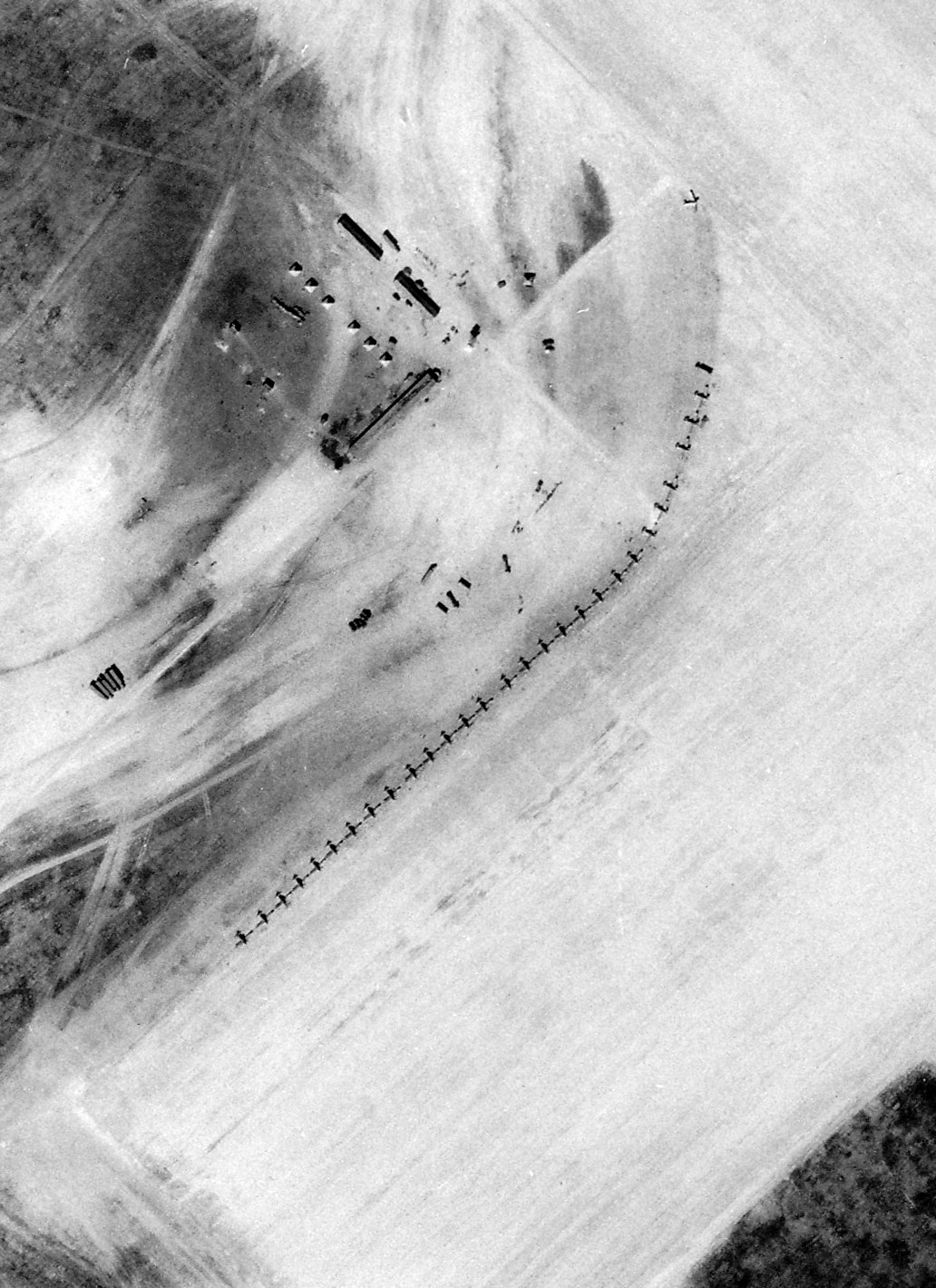
A closeup from the 1/19/44 USAAF aerial view of Eagle Pass Aux #3 (courtesy of Brian Rehwinkel).
Brian Rehwinkel observed, “This photo shows a busy field, with, 29 aircraft parked mostly wing-to-wing.
This is rather unusual for a small auxiliary field to have so many aircraft present at one time.
In addition, there are tents & a couple other small structures, indicating these planes may have spent time at the field (and soldiers needed to stay onsite in order to guard the aircraft).
Typically, these fields would just be used for practice during the day with the planes returning to the parent field each night.
The earliest aeronautical chart depiction of Eagle Pass Aux #3 which has been located was on the January 1945 Del Rio Sectional Chart.
Eagle Pass Aux #3 was already described as “Inactive” in the 1945 AAF Airfield Directory (courtesy of Scott Murdock).
It described “Eagle Pass AAF Auxiliary #3” as a 560 acre irregularly-shaped property having 2 bituminous 4,000' runways, oriented northeast/southwest & northwest/southeast.
The field was said to not have any hangars, to be owned by private interests, and to be operated by the Army Air Forces.
The Eagle Pass Aux #3 airfield was apparently reused for some unknown period of time as a private civil airfield,
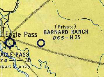
as it was labeled "Barnard Ranch (Pvt)" on the 1954 Edward's Plateau World Aeronautical Chart (courtesy of Chris Kennedy).
It was described as having a 3,500' hard-surface runway.
A 12/15/56 USGS aerial view showed the former Eagle Pass Aux #3 to remain in good condition, but without any sign of recent aviation use.
No airfield at this location was depicted on the 1956 USGS 250k topo map.
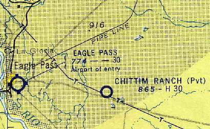
The airfield had been renamed "Chittim Ranch (Pvt)" by the time of the 1957 Del Rio Sectional Chart (courtesy of Chris Kennedy).
The Aerodromes table on the chart described the field as having 2 runways, with the longest being a 3,000' concrete strip.
The Chittim Ranch airfield was apparently abandoned at some point between 1957-61,
as it was no longer depicted at all on the January 1961 Edward's Plateau World Aeronautical Chart (courtesy of Chris Kennedy)
or the 1966 Del Rio Sectional Chart (courtesy of John Price).
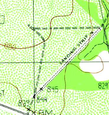
The 1982 USGS topo map depicted only Eagle Pass Aux #3's northeast/southwest runway, labeled simply as “Landing Strip”.
As of the 3/7/96 USGS aerial photo, Eagle Pass Aux Field #3's two 3,000' runways had decayed to a very poor condition but were still clearly recognizable.
The former Eagle Pass Aux Field #3 was no longer depicted at all (even as an abandoned airfield) on the 1998 World Aeronautical Chart.
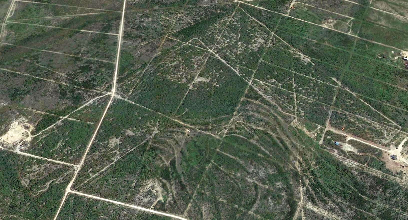
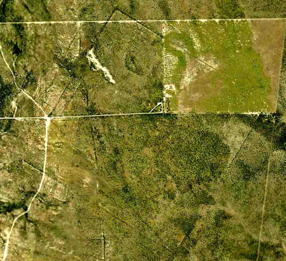
A 2015 aerial view looking east showed the L-shaped outline of Eagle Pass Aux Field #3's 2 runways was still recognizable.
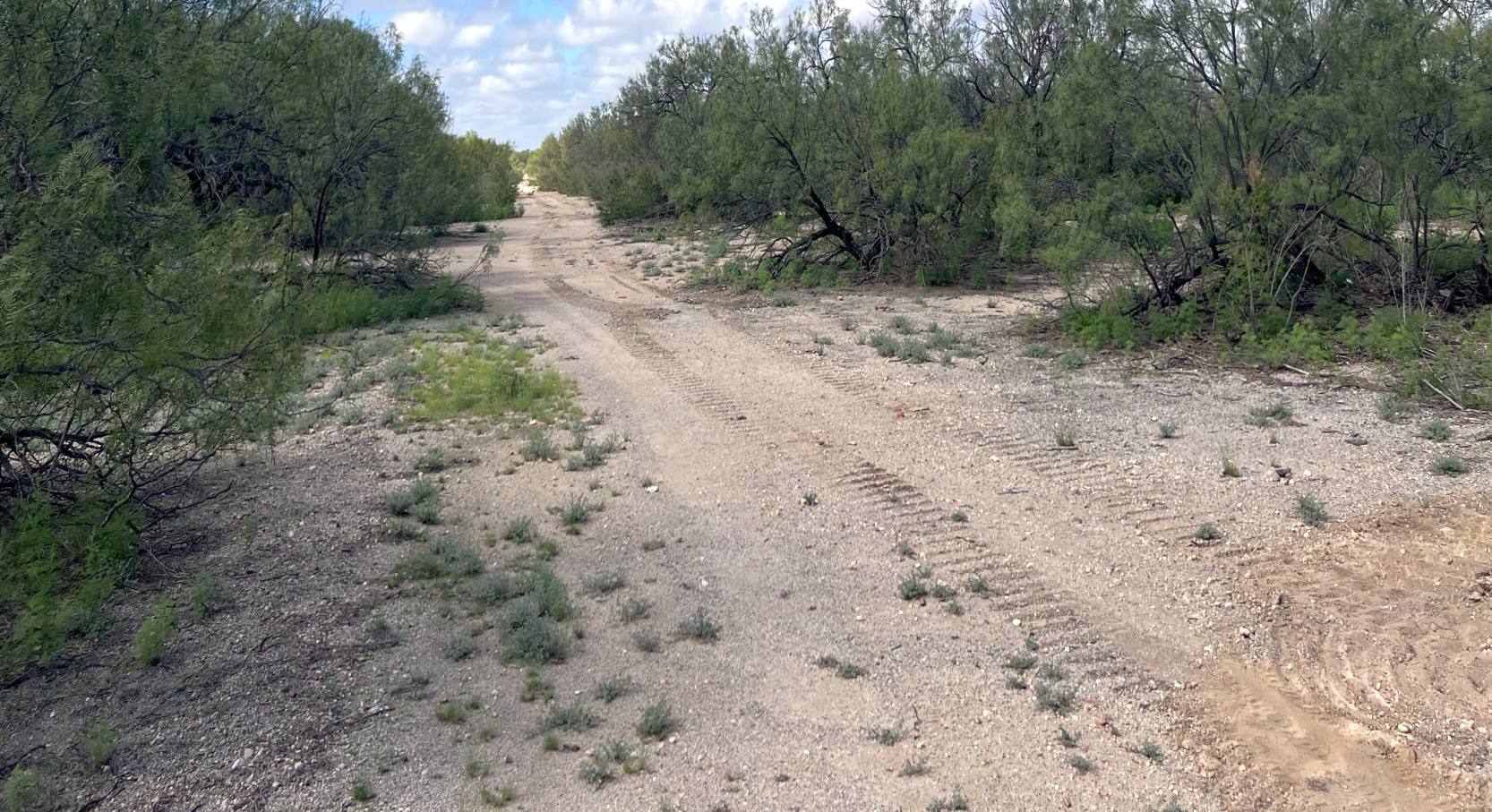
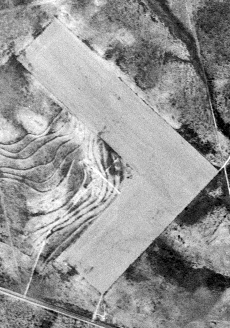
A 9/19/22 photo by Michael Kersten taken between the northwest & southeast boundaries where Eagle Pass Aux #3's two runways formed an “L”; this area is just east of where the tower & crash station were.
Michael reported, “I saw no asphalt macadam or concrete, just what appeared to be crushed caliche (limestone), a common road-building material in this part of TX.
Most of the former airfield has considerable regrowth brush common to southwest TX.
The airfield itself was re-incorporated back into a larger surrounding ranch surrounding the airfield.
Within the last 10-20 years, the ranch has been subdivided & sold off as 10- to 40-acre tracts.”
The site of Eagle Pass #3 is located on the north side of Route 277, 8 miles east of the town of Eagle Pass.
____________________________________________________
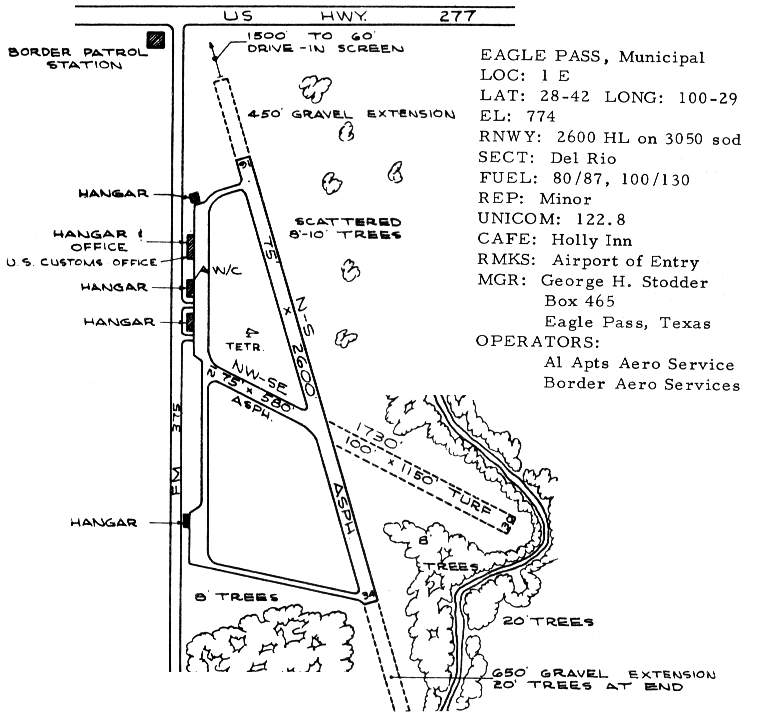
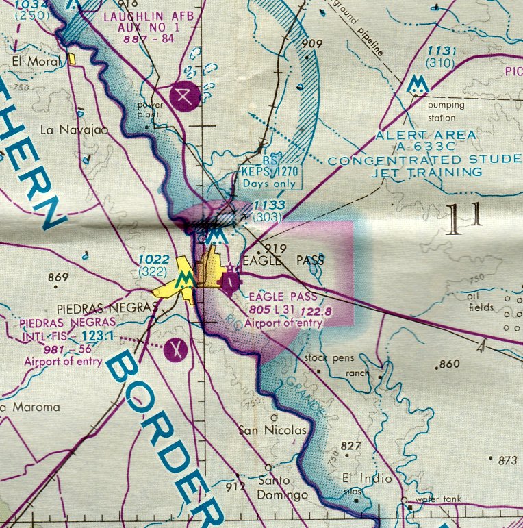
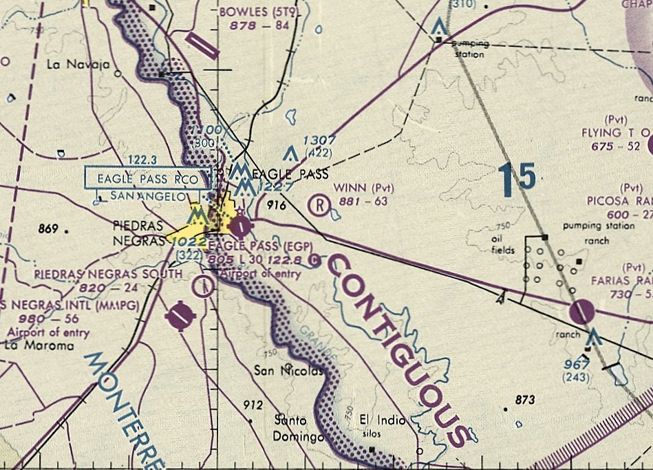
Eagle Pass Municipal Airport (EGP), Eagle Pass, TX
28.705, -100.482 (Southwest of San Antonio, TX)
Eagle Pass Municipal Airport, as depicted on the March 1935 Del Rio Sectional Chart.
According to Wikipedia, Eagle Pass Municipal Airport was established by the United States Army Air Service in 1919 as a military airfield.
It was constructed as a base for observation overflights along the Mexican Border.
During this period, Mexico was enduring a period of revolution & unrest, which led to border violations & the deaths of American citizens.
Flight "A" of the 90th Squadron (Surveillance) arrived at Eagle Pass Field on 8/27/1919 with de Havilland DH-4 aircraft, and flew observation missions along the border.
A very young James Doolittle was stationed at Eagle Pass with Flight A of the 90th.
On one trip he is said to have flown under the Pecos River railroad bridge on a dare, and, apparently, without a reprimand from his superiors.
The 90th operated from Eagle Pass until it was moved to Del Rio Field on 6/12/1920.
Eagle Pass continued to be used sporadically until the Border Patrol operation ended in June 1921.
The next use of Eagle Pass was when the Department of Commerce refitted the facility as one of its network of Intermediate Landing Fields,
which were established in the 1920s & 1930s to serve as emergency landing fields along commercial airways between major cities.
The earliest depiction of Eagle Pass Municipal Airport which has been located
was in the 1934 Department of Commerce Airfield Directory (according to Chris Kennedy).
It described the "Eagle Pass Airport" as being located on the eastern edge of the city on Highway 85,
and described the airfield as being a rectangular sod field.
The earliest aeronautical chart depiction which has been located of Eagle Pass Municipal Airport
was on the March 1935 Del Rio Sectional Chart, which depicted it as a commercial/municipal airport.
Eagle Pass was depicted as an auxiliary airfield on the 1943 Regional Aeronautical Chart (courtesy of Chris Kennedy).
However, Eagle Pass Airport may have been temporarily closed during WW2
(due to wartime security concerns, as was the case at many other small civil airports during the war),
as it was not depicted at all on the 1944 Del Rio Sectional Chart (courtesy of Chris Kennedy)
nor listed among active airfields in the 1945 AAF Airfield Directory (courtesy of Scott Murdock).
Eagle Pass Airport was apparently reopened at some point in 1945,
as "Eagle Pass" was depicted as an auxiliary airfield
on the July 1945 Edwards Plateau World Aeronautical Chart (courtesy of Chris Kennedy).
The earliest photo which has been located showing Eagle Pass Municipal Airport was an 8/7/46 USGS aerial view.
It Eagle Pass as having 2 unpaved runways, with a few small buildings along the northwest side.
"Eagle Pass" was depicted as a commercial/municipal airport
on the 1954 Edward's Plateau World Aeronautical Chart (courtesy of Chris Kennedy).
It was described as having a 3,000' unpaved runway.
The Aerodromes table on the 1957 Del Rio Sectional Chart (according to Chris Kennedy)
described Eagle Pass Municipal as having 3 runways, with the longest being a 3,000' turf strip.
The runway at Eagle Pass was evidently paved at some point between 1957-61,
as the January 1961 Edward's Plateau World Aeronautical Chart (courtesy of Chris Kennedy)
described the field as having a 2,600' hard-surface runway.
The 1962 AOPA Airport Directory described Eagle Pass Municipal Airport as having with 2 paved runways,
and listed the operator as the City of Eagle Pass & Maverick County.
According to William McEvoy (former 47th Flying Training Wing Historian), “Laughlin AFB began using Eagle Pass Municipal Airport for T-37 Tweet touch-&-gos on 12/10/62.”
The 1963 TX Airport Directory (courtesy of Steve Cruse)
depicted Eagle Pass Municipal Airport as having a 2,600' asphalt Runway 16/34,
and a crosswind Runway 12/30 (of which 580' was paved, with the remainder being turf).
Five hangars were depicted on a paved ramp along the west side.
The operators were listed as Al Apts Aero Service & Border Aero Services.
The 1966 Del Rio Sectional Chart (courtesy of John Price) depicted Eagle Pass Airport as having a 3,200' runway.
The last aeronautical chart depiction which has been located of Eagle Pass Airport was on the December 1976 San Antonio Sectional Chart.
It depicted Eagle Pass Airport as having a 3,100' paved northwest/southeast runway.
The 1983 USGS topo map depicted Eagle Pass Municipal Airport as having a single paved northwest/southeast runway,
with the former crosswind runway evidently having been closed at some point between 1963-83.
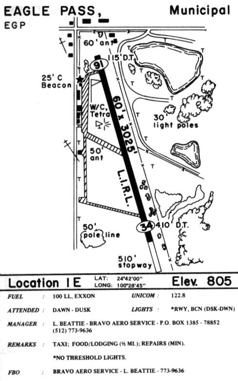
By the time of the 1985 TX Airport Directory (courtesy of Steve Cruse),
Runway 16/34 had been lengthened to 3,025', and the operator was listed as Bravo Aero Service.
According to William McEvoy (former 47th Flight Training Wing Historian), “Laughlin AFB used Eagle Pass Municipal Airport for T-37 Tweet touch-&-gos until 1/28/91,
when the new Laughlin AFB Auxiliary Field at Spofford, TX opened for touch-&-go landing operations.
Once the 47th Flight Training Wing started using Spofford for T-37, T-6 Texan II and T-38 landings, it cancelled its lease with Eagle Pass.”
The last photo which has been located showing the Eagle Pass Municipal Airport while it was operational
was a 3/7/96 USGS aerial view looking south.
It depicted 5 light single-engine aircraft on the ramp on the west side of the field.
Eagle Pass Municipal was closed sometime between 1996-2001,
after the former Eagle Pass AAF to the north was closed by the military
and reopened as a civil airport, Maverick County Memorial International Airport.
According to Lowell McManus, Eagle Pass Municipal Airport
was promptly subdivided & sold for commercial development.
A large new U.S. Post Office & several smaller businesses have already been built,
and 14 acres of it have been purchased for a new Wal-Mart Super Center.
"The new Wal-Mart Supercenter was completed & opened in the fall of 2002.
There is now no obvious evidence that the site was ever an airport."
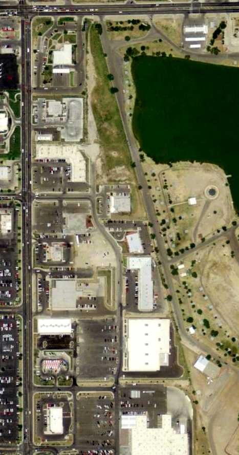
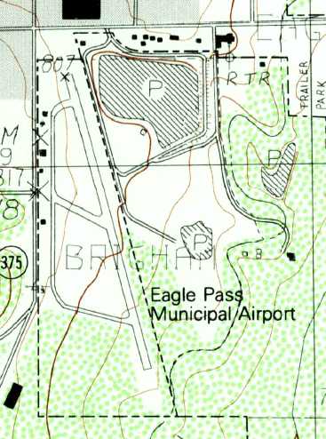
However, a 3/31/08 aerial photo show that a small northern portion of the former runway still remains.
However, all of the former hangars along the west side of the site have been replaced by modern buildings.
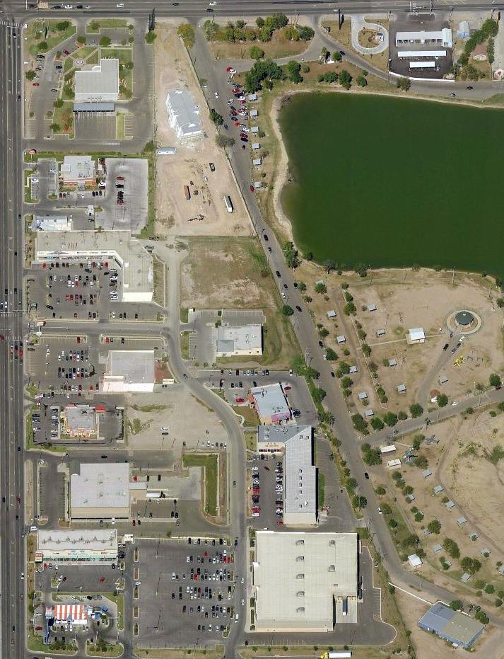
A circa 2010 aerial view looking north shows a northern portion of the former Eagle Pass Municipal Airport runway still remains intact.
____________________________________________________
Winn Exploration Company Airport (6TA4), Eagle Pass, TX
28.72, -100.41 (Southwest of San Antonio, TX)
The Winn Airfield was simply depicted as “Landing Strip” on the 1975 USGS topo map.
This private airfield was evidently constructed at some point between 1972-75,
as it was not yet depicted on a 1972 aerial photo.
The earliest depiction of the Winn Airfield which has been located was on the 1975 USGS topo map,
which depicted a single northwest/southeast runway, labeled simply as “Landing Strip”.
The Winn Airfield was not yet depicted on the December 1976 San Antonio Sectional Chart.
The earliest aeronautical depiction of the Winn Airfield which has been located was on the 1985 Del Rio Sectional Chart (courtesy of Steve Cruse).
It depicted Winn as a private airfield with a 6,300' runway.
Evan Hodgden recalled, “Winn Petroleum Field...
In late 1982 I interviewed for the Citation copilot job in Eagle Pass.
I was one of #10 of 11 interviewed & was told I had the job except for one more pilot from Houston. He got the job.
The aircraft was a [Cessna Citation] 501 model I think, and the 2nd aircraft a Cessna 210.
The aircraft were kept in a hangar at the south end of the field.
Mr. Winn was a very successful oil man, indeed. He had family members in the business also.
Since I was the 1st in line to be hired at the time, I got ushered into Mr. Winn's office for an interview with the boss.
Mr. Winn was quite an impressive figure & businessman.
The office was ultra-plush & his big game trophies from all over the world were extraordinary.
In late 1983 or early 1984 the Citation crashed at the Winn Field. I read the accident report.
They made an approach descending through an overcast, canceled IFR,
were not aligned with the runway & executed a missed approach to a circling VFR approach.
Apparently they got too low & slow returning to the field & impacted on base to final on sloping terrain somehow.
The Winn field sat on a plateau above the surrounding terrain & the highway leading in & out of town.
They mostly slid on impact. I don't think their aviation department lasted long after that.”
Dave Roach recalled, “My father used to fly for Winn Exploration in the late 1980s. I have flown in & out of it.”
The earliest aeronautical depiction which is available of the Winn Airfield was on the May 1993 San Antonio Sectional Chart (courtesy of Ron Plante).
It depicted Winn as a private airfield with a 6,300' unpaved runway.
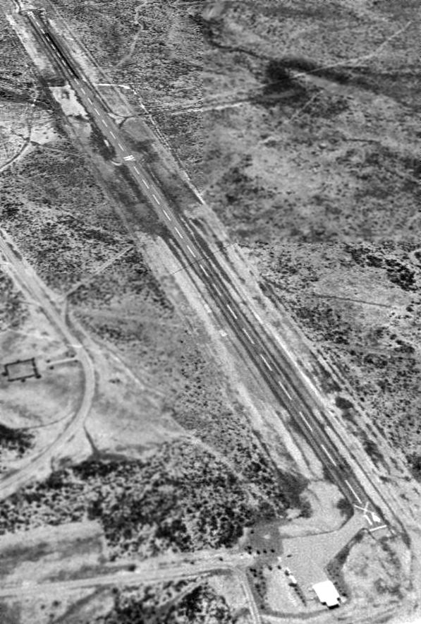
The earliest photo which has been located of the Winn Exploration Company Airfield was a 1996 USGS aerial view looking southeast,
which depicted a single paved runway, a ramp & a single hangar.
As of 2003 this airfield was listed in the FAA Airport/Facility Directory as an active private airfield, but with the note "Airport closed indefinitely".
It was listed as having 2 aircraft based at the field (including 1 jet),
and the runway configuration was listed as a single 6,300' paved Runway 14/32.
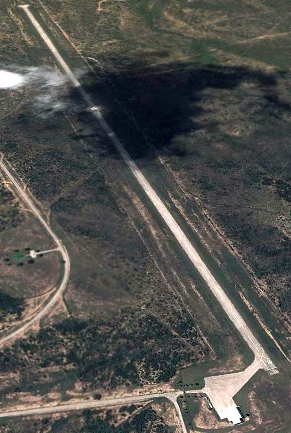
A 5/10/12 aerial view looking southeast showed the field remained unchanged compared to the 1996 photo.
Note the prominent “W” painted on the paved circle in the middle of the runway.
____________________________________________________
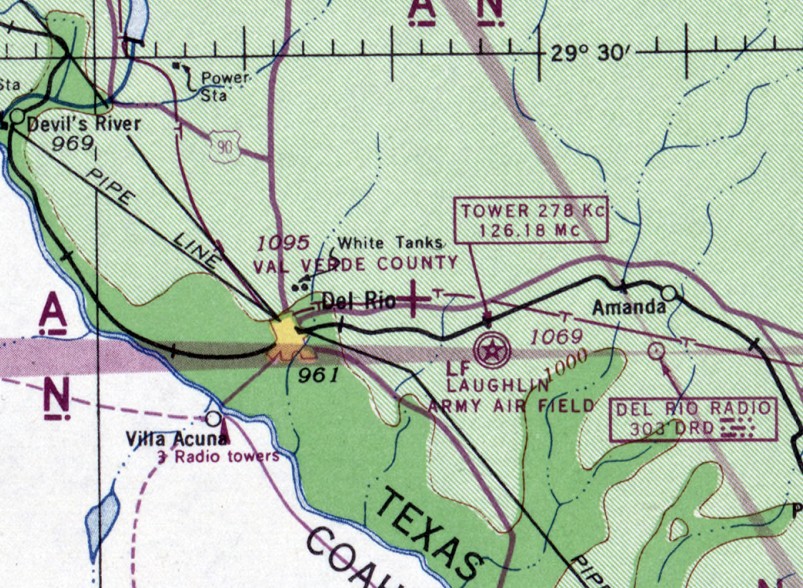
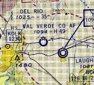
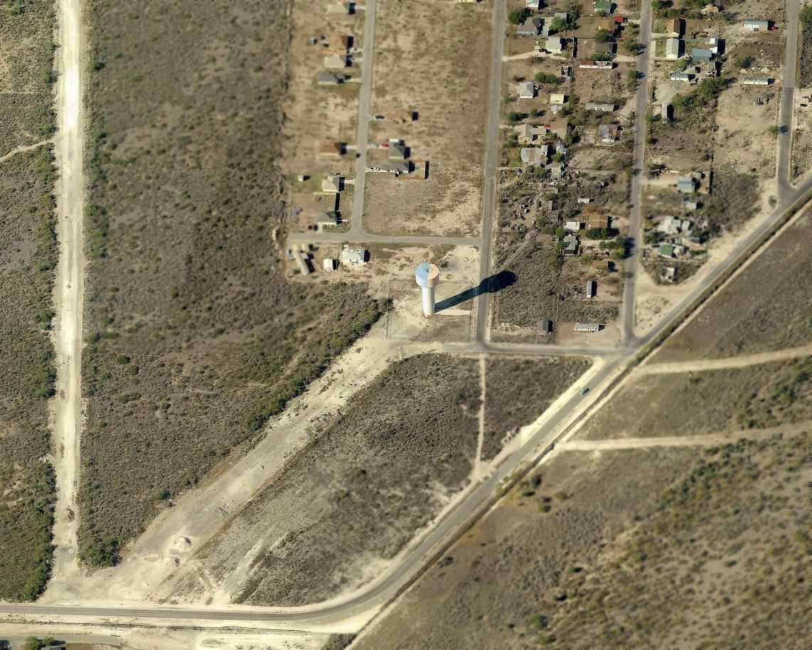
Val Verde County Airport, Del Rio, TX
29.375, -100.82 (West of San Antonio, TX)
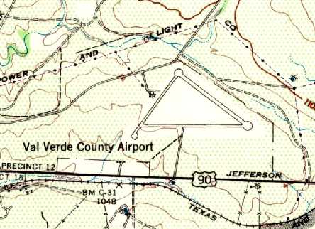
The 1943 USGS topo map depicted the Val Verde County Airport as having 3 paved runways.
Val Verde County Airport was not yet depicted on the November 1941 Del Rio Sectional Chart.
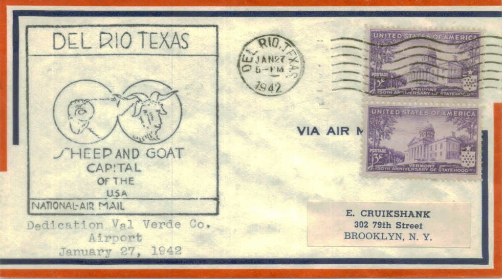
A postmark commemorated the 1/27/42 Dedication of Val Verde County Airport.
this fairly substantial airport was leased in 1943 as an auxiliary to Laughlin Field (which sits right across Route 90).
A 5/15/43 AAF list of airfields of the Gulf Coast Training Center (courtesy of Ron Plante)
described Vale Verde Field as having 3 asphalt runways, with the longest being the 4,875' east/west strip,
and listed it as an auxiliary of Laughlin Field.
The earliest depiction of Val Verde County Airport which has been located was on the 1943 USGS topo map.
It depicted the "Val Verde County Airport" as having 3 paved runways,
with one small building & a beacon on the west side of the field.
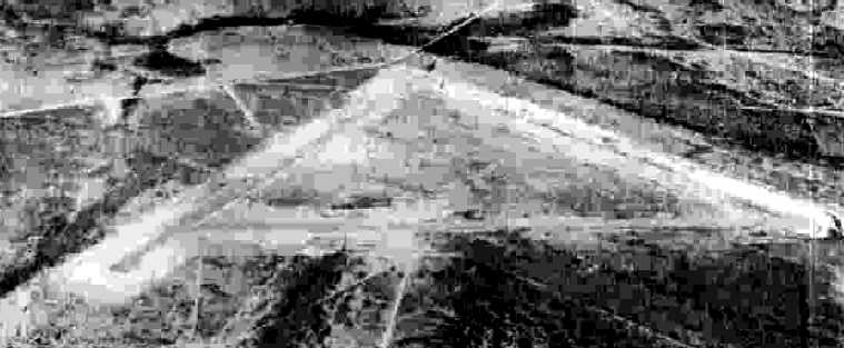
The earliest photo which has been located of the Val Verde County Airport
was a 10/26/43 aerial view looking north from the 1945 AAF Airfield Directory (courtesy of Scott Murdock).
It depicted the the field as having 3 paved runways.
The earliest aeronautical chart depiction of Val Verde County Airport which has been located was on the December 1943 Del Rio Sectional Chart.
It depicted "Val Verde County" as an auxiliary airfield.
The July 1945 Edwards Plateau World Aeronautical Chart (courtesy of Chris Kennedy),
also depicted "Val Verde County" as an auxiliary airfield.
According to Scott Murdock, Val Verde County Airport was declared surplus by the military in 1945.
The 1945 AAF Airfield Directory (courtesy of Scott Murdock) described “Val Verde County Airport”
as a 250 acre triangular property having 3 asphalt runways, with the longest being a 5,200' east/west strip.
The field was said to not have any hangars,
to be owned by Val Verde County, but not be to in operation.
A 4/25/50 USGS aerial photo showed the Val Verde County Airport to remain intact but evidently abandoned.
It consisted of 3 paved runways arranged in a triangle, with a paved ramp & one small building on the south side.
A list of offices of the National Weather Bureau stated that the local office
was located in the Administrative Building of the Val Verde County Airport from 1951-57.
Scott Murdock indicated that Val Verde County Airport was reactivated by the military in 1952.
According to William McEvoy (former 47th Flying Training Wing Historian), “Laughlin was reopened shortly after the Korean War’s outset,
and the newly constituted 3645th Pilot Training Wing’s mission comprised jet fighter combat operations (gunnery & weapons delivery)
training in the T-33 Shooting Star, F-80 Shooting Star and F-84 Thunderjet.
After the goats gave up their grazing pasture to the Air Force and the newly reopened Laughlin Air Force Base,
the only place to house and provide workspace for incoming personnel was to erect tents or use any nearby existing buildings until crews could erect permanent structures.
The civilian personnel office & commissary sat opposite the North gate on the far side of Highway 90 on what used to be Val Verde County Airport grounds.”
However, the 1954 Edward's Plateau World Aeronautical Chart (courtesy of Chris Kennedy) appeared to still depict Val Verde County as a civilian airport, not military.
It was described as having a 4,900' hard-surface runway.
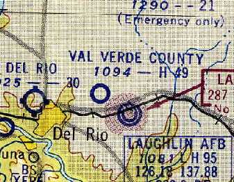
"Val Verde Co AF", as depicted on the 1957 Del Rio Sectional Chart (courtesy of Chris Kennedy).
In 1957 Val Verde County Airport was transferred from Air Training Command to Strategic Air Command, and in 1958 it was redesignated Laughlin Service Annex.
It was disposed of in 1959.
Val Verde County Airport was depicted as "Aband arpt" on the August 1960 Del Rio Sectional Chart.
The closure of Val Verde County Airport was undoubtedly caused by its unfortunate proximity to Laughlin AFB,
whose runways are only 1.5 miles to the southeast.
Val Verde County Airport was not depicted at all on the 1969 USGS topo map.
Jesse Kent was an instructor pilot in T-38s at Laughlin AFB from 1969-72,
and he recalled seeing the runways of the abandoned Val Verde County Airport while on approach to Laughlin.
"While I was there (stationed at Laughlin) you could still see the triangular shape of the runways in the midst of the mesquite.
It was directly underneath our traffic pattern.
My roommate & fellow T-38 IP [Instructor Pilot], Bob Ladley, from Uvalde, TX,
was killed on the grounds of that old airport in 1969 while on an instructional ride with a student pilot
(T-38 heavyweight single-engine final turn for Runway 14L)."
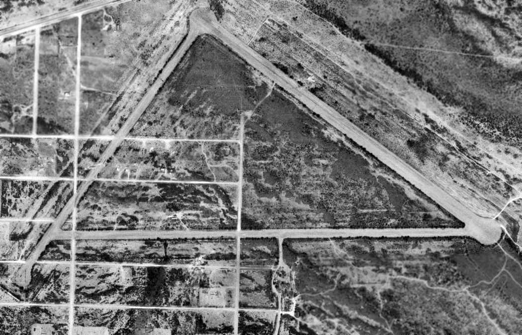
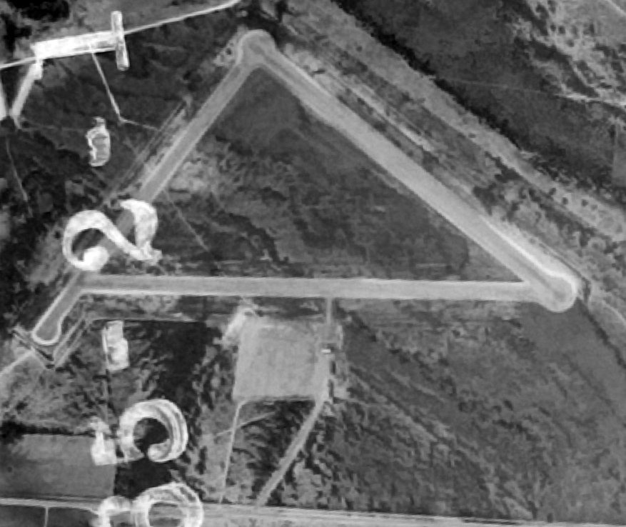
A 3/23/71 USGS aerial photo showed the Val Verde County Airport during its period of reuse by the USAF.
All 3 paved runways remained intact, although 2 of them had been narrowed at some point between 1950-71.
The ramp on the south side was still recognizable, but new roads had been overlaid on it.
"Another young T-38 IP, Bob Seabury, was killed on the old field in [May of 1971]
when the hydraulic system pitch control seized during a night touch & go on Runway 32R.
Captain Seabury & his student ejected at low altitude.
The student got a good chute, but came down in the flames of the wreckage, which was right in the middle of Highway 90.
He died from burns & trauma a few days later.
Bob Seabury's ejection trajectory carried him to his death straight out through the mesquite trees on the old airport.
He had just returned from a tour of duty in Viet Nam in F-100s, and had a brand new [son].
Though new at Laughlin, he had a reputation as an outstanding pilot."
Jason Seabury recalled, "My father, Bob Seabury, was the deceased T-38 pilot.
My dad's accident was in May 1971. When he died, I was one day short of 9 months old."
Denver Robinson recalled, “I well remember the T-38 final-turn crash, and knew & liked Bob Seabury.
I well remember the night he bought it... I was a flying a night round-robin student mission (as the IP in the back)
and during the mission we heard a broadcast on guard (243.0)
from a familiar voice from 'Lariat' (the T-38 RSU), something like '... it looks like sparks trailing...',
then after a long while we were informed (by 'Gunsmoke', the T-38 operations folks)
that Laughlin was only accepting a single approach & full stop landing (under tower control as Lariat was closed),
from a straight in to the center runway... which was a big surprise since Lariat never closed while students were in the air,
and we had all planned to do multiple night touch & go's prior to soloing our studs out at night.
We we got within visual range of the base (I remember it was an extremely clear night)
we saw multiple rotating red lights in the vicinity of the runway...
but, didn't learn that a plane was down until after our landing.”
The former airfield was not depicted at all on the 1972 USGS topo map,
but the northwest/southeast runway was depicted (labeled simply "Landing Strip") on the 1985 USGS topo map.
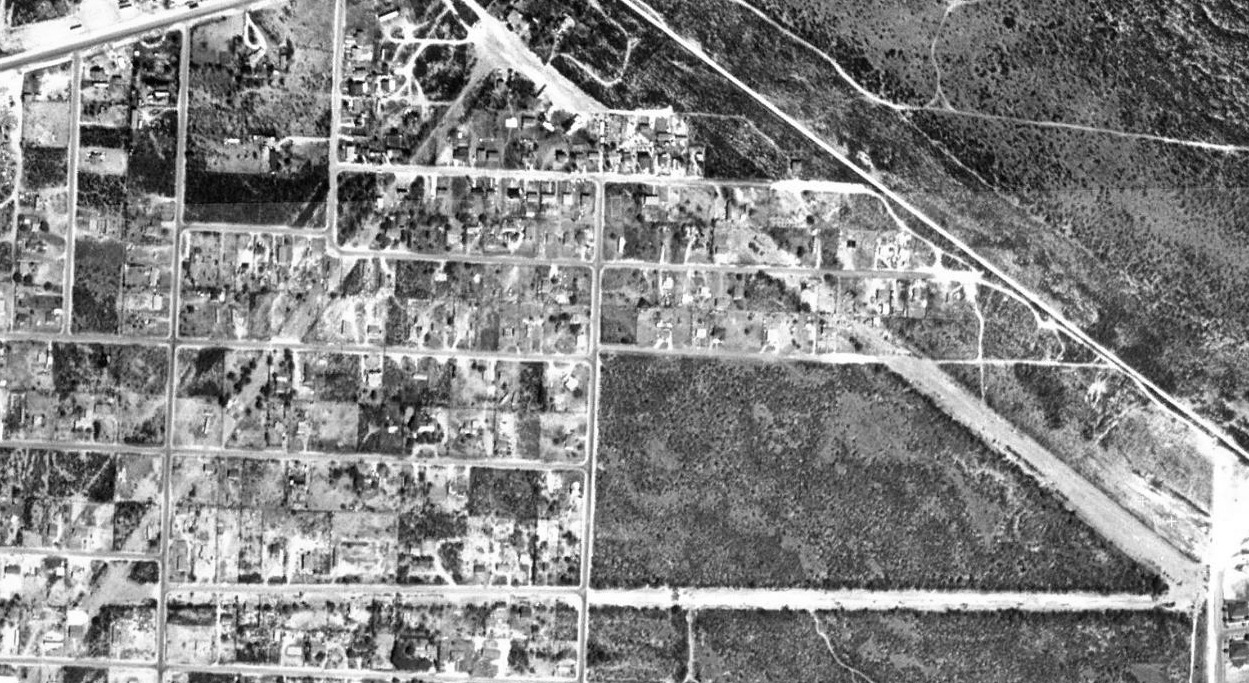
As can be seen in the 1996 USGS aerial photo, the Val Verde County Airport consisted of 3 paved runways arranged in a triangle, the longest being 4,800'.
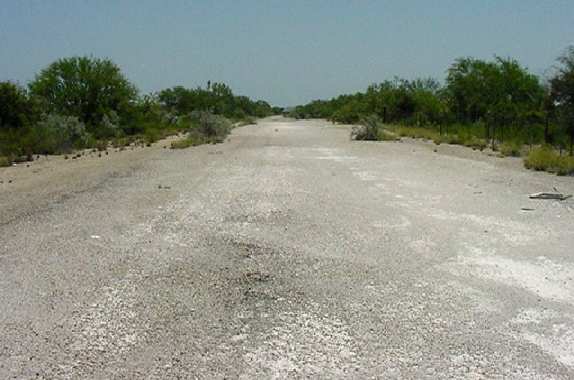
Scott Murdock visited the site in 1994 & 2003, and reported that "housing developments cover most of the former airport,
but the runways are still visible in aerial photos, cutting across the pattern of residential roads.
I was able to drive on 2 of the 3 old runways, in an undeveloped corner of the airfield."
The outline of the 3 former runways were still quite recognizable in the 2003 USGS aerial photo.
Larry Garrison reported in 2007, “I was at Laughlin recently & none of the current leadership has knowledge or interest
in the original Del Rio Airport right across Highway 90 from the base.”
A circa 2010 aerial view looking west showed the eastern end of 2 former Val Verde County Airport runways remained recognizable.
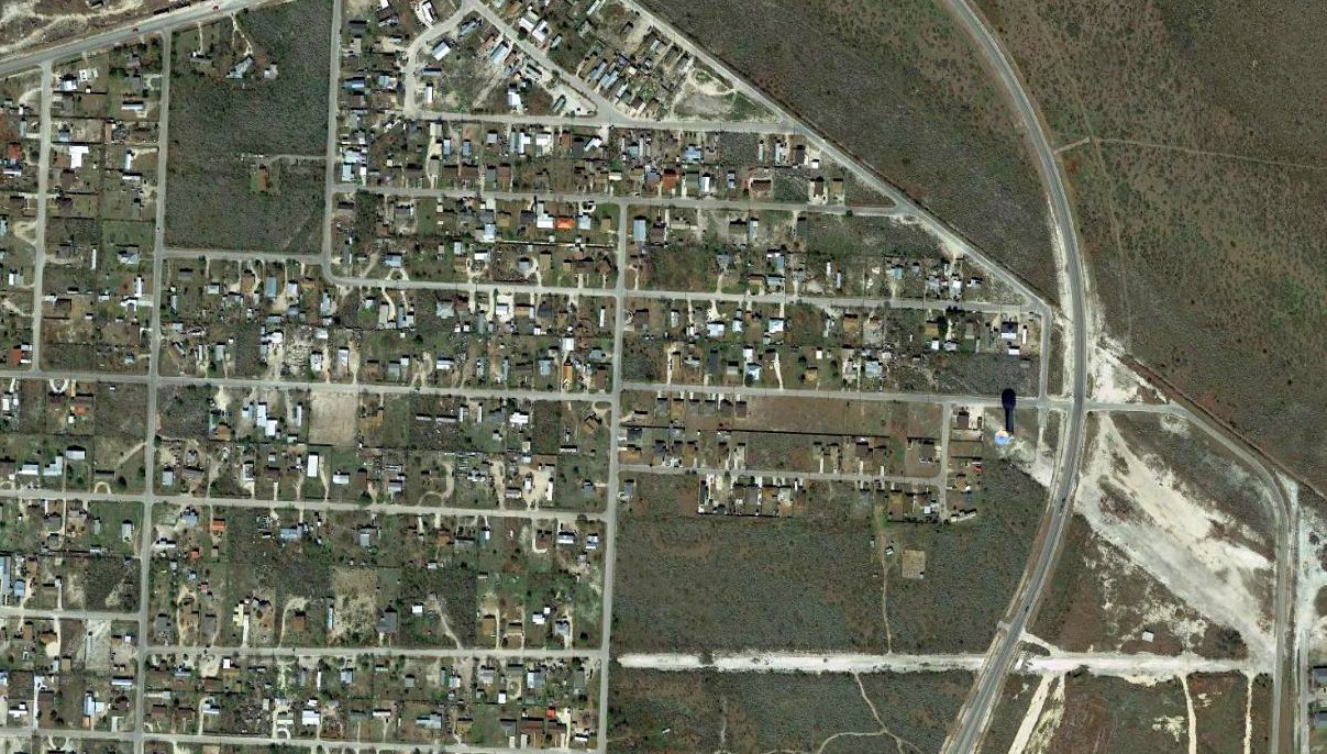
A 2017 aerial view showed portions of all 3 former Val Verde County Airport runways remained recognizable, though the site has been progressively covered by more housing.
The Val Verde County Airport site is located northeast of the intersection of Route 90 & Route 2523.
____________________________________________________
Since this site was first put on the web in 1999, its popularity has grown tremendously.
If the total quantity of material on this site is to continue to grow,
it will require ever-increasing funding to pay its expenses.
Therefore, I request financial contributions from site visitors,
to help defray the increasing costs of the site
and ensure that it continues to be available & to grow.
What would you pay for a good aviation magazine, or a good aviation book?
Please consider a donation of an equivalent amount, at the least.
This site is not supported by commercial advertising –
it is purely supported by donations.
If you enjoy the site, and would like to make a financial contribution,
you
may use a credit card via
![]() :
:
Please consider checking the box to make a monthly donatation.
For a mailing address to send a check, please contact me at: paulandterryfreeman@gmail.com
If you enjoy this web site, please support it with a financial contribution.
please contact me at: paulandterryfreeman@gmail.com
If you enjoy this web site, please support it with a financial contribution.
____________________________________________________
This site covers airfields in all 50 states.