Abandoned & Little-Known Airfields:
Texas: Southern Corpus Christi area
© 2002, © 2022 by Paul Freeman. Revised 9/6/22.
This site covers airfields in all 50 states: Click here for the site's main menu.
____________________________________________________
Please consider a financial contribution to support the continued growth & operation of this site.
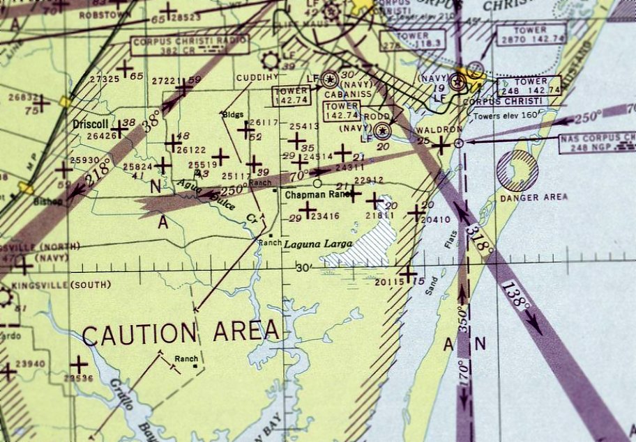
Kingsville NAS South Field (revised 1/2/17) - Kingsville NOLF #55 / Field #22441 (revised 3/8/20)
NOLF #20115 / Field #42 (revised 9/7/16) - NOLF #20410 / Field #41 (revised 9/7/16) - NOLF #23416 / Field #11 (revised 3/8/20)
NOLF #23521 / Field #13 (revised 3/2/19) - NOLF #24024 / Field #25 (revised 9/6/22) - NOLF #26117 / Field #21 (added 3/16/16)
____________________________________________________
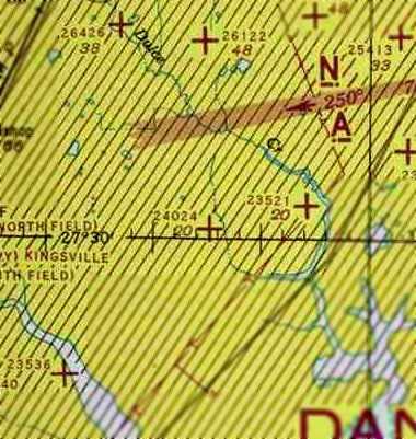
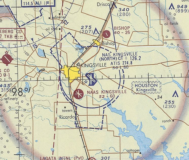
Naval Outlying Landing Field #24024 / Field #25, Corpus Christi, TX
27.51, -97.62 (Southwest of Corpus Christi, TX).
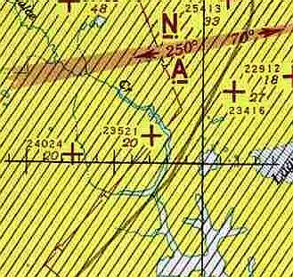
NOLF "24024", as depicted on the July 1943 Corpus Christi Sectional Chart (courtesy of David Brooks).
This field was one of a large number of satellite airfields built during WW2 to support Navy flight training in the Corpus Christi area.
Field #24024 was evidently established at some point in 1943,
as it was not yet depicted on the February 1943 Corpus Christi Sectional Chart (courtesy of Jim Stanton).
The earliest depiction which has been located of Field #24024 was on the July 1943 Corpus Christi Sectional Chart (courtesy of David Brooks).
Brian Rehwinkel reported, “According to a 1943 Navy memo, this field consisted of 250 acres of land.
During most of its use during WWII, Field # 25/ Designation 24024 was assigned to NAAS Rodd Field.”
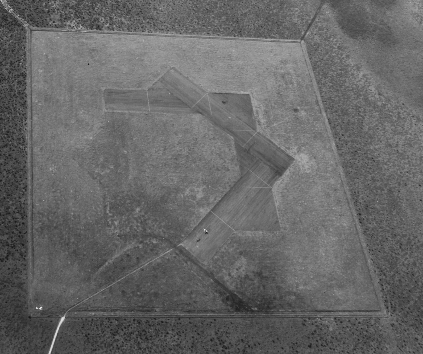
The earliest photo which has been located of Field # 25 / OLF 24024 (and the only photo showing it in use)
was a 12/15/44 USN aerial view looking south (from the NARA, courtesy of Brian Rehwinkel).
Brian observed, “This photo shows an aircraft in the process of landing (or more likely performing a touch & go).”
It showed Field #25 as having a total of 4 paved runways, with faint traces of the land having been graded but not paved for 4 other runways.
There did not appear to be any buildings at the site.
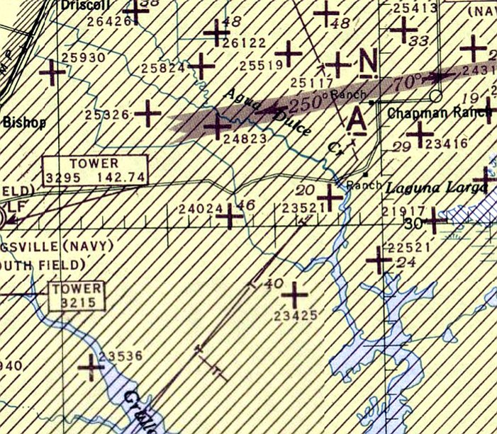
The last aeronautical chart depiction which has been located of NOLF #24024 was on the July 1945 Corpus Christi Sectional Chart.
NOLF 24024 was evidently abandoned by the Navy immediately after WW2,
as it was no longer depicted on the January 1946 Corpus Christi Sectional Chart or the 1949 USGS topo map.
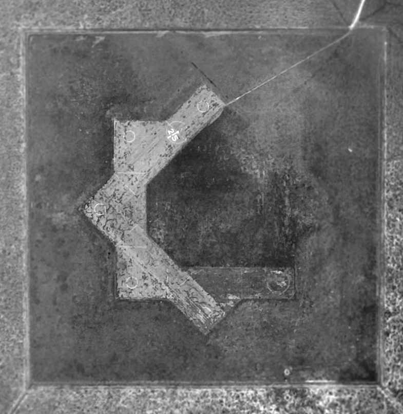
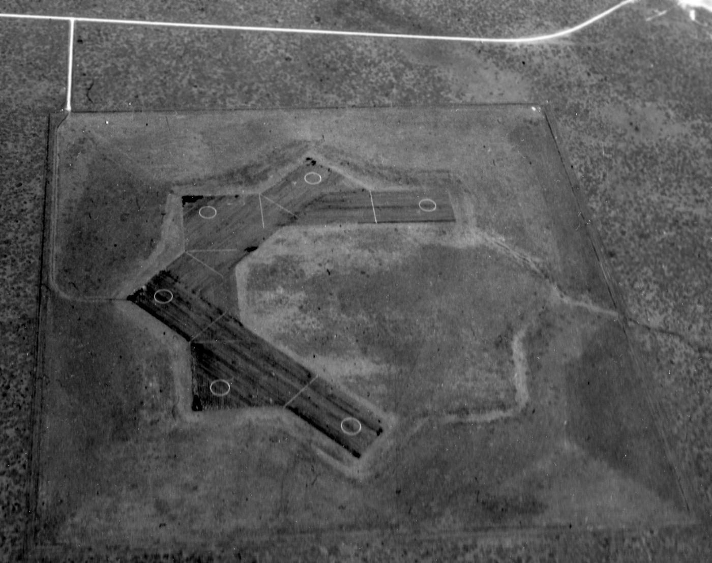
A 12/22/51 aerial photo of In the photo of Field # 25 / OLF 24024 (courtesy of Brian Rehwinkel).
Brian observed, “You can see the interesting runway layout,
which was common for the Corpus Christi area (at least 7 fields used this design) and was also used at other naval air training sites.”
The field had a total of 4 paved runways, with traces perceptible of the land having been graded but not paved for 4 other runways.
Also note the “25” - the field # painted in large numerals – which had been added at some point between 1944-51.
Brian observed, “Similar to the Pensacola area fields, the large concentration of training fields necessitated the marking of fields for pilots.”
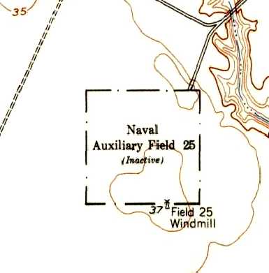
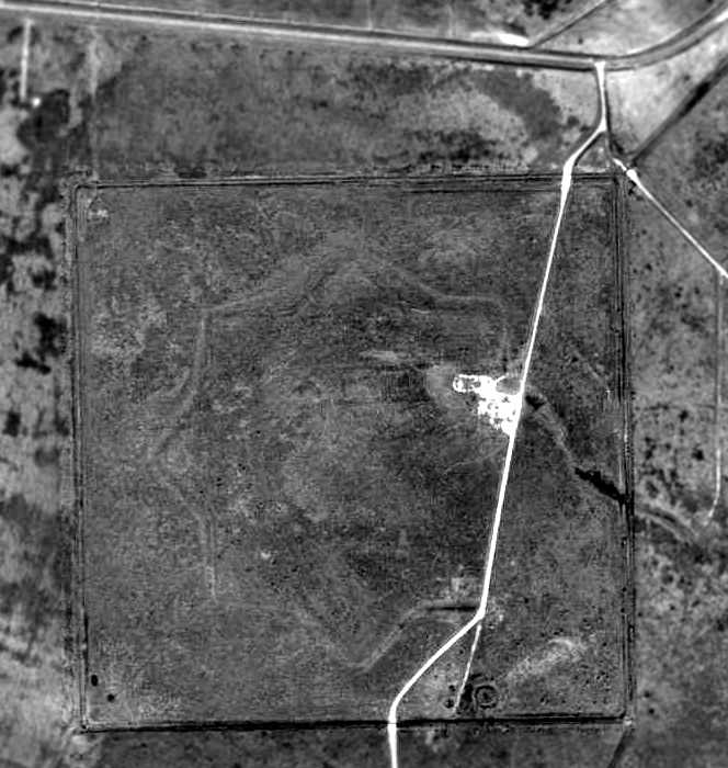
The 1954 USGS topo map depicted the rectangular property boundary of “Naval Auxiliary Field 25 (Inactive)”, along with “Field 25 Windmill” in the southeast corner.
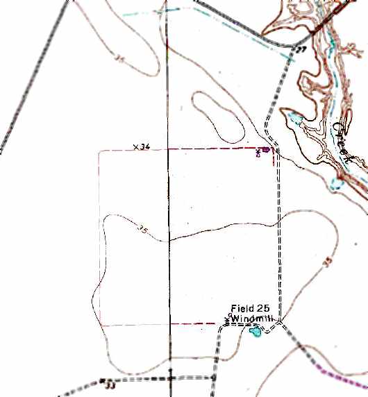
The 1989 USGS topo map depicted the rectangular property boundary of Naval Auxiliary Field 25,
along with the “Field 25 windmill” in the southeast corner.
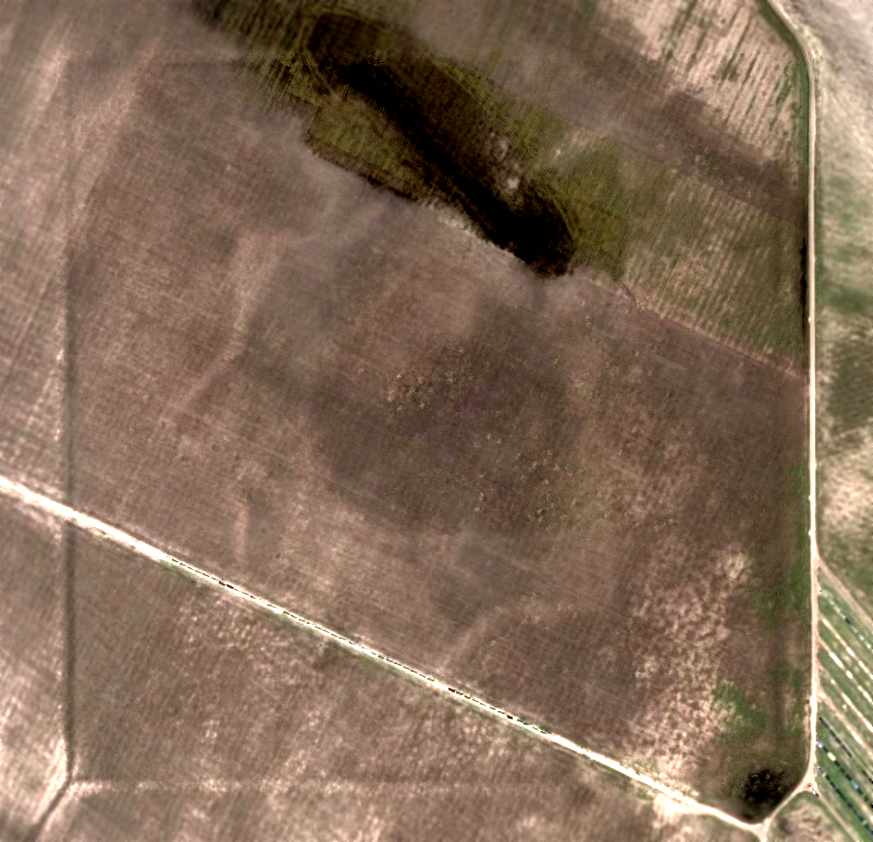
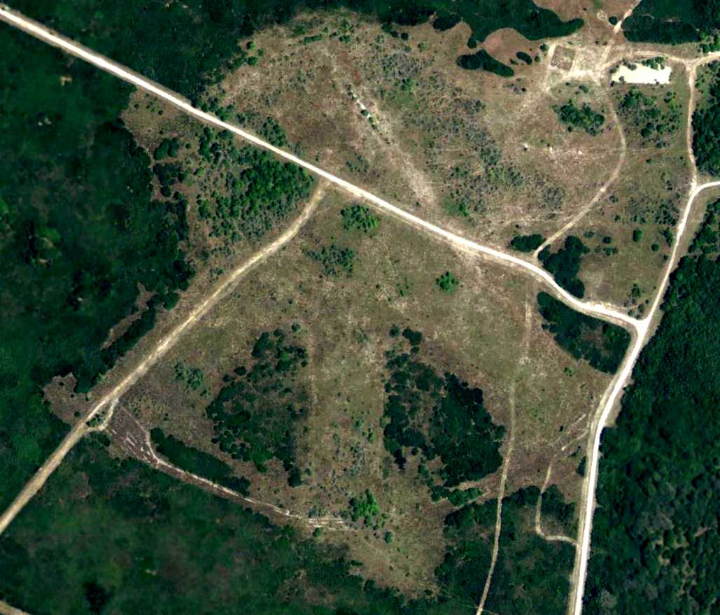
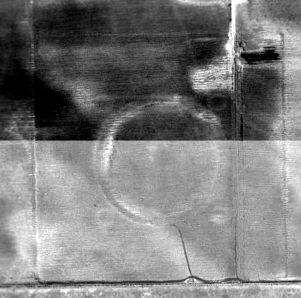
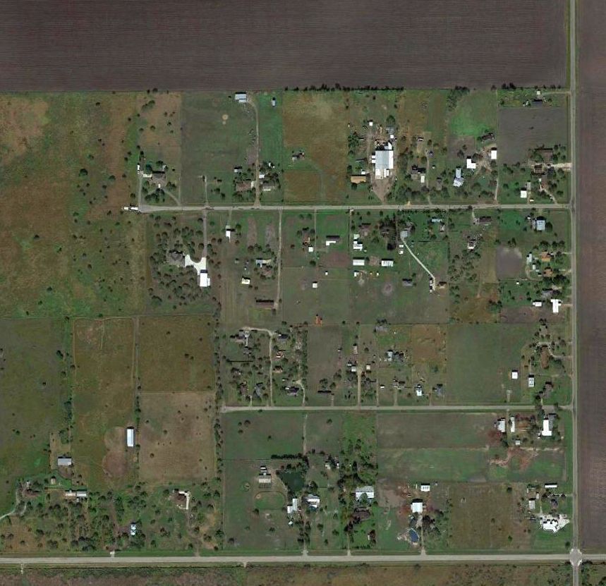
The telltale 8-pointed star-shaped outline of a Corpus Christi auxiliary airfield was still quite recognizable in a 2003 aerial photo.
The site of Field #24024 is located south of the intersection of Route 70 & CR-67.
____________________________________________________
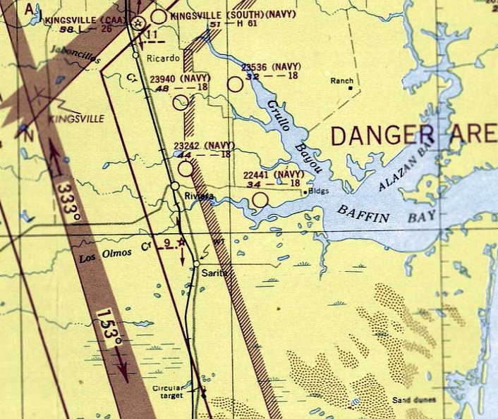
Kingsville Naval Air Station South Field / Kingsville South Municipal Airport, Kingsville, TX
27.48, -97.83 (Southwest of Kingsville NAS)
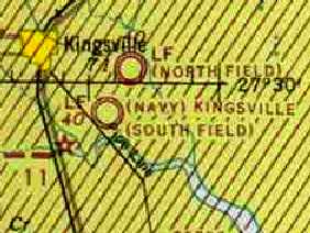
"(Navy) Kingsville (South Field)", as depicted on the July 1943 Corpus Christi Sectional Chart (courtesy of David Brooks).
Kingsville Naval Air Station was not yet depicted on the June 1941 Corpus Christi Sectional Chart.
The Navy purchased 2,850 acres of the King Ranch in 1941 to construct Kingsville Naval Air Station.
It was opened in 1942, and was initially known as P-4.
The base had 2 separate airfields - North & South Fields.
Both airfields had four 6,000' asphalt runways.
The South Field was first used for dive bomber training in 1942.
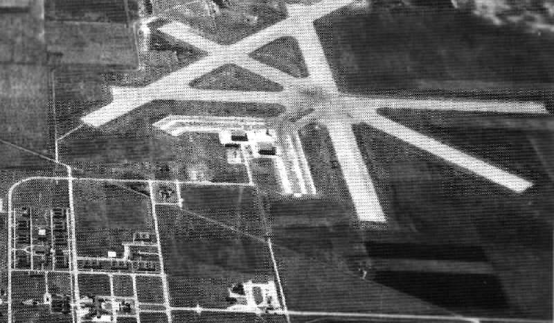
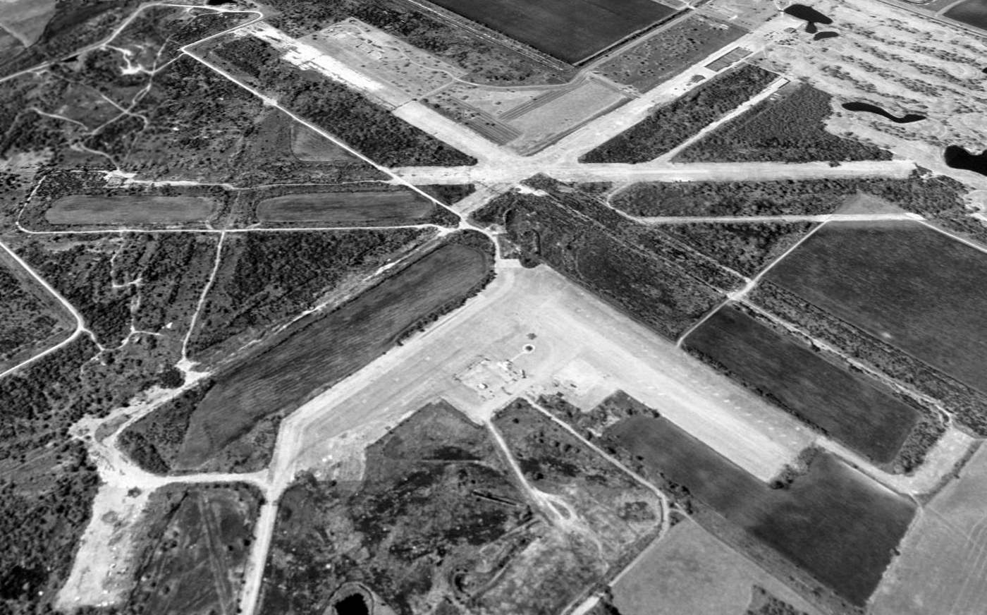
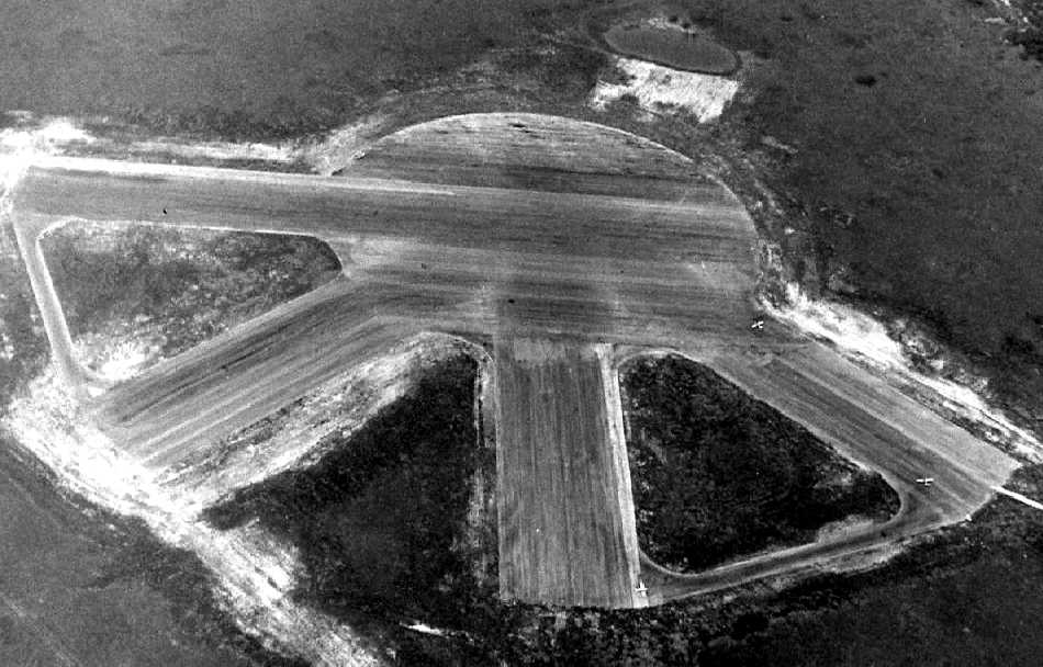
A 1944 aerial view looking south at Kingsville South Field (National Archives photo).
With the end of WW2, Kingsville went on standby status in 1946.
The Navy then leased the base to the City of Kingsville,
and the facility was used by the TX Agricultural & Industrial College of Kingsville.
Ganey Bradfield recalled, “In 1946/47, I attended Texas A & I College at Kingsville
and was housed in the old BOQ at South Field, which was being used as a dormitory for Texas A & I.
Some classes were held on the South Field 'campus',
but most were held at the main campus just west of downtown Kingsville.
There was an FBO at the airfield there, and I checked out in,
and flew a Rearwin Sportster from there a few times.
I don't remember just what that operation was called.”
Even though the Kingsville base was reportedly in a "standby" status after 1946,
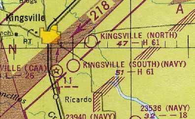
"Kingsville (South) (Navy)" was depicted as an active airfield
on the 1949 Corpus Christi Sectional Chart (courtesy of Chris Kennedy).
It was described as having a 6,100' hard-surface runway.
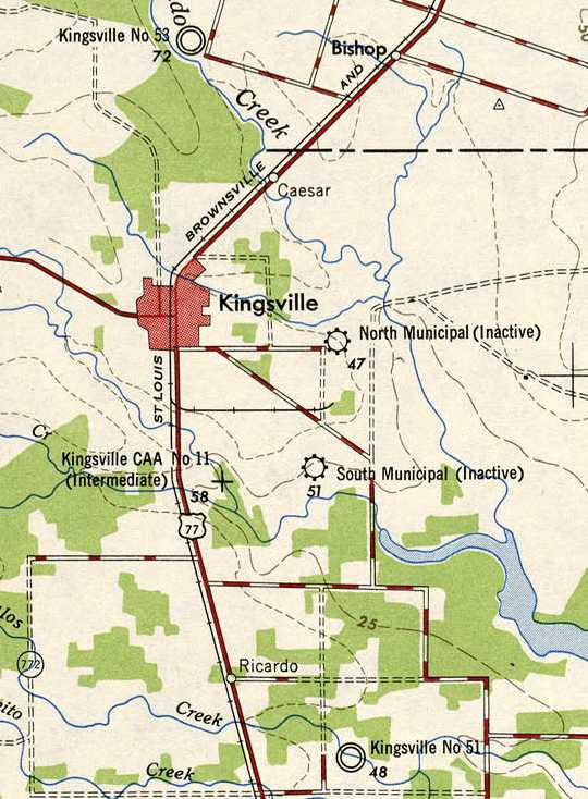
The 1949 USGS topo map depicted the field as Kingsville “South Municipal (Inactive)”.
Both Kingsville fields were reactivated in 1951.
South Field was used for antisubmarine aircraft training with TBM Avengers & SNJs, and fighter training with F8F Bearcats.
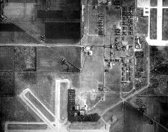
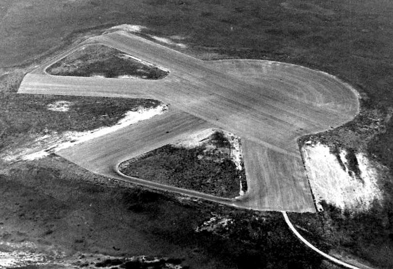
An undated (circa 1940s-50s?) aerial view showing Kingsville South Field in relation to the main field.
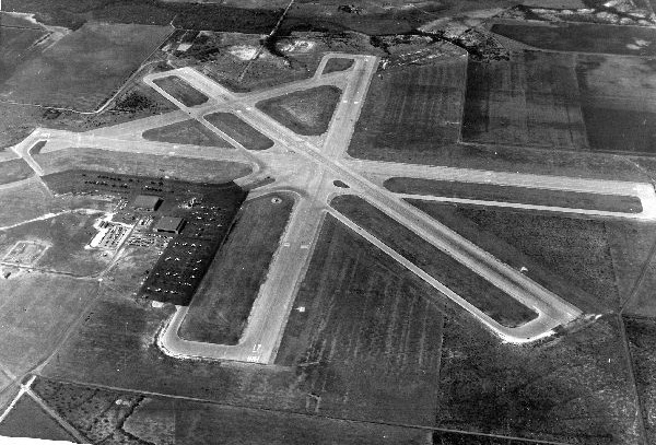
An undated (circa 1940s-50s?) aerial view looking southeast at Kingsville South Field.
A 12/22/51 USGS aerial view showed the Kingsville South Field runways remained marked as active runways, but there were no aircraft visible on the ramp.
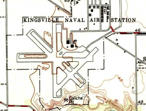
The 1954 USGS topo map depicted “Kingsville Naval Air Station” South Field as having 4 paved runways & 3 buildings.
According to Navy flight instructor Trevor Phillips-Levine, “Up until the late 1950s, F-9s could be heard operating at both fields.”
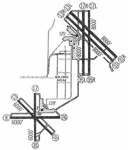
The 1960 Jeppesen Airway Manual (courtesy of Chris Kennedy) depicted both Kingville's South & North Fields.
The South Field was depicted as having a total of three 6,000' paved runways (8/26, 13/31, and 17/35), as well as several taxiways, a ramp, and 3 hangars.
The South Field was said to be closed to transient aircraft, and its lights were described as inoperative.
In 1960, Kingsville's antisubmarine training mission was moved to NAAS New Iberia, LA & Kingsville South Field was closed.
According to Navy flight instructor Trevor Phillips-Levine, “Eventually South field became a boneyard.”
"NAAS Kingsville (South)" was still depicted on the 1964 Corpus Christi Sectional Chart (courtesy of John Voss), but it was listed as closed.
"NAAS Kingsville" was still depicted as an active airfield on the January 1972 Brownsville Sectional Chart (courtesy of Ron Plante), but it may have been largely inactive by that point.
"NAS Kingsville (South)" was depicted as closed on the 1983 Brownsville Sectional Chart.
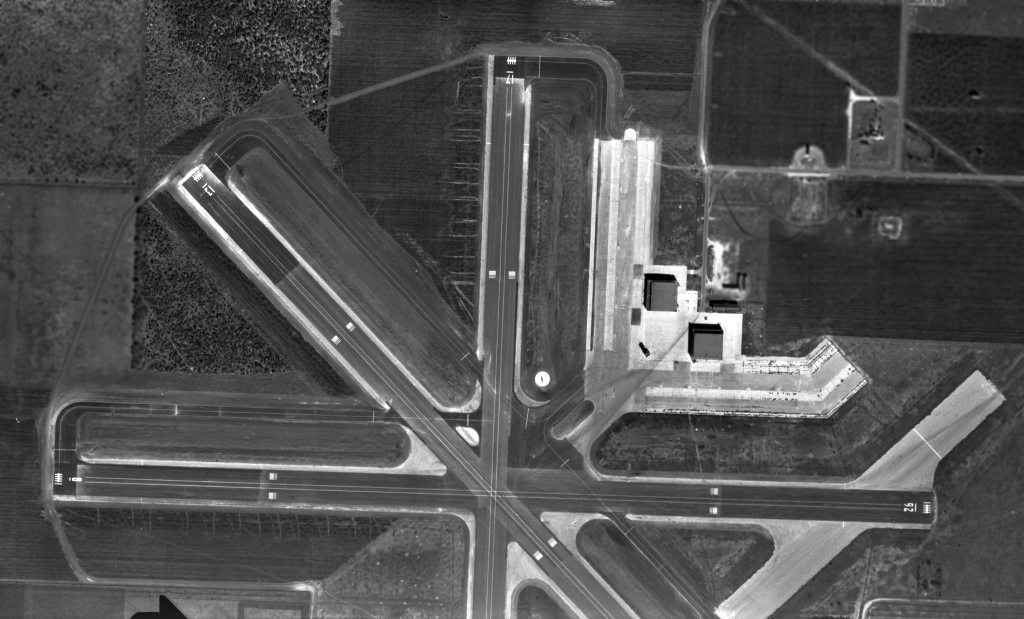
A 1996 USGS aerial view looking southwest at the remains of Kingsville South Field showed the hangars had evidently been removed at some point between 1960-96.
According to Naval Aviator Jeffery Sternberg, as of 2001, Kingsville South Field was used for activities that require a large concrete pad.
The Search & Rescue Huey from NAS Corpus frequently used it for hover work & ground hover taxi training, but it had no other aviation use.
There was a skeet range located on the site, and also a motorcycle training course.
As of 2002, portions of several of the South Field runways had been broken up,
and a county park golf course had been built adjacent to the airfield to the northwest.
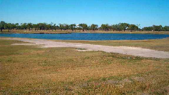
A 2003 photo by Mark Paulson of the remains of runway pavement at Kingsville South Field.
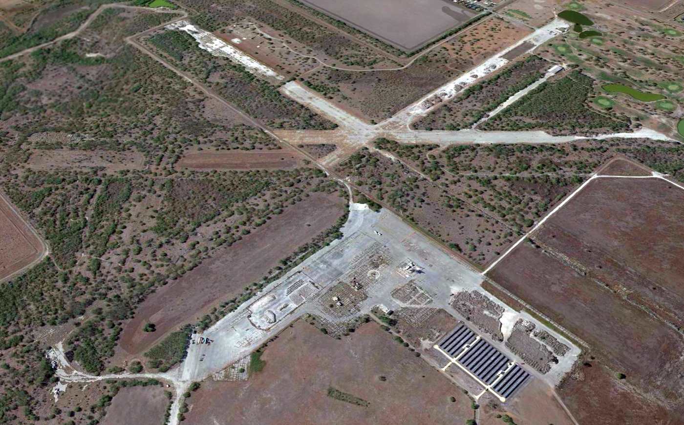
A 2011 aerial view looking southwest at the remains of Kingsville South Field.
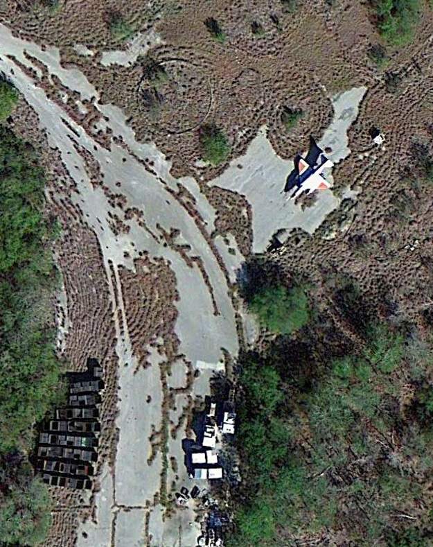
An 11/22/11 aerial photo of a derelict Douglas A-4 Skyhawk sitting just north of the former Kingsville South Field Runway 26 threshold.
It was not visible in aerial photos of the same location from 2008.
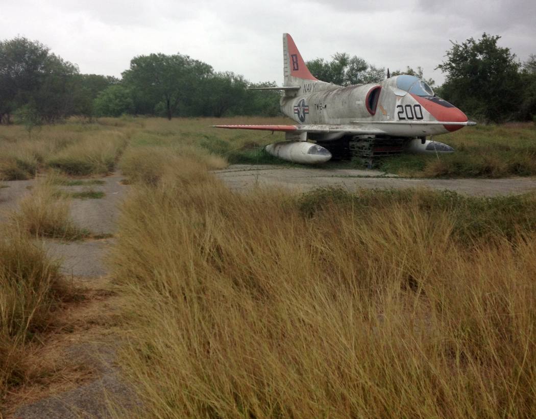
A 7/10/14 photo by Navy flight instructor Trevor Phillips-Levine at Kingsville South Field of a derelict Douglas A-4 Skyhawk,
which “now occupies what used to be the threshold area. Runway 26 is now mostly overgrown.
A gate now blocks the old taxiway that once connected North Field to South.
South field now is part of storage & hunting area for the base.
Most of the runways are now part of a private golf course with a fence running along the western portion of the old ramp.”
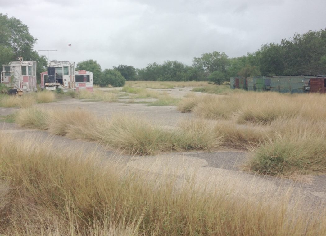
A 7/10/14 photo by Navy flight instructor Trevor Phillips-Levine at Kingsville South Field,
“Looking down Runway 26. Only 1,000' of the original 6,000' is visible. A tree line has since grown across.
To the left sit abandoned Landing Signal Officer / runway wheels watch shacks.”
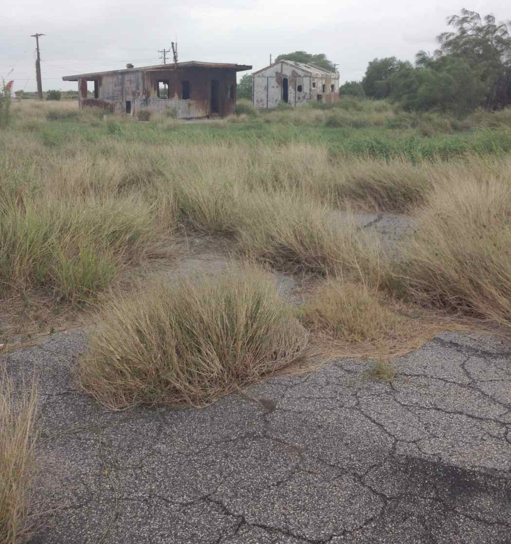
A 7/10/14 photo by Navy flight instructor Trevor Phillips-Levine at Kingsville South Field.
Trevor observed, “Grasses are now overtaking the concrete where the hangars used to stand.
Unknown when these 2 buildings were constructed, but judging by age & location, probably could have been around when the field was still active.”
Kingsville South Field is no longer depicted at all (even as an abandoned airfield) on recent aeronautical charts or USGS topo maps.
____________________________________________________
Kingsville Naval Outlying Landing Field #55 / Field #22441, Riviera, TX
27.28, -97.72 (South-southeast of Kingsville NAS)
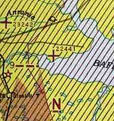
Field "22441", as depicted on the July 1943 Corpus Christi Sectional Chart (courtesy of David Brooks).
Photo of the airfield while operational has not been located.
This field was one of numerous satellite airfields used during WW2 by NAS Corpus Christi.
According to a Hank Counts (Army Corps of Engineers), this field was also known as Field #22441,
which meant that it was located 41 miles from the parent airfield, along a bearing of 224.
Field #22441 was evidently established at some point in 1943,
as it was not yet depicted on the February 1943 Corpus Christi Sectional Chart (courtesy of Jim Stanton).
The earliest depiction of the field which has been located
was on the July 1943 Corpus Christi Sectional Chart (courtesy of David Brooks).
Brian Rehwinkel reported, “According to a 1943 Navy memo, this field consisted of 221 acres of land.
During most of its use during WWII, Field # 55/ Designation 22441 was assigned to NAAS Kingsville Field.”
The last aeronautical chart depiction which has been located of Field #22441 was on the August 1949 Corpus Christi Sectional Chart.
It depicted "22441" (Navy)" as having an 1,800' unpaved runway.
Field #22441 was evidently closed at some point between 1949-50,
as it was no longer depicted on the February 1950 Corpus ChristiSectional Chart.
Following its use as an airfield, the Field #22441 property was reused by the Navy as a bombing target.
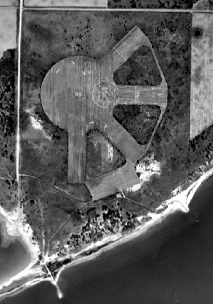
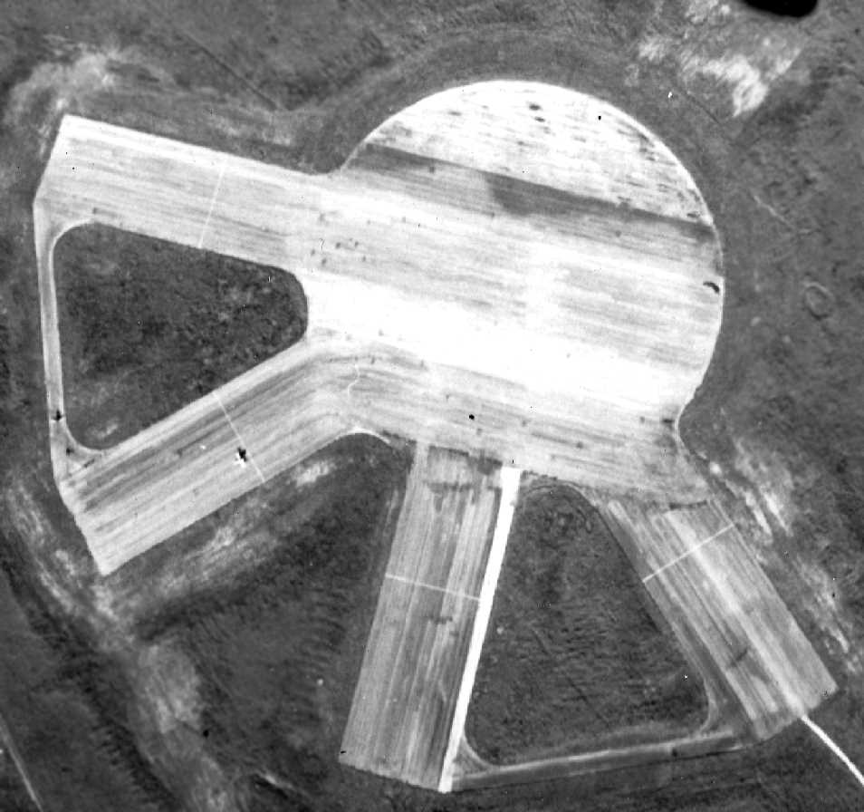
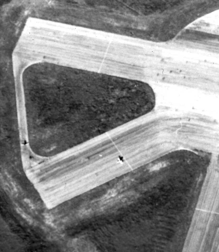
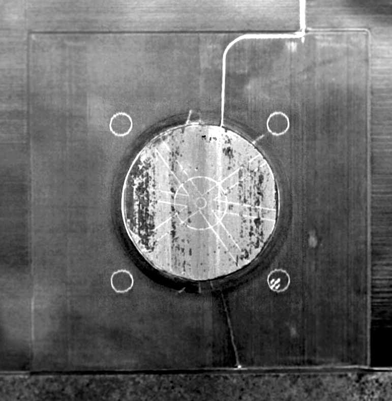
A 12/11/51 aerial view (courtesy of Brian Rehwinkel) showed Field # 55 / OLF 22441 had a total of 4 runways,
which extended outward from a circular landing mat, along with a ramp on the south side of the field.
The airfield surfaces appeared to be paved.
Brian observed, “This field, which at the time of this photograph was in use by the Navy, was probably being used as a bomb target.”
You can see arrows painted on portions of the field from a Northwest to Southeast direction pointing toward a large circle - apparently a target circle.
You can also see what appears to be a building at the south end of the parking area.”
The 1952 USGS topo map depicted the arrangement of the field with its circular landing mat, 4 runways, taxiways, ramp, and 1 small building.
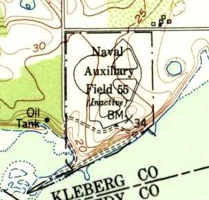
The field had evidently been closed at some point between 1949-52, as it was labeled “Naval Auxiliary Field 55 (Inactive)”.
Clyde McPherson recalled Field 55 as “an old fishing place where I used to fish when I was a kid in Riviera.
The fishing place was called Field 55 and by the residents at Riviera, Site 55.
Since I was a 'Navy brat', I had access to the fishing pier there,
and as a young boy, I roamed Filed 55 whenever I could.
During the 1960s the field was used for advanced radar training.
There were 2 radar units; one was at the far corner of the rectangular area, left of the small white speck (personnel building).
The other radar unit was at the opposite end of the runways.
During the 1960s the landing strips were still there,
the training squadrons from Kingsville would do some touch & goes.”
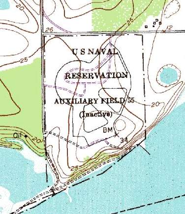
The airfield was labeled as "U S Naval Reservation Auxiliary Field 55 (Inactive)" on the 1975 USGS topo map.
It depicted the field as having four 2,000' runways, which intersected on the northwest corner at a 1,000' diameter circular landing mat.
A rectangular ramp area sat at the south end of the field.

In the 1995 USGS aerial photo, the outline of the runways & circular landing mat were still barely recognizable.
According to Clyde McPherson, “The rectangular outlines of the remains of a building was where the naval personnel stayed.”
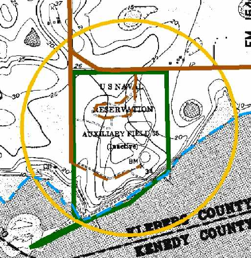
NOLF #55 is located southeast of the intersection of Kieberg County Road 1120 South & Farm Road 2510, 6 miles east of Rivera, TX.
____________________________________________________
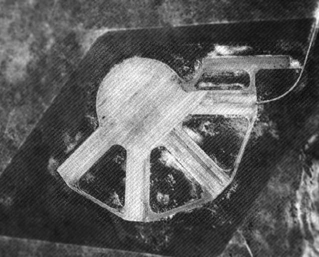
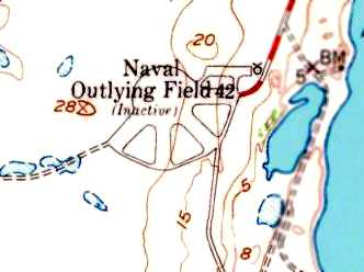
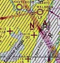
Naval Outlying Field #20115 / Field #42, Laguna Larga, TX
27.5, -97.36 (South of Corpus Christi, TX)
A December 1942 aerial view looking east at NOLF 20115 (courtesy of Gerry Asher).
This field was one of 7 Outlying Fields built during WW2 as satellite airfields for Kingsville Naval Air Station.
It was also known as OLF #20115.
It may have been a solo check field, due to the presence of the parking ramp northeast of the runways.
The date of construction of Field #20115 has not been determined.
The earliest depiction of the field which has been located was a December 1942 aerial view looking east (courtesy of Gerry Asher).
It depicted NOLF 20115 as consisting of a paved circular landing mat, from which extended a total of 4 paved runways.
The earliest aeronautical chart depiction of NOLF 20115 which has been located
was on the July 1943 Corpus Christi Sectional Chart (courtesy of David Brooks).
A WW2-era view (National Archives photo) depicted the Laguna Larga field as consisting of a 1,200' diameter circular landing mat,
from which extended a total of four 2,000' runways.
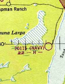
"20115" (Navy)" was still depicted as an active airfield on the 1949 Corpus Christi Sectional Chart (courtesy of Chris Kennedy).
The 1951 USGS topo map depicted the arrangement of the field with its circular landing mat, 4 runways, taxiways, and a ramp.
The field had evidently been closed at some point between 1949-52,
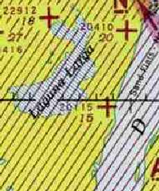
as it was labeled “Naval Auxiliary Field 42 (Inactive)”.
Field #20115 was not depicted at all (even as an abandoned airfield)
on the 1964 Corpus Christi Sectional Chart (courtesy of John Voss).
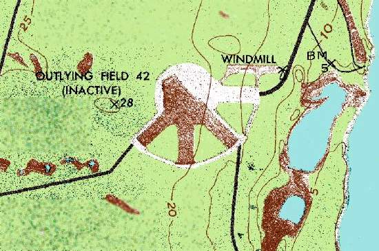
The field was designated "Outlying Field 42 (Inactive)" on the 1969 USGS topo map.
The outline of the circular mat & runways was still barely evident in the 1995 USGS aerial photo.
A portion of concrete (perhaps of later construction?) still remained on the parking ramp northeast of the circular mat.

A 4/26/03 aerial view by Dick Merrill looking northeast at the remains of of NOLF 20115
showed the outline of the circular mat & runways to still be barely evident.
A 3/31/08 aerial view of NOLF 20115 showed the outline of the circular mat & runways to still be barely evident.
A small portion of concrete remained on the parking ramp northeast of the circular mat.
According to Jeffery Sternberg,
this abandoned airfield is known among local pilots as the "Wagon Wheel".
Outlying Field #42 is located 4 miles northeast of Ojo de Angua, TX,
10 miles south of Waldron NOLF.
____________________________________________________
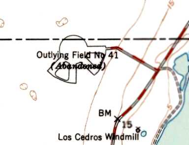
Naval Outlying Landing Field #20410 / Field #41, Corpus Christi, TX
27.56, -97.34 (South of Corpus Christi, TX)
A December 1942 aerial view looking northwest at NOLF 20410 (courtesy of Gerry Asher).
This field was one of a large number of satellite airfields built during WW2
to support Navy flight training in the Corpus Christi area.
The date of construction of Field #20410 has not been determined.
According to Brian Rehwinkel, “This outlying field was on a 530 acre parcel of land leased from the King Ranch company.
The Navy leased over 2,100 acres (with 7 outlying fields on this land) from the King Ranch company.”
The earliest depiction of the field which has been located
was a December 1942 aerial view looking northwest (courtesy of Gerry Asher).
It depicted NOLF 20410 as consisting of a paved circular landing mat, from which extended a total of 4 paved runways.
A total of 3 aircraft were visible on the runways.
An undated aerial view looking northeast at NOLF 20410 (courtesy of John Voss),
showing what appear to be 4 aircraft on the edge of the circular landing mat.
The earliest aeronautical chart depiction of NOLF 20410 which has been located
was on the July 1943 Corpus Christi Sectional Chart (courtesy of David Brooks).
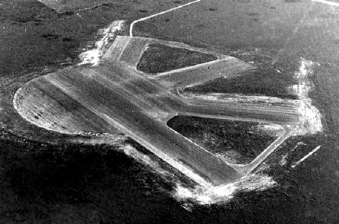
A 1/10/45 U.S. Navy aerial view looking northwest at Field #20410 (courtesy of Brian Rehwinkel).
Like many other WW2-era Corpus Christi area auxiliary airfields, Field #20410 consisted of a 1,200' diameter circular landing mat,
from which extended a total of four 2,000' runways.
A closeup from the 1/10/45 U.S. Navy aerial view (courtesy of Brian Rehwinkel), showing 2 aircraft on Field #20410.
Brian observed, “One aircraft looks to be performing a touch & go procedure, and the other aircraft is waiting on one of the taxiways.”
Field #20410 was apparently abandoned by the Navy at some point between 1945-49,
as it was no longer depicted at all (even as an abandoned airfield)
on the 1949 Corpus Christi Sectional Chart (courtesy of Chris Kennedy)or the 1969 USGS topo map.
The 1951 USGS topo map depicted the arrangement of the field with its circular landing mat, 4 runways, and taxiways.
The field was labeled “Naval Auxiliary Field 41 (Abandoned)”.
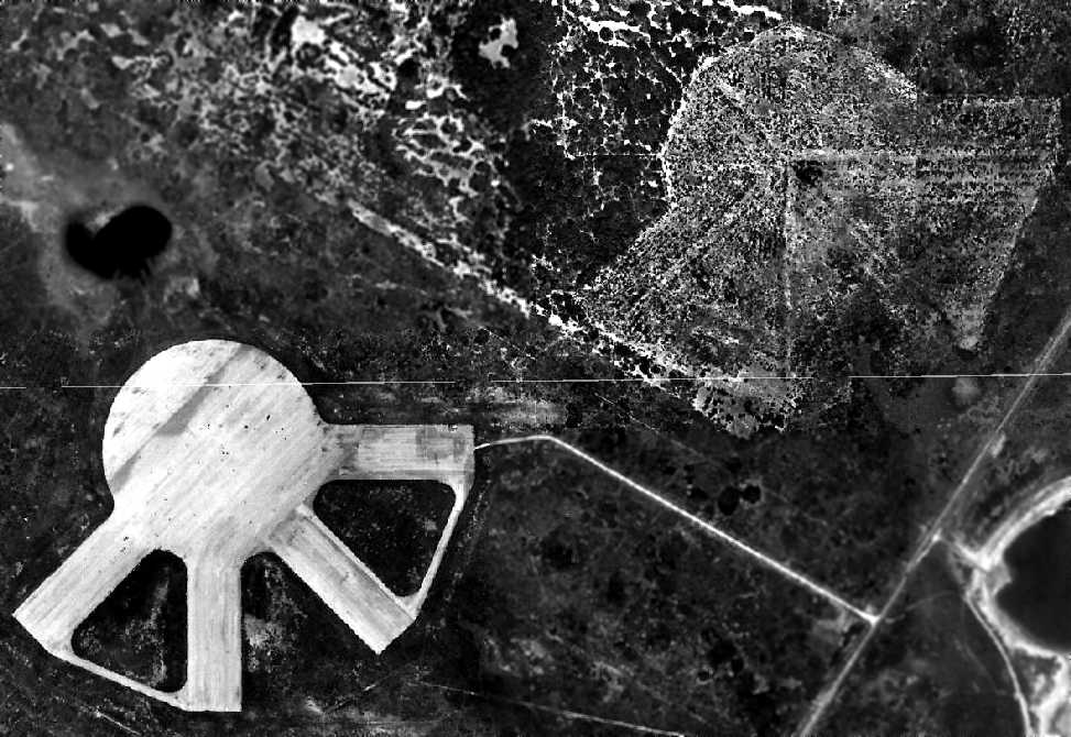
An amazing 3/4/56 aerial view depicted not 1 but 2 identical airfield layouts at the site of OLF 20410,
with the much-less-distinct remains of an identical airfield to the northeast of the fully-built airfield.
The reason for this is unknown – were 2 airfields intended to be built in close proximity,
or was construction of the northeast airfield abandoned due to problems with the site?
A 1961 aerial view showed that the outline of the northeast airfield had almost completely faded,
whereas Field #20410 was still somewhat more recognizable.
A 1979 aerial view showed that all traces of the northeast airfield had completely disappeared,
whereas Field #20410 was still somewhat recognizable.
The outline of the circular mat & runways of OLF 20410 were still quite recognizable
in the 1995 USGS photo (courtesy of David Brooks).
A 4/26/03 aerial view by Dick Merrill looking northwest at the remains of of NOLF 20410
showed the outline of the circular mat & runways to still be barely evident.
Field #20410 is located in a very undeveloped area of the Texas coast, six miles south of Waldron NOLF.
Thanks to David Brooks for locating this airfield.
____________________________________________________
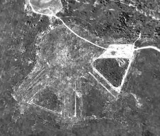
Naval Outlying Landing Field #23416 / Field #11, Corpus Christi, TX
27.56, -97.47 (Southwest of Corpus Christi, TX).
Field "23416", as depicted on the July 1943 Corpus Christi Sectional Chart (courtesy of David Brooks).
Photo of the airfield while in use has not been located.
This field was one of a large number of satellite airfields built during WW2
to support Navy flight training in the Corpus Christi area.
Field #23416 was evidently established at some point in 1943,
as it was not yet depicted on the February 1943 Corpus Christi Sectional Chart (courtesy of Jim Stanton).
The earliest depiction which has been located of Field #23416 was on the July 1943 Corpus Christi Sectional Chart (courtesy of David Brooks).
Brian Rehwinkel reported, “According to a 1943 Navy memo, this field consisted of 250 acres of land.
During most of its use during WWII, Field # 11/ Designation 23416 was assigned to NAAS Rodd Field.”
The last aeronautical chart depiction which has been located of Field #23416 was on the August 1947 Corpus Christi Sectional Chart.
Field #23416 was apparently abandoned by the Navy at some point between 1943-48,
as it was no longer depicted on the January 1948 Corpus Christi Sectional Chart or the 1969 USGS topo map.
A 12/22/51 aerial vieew of Field # 11 / OLF 24316 (courtesy of Brian Rehwinkel).
Brian observed, “You can clearly see the outline of the hard-surface circular mat that was located in the middle of this field.”
There were 3 runways painted on the surface of the landing mat.
According to Brian, the 4 small circle markings outside of the landing mat were “the so-called 'landing circles'.
They were usually 100 feet in circumference & were used as target landing areas.
That pattern of 4 circles in a square pattern was used at many other fields.”
There did not appear to be any buildings at the site.
The 1951 USGS topo map depicted the circular landing mat, labeled “Outlying Field #11 (Abandoned)”.
Field #23416 was no longer depicted at all (even as an abandoned airfield) on the 1969 USGS topo map.
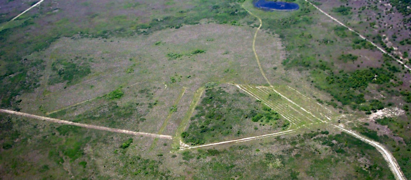
A 1995 USGS aerial view (courtesy of David Brooks) showed the remains of Field #23416,
including the square property outline & the circular airfield trace.
Field #23416 is located one mile south of Route 70, two miles south of Chapman Ranch, TX.
Thanks to David Brooks for locating this airfield.
____________________________________________________
Naval Outlying Landing Field #26117 / Field #21, Corpus Christi, TX
27.656, -97.54 West (Southwest of Corpus Christi, TX).
NOLF 26117, as depicted on the July 1943 Corpus Christi Sectional Chart (courtesy of David Brooks).
NOLF 26117 was one of a large number of satellite airfields built during WW2
to support Navy flight training in the Corpus Christi area.
Field #26117 was evidently established at some point in 1943,
as it was not yet depicted on the February 1943 Corpus Christi Sectional Chart (courtesy of Jim Stanton).
The earliest depiction of NOLF 26117 which has been located
was on the July 1943 Corpus Christi Sectional Chart (courtesy of David Brooks).
According to Brian Rehwinkel, “Bureau of Aeronautics designation #26117 / OLF 21 was a 250 acre airfield owned by the Navy.
I think the field was built in the 1943 period.”
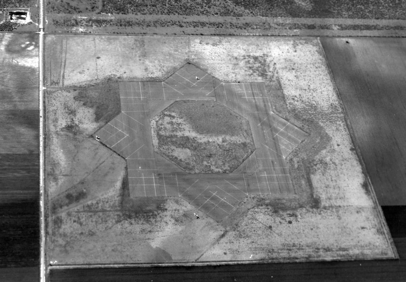
The earliest photo which has been located of NOLF 26117 was a 12/15/44 USN aerial view looking south (from the National Archives, courtesy of Brian Rehwinkel).
It depicted NOLF 26117 as having 8 paved runways, with 3 single-engine aircraft on the field, including one on final approach.
According to Brian Rehwinkel, “Bureau of Aeronautics designation #26117 / OLF 21... was probably abandoned soon after WWII.
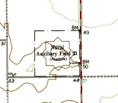
The 1951 USGS topo map depicted the 8-pointed star arrangement of the landing field, labeled “Naval Auxiliary Field 21 (Inactive)”.
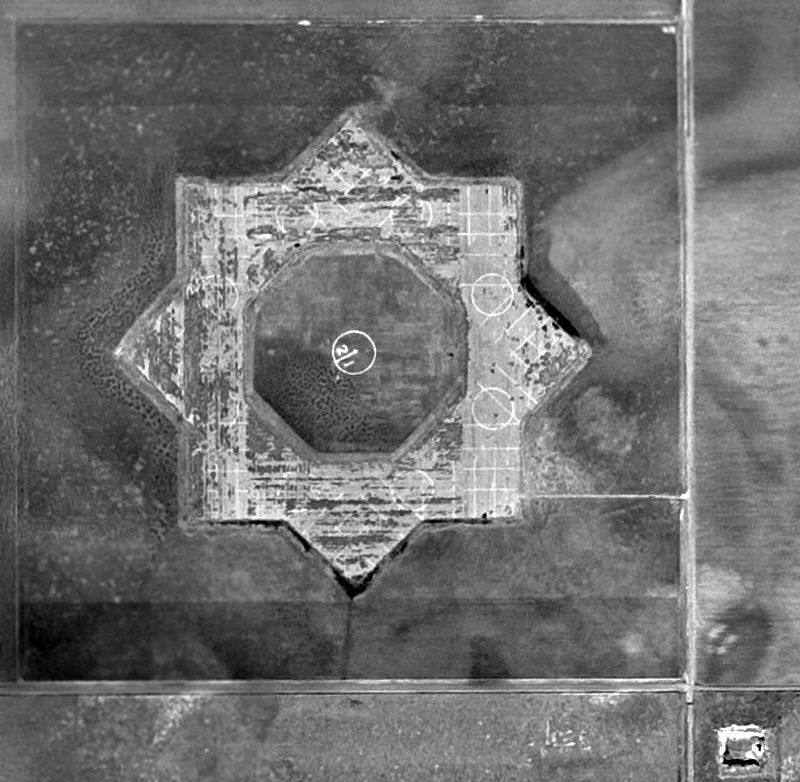
A 1951 USGS aerial view (courtesy of Brian Rehwinkel) showed NOLF 26117 remaining intact, though quite deteriorated.
Note the field number “21” in the center, which had been added at some point between 1944-51.
Brian Rehwinkel observed, a “1956 aerial [view] seems to show that the asphalt was removed.”
The last photo which has been located which shows the outline of NOLF 26117 was a 1960 aerial view.
A 1979 aerial view showed no trace remaining of NOLF 26117,
with the property having reverted to farming, and some houses built along the east side.
A 2014 aerial view (courtesy of Brian Rehwinkel) of the site of NOLF 26117.
As Brian Rehwinkel observed, “There is no trace of the field remaining.”
Field #26117 is located northwest of the intersection of Route 55 & South Staples Street.
Thanks to Brian Rehwinkel for locating this airfield.
____________________________________________________
Naval Outlying Landing Field #23521 / Field #13, Corpus Christi, TX
27.52, -97.54 (Southwest of Corpus Christi, TX).
Field "23521", as depicted on the July 1943 Corpus Christi Sectional Chart (courtesy of David Brooks).
This field was one of a large number of satellite airfields built during WW2
to support Navy flight training in the Corpus Christi area.
Field #23521 was evidently established at some point in 1943,
as it was not yet depicted on the February 1943 Corpus Christi Sectional Chart (courtesy of Jim Stanton).
The earliest depiction of the field which has been located
was on the July 1943 Corpus Christi Sectional Chart (courtesy of David Brooks).
According to Brian Rehwinkel, “This field, named Field 13 (Bureau of Aeronautics designation # 23521),
consisted of 250 acres of land with 4 paved runways in a partial star-shaped layout.
The land for this field was one of (at least) 10 outlying fields in the area the Navy leased from the owners of the King Ranch during WWII.”
The earliest photo which has been located of Corpus Christi OLF Field #23521 was a 1/9/45 USN aerial view looking north (from the National Archives, courtesy of Brian Rehwinkel).
It depicted Field #23521 having a total of 4 paved runways,
although it can also be seen that the site had been prepared for a total layout of 8 runways in a star-shaped layout.
Brian observed, “However, even with only 4 paved runways, planes could still land into the wind when necessary.”
The Navy's active use of Field #23521 probably ceased immediately with the end of WW2, if not sooner.
According to Brian Rehwinkel, “Sometime in the late 1940s,
the lease for this field was canceled & the land was returned to the owners.”
Field #23521 had been abandoned by the Navy by 1949,
as it was not depicted at all (even as an abandoned airfield)
on the 1949 Corpus Christi Sectional Chart (courtesy of Chris Kennedy).

A 12/22/51 USGS aerial photo of Corpus Christi OLF Field #23521 (courtesy of Brian Rehwinkel)
showed the paved runways to remain intact though deteriorated, with no sign of recent aviation usage.
Field #23521 was was not depicted at all on the 1969 USGS topo map.
A 1995 USGS photo (courtesy of David Brooks) showed that the runway pavement of Field #23521 had been had been removed at some point between 1951-95,
along with a road that had been built over the eastern portion of the airfield site.
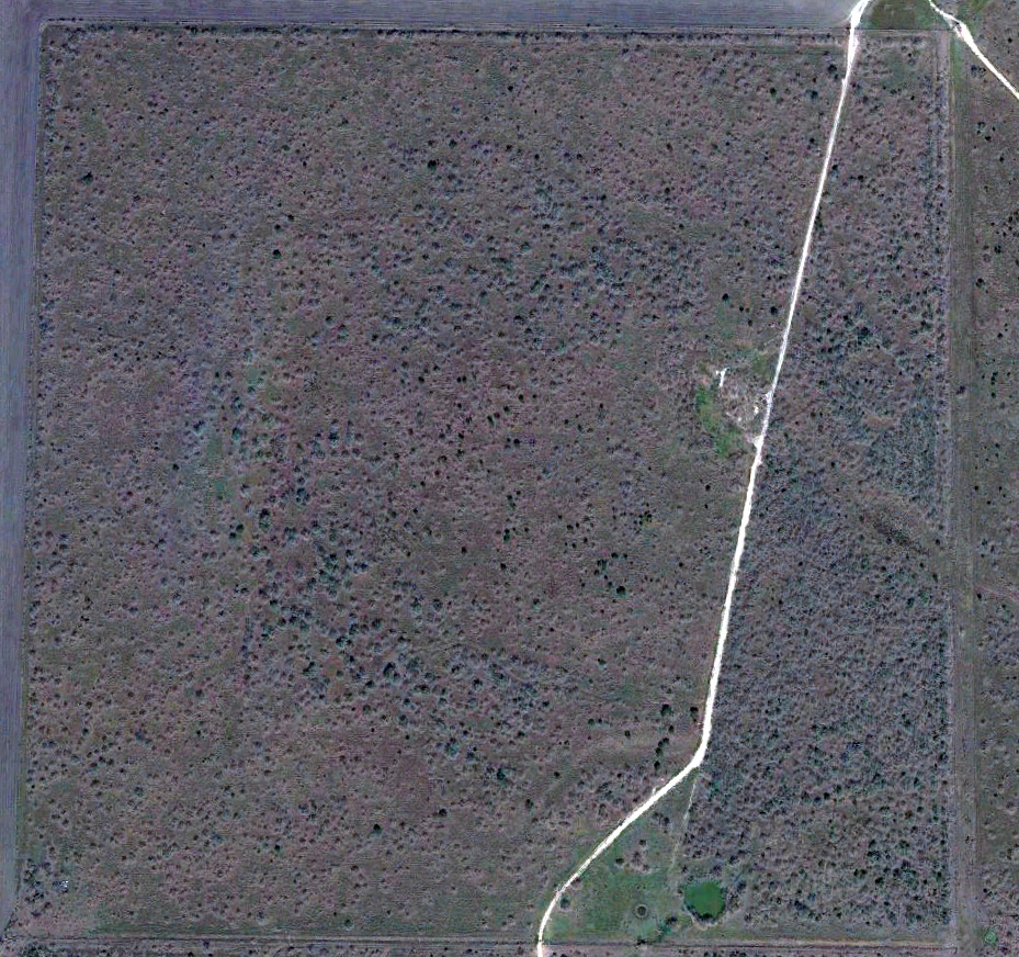
A 2017 aerial view (courtesy of Robert Richter) showed that the square outline of Field #23521 was still recognizable.
Field #23521 is located 4 miles south of Route 70, six miles southwest of Chapman Ranch, TX.
Thanks to David Brooks for locating this airfield.
____________________________________________________
Since this site was first put on the web in 1999, its popularity has grown tremendously.
If the total quantity of material on this site is to continue to grow,
it will require ever-increasing funding to pay its expenses.
Therefore, I request financial contributions from site visitors,
to help defray the increasing costs of the site
and ensure that it continues to be available & to grow.
What would you pay for a good aviation magazine, or a good aviation book?
Please consider a donation of an equivalent amount, at the least.
This site is not supported by commercial advertising –
it is purely supported by donations.
If you enjoy the site, and would like to make a financial contribution,
you
may use a credit card via
![]() :
:
Please consider checking the box to make a monthly donatation.
For a mailing address to send a check, please contact me at: paulandterryfreeman@gmail.com
If you enjoy this web site, please support it with a financial contribution.
please contact me at: paulandterryfreeman@gmail.com
If you enjoy this web site, please support it with a financial contribution.
____________________________________________________
This site covers airfields in all 50 states.