Abandoned & Little-Known Airfields:
Texas: Big Bend area
© 2002, © 2024 by Paul Freeman. Revised 1/12/24.
This site covers airfields in all 50 states: Click here for the site's main menu.
____________________________________________________
Please consider a financial contribution to support the continued growth & operation of this site.
(Original) Dryden Airport (added 3/5/17) - Johnson's Ranch Airfield (revised 11/29/18) - (Original) Lajitas Airport (revised 6/29/13) - Marfa AAF / Presidio County Airport (revised 9/16/22)
Marfa South Aux AAF #1 (revised 7/29/18) - Marfa Aux AAF #2 (revised 5/8/21) - Marfa Aux AAF #3 / Ryan Field (revised 7/29/18) - Marfa Aux AAF #5 / Aragon Field (revised 7/29/18)
(Original) Marfa Airport / Marfa Aux AAF #7 (revised 3/29/23) - Red Dog Airfield (added 1/12/24) - Sanderson Airport (original location) (added 3/13/20) - Sanderson Airport (2nd location) (revised 3/13/20)
____________________________________________________
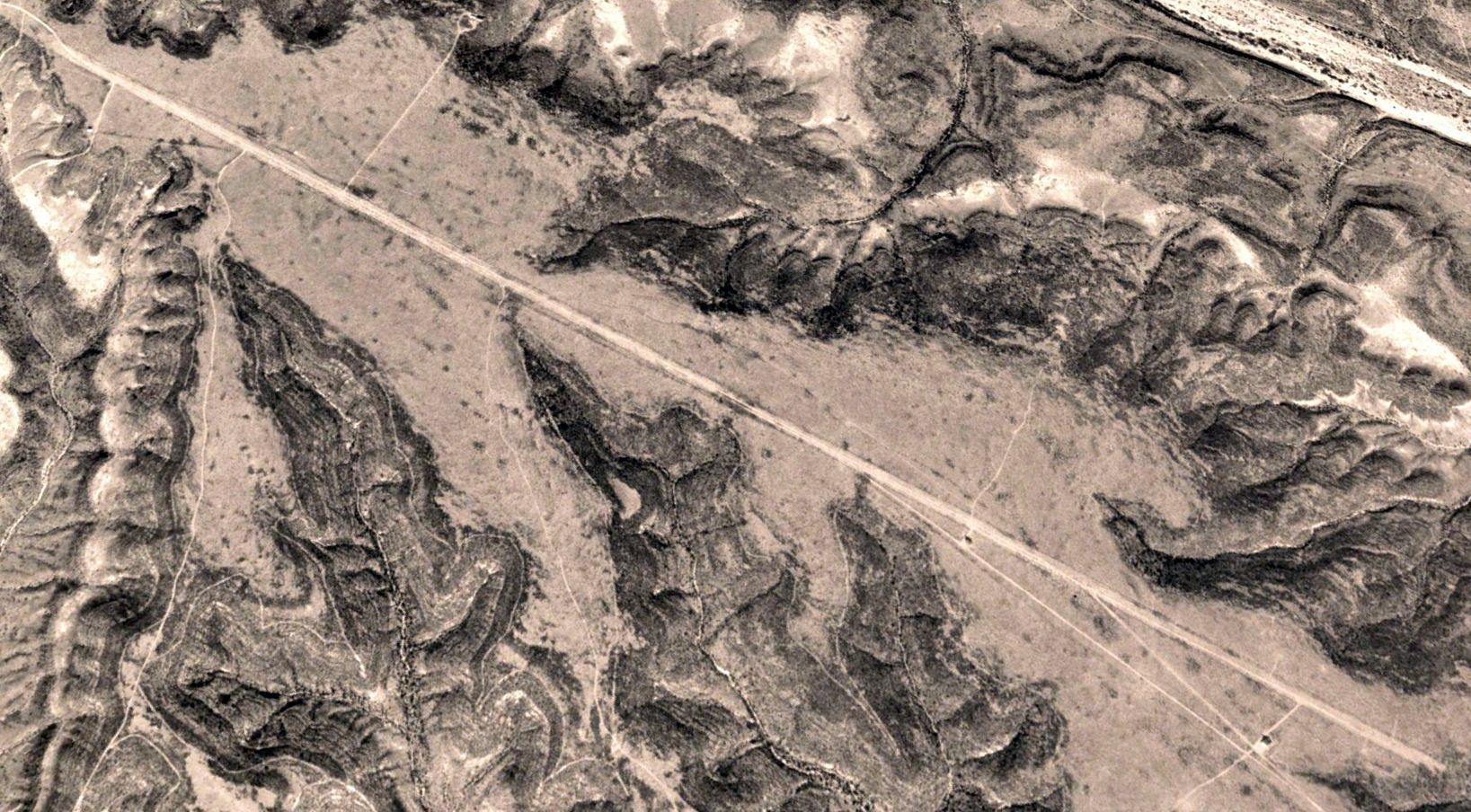
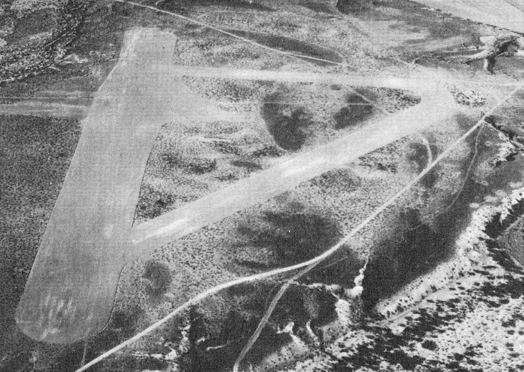
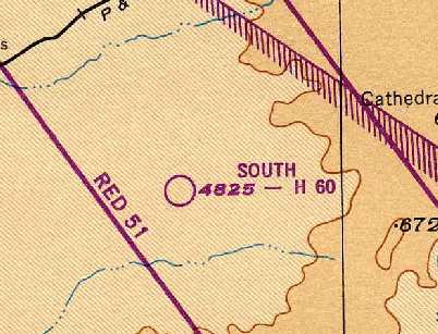
Red Dog Airfield, Sanderson, TX
29.961, -102.359 (Northwest of San Antonio, TX)
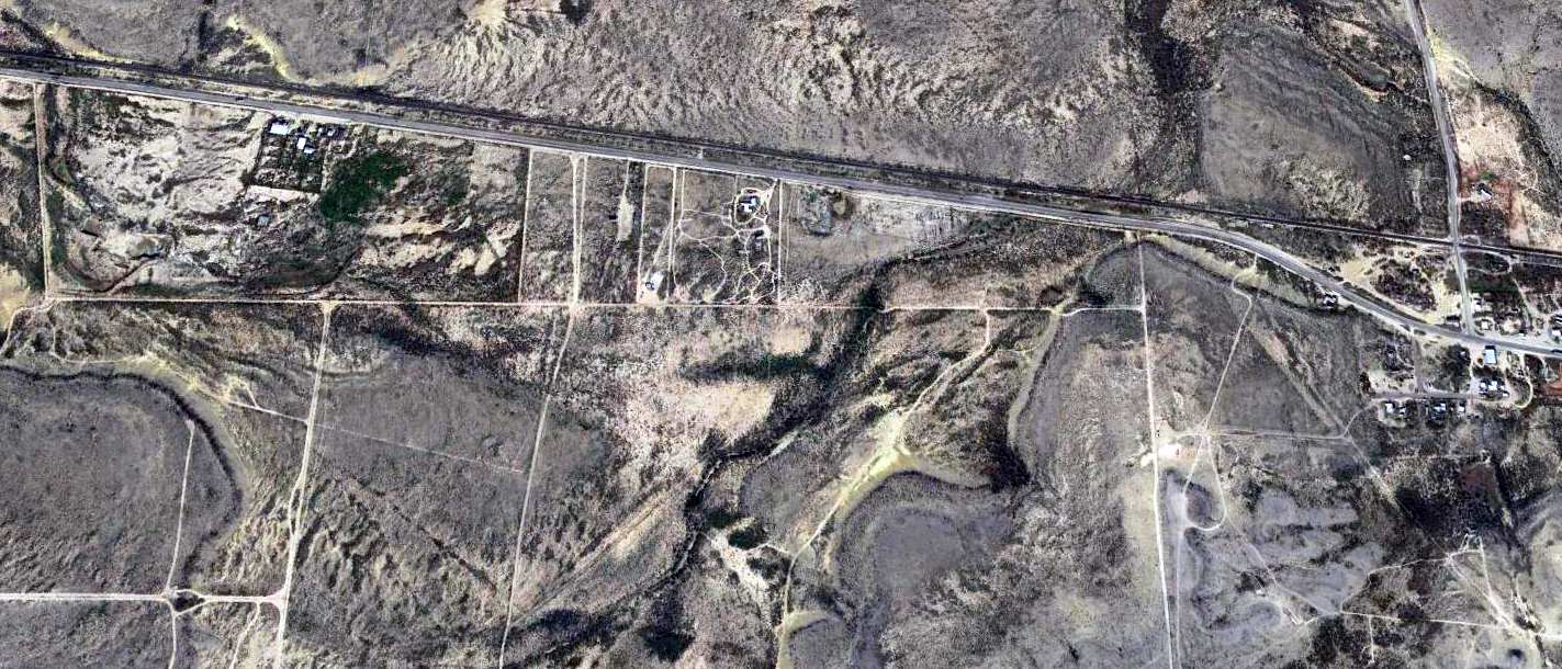
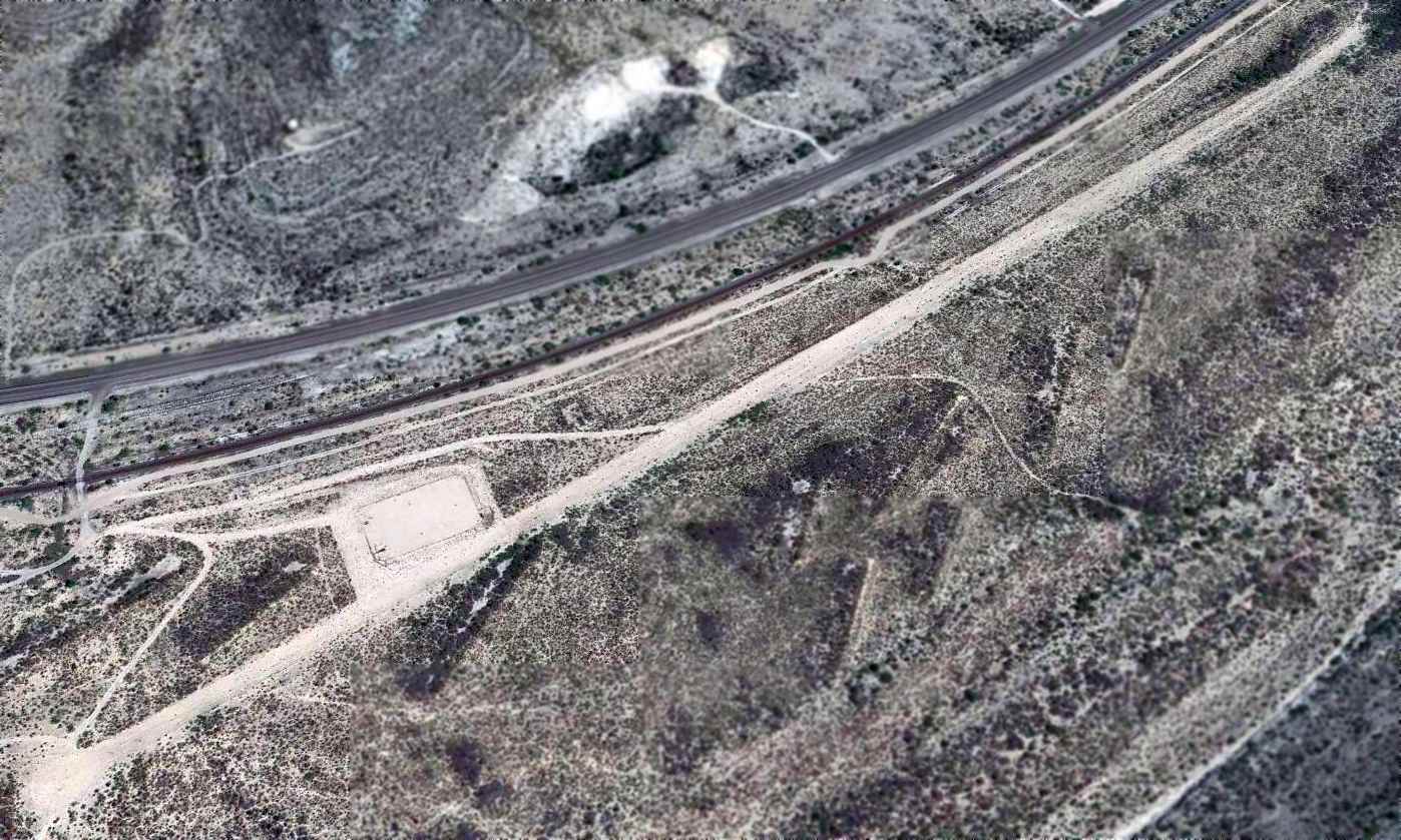
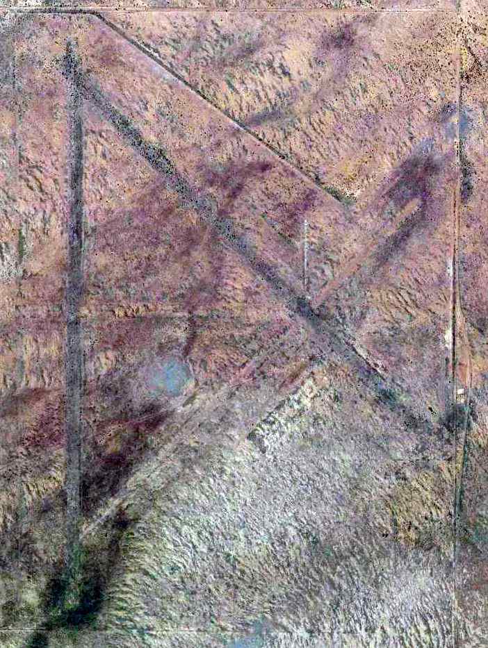
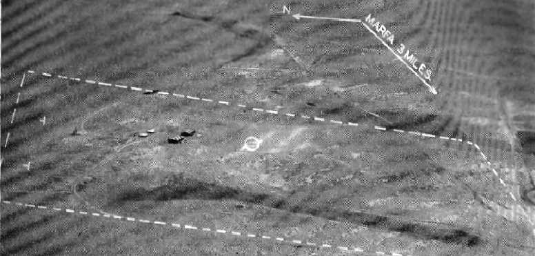
A 1996 aerial view looking northeast at the Red Dog Airfield.
Photo of the airfield while in use has not been located.
Not much is known about this airfield, including its formal name or purpose.
The airfield was evidently established at some point between 1974-84, as it was not yet depicted on a 1974 aerial photo.
No airfield was depicted at this location on the 1983 USGS topo map.
The earliest depiction which has been located of this airfield was a 1984 aerial view, which depicted a very long (8,000') unpaved northwest/southeast runway.
No buildings or aircraft were visible near the runway.
No airfield was depicted at this location on the 1985 USGS topo map.
Robert Graff reported, “My father-in-law has said it's referred to as 'Red Dog' by some USBP guys.
He also found a book about airstrips along the border after Vietnam & allegedly when Mexico raised the tariffs on appliances beyond 150%, people would fly appliances from the US south of the border to avoid those high taxes.
Take that with a grain of salt as we haven't found much information about how this airstrip played a role - or if it's simply just private.
It seems way too long compared to a small ranch strip to not have a good story.”
No airfield was depicted at this location on the 1993 San Antonio Sectional Chart.
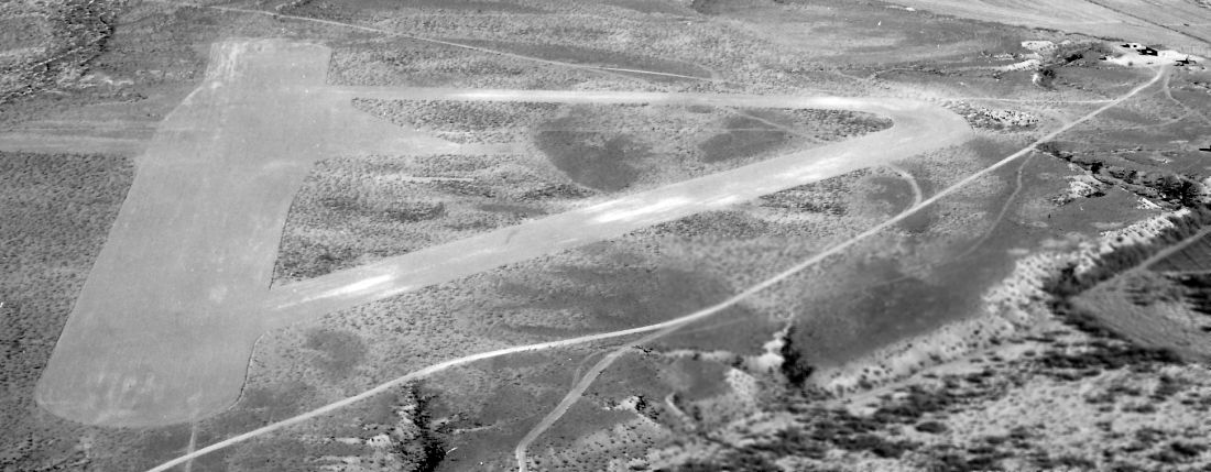
The earliest depiction which is available of the Red Dog Airfield was a 1996 aerial view, which depicted it in an unchanged configuration.
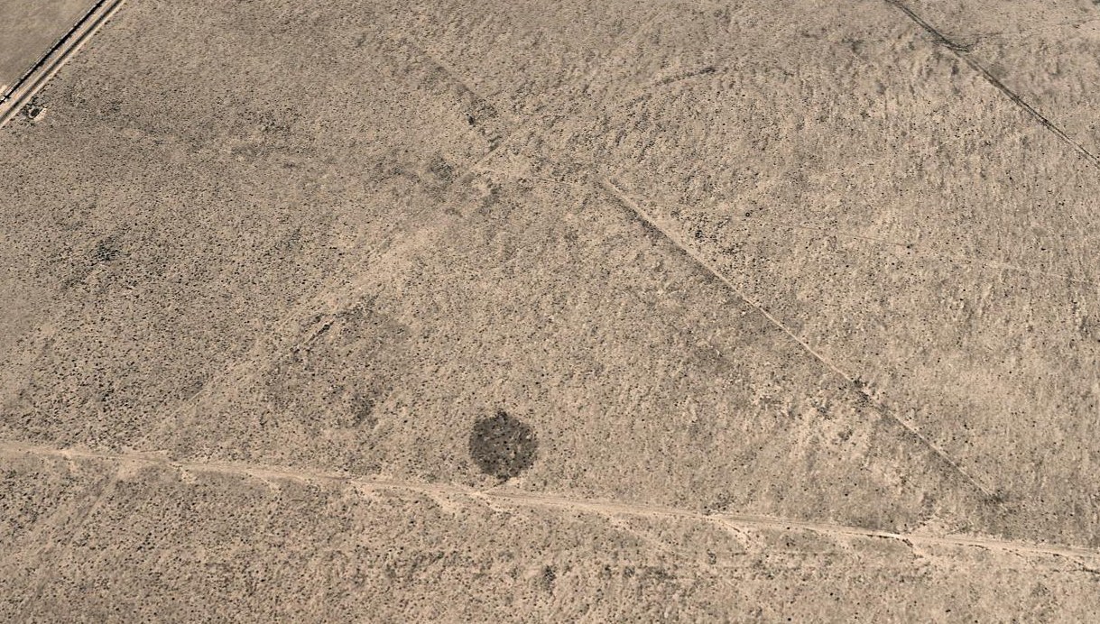
Robert Graff noted, aerial pictures show “the southern side of the strip was cleared again between 2016-2019.”
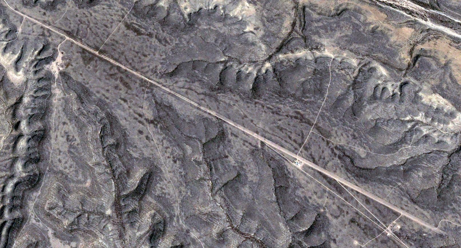
A 2020 aerial view looking northeast depicted the Red Dog Airfield in an unchanged configuration.
Robert Graff reported, “I saw a windsock out there last year”, 2023.
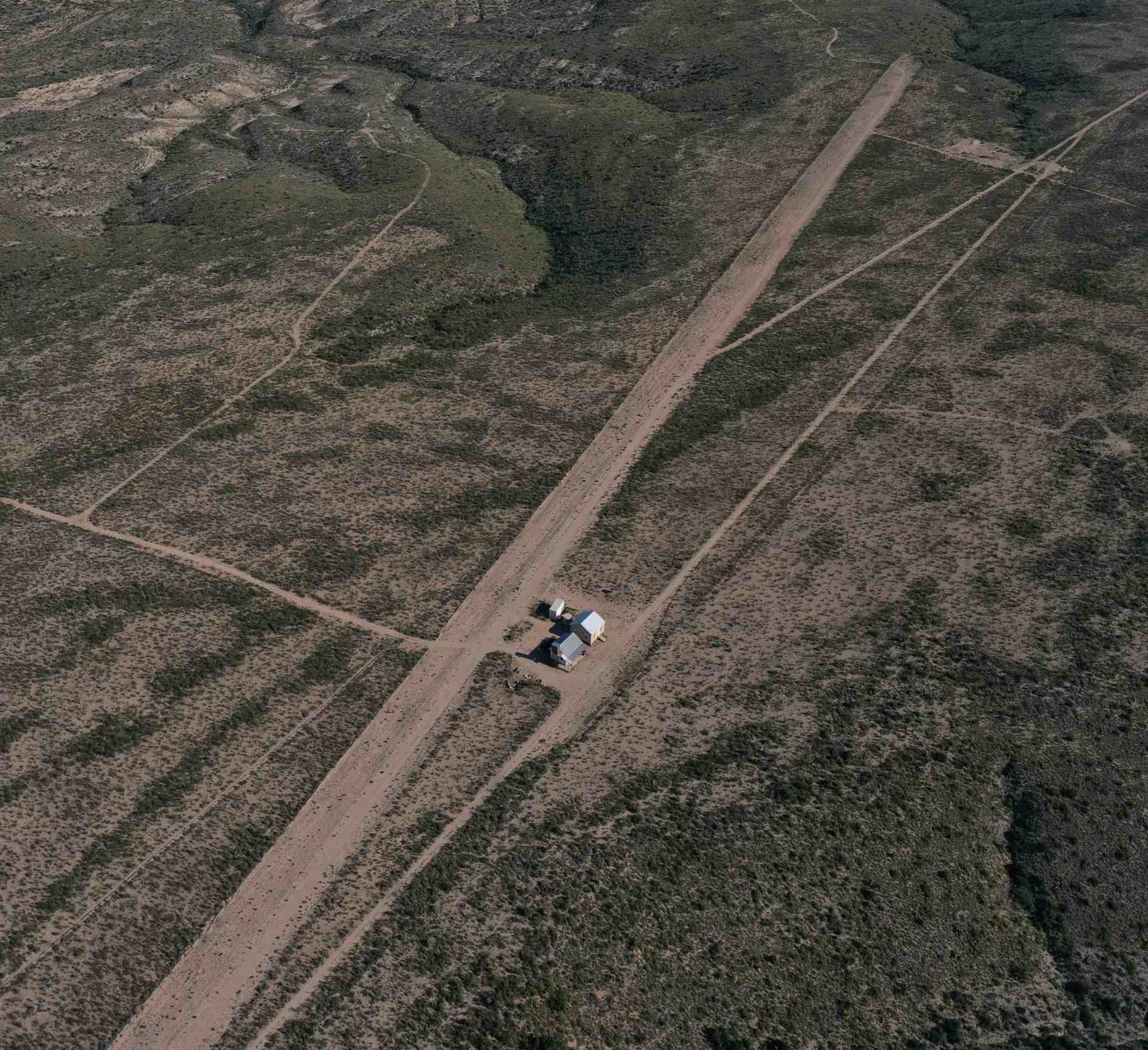
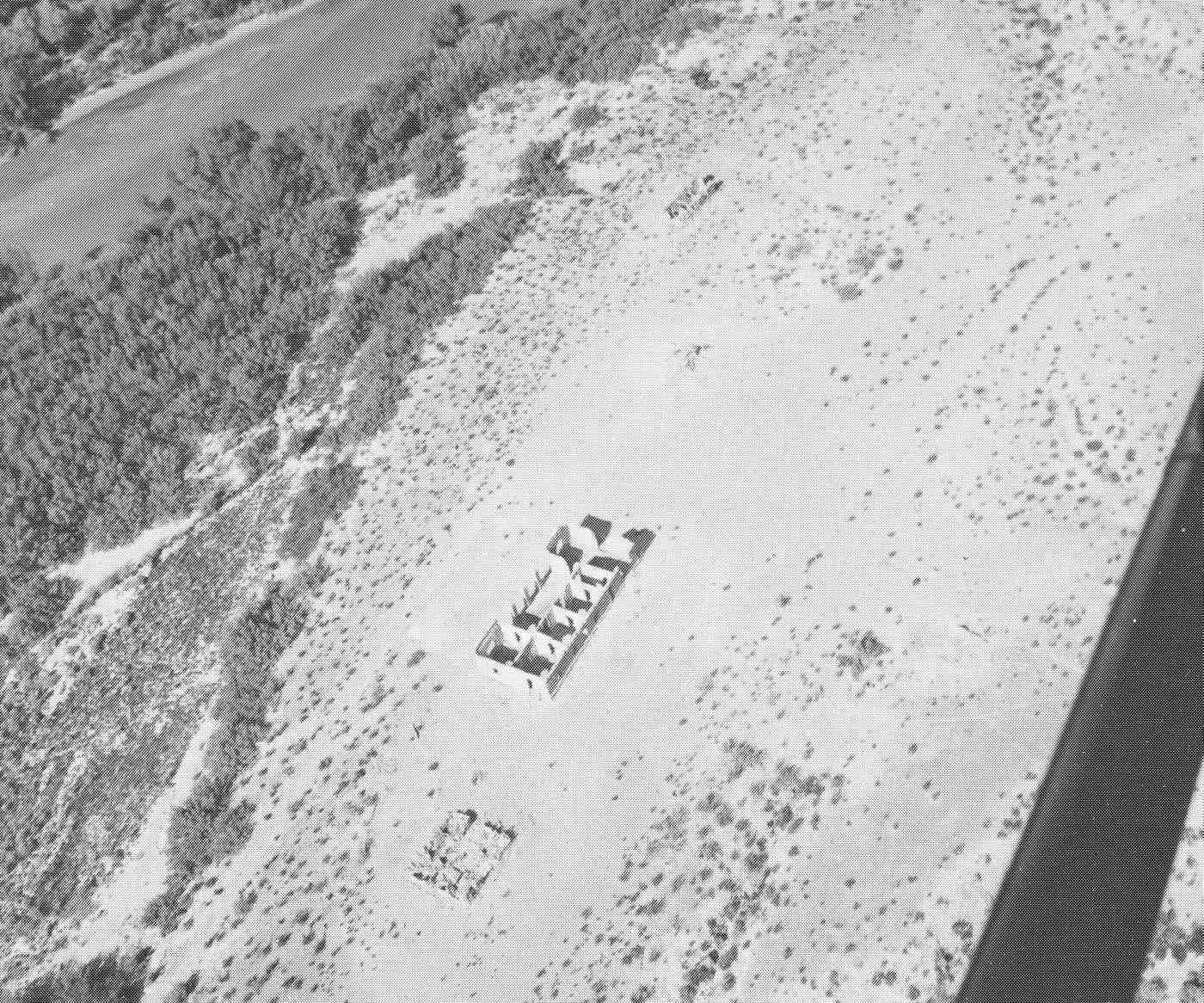
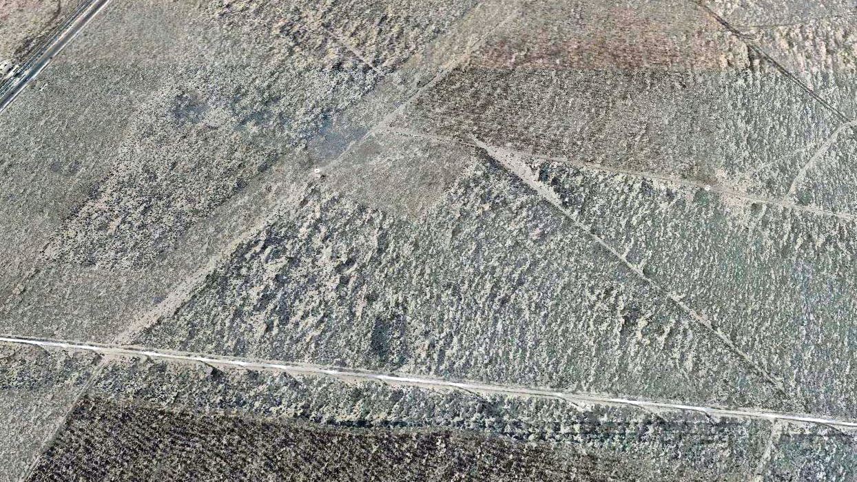
A circa 2023 drone aerial view by Robert Graff looking southeast depicted the Red Dog Airfield runway & several buildings along the west side.
No airfield was depicted at this location on the 2023 San Antonio Sectional Chart.
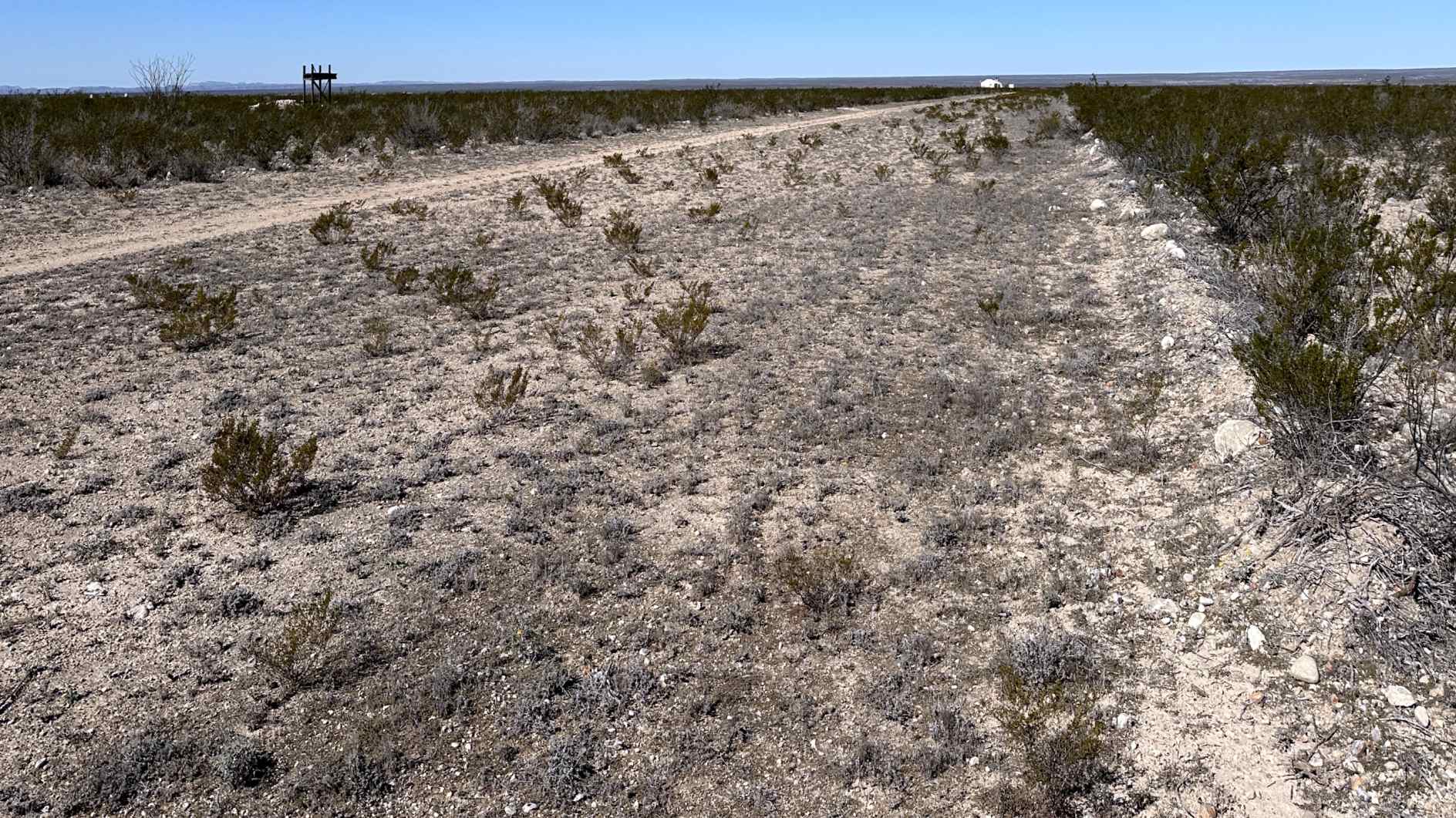
A 12/27/23 photo by Robert Graff looking along the Red Dog Airfield runway.
Thanks to Robert Graff for pointing out this airfield.
____________________________________________________
(Original) Dryden Airport, Dryden, TX
30.0455, -102.131 (Northwest of San Antonio, TX)
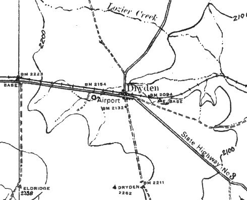
The original Dryden Airport, as depicted on the 1928 USGS topo map (courtesy of Jerry Eoff).
Photo of the airport while in use has not been located.
The first airfield for the town of Dryden was located 1 mile west of the town.
According to Jerry Eoff, “In the years around 1916 the Mexican Revolution, which featured Pancho Villa,
spilled across the international border and resulted in the first tactical use of U. S. Army Air Corps aircraft.
I would suppose that the first Dryden field could have been opened in that period as a refueling location for aircraft flying to west Texas, New Mexico, and Arizona fields.
Then it was used considerably during another period of unrest in the late 1920s when Johnson Ranch Airfield became of primary importance in patrolling the border.”
According to “Wings Over the Mexican Border: Pioneer Aviation in the Big Bend” by Kenneth Baxter Ragsdale (courtesy of Jerry Eoff),
“The Air Corps maintained an auxiliary field just west of Dryden, staffed by a sergeant who helped refuel transient military aircraft.
With the short cruising range of the airplanes flying to Johnson's Ranch in the 1930s [note: usually from Brooks Field in San Antonio],
a fuel stop at Dryden, usually on the return flight, was mandatory.
The Army later added a hangar with limited overnight facilities for Air Corps personnel who became stranded because of darkness, mechanical trouble, or weather.”
The earliest depiction which has been located of Dryden Airport was on the 1928 USGS topo map (courtesy of Jerry Eoff).
It depicted a circular airport symbol on the south side of State Highway #3, labeled simply as “Airport”.
The earliest aeronautical chart depiction which has been located of the original Dryden Airport was on the 1932 Dryden to El Paso Air Navigation Map #29 (courtesy of Jerry Eoff).
The last aeronautical chart depiction which has been located of the original Dryden Airport was on the January 1946 Del Rio Sectional Chart.
It depicted the original Dryden Airport as an auxiliary airfield,
but also depicted the new larger Dryden Airport which had been built a few miles to the west.
The original Dryden Airport was evidently closed at some point between 1946-50,
as it was no longer depicted on the February 1950 Del Rio Sectional Chart nor on the 1954 USGS topo map.
A 1994 USGS aerial photo showed what appeared to be a set of 3 runways in a triangular configuration immediately adjacent to the west side of the town of Dryden.
This was farther east than the airport was depicted on the 1928 topo map, but that early map depiction may have been erroneous.
A 2015 aerial photo continued to depict the remains of 3 runways in a triangular configuration immediately adjacent to the west side of the town of Dryden.
The site of the original Dryden Airport is located on the south side of Route 90, west of Dryden.
Thanks to Jerry Eoff for pointing out this airfield.
____________________________________________________
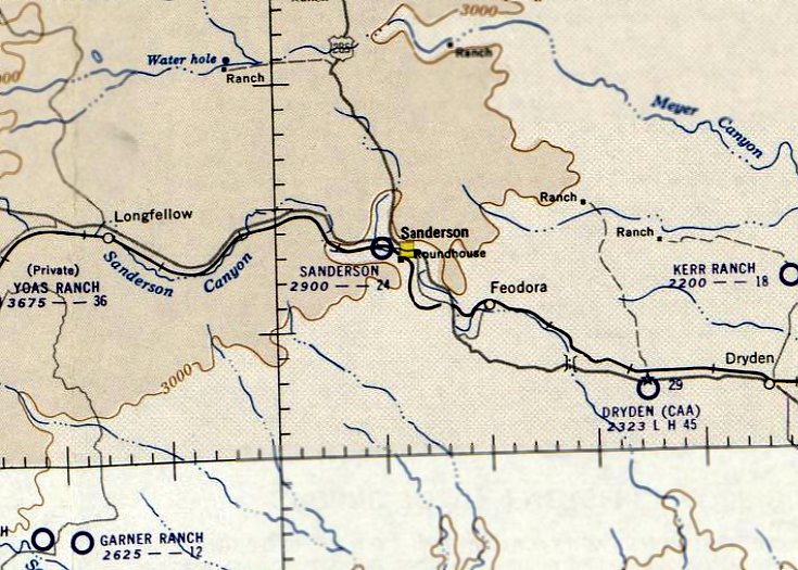
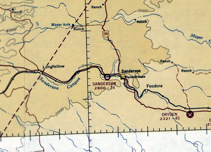
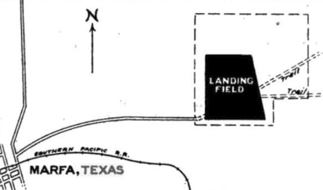
Sanderson Airport (original location), Sanderson, TX
30.151, -102.413 (Northwest of San Antonio, TX)
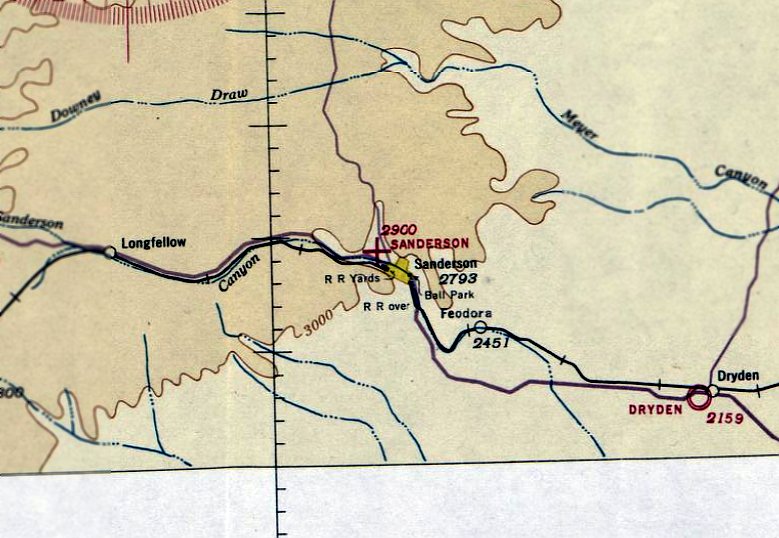
Sanderson Airport, as depicted on the northwest side of the town on the April 1938 El Paso Sectional Chart.
Photo of the airport while in use has not been located.
The original location of Sanderson Airport was established on the northwest side of the town evidently at some point between 1937-38,
as it was not yet depicted on the July 1937 El Paso Sectional Chart.
The earliest depiction which has been located of Sanderson Airport was on the April 1938 El Paso Sectional Chart.
It depicted Sanderson Airport as an auxiliary airfield.
Sanderson Airport was still depicted on the April 1941 El Paso Sectional Chart.
Sanderson Airport was evidently closed at some point between 1941-42 (like many other small civilian American airports during WW2),
as no Sanderson Airport was depicted on El Paso Sectional Charts from June 1942 – January 1946.
Sanderson Airport was evidently reopened after WW2,
as it was once again depicted on the July 1946 El Paso Sectional Chart.
Don Deaton recalled, Sanderson Airport “was built after WWII when the returning GIs wanted to learn to fly (1945-47?).
Joe Kerr, a former bomber pilot, was instrumental in getting the program established in Sanderson.
Jack Deaton provided the land & the Kerr brothers built the 40' x 40' hangar & runway.
There were 2-3 Piper Cubs & a fuel storage facility at the airport.
Following completion of the program, the airport served as a waypoint & was also available for use by local pilots & emergency services for the local township.”
Jack Tyler recalled, “My first airplane ride was off of Sanderson Airport, in a Ercoupe. I was 9, and the year was 1957.”
The last depiction which has been located of the original Sanderson Airport (on the northwest side of the town) was on the March 1956 El Paso Sectional Chart.
It depicted Sanderson Airport as having a 2,400' unpaved runway.
Sanderson Airport was evidently closed at some point in 1956,
as it was no longer depicted on the September 1956 El Paso Sectional Chart.
The original Sanderson Airport (northwest of the town) was eventually replaced by a 2nd location a few miles west of the town.
No airfield was depicted at the original Sanderson Airport location on the 1972 USGS topo map.
A 2017 aerial view showed no trace remaining of the original Sanderson Airport.
____________________________________________________
Sanderson Airport (2nd location), Sanderson, TX
30.144, -102.435 (Northwest of San Antonio, TX)
Sanderson Airport, as depicted on the April 1965 El Paso Sectional Chart.
Photo of the airport while in use has not been located.
The 2nd location of Sanderson Airport (a few miles west of the town) was evidently established at some point between 1961-65,
as no Sanderson Airport was depicted on the March 1961 El Paso Sectional Chart.
The earliest depiction which has been located of the Sanderson Airport to the west of the town was on the April 1965 El Paso Sectional Chart.
It depicted Sanderson Airport as having a 2,400' unpaved runway.
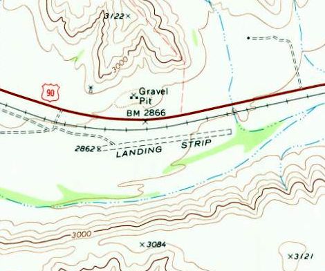
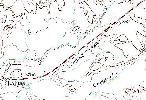
The 1969 USGS topo map depicted Sanderson Airport as a single unpaved northeast/southwest runway, labeled simply as “Landing Strip”.
The 1985 USGS topo map depicted Sanderson Airport as a single northeast/southwest runway, labeled simply as “Landing Strip”.
The earliest photo which has been located of Sanderson Airport was a 1996 USGS aerial view looking northeast.
It depicted Sanderson as having a single northeast/southwest unpaved runway.
A 2016 aerial view looking northeast depicted the abandoned Sanderson Airport runway as remaining clear though deteriorated.
Sanderson Airport is located on the south side of Route 90, west of Highland Plaza Avenue.
Thanks to Jack Tyler for pointing out this airfield.
____________________________________________________
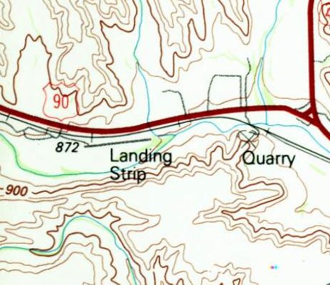
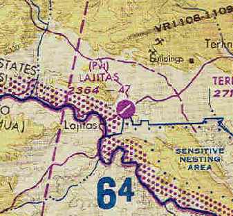
(Original) Lajitas Airport (17XS), Lajitas, TX
29.26, -103.77 (Southeast of El Paso, TX)
The original Lajitas Airport was depicted as “Landing Strip” on the 1971 USGS topo map.
This private airport was located directly along the Mexican border, and was operated by the Lajitas Resort.
The original Lajitas Airport may have been built at some point between 1970-71,
as it was not depicted on the November 1967 Del Rio Sectional Chart
nor listed among active airfields Airport in the 1970 TX Airport Directory (courtesy of Ray Brindle).
The earliest depiction of the Lajitas Airport which has been located was on the 1971 USGS topo map.
It depicted a single unpaved northwest/southeast runway, labeled “Landing Strip”.
The 1982 AOPA Airport Directory (courtesy of Ed Drury) described Lajitas as having a single 4,700' asphalt Runway 4/22,
and the remarks said "Private. Use at own risk."
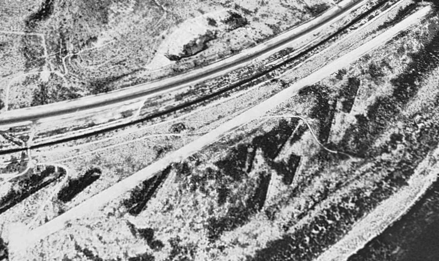
The earliest photo which has been located of the Lajitas Airport was a 1984 aerial view.
It depicted a single asphalt northeast/southwest runway with 1 small building on the southwest side.
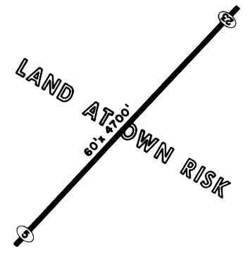
The 1985 TX Airport Directory (courtesy of Steve Cruse) depicted Lajitas Airport as having a single 4,700' paved Runway 5/23,
noted as “Land at own risk”, and listed the airport manager as Tom Moore.
Clark Baker recalled, “Lajitas Airport... those were hangars at the end of the runway - usually not full but often did have a few planes in them.
I recall a crash of an MU-2 there in mid-1980s. Hot day, over gross [weight], taking off uphill, clipped a signpost & plowed into the hill.
After that incident, the airport operator then went & cut back part of the hill to give a little more obstacle clearance.
I also remember a guy landing a Twin Bonanza gear-up on the strip.
When we got there he was drunk & asking for a ride to the nearest bar.
Seemingly oblivious to the fact the plane was in the middle of the runway!”
The earliest photo which is available of the Lajitas Airport was a 2/21/91 USGS aerial view looking northeast.
It depicted several buildings (hangars?) at the southwest end of the runway.
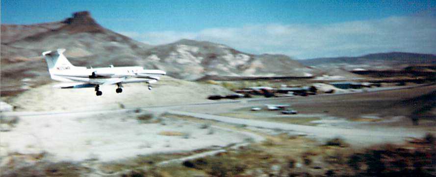
A 1995-96 photo (courtesy of Jon Dudeck) of a Learjet 25C on final approach to Lajitas Airport.
Jon recalled, “I flew a Lear 25 into & out of Lajitas several times in the mid-1990s when Larry McMurtry's Lonsome Dove sequels were being filmed.
The pictures were taken by a friend of mine who had flown in a day earlier.
The runway was one of the very few I ever flew into that actually had the FAA 50' obstacle at either end.”
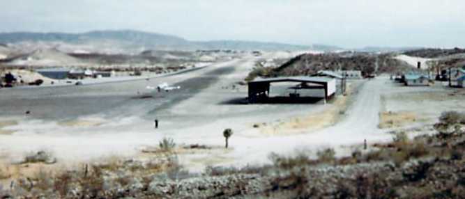
A 1995-96 photo (courtesy of Jon Dudeck) of a Learjet 25C about to touch down on Lajitas' runway
Jon observed, “You can see the Lear25B that he brought in parked under the 'hangar' structure to the east of the runway.”
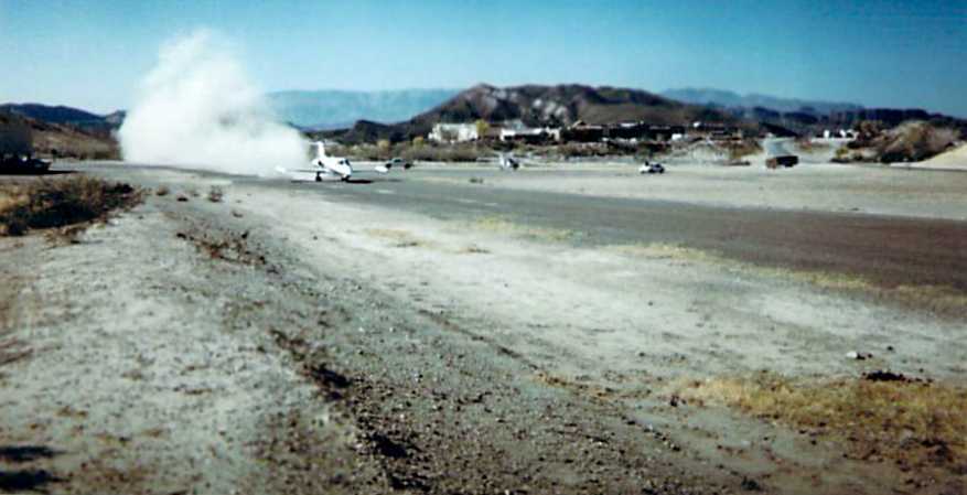
A 1995-96 photo (courtesy of Jon Dudeck) of a Learjet 25C taking off from Lajitas Airport.
Jon recalled, “The pavement had largely broken up & it was more airstrip than airport.
We did not use our reversers because of the gravel.”
The original Lajitas Airport was depicted on the August 1997 El Paso Sectional Chart (courtesy of Steve Cruse)
as having a single 4,700' paved runway.
A 1997 aerial photo showed the runway & hangar remained intact.
In 2001, the new owners of the Lajitas Resort built a new jet-capable Lajitas Airport 4 miles to the east,
and the old airfield was presumably closed.
The original Lajitas Airport was depicted as an abandoned airfield on the 2003 Sectional Aeronautical Chart.
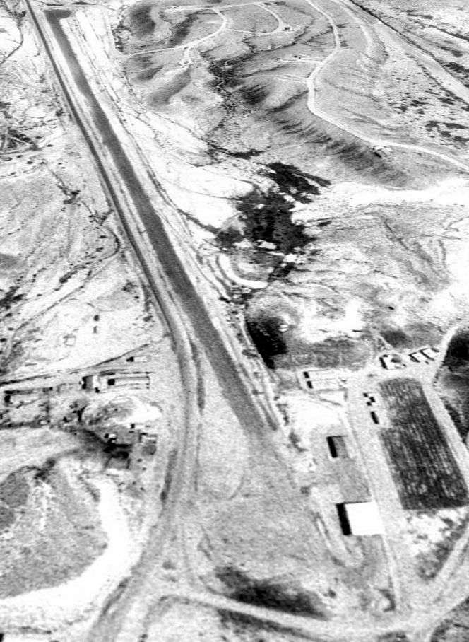
An October 21, 2005 aerial view showed that the hangar & the southwestern half of the length of the runway
had been removed at some point between 1997-2005.
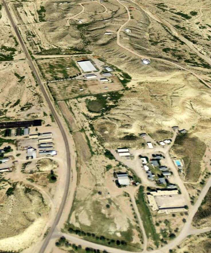
A 3/21/08 aerial view looking northeast showed the site of the of the original Lajitas Airport to be considerably redeveloped.
The outline of the northeastern end of the runway remained somewhat recognizable,
along with at least one building in the foreground possibly related to the airport.
____________________________________________________
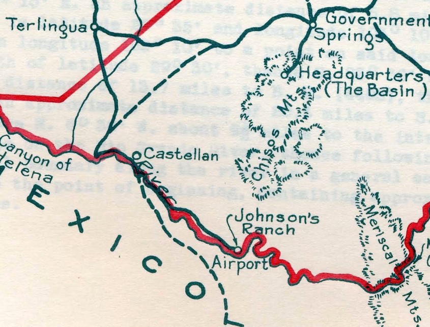
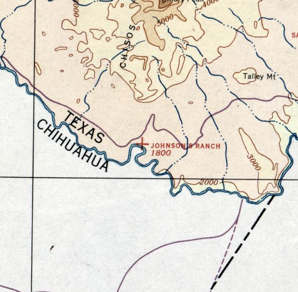
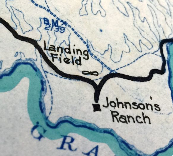
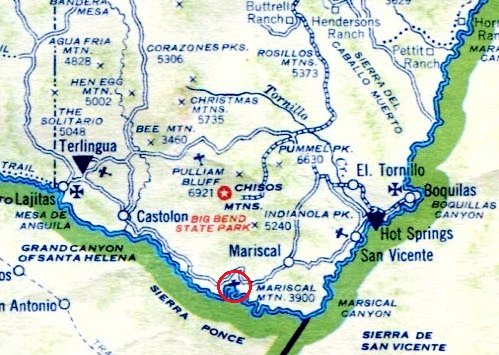
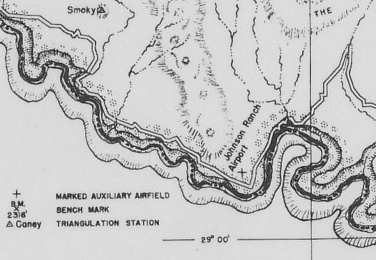
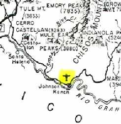
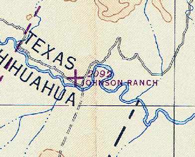
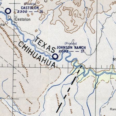
Johnson's Ranch Airfield, Big Bend National Park, TX
29.03, -103.37 (Southeast of El Paso, TX)
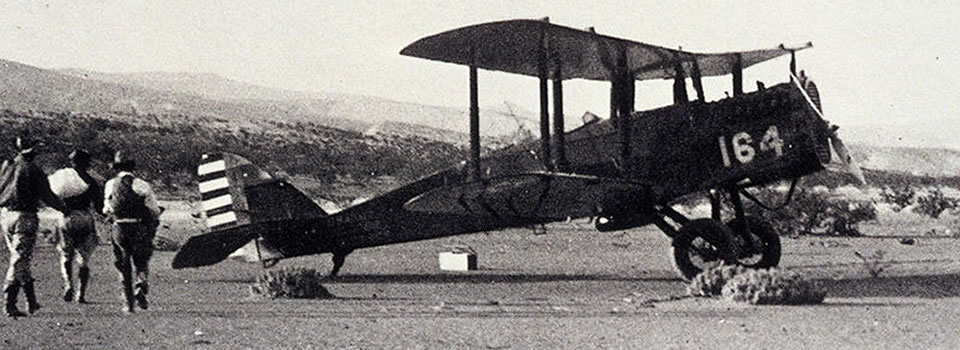
A 1929 photo of a De Havilland DH-4 at the Johnson Ranch Airfield (from the National Park Service collection, courtesy of Jason Abrams).
Elmo & Ada Johnson established their ranch & trading post on the banks of the Rio Grande in 1927.
With the exception of a few neighbors on each side of the US-Mexican border, they lived in almost total isolation.
In 1929, the Johnsons came face to face with the revolution as thirty Mexican bandits raided the trading post, driving away Johnson's goats & cattle.
In response, the cavalry was dispatched from Ft. Davis to patrol the area,
and the Army Air Corps established a landing field at Johnson’s ranch.
Two weeks later, Army transport planes delivered the first infantry troops from Ft. Sam Houston in San Antonio.
Big Bend had entered the annals of military aviation.
Lt. Thad Foster, 8th Corps Area assistant air officer, made the initial inspection flight of Johnson’s Ranch & quickly recommended its official authorization.
Lt. Foster was the first to make an entry in the field register when he carried the official authorization to Johnson’s Ranch in 1929.
The Johnsons kept the register on the patio for the subsequent 14 years.
Notable inscriptions included Lt. Nathan Twining, later Chairman of the Joint Chiefs of Staff,
and General Jonathan Wainwright, then post commander at Ft. Clark, who would later became a hero at Bataan.
Elmo Johnson’s position was unique - he owned the landing field,
was personally responsible for its maintenance, and was a close personal friend of Lt. Foster.
Due to his trading post & excellent relations on both sides of the border,
Elmo Johnson became a prime source of information on border activity in the Big Bend.
He was accredited to the G-2 Army Intelligence Section of the 8th Corps Area headquartered at Ft. Sam Houston.
The Johnson Ranch airfield was the first permanent installation by the Air Corps in the lower Big Bend.
It was distinct from other airfields in the area in that it was neither an auxiliary nor emergency field.
It was established solely due to its strategic location, where combat troops & aircraft could be deployed in case of a border emergency.
It was also unique in that the ranch house became the airfield headquarters,
and Elmo Johnson - with neither rank or authority - provided a quaint civilian dominance over the field's operations.
Johnson constructed 2 rock piles, 100' apart near the landing threshold, to help the pilots.
For night landings, he carried 2 lanterns out to identify the landing area.
The earliest depiction which has been located of the Johnson Ranch Airfield was a 1929 photo of a De Havilland DH-4 at the Ranch (from the National Park Service collection, courtesy of Jason Abrams).
Jason Abrams reported, “Supposedly it is the first plane to land at the Ranch, though I am not sure if they are confused & it was the first model of aircraft landed at the field.”
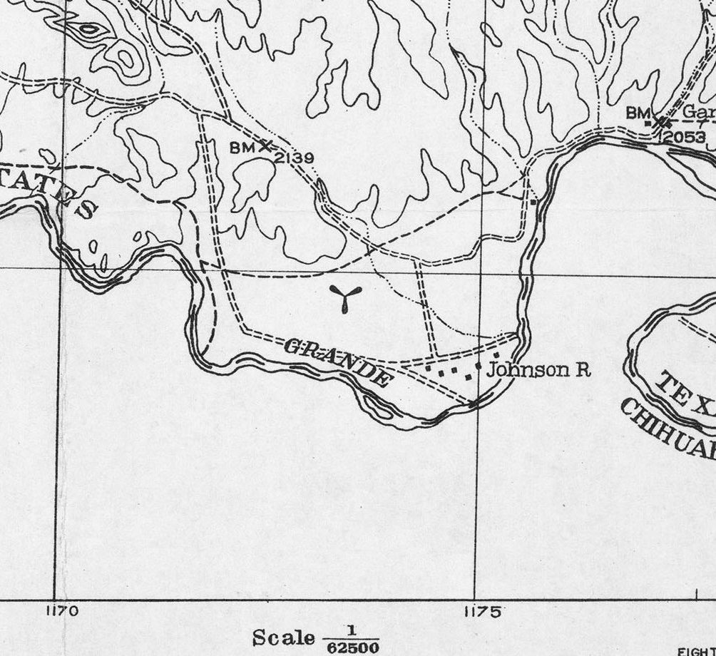
The earliest map depiction which has been located of Johnson Ranch Airfield was on the 1931 USGS topo map (courtesy of Jason Abrams).
The propeller symbol was used to depict airfields on topo maps of that era.
The earliest known aerial photograph of Johnson's Ranch Airfield was a 1932 aerial view by W.D. Smithers looking southeast (courtesy W.D. Smithers Collection, via Jason Abrams).
It depicted the field as having 3 graded runways.
Jason Abrams observed, “You can see the orchard/garden along the Rio Grande. Visiting pilots could eat fresh fruit & vegetables, swim in the river & go fishing.”
According to Jason Abrams, Johnson's Ranch Airfield “was very active in the early 1930s. About 300 planes landed just in 1933.”
A 1935 aerial view looking east taken by 8th Corps (from the National Archives, courtesy of Jason Abrams) depicted Johnson's Ranch Airfield
to have 3 wide unpaved runways, with a cluster of buildings on the south side.
A 1935 aerial view looking north taken by 8th Corps of the buildings on the south side of Johnson's Ranch Airfield (from the National Archives, courtesy of Jason Abrams).
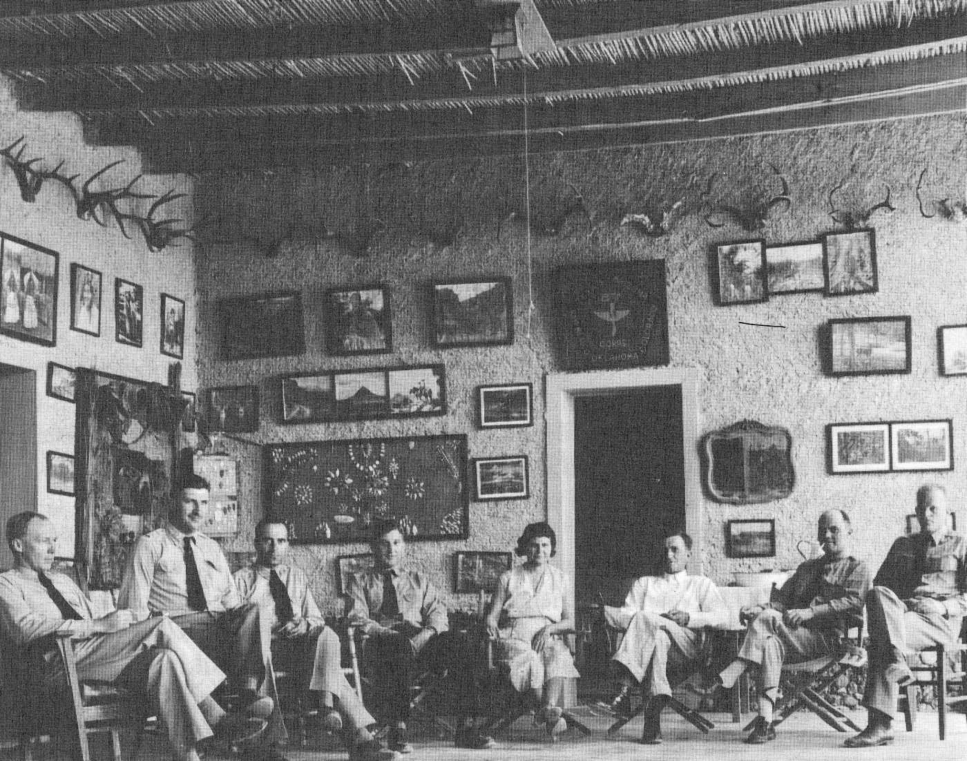
A circa 1935 photo from inside the porch at Johnson's Ranch, showing pilots from 8th Corps Army, Fort Sam Houston, and Elmo & Ada Johnson (courtesy of George Hansen, via Jason Abrams).
A 1935 map (from the National Park Service, courtesy of Jason Abrams) depicted Johnson's Ranch Airfield.
The earliest aeronautical chart depiction which has been located of the Johnson's Ranch Airfield was on the March 1935 Del Rio Sectional Chart.
It depicted Johnson's Ranch as an auxiliary airfield.
Johnson's Ranch Airfield, as depicted on an August 1935 map titled "Proposed Big Bend National Park" (from the National Archives, courtesy of Jason Abrams).
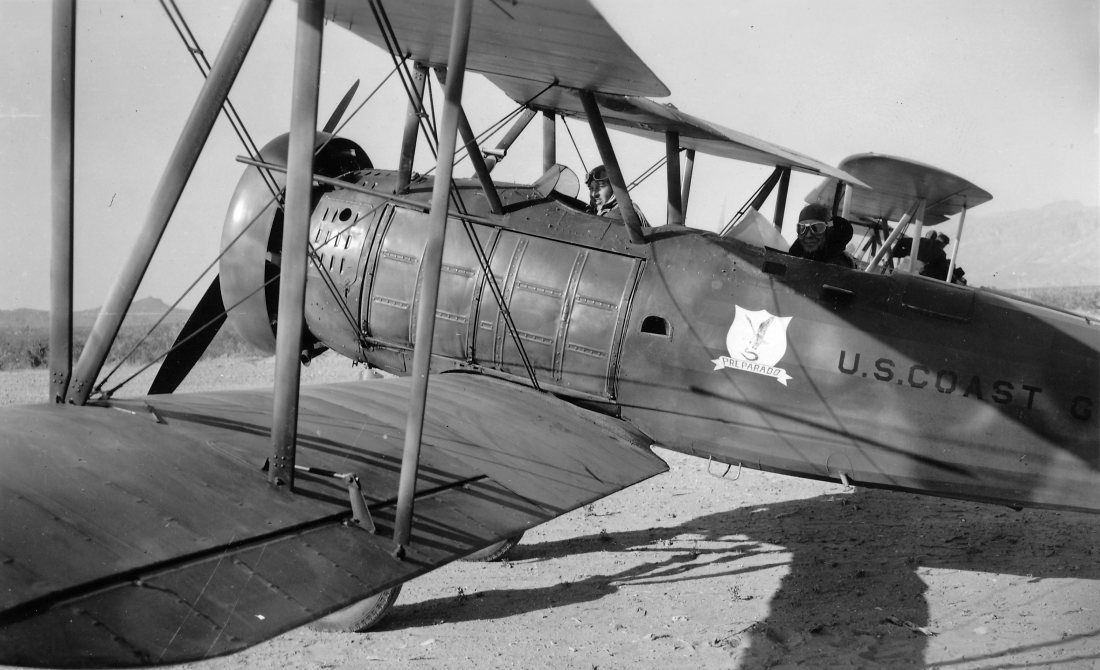
A 1936 photo of Daniel Galicia (Chief Inspector of the Mexico City Department of Forestry) in a U.S. Coast Guard Vought O2U-2 biplane
at the Johnson's Ranch Airfield (from the National Archives, courtesy of Jason Abrams).
A 1936 photo of Roger Roll climbing into a U.S. Coast Guard Vought O2U-2 biplane
at the Johnson's Ranch Airfield (from the National Archives, courtesy of Jason Abrams).
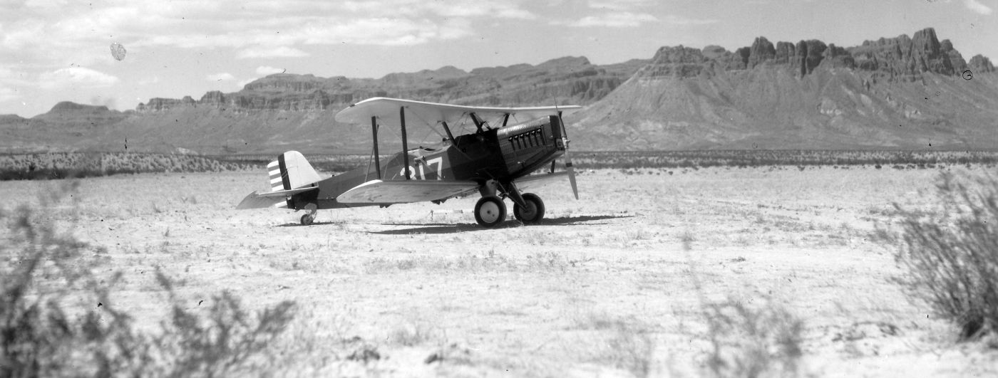
A circa 1930s photo of an Army Air Corps Douglas O-2 biplane at Johnson's Ranch Airfield (courtesy of Jason Abrams), with the picturesque Chisos Mountains in the background.
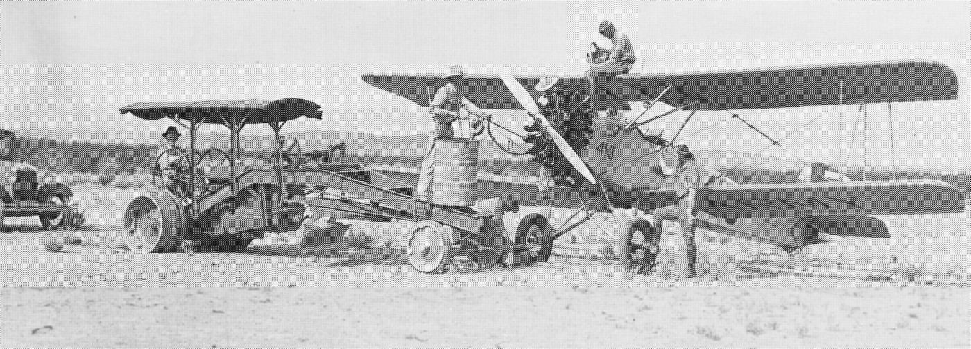
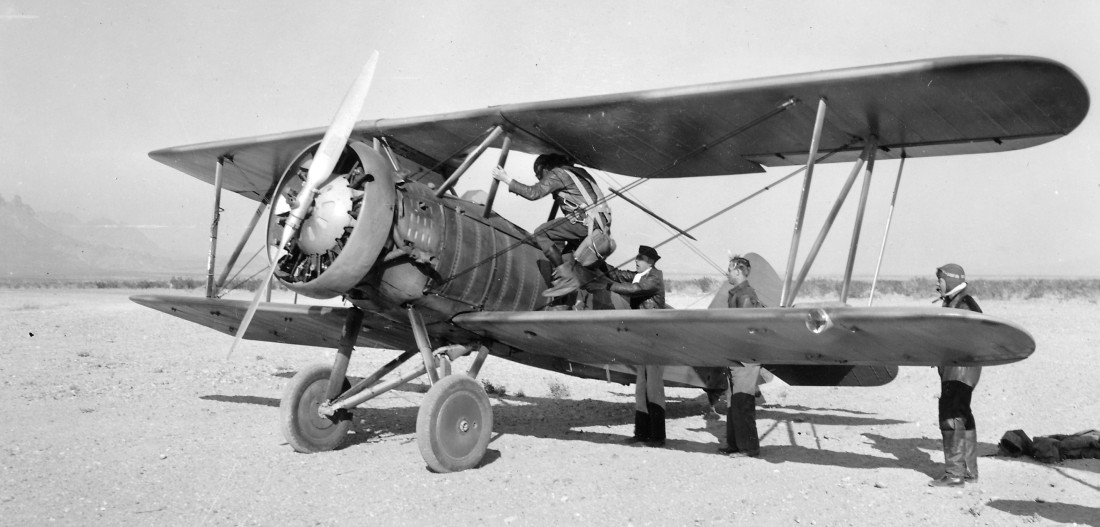
A circa 1930s photo of Elmo Johnson (standing on the 55 gallon drum) refueling an Army Consolidated PT-13 biplane at Johnson's Ranch Airfield (courtesy of W.D. Smithers Collection, via Jason Abrams).
A beautiful circa 1930s photo of 2 TX National Guard Douglas biplanes model undetermined) at Johnson's Ranch Airfield (courtesy of W.D. Smithers Collection, via Jason Abrams).
The last aerial photo which has been located of Johnson's Ranch Airfield was a 1936 aerial view looking northwest (courtesy of the TX Bureau of Economic Geology, via Jason Abrams),
showing the Chisos Mountains in the background.
According to Jason Abrams, in about 1936 the Works Progress Administration built a building at Johnson's Ranch to serve as overnight quarters for pilots & as a radio shack.
A 1936 road map depicting the Johnson's Ranch airfield (circled in red) & 2 other airfields in the Big Bend (scan by Terry Palmer, courtesy of Jason Abrams).
A 1936 road map of Brewster County (courtesy of Jason Abrams) depicted John Ranch Airport as an auxiliary airfield.
The high point of aviation activity at Johnson’s Ranch was in 1936.
The expanded training requirements of WW2 eventually eliminated it as a flight training center.
The field was located too far off the east/west traffic route
and had poor ground communications, poor access roads, and no rail line.
Ironically, a decade earlier Johnson's Ranch had been the beneficiary of the horse cavalry's loss to mechanization.
Now, it too was the victim of technological progress.
A stopover at Johnson’s Ranch also included lounging in the cool vine-covered patio & enjoying Ada Johnson's home cooking.
The field was a popular weekend destination for pilots -
a place to combine flying exercises with recreation such as hunting, fishing,
exploring Indian caves, and taking burro rides into Mexico.
Whatever technical skills a young aviator might wish to develop -
cross country navigation, strange field landings, or increasing his flying time -
a flight to Johnson’s Ranch provided ample opportunity.
Several times aircraft mobilized at Johnson’s Ranch in response to rumored border raids.
The 3rd Attack Group, stationed at Fort Crockett, staged its annual "field maneuver" at Johnson's Ranch
to coincide with the opening of deer season.
By 1939, the field had 3 graded runways, the longest measuring 4,200'.
These improvements transformed Johnson’s Ranch into a safe all-weather operational facility for emergency combat aircraft.
Johnson's Ranch Airfield, as depicted on a 1940 road map (courtesy of Steve Cruse).
By 1940, only 2 flights constituted the total annual activity.
The state of Texas purchased Johnson's Ranch in 1942 for inclusion in Big Bend National Park.
Air traffic continued temporarily - Johnson's ranch became a regular stop for the Civil Air Patrol's Southern Liaison Patrol.
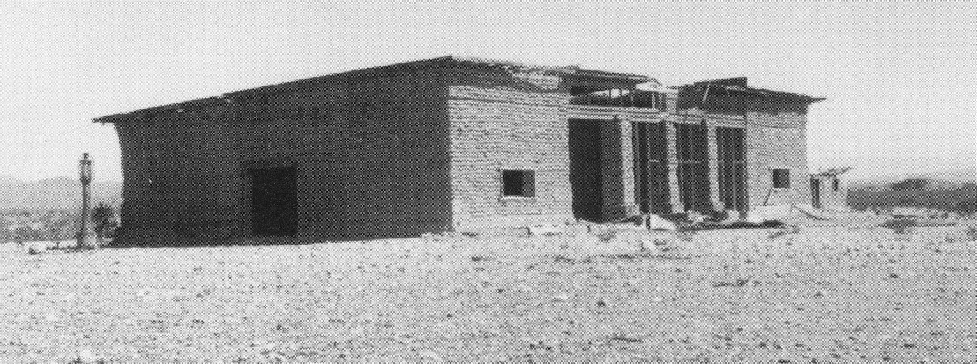
A circa 1943 of Johnson's Ranch pilot overnight quarters & radio shack building (courtesy of National Park Service, via Jason Abrams).
Johnson's Ranch Airfield was reportedly closed in 1943.
According to Jason Abrams, the ranch was abandoned in 1943.
The June 1944 Del Rio Sectional Chart (courtesy of Chris Kennedy) continued to depict Johnson Ranch as an auxiliary airfield.
According to Jason Abrams, “Johnson was forced off his land by the National Park Service around 1944,
and people started harvesting the wood from the roof, doors, and windows.”
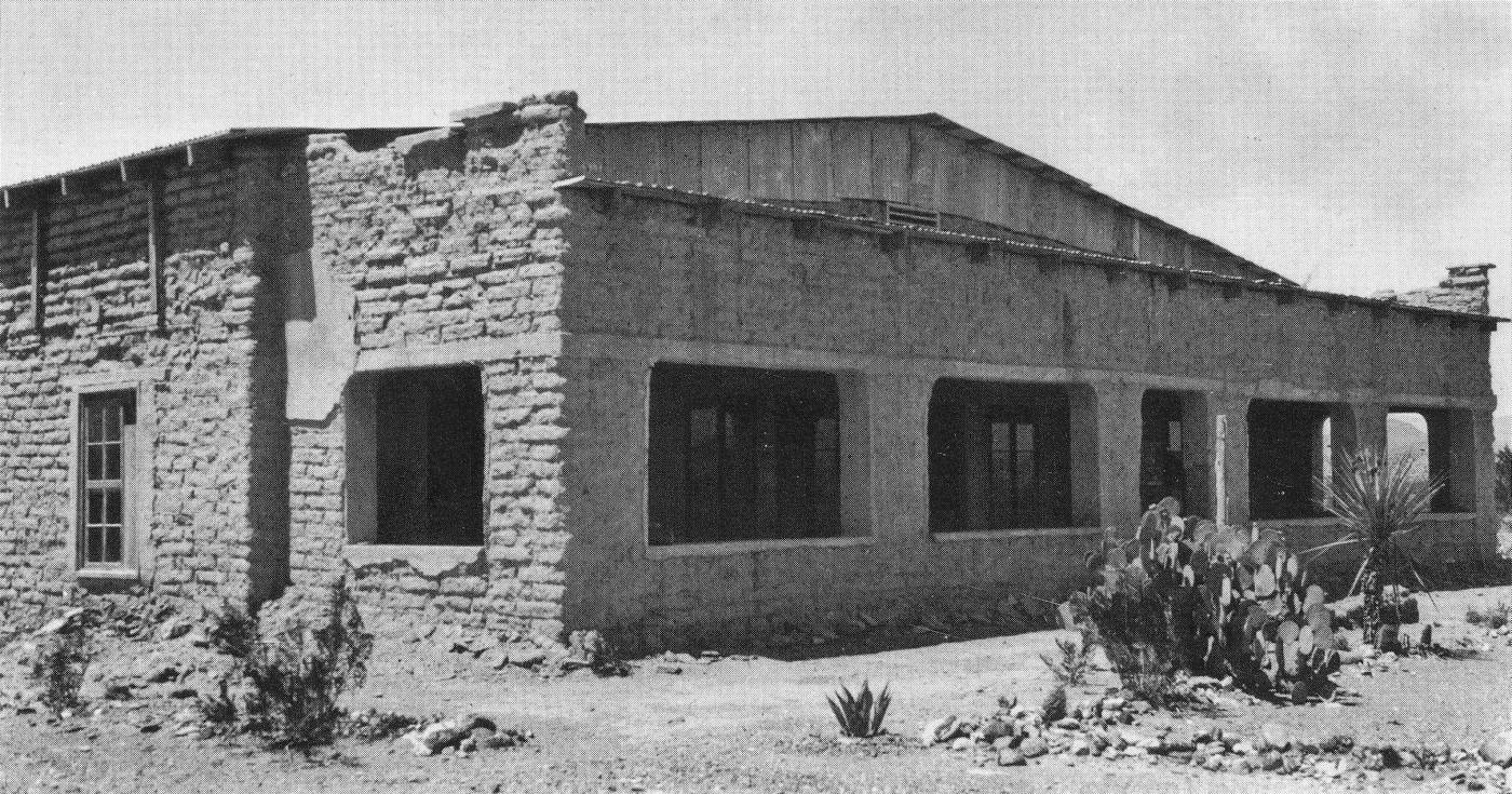
A sad circa 1946 photo of the abandoned Johnson's Ranch (courtesy of National Park Service, via Jason Abrams).
According to Jason Abrams, the pilot overnight quarters & radio shack building was bulldozed by the park service in 1953.
The Aerodromes table of the September 1954 Del Rio USAF Sectional Chart (courtesy of Chris Kennedy)
described Johnson Ranch as a private airfield with 2 runways, the longest being a 3,700' bare strip.
The remarks said, "Unattended. Emergency only. Big Bend National Park Service."
The last chart depiction which has been located of Johnson Ranch as an active airfield
was on the September 1955 Del Rio Sectional Chart.
The Johnson Ranch Airfield was evidently closed at some point between 1955-57,
as it was no longer depicted at all on the August 1957 Del Rio USAF Sectional Chart (courtesy of Chris Kennedy).
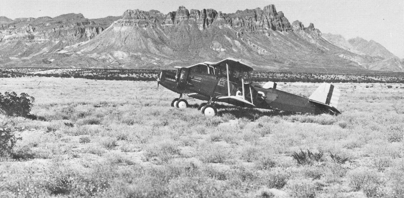
A circa late 1960s aerial view of the ruins of Johnson's Ranch (courtesy of W.D. Smithers Collection, via Jason Abrams).
Jason Abrams observed, “Once the roof was gone, the adobe walls melted away. You can see the foundation of the WPA building they bulldozed a decade earlier.”
The Johnson Ranch Airfield was no longer depicted at all on the 1971 USGS topo map.
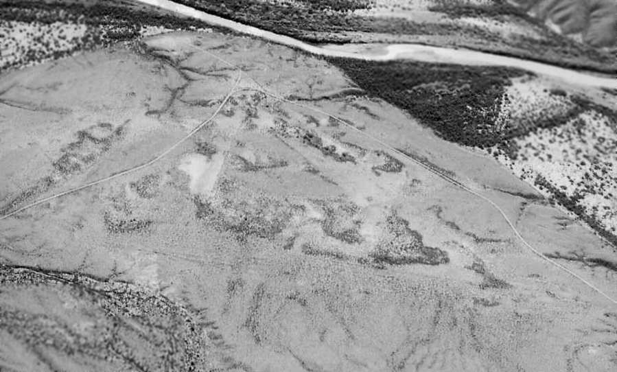
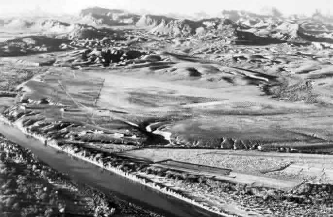
A circa 1980s aerial view looking south at Johnson's Ranch Airfield by Dick Merrill.
The triangular layout of the former runways is still barely apparent in the center of the photo.
The remains of the Johnson's Ranch Airfield runways were no longer depicted at all on recent USGS topo maps.
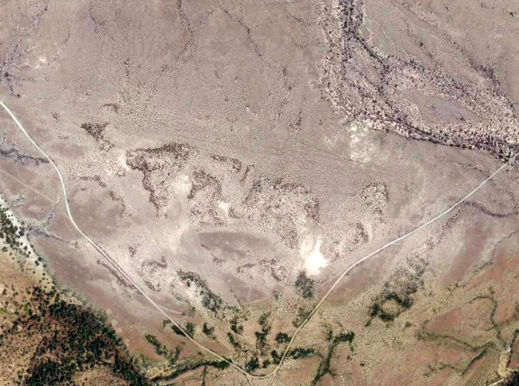
In a 4/18/13 aerial photo, the outline of the remains of the 3 former Johnson Ranch runways were still barely apparent.
Jason Abrams observed, “It is a sad ending to the Ranch story, since nothing is left but maps & photos.”
Thanks to Dick Merrill for pointing out this airfield.
See also:
Johnson's Ranch page, Big Bend National Park
____________________________________________________
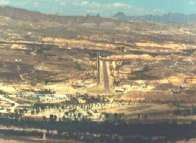
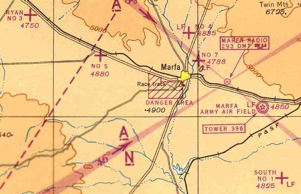
Marfa Army Airfield / Presidio County Airport, Marfa, TX
30.26 ,-103.89 (Southeast of El Paso, TX)
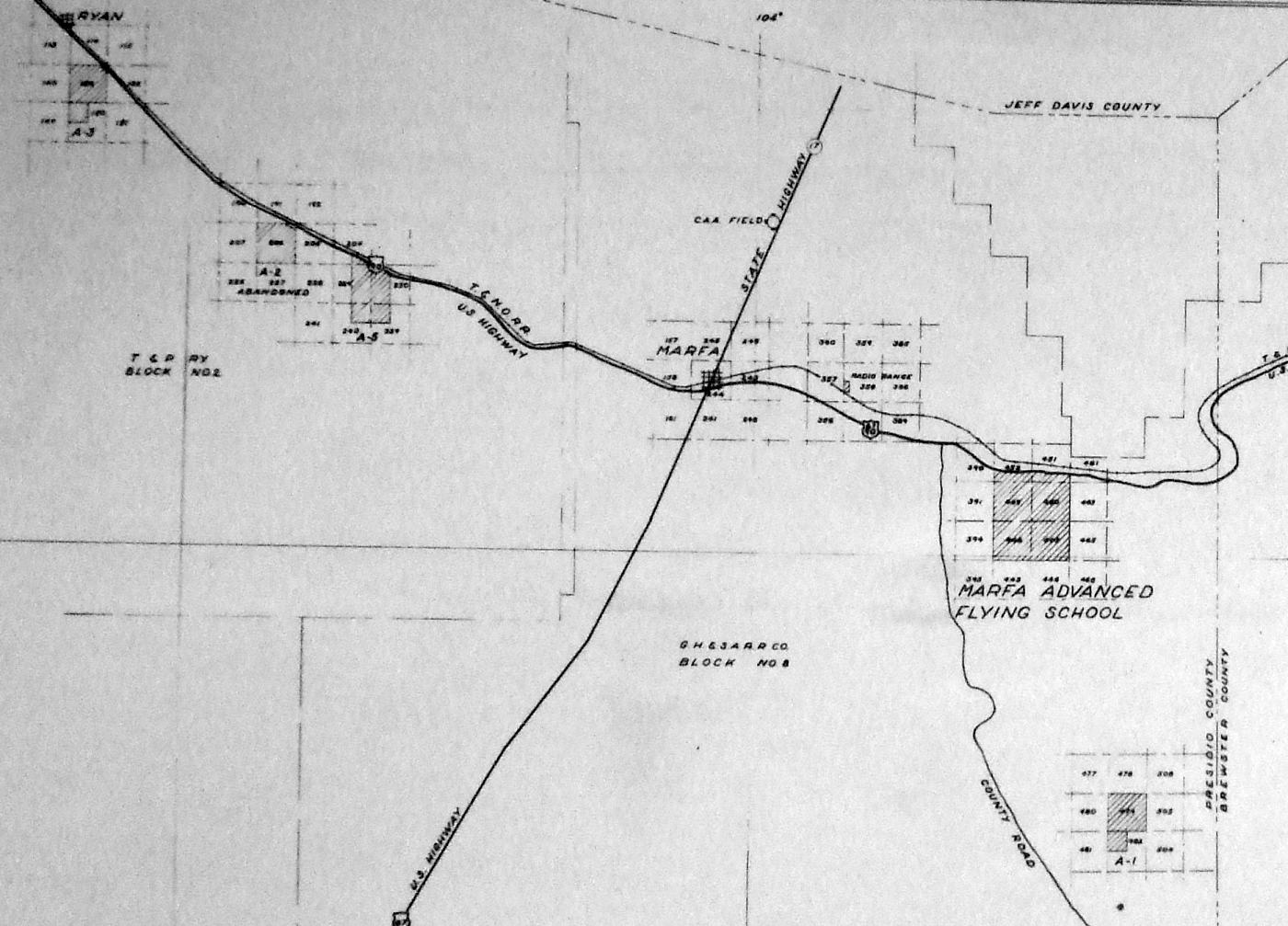
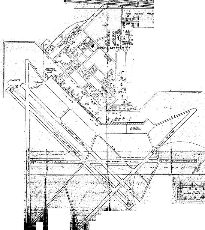
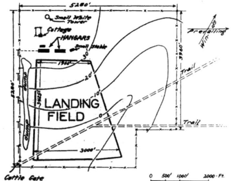
A 6/19/42 Army plan of the “Training Area & Auxiliary Fields, Advanced Flying School Marfa” (from the National Archives, courtesy of Ron Plante).
According to the book "History of Marfa & Presidio County, TX" by Cecilia Thompson (via David Brooks),
in April 1942 a site was selected that was 7.8 miles east of Marfa south of US Route 90 for a large new Army Airfield.
The Southern Pacific Railroad tracks run parallel to Route 90 at this area.
The highway & railroad provided excellent logistics support for the new airfield.
The land was owned by Thomas Hendrick & was on lease to W. B. Mitchell & sons for cattle grazing.
The Mitchells agreed to release the land and citizens of Marfa & Alpine jointly purchased the land with a bond issue for $30,000.
The offer was leased to the Federal Government for $1 per year,
but the Government decided to purchase the land outright, a total of 2,748 acres of land.
Several contractors were engaged to construct the Marfa airfield, supervised by the Army Corps of Engineers.
Construction started in early 1942.
The earliest depiction which has been located of Marfa AAF was a 6/19/42 Army plan
of the “Training Area & Auxiliary Fields, Advanced Flying School Marfa” (from the National Archives, courtesy of Ron Plante).
It depicted Marfa Advanced Flying School, along with 4 auxiliary fields: A-1 (located south-southeast),
A-2 (located northwest, strangely already labeled as “Abandoned”), A-3 (located northwest, in Ryan), and A-5 (located northwest).
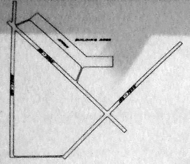
A 6/19/42 Army plan of the “Training Area & Auxiliary Fields, Advanced Flying School Marfa” (from the National Archives, courtesy of Ron Plante)
depicted Marfa Advanced Flying School as having 3 paved runways, with a large paved apron on the northwest side, and a Building Area to the north.
Marfa's construction was essentially completed by 8/22/42.
The U.S. Army Air Force Advanced Flying School came into existence at the Marfa AAF at that time.
It took about 6-8 weeks before military personnel were fully in place to operate the airfield.
Training at Marfa AAF commenced on 10/30/42.
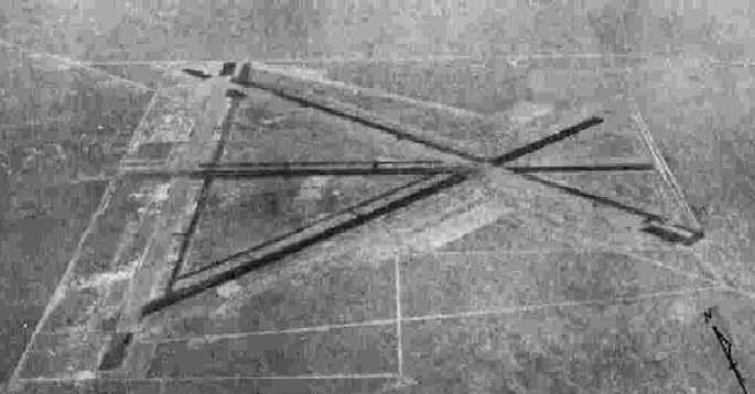
The earliest photo which has been located of Marfa AAF was a 12/5/42 aerial view looking north (from the National Archives, courtesy of Ron Plante).
It depicted Marfa as having 3 paved runways, a large ramp with 2 hangars, and an extensive street grid on the north side of the field.
On 11/25/42, the first shipment of AT-17B twin-engine trainers arrived from Cessna in Wichita, KS.
A flow of aircraft continued to be delivered as training ramped up.
The first class started training on 12/11/42, weeks ahead of planned schedule.
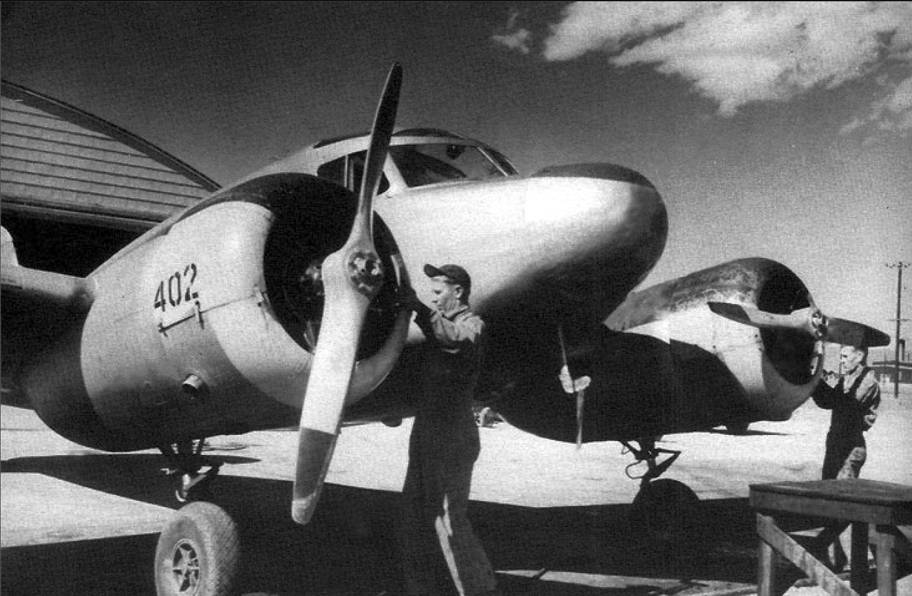
An undated photo of work being conducted on an AT-17 trainer at Marfa, from a circa 1942-45 Army booklet (courtesy of Mark Hess).
This class (43-B) completed its training on 2/6/43.
A 10/27/43 aerial view looking north from the 1945 AAF Airfield Directory (courtesy of Scott Murdock)
showed that Marfa AAF had gained 3 more runways (to a total of 6) at some point between 1942-43.
As built during the war, the airfield at Marfa consisted of a total of 6 asphalt runways (up to 7,500' long),
with an extensive network of taxiways & ramps.
Adjacent to the airfield to the north was an extensive street grid,
with a large number of buildings (eventually totaling nearly 250 buildings), including a hospital, barracks,
chapel, theater, mess halls, control tower, and hangars.
The initial construction at Marfa cost a total of over $6 million,
according to the book "The Wings of Change" (courtesy of Steve Cruse).
Auxiliary landing fields for the use of Marfa AAF had been provided by action of the Federal Court in El Paso.
Condemnation charges were filed for immediate possession of land vital to the successful prosecution of the war.
Four owners were directed to deliver 1,869 acres for landing fields, which eventually included:
Marfa South Aux #1 (15 miles SE of Marfa), Marfa Aux #2 (10.5 miles WNW of Marfa),
Ryan Aux #3 (16.5 miles WNW of Marfa), Marfa Aux #4 (4 miles north of Marfa), later reused as Marfa Municipal Airport,
Aragon Aux #5 (8.5 miles WNW of Marfa), and Marfa Aux #7 (2 miles NE of Marfa).
No "Marfa Aux #6" was ever constructed, and no record exist of where it had been planned to be located.
A 1943 U.S. Army Marfa Airfield General Plan depicted a total of 5 runways.
Fatal accidents were inevitable with the demands of wartime training, and the first killed at Marfa were Lieutenant Holland & Cadet Hallin.
The flying school experienced a total of 35 accidents during WW2.
A 1943-44 photo by Steve Patti (courtesy of Mark Hess) of the Marfa hangar used as a major overhaul shop by the Civil Air Patrol's Southern Liaison Patrol # 2 (Border Patrol).
A 1943-44 photo by Steve Patti (courtesy of Mark Hess) of the Lt. Filberts performing an engine ground run in a Civil Air Patrol Stinson 10 at Marfa.
By 4/30/44, Marfa AAF had a total complement of 3,293 personnel: 575 officers, 2,114 enlisted men, and 604 civilians.
At its peak, Marfa AAF would operate a staggering total of 500 aircraft, according to the book "The Wings of Change" (courtesy of Steve Cruse).
Marfa AAF & its satellite fields, as depicted on the June 1944 El Paso Sectional Chart (courtesy of David Brooks).
The 9th Chinese Cadet Detachment received their wings on 11/21/44 after receiving their training at Marfa AAF.
Some AT-6 advanced single engine trainers were also used at Marfa AAF.
The B-25 Mitchell bomber was also used for multi-engine training at Marfa during the later portions of the war.
In 1945, Marfa AAF underwent numerous changes.
After the graduation of Class 45-C on 5/23/45,
all remaining students & Chinese cadets were reassigned to other bases to complete their training.
A total of more than 7,000 pilots received training at Marfa AAF during WW2.
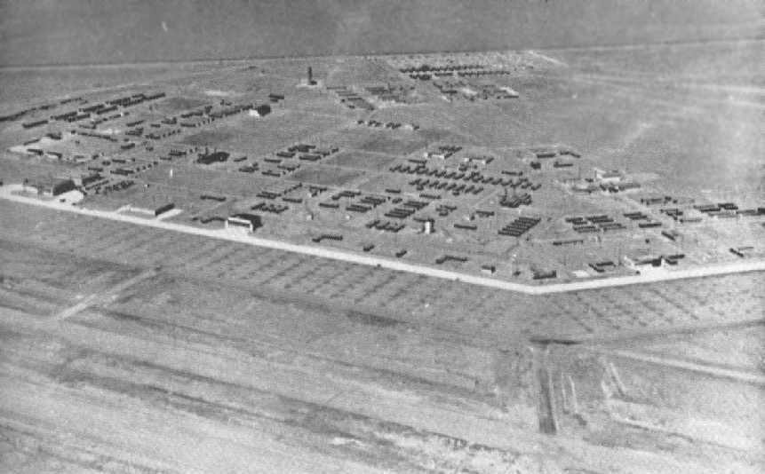
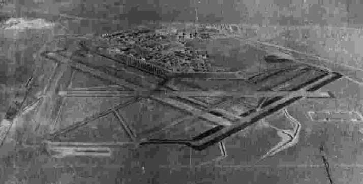
An aerial view looking northeast at the vast number of structures in the Marfa AAF housing area.
The photo was from a newspaper in the Marfa Public Library
(courtesy of Ms. C. Thompson of the Marfa Historical Society, via David Brooks).
The photo is undated, but presumably was circa 1945-46,
during the period that the field was being inactivated by the military.
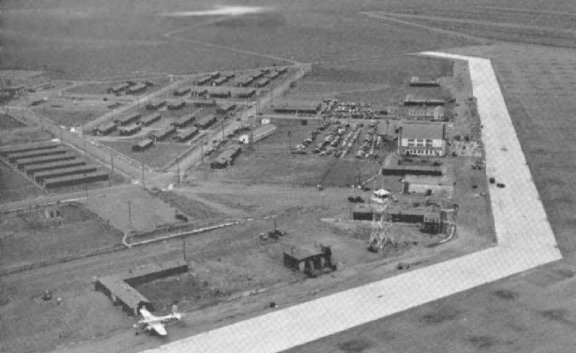
An aerial view looking east at the Marfa AAF ramp, showing a single B-25 Mitchell, the control tower, and a hangar.
The photo was from a newspaper in the Marfa Public Library (courtesy of Ms. C. Thompson of the Marfa Historical Society, via David Brooks).
The photo is undated, but presumably was circa 1945-46, during the period that the field was being inactivated by the military.
Marfa AAF was placed on standby status from 5/25/45 – 6/15/45. Much of the equipment & aircraft were reassigned.
A few administrative aircraft remained & base operations became inactive.
The field remained open for transient aircraft on official business or for emergency landings.
On 6/30/45, Marfa AAF functionally was transferred to Troop Carrier Command.
The 818th Air Base Wing was designated as the field's resident unit.
During this phase, the field had a total of 756 enlisted men, 75 officers and 416 civilians.
Several C-47A aircraft arrived on 7/5/45. By V-J day on 8/14/45, the field was no longer required for a redeployment center for the TCC.
By the end of 1945, flying operations at Marfa rapidly wound down,
with the base having only 1 C-64, 20 C-47s and 1 B-25 by 11/30/45.
The base manpower was reduced to a total of 1,133. From December 1945 to 1/31/46, the base was listed as "inactive".
During this time, many of the assets were advertised for sale as surplus property.
This included such things as a bowling alley, office equipment, trucks, shelving, etc.
The 1945 AAF Airfield Directory (courtesy of Scott Murdock) described Marfa AAF
as a 2,717 acre square shaped property, having 5 asphalt runways, the longest being a 7,525' north/south strip.
The field was said to have 4 wooden hangars, the largest being a 202' x 160' structure.
Marfa AAF was described as being owned by the U.S. Government, and operated by the Army Air Forces,
but the field was described as “Inactive”.
It was said to have 4 auxiliary fields: #1 (South Field), #3 (Ryan Field), #4 (CAA Field), and #5 (Aragon Field).
All operations at Marfa AAF were suspended by February 1946. The base was retained by the 818th AAF BU and later the 344th AAF BU.
On 1/31/47, the base was transferred by the 9th Air Force to the Army District Engineering Corps at Albuquerque, NM for disposition.
Thus closed the history of MAAF as a military establishment.
Marfa's auxiliary fields were immediately put up for disposal as they were declared surplus to needs.
The property of Marfa AAF was eventually returned to its prewar owners, and it was eventually reused as a civil airport.
“Marfa Army Air Field (Aux)” was still depicted as a military airfield on the July 1946 El Paso Sectional Chart.
David Brooks recalled, "My family comes from those parts of Texas. I have always been interested in the old air base at Marfa.
My father told me he flew in to the old Marfa AAF several times, once in 1947 & two times in 1948.
On two occasions, he flew on Trans Texas Airlines & once on a charter flight.
So there was some commercial traffic there for a while short time after the war."
The towns of Marfa & Alpine jointly used the former Army Airfield as a Regional Municipal Airport.
Trans Texas Airlines moved its operations from the original Marfa Municipal Airport to the former Marfa AAF by May 1946.
In addition to the daily flights (one east & one west),
a charter weekend service was also established that flew out of the field.
By June of 1946, Marfa requested operation rights for the Marfa Municipal Airport
to be moved to the former Marfa Aux AAF #4 (north of the town of Marfa).
It is unclear whether or not the commercial services moved from the former Marfa AAF to the "new" Marfa Municipal Airport or not.
The former Marfa AAF was depicted as the civil "Marfa-Alpine" airport
on the 1949 El Paso Sectional Chart (courtesy of Chris Kennedy).
The former Marfa AAF was still depicted as "Marfa-Alpine" Airport on aeronautical charts though 1952.
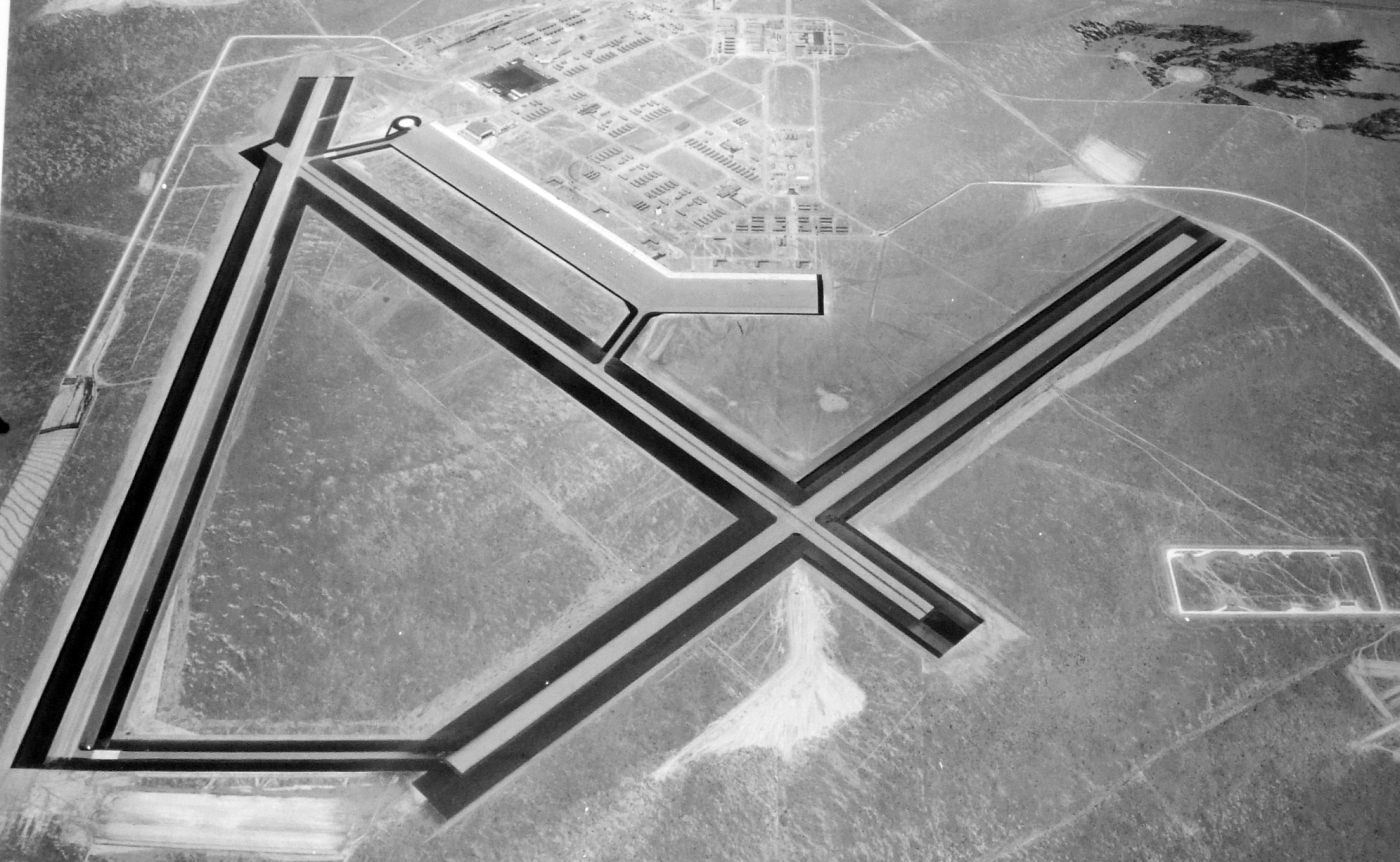
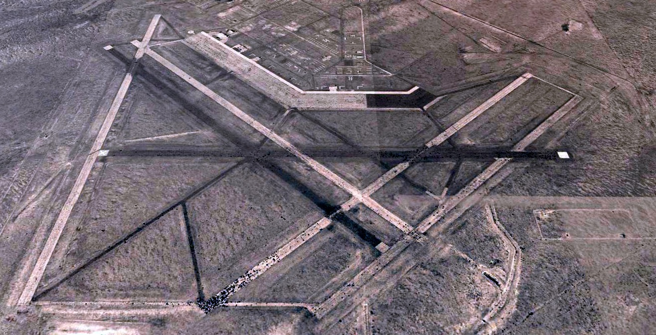
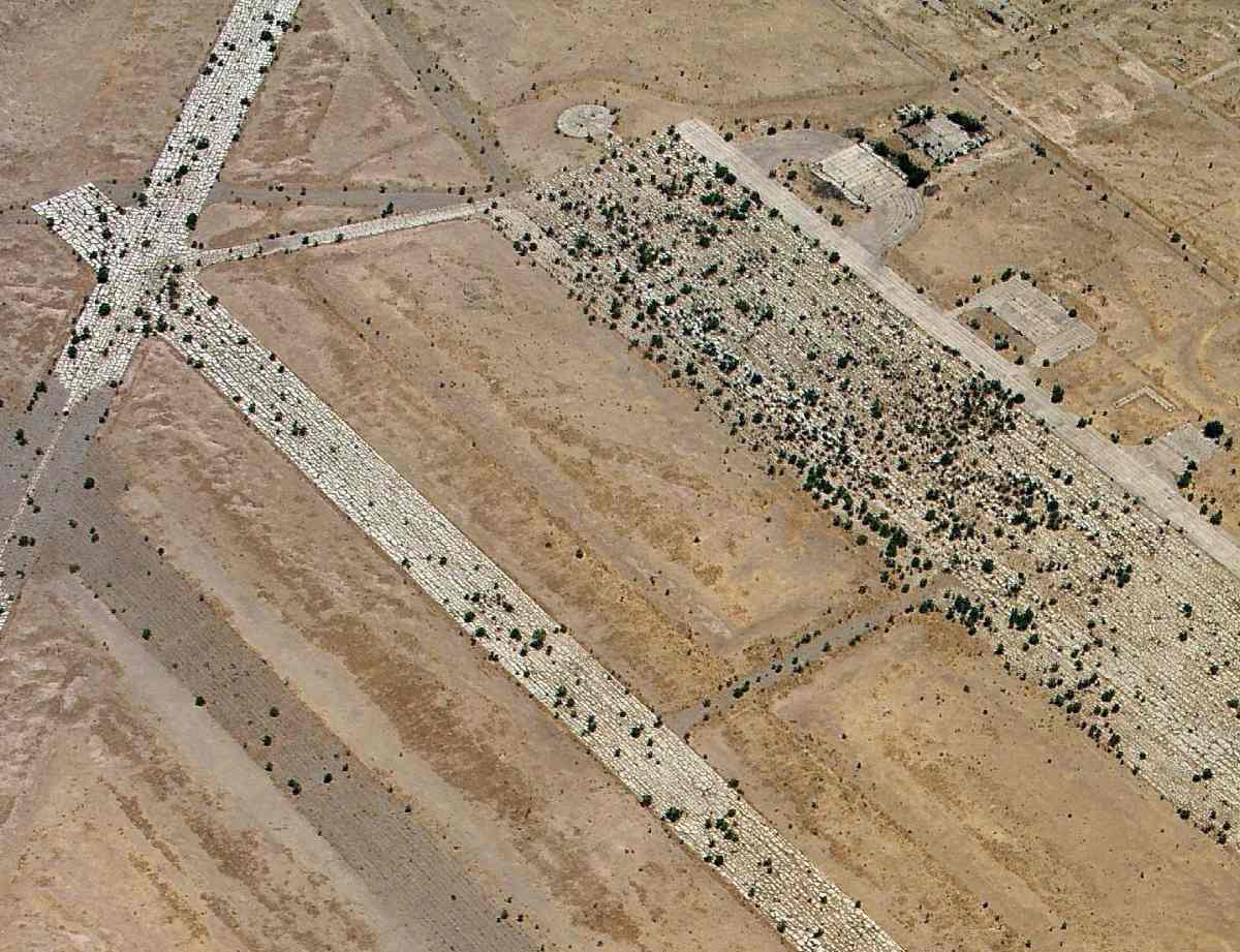
An amazing 5/27/54 aerial view of Marfa AAF (courtesy of Bob Morris).
Bob observed, the photo was taken “about 8 years after the U.S. Army Air Force ceased operations & turned the field over to the War Assets Administration for disposal.
Examination of the photograph reveals some interesting history. First, there are 6 runways instead of the typical 4 found at most WW-II era flying training fields;
even though [the 1943 plan above] shows 5 runways as part of the original plan.
I assume that the 6th runway was added at a later date but some time before training ceased.
Second, the ramp area shows a large but orderly number of smudges. These are assumed to be the 'drippings' resulting from fuel, oil, and hydraulic leaks typically found at airfield ramps.
The smudges indicate the aircraft were parked 7 abreast across the ramp. The parking ramp was 425' wide which indicates that the aircraft were parked about 60', fuselage to fuselage.
Along the ramp the aircraft were parked about 150', wingspan to wingspan.
This parking configuration allowed adequate space for aircraft taxiing to & from the parking area, in addition to space for maintenance & fueling personnel & equipment.
There are about 190 visible smudges on the ramp which would indicate the continuous use of that same number of aircraft at the field.
The far northwestern & far eastern ends of the ramp do not show an orderly arrangement of smudges;
however, it cannot be determined if this is due to the quality of the photography or to the fact that those portions of the ramp were not heavily used.
If those portions of the ramp were in fact used, the aforementioned aircraft spacing would suggest a total of about 250 aircraft could be parked at Marfa AAF.
That number, however, would leave no room for transient aircraft parking.
A 3rd characteristic revealed by the aerial photograph is that Marfa AAF appears to be half of a flying field.
Specifically, most of the support structures are along & to the west of the central north/south access road. The area to the east is virtually unused.
However, if that area was built up with a mirror image of the structures that are to the west of the central access road, the entire base would have almost perfect symmetry.
That this concept is not unreasonable is indicated by the small jog toward the northeast at the far eastern end of the parking ramp.
Why would the engineers go to the trouble to put that jog in the ramp if there was not at least a desire to have the option to extend the base into that area if the demands of the war required more multi-engine pilots?
Lastly, all but the 4 hangars & a few of the support structures have been completely demolished in the 8 years since flying operations ceased & the date the photograph was taken.
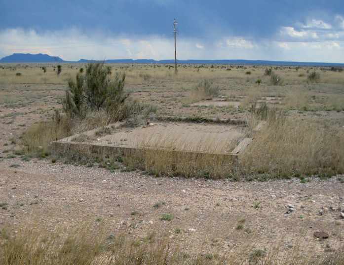
All that remains to indicate their former existence is their concrete slab foundations.
An interesting feature of the slab foundations is that those buildings are mostly concentrated in the southern & western portion of the base support area.
Apparently the buildings in the northern portion of the base, particularly the war housing project, did not have concrete slab foundations; and were probably built on piers.
I do not know the reason for this difference in foundations but it could have been an effort to reduce cost.”
It was still depicted as "Marfa Alpine Airport" on a 1961 road map (courtesy of David Brooks).
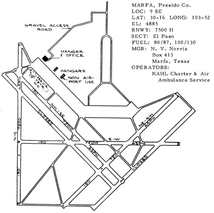
The former Marfa AAF was listed as "Presidio County Airport" in the 1963 TX Airport Directory (courtesy of Steve Cruse).
Only 3 runways were still maintained (21R/3L, 12L/30R & 17/35, all 7,500').
The 1963 diagram shows that only 3 hangars remained standing, all other hangars & buildings having been removed.
The operator was listed as KAHL Charter & Air Ambulance Service.
Kevin Shaw recalled of Marfa, “In the early 1960s, the area became popular for long-distance soaring flights.
The national championships were held there in the late 1960s.”
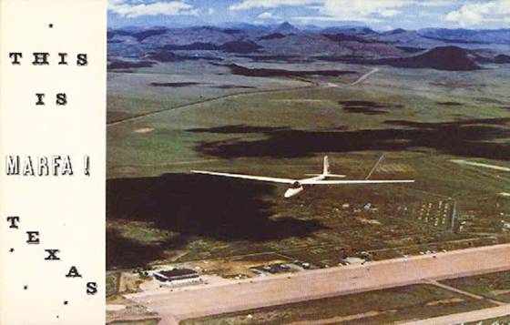
A postcard from the 1967 US National Contest,
looking northeast at Wally's Scott's Schleicher Ka-6 sailplane, with Marfa's ramp underneath.
According to the Landmark of Soaring, “Neil Armstrong earned his FAI Silver Badge at Marfa, before his flight to the moon.”
Kevin Shaw recalled, “In 1970 the World Soaring Championship contest was held at the 'Presidio County Airport'.
This was the 1st time that the World contest had ever been held in the US.
As a teenager, I visited the contests in 1969 & 1970. I remember the concrete ramp as enormously wide & endlessly long.
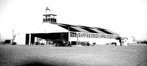
There was a least one old monstrously large WWII era hangar still in use.
I was motivated to learn to fly gliders that summer at the World Championships.
I started lessons when I got home & soloed later in the year. I've been flying ever since.”
David Brooks recalled, "I remember still seeing buildings there through the early 1960s."
The February 1968 El Paso Sectional Chart depicted Presidio County Airport as having 6 paved runways, with the longest being 7,500'.
Jeffery Brown recalled, “Probably the most famous single story involving that Marfa Airport was the dedication of the 107-inch telescope at McDonald in 1968.
That telescope was a major one for the times, and the runway at Marfa was long enough for a 737 to fly in & out of.
So they flew in a 737 with the press corps & VIPs for that dedication. While the runway was long enough, it was not hard enough.
The plane landed safely & everyone got off, but the wheels sank into the runway surface & substantial work was needed before the 737 could fly out again.
They ended up arranging many buses to carry VIPs & press back away from McDonald after the dedication, and it was an embarrassment.”
John Price recalled, “I was heavily involved in soaring & Marfa was the promised land.
The prime mover on getting soaring contests to Marfa was Fritz Kahl, owner of Kahl Flying Service & later many-times mayor of Marfa.
I’m not sure when the glider pilots first started showing up at the old airport, but they loved it because they could work out of the old hangar which was huge.
The first National Soaring Championships was held there in 1969 & the World Soaring Championships a year later.”
It was still listed as Presidio County Airport in the 1970 TX Airport Directory (courtesy of Ray Brindle).
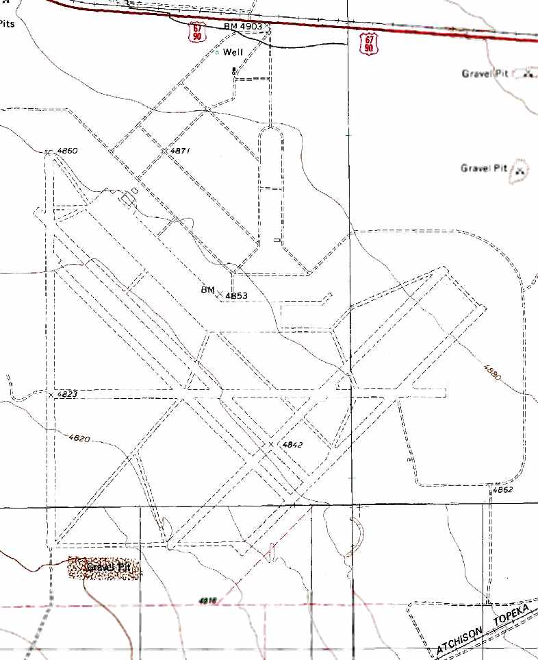
The ramps & runways of Marfa were depicted as unpaved on the 1972 USGS topo map, which also didn't label the huge facility at all.
Jeffery Brown recalled, “When I started grad school there in 1978, McDonald Observatory / UT Astronomy had a regular twice-weekly round trip
from Austin (and this was the old in-city Robert Mueller Airport in Austin) to Marfa & back, using the State Air Pool:
a Piper Aztec was the usual plane, usually flown by Ingvar 'Jake' Jacobsen, who had been LBJ's pilot earlier in his career.
I think the twice-weekly state flights must have been an important cash source for the airport.
I don't know when that arrangement started (I have the impression it dated back into the 1960s),
but it ended approximately 1985, when state budget concerns stopped the regular state pool flights.”
The Presidio County Airport was evidently closed at some point between 1970-85,
as the runways were labeled as “Abandoned” on the 1985 USGS topo map,
and it was no longer listed among active airfields in the 1985 TX Airport Directory.
David Brooks recalled, "It was about 20 years until I got back out there [1980s] & at that time, all was gone."
John Price recalled, “Right up until I dropped out of competition soaring in the late 1980s, we were still making an annual spring trek to Big Bend. The soaring conditions are fantastic.”
Jeffery Brown recalled, “When I visited the area about 1990, Marfa Airport was closed.”
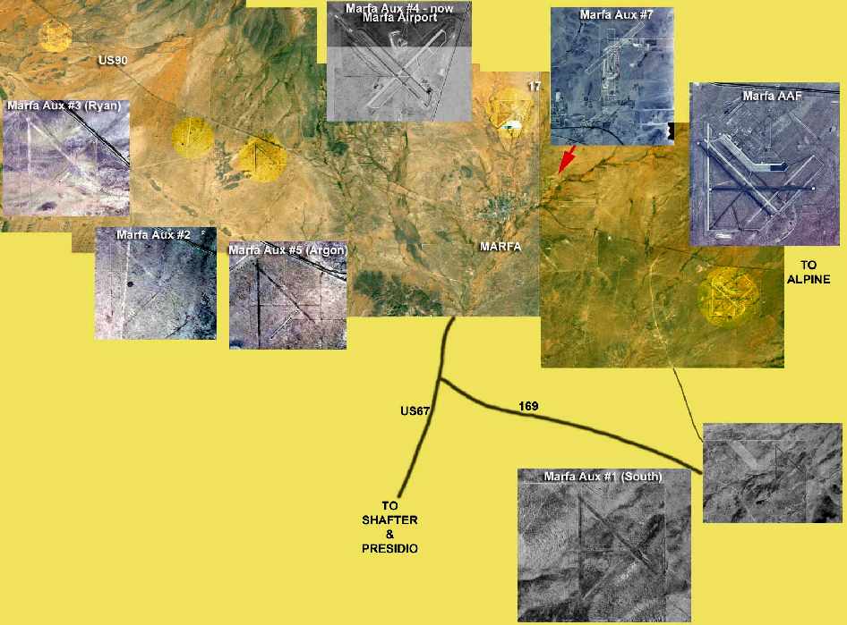
A fabulous composite photo by David Brooks, in which close-up views of Marfa AAF & its satellite airfields
have been superimposed over a 1996 CIR USGS aerial photo.
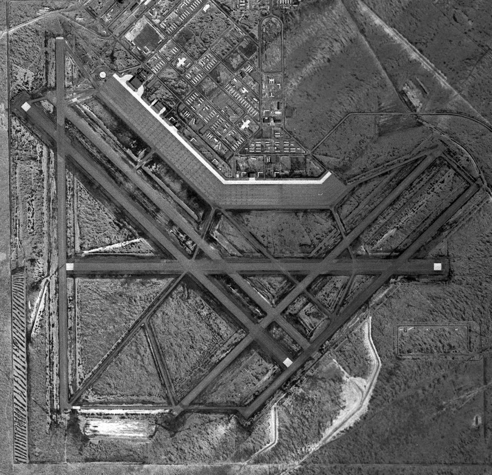
A 1996 aerial view looking north showed the massive airfield of the former Marfa AAF to largely remain intact though deteriorated.
Marfa AAF was still depicted as an abandoned airfield on 2000 aeronautical charts.
All of the runways, taxiways & ramps of this huge airfield still exist.
Spike Cutler flew over the Marfa airfield in 2002,
and observed that "it was MASSIVE, including what amounted to a good-sized city,
as well as the airfield; all gone but the paving, which the west Texas desert is slowly but surely reclaiming."
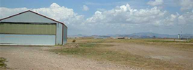
A 1/20/02 photo of a hangar (presumably of post-military construction) at Marfa.
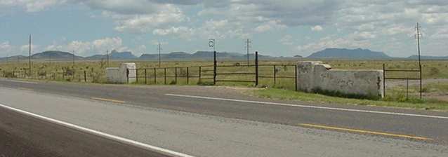
A 2003 photo by Scott Murdock of the former entrance gate to Marfa AAF.
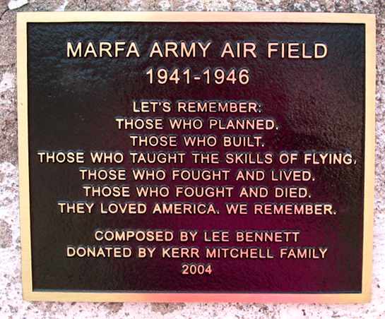
A 2004 photo by George Gee of the recently installed plaque on the wall flanking the Marfa gate,
about 100 yards east of the Marfa Lights Viewing Area on Highway 67.
A 2004 photo by George Gee of the remains of foundations in the war housing project, east of the main gate on Highway 67.
As of 2007, street maps labeled the former Marfa AAF as the “Alta Vista Ranch Airport”.
However, that may be in error, as 2007 Sectional Charts show the Alta Vista Ranch Airport as a different airfield, 13 miles to the south.
Jerry Eoff reported in 2008, “I fly out of KE38 in Alpine and use the old MAAF runways for practice emergency approaches regularly.
None could be used for actual touchdowns though, having cracked up with abundant mesquite growing within them.”
A circa 2010 aerial view looking north at the hangar foundations, ramps, taixways, and runways of the former Marfa AAF.
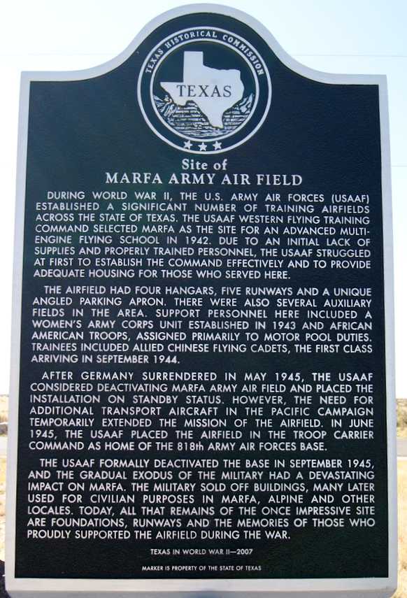
A 10/29/10 photo of a TX Historical Commission marker for Marfa AAF, which reads:
“During World War II, the U.S. Army Air Forces established a significant number of training airfields across the state of Texas.
The USAAF Western Flying Training Command selected Marfa as the site for an advanced multi-engine flying school in 1942.
Due to an initial lack of supplies and properly trained personnel,
the USAAF struggled at first to establish the command effectively and to provide adequate housing for those who served here.
The airfield had 3 hangars, 5 runways and a unique angled parking apron. There were also several auxiliary fields in the area.
Support personnel here included a Women's Army Corps unit established in 1943 & African American troops, assigned primarily to motor pool duties.
Trainees included allied Chinese flying cadets, the first class arriving in September 1944.
After Germany surrendered in May 1945, the USAAF considered deactivating Marfa Army Air Field & placed the installation on standby status.
However, the need for additional transport aircraft in the Pacific campaign temporarily extended the mission of the airfield.
In June 1945, the USAAF placed the airfield in the Troop Carrier Command as home of the 818th Army Air Forces Base.
The USAAF formally deactivated the base in September 1945, and the gradual exodus of the military had a devastating impact on Marfa.
The military sold off buildings, many later used for civilian purposes in Marfa, Alpine and other locales.
Today, all that remains of the once impressive site are foundations, runways & the memories of those who proudly supported the airfield during the war.”
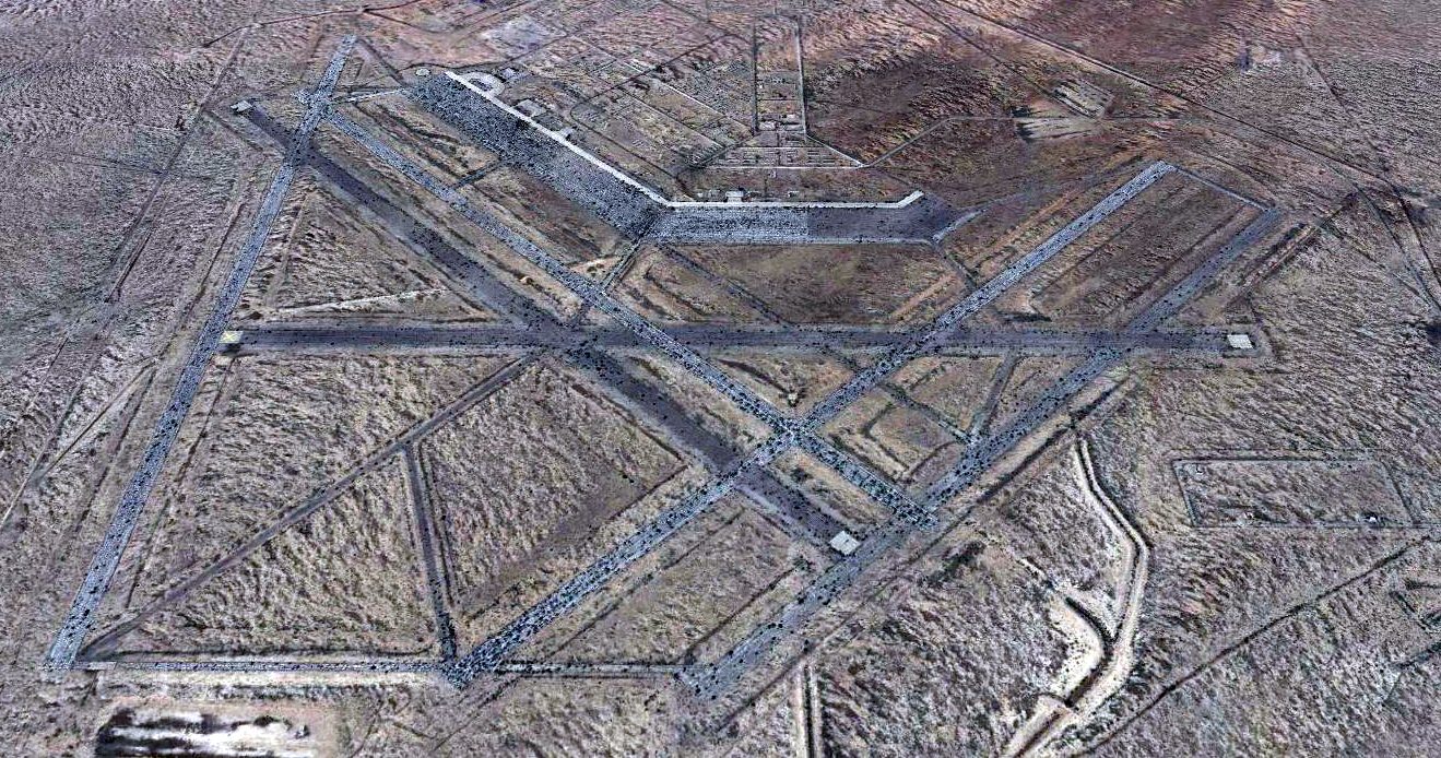
A 2015 aerial view looking north showed the massive airfield of the former Marfa AAF to largely remain intact though deteriorated.
A 1999 Army Corps of Engineers report provided further details about Marfa.
See also: The Handbook of TX Online.
____________________________________________________
Marfa Auxiliary Army Airfield #1 / A-1 South Field, Marfa, TX
30.15, -103.84 (Southeast of El Paso, TX)
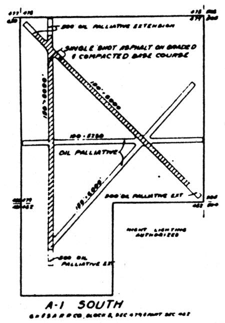
The airfield layout of A-1 South Field, from a 1942 AAF map of Marfa AAF & its satellite airfields (courtesy of John Voss).
Marfa Auxiliary Army Airfield #1 was evidently built at some point between 1942-44,
as it was not yet depicted on the June 1942 El Paso Sectional Chart.
Marfa Auxiliary Army Airfield #1 was built during WW2 as one of 6 satellite airfields for Marfa AAF (6 miles NNW),
which conducted advanced flight training for the Western Flying Training Command in AT-17 twin-engine trainers & B-25 Mitchell bombers.
A 10/27/43 aerial view looking north from the 1945 AAF Airfield Directory (courtesy of Scott Murdock)
depicted the “Marfa AAF Auxiliary #1 (South Field)” as having 4 runways.
According to a 1999 Army Corps of Engineers report, Marfa Auxiliary Army Airfield #1 consisted of 4 runways (up to 6,600' long).
The North/South & Northwest/Southeast runways were asphalt, while the other 2 were unpaved but oiled.
“South #1”, as depicted on the June 1944 El Paso Sectional Chart (courtesy of David Brooks).
The 1945 AAF Airfield Directory (courtesy of Scott Murdock) described “Marfa AAF Auxiliary #1 (South Field)”
as a 751 acre irregularly-shaped property, having 4 runways, the longest being two 6,000' asphalt strips oriented north/south & northwest/southeast.
The field was said to not have any hangars, to be owned by the U.S. Government, and operated by the Army Air Forces,
but the field was described as “Inactive”.
In mid-1945, Marfa AAF & its auxiliary fields transferred to the Troop Carrier Command.
Marfa AAF & its auxiliary fields were placed in temporary inactive status at the end of 1945.
“South #1” was depicted as an auxiliary airfield on the July 1946 El Paso Sectional Chart.
Marfa AAF & its auxiliary fields were transferred to the War Assets Administration in 1947.
The Marfa South Airfield was apparently reused for at least some period of time as a civil airport,
as that is how "South" Airfield was depicted on the 1949 El Paso Sectional Chart (courtesy of Chris Kennedy).
It was described as having a 6,000' hard-surface runway.
The Marfa South Airfield was apparently closed at some point between 1949-65,
as it was not depicted at all (even as an abandoned airfield) on the 1965 El Paso Sectional Chart (courtesy of John Voss),
the 1983 USGS topo map, or later aeronautical charts.
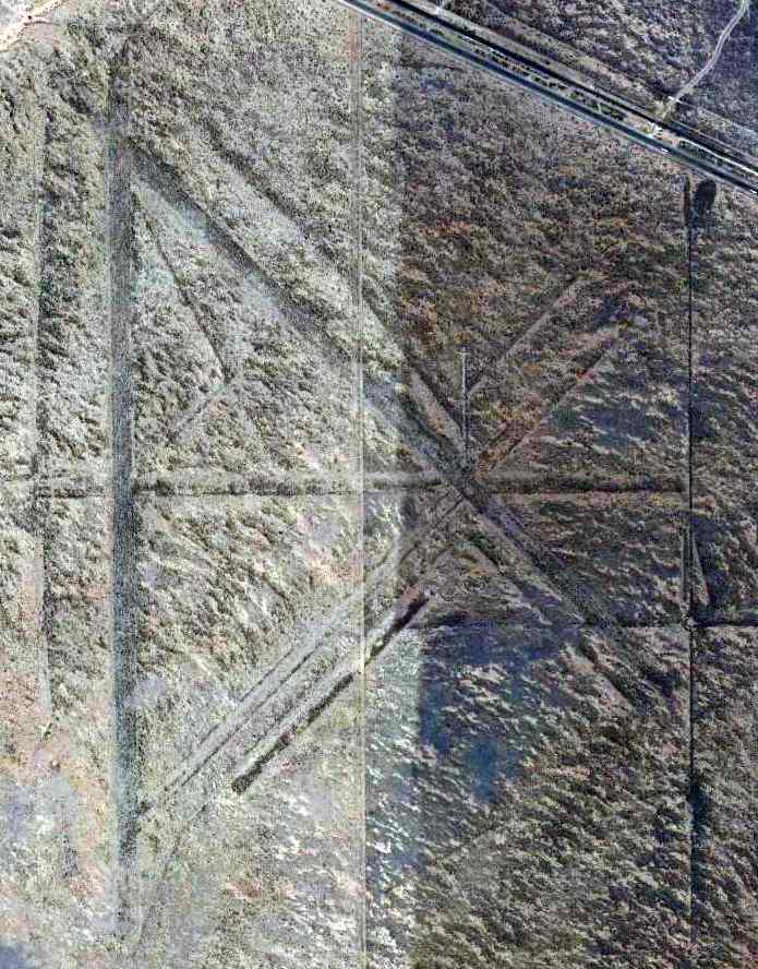
A 4/19/13 aerial photo showed the runways of Marfa Auxiliary AAF #1 have deteriorated greatly, but were still recognizable.
The site of Marfa Auxiliary AAF #1 is located in a very remote area, along a road not named on the maps,
15 miles southeast of the town of Marfa.
____________________________________________________
Marfa Auxiliary Army Airfield #2, Aragon, TX
30.36, -104.21 (Southeast of El Paso, TX)
Marfa Auxiliary Airfield #2, as depicted on a 6/19/42 Army plan of the “Training Area & Auxiliary Fields, Advanced Flying School Marfa” (from the National Archives, courtesy of Ron Plante).
Photo of the airfield while operational has not been located.
Marfa Auxiliary AAF #2 was built during WW2 as one of 6 satellite airfields for Marfa AAF (10.5 miles southeast),
which conducted advanced flight training for the Western Flying Training Command in AT-17 twin-engine trainers & B-25 Mitchell bombers.
The date of Marfa Auxiliary Airfield #2 has not been determined.
The earliest depiction which has been located of Marfa Auxiliary Airfield #2
was on a 6/19/42 Army plan of the “Training Area & Auxiliary Fields, Advanced Flying School Marfa” (from the National Archives, courtesy of Ron Plante).
Marfa Auxiliary Army Airfield #2 was not depicted on El Paso Sectional Charts from 1942/44/45/46.
According to a 1999 Army Corps of Engineers report, Marfa Auxiliary AAF #2 consisted of 4 runways (up to 6,600' long).
The North/South & Northwest/Southeast runways were asphalt, while the other 2 were unpaved but oiled.
In mid-1945, Marfa AAF & its auxiliary fields transferred to the Troop Carrier Command.
Marfa Auxiliary AAF #2 was apparently closed at an earlier date than the rest of the Marfa satellite fields,
as was labeled as "Abandoned" in the 1945 chart of Marfa satellite fields.
Marfa AAF & its auxiliary fields were placed in temporary inactive status at the end of 1945,
and were transferred to the War Assets Administration in 1947.
Marfa Auxiliary AAF #2 was no longer depicted at all on the 1983 USGS topo map.
A 1996 USGS aerial view looking east showed the runways of Marfa Auxiliary AAF #2 were noticeably more deteriorated than those of the other Marfa satellite fields.
A 2019 aerial view looking east showed the runways of Marfa Auxiliary AAF #2 have deteriorated greatly, but were still recognizable.
The site of Marfa Auxiliary AAF #2 is located adjacent to the south side of Route 90, west of the tiny town of Aragon.
____________________________________________________
Marfa Auxiliary Army Airfield #3 / Ryan Field, Ryan, TX
30.42, -104.3 (Southeast of El Paso, TX)

The airfield layout of Marfa Auxiliary AAF #3, from a 1942 AAF map of Marfa AAF & its satellite airfields (courtesy of John Voss).
Photo of the airfield while operational has not been located.
Marfa Auxiliary Army Airfield #3 was evidently built at some point between 1942-44,
as it was not yet depicted on the June 1942 El Paso Sectional Chart.
Marfa Auxiliary AAF #3 was built during WW2 as one of 6 satellite airfields for Marfa AAF (25 miles southeast),
which conducted advanced flight training for the Western Flying Training Command in AT-17 twin-engine trainers & B-25 Mitchell bombers.
According to a 1999 Army Corps of Engineers report, Marfa Auxiliary AAF #3 consisted of 4 runways (up to 6,600' long).
The North/South & Northwest/Southeast runways were asphalt, while the other 2 were unpaved but oiled.
“Ryan #3”, as depicted on the June 1944 El Paso Sectional Chart (courtesy of David Brooks).
In mid-1945, Marfa AAF & its auxiliary fields transferred to the Troop Carrier Command.
Marfa AAF & its auxiliary fields were placed in temporary inactive status at the end of 1945.
“Ryan #3” was depicted as an auxiliary airfield on the July 1946 El Paso Sectional Chart.
Marfa AAF & its auxiliary fields were transferred to the War Assets Administration in 1947.

Marfa Auxiliary AAF #3 was apparently reused for at least some period of time as a civil airport,
as that is how "Ryan" Field was depicted on the 1949 El Paso Sectional Chart (courtesy of Chris Kennedy).
It was described as having a 6,000' hard-surface runway.
Ryan Field was apparently closed at some point between 1949-65,
as it was not depicted at all (even as an abandoned airfield) on the 1965 El Paso Sectional Chart (courtesy of John Voss),
the 1983 USGS topo map, or later aeronautical charts.
A 3/31/08 aerial photo showed the runways of Marfa Auxiliary AAF #3 have deteriorated greatly, but were still recognizable.
The site of Ryan Field is located adjacent to the south side of Route 90,
southeast of the tiny town of Ryan.
____________________________________________________
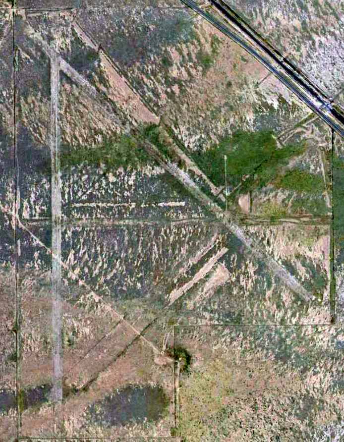
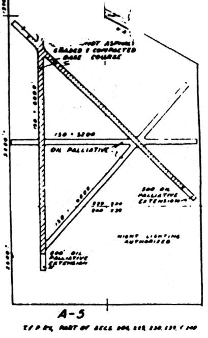
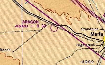
Marfa Auxiliary Army Airfield #5 / Aragon Field, Aragon, TX
30.34, -104.17 (Southeast of El Paso, TX)
The airfield layout of Marfa Auxiliary AAF #5, from a 1942 AAF map of Marfa AAF & its satellite airfields (courtesy of John Voss).
Photo of the airfield while operational has not been located.
Marfa Auxiliary Army Airfield #5 was built during WW2 as one of 6 satellite airfields for Marfa AAF (8.5 miles southeast),
which conducted advanced flight training for the Western Flying Training Command in AT-17 twin engine trainers & B-25 Mitchell bombers.
The date of construction of Marfa Auxiliary Army Airfield #5 has not been determined.
The earliest depiction which has been located of Marfa Auxiliary AAF #5 was on a 1942 AAF map of Marfa AAF & its satellite airfields (courtesy of John Voss).
Marfa Auxiliary Army Airfield #5 was not yet depicted on the January 1944 El Paso Sectional Chart.
According to a 1999 Army Corps of Engineers report, Marfa Auxiliary Army Airfield #5 consisted of 4 runways (up to 6,600' long).
The North/South & Northwest/Southeast runways were asphalt, while the other 2 were unpaved but oiled.
The earliest aeronautical chart depiction which has been located of Marfa Auxiliary AAF #5 was on the June 1944 El Paso Sectional Chart (courtesy of David Brooks).
It depicted “#5” as an auxiliary airfield.
In mid-1945, Marfa AAF & its auxiliary fields transferred to the Troop Carrier Command.
Marfa AAF & its auxiliary fields were placed in temporary inactive status at the end of 1945.
“Aragon #5” was depicted as an auxiliary airfield on the July 1946 El Paso Sectional Chart.
Marfa AAF & its auxiliary fields were transferred to the War Assets Administration in 1947.
Marfa Auxiliary AAF #5 was apparently reused for at least some period of time as a civil airport,
as that is how "Aragon" Field was depicted on the 1949 El Paso Sectional Chart (courtesy of Chris Kennedy).
It was described as having a 6,000' hard-surface runway.
Aragon Field was still depicted on the February 1950 El Paso Sectional Chart.
Aragon Field was apparently closed at some point between 1950-55, as it was not depicted at all (even as an abandoned airfield)
on the March 1955 El Paso Sectional Chart or the 1983 USGS topo map.
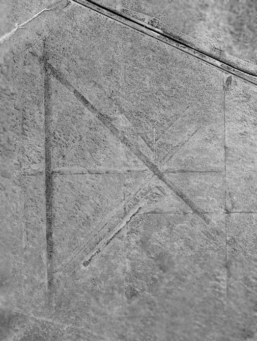
The Aragon Field runways had deteriorated greatly & were barely discernible in the 1996 USGS aerial photo.
Aragon Field was not depicted at all on recent aeronautical charts or USGS topo maps.
A 4/20/12 aerial photo showed the runways of Marfa Aux AAF #5 have deteriorated greatly, but were still recognizable.
The site of Aragon Field is located adjacent to the south side of Route 90, adjacent to the south of the tiny town of Aragon.
____________________________________________________
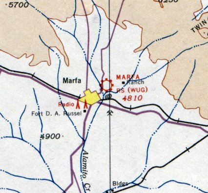
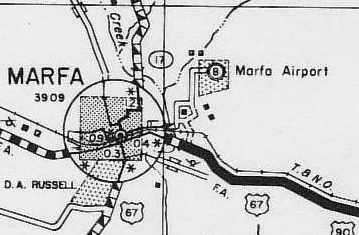
(Original) Marfa Airport / Marfa Auxiliary Army Airfield #7, Marfa, TX
30.33, -104 (Southeast of El Paso, TX)
Marfa “Army Air Service Field”, as depicted on the 5/1/24 Commerce Department Airway Bulletin (courtesy of Mike Denja).
The original municipal airport for the town of Marfa was located 2.7 miles northeast of the town.
According to the book "History of Marfa & Presidio County, TX" by Cecilia Thompson (via David Brooks),
the Marfa Municipal Airport at this location was originally built by the U.S. Army in 1919
for purpose of patrolling the Mexican border by airplane.
This installation was attached to Camp Marfa (later was renamed Camp Russell when it was made a permanent military establishment in 1927).
The Army's air patrols of the area were discontinued in 1923,
and the airfield was reportedly turned over to the town of Marfa which made it their Municipal Airport.
However the Marfa Municipal Airport continued to be used by the military on an as-needed basis until WW2.
The earliest depiction which has been located of Marfa “Air Service Field” was in the 5/1/24 Commerce Department Airway Bulletin (courtesy of Mike Denja).
It described Marfa as 1 square mile field leased & operated by the Army Air Service, with the best landing area measuring 3,425' north/south.
Two steel hangars “for Government aircraft” were depicted on the northwest side.
The U.S. Army’s 1st Cavalry Division was stationed at Camp Marfa during the 1920s.
A major U.S. Army maneuver took place at Marfa on 6/30/27, with 42 planes from San Antonio’s Kelly Field participating.
The planes would swoop down on strafing runs on the Mounted Cavalry, who were firing back up at the airplanes.
After the maneuvers, the planes flew on to Fort Bliss in El Paso.
The 1929 Rand McNally Standard Map of TX (courtesy of Chris Kennedy) described the Marfa “Army Airdrome” as being 270 acres in size.
The earliest aeronautical chart depiction which has been located of Marfa Municipal Airport was on the August 1935 El Paso Sectional Chart.
An aerial view looking east at the original Marfa Municipal Airport,
from the Airport Directory Company's 1937 Airports Directory (courtesy of Bob Rambo).
It described the Marfa Municipal Airport as having 4 sod runways, with the longest being the 4,800' northwest/southeast & northeast/southwest strips.
The aerial photo in the directory depicted the field as having 2 hangars, one of which was said to have "Marfa" painted on the roof.
The original Marfa Airport, as depicted on a 1940 Presidio County road map (courtesy of David Brooks).
At some point after the establishment of the much larger Marfa Army Airfield (which was built in 1942, several miles to the southeast),
Marfa's Municipal Airport was taken over by the military & became Marfa Auxiliary Airfield #7.
It was one of 6 satellite airfields used in support of Marfa AAF,
which conducted advanced flight training for the Western Flying Training Command in AT-17 twin-engine trainers & B-25 Mitchell bombers.
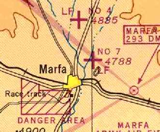
According to David Brooks, "Marfa Auxiliary #7 had 3 runways, only a maximum of approximately 5,000'.
The 3 runways were dirt/gravel and one (unidentified) had oil on top. It was really close into town."
Marfa Aux AAF #7, as depicted on the June 1944 El Paso Sectional Chart (courtesy of David Brooks).
In mid-1945, Marfa AAF & its auxiliary fields transferred to the Troop Carrier Command.
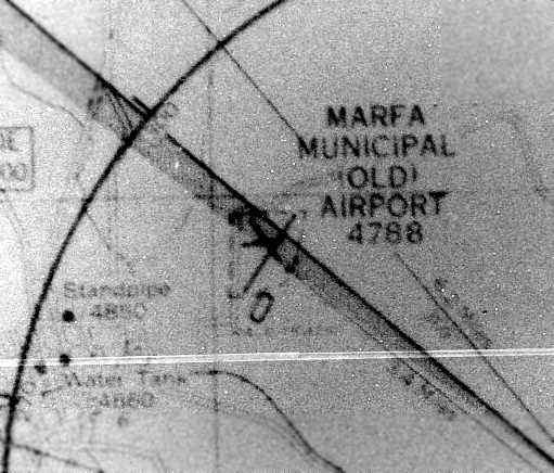
The “Marfa Municipal (Old) Airport”, as depicted on a 1945 Instrument Approach Chart (courtesy of Chris Kennedy).
It depicted the field as having 3 runways, with a racetrack located adjacent to the south side of the field.
According to the book "History of Marfa & Presidio County, TX" by Cecilia Thompson (via David Brooks),
after WW2, the Army offered the City of Marfa their choice of any of the Army Airfields surrounding the town.
The City selected the somewhat larger Marfa Auxiliary #4 (north of the town) as their new Marfa Municipal Airport.
The last aeronautical chart depiction which has been located of the original Marfa Municipal Airport was on the July 1946 El Paso Sectional Chart.
It depicted “Marfa Mun (Old)” as a commercial/municipal airport,
but also depicted “Marfa Mun (New)” to the north as an auxiliary airfield.
The original Marfa Municipal Airport was no longer depicted on the July 1948 El Paso Sectional Chart
or USGS topo maps.
Jerry Eoff reported in 2008, “There is an aerial photo in the Marfa Country Club Pro Shop that shows the golf course shortly after completion.
I think is shows the remains of at least some of the runways of Auxiliary #7.”
According to David Brooks, "The Marfa golf course sits on it now.
I spoke to a lady with the Presidio Historical Society & she said the field was there."
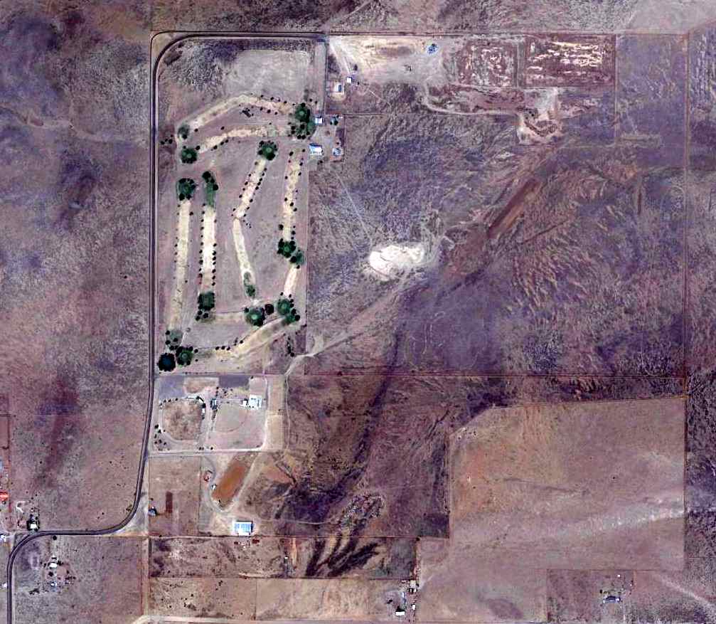
A 4/19/13 aerial photo of the site of the former Marfa Aux AAF #7, now occupied by a golf course.
The site of the Marfa Aux AAF #7 is located along the south side of Ranch Road 1112.
____________________________________________________
Since this site was first put on the web in 1999, its popularity has grown tremendously.
If the total quantity of material on this site is to continue to grow,
it will require ever-increasing funding to pay its expenses.
Therefore, I request financial contributions from site visitors,
to help defray the increasing costs of the site
and ensure that it continues to be available & to grow.
What would you pay for a good aviation magazine, or a good aviation book?
Please consider a donation of an equivalent amount, at the least.
This site is not supported by commercial advertising –
it is purely supported by donations.
If you enjoy the site, and would like to make a financial contribution,
you
may use a credit card via
![]() :
:
Please consider checking the box to make a monthly donatation.
For a mailing address to send a check, please contact me at: paulandterryfreeman@gmail.com
If you enjoy this web site, please support it with a financial contribution.
please contact me at: paulandterryfreeman@gmail.com
If you enjoy this web site, please support it with a financial contribution.
Or if you prefer to contact me directly concerning a contribution (for a mailing address to send a check),
please contact me at: paulandterryfreeman@gmail.com
If you enjoy this web site, please support it with a financial contribution.
____________________________________________________
This site covers airfields in all 50 states.