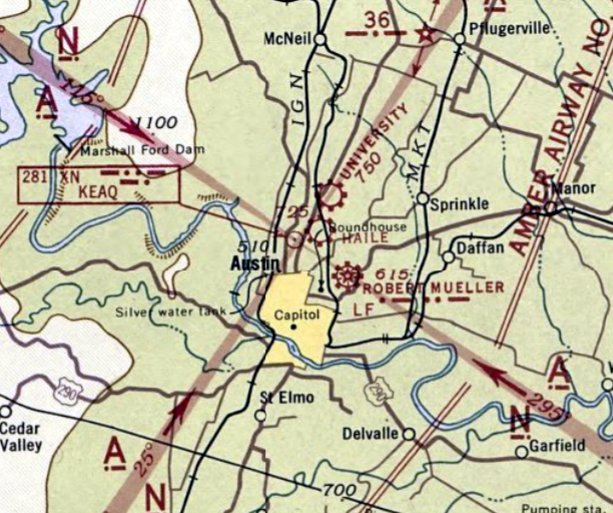
Abandoned & Little-Known Airfields:
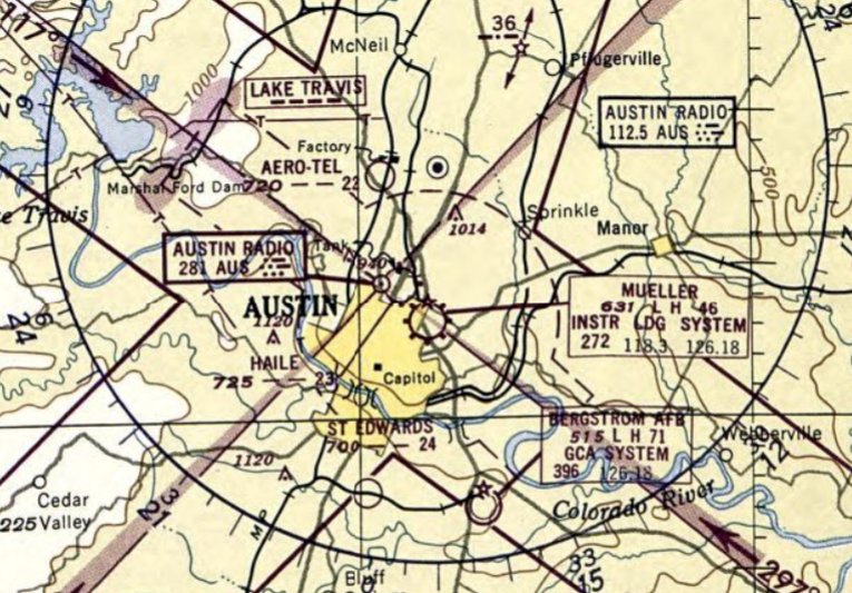
Texas: Western Austin area
© 2002, © 2024 by Paul Freeman. Revised 7/28/24.
This site covers airfields in all 50 states: Click here for the site's main menu.
____________________________________________________
Please consider a financial contribution to support the continued growth & operation of this site.
Haile Airport (revised 3/7/18) - Kittie Hill Airport (revised 3/10/21) - Penn Field (revised 7/28/24)
San Marcos Intermediate Field #30 / #31 / #31B / Thompson Field (revised 12/21/20)
(Original) San Marcos Municipal Airport / Robert Lowman Airport (revised 3/10/21) - University Airport (revised 5/18/22)
____________________________________________________
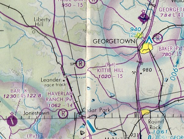
Kittie Hill Airport (77T), Leander, TX
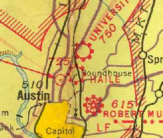
30.6, -97.823 (Northwest of Austin, TX)
Kittie Hill Airport, as depicted on the December 1976 San Antonio Sectional Chart.
Kittie Hill Airport was not yet depicted on the January 1972 San Antonio Sectional Chart (courtesy of Ron Plante).
According to its FAA Airport/Facility Directory data, this small general aviation airport was activated in March 1976.
The earliest depiction which has been located of Kittie Hill Airport was on the December 1976 San Antonio Sectional Chart.
It depicted Kittie Hill as a private airfield having a mere 1,500' unpaved runway.
The earliest photo which has been located of Kittie Hill Airport was a 2/28/82 USGS aerial view.
It depicted the field as having 3 unpaved runways, with multiple small hangars hangars on the northeast side.
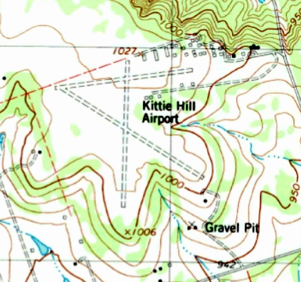
The 1987 USGS topo map depicted Kittie Hill Airport as having 3 unpaved runways, with a large number of small hangars on the northeast side.
The May 1993 San Antonio Sectional Chart (courtesy of Ron Plante) depicted Kittie Hill as a public-use airport having a 3,400' unpaved runway.
A 1/6/96 USGS aerial view looking west depicted Kittie Hill Airport as having 3 grass runways, with multiple small hangars hangars on the northeast side.
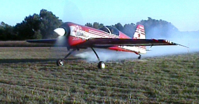
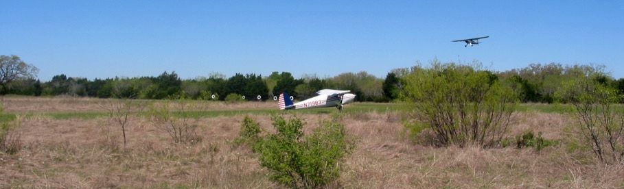
A 10/3/3 photo by Eric Dierks of a 1989 Su-26, a Russian competition aerobatic plane, with its smoke system activated at Kittie Hill Airport.
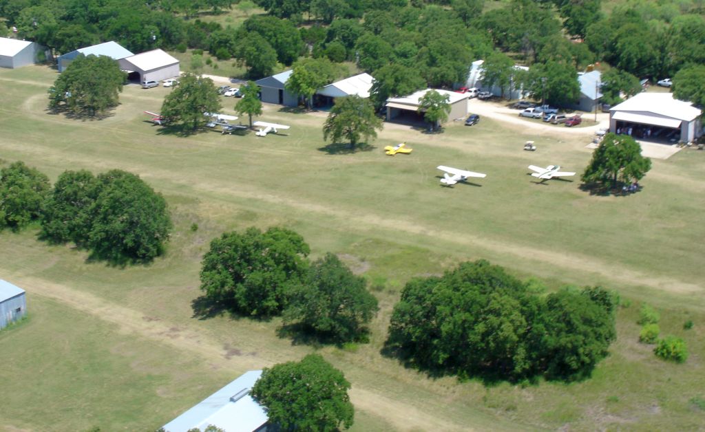
A 6/18/05 aerial view of a good number of light planes at Kittie Hill Airport.
A 2005 photo by Nathan Clay of Luscombes at Kittie Hill Airport, “for a Luscombe gathering aka 'CHILI FLY IN'. We had quite the turnout.”
A 2005 photo by Nathan Clay of Luscombes at Kittie Hill Airport.
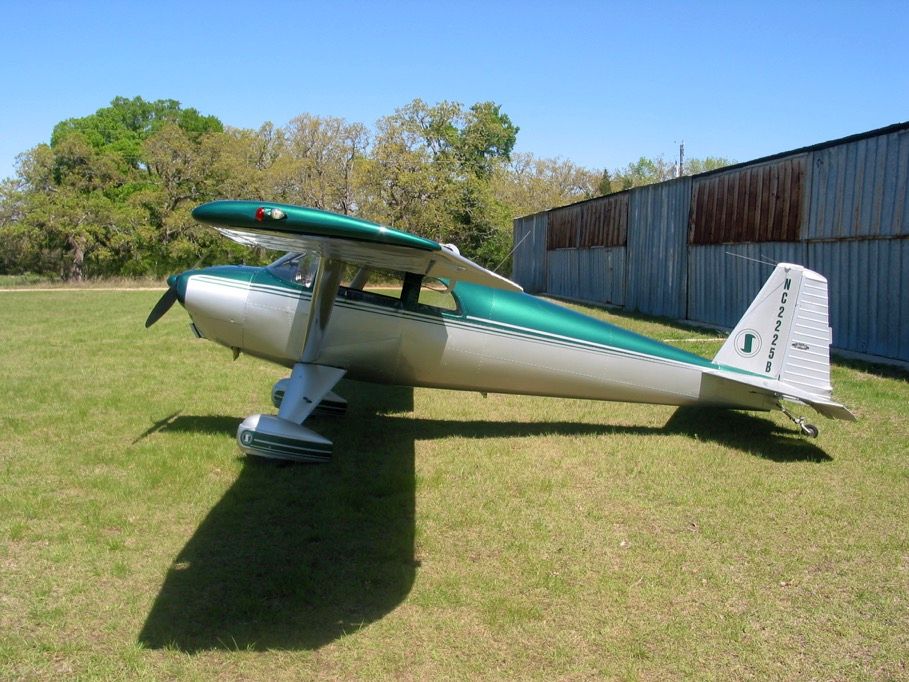
A 2005 photo by Nathan Clay of a Luscombe at Kittie Hill Airport.
As of 2013, the FAA Airport/Facility Directory data described Kittie Hill as having 3 turf runways, the longest being the 3,450' Runway 7/25.
All 3 were described as being “in poor condition”.
The owner & manager were listed as Charles Densford.
Kittie Hill was said to have 71 based aircraft, of which 13 were homebuilt,
and to conduct an average of 62 takeoffs or landings per day.
According to Cynthia Grant, “The number of aircraft - that number has always puzzled me;
I think there were probably 71 hangars & maybe 60 or so flyable airplanes up until a couple of years ago.
Some hangars were used to store non-flyable airplanes, airplane parts, and a couple contained non-aviation 'stuff'.
The 62 daily operations number was probably true in the 1990s when there was a flight school on the field, but there hasn't been that much activity in several years.
There is a hangar shortage in the Austin area so the hangars were usually full.
The economic downturn in 2008 probably gave us an extra 5 years.”
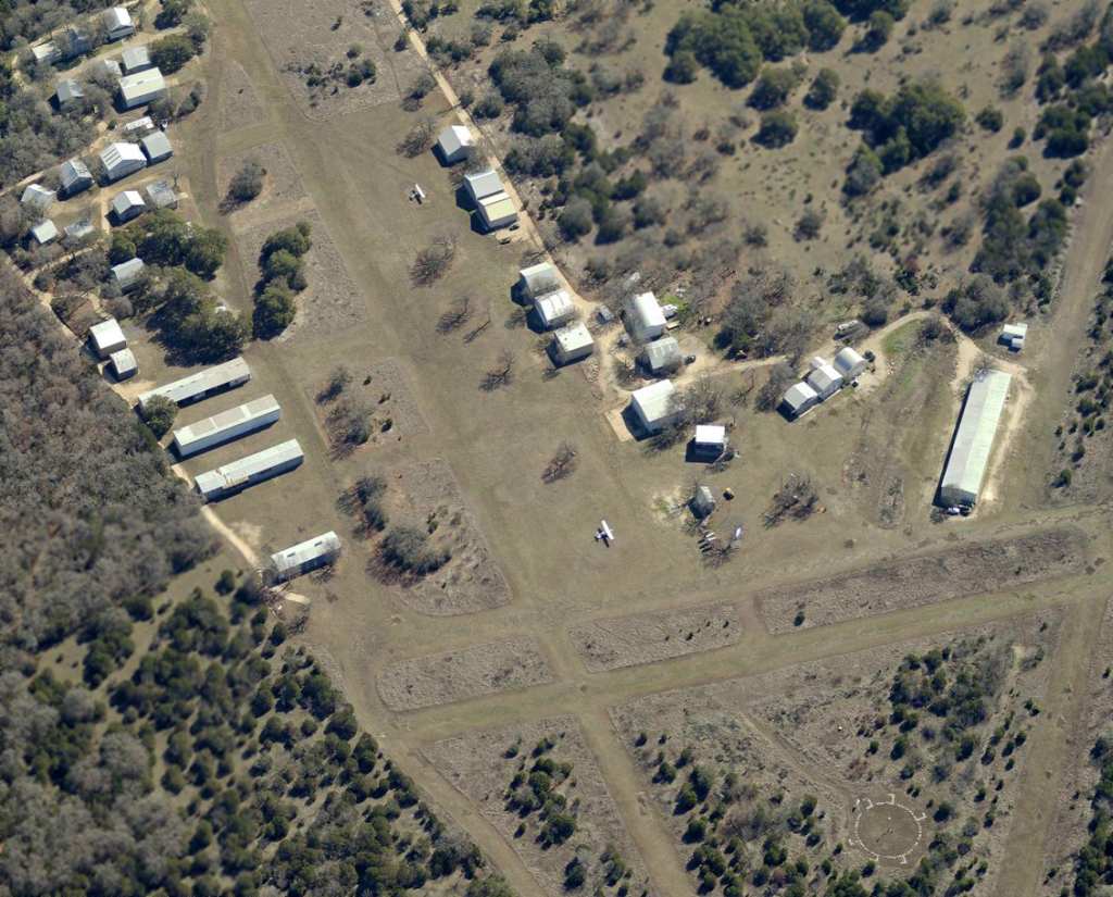
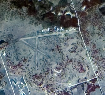
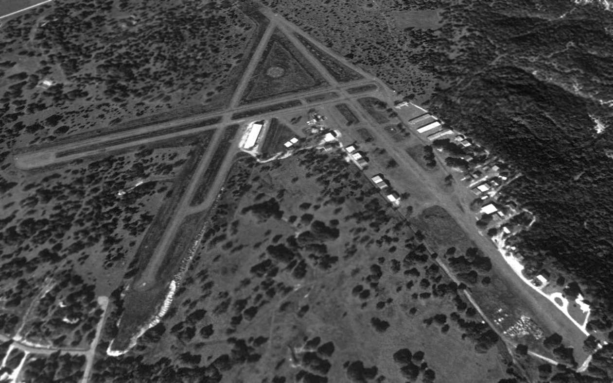
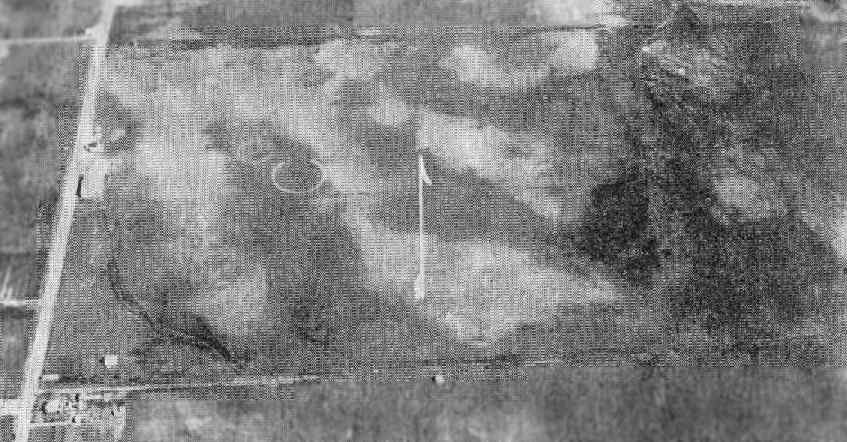
A circa 2008-2013 aerial view looking east at the large number of small hangars on the northeast side of Kittie Hill Airport.
Also visible are 2 single-engine aircraft, portions of 3 grass runways, and the segmented circle marking.
A 10/31/13 aerial view looking west depicted the 3 grass runways & multiple hangars at Kittie Hill Airport,
but only a single aircraft was visible parked outside.
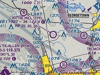
The 2013 Sectional Chart depicted Kittie Hill Airport as a public-use airport having a 3,400' unpaved runway.
Cynthia Grant reported in on 1/1/14, “I kept my plane there for 20+ years.
Kittie Hill has been sold to developers - it is basically closed as of yesterday.”
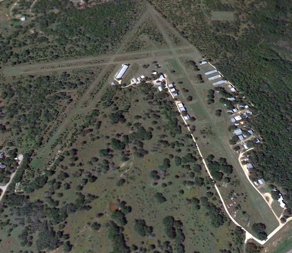
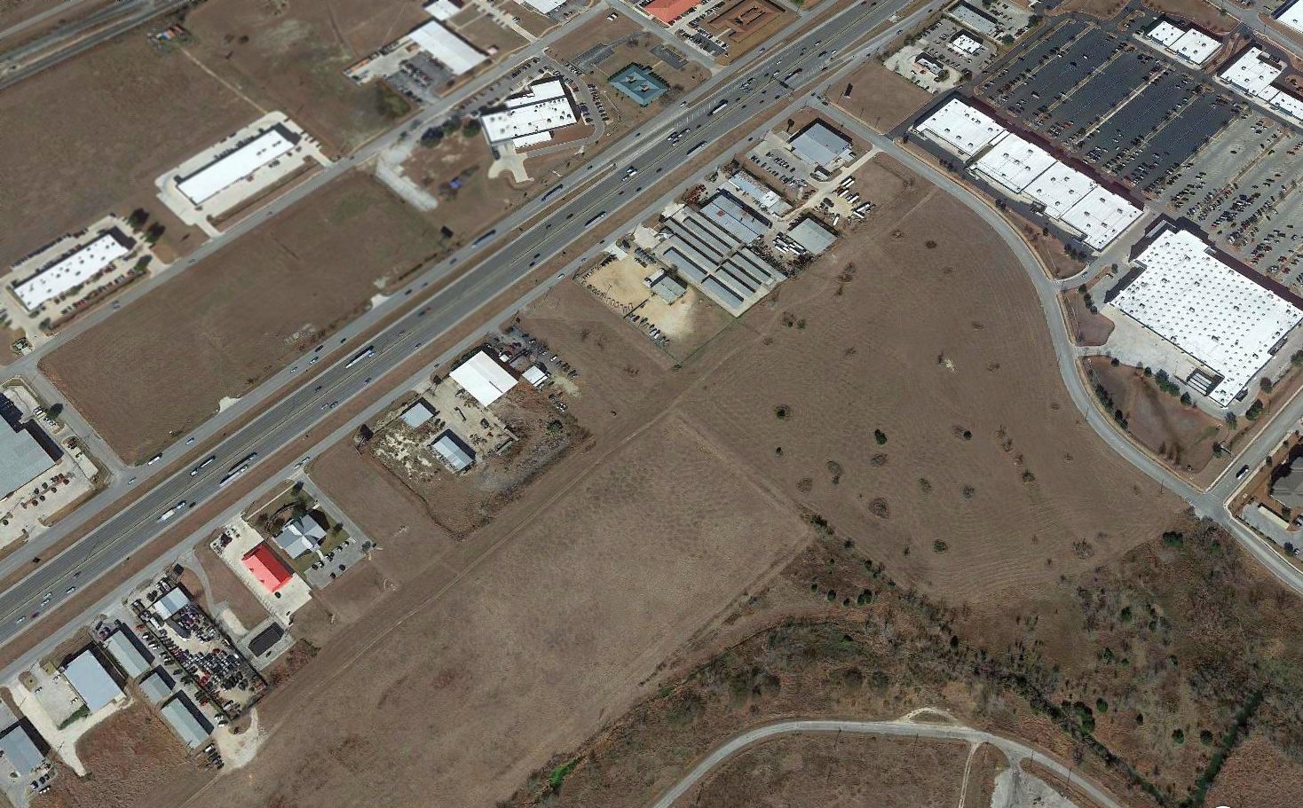
A 2014 aerial photo showed a sad & dramatic difference:
every single hangar & building at Kittie Hill Airport (more than 30) had been removed at some point between 2013-2014.
The runways still remained intact though.
A 2015 aerial photo showed residential streets starting to cover the site of Kittie Hill Airport.
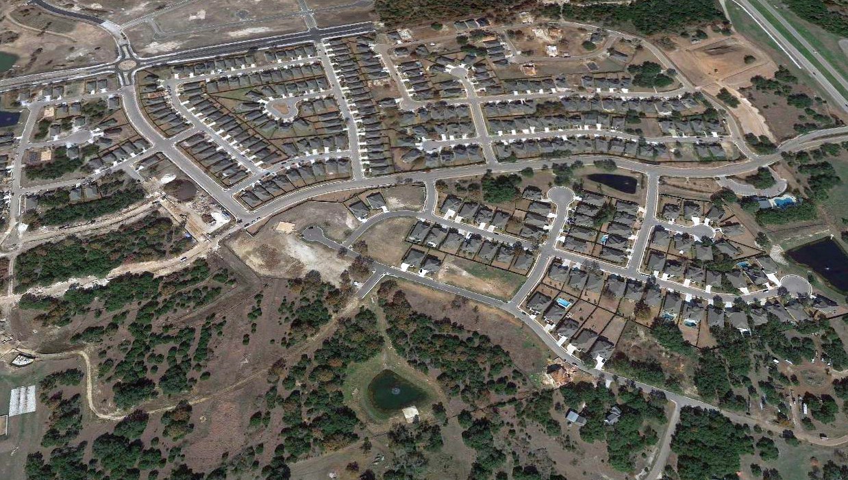
A sad sight for anyone who appreciates grassroots aviation: a 2019 aerial view looking north shows houses covering the site of Kittie Hill Airport, unrecognizable as a former aifield.
The site of Kittie Hill Airport is located northeast of the intersection of Ronald Reagan Boulevard & Hero Way.
____________________________________________________
30.23, -97.76 (South of Downtown Austin, TX)
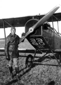
A circa 1917-18 photo of a Jenny biplane at Penn Field.
As America entered World War I & saw a need for aviators,
many US cities stepped up & provided facilities to encourage training in the new art of flying.
Austin was no exception, with local boosters jockying to get Army Air Corps training opportunities for the Central Texas area.
In 1917 the Austin Chamber of Commerce secured options on 1,700 acres south of Austin,
some of which had been part of the Blocker Ranch.
General George Squire, chief signal officer of the United States Army Signal Corps,
deemed 150 acres suitable for a landing field; he approved the site in September 1917.
Penn Field was named after Austin aviator Eugene Doak Penn, who died while training in Italy on 5/20/18.
It was established for use of the School of Military Aeronautics conducted by the University of TX for the federal government.
It was not until 1918 before planes started landing at Penn Field, and in doing so they encountered several obstacles.
Lt. John McCurdy, commander of advanced cross-country & formation flying at Kelly Field,
made a flight into the field & approved it except for the rocks & cornstalks.
The Chamber of Commerce appointed a cleanup committee,
and on 4 Sundays in September volunteer labor, including Boy Scouts & boys from the Deaf & Dumb Institute
picked up & hauled away 317 truckloads of rocks from the surface.
Lt. McCurdy subsequently began bringing in flights of 12-20 planes several times a week.
In March 1918 the University of TX was authorized to establish a radio school at the site.
The university took up the option on the land & purchased 318 acres for $40,000.
A railway track was laid to the site, and by November 1918 five brick buildings totaling 168,000 square feet were constructed.
The Chamber of Commerce has insisted on brick buildings since they intended for them to be used as factories after the war.
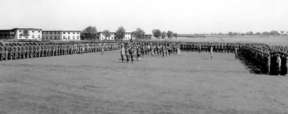
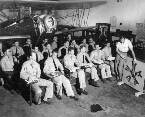
A circa 1917-18 photo of soldiers training at Penn Field.
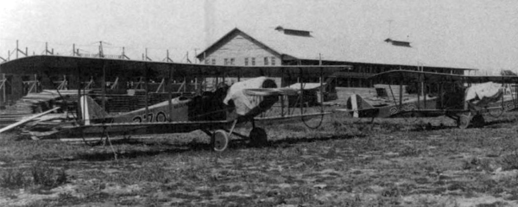
A circa 1917-18 photo of JN-4 trainers at Penn Field. (courtesy of Rob Schmidt).
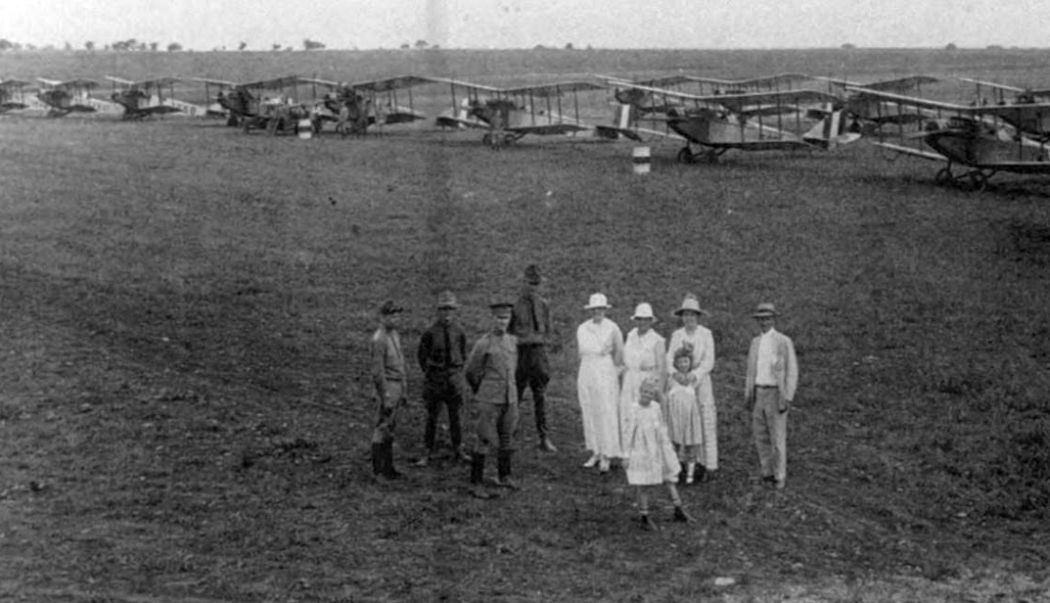
A circa 1917-18 photo of members of the Austin community meeting officers at Penn Field. (courtesy of Rob Schmidt).
After the war ended in 1918 the Penn Field site was auctioned off to the highest bidder for $107,000.
The Woodward Truck Body Company installed machinery there & manufactured wooden truck bodies
until the plant was destroyed by a tornado on 5/4/22.
The buildings were reconstructed, and the Woodward Furniture Factory went into operation in them
and manufactured furniture during most of the Great Depression.
Penn Field was not depicted on the February 1934 Austin Sectional Chart or the 1955 USGS topo map.
Over the years the state of the Penn Field buildings began to deteriorate.
In the fall of 2000 the buildings were renovated into modern office space.
Thankfully, the developers chose not to tear down the old brick buildings, but instead they built within them.
The buildings are completely modern inside with an aged exterior that hints at its history.
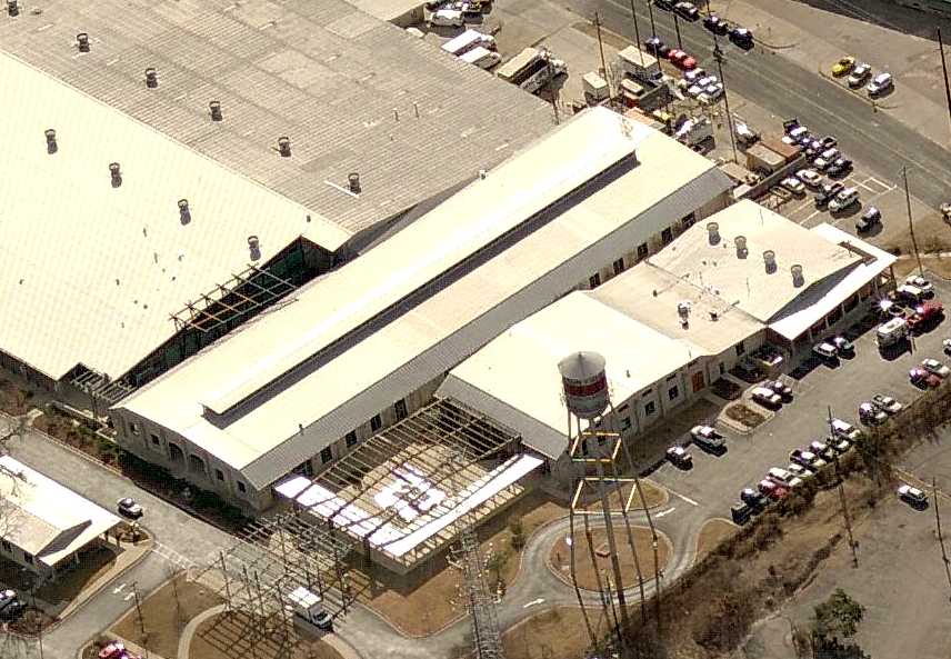
A circa 2007 aerial view looking south at the buildings which remain at the site of Penn Field.
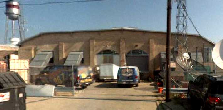
A 2008 photo looking north at the Penn Field building.
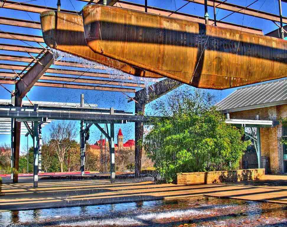
A 2010 photo of a fountain at Penn Field which appears to have been constructed of 2 airplane wings.
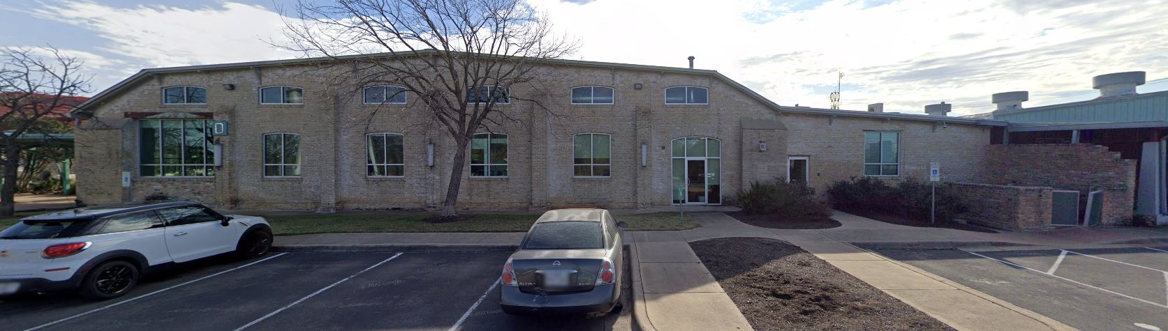
A January 2022 photo looking southeast at the Penn Field building.
The site of Penn Field is located east of the intersection of South Congress Avenue & Alpine Road West.
____________________________________________________
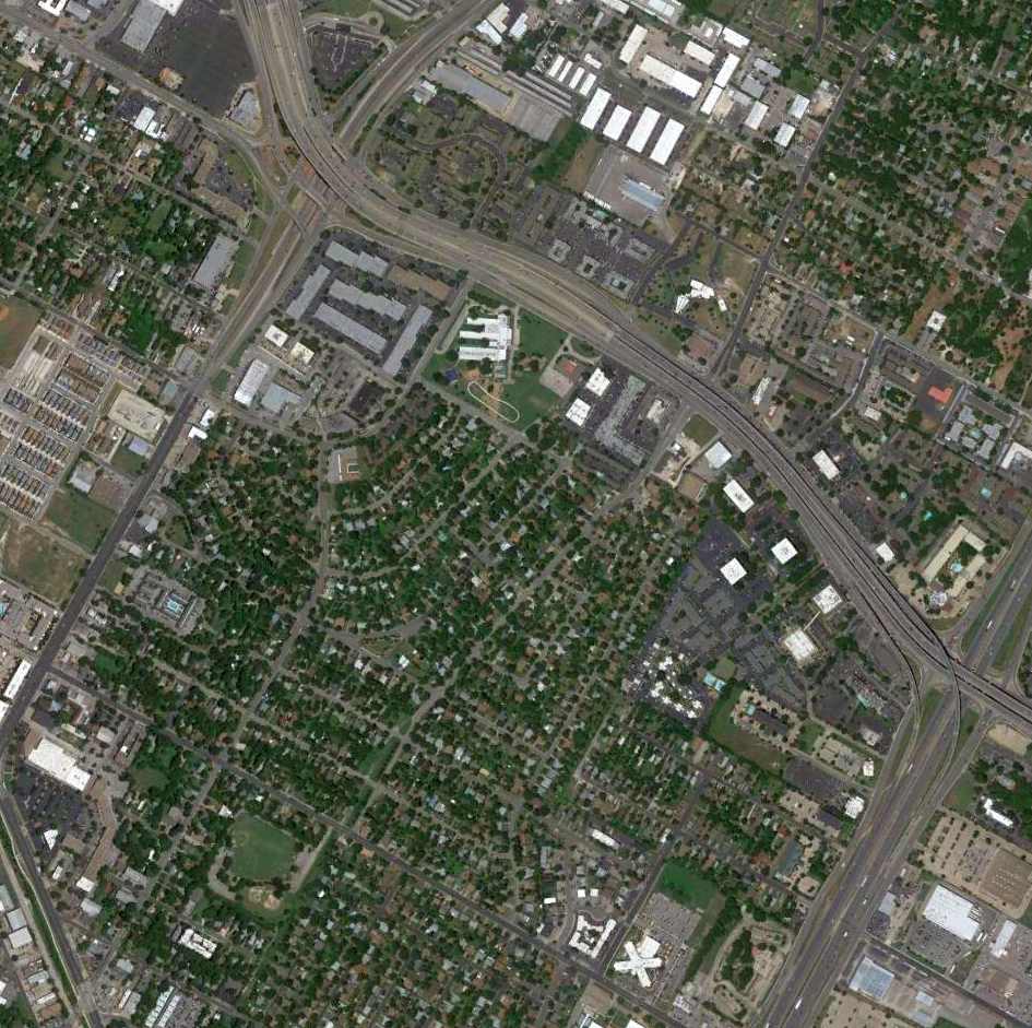
University Airport, Austin, TX
30.345, -97.71 (Northwest of Austin Mueller Airport, Austin, TX)
University Airport was owned & operated by the University of Texas in Austin.
According to the book “Austin, Cleared For Takeoff” by William Ragsdale (courtesy of Rob Schmidt),
Webb Ruff began fixed base operations at University Airport in 1925.
The earliest photo which has been located of University Airport
was a November 1927 photo of 2 Waco GXE biplanes & a hangar (courtesy of Jeff Morrison).
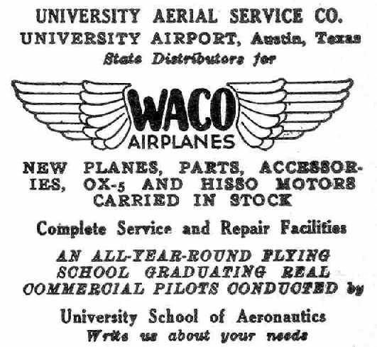
An advertisement for the University Aerial Service Company appeared in the 8/23/28 issue of Aviation Magazine (courtesy of Chris Kennedy).
The 1929 Rand McNally Air Trails Map (courtesy of Chris Kennedy)
described University as a commercial airport consisting of a 2,500' square landing area.
The operator was listed as S.W. Ruff.
The Airport Directory Company's 1933 Airport Directory (courtesy of Chris Kennedy)
described University as a commercial airport consisting of a 2,500' square sod landing area.
The hangar was said to have "University" & "Austin" painted on the roof.
The earliest aeronautical chart depiction which has been located of University Airport was on the 1934 Austin Sectional Chart.
The location of University Airport, as depicted on a 1936 TX State Highway Department map (courtesy of Chris Kennedy).
An aerial view looking north at University Airport,
from The Airport Directory Company's 1938 Airport Directory (courtesy of Chris Kennedy).
The directory described University as a commercial airport having 2 sod runways in an L-shape:
a 3,420' north-northeast/south-southwest & 3,130' west-northwest/east-southeast.
The hangar was said to have "University" & "Austin" painted on the roof.
Emma Carter Browning, a pioneer in Austin aviation, and her husband, barnstormer Robert Browning Jr.
started a Fixed Base Operation, Browning Aerial Services, at University Airport in 1939,
and trained many thousands of aviators in the years to come.
University Airport, as depicted on the 1940 Austin Sectional Chart (courtesy of David Brooks).
A 1940 aerial view (courtesy of Rob Schmidt) depicted University Airport as having 3 unpaved runways & a building along the west side.
The Airport Directory Company's 1941 Airport Directory (courtesy of Chris Kennedy)
described University as a commercial airport having 2 sod runways in an L-shape:
a 3,420' north-northeast/south-southwest & 3,130' west-northwest/east-southeast.
The hangar was said to have "University" & "Austin" painted on the roof.
A circa 1942 photo (courtesy of the UT library, via David Brooks)
of unformed cadets undergoing aviation training at University Airport.
A 1943 aerial view looking north at University Airport, from the 1945 AAF Airport Directory (courtesy of Chris Kennedy).
It depicted the field as having 3 unpaved runways.
The April 1944 US Army/Navy Directory of Airfields (courtesy of Ken Mercer) described University Airport as having a 2,600' unpaved runway,
and also indicated that Navy flight operations were conducted from the field.
The Haire Publishing Company's 1945 Airport Directory (courtesy of Chris Kennedy)
described University as having 2 asphalt runways in an L-shape: 3,000' north/south & 2,090' northwest/southeast
[this was the only reference among several directories of University having a paved runway, so this may have been in error].
The field was said to be a "class 2" airport, privately owned & operated.
The field was said to have a hangar, and the manager was listed as Robert Browning.
Browning Aerial Services relocated from University to Austin's Robert Mueller Airport in 1946.
The February 1949 Austin Sectional Chart (courtesy of Chris Kennedy) depicted University as having a 3,400' unpaved runway.
University Airport was evidently closed at some point in 1949,
as a 9/26/49 aerial view looking west (courtesy of Jeff Morrison) showed the hangars being reused for non-aviation commercial puposes.
University Airport was no longer depicted on the 1950 Austin Sectional Chart (courtesy of David Brooks).
According to the book “Austin, Cleared For Takeoff” by William Ragsdale (courtesy of Rob Schmidt),
on 7/21/52 Webb & Myrtle Ruff deeded the 23 acres of University Airport to the Northway Crest Development Company.
University Airport was no longer depicted at all on the 1954 USGS topo map.

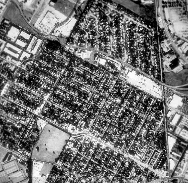
The last photo which has been located showing any trace of University Airport was a circa 1960 aerial view (courtesy of John Lane).
According to John, “It shows the University Airport site after closure but most of the buildings are still standing.
The location is Airport Boulevard at Lamar Boulevard (Dallas Highway back then)
across from the Jefferson Chemical Company near the International-Great Northern Railway (Southern Pacific) tracks.”
A 1964 aerial photo showed that the site of the former University Airport had been redeveloped.
Galen Blake reported in 2010 about a hangar-shaped building used by Alamo Glass, near the site of University Airport.
Galen reported, “This building has been extensively remodeled on the south half (right side) of the building
but remains in a more original state on the north half (left side) of the building.
In the un-remodeled side of the building (north), there are roof trusses and some posts on the side of the building but none in the interior of the building ... similar to a hangar.
I can offer no definitive proof on the original nature of these buildings.
The folks occupying these buildings are working for their respective companies & are not much interested in talking about subjects other than their own work.
If anyone wants to investigate this possible connection to the old airport further, they should contact the building owners directly.”
However, John Thywissen reported in 2011 that county tax records show this building to have been built in 1945 or 1947,
and that it is located just south of the University Airport site.
A 2015 aerial photo did not show any recognizable large-scale trace remaining of the former University Airport.
Ally Leon reported that Red Velvet purchased the former University Airport hangar in 2017.
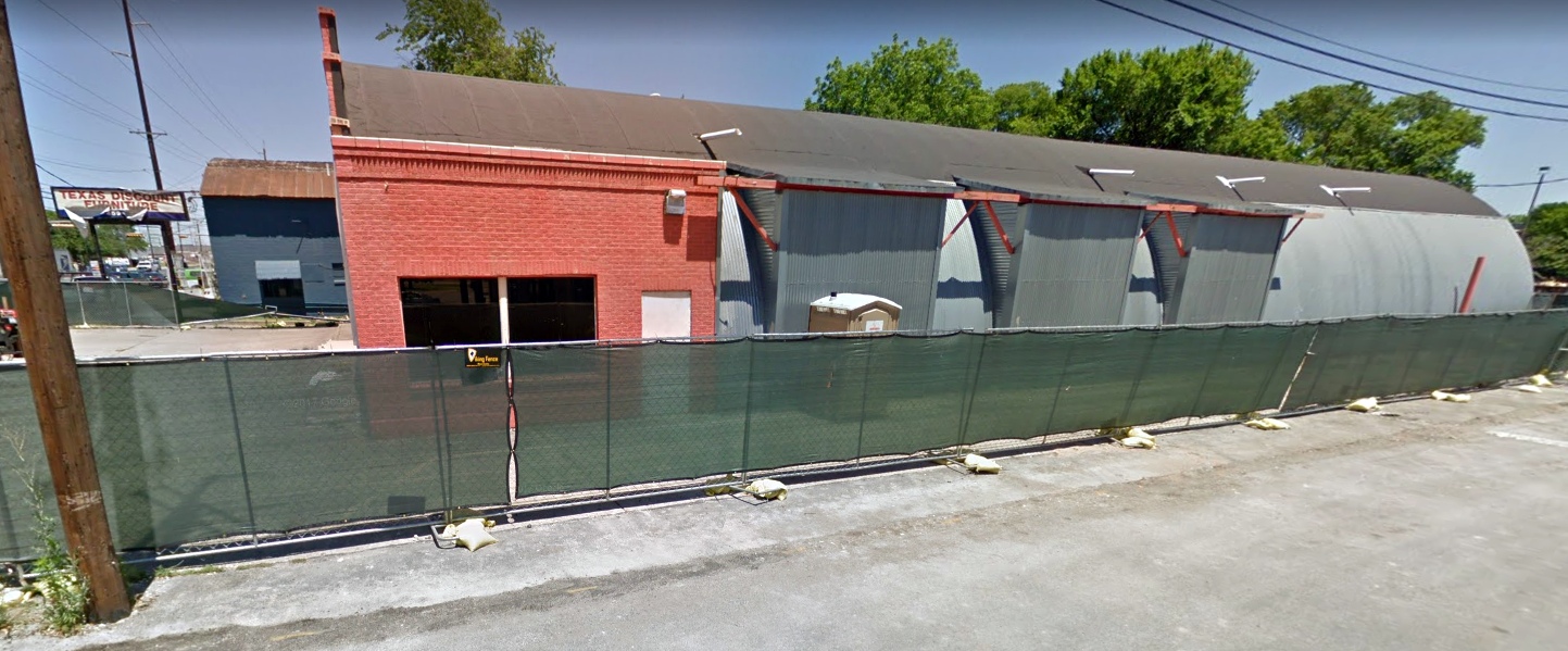
A May 2017 photo (courtesy of William Tate) showed the former 3-arched roof University Airport hangar,
which had been reused as TX Discount Furniture, with a brick front that had been added after the airport's closure.
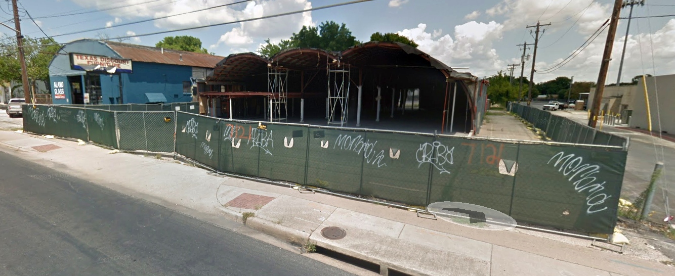
A July 2017 photo (courtesy of William Tate) showed the former 3-arched roof University Airport hangar,
which had been reused as TX Discount Furniture, after the brick front had been removed.
William Tate reported in 2019, “University Airport... There are at least 2 hangar buildings remaining on North Lamar Boulevard.
One, the wide,shorter building is currently Alamo Glass.
The 3-arched longer building was a cheap furniture store for many years.
It had a brick front added long ago that disguised the shape of the structure.
In the 1949 photo, this is the one that has 'Service' painted on the roof.
Both buildings were still there last time I was in the area. Austin is changing fast.
The chemical company across Lamar in that photo has been replaced with masses of apartments & condos.”
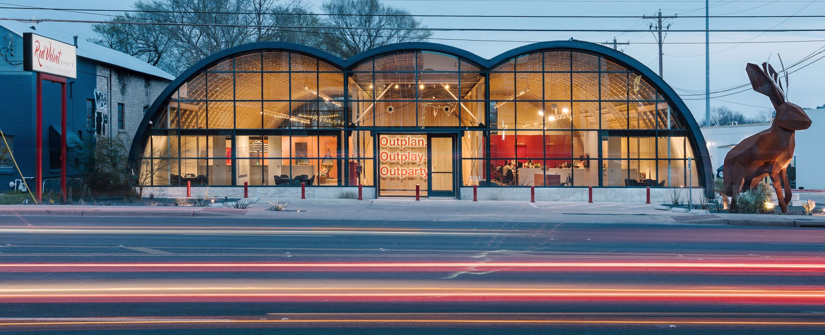
A 2/18/19 photo (courtesy of Ally Leon) of the former University Airport hangar, beautifully modernized as the Red Velvet facility.
Ally Leon reported, “We have completely remodeled the space, and have won multiple architecture & design awards for the renovations done to the former airplane hangar.”

A 2/18/19 photo (courtesy of Ally Leon) of the interior of the former University Airport hangar, beautifully modernized as the Red Velvet facility.
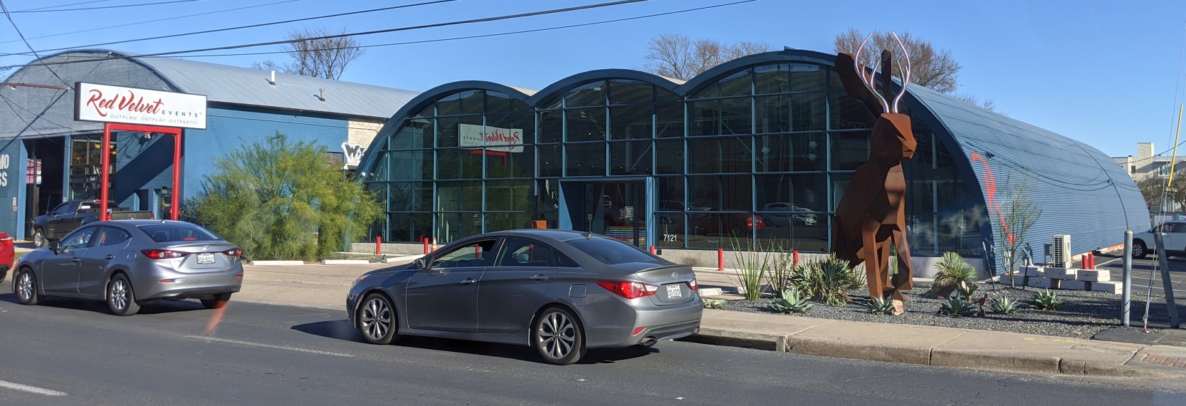
A 12/18/19 photo by Roy Stedman of the former 3-arched roof University Airport hangar, which has been beautifully modernized.
Roy reported, “The 3-arch hangar structure next to the brick Alamo Glass ex-hangar has been rebuilt into an events center.
Roy Stedman noted, “The location is at the intersection of Airport Boulevard & Lamar.
Further southeast, Airport Boulevard goes past the old Robert Muller Airport & ends somewhere in the highway mess at the Austin Bergstrom Airport.
I believe Airport Boulevard was constructed around or post-closure of University Airport,
but its location would have been well-known so probably contributed to the name.”
____________________________________________________
30.32, -97.72 (Northwest of Austin Mueller Airport, Austin, TX)
Haile Airport, as depicted on the August 1940 Austin Sectional Chart (courtesy of David Brooks).
Haile Airport was not yet depicted on the January 1939 Austin Sectional Chart.
According to Austin Explorer, Haile Airport was established in 1939 by Doc Haile, in what is now the neighborhood of Skyview.
The small facility was on 50 acres & primarily used for general aviation.
The earliest depiction which has been located of Haile Airport was on the August 1940 Austin Sectional Chart (courtesy of David Brooks).
The Airport Directory Company's 1941 Airport Directory (courtesy of Chris Kennedy)
described Haile as a commercial airport having 3 sod runways, with the longest being the 2,800' north/south strip.
The field was said to have a hangar.
During WW2 some GI flight training reportedly took place at Haile Airport.
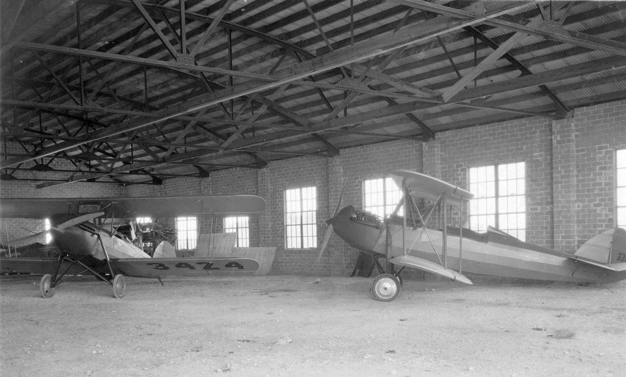
The only dated photo which has been located showing Haile Airport in operation
was a 10/24/43 aerial view looking north from the 1945 AAF Airfield Directory (courtesy of Scott Murdock).
It depicted Haile Airport as an open grass area with a few small buildings on the southwest side.
The April 1944 US Army/Navy Directory of Airfields (courtesy of Ken Mercer) described Haile Airport as having a 2,300' unpaved runway.
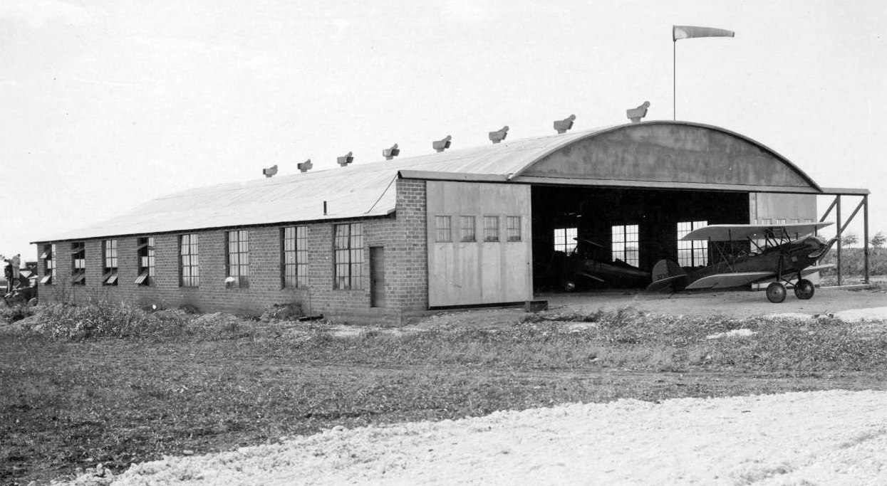
The 1945 AAF Airfield Directory (courtesy of Scott Murdock) described Haile Airport
as a 98 acre triangular property within which was a 2,300' x 1,900' sod all-way landing area.
The field was said to have 2 metal hangars, with the largest measuring 100' x 70'.
Haile Airport was described as being owned & operated by private interests.
The Haire Publishing Company's 1945 Airport Directory (courtesy of Chris Kennedy)
described Haile as a "class 1" airport, privately owned & operated.
The field was said to have a total of 4 gravel runways, with the longest being the 2,800' north/south strip.
The field was said to have 2 hangars. The operator was listed as the Haile Flying Service, and the manager was F. R. Haile.
An undated aerial view looking south (courtesy of Jeff Morrison) depicted Haile Airport as having 2 unpaved runways,
with 2 hangars & a dozen light aircraft on the south side.
The last depiction which has been located of Haile Airport was on the February 1950 Austin Sectional Chart (courtesy of David Brooks).
It depicted Haile as having a 2,300' unpaved runway.
According to the book “Austin, Cleared For Takeoff” by William Ragsdale (courtesy of Rob Schmidt),
Doc Haile had sold his remaining aircraft & terminated operations by the end of 1950.
Haile Airport was no longer depicted at all on the August 1950 Austin Sectional Chart or the 1954 USGS topo map.
A 1952 aerial photo showed houses had been built over most of the Haile Airport site, but 1 (or possibly 2) hangars remaining standing.
By the time of a 1964 aerial photo, the site of Haile Airport had been densely redeveloped, with only one hangar remaining.
A 1995 USGS aerial photo showed the site of Haile Airport has been densely redeveloped,
with the only remaining trace being the former hangar (the white building just above the center of the photo).
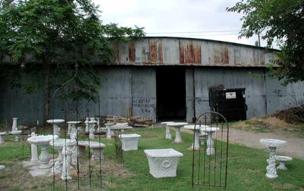
A 2004 photo of the front of the former Haile Airport hangar, with "Haile Flying Service" still faintly legible over the hangar door.
As of 2004 the only remaining sign of Haile Airport was one of its metal hangars.
The decaying structure served as storage space for Howard Nursery on Koenig Lane,
with "Haile Flying Service" still faintly ledgible over the hangar door.
The hangar was constructed of a metal frame with a corrugated metal surface that is attached to the frame with metal wire punched through the paneling.
Inside there was a large central area for plane storage, surrounded by spaces used for offices or storage spaces that occupied walled-off areas where the ceiling was lower.
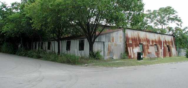
A 2004 photo of the back of the former Haile Airport hangar.
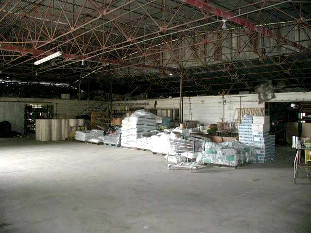
A 2004 photo of the interior of the former Haile Airport hangar.
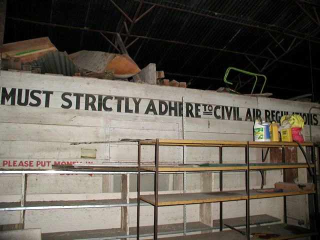
A 2004 photo of lettering which remains in the interior of the former hangar,
instructing that all "Must strictly adhere to Civil Air Regulations."
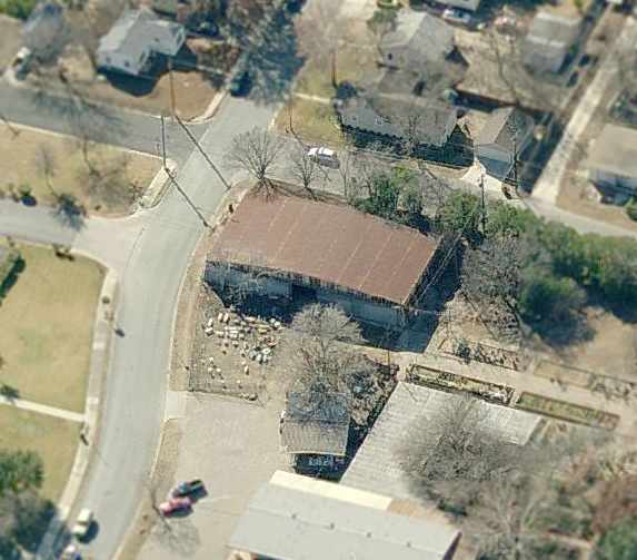
A circa 2005-2006 aerial view looking south at the remaining former Haile Airport hangar.
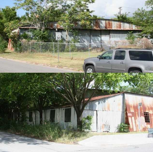
Two 2008 photos by Dick Merrill of the front & back of the former Haile Airport hangar.
Dick reported, “It doesn't look like the property has been sold yet.”
Tyler Kee reported that the Haile hangar was demolished in November 2013.
A December 2013 photo by Tyler Kee of the site of the Haile Airport hangar, now removed.
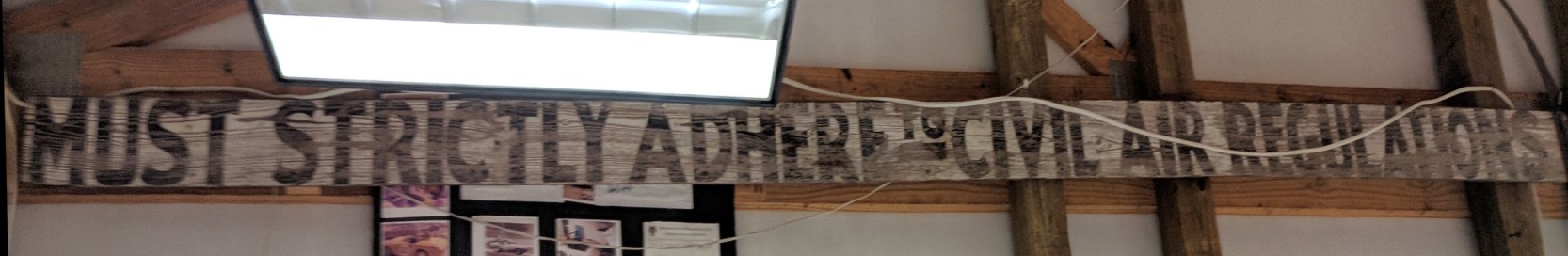
A 12/26/17 photo by Mike Jankowski of the wooden sign which previously hung in the interior of the Haile Airport hangar, instructing that all "Must strictly adhere to Civil Air Regulations".
Mike reported, “My friend has the sign from the Haile hangar hanging in his garage/shop in Georgetown, TX. It wasn't all lost to the loft apartments built on site.”
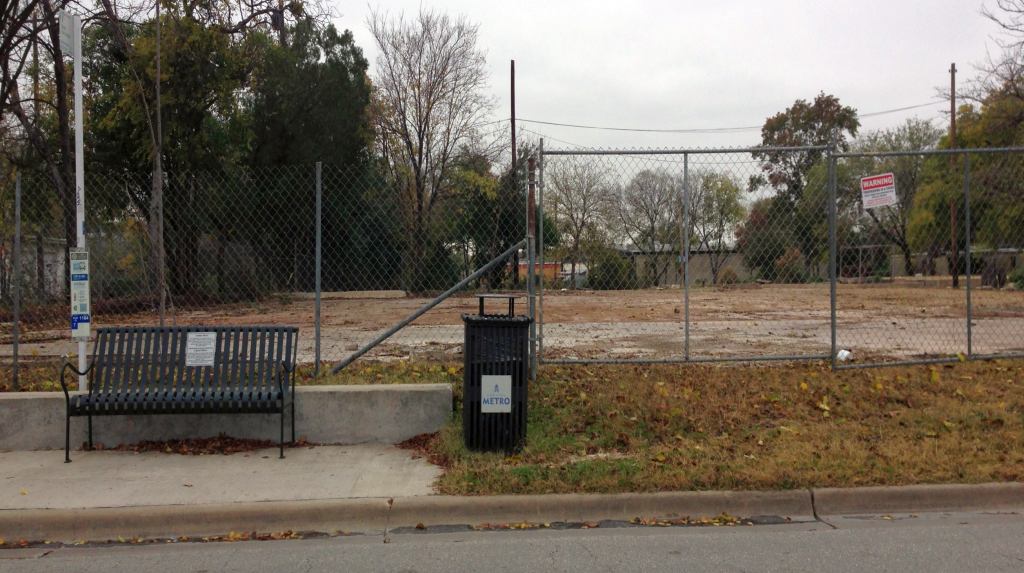
The site of Haile Airport is located at 111 East Koenig Lane, only 1.5 miles northwest of the site of Austin Mueller Airport.
Thanks to Konrad Kelly for pointing out this airfield.
____________________________________________________
San Marcos Intermediate Field #30 / Intermediate Field 31 / Intermediate Field 31B /
Thompson Field / San Marcos Airport, San Marcos, TX
29.864, -97.914 (Southwest of Austin, TX)
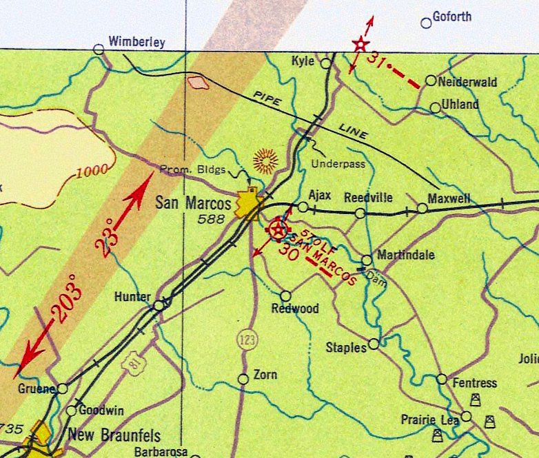
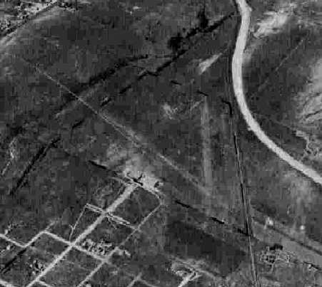
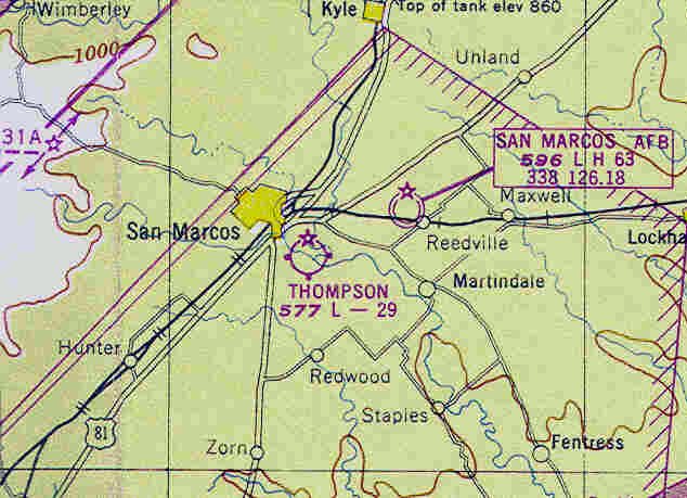
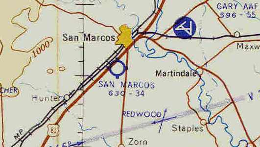
San Marcos Intermediate Field #30, as depicted on the 1934 San Antonio Sectional Chart.
The original airport for the town of San Marcos was located on the southeast side of the town.
It apparently was originally established by the Civil Aeronautics Administration as an Intermediate Field,
one of the network of such fields which were established along commercial airways between major cities.
The original San Marcos Airport was evidently established at some point between 1929-31,
as it was not yet listed at all in the 1929 Commerce Department Airway Bulletin (according to David Brooks).
The earliest reference to the San Marcos Airport which has been located was in the 1931 Commerce Department Airway Bulletin (according to David Brooks).
It was listed as the CAA Intermediate Field #30.
The earliest depiction of the airfield which has been located was on the 1934 San Antonio Sectional Chart, which depicted it as Site #30.
In 1934 the field was evidently redesignated as Site #31 (according to David Brooks).
In 1940 the field was redesignated yet again as Site #31B (according to David Brooks).
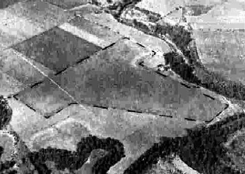
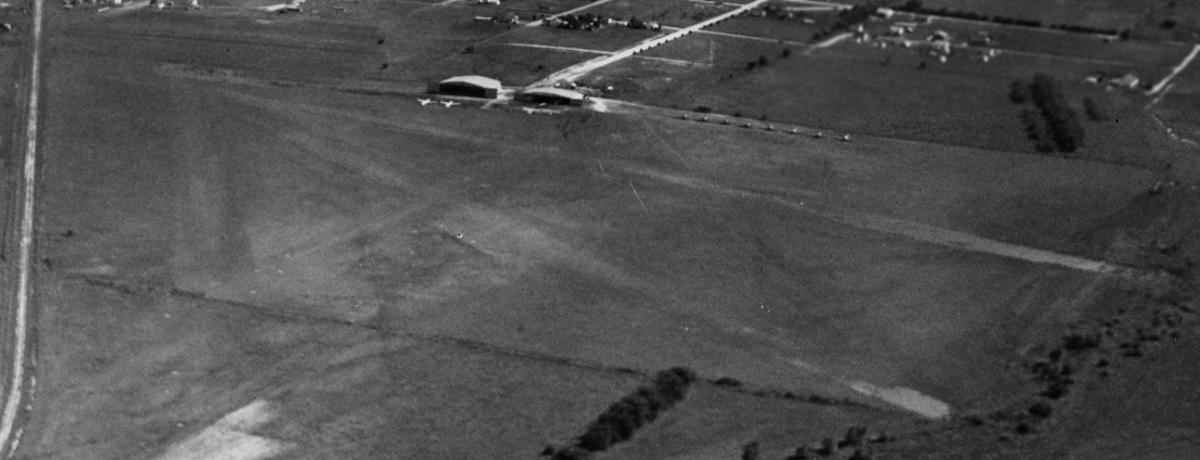
The only photo which has been located showing San Marcos Intermediate Field in operation
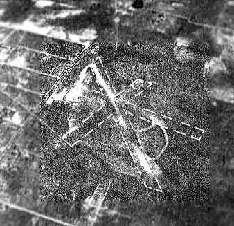
was a 10/24/43 aerial view looking north from the 1945 AAF Airfield Directory (courtesy of Scott Murdock).
It depicted “San Marcos Intermediate Field (Thompson Airport)” as an open grass area.
James Patton recalled, "I began taking flying lessons at the old San Marcos Airport in 1944.
I'm sure it was one of the emergency landing fields sited by the CAA, because it had the standard rotating airways beacon.
Ragsdale Flying Service of Austin operated the field, which also trained students at Southwest Texas State Teachers College
under the War Training Service (WTS), a sister government entity to CPTP & others.
In 1944 my first instructor still wore his khakis with WTS wings, so WTS must have been disbanded a short time before.
Several privately-owned airplanes were residents, among which were a Culver Cadet & a Buhl Pup.
For training, Ragsdale operated one or two J3 Cubs, a Piper J5 Cruiser, and a Meyers OTW biplane."
The San Marcos Airport was depicted as a municipal/commercial field on the 1945 San Antonio Sectional Chart (courtesy of John Voss).
The 1945 AAF Airfield Directory (courtesy of Scott Murdock) described “San Marcos Intermediate Field (Thompson Airport)”
as a 100 acre T-shaped property within which were 2 sod runways, measuring 2,900' northeast/southwest & 2,610' WNW/ESE.
The field was said to have a single wood & metal 100' x 60' hangar.
San Marcos Intermediate Field was described as being owned & operated by private interests, but “used as CAA Intermediate Field Site #31B”.
The 1946 Haire Publishing Company Airport Directory (according to David Brooks) listed the field as CAA Site 31B.
At some point between 1946-48 the airport was apparently renamed as "Thompson Field",
as that is how it was listed in the 1948 Haire Publishing Company Airport Directory (according to David Brooks).
The 1948 San Antonio Sectional Chart (according to David Brooks) also depicted the field as “Thompson”.
The January 1949 San Antonio Sectional Chart (courtesy of Chris Kennedy) depicted Thompson Field as having a 2,900' unpaved runway.
The 1950 San Antonio Sectional Chart (according to David Brooks)
described Thompson as having 2 crossing runways (with the longest being a 2,900' turf strip),
and indicated the field sold gas, and carried out minor & major repairs.
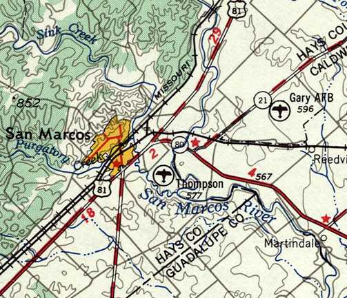
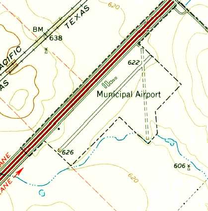
Thompson Field, as depicted on the 1953 USGS topo map.
Thompson Field was depicted on the August 1953 San Antonio Sectional Chart as having a 2,900' unpaved runway.
Thompson Field was evidently (briefly) renamed San Marcos Airport,
as that is how it was labeled on the February 1954 San Antonio Sectional Chart.
The Thompson Field / San Marcos Airport to the southeast of the town was evidently closed at some point in 1954,
it was no longer depicted on the August 1954 San Antonio Sectional Chart.
It was eventually replaced by a new San Marcos Municipal Airport, southwest of the town,
and the original airfield was apparently abandoned.
A 4/22/58 aerial view showed an open field, with no recognizable trace of Thompson Field.
James Patton reported in 2004, "Reacting to a fit of nostalgia, I drove to that location last year.
The hangar & beacon are both gone & the area is under cultivation."
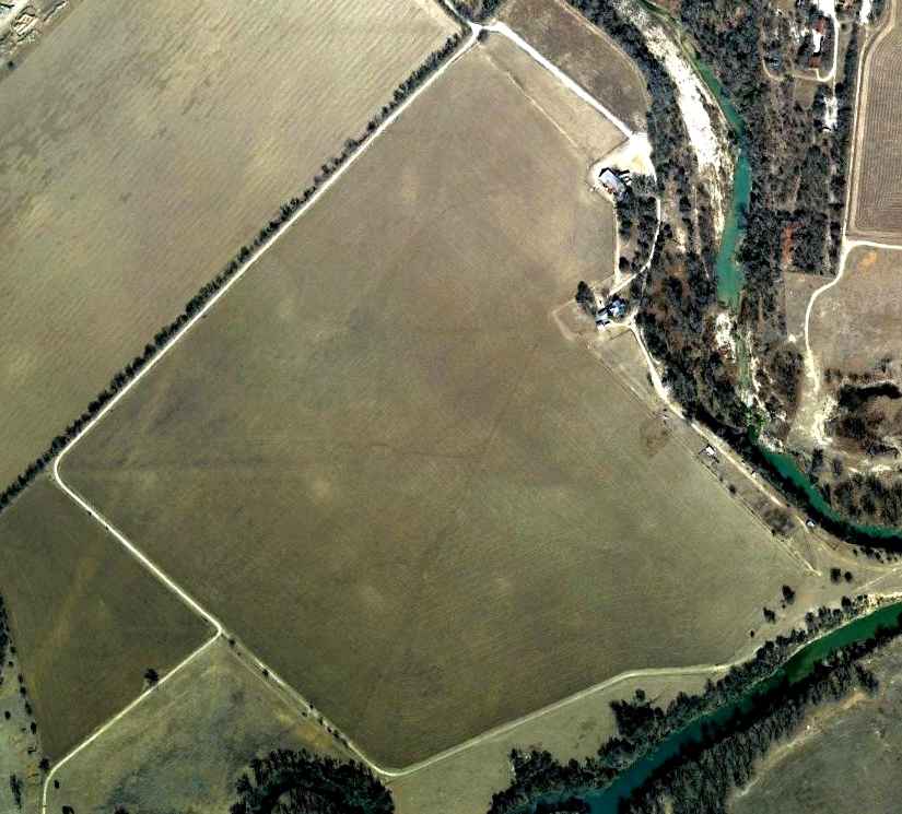
A 1/31/09 aerial photo did not depict any trace remaining of San Marcos Intermediate Field.
The site of Thompson Field is located southeast of the intersection of River Road & Old Martindale Road, just southwest of Thompson Road.
Thanks to David Brooks for pointing out this airfield.
____________________________________________________
(Original) San Marcos Municipal Airport / Robert Lowman Airport (5R6), San Marcos, TX
29.85, -97.96 (Southwest of Austin, TX)
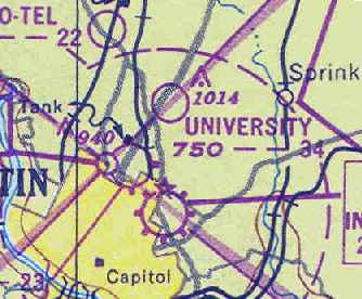
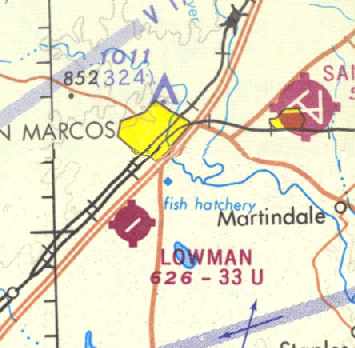
The original San Marcos Municipal Airport,
as depicted on the March 1960 San Antonio Sectional Chart (courtesy of Chris Kennedy).
The 2nd airport for the town of San Marcos was located 4 miles southwest of the town,
along the southeast side of Route 81 (what would eventually become Interstate 35).
The San Marcos Municipal Airport was not depicted on the 1955 San Antonio Sectional Chart (according to David Brooks).
According to a 4/23/84 article (courtesy of George Wilhite), “Lowman Airfield was opened in the mid-1950s.”
The earliest airfield directory reference to the San Marcos Municipal Airport which has been located
was in the 1957 Aviation Week & Business Flyers Airport Directory (according to David Brooks).
The earliest depiction of the San Marcos Municipal Airport which has been located
was on the 1958 San Antonio Sectional Chart (according to David Brooks).
According to George Wilhite, Joe Gafford operated the airport starting in the 1950s.
The March 1960 San Antonio Sectional Chart (courtesy of Chris Kennedy)
and the January 1961 World Aeronautical Chart (courtesy of Chris Kennedy)
described San Marcos as having a 3,400' unpaved runway.
San Marcos apparently gained a paved runway within the next year,
as the 1962 AOPA Airport Directory described San Marcos
as having a 3,400' asphalt Runway 4/22 & an 1,800' gravel Runway 17/35.
The operator was listed as B.E. Beecroft.
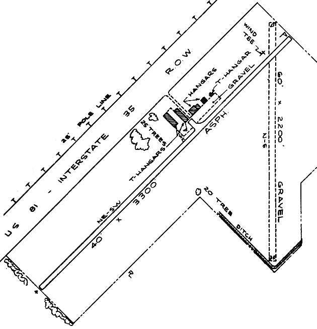
The 1963 TX Airport Directory (courtesy of Steve Cruse) depicted San Marcos as having a total of 5 hangars along the northwest side of Runway 4/22.
The airport manager was listed as A. Churchill, and the operators were listed as Gafford Aero Repair & San Marcos Aviation.
The 1964 USGS topo map depicted San Marcos Municipal Airport as having one paved northeast/southwest runway & an unpaved crosswind runway,
and 5 hangars along the northwest side.
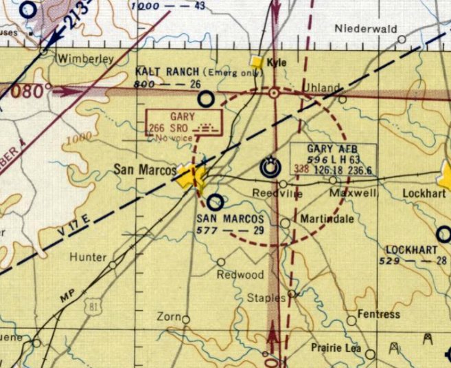
After the much larger Gary AFB (northeast of the town of San Marcos) had been closed by the military
and became the new San Marcos Municipal Airport,
the original San Marcos Municipal Airport was sold to Robert Lowman in late 1966,
and the field was renamed Robert Lowman Airport in 1967 (according to David Brooks).
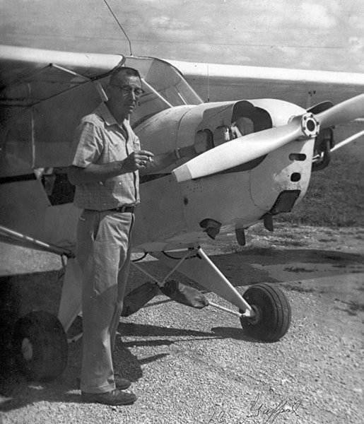
A circa 1950s-70s photo of Lowman Airport operator Joe Gafford with my George Wilhite's Piper Cub (courtesy of George Wilhite).
A 1967 aerial view by George Wilhite looking northeast at Lowman Field.
Lowman Airport was depicted on the 1968 San Antonio Sectional Chart (courtesy of David Brooks)
as having a single 3,300' paved runway.
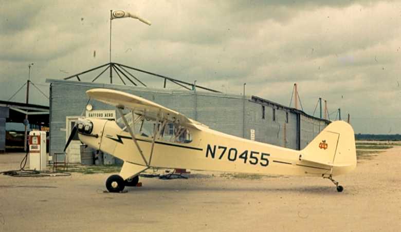
A 5/31/68 photo by George Wilhite of his Piper J-3 Cub (NC70455) parked by the fuel pump at Lowman.
George recalled, “Gafford Aero (Joe Gafford A&P/IA/pilot) was the FBO operator who rented hangars, sold fuel & did aircraft maintenance.”
Peter Maese recalled, “Robert Lowman Airport... AFROTC flight training was conducted there.
I received my private pilots license there in 1970 while attending Southwest TX State University.
Tom Webb was the chief pilot for the flight school. Many young ROTC students received their initial license at Lowman.”
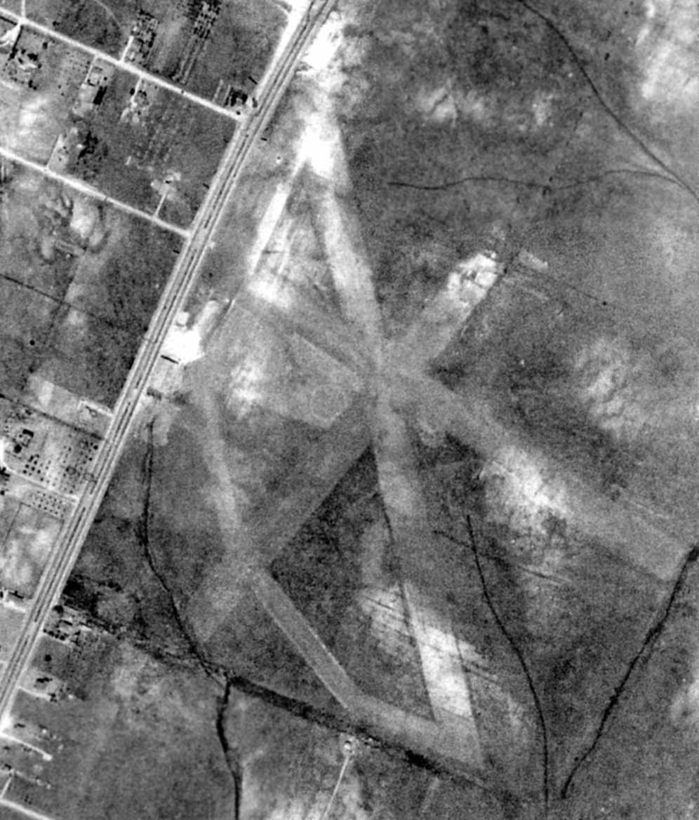
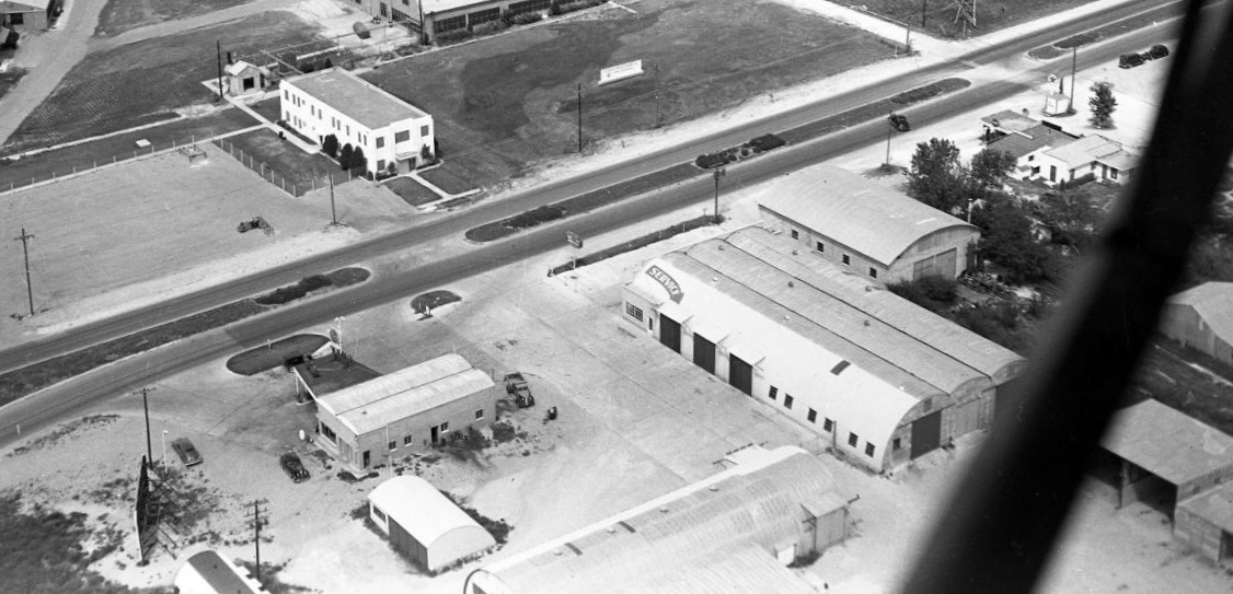
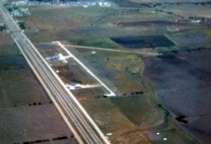
A 1973 aerial view depicted Lowman Airport as having a single paved northeast/southwest runway, along with the unpaved crosswind runway.
Several hangars were located on the northwest side of the field, around which could be seen a total of 7 light aircraft.
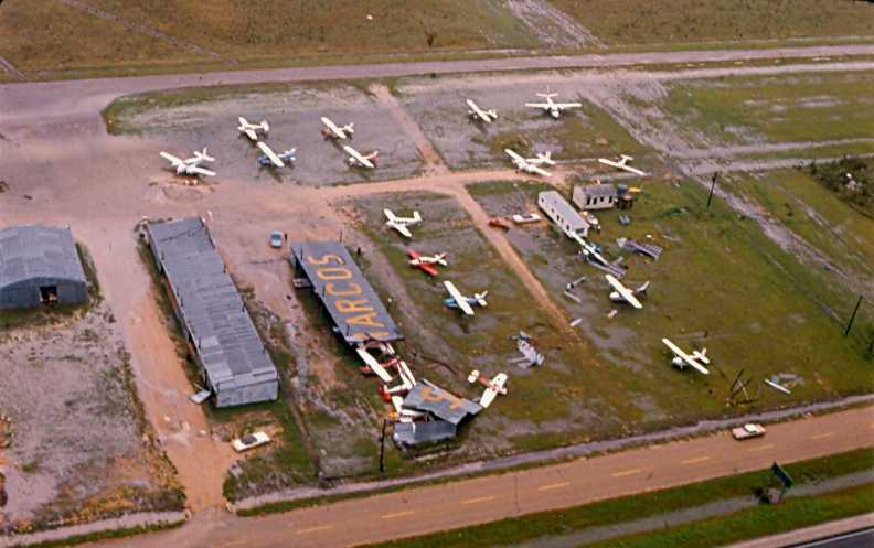
A May 1975 aerial view by George Wilhite looking east at Lowman Field,
“shows the damage from a wind & rain storm from the night before.”
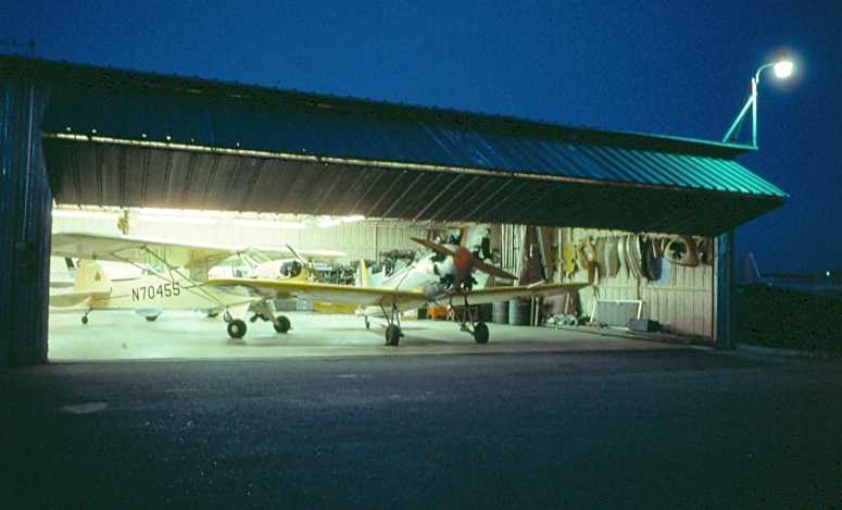
An August 1975 photo by George Wilhite of a nighttime view into a Lowman Field hangar,
“looking toward the lighted hangar highlights my Cub & Mr. Emmett McCoy's PT-22 (it possibly carried the Navy designation).”
According to George Wilhite, Joe Gafford operated Lowman Airport until his retirement in 1975.
The last aeronautical chart depiction which is available of Lowman Airport was on the December 1976 San Antonio Sectional Chart.
It depicted Lowman as having a single 3,300' paved runway.
Lowman Airport was still depicted on the 1980 San Antonio Sectional Chart (according to David Brooks).
Robert Lowman Airport was still listed as an active airfield in the 1982 AOPA Airport Directory (courtesy of Ed Drury),
and described as having a single 3,300' asphalt Runway 4/22 & a 2,200' gravel Runway 17/35.
Lowman Airport was apparently closed (for reasons unknown) at some point in 1982,
as it was marked “Closed” on the 1982 San Antonio Sectional Chart (according to David Brooks).
A 4/23/84 article entitled “Lowman Field closing June 7” (courtesy of George Wilhite) said,
“San Marcos City Council members this week voted to close down Lowman Airfield as of June 7.
The field had been used primarily by ultralight aircraft for the last few years.
Lowman had been closed to the public since December 1980.”
Lowman Airport was no longer listed among active airfields in the 1985 TX Airport Directory.
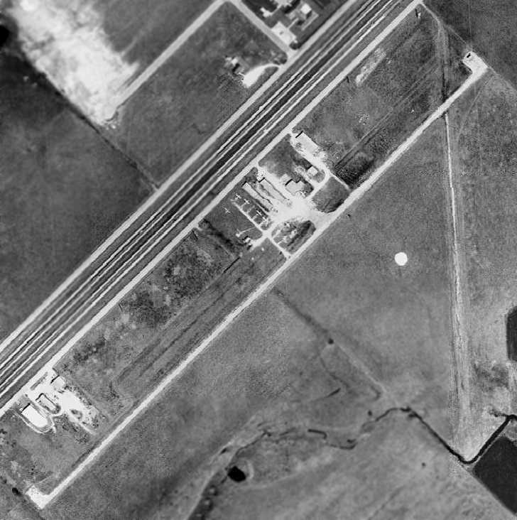
A 1986 aerial photo showed that the outline of both former runways was still perceptible,
but all of the pavement of the former Runway 4/22 had been removed except for a small portion along the northeast end,
which still had a closed runway "X" marking at its very end.
The former hangars still remained standing,
and were apparently being reused for some commercial purpose.
A 1995 USGS aerial view looking north showed the site of Lowman Field to remain in the same status as seen in 1986,
with the closed-runway “X” symbol still visible on the northeast end of Runway 22.
Garry Mangum recalled of the original San Marcos Airport,
"It was used for some time after it closed as a general aviation field for the flight of radio-controlled aircraft.
I flew there at couple of events on Memorial Day weekend during the late 1990s.
It sadly had to close also due to development."
The former airfield was no longer depicted at all (even as an abandoned airfield) on the 1998 World Aeronautical Chart.
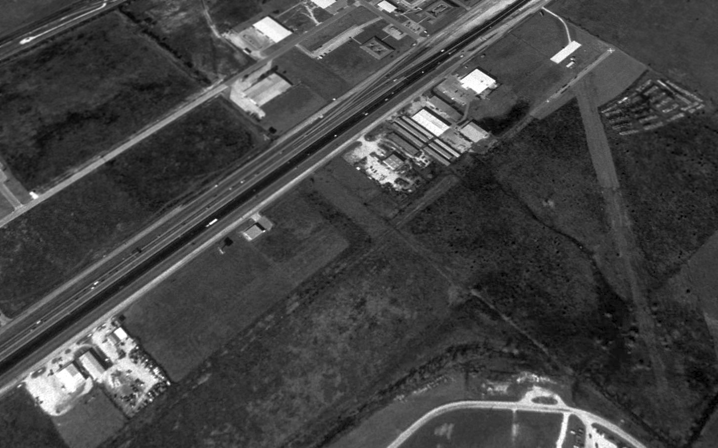
A 2018 aerial view looking north shows the site of Lowman Field is unrecognizable as a former airport,
but several former hangars remained standing along the northwest side.
The airfield site is located south of the intersection of Interstate 35 & Redwood Road.
____________________________________________________
Since this site was first put on the web in 1999, its popularity has grown tremendously.
If the total quantity of material on this site is to continue to grow,
it will require ever-increasing funding to pay its expenses.
Therefore, I request financial contributions from site visitors,
to help defray the increasing costs of the site
and ensure that it continues to be available & to grow.
What would you pay for a good aviation magazine, or a good aviation book?
Please consider a donation of an equivalent amount, at the least.
This site is not supported by commercial advertising –
it is purely supported by donations.
If you enjoy the site, and would like to make a financial contribution,
you
may use a credit card via
![]() :
:
Please consider checking the box to make a monthly donatation.
For a mailing address to send a check, please contact me at: paulandterryfreeman@gmail.com
If you enjoy this web site, please support it with a financial contribution.
please contact me at: paulandterryfreeman@gmail.com
If you enjoy this web site, please support it with a financial contribution.
____________________________________________________
This site covers airfields in all 50 states.