Abandoned & Little-Known Airfields:
Southwestern Oregon
© 2002, © 2024 by Paul Freeman. Revised 10/18/24.
This site covers airfields in all 50 states: Click here for the site's main menu.
____________________________________________________
Please consider a financial contribution to support the continued growth & operation of this site.
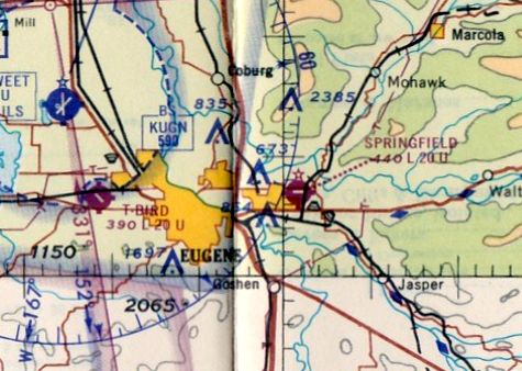
Crescent Airport / Daly Airport (revised 6/29/19) - Crissey Airport (revised 7/20/24) - (Original) Eugene Municipal Airport / Eugene Airpark (revised 10/18/24)
(Original) Grants Pass Airport (revised 12/8/23) - Harrisburg Airport / Commons Airport (added 12/31/22) - Springfield Airport (revised 2/27/23)
Sutherlin Valley Airport / Sutherlin Airport (revised 2/27/23) - Willamette Airpark / T-Bird Airport (revised 10/18/24)
____________________________________________________
Harrisburg Airport / Commons Airport, Harrisburg, OR
44.298, -123.149 (Southwest of Portland, OR)
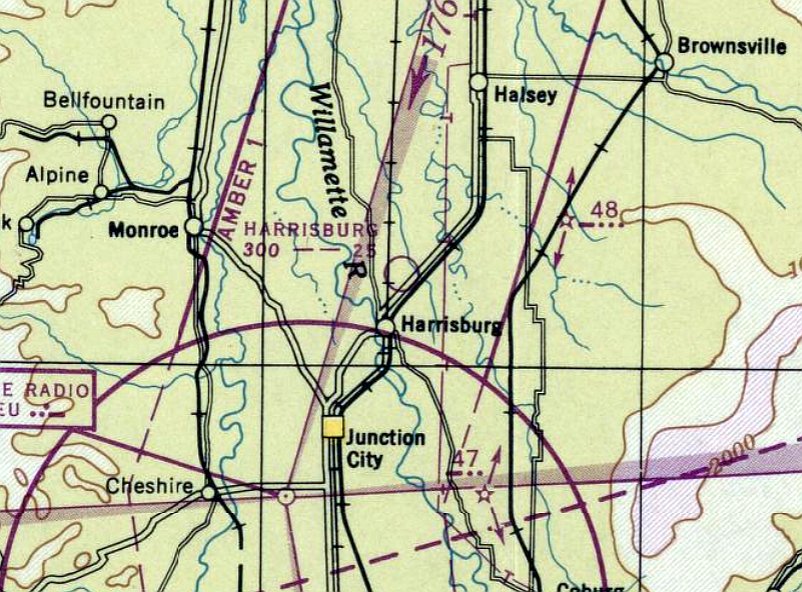
Harrisburg Airport, as depicted on the October 1946 Portland Sectional Chart.
This small general aviation airport was evidently established in 1946
(like hundreds of other small airports in the post-WW2 US general aviation boom),
as it was not yet depicted on the April 1946 Portland Sectional Chart.
The earliest depiction which has been located of Harrisburg Airport was on the October 1946 Portland Sectional Chart.
It depicted Harrisburg Airport as having a 2,500' unpaved runway.
The earliest photo which has been located of Harrisburg Airport was a 1954 aerial view.
It depicted 2 unpaved runways, with 2 T-hangars, a few other small buildings, and 1 or 2 light aircraft on the south side.
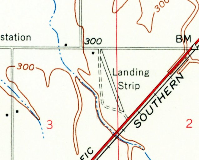
The earliest topo map depiction which has been located of Harrisburg Airport was on the 1957 USGS topo map (courtesy of Lee Corbin).
It depicted a single northwest/southeast runway, generically labeled as “Landing Strip”.
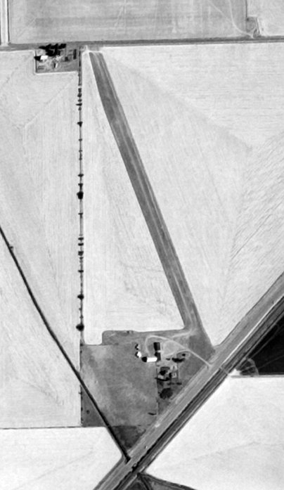
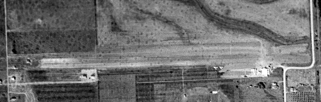
The earliest photo which is available of Harrisburg Airport was a 1967 USGS aerial view (courtesy of Lee Corbin).
It depicted a single northwest/southeast runway (with the previous north/south runway having been planted-over), with 2 T-hangars & a few other buildings on the southwest side.
The 1971 USGS topo map continued to depict the airfield in the same fashion as the 1957 USGS topo map.
The last aeronautical chart depiction which has been located of Harrisburg Airport was on the November 1971 Klamath Falls Sectional Chart.
It depicted Harrisburg Airport as a private airfield having a 2,400' unpaved runway.
Harrisburg Airport was evidently closed (for reasons unknown) at some point between 1971-82,
as a 1982 aerial photo showed the runways had been planted-over, and the 2 T-hangars had been removed at some point between 1967-82.
Harrisburg Airport was no longer depicted on the May 1985 Klamath Falls Sectional Chart or the 2014 USGS topo map.
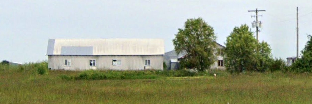
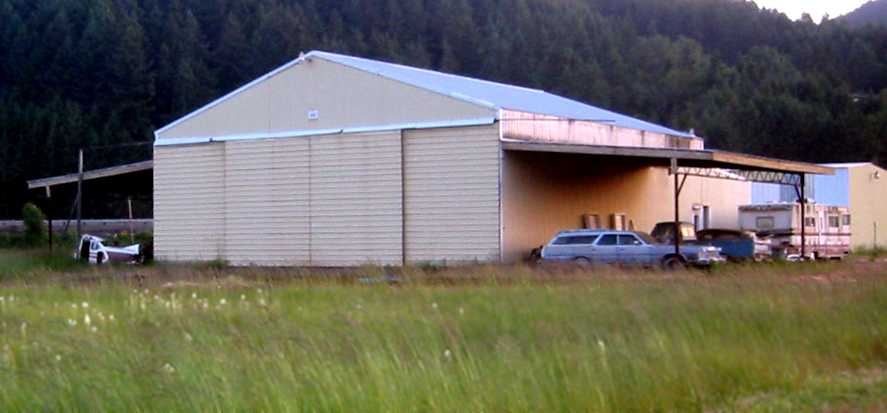
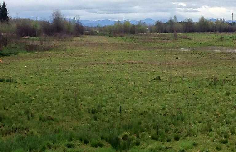
A May 2022 photo looking north at the buildings on the south side of the former Harrisburg Airport.
A 2022 aerial view looking northwest at the site of Harrisburg Airport showed no sign remaining of the runways.
As of 2022, road maps label the airfield site as “Commons Airport”, and the buildings on the south side as “Oregon Fresh Connection”, a florist.
Thanks to Lee Corbin for pointing out this airfield.
____________________________________________________
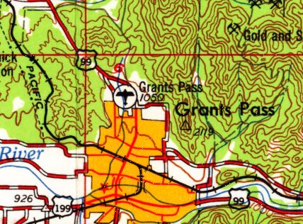
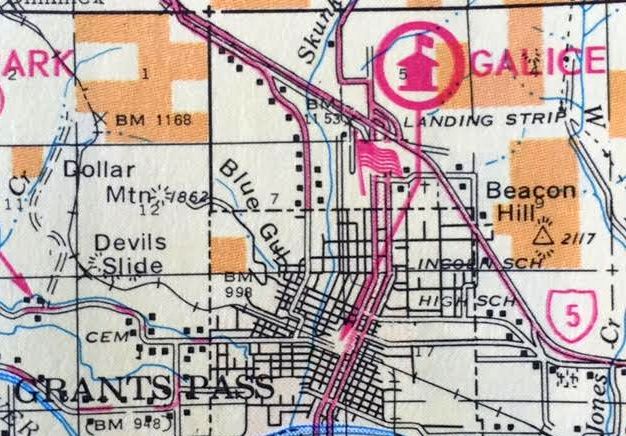
(Original) Grants Pass Airport / Josephine County Airport, Grants Pass, OR
42.46, -123.33 (South of Portland, OR)
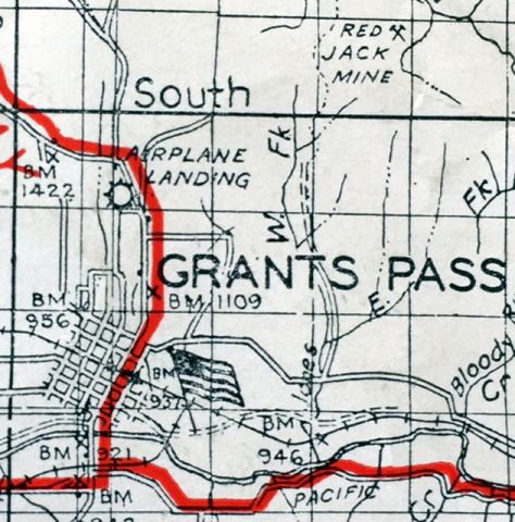
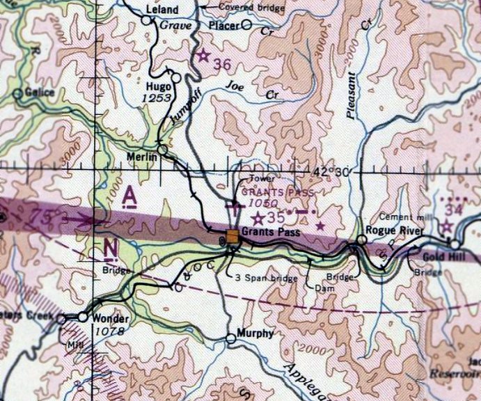
The original Grants Pass Airport, as depicted on a 1940 USFS map (courtesy of Kevin Walsh).
The original airport for the town of Grants Pass was located on the north side of the town.
The date of establishment of Grants Pass Airport has not been established.
The earliest depiction which has been located of Grants Pass Airport
was on a 1940 USFS map (courtesy of Kevin Walsh).
It depicted an “Airplane Landing” field on the north side of the town.
However, Grants Pass Airport was not yet depicted on the May 1942 Klamath Falls Sectional Chart.
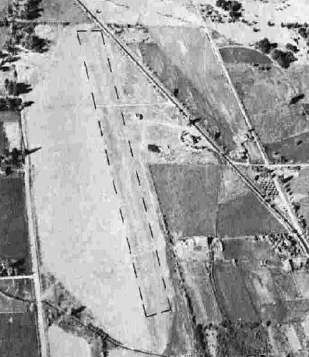
The earliest photo which has been located of Grants Pass Airport
was a circa 1943-45 aerial view looking north from the 1945 AAF Airfield Directory (courtesy of Scott Murdock).
It depicted Grants Pass Airport as having a single unpaved north/south runway.
The earliest aeronautical chart depiction which has been located of Grants Pass Airport was on the April 1944 Klamath Falls Sectional Chart.
It depicted Grants Pass as an auxiliary airfield.
The 1945 AAF Airfield Directory (courtesy of Scott Murdock)
described Grants Pass Airport as a 41 acre rectangular property having a bare 2,000' north/south runway.
The field was said to have 2 wooden hangars, the largest measuring 40' square,
and it was described as being owned by Josephine County.
The last aeronautical chart depiction which has been located of Grants Pass Airport
was on the April 1948 Klamath Falls Sectional Chart (courtesy of Chuck Jarecki).
It depicted Grants Pass as having a 2,700' unpaved runway.

The 1949 OR Airports Directory (courtesy of Jonathan Westerling) depicted Grants Pass “Josephine County Airport” as having a 2,700' gravel & turf north/south runway,
with a ramp & a few small buildings on the northeast side.
The manager was listed as Fred Hale, and the field was said to offer fuel & repairs.
A 9/1/52 USGS aerial photo depicted Grants Pass Airport as having a single unpaved north/south runway.
An undated aerial photo (courtesy of Kendall Pollard) depicted Grants Pass Airport as having a single unpaved north/south runway.
The 1954 USGS topo map depicted Grants Pass Airport as a single north/south runway, labeled simply as “Landing Strip”.
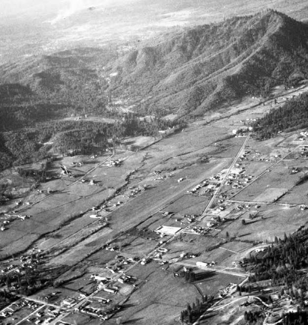
The last photo which has been located showing the original Grants Pass Airport still in operation was a 1954 USGS aerial view.
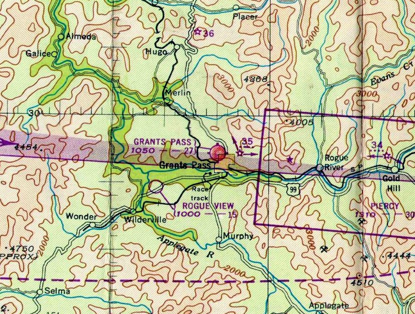
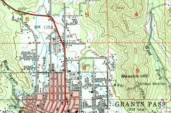
The original Grants Pass Airport, as depicted on the 1958 USGS topo map.
A larger replacement Grants Pass Airport was built to the northwest in the early 1960s,
at which point the original Grants Pass Airport was presumably closed.
The last map depiction which has been located of the original Grants Pass Airport was on a 1968 map (courtesy of Kevin Walsh),
which labeled it simply as “Landing strip”.
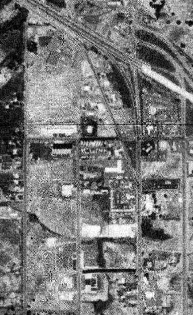
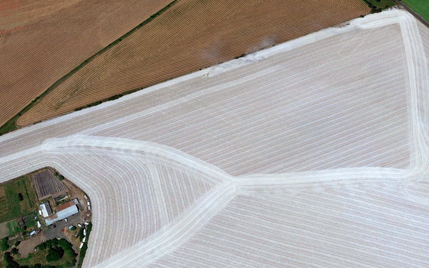
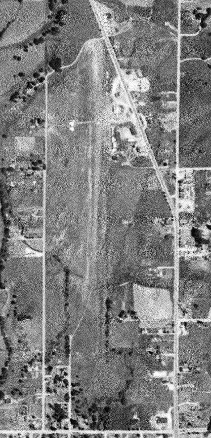
A 1974 USGS aerial view showed no trace remaining of the original Grants Pass Airport, with several buildings having been built over the site.
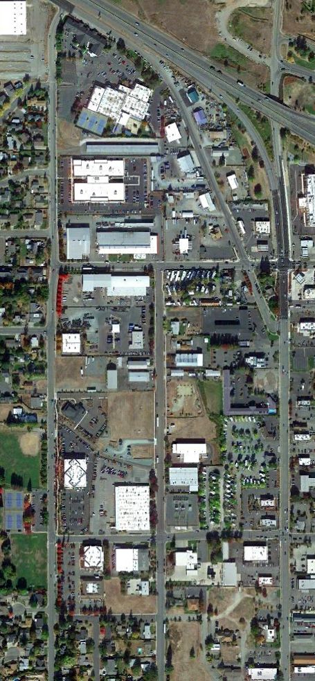
A 2020 aerial view showed no obvious trace remaining of the original Grants Pass Airport, but several of the small buildings on the northeast corner could possibly date from its airport days.
The site of the original Grants Pass Airport is located southwest of the intersection of Northeast 6th Street & Interstate 5.
Thanks to Kendall Pollard for pointing out this airfield.
____________________________________________________
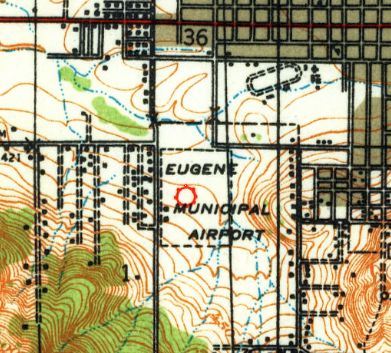
(Original) Eugene Municipal Airport / Eugene Airpark, Eugene, OR
44.04, -123.12 (Southwest of Portland, OR)
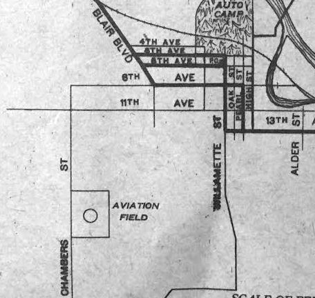
Eugene “Aviation Field”, as depicted on a 1920 BG Goodrich map (courtesy of Kevin Walsh).
The original airport for the town of Eugene was located on the southwest side of the town.
The date of establishment of Eugene Municipal Airport has not been established.
The earliest depiction which has been located of Eugene Municipal Airport was on a 1920 BF Goodrich map (courtesy of Kevin Walsh),
which depicted an “Aviation Field” with a rectangular property outline & a circular airport marking.
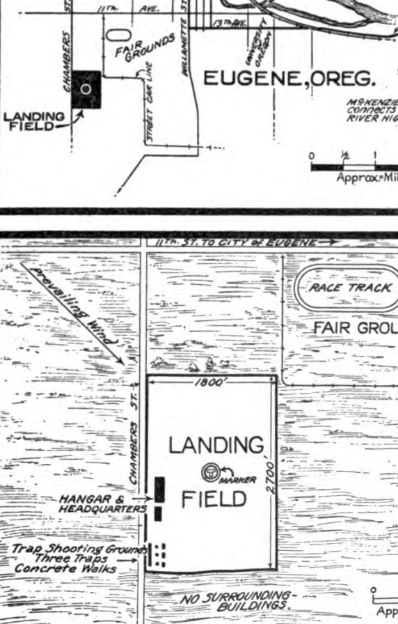
The location & layout Eugene “Municipal Landing Field” from the 3/15/25 Commerce Department Airway Bulletin (courtesy of Jonathan Westerling).
It depicted Eugene “Municipal Landing Field” as a rectangular field measuring 2,700' north/south by 1,800' east/west, with a hangar & headquarters on the west side.
It also depicted a “Trap Shooting Grounds” on the southwest corner - as Jonathan Westerling observed, “Not really a pairing that I would want as a pilot!”
The 1927 Aircraft Landing Fields of the Pacific Coast (courtesy of Chris Kennedy) listed Eugene Municipal Airport
as having a 2,700' x 1,800' landing area & having 3 hangars & a small cottage.
The earliest aeronautical chart depiction which has been located of Eugene Municipal Airport was on the June 1934 Portland Sectional Chart.
It depicted Eugene as a commercial/auxiliary airport.
The earliest photo which has been located of Eugene Municipal Airport was a 1936 aerial view (from the University of OR, courtesy of Jonathan Westerling).
It depicted Eugene as having 2 unpaved runways, with a few small buildings on the west side.
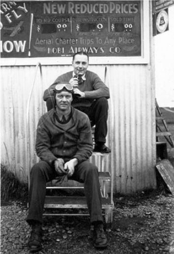
An undated photo presumably taken at Eugene Municipal in front of the Hobi Airways building (courtesy of Jonathan Westerling).
According to Jonathan Westerling, “Hobi Airways was the main operator at Eugene through the 1930s.
According to www.dmairfield.com/airplanes/NC8849/index.htm, one of the planes which Hobi purchased for use at the airport was a Travel Air S-6000-B, S/N 987.
NC8849 stayed with Hobi for 7 years, selling on 5/19/36 to Edward Dorrance of AK. It had accumulated 965 flight hours.”
An undated aerial view looking northeast at Eugene Municipal Airport from The Airport Directory Company's 1938 Airport Directory (courtesy of Jonathan Westerling).
It depicted Eugene as having 2 unpaved runways, with a few small buildings on the west side.
According to Jonathan Westerling, “In its heyday (1938), the field flaunted a 4,300' x 1,700' grass landing area.”
The 1940 USGS topo map depicted Eugene Municipal Airport as a rectangular property outline with 2 small buildings along the west side.
A 9/29/43 aerial view looking north at Eugene Municipal Airport from the 1945 AAF Airfield Directory (courtesy of Jonathan Westerling).
It depicted Eugene as having 2 unpaved runways, with a few small buildings on the west side.
The April 1948 Klamath Falls Sectional Chart (courtesy of Chuck Jarecki) depicted Eugene Airport as having a 2,900' paved runway.
According to Jonathan Westerling, “Nearby hills & the expanding city meant that to have airline service, the city needed a larger airport.
When the Army built larger Mahlon Sweet Airport to the north, the older municipal field became less of a focal point for local aviation.
After the war, the city decided to move all of its airport operations to the larger field.”
The 1949 OR Airport directory (courtesy of Jonathan Westerling) depicted “Eugene Airpark (Municipal)”
as having 2 runways, the longest being a 2,900' NNW/SSE gravel & bituminous strip.
The manager was listed as Earl Snyder.
The 1951 Klamath Falls Sectional Chart (courtesy of Jonathan Westerling) depicted Eugene as having a 2,900' paved runway.
The 1951 Airman’s Directory (courtesy of Jonathan Westerling) described Eugene as having a 2,900' gravel runway.

The last topo map depiction which has been located of Eugene Airpark was on the 1954 USGS topo map.
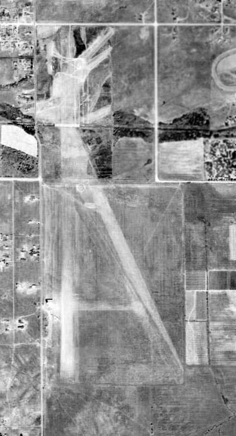
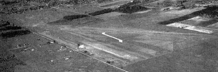
The last photo which has been located of Eugene Municipal Airport was an 8/3/55 USGS aerial view.
It depicted Eugene as having 2 unpaved runways, with a few small buildings & a row of light aircraft on the west side.
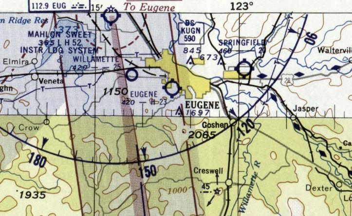
The last aeronautical chart depiction which has been located of Eugene Airpark was on the March 1956 Klamath Falls Sectional Chart.
It depicted Eugene as having a 2,300' paved runway.
Eugene Airpark was evidently closed at some point in 1956, as it was no longer depicted on the October 1956 Klamath Falls Sectional Chart
or the 1960 USGS topo map.
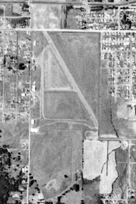
A 1965 aerial view showed a school had been built over the Eugene Municipal Airport site.
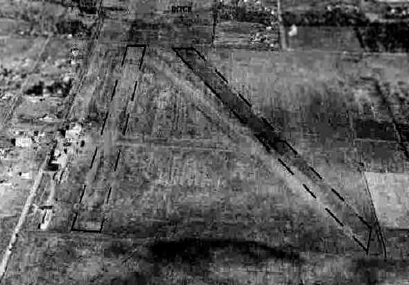
A 2009 photo by Jonathan Westerling looking along the site of Eugene Airpark's north/south runway.
Jonathan Westerling reported in 2009, “Where the airport once stood, is now Westmorland Park & the Jefferson Middle School.”
A 2009 photo by Jonathan Westerling looking along the site of Eugene Airpark's northeast/southwest runway.
A 2014 aerial view shows no trace of Eugene Airpark.
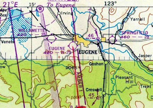
The site of the original Eugene Airport is located southeast of the intersection of 18th Avenue & Chambers Street.
Thanks to Jonathan Westerling for pointing out this airfield.
____________________________________________________
Daly Airport / Crescent Airport, Crescent, OR
43.46, -121.71 (Southwest of Portland, OR)
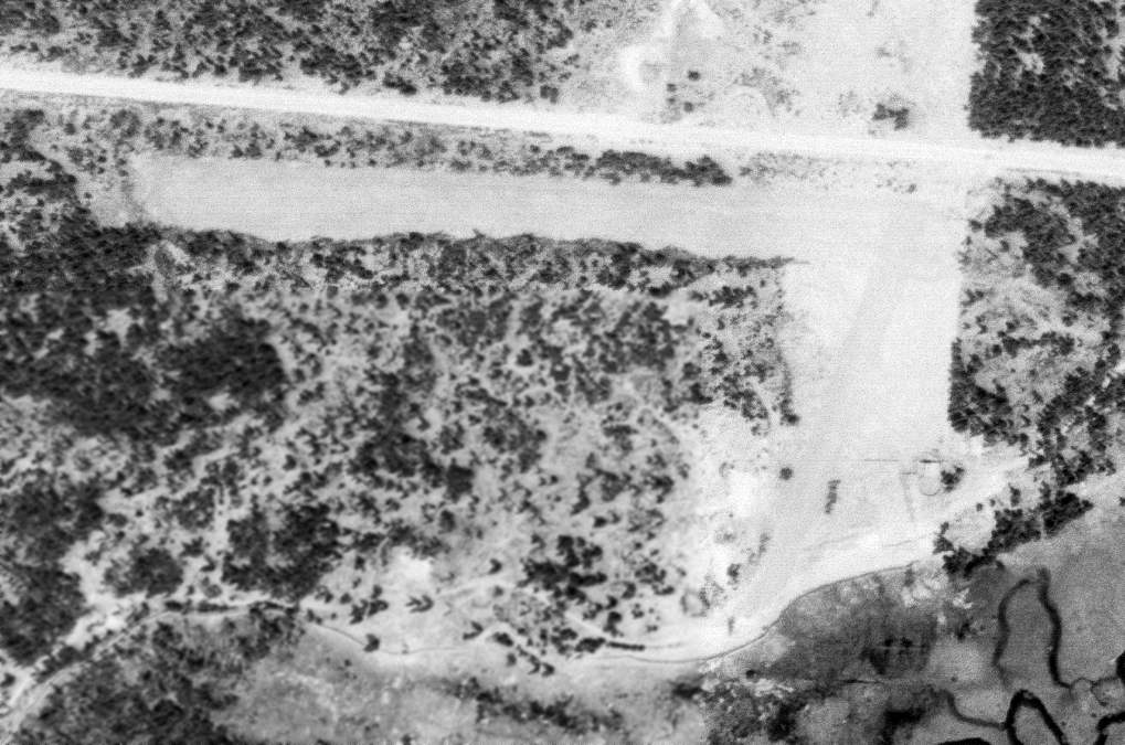
A 6/18/59 USGS aerial photo depicted the beginnings of the Daly Airport.
This small general aviation airport was evidently established at some point between 1958-59,
as it was not yet depicted on a 1953 USGS aerial photo, nor on the 1955 USGS topo maps.
The first depiction of Daly Airport which has been located was a 6/18/59 USGS aerial photo.
It depicted perhaps the beginnings of the airport, with a rough short dirt east/west runway, and a few small buildings on the east side.
Daly Airport was not yet depicted on the September 1960 Klammath Falls Sectional Chart.
An 8/1/63 USGS aerial photo showed that Daly Airport had gained a longer 2nd northeast/southwest runway at some point between 1959-63.
There were no aircraft visible on the field.
The earliest aeronautical chart depiction which has been located of Daly Airport was on the April 1965 Klamath Falls Sectional Chart.
It depicted Daly Airport as having a 4,600' unpaved runway.
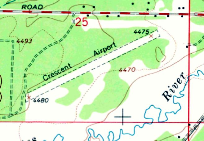
The 1967 USGS topo map depicted “Crescent Airport” as having a single northeast/southwest unpaved runway.
The clearing for the original east/west runway was still depicted but no longer labeled as a runway.
The last aeronautical chart depiction which has been located of Daly Airport was on the April 1969 Klamath Falls Sectional Chart.
It depicted Daly Airport as having a 4,200' unpaved runway.
The 1994 USGS topo map still depicted the single runway,
but no longer labeled the airport, evidently indicating it had closed (for reasons unknown) at some point between 1969-94.
A 1994 USGS aerial photo depicted houses having been built along both sides of the runway, evidently reused as a street.
The 2002 USGS topo map no longer depicted the runway, just a clearing along its orientation.
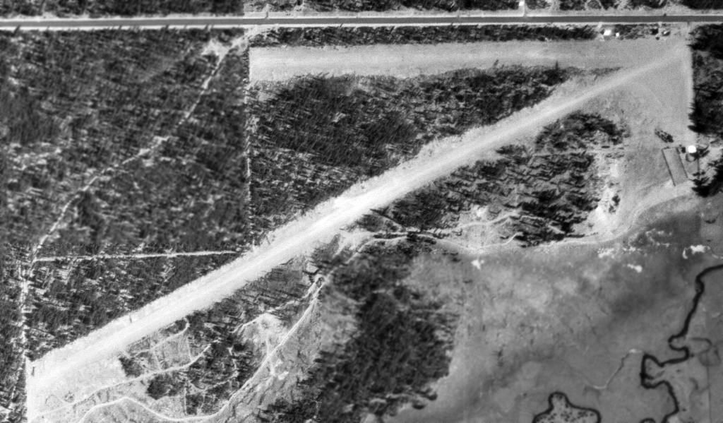
A 7/7/13 aerial view looking west showed Crescent / Daly Airport's paved runway remained intact, reused as a residential street.
Martin Rentsch reported in 2013, “I drove through Crescent today, and came across North Airport Road.
Curious, I checked out the place, but found nothing but a narrow, straight, flat road in a residential area.
No [other] signs of an airport whatsoever. Interestingly, Google Maps still denotes the [location as an] airport.”
____________________________________________________
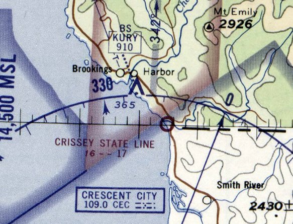
Crissey Airport, Brookings, OR
42, -124.21 (Southwest of Portland, OR)
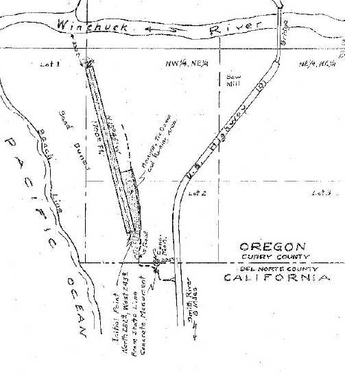
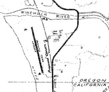
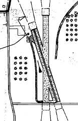
An official 1952 sketch of the “Crissey State Line Airstrip” (courtesy of Jonathan Westerling).
Jonathan Westerling reported, “The Crissey State Line Airstrip was, for over a decade the southernmost airport in Oregon,
and unique for being the only airport on the west coast to have its access road in another state!
The beginnings of the Crissey State Line airstrip are clouded by local folklore.
Brookings, OR was one of the few locations in the continental U.S. to be bombed by the Japanese during World War II.
According to some, it is due to these attacks that Crissey Airfield was established.
The airfield was supposedly used as a base for submarine-seeking airplanes towards the end of World War II.”
The website www.traveloregon.com states, “The area served as a coastal air strip & refueling station
for reconnaissance flights patrolling the northern CA & southern OR beaches searching for Japanese submarines.”
However, Crissey Airfield wasn’t depicted on the 1942, 1944, or 1945 Klamath Falls Sectional Charts.
The first reference to the Crissey State Line airstrip which has been located
was an article in the 10/4/51 Currey County Reporter (courtesy of the OR Department of Aviation, via Jonathan Westerling).
The article details the construction of the airstrip: ”A hard-surfaced airstrip has been put into service about 4 miles south of here & 10 miles from the one at Crescent City [CA].
Known as the Crissey State Line Airport, the north/south runway is 60' by 2,000'.
Parker Schram, road contractors, surfaced & rolled the strip with clay & shale, the latter being donated by L.W. Johnson.
The directors of the Brookings Chamber of Commerce are the sponsors & the CAA has been petitioned for certification.
The field is on a high back beach between Highway 101 & the sea.”
Jonathan Westerling reported, “However, it turns out there was debate within the Chamber of Commerce
as to their ability to fund & maintain operation of the airport.
An article in the December 1951 Brookings Harbor-Pilot newspaper (courtesy of the Oregon Department of Aviation) detailed a 12/5/51 meeting
where the Chamber board finally created a committee to re-open their plans to run the airfield.
However, in the end, they decided not to follow through – leaving State-Line airport a private airfield.”
No airfield was depicted at this location on the September 1952 Klamath Falls Sectional Chart.
Jonathan continued, “The trepidation on the part of the Chamber led the landowner, Mr. W.L Crissey,
to inquire whether the State wished to take over operation of his new airstrip.”
According to Sandi Larsen at the OR State Department of Aviation, “I’ve found more correspondence between W.L. Crissey & the State Board of Aeronautics.
In 1952 a lease agreement was entered into.”
This lease allowed the State to run the airstrip as a public airport for a 10 year period.
The earliest depiction of Crissey Airport which has been located was an official 1952 sketch (courtesy of Jonathan Westerling).
It depicted the “Crissey State Line Airstrip” as having a single 2,000' northwest/southeast runway.

The earliest photo which has been located of Crissey Airport was a 7/24/52 USGS aerial view.
It depicted Crissey as having a single unpaved northwest/southeast runway.
The earliest aeronautical chart depiction of Crissey Airport which has been located was on the March 1953 Klamath Falls Sectional Chart.
It depicted Crissey State Line Airport as having a, 1,700' unpaved runway.
The 1954 USGS topo chart depicted Crissey Airport as having a single northwest/southeast runway.
Jonathan Westerling reported, “According to Sandi Larsen of the OR State Department of Aviation, W.L. Crissey sold his land in 1961.”
Jonathan Westerling reported, “According to Sandi Larsen of the OR State Department of Aviation,
the airport lease was not renewed by the new owner when it was up in 1962.
Consequently, in 1963 the State & County began construction of a new Brookings airport a few miles to the north.”
According to an OR State Department of Aviation publication titled “Oregon State Airport Histories”, “[Today’s] airport was constructed in 1964.
This airport replaced Crissey State Line Air Strip, a facility leased by Aeronautics to serve the Brookings area.”
A 1964 sketch of Crissey Airport (courtesy of Jonathan Westerling), showing the proposed rerouting of Route 101 closer to the airport.
Jonathan reported, “Curiously, when the U.S. Department of Commerce sought to reorient Route 101 closer to the Crissey State Line Airstrip in 1964,
they were required to obtain approval from both the FAA & the State (according to a letter to the OR Department of Aeronautics).
It may be presumed that the airport was still in operation at that time, even though its lease had expired 2 years prior.”
According to Jonathan Westerling, “No record of airport operations at Crissey State-Line airstrip exist after 1964.
The last aeronautical chart depiction of Crissey Airport which has been located was on the April 1965 Klamath Falls Sectional Chart.
It depicted “Crissey State Line” Airport as having a 1,700' unpaved runway.
Crissey Airport was no longer depicted on the September 1965 Klamath Falls Sectional Chart.
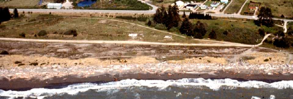
A 1972 aerial view looking east at the south end of the Crissey Airport site (Copyright 2002-2009 Kenneth & Gabrielle Adelman, California Coastal Records Project)
showed the foundations of several hangars at the site, however, no aviation use was evident.
The 1989 USGS topo map still depicted Crissey Airport, with a single runway, even though it had not been in operation for many years.
According to the OR State website, “OPRD [Oregon Parks & Recreation Department] acquired Crissey Field in a 1993 land exchange with a private timber firm.”
A 5/26/94 USGS aerial view looking north along the remains of the runway at Crissey Airfield.
Jonathan Westerling reported, “In 1999, Senate Bill 1102 was passed & funded the establishment of a new state park welcome center on the site.
The construction of the Welcome center removed any remaining traces of the airport.”
A 2009 photo by Jonathan Westerling looking north along the location of the runway at Crissey Airfield.
Jonathan reported, “The pavement is new, though the roadway is aligned with the runway orientation.
The area was recently graded to install an access road to the State Park Welcome Center recently constructed on the property.”
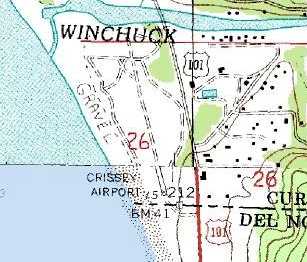
As of 2011, road maps label the airport site as Crissey Field State Park.
A 6/7/13 aerial view looking north shows the park road built over the alignment of the former Crissey Airfield runway.
____________________________________________________
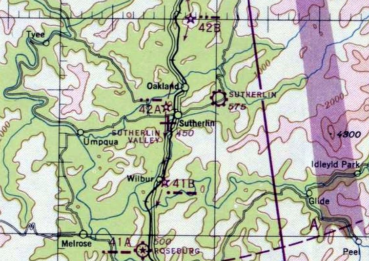
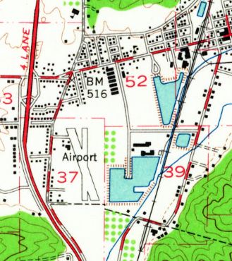
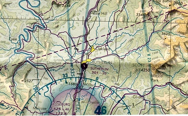
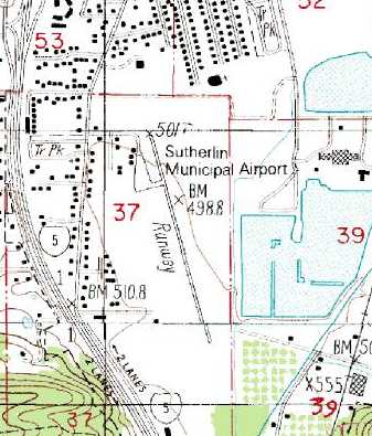
Sutherlin Valley Airport / Sutherlin Airport (3S3), Sutherlin, OR
43.38, -123.33 (Southwest of Portland, OR)
Sutherlin Valley Airport, as depicted on the April 1947 Klamath Falls Sectional Chart.
This general aviation airport was apparently built at some point between 1945-46,
as it was not yet depicted on the 1935 / 1939 / 1944 / November 1946 Klamath Falls Sectional Charts,
nor listed among active airfields in the 1945 AAF Airfield Directory (courtesy of Scott Murdock).
The earliest reference to Sutherlin Valley Airport which has been located
comes from a 1998 Douglas County Transportation Systems report (according to Jonathan Westerling),
which said that the airport started operations in 1946.
The earliest depiction of Sutherlin Valley Airport which has been located was on the April 1947 Klamath Falls Sectional Chart.
It depicted Sutherlin Valley as an auxiliary airfield.
The April 1948 Klamath Falls Sectional Chart (courtesy of Chuck Jarecki) depicted Sutherlin Valley Airport as having a 2,500' unpaved runway.
The 1949 OR Airport Directory (courtesy of Jonathan Westerling) depicted the “Sutherlin Valley Airways Airport” as having 2 turf runways:
2,500' north/south & 2,200' northwest/southeast (with gravel strip down the middle), and 2 small hangars were depicted on the northwest side.
The manager was listed as A.L. Koleno.
Sutherlin's second runway was evidently abandoned at some point between 1949-51,
as the 1951 Airman's Guide (according to Jonathan Westerling) only listed a single runway.
The 1954 USGS topo map depicted Sutherlin Airport as having 2 runways & a few small buildings on the northwest side.
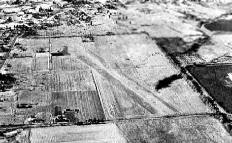
The earliest photo which has been located of Sutherlin Airport
was an undated aerial view looking north from the 1964 OR Airport Directory (courtesy of Jonathan Westerling).
It described Sutherlin as having a 2,200' north/south turf runway, and the photo also depicted a 2nd runway.
The operator was listed as the City of Sutherlin, and the manager was listed as John Knapp.
The 1967 AOPA Airport Directory (according to Jonathan Westerling) described Sutherlin as having a single turf Runway 13/31.
The 1977 AOPA Airport Directory (according to Jonathan Westerling) revised Sutherlin's runway configuration to a gravel Runway 15/33.
According to Jonathan Westerling, “The small field was for over 40 years, home to many private aviation & agricultural planes.
There was an FBO on field beginning in 1978 with Sutherlin Air Service. The runway was paved in the early 1980s.
The last aeronautical chart depiction which has been located of Sutherlin Valley Airport was on the May 1985 Klamath Falls Sectional Chart.
It depicted Sutherlin Airport as having a 2,600' paved northwest/southeast runway.
The 1987 USGS topo map showed that Sutherlin had a single northwest/southeast runway,
with a ramp & several small buildings on the northwest side.
An undated aerial view from the 1988 OR Airport Directory (courtesy of Jonathan Westerling)
depicted Sutherlin Airport as having a single 2,600' paved Runway 14/32.
A paved ramp was at the northwest corner, with a few small buildings, and 2 single-engine aircraft were visible.
According to Jonathan Westerling, Sutherlin's FBO “changed to Western Oregon Aviation which operated there until the airports closure in 1991.”
According to a 1998 Douglas County Transportation Systems report (according to Jonathan Westerling), Sutherlin Airport “was closed in 1991.
Closure was based on the realization that the airport could not be expanded for commercial aviation use.
It served primarily as a crop dusting base & had a variable level of based aircraft.
The city realized it could gain more economic benefit by using the land for [commercial & industrial buildings].
The City has designated the former airport park area as an industrial park.
There are 3 tenants in the industrial park, and further development is anticipated.
There are no plans to re-open the Sutherlin airport in the future.”
Unfortunately this is a very typical story – closing a municipal airport to realize short-term benefits by selling off the land to developers.
Regardless of whether the airport represents a long-term transportation & business asset the community.
With that kind of mentality, why not sell off parks to be “redeveloped”?
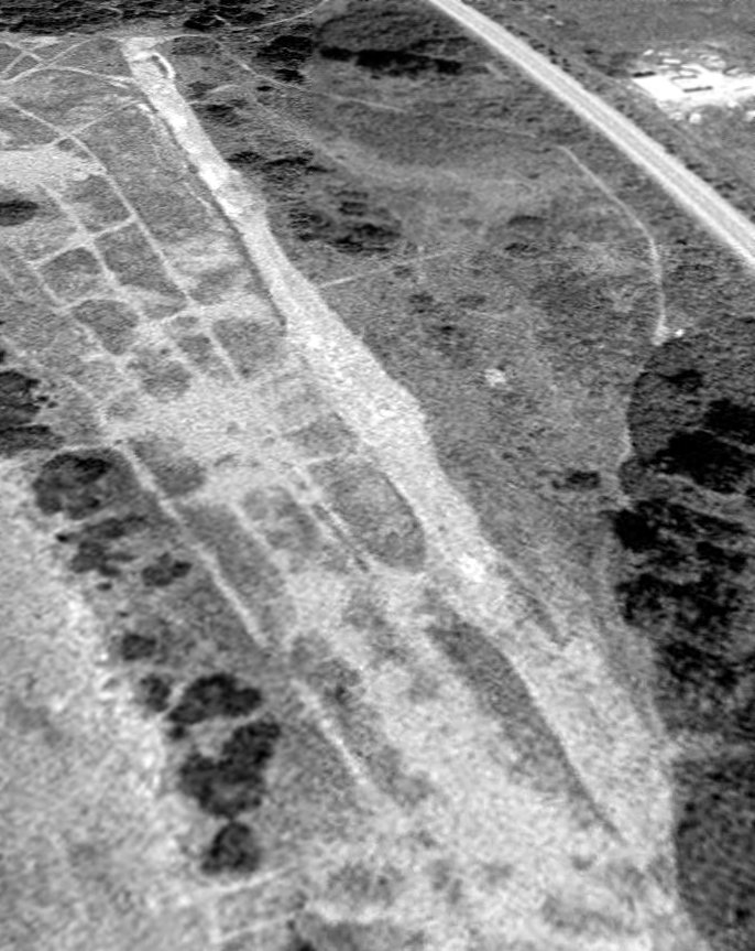
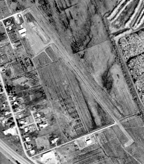
A 5/7/94 USGS aerial view looking south showed closed runway “X” symbols painted on the Sutherlin Airport runway,
and a large building having been built very close to the northwest end of the runway.
A 3/9/05 aerial view showed that the Sutherlin runway & hangars remained intact,
but several other large buildings had been built at some point between 1994-2005 on either side of the north end of the runway.
A May 2009 photo by Jonathan Westerling looking south along the former Sutherlin runway.
Jonathan reported in May 2009, “If you are driving up I-5, the old airport is less than 5 minutes off the highway,
and easily accessible by public roads.
I found there is still ample evidence of the airfield.”
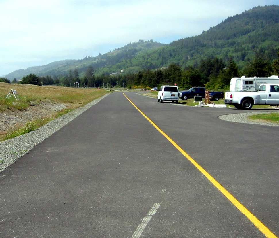
Much of the runway still remains, and is easily viewable off of Airway Avenue.
In fact, you can legally drive right onto the original runway which intersects with Page Avenue.
Walking down a runway is a neat experience for youngsters interested in aviation.”
A May 2009 photo by Jonathan Westerling of the larger of the 2 remaining hangars at Sutherlin,
along with a Cessna fuselage, and a fine example of 1970s American station wagon design.
A May 2009 photo by Jonathan Westerling of 2 fuselages (Beech?) next to a former Sutherlin maintenance hangar.
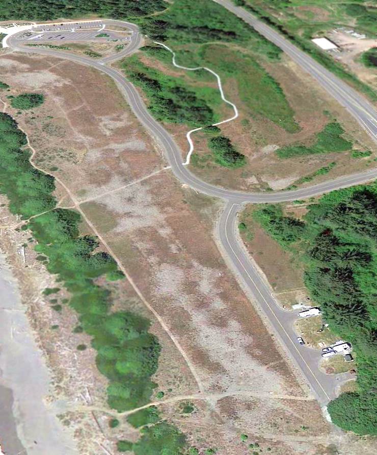
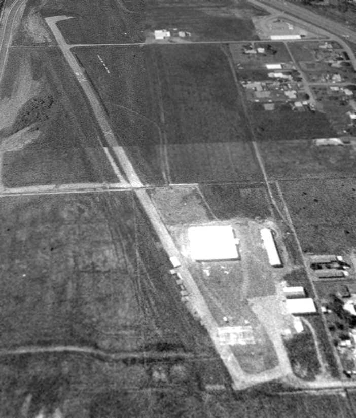
A 7/29/11 aerial view looking southeast showed that Sutherlin's 2 hangars remained standing & most of its runway remained intact,
although portions are covered by several large buildings.
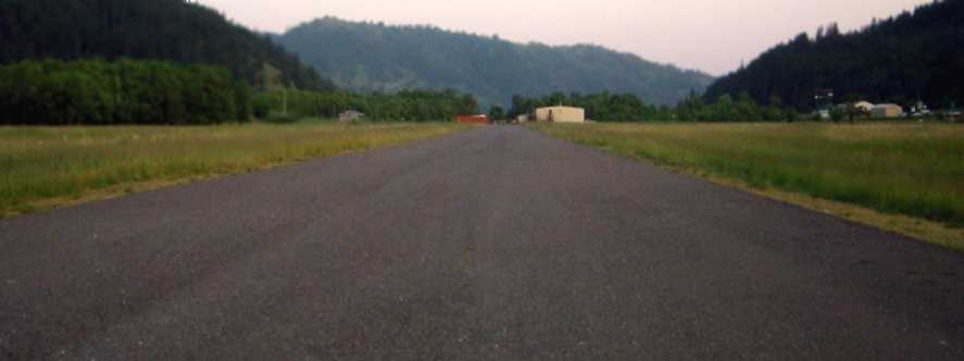
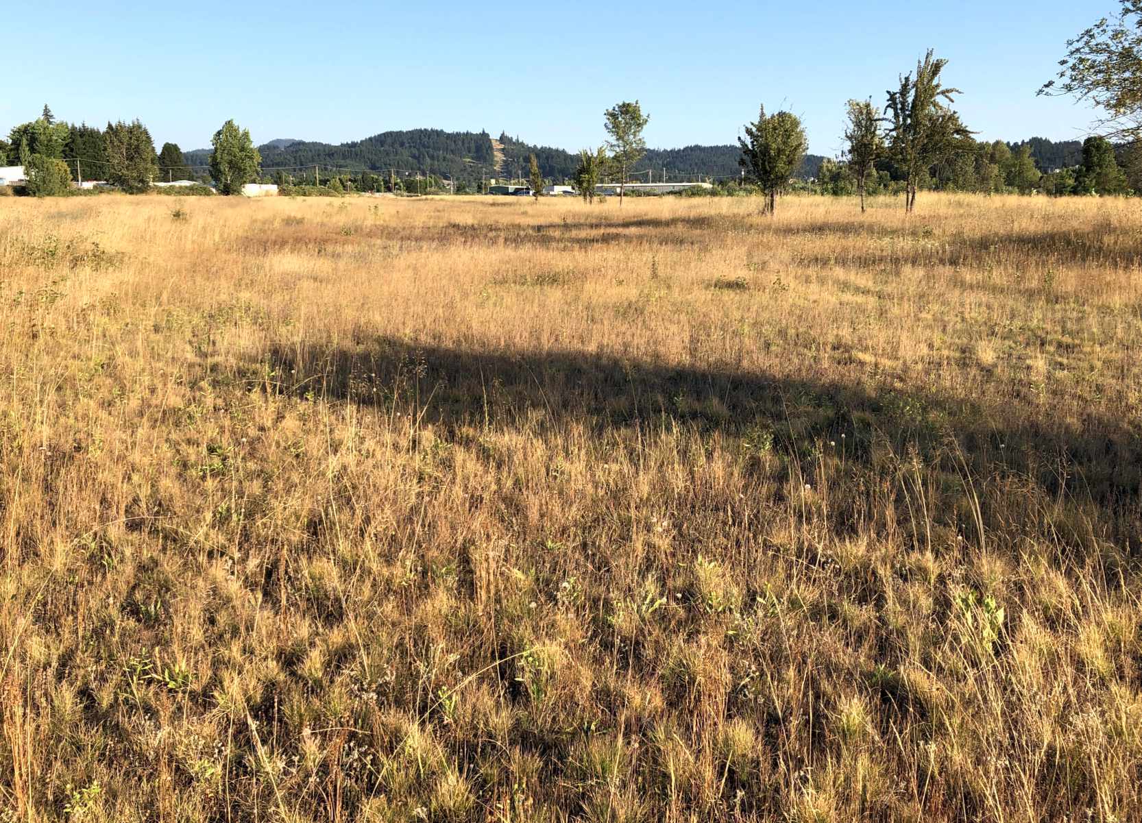
An August 2022 photo looking northwest along the former Sutherlin Airport runway showed it remained predominantly intact.
The site of Sutherlin Airport is located south of the intersection of Landing Street & Airway Avenue, appropriately enough.
____________________________________________________
Willamette Airpark / T-Bird Airport, Eugene, OR
44.05, -123.18 (South of Portland, OR)
Willamette Airpark, as depicted in the 1947 OR Airport Directory (courtesy of David Brooks).
This general aviation airport was evidently established at some point between 1945-47,
as it was not yet depicted on the April 1945 Portland Sectional Chart (according to Chris Kennedy).
The earliest reference which has been located of Willamette Airpark was in the 1947 OR Airport Directory (courtesy of David Brooks).
It described Willamette as being managed by a Robert Bevans, who operated Bevan’s Flying Service from the field.
The runway configuration consisted of a 2,500' northwest/southeast gravel strip & a 1,900' north/south sod strip.
The earliest aeronautical chart depiction which has been located of Willamette Airpark was on the April 1948 Klamath Falls Sectional Chart (courtesy of Chuck Jarecki).
It depicted Willamette Airpark as having a 2,500' unpaved runway.
Willamette Airpark was not yet depicted on the 1949 USGS topo map.
Willamette Airpark gained a paved runway at some point between 1948-51,
as the 1951 Klamath Falls Sectional Chart (courtesy of David Brooks) depicted Willamette Airpark as having a 2,500' paved runway.
The 1953 Klamath Falls Sectional Chart (courtesy of David Brooks) depicted Willamette Airpark in an unchanged fashion.
Willamette Airpark gained a paved runway at some point between 1953-59,
as the 1959 Klamath Falls Sectional Chart (courtesy of David Brooks) depicted the field as having a 2,500' hard surface runway.
The runway length at Willamette had been reduced by 400' within the next year,
as the 1960 Jeppesen Airway Manual (according to Chris Kennedy) described the field as having a single 2,100' hard surface runway.
Jay Flitton recalled, “Between 1962-1964 Willamette Airpark went by the name 'T-Bird' Airport.
My dad, while going to graduate school at the University of OR flew out of 'T-Bird' a lot.
My mom started her private pilot lessons there. That is where I had my first airplane ride! A Cherokee 140.
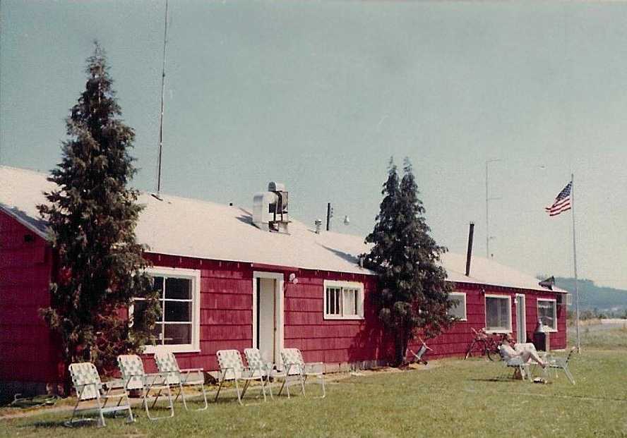
It had a beautiful log terminal building with a 'Control Room' that had a giant picture window overlooking the airport, there was no tower.
The whole terminal looked more like a ski lodge or maybe something that should be in Yellowstone National Park.
It was a beautiful little airport with a lot of activity. Too bad it is gone.”
![]()
A 1963 logo of T-Bird Airpark (courtesy of Jim Allen). According to Jim, “It appears that each one may have been numbered. I can't imagine why.”
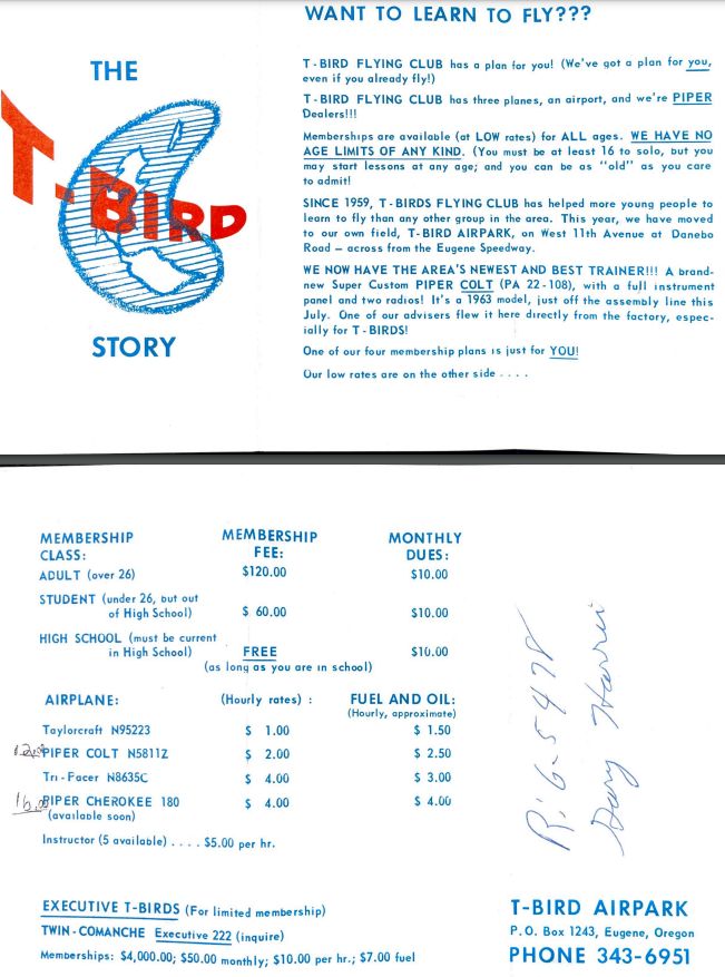
A 1963 advertisement for the T-Bird Airpark flying club (courtesy of Bob Saxton, via Rob Saxton). Renting a Taylorcraft cost a mere $1/hour.
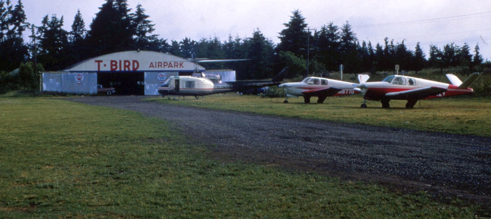
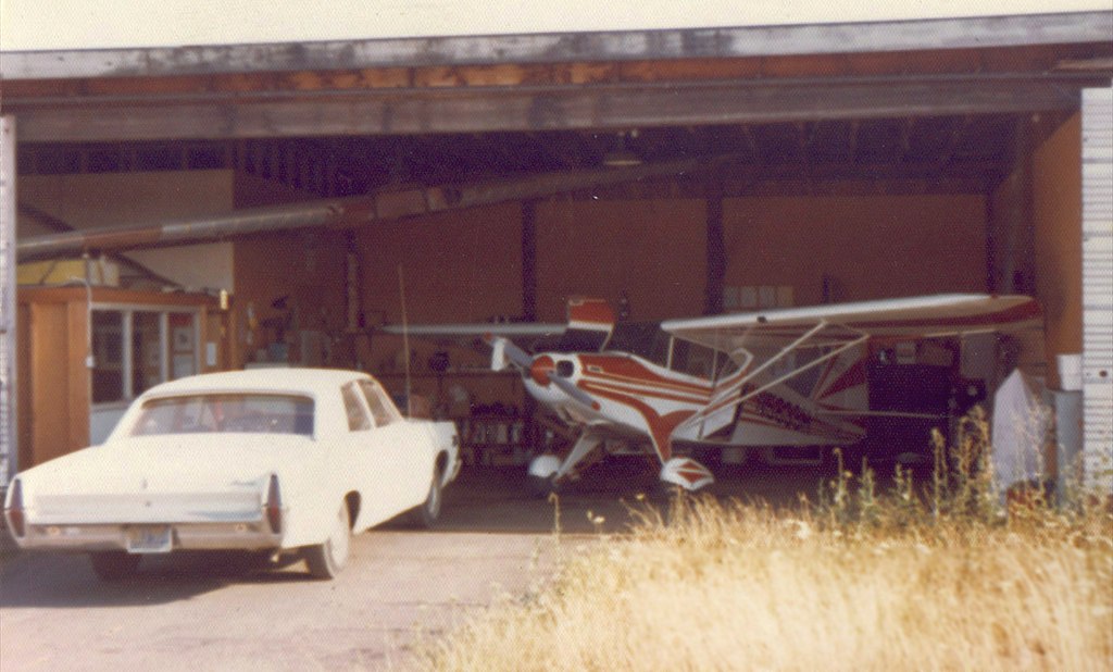
The earliest photo which has been located of T-Bird Airpark was a 1964 photo by Edmond Hutchinson of a civilian Bell Huey helicopter & 2 Beech Bonanzas in front of the hangar.
Edmond Hutchinson recalled, “I started flying there in the T-Bird Flying Club's 1947 Taylorcraft BC-12D, transitioned to the Aeronca Champ, and then to the club's Piper Colt.”
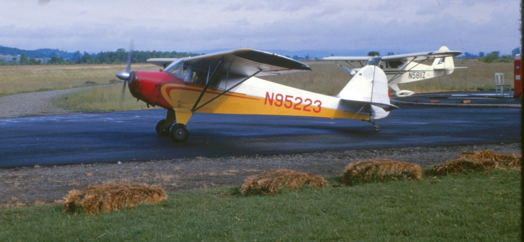
A 1964 photo by Edmond Hutchinson of a Taylorcraft taxiing in front of a Piper Colt at T-Bird Airpark.
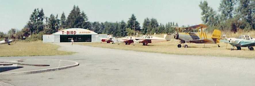
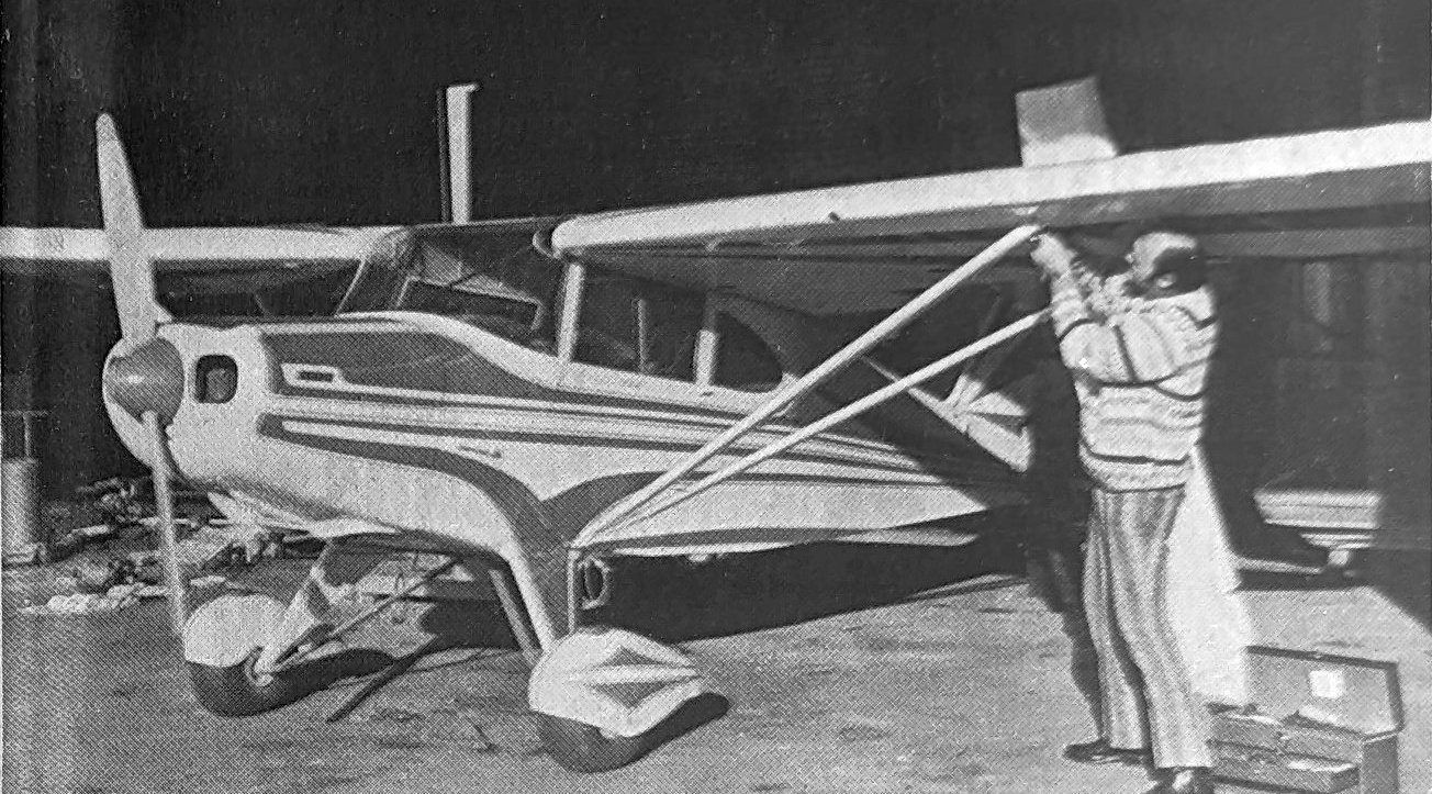
An August 1964 photo by Jim Allen of the T-Bird Airpark maintenance hangar, with a variety of general aviation aircraft.
An August 1964 photo by Jim Allen of the T-Bird Airpark administration & operations building.
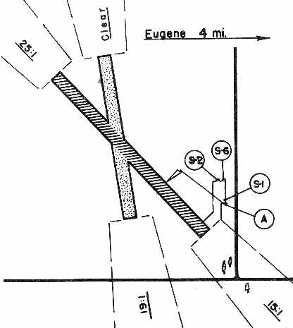
An undated aerial view looking north at T-Bird Airpark from the 1964 OR Airport Directory (courtesy of Jonathan Westerling).
It described T-Bird as having a 2,000' paved Runway 12/30.
The operator was listed as T-Birds Inc., and the manager listed as Robert Litten, and the T-Bird Flying Club was also listed.
The last aeronautical chart depiction which has been located of T-Bird Airpark was on the July 1965 Portland Sectional Chart (courtesy of Ron Kunse).
It depicted T-Bird as having a 2,000' paved northwest/southeast runway.
John Tucker recalled, “I learned to fly at T-Bird in the 1960s.
It was a wonderful place for a young boy to learn to fly. My dad started to fly & I took lessons too.
I was offered a job (which I took) mowing the grass around the airport.
Then I progressed to fuel & line boy. I also helped the mechanic in the shop with small jobs.
Of course I traded every hour against flying time.
They had a couple of Champs, one N81967, 2 Piper Colts, a Cherokee 140 & 180, the latter being N7432W.
Other planes were Champion 7402B, a Shinn, and a few others.
They also had a Link Trainer in which we airport kids had our first exposure to instrument flight.
We would take turns flying, then we would become controllers.
Great fun with all of the encouragement that could be given.
Although this Link Trainer was in the mechanic's hangar & sometimes he did not enjoy the enjoyment that we were having as much as we were.
Some of the instructors were Harry Powell & Gary McCaulley.
Robert Litton was the Airport Manager & I think the business owner was Robert Evans.
I flew roughly 80 hours between 1965-68, most of which were in the basic trainers.”
John Tucker recalled, “I think in 1967 they started running drag races there. I worked these races.
Looking back I believe they did not charge enough for their [aviation] services & that's why they quit business.
The drag races were a way to bring in more revenue.
I really do not think they liked having all of that noise & crowds.
I cannot think any business could have made it with those extremely low aircraft charges.
They did have leased a Martin 202 that they hoped would bring some activity to their flying club.
Reno & Las Vegas trips for the flying club people were scheduled & I think they did fly some of these.
I had the great experience of flying the copilot seat on a couple of short hops.”
Willamette / T-Bird Airport was evidently closed by 1967,
as it was no longer listed among active airports in the 1967 Flight Guide (according to Chris Kennedy)
nor depicted on the February 1968 Portland Sectional Chart.
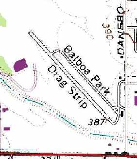
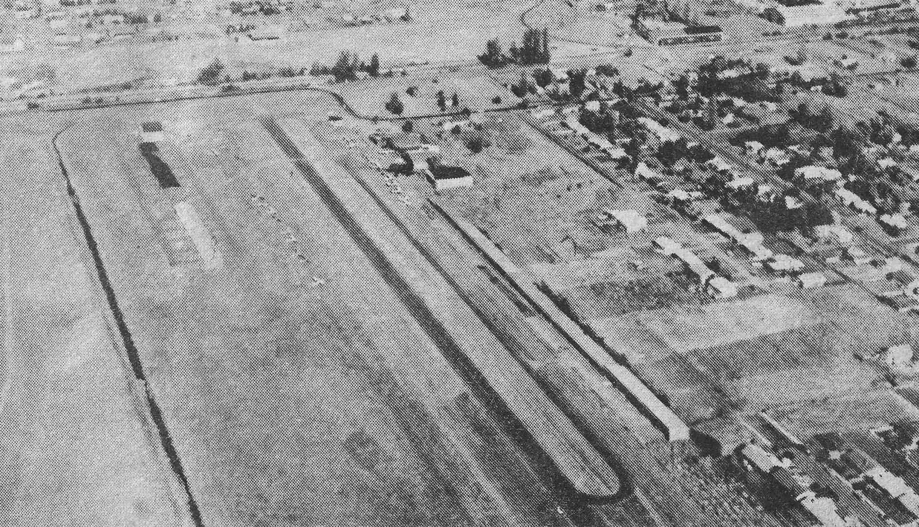
By 1975 the former northwest/southeast runway of the abandoned T-Bird Airpark had been reused as a drag strip,
as the 1975 USGS topo map depicted the characteristic layout of a single runway with a parallel taxiway, labeled as the "Balboa Park Drag Strip".
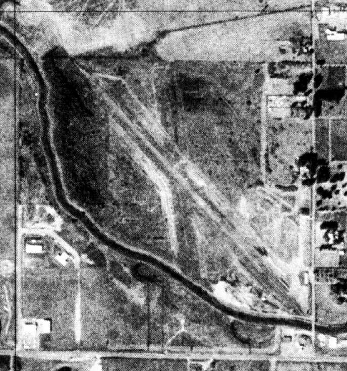
In the 9/3/75 USGS aerial photo, the remains of both T-Bird Airpark runways were still quite recognizable.
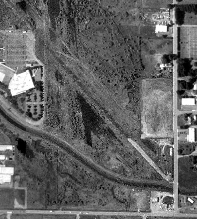
In the 1994 USGS aerial photo, the remains of T-Bird Airpark's northwest/southeast runway & its parallel taxiway were still quite recognizable,
while the outline of the shorter north/south crosswind runway was still barely perceptible.
A 4/1/13 photo by Dan Pimentel “of Willamette Airpark / T-Bird Airport... looking northwest, down the clearing that should have been right where Runway 30 was positioned.”
Edmond Hutchinson reported in 2022 of recent aerial views of the T-Bird Airpark site, “If you know exactly where to look, you can still see traces of the airpark.”
An 8/15/22 photo by Dan Pimentel looking southeast along the former T-Bird Airpark runway.
Dan reported, “I could hear the ghosts of a thousand Piper J3 Cubs coming & going.”
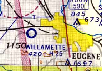
The site of T-Bird Airpark is located northwest of the intersection of South Danebo Avenue & West 11th Avenue.
____________________________________________________
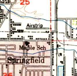
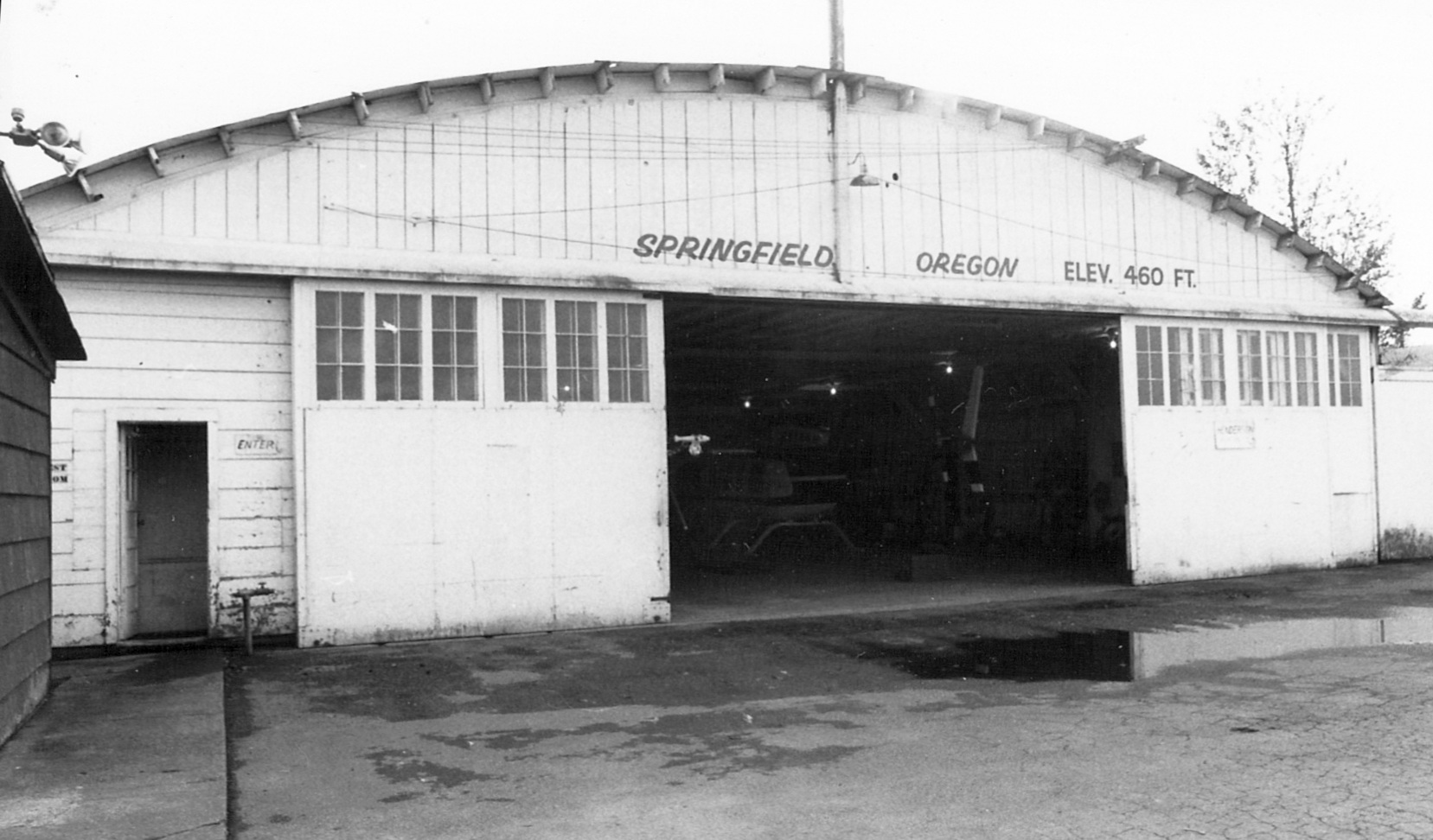
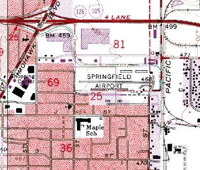
Springfield Airport, Springfield, OR
44.06, -122.99 (South of Portland, OR)
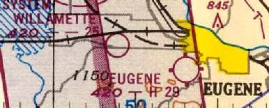
Springfield Airport, as depicted on the June 1934 Portland Sectional Chart.
The earliest depiction which has been located of Springfield Airport was on the June 1934 Portland Sectional Chart.
It depicted Springfield Airport as a commercial/municipal airport, locate east of Springfield.

A circa 1940s photo of an airshow believed to have been held at Springfield Airport (courtesy of Madeline McGraw).
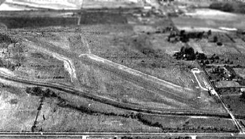
The earliest aerial view which has been located of Springfield Airport was an 11/15/47 USGS aerial photo.
It depicted Springfield Airport as having a single east/west unpaved runway,
with 5 single-engine planes visible near some small buildings on the southeast side.
The April 1948 Klamath Falls Sectional Chart (courtesy of Chuck Jarecki) depicted Springfield Airport as having a 2,000' unpaved runway.
The 1949 OR Airport Directory (courtesy of Jonathan Westerling) depicted Springfield Airport as having a single 2,000 east/west runway.
The manager was listed as Milt Ruberg.
The 1950 USGS topo map depicted Springfield Airport as having a single east/west runway.
William Greenlee recalled, “I remember hearing stores from my grandpa about him flying his airplane out of Springfield to Portland to go to work.”
Bob Litten recalled, "Both Georgia Pacific & Weyerhauser flew in & out to visit their mills East of town
and it was a hugely popular gathering spot with many locally owned private planes parked there.
I learned to fly there in 1957 when it was still a gravel strip, and kept flying out of there until about 1963."
Springfield's runway was evidently paved at some point between 1949-60,
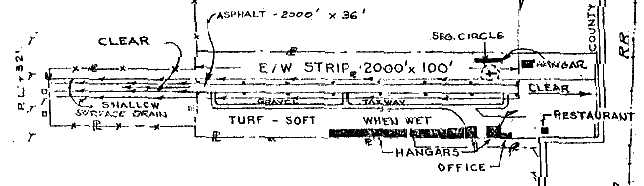
as the 1960 OR Airport Directory (courtesy of Ron Dupas) depicted the field as having a single 2,000' asphalt east/west runway.
Several hangars were depicted on the northeast & southeast side of the field, as well as an office & a restaurant.
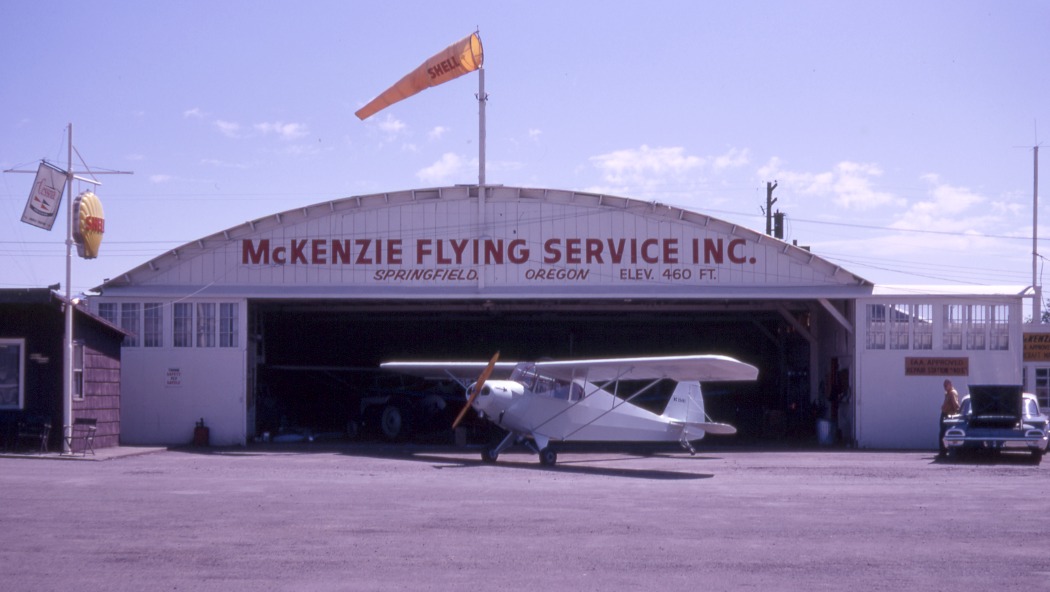
The operator was listed as the McKenzie Flying Service.
The 1962 AOPA Airport Directory described the "Springfield (McKenzie Flying Service)" Airport as having a single 2,500' asphalt Runway 7/25.
It listed the operator as H.M. Ruberg.
An undated aerial view looking north at Springfield Airport from the 1964 OR Airport Directory (courtesy of Jonathan Westerling).
It described Springfield as having a 2,000' paved Runway 7/25, and listed the operator as McKenzie Flying Service.

A 1964 photo of WA judges Bos Adkinson & Fred Terry with Mayor B.J. Rodgers, standing in front of a Piper Tri-Pacer owned by Rodgers & Kepler Builders, at Springfield Airport (courtesy of Madeline McGraw).
The July 1965 Portland Sectional Chart (courtesy of Ron Kunse) depicted Springfield as having a 2,000' paved east/west runway.
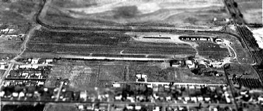
A 7/22/65 USGS aerial photo depicted Springfield Airport as having a single east/west runway,
with several rows of hangars & 16 light aircraft on the northeast & southeast sides.
The 1967 Klamath Falls Sectional Chart (courtesy of John Voss) described Springfield as having a 2,000' runway.
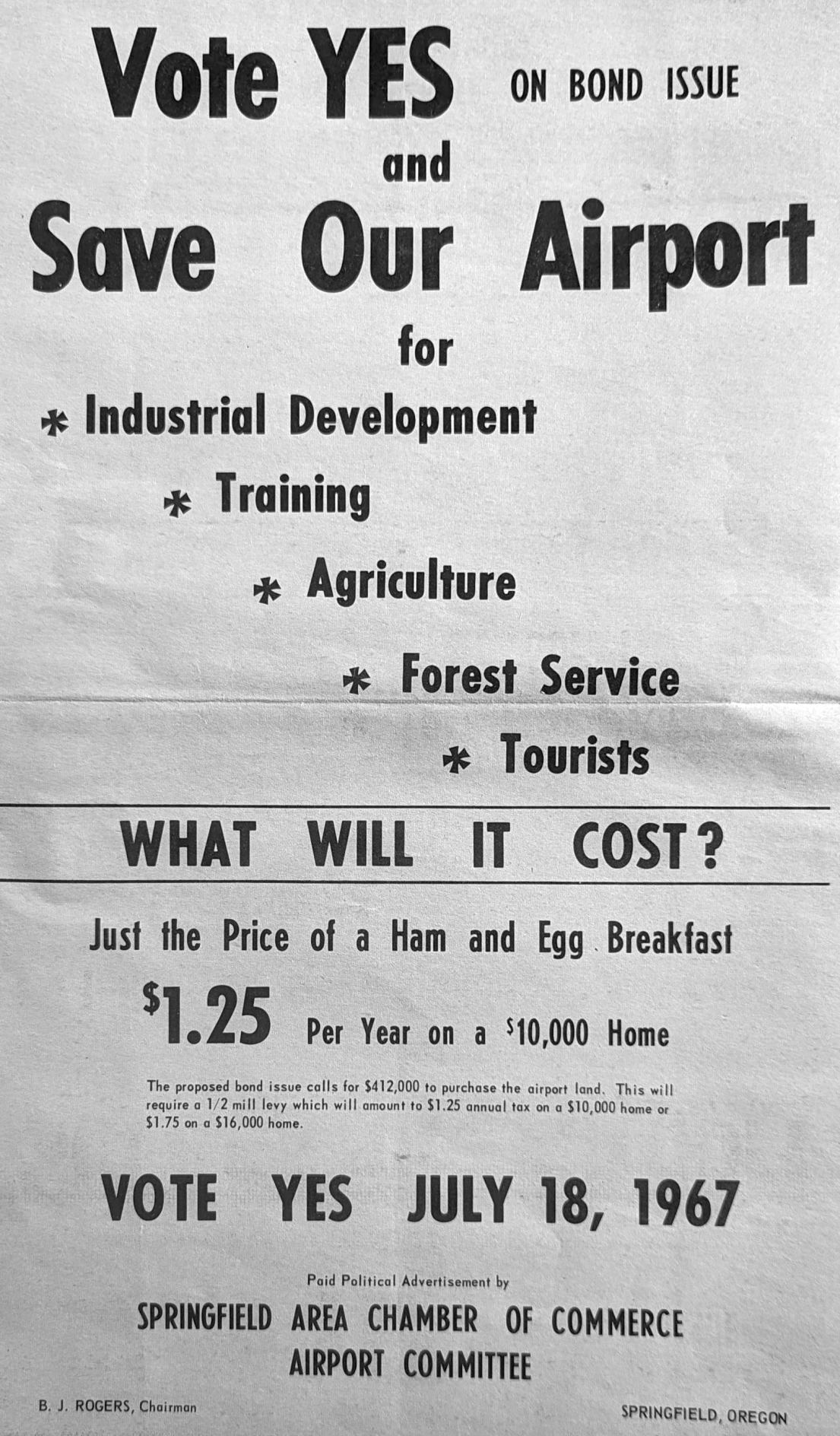
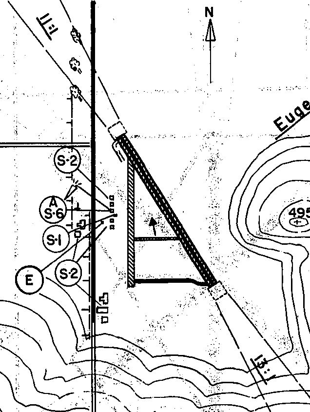
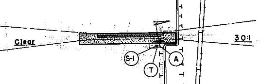
An advertisement from a circa 1967 newspaper flyer that was produced to try & rally the Springfield community to action to preventing the Springfield Airport closure (courtesy of Jeff Long).
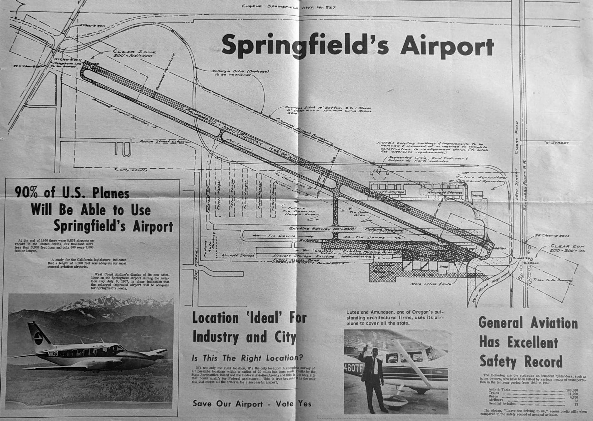
A plan for a proposed expansion of Springfield Airport, depicting a never-built longer northwest/southeast runway, from the circa 1967 newspaper flyer (courtesy of Jeff Long).
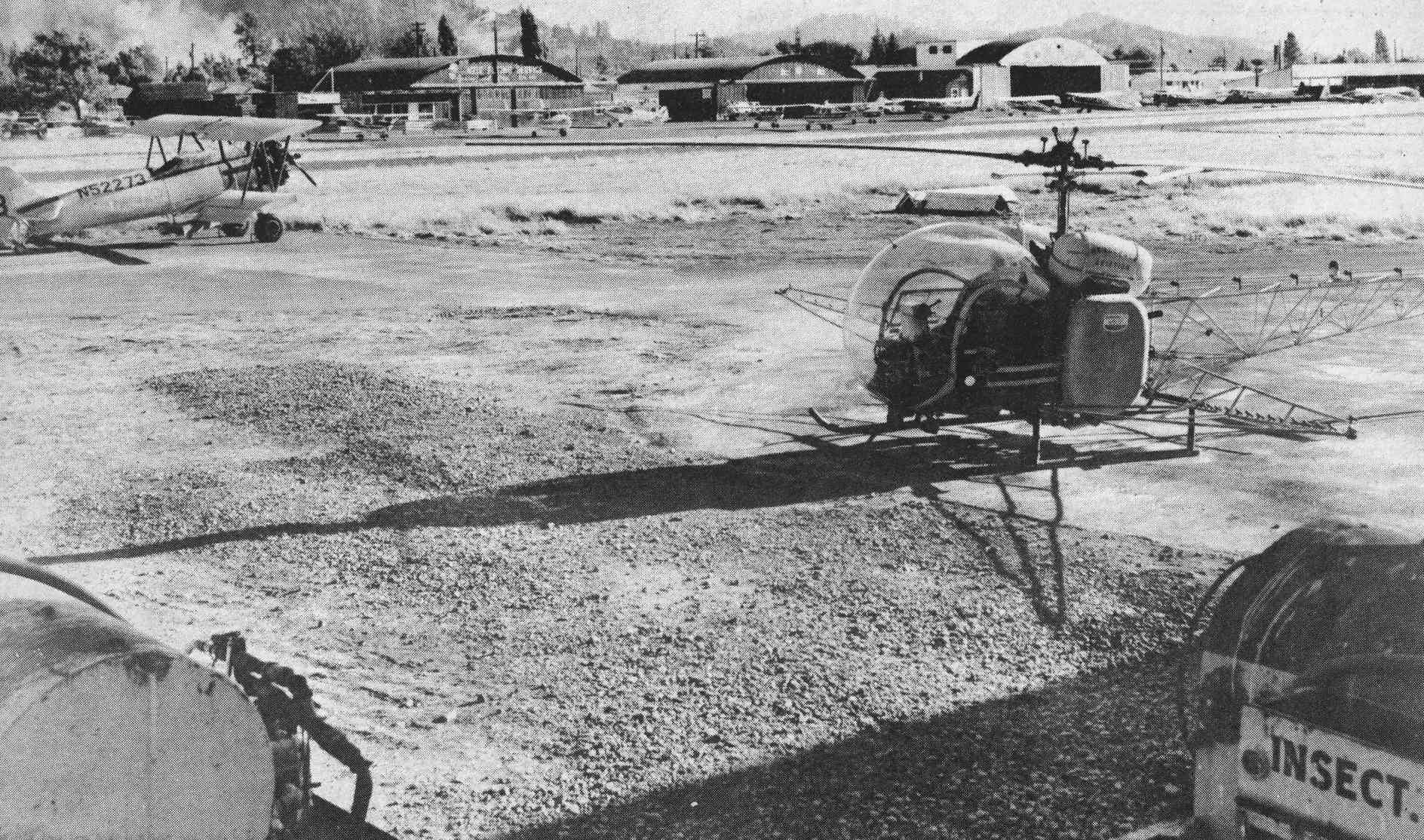
An undated photo of a Bell 47 helicopter modified to conduct agricultural spraying, shown at Springfield Airport, from the circa 1967 newspaper flyer (courtesy of Jeff Long).
Originally captioned, “One sixth of all farmland in U.S. Fertilized, treated, or planted by air.”
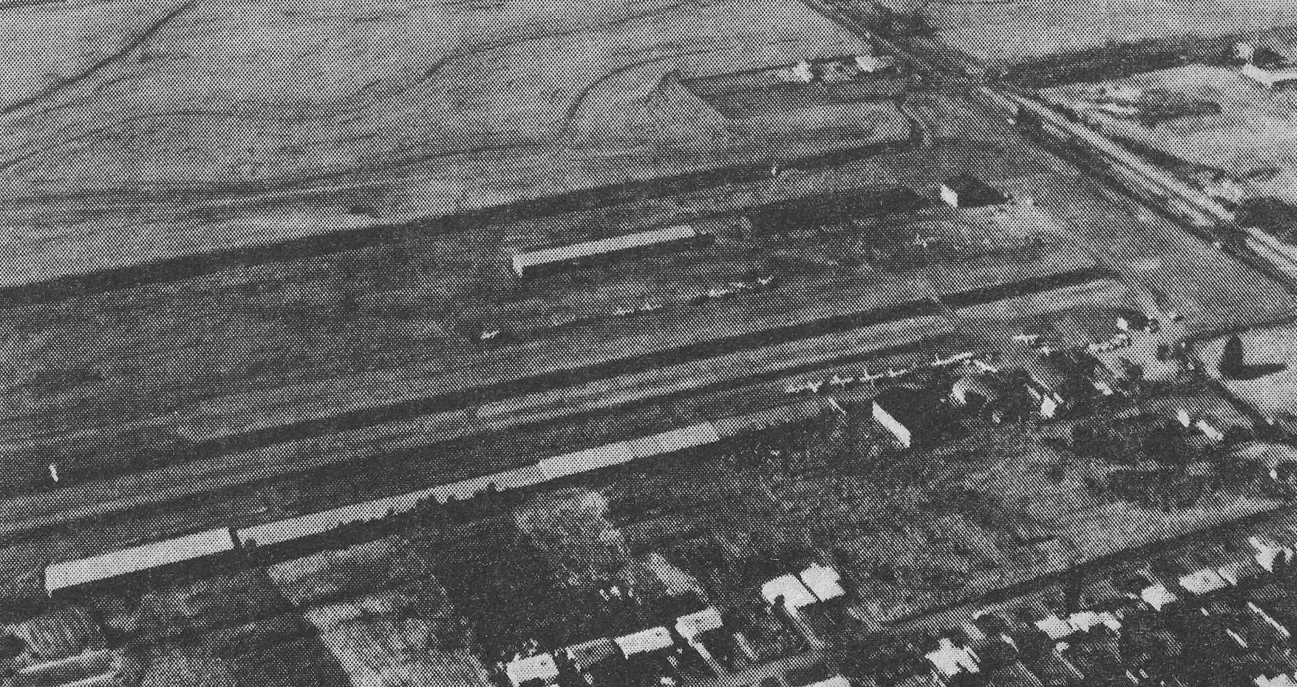
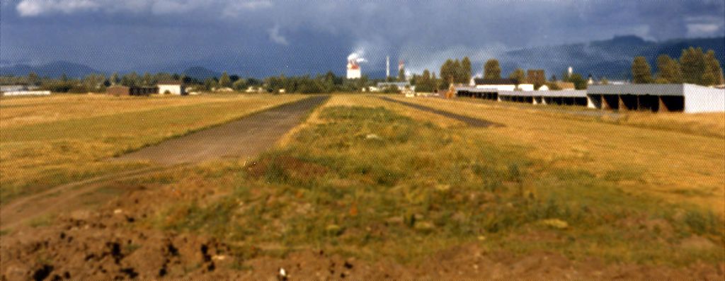
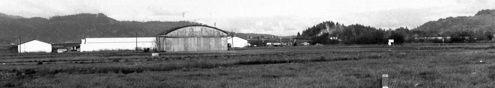
An undated aerial view looking northeast at Springfield Airport, from the circa 1967 newspaper flyer (courtesy of Jeff Long).
An undated aerial view looking southeast at Springfield Airport, from the circa 1967 newspaper flyer (courtesy of Jeff Long).
A circa 1960s photo of Gordon Rennie & 3 other men with a Piper at Springfield Airport (courtesy of Madeline McGraw).
Mark Fryburg recalled, “The old Springfield Airport... I learned to fly there 1967-68.
It was originally owned by Milt Ruberg, of DBA McKenzie Flying Service. He was also local FAA Examiner.
Milt owned an Aerocar that was mostly hangared & often had its engine quit after landing.
The airport flourished under 2 GI Bills, post WW-II and post VietNam.
Thousands of people found their love of flying there with its east/west 2,000' runway with cottonwoods to the east
and power lines to the west & an almost constant crosswind from the northwest.
They said, 'If you learn to fly at Springfield, you can fly just about anywhere.'”
Terry Liittschwager recalled, “I learned to fly at the old Springfield Airport in 1969.
Many fond memories of a much better time for general aviation.”
Springfield Airport had a long history as a center for crop-dusting planes & helicopters.
During much of that time, the main insecticide used was the now-banned DDT.
The helicopters would come in & dump on the ground whatever was left in their tanks.
Nobody really thought twice about it because DDT was legal at the time.
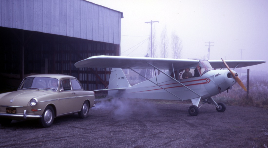
A 1970 photo by Stephen Schneider, taken in front of the cafe on the southeast side of the Springfield Airport,
looking west at unidentified biplane in front of the Mckenzie Flying Service.
A circa 1970-71 photo (courtesy of Jeff Long), which Jeff Long observed “shows my dad, Chad Long,
with his newly restored Porterfield, awaiting final paint”, at Springfield Airport.
A circa 1970-71 photo by Chad Long (courtesy of Jeff Long) of Chad's Porterfield in front of Springfield Airport's McKenzie Flying Service hangar.
A circa 1970-71 photo by Chad Long (courtesy of Jeff Long) of Chad's Porterfield at the far southwest of the Springfield Airport hangars.
Jeff Long remarked, “It shows the primitive open hangars, the gravel taxiway, and how close the houses were behind.
I’m the little boy with my big sister in the Porterfield. My mom is staying warm in the car.”
The last aeronautical chart depiction which has been located of Springfield Airport was on the November 1971 Klamath Falls Sectional Chart,
which depicted Springfield as having a 2,000' paved east/west runway.
According to Mark Fryburg, “I think [Springfield Airport] closed to public around 1971-72. It was used for skydiving shortly thereafter.”
Alan Carpenter recalled, “I did my first 3 skydives at the Springfield Airport in January 1973 with the University of Oregon Physical Education class.
Jim Wright was our P.E. instructor for skydiving.
In 1976 I drove a truck & mixed chemicals for Herb Henderson who operated a JetRanger, a LongRanger, and a Bell 47 helicopter for his crop dusting business, Henderson Aviation.
Those chemicals were some of the crop dusting powders & liquids I mixed for the JetRanger.”
According to Jesse Litten (who learned to fly at the old Springfield Airport),
"When the airport was closed, Milt Ruberg took his McKenzie Flying Service over to the Eugene Municipal Airport."
Bob Litten recalled, "Springfield's business district was moving too close to the West end of the runway
and as is frequently the case there was inadequate zoning to protect the airport.
Shortsighted on the city's part, in my opinion."
A circa 1973 photo by Chad Long (courtesy of Jeff Long) of the abandoned McKenzie Flying Service at the site of Springfield Airport.
An undated photo from a 1974 newspaper article (courtesy of Jeff Long) of Chad Long restoring his 1949 Piper Clipper inside a Springfield Airport hangar.
Jeff Long recalled, “Sometime in 1974 the open hangars to the south were torn down.
As an 8-year old I had played in the dirt piles a lot, flew control line airplanes on the end of the runway, and poked around the hangar remains.”
A circa 1975-76 photo by Chad Long (courtesy of Jeff Long) at Springfield Airport.
Jeff Long remarked, “This photo is of my dad’s PA-16 Piper Clipper tucked inside one of the 'executive' hangars (note the nice office to the left), on the north end looking south.
This hangar previously housed a Jet Ranger helicopter before the airport closure,
or so my dad told me to explain the awful smell that he said was from the helicopter’s leaky hydraulic fluid stains on the pavement.
This picture was taken after the open hangars were already torn down
and nobody else really used the airport for aviation other than my dad & that DDT helicopter spraying business
in the big hangar down at the other end of the hangar row, in the northeast corner of the airport.
The northwestern-most row of 'executive' hangars that were just west of this one that my dad used were already gone at the time of this picture.
Sometime between 1976-80 there was a fire that completely burned down this row of hangars.
Fortunately my dad’s plane wasn’t there anymore, but sadly the wing that you can see hanging above, was a complete loss
(it was an all-wood wing, 1-piece spar, belonging to Cessna C-34 N17054).”
A late 1970s photo of a Springfield Airport hangar (courtesy of Madeline McGraw).
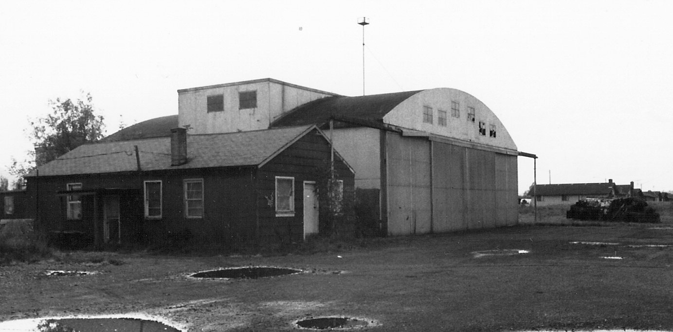
A late 1970s photo of a Springfield Airport office & hangar (courtesy of Madeline McGraw).
A late 1970s photo of Springfield Airport (courtesy of Madeline McGraw).
After the Springfield Airport closed down, the site (which was owned by a trust) was found to be contaminated.
According to Blake Hasting (who ultimately redeveloped the site), "It looked as if it would cost millions of dollars to clean it up, so it basically sat vacant for decades.
Every broker & developer knew about the site, and a lot of deals were proposed.
At one point, the trust tried to give the land away to the city. But ultimately everybody walked away because of the liability issues."
Gradually, the land became something of a dump.
"There must have been 20 abandoned cars on the site in addition to a homeless camp," says Hastings.
Springfield Airport was no longer depicted on the May 1985 Klamath Falls Sectional Chart (courtesy of Paul Columbus).
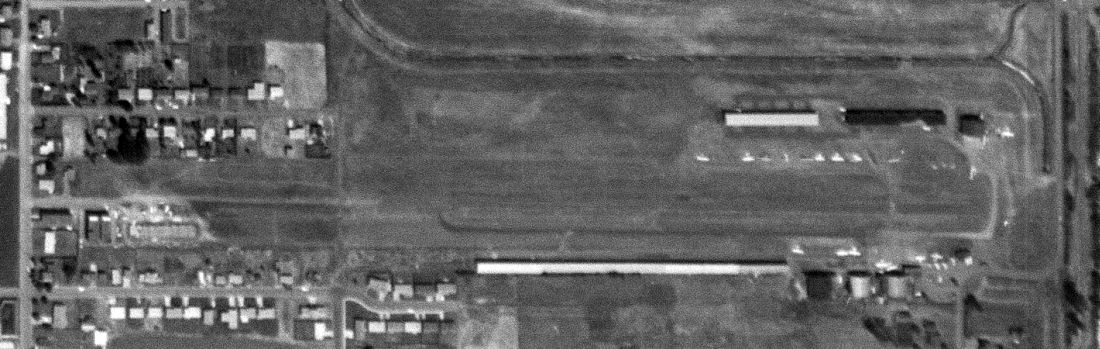
The field was still labeled "Springfield Airport" on the 1986 USGS topo map, and the runway & hangars were still depicted,
even though the field had apparently been abandoned for more than a decade.
According to Mark Fryburg, the “runway was still visible as late as 1990 running directly into the wall of the K-Mart.”
A 5/23/94 USGS aerial view looking northwest showed the remains of the Springfield Airport runway & paved ramp area were still visible.
Hastings & his partners bought the property for $700,000 in 1996 & began a 2-year cleanup program.
The property was eventually sold to Wal-Mart for $5.8 million.
How many small airports have befallen the fate of becoming a Wal-Mart?
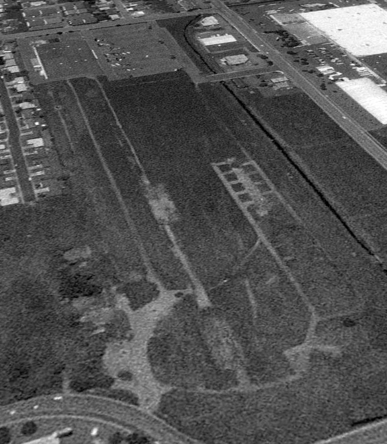
A 2000 aerial photo showed that more of the site had been scraped clean,
but traces were still visible of the runway & taxiway on the northeast portion of the airport site.
A 2003 aerial photo showed that several large buildings had been constructed, obliterating any trace of Springfield Airport.
According to William Greenlee, “Walmart built a Super Center.
Also during that time Jerrys Home Improvements built a store in between what was K-Mart (now Wilco Farm Store) & Walmart.
In 2010 Jerrys added a second building. There is no trace of the old Springfield Airport.”
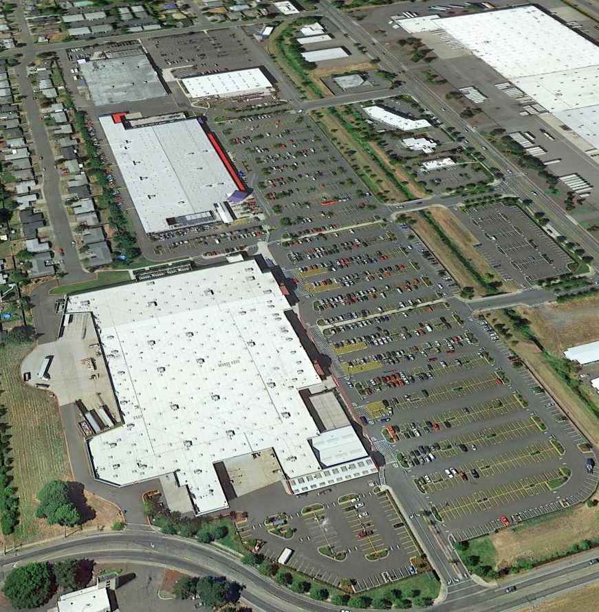
An 8/24/12 aerial view looking northwest showed no trace remaining of Springfield Airport.
____________________________________________________
Since this site was first put on the web in 1999, its popularity has grown tremendously.
If the total quantity of material on this site is to continue to grow,
it will require ever-increasing funding to pay its expenses.
Therefore, I request financial contributions from site visitors,
to help defray the increasing costs of the site
and ensure that it continues to be available & to grow.
What would you pay for a good aviation magazine, or a good aviation book?
Please consider a donation of an equivalent amount, at the least.
This site is not supported by commercial advertising –
it is purely supported by donations.
If you enjoy the site, and would like to make a financial contribution,
you
may use a credit card via
![]() :
:
Please consider checking the box to make a monthly donatation.
For a mailing address to send a check, please contact me at: paulandterryfreeman@gmail.com
If you enjoy this web site, please support it with a financial contribution.
please contact me at: paulandterryfreeman@gmail.com
If you enjoy this web site, please support it with a financial contribution.
____________________________________________________
This site covers airfields in all 50 states.