Abandoned & Little-Known Airfields:
Eastern Oklahoma
© 2002, © 2024 by Paul Freeman. Revised 3/20/24.
This site covers airfields in all 50 states: Click here for the site's main menu.
____________________________________________________
Please consider a financial contribution to support the continued growth & operation of this site.
Funk Airfield / Broken Arrow Airport / Country Club Airport / Cotton Field (revised 11/27/18) - Garland Airport / Garland-Clevenger Airport / Tulsa Commercial (1st location) / Mayo Airport / Brown Airport (revised 2/2/19)
Hatbox Field (revised 2/24/24) - Jensen Airport (revised 5/12/23) - Leonard Airfield (added 8/24/18) - Monkey Island Airport / Terramiranda Airport (revised 1/31/24)
Nash Municipal Airport (revised 9/26/16) - Okemah Airport (original location) (revised 3/26/23) - Sequoyah Park Airport (revised 12/30/17) - Site 5 / Fairfax Intermediate Field (added 2/17/24)
Stilwell Airport (added 3/20/24) - Tulsa Commercial (2nd location) / Cherokee Airpark (revised 5/10/23) - Tulsa North Airport / Downtown Airpark (revised 5/12/23) - Wilcox Airport / Collier Airport (revised 8/6/20)
____________________________________________________
Stilwell Airport, Stilwell, OK
35.837, -94.629 (Southeast of Tulsa, OK)
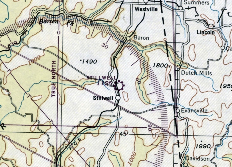
Stilwell Airport, as depicted on the October 1945 Little Rock Sectional Chart.
Photo of the airfield while in use is not available.
This little general aviation airport was evidently established at some point between 1944-45
(like hundreds of other small airports in America's post-WW2 aviation boom),
as it was not yet depicted on the 1944 Little Rock Sectional Chart.
The earliest depiction which has been located of Stilwell Airport was on the October 1945 Little Rock Sectional Chart,
which depicted Stilwell as a commercial/municipal airport.
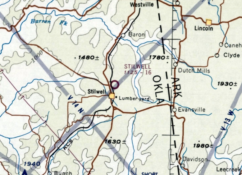
The last aeronautical chart depiction which has been located of Stilwell Airport was on the July 1968 Little Rock Sectional Chart,
which depicted Stilwell as having a mere 1,600' unpaved runway.
The earliest photo which has been located of Stilwell Airport was a 2/13/71 USGS aerial view.
It depicted Stilwell as having 2 unpaved runways, with 4 T-hangars on the northwest corner.
But there were no aircraft visible on the field.
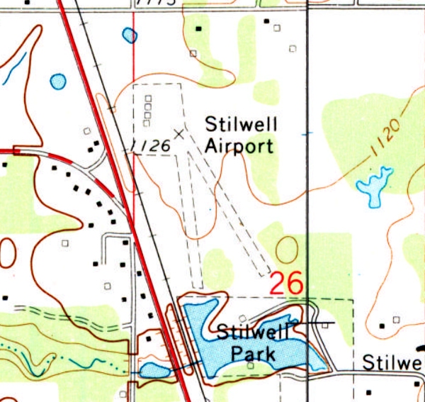
The earliest topo map depiction which has been located of Stilwell Airport was on the 1972 USGS topo map.
It depicted Stilwell as having 2 unpaved runways, with 4 T-hangars on the northwest corner.
The last topo map depiction which has been located of Stilwell Airport was on the 1978 USGS topo map.
At some point between 1980-95, the Painting Planes Airport (with a longer paved runway) was opened southwest of the town of Stilwell,
which evidently replaced Stilwell Airport.
Stilwell Airport was evidently closed at some point between 1968-2012,
as it was no longer depicted on the 2012 USGS topo map.
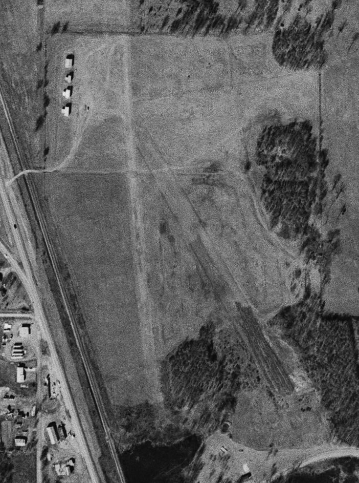
Aerial pictures show a house was built over the center of Stilwell Airport at some point between 2015-2017.
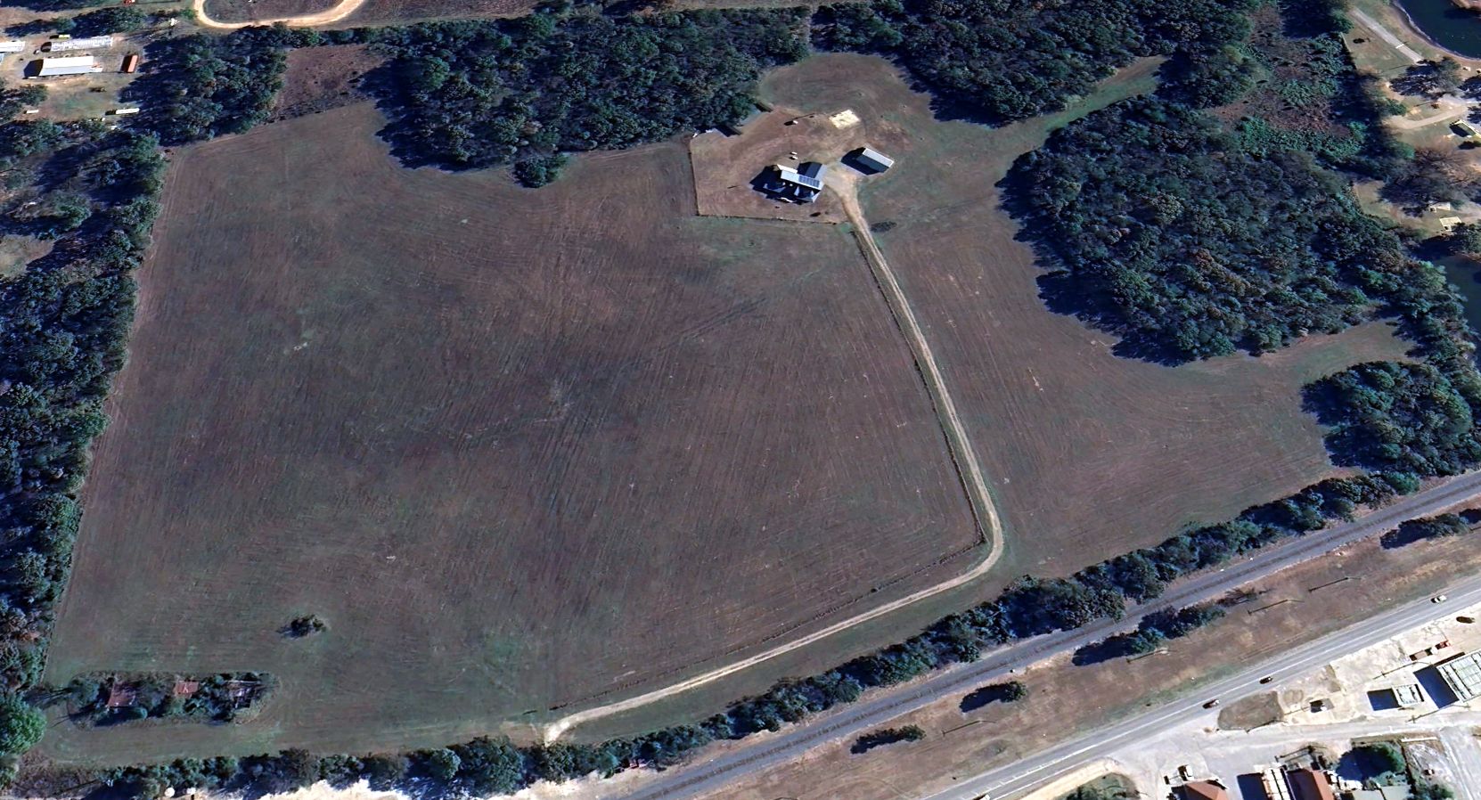
A 2023 aerial view looking east showed the Stilwell Airport T-hangars remained standing, though overgrown, at the northwest corner (bottom-left),
and the southern end of the 2 grass runways remained recognizable.
William Hyatt reported of the Stilwell Airport site in 2024, “There appear to still be hangar buildings on-site.”
Thanks to William Hyatt for pointing out this airfield.
____________________________________________________
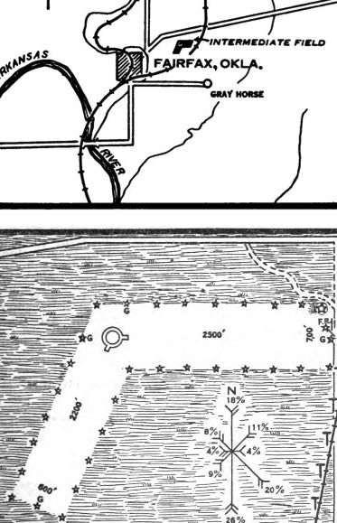
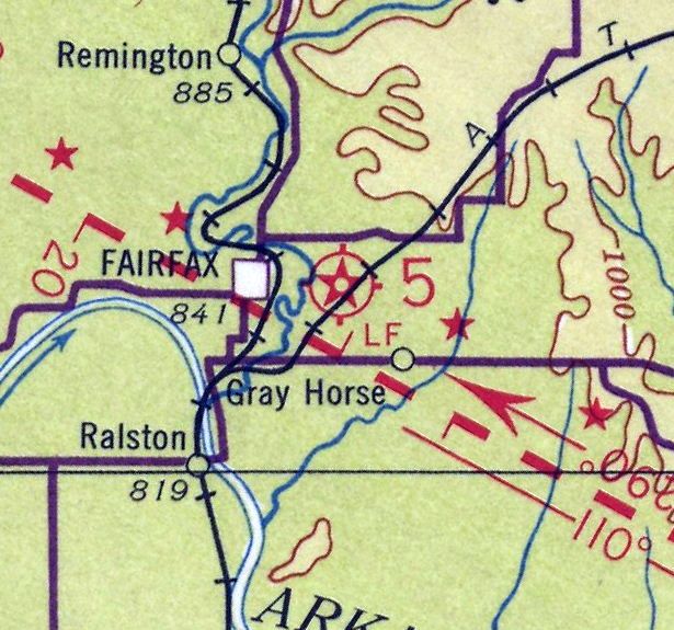
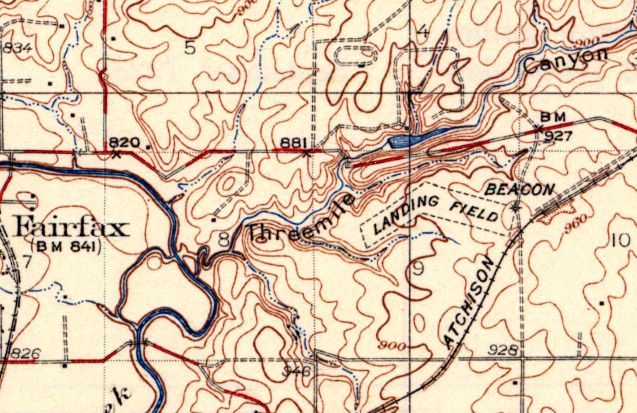
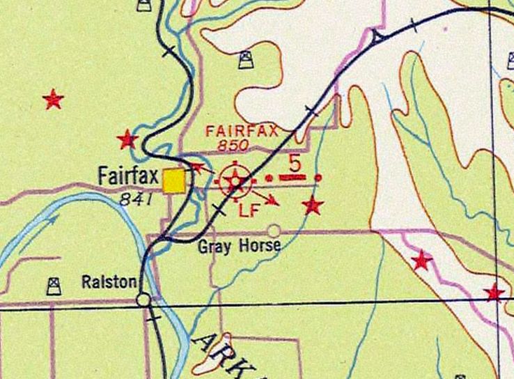
Site 5 / Fairfax Intermediate Field, Fairfax, OK
36.576, -96.659 (Northwest of Tulsa, OK)
Site 5 / Fairfax Intermediate Field, as depicted on the 9/14/29 Commerce Department Airway Bulletin (courtesy of Jonathan Westerling).
Photo of the airfield while in use is not available.
Jonathan Westerling reported, “The Osage Reservation's incredible oil wealth brought plenty of airplanes to the area in the 1920s
but did not result in the construction of any airfields significant enough to last more than a few years.
The first government-recognized airfields to be constructed in the county was to support the establishment of the short 72 mile Tulsa to Ponca City air route which was commissioned on 7/5/28.
An auxiliary airfield was constructed by the Commerce Department at 'Site #5' along this route & located 2.5 miles east of the town of Fairfax.
Fairfax Intermediate Field had two large runways connected in the middle.
According to Airway Bulletin # 742, one was 2,500' x 700' & the other was 2,200' x 600'.
However aside from the generator building, beacon, and wind direction indicator there wasn't much else located on the airfield.
At the intersection of the runways was a 50' white circle.”
Jonathan continued, “The 1931 Airway Bulletin #2 indicated the runways had shrunk a bit in size (or had perhaps been re-measured more accurately).
The longer runway was 2,435' x 685' & the shorter one 1,966' x 596'.”
Fairfax Intermediate Field, as depicted on the 1931 Pilot's Handbook Map (courtesy of the Museum of Flight).
The earliest aeronautical chart depiction which has been located of Fairfax Site 5 was on the 1931 Strip Chart (courtesy of Jonathan Westerling).
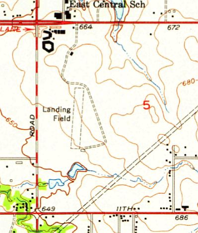
The earliest topo map depiction which has been located of Fairfax Intermediate Field was on the 1932 USGS topo map.
It depicted a property outline surrounding 2 runways, labeled “Landing Field”, with an aeronautical beacon on the east side.
The last aeronautical chart depiction which has been located of Fairfax Site 5 was on the 1933 Strip Chart (courtesy of Jonathan Westerling).
Jonathan Westerling reported, “The 1934 Airport Directory Company Directory indicated that the Fairfax runways had been extended from their original length; to 2,640' & 2,340'.
The Tulsa - Ponca City Air Route was decommissioned for reasons unknown in 1934 & was no longer shown on the 1935 CAA Air Commerce Bulletin.
Presumably the Fairfax Intermediate Field was decommissioned at this time.”
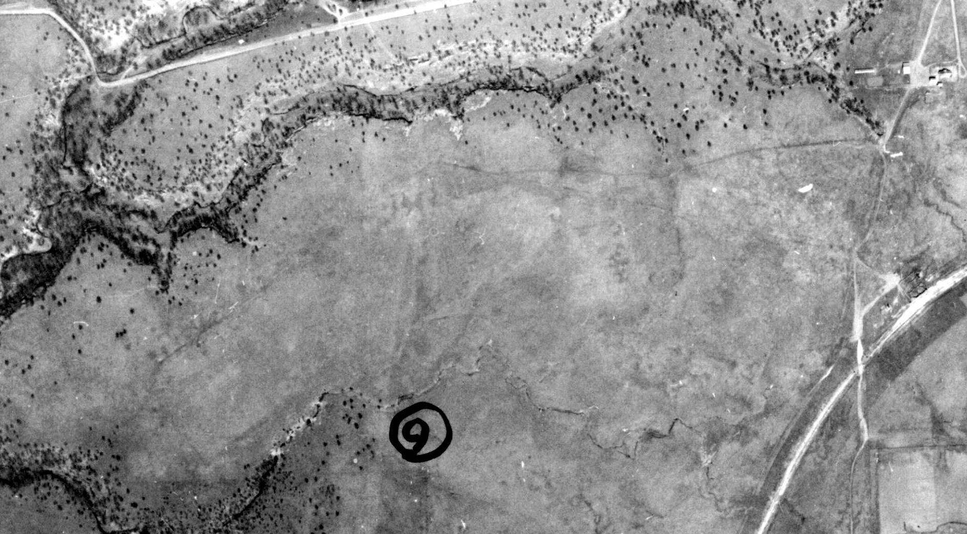
The Fairfax Intermediate Field was barely visible on a 1938 aerial photo (courtesy of the OSU Library Maps & Spatial Data Department).
The 1955 & 1958 USGS topo maps no longer depicted Fairfax Intermediate Field, but still depicted the beacon on its east side.
The 1978 USGS topo map no longer depicted the former Fairfax Intermediate Field beacon.
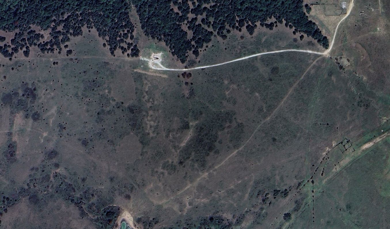
A 2023 aerial view showed no recognizable trace remaining of Fairfax Intermediate Field.
Thanks to Jonathan Westerling for pointing out this airfield.
____________________________________________________
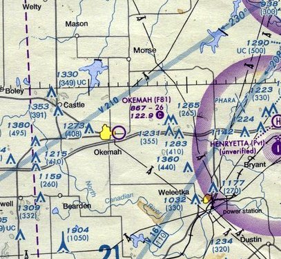
Okemah Airport (original location) (F81), Okemah, OK
35.432, -96.284 (East of Oklahoma City, OK)
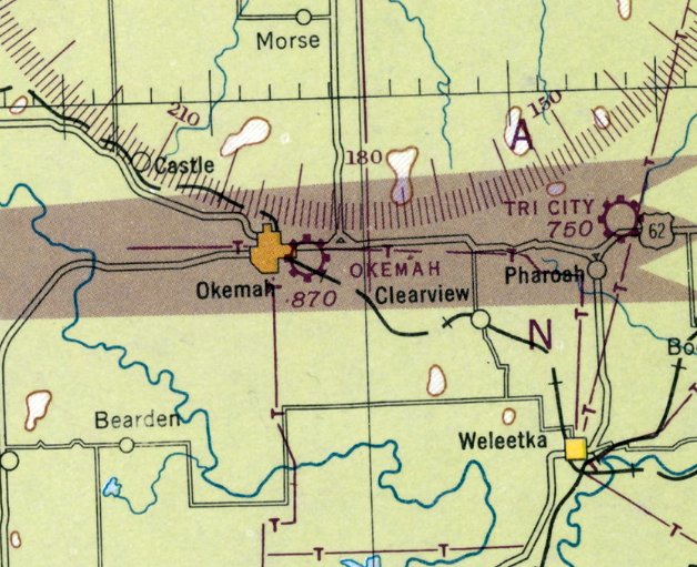
Okemah Airport, as depicted on the 1948 Sectional Chart (courtesy of Jonathan Westerling).
Photo of the airfield while in use is not available.
The original Okemah Airport was located east of the town.
According to FAA Airport/Facility Directory data, Okemah Airport was activated in November 1946.
The June 1947 Airman's Guide (courtesy of Jonathan Westerling) listed Okemah as a "New Airfield" with a 3,300' runway.
The earliest depiction which has been located of Okemah Airport was on the 1948 Sectional Chart,
which depicted Okemah as a commercial/municipal airport.
Jonathan Westerling reported, “However by 1949, the airport was listed as 'Emergency use only - soft when wet' & the runway shortened to 3,000'.”
The 1954 Airplane & Business Flying Directory (courtesy of Jonathan Westerling) described Okemah Municipal Airport as having 2 unpaved runways, with the longest as 1,900', with the note “Soft when wet”.
Jonathan Westerling observed, “It's likely that the original airfield was built without adequate drainage. The nearby marsh has since been named 'Airport Lake'!”"
Jonathan Westerling reported, “By 1960, however the runway had been returned to 3,000' of usable length according to the April Airman's Guide.”
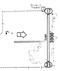
A 1967 airport directory (courtesy of Jonathan Westerling) depicted Okemah Airport as having a 3,000' turf north/south runway,
with a former east/west runway, and a few small buildings on the west side.
Jonathan Westerling reported, “By 1973, lighting had been installed & a second, shorter diagonal runway had been added according to the Central States Flight Handbook.
By 1976, the airport diagram includes a third short perpendicular Runway 9/27. This was previously just a taxiway out to the main runway.”

A 1982 airport directory (courtesy of Jonathan Westerling) depicted Okemah Airport as having 2 runways, measuring 3,200' north/south & 2,450' northeast/southwest.
A few small buildings were depicted on the northwest side.
An undated aerial view of Okemah Airport from the 1983 OK Airport Directory (courtesy of Jonathan Westerling).
It depicted Okemah Airport as having a 3,000' turf Runway 18/36.
Jonathan Westerling reported, “The 1989 AOPA Airports USA [directory] indicated an aerial spraying FBO operating from Okemah.”
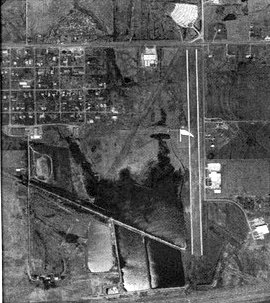
A 1995 aerial view looking southeast at Okermah Airport showed the 3 unpaved runways & the hangar on the west side.
There were no aircraft visible on the field.
An undated aerial view of Okemah Airport from the 1995 OK Airport Directory (courtesy of Scott Jednacz).
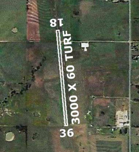
It described Okemah Airport as having 2 turf runways: 3,425' Runway 17/35 & 2,450' Runway 2/20.
It was described as owned by the City of Okemah, with the Airport Contact as Joe Parks.
Jonathan Westerling reported, “The 1997 AOPA Airports USA directory] listed the North/South runway at Okemah at its longest length, 3,360'.”
Scott Jednacz recalled, “I remember notices even before 2000 that there were numerous golf hazards on the North/South runway such as golf tees.”
Jonathan Westerling reported, “A golf course was constructed around the airfield around the year 2000;
the 2003 Airports USA directory added a note to beware of golf carts operating on the airfield.”
Jonathan Westerling reported, “According to the OK Aeronautics Division, in 2006 construction on a new airport 2 miles south of town began.
The new airport opened in 2010 with a turf runway. Presumably the old airport location was abandoned once the new airfield was completed.”
The last aeronautical chart depiction which has been located of the original Okemah Airport was on the September 2010 DFW Sectional Chart (courtesy of Scott Jednacz),
which depicted Okemah as having a 2,600' unpaved runway.
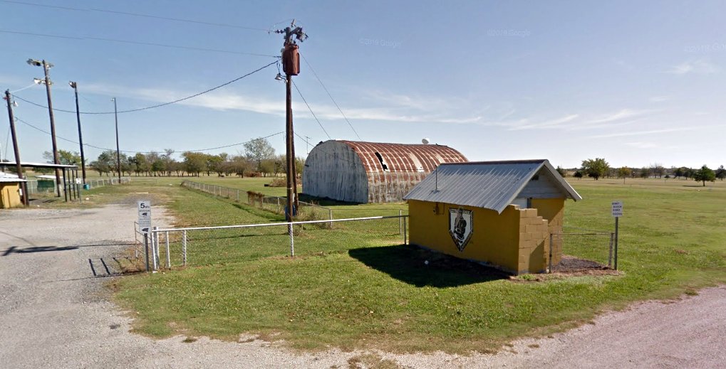
A 2012 photo of the former hangar on the west side of the site of the original Okermah Airport.
The March 2014 DFW Sectional Chart (courtesy of Scott Jednacz) no longer depicted the original Okemah Airport,
instead depicting the new airport to the south of the town.
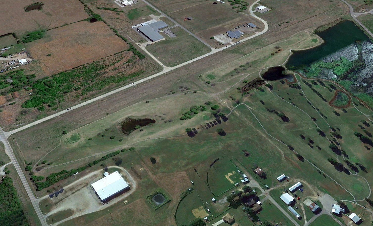
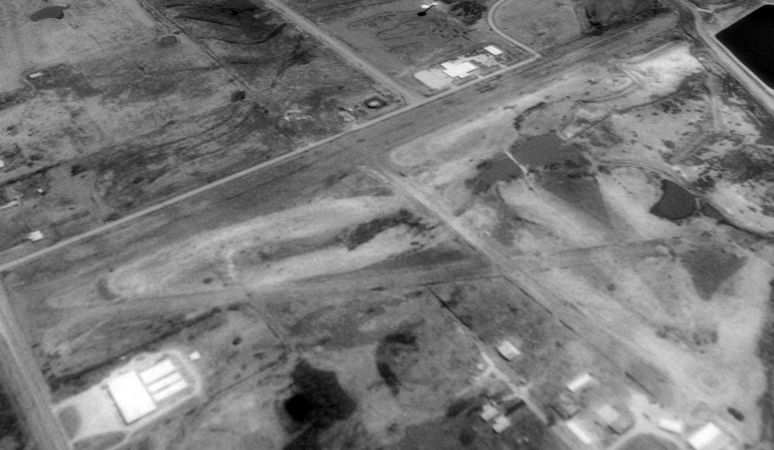
A 2021 aerial view looking southeast at the site of the original Okermah Airport showed the north/south runway remained intact, with traces of the other 2 runways still recognizable within the golf course.
The former hangar remained intact on the west side.
Thanks to Jonathan Westerling for pointing out this airfield.
____________________________________________________
35.908, -95.785 (Southeast of Tulsa, OK)
Leonard Airfield, as depicted on a 1995 USGS aerial view looking northwest.
Photo of the airfield while in use is not available.
No much is known about this airfield, including its name.
This small residential fly-in community airfield was evidently established at some point between 1967-80,
as it was not yet depicted on a 1967 aerial photo, the October 1968 Tulsa Sectional Chart, or the 1975 USGS topo map.
The earliest depiction which has been located of this airfield Airport was on a 1980 aerial view.
It depicted a paved 2,000' northeast/southwest runway, with several homes & hangars on either side, and 3 light single-engine planes parked alongside.
Scott Jednacz reported, “Leonard Airfield was created by Red Stevenson. The airfield was a community airpark.”
According to Joe Goodin, a nearby reported, “It was a private residential airstrip with a few houses around it.”
The last depiction which has been located showing aircraft on this field was a 1981 aerial view,
which depicted 3 light single-engine planes parked alongside.
The Leonard Airfield evidently didn't last long, and was evidently closed (for reasons unknown) at some point between 1981-84,
as it was not depicted on the 1984 DFW Sectional Chart.
Scott Jednacz reported, “Unfortunately after some years several of the homeowners decided to have it not be an airport anymore & they overrode the members that wanted it to stay an airport.”
The 2012 USGS topo map labeled the former runway as “S 175th E Ave”.
A 2018 aerial view looking northwest at the remains of the Leonard Airfield shows the paved runway remains intact though deteriorated,
with a closed-runway “X” symbol still barely recognizable on the southwest end.
Thanks to Joe Goodin for pointing out this airfield.
____________________________________________________
Monkey Island Airport / Terramiranda Airport (79F), Monkey Island, OK
36.61, -94.873 (Northeast of Tulsa, OK)
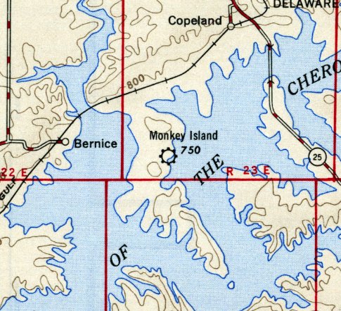
Monkey Island Airport, as depicted on the 1946 Tulsa Sectional Chart (courtesy of Jonathan Westerling).
This small airport was evidently built just after the artificial Grand Lake o' the Cherokees was opened in 1946,
as it was not yet depicted on the 1945 Tulsa Sectional Chart, nor listed in the 1946 Decker's Airport Guide (according to Jonathan Westerling).
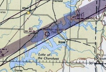
The earliest depiction which has been located of Monkey Island Airport was on the 1946 Tulsa Sectional Chart (courtesy of Jonathan Westerling).
It depicted Monkey Island Airport as a commercial/municipal airport.
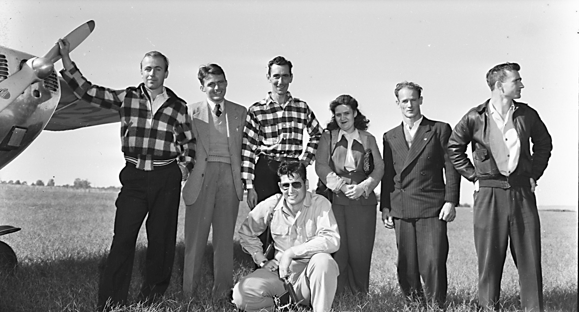
The earliest photo which has been located of Monkey Island Airport was a photo captioned “1946 Monkey Island flight” (courtesy of Bill Woodard).
Bill Woodard reported, “The person on the right is Paul Alden Cookerly Jr.; he would have been 20 in 1946.”
Monkey Island Airport, as depicted on the 1954 USGS topo map.
The last aeronautical chart depiction which has been located of Monkey Island Airport was on the 1968 Tulsa Sectional Chart (courtesy of Jonathan Westerling).
It depicted Monkey Island Airport as having a 2,600' unpaved runway.
The 1971 USGS topo map depicted Monkey Island Airport as having a single unpaved northeast/southwest runway.
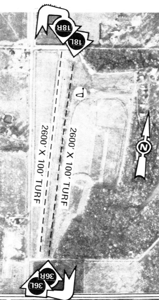
The 1974 Flight Handbook (courtesy of Jonathan Westerling) depicted Monkey Island Airport as having an unusual runway configuration for such a small airport,
with 2 parallel turf runways: 2,600' Runways 18R/36L & 18L/36R.
Why the parallel runways?
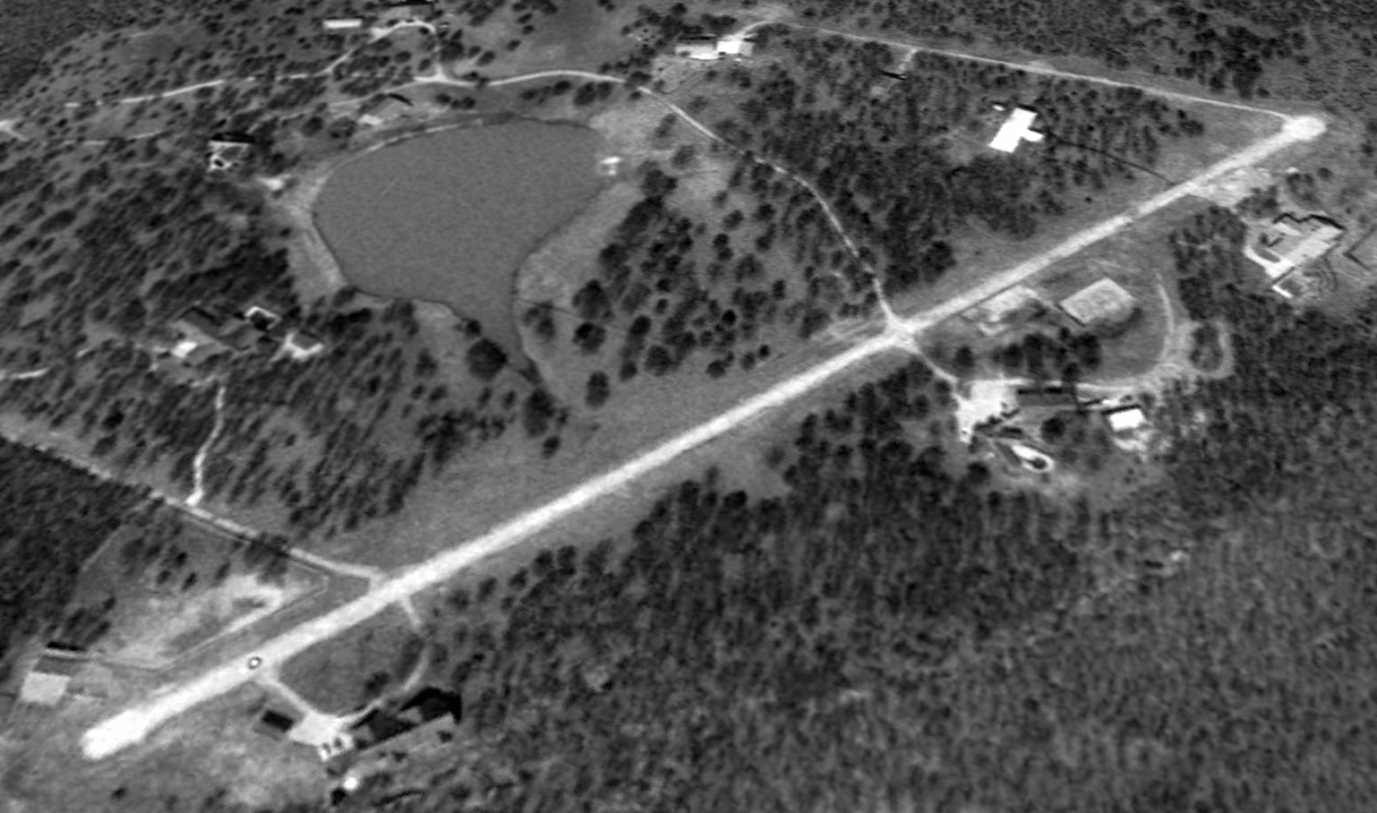
A 1980 aerial view depicted Monkey Island Airport as having a single unpaved northeast/southwest runway, with 2 light single-engine aircraft parked to the northeast.
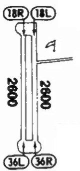
The 1981 Flight Guide (courtesy of Jonathan Westerling) depicted Monkey Island Airport as having 2 parallel turf runways: 2,600' Runways 18R/36L & 18L/36R.
The last airport directory entry which has been located of Monkey Island Airport was in the 1984 SkyPrint Aviation Atlas (courtesy of Jonathan Westerling).
It described Monkey Island Airport as having a 2,600' turf Runway 18L/36R.
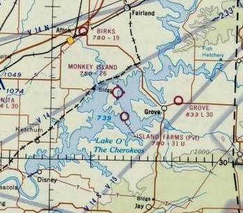
Monkey Island Airport was evidently renamed Terramiranda Airport at some point between 1984-94,
as that is how it was listed in a circa 1994 OK Airport Directory (courtesy of Scott Jednacz).
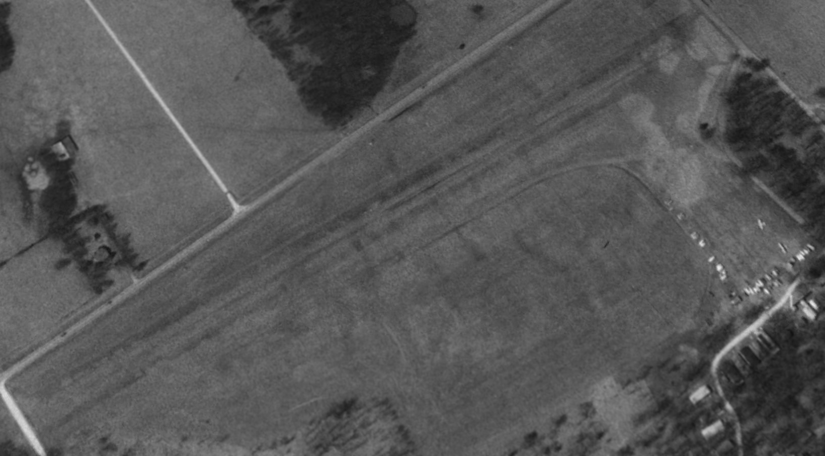
An undated aerial photo from the directory depicted Terramiranda Airport as having 2 parallel 2,580' turf runways,
with some buildings on the northeast side. There were no aircraft visible on the field.
The owners were listed as Gene Gregg & John Stewart.
Scott Jednacz recalled, “I flew over Terramiranda Airport occasionally, but never landed there as it looked like there may have been power lines at the north end of the runway.”
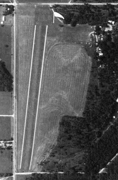
The only photo which is available showing aircraft at Terramiranda Island Airport was a 1995 aerial view looking northwest.
It showed 2 light single-engine aircraft parked on the northeast side of the grass runways.
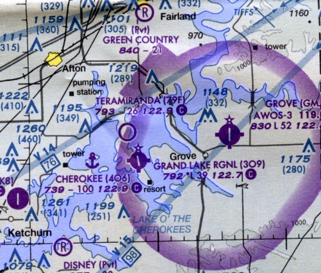
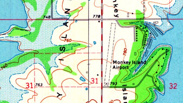
The only aeronautical chart depiction which has been located of Terramiranda Airport was on the 2007 Sectional Chart (courtesy of Scott Jednacz).
It depicted Terramiranda Airport as having a 2,600' unpaved runway.
Teramiranda Airport was evidenrly closed at some point between 2007-2010, as it was no longer depicted on the 2010 sectional Chart (according to Scott Jednacz).
It was presumably replaced by the larger Grand Lake Regional Airport which was built only a few miles to the southeast in the 1970s.
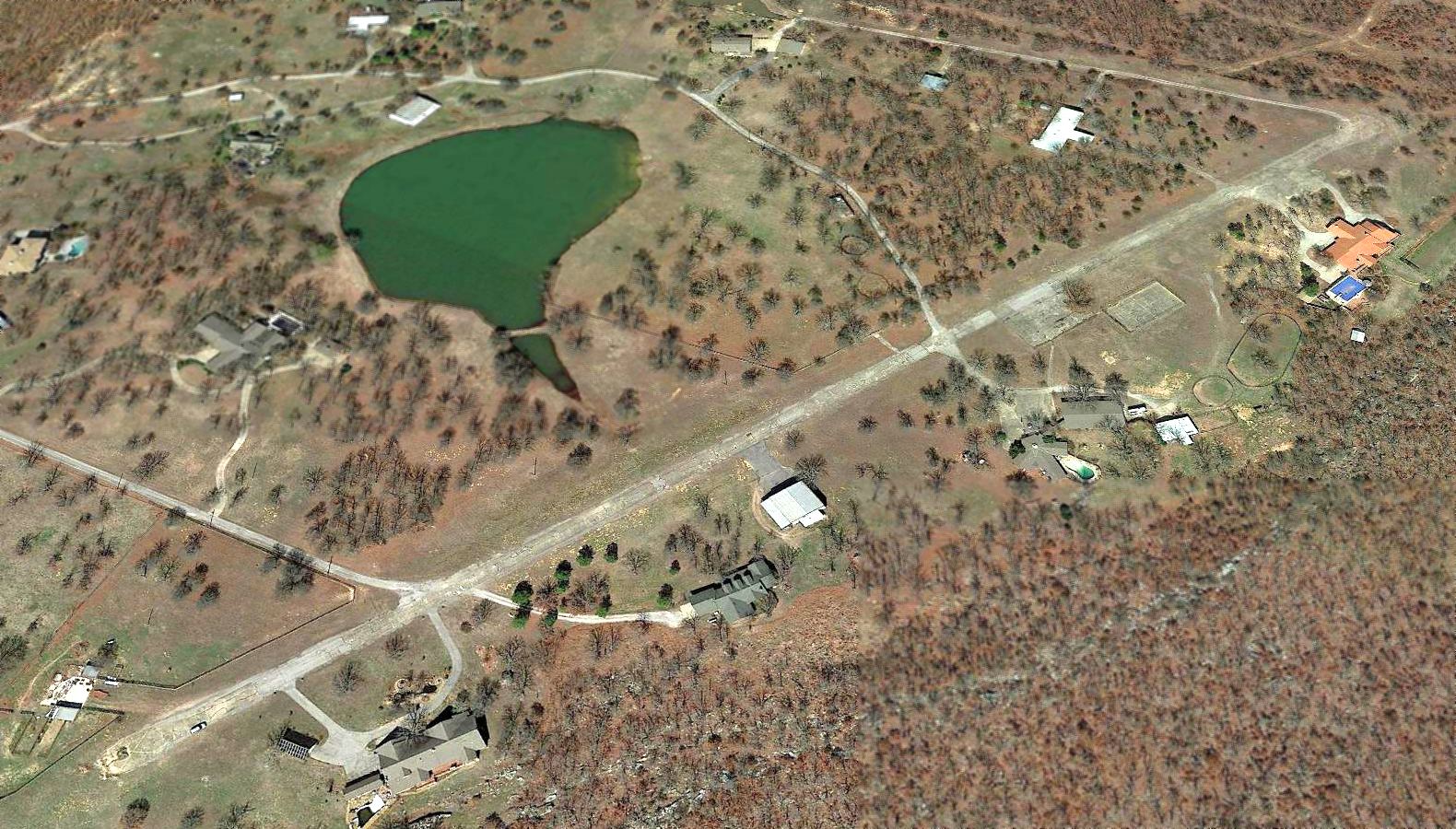
A 2011 aerial view still showed Teramiranda Airport as remaining intact, but without any sign of recent aviation use.
A 2013 aerial view still showed a road under construction crossing over the middle of the former Teramiranda Airport runways.
A 2015 aerial view looking northwest showed the remains of the Terramiranda Airport runways.
Thanks to Lee Corbin for pointing out this airfield.
____________________________________________________
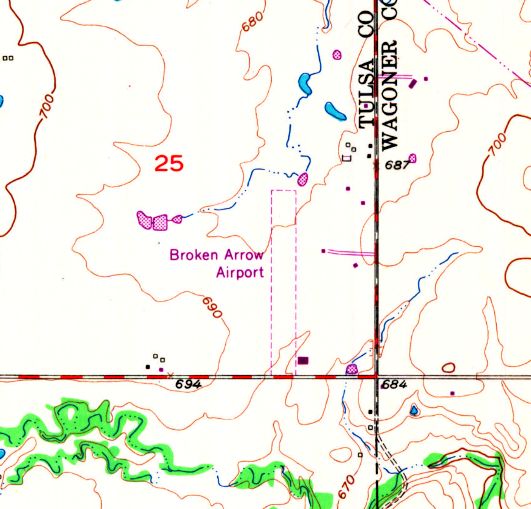
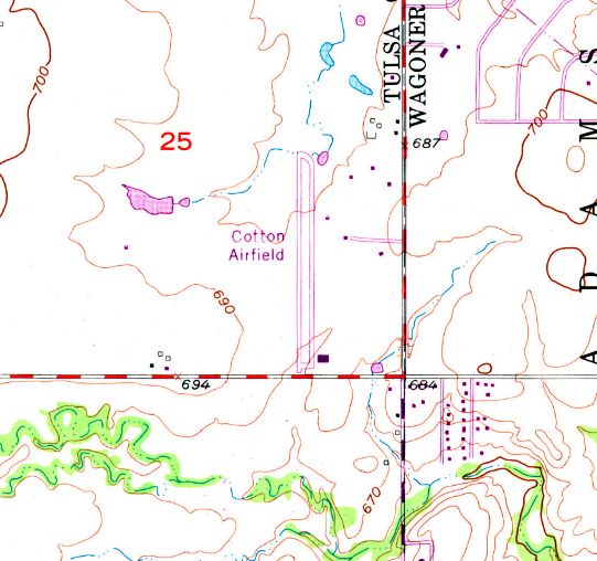
Funk Airfield / Broken Arrow Airport / Country Club Airport / Cotton Field, Broken Arrow, OK
36.091, -95.785 (Southeast of Tulsa, OK)
Funk Airfield, as depicted on the 1965 Tulsa Sectional Chart.
Photo of the airport while open has not been located.
This small general aviation airport was evidently established at some point between 1960-65,
as it was not yet depicted on the December 1960 Tulsa Sectional Chart.
The earliest depiction which has been located of Funk Airfield was on the 1965 Tulsa Sectional Chart.
It depicted Funk as having a 2,500' unpaved runway.
The airport was evidently renamed Broken Arrow Airport at some point between 1965-67,
as that is how it was labeled on the 1967 USGS topo map.
Broken Arrow Airport was depicted as having a single unpaved north/south runway, with a small building on the southeast side.
The airport was evidently renamed again, to Country Club Airport, at some point between 1967-73,
as that is how it was labeled on the January 1973 Kansas City Sectional Chart (courtesy of Stu Sibitzky).
It depicted Country Club Airport as having a 2,600' unpaved runway.
The airport was evidently renamed again, to Cotton Field, at some point later in 1973,
as that is how it was labeled on the 1973 USGS topo map.
Cotton Field had also gained a paved runway & paved parallel taxiway.
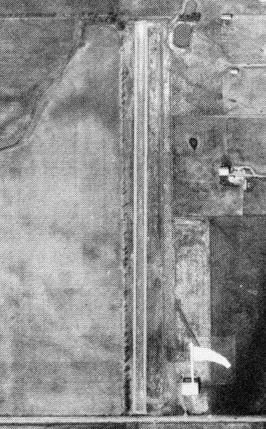
The earliest photo which has been located of Cotton Field was an undated aerial view from the 1978 OK Airport Directory (courtesy of Frank Holbert).
It depicted a single north/south runway, with a small hangar at the southeast corner.
The 1978 DFW Sectional Chart depicted Cotton Field as a public-use airport having a 2,600' unpaved runway.
Mike Huffman recalled, “In the late 1970s / early 1980s, Cotton Field's owner, Tulsa oilman Doyle Cotton, maintained a collection of antique airplanes in the hangar at the airport,
among which were a 1931 Kreider-Reisner KR-31 & a 1930s de Havilland DH. 89 Dragon Rapide.
A friend of mine, Jim Dross, maintained the airplanes for Mr. Cotton & he took me for a ride in the OX-5-powered KR-31.
It was very pitch-unstable; if the nose dropped a little, it tended to drop even further
and conversely, if it rose a little, it tended to rise even further, so constant attention to pitch attitude was very important.”
Bill Pinney recalled, “In the early to mid-1980s, I was based at TUL, flying a Lear 35A for a small, individually-owned oil company.
The owner, Doyle Cotton had a small airport in Broken Arrow, called Cotton Field.
It had about a 2,600-2,700' runway, mostly grass, but had paved (or oil covered dirt) for about the first 500’ on each end.
Part (threshold) was very close to the fence, the other side of which was a paved road.
The airport also had a parallel taxiway, grass, full length, with a turnoff at the mid-point.
There were 2 hangars, and a small fuel farm (all the 80 octane we could burn).
The main hangar was full of antiques, which we could fly as much as we wanted.”
The January 1988 DFW Sectional Chart (courtesy of Ron Plante)
showed Cotton Field had evidently changed to a private airfield at some point between 1978-88,
and was depicted as having a 2,600' unpaved runway.
The last aeronautical chart depiction which has been located of Cotton Field was on the June 1993 DFW Sectional Chart (courtesy of Ron Plante).
It depicted Cotton Field as a private airfield having a 2,600' unpaved runway.
According to Bill Pinney, “I think [Cotton Field] closed sometime in the early 1990s.”
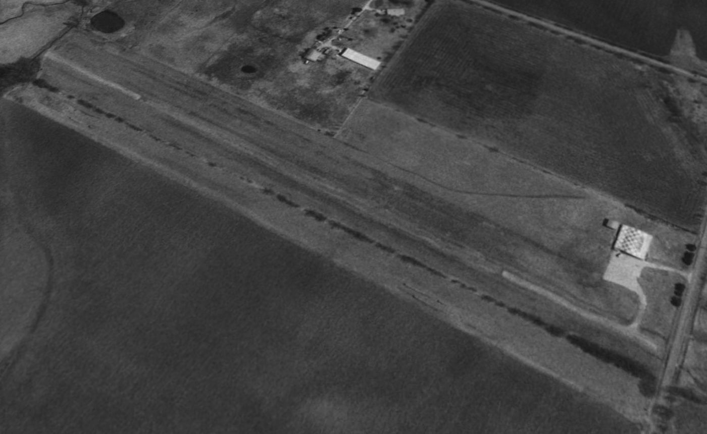
The last photo which has been located of Cotton Field was a 1995 USGS aerial view looking northeast.
The airport was still intact, but presumably abandoned by that point.
It had a single north/south unpaved runway, with short paved portions on each end,
and a paved ramp with a checkerboard-painted-roof hangar at the southeast corner.
Cotton Field was no longer depicted on the November 2004 Kansas City Sectional Chart.
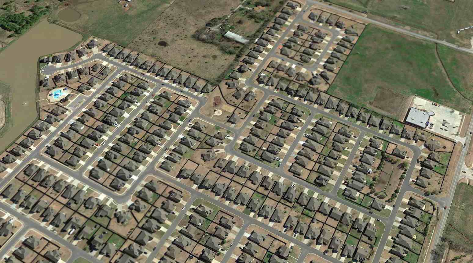
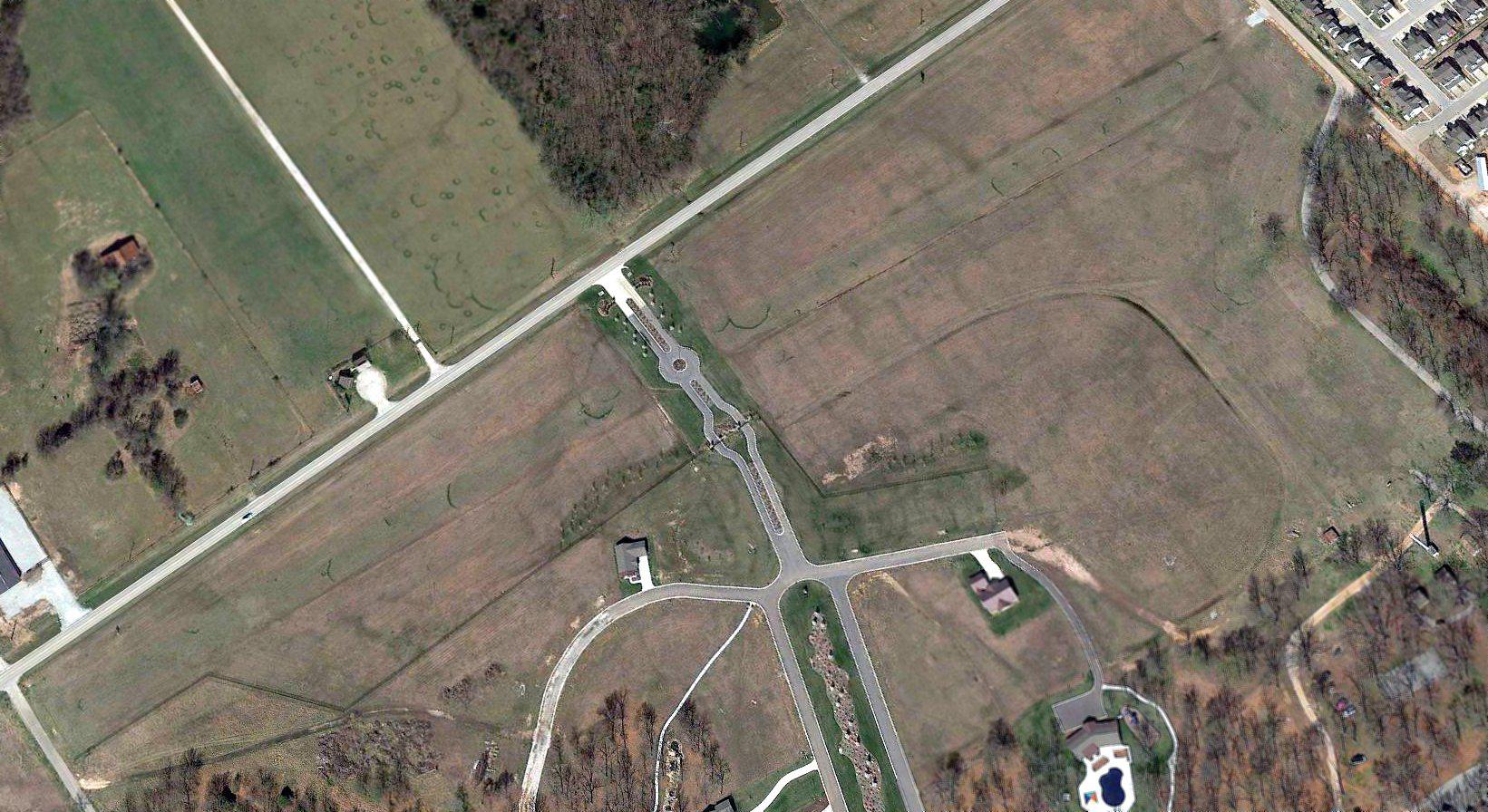
A 2015 aerial view looking southeast showed no trace remaining of Cotton Field, with the site covered by dense housing.
The site of Cotton Field is located north of the intersection of East Omaha Street & South 190th Avenue East.
Thanks to Bill Pinney for pointing out this airfield.
____________________________________________________
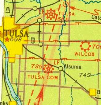
Wilcox Airport / Collier Airport, Tulsa, OK
36.16, -95.85 (East of Downtown Tulsa, OK)
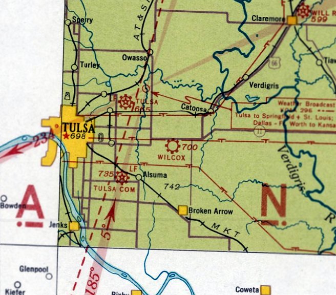
Wilcox Airport, as depicted on the August 1934 Tulsa Sectional Chart.
According to Carl Gregory, this small general aviation airport had its genesis on 3/30/29,
when “Homer Frank Wilcox incorporated H.F. Wilcox Aeronautics, Inc.
The other 2 persons on the incorporation papers were R. Berry & W. A. Collier (according to the Oklahoma Corporation Commission).
[On] 5/25/29 H. F. Wilcox leased the land at the southwest corner of Admiral & Garnett Road from R. L. Davis
to establish an airfield at that location (NE/4 Section 6 T19N R14E) (according to the Tulsa County Clerk records Book 842 Page 383).”
Carl Gregory reported, “[Circa] 1930 a chamber brochure on aviation in Tulsa showed the landing field & described the flying school (Collier had moved from Ponca City).
[On] 5/14/30 H.F. Wilcox re-incorporated in Delaware rather than Oklahoma (according to the OK Corporation Commission & Delaware Corporation Commission).”
Carl Gregory reported, “[On] 11/18/31 William Collier incorporated the Collier School of Aeronautics
(the other 2 officers were C Lynch & James Lynch).”
The 1934 Commerce Department Airway Bulletin (courtesy of Carl Gregory)
described Wilcox Airport as a commercial field located 8 miles east of the center of the city on Federal Drive,
adjacent to the Lake Side Country Club.
The field was said to consist of a rectangular 2,616' x 1,980' sod property with a hangar in the northwest corner.
The earliest depiction which has been located of Wilcox Airport was on the August 1934 Tulsa Sectional Chart.
It depicted Wilcox as a commercial/municipal airport.
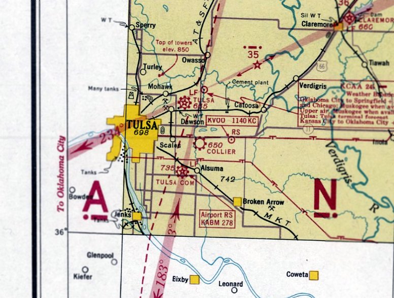
The January 1935 Tulsa Sectional Chart depicted Wilcox Airport in an unchanged fashion.
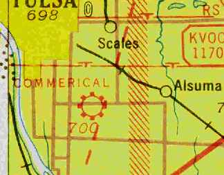
The November 1935 Tulsa Sectional Chart (& subsequent charts) depicted Wilcox Airport in somewhat different location,
about a mile to the west (due north of Alsuma, as opposed to the previous depiction northeast of Alsuma).
Did the airfield location change, or was this an error on previous charts?
Wilcox Airport was still depicted on the April 1937 Tulsa Sectional Chart.
According to Carl Gregory, on “3/3/39 Wilcox purchased the land in Section 11 of T20N R15E (according to the County Clerks office).”
At some point between 1937-39 it was evidently renamed Collier Airport, as that is how it was depicted on the March 1939 Tulsa Sectional Chart.
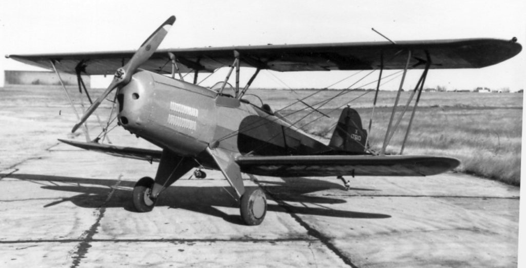
An undated photo of a Collier CA-1 Ambassador biplane at Wilcox Airport (courtesy of Carl Gregory).
According to Carl Gregory, “The Collier Ambassador, the CA-1 Ambassador, and the Collier T-21-1 were all constructed by Collier at [Wilcox Airport].
Collier also operated under the name Collier Aircraft Sales.”
An April 1941 plan (courtesy of Carl Gregory) depicting expansion at Tulsa Airport also showed the proximity of “Collier Airport”, depicted as a square property outline to the southeast.
Collier Airport was evidently closed at some point between 1939-41, as it was no longer depicted on the July 1941 Tulsa Sectional Chart.
According to Carl Gregory, on “By 1942 the field in Tulsa [Wilcox Airport] was closed & H. F. Wilcox had moved the field to Verdigris.”
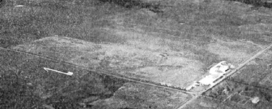
The last photo which has been located of Wilcox Airport was a 6/13/53 USGS aerial view.
The field had a single grass north/south runway, with a segmented circle on the northwest side & 1 hangar on the southeast side.
The last depiction which has been located of Wilcox Airport was on the 1955 USGS topo map.
It depicted a single unpaved north/south runway, labeled simply as “Landing Field”, with 1 small building on the southeast side.
The 1968 USGS topo map depicted residential streets covering the site of Wilcox Airport.
A 1995 UGGS aerial view depicted no trace of Wilcox Airport.
An 8/9/12 aerial view showed no trace remaining of Wilcox Airport.
Thanks to Carl Gregory for pointing out this airfield.
____________________________________________________
Nash Municipal Airport, Hugo, OK
34.02, -95.49 (Northeast of Dallas, TX)
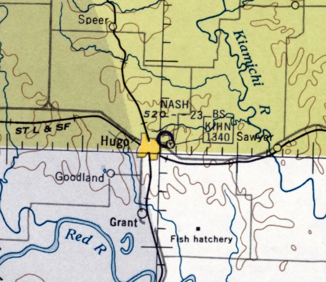
Nash Airport, as depicted on the February 1959 Little Rock Sectional Chart (courtesy of David Brooks).
Nash Municipal Airport was evidently established at some point between 1958-59,
as it was not yet depicted on the February 1958 Little Rock Sectional Chart.
The earliest depiction of Nash Municipal Airport which has been located
was on the February 1959 Little Rock Sectional Chart (courtesy of David Brooks).
The Aerodromes table on the chart described Nash as having a 2,300' turf runway.
Damon Nash reported, “Nash Field is named after [his grandfather] Homer Nash &/or his brothers Gene & Ray.
I flew as a tadpole out of there in the 1950s with Gran (Homer). He was the fire chief.”
Nash’s runway was still described as turf on the 1963 Sectional Chart (according to David Brooks).
The runway at Nash was evidently paved at some point between 1963-65,
as the 1965 Sectional Chart (according to David Brooks) described Nash as having a 2,900' asphalt runway.
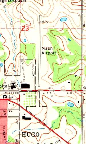
The 1971 USGS topo map depicted Nash Airport as having a single paved north/south runway.
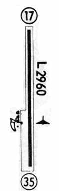
The 1971 Flight Guide (courtesy of David Brooks) depicted Nash Municipal Airport as having a single 2,960' paved Runway 17/35.
Four small buildings were located along the southwest side of the runway.
The 1974-75 OK Airport Directory (courtesy of David Brooks) depicted Nash Municipal as having a single 2,960' asphalt Runway 18/36.
The field was said to offer storage, tiedowns, and fuel. The airport's “proponent” was listed as Hugo Aviation.
The 1977 DFW Sectional Chart (courtesy of David Brooks) depicted Nash as having a single 2,900' paved runway.
The last photo which has been located showing Nash Municipal Airport still in operation
was an undated aerial view from the 1978 OK Airport Directory (courtesy of Frank Holbert).
It depicted Nash Municipal Airport as having a single north/south runway, with a few small hangars on the southeast side.
Nash Municipal Airport was still depicted on the 1981 USGS topo map.
The last chart depiction which has been located of Nash as an active airfield
was on the 1985 DFW Sectional Chart (according to David Brooks).
In 1985, the new Stan Stamper Municipal Airport was opened on the northwest side of Hugo,
presumably replacing Nash Municipal Airport
(although the reason for this is not obvious, as Stamper's runway is only 500' longer than Nash's runway).
Nash Municipal Airport was evidently abandoned at some point between 1985-91,
as it was depicted as an abandoned airfield on the 1991 DFW Sectional Chart (courtesy of David Brooks).
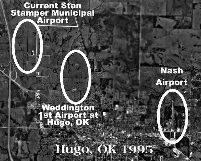
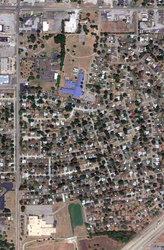
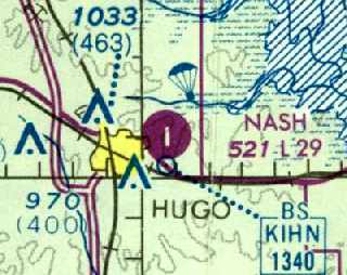
The location of the 3 airports around Hugo, as annotated by David Brooks on the 1995 USGS aerial picture.
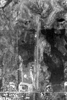
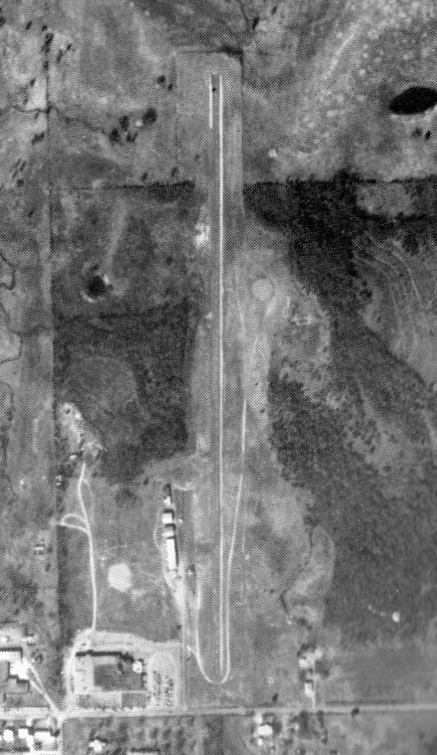
A 1995 USGS aerial view looking northwest showed the majority of the runway at the former Nash Municipal Airport was still intact, although a building has been built over the very south end of the strip.
It appeared as if all of the former airport buildings had been removed.
A 2015 aerial view looking northwest at the former Nash Municipal Airport showed that the majority of the runway had been reused as a street.
The site of Nash Municipal Airport is located northeast of the intersection of East Kirk Street & 16th Street.
____________________________________________________
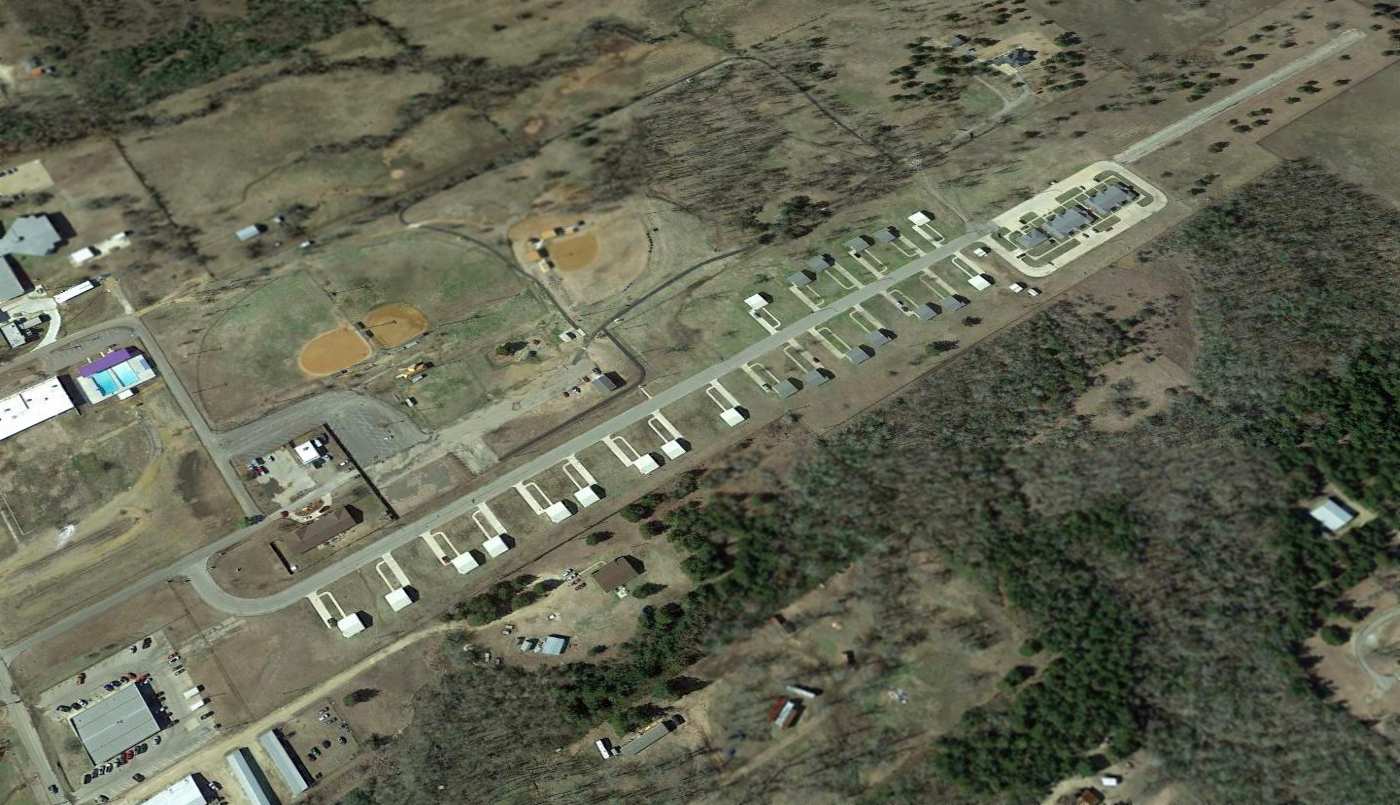
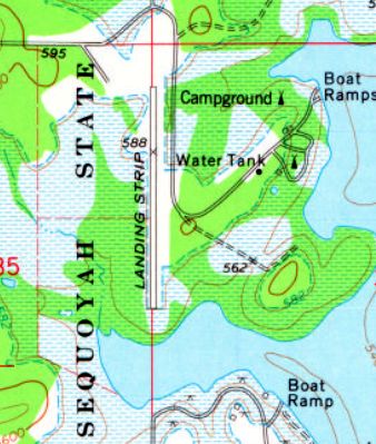
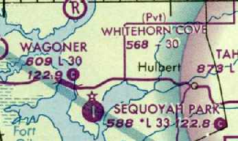
Sequoyah Park Airport (7F4), Wagoner, OK
35.91, -95.24 (Southeast of Tulsa, OK)
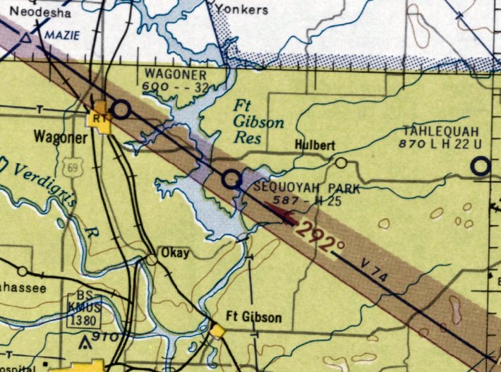
Sequoyah Park Airport, as depicted on the February 1959 Little Rock Sectional Chart (courtesy of David Brooks).
This little airport within the bounds of the Sequoyah State Park was apparently established at some point between 1958-59,
as it was not yet depicted on the February 1958 Little Rock Sectional Chart.
The earliest depiction of Sequoyah Park Airport which has been located
was on the February 1959 Little Rock Sectional Chart (courtesy of David Brooks).
It depicted the field as having a 2,500' hard-surface runway.
The January 1965 Little Rock Sectional Chart (according to Chris Kennedy)
still depicted Sequoyah Park Airport as having a 2,500' hard-surface runway.
The runway at Sequoyah Park had been slightly lengthened at some point between 1965-66,
as the 1966 AOPA Airport Directory (according to David Brooks)
described the field as having a single 3,000' asphalt Runway 17/35.
It was described as being unattended and had tie-downs, but no hangar.
The airport was operated by the Sequoyah State Park.
The 1970 AOPA Airport Directory (according to David Brooks)
described Sequoyah Park Airport in the same fashion.
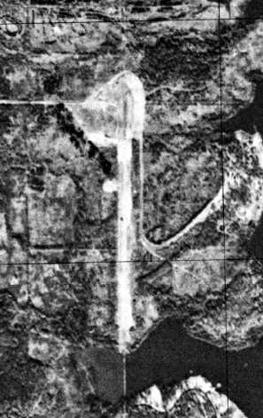
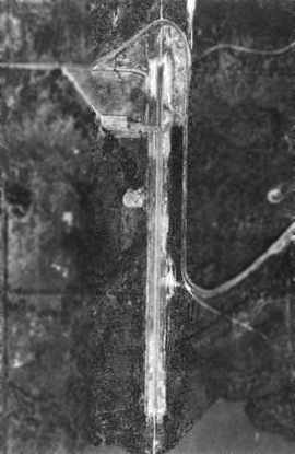
A 1972 USGS aerial photo depicted Sequoyah Park Airport as having a single north/south runway.
The 1974 USGS topo map depicted a single north/south “Landing Strip”.
The 1974-75 OK Airport Directory (courtesy of David Brooks) depicted Sequoyah Park Airport
as having a single 3,000' asphalt Runway 17/35 (although it also said “Airport to be expanded”).
The airport's “proponent” was listed as Rex Presley.
The January 1995 DFW Sectional Chart (courtesy of David Brooks) depicted Sequoyah Park Airport as having a single 3,300' paved runway.
In a 1995 USGS aerial view looking southeast, Sequoyah Park Airport was evidently still open – as one single-engine aircraft was parked on the ramp.
Sequoya Park Airport was apparently closed (for reasons unknown) at some point between 1995-2001, as it was reported closed as of June 2001,
and it was no longer depicted at all on the 2003 Sectional Chart (according to David Brooks).
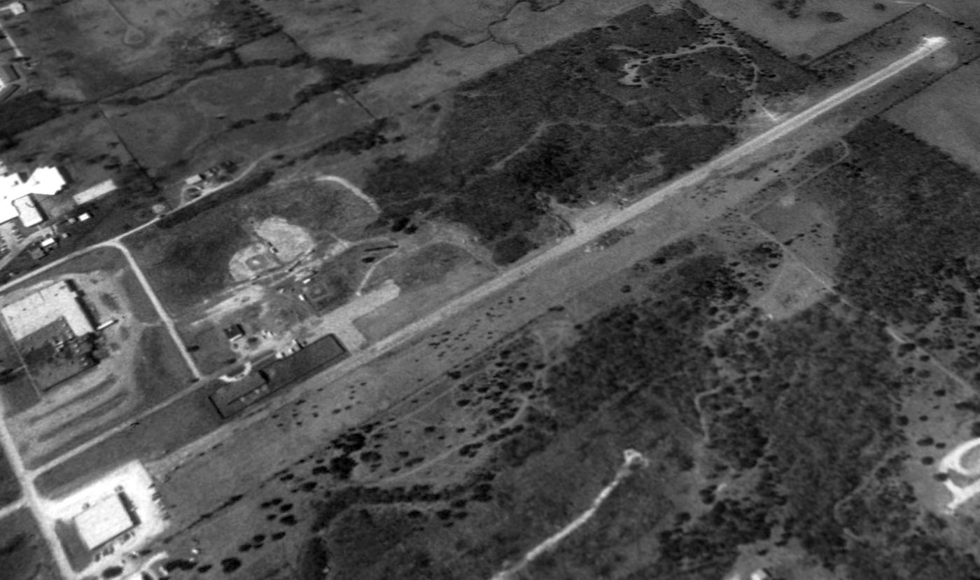
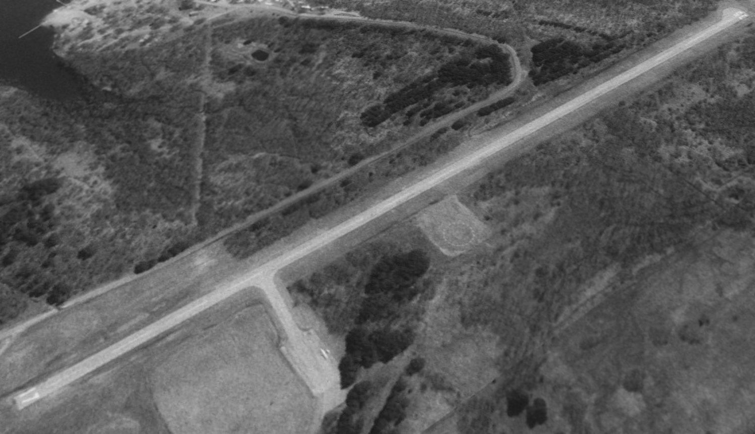
A 2017 aerial view looking southeast showed the former Sequoyah Park Airport runway & ramp to remain completely intact, although the ramp was being used to store hay.
The site of Sequoyah Park Airport is located west of the intersection of P50 & P52.
____________________________________________________
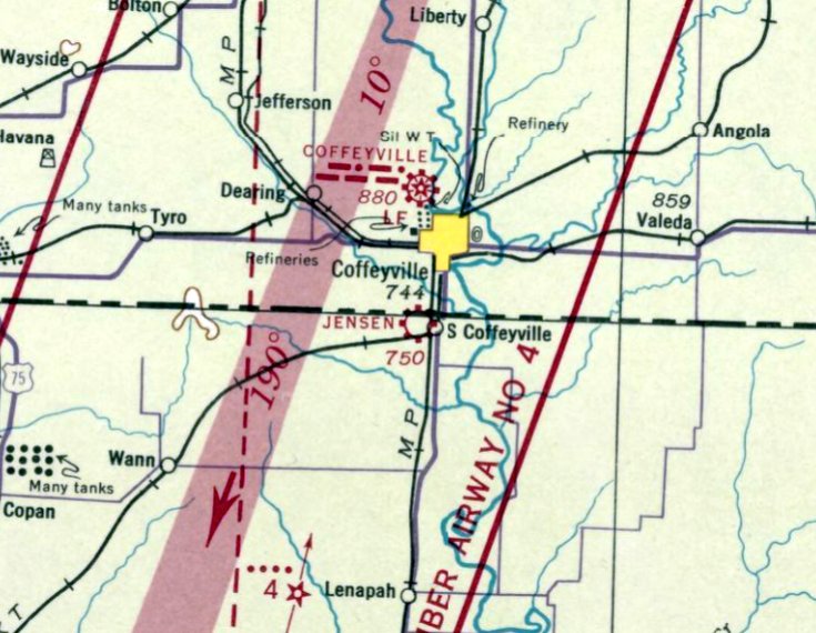
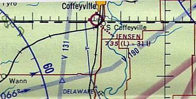
Jensen Airport, South Coffeyville, OK
36.99, -95.63 (North of Tulsa, OK)
Jensen Airport, as depicted on the July 1941 Tulsa Sectional Chart.
Jensen Airport was apparently established at some point between 1939-41,
as it was not yet listed in the Airport Directory Company's 1938 Airports Directory (according to Chris Kennedy)
nor depicted on the March 1939 Tulsa Sectional Chart.
The earliest reference to Jensen Airport which has been located was on the July 1941 Tulsa Sectional Chart,
which depicted Jensen as a commercial or municipal airport.
According to Dick Finley, “Funk Aircraft [previously in Akron OH]... was rescued by a couple of oilfield equipment suppliers, Bill & Raymond Jensen of Coffeyville.
A condition of the buyout was to relocate the company to Coffeyville. The revived firm began production as Funk Aircraft in 1941.
The company was again forced into a slump with the halting of private aircraft construction during the war years.”
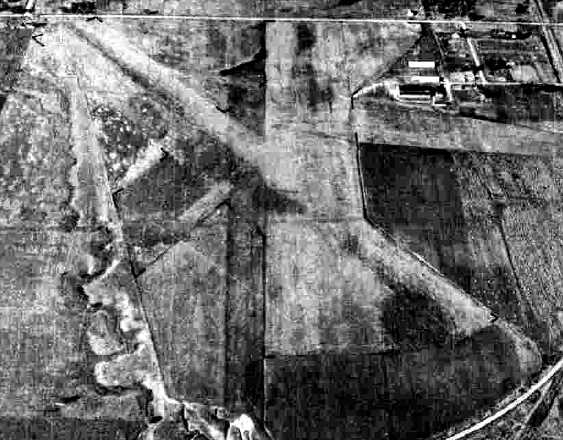
The earliest photo which has been located of Jensen was a 10/15/43 aerial view looking north
from the 1945 AAF Airfield Directory (courtesy of Scott Murdock).
It depicted “Jensen Commercial Airport” as having 3 grass runways, with several hangars on the northeast side.
The April 1944 US Army/Navy Directory of Airfields (courtesy of Ken Mercer) described Jensen as having a 3,400' unpaved runway.
The 1945 AAF Airfield Directory (courtesy of Scott Murdock) described “Jensen Commercial Airport”
as a 283 acre irregularly-shaped property having 3 sod runways, the longest being the 3,150' north/south strip.
The field was said to have 2 metal 152' x 32' hangars, and to be owned & operated by private interests.
According to Dick Finley, “After the war when many wartime pilots bought their own planes, the Funks resumed production in Coffeyville.
At one time their factory employed more than 200 people on the production line. In 1946 they manufactured 178 planes.
With release of surplus military aircraft in the postwar era & a glut of new civilian aircraft, production at the Coffeyville plant declined.
A few planes were produced in 1947. At the end of 1948 Funk Aircraft ceased production.
Although there are no reliable records, it is believed 337 planes were produced.
About 200 Funk planes are believed to be flying, according to a Funk Aircraft Owners website.”
The 1946 Kansas River World Aeronautical Chart (courtesy of John Price) depicted Jensen as a commercial/municipal airport.
According to Chris Decker, “Funk aircraft moved to Coffeyville after a fire destroyed the manufacturing facilities.”
Jensen Airport apparently gained a paved runway at some point between 1945-63,
as the 1963 OK Airport Directory (courtesy of Chris Kennedy)
described Jensen as having a single 3,100' asphalt Runway 17/35.
The aerial photo also appeared to have indicated the possible presence of former grass runways
oriented northeast/southwest & northwest/southeast, as well.
A single hangar was depicted on the northeast corner of the field.
No aircraft were visible parked on the field. The operator was listed as Roy Richardson.
The 1965 Tulsa Sectional Aeronautical Chart depicted Jensen as having a 3,100' unpaved runway.
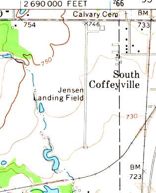
The 1972 USGS topo map depicted the “Jensen Landing Field” as having a single north/south runway.
The 1976 AOPA Airport Directory (courtesy of Chris Kennedy) described Jensen as having a single 3,100' blacktop Runway 17/35.
The field was said to offer hangars & tiedowns, but was unattended.
Jensen Airport was apparently closed (for reasons unknown) at some point within the next 4 years,
as it was not listed in the 1980 Flight Guide (according to Chris Kennedy).
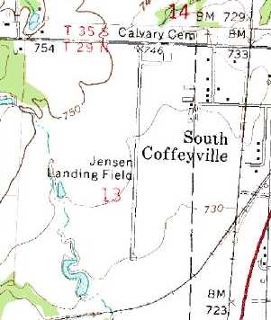
The 1980 USGS topo map depicted the “Jensen Landing Field” as having a single north/south runway.
The 1981 USGS topo map depicted a single north/south “Landing Strip”.
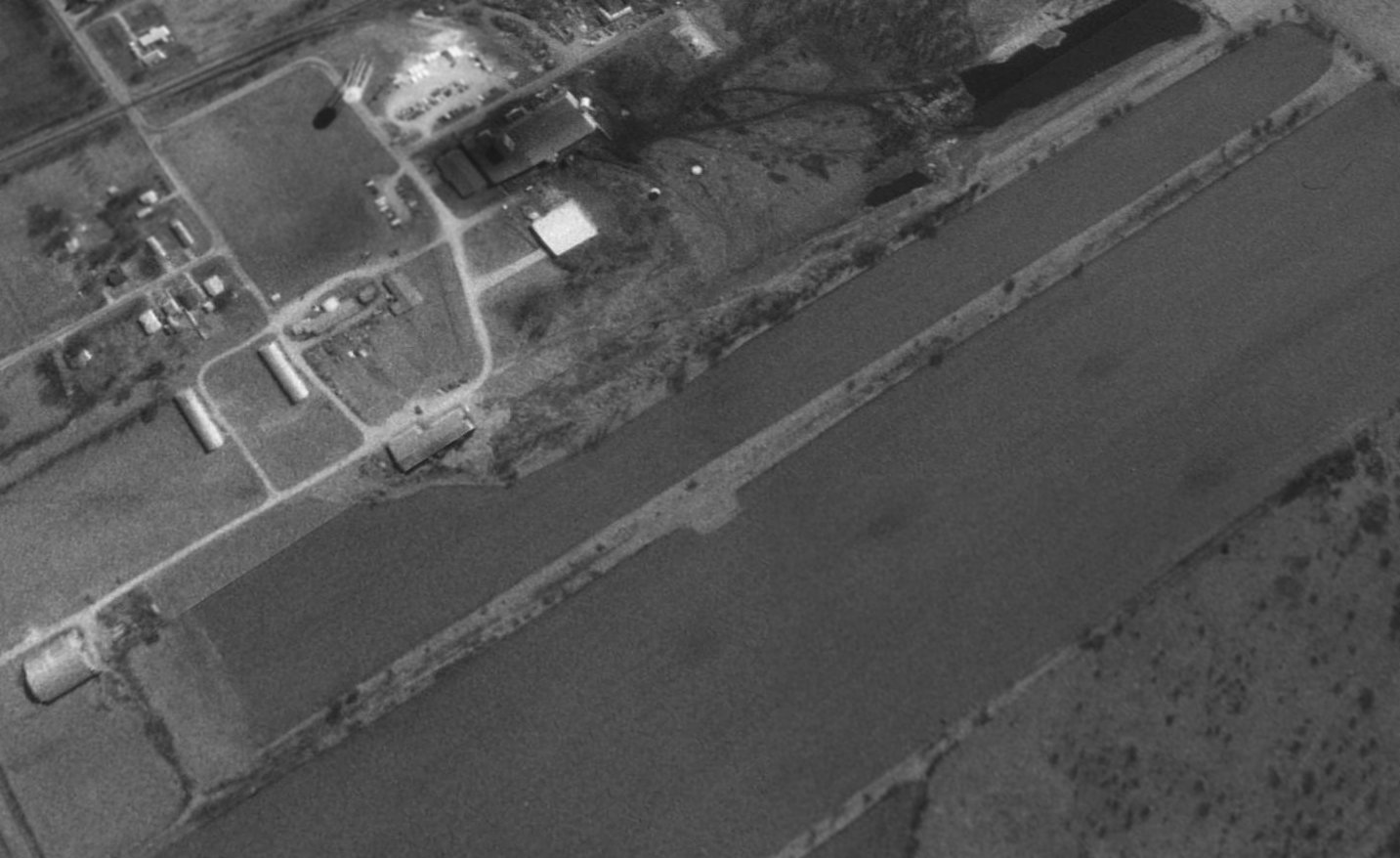
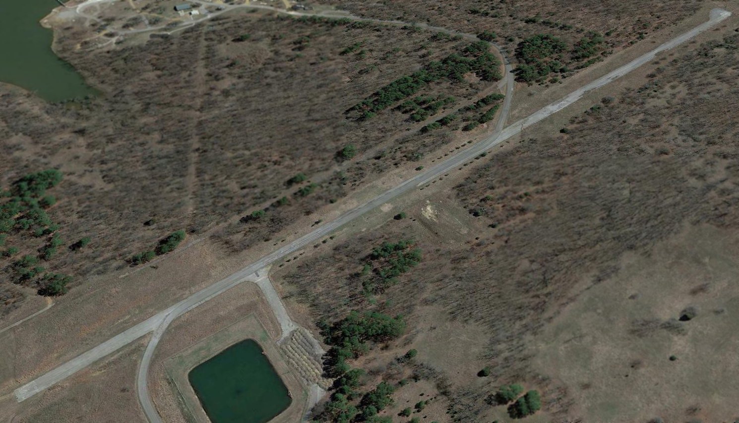
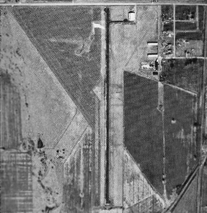
A 1995 USGS aerial view looking southeast showed Jensen Airport's former runway & hangar still remained in quite good condition.
A 2002 aerial photo showed the Jensen Airport site remained in the same condition.
A 2003 aerial photo showed that the runway pavement had been removed at some point between 2002-2003.
A 2005 photo by Chris Decker of the large former hangar at Jensen Airport, marked with “Jencast” on its roof.
Chris reported, “The large hangar on the north end of the field in still there,
there are also the 2 smaller hangars to the south of the large hangar.”
A 2005 photo by Chris Decker of the site of Jensen Airport.
Chris reported, “There is no asphalt [remaining], however the former runway is clearly visible and planted in row crops.”
A 2015 aerial view looking southeast showed the Jensen Airport hangar remained intact, with the lettering “Jencast” still visible on both sides of the roof.
The runway outline was still recognizable, although the pavement had been removed.
A 2023 photo looking southwest at the large former hangar at the Jensen Airport site, marked with “Jencast” on its roof.
The site of Jensen Airport is located southwest of the intersection of Interstate Street & Osage Street.
____________________________________________________
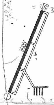
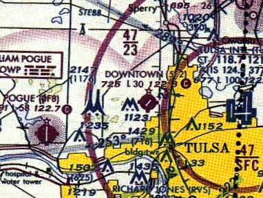
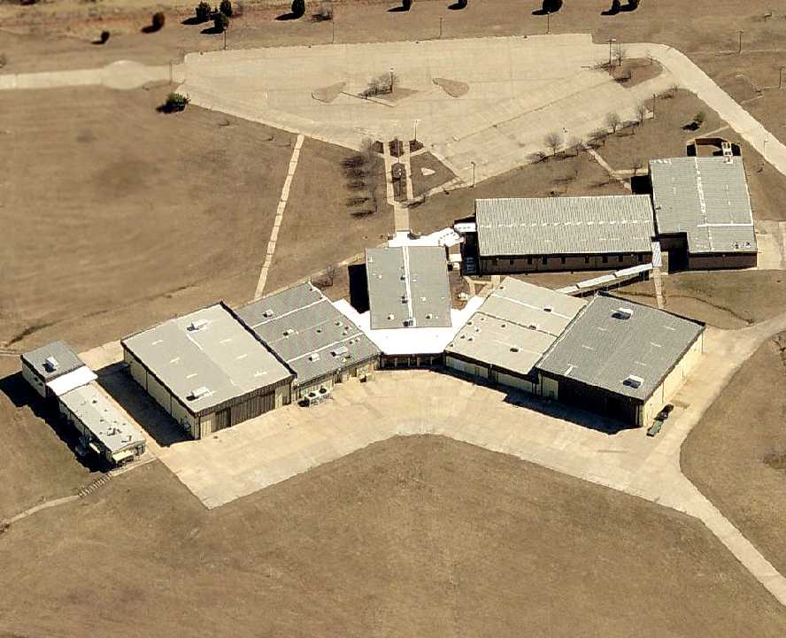
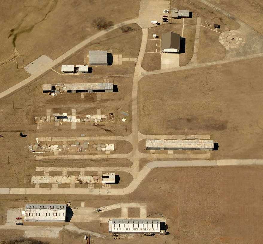
Tulsa North Airport / Downtown Airpark (5F2, OK12), Tulsa, OK
36.211, -96.007 (North of Downtown Tulsa, OK)
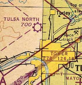
"Tulsa North" Airport, as depicted on the 1945 Tulsa Sectional Chart (courtesy of Chris Kennedy).
This small general aviation field was originally known as Tulsa North Airport.
It was apparently built at some point between 1944-45,
as it was not listed among active airfields in the 1944 US Army/Navy Directory of Airfields (courtesy of Ken Mercer)
nor depicted yet on the September 1944 Tulsa Sectional Chart (courtesy of Dallam Oliver-Lee).
The earliest reference to the field which has been located was on the 1945 Tulsa Sectional Chart (courtesy of Chris Kennedy).
The 1949 Wichita Sectional Chart (according to Chris Kennedy) described Tulsa North Airport as having a 2,500' unpaved runway.
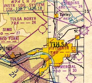
The Aerodromes table on the 1950 Wichita Sectional Chart (courtesy of Chris Kennedy)
described "Tulsa North" as having a total of 4 unpaved runways, with the longest being 2,400'.
An explanation for this came from Mike Sheehan, who recalled, “About 1953-55 there were drag races at Tulsa North.
The runway was asphalt & the dragsters tore up one end of the runway.”
The runway length had decreased by the time of the 1955 Tulsa Sectional Chart (courtesy of Chris Kennedy),
which described the longest runway at Tulsa North as being a 2,100' unpaved strip.
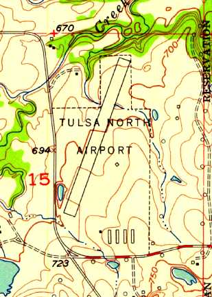
The 1956 USGS topo map depicted Tulsa North Airport as having a single paved northeast/southwest runway,
with 4 rows of hangars along the southeast side.
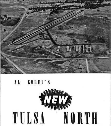
A circa late 1950s advertisement for “Al Kobel's New Tulsa North” Airport,
with an aerial view looking north showing a single paved runway & several rows of hangars.
By the time of the 1960 Jeppesen Airway Manual (courtesy of Chris Kennedy),
the runway configuration at Tulsa North had been upgraded to a single 3,000' asphalt Runway 1/19, with a parallel taxiway on the east side.
Several rows of T-hangars were depicted on the southeast side of the field.
The 1962 AOPA Airport Directory described Tulsa North as having a single 3,000' asphalt Runway 3/21, and listed the operator as A.E. Kobel.
Bill Wards recalled, “I attended drag races there in the early 1960s & it was still generally known as Tulsa North at that time.”
At some point between 1962-63 it was renamed Downtown Airpark, as that is how it was listed in the 1963 OK Airport Directory (courtesy of Chris Kennedy).
It described the field as having a single 3,000 asphalt Runway 3/21.
At least 5 rows of T-hangars were depicted on the southeast side of the field, and about a dozen aircraft were visible on the field in the aerial photo.
The operator was listed as Ray McCurdy.
The 1965 Tulsa Sectional Chart still labeled it as Tulsa North.
Allied Helicopter Service formed a flight school in 1966 at Tulsa (apparently at the Downtown Airpark),
forming Allied Helicopter International, utilizing the Bell 47 helicopter for training.
Craig Roberts recalled, “Tulsa North, later renamed Tulsa Downtown Airpark... I flew into this field in 1970 for the first time in my 1946 Luscombe 8A!
I was a new Tulsa Police officer at the time.”
The January 1973 Kansas City Sectional Chart (courtesy of Stu Sibitzky) depicted Downtown Airpark as having a 3,000' paved north/south runway.
Craig Roberts recalled, “Later in my career, Tulsa PD formed its first Helicopter Unit (later named the Air Support Unit),
and since I was the only department licensed A&P, I was asked if I wanted to transfer to the new unit (1982).
I said only if I could fly as well, so the decision was made to transfer me to the airport.
We began flying a single Hughes 300C, but within 2 years had bought a Hughes 500D turbine ship, then a MD500E, then a second 500E.
We had leased the large hangar at the south end of the field, just west of Allied Helicopter & the T hangars.
Tulsa Vo-Tech eventually bought the field & built the new A&P school, but eventually moved it several miles south to Jones/Riverside where it is today.”
The 1982 AOPA Airport Directory (courtesy of Ed Drury) described Downtown Airpark as having a 3,000' asphalt Runway 2/20 & a 1,800' turf Runway 9/27.
The operators were listed as Tulsa Downtown Airpark Inc., G & S Aviation, and Allied Helicopter Inc.
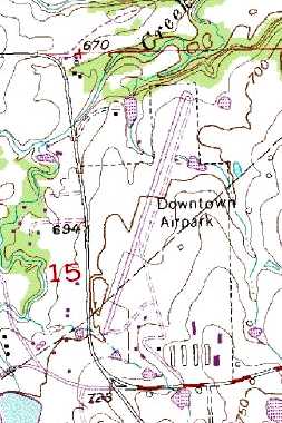
The 1983 USGS topo map depicted the “Downtown Airpark”
as having a single northeast/southeast runway, taxiways, and several hangars.
A 1990 photo by Carol Wilson of David Wilson in front of a Twin Bonanza at Tulsa Downtown Airpark.
A 4/2/91 photo by R.A. Scholefield of Piper PA-16 Clipper N5312H C/n 16-123 inside a Tulsa Downtown Airpark hangar.
Rick Bowlin recalled, “Tulsa Downtown Airpark hosted a Civil Air Patrol squadron for several years in the early 1990s.”
A winter 1994 photo by Rudolph Fahlhaber of a Allied Helicopter Bell 47 at Tulsa Downtown Airpark.
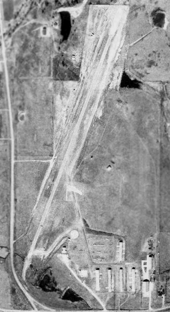
A 1995 USGS aerial view looking northeast showed the facilities at Downtown Airpark appeared to be quite well developed,
as 4 large hangars had been added on the ramp on the east side of the runway at some point between 1963-95, in addition to the large number of T-hangars on the southeast side.
A total of 15 aircraft were visible parked outside.
Rick Bowlin recalled, “OK State University expanded its flight training program to the airport around late 1995 - early 1996
(I started flying there in May 1996 & the operation was well established).
Ultimately OSU based 8-10 aircraft there.”
A 1997-98 photo by Rick Bowlin of an OSU Cessna 152 at Tulsa Downtown Airpark.
Downtown Airpark, as depicted on a 1998 Sectional Chart.
Rick Bowlin recalled, “OK State University moved its flight training program to R.L. Jones [Riverside Airport] in 1999.
At one point Tulsa Technology Center had a Convair 440 parked on the field.
For the move the aircraft was flown out to Jones... quite an event for the small runway.
The main landing gear did not have much room to spare to the edges of the pavement & the crew had to wait for just the right wind conditions.”
Downtown Airpark was still listed (for the last time) as an active airfield in the 2000 AOPA Airport Directory.
The crosswind grass runway had been closed, as the sole runway was listed as the 2,965' asphalt Runway 2/20.
The operator was listed as Allied Helicopter Inc.
Downtown Airpark apparently closed within the next year (for reasons unknown),
as it was not listed among active airfields in the 2001 AOPA Airport Directory.
A 2004 photo by Kristopher Crook, looking north at the former Downtown Airpark, with the runway visible at left.
The large hangar at right is part of the former Tulsa Technology Center campus.
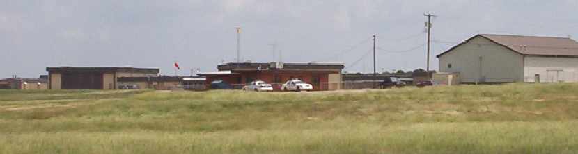
A 2004 photo by Kristopher Crook of the Allied Helicopter Service hangar & abandoned T-hangars, viewed from just off 36th Street North.
A 2004 photo by Kristopher Crook of the former Tulsa Technology Center hangar
and the Tulsa Police Department air operations building - note the police cars in from & the windsock in back.
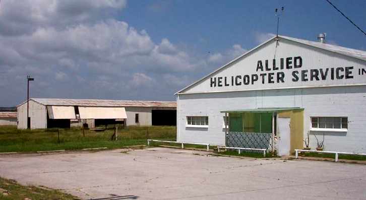
As of 2004, the former Downtown Airpark is still listed with the FAA as a private heliport, named Allied Heliport (OK12),
with a total of 8 helicopters listed as being based at the field.
It is owned by Allied Helicopter Service Inc.,
which apparently continues to operate flight training, tour flights, pipeline patrol, power line patrol,
news gathering, photo flights, air taxi, and charter flights, using Bell 47 & 206 helicopters.
A 4/30/05 aerial view by Danny Fritsche looking south at the former Tulsa Downtown Airpark.
A circa 2006 aerial view looking east at the large hangars on the northeast side of Downtown Airpark.
What a shame to see such extensive (and relatively recent-construction) aviation infrastructure going complete unused.
According to David Wilson, the buildings are (from left to right):
welding, airframe hangar, airframe classrooms, lunch room, powerplant classrooms, powerplant hangar.
A circa 2006 aerial view looking west at the hangars (& remains of hangars) on the southeast side of Downtown Airpark.
Note the single Bell 47 helicopter visible at the bottom, parked in between the hangars marked “Allied Helicopter Service”, a remaining aviation operator at the former airport.
According to “Tulsa's Forgotten Airports”, the Downtown Airpark property
“was owned by Tulsa Technology Center until 2006 when it was sold to an investor group.
In an ironic & historic turn, the 100 acre property - which was within the original allotment of Osage Chief Peter Bigheart -
was purchased by The Osage Nation in 2008.”
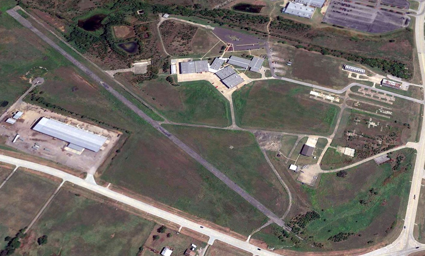
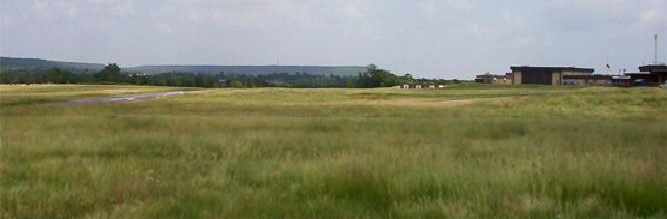
A 2016 aerial view looking northeast showed the facilities at Downtown Airpark appeared to be mostly intact, including the runway & many hangars.
What a shame to see all that nice aviation infrastructure simply going to waste.
The last photo which has been located of an aircraft operating from the former Downtown Airpark was a January 2016 photo looking northeast at a Eurocopter departing or landing
at the Tulsa Police Department air operations hangar on the south side of the airport site.
A 2022 photo looking north at a former Tulsa Downtown Airpark hangar.
As of 2022, street maps label the former Downtown Airpark buildings as being reused as offices for the Osage Casino which has been built adjacent to the east side of the airport site,
but the runway remained intact.
The site of Downtown Airpark is located northeast of the intersection of North Osage Drive & East 36th Street North.
Thanks to Chris Kennedy for pointing out this airfield.
____________________________________________________
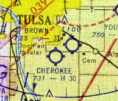
Garland Airport / Garland-Clevenger Airport /
Tulsa Commercial Airport (1st location) / Mayo Airport / Brown Airport, Tulsa, OK
36.09, -95.9 (South of Downtown Tulsa, OK)
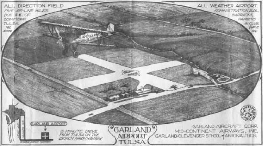
An undated advertisement for the Garland Airport (courtesy of Carl Gregory).
According to Carl Gregory, an article in the 10/30/29 issue of The Tulsa Spirit
described how Robert F.F. "Bob" Garland's new airport had opened earlier that year.
This was the original airport on the northeast corner of 51st & Sheridan Road.
A 10/10/29 letter (courtesy of Carl Gregory) described the “Garland School of Aeronautics”, a dealer for Bellanca, Stearman, Consolidated, and Fleet.
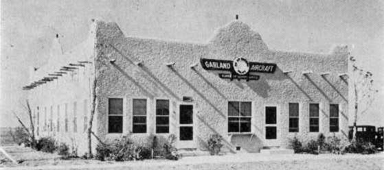
An undated photo of a building labeled “Garland Aircraft” (courtesy of Carl Gregory).
The field later became Garland-Clevenger Airport.
According to an article in an October 1931 issue of the Tulsa World the Garland airport merged with McIntyre Airport Company.
The outlay for the merger was $350,000.
At some point the airport was then renamed as Tulsa Commercial Airport.
The earliest depiction of the Tulsa Commercial Airport at this location which has been located
was on the 1934 Airway Map, which depicted "Tulsa Com" as a commercial or municipal airport.
At some point between 1934-37, the Tulsa Commercial Airport had relocated a few miles to the southwest,
as the Airport Directory Company's 1937 Airports Directory (courtesy of Bob Rambo)
described Tulsa Commercial Airport as being located 5.5 miles southeast of Tulsa,
which is consistent with the field's 2nd location.
The Airfield Directory Company's 1939 Airfield Directory (courtesy of Carl Gregory) had an aerial view looking northeast,
showing “Tulsa Commercial” to consist of a 160 acre sod field, measuring 2,640' per side,
with 2 hangars on the south side.
The field was said to be located 5.5 miles southeast of Tulsa.
By the time of the October 1941 Tulsa Sectional Chart (courtesy of Chris Kennedy),
the Tulsa Commercial Airport was depicted in its new location to the southwest,
and nothing was depicted at the airfield's original location.
At some point between 1941-44, a new airfield was apparently reopened at this location,
as the April 1944 US Army/Navy Directory of Airfields (courtesy of Ken Mercer)
described a "Mayo" Airport at this location, with a 2,600' unpaved runway.
"Mayo" was depicted as an auxiliary airfield at this location
on the September 1944 Tulsa Sectional Chart (courtesy of Dallam Oliver-Lee).
"Mayo" was depicted as an auxiliary airfield at this location
on the March 1945 Tulsa Sectional Chart (courtesy of Chris Kennedy).
According to “Tulsa's Forgotten Airports”,
“after serving as a bank president & an oil executive”, Walter Brown “acquired the Mayo airfield & facilities in 1946.
He constructed several hangars on the 160 acre airport & operated Browns Flying Service.”
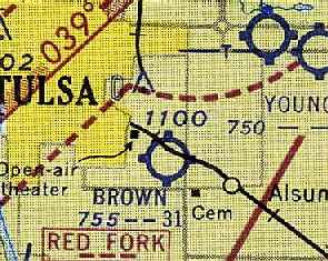
"Brown" was depicted as a commercial or municipal airport on the September 1946 Tulsa Sectional Chart (courtesy of Chris Kennedy).
According to “Tulsa's Forgotten Airports”,
Walter Brown leased Brown Airport “until 1949. After he retired, it was still called Brown Airport.”
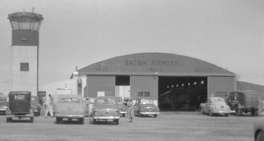
A 1951 photo by Art Brown of the control tower & a hangar at Brown Airport (courtesy of Robert Brown).
Bill Buck recalled, "At the time I was flying there (1951-56) George Mace operated Brown Airport
but Gleason-Romans also had an operation there on the West end of the field.
I used to rent planes from George & used instructors based at his operation.
When I went to take my flight exam the FAA inspector would not ride in the plane I had rented from George
but made me rent a plane from Gleason-Romans.
The inspector didn't trust George or any plane that he would rent.
George also had a habit of renting planes he didn't own out to people without the knowledge of the owner...
I found out about that because I was one of the people renting them."
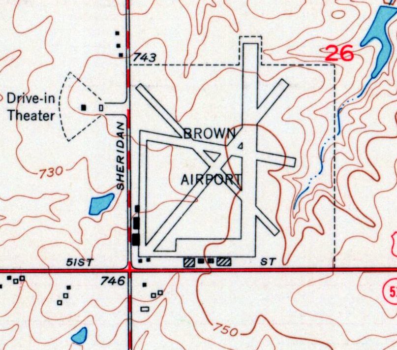
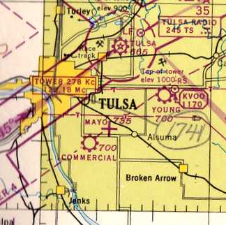
Brown Airport was depicted on the 1952 USGS topo map as having 4 paved runways , and ramps & buildings along the west & south sides.
A 4/25/54 USGS aerial view depicted Brown Airport as having 4 runways & several buildings & aircraft along the southwest side of the field.
Brown Airport was depicted on the June 1954 Tulsa USAF Sectional Chart (courtesy of Chris Kennedy)
as having a 3,100' unpaved runway.
Brown Airport was still depicted on the 1955 Tulsa Sectional Chart (courtesy of Chris Kennedy).
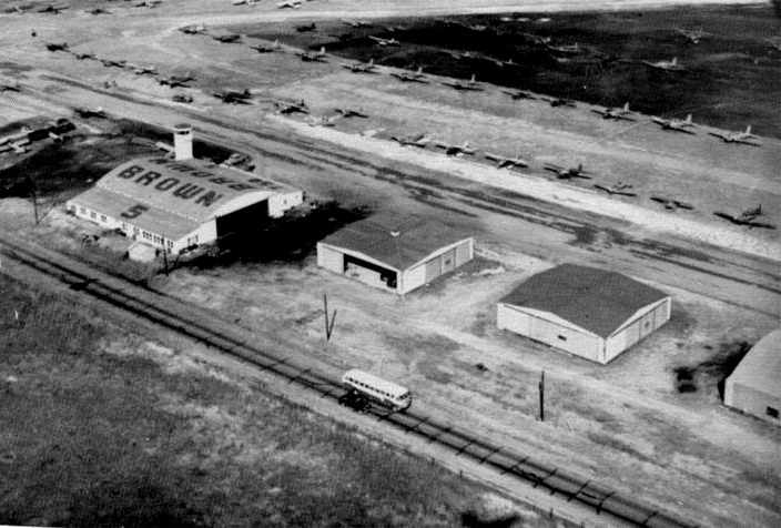
A 1957 aerial view of Brown Airport, showing 4 hangars, the control tower, and over 40 light aircraft (courtesy of Carl Gregory).
Craig Roberts recalled, “Northeast of us was Brown Airport at 51st & Sheriden.
My brother & I would walk over there & look at the airplanes.
Something of interest is that Gleason Romans owned two O-47 photo recon planes.
One was flyable in the hangar & one was on the tarmac missing several parts & its propeller.
We used to climb inside & play like we were combat pilots.
It was a very unusual plane, built by North American & evidently saw little WWII combat theater operations.”
Brown Airport was depicted in the 1960 Jeppesen Airway Manual (courtesy of Chris Kennedy)
as having 3 active runways (with the longest being the 2,800' Runway 13/31) in addition to a fourth, abandoned, runway.
Several buildings were depicted along the southwest side of the field.
A 1961 photo of Brown Airport, showing 2 of the hangars,
one of which is marked “Tulsa School of Aeronautics” (courtesy of Carl Gregory).
According to Kristopher Crook, "There used to be a drive-in across the street that pilots used as a means of finding the airport."
Brown Airport was described in the 1962 AOPA Airport Directory as having 3 sod runways, with the longest being the 2,800' Runway 18/36.
The field was said to offer fuel, major repairs, hangars, tiedowns, and charter.
The operator was listed as the Tulsa Airport Company, Inc.
Brown Airport was evidently closed (for reasons unknown) at some point between 1962-64,
as it was no longer depicted on the April 1964 Tulsa Sectional Chart (courtesy of Chris Kennedy).
According to Kristopher Crook, "A series of videotapes was produced by the Tulsa Historical Society,
and a couple of them featured home-movie & TV footage of Brown.
The video stated that Brown was closed in the early 1960s to make way for housing."
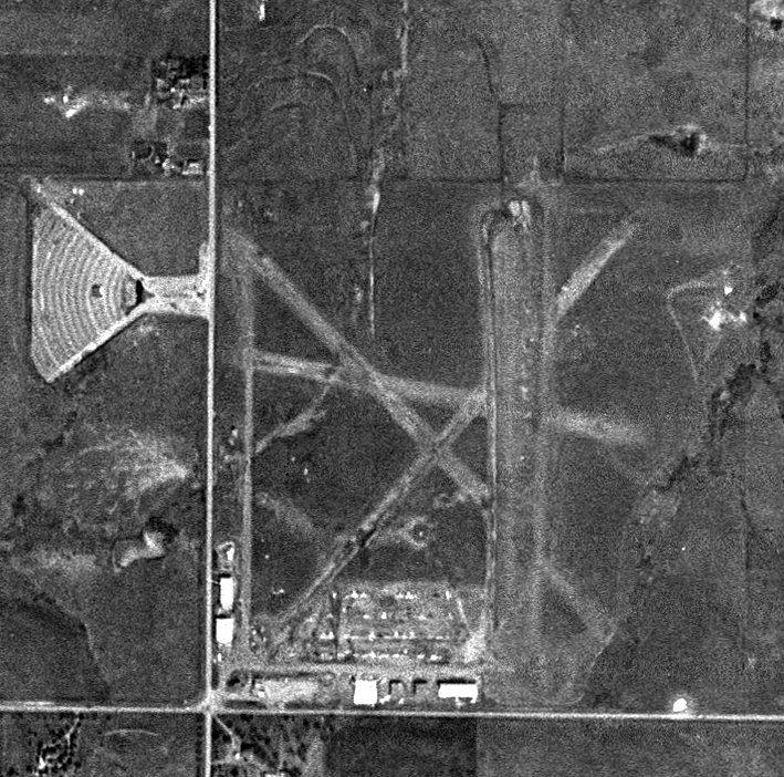
Residential construction covered the site of Brown Airport in a 1967 aerial view.
As seen in the 1999 USGS aerial photo, the site of Tulsa Commercial / Mayo / Brown Airport has been densely redeveloped,
and there did not appear to be any remnants of the former airfield still extant.
Kristopher Crook reported in 2004, "My girlfriend used to live in that neighborhood
and I searched for any trace of the airport & have not found a thing.
Unlike [Tulsa] Commercial #2, nothing remains of Brown Airport today."
____________________________________________________
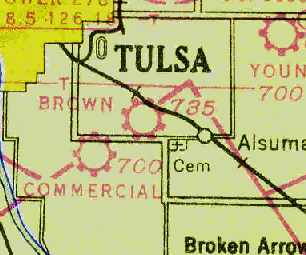
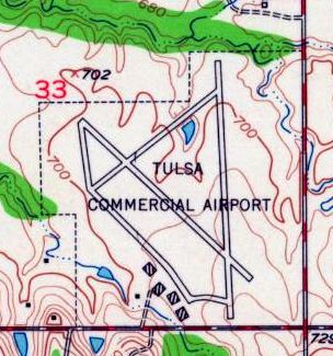
Tulsa Commercial Airport (2nd location) / Cherokee Airpark, Tulsa, OK
36.08, -95.93 (South of Downtown Tulsa, OK)
Tulsa Commercial Airport, as depicted in its 2nd location, on the October 1941 Tulsa Sectional Chart (courtesy of Chris Kennedy).
The original location of Tulsa Commercial Airport was west-northwest of Alsuma.
At some point between 1934-37, the airfield was apparently relocated (for reasons unknown) a few miles to the southwest.
The Airport Directory Company's 1937 Airports Directory (courtesy of Bob Rambo)
described Tulsa Commercial Airport as being located 5.5 miles southeast of Tulsa,
which evidently referred to the field's 2nd location.
The field was described as having a 2,640' square sod landing area,
with hangars which had "Commercial Airport" & "Tulsa" painted on the roof.
The earliest depiction of Tulsa Commercial Airport at 2nd location which has been located
was on the October 1941 Tulsa Sectional Chart (courtesy of Chris Kennedy).
The April 1944 US Army/Navy Directory of Airfields (courtesy of Ken Mercer)
described Tulsa Commercial Airport as having a 2,900' unpaved runway,
and indicated that Army flight operations were conducted from the field.
"Commercial" was depicted as an commercial/municipal airport
on the September 1944 Tulsa Sectional Chart (courtesy of Dallam Oliver-Lee).
Tulsa Commercial Airport apparently gained paved runways at some point between 1944-50,
as this 1950 aerial photo (courtesy of Michael Kersten) depicted the airport as having 2 paved runways (north/south & northwest/southeast),
along with what appeared to be a thinner paved runway running northeast/southwest.
Four hangars sat on the south side of the airfield.
The 1950 Wichita Sectional Chart (courtesy of Chris Kennedy) depicted Tulsa Commercial Airport as having a 3,000' paved runway.
A 1950 aerial view looking northwest at Tulsa Commercial Airport (courtesy of Carl Gregory).
A circa 1950s aerial view of Tulsa Commercial Airport, showing an unidentified single-engine plane overflying the field,
along with dozens of light aircraft on the field, and 3 hangars (courtesy of Carl Gregory).
The 1952 USGS topo map depicted Tulsa Commercial Airport as having 2 paved runways, taxiways,
and 4 hangars on the south side.
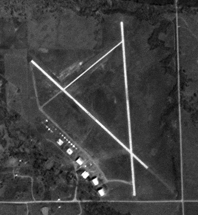
The last photo which has been located of Tulsa Commercial Airport was a 4/25/54 USGS aerial view.
It depicted the field as having 2 paved runways, with 6 hangars & a row of aircraft along the southwest side.
At some point between 1952-54, the field was apparently renamed "Cherokee Airpark",
as that it how it was depicted on the June 1954 Tulsa USAF Sectional Chart (courtesy of Chris Kennedy).
The field was described as having 3 runways, with the longest being a 3,004' concrete strip.
Unfortunately, Cherokee Airpark was a victim of suburban development, and it evidently closed at some point in 1954.
By the time of the December 1954 Tulsa Sectional Chart (courtesy of Chris Kennedy), Cherokee Airpark was no longer depicted at all.
Matthew Price recalled, "A few years ago, I learned that my neighborhood was once an airport.
Being a private pilot, it piqued my interest.
The neighborhood formerly known as Tulsa Commercial Airpark is now called Holiday Hills.
The neighborhood was started in the late 1950s.
My house sits on what used to be the narrow runway approximately 150' NE of the NW/SE runway on what is now 58th Place.
The original construction date of my house is 1957."
Craig Roberts recalled, “My family moved to Tulsa in 1957 when I was in the 6th grade.
My dad bought a new house in a new addition named Holliday Hills.
The addition was located between 55th Street South & 61st Sreett, and from Yale on the east to Pittsburgh street on the west.
Ours was one of the first houses built & in fact behind our back yard was an open field with one building (an old hangar) still standing, and one north/south asphalt runway in the middle.
There was another original runway a block to the east of us, also north/south, but the developer used it as a base for a concrete street named Urbana.
Urbana is the only long straight street in the neighborhood to this day.
We lived on South Richmond Street, and there was one older house at the end of the block that was originally the airport restaurant.
We found out that when the airport was operational it was named Commercial Airport.
When my dad & us boys tried to plant some trees in the back yard we ran into asphalt about a foot down, which was probably part of a taxiway.
My dad, being in the oil business, decided to use dynamite to blow some holes in the asphalt!
Problem is he overdid the charge & blew asphalt up in the air & down on our brand new house - a shake shingle wooden roof!
He never told the insurance company but replaced the shingles himself.”
Dennis Allen recalled, “We moved to the Holiday Hills subdivision in January 1958.
I lived next door to the former restaurant & office.
This building was converted to a home by Jack Sigler for his family.
I remember wondering about the bricked up extra doors, large kitchen
and my mother pointed out how they had 2 bathrooms side by side (men & women).
I remember the leftover hangars & some out-buildings from the airport when our house was being built.
I can even remember that some of the streets had runway markings.
The north/south and crosswind runways were used as residential streets.”

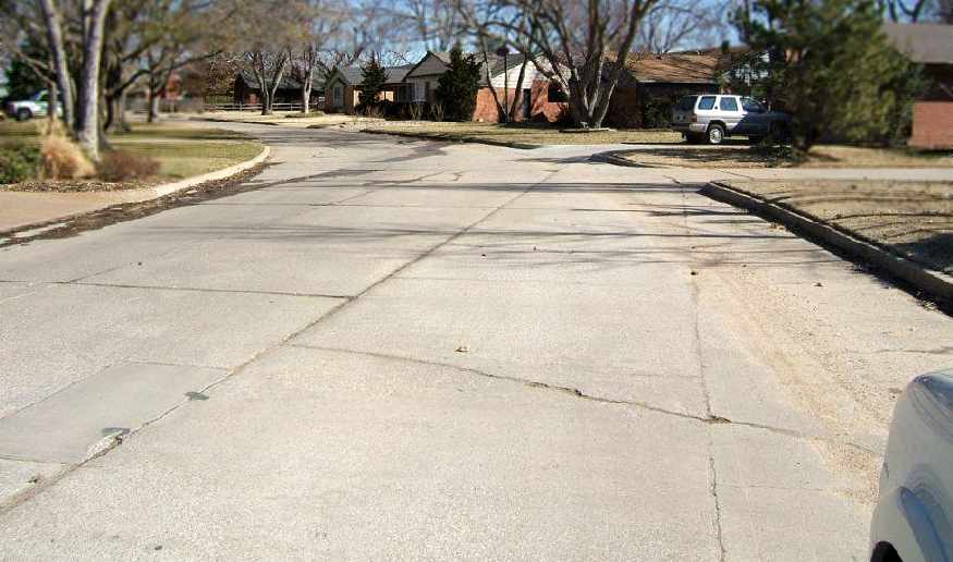
Kristopher Crook provided this annotated version of the 1995 USGS aerial photo, and observed,
"The main [north/south] runway of Commercial is still there, being used as a stretch of Urbana Avenue,
as well as the old restaurant/office which is now a private home."
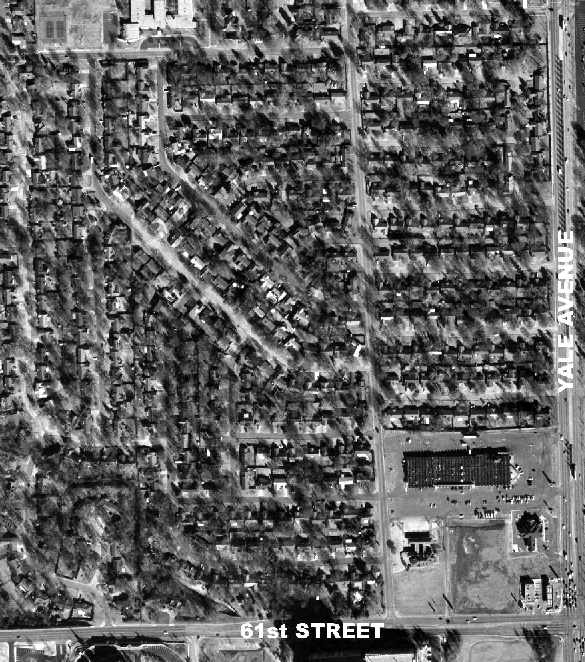
A 1999 aerial photo of the site of Tulsa Commercial Airport (courtesy of Michael Kersten).
Michael Kersten observed, "Urbana Street is a portion of the former north/south runway.
In addition, East 58th Place is atop the former northwest/southeast runway
(it is especially evident as you drive through the neighborhood -
the developers apparently did not want the added expense of breaking up the runway, so they left it as is.
The portion of the street that is former runway is considerably wider than the street to the northwest or southeast."
A February 2007 photo by Dennis Allen of the former Tulsa Commercial Airport restaurant/office building, now a house.
Dennis Allen reported in 2007, “I recently visited my Mother, who lives in the area near the former airport.
The original concrete from the crosswind runway is still in place.
The north/south runway (Urbana Avenue) has been repaved a few times over the years.
While visiting my mother I took pictures of what is left of the 2 runways.”
Dennis continued, “The main North/South runway (35/17) , now Urbana Avenue,
was intact & included some airport markings on the concrete.
The crosswind runway, now 58th Place, was largely left intact,
but the southeast end was chopped off & redirected east to connect to Urbana.
The Northwest end of the crosswind runway (58th Place) was also modified to make it curve into Quebec Ave.”
A February 2007 photo by Dennis Allen looking southeast at the former Tulsa Commercial Airport crosswind runway.
Dennis noted, “You can see the expansion joints mark the original direction of the southeast end of the crosswind runway.”
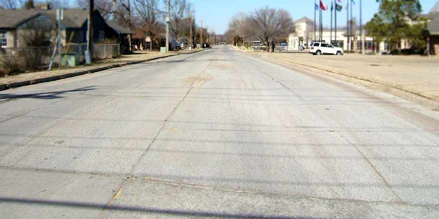
A February 2007 photo by Dennis Allen looking north along the former Tulsa Commercial Airport Runway 35.
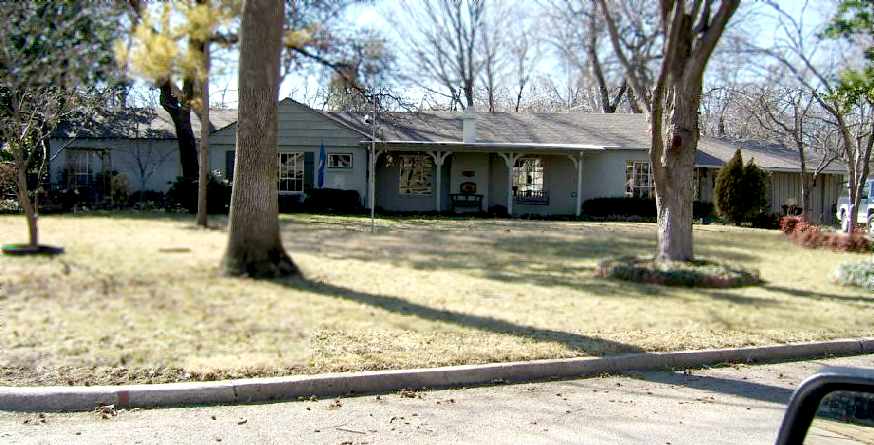
In 2021 a historical marker was erected commemorating Tulsa Commercial Airport.
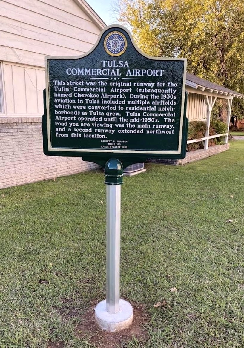
A circa 2021-23 photo (courtesy of Kevin Walsh) of a historical marker commemorating Tulsa Commercial Airport.
The site of Tulsa Commercial Airport is located at the intersection of Urbana Avenue & East 61st Street South.
____________________________________________________
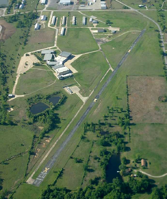
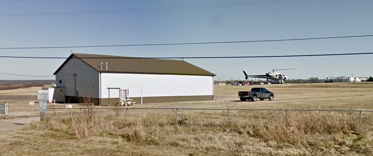
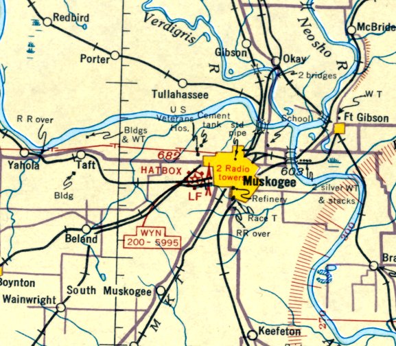
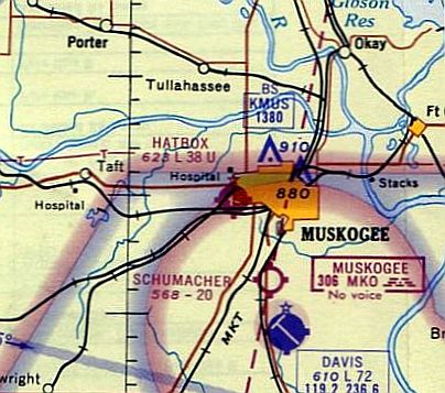
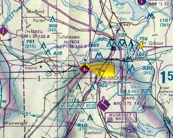
Hatbox Field (HAX), Muskogee, OK
35.74, -95.4 (Southeast of Tulsa, OK)
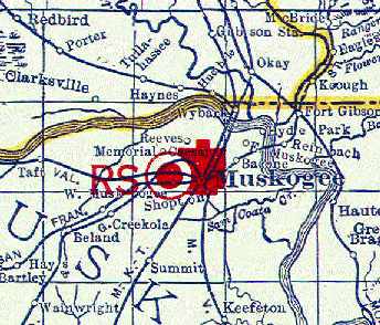
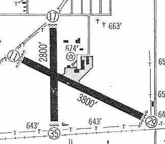
Hatbox Field was depicted on the 1929 Rand-McNally "Standard Indexed Map with Air Trails of OK" (courtesy of Chris Kennedy)
as a public airport with a radio station ("RS").
Hatbox Field was Muskogee's original municipal airport.
The date of construction of the field has not been determined.
According to Terry Hall, “The airport is a very historic airport.
The people that I talked with [at Hatbox Airport] said (and they had photos to back it up)
that this was one of the airports that the Douglas aircraft of the Army's [1924] Around the World Flight stopped.
The airport was in existence before then as I believe it was a stop on the Army's mail route.”
The earliest depiction of Hatbox which has been located
was on the 1929 Rand-McNally "Standard Indexed Map with Air Trails of OK" (courtesy of Chris Kennedy).
It described Hatbox Field as a municipal airport (but operated by Air Corps),
measuring 2,900' x 2,000', and having a beacon light.
A drawing of Hatbox Field from a 1929 brochure promoting the field (courtesy of Tom Hietzman).
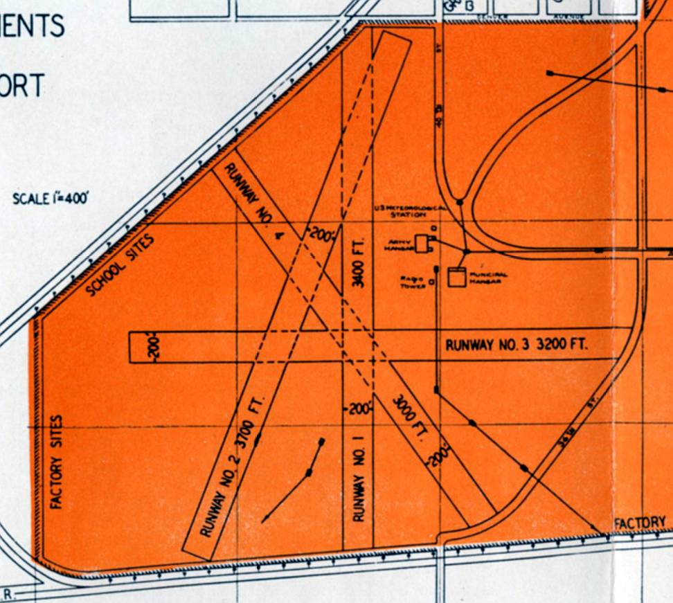
Plans for Hatbox Field from a 1929 brochure promoting the field (courtesy of Tom Hietzman)
showed a total of 4 planned runways, of which only 2 were built.
According to Terry Hall, the hangar closest to the runway intersection “dates to the early 1930s.
I believe Charles Lindbergh was on hand for the dedication.”
Hatbox Field was depicted as a commercial/municipal airport the November 1935 Little Rock Sectional Chart.
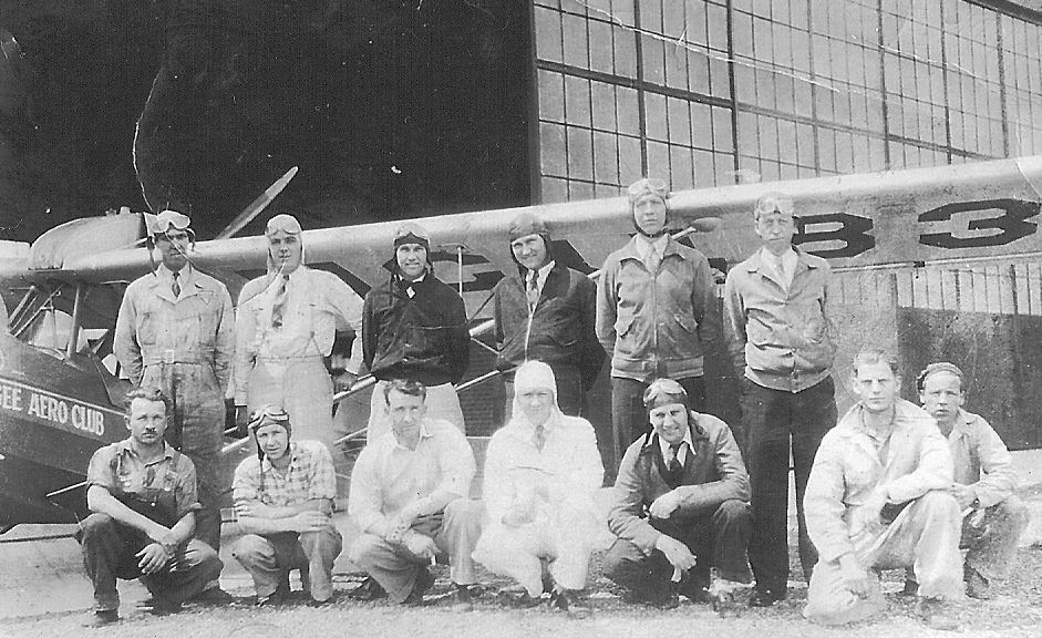
A circa 1930s photo of George Lamb & other members of the flying club & their model (model unidentified) that was based at Hatbox Field (courtesy of Bill Buck).
The Spartan Aviation School opened at Hatbox Field in 1940, using the 2 large arch-roofed hangars.
Spartan provided primary flight training to cadets as an Army Air Forces contract flying school until 1944.
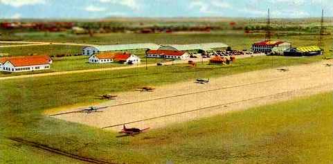
A circa 1940s postcard colorized aerial view looking southeast at Hatbox Field,
showing the Muskogee Division of the Spartan School of Aeronautics.
Joe St.Clair reported, “I recently purchased a PT-19 & discovered it was delivered directly from the factory at Hagarstown, MD to Hatbox AAF.
It was delivered in mid-June 1943 & Senator George McGovern went through primary training there Oct-Dec 1943.”
According to the book “The Curtiss-Wright AT-9” by Dan Hagedorn (courtesy of John Voss),
the 410th Bomb Group (with Douglas A-20s) was based at Hatbox Field in 1944.
The USAAF later parked 170 Curtiss AT-9s at Hatbox Field to be scrapped, as the AT-9 was deemed too unsafe for post-war surplus sales.
But 6 AT-9s did ‘escape’ & were sold to private buyers.
Following the end of its military use, Hatbox was reused as a purely civil airfield.
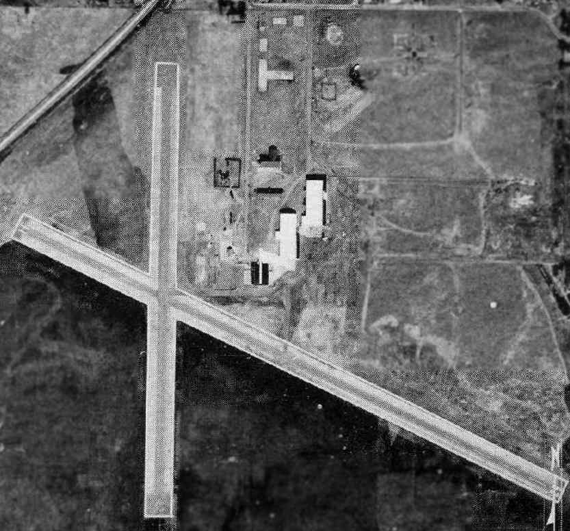
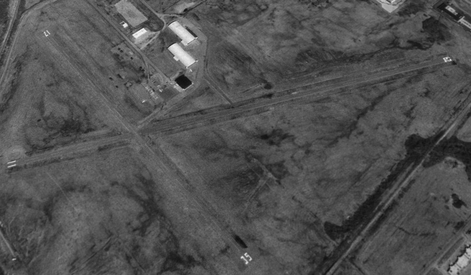
The 1948 USGS topo map depicted Hatbox Field as having 2 paved runways,
with several buildings & a radio tower on the northeast side of the field.
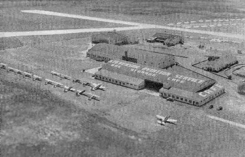
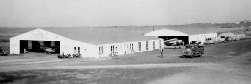
An aerial view looking southwest at the flightline of Hatbox Field from the 1950 OK Airport Directory (courtesy of Chris Kennedy).
Large numbers of aircraft were visible parked on the field. The large hangar had "Stevenson Aviation Service" painted on the roof.
The directory described Hatbox as having 2 asphalt runways: the 3,880' northwest/southeast & 2,800' north/south strips.
The field was said to offer repairs, fuel, and hangars. The manager was listed as Arthur Johnson.
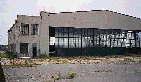
Bill Buck recalled, "Jimmy Stevenson operated Hatbox & then Nathan Sams took it over from Jimmy.
During the summers & sometimes in the winter I worked for Jimmy as a lineboy & mechanics helper.
Nathan had his operations on the West side of the field near the north/south runway
and Jimmy had his on the East side after the swap.
They started out in the reverse positions on the field.
I think the swap in management must have occurred about 1954-55 or so."
Betsy Bell recalled, “My father, Dr. Port Johnson, must have taken lessons from Nathan Sams.
I graduated from Central High School in 1955 & was part of a small group of girls who were working on that issue [school integration],
representatives from both black & white high schools.
I had no idea the flight instructor at Hat Box was black.
My father started taking lessons in 1954-55 & kept a progression of light planes hangared there beginning with a Cessna.”
The 1960 Jeppesen Airway Manual (courtesy of Chris Kennedy)
depicted Hatbox Field as having 2 paved runways: a 3,800' Runway 11/29 & a 2,800' Runway 17/35,
along with a ramp on the northeast side having several hangars.
Hatbox was described in the 1962 AOPA Airport Directory
as having 2 paved runways, and the operator was listed as the City of Muskogee.
The 1963 OK Airport Directory (courtesy of Chris Kennedy) described "Hatbox Downtown" Airport
as having 2 asphalt runways: 3,800' Runway 11/29 & 2,800' Runway 17/35.
Three hangars were depicted northeast of the runway intersection.
The airfield did not appear very busy, with only a few aircraft visible on the field in the aerial photo.
The operator was listed as Nathan Sams.
The 1965 Little Rock Sectional Chart (courtesy of John Price) depicted Hatbox as having a 3,800 paved runway.
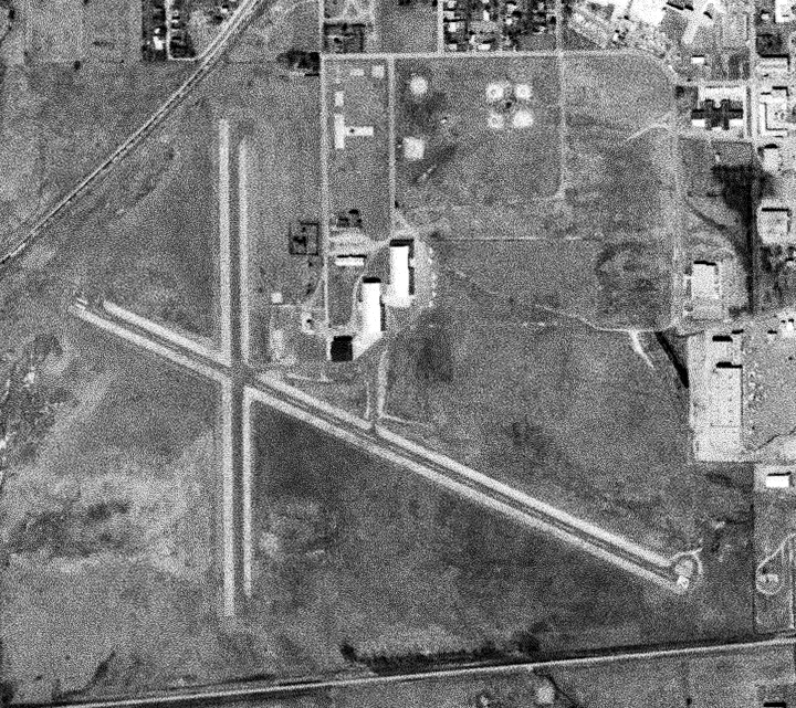
A 3/8/71 USGS aerial view depicted Hatbox Field as having 2 asphalt runways, with several hangars & a few light aircraft on the northeast side.
The last aeronautical chart depiction which has been located of Hatbox Field was on the January 1988 DFW Sectional Chart (courtesy of Ron Plante).
It depicted Hatbox as having as having 2 paved runways, with the longest being 3,800'.
According to Captain Don Foster (CAP), the city of Muskogee decided to close the field to the public following a 2 -fatality crash of a 152 in 1998.
Limited aviation use was allowed for a time by a private firm which refurbished military surplus King Airs.
The last photo which has been located showing Hatbox Field still in operation was a 1995 USGS aerial view looking northeast, taken only 5 years before the field's closure.
There were only 3 light aircraft visible on the airport.
Terry Hall recalled, “I first encountered the airport in 1996 when I flew my Cherokee there for avionics work.
The approach from the north to the north/south runway was a descent down a hill that the VA hospital sits upon.
Quite a ride, especially when the runway in front of you is very short.”
Gregory Myers recalled, “I flew some U-21s into Hatbox in January/February 1996 & was told by the manager that HAX was the first paved runway in the USA (or maybe west of the Mississippi?).
We had bought 124 U-21s & needed a lot of parking.
The manager was trying to forestall closing by filling the big glass-door hangar with HAX-based airplanes,
but the problem was there was no fuel or services there, so the average aircraft owner didn't want to stay there & the city (as usual) either fomented decline or slavered after the land for 'projects'.”
Hatbox was completely closed in 2000, and the King Airs were moved to nearby Muskogee.
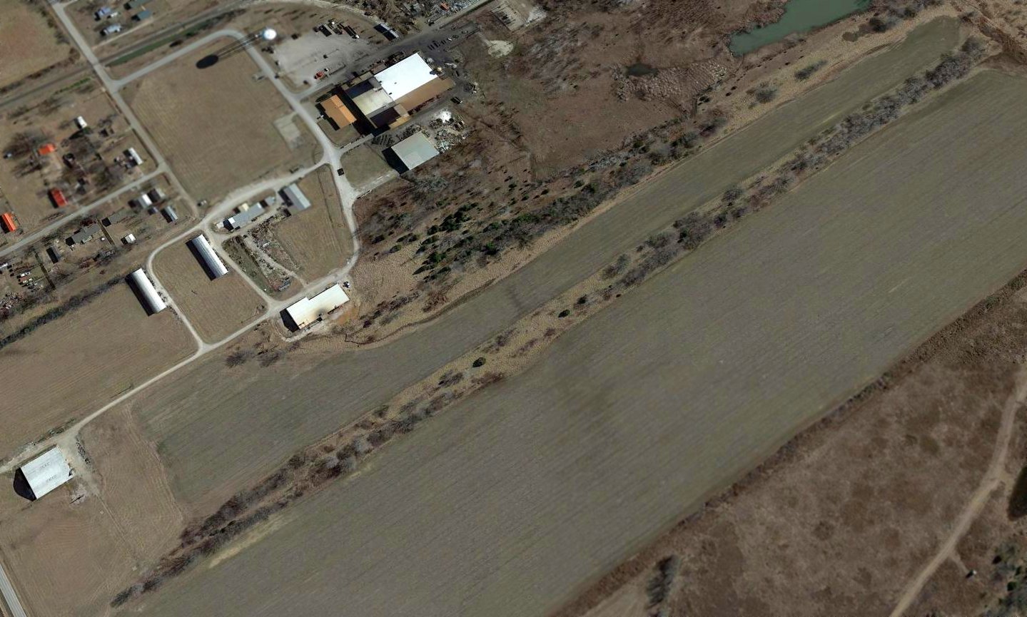
At the time of its closure the airfield consisted of 2 paved runways (the longest, 11/29, was 3,800' long), a ramp, and 3 hangars.
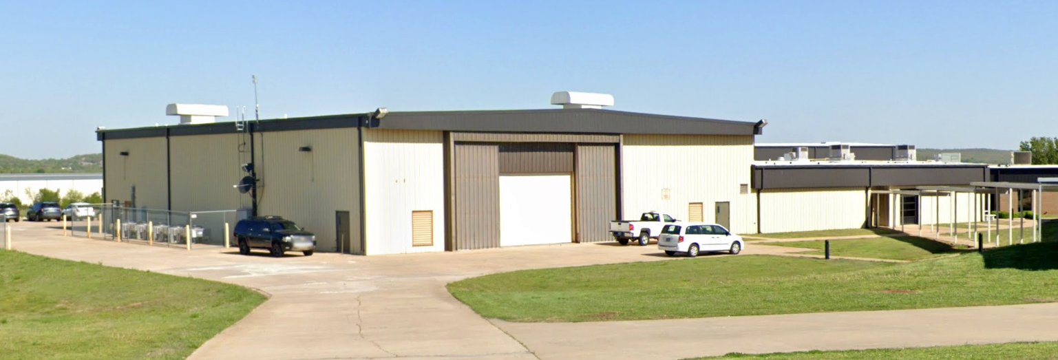
The city considers the field to be part of the nearby sports complex, and the WW2-era hangar now houses a skateboard course for local youth.
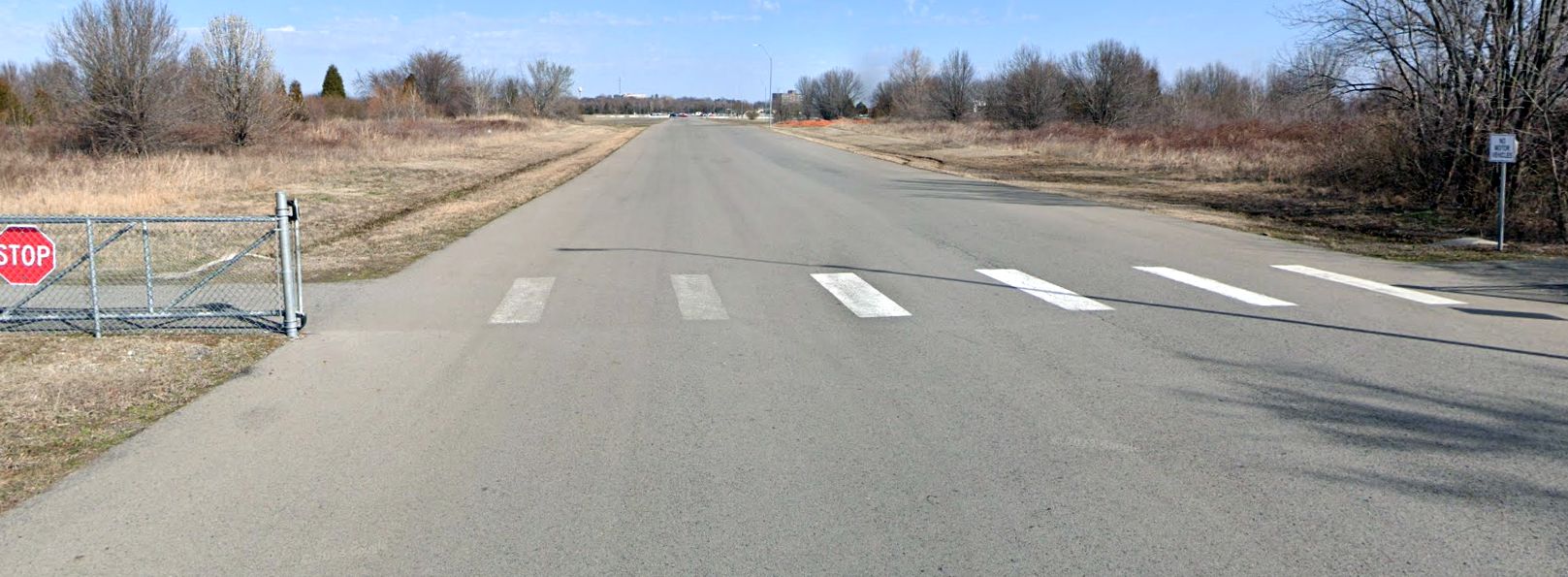
A circa 2000-2007 view of closed Runway 29 at Hatbox Field.
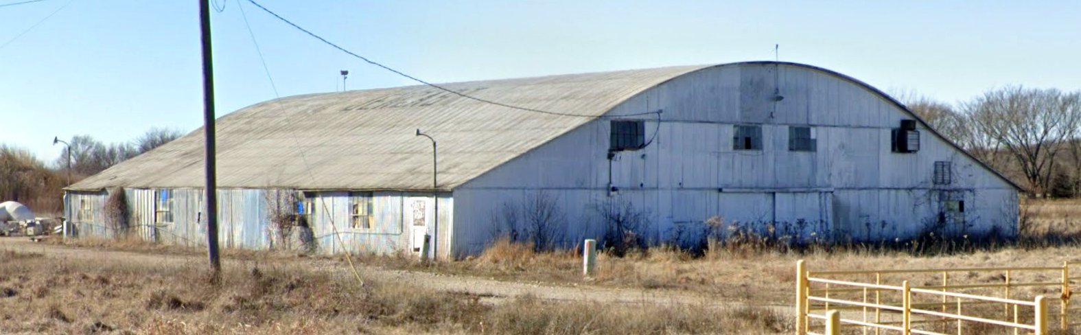
A circa 2000-2007 photo of a circa 1930s former military hangar at Hatbox Field (used until 2000 to store military surplus King Airs).
Terry Hall observed, “The hangar has tremendous character on the inside with laminated wooden beams used instead of steel.”
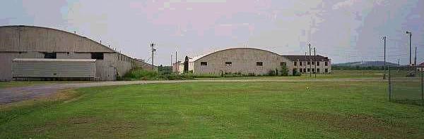
A circa 2000-2007 photo of other WW2-vintage former military hangars at Hatbox Field, currently used for industrial purposes.
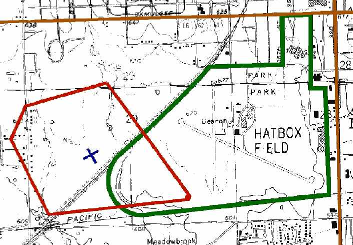
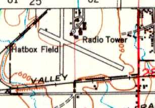
A 2001 Army Corps of Engineers diagram of the WW2-era boundaries of Hatbox Field & its Pistol Range.
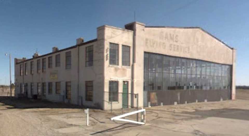
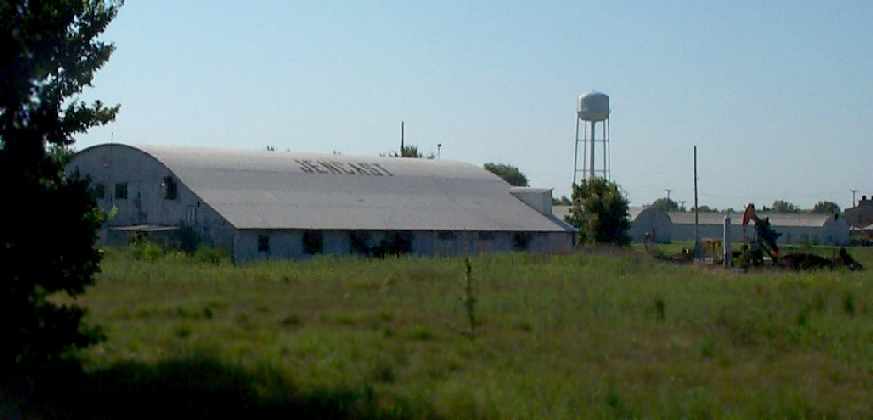
A circa 2007 photo looking southeast at the 1930s-era former military hangar at Hatbox Field, with “Sams Flying Service” still perceptible above the door.
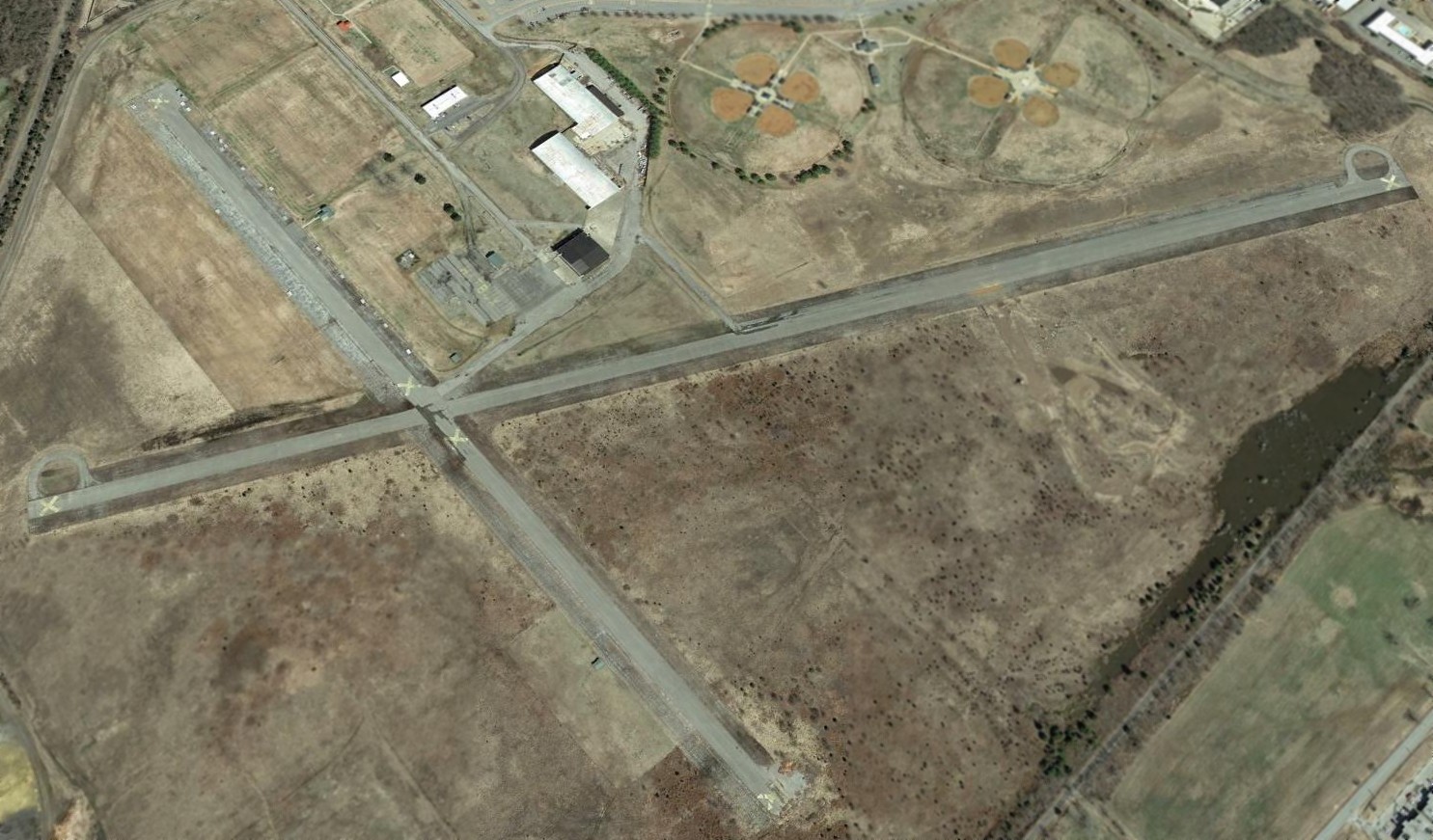
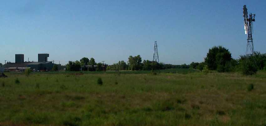
A 2014 aerial view looking northeast at Hatbox Field, with name “Hatbox” still recognizable, painted on the ramp.
What a shame to see this fine piece of aviation infrastructure going to waste.
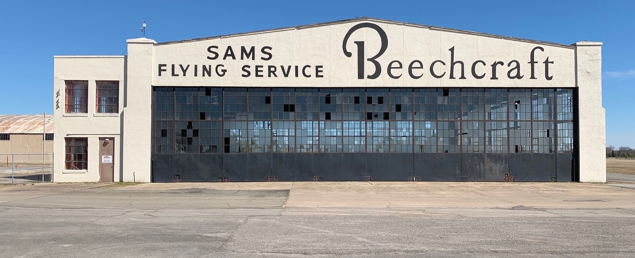
A 3/16/18 photo by Joe St. Clair at the 1930s-era former military hangar at Hatbox Field, showing that the “Sams Flying Service Beechcraft” lettering had been restored at some point between 2007-2019.
Joe reported, “To my surprise, the old airfield is still remarkably intact.”
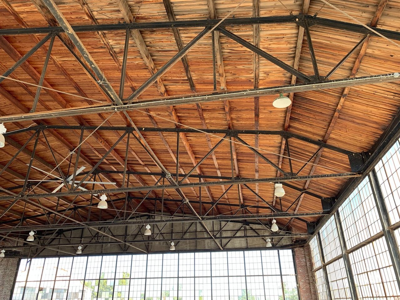
A 3/16/18 photo by Joe St. Clair at the interior of the 1930s-era former military hangar at Hatbox Field.
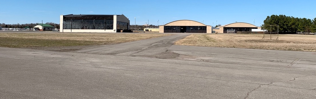
A 3/16/18 photo by Joe St. Clair of the 3 hangars at Hatbox Field.
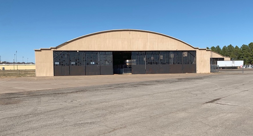
A 3/16/18 photo by Joe St. Clair of an arch-roof hangar at Hatbox Field.
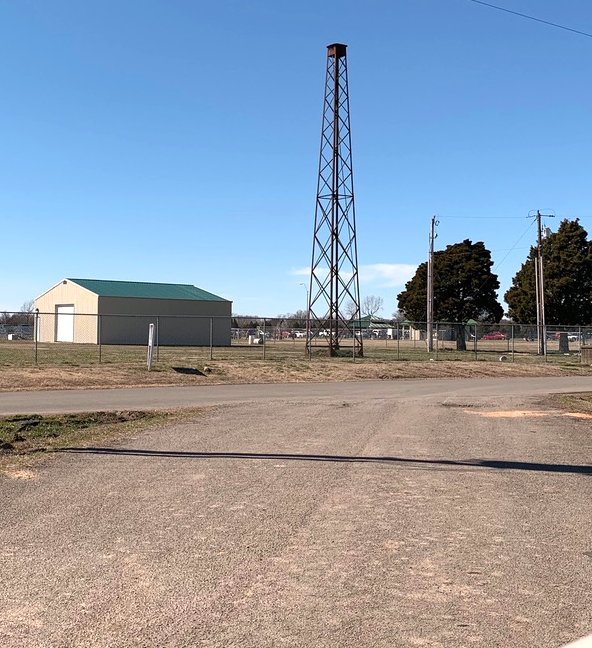
A 3/16/18 photo by Joe St. Clair of the former beacon light tower at Hatbox Field.
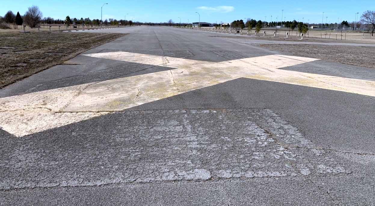
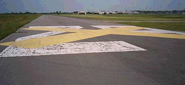
A 3/16/18 photo by Joe St. Clair of the closed-runway “X” marking on a former runway at Hatbox Field.
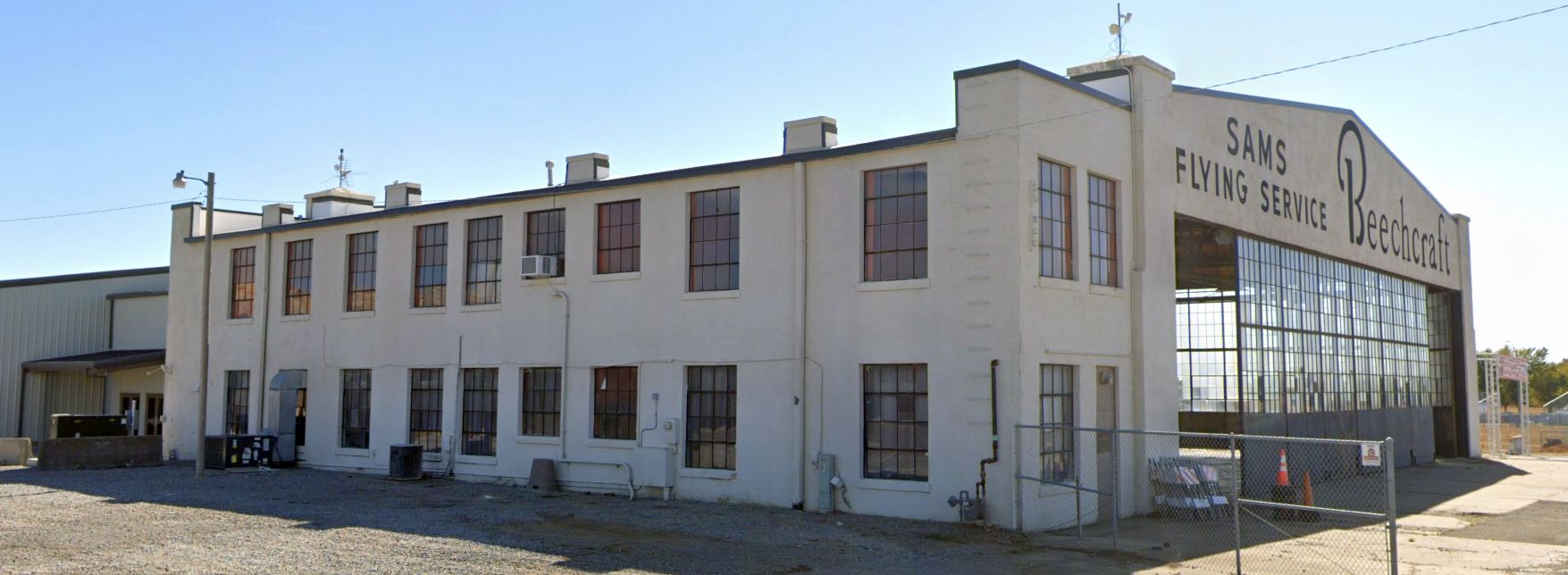
A 2022 photo looking southeast at the Hatbox Field “Sams Flying Service Beechcraft” hangar.
A 2023 photo looking north along the former Hatbox Field Runway 35.
____________________________________________________
Since this site was first put on the web in 1999, its popularity has grown tremendously.
If the total quantity of material on this site is to continue to grow,
it will require ever-increasing funding to pay its expenses.
Therefore, I request financial contributions from site visitors,
to help defray the increasing costs of the site
and ensure that it continues to be available & to grow.
What would you pay for a good aviation magazine, or a good aviation book?
Please consider a donation of an equivalent amount, at the least.
This site is not supported by commercial advertising –
it is purely supported by donations.
If you enjoy the site, and would like to make a financial contribution,
you
may use a credit card via
![]() :
:
Please consider checking the box to make a monthly donatation.
For a mailing address to send a check, please contact me at: paulandterryfreeman@gmail.com
If you enjoy this web site, please support it with a financial contribution.
please contact me at: paulandterryfreeman@gmail.com
If you enjoy this web site, please support it with a financial contribution.
____________________________________________________
This site covers airfields in all 50 states.