Abandoned & Little-Known Airfields:
Ohio: Northeastern Cleveland area
© 2002, © 2023 by Paul Freeman. Revised 12/27/23.
This site covers airfields in all 50 states: Click here for the site's main menu.
____________________________________________________
Please consider a financial contribution to support the continued growth & operation of this site.
Casement Airport (revised 8/4/23) - Chardon Airfield (revised 2/19/23) - East End Airport / Solon Airport (revised 12/23/23)
Ingalls Field (revised 1/14/19) - Jefferson Airport / Ashtabula-Jefferson Airport (revised 12/27/23) - Lake County Airpot / Willoughby Municipal Airport (revised 12/23/20)
Martin Factory Airfield / Great Lakes Aircraft Company Airfield (revised 12/23/23) - Stout Airport / Gardner Airpark / Ashtabula-Conneaut Airport (revised 12/23/23)
Willoughby Field / Euclid Avenue Airport / Cook Cleland Airport (revised 8/4/23)
____________________________________________________
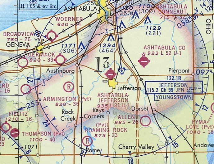
Jefferson Airport / Ashtabula-Jefferson Airport, Jefferson, OH
41.753, -80.77 (Northeast of Cleveland, OH)
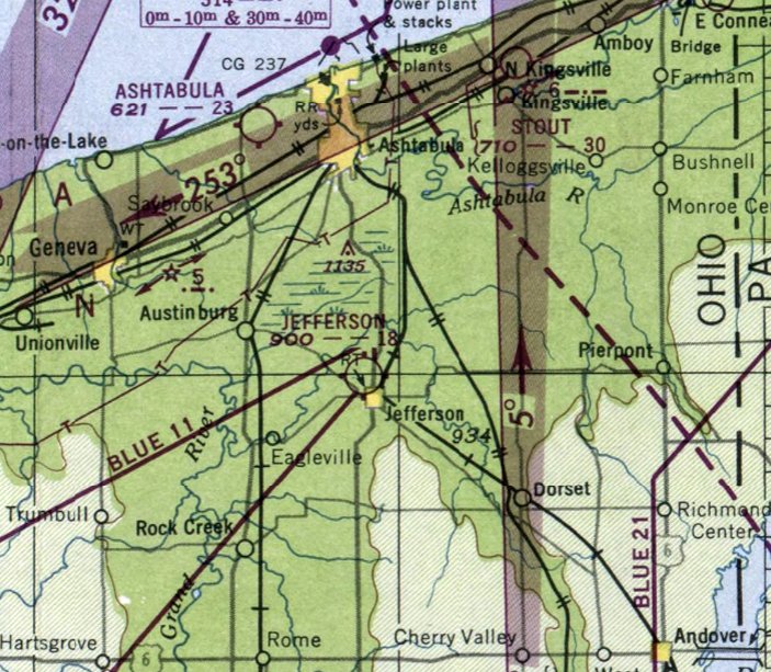
Jefferson Airport, as depicted on the January 1949 Cleveland Sectional Chart.
This small general aviation airport was evidently established at some point between 1948-49,
as it was not yet depicted on the 1948 Cleveland Sectional Chart.
The earliest depiction which has been located of Jefferson Airport was on the January 1949 Cleveland Sectional Chart.
It depicted Jefferson Airport as having a mere 1,800' unpaved runway.
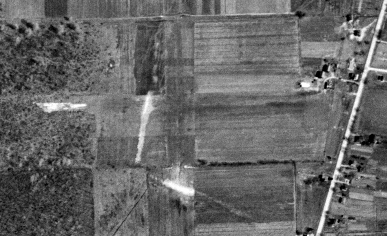
The earliest photo which has been located of Jefferson Airport was a 4/1/52 USGS aerial view.
It depicted Jefferson Airport as having an unpaved east/west runway, with a small hangar on the northeast side with an airport circle marking on its roof, but no planes were visible on the field.
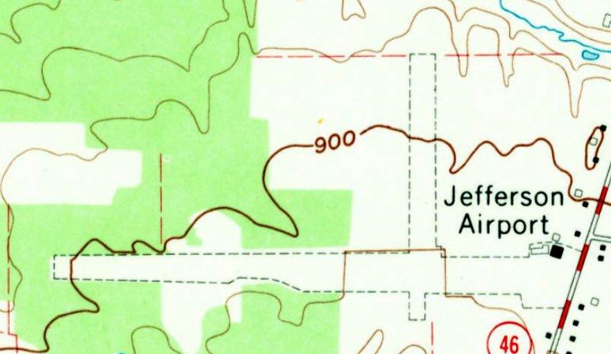
The earliest topo map depiction which has been located of Jefferson Airport was on the 1960 USGS topo map,
It depicted Jefferson Airport as having 2 unpaved perpendicular runways, with a few small buildings on the northeast side.
Jefferson Airport was evidently renamed Ashtabula-Jefferson Airport at some point between 1960-68,
as that is how it was labeled on the May 1968 Cleveland Sectional Chart.
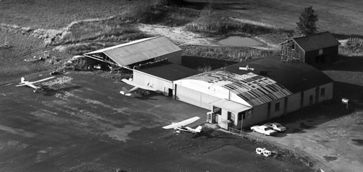
The only photo which has been located showing planes at Jefferson Airport was a 1968 aerial view looking northwest (courtesy of Dennis Thompson).
It depicted 3 Cessnas & a Piper in & around the hangars on the northeast side of the field.
A 1970 aerial view depicted Jefferson Airport as having an unpaved east/west runway, with 6 light planes parked near several small hangars on the east side.
The last aeronautical chart depiction which has been located showing Jefferson Airport as open was on the November 1972 Cleveland Sectional Chart (courtesy of Ron Plante).
It depicted Ashtabula-Jefferson Airport as having a 3,100' unpaved runway.
Jefferson Airport was evidently closed (for reasons unknown) at some point between 1972-74,
as it was depicted as an abandoned airfield on the November 1974 Cleveland Sectional Chart (courtesy of Ron Plante).
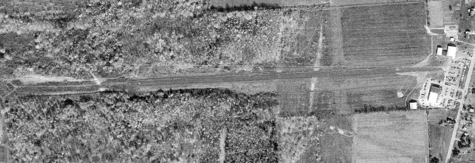
A 1974 aerial view (courtesy of Dennis Thompson) depicted Jefferson Airport after its closure.
The east/west runway remained intact, and the shorter north/south runway was still recognizable,
but a car dealership had been built on the eastern end of the field, and no planes were visible.
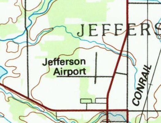
The 1986 USGS topo map still depicted Jefferson Airport as having 2 perpendicular runways, even though the airport had evidently been closed for at least a dozen years by that point.
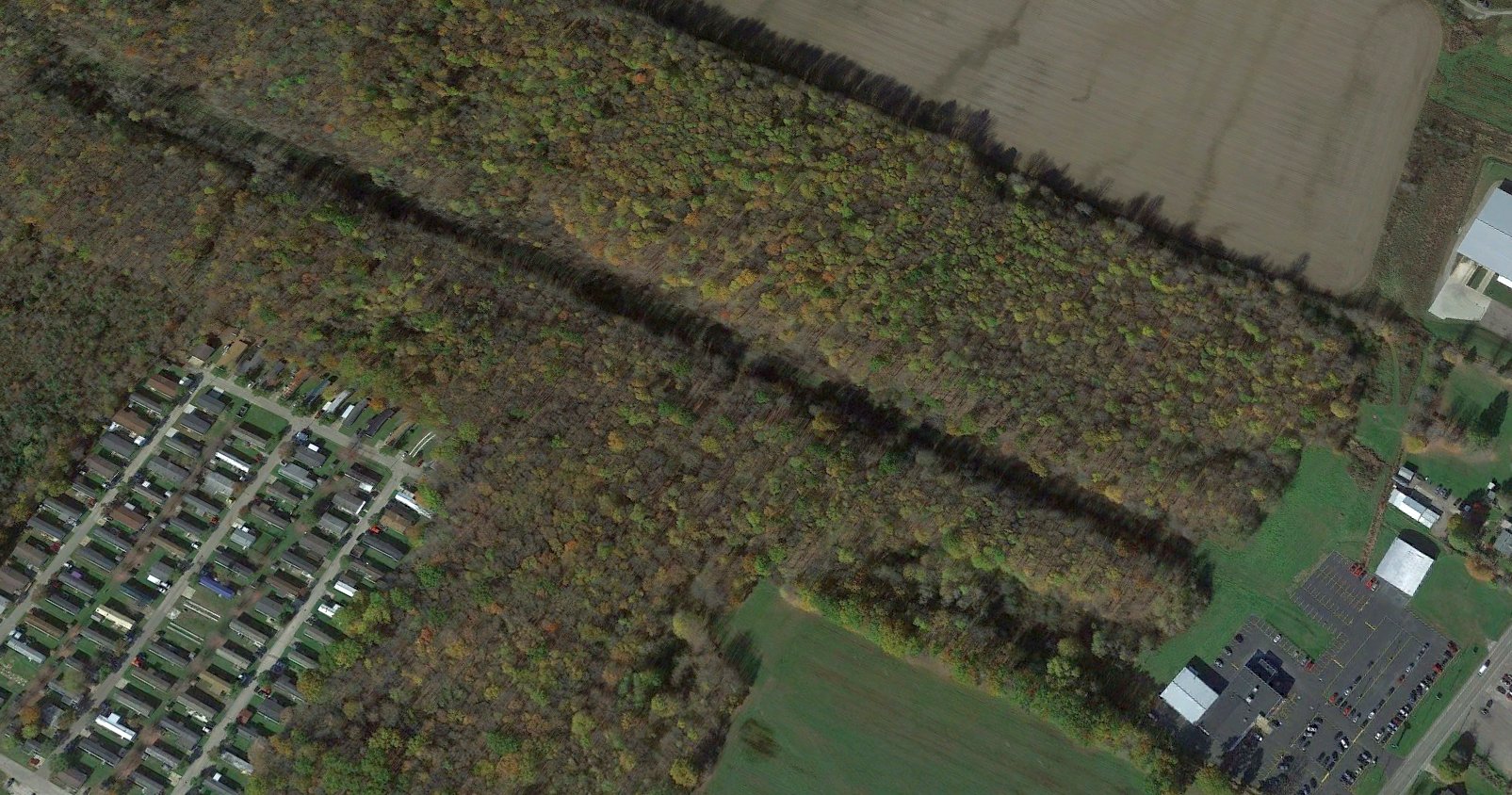
A 2021 aerial view looking northwest shows the alignment of the former Jefferson Airport east/west runway remains very recognizable, and a hangar remains on the northeast side.
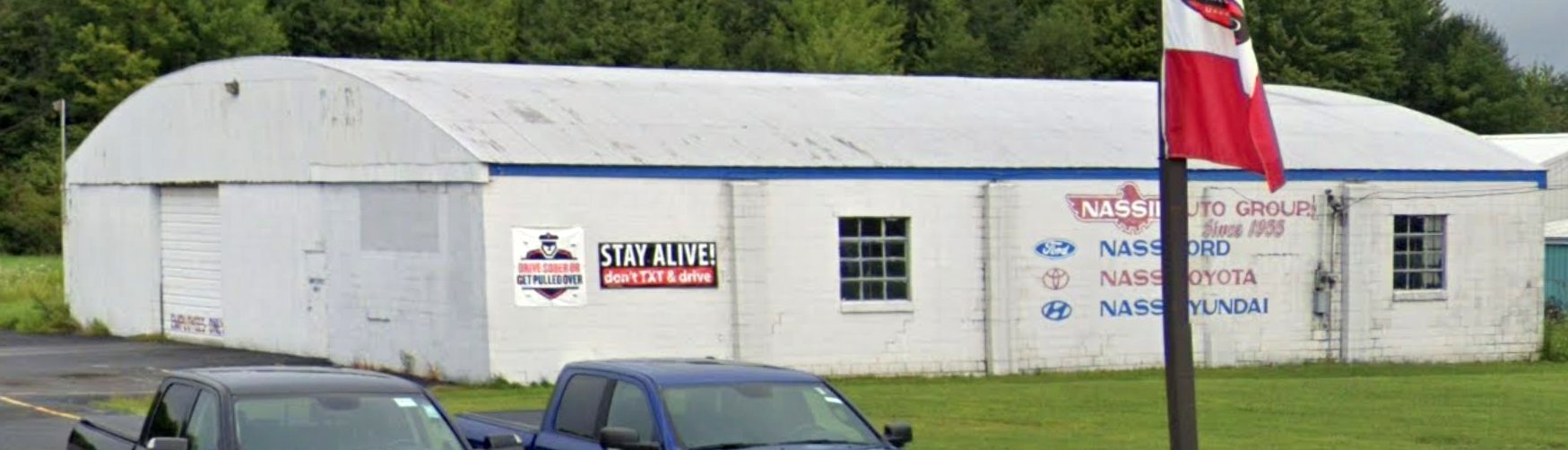
An August 2022 photo looking northwest at a former Jefferson Airport hangar, reused by the Nassif Group automobile dealership.
Thanks to Dennis Thompson for pointing out this airfield.
____________________________________________________
Stout Airport / Gardner Airpark / Ashtabula-Conneaut Airport (6D2), North Kingsville, OH
41.91, -80.677 (Northeast of Cleveland, OH)
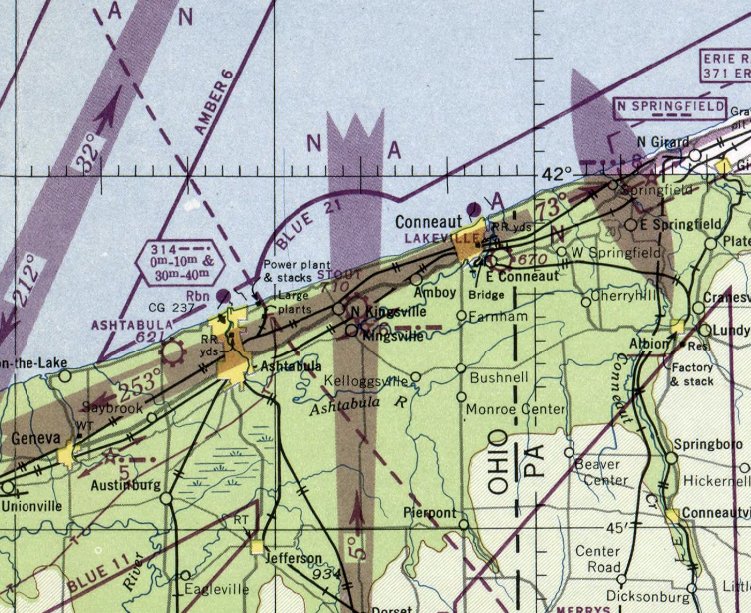
Stout Airport, as depicted on the July 1947 Cleveland Sectional Chart.
This small general aviation airport was evidently established at some point in 1947,
as it was not yet depicted on the January 1947 Cleveland Sectional Chart.
The earliest depiction which has been located of Stout Airport was on the July 1947 Cleveland Sectional Chart.
It depicted Stout as a commercial/municipal airport adjacent to the west side of the North Kingsville.
Dick Finley recalled, “I am old enough to remember flying in there one day.”
The only photo which is available showing Stout Airport in operation was a 4/21/52 USGS aerial view.
It depicted Stout as having 3 grass runways, with 5 light single-engine planes parked near a few small buildings on the northwest side.
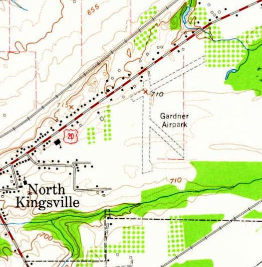
Apparently Stout Airport was renamed Gardner Airpark at some point between 1947-60,
as that is how it was labeled on the 1960 USGS topo map.
It depicted Gardner as having 3 unpaved runways & a few small buildings on the northwest side.
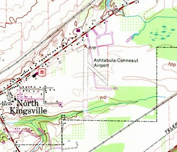
Gardner Airpark was evidently renamed again, to Ashtabula-Conneaut Airport, at some point between 1960-70,
as that is how it was labeled on the 1970 USGS topo map.
It had lost the northeast/southwest runway, leaving Ashtabula-Conneaut with 2 unpaved runways & a few small buildings on the northwest side.
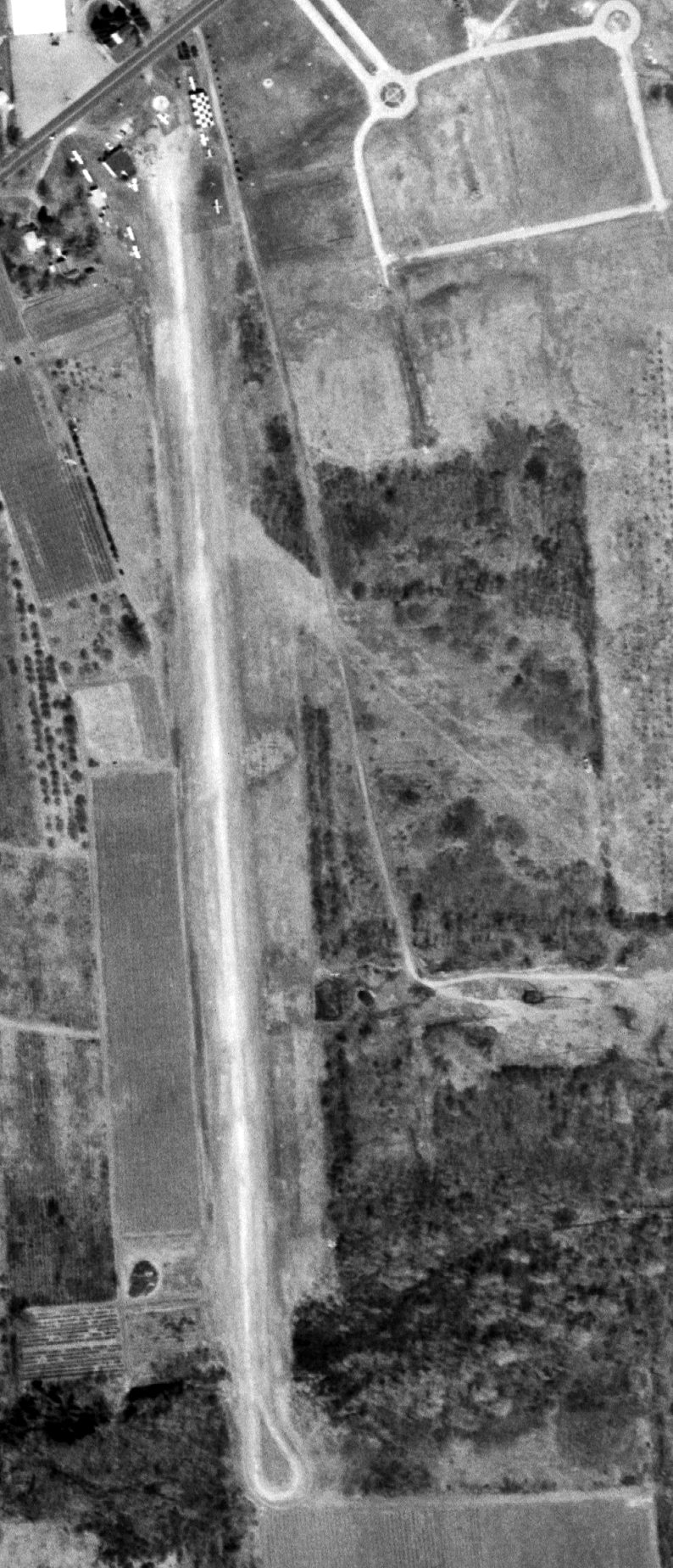
A 4/12/70 USGS aerial view showed Ashtabula-Conneaut Airport at perhaps the zenith of its popularity, with a total of 9 light single-engine aircraft on the field.
A second hangar, with a checkerboard roof, had been added on the northeast side at some point between 1952-70.
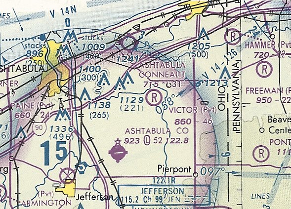
The last aeronautical chart depiction which has been located of Ashtabula-Conneaut Airport was on the May 1981 Cleveland Sectional Chart.
It depicted Ashtabula-Conneaut as having a 3,100' unpaved runway.
The last photo which has been located showing Ashtabula-Conneaut Airport in operation was a 1982 aerial view, but the number of aircraft visible has dwindled to only one.
Ashtabula-Conneaut Airport was evidently closed (for reasons unknown) at some point between 1982-93,
as it was no longer depicted on the October 1993 Cleveland Sectional Chart.
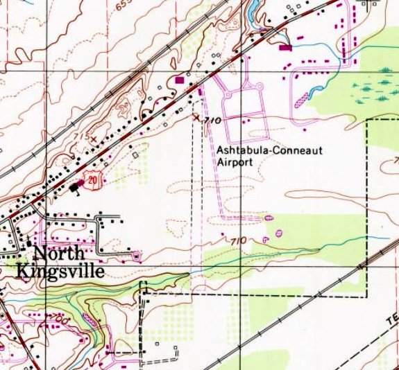
The last depiction which has been located of Ashtabula-Conneaut Airport was on the 1994 USGS topo map.
It had lost another runway (the northwest/southeast strip), leaving it with only an unpaved norths/south runway, a few small buildings on the northwest side.
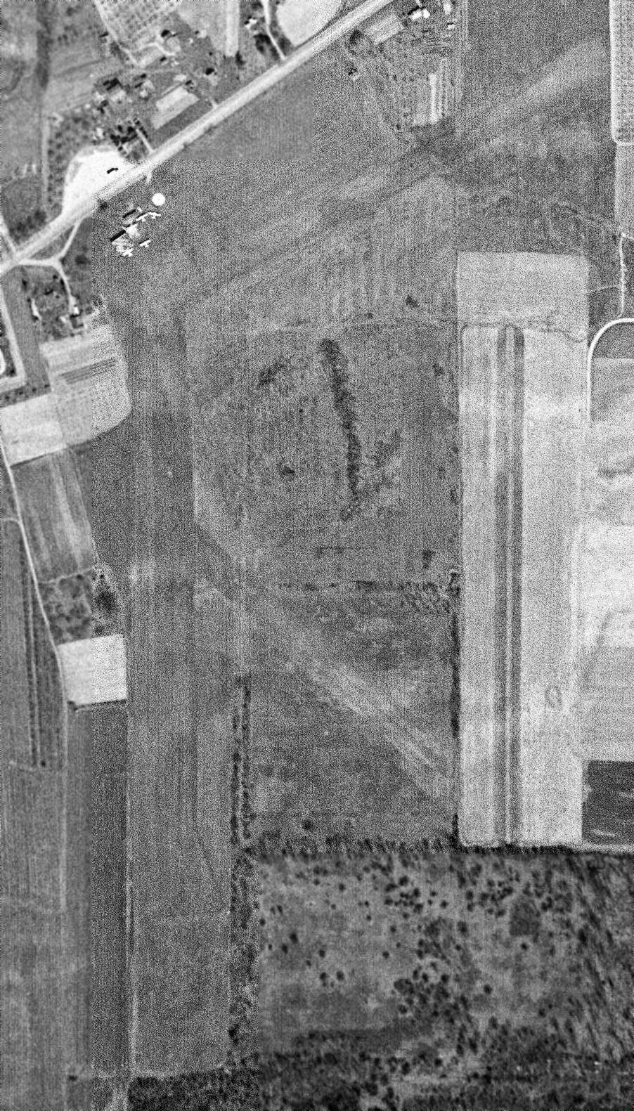
A 1994 USGS aerial photo showed the length of the former Ashtabula-Conneaut Airport north/south runway to have been excavated by numerous pits,
but a former airport building remained on the northwest side of the site.
A 2015 aerial view looking southeast at the site of Ashtabula-Conneaut Airport showed the alignment of the north/south runway was still recognizable (running diagonally from lower-left to upper-right).
One former airport building remained on the northwest side (bottom-left of picture).
As of 2018, street maps label the site of Ashtabula-Conneaut Airport as the location of Simak Trucking & Excavating.
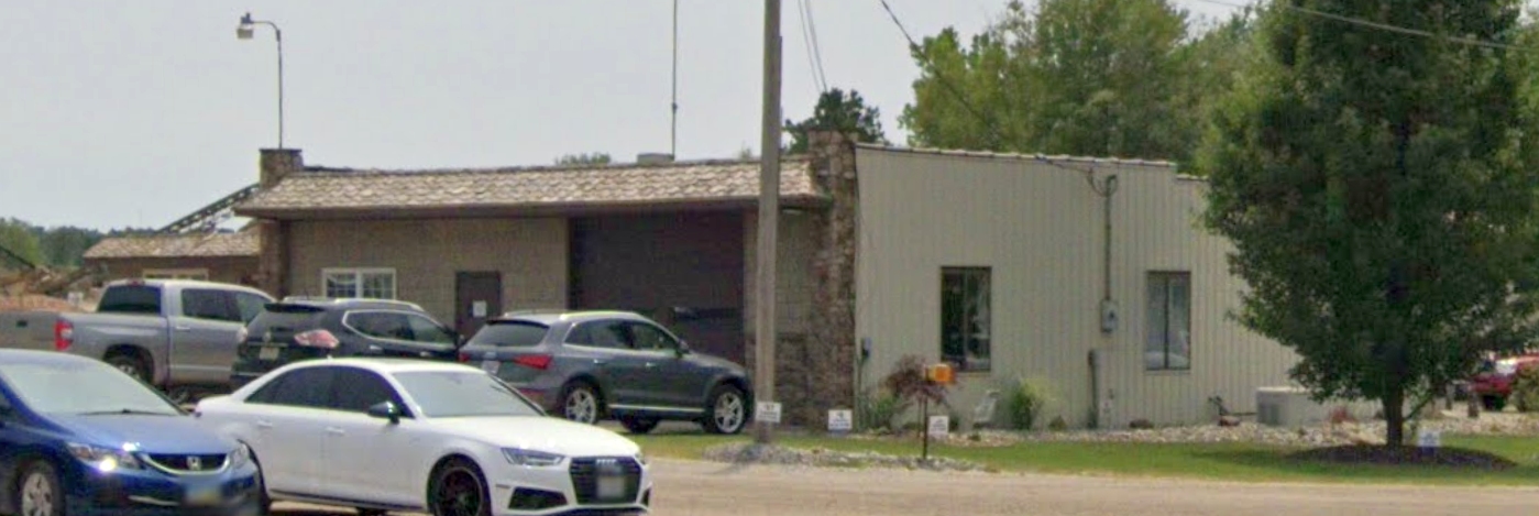
A July 2019 photo looking southwest at the last remaining Ashtabula-Conneaut Airport building, on the northwest side of the site.
The Ashtabula-Conneaut Airport site is located southwest of the intersection of Route 20 & Waters Circle.
Thanks to Dick Finley for pointing out this airfield.
____________________________________________________
East End Airport / Solon Airport, Solon, OH
41.375, -81.436 (Southeast of Cleveland, OH)
East End Airport, as depicted on the February 1935 Cleveland Sectional Chart.
East End Airport was evidently established at some point between 1933-35,
as it was not yet depicted on the April 1933 Cleveland Sectional Chart.
The earliest depiction which has been located of East End Airport was on the February 1935 Cleveland Sectional Chart.
It depicted East End as a commercial/municipal airport adjacent to the south side of the town of Solon.
Apparently the East End Airport was renamed/reestablished as Solon Airport.
According to Frank Doljack, “Solon Airport was established in 1937-38 by Lou Melter, who previously managed the old Bedford Airport.
Lou was one of the first aviators in the Cleveland area who during the 1920s owned & operated his own aircraft.
Lou became an instructor & IA” [Inspection Authorization].
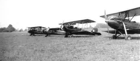
The earliest photo which has been located of Solon Airport was a circa 1937 photo of several planes (courtesy of the Solon Historical Society, via Frank Doljack).
The planes appear to be an unidentified biplane, a Piper J2 Cub, and 2 Waco OX5 biplanes.
According to Frank Doljack, “When he [Lou Melter] first established the airport there would have been no hangars.
Therefore the first tenants’ aircraft would have been tied out in a row, just as in the picture.”
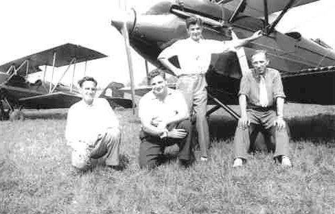
A circa 1937 photo of 3 unidentified men & Lou Melter (at right) in front of 2 Waco OX5 biplanes at Solon Airport (courtesy of the Solon Historical Society, via Frank Doljack).
Frank Doljack recalled, “Lou Melter often spoke about the first plane he owned was the Waco OX5,
and related how unreliable the engine was & always needed fixing.
On at least one occasion it quit on him & he made a forced landing in a field.
Lou Melter married Ann in about 1940 & taught her to fly.
She religiously ran the business activities of their operation & could be found every day in the office.
They made a perfect couple.”
According to Frank Doljack, “Lou got rid of the Waco prior to the start of the war & instead used Cubs in the Melter Flying Service.
After the beginning of WW2 Lou Melter joined the civilian Ferry Command.
Lou was a very independent individual & soon became disenchanted with the military orientation of the Ferry Command
and returned to re-open Solon Airport after which he provided primary training to Army Air Force pilots for the war effort.
Lou had many J3 Cubs for this effort & sold them as well.
After the war he made considerable money providing flight training under the G. I. Bill to many returning veterans.”
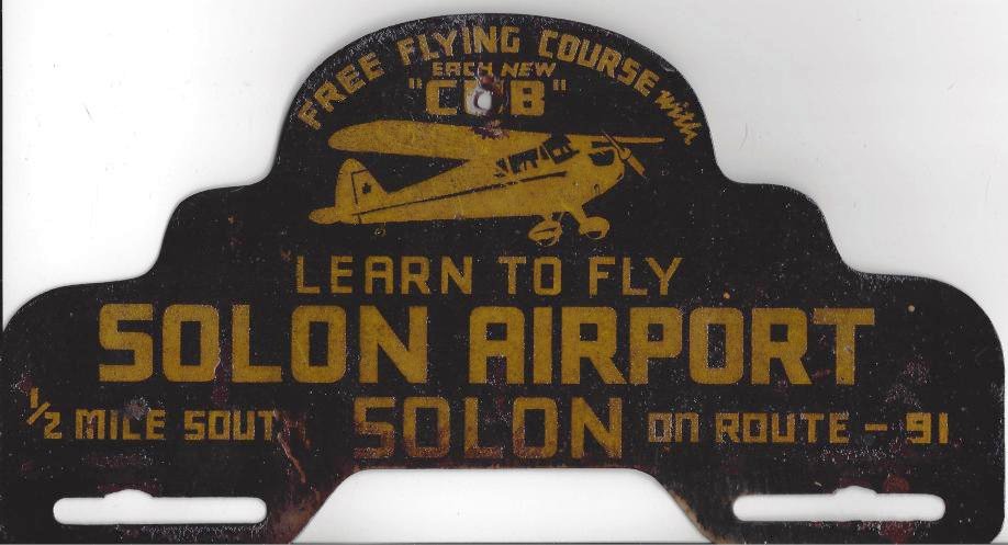
A circa 1940s license plate topper promoting Solon Airport (courtesy of the Solon Historical Society, via Frank Doljack).
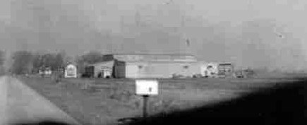
A circa 1950 photo looking north at the Solon Airport hangar (courtesy of the Solon Historical Society, via Frank Doljack), with SOM Center Road on the left.
According to Frank Doljack, “The small building to the left of the hangars is a small restaurant.”
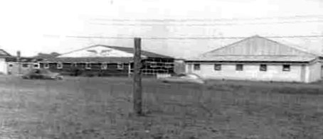
A circa 1950 photo looking east at the bck of the Solon Airport hangars (courtesy of the Solon Historical Society, via Frank Doljack).
Note the painted wings on the hangar on the left.
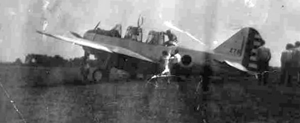
A circa 1950 photo of a surplus O-47 at Solon Airport (courtesy of the Solon Historical Society, via Frank Doljack).
The earliest aerial photo which has been located of Solon Airport was a 1951 aerial view (from the Cleveland Public Library, via Frank Doljack).
Frank Doljack observed, “The road on the left is Som Center Road & near the road is the row of hangars. One can almost see an airplane parked in front.
The airport property extends from the bottom of the photo to the top where one can see a small house on the left.
To the right one can see a vertical line which represents the eastern boundary of the rectangular-shaped property.
The airport remained a grass field throughout its life.”
The earliest topo map which has been located of Solon Airport was a 1953 USGS topo map (courtesy of Frank Doljack).
It depicted Solon Airport as a rectangular property outline with an irregularly-shaped building along the west side.
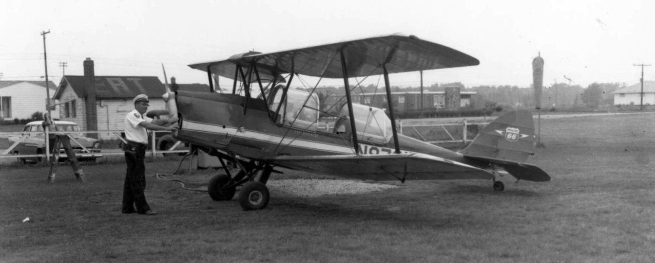
A circa 1950s photo of a De Havilland Tiger Moth (with a rare cockpit canopy) at Solon Airport (courtesy of the Solon Historical Society, via Frank Doljack).
Frank Doljack observed, “The small eatery can be seen. The apparent aircraft owner appears to be an airline captain.”
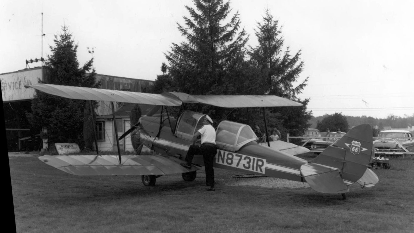
A circa 1950s photo of a De Havilland Tiger Moth at Solon Airport (courtesy of the Solon Historical Society, via Frank Doljack),
in front of the Melter Flying Service hangar, with the small office to its right.
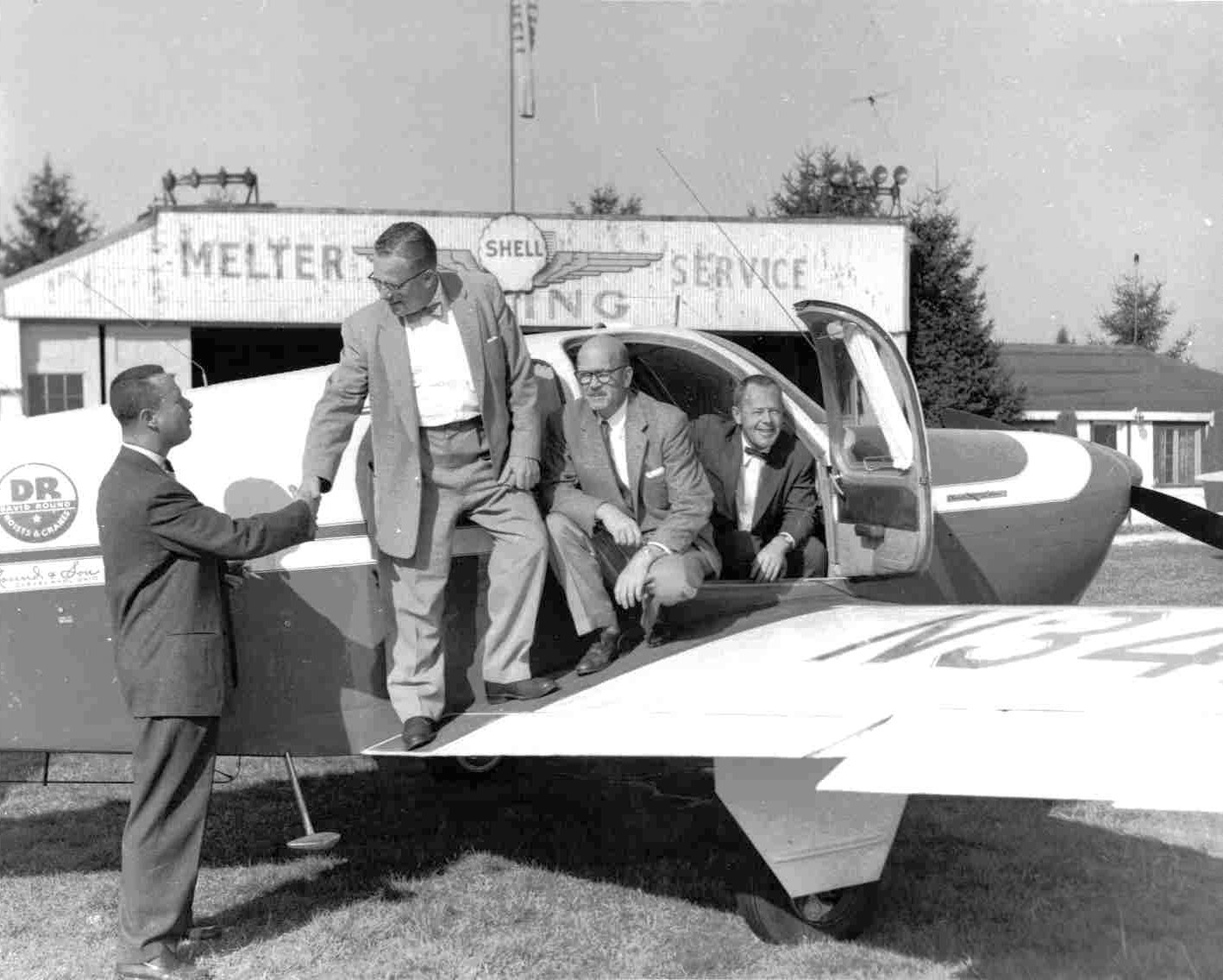
A 1956 photo of a group on a Beechcraft Bonaza in front of the Melter Flying Service hangar at Solon Airport (courtesy of the Solon Historical Society, via Frank Doljack).
The 1960 Cleveland Local Aeronautical Chart depicted Solon Airport as having a 3,000' unpaved runway.
Keith Alves recalled, “Solon Airport is where I learned to fly in the early 1960s.”
The last photo which has been located showing Solon Airport in operation was a 12/1/62 USGS aerial view.
It depicted Solon Airport as having 4 unpaved runways, with 3 light single-engine aircraft & a few small buildings along the west side.
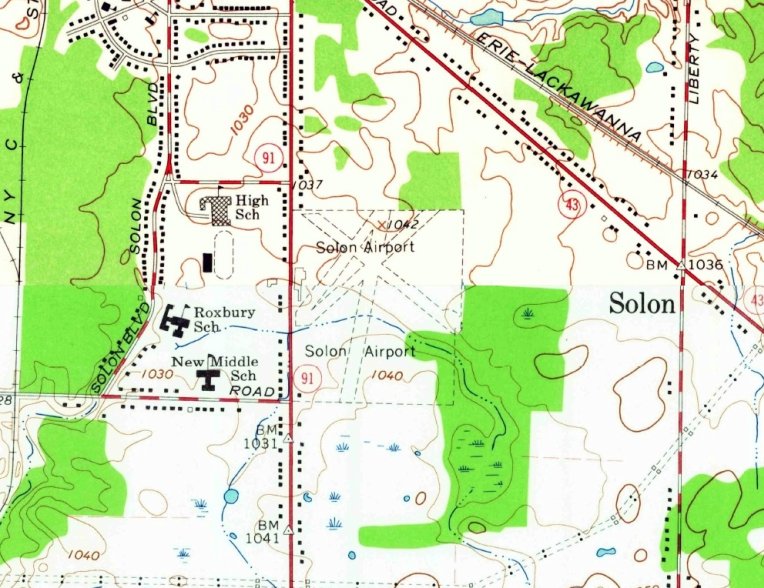
The last topo map which has been located of Solon Airport was a 1963 USGS topo map (courtesy of Frank Doljack).
It depicted Solon Airport as having 4 unpaved runways, with an irregularly-shaped building along the west side.
The last aeronautical chart depiction which has been located of Solon Airport was on the May 1963 Cleveland Sectional Chart.
It depicted Solon as having a 2,800' unpaved runway.
Frank Doljack recalled, “Towards the end Lou said he was going to put in a paved runway & had already scraped it out but never followed through
when he learned that such an improvement would only further increase his tax assessment.
As was the case with so many airports the city of Solon grew up around the airport & the tax assessment increased to where the business could not sustain itself.
At one point the city put in a water line & assessed the property owners on a per foot of frontage basis.
Lou complained how he could not afford the assessment with 'only one toilet' since the airport had considerable frontage on the road.
He hired a lawyer & fought it. I think he got the assessment lowered but he could still not sustain in the face of increasing taxes.
I believe he told me the developer offered him $225K for the property. This was a considerable sum in 1964 & subsequently he sold the property.
By 1964, the year I began my primary training under Lou at Solon Airport he sold the airport to a developer
and subsequently moved 2 aircraft he owned to Mills Airport near Mantua.
The airport closed in 1964 but was not developed for quite some time afterwards.”
Solon Airport was no longer depicted on the May 1965 Cleveland Sectional Chart.
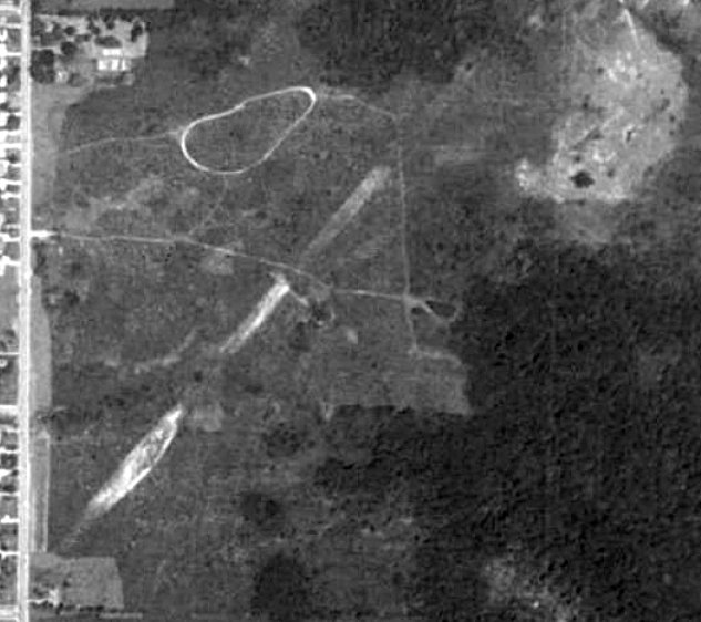
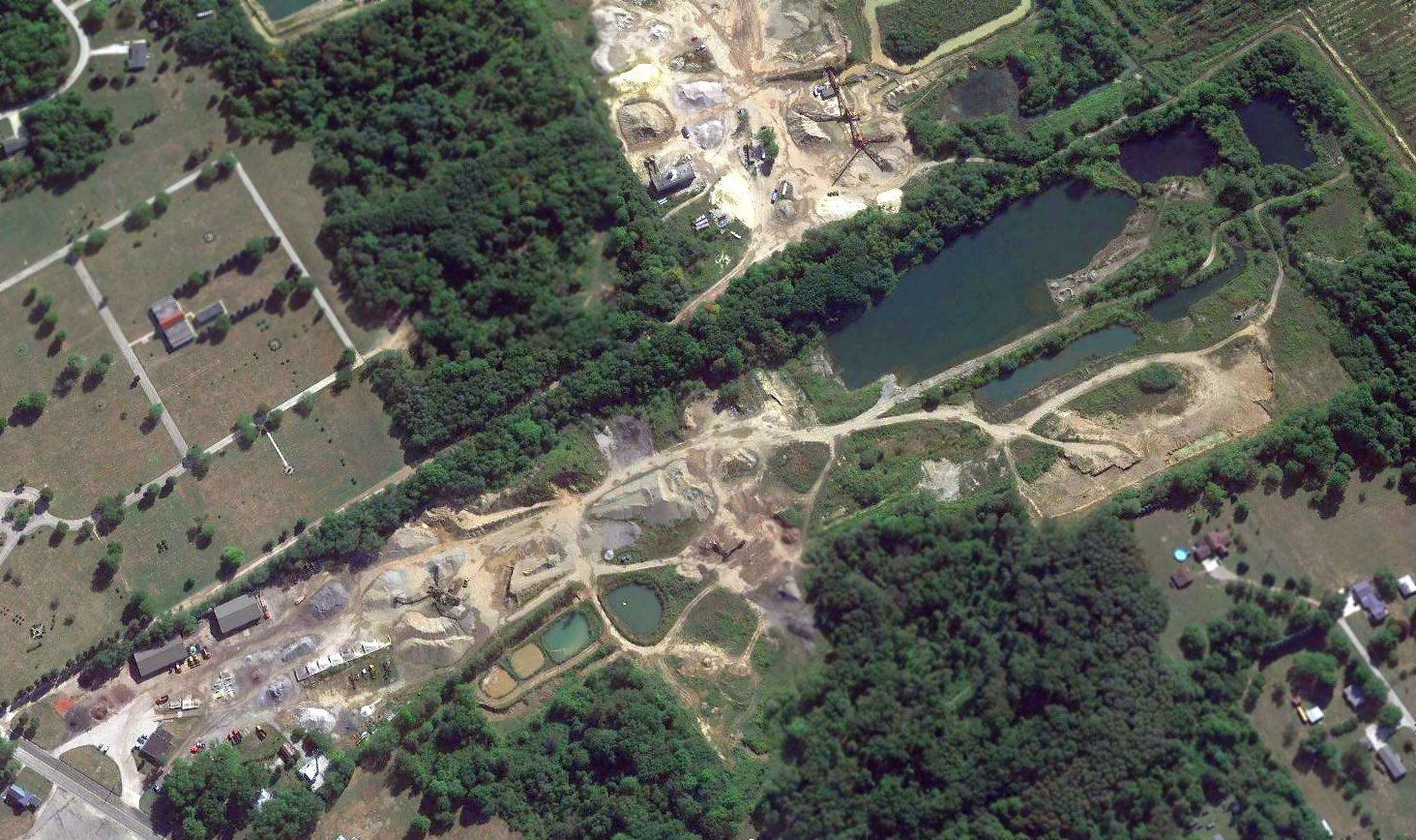
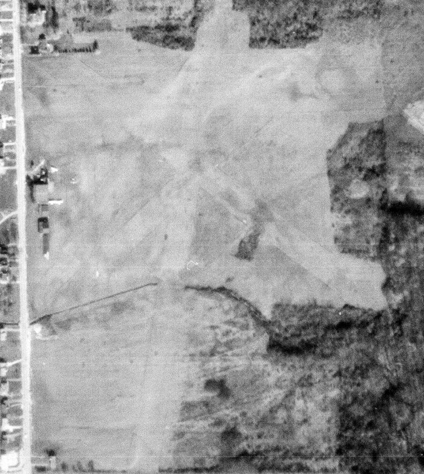
A 1979 aerial view of the site of Solon Airport (from the Cleveland Public Library, via Frank Doljack).
Frank Doljack observed, “The hangars are gone, nothing has been developed, and the remnants of a dirt northeast/southwest runway remain.”
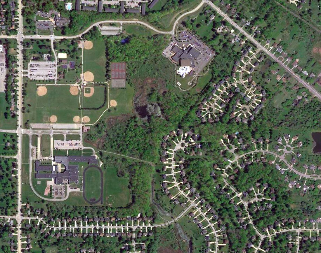
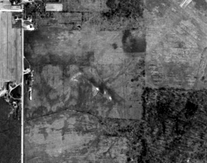
A 2017 aerial view of the site of Solon Airport (courtesy of Frank Doljack).
Frank Doljack observed, “Today the Solon Airport property is populated with schools & a community park.”
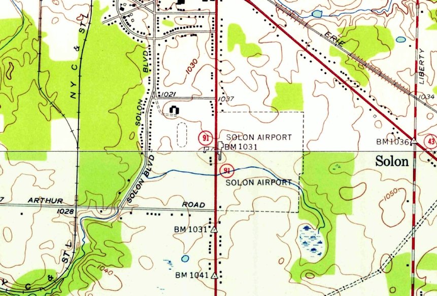
The site of Solon Airport is located southeast of the intersection of Som Center Road & Inwood Drive.
Thanks to Keith Alves & Frank Doljack for pointing out this airfield.
____________________________________________________
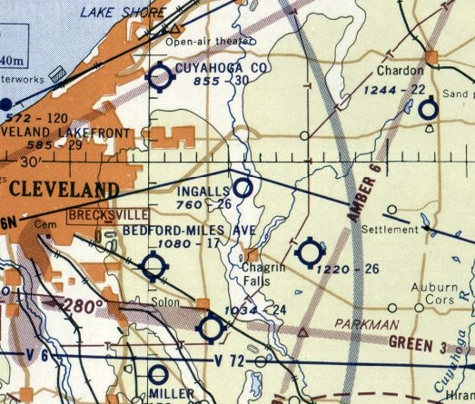
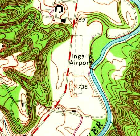
Ingalls Field / Ingalls Airport, Hunting Valley, OH
41.48, -81.4 (Southeast of Cleveland, OH)
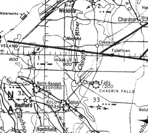
Ingalls Field, as depicted on the June 1941 Cleveland Sectional Chart.
According to www.firstworldwar.com, “David Sinton Ingalls was the U.S. Navy's sole air ace of World War I, achieving 6 victories in the air in a 6 week period in 1918.”
According to the Western Reserve Land Conservancy, this property included “David Ingalls' legendary landing strip...
on which renowned aviators such as Charles Lindbergh touched down.
Lucky Lindy frequently visited his friends in Hunting Valley after his 1927 solo flight across the Atlantic Ocean.”
Ingalls Field was not depicted on the March 1940 Cleveland Sectional Chart.
The earliest aeronautical chart depiction which has been located of Ingalls Field was on the June 1941 Cleveland Sectional Chart.
It depicted Ingalls as an auxiliary airfield.
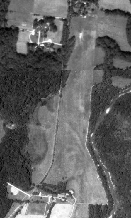
The earliest photo which has been located of Ingalls Field was a 4/16/52 USGS aerial view.
It depicted Ingalls as having a single north/south grass runway, with a hangar at the southwest end.
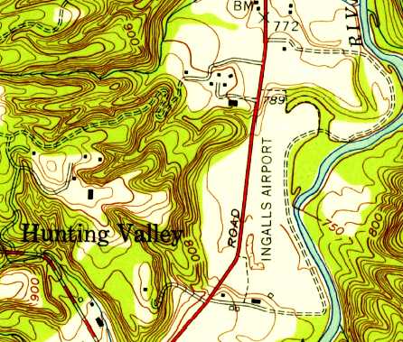
The earliest topo map depiction which has been located of Ingalls Airport was on the 1953 USGS topo map.
It depicted Ingalls Airport as a north/south clearing, with 2 small buildings on the southwest corner.
The last aeronautical chart depiction which has been located of Ingalls Field was on the July 1955 Cleveland Sectional Chart.
It depicted Ingalls as having a 2,600' unpaved runway.
Ingalls Field was evidently closed (at least in an official capacity) in 1955, as it was no longer depicted on the December 1955 Cleveland Sectional Chart
or subsequent sectionals.
According to Kevin Dunn, “David Ingalls kept a C90 King Air here. [He] even had lights on this sod strip.
I recall flying over Ingalls Field many times. [I] saw a Beech King Air C90 sitting outside the hangar.”
According to Dudley, “it was David Jr. [Ingalls] that owned the Baron & operated from his private strip in the 1960s.”
Jim Hackman recalled, “As a 26 year old Certified Flight Instructor & sales demonstration pilot
I demonstrated N7034D Beech Duke serial # P-9 in & out of Ingalls, I believe on 5/22/69.
The mission was to see if the Duke would fit in the hangar replacing the Baron. Also to let David Sr. fly it.
The short-wing BE-60 Duke was not a short-field airplane. The upside-down numbers on the far end of the runway are to tell a Duke pilot where to rotate.
Admiral Ingalls taxied up the hill at the north end, turned & launched.
We rotated in front of the hangar with a few hundred feet left. Flight was OK but I was really concerned about the landing.
Our experience was that anything below 100 knots in the Duke on final was TOO slow.
The Admiral got it down with my encouragement. They chose not to buy a Duke which was likely a good thing for them & for the Beech.”
The last map depiction which has been located of Ingalls Airport was on the 1970 USGS topo map.
It depicted Ingalls Airport as having a single unpaved north/south runway, with several small buildings on the southwest corner.
Ingalls Airport was no longer depicted on the 1979 USGS topo map.
According to Kevin Dunn, “Rumor goes one of the Ingalls kids had a Cessna Citation 1 & landed it there.
It was too heavy & it was buried in the grass & mud up to the gear locks! I believe the airport closed around 1980.”
Max Johnson recalled, “I grew up across the street from the Ingalls property on another Hunting Valley estate,
where my Father was the gardener & my Mother worked in the main house as a cook/housekeeper.
I can confirm the blurb about Ingalls' son trying to take off on a muddy field in 1980 & sinking the plane to the door locks.
The engines sucked up so much mud & debris that they had to be removed from the plane and shipped out for repair.
If I remember the story correctly, they were shipped to a company in Texas & the repair bill was well into the 6 figures.
The Ingalls estate caretaker was tasked with maintenance of the facility.
He had a radio in his home so that Mr. Ingalls could call ahead to get the strip lights turned on in advance of an arrival.”
According to www.firstworldwar.com, David Ingalls “died on 4/26/85 in Hunting Valley at the age of 86.”
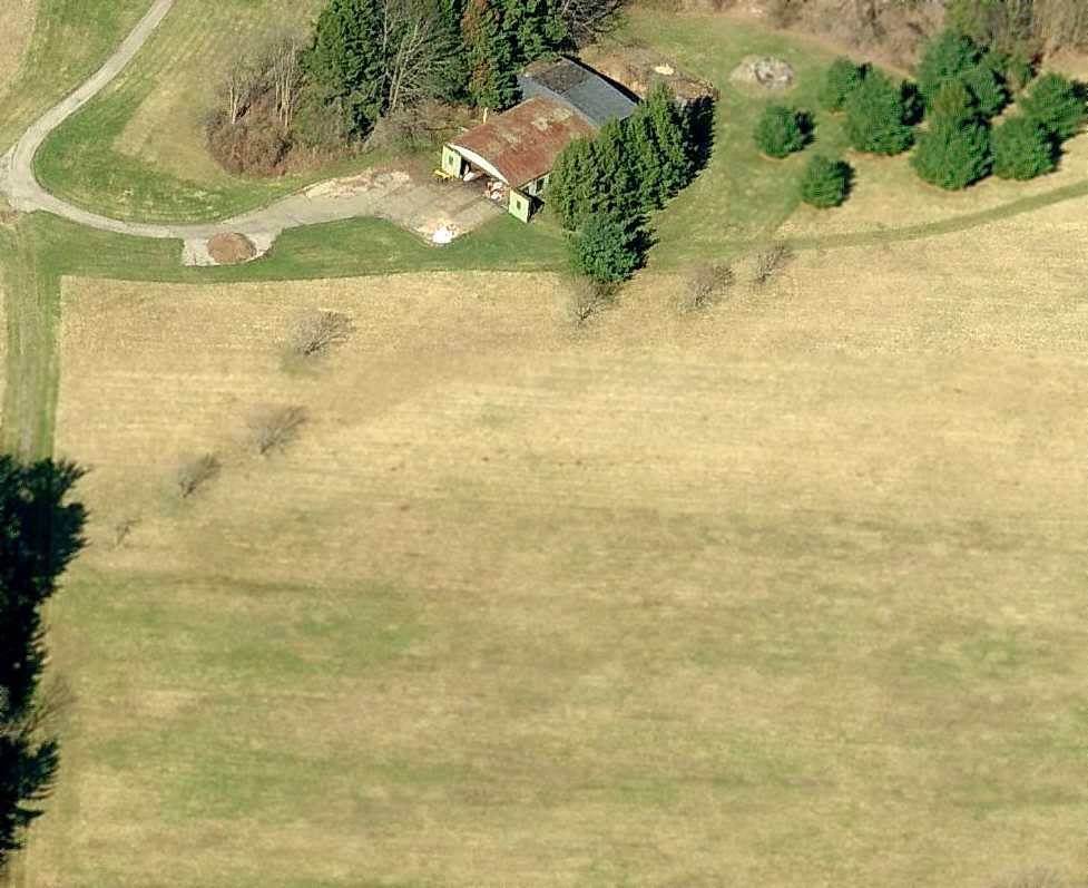
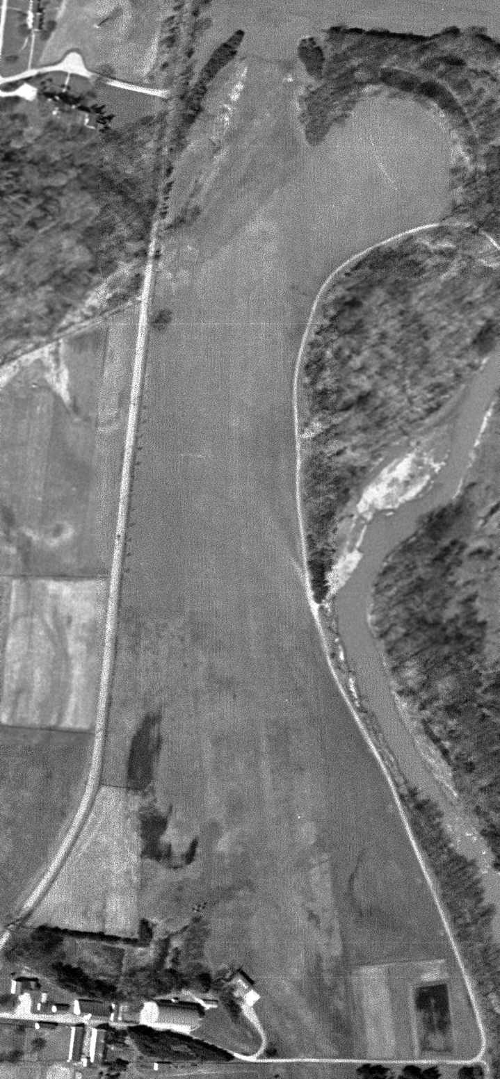
A circa 2008-2011 aerial view looking west at the Ingalls Field hangar, showing the doors open.
A 11/3/11 aerial view showed Ingalls Field remained completely intact.
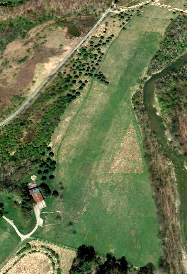
A 4/7/12 aerial view looking northwest at Ingalls Field,
showing that a small road or path had been cut across the northern portion of the runway at some point between 2011-2012.
Max Johnson recalled, “In my teenage years, I worked for Mr. Ingalls' daughter, who owned a house & property at the north end of the airstrip.
I planted most of the pine trees you can see in the recent photos.
I also had the unenviable task of weed eating around the hangar & the length of the fence line (which was close to a mile long).”
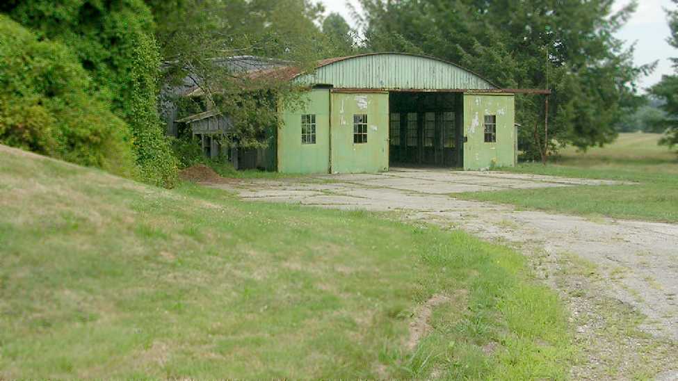
An August 2012 photo by Kevin Dunn looking north at the Ingalls Field hangar.
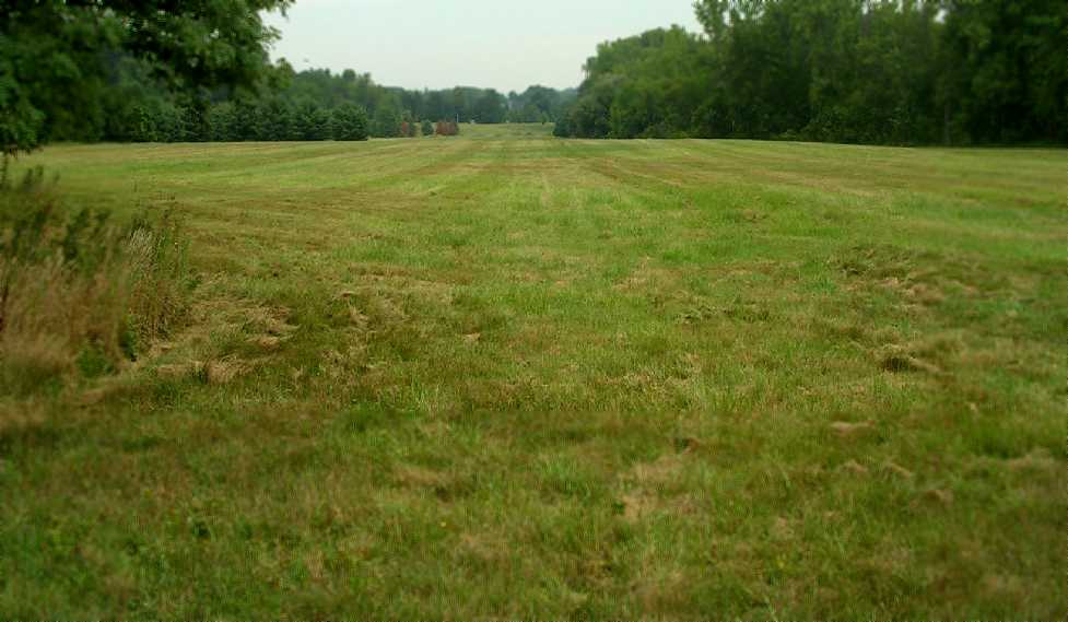
An August 2012 photo by Kevin Dunn looking north along the Ingalls Field runway.
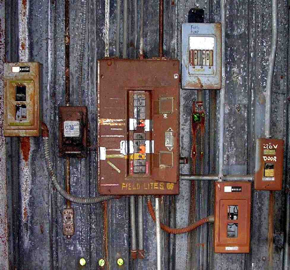
An August 2012 photo by Kevin Dunn of the electrical controls for Ingalls Field's field lights & fuel pump.
Lee Janotta reported in 2016, “Ingalls Airport is a horse ranch now, with paddocks on the runway.
There's a structure that looks like it could be the old hangar, restored.”
Ingalls Field is located southeast of the intersection of Fairmount Boulevard & Chagrin River Road.
____________________________________________________
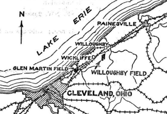
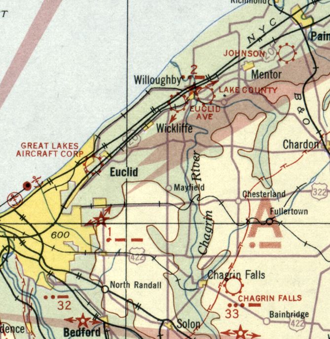
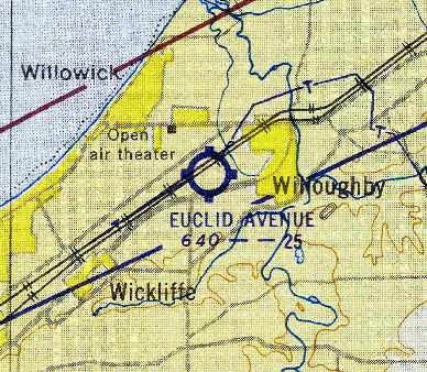
Lake County Airport / Willoughby Municipal Airport, Willoughby, OH
41.64, -81.38 (Northeast of Cleveland, OH)
Lake County Airport, as depicted on the December 1932 Cleveland Sectional Chart.
This small airport on the northeast side of Cleveland was evidently established at some point between 1929-38,
as it was not yet depicted on the 1929 Airway Map (courtesy of Chris Kennedy).
A newspaper article (courtesy of Chrisley Colwill) noted, “John Martens, President of Lake County Airways,
and the key man in the development of the Mentor Avenue airport which is to be dedicated July 6” [1929].
The earliest depiction which has been located of Lake County Airport was on the December 1932 Cleveland Sectional Chart.
It was still depicted as Lake County Airport on the May 1934 Cleveland Sectional Chart.
Lake County Airport was evidently renamed Willoughby Airport at some point between 1934-35,
as that is how it was labeled on the February 1935 Cleveland Sectional Chart.
A newspaper article (courtesy of Chrisley Colwill) noted, “Harry Playford is the head mechanic & assistant instructor at the Mentor Avenue airport of Lake Airways Inc.”
The earliest photo which has been located of Willoughby Municipal Airport
was an aerial photo in The Airport Directory Company's 1938 Airports Directory (courtesy of Chris Kennedy).
It described Willoughby Municipal Airport as having 3 sod runways, with the longest being the 2,500' northeast/southwest strip.
A May 1939 photo (courtesy of Chuck Slusarczyk of OPShots.net).
Chuck observed the photo is “of my grandfather (Ageton 'Aggie' Sobbota) as he waves from his beloved Travelair in Willoughby.
My Grandpa was a bit of a barnstormer back in the day.”
The last aeronautical chart depiction which has been located of Willoughby Airport was on the January 1953 Cleveland Sectional Chart.
It depicted Willoughby Airport as having a 2,300' unpaved runway.
Willoughby Airport was evidently closed (for reasons unknown) at some point in 1953,
as it was no longer depicted on the June 1953 Cleveland Local Aeronautical Chart (courtesy of Chris Kennedy).
A 2014 aerial view shows no trace remaining of Willoughby Airport.
The site of Willoughby Airport is located roughly near the intersection of Route 20 & Route 306.
____________________________________________________
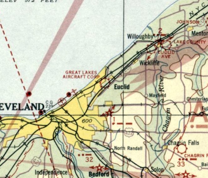
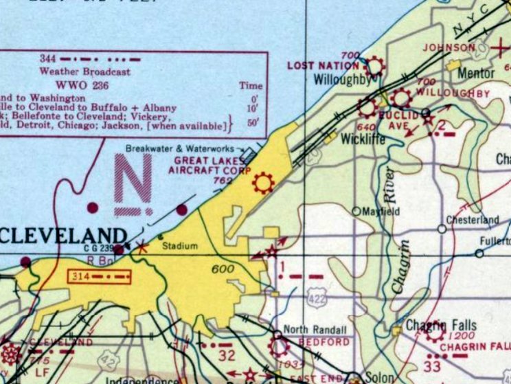
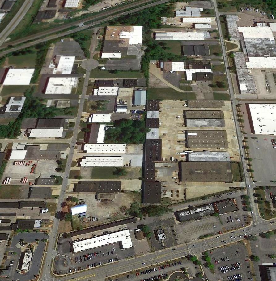
Martin Factory Airfield / Great Lakes Aircraft Company Airfield, Cleveland, OH
41.56, -81.56 (Northeast of Downtown Cleveland, OH)
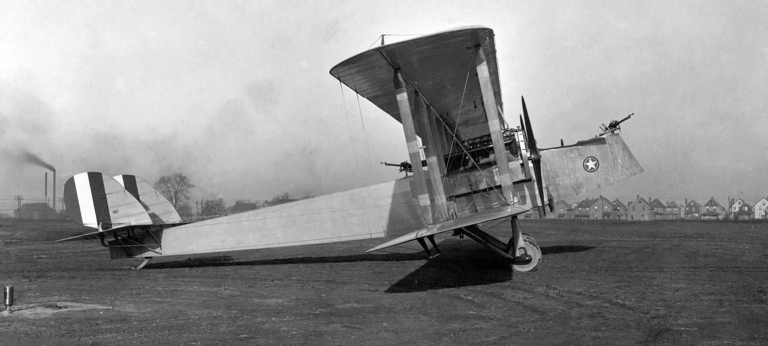
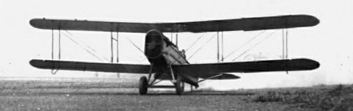
A 1919 photo of Martin MB-1 bomber C/n 3 39057 at the Martin factory airfield.
According to Tom Beamer, “In January 1918 Glenn L. Martin received a contract for a twin-engine biplane bomber.
Martin had financial backers in Cleveland, and built a 61,000 square foot plant with adjoining flight test field.
Lawrence Bell was the factory manager & was in charge of supervising plant construction.
Donald Douglas was responsible for design of the bomber.
The first plane (GMB/MB-1) was completed by September of 1918.”
The earliest depiction which has been located of the Cleveland Martin factory was a 1919 photo of Martin MB-1 bomber C/n 3 39057, showing the the houses in the close proximity which hemmed-in the airfield.
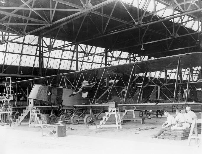
A 1920 photo of an Army MB-2 bomber under construction in the Cleveland Martin factory (courtesy of Mike Kmetz), with the workers seemingly on a break.
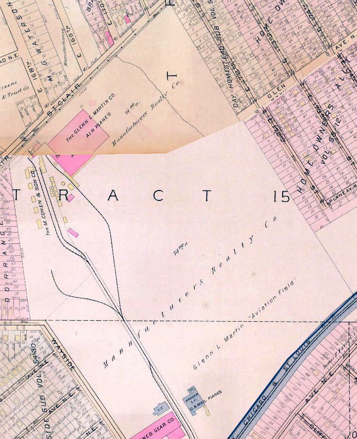
A circa 1920-22 map of the “Glenn L. Martin Aviation Field” depicted a factory building on the northwest corner of the field,
and an airmail hangar on the southern corner.
The earliest photo which has been located of “Glenn L. Martin Field” was an undated aerial view from the 1921 Eytinge's Flying Guide (courtesy of Alex Sheppard).
It depicted the “Aerial Mail Hangar & Cinder Runway”.
The directory described the “Glen l. Martin Company aeroplane factory & field” as “used by U.S. Aerial Mail”, as described the field as measuring 3,300' x 1,500'.
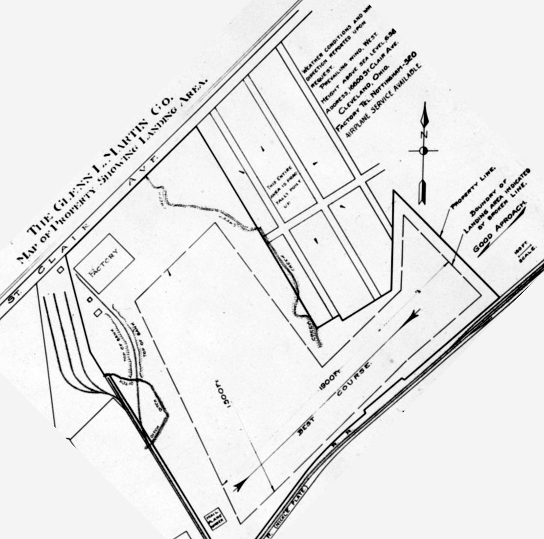
A circa 1922 Glen L. Martin Company map (courtesy of Tom Hietzman)
depicted the Martin factory airfield as having 2 runways: 1,900' northeast/southwest & 1,500' northwest/southeast.
An August 1923 photo of an Air Mail de Havilland DH-4 biplane landing at Martin Field (courtesy of Mike Kmetz).
Glen Martin Field, as depicted on the 10/10/27 Commerce Department Airway Bulletin (courtesy of Mike Denja).
According to Tom Beamer, “By 1928 Martin realized that the future was in all-metal aircraft & sold the Cleveland plant to Detroit Aircraft
so he could build a new plant optimized for metal construction in a warmer location (Baltimore, MD)
that was better suited for flight testing flying boats year-round.
The Cleveland subsidiary of Detroit Aircraft was named Great Lakes Aircraft & the first product was the TG-1 torpedo bomber biplane.
The TG-1 was a re-designation of the last aircraft Martin built for the Navy in Cleveland, the T4M-1.
In 1929 Great Lakes produced the famous Sport Trainer - the plane that established their reputation.”
The earliest aeronautical chart depiction which has been located of the Martin Factory Airfield
was on the 1929 Airway Map (courtesy of Chris Kennedy).
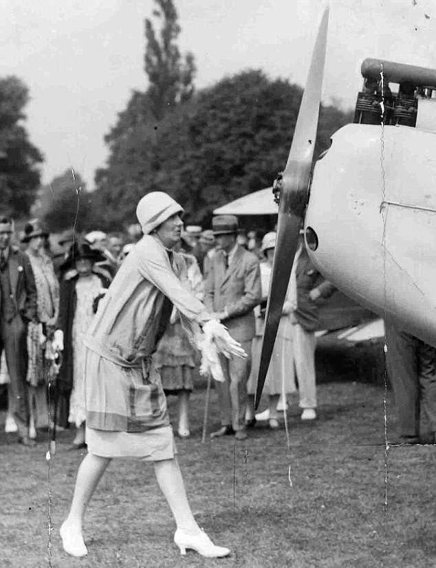
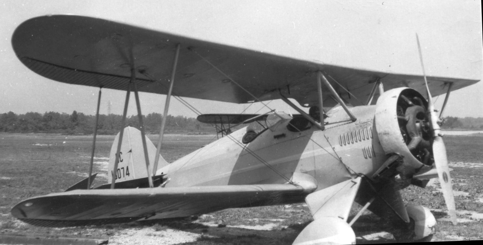
An 8/28/29 photo of Lady Mary Heath, a famous British flier, hand-propping a Great Lakes 2T1 trainer at the Great Lakes factory airfield (courtesy of Mike Kmetz).
According to Mike Kmetz, “Heath... was in the United States to promote British-made Cirrus engines. These were being used in the Great Lakes aircraft.
She was quite the lady! The picture of her hand-propping her engine shows her dressed in fashionable clothes of the day, while onlookers watched in astonishment.
She planned to compete in a power-off spot landing event on 8/29/29 at the National Air Races in Cleveland.
She was practicing for the event the day before flying a Great Lakes 2T1 trainer at the Great Lakes factory airfield.
With the engine shut off she was gliding toward a landing mark when the plane suddenly lost altitude & she had no power to recover.
She was trying to avoid an electric tower when her wing caught a guy wire of the high chimney of the Mills Company at 965 Wayside Drive.”
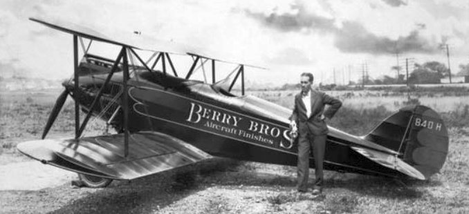
An undated photo of an unidentified man in front of Great Lakes biplane NC840H at Martin Field (courtesy of Mike Kmetz).
The earliest Sectional chart depiction which has been located of the Great Lakes Aircraft Corporation Airfield was on the December 1932 Cleveland Sectional Chart.
The January 1936 Civil Aeronautics Administration Airport Directory (courtesy of Tom Beamer)
described the Great Lakes Aircraft Corporation Field as a commercial field.
It was said to be an L-shaped field, with 2 runways: 1,900' northeast/southwest & 1,500' northwest/southeast.
The last aeronautical chart depiction which has been located of the Great Lakes Aircraft Corporation Airfield was on the October 1936 Cleveland Sectional Chart.
According to Tom Beamer, “Unfortunately the stock market crash & depression spelled an early end to Great Lakes.
By 1936 the doors were closed, and the plant up for sale in 1937.”
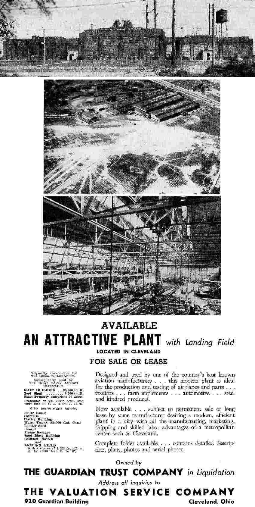
A 1937 advertisement for the property (courtesy of Tom Beamer)
described the site as totaling 70 acres, including 100,000 square feet of buildings.
An undated aerial photo depicted at least one biplane adjacent to the factory, with an open grass landing area.
The Great Lakes Airfield was no longer listed at all in The Airport Directory Company's 1937 Airports Directory (according to Tom Beamer),
nor depicted on the March 1937 Cleveland Sectional Chart or the 1939 USGS topo map.
A 1952 aerial photo showed that another industrial building had been constructed at some point on the site of the airfield,
but the Martin factory building remained standing.
A Cleveland resident reported, “The rest of the field has become factories that are today mostly abandoned.
Throughout the Cold War, Gould Ocean Systems built the drive portion of Navy torpedoes on the property.”
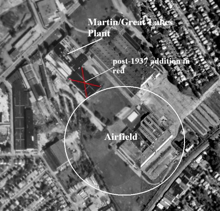
The 2000 USGS aerial photo was annotated by Tom Beamer to show the former Martin factory building & the location of its airfield.
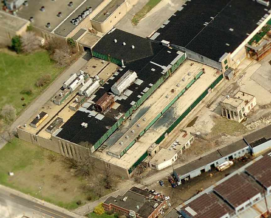
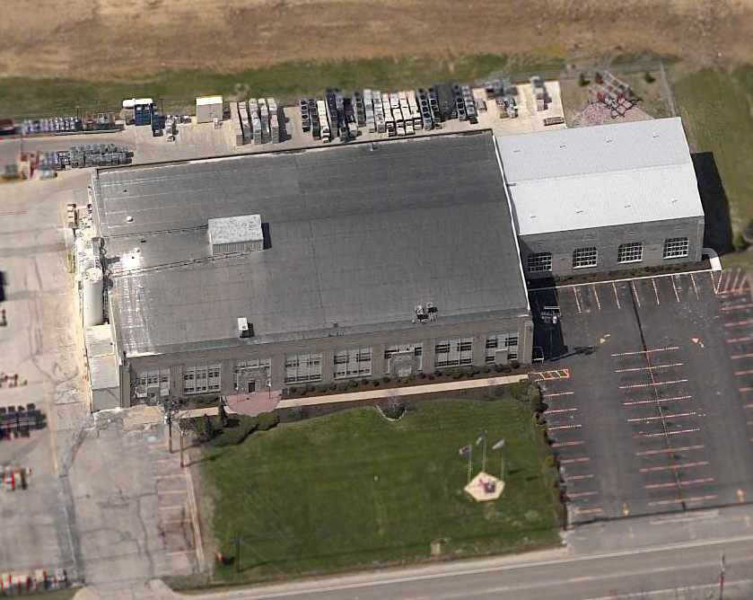
A circa 2006 aerial photo looking east at the former Martin aircraft factory building.
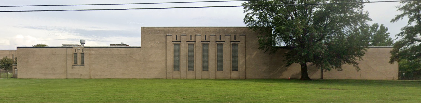
An August 2021 photo looking southeast at the former Martin aircraft factory building.
The site of the Martin Factory Airfield is located south of the intersection of St. Clair Avenue & East 168th Street.
____________________________________________________
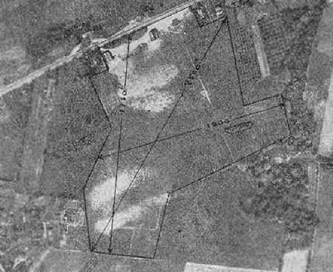
Willoughby Field / Euclid Avenue Airport / Cook Cleland Airport, Willoughby, OH
41.63, -81.433 (Northeast of Cleveland, OH)
Willoughby Field, as depicted on the 10/10/27 Commerce Department Airway Bulletin (courtesy of Mike Denja).
This small airport on the northeast side of Cleveland went by many names throughout its lifespan.
The date of establishment of Willoughby Field has not been determined.
The earliest depiction which been located of Willoughby Field was on the 10/10/27 Commerce Department Airway Bulletin (courtesy of Mike Denja).
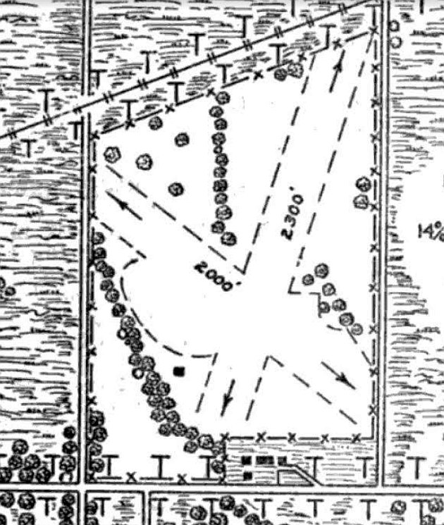
Willoughby Field was described in the 10/10/27 Commerce Department Airway Bulletin (courtesy of Mike Denja) as a commercial airport owned & operated by Sanborn Aviation Company.
It was said to consist of a 100 acre rectangular sod field, within which were 2 runways measuring 2,300' northeast/southwest & 2,000' northwest/southeast.
A single small building was depicted southwest of the runway intersection.
Willoughby Field was not yet depicted on the 1929 Airway Map (courtesy of Chris Kennedy).
The earliest aeronautical chart depiction which been located of Euclid Avenue Airport was on the December 1932 Cleveland Sectional Chart.
It depicted Euclid Avenue as a commercial/municipal airport.
A circa early 1930s photo (courtesy of Kyle Smith) of 2 pilots (one possibly Lester Dethloff) in front of a Great Lakes biplane at Euclid Avenue Airport.
A circa early 1930s photo (courtesy of Kyle Smith) of an American Eagle D or E-430 monoplane at Euclid Avenue Airport.
The Airport Directory Company's 1933 Airports Directory (courtesy of Chris Kennedy)
described “Willoughby Field” as a commercial airport, located 1 mile west of Willoughby.
The field was said to consist of a 100-acre rectangular sod field, on which were 2 runways:
2,300' northeast/southwest & 2,000' northwest/southeast.
The Commerce Department's 1934 Airport Directory (courtesy of Chris Kennedy)
described Euclid Avenue Airport as consisting of a rectangular sod field, on which were 3 runways,
with the longest being the 2,300' northeast/southwest strip.
A hangar was said to have “Euclid Avenue Airport” painted on the roof.
The earliest dated photo which has been located of Euclid Avenue Airport
was an undated aerial view in The Airport Directory Company's 1937 Airports Directory (courtesy of Bob Rambo).
It described Euclid Avenue as a commercial airport, consisting of a rectangular sod field.
The field was said to have 3 runways, with the longest being the 3,000' north-northeast/south-southwest strip.
A single hangar was depicted on the southwest side of the field, which was said to have "Euclid Avenue Air Service" on the roof.
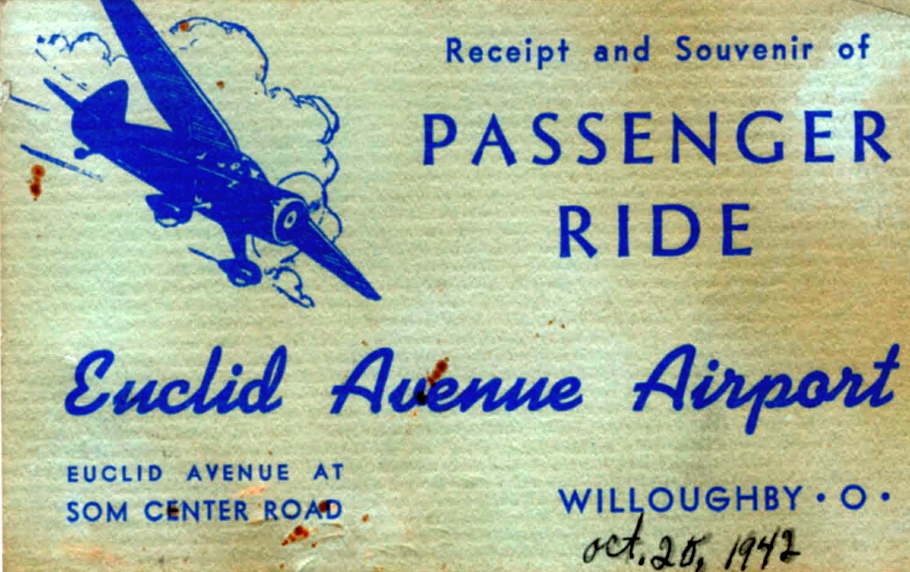
A 10/20/42 receipt for a passenger ride from Euclid Avenue Airport (courtesy of Bruce Bream).
Euclid Avenue was depicted as a commercial airport
on the April 1943 Cleveland Sectional Chart (courtesy of Barnard Kemter).
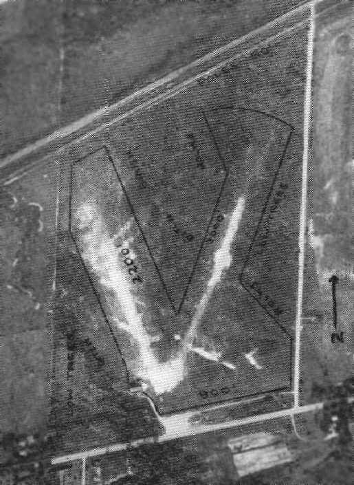
A 10/3/43 aerial view looking northwest at Euclid Avenue Airport from the 1945 AAF Airfield Directory (courtesy of Scott Murdock)
depicted the field as an open grass area.
The April 1944 US Army/Navy Directory of Airfields (courtesy of Ken Mercer)
described the Euclid Avenue Airport as having a 2,300' unpaved runway.
The 1945 AAF Airfield Directory (courtesy of Scott Murdock) described Euclid Avenue Airport
as a 90 acre rectangular property within which were 3 sod runways, with the longest being the 2,600' northeast/southwest strip.
The field was said to have a single 80' x 60' brick hangar, and to be privately owned & operated.
The Haire Publishing Company's 1945 Airport Directory (courtesy of Chris Kennedy)
described Euclid Avenue as a “class 2” airport, owned by A. T. Knudson, and operated & managed by George Latimer.
The field was said to have 3 sod runways, with the longest being a 2,600' northeast/southwest strip.
It was also said to have an 80' x 60' hangar & an office.
After WW2, Cleveland native Cook Cleland returned from a career as a Navy combat pilot & test pilot,
and he acquired the small airport, which he renamed "Cook Cleland's Euclid Avenue Airport".
He was joined by Dick Becker, who flew PBY’s & PBM’s in the South Pacific as a Navy enlisted pilot.
As a fixed-base operator, he offered flying lessons, banner towing and air charters.
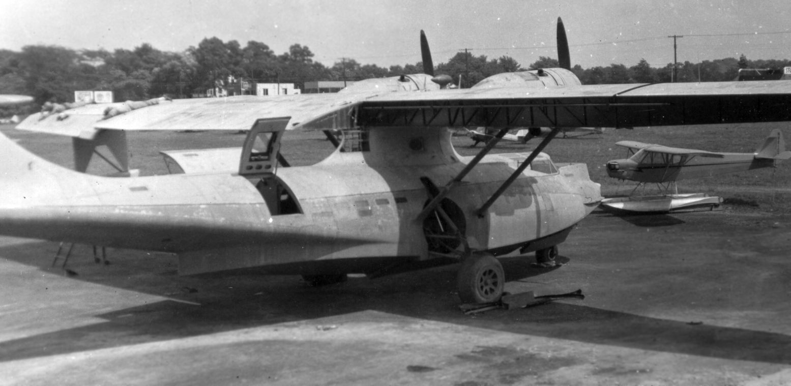
Wanting to expand his air charter service, Cook purchased 3 surplus PBY Catalina Flying Boats;
he sold one at the point of purchase & with Becker’s help he brought the 2 into Euclid Road airport -
quite to bring such a large amphibian into such a small grass runway.
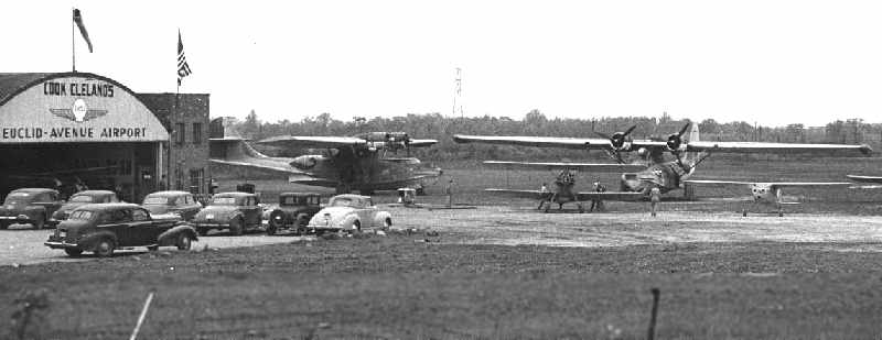
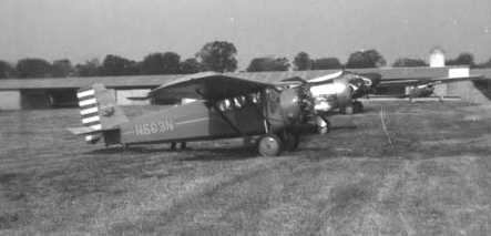
A 1940s aerial view by Bud Ricketts of Cook Cleland's Airport, taken on approach to the north runway.
The 2 PBY Catalinas are visible behind the hangar, and an FG-1 Corsair is parked in front of the hangar.
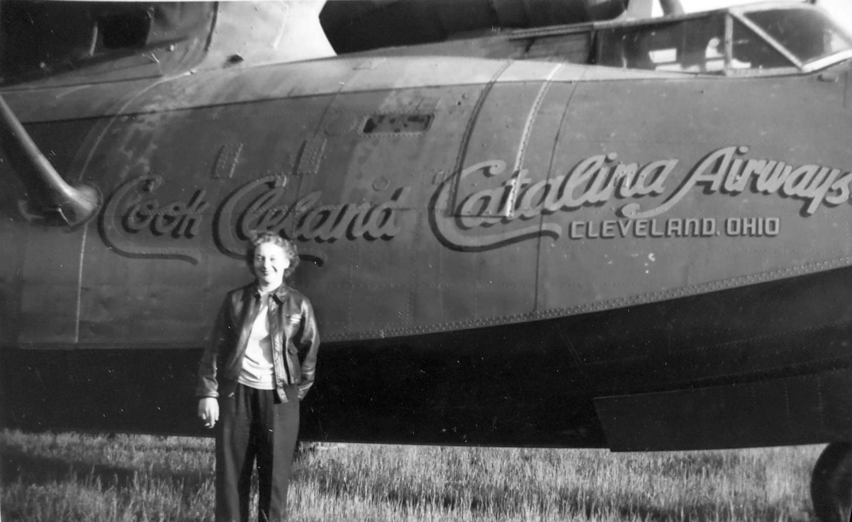
A circa 1940s photo by Robert Snyder (courtesy of Barb Rice) of June Snyder in front of a Cook Cleland Catalina Airways PBY Catalina, presumably at Cook Cleland's Airport.
To be certified for commercial use, the FAA required the following modifications to the Catalinas:
aluminum firewalls had to be replaced with stainless steel, fabric on 2/3 of the wing had to be replaced with metal,
and controls mounted in the pylon had to be moved to the cockpit.
When these modifications were completed, a second PBY was sold.
Work to convert the final plane for the new service which was to be called "Cook Cleland’s Catalina Airways",
and designed to carry sportsmen to Kodiak Alaska for hunting and fishing trips began in earnest.
The rear blister turrets were removed & covered over.
The interior was modified, but not elaborate;
the flying boat was completely painted, cream on top with a deep green on the bottom separated by a metallic bronze feature stripe.
Charlie Miller recalled, “I used to haunt Cook Cleland's Airport after WWII, as it was within range of my Whizzer motor bike.
I got to go through the PBY closest to the hangar.
I learned the difference between 'Port' & 'Starbord' when sitting in the engineer's seat, in the pylon.
They were penciled on either side of the bulkhead. I think the controls/instruments were still there.
Original ads on Cleveland radio were for Canadian fishing trips to otherwise inaccessible lakes north of Cleveland.
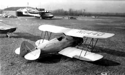
One of the Waco bipes was parked in front of the hangar,
and pilot bragged he could take the black Waco off on the square patch of blacktop in front of the hangar.
About 200' I think. He succeeded, though pretty wobbly.”
Charlie continued, “I saw the Corsairs. With the panels off, that engine looked like about 40 rows of radials, stacked!!!
They said he flew it off the line at Akron! Lot of interesting planes there. I had a chance to buy an AT-6 for $200.
When I sat in it, it seemed HUGE, too big for me.”
A 1940s photo by Bud Ricketts of the 2 PBY Calalinas shortly after they arrived.
Note the hi-tension towers in the background at the North end of the field.
A 1940s photo by Bud Ricketts of one of Cook's 2 banner-towing Wacos, with one of the modified PBYs & the hangar in the background.
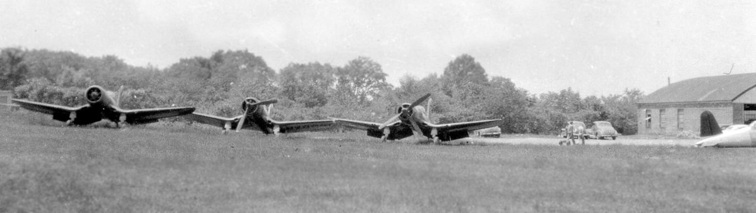
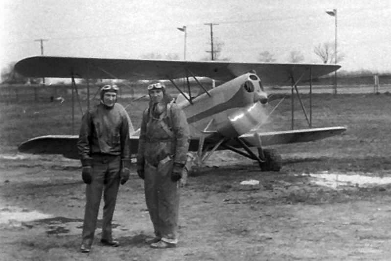
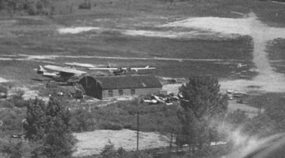
A late 1940s photo by Pat Hange (the 2nd woman to receive an aircraft mechanic license) of 3 surplus Corsair fighters at Cook Cleland's Airport (courtesy of Bill Meixner).
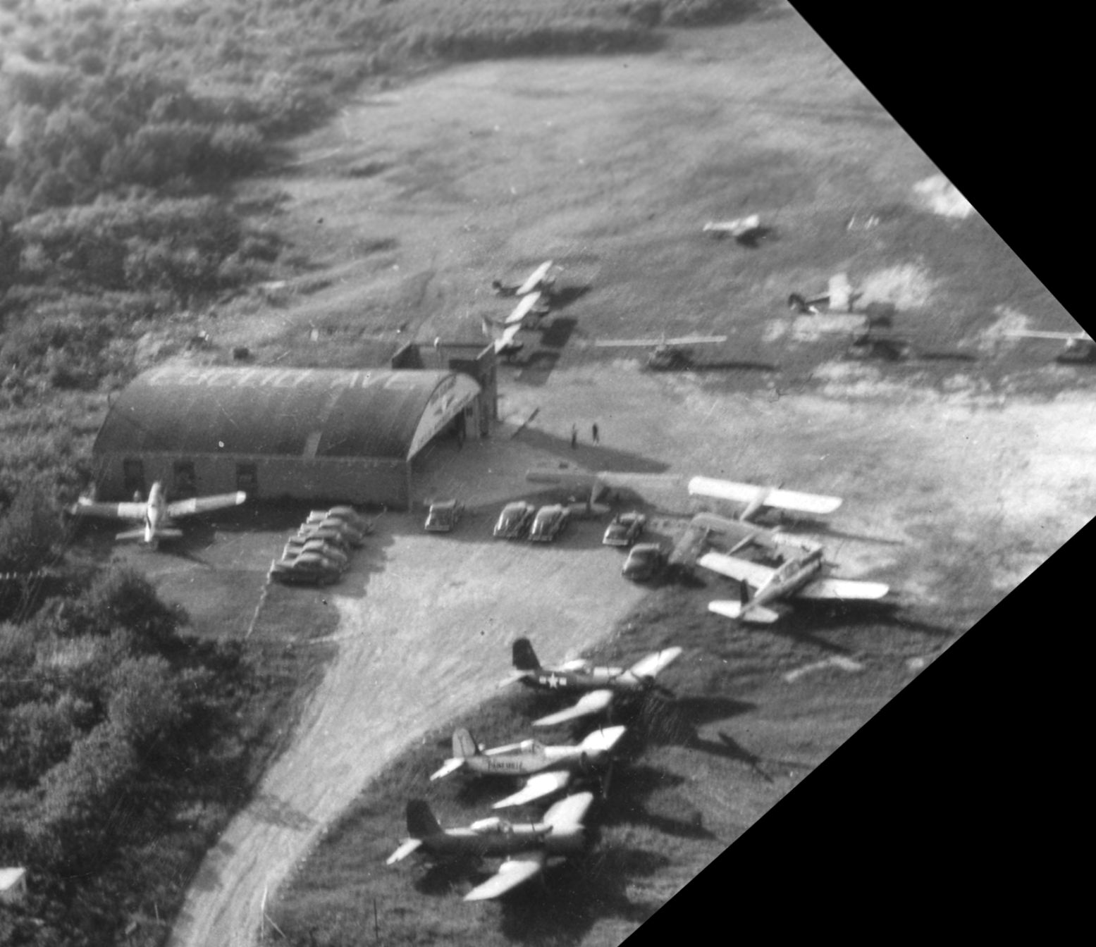
A late 1940s aerial view by Pat Hange of 3 the Corsair fighters & other aircraft around the hangar at Cook Cleland's Airport (courtesy of Bill Meixner).
A late 1940s photo by Pat Hange of a Waco biplane at Cook Cleland's Airport (courtesy of Bill Meixner).
A late 1940s photo by Pat Hange of a clipped-wing Corsair fighters at Cook Cleland's Airport (courtesy of Bill Meixner).
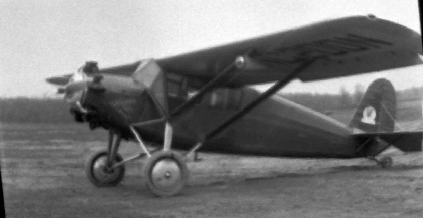
A late 1940s photo by Pat Hange of a Piper Cub on floats in front of the hangar at Cook Cleland's Airport (courtesy of Bill Meixner).
A late 1940s photo by Pat Hange of the Consolidated PBY Catalina at Cook Cleland's Airport (courtesy of Bill Meixner).
In 1946 Cook entered the Cleveland National Air Races,
with the help of some funding from Thompson Products employees with whom he had worked.
His dream was winning the Thompson Trophy Race.
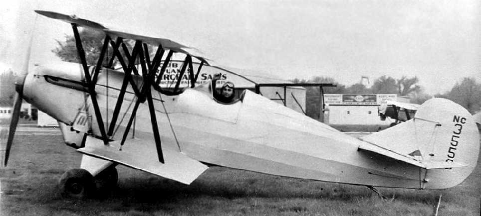
Cook purchased one of the first surplus Corsairs; a FG-1D built by Goodyear in Akron, OH.
He entered ex-Navy Corsairs in all 4 post-war races, realizing his dream twice.
About the time the PBY was finished, the FAA set the gross weight at 27,000 lbs.,
while the military normally flew them at 33,000 lbs.
This weight restriction would allow for only 2 pilots & fuel for a non-stop trip to Alaska.
Cook, now back on active duty, decided to ask Becker to sell the PBY.
Soon after advertising the PBY for sale, a representative from an air charter service in Trinidad arrived,
looking for a replacement of a PBY that was lost in a recent hurricane.
The purchase was completed & the ferry pilot made a fuel stop in Cuba.
On takeoff, someone forgot to secure the tunnel hatch
and once on the step the hull began to fill with water & the craft sank in deep water.
A still from a 1947 movie showing a Cessna T-50 & at least one other aircraft at Cook Cleleland's Euclid Avenue Airport (courtesy of Marc Obenshain).
The field was labeled “Cook Cleland” on the January 1949 Cleveland Sectional Chart (courtesy of Chris Kennedy).
Keith Alves recalled, “I was raised next to Cook Cleland's Euclid Ave Airport.
Winning the 1949 Thompson Trophy Race was one of the high points in Cook Cleland's aviation career.
During this time the Euclid Avenue Airport was very busy.
Lot's of folks were there looking, riding, etc.
And don't forget, the GI bill was making business.”
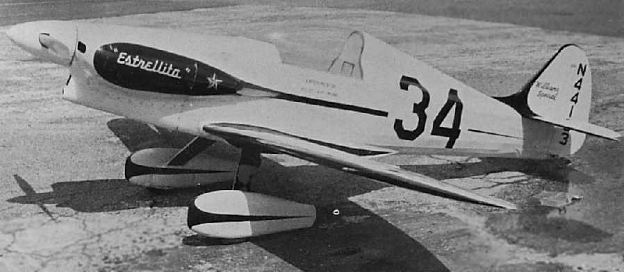
An undated photo (courtesy of Keith Alves) of the Estrellita racer, which crashed at Cook Cleland Airport.
Keith Alves recalled, “Since the 1950 air races were relocated to Detroit,
Cook decided to have an air show at Euclid Avenue Airport.
It was held on Labor Day weekend.
This event was marred by the crash of a racer named 'Estrellita', flown by its new owner Chester Black.
The aircraft was making a high speed pass from East to West when it lost a wing (right over my head).
The aircraft snapped into the ground in front of the spectators.”
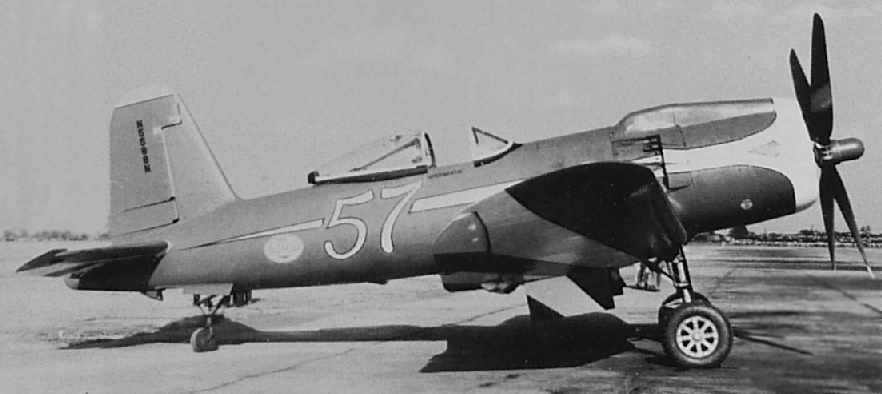
An undated photo (courtesy of Keith Alves) of the Goodyear F2G-1 Corsair racer #57.
According to Keith, “The last day this aircraft flew was at Euclid Ave Airport that weekend in 1950.
The aircraft was left behind at the airport when Cook was recalled.
It sat there long after the airport was gone.
Now [2006] the same aircraft is owned & operated by Bob Odegaard, Kindred, ND.”
Cal Ryan recalled, “My dad used to take me to Cook Cleland Airfield when he was taking flying lessons.
I was at the airport on 9/4/50 when Kieth Alves & I saw the Estrellita crash.
I remember the PBYs & Cleland’s Corsair 57 at the airport.
Dad would take his lessons in a Cessna 140. My big thrill was the ride in a Cessna 195.
When I would go up with my dad on a flight I was always amazed at how there were power lines at the far end of the runway.”
In February 1951, Cook Cleland returned to active duty as commanding officer of carrier-based Fighting Squadron 653
and flew the Chance-Vought F4U Corsair in 67 combat missions over North Korea.
The last photo which has been located of the Euclid Avenue Airport was a 4/1/52 USGS aerial view.
It depicted a single building at the southwest side of the field, along with 6 light aircraft.
Keith Alves recalled, “The postwar general aviation 'bust' was starting to affect everyone in the business,
so things started to slow down. Cook gave up his lease.
The owners of the field released the airport to Frank Zanzo, who had previously operated the Willoughby Airport.
The field closed in the latter part of 1952
and the land along Bidler Road (the east boundary road) was sold to small industry type shops.”
Even though Euclid Avenue Airport was closed in 1952, it continued to be depicted on aeronautical charts for at least 2 more years.
It was depicted as “Euclid Avenue” Airport on the June 1953 Cleveland Local Aeronautical Chart (courtesy of Chris Kennedy).
The last chart depiction which has been located of the Euclid Avenue Airport as an active airfield
was on the January 1954 Cleveland Local Aeronautical Chart (courtesy of Chris Kennedy).
It depicted the field as having a 2,500' unpaved runway.
According to Keith Alves (retired FAA controller / Airspace Specialist from the Cleveland area),
“The reason the airport was charted years after it closed was not uncommon in those days.
There was no notification made to the chart-makers.
If there had been a published approach into the airport the closure would have been listed right away.”
The Euclid Avenue Airport was no longer depicted at all on the January 1955 Cleveland Sectional Chart (courtesy of Chris Kennedy)
or the 1955 USGS topo map.
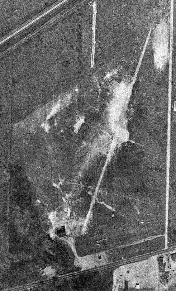
A 1962 aerial view showed that a building had been constructed over the north side of Euclid Avenue Airport,
but the hangar remained standing on the southwest corner of the property.
A 1970 aerial view showed that multiple buildings had been constructed over the site of Euclid Avenue Airport,
but the hangar remained standing on the southwest corner of the property.
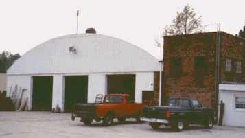
A circa 1990s photo by Bob Roskuski of the former Euclid Avenue Airport hangar.
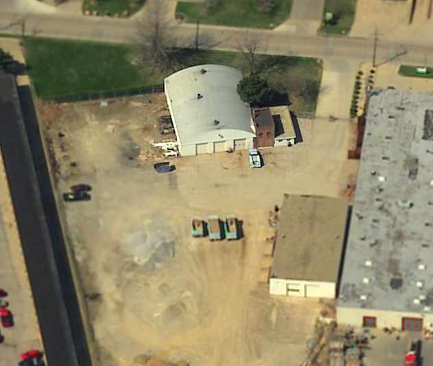
A circa 2001-2005 aerial view looking west at the former Euclid Avenue Airport hangar.
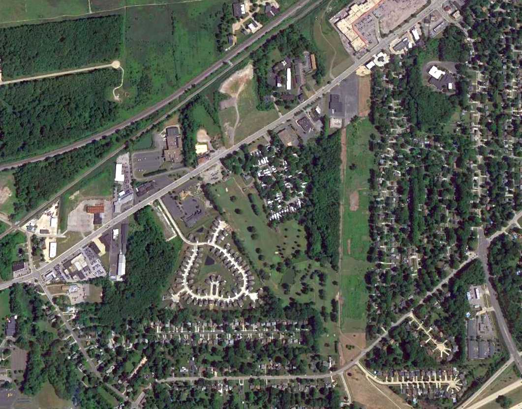
A 2016 aerial view looking north shows that the majority of the site of Euclid Avenue Airport had been extensively redeveloped.
The sole remaining trace – the hangar – sat at the bottom-left of the photo.
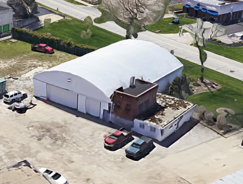
A 2023 3-D aerial image looking southwest showed that the former Euclid Avenue Airport hangar still remained standing after more than 80 years.
The site of Euclid Avenue Airport is located northeast Euclid Avenue & 355th Street.
____________________________________________________
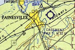
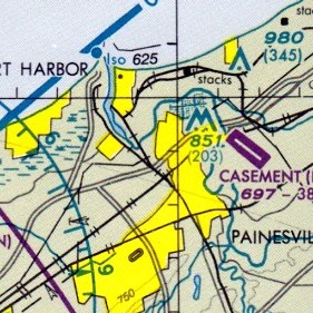
Casement Airport (PVZ), Painesville, OH
41.73, -81.22 (Northeast of Cleveland, OH)
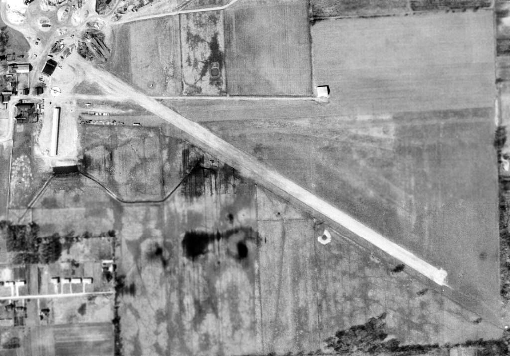
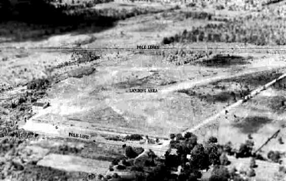
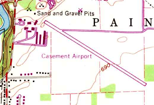
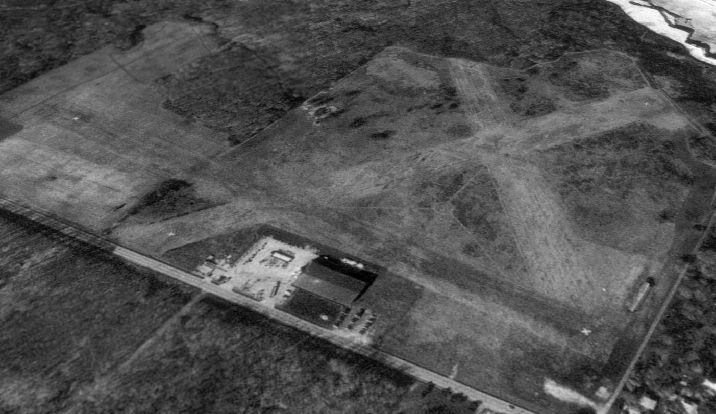
Casement Airport, as depicted on a 4/8/62 USGS aerial photo.
This small general aviation airport was evidently built at some point between 1961-62,
as it was not depicted on a 1952 aerial view nor on the January 1961 Cleveland Sectional Chart.
The earliest reference to the Casement Airport which has been located was in the 1962 AOPA Airport Directory,
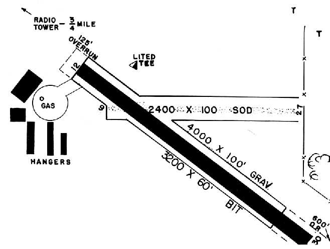
which described Casement Airport as having a 3,200' gravel Runway 13/31 & a 2,200' Runway 9/27.
The earliest depiction of Casement Airport which has been located was a 4/8/62 USGS aerial view.
It depicted the field as having 2 runways, with 2 hangars & 2 light aircraft on the northwest side.
The earliest aeronautical chart depiction which has been located of Casement Airport
was on the 1963 Cleveland Local Aeronautical Chart (courtesy of Mike Keefe).
It described Casement as having 2 runways, with the longest being a 3,200' bituminous strip.
David Tuuri recalled, "My first solo flight was from Casement in July 1963.
My flight instructor began teaching students in his Piper Super Cruiser on the Sidley farm & Mr. Sidley asked him to go to work for him.
Larry Wilson WAS Casement Airport.
Wolfgang Langewiesche (Stick & Rudder) wrote an article appearing in Readers Digest
about the commuter service Larry set up using Cessna 172's to ferry passengers to & from Cleveland Hopkins Airport
because it was one of the first if not THE first such service in existence.
My first tailwheel experience was on the east/west grass runway."
A June 1964 photo (courtesy of Richard Hess) of a Curtiss Robin & several other aircraft in front of Casement Airport hangars.
Richard reported, “They were in a Civil Air Patrol scrapbook, but these are not CAP planes. It looks like an Air Show or Fly-In Event.”
A circa 1964 photo (courtesy of Greg Pochapsky) of a Beech in front of hangars at Casement Airport.
An undated aerial view looking southeast at Casement Airport from the February 1965 issue of “The Flyer” magazine (courtesy of Daun Yeagley).
It was described as having a 3,200' paved northwest/southeast runway & a 2,400' east/west sod strip.
The manager was listed as Tom Jenkins.
The 1966 OH Airport Directory (courtesy of Chris Kennedy) depicted Casement Airport as having a total of 5 hangars on the west side of the field.
The manager was listed as Thomas Jenkins, and the operator was listed as Casement Aviation, Inc.
Strangely, Casement Airport was not depicted at all on the 1968 USGS topo map.
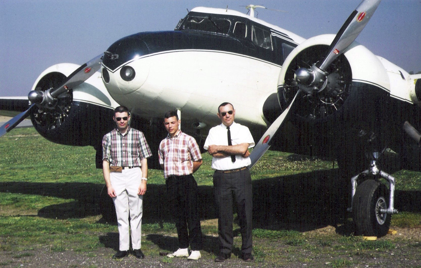
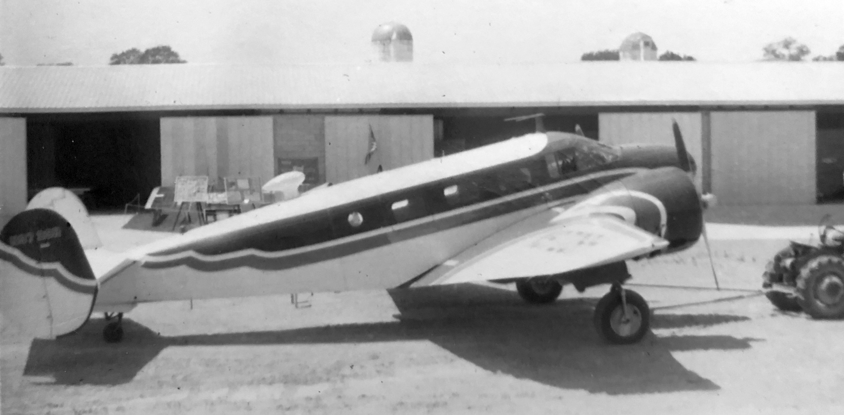
A circa 1968-69 photo (courtesy of Greg Pochapsky) of Mark Connor, Greg Pochapsky and Dick Cardina in front of Lockheed 10A N227M at Casement Airport.
Greg recalled, “We all flew for Casement. Casement purchased 2 Lockheed 10As from E. Lunken who had dissolved his Midwest Airlines operation at Lunken Field.
Casement used these aircraft for passenger charters & later freight. The photo aircraft, N227M, was written off during a takeoff at Casement.
The sister ship N241M, also flown by Casement, was later purchased & restored by its original owner, Bata Shoe Company.”
The 1970 USGS topo map depicted Casement Airport as having a paved northwest/southeast runway,
with a large cluster of hangars was on the northwest side of the field.
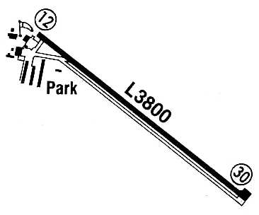
The May 1970 Cleveland Sectional Chart depicted Casement Airport as having a 3,800' paved northwest/southeast runway.
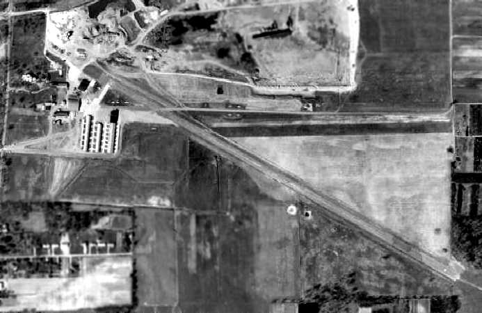
A 1970 aerial view depicted Casement Airport as having a paved northwest/southeast runway & an unpaved east/west runway.
A group of hangars was on the northwest side of the field, around which were visible 11 light aircraft.
The 1972 Flight Guide (courtesy of Chris Kennedy) showed that Casement's paved Runway 12/30 had been somewhat lengthened to 3,800',
and the 2,200' unpaved Runway 9/27 was still open.
By 1982 Casement Airport's crosswind runway had been closed,
as the 1982 AOPA Airport Directory (courtesy of Ed Drury) described the field as having a single 3,800' asphalt Runway 12/30.
Casement Airport was owned by R. W. Sidley, Inc.
Casement Airport, as depicted in the 1985 Flight Guide (courtesy of Chris Kennedy).
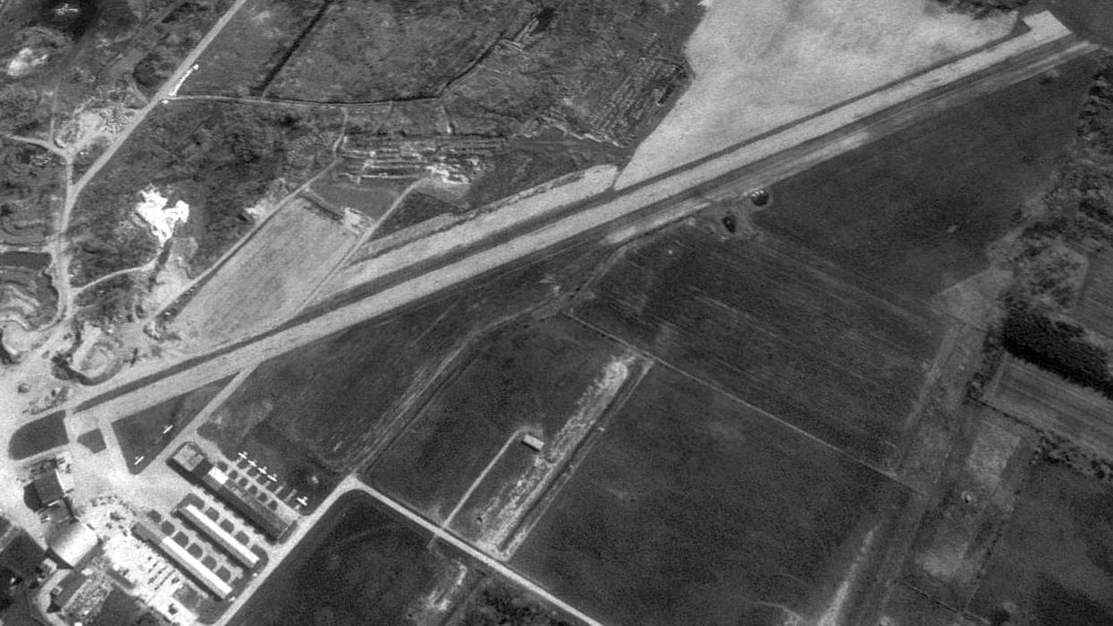
A 4/4/94 USGS aerial view looking northeast showed 7 single-engine aircraft parked among Casement Airport's hangars.
The last aeronautical chart depiction which has been located of Casement Airport
was on the April 1999 Cleveland Terminal Aeronautical Chart (courtesy of Ron Plante).
It depicted Casement as having a 3,800' paved northwest/southeast runway.
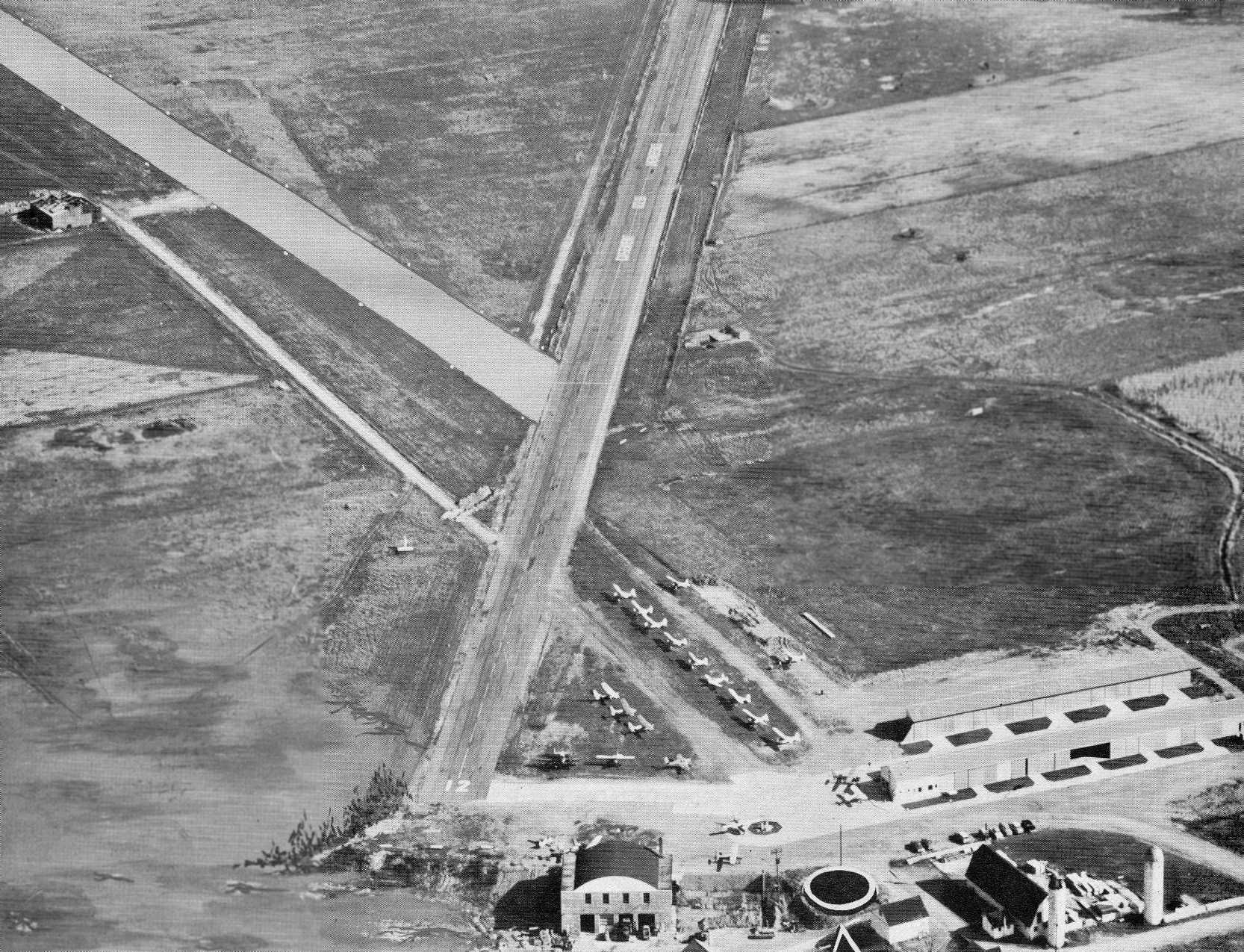
The last photo which has been located showing Casement Airport still in operation was a 2000 aerial view looking northeast.
It did not appear to be a very healthy airport at that point, as a total of only 6 light aircraft were visible outside in the photo.
There were also a total of 3 rows of T-hangars just south of the western end of the runway,
as well 2 somewhat larger hangars (at the bottom of the photo).
The Casement Airport apparently closed (for reasons unknown) in the year 2000,
as it was not listed among active airfields in the 2000 AOPA Airport Directory.
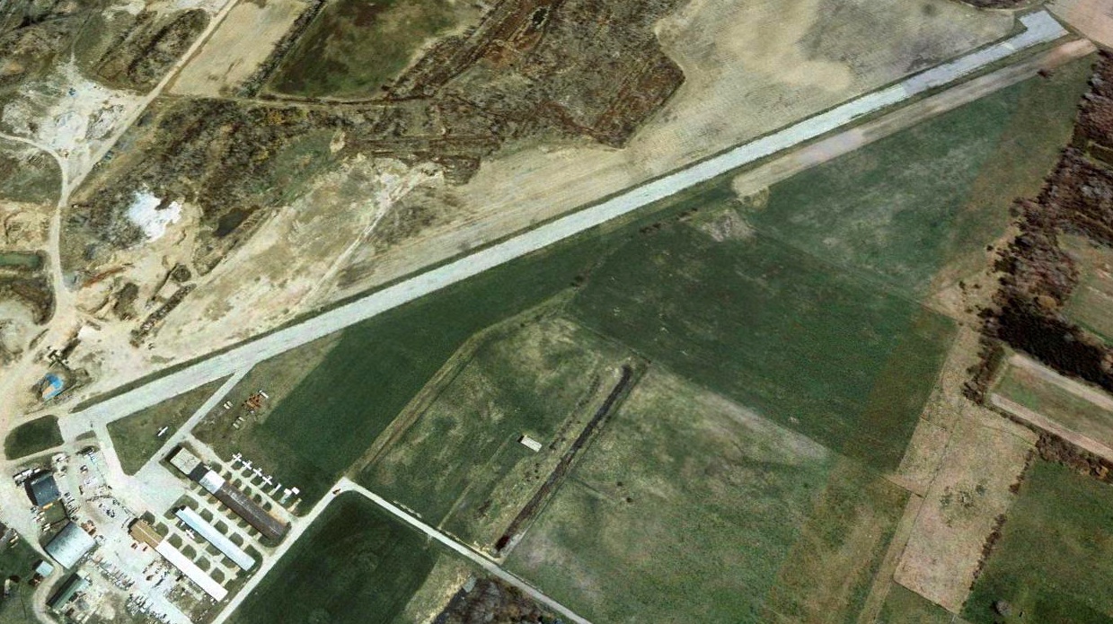
In a 2003 aerial photo, the runway had been marked with closed "X" symbols, and all of the planes were gone.
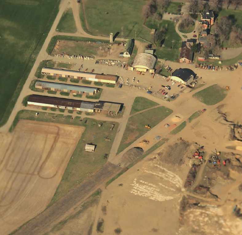
A sad circa 2001-2005 aerial view looking west at the site of Casement Airport showed that the hangars & runway still remained,
but construction was already evident on the site.
A 6/17/06 aerial photo showed that runway & hangars were still intact.
A 6/1/07 aerial photo showed that the middle row of T-hangars had been removed, but the runway remained intact.
A 6/5/09 aerial photo showed that the western row of T-hangars & the Quonset-hut hangar had been removed,
along with the majority of the width of the runway pavement.
A 2010 aerial photo showed that a new road was being built through the site of the former T-hangars.
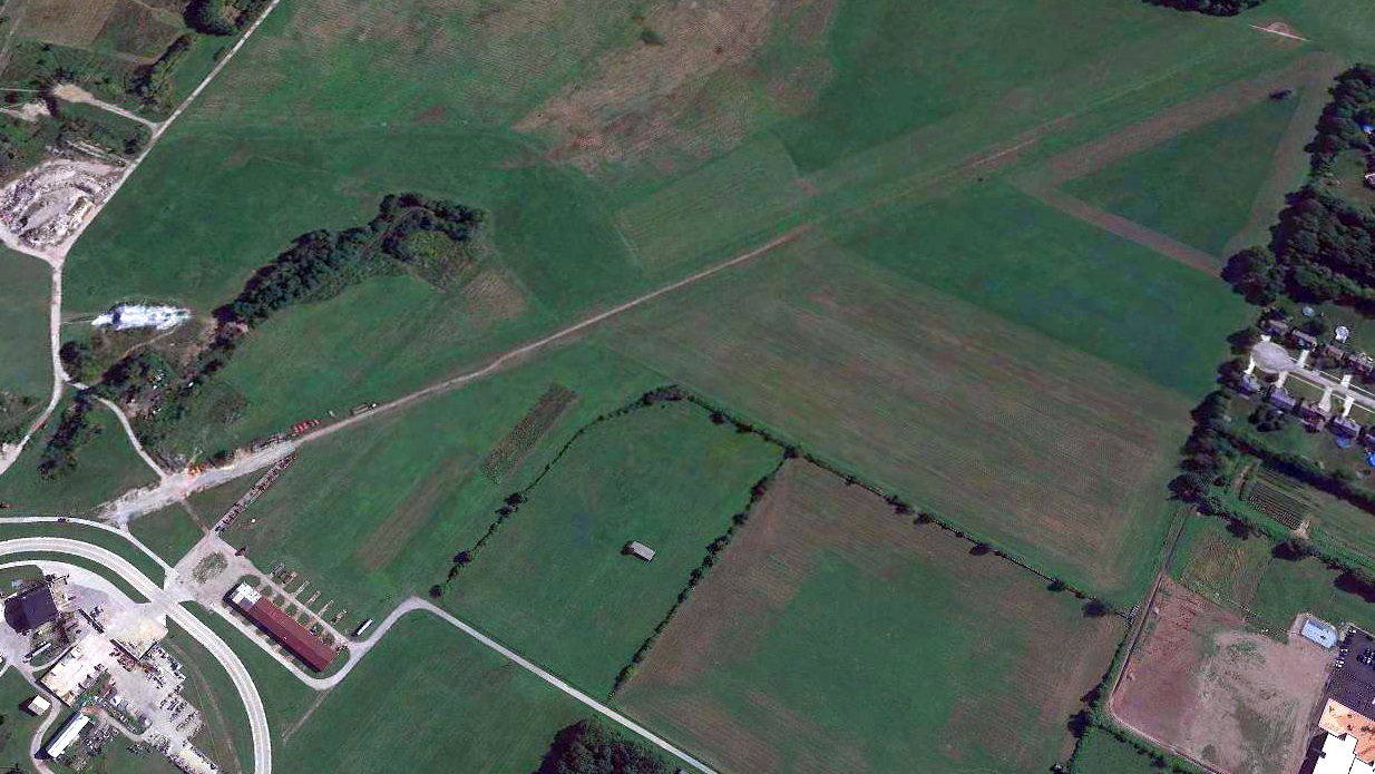
A 2019 aerial view looking northeast at the site of Casement Airport showed that only 1 row of T-hangars remained standing, along with a short portions of the runway pavement.
A new road & buildings covered the western portion of the airfield site.
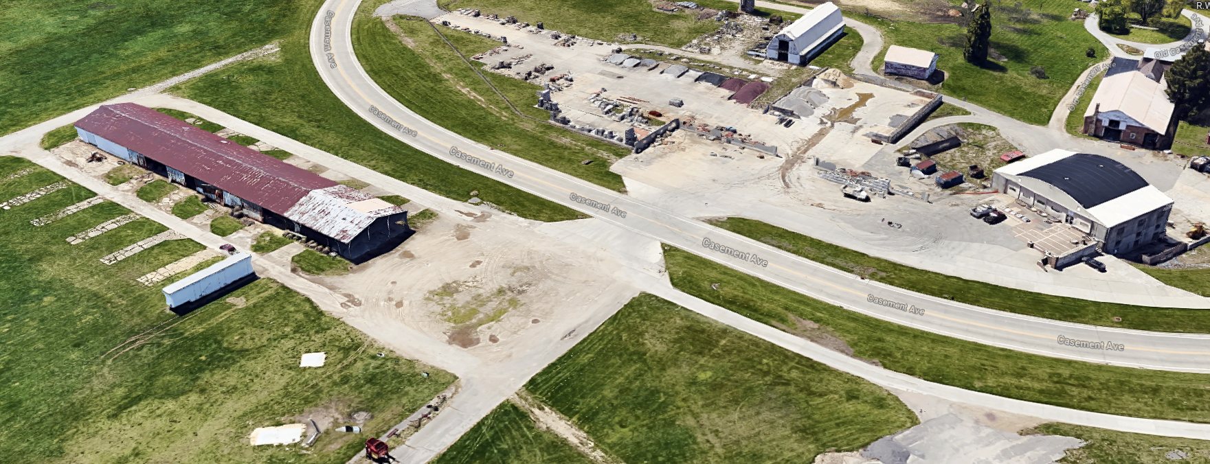
A 2023 3-D aerial view looking southwest at the 2 former Casement Airport hangars.
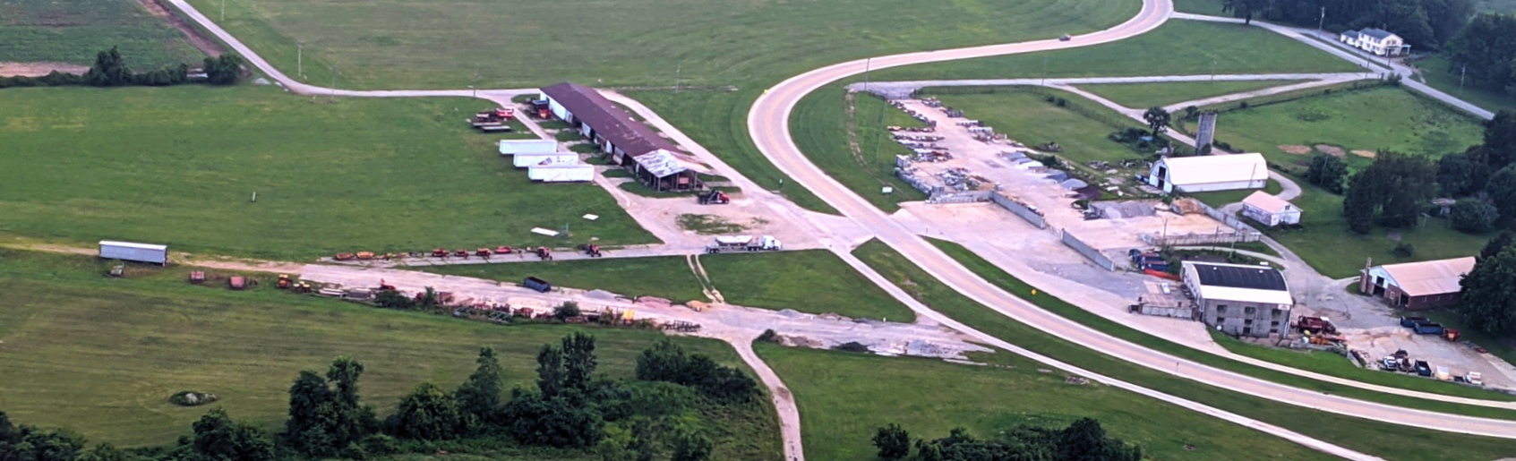
An 8/3/23 aerial view by Tom Wheeler looking southwest at the west end of the Casement Airport site from his Bell Jetranger, showing several former hangars & the remaining runway pavement.
Jonathan Westerling reported, “The Casement Airport property is now owned by R.W. Sidley, Inc., a concrete supplier.
They appear to be maintaining the main hangar as part of their operations, but [3 of the former] hangars have been taken down.”
The site of Casement Airport is located southeast of the intersection of Route 2 & Mantle Road.
Thanks to Chris Kennedy for pointing out this airfield.
____________________________________________________
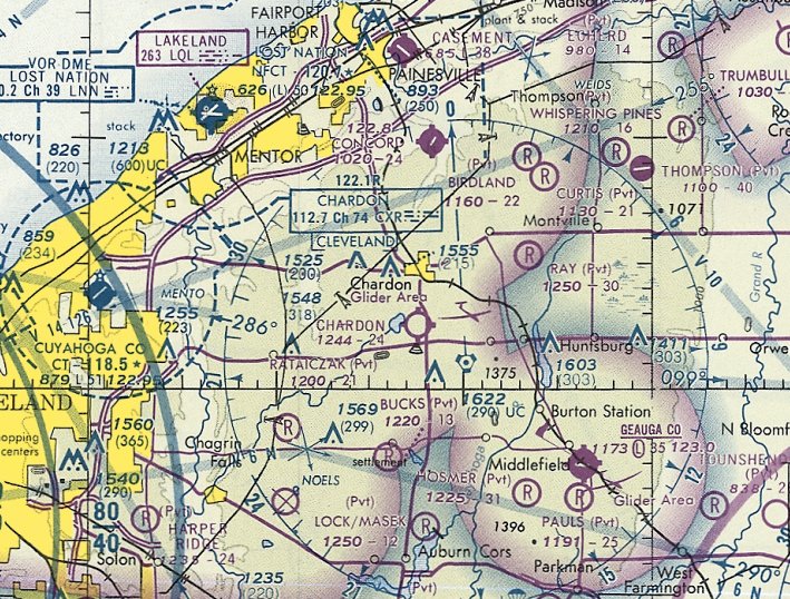
Chardon Airfield (4D6), Chardon, OH
41.542, -81.198 (East of Cleveland, OH)
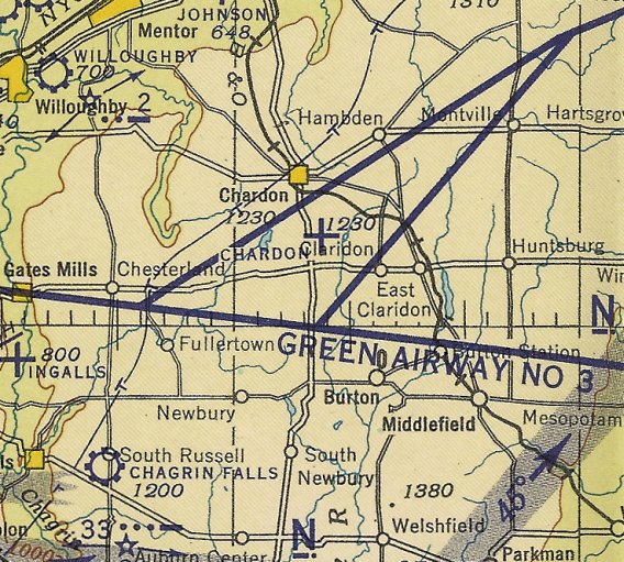
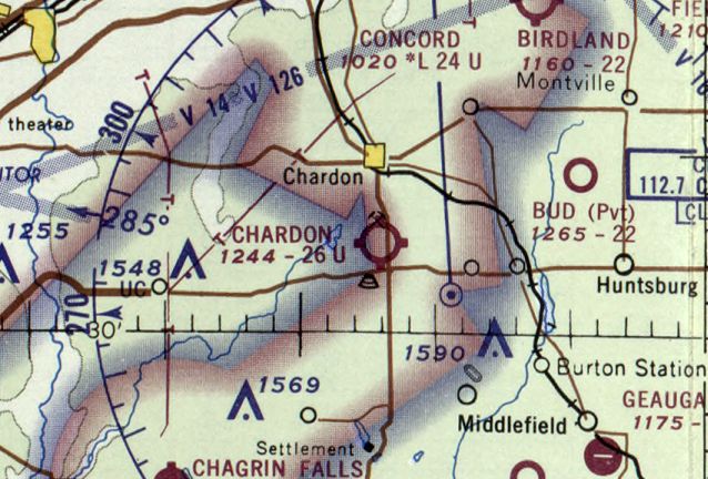
Chardon Airport, as depicted on the June 1942 Cleveland Sectional Chart.
Chardon Airfield was evidently established at some point between 1941-42,
as it was not yet depicted on the June 1941 Cleveland Sectional Chart.
The earliest depiction of Chardon Airfield which has been located was on the June 1942 Cleveland Sectional Chart.
However, this may have been in a somewhat different location than the eventual location of the field,
as it depicted Chardon Airfield to the southeast of the town of Chardon (compared to the southwest of the town, as depicted on later charts).
Chardon was described as having a 2,200 unpaved runway on the 1949 Cleveland Sectional Chart (according to Chris Kennedy).
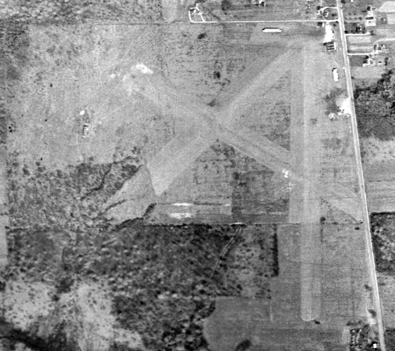
The earliest photo which has been located of Chardon Airport was a 4/1/52 USGS aerial view.
It depicted the field as having 3 grass runways,
with 4 small buildings & a single light aircraft on the northeast corner.
The 1953 USGS topo map depicted Chardon Airport as having 3 runways,
with several small buildings along the northeast side.
According to Keith Alves, the “block hangar at Chardon... came from Cleveland Airport.
But, another hangar was moved at the same time to the sand pit north of the airport.
The owner of the sand pit also owned the airport at that time.
During the 1950s-1960s, the Ohio National Guard had their L-19s based there in the block hangar.”
Lee Dalton recalled, “I learned to fly at Chardon Airport in the late 1950s. Lester Dethloff was my instructor, and I also had some time with Larry Wilson.”
The 1962 AOPA Airport Directory described Chardon as having 3 sod runways: 2,400' Runway 18/36, 2,000' Runway 13/31, and 1,800' Runway 5/23.
The operator was listed as Dethloff Flying Service.
A 1962 aerial view showed a large hangar had been added at Chardon Airfield at some point between 1952-62.
Three light aircraft were parked on the northeast corner of the field.
Chardon Airport, as depicted on the 1963 Cleveland Local Aeronautical Chart (courtesy of Mike Keefe).
The May 1970 Cleveland Sectional Chart depicted Chardon as having a 2,600' unpaved runway.
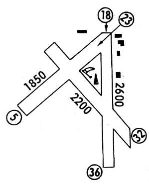
Chardon Airport, as depicted in the 1972 Flight Guide (courtesy of Chris Kennedy).
Bob Simonyi recalled, “Chardon Airport... I got my private pilot rating with Mr. Gilmore from 1974-76.
I was a sophomore in Berkshire High School. Across the street from the Chardon Airport was an radio-controlled model aircraft flying club & airstrip.
As I left the RC field, I noticed a sign at the Chardon Airport for an introductory flight lesson for $10.
The next day I met with Mr. Gilmore & asked if the into flight could be used to look for my RC plane from the air.
He took me into the air, we looked around for the 15 minutes time of the intro flight & no luck finding it.
After we landed we talked for a while & my love for aviation must have showed because he offered me a part-time job as a line crew member.
I agreed that all the money I would make would go for flying lessons.
I fueled planes, mowed runways, washed & waxed planes, ran out runway lights mounted on car batteries when needed,
helped in the shop working on aircraft, any other hours I could work to achieve my private pilot goal.
I worked there for 2 years before I left for the USAF in 1977.”
Hans Friedebach recalled, “Flying in the Cleveland area in the 1970s & 1980s
I was intrigued by the obvious mismatch of the Chardon airfield & its huge hangar.
Until one day the puzzle was solved when I came across an old issue of Fortune Magazine (circa 1930s).
I saw a display ad with line drawings of the Chardon hangar by the construction company. This explained its origin.”
Bill Meyer reported in 2003, "I had 2 airplanes (in succession) that I based at Chardon.
The building described & pictured however was not really part of the airport operation during the time I flew there (1975-81).
The property was owned by Walter Best.
He quarried the land to the north of the airport & kept 2 airplanes in that hangar, one of which was a Helio Courier.
It was also used at that time for some kind of non-aviation manufacturing.
There was an old wood hangar/office to the North of that building which housed Geauga Air.
It was last operated by Richard Gilmore who was a flight instructor and A & P [mechanic].
There were also 2 rows of small T hangars, one was on the East edge of the field & one on the North edge.
They were not large enough for a C-172. I did keep my Maule in one though. They were in very bad repair.
Night landings were accomplished with advance notice
when Dick Gilmore would place old smudge pots along the edge of the North/South runway.
Pretty dicey flying on a soft-field in a rural area. Fun airport though."
The last aeronautical chart depiction which has been located of Chardon Airport was on the May 1981 Cleveland Sectional Chart (courtesy of Ron Plante).
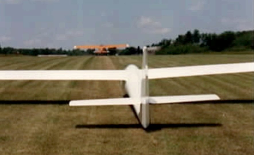
It depicted Chardon as having a 2,400' unpaved runway & a Glider Area to the north.
In the 1982 AOPA Airport Directory (courtesy of Ed Drury), the Chardon airfield configuration remained much the same.
The operator was listed as Geauga Air Service, and the notes included: "Glider operations (Apr-Dec). Gliders & towplanes land downwind off-runways."
A 1987 photo by John Baker of his Stinson 108-3 which he had flown into Chardon from Maryland.
"The small building that you see behind my plane was used as a clubhouse for the glider group based there.
This ramshackle building was to the north of the large hangar shown in the photo.
There was a parking area for cars just north of the clubhouse."
John Baker recalled of Chardon, "I spent some time there in the mid 1980s
visiting a friend who was a member of the Cleveland Soaring Society that operated out of the field.
I flew my Stinson 108-3 there from Maryland in 1987, arriving on 7/30/87 & departing on 8/6/87.
So the field was still in operation in 1987. The primary runway in use at that time was the north/south runway.
This runway ran parallel to the road, which was just a few hundred feet to the east. There was a large tree at the north end of the runway.
My friend had an Aeronca 11AC Chief with a sickly Continental A-65 that would barely clear that tree on takeoff.
With both of us in the Aeronca, it was necessary to go around the tree when taking off.
The Aeronca was kept in one of the dilapidated hangars near the north edge of the field.
During my 1987 visit, I got to take a few flights in the gliders based there
and also flew in a visiting Cessna C-34 Airmaster."
George Frost wrote in an Air Facts article about a circa 1987 engine-out episode: “At Chardon, which had a relatively short, 3,000' runway, we kept the fuel load light, enough fuel for 10 tows.
The Scout at that time had tanks with a 70 gallon capacity. It had been calculated, through experience, that we used a gallon & a half per tow.
We would normally put a maximum of 10 gallons in each tank & refill after 10 tows, thus remaining light. I was towing & we were taking a passenger on a ride.
The ride was a very attractive young lady so there were many volunteers among the commercial pilots, but it was Joni Whitten’s turn & she was not relinquishing that turn.
The flight was normal until we were at about 150' over the woods at the south end of the runway, when the engine quit.”
George continued, “This is not something anyone wants to experience, including me, maybe especially me.
Fortunately, I instinctively & instantly put the nose down to prevent a stall. I need to stress instantly.
When towing you are close to a stall & the glider drag will get you to stall speed very quickly.
Joni saw me disappear below her view, released & went into rope break mode.
As I was sinking into the trees & looking ahead for a landing spot, remaining fuel sloshed forward to the fuel pickup & the engine started again… briefly.
I saw I was not going to reach any forward landing site so I did that which is frowned upon.
I did a 45-degree banked turn, which was well above stall speed & headed back to the field & quickly released the rope.
As I was 90 degrees through the turn, the engine quit again but the turn sloshed more fuel into the pickup & I had another brief spurt of power before it quit again.
I made it back to land downwind at the field.”
George continued, “I looked in the mirror, wondering 'Oh my God, what happened to Joni' & there, to my great relief, was Joni on her final approach behind me.
The engine again started & ran long enough to get me clear of the runway. It quit for a final time & I coasted to the gas pump.
Joni had calmly flown a standard 180 back to the field as well.
The passenger remarked that the flight was shorter than she expected & I believe was surprised that she got her money back.
How is that for calmness & handling an emergency? The passenger was unaware.
Until Joni learned what happened she said she wanted to kill me for releasing her. We had both released the rope almost simultaneously.
She assumed that since I made it back to the field I could not have had a power loss.”
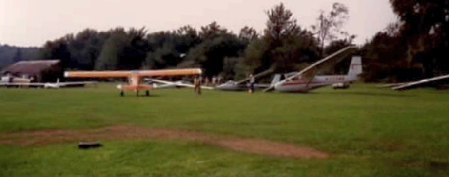
A late 1980s / early 1990s photo (courtesy of George Frost) of a glider under tow from a Chardon Airport grass runway.
A late 1980s / early 1990s photo (courtesy of George Frost) of 2 gliders (Schweitzers?) at Chardon Airport.
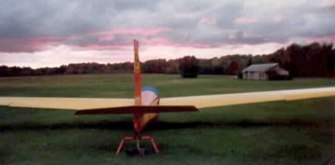
A late 1980s / early 1990s photo (courtesy of George Frost) of a glider at Chardon Airport.
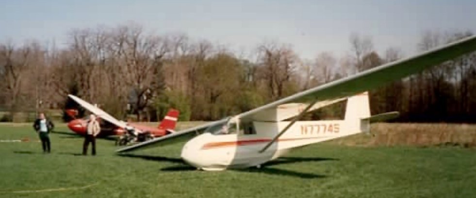
The last photos which have been located showing Chardon Airport in operation was a series of August 1990 photos (courtesy of George Frost),
this one showing several gliders & a tow plane parked on the grass.
Chardon Airport apparently closed by 1993,
as it was no longer depicted on the October 1993 Detroit Sectional Chart (courtesy of Ron Plante).
Chardon Airport was simply labeled "Landing Strip" on the 1994 USGS topo map.
In a 1994 USGS aerial view looking southwest, all 3 of Chardon Airport's grass runways still existed in very good condition,
with closed runway "X" markings still visible on 2 of them.
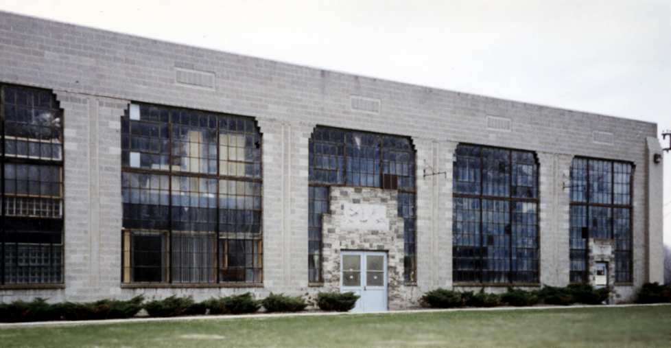
A 1995 photo by Jonathan Westerling of the front of the hangar at Chardon Airfield.
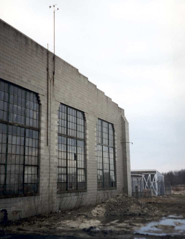
A 1995 photo by Jonathan Westerling of the rear of the hangar at Chardon Airfield.
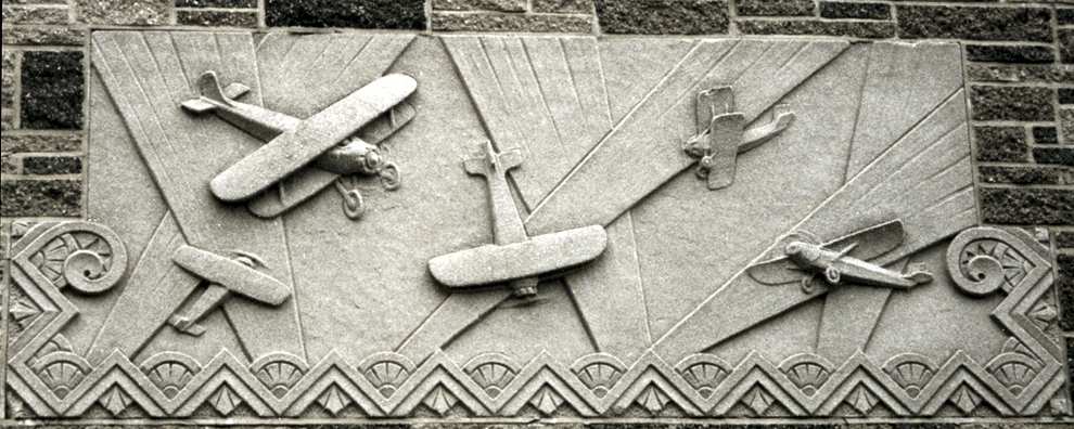
A 1995 photo by Jonathan Westerling of an elaborate & beautiful sandstone engraving
which remains above the entrance to the front of the hangar at Chardon Airfield.
The abandoned Chardon airfield was visited by Jonathan Westerling in 1995.
He reports, "There had been no development on the airfield,
though the turf runways have grown up with shrubs & small trees.
The only surviving building is the main hangar.
An impressive stone building which now functions as a warehouse for a German manufacturing firm
(complete with a German flag flying atop the flagpole out front!).
This must have been a charming airport in its day."
The airfield was not depicted at all (even as an abandoned airfield) on 1998 aeronautical charts.
Bill Meyer recalled in 2003, "Mr. Best died 10-15 years ago
and the airport property is now being quarried for sand by the Best Stone Company.
Flying over it now, you can still make out the remains of the runways."
Tom Beamer reported in 2003, "I understand the hangar was moved to Chardon from CLE/Hopkins."
According to Hans Friedebach, “The hangar at Chardon...
was originally built for United & at the time of its construction was billed as the largest clear-span hangar in the country.”
A circa 2001-2005 aerial view looking west at the hangar & other building which remain on the site of Chardron Airfield.
The majority of the western side of the former runway has been replaced by a sand quarry.
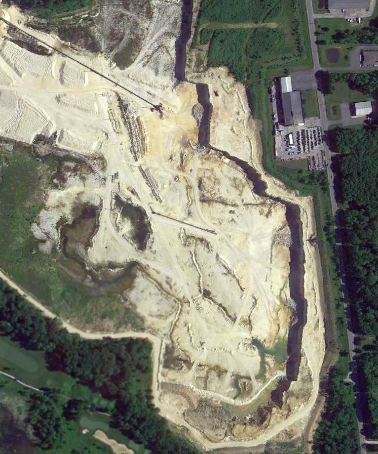
A 2014 aerial view shows the hangar remains on the east side of the Chardron Airfield site,
but the majority of the airfield property had been dug up for a sand quarry.
A 2015 aerial view showed the hangar still remained standing on the east side of the Chardron Airfield site.
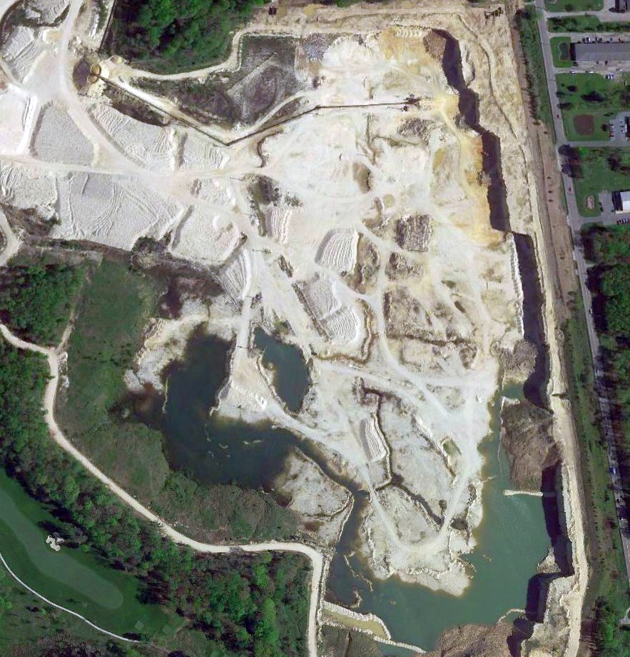
A 2017 aerial view (courtesy of Kevin Kuhn) showed that the last trace of Chardon Airfield – the hangar with the beautiful Art Deco aviation carvings –
had been removed at some point between 2015-2017 to further expand the adjacent quarry.
Kevin Kuhn observed, “All that history, those beautiful carvings, 'Vanished into the current of time'. What a waste.”
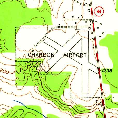
Chardon Airfield is located northwest of the intersection of Route 322 & Route 44.
____________________________________________________
Since this site was first put on the web in 1999, its popularity has grown tremendously.
If the total quantity of material on this site is to continue to grow,
it will require ever-increasing funding to pay its expenses.
Therefore, I request financial contributions from site visitors,
to help defray the increasing costs of the site
and ensure that it continues to be available & to grow.
What would you pay for a good aviation magazine, or a good aviation book?
Please consider a donation of an equivalent amount, at the least.
This site is not supported by commercial advertising –
it is purely supported by donations.
If you enjoy the site, and would like to make a financial contribution,
you
may use a credit card via
![]() :
:
Please consider checking the box to make a monthly donatation.
For a mailing address to send a check, please contact me at: paulandterryfreeman@gmail.com
If you enjoy this web site, please support it with a financial contribution.
please contact me at: paulandterryfreeman@gmail.com
If you enjoy this web site, please support it with a financial contribution.
____________________________________________________
This site covers airfields in all 50 states.