Abandoned & Little-Known Airfields:
North Dakota
© 2003, © 2024 by Paul Freeman. Revised 1/20/24.
____________________________________________________
Please consider a financial contribution to support the continued growth & operation of this site.
Bowman Field (original location) / Bowman Municipal Airport revised 3/17/23) – Canfield Aiport (2nd location) / Williston Municipal Airport (revised 11/18/22)
Chandler Airport (added 11/18/22) - Grand Forks Municipal Airport (original location) (revised 3/17/23) - Leonard Airport (revised 3/17/23) - Miller Airport (revised 3/17/23)
(Original) Minnkota Landing Strip (revised 4/25/16) - Sky Ranch Airport (added 1/20/24) - Williston Airport (1st location) / Canfield Airport (1st location) (revised 3/17/23)
Williston (New) Airport / Sloulin Field International Airport (revised 3/17/23) - Wimbledon Airport (revised 3/17/23) - Wright Field (revised 1/15/21)
____________________________________________________
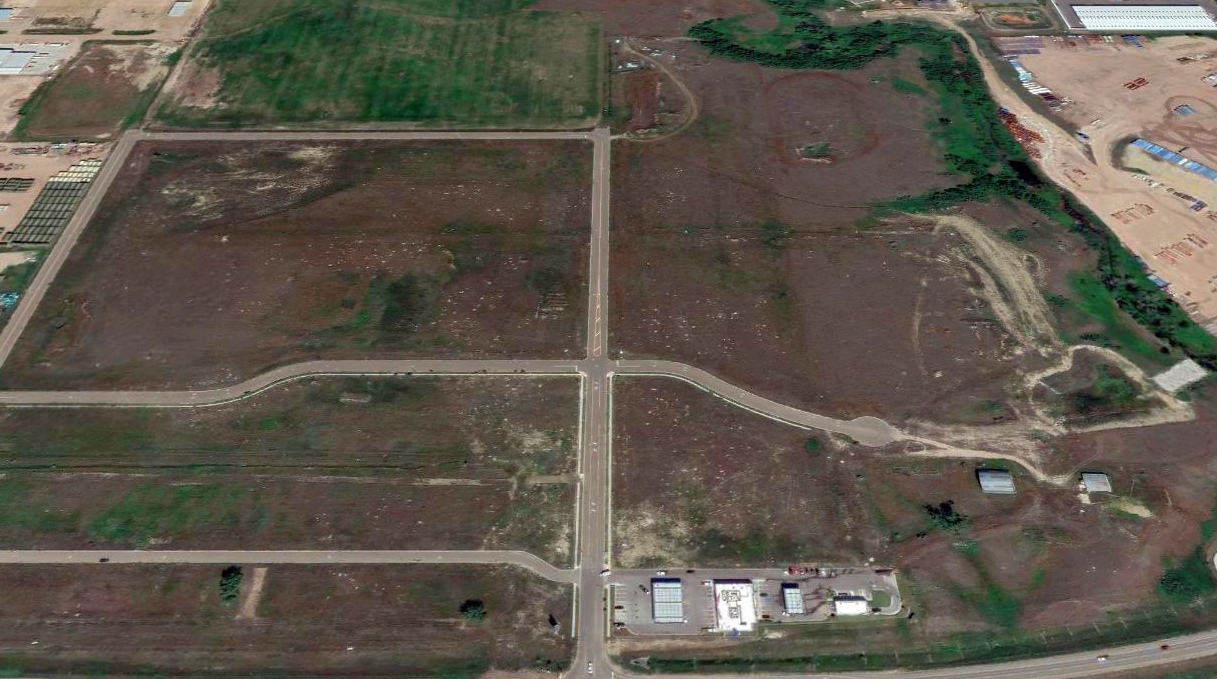
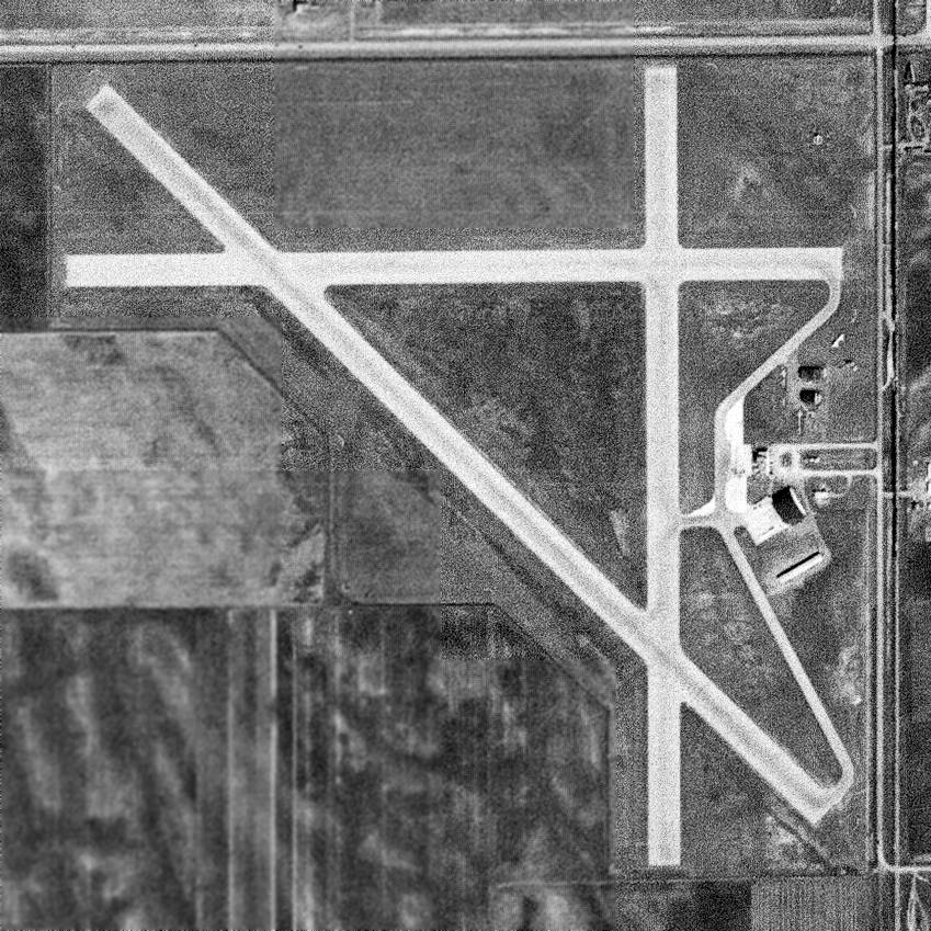
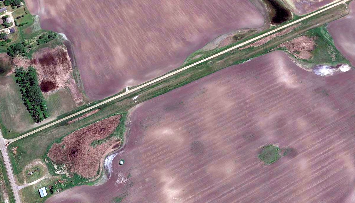
Sky Ranch Airport (6NA9), Brenna, ND
47.893, -97.113 (Southwest of Grand Forks, ND)
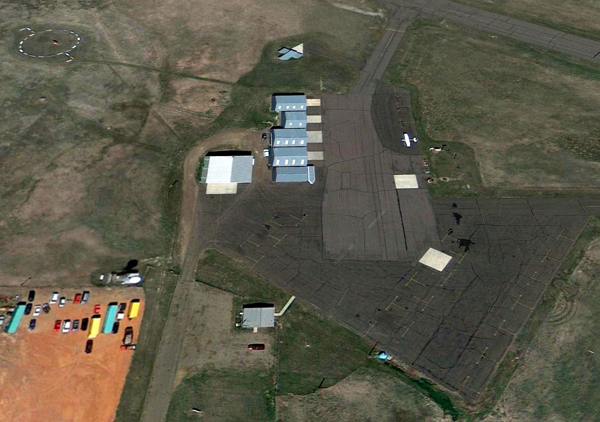
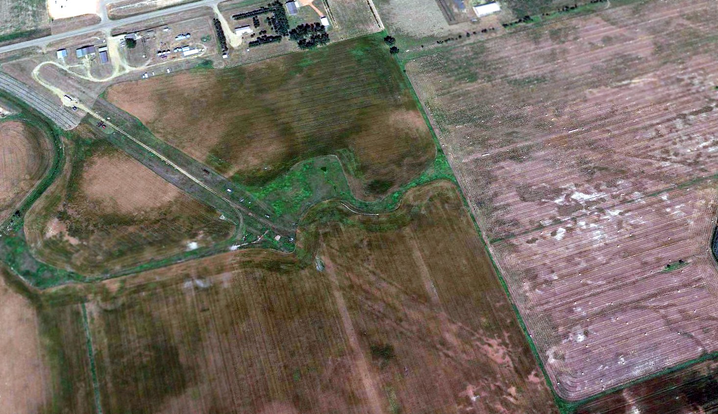
Sky Ranch Airport, as depicted on a 1991 aerial view looking northeast.
Photo of the airport while in use is not available.
This small general aviation airport on the southwest side of Grand Forks was evidently established at some point between 1962-78,
as it was not yet depicted on a 1962 aerial photo.
Sky Ranch Airport was already depicted as an abandoned airfield on the February 1978 Twin Cities Sectional Chart.
The earliest photo which has been located of Sky Ranch Airport (and the only photo which has been located showing aircraft on the field) was a 1981 aerial view.
It depicted Sky Ranch Airport as having a single north/south paved runway, with a paved ramp, a small hangar, and 2 light single-engine aircraft on the southeast side.
Jim Hann recalled, “Sky Ranch Airport on the southwest side of Grand Forks... was nearly abandoned when I was a student in the early 1990s.
The hangar had a UND Aviation sign on it when I was in school.
On 5/5/93 there was a UND helicopter accident there, Hughes 269C N7504D, no fatalities, that burned a hole just about at the midpoint of the runway, rendering it unusable for fixed-wing aircraft.
A picture of the wreckage [showed] it was less than 2' tall, it burned down that much.”
According to its FAA Airport/Facility Directory data, Sky Ranch Airport had a single 2,587' asphalt Runway 17/35.
A 1997 aerial photo showed the Sky Ranch hangar was still intact, but there were no aircraft visible on the field.
A 2014 aerial photo showed the Sky Ranch hangar had been removed.
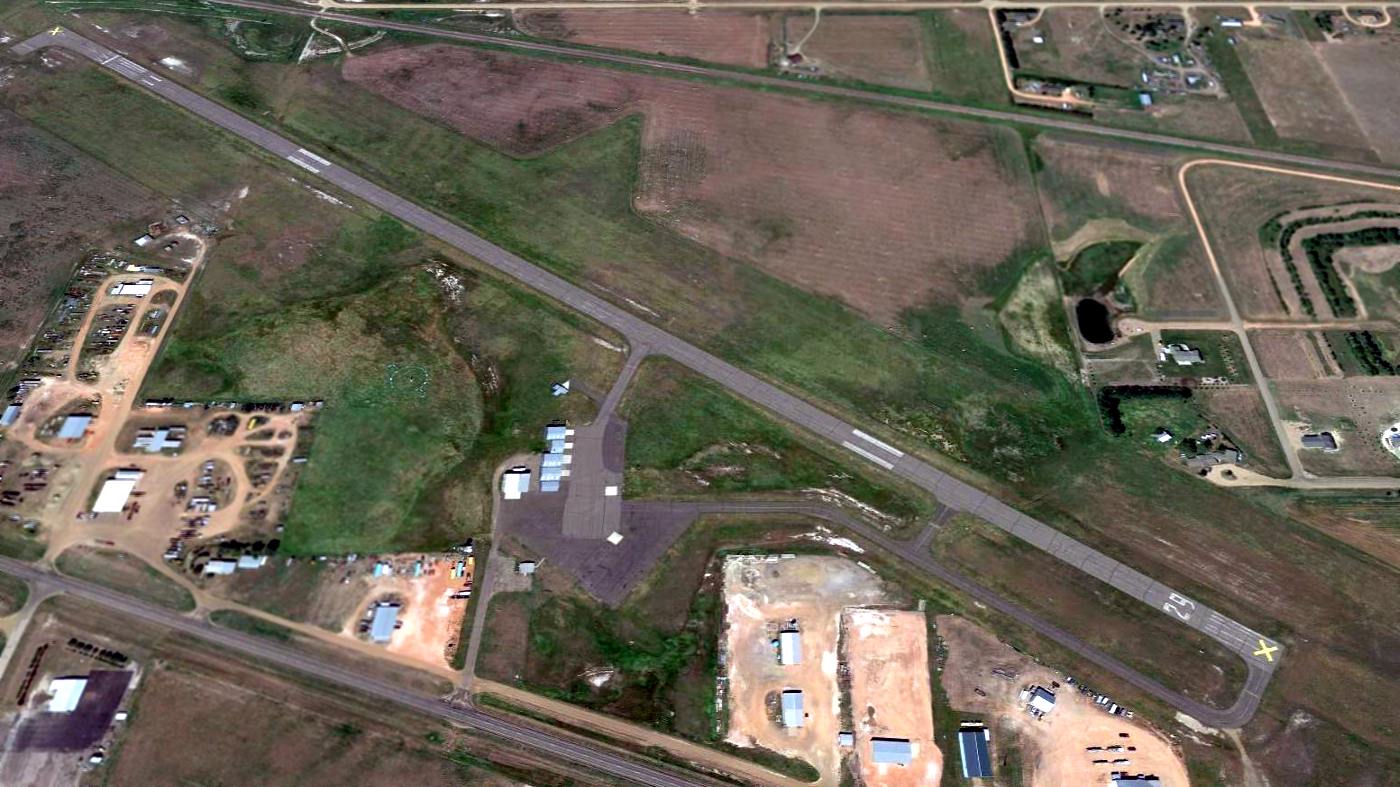
A 2021 photo looking north along the remains of the Sky Ranch Airport runway, with the hangar foundation on the right.
A 2023 photo looking northeast at the remains of Sky Ranch Airport, showing the hole burned in the midpoint of the runway.
Thanks to Jim Hann for pointing out this airfield.
____________________________________________________
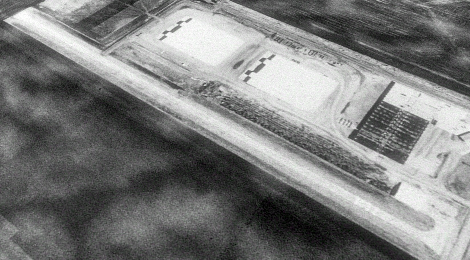
Chandler Airport, Williston, ND
48.142, -103.678 (Northwest of Bismark, ND)
Chandler Airport, as depicted on the May 1945 Williston Sectional Chart.
This small general aviation airport on the west side of Williston was evidently established at some point between 1944-45
(like hundreds of other small airports in the US post-WW2 aviation boom),
as it was not yet depicted on the 1944 Williston Sectional Chart.
The earliest depiction which has been located of Chandler Airport was on the May 1945 Williston Sectional Chart.
It depicted Chandler as a commercial/municipal airport.
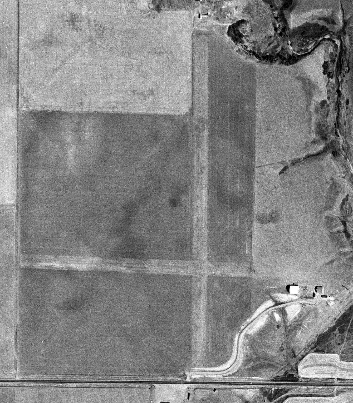
The earliest photo which has been located of Chandler Airport was an 8/21/49 USGS aerial view.
It depicted Chandler Airport as having 2 perpendicular unpaved runways, with 2 small hangars on the southeast side, but there were no aircraft visible on the field.
The April 1951 Williston Sectional Chart depicted Chandler Airport as having a 2,600' unpaved runway.
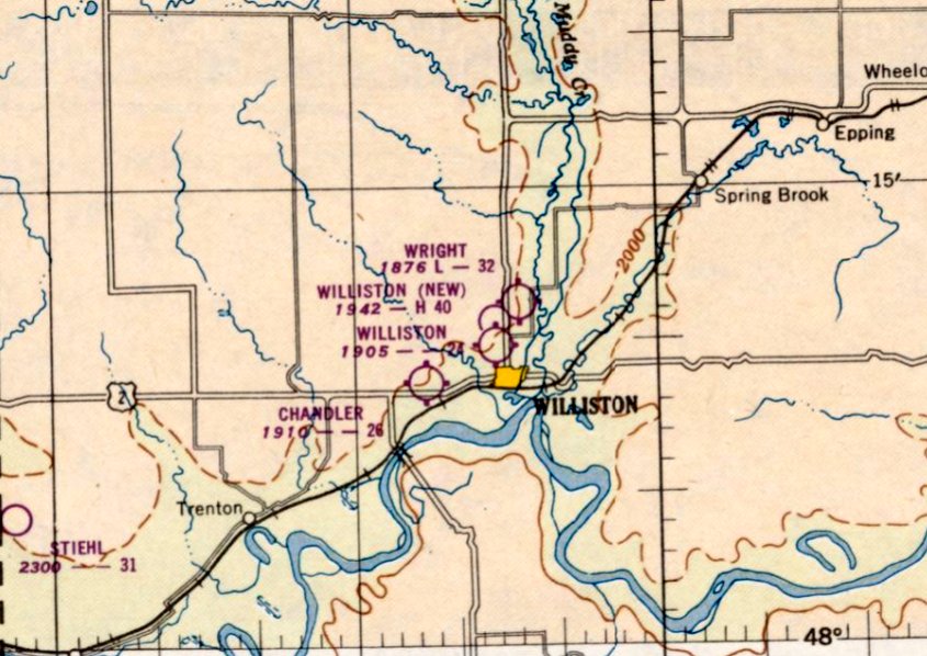
Note that it depicted a total of 4 airports located in close proximity to each other, all west to north of the town of Williston.
The earliest topo map depiction which has been located of Chandler Airport was on the 1953 USGS topo map.
A 1958 aerial photo depicted Chandler Airport in the same fashion as the 1949 photo.
The last aeronautical chart depiction which has been located of Chandler Airport was on the July 1968 Williston Sectional Chart.
It depicted Chandler Airport as having a 2,700' unpaved runway.
Chandler Airport was evidently closed (for reasons unknown) at some point between 1968-69,
as it was no longer depicted on the 1969 Williston Sectional Chart.
A 1983 aerial photo showed a trailer park had been built to the southwest of Chandler Airport, but the runways & hangars remained intact.
Aerial photos through 2010 show the area of the Chandler Airport runways remained unredeveloped, but the runways became progressively less distinct.
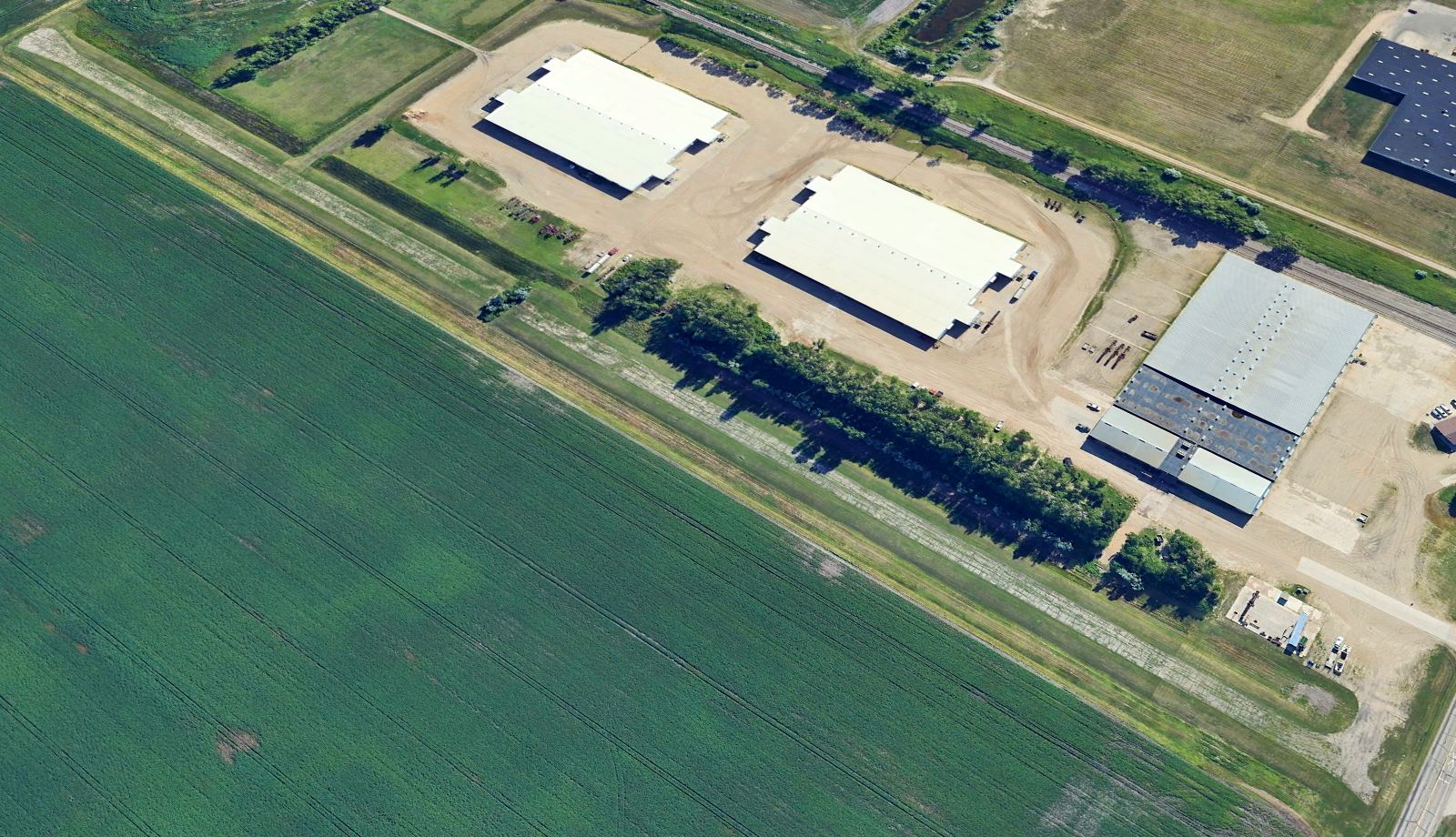
A 2012 aerial photo showed several roads had been built over the Chandler Airport runways, but the hangars remained intact.
A 2020 aerial view looking north showed streets having covered the runways of Chandler Airport, but the 2 hangars remained on the southeast side.
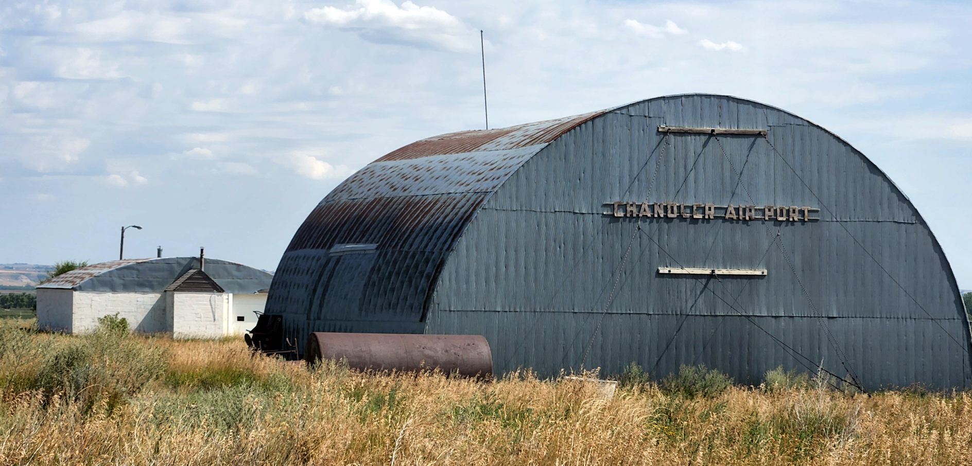
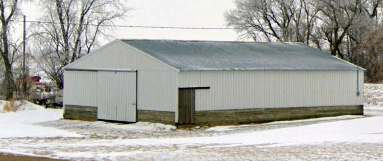
An 8/23/22 photo by Chris Brown of 2 hangars, one of which is still clearly signed “Chandler Air Port”.
Chris reported, “On one trip I stumbled across an old hangar with the name 'Chandler Airport' on it.
You can plainly see the 2 old hangars, but I did not see evidence of runways. Interesting there were that many airports in Williston.”
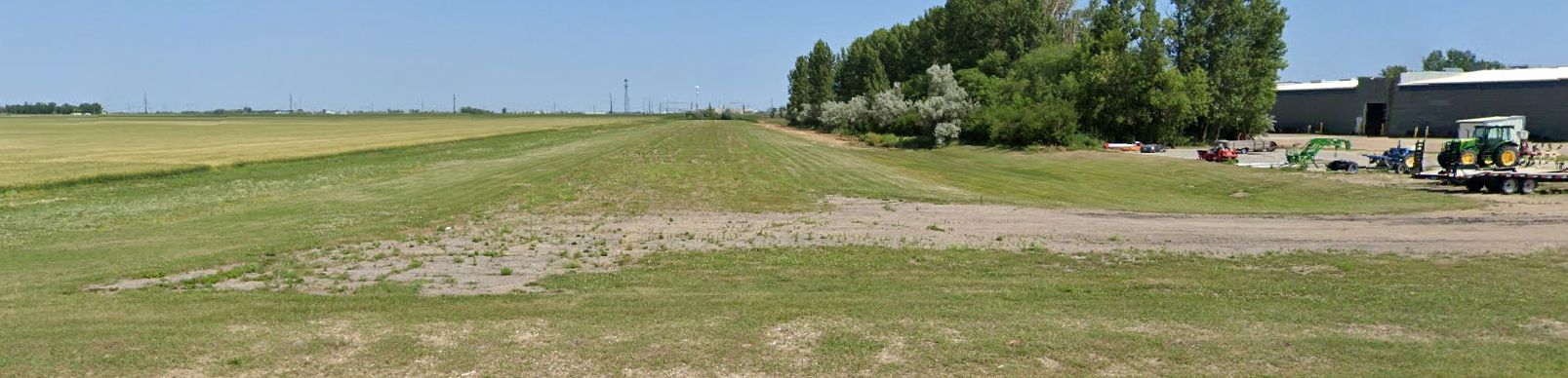
The site of Chandler Airport is located at the eastern terminus of Chandler Boulevard, appropriately enough.
Thanks to Chris Brown for pointing out this airfield.
____________________________________________________
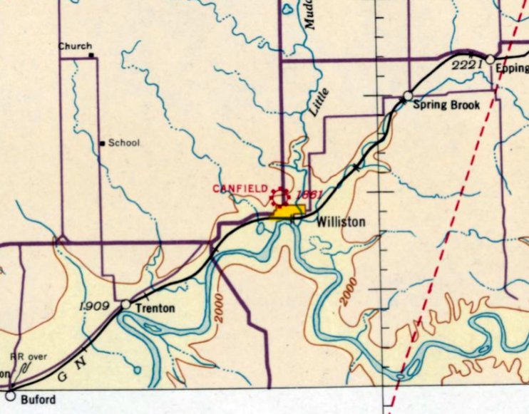
Williston Airport (1st location) / Canfield Airport (1st location), Williston, ND
48.147, -103.602 (Northwest of Bismark, ND)
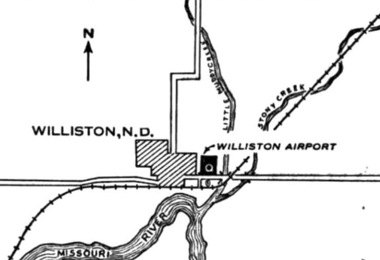
Williston Airport, as depicted in the 2/25/30 Commerce Department Airway Bulletin (courtesy of Mike Denja).
According to Wikipedia, “The first airport to serve Williston was east of the city near Little Muddy Creek.”
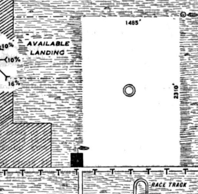
The earliest depiction which has been located of Williston Airport was in the 2/25/30 Commerce Department Airway Bulletin (courtesy of Mike Denja).
It described Willison Airport as a municipal airport, leased by the city, and operated by Canfield Flying Services.
It was said to consist of an 83 acre rectangular sod field measuring 2,310' north/south,
with a building depicted on the southwest corner.
The only aeronautical chart depiction which has been located of the airport on the east side of Williston was on the July 1935 Williston Sectional Chart.
It depicted Canfield Airport as a commercial/municipal airport.
According to Wikipedia, “The environment was unsuitable, and operations shifted to a new airport in 1936.”
The October 1937 Williston Sectional Chart no longer depicted the original Canfield Airport on the east side of Williston,
instead showing the 2nd location of Canfield Airport having been reestablished on the northwest side of the town.
A 1960 aerial view showed no trace of the original Canfield Airport.
A 2017 aerial view showed no trace of the original Canfield Airport.
____________________________________________________
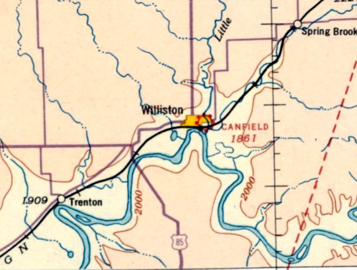
Canfield Airport (2nd location) / Williston Municipal Airport, Williston, ND
48.158, -103.638 (Northwest of Bismark, ND)
Canfield Airport, as depicted on the July 1937 Williston Sectional Chart.
According to Wikipedia, “The first airport to serve Williston was east of the city near Little Muddy Creek.
The environment was unsuitable, and operations shifted to a new airport in 1936.”
The earliest depiction which has been located of this 2nd location of Canfield Airport (on the northwest side of the town)
was on the July 1937 Williston Sectional Chart.
Canfield Airport was evidently renamed Williston Airport at some point between 1937-45,
as that is how it was depicted on the May 1945 Williston Sectional Chart.
The earliest photo which has been located of Williston Municipal Airport was a circa 1940s aerial view by Bill Shemorry.
It depicted a total of 14 light single-engine monoplanes & biplanes parked around 2 hangars, one of which was marked “Williston Municipal Airport”.
According to Wikipedia, “The 23-acre site became too small, so Sloulin Field was built in 1947.”
The last aeronautical chart depiction which has been located of Williston Municipal Airport was on the April 1951 Williston Sectional Chart.
It depicted Williston Municipal Airport as having a 2,400' unpaved runway.
Note that it depicted a total of 4 airports located in close proximity to each other, all northwest of the town of Williston.
Williston Municipal Airport was evidently closed at some point between 1951-52,
as it was no longer depicted on the April 1952 Williston Sectional Chart or the 1953 USGS topo map.
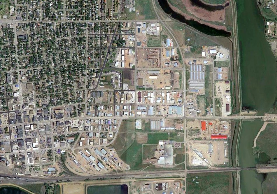
A 1958 aerial photo did not depict any recognizable trace of Williston Municipal Airport.
A 2017 aerial photo did not depict any recognizable trace of Williston Municipal Airport.
____________________________________________________
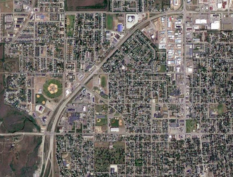
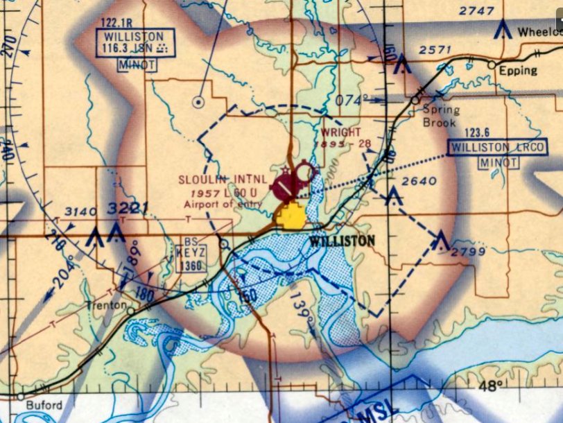
Williston (New) Airport / Sloulin Field International Airport (KISN), Williston, ND
48.178, -103.638 (Northwest of Bismark, ND)
Williston (New) Airport, as depicted on the April 1950 Williston Sectional Chart.
According to Wikipedia, when Williston Municipal Airport on the west side of the town “became too small, Sloulin Field was built in 1947, covering 740 acres.”
Sloulin Field was not yet depicted on the May 1948 Williston Sectional Chart.
The earliest depiction which has been located of Sloulin Field was on the April 1950 Williston Sectional Chart.
It depicted “Williston (New) Airport as having a 4,000' paved runway.
Note that it depicted a total of 4 airports located in close proximity to each other, all northwest of the town of Williston.
By the time of the April 1951 Williston Sectional Chart, the new Willison Airport was labeled as Sloulin Field.
It depicted Sloulin Field as having a 4,000' paved runway.
Sloulin Field, as depicted on the 1955 USGS topo map.
A 1958 aerial photo depicted Sloulin Field as having a paved northwest/southeast runway & an unpaved crosswind runway,
and taxiways leading to a ramp, buildings, and 5 single-engine & twin-engine aircraft on the east side.
The 1959 USGS topo map depicted Sloulin Field as having a paved northwest/southeast runway & an unpaved crosswind runway,
and taxiways leading to a ramp, buildings, and a beacon on the east side.
The last aeronautical chart depiction which has been located of Sloulin Field was on the July 1970 Williston Sectional Chart.
It depicted Sloulin International Field as having a 6,000' paved northwest/southeast runway.
The 1976 USGS topo map depicted Sloulin Field in the same fashion as the 1959 USGS topo map.

A circa 1985 aerial view by Bill Shemorry looking east at Williston Municipal Airport,
showing hangars & aircraft on the ramp on the northeast side, and 2 paved runways.
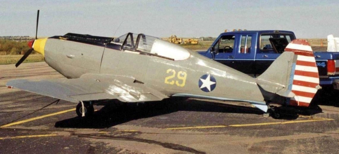
A 8/17/99 photo by R.A.Scholefield of N1029C, a Morris Hayden Curtiss P-40 Kittyhawk replica at Sloulin Field International.
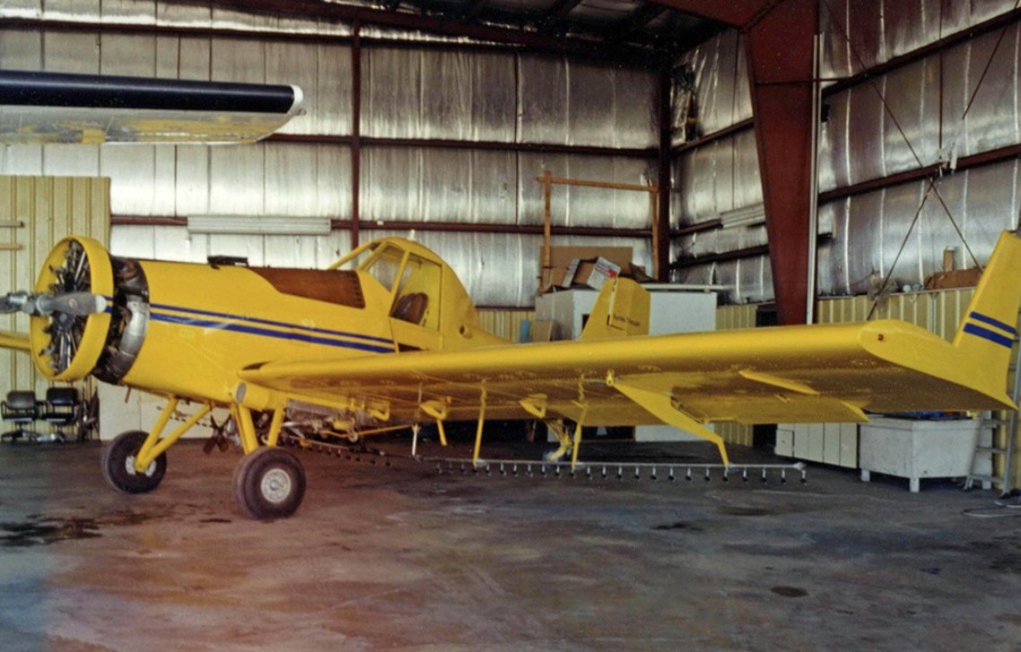
A 8/17/99 photo by R.A.Scholefield of N3679X, an Ayres S-2R Thrush Commander of Aero Spraying Service at Sloulin Field International.
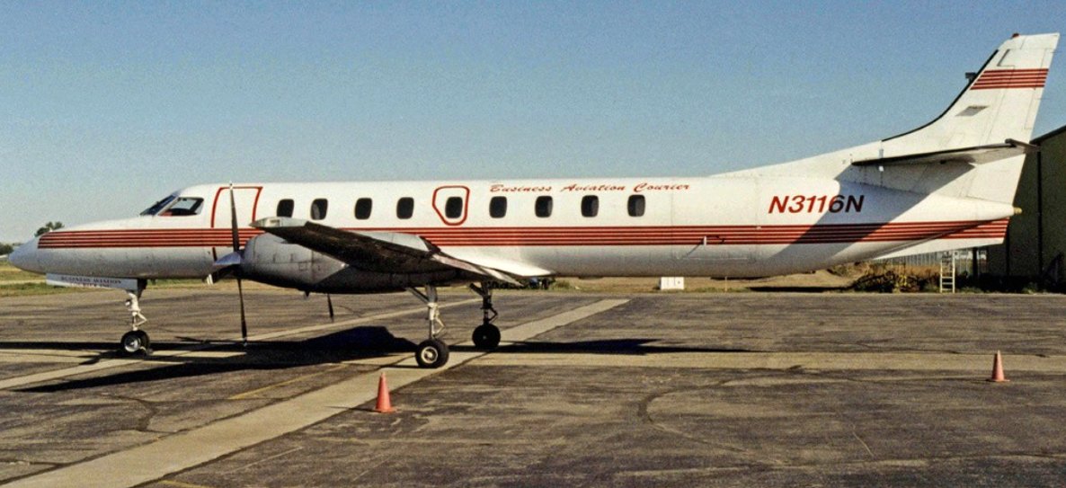
A 8/17/99 photo by R.A.Scholefield of N3116N, a Fairchild Swearingen SA.227AC Metro III of Business Aviation Courier at Sloulin Field International.
According to Wikipedia, “Sloulin Field Airport faced various problems as the city grew.
The 2004 master plan noted limited room for expansion because of the surrounding terrain and buildings, design issues that conflicted with the FAA's standards, and the need to refurbish the runway.
Runway improvements had also been recommended in the 1993 master plan.
A $4 million renovation project included the construction of a new terminal that opened in October 2006.
When Delta Air Lines & United Airlines announced plans to serve Williston in 2012, airport officials decided to add a mobile home trailer to provide additional capacity for the terminal.
In light of the issues highlighted in the 2004 master plan & increased air service to Williston amid the ND oil boom,
plans either to renovate Sloulin Field Airport or to construct a new airport surfaced in 2011.”

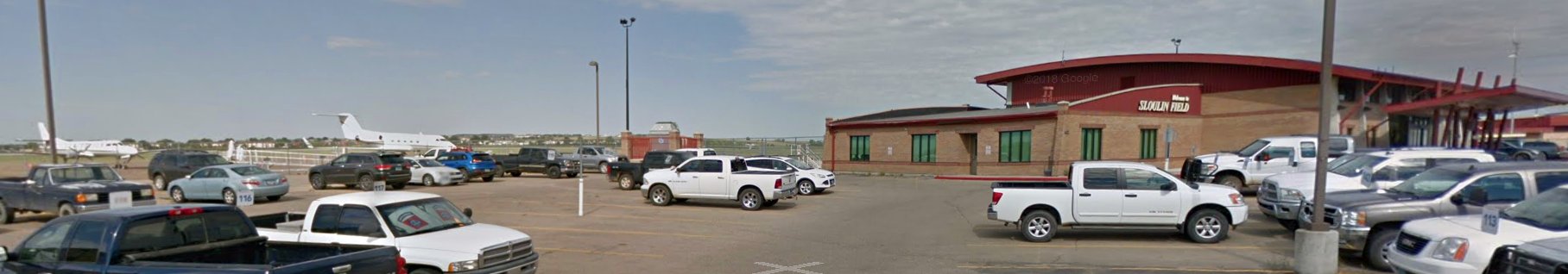
An August 2012 photo of the Sloulin Field terminal.
Wikipedia continued, “Sloulin Field International Airport had experienced great growth in air traffic amid the oil boom in the state.
Passenger enplanements went from 27,860 in 2011 to a peak of 119,069 in 2014, a roughly 327% increase over 3 years.
In 2015 the airport had 43,014 aircraft operations, averaging 118 per day: 82% general aviation, 8% air taxi, 8% airline, and 2% Air Cargo.
Forty-nine aircraft were based at the airport: 86% single-engine, 10% multi-engine, and 4% helicopter.”
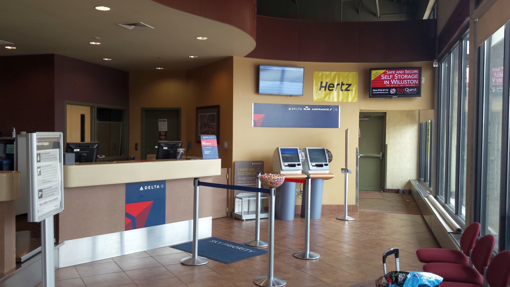
A July 2015 photo of the Sloulin Field Delta ticket counter.
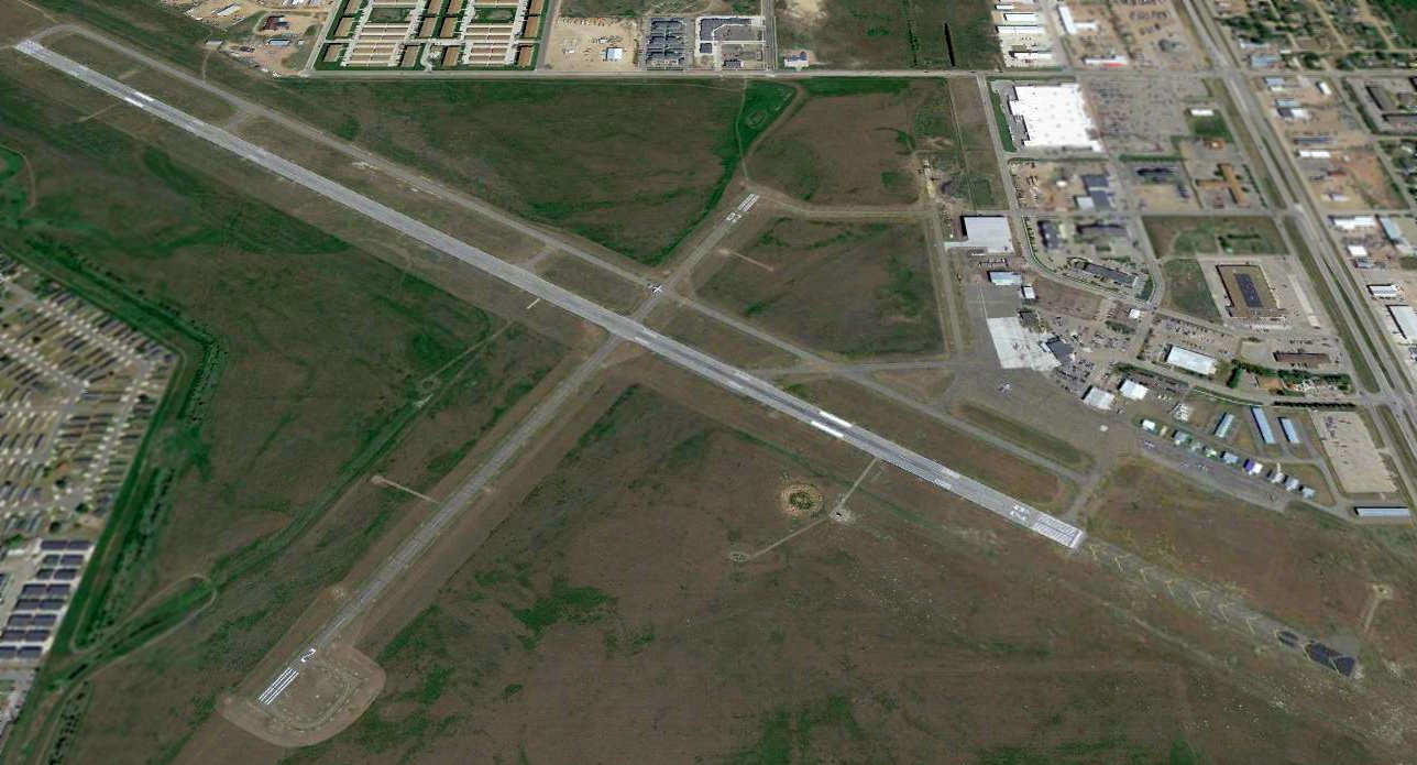
A 2017 aerial view looking north at Sloulin Field.
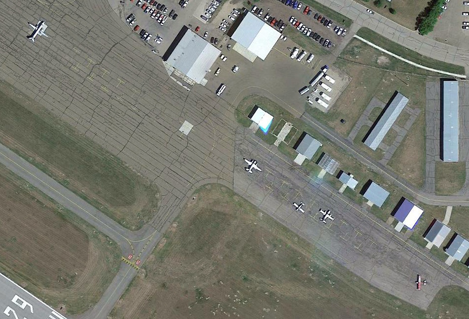
A 2017 aerial view of planes on the Sloulin Field ramp.
A July 2018 photo looking west at a Metroliner, a Gulfstream, and the Sloulin Field terminal.
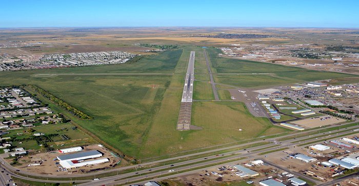
A 2019 or earlier aerial view looking northwest at Sloulin Field.
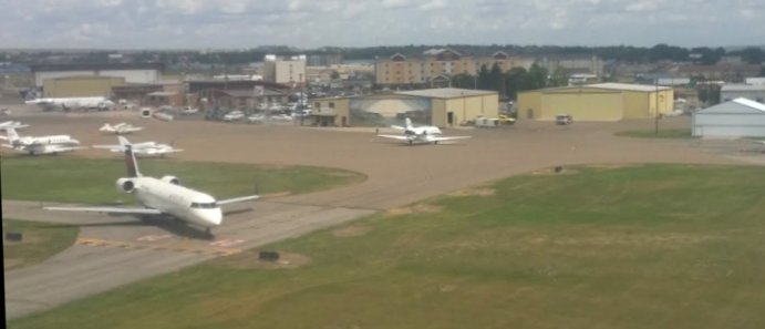
A 2019 or earlier aerial view looking north at the Sloulin Field ramp & hangars, showing a Bombardier CRJ regional jet & several other aircraft.
Wikipedia continued, “Officials ultimately decided to build Williston Basin International Airport because of cost considerations.
Sloulin Field Airport closed to the public on 10/10/19, and the land will be sold.
At the time of its closure, the airport had daily passenger service to Minneapolis on Delta Connection & to Denver on United Express.
The airlines together offered 5 flights per day to Sloulin Field.
The airport saw 11 flights per day, including nonstop service to Houston, at the height of the oil boom.
The airport had 2 asphalt runways: 6,550' Runway 11/29 & 3,453' Runway 2/20.
Sloulin Field Airport had a 9,600-square-foot terminal with a 1,500-square-foot trailer that provided extra seating capacity.
The terminal had 1 gate & vending machines for passengers.”
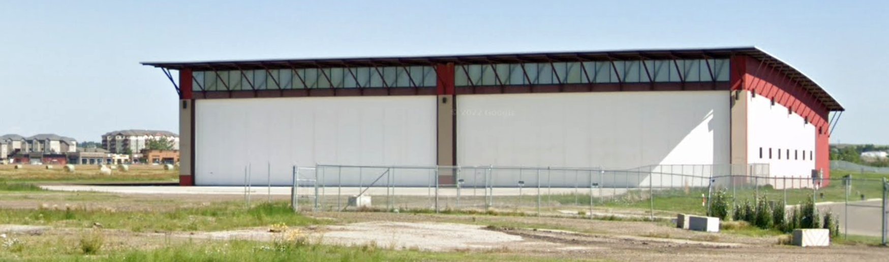
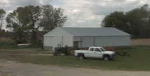
A July 2022 photo looking northwest at Sloulin Field hangar which appears to have been built only shortly before the airport's closure.
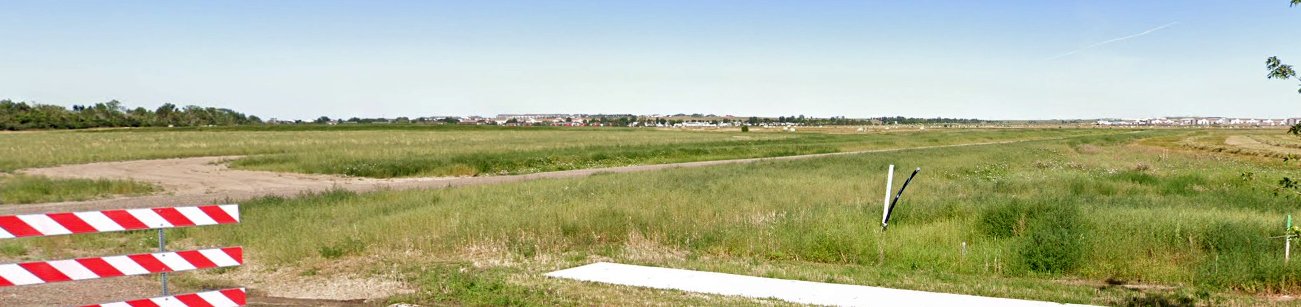
A July 2022 photo looking west at the remains of Sloulin Field's Runway 29.
Thanks to Steve Pouliot for pointing out this airfield.
____________________________________________________
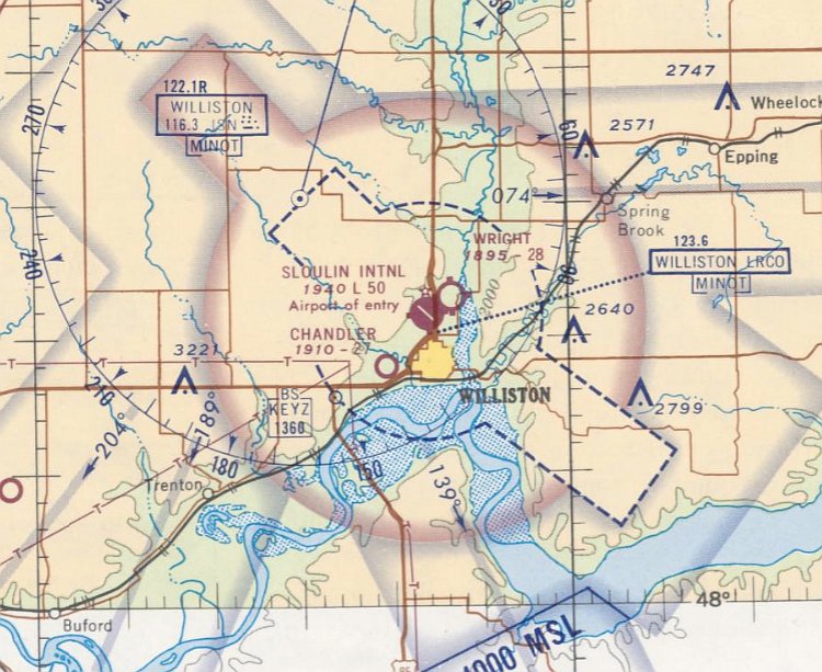
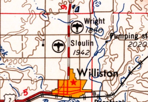
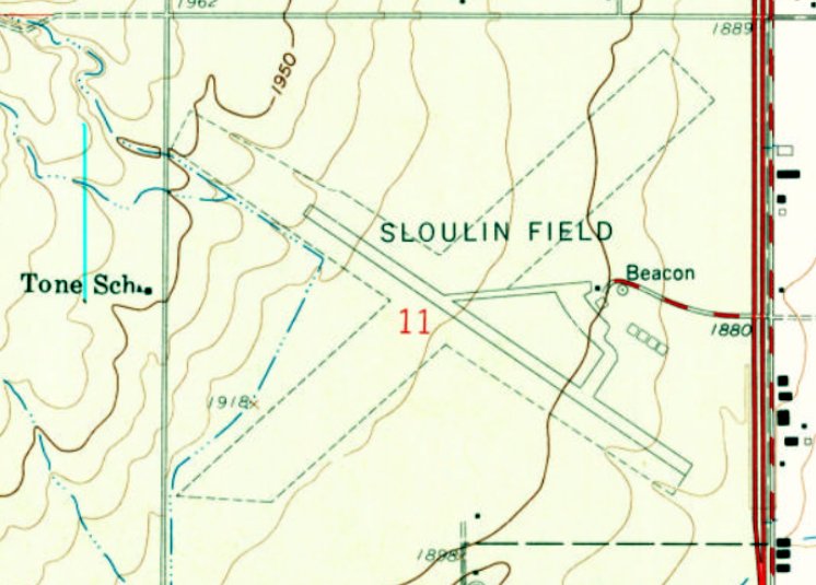
Wright Field (ND23), Williston, ND
48.189, -103.62 (Northwest of Bismark, ND)
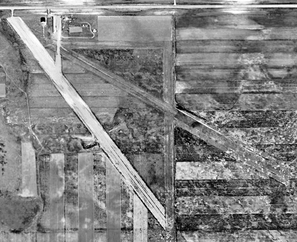
Wright Field, as depicted on the April 1950 Williston Sectional Chart.
This small general aviation airport was located less than a mile northeast of Williston's larger airport, Sloulin Field.
Wright Field was evidently established at some point between 1937-50,
as it was not yet depicted on the April 1937 Williston Sectional Chart.
The earliest depiction which has been located of Wright Field was on the April 1950 Williston Sectional Chart.
It depicted Wright Field as having a 3,200' unpaved runway.
Note that it depicted a total of 4 airports located in close proximity to each other, all northwest of the town of Williston.
Wright Field, as depicted on the 1955 USGS topo map.
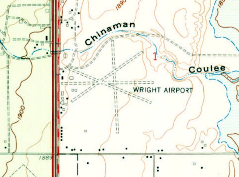
The 1959 USGS topo map depicted Wright Airport as having 4 unpaved runways,
with a cluster of small buildings (hangars?) on the west side.
According to Steve Brookfield, “At one point it was registered to an agricultural spraying service.”
The last aeronautical chart depiction which has been located of Wright Airport was on the July 1970 Williston Sectional Chart.
It depicted Wright Airport as having a 2,800' unpaved runway.
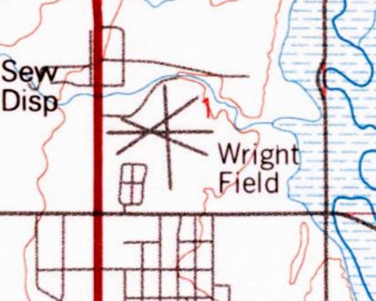
The 1982 USGS topo map depicted Wright Field as having 4 runways.
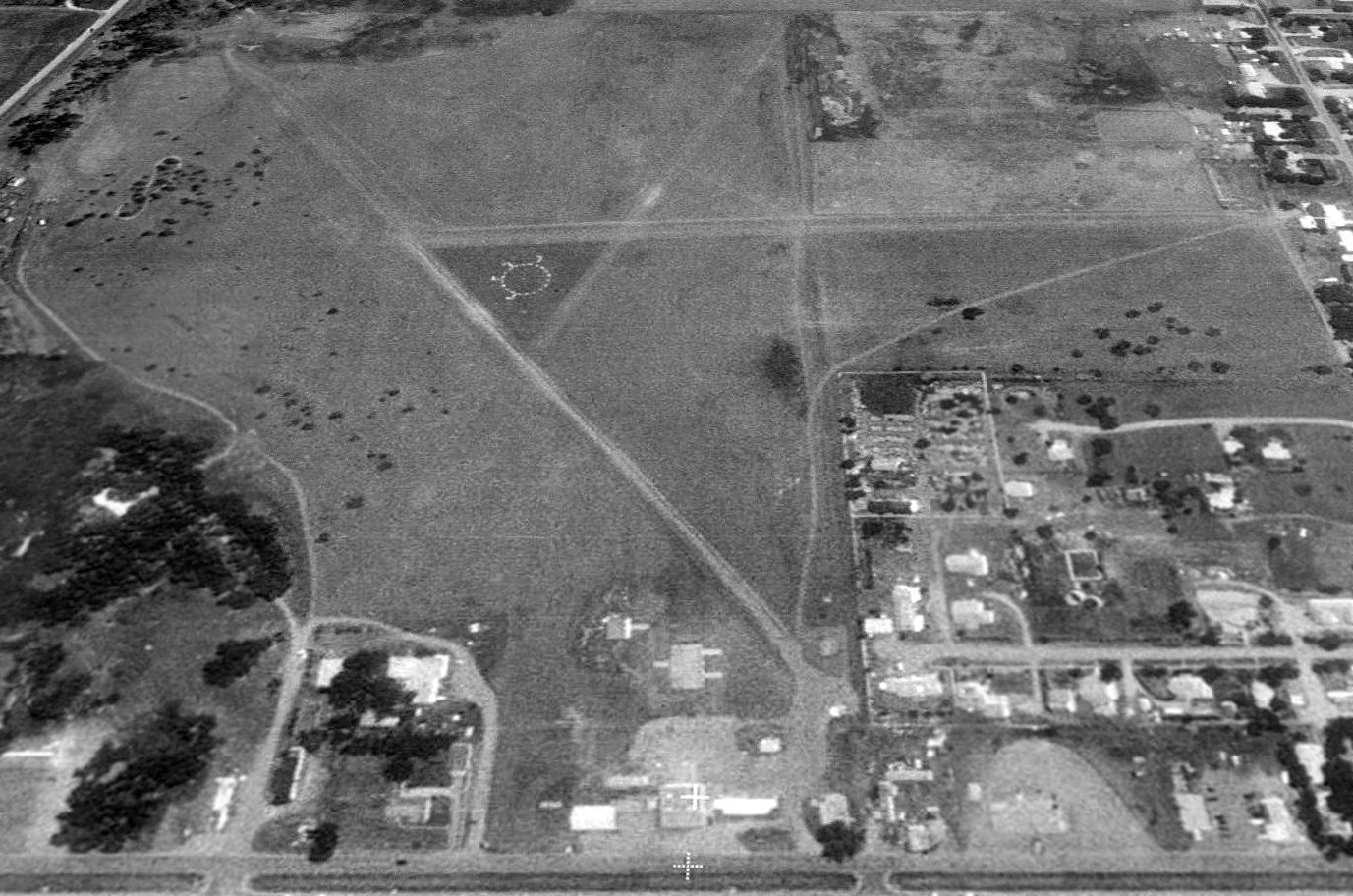
The earliest photo which has been located of Wright Field was a 1995 USGS aerial view looking east.
It depicted Wright Field as having 3 unpaved runways, with a segmented circle visible at the runway intersection.
It appeared as if the hangars on the west side of the field had been removed, with only their foundations still visible.
A 2014 aerial view looking east showed the remnants of Wright Field's
It depicted Wright Field as having 3 unpaved runways, with a segmented circle visible at the runway intersection.
It appeared as if the hangars on the west side of the field had been removed, with only their foundations still visible.
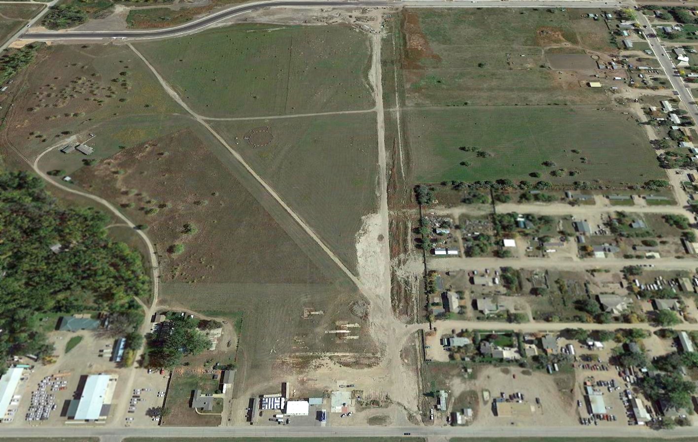
Steve Brookfield reported in 2017, “Wright Field... I ran by, you can clearly see the segmented circle but nothing else.
There is a sign advertising 85 acres for sale, which I have to assume is the airport property.”
The site of Wright Field is located northeast of the intersection of 2nd Avenue West & 42nd Street East.
Thanks to Steve Brookfield for pointing out this airfield.
____________________________________________________
46.654, -97.252 (Southwest of Fargo, ND)
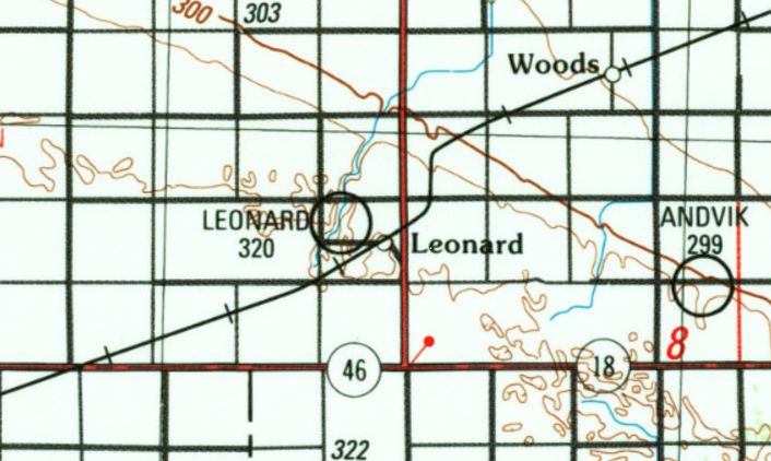
Leonard Airport, as depicted on the 1989 USGS topo map.
This small general aviation airport was evidently established at some point between 1971-89,
as it was not yet depicted on the February 1971 Fargo Sectional Chart.
The earliest depiction which has been located of Leonard Airport was on the 1989 USGS topo map.
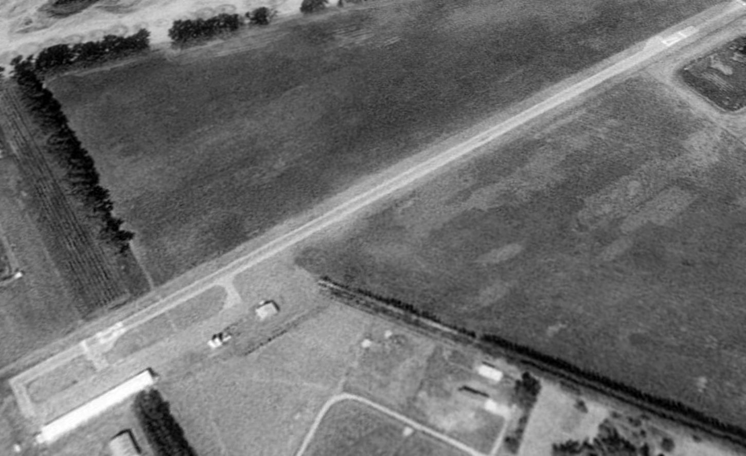
The earliest photo which has been located of Leonard Airport was a 1990 USGS aerial view looking northwest.
It depicted Leonard Airport as having a single paved Runway 17/35, with a ramp & 2 small hangars on the southeast side.
There were no aircraft visible on the field.
Leonard Airport was evidently closed (for reasons unknown) at some point between 1990-97,
as a 1997 aerial view showed the runway numbers had been removed,
and a 2004 aerial photo showed closed-runway “X” symbols painted on each runway end.
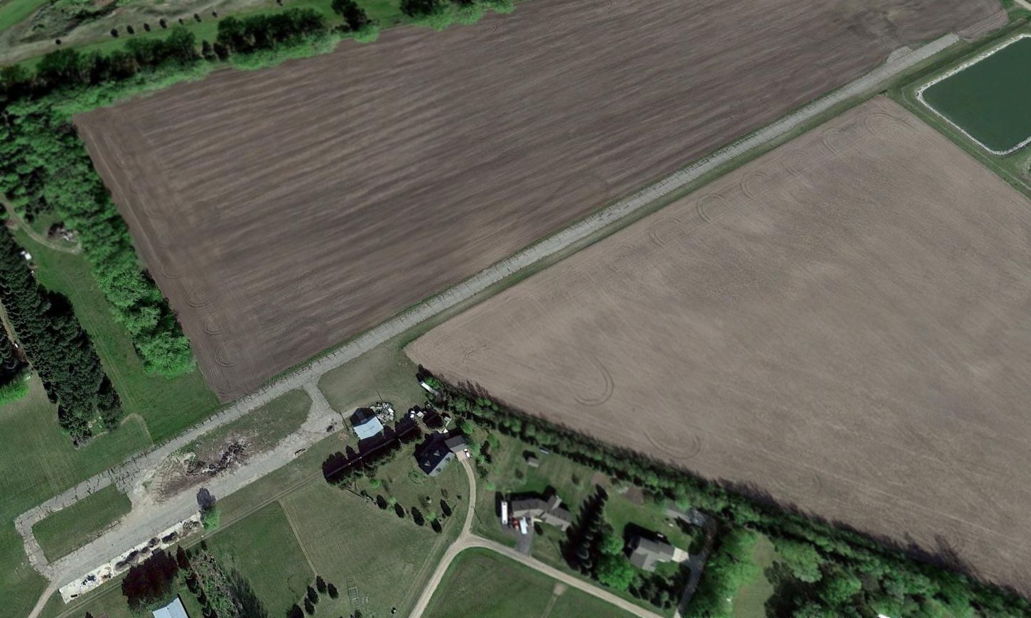
A 2016 aerial view looking northwest at Leonard Airport shows it to remain mostly intact, though the runway is deteriorated.
The northern hangar remained standing, but only the foundation remained of the southern hangar.
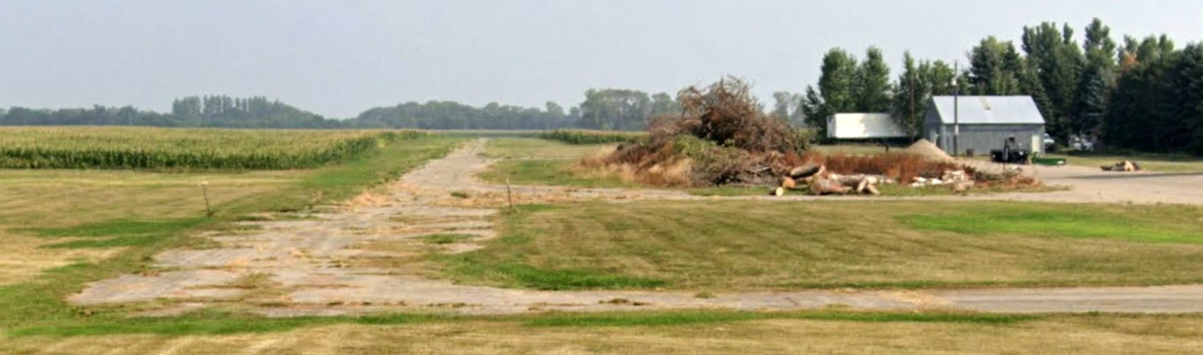
An August 2021 photo looking north at the remains of Leonard Airport, including the paved runway & the northern hangar.
Leonard Airport is located at the western terminus of 2nd Avenue.
Thanks to John Muenster for pointing out this airfield.
____________________________________________________
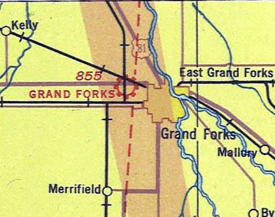
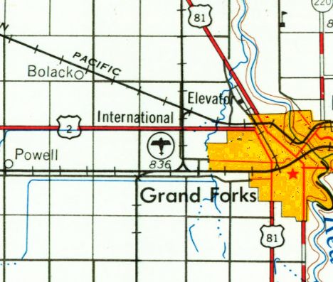
Grand Forks Municipal Airport (original location), Grand Forks, ND
47.929, -97.095 (Southwest of Bismarck, SD)
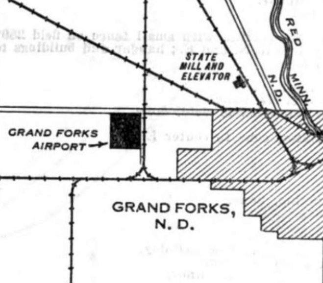
Grand Forks Airport, as depicted on the 12/3/29 Commerce Department Airway Bulletin (courtesy of Mike Denja).
The original airport for the town of Grand Forks was located adjacent to the west side of the town.
Mark Morgan reported, “In June 1928, a local club paid a landowner on Grand Forks’ west side $500 for 160 acres,
with a one-year option, for the purpose of building a permanent airport for the Grand Cities
(the earliest field serving Grand Forks was on the southwest side of town, consisting of a mowed alfalfa patch).
The proponents immediately had 2 runways graded & constructed support facilities.
The airport formally opened on 7/10/28; that date may have coincided with the field’s first BIG event,
the landing of an Army Air Service Fokker Trimotor hauling past national commander of the American Legion Hanford MacNider & Assistant Secretary of War Trubee Davison.
Interestingly enough, one Capt Ira Eaker piloted the aircraft, which delivered its passengers to the North Dakota Legion confab.
During the summer of 1929, Canadian-American Airlines added Grand Forks as a stop on its Twin Cities to Winnipeg route.
By the end of the year the company added Grand Forks to its Winnipeg to Omaha mail route.
Canadian-American, formed by investors in Minneapolis & Winnipeg with plans for major north-south operations, flew Travel Airs
and also made stops at St Cloud, Alexandria, Fergus Falls & Fargo. It went bankrupt in January 1930.
In October 1929, the city initiated efforts to purchase the field.
I have to assume the standards of the upper-Midwest – Northwest & later North Central – regularly operated through the airport.”
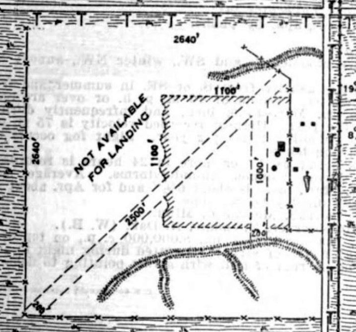
The 12/3/29 Commerce Department Airway Bulletin (courtesy of Mike Denja) described Grand Forks Airport as a municipal airport owned by the W.G. Smith estate & operated by the city.
It was depicted as a square sod field, within which were 2 runways, measuring 2,500' northeast/southwest & 1,000' north/south.
A hangar & several small buildings were depicted on the east side.
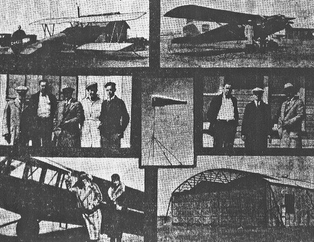
The earliest photo which has been located of Grand Forks Airport was a series of photographs from a 1929 newspaper article
showing aircraft, pilots, an a hangar (which appeared to still be under construction).
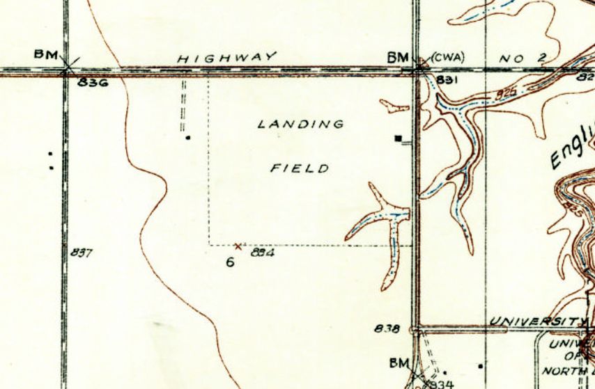
The earliest topo map depiction which has been located of the original Grand Forks Airport was on the 1934 USGS topo map.
It depicted as a square property outline, labeled simply as “Landing Field”, with a single building on the east side.
The earliest aeronautical chart depiction which has been located of the original Grand Forks Airport was on the 1935 Fargo Sectional Chart.
It depicted Grand Forks as a commercial/municipal airport.
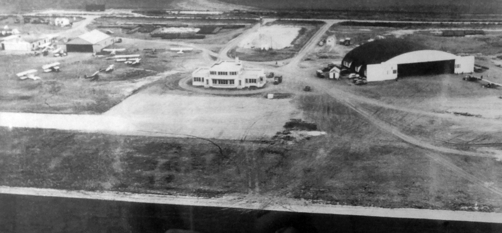
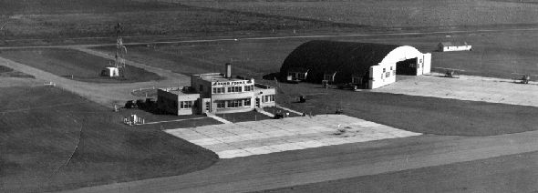
A circa 1930s aerial view looking east at the original Grand Forks Airport (courtesy of Linda Langrill, from a photo on the wall in the Brekke Tours & Travel building, the former terminal building).
It depicted the terminal building, 4 hangars, and a dozen biplanes & monoplanes.
Mark Morgan reported, “During World War II, Jolly Flying Services used the airport as a contract glider training facility for the Army.”
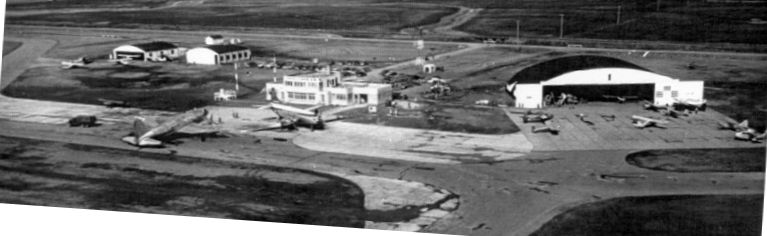
A 1950 aerial view looking northeast showed the original Grand Forks Airport with 2 commercial airliners on the ramp in front of the terminal,
and several smaller general aviation aircraft in front of 3 hangars.
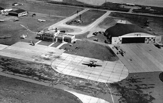
A circa 1950s aerial view looking northeast at the original Grand Forks Airport depicted several light aircraft on the ramp.
A circa 1950s aerial view looking southeast at the original Grand Forks Airport depicted several light aircraft on the ramp.
The last photo which is available showing aircraft at the original Grand Forks Airport was a 9/10/52 USGS aerial view.
There were no more commercial aircraft visible on the field, just some light general aviation aircraft in front of the hangars to the north of the terminal building.
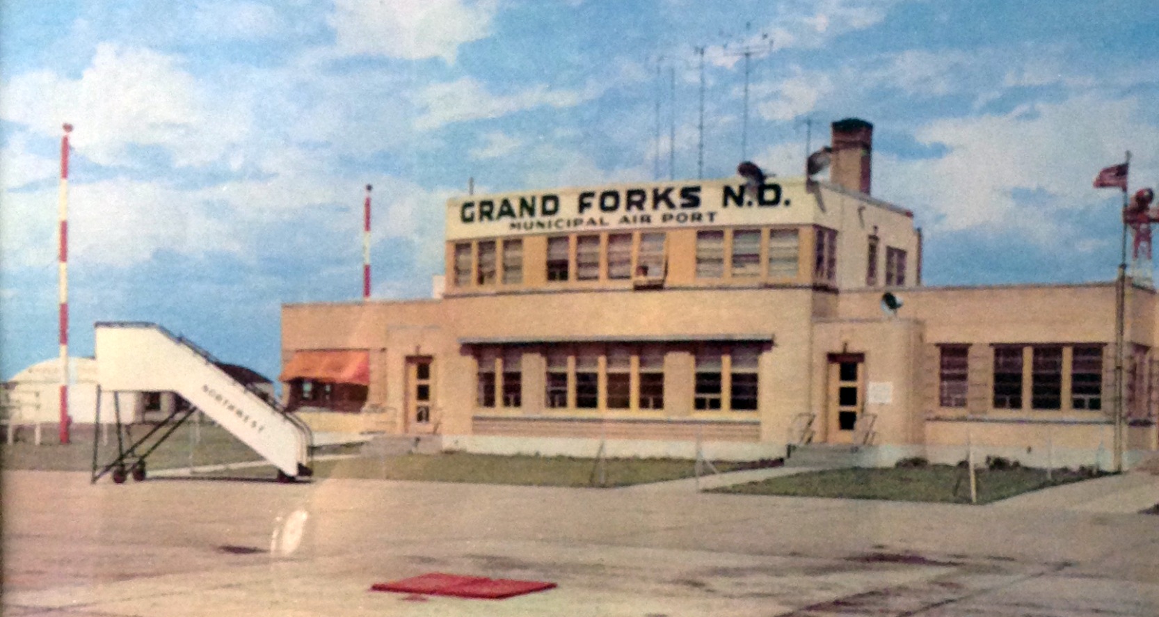
A circa 1950s photo looking east at the original Grand Forks Airport terminal building (courtesy of Linda Langrill, from a photo on the wall in the Brekke Tours & Travel building, the former terminal building).
Mark Morgan reported, “In 1959, with Grand Forks growing west & south, the city started identifying locations for a new, larger airport.
They settled on the current location, west of town on US2.”
The last aeronautical chart depiction which has been located of the original Grand Forks Airport was on the May 1960 Fargo Sectional Chart.
It depicted Grand Forks International Airport as having a 4,900' paved runway.
The last photo which has been located showing aircraft at the original Grand Forks Airport was a 1962 aerial view.
There were no more commercial aircraft visible on the field, just 6 light single-engine aircraft parked on the southeast side.
According to Mark Morgan, the replacement Grand Forks International Airport, “KGFK opened on 8/18/64.”
Presumably the original Grand Forks Airport closed simultaneously.
The original Grand Forks Airport was no longer depicted on the August 1965 Fargo Sectional Chart (courtesy of Ron Kunse).
The last depiction which has been located of the original Grand Forks Airport was on the 1966 USGS topo map,
even though the original airport may have already been closed by that point.
A 1992 aerial view showed nearly all of the original Grand Forks Airport having been removed, with Interstate 29 cutting through the property.
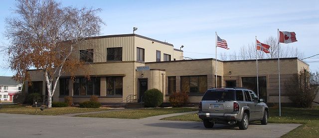
A 2011 photo of the last remnant of the original Grand Forks Airport – its terminal building which remains in good condition.
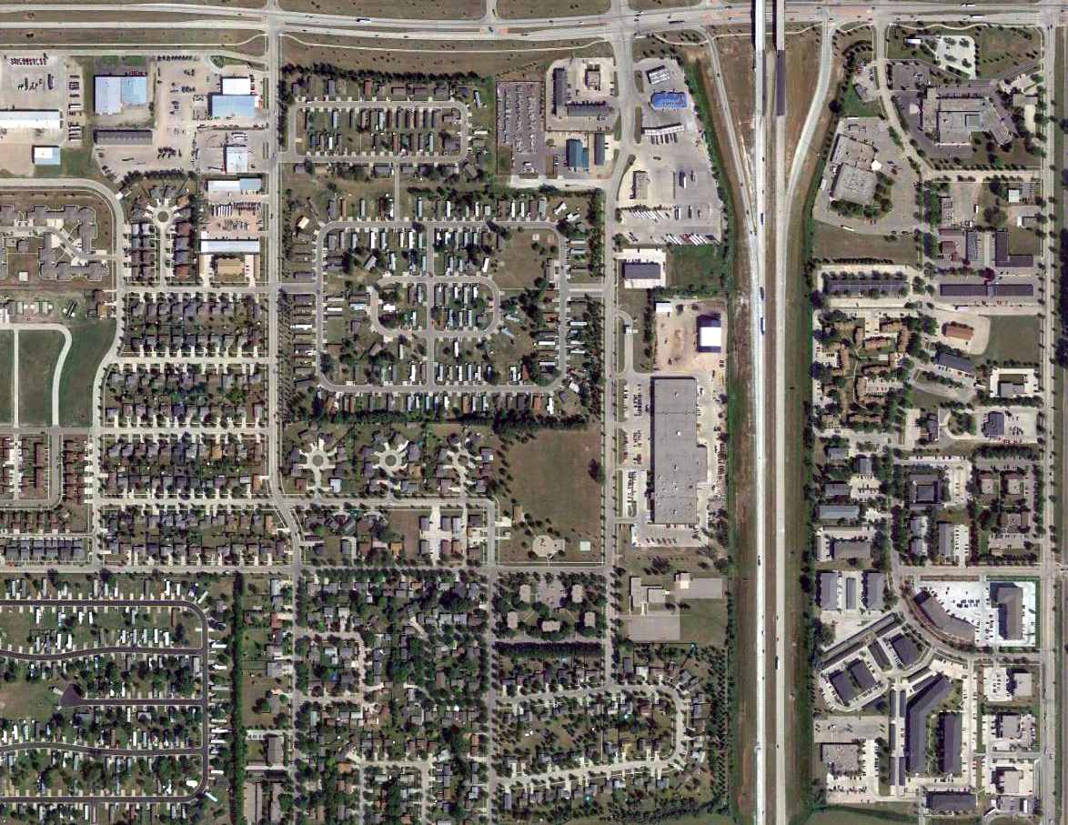
A 2015 aerial view of the site of the original Grand Forks Airport shows it to be heavily built-over,
but the terminal building remains standing on the east side of the property.
Mark Morgan reported in 2016, “The site’s now built over, with one exception: the city’s original passenger terminal, one story with a 2-story entry/atrium, in excellent condition.
Someone driving by would probably never figure out its original use.
Brekke Travel occupies the structure, complete complete with a sign out front styled to look like a B-52G/H tail”
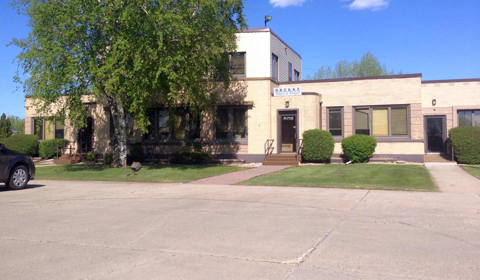
A 5/16/16 photo by Linda Langrill looking east at the former original Grand Forks Airport terminal building, now the home of Brekke Tours & Travel.
Linda Langrill reported, “We met the owner of Brekke Tours & Travel, Arne Brekke.
Inside their offices were photos hanging on the wall of the original airport. In the parking lot you could still see remnants of tie-downs!”
The site of the original Grand Forks Airport is located south of the intersection of Route 2 & Interstate 29.
Thanks to Mark Morgan for pointing out this airfield.
____________________________________________________
Bowman Field (original location) / Bowman Municipal Airport (KBPP), Bowman, ND
46.185, -103.427 (Southwest of Bismarck, SD)
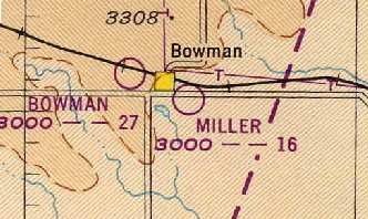
Bowman Field, as depicted on the 1948 Miles City Sectional Chart (courtesy of Chris Kennedy).
Photo of the airfield while open has not been located.
The original airport for the town of Bowman was located on the west side of the town.
According to its FAA Airport/Facility Directory data, Bowman Field was activated in September 1944.
The 1945 AAF Airfield Directory (courtesy of Scott Murdock) described Bowman Field
as a 160 acre square-shaped property having 2 turfed runways, measuring 2,400' northeast/southwest & 2,100' north/south.
The field was said to have a single 40' x 28' wooden hangar, and to be owned & operated by private interests.
The earliest depiction which has been located of Bowman Field was on the 1948 Miles City Sectional Chart (courtesy of Chris Kennedy).
It depicted Bowman as having a 2,700' unpaved runway.
The 1957 Miles City Sectional Chart (courtesy of Chris Kennedy)
depicted Bowman Field as having a 4,000' unpaved runway.
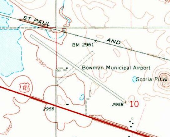
The 1968 USGS topo map depicted Bowman Municipal Airport as having a paved northwest/southeast runway, an unpaved crosswind runway,
and 4 small buildings on the west side.
The earliest photo which has been located of Bowman Field was a 1995 aerial view looking north Chart (courtesy of Chris Kennedy).
It depicted Bowman as having a 2,700' unpaved runway.
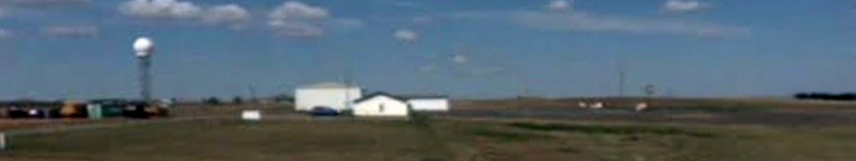
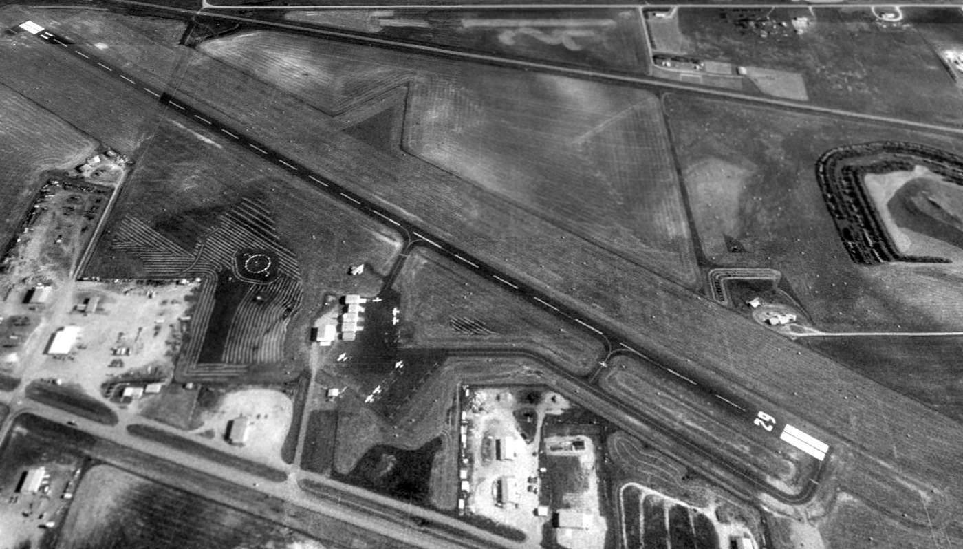
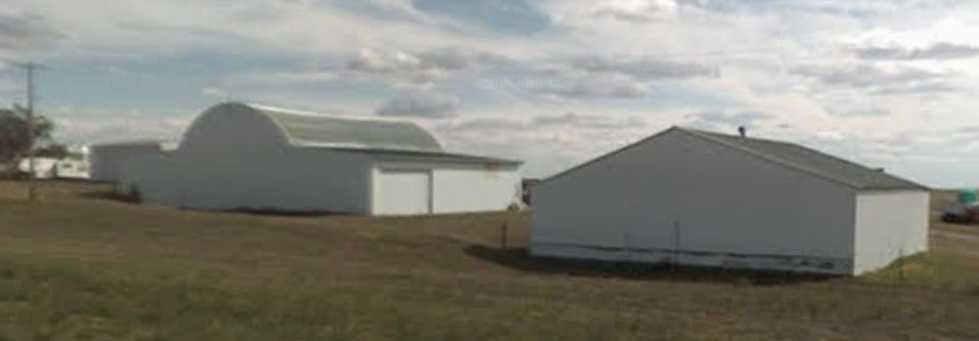
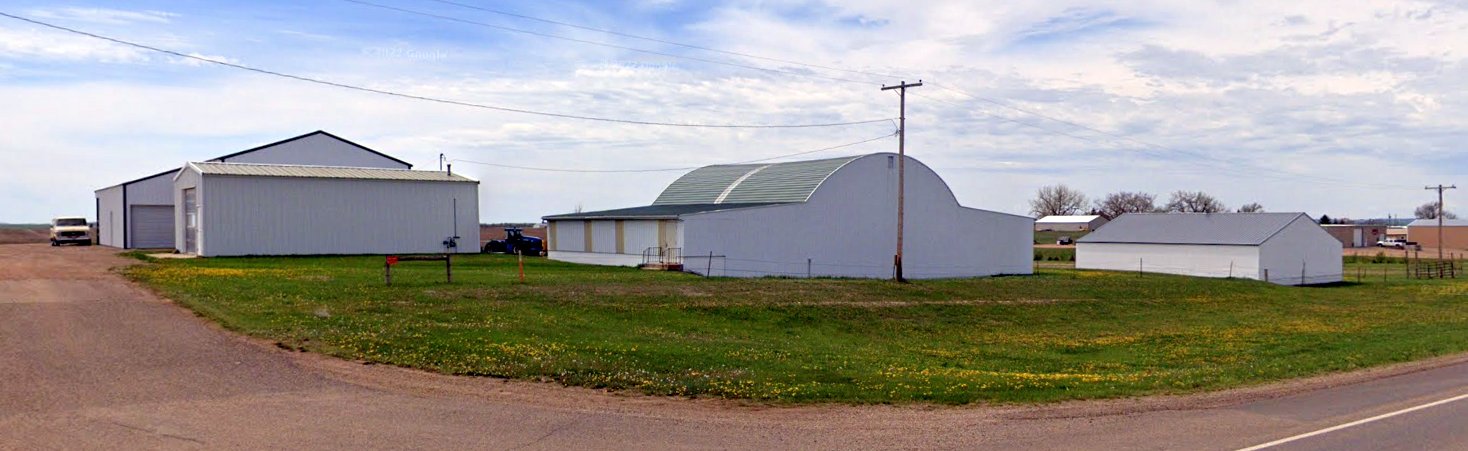
A 2008 photo looking north at Bowman Field showed several hangars & what appeared to be a tower-mounted NEXRAD weather radar.
The last photo which has been located showing an aircraft at Bowman Field was a 2013 aerial view looking north, which showed 1 single-engine Cessna on the ramp.
Bowman Field was apparently closed at some point between 2013-2015,
as the runway was marked with yellow closed-runway “X” symbols on a 2015 aerial view.
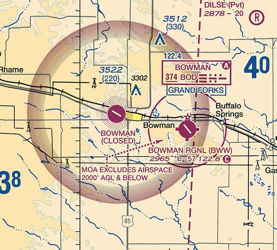
The original Bowman Airport was still depicted, but labeled as closed, on the 2016 Sectional Chart,
which also depicted the replacement Bowman Regional Airport several miles to the east.
A 2022 photo looking north at several hangars which remain at the original Bowman Airport site.
The site of the original Bowman Field is located northwest of the intersection of Route 12 & Route 85.
Thanks to Jim Dalton for pointing out this airfield.
____________________________________________________
Wimbledon Airport, Wimbledon, ND
47.16, -98.47 (Northeast of Bismarck, SD)
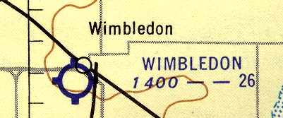
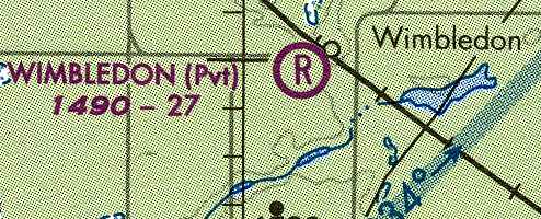
Wimbledon Airport, as depicted on the April 1953 Fargo Sectional Chart (courtesy of Timothy Aanerud).
Photo of the airfield while open has not been located.
This small general aviation airport was evidently established at some point between 1950-53,
as it was not yet depicted on the May 1950 Fargo Sectional Chart.
The earliest depiction which has been located of Wimbledon Airport
was on the April 1953 Fargo Sectional Chart (courtesy of Timothy Aanerud).
It depicted Wimbledon as a public-use airfield having a 2,600' unpaved runway.
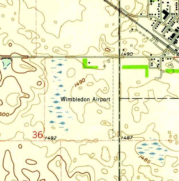
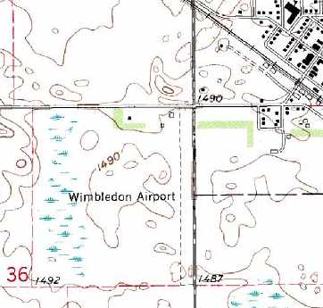
The 1961 USGS topo map depicted Wimbledon Airport as having a single north/south unpaved runway,
with a few small buildings on the northwest side of the field.
The March 1965 Fargo Sectional Chart (courtesy of Timothy Aanerud)
depicted Wimbledon in the same fashion.
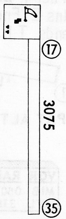
The 1968 Flight Guide (courtesy of Robert Levittan) depicted Wimbledon Airport as having a single 3,075' unpaved Runway 17/35,
with a few small buildings on the northwest side of the field.
The 1982 USGS topo map depicted Wimbledon Airport as having a single north/south unpaved runway,
with a few small buildings on the northwest side of the field.
At some point between 1965-86, the status of Wimbledon changed to a private airfield,
as that is how it was depicted on the July 1986 Twin Cities Sectional Chart (according to Timothy Aanerud).
A 1998 USGS aerial view looking southwest showed Wimbledon Airport to have a single unpaved north/south runway, and a few small hangars on the northwest side.
There were no aircraft visible on the field.
The last depiction which has been located of Wimbledon as an active airfield
was on the July 2001 Twin Cities Sectional Chart (courtesy of Timothy Aanerud).
The Wimbledon Airport was evidently closed (for reasons unknown) at some point between 2001-03,
as it was no longer depicted at all on the July 2003 Twin Cities Sectional Chart (according to Timothy Aanerud).
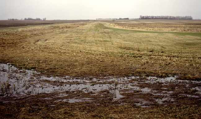
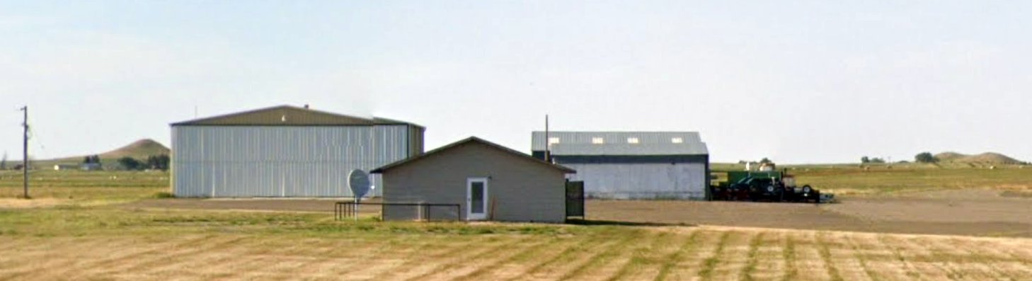
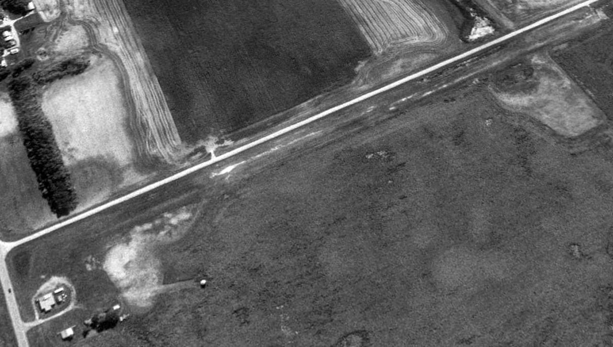
A 2006 photo by Jim Fenwick looking south down the former runway of Wimbledon Airport.
Jim reported also seeing a building being used for storage which looked “very much like a hangar.”
A 2009 aerial photo showed that one of the Wimbleton Airport hangars had been removed at some point between 2006-2009.
A circa 2007 photo looking southwest at what appears to be a former hangar at the site of Wimbledon Airport.
A 2017 aerial view looking southwest showed Wimbledon Airport to have a single unpaved north/south runway, and 1 small hangar on the northwest side.
There were no aircraft visible on the field.
A snowy 2021 photo looking southwest at what appears to be a former hangar on the northwest corner of the Wimbledon Airport site.
Wimbledon Airport is located southwest of the intersection of Route 9 & 96th Avenue Southeast.
Thanks to Timothy Aanerud for pointing out this airfield.
____________________________________________________
46.17, -103.38 (Southwest of Bismarck, SD)
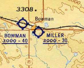
Miller Airport, as depicted on the 1948 Miles City Sectional Chart (courtesy of Chris Kennedy).
Photo of the airfield while open has not been located.
Miller Airport was evidently established at some point between 1946-48,
as it was not yet depicted on the May 1946 Miles City Sectional Chart.
The earliest depiction which has been located of Miller Airport was on the 1948 Miles City Sectional Chart (courtesy of Chris Kennedy),
which depicted Miller as having a 1,600' unpaved runway.
The 1957 Miles City Sectional Chart (courtesy of Chris Kennedy) described Miller Airport as having three runways, with the longest being a 3,000' turf strip.
The earliest photo which has been located of Miller Airport was a 6/11/59 USGS aerial view.
It depicted a northwest/southeast runway on the west side, perhaps still under construction,
along with 2 older unpaved runways to the east.
The 1962 AOPA Airport Directory described Miller Airport as having a 3,100' gravel Runway 14/32 & two shorter turf strips,
and listed the operator as Al Miller.
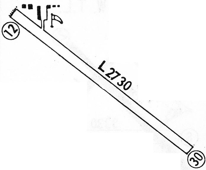
The 1968 Flight Guide (courtesy of Robert Levittan) depicted Bowman Municipal Airport as having a single 2,735' unpaved Runway 12/30,
with a few small buildings on the northwest side of the field.
Miller had apparently gained a paved runway at some point between 1962-68,
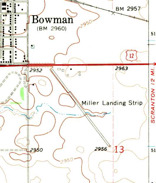
as the 1968 USGS topo map depicted “Miller Landing Strip” as having a single paved northwest/southeast runway.
Miller Airport was apparently closed (for reasons unknown) at some point between 1968-70,
as it is no longer depicted on the April 1970 Miles City Sectional Chart.
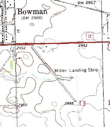
The 1991 USGS topo map still depicted “Miller Landing Strip” as having a single paved northwest/southeast runway.
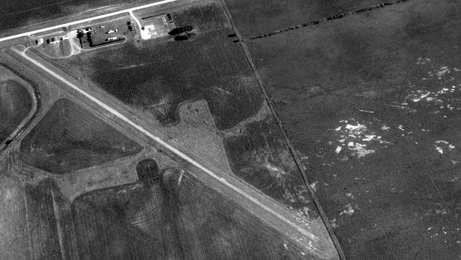
A 1995 USGS aerial view looking northeast depicted the paved runway at Miller as remaining in very good condition.
A few hangars sat at the northwest end of the runway.
There was no sign remaining of the 2 older unpaved runways to the east.
A circa 2007 photo looking southeast at what appears to be a former hangar at the northwest end of Miller Airport.
A 2015 aerial view looking northeast showed the former Miller Airport runway as having been partially removed, but still recognizable,
and the hangars also remained at at the northwest corner.
A May 2022 photo looking southwest at several former hangars at the northwest end of Miller Airport.
Miller Airport is located southeast of the intersection of Route 12 & 3rd Avenue Southeast.
Thanks to Chris Kennedy for pointing out this airfield.
____________________________________________________
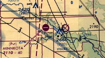
(Original) Minnkota Landing Strip, Center, ND
47.08, -101.2 (Northwest of Bismarck, SD)
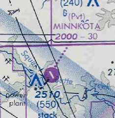
The original Minnkota Airfield, as depicted on the October 1977 Billings Sectional Chart (courtesy of Chris Kennedy).
This small private airfield was evidently constructed at some point between 1972-77,
as it was not yet depicted on a 4/25/72 USGS aerial photo.
The earliest depiction of the original Minnkota Airfield which has been located
was on the October 1977 Billings Sectional Chart (courtesy of Chris Kennedy).
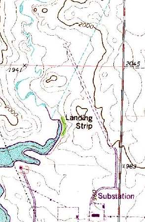
The 1977 USGS topo map depicted the field as having a single 3,000 northwest/southeast runway,
labeled simply as "Landing Strip".
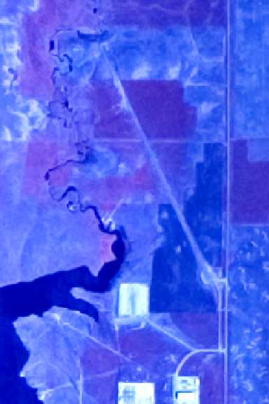
The only photo which has been located of the original Minnkota Airfield was a 5/16/79 USGS aerial view.
It depicted Minnkota as having a single northwest/southeast runway.
By 1993, the Billings Sectional Chart (courtesy of Timothy Aanerud)
showed that a replacement Minnkota Landing Strip had been built three miles to the west,
and the original airfield had been abandoned.
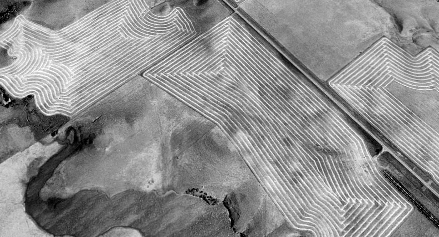
A 1997 USGS aerial view looking northeast showed that the site of the original Minnkota Airfield had been reused for farming, with the land processed by a combine or a swather.
The alignment of the former runway was still barely evident if you know where to look.
The site of the original Minnkota Landing Strip is located northwest of the intersection of 33rd Avenue SW & 24th Street SW.
Thanks to Chris Kennedy for pointing out this airfield.
____________________________________________________
Since this site was first put on the web in 1999, its popularity has grown tremendously.
If the total quantity of material on this site is to continue to grow,
it will require ever-increasing funding to pay its expenses.
Therefore, I request financial contributions from site visitors,
to help defray the increasing costs of the site
and ensure that it continues to be available & to grow.
What would you pay for a good aviation magazine, or a good aviation book?
Please consider a donation of an equivalent amount, at the least.
This site is not supported by commercial advertising –
it is purely supported by donations.
If you enjoy the site, and would like to make a financial contribution,
you
may use a credit card via
![]() :
:
Please consider checking the box to make a monthly donatation.
For a mailing address to send a check, please contact me at: paulandterryfreeman@gmail.com
If you enjoy this web site, please support it with a financial contribution.
please contact me at: paulandterryfreeman@gmail.com
If you enjoy this web site, please support it with a financial contribution.
____________________________________________________
This site covers airfields in all 50 states.