Abandoned & Little-Known Airfields:
Southeastern Michigan
© 2002, © 2024 by Paul Freeman. Revised 4/23/24.
This site covers airfields in all 50 states: Click here for the site's main menu.
____________________________________________________
Please consider a financial contribution to support the continued growth & operation of this site.
Carriage Lane Airport (added 7/24/22) - Erie Aerodrome (revised 6/6/22) - Genova Delve Airfield / Davison-Genova Airport / Williams Memorial Airport (added 1/23/23) - Holly Airport (revised 8/19/21)
Jonesville Airport / Merchant Field (revised 2/20/24) - Nan Bar Airport / NOLF 27106 / Flat Rock Field (revised 10/2/22) - Navarre Airport (revised 4/22/24) - Newton Field (revised 1/11/21)
Otisville Airport / Otisville Rixport Airport (revised 4/23/24) - Saline Airport (revised 7/24/22) - Silver Ace Airport / Monroe Airport / Marshall Airport (revised 6/2/22)
Washtenaw Airport / Young Airport (revised 2/21/24) - Ypsilanti Airport / Gridley Airport (revised 2/20/24)
____________________________________________________
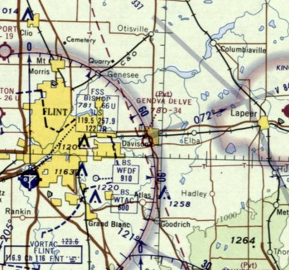
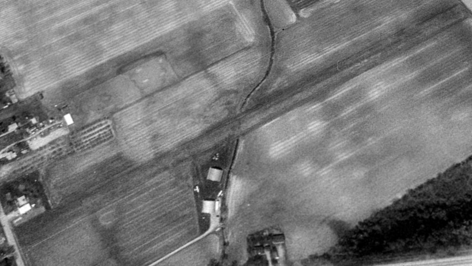
Genova Delve Airfield / Davison-Genova Airport /
Athelone S. Williams Memorial Davison Township Airport (6G0), Davison, MI
43.029, -83.534 (Northwest of Detroit, MI)
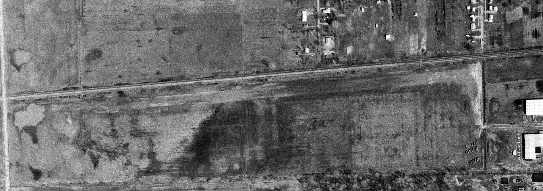
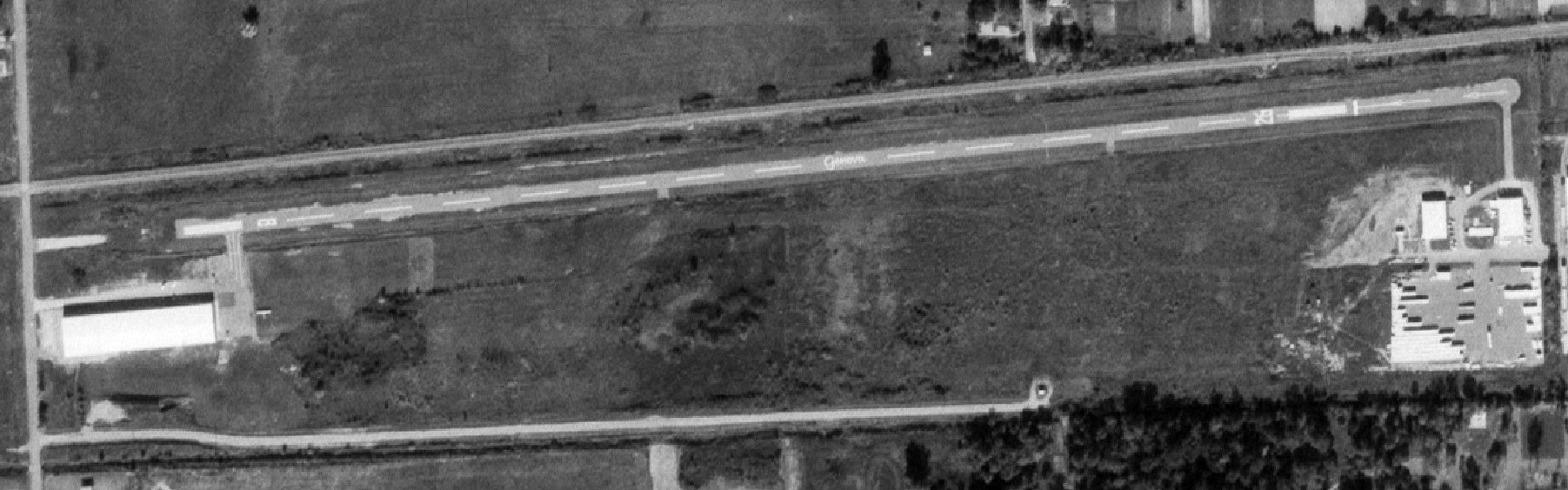
Genova Delve Airfield, as depicted on the 4/4/67 aerial view (courtesy of Mike Denja).
This small airfield was evidently established at some point between 1968-69,
as it was not yet depicted on a 1958 aerial photo or the 1968 Detroit Sectional Chart.
The earliest depiction which has been located of Genova Delve Airfield was on a 4/4/67 aerial photo (courtesy of Mike Denja).
It depicted a single unpaved northeast/southwest runway, paralleling the south side of the railroad tracks,
with access leading to a few small commercial buildings on the southeast side (presumably the builder/operator of the airfield).
The earliest aeronautical chart depiction which has been located of Genova Delve Airfield was on the July 1969 Detroit Sectional Chart.
It depicted a private airfield having a 3,400' unpaved runway.
Davison-Genova Airfield was evidently closed (for reasons unknown) at some point between 1969-72,
as it was listed as abandoned in the 6/22/72 Airman's Information Manual (courtesy of Mike Denja).
A 9/15/72 aerial view showed a building with a connecting taxiway had been added at some point between 1969-75 to the southwest side of Davison-Genova Airfield,
but closed-runway “X” symbols had been painted on both runway ends.
At some point in 1972, Davison-Genova was reopened as a public-use airport & improved with a single 3,600' east/west paved runway,
as that is how it was depicted on the November 1972 Detroit Sectional Chart.
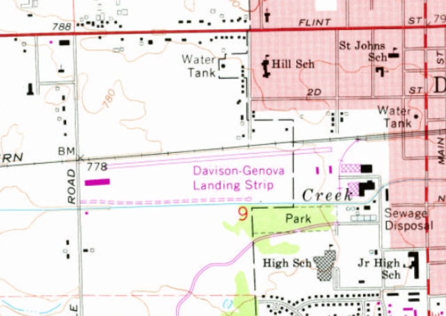
The earliest topo map depiction which has been located of Davison-Genova Airport was on the 1975 USGS topo map.
It depicted “Davison-Genova Landing Strip” as having a single paved northeast/southwest runway, with a building on the southwest side & several buildings on the southeast side.
The earliest depiction which has been located showing an aircraft at Davison-Genova Airport was a 10/1/75 aerial photo (courtesy of Mike Denja).
“Genova” was painted in script on the runway midpoint, and 1 light single-engine aircraft was parked on the southwest side.
The May 1981 Detroit Sectional Chart depicted Davison-Genova as a public-use airport having a single 3,500' east/west paved runway.
A 1983 aerial photo depicted Davison-Genova Airport in a largely unchanged configuration.
The airport land was donated by the Williams family with the stipulation its usage was open to the public, according to Davison Township Supervisor Karen Miller,
and in 1987 became a public airport, named the Athelone S. Williams Memorial Davison Township Airport.
The October 1993 Detroit Sectional Chart depicted Williams Memorial Airport as having a single 3,400' east/west paved runway.
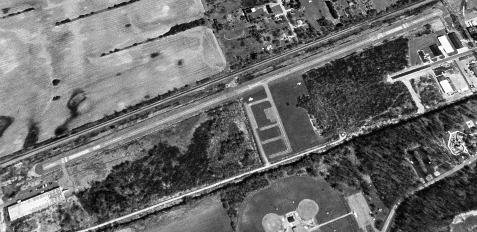
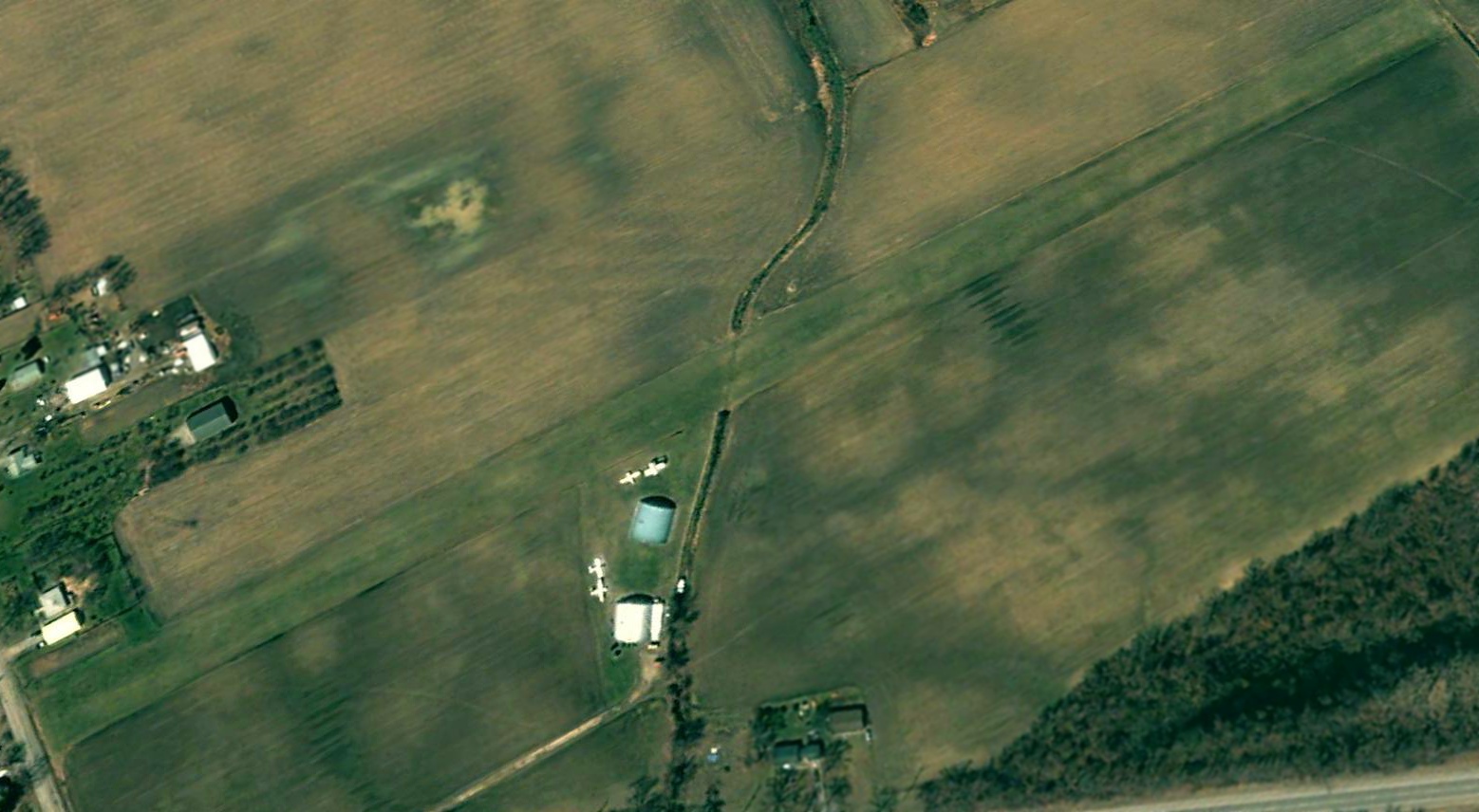
A 2000 aerial view looking northeast showed paved ramps & taxiways had been added south of the Williams Memorial Airport runway midpoint at some point between 1983-2000,
near which were parked 2 light single-engine aircraft.
The last aeronautical chart depiction which has been located of Williams Memorial Airport was on the September 2016 Detroit Sectional Chart.
It depicted Williams as having a single 3,400' paved northeast/southwest runway.
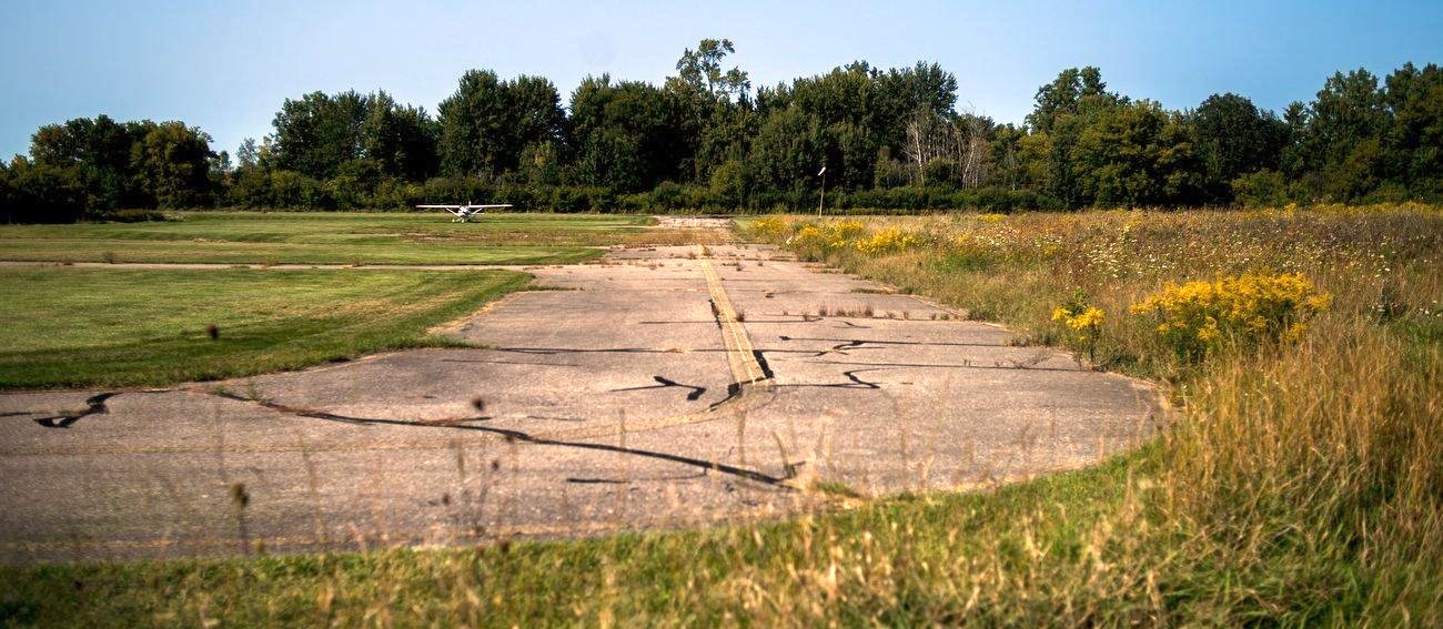
A 2017 photo looking north at the Williams Memorial Airport ramp, showing one last Cessna remaining.
An article entitled “Lack of funding, usage leads to closure of Davison Township airport” by Roberto Acostain the 9/14/17 mlive.com reported,
“Residents driving by the asphalt landing strip tucked behind a grove of trees may not even know there is an airport along Gale Road in Davison Township.
The Athelone Williams Memorial Airport has been in operation for more than 20 years, with pilots landing at the 3,500' runway bordered by railroad tracks to the north & the Black Creek on its south side.
But the days of aircraft flying into the airstrip on 37 acres of land may have finally come to an end.
Township board members voted this week to close the airport, citing lack of budget funding to complete needed repairs to cracks in the runway & ongoing costs for maintenance.”
The article continued, “The airport is named in honor of Robert Williams' mother.
The property where the runway sits was donated by the Williams family decades ago with the stipulation its usage was open to the public,
according to Davison Township Supervisor Karen Miller.”
"We've had discussions with Mr. Williams that was donated the airport to Davison Township," said Miller of discussion with Robert Williams.
"We told him about finances & the usage of the airport is way down & the airstrip was in desperate need of repair at a large cost & we only have a couple pilots out there."
"We don't have the money to repave that airstrip," said Miller.
"We have over the course of years, I can think of at least three developers, that came in and had discussions, lengthy discussions,
went out & even some of them put together drawings of putting in hangars & trying to make that a feasible operation."
The article continued, “None of those plans or discussions by township officials to build hangars on the property & pre-lease them ever came to fruition.”
Miller did not have a figure on how much the repaving may cost, only stating the cost would be "substantial."
Casting the lone no vote, board member Matthew Karr said he was "not ready to pull the trigger on closing it" minutes before the final tally.
Referencing previous studies done by the township on the airport, Karr noted they included the suggestion that "Once it closes, it'll never get open again"
and preferred to leave the item on the agenda for next month's meeting.
But board member Tim Elkins said the township does not have the money to pay for repairs & only 2 pilots currently use the airport,
adding a portion of the property just north of the Lake Callis Recreation Complex sits on a floodplain.
"We couldn't get anybody to invest in it," commented Elkins. "We don't have the financing for it."
There are no definite plans on what the township may utilize the property for moving forward, Miller said.
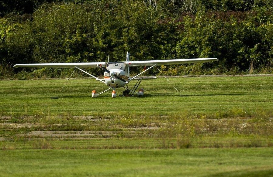
A 2017 photo looking north at the Williams Memorial Airport ramp, showing one last Cessna remaining.
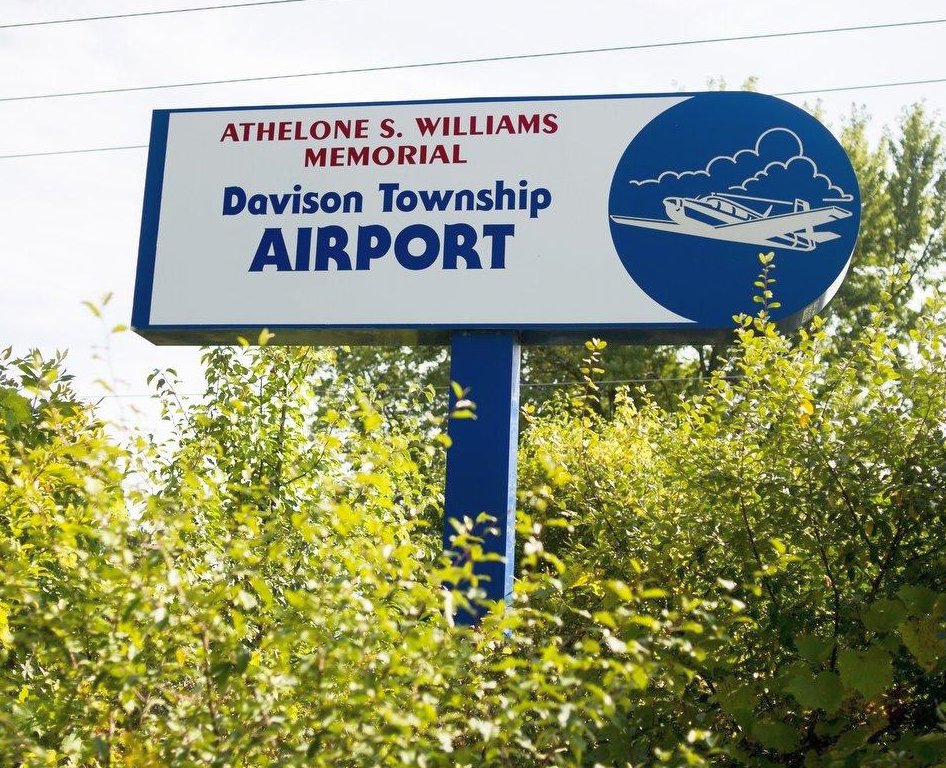
A 2017 photo of the Williams Memorial Airport sign.
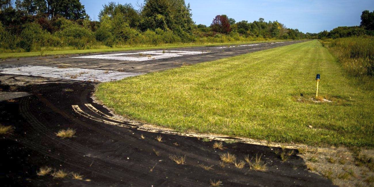
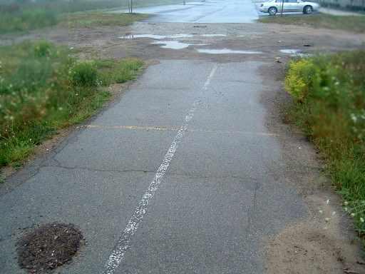
A 2017 photo looking northeast along Williams Memorial Airport's former Runway 8.
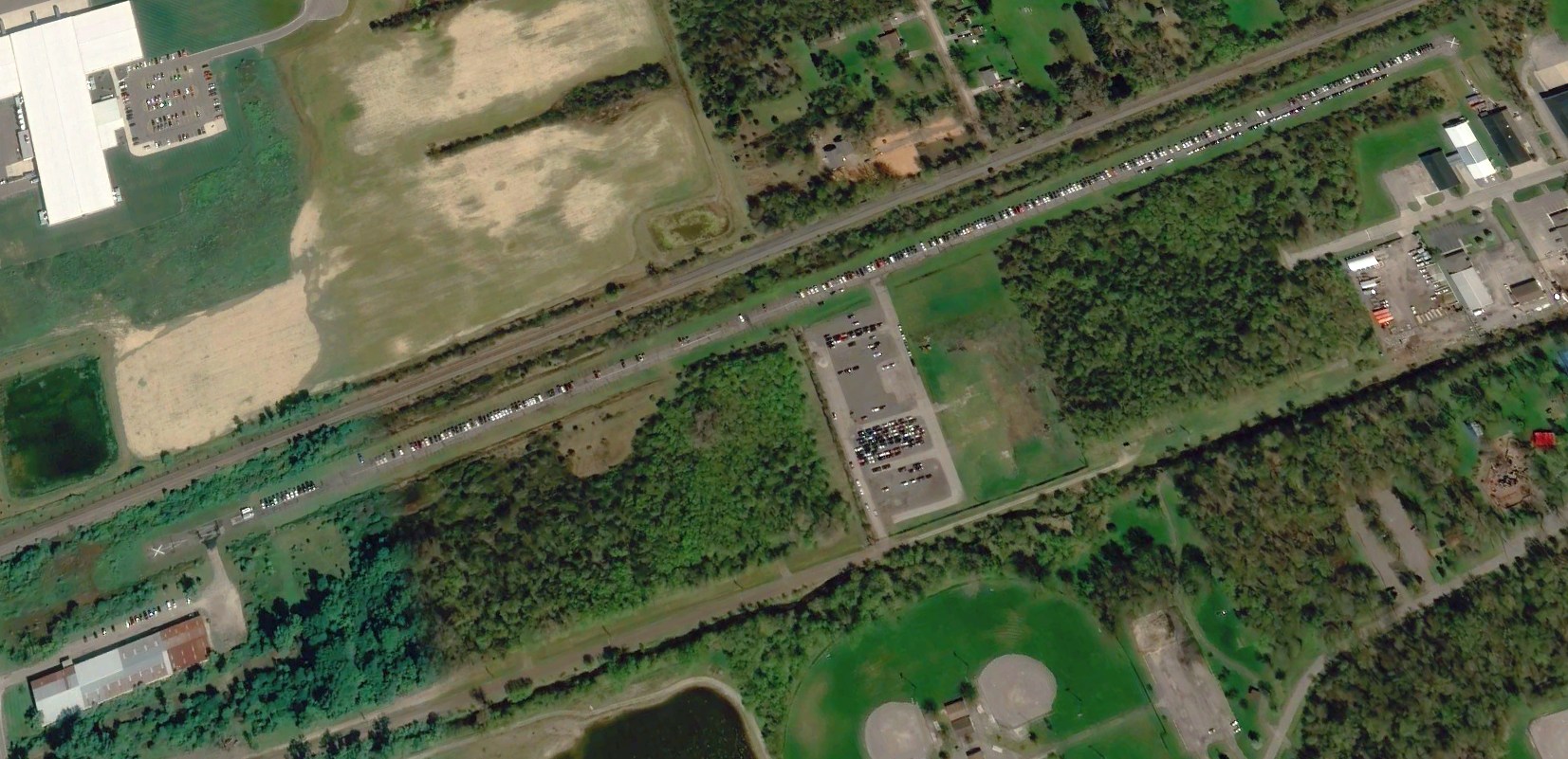
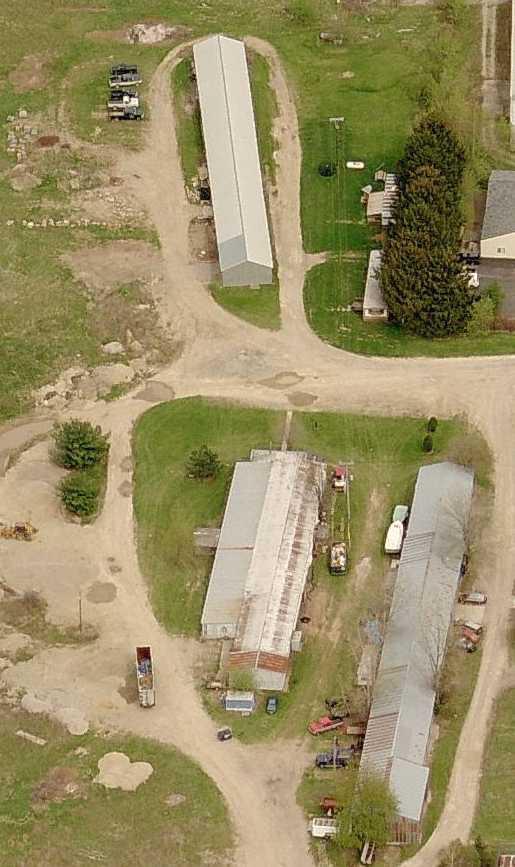
A 2019 aerial view looking northeast showed Williams Memorial Airport remained intact, but the runway & taxiways were being used to store cars.
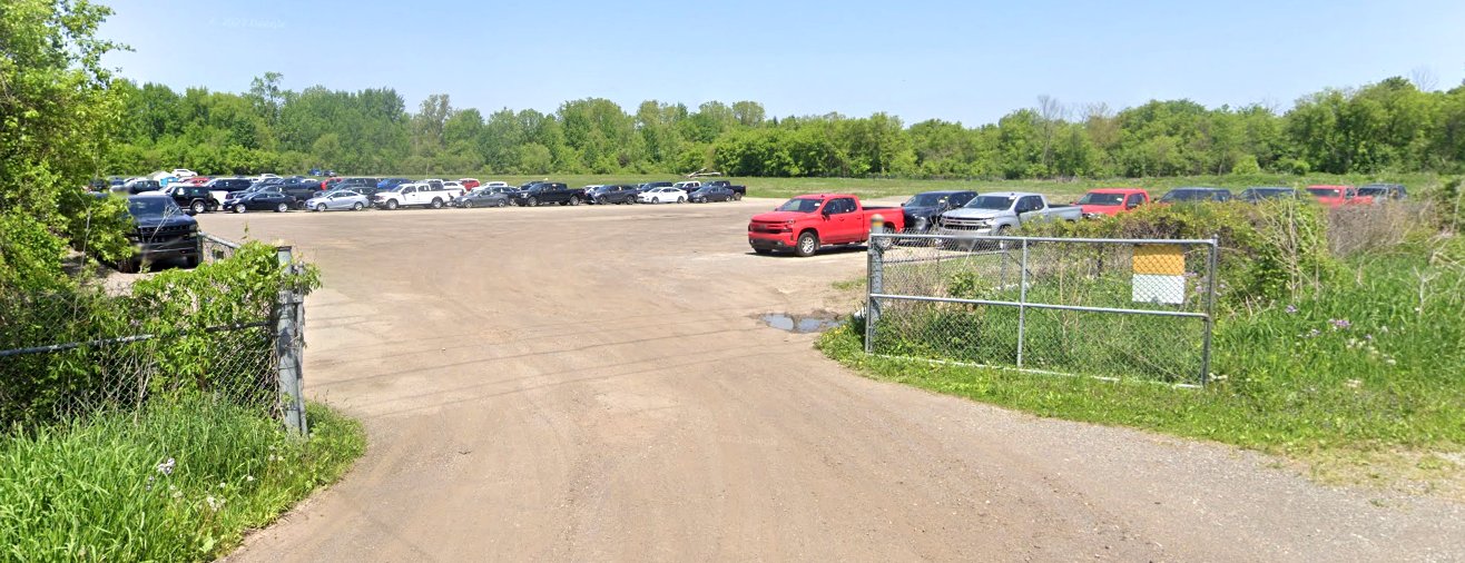
A May 2022 photo looking north showed the Williams Memorial Airport ramp being used to store cars.
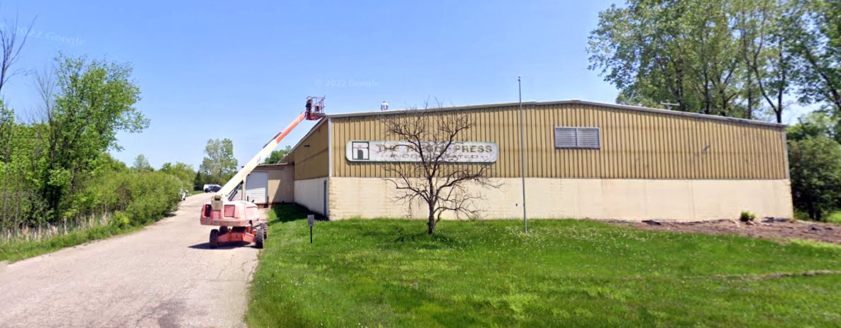
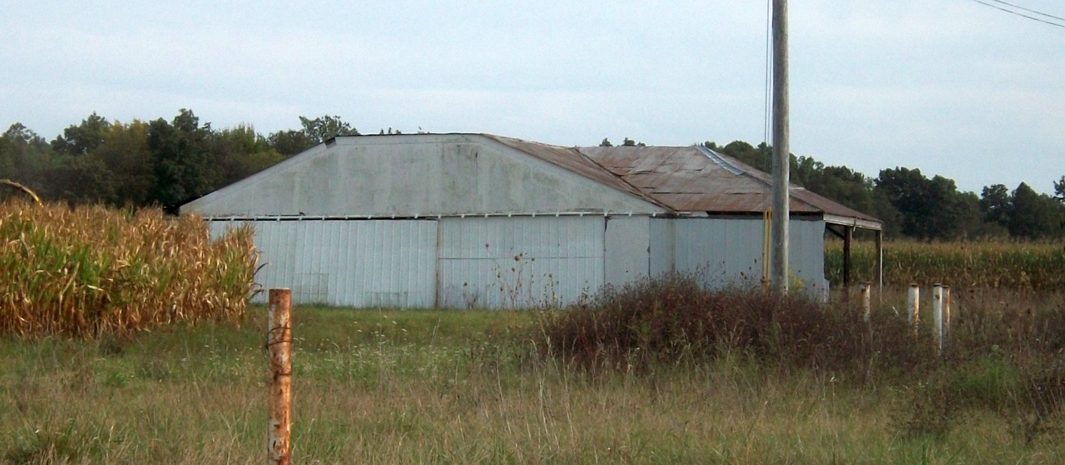
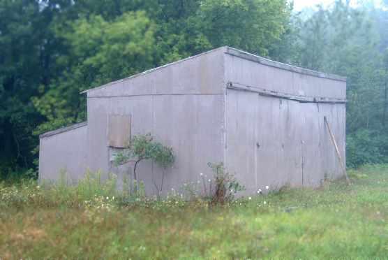
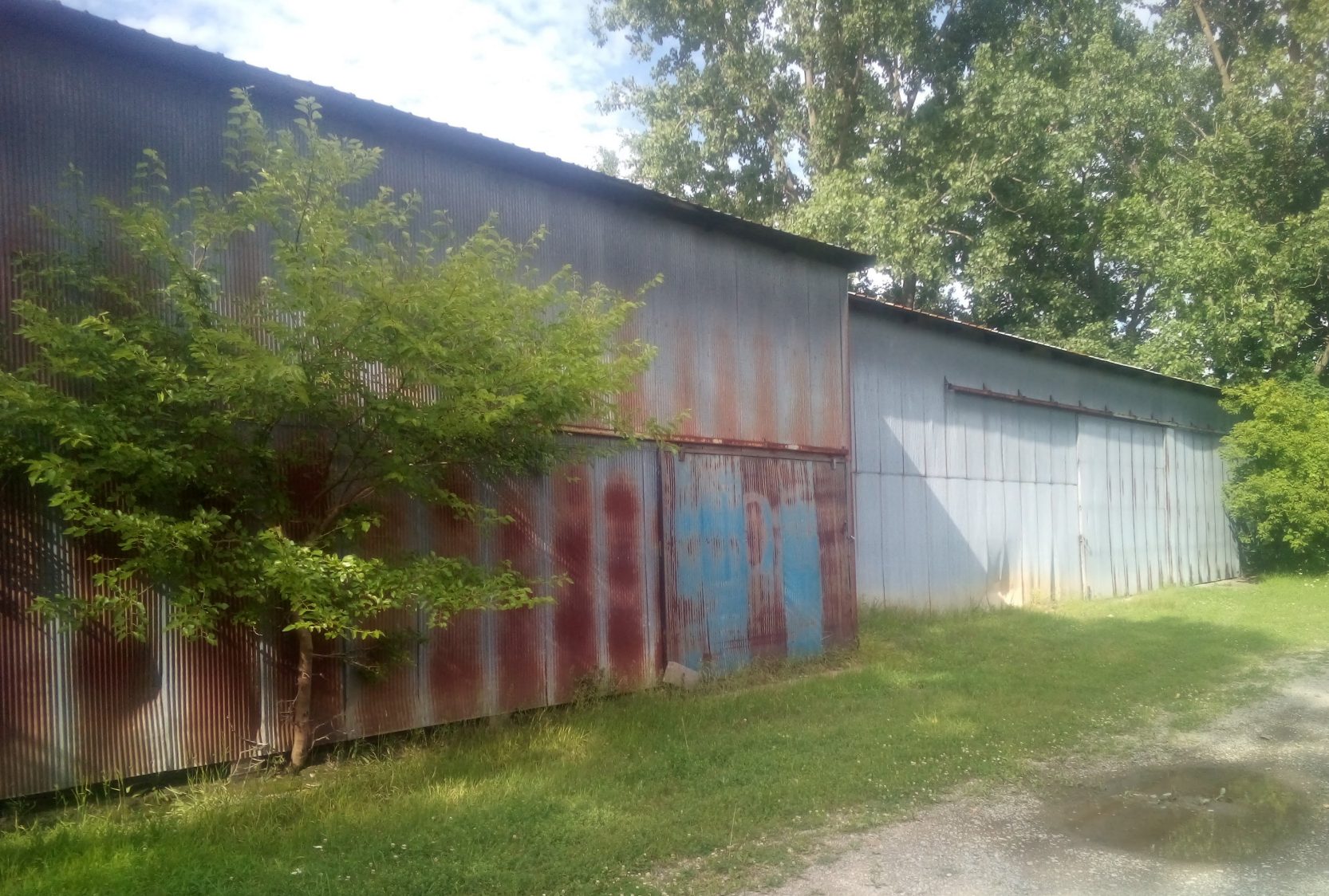
A May 2022 photo looking east at the building on the southwest side of Williams Memorial Airport, connected to the runway by a taxiway, presumably a former hangar.
Williams Memorial Airport was depicted as an abandoned airfield on the September 2018 Detroit Sectional Chart.
Thanks to Allison McCarty for pointing out this airport.
____________________________________________________
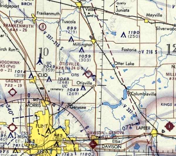
Otisville Airport / Otisville Rixport Airport, Otisville, MI
43.197, -83.546 (Northwest of Detroit, MI)
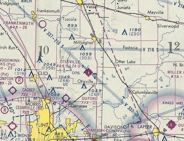
Otisville Airport, as depicted on the November 1972 Detroit Sectional Chart.
This small general aviation airport was evidently established at some point between 1970-72,
as it was not yet depicted on a 1967 aerial photo, the 1970 Detroit Sectional Chart, or the 1971 USGS topo map.
The earliest reference which has been located of Otisville Airport was in the 9/14/72 Airman's Information Manual (courtesy of Mike Denja),
which listed “Otisville Rixport” as a new airport.
The earliest depiction which has been located of Otisville Airport was on the November 1972 Detroit Sectional Chart,
which depicted Otisville as having a 2,400' unpaved runway, and to conduct parachute operations.
Otisville Airport was evidently improved with a paved runway at some point between 1972-74,
as the November 1974 Detroit Sectional Chart depicted Otisville as having a single 2,400' paved north/south runway, and to conduct parachute operations.
According to a 1984 EPA report (courtesy of Allison McCarty), the Rixport Airport site was also used as a dump, later declared a Superfund cleanup site:
“Forest Waste Disposal is a 15-acre landfill which was licensed from 1972-78 to accept general refuse & industrial wastes.
The site was also used as an airport named Rixport.”
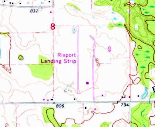
Otisville Airport was labeled “Rixport Landing Strip” on the 1975 USGS topo map.
The earliest photo which has been located of Otisville Airport was a 10/3/75 USGS aerial view.
It depicted a single paved north/south runway, with a small building & 14 light single-engine aircraft on the southeast side.
The last aeronautical chart depiction which has been located of Otisville Airport was on the May 1977 Detroit Sectional Chart,
which depicted Otisville as having a single 2,400' paved north/south runway, and to conduct parachute operations..

The last photo which has been located showing Otisville Airport in operation was a 10/20/78 aerial view (courtesy of Mike Denja).
It showed several light single-engine aircraft on the southeast side.
Otisville Airport was evidently closed (for reasons unknown) at some point between 1977-81,
as it was no longer depicted on the May 1981 Detroit Sectional Chart
and “Otisville Rixport” Airport was listed as abandoned by a 1981 NOTAM (courtesy of Mike Denja).
A 1982 aerial photo depicted Otisville Airport after its closure.
The runway & hangar remained intact, but the field was devoid of aircraft or any other sign of recent aviation use.
Allison McCarty recalled the “airport that was next door to my Grandparents' house in Otisville.
They closed it due to contamination of some sort & it was fenced off for about 10 years or so.
It was not active in the 1980s & we would walk and play back there. It was paved.”
It was still labeled “Rixport Landing Strip” on the 1990 USGS topo map.
A 2000 aerial photo showed the majority of Otisville Airport's runway pavement had been removed at some point between 1982-2000,
but the hangar remained standing on the southeast side.
Otisville / Rixport was no longer depicted on the 2014 USGS topo map.
A 2019 aerial view showed the former Otisville Airport hangar remained standing, and the alignment of the former runway was still recognizable, but all of the pavement was gone.
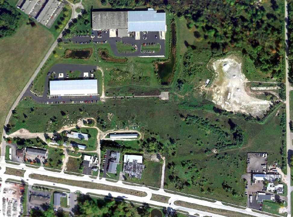
Ironically as of 2022, the property adjacent to the east of the Otisville Airport site has an aviation purpose,
as a sign at the former Otisville Airport entrance denotes “Forestville Aviators”, a model aircraft airfield.
Odd that they didn't reuse the former airport runway, but rather established operations on the adjacent land.
Thanks to Allison McCarty for pointing out this airport.
____________________________________________________
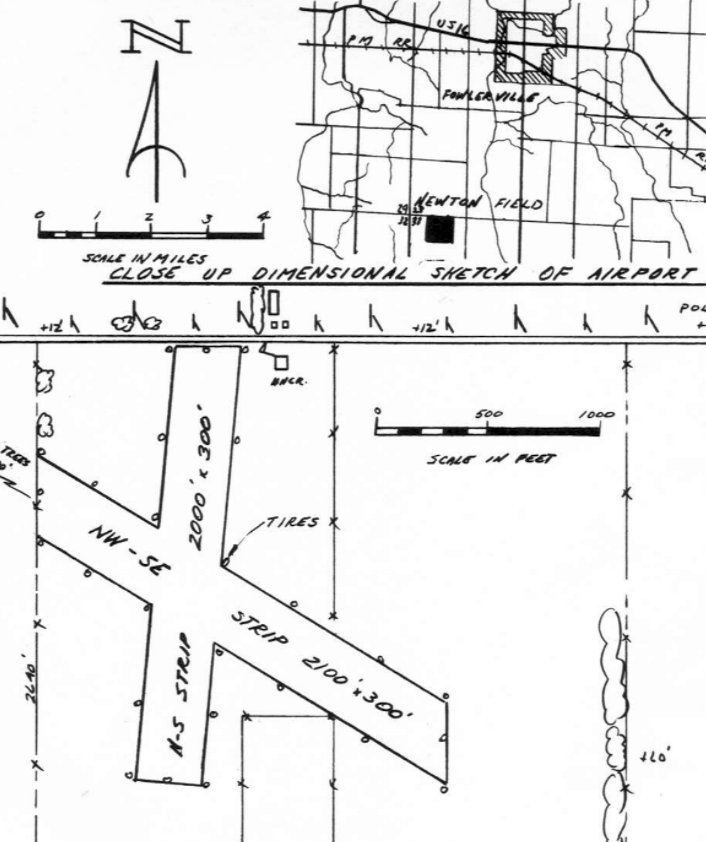
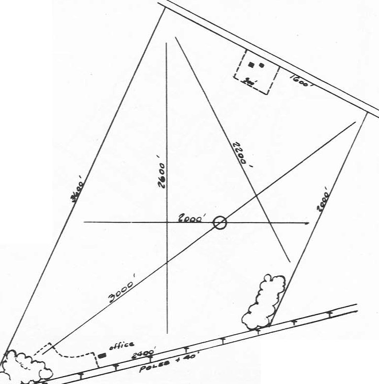
Newton Field (O86), Fowlerville, MI
42.611, -84.103 (Northwest of Detroit, MI)
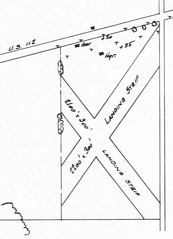
The location & layout of Newton field, as depicted in the 1947 MI Airport Directory (courtesy of Jol Silversmith).
Newton Field was evidently established at some point in 1947,
as it was not yet depicted on the June 1947 Detroit Sectional Chart.
The earliest depiction which has been located of Newton Field was in the 1947 MI Airport Directory (courtesy of Jol Silversmith).
It depicted Newton as having 2 unpaved runways, measuring 2,100' northwest/southeast & 2,000' north/south, with a small hangar on the northeast side.
The earliest aeronautical chart depiction which has been located of Newton Field was on the December 1947 Detroit Sectional Chart.
It depicted Newton as having a 2,100' unpaved runway.
An article in the 8/21/54 Lansing State Journal (courtesy of Jol Silversmith)
described how 150 light aircraft were expected to visit Newton Field for a Dawn Patrol Breakfast.
The earliest photo which has been located of Newton Field was a 1955 aerial view.
It depicted Newton as having 2 grass runways, oriented northwest/southeast & north/south, and with a small hangar on the northwest & northeast sides.
No aircraft were visible on the field.
An article in the 9/3/63 Lansing State Journal (courtesy of Jol Silversmith)
described how Newton Field would be offering free airplane rides for customers of the Kelin Fertilizer Company.
A 1970 aerial view showed Newton Field in the same configuration as the 1955 photo, but 8 light single-engine planes were visible parked on the north side.
An article in the 10/4/72 Livingston Daily Press (courtesy of Jol Silversmith)
said that Newton Field had closed the previous week, with operator Earl Peckens moving to Maple Grove Airport.
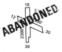
The 1974 Flight Guide (courtesy of Jonathan Westerling) depicted Newton Field as having 2 runways: 2,300' Runway 18/36 & 1,900' Runway 12/30,
and listed the operator as Fowlerville Flying Service, but showed the field to be abandoned.
A 1981 aerial view showed Newton Field after its closure, with the runways still clear but less distinct than in the 1970 photo.
The northwestern hangar had been removed at some point between 1970-81, and the field was devoid of aircraft.
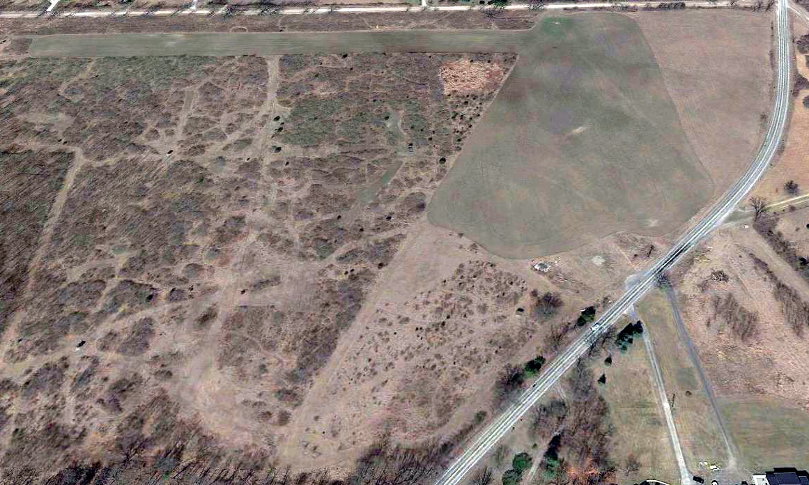
A 1998 aerial view showed Newton Field had been plowed over, with the runways no longer recognizable.
A 2018 aerial view looking southwest at the site of Newton Field showed the 2 traces remained: the Quonset hangar on the northeast side (bottom-right),
and the foundation of the other hangar on the northwest side (middle-right).
Thanks to Allison McCarty for pointing out this airport.
____________________________________________________
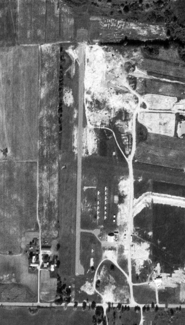
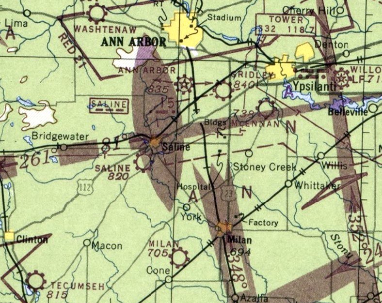
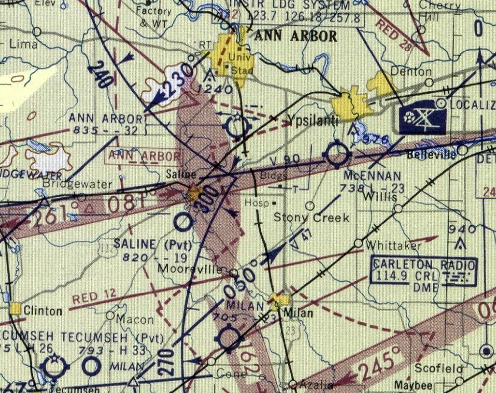
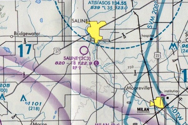
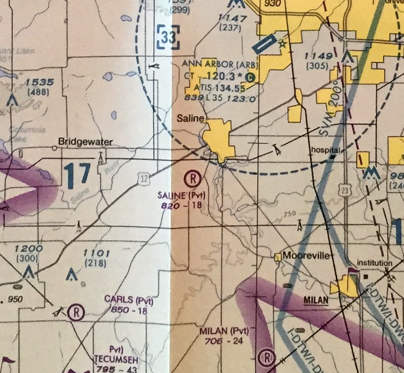
Saline Airport (2C3, 68MI), Saline, MI
42.146, -83.792 (Southwest of Detroit, MI)
Saline Airport, as depicted on the June 1948 Detroit Sectional Chart (courtesy of Mike Denja).
According to a sign on the airport office, Saline Airport was established in 1944.
Saline Airport was not yet depicted on the 1947 Detroit Sectional Chart (according to Mike Denja).
The earliest depiction which has been located of Saline Airport was on the June 1948 Detroit Sectional Chart (courtesy of Mike Denja),
which depicted Saline as a commercial/municipal airport.
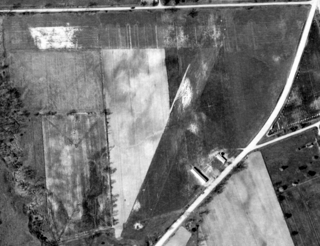
The earliest photo which has been located of Saline Airport was a 1949 aerial view (courtesy of Mike Denja).
It depicted Saline as having 2 unpaved runways, with 2 small hangars on the southeast side.
Saline Airport owner Rudulph Schumaier was killed in an Aeronca crash after departing from the airport in August 1955.
Saline Airport was still depicted on the 1958 Detroit Sectional Chart (courtesy of Mike Denja),
but its status had changed to a private airfield, with a mere 1,900' unpaved runway.
Saline Airport was no longer depicted on Sectional Charts after 1958.

A 1960 aerial view (courtesy of Mike Denja) depicted Saline Airport as mostly unchanged, but a small office had been built between the 2 hangars at some point between 1949-60.
The earliest photo which has been located showing an aircraft at Saline Airport was a 1966 aerial view (courtesy of Mike Denja).
It depicted 1 light single-engine plane parked near the hangars on the southeast side.
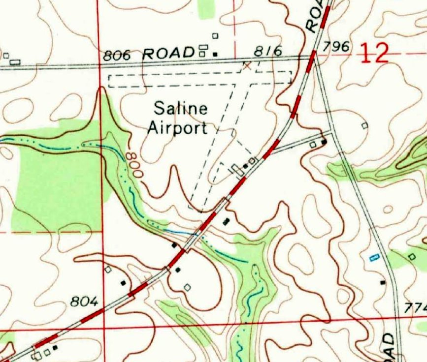
The earliest topo map depiction which has been located of Saline Airport was on the 1967 USGS topo map (courtesy of Mike Denja).
It depicted Saline as having 2 unpaved runways, with 3 small buildings on the southeast side.
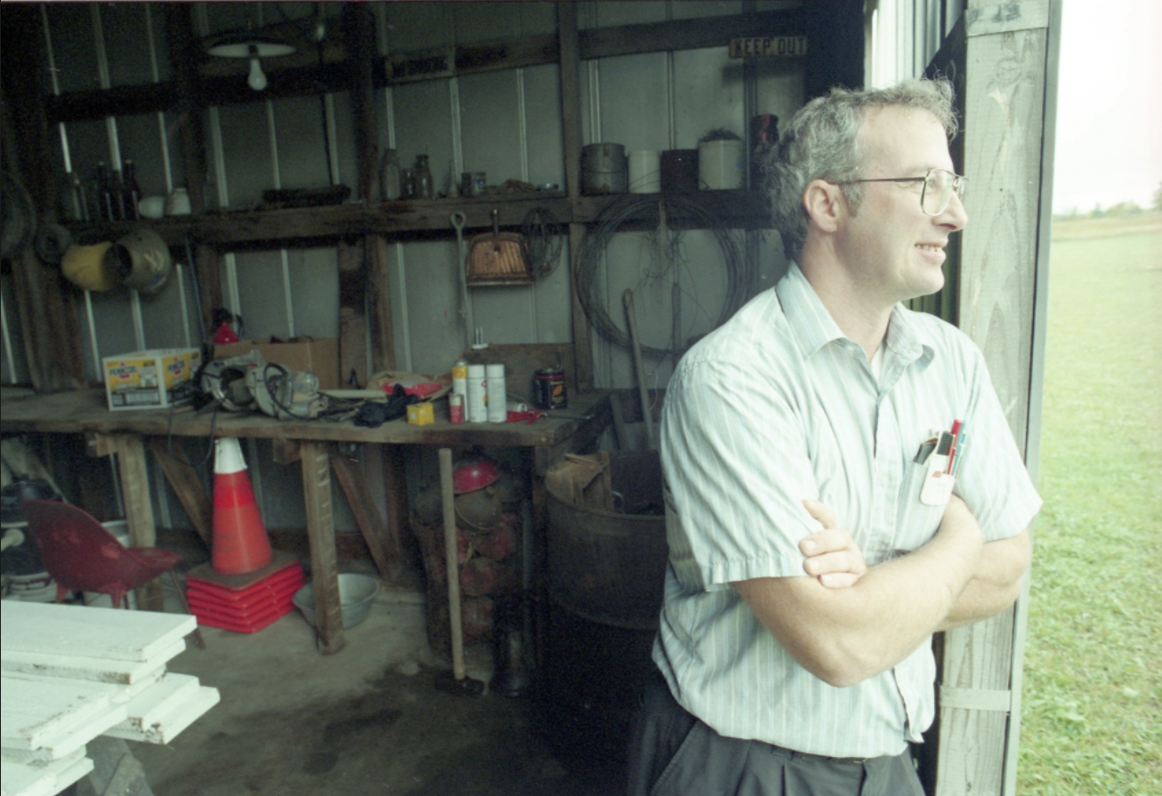
An undated photo of Saline Airport owner Terry Schumaier looking out from a hangar from a 9/30/96 article (courtesy of Mike Denja).
The article was entitled “Flight plan for an old airfield: Saline man's bid to reopen father's airport clears FAA but neighbors voice objections.”
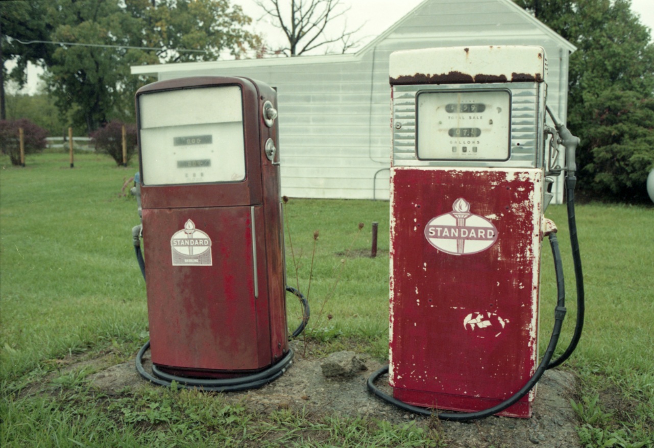
An undated photo of the Saline Airport fuel pumps from a 9/30/96 article (courtesy of Mike Denja).
The FAA Airport/Facility Directory listed Saline Airport's Activation Date as August 1996, but that was presumably when it was reopened.
It described Saline as having 2 turf runways, both “in poor condition”: 1,850' Runway 9/27 & 1,665' Runway 3/21.
The owner & manager was listed as Terence Schumaier.
The field was said to have 2 single-engine based aircraft,
and to have conducted an average of 27 takeoffs or landings per month in 1999.
Saline Airport was once again depicted on the 1999 Detroit Terminal Chart, shown as a public-use airport with an 1,800' unpaved runway.
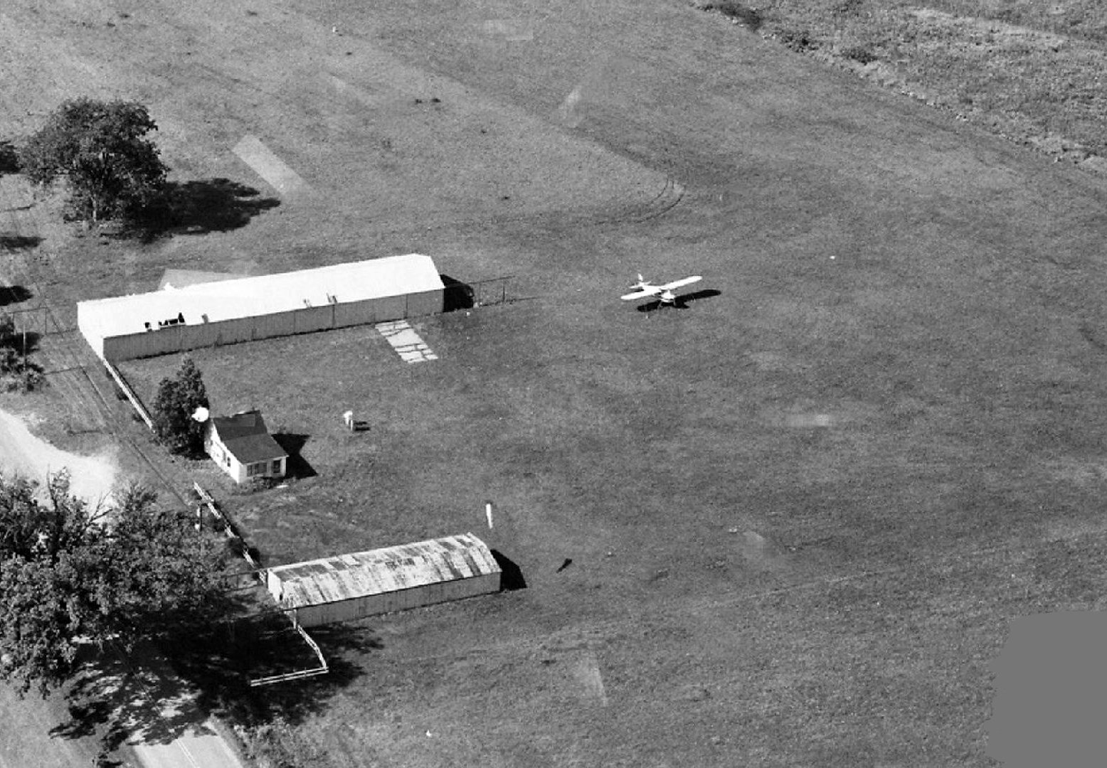
A 2000 aerial view looking west (courtesy of Mike Denja) depicted 1 light single-engine plane parked near the hangars on the southeast side of Saline Airport.
The last photo which has been located showing aircraft at Saline Airport was a 2005 aerial view looking north.
It depicted 2 light single-engine planes parked near the hangars on the southeast side.
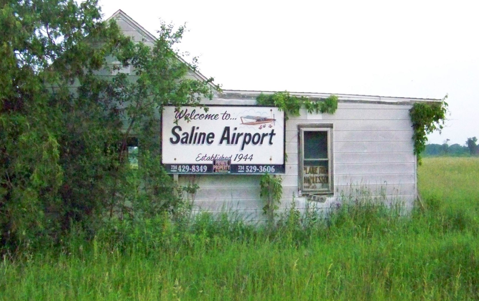
A 6/12/08 photo looking north at the Saline Airport office (courtesy of Mike Denja), showing the “Established 1944” marking.
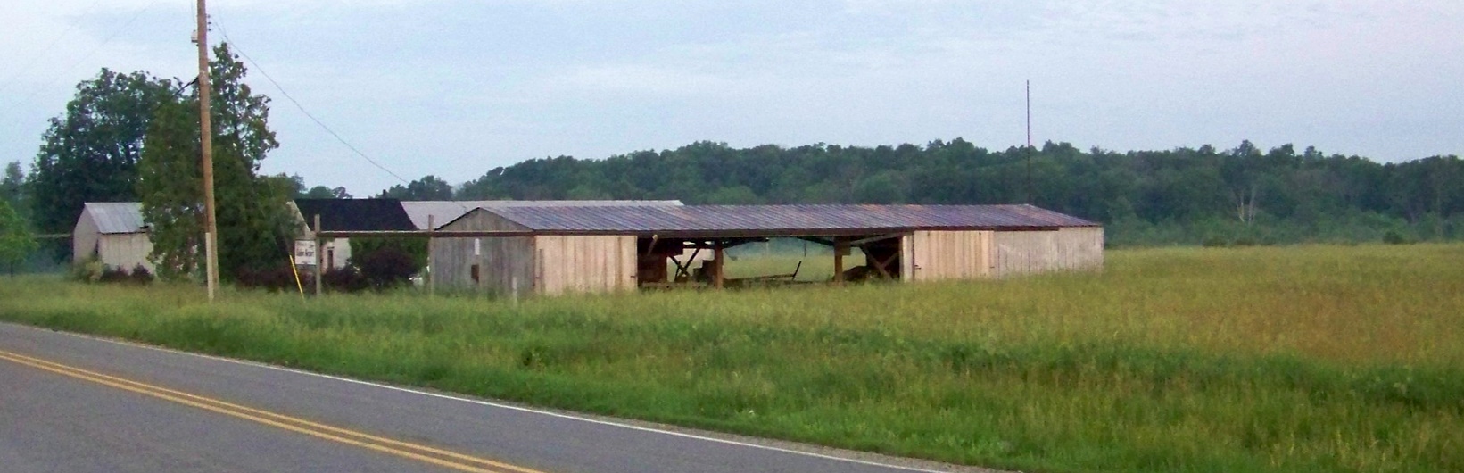
A 6/12/08 photo looking west at the Saline Airport hangars & office (courtesy of Mike Denja).
The last aeronautical chart depiction which has been located of Saline Airport was on the April 2009 Detroit Terminal Chart,
which depicted Saline as a private airfield having an 1,800' unpaved runway.
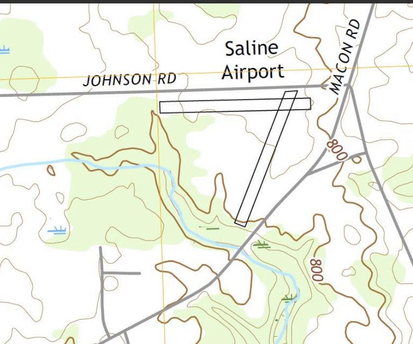
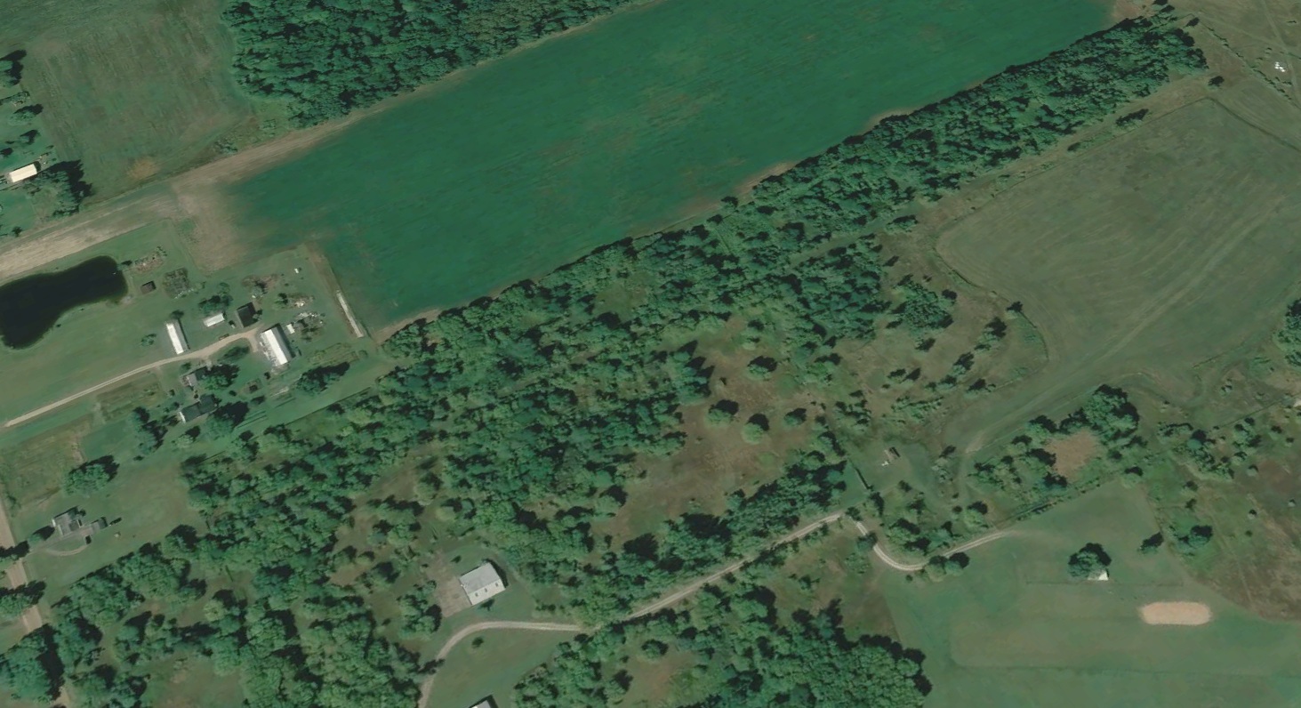
Saline Airport was still depicted on the 2019 USGS topo map (courtesy of Mike Denja), shown as having 2 runways.
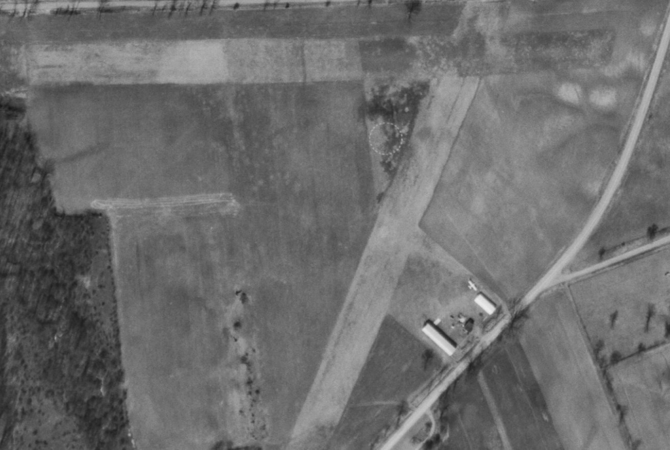
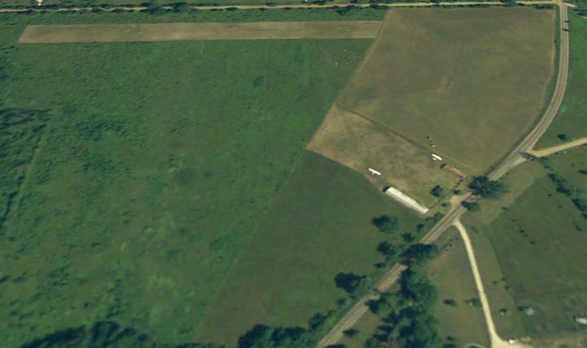
A 2020 aerial view looking north showed Saline Airport's hangars had been removed at some point between 2008-2020,
and the southern half of the northeast/southwest runway was overgrown,
but the east/west runway & the northern half of the northeast/southwest runway appeared to be regularly mowed, presumably for radio-controlled model aircraft &/or hang-glider operations.
As of 2022, the FAA Airport/Facility Directory listed Saline Airport's status as “Closed indefinitely”.
But it also remarked that radio-controlled model aircraft operate southeast of Runway 3/21, and hang-gliding was conducted on the airport.
Thanks to Mike Denja for pointing out this airport.
____________________________________________________
Newton Field (O86), Fowlerville, MI
42.611, -84.103 (Northwest of Detroit, MI)
The location & layout of Newton field, as depicted in the 1947 MI Airport Directory (courtesy of Jol Silversmith).
Newton Field was evidently established at some point in 1947,
as it was not yet depicted on the June 1947 Detroit Sectional Chart.
The earliest depiction which has been located of Newton Field was in the 1947 MI Airport Directory (courtesy of Jol Silversmith).
It depicted Newton as having 2 unpaved runways, measuring 2,100' northwest/southeast & 2,000' north/south, with a small hangar on the northeast side.
The earliest aeronautical chart depiction which has been located of Newton Field was on the December 1947 Detroit Sectional Chart.
It depicted Newton as having a 2,100' unpaved runway.
An article in the 8/21/54 Lansing State Journal (courtesy of Jol Silversmith)
described how 150 light aircraft were expected to visit Newton Field for a Dawn Patrol Breakfast.
The earliest photo which has been located of Newton Field was a 1955 aerial view.
It depicted Newton as having 2 grass runways, oriented northwest/southeast & north/south, and with a small hangar on the northwest & northeast sides.
No aircraft were visible on the field.
An article in the 9/3/63 Lansing State Journal (courtesy of Jol Silversmith)
described how Newton Field would be offering free airplane rides for customers of the Kelin Fertilizer Company.
A 1970 aerial view showed Newton Field in the same configuration as the 1955 photo, but 8 light single-engine planes were visible parked on the north side.
An article in the 10/4/72 Livingston Daily Press (courtesy of Jol Silversmith)
said that Newton Field had closed the previous week, with operator Earl Peckens moving to Maple Grove Airport.
The 1974 Flight Guide (courtesy of Jonathan Westerling) depicted Newton Field as having 2 runways: 2,300' Runway 18/36 & 1,900' Runway 12/30,
and listed the operator as Fowlerville Flying Service, but showed the field to be abandoned.
A 1981 aerial view showed Newton Field after its closure, with the runways still clear but less distinct than in the 1970 photo.
The northwestern hangar had been removed at some point between 1970-81, and the field was devoid of aircraft.
A 1998 aerial view showed Newton Field had been plowed over, with the runways no longer recognizable.
A 2018 aerial view looking southwest at the site of Newton Field showed the 2 traces remained: the Quonset hangar on the northeast side (bottom-right),
and the foundation of the other hangar on the northwest side (middle-right).
Thanks to Jol Silversmith for pointing out this airport.
____________________________________________________
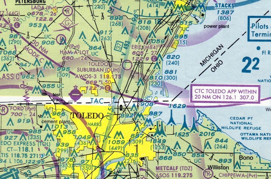
Erie Aerodrome (M84), Temperence, MI
41.782, -83.518 (South of Detroit, MI)
Erie Aerodrome, as depicted on the October 1993 Detroit Sectional Chart.
According to the 12/19/07 The Blade article “Erie Township airport has neighbors fuming” by Mark Reiter (courtesy of Bill Grasha),
Howard Crowe built Erie Aerodrome in 1979, offering aircraft repair & flight instruction.
However, Erie Aerodrome was not yet depicted on the May 1983 Detroit Sectional Chart (courtesy of Ron Plante).
The earliest depiction which has been located of Erie Aerodrome was on the October 1993 Detroit Sectional Chart.
It depicted Erie as a private airfield having a 2,700' unpaved runway.
The earliest photo which has been located of Erie Aerodrome was a 1993 USGS aerial view looking northwest.
It depicted Erie as having a single north/south grass runway, with 2 small arch-roof hangars & 2 light single-engine aircraft on the east side.
A March 1999 aerial photo (courtesy of Bill Grasha) showed Erie Aerodrome perhaps at its zenith of popularity, with 7 light planes visible on the field.
A 2003 aerial view looking northwest at Erie Aerodrome showed 2 light single-engine aircraft on the east side.
The last aeronautical chart depiction which has been located of Erie Aerodrome was on the March 2005 Detroit Sectional Chart.
It depicted Erie as a public-use airport having a 2,700' unpaved runway.
According to the 12/19/07 The Blade article “Erie Township airport has neighbors fuming” by Mark Reiter (courtesy of Bill Grasha),
“A small airport in Erie Township on East Temperance Road was a good neighbor for many years to residents who live in the shadow of its flight path.
But Erie Aerodrome became controversial nearly 3 years ago when residents learned about a MI aviator's plans for improvements on the grass strip just west of Telegraph Road.
The plans of David Germann to buy the airport & construct hangars to store airplanes, and the possibility that he can proceed with the project without township approval,
has whipped up the emotions of neighbors who surround the 30-acre airport.
The central issue in the controversy is whether planning & improvements of the airport should fall under the jurisdiction of the MI Aeronautics Commission or the township.
Erie Township trustees last week authorized township lawyer Phil Goldsmith to proceed with a lawsuit challenging the authority of the MI Aeronautics Commission to control the zoning of public-use airports in the state.
The deal that would transfer airport ownership from owner & founder Howard Crowe to Mr. Germann has been put on hold since 2005,
when Mr. Germann balked at a request from township officials to submit plans for the construction of hangars.
Officials want the operator to obtain approval for special-use permits from the township planning commission.
However, Mr. Germann contends that the permission for changes at the facility lies with the authority of the state Aeronautics Commission
because Mr. Crowe took the necessary steps years ago to have the privately owned airport registered as a public-use airport.”
The article continued, “Cheryl & Robert Martin are among the many neighbors opposed to improvements to the airport out of concerns that increased traffic could compromise safety.
Their home is about 100 feet from the runaway.”
"The aeronautics commission [is] treating it like a public or municipal airport. This is a privately owned airport that is open to the public & shouldn't have the same rights," Mrs. Martin said.
The Martins were recently accused by the state of violating federal airspace rules for planting a row of trees parallel to the runway.
Bill Frey, township supervisor, said the Aeronautics Commission would likely be named as the defendant in the complaint,
not the prospective owner of the airport, and it would seek to get a declaratory judgment to determine if the township controls jurisdiction of the airstrip changes.
The aeronautics commission, which is under the MI Department of Transportation, oversees zoning & changes on property that impact the airspace approach of airports in the state.
Because it is classified as a public-use airport, the state commission controls changes in building height & tree plantings on the Martin property & other land near the landing approach of the Erie Aerodrome.
However, Mr. Frey said the township believes the commission has overstepped its authority & the Legislature didn't intend for the law to be applied to public-use airports that are privately owned.
A private pilot, Mr. Germann said he wants to expand on the airplane repair and flying lesson business that Mr. Crowe began in 1979 when he built the airport from scratch.
The hangars that he wants to build would be rented to provide income for the business.
"I like old airports. I am not a developer. I am not expanding the airport or lengthening the runway. I simply want to put up storage units to put airplanes in," he said.
Mr. Crowe, 69, bought the land in 1979 & obtained the necessary zoning approval. He moved dirt & graded the land to construct the landing strip & erected 2 buildings.
Mr. Crowe is ready to retire & wants to pass the business on to a new owner.
"Mr. Germann wants to keep it going as an airport. I don't want the land plowed up & planted with corn," Mr. Crowe said.
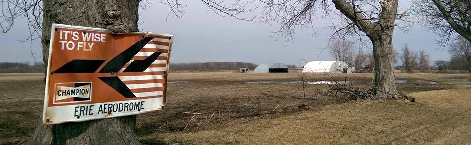
A 7/21/15 photo by David Martin of the sign for Erie Aerodrome, with its hangars visible in the background.
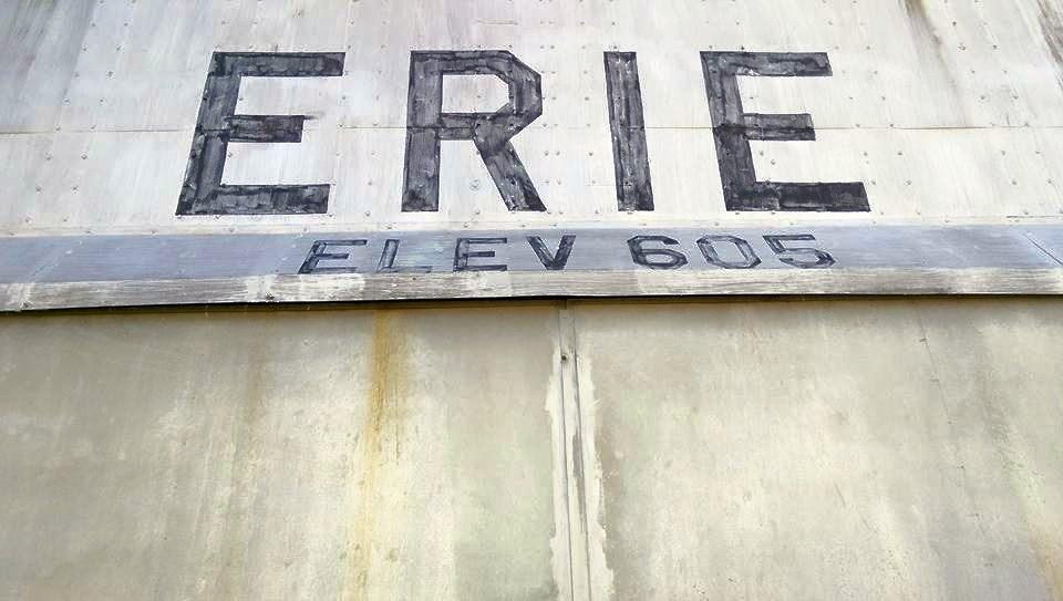
A 7/21/15 photo by David Martin of an Erie Aerodrome hangar.
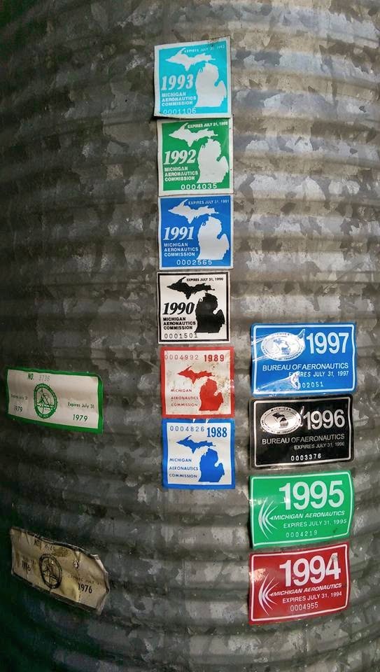
A 7/21/15 photo by David Martin of MI Aeronautics Commissions certificates on an Erie Aerodrome hangar.
The last photo which has been located showing a plane at Erie Aerodrome was a June 2011 aerial view.
Erie Aerodrome was evidently closed at some point between 2011-2014, as the runway appeared to be plowed in a May 2014 aerial photo,
and it was no longer depicted on the September 2016 Detroit Sectional Chart.
A 2018 aerial view looking northwest at the site of Erie Aerodrome showed the 2 arch-roof hangars remained on the east side, but the grass runway had been plowed.
Thanks to Bill Grasha for pointing out this airport.
____________________________________________________
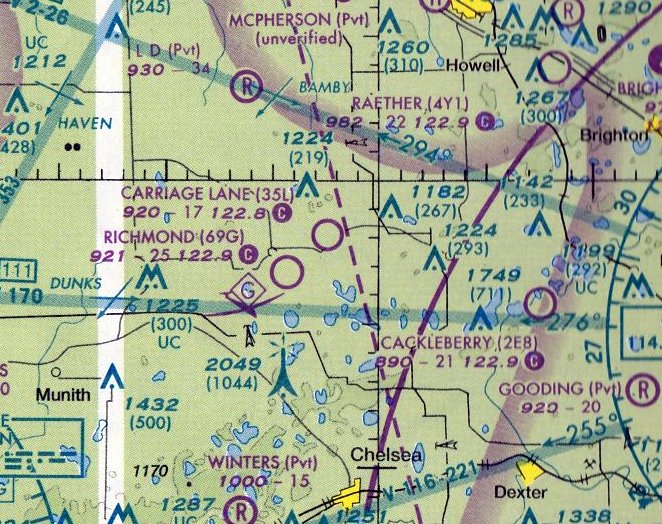
Carriage Lane Airport (35L), Unadilla Township, MI
42.465, -84.035 (West of Detroit, MI)
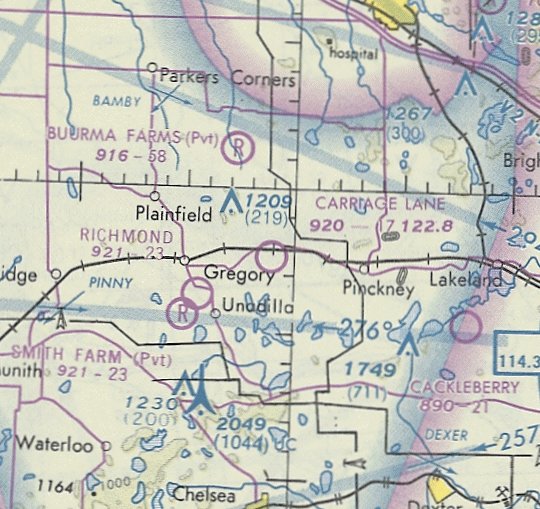
Carriage Lane Airport, as depicted on May 1981 Detroit Sectional Chart.
Carriage Lane Airport was not yet depicted on a 1970 aerial view,
or on the 1973 USGS topo map (or any subsequent topo maps either).
According to a 9/6/98 Livingston County Daily Press article (courtesy of Bill Grasha),
Carriage Lane Airport was opened in the early 1970s by Robert Poss.
The depiction which has been located of Carriage Lane Airport was on the May 1981 Detroit Sectional Chart.
It depicted Carriage Lane Airport as having a mere 1,700' unpaved runway.
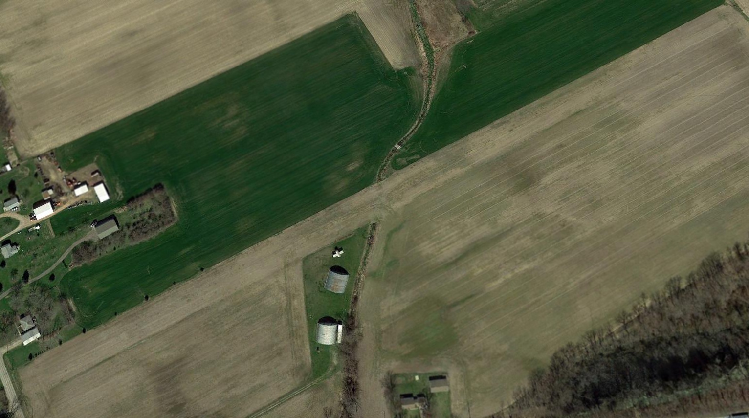
The earliest photo which has been located of Carriage Lane Airport was a 1981 aerial view.
It depicted Carriage Lane Airport as having a northeast/southwest grass runway, with a few buildings & 3 light single-engine aircraft on the northwest side.
The earliest photo which is available of Carriage Lane Airport was a 1983 aerial view looking northwest.
It depicted 4 light single-engine aircraft, along with the silo with observation windows.
A 1996 USGS aerial view looking southeast depicted Carriage Lane Airport as having a northeast/southwest grass runway, with a few buildings & 3 light single-engine aircraft on the northwest side.
Tragically, Carriage Lane Airport founder Robert Poss was murdered in 1998, as reported in a 6/28/98 Livingston County Daily Press article (courtesy of Bill Grasha).
Aerial views from the next few years show the Carriage Lane Airport remained intact, but the airport was devoid of planes.
An advertisement to sell Carriage Lane Airport ran in the 3/24/99 Livingston County Daily Press (courtesy of Bill Grasha).
Bill Grasha reported, “Similar adds ran from June through August of 2004.”
The last aeronautical chart depiction which has been located of Carriage Lane Airport was on the March 2005 Detroit Sectional Chart.
It depicted Carriage Lane Airport as having a mere 1,700' unpaved runway.
Bill Grasha observed that efforts to sell Carriage Lane Airport “must not have had any takers, as the runway started to be degraded in 2006.”
Carriage Lane Airport was evidently closed by 2009, as a 2009 aerial view showed a driveway for a new house had been built over the center of the former runway.
Carriage Lane Airport was no longer depicted on the September 2016 Detroit Sectional Chart.
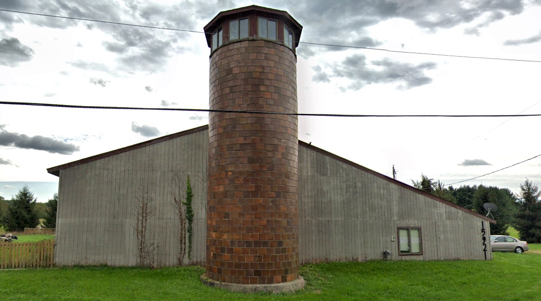
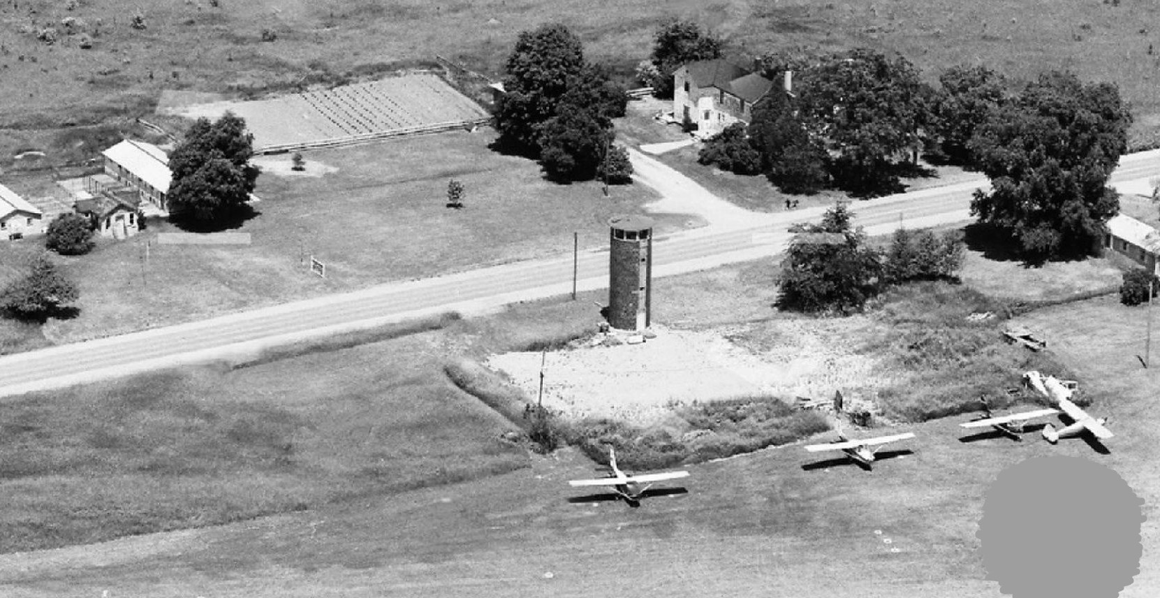
A September 2018 photo (courtesy of Bill Grasha) of the former Carriage Lane Airport hangar, with the adjacent silo with its unique 360-degree observation booth at its top.
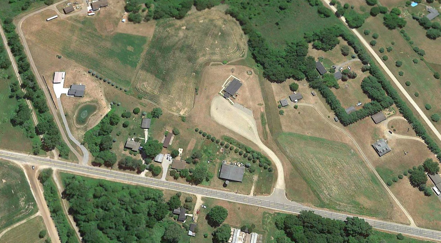
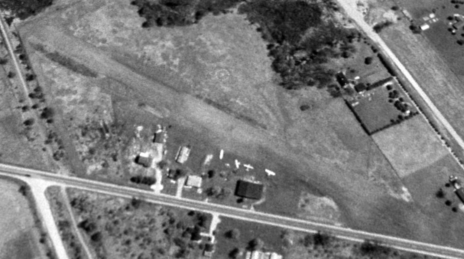
A 2018 aerial view looking southeast showed the orientation of the former Carriage Lane Airport runway was still recognizable.
The hangar with its adjacent silo remained along the northwest side (bottom-center of photo).
Thanks to Bill Grasha for pointing out this airport.
____________________________________________________
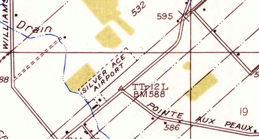
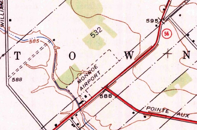
Silver Ace Airport / Monroe Airport / Marshall Airport, Monroe, MI
41.957, -83.301 (South of Detroit, MI)
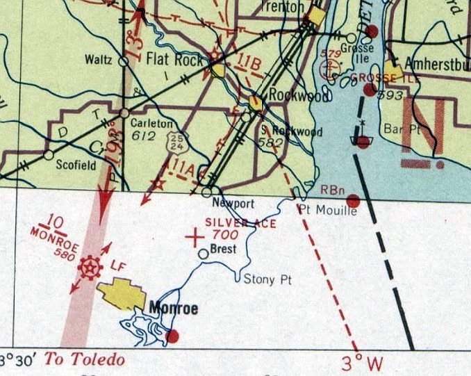
Silver Ace Airport, as depicted on the December 1935 Sectional Chart (courtesy of Mike Denja).
The date of establishment of Silver Ace Airport has not been determined.
The earliest reference which has been located to Silver Ace Airport was its listing in the 1931 Commerce Department Airway Bulletin (courtesy of Mike Denja).
It described Silver Ace Airways Airport as a private airfield consisting of a 1,800' x 500' rectangular sod field.
A 1933 article (courtesy of Mike Denja) said “Herbert Stigman & L. Mercure have formed a partnership to operate the Silver Ace airport, 5 miles north of Monroe.”
The earliest depiction which has been located of Silver Ace Airport was on the December 1935 Sectional Chart (courtesy of Mike Denja).
It depicted Silver Ace Airport as an auxiliary airfield.
The earliest topo map depiction which has been located of Silver Ace Airport was on the 1936 USGS topo map (courtesy of Mike Denja).
It depicted Silver Ace Airport as a northeast/southwest oriented property outline, with 2 small buildings on the southwest side.
Silver Ace Airport may have been closed (presumably due to the effects of the Depression) at some point between 1935-38,
as it was not depicted on the 1938 or 1940 Cleveland Sectional Charts.
The airport was evidently reopened as Monroe Airport at some point between 1940-41,
as that is how it was labeled on the June 1941 Cleveland Sectional Chart.
The 1942 USGS topo map (courtesy of Mike Denja) depicted Monroe Airport as a northeast/southwest oriented property outline, with 2 small buildings on the southwest side.

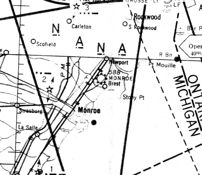
A 1942 map (courtesy of the NAS Grosse Ile web site) of NAS Grosse Ile & its auxiliary airfields depicted “Monroe Field” as being Naval Outlying Field 21712,
which indicated it was located on a heading of 217 degrees & a distance of 12 nautical miles from its parent airfield, NAS Grosse Ile.
The July 1947 Cleveland Sectional Chart depicted Monroe as a commercial/municipal airport.
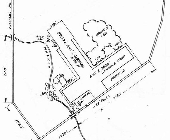
The 1947 MI Airport Directory (courtesy of Mike Denja) depicted Monroe Airport as having 2 unpaved runways, measuring 2,900' northwest/southeast & 2,600' northeast/southwest.
A hangar & a few smaller buildings were depicted on the southwest side.
The earliest photo which has been located showing aircraft at Monroe Airport was a 1949 aerial view (courtesy of Mike Denja).
It depicted 5 light single-engine aircraft on the southwest side of the field, near a few small buildings.
The field had 2 perpendicular grass runways, with an airport circle symbol at the intersection
The 1952 USGS topo map (courtesy of Mike Denja) depicted Monroe Airport as having 2 perpendicular unpaved runways, with a few small buildings on the southwest side.
The airport was evidently renamed Marshal Airport at some point between 1952-55, as that is how it was labeled on the January 1955 Cleveland Sectional Chart.
It depicted Marshall as having a 2,900' unpaved runway.
A 1961 aerial view (courtesy of Mike Denja) depicted Marshall Airport as remaining intact, but there were no aircraft visible on the field.
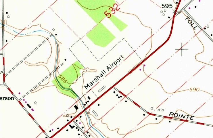
The 1971 USGS topo map (courtesy of Mike Denja) depicted Marshall Airport as having 2 perpendicular unpaved runways, with a few small buildings on the southwest side.
The last photo which has been located showing aircraft at Marshall Airport was a 1973 aerial view.
It depicted a sole light single-engine aircraft on the southwest side of the field, near a few small buildings.
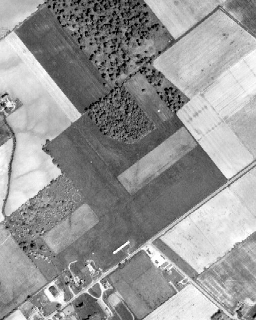
Marshall Airport was evidently closed (for reasons unknown) at some point between 1973-93,
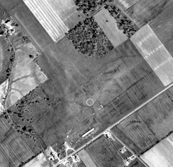
as a 1993 aerial view showed that the runways remained clear, but the hangars had been removed, and the field was devoid of aircraft.
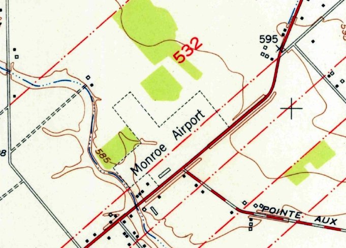
A 2000 aerial view showed residential streets having been built over the site of Marshall Airport.
Yet another of hundreds of small American grassroots airports consumed by our never-ending need for more housing.
Mike Denja observed, “The neighborhood they built there has all streets named after WW2-era aircraft & the main street is named Marshall Field after the last name of the airport.”
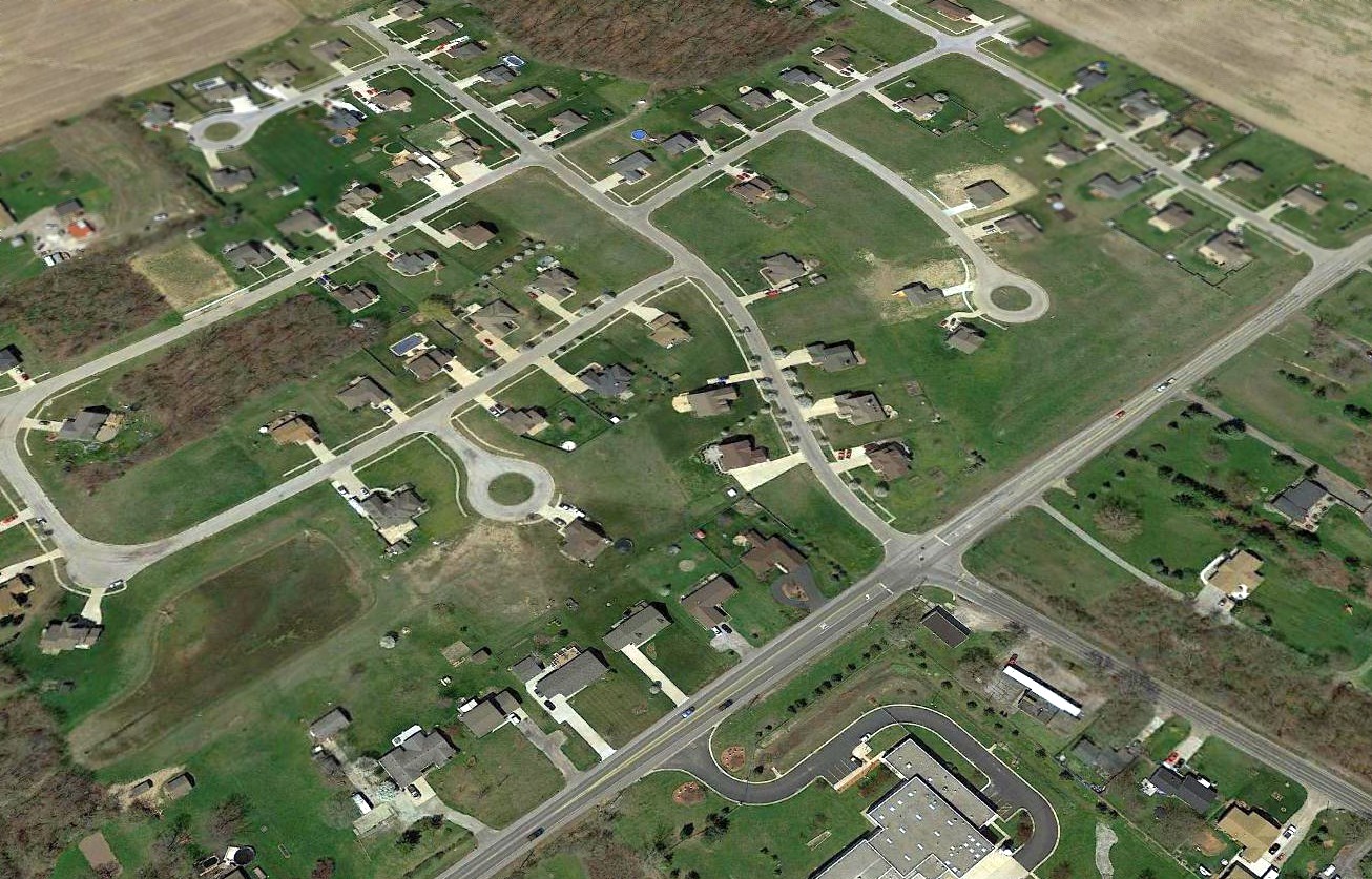
A 2016 aerial view showed no trace remaining of Marshall Airport.
____________________________________________________
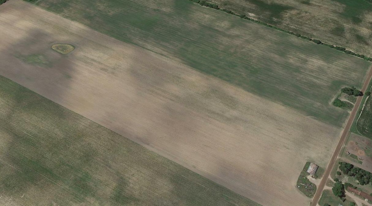
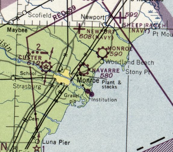
41.932, -83.351 (South of Detroit, MI)
Navarre Field, as depicted on a 1942 map (courtesy of the NAS Grosse Ile web site) of NAS Grosse Ile & its auxiliary airfields.
The date of establishment of this small airport has not been determined.
Navarre Airport was not yet depicted on the October 1942 Cleveland Sectional Chart.
The earliest depiction which has been located of Navarre Airport was on a 1942 map (courtesy of the NAS Grosse Ile web site) of NAS Grosse Ile & its auxiliary airfields.
It depicted “Navarre Field” as being Naval Outlying Field 22115,
which indicated it was located on a heading of 221 degrees & a distance of 15 nautical miles from its parent airfield, NAS Grosse Ile.
Brian Rehwinkel reported, “Navarre Airport was first leased by the Navy in 1942 as one of 16 outlying fields for NAS Grosse Ile.
According to Navy records, the Navy leased 107 acres from the Navarre family for use as an Outlying Field.
According to Navy records, the lands had been agricultural land & it is unlikely this had been an airport prior to Navy use.”

A 1943 Navy map of NAS Grosse Ile Outlying Fields (from the National Archives, courtesy of Brian Rehwinkel) depicted Navarre Airport as a 107 acre irregularly-shaped property.

The earliest photo which has been located of Navarre Airport was a 10/6/43 aerial view looking north (courtesy of Brian Rehwinkel).
It depicted Navarre as an irregularly-shaped grass airfield, with an airfield circle marking in the center.
Brian Rehwinlel observed, “If you look in the lower-right of the field, you see a pylon. Normally, there would be 3 pylons (spread apart) forming a triangle. I am not sure what a single pylon would have been used for at this field.”
Brian Rehwinkel reported, “After primary training was discontinued at NAS Grosse Ile in late 1944, the leases for many of the fields were canceled over the next several months.”
Navarre Airport was still not yet depicted on the June 1945 Cleveland Sectional Chart.
The earliest aeronautical chart depiction which has been located of Navarre Airport was on the July 1947 Cleveland Sectional Chart.
The 1947 MI Airport Directory (courtesy of Bill Grasha) depicted Navarre Airport as having 4 unpaved runways, with the longest measuring 3,000' northeast/southwest.
An office was depicted on the southwest side.
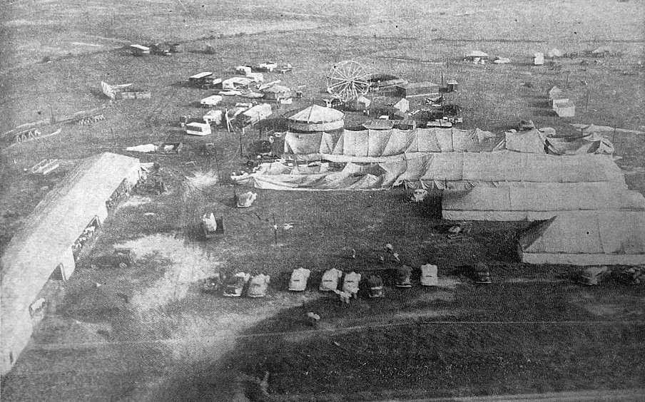
An 8/21/47 aerial view of Navarre Airport, showing damage which occurred the night before when a windstorm damaged some tents set up on the airport property for the 1947 Monroe County Fair (courtesy of David Eby).
A hangar is visible at bottom-left.
The earliest photo which has been located showing aircraft at Navarre Airport was a 1949 aerial view (courtesy of Mike Denja).
It depicted Navarre as having 2 grass runways, with a few small buildings & 6 light single-engine aircraft on the southwest side.
The last photo which has been located showing Navarre Airport in operation was a 1951 aerial view (courtesy of Mike Denja).
It depicted Navarre as having 2 grass runways, with a few small buildings & 6 light single-engine aircraft on the southwest side.
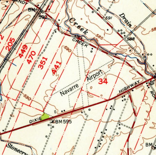
The 1952 USGS topo map depicted Navarre Airport as having 2 unpaved runways, with 3 small buildings on the southwest side.
The last aeronautical chart depiction which has been located of Navarre Airport was on the January 1955 Cleveland Sectional Chart.
It depicted Navarre as having a 3,000' unpaved runway.
Navarre Airport was evidently closed (for reasons unknown) at some point between 1955-58,
as it was no longer depicted on the January 1958 Cleveland Sectional Chart.
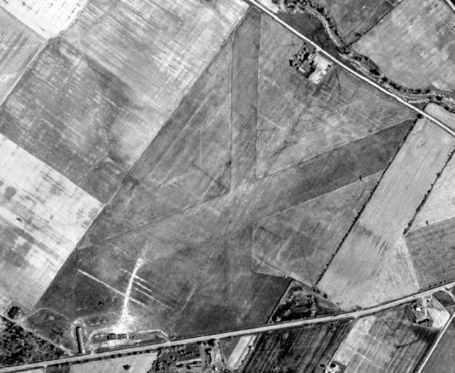
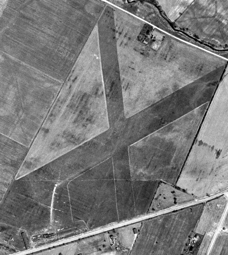
A 1964 aerial view showed no trace of Navarre Airport's runways, with the land having been returned to cultivation.
A 2016 aerial view showed no trace remaining of Navarre Airport.
Thanks to Bill Grasha for pointing out this airfield.
____________________________________________________
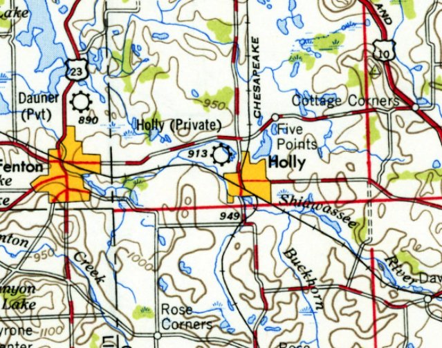
42.8, -83.633 (Northwest of Detroit, MI)
Holly Airport, as depicted on the July 1947 Detroit Sectional Chart.
This small airport was evidently one of the hundreds of airports established in the post-WW2 American general aviation boom,
and was established at some point between 1943-47,
as it was not yet depicted on the October 1943 Detroit Sectional Chart.
The earliest depiction which has been located of Holly Airport was on the July 1947 Detroit Sectional Chart.
The 1947 MI Airport Directory (courtesy of Bill Grasha) depicted Holly Airport as having 2 unpaved runways, measuring 1,850' north/south & 1,800' east west.
A small hangar was depicted on the northwest side, and an office & another small building on the southeast side.
The only photo which has been located showing Holly Airport in operation was a 5/6/49 Detroit Edison aerial view (courtesy of Bill Grasha).
It depicted a single-engine light plane parked near a hangar on the southeast side.
An airport circle marking was visible just northeast of the intersection of the 2 grass runways.

The last aeronautical chart depiction which has been located of Holly Airport was on the 1949 Detroit Sectional Chart.
It depicted Holly as having a mere 1,800' unpaved runway.
Holly was depicted as a private airfield on the 1954 USGS topo map.
Holly Airport was evidently closed at some point between 1949-57,
as the 5/6/57 Detroit Edison aerial view (according to Bill Grasha) depicted several homes on the site.
Yet another of hundreds of small American grassroots airports to fall victim to the insatiable appetite for housing.
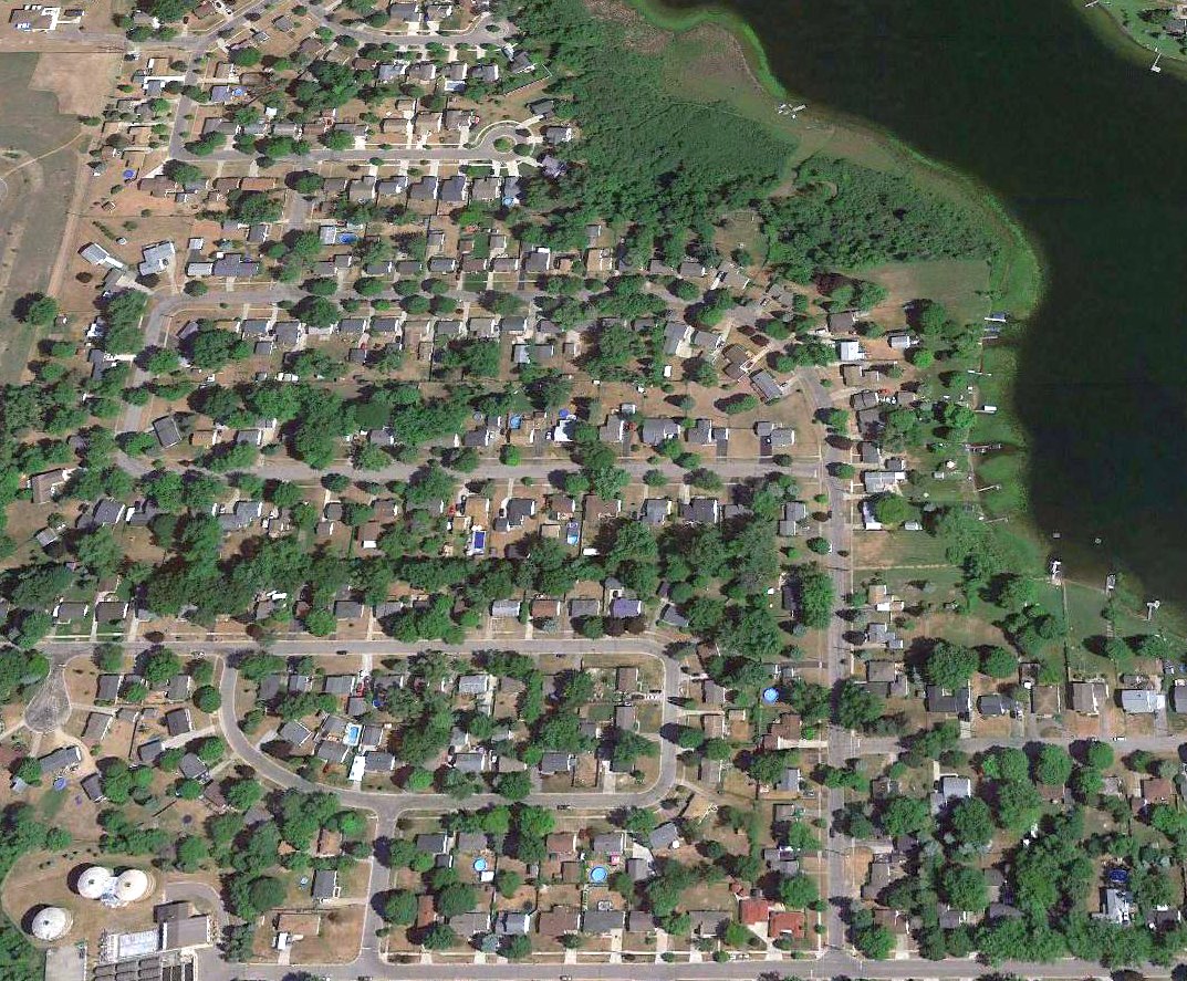
A 2016 aerial view showed no trace remaining of Holly Airport.
The only remaining clue to the existence of Holly Airport comes from the name of the residential street along the airport site's southern edge: Airport Drive.
Thanks to Bill Grasha for pointing out this airfield.
____________________________________________________
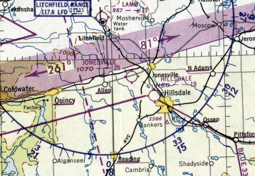
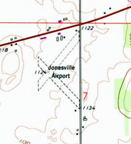
Jonesville Airport / Merchant Field (6D3), Jonesville, MI
41.967, -84.703 (West of Detroit, MI)
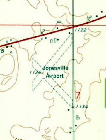
Jonesville Airport, as depicted in the 1947 MI Airport Directory (courtesy of Mike Denja).
According to “150 Years in the Hills & Dales: A Bicentennial History of Hillsdale County” by Milton Ferguson (courtesy of Mike Denja),
Jonesville Airport “was opened in 1946.”
However Jonesville Airport was not yet depicted on the December 1946 Chicago Sectional Chart (courtesy of Ron Plante).
The earliest depiction which has been located of Jonesville Airport
was in the 1947 MI Airport Directory (courtesy of Mike Denja).
Jonesville Airport was depicted as having 2 unpaved runways, measuring 2,200' northeast/southwest & 2,100' northwest/southeast.
A hangar & another building were depicted on the north side.
The earliest photo which has been located of Jonesville Airport was a photo from the 6/30/47 Ann Arbor News (from the Ann Arbor Library, courtesy of Mike Denja) captioned “THE DAWN PATROL:
More than 100 planes visited the airport of little Jonesville Sunday when the community near Hillsdale played host to the Dawn Patrol.
Eleven planes & 24 fliers came from Ann Arbor, forming the largest contingent representing any city there.
Some of the small craft are shown lined up at the Jonesville airport. The picture was taken by Maitland LaMott, an Ann Arbor News photographer, who with a reporter accompanied the Ann Arbor aviation enthusiasts.
Dawn Patrols visit a different community each Sunday, taking off early in the morning & returning usually before noon.”
The earliest aeronautical chart depiction which has been located of Jonesville Airport was on the November 1950 Chicago Sectional Chart.
It depicted Jonesville as having a 2,500' unpaved runway.
The earliest aerial view which has been located of Jonesville Airport was a 4/26/58 USGS aerial photo (courtesy of Mike Denja).
It depicted Jonesville Airport as having 2 unpaved runways, with a few small buildings on the north side.
There were no aircraft visible on the field.
The 1959 USGS topo map depicted Jonesville Airport as having 2 unpaved runways, with a few small buildings on the north side.
The last photo which has been located of Jonesville Airport was a 1963 aerial view looking southeast (courtesy of Mike Denja).
It depicted Jonesville Airport as having 2 hangars on the north side, one with the airport's name on its roof.
There were no aircraft visible on the field.
According to “150 Years in the Hills & Dales: A Bicentennial History of Hillsdale County” by Milton Ferguson (courtesy of Mike Denja),
as of 1976 the airport 2 miles west of Jonesville was known as Merchant Field,
and was still being used by several planes.
The 1979 USGS topo map continued to depict Jonesville Airport in an unchanged manner.
The last aeronautical chart depiction which has been located of Jonesville Airport was on the May 1981 Detroit Sectional Chart.
It depicted Jonesville as having a 1,900' unpaved runway.
The last reference which has been located to Jonesville Airport was in the 1983 AOPA Airports USA directory (courtesy of Jonathan Westerling).
It described Jonesville as a private airfield having a 2,000' turf Runway 5/23.
Jonesville Airport was evidently closed (for reasons unknown) at some point between 1983-93,
as it was no longer depicted on the October 1993 Detroit Sectional Chart.
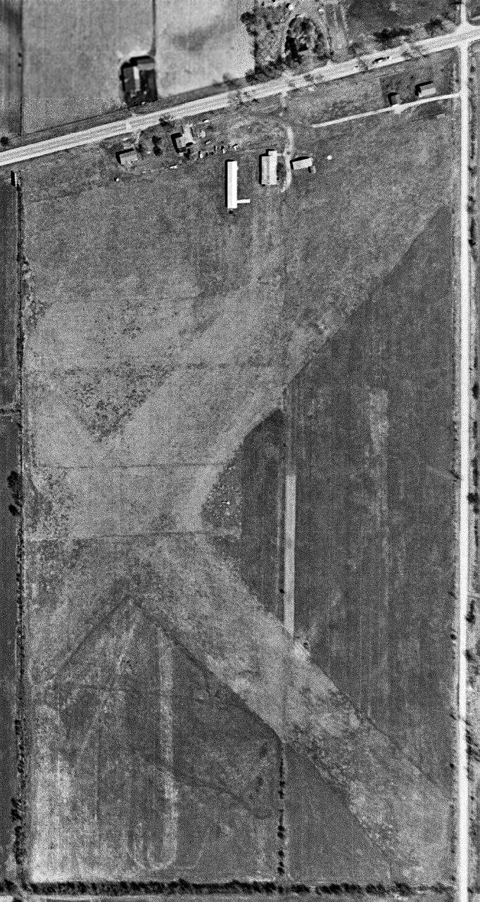
A 1998 USGS aerial photo showed no signs remaining of Jonesville Airport's runways, with the landing having been returned to cultivation,
but the former airport buildings remained on the north side of the site.
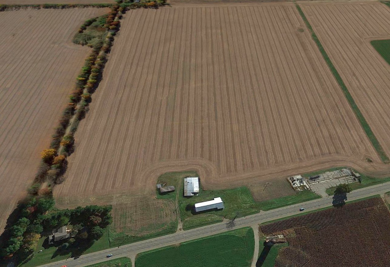
A 2016 aerial view looking south showed that a few small buildings remained on the north side of the Jonesville Airport property,
but there was no trace remaining of the runways.
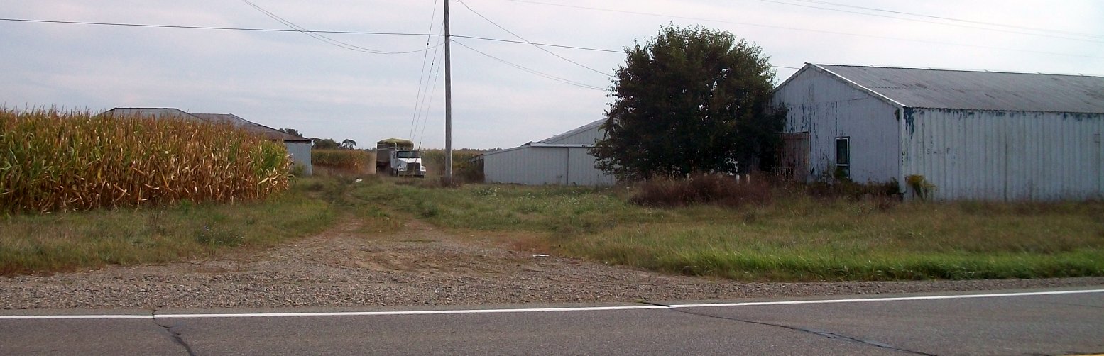
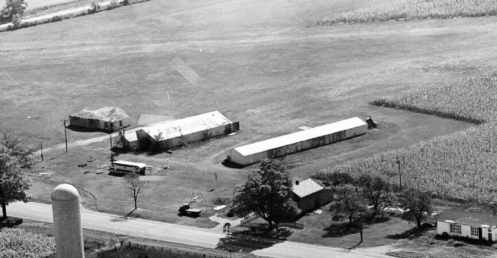
A 2017 photo by Jon Lanius looking south at the 3 remaining Jonesville Airport hangars.
A 2017 photo by Jon Lanius of a remaining Jonesville Airport hangar.
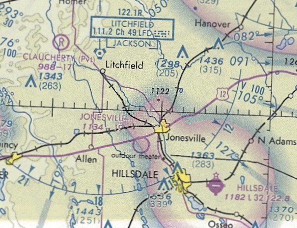
The site of Jonesville Airport is located southwest of the intersection of Route 12 & Wise Road.
Thanks to Jon Lanius for pointing out this airfield.
____________________________________________________
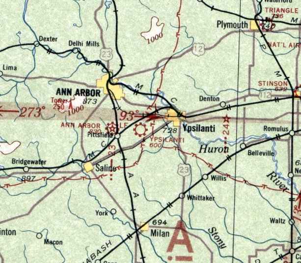
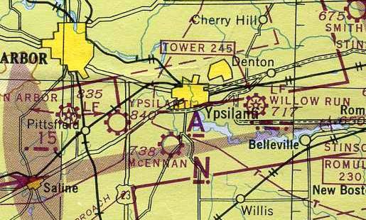
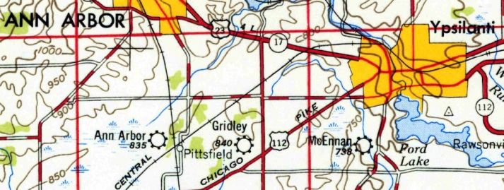
Ypsilanti Airport / Gridley Airport, Ypsilanti, MI
42.218, -83.684 (Southwest of Detroit, MI)
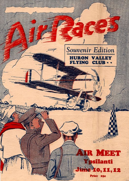
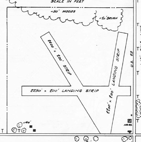
The cover of a program for the 1927 Air Races & Air Meet held at Ypsilanti Airport.
According to the Ypsilanti Historical Society's Winter 2008 Ypsilanti Gleanings (courtesy of Mike Denja),
“On 7/27/26 a group of 20 men interested in the possibility of an airfield near Ypsilanti listened to William Mars,
an airplane manufacturer who spoke on the general developments in aviation.
Ypsilanti, Mars pointed out, was on the biggest air route in the country - New York, Cleveland, Detroit & Chicago.
Airplane factories near Ypsilanti were 6 months behind in deliveries, he contended, and prospective buyers living in Ypsilanti would place orders if a landing field were near the city.
Within 5 years government officials expected people to fly to & from their place of employment in metropolitan areas miles apart.
Airplanes were then selling at $2,400, the cost of a medium priced automobile. All that was needed was a landing strip.”
The Ypsilanti Gleanings article continued, “Land for the airport was procured at Carpenter & Morgan Roads in Pittsfield Township, by a syndicate of 30 people.
The airport included 160 acres in a field a half mile square.
At the airport a hanger was constructed, 32' wide & 114' feet long, with room enough for 4 planes.”
“It is so arranged that each plane can be wheeled into place with a large door exactly in front of each plane,” reported The Daily Ypsilanti Press of 1/24/27.
The Ypsilanti Gleanings article continued, “The Ypsilanti City Airport was dedicated with 3 days of events at the airport on June 10-12, 1927.
Some 2,500 people watched as the program began with an aerial parade which was followed by a speed race around the field.
Planes raced that day at over 80 mph. The next day, the planes raced at speeds of over 100 mph.
Each day included a dead-stick landing contest & a parachute drop.”
“The program closed with a double parachute drop, Robert Manier & Leon Snyder leaping simultaneously from planes while at an altitude of 1,500'.
Snyder, who had given the parachute drop the 2 preceding days, Sunday landed on the field.
The wind the days before drove him beyond the landing field, into fields across the road from the airport,” reported The Daily Ypsilanti Press of 6/13/27.
“Leaders in aviation in Michigan who attended the meet here credit Ypsilanti with having carried out one of the few successful air meets so far held in the state.
Pilots expressed appreciation of the courtesies extended them & entertainment provided.
The crowd proved enthusiastic & intelligently interested in aviation & the program was not marred by mishaps or controversies.
In addition to proving constructive as well as interesting, the meet was a financial success,” noted the account.
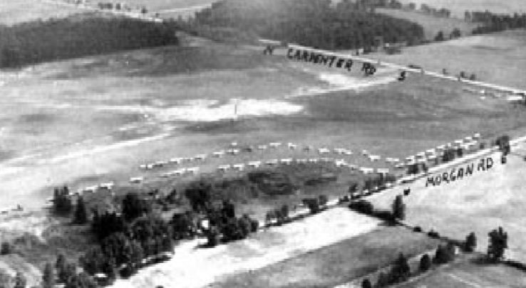
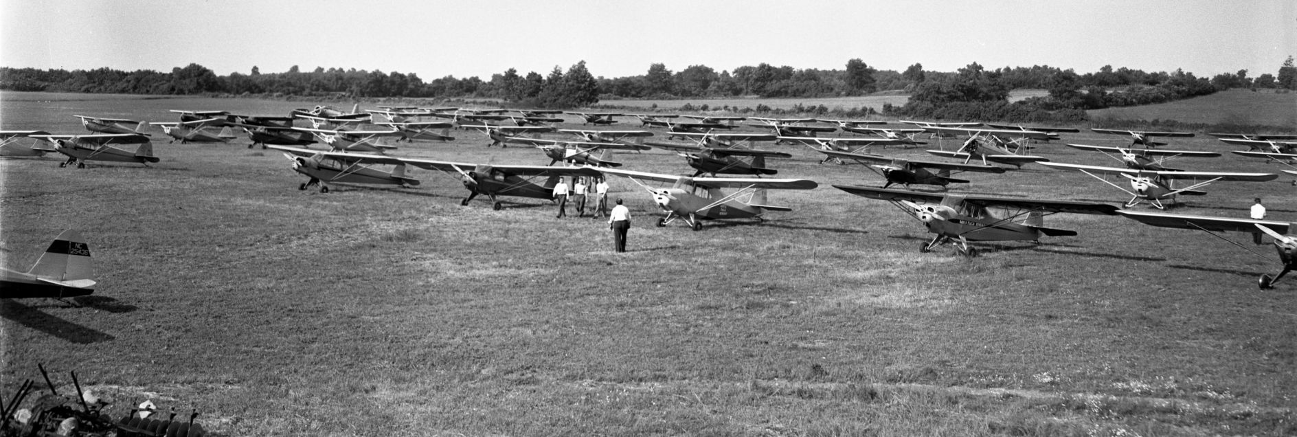
An undated aerial view by Lucy Gridley looking northeast depicted a huge number of aircraft at Ypsilanti Airport, presumably for the 1927 Air Meet.
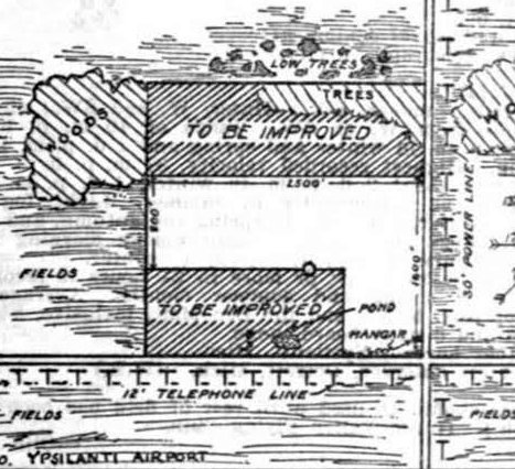
The 1928 Commerce Department Airway Bulletin (courtesy of Mike Denja) depicted Yipslanti Airport as an L-shaped property measuring 2,500' east/west,
with a single hangar on the southeast corner.
Additional areas to the southwest & north were labeled as “To be improved”.
Ypsilanti Airport was chosen to host air mail service in 1929.
According to the Ypsilanti Historical Society's Winter 2008 Ypsilanti Gleanings (courtesy of Mike Denja),
“Charles Lindbergh & his wife, Ann Morrow, landed at the Ypsilanti City Airport on 9/1/30, in their Lockheed plane.
The two were making a coast-to-coast tour & stopped in at Ypsilanti to visit Alexander Ruthven, President of the University of Michigan.”
“In keeping with the Lindbergh policy of private trips for brief visits,
the ship was set down here with no advance word of the arrival & attendants at the airport failed to attach sufficient significance to the landing
to prompt local announcement of any kind,” noted The Daily Ypsilanti Press of 9/2/30.
The Ypsilanti Gleanings article continued, “The airport was made a private field on 6/10/31,
when it was purchased from the original owners by Milo & Mrs. L. W. Oliphant.”
The earliest aeronautical chart depiction which has been located of Ypsilanti Airport was on the 1931 Detroit Sectional Chart (according to Mike Denja).
The August 1933 Detroit Sectional Chart depicted Ypsilanti Airport as a commercial/municipal airport.
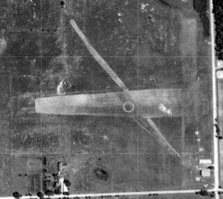
A 1940 aerial view (courtesy of Mike Denja) depicted Ypsilanti Airport as having 3 unpaved runways & a checkerboard-painted hangar on the southeast corner.
A 9/10/43 aerial view looking north from the 1945 AAF Airfield Directory (courtesy of Scott Murdock)
depicted Ypsilanti Airport as having 3 unpaved runways & a checkerboard-painted hangar on the southeast corner.
According to the Ypsilanti Historical Society's Winter 2008 Ypsilanti Gleanings (courtesy of Mike Denja),
“Milo & Mrs. L. W. Oliphant... sold the field to Dwight Reynolds in January of 1945.”
The 1945 AAF Airfield Directory (courtesy of Scott Murdock) described Ypsilanti Airport
as a 107 acre rectangular-shaped property having 3 loam runways, the longest being the 2,400' northwest/southeast strip.
The field was said to have 2 hangars, the largest being a 100' square metal structure,
and the field was described as being owned & operated by private interests.
The May 1945 Detroit Sectional Chart depicted Ypsilanti as a commercial/municipal airport.
According to the Ypsilanti Historical Society's Winter 2008 Ypsilanti Gleanings (courtesy of Mike Denja),
“The airport was sold in August of 1946 to Donald & Lucy Gridley.”
The airport was evidently renamed Gridley Airport at some point between 1945-47,
as that is how it was listed in the 1947 MI Airport Directory (courtesy of Mike Denja).
Gridley was depicted as having 3 unpaved runways, the longest being the 2,400' northwest/southeast strip.
Three 2 hangars were depicted on the southeast corner.
A photo from the 7/26/47 Ann Arbor News (from the Ann Arbor Library, courtesy of Mike Denja) captioned “FATHER, SON TAKE TO AIR:
Allen Sherzer & his son, Jack, 20 form a sizeable contribution to aviation circles in Washtenaw County, where they are one of the few father-&-son flying combinations.
The father, a former University of Michigan professor of mechanical engineering, became a licensed pilot last year, and Jack is working now for his private license.
The plane, a new Piper Super-Cruiser, is the second owned by Prof. Sherzer since he got his license. The father & son do their flying at the Gridley Airport.”
According to the Ypsilanti Historical Society's Winter 2008 Ypsilanti Gleanings (courtesy of Mike Denja),
“Fifty-nine private planes responded to the Dawn Patrol Fly-in at Gridley Airport in 1947.
The airport was located on the northwest corner of Carpenter & Morgan, Pittsfield Township, and was sometimes referred to as the Ypsilanti City Airport.”
An article entitled “Gridley Moves To Ypsilanti Airport” in the 8/29/48 Ann Arbor News (courtesy of Ed Vielmetti)
said that Gridley Flying Service had spent more than 14 months at Ann Arbor's city airport
before moving to its newly-purchased airfield, formerly known as the Ypsilanti Airport.
It said Gridley's former quarters at the Ann Arbor Airport have been subleased to the Airway Equipment Sales & Service Company.
A 1949 aerial view (courtesy of Mike Denja) depicted Ypsilanti as having 3 unpaved runways, and a total of 4 hangars on the southeast corner, of which one had a checkerboard-painted roof.
One single-engine aircraft was visible parked outside next to the main hangar.
The last aeronautical chart depiction which has been located of Gridley Airport was on the 1949 Detroit Sectional Chart.
It depicted Gridley as having a 2,400' unpaved runway.
An article entitled “County Offered Gridley Airport” in the 10/12/49 Ann Arbor News (courtesy of Ed Vielmetti)
said that the owners of the Gridley Airport offered to sell it to Washtenaw County for $40,000.
An article entitled “Gridley Airport, Buildings Sold to Beverage Firm” in the 6/10/50 Ann Arbor News (courtesy of Ed Vielmetti)
said that the purchase of Gridley Airport had been announced by Jack Smith Beverages Inc.,
which intended to use the 113 acres for a new beer distribution point.
The last labeled depiction which has been located of Gridley Airport was on the 1954 USGS topo map (courtesy of Mike Denja).
A 1955 aerial view did not show any aircraft visible at Gridley Airport.

A 1956 aerial photo (courtesy of Mike Denja) appeared to show the field after it had closed,
as the runways were less distinct than in previous photos,
there were no aircraft visible on the field, and the hangars on the southeast corner appeared to have been fenced-off from the rest of the property.
According to the Ypsilanti Historical Society's Winter 2008 Ypsilanti Gleanings (courtesy of Mike Denja),
“The Gridley Airport remained in operation possibly as late as the 1960s.
The story of the airport ends because the space needed for the expansion of U.S. 23 made it unsafe for the landing of planes.
Airplanes & airports were once the vision of the future, and this airport was closed because of the need for other means of transportation.”
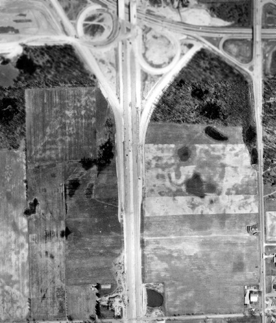
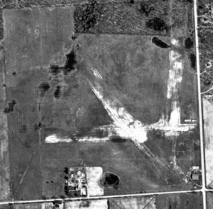
A 1962 aerial photo (courtesy of Mike Denja) showed the reason for Gridley Airport's demise:
with Route 23 having been constructed through the western portion of the airfield.
The hangars still remained standing on the southeast corner.
The 3 hangars on the southeast corner of the Gridley Airport site were still present on a 1973 aerial photo.
The last trace of Gridley Airport was removed at some point between 1973-2000,
as a 2000 aerial photo showed that the 3 former hangars on the southeast side had been replaced by a commercial building.
According to the Ypsilanti Historical Society's Winter 2008 Ypsilanti Gleanings (courtesy of Mike Denja),
“I-94 crossed through a portion of the airport & US-23 went through the western portion of the airport.
Today the Daniel L. Jacob & Co. Inc. (Budweiser beer distribution outlet) and an inflatable tennis court occupy much of the corner property.”
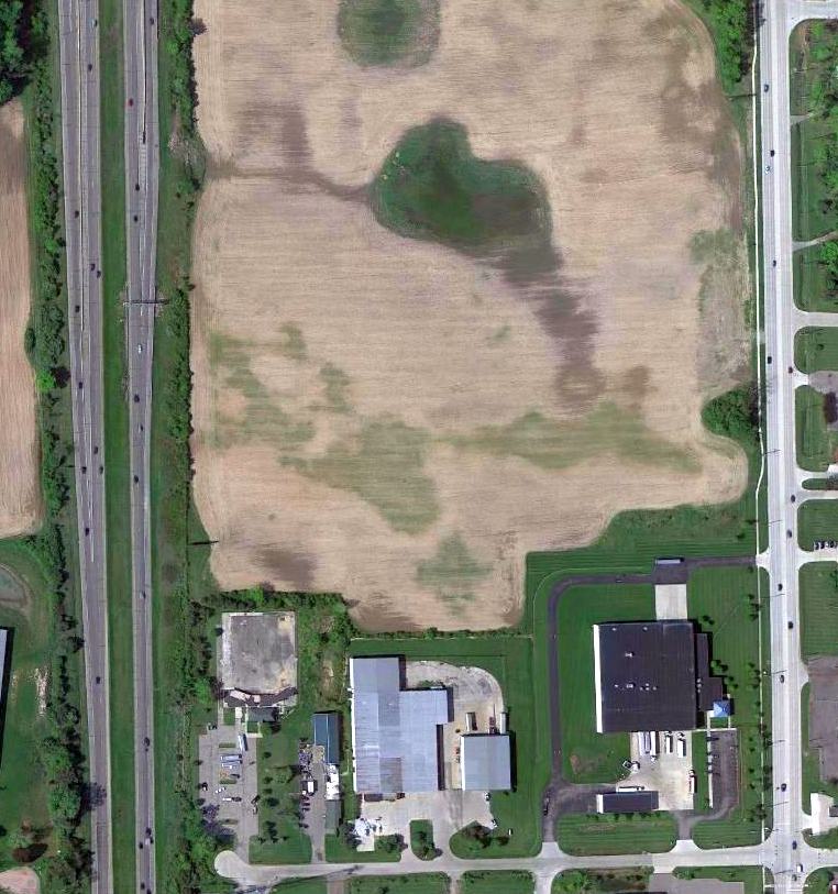
A 5/9/10 aerial photo showed no trace remaining of Gridley Airport.
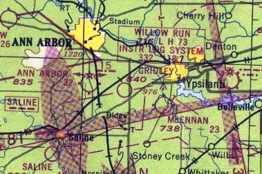
The site of Gridley Airport is located northwest of the intersection of Carpenter Road & Morgan Road.
Thanks to Mike Denja for pointing out this airfield.
____________________________________________________
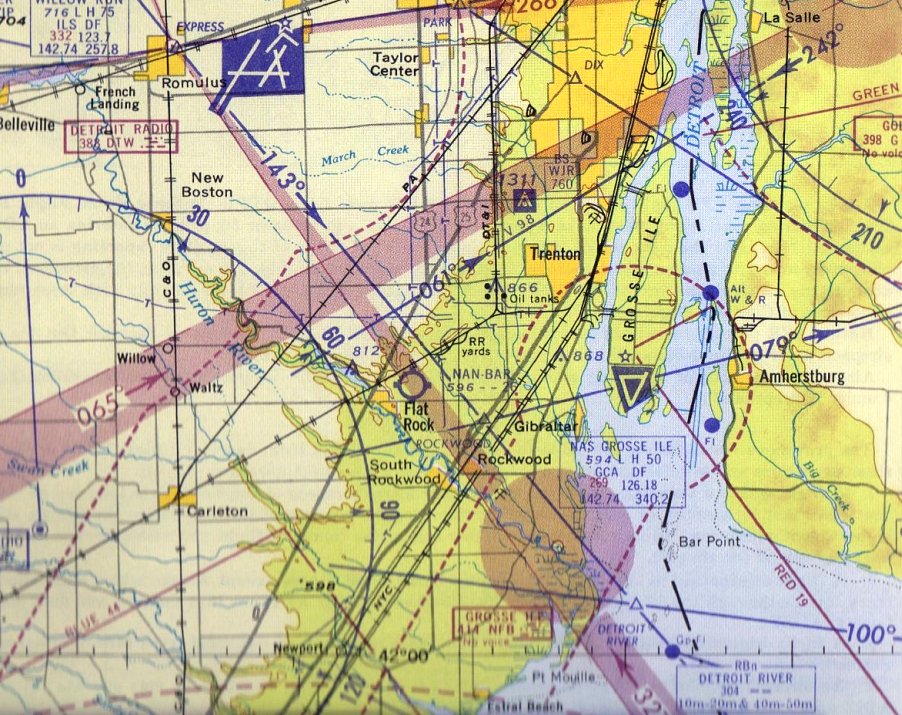
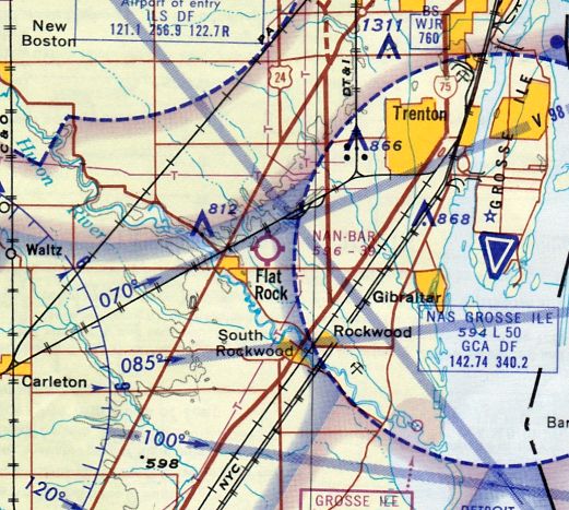
Nan Bar Airport / NOLF 27106 / Flat Rock Field, Flat Rock, MI
42.103, -83.27 (Southwest of Detroit, MI)
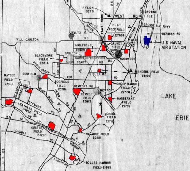
“Flat Rock Field 27106”, as depicted on a circa 1942 map of NAS Grosse Ile & its Outlying Fields.
Nan-Bar Airport was owned by Red Stultz & Chet Brazer.
According to Wikipedia, Nan-Bar Airport was established in the 1930s, named for Stultz's daughters, Nancy & Barbara.
During World War II Nan-Bar Airport served as one of 16 Outlying Fields used to support flight training at Naval Air Station Grosse Ile.
Navy pilots used Nan-Bar for short field landing instruction, as well as for emergency landings.
According to Brian Rehwinkel, “According to Navy records, the US Government leased 95 acres for this field.”
Nan Bar Airport was not yet depicted on the 1942 USGS topo map.
The earliest depiction of which has been located of Nan-Bar Airport was on a circa 1942 map of NAS Grosse Ile & its Outlying Fields.
It depicted “Flat Rock Field”, also with its Navy designator of “27106”,
which meant that it was located on a bearing of 271 degrees & a distance of 6 NM from its parent airfield, NAS Grosse Ile.
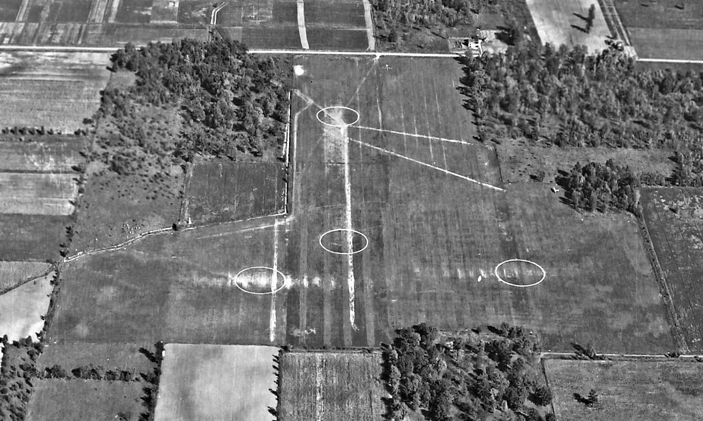
The earliest photo which has been located of Flat Rock OLF was a 10/6/43 aerial view looking east (courtesy of Brian Rehwinkel).
Brian Rehwinkel observed, “This photo shows the landing circles on the 2 sod runways.
Based on the worn grass near the circles, this field saw heavy use around this time, although there only seems to be one plane present, sitting on the southeast portion of the field.”
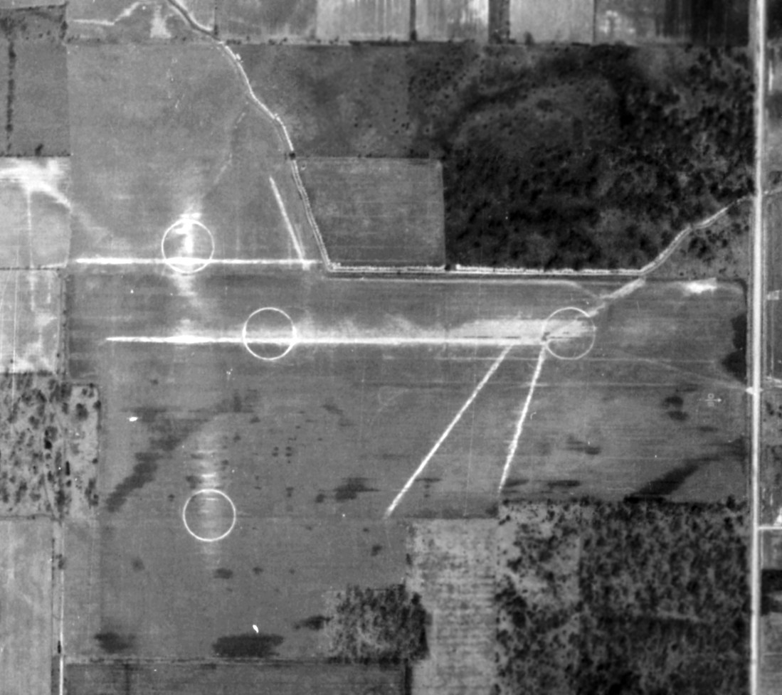
A circa 1943 aerial view of Flat Rock OLF showed the grass runways & 4 airfield circle markings (courtesy of Brian Rehwinkel).
Flat Rock OLF was not yet depicted on the May 1944 Detroit Sectional Chart.
Flat Rock OLF 27106 as depicted on the October 1944 Detroit Sectional Chart, along with a dense assemblage of other military airfields.
According to Brian Rehwinkel, “The Navy most likely canceled the lease for this field at the end of the war.”
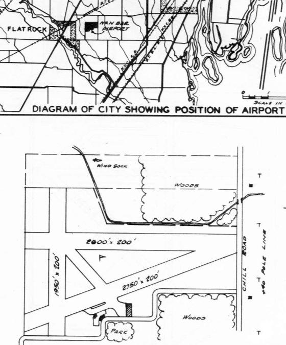
The 1946 MI Airport Directory (courtesy of Doug Ranz)
depicted Nan Bar Airport as having 3 unpaved runways, with 3 small buildings on the south side.
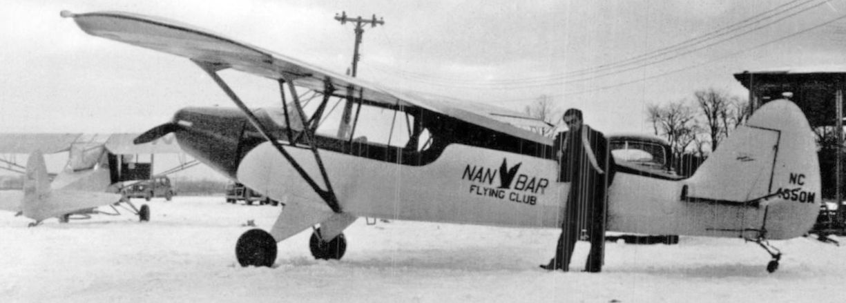
A 1948 photo of Robert Cornwell in front of a Piper Cub of the Nan Bar Flying Club at Nan Bar Airport (courtesy of Mike Denja).
Cornwell had trained to be a pilot & worked at repairing & painting planes at Nan Bar.
He also served as the observer on monthly flights piloted by Nan Bar Airport co-owner Chet Brazer
checking Detroit & Ohio Edison power lines for burned insulators.
A 1949 aerial view depicted Nan Bar Airport as having 3 unpaved runways,
with a half-dozen light planes around a small building on the south side of the field.
The 1952 USGS topo map depicted Nan Bar Airport as having 3 runways
and 3 small buildings on the southeast side.
A 1956 aerial view showed Nan Bare Airport had been reduced to 1 east/west runway, with the WW2-era layout of 3 runways just barely recognizable.
The earliest aeronautical chart depiction which has been located of Nan-Bar Airport was on the 1959 Detroit Local Aeronautical Chart.
It depicted Nan-Bar as having a 2,600' unpaved runway.
A 1964 aerial view showed Nan Bar Airport as having 12 light planes near a small building on the south side of a single grass east/west runway.
The last aeronautical chart depiction which has been located of Nan-Bar Airport
was on the July 1965 Detroit Local Aeronautical Chart (courtesy of Ron Kunse).
It depicted Nan-Bar as having a 3,900' unpaved runway.
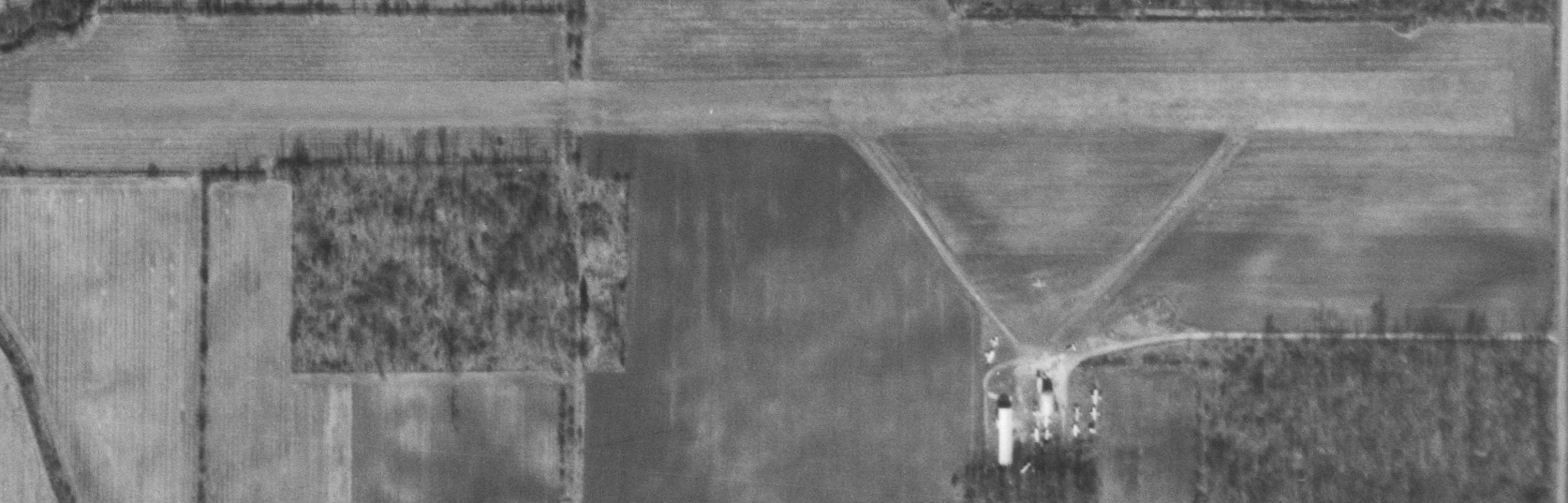
The last photo which has is available showing Nan Bar Airport was a 11/21/66 aerial view (courtesy of Mike Denja).
Only the single east/west runway remained, with no trace remaining of its WW2-era layout of 3 runways.
A dozen light planes were visible near the buildings on the south side.
The 1969 USGS topo map depicted Nan Bar Airport as having a single unpaved east/west runway.
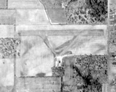
Nan Bar Airport was evidently closed (for reasons unknown) at some point between 1966-73,
as a 1973 aerial view showed the grass east/west runway remained clear, and a small building remained on the south side, but there were no planes on the field.
The 1974 USGS topo map depicted Nan Bar Airport as having a single unpaved east/west runway.
A 1993 aerial view showed the last remaining building from Nan Bar Airport had been removed at some point between 1973-93.
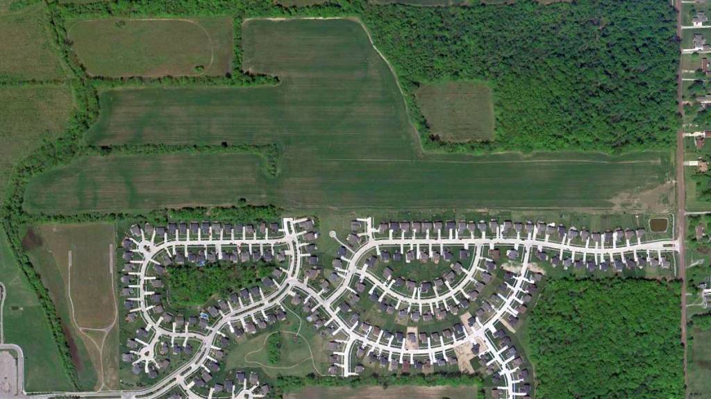
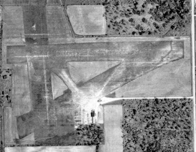
Amazingly a 5/9/10 aerial photo showed that the east/west grass runway of Nan Bar Airport remained clear & recognizable after more than 40 years.
Houses covered the airport ramp area.
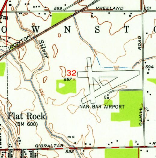
The site of Nan Bar Airport is located northwest of the intersection of Gilbraltar Road & Cahill Road.
Thanks to Michael McMurtrey for pointing out this airfield.
____________________________________________________
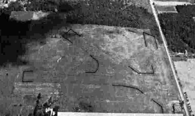
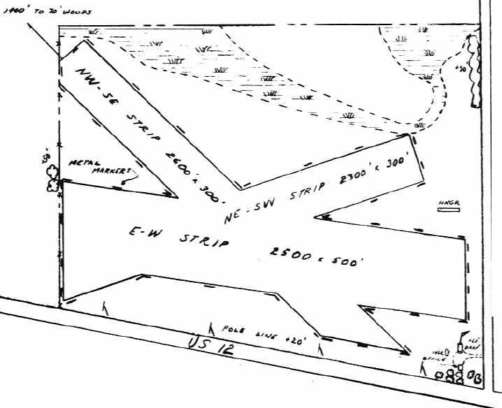
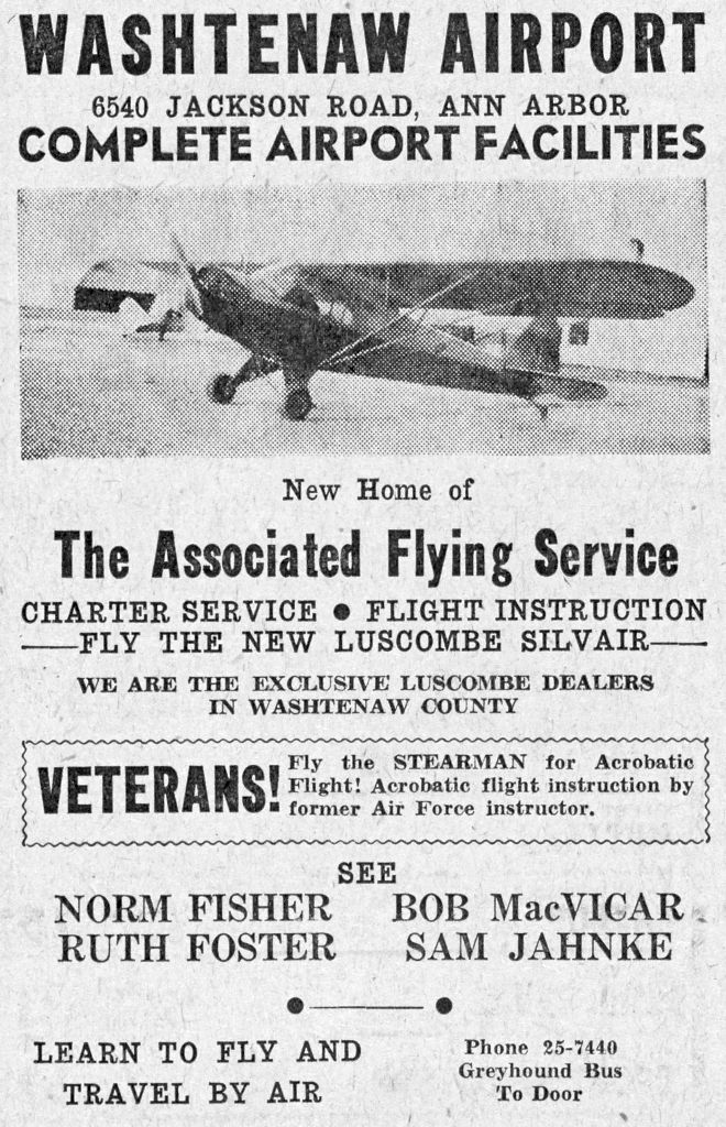
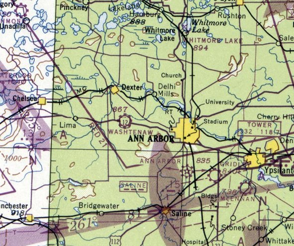
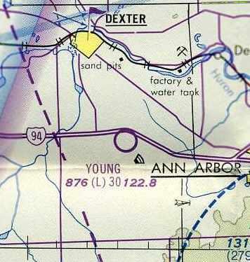
Washtenaw Airport / Young Airport, Ann Arbor, MI
42.295, -83.864 (West of Detroit, MI)
Washtenaw Airport, as depicted in the 1946 MI Airport Directory (courtesy of Doug Ranz).
This little general aviation field was evidently established at some point in 1946,
as it was not yet depicted at all on the December July 1946 Detroit Sectional Chart.
Tina Dowis reported, “My grandfather Robert MacVicar was founder/owner-operator of the Washtenaw Airport.
He also was a pilot in WWII... after the service he then built this airport
and taught flying in the Ann Arbor area for many years.
He also flew many years with Bill Barber who both were known for their airshows.”
The earliest depiction of Washtenaw Airport which has been located was in the 1946 MI Airport Directory (courtesy of Doug Ranz).
It depicted the field as having 3 unpaved runways (with the longest being the 2,600' northwest/southeast strip),
and having a single hangar on the east side.
The July 1947 Detroit Sectional Chart depicted Washtenaw as a commercial/municipal airport.
The 1949 Detroit Sectional Chart (courtesy of Donald Felton) depicted Washtenaw as having a 2,600' unpaved runway.
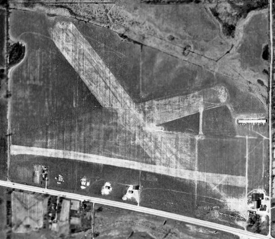
A 1949 aerial photo of Washtenaw Airport, from Wayne State University (courtesy of Greg Steinmayer).
The field had 3 unpaved runways, along with a row of T-hangars on the east side of the field.
A total of 6 light single-engine aircraft were visible parked on the southeast corner of the field.
A 1955 aerial photo of Washtenaw Airport showed that the southeast corner of the field had been taken up by a drive-in movie theater,
which considerably changed the airport's configuration.
The former east/west strip was gone,
and the former southeast/northwest strip had been relocated somewhat farther north, to avoid the drive-in theater.
The total number of aircraft visible parked on the field had decreased to only 3, all on the south side of the field.
It was still depicted as Washtenaw Airport on the May 1957 Detroit Sectional Chart (according to Chris Kennedy).
A 1961 aerial photo of Washtenaw Airport from Wayne State University (courtesy of Greg Steinmayer)
showed that an additional row of T-hangars had been added at some point between 1955-61 on the northwest side of the field.
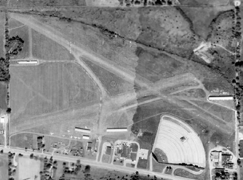
A 1963 aerial view of Washtenaw Airport showed that 3 more rows of T-hangars had been added at some point between 1961-63 on the south side side of the field.
The number of aircraft visible parked outdoors had also increased to 7.
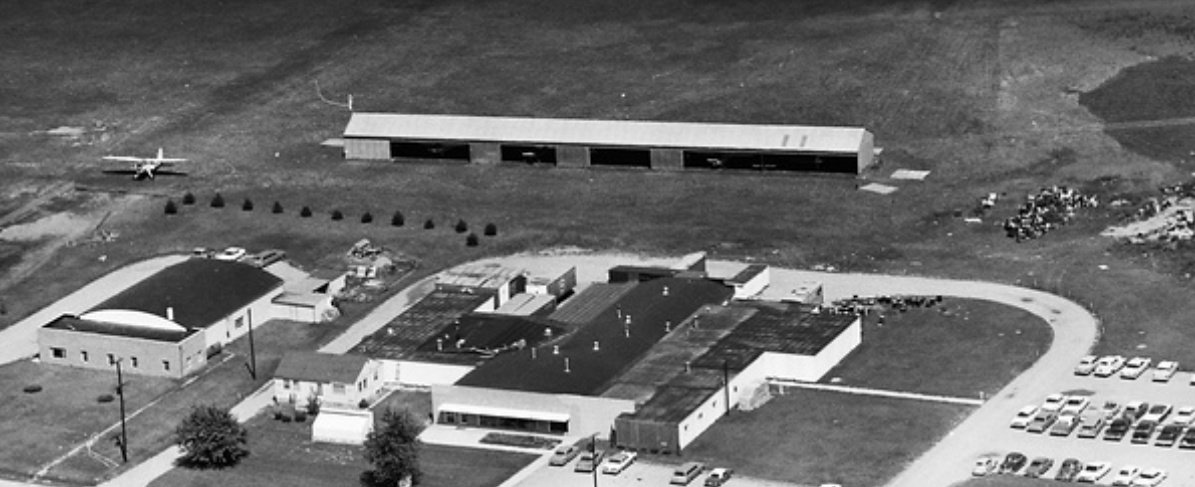
A 1963 aerial view looking northeast (courtesy of Dennis Thompson) showed 1 light single-engine taildragger parked outside the Washtenaw Airport hangars.
The airport was evidently renamed “Young” at some point between 1957-65,
as that is how it was labeled on the July 1965 Detroit Sectional Chart (courtesy of Chris Kennedy).
It was depicted as having a 3,000' unpaved runway.
According to Robert Young Jr., “I was told as a boy from my mother that it was named in honor of my dad Robert Young Sr.,
who was a pilot & trainer back in the 1940s & 1950s.
My dad worked at Willow Run flying the bombers, and trained many others to do that too.
He worked at Ann Arbor Airport for many years, and helped start the Civil Air Patrol.
Sadly my father passed away in a training accident in 1953, 2 months before I was born.
My Uncle Ernie & my mom used to tell me about the runway being named for him after his death.”
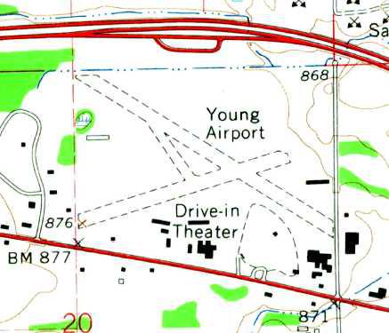
The 1965 USGS topo map depicted Young Airport as having 2 unpaved runways.
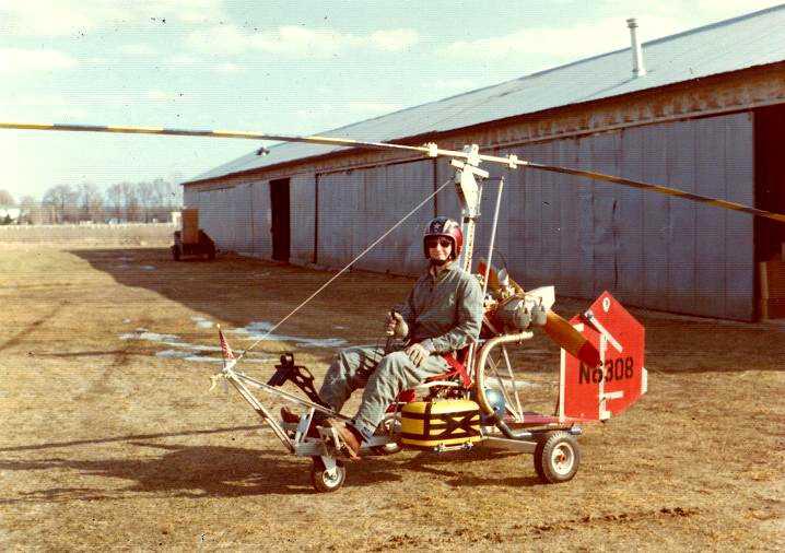
The last photo which has been located showing Washtenaw Airport in operation was a 1975 photo of Howard Cooper in his Bensen BM8 Gyrocopter.
Howard recalled, “When I was a senior in high school in Oak Park, Michigan, I built a Benson BM8 Gyrocopter.
In 1974, while a freshman at the University of Michigan, I located a small airport not too far from campus - Young Field -
and worked out a deal with a mechanic to allow me to park my Gyrocopter in his hangar for $25/month.
I flew the Gyro in the area for about a year. Eventually I sold it & moved on.”
The last aeronautical chart depiction which has been located of Young Airport
was on the May 1976 Detroit Terminal Aeronautical Chart (courtesy of Chris Kennedy).
It depicted Young as having a 3,000' unpaved runway.
A photo from the 7/25/76 Ann Arbor News (from the Ann Arbor Library, courtesy of Mike Denja) captioned “Privately-owned Salem Airport is up for sale now, but 3 months ago Young Field became a casualty of the rising costs of operating a private field.
Owner Aloys Metty has subdivided the acreage, put in a road & leased hangar space as storage to businesses & individuals.”
The 1977 USGS topo map showed that Young Airport had lost its longest runway at some point between 1965-77, leaving only the northeast/southwest runway.
Dave Lyjak recalled of Young Airport, “My dad kept his airplane there for a number of years in the 1970s-80s period
and I learned to fly & soloed there (also learned to drive a stick shift).
We also used to go to the drive-in the southeast corner –
the 1st time I saw 'Blue Max' although Mom & Dad made my brother & I lie down in the back seat whenever Ursula Andress was on screen.”
Young Airport evidently was closed (for reasons unknown) at some point between 1976-80,
as it was no longer listed among active airports in the 1980 AOPA Airports USA directory (according to Chris Kennedy),
nor depicted at all on the May 1981 Detroit Sectional Chart (courtesy of Ron Plante).
Dominic Hines reported he found “an article which the last owner explained that the airport was closed due to the land being zoned & taxed as commercial land,
meaning that the property taxes were too great for him to afford.”
Although it had evidently already been closed for at least 3 years,
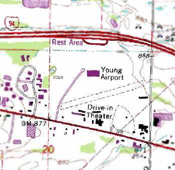
the 1983 USGS topo map still depicted Young Airport as having a single unpaved northeast/southwest runway,
with several rows of T-hangars on the southwest & east sides.
The 1991 USGS topo map still depicted Young Airport as having a single northeast/southwest runway.
A 1992 aerial photo showed that the hangars remained standing,
and the area of the northeast/southwest runway remained clear, but was no longer recognizable as a runway.
A 1998 USGS aerial photo showed that the former T-hangars remained standing,
but a strange paved item had been built over the center of the airfield at some point between 1992-98.
A 2005 aerial photo showed that the long row of T-hangars on the east side of the field had been removed at some point between 1998-2005.
A 2006 aerial photo showed that a large industrial building had been built over the western portion of the runway area at some point between 2005-2006.
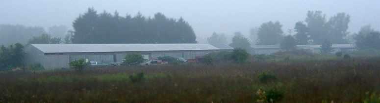
A 2006 photo by Greg Steinmayer. Greg reported, “On the Southern side of the field are 3 large, long hangar buildings,
which I presume to be T-hangars since they have doors on both sides.”
A 2006 photo by Greg Steinmayer. According to Greg, “On the Eastern end of the field are a lonely T-hangar,
and the foundations of a larger group of T-hangars.”
A 2006 photo of Greg Steinmayer of former runway or taxiway pavement.
According to Greg, “In the middle of the field is that weird paved area which I think MIGHT have been a runway,
but it is very narrow - no more than 8' wide, however it has some markings.
The area is now partially covered by a new industrial building which did not show up in the 1998 aerial photo.”
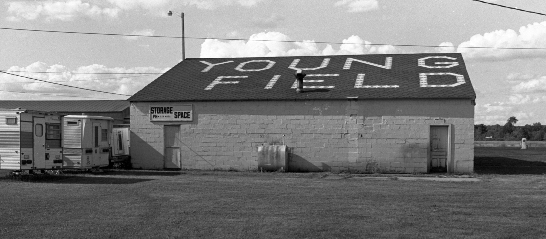
A circa 2006-2010 aerial view looking east at former hangars at the site of Young Airport.
A 10/4/11 aerial photo showed that several T-hangars remained standing on the south side of the Young Airport site.
A 6/30/21 photo by Dominic Hines of the westernmost former hangar on the Young Airport site.
Dominic reported, “I got a chance to talk with people who work in a business located in one of the former hangars,
and learned that the area has been used for racing go karts, which likely explains the asphalt strip on its west side.”
The site of Young Airport is located northwest of the intersection of Jackson Road & North Staebler Road.
____________________________________________________
Since this site was first put on the web in 1999, its popularity has grown tremendously.
If the total quantity of material on this site is to continue to grow,
it will require ever-increasing funding to pay its expenses.
Therefore, I request financial contributions from site visitors,
to help defray the increasing costs of the site
and ensure that it continues to be available & to grow.
What would you pay for a good aviation magazine, or a good aviation book?
Please consider a donation of an equivalent amount, at the least.
This site is not supported by commercial advertising –
it is purely supported by donations.
If you enjoy the site, and would like to make a financial contribution,
you
may use a credit card via
![]() :
:
Please consider checking the box to make a monthly donatation.
For a mailing address to send a check, please contact me at: paulandterryfreeman@gmail.com
If you enjoy this web site, please support it with a financial contribution.
please contact me at: paulandterryfreeman@gmail.com
If you enjoy this web site, please support it with a financial contribution.
____________________________________________________
This site covers airfields in all 50 states.