Abandoned & Little-Known Airfields:
Northern Michigan
© 2002, © 2024 by Paul Freeman. Revised 4/23/24.
This site covers airfields in all 50 states: Click here for the site's main menu.
____________________________________________________
Please consider a financial contribution to support the continued growth & operation of this site.
Calumet-Laurium Airport / Houghton County Airport (revised 10/16/23) - Crystal Falls Airport / Dr. A.L. Haight Airport (added 4/13/19) - Houghton-Hancock Landing Field / Isle Royale Sands Airport / Houghton Sands Airport & Seaplane Base (revised 4/23/24)
Ishpeming Airport / Ishpeming-Dexter Airport (added 12/31/18) - Marquette County Airport (revised 5/15/23) - Menominee County Airport (revised 4/27/22) - Muzzy's Airport / L'Anse Landing Field (revised 4/16/22) - Raco Airport / Raco AAF (revised 5/17/23)
Rexton Airport / D A R Airport (revised 5/15/23) - Riverland Airfield (revised 5/13/20) - Scheidler Field (revised 11/20/22) - Sunglen Airfield (revised 4/15/22)
____________________________________________________
Houghton-Hancock Landing Field / Isle Royale Sands Airport / Houghton Sands Airport & Seaplane Base, Houghton, MI
47.112, -88.521 (Northwest of Detroit, MI)
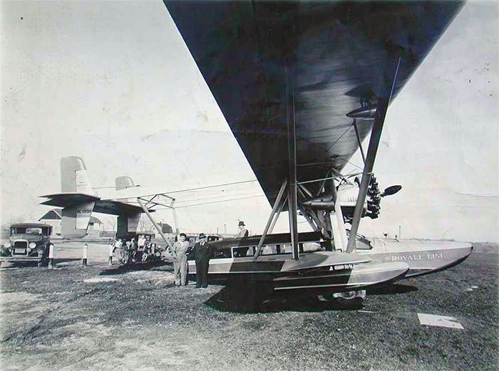
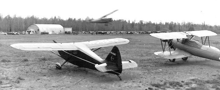
A 1932 photo of Sikorsky H-38 amphibian NC-199H at Houghton Sands (courtesy of Clyde Wescoat).
Ed Rothwell reported, “The Keewenaw Peninsula, jutting from the Upper Peninsula of Michigan into Lake Superior, was the site of the very first mineral boom in the Americas.
In 1842, 6 years before the California Gold Rush, rich veins of copper were discovered & a rush was on to extract the mineral. Over 250 mines were established using eastern & foreign capital.
For several decades the Copper Country was the leading producer of copper in the US, and in the early 1900s this small region led the world in copper production.
The Isle Royale Copper Mine was established in 1852 to exploit the copper deposits on the island of Isle Royale in Lake Superior.
The island was not a viable commercial source of copper, so interest soon shifted to an area on the mainland, in the hills south of Houghton, where several rich veins of copper were discovered among prehistoric mining pits.
Ownership of the mining site changed hands numerous times, but it was always known as the 'Isle Royale Mine'.
The mine operated nearly continuously until 1925, producing over 180 million pounds of copper.”
Ed continued, “The Isle Royale mine produced amygdaloid copper, which needed to be processed to extract the pure metal from the surrounding rock.
A stamping plant was built on the shore of Portage Lake near the outlet of the Pilgrim River at Pilgrim Point, east of Houghton, and ore was shipped there by rail.
The ore was pounded into a sand-like consistency, and the waste was pumped into the lake using sluices where it formed an expanding, drifting mass called the stamp sands.
These sands were relatively flat & reasonably dry, and formed an inviting landing spot for airplanes.
It is likely that seaplanes began landing on Portage Lake & taxiing onto the stamp sands even before the mine ceased operation in 1925.
Wheeled planes were also likely users of the convenient, flat, beach-like area. Clearly, the sands were being heavily used by the late 1920s to early 1930s.
Numerous photographs of an air show held on the stamp sands on 6/24/31 appear in the Michigan Technological University archives.
It was quite a production, with many airplanes parked on the sand along with dozens of automobiles & large numbers of people visiting the planes.
A number of exciting commercial ventures began operating from the stamp sands beginning in 1932.
That year D. W. Wescoat purchased a 1928 Sikorsky S-38 flying boat, NC199H, and started the Royale Line, ferrying tourists to Isle Royale, which was not yet a National Park.”
The earliest depiction which has been located of Houghton Sands Airport was a 1932 photo of Sikorsky H-38 amphibian NC-199H (courtesy of Clyde Wescoat).
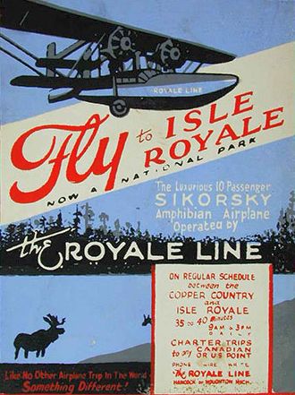
A circa 1932 poster advertising the Royale Line (courtesy of Clyde Wescoat).
Ed Rothwell reported, “By the early 1930s, an official airport had been established on the stamp sands, called the 'Houghton-Hancock Landing Field'.”
The 1935 Michigan Airports & Landing Fields described Houghton-Hancock Landing Field as an irregularly-shaped field having a 3,600' northwest/southeast runway, “slightly rolling, never wet.”
It noted “Amphibians can taxi up on field. Small hangar on north.”
The earliest aeronautical chart depiction which has been located of Houghton Sands Airport was on the March 1936 Lake Superior Sectional Chart, which depicted Isle Royale Sands Airport as a commercial/municipal airport.
A 1938 aerial view depicted a few small buildings on the north side of the Houghton Sands, but did not depict any aircraft.
The 1938 & 1940 Michigan Airports, Landing Fields and Intermediate Fields depicted Houghton-Hancock Landing Field.
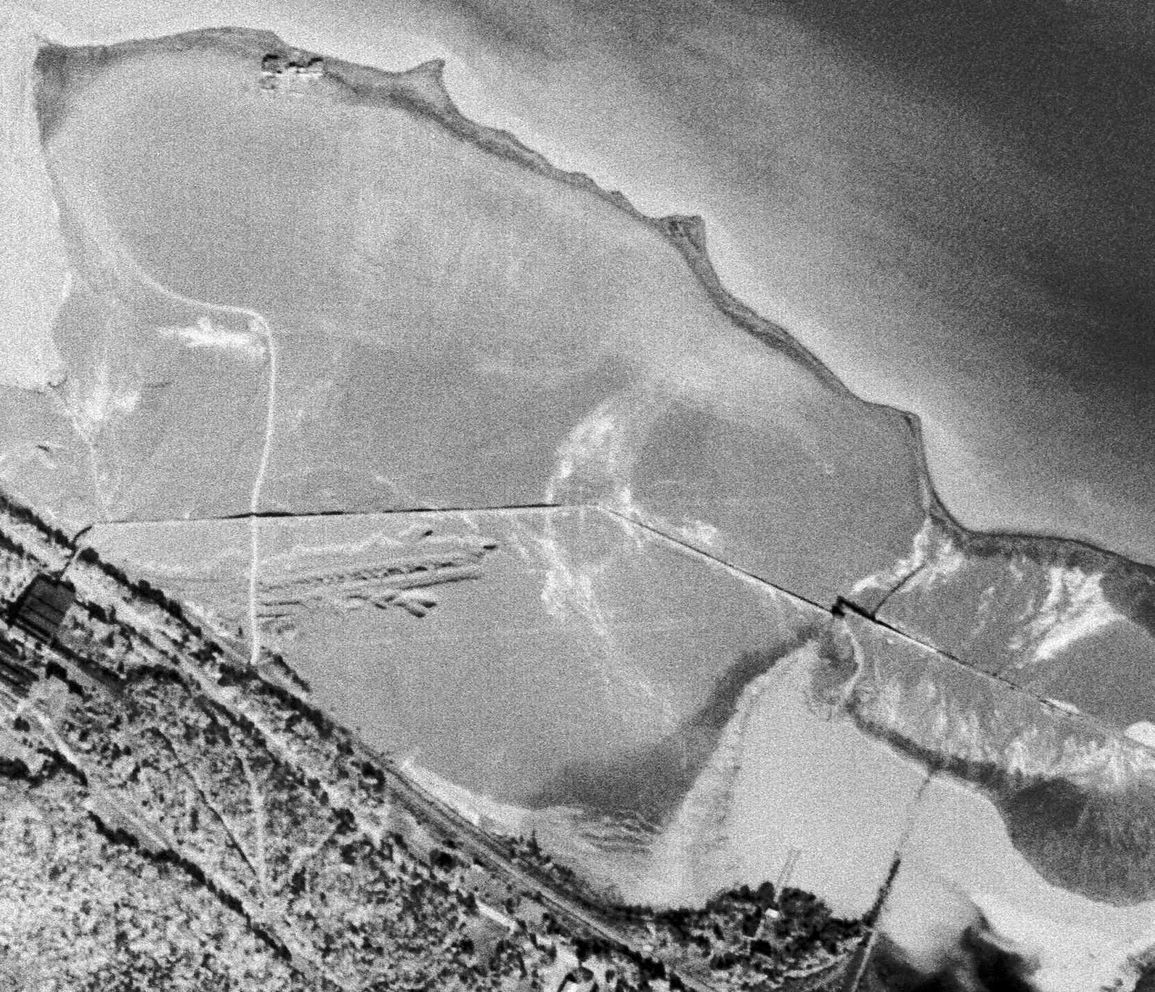
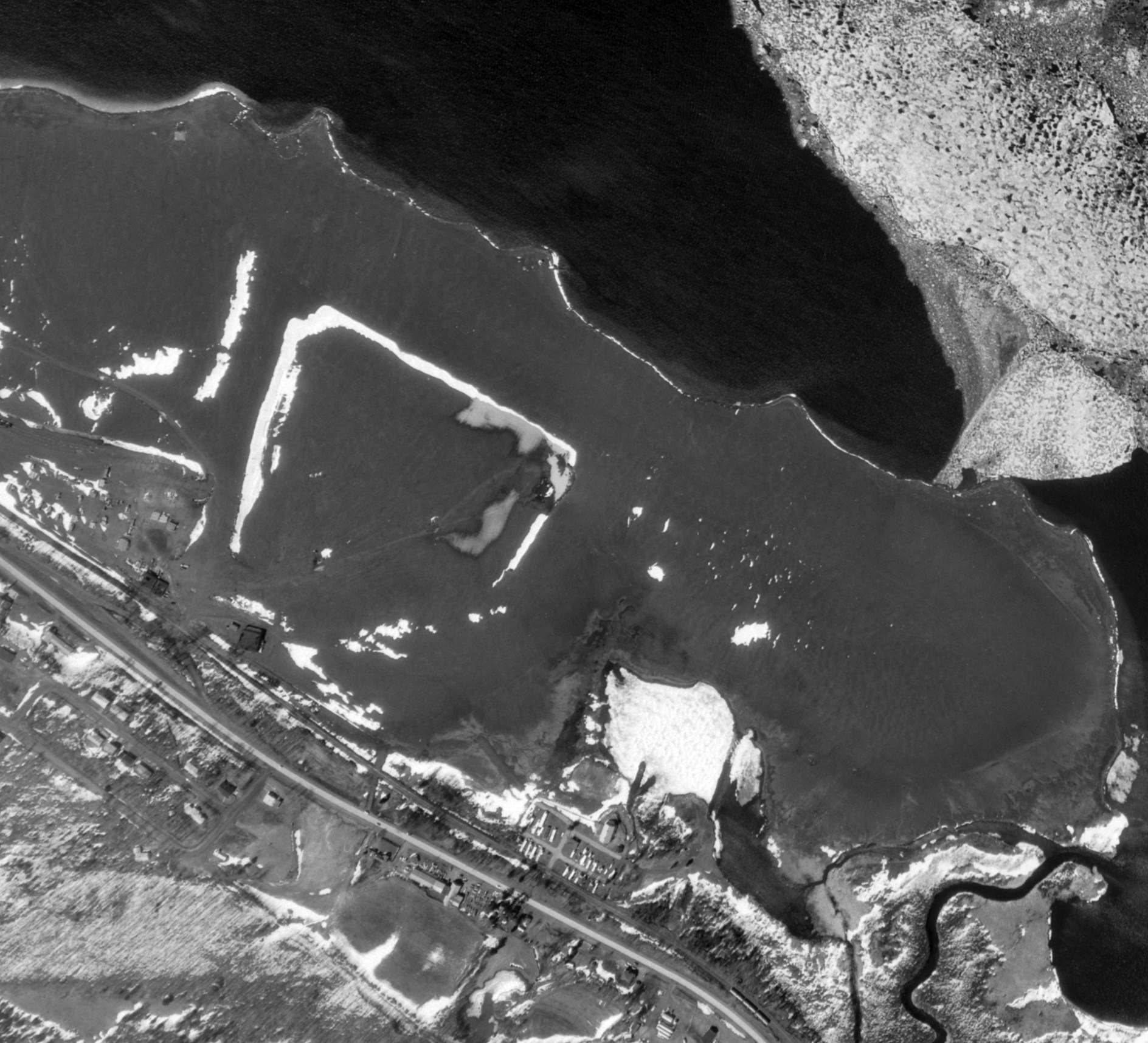
The earliest aerial photo which is available of Houghton Sands Airport & Seaplane Base was a 10/6/43 USGS aerial view.
It depicted a few small buildings along the river on the north side, along with possibly 2 light single-engine aircraft.
Ed Rothwell reported, “A flying school at Houghton Sands was listed in the 1945 Houghton telephone directory under the entry for the Range Oil & Gas Company.”
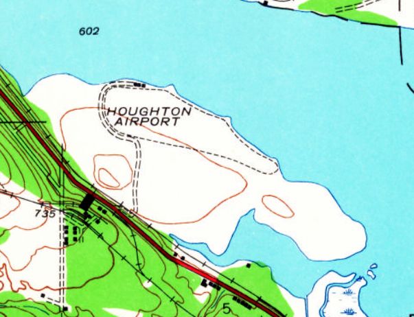
The earliest topo map depiction which has been located of Houghton Sands Airport was on the 1946 USGS topo map.
It depicted Houghton Airport as an oval property outline, with 2 small buildings along the river on the north side.
The 1947 MI Airport Directory (courtesy of Mike Denja) depicted Houghton Sands Airport as having a 2,600' northwest/southeast unpaved landing area,
with 2 hangars, and office, and seaplane base on the north side.
Ed Rothwell reported, “By 1948 the flying school entry is attributed to Lake Superior Aviation, Inc., presumably the FBO at Houghton Sands at that time.
The mine was closed permanently in 1949.”
“Houghton Sands” Airport & Seaplane Base were depicted on the 1949 Michigan Aeronautical Chart.
Ed Rothwell reported, “A new diagram appeared in the 1950 Sketch Book of Michigan’s Airports & Landing Fields, in which the airport was called 'Houghton Sands'.
Two hangars & a small office building were shown near a seaplane dock along the lake; the usable landing area had been expanded.”
A 5/21/51 USGS aerial view depicted Houghton Sands Airport as having a hangar on the south side, but no sign of the previously-depicted buildings along the river on the north side.
There were no aircraft visible on the field.
The airport was depicted as “Houghton Airport” on the 1954 USGS map.
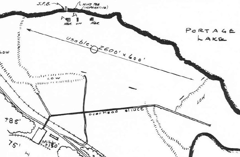
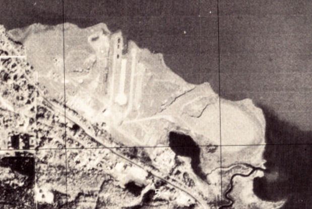
The 1954 “Vacation Michigan by Airplane” showed a diagram of the Houghton Sands Airport with 2 designated landing sites: the 4,100' Runway 12/30, extending the length of the stamp sands, and the 1,700' crosswind Runway 3/21.
An office & large hangar were shown along the north side of the highway.
A road/taxiway extended from US 41 along the west edge of the stamp sands, connecting the office & hangar to the seaplane base on the lake.
One hangar & a ready room were located near the seaplane dock. A gas pump was situated on the taxiway providing 80/91 octane fuel.”
A flight simulation scenery depiction by Ed Rothwell looking northwest at the Houghton Sands Airport & Seaplane Base.
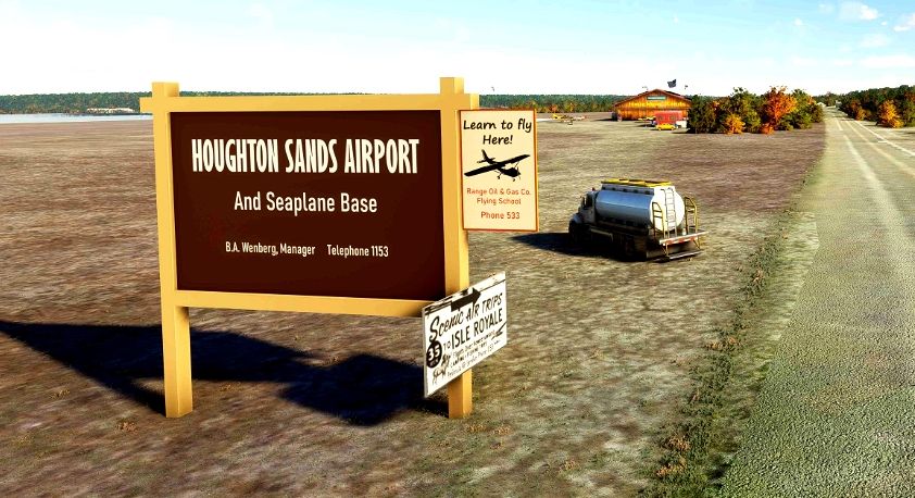
A flight simulation scenery depiction by Ed Rothwell of the Houghton Sands Airport & Seaplane Base sign.
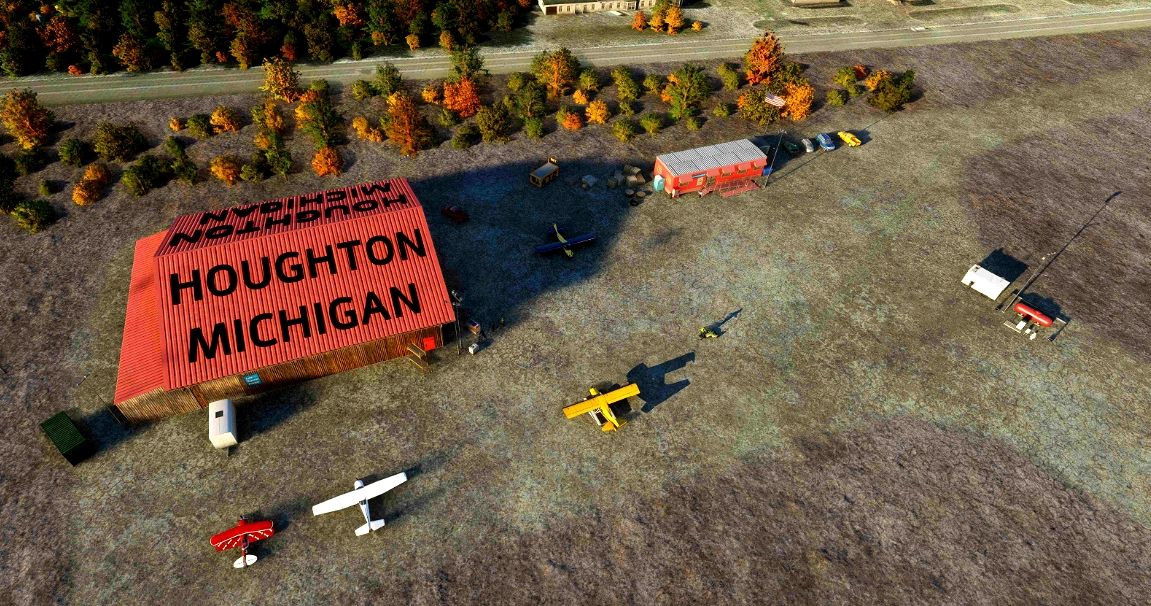
A flight simulation scenery depiction by Ed Rothwell of several planes & buildings at the Houghton Sands Airport.
A flight simulation scenery depiction by Ed Rothwell of several planes & buildings at the Houghton Sands Airport.
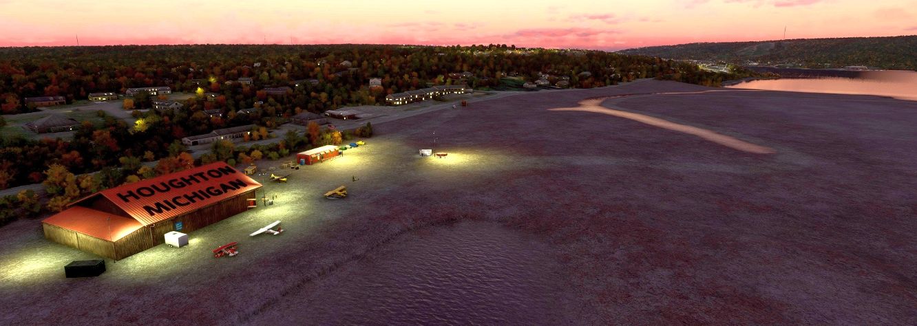
A flight simulation scenery depiction by Ed Rothwell looking northwest at the Houghton Sands Airport.
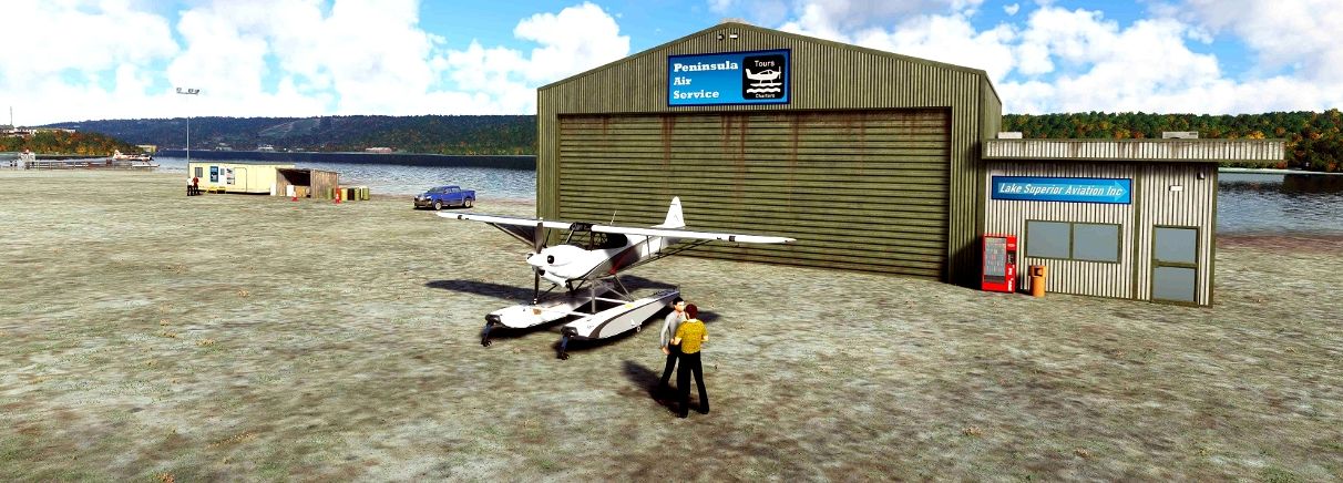
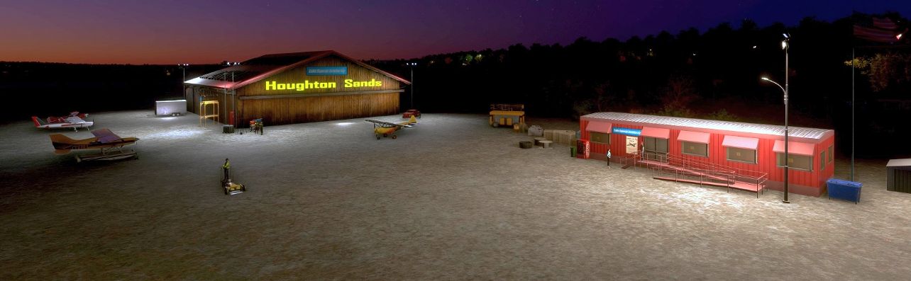
A flight simulation scenery depiction by Ed Rothwell of a floatplane & hangar at the Houghton Sands Seaplane Base.
Ed Rothwell reported, “Seaplane service to Isle Royale from Houghton Sands Seaplane Base continued through at least the 1950s, with operations conducted by Peninsula Air Service.”
A reference to this operation appears in the August 1959 Flying Magazine. In a letter to the editor, Dale Holbrook says:
“I have noticed a recent letter (by Lydia Jensen) in June 'Mailbox' inquiring about campgrounds near airstrips.
I would like to answer in part by giving information on such facilities in the Keweenaw, or the Copper Country of the Upper Peninsula of Michigan.
The Houghton Sands Airport & Seaplane base (Lake Superior Sectional Chart) is situated in the midst of many camping areas.
Located a mile from the village, it furnishes free tie-downs & has a full time A&E mechanic.
Isle Royal National Park, Porcupine Mountains State Park, Fort Wilkins State Park and others can be reached on an average of 30 minutes flight by floatplane from Houghton Sands Airport.
At present charter service if desired is offered by Peninsula Air Service in a 195 Cessna on floats.”
The airport was depicted as “Houghton Sands” on the 1961 & 1966 USGS maps.
“Houghton Sands” Airport & Seaplane Base were depicted on the 1964 Michigan Aeronautical Chart.
A 4/21/66 USGS aerial view depicted Houghton Sands Airport as having a hangar on the south side, but there were no aircraft visible on the field.
The December 1967 FAA AIM/Airport Directory described Houghton Sands as “Open November-April to ski aircraft.”
The December 1968 FAA AIM/Airport Directory described both Houghton Sands Airport & Seaplane Base as permanently closed.
The last aeronautical chart depiction which is available of Houghton Sands Airport & Seaplane Base was on the March 1969 Lake Superior Sectional Chart.
It depicted Houghton Sands as a private airfield & seaplane base, having a 4,000' runway & 25,000' seaplane operating area.
The Houghton Sands Airport & Seaplane Base were no longer depicted on the 1974 Michigan Aeronautical Chart or the 1975 USGS topo map.
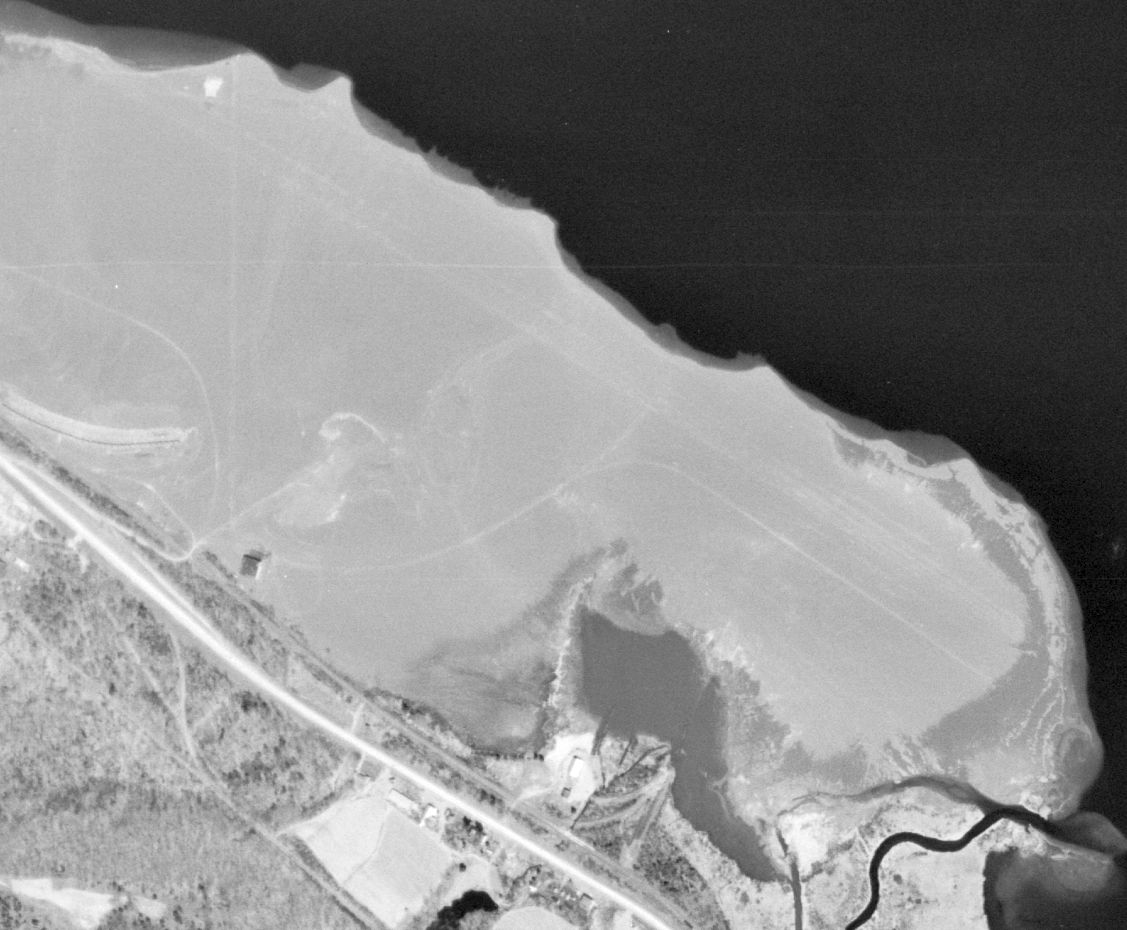
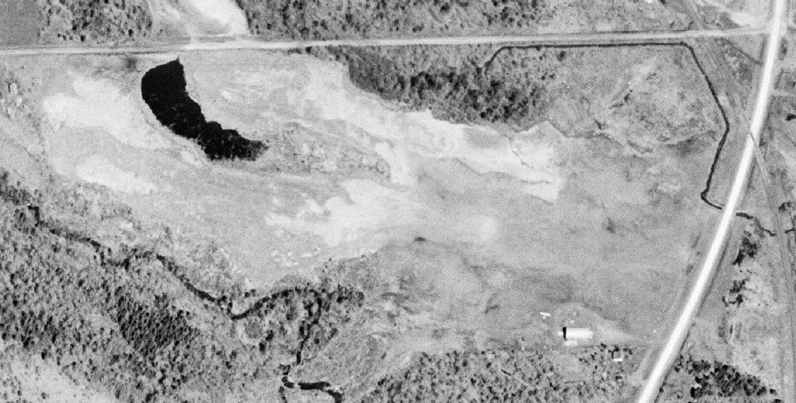
A 1978 USGS aerial view of the Houghton Sands Airport & Seaplane Base site did not show any sign of aviation use.
A water channel had been cut at some point from 1966-78, extending south into the former airport property.
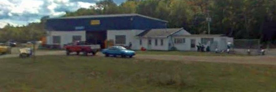
A 2008 photo looking south at the 57+ year-old former hangar which remains on the southwest side of the Houghton Sands Airport site.
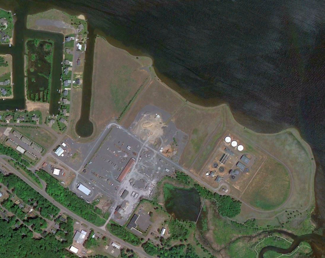
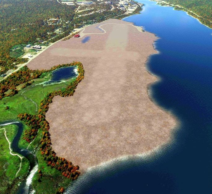
A 2022 aerial view of the Houghton Sands Airport site. A former hangar remains on the southwest side.
Ed Rothwell observed, “The Isle Royale Sands have been repurposed & now hold a subdivision, several businesses, and a water treatment plant.
Thanks to Ed Rothwell for pointing out this airfield.
____________________________________________________
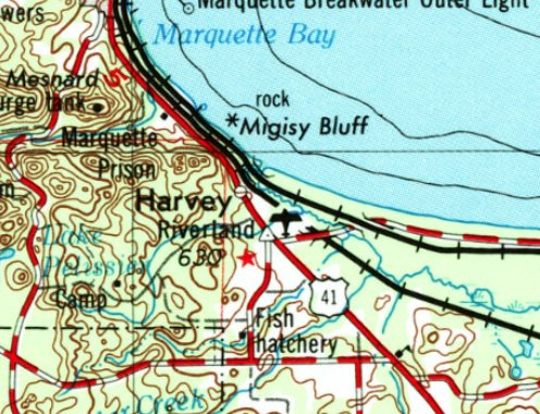
Riverland Airfield, Harvey, MI
46.489, -87.345 (Northwest of Detroit, MI)
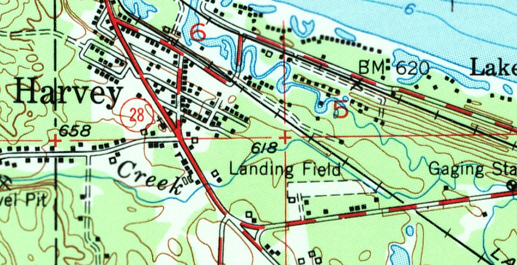
Riverland Airfield, as depicted on the 1952 USGS topo map.
Photo showing the airport in use has not been located.
The earliest depiction which has been located of Riverland Airfield was a 1951 aerial photo.
It depicted a single 1,700' unpaved east/west runway, with 1 small building on the southwest side.
There were no aircraft visible on the field, or any indication of recent use.
The earliest topo map depiction which has been located of Riverland Airfield was on the 1952 USGS topo map.
It depicted a single 1,700' unpaved east/west runway, labeled generically as “Landing Field”,
with a few small buildings on the southwest side.
This airfield may have also been known as Benny Peramaki Field.
According to the Chocolay Township History (courtesy of Pat Stanton),
Elry Reetz recalled, “Another landing field was located just off M-28 on the North side of the road commonly known as the Benny Peramaki Field.”
Riverland Airfield was not yet depicted on the March 1965 Lake Superior Sectional Chart.
The earliest aeronautical chart depiction which has been located of Riverland Airfield was on the August 1965 Lake Superior Sectional Chart.
It depicted Riverland as having a 2,500' unpaved runway.
Riverland Airfield, as depicted on the 1968 USGS topo map.
The last aeronautical chart depiction which has been located of Riverland Airfield was on the August 1969 Lake Superior Sectional Chart.
It depicted Riverland as having a 2,500' unpaved runway.
Riverland Airfield was evidently closed (for reasons unknown) at some point between 1969-70,
as it was no longer depicted on the March 1970 Lake Superior Sectional Chart.
A 1981 aerial view of Riverland Airfield showed the runway was overgrown & the single building had been removed at some point between 1951-81,
Riverland Airfield was no longer depicted on the 1983 USGS topo map.
Pat Stanton recalled, “Growing up, between 1984-88, I used to play in a forest located to the east of my subdivision.
I recall a friend taking me to a strip of land that had small, but distinctly abandoned small aviation building & what looked like an overgrown airstrip.
I remember going in what appeared to be a small hangar & the distinct appearance of what used to be an airstrip.”
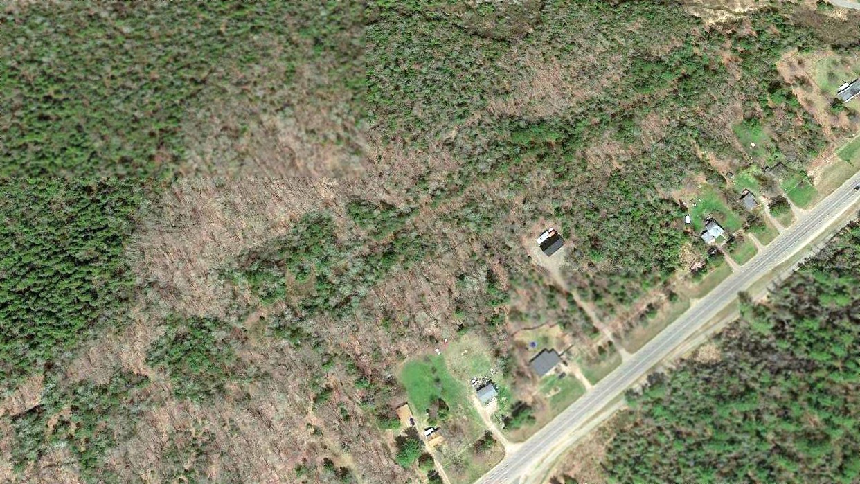
A 2019 aerial view looking northeast at the site of Riverland Airfield showed only the faintest trace of the east/west runway in the forested area.
Thanks to Pat Stanton for pointing out this airfield.
____________________________________________________
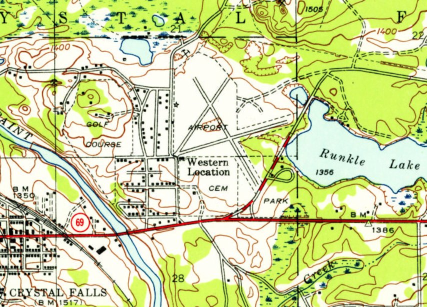
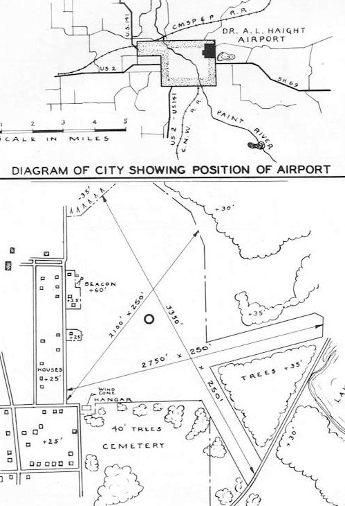
Crystal Falls Airport / Dr. A.L. Haight Airport, Crystal Falls, MI
46.103, -88.312 (Northwest of Detroit, MI)
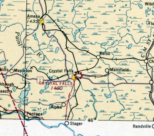
Crystal Falls Airport, as depicted on the February 1936 Lake Superior Sectional Chart.
Photo showing the airport in use has not been located.
The date of establishment of this early general aviation airport has not been determined.
The earliest depiction which has been located of Crystal Falls Airport was on the February 1936 Lake Superior Sectional Chart.
It depicted Crystal Falls as a commercial/municipal airport.
The earliest photo which has been located of Crystal Falls Airport was a 1943 aerial view.
It depicted 2 perpendicular unpaved runways, with a small building (a hangar?) of the southwest side.
There were no aircraft visible on the field.
The earliest topo map depiction which has been located of Crystal Falls Airport was on the 1944 USGS topo map.
It depicted 3 runways, generically labeled as “Airport”, with a beacon on the west side & a small building on the southwest side.
Crystal Falls Airport was evidently renamed Dr. A.L. Haight Airport at some point between 1936-47,
as that is how it was depicted in the 1947 MI Airport Directory (courtesy of Bill Grasha).
depicted Calumet-Laurium Airport as having 3 runways, with the longest measuring 2,600' northeast/southwest.
Two hangars & a classroom were depicted on the northwest side.
The 1956 USGS topo map continued to depict the 3 runways, generically labeled as “Airport”.
The last aeronautical chart depiction which has been located of Haight Airport was on the 1960 Lake Superior Sectional Chart.
It depicted Haight as a private airfield having a 3,100' unpaved runway.
Haight Airport was evidently closed (for reasons unknown) at some point between 1960-65,
as it was no longer depicted on the 1965 Lake Superior Sectional Chart.
A 1983 aerial photo showed the former runways of Haight Airport were overgrown but still recognizable,
and the former hangar / airport office building remained on the southwest side.
A 1998 aerial photo showed the former runways of Haight Airport were overgrown but still recognizable,
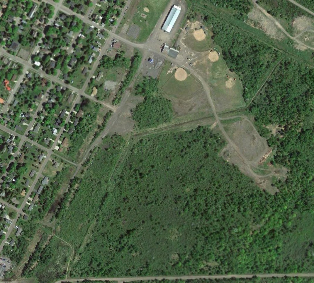
although a baseball diamond had been built over the runway intersection.
The former hangar / airport office building remained intact on the southwest side.
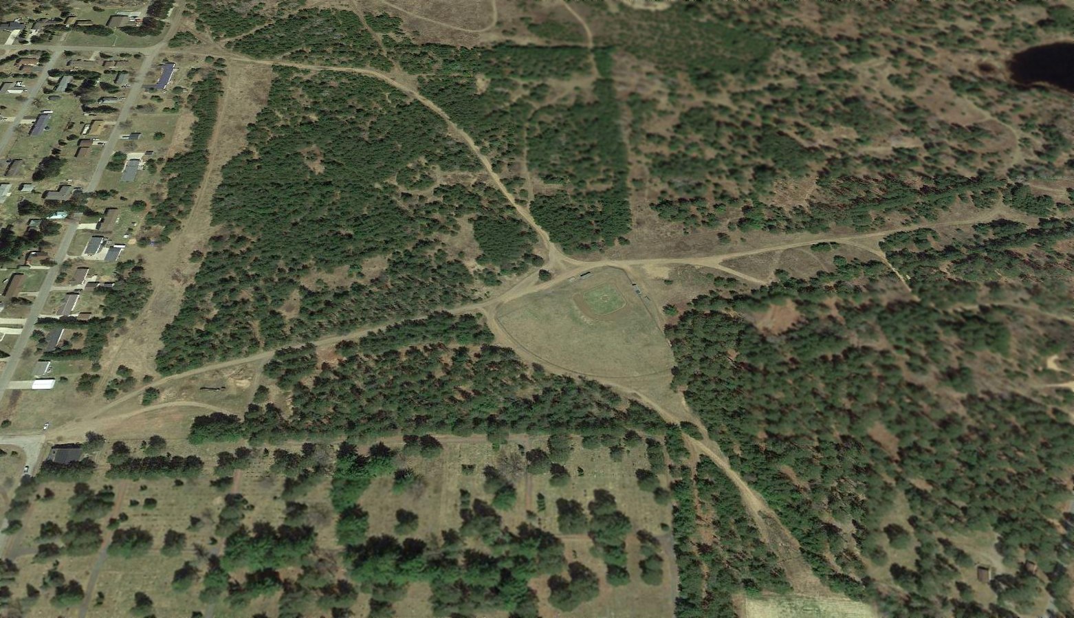
A 2014 aerial view looking north showed the former runways of Crystal Falls Airport were overgrown but still recognizable, although a baseball diamond had been built over the runway intersection,
and the former hangar / airport office building remained intact on the southwest side.
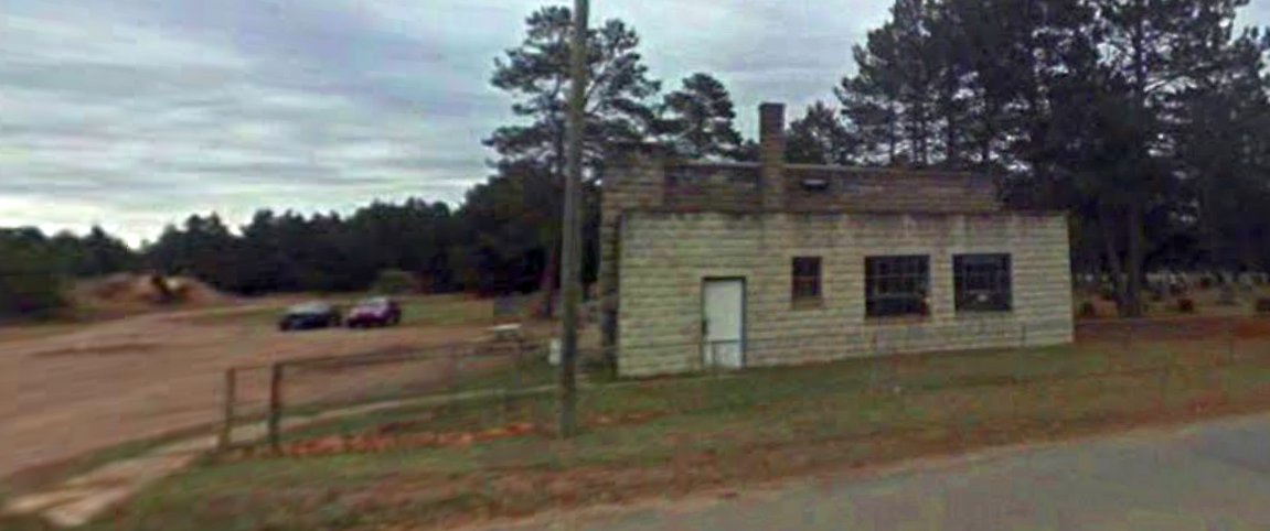
A circa 2016-2019 photo looking east at the former hangar / airport office building which remains intact on the southwest side of the Crystal Falls Airport site.
As of 2019, street maps depict the southeastern portion of the Crystal Falls Airport site as Runkle Lake Park.
Thanks to Bill Grasha for pointing out this airfield.
____________________________________________________
Ishpeming Airport / Ishpeming-Dexter Airport, Greenwood, MI
46.496, -87.809 (Northwest of Detroit, MI)
Ishpeming Airport, as depicted on the February 1936 Lake Superior Sectional Chart.
Photo showing the airport in use has not been located.
The date of establishment of this early general aviation airport has not been determined.
The earliest depiction which has been located of Ishpeming Airport was on the February 1936 Lake Superior Sectional Chart.
It depicted Ishpeming as an auxiliary airfield.
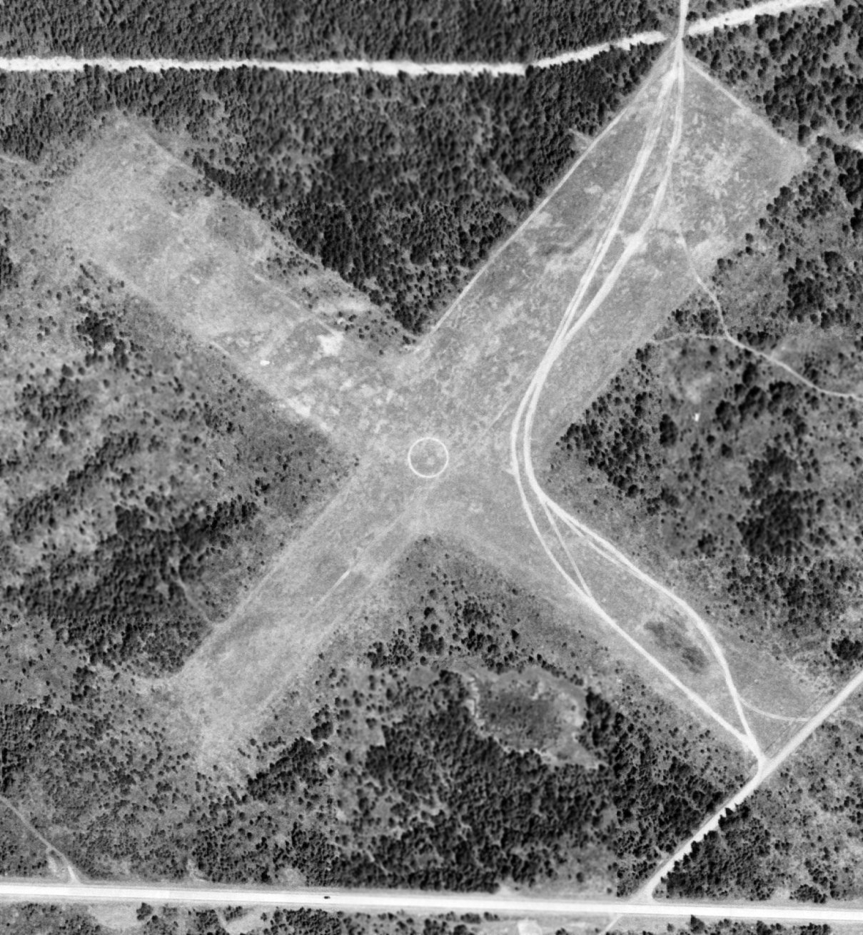
The earliest photo which has been located of Ishpeming Airport was a 5/13/51 USGS aerial view.
It depicted 2 perpendicular unpaved runways, with an airport circle marking at the intersection.
There were no aircraft visible on the field, nor any buildings.
A 1952 aerial view depicted Ishpeming Airport in an unchanged fashion.
The last aeronautical chart depiction which has been located of Ishpeming-Dexter Airport was on the April 1954 Lake Superior Sectional Chart.
It depicted Ishpeming-Dexter Airport as having a 2,500' unpaved runway.
Ishpeming-Dexter Airport was evidently closed (for reasons unknown) at some point between 1954-55,
as it was no longer depicted on the May 1955 Lake Superior Sectional Chart.
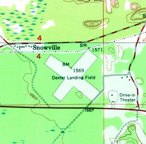
The 1955 USGS topo map continued to depicted “Dexter Landing Field”, with 2 perpendicular unpaved runways.
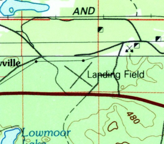
The 1983 USGS topo map continued to depict 2 perpendicular runways, generically labeled “Landing Field”, at the site of Dexter Airport.
By the time of a 1992 aerial view, the former runways of Dexter Airport were overgrown but still slightly recognizable,
but a gravel pit had covered the eastern portion of the airport site,
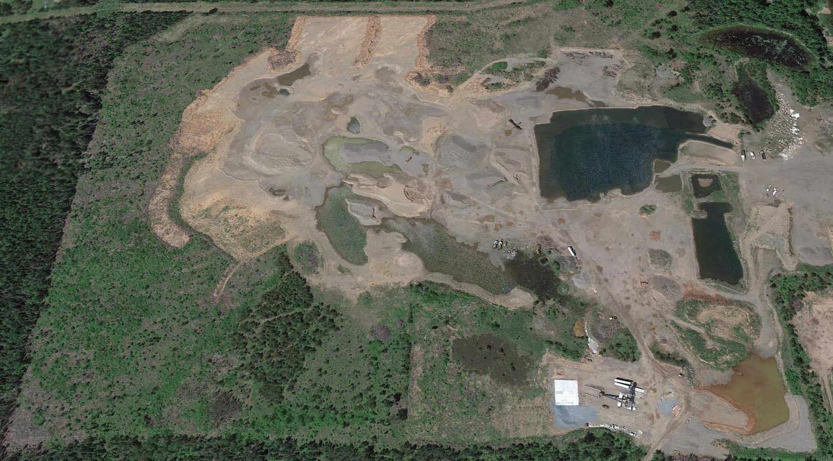
A 2014 aerial view looking north showed no trace remained recognizable of Dexter Airport.
Andy Larsen reported in 2018, “The area is completely unrecognizable & is owned by Odovero Properties, used as a gravel pit.”
Thanks to Andy Larsen for pointing out this airfield.
____________________________________________________
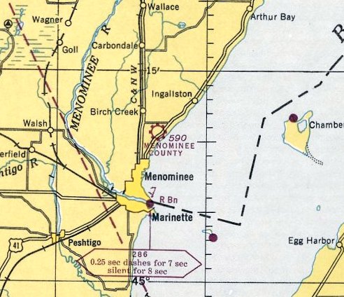
Menominee County Airport, Menominee, MI
45.186, -87.566 (Northwest of Detroit, MI)
Menominee Airport, as depicted on the 2/15/29 Commerce Department Airway Bulletin (courtesy of Mike Denja).
According to Walter Ballauer the Menominee County Airport, located 4 miles northeast of Menominee,
was “the second airport in Michigan founded in 1929.”
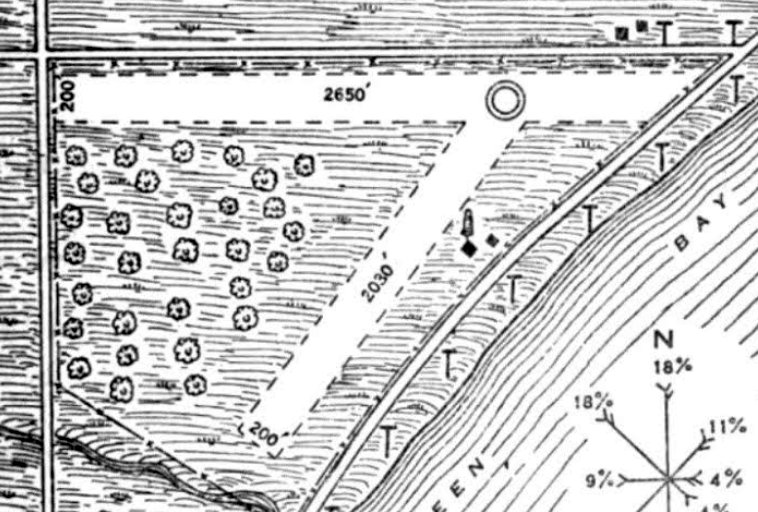
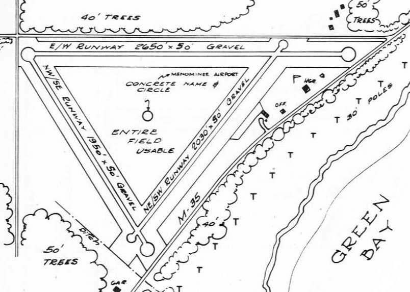
The earliest depiction which has been located of Menominee County Airport was on the 2/15/29 Commerce Department Airway Bulletin (courtesy of Mike Denja).
It described Menominee County Airport as a being owned & operated by Menominee County,
and to consist of a 100 acre irregularly-shaped field having 2 sod runways, measuring 2,650' east/west & 2,030' northeast/southwest.
Two small buildings were depicted on the east side.
The earliest aeronautical chart depiction which has been located of Menominee County Airport was on the October 1936 Green Bay Sectional Chart.
It depicted Menominee County as a commercial/municipal airport.
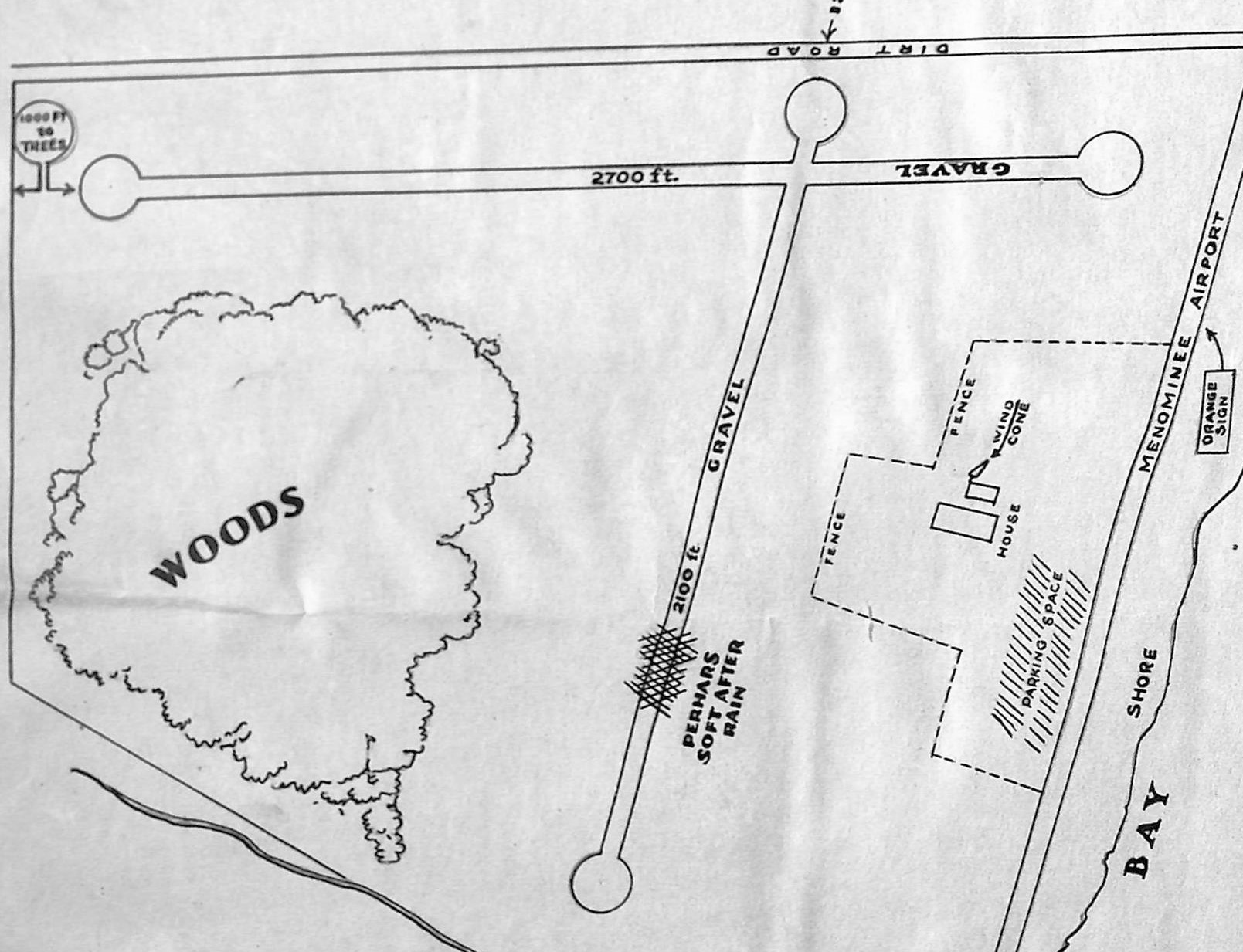
A circa 1930s plan (courtesy of Mike Kaufman, via Walter Ballauer) depicted Menominee County Airport
as having 2 gravel runways (measuring 2,700' east/west & 2,100' northeast/southwest), with a house on the east side.
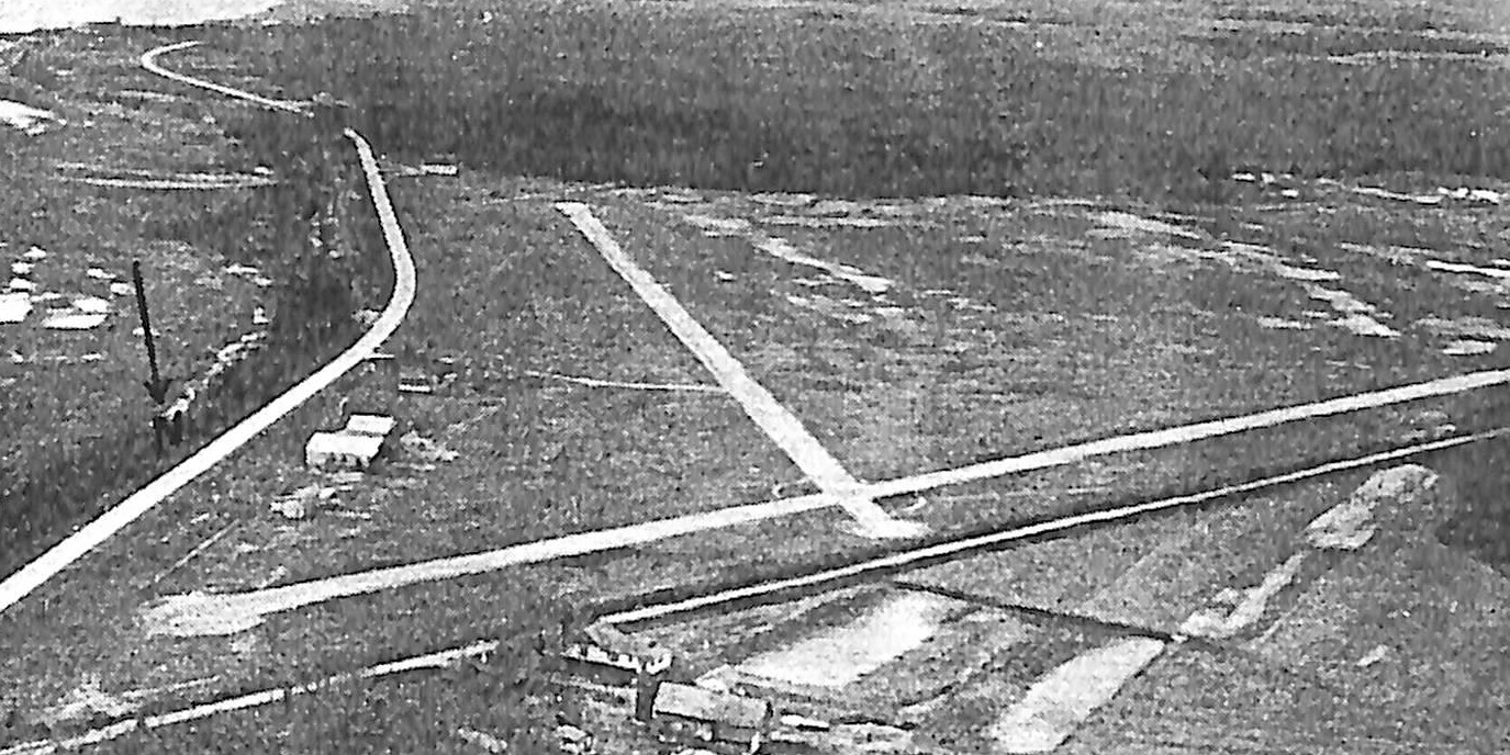
A circa 1930s aerial view looking south (courtesy of Mike Kaufman, via Walter Ballauer) depicted Menominee County Airport
as having 2 perpendicular gravel runways, with a few small hangars on the east side.
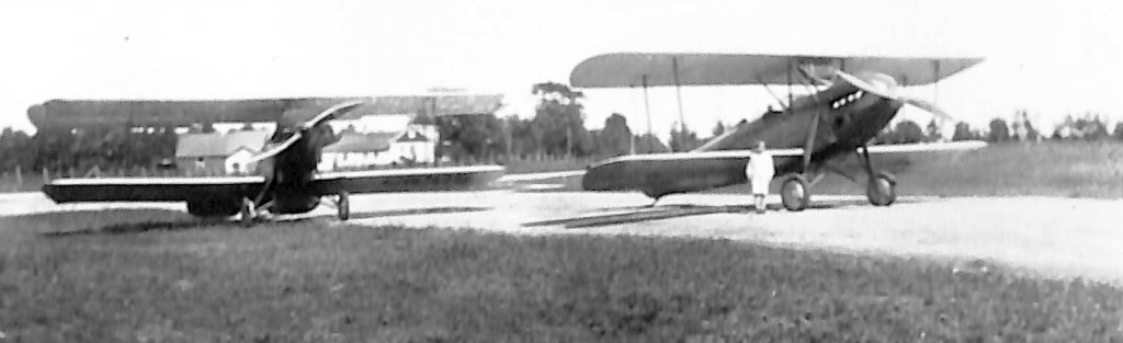
A circa 1930s photo (courtesy of Mike Kaufman, via Walter Ballauer) of 2 unidentified biplanes at Menominee County Airport.
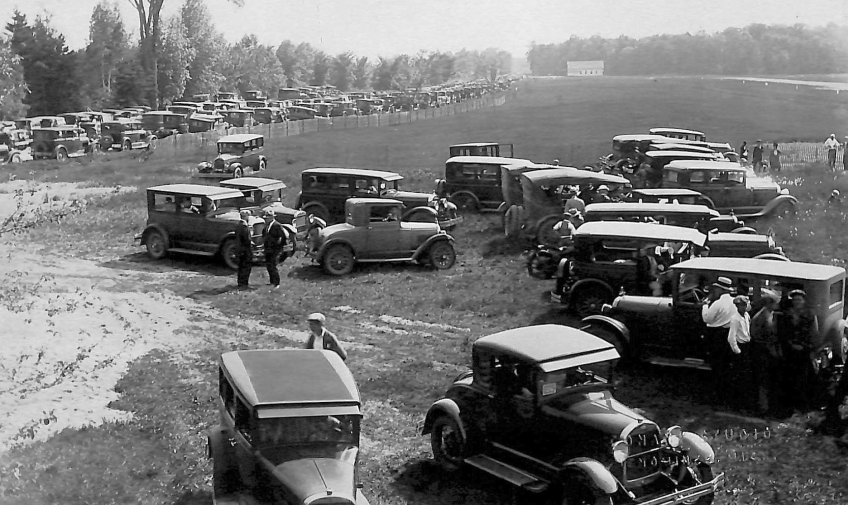
A circa 1930s photo (courtesy of Mike Kaufman, via Walter Ballauer) of a large number of cars parked at Menominee County Airport for an air show.
The last aeronautical chart depiction which has been located of Menominee County Airport was on the December 1943 Green Bay Sectional Chart.
It depicted Menominee County as a commercial/municipal airport.
The last depiction which has been located of Menominee County Airport was in the 1947 MI Airport Directory (courtesy of Mike Denja).
It depicted Menominee County Airport as having 2 gravel runways, with the longest being the 2,650' east/west strip.
A hangar, office, and a few other small buildings were depicted on the east side.
The much larger Menominee Regional Airport opened on the west side of Menominee in June 1947,
at which point the Menominee County Airport.
Only the
Menominee Regional Airport was depicted on the November 1950 Green
Bay Sectional Chart.
A 6/1/53 USGS aerial photo depicted Menominee County Airport after it had been abandoned.
The alignment of the 2 former runways was still apparent, and the airport concrete circle marking was still prominent.
A few small buildings appeared to remain on the east side.
By the time of a 1994 aerial view, the site of Menominee County Airport had become overgrown, and was no longer recognizable as a former airport.
A 2016 aerial view looking north showed the faintest trace of the Menominee County Airport's 3 runway triangular layout was still recognizable.
Mike Denja reported in 2022, “There is some small legacy of the airport: The park next to the old airport is called oddly enough Airport Park.
I also wouldn’t doubt that under the canopy of all those trees that the concrete circle so very common in the Michigan Upper Peninsula airports of that time is still there.”
Thanks to Walter Ballauer for pointing out this airfield.
____________________________________________________
Calumet-Laurium Airport / Houghton County Airport, Laurium, MI
47.233, -88.434 (Northwest of Detroit, MI)
Calumet-Laurium Airport, as depicted on the February 1936 Lake Superior Sectional Chart.
According to “The Living Legacy of the CWA” by James Anderson,
“The city purchased property in December 1933 with a CWA grant for airport construction.
The announcement of the site was announced in the 12/13/33 EDP.
According to the CWA report, the airport was 50% completed by the end of March, with a CWA expenditure of $24,500.”
According to Paul Kaiser, "The construction of the Airport was the largest WPA Project in Houghton County.
Over 5,000 men loaded & moved the dirt with picks & shovels & wheelbarrows.
It was very popular as a stop on the American Legion 'fly-ins' in the 1930s.
Many of us had our first airplane ride during one of these barnstorming flights."
According to Ice Hokey Wiki, the Laurium Airport hangar “was built in 1934.”
The earliest depiction which has been located of Calumet-Laurium Airport was on the February 1936 Lake Superior Sectional Chart.
It depicted Calumet-Laurium as a commercial/municipal airport.
According to “The WPA Guide to Michigan: The Great Lakes State", “The Laurium City Airport, at the eastern end of 3rd Street,
was once used by Army flyers from Selfridge Field for winter maneuvers, the planes being equipped with skis for landing on snow & ice."
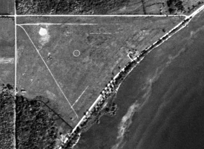
The only photo which has been located of Calumet-Laurium Airport was a 6/5/38 USGS aerial view.
It depicted Calumet-Laurium Airport as having a grass airfield, with one hangar on the northwest side.
An airport circle marking was in the center of the airfield, a north arrow was on the west side,
and the words “Calumet-Laurium” were prominently spelled out next to the hangar.
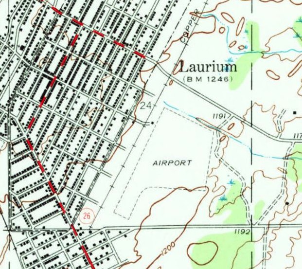
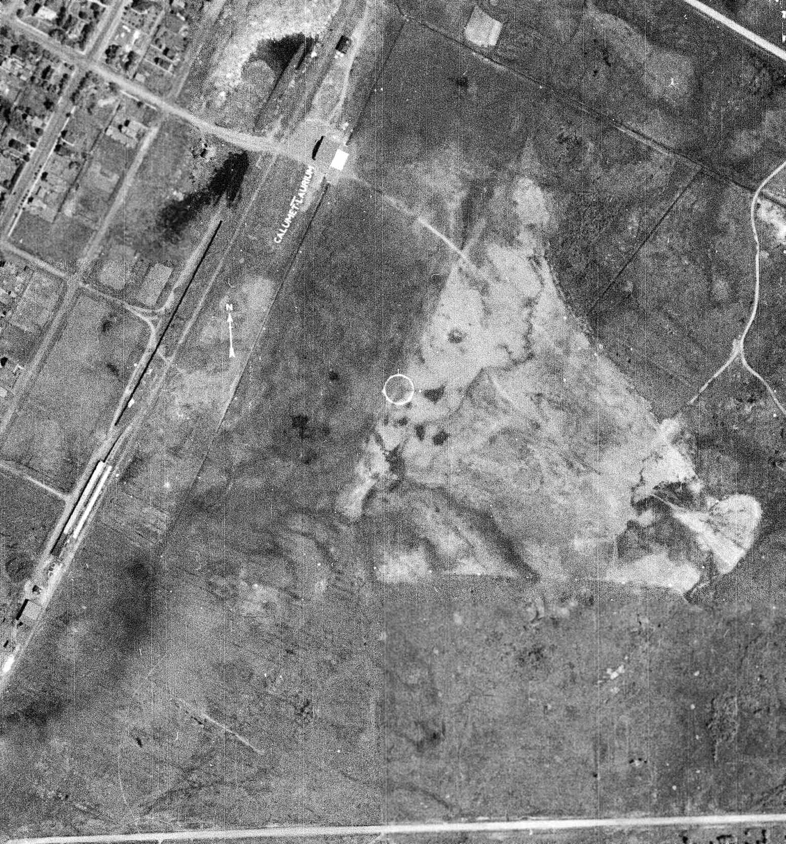
The 1946 USGS topo map depicted Calumet-Laurium Airport as an irregularly-shaped property outline with 1 small building on the northwest side.
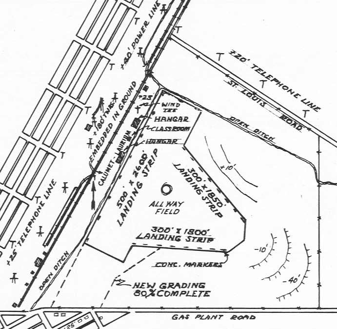
The 1947 MI Airport Directory (courtesy of Bill Grasha) depicted Calumet-Laurium Airport as having 3 runways, with the longest measuring 2,600' northeast/southwest.
Two hangars & a classroom were depicted on the northwest side.
The last aeronautical chart depiction which has been located of Laurium Airport was on the May 1950 Lake Superior Sectional Chart.
It depicted Laurium Airport as having a 2,800' unpaved runway.
According to Ice Hokey Wiki, “The airport closed in the late 1950s & was redesigned into a 140'x60' natural ice surface”, reused as the Laurium Airport Ice Rink.
“The facility was owned by the Village of Laurium.”
According to “The Living Legacy of the CWA” by James Anderson, “The original Laurium Airport hangar was so sturdily constructed
that it was then taken over by the Village of Laurium, probably around 1968.”
According to
Ice Hokey Wiki, “The arena was used until 1976. The facility
was converted into a maintenance garage by the Village.”
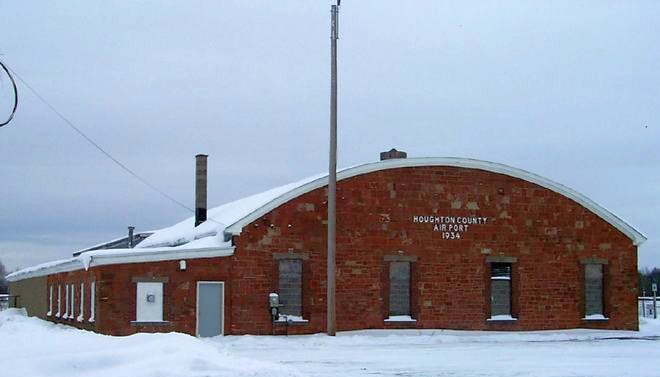
A 2000 or before photo of the brick former hangar, marked “Houghton County Airport 1934”.
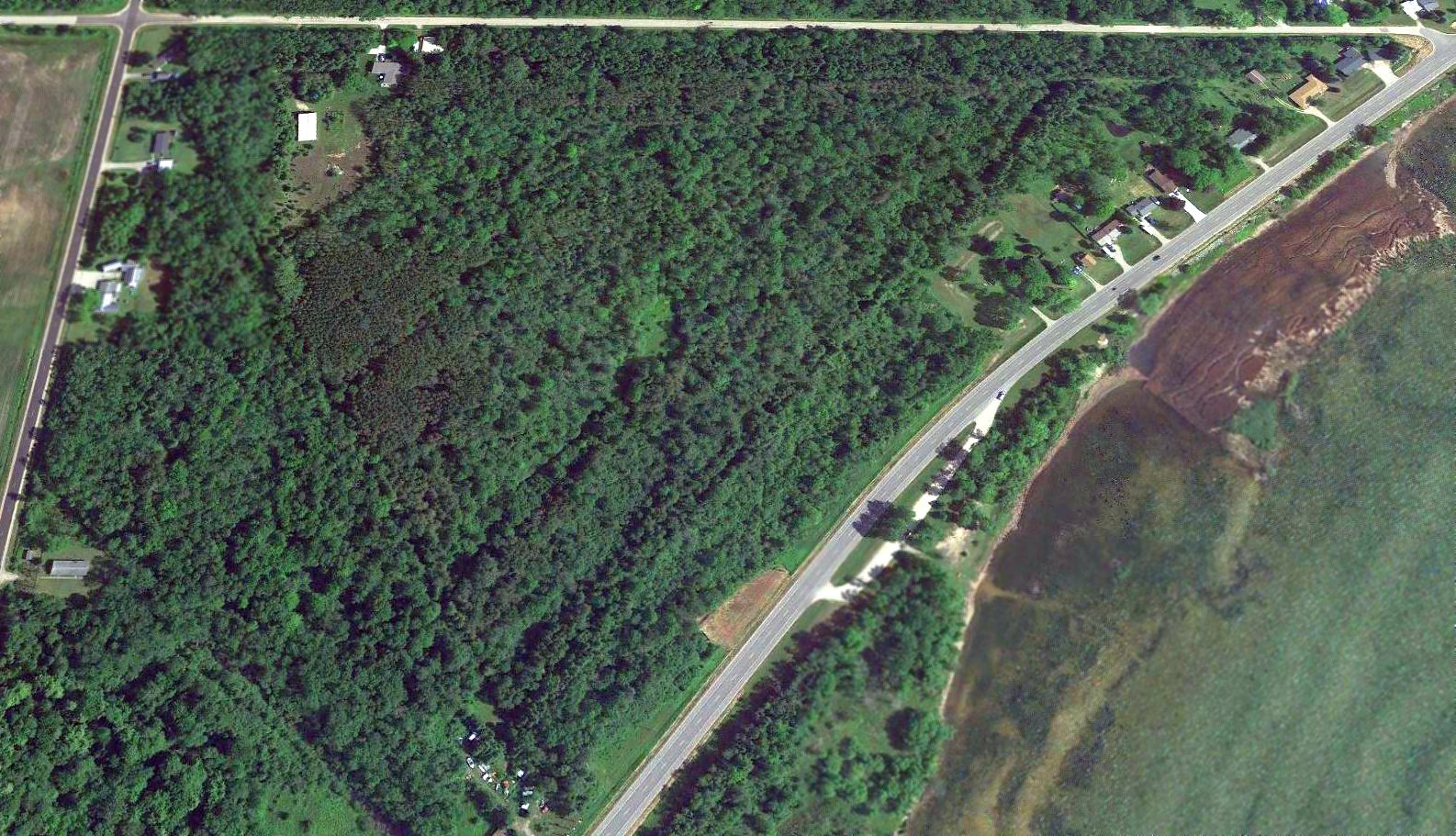
A 2017 aerial view of the site of Calumet-Laurium Airport, showing the airfields area remains open, and the former hangar remains standing on the northwest side.
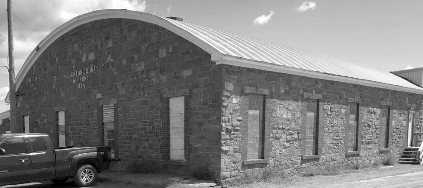
A 7/3/19 photo by James Anderson of the brick former hangar, marked “Houghton County Airport 1934”.
According to “The Living Legacy of the CWA” by James Anderson, “The original Laurium Airport hangar is now in active service as the village’s heavy equipment & maintenance garage (primarily for winter snow plowing).
I was fortunate enough to be given a tour of the structure & the heavy equipment stored & maintained in it, by its head mechanic on 7/3/19.
From outward & limited inside appearances, the building looks well fit for another half-century of use, if it continues to receive sufficient preventive maintenance.”
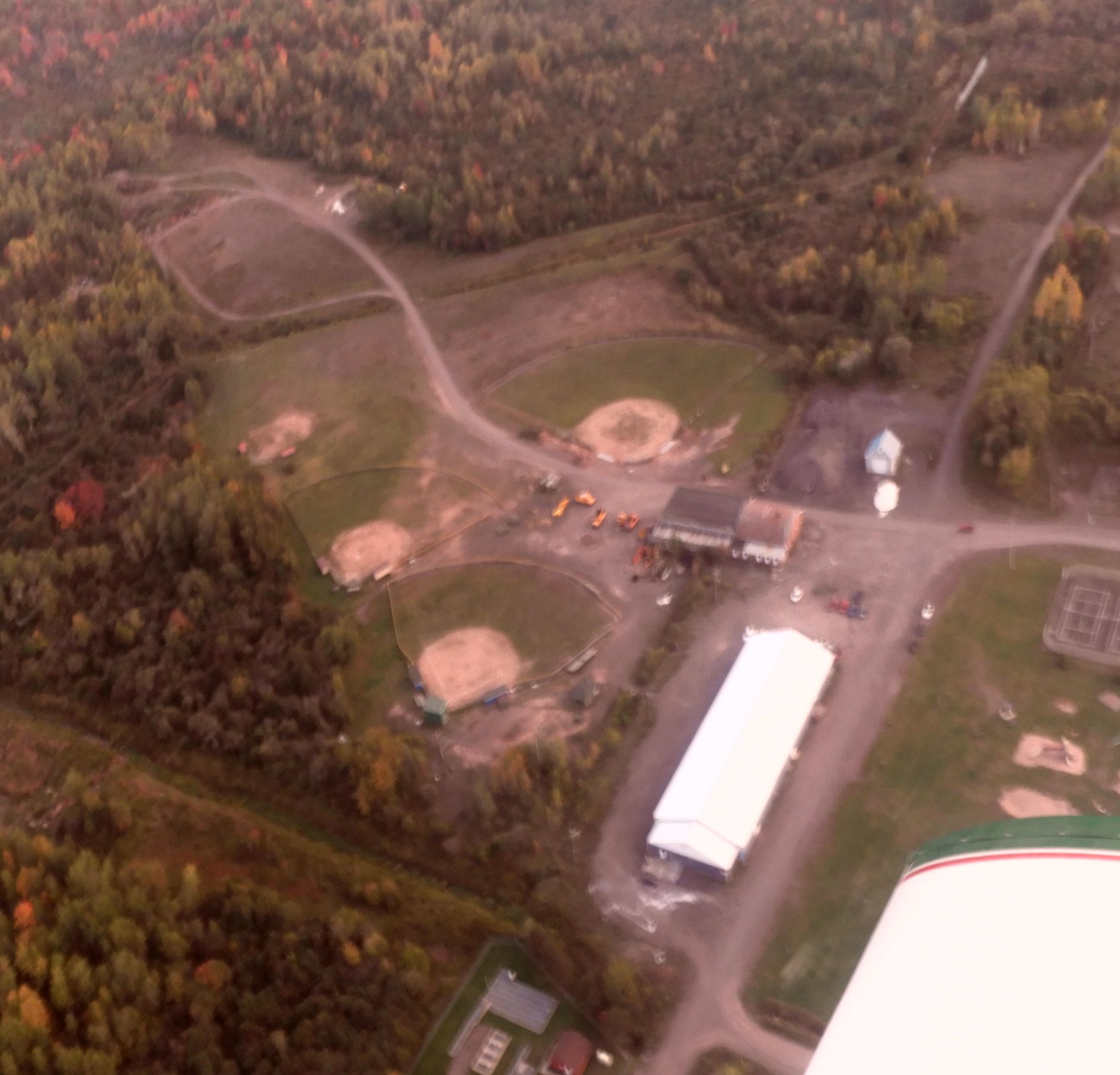
A September 2023 aerial view by Hurricane Hamilton looking southeast the Calumet-Laurium Airport site, showing the former hangar in the center of the photo.
Thanks to Bill Grasha for pointing out this airfield.
____________________________________________________
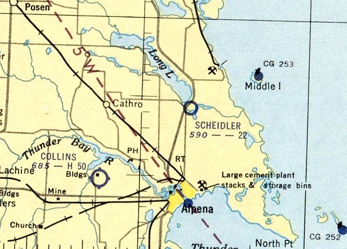
45.162, -83.42 (Northwest of Detroit, MI)
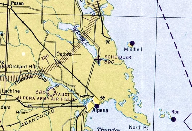
Scheidler Field, as depicted on the January 1946 Lake Huron Sectional Chart (courtesy of Mike Denja).
According to an article by Mae Blake in the 10/15/45 99 Newsletter (courtesy of Bill Grasha),
“Our weekend in Alpena was held September 8-9 in connection with the opening & dedication of Scheidler Field, situated among the lakes & woods of northern Michigan.
It is a privately-owned field on the farm of Dr. N.O. Scheidler & his daughter Carol, our newest 99'er & only member in Alpena.
It's a lovely field - adequate runways (2,400' & 1,900' usable), wind sock & tee, runway markers all painted a bright yellow, and gas pumps.
The Scheidlers own their own plane & both fly. They have opened the field & its facilities to the people of Alpena & surrounding towns.
Airline service & planes for private charter & passenger work will be available. Also a full-time instructor has been brought in for the use of the community.
They want the 99'ers to know that they are especially welcome. For the benefit of the 49½'ers, I might say that the field is In the heart of excellent hunting & fishing territory.
Transportation to & from city & hotel accommodations are guaranteed at all times.
All of this, in the beginning just a hobby, has been accomplished in a year - you see Dr. Scheidler is a dentist (and no time & a half for overtime, he says) and Carol a laboratory technician.
The Scheidlers are looking for no laurels, but the 99'ers extend their heartiest congratulations to them for their contribution to the community & aviation.”
The earliest depiction which has been located of Scheidler Field was on the January 1946 Lake Huron Sectional Chart (courtesy of Mike Denja).
It depicted Scheidler Field as as auxiliary airfield.
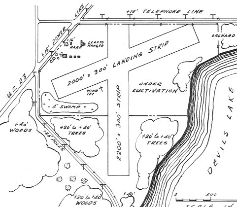
The 1947 MI Airport Directory (courtesy of Bill Grasha) depicted Scheidler Field as having 2 runways, with the longest being the 2,200' north/south strip.
A lean-to hangar & several small buildings were depicted on the northwest side.
According to the book “Michigan Aviation” (courtesy of Mike Denja), Scheidler Field closed in 1951.
The last aeronautical chart depiction which has been located of Scheidler Field was on the June 1952 Lake Huron Sectional Chart (courtesy of Mike Denja).
It depicted Scheidler Field as having a 2,200' unpaved runway.
Scheidler Field was no longer depicted on the 1953 Lake Huron Sectional Chart (according to Mike Denja).
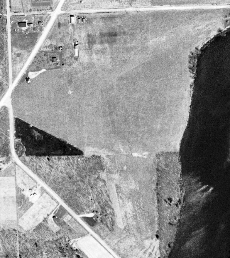
The only photo which has been located of Scheidler's Field was on a 4/28/54 aerial view (courtesy of Mike Denja), after the airport's closure.
It depicted Scheidler Field as having 2 unpaved runways, with a few small buildings on the northwest side. There were no aircraft visible on the field.
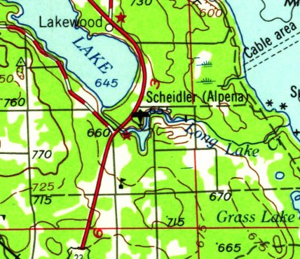
The earliest topo map depiction which has been located of Scheidler's Field was on the 1958 USGS topo map.
A 1971 aerial photo showed several houses having been built on the northwest side of the Scheidler Field site,
and the area of the runways was overgrown.
A 2016 aerial view showed no trace remaining of Scheidler Field.
Thanks to Bill Grasha for pointing out this airfield.
____________________________________________________
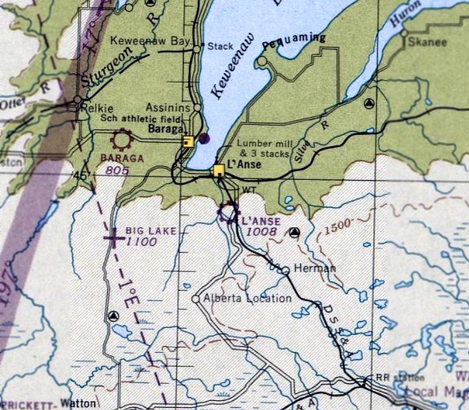
L'Anse Airport / Muzzy's Airport, L'Anse, MI
46.722, -88.431 (Northwest of Detroit, MI)
L'Anse Airport, as depicted on the June 1947 Lake Superior Sectional Chart.
L'Anse Airport was evidently established at some point between 1946-47
(like hundreds of other small airports in the US post-WW2 aviation boom),
as it was not yet depicted on the June 1946 Lake Superior Sectional Chart.
The earliest depiction which has been located of L'Anse Airport was on the June 1947 Lake Superior Sectional Chart.
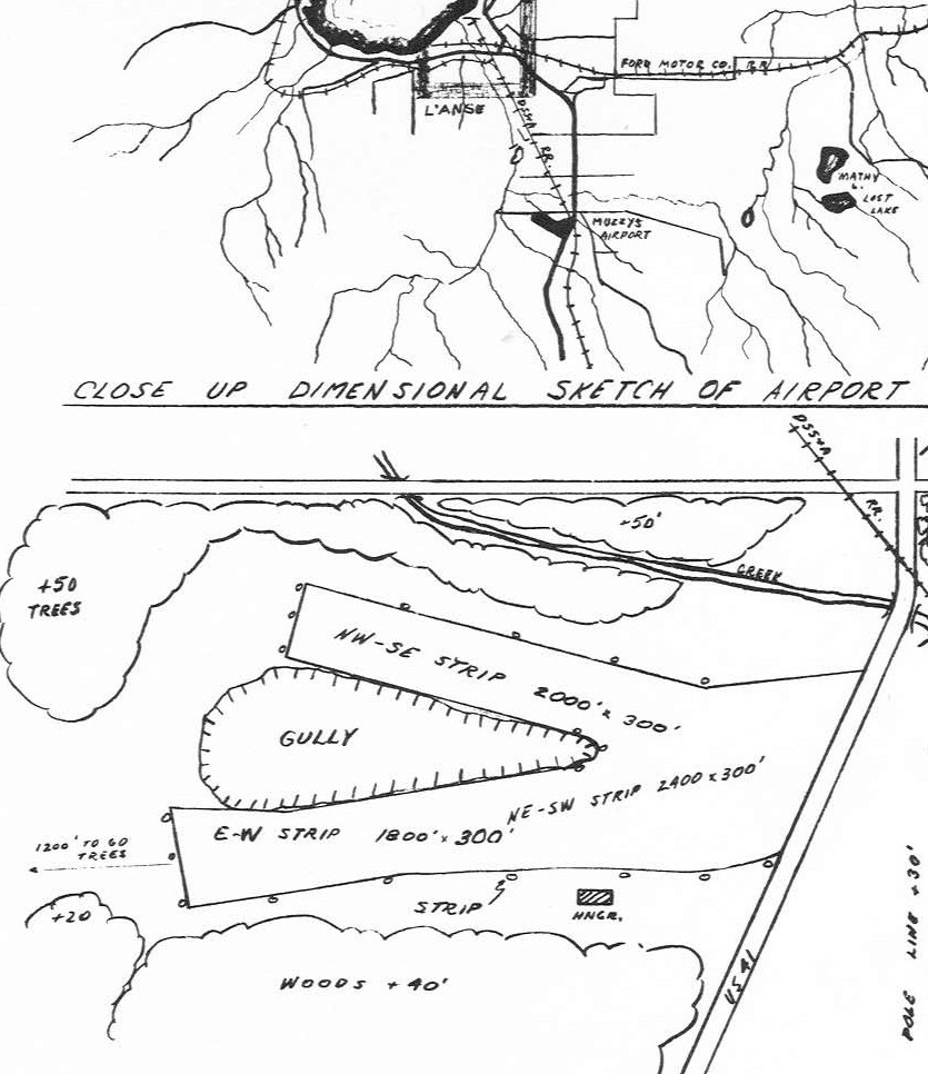
The 1947 MI Airport Directory (courtesy of Bill Grasha) depicted L'Anse Airport under the name of Muzzy's Airport.
It was shown to have 3 unpaved runways, with the longest being the 2,400' northeast/southwest strip.
A single hangar was depicted on the south side.
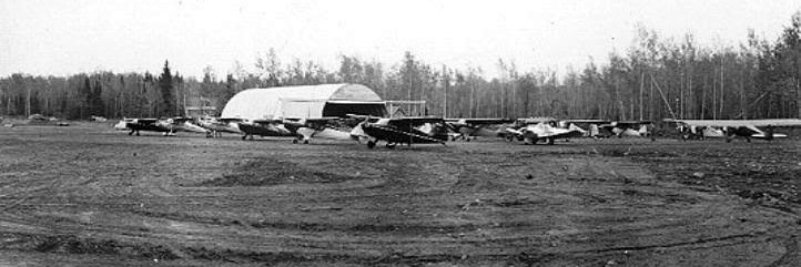
The earliest photo which has been located of Muzzy's Airport was a circa 1940s photo of a dozen light single-engine aircraft parked near a Quonset hut hangar.
A circa 1940s photo depicted a light aircraft landing or taking off at Muzzy's Airport.
The last photo which has been located of Muzzy's Airport was a 5/12/52 aerial view (courtesy of Mike Denja)
which showed an irregularly-shaped unpaved airfield, with 1 light single-engine aircraft parked near a Quonset hut on the southeast side.
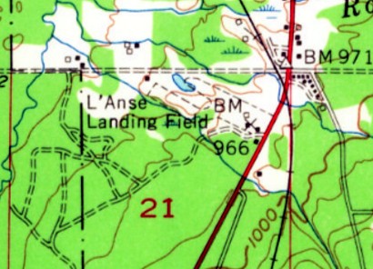
The 1955 USGS topo map depicted “L'Anse Landing Field” as an irregularly-shaped property outline.
L'Anse Airport was evidently closed by 1962, as that is when the L'Anse Golf Course opened on the property.
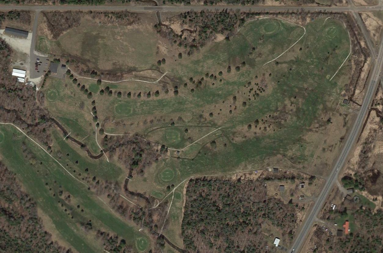
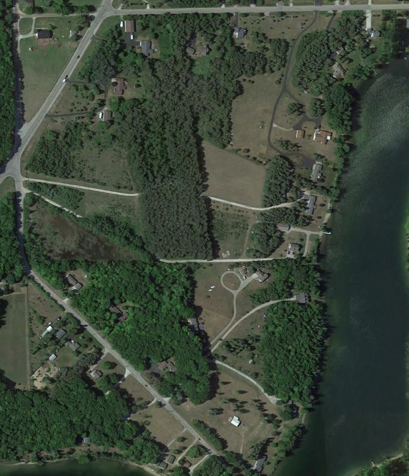
A 2014 aerial view showed the L'Anse Golf Course occupying the site of Muzzy's Airport.
The site of Muzzy's Airport is located southwest of the intersection of Golf Course Road & Route 41.
Thanks to Bill Grasha for pointing out this airfield.
____________________________________________________
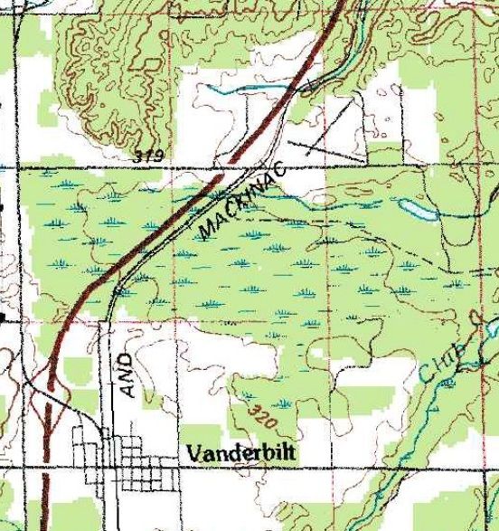
Sunglen Airfield, Vanderbilt, MI
45.173, -84.633 (Northwest of Detroit, MI)
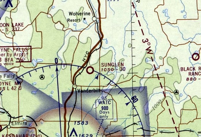
Sunglen Airfield, as depicted on the March 1966 Green Bay Sectional Chart (courtesy of Mike Denja).
Sunglen Airfield may have been constructed at some point between 1965-66,
as it was not yet depicted on a 1952 aerial photo, the 1955 USGS topo map, or the May 1965 Green Bay Sectional Chart.
The earliest depiction which has been located of Sunglen Airfield was on the March 1966 Green Bay Sectional Chart (courtesy of Mike Denja).
It depicted Sunglen Airfield as having a 3,000' unpaved runway.
The 1970 Airman’s Information Manual shows Sunglen Airport to be permanently closed to the public.
The last aeronautical chart depiction which has been located of Sunglen Airport was on the May 1971 Green Bay Sectional (according to Mike Denja),
which described Sunglen as a private airfield.
The 1979 USGS topo map (courtesy of Mike Denja) depicted 2 runways of Sunglen Airfield, but without any label.
The earliest photo which has been located of Sunglen Airfield was a 1981 aerial view.
It depicted 2 runways with a small hangar & a larger building on the southwest side.
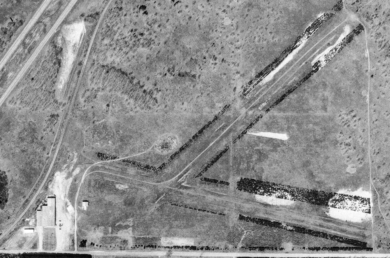
The earliest photo which is available of Sunglen Airfield was a 4/20/83 aerial view (courtesy of Mike Denja).
It depicted Sunglen Airfield as having 2 unpaved runways with a small hangar on the west side.
Sunglen Airfield was not depicted on the 1986 USGS topo map.
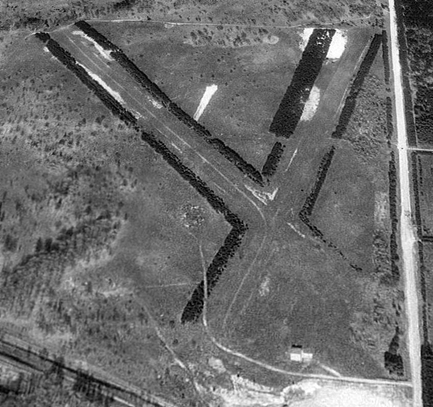
A 1993 USGS aerial view looking east depicted Sunglen Airfield as having 2 unpaved runways with a small hangar on the west side.
Sunglen Airport was evidently closed (for reasons unknown) at some point between 1971-94,
as it was no longer depicted on the 1994 Green Bay Sectional Aeronautical Chart.
A 2013 aerial view looking east at Sunglen Airfield showed the runways remained clear.
A 2014 aerial view by Greg Wilson looking east at Sunglen Airfield showed the runways remained clear.
Sunglen Airfield is located northeast of the intersection of Interstate 75 & East Alexander Road.
Thanks to Greg Wilson for pointing out this airfield.
____________________________________________________
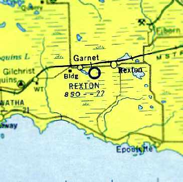
Rexton Airport / D A R Airport, Rexton, MI
46.153, -85.271 (North of Detroit, MI)
Rexton Airport, as depicted on the February 1936 Lake Superior Sectional Chart.
This small general aviation airport was established at some point between 1933-34,
as it was not listed among active airfields in the Airport Directory Company's 1933 Airport Directory (according to Chris Kennedy).
The earliest reference to Rexton Airport which has been located
was in 1934 Department of Commerce Airport Directory (courtesy of Chris Kennedy).
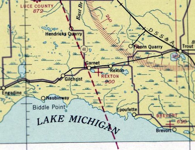
It described “Rexton Airport” as a state airport, located along the south side of Route 2, 1.5 miles southwest of Rexton.
The field was said to have 2 sandy loam runways, oriented in a T-shape, measuring 2,100' east/west & 1,700' north/south.
The earliest depiction of Rexton Airport which has been located was on the February 1936 Lake Superior Sectional Chart.
It depicted Rexton as an auxiliary airfield.
On the December 1942 4M Regional Aeronautical Chart (according to Chris Kennedy) it was still labeled as “Rexton”.
The earliest photo which has been located of Rexton Airport was a 9/19/43 aerial view looking north (courtesy of Brian Rehwinkel).
Brian Rehwinkel observed, “The photo was taken in the middle of the war & it shows an empty field, which seems par for the course for this airfield.”
At some point between 1942-44, it was apparently renamed as “D A R Airport”,
as that is how it was labeled on the June 1944 Lake Superior Sectional Chart (courtesy of Chris Kennedy).
It depicted “D A R” as an auxiliary airfield.
It was still listed as “D A R” in the December 1944 Army/Navy Airfield Directory (according to Chris Kennedy).
The airfield was evidently renamed “Rexton Municipal” at some point between 1944-45,
as that is how it was listed in the 1945 Haire Publishing Company Airport Directory (according to Chris Kennedy).
It was said to be owned by the State, and its condition was described as “Rough. Not maintained.”
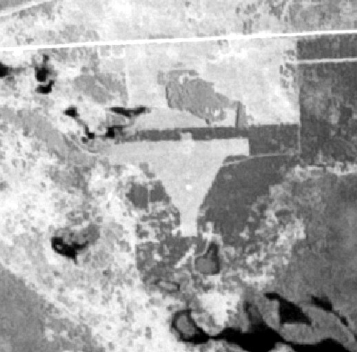
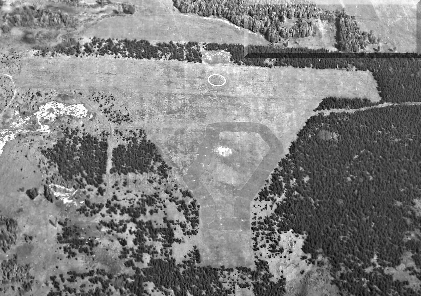
An admittedly low-resolution 6/1/53 aerial view depicted Rexton Airport as having 2 perpendicular unpaved runways.
The last photo which has been located of the Rexton Airport while it was in operation was a 5/2/55 USGS aerial view (courtesy of Brian Rehwinkel).
It depicted Rexton as having 2 perpendicular unpaved runways, with a prominent airport circle marking in the center.
There did not appear to be any buildings at the site.
The last aeronautical chart depiction which has been located of the Rexton Airport
was on the May 1957 Lake Superior Sectional Chart (courtesy of Chris Kennedy).
It depicted Rexton as having a 2,200' unpaved runway.
Rexton Airport was still listed in the 1957/58 Aviation Week Airport Directory (according to Chris Kennedy).
The field's status was described as "Emergency field only."
Rexton Airport was still depicted on the 1958 USGS topo map.
Rexton Airport was evidently closed (for reasons unknown) at some point between 1957-58,
as it was no longer depicted on the May 1958 Lake Superior Sectional Chart.
No airfield or airfield features were depicted at the site of the Rexton Airport on the 1963 or 1973 USGS topo maps,
although the 1973 topo map labeled “Airport Road”, but not the airport itself.
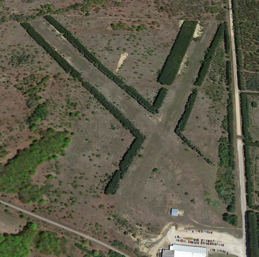
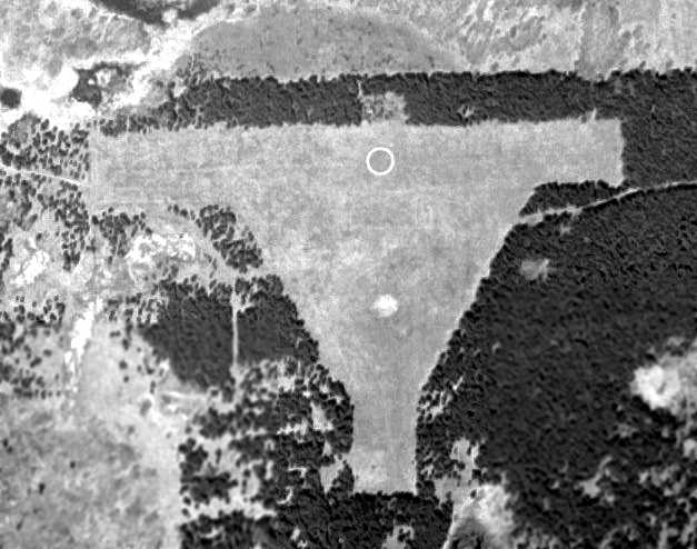
In the 1998 USGS aerial photo the airport circle marker was still plainly evident.
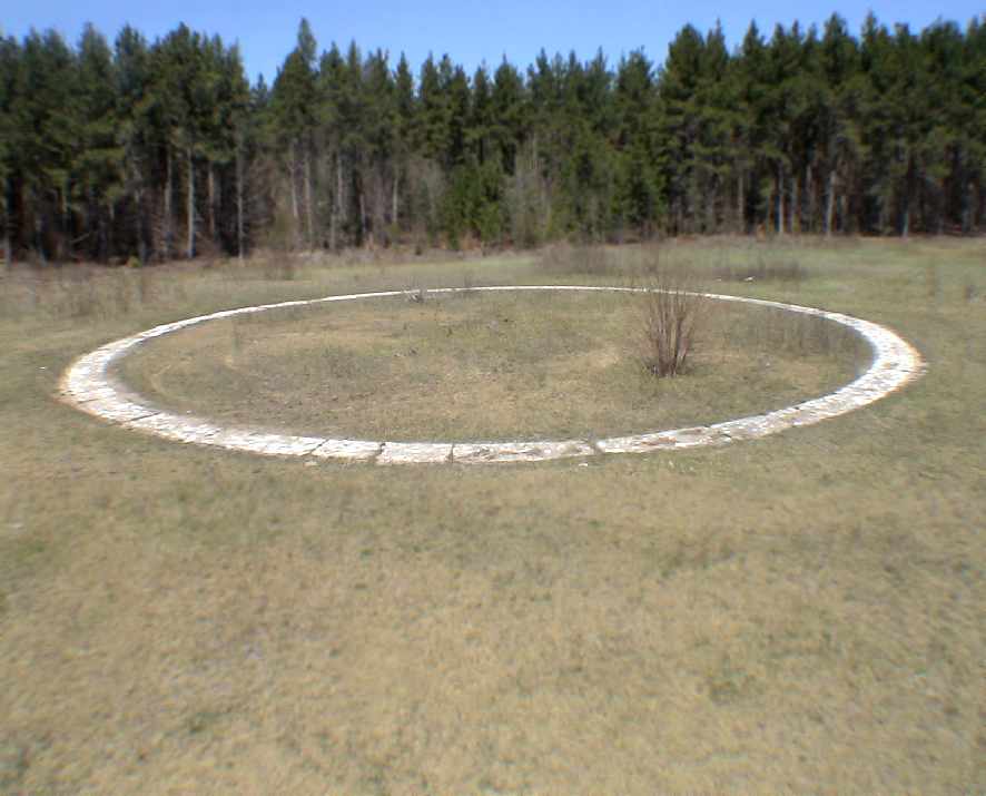
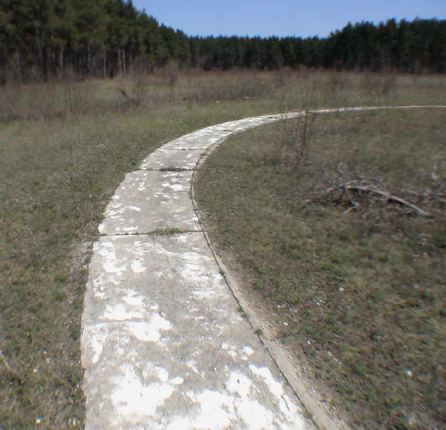
A 2007 photo by Will Denihan of the former airport circle marker,
which remains remarkably completely intact at the site of the Rexton Airport.
Will reported, “My dad has a cabin just a couple of miles from Rexton,
and there is a dirt road named 'Airport Road' which makes a mile or so loop around a forested area with a concrete circle in it's midst,
the circle is roughly 150' in diameter & was obviously painted white at some point in the past,
possibly with reflective paint of some sort.
There are sections of the circle that still have remarkably good paint.”
A closeup 2007 photo by Will Denihan of the former airport circle marker at the site of the Rexton Airport.
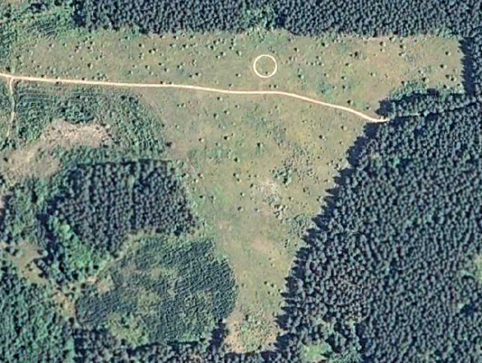
In a 7/26/10 aerial photo, the Rexton Airport circle marker was still plainly evident, along with the presumed airfield outline.
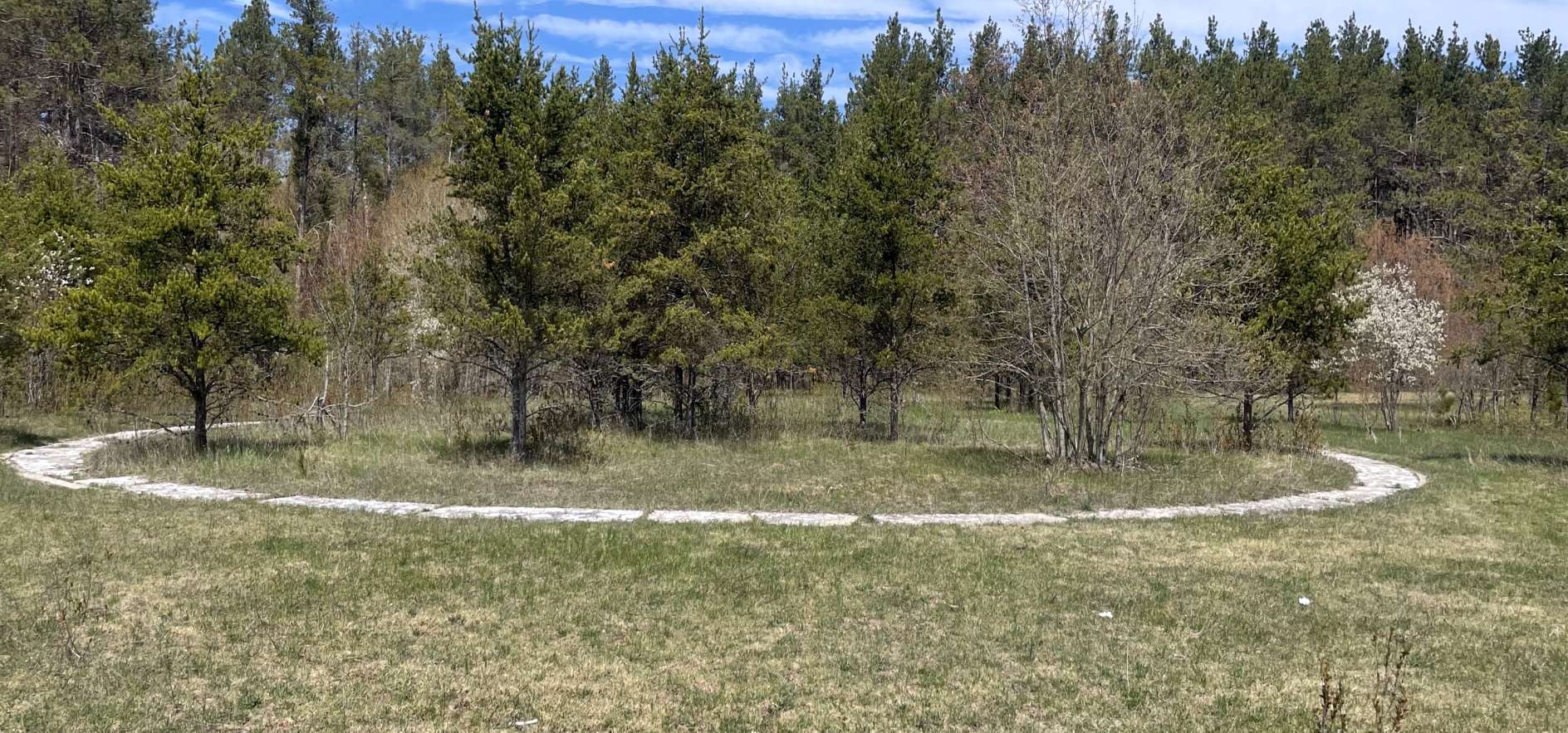
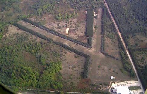
A 5/14/23 photo by Grace Yakuber of the former airport circle marker at the site of the Rexton Airport.
Grace Yakuber reported of Rexton Airport, “The airport can be accessed off a used / maintained 2-track; no issues for the little Buick to make it down.
About halfway down the loop of the road you can find the still-intact airport circle.
The trees have since grown up quite a bit inside of it, and the paint is slowly washing away.
The treeline from the perimeter of both runways still exists. The runways now both consist of a young forest, not landable by any means anymore.”
____________________________________________________
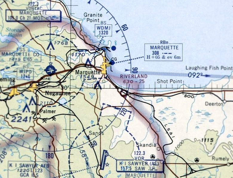
Marquette County Airport (original location) (MQT), Marquette, MI
46.533, -87.56 (North of Green Bay, WI)
Marquette County Airport, as depicted on the February 1936 Lake Superior Sectional Chart.
The original Marquette County Airport was dedicated on 7/12/32, according to a postmark commemorating the occasion (courtesy of Mike Denja).
The earliest depiction of the Marquette County Airport which has been located was on the February 1936 Lake Superior Sectional Chart.
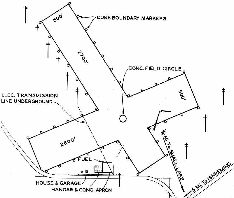
The 1940 MI Airport Directory (courtesy of Chris Kennedy) depicted the “Marquette County Landing Field” as having 2 unpaved runways
(2,700' northwest/southeast & 2,600' northeast/southwest).
A hangar & concrete apron were depicted south of the runway intersection.
The 1946 MI Airport Directory (courtesy of Doug Ranz) depicted Marquette County Airport
as having 2 turf runways (2,700' & 2,600'), and a hangar south of the runway intersection.
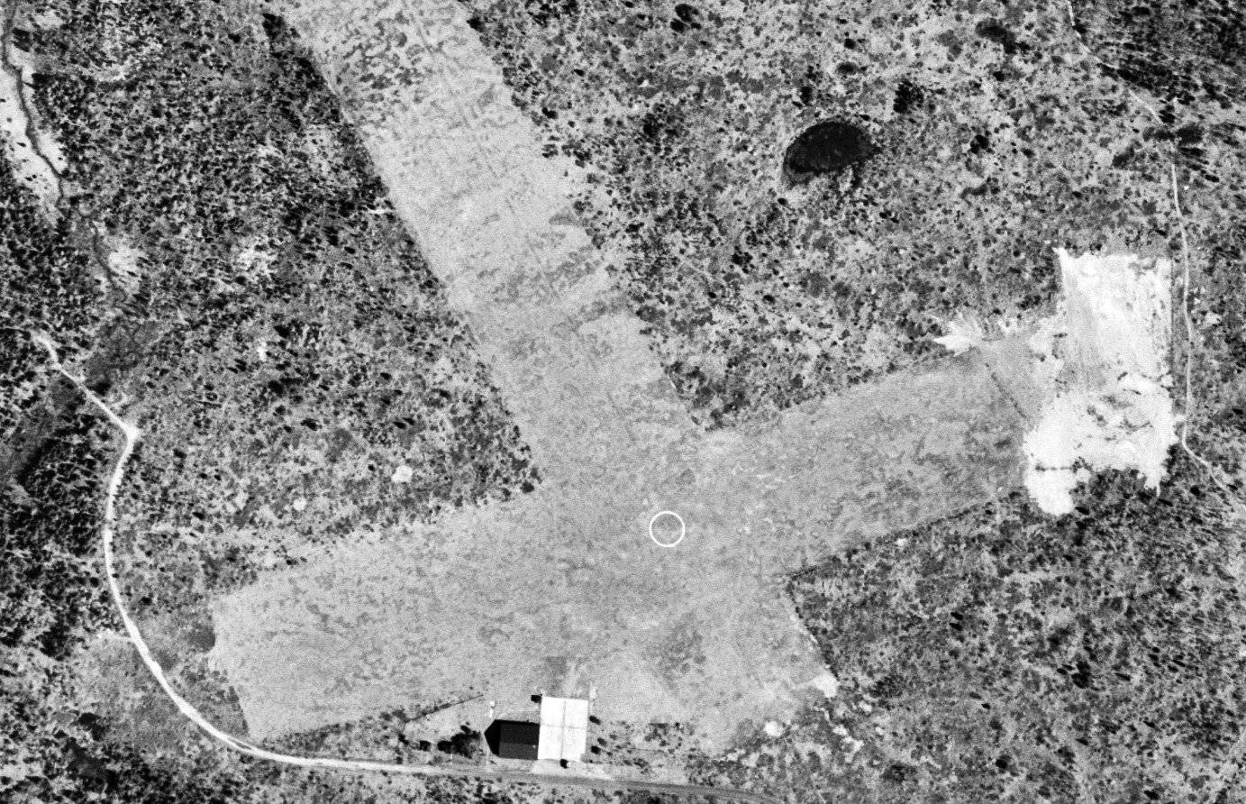
The earliest photo which has been located of Marquette County Airport was a 5/3/52 aerial view (courtesy of Mike Denja).
It depicted Marquette County Airport as having 2 unpaved runways with an airport circle marking at the intersection, and a hangar on the south side.
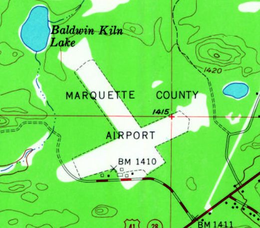
The 1953 USGS topo map depicted Marquette County Airport as having 2 unpaved runways, with a few small buildings along the southwest side.
According to David York, the older terminal at Marquette County Airport
(the brown brick building) was built in 1957, and was also used by the U.S. Weather Service.
Marquette had apparently gained paved runways (in a different configuration as well) at some point between 1946-60,
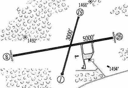
as the 1960 Jeppesen Airway Manual (courtesy of Chris Kennedy)
depicted the field as having 2 paved runways: 5,000' Runway 8/26 & 3,000' Runway 1/19.
A ramp on the southeast side had 2 buildings.
An aerial view looking north at the Marquette County Airport,
from the 1962 Sky Eye Northern Michigan Airport Directory (courtesy of Chris Kennedy).
The field was described as having 2 paved runways: 5,000' east/west & 3,000' north/south.
Marquette County Airport was listed among active airports in the 1962 AOPA Airport Directory,
with 2 paved runways, and the operator listed as Peninsula Air Service.
In the 1982 AOPA Airport Directory (courtesy of Ed Drury),
the field was described as having a 6,500' asphalt Runway 8/26 & a 3,000' asphalt Runway 1/19.
The operators were listed as Marquette Executive Air & Northern Airmotive Inc.
According to David York, in 1983 the older terminal building at Marquette County Airport was replaced by a new, larger terminal building.
However, it was not destined to serve a very long life.
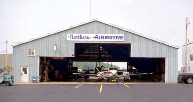
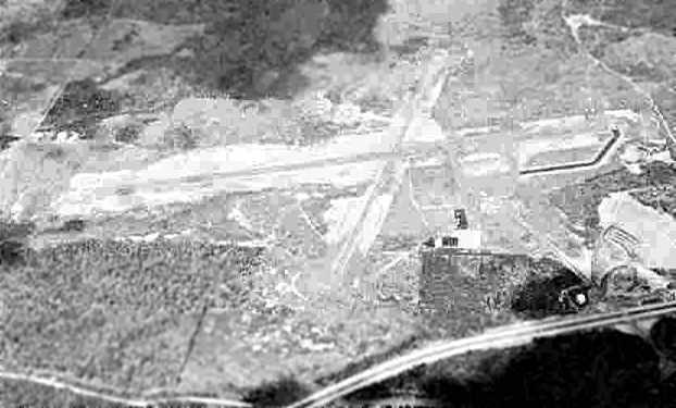
A 1988 photo by Scott Anttila of the Northern Airmotive hangar at Marquette County Airport.
Scott recalled, "I learned to fly at MQT, miss the airport much, and do not want parts of it to be forgotten."
The last aeronautical chart depiction which has been located of the original Marquette County Airport was on the January 1994 Green Bay Sectional Chart (courtesy of Ron Plante).
It depicted Marquette County Airport as having 2 paved runways, with the longest being 6,500'.
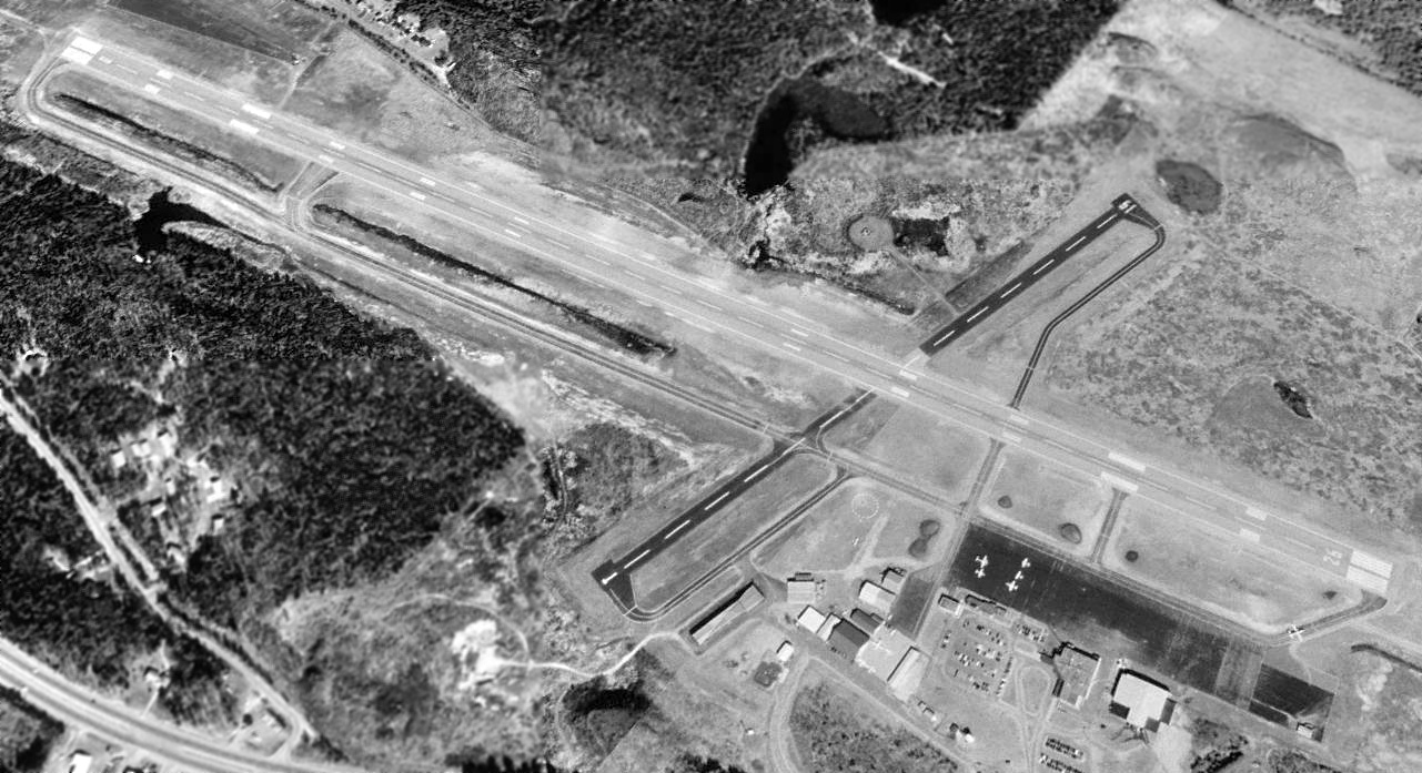
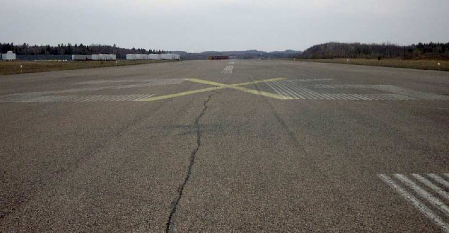
The last photo which has been located showing aircraft at the original Marquette County Airport while it was still open was a 4/29/99 USGS aerial view looking northwest.
A total of 5 light aircraft were visible on the ramp, and a 6th aircraft was taxiing toward Runway 26 for takeoff.
When nearby KI Sawyer AFB was closed by the Air Force in 1999 it became the "new" Marquette County Airport,
and the original Marquette County Airport was closed.
At the time of its closure, the original Marquette County Airport consisted of 2 paved runways
(the longest, 8/26, was 7,000' long), taxiways, ramps & hangars.
A 2003 photo by David York looking along the closed Runway 26 at the former Marquette County Airport.
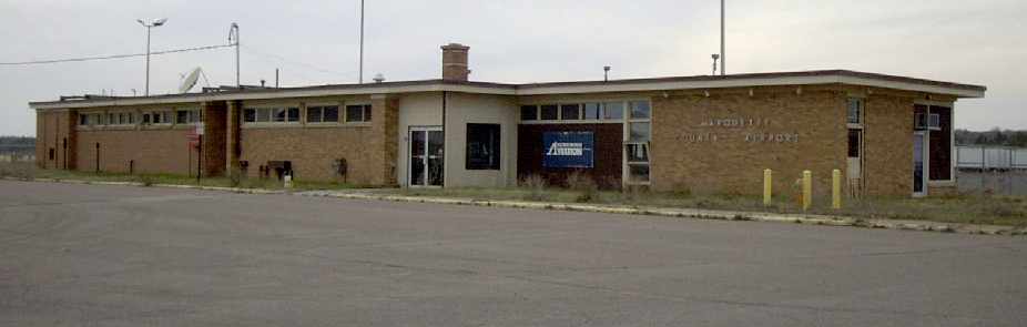
A 2003 photo by David York of the old terminal building at the former Marquette County Airport.
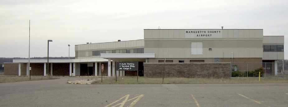
A 2003 photo by David York of the new terminal building at the former Marquette County Airport.
This public building was abandoned only 16 years after it was built.
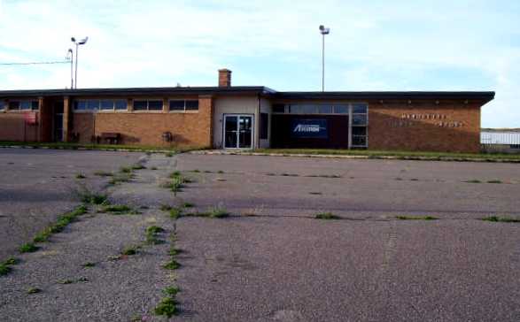
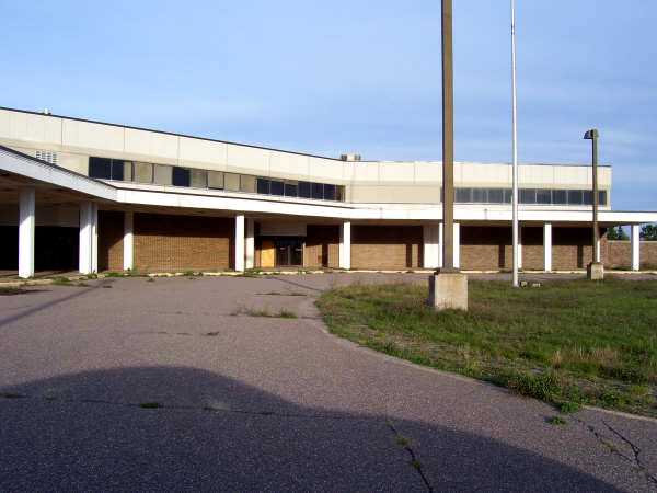
A 2007 photo by John Grego of the abandoned old terminal building at the former Marquette County Airport.
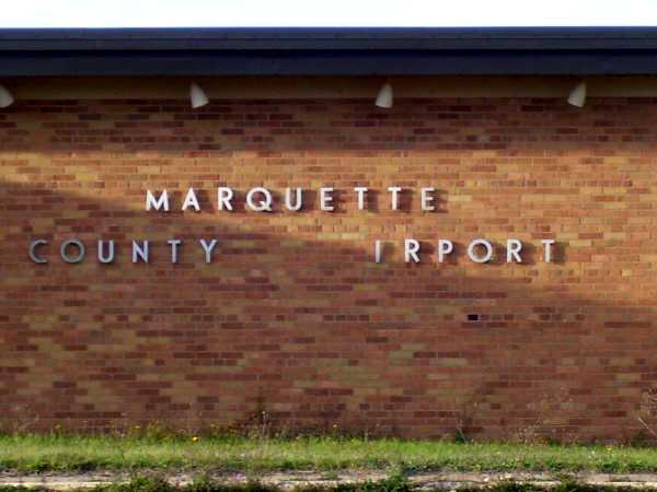
A 2007 photo by John Grego of the sign on the abandoned old terminal building at the former Marquette County Airport.
A 2007 photo by John Grego of the abandoned new terminal at the former Marquette County Airport.
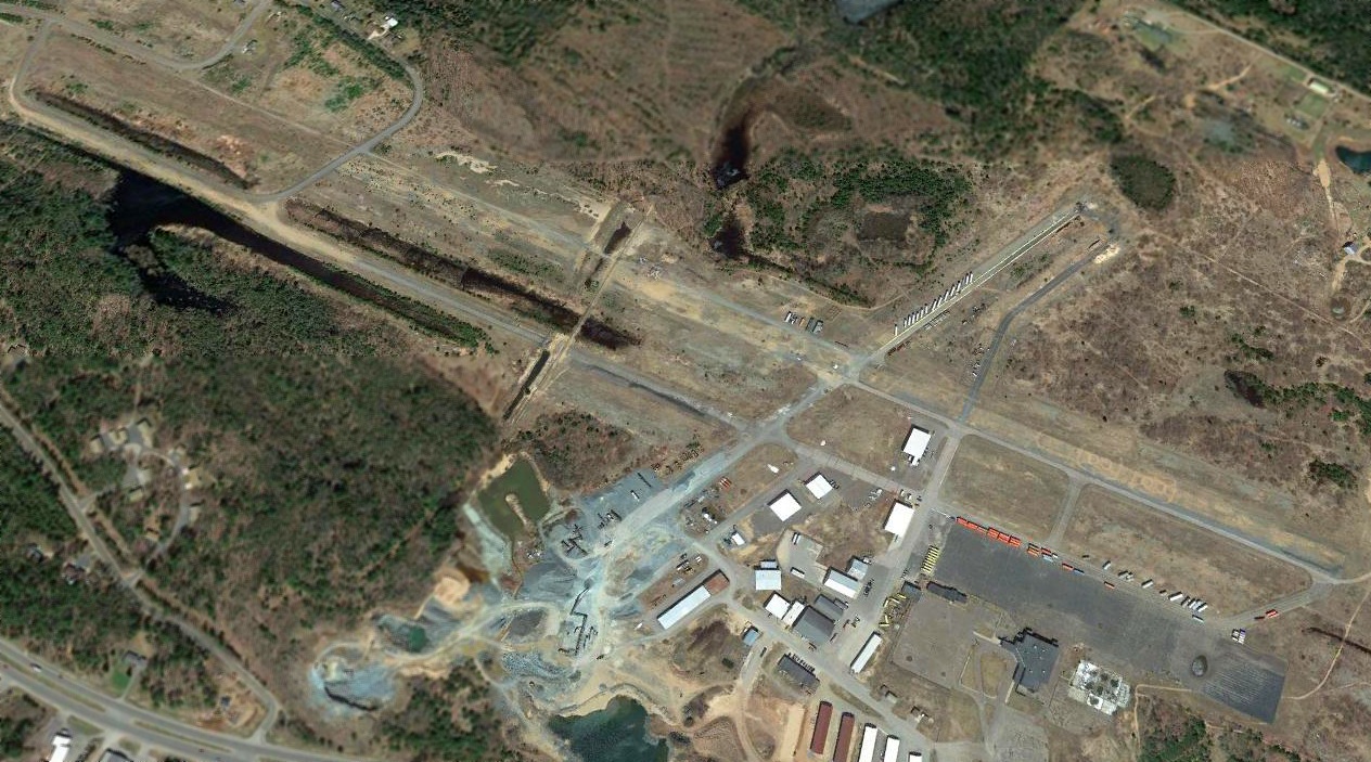
A 2019 aerial view looking northwest showed much of the 2 paved runways had been removed at the site of the original Marquette County Airport.
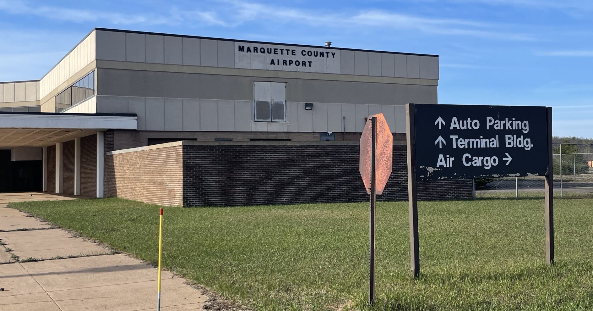
A 5/14/23photo by Grace Yakuber of the abandoned Marquette County Airport “new” terminal building.
Grace Yakuber reported, “Both runways now have been taken by development, or are used as cargo storage for some of the manufacturing companies now based at the airport hangars.”
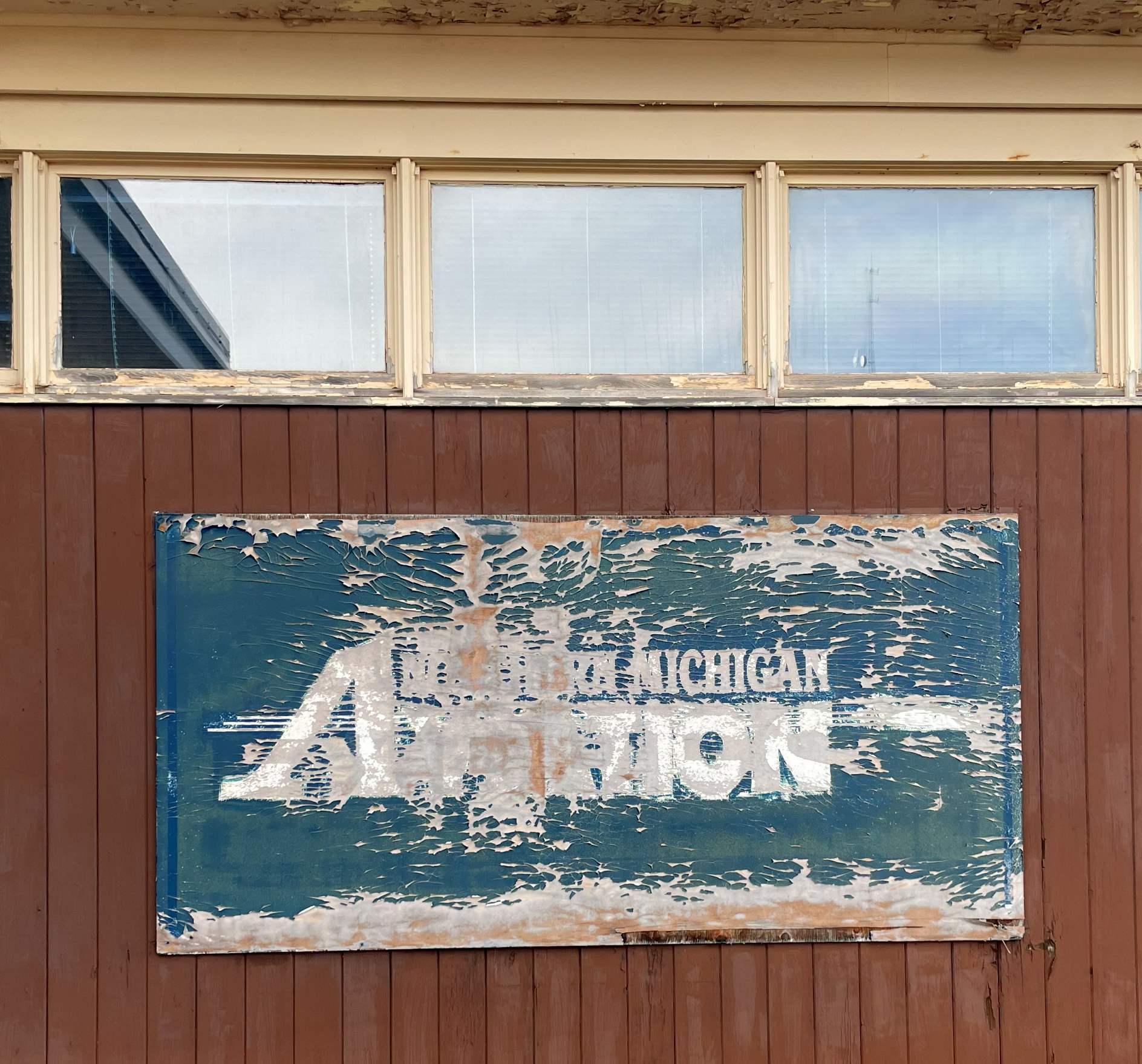
A 5/14/23photo by Grace Yakuber of a sign for “Northern Michigan Aviation” at the abandoned Marquette County Airport.
____________________________________________________
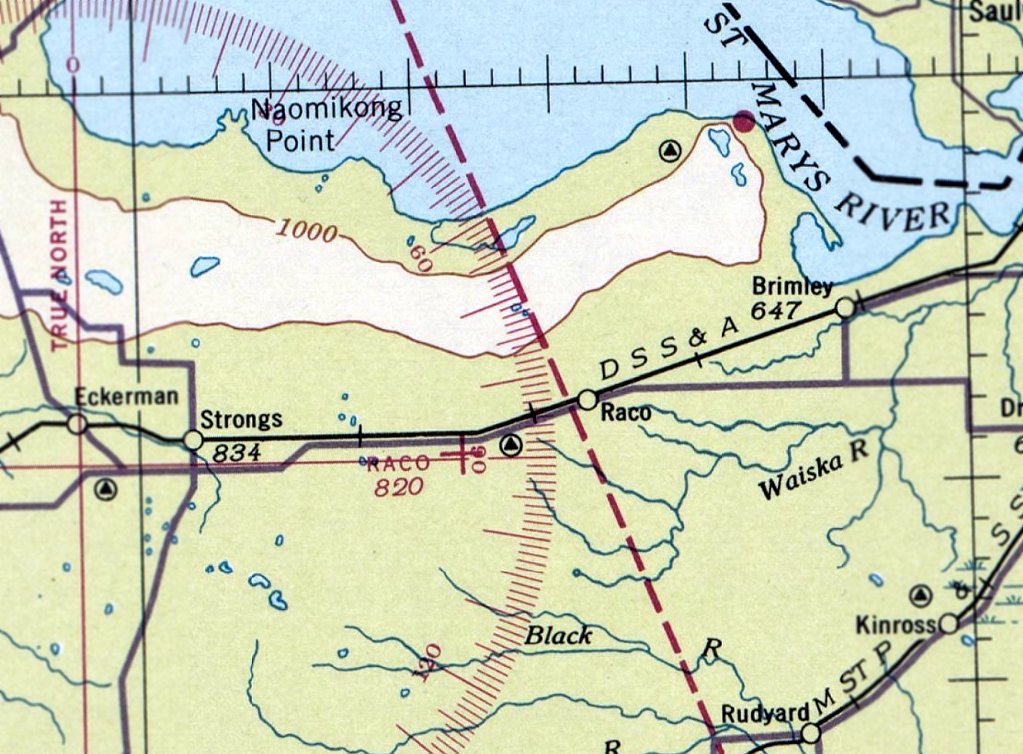
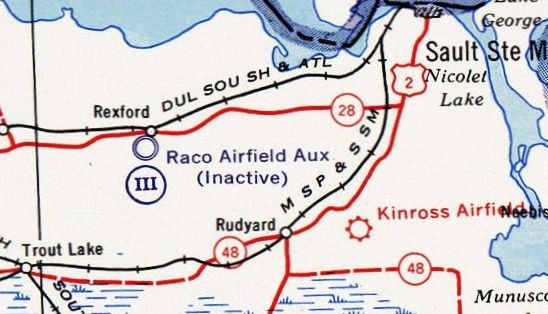
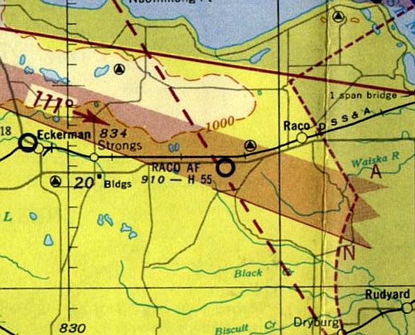
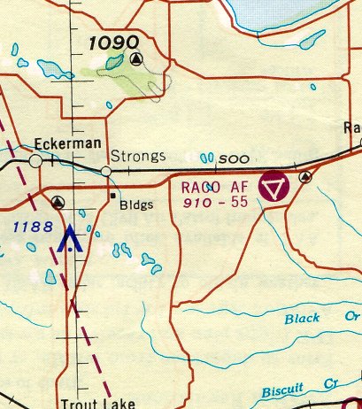
Raco Airport / Raco Army Airfield, Raco MI
46.352, -84.815 (North of Detroit, MI)
Raco Airport, as depicted on the February 1936 Sectional Chart (courtesy of Mike Denja).
Photo of the airfield while open has not been located.
This site has had (at least) 6 completely distinct uses over the years.
The property adjacent to the west side of the airfield has a series of rifle ranges that were established before the first World War.
The date of construction of the first airfield at Raco has not been determined.
The earliest depiction which has been located of Raco Airport was on the February 1936 Sectional Chart (courtesy of Mike Denja).
It depicted Raco as an auxiliary airfield.
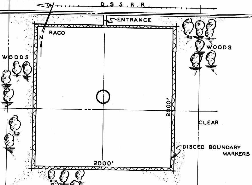
“Raco Landing Field” was depicted on the south side of Route 28, 4 miles west of the town of Raco, on the 1940 MI Airport Directory (courtesy of Chris Kennedy).
It depicted the field as consisting of a 2,000' square, surrounded by “disced boundary markers”.
Raco Airport was still depicted as a civilian auxiliary airfield on the August 1942 Sectional Chart (courtesy of Mike Denja),
but the chart also depicted a very large Prohibited Area in the surrounding area, around the Sault Saint Marie locks.
The site of the pre-WW2 civilian Raco Airport was evidently reused by the military at some point between 1942-43 for the construction of a much more elaborate military airfield,
intended to provide protection to the Sault Saint Marie locks.
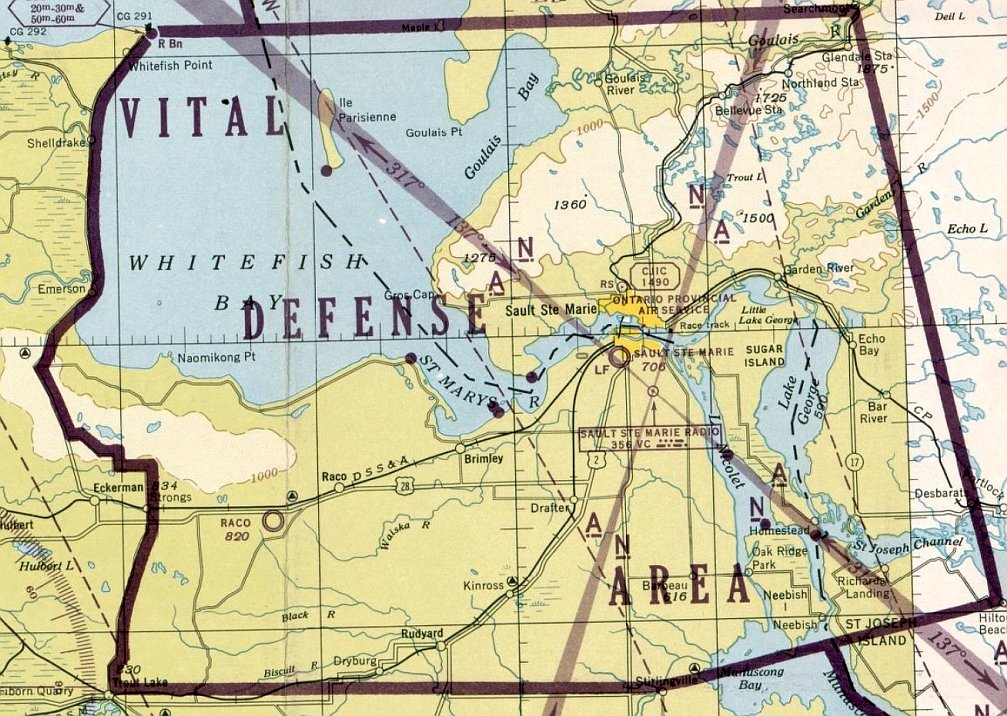
The December 1943 Sectional Chart (courtesy of Mike Denja) depicted Raco Field as a military airfield,
with a “Vital Defense Area” also depicted in the surrounding area, around the Sault Saint Marie locks.
Raco Field may have been under the administrative control of Alpena AAF.
As no threats materialized to the locks, the airfield was apparently little-used, or possibly never used at all.
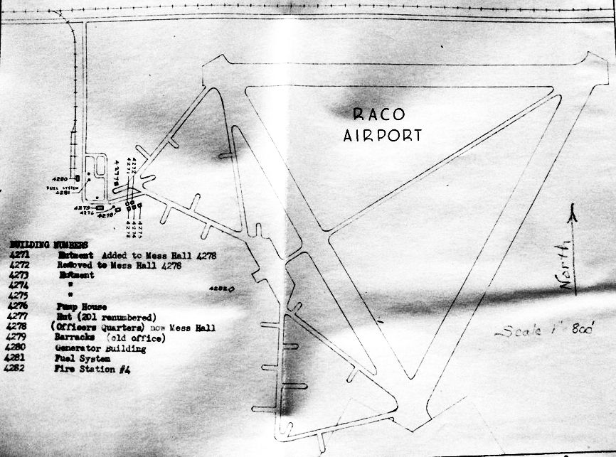
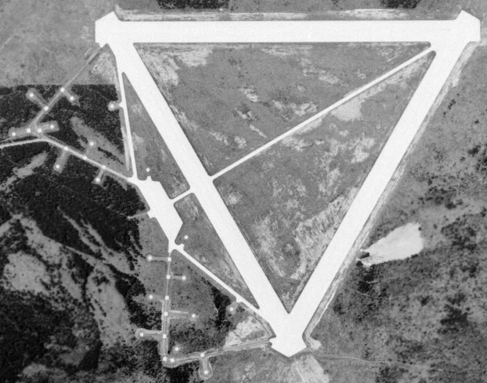
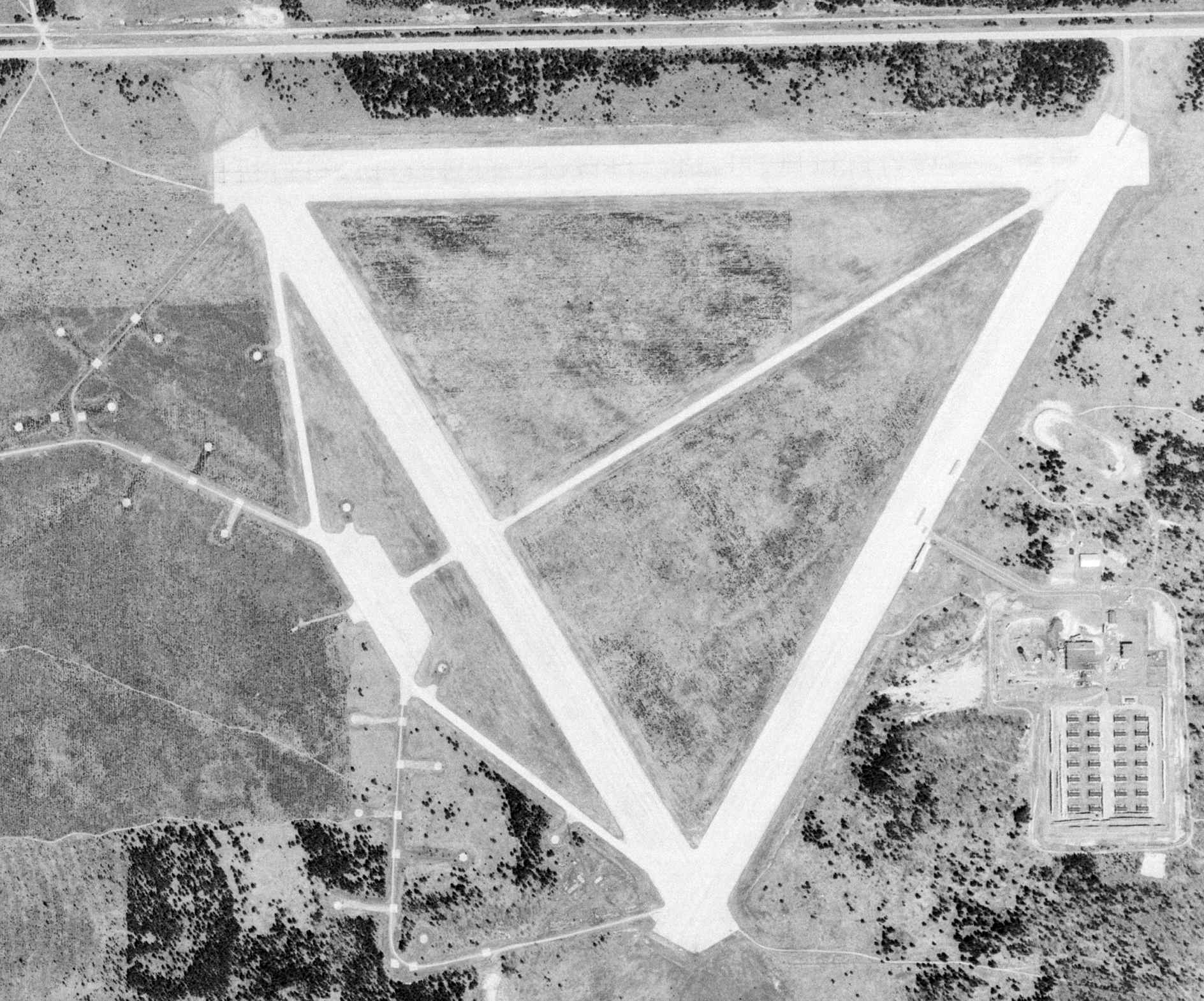
A circa 1945 map of “Raco Airport” (from the St. Louis National Personnel Records Center, courtesy of Ron Plante).
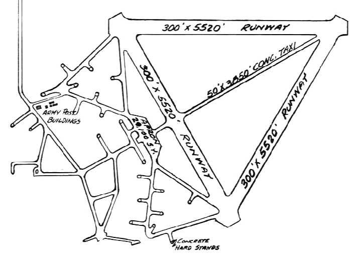
It depicted Raco as having 3 paved runways, along with an extensive network of concrete hardstands to the west of the runways.
It is possible that the Raco military airfield was intended to be reused as a civil airport after the end of WW2,
as the 1946 MI Airport Directory (courtesy of Doug Ranz) listed it as the "Raco Airport".
Although it was depicted as being adjacent to the property of the "Fort Brady Military Reservation",
there was no mention of any military ownership of the airfield itself.
The Raco airfield was depicted as having three 5,520' runways,
along with its extensive network of concrete hardstands to the west of the runways.
According to Dale Lutz (whose grandfather performed contract work at RACO during the 1960s), during WW2 & the early part of the Cold War,
the Army reused the western portion of the Raco property as an anti-aircraft artillery site.
Two triangular shaped roads were laid out, extending outward from the western runway,
along which were situated a total of 18 heavy AAA guns.
The guns were apparently placed on top of the square pads,
while a number of 20-30' diameter concrete "silos" were located around the guns, in which was stored their ammunition.
The silos were filled with concrete in the 1980s.
In Lutz's words, "These guns were poised to intercept bomb runs by the Nazis or the Ruskies
at low altitudes into the entrance of the Soo locks & shipping narrows tens of miles away."
A 1947 Army Corps of Engineers map (courtesy of Mike Denja) depicted “Raco Airfield Aux” as inactive.
The 1951 USGS topo map (courtesy of Mike Denja) depicted Raco Field
along with the numerous anti-aircraft artillery pads to the southwest.
"Raco AF" was still depicted as a military airfield on the November 1952 Lake Superior Sectional Chart, with a 5,500' paved runway.
The earliest photo which has been located of Raco AAF was a 6/2/53 aerial view (courtesy of Mike Denja).
It depicted Raco as having 3 concrete runways, along with the numerous anti-aircraft artillery pads to the southwest.
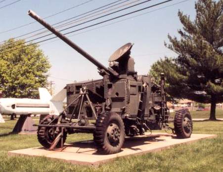
A 75mm Skysweeper gun on display at the Army Ordnance Museum, Aberdeen, MD.
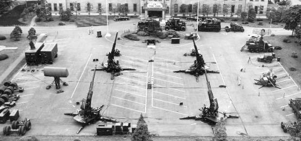
A 1955 static display of Army Antiaircraft command 90mm & 75mm Skysweeper guns & radars.
Although the type of guns used at Raco is unknown, an official history of the Army Antiaircraft Command includes the following:
"ARAACOM AW battalions defended linear targets, like locks & airfields, from air attack.
A new weapon system was developed & fielded in the early 1950s to replace their 40mm guns & 0.50 caliber machine guns.
Called the Skysweeper, it was the first weapon to emerge in the atomic age
with radar, computer & gun on one carriage, a fully integrated gun & fire-control system.
With its 75mm gun, the Skysweeper could find & track approaching aircraft as far away as 15 miles
and destroy air targets as far away as 4 miles.
Its automatic loading & firing capability allowed it to fire 45 rounds/minute.
Peak deployment for Skysweeper battalions was achieved in the mid-1950s when 8 battalions were deployed.
As more & more Nike missile systems were deployed,
ARAACOM slashed the number of AAA guns in the command in the last half of 1957.
By the end of the year only three 75mm Skysweeper battalions remained,
one at Sault Saint Marie." [which is apparently referring to Raco].
"Raco AF" was still depicted as a military airfield on the 1957 Lake Superior Sectional Chart (according to Chris Kennedy).
Part of the Raco airfield property was later reused by the Air Force to build a launch site for the huge BOMARC ramjet surface-to-air missiles.
The BOMARC was a long-range surface to air missile, intended to shoot down Soviet bombers with a nuclear warhead.
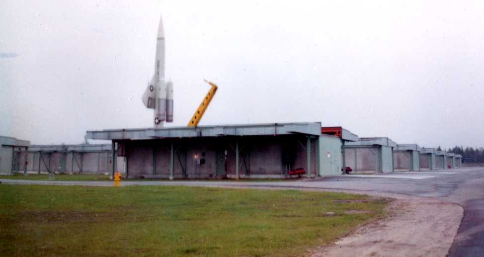
An undated photo of a BOMARC-B missile raised into firing position for the dedication of the Raco BOMARC installation.
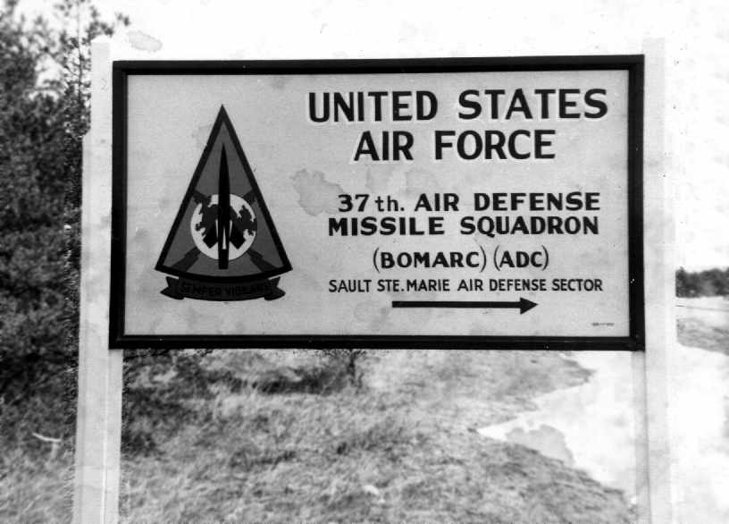
This facility was known as the Kincheloe AFB BOMARC site,
and it was manned by the 37th Air Defense Missile Squadron starting in 1960.
The BOMARC site was a rectangular installation, just southeast of the runways.
It operated the 2nd-generation IM-99B version of the BOMARC missile.
The site consisted of a grid of 28 individual missile launcher buildings on the south end,
along with larger missile assembly buildings on the north end.
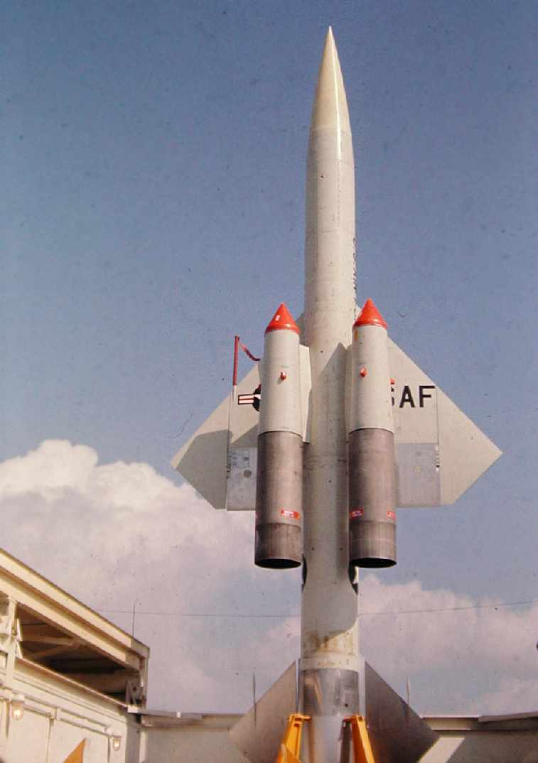
A circa-1963 photo by John Frye of a BOMARC-B missile at Raco.
John Frye recalled, "I was stationed at the BOMARC installation as a missile mechanic from July 1962 to December 1965.
The area to the West was indeed an old military training site. We used the area for carbine qualification one year.
There was a few ponds or swampy areas out there,
and a friend found live Canadian artillery shells in one of the small lakes which had to be recovered by the military.
There was a ring of concrete sample cores (probably from the runway construction) located in the very center of the runway complex.
In the center was a wooden pole that had a wind sock on it that had rotted off & fallen years before, possibly from WW2.
I remember brass fittings in the apron area that was intended for electrical & water supply to aircraft I assume, very first class.
I was never able to find out if troops had been stationed there or if it had ever been active.
It must have taken a lot of concrete to build since the cores found in the center of the complex were about a foot or more long (I'll bet they are still there).
While we were there, the only aircraft that landed there was a T-33 that ran out of fuel & helicopters from Kincheloe.
Our 37th ADMS chow hall had quarters for about a dozen men.
I spent many weekends on standby duty out there, and would ride a bicycle around the runways & hike in the area.
Some of the area to the South had been planted with pines about that time,
but the center of the runways was open grasslands."
A circa-1963 photo by John Frye of the sign at the entrance to the Raco missile site, on the highway at the end of the north/south runway.
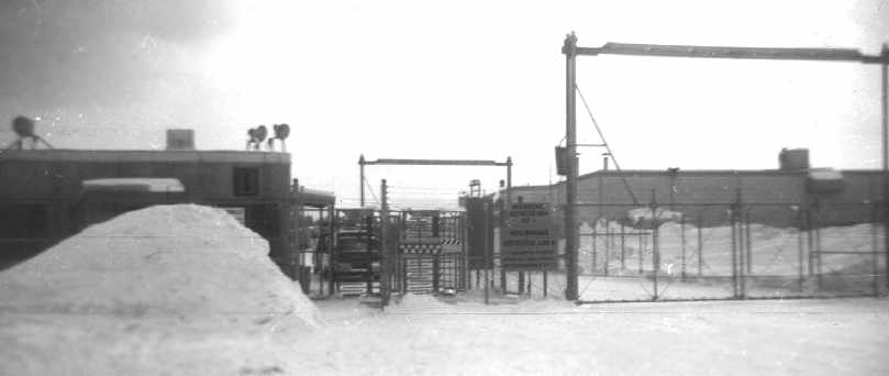
A circa-1963 photo by John Frye of the sally port & finger gate going into the support area of the Raco missile site.
John Frye recalled, "We followed the old runway down to the chow hall
and there was a Quonset hut housing a fire engine with storage & the chow hall just beyond, both built on the runway.
A road ran up over the hill to the launch area & support buildings between these 2 buildings.
A steel Butler Building was on the hill north of the complex that had engineering & a meeting hall at one end.
Just north of the Butler building was a deep covered pit that a temporary acting 1st Sergeant built as a retreat in case of a nuclear attack.
It was big enough to hold about 60 troops beneath pierced steel planking in a sand pit.
I guess the guy had a fear of being blown up. I kind of remember it being covered up before I left there in December of 1965."
Ralph Fox recalled, “37th ADMS, Semper Vigilance... I was stationed there 1965-66 & I lived there on the missile site in 1966.
Eight of us lived there plus a cook who came on Friday afternoon & stayed until Monday morning.
We had drag races there; it sure gave us guys that lived there something to do that summer other than getting lost in the forest.
I really enjoyed my time there. A really beautiful place.”
"Raco AF" was still depicted as a military airfield on the 1966 Lake Superior Sectional Chart, with 3 paved 5,500' runways.
It is not known if Raco was ever formally reused as a civil airport, but it appears as if it did not.
The runways at Raco were occasionally used by small planes (most of the Forrest Service) during the 1960s,
according to a former Raco BOMARC squadron member.
The Raco BOMARC facility was closed in 1972.
David McLaren recalled, "I visited Raco AAF back in 1974 after spotting it from a B-52 at 20,000 feet.
At that time the seedlings had just been planted.
The only remaining Air Force structure was a mess hall, which still had the stainless steel coolers & tables.
The missile buildings were intact, and although the launching equipment had been removed,
the buildings still had their heaters installed."
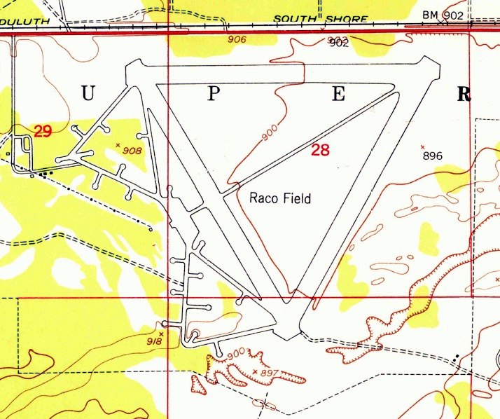
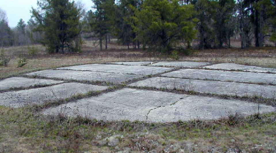
A 4/28/76 USGS aerial photo showed Raco's 3 runways, taxiways, and ramp area, along with the Skysweeper antiaircraft gun pads on the southwest side,
and the still-intact launcher buildings of the BOMARC missile site on the southeast side.
In 1985, the Army Corps of Engineers began a project intending to demolish buildings at Raco.
Krygoski Construction Company won a contract to perform the work. This eventually resulted in a 1996 lawsuit.
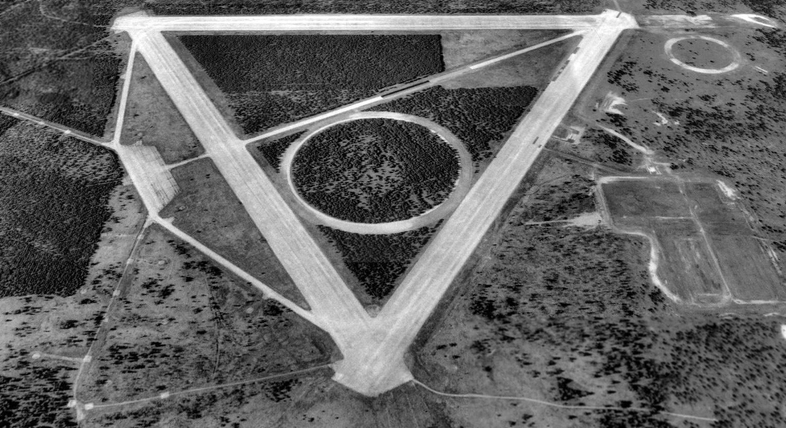
A 1994 USGS aerial view looking north showed the 3 former Raco runways & the numerous former Skysweeper AAA pads.
Note the vehicle test track which had been constructed at some point between 1976-94 over the former BOMARC missile site, along with the circular track in the middle of the runways.
John Frye recalled, "In 2001 the concrete base for the finger gates was still there, but everything else was gone with just some rubble."
A 2002 photo by David York of remains at Raco AAF.
A 2002 photo of David York on a runway of Raco AAF.
A 2002 photo by David York of the remains of the former BOMARC missile installation adjacent to Raco AAF.
A 2002 photo by David York of what is presumably the remains of a Skysweeper artillery pad in the woods adjacent to Raco AAF.
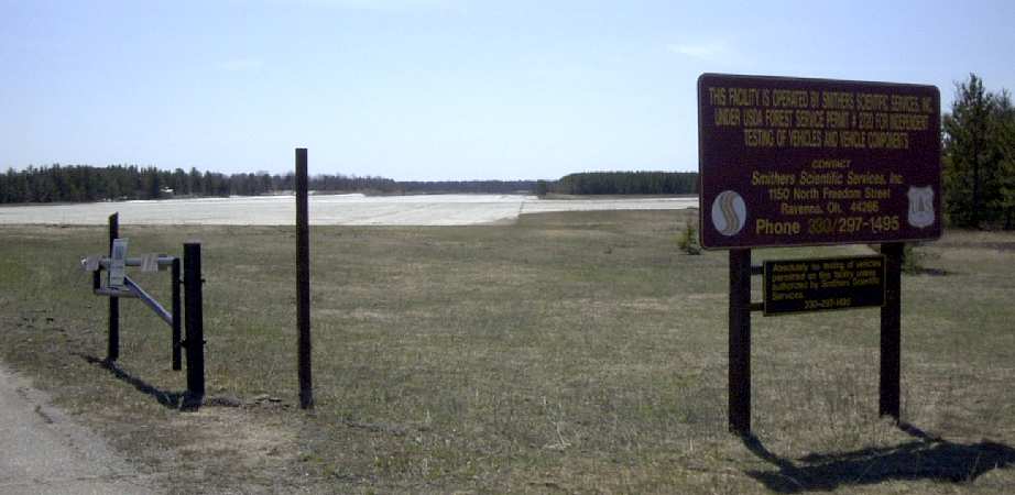
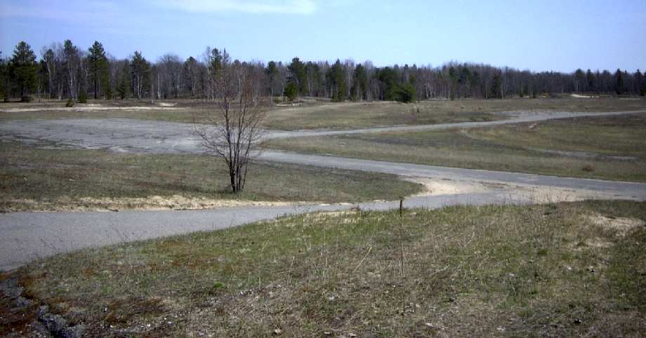
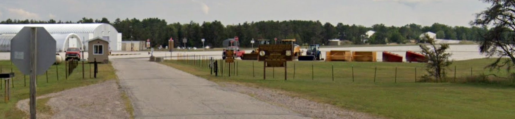
The former runways at Raco are now used by Smithers Scientific Services as an automobile testing site, primarily during the winter.
No original military buildings remain, other than concrete foundations for the BOMARC launcher shelters.
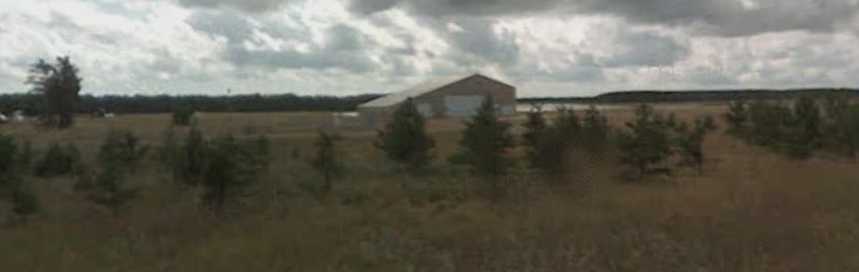
A circa 2007 photo looking southwest at a Smithers Scientific Services building, with the Raco runways in the background.
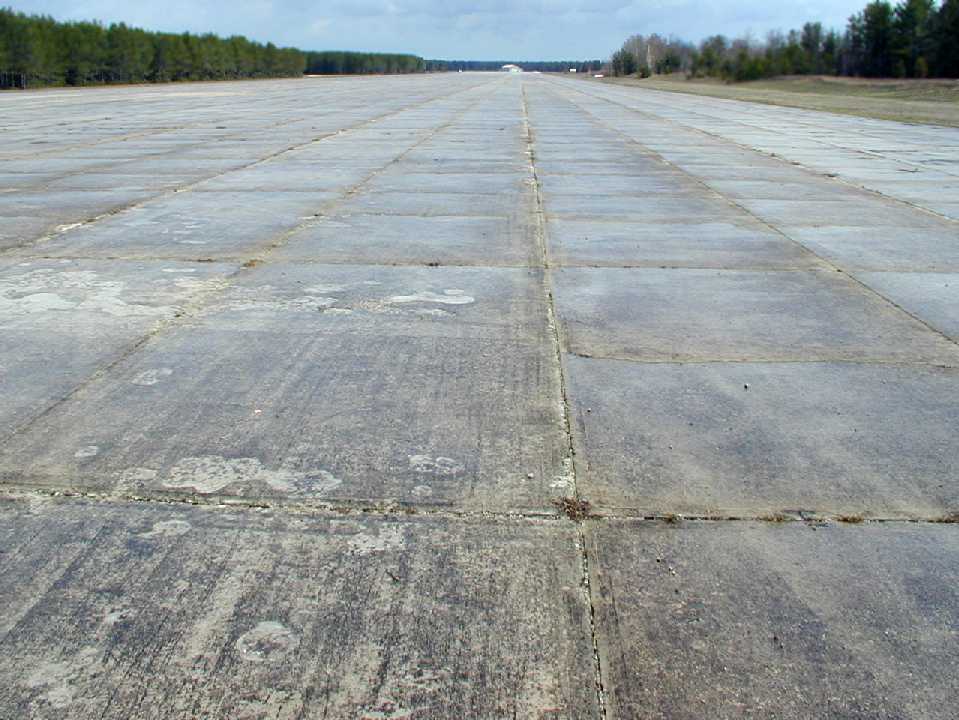
A 2008 photo by Eric Douglas looking along a former Raco runway.
He attended a BloKarting event using the former runways.
A 2008 photo by Eric Douglas of what is presumably the remains of a Skysweeper artillery pad in the woods adjacent to Raco AAF.
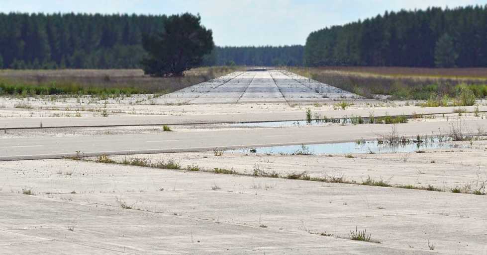
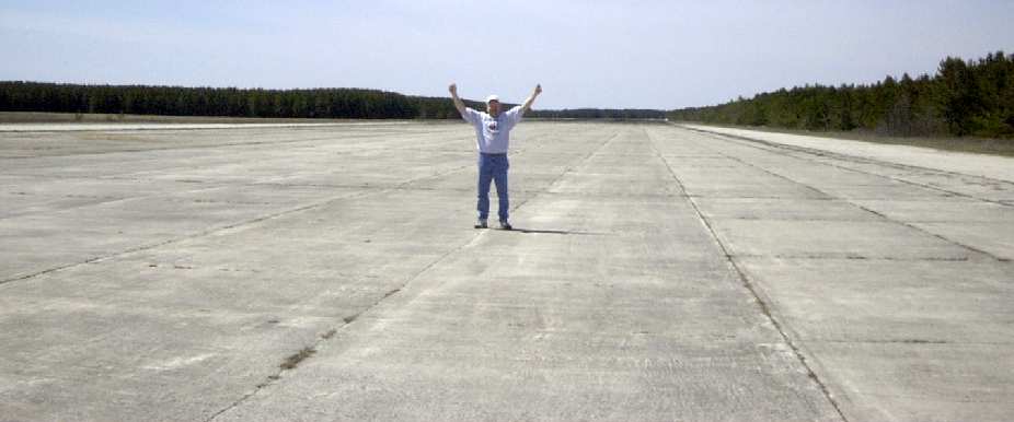
A 2012 photo by Scott Murdock looking along a former Raco runway.
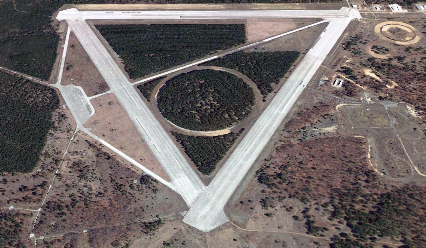
A 2016 aerial view looking north showed the 3 former Raco runways, the numerous former Skysweeper AAA pads,
and the test track constructed over the former BOMARC missile site.
A 2022 photo looking southwest the former Raco runway from the Smithers Scientific Services entrance on the north side.
Thanks to Tim Tyler for contributing information about Raco.
____________________________________________________
Since this site was first put on the web in 1999, its popularity has grown tremendously.
If the total quantity of material on this site is to continue to grow,
it will require ever-increasing funding to pay its expenses.
Therefore, I request financial contributions from site visitors,
to help defray the increasing costs of the site
and ensure that it continues to be available & to grow.
What would you pay for a good aviation magazine, or a good aviation book?
Please consider a donation of an equivalent amount, at the least.
This site is not supported by commercial advertising –
it is purely supported by donations.
If you enjoy the site, and would like to make a financial contribution,
you
may use a credit card via
![]() :
:
Please consider checking the box to make a monthly donatation.
For a mailing address to send a check, please contact me at: paulandterryfreeman@gmail.com
If you enjoy this web site, please support it with a financial contribution.
please contact me at: paulandterryfreeman@gmail.com
If you enjoy this web site, please support it with a financial contribution.
____________________________________________________
This site covers airfields in all 50 states.