Abandoned & Little-Known Airfields:
Maryland: Anne Arundel County
© 2002, © 2023 by Paul Freeman. Revised 10/30/23.
This site covers airfields in all 50 states: Click here for the site's main menu.
____________________________________________________
Please consider a financial contribution to support the continued growth & operation of this site.
Annapolis Airport (revised 1/6/20) - Annapolis NAF (revised 6/16/23) - Deep Creek Airport (revised 8/7/23) - Dixie Airport (revised 1/6/20)
(Original) Fort Meade Aux AAF (revised 6/22/23) - Shadyside Airport (revised 8/7/23) - Suburban Airport (revised 6/16/23) - Whipp Airport & Seaplane Base (revised 10/30/23)
____________________________________________________
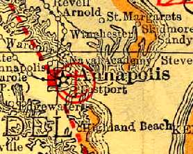
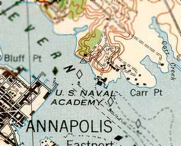
Annapolis Airport, Annapolis, MD
38.949, -76.487 (Northeast of Washington, DC)
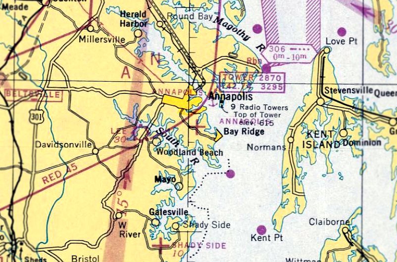
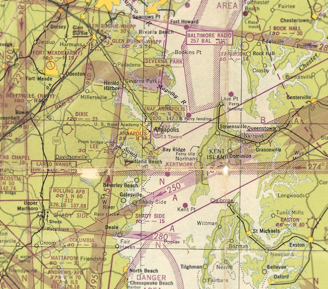
Annapolis Airport, as depicted on the October 1946 Washington Sectional Chart.
This small, short-lived general aviation airport was located due south of the center of Annapolis,
as opposed to the better-known Lee Airport located to the southwest of Annapolis.
Annapolis Airport was not yet depicted on the April 1946 Washington Sectional Chart.
The earliest depiction which has been located of Annapolis Airport was on the October 1946 Sectional Chart.
It depicted Annapolis Airport as an auxiliary airfield.
The earliest photo which has been located of Annapolis Airport was an 11/15/46 aerial view (courtesy of NARA, via Oscar Gregory).
It depicted Annapolis Airport as having 2 unpaved runways, with a small building & several light aircraft on the west side.
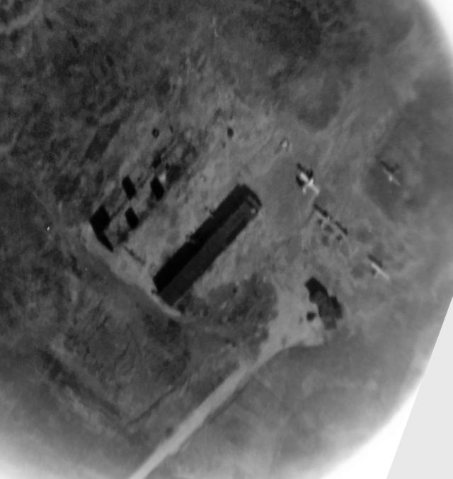
A close-up from the 11/15/46 aerial view of Annapolis Airport (courtesy of NARA, via Oscar Gregory),
showing a small building & 5 light single-engine aircraft on the west side of the field.
A 1947 airport directory described Annapolis Airport as a 196 acre property 2 miles south of Annapolis.
It described Annapolis as having 2 'surfaced' runways, 2 hangars, and an administrative building.
Annapolis Airport was said to offer student flying, charter service, and repairs. Annapolis Airport Inc. was listed as the owner.
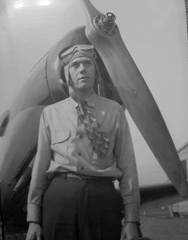
A circa 1940s photo of Charles Haas in front of a PT-19 at Annapolis Airport (courtesy of Michael Haas).
A 1947 airport directory described Annapolis Airport as a 196 acre property 2 miles south of Annapolis.
It described Annapolis as having 2 'surfaced' runways, 2 hangars, and an administrative building.
Annapolis Airport was said to offer student flying, charter service, and repairs, and Annapolis Airport Inc. was listed as the owner.
A 1948 airport directory listed Annapolis Airport Inc. as the operator.
The last depiction which has been located of Annapolis Airport was on the October 1948 Sectional Chart (courtesy of Ron Plante).
It depicted Annapolis Airport as having an 1,800' paved runway.
A July 1949 directory listed Annapolis Airport's operator as Dixie Aero Inc. (which also operated Dixie Airport only a few miles to the northwest).
Michael Haas recalled, “Our father (Charles) and our Uncle Edward Haas operated from Annapolis Airport providing flight instruction, charter services & repairs.
Charter services were provided using a V77 Stinson. Flight instruction was provided using a J-2 & J-3 Cubs. A PT-19 was used for aerobatic training.”
Annapolis Airport was not depicted at all on the 1951 Washington Local Aeronautical Chart.
It may have been closed by that point, or possibly continued in informal operation for a few more years.
According to Charlie Haas, “Annapolis Airport... I vaguely remember from when I was 10 or 12 (1956 or so).
I believe my dad had a hand in running the airport. It was located on Bay Ridge Road outside of Annapolis.”
Michael Haas recalled, “The owners of the airport closed it due to the postwar crash of the general aviation boom.
When the 2 brothers were notified that Annapolis Airport was closing they transferred their operations to Lee Airport while they purchased the Dixie Airport property.”
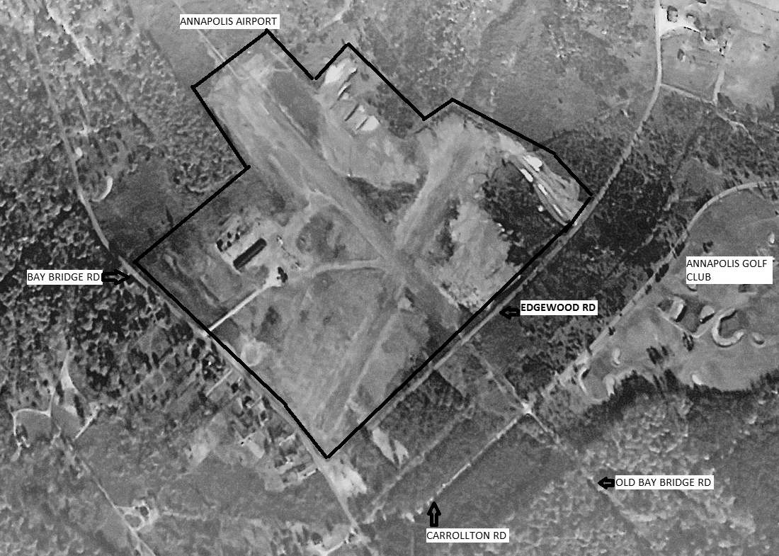
A 1957 aerial view showed houses had been built over the northwest portion of the Annapolis Airport property, but the hangar remained standing.
The 1958 USGS topo map depicted a clearing at the site of Annapolis Airport, but did not label the airport.
A 1970 aerial view showed houses had covered the site, with no trace remaining of Annapolis Airport.
A 2014 aerial view showed no trace remaining of Annapolis Airport.
The site of Annapolis Airport is located north of the intersection of Bay Ridge Road & Edgewood Road.
Thanks to Charlie Haas for pointing out this airfield.
____________________________________________________
38.99, -76.69 (Northeast of Washington, DC)
Dixie Airport, as depicted on the 1947 Washington Sectional Chart (courtesy of Roger Connor).
This small, short-lived general aviation airport was evidently established at some point between 1946-47,
as it was not yet listed among active airfields in the 1946 Haire Publishing Company Airport Directory (according to the book "Maryland Aloft" by Preston, Lanman, and Breilhan)
nor depicted on the October 1946 Sectional Chart (courtesy of Ron Plante).
The earliest reference which has been located to Dixie Airport was its listing in the 3/1/47 MD Airport Directory,
which described it as a 40 acre property owned by Dixie Aero Flying Service Inc.
It described Dixie as having 2 unpaved runways, measuring 2,490' & 1,900'.
Dixie Airport was said to offer student flying, charter service, and minor repairs.
Dixie Airport was also listed in the 1947 Haire Publishing Company Airport Directory.
The earliest depiction which has been located of Dixie Airport was on the October 1947 Sectional Chart (courtesy of Roger Connor).
It depicted Dixie as having a 2,300' unpaved runway.
According to Charlie Haas, “Dixie Airport was located in Crofton, near Route 3.
I believe my dad [Charles B. Haas] & uncle [Edward Haas] had visions of teaching flying & perhaps selling a few aircraft.
Ed has was a former Army Aviation Instructor & later a pilot with what became United Airlines (maybe Capital Airlines).”
Michael Haas recalled, “When the 2 brothers (Charles & Edward Haas) were notified (1946/47) that Annapolis Airport was closing
they transferred their operations to Lee Airport while they purchased the Dixie Airport property.
Access to Dixie was off of Defense Highway (Route 450).
Upon purchase the runways at Dixie were cleared for use. A hangar & office constructed.
Meanwhile they had purchased 2 new 1946 T-Craft BC-12Ds for flight instruction & pleasure rides.
The Piper J-3 was converted for seaplane instruction & later placed in storage.
The Piper J-2 had been destroyed by a recently solo'ed student pilot.
I have 8mm movie film of the hangar at Dixe being constructed & also of the 2 Taylorcraft BC-12Ds operating out of Dixie.”
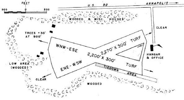
The 1950 MD Airport Directory (courtesy of Stephen Mahaley) depicted Dixie as having 2 turf runways,
measuring 2,270' East-Northeast/West-Southwest & 2,200' West-Northwest/East-Southeast.
A hangar & office were depicted on the east side, along with 4 small buildings on the west side.
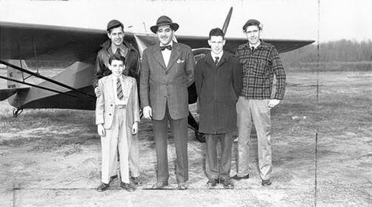
The only photo which has been located showing Dixie Airport in operation was a circa early 1950s photo (courtesy of Charlie Haas)
of Edward Haas, Charles B. Haas, and 3 others in front of a Taylorcraft BC12D.
A June 1950 directory indicated portable lights were available at Dixie Airport on request.
Michael Haas recalled, “In the early 1950s Ed began flying for Capital Airlines & could not devote sufficient time to the business. Ed also had to deal with his divorce.
Business was slack & bills had to be paid so all aircraft were sold.”
Dixie Airport was no longer depicted on the 1951 Washington Sectional Chart.
A May 1952 newspaper article indicated that Dixie Airport was one of 4 MD airports that had closed since June 1950.
A 2/3/60 USGS aerial view depicted a grass field still in the same overall shape as the runway layout depicted in the 1950 directory,
but there were no aircraft or any other indication of recent aviation use.
Dixie Airport was not depicted at all on the 1961 Washington Sectional Chart.
A 1993 aerial view showed that industrial buildings had covered the site, with no trace remaining of little Dixie Airport.
A 2014 aerial view showed that industrial buildings had covered the site, with no trace remaining of little Dixie Airport.
The site of Dixie Airport is located southwest of the intersection of Route 450 & Baldwin Avenue.
Thanks to Charlie Haas for pointing out this airfield.
____________________________________________________
Annapolis Naval Air Facility, Annapolis, MD
38.98, -76.46 (Northeast of Washington, DC)
The Annapolis Navy "Seaplane Port",
as depicted on the 1929 "Rand McNally Standard Map of MD with Air Trails" (courtesy of Chris Kennedy).
The US Navy's first naval aviation base was established in 1911 at Greenbury Point,
across the Severn River from the US Naval Academy.
This unit conducted training & experimentation with seaplanes, until being transferred to Pensacola FL in 1914.
In 1925, a naval aviation program was reestablished at a dock at the Naval Academy,
intended to provide 25 hours of flight instruction to each Naval Academy Midshipman.
No aviation facility was yet depicted at Annapolis on the October 1933 Washington Sectional Chart.

The earliest aeronautical chart depiction which has been located of Annapolis Naval Air Facility was on the July 1934 Washington Sectional Chart.
The 1937 USGS topo map depicted the hangar of the Annapolis seaplane facility, but did not label it.
This program was expanded in 1937, with a 16 acre site being constructed across the Severn River,
near the site of the original aviation camp.
The new facilities included a 900' x 600' concrete seaplane parking apron,
two ramps leading down into the river, hangars & other buildings.
Ken Sabel reported, “Midshipmen familiarization flights were discontinued in 1939 as a result of the impending war.”
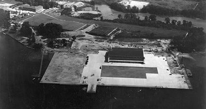
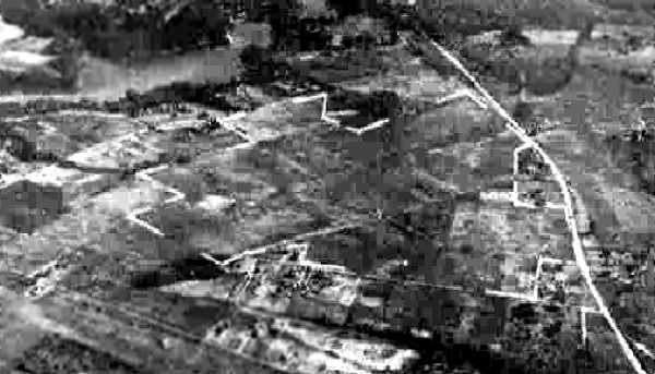
An August 1941 aerial view looking north at Annapolis NAF (from the National Archives, courtesy of Ken Sabel).
Ken observed, the photo “shows the facility as it was being completed in August 1941.”
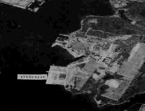
A 4/16/42 aerial view looking west at the Annapolis NAF from the 1945 AAF Airfield Directory (courtesy of Scott Murdock)
depicted the seaplane apron & a single hangar.
The 1945 AAF Airfield Directory (courtesy of Scott Murdock) described the Annapolis NAF as having a single hangar.
A WW2-era view of Annapolis NAF, with a PBM Mariner seaplane & several floatplanes parked on the ramp.
National Archives photo.
During WW2, the Annapolis Naval Air Facility flew emergency & utility flights, and flights in support of the adjacent Naval Experiment Station.
Ken Sabel reported, “Midshipmen familiarization flights resumed in 1946.”
According to the book "Maryland Aloft" by Preston, Lanman, and Breilhan,
training at the Annapolis NAF "utilized the Combat Information Center aboard the Carrier Block Island, towed to the facility in 1946."
A circa 1940s photo by Howard Levy (courtesy of John Voss) of an N3N-3 "Yellow Peril" floatplane landing at Annapolis.
Note the dome of the Naval Academy behind the nose.
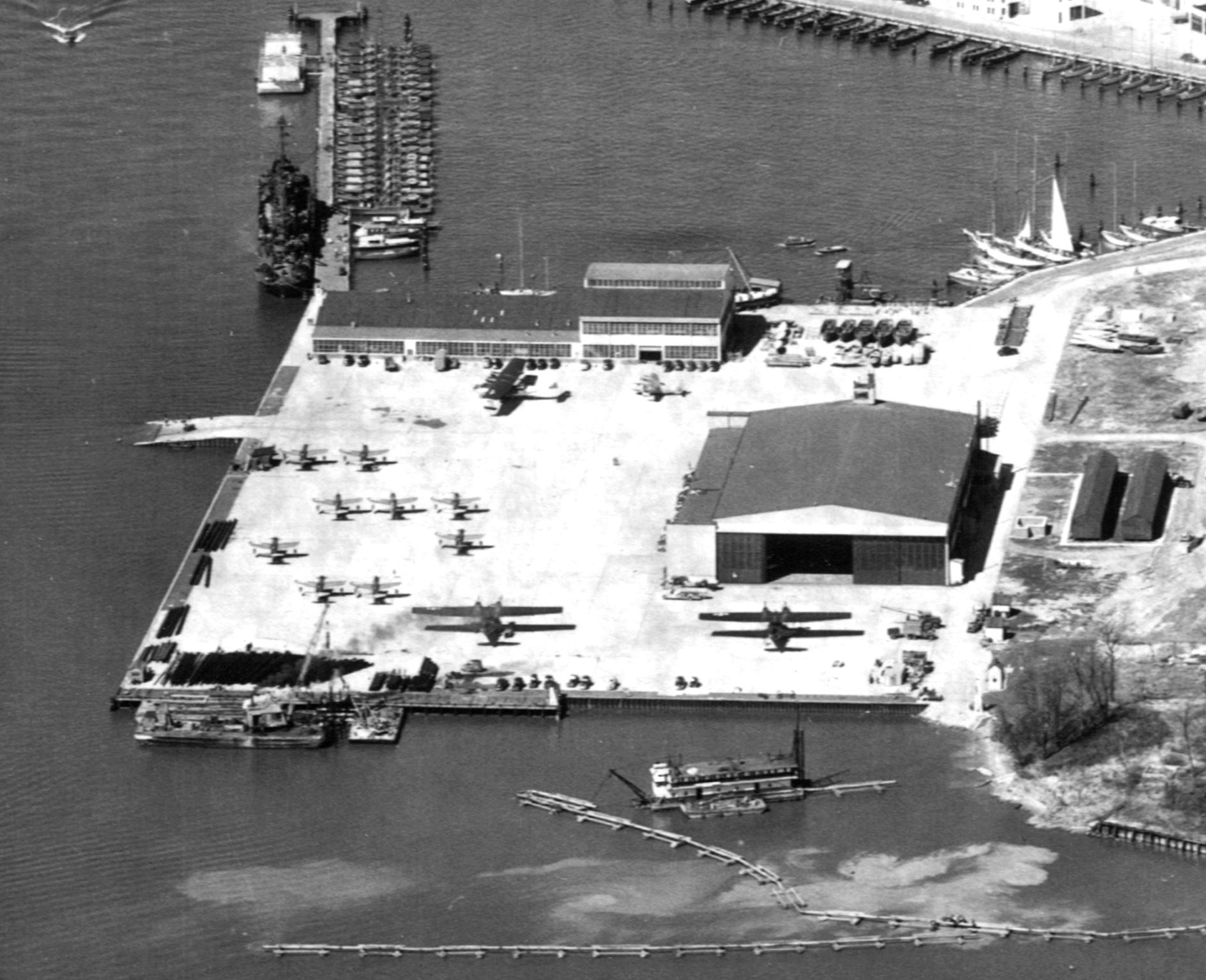
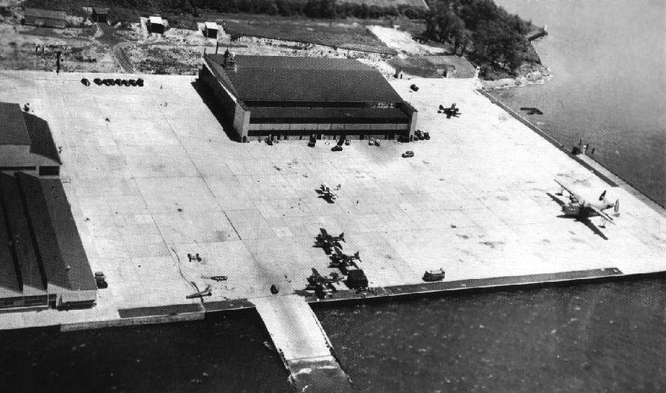
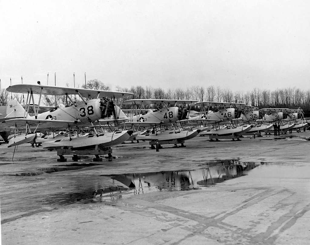
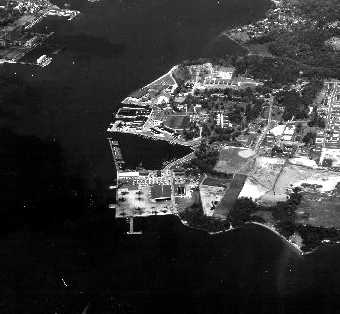
A circa late 1940s aerial view looking west at Annapolis NAF (courtesy of Bill Williams), showing 3 PBY Catalinas, 9 single-engine monoplane floatplanes, and a Grumman amphibian on the ramp.
The 1946 USGS topo map labeled the property as “Annapolis Naval Air Facility”.
A circa 1948-49 aerial view looking northwest at Annapolis NAF (courtesy of Ken Sabel), showing an amazing number of aircraft on the small facility's ramp.
Ken Sabel observed, “The carrier shown in the photo is the USS Block Island,
which was used until September 1950 as a barracks for enlisted men as well as a training facility for enlisted aviation technicians.”
According to the book "Maryland Aloft" by Preston, Lanman, and Breilhan,
the use of the aircraft carrier USS Block Island at Annapolis NAF was later replaced by the USS APL-5.
By the early 1950s, NAF Annapolis' complement of aircraft consisted of 5 large twin-engine PBM Mariner seaplanes,
19 smaller twin-engine JRF Goose seaplane, and 35 N3N "Yellow Peril" biplane floatplanes.
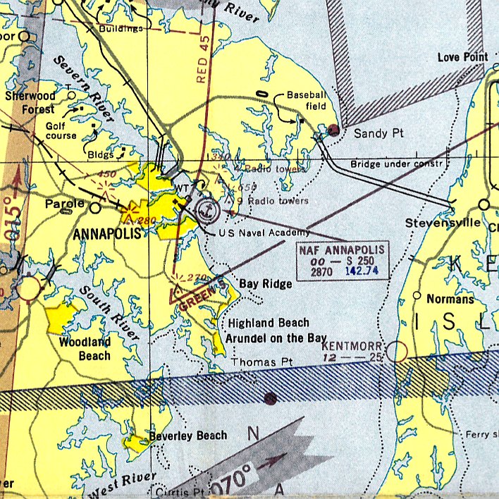
The 1951 Washington Local Aeronautical Chart depicted the Annapolis Naval Air Facility as having a control tower.
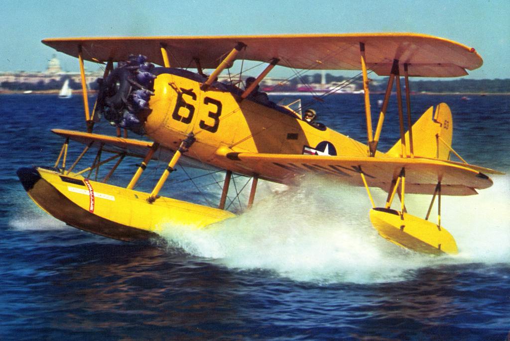
A circa 1950s photo of a row of 6 N3N-3 "Yellow Peril" floatplanes on their cradles on the NAF Annapolis ramp.
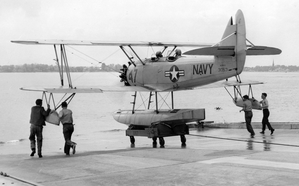
A circa June/July 1952 photo of a N3N-3 "Yellow Peril" floatplane being maneuvered into the water from NAF Annapolis
(from the Nimitz Library Special Collections Department at the U.S. Naval Academy, courtesy of Ken Sabel).
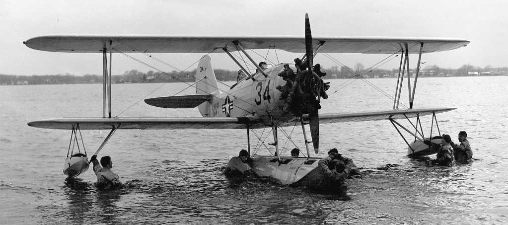
A circa 1950s photo of a N3N-3 "Yellow Peril" floatplane being maneuvered in the water from NAF Annapolis.
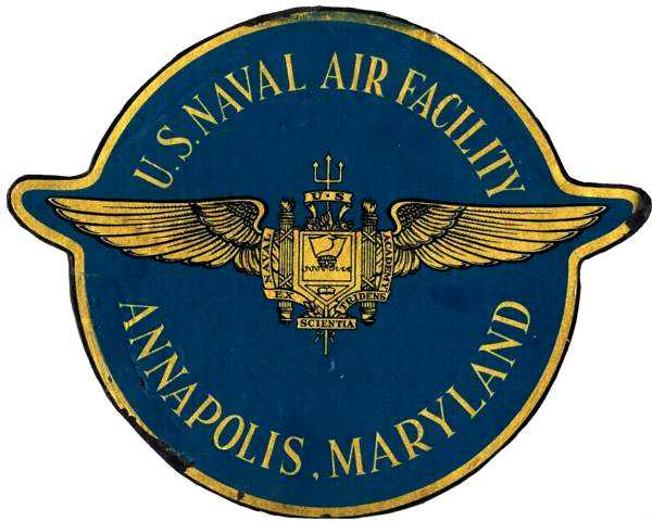
An insignia for NAF Annapolis which Bill Heino obtained during his duty at NAF Annapolis during 1953-54.
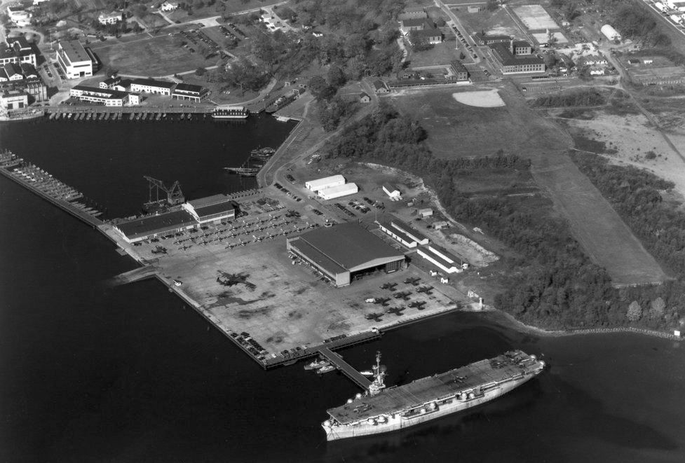
A 5/19/56 aerial view looking west at Annapolis NAF showed several aircraft on the ramp.
The 1956 Washington Local Aeronautical Chart depicted the Annapolis Naval Air Facility as having a control tower.
According to the book "Maryland Aloft", "During the 1950s, the ability of the NAF's seaplanes to provide realistic, modern training was questioned;
however, attempts to acquire land for an airfield as a replacement were unsuccessful.
Instead, a decision was made to transfer the functions of the installation to a naval facility at Andrews AFB."
Gary Miller recalled, “My father (Capt. Floyd E. Miller) was the CO of the Naval Air Facility from 1958-60.
I remember soon after he took over the Air Facility he had maintenance do a check on the N3N-3s.
They found that they had severe corrosion.... he grounded the lot! That was the beginning of the end for the Facility.”
The last photo which has been located showing Annapolis NAF still in operation was a 8/13/59 USGS aerial view,
which showed 4 fairly large seaplanes (type undetermined?) on the ramp.
The last aeronautical chart depiction which has been located of Annapolis Naval Air Facility was on the July 1960 Washington Sectional Chart.
It still depicted the seaplane base as having its own control tower.
The Annapolis Naval Air Facility was the last American military user of the N3N "Yellow Peril" floatplane until it closed in 1962.
This was also the last biplane in regular US military service.
According to the book "Maryland Aloft", the Annapolis Naval Air Facility "officially closed on 1/17/62.
The property was transferred to the Naval Academy to use for storage & supply, and is now part of Naval Station Annapolis."
After the closure of the Annapolis NAF, the flying operations of the Academy moved to Andrews AFB,
and the Naval Academy Flying Club relocated to Lee Airport, a small general aviation field a few miles southwest of the Academy.
Annapolis Naval Air Facility was no longer depicted on the April 1965 Washington Sectional Chart.
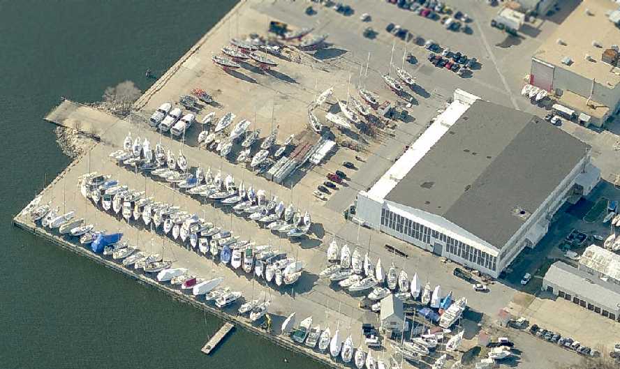
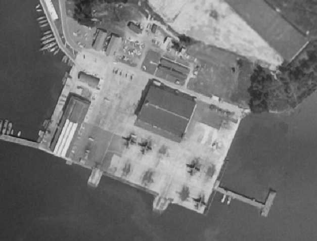
As seen in a circa 2007 aerial view looking west, the seaplane apron & hangar of the former Naval Air Facility still exist,
with numerous sailboats stored on the former apron.
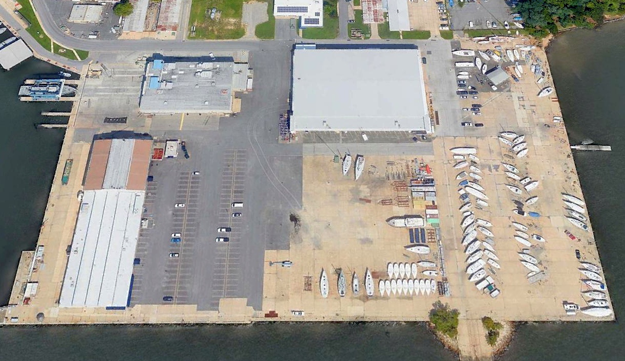
A 2018 aerial view looking northeast at the seaplane apron & hangar of the former Naval Air Facility Annapolis.
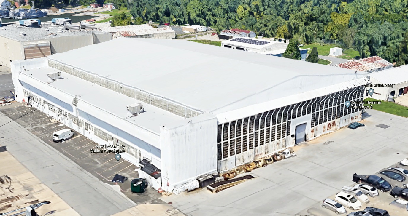
A 2020 3-D image looking north at the former Naval Air Facility Annapolis hangar.
____________________________________________________
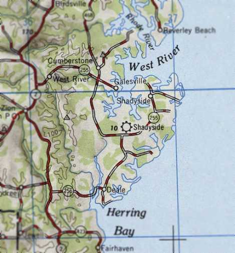
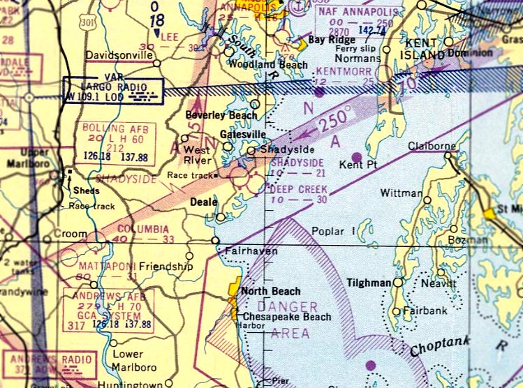
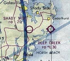
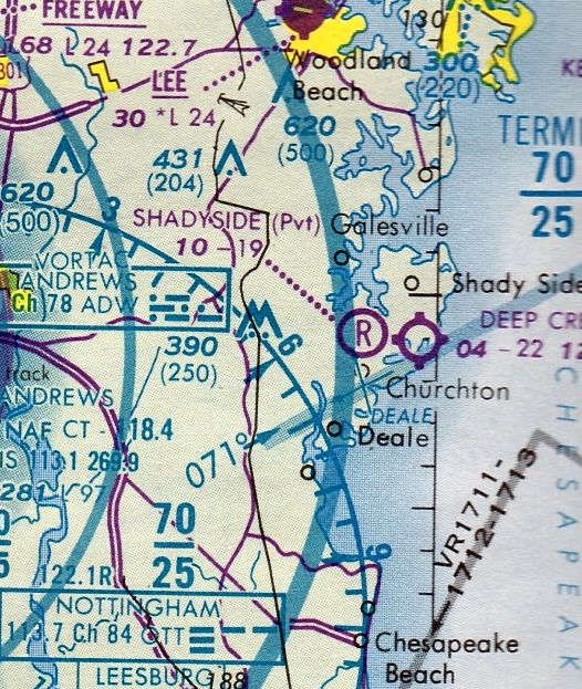
Shadyside Airport, Churchton, MD
38.82, -76.54 (South of Annapolis, MD)
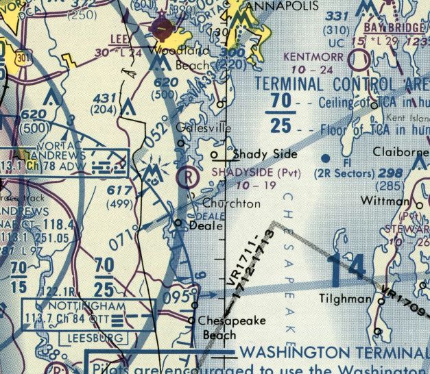
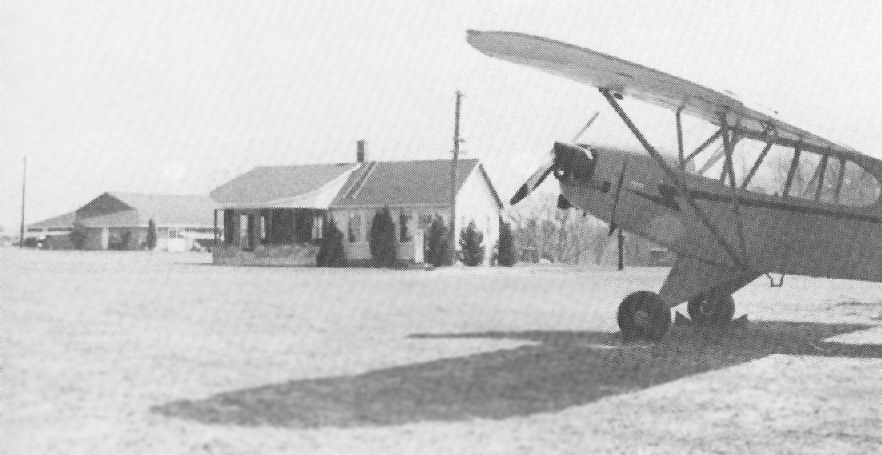
Shadyside Airport, as depicted on the December 1945 Washington Sectional Chart.
This small general aviation airport was evidently established at some point in 1945 (like hundreds of other small U.S. airports in the post-WW2 general aviation boom),
as it was not yet depicted on the June 1945 Washington Sectional Chart.
The earliest depiction of Shadyside Airport which has been located was on the Deember 1945 Washington Sectional Chart.
It depicted Shady Side as an auxiliary airfield.
Shadyside Airport, as depicted on the 1946 USGS topo map.
The July 1950 Washington Sectional Chart depicted Shadyside Airport as having a 2,100' unpaved runway.
The earliest photo which has been located of Shadyside Airport was a 12/17/53 USGS aerial view.
It depicted the field as having 2 unpaved runways, with a prominent airport circle marking on the southwest side.
A few small buildings were visible to the southwest of the runway intersection,
but is not apparent if these were related to the airfield, and no aircraft were visible on the field.
Shadyside's runway had been slightly lengthened by 1956,
as the Aerodromes table on the January 1956 Washington Sectional Chart (courtesy of Chris Kennedy)
described the field as having a single 2,050' turf runway,
and it also said "East/West strip under construction."
Mark McKibben reported, “Shady Side Airport was owned & operated by Frank Miller.
Frank was a mechanic & service station owner on the same property.
They never operated commercially as far as I know.
Frank was a character & was said that he never flew much above the tree tops.
He purchased a new 1956 Cessna 172, and that was based there.”
Shadyside Airport was inexplicably not depicted on the August 1957 Washington Sectional Chart (according to Chris Kennedy)
or the 1960 Washington Sectional Chart (courtesy of Mike Keefe).
Shadyside Airport was depicted on the September 1965 Washington Local Visual Navigation Chart,
which depicted it as having a 2,000' unpaved runway.
The latest photo which has been located showing Shadyside Airport while in operation was a 1970 aerial view.
Only the northwest/southeast runway remained clear; the east/west runway was cluttered with multiple unknown objects.
A few small buildings were visible to the southwest of the runway intersection,
but is not apparent if these were related to the airfield, and no aircraft were visible on the field.
The 1975 Washington Terminal Area Chart (courtesy of Ed Drury) depicted Shadyside as having a 2,000' unpaved runway.
The 1988 USGS topo map depicted the Shadyside Airfield as having a single northeast/southwest runway.
The last aeronautical chart depiction which has been located of Shareside Airfield was on the 1989 Washington Sectional Chart (courtesy of Jonathan Westerling).
It depicted Shadyside as a private airfield having a mere 1,900' unpaved runway.
Mark McKibben reported, “Frank Miller eventually converted the field to a salvage yard & closed the airport
until his son cleaned the place up & Steve started flying sometime in the late 1980s / early 1990s.
The north/south runway actually exceeded the property line & when the developers descended on South County, Steve had no option but to close.”
Shadyside Airport was evidently closed at some point between 1989-91,
as it was no longer depicted on the 1991 Washington Sectional Chart (courtesy of Mike Keefe).
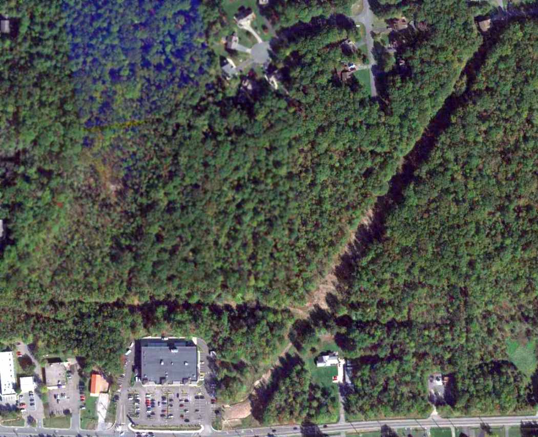
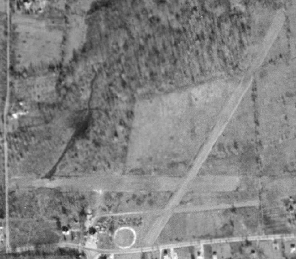
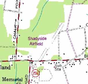
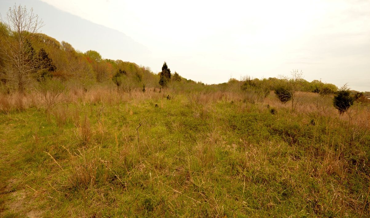
In a 10/12/12 aerial photo, the outlines of Shadyside's 2 runways were still quite apparent. It is not known if any airfield buildings remain.
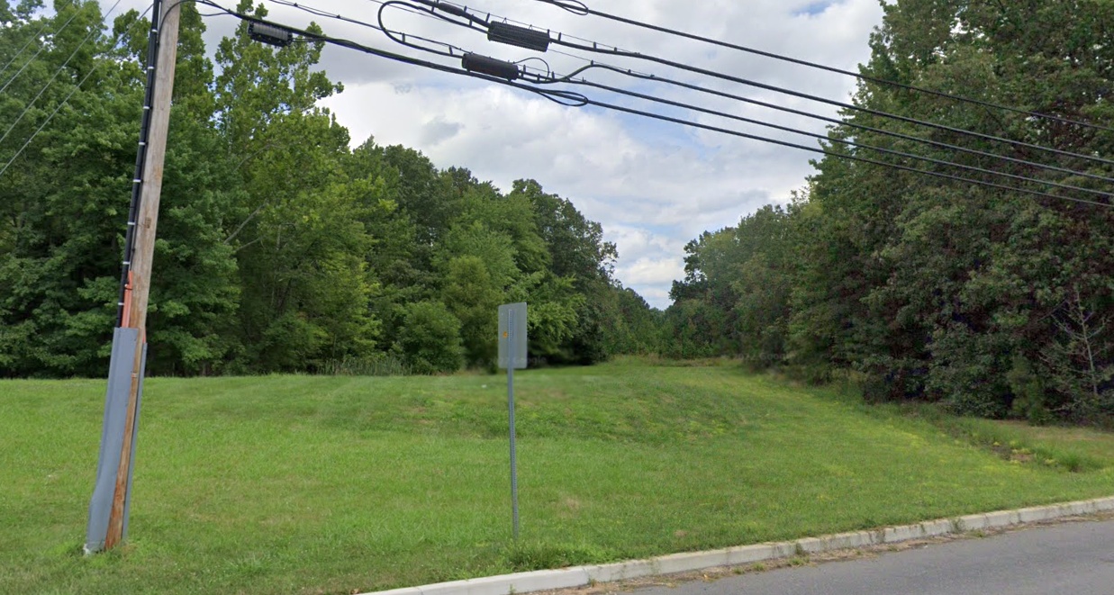
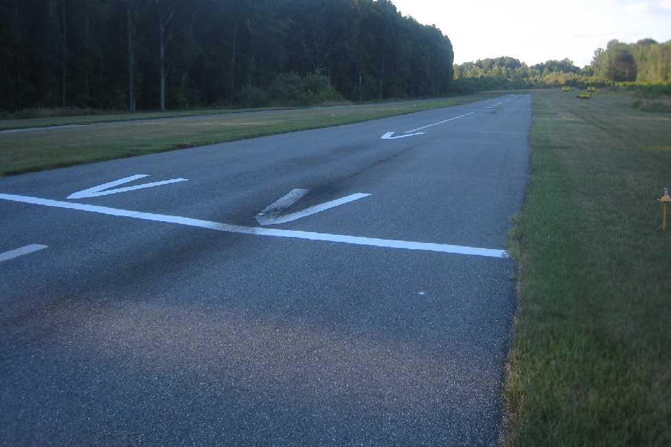
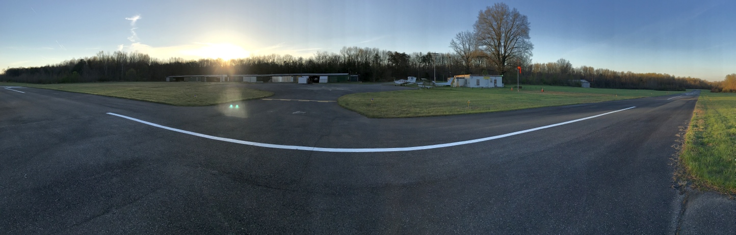
A 2022 photo looking northeast along the former Shadyside Airfield northeast/southwest runway.
The Shadyside Airfield is located northeast of the intersection of Deale Churchton Road & Shady Side Road.
____________________________________________________
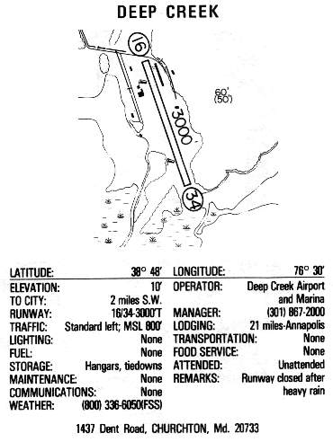
Deep Creek Airport, Churchton, MD
38.81, -76.51 (South of Annapolis, MD)
Deep Creek Airport, as depicted on the July 1950 Washington Sectional Chart.
Deep Creek Airport was apparently established at some point in 1950,
as it was not depicted on the January 1950 Washington Sectional Chart.
The earliest depiction which has been located of Deep Creek Airport was on the July 1950 Washington Sectional Chart.
It depicted Deep Creek Airport as having a 3,000' unpaved runway.
Deep Creek Airport was described on the Aerodromes table
on the 1951 Washington Sectional Chart (courtesy of Mike Keefe)
as having 2 runways, with the longest being a 3,000' unpaved strip.
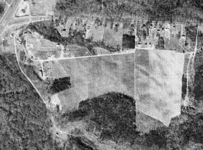
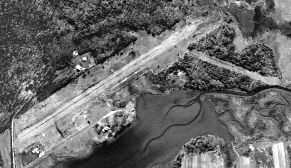
The earliest photo which has been located of Deep Creek Airport was a 12/17/53 USGS aerial view.
It depicted the field as having 2 unpaved runways,
with a few small buildings on the north side, although it was apparent if these were related to the airfield.
No aircraft were visible on the field.
Walter Neitzey was the owner & operator of Deep Creek Airport starting in the 1950s,
according to his obituary in the 3/18/06 Annapolis Capital (courtesy of Fred Sanford).
It described Deep Creek as a “full-service airport,
where he gave flight lessons.
He flew advertising banners over Washington Redskins home football games.”
Terri (Neitzey) Flaherty recalled, “My childhood home, Deep Creek Airport... I spent many summer hours mowing those runways with a tractor & gang mower.
My dad taught me & my husband how to fly in a PA-12 but neither of us got our licenses.
It was too expensive a hobby for young people even if your dad had a plane.”
Deep Creek Airport was described in the 1962 AOPA Airport Directory
as having 2 sod runways (14/32: 3,000' & 4/22: 2,000'), and the operator was listed as Walter Neitzey.
Mark McKibben reported, “We were based at Deep Creek with our Chief in 1966 & sold that for a Stinson 108-3 in 1967.
We moved from Deep Creek to Lee for the use of hangar / T-hangars.”
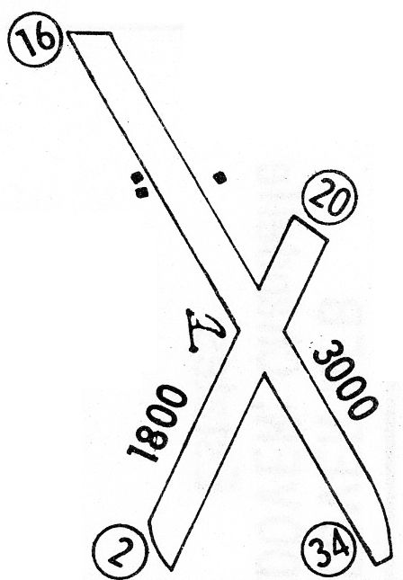
The 1968 Flight Guide (courtesy of Robert Levittan) depicted Deep Creek Airport
as having 2 unpaved runways: 3,000' Runway 16/34 & 1,800' Runway 2/20,
with a few small buildings on the west & east sides.
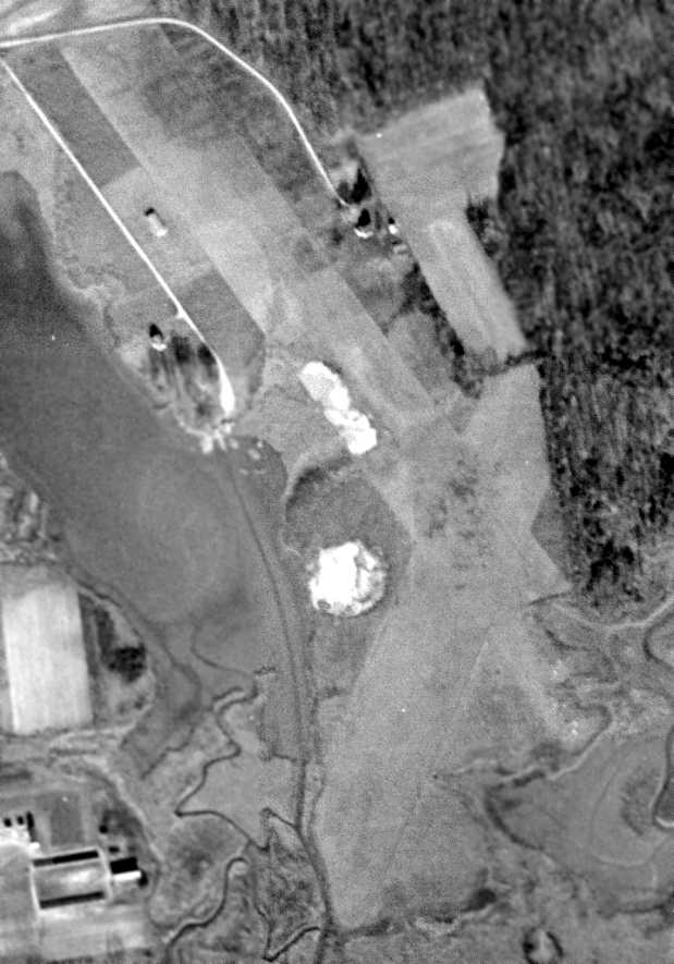
A 1970 aerial photo depicted Deep Creek to have 2 unpaved runways.
Several small buildings & 4 light planes were visible on the northwest side of the field.
Deep Creek Airport, as depicted on the 1975 Washington Terminal Area Chart (courtesy of Ed Drury).

The earliest photos which are available showing aircraft at Deep Creek Airport was a series of circa 1976 photos (courtesy of Garry Cline, via Bob McLean)
of Stinson 108-1, N1962K at Deep Creek Airport. Several other light single-engine aircraft were visible in the background.
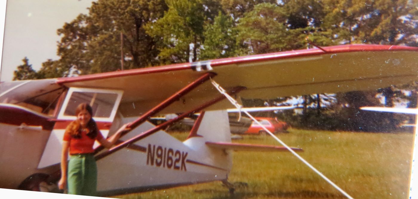
A circa 1976 photo by Garry Cline (courtesy of Bob McLean) of Zayna Cline in front of Stinson 108-1, N1962K at Deep Creek Airport. Several other light single-engine aircraft were visible in the background.
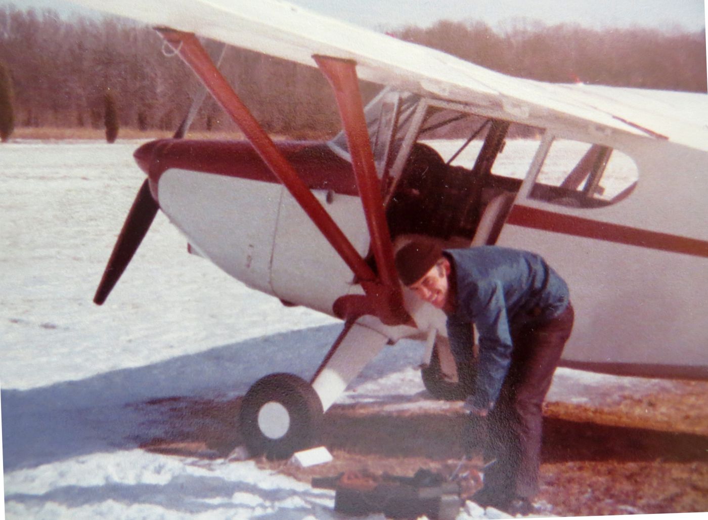
A circa 1976 photo (courtesy of Bob McLean) of Garry Cline removing chocks from Stinson 108-1, N1962K at a snowy Deep Creek Airport.
Richard Terry recalled, “I leaned to fly out of Deep Creek Airport in 1980-81.
Walter owned the airport at that time, but it was operated by Aircraftsman, Inc. which was Mark Spry & his son Steve.
Mark was a character. I never met a better pilot.
He was an ex-RAF mosquito pilot & operated the Rolls-Royce Engines facility in New York until he retired.
Various troubles drove him from New Jersey to MD & then to who knows where.
While we were there, the main runway was raised & extended with gravel. It was never paved.
There was also a glider operation there for several years.
There was also a guy giving seaplane ratings operating there at that time, using the waterway that paralleled the runway.”
In the 1982 AOPA Airport Directory (courtesy of Ed Drury),
Deep Creek Airport was described as having a single 3,000' gravel Runway 16/34,
and listed the operator as Aircrasftmen Inc.
Deep Creek Airport, as depicted in the 1983 MD State Aeronautical Chart.
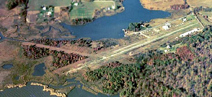
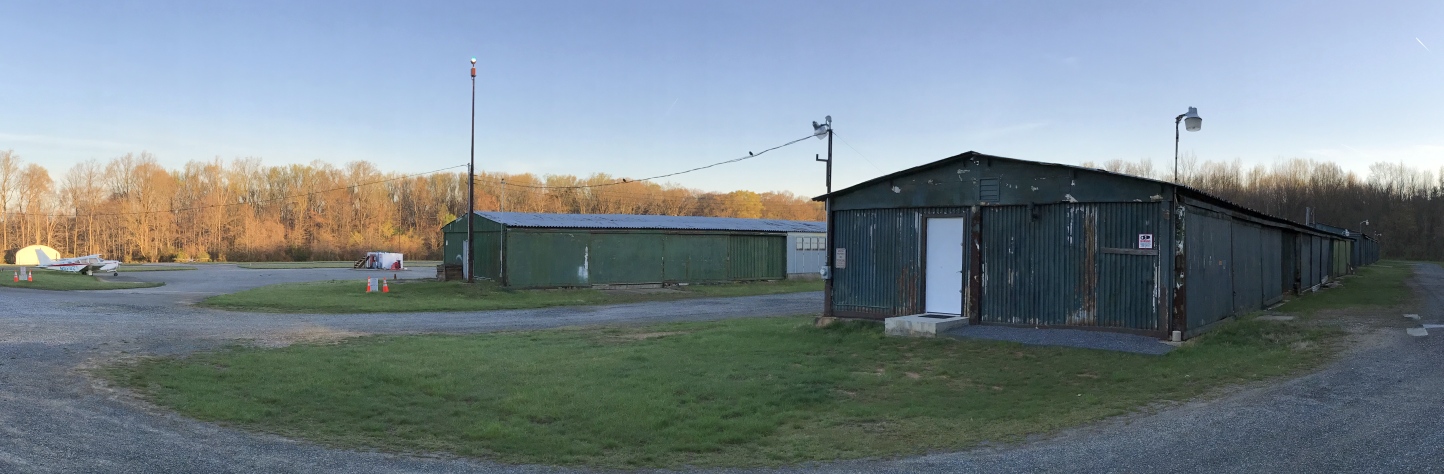
The last photo which has been located showing planes at Deep Creek was a 10/28/83 aerial view by Kenneth Keeton looking west.
It showed Deep Creek to have a single gravel north/south runway, along with a grass former crosswind runway.
Several hangars & planes were visible on the north end of the field.
John Baker recalled that "I flew into Deep Creek Airport on 8/4/84 in the Champ.”
Bob McLean reported, “Deep Creek Airport... I landed there around 1985 in a Piper Colt when the runway was gravel & it was still a functional airport.”
John Baker recalled, “Deep Creek Airport... On 11/28/86, I flew in again in my Stinson 108-3, N6197M."
The last aeronautical chart depiction which has been located of Deep Creek Airfield was on the March 1987 Washington Sectional Chart.
It depicted Deep Creek as having a 2,200' unpaved runway.
Deep Creek Airport was still listed among active airports in the 1987 AOPA Airport Directory (according to the book "Maryland Aloft").
The operator was listed as Deep Creek Airport & Marina Inc.
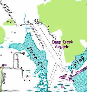
The 1988 USGS topo map depicted “Deep Creek Airpark” as having 2 unpaved runways.
Terri (Neitzey) Flaherty recalled, “My parents sold the property in 1988 to a property developer called Antonelli.
The property couldn’t be developed.”
Mark McKibben reported, “When Walt decided to retire, he had advertised to sell the airport & had no success in its sale as an operating facility.
It was purchased by a DC developer who intended to put townhouses/condos on the property.
The community raised a stink & it was sold to the State & was supposed to be updated to a park.”
Deep Creek Airport was no longer depicted on the 1991 Washington Sectional Chart (courtesy of Mike Keefe).
A 1994 USGS aerial view looking east at the site of Deep Creek Airport showed the 2 unpaved runways, but with no aircraft on the field.
According to Amy Neitzey's 2003 obituary in the Annapolis Capital (courtesy of Al Peters),
Amy & her husband Walter owned Deep Creek Airport for 45 years.
According to local pilot Roger Bartholomee, the developer who bought the Deep Creek property was unable to obtain building permits,
as the site consists of wetlands on the bay front.
Terri (Neitzey) Flaherty reported in 2014, “A citizens' group got Anne Arundel County to buy the property for playing fields but that hasn’t happened yet.”
A 4/21/16 photo by Bob McLean LLC looking along the former Deep Creek Runway.
Bob reported, “Deep Creek Airport is now part of Franklin Point State Park. As a State Park, it is presently undeveloped.
I walked the park for the first time in decades, and the runways are barely discernible & considerably overgrown.”
A website describing the state park acknowledges the property's former life as an airport.
Mark McKibben reported in 2017, “As far as I know it’s still vacant.
I know some instructors were still using it for forced landing practice, some to full-stop. I don’t believe I’d try it today.”
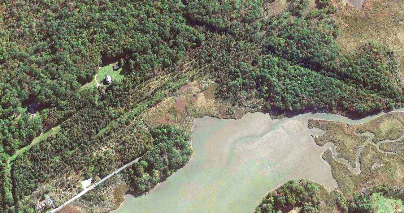
A 2020 aerial view looking east at the site of Deep Creek Airport showed the 2 unpaved runways remained barely recognizable.
The site of Deep Creek Airport is located along the western shore of the Chesapeake Bay, at the end of Dent Road, south of Shady Side Road.
Thanks to Larry Schuler for pointing out this airfield.
____________________________________________________
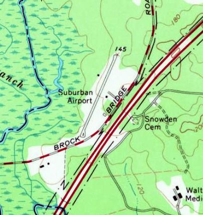
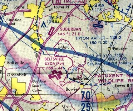
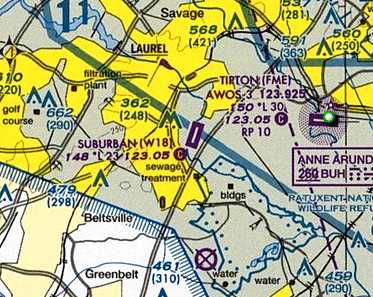
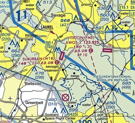
Suburban Airport (W18), Laurel, MD
39.08, -76.83 (Southwest of Baltimore, MD)
A 12/14/59 USAF aerial view depicted Suburban Airport evidently while it was still under construction (courtesy of Dallam Oliver-Lee).
A 1957 aerial view did not yet depict Suburban Airport.
The earliest depiction which has been located of Suburban Airport was a 12/14/59 USAF aerial view (courtesy of Dallam Oliver-Lee).
It evidently depicted the field while still under construction, showing a single northeast/southwest runway.
Suburban Airport was not yet depicted on the January 1960 Washington Sectional Chart.
According to Wikipedia, “Suburban Airport opened in March 1960 as a family-run airport & fixed base operation.”
This date is confirmed by the activation date in the FAA Airport/Facility Directory listing.
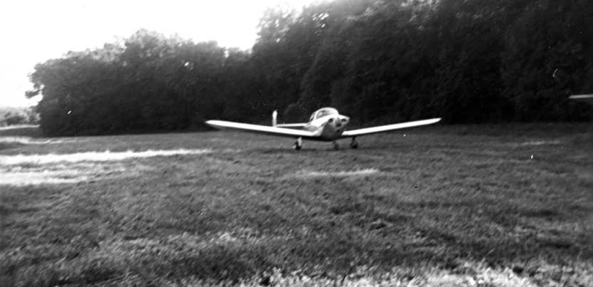
A June 1960 photo of Suburban Airport's 1st customer: an ERCO Ercoupe taxis to its tiedown.
The Ercoupe had been manufactured only a few miles away at the ERCO plant in Riverdale MD.
The earliest aeronautical chart depiction which has been located of Suburban Airport was on the July 1960 Washington Sectional Chart.
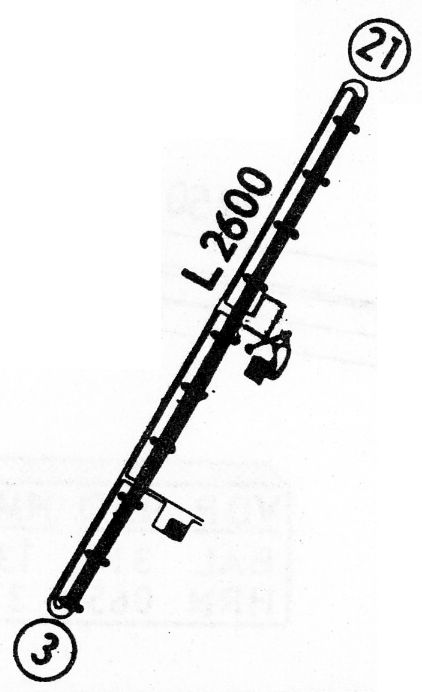
It depicted Suburban as having a 2,600' unpaved runway.
According to Wikipedia, “By 1963 the operations building & maintenance hangar were complete & there were 33 aircraft based on the field."
A 1963 aerial photo depicted Suburban as having a single paved northeast/southwest runway, with 2 small buildings.
Over 2-dozen light aircraft were visible on the field.
The 1964 Washington Sectional Chart (courtesy of Ed Drury) depicted Suburban as having a 2,600' paved runway.
A 10/7/64 USGS aerial view depicted over 3-dozen light aircraft at Suburban Airport.
The 1965 USGS topo map depicted Suburban Airport as having a single paved northeast/southwest runway, with 2 small buildings.
Charles Bruno recalled, “My father learned to fly at W18 in the mid-1960s.”
The 1968 Flight Guide (courtesy of Robert Levittan) depicted Suburban Airport
as having a 2,600' paved Runway 3/21 & 2 small buildings on the east side.
The 1975 Washington Terminal Aeronautical Chart (courtesy of Ed Drury) depicted Suburban as having a 2,100' paved runway.
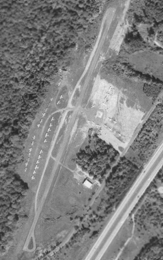
A 1980 aerial showed that Suburban had gained 4 rows of T-hangars on the east side of the field at some point between 1964-80.
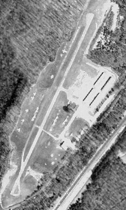
A 1982 aerial view depicted Suburban Airport as having 4 rows of T-hangars on the east side of the field.
A 1993 aerial photo showed Suburban in much the same configuration as seen in 1982.
According to Wikipedia, “The airport hosts meetings of the Experimental Aircraft Association
and aviation-oriented youth education programs such as Young Eagles flights.
The airport has been a Piper Aircraft dealer.”
A Summer 1998 aerial view looking southeast on final approach for Suburban Airport's Runway 21.
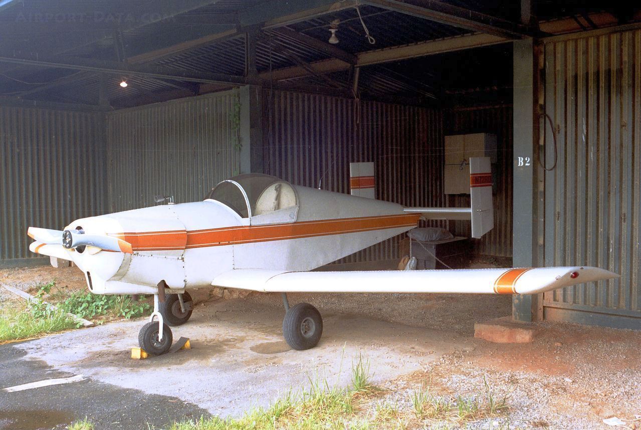
A 5/20/00 photo of N72RD, a 1975 Dixon CRIS-TENA, C/N: MC107, inside a Suburban Airport hangar.
Charles Bruno recalled, “Ron Dixon was a fixture at W18.”
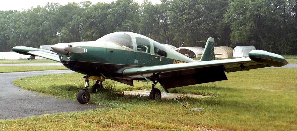
A 5/20/00 photo of N90RD, a rare Navion Rangemaster H, C/N: NAV-4-2519, at Suburban Airport.
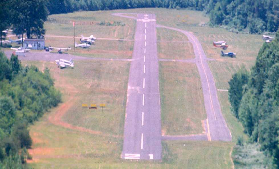
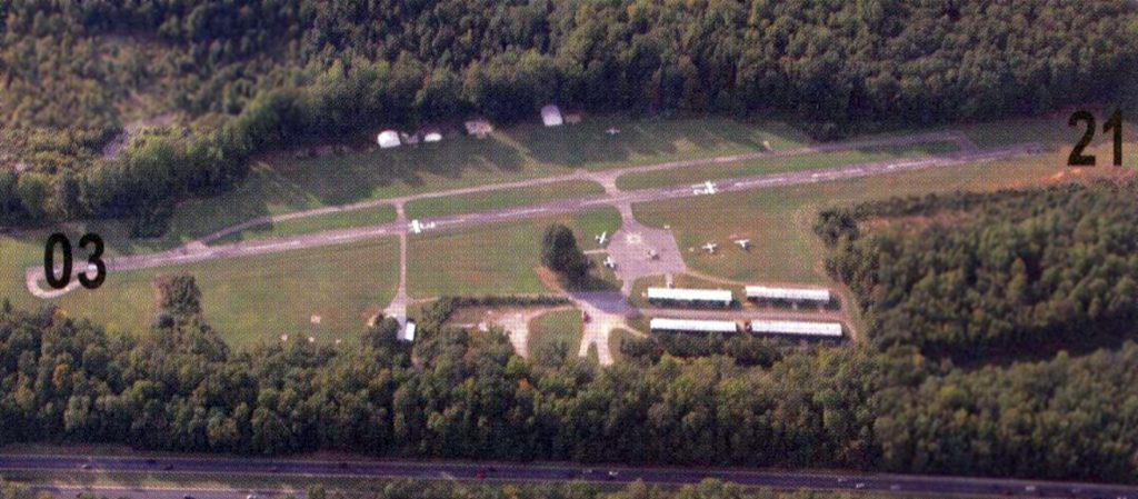
A February 2001 aerial view by Paul Freeman looking west at Suburban Airport.
The little airport was well-used, with over a dozen light aircraft visible.
A row of a dozen fabric shelter hangars had been added to the west side of the field at some point between 1993-2001.
A 2001 photo by Charles Bruno of his Rotary Air Force 2000 autogyro at Suburban Airport.
Charles recalled, “Suburban, where I based at about 2 years. I had a fabric hangar for it, a narrow hangar no airplane would fit in.”
Charles Bruno recalled, “When 9/11 happened, airspace was severely restricted. That played a major role killing that airport.
There was no radio relay to ATC there. To fly after 9/11, you had to have a cell phone.
You call Potomac TARCON by phone, if you could get past a busy signal. If you got through, you'd be put on hold.
Here is the fun part, you talk to controller who gives you a transponder code, and wants you airborne in 10 minutes or less.
If you takeoff outside that window, you get an ear-full & maybe the letter.
To get back in, you have to have a flight plan filed. If ATC can't find the plan you filed, they won't let you in the airspace.
Just way too much hassle for VFR flying, which was the majority of operation there.”
According to Wikipedia, “In 2001 Suburban Airport was closed for operations by the September 11 attacks.
Aircraft had limited access to leave, then eventually arrivals & departures were granted under the flight rules of the Washington Air Defense Identification Zone.”
According to Wikipedia, “Suburban airport is currently owned by W18 LLC, an entity co-located with Bay Area Land Development & Polm Housing.
The airport property is in a region affected by Base Realignment & Closure & gambling legislation at the nearby Laurel Park Racecourse.
In 2004 Polm attempted to increase the zoning of the airport property from 21 allowable housing units to 641 units for a development called Riverwood.
Polm publicly announced plans prior to the hearing to expand Suburban airport to support 300 aircraft,
100 hangars, helicopter charters, and operate a flight school if the increased zoning failed.
Two hundred fifty people attended the zoning hearing where the Riverwood zoning attempt did not pass.
The same hearing passed zoning changes for the Polm development Fieldstone on the same road.”
A 2005 aerial photo showed the effect of airspace restrictions & neglect on the little airport,
with the number of aircraft visible on the field having fallen to only 4.
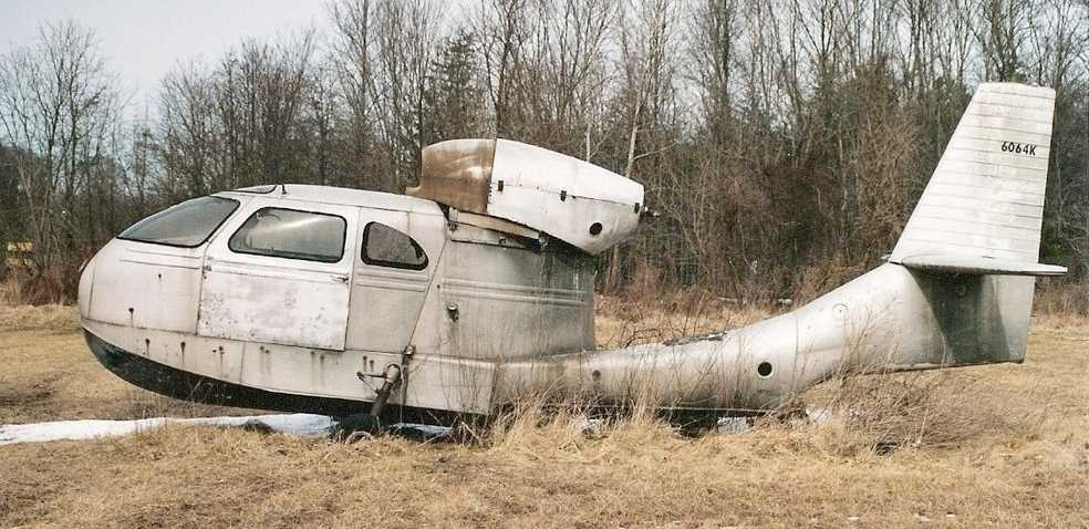
A 2/27/05 photo by Stuart Miller of a sad wingless Republic RC-3 SeaBee, an unusual seaplane, at Suburban Airport.
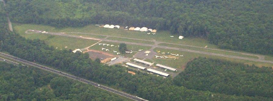
A circa 2008-2011 aerial view looking south at Suburban's ramp & hangars.
According to Wikipedia, “In 2009 Polm offered to build a 715 seat privately-run school if Riverwood zoning is approved.”
A 7/1/10 photo looking southeast at 4 aircraft at Suburban Airport.
A 7/1/10 photo looking northwest at Suburban's new threshold in the foreground, with the former threshold in the background.
According to Wikipedia, “In 2010 The Maryland Aviation Administration changed the criteria for minimum approach angles & marked the airport with new displaced thresholds.
The thresholds shortened 1/3 of the runway for landing operations both ways on the 2,300' runway.
Organizations that provided aircraft for Young Eagles flights have needed to relocate because the available runway was reduced beyond safe operating limits of their aircraft.”
According to Wikipedia, “Suburban Airport covers an area of 52 acres which contains one paved runway (3/21) measuring 2,324'.
For 12-month period ending 4/24/07, the airport had 20,400 aircraft operations, an average of 55 per day, 100% of which were general aviation.
There are 66 aircraft based at this airport, including 65 single-engine airplanes and 1 helicopter.
A combination of grass, paved-pad, ramp, owner-maintained fabric hangars, and steel hangars are available for aircraft to base from.
The airport hosts homebuilt experimental aircraft, and has been the primary construction site of several aircraft past & present.”
A 8/30/10 aerial view looking northeast at Suburban Airport
showed that some of the fabric shelter hangars on the west side of the field had been removed at some point between 2005-2010,
and only 4 aircraft were visible parked outdoors.
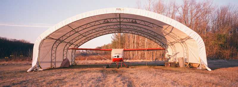
A 3/2/11 photo of a single-engine high-wing plane under an open-ended fabric shelter at Suburban Airport.
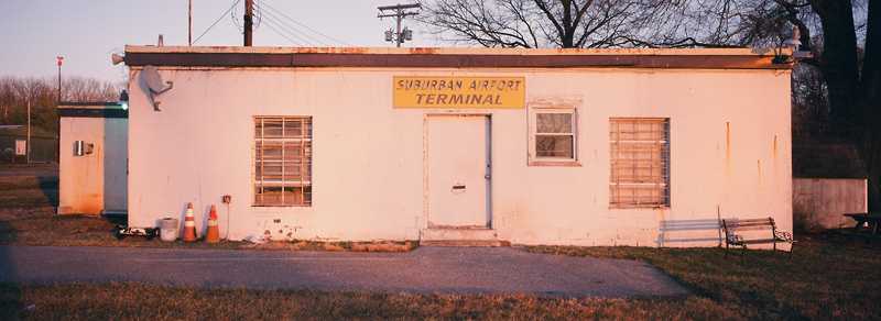
A 3/2/11 photo of Suburban Airport's Terminal Building.
A 6/4/11 aerial view showed that most of the fabric shelter hangars on the west side of the field had been removed,
and only 4 aircraft were visible on the field.
The 2012 Washington Terminal Aeronautical Chart depicted Suburban as having a 2,300' paved runway.
Note the proximity of the DC Flight Restricted Zone only a mile to the southwest.
This little general aviation airport came close to the end in 2012,
when it was reported that “Suburban Airport to close at midnight on August 13.”
However, the airport managed to get a reprieve, and stayed open.
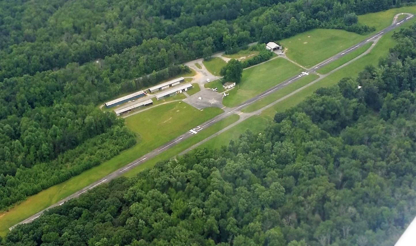
An undated aerial view looking west at Suburban Airport from the 2013 MD Airport Directory.
Note that both ends of the runway had been ridiculously shortened with displaced thresholds.
A 2016 aerial view looking northwest at Suburban Airport showed only 3 aircraft were visible parked outdoors.
The 2017 Washington Terminal Aeronautical Chart continued to depict Suburban as having a 2,300' paved runway.
A 4/10/17 panoramic photo by Pete Meyer looking along Suburban Airport's runway.
A 4/10/17 photo by Pete Meyer looking west at Suburban Airport's hangars.
Unfortunately the end came for Suburban Airport on 5/26/17,
when Pete Meyer reported, “This afternoon the tenants of W18 Suburban Airport received the official notice of lease termination & have been order to vacate the property by 6/30/17.
As you all know we have worked tirelessly of the past decade to keep W18 open & operating.
While we all knew that someday we would be faced with leaving, we didn't expect it to be on such short notice.
W18 has been operational since 1959 & we have some tenants that have been on the field for nearly 40 years.
We have a wide selection of aircraft (metal & fabric), uncompleted kits & homebuilts,
and all those things one collects in the process of build, maintaining & flying aircraft.
As well as approximately 1,800 gallons of 100LL that was just delivered in the past month, all of which we must now find homes for in the coming weeks.”
A 6/3/17 aerial view by T.J. Henry (courtesy of Pete Meyer) looking east at Suburban Airport, showing 2 light single-engine aircraft still parked outdoors.
Charles Bruno observed, “They displaced the threshold on Runway 3 by a huge amount. When I flew there, it was only displaced maybe 50'.
Some new FAA regulation concerning trees I believe was the reason of that huge displacement. That displacement was probably an issue too, as the runway was not long to begin with.”
Pete Meyer reported, “Maryland Aviation Administration was on location at W18 yesterday 6/30/17
and at 1200 Local time the airport was closed indefinitely. I made the last flight out shortly after that.”
A 12/2/17 aerial view by Tom Henry (courtesy of Pete Meyer) looking south at Suburban Airport. Pete Meyer observed, “It looks like after 5 months they finally have marked the airport closed.”
Pete Meyer reported that Suburban Airport is no longer depicted on the 2018 Washington Sectional Chart.
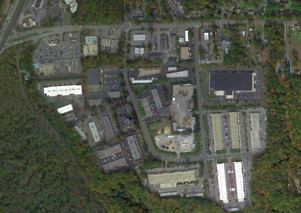
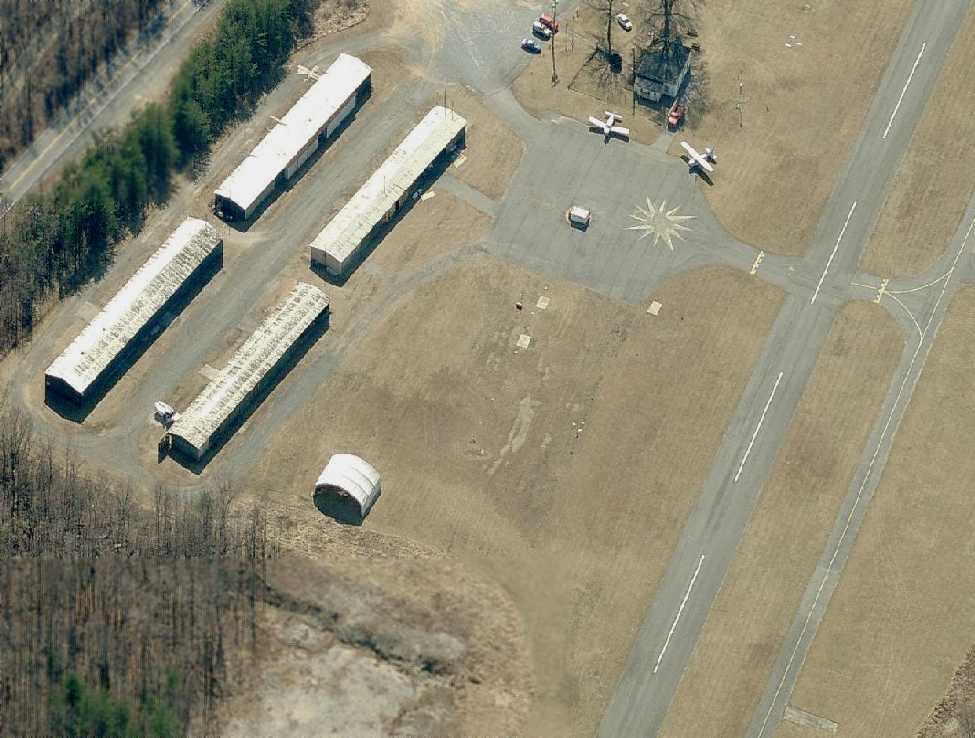
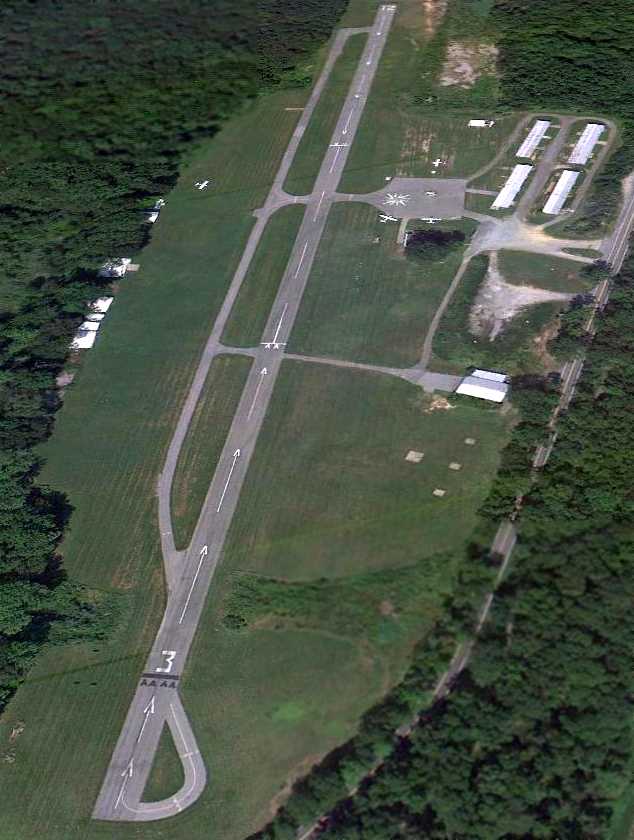
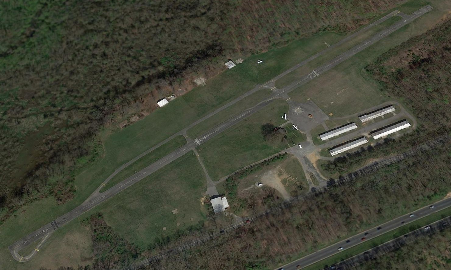
A 2020 aerial view looking northwest at the site of Suburban Airport shows the majority of it remains intact, including the runways & most of the hangars.
So 3 years after the airport's closure, presumably for more-lucrative commercial redevelopment, nothing has replaced the airport. Why did it have to be closed?
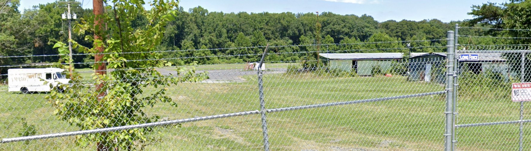
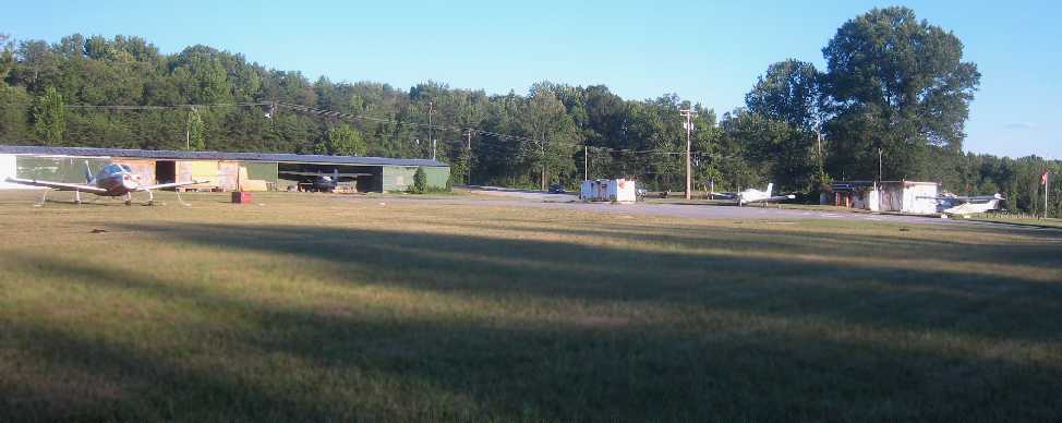
A 2022 photo looking northwest at the fenced-off Suburban Airport entrance, showing hangars & the ramp.
Karl Ginter reported in 2022, “Suburban Airport... rumors have it that a developer bought the land a year ago & they're starting to raze structures on the grounds.”
Suburban Airport is located northwest of the intersection of Route 197 & Brock Ridge Road.
____________________________________________________
Glen Burnie Airport & Seaplane Base / Whipp Airport & Seaplane Base, Glen Burnie, MD
39.17, -76.6 (South of Baltimore, MD)
"Glen Burnie" Airport & seaplane base, as depicted on the November 1942 Washington Sectional Chart.
This general aviation airport & seaplane base was located along the western bank of Marley Creek,
just south of Baltimore Harbor.
According to the fantastic book "Maryland Aloft" by Preston, Lanman, and Breilhan,
"Ed Whipp ran the facility & lived on its premises, beginning at least as early as 1938."
However, no airfield at this location was listed in the 1938 Commerce Department Descriptions of Airports & Landing Fields (courtesy of Jim Fretwell)
nor depicted on the September 1938 Washington Sectional Chart.
Glen Burnie Airport was not yet depicted on the May 1942 Washington Sectional Chart.
The earliest depiction which has been located of Glen Burnie Airport was on the November 1942 Washington Sectional Chart,
which depicted "Glen Burnie" as both a commercial airport & a seaplane base.
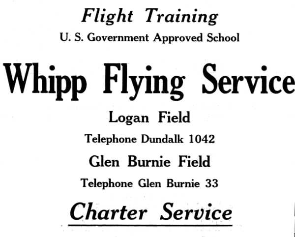
A circa 1940s advertisement for Whipp Flying Service, at Logan Field & “Glen Burnie Field”.
A 9/29/43 aerial view looking south at Glen Burnie Whipp Airport from the 1945 AAF Airfield Directory (courtesy of Scott Murdock)
depicted the field as an open grass area.
Glen Burnie Airport may have been temporarily closed at some point between 1943-44
(like many other small civil airports along the east coast during WW2),
as it was not depicted on the 1944 Washington Sectional Chart (courtesy of Mike Keefe).
According to the book "Maryland Aloft",
proprietor Ed Whipp flew seaplanes as a test pilot for Baltimore's Martin Aircraft Company during the war.
The 1945 AAF Airfield Directory (courtesy of Scott Murdock) described Glen Burnie Whipp Airport
as a 125 acre irregularly-shaped property within which were 3 sod runways, the longest being a 2,600' northeast/southwest strip.
The field was said to have a single 70' x 50' concrete block hangar under construction, and to be privately owned & operated.
The 1945 Washington Sectional Chart (courtesy of John Voss) once again depicted "Glen Burnie - Whipp" as a commercial airport & a seaplane base.
Murray Cole recalled, “My Mother (Thelma Anderson) at the age of 23 years old in 1945 learned to fly at Whipp's Field.
I have a copy of her diploma where she had a solo flight in a Piper Cub in 1945.
I have several photos of her with Mr. Whipp, standing by a plane & getting ready to take off.
I also have several photos of her taken with the other members of the Pegasus Flying Club.”
A circa 1940s photo of a Cub & several other aircraft in front of a hangar at Whipp Airport.
According to the book "Maryland Aloft",
the 1945 Haire Publishing Airport Directory listed the operator as Robert Whipp,
and described the field as consisting of "165 acres,
with buildings that included a small administration building, a restaurant, and a hangar."
The report "Glen Burnie, A Pictorial History: 1888-1988" depicted the hangar
"as a large barrel-roofed structure of corrugated metal."
A 1946 photo of Fred Klaburner Sr. receiving his pilot's license from Ed Whipp
in front of a Cessna & the Whipp Airport office building (courtesy of Fred Klaburner Jr).
According to Fred Klaburner Jr., his parents, “Fred & Clara Klaburner... belonged to the Pegasus Flying Club.”
His father got his license in 1946, and “the Pegasus Flying Club flew out of Whipp's airport during the late 1940s.”
A 1947 photo of a Piper in front of the Whipp Airport office building (courtesy of Fred Klaburner Jr.).
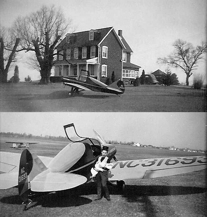
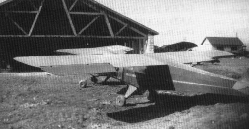
Two 1947 photos by William Ledford of a Dart GC at Whipp Airport.
William recalled, “I landed there on Easter 1947 & spent the night in the family home pictured here.”
The lower picture shows William's wife holding their 4-month old daughter.
“The Whipp's even babysat for us so we could take a stroll of downtown Glenn Bernie that evening.
We were en-route to Brooklyn to visit with my wife's people.”
According to William, the Dart GC was “built by Ray Applegate after the war, original design was by Al Mooney & built by Culver.”
The 1947 USGS topo map depicted Glen Burnie Whipp Airport as having three runways
along with a number of small buildings along the east & west sides of the field.
The 1947 Washington Sectional Chart (courtesy of Roger Connor)
depicted "Glen Burnie - Whipp" as a commercial airport (having a 3,000' unpaved runway) & a seaplane base.
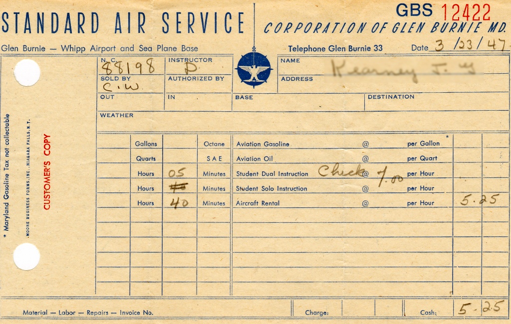
A 3/23/47 receipt for flight instruction in NC88198 from Whipp Airport's Standard Air Service for the whopping total of $5.25 (courtesy of Rick Vaeth).
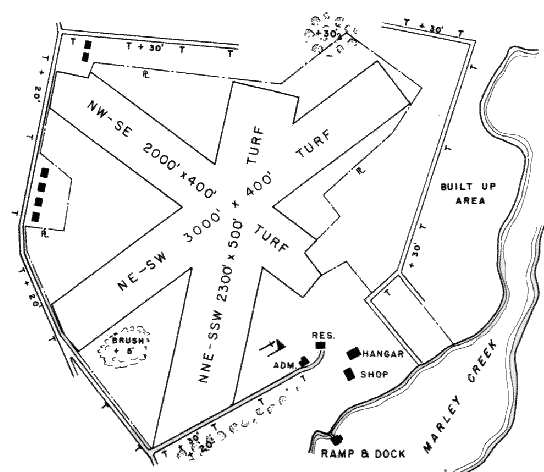
The 1950 MD Airport Directory (courtesy of Stephen Mahaley) depicted Whipp as having three turf runways,
with the longest being a 3,000' northeast/southwest strip.
A hangar & shop were situated southeast of the runways,
and a ramp & dock for the seaplane base was along the bank of Marley Creek.
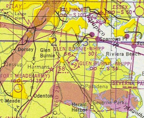
Glen Burnie - Whipp Airport was depicted on the January 1951 Washington Local Aeronautical Chart (courtesy of Tim Zukas)
as having a 2,800' unpaved runway & 5,400' seaplane landing area.
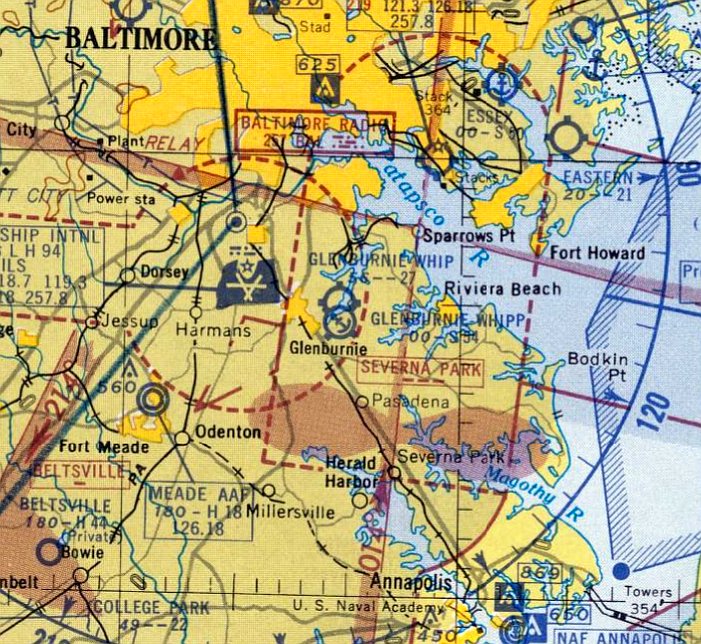
However, Whipp Airport's days were numbered by this point, as the cause its demise was also depicted nearby to the west:
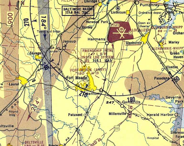
Friendship International Airport had opened less than 3 miles to the west in 1950.
Friendship International would eventually be renamed Baltimore-Washington International Airport,
and its rapid growth in air traffic undoubtedly hastened the demise of the sleepy little general aviation airport nearby,
as airspace concerns would have made this an unworkable arrangement.
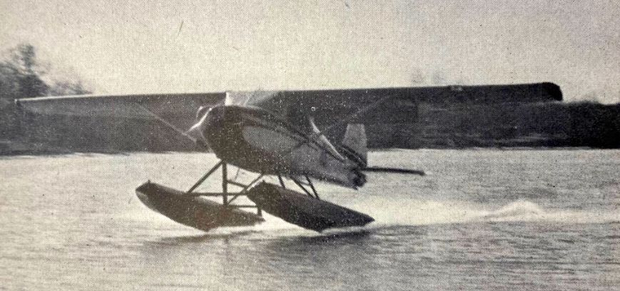
An undated photo of Ed Whipp's Cessna 170 floatplane from a November 1953 Air Facts article (courtesy of Mike Davidson).
The article reported, “A low flying, float plane, cruising daily over the Chesapeake Bay & its tributaries, maintains law & order among the vast commercial fishing fleets working in Maryland waters.
The aircraft, an important cog in the state’s enforcement fleet, bears the yellow & black triangular insignia of Maryland’s Department of Tidewater Fisheries.
After a day with Pilot Ed Whipp, it seemed as though we had been on a 100 MPH boat trip instead of a flight.
In about 4 hours of flying time, more than 90% of it was at an altitude (if you would term it such) of between 100-200'.
It was a brisk, sunny morning when I walked with Pilot Whipp toward the hangar of the department patrol plane.
He keeps & maintains it at his airport-residence near Glen Burnie.
The seaplane was resting on an improvised, flat-bed trailer near Curtis Creek, which empties into the Bay only 2 miles away.”
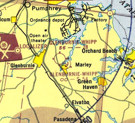
The last depiction which has been located of Glen Burnie - Whipp Airport was on the July 1955 Washington Sectional Chart.
It depicted Glen Burnie - Whipp Airport as having a 2,700' unpaved runway & 5,400' seaplane landing area.
Whipp Airport was apparently closed at some point between 1955-56,
as it was no longer depicted on the January 1956 Washington Sectional Chart.
Don Price recalled, “I lived in Country Club Estates since 1968. I have heard that Whipp Airport was here.
The development was built around 1957-58. The original new deed on my house was from 1958.”
A 11/19/59 USAF aerial photo (courtesy of Dallam Oliver-Lee) showed houses covering the site, with no trace recognizable of Whipp Airport.
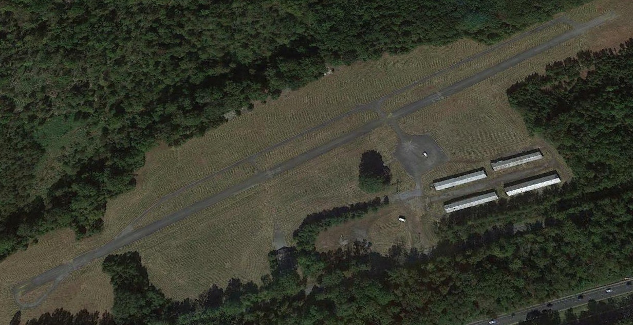
A 2014 aerial view looking north showed no remaining trace of the former Whipp Airport.
The property has been heavily redeveloped as the Country Club Estates housing development.
A token reminder exists as to the site's former role - one of the residential streets is named Whip Lane.
Country Club Estates resident Don Price reported, “It is true there is a street named after Mr. Whipp.
However when all the streets were officially named it came out as Whip Lane. Apparently an oversight that was never changed.”
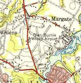
The site of Whipp Airport is located southeast of the intersection of East Furnace Branch Road & Margate Drive.
____________________________________________________
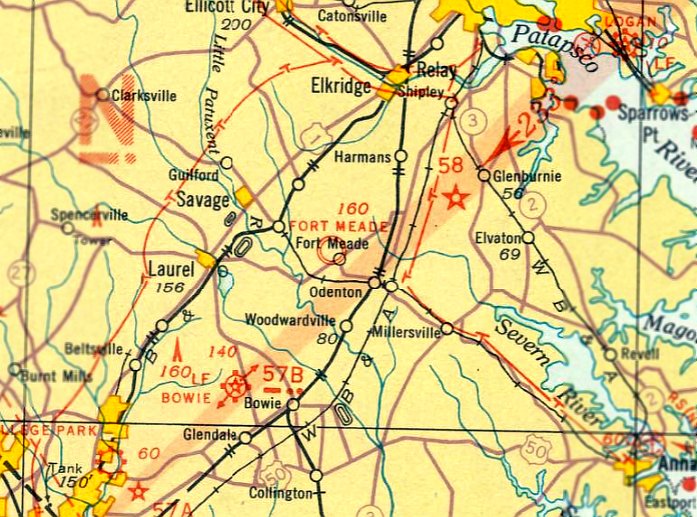
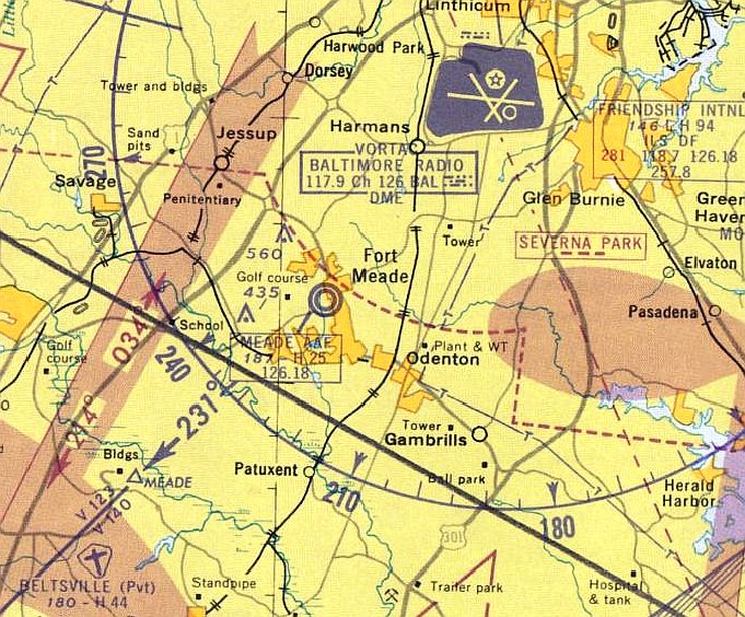
(Original) Fort Meade Auxiliary Army Airfield, Fort Meade, MD
39.11, -76.74 (South of Baltimore, MD)
The original Fort Meade airfield, as depicted on the August 1935 Washington Sectional Chart.
The original airfield on the property of Fort Meade is not in the same location as the present-day Tipton Field.
The original Fort Meade airfield was located in the central portion of the base, two miles northeast of where Tipton AAF would eventually be built.
The date of construction of the original Fort Meade airfield is unknown.
According to the fantastic book "Maryland Aloft" by Preston, Lanman, and Breilhan,
"An emergency landing field was reported to exist there as early as 1920, and an auxiliary landing field was listed in a 1930 publication."
However, no airfield at Fort Meade was yet depicted on the May 1932 or October 1934 Washinton Sectional Charts,
nor listed in the 1934 Commerce Department Descriptions of Airports & Landing Fields (courtesy of David Brooks).
The earliest depiction of the Fort Meade field which has been located was on the August 1935 Washington Sectional Chart.
The 1936 Commerce Department Descriptions of Airports & Landing Fields (courtesy of David Brooks)
described Fort George Meade Airport as an Army facility having a rectangular sod field within which were 3 runways,
including a 1,800' asphalt northwest/southeast strip.
The Airport Directory Company's 1937 Airports Directory (courtesy of Bob Rambo) described Fort Meade AAF as having a total of 3 runways,
including a 1,800' northwest/southeast asphalt runway.
The Fort Meade airfield may have been temporarily closed during the early WW2 years,
as it was not depicted at all on the 1942 Regional Aeronautical Chart (courtesy of Chris Kennedy).
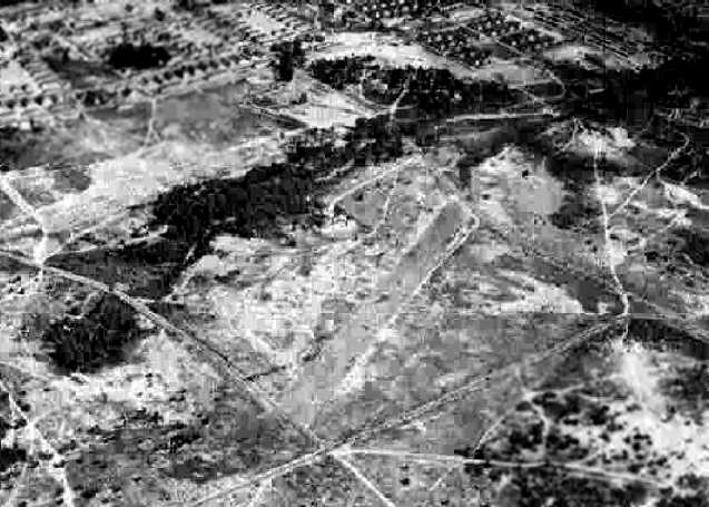
A 9/25/43 aerial view looking southeast at “Fort George G. Meade Airport” from the 1945 AAF Airfield Directory (courtesy of Scott Murdock)
depicted the field as a very modest single runway.
Fort Meade AAF, as depicted on the May 1944 Washington Sectional Chart (courtesy of Ron Plante).
The 1944 US Army/Navy Directory of Airfields (courtesy of Ken Mercer) described Fort Meade AAF as having a 2,000' hard-surfaced runway.
The 1945 AAF Airfield Directory (courtesy of Scott Murdock) described “Fort George G. Meade Airport”
as a 45 acre rectangular property within which was a single 2,000' bituminous northwest/southeast runway.
The field was said to not have any hangars, to be owned by the U.S. Government, and operated by the Army Air Forces.
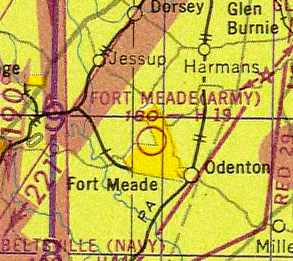
"Fort Meade (Army)", as depicted on the 1947 Washington Sectional Chart.
The 1947 USGS topo map depicted the original Fort Meade Airfield a single 1,800' northwest/southeast runway, labeled simply "Landing Strip".
The 7/15/1949 Washington Sectional Chart (courtesy of Mike Keefe) and the 1955 Washington Local Aeronautical Chart (courtesy of Mike Keefe)
described "Fort Meade (Army)" as having a 1,900' hard-surface runway.
The 1951 Washington Local Aeronautical Chart depicted "Fort Meade (Army)” Airfield as having a 1,900' paved runway.
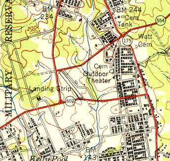
The 1957 USGS topo map depicted the original Fort Meade Airfield as a single 1,800' northwest/southeast runway, with a control tower on the east side, labeled simply "Airfield".
Note that the runway had been extended toward the southeast at some point between 1947-57, extending across Route 602.
According to Stephen Bloor, “The runway had railroad-style control gates to stop road traffic for aircraft.”
According to the book "Maryland Aloft", "As described in a historical report by Clayton Davis,
Fort Meade Army Airfield in 1957 was crossed by both MacArthur Boulevard & Mapes Road.
Movable barriers were raised & lowered by the control tower to prevent surface traffic from interfering with air operations.
Davis noted that the airfield was used by civilian as well as military aircraft."
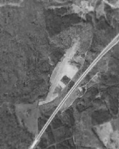
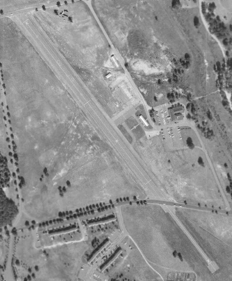
A 12/14/59 USAF aerial view (courtesy of Dallam Oliver-Lee) depicted the original Fort Meade Airfield
as a single northwest/southeast paved runway, with a few small buildings on the east side.
The last aeronautical chart depiction which has been located of the original Fort Meade AAF was on the 1960 Washington Local Aeronautical Chart.
It depicted "Meade AAF" as having a 2,500' paved runway & a control tower.
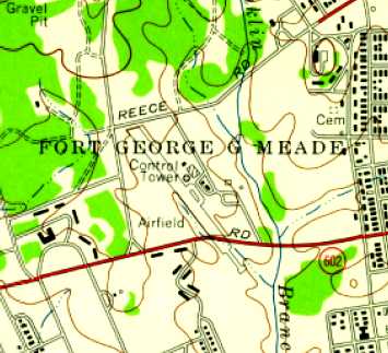
The location of the original airfield, within the center portion of the base, hemmed in by roads & buildings on all sides,
was apparently the reason for its eventual replacement.
The original Fort Meade airfield was replaced in 1961 by Tipton AAF,
built over the site of a landfill two miles to the southwest, in an area on the outskirts of the base which offered much more room.
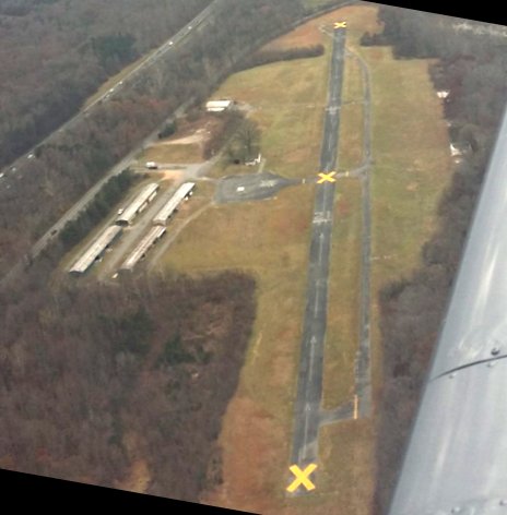
The site of the original Fort Meade airfield was labeled "Abandoned Airport" on the 1961 Washington Local Aeronautical Chart (courtesy of Mike Keefe)
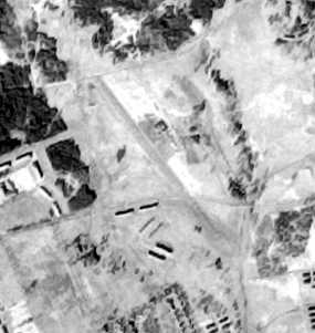
The last photo which has been located showing the original Fort Meade Airfield still intact was a 10/7/64 USGS aerial view.
It depicted the field as a single northwest/southeast paved runway (marked with closed-runway “X” symbols), with a few small buildings on the east side.
The site of the original Fort Meade airfield was labeled "Abandoned Airport" on the 1966 Washington Local Aeronautical Chart (courtesy of Jonathan Westerling).
The 1970 USGS topo map no longer depicted the runway or airfield buildings, which had presumably been removed.
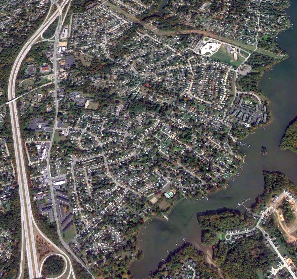
Stephen Cerutti reported that the site of the original Fort Meade airfield was covered by the PX/Theatre/Bowling Alley/Commissary complex,
which "were built in the early/mid 1970s."
A 1993 USGS aerial photo showed no trace of the original Fort Meade airfield.
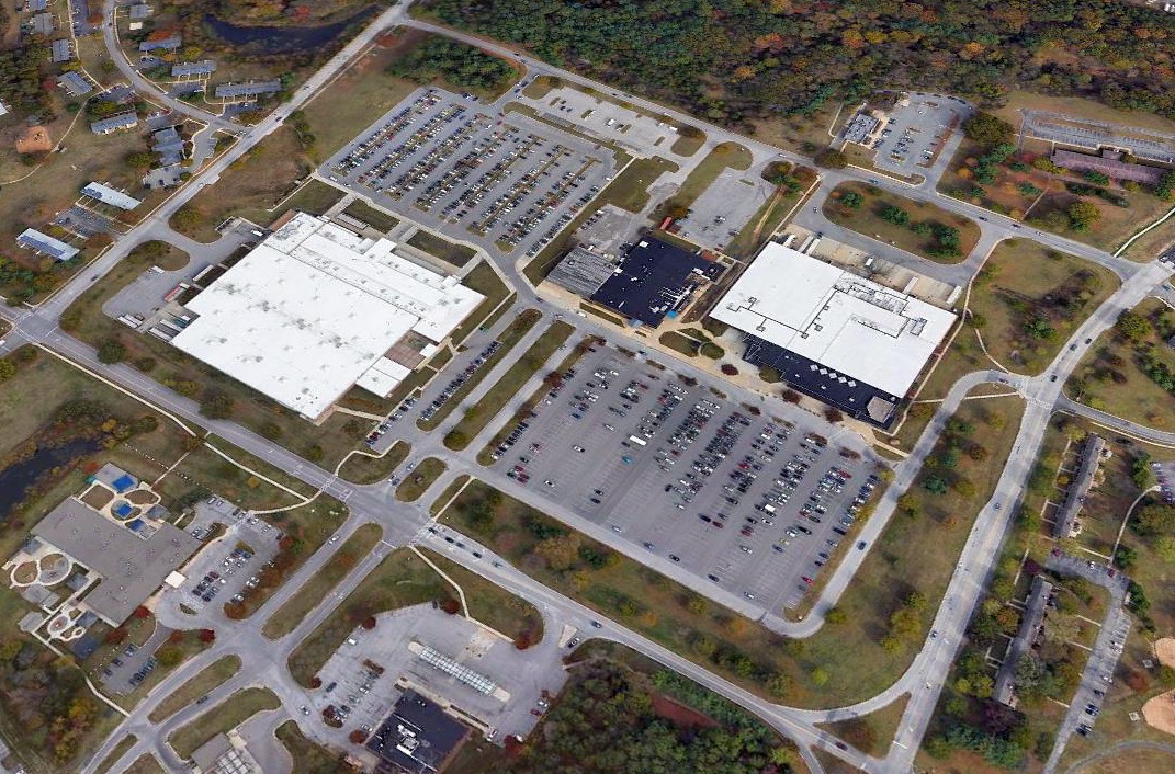
A 2019 aerial view looking northeast showed the PX/Theatre/Bowling Alley/Commissary complex which occupies the site, with not a trace remaining of the original Fort Meade airfield.
The site of the original Fort Meade airfield is bounded by Reece Road, Mapes Road on the south, Ross Street on the east, and MacArthur Road on the west.
____________________________________________________
Since this site was first put on the web in 1999, its popularity has grown tremendously.
If the total quantity of material on this site is to continue to grow,
it will require ever-increasing funding to pay its expenses.
Therefore, I request financial contributions from site visitors,
to help defray the increasing costs of the site
and ensure that it continues to be available & to grow.
What would you pay for a good aviation magazine, or a good aviation book?
Please consider a donation of an equivalent amount, at the least.
This site is not supported by commercial advertising –
it is purely supported by donations.
If you enjoy the site, and would like to make a financial contribution,
you
may use a credit card via
![]() :
:
Please consider checking the box to make a monthly donatation.
For a mailing address to send a check, please contact me at: paulandterryfreeman@gmail.com
If you enjoy this web site, please support it with a financial contribution.
please contact me at: paulandterryfreeman@gmail.com
If you enjoy this web site, please support it with a financial contribution.
____________________________________________________
This site covers airfields in all 50 states.
For the site's main menu: Home